plate tectonics: grand unifying theory of everything... for the geosciences, at least! plate...
TRANSCRIPT
Plate Tectonics:
Grand Unifying Theory
of everything...
for the Geosciences,at least!
Plate Tectonics:
Grand Unifying Theory
of everything...
for the Geosciences,at least!

QuickTime™ and aCinepak Codec by Radius decompressor
are needed to see this picture.
A video

Plate tectonics theory says that the Earth’s core is broken up into pieces that move by plowing through the other rocks on Earth’s surface?
Plate tectonics theory says that the Earth’s core is broken up into pieces that move by plowing through the other rocks on Earth’s surface?
A. TrueB. FalseA. TrueB. False

IntroductionIntroduction•• Plate Tectonics Theory Plate Tectonics Theory
>> explains location of and actions associated with.... explains location of and actions associated with....-- Volcanoes (distribution and composition) Volcanoes (distribution and composition)-- Earthquakes (distribution, strength, depth) Earthquakes (distribution, strength, depth)-- Mountain Ranges (of all types) Mountain Ranges (of all types)-- Natural resources (distribution and formation of Natural resources (distribution and formation of
Coal, Mineral Resources, & Oil)Coal, Mineral Resources, & Oil)-- Ocean basins ( age, shape, and size) Ocean basins ( age, shape, and size)-- biologicbiologic distribution and behavior distribution and behavior
+ + (fossils and modern animals)(fossils and modern animals)-- seemingly incompatible climate records seemingly incompatible climate records
A theory that unified the geosciences by explainingA theory that unified the geosciences by explainingnearly all geological phenomenanearly all geological phenomena

Plate Tectonics and Continental drift are NOT the same thing!
Continental drift was the hypothesis postulated by Alfred Wegener that was rejected due to the wrong explanation for how the continents were moving
Plate tectonics built upon Wegener’s rejected hypothesis and added a lot of new information
•Sea floor spreading•Paleomagnetism•Age of sea floor along oceanic ridges

Plate Boundaries, Earthquakes and Volcanoes
•Red boxes show the location of the next three slides

A small shield volcano in Iceland
•thin lava is created at a divergent plate boundary
•The low viscosity lava creates the shield volcano

Confirmation of Sea-Floor Spreading
• Deep sea drilling supports the hypothesis that ocean crust is forming atthe ridges and moving away from the ridges.

Mt Rainier in Washington State- a classic example of a stratovolcano
•The lava associated with this type of volcano is created as oceanic crust melts and pushes through continental crust along convergent subduction plate boundaries
Mt Rainier in Washington State- a classic example of a stratovolcano
•The lava associated with this type of volcano is created as oceanic crust melts and pushes through continental crust along convergent subduction plate boundaries

Convergent Subduction (Oceanic-Continental) Plate Boundary
・ Denser oceanic crust subducted beneath continental crust.・ Andesitic volcanic arcs form on the leading edge of thecontinental plate.・ Andes Mountains, Cascades
・ Denser oceanic crust subducted beneath continental crust.・ Andesitic volcanic arcs form on the leading edge of thecontinental plate.・ Andes Mountains, Cascades

A couple of cinder cones and a lava flow in New Mexico
•This type of volcanic cone is often found associated with other volcanoes, and commonly where plates have been completely subducted and the melted material is in its last gasps.
A couple of cinder cones and a lava flow in New Mexico
•This type of volcanic cone is often found associated with other volcanoes, and commonly where plates have been completely subducted and the melted material is in its last gasps.

Alfred Wegener & Continental Drift HypothesisAlfred Wegener & Continental Drift Hypothesis
•• 1912-1915: 1912-1915: Alfred WegenerAlfred Wegener>> proposed a hypothesis called "continental drift".proposed a hypothesis called "continental drift".
Continents were once togetherContinents were once together>> Supercontinent; Supercontinent; PangaeaPangaea (Pan (Pan = all, = all, GaeaGaea = land). = land).
•• Based on a lot of geological evidenceBased on a lot of geological evidence>> mountain ranges, fossils, continental fit, & similar rocks mountain ranges, fossils, continental fit, & similar rocks
•• Wegener's theory lacked a scientifically valid Wegener's theory lacked a scientifically validexplanation for how the continents could move.explanation for how the continents could move.
- - Hypothesis was rejected for the above reason Hypothesis was rejected for the above reason
An alternative to the “Contracting Earth” model favored by many geoscientists at the timeAn alternative to the “Contracting Earth” model favored by many geoscientists at the time

Continental FitContinental Fit
• 1965: Edward• 1965: EdwardBullard proposedBullard proposedmodification ofmodification ofWegener’s idea ofWegener’s idea offitting continents byfitting continents byusing the 2,000 musing the 2,000 misobath, whichisobath, whichcorresponds to thecorresponds to thecontinental slopecontinental slopeand the edge ofand the edge ofcontinental crust.continental crust.

Similarity of Rock Sequences Similarity of Rock Sequences • Identical Carboniferous rocks on Gondwana is tough to explain
if the continents were not joined at that time

• Various mountain ranges are currently• Various mountain ranges are currently
widespread. Rejoining separated continentswidespread. Rejoining separated continents
shows the linear nature of the mountain chains.shows the linear nature of the mountain chains.
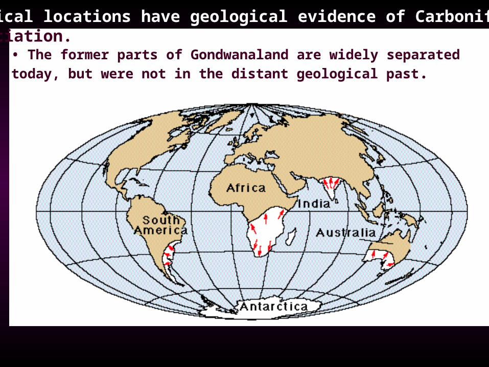
Tropical locations have geological evidence of Carboniferous glaciation.
• The former parts of Gondwanaland are widely separated today, but were not in the distant geological past.

The Gondwana Ice CapThe Gondwana Ice Cap
• If the continentsare reassembled,the glacialevidence makessense.
• At the same timemost of Laurasiawas in the tropics.
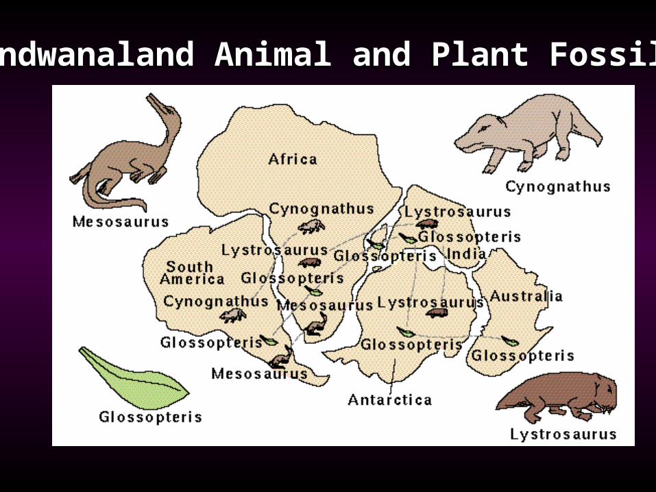
Gondwanaland Animal and Plant Fossils Gondwanaland Animal and Plant Fossils

Sea-Floor SpreadingSea-Floor Spreading
•• Sea floor mapped during the 1950s Sea floor mapped during the 1950s-- revealed the Mid oceanic ridge system. revealed the Mid oceanic ridge system.
Magnetic reversals recorded in the rocks were discovered later and verified Hess’ hypothesis
Magnetic reversals recorded in the rocks were discovered later and verified Hess’ hypothesis >> patterns were symmetrical with respect to the ridge axis. patterns were symmetrical with respect to the ridge axis.
•• 1962: Captain Harry Hess (US Navy) 1962: Captain Harry Hess (US Navy) >> proposed Sea-floor Spreading to account for proposed Sea-floor Spreading to account for
continental movement and size of oceans.continental movement and size of oceans.
The mountain chain had a down-dropped valley in the middle, called a rift valley.
could only be caused by pulling apart
The mountain chain had a down-dropped valley in the middle, called a rift valley.
could only be caused by pulling apart

Magnetic Data and the Mid Ocean Ridge Rift valleyan example of an Oceanic crust divergent boundary
Magnetic Data and the Mid Ocean Ridge Rift valleyan example of an Oceanic crust divergent boundary
• proof for sea floor spreading and a mechanism to move continents as Part of the larger tectonic plates


Age of the Ocean Basins
Final verification of sea floor spreading.
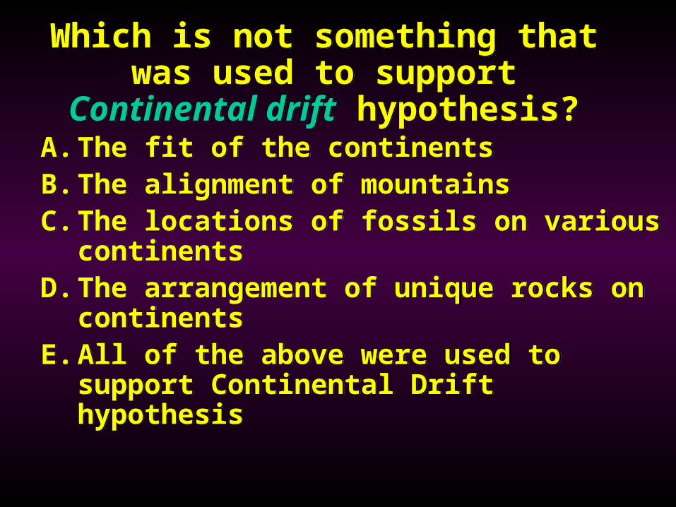
Which is not something that was used to support
Continental drift hypothesis?
Which is not something that was used to support
Continental drift hypothesis?A. The fit of the continentsB. The alignment of mountainsC. The locations of fossils on various
continentsD.The arrangement of unique rocks on
continentsE. All of the above were used to
support Continental Drift hypothesis
A. The fit of the continentsB. The alignment of mountainsC. The locations of fossils on various
continentsD.The arrangement of unique rocks on
continentsE. All of the above were used to
support Continental Drift hypothesis

Plate BoundariesPlate Boundaries•• Convergent : where two plates meet,
with one being subducted or both being forced upward
Convergent : where two plates meet, with one being subducted or both being forced upward > > oceanic-oceanic subduction; >continental-oceanic subduction; Continental-continental collision
oceanic-oceanic subduction; >continental-oceanic subduction; Continental-continental collision
..
•• Divergent : where two plates spread apart at a ridge or rift valley.Divergent : where two plates spread apart at a ridge or rift valley.
•• Transform : where two plates or plate segments slide past each other.Transform : where two plates or plate segments slide past each other.
> driven by convection cells within the mantle, the plates interact with each other > faults and earthquakes often occur along plate boundaries
> driven by convection cells within the mantle, the plates interact with each other > faults and earthquakes often occur along plate boundaries
oceanic >continentaloceanic >continental

EarthquakesOccur along breaks in the Crust
known as faultsEnergy stored along faults released
as rock strength and friction are overcome releasing energy waves
Three kinds of energy waves• P-waves (fastest)-move through any
substance• S-waves (next fastest)-move through solids
ONLY• Surface waves (slowest)-move along the
Earth’s surface

Convection currents drive plate motionConvection currents drive plate motion

Earthquake waves allow us to determine what the internal structure of Earth looks like
concentric spheres of material, each layer with specific characteristics that influence seismic wave movement

QuickTime™ and aTIFF (Uncompressed) decompressor
are needed to see this picture.
3D maps of the Earth’s convection currents based on seismic wave analysis-complicated, but likely more realistic!
3D maps of the Earth’s convection currents based on seismic wave analysis-complicated, but likely more realistic!

Continental-Convergent Plate BoundaryConvergent Continental-Continental Plate Boundary
Continental crustContinental crust

TibetPlateauTibetPlateau
HimalayasHimalayas
IndiansubcontinentIndiansubcontinent

Convergent Subduction (Oceanic-Continental) Plate Boundary
Western coast of South AmericaWestern coast of South America

Oceanic-Oceanic Plate BoundaryConvergent subduction Oceanic-Oceanic Plate Boundary・ Volcanic island arcs form nearly parallel to the subduction
zone, which is expressed as a deep ocean trench.
・ Most modern island arcs are in the Pacific Ocean.
・ Volcanic island arcs form nearly parallel to the subduction
zone, which is expressed as a deep ocean trench.
・ Most modern island arcs are in the Pacific Ocean.
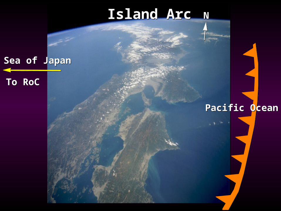
Sea of JapanSea of Japan
To RoCTo RoC
Island ArcIsland Arc NN
Pacific OceanPacific Ocean

East African Rift Valley
East African Rift Valley
・ Eastern Africaappears to berifting away fromthe rest of thecontinent.
Continental Divergent boundary

San Andreas Fault- a Transform BoundarySan Andreas Fault- a Transform Boundary

QuickTime™ and aCinepak Codec by Radius decompressor
are needed to see this picture.

Which type of plate boundary is not commonly associated with
volcanoes?
Which type of plate boundary is not commonly associated with
volcanoes?
A.Continent-Oceanic convergent subduction
B.DivergentC.Transform
A.Continent-Oceanic convergent subduction
B.DivergentC.Transform