npoess national polar-orbiting operational environmental satellite system january 26, 2005
TRANSCRIPT
NPOESSNPOESSNational Polar-orbiting Operational Environmental National Polar-orbiting Operational Environmental
Satellite SystemSatellite System
January 26, 2005January 26, 2005
NNATIONAL ATIONAL PPOLAR-ORBITING OLAR-ORBITING OOPERATIONAL PERATIONAL EENVIRONMENTAL NVIRONMENTAL SSATELLITE ATELLITE SSYSTEMYSTEM
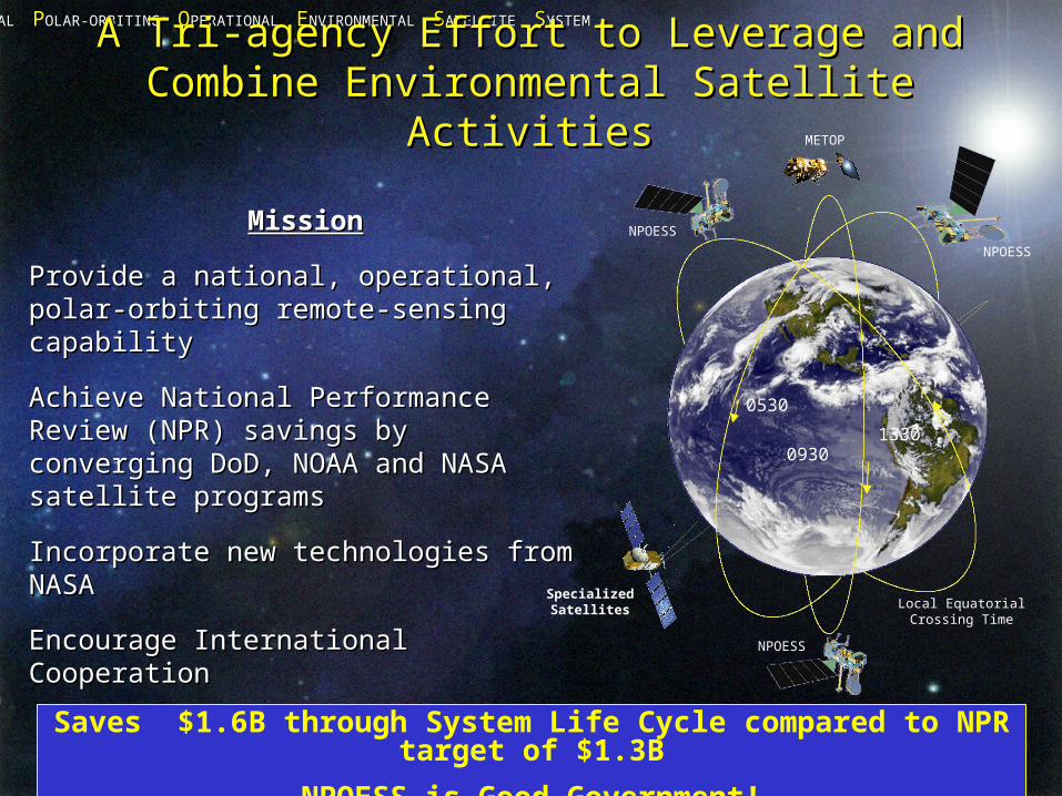
A Tri-agency Effort to Leverage and A Tri-agency Effort to Leverage and Combine Environmental Satellite ActivitiesCombine Environmental Satellite Activities
MissionMission
Provide a national, operational, Provide a national, operational, polar-orbiting remote-sensing polar-orbiting remote-sensing capabilitycapability
Achieve National Performance Achieve National Performance Review (NPR) savings by converging Review (NPR) savings by converging DoD, NOAA and NASA satellite DoD, NOAA and NASA satellite programsprograms
Incorporate new technologies from Incorporate new technologies from NASANASA
Encourage International CooperationEncourage International CooperationSaves $1.6B through System Life Cycle compared to NPR target of $1.3B
NPOESS is Good Government!
METOP
NPOESS
Specialized Satellites Local Equatorial
Crossing Time
0530
13300930
NPOESS
NPOESS
NNATIONAL ATIONAL PPOLAR-ORBITING OLAR-ORBITING OOPERATIONAL PERATIONAL EENVIRONMENTAL NVIRONMENTAL SSATELLITE ATELLITE SSYSTEMYSTEM
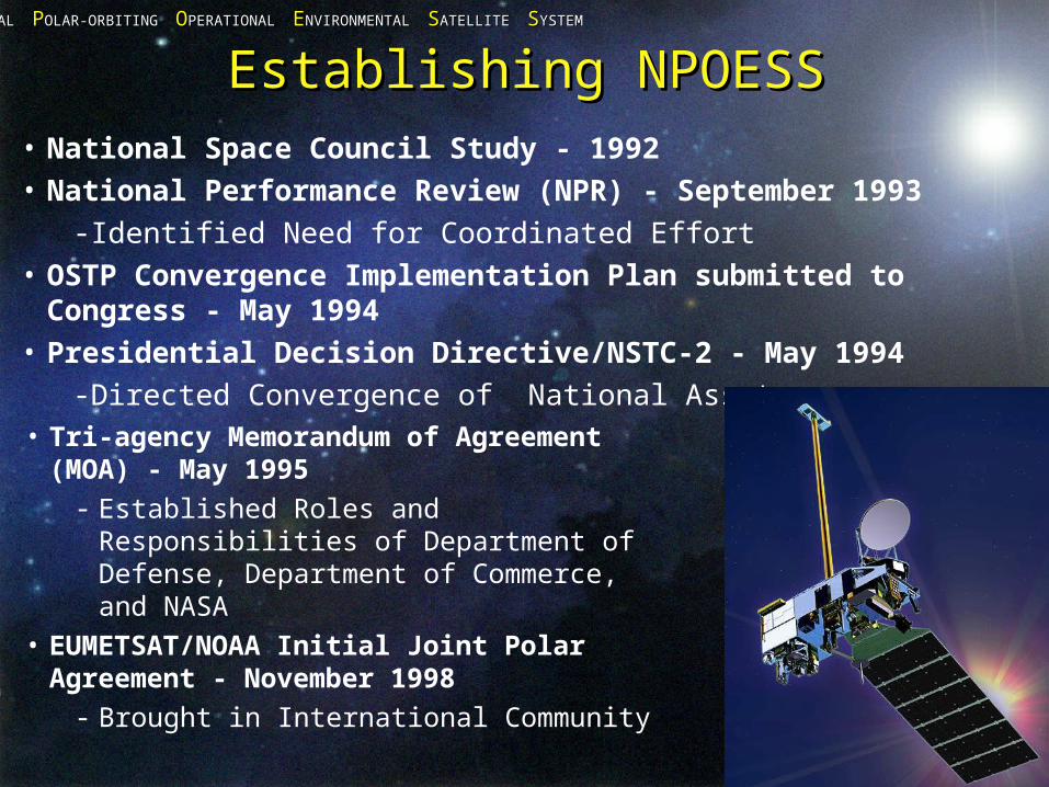
Establishing NPOESSEstablishing NPOESS• National Space Council Study - 1992• National Performance Review (NPR) - September 1993
-Identified Need for Coordinated Effort • OSTP Convergence Implementation Plan submitted to
Congress - May 1994• Presidential Decision Directive/NSTC-2 - May 1994
-Directed Convergence of National Assets• Tri-agency Memorandum of
Agreement (MOA) - May 1995- Established Roles and Responsibilities
of Department of Defense, Department of Commerce, and NASA
• EUMETSAT/NOAA Initial Joint Polar Agreement - November 1998
- Brought in International Community
NNATIONAL ATIONAL PPOLAR-ORBITING OLAR-ORBITING OOPERATIONAL PERATIONAL EENVIRONMENTAL NVIRONMENTAL SSATELLITE ATELLITE SSYSTEMYSTEM
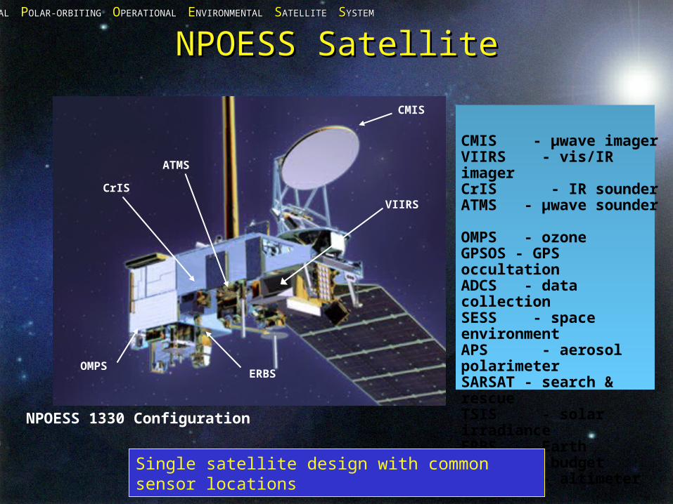
CMIS - μwave imagerVIIRS - vis/IR imagerCrIS - IR sounderATMS - μwave sounder OMPS - ozoneGPSOS - GPS occultation ADCS - data collectionSESS - space environmentAPS - aerosol polarimeterSARSAT - search & rescueTSIS - solar irradianceERBS - Earth radiation budgetALT - altimeter
NPOESS SatelliteNPOESS Satellite
Single satellite design with common sensor locations
CMIS
VIIRS
CrIS
ATMS
ERBSOMPS
NPOESS 1330 Configuration
NNATIONAL ATIONAL PPOLAR-ORBITING OLAR-ORBITING OOPERATIONAL PERATIONAL EENVIRONMENTAL NVIRONMENTAL SSATELLITE ATELLITE SSYSTEMYSTEM
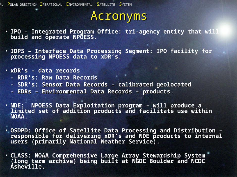
AcronymsAcronyms• IPO – Integrated Program Office: tri-agency entity that will
build and operate NPOESS.
• IDPS – Interface Data Processing Segment: IPO facility for processing NPOESS data to xDR’s.
• xDR’s – data records- RDR’s: Raw Data Records- SDR’s: Sensor Data Records – calibrated geolocatedSensor Data Records – calibrated geolocated- EDRs – Environmental Data Records – products.- EDRs – Environmental Data Records – products.
• NDE: NPOESS Data Exploitation program – will produce a limited set of addition products and facilitate use within NOAA.
• OSDPD: Office of Satellite Data Processing and Distribution – OSDPD: Office of Satellite Data Processing and Distribution – responsible for delivering xDR’s and NDE products to internal responsible for delivering xDR’s and NDE products to internal users (primarily National Weather Service). users (primarily National Weather Service).
• CLASS: NOAA Comprehensive Large Array Stewardship System (long term archive) being built at NGDC Boulder and NCDC Asheville.
NNATIONAL ATIONAL PPOLAR-ORBITING OLAR-ORBITING OOPERATIONAL PERATIONAL EENVIRONMENTAL NVIRONMENTAL SSATELLITE ATELLITE SSYSTEMYSTEM
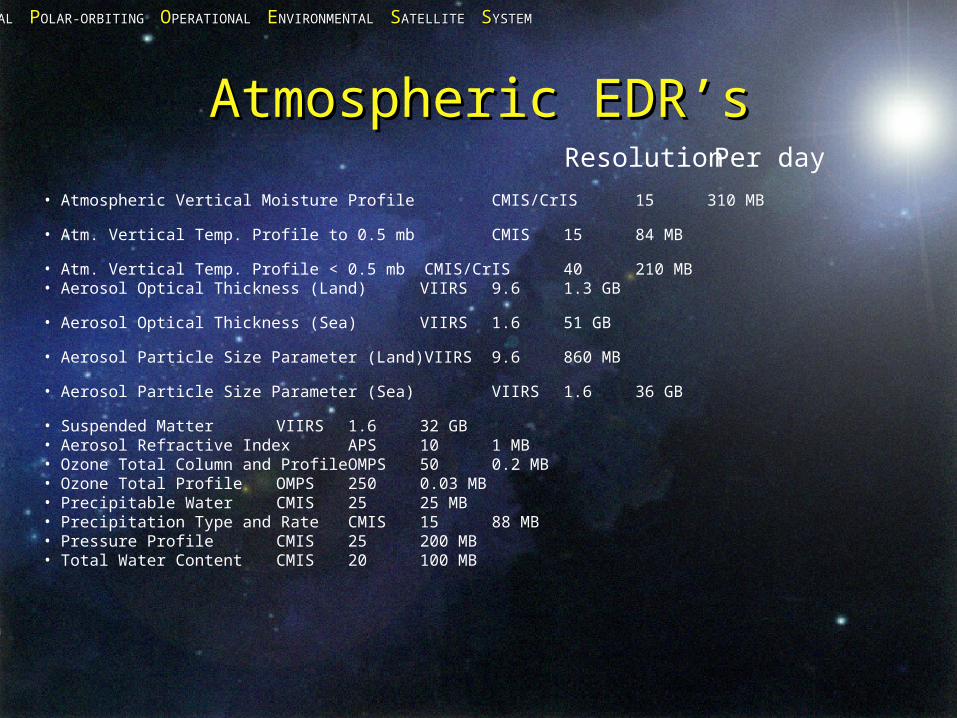
Atmospheric EDR’sAtmospheric EDR’s
• Atmospheric Vertical Moisture Profile CMIS/CrIS 15 310 MB
• Atm. Vertical Temp. Profile to 0.5 mb CMIS 15 84 MB
• Atm. Vertical Temp. Profile < 0.5 mb CMIS/CrIS 40 210 MB • Aerosol Optical Thickness (Land) VIIRS 9.6 1.3 GB • Aerosol Optical Thickness (Sea) VIIRS 1.6 51 GB • Aerosol Particle Size Parameter (Land)VIIRS 9.6 860 MB • Aerosol Particle Size Parameter (Sea) VIIRS 1.6 36 GB
• Suspended Matter VIIRS 1.6 32 GB • Aerosol Refractive Index APS 10 1 MB • Ozone Total Column and Profile OMPS 50 0.2 MB • Ozone Total Profile OMPS 250 0.03 MB • Precipitable Water CMIS 25 25 MB • Precipitation Type and Rate CMIS 15 88 MB
• Pressure Profile CMIS 25 200 MB • Total Water Content CMIS 20 100 MB
Resolution Per day
NNATIONAL ATIONAL PPOLAR-ORBITING OLAR-ORBITING OOPERATIONAL PERATIONAL EENVIRONMENTAL NVIRONMENTAL SSATELLITE ATELLITE SSYSTEMYSTEM
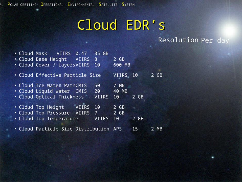
Cloud EDR’sCloud EDR’s
• Cloud Mask VIIRS 0.47 35 GB • Cloud Base Height VIIRS 8 2 GB • Cloud Cover / Layers VIIRS 10 600 MB
• Cloud Effective Particle Size VIIRS 10 2 GB • Cloud Ice Water Path CMIS 50 7 MB • Cloud Liquid Water CMIS 20 40 MB • Cloud Optical Thickness VIIRS 10 2 GB • Cloud Top Height VIIRS 10 2 GB • Cloud Top Pressure VIIRS 7 2 GB • Cloud Top Temperature VIIRS 10 2 GB • Cloud Particle Size Distribution APS 15 2 MB
Per dayResolution
NNATIONAL ATIONAL PPOLAR-ORBITING OLAR-ORBITING OOPERATIONAL PERATIONAL EENVIRONMENTAL NVIRONMENTAL SSATELLITE ATELLITE SSYSTEMYSTEM
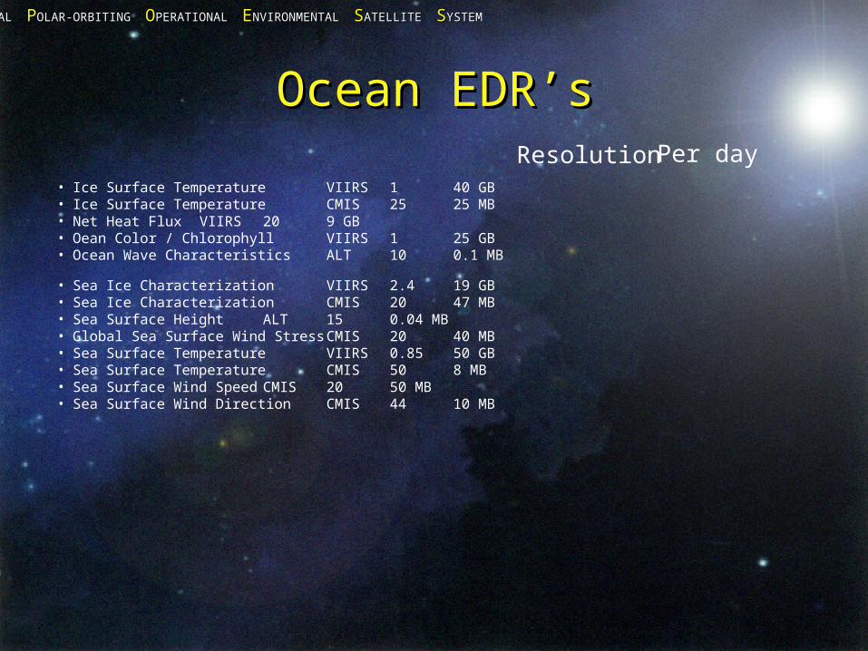
Ocean EDR’sOcean EDR’s
• Ice Surface Temperature VIIRS 1 40 GB • Ice Surface Temperature CMIS 25 25 MB • Net Heat Flux VIIRS 20 9 GB • Oean Color / Chlorophyll VIIRS 1 25 GB • Ocean Wave Characteristics ALT 10 0.1 MB
• Sea Ice Characterization VIIRS 2.4 19 GB • Sea Ice Characterization CMIS 20 47 MB • Sea Surface Height ALT 15 0.04 MB • Global Sea Surface Wind Stress CMIS 20 40 MB • Sea Surface Temperature VIIRS 0.85 50 GB • Sea Surface Temperature CMIS 50 8 MB • Sea Surface Wind Speed CMIS 20 50 MB • Sea Surface Wind Direction CMIS 44 10 MB
Resolution Per day
NNATIONAL ATIONAL PPOLAR-ORBITING OLAR-ORBITING OOPERATIONAL PERATIONAL EENVIRONMENTAL NVIRONMENTAL SSATELLITE ATELLITE SSYSTEMYSTEM
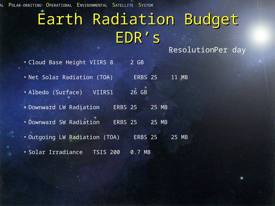
Earth Radiation Budget Earth Radiation Budget EDR’sEDR’s
• Cloud Base Height VIIRS 8 2 GB • Net Solar Radiation (TOA) ERBS 25 11 MB
• Albedo (Surface) VIIRS 1 26 GB • Downward LW Radiation ERBS 25 25 MB
• Downward SW Radiation ERBS 25 25 MB
• Outgoing LW Radiation (TOA) ERBS 25 25 MB
• Solar Irradiance TSIS 200 0.7 MB
Resolution Per day
NNATIONAL ATIONAL PPOLAR-ORBITING OLAR-ORBITING OOPERATIONAL PERATIONAL EENVIRONMENTAL NVIRONMENTAL SSATELLITE ATELLITE SSYSTEMYSTEM
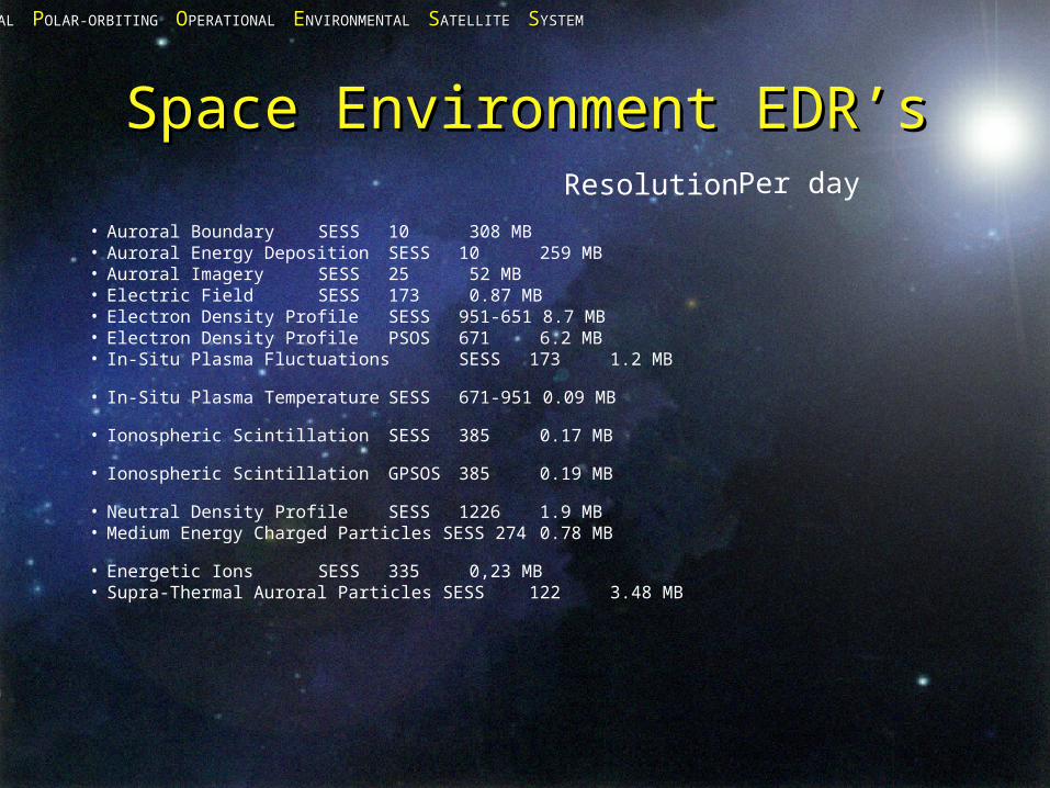
Space Environment EDR’sSpace Environment EDR’s
• Auroral Boundary SESS 10 308 MB • Auroral Energy Deposition SESS 10 259 MB
• Auroral Imagery SESS 25 52 MB • Electric Field SESS 173 0.87 MB • Electron Density Profile SESS 951-651 8.7 MB • Electron Density Profile PSOS 671 6.2 MB • In-Situ Plasma Fluctuations SESS 173 1.2 MB • In-Situ Plasma Temperature SESS 671-951 0.09 MB
• Ionospheric ScintillationSESS 385 0.17 MB • Ionospheric ScintillationGPSOS 385 0.19 MB • Neutral Density Profile SESS 1226 1.9 MB • Medium Energy Charged Particles SESS 274 0.78 MB
• Energetic Ions SESS 335 0,23 MB • Supra-Thermal Auroral Particles SESS 122 3.48 MB
Resolution Per day
NNATIONAL ATIONAL PPOLAR-ORBITING OLAR-ORBITING OOPERATIONAL PERATIONAL EENVIRONMENTAL NVIRONMENTAL SSATELLITE ATELLITE SSYSTEMYSTEM
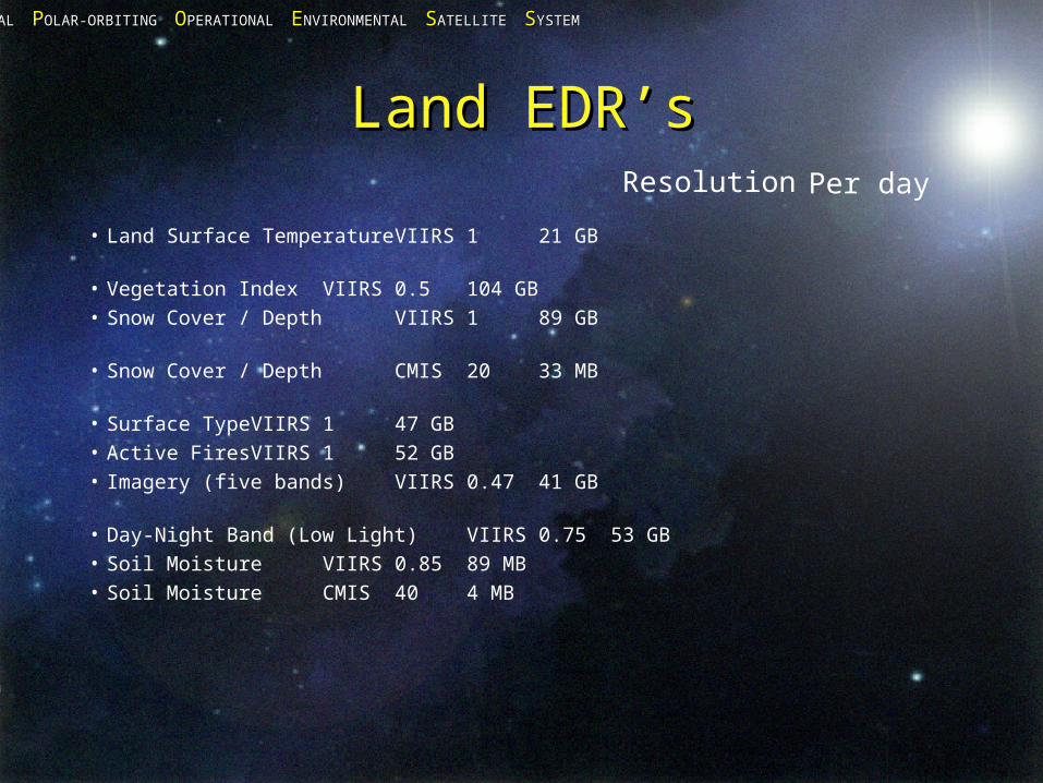
Land EDR’sLand EDR’s
• Land Surface Temperature VIIRS 1 21 GB • Vegetation Index VIIRS 0.5 104 GB • Snow Cover / Depth VIIRS 1 89 GB • Snow Cover / Depth CMIS 20 33 MB • Surface Type VIIRS 1 47 GB • Active Fires VIIRS 1 52 GB• Imagery (five bands) VIIRS 0.47 41 GB • Day-Night Band (Low Light) VIIRS 0.75 53 GB• Soil Moisture VIIRS 0.85 89 MB • Soil Moisture CMIS 40 4 MB
Resolution Per day
NNATIONAL ATIONAL PPOLAR-ORBITING OLAR-ORBITING OOPERATIONAL PERATIONAL EENVIRONMENTAL NVIRONMENTAL SSATELLITE ATELLITE SSYSTEMYSTEM
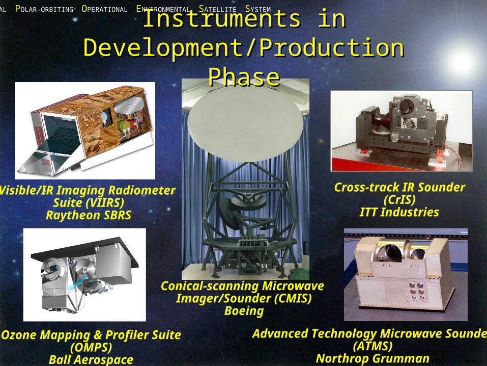
Advanced Technology Microwave Sounder(ATMS)
Northrop Grumman
Ozone Mapping & Profiler Suite(OMPS)
Ball Aerospace
Cross-track IR Sounder(CrIS)
ITT Industries
Visible/IR Imaging Radiometer Suite (VIIRS)
Raytheon SBRS
Instruments inInstruments inDevelopment/Production PhaseDevelopment/Production Phase
Conical-scanning Microwave Imager/Sounder (CMIS)
Boeing
NNATIONAL ATIONAL PPOLAR-ORBITING OLAR-ORBITING OOPERATIONAL PERATIONAL EENVIRONMENTAL NVIRONMENTAL SSATELLITE ATELLITE SSYSTEMYSTEM
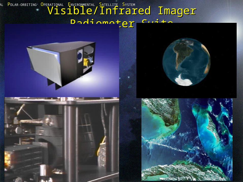
Visible/Infrared Imager Visible/Infrared Imager Radiometer SuiteRadiometer Suite

NNATIONAL ATIONAL PPOLAR-ORBITING OLAR-ORBITING OOPERATIONAL PERATIONAL EENVIRONMENTAL NVIRONMENTAL SSATELLITE ATELLITE SSYSTEMYSTEM
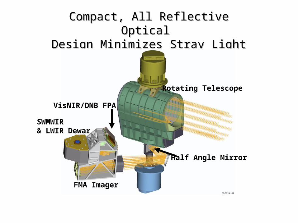
VIIRS DesignVIIRS Design
NNATIONAL ATIONAL PPOLAR-ORBITING OLAR-ORBITING OOPERATIONAL PERATIONAL EENVIRONMENTAL NVIRONMENTAL SSATELLITE ATELLITE SSYSTEMYSTEM
Compact, All Reflective Optical Compact, All Reflective Optical Design Minimizes Stray LightDesign Minimizes Stray Light
Rotating Telescope
Half Angle Mirror
FMA Imager
SWMWIR& LWIR Dewar
VisNIR/DNB FPA
NNATIONAL ATIONAL PPOLAR-ORBITING OLAR-ORBITING OOPERATIONAL PERATIONAL EENVIRONMENTAL NVIRONMENTAL SSATELLITE ATELLITE SSYSTEMYSTEM
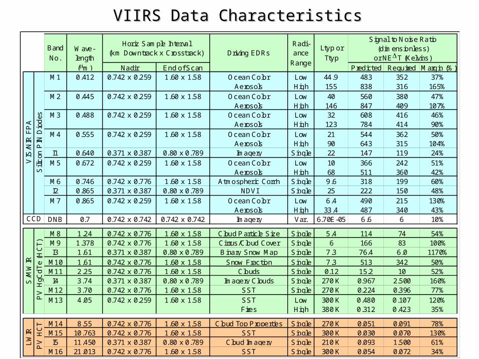
VIIRS Data CharacteristicsVIIRS Data Characteristics
Nadir End of Scan Predicted Required Margin (%)M1 0.412 0.742 x 0.259 1.60 x 1.58 Ocean Color
AerosolsLowHigh
44.9155
483838
352316
37%165%
M2 0.445 0.742 x 0.259 1.60 x 1.58 Ocean ColorAerosols
LowHigh
40146
560847
380409
47%107%
M3 0.488 0.742 x 0.259 1.60 x 1.58 Ocean ColorAerosols
LowHigh
32123
608784
416414
46%90%
M4 0.555 0.742 x 0.259 1.60 x 1.58 Ocean ColorAerosols
LowHigh
2190
544643
362315
50%104%
I1 0.640 0.371 x 0.387 0.80 x 0.789 Imagery Single 22 147 119 24%
M5 0.672 0.742 x 0.259 1.60 x 1.58 Ocean ColorAerosols
LowHigh
1068
366511
242360
51%42%
M6 0.746 0.742 x 0.776 1.60 x 1.58 Atmospheric Corr'n Single 9.6 318 199 60%I2 0.865 0.371 x 0.387 0.80 x 0.789 NDVI Single 25 222 150 48%
M7 0.865 0.742 x 0.259 1.60 x 1.58 Ocean ColorAerosols
LowHigh
6.433.4
490487
215340
130%43%
DNB 0.7 0.742 x 0.742 0.742 x 0.742 Imagery Var. 6.70E-05 6.6 6 10%
M8 1.24 0.742 x 0.776 1.60 x 1.58 Cloud P article Size Single 5.4 114 74 54%M9 1.378 0.742 x 0.776 1.60 x 1.58 Cirrus/Cloud Cover Single 6 166 83 100%I3 1.61 0.371 x 0.387 0.80 x 0.789 B inary Snow Map Single 7.3 76.4 6.0 1170%
M10 1.61 0.742 x 0.776 1.60 x 1.58 Snow Fraction Single 7.3 513 342 50%M11 2.25 0.742 x 0.776 1.60 x 1.58 Clouds Single 0.12 15.2 10 52%I4 3.74 0.371 x 0.387 0.80 x 0.789 Imagery Clouds Single 270 K 0.967 2.500 160%
M12 3.70 0.742 x 0.776 1.60 x 1.58 SST Single 270 K 0.224 0.396 77%
M13 4.05 0.742 x 0.259 1.60 x 1.58 SSTFires
LowHigh
300 K380 K
0.4800.312
0.1070.423
120%35%
M14 8.55 0.742 x 0.776 1.60 x 1.58 Cloud Top Properties Single 270 K 0.051 0.091 78%M15 10.763 0.742 x 0.776 1.60 x 1.58 SST Single 300 K 0.030 0.070 130%I5 11.450 0.371 x 0.387 0.80 x 0.789 Cloud Imagery Single 210 K 0.093 1.500 61%
M16 21.013 0.742 x 0.776 1.60 x 1.58 SST Single 300 K 0.054 0.072 34%
Driving EDRsRadi-ance
Range
Ltyp or
Ttyp
Signal to Noise Ratio(dimensionless)
or NET (Kelvins)
CCD
Horiz Sample Interval(km Downtrack x Crosst rack)
Band
No.Wave-length
(m)
Sili
con
PIN
Dio
des
VIS
/NIR
FP
A
PV
HC
T
S/M
WIR
PV
HgC
dT
e (H
CT
)
LW
IR
NNATIONAL ATIONAL PPOLAR-ORBITING OLAR-ORBITING OOPERATIONAL PERATIONAL EENVIRONMENTAL NVIRONMENTAL SSATELLITE ATELLITE SSYSTEMYSTEM
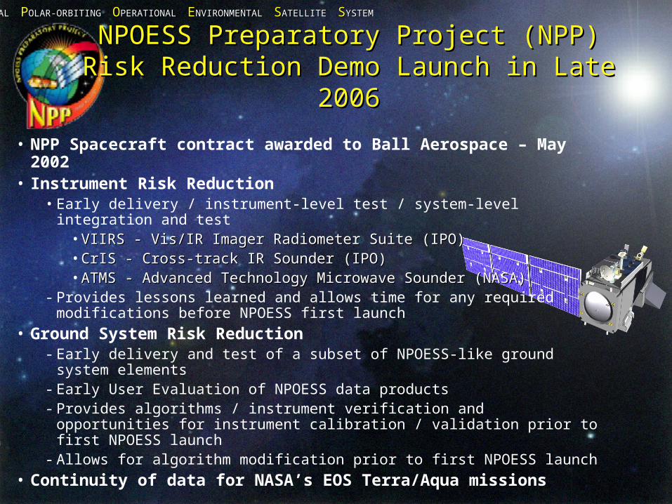
NPOESS Preparatory Project (NPP)NPOESS Preparatory Project (NPP)Risk Reduction Demo Launch in Late 2006Risk Reduction Demo Launch in Late 2006
• NPP Spacecraft contract awarded to Ball Aerospace – May 2002• Instrument Risk Reduction
• Early delivery / instrument-level test / system-level integration and test• VIIRS - Vis/IR Imager Radiometer Suite (IPO)VIIRS - Vis/IR Imager Radiometer Suite (IPO)• CrIS - Cross-track IR Sounder (IPO)CrIS - Cross-track IR Sounder (IPO)• ATMS - Advanced Technology Microwave Sounder (NASA)ATMS - Advanced Technology Microwave Sounder (NASA)
- Provides lessons learned and allows time for any required modifications before NPOESS first launch
• Ground System Risk Reduction- Early delivery and test of a subset of NPOESS-like ground system
elements- Early User Evaluation of NPOESS data products- Provides algorithms / instrument verification and opportunities for
instrument calibration / validation prior to first NPOESS launch- Allows for algorithm modification prior to first NPOESS launch
• Continuity of data for NASA’s EOS Terra/Aqua missions
NNATIONAL ATIONAL PPOLAR-ORBITING OLAR-ORBITING OOPERATIONAL PERATIONAL EENVIRONMENTAL NVIRONMENTAL SSATELLITE ATELLITE SSYSTEMYSTEM
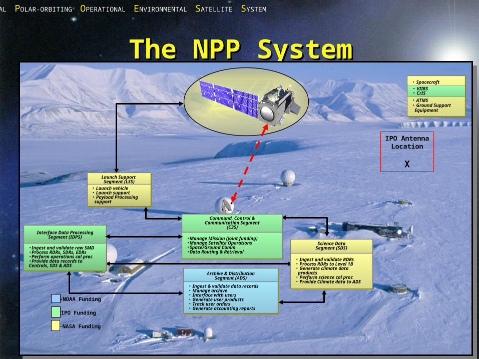
The NPP SystemThe NPP System
Command, Control &Communication Segment
(C3S)
Command, Control &Communication Segment
(C3S)Interface Data Processing
Segment (IDPS)Interface Data Processing
Segment (IDPS)
Launch Support Segment (LSS)
Launch Support Segment (LSS)
Archive & DistributionSegment (ADS)
Archive & DistributionSegment (ADS)
•Manage Mission (joint funding)•Manage Satellite Operations•Space/Ground Comm•Data Routing & Retrieval
•Manage Mission (joint funding)•Manage Satellite Operations•Space/Ground Comm•Data Routing & Retrieval
• Launch vehicle• Launch support• Payload Processing support
• Launch vehicle• Launch support• Payload Processing support
•Ingest and validate raw SMD•Process RDRs, SDRs, EDRs•Perform operations cal proc•Provide data records to Centrals, SDS & ADS
•Ingest and validate raw SMD•Process RDRs, SDRs, EDRs•Perform operations cal proc•Provide data records to Centrals, SDS & ADS
• Ingest & validate data records• Manage archive• Interface with users• Generate user products• Track user orders• Generate accounting reports
• Ingest & validate data records• Manage archive• Interface with users• Generate user products• Track user orders• Generate accounting reports
Science DataSegment (SDS)Science Data
Segment (SDS)
• Ingest and validate RDRs• Process RDRs to Level 1B• Generate climate data products• Perform science cal proc• Provide Climate data to ADS
• Ingest and validate RDRs• Process RDRs to Level 1B• Generate climate data products• Perform science cal proc• Provide Climate data to ADS
• Spacecraft
• ATMS• Ground Support Equipment
• Spacecraft
• ATMS• Ground Support Equipment
• VIIRS• CrIS
-NOAA Funding
-IPO Funding
-NASA Funding
IPO AntennaLocation
X
NNATIONAL ATIONAL PPOLAR-ORBITING OLAR-ORBITING OOPERATIONAL PERATIONAL EENVIRONMENTAL NVIRONMENTAL SSATELLITE ATELLITE SSYSTEMYSTEM
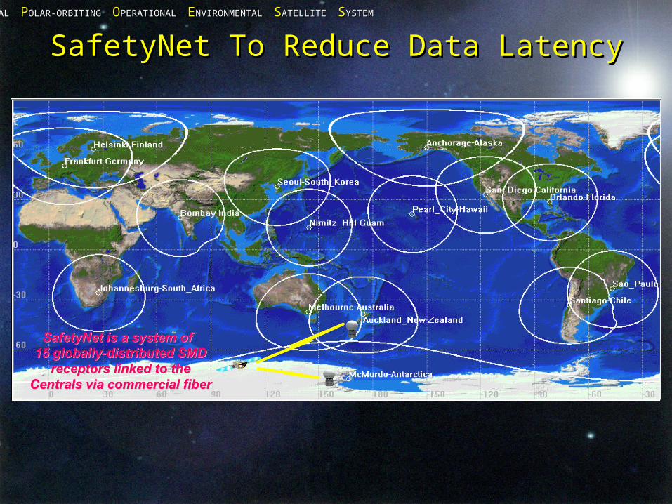
SafetyNet To Reduce Data LatencySafetyNet To Reduce Data Latency
NNATIONAL ATIONAL PPOLAR-ORBITING OLAR-ORBITING OOPERATIONAL PERATIONAL EENVIRONMENTAL NVIRONMENTAL SSATELLITE ATELLITE SSYSTEMYSTEM
NOAA’s Data Distribution NOAA’s Data Distribution PlansPlans
• IDPSIDPS- Receives data from SafetyNetReceives data from SafetyNet- Processes and delivers xDR’s with one hour to OSDPD data poolProcesses and delivers xDR’s with one hour to OSDPD data pool
• OSDPD will deliver xDR’s plus limited set of additional OSDPD will deliver xDR’s plus limited set of additional products (NDE) to NOAA internal customers (primarily products (NDE) to NOAA internal customers (primarily National Weather Service).National Weather Service).
• CLASS Long Term Archive (NGDC Boulder and NCDC CLASS Long Term Archive (NGDC Boulder and NCDC Asheville) will ingest data and make it available within 6-12 Asheville) will ingest data and make it available within 6-12 hours.hours.
• NASA and scientific communities expected to access xDR’s NASA and scientific communities expected to access xDR’s through CLASSthrough CLASS
• No set plans for providing near real time xDR’s outside of No set plans for providing near real time xDR’s outside of USA (requirements not yet expressed).USA (requirements not yet expressed).
NNATIONAL ATIONAL PPOLAR-ORBITING OLAR-ORBITING OOPERATIONAL PERATIONAL EENVIRONMENTAL NVIRONMENTAL SSATELLITE ATELLITE SSYSTEMYSTEM
Additional ConsiderationsAdditional Considerations
• Each satellite will produce approximately 2 TB Each satellite will produce approximately 2 TB of data per dayof data per day
• NPP will not have direct broadcastNPP will not have direct broadcast
• NPOESS will have direct broadcast, but NPOESS will have direct broadcast, but receiving station costs will make electronic data receiving station costs will make electronic data transfers attractive.transfers attractive.
NNATIONAL ATIONAL PPOLAR-ORBITING OLAR-ORBITING OOPERATIONAL PERATIONAL EENVIRONMENTAL NVIRONMENTAL SSATELLITE ATELLITE SSYSTEMYSTEM
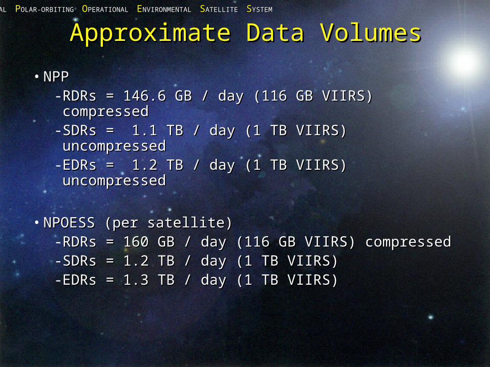
Approximate Data VolumesApproximate Data Volumes
• NPPNPP- RDRs = 146.6 GB / day (116 GB VIIRS) RDRs = 146.6 GB / day (116 GB VIIRS) compressedcompressed
- SDRs = 1.1 TB / day (1 TB VIIRS) uncompressedSDRs = 1.1 TB / day (1 TB VIIRS) uncompressed- EDRs = 1.2 TB / day (1 TB VIIRS) uncompressedEDRs = 1.2 TB / day (1 TB VIIRS) uncompressed
• NPOESS (per satellite)NPOESS (per satellite)- RDRs = 160 GB / day (116 GB VIIRS) compressedRDRs = 160 GB / day (116 GB VIIRS) compressed- SDRs = 1.2 TB / day (1 TB VIIRS)SDRs = 1.2 TB / day (1 TB VIIRS)- EDRs = 1.3 TB / day (1 TB VIIRS)EDRs = 1.3 TB / day (1 TB VIIRS)
NNATIONAL ATIONAL PPOLAR-ORBITING OLAR-ORBITING OOPERATIONAL PERATIONAL EENVIRONMENTAL NVIRONMENTAL SSATELLITE ATELLITE SSYSTEMYSTEM
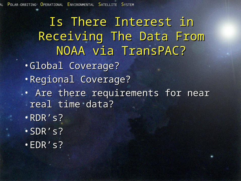
Is There Interest in Receiving Is There Interest in Receiving The Data From NOAA via The Data From NOAA via
TransPAC?TransPAC?•Global Coverage?Global Coverage?•Regional Coverage?Regional Coverage?• Are there requirements for near real Are there requirements for near real
time data?time data?•RDR’s?RDR’s?•SDR’s?SDR’s?•EDR’s?EDR’s?
NNATIONAL ATIONAL PPOLAR-ORBITING OLAR-ORBITING OOPERATIONAL PERATIONAL EENVIRONMENTAL NVIRONMENTAL SSATELLITE ATELLITE SSYSTEMYSTEM
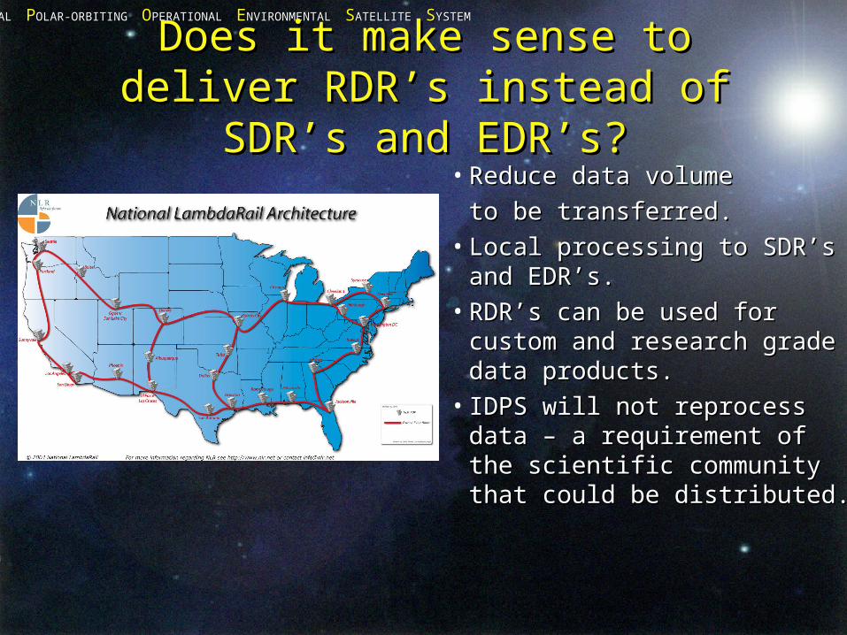
Does it make sense to deliver Does it make sense to deliver RDR’s instead of SDR’s and RDR’s instead of SDR’s and
EDR’s?EDR’s?• Reduce data volumeReduce data volume
to be transferred.to be transferred.• Local processing to SDR’s Local processing to SDR’s
and EDR’s.and EDR’s.• RDR’s can be used for RDR’s can be used for
custom and research grade custom and research grade data products.data products.
• IDPS will not reprocess data IDPS will not reprocess data – a requirement of the – a requirement of the scientific community that scientific community that could be distributed.could be distributed.