nasa's land-cover/land use change...
TRANSCRIPT

NASA's Land-Cover/Land Use Change Program: Update
Garik Gutman, NASA Headquarters
Manager, LCLUC Program
Note: The TE agenda has been modified
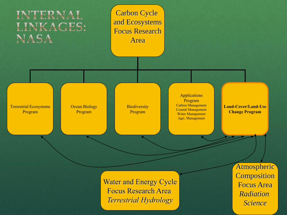
Carbon Cycle
and Ecosystems
Focus Research
Area
Terrestrial Ecosystems
Program
Ocean Biology
Program
Biodiversity
Program
Applications
Program Carbon Management
Coastal Management
Water Management
Agri. Management
Land-Cover/Land-Use
Change Program
Water and Energy Cycle
Focus Research Area
Terrestrial Hydrology
Atmospheric
Composition
Focus Area
Radiation
Science

LCLUC Program Status at a Glance
2011: 15-th anniversary; celebrated last spring
Budget “stability”: same all 15 years With episodic losses, like 15% cut this
year
Nationally Partner with USGS on Landsat activities
Global Land Survey datasets Support of USGCRP LUIWG NRC Land-use modeling review
Internationally IGBP-IHDP/Global Land Project GTOS/GOFC-GOLD support
Regional programs and networks GEO/CEOS
WG on cal/val Land Surface Imaging constellation

Program Components
Total 30-40 projects
Detection/Monitoring/Observations
LCLUC Predictive Modeling
LCLUC impact on
Carbon Cycle
Water Cycle
Climate, Environment, Biodiversity
Drivers of Change
Climate impact on LCLUC
Vulnerability, Impacts and Adaptation
Synthesis studies
External NASA Earth Science
LCLUC-related programs
contributing to LCLUC Program:
Carbon Cycle
USPI
IDS
NIP

Direct Readout Ground Stations: Getting Ready for NPP
5
• 30 countries have EOS/NPP direct
readout capabilities.
• 50% owned by government agencies
and organizations
• 35% owned by educational institutions,
15% owned by the commercial sector
• These support an estimated 3000
individual users world-wide
• 100% of DB sites use at least one of
NASA’s DR algorithms/tools.
• 85% of these ground stations support
real-time applications.
• 40% of DB sites have developed
additional algorithms for their own
applications using locally-generated
Level-1 data
• Fire detection and Corrected Reflectance science algorithms
for the generation of fire perimeter mapping products for
strategic fire mapping and resource planning. US Forest
Service Remote Sensing Application Center (RSAC), the
National Inter-agency Fire Center (NIFC), and the Canadian
Forest Service.
• Burn Scar and NDVI algorithm for fire damage assessment by
RSAC.
• USDA uses MODIS NDVI/EVI and LST algorithms to
operationally and continually monitor drought/crop health on
the US sun belt.
Land Applications Pat Coronado,
GSFC

LDCM Update
System Integration Review (SIR) was held on September 6-9, 2011 at Orbital Operational Land Imager (OLI) • Instrument calibration is complete. Instrument performance is excellent • All environmental testing was successfully completed
OLI delivered to Orbital • Integration activities will start this month Thermal Infrared Sensor (TIRS) • Current delivery date to Orbital is January 3, 2012 Need to maintain December 2012 LRD at all costs because launch window is December 1-30, 2012; Atlas V manifest is very crowded in 2013 – the only open slot is October 2013 at VAFB, which means 10 months or longer delay.
Overall: LDCM is ready to formally move
into the implementation Phase D and
proceed to Launch.
OLI arrival to Orbital

LCLUC Data Initiatives
NASA's new collaboration facility for the NASA Earth science community: NASA Earth Exchange (NEX) web portal
state-of-the-art supercomputing
Earth system modeling
remote sensing data from NASA and other agencies
All GLS data have been downloaded
scientific social networking platform to deliver a complete work environment in which users can
explore and analyze large Earth science data sets
run modeling codes
collaborate on new or existing projects
share results within and/or among communities
All LCLUC projects are listed on the NEX site -- PI’s are encouraged to register
Fine Resolution Data Initiative
Global Land Surveys (GLS) Initiative – incomplete yet but much is already available at USGS
Rama Nemani,
NASA Ames

LCLUC Agriculture Component
Applications-supported project:
Global Agricultural Monitoring: Enhancing the agricultural monitoring and crop forecasting capabilities of the Foreign Agricultural Service using MODIS
10 new projects (global and regional)
NDVI anomaly image created using
MODIS data collected between May 25
and June 9 2005 compared to the mean
NDVI for this time-step between 2000 and
2004. The entire Iberian Peninsula was
clearly stressed due to the drought in
2005. Reds/Brown represent the regions
where vegetation is thin and less dense
than average, while tiny flecks of green
show where vegetation is healthier than
average.

Name Affiliation Title
Brown de Colstoun
NASA GSFC (with UMD) Using Landsat Global Land Survey Data to
Measure and Monitor Worldwide
Urbanization
Seto Yale University (+ U. Wisconsin and Arizona
State U.)
Multi-Scale and Multi-Sensor Analysis of
Urban Cluster Development and Agricultural
Land Loss in China and India
Curran
Standford U. (+ U. Arizona and U. Texas
Austin)
Socio-economic and political drivers of oil
palm expansion in Indonesia
Mustard
Brown University Rates and Drivers of Land Use Land Cover
Change in the Agricultural Frontier of Mato
Grosso, Brazil
Coe
The Woods Hole Research Center
Linking Historical and Future Land-Use
Change to the Economic Drivers and
Biophysical Limitation of Agricultural
Expansion in the Brazilan Cerrado
Roy South Dakota State U. (+ USGS)
Changing Field Sizes of the Conterminous
United States, a Decennial Landsat
Assessment
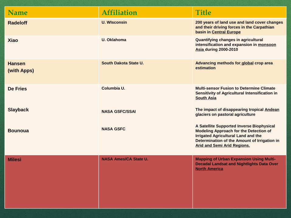
Name Affiliation Title
Radeloff U. WIsconsin 200 years of land use and land cover changes
and their driving forces in the Carpathian
basin in Central Europe
Xiao U. Oklahoma Quantifying changes in agricultural
intensification and expansion in monsoon
Asia during 2000-2010
Hansen
(with Apps)
South Dakota State U.
Advancing methods for global crop area
estimation
De Fries
Slayback
Bounoua
Columbia U.
NASA GSFC/SSAI
NASA GSFC
Multi-sensor Fusion to Determine Climate
Sensitivity of Agricultural Intensification in
South Asia
The impact of disappearing tropical Andean
glaciers on pastoral agriculture
A Satellite Supported Inverse Biophysical
Modeling Approach for the Detection of
Irrigated Agricultural Land and the
Determination of the Amount of Irrigation in
Arid and Semi Arid Regions.
Milesi
NASA Ames/CA State U.
Mapping of Urban Expansion Using Multi-
Decadal Landsat and Nightlights Data Over
North America

Ongoing Projects
Climate impact on land use, adaptation (final year)
Agriculture, Urbanization
Carbon Cycle
US Participating Investigator (USPI)
Sentinel program
Recent selections to start next year
Synthesis (2)
Wetlands Vulnerability, Impacts, Adaptation (5)
Note: Not a single synthesis proposal on Central Asia or SE Asia was selected Need more interactions on synthesis formulation, expectations
and requirements with the LCLUC community

Name Affiliation Title
Radeloff U. Wisconsin Synthesis of studies on institutional change
and LCLUC effects on carbon, biodiversity,
and agriculture after the collapse of the
Soviet Union
Bergen U. Michigan Regional Synthesis: LCLUC over Changing
Socio-Economic Eras in the Former Soviet
Union and Eastern Bloc
Hess U. CA Santa Barbara Land and resource use on the Amazon
floodplain under evolving management
systems and environmental change: Fish,
forests, cattle, and settlements
Simard JPL Vulnerability assessment of mangrove
forests in the Americas
Vorosmarty
City College, U. New York
Global-scale assessment of threatened river
delta systems: Evaluation of connections
between the continental land mass and
ocean through integrated remote sensing
and process modeling
Yeo
Yu
U. Maryland
U. Puerto Rico
Mapping and Monitoring of Wetland
Dynamics for Improved Resilience and
Delivery of Ecosystem Services in the Mid-
Atlantic Region
Vulnerability and adaptive management of
tropical coastal wetlands in the context of
land use and climate changes
Selections From LCLUC-2010 Round

Enhancing the Conceptual Underpinning of LCLUC Science Summarizes state-of-the-art knowledge
Compiles available relevant datasets and research studies
Advances our understanding of the processes, drivers and impacts of LCLUC
Develops new understanding and conceptual framework
Possible Components Theory and Hypothesis testing
Compilation and comparative analyses
Data integration and model development
Identify in data and research gaps and proposed ways to fill these gaps and new research areas
Articulating/publishing refined or new conceptual framework for an aspect of LCLUC
Synthesis: Putting Together a “Big Picture”

Future Solicitations
ROSES-2011: LCLUC for Early Career Scientists (short) proposals (similar to NIP; requirements differ)
Step-1 due Dec 1, Step-2 due Jun 1
ROSES-2011 IDS: Impacts of Urbanization on the Environment
LOI due Oct 18, 2011; proposals due Jan 19, 2012
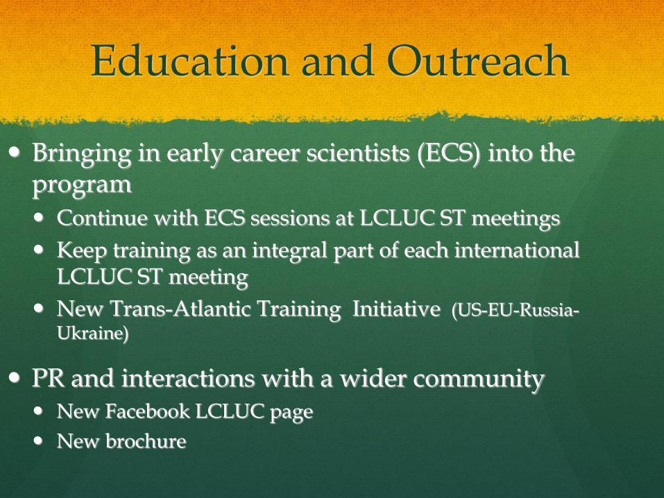
Education and Outreach
Bringing in early career scientists (ECS) into the program
Continue with ECS sessions at LCLUC ST meetings
Keep training as an integral part of each international LCLUC ST meeting
New Trans-Atlantic Training Initiative (US-EU-Russia-Ukraine)
PR and interactions with a wider community New Facebook LCLUC page
New brochure

Programmatic Issues
Keep social science component in LCLUC projects an integral part of the LCLUC proposals
Balance the program thematically and geographically
Foster global products generation
Develop synthesis of global forest products from GLS projects
Develop global land-use products (Urban, Ag) for use in models
Keep LCLUC 2-step calls on a regular, annual basis
Step-1 Dec 1, Step-2 June 1
Continue the twice-a-year ST meetings structure

17
LCLUC Science Team Meetings Washington: Cherry Blossom
2007: Climate/Carbon
2008: Joint CC&E Focus Area meeting
2009: LCLUC impacts on climate
2010: GLS LCLUC products
2011: 15th Anniversary (review/update)
2011/9: Agriculture (Joint CC&E FA)
2012: Urban
2013: Wetlands
International: Fall-Winter 2007: Drylands (NEESPI/MAIRS)
Urumqi, China
2009/1: Tropics (MAIRS)
Kohn Kaen,Thailand
2009/9: Drylands (MAIRS/NEESPI)
Almaty, Kazakhstan
2010: Boreal/Temperate (NEESPI)
Tartu, Estonia
2011: Tropics (MAIRS)
Hanoi, Vietnam
2012: Drylands (NEESPI/MAIRS)
Samarkand, Uzbekistan
2013: Borela/Temperate (NEESPI)
Copenhagen, Denmark
