mapping our course of study - cambridge university...
TRANSCRIPT
We long to have nature in our lives and the field of physical geography helps fulfill that need. But it’s not just natural things and where they are on maps that interests us here. We are equally interested in examining how things like glaciers and stream valleys form and change, and to do this we have to look at the systems that deliver the forces and processes of change. Systems. They are the blood and bones of the Earth, the networks of energy and matter that, like the belts of winds that deliver heat and water, lace the planet together. These global scale systems run the Earth and we call them “great systems”. What are their attributes and how do they operate? And what does it all mean in terms of scientific inquiry? How do we use scientific thinking, rather than, say, religion or mythology, to explain the world around us?
Chapter Overview
1Mapping Our Course of Study
Introduction Earth is a glorious planet, a nurturing place that is home to countless billions of organisms. We humans are among the most geographically versatile of these organisms. In less than 50 thousand years – a mere wink of Earth time – our species has spread over the entire planet, rooted itself in its different geographic environments, and made them part of our heritage. We celebrate our geographic heritage in nearly every aspect of culture – in poetry, prose, song, painting, architecture, science, religion, recreation, and much more. In short, Earth’s places and landscapes are central to understanding who we are as people – as nations, societies, communities, families, and individuals.
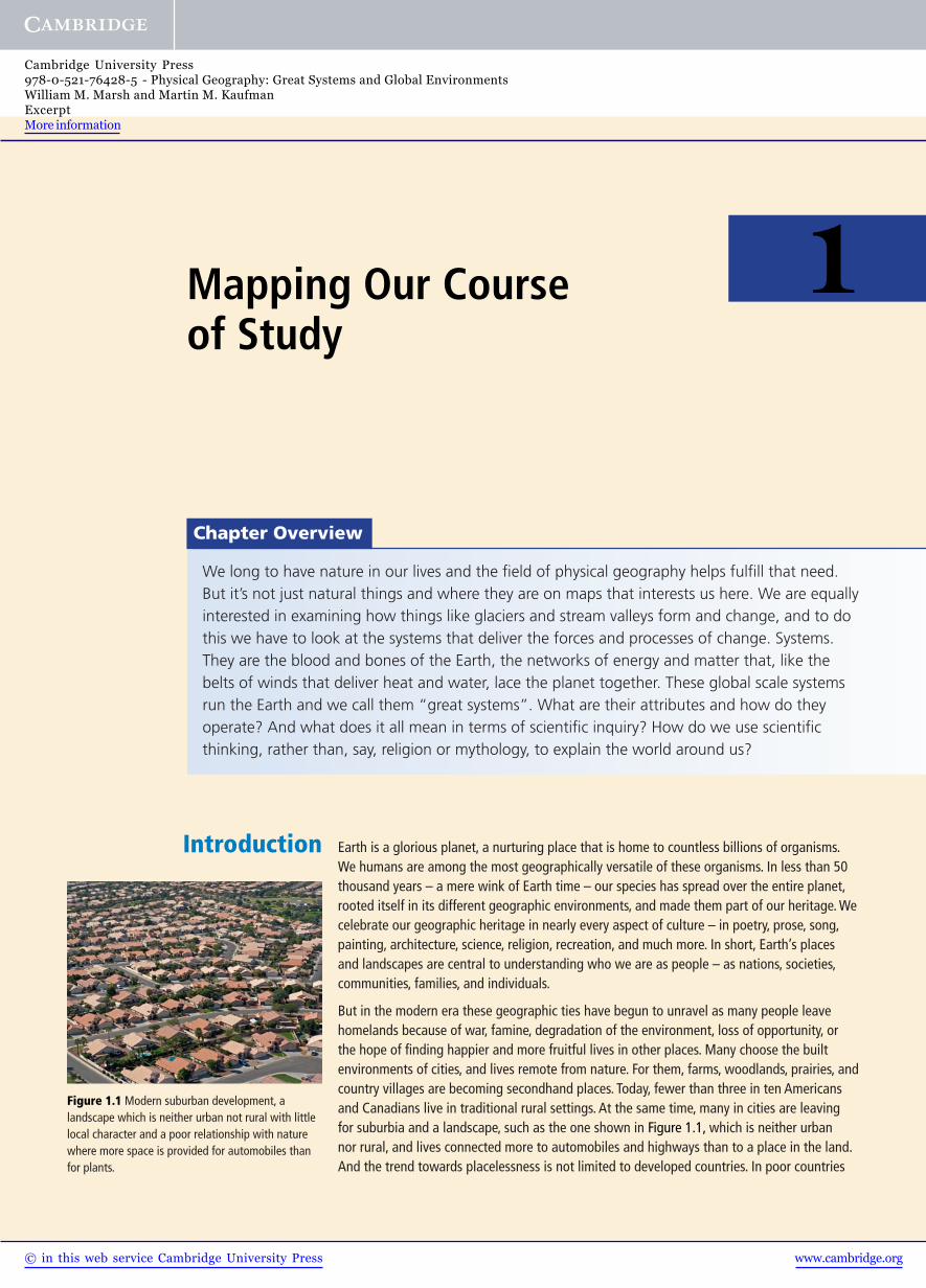
But in the modern era these geographic ties have begun to unravel as many people leave homelands because of war, famine, degradation of the environment, loss of opportunity, or the hope of finding happier and more fruitful lives in other places. Many choose the built environments of cities, and lives remote from nature. For them, farms, woodlands, prairies, and country villages are becoming secondhand places. Today, fewer than three in ten Americans and Canadians live in traditional rural settings. At the same time, many in cities are leaving for suburbia and a landscape, such as the one shown in Figure 1.1, which is neither urban nor rural, and lives connected more to automobiles and highways than to a place in the land. And the trend towards placelessness is not limited to developed countries. In poor countries
Figure 1.1 Modern suburban development, a landscape which is neither urban not rural with little local character and a poor relationship with nature where more space is provided for automobiles than for plants.
www.cambridge.org© in this web service Cambridge University Press
Cambridge University Press978-0-521-76428-5 - Physical Geography: Great Systems and Global EnvironmentsWilliam M. Marsh and Martin M. KaufmanExcerptMore information
Mapping Our Course of Study2
throughout the world people are abandoning the countryside and crowding into sprawling, faceless cities. Mexico City, which receives as many as 1000 immigrant families a day, will soon exceed a population of 40 million persons and Shanghai, China, has exploded to a population of more than 50 million. Roughly half of all humanity now lives in urban areas.
1.1 Our Place on the Planet
Many of us today are being threatened with the loss of our geographic roots and the opportunity, shared by hundreds of generations before us, to become intimate with a piece of Earth, to commit to memory and emotion its forms and features, to ride the rhythms of its seasons, to mark the signs of years building one upon another, to suffer the ravages of nature’s destructive forces upon it, to celebrate the processes of healing, and to remember these things as a part of one’s time on the planet. With life increasingly confined to massive cities, giant freeways, huge commercial malls, over-grown universities, mega corporations, and maze-like bureaucracies, a great many of us appear to be losing the privilege of knowing a parcel of land and embracing the real workings of its nature. Yet we long to have nature in our lives.
How then do we come to know nature? In our college days, some of us believed the answer lay in turning away from “the system” and returning to the land, as Thoreau did at Walden to build social arrangements close to the rudiments of nature in small, knowable, and supposedly happy places. Others of us believed the answer lay in our books, research projects, and expeditions to distant and exotic places to discover inner workings of nature. On many occasions we have weighed these two perspec-tives and reflected on our own good luck to have had a childhood lived close to the land, free of the rigors of formal science, followed by an adulthood lived close to science with its resources and abstract insights into nature’s more hidden reaches.
Our lives today, we believe, need both a scientific and romantic acquaintance with nature. The first is necessary to becoming a responsible citizen in a very large world and the second to shaping a sense of one’s place with nature in a very small world. This book is written with both objectives in mind, though it can address only the first with any confidence. In many respects, the second is far too personal to be learned in a book, and for a great many North Americans in the twenty-first century, it awaits a time in life more toward the end with retirement than at the beginning with youth. Our task in colleges and universities, then, is learning about the larger world through the windows provided by science and there is no better vehicle for approaching this challenge than physical geography.
1.2 The Great Systems of Physical Geography
Before you lies Earth, the Eden planet of the Solar System (Figure 1.2). Wonderfully diverse and constantly changing, it is a geographer’s paradise. As the photograph in Figure 1.2 suggests, it is a superb place to study the patterns, processes, and prod-ucts of nature. Here we have all that the other planets possess plus a lot more, most notably vast and mobile systems of life and water, which we call the biosphere and hydrosphere, wrapped in an envelope of gases, called the atmosphere, and set upon a stage of rock and soil, called the lithosphere. Yet, as impressive as the hydrosphere, biosphere, atmosphere, and lithosphere are individually, Earth’s true geographic character is found by discovering their interplay, for all are intricately intertwined in great flowing systems.
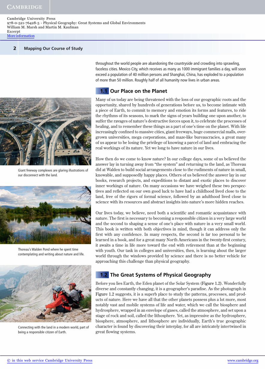
Giant freeway complexes are glaring illustrations of our disconnect with the land.
Thoreau’s Walden Pond where he spent time contemplating and writing about nature and life.
Connecting with the land in a modern world, part of being a responsible citizen of Earth.
www.cambridge.org© in this web service Cambridge University Press
Cambridge University Press978-0-521-76428-5 - Physical Geography: Great Systems and Global EnvironmentsWilliam M. Marsh and Martin M. KaufmanExcerptMore information

3The Nature of Geographic Systems
In their simplest form, Earth’s systems are defined by cycles of matter and energy. Predictably, they operate at different scales and rates. Some, such as prevailing wind systems, operate almost con-tinuously over the whole planet; others, such as weather systems, begin, expand, and contract with the seasons. Still others, such as ocean currents, flow with graceful uniformity, whereas beneath the sea molten rock in volcanoes moves with unpredictable irregularity. But they are all capable of rendering change in the Earth’s surface, some slowly and gradually, some suddenly and violently.
The Drivers of Geographic Change: These vast systems – let us call them great systems – touch all parts of the planet and drive geo-graphic change. Deep within the Earth, for example, a great system of heat and rock slowly mixes the mantle (see A in Figure 1.3 ), which in turn pushes the crust around, rearranging the continents, building mountains, bringing new rock to the surface via volcanoes, and gradually drawing older rock down along the margins of the ocean basins. On the Earth’s surface, the atmosphere continuously takes in water from the oceans, and, through the mechanisms of storms of various sizes and durations, delivers a large part of
it to the continents ( B in Figure 1.3). The streams that result from this rainwater erode the continents and carry the resultant sediment to the ocean where it settles to the bottom, gradually building new rock on the continental edges. And above us, the atmosphere’s system of gases couples with the oceans and biosphere in a massive flow system (C in Figure 1.3) that recycles carbon, nitrogen, oxygen, and other ele-ments necessary to the chemical balance of air, water, and life itself.
These and many other geographic systems set the framework for Earth’s global envi-ronment. Within them the individual forces of change or destabilization are played out while stabilizing or holding forces such as gravity, molecular cohesion among rock particles, and the binding effect of plant roots in soil struggle to hold it all together. As Figure 1.4 suggests, the relative balance between the forces of change and those of stabilization (that is, which side wins the struggle) is defined by critical limits or thresholds and these thresholds vary from place to place over the Earth’s surface.
Figure 1.2 A most glorious planet. A view of home from the Moon taken during the Apollo 11 mission about 40 years ago.
Earth
atmospherecore
lithosphere
hydrosphererock andheat flow
oxygen
nitrogen carbonprecipitation
streamsevaporation
atmosphereA
BC
core
Figure 1.3 A slice of the Earth showing three important global systems, one in the lithosphere (A) that moves rock and heat; one in the hydrosphere (B) that moves water and sediment; and one in the atmosphere (C) that cycles gases between the atmosphere, biosphere, hydrosphere, and lithosphere.
Figure 1.4 The contest between destabilizing forces, which work to change the Earth’s surface, and stabilizing forces, which work to hold it together. Geographic change occurs when the threshold of stability is exceeded.
www.cambridge.org© in this web service Cambridge University Press
Cambridge University Press978-0-521-76428-5 - Physical Geography: Great Systems and Global EnvironmentsWilliam M. Marsh and Martin M. KaufmanExcerptMore information

Mapping Our Course of Study4
Without the protection of plants, for instance, sand has a low threshold to erosion by wind. In other words, it takes a wind of only modest velocity to dislodge and blow away loose sand. But with a cover of plants, the threshold of erosion is raised enor-mously; under a forest, winds of hurricane force can barely dislodge a particle. We also know that wind velocities vary over the Earth, so the geographic pattern of wind erosion we see on maps is actually a product of both the distribution of driving force (wind) and resisting force (vegetation).
1.3 The Nature of Geographic Systems
Any set of things linked together by some kind of interaction constitutes a system. You deal with all sorts of systems every day. Highway systems in which cities and towns interact with each other via vehicles moving over the ground; telecom-munication systems in which individuals interact with others via wires and electronic signals; and water systems in which communities of people interact with a river or lake by taking in water through one set of pipes and returning it (as sewer water) through another set of pipes.
All systems involve interactions and most interactions take the form of exchanges or cycles of energy and matter. In the water cycle example cited above (B in Figure 1.3), for instance, the atmosphere and the hydrosphere exchange matter when the oceans feed the atmosphere with water vapor and the
atmosphere in turn feeds the oceans with rainwater, as shown in Figure 1.5. The exchange process is driven by energy, beginning with heat powering evaporation on the ocean surface. The heat energy in turn is transferred into the atmosphere with the vapor and then released into the air with the formation of clouds and rain-water. Thus we have a cycle, one of many that exists between the atmosphere and hydrosphere.
General Characteristics of Earth Systems: The idea of systems as cycles of energy and matter is central to understanding these magnificent constructs, but there is of course much more to them than this one characteristic. For example, all systems can be described in terms of their geographic scale, that is, how much Earth space they occupy and where they are found. Then there are also characteristics that describe
their operation and organization. Five of the most important ones are:• Whether they are open or closed. Open systems receive
inputs from outside their boundaries (see Figure 1.6a ). Earth is an open system, because it receives energy (solar radiation) from the Sun and matter (meteorites) from space. The Earth also gives up energy and matter. It releases infra-red radiation and molecules of gas to space from the top of the atmosphere. The balance between outgoing and incom-ing energy and matter currently favors incoming for both. Therefore, Earth is gaining energy and matter, but the gains are small for each. All the systems that operate on the Earth’s surface, such as ocean currents, stream networks, and rainstorms, are open systems.
Figure 1.5 Geographic systems are characterized by interactions among different parts of the environment such as in this cycle that exchanges water between the atmosphere and the oceans.
(a)open system closed system
input(energy and
matter)
output(energy and
matter)
Figure 1.6 In these diagrams the box represents a system. In an open system (a) energy and/or matter are able to move in and out. By contrast, in a closed system there are no inputs or outputs.
www.cambridge.org© in this web service Cambridge University Press
Cambridge University Press978-0-521-76428-5 - Physical Geography: Great Systems and Global EnvironmentsWilliam M. Marsh and Martin M. KaufmanExcerptMore information

5The Nature of Geographic Systems
• How much energy and/or matter they receive and release. This character-istic, referred to as system balance or budget, addresses the relative quantities of inputs and outputs in an open system over time as illustrated in Figure 1.6b. Think of a banking system as a model. If it gains more energy or matter (that is, money) than it gives up over some period of time, it is positively balanced and the surplus goes into storage. If the reverse, it is negatively balanced and the reserve in storage is drawn down. When inputs and outputs balance, the system is in equi-librium. We know that the Earth’s atmosphere currently has a positive energy balance because its temperature is rising, meaning that it is taking on or storing more energy (heat) than it is giving up. We will say a lot more about the warming of planet Earth later in the book.
• Systems have the capacity to perform work. When particles of sediment are carried by a river, or when moisture is moved by wind, work is being performed because matter is lifted and carried from one place to another. Energy is needed to drive systems to perform work, but when work is produced, it does not mean that energy has been consumed or lost. It means only that it has changed its form as, for example, from gasoline (chemical energy) to heat and kinetic energy as a car is propelled down the road. In a river, the kinetic energy required to do the work of moving water and its sediment is converted to heat from friction as the water and sediment rub and bounce along the channel.
• Systems also possess the ability to change themselves. Since they consist of exchanges of energy and matter, the outcomes from certain exchanges may affect the subsequent operation of the system itself. This is known as feedback (Figure 1.6c). In your body system it might work like this: You increase the intake of food which gives you more energy to undertake more physical activity and the increased activity burns more energy, which in turn causes you to eat more food. This is called positive feedback. Positive feedback occurs when the outcome of a process within a system speeds up or magnifies the system’s activity or work output. Negative feedback results when an output from a process in a system slows down or dampens the overall operation of the system. If you eat bad food, for example, it curbs your appetite, causing you to eat less food which in turn dampens your activity and ultimately lowers your appetite even more.
• Another general property of systems is the way in which they are organized. Large systems are typically composed of an extended family of smaller systems, and these systems may consist of even smaller systems. This arrangement is called hierarchical organization. And here is where geography fits in well, because systems at different levels in the hierarchy operate at different geo-graphic scales. Precipitation systems, for example, operate at several different scales as illustrated in Figure 1.7. Hurri-canes are decidedly regional, covering large parts of oceans like the North Atlantic, whereas thunderstorms are typi-cally local covering areas only the size of a city or smaller. And sometimes the systems in a hierarchical order are set or nested one inside another. Watersheds are arranged in this way. Little watersheds are nested in bigger watersheds, which in turn are nested in even bigger watersheds, and so on.
(b)system balance
input =10 unitsper hour
output =9 units
per hour
1 unit perhour heldin storage
(c)feedback
output
input
feedbackalters system’s
behavior
Figure 1.6 The diagram at (b) measures the inputs and outputs to determine the system’s balance. The last diagram (c) represents the concept of feedback in which an outcome of the system comes back to affect the system’s operation, making it slow down or speed up.
coastal mountain storm
thunderstorm
tropical storm
500 km
50 km
5 kmFigure 1.7 Three rainstorm systems which occur in nature at distinctly different geographic scales. All three perform basically the same function as systems in that they cycle water to and from the Earth’s surface.
www.cambridge.org© in this web service Cambridge University Press
Cambridge University Press978-0-521-76428-5 - Physical Geography: Great Systems and Global EnvironmentsWilliam M. Marsh and Martin M. KaufmanExcerptMore information
Mapping Our Course of Study6
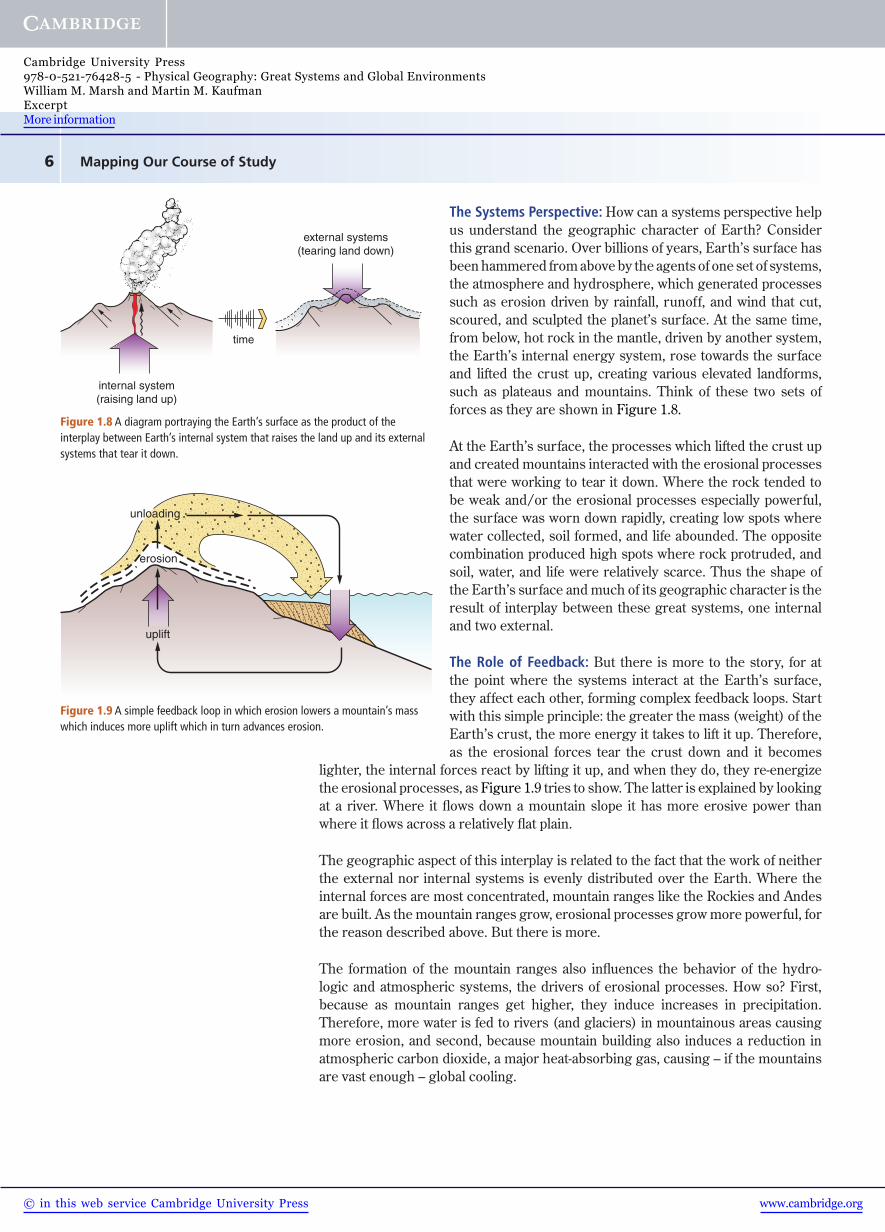
The Systems Perspective: How can a systems perspective help us understand the geographic character of Earth? Consider this grand scenario. Over billions of years, Earth’s surface has been hammered from above by the agents of one set of systems, the atmosphere and hydrosphere, which generated processes such as erosion driven by rainfall, runoff, and wind that cut, scoured, and sculpted the planet’s surface. At the same time, from below, hot rock in the mantle, driven by another system, the Earth’s internal energy system, rose towards the surface and lifted the crust up, creating various elevated landforms, such as plateaus and mountains. Think of these two sets of forces as they are shown in Figure 1.8.
At the Earth’s surface, the processes which lifted the crust up and created mountains interacted with the erosional processes that were working to tear it down. Where the rock tended to be weak and/or the erosional processes especially powerful, the surface was worn down rapidly, creating low spots where water collected, soil formed, and life abounded. The opposite combination produced high spots where rock protruded, and soil, water, and life were relatively scarce. Thus the shape of the Earth’s surface and much of its geographic character is the result of interplay between these great systems, one internal and two external.
The Role of Feedback: But there is more to the story, for at the point where the systems interact at the Earth’s surface, they affect each other, forming complex feedback loops. Start with this simple principle: the greater the mass (weight) of the Earth’s crust, the more energy it takes to lift it up. Therefore, as the erosional forces tear the crust down and it becomes
lighter, the internal forces react by lifting it up, and when they do, they re- energize the erosional processes, as Figure 1.9 tries to show. The latter is explained by looking at a river. Where it flows down a mountain slope it has more erosive power than where it flows across a relatively flat plain.
The geographic aspect of this interplay is related to the fact that the work of neither the external nor internal systems is evenly distributed over the Earth. Where the internal forces are most concentrated, mountain ranges like the Rockies and Andes are built. As the mountain ranges grow, erosional processes grow more powerful, for the reason described above. But there is more.
The formation of the mountain ranges also influences the behavior of the hydro-logic and atmospheric systems, the drivers of erosional processes. How so? First, because as mountain ranges get higher, they induce increases in precipitation. Therefore, more water is fed to rivers (and glaciers) in mountainous areas causing more erosion, and second, because mountain building also induces a reduction in atmospheric carbon dioxide, a major heat-absorbing gas, causing – if the mountains are vast enough – global cooling.
internal system(raising land up)
external systems(tearing land down)
time
Figure 1.8 A diagram portraying the Earth’s surface as the product of the interplay between Earth’s internal system that raises the land up and its external systems that tear it down.
uplift
erosion
unloading
Figure 1.9 A simple feedback loop in which erosion lowers a mountain’s mass which induces more uplift which in turn advances erosion.
www.cambridge.org© in this web service Cambridge University Press
Cambridge University Press978-0-521-76428-5 - Physical Geography: Great Systems and Global EnvironmentsWilliam M. Marsh and Martin M. KaufmanExcerptMore information
7The Nature of Geographic Systems
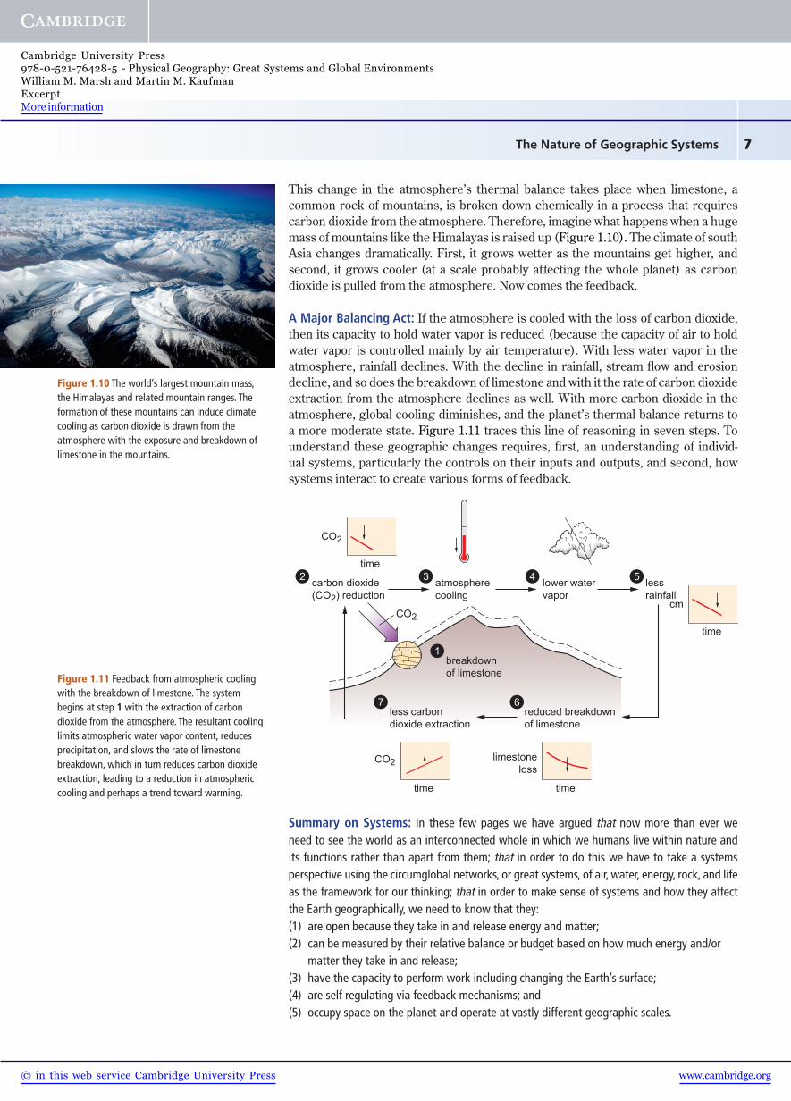
This change in the atmosphere’s thermal balance takes place when limestone, a common rock of mountains, is broken down chemically in a process that requires carbon dioxide from the atmosphere. Therefore, imagine what happens when a huge mass of mountains like the Himalayas is raised up (Figure 1.10). The climate of south Asia changes dramatically. First, it grows wetter as the mountains get higher, and second, it grows cooler (at a scale probably affecting the whole planet) as carbon dioxide is pulled from the atmosphere. Now comes the feedback.
A Major Balancing Act: If the atmosphere is cooled with the loss of carbon dioxide, then its capacity to hold water vapor is reduced (because the capacity of air to hold water vapor is controlled mainly by air temperature). With less water vapor in the atmosphere, rainfall declines. With the decline in rainfall, stream flow and erosion decline, and so does the breakdown of limestone and with it the rate of carbon dioxide extraction from the atmosphere declines as well. With more carbon dioxide in the atmosphere, global cooling diminishes, and the planet’s thermal balance returns to a more moderate state. Figure 1.11 traces this line of reasoning in seven steps. To understand these geographic changes requires, first, an understanding of individ-ual systems, particularly the controls on their inputs and outputs, and second, how systems interact to create various forms of feedback.
Summary on Systems: In these few pages we have argued that now more than ever we need to see the world as an interconnected whole in which we humans live within nature and its functions rather than apart from them; that in order to do this we have to take a systems perspective using the circumglobal networks, or great systems, of air, water, energy, rock, and life as the framework for our thinking; that in order to make sense of systems and how they affect the Earth geographically, we need to know that they:(1) are open because they take in and release energy and matter;(2) can be measured by their relative balance or budget based on how much energy and/or
matter they take in and release;(3) have the capacity to perform work including changing the Earth’s surface;(4) are self regulating via feedback mechanisms; and(5) occupy space on the planet and operate at vastly different geographic scales.
Figure 1.10 The world’s largest mountain mass, the Himalayas and related mountain ranges. The formation of these mountains can induce climate cooling as carbon dioxide is drawn from the atmosphere with the exposure and breakdown of limestone in the mountains.
carbon dioxide(CO2) reduction
less carbondioxide extraction
reduced breakdownof limestone
atmospherecooling
lower watervapor
lessrainfall
time
CO2
CO2
CO2
32 4 5
67
breakdownof limestone
1
time
cm
time
limestoneloss
time
Figure 1.11 Feedback from atmospheric cooling with the breakdown of limestone. The system begins at step 1 with the extraction of carbon dioxide from the atmosphere. The resultant cooling limits atmospheric water vapor content, reduces precipitation, and slows the rate of limestone breakdown, which in turn reduces carbon dioxide extraction, leading to a reduction in atmospheric cooling and perhaps a trend toward warming.
www.cambridge.org© in this web service Cambridge University Press
Cambridge University Press978-0-521-76428-5 - Physical Geography: Great Systems and Global EnvironmentsWilliam M. Marsh and Martin M. KaufmanExcerptMore information

Mapping Our Course of Study8
1.4 The Physical Geographer’s Perspective
Documenting and mapping change in the Earth’s surface is central to physical geography. In fact, much of the field is organized around a study of the agents that change the geo-graphic character of the Earth: atmospheric processes, such as hurricanes and thunderstorms; hydrologic processes, such as flood flows and storm waves; biological processes, such as forest growth and the construction of beaver dams; human processes, such as agriculture and urban development; geo-logic processes, such as volcanoes and earthquakes; and so on. Physical geography seeks to explain the distribution of the various forms and features that constitute the landscapes of our planet by analyzing the processes and systems that create them. Like all branches of geography, physical geography has an abiding interest in the spatial patterns and geographic dimensions of Earth’s surface phenomena, like those shown in Figure 1.12, and why they differ from place to place.
Although geography is traditionally associated with global scales of study – and indeed we are today concerned with global distributions as much or more than ever – geographic inquiry is actually carried out at all scales from beyond the global down to areas the size of one’s community and smaller. The key is that geographic inquiry must be taken to whatever scale is necessary to provide scientific explanations of the phe-
nomena being investigated. This may take us into the Solar System to explain the origins of our energy supply or into the tiniest particles of the soil to explain the water supply available to vegetation.
New Horizons: In the past quarter century we have witnessed a tremendous explo-sion of scientific knowledge. You have an opportunity to know more about Earth today than we could possibly have imagined when we were little boys in the 1950s, including insights into the origin of our planet and the geological mechanisms that govern the formation of its continents and ocean basins; the mechanisms governing evolution and the geographic diversity of life; the origins, growth, and development of human societies; the intricate interrelationship of the atmosphere and oceans and its implications in shaping the global climate; and the origins and spread of people, land use, and food-production systems.
In geography, our ability to monitor and map the planet improved immeasurably with advancements in remote sensing and computer data processing. Remote sensors in aircraft and satellites, such as the one depicted in Figure 1.13, allow ready surveillance of the atmosphere, seas, forests, land uses, water systems, and many other geographic features on a day-by-day basis. With these advances has come not just greater factual knowledge but vastly improved understanding about how the planet works, with special insights on how its various parts are interconnected.
Tibesti Plateau
AhaggerPlateau
Atlas Mountains
ChadBasin
Nile R
iver
Mediterranean Sea
Red Sea
ZaireBasin
KalahariBasin
rift margin
riftvalley
0 1000 km500
fracture zone
fracture zone
land over 1000m
relatively youngvolcanic rocks
major escarpment
Figure 1.12 The heart of physical geography, like all branches of geography, lies in its maps. Here is a map of the major landforms of Africa. It represents one layer in the larger geographic picture of the continent. Others include climate, drainage, vegetation, and animals, including people.
Figure 1.13 Tens of satellites such as this one monitor the Earth from space, tracking weather, vegetation, snow cover, volcanic activity, and many other geographic phenomena.
www.cambridge.org© in this web service Cambridge University Press
Cambridge University Press978-0-521-76428-5 - Physical Geography: Great Systems and Global EnvironmentsWilliam M. Marsh and Martin M. KaufmanExcerptMore information

9Scientifi c Thought and its Application in Physical Geography
Our Unified Planet: A picture has emerged of Earth as a geo-graphically unified planet, in which distant and often remote parts are linked together by the great systems. These systems are organized in an amazing variety of ways that in many respects we are just beginning to understand. Witness, for example, that changes in atmospheric pressure in the western Pacific can produce a string of changes having profound influ-ences, via an ocean warming event called El Niño, on climate 10,000 miles away in western North America. And deep within the Earth at the base of the mantle, 2000 miles down, pockets of hot, partially melted rock appear to send heated plumes slowly toward the crust where they may fuel clusters of vol-canoes. And the global systems of prevailing winds commonly carry the plumes of ash from large volcanic eruptions entirely around the world as the tropical tradewinds did with the debris
from the 1991 Mt. Pinatubo eruption in the Philippines, darkening and cooling the atmosphere under them (Figure 1.14). Indeed, discovering the geographic inter-connectedness of Earth as a planet may well emerge as one of the great scientific advancements of our times.
1.5 Scientifi c Thought and its Application in Physical Geography
The story we tell in the pages ahead is part of a great tradition practiced in some form by virtually all peoples, modern and ancient, to explain the nature and origin of the world around them. Our story, however, is different than most Earth stories because it is based on science and most traditional stories are not. So what is it that sets the science story apart from, say, those based on mythology or religion? Both involve considerable thought, both address tough questions, and both provide answers. The difference is the way the thought process is structured.
Science is a way of arriving at understanding by observing, measuring, testing, and reasoning. In the modern world it is often confused with its tools. Science is not, as is commonly thought, the development and application of technology and technical apparatus. Technology and its apparatus, such as microscopes, radars, cameras, tel-escopes, and computers, are very much a part of science but exist as tools in making observations, measurement, and analyzing data rather than as objects of scientific study themselves.
Realms of Thought: In a general way, the world of thought can be divided into two broad realms: physical and metaphysical. Metaphysical thought is based on things such as feelings, beliefs, dreams, and emotions. It often relates to the physical world, as in the way romantic poetry such as Walt Whitman’s lines in Figure 1.15 relate to sounds, smells, wind, and morning feelings, but it does not require measuring, testing, or logical discourse. Music, religion, mythology, and much of literature are rooted in metaphysical thought.
Science belongs to the realm of physical thought. At its simplest level, physical thought deals with the world we can see, touch, and smell and how to portray what we learn without invoking feelings or beliefs. When people invoke the metaphysical, such as ideas from mythology, to explain natural phenomena like a massive hurricane, they
Mt. Pinatubo
Figure 1.14 The airborne ash from the 1991 explosion of Mt. Pinatubo in the Philippines was carried around the world by global wind systems. The same can take place with dust from deserts and smoke from wars and forest fi res.
� e smoke of my own breath.Echos, ripples and buzzed whispers….
loveroot, silkthread, crotch and vine,My respiration and inspiration….the beating
of my heart….the passing of blood and air through my lungs,
� e sni� of green leaves and dry leaves, and of the shore and darkcolored sea-rocks, and of hay in the barn,
� e sound of the belched words of my voice….words loosed to the eddies of the wind,
A few light kisses….a few embraces….a reaching around of arms,
� e play of shine and shade on the trees as the supple boughs wag,
� e delight alone or in the rush of the streets, or along the �elds and hillsides,
The feeling of health….the full-noon trill….the song of me rising from bed and meeting the sun.
Have you reckoned a thousand acres much? Have you reckoned the earth much?
Have you practiced so long to learn to read?Have you felt so proud to get the meaning of
poems? Walt Whitman (1819–1892)
Figure 1.15 An excerpt from Walt Whitman’s book Leaves of Grass, fi rst published untitled in the collection in 1855. An example of metaphysical thought that draws on images from the physical world but makes no claims to scientifi c reasoning.
www.cambridge.org© in this web service Cambridge University Press
Cambridge University Press978-0-521-76428-5 - Physical Geography: Great Systems and Global EnvironmentsWilliam M. Marsh and Martin M. KaufmanExcerptMore information

Mapping Our Course of Study10
are not using scientific thought. “We angered the gods with irreverent thought and behavior and they punished us with a destructive hurricane.” Scientific thought, by contrast, would pursue an explanation based on what could be discovered about the hurricane from observations and measurements before, during, and after the event followed by a course of reasoning which is built on the assembled facts.
Induction and Deduction: There are several approaches or methods of putting facts and reasoning together and scientists have long debated about which is most appro-priate for various types of problems. Among them, two approaches are widely recog-nized: induction and deduction. Both begin with a problem or question; for example, what causes the formation and growth of hurricanes? With induction the process involves gathering copious data on where hurricanes form, their dimensions, air con-ditions within, above, and around them, their patterns and rates of movement, and so on. These data are then assembled in some fashion, for example, in maps and tables, and, with the help of computers, examined in various ways to see if geographic patterns, trends, and interconnections can be identified.
The data may reveal nothing. On the other hand, maps plotting the geographic loca-tions of hurricane formation, as the map in Figure 1.16 reveals, may show that they always begin and develop over oceans in the tropics. But is this mere coincidence or is there something meaningful about the connection with warm ocean water? Further data are called for and if the tropical-water correlation repeats itself in differ-ent oceans over many years, then we may have discovered something meaningful. But strictly speaking we still do not have an answer on what causes hurricanes. We may, however, have narrowed the search.
Deduction, on the other hand, involves putting our efforts first into a line of reasoning rather than into the collection of data. We usually begin with some things we already know from established scientific principles. For example, from physics we can reason that it takes a massive force to grow and drive a weather system the size of a hurricane. With a few calculations, we can even approximate the amount of energy involved. What Earth force can provide that much power? Heat in the atmosphere from the absorption of solar radiation? The tidal force of the solar and lunar gravitational fields acting on the ocean surface? Heat stored in ocean water? Heat from volcanic activity on the ocean floor? A comparison of the
40°
20°
0°
20°
40°
23°
24°24°26°
28°
27°
27°
27°
26° 25°
24°23°
23°25°
25°
26°
26°
27°
27°
27° 24°
24°
25°28°
28°28°
28°
27°
27°27°
26°24°
26°
water surface temperature, °Churricane tracks
Figure 1.16 Data on the locations of origin of hurricanes (red dots) reveal that all begin over warm tropical seas.
A huge hurricane sweeping across Florida and the East Coast of the United States.
www.cambridge.org© in this web service Cambridge University Press
Cambridge University Press978-0-521-76428-5 - Physical Geography: Great Systems and Global EnvironmentsWilliam M. Marsh and Martin M. KaufmanExcerptMore information