map legend comparison - usgs · pdf filethe challenge of creating a common map legend among...
TRANSCRIPT
Map Legend
Comparison
Don Faber-Langendoen
and Regan Smyth

OVERVIEW
The challenge of creating a common map legend among the 4 projects.
1. Lumping/splitting Aggregates
Finer scale units
Ruderal vegetation
2. Choice of which systems to map.
3. Describing the map classes
Confidential – Not for Distribution

Creating a Common Map Legend
• Systems were target for all efforts, but differences in how they were applied
• Common legend required reconciling:
– Different versions of classification
– Different coding schemes
– Use of non-standard systems
– Use aggregates
– Use of finer scale units (modifiers)
– Different classifications for ruderal & cultural types

Creating a Common Legend
code aggregate System
finer-scale unit
who
(original code)
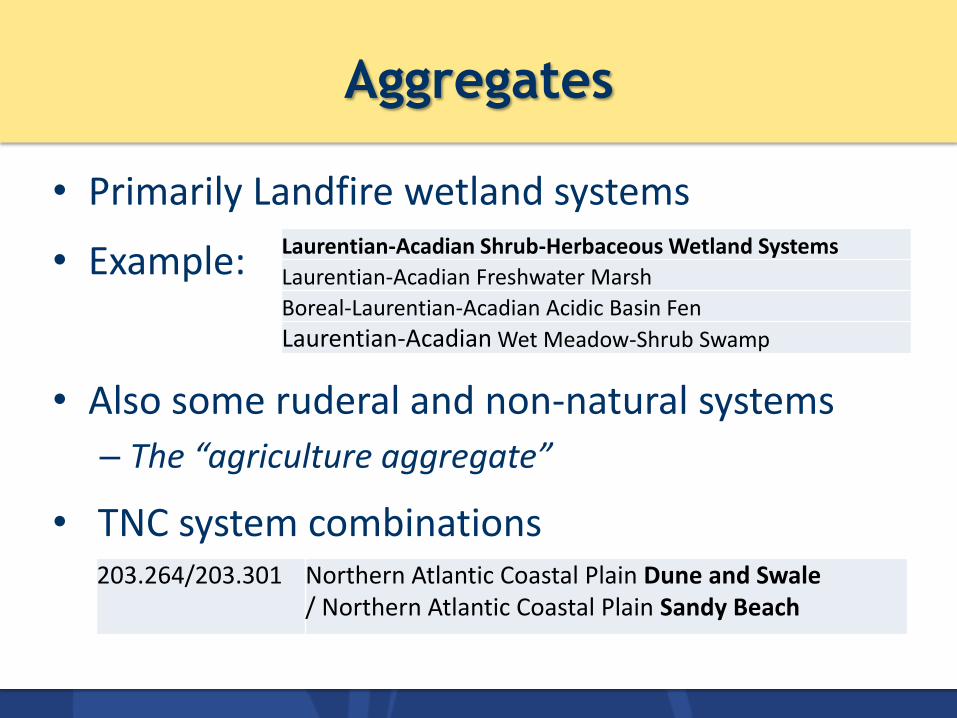
Aggregates
• Primarily Landfire wetland systems
• Example:
• Also some ruderal and non-natural systems
– The “agriculture aggregate”
• TNC system combinations
Laurentian-Acadian Shrub-Herbaceous Wetland Systems
Laurentian-Acadian Freshwater Marsh
Boreal-Laurentian-Acadian Acidic Basin Fen
Laurentian-Acadian Wet Meadow-Shrub Swamp
203.264/203.301 Northern Atlantic Coastal Plain Dune and Swale / Northern Atlantic Coastal Plain Sandy Beach

Aggregates
System SEGAP LF EVT NS ESLF TNC Gulf and Atlantic Coastal Plain Sparsely Vegetated Systems 2498 Northern Atlantic Coastal Plain Dune and Swale 203.264 2436 7149 Northern Atlantic Coastal Plain Sandy Beach 3124 Central Atlantic Coastal Plain Sandy Beach 3162 Northern Atlantic Coastal Plain Dune and Swale/NACP Sandy Beach 264 Northern Atlantic Coastal Plain Dune and Swale/Central Atlantic Coastal Plain Sandy Beach 264064
Confidential – Not for Distribution

Finer-Scale Units
• TNC: varied – including wetland characteristics – moisture gradients – pH – conifer vs. hardwood dominated
• SEGAP: – structural – conifer vs. mixed vs. hardwood dominated
• Landfire: structural
• NatureServe: did not use. When present in source data, rolled up to systems level.

System Name Finer-Scale Unit LF SEGAP NS TNC Central Interior and Appalachian Floodplain Systems 2471 Central App River Floodplain X 9333 608 Central App River Floodplain Central App Floodplain - Forest Modifier 202.608a SCI Large Floodplain X 9334 SCI Large Floodplain SCI Large Floodplain - Forest Modifier 202.705a SCI Large Floodplain SCI Large Floodplain - Herbaceous Modifier 202.705b Southern Piedmont Large Floodplain Forest 9324 324
Central Interior and Appalachian Floodplain
Aggregate with Finer-scale Modifiers
National map reconciliation of SE
ReGAP with LANDFIRE
Updates to EVT
and BpS for IUCN
Red Listing

Ruderal Vegetation
9

Treatment of Ruderal Vegetation
10
• Not standardized; classifications concepts still under development at time of mapping
• Little documentation provided by mappers
• TNC: did not attempt to capture
• Others: did, but not evenly
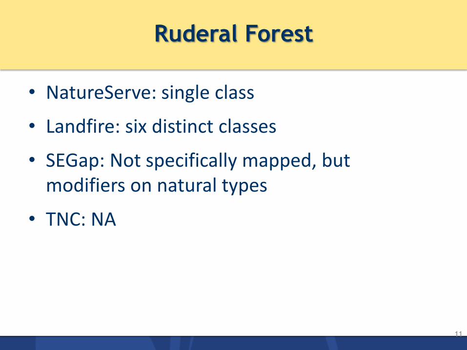
Ruderal Forest
11
• NatureServe: single class
• Landfire: six distinct classes
• SEGap: Not specifically mapped, but modifiers on natural types
• TNC: NA
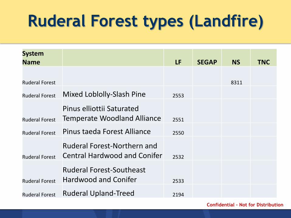
Ruderal Forest types (Landfire)
System Name LF SEGAP NS TNC
Ruderal Forest
8311
Ruderal Forest Mixed Loblolly-Slash Pine 2553
Ruderal Forest
Pinus elliottii Saturated Temperate Woodland Alliance 2551
Ruderal Forest Pinus taeda Forest Alliance 2550
Ruderal Forest
Ruderal Forest-Northern and Central Hardwood and Conifer 2532
Ruderal Forest
Ruderal Forest-Southeast Hardwood and Conifer 2533
Ruderal Forest Ruderal Upland-Treed 2194
Confidential – Not for Distribution

Ruderal Grassland & Shrubland
13
• Attempted to group into broad classes – Recently Logged Grassland/Shrubland – Successional Grassland & Shrubland
• LF, SEGAP, NS all have multiple finer-scale units beneath broad classes
• Additional LF (and NS) classes for: – Recently burned – Introduced upland – Introduced wetland – Modified/managed grasslands
• TNC: NLCD 52/71: shrublands/grasslands class
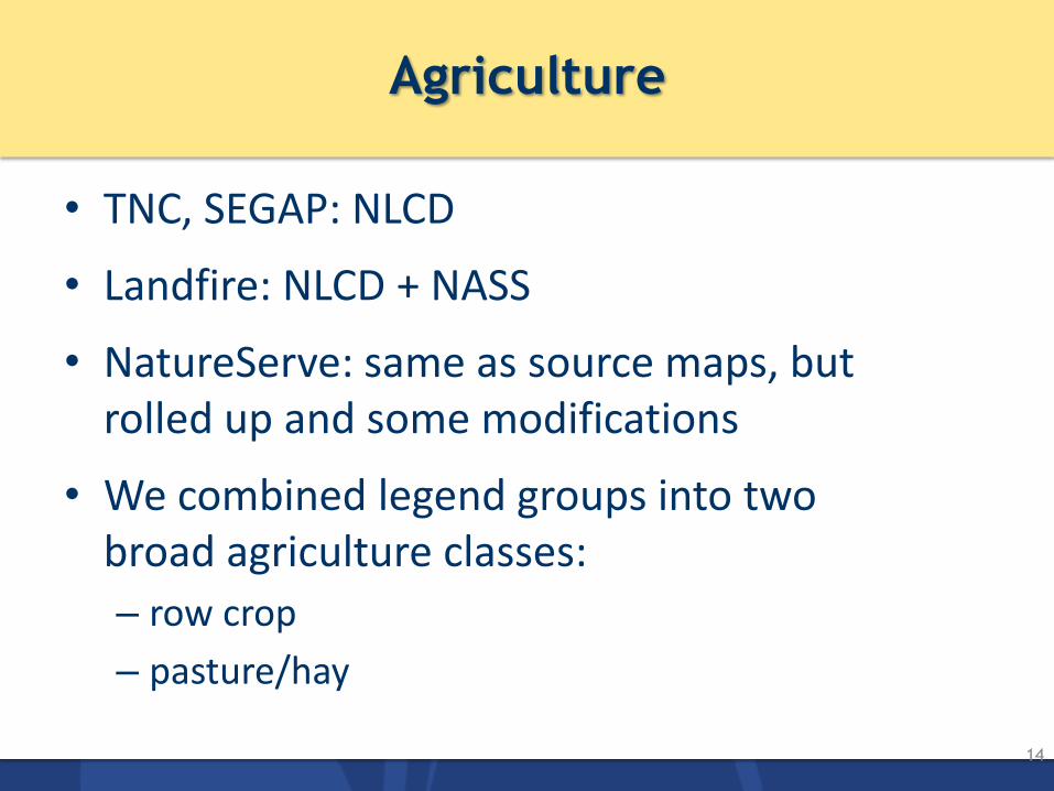
Agriculture
14
• TNC, SEGAP: NLCD
• Landfire: NLCD + NASS
• NatureServe: same as source maps, but rolled up and some modifications
• We combined legend groups into two broad agriculture classes:
– row crop
– pasture/hay

Differences in Mapped Targets
15
• Once common legend built, able to ask “who mapped what?”
System Finer-Scale Unit SEGAP LF NA TNC Laurentian Pine-Oak Barrens 2407 5423 Laurentian-Acadian Northern Pine-(Oak) Forest 2362 4265 719 Great Lakes Alvar 2409 5458 721 Great Lakes Wooded Dune and Swale 2466 9135 726 C. Interior Highlands and Appalachian Sinkhole and Depression Pond X C. Interior Highlands and Appalachian Sinkhole and Depression Pond Large River FP 18 C. Interior Highlands and Appalachian Sinkhole and Depression Pond Small River FP 10018 Southern Ridge and Valley Calcareous Glade and Woodland 24
Great Lakes Wet-Mesic Lakeplain Prairie 2411 7124 Central and Southern Appalachian Spruce-Fir Forest 202.028 2350 4253 28 Southern Appalachian Northern Hardwood Forest 202.029 2309 4115 29 Great Lakes Coastal Marsh Systems 2492 Great Lakes Freshwater Estuary and Delta 9268 Northern Great Lakes Coastal Marsh 9296

Differences in Mapped Targets
16
• Once common legend built, able to ask “who mapped what?”
System Finer-Scale Unit SEGAP LF NA TNC Laurentian Pine-Oak Barrens NA 2407 5423 Laurentian-Acadian Northern Pine-(Oak) Forest NA 2362 4265 719 Great Lakes Alvar NA 2409 5458 721 Great Lakes Wooded Dune and Swale 2466 9135 726 C. Interior Highlands and Appalachian Sinkhole and Depression Pond X C. Interior Highlands and Appalachian Sinkhole and Depression Pond Large River FP 18 C. Interior Highlands and Appalachian Sinkhole and Depression Pond Small River FP 10018 Southern Ridge and Valley Calcareous Glade and Woodland 24
Great Lakes Wet-Mesic Lakeplain Prairie NA 2411 7124 NA Central and Southern Appalachian Spruce-Fir Forest 202.028 2350 4253 28 Southern Appalachian Northern Hardwood Forest 202.029 2309 4115 29 Great Lakes Coastal Marsh Systems NA 2492 Great Lakes Freshwater Estuary and Delta 9268 Northern Great Lakes Coastal Marsh 9296
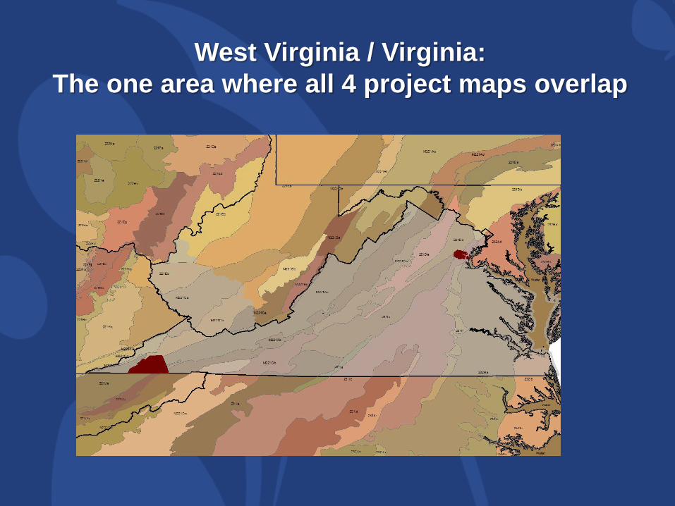
West Virginia / Virginia:
The one area where all 4 project maps overlap
National map reconciliation of SE
ReGAP with LANDFIRE
Updates to EVT
and BpS for IUCN
Red Listing
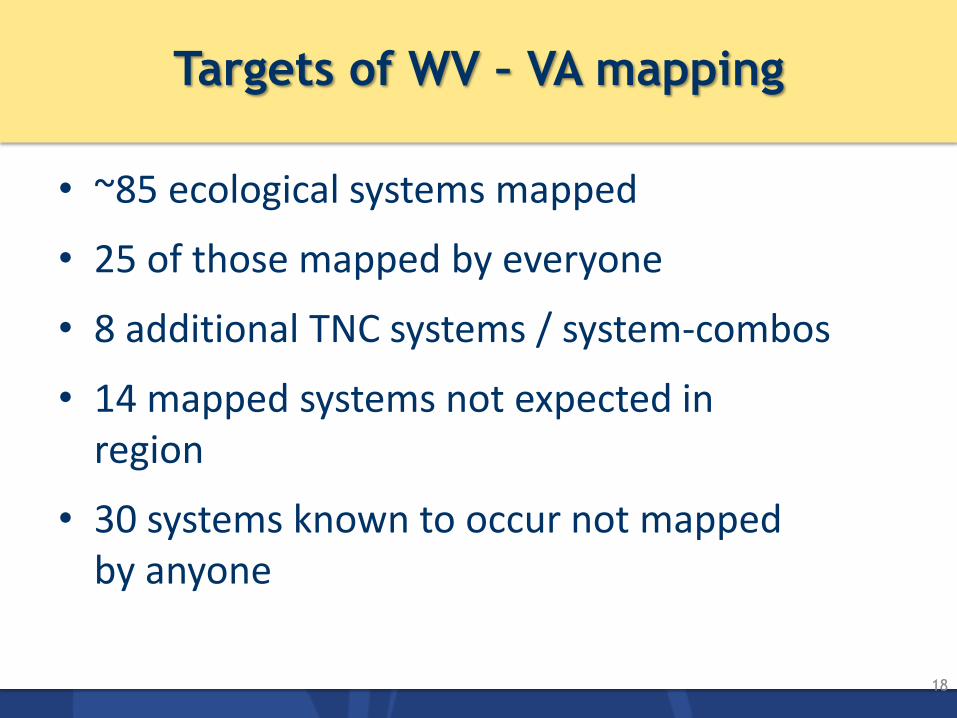
Targets of WV – VA mapping
18
• ~85 ecological systems mapped
• 25 of those mapped by everyone
• 8 additional TNC systems / system-combos
• 14 mapped systems not expected in region
• 30 systems known to occur not mapped by anyone

Only Mapped by TNC (9 systems)
19
• Central Interior Highlands and Appalachian Sinkhole and Depression Pond
• Southern Ridge and Valley Calcareous Glade and Woodland
• Southern Piedmont Glade and Barrens
• Southern Piedmont Granite Flatrock and Outcrop
• Southern and Central Appalachian Mafic Glade and Barrens
• Southern Interior Calcareous Cliff
• North-Central Appalachian Acidic Swamp
• Northern Atlantic Coastal Plain Riverine Peat Swamp
• Southern Atlantic Coastal Plain Tidal Wooded Swamp

Only Mapped by NatureServe/SEGAP (6 systems)
20
• Southern and Central Appalachian Bog and Fen
• Southern Piedmont Cliff
• South-Central Interior Large Floodplain
• South-Central Interior Small Stream and Riparian
• Atlantic Coastal Plain Blackwater Stream Floodplain Forest
• Northern Atlantic Coastal Plain Fresh and Oligohaline Tidal Marsh
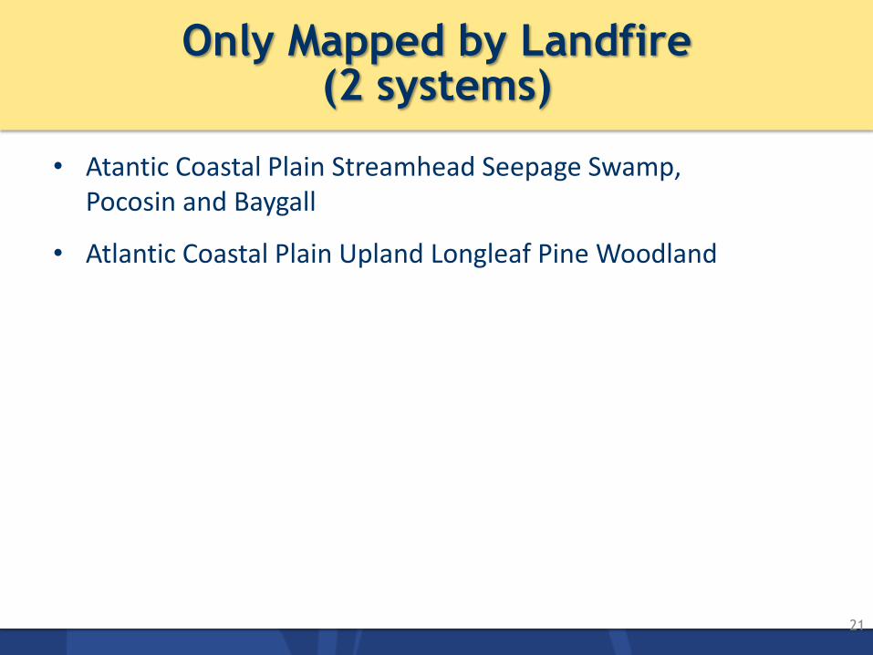
Only Mapped by Landfire (2 systems)
21
• Atantic Coastal Plain Streamhead Seepage Swamp, Pocosin and Baygall
• Atlantic Coastal Plain Upland Longleaf Pine Woodland
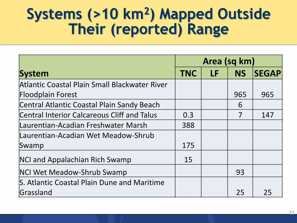
Systems (>10 km2) Mapped Outside Their (reported) Range
22
System Area (sq km)
TNC LF NS SEGAP Atlantic Coastal Plain Small Blackwater River Floodplain Forest 965 965 Central Atlantic Coastal Plain Sandy Beach 6 Central Interior Calcareous Cliff and Talus 0.3 7 147 Laurentian-Acadian Freshwater Marsh 388 Laurentian-Acadian Wet Meadow-Shrub Swamp 175
NCI and Appalachian Rich Swamp 15
NCI Wet Meadow-Shrub Swamp 93 S. Atlantic Coastal Plain Dune and Maritime Grassland 25 25

Systems Not Mapped
23
• Mostly small patch: seeps, glades, cliffs, ponds
• Also linear types: riverscour, ravines, beaches and bluffs
• Large patch types include seagrass and aquatic beds, tidal marshes, peatlands, lakeshores
• One matrix system [but edge of range]: Central Atlantic Coastal Plain Wet Longleaf Pine Savannah and Flatwoods
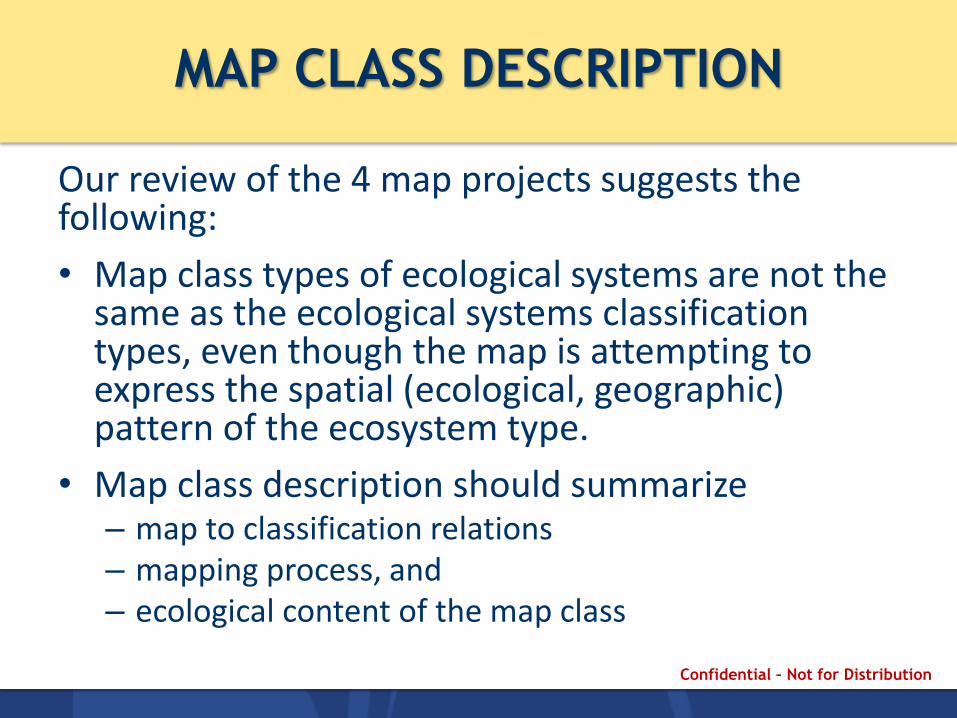
MAP CLASS DESCRIPTION
Our review of the 4 map projects suggests the following:
• Map class types of ecological systems are not the same as the ecological systems classification types, even though the map is attempting to express the spatial (ecological, geographic) pattern of the ecosystem type.
• Map class description should summarize – map to classification relations – mapping process, and – ecological content of the map class
Confidential – Not for Distribution
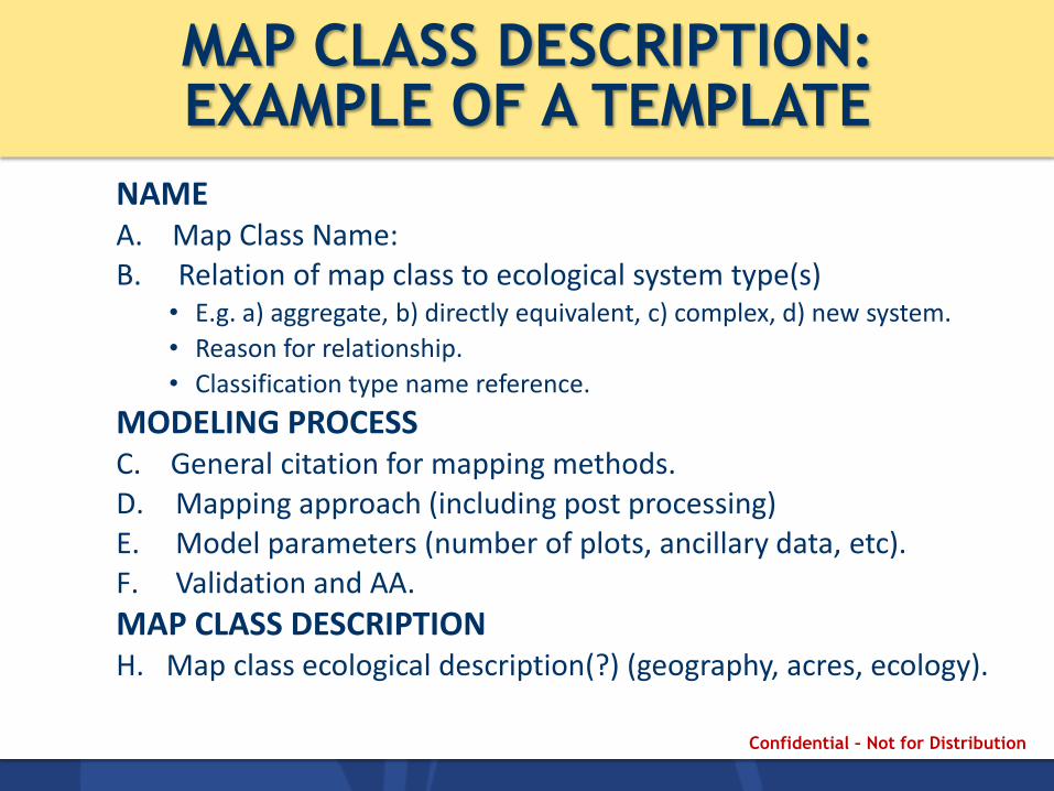
MAP CLASS DESCRIPTION: EXAMPLE OF A TEMPLATE
NAME A. Map Class Name: B. Relation of map class to ecological system type(s)
• E.g. a) aggregate, b) directly equivalent, c) complex, d) new system.
• Reason for relationship.
• Classification type name reference.
MODELING PROCESS C. General citation for mapping methods. D. Mapping approach (including post processing) E. Model parameters (number of plots, ancillary data, etc). F. Validation and AA.
MAP CLASS DESCRIPTION H. Map class ecological description(?) (geography, acres, ecology).
Confidential – Not for Distribution

MAP CLASS DESCRIPTION: Name
NAME
A. Map Class Name: Gulf and Atlantic Coastal Plain Sparsely Vegetated Systems
B. Relation to Ecological Systems: Aggregate
• Northern Atlantic Coastal Plain Dune and Swale
• Central Atlantic Coastal Plain Sandy Beach
• Northern Atlantic Coastal Plain Sandy Beach
Comment:
Confidential – Not for Distribution
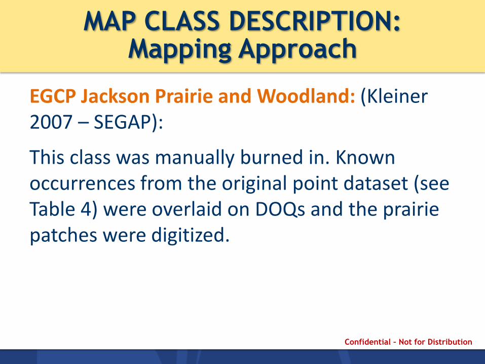
MAP CLASS DESCRIPTION: Mapping Approach
EGCP Jackson Prairie and Woodland: (Kleiner 2007 – SEGAP):
This class was manually burned in. Known occurrences from the original point dataset (see Table 4) were overlaid on DOQs and the prairie patches were digitized.
Confidential – Not for Distribution

MAP CLASS DESCRIPTION: Mapping Approach
Mapping Approach: Ferree and Anderson 2013 (TNC)
Confidential – Not for Distribution

MAP CLASS DESCRIPTION: Validation and AA
Confidential – Not for Distribution
• Validation and AA: Ferree and Anderson 2013 (TNC)
Map Class Description: end of story
• Given that large-area maps need to model the ecosystem types, documentation of the method is essential.
• Providing a map class description for each type allows users to readily understand how the map was created.
• Users will often be interested in description and accuracy of individual types, rather than the whole map!
Confidential – Not for Distribution
SUMMARY
A common map legend among the 4 projects had to overcome a number of challenges
1. Lumping/splitting of systems. Aggregates Finer scale units Ruderal vegetation
2. Choice of which systems to map.
3. Understanding how each system was treated in the mapping process. Map class descriptions, which some projects provide, make the interpretation of the map much easier.
Confidential – Not for Distribution

List of Systems not mapped
Confidential – Not for Distribution