map carry inlet – south, k-43 legend
TRANSCRIPT

This is not intended for navigational use.
Lege
ndMap Photo&
Geo
grap
hic
Res
pons
e St
rate
gies
for
Nor
ther
n K
odia
k S
uba
rea
NUKA Research & Planning Group, LLC.June 2008
Soundings in fathoms
Scale
1 nm
1 mi.
1,000 yds.
FO-S01
FO-S01
02aEX
02bEX
Ca
rry
Inle
t
Shuyak Island
Carry Inlet – South, K-43Center of map at 58˚ 36.2’ N Lat., 152˚ 30.8’ W Lon.
Carry Inlet-South, EX-02a viewed from the southwest.
Carry Inlet-South, EX-02b deployment site viewed from the west.
Free-oil Containment and Recovery, Shallow Water
Exclusion Booming
Calm-water Boom
Tidal-seal Boom
Private Cabins
Public Use Cabins
Bears in Area, Guards Recommended
FO-S
EX
Kodiak Subarea Geographic Response Strategies June 2008
K-43
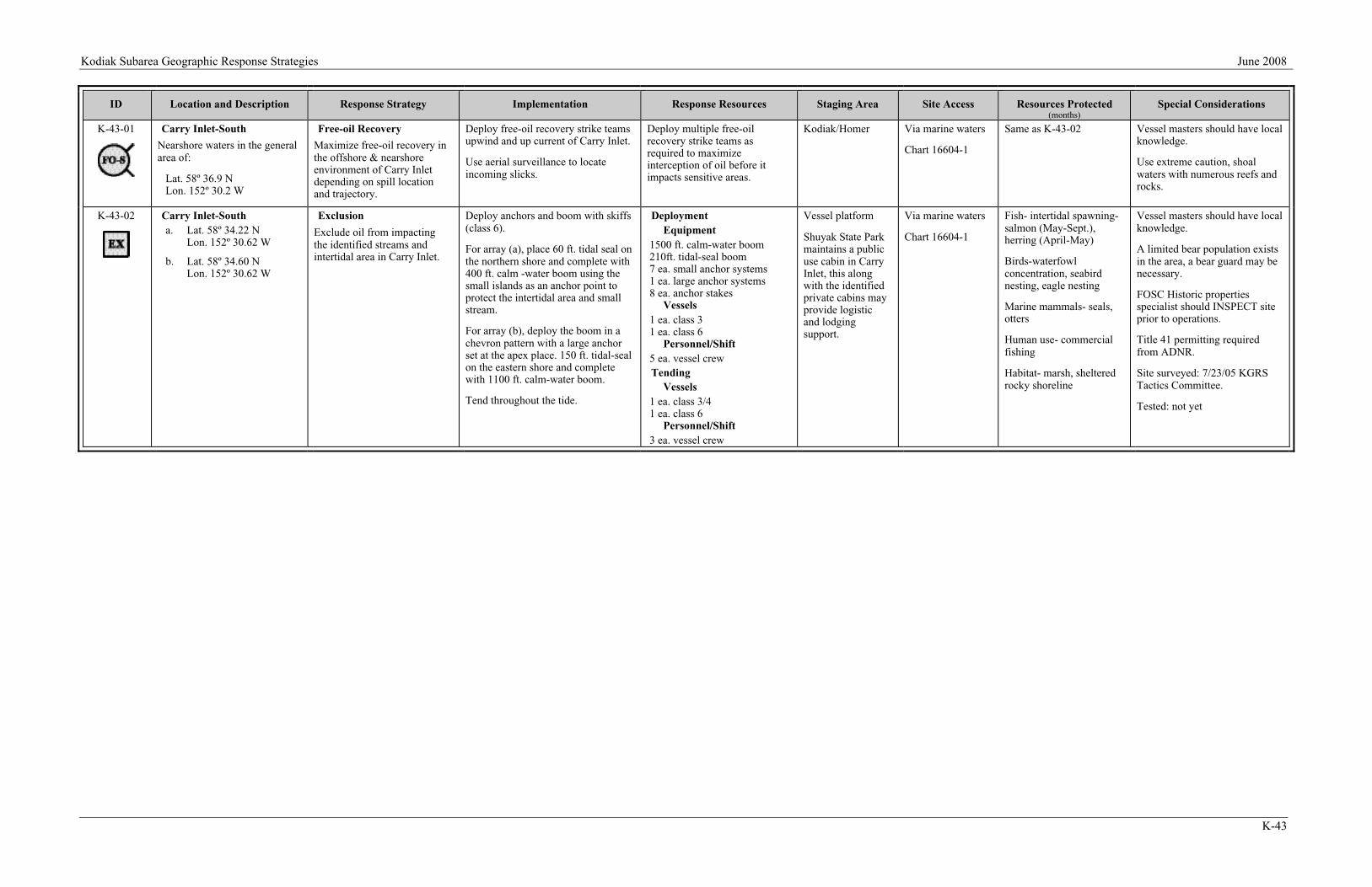
ID Location and Description Response Strategy Implementation Response Resources Staging Area Site Access Resources Protected(months)
Special Considerations
K-43-01 Carry Inlet-South
Nearshore waters in the generalarea of:
Lat. 58º 36.9 NLon. 152º 30.2 W
Free-oil Recovery
Maximize free-oil recovery inthe offshore & nearshoreenvironment of Carry Inletdepending on spill locationand trajectory.
Deploy free-oil recovery strike teamsupwind and up current of Carry Inlet.
Use aerial surveillance to locateincoming slicks.
Deploy multiple free-oilrecovery strike teams asrequired to maximizeinterception of oil before itimpacts sensitive areas.
Kodiak/Homer Via marine waters
Chart 16604-1
Same as K-43-02 Vessel masters should have localknowledge.
Use extreme caution, shoalwaters with numerous reefs androcks.
K-43-02 Carry Inlet-Southa. Lat. 58º 34.22 N
Lon. 152º 30.62 W
b. Lat. 58º 34.60 NLon. 152º 30.62 W
Exclusion
Exclude oil from impactingthe identified streams andintertidal area in Carry Inlet.
Deploy anchors and boom with skiffs(class 6).
For array (a), place 60 ft. tidal seal onthe northern shore and complete with400 ft. calm -water boom using thesmall islands as an anchor point toprotect the intertidal area and smallstream.
For array (b), deploy the boom in achevron pattern with a large anchorset at the apex place. 150 ft. tidal-sealon the eastern shore and completewith 1100 ft. calm-water boom.
Tend throughout the tide.
DeploymentEquipment
1500 ft. calm-water boom210ft. tidal-seal boom7 ea. small anchor systems1 ea. large anchor systems8 ea. anchor stakes
Vessels1 ea. class 31 ea. class 6
Personnel/Shift5 ea. vessel crewTending
Vessels1 ea. class 3/41 ea. class 6
Personnel/Shift3 ea. vessel crew
Vessel platform
Shuyak State Parkmaintains a publicuse cabin in CarryInlet, this alongwith the identifiedprivate cabins mayprovide logisticand lodgingsupport.
Via marine waters
Chart 16604-1
Fish- intertidal spawning-salmon (May-Sept.),herring (April-May)
Birds-waterfowlconcentration, seabirdnesting, eagle nesting
Marine mammals- seals,otters
Human use- commercialfishing
Habitat- marsh, shelteredrocky shoreline
Vessel masters should have localknowledge.
A limited bear population existsin the area, a bear guard may benecessary.
FOSC Historic propertiesspecialist should INSPECT siteprior to operations.
Title 41 permitting requiredfrom ADNR.
Site surveyed: 7/23/05 KGRSTactics Committee.
Tested: not yet