chapter 8 land use legend and map - pima...
TRANSCRIPT

L a n d U s e L e g e n d a n d M a p
8.1 | P a g e P o l i c y V o l u m e
Chapter 8: Land Use Legend and Map
8.1 Preface and Map Interpretation The Land Use Intensity Legend included in this chapter complements the Regional Plan Policies provided
throughout this comprehensive plan as well as the Special Area and Rezoning Policies included in Chapter
9. It is to be used in conjunction with the Land Use maps in Section 8.2. The following planned land use
intensity categories are designated on the Pima County Comprehensive Plan (Plan), which was initially
adopted by the Pima County Board of Supervisors on October 13, 1992, revised on December 18, 2001,
and the most recent update adopted on [insert date of adoption of this plan]. Land uses are only shown
for land in unincorporated Pima County.
Unless otherwise noted, references to code chapters or sections are to the Pima County Zoning Code as
of the date of adoption of this plan or as may be amended.
Please refer to section 10.4 of the Administration chapter of the Plan for how the rezoning process,
conditional use process, and the Transfer of Development Rights (TDRs) relate to the plan, open space
requirements, and the calculation of possible densities and uses for properties affected by resource areas
on the Regional Hydrology Maps (Section 4.9 of the Physical Infrastructure Chapter).
Land Use Legend and Map

L a n d U s e L e g e n d a n d M a p
8.2 | P a g e P o l i c y V o l u m e
Land Use Legend
The Land Use Intensity Legend is composed of a number of “urban/suburban”, “rural” land use and
general categories. Urban/suburban designations are usually used in the metropolitan of Tucson, Green
Valley and certain unincorporated communities. Rural land uses are generally used in exurban and rural
locales. General categories can be found throughout the unincorporated county. Each category includes
a description of the objectives and the types of uses intended for that category. In addition, most
categories that allow residential uses include a minimum and maximum gross density, defined as
residences per acre (RAC). Only land area zoned and planned for residential use or open space areas not
including golf courses, shall be included in gross density calculations.
Effective densities throughout the rezoning process may be constrained by hydrology, open space
requirements, overlay zones, cultural resources and many other factors.
A. Urban/Suburban Intensity Categories
The following land use intensity categories shall be applied to designate planned land use within urban
and suburban areas only:
1. Community Activity Center (CAC)
a. Objective: To designate medium and higher intensity mixed‐use districts designed to
provide a full range of goods and services; office and medical uses; hotels; research and
development opportunities; educational and institutional uses; and other similar uses
as described in the Campus Park Industrial (CPI) zoning district (Section 18.49); and
compatible medium to higher density housing. Individual rezoning requests do not
necessarily have to be a mixed use project; however, the application must demonstrate
how it serves to create or enhance the mixed use character of the designated activity
center as a whole.
Larger centers may include a regional mall. Smaller centers may provide goods and
services needed on a more frequent basis. These may include a major supermarket,
discount department stores, large variety stores, or specialty stores such as a
hardware/building/home improvement stores. Community Activity Centers may be
located on major arterial roadways with access to public transportation. All centers
will have direct pedestrian and bicycle access to surrounding neighborhoods.
Community Activity Centers may range from 25 acres to up to 100 acres or more in size
depending on the area served and services provided.
b. Residential Gross Density: Residential gross density, if any, shall conform to the
following:
1) Minimum – 6 RAC

L a n d U s e L e g e n d a n d M a p
8.3 | P a g e P o l i c y V o l u m e
2) Maximum ‐ As allowed by the requested conforming zoning district.
c. Residential Gross Densities for Developments Using Transfer of Development Rights
(TDRs): Projects within designated Receiving Areas utilizing TDRs for development shall
conform to the following density requirements:
1) Minimum – 6 RAC
2) Maximum – 18 RAC
2. Neighborhood Activity Center (NAC)
a. Objective: To designate lower intensity mixed‐use areas designed to provide goods and
services within or near residential neighborhoods for day‐to‐day and weekly living
needs. Neighborhood Activity Centers provide lower‐intensity commercial services. For
example a grocery market may be the principle anchor tenant along with other
neighborhood services, such as a drugstore, variety/hardware store, self‐service
laundry, and bank. The center may include a mix of medium‐density housing types.
Neighborhood Activity Centers are generally less than 25 acres in size. Larger centers
provide opportunity for more of a mix of intensive non‐residential uses and medium‐
density residential uses, and are to be located on arterials. Smaller mixed use centers
may contain medium‐density residential uses and may be located along collector or
arterial streets. All centers will have direct pedestrian and bicycle access to the
surrounding neighborhoods. Individual rezoning requests do not necessarily have to be
a mixed use project; however, the application must demonstrate how the project serves
to create or enhance the mixed‐use character of the designated activity center as a
whole.
b. Residential Gross Density: Residential gross density, if applicable, shall conform to the
following:
1) Minimum – 5 RAC
2) Maximum ‐ 12 RAC
c. Residential Gross Densities for Developments Using Transfer of Development Rights
(TDRs). Projects within designated Receiving Areas utilizing TDRs for development shall
conform to the following density requirements:
1) Minimum – 5 RAC
2) Maximum – 8 RAC

L a n d U s e L e g e n d a n d M a p
8.4 | P a g e P o l i c y V o l u m e
3. Multifunctional Corridor (MFC)
a. Objective: To designate areas for the integrated development of complementary uses
along major transportation corridors. The MFC designation serves a similar purpose as
the CAC plan designation. These areas contain commercial and other non‐residential
use services, research and development and similar uses (as delineated in the CPI
zoning district) and medium to high density residential clusters in a linear configuration
along major transportation corridors. Potential adverse impacts of strip commercial
development are mitigated through application of special design standards, in the
zoning code and design manuals such as standards for access management, building
setbacks, open space, signs, parking, and landscaping.
b. Residential Gross Density: Residential gross density, if applicable, shall conform to the
following:
1) Minimum – 6 RAC
2) Maximum ‐ As allowed by the requested conforming zoning district.
c. Residential Gross Densities for Developments Using Transfer of Development Rights
(TDRs): Projects within designated Receiving Areas utilizing TDRs for development shall
conform to the following density requirements:
1) Minimum – 6 RAC
2) Maximum – 18 RAC
4. Multiple Use (MU)
a. Objective: To identify multiple‐use areas that contain a wide range of uses, including
residential, commercial and light industrial and provide standards for how these areas
should develop or redevelop in the future. Proposals for new non‐residential uses must
show how the uses will minimize negative impacts on existing residential uses.
b. Residential Gross Density: Residential gross density, if applicable, shall conform to the
following:
1) Minimum – 6 RAC
2) Maximum ‐ As allowed by the requested conforming zoning district.
c. Residential Gross Densities for Developments Using Transfer of Development Rights
(TDRs): Projects within designated Receiving Areas utilizing TDRs for development shall
conform to the following density requirements:
1) Minimum – 6 RAC
2) Maximum – 18 RAC

L a n d U s e L e g e n d a n d M a p
8.5 | P a g e P o l i c y V o l u m e
5. Planned Development Community (PDC)
a. Objective: To designate existing approved specific plans. Specific plans comprise a
unique zoning regimen within a planned community. Specific plan documents include
detailed information on the intent of the community as a whole, as well as the individual
planning and zoning districts within the specific plan area. Applications for amendments
to individual specific plans shall be done in accordance with Section 18.90 (Specific Plans)
of the Pima County Zoning Code.
b. Exception: State Trust land in the proposed Sahuarita East Conceptual Plan is designated
a PDC under Special Area Policy S‐36 in Chapter 9.
6. Higher Intensity Urban (HIU)
a. Objective: To designate areas for a mix of medium to high density housing types, such
as higher density single‐family development, townhomes, condominiums and
apartment complexes, as well as other compatible uses, such as offices, hotels, research
and development, and other similar uses. These areas have direct access to major
transportation corridors and other arterials and are within walking or bicycling distance
from major commercial services and employment centers. They generally do not abut
land in low intensity urban categories. Small‐scale residential compatible retail services
are allowed on the first floor of a multi‐story building, provided that they are accessed
from an arterial and are oriented away from lower density residential development.
b. Residential Gross Density: Residential gross density shall conform to the following:
1) Minimum – 8 RAC
2) Maximum ‐ As allowed by the requested conforming zoning district.
c. Residential Gross Densities for Developments Using Transfer of Development Rights
(TDRs): Projects within designated Receiving Areas utilizing TDRs for development shall
conform to the following density requirements:
1) Minimum – 8 RAC
2) Maximum – 18 RAC
7. Medium Intensity Urban (MIU)
a. Objective: To designate areas for a mix of medium density housing types, such as
attached dwellings, garden apartments, and single family, as well as non‐residential
uses such as offices, medical offices, and hotels. Special attention should be given in
site design to assure that uses are compatible with adjacent lower density residential

L a n d U s e L e g e n d a n d M a p
8.6 | P a g e P o l i c y V o l u m e
uses. Where possible, pedestrian and bicycle access shall be provided to commercial
areas, schools, institutional uses, and other similar uses.
b. Residential Gross Density: Residential gross density shall conform to the following:
1) Minimum – 5 RAC
2) Maximum – 13 RAC
c. Residential Gross Densities for Developments Using Transfer of Development Rights
(TDRs). Projects within designated Receiving Areas utilizing TDRs for development shall
conform to the following density requirements:
1) Minimum – 5 RAC
2) Maximum – 10 RAC
8. Medium Low Intensity Urban (MLIU)
a. Objective: To designate areas for a mix of medium density single‐family and lower
density attached dwelling units; to provide opportunities for a mix of housing types
throughout the region.
b. Residential Gross Density: Residential gross density shall conform to the following:
1) Minimum – 2.5 RAC
2) Maximum – 5 RAC
c. Residential Gross Densities for Developments Using Transfer of Development Rights
(TDRs). Projects within designated Receiving Areas utilizing TDRs for development shall
conform to the following density requirements.
1) Minimum – 2.5 RAC
2) Maximum – 4 RAC
9. Low Intensity Urban (LIU)
Low Intensity Urban includes four land use categories designations ranging from a maximum
of 3 RAC stepped down to 0.3 RAC. The Low Intensity Urban categories are LIU3.0, LIU1.2,
LIU0.5, and LIU‐0.3.
a. Objective: To designate areas for low density residential and other compatible uses and
to provide incentives for residential conservation subdivisions to provide more natural
open space. Density bonuses are offered in exchange for the provision of natural
and/or functional open space. Natural open space must be set aside, where applicable,
to preserve land with the highest resource value and be contiguous with other
dedicated natural open space and public preserves.

L a n d U s e L e g e n d a n d M a p
8.7 | P a g e P o l i c y V o l u m e
1) Low Intensity Urban 3.0 (LIU‐3.0)
a) Residential Gross Density:
i) Minimum – none
ii) Maximum ‐ 3.0 RAC.
b) Residential Gross Densities for Developments Using Transfer of
Development Rights (TDRs). Projects within designated Receiving
Areas utilizing TDRs for development shall conform to the following
density requirements:
i) Minimum density 1.5 RAC
ii) Maximum density 3.0 RAC.
2) Low Intensity Urban 1.2 (LIU‐1.2)
a) Residential Gross Density:
i) Minimum – none
ii) Maximum – 1.2 RAC. The maximum gross density may be
increased in accordance with the following options:
a] Gross density of 2.5 RAC with 45 percent open space;
or
b] Gross density of 4 RAC with 60 percent open space.
b) Residential Gross Densities for Developments Using Transfer of
Development Rights (TDRs). Projects within designated Receiving
Areas utilizing TDRs for development shall conform to the following
density requirements:
i) Minimum density – none
ii) Maximum – 1.2 RAC. The maximum gross density may
be increased in accordance with the following option:
a] Gross density of 2 RAC with 50 percent open space.
3) Low Intensity Urban 0.5 (LIU‐0.5)
a) Residential Gross Density:
i) Minimum – none
ii) Maximum – 0.5 RAC. The maximum gross density may be
increased in accordance with the following options:
a] Gross density of 1.2 RAC with 50 percent open
space; or

L a n d U s e L e g e n d a n d M a p
8.8 | P a g e P o l i c y V o l u m e
b] Gross density of 2.5 RAC with 65 percent open space.
b) Residential Gross Densities for Developments Using Transfer of
Development Rights (TDRs). Projects within designated Receiving
Areas utilizing TDRs for development shall conform to the
following density requirements:
i) Minimum density – none
ii) Maximum – 0.5 RAC. The maximum gross density may
be increased in accordance with the following option:
a] Gross density of 1 RAC with 50 percent open space.
4) Low Intensity Urban 0.3 (LIU‐0.3)
a) Residential Gross Density:
i) Minimum – none
ii) Maximum – 0.3 RAC. The maximum gross density may be
increased in accordance with the following options:
a] Gross density of 0.7 RAC with 50 percent open
space; or
b] Gross density of 1.2 RAC with 65 percent open
space.
b) Residential Gross Densities for Developments Using Transfer of
Development Rights (TDRs). Projects within designated Receiving
Areas utilizing TDRs for development shall conform to the following
density requirements:
i) Minimum density – none
ii) Maximum – 0.3 RAC. The maximum gross density may
be increased in accordance with the following option:
a] Gross density of 0.7 RAC with 60 percent open
space.
L a n d U s e L e g e n d a n d M a p
8.9 | P a g e P o l i c y V o l u m e
B. RURAL INTENSITY CATEGORIES
The following land use categories shall be applied to designate rural development intensities on the
land use plan.
1. Rural Crossroads (RX)
a. Objective: To designate mixed‐use areas where basic goods and services are provided to
rural settlements and rural residents as conveniently as possible. Residential densities
slightly higher than the surrounding rural neighborhoods are allowed to provide
opportunities especially for certain housing types such as those serving the elderly,
single, and low income residents. In more developed communities, a grocery may be the
principal anchor tenant, along with other uses such as a drugstore, variety/hardware
store, self‐service laundry, bank, and other similar uses. Such areas will generally be less
than twenty acres. Smaller rural crossroads will generally be located at rural roadway
intersections of collector or arterial roads for the provision of limited commercial
services to rural residents and travelers.
b. Residential Gross Density: Residential gross density shall conform to the following:
1) Minimum ‐ 1.2 RAC
2) Maximum – 10 RAC
c. Residential Gross Densities for Developments Using Transfer of Development Rights
(TDRs): Projects within designated Receiving Areas utilizing TDRs for development
shall conform to the following density requirements:
1) Minimum – 1.2 RAC
2) Maximum – 5.0 RAC
2. Rural Forest Village (RFV)
a. Objective: To designate rural villages within confines of the Coronado National Forest.
b. Residential Gross Density: Residential gross density shall conform to the following:
1) Minimum – none
2) Maximum ‐ 1.2 RAC
c. Zoning Districts: Only the ML Mount Lemmon Zone shall be deemed in conformance
with the land use plan.

L a n d U s e L e g e n d a n d M a p
8.10 | P a g e P o l i c y V o l u m e
3. Medium Intensity Rural (MIR)
a. Objective: To designate areas for residential uses at densities consistent with rural
settlements in reasonable proximity to Rural Crossroads, arterials or suburban areas.
b. Residential Gross Density: Residential gross density shall conform to the following:
1) Minimum – none
2) Maximum ‐ 1.2 RAC
c. Residential Gross Densities for Developments Using Transfer of Development Rights
(TDRs): Projects within designated Receiving Areas utilizing TDRs for development
shall conform to the following density requirements:
1) Minimum – none
2) Maximum – 1.2 RAC
4. Low Intensity Rural (LIR)
a. Objective: To designate areas for residential uses at densities consistent with rural and
resource‐based characteristics.
b. Residential Gross Density: Residential gross density shall conform to the following:
1) Minimum – none
2) Maximum ‐ 0.3 RAC
c. Residential Gross Densities for Developments Using Transfer of Development Rights
(TDRs): Projects within designated Receiving Areas utilizing TDRs for development
shall conform to the following density requirements:
1) Minimum – none
2) Maximum – 0.3 RAC

L a n d U s e L e g e n d a n d M a p
8.11 | P a g e P o l i c y V o l u m e
C. GENERAL INTENSITY CATEGORIES
The following land use categories shall be applied to designate urban and rural development
intensities on the Land Use Plan maps.
1. Industrial (I)
a. Objective: To designate adequate area for industrial uses that, if properly located and
regulated, are compatible with certain types of commercial activities. Residential
development is permitted within a proposed project provided that it meets the
requirements of the Mixed Use Option under the CI‐1 zoning district (Section 18.51.070
of the zoning code).
b. Zoning Districts: Only the following zoning districts shall be deemed in conformance
with the land use plan:
1) CB‐1 Local Business Zone
2) CB‐2 General Business Zone
3) CPI Campus Park Industrial Zone
4) CI‐1 Light Industrial/Warehousing Zone
5) CI‐2 General Industrial Zone
6) SP Specific Plans
2. Heavy Industrial (HI)
a. Objective: To designate adequate area for higher intensity industrial uses that is not
compatible with non‐industrial uses.
b. Zoning Districts: Only the following zoning districts shall be deemed in conformance
with the land use plan:
1) CI‐1 Light Industrial Zone
2) CI‐2 General Industrial Zone
3) CI‐3 Heavy Industrial Zone
4) SP Specific Plans
3. Resource Sensitive (RS)
a. Objective: To designate key larger parcels and land holdings with environmentally
sensitive characteristics in close proximity to public preserves or other environmentally
sensitive areas. Development of such land shall emphasize design that blends with the
surrounding natural desert and provides connectivity to environmentally sensitive
linkages in developing areas.

L a n d U s e L e g e n d a n d M a p
8.12 | P a g e P o l i c y V o l u m e
b. Residential Gross Density:
1) Minimum – none
2) Maximum ‐ 0.3 RAC
c. Residential Gross Densities for Developments Using Transfer of Development Rights
(TDRs): Projects within designated Receiving Areas utilizing TDRs for development
shall conform to the following density requirements:
1) Minimum – none
2) Maximum – 0.3 RAC
4. Resource Conservation (RC)
a. Objective: To designate publically‐owned lands that are public resource lands and
preserves that protect sensitive and high‐value biological, resource value cultural,
recreational and other sensitive resources lands. These do not include private or state
trust lands, whether or not they are leased by the County for open space purposes. If
these lands become privately held during the lifespan of this plan, they will be treated
as Resource Sensitive unless otherwise designated through a plan amendment process.
b. Residential Gross Density: None, other than allowances for life estates, ranch caretakers
and similar uses.
5. Resource Extraction (RE)
a. Objective: To designate mining lands and to protect these areas from encroachment by incompatible uses.
b. Residential Gross Density: Residential gross density shall conform to the following:
1) Minimum – none
2) Maximum ‐ 0.3 RAC
6. Military Airport (MA)
a. Objective: To recognize Davis‐Monthan Air Force Base (DMAFB) as a unique and
significant factor in shaping the history, character, and economy of Eastern Pima
County; provide guidance for future compatible land uses to promote the health, safety
and welfare of the community; and, to promote the long‐term viability of the base and
its missions.
b. Residential Gross Density: New residential development is not a compatible use.

L a n d U s e L e g e n d a n d M a p
8.13 | P a g e P o l i c y V o l u m e
c. Zoning Districts: Only the following zoning districts in compliance with the zoning code
shall be deemed in conformance with the land use plan subject to compliance with the
zoning code:
1) CB‐1 Local Business Zone
2) CB‐2 General Business Zone
3) CPI Campus Park Industrial Zone
4) CI‐1 Light Industrial/Warehousing Zone
5) CI‐2 General Industrial Zone
6) SP Specific Plan Zone
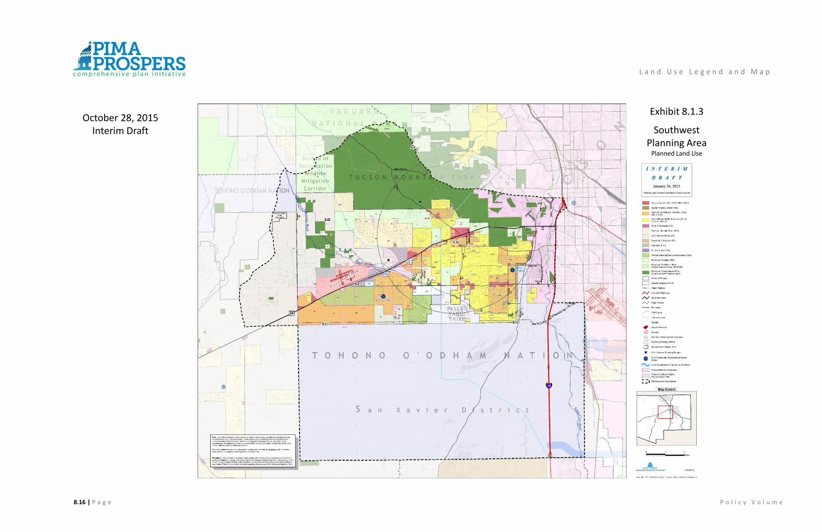
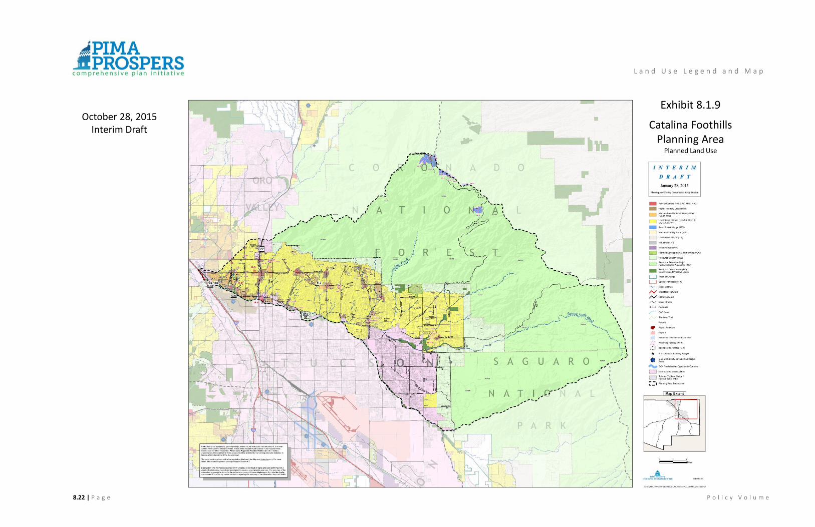
8.2 Land Use Maps The thirteen Land Use maps which follow, cover the unincorporated county except for the Tohono
O’odham Nation and the Pascua Yaqui Tribe. They should be used as a resource along with the Regional
Hydrology maps in Section 4.9 of this plan and the Maeveen Marie Behan Conservation Lands System map
in Section 3.4 of this plan. The land use legend is described in Section 8.1 above. Application and
interpretation of the maps is addressed in Chapter 10, Plan Administration.

L a n d U s e L e g e n d a n d M a p
8.14 | P a g e P o l i c y V o l u m e
Exhibit 8.1.1
Avra Valley Planning AreaPlanned Land Use
October 28, 2015Interim Draft

8.15 | P a g e P o l i c y V o l u m e
Exhibit 8.1.2
Tucson MountainsPlanning AreaPlanned Land Use
L a n d U s e L e g e n d a n d M a p
October 28, 2015Interim Draft
8.16 | P a g e P o l i c y V o l u m e
Exhibit 8.1.3
SouthwestPlanning Area
Planned Land Use
L a n d U s e L e g e n d a n d M a p
October 28, 2015Interim Draft

8.17 | P a g e P o l i c y V o l u m e
Exhibit 8.1.4
Altar Valley Planning Area
Planned Land Use
L a n d U s e L e g e n d a n d M a p
October 28, 2015Interim Draft

8.18 | P a g e P o l i c y V o l u m e
Exhibit 8.1.5
Upper Santa CruzPlanning Area
Planned Land Use
L a n d U s e L e g e n d a n d M a p
October 28, 2015Interim Draft

8.19 | P a g e P o l i c y V o l u m e
Exhibit 8.1.6
Mountain ViewPlanning Area
Planned Land Use
L a n d U s e L e g e n d a n d M a p
October 28, 2015Interim Draft

8.20 | P a g e P o l i c y V o l u m e
Exhibit 8.1.7
SoutheastPlanning Area
Planned Land Use
L a n d U s e L e g e n d a n d M a p
October 28, 2015Interim Draft

8.21 | P a g e P o l i c y V o l u m e
Exhibit 8.1.8
CentralPlanning Area
Planned Land Use
L a n d U s e L e g e n d a n d M a p
October 28, 2015Interim Draft
8.22 | P a g e P o l i c y V o l u m e
Exhibit 8.1.9
Catalina Foothills Planning Area
Planned Land Use
L a n d U s e L e g e n d a n d M a p
October 28, 2015Interim Draft

8.23 | P a g e P o l i c y V o l u m e
Exhibit 8.1.10
Rincon ValleyPlanning Area
Planned Land Use
L a n d U s e L e g e n d a n d M a p
October 28, 2015Interim Draft

8.24 | P a g e P o l i c y V o l u m e
Exhibit 8.1.11
TortolitaPlanning Area
Planned Land Use
L a n d U s e L e g e n d a n d M a p
October 28, 2015Interim Draft

8.25 | P a g e P o l i c y V o l u m e
Exhibit 8.1.12
San PedroPlanning Area
Planned Land Use
L a n d U s e L e g e n d a n d M a p
October 28, 2015Interim Draft

8.26 | P a g e P o l i c y V o l u m e
Exhibit 8.1.13
Ajo-Why Planning Area
Planned Land Use
L a n d U s e L e g e n d a n d M a p
October 28, 2015Interim Draft