lune and wyre abstraction licensing strategy
TRANSCRIPT
Reference number/code [Sector Code]
Lune and Wyre abstraction licensing strategy
A licensing strategy to manage water resources sustainably
February 2013
Environment Agency Lune and Wyre Licence Strategy
We are the Environment Agency. It's our job to look after your environment and make it a better place - for you, and for future generations. Your environment is the air you breathe, the water you drink and the ground you walk on. Working with business, Government and society as a whole, we are making your environment cleaner and healthier. The Environment Agency. Out there, making your environment a better place.
Published by: Environment Agency Rio House Waterside Drive, Aztec West Almondsbury, Bristol BS32 4UD Tel: 03708 506506 Email: [email protected] www.environment-agency.gov.uk © Environment Agency All rights reserved. This document may be reproduced with prior permission of the Environment Agency.
2
Environment Agency Lune and Wyre Licence Strategy
Foreword
Water is the most essential of our natural resources, and it is our job to ensure that we manage and use it effectively and sustainably. The latest population growth and climate change predictions show that pressure on water resources is likely to increase in the future. In light of this, we have to ensure that we continue to maintain and improve sustainable abstraction and balance the needs of society, the economy and the environment. This licensing strategy sets out how we will manage water resources in the Lune and Wyre catchment and provides you with information on how we will manage existing abstraction licences and water availability for further abstraction. Both the Rivers Lune and Wyre have a high conservation value. The Lune has a highly regarded salmon fishery while the Wyre has many areas of protected habitat relating to salt marsh and estuarine environments. Therefore, protection and management of water resources is crucial in these catchments. Key issues within the catchments include:
• the strategic significance of public water supply sources in the catchment for the North West
• the transfer of water from the River Lune at Caton, to the River Wyre, for the use of public water supply
• major groundwater abstractions for public water supply • Lancaster Canal uptake on the River Calder • protection of flows to support migration of fish, spawning areas and the
existing ecology.
3

Environment Agency Lune and Wyre Licence Strategy
Contents 1. About the Licensing Strategy .......................................................................... 5
2. Lune and Wyre CAMS area .............................................................................. 6
2.1 Lune ............................................................................................................................................. 6
2.2 Wyre ............................................................................................................................................. 6
3. Water resource availability of the Lune and Wyre area................................. 8
3.1 Resource assessment ............................................................................................................... 8
3.2 Resource availability .................................................................................................................. 8 3.2.1 Surface water ..................................................................................................................... 8 3.2.2 Groundwater .................................................................................................................... 11
3.3 Resource reliability .................................................................................................................. 13
4. How we manage abstractions in the Lune and Wyre catchment ............... 15
4.1 Water abstraction in the Lune and Wyre CAMS area ........................................................... 15
4.2 Principles .................................................................................................................................. 15
4.3 Abstraction restrictions ........................................................................................................... 17 4.3.1 Surface water ................................................................................................................... 18 4.3.2 Groundwater .................................................................................................................... 19 4.3.3 Water availability .............................................................................................................. 20 4.3.4 Estuaries/Coast ................................................................................................................ 21
4.4 Opportunities for licence trading ........................................................................................... 22
4.5 New Authorisations .................................................................................................................. 22
4.6 Restoring Sustainable Abstraction (RSA) ............................................................................. 23
4.7 Heavily Modified Water Bodies ............................................................................................... 23
4.8 Habitats Directive ..................................................................................................................... 23
5. Strategy actions ............................................................................................. 25
Glossary of terms ............................................................................................... 27
List of abbreviations .......................................................................................... 28
4
Environment Agency Lune and Wyre Licence Strategy
1. About the Licensing Strategy This Licensing Strategy sets out how water resources are managed in the Lune and Wyre area. It provides information about where water is available for further abstraction and an indication of how reliable a new abstraction licence may be. The Lune and Wyre Catchment Abstraction Licensing Strategy supersedes the Lune Catchment Abstraction Strategy (issued in March 2004) and Wyre Catchment Abstraction Strategy (issued in November 2006). How CAMS contributes to achieving environmental objectives under the (WFD) Water Framework Directive The Water Framework Directive’s main objectives are to protect and enhance the water environment and ensure the sustainable use of water resources for economic and social development. Catchment Abstraction Management Strategies (CAMS) set out how we will manage the water resources of a catchment and contribute to implementing the WFD. CAMS contribute to the WFD by:
providing a water resource assessment of rivers, lakes, reservoirs, estuaries and groundwater referred to as water bodies under the WFD
identifying water bodies that fail flow conditions expected to support good ecological status preventing deterioration of water body status due to new abstractions providing results which inform River Basin Management Plans (RBMP)
When is an abstraction licence required? You need a licence from us if you want to abstract more than 20m3/day (4400 gallons) of water per day from a:
river or stream reservoir, lake or pond spring or an underground source
Whether or not a licence is granted depends on:
the amount of water available after the needs of the environment and existing abstractors are met
whether the justification for the abstraction is reasonable the abstractor has considered water efficiency measures
If you want to apply for an abstraction licence or make changes to a licence that you already have, please contact us:
by telephone on 03708 506 506 by email at [email protected] or visit our website at www.environment-agency.gov.uk
Sustainable abstraction This licensing strategy has been produced using evidence and information gathered during the Catchment Abstraction Management Strategy (CAMS) process. Through this process we consider the impact of abstraction at all flows. This helps to manage future abstraction more sustainably. We now assess water resources at a sub-catchment level called water bodies. This means that we can provide more detailed information on the availability of water resources in the Lune and Wyre CAMS area compared to the scale used in the previous strategy. Within this strategy we also outline where we may need to reduce current rates of abstraction and our approach on time limiting licences. The background, aims and principles of CAMS, the over arching principles we use when managing abstraction licences and links with other initiatives are detailed in our document: Managing Water Abstraction. You should refer to Managing Water Abstraction alongside this licensing strategy document.
5
Environment Agency Lune and Wyre Licence Strategy
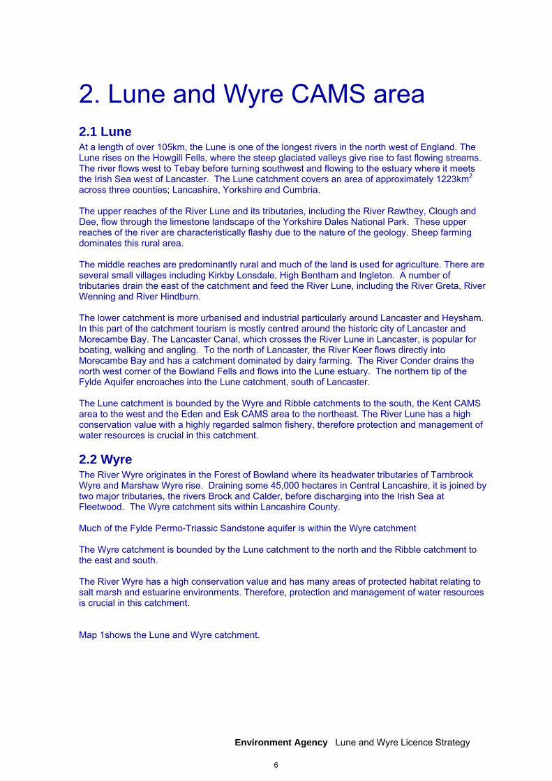
2. Lune and Wyre CAMS area 2.1 Lune At a length of over 105km, the Lune is one of the longest rivers in the north west of England. The Lune rises on the Howgill Fells, where the steep glaciated valleys give rise to fast flowing streams. The river flows west to Tebay before turning southwest and flowing to the estuary where it meets the Irish Sea west of Lancaster. The Lune catchment covers an area of approximately 1223km2 across three counties; Lancashire, Yorkshire and Cumbria. The upper reaches of the River Lune and its tributaries, including the River Rawthey, Clough and Dee, flow through the limestone landscape of the Yorkshire Dales National Park. These upper reaches of the river are characteristically flashy due to the nature of the geology. Sheep farming dominates this rural area. The middle reaches are predominantly rural and much of the land is used for agriculture. There are several small villages including Kirkby Lonsdale, High Bentham and Ingleton. A number of tributaries drain the east of the catchment and feed the River Lune, including the River Greta, River Wenning and River Hindburn. The lower catchment is more urbanised and industrial particularly around Lancaster and Heysham. In this part of the catchment tourism is mostly centred around the historic city of Lancaster and Morecambe Bay. The Lancaster Canal, which crosses the River Lune in Lancaster, is popular for boating, walking and angling. To the north of Lancaster, the River Keer flows directly into Morecambe Bay and has a catchment dominated by dairy farming. The River Conder drains the north west corner of the Bowland Fells and flows into the Lune estuary. The northern tip of the Fylde Aquifer encroaches into the Lune catchment, south of Lancaster. The Lune catchment is bounded by the Wyre and Ribble catchments to the south, the Kent CAMS area to the west and the Eden and Esk CAMS area to the northeast. The River Lune has a high conservation value with a highly regarded salmon fishery, therefore protection and management of water resources is crucial in this catchment.
2.2 Wyre The River Wyre originates in the Forest of Bowland where its headwater tributaries of Tarnbrook Wyre and Marshaw Wyre rise. Draining some 45,000 hectares in Central Lancashire, it is joined by two major tributaries, the rivers Brock and Calder, before discharging into the Irish Sea at Fleetwood. The Wyre catchment sits within Lancashire County. Much of the Fylde Permo-Triassic Sandstone aquifer is within the Wyre catchment The Wyre catchment is bounded by the Lune catchment to the north and the Ribble catchment to the east and south. The River Wyre has a high conservation value and has many areas of protected habitat relating to salt marsh and estuarine environments. Therefore, protection and management of water resources is crucial in this catchment. Map 1shows the Lune and Wyre catchment.
6
AP1AP18
AP12AP13
AP11
9
875
4
3
2
1
10
9
8
76
5
4
3
21
13
12
1110
Stainto
n B
eck
River Gilpin
River Sprint
R ive r Kee
r
River Kent
Artle Bec k
Pease
y Beck
Rive r GretaR ive
r Eea
River Wenning
River C lough
Cant Beck
River Dee
Rusland Pool
River
Leve
n
R iver Brock
River Roeburn
Scand
al Beck
Long dale Beck
R iver Loud
River Doe
River Mint
R iver C alder
Borrow Beck
River Con
der
Woodplumpton Brook
Kett le
s Bec
kFen Beck
Helm Beck
Mearley Brook
Hillylaid Pool
Savick B
rook
River
Rotha
y
KeerRiv
e r Lune
Rathmell Beck
Skirden Beck
Ridgy Pool
Pilling Water
River Gowan
Ellerg
ill bec
k
Cam
Beck
Croasdale Beck
Leck Beck (Ea
se
Gill)
Easington B
rook
Barbon Beck (Barkin Beck)
Birk Beck
Burro
w Beck
Deepdale Beck
Austwick beck
Chap
el Be
ck
River Bela
Sabden
Brook
River Hindburn
Holden Beck
River
Eden
(top)
Duddel Brook
Rive
r L
owther
Rais B
eck
Wyre (Tidal)
Langden Brook
Flodder Beck
River Brennand
Unknown
Holme Beck
Windermoor Main Drain
Hillyla
id Po
ol
River Gilpin
River M int
Map 1 Lune and Wyre CAMS Area
±
0 4 8 12 16 202Kilometres
© Crown copyright. All rights reserved.Environment Agency 100026380. 2012.Some features of this map are basedon digital spatial data licensed from theCentre for Ecology and Hydrology, © CEH.
Creation date January 2013
LegendLune catchment assessment pointsWyre catchment assessment pointsCanalsRiversRamsar
SACSPANational ParksSSSI
7

Environment Agency Lune and Wyre Licence Strategy
3. Water resource availability of the Lune and Wyre area 3.1 Resource assessment Resource assessment is at the heart of abstraction management. To manage water effectively we need to understand how much is available and where it is available, after considering the needs of the environment. We have a monitoring network to measure river flows and groundwater levels. We use this data along with our knowledge of human influences and environmental needs to establish a baseline of water availability for each water body that builds into a picture for the catchment. The main components of this assessment that help us to understand the availability of water resources are: a resource allocation for the environment defined as a proportion of natural flow, known as the
Environmental Flow Indicator (EFI) the Fully Licensed (FL) scenario - the situation if all abstraction licences were being used to full
capacity the Recent Actual (RA) scenario – the amount of water which has actually been abstracted on
average over the previous six years River flows change naturally throughout the year, so we want to protect flow variability in our rivers from low to high flow conditions. We use flow statistics to help to do this. Flow statistics are expressed as the percentage of time that flow is exceeded. Resource availability is calculated at four different flows, Q95 (lowest), Q70, Q50 and Q30 (highest). For example, Q95 is flow that is equalled or exceeded for 95% of the time. It's termed a low flow because only 5% of the time is flow less than this. This information gives a realistic picture of what the current resource availability is within a given water body. Water bodies are sub-catchment surface water units or groundwater units on which we carry out assessments and map results.
3.2 Resource availability 3.2.1 Surface water If you want to abstract water, you need to know what water resources are available within a catchment and where abstraction for consumptive purposes is allowed. To show this we have developed a classification system which indicates: the relative balance between the environmental requirements for water and how much is
licensed for abstraction whether water is available for further abstraction areas where abstraction may need to be reduced The availability of water for abstraction is determined by the relationship between the fully licensed and recent actual flows in relation to the EFI. The results mapped onto these water bodies are represented by different water resource availability colours showing the availability of water resource for further abstraction. The water resource availability colours are explained in Table 1. In addition to these water resource availability colours we’ve classified some surface water bodies as ‘high hydrological status’ which are coloured blue on the maps. In these water bodies very little actual abstraction occurs and they show virtually undisturbed, or close to natural, flow conditions. Another category of water body is Heavily Modified Water bodies (HMWB). These can be classified for many reasons but for water resources they are classified if they may contain a modified lake and/or reservoir that influence the downstream flow regime of the river.
8
Environment Agency Lune and Wyre Licence Strategy
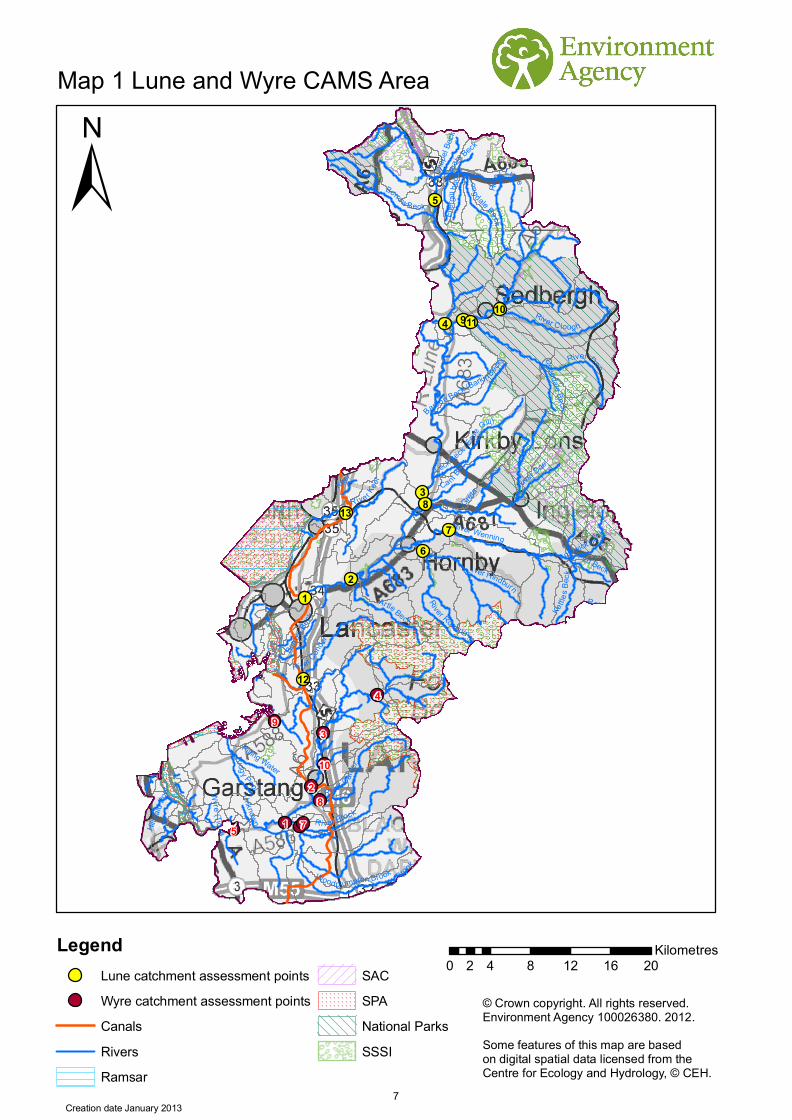
We’ll add any conditions necessary to protect flows to a new licence during the licence determination procedure. We’ll base these on the water resource availability colours from high to low flows. Table 1 lists the implications for licensing for each water resource availability colour. Water resource availability colour
Implication for licensing
High hydrological regime
There is more water than required to meet the needs of the environment. However, due to the need to maintain the near pristine nature of the water body, further abstraction is severely restricted.
Water available There is more water than required to meet the needs of the environment. New licences will be considered depending on local and downstream impacts.
Restricted water available
Full Licensed flows fall below the EFI. No new consumptive licences would be granted. It may also be appropriate to investigate the possibilities for reducing fully licensed risks. Water may be available if you can ‘buy’ (known as licence trading) the entitlement to abstract water from an existing licence holder.
Water not available
Recent actual flows are below the EFI. This scenario highlights water bodies where flows are below the indicative flow requirement to help support Good Ecological Status (GES) as required by the Water Framework Directive. Note: we are currently investigating water bodies that are not supporting GES / GEP. No further consumptive licences will be granted. Water may be available if you can ‘buy’ (known as licence trading) the amount equivalent to recently abstracted from an existing licence holder.
HMWB These water bodies have a modified flow that is influenced by reservoir compensation releases or they have flows that are augmented. These are often known as ‘regulated rivers’. They may be managed through an operating agreement, often held by a water company. The availability of water is dependent on these operating agreements. More detail, if applicable, can be found in section 4.2.1 Surface Water..
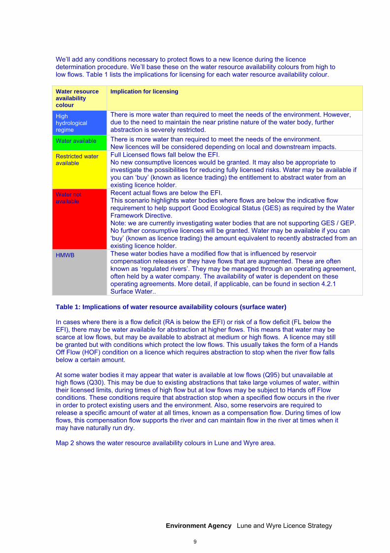
Table 1: Implications of water resource availability colours (surface water) In cases where there is a flow deficit (RA is below the EFI) or risk of a flow deficit (FL below the EFI), there may be water available for abstraction at higher flows. This means that water may be scarce at low flows, but may be available to abstract at medium or high flows. A licence may still be granted but with conditions which protect the low flows. This usually takes the form of a Hands Off Flow (HOF) condition on a licence which requires abstraction to stop when the river flow falls below a certain amount. At some water bodies it may appear that water is available at low flows (Q95) but unavailable at high flows (Q30). This may be due to existing abstractions that take large volumes of water, within their licensed limits, during times of high flow but at low flows may be subject to Hands off Flow conditions. These conditions require that abstraction stop when a specified flow occurs in the river in order to protect existing users and the environment. Also, some reservoirs are required to release a specific amount of water at all times, known as a compensation flow. During times of low flows, this compensation flow supports the river and can maintain flow in the river at times when it may have naturally run dry. Map 2 shows the water resource availability colours in Lune and Wyre area.
9
AP1AP2
AP3
AP18
AP10
AP12AP13
AP11
AP17
Map 2 Lune and WyreCAMS Resource Colours
© Crown copyright. All rights reserved.Environment Agency 100026380. 2012.Some features of this map are basedon digital spatial data licensed from theCentre for Ecology and Hydrology, © CEH.Creation date 3 January 2013
Q95
Q30Q50Q70
AP1AP2
AP3
AP18
AP10
AP12AP13
AP11
AP17AP1
AP2AP3
AP18
AP10
AP12AP13
AP11
AP17AP1
AP2AP3
AP18
AP10
AP12AP13
AP11
AP17
±
0 20 40 6010Kilometres
LegendWater AvailableLimited Water AvailableNo Water Available
Heavily Modified and Artificial RiversRiversCAMS Waterbodies
low flows i.e. flows areexceeded 95% of the time
10
Environment Agency Lune and Wyre Licence Strategy
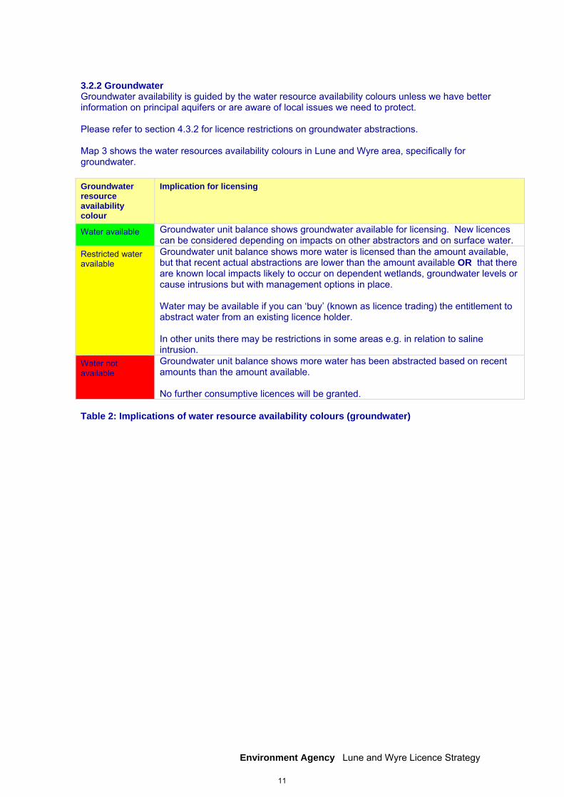
3.2.2 Groundwater Groundwater availability is guided by the water resource availability colours unless we have better information on principal aquifers or are aware of local issues we need to protect. Please refer to section 4.3.2 for licence restrictions on groundwater abstractions. Map 3 shows the water resources availability colours in Lune and Wyre area, specifically for groundwater. Groundwater resource availability colour
Implication for licensing
Water available Groundwater unit balance shows groundwater available for licensing. New licences can be considered depending on impacts on other abstractors and on surface water.
Restricted water available
Groundwater unit balance shows more water is licensed than the amount available, but that recent actual abstractions are lower than the amount available OR that there are known local impacts likely to occur on dependent wetlands, groundwater levels or cause intrusions but with management options in place. Water may be available if you can ‘buy’ (known as licence trading) the entitlement to abstract water from an existing licence holder. In other units there may be restrictions in some areas e.g. in relation to saline intrusion.
Water not available
Groundwater unit balance shows more water has been abstracted based on recent amounts than the amount available. No further consumptive licences will be granted.
Table 2: Implications of water resource availability colours (groundwater)
11
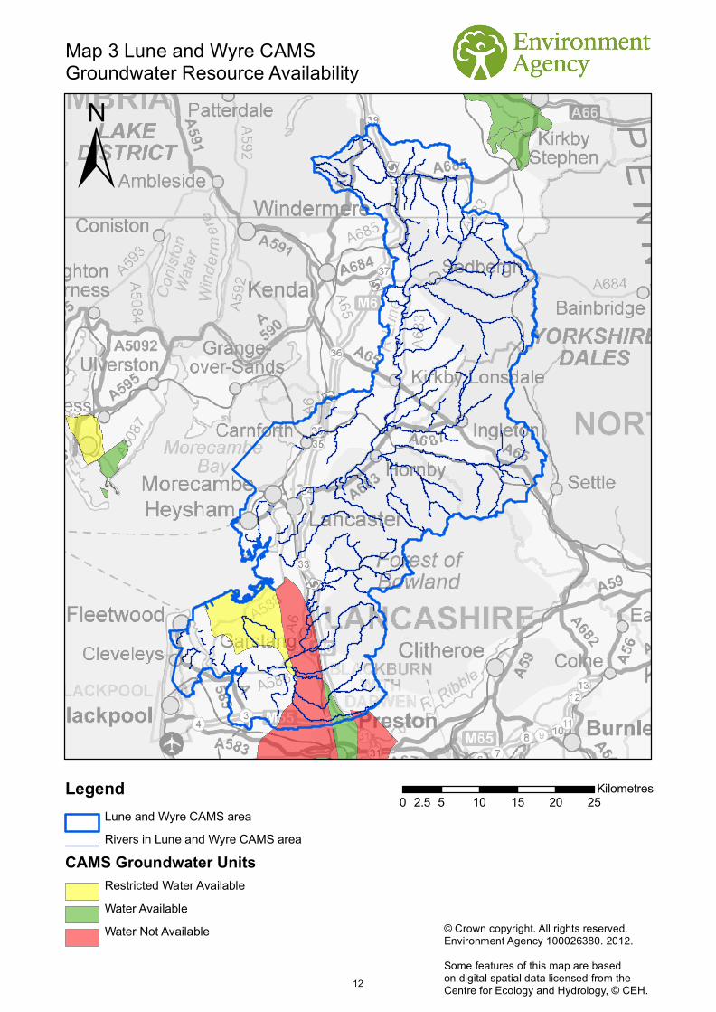
Map 3 Lune and Wyre CAMS Groundwater Resource Availability
±
0 5 10 15 20 252.5Kilometres
© Crown copyright. All rights reserved.Environment Agency 100026380. 2012.Some features of this map are basedon digital spatial data licensed from theCentre for Ecology and Hydrology, © CEH.
LegendLune and Wyre CAMS areaRivers in Lune and Wyre CAMS area
CAMS Groundwater UnitsRestricted Water AvailableWater AvailableWater Not Available
12

Environment Agency Lune and Wyre Licence Strategy
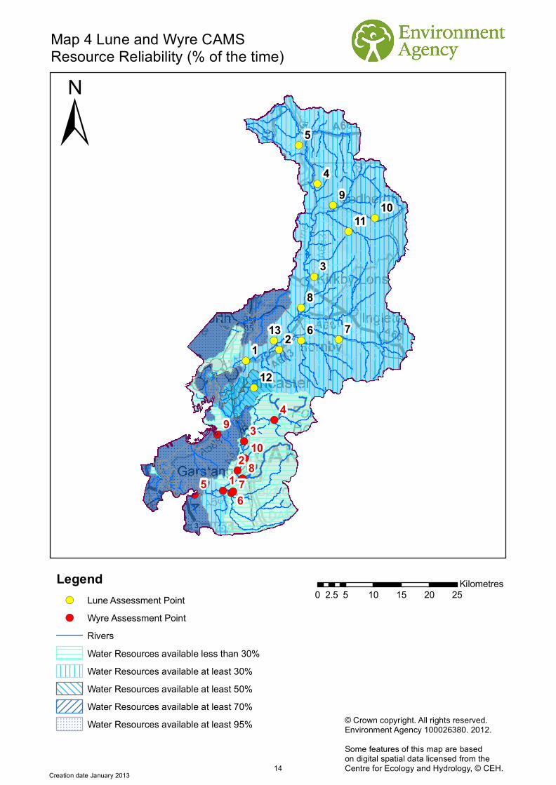
3.3 Resource reliability If you want to apply for a licence, it is worth considering that in some areas a new, consumptive abstraction may not be 100% reliable. This is because there may be significant periods of time when flows are low so you will not be able to abstract due to the likely HOF conditions that we will place on your new/varied licence. Reliability information is based on CAMS resource availability colours and is a way of presenting the reliability of new abstractions at all flows. The availability of water for abstraction within a river varies greatly from high to low flows. By assessing the quantity of water available at different flows it is possible to see when there is a surplus or deficit of water and the associated reliability of an abstraction. This is an indication only, actual reliability of a licence will be discussed on application. Table 3 shows the resource availability colour associated with the percentage reliability of consumptive abstraction. Map 4 gives an indication of the resource reliability in Lune and Wyre area expressed as percentage of time. Resource Percentage of the time additional consumptive resource may be available Consumptive abstraction available less than 30% of the time
Consumptive abstraction available at least 30% of the time
Consumptive abstraction available at least 50% of the time
Consumptive abstraction available at least 70% of the time
Consumptive abstraction available at least 95% of the time
Not assessed
Table 3: Percentage reliability of consumptive abstraction
13
!(
!(
!(
!(
!( !(!(
!(
!(
!(
!(!(
!(
!(
!(
!( !(
!(
!(
!(
!(
!(
!(
AP1AP18
AP12AP13
AP11
9
8
76
5
4
3
21
13
12
1110
9
876
5
43
21
10
Map 4 Lune and Wyre CAMS Resource Reliability (% of the time)
±
0 5 10 15 20 252.5Kilometres
© Crown copyright. All rights reserved.Environment Agency 100026380. 2012.Some features of this map are basedon digital spatial data licensed from theCentre for Ecology and Hydrology, © CEH.
Creation date January 2013
Legend!( Lune Assessment Point!( Wyre Assessment Point
RiversWater Resources available less than 30%Water Resources available at least 30%Water Resources available at least 50%Water Resources available at least 70%Water Resources available at least 95%
14

Environment Agency Lune and Wyre Licence Strategy
4. How we manage abstractions in the Lune and Wyre catchment 4.1 Water abstraction in the Lune and Wyre CAMS area Water is abstracted throughout the area from surface waters and groundwater for agriculture, power generation, spray irrigation, canal supply, industry, environmental and public water supply purposes. Industry and public water supply account for the largest abstractions in the Lune and Wyre area. The majority of abstraction is from surface water, with a small volume abstracted from the Flyde aquifer. Homes and industries within this CAMS area receive their water supply from United Utilities Water Plc. All of the public water supply abstractions within the area feed into the water company integrated system. This system supplies water to 95 per cent of customers in the north west of England. Water is sourced from as far afield as Haweswater and Thirlmere Reservoirs in the Lake District and Lake Vyrnwy in mid-Wales to meet the demand for water in the north west. Lancashire Conjunctive Use Scheme, commissioned in the 1970s, comprises river, reservoir and borehole sources. Part of the scheme involves the transfer of significant quantities of water from the River Lune to the River Wyre to support abstraction further downstream on the Wyre. There are residual flow conditions to protect flows on the Rivers Lune and Wyre. There are two abstractions within the Lune CAMS area which are used to supply the canal network operated by the Canal & Rivers Trust. In the Lune area, wastewater treatment work discharges contribute to flows at AP7 River Wenning and AP8 River Greta. However, there are no abstractions supported by discharges to the rivers.
4.2 Principles The document Managing Water Abstraction outlines the over-arching principles that we follow in managing our water resources. How we apply these principles in the Lune and Wyre area is outlined in this section. If you want to abstract water it outlines where water is available for further abstraction and the principles we follow in assessing your application for a licence. Abstraction licence application process Anyone wanting to take more than 20m3/day from a ‘source of supply’ (river, stream, lake, well, groundwater etc) must have an abstraction licence. The application process for abstraction is similar to the planning process in that we may require the application to be advertised and may require supporting environmental information. When considering the application we check that the quantities applied for and the purpose of the abstraction are reasonable, that there is sufficient water available to support it and that the potential impacts on the environment and other water users are acceptable. Depending on the outcome of our investigations we will issue a licence either as applied for, or with conditions that restrict the abstraction to protect the environment or other users. In certain cases we may have to refuse the application. Any applicant who is not happy with our determination (decision) has the right to appeal against it. Each application is determined on its own merits Whilst this document may say that water is available for further abstraction, this does not guarantee that all applications will be successful. We’ll determine each application upon its own merits and any local impacts.
15
Environment Agency Lune and Wyre Licence Strategy
A licence does not guarantee that water is available It’s important to understand that when we issue a licence we do not guarantee the supply of water. We have to protect the environment and rights of other abstractors. To do this we may add constraints to licences. Licence holders should understand the implications of this as it affects the reliability of supply. For example, in drier years it’s more likely that conditions will come into effect and abstraction is more likely to be stopped. Abstractions are managed to protect the environment. No ecological deterioration We assess the impact of new applications for water to make sure that the resultant river flows:
will maintain a good ecology or if the ecology is not good, will not deteriorate the ecology of our rivers further
will maintain the near pristine condition of high hydrological regime water bodies For existing licences, where current abstraction is less than licensed i.e. more water could be legally abstracted, we may take action to limit such an increase if we think this will lead to deterioration of the ecology of water bodies. These principles apply to the water body in which the abstraction is located and also to all downstream water bodies that may be affected by any reduction in flow caused by abstraction. Doing this means that we will maintain the water body status as reported in the River Basin Management Plans (2009) and ensure compliance with the European Union Water Framework Directive. Water efficiency and demand management We need to make the best use of our existing water resources. Adopting water efficiency and demand management measures can help us achieve this goal. Water efficiency is one of the tests that will need to be satisfied before we grant a new licence or renew a time limited licence. We will promote the wise and efficient use of water and actions to limit demand (and reduce leakage) to curb the growth in abstraction and limit the impact on flows and any consequent impact on the ecology. For further details on our general approach to licensing please see the document Managing Water Abstraction. Impoundments An impoundment is a construction in an inland waterway that obstructs or impedes flow and/or raises water levels. These structures include weirs, dams, fish passes and sluices. You normally need an impoundment licence to construct, alter, repair or remove an impoundment structure. We will consider every case on its individual merits. We will normally only approve an application to install new structures in a watercourse if one or more of the following apply:
it is demonstrated to our satisfaction that there are over-riding social or economic reasons for the structure(s) in line with our sustainable development remit and there is no reasonable alternative
we agree that the impacts on flood risk, ecology and morphology will not be significant or will be adequately mitigated against or compensated for
we accept that the watercourse or floodplain has been modified or degraded, and restoration or enhancement using in-channel structures is justified and acceptable to flood risk management and ecological interests
there are important strategic or operational reasons to monitor or regulate river levels and flows, and alternative methods are not technically or financially viable
We will seek mitigation or compensation to ensure environmental impacts and residual damage are minimised, where appropriate. We may seek the removal or modification of structures that have an adverse effect on flood risk or on the ecology, morphology and visual amenity of a river if we believe it is justified, practical and economic.
16
Environment Agency Lune and Wyre Licence Strategy
Hydropower Hydropower schemes harness the energy from flowing water to generate electricity, using a turbine or other device. Sustainable, small scale hydropower has a small but important part to play in meeting UK renewable energy targets. Water abstraction for hydropower schemes is non-consumptive, with all water used returned to the watercourse. Hands Off Flows and maximum abstraction volumes are determined in line with the Environment Agency's Hydropower Good Practice Guidelines and based on the assessment of environmental risk for each scheme. For further information please refer to our website.
4.3 Abstraction restrictions When issuing a licence we have to protect the environment and rights of other abstractors. To do this we may add conditions to licences. Time limited licences In recognition of changing pressures on water resources all new licences and variations will have a time limit imposed, apart from downward variations or minor variations having no environmental impact. This allows for the periodic review and changes to abstraction licences where circumstances have changed since the licence was granted. All new licences within a CAMS area have a Common End Date (CED) so they can be reviewed at the same time. When an application is made within six years of the CED, we will generally apply the subsequent CED to any licence granted. This is to avoid issuing shorter and shorter duration licences as the CED approaches. This means that the initial CED on a licence may be between six and 18 years duration. On replacement the normal duration will then usually be 12 years. However, where we are uncertain about the long term impacts of an abstraction we will grant a short term licence during which time potential impacts are monitored. 11% of the current licences in the Lune and Wyre CAMS area are time-limited. CEDs occur every twelve years. The next CED for Lune and Wyre CAMS are:
Lune area: 31 March 2017 and the subsequent CED is 31 March 2029 Wyre area: 31 March 2018 and the subsequent CED is 31 March 2030
Additional information about the replacement of time limited licences is available in Managing Water Abstraction. Hands Off Flow conditions To protect the environment we may issue a licence with a condition referred to as a Hand Off Flow (HOF). This specifies that if the flow in the river drops below that which is required to protect the environment abstraction must stop, hence Hands Off Flow. Please refer to Table 4 for Hands Off Flows for each assessment point.
17
Environment Agency Lune and Wyre Licence Strategy
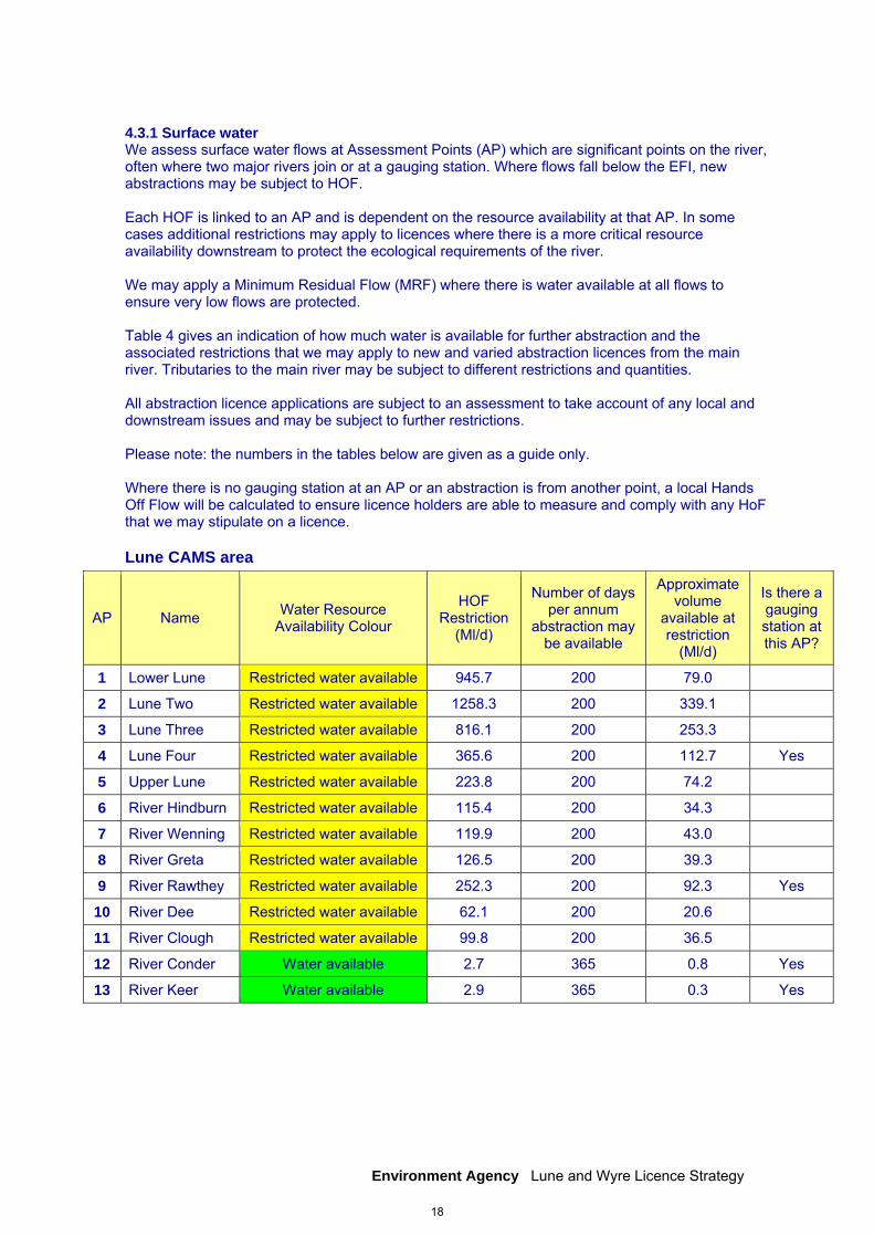
4.3.1 Surface water We assess surface water flows at Assessment Points (AP) which are significant points on the river, often where two major rivers join or at a gauging station. Where flows fall below the EFI, new abstractions may be subject to HOF. Each HOF is linked to an AP and is dependent on the resource availability at that AP. In some cases additional restrictions may apply to licences where there is a more critical resource availability downstream to protect the ecological requirements of the river. We may apply a Minimum Residual Flow (MRF) where there is water available at all flows to ensure very low flows are protected. Table 4 gives an indication of how much water is available for further abstraction and the associated restrictions that we may apply to new and varied abstraction licences from the main river. Tributaries to the main river may be subject to different restrictions and quantities. All abstraction licence applications are subject to an assessment to take account of any local and downstream issues and may be subject to further restrictions. Please note: the numbers in the tables below are given as a guide only. Where there is no gauging station at an AP or an abstraction is from another point, a local Hands Off Flow will be calculated to ensure licence holders are able to measure and comply with any HoF that we may stipulate on a licence.
Lune CAMS area
AP Name Water Resource Availability Colour
HOF Restriction
(Ml/d)
Number of days per annum
abstraction may be available
Approximate volume
available at restriction
(Ml/d)
Is there a gauging station at this AP?
1 Lower Lune Restricted water available 945.7 200 79.0
2 Lune Two Restricted water available 1258.3 200 339.1
3 Lune Three Restricted water available 816.1 200 253.3
4 Lune Four Restricted water available 365.6 200 112.7 Yes
5 Upper Lune Restricted water available 223.8 200 74.2
6 River Hindburn Restricted water available 115.4 200 34.3
7 River Wenning Restricted water available 119.9 200 43.0
8 River Greta Restricted water available 126.5 200 39.3
9 River Rawthey Restricted water available 252.3 200 92.3 Yes
10 River Dee Restricted water available 62.1 200 20.6
11 River Clough Restricted water available 99.8 200 36.5
12 River Conder Water available 2.7 365 0.8 Yes
13 River Keer Water available 2.9 365 0.3 Yes
18
Environment Agency Lune and Wyre Licence Strategy
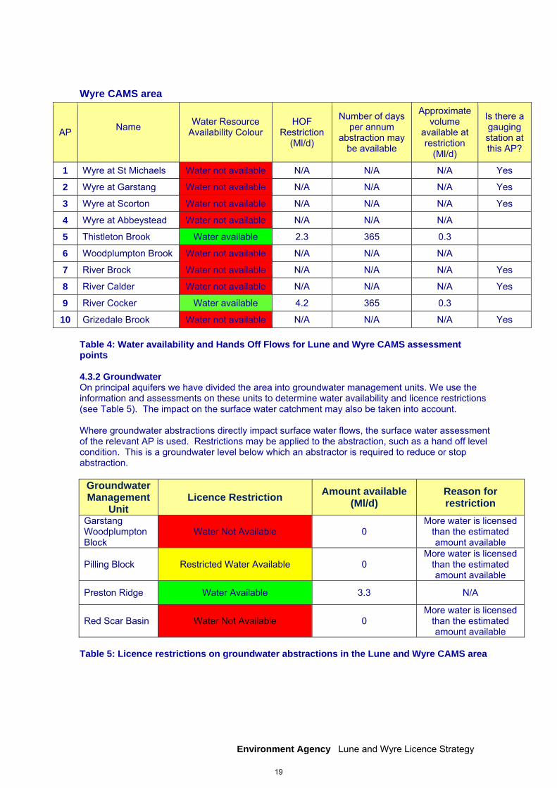
Wyre CAMS area
AP Name
Water Resource Availability Colour
HOF Restriction
(Ml/d)
Number of days per annum
abstraction may be available
Approximate volume
available at restriction
(Ml/d)
Is there a gauging station at this AP?
1 Wyre at St Michaels Water not available N/A N/A N/A Yes
2 Wyre at Garstang Water not available N/A N/A N/A Yes
3 Wyre at Scorton Water not available N/A N/A N/A Yes
4 Wyre at Abbeystead Water not available N/A N/A N/A
5 Thistleton Brook Water available 2.3 365 0.3
6 Woodplumpton Brook Water not available N/A N/A N/A
7 River Brock Water not available N/A N/A N/A Yes
8 River Calder Water not available N/A N/A N/A Yes
9 River Cocker Water available 4.2 365 0.3
10 Grizedale Brook Water not available N/A N/A N/A Yes Table 4: Water availability and Hands Off Flows for Lune and Wyre CAMS assessment points 4.3.2 Groundwater On principal aquifers we have divided the area into groundwater management units. We use the information and assessments on these units to determine water availability and licence restrictions (see Table 5). The impact on the surface water catchment may also be taken into account. Where groundwater abstractions directly impact surface water flows, the surface water assessment of the relevant AP is used. Restrictions may be applied to the abstraction, such as a hand off level condition. This is a groundwater level below which an abstractor is required to reduce or stop abstraction.
Groundwater Management
Unit Licence Restriction
Amount available (Ml/d)
Reason for restriction
Garstang Woodplumpton Block
Water Not Available 0 More water is licensed
than the estimated amount available
Pilling Block Restricted Water Available 0 More water is licensed
than the estimated amount available
Preston Ridge Water Available 3.3 N/A
Red Scar Basin Water Not Available 0 More water is licensed
than the estimated amount available
Table 5: Licence restrictions on groundwater abstractions in the Lune and Wyre CAMS area
19
Environment Agency Lune and Wyre Licence Strategy
4.3.3 Water availability The information below gives an indication of whether licenses will be renewed or granted for each assessment point. Water available The following surface water assessment points have water available for licensing: Wyre
AP 5 Thistleton Brook AP 9 River Cocker
Lune
AP12 River Condor AP13 River Keer
This means that for new licences:
there is water available for unconstrained abstraction we will continue licensing the available resource and then implement the Hands Off Flow
(HOF) constraints the time limit will be the relevant CED
As an example in the Lune CAMS area, Assessment Point 13, River Keer, there is approximately 0.3 Megalitres per day of water available for licensing every day of the year. This would be available after a Hands Off Flow restriction of the Minimal Residual Flow of 2.9Ml/d. For existing licences: There is a presumption of renewal, subject to the other renewal criteria and local considerations. Renewals may be subject to minor changes including the addition of water efficiency conditions. Within the groundwater management unit of Preston Ridge, new licences can be considered depending on impacts on other abstractors and on surface water. Restricted water available The following surface water assessment points have restricted water available for licensing: Lune
AP1 Lower Lune AP2 Lune Two AP3 Lune Three AP4 Lune Four AP5 Upper Lune AP6 River Hindburn AP7 River Wenning AP8 River Greta AP9 River Rawthey AP10 River Dee AP11 River Clough
This means that for new licences:
no new unconstrained licences will be granted water is only available during periods of medium to high flows with HOF conditions there is a time limit of 31 March 2017 ie the relevant CED
For existing licences:
no impact on existing licence holders
20

Environment Agency Lune and Wyre Licence Strategy
The groundwater management unit balance for Pilling Brook shows that more water is licensed than the amount available. Therefore, no new consumptive licences will be granted. Water may be available if you can ‘buy’ (known as licence trading) the entitlement to abstract water from an existing licence holder. Water not available The following surface water assessment points have no water available for licensing: . Wyre
AP1 Wyre at St Michaels AP2 Wyre at Garstang AP3 Wyre at Scorton AP4 Wyre at Abbeystead AP6 Woodplumpton Brook AP7 River Brock AP8 River Calder AP10 Grizedale Brook
We will not consider any further consumptive upstream of these Assessment Points. A new licence could be considered as the result of a trade. For the Garstang Woodplumpton Block and Red Scar Basin groundwater management units, balances based on recent amounts show that more water has been abstracted than the amount available. Therefore no further consumptive licences will be granted for these units. Further Information For further information about the availability of water at specific locations and any restrictions likely to apply, please enquire using the following contact details:
by telephone on 03708 506 506 by email at [email protected] or visit our website at www.environment-agency.gov.uk
4.3.4 Estuaries/Coast The tidal limit for the River Lune is at Skerton Gauging Station in Lancaster (SD48266339). The river flows from here into Morecambe Bay. The tidal limit for the River Wyre is at St Michael’s on Wyre (SD46304110). Downstream of this point the tidal river meanders across the flat low-lying land past Eccleston and Singleton before turning north and discharging into Morecambe Bay at Fleetwood. Abstractions from the sea are not licensable unless they are clearly in a dock, channel, creek, bay, estuary or arm of the sea. For all estuarine abstractions, we require abstraction intakes to be fitted with screens (to 3mm) to prevent eels and elvers being abstracted from the estuary. This is because the estuaries are an obvious migratory route for eels and is required under the Eels (England and Wales) Regulations 2009.
Applications made in designated sites (SAC, SPA, SSSI) will be given further scrutiny to avoid impacts on habitats and the environment.
21
Environment Agency Lune and Wyre Licence Strategy
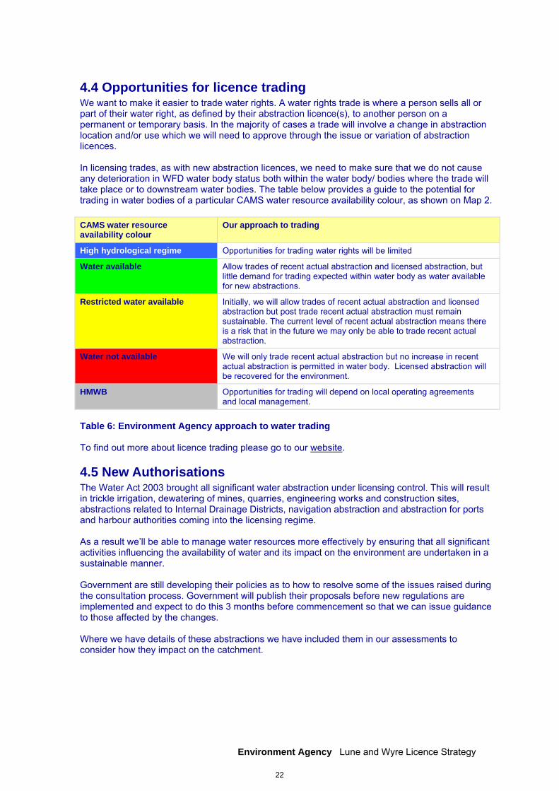
4.4 Opportunities for licence trading We want to make it easier to trade water rights. A water rights trade is where a person sells all or part of their water right, as defined by their abstraction licence(s), to another person on a permanent or temporary basis. In the majority of cases a trade will involve a change in abstraction location and/or use which we will need to approve through the issue or variation of abstraction licences. In licensing trades, as with new abstraction licences, we need to make sure that we do not cause any deterioration in WFD water body status both within the water body/ bodies where the trade will take place or to downstream water bodies. The table below provides a guide to the potential for trading in water bodies of a particular CAMS water resource availability colour, as shown on Map 2. CAMS water resource availability colour
Our approach to trading
High hydrological regime Opportunities for trading water rights will be limited
Water available Allow trades of recent actual abstraction and licensed abstraction, but little demand for trading expected within water body as water available for new abstractions.
Restricted water available Initially, we will allow trades of recent actual abstraction and licensed abstraction but post trade recent actual abstraction must remain sustainable. The current level of recent actual abstraction means there is a risk that in the future we may only be able to trade recent actual abstraction.
Water not available We will only trade recent actual abstraction but no increase in recent actual abstraction is permitted in water body. Licensed abstraction will be recovered for the environment.
HMWB Opportunities for trading will depend on local operating agreements and local management.
Table 6: Environment Agency approach to water trading To find out more about licence trading please go to our website.
4.5 New Authorisations The Water Act 2003 brought all significant water abstraction under licensing control. This will result in trickle irrigation, dewatering of mines, quarries, engineering works and construction sites, abstractions related to Internal Drainage Districts, navigation abstraction and abstraction for ports and harbour authorities coming into the licensing regime. As a result we’ll be able to manage water resources more effectively by ensuring that all significant activities influencing the availability of water and its impact on the environment are undertaken in a sustainable manner. Government are still developing their policies as to how to resolve some of the issues raised during the consultation process. Government will publish their proposals before new regulations are implemented and expect to do this 3 months before commencement so that we can issue guidance to those affected by the changes. Where we have details of these abstractions we have included them in our assessments to consider how they impact on the catchment.
22

Environment Agency Lune and Wyre Licence Strategy
4.6 Restoring Sustainable Abstraction (RSA) Where water abstractions cause or potentially cause actual flows to fall short of the EFIs and result in environmental damage, we may need to change or even revoke existing abstractions in order to achieve a sustainable abstraction regime. The abstraction licences within these water bodies that cause these issues are being investigated as part of the RSA programme. Investigations into the impact caused by these licences, individually or cumulatively, will result in options being developed with licence holders on how to improve sustainability. Investigations will include a cost/benefit analysis. Information on how licences in the RSA programme are dealt with can be found in our Step by Step guide on our website. Within the current RSA programme, no water bodies in the Lune and Wyre CAMS area are being investigated.
4.7 Heavily Modified Water Bodies Some water bodies have been designated as artificial or heavily modified if they are substantially modified or constructed to be used for water supply, urban purposes, flood protection or navigation. Under the River Basin Management Plan for the North West, private, public and voluntary/third sector organisations will work together to ensure that these water bodies can achieve their full environmental potential.
4.8 Habitats Directive Under the Habitats Regulations1 we have assessed the effects of existing abstraction licences and will assess new applications to make sure they are not impacting on internationally important nature conservation sites. These sites are known as Special Areas of Conservation (SAC) and Special Protection Areas (SPA). If you’re current licence has been reviewed under this legislation to assess its impact you will already know about the review. If we haven’t contacted you yet then your licence is either not near a SAC/SPA or isn’t having an impact on these sites. If our assessment shows that a new application could have an impact on a SAC/SPA we have to follow strict rules in setting a time limit for that licence. These are:
We may be able to grant the licence but only with a short time limit. This allows us to monitor the impact of the abstraction on a SAC/SPA and change the licence if necessary;
If we can’t determine that your application will not affect the site we have to either put conditions on the licence so that it cannot affect the site or refuse the application. If we grant the licence we may ask you to monitor its impact;
If our assessment shows that there isn’t an impact on the site we will manage the application according to the principles in this document.
When assessing new licence applications, we will consider any impacts on the Sites of Special Scientific Interest (SSSI), Special Protection Areas (SPA) and Ramsar sites as displayed in Map 1.
The River Lune has high conservation value as it supports a wide range of wildlife and has many designations for specific species and habitats. Over three-quarters of the Lune CAMS area is designated for its beauty and contribution to landscape character with two National Parks (the Lake District and Yorkshire Dales) and two Areas of Outstanding Natural Beauty (Forest of Bowland and Arnside/Silverdale).
23
Environment Agency Lune and Wyre Licence Strategy
The River Wyre catchment similarly includes a wide variety of habitats and designations. The upper reaches of the River Wyre, above Abbeystead, flow through many designated areas including the Bowland Fells SPA, Tarnbrook Meadows SSSI and various County Biological Heritage Sites. South of the Wyre is Carr House Green Common, a County Biological Heritage Site designated for its varied plant species, and Marton Mere SSSI. To the north is Winmarleigh Moss SSSI. The Lancaster Canal runs adjacent to the Wyre for around 8km and is designated a County Biological Heritage Site for its flora. Tarnbrook and Marshaw Wyre flow through the Forest of Bowland, which is an Area of Outstanding Natural Beauty (AONB). Much of this area is also designated as Bowland Fells SSSI. Morecambe Bay is designated a SAC wetland site and a Ramsar Site for its international importance for overwintering wildfowl and waders and its coastal, estuarine and intertidal habitats. The Wyre Estuary, part of the Morecambe Bay Ramsar site, is also a SSSI.
24
Environment Agency Lune and Wyre Licence Strategy
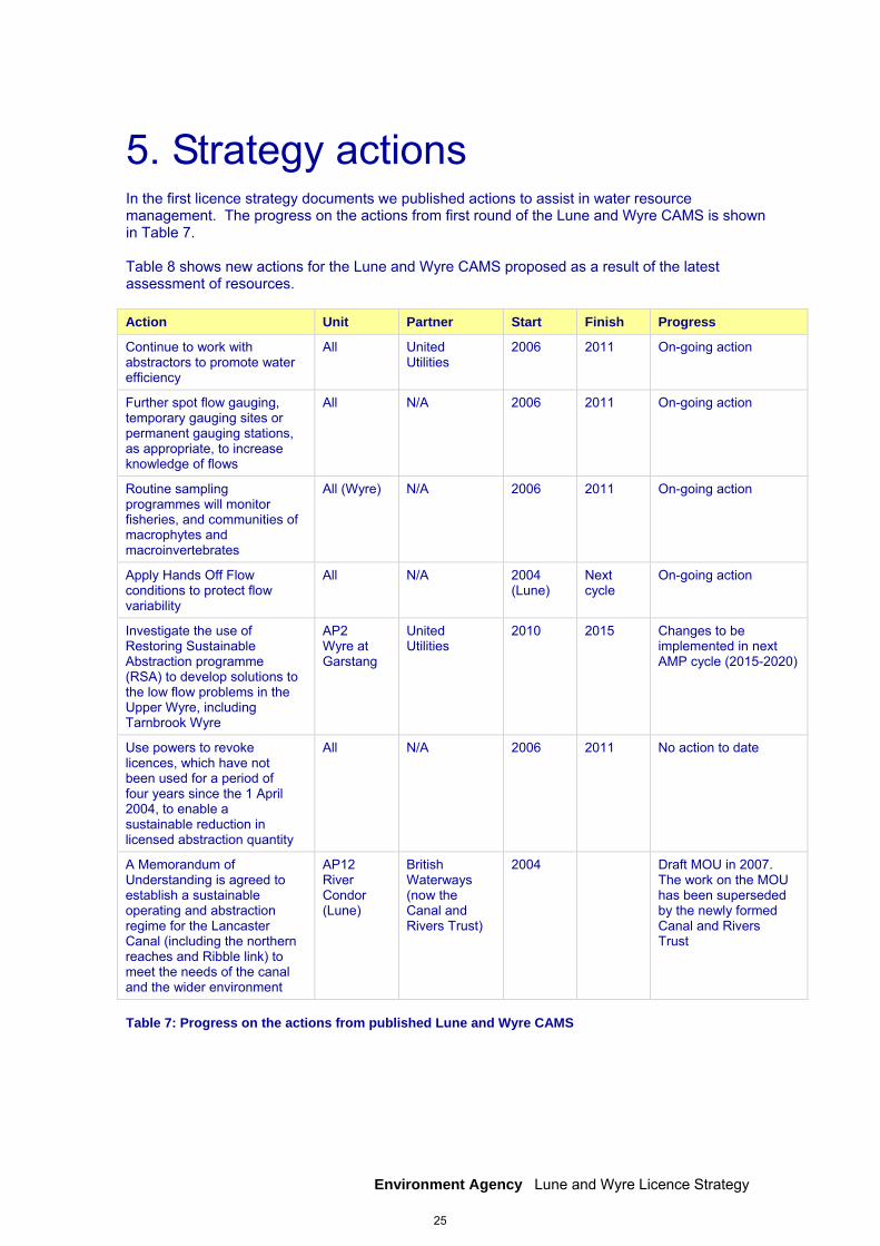
5. Strategy actions In the first licence strategy documents we published actions to assist in water resource management. The progress on the actions from first round of the Lune and Wyre CAMS is shown in Table 7. Table 8 shows new actions for the Lune and Wyre CAMS proposed as a result of the latest assessment of resources. Action Unit Partner Start Finish Progress
Continue to work with abstractors to promote water efficiency
All United Utilities
2006 2011 On-going action
Further spot flow gauging, temporary gauging sites or permanent gauging stations, as appropriate, to increase knowledge of flows
All N/A 2006 2011 On-going action
Routine sampling programmes will monitor fisheries, and communities of macrophytes and macroinvertebrates
All (Wyre) N/A 2006 2011 On-going action
Apply Hands Off Flow conditions to protect flow variability
All N/A 2004 (Lune)
Next cycle
On-going action
Investigate the use of Restoring Sustainable Abstraction programme (RSA) to develop solutions to the low flow problems in the Upper Wyre, including Tarnbrook Wyre
AP2 Wyre at Garstang
United Utilities
2010
2015
Changes to be implemented in next AMP cycle (2015-2020)
Use powers to revoke licences, which have not been used for a period of four years since the 1 April 2004, to enable a sustainable reduction in licensed abstraction quantity
All N/A 2006 2011 No action to date
A Memorandum of Understanding is agreed to establish a sustainable operating and abstraction regime for the Lancaster Canal (including the northern reaches and Ribble link) to meet the needs of the canal and the wider environment
AP12 River Condor (Lune)
British Waterways (now the Canal and Rivers Trust)
2004 Draft MOU in 2007. The work on the MOU has been superseded by the newly formed Canal and Rivers Trust
Table 7: Progress on the actions from published Lune and Wyre CAMS
25

Environment Agency Lune and Wyre Licence Strategy
Measures Unit Partner Start Finish
Investigate reducing fully licensed abstraction volumes in over-licensed groundwater units
Garstang Woodplumpton Block, Pilling Block, Red Scar Basin
N/A 2013 2020
Continue monitoring groundwater levels and review groundwater licence applications
All groundwater units
N/A 2013 2020
Investigate waterbodies where recent actual flows have fallen below EFI. We may seek to reduce licensed quantities as part of the renewal process
Where applicable (mainly Wyre area)
N/A 2013 2014
Continue to investigate waterbodies that are over-licensed and consider options to improve sustainability
Where applicable N/A 2013 2020
Review Environmental Flow Indicators to ensure the correct Hands Off Flow constraints are in place to protect the river ecology
All N/A 2013 2014
Table 8: New measures arising from the latest assessment of resources in the Lune and Wyre CAMS
26
Environment Agency Lune and Wyre Licence Strategy
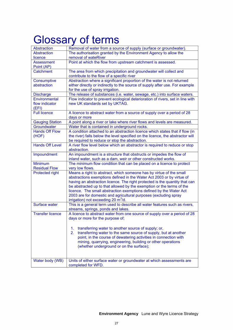
Glossary of terms Abstraction Removal of water from a source of supply (surface or groundwater). Abstraction licence
The authorisation granted by the Environment Agency to allow the removal of wateRiver
Assessment Point (AP)
Point at which the flow from upstream catchment is assessed.
Catchment The area from which precipitation and groundwater will collect and contribute to the flow of a specific river
Consumptive abstraction
Abstraction where a significant proportion of the water is not returned either directly or indirectly to the source of supply after use. For example for the use of spray irrigation.
Discharge The release of substances (i.e. water, sewage, etc.) into surface waters. Environmental flow indicator (EFI)
Flow indicator to prevent ecological deterioration of rivers, set in line with new UK standards set by UKTAG.
Full licence A licence to abstract water from a source of supply over a period of 28 days or more
Gauging Station A point along a river or lake where river flows and levels are measured. Groundwater Water that is contained in underground rocks. Hands Off Flow (HOF)
A condition attached to an abstraction licence which states that if flow (in the river) falls below the level specified on the licence, the abstractor will be required to reduce or stop the abstraction.
Hands Off Level A river flow level below which an abstractor is required to reduce or stop abstraction.
Impoundment An impoundment is a structure that obstructs or impedes the flow of inland water, such as a dam, weir or other constructed works.
Minimum Residual Flow
The minimum flow condition that can be placed on a licence to protect very low flows.
Protected right Means a right to abstract, which someone has by virtue of the small abstractions exemptions defined in the Water Act 2003 or by virtue of having an abstraction licence. The right protected is the quantity that can be abstracted up to that allowed by the exemption or the terms of the licence. The small abstraction exemptions defined by the Water Act 2003 are for domestic and agricultural purposes (excluding spray irrigation) not exceeding 20 m3/d.
Surface water This is a general term used to describe all water features such as rivers, streams, springs, ponds and lakes.
Transfer licence A licence to abstract water from one source of supply over a period of 28 days or more for the purpose of;
1. transferring water to another source of supply; or, 2. transferring water to the same source of supply, but at another
point, in the course of dewatering activities in connection with mining, quarrying, engineering, building or other operations (whether underground or on the surface);
Water body (WB) Units of either surface water or groundwater at which assessments are
completed for WFD.
27
Environment Agency Lune and Wyre Licence Strategy
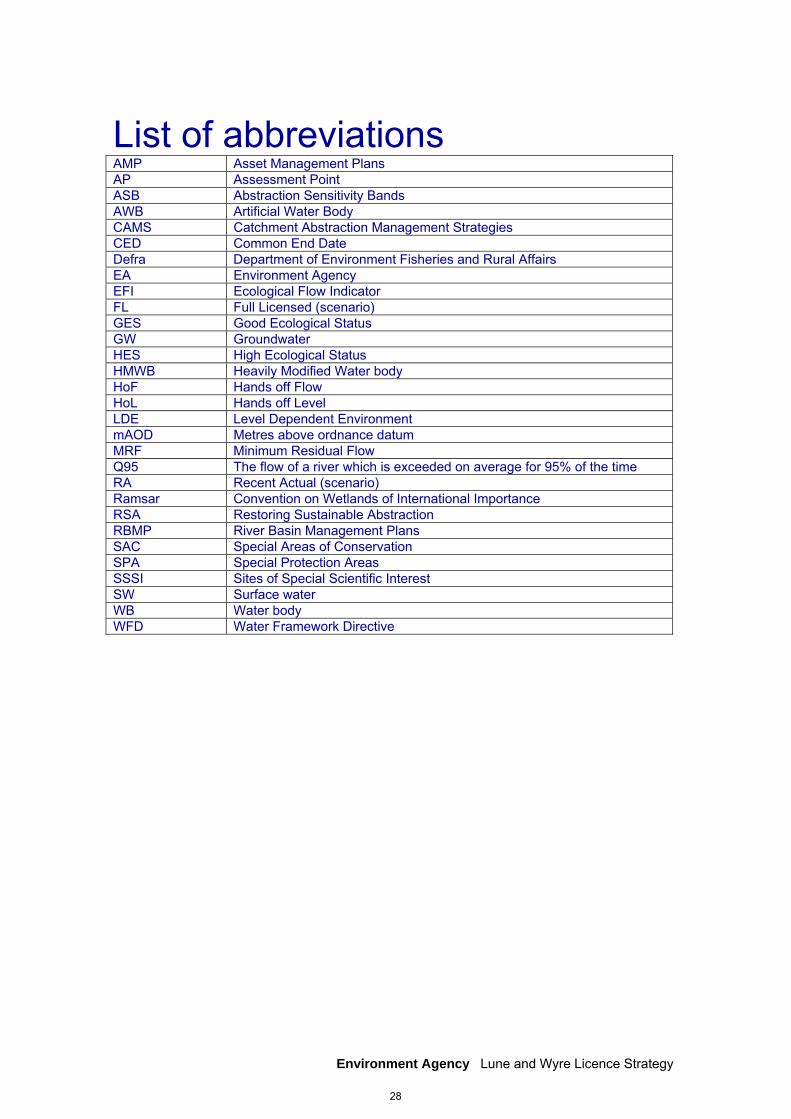
List of abbreviations AMP Asset Management Plans AP Assessment Point ASB Abstraction Sensitivity Bands AWB Artificial Water Body CAMS Catchment Abstraction Management Strategies CED Common End Date Defra Department of Environment Fisheries and Rural Affairs EA Environment Agency EFI Ecological Flow Indicator FL Full Licensed (scenario) GES Good Ecological Status GW Groundwater HES High Ecological Status HMWB Heavily Modified Water body HoF Hands off Flow HoL Hands off Level LDE Level Dependent Environment mAOD Metres above ordnance datum MRF Minimum Residual Flow Q95 The flow of a river which is exceeded on average for 95% of the time RA Recent Actual (scenario) Ramsar Convention on Wetlands of International Importance RSA Restoring Sustainable Abstraction RBMP River Basin Management Plans SAC Special Areas of Conservation SPA Special Protection Areas SSSI Sites of Special Scientific Interest SW Surface water WB Water body WFD Water Framework Directive
28
Environment Agency Lune and Wyre Licence Strategy
Would you like to find out more about us, or about your environment? Call us on 08708 506 506* (Mon-Fri 8am-6pm) email [email protected] or visit our website www.environment-agency.gov.uk incident hotline 0800 80 70 60 (24 hours) floodline 0845 988 1188 * Approximate calls costs: 8p plus 6p per minute (standard landline). Please note charges will vary across telephone providers
Environment first: This publication is printed on paper made from 100 per cent previously used waste. By-products from making the pulp and paper are used for composting and fertiliser, for making cement and for generating energy. Catcode: LIT7917
29