landslide management guidelines - … for landslide management and storm damage response july 2003...
TRANSCRIPT


G U I D E L I N E S F O R L A N D S L I D E M A N A G E M E N T A N DS T O R M D A M A G E R E S P O N S E
July 2003 Big Sur Coast Highway Management Plan i
TABLE OF CONTENTS
1.0 INTRODUCTION ......................................................................................................................................... 1
1.1 BACKGROUND FOR THE GUIDELINES..................................................................................................... 21.2 NEED & PURPOSE FOR THE GUIDELINES .............................................................................................. 31.3 STAKEHOLDER PARTICIPATION............................................................................................................. 41.4 REGULATORY CONTEXT....................................................................................................................... 51.5 APPLICABILITY AND AUTHORITY............................................................................................................ 61.6 ORGANIZATION OF THIS DOCUMENT ..................................................................................................... 6
2.0 OVERVIEW OF GEOLOGY & LANDSLIDES ON THE BIG SUR COAST........................................ 8
2.1 COAST GEOLOGY................................................................................................................................ 82.2 FACTORS INFLUENCING SLOPE STABILITY ALONG HIGHWAY 1 ............................................................... 92.3 TYPES OF LANDSLIDES ...................................................................................................................... 102.4 APPLIED SCIENCE ALONG THE CORRIDOR........................................................................................... 112.5 EVOLVING PRACTICES FOR MANAGING INSTABILITIES.......................................................................... 152.6 INFORMATION RESOURCES FOR THE CORRIDOR ENVIRONMENT........................................................... 17
3.0 PROGRAMS FOR LANDSLIDE MANAGEMENT ACTIVITIES ....................................................... 19
3.1 MAINTENANCE................................................................................................................................... 193.2 CAPITAL IMPROVEMENTS ................................................................................................................... 20
4.0 USING AN INTEGRATED PROCESS..................................................................................................... 23
4.1 INTERDISCIPLINARY APPROACH.......................................................................................................... 234.2 FOLLOWING A LOGICAL PROCESS FOR DECISION MAKING ................................................................... 23
5.0 FUNDAMENTAL HIGHWAY REPAIR STRATEGIES........................................................................ 32
5.1 MANAGING FOR LANDSLIDES.............................................................................................................. 325.2 MANAGING DRAINAGES AND CULVERTS.............................................................................................. 335.3 EARTHWORK AND HANDLING OF EXCESS MATERIAL............................................................................ 355.4 WEIGHING THE OPTIONS AND MANAGING RISK ................................................................................... 38
6.0 BEST AVAILABLE TECHNIQUES......................................................................................................... 42
6.1 LANDSLIDE MANAGEMENT.................................................................................................................. 426.2 DRAINAGEWAY AND CULVERT MANAGEMENT ...................................................................................... 556.3 EARTHWORK AND MATERIAL HANDLING.............................................................................................. 70
7.0 FUTURE ACTIONS.................................................................................................................................... 76
8.0 REFERENCES ............................................................................................................................................ 77
LIST OF APPENDICES
APPENDIX A PRELIMINARY GUIDANCE FOR SHORELINE HABITAT ASSESSMENTSAPPENDIX B STATE HIGHWAY OPERATIONS AND PROTECTION PROGRAM ACTIVITIESAPPENDIX C INTERAGENCY EMERGENCY NOTIFICATION FORM AND GUIDELINES FOR USEAPPENDIX D EMERGENCY COMMUNICATIONSAPPENDIX E PROJECT COMPLETION REPORT
ATTACHMENT 1 CORRIDOR MAPS
G U I D E L I N E S F O R L A N D S L I D E M A N A G E M E N T A N DS T O R M D A M A G E R E S P O N S E
ii Big Sur Coast Highway Management Plan July 2003
BIG SUR COAST HIGHWAY MANAGEMENT PLAN STEERING COMMITTEE
R. Gregg Albright, District 5 Director, California Department of TransportationJohn Bradford, District Ranger, Monterey District, USDA Forest ServiceMike Caplin, President, Coast Property Owners AssociationLygia Chappelet, Member, Coast WatchWilliam Douros, Superintendent, Monterey Bay National Marine SanctuarySam Farr, US Congress House of Representatives—17th DistrictGary Hamby, Division Administrator, Federal Highway AdministrationJohn Harlan, Member, South Coast Land Use Advisory CommitteeScott Hennessy, Director, Monterey County Planning & Building DepartmentJohn Laird, Member, State Assembly—27th DistrictCharles Lester, District Manager, California Coastal CommissionBruce McPherson, Member, State Senate—15th DistrictLaura Moran, President, Big Sur Chamber of CommerceJeff Norman, Resident representative, Big Sur Multi-Agency Advisory CouncilNick Papadakis, Executive Director, Association of Monterey Bay Area GovernmentsDave Potter, 5th District Supervisor, Monterey County Board of Supervisors,Phil Jenkins, Monterey District Manager (Acting), California Department of Parks & RecreationMary Trotter, Chairperson, Big Sur Land Use Advisory CommitteeKen Wright, Member, Monterey County Tourism & Travel Alliance
CALIFORNIA DEPARTMENT OF TRANSPORTATION
R. Gregg Albright, District 5 DirectorRichard Krumholz, Deputy District Director, Transportation Planning & Local ProgramsSteve Price, Deputy District Director, Maintenance & Operations
Aileen K. Loe, Project ManagerGina K. Francis, Transportation Planner
Bob Carr, Landscape ArchitectJohn D. Duffy, Senior Engineering GeologistMorgan Gaudioso, Technical AssistantBob Pavlik, Architectural HistorianAndy Richardson, GIS CoordinatorRon Richman, Senior Engineering Geologist/Civil EngineerTeresa Salak, Maintenance Supervisor (Big Sur)David Serafini, Technical AssistantDon Webster, Maintenance Area Superintendent
PARSONS TRANSPORTATION GROUP
Pat Gelb, Project ManagerConrad Franchi, Civil EngineerChristie Consolini, Planner

G U I D E L I N E S F O R L A N D S L I D E M A N A G E M E N T A N DS T O R M D A M A G E R E S P O N S E
July 2003 Big Sur Coast Highway Management Plan iii
ACKNOWLEDGEMENTS
These guidelines represent a considerable work effort by a variety of dedicated people.In addition to the consistent high quality work of professional staff of the Department ofTransportation and its consultants, numerous individuals volunteered their valuable timeto make meaningful contributions to these guidelines.
Community members volunteered their time to help shape these guidelines byparticipating in various working group sessions and providing input to draft writtenproducts. Among the most enduring and passionate of these volunteers have beenMary Trotter, Ken Wright, John Harlan, Jeff Norman. Likewise, invaluable participationby public agency staff included Holly Price (Monterey Bay National Marine Sanctuary);Lois Harter (CA Department of Parks & Recreation); Lee Otter and Mark Johnsson (CACoastal Commission) and Jeff Main (Monterey County Planning & Building).Participation by many others at various stages of the effort added tremendous value andinsight.
Consultant support provided a critical role in several ways. A team assembled byParsons Brinckerhoff for the CHMP made this undertaking possible and also brought thetalents and dedication of Ben Strumwasser (Public Affairs Management) and Pat Gelb(Parsons Transportation Group) who consistently brought good energy and professionalquality to the project.
Interagency partnerships with the US Geological Survey, UC Santa Cruz through thehard work of Dr. Cheryl Hapke provided for innovative research and analysis aboutcoastal landslides; Chris Wills and Mike Manson with the California Geological Survey(CGS) developed the excellent reference of baseline landslide mapping andcharacterization.
Individual staff from the Department of Transportation who have made specialcontributions to these guidelines include John Duffy, who has made tangible to many thecomplex phenomena of landslides and the principles of living with the ever-presentevolution of the landscape. Under the direction of Ron Richman, David Serafinideveloped the first comprehensive GIS database of locations exhibiting instabilitiesalong the route; Ron also provided instrumental guidance to the work performed byCGS. The combined experiences of Zeke Dellamas, Steve Hendrickson, Grant Krueger,Steve Balaban and Teresa Salak brought invaluable perspectives into the developmentof these guidelines; furthermore, the leadership of Steve Price continues to provide theessential direction to determine a clear course of action that allows for practicalsolutions. Gina Francis invested terrific energy and skill into the organization ofinformation and concepts as presented in this document. The dedication of AndyRichardson and Morgan Gaudioso provided the expert GIS work and production of mapsfor these guidelines.
The overall undertaking of the Big Sur Coast Highway Management Plan has been ateam effort of extraordinary magnitudes and owes everything to the commitment anddedication of these people and so many others who have not been named here.
Cover Graphics and Design by David Meyers and Whitney Fisher
G U I D E L I N E S F O R L A N D S L I D E M A N A G E M E N T A N DS T O R M D A M A G E R E S P O N S E
July 2003
1.0 Introduction
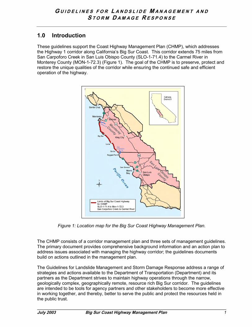
These guidelines support the Coast Highway Management Plan (CHMP), which addressesthe Highway 1 corridor along California’s Big Sur Coast. This corridor extends 75 miles fromSan Carpoforo Creek in San Luis Obispo County (SLO-1-71.4) to the Carmel River inMonterey County (MON-1-72.3) (Figure 1). The goal of the CHMP is to preserve, protect andrestore the unique qualities of the corridor while ensuring the continued safe and efficientoperation of the highway.
Figure 1: Loc
The CHMP consists ofThe primary documentaddress issues associabuild on actions outline
The Guidelines for Lanstrategies and actions partners as the Departgeologically complex, gare intended to be toolin working together, anthe public trust.
Big Sur Coast Highway Management Plan 1
ation map for the Big Sur Coast Highway Management Plan.
a corridor management plan and three sets of management guidelines. provides comprehensive background information and an action plan toted with managing the highway corridor; the guidelines documentsd in the management plan.
dslide Management and Storm Damage Response address a range ofavailable to the Department of Transportation (Department) and itsment strives to maintain highway operations through the narrow,eographically remote, resource rich Big Sur corridor. The guidelines
s for agency partners and other stakeholders to become more effectived thereby, better to serve the public and protect the resources held in

G U I D E L I N E S F O R L A N D S L I D E M A N A G E M E N T A N DS T O R M D A M A G E R E S P O N S E
2 Big Sur Coast Highway Management Plan July 2003
1.1 Background for the Guidelines
The ongoing natural processes that shape the spectacular Big Sur coastal corridor createhuge challenges for the Department of Transportation, which is charged with maintainingHighway 1 through the corridor. The steep mountains are strained by a weak structure ofvarious rock types. The erosive forces of heavy seasonal storms, wave action of ocean andsimple gravity all exploit weaknesses in these rock-clad coastal slopes with predictableresults: landslides.
As an engineering organization, the Department is skilled at responding to the challenges ofmaintaining a highway in a difficult environment. The Department has decades of experienceavoiding and minimizing impacts to the Big Sur highway with well-engineered projects:engineered slopes, culverts, and bridges. The Department has always employed the latestresearch and state-of-the-art design, materials and equipment in undertaking such projects.The Department also has proven capabilities responding to slides and washouts with effectivenotification and traffic control and timely repairs to reestablish full use of the route. Thiscapability is critical because Highway 1 is the lifeline to several well-established communitiesalong the corridor and a major travel destination for tourists as well. Highway closures andextended delays reverberate throughout the coastal communities whose economies areheavily dependent on recreational travel.1
Although the Department has an outstanding record for maintaining the roadway and restoringaccess for safe travel, the accumulated consequences of repairs and related highwayimprovements have been perceived as threatening the qualities and resources most highlytreasured in the coastal corridor. Virtually all of the Department’s processes with respect toundertaking corridor projects have been modified or restructured through the years inresponse to environmental considerations: visual impacts from large cut and fill slopes, spreadof invasive plants, impacts to marine and upland coastal habitats, and proliferation of standardhighway treatments. The Department recognizes that efforts to manage the highway corridormust be undertaken in a manner that is environmentally sensitive. The need to balancedecisions among many stakeholder interests is evident in the numerous regulatory approvalsrequired to develop a project.
Communications and consultations among corridor stakeholders were tested during theextended road closures that followed outsized storm events in several late-20th centuryseasons, of which 1997-98 is the most recent. These events brought a new level of highwaydependence into sharp focus for both the Department and the community of local residentsand businesses. The shared experience of undertaking complex and costly and time-consuming earthwork, repairs, and site restoration during emergency conditions also causedthe Department and its partner agencies to consider new ways of working together in thecorridor. All stakeholders were motivated to consider ways not only to improvecommunications in the throes of an emergency, but also to avoid or lessen the effects offuture damage through prevention projects, proactive planning and pre-need agreements.
The myriad issues related to the 1997-98 slides prompted the undertaking of the Big SurCoast Highway Management Plan. The need for detailed information about storm damagephenomena and effects on corridor stakeholders, who included the Department, propertyowners, resource agencies, the traveling public and others, was understood early on. There
1 JRP Historical Consulting Services, Inc. A History of Road Closures Along Highway 1 in San LuisObispo and Monterey Counties, November 2001.

G U I D E L I N E S F O R L A N D S L I D E M A N A G E M E N T A N DS T O R M D A M A G E R E S P O N S E
July 2003 Big Sur Coast Highway Management Plan 3
was a collective willingness to collaborate in efforts to prevent, anticipate and minimize futureimpacts to the coast highway corridor. The CHMP process has been based in anunderstanding that success in finding the solutions that best respond to environmentalconditions and social values cannot be accomplished independently by the Department ofTransportation.
This compendium provides a common base of information to guide future decisions and toensure an appropriate balance among the concerns and values of all parties. This documentis a reference guide for stakeholders and includes the following elements:
1. Geology of the Big Sur Coast: the factors influencing slope stability and variationsalong the corridor
2. Interventions to manage landslides: opportunities and consequences, known andunknown
3. Current strategic options for maintaining a highway through a landslide-proneenvironment
4. Programs for landslide management: how the Department organizes and funds itswork
5. The Department’s current disciplined approach to corridor projects6. Available techniques and their applicability7. Future actions for continuous improvement
1.2 Need & Purpose for the Guidelines
The Department of Transportation currently undertakes projects along the Big Sur Coastaccording to a rational and disciplined process. The process is bounded by factors includingthe current level of information about geology; past experience working in the corridorenvironment; and the match of the project characteristics with current programs, availableresources, and the interests and requirements of other stakeholders. Although theDepartment’s processes are disciplined, they are improved constantly. The CHMP itself hasbeen an opportunity to improve the Department’s processes with more effective partnerships,improved methods, and better information.
The need for these guidelines is directly related to those events that triggered thedevelopment of the CHMP: episodic storm damage events that require rapid decisions andeffective response. Although management practices continually evolve with information andknowledge available, the Department’s processes and actions have not always been wellunderstood by stakeholder groups. Critics of some of the Department’s actions or approachbring attention to the reactive nature of management activities, and particularly emergencyrepairs that require response in crisis mode. In fact, expenditures on this stretch of Highway 1between 1996 and 2002 have amounted to over $110,000,000 with nearly half this total foractions that qualified as emergencies. The 1998 El Nino storms clearly weigh heavily in thistime period, which may not make it a typical average cycle. Nevertheless, El Nino conditionsare cyclical patterns that can be expected to return to the Big Sur Coast.
With limited tolerance to highway closures and increasing expenditures and delays related tothe disposition of excess material, it is evident that the Department together with itsstakeholders must outline a common course of action for dealing with these recurring events.

G U I D E L I N E S F O R L A N D S L I D E M A N A G E M E N T A N DS T O R M D A M A G E R E S P O N S E
4 Big Sur Coast Highway Management Plan July 2003
The Landslide Management and Storm Damage Response Guidelines will be an importanttool for improving the process of managing the highway. The guidelines will enhance theeffectiveness of partnerships and collaborative decision-making by providing a common baseof information about the corridor and identifying important issues that must be considered inundertaking any action. When time is critical for restoring essential service, it is important tohave a common understanding of the safeguards available to ensure that environmentalprotection measures are part of the response. When time is less critical, it is important to bemoving forward with research, preventive actions and programmatic-type agreements that willlessen the impacts of future emergencies. The guidelines can serve as a foundation for suchagreements between the Department and regulatory agencies, satisfying regulatoryrequirements related to certain types of highway-related actions in advance of need, thusreducing the time required to take such actions.
The guidelines also identify the need for additional funding and research by demonstratinghow the research findings would be applied to achieve results that are critical to multiplestakeholders. As a work in progress, the guidelines will serve as the record for newinformation about managing the corridor as such information becomes available.
In summary, these guidelines are intended to improve collaborative decision-making based onthe best available information.
1.3 Stakeholder Participation
The planning process that led to the development of these guidelines was based instakeholder participation. Technical sessions of the Storm Damage Response and RepairWorking Group served as a major forum for this participation. These sessions providedopportunities for stakeholders to articulate and prioritize problem issues, share information,identify information needs and work toward long-term solutions. The Working Group’sdeliberations established the following principles:
Guiding Principles for Storm Damage Response & Repair1. Respect travelers’ needs for timely information on highway conditions2. Act immediately and responsibly to protect or restore highway access.3. Promote interagency solutions to prevent, anticipate and respond to disruptions
caused by storm events.4. Pursue solutions that avoid or minimize overall adverse environmental impacts
and respect natural processes.
The Working Group also outlined the following objectives for these guidelines:
• Improve efficiency of emergency communication and notification for overall betterresponse to restore transportation function
• Limit the impact of landslides on highway operations• Reduce the volume of excess material in the course of highway repairs• Identify options for re-use of excess material to reduce the amounts for disposal

G U I D E L I N E S F O R L A N D S L I D E M A N A G E M E N T A N DS T O R M D A M A G E R E S P O N S E
July 2003 Big Sur Coast Highway Management Plan 5
• Achieve response strategies that avoid or minimize adverse impacts to theenvironment
• Select mechanical responses (to storm damage) that mimic natural processes asmuch as possible, striving to achieve outcomes that might resemble conditions withoutthe highway
• Respect the environment, both land-based and marine, in the course of undertakingrepairs and removing landslide debris
• Consider repair strategies and alternatives that avoid or minimize impacts to sensitiveenvironmental resources, including the marine environment: seek a balancedapproach among the variety of sensitive habitats that could be affected
• View the coastal environment as a system in dynamic equilibrium: honor the naturalprocesses of erosion; avoid import of exotic material into terrestrial or marineenvironments; and avoid export of indigenous material from its natural system
• Keep the highway safe and open to travel in a fiscally and environmentally responsiblemanner
1.4 Regulatory Context
Activities for managing the highway are subject to a complex regulatory environment. Each ofthe following agencies may have jurisdiction over activities undertaken by the Department ofTransportation:
� California Coastal Commission� California Department of Fish & Game� California Department of Parks &
Recreation� County of Monterey� County of San Luis Obispo
� Monterey Bay National MarineSanctuary
� National Marine Fisheries Service� Regional Water Quality Control Board� US Army Corps of Engineers� USDA Forest Service� US Fish & Wildlife Service
The Department anticipates that the CHMP will provide the foundation for programmatic-typeagreements that will satisfy regulatory requirements applicable to certain types of highway-related actions.
The California Coastal Act regulates development in the coastal zone. These guidelines applyprimarily to the activities that would be considered development projects under the CoastalAct. In many cases, capital highway improvements constitute such development. Capitalimprovements are conducted under the authority of the Department, usually under the StateHighway Operation and Protection Program (SHOPP), which covers traffic safety, roadwayrehabilitation, roadside rehabilitation, and operations.
Both Monterey and San Luis Obispo Counties have been delegated authority to administer theCoastal Act through certification of their respective Local Coastal Programs. Their authority isfor actions above the mean high tide; actions below that limit remain under the jurisdiction ofthe California Coastal Commission.
As an alternative to project-by-project review and permitting under the Coastal Act, theDepartment will pursue the opportunity to implement a Public Works Plan. This provision mayprovide a means to greater efficiency in the reviews of certain of the Department’s capital
G U I D E L I N E S F O R L A N D S L I D E M A N A G E M E N T A N DS T O R M D A M A G E R E S P O N S E
6 Big Sur Coast Highway Management Plan July 2003
projects. A Public Works Plan could address projects at multiple sites along the corridor.Certification of a Public Works Plan by the Coastal Commission entails reviews, publichearings and a finding of consistency with the Coast Act and conformity with any certified localcoastal program. If a Public Works Plan was certified, the Department would not be requiredto obtain separate coastal development permits, emergencies permits, or permit waivers forindividual projects that are found to be within the scope of the plan. The Department wouldstill be responsible for environmental review and compliance with conditions of approval theCommission might impose. The Department would still be responsible for regulatorycompliance with all other applicable environmental regulations.
Much of the work the Department undertakes along the Big Sur coast is for maintenance andrepair purposes. Maintenance activities are exempt from the California Coastal Act. The Actdefines such activities as those “necessary to preserve the highway facility as it wasconstructed and that do not result in an addition to, or enlargement or expansion of, the objectof those repair or maintenance activities…” [California Coastal Act Section 30610]. Althoughmost maintenance activities do not require formal environmental review, actions must complywith provisions of environmental laws and regulations. For example, certain maintenanceactivities related to channel maintenance are subject to Section 1601 of the California Fish &Game Code.
Jurisdiction by State Parks or the US Forest Service may apply to both capital projects andmaintenance activities that involve land controlled by these agencies.
1.5 Applicability and Authority
These guidelines apply to the CHMP study area, which extends 75 miles along Highway 1from San Carpoforo Creek in San Luis Obispo County (SLO-1-71.4) to Carmel River inMonterey County (MON-1-72.3).
The guidelines are intended to facilitate decision-making by the Department of Transportationand regulatory agencies toward coordinated responses to highway actions. Community andnon-governmental stakeholders who participate in decisions may also refer to this document.
The guidelines are not considered regulatory in nature. The guidelines are consistent with theDepartment’s existing authority and responsibility to maintain and operate the highway. Theguidelines do not alter the Department’s obligations to comply with state and federalenvironmental laws and regulations, nor do they imply any change in the authority or anyagency with jurisdiction over specific actions of the Department.
1.6 Organization of this Document
The Guidelines for Landslide Management and Storm Damage Response document isintended to provide corridor stakeholders with a common base of information about thecorridor and actions that can or might be taken to improve landslide management. Thedocument is comprised of seven major sections, the first of which has conveyed thebackground and purpose for the guidelines and a brief account of the regulatory context forthe capital and maintenance projects that are carried out under the authority of theDepartment of Transportation. The remainder of the guidelines document providesdescriptions of the coastal geology, types of earth movement that occur along the corridor,and the way the Department organizes its work to operate and maintain Highway 1 throughthe corridor. The document also identifies in some detail the best available techniques

G U I D E L I N E S F O R L A N D S L I D E M A N A G E M E N T A N DS T O R M D A M A G E R E S P O N S E
July 2003 Big Sur Coast Highway Management Plan 7
deployed in the corridor, considerations in using each technique and unsettled issuespertaining to their use.
Section 2 provides an overview of the geology of the Big Sur Coast and defines the types oflandslides that occur along the coast. For considering strategies for handling excessmaterials, this section introduces concepts related to managing instabilities and presentsfindings of recent research into historical volume losses along the coast.
Relevant program terminology of the Department of Transportation is introduced in Section 3.Corridor stakeholders became familiar with the three-pronged management approach ofprevention, response and anticipation during the CHMP process. Section 3 describes howthese three approaches would be addressed within the Department’s two main program areasfor projects on Highway 1, the maintenance and capital improvements programs.
The Department undertakes actions along the coast highway according to a rational,disciplined process that is described in Section 4. This process is followed for every project,whether maintenance or capital improvements and whether aimed at prevention, anticipationor response.
Section 5 introduces and describes major strategies for undertaking three large categories ofwork in the corridor: (1) managing for landslides, (2) culvert and drainage management, and(3) earthwork, which is an inherent aspect of the two preceding categories.
At any point in time, the Department uses many specific techniques to manage the corridor.These techniques, known collectively as Best Available Techniques, are presented in Section6. Each of the Best Available Techniques is attended by considerations that may determineits applicability in given circumstances or location. Some of the techniques are controversial.Many will be supplanted as new research findings become available or new technologicalbreakthroughs occur.
In the course of evaluating existing information and current programs and practices, the StormDamage Response and Repair Working Group identified additional information and resources,unavailable at the present that could improve capabilities to manage the highway in thegeologically unstable coastal environment. The guidelines document concludes with Section7, identifying future research, funding changes, and actions that would contribute tocontinuous improvement of landslide management practices.
G U I D E L I N E S F O R L A N D S L I D E M A N A G E M E N T A N DS T O R M D A M A G E R E S P O N S E
8 Big Sur Coast Highway Management Plan July 2003
2.0 Overview of Geology & Landslides on the Big Sur Coast
The Big Sur coast is located within a geologically complex part of the Coast Rangesgeomorphic province, which extends for about seven hundred miles within California fromSanta Barbara County to the Oregon border. The Big Sur coast is noted for its abruptly steepslopes, which rise from sea level to over 3000 feet within less than three miles. Uplift of theSanta Lucia Mountains and continuing wave erosion at their base has formed precipitousslopes in many types of bedrock and overlying surficial deposits. The steep slopes, constantwave action, winter storms, and types of bedrock and cover have proven to be key ingredientsfor numerous landslides that characterize the area.
Much of the information for this section is from Landslides in the Highway 1 Corridor: Geologyand Slope Stability along the Big Sur Coast prepared by the California Division of Mines &Geology’s (now California Geological Survey), November 2001.
2.1 Coast Geology
Rock types of the Coast Ranges belong to all three major rock classes: igneous, metamorphicand sedimentary. The most widespread geologic unit is the Franciscan Complex, composedof variably metamorphosed fine to medium grained graywacke sandstone and highly shearedshale. Other minor components of the Franciscan Complex include serpentinite, greenstoneand chert.
In areas underlain by the Franciscan complex, all of the rock types tend to be weak, intenselysheared and slightly metamorphosed sedimentary rocks or overlying unconsolidated deposits.The tectonics of the region, driven by right-lateral motion on the San Andreas fault system,has led to compression and uplift of these sedimentary rocks in recent geologic time. Uplift ofsuch weak rocks has led to high rates of erosion and abundant landslides.
The other major rock mass in the study area is the Salinian block, which extends southeastfrom Monterey and Salinas. This block of distinctive rocks is bounded by the San Andreasfault on the east and the Sur-Nacimiento faults on the west. In contrast to the areas underlainby the Franciscan complex, where no crystalline basement rocks are exposed, granitic andmetamorphic rocks underlie large areas of the Salinian block. One of the more extensiveareas of granitic rocks is the northern Big Sur coast, from Rocky Creek north to Monterey.Metamorphic rocks of the Sur complex and overlying Cretaceous through Miocenesedimentary rocks underlie the remainder of the Salinian block from Rocky Creek south alongthe coast or just inland to south of Lopez Point.
The Salinian block bedrock is harder and in most places more resistant to landsliding thantypical Franciscan bedrock, but the steep natural slopes lead to numerous landslides in mostrock units. Deep weathering of many Salinian block rocks has broken down mineral grainswithin once-hard and landslide resistant rocks, leading to surficial layers in many areas of"decomposed" or weakened rocks that are relatively prone to landsliding. Landslides inSalinian block bedrock are both large intact blocks of bedrock that move as rock slides andareas of deeply weathered coarse soils that mobilize as debris flows. Sedimentary rocksoverlying the Salinian block basement are commonly weaker than the granitic andmetamorphic rocks and more prone to sliding as intact masses on weak bedding planes.
G U I D E L I N E S F O R L A N D S L I D E M A N A G E M E N T A N DS T O R M D A M A G E R E S P O N S E
July 2003 Big Sur Coast Highway Management Plan 9
2.2 Factors Influencing Slope Stability Along Highway 1
The uplift of the Coast Ranges, the inclination of slopes, the underlying rock types andgeologic structures, landforms, fire history, rainfall and waves related to winter storms allinfluence slope stability along the Highway 1 corridor in the study area. In addition to thenatural processes that have led to numerous landslides along the coast, constructionpractices used in building the original highway and in maintaining it have affected the stabilityof slopes locally.
Slope steepness. Slopes along the Highway 1 corridor range from moderate to extremelysteep. The steepest slopes are along the sea cliffs. Some sea cliffs are as steep as 56° andas high as 400 feet. More typically, sea cliffs are about 200 feet high and have slopes ofapproximately 45°. Slopes this steep are characterized by bare rock outcrops and landslidescars. Most landslides on such steep slopes involve shallow soil and loose rocks, moving asdebris slides and rock falls. Slopes to the crest of the ridge above the highway are not soprecipitous, but many slopes as steep as 27° to 31° extend to the ridge crests at over 2000feet.
These steep slopes are formed by a combination of uplift of the mountains that has beenongoing for millions of years and coastal wave erosion. The historic rate of uplift of the areabetween the San Simeon fault at San Carpoforo Creek and the Sur-San Gregorio fault zone atHurricane Point, that is, the majority of the study area, is not known.
Wave erosion. The ocean helps to maintain the steepest slopes in the sea cliffs by removingloose rock deposited at the base and undermining the base of slopes, triggering landslides.The effect of wave erosion is greatest where steep high slopes extend upwards from thebeach without intervening marine terraces and where weak rocks are found at sea level.Erosion of weaker rocks at sea level contributes to the instability of the harder rocks higher upthe slopes. Landslide debris is eventually removed by the waves, decreasing the overallstability of the slide mass.
Rock type. Bedrock geology also has a very strong influence on the types and activity oflandslides. The rock units in this highway corridor range from weak rock with pervasive shearsurfaces and fractures (the Franciscan melange) to massive, hard rocks with few fractures(notably the charnockitic tonalite and granitic rocks). The melange is much more prone tolandsliding. Tonalite is less prone to large rotational landslides and forms very steep slopesalong the coast (historically, those slides that have occurred have been large and verydamaging, notably the 1983 McWay (or J.P. Burns) slide). The granitic rocks on the northernpart of the Big Sur coast, the quartz-diorite, granodiorite and granite, are similarly resistant tolarge landslides, though some slides are found in all units.
Weathering. The weathering characteristics of the bedrock units are also important factors incontrolling the size and density of landslides. Weathering is not as important in rocks that areweak and soil-like in their unweathered state, but in hard rocks the speed and depth ofweathering influences the potential for landslides.
Precipitation. Rainfall is a major factor in landslides. The Big Sur segment of Highway 1receives up to 60 inches of rainfall annually, up to four times as much as the Salinas Valley onthe landward side of the Santa Lucia Mountains. The greater rainfall increases the saturationof the landslide masses on the coastal slopes, decreasing their stability. Long-term steadyrain leads to deep saturation of landslide masses and tends to destabilize the larger, deeper

G U I D E L I N E S F O R L A N D S L I D E M A N A G E M E N T A N DS T O R M D A M A G E R E S P O N S E
10 Big Sur Coast Highway Management Plan July 2003
types of landslides. Short-term, very intense rain tends to trigger the shallower types oflandslides, such as debris slides and debris flows.
Fire. Wildfires also contribute to the triggering of debris flows. The effect of fire on debris flowpotential was demonstrated clearly in the Big Sur River watershed, where a fire in 1972 wasfollowed by debris flows.
Geologic structure. The northwest trend of geologic structure, which is the similarorientation of bedding, shear zones and faults, controls the general trend of ridges and streamvalleys. Bedding and shear zones dip to both northeast and southwest, leading to planes ofweakness that favor landslides that move in those directions. The overall structural grain andorientation of common planes of weakness leads to relatively large landslides on slopes thatface northeast and southwest.
Landforms. In some cases, the landforms created by landslides also perpetuate the slides.Closed depressions, troughs and benches that commonly form near the headscarps oflandslides. This allows increased percolation of water into the slide mass and along the slideplane, where accumulated rainwater can destabilize the slide. Shallow debris slides maydestabilize the adjacent upslope area when they move. This leads to a progressive upslopesequence of debris slides or debris flows.
Highway 1. The construction and maintenance of Highway 1 across many marginally stableand unstable slopes has also contributed to the triggering of new or renewed movement onlandslides. Original construction of the highway left many steep cut slopes above the road,and blasting used during the original construction left loose and fractured rocks on theseslopes, which has contributed to rock falls and small debris slides.
2.3 Types of Landslides
Landslide mapping performed by the California Geological Survey (CGS)2 throughout thecorridor has identified over 1500 landslides within about a three-mile-wide section along the75-mile-long study area. A recent evaluation by the Department of Transportation indicatesthat 88 locations along the highway currently exhibit stress or influence related to underlyingmovements (depicted on Attachment 1).3 The implications for Highway 1 are obvious:maintaining a reliable linear feature, such as a highway, in this unsteady landscape will alwaysbe challenging.
Of all the landslides along the Big Sur Coast section of the Highway 1 corridor, many areextensive, deep-seated slides that affect large areas. The predominant types of landslidesdescribed in the corridor are:
• Rock Slide: A slide involving bedrock in which much of the original structure ispreserved.
• Rock Fall: A landslide in which a fragment or fragments breaks off of an outcrop ofrock and falls, tumbles or rolls downslope.
• Earth Flow: A landslide composed of mixture of fine-grained soil, consisting ofsurficial deposits and deeply weathered, disrupted bedrock.
2 November 2001 (formerly the California Division of Mines & Geology, as referenced above)3 California Department of Transportation, Potential Slope Instabilities in the Highway 1 Corridor: RoadCondition and Hazard Potential at Sites Between San Carpoforo Creek and Carmel Highlands.September 2001.
G U I D E L I N E S F O R L A N D S L I D E M A N A G E M E N T A N DS T O R M D A M A G E R E S P O N S E
July 2003 Big Sur Coast Highway Management Plan 11
• Debris Slide: A slide of coarse-grained soil, commonly consisting of a loosecombination of surficial deposits, rock fragments, and vegetation.
• Debris Flow: A landslide in which a mass of coarse-grained soil flows down slope asslurry.
Note: Debris slides and debris flows are commonly found on a landform called adebris slide slope, which represents the coalesced scars of numerous landslides.
Another condition relevant on the coast is bluff erosion caused predominantly by wave action.While this natural process is not considered a landslide per se, the options for managing thehighway in proximity to eroding bluffs are similar.
2.4 Applied Science along the Corridor
Strategies for the Big Sur Coast must build on the current body of knowledge. Site-specificinformation about the geology, patterns of change, and environmental sensitivity will all factorinto decisions.
Recent inventories and databases include information that is relevant to developing integratedlandslide and storm damage management strategies. Some of the studies described beloware currently underway; others are planned to address critical gaps in current knowledge.Keeping databases current will ensure that the best information is availed to decision makers.
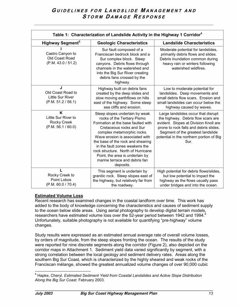
Landslide ActivityThe California Geological Survey has divided the Big Sur coastal corridor into 12 distinctareas according to geological and landslide characteristics. The CGS has also indicated therelative landslide potential for each of the areas based on observed activity levels. Summarydata for each of the 12 areas are presented in Table 1 and depicted on the corridor maps inAttachment 1.

G U I D E L I N E S F O R L A N D S L I D E M A N A G E M E N T A N DS T O R M D A M A G E R E S P O N S E
12 Big Sur Coast Highway Management Plan July 2003
Table 1: Characterization of Landslide Activity in the Highway 1 Corridor4
Highway Segment5 Geologic Characteristics Landslide CharacteristicsA
San Carpoforo Creek toRagged Point Resort
(SLO-71.4 / 73.0)
Steep marine terrace and canyon. Moderate potential for landslides.Canyon area prone to rockfall and
small events. Some (wave) erosionmay cause events below roadway.
BRagged Point Resort to Salmon
Cone(SLO-73.1 to MON-2.8)
Very steep slopes underlain bycompetent rocks of the Franciscan
mélange.
Prehistoric slides. Small landslidescommon above and below highway.Some moderate events result in roadclosure. Moderate to high potential
for landslides.C
Salmon Cone to Willow Creek
(P.M. 2.8 /12.1)
Gentler slopes with scarps andbenches. Weaker mélange
bedrock. Prominent bands ofserpentine which weakens rock
structure.
Large recent landslides havedamaged the road. Mixture of newand prehistoric slides with smallerslides later creating large events.
High landslide potential. Very active.D
Pacific Valley Area(P.M. 12.1/16.6)
Gently sloping marine terrace anddebris fan deposits. Uplifted
terrace prevents wave erosion.
Low landslide potential. Moderateslides possible above highway.
EPacific Valley to
Limekiln State Park(P.M. 16.6 / 21.0)
Steep slopes rising almost directlyfrom the beach. Cut slopes have
caused landslides.
Relatively few large or activelandslides. Moderate landslide
hazard – mostly small to mediumsized events.
FRain Rocks to Cow Cliffs
(P.M. 21.0 / 28.5)
Steep slopes. Rain Rocks slopesnearly vertical and composed ofhard rock. Less steep slopes atCow Cliffs with more fractured
rock. Area in between consists ofunstable Franciscan mélange.
Rain Rocks prone to rockfall due tohard rocks. Cow Cliffs prone to rockfalls and debris slides. Highest levelof landslide activity in the highwaycorridor located between these two
points. Both historic and youngactivity.
GCow Cliffs to
McWay Canyon(P.M. 28.5 / 35.7)
Steep slopes of competent rock(Franciscan mélange, Cretaceous
sandstone and conglomerate).Remnants of marine terraces and
debris fans.
Moderate potential for small tomoderate landslides. Human
activities (ranching and road repairefforts) have created small, shallowevents. Wave erosion can cause
small slides.H
McWay Canyon toCastro Canyon
(P.M. 35.7 / 43.0)
Uniformly steep slopes of 50% to65%. Slopes are very stable and
composed of CharnockiticTonalite – a hard, massive,
coarse-grained igneous rock withfew fractures.
Moderate potential for landslides,mostly small rock falls and debris
slides. Exceptional circumstances,like extreme rainfall, can cause major
events.
4 From California Division of Mines & Geology (now, California Geological Survey) in Landslides in theHighway 1 Corridor: Geology and Slope Stability Along the Big Sur Coast, November 2001.5 Locations are identified by postmile (P.M.) and are located in Monterey County unless specified asSLO for San Luis Obispo County.
G U I D E L I N E S F O R L A N D S L I D E M A N A G E M E N T A N DS T O R M D A M A G E R E S P O N S E
July 2003 Big Sur Coast Highway Management Plan 13
Table 1: Characterization of Landslide Activity in the Highway 1 Corridor4
Highway Segment5 Geologic Characteristics Landslide CharacteristicsI
Castro Canyon toOld Coast Road
(P.M. 43.0 / 51.2)
Sur fault composed of aFranciscan bedrock block and a
Sur complex block. Steepcanyons. Debris flows throughchannels in the watershed andinto the Big Sur River creating
debris fans crossed by thehighway.
Moderate potential for landslides,primarily debris flows and slides.Debris inundation common during
heavy rain or winters followingwatershed wildfires.
JOld Coast Road to
Little Sur River(P.M. 51.2 / 56.1)
Highway built on debris fanscreated by the deep slides andslow moving earthflows on hills
east of the highway. Some steepsea cliffs and erosion.
Low to moderate potential forlandslides. Deep movements and
small debris flow scars. Erosion andsmall landslides can occur below the
highway caused by waves.K
Little Sur River toRocky Creek
(P.M. 56.1 / 60.0)
Steep slopes underlain by weakrocks of the Tertiary Pismo
Formation at the base faulted withCretaceous rocks and Sur
complex metamorphic rocks.Wave erosion is associated with
the base of the rock and shearingin the fault zones weakens the
rock structure. North of HurricanePoint, the area is underlain bymarine terrace and debris fan
deposits.
Large landslides occur that disruptthe highway. Debris flow scars are
evident. Slopes at Division Knoll areprone to rock falls and debris slides.Segment of the greatest landslide
potential in the northern portion of BigSur.
LRocky Creek to
Point Lobos(P.M. 60.0 / 70.4)
This segment is underlain bygranitic rock. Steep slopes east ofthe highway, but relatively far from
the roadway.
High potential for debris flows/slides,but low potential to impact the
highway as the flows usually passunder bridges and into the ocean.
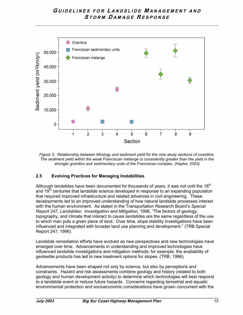
Estimated Volume LossRecent research has examined changes in the coastal landform over time. This work hasadded to the body of knowledge concerning the characteristics and causes of sediment supplyto the ocean below slide areas. Using aerial photography to develop digital terrain models,researchers have estimated volume loss over the 52-year period between 1942 and 1994.6Unfortunately, suitable photography is not available for quantifying “pre-highway” volumechanges.
Study results were expressed as an estimated annual average rate of overall volume losses,by orders of magnitude, from the steep slopes fronting the ocean. The results of the studywere reported for nine discrete segments along the corridor (Figure 2), also depicted on thecorridor maps in Attachment 1. Sediment yield data varied significantly by segment, with astrong correlation between the local geology and sediment delivery rates. Areas along thesouthern Big Sur Coast, which is characterized by the highly sheared and weak rocks of theFranciscan mélange, showed the greatest annualized volume changes of over 90,000 cubic 6 Hapke, Cheryl. Estimated Sediment Yield from Coastal Landslides and Active Slope DistributionAlong the Big Sur Coast. February 2003.

G U I D E L I N E S F O R L A N D S L I D E M A N A G E M E N T A N DS T O R M D A M A G E R E S P O N S E
14 Big Sur Coast Highway Management Plan July 2003
yards per mile. Average annual volumes were estimated to be over 40,000 cubic yards permile over the entire 75-mile long corridor (Figure 3).
The results provide valuable information about the magnitude and area distribution of volumelosses in the post-highway era. The methodology is expected to be a valuable tool foraccumulating a longitudinal record of sediment movement along the coast.
Figure 2: Geologic Map of the Big Sur coast area showing the general lithologies exposed along thecoast. Major faults are shown as red lines. The numbers 1 – 9 are the locations of the specific study
areas by Hapke (see also Attachment 1).
G U I D E L I N E S F O R L A N D S L I D E M A N A G E M E N T A N DS T O R M D A M A G E R E S P O N S E
July 2003 Big Sur Coast Highway Management Plan 15
Figure 3: Relationship between lithology and sediment yield for the nine study sections of coastline.The sediment yield within the weak Franciscan mélange is consistently greater than the yield in the
stronger granitics and sedimentary units of the Franciscan complex. (Hapke, 2003)
2.5 Evolving Practices for Managing Instabilities
Although landslides have been documented for thousands of years, it was not until the 18th
and 19th centuries that landslide science developed in response to an expanding populationthat required improved infrastructure and related advances in civil engineering. Thesedevelopments led to an improved understanding of how natural landslide processes interactwith the human environment. As stated in the Transportation Research Board’s SpecialReport 247, Landslides: Investigation and Mitigation, 1996, “The factors of geology,topography, and climate that interact to cause landslides are the same regardless of the useto which man puts a given piece of land. Over time, slope stability investigations have beeninfluenced and integrated with broader land use planning and development.” (TRB SpecialReport 247, 1996)
Landslide remediation efforts have evolved as new perspectives and new technologies haveemerged over time. Advancements in understanding and improved technologies haveinfluenced landslide investigations and mitigation methods: for example, the availability ofgeotextile products has led to new treatment options for slopes. (TRB, 1996).
Advancements have been shaped not only by science, but also by perceptions andconstraints. Hazard and risk assessments combine geology and history (related to bothgeology and human development activity) to determine which technologies will best respondto a landslide event or reduce future hazards. Concerns regarding terrestrial and aquaticenvironmental protection and socioeconomic considerations have grown concurrent with the
G U I D E L I N E S F O R L A N D S L I D E M A N A G E M E N T A N DS T O R M D A M A G E R E S P O N S E
16 Big Sur Coast Highway Management Plan July 2003
development of new technologies. Recognition and understanding of the potential forlandslides to affect valuable marine resources has developed more recently. The designationof the Monterey Bay National Marine Sanctuary has focused attention on this aspect ofmanaging the highway in relation to landslides.
Environmental protection and socioeconomic factors are now major considerations and oftenimpose constraints on selecting and applying highway repair strategies and techniques. Theinteraction of concerns suggests the need to balance technological solutions with thenecessary protections for a healthy environment and sustainable social economy. Becauselandslides can damage and destroy infrastructure and other development, historically thefocus has been on the costs and inconveniences associated with the disruptions thatlandslides cause for people. This focus is expanding to address environmental concerns.While engineering solutions tend to be based upon measurable phenomena (such as soiltypes, slope ratios and drainage), environmental and social solutions draw upon an integratedsystem of ecological science and social values (such as how changes can affect a terrestrialor marine habitat, a scenic view or a business). State and federal environmental laws andregulations now prescribe the processes that seek a balance.
Perceptions of coastal landslides have also evolved as people become more aware of thenature of landslides and how they contribute to Big Sur as a unique place. Now that a largeinventory of information has been assembled, landslides are being understood as the primarynatural process that shapes the landform and creates the essential character of the coast.
With this expanded perspective, efforts to prevent slides have evolved into efforts to manageinstabilities to maintain traveler safety, local communities, and livelihoods while respectinglandslides as part of the natural landscape. The philosophy can be said to have evolved from“moving the mountains” to “living with landslides.” From grand civil engineering projectsattempting to stabilize large landslides, the shift now is toward less ambitious approaches toachieve adequate stability with some allowance for local instabilities. This means highwayrepairs with fewer direct environmental impacts and a quicker reopening of the road after alandslide-related closure. Such approaches may require more intensive maintenance andassociated traffic delays.7
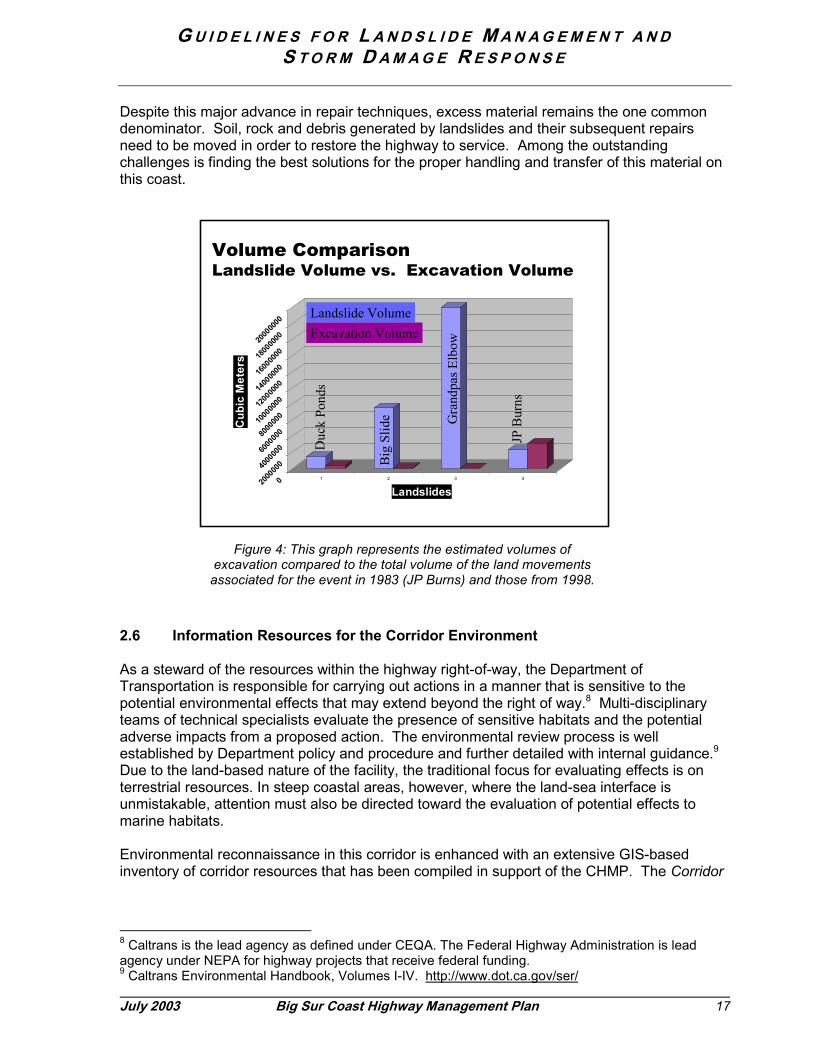
The evolution in engineering approach described above is illustrated by comparing Caltransresponses to two recent El Nino storm periods. After the storms of 1983, highway repair fromone large landslide (McWay Canyon, also known as JP Burns) resulted in the removal of 3.1million cubic meters of earth and a one-year road closure. Highway repairs from three largelandslides (Duck Ponds, Big Slide and Grandpa’s Elbow) in 1998 resulted in the removal ofonly 700,000 cubic meters of earth and a three-month road closure (Figure 4). The minimalearthwork also resulted in fewer adverse aesthetic, habitat, traffic, and emissions impacts.
7“Living with Landslides on the Big Sur Coast: The challenges of maintaining Highway 1,” John D. Duffy and Aileen Loe, California and the World Ocean Conference, October 2002.
G U I D E L I N E S F O R L A N D S L I D E M A N A G E M E N T A N DS T O R M D A M A G E R E S P O N S E
July 2003 Big Sur Coast Highway Management Plan 17
Despite this major advance in repair techniques, excess material remains the one commondenominator. Soil, rock and debris generated by landslides and their subsequent repairsneed to be moved in order to restore the highway to service. Among the outstandingchallenges is finding the best solutions for the proper handling and transfer of this material onthis coast.
2.6 Information Resources for the Corridor Environment
As a steward of the resources within the highway right-of-way, the Department ofTransportation is responsible for carrying out actions in a manner that is sensitive to thepotential environmental effects that may extend beyond the right of way.8 Multi-disciplinaryteams of technical specialists evaluate the presence of sensitive habitats and the potentialadverse impacts from a proposed action. The environmental review process is wellestablished by Department policy and procedure and further detailed with internal guidance.9Due to the land-based nature of the facility, the traditional focus for evaluating effects is onterrestrial resources. In steep coastal areas, however, where the land-sea interface isunmistakable, attention must also be directed toward the evaluation of potential effects tomarine habitats.
Environmental reconnaissance in this corridor is enhanced with an extensive GIS-basedinventory of corridor resources that has been compiled in support of the CHMP. The Corridor
8 Caltrans is the lead agency as defined under CEQA. The Federal Highway Administration is leadagency under NEPA for highway projects that receive federal funding.9 Caltrans Environmental Handbook, Volumes I-IV. http://www.dot.ca.gov/ser/
Volume ComparisonLandslide Volume vs. Excavation Volume
02000
00040
0000
06000
00080
0000
01000
000012
0000
001400
000016
0000
001800
000020
0000
00
Cub
ic M
eter
s
1 2 3 4
Landslides
Duc
k P o
n ds
Big
Slid
e Gra
ndp a
s Elb
ow
JP B
urns
Landslide VolumeExcavation Volume
Figure 4: This graph represents the estimated volumes ofexcavation compared to the total volume of the land movementsassociated for the event in 1983 (JP Burns) and those from 1998.

G U I D E L I N E S F O R L A N D S L I D E M A N A G E M E N T A N DS T O R M D A M A G E R E S P O N S E
18 Big Sur Coast Highway Management Plan July 2003
Inventory of Natural Qualities10 identifies and characterizes terrestrial resources along bothsides of the highway, a corridor approximately 400 feet in width for the 75-mile corridor. Theinventory includes vegetation communities, sensitive habitats, streams, and other specialfeatures, including wildlife corridors. Similar inventory information is available for cultural andhistoric resources, recreational features and scenic qualities along the corridor.
Shoreline and marine resources are characterized at a broad scale. However, limitedinformation is available to characterize the potential for effects to marine habitats on a moresite-specific basis from highway management activities. Protocols have not yet beenestablished for shoreline habitat classification, estimation of impacts, and appropriatemitigation and monitoring. Information being developed under the leadership of the MontereyBay National Marine Sanctuary will be a key component toward achieving such a protocol. Inthe interim, a preliminary set of guidelines for evaluating shoreline habitats has been draftedfor purposes of discussion (see Appendix A).
The study of historical volume loss referenced in Section 2.4, above, contributed to knowledgeof materials that have moved from terrestrial slopes into the ocean at various locations alongthe corridor. It was beyond the scope of that study to consider the deposition or movement ofthe material within the marine environment or its impacts on marine habitat. However,research into the effects of landslide-related highway repairs on marine habitats has beenconducted at three locations in central and northern California: Lone Tree landslide (SonomaCounty), Waddell Bluffs (Santa Cruz County), and McWay landslide (Monterey County-BigSur Coast). Research at a number of other sites along the Big Sur Coast has been initiated tohelp characterize the conditions on and offshore of known landslide sites (Grey Slip, WillowCreek, Pitkins Curve and Big Creek). The potential for impacts is largely focused onconditions caused by burial, scour and turbidity from the input of large volumes of sediment inrelatively short time periods.11
More information about shoreline dynamics and site-specific habitat sensitivity is important tobetter understand the potential effects to the nearshore and offshore marine environmentsfrom highway-related manipulation of landslides. Sediment balance relationships are alsoimportant in the equation. Neither of these components is well understood at this time.Recommendations within the larger context of the CHMP include pursuing actions that lead toan improved understanding of these habitats and the relationship to natural coastalprocesses. The objective for this is to advance the range of management solutions that maybe available in the future.
10 Parsons Transportation Group. Corridor Intrinsic Qualities Inventory: Natural Qualities. December2001.11 See, for example, Tenera Environmental. “Shoreline Biological Assessment of Highway 1 Slide Areaat Pitkins Curve, Monterey County,” February 21, 2002, or Moss Landing Marine Laboratories, “MarineDisposal of Landslide Debris Along Highway One: Environmental Risk Assessment and MonitoringProtocols,” February 1998.
G U I D E L I N E S F O R L A N D S L I D E M A N A G E M E N T A N DS T O R M D A M A G E R E S P O N S E
July 2003 Big Sur Coast Highway Management Plan 19
3.0 Programs for Landslide Management Activities
Minimizing highway damage, service interruptions, and impacts to the environment requires athree-pronged management approach. Prevention is action taken in advance to avert slopefailure from affecting the highway or to minimize the potential for damage. Responseactivities are conducted when a break in service has occurred or there is imminent threat totraveler safety or integrity of the facility. Anticipation refers to actions taken in preparation forbreaks or disruptions in service that cannot be avoided and putting mechanisms in place tofacilitate future responses.
These landslide management actions are funded under the Department’s maintenance andcapital improvement programs. Highway funds are limited and allocated on a competitivebasis. The magnitude of the project and its source of funds are major factors in determiningthe time it takes to deliver a project.
3.1 Maintenance
PreventionWork performed by Maintenance crews is the first level of prevention. A year-round planningstrategy focuses primarily on ways to prevent the road from being closed and how quickly thecrews can safely restore service if the highway becomes closed. A full range of maintenanceduties is employed throughout the year to prevent or minimize damage from winter storms; theactivities encompass maintenance of the roadbed, shoulders, and drainage and vegetationmanagement.
The quality of the roadbed surface is important to ensure its ability to properly drain water. Apoor quality surface can result in highway flooding, ineffective water flow, draining to thewrong side of the highway or not draining to the proper ditches and culverts. Repairingpotholes in the surface helps maintain the quality of a smooth ride, but is also important toprotect the integrity of the roadbed that can be threatened by aggravated deterioration.
Effective roadside management provides assurance for the quality of highway shoulders andthe functioning of drainage facilities, which also includes vegetation management. Similar toconcerns about the roadbed, the condition of the highway shoulder is important for ensuringeffective drainage and stormwater runoff. Ensuring the proper functioning of drainagesrequires keeping ditches and culvert inlets clear of debris and major vegetation. Furthermore,ease of access to ditches and culverts by maintenance crews is important should they requireremediation under storm conditions. Vegetation management also includes the removal ofdead trees to avoid the potential for these trees to fall onto the road or knock down powerlines.
ResponseMaintenance crews perform storm response with continuous patrolling during daylight hours toensure a roadway free of rocks and debris, clear downed vegetation and monitor drainage.The crews shovel out culverts and ditches that are starting to plug or drain improperly. Stormresponse also includes using equipment to clean up small slides. This work can be laborintensive, involving an entire maintenance crew for traffic control, equipment operation,spotting (for safety) and truck hauling the material away to temporary locations (such asturnouts). Further cleanup includes repairing potholes, hauling material from turnouts tolocations for recycling or permanent disposal, equipment maintenance, removing otherdowned vegetation and repairs to drainage systems.

G U I D E L I N E S F O R L A N D S L I D E M A N A G E M E N T A N DS T O R M D A M A G E R E S P O N S E
20 Big Sur Coast Highway Management Plan July 2003
Maintenance crews are limited by their size (human power) and sometimes by the availabilityof equipment. When the needs posed by an event exceed the ability of the crews to respond,rented equipment may be used or capital program efforts may be initiated.
3.2 Capital Improvements
Capital improvements refer to the expenditure of funds for activities that go beyond routinemaintenance and operations. The primary source of funds for capital improvements onHighway 1 is the State Highway Operations and Protection Program (SHOPP), which providesfor improvements that are necessary to preserve and protect the state highway system.Projects are limited to improvements relative to maintenance, safety, and rehabilitation ofstate highways and bridges that do not add a new traffic lane to the system. A complete list ofthe categories of projects that are funded by this program is shown in Appendix B.
Planned Projects under SHOPPSHOPP program funds are organized by funding limits into minor and major categories. Minorprojects are broken down into two sub-categories: Minor B projects are limited to $110,000and Minor A projects are limited to $750,000.12 Minor program funds are provided on anannual cycle. Major SHOPP projects are those estimated to cost over $750,000 and areallocated on a two-year programming cycle.
Authority to manage SHOPP funds and set priorities varies by size of project. Discretionaryauthority to manage the Minor program funds is held by each of the 12 District offices of theDepartment of Transportation. A project over $750,000 that qualifies as a Major project underthe SHOPP is subject to a statewide competitive process and requires approval from theCalifornia Transportation Commission (CTC) prior to beginning work, including the initiation ofpreliminary studies. The statewide competition is among all SHOPP project categories.Often, the most competitive projects are those to improve safety and those needed on routeswith the highest traffic volumes. The majority of projects for this part of Highway 1 fall underthe SHOPP category of Protective Betterments; these types of projects generally havedifficulty competing at the statewide level unless there is a high degree of urgency. This is alimitation of existing funding programs.
The time to deliver a SHOPP project also corresponds somewhat to the project cost.Candidates for the Minor program (under $750,000) have the potential to proceed relativelyquickly, since more local discretion is involved for setting priorities, initiating studies andawarding contracts. The Department has authority to begin studies for Minor projects prior toCTC approval of funds.
The competition for Major SHOPP projects (over $750,000) requires more formal scoping,process review and centralized contract authority. Initiating these projects requires approvalby the CTC before any studies can proceed. As a result, these projects can take severalyears before they are programmed (funded); it may require an additional five to eight yearsafter programming for a Major SHOPP project to come to fruition with completedenvironmental review, permits, project design and detailed plans.
12 This amount represents the current limit, which is subject to periodic change as established by theCalifornia Transportation Commission (CTC).
G U I D E L I N E S F O R L A N D S L I D E M A N A G E M E N T A N DS T O R M D A M A G E R E S P O N S E
July 2003 Big Sur Coast Highway Management Plan 21
Emergency Projects under SHOPPEmergency project funding also comes from the SHOPP, but is accessed in different waysand according to certain limits. If the Governor of California or the President of the UnitedStates has declared an emergency, additional funds may be available. A presidentialdeclaration authorizes use of Emergency Relief (ER) funds that are administered by theFederal Highway Administration.
The local District Director can authorize spending up to $120,000 for emergency work; theDepartment Director must authorize spending over that amount. The focus is on restoring thehighway after damage but the work may include activities normally considered “prevention.”This work is usually accomplished without the benefit of formal plans, unless an emergencycondition arose during the development of a related project, such as a preventive action.Response is generally distinguished from prevention by an adverse situation that requiresquick action to protect the public safety or integrity of the facility or to restore essential service.
SHOPP funding covers all three types of highway management activities, as described below.
PreventionProjects initiated to prevent progressive failures affecting the highway are accomplishedthrough the SHOPP. The Department regularly initiates projects to address specificdeficiencies throughout the corridor; at any given time, more than a dozen projects are indevelopment along the Big Sur Coast. The scope of projects under the category of preventionincludes those to protect facilities from future catastrophic damage from natural events(storms, floods, landslides) or human-caused events. Examples of Roadway ProtectiveBetterments that would be considered preventative include the following:
• Retaining or stabilizing features (e.g., retaining, crib or sheet pile walls;mechanically stabilized or reinforced embankments, rock slope protection, slopecorrections, soil nailing)
• Culvert rehabilitation or replacement• Minor realignments• Rockfall protection measures (e.g., rocknet drapery, fence, sheds)• Separation structures (e.g., viaducts and bridges)
Depending on the scope of the problem and the range of viable alternatives, these could beeither minor or major projects.
ResponseWhere the highway is threatened with imminent failure or has been badly damaged by anevent, Caltrans may determine that an emergency condition exists. Projects undertaken inresponse to a defined, immediate threat are classified as Major Damage restoration.
Such projects are undertaken in response to natural disasters, catastrophes or events such asstorms, floods, fires, earthquakes, tsunamis (tidal waves), or volcanic action. Responses toman-made disasters such as large-scale civil unrest, hazardous material and chemical spills,explosions, and acts of war or terrorism are also included. Typical activities includeemergency road openings (which may re-establish full service or provide temporary detour);large-scale debris removal and demolition; repairs and construction needed to restore thefacility to its pre-disaster condition. Some realignment or upgrading of the original facility maybe included, but the overall scope of the work must be associated with a catastrophic event.
G U I D E L I N E S F O R L A N D S L I D E M A N A G E M E N T A N DS T O R M D A M A G E R E S P O N S E
22 Big Sur Coast Highway Management Plan July 2003
AnticipationThis category of actions might be considered “preparedness planning”. Not all events can beavoided; destructive events will occur despite the best preventative actions to minimize riskand the potential for damage. A primary example of anticipation is making arrangements inadvance for transfer and disposal of excess material. Despite the pressing need for suchefforts, however, most preparedness type actions would be considered “protectivebetterments” as defined by the SHOPP, and their ability to compete for statewide fundingwould be limited when urgency is not apparent and the project does not qualify as emergencywork.
G U I D E L I N E S F O R L A N D S L I D E M A N A G E M E N T A N DS T O R M D A M A G E R E S P O N S E
July 2003 Big Sur Coast Highway Management Plan 23
4.0 Using an Integrated Process
Developing projects to deal with the pressure of deteriorating conditions or responding tocomplete failure that disrupts service requires a high level of efficiency and coordination.Activities must be coordinated within the Department as well as among the regulatoryagencies, community stakeholders and landowners adjacent to the project, particularly whenproject-related activities may extend outside the highway right-of-way.
4.1 Interdisciplinary Approach
Expertise from a variety of disciplines is critical to Caltrans’ approach to evaluating conditions,exploring alternatives, and making recommendations regarding complex problems. Amongthe primary disciplines are:
� Geotechnical Engineering� Environmental Planning� Landscape Architecture� Project Development� Design
� Maintenance� Hydraulics� Construction� Right of Way
4.2 Following a Logical Process for Decision Making
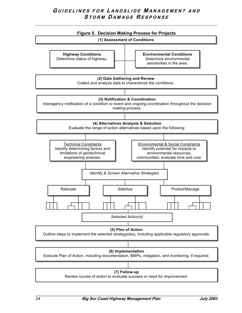
The Department follows a rational decision-making process for any project, whether a plannedcapital improvement or a project developed quickly in response to a site condition wheretraveler safety is compromised or the integrity of the highway is imperiled (Figure 5). Whilethe process is applicable in any situation, the timeframe for proceeding through the steps willvary depending on the condition of the highway and the urgency to restore service. An urgentcondition will progress on a very compressed timeframe (Figure 8). In any event, theprogression must be reasonable and prudent for a timely response to address any situationwhere the integrity of the highway is compromised.
(1) Assessment of Conditions
Highway Conditions. When a deficiency is noted, an engineering site reconnaissance wouldbe undertaken and the need for a project determined. The current assessment of corridor-wide conditions is catalogued as part of the Potential Slope Instabilities Database. In caseswhere projects have not been constructed and a situation escalates to where a break inservice has occurred, the criteria to be used to evaluate the situation are outlined in Table 2and described below (in no particular order):
• Estimated Quantity of Material: The estimated volume of material that appears tobe involved in a landslide or debris flow event provides an order of magnitude thatwill help direct the response. Generally the first order of the threshold rangesoffered (up to 1,000 cubic yards) is within the quantities that Maintenance crewsmay handle. The higher ranges reflect correspondingly more significant eventsand the options available to handle the material will be critical to determining thetime required to restore service.
G U I D E L I N E S F O R L A N D S L I D E M A N A G E M E N T A N DS T O R M D A M A G E R E S P O N S E
24 Big Sur Coast Highway Management Plan July 2003
Figure 5. Decision Making Process for Projects
(2) Data Gathering and ReviewCollect and analyze data to characterize the conditions.
Environmental & Social ConstraintsIdentify potential for impacts to
environmental resources,communities; evaluate time and cost.
Technical ConstraintsIdentify determining factors and
limitations of geotechnicalengineering analysis.
Relocate Stabilize Protect/Manage
(3) Notification & CoordinationInteragency notification of a condition or event and ongoing coordination throughout the decision
making process.
(4) Alternatives Analysis & SelectionEvaluate the range of action alternatives based upon the following:
Identify & Screen Alternative Strategies.
(6) ImplementationExecute Plan of Action, including documentation, BMPs, mitigation, and monitoring, if required.
(7) Follow-upReview course of action to evaluate success or need for improvement.
Selected Action(s)
(1) Assessment of Conditions
(5) Plan of ActionOutline steps to implement the selected strategy(ies), including applicable regulatory approvals.
Highway ConditionsDetermine status of highway.
Environmental ConditionsDetermine environmentalsensitivities in the area.

G U I D E L I N E S F O R L A N D S L I D E M A N A G E M E N T A N DS T O R M D A M A G E R E S P O N S E
July 2003 Big Sur Coast Highway Management Plan 25
• Estimated Duration of Closure: Estimating the probable duration of closure ishighly dependent on the overall quantity of material to be moved, but also on theselected repair strategy. Nevertheless, a provisional estimate about the potentialclosure (one lane or both lanes) is important for making provisions for emergencyservices, local and through traffic. Phasing that could enable access foremergency vehicles and essential services followed by considerations for anintermediate detour is included. The time periods shown in the table are indicatorsto guide development of provisions for accommodating local traffic (includingcommuters and school buses) and inter-regional traffic (visitors and long-distancetravelers).
• Proximity to Available Receiver Site (Haul Distance): When excess materialcannot be used for replenishment onsite or reused nearby, landslide material mustbe hauled to off-site locations. The distance of the haul determines the number oftrucks required for efficient haul operations and, therefore, the production rate formoving material from the site to reopen the road. Generally speaking, haulingdistances over 10 miles in one direction significantly impact production rates andthe time to complete construction.
• Roadway Status: The integrity of the highway is assessed based on the degree ofdamage or imminent threat. The type and presence of cracking may pose avariable threat depending on other conditions at the site. Determining the degreeof stress and threat to highway stability is a critical judgment by professional staff.The distinctions provided indicate whether hillside stability can be carefullymonitored (i.e., without immediately requiring a closure), or whether a section ofthe roadway is so damaged that it must be partially or completely closed to protecttraveler safety.
• Detour Length: The availability and length of detours to bypass a damagedsection of highway is an important factor. Generally, few alternatives exist on thiscoast; in some cases, existing private or public connections can be upgraded ornew connections can be provided. On most sections of the coast, however,opportunities for detours are extremely limited. The length of the detour option isan indicator of the potential severity of the service disruption.
Environmental Site Conditions. An environmental site reconnaissance would also beundertaken to locate and identify resources near the event or proposed project. ManyHighway 1 corridor environmental resources have been catalogued as part of the PotentialSlope Instabilities Database and the CHMP inventories of intrinsic qualities: Natural, Historic,Cultural, Scenic, and Recreational Qualities Inventories.13
• Topographic Conditions: Topographic considerations include geology, slopestability, seismicity, hydrology, water quality, storm water runoff, wave action, and
13 Farwestern Anthropological Research Group. Cultural Resources Inventory of Caltrans District 5Rural Highways. June 2001; JRP Historical Consulting Services. Corridor Intrinsic Qualities Inventory:Historic Qualities. November 2001; Parsons Brinckerhoff. Corridor Intrinsic Qualities Inventory: CulturalQualities. March 2002; California Department of Transportation. Historic Resources Inventory Report.November 1996; Parsons Transportation Group. Corridor Intrinsic Qualities Inventory: Natural Qualities.November 2001; Pattillo & Garrett Associates. Corridor Intrinsic Qualities Inventory: RecreationalQualities. November 2001.

G U I D E L I N E S F O R L A N D S L I D E M A N A G E M E N T A N DS T O R M D A M A G E R E S P O N S E
26 Big Sur Coast Highway Management Plan July 2003
climate (precipitation and wind erosion). Each of these factors affects the stabilityof the area and can limit the range of appropriate responses based on engineeringand volume demands. Slope, soil type, water availability, and erosion can bestructurally challenging, singly or in combination. These factors also indicate thepotential for loose debris that may affect downstream locations. Responses mustconsider these factors or system failure may occur. Assessment of theseconditions also indicates the location of potential landslide movement to informadvance planning.
• Biological Resources: Biological resources include terrestrial and marinehabitats, special-status plants and animals, the coastal zone, and wetlands andother waters of the United States. Construction, earth moving, or disposalactivities can damage these resources both directly and indirectly. Areas withsensitive resources may constrain activities that utilize heavy equipment or involveexcavation, sidecasting, hauling, or land coverage. If such activities are critical tothe response, mitigation measures such as worker education, avoidance,temporary species relocation, covering of loose earth products, removal andstockpiling of top soil, and replacement and enhancement of disturbed areas, canbe identified early in the planning process.
• Community Resources: Community resources include cultural and historicresources, visual and aesthetic resources, public recreation lands and privateproperty. Such resources may be negatively affected by construction activitythrough displacement or direct loss. Therefore, the range of acceptable landslideresponses may be limited if the surrounding environment contains these assets.
(2) Data Gathering and ReviewOnce on-site conditions are assessed, more comprehensive and detailed information aboutthe site would be collected and evaluated. Physical conditions affecting the site would benoted, such as geologic characteristics, soil type, topography, settlement patterns,groundwater, anticipated subsurface conditions and history of activity. Environmentalresource information would expand the assessment of habitat types, biological, cultural andvisual resources. A preliminary geotechnical investigation would be conducted to developcomprehensive information about site conditions and constraints. Information needs and levelof analysis for the affected disciplines, such as environmental review and geotechnicalinvestigations, are performed in accordance with Department policy and procedures as well asestablished internal guidance documents.14
(3) Notification and CoordinationThis step is relevant to agency and community stakeholders. For non-emergency conditions,interagency coordination proceeds through traditional methods. However, in order to improvethe efficiency of interagency coordination to accelerate response and restoration of highwayservice, a new notification form should be developed for non-emergency projects. Theprocess for ensuring priority given to the review of protective betterment type projects is animportant aspect of agencies’ shared responsibility for preventing or reducing the magnitudeof a potential failure. Timing and frequency of coordination (corresponding to projectmilestones) will vary with individual projects. Under emergency conditions, the Interagency 14 Caltrans Standard Environmental Reference, including the Caltrans Environmental Handbook(Volumes I-IV) which outlines guidance for evaluating impacts under CEQA/NEPA and resource-specific laws and regulations. http://www.dot.ca.gov/ser/

G U I D E L I N E S F O R L A N D S L I D E M A N A G E M E N T A N DS T O R M D A M A G E R E S P O N S E
July 2003 Big Sur Coast Highway Management Plan 27
Emergency Notification Form (ENF) is used as the primary tool to coordinate among agenciesthat may have jurisdiction over certain activities (Appendix C). Appropriate information is alsoprovided to travelers, both local and inter-regional traffic, residents, and businesses (AppendixD).
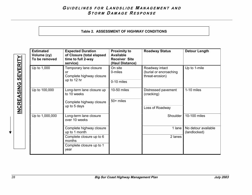
G U I D E L I N E S F O R L A N D S L I D E M A N A G E M E N T S T O R M D A M A G E R E S P O N S E
28 Big Sur Coast Highway Management Plan
EstimatedVolume (cy)To be removed
Expected Durationof Closure (total elapsedtime to full 2-wayservice)
Proximity toAvailableReceiver Site(Haul Distance)
Roadway Status
On site0-miles
Up to 1,000 Temporary lane closureorComplete highway closureup to 12 hr 0-10 miles
Roadway intact(burial or encroacthreat-erosion)
10-50 miles Distressed pavem(cracking)
Up to 100,000 Long-term lane closure upto 10 weeks
Complete highway closureup to 5 days
Long-term lane closureover 10 weeks
Loss of Roadway
S
Complete highway closureup to 1 monthComplete closure up to 6months
Up to 1,000,000
Complete closure up to 1year
50+ miles
Table 2. ASSESSMENT OF HIGHWAY CONDITIONS
INC
REA
SIN
G S
EVER
ITY
A N D
July 2003
Detour Length
hingUp to 1-mile
ent 1-10 miles
houlder 10-100 miles
1 lane
2 lanes
No detour available(landlocked)

G U I D E L I N E S F O R L A N D S L I D E M A N A G E M E N T A N DS T O R M D A M A G E R E S P O N S E
July 2003 Big Sur Coast Highway Management Plan 29
(4) Alternatives Analysis and SelectionA range of alternative response or repair strategies would be developed based on siteconditions and characteristics of the surrounding environment. Cost estimates would also beprepared as part of this step. An initial range of alternatives would be derived with informationfrom the geotechnical site investigation (for understanding physical parameters and technicalconstraints) together with information about environmental sensitivities and community needs.Field exploration would usually be supplemented with additional subsurface testing andanalyses to better describe anticipated subsurface conditions. A review of the potential forenvironmental effects, including biological, cultural (contemporary, historic, prehistoric) andvisual impacts would be conducted.
The analysis at this stage would identify both the repair technique (construction) andsecondary actions, such as the recommended disposition of excess material and siterestoration strategy. In combination, the technical information together with the considerationfor environmental and socioeconomic impacts screens the range of alternatives for developingan action plan.
Under non-emergency conditions, the geotechnical analysis would be described as part of awritten report. Environmental considerations would be reviewed in compliance with CEQAand NEPA and other resource-specific laws and regulations, as applicable to the project.15
Under emergency conditions, all of the same information would be collected, but it would bedocumented in an abbreviated format. The scope and level of detail of the information,however, may be less; in particular, subsurface exploration of conditions may be limited.Generally, an alternatives analysis conducted under shorter timeframes may favor a moreconservative approach.
Coordination activities initiated in step 3 would extend to the evaluation and selection of apreferred alternative. As with the documentation, the degree of coordination activity wouldvary with the time available (i.e., during emergency procedures, certain coordination activitiesmay be waived or conducted within a compressed timeframe).
To thoroughly understand the various options, each alternative should include a preliminaryplan of action and describe proposed mitigation and monitoring requirements and other follow-up that may be required. Written documentation of the alternatives analysis is an importantcomponent of the decision-making process.
(5) Plan of ActionSteps would be outlined to implement the selected repair strategy, including applicableregulatory approvals prior to commencing work. The steps may include any additionalnotification, coordination of environmental review and regulatory permits, right-of-way, sitepreparation, restoration planning, engineering design (roadway and structures, as applicable)and construction. Interdisciplinary review of the proposed plan is essential sinceimplementation will require interdisciplinary action. Since action by several agencies may alsobe required, coordination and feedback processes are critical to ensure that all steps andcoordination requirements are clear to all parties.
15 Professional staff, in accordance with well-established guidelines for review and analysis, performsboth the geotechnical and environmental evaluations.
G U I D E L I N E S F O R L A N D S L I D E M A N A G E M E N T A N DS T O R M D A M A G E R E S P O N S E
30 Big Sur Coast Highway Management Plan July 2003
(6) ImplementationCarry out the actions as outlined above, ensuring that all requirements are identified andhonored in the field. Any required changes must be carefully evaluated and documented asthey occur. Appropriate coordination consistent with agreed-upon parameters and asapplicable to the nature and extent of any changes will be conducted.
(7) Follow UpThe follow-up portion of the process encompasses monitoring, evaluation, reporting, andrecommendations for any future action. Follow-up documentation would take the form of aProject Completion Report (Appendix E). The Project Completion Report would document:
• Information about the project as built.• Review of environmental impacts (associated with project construction).• Successes or failures encountered with mitigation measures.• Any additional monitoring or follow-up requirements.
An evaluation of the implementation program (looking at both processes and actions) wouldbe conducted on an annual basis. Needs for improvement would be outlined as specificactions.

G U I D E L I N E S F O R L A N D S L I D E M A N A G E M E N T A N DS T O R M D A M A G E R E S P O N S E
July 2003 Big Sur Coast Highway Management Plan 31
Figure 6. Project Processing
FundingInformation Regular
SHOPP E*
Decision Process Step
Method Detail
Min
or
Maj
or
Emer
gen
cy
Annual monitoringreport
Updated database of potential slopeinstabilities with identification ofpotential projects
x x(1) Highway Assessment
Interagency ENF See ENFx
Technical Reports as outlined foreach discipline x x
(2) Data Gathering & Review
GIS DatabaseReviewSite Investigations
Field Review
Technical memoranda for eachdiscipline x
Priority projectprocessing** x x
(3) Notification & CoordinationExpeditedprocedures orwaivers
Corresponding to the potential forspecific impacts, regulatoryjurisdiction and potential trafficdisruption x
(4) Alternatives Analysis &Selection
Supportingdocumentation forproject specificenvironmentalreview
Corresponding to the potential forimpacts to sensitive resources
x x x
Project ApprovalDocument andContract Plans
As necessary to guide constructionactivities and interagencycoordination; supplementaldocumentation may be required forinteragency coordination
x x(5) Plan of Action
Memoranda As outlined to include agencyresponses to the ENF x
(6) Implementation Construction &Mitigation N/A x x x
(7) Follow UpProject CompletionForm and AnnualReview
Description of impacts/mitigation;successes and failures x x x
* Pursuant to a determination by the Department of Transportation that an emergencycondition exists.
** Identification of priority processing details consistent with each agency’s responsibilitiesand obligations is recommended as a future action towards the CHMP objective ofenvironmental streamlining.

G U I D E L I N E S F O R L A N D S L I D E M A N A G E M E N T A N DS T O R M D A M A G E R E S P O N S E
32 Big Sur Coast Highway Management Plan July 2003
5.0 Fundamental Highway Repair Strategies
This section provides an introduction to the basic strategies available to the Departmentfor highway repair and landslide management, culvert and drainage maintenance andrepair, and earthwork. This information lays the foundation for the best practicespresented in Section 6.
5.1 Managing for Landslides
The Department employs three approaches or strategies for maintaining a functioninghighway in a landslide-prone environment:
� Relocation or Separation� Stabilization� Management and Protection
These strategies are not mutually exclusive, nor listed in any particular order. A repairproject for an individual location may include elements or techniques from more than onestrategy, depending on the specific site conditions. In the descriptions and examplesthat follow for each of the three strategies, an indication is given as to whether minor ormajor SHOPP funding would be most likely. Given an escalation of circumstances,usually precipitated by a natural event such as a storm or earthquake, any of theseprojects could be undertaken as part of the Emergency Relief program with SHOPPfunding under certain circumstances.
Relocation or SeparationThis strategy involves moving the roadway alignment away from the problem area,thereby separating the highway from further influence of the natural land movements.Relocation protects the public investment in the facility while allowing the naturalprocesses associated with landslides to continue without interference. This approachincludes minor realignments as well as construction of bridges, viaducts, and tunnels. Inmany cases, a separation project requires substantial planning and involves high costsand considerable time for project delivery. Except for a minor realignment-type project,most of these projects would compete for funding among major SHOPP projects.
StabilizationStabilization refers to techniques applied to a slope to prevent or minimize movementsfrom either above or below the highway. Examples of stabilization techniques includebuttresses, retaining walls, crib walls, shoreline armor, anchor bolts and reinforced earthembankments. Completely removing an unstable mass (potential landslide) is also alegitimate stabilization technique. Aspects of stabilization approaches may also includemodifications to control surface or subsurface water to avoid retention or concentrationof water that could lead to severe erosion or saturation and ultimately slope failure.Depending on the magnitude of the instability, stabilization-type projects could be fundedunder the minor or major SHOPP program.
Management and ProtectionThe primary objective of management and protection is to reduce the potential fordamage from future movement or failure. Management and protection techniques applya variety of measures to protect the traveler from harm and the highway from damage.The newest techniques are consistent with a strategy of “living with” a certain amount of
G U I D E L I N E S F O R L A N D S L I D E M A N A G E M E N T A N DS T O R M D A M A G E R E S P O N S E
July 2003 Big Sur Coast Highway Management Plan 33
on-site movement by balancing the forces of the instabilities. Techniques includereducing the driving forces of a landslide (for example, removing a mass of material fromthe head of a landslide) or increasing the resisting forces (such as buttressing a slope).While balancing forces may prevent or reduce the likelihood of a larger scale event (ormovement), slopes may continue to move more gradually. While localized (or smaller)instabilities may continue to be apparent, stability may be achieved more globally.
Other management and protection techniques include installation of rockfall protectiondevices such as rocknet fences or drapery, construction of catchment areas allowingmaterial to accumulate safely away from the traveled way, and simple embankmentreconstruction. These techniques, which are both economical and practical, are nowemployed regularly throughout the corridor. As with stabilization type projects, eitherminor or major SHOPP programs may fund management and protection activities.
5.2 Managing Drainages and Culverts
Managing the flow of water under and around Highway 1 along the Big Sur Coast is alsoessential to continued highway operations. Over 700 culverts carry water under this 75-mile stretch of highway, while approximately 40 bridges span larger waterways orsteeper canyons.16 The primary function of good drainage is to prevent ponding of wateron the roadway and to maintain the free flow of water around and across the highway.An active program is necessary to ensure the proper functioning and overall integrity ofthe drainage facilities.
Drainages are important components in the overall landscape and can serve multiplefunctions. Cross-highway drainages may have a function as a natural wildlife corridor.In some cases, these same areas may provide conduits under the highway forpedestrian or other non-motorized access as well. The extent to which wildlife crossingsmay be present along individual drainages is included in the Natural QualitiesInventory.17 Further information that may be used to determine wildlife corridors thatmay coincide with cross-highway drainages is available from a volunteer “roadkillsurvey”18. Data collected over several years time may be used to identify trends inwildlife crossing patterns. The multiple functionality of drainages is an importantconsideration in the overall scheme of managing these features that are most well-known for conveying water.
Although overside drains and bridges also have important functions in conveying wateracross or under the highway, the focus of this discussion is culverts. Culverts consist ofthree main components: the pipe or box, the inlet and the outlet. Each component isperiodically evaluated against multiple criteria for healthy function, but these criteriagenerally take into consideration flow, energy dissipation, and structural integrity.
Proper flow is maintained by ensuring that facilities remain free from obstructions, suchas woody growth and sediment build-up. Obstructions can result in water and debrisbacking up behind the roadway embankment, and in severe cases, loss of the roadway.Energy dissipation focuses on the outlet of a culvert or overside drain and at the piers of
16 Draft Culvert Inventory for the Big Sur Coast Highway Management Plan. May 200217 Parsons Transportation Group. Corridor Intrinsic Qualities Inventory: Natural Qualities.December 2001.18 Smiley, John. Big Sur Coast Highway Volunteer Roadkill Survey. 2003.http://www.redshift.com/~bigcreek/roads/roadkill_survey/index.html

G U I D E L I N E S F O R L A N D S L I D E M A N A G E M E N T A N DS T O R M D A M A G E R E S P O N S E
34 Big Sur Coast Highway Management Plan July 2003
bridges (scour) to ensure that erosive action from the water is not causing an aggravatedcondition that is threatening either to the environment or to the structural integrity of thefacility itself. The structural integrity of the facility, including the fundamental condition ofthe pipe and its component ends, is important to ensure that the system operates as afully functioning unit to handle water and the associated debris that gets carrieddownstream.
As noted in Section 2.3, above, debris flows are common in some places along thecorridor. Debris flows occurring upstream from the highway can have a severe impacton the facilities, which emphasizes the need to manage the debris as well as the waterthat flows downstream, especially during a storm event. Three techniques for effectivelymanaging culverts are:
� Debris Management� Rehabilitation� Replacement
Debris ManagementDebris-flow protection strategies can be looked at as measures to protect the highwaybefore or after debris enters the right-of-way. Strategies attempting to mitigate debrisflow before it gets to the highway are complex and this rugged section of coast is notconducive to them. An example would be construction of basins to impound debrisbefore it reaches the highway. Inter-agency cooperation – for example, to ensure thattrimming vegetation to improve fire safety does not pose culvert debris managementproblems downstream – could be undertaken on a regional or watershed basis. This isan option for future exploration.
There are prudent methods to handle debris flows once they reach the highway, and thebest method would be simply to allow debris to continue beneath the highwayunimpeded. Generally, only the largest of culverts or a bridge would accommodatemajor debris flows. Larger culverts also enable easier passage by wildlife. Sizing aculvert to pass debris flow is difficult. A bulking factor can be added to account for anestimated quantity of suspended sediment and bed load but there is still uncertaintyabout what the debris will contain. A general idea of the future debris can be gainedfrom past debris flows.
Candidate locations for debris-flow protection projects may be identified with informationfrom the landslide maps produced by the California Geologic Survey. Typical methodsto protect an inlet from debris flow include installation of risers, bear traps, debris racks,and overflow inlets. The first three measures trap debris while allowing water tocontinue to flow into the inlet; the overflow inlet is a second large culvert installed at ahigher elevation than the first, allowing water to flow through if the original culvertbecomes blocked. These actions serve to prevent highway inundation and potential lossof the roadway.
Debris management techniques can be installed as part of regular maintenance or maybe funded as part of a Minor project.
RehabilitationRehabilitation is an intermediate measure to extend the service life of an existing culvertand can be carried out with relatively little disruption to traffic and the surroundingenvironment. These strategies involve protecting and reinforcing the existing culvert,generally by lining them, before excessive corrosion causes the culvert to lose its shape
G U I D E L I N E S F O R L A N D S L I D E M A N A G E M E N T A N DS T O R M D A M A G E R E S P O N S E
July 2003 Big Sur Coast Highway Management Plan 35
or escaping water has eroded its essential support. The lining options include liners ofplastic, resin and cement mortar. All rehabilitation strategies require complete cleaningof the existing culvert and access to both the inlet and outlet. These techniques areoften funded as part of the Minor program.
ReplacementCulvert replacement is necessary when the service life has been reached and the facilitycan no longer be maintained effectively and is beyond simple repair or evenrehabilitation. Replacement may also be necessary if other activities occur incombination, such as landslides, where an event may cause collapse or seriousdeformity. Two methods for replacement are available: cut and cover or jacking. Cutand cover is the simplest method, involving excavation of a trench to remove and thenreplace the culvert in place. The second method, jacking, is generally used whenculverts are located under deep fills; this technique employs a type of tunneling andusually requires construction of temporary pits at the inlet and outlet ends. With fewexceptions, culvert replacement projects are funded as part of the Minor program.
5.3 Earthwork and Handling of Excess Material
Properly handling earthwork activities is a combination of reducing overall disturbance tothe extent practicable to minimize generation of excess material and finding suitabledestinations for any such excess.
Even using the most prudent construction techniques to minimize the area ofdisturbance, some excess material must generally be transferred from a work site inorder to reopen the highway for service. The earthwork activities described below canresult from activities undertaken as described in Sections 5.1 and 5.2 above. Theamount of excess material generated and how it is handled are the controlling factors indetermining how quickly highway service can be restored after significant storm damage.
Figure 7 below illustrates the relative time to opening based on hauling distances forexcess material; the example is based on a hypothetical situation where 20,000 cubicyards of material must be removed to restore service. In addition to delay, the cost ofhandling material is high in relation to total construction costs. For a single repair projectduring in the year 2000, the cost of truck hauling was approximately $1,200/day pertruck. Twenty trucks, each having a capacity of 10-cubic yards, were involved in theoperation, resulting in an estimated expenditure of $24,000/day for hauling costs alone.Additional direct costs are incurred for loading, traffic control, and spreading the materialat its destination. Indirect but very real costs are not charged to the project: roadwaywear and tear, impacts to travelers and loss of business revenue for the duration of aclosure.
All of the earthwork activities described here result from activities undertaken asdescribed in Sections 5.1 and 5.2. Determining the disposition of that material, however,has been the subject of much discussion and is not easily resolved.
Earthwork Strategies
The Department’s historic approach to earthwork related to highway projects along theBig Sur corridor is captured by the familiar mantra: “reduce, reuse, recycle.” These threeoptions are not mutually exclusive. They can be used singly or in combination for any

G U I D E L I N E S F O R L A N D S L I D E M A N A G E M E N T A N DS T O R M D A M A G E R E S P O N S E
36 Big Sur Coast Highway Management Plan July 2003
given situation. However, even where reduction, reuse and recycling are achieved,residual material may remain that requires further handling. The full array of options forhandling material on the Coast Highway corridor is the following: reduce, reuse, recycle,replenish and dispose.
(1) Reduce overall quantities by selecting maintenance and repair techniques andpractices that reduce the overall footprint of disturbance and in the case of repairs arethe least disruptive beyond the event that destabilized the highway.
(2) Reuse material that is viable for other highway maintenance or reconstructionprojects. Rock and soil suitable for other highway repairs would be re-used locally or inother parts of the corridor, as needed. For structural use, the material cannot be high inorganic matter; for revegetation efforts, organic material such as duff or topsoil is animportant component. Care must also be taken to avoid the export of exotic plantmaterial within the corridor. Material slated for reuse may require double handling as itmay be stockpiled and processed for later use.
Sample Landslide Repair: Factors Influencing Time to Opening
0
5000
10000
15000
20000
25000
30000
1 2 3 4 5 6 7 8 9 10 11 12 13 14 15
Number of Days
Volu
me
of M
ater
ial f
or R
emov
al
Approximate rate of work with off-site hauling operation**
Approximate rate of work with on-
site material handling
Roadway open to traffic
Assumptions: Variables:1. Rate of work w/ on-site handling & compact in place: 5,000 CY/Day 1. 2-way versus 1-way haul 2. Rate of work with 2-way hauling operation: 2,000 CY/Day 2. Availability of trucks3. Compaction at receiver site is rated for stability in place only 3. Site access (work site and disposal site) (i.e. not suited as building site) ** Rate of haul shown is optimal and slows in correlation to variables
Figure 7: This graph represents a hypothetical project where removal of 20,000 cubic yards ofmaterial is necessary to re-open the highway safely to traffic.

G U I D E L I N E S F O R L A N D S L I D E M A N A G E M E N T A N DS T O R M D A M A G E R E S P O N S E
July 2003 Big Sur Coast Highway Management Plan 37
(3) Recycle material for non-highway uses, either along the corridor or elsewhere. Thisinvolves transferring material that has commercial value for use in other approved publicor private development projects or activities. Recycling may require double handling orlong transport.
(4) Replenish sediment supplies to natural systems by removing or bypassing man-made barriers. Replenishment would take place in circumstances under which thehighway (or highway management practices) may inhibit natural flow of sediment.
(5) Dispose of any remaining excess material that cannot be put to any other beneficialuse. Disposal may require double handling depending on its final destination.
Assuming the most vigilant actions to minimize the quantity of material that wouldrequire any transfer (i.e. opportunities to first reduce, reuse and recycle are maximized),residual material is a given under many circumstances. The primary decision is to locatean appropriate receiver site. Trucks are the conventional means of transport.
Receiver Sites
Determining the final destination for residual material is a discretionary action. As withrepairs, alternatives must be considered; unlike repairs, the range of potential locationsis fundamentally broader.
Suitable receiver locations within the corridor are extremely limited. Under currentpractice, the default response is to take material to landfills, either commercial facilitiesor private or public properties, where a landowner/manager will accept the material. Inpreparing material for its ultimate destination (also the case for reuse and recycling)temporary stockpile areas are often needed. Stockpiling is a useful option for expeditingaspects of a highway repair before material can be processed or hauled to itsdestination. Stockpiling involves double handling.
Due to the magnitude of the potential events and the effort required to prepare a site,permanent receiver sites less than 5,000 cubic yards are generally not cost effective forthe Department. Receiver sites of 50,000-100,000 cubic yards offer economies of scaleand so may warrant investigation, environmental evaluation, design and permitting.
In the summer following the 1998 El Nino, the Department began the process ofdeveloping potential disposal sites that could be used in response to future stormevents. Initially, 45 terrestrial sites were identified and sent through a screeningprocess. The Department approved nine of those sites with a Negative Declarationunder CEQA. Four of those sites are proceeding through the regulatory permit process.
Natural sinks for sediment must also be considered as an important option for handlingmaterial. Along this corridor, the ocean is considered a natural sediment sink.Landslides and streams deliver sediment to the ocean as part of natural coastal erosionprocesses. The degree to which human influence aggravates the volume of materialgenerated remains an unanswered question19. Future research findings may determinethe degree to which regulators will allow the ocean to be relied upon as part of thesolution to handling excess material. Decisions on this subject will rely on a formal
19 Hapke, 2003.
G U I D E L I N E S F O R L A N D S L I D E M A N A G E M E N T A N DS T O R M D A M A G E R E S P O N S E
38 Big Sur Coast Highway Management Plan July 2003
environmental review process to carefully evaluate the various alternatives and thepotential environmental effects.
Where repair techniques have involved mechanical excavation of slopes, relativelyrecent regulatory decisions have generally precluded options involving the ocean as asediment sink20. However, where the source and quantity generated is accepted asentirely natural (defined loosely as involving no mechanized or human-assistedexcavation of a slope), the ocean has been accepted as a legitimate sediment sink.21
The potential for adverse environmental impacts is the driving factor in the decision-making process. Adaptation and tolerance of the receiver site or habitat must beevaluated to determine the severity and duration of potential effects. Changes toterrestrial sites with appropriate surface treatment to restore vegetation have traditionallymet with greater acceptance in the coastal development permit process than changes tothe shoreline. This is due in part to a lack of scientific information on which to assessrecovery rates of shoreline intertidal habitats from the potential effects of burial, turbidityand scour. Regulatory agency managers have requested additional study of thesensitivity of these habitats and a better (quantitative) understanding of the ambientsediment budget to advance decision-making on this subject.22
Transport Mechanisms
Trucking is the conventional method for transport, trips over 10-miles one-way from thesource are considered long-haul trips, where costs increase exponentially. Bargetransport to other destinations may be an option in the future. Such an option wouldlikely driven by the commercial value for suitable material.
Several transport mechanisms may also be considered under scenarios involving theocean a natural sediment sink. These include mechanically depositing material over theside of the highway; loading natural landslides for gradual deposit by wave action;barging material to approved offshore ocean disposal sites; and pumping material intothe surf zone or beyond in order to avoid burial of intertidal habitats. These mechanismsare still under discussion as to whether they are appropriate along the Big Sur Coast.
5.4 Weighing the Options and Managing Risk
Given the responsibility to preserve the integrity of the highway, the Departmentmaintains full-time crews in the field. These maintenance crews are the first-line ofobservation and action on a daily basis. Staff from the geotechnical branch also makesregular reviews of active landslide areas, which may include monitoring with scientificinstrumentation to detect and record information about subtle movements.
Managers employ databases to organize and track information centrally about twocritical aspects of highway management and function: landslides and drainages served
20 By application of current regulations of the Monterey Bay National Marine Sanctuary.21 Resulting from over 20 years of investigation, research and negotiation. Waddel Bluffs, SantaCruz County.22 Initial components for developing a sediment budget along the Big Sur Coast may be initiatedby the US Army Corps of Engineers through a Coast of California Study.

G U I D E L I N E S F O R L A N D S L I D E M A N A G E M E N T A N DS T O R M D A M A G E R E S P O N S E
July 2003 Big Sur Coast Highway Management Plan 39
by culverts.23 While the traditional approach is to look at isolated sites at a point in time,an interdisciplinary team with access to a well-maintained comprehensive database canconsider conditions at multiple locations concurrently or observe trends at specific sitesover time.
Multi-disciplinary teams with specialized expertise evaluate problem areas or notablechanges in conditions. Locations that exhibit high rates of change, or are chronic andhighly labor intensive to maintain, may be identified as potential project locations. Onceinitiated, a formal investigation would determine whether a preventive type project couldeffectively correct or improve an existing situation. The investigation would also identifya range of possible technical solutions. With good information about the potentialsolutions, managers can seek funding to complete project development and construction(see Section 3.2).
Available funds are insufficient to address all the locations along the Big Sur Coast thatexhibit stress from underlying movements or instabilities. Even if funds were available,the degree to which the sum of the repairs would measurably improve reliability alongthe corridor might not outweigh the cumulative impacts to the surrounding area and thelong-term, nearly continuous disruptions to traffic during construction of the repairs. It isnot desirable to initiate projects at every location of instability along the Big Sur Coast.However, advancing knowledge of potential trends and hazards is recommended todevelop a more systematic long-term management approach.
As the owner and operator of the highway, the Department continuously evaluates riskand sets priorities for repair at individual sites throughout the corridor. Under the currentapproach, those locations where instabilities are known to have the greatest potential toadversely affect traveler safety or threaten the integrity of the highway are given thehighest priority. Careful engineering judgment is required to make this determination.
When initial assessments indicate repair can be accomplished for $750,000 or less,projects can be initiated under the Minor program. Projects are initiated forprogramming as a Major project when enough information is available to demonstratethat the repair strategy is likely to exceed the Minor limit and the urgency of the situationwill make it competitive on a statewide basis.
Traditional maintenance activities are generally carried out within parameters that do notrequire individual regulatory approvals.24 Implementing more involved preventive orcorrective action usually requires greater levels of coordination and a longer timeframe.Ultimately, delivering such projects in a timely fashion becomes a responsibility sharedamong a number of stakeholders.
Effective coordination must involve community and other non-governmentalstakeholders in the decision-making process in conjunction with traditional review byregulatory agencies. Because there are times when the Department must act quickly, itis important that stakeholder issues have been well defined ahead of time
23 See Locations of Potential Slope Instabilities and Culvert Inventory Databases.
24 Note that certain maintenance actions, such as work in streambeds or sensitive habitats, aresubject to compliance with resource-specific laws and regulations, such as the California Fish &Game Code and the Federal Endangered Species Act.

G U I D E L I N E S F O R L A N D S L I D E M A N A G E M E N T A N DS T O R M D A M A G E R E S P O N S E
40 Big Sur Coast Highway Management Plan July 2003
When a capital improvement is funded to undergo the formal project developmentprocess, detailed site investigations are conducted. If a project is not approved toundergo project development and an urgent situation develops, accelerated action willtake place. The risk in expediting the analysis and design in such a situation is that theconservative engineering approach will prevail. The more information available, themore thorough the analysis can be that informs the design.
Fundamentally, as an essential service, any break in highway continuity needs to berestored as soon as possible. As a first priority, safe emergency vehicle access iscritical. Accommodating local and through traffic is the next priority, and must alsoensure traveler safety. Since existing detours via local roads are not readily available onthe Big Sur Coast, establishing a practical detour may also be part of the repair strategy.Such detours can require new construction or upgrades to existing private or publicroads. Unless a structural solution is contemplated, the single greatest factor driving thetime required to reopen the highway is the efficiency of moving material (quantities,rates, and distance), see Figure 6.
The emphasis on effective interagency coordination relies on both a sharedunderstanding of programs and funding and a shared commitment to a set of process-related practices. These are outlined as follows:
� Minor SHOPP projects can be delivered most rapidly, as these programs aremanaged locally (District 5).
� Delivery of Major SHOPP projects requires greater time, in part due to the statewidecompetition for funds. These projects may be more likely to involve structures,requiring detailed investigations, foundation studies and design.
� Emergency Relief (ER) funding is made available only under a declared state ofemergency. This funding is also from the SHOPP.
� Any project could be elevated to an emergency project should conditions deterioratebefore design and all approvals are obtained. The Forest Boundary viaductillustrated this, where geotechnical investigation had been underway when a failureimpacted the southbound lane.
� The Department is granted statutory authority to determine when an emergencyexists for the condition of the highway.
Given the conditions above, the following actions are suggested for the Department totake:
� Maximize opportunities to evaluate and monitor site conditions on a corridor-widebasis, that would promote more trend analysis and enable evaluation of potentialsolutions at a larger scale.
� From the trend analysis, identify priority locations for geotechnical and environmentalsite investigations.
� Initiate projects where a specific need is identified and a concept for a feasiblesolution validated.

G U I D E L I N E S F O R L A N D S L I D E M A N A G E M E N T A N DS T O R M D A M A G E R E S P O N S E
July 2003 Big Sur Coast Highway Management Plan 41
� Analyze proposed improvements in respect to resource impacts (e.g., impacts toterrestrial or marine habitats and/or sensitive species) and considerations for cost,community disruptions, and delays in restoring highway service.
A suggestion for key stakeholders is to cooperate in designing and sponsoring researchand demonstration projects that will clarify the impacts and tradeoffs of projects andpractices on the corridor.

G U I D E L I N E S F O R L A N D S L I D E M A N A G E M E N T A N DS T O R M D A M A G E R E S P O N S E
42 Big Sur Coast Highway Management Plan July 2003
6.0 Best Available Techniques
Remaining up to date with developments in new technology and materials is a highpriority for the Department. Innovation in methods and materials is often the means toimprove outcomes while reducing or avoiding impacts to the environment. This sectionof the guidelines describes best available techniques for handling the followingcategories of activities:
1. Landslide Management2. Drainageway and Culvert Management3. Earthwork and Materials Handling
The techniques described below are theoretically feasible for the Department toconsider. Several techniques, however, have not been tested or are not readilyavailable for use for a variety of reasons including costs and completion ofenvironmental analysis. As innovation continues, many of today’s best availabletechniques will be modified or supplanted over time, requiring updates to theseguidelines. Modifications considered for implementation in the corridor will be evaluatedthrough an inter-disciplinary approach.
6.1 Landslide Management
The best available techniques for landslide management are organized into three typesof strategies:
Relocate or Separate - The basic strategy is to relocate or separate the roadway fromthe area of instability. This type of approach includes such construction techniques asviaduct/bridges, tunnels, or realignment of the roadway.
Stabilize - This strategy employs a variety of techniques to improve stability in place.This approach includes techniques such as buttresses, reinforced earth embankments,retaining walls, anchor bolts, soil nails, slope excavation and shoreline armor.
Manage and Protect – This strategy seeks to “live with” the landslide by hindering itsmovement and providing protection for travelers with physical barriers. Approachesinclude manipulating areas within a landslide in attempt to balance the driving andresisting forces or installing rockfall protection devices.
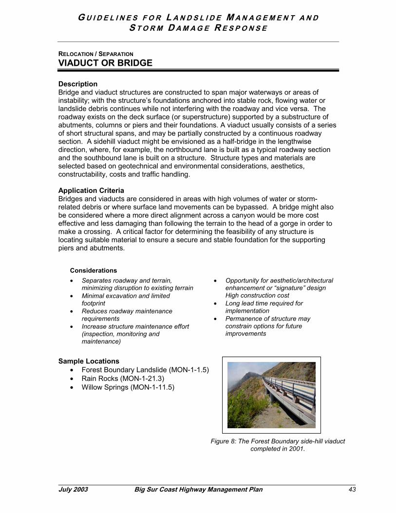
G U I D E L I N E S F O R L A N D S L I D E M A N A G E M E N T A N DS T O R M D A M A G E R E S P O N S E
July 2003 Big Sur Coast Highway Mana
RELOCATION / SEPARATION
VIADUCT OR BRIDGE
DescriptionBridge and viaduct structures are constructed to span major waterways or areas ofinstability; with the structure’s foundations anchored into stable rock, flowing water orlandslide debris continues while not interfering with the roadway and vice versa. Theroadway exists on the deck surface (or superstructure) supported by a substructure ofabutments, columns or piers and their foundations. A viaduct usually consists of a seriesof short structural spans, and may be partially constructed by a continuous roadwaysection. A sidehill viaduct might be envisioned as a half-bridge in the lengthwisedirection, where, for example, the northbound lane is built as a typical roadway sectionand the southbound lane is built on a structure. Structure types and materials areselected based on geotechnical and environmental considerations, aesthetics,constructability, costs and traffic handling.
Application CriteriaBridges and viaducts are considered in areas with high volumes of water or storm-related debris or where surface land movements can be bypassed. A bridge might alsobe considered where a more direct alignment across a canyon would be more costeffective and less damaging than following the terrain to the head of a gorge in order tomake a crossing. A critical factor for determining the feasibility of any structure islocating suitable material to ensure a secure and stable foundation for the supportingpiers and abutments.
Considerations• Separates roadway and terrain,
minimizing disruption to existing terrain• Minimal excavation and limited
footprint• Reduces roadway maintenance
requirements• Increase structure maintenance effort
(inspection, monitoring andmaintenance)
• Opportunity for aesthetic/architecturalenhancement or “signature” designHigh construction cost
• Long lead time required forimplementation
• Permanence of structure mayconstrain options for futureimprovements
Sample Locations• Forest Boundary Landslide (MON-1-1.5)• Rain Rocks (MON-1-21.3)• Willow Springs (MON-1-11.5)
Figur
gement Plan 43
e 8: The Forest Boundary side-hill viaductcompleted in 2001.

G U I D E L I N E S F O R L A N D S L I D E M A N A G E M E N T A N DS T O R M D A M A G E R E S P O N S E
44 Big Sur Coast Highway Management Plan July 2003
RELOCATION / SEPARATION
TUNNEL
DescriptionA tunnel allows passage directly through a land barrier, such as a steep hill or mountain.Tunnels may allow a more direct route between two points without significant alterationof the landform.
Application CriteriaImportant criteria for constructing a tunnel include the integrity and strength of thelandmass: can the mass withstand the tunneling operation without collapse and canstable entry and exit portals be secured? Long-term lifecycle and maintenance costsmust also be considered when evaluating alternatives for circumnavigating versus boringthrough the mountain. Power is also required for lighting and ventilation systems.
Considerations• Ability to penetrate rather than alter
terrain• Minimal footprint compared to slope
excavation alternatives• Opportunity to improve roadway
geometry• Direct route may bypass areas
requiring intensive maintenance• Natural flow of material and roadway
coexist with fewer conflicts
• Very high design and construction cost• Long lead time for implementation• Increased structure maintenance effort
(inspection, monitoring andmaintenance)
• Provisions for lighting, ventilation anddrainage
• Permanent structure may constrainoptions for future improvements
• Obstructs views from the road
Sample Locations• Waldo Tunnel, Route 101 Marin Co.• Gaviota Tunnel, Route 101 Santa Barbara Co.• Cascade Highway, Route 20, Washington
Figure 9: A two-lane tunnel on theCascade Highway, State Route
20 in Washington.

G U I D E L I N E S F O R L A N D S L I D E M A N A G E M E N T A N DS T O R M D A M A G E R E S P O N S E
RELOCATION / SEPARATION
REALIGNMENT
DescriptionRealignment moves the roadway away from an encroaching threat or instability and mayvary greater in length and horizontal offset. On the Big Sur Coast, the degree of offset isconstrained by the topography. Constructing a tunnel or bridge (above) is a form ofrealignment. Depending on the location, a typical roadway realignment on the coastinvolves some degree of excavation. Realignments accomplished with steep cut slopesmay also require a catchment area in anticipating of localized sloughing that would beexpected.
Application CriteriaRealignments can be considered where the highway can be moved to a more stablelocation or to facilitate traffic handling from a repair.
Considerations• Ability to move the roadway away from
the problem area• Opportunity to improve roadway
geometry• Facilitate traffic handling• Typically more cost effective than other
relocation/separation strategies
• Aesthetics and ability to revegetatenew cut and fill slopes
• Presence of sensitive corridorresources
• Changes in access to adjoining areas.
Sample Locations• Pitkins Curve (MON-1-21.5)• Mill Creek (MON-1-18.6)• Hurricane Point (MON-1-59.0)
July 2003 Big Sur Coast Highway M
Figure 10: The roadway was realigned intothe slope and a catchment area was
provided at Hurricane Point.
anagement Plan 45

G U I D E L I N E S F O R L A N D S L I D E M A N A G E M E N T A N DS T O R M D A M A G E R E S P O N S E
46 Big Sur Coast
STABILIZATION
BUTTRESS
DescriptionA buttress is a gravity system that depends on the friction and shear between the facingunits and their combined weight to retain backfill or to enable slopes to stand moresteeply than they could without reinforcement. Buttresses may be constructed with rockor wire enclosed gabions (containing smaller rock); in some cases, retaining walls alsoact as a buttress.
Application CriteriaButtressing is a potential solution for small scale, local instabilities where there is asound foundation for the buttress materials and sufficient area for access andconstructability. Availability of suitably sized material is also a consideration.
Considerations:• Minimal footprint• Reduces need for slope reconstruction
or regrading• Low cost
• Difficult to revegetate• Access and constructability
Sample Location• Gorda, MON-1-10.1
Figure 11: The Gorda Retaining Wall (MON-1-10.1) isa large scale buttress, which supports the highway
across a large landslide.
Highway Management Plan July 2003

G U I D E L I N E S F O R L A N D S L I D E M A N A G E M E N T A N DS T O R M D A M A G E R E S P O N S E
July 2003 Big Sur Coast Highway Management Plan 47
STABILIZATION
RETAINING WALLS
DescriptionRetaining walls are a means of preserving slopes and allowing them to stand steeperthan without reinforcement. A retaining wall can be used for either cut or fill slopes.There is a wide variety of wall types and materials available including cast-in-placeconcrete; concrete or rock masonry; concrete, steel or timber crib walls; and an array ofearth retaining systems that may combine tie-backs, soil reinforcement and facingpanels. Factors that influence the selection of type and materials include the geology,design loading, height, foundation, constructability, costs and aesthetics.
Application CriteriaAreas with tight constraints where the footprint and earthwork must be minimized toreduce overall impacts; areas where steep slopes can be stabilized and minimize theeffects of erosion. Examples of constraints include environmentally sensitive areas,right-of-way, native habitats and visual resources. Site geology is important todetermine the maximum wall height, which is governed by the bearing capacity of thefoundation material and the global stability of the site.
Considerations• Reduces earthwork and allows steeper
slopes that minimize overall footprint• Opportunities for aesthetic/architectural
treatments
• Visibility• Moderate cost• Longer lead time for implementation• Constructability requirements
Sample Locations• Grey Slip (MON-1-6.7)• El Sur Ranch sheet pile wall
(MON-1-55.1)
Figure 12: A sheet pile retaining wall wasconstructed near the El Sur Ranch (MON-1-55.1) tostabilize the roadbed from movement undercutting

G U I D E L I N E S F O R L A N D S L I D E M A N A G E M E N T A N DS T O R M D A M A G E R E S P O N S E
48 Big Sur Coast Highway Management Plan July 2003
STABILIZATION
ENGINEERED SLOPES
DescriptionEngineered slopes describe the application of specialized techniques to reinforce a cutor fill slope or to control settlement and erosion. Examples include lightweight fill;geotextile mats; grids or membranes to improve bearing capacity; slope benching anddrainage systems to control surface and subsurface water, pore pressure and erosion.Techniques may also employ surface materials such as jute or mesh netting to controlerosion and facilitate plant establishment.
Application CriteriaSimilar to retaining walls, engineered slopes are considered where there are limitationson overall width due to environmental or property constraints. Engineered slopes areconsidered where the construction of conventional slopes is not feasible due to presenceof poor or unsuitable foundation soils, lack of suitable fill material, or unusualgeotechnical or loading conditions.
Considerations• Slopes can be built steeper than the
natural material would generally allow• Minimizes earthwork; small footprint• Alleviates surface erosion and
facilitates plant establishment
• Moderate lead time for implementation• Cost-effective
Sample Locations
• North of San CarpoforoCreek (SLO-1-71.4)
• South of Garrapata Creek(MON-1-62.1)
• North of Rancho Barranca(MON-1-31.5)
Figure 13: This reinforced earth embankment is locatednorth of Rancho Barranca (MON-1-31.5)

G U I D E L I N E S F O R L A N D S L I D E M A N A G E M E N T A N DS T O R M D A M A G E R E S P O N S E
July 2003 Big Sur Coast Highway Management Plan 49
STABILIZATION
ROCK BOLTS AND SOIL NAILS
DescriptionRock bolts and soil-nailing systems achieve stability by binding friable or fractured in-siturock and soil slopes. The anchors may be driven directly into the rock or installed intopre-drilled holes and grouted. The treatments may be used in conjunction with facingmaterials such as welded wire mesh, concrete or stone panels or reinforced shotcrete.
Application CriteriaRock bolting and soil nailing techniques are used to increase the strength and stability ofexisting rock and soil slopes. Soil nailing can also be used to facilitate methods ofexcavating a cut slope.
Considerations• Stabilizes in-situ materials with minimal
or no excavation• Minimizes overall footprint• Cost effective• Slope retains a relatively natural
appearance
• Moderate lead time for implementation• Challenging working conditions for
personnel and equipment.
Sample Location• Highway 9 in Santa Cruz County (SCr-9-13.5)
Figure 14: Soil nailing and in-situ reinforcement used tostabilize a slope after a landslide above Highway 9 near
Boulder Creek in Santa Cruz County.

G U I D E L I N E S F O R L A N D S L I D E M A N A G E M E N T A N DS T O R M D A M A G E R E S P O N S E
50 Big Sur Coast Highway Management Plan July 2003
STABILIZATION
ROCK SLOPE AND SHORELINE PROTECTION
DescriptionLarge rock used to alleviate stream bank erosion or bluff retreat is known as rock slopeprotection (RSP). RSP armors slopes that support features of the highway against scourin a stream or the erosive action of tidal and wave action along the shoreline. Sizing therock will depend on the magnitude of the erosive forces and it may be either grouted orungrouted. Other methods of shoreline protection include seawalls and wire meshgabions (wire baskets filled with rock and interwoven).
Application CriteriaShoreline protection is considered where it is not practicable, either from an engineeringstandpoint or the allowable time, to implement a long-term solution such as relocatingthe highway away from the erosive forces or onto competent rock. Choice of type anddesign will depend on site-specific coastal processes and conditions including wave run-up, elevation of mean high water; shoreline morphology, erosion rates, coastal access,aesthetics and costs. The guiding principle for engineering design is to stabilize theshoreline; issues of sediment supply and potential effects to the nearshore habitats mustbe considered for suitability to an individual site.
Considerations• Prevents undermining or erosion of the
roadway embankment from tidal andwave action
• Cost effective• Flexible, allowing some shifting of rock
without compromising overall stability• Effects to nearshore environment
• Susceptible to ongoing damage anderosion
• Design choices must consider visualcompatibility with the natural shoreline.
• Artificial structures can upset naturalbalances of sediment flux, includingseasonal variations of beach sand
Sample Locations• Arroyo Del Oso, north of Piedras
Blancas in San Luis ObispoCounty (SLO-1-65.3)
• Alder Creek (MON-1-7.9)• Limekiln Creek (MON-1-20)• Rocky Creek (MON-1-60.0)
Figure 15: Rock slope protection has been used as atemporary measure at Arroyo Del Oso until a long-term
solution to realign the highway can be implemented.

G U I D E L I N E S F O R L A N D S L I D E M A N A G E M E N T A N DS T O R M D A M A G E R E S P O N S E
July 2003 Big Sur Coast Highway Management Plan 51
STABILIZATION
EXCAVATION AND REMOVAL
DescriptionOne traditional approach to landslide repair involves excavation and removal of anunstable mass (landslide) to re-establish a stable slope. Dewatering and creatingbenches on the slope are often integral aspects of the design and construction.Excavation techniques can vary depending on site conditions and available equipment.Flatter slopes provide greater local and global stability but produce larger quantities ofexcavation and have a larger overall footprint. Steeper slopes may result in localizedinstabilities, requiring a wider bench near the roadway for catchment of material.
Application CriteriaUsed where other methods to achieve stability are not practical due to deep instabilityalong discontinuous rock types, continued movement of a hillside, or unstable foundationmaterials.
Considerations• Provides long-term solution by
removing source of instability• Depending on mass of landslide, has
the potential to generate large volumesof excess material
• Time in construction and secondaryeffects depend on methods of handlingexcess material
• Depending on techniques andequipment available, may result inrelatively extensive footprint
• Very difficult to successfully revegetateexcavated slopes
Sample Locations• Redwood Gulch landslide• Highway 9 in Santa Cruz County
(SCr-9-13.5)
Figure 16: The use of specialized equipment onHighway 9 in Santa Cruz County enabled excavation of
a slide mass without the need for access roads,minimizing the overall impact area.

G U I D E L I N E S F O R L A N D S L I D E M A N A G E M E N T A N DS T O R M D A M A G E R E S P O N S E
52 Big Sur Coast Highway Management Plan July 2003
MANAGEMENT & PROTECTION
BALANCING FORCES
DescriptionThese techniques involve balancing the forces of instabilities to achieve a condition ofglobal stability and to prevent or reduce the likelihood and severity of a larger scaleevent, while accepting or “living with” continuing localized on-site settlement andcreeping (slow) movements. The techniques include decreasing the driving forces (e.g.removing material from the head of a landslide) or increasing the resisting forces (suchas buttressing the toe of a slope or dewatering).
Application CriteriaThese techniques may be considered where their implementation will result in areasonable degree of global stability of a landslide, and conventional landslide removalmethods are not warranted or are undesirable for environmental or aesthetic reasons.
Considerations• Smaller footprint and reduction in
earthwork/disposal quantities• Less impacts, shorter timeframe and
lower cost
• Tolerance for occasional localizedinstabilities
• Facilitates traffic handling
Sample Locations• Wild Cattle Creek (MON-1-17.7)• Big Slide (MON-1-22)• Grandpas Elbow (MON-1-23)• Duck Ponds (MON-1-8.3)• Grey Slip (MON-1-6.8)
Figure 17: Balancing forces is applied tomanagement of the Grey Slip Landslide
(MON-1-6.8)

G U I D E L I N E S F O R L A N D S L I D E M A N A G E M E N T A N DS T O R M D A M A G E R E S P O N S E
July 2003 Big Sur Coast Highway Management Plan 53
MANAGEMENT & PROTECTION
ROCKFALL PROTECTION
DescriptionRockfall protection techniques include surface scaling, rock catch fences, net drapery,catchment areas, rock bolting and rock sheds. Some slopes are managed with periodicscaling which is a method of prying loose rocks down from a natural rock slope surface.Other slopes require additional protection in the form of physical barriers to absorbenergy and control continuously falling rock from a natural slope or to manage thesloughing material from excavation of a steep slope. These measures are all aimed toprotect travelers and the roadway itself. Development of new technologies hasadvanced the availability of flexible barriers made of high strength materials andcoatings that last longer and are less visually prominent than rigid or fixed barriers.
Application CriteriaRockfall protection is considered where the amount, size or severity and past history offalling rocks presents a safety or maintenance concern.
Considerations• Minimal footprint, alleviates the need
for aggressive solutions such asexcavation or permanent slopetreatments
• Methods can be used in combination• Accessibility of catchment areas for
maintenance
• Availability of space to accommodate acatchment area
• Ability to minimize visibility of rock netand mesh features with color coating
• Aesthetics
Sample Locations• Cow Cliffs (MON-1-28.3)• Rain Rocks (MON-1- 2.8)• San Marcos Pass,
Highway 154 in Santa BarbaraCounty
Figure 18: A flexible rocknet fence protects motorists at CowCliffs near the Big Creek Reserve on the Big Sur Coast.

G U I D E L I N E S F O R L A N D S L I D E M A N A G E M E N T A N DS T O R M D A M A G E R E S P O N S E
MANAGEMENT & PROTECTION
ROCK SHEDS
DescriptionA rock shed provides protection to the highway traveler by creating a roof-type structureas a shield from chronic rock falls.
Application CriteriaUsed where other protective methods cannot be applied due to terrain, spacerequirements, or severity of rockfalls.
Considerations• Provides high degree of protection• Minimizes disruption of the natural flow
of material across roadway• Reduces daily maintenance
requirements
• Massive structure may contrast withvisual context
• High design and construction costs• Interferes with views from road• Long lead time to implementation
Sample Locations• Historic Columbia River Scenic
Highway, Oregon• New Zealand
54 Big Sur Coast Highway Management Plan July 2003
Figure 20: This rockshed protects a bicycle/pedestrianpath on the Historic Columbia River Highway in Oregon.
Figure 19: This rockshed protects a highway inNew Zealand.
G U I D E L I N E S F O R L A N D S L I D E M A N A G E M E N T A N DS T O R M D A M A G E R E S P O N S E
July 2003 Big Sur Coast Highway Management Plan 55
6.2 Drainageway and Culvert Management
Drainage ways and culverts provide a means by which water, suspended sediment, andother organic material (leaves and woody debris) can pass around or beneath theroadway via bridge, pipe (of metal, plastic or concrete) or concrete box. These featuresare essential to maintaining the integrity of the roadway. Although the systems attemptto accommodate natural background flows as if the highway wasn’t there, culvert designcannot completely avoid sediment deposition at the inlet and erosion at the outlet.Therefore, proper management of drainage ways and culverts require debris removaland basic structural maintenance.
Culvert maintenance requires periodic inspection to maintain flow capacity, preventdebris blockages and control erosion. Maintenance also involves repairing worn areasof the culvert or the inlet and outlet structures, and serves to extend the life of thesystem. It also helps prevent emergencies that require extensive cleaning or repair ofthe roadway following a drainage system failure.
The practices are organized into three types:
Debris Management - Debris management methods are meant to protect the roadwayand upstream property from damage caused by debris blockages and overtopping.Protection strategies can deal with debris before or after it enters the highway right-of-way, although it is more feasible and economical to prevent the debris flows fromreaching the highway. When debris blocks a culvert without any back up system, theincoming flow will continue to build up behind the roadway (i.e. the roadwayembankment effectively becomes a dam), creating flooding upstream until it eventuallyovertops the road. Overtopping can result in severe damage to the roadway and thedownstream embankment causing secondary problems with erosion and slope stability.
There are two methods of handling debris: adequately sizing the channel or culvert andintercepting debris upstream with control structures such as deflectors, racks, risers,additional culverts and inlets, debris basins and flexible barriers. Debris trap devicescan lead to accumulation of debris at the inlet and therefore require ongoingmaintenance for debris removal.
Culvert Rehabilitation - Rehabilitation extends the service life of a culvert. Generallyless intrusive than a complete replacement, rehabilitation may include structural repairs,pipe lining and outlet protection.
Culvert Replacement - When conditions of a culvert deteriorate to a point where itssupport or integrity has been lost, rehabilitation is no longer an option and the culvertmust be replaced. There are two basic replacement methods: cut-and-cover (trenching)and jacking (boring). Culverts in fill up to 20 feet deep are often replaced using thecut/cover method; jacking methods are considered where the culverts are under fills of15 to 20-feet or more. Replacement projects can become complex since the waterwaysoften provide sensitive habitat.
Design for a new culvert must consider hydraulic capacity, structural integrity andservice life as well as the potential of the drainage as a wildlife corridor or as a route forrecreational access to the coast.

G U I D E L I N E S F O R L A N D S L I D E M A N A G E M E N T A N DS T O R M D A M A G E R E S P O N S E
56 Big Sur Coast Highway Management Plan July 2003
From an engineering perspective, considerations include location, alignment, slope,type, strength, shape, jointing, and means of protection to meet the hydraulic, loading,and soil conditions. Use of the most appropriate culvert type for an area will ensure along service life and reduce the level and frequency of maintenance.
DEBRIS MANAGEMENT
DEBRIS DEFLECTORS
DescriptionDebris deflectors create a “V” shape deflection system to guide medium and heavydebris or rocks away from the inlet to an accumulation point where the material can beeasily collected and removed. Debris deflectors are suitable for large culvertsconstructed for high velocity flow and large debris (e.g. logs and boulders). Deflectorsmay be constructed from steel pipe, heavy rail, timber, and wire, depending on the sizeof debris that may impact the area.
Application Criteria• Areas of high flow velocities or quantities• Potential for large debris in the watershed• Large capacity culverts
Considerations• Extends the life of the culvert• Reduces the chance of culvert failure• Facilitates maintenance, but requires periodic cleaning
and removal of debris
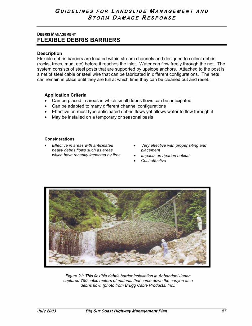
G U I D E L I N E S F O R L A N D S L I D E M A N A G E M E N T A N DS T O R M D A M A G E R E S P O N S E
July
DEBRIS MANAGEMENT
FLEXIBLE DEBRIS BARRIERS
DescriptionFlexible debris barriers are located within stream channels and designed to collect debris(rocks, trees, mud, etc) before it reaches the inlet. Water can flow freely through the net. Thesystem consists of steel posts that are supported by upslope anchors. Attached to the post isa net of steel cable or steel wire that can be fabricated in different configurations. The netscan remain in place until they are full at which time they can be cleaned out and reset.
Application Criteria• Can be placed in areas in which small debris flows can be anticipated• Can be adapted to many different channel configurations• Effective on most type anticipated debris flows yet allows water to flow through it• May be installed on a temporary or seasonal basis
Considerations• Effective in areas with anticipated
heavy debris flows such as areaswhich have recently impacted by fires
• Very effective with proper siting andplacement
• Impacts on riparian habitat• Cost effective
2003 Big Sur Coast Highway Management Plan 57
Figure 21: This flexible debris barrier installation in Aobandani Japancaptured 750 cubic meters of material that came down the canyon as a
debris flow. (photo from Brugg Cable Products, Inc.)

G U I D E L I N E S F O R L A N D S L I D E M A N A G E M E N T A N DS T O R M D A M A G E R E S P O N S E
58 Big Sur Coast Highway Management Plan July 2003
DEBRIS MANAGEMENT
DEBRIS RACKS
DescriptionDebris racks are located within the stream channel to collect debris before it reaches the inlet.Racks consist of rigid bars placed within the stream at a distance from the culvert to catchlarge debris that could clog the pipe. Debris storage areas near racks can minimize thefrequency of removing and hauling material.
Application Criteria• Areas of high flow quantities• Must have adequate spacing to place the racks• Large and small debris
Considerations• Extends the lifespan of the culvert• Reduces the chance of culvert failure• Facilitates maintenance
• Impacts on riparian habitat• Proper siting and placement to
effectively catch the debris
DEBRIS MANAGEMENT
DEBRIS CRIBS
DescriptionDebris cribs or bear traps are taller structures (in comparison to debris racks) placed over theinlet with crib-type openings to allow water to flow through while keeping debris out,particularly coarse bed load or larger debris. Cribs provide a similar function as risers but areused where the culvert has little cover and the sediment is coarse. Debris cribs and risers arevery efficient and require relatively low-maintenance. They can be made less visuallyprominent by selecting materials and finishes compatible with its surroundings.
Application Criteria• Small culverts• Areas of large debris or coarse bed load• Areas with sharp grade changes• Areas where deposits tend to collect at the inlet
Considerations• Extends the life of the culvert• Reduces the chance of culvert failure• Highly efficient
• Visibility• Low maintenance
Figure 22
Figure 23

G U I D E L I N E S F O R L A N D S L I D E M A N A G E M E N T A N DS T O R M D A M A G E R E S P O N S E
July 2003
DEBRIS MANAGEMENT
DEBRIS RISERS
DescriptionDebris risers are closed structures placed over the inlet to prevent debris from entering theculvert. They consist of a vertical culvert pipe covered by a grate that acts a riser. Slots arecreated within the vertical pipe to allow for continued water flow. If placed at the bottom of asteep area, the riser will cause ponding to reduce flow velocity and cause sediment to dropfrom the load. Risers can be created and installed at a lower expense than more labor-intensive structures like debris cribs, and be painted to blend into the natural background.
Application Criteria• Low flow velocities• Fine or small to medium size debris• Boulder-free area
Considerations• Extends the life of the culvert• Reduces the chance of culvert failure
• Highly efficient• Visibility from the highway• Low maintenance
Big Sur Coast Highway Management Plan 59
Figure 24: This riser allows for water to flow into thepipe inlet when debris builds up at the base.

G U I D E L I N E S F O R L A N D S L I D E M A N A G E M E N T A N DS T O R M D A M A G E R E S P O N S E
60 Big Sur Coast Highway Management Plan July 2003
DEBRIS MANAGEMENT
DEBRIS DAMS AND BASINS
DescriptionDebris dams and basins are used to impede stream flow, causing material to drop out ofsuspension and collect on the bottom. These structures are used if the height of the highwayembankment and storage area is insufficient to accommodate a riser or a crib. Dams andbasins can trap heavy boulders and coarse gravel. They are usually made of pre-castconcrete beams and rocks or with rock held by wire.
Application Criteria• Areas with heavy boulders and coarse gravel• Inadequate location for cribs or risers• High velocity flows• Suitable area for dam foundation
Considerations• Extends the lifespan of the culvert• Reduces debris buildup or blockage• Lower annual maintenance cost
compared with removing debris fromother structures
• Potential effects to habitat associatedwith alteration of natural flows
DEBRIS MANAGEMENT
OVERFLOW CULVERTS
DescriptionOverflow culverts provide a secondary route for conducting water across the highway toprevent overflow damage. The overflow is located in the same general vicinity as the mainculvert and act as an emergency back-up system.
Application Criteria• Areas of high flow velocities or quantities• Areas prone to debris blockage• Areas where debris control systems are not feasible or effective
Considerations• Reduces potential for overtopping and
potential for emergency repairs• Higher annual maintenance costs
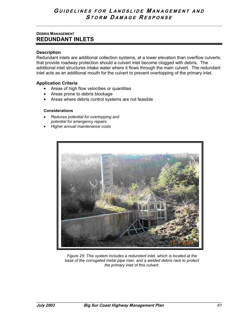
G U I D E L I N E S F O R L A N D S L I D E M A N A G E M E N T A N DS T O R M D A M A G E R E S P O N S E
July 2003
DEBRIS MANAGEMENT
REDUNDANT INLETS
DescriptionRedundant inlets are additional collection systems, at a lower elevation than overflow culverts,that provide roadway protection should a culvert inlet become clogged with debris. Theadditional inlet structures intake water where it flows through the main culvert. The redundantinlet acts as an additional mouth for the culvert to prevent overtopping of the primary inlet.
Application Criteria• Areas of high flow velocities or quantities• Areas prone to debris blockage• Areas where debris control systems are not feasible
Considerations• Reduces potential for overtopping and
potential for emergency repairs• Higher annual maintenance costs
Big Sur Coast Highway Management Plan 61
Figure 25: This system includes a redundant inlet, which is located at thebase of the corrugated metal pipe riser, and a welded debris rack to protect
the primary inlet of this culvert.

G U I D E L I N E S F O R L A N D S L I D E M A N A G E M E N T A N DS T O R M D A M A G E R E S P O N S E
62 Big Sur Coast Highway Management Plan July 2003
CULVERT REHABILITATION
STRUCTURAL REPAIR
DescriptionDamage to culverts is a result of erosion, distortion, joint separation, rust, abrasion, and otherphysical defects. Structural repair consists of a variety of methods to improve or maintain theintegrity of the culvert and drainage channels. In addition to a thorough cleaning, manystructural repairs can be considered rehabilitation of the culvert:
• Placing rip-rap to repair erosion around the culvert inlet and outlet structures• Coating metal pipe with protective bituminous tar or asphalt mastic• Applying concrete to metal culverts• Paving and lining inverts to prevent abrasive wear on the bottom of the culvert• Lining excessively corroded culverts with polyvinyl chloride (PVC) or polyethylene
plastic (PEP) pipe• Repairing and maintaining joints• Correcting pipe distortion
Application Criteria• Areas of wear-through abrasion and erosion of backfill materials.• Areas of fill erosion.• Areas where the culvert or drainage channel has been weakened, abraded, corroded,
perforated, distorted, or otherwise compromised.
Considerations• Extends the life of the culvert and
drainage channel• Reduces the chance of culvert failure• Cost effective
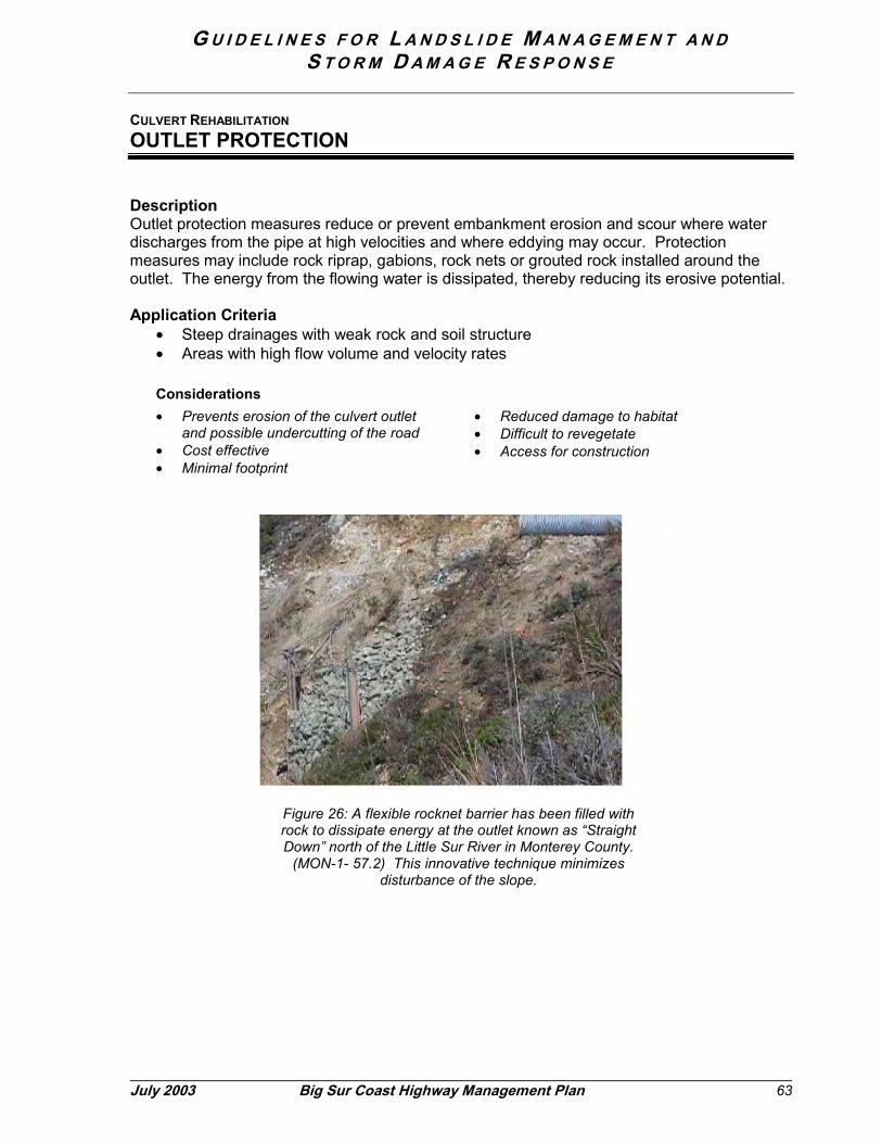
G U I D E L I N E S F O R L A N D S L I D E M A N A G E M E N T A N DS T O R M D A M A G E R E S P O N S E
July 2003 Big Sur Coast Highway Management Plan 63
CULVERT REHABILITATION
OUTLET PROTECTION
DescriptionOutlet protection measures reduce or prevent embankment erosion and scour where waterdischarges from the pipe at high velocities and where eddying may occur. Protectionmeasures may include rock riprap, gabions, rock nets or grouted rock installed around theoutlet. The energy from the flowing water is dissipated, thereby reducing its erosive potential.
Application Criteria• Steep drainages with weak rock and soil structure• Areas with high flow volume and velocity rates
Considerations• Prevents erosion of the culvert outlet
and possible undercutting of the road• Cost effective• Minimal footprint
• Reduced damage to habitat• Difficult to revegetate• Access for construction
Figure 26: A flexible rocknet barrier has been filled withrock to dissipate energy at the outlet known as “StraightDown” north of the Little Sur River in Monterey County.
(MON-1- 57.2) This innovative technique minimizesdisturbance of the slope.
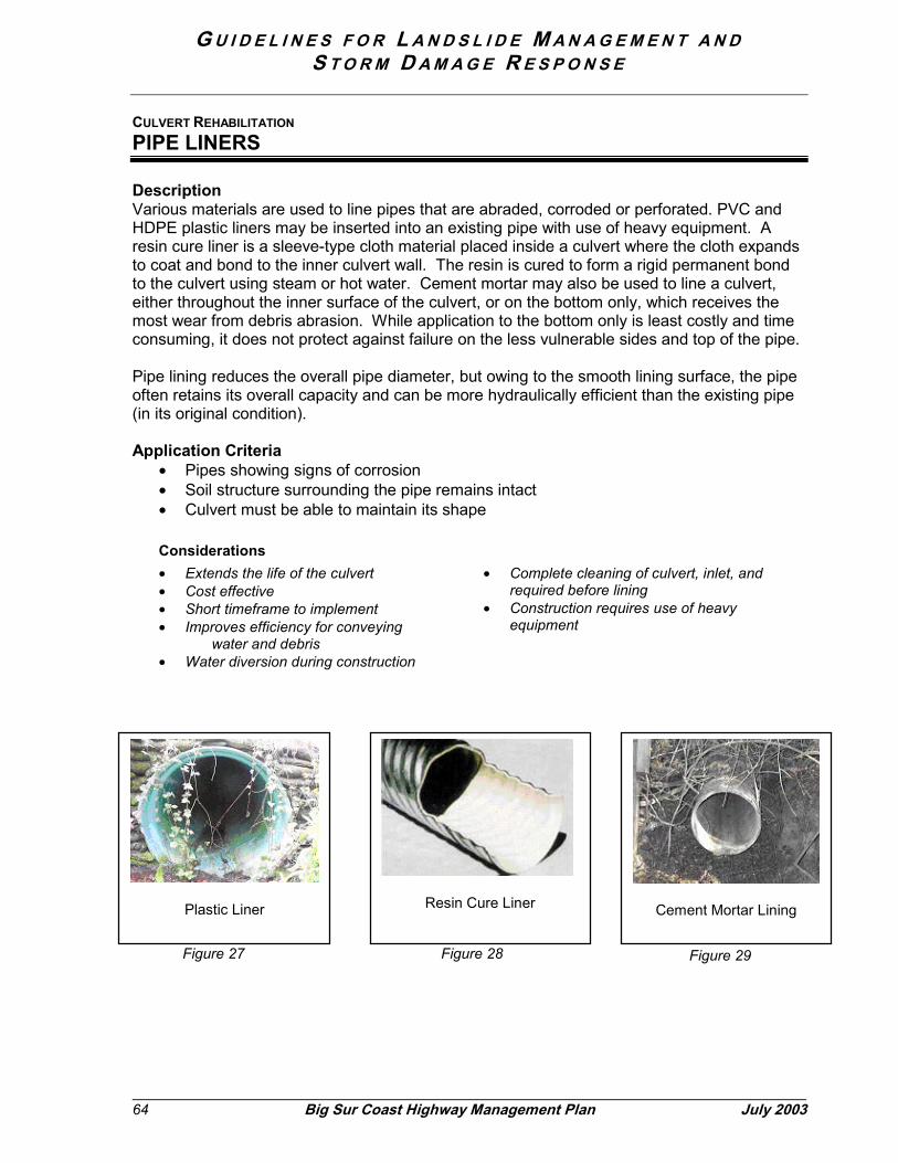
G U I D E L I N E S F O R L A N D S L I D E M A N A G E M E N T A N DS T O R M D A M A G E R E S P O N S E
64 Big Sur Coast Highway Management Plan July 2003
CULVERT REHABILITATION
PIPE LINERS
DescriptionVarious materials are used to line pipes that are abraded, corroded or perforated. PVC andHDPE plastic liners may be inserted into an existing pipe with use of heavy equipment. Aresin cure liner is a sleeve-type cloth material placed inside a culvert where the cloth expandsto coat and bond to the inner culvert wall. The resin is cured to form a rigid permanent bondto the culvert using steam or hot water. Cement mortar may also be used to line a culvert,either throughout the inner surface of the culvert, or on the bottom only, which receives themost wear from debris abrasion. While application to the bottom only is least costly and timeconsuming, it does not protect against failure on the less vulnerable sides and top of the pipe.
Pipe lining reduces the overall pipe diameter, but owing to the smooth lining surface, the pipeoften retains its overall capacity and can be more hydraulically efficient than the existing pipe(in its original condition).
Application Criteria• Pipes showing signs of corrosion• Soil structure surrounding the pipe remains intact• Culvert must be able to maintain its shape
Considerations• Extends the life of the culvert• Cost effective• Short timeframe to implement• Improves efficiency for conveying
water and debris• Water diversion during construction
• Complete cleaning of culvert, inlet, andrequired before lining
• Construction requires use of heavyequipment
Plastic Liner Resin Cure Liner Cement Mortar Lining
Figure 27 Figure 28 Figure 29
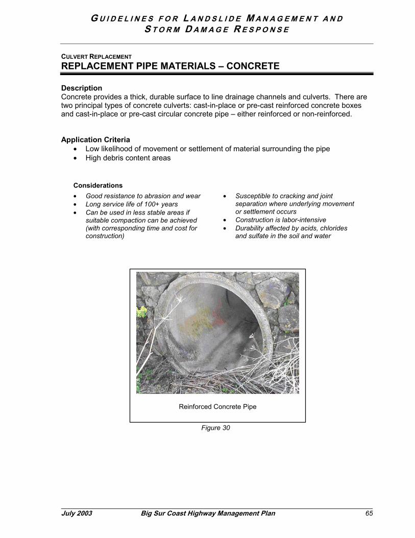
G U I D E L I N E S F O R L A N D S L I D E M A N A G E M E N T A N DS T O R M D A M A G E R E S P O N S E
July 2003 Big Sur Coast Highway Management Plan 65
CULVERT REPLACEMENT
REPLACEMENT PIPE MATERIALS – CONCRETE
DescriptionConcrete provides a thick, durable surface to line drainage channels and culverts. There aretwo principal types of concrete culverts: cast-in-place or pre-cast reinforced concrete boxesand cast-in-place or pre-cast circular concrete pipe – either reinforced or non-reinforced.
Application Criteria• Low likelihood of movement or settlement of material surrounding the pipe• High debris content areas
Considerations• Good resistance to abrasion and wear• Long service life of 100+ years• Can be used in less stable areas if
suitable compaction can be achieved(with corresponding time and cost forconstruction)
• Susceptible to cracking and jointseparation where underlying movementor settlement occurs
• Construction is labor-intensive• Durability affected by acids, chlorides
and sulfate in the soil and water
Reinforced Concrete Pipe
Figure 30

G U I D E L I N E S F O R L A N D S L I D E M A N A G E M E N T A N DS T O R M D A M A G E R E S P O N S E
66 Big Sur Coast Highway Management Plan July 2003
CULVERT REPLACEMENT
REPLACEMENT PIPE MATERIALS – CORRUGATED METAL PIPE
DescriptionGalvanized corrugated metal pipe is a very common type of material used for culverts alongthe coast. The choice of corrugation type, shape, and protection is dependent on hydraulic,structural, and design service life considerations. Ten-foot sections of the pre-formed metalmay be banded or riveted together to form longer culverts.
Application Criteria• Suitable under many conditions, including areas where minor settlement or movement
could occur• Low debris content areas
Considerations• Lower initial expense than concrete• More susceptible to wear and tear and
corrosion (than concrete) requiringmore frequent maintenance andpotential repair
• May require special protection to meetdesign service life requirements.
• Ability to conform shape in light ofsettling and movement
Corrugated Metal Pipe
Figure 31
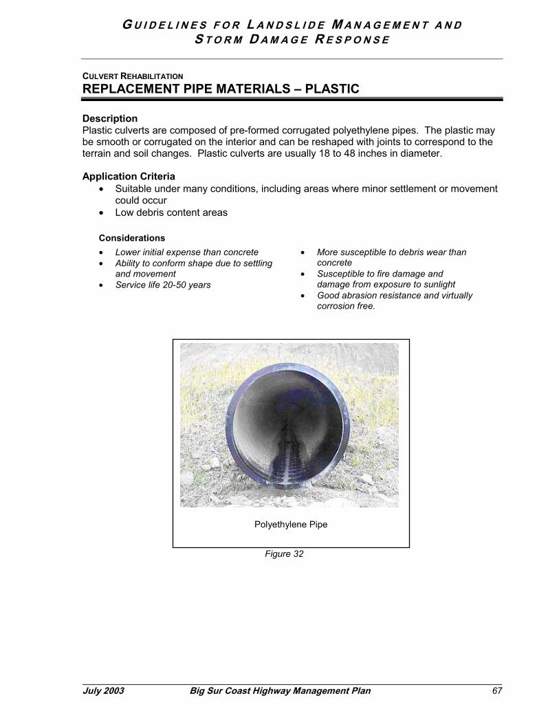
G U I D E L I N E S F O R L A N D S L I D E M A N A G E M E N T A N DS T O R M D A M A G E R E S P O N S E
July 2003 Big Sur Coast Highway Management Plan 67
CULVERT REHABILITATION
REPLACEMENT PIPE MATERIALS – PLASTIC
DescriptionPlastic culverts are composed of pre-formed corrugated polyethylene pipes. The plastic maybe smooth or corrugated on the interior and can be reshaped with joints to correspond to theterrain and soil changes. Plastic culverts are usually 18 to 48 inches in diameter.
Application Criteria• Suitable under many conditions, including areas where minor settlement or movement
could occur• Low debris content areas
Considerations• Lower initial expense than concrete• Ability to conform shape due to settling
and movement• Service life 20-50 years
• More susceptible to debris wear thanconcrete
• Susceptible to fire damage anddamage from exposure to sunlight
• Good abrasion resistance and virtuallycorrosion free.
Polyethylene Pipe
Figure 32
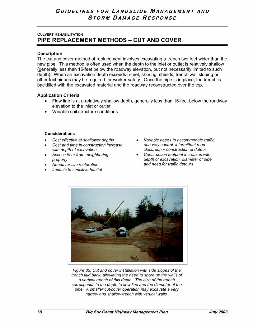
G U I D E L I N E S F O R L A N D S L I D E M A N A G E M E N T A N DS T O R M D A M A G E R E S P O N S E
68
CULVERT REHABILITATION
PIPE REPLACEMENT METHODS – CUT AND COVER
DescriptionThe cut and cover method of replacement involves excavating a trench two feet wider than thenew pipe. This method is often used when the depth to the inlet or outlet is relatively shallow(generally less than 15-feet below the roadway elevation, but not necessarily limited to suchdepth). When an excavation depth exceeds 5-feet, shoring, shields, trench wall sloping orother techniques may be required for worker safety. Once the pipe is in place, the trench isbackfilled with the excavated material and the roadway reconstructed over the top.
Application Criteria• Flow line is at a relatively shallow depth, generally less than 15-feet below the roadway
elevation to the inlet or outlet• Variable soil structure conditions
Considerations• Cost effective at shallower depths• Cost and time in construction increase
with depth of excavation• Access to or from neighboring
property• Needs for site restoration• Impacts to sensitive habitat
• Variable needs to accommodate traffic:one-way control, intermittent roadclosures, or construction of detour
• Construction footprint increases withdepth of excavation, diameter of pipeand need for traffic detours
Big Sur Coast Highway Management Plan July 2003
Figure 33: Cut and cover installation with side slopes of thetrench laid back, alleviating the need to shore up the walls of
a vertical trench of this depth. The size of the trenchcorresponds to the depth to flow line and the diameter of the
pipe. A smaller cut/cover operation may excavate a verynarrow and shallow trench with vertical walls.

G U I D E L I N E S F O R L A N D S L I D E M A N A G E M E N T A N DS T O R M D A M A G E R E S P O N S E
July 2003 Big Sur Coast Highway Management Plan 69
CULVERT REHABILITATION
PIPE REPLACEMENT METHODS – JACKING NEW CULVERTS
DescriptionJacking is used to replace culverts under fills that are generally deeper than 15-20 feet. Withthis technique a tunnel is created, usually by an auger, to create a void ahead of theadvancing hydraulically jacked pipe. Requirements for construction include excavating pits onboth sides of the roadway to jack and receive the pipe; heavy equipment is used for boringand jacking 10- to 20-foot sections of the pipe at a time.
Application Criteria• Flow line of the drainage exceeds 15-20 feet below the roadway elevation• Reliable or near-uniform soil structure
Considerations
• Costly operation that increases withpipe diameter and length
• Access to or easements fromneighboring property
• Construction footprint increases withdepth to flow line and diameter of pipe
• Needs for site restoration• Impacts to sensitive habitat
• Traffic handling may be limited tointermittent delay with one-way trafficcontrol as the roadway remains intactduring the operation; construction ofdetours less likely than with larger cut-cover operations
• Potential to encounter rock, very hardor impenetrable material, increasingthe cost and time in construction
Figure 34: The crew operates heavy equipment in the jacking pit toinstall a new culvert under deep fill at Hubbell Gulch (MON-1-20).
G U I D E L I N E S F O R L A N D S L I D E M A N A G E M E N T A N DS T O R M D A M A G E R E S P O N S E
70 Big Sur Coast Highway Management Plan July 2003
6.3 Earthwork and Material Handling
In responding to a debris flow or other landslide activity, the issue that most influences thetime required to re-open the highway is earthwork. The quantity of excess material, proximityof sensitive environmental resources, and availability and proximity of disposal sites arecritical factors. This section describes the current understanding of the best availabletechniques and identifies strategies for future exploration and development.
As set forth in Section 5.3, the priorities for earthwork on the coast are “reduce, reuse, recycle,replenish, dispose”. Reducing the quantity of excess materials is either the primary or asecondary objective of virtually all the roadway maintenance, landslide management, anddrainage management efforts the Department undertakes in the corridor. However, in thecase of some planned or unplanned projects, full use of reduction strategies cannotcompletely eliminate the generation of excess material that requires subsequent handling.Therefore, the discussion below focuses on methods for handling excess material.
The approaches to handling excess material may be used exclusively or in combination,depending upon site conditions, quantities of material and other factors as described for each.
Site CompatibilityDetermining the ultimate destination should be based upon information about backgroundnatural conditions and natural system inputs:
(a) Seek compatibility with background conditions, including:• Rock and soil types (physical characteristics)• Location (habitats indicate adaptation to similar disturbances)• Volumes (quantities of material are within range of historic patterns, chronic or
episodic)• Timing (seasonal or annual variations)• Biological factors (including presence of rare and endangered species or exotics)
(b) Offset impacts of withholding natural sediment inputs• Reduce the effect of highway as a sediment barrier (e.g., highway as a dam, where
sediment carried by streams is trapped behind fill embankments (culverts), ordetained on an artificial bench where rockfalls or landslide material is held.
(c) Monitor site conditions for change• Verify or differ with anticipated changes• Determine relative capacity for site recovery• Duration appropriate and responsible to degree of potential impact (risk tolerance)
(d) Ensure disposal of man-made materials (i.e., steel, asphalt) at authorized sites, such aslandfills or recycling centers.
G U I D E L I N E S F O R L A N D S L I D E M A N A G E M E N T A N DS T O R M D A M A G E R E S P O N S E
July 2003 Big Sur Coast Highway Management Plan 71
Mode of TransportAt present, truck hauling is the method of transport for excess soil and rock to a designatedreceiver site, whether temporary or permanent, and whether for reuse, recycling,replenishment or disposal. Haul distance is an important factor in determining the time andcosts for restoring service on the highway. Should barge transport be realized along the coastin the future, this mode could facilitate either transport to another land site (for re-use ordisposal) or to an offshore site for replenishment or disposal options (see below). Thereplenishment and progressive disposal practices described below are assumed to requirelittle or no truck hauling from the site of origin.
MATERIAL HANDLING
HIGHWAY REUSE
DescriptionThis practice refers to incorporating excess material into the highway facility. Material may beused to re-profile (raise the grade of) a section of highway or buttress a slope or retaining wall.It may be placed as shoulder backing along the edge of pavement or as earthen berms thatdelimit the boundaries of pullouts or turnouts25. Topsoil may be collected for re-applicationduring site restoration.26 Rock may be screened for appropriate size and used as lining forroadside ditches to improve drainage. Unless special restrictions apply, material may betransported to other locations throughout the corridor where a need has been identified. Anytransfer, however, must take into account the potential for and must avoid to the extentpossible the transport of undesirable invasive plant seed or other exotic materials.
Application Criteria• Material type and structure is suitable for roadway construction• Material is low in organic matter and free of undesirable vegetation or seed• Sensitive habitats can be avoided or impacts minimized by the reuse activity• Rock can be screened
Considerations• Contribution to facilitating earthwork for
restoring the highway.• Proximity to sensitive environmental
resources and habitats
• Potential for unintended spread ofinvasive plants
• Needs for follow-up weeding• Visual compatibility and preservation of
views from the highway
Sample Locations� Re-profiling Highway 1 south of Big Creek (2000)� Re-profiling Highway 1 between Pitkins Curve and Big Slide
25 Earthen berms also help prevent against illegal dumping of cars over steep cliffs, which has beendocumented at several locations throughout the corridor.26 See the Vegetation Management Guidelines prepared for the CHMP for more details on siterestoration.

G U I D E L I N E S F O R L A N D S L I D E M A N A G E M E N T A N DS T O R M D A M A G E R E S P O N S E
72 Big Sur Coast Highway Management Plan July 2003
MATERIAL HANDLING
STOCKPILING
DescriptionStockpiling refers to the practice of depositing excess material at sites along the highway corridor fortemporary storage until the material can be processed for recycling or transported to its permanentdestination (whether reuse, recycling or disposal). Stockpiled material may occupy any wide spotgenerally lacking substantial vegetation along the corridor, such as at pullouts.
Application Criteria• Permanent receiver site not available in timeframe needed to restore highway service• Material requires processing prior to reuse or recycling• Stockpile location is previously disturbed, such as a pullout
Considerations• Expected timeframe for completing
transfer to permanent location• Potential to transfer undesirable plants
or seed• Entails double-handling of material
which increases costs
• Needs for surface treatments on drymaterial to prevent wind and watererosion
• Thoughtful siting, to the extentpractical, to avoid inadvertent blockingof coastal access or views eventemporarily.
Sample Locations• Willow Springs• Garrapata State Park
Figure 35: Temporary stockpiling near Garrapata State Park
G U I D E L I N E S F O R L A N D S L I D E M A N A G E M E N T A N DS T O R M D A M A G E R E S P O N S E
July 2003 Big Sur Coast Highway Management Plan 73
MATERIAL HANDLING
REPLENISH: LOCALIZED SIDECASTING
DescriptionThis approach assumes a condition where the highway acts as a barrier to the natural movement of alandslide, debris flow or other natural process delivering a significant amount of material to thehighway. The principle behind this approach is to enable organic material generated by a landslide tocontinue relatively uncontrolled on its downward migration in its original location and in a mannerconsistent with background natural processes. The “destination” essentially remains unchanged,except for the period of being detained by the highway or a related feature (e.g. fill embankmentdamming a debris flow). In simple terms, this could be thought of strictly as “sweeping” the roadwayclear of debris in the same location where it has fallen or carrying material over the highway fill slopebarrier on a debris flow course.
Under this practice, debris from slopes above the roadway would be deposited immediately downslope of the highway. The objective is to enable material to continue the down slope or downstreamtransfer that would have occurred had the highway not been in place.
Given the intent to allow natural sediment transport mechanisms to continue unabated, artificialmeasures for controlling surface erosion would not be employed as a general rule, unless there wasrisk of aggravating a condition that would adversely affect a sensitive resource or the integrity of thehighway.
Application Criteria• Highway acts as barrier to continued movement of material down slope or down stream• Volume of material side cast is limited to that displaced by natural event• Material is organic in nature, i.e. free from built infrastructure elements such as concrete,
asphalt, steel• Areas with shoreline dynamics and habitat characteristics that indicate adaptation and
tolerance of periodic inputs (relative quantities, rates).• Area down slope or downstream characterized by conditions indicating that the side cast
material would not disproportionately affect sensitive habitats, including the nearshore marineenvironment
Considerations:• Presence or absence of protected
resources, sensitive habitat, or specialstatus species
• Mimics natural processes of masswasting
• Supports dynamic equilibrium ofregional sediment inputs and outputs
• Needs for ongoing monitoring andreporting
Sample Locations• Waddell Bluffs, Highway 1 in Santa Cruz County• Hubbell Gulch, MON-1-18.0

G U I D E L I N E S F O R L A N D S L I D E M A N A G E M E N T A N DS T O R M D A M A G E R E S P O N S E
74 Big Sur Coast Highway Management Plan July 2003
MATERIAL HANDLINGREPLENISH: SLOPE DETENTION
DescriptionThis technique considers and would accept the ocean as a natural sediment sink and includes site-specific information about the tolerance for or adaptation to periodic burial, turbidity and scour. Thistechnique also involves a higher degree of control or manipulation over the localized sidecastingdescribed above and may involve import of material from other locations within the corridor where thematerial is geologically compatible. Under this scenario, material is placed in a manner that isconsidered relatively stable in the short term, but is understood to erode and enter the ocean overtime through wave action or other major natural influence. In lay terms, this concept has beendescribed as the “conveyor belt” approach.
Under this scenario, material would be placed above the shoreline, but the erosion of material mayresult in periodic or episodic pulses (high volumes at one time). This approach also aims forcompatibility with the dynamic background conditions, but is conducted in a more controlled manner.
Application Criteria• Material is organic in nature (free from built infrastructure elements such as concrete, asphalt,
steel)• Site characteristics suitable for controlled placement and wave action appropriate for gradual,
if episodic, erosion• Areas with shoreline dynamics and habitat characteristics that indicate adaptation and
tolerance of periodic inputs• Area down slope or downstream characterized by conditions indicating that the side cast
material would not disproportionately affect sensitive habitats, including the nearshore marineenvironment.
Considerations:• Presence or absence of protected
resources, sensitive habitat, or specialstatus species
• Mimics natural processes of masswasting
• Supports dynamic equilibrium ofregional sediment inputs and outputs
• Needs for ongoing monitoring andreporting
Figure 36: Slope detention is proposed as a pilot project at thePitkins Curve Landslide, Highway 1 in Monterey County, PM 21.0.
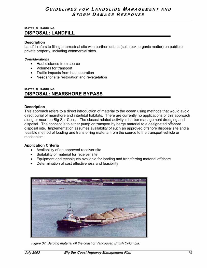
G U I D E L I N E S F O R L A N D S L I D E M A N A G E M E N T A N DS T O R M D A M A G E R E S P O N S E
Jul
MATERIAL HANDLING
DISPOSAL: LANDFILL
DescriptionLandfill refers to filling a terrestrial site with earthen debris (soil, rock, organic matter) on public orprivate property, including commercial sites.
Considerations• Haul distance from source• Volumes for transport• Traffic impacts from haul operation• Needs for site restoration and revegetation
MATERIAL HANDLING
DISPOSAL: NEARSHORE BYPASS
DescriptionThis approach refers to a direct introduction of material to the ocean using methods that would avoiddirect burial of nearshore and intertidal habitats. There are currently no applications of this approachalong or near the Big Sur Coast. The closest related activity is harbor management dredging anddisposal. The concept is to either pump or transport by barge material to a designated offshoredisposal site. Implementation assumes availability of such an approved offshore disposal site and afeasible method of loading and transferring material from the source to the transport vehicle ormechanism.
Application Criteria• Availability of an approved receiver site• Suitability of material for receiver site• Equipment and techniques available for loading and transferring material offshore• Determination of cost effectiveness and feasibility
.
Figure 37: Barging material off the coast of Vancouver, British Columbia y 2003 Big Sur Coast Highway Management Plan 75
G U I D E L I N E S F O R L A N D S L I D E M A N A G E M E N T A N DS T O R M D A M A G E R E S P O N S E
76 Big Sur Coast Highway Management Plan July 2003
7.0 Future Actions
Throughout the planning process that led to the development of these guidelines, the Storm DamageResponse and Repair Working Group noted informational gaps and institutional circumstances thatshould be addressed, but were considered as beyond the scope of these guidelines, but within thespirit of the CHMP for identifying specific actions for improving overall fulfillment of managementresponsibilities by multiple stakeholders. Several actions are recommended that may improve theoverall approach to long-term management.
1. Pursue funded research to clarify policy options
a) Conduct preliminary geotechnical investigations on priority sites to identify trends aboutindividual landslides and make recommendations for site management; evaluate priorities forprotective betterments at a corridor scale.
b) Conduct shoreline and marine habitat analysis along stretches of coast in proximity to thehighway where landslide-related management activities or repairs could affect the marineenvironment.
c) Correlate marine habitat sensitivities with sites that may be candidates for replenishment-typematerial handling strategies.
d) Conduct investigations toward estimating a sediment budget for the Big Sur Coast.
2. Pursue changes to improve delivery of needed “Protective Betterments”
a) Pursue Programmatic Agreements between the Department and individual regulatoryagencies, such as the preparation of a Public Works Plan under provisions of the CaliforniaCoastal Act for all landslide management and storm damage response activities.
b) Identify opportunities for alternatives or supplemental fund sources to initiate detailed studiesand construction of protective betterments.
c) Identify watersheds with the greatest potential to generate debris flow based on vegetation,land use and geotechnical characteristics. Initiate a partnership with land managemententities, property owners and regulatory agencies for cooperative watershed management
3. Use Best Available Information
a) Commit to continuous updating, collection, and sharing of best available information.b) Test unproven techniques in controlled demonstration projects and pilot studies.
4. Establish a Technical Advisory Group
a) Monitor and evaluate implementation of guidelinesb) Update guidelines to reflect evolution of knowledge and best available techniquesc) Ensure completion of studies that are critical to fill important data gaps

G U I D E L I N E S F O R L A N D S L I D E M A N A G E M E N T A N DS T O R M D A M A G E R E S P O N S E
July 2003 Big Sur Coast Highway Management Plan 77
8.0 References
California Department of Transportation. Highway Design Manual, 5th Edition.
California Department of Transportation. “Draft Preliminary Geotechnical Report Guidelines.” March18, 1993.
California Department of Transportation. “Geotechnical Design Reports – Purpose, Development,and Application.” Draft. October 2, 1995.
California Department of Transportation. Potential Slope Instabilities in the Highway 1 Corridor:Road Condition and Hazard Potential at Sites between San Carpoforo Creek and Carmel Highlands.September 2001.
California Department of Transportation, District 5. Culvert Inventory for the Big Sur Coast HighwayManagement Plan. May 2002.
California Department of Transportation, District 5. Mitigated Negative Declaration: Disposal Sites forStorm Damage Repair, Highway 1 Near Big Sur, December 2000.
California Division of Mines & Geology (now, California Geological Survey). Landslides in theHighway 1 Corridor: Geology and Slope Stability Along the Big Sur Coast. November 2001.
California Geological Survey and California Department of Transportation. Proceedings: 53rd AnnualHighway Geology Symposium, San Luis Obispo, California. August 13 – 16, 2002.
Duffy, John D. “Living with Landslides.” Powerpoint Presentation. Caltrans. January, 2001.
Duffy, John D. “New Technology & Innovation: Landslide Stabilization, Tecco System.” PowerpointPresentation. Caltrans. January 2001.
Federal Highway Administration. “Debris Control Structures – March 1971.” Site accessed 10/1/02.http://www.fhwa.dot.gov/bridge/hec09.pdf
Hapke, Cheryl. Estimated Sediment Yield from Coastal Landslides and Active Slope DistributionAlong the Big Sur Coast. February 2003.
JRP Historical Consulting Services, Inc. A History of Road Closures Along Highway 1 in San LuisObispo and Monterey Counties. November 2001.
Monterey County Planning Department. Big Sur Coast Land Use Plan, Local Coastal Program,Monterey County, California. 1986.
Parsons Transportation Group. Corridor Intrinsic Qualities Inventory: Natural Qualities. November2001.
Public Affairs Management. Summaries of Storm Damage and Maintenance Practices WorkingGroup Meetings for the Coast Highway Management Plan. May 12, 2000 – March 29, 2002.

G U I D E L I N E S F O R L A N D S L I D E M A N A G E M E N T A N DS T O R M D A M A G E R E S P O N S E
78 Big Sur Coast Highway Management Plan July 2003
Smiley, John. “Big Creek Slide of March 2000: March 2000 – May 2002.” Site accessed August,2002. http://www.redshift.com/bigcreek/roads/slide2000/index.html
Smiley, John. “Big Sur Coast Highway Volunteer Roadkill Survey.” February 2003. Site accessedJun3 2003. http://www.redshift.com/~bigcreek/roads/roadkill_survey/index.html
Transportation Research Board. Landslides: Investigation and Mitigation. Special Report 247. 1996.
United States Department of Agriculture, Forest Service. Slope Stability Reference Guide forNational Forests in the United States. Volume I. August 1994.

G U I D E L I N E S F O R L A N D S L I D E M A N A G E M E NS T O R M D A M A G E R E S P O N S E
July 2003 Big Sur Coast Highway Management Plan
Category Components
Marine BiologicalCharacterization
� What is the composition, abundance, and distribution of the major� Are species of special interest present? What are they?� Does the shoreline represent a unique habitat? In what manner?� What is the spatial area of concern?� Is there pre-existing evidence of sedimentation and sand scour?
OtherConsiderations
� Is the area of concern within other jurisdictions (e.g., National MaSignificance , preserves, reserves, refuges)?
� Are there other sensitive habitats between the highway and the shplants, steelhead stream, riparian habitat)?
� Are the lands between the highway and the shoreline designated or system (i.e., National Forest, State Park, Natural Reserve)?
Risk Evaluation � Will the effects of the landslide and side cast materials be irreversbe reasonably anticipated, what is the expected time frame for reb
� What are the habitats and species at greatest risk?� Will the landslide or side cast materials from road repairs cause pe
constant low-levels of disturbance?
� Is there potential for an environmentally sensitive habitat area to
� Can the credible risks be reduced or offset?
Social Acceptanceand Considerations
� Does the shoreline represent an area of economic importance (e.g� Is the area popular for recreational use (e.g., tidepooling, beach a� Is the area clearly visible from the highway, designated vista point
improved public viewing point?
APPENDIX A – PRELIMINARY GUIDANCE FOR SHORELINE HA
T A N D
A-1
species?
rine Sanctuary, Areas of Special Biological
oreline (e.g., Smith’s blue butterfly, rare
as part of any resource management program
ible (i.e., can species recover)? If recovery canound to original conditions?
rmanent damage, temporary damage, or
be significantly degraded?
., fisheries value)?ctivities, diving, surfing)?, public beach recreation area or other
BITAT ASSESSMENTS

G U I D E L I N E S F O R L A N D S L I D E M A N A G E M E N T A N DS T O R M D A M A G E R E S P O N S E
July 2003 Big Sur Coast Highway Management Plan A-2
The following table provides an example of how habitats can be “ranked” according to their risk potential to landslides and sedimentationeffects from side cast materials, based on the biota present and physical setting. The habitat value gradient below does not account forother criteria, such as recreational use or economic importance.
Example Gradient of Biological Risk to Landslides and Side Cast Materials
High Habitat Value Low Habitat Value
Highest Risk to Biota Lowest Risk to Biota
Rocky bench orboulder field with highbiodiversity, which isnot largely influencedby naturalsedimentation.
Boulder fields in high waveenergy areas andsediments. Populations areadapted to persist inconstantly disturbedenvironments.
Few rocks with limited biotainfluenced by naturalsedimentation.
Sandy beach with lack of infauna (no clams, sandcrabs).
Sandy beach withdense eelgrass beds.
Sandy beach withabundant infauna(clams, sand crabs)
Considerations for Decision-makingMinimization � Does the highway repair strategy minimize the potential for excess quantities of material? (i.e. reduce the need for disposal)
� Does the highway repair strategy reduce the risk of more massive failures (e.g., through reduction of driving forces or increasedresisting forces as needed to promote stability, or replenishment of beaches or boulder fields that diffuse wave energy)?
Evaluation ofAlternatives
� Are there alternative road repair and sediment disposal practices that can further avoid or minimize sedimentation effects to theshoreline?
� What are the trade-offs?
Post Construction and Disturbance MonitoringImpact Assessment � Did the landslide permanently change the habitat characteristics?
� Have native species been able to repopulate the disturbed areas?� Has the landslide resulted in a species assemblage dissimilar to the pre-slide assemblage?
� If the habitat outcome is different than expected, is remediation recommended? If so, what would be appropriate?
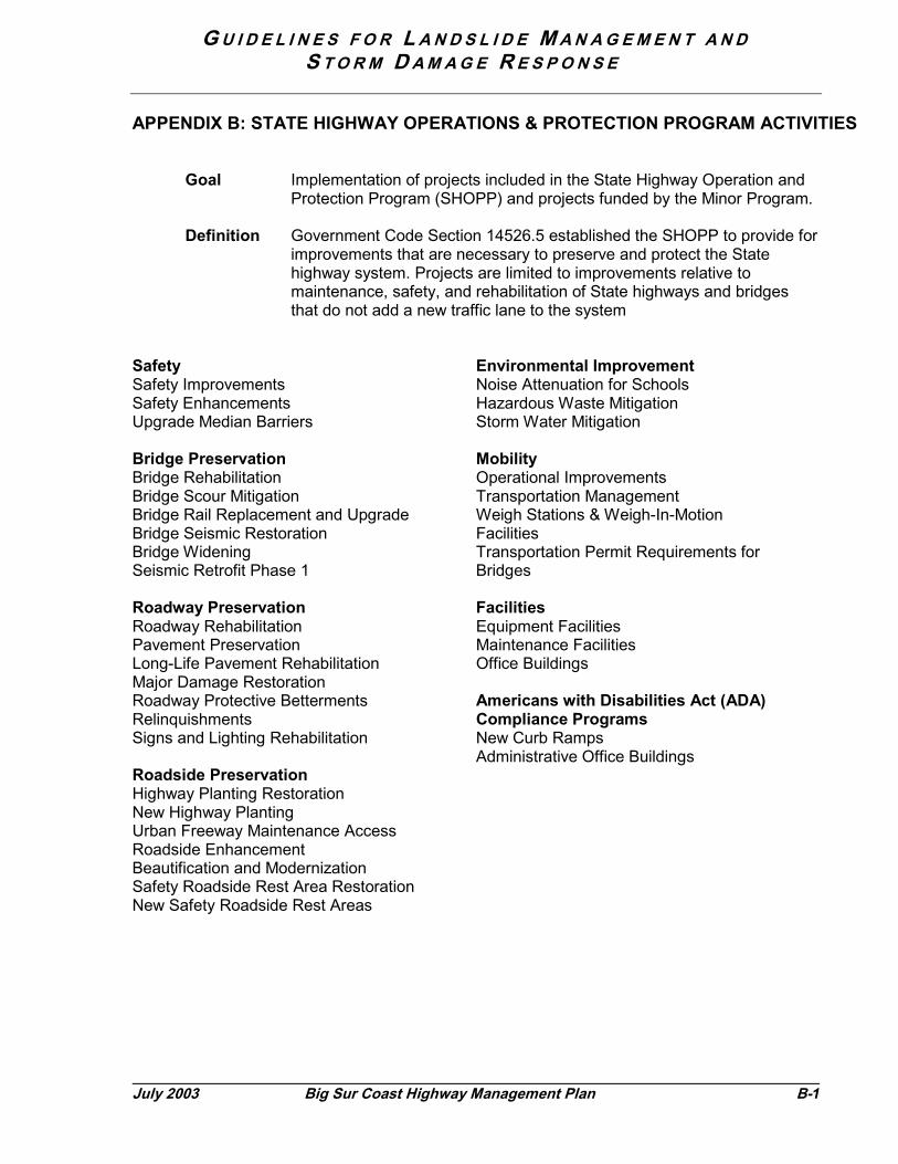
G U I D E L I N E S F O R L A N D S L I D E M A N A G E M E N T A N DS T O R M D A M A G E R E S P O N S E
July 2003 Big Sur Coast Highway Management Plan B-1
APPENDIX B: STATE HIGHWAY OPERATIONS & PROTECTION PROGRAM ACTIVITIES
Goal Implementation of projects included in the State Highway Operation andProtection Program (SHOPP) and projects funded by the Minor Program.
Definition Government Code Section 14526.5 established the SHOPP to provide forimprovements that are necessary to preserve and protect the Statehighway system. Projects are limited to improvements relative tomaintenance, safety, and rehabilitation of State highways and bridgesthat do not add a new traffic lane to the system
SafetySafety ImprovementsSafety EnhancementsUpgrade Median Barriers
Bridge PreservationBridge RehabilitationBridge Scour MitigationBridge Rail Replacement and UpgradeBridge Seismic RestorationBridge WideningSeismic Retrofit Phase 1
Roadway PreservationRoadway RehabilitationPavement PreservationLong-Life Pavement RehabilitationMajor Damage RestorationRoadway Protective BettermentsRelinquishmentsSigns and Lighting Rehabilitation
Roadside PreservationHighway Planting RestorationNew Highway PlantingUrban Freeway Maintenance AccessRoadside EnhancementBeautification and ModernizationSafety Roadside Rest Area RestorationNew Safety Roadside Rest Areas
Environmental ImprovementNoise Attenuation for SchoolsHazardous Waste MitigationStorm Water Mitigation
MobilityOperational ImprovementsTransportation ManagementWeigh Stations & Weigh-In-MotionFacilitiesTransportation Permit Requirements forBridges
FacilitiesEquipment FacilitiesMaintenance FacilitiesOffice Buildings
Americans with Disabilities Act (ADA)Compliance ProgramsNew Curb RampsAdministrative Office Buildings


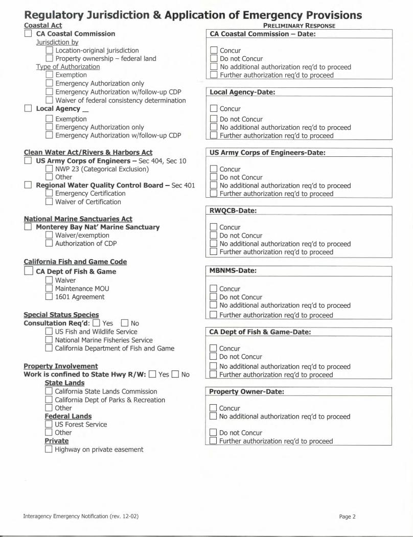

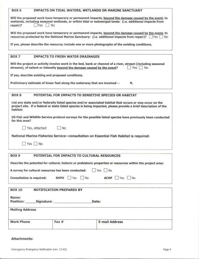

G U I D E L I N E S F O R L A N D S L I D E M A N A G E M E N T A N DS T O R M D A M A G E R E S P O N S E
July 2003 Big
The primary objectivprovide information
• Reliable—Estabenables people
• Accurate—Upddisruption (rangidynamic nature needed on a dai
• Consistent—Thofficial statemenas possible. Givinformation, it isreliable source o
Incident CommandResponse Plan27 is system. Caltrans alNotification Plan as operations during fu
Public Informationincidents are dissemattachment X for de
Agency Roles: Cocommunications:
ResponsibleMonterey Co. OES
Sheriff, CHP, Voluntee
Traffic Management C
Caltrans Environmenta
Caltrans Public Informa
Big Sur Chamber of Co
27 Monterey County Office of EPlan. 1999
APPENDIX D
– EMERGENCY COMMUNICATIONSSur Coast Highway Management Plan D-1
e for effective communication during an emergency is tothat is:
lish a best source for consistent and reliable information thatto make informed decisions about their travel.ate relevant information as conditions warrant. The degree ofng from “inconvenience” to “extreme” per CERP) and theof the work generally dictate the frequency, which may bely basis under the most severe conditions.e message sent and delivered by multiple sources, fromts (press releases) to roadside flag-persons, is as consistenten there is little control over “unofficial” sources of
recognized that emphasis on the first two points to produce af accurate information, can help control potential rumors.
: Monterey County’s Big Sur Coordinated Emergencythe guiding document for establishing the incident commandso uses the Big Sur Coast Emergency Operations anda means of initiating and maintaining communications andll closures of Highway 1 along the Big Sur Coast.
: Caltrans provides information about highway conditions orinated to Big Sur travelers and the local community. See
scription of the information and distribution of the messages.
nfirm agency roles and responsibilities for emergency
Party Area of ResponsibilityEstablish Incident Command andprovide tactical incident and dispatchcommunications
r Fire Dept. Emergency Services per Incident Command
enter (TMC) Caltrans Operations
l Planning Caltrans Interagency Coordination andEnvironmental Compliance
tion Traveler and Community Liaison
mmerce Liaison to Community and Businesses
mergency Services. Big Sur Coordinated Emergency Response
G U I D E L I N E S F O R L A N D S L I D E M A N A G E M E N T A N DS T O R M D A M A G E R E S P O N S E
D-2 Big Sur Coast Highway Management Plan July 2003
Caltrans• Traffic Management Center (Operations)• Environmental Planning (Interagency Coordination)• Public Affairs Office (Traveler and Community Liaison) – writes and
disseminates news releases; answers questions from the public, otheragencies, and the media
• Caltrans Environmental Coordinator (monitor)—ensures storm damageconstruction is conducted in compliance with environmental regulations;primary liaison between Caltrans and regulatory agencies regarding changesin project scope, conditions, impacts or mitigation.*
Monterey County Office of Emergency Services• Establishes Incident Command• Provide tactical incident and dispatch communications
CHP and Monterey County Sheriff• Emergency response providers
Big Sur Chamber of Commerce• Liaison to community and businesses
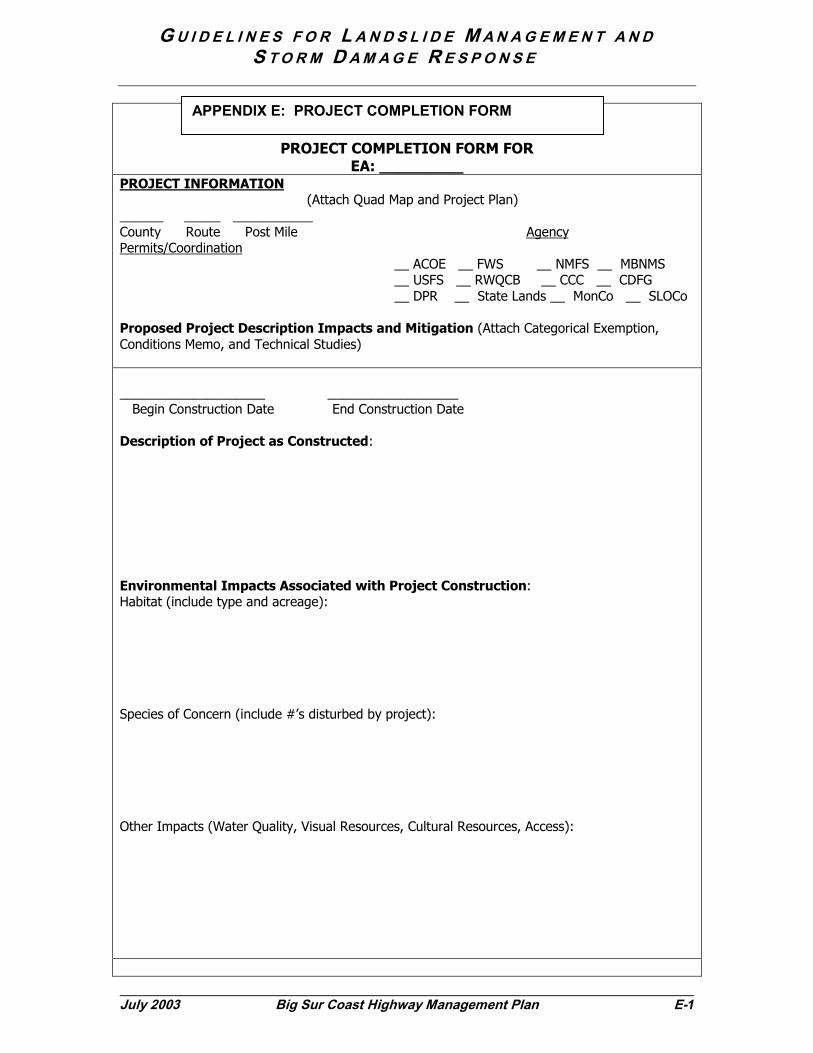
G U I D E L I N E S F O R L A N D S L I D E M A N A G E M E N T A N DS T O R M D A M A G E R E S P O N S E
July 2003 Big Sur Coast Highway Management Plan E-1
PROJECT COMPLETION FORM FOREA: _________
PROJECT INFORMATION (Attach Quad Map and Project Plan)______ _____ ___________County Route Post Mile AgencyPermits/Coordination __ ACOE __ FWS __ NMFS __ MBNMS __ USFS __ RWQCB __ CCC __ CDFG __ DPR __ State Lands __ MonCo __ SLOCo
Proposed Project Description Impacts and Mitigation (Attach Categorical Exemption,Conditions Memo, and Technical Studies)
____________________ __________________ Begin Construction Date End Construction Date
Description of Project as Constructed:
Environmental Impacts Associated with Project Construction:Habitat (include type and acreage):
Species of Concern (include #’s disturbed by project):
Other Impacts (Water Quality, Visual Resources, Cultural Resources, Access):
APPENDIX E: PROJECT COMPLETION FORM
G U I D E L I N E S F O R L A N D S L I D E M A N A G E M E N T A N DS T O R M D A M A G E R E S P O N S E
E-2 Big Sur Coast Highway Management Plan July 2003
Mitigation ImplementationDescribe success in meeting project avoidance, minimization, and compensation measures:
If unsuccessful, explain failure to meet project avoidance, minimization, and compensationmeasures:
Additional Monitoring Requirements
Mitigation Agency
Date of Next Report
___________________________________ _________________ ___________Signature Phone Date

!(
!(
!(
!.
!.
!.
!.
!.
!.
!.
!.
!.
!.
!.
!.
!.
!.
!.
!.
!.
!.
!.
!.
!.
!.
!.
!.
!.
!.
!.
!.
!.
!.
%9
%9
%9%9
%9%9
%9
%9%9%9
%9
%9%9%9
%9
%9%9
%9
%9%9
%9
%9
%9
SycamoreCanyon Road
Palo
Pfeiffer Beach
Cooper Point
Old Coast
San
Little Sur Rive
r
Juan
CreekHiguera
PfeifferRedwood Creek
Castro Canyon Creek
Cree
k
JoseCreek
Road
ColoradoRoad
48
Granite Canyon Creek
Garrapata Creek
Malpaso Creek
Wildcat Creek
Bixby Creek
Rocky Creek
I
J
K
L
3
2
1
Los PadresNational Forest
Garrapata State Park
Andrew Molera State Park
Pfeiffer-BigSur State Park
Santa Lucia Range
Carmel-by-the-Sea
Big Sur
Carmel Highlands
River
River
Carmel
Big
Sur
Big
Sur
River
Soberanes Point
Hurricane Point
Point Sur
Monterey Bay National M
arine Sanctuary
54
57
66
61
56
65
69
64
43
45
53
51
47
49
60
44
52
50
46
72
68
63
71
70
59
55
58
67
62
Guidelines for Landslide Management and Storm Damage Response
±0 1 2 3 4 5
Miles
1!.
!(
%2
Ownership
Private
Public
Indications ofRoadway Stress
Communities
Postmiles
Sediment Yield Section
Corridor Geology Segment
Corridor Map Attachment 1a
07/03
(north)

!(
!.
!.
!.
!.
!.
!.
!.
!.!.
!.
!.
!.
!.
!.
!.
!.
!.
!.
!.
!.
!.
!.
!.
!.
!.
!.
!.
!.
!.
%9
%9
%9%9
%9
%9%9%9%9%9
%9%9
%9
%9
%9
%9
%9
%9
%9
%9
%9%9
%9
%9
%9%9
%9%9
%9
%9%9
%9
%9
%9%9
oad
Pitkin's Curve
Cow Cliffs
JuanCreek
Higuera
PfeifferRedwood Creek
Castro Canyon Creek
Torr
eC
anyo
nCr
eek
Anderson Canyon Cre
ek
Burns Creek
Buck Creek
Hot Springs
Cany
on
Creek
Vicente Creek
Lime Creek
Dolan Canyon Creek
Lim
ekiln
Cree
k
48
Big Creek
E
F
G
H
7
6
5
4
3
Hubbel Gulch
Grandpas Elbow
Big Slide
Santa Lucia Range
JP Burns/McWayLandslide
McW
ay C
anyo
n
Pfeiffer-BigSur State Park
Julia PfeifferBurns State
Park
LimekilnState Park
Los PadresNational Forest
Rain Rocks
Lucia
iver
Big
Sur
River
Lopez Point
Monterey Bay National Marine Sanctuary
29
20
21
28
31
33
35
37
39
41
43
45
47
23
30
26
32
34
36
38
40
42
24
44
27
46
22
25
Guidelines for Landslide Management and Storm Damage Response
±0 1 2 3 4 5
Miles
1!.
!(
%2
Ownership
Private
Public
Indications ofRoadway Stress
Communities
Postmiles
Sediment Yield Section
Corridor Geology Segment
Corridor Map Attachment 1b
07/03
(central)

!(
!(
!.
!.
!.
!.
!.
!.
!.
!.
!.
!.
!.
!.
!.
!.
!.
!.
!.
!.
!.
!.
!.
!.
!.
!.
!.
!.
!.
!.
!.
!.
!.
!.
%9
%9
%9%9
%9%9%9%9
%9
%9%9
%9%9
%9
%9
%9
%9%9
%9
%9
%9%9
%9
%9
%9
%9
%9
%9
%9
%9%9
%9
%9%9%9%9%9
%9
%9
%9%9%9%9
%9
NacimientoPitkin's Curve
Forest Boundary Sidehill Viaduct
reek
Lim
ekiln
Cree
k
Kirk C
reek
Wild Cattle Creek
Mill CreekPr
ewitt
Cree
k
VillaCreek
Willow Creek
69
A
B
C
D
E
68
67
Greyslip
9
8
7
6
Redwood Gulch
Duck Ponds
Cape SanMartin
Los PadresNational Forest
Santa Lucia Range
Pacific Valley
Hubbel Gulch
LimekilnState Park
Gorda
Lucia
Cree
k
San Carp
ofor
o
FergussonRoad
Ragged Point
Monterey Bay National Marine Sanctuary
MontereyCounty
San LuisObispo County
8
4
9
5
6
7
2
1
3
72
14
71
70
20
15
21
10
16
23
12
18
22
11
17
13
19
74
73
Guidelines for Landslide Management and Storm Damage Response
±0 1 2 3 4 5
Miles
1!.
!(
%2
Ownership
Private
Public
Indications ofRoadway Stress
Communities
Postmiles
Sediment Yield Section
Corridor Geology Segment
Corridor Map Attachment 1c
07/03
(south)