landslide and debris flow hazard management · landslide and debris flow hazard management: issues...
TRANSCRIPT
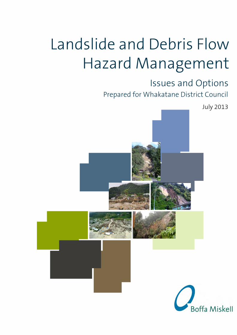
Landslide and Debris Flow Hazard Management
Issues and Options
July 2013
Prepared for Whakatane District Council
Document Quality Assurance
Bibliographic reference for citation: Boffa Miskell Limited 2013. Landslide and Debris Flow Hazard Management: Issues and Options. Report prepared by Boffa Miskell Limited for Whakatane District Council.
Prepared by: Craig Batchelar Director Boffa Miskell Limited
Reviewed by: Matt Allott Principal Boffa Miskell Limited
Status: FINAL Revision / version: 1 Issue date: 5 July 2013
Use and Reliance This report has been prepared by Boffa Miskell Limited on the specific instructions of our Client. It is solely for our Client’s use for the purpose for which it is intended in accordance with the agreed scope of work. Boffa Miskell does not accept any liability or responsibility in relation to the use of this report contrary to the above, or to any person other than the Client. Any use or reliance by a third party is at that party's own risk. Where information has been supplied by the Client or obtained from other external sources, it has been assumed that it is accurate, without independent verification, unless otherwise indicated. No liability or responsibility is accepted by Boffa Miskell Limited for any errors or omissions to the extent that they arise from inaccurate information provided by the Client or any external source.
Template revision: 20120608 0000
File ref: U:\2013\T13010_CBA_Whakatane_Hazard_Management\Documents\Planning\Issues and Options\T13010_Issues and Options_FINAL_20130703.docx
CONTENTS
Summary 1
1.0 Introduction 3
2.0 Legislation 3
2.1 Local Government Act 2002 3 2.2 Civil Defence Emergency Management Act 2006 4 2.3 Resource Management Act 1991(RMA) 4 2.4 Building Act 2004(BA) 5 2.5 Local Government and Official Information and Meetings
Act (LGOIMA) 6 2.6 Legislative Reviews 6
3.0 Landslide Risk Analysis 7
3.1 Landslide Hazards 7 3.2 Landslide Risk Management Process 9 3.3 Landslides at Whakatane and Ohope 11 3.4 Landslides at Matata 13
4.0 Landslide Risk Assessment 15
4.1 International Risk Assessment Practice 15 4.2 National Risk Assessment Practice 15 4.3 Proposed Regional Policy Statement 16 4.4 Community Attitudes and Expectations 16
5.0 Landslide Risk Management 17
6.0 Potential Risk Management Measures 18
6.1 Structural Measures 18 6.2 Non –structural Measures 19
7.0 Current Risk Management Strategy 22
7.1 Civil Defence and Emergency Management (CDEM) 23 7.2 Regional Policy Statement 24 7.3 Operative Regional Plans 26 7.4 Operative District Plan 26 7.5 Proposed District Plan 28 7.6 Building Consents 29 7.7 Land Information Memoranda (LIM) 29
7.8 Landslide Hazard Mitigation Works at Whakatane and Ohope 29
7.9 Debris Hazard Mitigation Works at Matata 30
8.0 Risk Management Strategy Options 30
8.1 Measures for All Options 30 8.2 Doing Nothing 30 8.3 Business As Usual 31 8.4 Alternative 1 - Risk Acceptance 31 8.5 Alternative 2 - Risk Reduction 32 8.6 Alternative 3 - Risk Avoidance 33
9.0 Option Evaluation 34
9.1 Evaluation Criteria and Method 34 9.2 Evaluation Method 35 9.3 Evaluation Matrix 36 9.4 Conclusions 38
10.0 Monitoring and Review 38
References 39
1.0 Appendix 1 – Legislative Framework i
1.1 Local Government Act 2002 i 1.2 Civil Defence Emergency Management Act 2006 ii 1.3 Resource Management Act 1991(RMA) iii 1.4 Building Act 2004(BA) vi 1.5 Local Government and Official Information and Meetings
Act (LGOIMA) vii 1.6 Legislative Reviews vii
Summary
The Council has undertaken assessments of landslide risks at Whakatane, Ohope and Matata. This work was initiated following hazard events that have occurred over recent years that have caused significant property damage and, in the case of Ohope, loss of life.
The Council’s responsibilities for hazard management are mandated under legislation. Under the Local Government Act the “core services” that Council must have particular regard to include the “avoidance or mitigation of natural hazards”. Hazards are managed under several interrelated statutes, including the Local Government Act (LGA), Civil Defence Emergency Management Act (CDEMA), Resource Management Act (RMA) and Building Act (BA).
Better natural hazard management is identified as one of the current proposals for reform of the RMA by central government. The policy direction is to take full account of risk in hazard management under the RMA and to apply this on a consistent basis across all hazards. This is seen as improving the effectiveness of consenting and resilience to natural hazards.
The Landslide Risk Analysis for Whakatane, Ohope and Matata follows best practice methods. Historic and recent evidence indicates that the steep escarpment slopes that form the backdrop to Whakatane, Ohope and Matata have been, and will continue to be, susceptible to landslide events.
These landslide hazards represent a significant risk to both people and property. The loss of life risk in some locations is well above international standards of acceptable risk.
Community engagement on acceptable risk levels is required. However, regardless of the final value judgement on what is acceptable, the risks are estimated as being at such a level that some significant measures will be needed to reduce the risk to more acceptable levels. In this context, the more important issue for the community is likely to be how the risks are managed.
Potential risk management measures include structural or engineering type solutions that eliminate or mitigate a hazard, or reduce the risk from a hazard. The cost of these solutions means they are unlikely to be practicable at an area wide scale. These solutions may be applicable at an individual site scale.
Vegetation control is particularly applicable, as vegetation has been identified as a major component of destructive debris that reached the residential areas in Ohope as a consequence of land slides occurring high in the escarpment.
Non-structural measures are risk reduction measures that do not alter the likelihood of hazard occurring, but contribute towards addressing some, or all, of the consequences. These measures include providing information, early warning and event warning systems, development controls and development retreat.
Five options are identified to assist in deciding on the most appropriate Risk Management Strategy:
• Do Nothing - This is not an appropriate strategy as the Council has legislative duties and responsibilities that require it to act;
Landslide and Debris Flow Hazard Management | Issues and Options 1
• Business As Usual – while not ideal, the current approach will apply, but informed by new information until a new Strategy is in place. Conceivably, this may be the situation for several years ahead;
• Alternative 1 - Risk Acceptance - meets the minimum statutory requirements, putting greater emphasis on providing information to property owners and allowing them to act according to their own levels of risk acceptance;
• Alternative 2 - Risk Reduction - a moderate level of regulatory intervention, creating a policy framework that halts further intensification, but encourages owners of moderate and high risk properties to reduce individual risk over time as the building renewal process plays out;
• Alternative 3 - Risk Avoidance - the highest level of regulatory intervention, creating a policy framework that halts further intensification, and requires owners of moderate and high risk properties to reduce individual risk within a defined timeframe.
Options are evaluated on their effectiveness and their efficiency. Effectiveness criteria relate to the risk management outcomes sought by policy, in particular the Regional Policy Statement. Efficiency criteria relate to the costs and benefits and where these may fall.
None of the strategies are likely to achieve “acceptable risk” through development control measures alone in a meaningful timeframe. Significant and timely reduction of loss of life risk to a tolerable level is likely to be more influenced by risk management measures such as slope monitoring, vegetation management and early warning and event warning systems than development control measures.
The effectiveness and efficiency of the adopted Risk Management Strategy will require ongoing monitoring and review.
Landslide and Debris Flow Hazard Management | Issues and Options 2
1.0 Introduction
The purpose of the Issue and Options Report is to provide information to stakeholders about the management of landslide risks at Whakatane, Ohope and Matata.
The Council has undertaken assessments of landslide risks at Whakatane, Ohope and Matata. This work was initiated following hazard events that have occurred over recent years that have caused significant property damage and, in the case of Ohope, loss of life.
That the study areas are affected by landslide hazards is already well known within the affected communities. The physical evidence of this is very clear. What has not been understood until recently is the level of risk to people and property that is present and the need to put in place measures that will, over time, reduce these risks to more acceptable levels.
This report summarises the findings of the risk assessments and sets out issues and options that should be considered in coming up with an appropriate management response to the identified risks, including the nature of the hazard, the level of risk, and the practicalities of implementation of mitigation measures in the affected communities.
2.0 Legislation
The Council’s responsibilities for hazard management are mandated under legislation. A summary of the key statutes and relevant provisions is set out in this section.
A complete commentary is included in Appendix 1.
2.1 Local Government Act 2002 The Local Government Act 2002 provides extensive powers to councils to decide which activities they undertake and the manner in which they will undertake them.
The “core services” that Council must have particular regard to include the “avoidance or mitigation of natural hazards”.
The LTP is the key long-term planning tool for councils. The LTP must include information on activities, goods or services provided by a council, and specific funding and financial management policies and information.
LTPs outline all things a council does and how they fit together. They show what will be done over the plan's 10 year period, why the council is doing things, and their costs.
The annual plan process focuses on year-to-year budgets. Councils prepare an annual plan in each of the two years between LTP reviews, and set out in them what the council plans to do in
Landslide and Debris Flow Hazard Management | Issues and Options 3
the next 12 months to move towards achieving its goals. These plans are adopted before the start of the financial year in July, following a submission process.
Councils are required to establish consultative processes around their policy-making activities which reflect the intent of the Local Government Act 2002 and are in line with goals for community well-being.
2.2 Civil Defence Emergency Management Act 2006 One of the purposes of the Civil Defence Emergency Management Act 2002 (CDEMA) is to encourage and enable communities to achieve acceptable levels of risk by:
(i) identifying, assessing, and managing risks; and
(ii) consulting and communicating about risks; and
(iii) identifying and implementing cost-effective risk reduction; and
(iv) monitoring and reviewing the process.
Every regional council and every territorial authority within that region must unite to establish a Civil Defence Emergency Management (CDEM) Group and establish a Group Plan.
Land use risk reduction policies within a CDEM Group Plan should be linked to a Regional Policy Statement, then down to regional and district plans.
2.3 Resource Management Act 1991(RMA) Under the RMA, the term “natural hazard” means
“any atmospheric or earth or water related occurrence (including earthquake, tsunami, erosion, volcanic and geothermal activity, landslip, subsidence, sedimentation, wind, drought, fire, or flooding) the action of which adversely affects or may adversely affect human life, property, or other aspects of the environment”
The meaning of “effect” includes any potential effect of low probability which has a high potential impact”. Some hazards effects may fall within the scope of a “potential effect of low probability which has a high potential impact".
Functions, powers and duties for Regional Councils and District Councils include the avoidance or mitigation of natural hazards.
The RMA imposes a general duty for local authorities to gather information and undertake monitoring. This requirement applies to natural hazards.
The RMA allows resource consents to be granted subject to conditions, including conditions relating to natural hazards. Subdivision consent can be refused, or granted subject to conditions, if land is likely to be subject to natural hazards.
Resource consents are required to be consistent with the requirements of a Regional Policy Statement.
Any risk to the neighbourhood, community or the environment through natural hazards must be addressed in an assessment of environmental effects.
Existing use rights apply to any activity that contravenes a rule in a district plan if the use was lawfully established and the effects of the use are the same or similar in character, intensity, and
Landslide and Debris Flow Hazard Management | Issues and Options 4
scale to those existing before the rule came into effect. This means that any new hazard controls in a District Plan cannot be applied retrospectively.
A Regional Council can control the use of land for the purpose of avoidance or mitigation of natural hazards under a Regional Plan rule. Existing use rights do not apply to land uses controlled by a Regional Plan.
Plan rules relating to hazards have no legal effect until decisions on submissions have been made and publicly notified. The operative plan rules apply until that time. A local authority may apply to the Environment Court for a rule to have legal effect from an earlier date. Early implementation of new rules can also be enabled by prioritising hearings for submissions and possible appeals.
The impact of planning controls is not compensatable. However, a provision or proposed provision of a plan or a proposed plan that renders any land incapable of reasonable use, and places an unfair and unreasonable burden on any person, can be challenged to the Environment Court.
Emergency works provisions enable activities that might otherwise contravene the RMA and would require resource consent in advance. They can only be used in emergency situations when there is a need for immediate intervention to prevent or remedy adverse environmental effects or prevent loss of life, injury or serious damage to property. Retrospective resource consents must be obtained for most emergency works.
There are no directly relevant National Policy Statements and Standards that deal with natural hazard management. The New Zealand Coastal Policy Statement has indirect relevance where works may result in effects on coastal values, including natural character, in the coastal environment. The two study areas are both within the “coastal environment”.
2.4 Building Act 2004(BA) Under the Building Act “natural hazard” means any of the following:
“(a)erosion (including coastal erosion, bank erosion, and sheet erosion):
(b)falling debris (including soil, rock, snow, and ice):
(c)subsidence:
(d)inundation (including flooding, overland flow, storm surge, tidal effects, and ponding):
(e)slippage.”
A ‘Project Information Memorandum’, (PIM) prepared by a territorial authority must include information that is likely to be relevant to a proposed building work and should identify special features of the land. Special features include natural hazards.
A building consent authority must refuse to grant a building consent for construction of a building or a major alteration if the land is subject to a natural hazard or if the building work is likely to accelerate, worsen, or result in a natural hazard on that land or any other property.
A building consent may be granted for a building where a natural hazard has been identified and not mitigated, subject to a condition requiring a notation to be recorded on the property title and the building consent authority deeming it reasonable to grant a waiver for non-compliance with one or more provisions of the building code. Waivers are required to be notified to the Chief Executive of the Ministry of Innovation, Business and Employment for external oversight.
Landslide and Debris Flow Hazard Management | Issues and Options 5

Hazard areas do not need to be included in the District Plan for the Building Act hazard provisions to apply.
2.5 Local Government and Official Information and Meetings Act (LGOIMA)
A person may apply to a territorial authority for the issue of a Land Information Memorandum (LIM) in relation to matters affecting any land in the district.
The matters that must be in a LIM include:
“(a) information identifying each (if any) special feature or characteristic of the land concerned, including but not limited to potential erosion, avulsion, falling debris, subsidence, slippage, alluvion, or inundation, or likely presence of hazardous contaminants, being a feature or characteristic that—
(i) is known to the territorial authority; but
(ii) is not apparent from the district scheme under the Town and Country Planning Act 1977 or a district plan under the Resource Management Act 1991”
This means that any person requesting a LIM in respect of land within the landslide hazard zones must be provided with information relating to debris hazards.
Hazard areas do not need to be included in the District Plan for the LGOIMA hazard provisions to apply.
Hazard information in a regional plan is not specifically required to be included in a LIM but a LIM must include information relating to the use to which that land may be put and conditions attached to that use and information which has been notified to the territorial authority by any statutory organisation having the power to classify land or buildings for any purpose.
2.6 Legislative Reviews Several legislative changes are currently under consideration which may have a significant impact on the management of natural hazard risks by local authorities.
Better natural hazard management is identified as one of the current proposals for reform of the RMA by central government. The proposals are aimed at providing greater national consistency and guidance to improve the way that natural hazards are planned for and managed1. Although, the catalyst for reform is the Canterbury earthquakes of 2010 and 2011, the scope of reform relates to the management of all hazards.
The proposals put forward for discussion include:
• Including natural hazards as a “matter” in the principles of the RMA.
• Amending Section 106 to:
o Ensure all natural hazards can be appropriately considered in both subdivision and land use consent decisions;
o Require the full risk of natural hazards to be taken into consideration – both likelihood and magnitude of the impacts.
1 Improving Our Resource Management System – Discussion Document – February 2013
Landslide and Debris Flow Hazard Management | Issues and Options 6
These changes are coupled with proposals that would extend central government powers to direct plan changes for some natural hazards.
Read as whole, the policy direction is to take full account of risk in hazard management under the RMA and to apply this on a consistent basis across all hazards. This is seen as improving the effectiveness of consenting and resilience to natural hazards.
A review of the BA has been underway since 2009. The terms of reference are to reduce the costs, but not the quality, of the building control system2. The review scope does not currently include the hazard related sections of the Act, paralleling those proposed under the RMA reform, but this situation is likely to change with the next review of the Building Code.
3.0 Landslide Risk Analysis
This section of the report briefly summarises the main findings of two reports prepared by Tonkin and Taylor Ltd:
• Quantitative Landslide Risk Assessment - Whakatane and Ohope Escarpments(Draft) – June 2013
• Quantitative Landslide Risk Assessment - Matata Escarpment (Draft) – June 2013
The brief for both of the assessments was
“An extensive assessment of the … escarpments with a broad management focus that will input into the development of natural hazard objectives, rules and policies for the District Plan review project”.
3.1 Landslide Hazards Landslides occur in many forms depending on things such as geology, topography, climate and triggering mechanisms.
Major types of landslides are shown in Figure 2.1 below3:
2 http://www.dbh.govt.nz/buildingactreview 3 U.S. Department of the Interior U.S. Geological Survey Fact Sheet 2004-3072 July 2004
Landslide and Debris Flow Hazard Management | Issues and Options 7
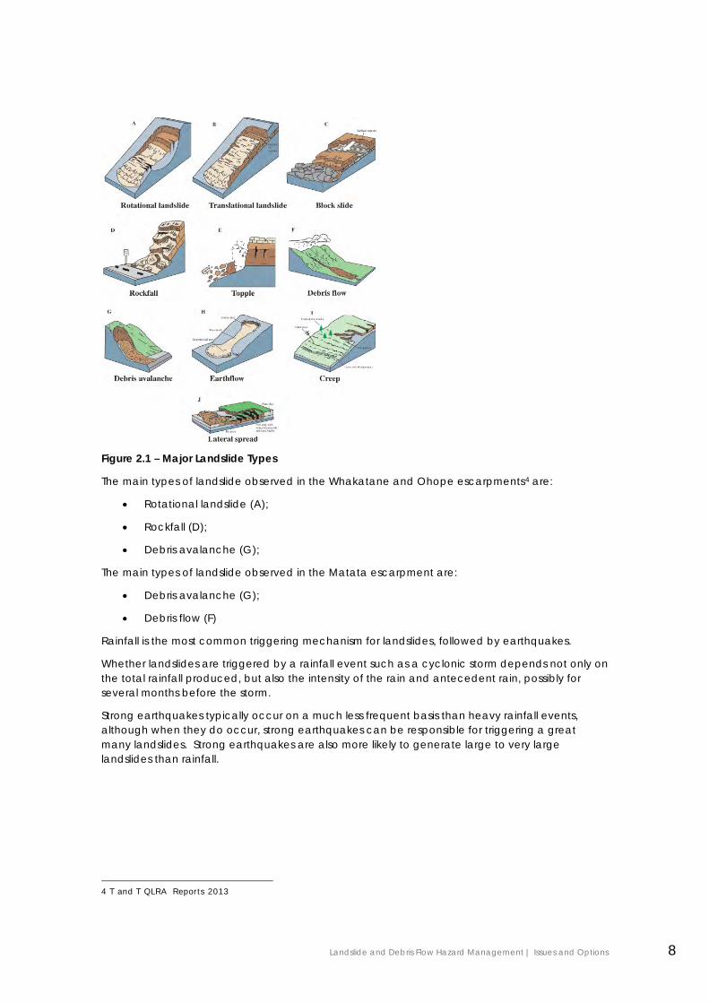
Figure 2.1 – Major Landslide Types
The main types of landslide observed in the Whakatane and Ohope escarpments4 are:
• Rotational landslide (A);
• Rockfall (D);
• Debris avalanche (G);
The main types of landslide observed in the Matata escarpment are:
• Debris avalanche (G);
• Debris flow (F)
Rainfall is the most common triggering mechanism for landslides, followed by earthquakes.
Whether landslides are triggered by a rainfall event such as a cyclonic storm depends not only on the total rainfall produced, but also the intensity of the rain and antecedent rain, possibly for several months before the storm.
Strong earthquakes typically occur on a much less frequent basis than heavy rainfall events, although when they do occur, strong earthquakes can be responsible for triggering a great many landslides. Strong earthquakes are also more likely to generate large to very large landslides than rainfall.
4 T and T QLRA Reports 2013
Landslide and Debris Flow Hazard Management | Issues and Options 8
3.2 Landslide Risk Management Process
3.2.1 Terminology
The reports note that preconceptions of the meaning of the terms “hazard” and ”risk” can lead to significant confusion when communicating the results of studies of this type.
The reports adopt the definitions used by the Australian Geomechanics Society (AGS 2007)5:
“Susceptibility: The relative potential for a landslide event to occur Example: an area has a high susceptibility to landsliding because of the soft geology and steep terrain.
Hazard: Probability or likelihood of a landslide occurring Example: an area typically experiences 5 landslides/km2/annum, thereby qualifying for a “high”landslide hazard rating according to AGS(2007).
Risk: Hazard x consequence Example: the annual Loss of Life Risk for the person most at risk in this area is 1x10⁻⁴ or in other words 1 chance in 10,000 per year.”
This Issues and Options Report adopts the same definitions.
3.2.2 Landslide Risk Management Framework
New Zealand does not have its own formal system for assessing landslide risk. The risk assessment reports generally follow the landslide risk management methodology published by the Australian Geomechanics Society (AGS 2007).
The AGS 2007 risk management methodology comprises three basic elements:
• Risk analysis – where hazard is assessed and a numerical value of risk is estimated;
• Risk assessment - where judgements are made as to the acceptability of the estimated risk;
• Risk management – where risk mitigation measures are assessed and implemented.
The risk assessment reports essentially cover the risk analysis element of AGS 2007.
The reports also address property risk, although this is expressed in qualitative terms.
Although the reports states that no value judgements are made on acceptability of estimated risks6, the reports do discuss the policies for risk tolerability applied in other countries and at the Port Hills in Christchurch.
Apart from the Port Hills example, New Zealand has no established criteria for determining risk tolerability and acceptance. Therefore, this is a judgement that is made by the community or, as in this case, by the Council on behalf of the community.
5 E.g. From Quantitative Landslide Risk Assessment Matata Escarpment – Section 3.1 6 Section 3.3 QRLA Ohope / Whakatane
Landslide and Debris Flow Hazard Management | Issues and Options 9
3.2.3 Loss of Life Risk
The quantitative risk metric used in both reports7 is “annual individual fatality risk” also referred to as “Loss of Life Risk” (R LOL).
Annual loss of life risk is calculated from a number of variables8, but primarily:
• The annual probability of landslide occurrence;
• The probability that the landslide can reach the location of interest; and
• The presence of a person at that location and their vulnerability to an impact.
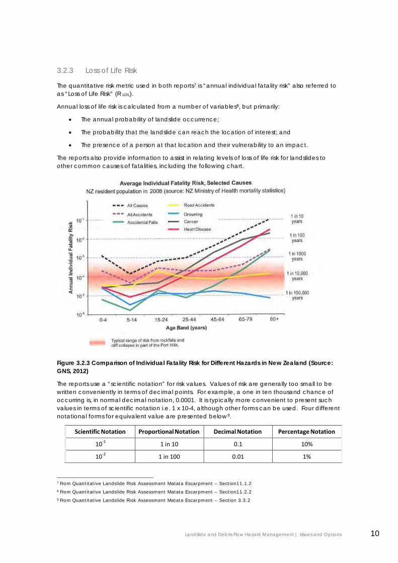
The reports also provide information to assist in relating levels of loss of life risk for landslides to other common causes of fatalities, including the following chart.
Figure 3.2.3 Comparison of Individual Fatality Risk for Different Hazards in New Zealand (Source: GNS, 2012)
The reports use a “scientific notation” for risk values. Values of risk are generally too small to be written conveniently in terms of decimal points. For example, a one in ten thousand chance of occurring is, in normal decimal notation, 0.0001. It is typically more convenient to present such values in terms of scientific notation i.e. 1 x 10⁻⁴, although other forms can be used. Four different notational forms for equivalent value are presented below9.
Scientific Notation Proportional Notation Decimal Notation Percentage Notation 10-1 1 in 10 0.1 10% 10-2 1 in 100 0.01 1%
7 From Quantitative Landslide Risk Assessment Matata Escarpment – Section11.1.2 8 From Quantitative Landslide Risk Assessment Matata Escarpment – Section11.2.2 9 From Quantitative Landslide Risk Assessment Matata Escarpment – Section 3.3.2
Landslide and Debris Flow Hazard Management | Issues and Options 10

10-3 1 in 1,000 0.001 0.1% 10-4 1 in 10,000 0.0001 0.01% 10-5 1 in 100,000 0.00001 0.001% 10-6 1 in 1,000,000 0.000001 0.0001%
3.2.4 Property Loss Risk
Property loss risk is assessed on a qualitative basis.
The evaluation of property loss risk is based on a consideration of the likelihood of an impact occurring during the lifetime of the structure (assumed to be 50 years) and the physical consequences should the impact occur10.
Property loss risk is highly dependent on the nature of the building impacted and is therefore property specific11.
3.3 Landslides at Whakatane and Ohope
3.3.1 Summary of Findings12
Historic and recent evidence indicates that the steep escarpment slopes that form the backdrop to Whakatane and Ohope have been, and will continue to be, susceptible to landslide events. These landslides represent a significant risk to both people and property.
Following a number of significant landslides between 2004 and 2011, the Whakatane District Council (WDC) commissioned Tonkin & Taylor Ltd (T&T) to undertake a Quantitative Landslide Risk Assessment study to assess the level of risk posed by future landslides from the escarpments. The methodology published by the Australian Geomechanics Society (AGS, 2007) has generally been adopted by this study.
The study includes a consideration of potential options for managing landslide hazards and reducing the risk they represent to lower levels, as well as a review of the current WDC policies relating to landslide hazard management.
WDC defined the study areas as follows:
Whakatane Escarpment
The northern and western faces from Mokorua Gorge Road in the south, through to 1C Muriwai Drive in the north.
Ohope Escarpment The northern face from 254 Pohutukawa Avenue in the east through to 71 West End Road in the west.
The geology of the study areas consists of greywacke basement rock overlain by a series of much younger marine, terrestrial and volcanic deposits. Steep terrain and the very weak nature of the geology makes both escarpments susceptible to landslides.
A landslide inventory has been developed for the escarpments based primarily on T&T’s record of landslide investigations for the Earthquake Commission, but also from historical
10 From Quantitative Landslide Risk Assessment Matata Escarpment – Section 11.1.3
11 From Quantitative Landslide Risk Assessment Matata Escarpment – Section 11.2.2
12 From Quantitative Landslide Risk Assessment, Whakatane & Ohope – Executive Summary
Landslide and Debris Flow Hazard Management | Issues and Options 11
photographic records and field mapping. The period covered by the inventory is approximately 50 years in the case of the Whakatane Escarpment and 70 years for the Ohope Escarpment. The inventory indicates that the study area can be divided into four hazard sectors based on the frequency of recorded landslides and assessed susceptibility:
• Whakatane Escarpment north of the Wairere Stream; • Whakatane Escarpment south of the Wairere Stream; • Ohope Escarpment behind West End Road; and • Ohope Escarpment behind Pohutukawa Avenue.
All of the landslides in the inventory were triggered by rainfall. An assessment of past rainfall and escarpment landslide records indicates that landslides occur both as a result of individual high intensity rain storms, and during unusually wet years. The available data indicates that significant rainfall-induced landslides occur when the daily rainfall exceeds the typical monthly average, a situation which is likely to occur approximately once every 10 years.
Seismic events can also trigger landslides. Rupture along the Whakatane Fault is the most likely source of seismic landsliding on the Whakatane and Ohope escarpments. Although dozens of landslides could potentially be triggered by a major rupture of the Whakatane Fault, the long return period of a major seismic event (1,000 to 2,300 years) means that the annualised risks associated with seismic-induced landslides are one or two orders of magnitude less (between 10 and 100 times less likely) than those associated with rainfall.
The overall landslide susceptibility, hazard and loss of life risk classifications of the study area sectors are as follows. Note that ‘susceptibility’ is a measure of the likelihood of an event happening in a particular area; ‘hazard’ includes an analysis of the estimated frequency of that event; and ‘risk’ is a measure of both the likelihood of the event and the consequences it would have for people exposed to it, i.e. the expected loss.
Sector Susceptibility Hazard Loss of Life Risk Whakatane – Nth of Wairere Stream High High Very High Whakatane – Sth of Wairere Stream Moderate Moderate Very High Ohope – West End Road High High Very High Ohope – Pohutukawa Avenue High Moderate Very High
Although all four sectors fall within the loss of life risk range that AGS (2007) classifies as very high, there is an order of magnitude difference in the annual loss of life risk between the highest risk and lowest risk sectors. In the context of AGS (2007) a very high risk is where one or more deaths can be expected within a 1,000 year period. A high loss of life risk is one where a single death can be expected to occur in a time period of between 1,000 and 10,000 years. It is highly likely that a lay person’s concept of what constitutes a high or very high risk is very different to this.
It should be noted that this study provides an estimate of the level of landslide risk present on the two escarpments, however it does not draw conclusions as to whether they are acceptable or unacceptable for specific properties. These issues lie outside the scope of a general study such as this.
Options for reducing the occurrence of landslides on the Whakatane and Ohope escarpments are very limited, due to both the scale of the escarpments and the unpredictable and cyclic nature of the landslides. Realistically, landslide management should therefore focus on reducing (avoiding or mitigating) the risk to both people and
Landslide and Debris Flow Hazard Management | Issues and Options 12
property (i.e. reducing the consequences should a landslide occur). Methods of reducing landslide risk include controls on new development and building, warning systems, the construction of landslide debris barriers and, in extreme situations, the abandonment of very high risk sites.
3.3.2 Hazard maps
Landslide Hazard Maps from the report for Whakatane13 and Ohope14 are included in Appendix 2.
3.4 Landslides at Matata15
3.4.1 Summary of Findings
On 18 May 2005, the town of Matata was severely impacted by several large debris flows generated by intense rainfall within the adjacent hill country. Significant landsliding also occurred within the escarpment and hill country. Between May 2010 and June 2011, a series of high rainfall weather events passed over the eastern Bay of Plenty, triggering numerous landslides on the Matata Escarpment and adjacent hills, although no debris flows were generated.
WDC commissioned Tonkin & Taylor Ltd to undertake a Quantitative Landslide Risk Assessment of the Matata Escarpment in order to develop an understanding of the landslide and debris flow hazard within the vicinity of Matata and the risks that future events of this type pose to residents and potential future developments.
The methodology of AGS (2007) has been adopted for this study, where considered appropriate.
The study area was defined in the WDC brief as: “...the western end of the Awatarariki Stream debris fan to 71 Manawahe Rd to the east and Arawa [Street/SH2] to the north”.
The primary output from this study is a series of maps showing the nature and spatial distribution of these natural hazards. It is intended that these hazard maps, together with broad estimates of the personal and property risks associated with them, will aid the development of appropriate Council policies with respect to the ongoing occupancy and future development of Matata and its immediate surrounds.
The hazard and risk assessments presented are limited to landslides and debris flows. Risks associated with other natural hazards such as tsunami, flooding, coastal erosion etc do not form part of the scope of this report.
The main forms of slope instability observed on the Matata Escarpment during the significant rainfall events of 2005 and 2010-2011 were debris avalanches originating on steep slopes, gullies and cliff faces. Despite the number of landslides generated during this period, no damage is known to have occurred as a result of direct landslide impact. Indeed, T&T have no records of any claims being made to the Earthquake Commission (EQC) for property or land damage as a result of any landslides originating from the Matata Escarpment. This compares to over 150 claims for landslide damage to properties near the Whakatane and Ohope escarpments for the years 2004 to 2012.
13 Appendix P 14 Appendix Q 15 From Quantitative Landslide Risk Assessment Matata Escarpment – Executive Summary
Landslide and Debris Flow Hazard Management | Issues and Options 13
Photographs from the early to mid 20th Century present an image of the Matata Escarpment as being relatively well vegetated and largely devoid of significant landslide scarring. It is clear from aerial photographs that there were very few landslides on either the escarpment or the hills behind it prior to the 2005 debris flow event. Nevertheless, the presence of a significant debris or talus slope at the base of the escarpment clearly illustrates that a significant quantity of material has descended the escarpment in the form of landslides.
There is evidence of debris flows having occurred at Matata prior to 2005, however neither the magnitude nor the recurrence interval of such events are known. Although topography of the lowlands area is subdued, there is geomorphologic evidence of the presence of debris fans extending out a considerable distance from the base of the escarpment. These fans are expected to be formed from both normal alluvial and debris flow depositional processes.
A landslide inventory developed for Matata shows the escarpment is dominated by rainfall- triggered instability events. Strong seismic-shaking is potentially the source of the largest landslides that could occur on the escarpment, although the triggering event may have a much longer return period that rain storms. The triggering event for large debris flows may be about the same frequency as that for strong (MM9) earthquake shaking.
Through a process of developing the landslide inventory and mapping the extent of previous debris flows, a series of hazard maps has been developed that shows the spatial distribution of landslide and debris flow hazards across the escarpment and flatlands of Matata. A combined landslide initiation and inundation hazard map for Matata is also presented.
Advantage was taken of numerical debris flow modelling undertaken by T & T as part of the Matata Regeneration Project to supplement the knowledge gained from the sole witnessed debris flow in 2005.
Estimates of loss of life risk and property loss risk have been assigned to the different landslide and debris flow hazard zones. The results indicate that the risks to some properties in Matata are considered to be moderate to very high and therefore in excess of the level of risk commonly adopted as being tolerable. Despite the loss of life risk being considered high for some properties located near the base of the escarpment, a number of factors have contributed to a lack of previous landslide impacts. This distinguishes the Matata Escarpment from the Whakatane and Ohope escarpments where many houses have been damaged or destroyed and several lives have been lost in the past 50 years or so.
The greatest instability-related risk to Matata is considered to be from moderate to large debris flows rather than landslides on the escarpment. It is a certainty that debris flows will occur in the future (the 2005 event is thought to have a return period of between 200 and 500 years), with the Awatarariki and Waitepuru Streams providing the most likely sources.
Options for mitigation of the risks associated with landsliding and debris flows are limited as the higher hazard zones are already occupied. Suitable planning restrictions, together with an early warning system of unusually heavy rain are probably the most suitable responses to the identified risks.
3.4.2 Hazard maps
Landslide Hazard Maps16 and Debris Flow Hazard Maps17 from the report are included in Appendix 3.
16 Appendix E 17 Appendix F
Landslide and Debris Flow Hazard Management | Issues and Options 14
4.0 Landslide Risk Assessment
Under the AGS 2007 Risk Management Framework, “risk assessment” is the element of risk management where value judgements are made as to whether the calculated risks are acceptable, tolerable or intolerable.
This value judgement needs to be informed by consideration of legislation, guidelines, standards, international and national practices, and community attitudes and expectations.
Relevant legislation is outlined in Section 2. The legislation provides only general guidance. Specific provisions under Section 71 of the BA and Section 106 of the RMA focus on hazard rather than risk, and even in these cases provide no quantitative standards.
The risk assessment report notes as follows:
“This study is not making a recommendation as to whether risks greater than 10-4/annum should be considered unacceptable or not. It is suggested however that what is considered appropriate in other jurisdictions may not be appropriate for New Zealand. It is noted that Christchurch City Council have adopted these levels of acceptable and unacceptable risk for the Port Hills zoning assessment.”
4.1 International Risk Assessment Practice A number of overseas government and non-government organisations have published what they consider to be reasonable interpretations of risk acceptability based on Loss of Life Risk:
• AGS (2007) suggests 10-5/annum be adopted as the limit for acceptable risk and 10-4 /annum for tolerable risk for the Person Most at Risk for existing slopes (excluding those with existing landslides);
• The Government of Hong Kong has adopted a tolerable limit of 10-4/annum for existing slopes (AGS, 2007); and
• The British HSE suggests an upper limit of tolerability of 10-4 for the public and 10-3 for workers (Taig, 201218).
The 10-4/annum value is approximately equal to the risk of death in a road accident in New Zealand.
4.2 National Risk Assessment Practice New Zealand does not have established criteria for determining acceptable, tolerable or intolerable risk levels.
The international interpretations of risk acceptability have been applied by Christchurch City Council to landslide management in the Port Hills area.
An independent task force on workplace health and safety has identified that one of the systemic weaknesses leading to New Zealand’s poor record is a “risk tolerant culture”19.
18 Taig, T. 2012 A risk framework for earthquake prone buildings. MBIE 19 Independent Taskforce on Workplace Health and Safety May 2013
Landslide and Debris Flow Hazard Management | Issues and Options 15
4.3 Proposed Regional Policy Statement The Proposed RPS20 contained quantitative risk assessment criteria for Loss of life risk at the time of public notification, including:
• Acceptable Risk exceeded if annual loss of life risk is greater than 1x10⁻⁶
• Intolerable Risk if annual loss of life risk is greater than 1x10⁻⁴
These criteria are consistent with the international benchmarks summarised above. The policy also included a requirement to inform and take account of community responses in assessing acceptable risk levels21.
The quantitative criteria were removed from the RPS in response to submissions by land developers in Tauranga concerned about their practical application to tsunami risk.
The amended RPS no longer specifies quantitative criteria for acceptable, tolerable or intolerable risk. The Proposed RPS now contains the following policy:
“Policy NH 1B: Assessing natural hazard risk
Assess natural hazard risk to human health and safety, buildings, property, infrastructure and to the social, economic and cultural well-being of people and communities in three categories – acceptable, tolerable, and intolerable.
An assessment of whether a risk is acceptable, tolerable or intolerable should:
(a) Be in such detail as corresponds with the scale and significance of the risk having regard to the purpose of infrastructure and the land uses that could be affected;
(b) Include an evaluation of the likelihood and consequences of maximum credible events and an appropriate range of lesser events;
(c) Facilitate review;
(d) Inform and take account of the community response to the risk and the proposed level of residual risk; and
(e) Be informed by and recognise the relevant legislation, guidelines, standards and best practice.
These provisions are currently under appeal and it is uncertain what the final detail of the policy will be. However it is reasonable to assume that the policy will require a balanced judgement to be made taking into account established practice elsewhere and local community responses.
4.4 Community Attitudes and Expectations The community response to the estimated risks will only be known once the community has been informed and been given the opportunity to provide feedback.
Based on experience elsewhere, there will be a wide range of local community responses:
• The response is likely to include scepticism about the risk analysis, identification of localised mitigating factors that could be taken into account, and calls for further independent analysis and reviews to be undertaken. This may culminate in submissions opposing policy and plan changes.
20 Policy NH1B Proposed Regional Policy Statement, November 2010 21 Policy NH1B (d) Proposed Regional Policy Statement, November 2010
Landslide and Debris Flow Hazard Management | Issues and Options 16
• Some of the community are likely to have a view that the hazards are already well known and accepted, and that no further intervention is warranted.
• Some of the community are likely to have a view that the hazards are already well known and the reports confirm an unacceptable degree of risk exists, and that the land should be rezoned reserve and property owners compensated.
• There are also likely to be strong feelings generated by the impact of the risk analysis on public safety, property values, and insurability. This may be coupled with expectations that the Council should compensate property owners, or purchase their land.
It is possible that the technical complexity of the hazards and the risk analysis methodology will make it difficult for some in the community to provide a meaningful response. The consultation process will need to take this into account.
In other jurisdictions, issues of these types have been successfully addressed by establishing a public task force made up of volunteer District residents and subject-matter experts working together to make recommendations to Council regarding tolerable risk levels22. This approach could be considered for Whakatane.
The community in this case also includes stakeholders with a specialist knowledge and interest in how hazards are managed. This includes organisations such as the insurance industry, EQC and the Ministry of Civil Defence and Emergency Management and lending institutions.
Regardless of the final value judgement, the risks are estimated as being at such a level that some significant measures will be needed to reduce the risk to more acceptable levels. In this context, the more important issue for the community is likely to be how the risks are managed.
5.0 Landslide Risk Management
Under the AGS 2007 Risk Management Framework, “risk management” is the element of risk management methodology where risk mitigation measures are assessed and implemented.
Risk management is assessed in the report as follows:
• Potential risk management measures;
• Current risk management strategy;
• Risk management strategy options;
• Evaluation criteria;
• Evaluation of strategy options.
22 http://www.dnv.org/article.asp?c=1030
Landslide and Debris Flow Hazard Management | Issues and Options 17
6.0 Potential Risk Management Measures
This section describes and broadly evaluates the applicability of a range of measures that are available to manage risks from landslides and debris flows.
This is the “toolkit” from which measures can be drawn to formulate risk management strategies.
6.1 Structural Measures Structural measures include physical measures that eliminate or mitigate a hazard, or reduce the risk from a hazard.
6.1.1 Hazard Elimination23
Potential measures include:
• Re-profiling of slopes;
• Reducing the height of slopes and/or removing potential landslide material;
• Construction of earthwork buttresses to support slopes;
• Construction of retaining walls;
• Reinforcement of slopes by the installation of rock anchors etc;
• Prevention of material falling from slopes through the placement of shotcrete, wire netting etc.
The cost of these solutions means they are unlikely to be practicable at an area wide scale. These solutions may be applicable at an individual site scale.
6.1.2 Hazard Reduction24
Potential measures include:
• Stormwater and Ground water control through:
o Diverting water flows away from landslide prone land.
o Lowering groundwater levels through subsurface drains.
• Vegetation Control through:
o Removal or reduction of dangerous overhanging trees.
o Planting of appropriate species at crest, face and base of slopes.
Some stormwater diversion works have been undertaken in Otarawairere and above West End Road to reduce the severity and frequency of landslide hazards. These measures may also have application in other parts of the hazard areas.
23 Section 12.2 - T and T QLRA Matata Escarpment May 2013 24 Section 12.3 - T and T QLRA Matata Escarpment May 2013
Landslide and Debris Flow Hazard Management | Issues and Options 18
Vegetation control is particularly applicable as vegetation has been identified as a major component of destructive debris that reached the residential areas in Ohope as a consequence of land slides occurring high in the escarpment25. The most recent landslide fatality at West End in 2011 occurred as a consequence of vegetation debris impacting an occupied dwelling.
The implementation of vegetation control measures will be affected by land ownership, land status, and zoning. For example, some of the vegetated escarpments are in reserves or identified as Outstanding Natural Features and Landscapes or as having ecological significance. Priority should be considered for vegetation works that reduce loss of life risk.
All of these measures could be applicable to the study areas.
6.1.3 Risk Reduction26
Potential measures include:
• Debris flow control structures
o Debris dams
o Debris nets
• Debris barriers
o Earth bunds
o Steel posts
o Flexible ring net barriers
o Impact walls
Debris flow control structures have been installed at the Waitepuru stream to reduce debris flow risk, designed to contain a repeat of the May 2005 debris flow event (200-500 annual exceedance probability for rainfall).
Proposals for debris flow control structures at the Awatarariki stream for a 2005 equivalent event have been abandoned due to the high cost and engineering feasibility.
The cost and feasibility of these solutions at an area wide scale means they are not currently practicable as options. Some solutions may be applicable at site level for those sites situated in a low hazard zone.
Risk reduction works become a permanent commitment if development is allowed to proceed on the basis of the risk reduction that is provided. This includes long term maintenance and ensuring that granted resource consents are kept current and conditions are met.
6.2 Non –structural Measures Non-structural measures are risk reduction measures. They do not alter the likelihood of hazard occurring, but contribute towards addressing some, or all, of the consequences.
25 Section 12.3.2 - T and T QLRA Matata Escarpment May 2013 26 Section 12.4 - T and T QLRA Matata Escarpment May 2013
Landslide and Debris Flow Hazard Management | Issues and Options 19
6.2.1 Information
Potential measures include:
• Research, scoping studies, hazard vulnerability studies, risk assessments to inform decision making;
• Monitoring of existing landslides by technical specialists;
• Lifeline engineering projects to assess vulnerability of lifelines and develop contingency and response plans;
• Education programmes to improve knowledge and promote awareness;
• Advice and advocacy e.g. keeping up to date best practice guidelines on mitigation measures and contact information for qualified experts;
• LIMs to provide information on location and/or characteristics of known hazards;
• PIMs to provide information on location and/or characteristics of known hazards.
All of these measures could be applicable to the study areas.
6.2.2 Warning Systems
Potential measures include:
• Landowner education on natural warning signs and self evacuation;
• Low Level Early warning systems;
o Regular monitoring and assessment of risk areas by qualified staff o Active monitoring of rainfall forecasts and radar during events to detect any
potential issues
• High Level Early warning systems - Low Level Early warning systems plus
o Forwarding of all severe weather warnings to residents in risk areas (email and text alert)
o Deployment of mobile radar to monitor areas of concern during major events o Installation of wire sensors to measure land movement in all areas of high risk o Rainfall sensors in all catchments
• Low level event system:
o Visual observation by residents in risk areas
• High level event system:
o Sensors connected to alarms placed in all areas with a high risk of potential landslide/debris flow
o Staff deployed to monitor specific sites during heavy rainfall events and warn residents if movement in slope detected
• Evacuation procedures, including both formal and self evacuation.
The potential advantage of warnings systems is that they can provide a relatively immediate reduction of loss of life risk where there is sufficient warning and residents have been educated on the risk and what action to take. However, effective management of property risk requires other interventions such as the structural measures referenced in Section 6.1.2.
Landslide and Debris Flow Hazard Management | Issues and Options 20
Given the restrictions of legislation evacuation and the minimal amount of warning for both landslide and debris flow hazards, formal evacuations are unlikely to take place to take place. Self-evacuation is a more likely scenario.
With rapid advances in remote sensing and personal communications technology warning systems could, over time, become an increasingly effective measure to manage loss of life risk.
However, the practical limitations of warning systems are identified in the Landslide Hazard Report27 e.g.:
“… there is no absolute relationship between rainfall and landslide occurrence. With landslides occurring only some of the time when daily rainfall reaches 100mm, it is likely that most storm warnings will not be accompanied by landslides. The risk of this is of course that heavy rain warnings will be increasingly ignored. If, however, a higher rainfall threshold is used to determine when warnings are given, there is the real risk that landslides may occur in absence of warning. Heavy rain warning could however be the most effective means of managing the Loss of Life Risk associated with debris flows. The Property Loss Risk would however, remain unchanged.”
Monitoring of macro scale data, such as weather forecasts, is generally helpful but does not forewarn people at an individual site level. Information of this type requires interpretation, taking into account the current state of the hazard in a particular location. Annual inspections of landslides and debris flow catchments could, over time, assist in the developing appropriate responses.
The procedures for issuing warnings in hazard zones require careful consideration. Indicators or thresholds for taking this course of action need to be agreed ahead of time. The “cry wolf” syndrome may arise if thresholds are set too low. Lives may be put at risk if thresholds are set too high. Who would take the responsibility for the action also needs to be agreed.
For landslides, hazards are localised and highly variable. Landowner self sufficiency through education on natural warning signs and self-evacuation may be the most effective measure.
For debris flows, hazard effects are of a larger scale and extent. Land owner self sufficiency is more problematic as the event is likely to be generated in a catchment distant from the property. Formal warning systems and self-evacuation procedures may be the most effective measure for debris flows.
6.2.3 Development Control
Potential measures include:
• Enabling District and Regional Plan rules to manage development in hazard areas, such as:
o Allowing existing activities to continue but only within the existing building envelope;
o Allowing alterations or re-development where risk is reduced;
o Allowing properly designed protection works to be undertaken without resource consent or streamlined consent procedures;
o Providing best practice guidelines to assist landowners with risk mitigation;
o Allowing vulnerable uses to be replaced with less vulnerable uses (e.g. residential use replaced by non-habitable use).
27 Section 12.4.3 Quantitative Landslide Risk Assessment Matata Escarpment
Landslide and Debris Flow Hazard Management | Issues and Options 21

• Restrictive District Plan zoning and rules to manage development in hazard areas, such as:
o Requiring resource consent for extensions and relocations, and any works on sites within hazard zones;
o Continuation of existing uses meeting the legal requirements of the RMA (Section 10);
o Not allowing intensification by further subdivision within hazard zones;
o Not allowing new vulnerable land uses to establish within hazard zones.
• Restrictive Regional Plan rules to manage development in hazard areas, such as:
o Requiring existing activities to cease by a specified date unless resource consent is obtained, which would require risk to be reduced to an acceptable level?
o Not allowing reoccupation of sites that have been rendered uninhabitable by a hazard event unless resource consent to re-establish is granted, which would require risk to be reduced to an acceptable level.
o Allowing life-time occupation of a site by current occupants and requiring resource consent for reoccupation by others, which would require risk to be reduced to an acceptable level.
The Regional Plan zoning and rules to control development are largely untested as a measure. In effect, these measures would override “existing use rights” under the District Plan. This approach is currently the subject of a separate study by the Bay of Plenty Regional Council to consider the legal and other implications.
6.2.4 Development Retreat
Potential measures include:
• Acquire / purchase properties that have unacceptably high risk and enable relocation to sites with acceptable risk.
The cost of this solution means that it is not practicable on an area wide scale. Councils do not have legal powers to compulsorily acquire land that is affected by hazards; nor can they be compelled to acquire such land.
7.0 Current Risk Management Strategy
This section describes the policies and practices that currently apply to the management of landslide hazards in the study area.
Landslide and Debris Flow Hazard Management | Issues and Options 22
7.1 Civil Defence and Emergency Management (CDEM)
7.1.1 Regional CDEM
The Bay of Plenty CDEM Group Plan includes the following principles:
• Increased Community Resilience
• Sustainability
• Holistic Community Management and Partnership
• Comprehensive Emergency Management
• Active Risk Management
• Integrated Emergency Management Resources
Resilience involves the reduction of hazards so that a community is less likely to be harmed and the ability to respond to and recover from a disruptive event. Resilience is a measure of how capable a community is to avoid or withstand a disaster and to keep functioning as a community.
Sustainable planning of communities should be based on a long-term strategy that is consistent with the hazards and vulnerabilities that are present. Mitigation activities that are undertaken without this long-term perspective may decrease risk in the short term but actually increase it in the long term. For instance, a mitigation activity may encourage building within a hazard area. In the short term (say 20 years) the risk is low. However, taking a 50-year perspective may result in the level of risk being viewed as unacceptable.
Active risk management is a process for ensuring that decisions about risk enable individuals, organisations, communities and the nation to minimise loss and maximise opportunities. This principle recognises that many risks will not be able to be eliminated and that the benefits of some activities mean that the risk is acceptable. The risks associated with CDEM hazards require active management. This means:
• Identifying and considering all aspects of risk (social, political, economic and physical) from all hazards.
• Determining acceptable risk levels.
• Balancing costs and benefits of options to address risks.
• Developing, agreeing on, and implementing ways to minimise potential damage and disruption.
The four elements of Comprehensive Emergency Management are:
• Reduction: Activities that reduce the degree of long-term risk to human life and property arising from hazards.
• Readiness: Activities that develop community capabilities for responding to an emergency.
• Response: Activities taken immediately before, during or directly after an emergency that can save lives, minimise property damage or improve recovery.
• Recovery: Activities that stabilise the affected community and ensure that life support systems are operational, and longer term actions for community rehabilitation and
Landslide and Debris Flow Hazard Management | Issues and Options 23
restoration. This restoration needs to have a reduction focus to ensure that vulnerabilities are eliminated where possible.
Landslides are identified as a priority hazard28.
7.1.2 District CDEM
Whakatane, Opotiki and Kawerau District Councils have a combined emergency management office. All three councils contribute to the maintenance of the office, which in turn has several important functions, including maintenance of the emergency operations centre and the training of a response team.
As part of its responsibility to the community it serves, the office also offers education and training to any group wishing to up-skill in civil defence matters.
7.2 Regional Policy Statement The District Plan must give effect to the relevant provisions of the RPS.
The general policy intent of both the operative and proposed RPS includes avoiding any increase in vulnerability of existing settlements that are at risk from natural hazards, and reducing vulnerability over time. However, the proposed RPS makes more explicit reference to “risk” and risk assessment as part of the required approach.
Relevant objectives and policies in the Proposed RPS (appeals unresolved at the date of this report) are:
Objective 23
Communities are not adversely affected by natural hazards and residual risks are managed to acceptable levels.
“Policy NH 1B: Assessing natural hazard risk
Assess natural hazard risk to human health and safety, buildings, property, infrastructure and to the social, economic and cultural well-being of people and communities in three categories – acceptable, tolerable, and intolerable.
An assessment of whether a risk is acceptable, tolerable or intolerable should:
(a) Be in such detail as corresponds with the scale and significance of the risk having regard to the purpose of infrastructure and the land uses that could be affected;
(b) Include an evaluation of the likelihood and consequences of maximum credible events and an appropriate range of lesser events;
(c) Facilitate review;
(d) Inform and take account of the community response to the risk and the proposed level of residual risk; and
(e) Be informed by and recognise the relevant legislation, guidelines, standards and best practice.
28 1.10 Hazard Identification
Landslide and Debris Flow Hazard Management | Issues and Options 24
Policy NH 2B: Managing natural hazard risk for new development
Manage new development so that natural hazard risk does not exceed acceptable levels.
Policy NH 3B: Reducing natural hazard risk in existing use and development
Reduce the risk from natural hazards to life and property in areas of existing use and development to be as low as reasonably practicable until acceptable levels of risk are achieved.
Particular regard shall be given to:
(a) Providing for low intensity activities in vulnerable locations;
(b) Designing for relocatable or recoverable structures;
(c) Relocation or removal of structures;
(d) Replacement or modification of existing development to reduce risk without recourse to hard protection structures; and
(e) Protecting, restoring or enhancing natural defences against natural hazards.
Policy NH 4B: Avoiding intolerable risk from natural hazards
Avoid any intolerable risk from natural hazards.
Policy NH 5B: Facilitating reduced natural hazard risk
Regard likely reduction in natural hazard risk deriving from elements of development or use proposals as a positive effect in the consideration of such proposals.
Policy NH 6B: Providing for climate change
Incorporate the effects of climate change in natural hazard risk assessment.”
These provisions are under appeal, so reference must be also made to the operative RPS in policy development.
It is assumed that existing uses, including where reconstruction occurs, are not deemed “new development” under Policy NH2B.
Policy NH 3B (d) also creates a degree of constraint to use of structural mitigation options. This appears to be included because of the adverse natural character and coastal process effects associated with hard structures in the coastal environment, such as seawalls. Where loss of life risk is a consideration and other options are now effective, it is assumed that less weight would be given to this policy.
Policy NH 3B is particularly relevant to the circumstances in the two study areas which contain existing use and development.
Policy NH3B seeks to reduce the risk from natural hazards to life and property in areas of existing use and development to be as low as reasonably practicable until acceptable levels of risk are achieved. It is assumed that risk reduction to at least a tolerable level is required under this policy, with further reduction toward acceptable levels where this is practicable (cost effective).
It is noted that Policy NH3B has no specified timescale. Reduction in risk is not something that can be achieved instantaneously and will require progressive implementation.
Landslide and Debris Flow Hazard Management | Issues and Options 25
7.3 Operative Regional Plans Development on hazard prone land is not directly controlled by any Regional Plan provisions.
However, in some circumstances, hazard management related works do require resource consent under the:
• Coastal Environment Plan – for works that may have an effect on identified features of ecological significance (such as the lagoon and escarpment at Matata and the escarpment at Kohi Point) consideration needs to be given to protection of natural character and ecological values;
• Regional Land and Water Plan – for soil disturbance, sediment discharge, damming or diverting water, activities in a stream bed there is consideration of erosion, flooding or land instability effects of works;
• Tarawera River Catchment Management Plan (Matata only) - largely duplicated by the Regional Land and Water Plan;
• Regional Gravel Management Plan - for stream bed disturbance;
• Regional Air Plan – for dust emissions.
In most cases, the activity status is discretionary. The maximum term for resource consent under the Regional Plan is 35 years.
Consideration could also be given to changes to the Regional Water and Land Plan (RWLP) to give more certain status to renewal of consents for hazard and risk reduction works. Under the RWLP “permitted activity” status is given to existing flood control structures29 and “controlled activity” status is given to established hydroelectric power schemes30. Similar provision could be made for hazard and risk reduction measures that protect development.
7.4 Operative District Plan The operative District Plan provisions will apply until replaced through the District Plan Review process.
7.4.1 Issues, Objectives, and Policies
Flooding and landslides are described as natural hazards affecting the District31. Debris flows are not specifically described as this type of landslide had not been identified until following the 2005 event at Matata.
Significant Resource Management Issues are:
“1. The loss of life, physical destruction including loss of significant ecological areas, and cost which result from a natural hazard event.
2. The need to quantify the degree of risk associated with particular natural hazard events and their effect on existing or proposed developments.
29 RWLP Rule 45 30 RWLP Rule 47C 31 Policy 2.3
Landslide and Debris Flow Hazard Management | Issues and Options 26
3. Whether modification to, or the placement of structures on, over or under land to prevent or reduce the adverse effects of an event are environmentally appropriate and sustainable.
4. The avoidance or mitigation of future development in areas identified as sensitive to natural hazards, particularly in the coastal environment.
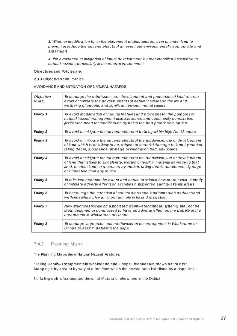
Objectives and Policies are:
2.3.3 Objectives and Policies
AVOIDANCE AND MITIGATION OF NATURAL HAZARDS
Objective NHaz1
To manage the subdivision, use, development and protection of land so as to avoid or mitigate the adverse effects of natural hazards on the life and wellbeing of people, and significant environmental values.
Policy 1 To avoid modification of natural features and processes for the purposes of natural hazard management unless research and community consultation justifies the need for modification by being the best practicable option.
Policy 2 To avoid or mitigate the adverse effects of building within high fire risk areas.
Policy 3 To avoid or mitigate the adverse effects of the subdivision, use or development of land which is, or is likely to be, subject to material damage to land by erosion, falling debris, subsidence, slippage or inundation from any source.
Policy 4 To avoid or mitigate the adverse effects of the subdivision, use or development of land that is likely to accelerate, worsen or result in material damage to that land, or other land, or structures, by erosion, falling debris, subsidence, slippage or inundation from any source.
Policy 5 To take into account the extent and nature of seismic hazards to avoid, remedy or mitigate adverse effects on activities in suspected earthquake risk areas.
Policy 6 To encourage the retention of natural areas and landforms such as dunes and wetlands which play an important role in hazard mitigation.
Policy 7 New structures (including associated stormwater disposal systems) shall not be sited, designed or constructed to have an adverse effect on the stability of the escarpment in Whakatane or Ohope.
Policy 8 To manage vegetation and earthworks on the escarpment in Whakatane or Ohope to assist in stabilising the slope.
7.4.2 Planning Maps
The Planning Maps show Natural Hazard Features.
“Falling Debris – Escarpments in Whakatane and Ohope” features are shown as “NHaz4”. Mapping is by area or by way of a line from which the hazard area is defined by a slope limit.
No falling debris features are shown at Matata or elsewhere in the District.
Landslide and Debris Flow Hazard Management | Issues and Options 27
7.4.3 Rules
The Subdivision Performance Standards include a “Management of Natural Hazards Rule”32 which refers to Section 106 of the RMA and the requirement that subdivision consent cannot be granted if land is likely to be affected by natural hazards and these effects cannot be avoided, remedied, or mitigated.
Land use including buildings, significant vegetation removal and earthworks within the NHaz4 feature is controlled by discretionary resource consent.
Where an activity does not comply with the rules, discretionary resource consent is required.33
The discretionary consent process allows the specific hazard to be assessed against listed criteria under Rule 3.11.10. Although these criteria do not refer directly to risk, reference is made to “effects” which, under Section 3 of the RMA, includes consideration of any potential effect of low probability which has a high potential impact (i.e. risk).
The explanation to the Falling Debris Performance Standards provides further policy guidance in relation to protection of health, safety and property with references to management of slope vegetation and the need for specific investigation of impact and or risk. A precautionary approach is advocated, based on the poor understanding of the hazards.
Other Methods34 include the following general provision which applies District wide:
“4.3.5.1 Land Instability
The provisions of the Building Act 1991 deal with the management of land instability.
In areas identified as prone to instability, the Act’s provisions will be used to exercise control over buildings and may include restrictions concerning the design and liability for damage.
Where, as a result of stability investigations, land is found to be subject to, or likely to be subject to, slippage but the building work itself will not accelerate or worsen the situation or affect other land, then the Council can grant building consent subject to the title being annotated that the land is subject to, or is likely to be subject to, slippage pursuant to Section 72 of the Building Act 2004.”
The District Plan also addresses other natural hazards including coastal erosion and inundation, flooding and fire. Some of the landslide and debris hazard areas are also affected by these other hazards which increase overall risk on affected sites.
7.5 Proposed District Plan The proposed District Plan was publicly notified on 28 June 2013 with submissions closing on 13 September 2013.
The proposed District Plan carries over the operative provisions dealing with natural hazards in a similar form to the Operative District Plan.
32 Rule 4.1.15 33 Rule 3.11.10 34 Rule 4.3.5
Landslide and Debris Flow Hazard Management | Issues and Options 28

A notation has been included signalling that further changes to the District Plan may be required once the landslide risk management issues have been fully considered.
7.6 Building Consents Where building work is proposed on land that may be subject to a natural hazard, applicants for building consents are required to provide information about the hazard sufficient to demonstrate that it is reasonable for the Council to grant a building consent.
Applicants are not required to mitigate the natural hazard. An option exists under the BA for property owners to take responsibility for the consequences of a natural hazard event upon their development. A notation to this effect is registered on the property title. In such cases the Council may not be held accountable for any subsequent damage caused by the specified natural hazard.
In granting building consents using these provisions, the Council must be satisfied that the hazard will not be worsened, that other property will not be affected, and a waiver or modification from one or more provisions of the Building Code is justified. Waivers are required to be notified to the Ministry of Innovation, Business and Employment for external oversight. Title notations may be revoked should circumstances change resulting in the hazard risk being reduced to an acceptable level.
7.7 Land Information Memoranda (LIM) Information on natural hazards that is known to the Council to be relevant to the property that is subject to a LIM application, is required to be disclosed in the LIM.
A heavy reliance is placed on the integrity of natural hazard information held by the Council. Ensuring the information provided is complete and accurate is a key issue in the granting of a LIM as LIMs are a key input into decisions by property owners, lenders and Insurers. Failure to disclose information, or to provide incorrect information, carries a high liability exposure for the Council.
7.8 Landslide Hazard Mitigation Works at Whakatane and Ohope
Stormwater diversion works have been undertaken in Otarawairere and above West End Road to reduce the severity and frequency of landslide hazards at West End. This work was completed following the recommendations of a geotechnical report produced in February 2005 for the Council, Department of Conservation and Earthquake Commission35.
The report also made recommendations in relation to engineering requirements for new development works, vegetation management above, below and on the escarpment, and routine geological monitoring.
Some private landowners have also undertaken landslip remediation and mitigation works including slope re-profiling, stormwater control and installation of debris barriers.
These works all require land use consent within the District plan “Nhaz 4” policy area and Building Consent
35 West End Escarpment Geotechnical Overview Report Tonkin and Taylor February 2005
Landslide and Debris Flow Hazard Management | Issues and Options 29
7.9 Debris Hazard Mitigation Works at Matata Debris hazard risk assessments will be able to take into account the risk mitigation provided by the completed debris control works at Waitepuru that have been provided under resource consents from both the regional and district councils.
There must be a long term commitment from Council to maintain the functionality of the debris mitigation works if the risk management is to take these works into account. This would include the removal of debris following an event to re-establish the capacity of the structures to take any further event.
8.0 Risk Management Strategy Options
Five Risk Management Strategy Options are described below to assist in deciding on the most appropriate Risk Management Strategy.
• Doing Nothing
• Business As Usual
• Alternative 1 - Risk Acceptance
• Alternative 2 - Risk Reduction
• Alternative 3 - Risk Avoidance
Area wide structural measures and property purchase undertaken by the council as described in Section 6.0 are not included as options as they are likely to be impracticable due to cost and feasibility.
8.1 Measures for All Options All options are assumed to include:
• Early warning and event warning systems;
• Landowners being provided information on warning signs and to assist with self help responses and self evacuation;
• Compliance with BA and LGOIMA requirements for information disclosure; and
• Compliance with BA and RMA minimum requirements for building and subdivision on hazard prone land.
8.2 Doing Nothing “Do nothing” would ignore the new landslide risk information and allow subdivision use and development in the hazard areas to occur without regard to the risks that have been identified.
Landslide and Debris Flow Hazard Management | Issues and Options 30
This is not an appropriate strategy as the Council has legislative duties and responsibilities that require it to act. Such an approach could be considered reckless and it might also see Council lose its insurance cover. This option should not be given any further consideration.
8.3 Business As Usual “Business as Usual” would continue with the current Risk Management Strategy described in Section 7.0.
Business as Usual is a not a static approach as the new hazard information must be considered under both s71 BA and s106 RMA, and disclosed in LIMs.
The new information on debris flow risk from the Awatarariki catchment will make the granting of a waiver or modification of the Building Code problematic for designers and for building control staff of the Council.
A “precautionary approach” is currently advocated, based on the poor understanding of the hazards. The consenting requirements are therefore relatively onerous and potentially create a disincentive to those wishing to redevelop sites to a reduced risk profile.
The current Strategy does not give effect to the Regional Policy Statement policies that require the assessment of natural hazard risk, the reduction of natural hazard risk in existing use and development, and the avoidance of intolerable risk from natural hazards.
Although this option is unlikely to be the preferred approach, Business as Usual will apply until a new Strategy is in place. Conceivably, this may be the situation for several years ahead.
8.4 Alternative 1 - Risk Acceptance A Risk Acceptance Strategy would be characterised by a level of regulatory intervention that meets the current minimum statutory requirements, putting greater emphasis on providing information to property owners and allowing them to act according to their own levels of risk acceptance.
The following measures would apply in land slide and debris flow hazard areas:
• “Hazard Zones” are included as a policy overlay for all urban zones in the District Plan.
• Subdivision is controlled, subject to a specific hazard assessment to demonstrate that the site complies with s106 of the RMA (i.e. can protected from the likely hazard).
• Modification and replacement of existing residential use and buildings, and new residential use and buildings are permitted on vacant sites where the risk is accepted by the owner (BA s73 Certificate).
• Design guidelines for protecting vulnerable structures are provided to promote risk reduction and reduce the cost of planning and design.
• Protection works are permitted.
In the Low and Very Low Landslide Hazard Areas, no measures are required.
For the Low and Very Low Debris Flow Hazard Areas, warning systems are in place to alert land owners to high rainfall events that may result in increased debris flow hazard.
Landslide and Debris Flow Hazard Management | Issues and Options 31
8.5 Alternative 2 - Risk Reduction A Risk Reduction Strategy would be characterised by a moderate level of regulatory intervention, creating a policy framework that halts further intensification, but encourages owners of moderate and high risk properties to reduce individual risk over time as the building renewal process plays out.
In the High and Moderate Hazard Areas the following measures would apply:
• “Hazard Zones” are included as a policy overlay for all urban zones in the District Plan.
• Continuation of residential use within an existing building envelope is permitted but only within the existing envelope (i.e. encapsulating existing use rights).
• No intensification of residential development is allowed beyond that existing:
o No new dwellings on vacant sites are allowed unless the risk is mitigated to an acceptable level36 on the site;
o No subdivision is allowed unless the risk is mitigated to an acceptable level on the site.
• Modification of existing residential use and buildings is permitted where this will reduce risk to occupants. This includes building relocation or extensions that move habitable rooms to areas with a lower likelihood of hazard risk.
• Design guidelines for protecting vulnerable structures are provided to promote risk reduction and reduce the cost of planning and design.
• Hazard and risk reduction measures such as debris control nets and bunds are permitted where they meet engineering guidelines and do not transfer the risk to other landowners. Engineering guidelines are provided to promote best practice and reduce the cost of planning and design for individuals.
• Changes of landform is controlled where that may reduce shielding of habitable buildings or worsen the hazard.
• New planting is controlled at crest, face and base of slopes where planting may worsen the hazard. Removal of dangerous trees is permitted.
• Works and other actions taken on escarpments by Council to reduce risk to people and property from instability and dangerous debris are permitted.
• Escarpments are inspected annually by the Council-engaged specialists, including on private land, to determine whether there are unstable areas, trees or other debris that may require remediation, prioritised to areas which have the highest loss of life risk.
• Debris flow catchments are inspected annually by the Council-engaged specialists, including on private land, to determine condition.
• Event warning systems are in place in areas which have the highest loss of life risk.
In the Low and Very Low Landslide Hazard Areas, no measures are required.
For the Low and Very Low Debris Flow Hazard Areas, warning systems are in place to alert land owners to high rainfall events that may result in increased debris flow hazard.
36 See Section 4 above. “Acceptable” means as defined by AGS 2007 (I.e. Loss of Life risk no greater than 10-5 /annum).
Landslide and Debris Flow Hazard Management | Issues and Options 32
8.6 Alternative 3 - Risk Avoidance A Risk Avoidance Strategy would be characterised by a higher level of regulatory intervention, creating a policy framework that halts further intensification, and requires owners of moderate and high risk properties to reduce individual risk within a defined timeframe to a tolerable or acceptable level.
In the High and Moderate Hazard Areas the following measures would apply:
• “Hazard Zones” are included as a policy overlay for all urban zones in the District Plan.
• Continuation of residential “existing use” is constrained by one or more Regional Plan rules such as:
o Reoccupation following a hazard event causing property to become uninhabitable is not allowed;
o Continuation of occupation of high risk sites is only allowed subject to gaining regional consent within a specified time frame, with timing based on the level of Loss of Life risk (similar to the prioritisation of earthquake strengthening of buildings).
o Resource consent to continue occupation would be subject to site specific risk assessment and establishing that at least a tolerable level of risk is being achieved.
• Design guidelines for protecting vulnerable structures are provided to promote risk reduction and reduce the cost of planning and design.
• No intensification of development is allowed beyond that existing:
o No new dwellings on vacant sites are allowed unless the risk can be mitigated to an acceptable level on the site;
o No subdivision of is allowed unless the risk can be mitigated to an acceptable level on the site.
• Hazard and risk reduction measures such as debris control nets and bunds are permitted where they meet engineering guidelines and do not transfer the risk to other landowners. Engineering guidelines are provided to promote best practice and reduce the cost of planning and design for individuals.
• Changes of landforms are controlled where that may reduce shielding of habitable buildings or worsen the hazard.
• New planting is controlled at crest, face and base of slopes where planting may worsen the hazard. Removal of dangerous trees is permitted.
• Works and other actions taken on escarpments by Council to reduce risk to people and property from instability and dangerous debris are permitted.
• Escarpments are inspected annually by the Council-engaged specialists, including on private land, to determine whether there are unstable areas, trees or other debris that may require remediation, prioritised to areas which have the highest loss of life risk.
• Debris flow catchments are inspected annually by the Council-engaged specialists, including on private land, to determine condition.
• Event warning systems are in place in areas which have the highest loss of life risk.
Landslide and Debris Flow Hazard Management | Issues and Options 33

In the Low and Very Low Landslide Hazard Areas, no mitigation measures are required.
For the Debris Flow Hazard Areas, early warning and event warning systems are in place to alert land owners to increased debris flow hazard.
9.0 Option Evaluation
9.1 Evaluation Criteria and Method Options can be evaluated on their effectiveness and their efficiency.
9.1.1 Effectiveness
Effectiveness generally means consideration of the extent to which an outcome will be achieved.
In this case, the objectives and policies for hazard management included in the RPS provide useful criteria for evaluating effectiveness. The Council must give effect to the RPS in its District Plan.
The effectiveness of the options can be evaluated and compared by assessing the following:
1. Whether new development is managed so that natural hazard risk does not exceed acceptable levels;
2. Whether the risk from natural hazards to life and property in areas of existing use and development is reduced to at least a tolerable level of risk;
3. Whether intolerable risk from natural hazards is avoided.
An option must be assessed as reasonably effective and not fatally flawed before its efficiency is considered
9.1.2 Efficiency
Efficiency generally means consideration of the costs and benefits of management measures.
In this case, the efficiency of the options can be evaluated and compared by assessing the following:
1. Costs of establishing the strategy;
2. Costs of compliance with new development requirements;
3. Costs of readiness, response and recovery activities.
4. Benefits of reduced loss of life risk;
5. Benefits of reduced property damage.
Landslide and Debris Flow Hazard Management | Issues and Options 34
9.2 Evaluation Method The Evaluation Matrix in Table 9.3 provides a qualitative comparison of the three alternatives based on the above evaluation criteria. A three tiered rating of “high”, moderate” and “low” is given with “high” being the most favourable rating.
This evaluation will be further informed by responses to the options by the community and stakeholders.
The “do nothing” and “business as usual” options are ruled out as neither option will be effective or efficient.
Landslide and Debris Flow Hazard Management | Issues and Options 35
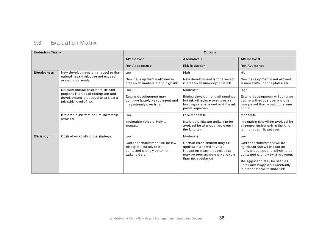
9.3 Evaluation Matrix Evaluation Criteria Options
Alternative 1
Risk Acceptance
Alternative 2
Risk Reduction
Alternative 3
Risk Avoidance
Effectiveness New development is managed so that natural hazard risk does not exceed acceptable levels.
Low
New development is allowed in areas with moderate and high risk.
High
New development Is not allowed in areas with unacceptable risk.
High
New development is not allowed in areas with unacceptable risk.
Risk from natural hazards to life and property in areas of existing use and development is reduced to at least a tolerable level of risk.
Low
Existing development may continue largely as at present and may intensify over time.
Moderate
Existing development will continue but risk will reduce over time as buildings are renewed and the risk profile improves.
High
Existing development will continue but risk will reduce over a shorter time period than would otherwise occur.
Intolerable risk from natural hazards is avoided.
Low
Intolerable risks are likely to increase.
Low/Moderate
Intolerable risks are unlikely to be avoided for all properties, even in the long term.
Moderate
Intolerable risks will be avoided for all properties but only in the long term or at significant cost.
Efficiency Costs of establishing the strategy. Low
Costs of establishment will be low initially, but is likely to be contested strongly by some stakeholders.
Moderate
Costs of establishment may be significant as it will have an impact on many properties but may be seen as more practicable than risk avoidance.
Low
Costs of establishment will be significant as it will impact on many properties and is likely to be contested strongly by landowners.
The approach may be seen as unfair unless applied consistently to other areas with similar risk.
Landslide and Debris Flow Hazard Management | Issues and Options 36

Evaluation Criteria Options
Alternative 1
Risk Acceptance
Alternative 2
Risk Reduction
Alternative 3
Risk Avoidance
Costs of development compliance. High
Compliance costs for individual property owners will be low.
Moderate
Compliance costs for individual property owners will be significant, but will be spread over time and timed to coincide with the normal building replacement cycle.
Low
Compliance costs for individual property owners will be very significant,
Timing may not coincide with normal building replacement cycle and could place large additional costs of landowners.
Compliance will be hard to manage and coercion is likely to be required.
Costs of readiness, response and recovery activities.
Low
Increased intensification of activity will lead to greater need to implement response and recovery activities.
Increasing reliance on warning systems over time.
Moderate
Similar need to implement response and recovery activities over time.
Similar reliance on warning systems over time.
High
Reducing need over time to implement response and recovery activities over time.
Reducing reliance on warning systems over time.
Benefits of reduced loss of life. Low
Loss of Life risk is likely to increase.
Low/Moderate
Risk profile is likely to reduce but over a long period of time.
Moderate
Risk profile will reduce but over a long period of time.
Benefits of reduced property damage. Low
Risk profile is likely to increase.
Low/Moderate
Risk profile is likely to reduce, but over a long period of time.
Moderate
Risk profile will reduce, but over a long period of time.
Landslide and Debris Flow Hazard Management | Issues and Options 37
Efficiency
9.4 Conclusions None of the strategies are likely to achieve acceptable risk in a meaningful timeframe through development control measures alone.
Significant and timely reduction of loss of life risk to a tolerable level is likely to be more influenced by risk management measures such as slope monitoring, vegetation management and early warning systems than development control measures.
The Risk Acceptance Strategy scores poorly in relation to the effectiveness criteria. Although this option may have low implementation cost once established, it may be strongly contested as it does not give effect to the RPS.
The Risk Reduction Strategy has the highest overall effectiveness and efficiency score. Its major weakness is the length of time it may take for a significant reduction in risk.
The Risk Avoidance Strategy may achieve a more timely reduction in risk. However, this is still likely to be a very long term outcome and therefore may only be marginally better than the Risk Reduction strategy. The result will depend on what criteria and timeframes are applied to the regional consent process.
The difficulties that are likely to occur with strategy establishment and implementation are significant potential weaknesses. Costs imposed on landowners are likely to be high and cause economic hardship in some cases.
The introduction of a hazard avoidance strategy with strongly regulated development controls to reduce risk may be a strategy to consider if the other risk management measures prove to be ineffective.
10.0 Monitoring and Review
The effectiveness and efficiency of the final adopted Risk Management Strategy will require ongoing monitoring and review.
Milestones should be established for the implementation of any agreed measures and progress should be reported on an agreed time table.
The Risk Analysis will need to be updated from time to time as new information or knowledge becomes available.
If the final adopted strategy does not achieve the intended outcomes, the strategy will need to be reviewed.
Landslide and Debris Flow Hazard Management | Issues and Options 38
References
Bay of Plenty Proposed Regional Policy Statement, November 2010.
Bay of Plenty Regional Land and Water Plan WLP
Department of Building and Housing, viewed at http://www.dbh.govt.nz/buildingactreview
Department of Building and Housing, viewed at http://www.dbh.govt.nz/epb-policy-review
District of North Vancouver, viewed at http://www.dnv.org/article.asp?c=1030
Independent Taskforce on Workplace Health and Safety, May 2013.
Improving our Resource Management System. Discussion document dated February 2013.
Saunders, W. And Glassey, P., (Compilers) 2007. Guidelines for assessing planning policy and consent requirements for landslide prone land. GNS Science Miscellaneous Series 7. Institute of Geological and Nuclear Sciences Limited.
Taig, T., 2012. A risk framework for earthquake prone buildings. MBIE
Tonkin & Taylor, 2013. Quantitative Landslide Risk Assessment Whakatane and Ohope Escarpments. Prepared for Whakatane District Council.
Tonkin & Taylor, 2013. Quantitative Landslide Risk Assessment Matata Escarpment. Prepared for Whakatane District Council.
Tonkin & Taylor, 2005. West End Escarpment Geotechnical Overview Report. Prepared for Whakatane District Council, Department of Conservation, Earthquake Commission.
Tonkin & Taylor, 2005. The Matata Debris Flows: Preliminary Infrastructure and Planning Options Report. Prepared for Whakatane District Council.
U.S. Department of the Interior U.S. Geological Survey Fact Sheet 2004-3072 July 2004
http://www.lawcom.govt.nz/project/review-official-information-act-1982-and-local-government-official-information-act-1987
Landslide and Debris Flow Hazard Management | Issues and Options 39
1.0 Appendix 1 – Legislative Framework
1.1 Local Government Act 2002
1.1.1 Scope and Purpose
The Local Government Act 2002 provides extensive powers to councils to decide which activities they undertake and the manner in which they will undertake them. These powers are limited by –
• The purpose of local government.
• Transparency and accountability requirements.
• Other specific provisions in the Local Government Act – including requirements to listen to the concerns and suggestions of community members.
• Provisions in other Acts.
The purpose of local government, as defined in the Act, is to “enable democratic local decision-making and action by, and on behalf of, communities”.
The second part of the purpose of local government is : “to meet the current and future needs of communities for good-quality local infrastructure, local public services and performance of regulatory functions in a way that is most cost-effective for households and businesses”.
In performing its role, a local authority must have particular regard to the contribution that the following core services make to its communities:
(a) network infrastructure:
(b) public transport services:
(c) solid waste collection and disposal:
(d) the avoidance or mitigation of natural hazards:
(e) libraries, museums, reserves, recreational facilities, and other community infrastructure
“Natural Hazard has the meaning given to it in the Resource Management Act 1991.
There is a robust planning process demanded by the Local Government Act 2002 (part 6). In consultation with their communities, councils must prepare long-term plans every three years, and annual plans in the other two years.
1.1.2 Long Term Plan
The LTP is the key long-term planning tool for councils.
Its purpose is to –
• Describe the council’s activities and the community outcomes it aims to achieve.
Landslide and Debris Flow Hazard Management | Issues and Options i
• Provide integrated decision-making and coordination of the resources, as set out in section 93 (6)(c) of the Act.
• Provide a long-term focus.
• Show accountability to the community.
• Provide an opportunity for participation by the public in council decision-making processes.
The LTP must include information on activities, goods or services provided by a council, and specific funding and financial management policies and information.
LTPs outline all things a council does and how they fit together. They show what will be done over the plan's 10 year period, why the council is doing things, and their costs.
People can express their views on the LTPs when they are reviewed every three years. In addition as part of their LTP development process, councils may talk with other parties about how they can help promote identified local outcomes in which those parties have an interest.
1.1.3 Annual Plan
The annual plan process focuses on year-to-year budgets. Councils prepare an annual plan in each of the two years between LTP reviews, and set out in them what the council plans to do in the next 12 months to move towards achieving its goals. These plans are adopted before the start of the financial year in July, following a submission process.
Councils are required to establish consultative processes around their policy-making activities which reflect the intent of the Local Government Act 2002 and are in line with goals for community well-being.
1.2 Civil Defence Emergency Management Act 2006 One of the purposes of the Civil Defence Emergency Management Act 2002 (CDEMA) is to encourage and enable communities to achieve acceptable levels of risk by,
(v) identifying, assessing, and managing risks; and
(vi) consulting and communicating about risks; and
(vii) identifying and implementing cost-effective risk reduction; and
(viii) monitoring and reviewing the process;
All persons exercising functions in relation to the development and implementation of civil defence emergency management plans under this Act may be cautious in managing risks even if there is scientific and technical uncertainty about those risks.
Every regional council and every territorial authority within that region must unite to establish a Civil Defence Emergency Management Group and establish a Group Plan.
Land use risk reduction policies within a CDEM Group Plan should be linked to a Regional Policy Statement, then down to regional and district plans.
Landslide and Debris Flow Hazard Management | Issues and Options ii
1.3 Resource Management Act 1991(RMA)
1.3.1 Meaning of “Natural Hazard”
The term “natural hazard” means
“any atmospheric or earth or water related occurrence (including earthquake, tsunami, erosion, volcanic and geothermal activity, landslip, subsidence, sedimentation, wind, drought, fire, or flooding) the action of which adversely affects or may adversely affect human life, property, or other aspects of the environment”
1.3.2 Meaning of Effect
Section 3 sets out the meaning of “effect”:
“In this Act, unless the context otherwise requires, the term effect includes—
(a) any positive or adverse effect; and
(b) any temporary or permanent effect; and
(c) any past, present, or future effect; and
(d) any cumulative effect which arises over time or in combination with other effects—
regardless of the scale, intensity, duration, or frequency of the effect, and also includes—
(e) any potential effect of high probability; and
(f) any potential effect of low probability which has a high potential impact”
Some hazards effects may fall within the scope of a “potential effect of low probability which has a high potential impact.”
1.3.3 Functions Powers and Duties for territorial authorities
Section 30 includes the following function for regional councils:
“ …the control of the use of land for the purpose of…the avoidance or mitigation of natural hazards:”
Section 31 includes the following function for territorial authorities:
“…the control of any actual or potential effects of the use, development, or protection of land, including for the purpose of…the avoidance or mitigation of natural hazards”.
Section 35 imposes a general duty for local authorities to gather information and undertake monitoring. This applies to natural hazards.
1.3.4 Resource Consents
Section 108 allows resource consents to be granted subject to conditions, including conditions relating to natural hazards.”
Under Section 106, subdivision consent can be refused, or granted subject to conditions, if land is likely to be subject to natural hazards:
Landslide and Debris Flow Hazard Management | Issues and Options iii
“A consent authority may refuse to grant a subdivision consent, or may grant a subdivision consent subject to conditions, if it considers that—
(a) the land in respect of which a consent is sought, or any structure on the land, is or is likely to be subject to material damage by erosion, falling debris, subsidence, slippage, or inundation from any source; or
(b) any subsequent use that is likely to be made of the land is likely to accelerate, worsen, or result in material damage to the land, other land, or structure by erosion, falling debris, subsidence, slippage, or inundation from any source; or
…”
The phrase “is or is likely to be subject to” requires assessment of the likelihood of a hazard occurring in a particular instance. The provision does not allow consideration of the consequences of any hazard, so does not address overall risk.
Section 106 does not apply directly to land use consents, although the subdivision process does ensure that sites are suitable for future land uses.
Several hazards are omitted from Section 106 including earthquake, liquefaction and tsunami.
These features of Section 106 are regarded as shortcomings by the government and are the subject of discussion in the current RMA reform process.
Any risk to the neighbourhood, community or the environment through natural hazards must be addressed in an assessment of environmental effects under the Fourth Schedule.
1.3.5 Existing Use Rights – District Plans
Under Section 10, existing use rights apply to any activity that contravenes a rule in a district plan if the use was lawfully established and the effects of the use are the same or similar in character, intensity, and scale to those existing before the rule came into effect.
This means that any new hazard controls in a District Plan cannot be applied retrospectively.
1.3.6 Existing Use Rights – Regional Plans
Under Section 30, a Regional Council can control the use of land for the purpose of avoidance or mitigation of natural hazards under a Regional Plan rule. Existing use rights do not apply to land uses controlled by a Regional Plan.
In this regard, the proposed Regional Policy Statement includes the following37:
“Natural hazards generating intolerable risk to existing uses may be able to be mitigated. If practical, non-structural mitigation to reduce risk to a tolerable level is not possible, removing the use or development from the location that is threatened may be necessary to avoid an intolerable risk. Although section 10 of the Act provides that certain existing uses of land may continue even though such a use may contravene a rule in a district plan, that section does not apply to any use of land that is controlled under section 30(1)(c) (regional control of certain land uses). Consequently, it is possible for a rule in a regional plan to require an existing use in a hazardous area to cease and be removed.”
The ability to use a Regional Plan rule to effectively extinguish existing use rights under the District Plan has not been implemented or tested.
37 Explanation to Policy NH 4B Avoiding intolerable risk from natural hazards
Landslide and Debris Flow Hazard Management | Issues and Options iv
If used, this method could have significant consequences for land owners given that compensation is not payable for controls on land. However, it is noted that Section 85 of the RMA creates safeguards for land owners against plan provisions that render land incapable of reasonable use (See below). This may limit the ability to apply this method.
There is a further potential legal issue. Existing use rights under Section 10 have the force of statute, whereas any rule under a Regional Plan has the force of regulation. Where there is a conflict, statute over-rides a regulation.
1.3.7 Legal Effect of Rules
Under Section 86B, rules have no legal effect until decisions on submissions have been made and publicly notified. The operative plan rules apply until that time.
Hazards rules are not included as a matter where immediate legal effect can be given on public notification of a plan.
A local authority may apply before or after the proposed plan is publicly notified to the Environment Court for a rule to have legal effect from a date other than the date on which the decision on submissions relating to the rule is made and publicly notified.
Also, any owner can seek a “Certificate of Compliance” (C o C) to secure permitted activity rights under the operative District Plan. A C o C has effect for up to 5 years.
1.3.8 Compensation not payable in respect of controls on land
Under section 85 an interest in land shall be deemed “not to be taken or injuriously affected by reason of any provision in a plan”. In other words, the impact of planning controls is not compensatable.
However, a provision or proposed provision of a plan or a proposed plan that renders any land incapable of reasonable use, and places an unfair and unreasonable burden on any person, can be challenged in the Environment Court.
This should not be an issue if the debris hazard assessment is robust and the plan provisions are reasonable having regard to the degree of risk (i.e. probability and impact).
1.3.9 Emergency Works
The emergency works provisions under Section 330 enable authorised persons to undertake activities that might otherwise contravene the RMA and would require resource consent in advance. They can only be used in emergency situations when there is a need for immediate intervention to prevent or remedy adverse environmental effects or prevent loss of life, injury or serious damage to property.
Emergency works require retrospective resource consents to be sought.
1.3.10 National Policy Statements and Standards
There are no directly relevant NPS or NES that deal with natural hazard management.
The New Zealand Coastal Policy Statement has indirect relevance where works may result in effects on coastal values, including natural character, in the coastal environment. The two study areas are both within the “coastal environment”.
Landslide and Debris Flow Hazard Management | Issues and Options v
1.4 Building Act 2004(BA) The term “natural hazard” means any of the following:
“(a) erosion (including coastal erosion, bank erosion, and sheet erosion):
(b) falling debris (including soil, rock, snow, and ice):
(c) subsidence:
(d) inundation (including flooding, overland flow, storm surge, tidal effects, and ponding):
(e) slippage.”
Section 35 outlines the information required for inclusion on a ‘Project Information Memorandum’, (PIM) prepared by a territorial authority. Information that is likely to be relevant to the proposed building work must be included and should identify special features of the land. Special features include natural hazards.
Section 71 requires a building consent authority to refuse to grant a building consent for construction of a building or a major alteration, if the land is subject to, or is likely to be subject to, a natural hazard (section 71 (a)), or if the building work is likely to accelerate, worsen, or result in a natural hazard on that land or any other property (71 (b)).
Section 72 of the Act allows for a building consent to be granted for a building where a natural hazard has been identified, subject to conditions.
Building consent for building on land subject to natural hazards must be granted in certain cases
• Despite section 71, a building consent authority that is a territorial authority must grant a building consent if the building consent authority considers that—
• (a) the building work to which an application for a building consent relates will not accelerate, worsen, or result in a natural hazard on the land on which the building work is to be carried out or any other property; and
• (b) the land is subject or is likely to be subject to 1 or more natural hazards; and
• (c) it is reasonable to grant a waiver or modification of the building code in respect of the natural hazard concerned.
Similar to Section 108 of the RMA, the phrase “is or is likely to be subject to” is used which requires assessment of the likelihood of a hazard occurring in a particular instance. The provision does not allow consideration of the consequences of any hazard, so does not address risk per se.
Under Section 73, any identified natural hazards are recorded on the property title. This can then have insurance implications for property owners and could have the effect of controlling development.
In 2006, the Council sought a determination from the Department of Building and Housing on whether houses at Matata affected by debris hazards from the Awatarariki catchment were “dangerous buildings” in terms of Section 121 of the Building Act.
The Department determined that the buildings were not “dangerous’ because the return period of the storm (less than 200 years) that caused damaging flows was not likely “In the ordinary
Landslide and Debris Flow Hazard Management | Issues and Options vi
course of events”. The determination also observed that a warning system would “contribute to life safety”.
Hazard areas do not need to be included in the District Plan for the Building Act hazard provisions to apply. The landslide risk assessment reports will need to be taken into consideration from the time they have been received by the Council.
1.5 Local Government and Official Information and Meetings Act (LGOIMA)
Under Section 44, a person may apply to a territorial authority for the issue of a Land Information Memorandum (LIM) in relation to matters affecting any land in the district.
The matters that must be in a LIM include:
“(a) information identifying each (if any) special feature or characteristic of the land concerned, including but not limited to potential erosion, avulsion, falling debris, subsidence, slippage, alluvion, or inundation, or likely presence of hazardous contaminants, being a feature or characteristic that—
(i) is known to the territorial authority; but
(ii) is not apparent from the district scheme under the Town and Country Planning Act 1977 or a district plan under the Resource Management Act 1991”
This means that any person requesting a LIM for land within the landslide hazard zones must be provided with information relating to debris hazards.
Hazard areas do not need to be included in the District Plan for the LGOIMA hazard provisions to apply. The landslide risk assessment reports will need to be identified in a LIM from the time they have been received by the Council.
1.6 Legislative Reviews Several legislative changes are currently under consideration which may have a significant impact on the management of natural hazard risks.
1.6.1 RMA Reforms – “Improving Our Resource Management System”
“Better natural hazard management” is identified as one of the current proposals for reform of the RMA by central government.
The proposals are aimed at providing greater national consistency and guidance to improve the way that natural hazards are planned for and managed38. Although, the catalyst for reform is the Canterbury earthquakes of 2010 and 2011, the scope of reform relates to the management of all hazards.
The proposals put forward for discussion include:
• Including natural hazards as a “matter” in the principles of the RMA.
• Amending Section 106 to:
38 Improving Our Resource Management System – Discussion Document – February 2013
Landslide and Debris Flow Hazard Management | Issues and Options vii
o Ensure all natural hazards can be appropriately considered in both subdivision and land use consent decisions;
o Require the full risk of natural hazards to be taken into consideration – both likelihood and magnitude of the impacts.
These changes are coupled with proposals that would extend central government powers to direct plan changes for some natural hazards.
Read as whole, the policy direction is to take full account of risk in hazard management under the RMA and to apply this on a consistent basis across all hazards. This is seen as improving the effectiveness of consenting and resilience to natural hazards.
Although not yet proposed as part of a bill, the proposals have generally been supported by submissions, with the likelihood of the changes being enacted.
There are some potential pitfalls in the proposals as presented that will limit their effect. Most notably, many land uses, particularly residential uses, do not require land use consent and will not be caught by the proposals to bring land use under Section 106. The provisions will also have no retrospective effect given the existing use provisions under Section 10 the Act and, overall, would appear to have little impact on situations such as those in the study area involving existing development.
1.6.2 Building Act Review
A review of the Building Act 2004 has been underway since 2009. The terms of reference are to reduce the costs, but not the quality, of the building control system39.
The review scope does not include the hazard related sections of the Act, paralleling those proposed under the RMA reform.
1.6.3 Review of Earthquake-prone Building Policy
The Ministry of Business, Innovation and Employment is consulting on proposed changes to the system for dealing with earthquake-prone buildings. The proposals set out a consistent national approach to dealing with these buildings40.
The review scope does not include the hazard related sections of the Act, similar to those proposed under the RMA reform.
1.6.4 Review of Official Information Act 1982 and Local Government Official Information Act 1987
The Law Commission undertook a review of the two Acts and reported to Parliament in July 2012. The review assessed the two Acts in light of changes in the operating environment from 30 years ago, in terms of parliamentary and government processes, technology, the internet, and public expectations41.
The review did not include any recommended changes to the special feature or characteristic of the land (hazard) related sections of the Act, similar to those proposed under the RMA reform.
39 http://www.dbh.govt.nz/buildingactreview 40 http://www.dbh.govt.nz/epb-policy-review 41 http://www.lawcom.govt.nz/project/review-official-information-act-1982-and-local-government-official-information-act-1987
Landslide and Debris Flow Hazard Management | Issues and Options viii

1.6.5 Conclusion
The approach taken in the risk assessments is generally consistent with the probable future direction of government policy on natural hazard management.
There is some risk that the RMA reforms will result in inconsistency in the approach to hazards across the key pieces of legislation, notably the Building Act.
Landslide and Debris Flow Hazard Management | Issues and Options ix

Appendix 2 – Whakatane Ohope Hazard Maps
Landslide and Debris Flow Hazard Management | Issues and Options i
Tonk
in &
Tay
lor
Not
es:
Envi
ronm
enta
l and
Eng
inee
ring
Con
sulta
nts
ww
w.to
nkin
.co.
nz
SC
ALE
(AT
A3
SIZ
E)
PR
OJE
CT
No.
AR
CFI
LE
DR
AWN
CH
EC
KED
APPR
OVE
D
FIG
UR
E N
o.R
ev.
25 m
50 m
150 m
50 m50 m
50 m
125 m
Prop
erty
1_N
ZTM
_pol
ygon
Prop
erty
2_N
ZTM
_pol
ygon
_pol
ygon
Prop
erty
4_N
ZTM
_pol
ygon
<all
othe
r val
ues>
Id
0 1 2 3 4
! 00
2040
6080
100
(m)
A3 S
CA
LE
Figu
re P
1
WH
AK
ATA
NE
DIS
TRIC
T C
OU
NC
ILW
HA
KAT
AN
E &
OH
OP
E Q
LRA
Land
slid
e H
azar
d - W
haka
tane
She
et: P
1Lo
catio
n Pl
an1:
2,00
0
2827
310
5 C
arlto
n G
ore
Roa
d, N
ewm
arke
t, Au
ckla
nd
1:2,
000
2827
3.AP
.r4.m
xd
MC
IAp
r.13
Path: G:\28273\Mapping\April 2013 Updates\28273.AP.r4.mxd Date: 30/04/2013 Time: 3:00:00 p.m.
Aeria
l Im
ager
y 20
07 s
ourc
ed fr
om T
erra
link
Inte
rnat
iona
l (C
opyr
ight
200
2-20
05 T
erra
link
Inte
rnat
iona
l Lim
ited
and
its li
cens
ors)
.
LEG
END
Hig
h
Mod
erat
e
Low
to v
ery
low
Tonk
in &
Tay
lor
Not
es:
Envi
ronm
enta
l and
Eng
inee
ring
Con
sulta
nts
ww
w.to
nkin
.co.
nz
SC
ALE
(AT
A3
SIZ
E)
PR
OJE
CT
No.
AR
CFI
LE
DR
AWN
CH
EC
KED
APPR
OVE
D
FIG
UR
E N
o.R
ev.
25 m
75 m
125 m
Prop
erty
1_N
ZTM
_pol
ygon
Prop
erty
2_N
ZTM
_pol
ygon
_pol
ygon
Prop
erty
4_N
ZTM
_pol
ygon
<all
othe
r val
ues>
Id
0 1 2 3 4
! 00
2040
6080
100
(m)
A3 S
CA
LE
Figu
re P
2
WH
AK
ATA
NE
DIS
TRIC
T C
OU
NC
ILW
HA
KAT
AN
E &
OH
OP
E Q
LRA
Land
slid
e H
azar
d - W
haka
tane
She
et: P
2Lo
catio
n Pl
an1:
2,00
0
2827
310
5 C
arlto
n G
ore
Roa
d, N
ewm
arke
t, Au
ckla
nd
1:2,
000
2827
3.AP
.r4.m
xd
MC
IAp
r.13
Path: G:\28273\Mapping\April 2013 Updates\28273.AP.r4.mxd Date: 30/04/2013 Time: 3:00:05 p.m.
Aeria
l Im
ager
y 20
07 s
ourc
ed fr
om T
erra
link
Inte
rnat
iona
l (C
opyr
ight
200
2-20
05 T
erra
link
Inte
rnat
iona
l Lim
ited
and
its li
cens
ors)
.
LEG
END
Hig
h
Mod
erat
e
Low
to v
ery
low
Tonk
in &
Tay
lor
Not
es:
Envi
ronm
enta
l and
Eng
inee
ring
Con
sulta
nts
ww
w.to
nkin
.co.
nz
SC
ALE
(AT
A3
SIZ
E)
PR
OJE
CT
No.
AR
CFI
LE
DR
AWN
CH
EC
KED
APPR
OVE
D
FIG
UR
E N
o.R
ev.
100 m125 m
75 m
50 m
150 m
175 m
75 m
Prop
erty
1_N
ZTM
_pol
ygon
Prop
erty
2_N
ZTM
_pol
ygon
_pol
ygon
Prop
erty
4_N
ZTM
_pol
ygon
<all
othe
r val
ues>
Id
0 1 2 3 4
! 00
2040
6080
100
(m)
A3 S
CA
LE
Figu
re P
3
WH
AK
ATA
NE
DIS
TRIC
T C
OU
NC
ILW
HA
KAT
AN
E &
OH
OP
E Q
LRA
Land
slid
e H
azar
d - W
haka
tane
She
et: P
3Lo
catio
n Pl
an1:
2,00
0
2827
310
5 C
arlto
n G
ore
Roa
d, N
ewm
arke
t, Au
ckla
nd
1:2,
000
2827
3.AP
.r4.m
xd
MC
IAp
r.13
Path: G:\28273\Mapping\April 2013 Updates\28273.AP.r4.mxd Date: 30/04/2013 Time: 3:00:10 p.m.
Aeria
l Im
ager
y 20
07 s
ourc
ed fr
om T
erra
link
Inte
rnat
iona
l (C
opyr
ight
200
2-20
05 T
erra
link
Inte
rnat
iona
l Lim
ited
and
its li
cens
ors)
.
LEG
END
Hig
h
Mod
erat
e
Low
to v
ery
low

Tonk
in &
Tay
lor
Not
es:
Envi
ronm
enta
l and
Eng
inee
ring
Con
sulta
nts
ww
w.to
nkin
.co.
nz
SC
ALE
(AT
A3
SIZ
E)
PR
OJE
CT
No.
AR
CFI
LE
DR
AWN
CH
EC
KED
APPR
OVE
D
FIG
UR
E N
o.R
ev.
25 m
50 m
75 m
100 m
150 m
50 m
50 m
Prop
erty
1_N
ZTM
_pol
ygon
Prop
erty
2_N
ZTM
_pol
ygon
_pol
ygon
Prop
erty
4_N
ZTM
_pol
ygon
<all
othe
r val
ues>
Id
0 1 2 3 4
! 00
2040
6080
100
(m)
A3 S
CA
LE
Figu
re P
4
WH
AK
ATA
NE
DIS
TRIC
T C
OU
NC
ILW
HA
KAT
AN
E &
OH
OP
E Q
LRA
Land
slid
e H
azar
d - W
haka
tane
She
et: P
4Lo
catio
n Pl
an1:
2,00
0
2827
310
5 C
arlto
n G
ore
Roa
d, N
ewm
arke
t, Au
ckla
nd
1:2,
000
2827
3.AP
.r4.m
xd
MC
IAp
r.13
Path: G:\28273\Mapping\April 2013 Updates\28273.AP.r4.mxd Date: 30/04/2013 Time: 3:00:16 p.m.
Aeria
l Im
ager
y 20
07 s
ourc
ed fr
om T
erra
link
Inte
rnat
iona
l (C
opyr
ight
200
2-20
05 T
erra
link
Inte
rnat
iona
l Lim
ited
and
its li
cens
ors)
.
LEG
END
Hig
h
Mod
erat
e
Low
to v
ery
low
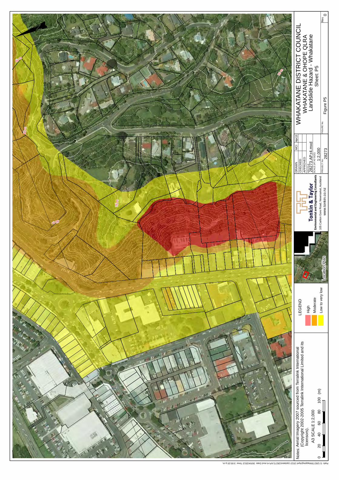
Tonk
in &
Tay
lor
Not
es:
Envi
ronm
enta
l and
Eng
inee
ring
Con
sulta
nts
ww
w.to
nkin
.co.
nz
SC
ALE
(AT
A3
SIZ
E)
PR
OJE
CT
No.
AR
CFI
LE
DR
AWN
CH
EC
KED
APPR
OVE
D
FIG
UR
E N
o.R
ev.
75 m
75 m
50 m
50 m
50 m
Prop
erty
1_N
ZTM
_pol
ygon
Prop
erty
2_N
ZTM
_pol
ygon
_pol
ygon
Prop
erty
4_N
ZTM
_pol
ygon
<all
othe
r val
ues>
Id
0 1 2 3 4
! 00
2040
6080
100
(m)
A3 S
CA
LE
Figu
re P
5
WH
AK
ATA
NE
DIS
TRIC
T C
OU
NC
ILW
HA
KAT
AN
E &
OH
OP
E Q
LRA
Land
slid
e H
azar
d - W
haka
tane
She
et: P
5Lo
catio
n Pl
an1:
2,00
0
2827
310
5 C
arlto
n G
ore
Roa
d, N
ewm
arke
t, Au
ckla
nd
1:2,
000
2827
3.AP
.r4.m
xd
MC
IAp
r.13
Path: G:\28273\Mapping\April 2013 Updates\28273.AP.r4.mxd Date: 30/04/2013 Time: 3:00:20 p.m.
Aeria
l Im
ager
y 20
07 s
ourc
ed fr
om T
erra
link
Inte
rnat
iona
l (C
opyr
ight
200
2-20
05 T
erra
link
Inte
rnat
iona
l Lim
ited
and
its li
cens
ors)
.
LEG
END
Hig
h
Mod
erat
e
Low
to v
ery
low
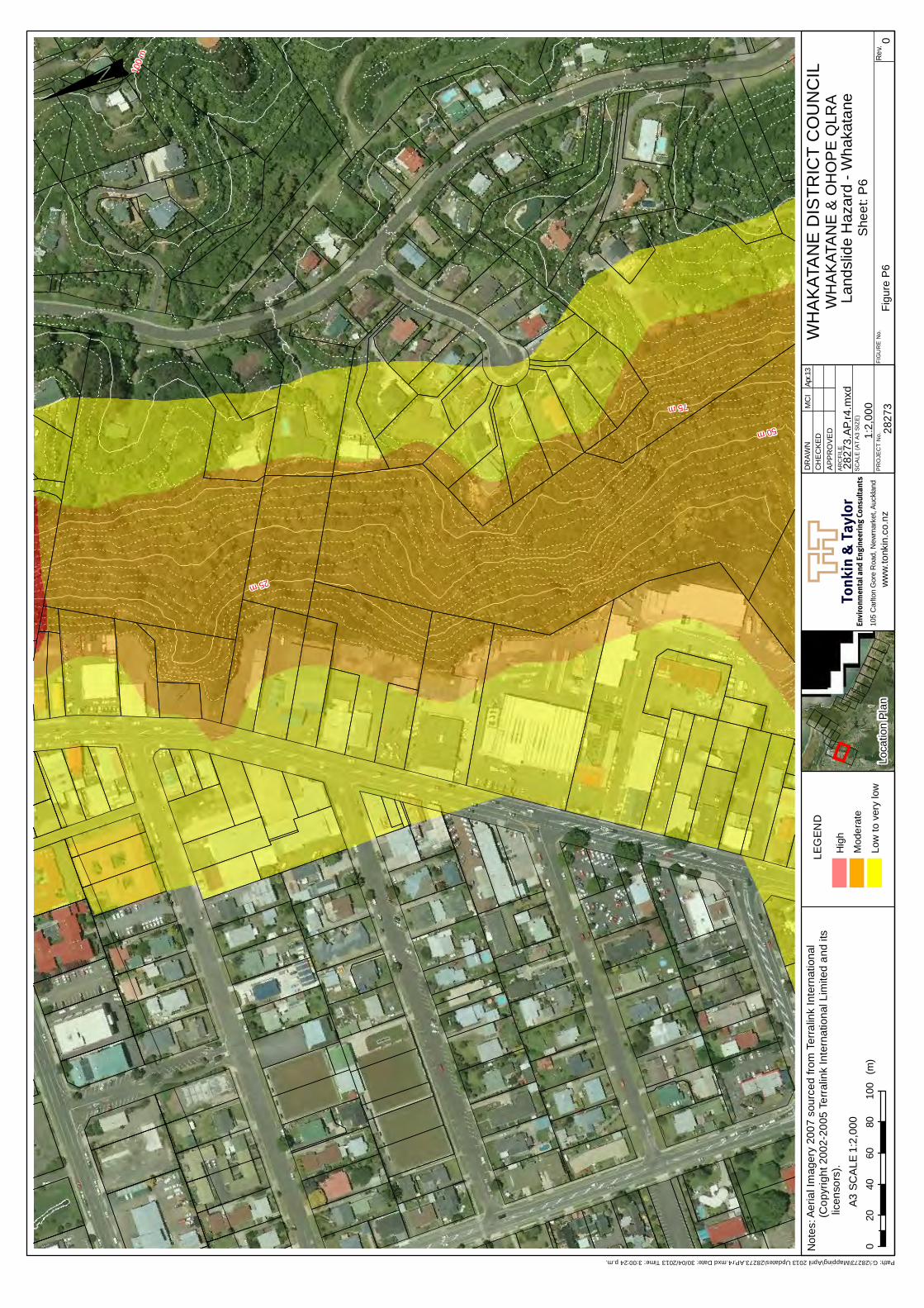
Tonk
in &
Tay
lor
Not
es:
Envi
ronm
enta
l and
Eng
inee
ring
Con
sulta
nts
ww
w.to
nkin
.co.
nz
SC
ALE
(AT
A3
SIZ
E)
PR
OJE
CT
No.
AR
CFI
LE
DR
AWN
CH
EC
KED
APPR
OVE
D
FIG
UR
E N
o.R
ev.
25 m
50 m
75 m
100
m
Prop
erty
1_N
ZTM
_pol
ygon
Prop
erty
2_N
ZTM
_pol
ygon
_pol
ygon
Prop
erty
4_N
ZTM
_pol
ygon
<all
othe
r val
ues>
Id
0 1 2 3 4
! 00
2040
6080
100
(m)
A3 S
CA
LE
Figu
re P
6
WH
AK
ATA
NE
DIS
TRIC
T C
OU
NC
ILW
HA
KAT
AN
E &
OH
OP
E Q
LRA
Land
slid
e H
azar
d - W
haka
tane
She
et: P
6Lo
catio
n Pl
an1:
2,00
0
2827
310
5 C
arlto
n G
ore
Roa
d, N
ewm
arke
t, Au
ckla
nd
1:2,
000
2827
3.AP
.r4.m
xd
MC
IAp
r.13
Path: G:\28273\Mapping\April 2013 Updates\28273.AP.r4.mxd Date: 30/04/2013 Time: 3:00:24 p.m.
Aeria
l Im
ager
y 20
07 s
ourc
ed fr
om T
erra
link
Inte
rnat
iona
l (C
opyr
ight
200
2-20
05 T
erra
link
Inte
rnat
iona
l Lim
ited
and
its li
cens
ors)
.
LEG
END
Hig
h
Mod
erat
e
Low
to v
ery
low
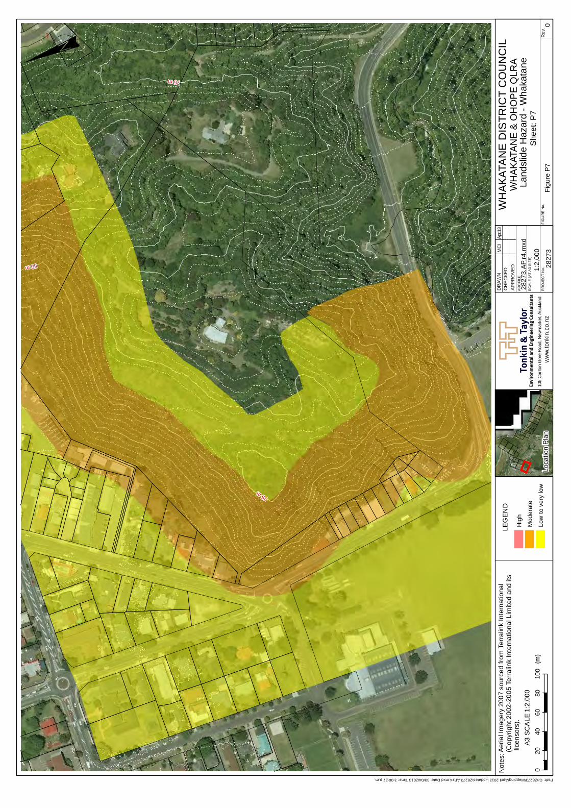
Tonk
in &
Tay
lor
Not
es:
Envi
ronm
enta
l and
Eng
inee
ring
Con
sulta
nts
ww
w.to
nkin
.co.
nz
SC
ALE
(AT
A3
SIZ
E)
PR
OJE
CT
No.
AR
CFI
LE
DR
AWN
CH
EC
KED
APPR
OVE
D
FIG
UR
E N
o.R
ev.
50 m
75 m
75 m
Prop
erty
1_N
ZTM
_pol
ygon
Prop
erty
2_N
ZTM
_pol
ygon
_pol
ygon
Prop
erty
4_N
ZTM
_pol
ygon
<all
othe
r val
ues>
Id
0 1 2 3 4
! 00
2040
6080
100
(m)
A3 S
CA
LE
Figu
re P
7
WH
AK
ATA
NE
DIS
TRIC
T C
OU
NC
ILW
HA
KAT
AN
E &
OH
OP
E Q
LRA
Land
slid
e H
azar
d - W
haka
tane
She
et: P
7Lo
catio
n Pl
an1:
2,00
0
2827
310
5 C
arlto
n G
ore
Roa
d, N
ewm
arke
t, Au
ckla
nd
1:2,
000
2827
3.AP
.r4.m
xd
MC
IAp
r.13
Path: G:\28273\Mapping\April 2013 Updates\28273.AP.r4.mxd Date: 30/04/2013 Time: 3:00:27 p.m.
Aeria
l Im
ager
y 20
07 s
ourc
ed fr
om T
erra
link
Inte
rnat
iona
l (C
opyr
ight
200
2-20
05 T
erra
link
Inte
rnat
iona
l Lim
ited
and
its li
cens
ors)
.
LEG
END
Hig
h
Mod
erat
e
Low
to v
ery
low
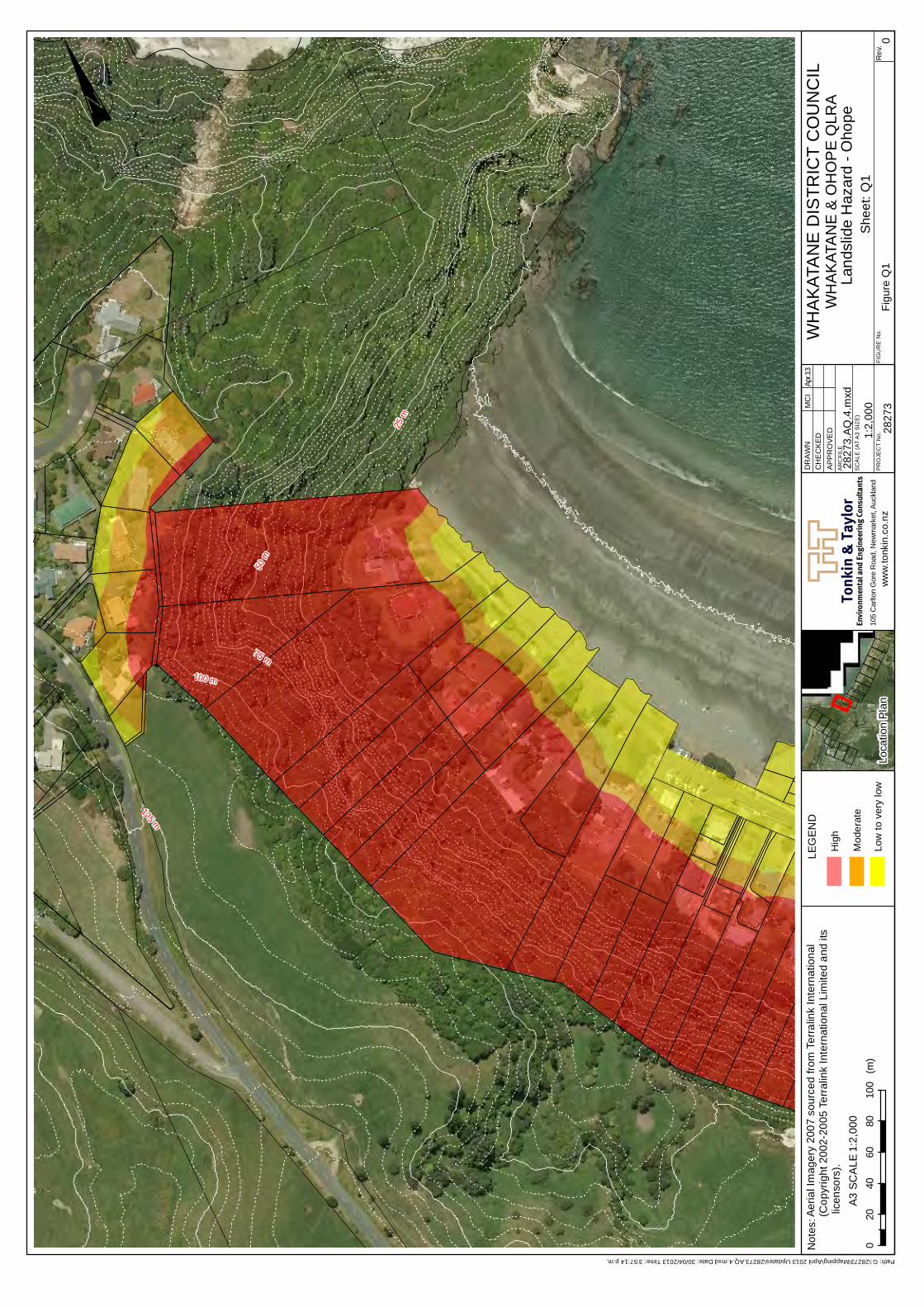
Tonk
in &
Tay
lor
Not
es:
Envi
ronm
enta
l and
Eng
inee
ring
Con
sulta
nts
ww
w.to
nkin
.co.
nz
SC
ALE
(AT
A3
SIZ
E)
PR
OJE
CT
No.
AR
CFI
LE
DR
AWN
CH
EC
KED
APPR
OVE
D
FIG
UR
E N
o.R
ev.
50 m
75 m
25 m
100 m
125 m
! 00
2040
6080
100
(m)
A3 S
CA
LE
Figu
re Q
1
WH
AK
ATA
NE
DIS
TRIC
T C
OU
NC
ILW
HA
KAT
AN
E &
OH
OP
E Q
LRA
Land
slid
e H
azar
d - O
hope
She
et: Q
1Lo
catio
n Pl
an1:
2,00
0
2827
310
5 C
arlto
n G
ore
Roa
d, N
ewm
arke
t, Au
ckla
nd
1:2,
000
2827
3.AQ
.4.m
xd
MC
IAp
r.13
Path: G:\28273\Mapping\April 2013 Updates\28273.AQ.4.mxd Date: 30/04/2013 Time: 3:57:14 p.m.
Aeria
l Im
ager
y 20
07 s
ourc
ed fr
om T
erra
link
Inte
rnat
iona
l (C
opyr
ight
200
2-20
05 T
erra
link
Inte
rnat
iona
l Lim
ited
and
its li
cens
ors)
.
LEG
END
Hig
h
Mod
erat
e
Low
to v
ery
low
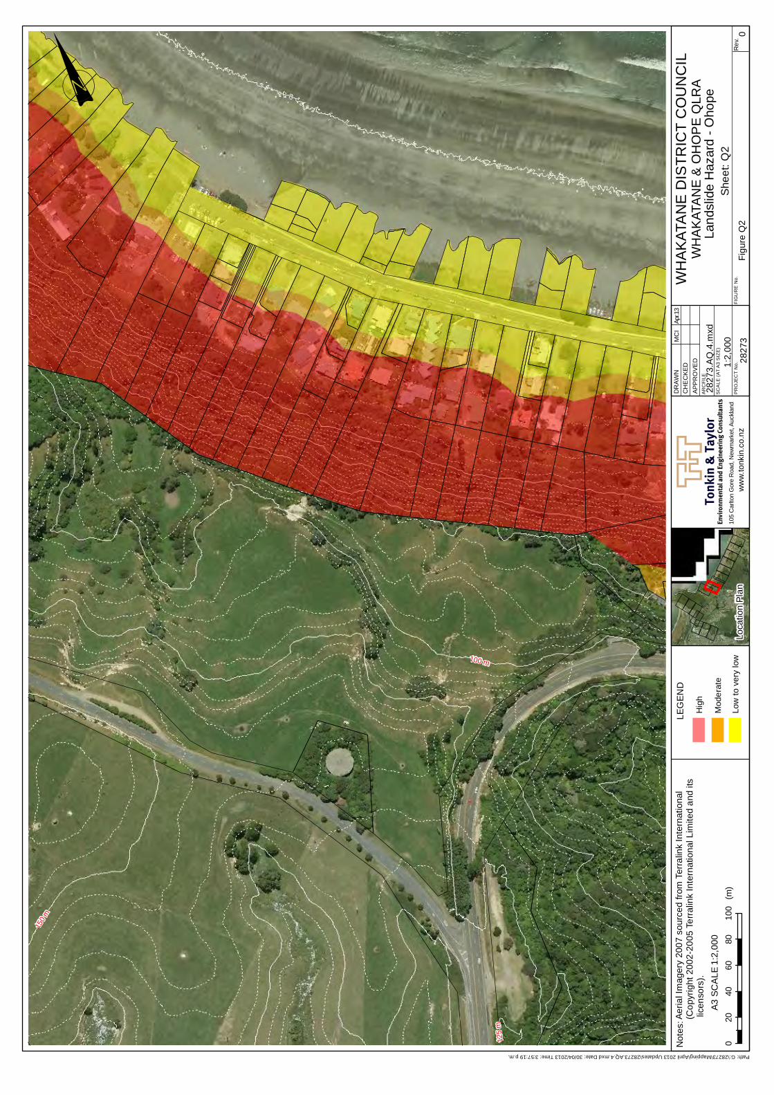
Tonk
in &
Tay
lor
Not
es:
Envi
ronm
enta
l and
Eng
inee
ring
Con
sulta
nts
ww
w.to
nkin
.co.
nz
SC
ALE
(AT
A3
SIZ
E)
PR
OJE
CT
No.
AR
CFI
LE
DR
AWN
CH
EC
KED
APPR
OVE
D
FIG
UR
E N
o.R
ev.
100 m
150
m
125
m
! 00
2040
6080
100
(m)
A3 S
CA
LE
Figu
re Q
2
WH
AK
ATA
NE
DIS
TRIC
T C
OU
NC
ILW
HA
KAT
AN
E &
OH
OP
E Q
LRA
Land
slid
e H
azar
d - O
hope
She
et: Q
2Lo
catio
n Pl
an1:
2,00
0
2827
310
5 C
arlto
n G
ore
Roa
d, N
ewm
arke
t, Au
ckla
nd
1:2,
000
2827
3.AQ
.4.m
xd
MC
IAp
r.13
Path: G:\28273\Mapping\April 2013 Updates\28273.AQ.4.mxd Date: 30/04/2013 Time: 3:57:19 p.m.
Aeria
l Im
ager
y 20
07 s
ourc
ed fr
om T
erra
link
Inte
rnat
iona
l (C
opyr
ight
200
2-20
05 T
erra
link
Inte
rnat
iona
l Lim
ited
and
its li
cens
ors)
.
LEG
END
Hig
h
Mod
erat
e
Low
to v
ery
low
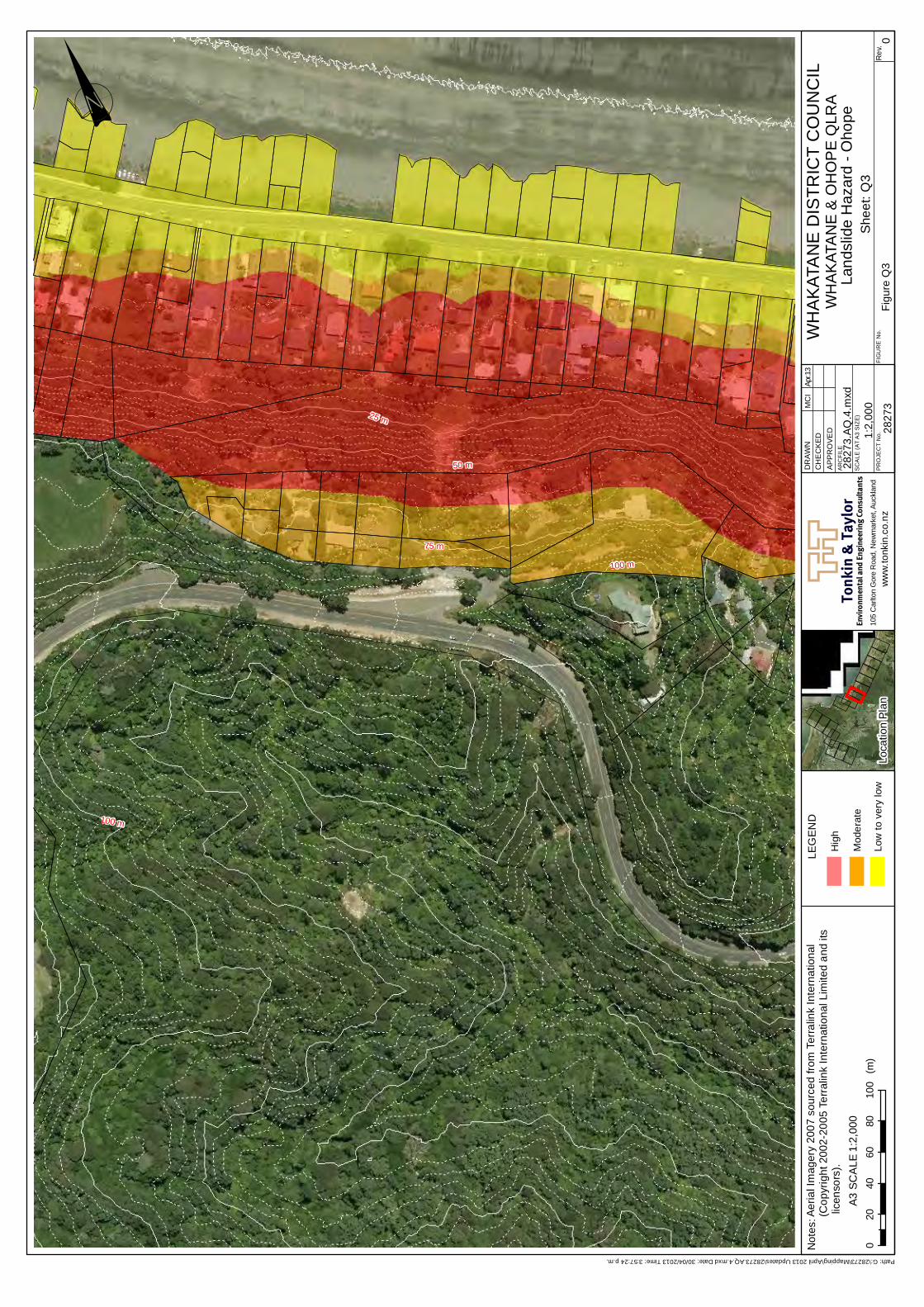
Tonk
in &
Tay
lor
Not
es:
Envi
ronm
enta
l and
Eng
inee
ring
Con
sulta
nts
ww
w.to
nkin
.co.
nz
SC
ALE
(AT
A3
SIZ
E)
PR
OJE
CT
No.
AR
CFI
LE
DR
AWN
CH
EC
KED
APPR
OVE
D
FIG
UR
E N
o.R
ev.
75 m
50 m
25 m
100 m
100 m
! 00
2040
6080
100
(m)
A3 S
CA
LE
Figu
re Q
3
WH
AK
ATA
NE
DIS
TRIC
T C
OU
NC
ILW
HA
KAT
AN
E &
OH
OP
E Q
LRA
Land
slid
e H
azar
d - O
hope
She
et: Q
3Lo
catio
n Pl
an1:
2,00
0
2827
310
5 C
arlto
n G
ore
Roa
d, N
ewm
arke
t, Au
ckla
nd
1:2,
000
2827
3.AQ
.4.m
xd
MC
IAp
r.13
Path: G:\28273\Mapping\April 2013 Updates\28273.AQ.4.mxd Date: 30/04/2013 Time: 3:57:24 p.m.
Aeria
l Im
ager
y 20
07 s
ourc
ed fr
om T
erra
link
Inte
rnat
iona
l (C
opyr
ight
200
2-20
05 T
erra
link
Inte
rnat
iona
l Lim
ited
and
its li
cens
ors)
.
LEG
END
Hig
h
Mod
erat
e
Low
to v
ery
low
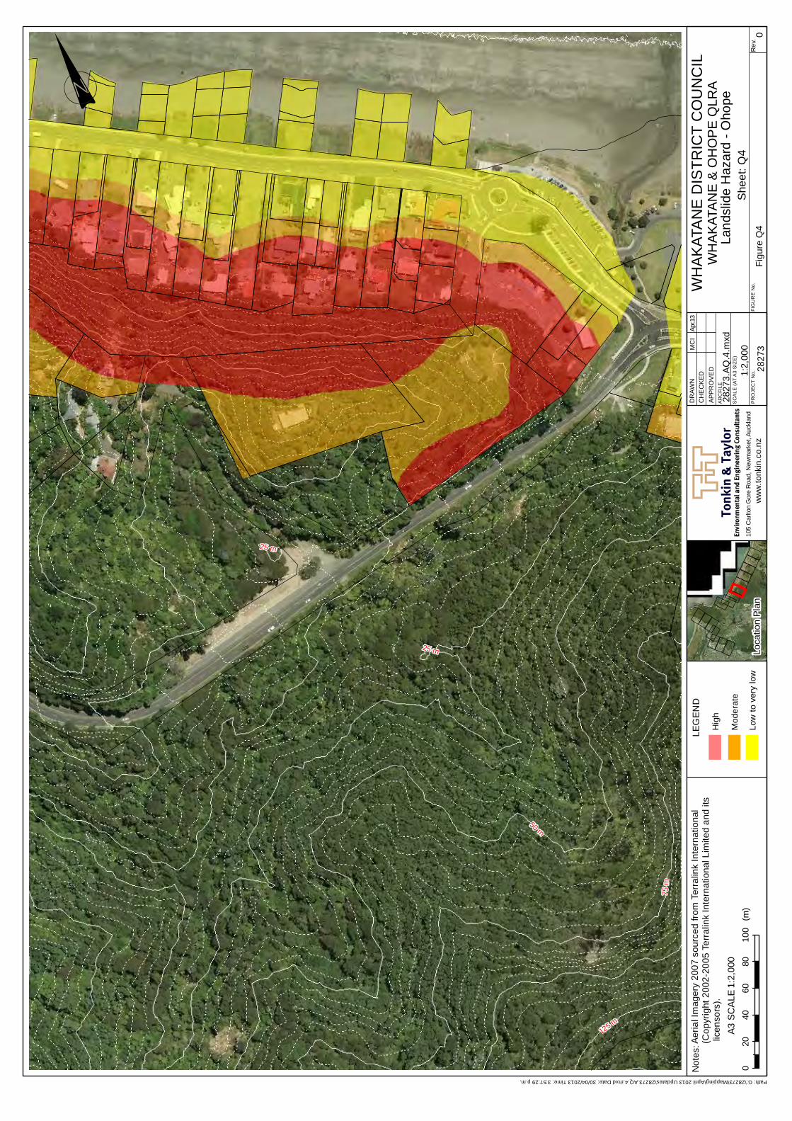
Tonk
in &
Tay
lor
Not
es:
Envi
ronm
enta
l and
Eng
inee
ring
Con
sulta
nts
ww
w.to
nkin
.co.
nz
SC
ALE
(AT
A3
SIZ
E)
PR
OJE
CT
No.
AR
CFI
LE
DR
AWN
CH
EC
KED
APPR
OVE
D
FIG
UR
E N
o.R
ev.
50 m
75 m
125 m
25 m
25 m
! 00
2040
6080
100
(m)
A3 S
CA
LE
Figu
re Q
4
WH
AK
ATA
NE
DIS
TRIC
T C
OU
NC
ILW
HA
KAT
AN
E &
OH
OP
E Q
LRA
Land
slid
e H
azar
d - O
hope
She
et: Q
4Lo
catio
n Pl
an1:
2,00
0
2827
310
5 C
arlto
n G
ore
Roa
d, N
ewm
arke
t, Au
ckla
nd
1:2,
000
2827
3.AQ
.4.m
xd
MC
IAp
r.13
Path: G:\28273\Mapping\April 2013 Updates\28273.AQ.4.mxd Date: 30/04/2013 Time: 3:57:29 p.m.
Aeria
l Im
ager
y 20
07 s
ourc
ed fr
om T
erra
link
Inte
rnat
iona
l (C
opyr
ight
200
2-20
05 T
erra
link
Inte
rnat
iona
l Lim
ited
and
its li
cens
ors)
.
LEG
END
Hig
h
Mod
erat
e
Low
to v
ery
low
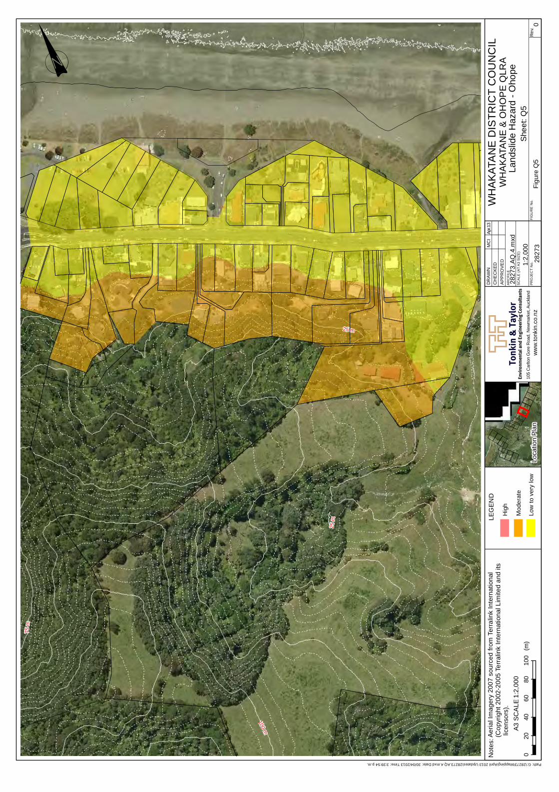
Tonk
in &
Tay
lor
Not
es:
Envi
ronm
enta
l and
Eng
inee
ring
Con
sulta
nts
ww
w.to
nkin
.co.
nz
SC
ALE
(AT
A3
SIZ
E)
PR
OJE
CT
No.
AR
CFI
LE
DR
AWN
CH
EC
KED
APPR
OVE
D
FIG
UR
E N
o.R
ev.
25 m
75 m
100 m
25 m
! 00
2040
6080
100
(m)
A3 S
CA
LE
Figu
re Q
5
WH
AK
ATA
NE
DIS
TRIC
T C
OU
NC
ILW
HA
KAT
AN
E &
OH
OP
E Q
LRA
Land
slid
e H
azar
d - O
hope
She
et: Q
5Lo
catio
n Pl
an1:
2,00
0
2827
310
5 C
arlto
n G
ore
Roa
d, N
ewm
arke
t, Au
ckla
nd
1:2,
000
2827
3.AQ
.4.m
xd
MC
IAp
r.13
Path: G:\28273\Mapping\April 2013 Updates\28273.AQ.4.mxd Date: 30/04/2013 Time: 3:39:54 p.m.
Aeria
l Im
ager
y 20
07 s
ourc
ed fr
om T
erra
link
Inte
rnat
iona
l (C
opyr
ight
200
2-20
05 T
erra
link
Inte
rnat
iona
l Lim
ited
and
its li
cens
ors)
.
LEG
END
Hig
h
Mod
erat
e
Low
to v
ery
low
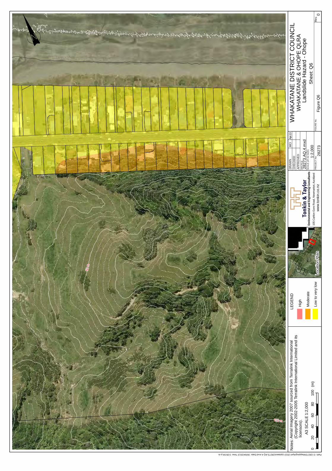
Tonk
in &
Tay
lor
Not
es:
Envi
ronm
enta
l and
Eng
inee
ring
Con
sulta
nts
ww
w.to
nkin
.co.
nz
SC
ALE
(AT
A3
SIZ
E)
PR
OJE
CT
No.
AR
CFI
LE
DR
AWN
CH
EC
KED
APPR
OVE
D
FIG
UR
E N
o.R
ev.
50 m
100 m
! 00
2040
6080
100
(m)
A3 S
CA
LE
Figu
re Q
6
WH
AK
ATA
NE
DIS
TRIC
T C
OU
NC
ILW
HA
KAT
AN
E &
OH
OP
E Q
LRA
Land
slid
e H
azar
d - O
hope
She
et: Q
6Lo
catio
n Pl
an1:
2,00
0
2827
310
5 C
arlto
n G
ore
Roa
d, N
ewm
arke
t, Au
ckla
nd
1:2,
000
2827
3.AQ
.4.m
xd
MC
IAp
r.13
Path: G:\28273\Mapping\April 2013 Updates\28273.AQ.4.mxd Date: 30/04/2013 Time: 3:39:59 p.m.
Aeria
l Im
ager
y 20
07 s
ourc
ed fr
om T
erra
link
Inte
rnat
iona
l (C
opyr
ight
200
2-20
05 T
erra
link
Inte
rnat
iona
l Lim
ited
and
its li
cens
ors)
.
LEG
END
Hig
h
Mod
erat
e
Low
to v
ery
low
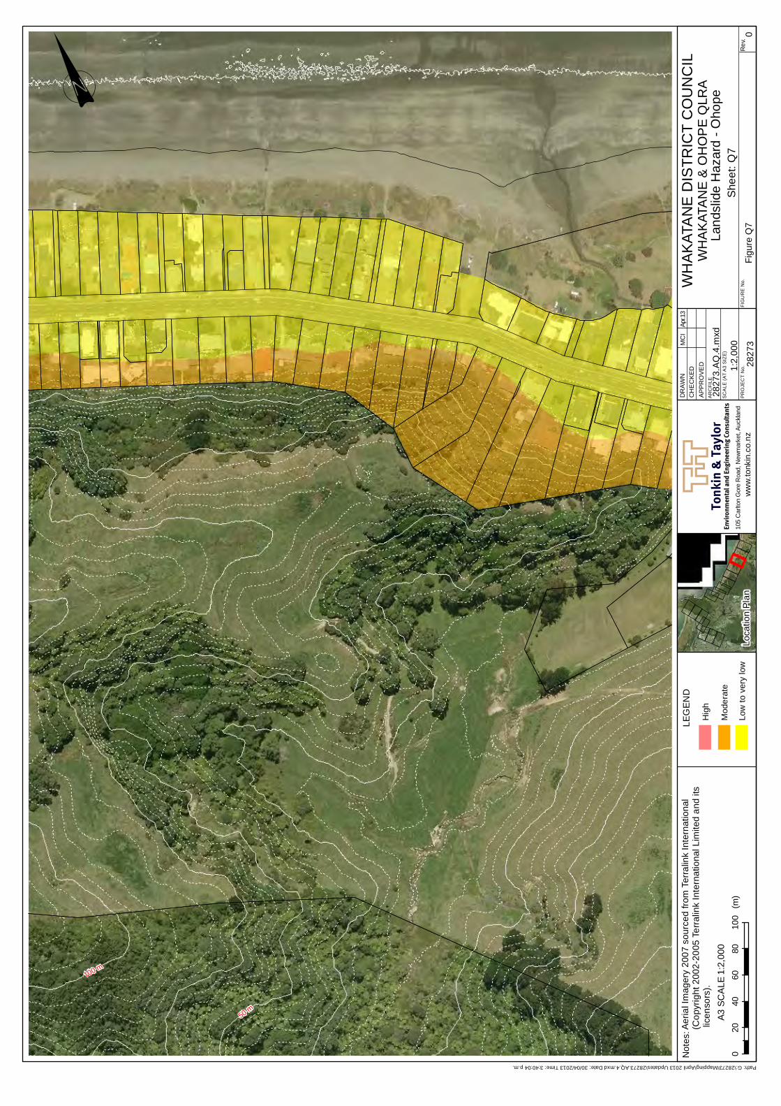
Tonk
in &
Tay
lor
Not
es:
Envi
ronm
enta
l and
Eng
inee
ring
Con
sulta
nts
ww
w.to
nkin
.co.
nz
SC
ALE
(AT
A3
SIZ
E)
PR
OJE
CT
No.
AR
CFI
LE
DR
AWN
CH
EC
KED
APPR
OVE
D
FIG
UR
E N
o.R
ev.
50 m
100 m
! 00
2040
6080
100
(m)
A3 S
CA
LE
Figu
re Q
7
WH
AK
ATA
NE
DIS
TRIC
T C
OU
NC
ILW
HA
KAT
AN
E &
OH
OP
E Q
LRA
Land
slid
e H
azar
d - O
hope
She
et: Q
7Lo
catio
n Pl
an1:
2,00
0
2827
310
5 C
arlto
n G
ore
Roa
d, N
ewm
arke
t, Au
ckla
nd
1:2,
000
2827
3.AQ
.4.m
xd
MC
IAp
r.13
Path: G:\28273\Mapping\April 2013 Updates\28273.AQ.4.mxd Date: 30/04/2013 Time: 3:40:04 p.m.
Aeria
l Im
ager
y 20
07 s
ourc
ed fr
om T
erra
link
Inte
rnat
iona
l (C
opyr
ight
200
2-20
05 T
erra
link
Inte
rnat
iona
l Lim
ited
and
its li
cens
ors)
.
LEG
END
Hig
h
Mod
erat
e
Low
to v
ery
low
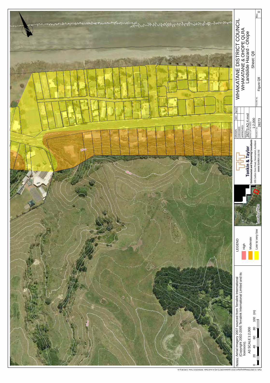
Tonk
in &
Tay
lor
Not
es:
Envi
ronm
enta
l and
Eng
inee
ring
Con
sulta
nts
ww
w.to
nkin
.co.
nz
SC
ALE
(AT
A3
SIZ
E)
PR
OJE
CT
No.
AR
CFI
LE
DR
AWN
CH
EC
KED
APPR
OVE
D
FIG
UR
E N
o.R
ev.
25 m
50 m
75 m
! 00
2040
6080
100
(m)
A3 S
CA
LE
Figu
re Q
8
WH
AK
ATA
NE
DIS
TRIC
T C
OU
NC
ILW
HA
KAT
AN
E &
OH
OP
E Q
LRA
Land
slid
e H
azar
d - O
hope
She
et: Q
8Lo
catio
n Pl
an1:
2,00
0
2827
310
5 C
arlto
n G
ore
Roa
d, N
ewm
arke
t, Au
ckla
nd
1:2,
000
2827
3.AQ
.4.m
xd
MC
IAp
r.13
Path: G:\28273\Mapping\April 2013 Updates\28273.AQ.4.mxd Date: 30/04/2013 Time: 3:40:08 p.m.
Aeria
l Im
ager
y 20
07 s
ourc
ed fr
om T
erra
link
Inte
rnat
iona
l (C
opyr
ight
200
2-20
05 T
erra
link
Inte
rnat
iona
l Lim
ited
and
its li
cens
ors)
.
LEG
END
Hig
h
Mod
erat
e
Low
to v
ery
low
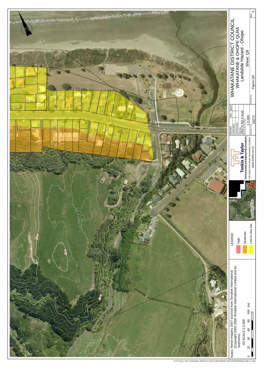
Tonk
in &
Tay
lor
Not
es:
Envi
ronm
enta
l and
Eng
inee
ring
Con
sulta
nts
ww
w.to
nkin
.co.
nz
SC
ALE
(AT
A3
SIZ
E)
PR
OJE
CT
No.
AR
CFI
LE
DR
AWN
CH
EC
KED
APPR
OVE
D
FIG
UR
E N
o.R
ev.
25 m
50 m
50 m
! 00
2040
6080
100
(m)
A3 S
CA
LE
Figu
re Q
9
WH
AK
ATA
NE
DIS
TRIC
T C
OU
NC
ILW
HA
KAT
AN
E &
OH
OP
E Q
LRA
Land
slid
e H
azar
d - O
hope
She
et: Q
9Lo
catio
n Pl
an1:
2,00
0
2827
310
5 C
arlto
n G
ore
Roa
d, N
ewm
arke
t, Au
ckla
nd
1:2,
000
2827
3.AQ
.4.m
xd
MC
IAp
r.13
Path: G:\28273\Mapping\April 2013 Updates\28273.AQ.4.mxd Date: 30/04/2013 Time: 3:40:11 p.m.
Aeria
l Im
ager
y 20
07 s
ourc
ed fr
om T
erra
link
Inte
rnat
iona
l (C
opyr
ight
200
2-20
05 T
erra
link
Inte
rnat
iona
l Lim
ited
and
its li
cens
ors)
.
LEG
END
Hig
h
Mod
erat
e
Low
to v
ery
low

Appendix 3 – Matata Hazard Maps
Landslide and Debris Flow Hazard Management | Issues and Options i
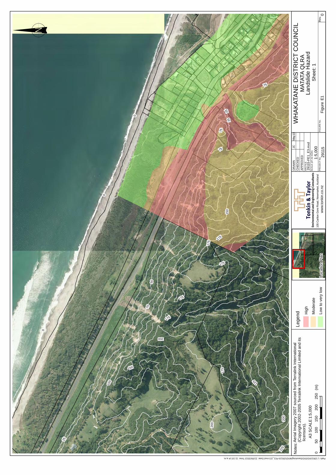
Tonk
in &
Tay
lor
Not
es:
Envi
ronm
enta
l and
Eng
inee
ring
Con
sult
ants
ww
w.to
nkin
.co.
nz
SC
ALE
(AT
A3
SIZ
E)
PR
OJE
CT
No.
AR
CFI
LE
DR
AWN
CH
ECKE
DAP
PR
OV
ED
FIG
UR
E N
o.R
ev.
0
25
5075
100 125
150
175
200
225
2525
0
75
200
175
175
150
75
200
75
175
175
0
175
! 00
5010
015
020
025
0(m
)A3
SC
ALE
Figu
re E
1
WH
AK
ATA
NE
DIS
TRIC
T C
OU
NC
ILM
ATAT
A Q
LRA
Land
slid
e H
azar
dS
heet
: 1Lo
catio
n P
lan
1:5,
000
2911
510
5 C
arlto
n G
ore
Roa
d, N
ewm
arke
t, Au
ckla
nd
1:5,
000
2911
5-FE
1_E
3.m
xd
JCM
ay.1
3
Path: L:\29115\GIS\GISworking\MXD\29115-FE1_E3.mxd Date: 21/05/2013 Time: 11:10:14 a.m.
Aeria
l Im
ager
y 20
07 s
ourc
ed fr
om T
erra
link
Inte
rnat
iona
l (C
opyr
ight
200
2-20
05 T
erra
link
Inte
rnat
iona
l Lim
ited
and
its li
cens
ors)
.Le
gend H
igh
Mod
erat
e
Low
to v
ery
low
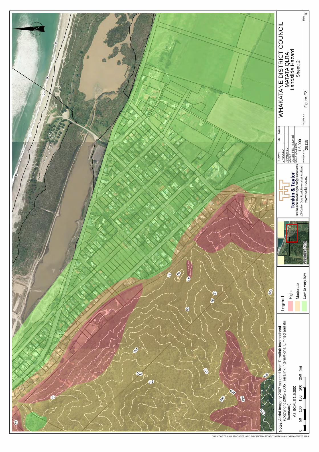
Tonk
in &
Tay
lor
Not
es:
Envi
ronm
enta
l and
Eng
inee
ring
Con
sult
ants
ww
w.to
nkin
.co.
nz
SC
ALE
(AT
A3
SIZ
E)
PR
OJE
CT
No.
AR
CFI
LE
DR
AWN
CH
ECKE
DAP
PR
OV
ED
FIG
UR
E N
o.R
ev.
25
50
75
0
100
125
150
175
200
75
200
200
200
0
00
12575
200
25
0
25
50
! 00
5010
015
020
025
0(m
)A3
SC
ALE
Figu
re E
2
WH
AK
ATA
NE
DIS
TRIC
T C
OU
NC
ILM
ATAT
A Q
LRA
Land
slid
e H
azar
dS
heet
: 2Lo
catio
n P
lan
1:5,
000
2911
510
5 C
arlto
n G
ore
Roa
d, N
ewm
arke
t, Au
ckla
nd
1:5,
000
2911
5-FE
1_E
3.m
xd
JCM
ay.1
3
Path: L:\29115\GIS\GISworking\MXD\29115-FE1_E3.mxd Date: 21/05/2013 Time: 11:10:23 a.m.
Aeria
l Im
ager
y 20
07 s
ourc
ed fr
om T
erra
link
Inte
rnat
iona
l (C
opyr
ight
200
2-20
05 T
erra
link
Inte
rnat
iona
l Lim
ited
and
its li
cens
ors)
.Le
gend H
igh
Mod
erat
e
Low
to v
ery
low
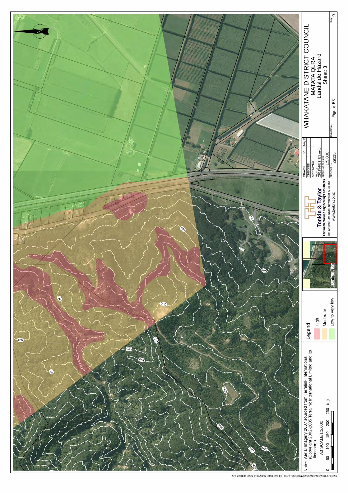
Tonk
in &
Tay
lor
Not
es:
Envi
ronm
enta
l and
Eng
inee
ring
Con
sult
ants
ww
w.to
nkin
.co.
nz
SC
ALE
(AT
A3
SIZ
E)
PR
OJE
CT
No.
AR
CFI
LE
DR
AWN
CH
ECKE
DAP
PR
OV
ED
FIG
UR
E N
o.R
ev.
25
75
50
100
175
125
150
200
225
250
125
250
225
200
75! 0
050
100
150
200
250
(m)
A3 S
CA
LE
Figu
re E
3
WH
AK
ATA
NE
DIS
TRIC
T C
OU
NC
ILM
ATAT
A Q
LRA
Land
slid
e H
azar
dS
heet
: 3Lo
catio
n P
lan
1:5,
000
2911
510
5 C
arlto
n G
ore
Roa
d, N
ewm
arke
t, Au
ckla
nd
1:5,
000
2911
5-FE
1_E
3.m
xd
JCM
ay.1
3
Path: L:\29115\GIS\GISworking\MXD\29115-FE1_E3.mxd Date: 21/05/2013 Time: 11:10:32 a.m.
Aeria
l Im
ager
y 20
07 s
ourc
ed fr
om T
erra
link
Inte
rnat
iona
l (C
opyr
ight
200
2-20
05 T
erra
link
Inte
rnat
iona
l Lim
ited
and
its li
cens
ors)
.Le
gend H
igh
Mod
erat
e
Low
to v
ery
low
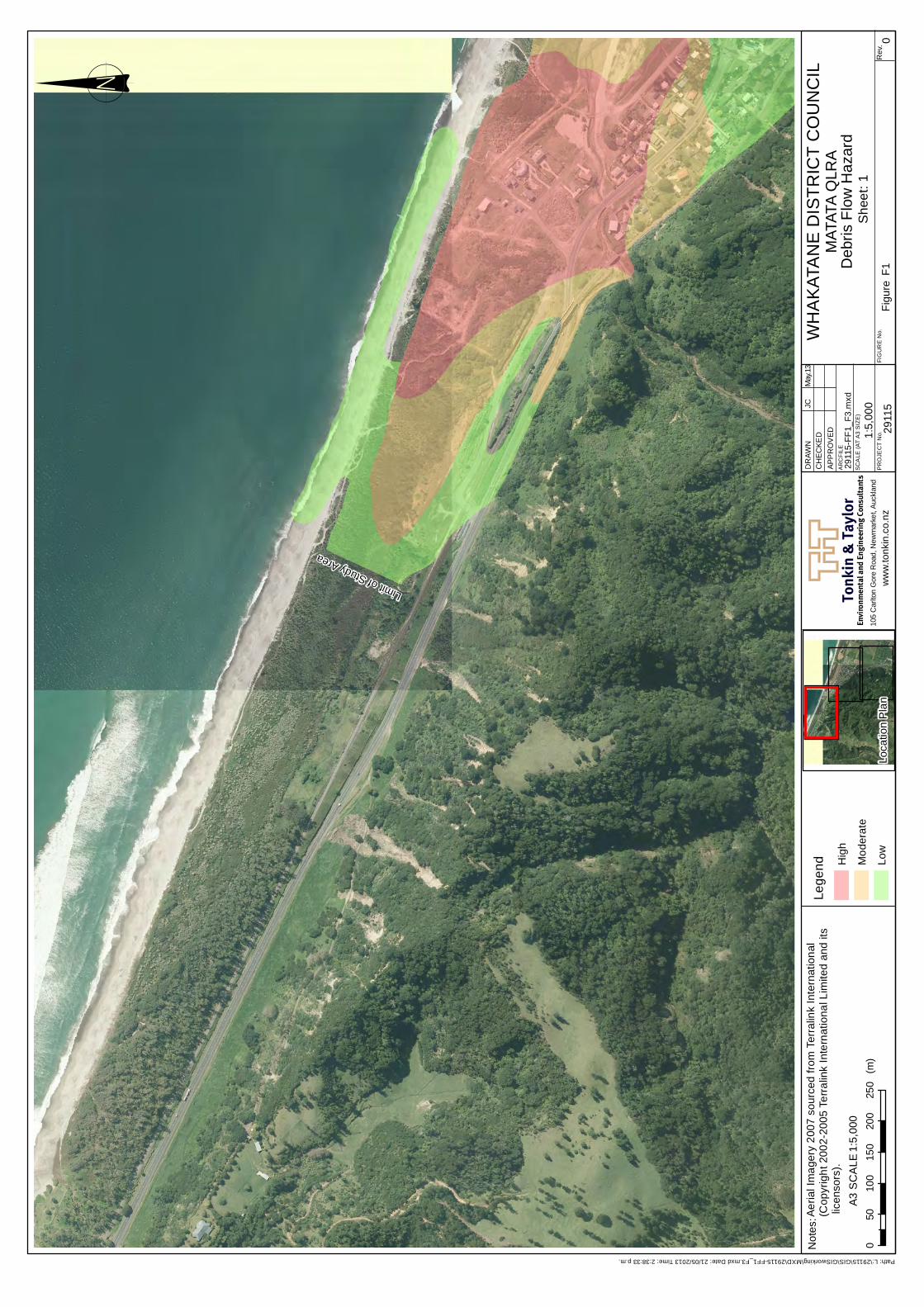
Tonk
in &
Tay
lor
Not
es:
Envi
ronm
enta
l and
Eng
inee
ring
Con
sult
ants
ww
w.to
nkin
.co.
nz
SC
ALE
(AT
A3
SIZ
E)
PR
OJE
CT
No.
AR
CFI
LE
DR
AWN
CH
ECKE
DAP
PR
OV
ED
FIG
UR
E N
o.R
ev.
Limit of Study Area
! 00
5010
015
020
025
0(m
)A3
SC
ALE
Figu
re F
1
WH
AK
ATA
NE
DIS
TRIC
T C
OU
NC
ILM
ATAT
A Q
LRA
Deb
ris F
low
Haz
ard
She
et: 1
Loca
tion
Pla
n1:
5,00
0
2911
510
5 C
arlto
n G
ore
Roa
d, N
ewm
arke
t, Au
ckla
nd
1:5,
000
2911
5-FF
1_F3
.mxd
JCM
ay.1
3
Path: L:\29115\GIS\GISworking\MXD\29115-FF1_F3.mxd Date: 21/05/2013 Time: 2:38:33 p.m.
Aeria
l Im
ager
y 20
07 s
ourc
ed fr
om T
erra
link
Inte
rnat
iona
l (C
opyr
ight
200
2-20
05 T
erra
link
Inte
rnat
iona
l Lim
ited
and
its li
cens
ors)
.Le
gend H
igh
Mod
erat
e
Low
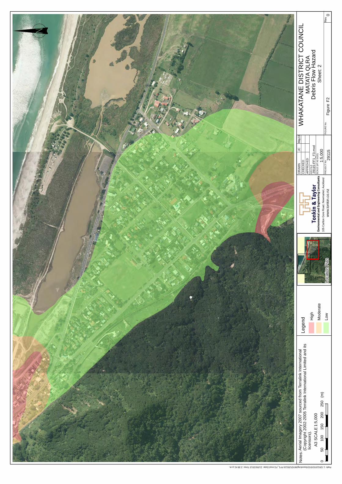
Tonk
in &
Tay
lor
Not
es:
Envi
ronm
enta
l and
Eng
inee
ring
Con
sult
ants
ww
w.to
nkin
.co.
nz
SC
ALE
(AT
A3
SIZ
E)
PR
OJE
CT
No.
AR
CFI
LE
DR
AWN
CH
ECKE
DAP
PR
OV
ED
FIG
UR
E N
o.R
ev.! 0
050
100
150
200
250
(m)
A3 S
CA
LE
Figu
re F
2
WH
AK
ATA
NE
DIS
TRIC
T C
OU
NC
ILM
ATAT
A Q
LRA
Deb
ris F
low
Haz
ard
She
et: 2
Loca
tion
Pla
n1:
5,00
0
2911
510
5 C
arlto
n G
ore
Roa
d, N
ewm
arke
t, Au
ckla
nd
1:5,
000
2911
5-FF
1_F3
.mxd
JCM
ay.1
3
Path: L:\29115\GIS\GISworking\MXD\29115-FF1_F3.mxd Date: 21/05/2013 Time: 2:38:41 p.m.
Aeria
l Im
ager
y 20
07 s
ourc
ed fr
om T
erra
link
Inte
rnat
iona
l (C
opyr
ight
200
2-20
05 T
erra
link
Inte
rnat
iona
l Lim
ited
and
its li
cens
ors)
.Le
gend H
igh
Mod
erat
e
Low
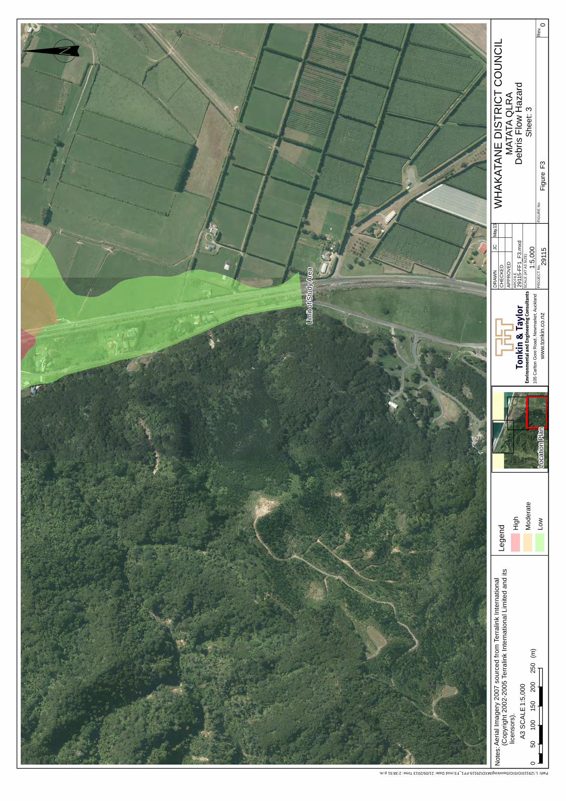
Tonk
in &
Tay
lor
Not
es:
Envi
ronm
enta
l and
Eng
inee
ring
Con
sult
ants
ww
w.to
nkin
.co.
nz
SC
ALE
(AT
A3
SIZ
E)
PR
OJE
CT
No.
AR
CFI
LE
DR
AWN
CH
ECKE
DAP
PR
OV
ED
FIG
UR
E N
o.R
ev.
Lim
it of
Stu
dy A
rea
! 00
5010
015
020
025
0(m
)A3
SC
ALE
Figu
re F
3
WH
AK
ATA
NE
DIS
TRIC
T C
OU
NC
ILM
ATAT
A Q
LRA
Deb
ris F
low
Haz
ard
She
et: 3
Loca
tion
Pla
n1:
5,00
0
2911
510
5 C
arlto
n G
ore
Roa
d, N
ewm
arke
t, Au
ckla
nd
1:5,
000
2911
5-FF
1_F3
.mxd
JCM
ay.1
3
Path: L:\29115\GIS\GISworking\MXD\29115-FF1_F3.mxd Date: 21/05/2013 Time: 2:38:51 p.m.
Aeria
l Im
ager
y 20
07 s
ourc
ed fr
om T
erra
link
Inte
rnat
iona
l (C
opyr
ight
200
2-20
05 T
erra
link
Inte
rnat
iona
l Lim
ited
and
its li
cens
ors)
.Le
gend H
igh
Mod
erat
e
Low