guidelines legislated landslide 1
TRANSCRIPT
Guidelinesfor
LegislatedLandslideAssessments
forProposedResidential Developmentsin BC
Revised May 2010Association of Professional Engineersand Geoscientists of British Columbia
© APEGBC
TABLE OF CONTENTS 1. INTRODUCTION 3
Introduction to the 2006 Guidelines 3 Introduction to the 2008 Revisions 3 Introduction to the 2010 Revisions 4 1.1 Purpose of the Guidelines 5 1.2 Role of APEGBC 6 1.3 Introduction of Terms 6 1.4 Scope of the Guidelines 7 1.5 Applicability of the Guidelines 8 1.6 Acknowledgments 8
2. PROJECT ORGANIZATION AND RESPONSIBILITIES 10 2.1 Common Forms of Project Organization 10 2.2 Responsibilities 10
2.2.1 The Client 10 2.2.2 The Qualified Professional 12 2.2.3 The Approving Authority 14 2.2.4 Reviews of Landslide Assessment Reports 14
3. GUIDELINES FOR PROFESSIONAL PRACTICE 16 3.1 Initiation 16
3.1.1 Phases of a Landslide Assessment 16 3.1.2 Objectives 17 3.1.3 Type of Landslide Assessment 17 3.1.4 Level of Effort 17 3.1.5 Study Area 18
3.2 Background Information 18 3.3 Field Work 19 3.4 Landslide Hazard and Landslide Risk Analyses 20
3.4.1 Methods of Landslide Analysis 20 3.4.2 Quantitative vs Qualitative 21 3.4.3. Consideration of Changed Conditions 21
3.5 Landslide Assessment 21 3.6 Measures to Reduce Landslide Hazards and/or Landslide Risks 23 3.7 Report 23 3.8 Limitations and Qualifications of a Landslide Assessment 24 3.9 Specialty Services 25
4. SEISMIC SLOPE ANALYSIS 27 4.1 Seismic Slope Analysis Flowchart 27
4.1.1 Landslide Hazard or Landslide Risk 27 4.1.2 Liquefaction or Strain Softening 27 4.1.3 Factor of Safety and/or Slope Displacements 27 4.1.4 Complex Slope Displacement Analysis 28
4.2 Review of Earthquake-Induced Landslides 29
5. QUALITY ASSURANCE/QUALITY CONTROL 30 5.1 APEGBC Quality Management Bylaws 30 5.2 Direct Supervision 30 5.3 Internal and External Peer Review 30
6. PROFESSIONAL REGISTRATION; EDUCATION, TRAINING AND EXPERIENCE 32 6.1 Professional Registration 32 6.2 Education, Training and Experience 33
7. REFERENCES AND RELATED DOCUMENTS 35
APPENDIX A: GLOSSARY OF SELECTED TERMS 42
APPENDIX B: LEGISLATIVE FRAMEWORK 47 B.1 Land Title Act (Section 86) – Subdivision Approvals 47 B.2 Local Government Act (Sections 919.1 and 920) – Development Permits 47 B.3 Community Charter (Section 56) – Building Permits 48 B.4 Local Government Act (Section 910) – Flood Plain Bylaw
Variances or Exemptions 48 B.5 British Columbia Building Code Amendments Related to Seismic Slope Stability and
Technical Guidance 49
APPENDIX C: REVIEW OF LEVELS OF LANDSLIDE SAFETY 51 C.1 British Columbia 51 C.2 Canada 53
APPENDIX D: LANDSLIDE ASSESSMENT ASSURANCE STATEMENT 55
APPENDIX E: METHODS OF SEISMIC ANALYSIS OF SOIL SLOPES 58 E.1 Introduction 58 E.2 Review of Current Practice 58 E.3 Slope Performance During Earthquake Shaking 59 E.4 Slope Displacement (Method 1) 61 E.5 Pseudo-static Analysis using a Slope Displacement-Based Seismic
Coefficient (Method 2) 63 E.6 Limitations 65 E.7 Concluding Remarks 65 E.8 References 66
APPENDIX F: REVIEW OF EARTHQUAKE-INDUCED LANDSLIDES 67 F.1 Introduction 67 F.2 Extent of Earthquake-Induced Landslides 67 F.3 Some Global Examples 68 F.4 Some United States Examples 69 F.5 Western Canada 70
APPENDIX G: GEOTECHNICAL DESIGN GUIDELINES FOR BUILDINGS ON LIQUEFIABLE SITES 71
APPENDIX H: PRELIMINARY SITE RESPONSE 73
APPENDIX I: AUTHORS AND REVIEWERS 74
Guidelines for Legislated Landslide Assessments APEGBC Revised May 2010 for Proposed Residential Development in British Columbia
3
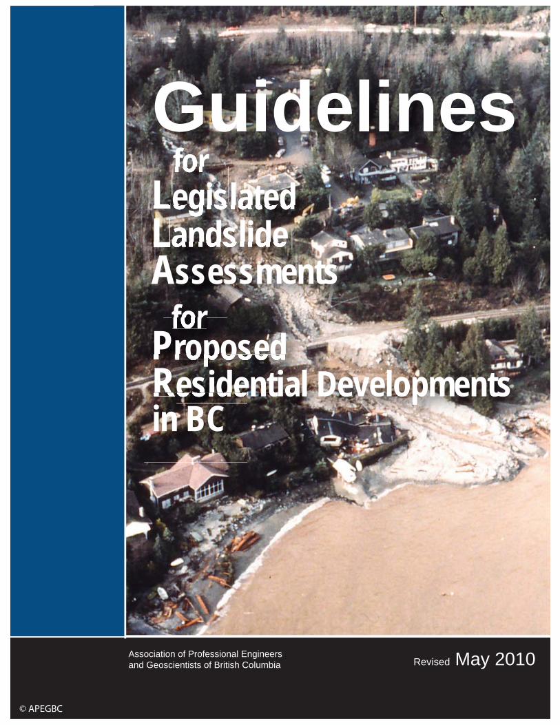
1. INTRODUCTION INTRODUCTION TO THE 2006 GUIDELINES As British Columbia continues to grow in population, pressure for residential development1, in areas that are prone to landslides, or have potentially unstable slopes, will increase. For the past 30 years, various pieces of provincial legislation have required that landslide assessments for proposed residential development in landslide-prone areas be carried out by Professional Engineers. More recently, Professional Geoscientists have been included in some of this legislation. The legislation requires that a Professional Engineer or Professional Geoscientist indicate whether the residential development will be ‘safe’ from the effects of landslides. Professional Engineers and Professional Geoscientists with appropriate education, training and experience have the technical ability to carry out various forms of landslide analysis; however, to date, guidelines for such analyses for residential development have not been documented. In addition, defined levels of safety from the effects of landslides2 have not been adopted for most of BC. It is not the role of a Professional Engineer or Professional Geoscientist to define such levels of safety; they must be established and adopted by the local government or the provincial government after considering a range of societal values. The lack of a landslide hazard policy was first brought to the provincial government’s attention by the Association of Professional Engineers and Geoscientists of British Columbia (APEGBC) in 1977, in a brief outlining a “Proposed Hazard Policy for British Columbia” (APEGBC 1977; initiated by Farquharson et al 1976, see also Williams 1983).
INTRODUCTION TO THE 2008 REVISIONS The impetus for the 2008 revisions of these guidelines was the publication of the 2006 BC Building Code (BCBC 2006) in December 2006, subsequent to the adoption of the original Guidelines by Council of APEGBC in March 2006. The BCBC 2006 adopted the ground motions for seismic design from the 2005 National Building Code for Canada (NBCC 2005). These ground motions have a probability of exceedance of 2% in 50 years (annual probability of 1/2475), whereas the previous ground motions for seismic design (NBCC 1995, BCBC 1998) had a probability of exceedance of 10% in 50 years (annual probability of 1/475)3. Many seismic design methods, including the analysis of the stability of slopes during and shortly after an earthquake (seismic slope analysis4), are based on ground motions. In some areas of British Columbia, the above change in design ground motions resulted in an approximate doubling of the peak ground acceleration (PGA) used in seismic slope analysis.
1 Terms in italics are explained in Appendix A 2 For the purpose of these guidelines, the level of safety from the effects of landslides is referred to as level of landslide safety and includes levels of acceptable landslide hazard and landslide risk. 3 For convenience, these are referred to as “2% in 50-year ground motions” and “10% in 50-year ground motions”, respectively. 4 Seismic slope analysis includes both seismic slope stability analysis and seismic slope displacement analysis.
Guidelines for Legislated Landslide Assessments APEGBC Revised May 2010 for Proposed Residential Development in British Columbia
4
Using current practice, the effect of this change was to increase the number of slopes that could be considered unstable during an earthquake, and therefore potentially not suitable for residential development. This caused concern to Land Owners, Development Consultants, local governments, and the provincial government (Kuan 2007). As a temporary measure, the provincial government, by special regulation “Local Government Act, Section 692(d), Geotechnical Slope Stability (Seismic) Regulation BC Reg. 358/2006 (December 2006)”, permitted the use of the NBCC 1995 and BCBC 1998 ground motions (10% in 50-year ground motions) for seismic slope analysis. As a result, APEGBC, with support from the provincial government, established a Task Force on Seismic Slope Stability (TFSSS) to study this issue and to make appropriate recommendations. The TFSSS reviewed current practice and recent developments in seismic slope analysis. As a result these guidelines were revised in 2008 to introduce two new methods of seismic slope analysis of soil slopes based on the concept of tolerable earthquake-induced slope displacements along a slip surface. The 2008 revisions included the addition of a new Chapter 4 and four Appendices (Appendix E, Appendix F, Appendix G and Appendix H). Other minor revisions were also made at the time.
INTRODUCTION TO THE 2010 REVISIONS The approach, as presented in the 2008 Guidelines, to landslide assessments for proposed residential development where seismic considerations are of concern (Chapter 4 and Appendices E, F, G and H), was communicated to the engineering/geoscience community and to local governments in 2008 and 2009. Feedback indicated that the use and application of the two new methods of seismic slope analysis of soil slopes (Appendix E):
• provided a practical means of combining slope displacement and set back considerations to determine if a soil slope would adversely affect a proposed residential development
• was user friendly for practitioners who had a range of backgrounds, education and training
• provided practical “life safe” solutions for proposed residential development even when using ground motions with a probability of exceedance of 2% in 50 years (annual probability of 1/2475), and
• was found to be appropriate by local governments (for example, District of North Vancouver, Master Requirements SPE 104 & 105) (refer to http://www.dnv.org/article.asp?a=1956&c=331, as of April 2010),
Because the Geotechnical Slope Stability (Seismic) Regulation, BC Reg 358/2006, was intended only as a temporary measure, on December 15, 2010, Ministerial Orders M296 and M297 were issued, and effective February 1, 2010:
• the Geotechnical Slope Stability (Seismic) Regulation, BC Reg 358/2006 was
repealed and the Companion Commentary, issued by the BC Building and Safety Policy Branch in January 2007, was withdrawn, and
Guidelines for Legislated Landslide Assessments APEGBC Revised May 2010 for Proposed Residential Development in British Columbia
5
• BCBC 2006 was amended with the additions of sentences 4.1.8.16 (8) and 9.4.4.4(2)5.
On January 18, 2010, the BC Building and Safety Policy Branch issued “British Columbia Building Code Amendments Related to Seismic Slope Stability and Technical Guidance”. This bulletin summarized two changes that resulted from the issuance of Ministerial Order M297:
• the consideration of potential for slope instability and its consequences at a building site is now an explicit requirement in designs of structures and their foundations, and
• the seismic hazard probability level to be used in seismic slope analysis is ground motions with a probability of exceedance of 2% in 50 years (annual probability of 1/2475), as referenced in Subsection 1.1.3 of Division B of BCBC 2006.
As a result of the second bullet, the seismic hazard probability levels for structural design and for seismic slope analysis are now the same: ground motions with a probability of exceedance of 2% in 50 years (annual probability of 1/2475). The 2010 revisions to these APEGBC Guidelines are have been made to ensure that the provisions contained in Ministerial Orders M296 and M297, referenced above, are identified and appropriately considered (Appendix B). The 2010 revisions also update and clarify the levels of landslide safety as recently adopted by the BC Ministry of Transportation (MOT) and by the District of North Vancouver (Appendix C).
1.1 PURPOSE OF THE GUIDELINES This document (1) provides guidelines of professional practice for a Professional Engineer and Professional Geoscientist who carries out a landslide analysis for a proposed residential development, and (2) provides guidance to the professional as to how to relate the results of the analysis to a level of landslide safety for residential development when required by provincial legislation. Appendix D to these guidelines provides a Landslide Assessment Assurance Statement that must be submitted, along with a landslide assessment report, to an Approving Authority. Land Owners and Development Consultants; Land Use Planners, Approving Officers and Building Inspectors; Municipalities, Regional Districts, and the Islands Trust6; the provincial government; and the general public frequently rely on such landslide assessments. These guidelines may also assist those parties. These guidelines address typical project organization and responsibilities of the various stakeholders; professional practices that should typically be provided; quality assurance/quality control; and professional registration and education, training and experience.
5 refer to Appendix B, section B.5 for the wordings of sentences 4.1.8.16 (8) and 9.4.4.4(2) 6 Municipalities, Regional Districts and the Islands Trust are collectively referred to as local governments.
Guidelines for Legislated Landslide Assessments APEGBC Revised May 2010 for Proposed Residential Development in British Columbia
6
1.2 ROLE OF APEGBC These guidelines have been formally adopted by the Council of APEGBC, and form part of APEGBC’s ongoing commitment to maintaining the quality of services that its Members provide to their Clients and the general public. Professional Engineers and Professional Geoscientists are professionally accountable for their work under the Engineers and Geoscientists Act (RSBC 1996, Chapter 116, as amended), which is enforced by APEGBC. A Member must exercise professional judgment when providing professional services; as such, application of these guidelines will vary depending on the circumstances. APEGBC supports the principle that a Member should receive fair and adequate compensation for professional services, including services provided to comply with these guidelines. An insufficient fee does not justify services that do not meet the intent of these guidelines. These guidelines may be used to assist in establishing the objectives, type of landslide analysis, level of effort and terms of reference of a Member’s agreement with his/her Client. By following these guidelines a Member should fulfill his/her professional obligations, especially with regards to APEGBC Code of Ethics Principle 1 (hold paramount the safety, health and welfare of the public, protection of the environment and promote health and safety in the workplace7). Failure of a Member to meet the intent of these guidelines could be evidence of unprofessional conduct and lead to disciplinary proceedings by APEGBC.
1.3 INTRODUCTION OF TERMS Appendix A explains all terms shown in italics in these guidelines. The following introduces some of the terms. For the purpose of these guidelines, a Qualified Professional is a Professional Engineer or Professional Geoscientist with appropriate education, training and experience to conduct landslide assessments for residential development as described in these guidelines (refer to Section 6). Typically, such a Professional Engineer will be practising geological engineering, mining engineering or civil engineering8; and such a Professional Geoscientist will be practising geology or environmental geoscience9. A landslide is a movement of rock, debris or earth down a slope. Landslides can be a result of a natural sequence of events and/or human activities. Landslides include: rock falls, rock slumps, rock slides, rock avalanches, rock creep; debris falls, debris slides, debris flows, debris floods; earth falls, earth slumps, earth slides, earth flows, earth creep; and flow slides. Debris flows and debris floods have some characteristics of both landslides and floods. A landslide assessment is a combination of (1) landslide analysis (recognition, characterization and estimation of hazard, and may include estimation of potential
7 APEGBC’s Code of Ethics is at http://www.apeg.bc.ca/library/actbylawscode.html. The Code of Ethics, along with accompanying Guidelines and Commentary, are published in the current (1994) edition of APEGBC’s “Guidelines for Professional Excellence”. 8 Geological engineering, mining engineering and civil engineering are disciplines of engineering registration within APEGBC. 9 Geology and environmental geoscience are disciplines of geoscience registration within APEGBC. Until 2000, APEGBC referred to the discipline of environmental geoscience as ‘geotechnics’.
Guidelines for Legislated Landslide Assessments APEGBC Revised May 2010 for Proposed Residential Development in British Columbia
7
consequences), and (2) a comparison of the results of the analysis with a level of landslide safety (Canadian Standards Association – CSA 1997). Based upon the comparison, and where required by legislation, a Qualified Professional must state whether the level of landslide safety is acceptable or unacceptable relative to an adopted level of landslide safety. If required, the Qualified Professional can make recommendations to reduce hazards and/or consequences. For the purpose of these guidelines, a landslide assessment is either a landslide hazard assessment or landslide risk assessment. As defined by various pieces of provincial legislation, residential development includes:
• subdivision of property • construction, including construction of new buildings or structures, and • structural alteration of, or addition to, existing buildings or structures.
Residential development also includes site development including, but not limited to, removing vegetation, providing access, site grading, filling, construction of infrastructure, installation of utilities and modification of natural drainage. Subdivision of property can result from a number of different activities, including:
• creating several lots, or strata lots, from one or more existing properties • consolidating two or more properties into one lot, and • adjusting or realigning an existing property line.
Types of subdivisions include: conventional, strata, cooperative corporation/shared interest, aboriginal reserves and leases. Therefore, residential development can range from the alteration of, or addition to, a single residence to the subdivision of property containing a large number of residential lots. A landslide assessment is only one aspect of the overall residential development process.
1.4 SCOPE OF THE GUIDELINES These guidelines apply to legislated landslide assessments for proposed residential development (refer to Appendix B for a summary of the legislative framework). These guidelines do not address other potential natural hazards such as flooding, soil erosion, subsidence or snow avalanches, except as related to landslides. If a Qualified Professional identifies other potential hazards during a landslide assessment, he/she should notify the Client and the Land Owner (in situations where the Client is not the Land Owner). It is recognized that landslide assessments are also carried out for other types of proposed non-residential development including institutional, commercial, industrial and infrastructure; sometimes as part of emergency response; and for existing residential areas for a wide variety of reasons. There is, however, no provincial legislation that pertains to landslide assessments for those other purposes, and therefore these guidelines do not address them. Some of the information contained herein may, however, be relevant to such non-legislated landslide assessments.
Guidelines for Legislated Landslide Assessments APEGBC Revised May 2010 for Proposed Residential Development in British Columbia
8
Other pieces of residential development-related provincial legislation exist in which a Qualified Professional, as defined in these guidelines, may be involved, but for whom there is no explicit professional mandate. For example:
• a local government developing an Official Community Plan, designating a Development Permit Area, or preparing a bylaw, including flood plain10 and zoning bylaws (Local Government Act (RSBC 1996, Chapter 323),
• a local government issuing a tree cutting permit (Local Government Act (RSBC 1996, Chapter 323), and
• Integrated Land Management Bureau of BC Ministry of Agriculture and Lands (formerly Land and Water BC Inc) disposing of Crown Land (Land Act, RSBC 1996, Chapter 245).
In such instances, there is no legislated requirement for the involvement of a Qualified Professional except where such work is mandated to APEGBC Members by the Engineers and Geoscientists Act. These guidelines do not address such non-legislated involvement of Qualified Professionals; however, some of the information contained herein may be relevant.
1.5 APPLICABILITY OF THE GUIDELINES Notwithstanding the purpose and scope of these guidelines, a Qualified Professional’s decision not to follow one or more aspects of these guidelines does not necessarily mean that he/she fails to meet his/her professional obligations. Such judgments and decisions depend upon weighing facts and circumstances to determine whether another reasonable and prudent Qualified Professional, in a similar situation, would have conducted himself/herself similarly. Although the Client is often a Land Owner or Development Consultant, landslide assessments for residential development are usually carried out at the request of the local government or the provincial government. Following these guidelines, however, does not ensure that the conclusions and recommendations contained within the landslide assessment report will be accepted by Approving Authority11. These guidelines are influenced by current provincial legislation, provincial case law, advances in knowledge, and evolution of general professional practices in BC. As such, they may require updating from time to time. Landslide assessments for residential development may have to address other geotechnical engineering-related issues and/or forestry issues. For these issues, refer to “Guidelines for Geotechnical Engineering Services for Building Projects” (APEGBC 1998) and “Guidelines for Terrain Stability Assessments in the Forest Sector” (APEGBC 2003).
1.6 ACKNOWLEDGMENTS The 2006 Guidelines were prepared on behalf of APEGBC by a Committee of Qualified Professionals and were reviewed by several diverse parties and stakeholders as members of an APEGBC Internal Review Task Force and an External Review Group. The authors and reviewers are listed in Appendix I. The authors thank the reviewers for
10 Flood plains as related to landslides. 11 An Approving Officer, Building Inspector, and Planners and Councils of a local government are collectively referred to as an Approving Authority.

Guidelines for Legislated Landslide Assessments APEGBC Revised May 2010 for Proposed Residential Development in British Columbia
9
their constructive suggestions. A review of this document does not necessarily indicate the reviewer and/or his employer endorses everything in the document. Any errors are the responsibility of the authors. APEGBC thanks the BC Ministry of Public Safety and Solicitor General, Provincial Emergency Program Natural Hazards Mitigation Fund, which funded the preparation of the 2006 Guidelines; and the BC Ministry of Forests and Range, which facilitated the the 2006 Guidelines. The 2008 revisions were carried out by the TFSSS and reviewed by a number of APEGBC Members. Members of the TFSSS and the reviewers are listed in Appendix I. The members of the TFSSS thank the reviewers for their constructive suggestions. A review of this document does not necessarily indicate the reviewer and/or his employer endorses everything in the document. Any errors are the responsibility of the TFSSS. APEGBC also thanks the Ministry of Forests and Range, Minister Responsible for Housing for funding the work of the TFSSS.
Guidelines for Legislated Landslide Assessments APEGBC Revised May 2010 for Proposed Residential Development in British Columbia
10
2. PROJECT ORGANIZATION AND RESPONSIBILITIES 2.1 COMMON FORMS OF PROJECT ORGANIZATION
Landslide assessments for subdivision approvals, development permits, building permits, and flood plain bylaw variances or exemptions are typically initiated by the local government or the provincial government requesting the Land Owner or Development Consultant to retain a Qualified Professional to carry out a landslide assessment and prepare a report. The Land Owner or Development Consultant then forwards that report to the requesting government body, usually an Approving Authority for review and either acceptance or rejection of the conclusions and recommendations contained in the report. On occasion, the local government or the provincial government will directly retain a Qualified Professional. Therefore, typically the Land Owner or Development Consultant is the Client, and the Qualified Professional establishes an agreement for professional services with that party. The Qualified Professional should be aware, however, that his/her report will ultimately be reviewed by an Approving Authority. The Client should be aware that the findings of the Qualified Professional could possibly result in the residential development requiring modification, the Approving Authority requiring covenants or the residential development being turned down. In this regard, it is useful if the landslide assessment is carried out early in the residential development planning process. The Qualified Professional should ensure that his/her role, in relation to the Client and the Approving Authority, is clearly defined. It is possible that a Client may not have been previously involved in residential development, nor previously engaged a Qualified Professional. In such situations the Qualified Professional should consider reviewing with the Client the typical responsibilities listed below, to assist in establishing an appropriate agreement for professional services and to inform the Client of the expectation of appropriate and adequate compensation (APEGBC Code of Ethics Principle 5).
2.2 RESPONSIBILITIES Sections 2.2.1 to 2.2.3 describe some of the typical responsibilities of a Client, Qualified Professional and Approving Authority. Section 2.2.4 describes some of the typical responsibilities of a Qualified Professional when asked by an Approving Authority or Client to review a landslide assessment report prepared by another Qualified Professional.
2.2.1 The Client The Client is typically the Land Owner or the Development Consultant, or occasionally the local government or the provincial government. Prior to a landslide assessment it is helpful and will likely reduce the cost of professional services if the Client is knowledgeable about, and can provide the Qualified Professional with, the following:

Guidelines for Legislated Landslide Assessments APEGBC Revised May 2010 for Proposed Residential Development in British Columbia
11
• process and procedures of subdivision approvals, development permits, building permits, and flood plain bylaw variance or exemption, as applicable12
• legal description of the property, as registered with Land Titles and Survey Authority, and a copy of the current land registration including covenants
• for subdivision, a copy of the existing survey plan of the property, or the need for a survey plan, and the location of the legal property boundary markers on the ground (this may require a British Columbia Land Surveyor (BCLS))
• for subdivision, proposed subdivision plan13 • for construction, plans of existing buildings or structures, and location of the
proposed construction on the ground • for construction, proposed construction drawings • locations of existing, proposed and anticipated elements at risk on and, if
required, beyond the property • in general terms, proposed and anticipated land use changes (for example
logging) on and, if required, beyond the property • information on past or existing landslide problems, or potentially unstable slopes • recognition that the landslide assessment is based on the proposed residential
development and changes to that development may require changes to, or invalidate, the landslide assessment
• relevant background information (written or otherwise) related to the property and the existing and proposed residential development, including previous landslide assessment reports conducted for the Client or available to the Client, and
• the Qualified Professional should have unrestricted access to and, if required, beyond the property.
With assistance from the Qualified Professional, the Client should complete an agreement with the Qualified Professional confirming scope, schedule and compensation for the landslide assessment; need and scope of specialty services; and need for external peer review. It is recommended that such an agreement include a clause that deals with potential disclosure issues due to the Qualified Professional’s obligation under APEGBC Code of Ethics Principle 1 (hold paramount the safety, health and welfare of the public, the protection of the environment, and promote health and safety in the workplace). In certain circumstances the Qualified Professional may have to convey adverse landslide risk assessment findings to parties who may not be directly involved, but who have a compelling need to know. Following is suggested wording for such a clause:
“Subject to the following, the Qualified Professional will keep confidential all information, including documents, correspondence, reports and opinions, unless disclosure is authorized in writing by the Client. However, in keeping with APEGBC’s Code of Ethics, if the Qualified Professional discovers or determines that there is a material risk to the environment or the safety, health and welfare of the public or worker safety, he/she shall notify the Client as soon as practicable of this information and the need that it be disclosed to the appropriate parties. If the Client does not take the necessary steps to notify the appropriate parties in a reasonable amount of time, the Qualified Professional
12 In this regard, a Qualified Professional should consider beginning an assignment only after the Client has applied to, and received a response from, the approving jurisdiction for the proposed residential development. 13 Subdivision and construction planning are iterative processes, and therefore proposed plans may not be produced until the results of the landslide assessment are known.
Guidelines for Legislated Landslide Assessments APEGBC Revised May 2010 for Proposed Residential Development in British Columbia
12
shall have the right to disclose that information in order to fulfil his/her ethical duties and the Client hereby agrees to that disclosure.”
The Client should be aware the Qualified Professional’s cost estimate may have to be amended during the assessment, depending on the Qualified Professional’s findings and analysis. The Client should also be aware that a landslide assessment does not guarantee the results will be favourable for the proposed residential development. The cost estimate and likely results should be discussed with the Client prior to the assignment. During the landslide assessment it is helpful if the Client:
• shows the Qualified Professional the locations of legal property boundary markers on the ground and location of the proposed residential development
• allows the Qualified Professional unrestricted access to the property, and • obtains access, if required, to areas beyond the property.
After the landslide assessment it is helpful if the Client:
• reviews the landslide assessment report, and understands the limitations and qualifications that apply;
• if necessary, discusses the report with the Qualified Professional and seeks clarification;
• if desired, directs the Qualified Professional to complete a Landslide Assessment Assurance Statement, and provides the Statement and the landslide assessment report to the Approving Authority;
• allows the Qualified Professional to confirm that his/her recommendations have been followed so that Letters of Assurance (Schedules A, B-1, B-2, C-A and C-B) under the current edition of the BC Building Code or other applicable codes can be prepared, and
• notifies the Qualified Professional if land use, site development or slope conditions change or vary from those described in the report.
The Landslide Assessment Assurance Statement and the landslide assessment report are the property of the Qualified Professional until outstanding invoices of the Qualified Professional are fully paid by the Client.
2.2.2 The Qualified Professional The Qualified Professional is responsible for carrying out the landslide assessment and, if required, making recommendations to reduce the likelihood of landslides and/or consequences. Prior to carrying out a landslide assessment the Qualified Professional should:
• be knowledgeable about application and approval processes; procedures of subdivision approval, development permit, building permit and flood plain bylaw variance and exemption; and applicable legislation;
• confirm that he/she has appropriate training and experience to carry out a landslide assessment associated with the complexity of associated terrain and geology and, if not, involve required specialists;
Guidelines for Legislated Landslide Assessments APEGBC Revised May 2010 for Proposed Residential Development in British Columbia
13
• if they exist, obtain a copy of the approving jurisdiction’s guidelines for carrying out landslide assessments and/or for preparing landslide assessment reports, and
• if one exists, obtain the adopted level of landslide safety, or other landslide assessment approval criteria, for the proposed residential development in the approving jurisdiction.
The Qualified Professional and Client should complete an agreement confirming scope, schedule and compensation for the landslide assessment; need for and scope of specialty services; and anticipated need for an external peer review. The Qualified Professional should comply with the requirements of APEGBC Bylaw 17 regarding professional liability insurance. During the landslide assessment the Qualified Professional should:
• if necessary, assist the Client in obtaining relevant information such as listed in Section 2.2.1;
• make reasonable attempts to obtain from the Client and others all relevant information related to the slope stability of and, if required, beyond the property;
• prior to field work, review collected information; • conduct field work within the limits of and, if necessary, beyond the property at an
intensity appropriate to the method of landslide assessment and to meet the requirements of existing jurisdictional guidelines;
• conduct the landslide assessment in compliance with applicable jurisdictional codes and regulations;
• consider both landslides and their consequences on the residential development, and the consequences of the residential development on landslides on and, if required, beyond the property;
• notify the Client as soon as reasonably possible if specialty services or changes in scope of work are required, and of associated changes to the original cost estimate;
• write the report clearly, concisely and completely and conform, where applicable, to jurisdictional guidelines for landslide assessment reports;
• have a draft of the report appropriately peer reviewed; • submit to the Client a signed, sealed and dated copy of the report, and • if directed by the Client, complete a Landslide Assessment Assurance
Statement, and provide the Statement and the landslide assessment report to the Approving Authority
After the landslide assessment the Qualified Professional should:
• clarify questions the Client and/or Approving Authority may have with regards to the landslide assessment, report, and/or Landslide Assessment Assurance Statement, and
• carry out follow up work if requested by, and by agreement with, the Client. If aspects of the landslide assessment are delegated, they should only be carried out under direct supervision of the Qualified Professional. The Qualified Professional assumes full responsibility for all work delegated (refer to Section 5.2). According to APEGBC Code of Ethics Principle 8, a Member should clearly indicate to his/her Client possible consequences if recommendations are disregarded.
Guidelines for Legislated Landslide Assessments APEGBC Revised May 2010 for Proposed Residential Development in British Columbia
14
To fulfill APEGBC Code of Ethics Principle 1 (hold paramount the safety, health and welfare of the public, the protection of the environment, and promote health and safety in the workplace) and Principle 9 (report to APEGBC or another appropriate agency any hazardous, illegal or unethical professional decisions or practices by a Professional Engineer, Professional Geoscientist or others if a Client fails or refuses to accept the conclusions and recommendations of the report), the Qualified Professional should:
• advise the Client in writing of the potential consequences of the Client’s actions or inactions, and
• consider whether the situation warrants notifying APEGBC, the Land Owner (if different from the Client) and/or appropriate authorities.
The above actions should be taken particularly if loss of life and/or other significant negative consequences are a possibility, or if workplace safety or the environment is potentially jeopardized.
2.2.3 The Approving Authority Even though most landslide assessments are carried out for a Land Owner or Development Consultant, the local government or the provincial government typically initiates the requirement for an assessment and is the Approving Authority. As previously noted, an Approving Authority can be an Approving Officer, Building Inspector, or Planner and/or Council of a local government. Before the landslide assessment is initiated it is helpful if the Approving Authority:
• informs the Client why a landslide assessment is required; • informs the Client, if applicable, of the adopted level of landslide safety for
residential development in the approving jurisdiction, and • provides the Client with guidelines, if they exist, for carrying out a landslide
assessment and/or preparing a landslide assessment report. After the landslide assessment it is helpful if the Approving Authority:
• reviews the Landslide Assessment Assurance Statement and the landslide assessment report, and
• if necessary, discusses the Statement and report with the Qualified Professional and seeks clarification.
The Approving Authority may be guided by the Municipal Insurance Association of British Columbia’s document “Guidelines for Planners, Approving Officers and Building Inspectors for Landslide-Prone Areas in British Columbia” (Skermer 2002).
2.2.4 Reviews of Landslide Assessment Reports A Qualified Professional may be engaged by an Approving Authority to carry out an independent external peer review of a landslide assessment report and Landslide Assessment Assurance Statement prepared by another Qualified Professional. Less frequently, a Client may ask for such a review. This type of review is not the same as an internal or external peer review carried out at the request of the Qualified Professional prior to submitting the report to his/her Client and/or the Approving Authority (refer to Section 5.3).

Guidelines for Legislated Landslide Assessments APEGBC Revised May 2010 for Proposed Residential Development in British Columbia
15
In order for the reviewing Qualified Professional to carry out an appropriate review, it is helpful if the requesting Approving Authority or Client:
• is aware of the APEGBC Code of Ethics Principle 7; specifically, guideline (c), which states that a Member should not, except in cases where review is usual and anticipated, evaluate the work of a fellow Member without the knowledge of, and after communication with, that Member where practicable;
• provides the reviewing Qualified Professional with a copy of the landslide assessment report and Landslide Assessment Assurance Statement, necessary background information, and the reason for the review;
• reviews the review letter or report, and • if necessary, discusses the review letter or report with the reviewing Qualified
Professional and seeks clarification. The reviewing Qualified Professional should consider whether there may be a conflict of interest and act accordingly (APEGBC Code of Ethics Principle 4), and conduct himself/herself with fairness, courtesy and good faith towards colleagues and provide honest and fair comment (APEGBC Code of Ethics Principle 7). Following guideline (c) of APEGBC Code of Ethics Principle 7, the reviewing Qualified Professional should:
• if authorized to do so, inform the Qualified Professional who prepared the landslide assessment report and Landslide Assessment Assurance Statement of the review, and the reasons for the review, and document in writing that the Qualified Professional was so informed;
• ask the Qualified Professional who prepared the report if the reviewing Qualified Professional should know about unreported circumstances that may have limited or qualified the landslide assessment, the Statement and/or the report, and
• with the Client’s authorization, contact the Qualified Professional who prepared the report and Statement if the results of the review identify safety or environmental concerns, in order to allow the opportunity for the Qualified Professional to comment prior to further action.
The review should be appropriately documented in a letter or a report. The reviewing Qualified Professional should submit a signed, sealed and dated review letter or report including:
• limitations and qualifications with regards to the review, and • results and/or recommendations arising from the review.
The reviewing Qualified Professional should clarify any questions the Approving Authority or Client may have with regards to the review letter or report. Occasionally, a Qualified Professional is retained to provide a second opinion. This role goes beyond that of reviewing the work of the original Qualified Professional. The second Qualified Professional should carry out sufficient pre-field work, field work, analysis and comparisons, as required, to accept full responsibility for his/her landslide assessment.
Guidelines for Legislated Landslide Assessments APEGBC Revised May 2010 for Proposed Residential Development in British Columbia
16
3. GUIDELINES FOR PROFESSIONAL PRACTICE As noted in Section 1, a landslide assessment is a combination of (1) landslide analysis (recognition, characterization and estimation of hazard, and may include estimation of potential consequences), and (2) a comparison of the results of the analysis with a level of landslide safety (CSA 1997). A landslide analysis can either be a landslide hazard analysis or landslide risk analysis. The CSA (1997) defines a hazard as “a source of potential harm, or a situation with a potential for causing harm, in terms of human injury; damage to health, property, the environment, and other things of value; or some combination of these.” Landslide risk considers both landslide hazard and potential consequences to elements at risk (elements of social, environmental and economic value, including human well-being and property)14. A landslide assessment compares the result of a landslide analysis with a level of landslide safety to determine if the residential development will be ‘safe’ from the effects of landslides. As noted in Appendix C, no province-wide defined level of landslide safety has been adopted. Only a few local governments in the province have adopted defined levels of landslide safety. The following sections provide guidelines for carrying out landslide analyses and, where a defined level of landslide safety has been adopted, for carrying out landslide assessments. Where a defined level of landslide safety has not been adopted, guidance is provided to assist the Qualified Professional in fulfilling the requirements of the provincial legislation. Appendix D to these guidelines is a Landslide Assessment Assurance Statement that must be completed, signed, sealed and dated; and submitted by the Qualified Professional, along with the landslide assessment report, to the Approving Authority.
3.1 INITIATION 3.1.1 Phases of a Landslide Assessment
A landslide assessment typically involves the following phases:
• initiation: determination of objectives, type of landslide assessment, level of effort, study area;
• collection and review of background information; • landslide hazard or landslide risk analysis; • comparison of the results of the landslide analysis with a level of landslide safety; • if requested, recommendations to reduce landslide hazards and/or landslide
risks, and • reporting.
These guidelines follow the steps in the Canadian Standards Association’s risk management process from initiation to risk control, but exclude the action/monitoring phase (CSA 1997).
14 Other definitions of hazard and risk exist. The choice of definitions rests with the Qualified Professional, although the definitions should be included in the landslide assessment report.
Guidelines for Legislated Landslide Assessments APEGBC Revised May 2010 for Proposed Residential Development in British Columbia
17
The following sub-sections provide professional practice guidelines for the above phases. The information in this section can assist in defining the scope of the landslide assessment. However, it is not intended to be exhaustive, and professional judgment is required when adding to or subtracting from specific phases.
3.1.2 Objectives The objectives of a landslide assessment are often defined by legislated requirements for either subdivision approval, development permit, building permit, or flood plain bylaw variance or exemption. The Qualified Professional should be aware of applicable legislated requirements. He/She should also be aware of the level of landslide safety that has been adopted by the approving jurisdiction, and jurisdictional guidelines for carrying out landslide assessments and/or preparing the landslide assessment report.
3.1.3 Type of Landslide Assessment The objectives of a landslide assessment for residential development will determine whether a landslide hazard or landslide risk assessment is appropriate. A landslide hazard assessment:
• recognizes and characterizes landslides (active, inactive, dormant and potential) within and, if required, beyond the residential development
• estimates associated landslide hazards, and • compares estimated hazards with a level of landslide safety adopted by the
approving jurisdiction. A landslide risk assessment, in addition to a landslide hazard analysis:
• identifies existing and, where anticipated, future elements at risk • estimates potential consequences to those elements at risk, and • compares estimated risks with a level of landslide safety adopted by the
approving jurisdiction.
3.1.4 Level of Effort The appropriate level of effort of a landslide assessment is a function of the objectives and type of assessment along with size of the study area; stability and geological and geotechnical complexity of the terrain; type of residential development; elements at risk; and availability, quality and reliability of background information and field data. Overview landslide assessments are typically map-based using available provincial topographic maps at 1:20,000 or larger (more detailed) scales, or larger scale topographic maps prepared specifically for the project (e.g. 1:5,000 to 1:10,000 scale). Overview landslide assessments usually require at least a reconnaissance intensity of field work, but depending on the purpose and mapping scale they may require a greater intensity of field work. They delineate zones of landslide hazard and/or landslide risk where further field work is required or, with a greater level of effort, they can delineate potential landslides and potential hazards and/or risks. Results can then be compared with an adopted level of landslide safety. Detailed landslide assessments are typically field work intensive. The study area is typically ground traversed at a detailed intensity level, areas prone to landslides are
Guidelines for Legislated Landslide Assessments APEGBC Revised May 2010 for Proposed Residential Development in British Columbia
18
delineated and characterized, and estimates of hazard or risk are made. Some detailed landslide assessments may require one or more specialty services as described in Section 3.9. Accompanying maps or plans are typically larger (more detailed) than 1:5,000 scale. The results can then be compared with an adopted level of landslide safety. It is sometimes useful to use a phased approach of landslide assessment, trending from overview to more detailed.
3.1.5 Study Area Landslide assessments for residential development are either carried out for a parcel of land (in the case of subdivision approvals or flood plain bylaw variance or exemption) or for a specific site (in the case of development permits or building permits). The study area should be determined by the size of the parcel of land or the size of a specific site, as well as the stability and geological and geotechnical complexity of the terrain involved, and the type of existing and residential development. The study area should not necessarily be limited to the property or to the specific site, but may include other properties or sites that could potentially affect, or be affected by, slope instability. Some types of landslides can travel long distances. If it is possible that landslides from remote sources such as upper watershed areas, glacial lakes, dammed lakes and volcanoes could affect the residential development, the study area should also include such areas where appropriate.
3.2 BACKGROUND INFORMATION Prior to field work, the Qualified Professional should collect, possibly with the help of the Client, available existing information associated with the study area. The Qualified Professional should consider the following, and their respective levels of reliability, as possible sources of existing information:
• large and small scale topographic and cadastral maps; • maps that show existing and proposed infrastructure such as transportation
routes, utilities, surface drainage, in-ground disposal of storm water, and in-ground disposal of waste water and/or sewage;
• airphotos of different years (historical to present) and scales; • terrain maps, terrain stability maps, landslide inventories, landslide hazard maps
and reports; • bedrock and surficial geology; • seismic data including: seismic hazard maps and reports; ground motion data,
seismic Site Class, and modal magnitude values of the design earthquake • water well records and hydrogeology reports; • in areas of logging: forest cover maps, forest development/stewardship plans,
watershed assessments, terrain stability assessments, past and proposed forest road construction and logging, and other relevant logging-related information;
• flood plain mapping and alluvial fan mapping; • evidence and history of wildfires in the area; • other resource inventory maps and reports; • previous development, including residential and non-residential, and associated
infrastructure; and • previous geological, geotechnical and landslide assessment reports that address
the study area and, if available, neighbouring areas.
Guidelines for Legislated Landslide Assessments APEGBC Revised May 2010 for Proposed Residential Development in British Columbia
19
Landslide assessment reports from neighbouring areas can be useful to the Qualified Professional and, in this regard, the local and provincial governments are encouraged to make such reports available to the Qualified Professional. Information can also be obtained from published and non-published sources from various federal and provincial agencies, local governments and other local sources. For landslide assessments of larger areas, purchasing or obtaining project-specific information, in addition to existing background information, may be useful. Examples are airphotos, high-resolution satellite imagery, and LiDAR (Light Detection and Ranging) images that can be used for geological and geomorphological mapping and/or topographical mapping. Background information should be reviewed prior to undertaking subsequent phases, and the Qualified Professional should consider the reliability of such information. If information is known to be available and the Qualified Professional did not (or was not able to) obtain it, the circumstances should be reported.
3.3 FIELD WORK Landslide assessments rely to a large extent on field work. Field work is often preceded by office-based interpretation of airphotos and possibly other imagery and mapping that can be used to identify, verify and characterize terrain conditions, landslides and potentially unstable slopes, and elements at risk. The intensity of field work depends on the objectives, type of landslide assessment and level of effort along with the size of the study area; stability and geological and geotechnical complexity of the terrain; type of residential development; elements at risk; and availability, quality and reliability of background information. Depending on the above, intensity of field work can range from:
• reconnaissance or overview site visit, to detailed examination of the entire study area, to detailed measurements of profiles and cross sections and other surveys;
• reconnaissance fly-overs to detailed and systematic foot traverses, and • surface observations to subsurface investigations and specific tasks such as
dendrochronological studies and/or laboratory analyses of soil or rock samples. The Qualified Professional must exercise professional judgment when determining the intensity of field work and which specific areas to visit in the field. Field work should consider different types of landslides and potentially unstable slopes within and, if required, beyond the residential development. Rugged or difficult-to-access terrain should not deter required field work in areas with questionable slope stability. As part of determining supporting rationale, field work should review areas of past instability and should assess the possible causes of such instability. Complex geological conditions can have a profound effect on the slope stability of a residential development, and frequently such geological complexity is hidden. The Qualified Professional should recognize the potential for slope instability. Such recognition can be initially based on local experience and review of background airphotos, but typically also requires experienced, quality field work. Seismic slope
Guidelines for Legislated Landslide Assessments APEGBC Revised May 2010 for Proposed Residential Development in British Columbia
20
analyses require comparatively detailed knowledge of subsurface bedrock, soil and groundwater conditions. The Qualified Professional should appropriately record field observations and results of field investigations. Ground photographs, stereo ground photographs, videos and/or GPS landmarks should be considered as means of documentation. If there are specific areas or sites of importance, or if a building envelope or covenant boundary is to be recommended, temporary survey markers should be located and appropriately labelled during the field work. The Qualified Professional should consider recording these areas or sites by means of photographs (with temporary survey markers in place) or GPS landmarks. Landslide assessments depend to a large extent on observation and evaluation of underlying geological conditions by experienced Qualified Professionals. The delegation of field work to a less experienced engineer, geoscientist, technologist or technician, under the supervision of a Qualified Professional, should be done judiciously (refer to Section 5.2).
3.4 LANDSLIDE HAZARD AND LANDSLIDE RISK ANALYSES 3.4.1 Methods of Landslide Analysis
The first step in a landslide analysis is to recognize and characterize the landslide (active, inactive, dormant and potential), within and, if required, beyond the residential development. The next step is to analyze, either quantitatively or qualitatively, the hazard and, for a risk analysis, the potential consequences to elements at risk. Landslide hazard can be estimated in a number of ways that include, but are not limited to, estimating:
• likelihood or probability of occurrence of a landslide, • factor of safety (FS) of a slope, or • slope displacement along a slip surface.
The results of the above estimate, must then be combined with an estimate of landslide runout (for residential development at the bottom of the slope), or an estimate of where the main scarp of the landslide will intersect the ground (for residential development on, or at the top of, the slope). Common methods of estimating landslide risk include, but are not limited to, risk matrices, event tree decomposition and quantitative risk analysis (QRA), including the use of F-N (frequency-number of fatality) plots. The choice of which analytical method to use depends on a number of factors including whether the parcel of land or specific site of interest is upslope, downslope or on the slope being analyzed; configuration of the slope; and most likely type of landslide. The choice also depends on the level of hazard and elements at risk. In seismically active areas, seismic slope analyses should be considered as part of the landslide analysis (refer to Section 4). The selected analytical method must provide results that are technically defensible, and can be compared with any adopted level of landslide safety. The Qualified Professional should also consider jurisdictional guidelines for carrying out a landslide analysis, if they exist.
Guidelines for Legislated Landslide Assessments APEGBC Revised May 2010 for Proposed Residential Development in British Columbia
21
The landslide analysis should clearly state assumptions made, including a description of the proposed residential development. The analysis should also provide a clear description of the magnitude and intensity of the landslides that are envisioned, including parameters such as velocity and flow depth that are useful to describe the destructiveness of the landslide at various locations along the slide, fall or flow path. Generally, any landslide analysis method requires a good deal of professional judgment, and assumptions should be carefully considered and clearly stated in the landslide assessment report.
3.4.2 Quantitative vs Qualitative Landslide hazard and landslide risk analyses can be carried out, and the results can be expressed, either quantitatively or qualitatively. Quantitative estimates use numerical values or ranges of values, while qualitative estimates use relative terms such as high, moderate and low. Both quantitative and qualitative estimates can be based on either objective (statistical or mathematical) estimates or subjective (professional judgmental or assumptive) estimates, or some combination of both. No standard definitions exist for relative qualitative terms. Therefore, to avoid ambiguity, such terms must be defined with reference to quantitative values or ranges of values. Quantitative estimates may be no more accurate than qualitative estimates. The accuracy of an estimate does not depend on the use of numbers. Rather, it depends on whether the components of landslide hazard and landslide risk analyses have been appropriately considered; and on the availability, quality and reliability of required data. Section 4 addresses quantitative seismic slope analysis. The decision whether to carry out and report the results of a landslide analysis quantitatively or qualitatively also depends on how the adopted level of landslide safety is expressed, and/or the requirements of the Approving Authority.
3.4.3. Consideration of Changed Conditions Landslide analysis requires consideration of changes to existing conditions, including:
• changes to slope geometry from either natural geomorphic processes or human activities;
• changes to groundwater and/or surface flow patterns from either natural changes in precipitation trends and runoff patterns, or human activities and urban development;
• changes in land use and/or changes resulting from resource development; • natural processes such as earthquakes and volcanic eruptions, and • wildfires and insect infestations on treed slopes.
3.5 LANDSLIDE ASSESSMENT To complete a landslide assessment, the Qualified Professional must compare the results of the landslide analysis with a level of landslide safety. Ideally, the level of safety used for comparison should be a defined level of landslide safety that has been adopted by the approving jurisdiction.
Guidelines for Legislated Landslide Assessments APEGBC Revised May 2010 for Proposed Residential Development in British Columbia
22
As noted in Appendix C, the statements “that the land may be used safely for the use intended” and “that development may safely occur” used in provincial legislation and associated guidelines are not considered defined. Only a few local governments in the province have adopted a defined level of landslide safety. In addition, although words such as ‘certify’ and ‘guarantee’ are used in everyday language, they have specific legal meanings and Qualified Professionals should avoid the use of such words. APEGBC considers that when a Qualified Professional signs, seals and dates a document he/she is certifying that document. When preparing landslide assessment reports for jurisdictions that have adopted a defined level of landslide safety, the Qualified Professional should refer to that level, and follow jurisdictional guidelines for carrying out a landslide assessment. For example, if an approving jurisdiction has adopted a level of landslide safety of 10% probability in 50 years of a landslide affecting a proposed building, the Qualified Professional could use language such as:
“[I, we or the name of the firm] estimate the likelihood of a landslide occurring and affecting the proposed building site is low, which is defined as having a probability of less than 10% in 50 years. The [approving jurisdiction] has adopted a 10% probability in 50 years of a landslide affecting a building as its level of landslide safety. Therefore, as required by the [refer to Act and section], it is [my, our or the name of the firm’s] professional opinion that the land may be used safely for the use intended.”
A statement such as that above should refer to the assumptions used in landslides analysis (refer to Section 3.4.1). If the Qualified Professional cannot make a statement in support of the proposed residential development, he/she should state the reason for being unable to make such a statement. When preparing landslide assessment reports for approving jurisdictions that have not adopted defined levels of landslide safety, the Qualified Professional should follow the appropriate jurisdictional guidelines for carrying out a landslide assessment, but whenever possible he/she should avoid use of statements such as “certify that the land may be used safely for the use intended” or “that development may safely occur.” Although APEGBC does not agree with using undefined statements such as “that the land may be used safely for the use intended” and “that development may safely occur” until there are defined levels of landslide safety and where the Approving Authority requires such a statement, the Qualified Professional should define or qualify the term ‘safe’ in relation to:
• method of landslide hazard or landslide risk analysis used; • appropriate regional, provincial and/or national guidelines, and • specific provincial legislation (Act and section) for which the landslide
assessment report is being prepared. The Qualified Professional should ask his/her professional liability insurer if there could be coverage issues relating to providing such landslide assessments.
Guidelines for Legislated Landslide Assessments APEGBC Revised May 2010 for Proposed Residential Development in British Columbia
23
If the Client directs the Qualified Professional to submit the landslide assessment report to an Approving Authority, the Qualified Professional must also complete, sign, seal and date a Landslide Assessment Assurance Statement (Appendix D to these guidelines) and submit it along with the landslide assessment report. The Statement is patterned after BC Building Code Schedules B-1, B-2 and C-B.
3.6 MEASURES TO REDUCE LANDSLIDE HAZARDS AND/OR LANDSLIDE RISKS If unacceptable levels of landslide safety are identified it may be appropriate, and required, that the Qualified Professional provide recommendations for measures to reduce landslide hazards and/or landslide risks. Measures can be ‘passive’ such as covenants or relocation of proposed buildings, or ‘active’ such as stabilization or protective works. Residual risks, or those that remain should the recommendations be implemented, should be estimated and clearly explained. Design of stabilization or protective works may be beyond the scope of the landslide assessment, and may be considered a specialty engineering service. Ideally, conceptual designs should be submitted to the local government for approval in principle before time and effort is expended on detailed designs. Stabilization or protective works must not transfer landslide hazards and/or landslide risks to other properties. Stabilization or protective works that are constructed to reduce landslide hazards and/or landslide risks on multiple properties may require ongoing operation and maintenance that may have to be approved by the local and/or provincial government, possibly including the provincial Inspector of Dikes. In addition, the local government and/or provincial government may require permanent access to such works.
3.7 REPORT Written reports are the means by which the Qualified Professional communicates the results of his/her landslide assessment to the Client and, along with the Landslide Assessment Assurance Statement, to the Approving Authority. Report formats will vary depending on the objective, type of landslide hazard or landslide risk analysis, and level of effort. If they exist, the Qualified Professional should follow jurisdictional guidelines for preparing the landslide assessment report. The Qualified Professional should consider reviewing the format and contents of the landslide assessment report with the Client and the Approving Authority prior to finalizing the report. Typically, a landslide assessment report should include the following:
• legal description of the property; • location map or description of property relative to well known geographic
features; • objectives, method of landslide hazard or landslide risk analysis, and level of
effort; • list of background information available, collected and reviewed, and its
relevance; • terrain or physical description of the study area; • map or plan of the property including topography, natural features, existing
structures, roads, infrastructure and surface drainage; • description of proposed residential development; • methods and intensity of field work; • observations of topography, geology, landslide processes and elements at risk;
Guidelines for Legislated Landslide Assessments APEGBC Revised May 2010 for Proposed Residential Development in British Columbia
24
• if applicable, adopted level of landslide safety used for comparison • results of the landslide assessment; • conclusions, accompanied by supporting rationale; • recommendations, if requested and as required, to reduce the landslide hazards
and/or landslide risks; • an estimate of the associated residual risks if the recommendations are
implemented; • if required, recommendations for further work and requirements for future
inspections, and by whom; • definitions of qualitative terms, technical terms, concepts and variables; • other information as specified in the agreement with the Client, or as required in
jurisdictional guidelines; • references, including maps and airphotos; and • limitations and qualifications of the assessment and report, assumptions, error
limits and uncertainties. Reports should be accompanied by drawings, figures, sketches, photographs, test hole or test pit logs, laboratory test results, other tables and/or other support information as required. Graphic information should be consistent with the information in the text. Maps or plans should delineate the areas of landslide hazard and landslide risk in relation to existing and proposed residential development. The report should be clearly written with sufficient detail to allow the Client, Approving Authority and others reviewing the report to understand the methods, information used and supporting rationale for conclusions and recommendations, without necessarily visiting the property or site. Landslide assessment reports are frequently included as part of a covenant on the Title, and should be written accordingly. The Municipal Insurance Association of British Columbia (Skermer 2002) recommends an independent external peer review of the report if the Approving Authority feels the report is inadequate. Most Approving Authorities require the Client to bear the costs of such independent reviews. In some instances, a field visit by the reviewing Qualified Professional may be warranted, and the necessity of such a visit should be at the discretion of the reviewer. A peer review of the landslide assessment report, prior to its submission to the Client and Approving Authority, is strongly encouraged as part of the quality assurance/quality control program (refer to Section 5).
3.8 LIMITATIONS AND QUALIFICATIONS OF A LANDSLIDE ASSESSMENT The limitations and qualifications of a landslide assessment depend on the objectives; method of landslide hazard or landslide risk analysis; level of effort; size of the study area; stability and geological and geotechnical complexity of the terrain; type of residential development; elements at risk; availability, quality and reliability of background information and field data; intensity of field work; experience and local experience of the Qualified Professional; and whether or not a defined level of landslide safety has been adopted by the approving jurisdiction. Although field work associated with a landslide assessment can provide reasonable coverage of the study area, field work may not cover the entire study area or all areas potentially affected by the residential development. The extent of field work should be described in the report.
Guidelines for Legislated Landslide Assessments APEGBC Revised May 2010 for Proposed Residential Development in British Columbia
25
Many aspects of a landslide assessment are qualitative and subjective based on observed, inferred and assumed conditions. Only some landslide assessments include subsurface investigations, sampling, instrumentation, monitoring and laboratory testing. Conclusions and recommendations are based on the assumption that standard methods of residential development will be followed. Non-standard development, design and/or construction recommendations should be clearly described. Substandard practices of construction may render the conclusions and recommendations invalid. A landslide assessment is prepared to obtain a subdivision approval, a development permit, a building permit, or a flood plain bylaw variance or exemption. The assessment and the associated report is typically one early step in the residential development process. Usually, more detailed planning and/or engineering design is required to continue the development process. A landslide assessment cannot be relied on in perpetuity. Although both the Client and the Qualified Professional should attempt to anticipate reasonable changes that could affect the results of the landslide assessment, the ‘shelf life’ of a landslide assessment report depends on the occurrence of subsequent landslides, changes in land use, site development, Land Owner neglect or the discovery of previously unknown information. Limitations and qualifications, including those associated with background information, assumptions, sources of error and ranges of values, should be described clearly in the report.
3.9 SPECIALTY SERVICES For some landslide assessments for residential development, specialty services may be required. Such services may include:
• detailed slope stability analysis; • complex slope displacement analysis; • piezometer and/or slope indicator installation and monitoring; • landslide runout modelling; • hydraulic discharge modelling; • landslide magnitude/frequency modelling; • investigation of specific landslides; • coordination of reporting from several different landslide specialists ; • investigation for, and design of, slope stabilization works; • investigation for, and design of, structural protective works; • investigation for, and design of, debris flow control structures; and • subsurface drainage design.
Specialty services may be beyond the scope of some landslide assessments. The Client should not expect such services to be automatically included in a landslide assessment. This should be clear in the agreement between the Qualified Professional and the Client. If, during the course of the landslide assessment, the Qualified Professional identifies a need for specialty services, he/she should advise the Client, and either revise the scope of work or recommend another appropriately Qualified Professional to carry out the specialty service or services.

Guidelines for Legislated Landslide Assessments APEGBC Revised May 2010 for Proposed Residential Development in British Columbia
26
A Professional Engineer must take responsibility for specialty services that involve ‘design’. A Qualified Professional may be needed to coordinate landslide assessments where multiple hazards exist.
Guidelines for Legislated Landslide Assessments APEGBC Revised May 2010 for Proposed Residential Development in British Columbia
27
4. SEISMIC SLOPE ANALYSIS As discussed in Section 3.1.4, the landslide hazard component of landslide analysis can be estimated in a number of ways. In seismically active areas of BC, earthquakes can destabilize slopes leading to landslides, can cause liquefaction leading to landslides and/or can cause slope displacements. Therefore, seismic slope stability analysis, or seismic slope displacement analysis (collectively referred to as seismic slope analysis) may be required as part of the landslide analysis.
4.1 SEISMIC SLOPE ANALYSIS FLOWCHART Figure 4.1 is a flowchart to help determine the appropriate method of seismic slope analysis. Initially, the type of potential slope hazard (for example rock fall, debris flow, earth slide, earth slump, or liquefaction) should be identified, then the appropriate flow path on Figure 4.1 should be followed. In the case of more than one slope hazard, or types of slope hazards, several different types of seismic slope analyses may be appropriate. Regardless of the method of seismic slope analysis, the results should then be used to complete the landslide analysis and used in the landslide assessment.
4.1.1 Landslide Hazard or Landslide Risk If the slope hazard lends itself to a landslide hazard analysis or a landslide risk analysis (for example, rock fall, rock avalanche or debris flow) Flow Paths 1 or 2 of Figure 4.1 should be followed.
4.1.2 Liquefaction or Strain Softening If the slope hazard is due to liquefaction or strain-softening, Flow Path 3 of Figure 4.1 should be followed. Procedures to estimate the potential for, and consequences of, liquefaction are referenced in Appendix G.
4.1.3 Factor of Safety and/or Slope Displacements If liquefaction or strain softening is not considered an issue, the FS and/or the amount of slope displacement should be estimated. These procedures are shown in Flow Path 4 of Figure 4.1, and described below. Step 1 is to determine the FS using a pseudo-static limit equilibrium slope stability analysis with a seismic coefficient (k) equal to the 2% in 50-year peak ground acceleration (PGA). If the resulting FS ≥ 1.0, no further seismic slope analysis is required. If FS < 1.0, and it is a soil slope, then further seismic slope analysis is warranted (go to Step 2). Step 2 introduces two methods of seismic slope analysis for soil slopes as described in Appendix E.
• Method 1 involves estimating the median slope displacement along a slip surface with parameters that reflect slope properties and local seismicity (Appendix E, Equation 1). This slope displacement has an annual probability of 1/4750. A
Guidelines for Legislated Landslide Assessments APEGBC Revised May 2010 for Proposed Residential Development in British Columbia
28
slope displacement along the slip surface of 15 cm or less is considered acceptable when the sliding surface is between the proposed residential building and the face of the slope.
• Method 2 is based on pseudo-static limit equilibrium seismic slope stability
analysis of soil slopes, similar to current practice. This method uses a slope displacement-based seismic coefficient (k15) given by Appendix E, Equation 4, that is equivalent to a tolerable slope displacement along the slip surface of 15 cm, when the slope is subjected to 2% in 50-year ground motions 15.
Slope displacements along the slip surface of 15 cm or less, or FS(k15) ≥ 1.0, are considered tolerable with respect to “life safety”, as described in NBCC 2005, Commentary on Design for Seismic Effects in the User’s Guide, Structural Commentaries, Part 4 of Division B.
“The primary objective of seismic design is to provide an acceptable level of safety for building occupants and the general public as the building responds to strong ground motion; in other words, to minimize loss of life. This implies that, although there will likely be extensive structural and non-structural damage, during the DGM (design ground motion), there is a reasonable degree of confidence that the building will not collapse nor will its attachments break off and fall on people near the building. This performance level is termed ‘extensive damage’ because, although the structure may be heavily damaged and may have lost a substantial amount of its initial strength and stiffness, it retains some margin of resistance against collapse”.
The tolerable slope displacement of 15 cm is proposed as a guideline, based on experience with residential wood-frame construction. This guideline is not intended to preclude a Qualified Professional or an Approving Authority from selecting another appropriate value. The Qualified Professional should strive for a balance between the location of the proposed residential building and the associated seismic slope displacement.
4.1.4 Complex Slope Displacement Analysis In some instances, for slope materials that can liquefy or strain soften (Flow Path 3), or for some soil slopes (Flow Path 4), complex slope displacement analysis (for example, seismic response or dynamic numerical displacement analyses) may be warranted. Such instances include, but are not limited to, slopes:
• that do not meet the above slope displacement (Flow Path 4) or FS (Flow Path 3 or 4) criteria
• composed of very soft or sensitive clay or silt soils • where soil-structure interaction analysis may allow slope displacements greater
than 15 cm. or • where an estimate of landslide runout at the base of the slope is required.
Complex slope displacement analysis typically requires specialized knowledge.
15 The use of a pseudo-static limit equilibrium analysis with a seismic coefficient that is not calibrated to a slope displacement along the slope surface of 15 cm is not recommended because there is no rational basis for doing so.
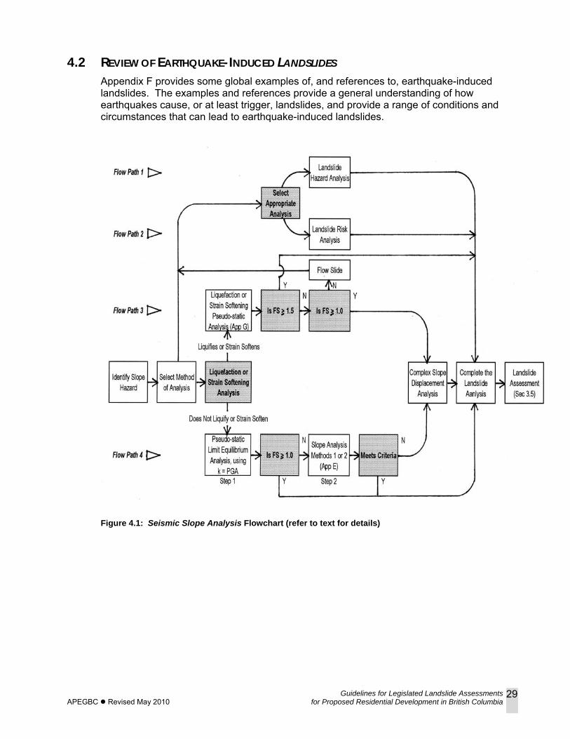
Guidelines for Legislated Landslide Assessments APEGBC Revised May 2010 for Proposed Residential Development in British Columbia
29
4.2 REVIEW OF EARTHQUAKE-INDUCED LANDSLIDES Appendix F provides some global examples of, and references to, earthquake-induced landslides. The examples and references provide a general understanding of how earthquakes cause, or at least trigger, landslides, and provide a range of conditions and circumstances that can lead to earthquake-induced landslides.
Figure 4.1: Seismic Slope Analysis Flowchart (refer to text for details)
Guidelines for Legislated Landslide Assessments APEGBC Revised May 2010 for Proposed Residential Development in British Columbia
30
5. QUALITY ASSURANCE/QUALITY CONTROL A Qualified Professional should carry out quality assurance/quality control (QA/QC) for all phases of his/her landslide assessments.
5.1 APEGBC QUALITY MANAGEMENT BYLAWS As a minimum, a QA/QC program must satisfy the requirements of APEGBC Quality Management Bylaws 14(b) (1), (2) and (4) with regards to:
• retention of complete project files for a minimum of 10 years; • in-house checks of designs as standard procedure; and • field reviews to confirm that construction of slope stabilization or structural
protective works are in general conformance with the recommendations of the Qualified Professional.
5.2 DIRECT SUPERVISION The Engineers and Geoscientists Act (Section 1 (1)) states that direct supervision means taking responsibility for the control and conduct of the engineering or geoscience work of a subordinate. With regards to direct supervision, the Qualified Professional having overall responsibility should consider:
• geological and geotechnical complexity of the terrain and level of landslide hazards and/or landslide risks;
• which aspects of the landslide assessment, and how much of those aspects, should be delegated;
• training and experience of individuals to whom work is delegated; and • amount of instruction, supervision and review required.
Field work is one of the most critical aspects of a landslide assessment. Therefore, careful consideration must be given to delegating field work. Due to the complexities and subtleties of landslide assessments, direct supervision of field work is difficult and care must be taken to ensure that delegated work meets the standard expected by the Qualified Professional. Such direct supervision could typically take the form of specific instructions on what to observe, check, confirm, test, record and report back to the Qualified Professional. The Qualified Professional should exercise judgment when relying on delegated field observations by conducting a sufficient level of review to be satisfied with the quality and accuracy of those field observations.
5.3 INTERNAL AND EXTERNAL PEER REVIEW The QA/QC program should include, as appropriate, an internal and/or external peer review of the landslide assessment project and report before it is submitted to the Client and/or the Approving Authority. An internal peer review is carried out by another Qualified Professional, usually in the same firm. An external peer review is carried out by a Qualified Professional who is independent and may be a specialist.
The level of peer review should be discussed with the Client but based on the professional judgment of the Qualified Professional. Considerations should include the stability and geological and geotechnical complexity of the terrain; type of residential development; elements at risk; availability, quality and reliability of background information and field data; and the Qualified Professional’s training and experience.
Guidelines for Legislated Landslide Assessments APEGBC Revised May 2010 for Proposed Residential Development in British Columbia
31
The external peer review process should be more formal than an internal review and it should be appropriately documented. An external reviewer should submit a signed, sealed and dated letter or report, to be either included with the report or put on file, that includes the following:
• limitations and qualifications with regards to the review; and • results of the review.
For both internal and external peer reviews, the name of the reviewing Qualified Professional should be identified in the landslide assessment report. When an external peer review is carried out, the Qualified Professional who signed the landslide assessment report remains the Engineer of Record or Geoscientist of Record. The internal or external peer review discussed above is not the same as an independent review by a Qualified Professional who is retained by an Approving Authority, or sometimes a Client, to review a landslide assessment report after it has been submitted (refer to Section 2.2.4).

Guidelines for Legislated Landslide Assessments APEGBC Revised May 2010 for Proposed Residential Development in British Columbia
32
6. PROFESSIONAL REGISTRATION; EDUCATION, TRAINING AND EXPERIENCE
6.1 PROFESSIONAL REGISTRATION As summarized in Appendix B of these guidelines, the following are the professional registration requirements for legislated landslide assessments for proposed residential development in BC:
• Land Title Act (Section 86(1)(d)(i)) indicates that landslide assessments for subdivision approval should be carried out by a Professional Engineer or Professional Geoscientist “experienced in geotechnical engineering”
• Local Government Act (Section 920(11)) indicates that, for a development permit, the local government may require a report from a Professional Engineer “with experience relevant to the applicable matter”
• Community Charter (Section 56(1)) indicates that landslide assessments for construction should be carried out by a Professional Engineer or Professional Geoscientist “with experience or training in geotechnical study and geohazard assessments”
• Local Government Act (Section 910(5)) indicates that, for flood plain bylaw exemption, a Professional Engineer or Professional Geoscientist “experienced in geotechnical engineering” is required
• The provincial document associated with the Local Government Act (Section 910) (Ministry of Water, Land and Air Protection, c2004) indicates that a qualified professional is a Professional Engineer or Professional Geoscientist with “geotechnical engineering experience and expertise in river engineering and hydrology, and in appropriate cases, … debris flow … processes.”
A Professional Engineer as described above is typically registered with APEGBC in the discipline of geological engineering, mining engineering or civil engineering. A Professional Geoscientist as described above is typically registered with APEGBC in the discipline of geology or environmental geoscience16. Although the Land Title Act and the Local Government Act refer to a Professional Geoscientist “experienced in geotechnical engineering,” by definition a geoscientist is not experienced in engineering. APEGBC interprets the Land Title Act and the Local Government Act to mean a “Professional Geoscientist experienced in geotechnical study,” similar to that expressed in the Community Charter. Not all Professional Engineers registered in the disciplines of geological engineering, mining engineering or civil engineering are necessarily appropriately knowledgeable in geotechnical engineering, geohazard assessments, river engineering, hydrology and/or debris flow processes. Similarly, not all Professional Geoscientists registered with APEGBC in the disciplines of geology or environmental geoscience are necessarily knowledgeable in geotechnical study, geohazard assessments and debris flows. It is the responsibility of the Professional Engineer or Professional Geoscientist to determine whether he/she is qualified by training or experience to undertake and accept responsibility for legislated landslide assessments for proposed residential development (APEGBC Code of Ethics Principle 2).
16 Until 2000, APEGBC referred to the discipline of environmental geoscience as ‘geotechnics.’
Guidelines for Legislated Landslide Assessments APEGBC Revised May 2010 for Proposed Residential Development in British Columbia
33
As noted previously, as the complexity of the terrain increases, site characterization and a sound understanding of the geology and geological/geomorphological processes becomes more critical.
With regards to the distinction between professional engineering and professional geoscience, following is an excerpt under Principle 2 of the Code of Ethics guidelines (APEGBC 1994; amended in 1997):
“The professions are distinct and registration in one does not give a member the right to practice in the other; however, the Association recognizes that there is some overlap of the practices of engineering and geoscience. Nothing in this principle authorizes a professional engineer to carry on an activity within the area of professional geoscience which goes beyond the practice of professional engineering and nothing in this principle authorizes a professional geoscientist to carry on an activity within the area of professional engineering which goes beyond the practice of professional geoscience.”
On this basis, the Qualified Professional who provides designs such as reinforced or mechanically stabilized slopes, retaining walls and other geotechnical structures to reduce landslide hazards and/or landslide risks requires registration with APEGBC as a Professional Engineer. The Qualified Professional who investigates or interprets complex geological conditions, geomorphic processes and geochronology in support of landslide assessments is typically registered with APEGBC as a Professional Geoscientist in the discipline of geology or environmental geoscience, or as a Professional Engineer in the discipline of geological engineering.
6.2 EDUCATION, TRAINING AND EXPERIENCE Landslide assessments, as described in these guidelines, require minimum levels of education, training and experience in many overlapping areas of engineering and geoscience. A Qualified Professional must adhere to APEGBC Code of Ethics Principle 2 (to undertake and accept responsibility for professional assignments only when qualified by training or experience), and therefore must evaluate his/her qualifications and possess appropriate education, training and experience consistent with the services provided. Education, training and experience can vary depending on the Qualified Professional’s background and whether specialty services are being provided. Whether carrying out a landslide assessment or providing specialty services, appropriate experience can only be gained by working under the direct supervision of a suitably knowledgeable and experienced Professional Engineer or Professional Geoscientist. Minimum qualifications for a Qualified Professional or a team of professionals who carry out landslide assessments for residential development should include education, training and experience in bedrock geology, surficial geology, geomorphology, hydrology and groundwater geology, airphoto interpretation, soil and rock mechanics, and landslide hazard and landslide risk analyses. As the complexity of the terrain increases, and depending on the location in the province, the minimum qualifications should be supplemented by training and experience in additional subject areas as required such as Quaternary geology,
Guidelines for Legislated Landslide Assessments APEGBC Revised May 2010 for Proposed Residential Development in British Columbia
34
structural geology, petrology, sedimentology, permafrost, slope stability analysis (both static and seismic), landslide mitigation and remediation, and site investigation methods. Specialists may have to be retained to provide experience in some of the above subject areas. The academic training for the above skill sets can be acquired through formal university or college courses, or through continuing professional development. There may be some overlap in courses and specific courses may not correlate to specific skill sets. A Qualified Professional should also remain current, through continuing professional development, with the evolving topics of landslide assessments and specialized services offered (refer to APEGBC Code of Ethics Principle 6). Continuing professional development can include taking formal courses; attending conferences, workshops, seminars and technical talks; reading new texts and periodicals; searching the web; and participating in field trips. A specialist who offers specialty services require education, training and experience in addition to that discussed above.

Guidelines for Legislated Landslide Assessments APEGBC Revised May 2010 for Proposed Residential Development in British Columbia
35
7. REFERENCES AND RELATED DOCUMENTS Not all of the following documents are referenced in the text or appendices. Some are related sources of useful information. Where documents are known to be available on the world wide web, they are noted as [web]. Ambraseys, NN (1976). The Gemona di Friuli earthquake of 6 May 1976. UNESCO
Technical Report RP/1975-76/2.222.3, Serial No. FMR/CC/SC/ED/76/169 Paris, 111 p.
Ambraseys, NN and Melville, CP (1982). A history of Persian earthquakes. Cambridge University Press, 219 p.
Ambraseys, NN, Lensen, B and Moinfar, A (1975). The Pattan earthquake of 28 December 1974. UNESCO Technical Report RP/1975-76/2.222.3, Serial No. FMR/SC/GEO/75/134, Paris, 35 p.
Association of Professional Engineers and Geoscientists of British Columbia (1977). Proposed Hazards Policy for British Columbia. The BC Professional Engineer, June 1977, p 9-10.
Association of Professional Engineers and Geoscientists of British Columbia (the 1994 edition is current as of March 2006). Guidelines for Professional Excellence. Commentary to Principle 2 was amended at the October 1997 Council Meeting. [the Code of Ethics, without Guidelines and Commentary, is available on the web]
Association of Professional Engineers and Geoscientists of British Columbia (1998). Guidelines for Geotechnical Engineering Services for Building Projects, 23 p. [web]
Association of Professional Engineers and Geoscientists of British Columbia (2003). Guidelines for Terrain Stability Assessments in the Forest Sector, 24 p. [web]
Association of Professional Engineers and Geoscientists of British Columbia (APEGBC) and University of British Columbia (UBC) (2007). Preliminary Site Response Analysis, a report associated with “Bridging Guidelines for the Performance-based Seismic Retrofit of British Columbia School Building – Second Edition” Prepared for the BC Ministry of Education, March 2007.
Australian Geomechanics Society (2000). Landslide Risk Management Concepts and Guidelines. Sub-committee on Landslide Risk Management, p 49-92 [web].
BC Community Charter (RSBC 2003, Chapter 26). [web]
BC Engineers and Geoscientists Act (RSBC 1996, Chapter 116, as amended). [web]
BC Land Act (RSBC 1996, Chapter 245). [web]
BC Land Title Act (RSBC 1996, Chapter 250). [web]
BC Local Government Act (RSBC 1996, Chapter 323). [web]
BC Ministry of Forests (1999). Mapping and Assessing Terrain Stability Guidebook. 2nd Edition; Forest Practices Code of British Columbia, Victoria, 36 p. [web]
BC Ministry of Forests (2002). Forest Road Engineering Guidebook. 2nd Edition; Forest Practices Code of British Columbia, Victoria, 208 p. [web]
BC Ministry of Public Safety and Solicitor General (2003). Hazard, Risk and Vulnerability Analysis Tool Kit. Provincial Emergency Program. [web]
Guidelines for Legislated Landslide Assessments APEGBC Revised May 2010 for Proposed Residential Development in British Columbia
36
BC Ministry of Transportation (MOT) 2005. Guide to Rural Subdivision Approvals, Sections 2.3.1.06 and 2.3.1.07. [web]
BC Ministry of Transportation and Highways (MOT) (1993). Subdivision Policy and Procedures Manual. Systems Planning Research Officer, Victoria BC.
BC Ministry of Water, Land and Air Protection (2004). Flood Hazard Area Land Use Management Guidelines, 35 p. [web]
BC Ministry of Water, Land and Air Protection (2004). Flood Hazard Map User Guide, 20 p. [web]
BC Ministry of Water, Land and Air Protection (c2004). Flood Hazard Area Land Use Management. Guidance for Selection of Qualified Professionals and Preparation of Flood Hazard Assessment Reports, 7 p. [web]
BC Resource Inventory Committee (1996a). Guidelines and Standards for Terrain Mapping in British Columbia (draft). [web]
BC Resource Inventory Committee (1996b). Terrain Stability Mapping in British Columbia: a review and suggested methods for landslide hazard and risk mapping (draft). [web].
BCBC (BC Building Code) (1998). Published by the BC Ministry of Municipal Affairs.
BCBC (BC Building Code) (2006). Published by the Office of Housing and Construction Standards, BC Ministry of Forests and Range.
Benitez, SA (1989). Landslides: extent and economic loss in Ecuador. Landslides: Extent and Economic Significance, (Editors E Brabb and B Harrod). Balkema, p 123-126.
Berger TB (1973). Reasons for judgment for the Honourable Mr Justice Berger on the matter of the Land Registry Act – and on application for approval of a proposed subdivision by Cleveland Holdings Ltd. Supreme Court of British Columbia.
Bichler A, VanDine D and Bobrowsky P (2004). Landslide hazard and risk mapping – a review and classification. In Proceedings of 57th Canadian Geotechnical Conference, October 2004, Quebec City, Session 5C, p 1-13.
Blake, TF, Hollingsworth, N, Bray, JD and Stewart, JP (2002). Recommended Procedures for Implementing of DGM. Special Publication 117, Guidelines for Analyzing and Mitigating Landslide Hazards in California, Southern California Earthquake Center, University of Southern California, Los Angeles, California.
Boyer D (2001a). Recommended procedure for conducting studies in support of land development proposals on alluvial and debris torrent fans. In Proceedings of Terrain Stability and Forest Management on the Interior of British Columbia, BC Ministry of Forests Technical Report 003, p 156-168.
Boyer D (2001b). Risk assessment procedure for proposed development activities above alluvial and debris torrent fans. In Proceedings of Terrain Stability and Forest Management on the Interior of British Columbia, BC Ministry of Forests Technical Report 003, p 144-155.
Bray, JD (2007). Simplified Seismic Slope Displacement Procedures. Earthquake Geotechnical Engineering, Chapter 14 in Proceedings 4th International Conference on Earthquake Geotechnical Engineering – Invited Lectures, in Geotechnical, Geological and Earthquake Engineering Series, Vol 6, Pitilakis, Kyriazis D, Springer, p 327-353.
Guidelines for Legislated Landslide Assessments APEGBC Revised May 2010 for Proposed Residential Development in British Columbia
37
Bray, JD and Travasarou, T (2007). Simplified procedure for estimating earthquake-induced deviatoric slope displacements. Journal of Geotechnical and Environmental Engineering, ASCE, Vol 153, No 4, pp 381-392.
Buchanan R (1983). An assessment of natural hazards management in British Columbia. MA Thesis, Department of Geography, University of British Columbia, 260 p.
Bulletin of the Seismological Society of America (1963). Landslides of the Great Chilean Earthquake, 1960. Bulletin of the Seismological Society of America, Vol 35, No 6, p 1123–1414.
Cave PW (1992a, revised 1993). Hazard acceptability thresholds for development approvals by local governments. In Proceedings of Geological Hazards Workshop, University of Victoria, BC. February 20-21, 1991. BC Geological Survey Branch, Open File 1992-15, p 15-26. Also available from the Regional District of Fraser Valley.
Cave PW (1992b). Natural hazards, risk assessment and land use planning in British Columbia. In Proceedings of Geotechnique and Natural Hazards Symposium, Canadian Geotechnical Society, Bi-Tech Publishers, Vancouver, BC, p 1-11.
Close, U and McCormick, E (1922). Where the mountains walked. The National Geographic Magazine, Vol 41, No 5, p 445 – 464.
CGS (Canadian Geotechnical Society) (2006). Canadian Foundation Engineering Manual, 4th edition.
CSA (Canadian Standards Association) (1997). Risk Management: Guidelines for Decision-Makers. Canadian Standards Association, CAN/CSA-Q850-97, 46 p.
Duncan JD and Wright, SG (2005). Soil Strength and Slope Stability Wiley, Hoboken, NJ.
Evans, SG (1989). The 1946 Mount Colonel Foster rock avalanche and associated displacement wave, Vancouver Island, British Columbia. Canadian Geotechnical Journal, Vol 26, p 447-452.
Evans, SG, Aitken, JD, Wetmiller, RJ and Horner, RB (1987). A rock avalanche triggered by the October 1985 North Nahanni earthquake, District of Mackenzie, NWT. Canadian Journal of Earth Sciences, Vol 24, p 176-184.
Farquharson KG, Russell SO and Skermer NA (1976). Editorial – Provincial Natural Hazards Policy. The BC Professional Engineer, January 1976, p 4.
Fell R and Hartford D (1997). Landslide risk management. In Proceedings of International Workshop on Landslide Risk Assessment, (ed) D Cruden and R Fell, Honolulu, Hawaii, USA, p 51-109.
Fell R, Ho KKS, Lacasse S and Leroi E (2005). A framework for landslide risk assessment and management. In Proceedings of International Conference on Landslide Risk Management (Hungr O, Fell R, Couture R, Eberhardt E, editors), Vancouver, Canada, AA Balkema Publishers, p 3-26.
Greater Vancouver Liquefaction Task Force (2007). Task Force Report - Geotechnical Design Guidelines for Buildings on Liquefiable Sites in accordance with NBC 2005 for Greater Vancouver Region, May 8, 2007
Hadley, JB (1959). The Madison Canyon landslide. American Geological Institute, Geotimes, Vol 4, No 3, p 14-17.
Guidelines for Legislated Landslide Assessments APEGBC Revised May 2010 for Proposed Residential Development in British Columbia
38
Hadley, JB (1978). Madison Canyon rockslide, Montana USA. In Rockslides and Avalanches (Editor B Voight), Elsevier, Vol 1, p 167 - 180.
Harp, EL, and Jibson, RW (1995). Inventory of landslides triggered by the 1994 Northridge, California earthquake. United States Geological Survey Open File Report 95–213. [web]
Harp, EL and Jibson, RW (1996). Landslides triggered by the 1994 Northridge, California, earthquake. Bulletin of the Seismological Society of America, Vol 86, No 1B, p S319-S332.
Harp, EL, Wilson, RC, and Wieczorek, GF (1981). Landslides from the February 4, 1976, Guatemala earthquake. United States Geological Survey Professional Paper 1204-A, 35 p.
Heim, A. (1932). Bergsturz und Menschenleben, Zurich. (Landslides and Human Lives, translated by Nigel Skermer, 1989, BiTech Publishers, Vancouver, 218 p.)
Hodgson, EA (1946). British Columbia earthquake, June 23, 1946. Journal of the Royal Astronomical Society of Canada. Vol 60, No 8, p 285–319.
Hong Kong Geotechnical Engineering Office (1998). Landslides and Boulder Falls from Natural Terrain: Interim Risk Guidelines. GEO Report No 75, Geotechnical Engineering Office, The Government of Hong Kong Special Administrative Region, 183 p.
Howes DE and Kenk E (ed) (1997). Terrain classification system for British Columbia (draft). BC Ministry of Environment, Lands and Parks, Resource Inventory Branch. [web]
Huang, C, Lee, H, Liu, H, Keefer, DK and Jibson, RW (2001). Influence of surface-normal ground acceleration on the Initiation of the Jih-Feng-Erh-Shan landslide during the 1999 Chi-Chi, Taiwan, earthquake. Bulletin of the Seismological Society of America, Vol 91, No 5, p 953–958.
Hungr O (1997). Some methods of landslide hazard intensity mapping. In Proceedings of International Workshop on Landslide Risk Assessment, (ed) D Cruden and R Fell, Honolulu, Hawaii, USA, p 215-226.
Hungr O (2004a). Landslide Hazards in BC: Achieving Balance in Risk Assessment. Innovation, April 2004, p 12-15.
Hungr O (2004b). Geotechnique and the management of landslide hazards. In Proceedings of 57th Canadian Geotechnical Conference, October 2004, Quebec City, Session 4C, p 1-10.
Hungr O, Evans SG, Bovis MJ and Hutchinson JN (2001). A review of the classification of landslides of the flow type. Environmental and Engineering Geoscience, Vol 7, No 3, p 221-238.
Hungr O, Fell R, Couture R and Eberhardt E (editors) (2005). Landslide Risk Management. In Proceedings of International Conference on Landslide Risk Management (Hungr O, Fell R, Couture R, Eberhardt E, editors), Vancouver, Canada, AA Balkema Publishers.
Hynes-Griffin, ME and Franklin, AG (1984). Rationalizing the Seismic Coefficient Method. Miscellaneous Paper GL-84-13, United States Army Engineers, WES, Vicksburg, MS.
Guidelines for Legislated Landslide Assessments APEGBC Revised May 2010 for Proposed Residential Development in British Columbia
39
International Society of Soil Mechanics and Geotechnical Engineering (ISSMGE) (2004). Risk Assessment – Glossary of Terms. ISSMGE Technical Committee 32, Version 1, July 2004. [web]
Jibson, RW and Keefer, DK (1988). Landslides triggered by earthquakes in the central Mississippi Valley, Tennessee and Kentucky. United States Geological Survey Professional Paper 1336-C, 24 p.
Jibson, RW and Keefer, DK (1993). Analysis of the seismic origin of landslides: Examples from the New Madrid seismic zone. Geological Society of America Bulletin, Vol 105, p 521-536.
Keefer, DK (1984). Landslides caused by earthquakes. Geological Society of America Bulletin, Vol 95, p 406-421.
Keefer, DK (1994). The importance of earthquake-induced landslides to long-term slope erosion and slope hazards in seismically active regions. Geomorphology, Vol 10, p 265-284.
Keefer, DK, Harp, EL and Griggs, GB (2002). Identifying a large landslide with small displacements in a zone of coseismic tectonic deformation: The Villa Del Monte landslide triggered by the 1989 Loma Prieta, California, earthquake. Geological Society of America, Reviews in Engineering Geology, Vol 15, p 117-134.
Kuan, S (2007). Building Policies for Managing Concerns and Issues in Seismic Assessments of Slope Stability to 2%-in-50 Year Hazard Level. Proceedings of the 60th Canadian Geotechnical Conference, Ottawa, Ontario. October 2007. Session M3-A.
Lee EM and Jones DKC (2004). Landslide Risk Assessment. Thomas Telford Publishing, London.
Leroi E, Bonnard CH, Fell R and MacInnis R (2005). Risk Assessment and Management. In Proceedings of International Conference on Landslide Risk Management (Hungr O, Fell R, Couture R, Eberhardt E, editors), Vancouver, Canada, AA Balkema Publishers, p 159-198.
Makdisi, F, and Seed, HB (1978). Simplified procedure for estimating dam and embankment earthquake-induced deformations. Journal of Geotechnical and Environmental Engineering, ASCE, Vol 104, No 4 , pp 381-392.
Malamud, BD, Turcotte, DL, Guzzetti, F, and Reichenbach, P (2004). Landslide inventories and their statistical properties. Earth Surface Processes and Landforms, Vol 29, p 687-711.
Mathews, WH (1979). Landslides of central Vancouver Island and the 1946 earthquake. Bulletin of the Seismological Society of America, Vol 69, p 445-450.
Montandon, F (1942, 1943). Les séismes de forte intensité en Suisse. Revue pour L’Étude des Calamites. Société de Géographie Genève, I Partie, Tome V/18-19, II Partie, Tome VI/20.
Morgan GC (1992). Quantification of risks from slope hazards. In Proceedings of Geologic Hazards in British Columbia, BC Geological Survey Branch, Open File 1992-15, p 57-70.
Morton, DM (1971). Seismically triggered landslides in the area above the San Fernando Valley, in the San Fernando, California, earthquake of February 9, 1971. United States Geological Survey Professional Paper 733, p 93-104.
Guidelines for Legislated Landslide Assessments APEGBC Revised May 2010 for Proposed Residential Development in British Columbia
40
NBCC (National Building Code of Canada) (1995). Published by the National Research Council of Canada, Ottawa.
NBCC (National Building Code of Canada) (2005). Published by the National Research Council of Canada, Ottawa.
Newmark, NM (1965). Effects of earthquakes on dams and embankments, Geotechnique, Vol 15, No 2, p 139-160.
Ng KC, Parry S, King JP, Franks CAM and Shaw R (2002). Guidelines for Natural Terrain Hazard Studies. Geotechnical Engineering Office, The Government of Hong Kong Special Administrative Region, Special Project Report, SPR 1/2002, 136 p.
Noson, LL, Qamar, A and Thorsen, GW (1988). Washington State Earthquake Hazards. Washington Division of Geology and Earth Resources, Information Circular 85, 77 p.
Pacific Earthquake Engineering Research (PEER) Center Database (2005). [Web]
Panizza, M (1991). Geomorphology and seismic risk. Earth-Science Reviews, Vol 31, p 11-20.
Plafker, G, and Ericksen, GE (1978). Nevados Huascaran avalanches, Peru. In Rockslides and Avalanches (Editor B Voight), Elsevier, Vol1, p 277 – 314.
Plafker, G, and Galloway, JP (Editors). (1989). Lessons learned from the Loma Prieta, California, earthquake of October 17, 1989. United States Geological Survey Circular 1045, 48 p.
Plant, N, and Griggs, GB (1990). Coastal landslides and the Loma Prieta earthquake. American Geological Institute, Earth Science, Vol 43, No 3, p 13-17.
Regional District of Central Kootenay (2002). Bylaw No xxxx, Schedule ‘D’ Non-Standard Flooding and Erosion Ratings Table. [draft on web]
Richter, CF (1958), Elementary Seismology, Freeman and Company, 768 p.
Seed, HB (1979). Considerations in the earthquake-resistant design of earth and rockfill dams, Geotechnique, Vol 29, No 3, p 215-263.
Shreve, RL (1966). Sherman Landslide, Alaska. Science, Vol 154, p 1639-1643.
Sitar, N and Clough, GW (1983). Seismic response of steep slopes in cemented soils. Journal of Geotechnical Engineering, ASCE, Vol 109, No 2, p 210 – 227.
Skermer N (2002). Guidelines for planners, approving officers and building inspectors for landslide-prone areas in British Columbia. Report by Municipal Insurance Association of British Columbia.
Skermer, NA and VanDine, DF (1992). Catastrophic impact of some historical mountain landslides. Symposium on Geotechnique and Natural Hazards, Bitech Publishers, Vancouver, BC, p 91-98.
Solonenko, VP (1977). Landslides and collapses in seismic zones and their prediction. Bulletin of the International Association of Engineering Geology, No. 15, p 4-8.
Sykora DW and Koester JP (1988). Review of existing correlations between dynamic shear resistance and standard penetrations in soils. Proceedings, Earthquake Engineering and Soil Dynamics II - Recent Advances in Ground Motion Evaluation, ASCE Geotechnical Engineering Division, Park City, Utah.
Terzaghi K and Peck RP (1948; 2nd edition 1967). Soil Mechanics in Engineering Practice. John Wiley and Sons, 729 p.
Guidelines for Legislated Landslide Assessments APEGBC Revised May 2010 for Proposed Residential Development in British Columbia
41
Thurber Engineering Ltd (2000). Review of Policies and Procedures for Lease or Sale of Public Lands Subject to Debris Flow and Related Hazards. Report to BC Ministry of Environment, Lands and Parks, Lower Mainland Region (file 15-33-23).
Turner KA and Schuster RL (editors) (1996). Landslides Investigation and Mitigation, (US) Transportation Research Board, Special Report 247, 673 p.
Vick SG (2002). Degrees of Belief, Subjective Probability and Engineering Judgment. American Society of Civil Engineers, 455 p.
Walsh, TJ, Pringle, PT and Palmer, SP (2001). Working a geologic disaster. Washington Geology, Vol. 28, No. 3, p 6-19.
Williams KF (1983). Letter to the Honourable Stephen Rogers, BC Ministry of Environment, dated February 28, 1983. Published in The BC Professional Engineer, April 1983, p 23.
Wise M, Moore G and VanDine D (2004). Landslide risk case studies in forest development planning and operations. BC Ministry of Forests, Land Management Handbook 56, 119 p. [web]
Youd, TL and Hoose, SN (1978). Historic ground failures in northern California triggered by earthquakes. United States Geological Survey Professional Paper 993, 177 p.
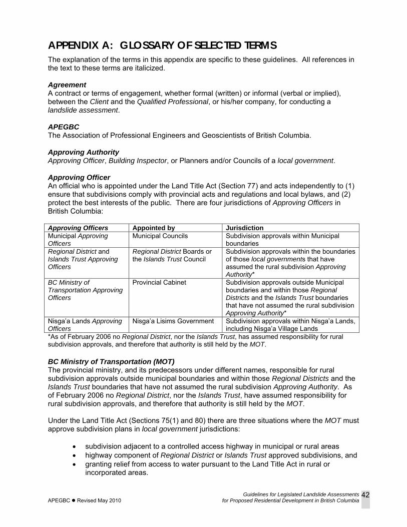
Guidelines for Legislated Landslide Assessments APEGBC Revised May 2010 for Proposed Residential Development in British Columbia
42
APPENDIX A: GLOSSARY OF SELECTED TERMS The explanation of the terms in this appendix are specific to these guidelines. All references in the text to these terms are italicized. Agreement A contract or terms of engagement, whether formal (written) or informal (verbal or implied), between the Client and the Qualified Professional, or his/her company, for conducting a landslide assessment. APEGBC The Association of Professional Engineers and Geoscientists of British Columbia. Approving Authority Approving Officer, Building Inspector, or Planners and/or Councils of a local government. Approving Officer An official who is appointed under the Land Title Act (Section 77) and acts independently to (1) ensure that subdivisions comply with provincial acts and regulations and local bylaws, and (2) protect the best interests of the public. There are four jurisdictions of Approving Officers in British Columbia: Approving Officers Appointed by Jurisdiction Municipal Approving Officers
Municipal Councils Subdivision approvals within Municipal boundaries
Regional District and Islands Trust Approving Officers
Regional District Boards or the Islands Trust Council
Subdivision approvals within the boundaries of those local governments that have assumed the rural subdivision Approving Authority*
BC Ministry of Transportation Approving Officers
Provincial Cabinet Subdivision approvals outside Municipal boundaries and within those Regional Districts and the Islands Trust boundaries that have not assumed the rural subdivision Approving Authority*
Nisga’a Lands Approving Officers
Nisga’a Lisims Government Subdivision approvals within Nisga’a Lands, including Nisga’a Village Lands
*As of February 2006 no Regional District, nor the Islands Trust, has assumed responsibility for rural subdivision approvals, and therefore that authority is still held by the MOT. BC Ministry of Transportation (MOT) The provincial ministry, and its predecessors under different names, responsible for rural subdivision approvals outside municipal boundaries and within those Regional Districts and the Islands Trust boundaries that have not assumed the rural subdivision Approving Authority. As of February 2006 no Regional District, nor the Islands Trust, have assumed responsibility for rural subdivision approvals, and therefore that authority is still held by the MOT. Under the Land Title Act (Sections 75(1) and 80) there are three situations where the MOT must approve subdivision plans in local government jurisdictions:
• subdivision adjacent to a controlled access highway in municipal or rural areas • highway component of Regional District or Islands Trust approved subdivisions, and • granting relief from access to water pursuant to the Land Title Act in rural or
incorporated areas.
Guidelines for Legislated Landslide Assessments APEGBC Revised May 2010 for Proposed Residential Development in British Columbia
43
Building Inspector An individual appointed by a local government to administer its building bylaw within the context of the BC Building Code or, in the case of the City of Vancouver, the Vancouver building bylaw. The Islands Trust does not have Building Inspectors. Client An individual or company who engages a Qualified Professional to conduct a landslide assessment. Consequence A result or effect on human well-being, property or the environment due to a landslide occurring. Construction Either new construction of a building or structure, or the structural alteration of or addition to an existing building or structure. Construction does not include the repair of an existing building or structure. Covenant A registered agreement, established by the Land Title Act (Section 219), between a Land Owner and the local or provincial government that sets out certain conditions for a specific property with regards to building use, building location, land use, property subdivision and property sale. Development Consultant An individual or company retained by a Land Owner to plan and oversee development of a parcel of land or to look after the affairs of the land. This individual or company may be an Architect, a BC Land Surveyor, a Civil (Land Development) Engineer, a Land Use Planner, a Realtor or a family member. Elements at Risk Things of social, environmental and economic value, including human well-being and property, that may be affected by a landslide. Environmental Geoscience The application of geology and related earth sciences to obtain information on, and an understanding of, geological materials, processes and structures as needed for engineering and environmental investigation, analysis and design. Also, a discipline of APEGBC professional registration that includes geoscientists who practice environmental geoscience, and who typically identify themselves as Environmental Geoscientists, Geomorphologists, Hydrogeologists, Groundwater Geologists, Terrain Scientists and/or Engineering Geologists. Until 2000, APEGBC referred to environmental geoscience as ‘geotechnics.’ Factor of Safety (FS) As related to slope stability, the ratio of the shear strength of the soil or rock that comprise the slope divided by the shear stresses within the slope. The most common method of estimating FS is using a limit equilibrium analysis method. When seismic or other dynamic loadings are not considered, this is referred to as a static limit equilibrium limit analysis. When seismic or other dynamic loadings are considered this is referred to as a psuedo-static limit equilibrium analysis.
Guidelines for Legislated Landslide Assessments APEGBC Revised May 2010 for Proposed Residential Development in British Columbia
44
Geological Engineering The application of a combination of geology, engineering and related disciplines to the investigation, analysis and design involving rock, soil, water and mineral resources for engineering and environmental projects. Also a discipline of APEGBC professional registration. Geotechnical Engineering The application of soil mechanics, rock mechanics, engineering geology and related disciplines to the investigation, analysis and design involving rock, soil, and water for engineering and environmental projects. Professionals who practice geotechnical engineering are typically registered with APEGBC as Civil Engineers, Mining Engineers and/or Geological Engineers. Ground Motions A general term for all seismic related motions of the ground, including ground acceleration, slope displacement and stress and strain. Islands Trust The autonomous local government, established by the Islands Trust Act, with land use planning and regulatory authority similar to those of a Regional District but without the role of building inspection. The Islands Trust has broad authority for coordinating work with other agencies, organizations and groups. The Islands Trust area covers the islands and waters between the British Columbia mainland and southern Vancouver Island, including Howe Sound and as far north as Comox. Indian Reserves are not included in the Islands Trust area. Land Owner An individual or company identified as the owner on the title of the land registered in a Land Title Office. Landslide A movement of rock, debris or earth down a slope. Landslides can be a result of a natural sequence of events and/or human activities. The Land Title Act (Section 86) refers to the following natural hazards: “flooding, [soil] erosion, land slip and [snow] avalanche.” The Local Government Act (Section 920) refers to: “flooding, mud flows, torrents of debris, [soil] erosion, land slip, rock falls, subsidence, tsunami, [snow] avalanches or wildfire.” The Community Charter (Section 56) refers to: “flooding, mud flows, debris flows, debris torrents, [soil] erosion, land slip, rock falls, subsidence and [snow] avalanche.” These guidelines address only the landslides (referred to as “land slips, debris flows, debris torrents, mud flows and rock falls”) in the above lists. They do not address the other natural hazards except as they relate to landslides. For the purpose of these guidelines, landslides include: rock falls, rock slumps, rock slides, rock avalanches, rock creep; debris falls, debris slides, debris flows, debris floods; earth falls, earth slumps, earth slides, earth flows, earth creep; and flow slides. Debris flows and debris floods have some characteristics of both landslides and floods. Landslide Analysis A combination of recognition, characterization and estimation of the landslide hazard, and may include estimation of potential consequences. Landslide Assessment A combination of (1) landslide analysis and (2) a comparison of the results of the analysis with a level of landslide safety. For the purpose of these guidelines, a landslide assessment is the same as a landslide hazard assessment or landslide risk assessment.
Guidelines for Legislated Landslide Assessments APEGBC Revised May 2010 for Proposed Residential Development in British Columbia
45
Landslide Assessment Assurance Statement The Statement for submission, along with a landslide assessment report, to an Approving Authority. Attached as Appendix D to these guidelines. Landslide Hazard The Canadian Standards Association (CSA 1997) defines a hazard as “a source of potential harm, or a situation with a potential for causing harm, in terms of human injury; damage to health, property, the environment, and other things of value; or some combination of these.” Landslide hazard can be estimated in a number of ways that include, but are not limited to, estimating likelihood or probability of occurrence of a landslide, FS of a slope, or slope displacement along a slip surface. The results of the above estimate, must then be combined with an estimate of landslide runout (for residential development at the bottom of the slope), or an estimate of where the main scarp of the landslide will intersect the ground (for residential development on, or at the top of, the slope). Landslide Risk An estimate of landslide hazard and potential consequences to an element at risk. Level of Landslide Safety Level of safety from the effects of landslides, including levels of acceptable landslide hazard and landslide risk. Liquefaction A phenomenon where a earth material looses a large percentage of its shear resistance and flows in a manner resembling a liquid until the shear stresses acting on the mass are as low as the reduced shear resistance. Local Government Municipalities, Regional Districts and, in some cases, the Islands Trust. Magnitude (Earthquake Magnitude – M) A general term for the measure of the strength of an earthquake or the strain energy released by an earthquake, as determined by a seismographic observations. In BCBC 2006, magnitude is referred to as moment magnitude. Modal magnitude is the moment magnitude providing the largest contribution to the ground motion. Member Professional Engineer or Professional Geoscientist. A Member of the Association of Professional Engineers and Geoscientists of British Columbia. Municipality A corporation into which the residents of an area are incorporated under the Local Government Act or another Act, or the geographic area of the municipal corporation. Official Community Plan A statement of objectives and policies to guide decisions on planning and land use management within the area covered by the plan, respecting the purposes of the local government (Local Government Act Part 26, Division 2).
Guidelines for Legislated Landslide Assessments APEGBC Revised May 2010 for Proposed Residential Development in British Columbia
46
Professional Engineer An Engineer who is a registered or licensed member in good standing with APEGBC and typically is registered in the disciplines of geological engineering, mining engineering or civil engineering, which are designated disciplines of professional engineering. Professional Geoscientist A Geoscientist who is a registered or licensed member in good standing with APEGBC and typically is registered in the disciplines of geology or environmental geoscience, which are designated disciplines of professional geoscience. Until 2000, APEGBC referred to the discipline of environmental geoscience as ‘geotechnics.’ Qualified Professional A Professional Engineer or Professional Geoscientist with the appropriate level of education, training and experience to conduct landslide assessments for residential development as described in these guidelines. Regional District One of 28 districts incorporated under that Local Government Act, or the geographic area of the district, that has authority to enact subdivision servicing and zoning bylaws. Residential Development As defined by various pieces of provincial legislation, either (1) the subdivision of property, (2) the new construction of a building or structure, or (3) the structural alteration of, or addition to, an existing building or structure. Seismic Slope Analysis Either seismic slope stability analysis and/or seismic slope displacement analysis. A seismic slope stability analysis estimates the FS of the slope due to an earthquake. A seismic slope displacement analysis estimates the amount a slope moves along the slip surface due to an earthquake. Slope Displacement The amount a slope moves along the slip surface. It has horizontal and vertical components, but typically, near the head scarp of the landslide, the vertical component is dominant. References for Appendix A are included in Section 7 of these guidelines.
Guidelines for Legislated Landslide Assessments APEGBC Revised May 2010 for Proposed Residential Development in British Columbia
47
APPENDIX B: LEGISLATIVE FRAMEWORK Proposed residential development in British Columbia is governed by several provincial statutes. The statutes that require landslide assessments by Qualified Professionals include: the Land Title Act (RSBC 1996, Chapter 250); Local Government Act (RSBC 1996, Chapter 323); and the Community Charter (RSBC 2003, Chapter 26). The following sub-sections summarize the framework; the actual legislation should be referred to for details. These guidelines were prepared between September 2005 and February 2006, and the above referenced statutes may have changed thereafter. In December 2006, Provincial Regulation M268, Geotechnical Slope Stability (Seismic) Regulation (described below), was proclaimed under Section 692(d) of the Local Government Act.
B.1 LAND TITLE ACT (SECTION 86) – SUBDIVISION APPROVALS The Land Title Act (Section 86) contains provisions for “refusing to approve” a subdivision “if the Approving Officer considers the land is subject, or could reasonably be expected to be subject, to flooding, [soil] erosion, land slip or [snow] avalanche.” These guidelines only address landslides (referred to as land slips) in the above list. They do not address the other natural hazards, except as related to landslides. The Land Title Act (Section 86) also indicates that if the land to be subdivided is subject, or could reasonably be expected to be subject, to landslides, as a condition of subdivision approval the Approving Officer may require either or both of the following:
• a report “certified” by a Professional Engineer or Professional Geoscientist “experienced in geotechnical engineering” that “the land may be used safely for the use intended” and/or
• one or more registered covenants restricting the use of the land.
B.2 LOCAL GOVERNMENT ACT (SECTIONS 919.1 AND 920) – DEVELOPMENT PERMITS
The Local Government Act (Sections 919.1 and 920) states that a local government Official Community Plan may establish a Development Permit Area for a number of reasons, one of which is to protect development from “hazardous conditions.” Hazardous conditions include “flooding, mud flows, torrents of debris, [soil] erosion, land slip, rock falls, subsidence, tsunami, [snow] avalanches or wildfire.” These guidelines only address landslides (mud flows, debris torrents17, land slip and rock falls) in the above list. They do not address the other natural hazards, except as related to landslides. A development permit may be required by a local government before residential development can occur within a Development Permit Area. Before issuing a development permit, the local government may require a report “certified by a Professional Engineer with experience relevant to the applicable matter, to assist the local government in determining what conditions or requirement … it will impose in the permit” (Section 920). Typically a Planner and/or the Council of a local government reviews the Professional Engineer’s report, and then determines what conditions or requirements to include in the development permit.
17 For the purpose of these guidelines debris flows, debris torrents and mud flows are collectively considered as debris flows.
Guidelines for Legislated Landslide Assessments APEGBC Revised May 2010 for Proposed Residential Development in British Columbia
48
Development permits and building permits are different. Development permits precede building permits and both may be required in jurisdictions that have an Official Community Plan and where residential development may be exposed to landslides.
B.3 COMMUNITY CHARTER (SECTION 56) – BUILDING PERMITS The Community Charter (Section 56) contains provisions for not issuing a building permit “if a Building Inspector considers that construction would be on land that is subject to or is likely to be subject to flooding, mud flows, debris flows, debris torrents, [soil] erosion, land slip, rock falls, subsidence or [snow] avalanche.” These guidelines only address landslides (mud flows, debris flows, debris torrents, land slips and rock falls) in the above list. They do not address the other natural hazards, except as related to landslides. The Community Charter (Section 56) indicates that if construction is on land that is subject, or is likely to be subject, to landslides, as a condition of a building permit the Building Inspector may require a “certified” report by “(a) a Professional Engineer or (b) a Professional Geoscientist with experience or training in geotechnical study and geohazard assessments “that the land may be used safely for the use intended.” The Building Inspector may issue a building permit if:
• a Qualified Professional reports the land may be used safely for the use intended if the land is used in accordance with conditions specified in his/her report, and
• there is a registered covenant restricting the use of the land. If the Qualified Professional determines the land may not be used safely for the use intended, the Building Inspector must not issue a building permit.
B.4 LOCAL GOVERNMENT ACT (SECTION 910) – FLOOD PLAIN BYLAW VARIANCES OR EXEMPTIONS
The Local Government Act (Section 910) addresses construction requirements in relation to flood plains and states that “a local government, in making bylaws under this section, must (a) consider the provincial guidelines, and (b) comply with the provincial regulations and a plan or program the local government has developed under those regulations.” To date, there are no such provincial regulations and therefore no local government plans or programs developed under regulation. Section 910 does not refer specifically to landslides; however, the provincial document “Flood Hazard Area Land Use Management Guidelines” (Ministry of Water, Land and Air Protection, 2004), which guides a local government in making bylaws under Section 910, addresses debris flows, a type of landslide as defined in these guidelines. The flood hazard guidelines state that, although development should be discouraged in areas prone to debris flows, “consent to develop [variance] may be granted, with standard requirements as established for alluvial fan in section 3.3 [of those guidelines], where:
• there is no other land available, and • where an assessment of the land by a suitably qualified professional indicates that
development may occur safely.” Section 910 also indicates that a local government may grant a bylaw exemption if it considers it advisable and considers that the exemption is consistent with the provincial guidelines, or has received a report that the land may be used safely for the use intended, certified by:
Guidelines for Legislated Landslide Assessments APEGBC Revised May 2010 for Proposed Residential Development in British Columbia
49
• a Professional Engineer or Professional Geoscientist experienced in geotechnical
engineering, or • a person in a class prescribed by the minister in the Local Government Act (Section
910); however, to date no class of persons has been prescribed. Typically a Planner and/or the Council of a local government reviews the Professional Engineer’s or Professional Geoscientist’s report, and then determines what conditions or requirements to include in the bylaw or exempt from the bylaw. The provincial document “Flood Hazard Area Land Use Management, Guidance for Selection of Qualified Professionals and Preparation of Flood Hazard Assessment Reports” ((Ministry of Water, Land and Air Protection, c2004) indicates that a qualified professional is:
• a Professional Engineer or Professional Geoscientist with geotechnical engineering experience and expertise in river engineering and hydrology, and in appropriate cases, … debris flow … processes.
B.5 BRITISH COLUMBIA BUILDING CODE AMENDMENTS RELATED TO SEISMIC SLOPE STABILITY AND TECHNICAL GUIDANCE
On December 15, 2009, Ministerial Order M296 repealed “Geotechnical Slope Stability (Seismic) Regulation”, BC Reg 358/2006, effective February 1, 2010. As a result, the companion “Commentary on Geotechnical Slope Stability (Seismic) Regulation”, issued by the BC Building and Safety Policy Branch in January 2007, was also withdrawn. On December 15, 2009, Ministerial Order M297 added sentences 4.1.8.16.(8) and 9.4.4.4.(2) to the BCBC 2006, effective February 1, 2010. Sentence 4.1.8.16:
8) “The potential for slope instability and its consequences, such as slope displacement, shall be evaluated based on site-specific material properties and ground motion parameters in Subsection 1.1.3 [of BCBC 2006] and shall be taken into account in the design of the structures and its foundations.”
Sentence 9.4.4.4:
2) “The potential for slope instability and its consequences, such as slope displacement, shall be evaluated based on site-specific material properties and ground motion parameters in Subsection 1.1.3 [of BCBC 2006] and shall be taken into account in the design of the structures and its foundations.”
The BC Building and Safety Policy Branch issued Information Bulletin B10-01, “British Columbia Building Code Amendments Related to Seismic Slope Stability and Technical Guidance”, on January 18, 2010. The bulletin summarizes the two changes that resulted from the issuance of Ministerial Order M297:
• the consideration of potential for slope instability and its consequences at a building site is now an explicit requirement in designs of structures and their foundations, and
• the seismic hazard probability level to be used in seismic slope analysis is ground motions with a probability of exceedance of 2% in 50 years (annual probability of 1/2475), as referenced in Subsection 1.1.3 of Division B of BCBC 2006.

Guidelines for Legislated Landslide Assessments APEGBC Revised May 2010 for Proposed Residential Development in British Columbia
50
As a result of the second bullet, the seismic hazard probability levels for structural design and for seismic slope analysis are now the same: ground motions with a probability of exceedance of 2% in 50 years (annual probability of 1/2475).
Guidelines for Legislated Landslide Assessments APEGBC Revised May 2010 for Proposed Residential Development in British Columbia
51
APPENDIX C: REVIEW OF LEVELS OF LANDSLIDE SAFETY As used in these guidelines, the term level of landslide safety includes levels of acceptable landslide hazard and landslide risk. Levels of landslide safety are determined by society, not individuals. Therefore, for residential development, the levels must be established and adopted by the local government or the provincial government after consideration of a range of societal values. Some Land Owners may feel a government-adopted level of landslide safety is too high, while others are willing to live with an ‘unacceptable’ level of landslide safety. A Qualified Professional should not be expected to establish a level of landslide safety, although he/she may provide a useful role in advising the local or provincial government that wishes to do so. The following sub-sections briefly review some aspects of levels of landslide safety in British Columbia and nationally.
C.1 BRITISH COLUMBIA Until 2010, the BC Building Code (BCBC 2006) did not mention landslide safety for buildings. It stated only “Where a foundation is to rest on, in or near sloping ground, this particular condition shall be provided for in the design” (Section 4.2.4.7). On December 15, 2009, Ministerial Order M297 added Sentences 4.1.8.16.(8) and 9.4.4.4.(2) to BCBC 2006, effective February 1, 2010. The sentences are identical and read:
“The potential for slope instability and its consequences, such as slope displacement, shall be evaluated based on site-specific material properties and ground motion parameters in Subsection 1.1.3 [of BCBC 2006] and shall be taken into account in the design of the structures and its foundations.”
In 1973, BC Supreme Court Justice Thomas Berger ruled that the possibility of a major landslide between Squamish and Whistler was unacceptable to a proposed residential development. He based his judgment, in part, on a return period of 10,000 years for a major landslide (Berger 1973). The Berger ruling set a precedent of a level of landslide safety at an annual probability of occurrence of a major landslide of 1/10,000 (0.5% probability in 50 years) being a hazard to a proposed residential development (that is, P(H)18 = 1/10,000). Sometime between 1978 and 1993 the MOT began to ask Qualified Professionals who carry out landslide assessments for proposed subdivisions “to think in terms of a 10% probability in 50 years” (annual probability of occurrence of 1/475; that is, P(H) = 1/475) (MOT 1993). MOT’s web-based “Guide to Rural Subdivision Approval” (MOT 2005, Section 2.3.1.07, and current as of April 2010) states that a Professional Engineer (a Professional Geoscientist is not included in this document, but is included in the governing Land Title Act) should:
• determine if there is a hazard • determine extent of any hazard • identify building sites free from hazard, or when risk could be rendered acceptable.
18 P(H) is an estimate of the annual probability of occurrence of a specific hazardous landslide. P(H) is a measure of hazard, and not risk, because it does not consider the effects or potential effects of the landslide on the proposed residential development (refer to Wise et al, 2004, pg 15 and 16).
Guidelines for Legislated Landslide Assessments APEGBC Revised May 2010 for Proposed Residential Development in British Columbia
52
The MOT guide does not provide a level of landslide safety other than the phrase “free from hazard,” which as noted previously is seldom the case. In 2009, MOT Approving Officers provided guidance in a document entitled “Subdivision Preliminary Layout Review – Natural Hazard Risk”. With respect to landslides, levels of landslide safety, paraphrased from that document, are as follows:
• for a building site, unless otherwise specified, an annual probability of occurrence of a damaging landslide of 1/475 (10% probability in 50 years; that is, P(H) = 1/475)
• for a building site or a large scale development an annual probability of occurrence of a life-threatening or catastrophic landslide of 1/10,000 (0.5% probability in 50 years; that is, P(H) = 1/10,000), and
• large scale developments must also consider total risk and refer to international standards.
Because this MOT guidance document has not yet been published (April 2010), contact a MOT Approving Officer for further details. In the 1990s, what is presently the Fraser Valley Regional District published levels of landslide safety for that Regional District for various types of natural hazards for a range of residential development (Cave 1992a, revised 1993). These levels of landslide safety, which are current today, were based on:
• Mr. Justice Thomas Berger’s 1973 unacceptable landslide return period of 10,000 years for a proposed subdivision (that is, P(H) = 1/10,000)
• the 200-year return period for provincially sponsored flood-proofing19, and • the MOT’s 1993 guideline of 10% probability in 50 years (that is, P(H) = 1/475).
In 1999, the Regional District of Fraser-Fort George adopted a level of landslide safety similar to MOT’s 1993 guideline (that is P(H) = 1/475). In 2009, the District of North Vancouver endorsed a level of landslide safety with its “Natural Hazards Risk Tolerance Criteria”. The criteria, which addresses natural hazards including landslides, is summarized in the following table. The table should be read in conjunction with the November 2009 District of North Vancouver Council Report (as of April 2010 available at www.dnv.org/hazards). Contact the Section Manager Public Safety, District of North Vancouver for further details.
19 Although the processes of debris flows and debris floods overlap between landslides and flooding, the provincial level of flooding safety (annual probability of 1/200) does not apply to debris flows or debris floods.
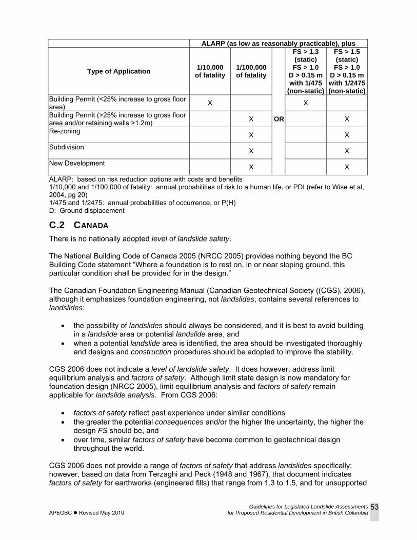
Guidelines for Legislated Landslide Assessments APEGBC Revised May 2010 for Proposed Residential Development in British Columbia
53
ALARP (as low as reasonably practicable), plus
Type of Application 1/10,000 of fatality
1/100,000 of fatality
FS > 1.3 (static) FS > 1.0
D > 0.15 m with 1/475
(non-static)
FS > 1.5 (static) FS > 1.0
D > 0.15 m with 1/2475(non-static)
Building Permit (<25% increase to gross floor area) X X
Building Permit (>25% increase to gross floor area and/or retaining walls >1.2m) X OR X
Re-zoning X X
Subdivision X X
New Development X X
ALARP: based on risk reduction options with costs and benefits 1/10,000 and 1/100,000 of fatality: annual probabilities of risk to a human life, or PDI (refer to Wise et al, 2004, pg 20) 1/475 and 1/2475: annual probabilities of occurrence, or P(H) D: Ground displacement
C.2 CANADA There is no nationally adopted level of landslide safety. The National Building Code of Canada 2005 (NRCC 2005) provides nothing beyond the BC Building Code statement “Where a foundation is to rest on, in or near sloping ground, this particular condition shall be provided for in the design.” The Canadian Foundation Engineering Manual (Canadian Geotechnical Society ((CGS), 2006), although it emphasizes foundation engineering, not landslides, contains several references to landslides:
• the possibility of landslides should always be considered, and it is best to avoid building in a landslide area or potential landslide area, and
• when a potential landslide area is identified, the area should be investigated thoroughly and designs and construction procedures should be adopted to improve the stability.
CGS 2006 does not indicate a level of landslide safety. It does however, address limit equilibrium analysis and factors of safety. Although limit state design is now mandatory for foundation design (NRCC 2005), limit equilibrium analysis and factors of safety remain applicable for landslide analysis. From CGS 2006:
• factors of safety reflect past experience under similar conditions • the greater the potential consequences and/or the higher the uncertainty, the higher the
design FS should be, and • over time, similar factors of safety have become common to geotechnical design
throughout the world. CGS 2006 does not provide a range of factors of safety that address landslides specifically; however, based on data from Terzaghi and Peck (1948 and 1967), that document indicates factors of safety for earthworks (engineered fills) that range from 1.3 to 1.5, and for unsupported
Guidelines for Legislated Landslide Assessments APEGBC Revised May 2010 for Proposed Residential Development in British Columbia
54
excavations (engineered cuts) that range from 1.5 to 2.0. CGS 2006 indicates a lower FS may be acceptable if:
• a particularly detailed soil investigation has been carried out; • where the analysis is supported by well documented local experience; • where geotechnical instrumentation to measure pore pressure and movement is
provided and monitored at regular intervals to check the slope behaviour; or • where slope failure would have only limited consequences.
CGS 2006 also addresses earthquake loading, and indicates:
• NRCC 2005 has selected ground motions with a probability of exceedance of 2% in 50 years (annual probability of 1/2475) for earthquake-resistant design purposes;
• FS of a slope under static conditions must be significantly greater than 1.0 to accommodate earthquake loads; and
• acceptable FS depends on the uncertainty in the analysis, the soil parameters and the magnitude and duration of seismic excitation, in addition to the potential consequences of slope failure.
A number of other geotechnical engineering manuals and textbooks, generally non-Canadian, provide some guidance to factors of safety related to landslides. References for Appendix C are included in Section 7 of these guidelines.
Guidelines for Legislated Landslide Assessments APEGBC Revised May 2010 for Proposed Residential Development in British Columbia
55
APPENDIX D: LANDSLIDE ASSESSMENT ASSURANCE STATEMENT Note: This Statement is to be read and completed in conjunction with the “APEGBC Guidelines for Legislated Landslide Assessments for Proposed Residential Development in British Columbia”, March 2006/Revised September 2008 (“APEGBC Guidelines”) and the “2006 BC Building Code (BCBC 2006)” and is to be provided for landslide assessments (not floods or flood controls) for the purposes of the Land Title Act, Community Charter or the Local Government Act. Italicized words are defined in the APEGBC Guidelines. To: The Approving Authority Date: _______________________________
Jurisdiction and address
With reference to (check one):
□ Land Title Act (Section 86) – Subdivision Approval □ Local Government Act (Sections 919.1 and 920) – Development Permit □ Community Charter (Section 56) – Building Permit □ Local Government Act (Section 910) – Flood Plain Bylaw Variance □ Local Government Act (Section 910) – Flood Plain Bylaw Exemption □ British Columbia Building Code 2006 sentences 4.1.8.16 (8) and 9.4 4.4.(2) (Refer to BC Building
and Safety Policy Branch Information Bulletin B10-01 issued January 18, 2010) For the Property: Legal description and civic address of the Property The undersigned hereby gives assurance that he/she is a Qualified Professional and is a Professional Engineer or Professional Geoscientist. I have signed, sealed and dated, and thereby certified, the attached landslide assessment report on the Property in accordance with the APEGBC Guidelines. That report must be read in conjunction with this Statement. In preparing that report I have: Check to the left of applicable items
___1. Collected and reviewed appropriate background information ___2. Reviewed the proposed residential development on the Property ___3. Conducted field work on and, if required, beyond the Property ___4. Reported on the results of the field work on and, if required, beyond the Property ___5. Considered any changed conditions on and, if required, beyond the Property
6. For a landslide hazard analysis or landslide risk analysis I have: ___6.1 reviewed and characterized, if appropriate, any landslide that may affect the Property ___6.2 estimated the landslide hazard ___6.3 identified existing and anticipated future elements at risk on and, if required, beyond the
Property ___6.4 estimated the potential consequences to those elements at risk
7. Where the Approving Authority has adopted a level of landslide safety I have: ___7.1 compared the level of landslide safety adopted by the Approving Authority with the findings of
my investigation ___7.2 made a finding on the level of landslide safety on the Property based on the comparison ___7.3 made recommendations to reduce landslide hazards and/or landslide risks
8. Where the Approving Authority has not adopted a level of landslide safety I have:
Guidelines for Legislated Landslide Assessments APEGBC Revised May 2010 for Proposed Residential Development in British Columbia
56
___8.1 described the method of landslide hazard analysis or landslide risk analysis used ___8.2 referred to an appropriate and identified provincial, national or international guideline for level
of landslide safety ___8.3 compared this guideline with the findings of my investigation ___8.4 made a finding on the level of landslide safety on the Property based on the comparison ___8.5 made recommendations to reduce landslide hazards and/or landslide risks
___9. Reported on the requirements for future inspections of the Property and recommended who should conduct those inspections.
Based on my comparison between
Check one □ the findings from the investigation and the adopted level of landslide safety (item 7.2 above) □ the appropriate and identified provincial, national or international guideline for level of
landslide safety (item 8.4 above) I hereby give my assurance that, based on the conditions[1] contained in the attached landslide assessment report,
Check one □ for subdivision approval, as required by the Land Title Act (Section 86), “that the land may be
used safely for the use intended” Check one □ with one or more recommended registered covenants. □ without any registered covenant.
□ for a development permit, as required by the Local Government Act (Sections 919.1 and 920), my report will “assist the local government in determining what conditions or requirements under [Section 920] subsection (7.1) it will impose in the permit”.
□ for a building permit, as required by the Community Charter (Section 56), “the land may be used safely for the use intended” Check one □ with one or more recommended registered covenants. □ without any registered covenant.
□ for flood plain bylaw variance, as required by the “Flood Hazard Area Land Use Management Guidelines” associated with the Local Government Act (Section 910), “the development may occur safely”.
□ for flood plain bylaw exemption, as required by the Local Government Act (Section 910), “the land may be used safely for the use intended”.
_____________________________________ _______________________________ Name (print) Date _____________________________________ Signature
[1] When seismic slope stability assessments are involved, level of landslide safety is considered to be a “life safety” criteria as described in the National Building Code of Canada (NBCC 2005), Commentary on Design for Seismic Effects in the User’s Guide, Structural Commentaries, Part 4 of Division B. This states:
“The primary objective of seismic design is to provide an acceptable level of safety for building occupants and the general public as the building responds to strong ground motion; in other words, to minimize loss of life. This implies that, although there will likely be extensive structural and non-structural damage, during the DGM (design ground motion), there is a reasonable degree of confidence that the building will not collapse nor will its attachments break off and fall on people near the building. This performance level is termed ‘extensive damage’ because, although the structure may be heavily damaged and may have lost a substantial amount of its initial strength and stiffness, it retains some margin of resistance against collapse”.

Guidelines for Legislated Landslide Assessments APEGBC Revised May 2010 for Proposed Residential Development in British Columbia
57
Address
______________________________________ (Affix Professional seal here) Telephone If the Qualified Professional is a member of a firm, complete the following. I am a member of the firm _______________________________________________________________ and I sign this letter on behalf of the firm. (Print name of firm)
Guidelines for Legislated Landslide Assessments APEGBC Revised May 2010 for Proposed Residential Development in British Columbia
58
APPENDIX E: METHODS OF SEISMIC ANALYSIS OF SOIL SLOPES E.1 INTRODUCTION
As discussed in Section 1 of the Guidelines, the impetus for the 2008 revisions was the publication of the 2006 BC Building Code (BCBC 2006). BCBC 2006 adopted the ground motions for seismic design as stated in the 2005 National Building Code for Canada (NBCC 2005). These ground motions have a probability of exceedance of 2% in 50 years20 (annual probability of exceedance of 1/2475), whereas the previously adopted ground motions for seismic design (NBCC 1995, BCBC 1998) had a probability of exceedance of 10% in 50 years21 (annual probability of exceedance of 1/475). The effect of this change was to increase the number of slopes that could be considered unstable during an earthquake, and therefore potentially not suitable for residential development. APEGBC, with support from the provincial government, established a Task Force on Seismic Slope Stability (TFSSS) to study this issue and to make appropriate recommendations. During its deliberations, the TFSSS reviewed current practice and recent developments in seismic analysis of soil slopes and recommends two new methods of analysis that are based on the concept of tolerable earthquake-induced slope displacements along a slip surface. These methods are relatively easy to use and achieve the NBCC 2005 objective of “life safety”22. These methods are intended for soil slopes, primarily where the location of the proposed residential building is at the top of the slope. The methods identified in this Appendix are suitable for application to both proposed residential and non-residential developments including institutional, commercial, industrial and infrastructure projects when combined with an appropriate limiting displacement and reference seismic hazard level.
E.2 REVIEW OF CURRENT PRACTICE In BC, the most common method currently used to carry out seismic slope stability analysis of soil slopes is the pseudo-static limit equilibrium method. In this method, earthquake loading is represented by a constant horizontal force, expressed as kW, applied to the centre of gravity of the potential sliding mass, where W is the weight of the sliding mass and k is a seismic coefficient expressed as a proportion of peak ground acceleration (PGA). This method is depicted in Figure E1. There is, however, no generally accepted method in BC for selecting seismic coefficients for slopes. From a limited survey, the TFSSS determined that seismic coefficients used in BC are typically in the range 0.5(PGA) ≤ k ≤ 1.0(PGA).
20 2% in 50-year ground motions 21 10% in 50-year ground motions 22 as described in NBCC 2005, Commentary on Design for Seismic Effects in the User’s Guide, Structural Commentaries, Part 4 of Division B. “The primary objective of seismic design is to provide an acceptable level of safety for building occupants and the general public as the building responds to strong ground motion; in other words, to minimize loss of life. This implies that, although there will likely be extensive structural and non-structural damage, during the DGM (design ground motion), there is a reasonable degree of confidence that the building will not collapse nor will its attachments break off and fall on people near the building. This performance level is termed ‘extensive damage’ because, although the structure may be heavily damaged and may have lost a substantial amount of its initial strength and stiffness, it retains some margin of resistance against collapse”.
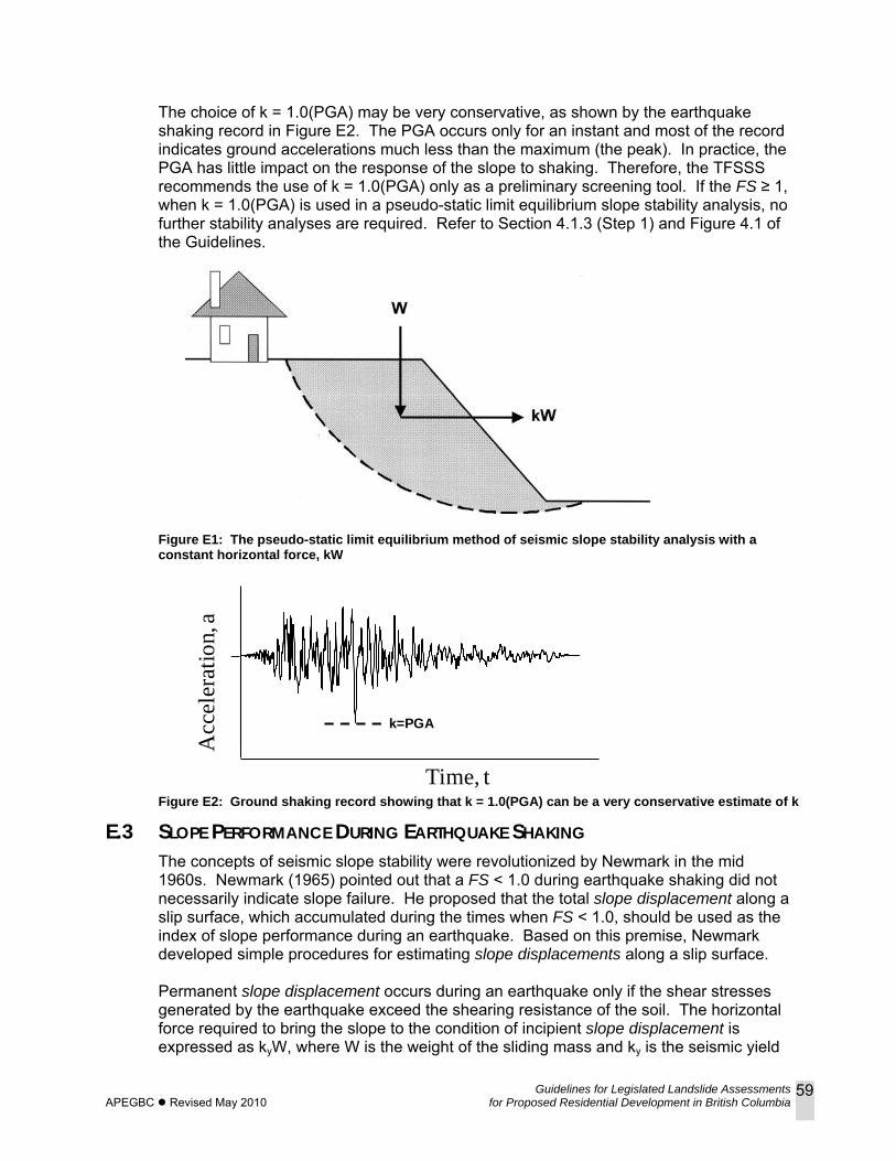
Guidelines for Legislated Landslide Assessments APEGBC Revised May 2010 for Proposed Residential Development in British Columbia
59
The choice of k = 1.0(PGA) may be very conservative, as shown by the earthquake shaking record in Figure E2. The PGA occurs only for an instant and most of the record indicates ground accelerations much less than the maximum (the peak). In practice, the PGA has little impact on the response of the slope to shaking. Therefore, the TFSSS recommends the use of k = 1.0(PGA) only as a preliminary screening tool. If the FS ≥ 1, when k = 1.0(PGA) is used in a pseudo-static limit equilibrium slope stability analysis, no further stability analyses are required. Refer to Section 4.1.3 (Step 1) and Figure 4.1 of the Guidelines.
Figure E1: The pseudo-static limit equilibrium method of seismic slope stability analysis with a constant horizontal force, kW
Time, t
k=PGA
0
a
t
Acc
eler
atio
n, a
Figure E2: Ground shaking record showing that k = 1.0(PGA) can be a very conservative estimate of k
E.3 SLOPE PERFORMANCE DURING EARTHQUAKE SHAKING The concepts of seismic slope stability were revolutionized by Newmark in the mid 1960s. Newmark (1965) pointed out that a FS < 1.0 during earthquake shaking did not necessarily indicate slope failure. He proposed that the total slope displacement along a slip surface, which accumulated during the times when FS < 1.0, should be used as the index of slope performance during an earthquake. Based on this premise, Newmark developed simple procedures for estimating slope displacements along a slip surface. Permanent slope displacement occurs during an earthquake only if the shear stresses generated by the earthquake exceed the shearing resistance of the soil. The horizontal force required to bring the slope to the condition of incipient slope displacement is expressed as kyW, where W is the weight of the sliding mass and ky is the seismic yield
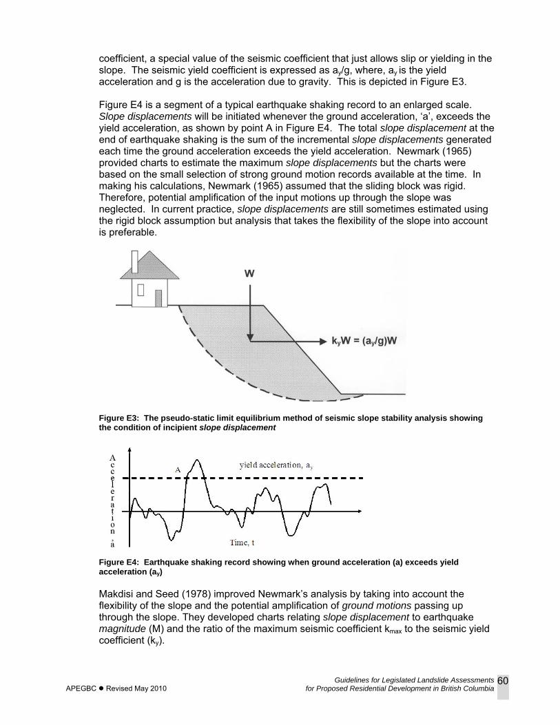
Guidelines for Legislated Landslide Assessments APEGBC Revised May 2010 for Proposed Residential Development in British Columbia
60
coefficient, a special value of the seismic coefficient that just allows slip or yielding in the slope. The seismic yield coefficient is expressed as ay/g, where, ay is the yield acceleration and g is the acceleration due to gravity. This is depicted in Figure E3. Figure E4 is a segment of a typical earthquake shaking record to an enlarged scale. Slope displacements will be initiated whenever the ground acceleration, ‘a’, exceeds the yield acceleration, as shown by point A in Figure E4. The total slope displacement at the end of earthquake shaking is the sum of the incremental slope displacements generated each time the ground acceleration exceeds the yield acceleration. Newmark (1965) provided charts to estimate the maximum slope displacements but the charts were based on the small selection of strong ground motion records available at the time. In making his calculations, Newmark (1965) assumed that the sliding block was rigid. Therefore, potential amplification of the input motions up through the slope was neglected. In current practice, slope displacements are still sometimes estimated using the rigid block assumption but analysis that takes the flexibility of the slope into account is preferable.
Figure E3: The pseudo-static limit equilibrium method of seismic slope stability analysis showing the condition of incipient slope displacement
Figure E4: Earthquake shaking record showing when ground acceleration (a) exceeds yield acceleration (ay) Makdisi and Seed (1978) improved Newmark’s analysis by taking into account the flexibility of the slope and the potential amplification of ground motions passing up through the slope. They developed charts relating slope displacement to earthquake magnitude (M) and the ratio of the maximum seismic coefficient kmax to the seismic yield coefficient (ky).
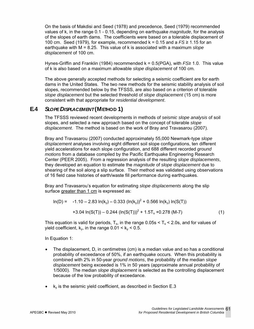
Guidelines for Legislated Landslide Assessments APEGBC Revised May 2010 for Proposed Residential Development in British Columbia
61
On the basis of Makdisi and Seed (1978) and precedence, Seed (1979) recommended values of k, in the range 0.1 - 0.15, depending on earthquake magnitude, for the analysis of the slopes of earth dams. The coefficients were based on a tolerable displacement of 100 cm. Seed (1979), for example, recommended k = 0.15 and a FS ≥ 1.15 for an earthquake with M = 8.25. This value of k is associated with a maximum slope displacement of 100 cm. Hynes-Griffin and Franklin (1984) recommended k = 0.5(PGA), with FS≥ 1.0. This value of k is also based on a maximum allowable slope displacement of 100 cm. The above generally accepted methods for selecting a seismic coefficient are for earth dams in the United States. The two new methods for the seismic stability analysis of soil slopes, recommended below by the TFSSS, are also based on a criterion of tolerable slope displacement but the selected threshold of slope displacement (15 cm) is more consistent with that appropriate for residential development.
E.4 SLOPE DISPLACEMENT (METHOD 1) The TFSSS reviewed recent developments in methods of seismic slope analysis of soil slopes, and selected a new approach based on the concept of tolerable slope displacement. The method is based on the work of Bray and Travasarou (2007). Bray and Travasarou (2007) conducted approximately 55,000 Newmark-type slope displacement analyses involving eight different soil slope configurations, ten different yield accelerations for each slope configuration, and 688 different recorded ground motions from a database compiled by the Pacific Earthquake Engineering Research Center (PEER 2005). From a regression analysis of the resulting slope displacements, they developed an equation to estimate the magnitude of slope displacement due to shearing of the soil along a slip surface. Their method was validated using observations of 16 field case histories of earth/waste fill performance during earthquakes. Bray and Travasarou’s equation for estimating slope displacements along the slip surface greater than 1 cm is expressed as:
ln(D) = -1.10 – 2.83 ln(ky) – 0.333 (ln(ky))2 + 0.566 ln(ky) ln(S(T)) +3.04 ln(S(T)) – 0.244 (ln(S(T)))2 + 1.5Ts +0.278 (M-7) (1)
This equation is valid for periods, Ts, in the range 0.05s < Ts < 2.0s, and for values of yield coefficient, ky, in the range 0.01 < ky < 0.5. In Equation 1: • The displacement, D, in centimetres (cm) is a median value and so has a conditional
probability of exceedance of 50%, if an earthquake occurs. When this probability is combined with 2% in 50-year ground motions, the probability of the median slope displacement being exceeded is 1% in 50 years (approximate annual probability of 1/5000). The median slope displacement is selected as the controlling displacement because of the low probability of exceedance.
• ky is the seismic yield coefficient, as described in Section E.3
Guidelines for Legislated Landslide Assessments APEGBC Revised May 2010 for Proposed Residential Development in British Columbia
62
ky is best determined by iterative analyses using commercially available computer programs. Simplified equations for estimating ky may be found in Bray (2007). Bray and Travasarou (2007) pointed out that “the primary issue in calculating ky is estimating the dynamic strength of the critical strata within the slope”. Because ky is assumed to be a constant during earthquake shaking, the method is for cases where the soil forming the slope does not undergo significant strength loss. The selection of appropriate shear strength parameters should follow best current practices. Blake et al (2002) and Duncan and Wright (2005) provide extensive discussions of the dynamic strength of soil.
• M is the moment magnitude of the design earthquake. Ground motions specified by BCBC 2006 are probabilistic. Therefore, they are not associated with any particular earthquake magnitude but reflect the contributions of all earthquake magnitudes considered in the probabilistic seismic hazard analysis. To use Equation 1, however, the Qualified Professional must select an appropriate magnitude. The TFSSS recommends using the modal magnitude. This is the moment magnitude providing the largest contribution to the ground motion. Since modal magnitudes for BC sites are rarely much larger than M = 7, it is suggested that M = 7 can be used for all sites. Alternatively modal magnitude values for BC are available for selected locations from Natural Resources Canada, Earth Sciences Sector, website (www earthquakescanada.ca).
• T is the degraded period of the sliding mass, in seconds (s), adjusted for the effects of strong shaking and is given by T=1.5 Ts, where Ts is the initial fundamental period of the potential sliding mass, in seconds (s), prior to the design seismic event, and, for slopes where the ground is relatively horizontal behind the crest, Ts can be estimated by: Ts = 4H/Vs (2) Where H is the average height and Vs is the average shear wave velocity in metres per second (m/s), of the potential sliding mass. For sliding along the base, H is the height of the slope. For other sliding surfaces, such as circular, the height is the estimated average depth of the sliding mass. Site investigations for most residential developments do not typically include measurements of shear wave velocity, but estimates can be inferred from standard penetration test or cone penetration test data (Sykora and Koester 1988).
• S(T) is the spectral response acceleration of the slope, in units of gravity (g) for the degraded slope period of 1.5Ts S(T) is given by the equation S(T) = F*Sa(1.5Ts) (3) where F is the amplification or deamplification factor for the site class of the ground below the slope, and Sa(1.5Ts) is the 5% damped spectral response acceleration at the site for firm soil conditions (reference Site Class C). Values of Sa for periods of 0.0(PGA), 0.2, 0.5, 1.0 and 2.0 seconds for a 2% probability of exceedance in 50 years are given in BCBC 2006 Division B Appendix C. They may also be obtained from the Geological Survey of Canada website (www.earthquakescanada.ca).
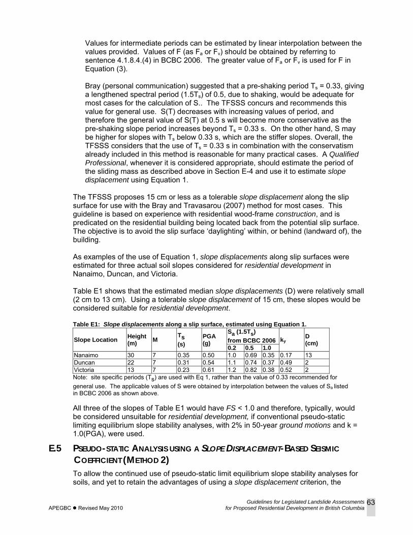
Guidelines for Legislated Landslide Assessments APEGBC Revised May 2010 for Proposed Residential Development in British Columbia
63
Values for intermediate periods can be estimated by linear interpolation between the values provided. Values of F (as Fa or Fv) should be obtained by referring to sentence 4.1.8.4.(4) in BCBC 2006. The greater value of Fa or Fv is used for F in Equation (3). Bray (personal communication) suggested that a pre-shaking period Ts = 0.33, giving a lengthened spectral period (1.5Ts) of 0.5, due to shaking, would be adequate for most cases for the calculation of S.. The TFSSS concurs and recommends this value for general use. S(T) decreases with increasing values of period, and therefore the general value of S(T) at 0.5 s will become more conservative as the pre-shaking slope period increases beyond Ts = 0.33 s. On the other hand, S may be higher for slopes with Ts below 0.33 s, which are the stiffer slopes. Overall, the TFSSS considers that the use of Ts = 0.33 s in combination with the conservatism already included in this method is reasonable for many practical cases. A Qualified Professional, whenever it is considered appropriate, should estimate the period of the sliding mass as described above in Section E-4 and use it to estimate slope displacement using Equation 1.
The TFSSS proposes 15 cm or less as a tolerable slope displacement along the slip surface for use with the Bray and Travasarou (2007) method for most cases. This guideline is based on experience with residential wood-frame construction, and is predicated on the residential building being located back from the potential slip surface. The objective is to avoid the slip surface ‘daylighting’ within, or behind (landward of), the building. As examples of the use of Equation 1, slope displacements along slip surfaces were estimated for three actual soil slopes considered for residential development in Nanaimo, Duncan, and Victoria. Table E1 shows that the estimated median slope displacements (D) were relatively small (2 cm to 13 cm). Using a tolerable slope displacement of 15 cm, these slopes would be considered suitable for residential development. Table E1: Slope displacements along a slip surface, estimated using Equation 1.
Slope Location Height (m) M
Ts (s)
PGA (g)
Sa (1.5Ts)
from BCBC 2006 ky D (cm)
0.2 0.5 1.0Nanaimo 30 7 0.35 0.50 1.0 0.69 0.35 0.17 13 Duncan 22 7 0.31 0.54 1.1 0.74 0.37 0.49 2 Victoria 13 7 0.23 0.61 1.2 0.82 0.38 0.52 2 Note: site specific periods (Ts) are used with Eq 1, rather than the value of 0.33 recommended for general use. The applicable values of S were obtained by interpolation between the values of Sa listed in BCBC 2006 as shown above. All three of the slopes of Table E1 would have FS < 1.0 and therefore, typically, would be considered unsuitable for residential development, if conventional pseudo-static limiting equilibrium slope stability analyses, with 2% in 50-year ground motions and k = 1.0(PGA), were used.
E.5 PSEUDO-STATIC ANALYSIS USING A SLOPE DISPLACEMENT-BASED SEISMIC COEFFICIENT (METHOD 2) To allow the continued use of pseudo-static limit equilibrium slope stability analyses for soils, and yet to retain the advantages of using a slope displacement criterion, the
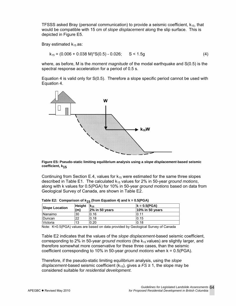
Guidelines for Legislated Landslide Assessments APEGBC Revised May 2010 for Proposed Residential Development in British Columbia
64
TFSSS asked Bray (personal communication) to provide a seismic coefficient, k15, that would be compatible with 15 cm of slope displacement along the slip surface. This is depicted in Figure E5.
Bray estimated k15 as:
k15 = (0.006 + 0.038 M)*S(0.5) - 0.026; S < 1.5g (4) where, as before, M is the moment magnitude of the modal earthquake and S(0.5) is the spectral response acceleration for a period of 0.5 s. Equation 4 is valid only for S(0.5). Therefore a slope specific period cannot be used with Equation 4.
Figure E5: Pseudo-static limiting equilibrium analysis using a slope displacement-based seismic coefficient, k15 Continuing from Section E.4, values for k15 were estimated for the same three slopes described in Table E1. The calculated k15 values for 2% in 50-year ground motions, along with k values for 0.5(PGA) for 10% in 50-year ground motions based on data from Geological Survey of Canada, are shown in Table E2. Table E2: Comparison of k15 (from Equation 4) and k = 0.5(PGA)
Slope Location Height (m)
k15 k = 0.5(PGA)2% in 50 years 10% in 50 years
Nanaimo 30 0.16 0.11 Duncan 22 0.18 0.15 Victoria 13 0.20 0.18
Note: K=0.5(PGA) values are based on data provided by Geological Survey of Canada Table E2 indicates that the values of the slope displacement-based seismic coefficient, corresponding to 2% in 50-year ground motions (the k15 values) are slightly larger, and therefore somewhat more conservative for these three cases, than the seismic coefficient corresponding to 10% in 50-year ground motions when k = 0.5(PGA). Therefore, if the pseudo-static limiting equilibrium analysis, using the slope displacement-based seismic coefficient (k15), gives a FS ≥ 1, the slope may be considered suitable for residential development.
Guidelines for Legislated Landslide Assessments APEGBC Revised May 2010 for Proposed Residential Development in British Columbia
65
E.6 LIMITATIONS As with all analyses based on assumptions and models, both methods presented in this appendix have limitations to their applicability. In certain cases, additional judgement should be exercised when applying the methods. In some unusual cases involving very weak layers that produce horizontal or nearly horizontal sliding, a FS greater than or equal to 1.0 may not be achievable using Method 2 (analysis using k15) and therefore the displacements may be greater than 15 cm. The actual probable displacements may be estimated using Method 1. Equation 1 in Section E.4 is valid for periods of Ts in the range 0.05s < Ts < 2.0s, and for values of yield coefficient of ky, in the range 0.01 < ky < 0.5. Equation 4 in Section E.5 is valid only for S(0.5). Therefore a slope specific period cannot be used for Equation 4.
E.7 CONCLUDING REMARKS The TFSSS recommends two methods of determining whether a soil slope is suitable for residential development,
• Method 1 involves estimating the median slope displacement along a slip surface with parameters that reflect slope properties and local seismicity (Equation 1). This slope displacement has an approximate annual probability of exceedance of 1/5000. It is the opinion of the TFSSS that 15 cm or less is a tolerable slope displacement, when the sliding surface is between the building foundation perimeter and the face of the slope.
• Method 2 is based on pseudo-static limit equilibrium seismic slope stability
analysis of soil slopes, similar to current practice. This method uses a slope displacement-based seismic coefficient (k15) given by Equation 4, that is equivalent to a tolerable median slope displacement along the slip surface of 15 cm, when the slope is subjected to design ground motions.
Both methods provide the Qualified Professional with a basis for exercising his/her judgment as to whether the slope is suitable for residential development. The results of the above two methods, when used in conjunction with 2% in 50-year ground motions (BCBC 2006), are comparable to the results obtained by the current pseudo-static limit equilibrium methods using 10% in 50-year ground motions (as recommended by BC Provincial Regulation M268, December 2006) and k = 0.5(PGA). The use of k = PGA with a FS ≥ 1.0 as a basis for final judgment on slope stability is considered by the TFSSS as too conservative for use with low probability events (for example, annual probability of exceedance of 1/2475), and is recommended only as a preliminary screening tool. The proposed procedure is intended to define the critical slip surface that has an estimated 15 cm of median displacement so that the building can be located behind (landward of) the critical slip surface. The tolerable slope displacement of 15 cm is proposed as a guideline, based on experience with residential wood-frame construction. This guideline is not intended to
Guidelines for Legislated Landslide Assessments APEGBC Revised May 2010 for Proposed Residential Development in British Columbia
66
preclude the Qualified Professional from selecting another value that he/she deems appropriate. Appendix E only addresses the mechanics of the proposed new methods for analyzing seismic slope stability of soil slopes. Other aspects of the analyses such as, for example, selecting appropriate shear strength parameters should reflect best current practices.
E.8 REFERENCES BCBC (BC Building Code) (1998). Published by the BC Ministry of Municipal Affairs.
BCBC (BC Building Code) (2006). Published by the Office of Housing and Construction Standards, BC Ministry of Forests and Range.
Blake, TF, Hollingsworth, N, Bray, JD and Stewart, JP (2002). Recommended Procedures for Implementing of DGM. Special Publication 117, Guidelines for Analyzing and Mitigating Landslide Hazards in California, Southern California Earthquake Center, University of Southern California, Los Angeles, California.
Bray, JD. (2007). Simplified Seismic Slope Displacement Procedures. Earthquake Geotechnical Engineering, Chapter 14 in Proceedings 4th International Conference on Earthquake Geotechnical Engineering – Invited Lectures, in Geotechnical, Geological and Earthquake Engineering Series, Vol. 6, Pitilakis, Kyriazis D, Springer, p 327-353.
Bray, JD and Travasarou, T (2007). Simplified procedure for estimating earthquake-induced deviatoric slope displacements. Journal of Geotechnical and Environmental Engineering, ASCE, Vol 153, No 4, p 381-392.
Duncan JD and Wright, SG (2005). Soil Strength and Slope Stability Wiley, Hoboken, NJ.
Hynes-Griffin, ME and Franklin, AG (1984). Rationalizing the Seismic Coefficient Method. Miscellaneous Paper GL-84-13, United States Army Engineers, WES, Vicksburg, MS.
Makdisi, F, and Seed, HB (1978). Simplified procedure for estimating dam and embankment earthquake-induced deformations. Journal of Geotechnical and Environmental Engineering, ASCE, Vol 104, No 4 , p 381-392.
NBCC (National Building Code of Canada) (1995). Published by the National Research Council of Canada, Ottawa.
NBCC (National Building Code of Canada) (2005). Published by the National Research Council of Canada, Ottawa.
Newmark, NM (1965). Effects of earthquakes on dams and embankments, Geotechnique, 15(2) p 139-160.
Pacific Earthquake Engineering Research (PEER) Center Database (2005). [Web]
Seed, HB (1979). Considerations in the earthquake-resistant design of earth and rockfill dams, Geotechnique, Vol 29, No 3, p 215-263.
Sykora DW and Koester JP (1988). Review of existing correlations between dynamic shear resistance and standard penetrations in soils. Proceedings, Earthquake Engineering and Soil Dynamics II - Recent Advances in Ground Motion Evaluation, ASCE Geotechnical Engineering Division, Park City, Utah.
Guidelines for Legislated Landslide Assessments APEGBC Revised May 2010 for Proposed Residential Development in British Columbia
67
APPENDIX F: REVIEW OF EARTHQUAKE-INDUCED LANDSLIDES F.1 INTRODUCTION Earthquakes can:
• destabilize rock masses by overturning or sliding • reduce soil strength by:
remoulding clay breaking cohesive or cementation bonds, and transferring inter-particle stresses to the porewater by shaking-induced volumetric
contraction, resulting in a reduction in effective stress, possible liquefaction, and/or slope settlement
• cause permanent slope displacements by intermittently exceeding soil or rock strength. Earthquake-induced landslides can occur both subaerially (above water) and subaqueously (below water). The following sections provides some global examples of, and references to, earthquake-induced landslides. Such publications can provide a general understanding of how earthquakes cause, or at least trigger, landslides, and can provide a range of conditions and circumstances that can lead to earthquake-induced landslides. The examples chosen illustrate some of the factors that require consideration in assessing landslide hazard and landslide risk, including:
• the historical frequency of earthquake-induced landslides throughout the world • the variable areas of influence, distances from the epicentres and landslide volumes, for
earthquakes of different magnitudes • the potential for earthquakes to trigger potentially large rock avalanches in marginally
stable rock formations • the dominant types of earthquake-induce landslides, principally, rock falls, earth slumps
and debris slides • the topographic amplification where bluffs and promontories exist, and the retreat of
coastal bluffs • the loss of cohesion during ground shaking, especially in weakly bonded soils and rocks • the occurrence of earthquake-induced landslides where slopes are marginally stable
under static loading conditions.
F.2 EXTENT OF EARTHQUAKE-INDUCED LANDSLIDES Detailed studies of earthquake-induced landslides have been carried out over the past 30 years by the United States Geological Survey (USGS). These studies have been global, but focused the USA. Based on numerous earthquakes in the twentieth century, Keefer (of the USGS) has investigated earthquake-induced landslides, in terms of distance from the epicentre, the geographic area affected by landslides, and the total volume of all landslides during each particular seismic event for earthquakes of different magnitudes (Keefer 1984,1994). The values summarized in Table F.1 represent ranges and approximate upper bounds. Regional variations depend on the geology and the type of landslide. Within the USA, the smallest earthquake reported to have triggered a landslide is magnitude 4 (M4), but theoretically even a M3 earthquake can induce a landslide on a marginally stable slope.
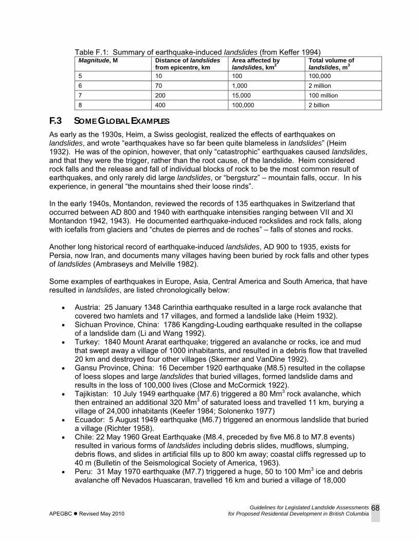
Guidelines for Legislated Landslide Assessments APEGBC Revised May 2010 for Proposed Residential Development in British Columbia
68
Table F.1: Summary of earthquake-induced landslides (from Keffer 1994)
Magnitude, M Distance of landslidesfrom epicentre, km
Area affected by landslides, km2
Total volume of landslides, m3
5 10 100 100,000 6 70 1,000 2 million 7 200 15,000 100 million 8 400 100,000 2 billion
F.3 SOME GLOBAL EXAMPLES As early as the 1930s, Heim, a Swiss geologist, realized the effects of earthquakes on landslides, and wrote “earthquakes have so far been quite blameless in landslides” (Heim 1932). He was of the opinion, however, that only “catastrophic” earthquakes caused landslides, and that they were the trigger, rather than the root cause, of the landslide. Heim considered rock falls and the release and fall of individual blocks of rock to be the most common result of earthquakes, and only rarely did large landslides, or “bergsturz” – mountain falls, occur. In his experience, in general “the mountains shed their loose rinds”. In the early 1940s, Montandon, reviewed the records of 135 earthquakes in Switzerland that occurred between AD 800 and 1940 with earthquake intensities ranging between VII and XI Montandon 1942, 1943). He documented earthquake-induced rockslides and rock falls, along with icefalls from glaciers and “chutes de pierres and de roches” – falls of stones and rocks. Another long historical record of earthquake-induced landslides, AD 900 to 1935, exists for Persia, now Iran, and documents many villages having been buried by rock falls and other types of landslides (Ambraseys and Melville 1982). Some examples of earthquakes in Europe, Asia, Central America and South America, that have resulted in landslides, are listed chronologically below:
• Austria: 25 January 1348 Carinthia earthquake resulted in a large rock avalanche that covered two hamlets and 17 villages, and formed a landslide lake (Heim 1932).
• Sichuan Province, China: 1786 Kangding-Louding earthquake resulted in the collapse of a landslide dam (Li and Wang 1992).
• Turkey: 1840 Mount Ararat earthquake; triggered an avalanche or rocks, ice and mud that swept away a village of 1000 inhabitants, and resulted in a debris flow that travelled 20 km and destroyed four other villages (Skermer and VanDine 1992).
• Gansu Province, China: 16 December 1920 earthquake (M8.5) resulted in the collapse of loess slopes and large landslides that buried villages, formed landslide dams and results in the loss of 100,000 lives (Close and McCormick 1922).
• Tajikistan: 10 July 1949 earthquake (M7.6) triggered a 80 Mm3 rock avalanche, which then entrained an additional 320 Mm3 of saturated loess and travelled 11 km, burying a village of 24,000 inhabitants (Keefer 1984; Solonenko 1977)
• Ecuador: 5 August 1949 earthquake (M6.7) triggered an enormous landslide that buried a village (Richter 1958).
• Chile: 22 May 1960 Great Earthquake (M8.4, preceded by five M6.8 to M7.8 events) resulted in various forms of landslides including debris slides, mudflows, slumping, debris flows, and slides in artificial fills up to 800 km away; coastal cliffs regressed up to 40 m (Bulletin of the Seismological Society of America, 1963).
• Peru: 31 May 1970 earthquake (M7.7) triggered a huge, 50 to 100 Mm3 ice and debris avalanche off Nevados Huascaran, travelled 16 km and buried a village of 18,000
Guidelines for Legislated Landslide Assessments APEGBC Revised May 2010 for Proposed Residential Development in British Columbia
69
inhabitants (one of the most catastrophic landslides in western history). It also triggered many other landslides within a 30,000 km2 area (Plafker and Ericksen 1978).
• Pakistan: 1974 Pattan earthquake (M6) triggered numerous rock falls up to 70 km away, one of which buried a village of 500 inhabitants. Very few other types of landslides, however, were reported (Ambraseys et al 1975).
• Northern Italy: 1976 (M6.5) Friuli earthquake set off numerous debris falls and rock falls, striking one village (Ambraseys 1976; Panizza 1991).
• Guatemala: 4 February 1976 Guatemala earthquake (M7.5), triggered more than 10,000 landslides, predominantly rock falls and debris slides, over an area of about 16,000 km2. Most of the landslides were < 15,000 m3; 11 were > 100,000 m3. Caused extensive property damage and hundreds of fatalities (Harp et al 1981). Loss of cohesion occurred in the weakly cemented rocks (Sitar and Clough 1983).
• Southern Italy: 1980 Irpinia earthquake reactivated extensive paleo-landslides (Panizza 1991).
• Ecuador: two 1987 earthquakes (M6.1 and M6.9) triggered thousands of debris slides and debris flows in both soil and rock, and results in $1.5 billion in losses and many deaths (Benitez 1989).
• Taiwan: 20 September Chi-Chi 1999 earthquake (M7.6) triggered two rock avalanches, 120 Mm3 and 30 Mm3. A 1979 earthquake (M6 to M7) in the same area also resulted in a rock avalanche (Huang et al, 2001).
F.4 SOME UNITED STATES EXAMPLES In Washington State, 15 earthquakes, from 1872 to 2001, are known to have triggered landslides (Noson et al 1988). For example, a 100 m high bluff along the Tacoma Narrows, thought to have been weakened by the 1949 Olympia earthquake (M7.1), slid into Puget Sound three days after the earthquake. In each of the 1949 and 1965 Puget Sound earthquakes, about 20 landslides resulted (Noson et al 1988). The 2001 Nisqually earthquake (M6.8) caused a number of landslides, mostly earth slumps, debris avalanches and lateral spreads (Walsh et al 2001). For California, Youd and Hoose (1978) have reviewed historic earthquakes and associated landslides in the northern portion of the state over the 200-year period, 1769 to 1970. Landslides following recent major earthquakes in California are well-documented. For example:
• Morton (1971) mapped landslide locations for the 1971 San Fernando earthquake (M6.4) and distinguished between landslide type and predominance.
• The 1989 Loma Prieta earthquake (M7.1) in the San Francisco – Monteray Bay area triggered an estimated 2000 to 4000 rock, soil and debris falls and slides over an area of 14,000 km2. Rock falls, < 100 m3, were the most common type of landslide; deep-seated (3-30 m), slower moving rotational slumps and translational block slides were also common. Total damages was in the tens of millions of dollars (Plafker and Galloway 1989). Widespread coastal landslides occurred up to 80 km from the epicentre. Peak ground accelerations of 0.5 to 0.6 g were recorded (Plant and Griggs 1990). See also Keefer et al (2002).
• The 1994 Northridge earthquake in southern California (M6.6) induced tens of thousands of landslides (< 1 m3 to > 1,000,000 m3) over an area of roughly 10,000 km2 (Harp and Jibson 1995; 1996; Malamud et al 2004)
Guidelines for Legislated Landslide Assessments APEGBC Revised May 2010 for Proposed Residential Development in British Columbia
70
Other examples from the United States include the following:
• In what is now Missouri: the 1811 and 1812 New Madrid earthquakes (the largest estimated to have been M7.1 to M7.4) triggered over 200 landslides, many translational, earth flows and rotational slumps, over a 300 km length between Illinois and Tennessee (Jibson and Keefer 1988, 1993).
• Montana: 17 August 1959 Hebgen Lake earthquake (M7·1) triggered the Madison Canyon rockslide (32 Mm2), one of the largest rock avalanches in historic times, and killed 26 people in a campground (Hadley 1959, 1978).
• Alaska: 27 March 1964 Good Friday earthquake (M8.6) triggered the Sherman rock avalanche (30 Mm3), a distance of 130 km from the epicentre (Shreve 1966).
F.5 WESTERN CANADA The 23 June 1946 central Vancouver Island earthquake (M7.2) resulted in approximately 360 landslides, principally rock falls, that occurred between Latitudes 49° and 50° N, some 50 km from the epicentre (Mathews 1979). Hodgson (1946) mentions a number of resulting landslides, including some subaqueous landslides and slumps. The largest landslide triggered by the earthquake was the 1.5 Mm3 Mount Colonel Foster rockslide (Evans 1989). In the Northwest Territories, the October 1985 Nahanni earthquake (M6.6) triggered a 5 to 7 Mm3 rock avalanche approximately 10 km from the epicentre. The larger (M6.9), December 1985 earthquake in the same area triggered numerous rock falls, one of which was estimated to be 100,000 m3 (Evans et al 1987). In most of the global and United States examples, above, there were many (sometimes in the tens of thousands) fatalities associated with the earthquake-related landslides. Despite the fact that BC is in a high earthquake hazard zone, there have been no recorded deaths from earthquake-related landslides in the past century. To a large extent this can be attributed to the sparsely populated extent of the province and the fact that in general the larger earthquakes have occurred off the coast of BC and in remote areas. With increasing population, however, and in particular the expansion of communities into and onto more mountainous terrain, the risk, in contrast to the hazard, is expected to increase. References for Appendix F are included in Section 7 of these guidelines.
Guidelines for Legislated Landslide Assessments APEGBC Revised May 2010 for Proposed Residential Development in British Columbia
71
APPENDIX G: GEOTECHNICAL DESIGN GUIDELINES FOR BUILDINGS ON LIQUEFIABLE SITES Reference:
Greater Vancouver Liquefaction Task Force (May 8, 2007). Task Force Report - Geotechnical Design Guidelines for Buildings on Liquefiable Sites in accordance with NBC 2005 for Greater Vancouver Region
This document is available on the web at http://www.civil.ubc.ca/liquefaction/ From the Preamble “In 1991, a task force consisting of a group of local geotechnical and structural engineers produced a report entitled Earthquake Design in the Fraser Delta (Task Force Report 1991). The report was intended to provide general design guidelines for engineers involved in the seismic design of foundations for buildings in the Fraser Delta where liquefaction is a concern. At that time, the building code in effect was the National Building Code of Canada (1990) [NBCC 1990], and the seismic hazard stipulated by this code remained essentially unchanged until 2005. However, in 2005 the national building code changed to a new version, National Building Code of Canada (2005) [NBCC 2005], which includes a substantial increase in the return period of ground motions required for design. The seismic hazard in NBCC 1990 was based on a probability of exceedance of 10% in 50 years (the 475 year ground motions), while NBCC 2005 is based on an exceedance probability of 2% in 50 years ([the] 2475 year ground motions). Furthermore, the seismic design philosophy has changed to collapse prevention from what used to be moderate damage and life safety. NBCC 2005 considers the explicit use of over-strength factors for structural design, so that the lateral force levels required for the seismic design of structures has not changed appreciably. However, the larger intensity of ground motions poses problems for geotechnical engineers in assessing the potential for soil liquefaction, analysis and design of the foundations and the resulting movements, and if needed, remedial measures. Included in this report is a discussion on the structural deformation limits prescribed in NBCC 2005, and how deformations caused by liquefaction might be assessed. The purpose of this report is to provide revised general guidelines for geotechnical and structural engineers taking into consideration the longer return period ground motions and the change in seismic design philosophy. Since 1991, there have been considerable advances in the methods used to assess soil liquefaction, as well as analysis techniques that can better predict movements associated with liquefied sites. Furthermore, there have been a number of earthquakes in the past 15 years that have caused widespread soil liquefaction and foundation damage, and observations from these events have led to better analysis and design procedures for dealing with soil liquefaction. However, there are many judgmental factors in assessing soil liquefaction, and its implications on safety, and there is a need for some consensus on these issues to agree on an accepted state of practice when using the new NBCC 2005. This Task Force Report reflects a consensus of the task force members on recommended design philosophies and methodologies to be followed in the seismic design of foundations. NBCC 2005 presents the seismic hazard in terms of a probabilistic-based uniform hazard spectrum, replacing the probabilistic estimates of peak ground velocity (PGV) and peak ground acceleration (PGA) in earlier codes. In addition, NBCC 2005 explicitly considers ground motions from the potential Cascadia subduction earthquake located off the west coast of Vancouver Island. While the amplitude of peak ground motions resulting from such an

Guidelines for Legislated Landslide Assessments APEGBC Revised May 2010 for Proposed Residential Development in British Columbia
72
earthquake are expected to be smaller than from local crustal earthquakes, the duration of shaking will be greater which has implications for liquefaction assessment. This report presents guidelines for the analysis and design of building foundations in Greater Vancouver, where soil liquefaction is a concern. The concepts and guidelines presented herein may be extended to other geographic areas with appropriate modifications of the seismic hazard.”
Guidelines for Legislated Landslide Assessments APEGBC Revised May 2010 for Proposed Residential Development in British Columbia
73
APPENDIX H: PRELIMINARY SITE RESPONSE Reference: Association of Professional Engineers and Geoscientists of British Columbia (APEGBC) and University of British
Columbia (UBC) (March 2007). Preliminary Site Response Analysis, a report associated with “Bridging Guidelines for the Performance-based Seismic Retrofit of British Columbia School Building – Second Edition” Prepared for the BC Ministry of Education.
This document is available upon request from APEGBC. Paraphrased from the Introduction “The second edition of the ‘Bridging Guidelines for the Performance-based Seismic Retrofit of British Columbia School Building’ recommended that a seismic site response analysis be carried out for all public school building in British Columbia founded on Site Class E or Site Class F soils, as defined in the National Building Code of Canada 2005 (NBCC 2005, Section 4.1.8.4). Several of these seismic site response analyses are presently underway to complete Stage 2 feasibility studies, or to prepare for final school building designs. During the development of the second edition of the ‘Bridging Guidelines’, the need to extend seismic site response analyses to Site Class D sites as well was recommended by the APEGBC Seismic Peer Review Committee (PRC). Given the potentially high number of school building founded on Site Class D sites, and keeping in mind the BC Ministry of Education’s commitment to cost-effective seismic retrofit solutions, the PRC recommended analysing the seismic surface response of at least 10 Site Class D sites. The results of these 10 analyses could then be used to refine the tables in the second edition of the ‘Bridging Guidelines’ that address the “minimum required factored resistance (Rm) for the retrofit of the building”. This study was carried out in response to the PRC recommendation. The results presented in this report are preliminary and correspond to schools founded on Site Class C, D and E sites, rather that just Site Class D sites. It is the opinion of the authors that including seismic site response analysis for different Site Classes provides valuable insight into the significant influence that Site Class has on the expected performance of various structural systems considered within the scope of the ’Bridging Guidelines’. It is anticipated that some Site Class D sites may exhibit substantial amplification of surface ground motions. The results of this study clearly demonstrate the need for further study on the influence of Site Class on the expected earthquake response of a school building.”
Guidelines for Legislated Landslide Assessments APEGBC Revised May 2010 for Proposed Residential Development in British Columbia
74
APPENDIX I: AUTHORS AND REVIEWERS AUTHORS (2006)
Robert Gerath PGeo, Thurber Engineering, Vancouver, BC Matthias Jakob PhD PGeo, BGC Engineering, Vancouver, BC Peter Mitchell PEng, APEGBC, Burnaby, BC Doug VanDine PEng/PGeo, VanDine Geological Engineering, Victoria, BC
APEGBC INTERNAL REVIEW TASK FORCE (2006) Oldrich Hungr PhD PEng/PGeo, Earth and Ocean Sciences, University of British
Columbia, Vancouver, BC Norbert Morgenstern PhD, Geotechnical Engineering, University of Alberta, Edmonton,
AB Nigel Skermer PEng, Consulting Engineer, Kaleden, BC Calvin VanBuskirk PEng/PGeo, Terratech Consulting, Salmon Arm, BC Consulting Engineers of BC
Richard Butler PEng, Golder Associates, Burnaby, BC James O’Brien PEng, Trow Associates, Vancouver, BC
EXTERNAL REVIEW GROUP (2006) Association of Regional District Planning Managers
Bob Finlay, Kamloops, BC Gordon Simmins, Prince George, BC
BC Ministry of Community Services Bill Hout, Victoria, BC
BC Ministry of Environment Dwain Boyer PEng, Nelson, BC Brian McMullen PEng, Victoria, BC Duane Wells, Kamloops, BC
BC Ministry of Forests Peter Egyir PEng, Prince George, BC Peter Jordan PGeo, Nelson, BC Tom Millard PGeo, Nanaimo, BC Glenn Moore PEng, Victoria, BC Doug Nicol PEng, Nelson, BC Kevin Turner PEng, Kamloops, BC
BC Ministry of Public Safety and Solicitor General, Provincial Emergency Program Jim Whyte, Victoria, BC
BC Ministry of Transportation Rob Buchanan PGeo, Victoria, BC Bill Eisbrenner PEng, Prince George, BC Sarah Gaib PEng, Victoria, BC David Gerraghty PEng, Burnaby, BC Don Gillespie PEng, Victoria, BC Gordon Hunter PEng, Prince George, BC Daryn Yonin PEng, Nelson, BC
Fraser Valley Regional District Frank Kelly, Chilliwack, BC Hugh Sloan, Chilliwack, BC
Municipal Insurance Association of British Columbia Dave Tupper, Vancouver, BC
Guidelines for Legislated Landslide Assessments APEGBC Revised May 2010 for Proposed Residential Development in British Columbia
75
AUTHORS (2008) (Following are the authors as appointed by APEGBC Council as members of the Task Force on Seismic Slope Stability (TFSSS))
Liam Finn PhD PEng, Civil Engineering, University of British Columbia, Vancouver, BC Robert Gerath PGeo, Qcd Geotechnics, Vancouver, BC Don Gillespie PEng, BC Ministry of Transportation, Victoria, BC Matthias Jakob PhD PGeo, BGC Engineering, Vancouver, BC Steven Kuan PhD PEng, Building and Safety Policy Branch, Office of Housing and
Construction Standards, BC Ministry of Forests and Range and Minister Responsible for Housing, Victoria, BC
Ernest Naesgaard PEng, Naesgaard Geotechnical, Bowen Island, BC Bob Patrick PEng, EBA Engineering, Nanaimo, BC Nigel Skermer PEng, Consulting Engineer, Kaleden, BC Doug Wallis PEng, Levelton Engineering, Vancouver, BC Peter Mitchell PEng, APEGBC, Burnaby, BC
APEGBC INTERNAL REVIEWERS (2008) Norman Cameron Doug VanDine PEng/PGeo, VanDine Geological Engineering, Victoria, BC Adrian Wightman, PEng, BGC Engineering, Vancouver, BC Upal Atukorala, PhD, PEng, Golder Associates, Burnaby, BC James Wetherill, PEng, Braun Geotechnical, Vancouver, BC.
ADVISOR (2008) Johnathan Bray, PhD, PE, Professor of GeoEngineering, University of California, Berkeley advised the TFSSS on all aspects of Methods 1 and 2 in Appendix E
EDITORIAL CONSULTANT (2008) Doug VanDine, PEng/PGeo, VanDine Geological Engineering, Victoria, BC