kahurangi national park management plan · issn 1170-9626 (print) issn 1179-4429 ... the amendment...
TRANSCRIPT

JUNE 2001
Kahurangi National Park Management Plan
(incorporating the 2009/2010 partial review and 2016/2017 amendment)


Kahurangi National Park Management Plan
(incorporating the 2009/2010 partial review and 2016/2017 amendment)
JUNE 2001
Published by Department of ConservationNelson/Marlborough Conservancy Private Bag 5Nelson, New Zealand

© Copyright 2001, New Zealand Department of Conservation
Management Plan Series 18
ISSN 1170-9626 (print)ISSN 1179-4429 (web)ISBN 978-0-478-14846-6 (print)ISBN 978-0-478-14847-3 (web)
Cover: Looking West, Saddle Lake, adjacent to Wangapeka Track, Little Wanganui Saddle, Kahurangi National Park. Photographer: Janice Gravett.

5
Kahurangi National Park Management Plan 2016/2017 amendment
E X P L A N A T I O N O F 2 0 1 6 / 2 0 1 7 A M E N D M E N T
The 2016/2017 amendment to the Kahurangi National Park Management
Plan (incorporating 2009/2010 partial review) was carried out in
accordance with sections 46–48 of the National Parks Act 1980. The
purpose of the amendment was to extend the mountain biking season
on the Heaphy Track.
The Department prepared the draft amendment to the management plan
in consultation with the Nelson Marlborough Conservation Board, iwi
and key stakeholders. The draft amendment, to extend the Heaphy Track
mountain biking season from 1 May – 30 September to 1 April – 30
November, was publicly notified on 11 May 2016 for written comments
(submissions). During the submission period, which closed on 12 July
2016, 188 submissions were received. Hearings for eight submitters
were held in Motueka and Westport in August 2016. The hearing panel
comprised two representatives from the Department and two members
of the Nelson Marlborough Conservation Board (the Board).
Following the hearings and consideration of all submissions, the
amendment was revised to remove April, but retain October/November,
for the mountain biking season extension. The Board agreed with this
revision in December 2016 and recommended it to the New Zealand
Conservation Authority (NZCA) for approval. The NZCA considered
the recommendation and comments from the Minister of Conservation
before approving the plan amendment on 3 April 2017, subject to a few
requirements, including reporting back to the NZCA on monitoring.
The amendment is part of this Kahurangi National Park Management Plan.

Kahurangi National Park Management Plan 2009/2010 Partial Review
E X P L A N A T I O N O F 2 0 0 9 / 2 0 1 0 P A R T I A L R E V I E W
The 2009/2010 partial review of the Kahurangi National Park Management Plan was prepared in accordance with sections 46 and 47 of the National Parks Act 1980. It reviewed parts of the existing Kahurangi National Park Management Plan 2001.
The matters reviewed were:
(a) Mountain bike access on the Heaphy, Flora Saddle to Barron Flat (Flora Carpark to Upper Takaka Valley), Kill Devil (adjacent to Uruwhenua Road, Upper Takaka) and Lake Sylvester tracks.
(b) Private accommodation on the Heaphy Track.
(c) Access provisions for aircraft.
(d) Hunting access restrictions.
(e) Horse riding concessionaire access – limited to a part of the Park near Puponga Farm Park.
The Nelson/Marlborough Conservancy of the Department of Conservation prepared the partial review of the management plan in consultation with key stakeholders, the Nelson/ Marlborough Conservation Board, iwi, and other interested groups and individuals.
The Department notified its intention to carry out a partial review of the plan in July 2007 and received 160 written suggestions. The Department took those suggestions into account in the development of the draft partial review.
The draft partial review was publicly notified for comment (submissions) on 1 July 2009. The submission period closed 4 September 2009. 645 submissions were received. All comments were considered by a hearing panel comprising members of the Nelson/Marlborough Conservation Board and Departmental representatives. Hearings were held in Nelson, Motueka, Takaka and Karamea for those submitters who indicated they wished to be heard.
As a result of the hearings and consideration of all submissions, changes were made to the draft partial review prior to it being presented to the New Zealand Conservation Authority (NZCA) on 15 April 2010 for approval. Following consideration by the NZCA and the Minister of Conservation, some further changes were made before the partial review was approved by the NZCA on 8 December 2010. These changes include minor amendments to spelling and grammar within those parts of the original plan not subject to the partial review.
The partial plan review is part of, and will be effective for, the life of
the Kahurangi National Park Management Plan.

CONTENTS
Preface 7
1. Introduction 11
1.1 Management Planning 11
1.2 Legislative Context 13
1.2.1 The National Parks Act 1980 13
1.2.2 The General Policy for National Parks 14
1.2.3 The Conservation Act 1987 14
1.2.4 The Conservation Amendment Act 1996 15
1.2.5 Ngai Tahu Acts 15
1.2.6 The Resource Management Act 1991 15
1.2.7 The Crown Minerals Act 1991 16
1.2.8 Other strategies and plans 16
1.2.9 Other bodies with administrative responsibilities 16
1.3 Background 17
1.3.1 Physical landscape 17
1.3.2 Waters 22
1.3.3 Ecosystems, plants and animals 23
1.3.4 Introduced animals and plants 27
1.3.5 Historic and cultural heritage 30
1.3.6 Use and accessibility 33
1.4 Vision 39
1.5 Primary Objectives 39
1.6 Heaphy Track Corridor Place 40
1.6.1 Outcomes for Heaphy Track Corridor 40
1.6.2 Description of the Heaphy Track Corridor 40
1.6.3 Justification for the Heaphy Track Corridor 43
1.6.4 Values of the Heaphy Track Corridor 43
2. Treaty of Waitangi 47
3. Heritage preservation 51
3.1 Biodiversity 51
3.2 Landscape 63
3.3 Historic preservation 66
4. Use and accessibility 71
4.1 Visitor Services and Management 71
4.1.1 Mountain biking 82
4.1.2 The Tasman Wilderness Area 102
4.1.3 The Honeycomb Hill Caves Specially Protected Area 105
4.2 Concessions 107
4.2.1 Air access 122
4.2.2 Customary harvest and use 137
4.3 Mining 141

5. Community relations 143
6. Administration 149
7. Implementation and review 155
Appendices 157
Appendix 1: Native plants 157
Appendix 2: Ngai Tahu values relating to Kahurangi 161
Appendix 3: Ngai Tahu acts 165
Appendix 4: The principles of the Treaty of Waitangi 167
Appendix 5: Recreational Opportunities Spectrum (ROS)
classification categories 169
Appendix 6: National parks act 1980 - offences 177
Appendix A: Mountain bikers code 179
Appendix B: Mountain bike grading System 181
Appendix C: Schedule of aircraft landing zone boundaries 183
Glossary 189
Bibliography 197

7
Preface
This Management Plan for Kahurangi National Park has been prepared
in accordance with Sections 45-48 of the National Parks Act 1980. This
Management Plan is a statutory document which implements Conservation
Management Strategies and provides for the management of Kahurangi
National Park in accordance with General Policies and the Act.
A partial review has been carried out for specific sections of the
management plan to meet changed circumstances and policy. The partial
review process was undertaken in accordance with sections 45 - 47 of
the National Parks Act 1980. The outcomes of the partial review will
remain in place for the life of the management plan.
A Management Plan is generally a statement of intent and does not
override the provisions of legislation, general policy and agreements.
The objectives of this plan express the Department’s overall management
intentions for Kahurangi National Park over the next 10 years. Achievement
will be determined by the availability of resources and level of community
support. The plan does not establish a promised level of funding.
Nonetheless, the stated objectives are underscored by a commitment to
endeavour to obtain the necessary funding and support.
This Management Plan has been prepared jointly by the Nelson/
Marlborough Conservancy and the West Coast Tai Poutini Conservancy of
the Department of Conservation, in consultation with the general public
and with representatives from tangata whenua, the Nelson/Marlborough
Conservation Board and other interested groups and individuals.
This management plan recognises the mana and tangata whenua status of
Ngai Tahu, Ngati Apa, Ngati Rarua, Ngati Tama and Te Atiawa over their
ancestral lands and waters within the Park and its significance to them.
The recognition of mana and tangata whenua status is present through
all sections and policies of this management plan.
This plan is a working tool for the future of the Park only, but
acknowledges the Crown’s relationship with and obligations to Ngai Tahu,
Ngati Apa, Ngati Rarua, Ngati Tama and Te Atiawa under Section 4 of
the Conservation Act 1987 which requires the Department to give effect
to the principles of the Treaty of Waitangi. This plan also acknowledges
the Department's obligations under the Ngai Tahu Claims Settlement Act
1998.
Prior to Kahurangi becoming a national park a discussion document
was prepared for the national park investigation. Submissions on that
document were taken into account in the development of the draft plan.
The first round of public consultation on the draft plan was carried out
in July 1996 when a notice was published calling for suggestions.

8
The draft plan was then notified for public submission on 1 November
1997. A total of 317 submissions were received and 60 submitters were
heard in support of their submissions. These submissions were taken into
account in the development of this plan.
The plan will be effective for 10 years from the date of approval (13
June 2001), but may be reviewed at any time as a result of changes
in circumstance. A partial review was undertaken in 2009/10 and an
amendment was carried out in 2016/2017. The processes and the
subject matter of the partial review and amendment are set out in the
Introduction which follows.

9
HE WHAKATAUAKI TUPUNA
(A PROVERB)
Kia au mai nga tatai nga whetu ta tu atu ki te kaupapa
Kia au ki te mana, ihi, wehi, o nga mea katoa
Kia tapu te mara o Papatuanuku. He karakia mo tera mara mo tiki kai
me mahi kai
Kia whakatu tika te Tai Ao me Te Tai Ao tiaki te Tai Ao
Kia mohio tika te tangata nga korero me nga tikanga o Te Tai Ao.
Hold fast to the genealogy lines from the stars to oneself and all
things
Hold strong to the sacredness, prestige and awe of all things created
Keep the garden of mother earth sacred and open through
appropriate incantations
for all things and when planting or gathering food
If the environment is kept well and strong it will look after itself
The one who teaches about the environment must understand the
structure, lore and rituals pertaining to it.

10

11
1. Introduction
1 . 1 M A N A G E M E N T P L A N N I N G
The purpose of a Management Plan is to provide for the management of
the park in accordance with the National Parks Act 1980, Conservation
Management Strategies and the General Policy for National Parks. The
plan will guide the work of the Department in the park from 2001-2011.
As a guide for the next 10 years, the plan seeks to give clear directions
for management while remaining flexible enough to allow for changing
circumstances within the 10 year time frame.
The Park has been created to protect its valuable natural features in
perpetuity. These features can be looked on as resources which are scarce
and irreplaceable. As development proceeds elsewhere, they will become
even more scarce and more valuable, which implies greater pressure
on them. The purpose of this plan is to provide for the management
of these scarce resources so that their intrinsic values can be retained,
while, at the same time, allowing for the public to have access to them.
Underlying all decisions must be the need to preserve the Park as far as
possible in its natural state.
Section 45(5) of the National Parks Act requires that a management plan
be prepared for a national park within two years of the formation of
that park.
The process for the preparation of a management plan is set out in
Section 47 of the Act and is summarised as follows:
1. An initial notice is published asking for suggestions and comments.
(July 1996).
2. A draft management plan is prepared in consultation with the
Conservation Board.
3. The draft management plan is released for public submission for at
least 2 months. (November 1997).
4. Those wishing to be heard in support of their submissions appear
before representatives of the Department and the Conservation
Board.
5. The draft plan is revised in light of submissions.
6. The Conservation Board considers the revised draft and the summary
of submissions and may make further amendments. (December
1998)
7. When satisfied the Board recommends the revised draft to the
New Zealand Conservation Authority (NZCA) for approval (August
1999).
12
8. The NZCA considers the amended draft and refers the draft to the
Minister of Conservation for comment (March 2000).
9. When satisfied, the NZCA approves the management plan (June
2001).
This is the first management plan for Kahurangi National Park, although
much of the area was previously North West Nelson Forest Park and was
covered by its management plans.
A partial review and an amendment have been undertaken in accordance
with sections 46–48 of the National Parks Act 1980. The process for the
partial review followed the process for a full review of a management
plan as outlined above. The amendment followed the above process,
except for step 1.
The partial review and amendment of this management plan were
undertaken for specific matters for the following reasons:
“… so that it takes account of increased knowledge or changing
circumstances” (section 46(1) National Parks Act 1980)
And
“Review or amend this management plan where changes in circumstances
or legislation, or new knowledge cause the policies in the plan to
become ultra vires, outdated or irrelevant” (Section 7, Implementation
3 of this plan)
The matters reviewed were:
(a) Mountain bike access on the Heaphy, Flora Saddle to Barron Flat
(Flora Carpark to Upper Takaka Valley), Kill Devil (adjacent to
Uruwhenua Road, Upper Takaka) and Lake Sylvester tracks.
(b) Private accommodation on the Heaphy Track.
(c) Access provisions for aircraft.
(d) Hunting access restrictions.
(e) Horse riding concessionaire access – limited to a part of the Park
near Puponga Farm Park.
The amendment extended the mountain biking season on the Heaphy
Track.
Kahurangi National Park is administered by two conservancies of the
Department of Conservation, the West Coast Tai Poutini Conservancy
administered from Hokitika and the Nelson/Marlborough Conservancy
administered from Nelson. Day to day management activities are carried
out by Area Offices at St Arnaud, Motueka, Takaka and Westport.

13
1 . 2 L E G I S L A T I V E C O N T E X T
1.2.1 The National Parks Act 1980
National Parks Act, Section 4: “(1) The provisions of this Act shall have
effect for the purpose of preserving in perpetuity as national parks, for
their intrinsic worth and for the benefit, use, and enjoyment of the
public, areas of New Zealand that contain scenery of such distinctive
quality, ecological systems, or natural features so beautiful, unique,
or scientifically important that their preservation is in the national
interest”
It is further stated in Section 4(2) that:
“(a) They shall be preserved as far as possible in their natural
state;
(b) Except where the Authority otherwise determines, the native plants
and animals of the parks shall as far as possible be preserved
and the introduced plants and animals shall as far as possible
be exterminated;
(c) Sites and objects of archaeological and historical interest shall
as far as possible be preserved;
(d) Their value as soil, water, and forest conservation areas shall
be maintained;
(e) Subject to the provisions of this Act and to the imposition of
such conditions and restrictions as may be necessary for the
preservation of the native plants and animals or for the welfare
in general of the parks, the public shall have freedom of entry
and access to the parks, so they may receive in full measure
the inspiration, enjoyment, recreation, and other benefits that
may be derived from mountains, forests, sounds, seacoasts, lakes,
rivers, and other natural features.”
This management plan and subsequent partial review has been prepared
under Section 45 of the Act and provides for the management of the
park in accordance with the Act.
B y l a w s
Section 56 of the National Parks Act provides for the Minister of
Conservation to make bylaws for controlling access and various activities
in national parks. Bylaws can not be inconsistent with the management
plan for the national park.
Bylaws for Kahurangi National Park came into effect on 27 March 2009.
These bylaws were amended in 2011 to give effect to the 2009/2010
partial review, and will be amended to give effect to the 2016/2017
plan amendment.

14
1.2.2 The General Policy for National Parks
The General Policy for National Parks (1983) was prepared by the
National Parks and Reserves Authority as a guide for the interpretation
and exercise of discretions contained in the National Parks Act 1980
and is directed at achieving the broad objectives of that Act. From time
to time the New Zealand Conservation Authority (NZCA) may approve
additional statements of General Policy or may review General Policies.
The General Policy for National Parks (1983) was reviewed by the NZCA
and a new General Policy for National Parks was approved in 2005.
This management plan must be in accordance with the General Policy
for National Parks. Policy 1(h) of General Policy for National Parks
2005 identifies that national park management plans prepared under the
General Policy for National Parks 1983 will continue to have effect until
they are amended or reviewed, except where they clearly derogate from
General Policy for National Parks 2005.
General Policy for National Parks 2005 provided for mountain biking
to occur in national parks following a public process and enabled the
possibility of mountain biking occurring in parts of Kahurangi National
Park (see Section 4.1.1 Mountain biking).
General Policy for National Parks 2005 requires that a management plan
identifies the outcomes planned for places within the national park,
consistent with the values of any places identified in the planning process.
Outcomes describe what a place will be like at the end of the life of this
plan. Places are particular areas identified in this plan for the purposes
of integrated management. This plan identifies one place: the Heaphy
Track Corridor (see Section 1.6 Heaphy Track Corridor Place).
1.2.3 The Conservation Act 1987
This Act brought about the establishment of the Department of
Conservation and directs the administration and management of all land
and resources under the Department’s control.
T h e C o n s e r v a t i o n M a n a g e m e n t S t r a t e g i e s ( C M S )
Kahurangi National Park is administered by two conservancies, Nelson/
Marlborough and the West Coast Tai Poutini. Under Section 17 of the
Conservation Act each Conservancy must prepare a 10 year Conservation
Management Strategy (CMS) which applies to all land administered by
the Department in that conservancy. The Nelson/Marlborough CMS was
approved in September 1996. The West Coast Tai Poutini has a draft
CMS at present which is expected to be approved in 2002.
The purpose of a CMS is “to implement general policies and establish
objectives for the integrated management of natural and historic
resources, including any species, managed by the Department under
the Wildlife Act 1953, the Marine Reserves Act 1971, The Reserves
Act 1977, the Wild Animal Control Act 1977, the Marine Mammals
Protection Act 1978, the National Parks 1980, the New Zealand
Walkways Act 1990, or the Conservation Act 1987, or any of them, and

15
for recreation, tourism, and other conservation purposes” (Conservation
Act 1987, Section 17D(1)).
The CMS is an overarching document which sets the general direction for
the management of all land administered by the Department, including
this national park. This management plan comes under the CMS and must
be in accordance with policies contained within the approved Nelson/
Marlborough CMS and the West Coast Te Tai o Poutini CMS, once it
has been approved. As the West Coast Te Tai o Poutini CMS is still in
draft form, development of this management plan should have regard to
the policies contained in the draft West Coast Te Tai o Poutini CMS.
1.2.4 The Conservation Amendment Act 1996
This Act came into effect on 1 July 1996 and covers new provisions
regarding concessions (leases, licences, permits and easements) on land
administered by the Department. It requires applicants for concessions to
identify all possible effects of their proposed activity and suggest ways
in which adverse effects may be avoided, remedied or mitigated.
1.2.5 Ngai Tahu Acts
T e R u n a n g a o N g a i T a h u A c t 1 9 9 6
This Act established the Te Runanga o Ngai Tahu as a "body corporate"
with the authority to act on behalf of all Ngai Tahu Whanui and enshrined
in legislation the boundary of Ngai Tahu as established by the Mäori
Appellate Court in 1990.
N g a i T a h u C l a i m s S e t t l e m e n t A c t 1 9 9 8
This Act came into effect on 1 October 1998. It contains a number of
provisions that are relevant to this plan.
N g a i T a h u ( P o u n a m u V e s t i n g ) A c t 1 9 9 7
This Act transferred ownership of all pounamu found within the Ngai
Tahu Takiwa to Te Runanga o Ngai Tahu.
1.2.6 The Resource Management Act 1991
The purpose of this Act is -
“to promote the sustainable management of natural and physical
resources by managing the use, development and protection of natural
and physical resources in a way, or at a rate, which enables people
and communities to provide for their social, economic, and cultural
well being and for their health and safety while -
(a) sustaining the potential of natural and physical resources
(excluding minerals) to meet the reasonably foreseeable needs
of future generations; and
(b) safeguarding the life supporting capacity of air, water, soil, and
ecosystems; and

16
(c) avoiding, remedying, or mitigating, any adverse effects of
activities on the environment.” (Section 5, Resource Management
Act 1991).”
The Resource Management Act is implemented by local government
and is implemented through District and Regional Plans and Statements
prepared by Councils. The activities of the Department are bound by the
provisions of the Regional Policy Statement, District Plans and Regional
Plans and the Department must apply for resource consents for activities
as required under those Plans. However, Section 4 of the Act allows for
a limited exemption for the Department where a land use activity is in
accordance with a management plan or a CMS and where it does not
have significant adverse effects outside the boundary on the Park.
Section 74(2)(b) of the Act states that “A territorial authority shall have
regard to any management plans and strategies prepared under any other
Act”. Councils will therefore have to have regard to the Conservation
Management Strategies for Nelson/Marlborough and the West Coast Tai
Poutini (once approved) and this management plan when preparing their
plans and policies.
1.2.7 The Crown Minerals Act 1991
The purpose of this Act is "to restate and reform the law relating to
the management of Crown owned minerals".
The Crown Minerals Amendment Act (No. 2) 1997 restricts mining in
those national parks in existence as at 1 October 1991. All national
parks created after this date, which includes Kahurangi, are subject to
the mining provisions set out in Section 61(2) of the Crown Minerals
Act 1991.
1.2.8 Other strategies and plans
The Department produces plans, strategies and reviews of particular
issues both on a local and national basis. Important documents include:
the national Visitor Strategy, Biodiversity Strategy, Historic Strategy and
Kaupapa Atawhai Strategy, recovery plans for threatened native species,
also local animal/plant pest control plans, Nelson/Marlborough Hut and
Track Review, Camp and Service Area Review, and the Heaphy Track
Operational Plan 2008 to 2018.
This plan is a means of implementing these documents and strategies.
1.2.9 Other bodies with administrative responsibilities
Buller District Council, Tasman District Council and West Coast Regional
Council - responsible for regional and district planning through Regional
Policy Statements and District and Regional Plans, civil defence, water
and soil conservation and air pollution control.
The New Zealand Police - responsible for law and order and search and
rescue.
Ministry of Health - responsible for public health.

17
The New Zealand Fire Service - responsible for determining standards of
fire prevention, safety and control.
The Ministry of Transport (Civil Aviation Authority) - responsible for
aviation safety and regulation.
The Nelson/Marlborough and West Coast Fish and Game Councils -
responsible for the issue of sports fish and game bird licences and for the
setting of related restrictions for the sustainable management of sports
fisheries.
Te Runanga o Ngai Tahu - responsible for the on-going relationships
between Te Runanga o Ngai Tahu and the Department of Conservation,
the Minister of Conservation, and the Conservation Board with respect
to a series of statutory duties and functions pursuant to the Ngai Tahu
Settlement. Te Runanga is also the owner of any pounamu which may
be located within the area of the Park which is also in the Ngai Tahu
Takiwa.
1 . 3 B A C K G R O U N D
Te Tapuae o Te Kahu o Te Rangi
The name is Mäori for sky blue, Princess, blue skies of Rangi, a precious
type of stone, which all symbolise Kahurangi National Park. It is the
meeting place of a great diversity of life forms and forces of nature, and
a marker for the meeting place of peoples.
Kahurangi National Park was formally gazetted in April 1996. The 452,000
ha park lies in the northwest of the South Island and is the second
largest national park in New Zealand. It contains the greatest range of
landforms, habitats and communities of plants and animals of any of the
national parks in New Zealand.
A full resource description and further information about the Park is
contained in the Northwest Nelson National Park Investigation Public
Discussion Paper, 1992. References of relevance to each section of
this plan are listed in the boxes at the end of each implementation
section.
1.3.1 Physical landscape
Te tinana o Te Whea Tapu
Understanding the geology of the park is an important key to understanding
the landforms, landscapes and biodiversity of the park. The Kahurangi
area is geologically one of the most complex in New Zealand. There
is a basic pattern of five geological bands orientated in a north-south
direction. From west to east the bands are firstly, a wide band of western
Karamea granites followed by a western sedimentary belt of sandstones
and quartzites, a complex central sedimentary belt about the Anatoki

18
Thrust, an eastern sedimentary belt with much marble and, just on the
edge of the park, Separation Point granites. Overlying this in various
places are younger rocks dominated by limestones and in the north,
along the Wakamarama Range, there are conglomerates, siltstone and coal
measures.
The geology is the most diverse of any protected area in the country,
with the best sequence of Palaeozoic rocks in New Zealand. Complex
rock patterns suggest that the Palaeozoic rocks comprise three former
continents which have collided. The area contains dozens of rock types
and in many places the exact nature and relationship of the rock units is
still unresolved and subject to on-going research. Such study is yielding
much evidence of the history of the Earth, and New Zealand in particular.
The geology of the area is a crucial element in the reconstruction of
geological events in the southwest Pacific region (including Antarctica
and Australia) dating back more than 500 million years.
The Cambrian rocks contain the oldest fossils in New Zealand, including
trilobites and graptolites. At Baton River there is an outstanding Devonian
fossil assemblage equalled in New Zealand only by fossils in the Reefton
area. The whole sequence forms the longest fossil record in New Zealand,
covering 220 million years, from Cambrian to Devonian. At Parapara Peak
Permian fossils are found which are unlike any others of their age in New
Zealand, thereby providing the links that bind New Zealand to ancient
land mass of Gondwanaland.
Outstanding Pleistocene fossil bird, amphibian and reptile bone deposits
are found in the Honeycomb Hill Cave in the Oparara Valley. This unique
assemblage of fossil deposits is helping to unravel the biological and
climatic history of the area through the peak of the last glaciation. The
cave systems contain an internationally important fossil record of now
extinct native birds extending back 20,000 years.
Nowhere else in New Zealand is such variety in age of landforms and
rocks found so close together. The oldest landforms are the exposed
peneplains of Gouland Downs, Gunner Downs and Mt. Arthur Tablelands,
nationally important because they are the most intact examples in the
country. Elsewhere in the park the peneplain remnants are largely overlain
by Tertiary rocks forming the spectacular plateaux of the Garibaldi Ridge
and the Thousand Acres Plateau. These areas of young Tertiary sediments
on very old horizontal peneplains are found nowhere else in New Zealand.
Natural erosion accentuates the layering of the Tertiary marine sediments,
creating remarkable tiered landscapes such as in Silvermine Creek and
on the Pyramid.
Downcutting into the uplifted peneplain surface by glaciers and rivers
has resulted in most peaks being of similar height, with only a few
higher peaks. Over much of Kahurangi there is now a complex, youthful
landscape of ridges and valleys with some impressive gorges. Where this
landscape meets the coast it has produced formidable cliffs between
Kahurangi Point and the Heaphy River.
Glaciated landscapes are an important part of Kahurangi. The most
spectacular are in the Island Lake-Cobb area where there are fine

19
MAP 1: Locality

20

21
examples of cirque lakes, U-shaped valleys, horn peaks, moraines and
polished roches moutonnés. The Cobb is the longest glaciated valley in
Kahurangi and is associated with the Lake Sylvester cirque field.
Earthquake-formed lakes of several different ages attest to a long history
of seismic activity. Lake Matiri was formed by an ancient, rock-block slide
and Lake Stanley is of recent origin. The 1929 Murchison earthquake
heavily scarred the landscapes on Karamea Granites in the south and
centre of the Park and left a series of debris dams on the Karamea River
and its tributaries. It also produced widespread, dramatic earthquake
shatter in the Matiri Range and Matiri Valley.
C a v e s a n d k a r s t
Mt. Owen supports the finest example of glaciated marble karst in the
Southern Hemisphere. The Mt. Arthur Range also contains areas of similar
terrain, which are ranked of national importance in the Cave and Karst
Inventory. Fiordland is the only other place in New Zealand where areas
of glaciated karst occur, but they are very small.
Kahurangi contains the longest (39.9km), deepest (889m) and oldest (at
least 700,000 years) known cave systems in New Zealand. They are still
being explored and the potential exists to make discoveries which may
greatly increase the known extent of the cave systems. The Mt Owen
area also contains New Zealand’s best example of an ice cavern and ice
speleothems.
The well-known karst landforms of the Oparara valley include the Oparara
Arch which is the largest such feature in New Zealand and Australia.
The diversity of karst landscapes is noteworthy as nowhere else in New
Zealand is such a range of lowland and upland limestones and marble
landforms found. The lowland limestones of the Oparara Syncline are
paralleled by the upland Matiri and Garibaldi limestones; marbles extend
from the lowlands near Takaka to the summit of Mt. Owen. Each produces
very different landforms.
M ä o r i c u l t u r a l v a l u e s
To tangata whenua, Papatuanuku, the Earth Mother, one of the primal
parents, is personified in all land, including karst. Through cave systems,
people can return, literally, back into the safety and care of Papatuanuku
for whatever purpose or occasion.
Caves are some of the areas where the many worlds and universes come
together - the terrestrial, the physical, the spiritual and the metaphysical.
They are the cultural po (supports) of the beliefs of iwi. Caves are
places of healing, learning, instruction and security for the families of
those undertaking the higher aspects of learning, places to congregate, to
receive or give wise counsel, and places of refuge in hard times. Some
caves and rock shelters also contain writings. Nga iwi view these writings
as taonga (sacred), requiring respect, understanding and preservation.
Caves and karst areas are also burial places. These burial sites are not
just convenient holes or spaces for putting deceased people in, they

22
are instead special areas because of the maternal relationship with
Papatuanuku.
The significance of specific sites of karst areas is enshrined in the tikanga
and kawa of those with the whakapapa to talk about them. Even if
there are no visible signs of ko iwi (bones) or taonga (relics, artefacts,
treasures), the sites may be of cultural significance to nga iwi. Such sites
are "windows in time" which connect the nga iwi of today with the
beliefs, knowledge and responsibilities of their ancestors. Caves and karst
are, therefore, of great cultural significance and are extremely precious
to nga iwi.
1.3.2 Waters
Nga wai tapu o Tangaroa te toto heke o nga tuupuna
The Park contains a large number of sub-alpine lakes of glacial origin,
including Diamond Lake, Lake Sylvester, Little Lake Sylvester and Iron
Lake, in the Lockett Range, Bulmer Lake on Mt Owen and Boulder Lake,
which is the South Island’s northernmost glaciated valley with a superb
array of features.
Major earthquake-induced landslides have created lakes in the Karamea,
Waingaro and Matiri Valleys. The largest of these is Lake Stanley. Major
river systems in the Park include the Karamea, Heaphy, Aorere, Takaka,
Wangapeka, Owen and Matiri. The Park provides a water source for most
of the surrounding land and settlements.
M ä o r i c u l t u r a l v a l u e s
The landforms of Kahurangi National Park have a close relationship
with water in aspects of their formation. To nga iwi these connections
are fundamental to the cultural values of the area. "Te Tinana o Te
Whaea Tapu (physical landscape) refers to the body of the primal parent
Papatuanuku. The waters are connected to this parent and are the
manifestation of the first life-force which came forth after the separation
of Ranginui and Papatuanuku. Therefore, these waters are all pervading
and part of the nga iwi's holistic view of the Kahurangi landscape.
The caves and karst which occur throughout the park landscape are
formed by water, and are an important part of the cultural beliefs of the
nga iwi. The waters flow from known tupuna sites which are all culturally
significant to nga iwi. Water in all its forms, frozen, liquid or gaseous,
is culturally sensitive and of paramount importance to nga iwi.
The cultural significance of the waters is specific to every location and
the management of all areas by the Department should reflect this through
active consultation with nga iwi to obtain their cultural viewpoint and
input. Management of the park should reflect these cultural views where
possible.
Nothing in this section (1.3.2) is intended to infer or imply that there
is ownership of waters by Mäori.

23
1.3.3 Ecosystems, plants and animals
Te toi potapotae o Te Wa-o-nui-a-Tane
E c o s y s t e m s
The geology and soils, together with differences in rainfall and altitude,
contribute to the pattern of Park vegetation and produce a variety of
ecosystems which reflect a range of plant and animal life.
A l p i n e c o m m u n i t i e s
Despite the relatively small area which alpine communities cover they
contain most of the Park’s plant diversity. There are distinctive flora
types on the various substrates in the alpine zone (granite, limestone
and marble, volcanic, sedimentary). Landforms and micro topography
are especially important for determining vegetation types in the alpine
zone.
L i m e s t o n e a n d m a r b l e c o m m u n i t i e s
Examples of important limestone and marble areas in the Park include the
Matiri Range and Valley, Tablelands, Garibaldi, Mt Owen, Mt Arthur and
the Twins, Mt Burnett, Oparara and Heaphy Valleys, summit limestone
on Mts Mytton, Olive and Patriarch and Gouland Downs limestone
remnants.
These limestone ecosystems are important because of the high diversity,
endemism and rarity of species associated with them. Almost half of
the 66 endemic plant species in the Park are limited to marble or
limestone substrates. They are also important areas for giant land snails
(Powelliphanta) and other smaller land snails. There is a diversity of
cave dwelling animals, unequalled anywhere else in New Zealand. Some
cave dwelling species are limited to a single karst area.
The high stability of streams draining limestone/marble areas contributes
to the large caddisfly populations which in turn supports the sizeable
population of blue duck in the Park.
The Park’s alpine limestone and marble areas are particularly important
as they are the most extensive examples of these ecosystems in New
Zealand.
U l t r a m a f i c c o m m u n i t i e s
These areas contain high levels of endemism. The largest area in the Park
is centred on the lower Cobb Valley. In the northern South Island, the
only other large areas of these communities occur in the Dun Mountain
and Red Hills area of Mt Richmond Forest Park and on D’Urville Island.
Ultramafic areas contain distinctive, low diversity communities dominated
by heath species and often comprised of prostrate forms of other plants.
Some of these prostrate plants are endemic to the area at the sub-species
level.

24
L o w l a n d f o r e s t c o m m u n i t i e s
Approximately 20 percent of the Park is lowland forest (lying below
600 m altitude). Outside of the West Coast, there are very few other
substantial areas of lowland forest remaining in the South Island. There
are large areas of low altitude forest in Southland, but these generally have
low biodiversity and their species composition resembles the montane
forests further north. New Zealand has lost most of its lowland forest,
making remaining areas very important for conservation. Significant areas
of regenerating and mature lowland forest occur in West Coast areas.
There are excellent examples of pure stands of lowland podocarp forest
in the Oparara and Heaphy valleys. These are mixed podocarp forests
dominated by rimu. The trees are scientifically important due to their
large size.
C o a s t a l c o m m u n i t i e s
The coast from Kohaihai to Kahurangi Point is nationally important due
to its almost totally unmodified ecological sequences and the fact that
it is the only piece of Wilderness coastline in central and northern New
Zealand. These communities include a narrow zone of some of the least
modified dune ecosystems in the South Island and a strip of very diverse
coastal forest (including northern rata, nikau, karaka, kiekie). Note: the
Park boundary only extends down as far as mean high water spring, so
beaches are not included within the Park.
G r a n i t e c o m m u n i t i e s
Upland granite communities occur on wet, infertile areas. They are
characterised by pink and yellow pine, cedar and Dracophyllum traversii.
The Park includes some of the largest areas and most representative
examples of this vegetation type in the country. The western parts of
Northwest Nelson outside the park, southern Fiordland and Stewart Island
are the only other regions containing comparable areas of this type. The
Park’s granite areas also contain several species endemic to the northwest
Nelson - Paparoa region (Dracophyllum townsonii, Pseudowintera
traversii, and Celmisia parva).
Lower lying areas of granite occur in the Gouland, Mackay, Gorton and
Gunner Downs. These areas are characterised by mosaics of red tussock
and stunted trees of similar species to the upland granite areas. Together,
these Downs ecosystems are the most extensive and best examples in
the country.
P a k i h i c o m m u n i t i e s
The peneplain surfaces in the Aorere support some of the most extensive
pakihi ecosystems in the northwest South Island. They contain a mix of
the southern pakihi endemic species (e.g. Epacris alpina) and species
common to Northland gumfields (e.g. Lepidosperma filiforme). They are
also an important habitat for fernbirds.

25
N a t i v e p l a n t s
The diversity of plant life within the Park is impressive with representatives
of around 1200 species of native vascular plants (conifers, flowering
plants, ferns and fern allies). This amounts to nearly half of New Zealand’s
2500 or so native plant species, including over a third of all tree, shrub
and climber species, and an exceptional 80 % of the New Zealand alpine
flora species.
The Park has by far the highest number of endemic plants of any National
Park because of the high regional endemism of northwest Nelson. Of
the 75 or so plant species confined to Northwest Nelson, at least 64
occur in the Park including several which are not yet formally described
(Appendix 1). A further 10 extend outside the Park only as far south as
the Paparoa Range. Around 60% of the Park’s endemic plants are confined
to alpine ecosystems.
At least 38 (12%) of the 320 or so of New Zealand’s nationally threatened
plants occur in the Park, including 18 species for which very little
information exists about their taxonomy, ecology and biogeography. Most
of these 18 species appear to be endemic to the Park (Appendix 1).
Direct damage by wild animals is the single greatest threat to 8 of the 10
most threatened species. Habitat loss elsewhere in the country, especially
of wetlands, is the main reason why many of the remaining 30 species,
including nine confined to wetlands, are threatened. Competition by
weeds such as gorse and marram on dunes and Hieracium or hawkweeds
in alpine herbfields is also a major threat to some threatened plants
and their communities. Several rare species have restricted distributions,
or are in low numbers due to the natural rarity of their habitat in the
Park, for example species which require special or relictual substrates or
landforms, like the limestone outcrops on the Gouland Downs.
There are an additional 14 species in the Park whose national distributions
are sufficiently localised to require regular monitoring in case they
become threatened. Six of these are endemic to the Park.
There are at least a further 55 plant species which, while not nationally
threatened or localised in their occurrence, are nevertheless very rare in
the Park. Generally, these species are at their natural limits of distribution,
such as the suite of dry, eastern South Island high country plants which
retain a western toehold along the relatively dry eastern flanks of the
Park.
Parts of the Park are strongholds, or appear be vestigial refuges, for a
number of species which have very disjunct distributions nationally. Many
of these distributions give an indication of Northwest Nelson’s ancient
biogeographical affinities with Fiordland, Western Otago and Central
North Island.
Many of the more common plants in the Park are confined to the
South Island and reach their northern limits in the Park, and, because
of Northwest Nelson’s biological affinities to the North Island, several
species also reach their southern limits here.

26
There are a number of reasons why the Park supports a very rich
flora and a high number of endemics. A long and complex geological
history, including glaciation and tectonic processes, has brought
about the adaptation and evolution of plants and animals in the area.
The Park contains an extraordinary diversity of substrates (sandstone,
limestones, marble, coal measures, granite and ultramafics) and associated
ecosystems (coastal bluffs, duneland, riparian, rainforest, mesic forest,
subalpine shrubland, karrenfield, fertile swamp, alpine bogs, cirque
tarns, fellfield, tussockland, scree, alpine bluffs and rockland), each of
which support their own type of plants. Substrates profoundly influence
vegetation composition, structure and dynamics by their effect on soil
fertility, topography and landforms, stability, erosion patterns, and water
regimes.
In addition the Park encompasses a wide range of altitude, and climatic
conditions. Although much of the high diversity in the area must have
been present before the last ice age, speciation during ice age isolation
has contributed to species richness.
Some endemic species or varieties, may be either relics of species that
were previously widespread but now extinct outside Northwest Nelson,
or may have evolved from a more widespread species after the Northwest
Nelson population was isolated.
N a t i v e a n i m a l s
There are well established fur seal colonies along the Heaphy/Kahurangi
Point coast adjacent to the Park. Both long-tailed bats and short tailed
bats, New Zealand's only two native land mammals, have been recorded
in the Park and both are nationally threatened.
The diversity of habitat in the Park provides for a wide range of native
alpine and forest birds (approximately 18 species). The large size of
the Park means that it is a stronghold for birds which range widely,
including South Island kaka, kea, kereru (New Zealand woodpigeon),
kakariki (yellow crowned parakeet) and New Zealand falcon. The kea
and pipit are the most common native species above the treeline. The
rare rock wren is widespread but low in numbers and occurs locally in
boulder fields above the treeline.
The Park, particularly the western part, is also an important haven for
the threatened great spotted kiwi, as one of only three such strongholds
in the country. Many of New Zealand’s freshwater birds inhabit the
lakes and waterways of the Park, including the New Zealand scaup and
the Australasian bittern. It is also a stronghold for the rare blue duck
(whio).
The reptilian fauna of the Park is poorly known although four species
of gecko and at least one species of skink have been recorded in the
area.
The Park has a high diversity of aquatic and terrestrial invertebrates which
exhibit a high level of endemism, for example the Northwest Nelson
giant weta. This arises because of complex biogeographic processes,
including the area’s role as an important refuge during the Pleistocene

27
ice ages, and also because of the many specialised habitats present. For
instance, the Park is an important centre for obligate cave dwelling
species (troglobites) because of the large areas of karst and numerous
cave systems. Of particular note is a cave spider (Spelungula cavernicola)
which is found in limestone fissures and caves of the Oparara and lower
Heaphy valleys.
The Park is the most important part of New Zealand for Powelliphanta,
with 29 of the 64 known taxa found only in the Park (endemic).
Populations have declined dramatically due to predation by rats, pigs
and possums and through habitat modification. The Park also has a rich
diversity of native slugs and small land snails.
A total of 12 native fish species have been recorded from the Park,
including 4 threatened species. Extensive areas of the Park are free from
introduced fish. The absence of trout from such large and diverse areas is
uncommon in mainland New Zealand and is of national value scientifically,
as it provides opportunities for the scientific study of native fish in their
natural habitat. High levels of diversity in native fish generally coincide
with low altitude and close proximity to the coast. The maintenance of
unmodified lowland forest ecosystems is therefore of great importance
to the preservation of native fish diversity. Most native freshwater fish
rely on unimpeded access to and from the sea to complete their life
cycles.
Long finned eels are the most widespread fish species in many rivers
and used to occur in large numbers in the Park, but populations are
thought to have declined due to harvesting by commercial fishers in
the earthquake lakes of the Karamea River and some montane lakes. Eel
populations occupying the montane lakes and rivers are believed to have
very slow growth rates compared to populations at lower altitudes. Short
finned eels are usually found in lowland areas, especially wetlands and
slower moving waters, which are uncommon habitats in the Park. Five
whitebait species are also found in the Park.
1.3.4 Introduced animals and plants
Nga kararehe nga rakau me nga otaota tau hou
I n t r o d u c e d a n i m a l s
D e e r
Red deer were liberated in the Park area in 1906. Highest deer densities
occurred initially along river flats and on clearings, where the vegetation
was quickly depleted through browsing. From there, the browsing
pressure shifted gradually to alpine and upper forest areas. In the late
70s, early 80s, concentrated pressure from commercial helicopter based
hunters greatly reduced deer numbers.
Fallow deer were liberated at upper Takaka and on the Arthur Range.
These two herds established rapidly and soon merged. Today fallow deer
occur in the Mt Arthur - Tableland - Cobb area but recreational hunters
appear to maintain low deer numbers throughout the fallow range.

28
G o a t s
Wild goats originated from herds abandoned by early settlers, gold diggers
and graziers. More recently, animals have escaped from herds used
for scrub clearing and domestic purposes along the eastern boundary.
Problems in some areas, including the Lower Wangapeka, have also been
created by the release of goats from collapsed commercial ventures. Goats
are among the most damaging of introduced animals. The main population
extends from Mt Patriarch to the head of the Riwaka River. Scattered
colonies occur in the Leslie and Crow catchments and on the Wakamarama
Range in Golden Bay. Goats also occur in the Cobb, Stanley and Waingaro
Catchments. Heaviest concentrations are in the Waingaro River environs,
as well as in the northern Arthur Range where the vegetation shows
significant damage.
Current control measures focus on prevention of goats spreading into
western and central areas which are currently goat-free, and on protection
of limestone vegetation communities. For example, extensive goat control
is underway in the Matiri/Owen areas to prevent goats spreading into
alpine and/or goat-free areas. Goats are not highly regarded as a sport
or commercial animal.
C h a m o i s
Chamois were first liberated at Aoraki/Mount Cook and rapidly dispersed
northward up to the Buller River. Chamois are present throughout
the Park. They have been found in the Mt Owen area and recently at
Silvermine Creek and as far north as Anatoki Peaks. They can cause
considerable damage, particularly to alpine areas, if left uncontrolled.
P o s s u m s
Liberations of possums occurred in the Takaka, Aorere and Karamea
valleys. Other unrecorded liberations are evident from distribution patterns.
Colonisation and establishment were rapid, aided by official protection
from trapping. They are now found throughout the Park. Because large
tracts of even-aged beech forest provide limited food opportunities for
possums, densities are lower in these forests. Higher densities occur on
the western side of the Park where vegetation types, such as rata and
kamahi, provide a more suitable food source. As well as the recognised
effects on plants, possums act as competitors and predators for many
bird species, eating eggs and young and competing for food. They also
eat invertebrates, including large native land snails.
P i g s
From the early days of European settlement pigs escaped into the forests
and shrublands to form wild populations. Pigs are scattered throughout
the Wakamarama Range and along the eastern fringe of the area from
Parapara to Wangapeka Rivers. They also occur locally in the Karamea
area. Pigs seldom inhabit alpine areas and only the occasional pig occurs
as far west as the Roaring Lion River. Pigs rarely occur in sufficient
numbers to cause significant damage to vegetation. Their main impact

29
is on populations of native land snails of the genus Powelliphanta and
where pig numbers are locally concentrated, usually in areas bordering
farmland. Pigs also feed on a wide range of small animals and the eggs
of ground nesting birds.
R a b b i t s a n d h a r e s
Rabbits scarcely penetrate the forest and although present along the
Motueka River are not known to be in Golden Bay. Hares however spread
rapidly throughout the South Island from a single liberation at Lyttelton.
They are common throughout lowland and alpine grasslands of the Park,
except for the centre, which they are still colonising. They appear to be
widespread and in high numbers in the sub-alpine zone, with subsequent
high impacts on native vegetation there.
O t h e r p r e d a t o r s
Stoats, ferrets, feral cats, hedgehogs, wasps, rats and mice also occur in
the Park and between them they are capable of preying on or competing
with most native animal species. Rats have a major impact on native
birds and in some areas on Powelliphanta snail populations, while stoats
and ferrets have a significant impact on native birds. Feral cats affect
bird and lizard populations and hedgehogs and wasps prey on native
invertebrates.
B i r d s
Approximately 20 introduced bird species are recorded within the Park
or along its shores. About five of these are widespread throughout the
forests, including blackbirds, song thrush, hedge sparrows, redpolls
and chaffinches. About seven introduced species inhabit lakes and
waterways of the area. Mallard were liberated along the northern and
eastern boundaries of the Park in the 1950s and numbers have increased
dramatically in farmed areas outside the Park. Mallard do interbreed with
the native grey duck, but generally prefer lowland grassy habitats and so
do not pose a significant threat to grey duck, which prefer heavy forest
cover. Dabbling duck numbers are not particularly high in the Park as
most wetlands and lakes are at high altitude and are therefore not a
favoured habitat. Californian quail are present in low numbers in drier
areas in the east of the Park.
F i s h
Rainbow and brown trout are the only introduced fish found in the
Park. Brown trout are widely spread throughout park waters, although
larger populations of sizeable trout are confined to the larger rivers,
particularly the headwaters of the upper Buller, Motueka, Takaka, Aorere,
Wangapeka and Karamea Rivers and their tributaries. Rainbow trout have
been released into the Cobb Reservoir and are also present in the upper
Cobb River, and have been periodically restocked, although not in recent
years. Extensive areas of the Park however, either remain free from trout,
or have only the occasional non-resident sea run brown trout.

30
I n t r o d u c e d p l a n t s
Few introduced plants occur in the interior of the Park. For example,
one study found only about 25 species of weeds in the Haupiri Range.
However, peripheral areas have more weeds (e.g. 141 species have been
recorded from lowland forest areas in the Karamea area), including gorse,
marram, buddleia, cotoneaster, broom, pines, hakea, blackberry, wild
ginger, German ivy, kikuyu grass, pampas, nasturtium, lupin, blackberry
and old man’s beard.
Substrates with moderate to high fertility, such as limestone and alluvium,
tend to support more weeds than infertile substrates such as granite
and non-calcareous sandstones. The high fertility substrates also have
a predisposition towards providing for the establishment of new weed
species.
Gorse is widespread in peripheral areas such as the Aorere area and has
spread via machinery into largely pristine places such as Gouland Downs
and the Cobb valley. In these latter areas, major attempts have been made
to remove it. Gorse has also invaded the Heaphy valley and the coast
from Kohaihai to north of the Heaphy River. Scattered wilding pine trees
occur on the eastern margins of the Park near Uruwhenua, the Takaka
Valley and in the Little Onahau granite area. Hakea is present in the
Onekaka area and the Aorere valley, but in the absence of fire it will be
eliminated in the long term by the reversion of scrub to forest. Marram
grass is a problem on the coastline north of the Heaphy and is being
controlled, along with gorse in that area. Horsetail is widespread in the
Mokihinui River catchment and is becoming a problem in the Karamea
River area. Wild ginger is becoming firmly established around Kohaihai
in forest and scrub areas where it is beginning to spread.
Some parts of the Park were previously farmed and these are slowly
regenerating. There are also some plantations and trial plots of exotics
which will be harvested when mature.
1.3.5 Historic and cultural heritage
Koorero tuuturu o nga taonga tuku iho
M ä o r i h i s t o r y
The human history of the Park has seen a predominant pattern of coastal
settlement and exploration of the region's diverse natural resources.
It seems probable that Polynesians had settled in the Park around 700 to
800 years ago. Although little detailed archaeology has been done in the
area, it is evident from the continually improving record of archaeological
sites that Mäori sustained a substantial presence in the region and derived
intimate knowledge of its geography and resources.
The pattern of Mäori settlement is overwhelmingly coastal, with middens
and general occupation clustered around the larger river mouths and
estuaries, which provided both shelter and abundant food resources. The
most notable of these are the Kohaihai, Heaphy, Whanganui, Pakawau,
31
Ruataniwha and Parapara inlets. Defensive Pa and kumara storage pits
were also established on coastal ridges and terraces around Golden
Bay.
The only extensive excavation undertaken in the area to date was at a
site at the Heaphy River mouth by Canterbury Museum in 1962-63. This
revealed a small village dating from about 1380 AD, where the occupants
were hunting moa (Anamalopteryx didiformis), fur seal (kekeno) and
Polynesian dog (kuri). Tools were being manufactured from a variety
of materials, mostly imported from elsewhere in New Zealand, such
as nephrite (pounamu), artillite (pakohe), chert (kirpaka) and obsidian
(mata).
Evidence from the more rugged inland areas of the Park is much more
sporadic and relates to seasonal food gathering, or regularly travelled
routes between Nelson Bays and the West Coast.
Traditional evidence shows that by 1600 AD Ngati Tumatakokiri held
much of the northwest until after the arrival of Ngai Tahu on the West
Coast and Ngati Apa in Tasman and Golden Bays, around 1800. Ngai Tahu
applied pressure on Ngati Tumatakokiri's southern boundary around the
Buller and Grey Rivers, winning a decisive victory near Whanganui Inlet
under their chiefs Wharakino and Tuhuru, while Ngati Apa defeated them
in the Nelson Bays.
Ngati Apa’s period of mana whenua was comparatively short-lived and
they, in turn, were displaced in the raids of 1828-30 by Te Atiawa, Ngati
Rarua and Ngati Tama. Under their chiefs Niho, Takerei, Te Koihua and Te
Puoho, control was gained over much of the northwest, extending at one
stage as far south as Hokitika. By 1837 Te Puoho had been defeated by
Ngai Tahu and Niho and Takeri had withdrawn to the north of Kahurangi
Point. It is these iwi who now hold mana whenua of that area while it is
Ngai Tahu who retain mana whenua to the south of Kahurangi Point.
The legal status of the Ngai Tahu boundary is that which is set out in
the Mäori Appellate Court decision of 1990, Te Runanga o Ngai Tahu
Act 1996, and the Ngai Tahu Claims Settlement Act 1998.
At the time of this plan's publication, various land claims are before the
Waitangi Tribunal, and some elements of the region's history are disputed.
Material for this brief summary has been sourced from 'Nelson - A History
of Early Settlement' by Ruth M. Allen and adapted from the 'Northwest
South Island National Park Investigation: Discussion Document' (also the
associated Report to the New Zealand Conservation Authority).
P o s t - E u r o p e a n s e t t l e m e n t
S e t t l e m e n t
Although both Tasman and Cook described the coast of Kahurangi as they
sailed past, the first European visitors were Australian sealing gangs who
established seasonal camps at Toropuhi and Kahurangi between about
1803 and the 1820s, and later Marlborough whalers who worked the
seal rookeries in the off-season until 1844. The New Zealand Company
settled Nelson between 1841-1842

32
E x p l o r a t i o n
In the 1840s, Heaphy, Fox, Brunner and other explorers, accompanied
by the Mäori guides Kehu, Tau, Pikewati and others, undertook journeys
following the Mäori routes along the Northwest Coast and the Buller
River, which had long provided Mäori with access from Nelson to the
West Coast nephrite sources. These journeys are almost legendary in the
history of the exploration of the South Island by these famous European
explorers.
M i n i n g
Following the settlement of Nelson the mining and use of geological and
other natural resources increased rapidly.
The first mineral mined by Europeans was coal, found in exposed seams at
Whanganui Inlet. Subsequent commercial coal mining was centred around
Puponga and Mangarakau and finished as recently as 1974. Several old
mines are located within the Park.
The discovery of gold in tributaries of the Aorere in 1856 saw the Aorere
become New Zealand’s first official goldfield (mostly outside the Park)
and heralded the start of over 50 years of concentrated gold mining
throughout much of the northwest. Other historically important mining
ventures included the quarrying of iron ore near Onekaka and asbestos in
the Upper Takaka, where the evidence is still visible on the landscape.
More than anything, gold mining was responsible for the establishment
of settlements and the exploration and opening up of the rugged interior
of the Park with established tracks and routes. Many of the present
recreational tracks were first developed by goldminers and graziers. The
tracks over the Heaphy and Wangapeka were further upgraded by the
Government as pack tracks between 1888 and 1899 to provide links
with the Karamea settlement established in 1874. Several places within
the Park, including the Mt Arthur Tableland, were regularly grazed up
until the 1960s and the lower Heaphy valley was grazed until the mid
1980s.
L o g g i n g
Commercial logging and milling of native timber has been carried out
adjacent to the Park since the 1840s. Some parts of the Park have been
logged in the past and logging was carried out in Oparara as recently
as 1986.
W a t e r a n d p o w e r
Many streams were dammed last century to supply water to alluvial
goldfields. Early hydroelectric generation schemes supplied power to
the Onekaka Ironworks, and a dam in Campbell’s Creek supplied power
to Takaka. Although the latter was abandoned by the 1970s, the Pupu
Hydro Society recently reopened the Pupu Scheme and there is also a
proposal to redevelop the Onekaka Scheme. The first dam and reservoir
in the Cobb valley were built in 1944. The present dam was completed

33
and the reservoir filled in 1955. The reservoir and the surrounding strip
of land cover about 317 hectares and the Electricity Corporation of New
Zealand (ECNZ) retains freehold about 8.5 hectares for part of the dam,
penstocks and generating plant. All hydroelectric schemes were excluded
from the national park when it was formed, as case law prohibits such
power schemes in national parks, although transmission lines transferring
energy from these schemes still exist within the park in very limited
locations.
R e c r e a t i o n a l h u n t i n g a n d f i s h i n g
Hunting and fishing were some of the first recreational activities carried
out in what is now the national park. Trout have been fished in the
Wangapeka since the 1880s and deer have been hunted in the Wangapeka
and Tablelands areas since the early 1900s. Both activities continue to be
popular today. The Park was used increasingly in the 1940s and 1950s
by recreational hunters and trampers.
R e c e n t t i m e s
The earliest gazettals of the State Forests, which became part of the
national park, were in 1920. There were 13 State Forests north of the
Buller River, the eight northernmost were combined to form Northwest
Nelson Forest Park in 1972.
Mineral exploration of the then Forest Park was undertaken by mining
companies in the 1970s, the evidence of which is still visible. Mining
interest heightened in the 1980s and focused public interest on seeking
a higher level of protection for the area through national park status.
The Forest Park, along with other small reserves and parts of Mt Owen
and Matiri State Forests, became Kahurangi National Park in 1996.
The Royal Forest and Bird Protection Society, the Maruia Society and
Federated Mountain Clubs played important roles in the establishment of
the Tasman Wilderness Area in 1988, and later in gaining national park
status for Kahurangi in 1996. World Heritage Area status was also sought
in the past, prior to the area gaining national park status.
1.3.6 Use and accessibility
Nga painga me nga putangatia
A c c e s s
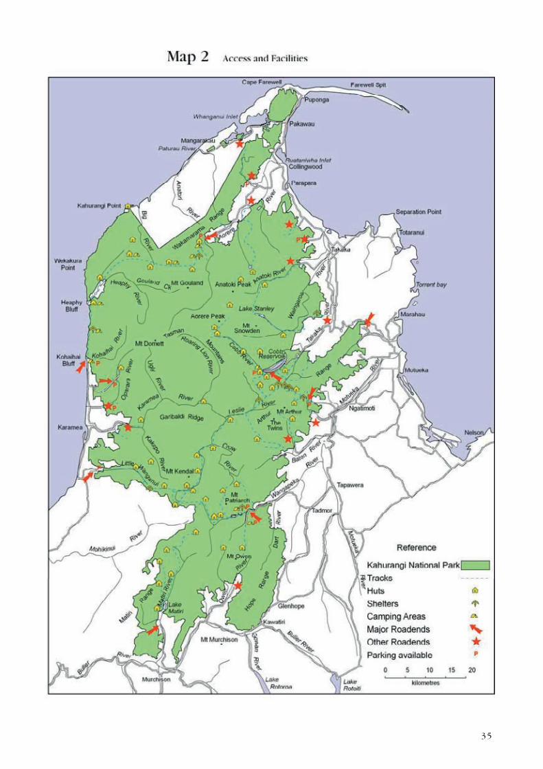
Kahurangi National Park is accessible from a large number of road-
ends around the periphery (Map 2). The most commonly used points
of entry are the Cobb Valley, Flora Saddle, Brown River, Kohaihai, the
Wangapeka, and Little Wanganui. There are also several popular visiting
points on the perimeter of the Park such as the Riwaka Resurgence,
Hawke's Lookout, Hope Lookout and the Oparara Arches. The remainder
are less popular and serve a limited number of hunters and trampers.
The Park is also accessible by helicopters with concessions (except in
the Tasman Wilderness Area), but there are no functional landing strips
for fixed wing aircraft.

34
Two areas in the Park have special status which affects accessibility. The
80,000ha Tasman Wilderness Area, in the heart of the Park, was first
gazetted in 1988 and was re-gazetted in 1996 when the national park was
formed. It provides a special wilderness recreational opportunity where
visitors can encounter wild and remote country entirely on nature’s
own terms. Huts, tracks and all other facilities, as well as vehicles of
any kind, including aircraft landings and power boats, are prohibited
(except for park management, including wild animal control, scientific
and search and rescue purposes). Access is open but is not promoted.
The 120ha Honeycomb Hill Caves Specially Protected Area protects a
range of outstanding scientific values contained within its cave systems.
Entry is by permit only.
R e c r e a t i o n a l u s e
Use of the Park by both New Zealanders and overseas visitors has been
increasing steadily over the past 10 years. Public use of the area peaked
in the 1970s when a road was proposed along the Heaphy Track and
thousands of people walked the track in protest. During the 1980s
numbers on the Heaphy Track dropped off again, but use continued to
gradually increase in the Park area generally. Publicity arising from the
national park investigation process and resulting from the newly acquired
Great Walk status of the Heaphy Track has probably played a part in
raising the profile of the Park more recently. Use of the Heaphy Track
has increased by 63% in the last 10 years and use of the Matiri, Cobb,
Wangapeka, Mt Arthur and Mt Owen areas is rising rapidly. Experiences
in other national parks indicate that there is a high probability that visitor
use will increase for the reasons outlined above.
At the time of writing there are over 570 km of walks, tracks and routes,
60 public huts and four shelters within the Park (Map 2). Only a small
proportion of these facilities, mostly those on the Heaphy and in the
Tablelands, experience a high level of use. Most of the Park’s facilities
have a medium level of use and about a third are used infrequently,
which makes them attractive to trampers seeking a remote experience.
The Tablelands Track network is the most popular in the park and
receives over 12000 visitors each year. The Heaphy Track draws about
4500 visitors per annum, and the Wangapeka Track is used by about
1200 visitors each year. About 800 people annually use the Leslie-Karamea
Track. Elsewhere, there is a range of low to moderate use by locals,
domestic and overseas visitors.
It is estimated that a third of Park users are from overseas and half the
domestic visitors come from the North Island. The Heaphy is the most
popular track in the Park among overseas visitors. Areas which tend to
be valued most by locals include the Cobb Valley, Mt Arthur Tableland,
the Douglas Range, the Wangapeka Track, the Leslie-Karamea Track, the
Fenian Track and the Anatoki, Little Wanganui, Mt Owen and Matiri areas.
The most popular areas for day visits are the lower Wangapeka Valley,
Graham Valley (Flora Saddle), Cobb Valley, the Riwaka Resurgence and
the Oparara and Kohaihai areas.
35
31

36

37
Visitor surveys identify two major visitor groups almost equal in number:
day visitors and multi-day trampers. Day visitors are mainly overseas
visitors and local people who regularly use a few favoured sites for short
walks, while climbers, trampers, fishers and hunters venture further into
the Park for longer and seek a diversity of experiences. Only 15% of
visitors spend more than 5 days on each trip. A very small proportion of
visitors, usually associated with tramping clubs, organise longer trips to
remote areas such as the Tasman Wilderness Area. Caving clubs usually
organise two or three major expeditions a year and will camp at a cave
site for up to two weeks.
Limestone and marble karst areas, containing extensive cave systems,
attract a high level of interest from speleologists and cavers from
throughout the world and local caving groups are also active. The cave
systems of Mt Arthur and Mt Owen are of particular interest to cavers
because of their length and depth. The Nettlebed cave system under Mt
Arthur has at least 24 km of passage and is New Zealand’s deepest known
cave at 889m. The Bulmer Chasm, on the south side of Mt Owen, extends
for at least 39.9 km and is 749 m deep (the longest and third deepest
in New Zealand). The Oparara Arches are also an important karst visitor
attraction. The Honeycomb Hill Cave system in the Oparara Valley near
Karamea has high scientific values which are very vulnerable to damage
and so has Specially Protected Area status. There is presently only one
concessionaire operating a guiding service for this cave system.
The vast network of waterways in the park attracts an increasing number
of kayakers from around the country, as well as international visitors.
The Karamea River is nationally important for kayaking and rafting,
particularly for multi-day trips. It is a challenging river (graded four to five
on a scale of six) and is regarded highly for its wilderness experience. It
also provides one of the most challenging long (three to four day) kayak/
raft trips in New Zealand. Guided raft trips are offered by concessionaires.
Kayakers often use helicopters to access remote rivers.
Recreational hunting is popular and hunters play a significant role in the
control of animal pests, particularly deer and pigs. Fallow deer hunting
occurs in the Cobb Valley and Mt Arthur Tableland, which was previously
managed as a Recreational Hunting Area in the former Forest Park. Red
deer are hunted throughout most of the central ranges and the Little
Wanganui and Karamea areas. Pig hunting is popular in the north-eastern
areas and in the eastern valleys of the Mt Arthur Range.
Brown trout occur in many of the Park's major rivers. The Wangapeka and
Karamea and several of its tributaries contain nationally or internationally
recognised fisheries due to the abundance of wild trophy-sized fish and
the magnificent setting. Rainbow trout occur in the Cobb Reservoir and
upper Cobb River. Backcountry and wilderness fishing in the Park is both
highly valued and popular, with a significant proportion of fishers coming
from outside the region or from overseas. Several concessionaires operate
helicopter transport and guiding services for hunting and fishing. Trout
fishing is managed by the West Coast and Nelson/Marlborough Fish and
Game Councils, from whom a licence is required to fish.

38
Snow is of insufficient duration and depth to provide any major potential
for ski field development. However, Mt. Arthur and the Tablelands areas
are occasionally used for cross-country skiing in good snow years. Flora
Saddle is an important access point for local family groups to visit the
snow in winter.
The Tasman Wilderness Area is one of New Zealand's premier tramping,
hunting and fishing wilderness areas and is highly valued by those who
recreate there.
Powered off-road vehicles, are allowed only on formed roads in the National
Park, except for management or search and rescue purposes. Mountain
bikes are only allowed on roads formed and maintained for vehicle
use or on routes which have been specifically identified for mountain
bike use within this management plan (see Section 4.1.1 Mountain
biking). When most of Kahurangi was still a forest park, mountain biking
was not prohibited and the Department actively encouraged it on some
routes. Biking on the Heaphy Track was discouraged, but it was still used
extensively by mountain bikers until the national park was formed.
The Park is also used for a range of other recreational activities including
photography, botanising, bird watching, education and sight seeing and
is an important part of regional tourism marketing.
S c i e n t i f i c s t u d y
The Department and other organisations such as Fish and Game Councils
and Universities, carry out some scientific studies within the Park related
to species and ecosystem management. Scientific study by those outside
the Department is permitted in the Park under a concession, which may
or may not allow for the taking of samples.
C u s t o m a r y h a r v e s t a n d u s e
Mäori have traditionally collected plants and animals from the Park area
for food and use in traditional clothing or ceremonies as part of their
right as kaitiaki. The harvest of natural resources in this way is protected
by the Treaty of Waitangi. Although the Department actively encourages
nga iwi to harvest cultural materials outside of the Park area, where
appropriate, cultural harvest in accordance with tikanga Mäori may be
allowed within the Park. This activity is controlled by way of a permitting
system administered by the Department of Conservation.
N o n - r e c r e a t i o n a l c o m m e r c i a l u s e
Commercial use of the Park is relatively low and most concessionaires
offer recreational activities such as guiding, transport and ecotoursim.
Commercial deer hunters carry out deer recovery by helicopter in the Park,
which assists the Department with animal pest control. Other companies
use the Park for purposes such as the siting of telecommunication
structures, high voltage electricity transmission structures and filming.
Mining and prospecting were historically widespread in the Park but all
areas being actively mined or with mining or prospecting rights over them
were excluded from the Park at its formation. Since the Park's formation,

39
the Crown Minerals Amendment Act (No. 2) 1997 was introduced to
restrict mining in National Parks. However, Kahurangi National Park is
not covered by this amendment (being gazetted after 1 October 1991).
In considering applications for access arrangements to undertake mining
activities, the Minister of Conservation is required to have regard to the
matters set out in Section 61(2) of the Crown Minerals Act 1991.
1 . 4 V I S I O N
The vision is a prediction of what the Park will be like in the long term
future, as a result of effective management.
Diversity ~ Sanctuary ~ Wilderness
Kahurangi National Park will stand as a premier example of natural
New Zealand. It will be a sanctuary for a diversity of nationally and
internationally important native plants, animals and geological features.
It will be protected from the ravages of plant and animal pests and
uncluttered by intrusive structures. It will be a treasured relic of pre-
human ecosystems, natural landscapes and landforms and will provide
a window to the cultural history of the northwest South Island. On
its fringes a network of high quality tracks will allow visitors to make
short excursions to explore its historic areas, karst landscapes, forests,
coastal and mountain scenery and experience natural quiet, peace and
tranquillity. More adventurous visitors will venture further on extensive
track systems and routes to experience peace, solitude, inspiration,
recreational enjoyment and challenge. In its wild heart, the Tasman
Wilderness Area will contain undisturbed natural treasures and provide
the ultimate nature experience to those who wish to meet its challenges.
The Park will be treasured and supported by the local communities
surrounding it and by the nation.
1 . 5 P R I M A R Y O B J E C T I V E S
• To preserve in their natural state in perpetuity the landscape, natural
ecological systems, wilderness and natural and historic features of
Kahurangi National Park and as far as possible eradicate introduced
plants and animals.
• To retain the essential character of Kahurangi National Park as a
remote, undeveloped, natural area of great beauty, natural quiet and
diversity, and of value for whakapapa, recreation, appreciation and
study.
• To give effect to the principles of the Treaty of Waitangi, at least
to the extent that the provisions of the National Parks Act 1980 are
not inconsistent with those principles.
• To give the public the opportunity to gain benefit, enjoyment,
inspiration and opportunities for recreation from the Park to the
extent compatible with the Objectives above.
40
1 . 6 H E A P H Y T R A C K C O R R I D O R P L A C E
1.6.1 Outcomes for Heaphy Track Corridor
(a) The Heaphy Track Corridor continues to reflect the diversity of
values that contribute to it being a unique place and historic route
in Kahurangi National Park. These include a range of exceptional
landscapes, scenery, biodiversity, and recreational opportunities
together with interesting historical and cultural heritage features.
(b) The Heaphy Track Corridor provides a premier example of natural
New Zealand giving a backcountry experience in the heart of
Kahurangi National Park.
(c) Visitors to the Heaphy Track Corridor can experience natural
beauty, quiet and solitude. The Corridor is a relatively undeveloped
environment and remains free from the proliferation of man-made
structures.
(d) Within the Corridor the Heaphy Track is managed as a Great
Walk, which encourages self-reliance in a moderate to low risk
backcountry environment. It gives visitors with limited backcountry
experience a safe and challenging environment, accessed either
by foot or seasonally by mountain bike where potential conflicts
between different user groups are minimised.
(e) The integrity of the historic pack track on the West Coast Tai
Poutini Conservancy side is preserved.
1.6.2 Description of the Heaphy Track Corridor
Within the context of a national framework the Heaphy Track (see Map
A) is the longest of New Zealand’s nine Great Walks and is managed
to a specific standard. These standards require that it is well formed,
well marked, has facilities for river crossings and is suitable for people
with average fitness and limited back country experience. The Heaphy
Track complies with all these standards, except for the track formation
in some sections, and is one of the least developed and modified of the
Great Walks.
The Corridor includes the entire length of the track (part of the track,
along the lower reaches of the Heaphy River, is not in the Park, but
is on conservation land) as well as extending 500 metres either side,
consistent with the 500 metre corridor established for other Great Walks
and the hunting exclusion zones (see Section 4.1 Visitor services and
management – Hunting). The exception to this is on the West Coast
Tai Poutini Conservancy side, between Heaphy Bluff and Kohaihai Bluff,
where the Corridor place extends only as far as mean high water mark
on the seaward side of the track (the boundary of the Park).
The Heaphy Track Corridor also deviates slightly from the 500 metre
corridor boundary at Perry Saddle to include the track and summit of Mt
Perry which trampers often take in as part of their Heaphy Track walk.
The side track is not managed as part of the Great Walk but contributes
to the overall context of the Heaphy Track Corridor experience.

41

42

43
1.6.3 Justification for the Heaphy Track Corridor
General Policy for National Parks 2005 seeks that a “place” is identified
for the purposes of integrated conservation management. The Heaphy
Track Corridor can be identified as an area where integrated conservation
management is necessary because of the need to balance its intrinsic
worth and values with the recreation interest it attracts.
The Heaphy Track Corridor is an area which has been defined using the
following criteria: it is a major recreation and tourism destination; it has
common management considerations as a Great Walk; and has unique
management needs as it straddles two conservancies which manage it
for a single purpose. It also has several discrete ecosystems which in
combination characterise the Heaphy Track Corridor.
The values of the Heaphy Track are described in more detail below,
outlining those features which contribute to making the Heaphy Track
Corridor a distinctive place.
1.6.4 Values of the Heaphy Track Corridor
The Heaphy Track Corridor as a place can be determined by its:
(i) Significant recreation values and tourism destination – the Heaphy
Track is managed as a Great Walk and as such there is a defined
standard of level of facilities (both for huts and tracks) that the
Department seeks to provide in order to meet visitor expectations.
The recreational facilities on the track support backcountry
recreation such as multi-day tramping, hunting and mountain biking.
Limited helicopter landings at the Heaphy Hut provide access for
trampers (particularly day walkers), fishers (including whitebaiters)
and hunters.
(ii) Natural values – along the Heaphy Track Corridor there is a range of
outstanding natural features and complex ecosystems that provide
habitat for a number of threatened and endangered species.
(iii) Historic and cultural values – it is a location of significant historic
activity as a former trading route and access to and from the West
Coast for Mäori and European alike as well as in more recent times
being a favoured recreation destination. The track is recorded in the
NZ Archaeological Association site record file (Number L26/11).
N a t u r a l V a l u e s
The Heaphy Track Corridor contains a diverse range of landforms and
ecosystems that span from mountain to the sea. The entire length of the
track has high biodiversity and habitat values, particularly for the great
spotted kiwi (roa), blue duck (whio) and Powelliphanta land snails. The
Department has developed and is implementing species recovery plans
for all these species.
The changing vegetation patterns, influenced by a range of altitudes and
underlying geologies along the track, give the Heaphy the reputation of
being a diverse botanical experience. From the Golden Bay end, the first
section of the track climbs from Brown Hut to Perry Saddle through
44
forest dominated by hard beech and rimu below 700 metres, changing
to red and silver beech above this altitude. Trees become more stunted
with increasing altitude and mountain beech begins to appear near Perry
Saddle.
Through Gouland and Saxon Downs the landscape opens out onto a gently
sloping plateau known as peneplain. Here, the bedrock underlying this
landscape is close to 500 million years old, some of the oldest in New
Zealand. The gentle landforms, relatively high altitude, high rainfall and
poor drainage heavily influence the vegetation here. Pakihi comprising
wire rush, Baumea and tangle fern dominates over large areas. Where
there is better drainage, red tussockland is found along with mountain
flax, stunted shrubs and small herbs. Two species confined to the Downs
are the small yellow-flowered lily Bulbinella talbotii and a small native
foxglove Ourisia goulandiana. The peneplain is also studded with
outcropping limestone remnants which have their own distinct flora. Of
particular note is an unnamed limestone-endemic species of woollyhead
(Craspedia) which has a tiny range and has a conservation status of
nationally critical.
West of Gouland-Saxon Downs, through to James Mackay Hut and beyond,
the bedrock changes into Karamea granite - pink stained and grained with
large black and white crystals of mica, quartz and other minerals. The
vegetation changes from stunted upland beech forest as the track descends
off the peneplain. Below 600 metres the large emergent podocarps: rimu,
kahikatea, miro and matai, tower above the beech canopy. Below 300
metres, along with the podocarps the broad-leaved lowland species co-
dominate such as northern rata, mahoe, pigeonwood, hinau, pokaka and
pukatea.
At the Lewis River confluence the first of the nikau palms appear. These
become more frequent along the coast and are a characteristic feature
of the coastal landscape to the end of the track at Kohaihai, providing
a sub-tropical element to the vegetation. Coastal headlands support
maritime herbfields and shrublands, while native sand binders: pingao
and Austrofestuca, still dominate the foreshore dunes.
There is also significant native fauna within the Heaphy Track Corridor.
Native bird species include western weka, South Island fernbird, pipit,
tui, bellbird, kereru, käkäriki, South Island robin, käkä, morepork and the
nationally endangered blue duck (whio), as well as iconic species such
as the great spotted kiwi and the kea.
One of New Zealand’s only two land mammals, the long-tailed bat, can
be found along the Corridor as well as half of New Zealand’s 40 species
of carnivorous land snail (Powelliphanta). This is by far the highest
concentration of Powelliphanta species in New Zealand. The largest
is Powelliphanta superba prouseorum which measures about 90mm
across.
H i s t o r i c a l a n d c u l t u r a l v a l u e s
Routes between the Heaphy River mouth and the Aorere River were
known to Mäori and, from the late 1850s, European explorers, gold

45
miners and farmers. The alignment of these routes is likely to have varied;
however the current route along the Heaphy Track Corridor follows a
line surveyed in 1885.
Evidence of early human occupation has been found at the mouth
of the Heaphy River. This site is recognised as one of the places of
earliest human settlement in New Zealand and has been dated to around
1300AD. This places the site within the first century of East Polynesian
(Archaic Mäori) settlement and its material culture has provided important
information about the lifestyle of these people. The site contains evidence
of cooking features and structures and has paved areas reminiscent of
sites in other parts of Eastern Polynesia. There is also evidence of stone
tool manufacture and the range of stone types demonstrate that even
at this date early Mäori had extensive knowledge of New Zealand’s
geological resources.
In later years the Heaphy-Aorere route was one of several used by Mäori
to access the West Coast pounamu (greenstone) sources which were so
important in providing stone for tools, weapons and ornaments.
The river and the track are named after the artist, surveyor and explorer
Charles Heaphy. In 1846 he and New Zealand Company surveyor Thomas
Brunner and local Mäori, Kehu and Tau, travelled from Golden Bay to the
West Coast seeking new land for settlement. Although their route was
along the coast Heaphy learned from Kehu that an inland route between
the Whakapoai (Heaphy) and the Aorere had been used by Ngati Apa on
hunting expeditions.
The first Europeans to use the route were miners travelling from Golden
Bay to the newly discovered goldfields on the Buller. The first marked
route (which differed significantly from the present track) was made by
James Mackay and John and Arthur Knyvett in 1862. In 1885 John Saxon
was employed by the Collingwood County Council to survey a route for a
cart track. This was to give overland communication between Nelson and
the Karamea settlement and to open up economic opportunities. Although
a cart road did not eventuate, a horse track was cut along this line. This
was completed in 1893 and is the foundation of the present track.
Use of the track diminished significantly in the early 1900s and its
condition deteriorated. Sporadic attempts at maintenance were made
through the first half of the 20th century but it was not until the New
Zealand Forest Service took over management of North West Nelson
Forest Park and the track in the 1960s that the track was upgraded and
established as a popular walking track.
The West Coast Tai Poutini Conservancy actively manages the Heaphy
as an historic pack track to preserve its historical and cultural values.
Specific sites such as the archaeological site near the Heaphy Hut are
also actively managed.
The option to form a vehicle road through this area had been lobbied for
by local authorities for many years and gained sufficient traction in the
late 1960s to see a preferred route option, which included a substantial
section of the track, surveyed by Ministry of Works. The road proposal

46
coincided with an upsurge in public interest in the environment and public
enjoyment of the Heaphy as a walk. In the end the project foundered
through public opposition and lack of Government enthusiasm.
The Heaphy Track Corridor has a long standing culture and tradition of
recreation with accounts of crossings on the track by foot, and until the
National Park was created in 1996, on bicycles.
R e c r e a t i o n a l v a l u e s
The Heaphy Track Corridor is a significant recreation destination in the
Nelson/Marlborough and West Coast Tai Poutini conservancies with
approximately 4500 people walking the track each year. The Heaphy Track
has the lowest number of visitors of any of the nine Great Walks.
It offers a multi or single day tramping experience of “Great Walk”
standard which provides visitors with a reasonable expectation of a
high standard track and facilities. The track can be walked either by
individuals or as a guided walk with a concessionaire.
Provision has been made for limited aircraft (helicopter) landings at the
Heaphy Hut to support recreational access at this site (excluding the
transportation of mountain bikes, see Sections 4.1.1.4(f) and 4.2.1.5) and
because landings could potentially take place in this vicinity on land
outside the Park, such as on the beach at low tide. Landing at other
huts on the Heaphy Track is inconsistent with the outcomes sought for
the Heaphy Track Corridor, particularly natural quiet and encouraging a
self reliant experience on a multi day Great Walk, and for this reason
existing concessions to land at these huts should be phased out by 31
December 2015 (see Section 4.2.1.6b).
The Heaphy has a long held iconic status along with tracks such as the
Milford as one of New Zealand’s premier walking experiences.
Mountain biking use occurred prior to Kahurangi National Park being
formed in 1996. This plan provides access for mountain bikers on a
seasonal basis from 1 May to 30 November, when walker numbers are
lower (see Section 4.1.1 Mountain biking).

47
2. Treaty of Waitangi
P o l i c y
To actively protect and provide for the interests of iwi.
Background
Under Section 4 of the Conservation Act 1987 the Department is
required to interpret and administer that Act so as to give effect to the
principles of the Treaty of Waitangi. Case law has established that those
obligations also apply to the National Parks Act 1980 to the extent that
the provisions of the National Parks Act are not clearly inconsistent with
those principles.
The Department must recognise the mana and tangata whenua status of
nga iwi whose rohe includes the Park and ensure where appropriate that
nga iwi are actively involved in the protection of their taonga (treasures)
within the park. Consultation from the early stages of any proposed
undertaking which may affect iwi interests and full consideration of
their views is essential. It is important to establish and maintain a close
relationship with nga iwi and ensure that their concerns are heard and
acted on.
Settlement of the Ngai Tahu Treaty of Waitangi claim has been negotiated
with the Crown. This will affect the way in which the Department
manages some areas of Kahurangi National Park. The Ngai Tahu Claims
Settlement Act 1998 has also been passed as part of the settlement
process and this must be taken into account in the implementation of
this plan. (A map of the Ngai Tahu Takiwa boundary is shown on Map
4 Administration in Section 5 of the plan.)
S e t t l e m e n t m e c h a n i s m s
Mechanisms established in the Deed of Settlement and Ngai Tahu Claims
Settlement Act place a number of specific obligations on the Department
of Conservation with respect to land administered by the Department, in
addition to the general duty imposed by Section 4 of the Conservation
Act.
T o p u n i
The concept of Topuni derives from the traditional Ngai Tahu tikanga
(custom) of persons of rangatira (chiefly) status extending their mana
and protection over a person or area by placing their cloak over
them or it. In its new application, a Topuni confirms and places an
'overlay' of Ngai Tahu values on specific pieces of land managed by the
Department. A Topuni does not override the existing status of the land
(for example, National Park status), but ensures that Ngai Tahu values
are also recognised, acknowledged and provided for.

48
One Topuni, Kahurangi, has been declared in the Kahurangi National
Park area.
A Topuni involves three levels of information:
• a statement of the Ngai Tahu values in relation to the area;
• a set of principles aimed at ensuring that the Department avoids
harming or diminishing those values;
• specific actions which the Director-General of Conservation has agreed
to undertake to give effect to those principles.
Further details relating to these Topuni are contained in Appendix 2.
There is another Topuni, Otukoro Iti, which is located adjacent to the
Park on its north-western side.
The Nelson/Marlborough Conservation Board and New Zealand Conservation
Authority are required to have particular regard to the Ngai Tahu values
and specific principles in relation to each Topuni, and to consult with
and have particular regard to the views of Te Runanga o Ngai Tahu
in the preparation of Conservation Management Plans and National Park
Management Plans in relation to these areas. The specific actions may
change over time as circumstances change.
P r o t o c o l s
Pursuant to Section 282 of the Ngai Tahu Claims Settlement Act,
the Minister of Conservation has issued protocols in relation to the
Department's relationship with Ngai Tahu. In this context, Section 281
of the Act provides:
“... the term ‘protocol’ means a statement in writing, issued by the
Crown through the Minister of Conservation to Te Runanga o Ngai
Tahu, which sets out:
(a) how the Department of Conservation will exercise its functions,
powers and duties in relation to specific matters within the Ngai
Tahu claim area; and
(b) how the Department of Conservation will, on a continuing
basis, interact with Te Runanga o Ngai Tahu and provide
for Te Runanga o Ngai Tahu’s input into its decision-making
process.”
The ‘specified matters’ dealt with in the protocols are:
• cultural materials;
• freshwater fisheries;
• the culling of species of interest to Ngai Tahu;
• historic resources;
• Resource Management Act involvement;
• visitor and public information.

49
The protocols, which are enforceable against the Minister of Conservation
by way of public law action (Section 285), make general statements
about how the Department should conduct its business in these areas.
The protocols also establish a process whereby Te Runanga o Ngai Tahu
can have input into the Department's business planning processes, and
identify specific projects to be pursued, subject to available funding.
A schedule of all the provisions of the Ngai Tahu settlement that are
relevant to the Kahurangi National Park Management Plan are contained
in Appendix 3.
In addition to the Ngai Tahu settlement, there are claims currently
registered with the Waitangi Tribunal which may affect some areas of
the Park1. However, major areas subject to Treaty of Waitangi claims,
such as the lower Heaphy (Whakapoai) valley and Taitapu, were excluded
from Kahurangi National Park when it was established and continue to
be managed in the interim as remnant Forest Park, while recognising the
national park status of the adjacent land.
I M P L E M E N T A T I O N
1. Actively consult and work with nga iwi throughout the term
of this plan regarding its implementation.
2. Recognise that this management plan is being developed and
will be implemented in an environment of evolving legislation
and policy.
3. Recognise that certain provisions of the Ngai Tahu Settlement
Act 1998 will affect management of the Park land which
is in the Takiwa/area of Ngai Tahu and that other Treaty
settlements may affect the implementation of this plan.
R E F E R E N C E S
Nelson/Marlborough CMS
Treaty Obligations, p111-112
West Coast Te Tai o Poutini draft CMS
Giving Effect to the Principles of the Treaty of Waitangi, p20-26
Treaty of Waitangi
1 Hearings began in August 2000.

50

51
3. Heritage preservation
3 . 1 B I O D I V E R S I T Y
P o l i c y
To preserve the indigenous biodiversity of the Park and maintain
the integrity of its natural ecosystems as the highest management
priority.
Background
(See also previous Sections 1.3.3 and 1.3.4)
V a l u e s
A complex geological history, recent ice-age influence, and its function
as an isolated refuge during the Pleistocene ice age have resulted in
the development of a rich geological and biological diversity and an
exceptional variety of ecosystems in northwest Nelson. The Park has
several areas of particular importance in terms of biodiversity and these
are often associated with karst landscapes.
Kahurangi National Park contains nearly half of all native vascular plant
species. It has a very high number of plant and animal species found
nowhere else (endemic) and many species that reach their distributional
limits there. The Park also supports 12% of the country’s threatened
plants. It is home to 60 percent of all native land bird species and is a
stronghold for birds which range widely, including the threatened kea,
South Island kaka, kereru, kakariki and New Zealand falcon. The Park is
also an important stronghold for the threatened great spotted kiwi and
blue duck (whio). Both long- and short-tailed bats have also been found
in the Park, both of which are nationally threatened.
Kahurangi is a major centre of evolution for the giant native land snails
of the genus Powelliphanta, with almost half the named forms confined
to the area. The Park also supports a wide range of the country’s named
terrestrial and freshwater invertebrates. It contains endemic species
of almost every group of insects, including the giant weta, and some
particularly primitive insects. The native cave spider is also endemic to
the Park area.
There are 12 species of native fish in the freshwater bodies of the Park,
including four threatened species. There is also a large diversity of aquatic
invertebrate species which exhibit a high level of endemism.

52
I n t r o d u c e d p l a n t s a n d a n i m a l s
Introduced animals pose a significant threat to native plants and animals
through predation, competition and browsing. The most common
introduced animals are deer, chamois, goats, possums, mustelids, vespid
wasps, pigs and rats. Possums, rats and pigs feed on Powelliphanta
snails while stoats and rats prey on most bird and lizard species. Vespid
wasps prey on invertebrates and compete with nectar-feeding birds,
such as the kaka, for the sugar-rich honeydew found on the trunks of
beech trees. Goats, chamois, deer and possums browse on a range of
native vegetation and, when present in the same area, can cause severe
ecological damage, even canopy collapse. Possums cause widespread die-
back and eventual tree mortality, while deer, chamois and goats prevent
seedling establishment.
Browsers can also compete with birds for nectar and fruit. Pigs are
capable of massive disturbance of the forest floor while rooting for food.
Cave and karst areas are particularly vulnerable to damage from browsing
animals through both vegetation removal and trampling/erosion.
Trout are present in several rivers within the Park and their management
is dealt with in Section 4.0 Use and Accessibility, as they are primarily
a recreation resource. Although coarse fish (e.g. koi carp) are not yet
known to occur in the South Island, they are a potential long-term threat
to the aquatic ecosystems of the Park.
In contrast, introduced plants are generally not widespread and do
not pose a significant threat to the Park at present. However, wilding
pines, gorse, horsetail, marram, pampas and wild ginger are becoming
an increasing problem in some areas.
O t h e r t h r e a t s
Fire and human impacts can also threaten Park values and these are dealt
with in Section 4.0 Use and Accessibility.
Issues and opportunities
S u r v e y , m o n i t o r i n g a n d r e s e a r c h
The special qualities of the Park give it an important role in the protection
and preservation of many indigenous species of plants and animals. Apart
from the fact that these species exist in the Park, not much more is
known about many of them. The top priorities are to survey, monitor,
and/or undertake research on species which are currently considered to
be nationally threatened, as well as species which are very localised in
the Park. This will include ascertaining species distributions, numbers and
ecology, identifying threats, determining whether active management is
required, and if so, establishing management programmes and recovery
plans to ensure their preservation. Species Recovery Plans are in operation

53
nationally for kiwi, bats, native frogs and the blue duck (whio).
Animals which particularly need to be targeted for survey in the Park
are the threatened blue duck, weka and both species of bat, as they are
known to be in the Park but their distributions are not clear. A search
is required to determine whether or not some previously recorded native
species are still present, particularly Leiopelma frogs. Further native fish
survey work is also required, especially in small streams close to the
coast. Research is currently being undertaken on the great spotted kiwi,
the South Island kaka, blue duck and Powelliphanta snails. This research
will continue and further projects need to be initiated for species such
as the New Zealand falcon, in order to develop successful management
programmes.
Survey, monitoring and research priorities for plants need to focus on
the nationally threatened species, and endemic species listed in Appendix
1. Research into the taxonomic status of the unnamed endemics in the
Park needs to be encouraged.
B i o d i v e r s i t y
The Department is in the process of developing a national Biodiversity
Strategy which will set strategic directions and priorities for the
management of the natural environment. The Biodiversity Strategy will
require both Conservancies to improve and maintain the biological
resource databases of the Park by way of general surveys, inventories
and vegetation mapping. This management plan will implement that
Strategy.
The Department has developed a programme of establishing "mainland
islands" where intensive pest control is undertaken and native species
rehabilitation is monitored. No new areas have been established recently,
however, the potential remains for their establishment in the park.
"Islands" chosen are usually typical of an area rather than those containing
threatened or rare species.
The Park has several Key Biodiversity Areas (Table 1) which contain
biological organisms or associations of particular importance and
vulnerability. These areas need to be managed as a priority for pest
monitoring and native species protection, monitoring and research. Visitor
impacts on Key Biodiversity Areas should also be carefully monitored (see
Section 4.0 Use and Accessibility).

54
TABLE 1 KEY BIODIVERSITY AREAS IN KAHURANGI NATIONAL PARK
LOCATION BIODIVERSITY VALUES
Mt Burnett Forest and shrubland communities endemic to marble and dolomite on Mt Burnett.
A nationally important centre of biodiversity.
Threatened/Endemic/Notable species: Powelliphanta g. gilliesi, Carex ‘Burnett’, Senecio
glaucophyllus ssp. ‘Burnett’, Myrsine ‘Burnett’, Melicytus ‘Burnett’, Hebe aff. glaucophylla ssp.
‘Burnett’, Gingidia ‘Burnett’, scarlet mistletoe, Libertia aff. grandiflora, Hymenophyllum aff.
flexuosum, Hebe townsonii, Coprosma obconica.
Kaituna – Mt Haidinger Pakihi forest and heathland, coal measure shrublands Knuckle Hill
Threatened/Endemic/Notable species: bearded orchid, Powelliphanta gilliesi ‘Haidinger’, forest
ringlet butterfly, Bulbophyllum tuberculatum, scarlet mistletoe, Brachyglottis rotundifolia var.
‘cockaynei’.
Mangarakau Part of largest freshwater wetland in Nelson-Marlborough regions.
Rainforest on limestone, coastal, swamp forest, low fertility wetland and estuarine communities.
Absence of introduced fish.
Threatened/Endemic/Notable species: Powelliphanta gilliesi aurea, Australasian bittern, fernbird,
Patarau coast cave fauna (only representation in the Park), brown mudfish.
Kahurangi Point Coastal lagoon and estuary communities, high fertility freshwater wetland, coastal and lowland
rainforest, salt turf communities, open dunelands, dune forest and shrublands. Vegetation sequences
from coastal communities and landforms, to upland infertile granite communities.
Threatened/Endemic/Notable species: great spotted kiwi, Powelliphanta gilliesi kahurangica,
Raunuculus recens, Oreomyrrhis ‘minutiflora’, Leptinella calcarea.
Gouland, Gorton and Ancient granite peneplain landform with residual limestone blocks – regionally significant landforms.
Mackay Downs Extensive low fertility forest, shrubland, red tussockland, pakihi and rockland vegetation on
undulating peneplain topography.; complex vegetation mosaics. Remnant limestone forest ecosystem
on scattered outcrops. A stronghold for numerous animal and plant species.
Threatened/Endemic/Notable species: great-spotted kiwi, fernbird, blue duck, Powelliphanta gilliesi
montana, 5 subspecies of P. superba (3 endemic to the area), West Coast skink, NW Nelson giant
weta, Craspedia ‘Gouland’, Bulbinella talbotii, Coprosma talbrockiei, Ourisia goulandiana,
Ourisia modesta, Astelia subulata, Microlaena thomsonii, Gingidia baxterae, Olearia capillaris,
red mistletoe, Pseudowintera traversii, Pimelea gnidia, Simplicia buchananii, Gratiola nana.
Heaphy limestone Extensive karst plateau and bluff landscape. One of the largest cave systems in New Zealand -
regionally important.
May have internationally important fossil collection.
Large area of lowland rainforest on limestone. Extensive northern rata - mixed broadleaf forest.
Threatened/Endemic/Notable species: Powelliphanta gilliesi ‘Heaphy, P. superba harveyi, P.
annectens, spelungula cave spider, blue duck, Parahebe ‘hairy’, great-spotted kiwi.
Extensive, largely unmodified tract of coastal ecosystems: flaxland; kiekie vineland; broadleaved
forest dominated by northern rata, nikau and karaka; salt turfland; duneland.
Excellent quality dunes still dominated by native species: pingao, sand tussock.
Large breeding populations of NZ fur seal.
Threatened/Endemic/Notable species: sand spurge, sand tussock, Lepidium flexicaule, Oreomyrrhis
‘minutiflora’, fur seal.

55
LOCATION BIODIVERSITY VALUES
Gunner Downs Extensive mosaics of low fertility forest, shrubland, red tussockland, pakihi and rockland vegetation
on undulating peneplain topography.
Remnant upland forest ecosystem on scattered limestone outcrops.
Threatened/Endemic/Notable species: great spotted kiwi, fernbird, Powelliphanta superba ‘Gunner
Downs’, Ourisia goulandiana, Pseudowintera traversii, Microlaena thomsonii, kea.
Oparara Altitudinal sequence from coastal plains and older terraces to tertiary sequences and granite plateau.
Impressive limestone landscape of arches, canyons, bluffs, caves and underground streams.
Honeycomb cave is internationally important for its cave fossil deposits, and regionally important as
one of the largest cave systems in New Zealand.
Dense stands of alluvial and hillslope podocarp-beech forest and large areas of fertile, lowland forest
on limestone. Vegetation sequences from coastal to subalpine habitats.
Threatened/Endemic/Notable species: short-tailed bat, blue duck, Powelliphanta annectens,
spelungula cave spider, great-spotted kiwi, kaka, kakariki, Simplicia buchananii, Asplenium
‘calcicole’, pukatea, silver fern.
Aorere pakihi Extensive gently tilted, low-altitude peneplain intersected by deep gorges - a regionally significant
landform.
Large areas of lowland pakihi heathland and rushland. Lowland forest in gorges.
Threatened/Endemic/Notable species: fernbird, blue duck, great-spotted kiwi, Lepidosperma
filiforme.
The Castles Isolated limestone block with karst landforms on the Aorere peneplain.
Threatened/Endemic/Notable species: Powelliphanta gilliesi compta, Myosotis spathulata.
Parapara Peak – Internationally important fossil-bearing Permian rock.
Walker Ridge
Large forested ecosystem on forest on marble substrate.
Most diverse assemblage of Powelliphanta snails known.
Threatened/Endemic/Notable species: Powelliphanta gilliesi fallax, P. hochstetteri anatokiensis,
P. suberba superba, P. ‘Parapara’, Coprosma obconica, Hymenophyllum aff. flexuosum, scarlet
mistletoe.
Mt Olympus – One of the best exposures of a contact between granite and metamorphosed schist in New Zealand
Lead Hills – Boulder nationally important. Excellent glacial landforms and features - Boulder Lake cirque complex is
Lake – Douglas Range regionally important as the northernmost glacial feature in the South Island. Douglas Range and
Dragons Teeth a major upthrust fault feature.
Extensive alpine rockland and bluff vegetation on glaciated granite and sedimentary rocks; tarn
communities; red tussocklands; subalpine shrublands.
Threatened/Endemic/Notable species: lake-locked koaro, great-spotted kiwi, fernbird, rockwren,
Powelliphanta s. superba, P. hochstetteri anatokiensis, Pittosporum patulum, Pittosporum dallii,
Pseudowintera traversii, red mistletoe, Ourisia ‘Clark’, Rytidosperma pulchrum, Melicytus ‘Matiri’,
Dracophyllum aff. kirkii.
Introduced trout absent from Boulder Lake.
Devil River – Anatiki Remnant alpine peneplain and extensive glaciated landscape.
Range
Diverse alpine flora on base-rich geologies and glaciated landforms.
Threatened/Endemic/Notable species: rock wren, blue duck, falcon, Powelliphanta ‘Anatoki Peak’,
NW Nelson giant weta, forest ringlet butterfly, red mistletoe, Pittosporum dallii, Pittosporum
patulum, Hebe ochracea, Olearia cymbifolia.
Heaphy coast
(Kahurangi River to
Kohaihai River

56
LOCATION BIODIVERSITY VALUES
Snowden Range – Lake Stanley an excellent example of an earthquake debris formed lake - nationally significant
Lake Stanley landform; the only known oolitic limestone in NZ - nationally important geology; second highest peak
in NW Nelson.
Scree vegetation rare in NW Nelson; high altitude alpine rockland vegetation, bands of limestone
alpine vegetation.
Threatened/Endemic/Notable species: eastern South Island scree flora, rock wren, Hebe ochracea,
Hebe ‘marble’.
Lake Stanley trout-free; lake-locked populations of koaro.
Riwaka River Part of the most extensive and best exposed marble formation in New Zealand - nationally important;
headwaters includes part of the Riwaka caves complex (and resurgence) - nationally significant for its
geomorphology and depth.
Extensive ecosystems on marble substrate – lowland broadleaved forest, dryland upland plateau forest
and shrublands, bluff vegetation.
Threatened/Endemic/Notable species: Craspedia ‘Pikikiruna’, blue duck, Powelliphanta h.
hochstetteri, cave fauna including Horatia nelsonensis.
Hoary Head - Crusader Alpine non-glaciated karst landscape with marble rockland and bluff vegetation, doline turfland,
tussockland, subalpine shrubland and upland forest.
Threatened/Endemic/Notable species: Myosotis arnoldii, Clematis marmoraria, moonwort,
Powelliphanta h. hochstetteri, Schizeilema colensoi, Coprosma ‘rimicola’, Dracophyllum aff. kirkii,
Carex enysii, 3 species of unnamed Carex calicoles, Colobanthus ‘marble’, Oreoporanthera alpina,
Raoulia subsericea.
Diamond Stream Lakes Trilobite rock internationally significant; ultramafic geology (talc, asbestos, serpentinite, magnesite)
– Cobb Valley Range and cambrian volcanic Peel outcrops nationally significant; Mt Mytton paleozoic marble nationally
significant; nationally significant fossil localities; regionally important valley and cirque field glacial
features, roche moutonnee landform nationally significant.
Endemic heathland on ultramafic geology; extensive valley floor red tussocklands, shrublands and
wetlands; extensive and diverse alpine communities on a wide range of glaciated landforms and
base- rich geologies; glaciated marble rockland and bluff vegetation; scree communities; tarn and rare
emphemeral wetland communities.
Threatened/Endemic/Notable species: rock wren, Powelliphanta h. hochstetteri, lake-locked
koaro, NW Nelson giant weta, scree weta, Corosma obconica, Pittosporum dallii, P. patulum, red
mistletoe, Olearia capillaris, Hebe ochracea, Hebe ‘marble’, Pimelea aff. sericeo-villosa, Clematis
quadribracteolata, Coprosma ‘rimicola’, Pterostylis micromega, P. oliveri, Oreoporanthera
alpina, Myosotis tenericaulis, Chionochloa defracta, Carex devia, Dracophyllum longifolium var.
‘serpentine’, Colobanthus ‘serpentine’, Trisetum ‘serpentine’, Myosotis brockiei, M. spathulata,
Deschampsia caespitosa, Simplicia buchananii, Lachnagrostis ‘Sylvester’, Euphrasia ‘Mt Arthur’,
Gentiana ‘Cobb’, Ranunculus simulans, R. ternatifolius, R. ‘Cobb’, R. ‘Burgoo’, Luzula, ’Cobb’, L.
‘albicomans’, Hypsela ‘Burgoo’, Craspedia ‘Henderson’, Carex kirkii.
Introduced trout absent from lakes.
Tablelands – Flora – Alpine marble glaciated karst with superb solution features nationally important. Nettlebed and
northern Arthur Range Ellis Basin cave systems the deepest in the Southern hemisphere and second longest in NZ. - with the
Pearse resurgence, internationally significant. Regionally significant peneplain landform. Complex
geology including marble, limestone, base-rich sedimentary and volcanic rocks, conglomerates.
Extensive alpine karst rockland and bluff vegetation; extensive peneplain red tussocklands; alpine
ultramafic vegetation; diverse limestone forest and bluff vegetation.

57
LOCATION BIODIVERSITY VALUES
Threatened/Endemic/Notable species: endemic cave fauna, rock wren, blue duck, Powelliphanta ‘striped
Lodestone’, P. h. hochstetteri, P. patrickensis ‘Baton’, NW Nelson giant weta, scree weta, Myosotis
angustata, M. ‘Flora’, M. petiolata, M. brockiei, M. spathulata, Montia ‘Arthur’, Euphrasia ‘Arthur’,
Olearia capillaris, orange mistletoe, Craspedia ‘Loveridge’, Hebe ‘marble’, Coprosma ‘rimicola’, Simplicia
buchananii, Oreoporanthera alpina, Pimelea pseudolyallii, Carex ‘brockiei’, Colobanthus ‘marble’,
Ourisia modesta, Ranunculus simulans, Senecio g. ssp. glaucophyllus, Pterostylis aff. cycnocephala,
Anemone tenuicaulis.
Garibaldi Ridge Limestone karst plateau landforms regionally important.
Plateau tussocklands, wetlands and karst vegetation; bluff and scree communities, talus shrublands.
Threatened/Endemic/Notable species: rock wren, Powelliphanta patrickensis ‘Garibaldi’,
Ranunculus ‘Hope’, Astelia subulata, Carex ‘Matiri, C. ‘brockiei’, Craspedia ‘Garibaldi’, Anemone
tenuicaulis.
Southern Arthur Range Nationally important fossil beds.
(Baldy to Patriarch)
Very diverse alpine communities on base-rich substrata; marble rockland and bluff communities.
Threatened/Endemic/Notable species: Euphrasia ‘white’, Melicytus ‘Matiri’, Craspedia ‘Loveridge’,
Olearia capillaris, Poa sudicola.
Owen Massif – Internationally important as one of two best areas of glaciated karst in the Southern hemisphere.
Turks Cap - Fyfe Internationally important cave systems with unique formations (including the longest and third
deepest cave in the country). Highest peaks in the Park.
Extensive alpine karst vegetation, doline turflands and herbfields, subalpine cedar forest and
shrublands.
Threatened/Endemic/Notable species: blue duck, marble gecko, Powelliphanta ‘striped Owen’,
P. ‘big green northern’, moonwort, Myosotis angustata, M. concinna, Hebe ochracea, Olearia
capillaris, Pittosporum patulum, Calochilus robertsonii, scarlet mistletoe, Pterostylis aff.
cycnocephala, Simplicia buchananii, Brachyscome longiscapa, Senecio rufiglandulosus, S. g.
glaucophyllus, South Island scree species, Colobanthus ‘marble’, Melicytus ‘Matiri’, Craspedia ‘Fyfe’,
Pterostylis humilis, Schizeilema colensoi, Carex enysii, Anemone tenuicalis, Oreoporanthera
alpina.
Lookout Range Extensive, dry alpine carpet grasslands, rockland, and quartz sandfield vegetation on granite geology.
Threatened/Endemic/Notable species: Gentiana ‘Lookout’, Anisotome flexuosua, scree weta.
Hope Range Broad granite plateaux with impressive tor features.
Extensive mosaics of plateau upland forest and red tussocklands; plateau tarn complex; big pine
communities.
Threatened/Endemic/Notable species: Ourisia ‘Hope’, Coprosma talbrockiei.
Matiri Range Extensive area of limestone plateaux and bluffs, and extremely well-defined cirque complex on gentle
topography around Mt Misery are nationally significant landforms.
Threatened/Endemic/Notable species: Powelliphanta ‘big green northern’, Crassula multicaulis,
Tetrachondra hamiltonii, Deschampsia caespitosa, Dracophyllum aff. kirkii, Melicytus ‘Matiri’,
Poa sudicola, Carex enysii, C. ‘Matiri’, C. ‘brockiei’, Anemone tenuicaulis, Gingidia baxterae,
Schizeilema colensoi.
Coastal Streams Many of the lowland and coastal stretches of larger river catchments and smaller streams support the
(between Karamea Many of these areas support threatened species such as banded, giant and short- jawed kokopu. The
and Takaka) presence of lowland podocarp/broadleaf forest has particular significance for short-jawed kokopu as
this species is not found in streams with riparian beech forest.
Various river systems Introduced trout absent.
including Matiri, Fyfe

58
P e s t c o n t r o l
The National Parks Act requires that introduced plants and animals
be exterminated as far as possible. However, in most cases control or
localised extermination are the best that can be achieved using current
methods. The General Policy for National Parks recognises this problem
and states that until the technological means of eradication become
available, the immediate objective is the reduction of pest numbers by
all available means to a level the flora and fauna can tolerate. Salmonids
(trout) and game birds are exempt from this provision.
Departmental animal pest control priorities are determined by national
control plans such as the Policy Statement on Deer Control, the Feral Goat
Control Plan and the Possum Control Plan. The Conservation Management
Strategies determine priority areas for pest control within Conservancies.
On a national level, the Department directs funds where they will have
the most long term effect (based on a process of ranking and prioritising
control effort nationally) and on research into more effective control
methods. Where practical and meeting the objectives of the plan, the
Department's pest control programmes should be co-ordinated with those
of adjoining land managers to maximise efficiency.
A n i m a l p e s t c o n t r o l
Deer are primarily controlled with the assistance of recreational and
commercial hunters (this is discussed in detail in Section 4.0 Use and
Accessibility). When deer numbers are not adequately controlled by private
hunters, other methods of control will need to be used. Recreational
hunters can be encouraged to assist in the control of chamois, goats
and pigs in conjunction with hunters employed by the Department. Dogs
can be an effective management tool for the hunting of animal pests
such as pigs or goats. However, other pests such as rats, hares and
possums have little or no commercial or recreational value at present,
so control must be carried out by the Department. In line with the
National Parks Act, all animal pests have to be exterminated as far as
possible by the Department using the most efficient and appropriate
means available, including hunting, trapping, biocontrol, ground baiting
and aerial poisoning.
Currently there are no economically feasible methods for effective possum
control throughout an area as large as the Park. Other animal pests such
as mustelids and vespid wasps also cannot be effectively controlled over
large areas by any known method. However, smaller areas of the Park
can be targeted for local control of possums and these other pests using
existing methods, where this is justified by the special values of those
areas. Further research into new methods of control and eradication
is required and is currently being carried out by the Department and
other organisations. Such research includes the use of biological control
methods for controlling possums and wasps.

59
Regional Councils (which include Unitary Authorities) have responsibilities
for setting animal pest control priorities for regions and these are set out
in Regional Pest Management Strategies. The Department must control
certain pests as agreed with Local Government. The Department will
target its funds to control priority pests in the highest value areas of
the park using the most effective methods at its disposal.
TABLE 2: ANIMAL PEST CONTROL PRIORITIES
ANIMAL PEST CONTROL STRATEGY PRIORITY CONTROL AREAS
Goat DOC hunters. Prevent spread south along Wakamarama Range towards the
Encourage recreational and commercial Heaphy, west into the Roaring Lion and north of the Karamea;
hunters. Limestone/Marble vegetation - Mt Arthur Range, Tablelands,
Leslie, Mt Owen, Matiri; Alpine vegetation and forest communities
Leslie/Karamea, Cobb/Tablelands, Waingaro, Anatoki, Owen,
Matiri, Arthur Range, Wakamarama Range, Parapara
Possum DOC hunters. Poison – bait stations/aerial Land snail populations - Wakamarama Ranges, Kahurangi Point,
drops. Heaphy/Gouland, Castles, Mangarakau, Parapara, Cobb, Mt Arthur/
Encourage recreational and Flora, Leslie, Anatoki, Riwaka and commercial hunters. South
commercial hunters. Branch, Oparara; Forest communities - Wakamarama Ranges/Mt
Encourage research into new control Burnett, Kahurangi Pt, Heaphy/Gouland, Parapara, Castles, Riwaka
techniques. South Branch, Roaring Lion, Leslie, Cobb, Matiri, Baton, Owen.
Deer Recreational and commercial hunters; Priority areas determined in conjunction with goat management
other methods if necessary. regarding impacts on forest regeneration, and on relative
protected status of individual plant species at risk.
Pig Encourage recreational and commercial Landsnail populations - Kahurangi Pt, Mangarakau, Parapara, front
hunters initially; Department control in faces of Devil to Anatoki, Cobb Ridge, Flora, Riwaka South Branch,
priority areas. Billie’s Knob; Forest communities where pigs impacting on
regeneration.
Chamois Identify and eliminate core breeding All areas in the Park, particularly those known to have harboured
populations. Encourage recreational and chamois periodically such as Mt Owen, Herbert Range, head of
commercial hunters; DOC hunters (with Roaring Lion and alpine areas in the north.
other pest work)
Hare Monitor impacts; encourage recreational Alpine grasslands, especially where control of other pests is
hunters and research into impacts and undertaken.
control techniques.
Rat/Mouse Support research into control techniques. No control planned.
Wasp Nest destruction; support research into All areas in the Park, particularly along key tracks and high
bio-control techniques. recreational use areas.
Mustelids Support research into control techniques. Areas where special fauna values justify localised control.
P l a n t p e s t c o n t r o l
Plant pests need to be eradicated where possible, or controlled to prevent
their establishment in the pristine areas of the Park. Monitoring also
needs to be undertaken to prevent the establishment of new plant pests
in the Park, including waterweeds. Infested areas need to be cleared
and vehicular access may need to be limited in some areas to prevent
transportation of weeds further into the Park.

60
Priorities for plant pest control are set out in the two Conservation
Management Strategies and Conservancy Plant Pest Control Strategies. In
addition, certain plant pests such as boxthorn, buddleia, old man’s beard,
pampas, broom, gorse, blackberry, and ragwort must be controlled as
agreed with Regional Councils and Unitary Authorities and set out in
their Regional Pest Management Strategies.
Potential invaders such as old man’s beard, German ivy, Kikuyu grass,
buddleia, tutsan, Spanish heath and lupin which are common outside the
Park, and garden escapes, such as Himalayan honeysuckle and nasturtium,
need to be prevented from taking hold in the Park. The waterweeds
Egeria densa and Lagarosiphon major are not present within the Park
but exist in Golden Bay and Blenheim and could be easily spread to the
Park via eel nets and other such equipment.
In the Oparara area there are some trial plots of Tasmanian blackwood
and eucalypts. There is also an area of exotics over which Timberlands
West Coast Ltd has cutting rights for the harvest of existing trees. In
addition there is a pine plantation in the Pakawau Gorge which the
Department has the cutting rights to.
F i r e
The Department sets management policies for fires through the preparation
of annual Fire Plans. The fire plans for the West Coast Tai Poutini
and Nelson/Marlborough Conservancies will be implemented in the
management of the Park (see also Section 4.0 Use and Accessibility).
TABLE 3: PLANT PEST CONTROL PRIORITIES
PLANT PEST PRIORITY AREAS FOR CONTROL
Gorse Gouland Downs (to protect tussocklands and communities for rare plants); Parapara Peak/
Haupiri Range and Herbert Range (to protect sub-alpine shrublands); Cobb (to protect a
range of communities); coast north of Heaphy River (to protect coastal dunelands).
Old mans beard/ banana All Park boundaries (to protect forest ecosystems).
passionfruit/ blackberry/lupin
Broom Cobb (to protect shrublands, ultramafic communities, red tussocklands and herbfields).
Buddleia/cotoneaster Mt Burnett; Cobb; Parapara.
Wilding trees/hakea Pakihi; Aorere; monitoring and impact assessment required elsewhere in Park.
Wild ginger Kohaihai; monitoring and impact assessment required elsewhere in Park.
Horsetail Matiri catchment; Upper Karamea River catchment; monitoring and impact assessment
required elsewhere in Park. Herbicide trials required.
Marram Coast north of Heaphy River
Ragwort/thistle Karamea; Heaphy; Cobb (monitoring, impact assessment required).
Barberry Cobb.

61
I M P L E M E N T A T I O N
1. Carry out effective survey, monitoring and research on native
species and habitats in accordance with this management
plan and CMS priorities.
2. Carry out effective survey, monitoring and research for
threatened plants and endemic plant species listed in
Appendix 1.
3. Manage native plant and animal populations consistent with
CMS priorities and the Department’s Biodiversity Strategy
(when complete).
4. Manage great spotted kiwi, long and short-tailed bats,
Leiopelma frogs and blue duck (whio) according to their
approved Species Recovery Plans.
5. Make special provisions for the management of threatened
plants and animals as and when required.
6. Investigate the potential for establishing a mainland island
in the park and implement if appropriate.
7. Recognise Key Biodiversity Areas as places of high
vulnerability and seek to protect the biodiversity of those
areas as a priority.
8. Monitor and inventory plant and animal pests in Key
Biodiversity Areas in the Park as a priority.
9. Carry out animal pest eradication/control operations
consistent with priorities identified in Table 2, the two CMS's,
national pest control plans and Regional Pest Management
Strategies.
10. Assist and encourage research into new control methods
for animal pests, particularly wasps, mustelids and possums
through the annual science funding round and liaison with
research agencies.
11. Encourage commercial and recreational hunters to assist
with deer, goat, chamois, hare and pig control (see also
Section 4.0 Use and Accessibility).
12. The Department will use whatever method or combination
of methods for wild animal control necessary to maintain
ecosystem health.
13. Carry out plant pest eradication/control consistent with
priorities identified in Table 3, the CMS’s, conservancy
pest control strategies and Regional Pest Management
Strategies.
14. Where practical and where they meet the objectives of this
plan, co-ordinate pest control programmes with those of
adjoining land managers.

62
15. Prevent the establishment of new populations of significant
plant and animal pests where achievable by removing
any individuals or groups that are found outside their
established range.
16. Provide for the managed harvest of trial plots of exotic
trees in the Oparara Basin by local communities and
facilitate the regeneration of those plots in native species.
17. Provide for the managed harvesting of remaining exotic
plantations by Timberlands West Coast Ltd and facilitate
the regeneration of native species once logging has been
completed.
18. Manage the Park in accordance with the annual Fire
Plans for Nelson/Marlborough and West Coast Tai Poutini
Conservancies.
R E F E R E N C E S
Nelson/Marlborough CMS
Upland Ecosystems, p55-65
Legal Protection Responsibilities for Species, p137-140
Management of Threatened Species and Communities, p141-154
Research, Survey and Monitoring, p167-177
Plant Pests, p187-194
Animal Pests, p195-208 Fire, p209-220
West Coast Te Tai o Poutini draft CMS
Natural Diversity, p79-145
Identification and Assessment of Frameworks, p81
Terrestrial Ecosystems, p88
Freshwater/wetland Ecosystems, p96
Karst Ecosystems, p109
Threatened Species, p119
Pest Management, p128
Mainland Habitat Islands, p137
Science and Research, p139
Survey and Monitoring, p140
Summary, p145
National Parks Act 1980
Wildlife Act 195
Wild Animal Control Act 1977
Biodiversity Strategy (under development)

63
Species Recovery Plans for kiwi, frogs, bats, blue duck
Policy Statement on Deer Control - February 2001
Possum Control Plan
Feral Goat Control Plan
Regional Pest Control Plans
Conservancy Fire Control Plans
Karst Management Guidelines - Policies and Actions, May 1999
3 . 2 L A N D S C A P E
P o l i c y
To preserve and protect the landscape and scenic values of the Park
Background
(See also sections 1.3.1, 1.3.2 and 4.2)
Kahurangi National Park contains imposing mountains and plunging gorges,
massive rivers, spectacular waterfalls and tall cliffs. Many landforms in the
Park are considered internationally, nationally or regionally important.
The mountains of the northwest dominate the scenic backdrop of cities
and towns of the surrounding land. The mountainous skyline presented
by the Mt Arthur and Mt Owen ranges is integral to the landscape visible
from Nelson and Motueka. Likewise the mountains of the Douglas and
Anatoki Ranges form a backdrop for Golden Bay communities. Mt Newton
is a dominant feature of the landscape close to Murchison and the Fenian
Range and mountains on the western fringes form a backdrop for the
Karamea community.
The Park has no single dominating landform, but rather a great variety
in nature and scale. No single process dominates the area. Some of the
highest points were carved by glaciers, and others were uplifted and
remain as largely intact plateaux. Water is a powerful force shaping
the landscape and recent massive earthquakes have also left their mark.
Chemical processes have produced many varied forms of karst landscape,
with extensive cave systems.
One of the striking features of the Park is its vastness. The scale of
the area is apparent from its highest points where vistas of bush clad
valleys and interconnecting ranges can be viewed stretching into the
distance. Special scenic features include the vast red tussocklands on
the raised peneplains such as the Mt Arthur Tableland and the Thousand
Acres Plateau. The layering of tertiary sediments, including limestone,
and interesting contrasts between cliffs and plateaux create spectacular
scenery in the Thousand Acre and Hundred Acre Plateaux and the
Garibaldi Ridge. The jagged skyline of the Dragons Teeth in the Douglas
Range presents a distinctive landmark which can be viewed from many
angles.
64
The grandeur of the Mt Arthur and Mt Owen marble karst has been
shaped by solution weathering and carved by glaciers, creating complex
landscapes of mazed and fluted stone. These expansive areas contain rock
gardens of alpine plants with buttercups, gentians, daisies and specialised
plants hanging onto the steep sides of sinkholes and depressions. In the
vast cave systems of karst areas there are spectacular cave formations
(speleothems). Places such as the Honeycomb Hill Caves in the Oparara
basin, where animal-life was trapped and fossilised in caves, provide a
unique scientific opportunity. The limestone Oparara Arch is the largest
of its kind in Australasia. Other scenic limestone features include the
forested limestone bluffs of the lower Heaphy valley.
An earthquake shattered landscape stretches from Murchison northwards
into the Karamea River for over 50km, with dozens of massive land
slips often extending from ridge top to river, and many huge earthquake
formed dams in the rivers.
The contrast between red tussockland and patches of stunted woody
vegetation create visually interesting vegetation mosaics on the undulating
tablelands of the Gouland, Mackay, Gorton and Gunner Downs. The
Lockett Range in the Cobb vicinity has glaciated scenery including
numerous tarns and cirques and the Cobb valley itself is a very accessible
and classic example of a glaciated ‘U’ shaped valley.
The largely unmodified coast between Kahurangi Point and the Heaphy
river mouth has very high scenic values, with its strongly cliffed granite
coast and its wild and rugged nature.
Issues and opportunities
D e v e l o p m e n t
The high quality of the Park’s landscape is one of Kahurangi National
Park’s principle attributes. Landscape values, as well as natural values,
can be adversely affected by the development of facilities such as
telecommunication structures, buildings, huts, signs, bridges, fences and
tracks. By careful consideration of the impact of development on the
landscape, detrimental effects can be avoided, for example by using
colours and shapes which blend in with the environment and locating
buildings away from ridgelines. The quality of design and materials often
determines how well structures fit into the natural landscape.
Some facilities such as alpine huts and route markers must be highly
visible for safety reasons. In these instances a conscious decision should
be made that this is the case. For all other facilities, specific attempts
should be made to reduce the visual impacts of development.
For private or commercial structures the applicant must first show that
there are no practicable alternative sites outside the Park. Because of
the primary objective to retain the undeveloped nature of the Park,
commercial accommodation developments would generally be discouraged
as not in keeping with the management philosophy of the Park. Mitigation
measures such as those mentioned above would have to be implemented
in any approved structural development.

65
S i g n s
All signage relating to the Park will need to be produced to the
Department's national sign standards and be located in safe and appropriate
locations. Liaison with Transit New Zealand should be undertaken for
signs on roadsides.
V i e w s
The appreciation of landscape values is an important aspect of the Park’s
use. There may be instances where this can be facilitated by judicious
removal of trees to open up significant views. Such opportunities to
increase the enjoyment of the landscape should only be considered on
a limited scale and where it would not significantly affect vulnerable
ecosystems. The approval of the Minister is required where such a specific
exception to the primary objective of preservation is warranted.
A i r c r a f t
Landscape values can also be affected by the visual intrusion of aircraft
into a natural scene. Air access is covered in Section 4.0 Use and
Accessibility and Section 4.2.1 Air access.
C a v e a n d k a r s t
The West Coast Tai Poutini Conservancy has an operative Cave and Karst
Management Strategy which sets management directions and priorities for
these vulnerable systems. The Nelson/Marlborough Conservancy intends
to have a Cave and Karst Management Strategy completed in 2003. This
management plan will implement those strategies.
Cave and karst features, especially cave formations, can be easily damaged
by visitors and need to be actively protected, this issue will be addressed
in the Cave and Karst Management Strategies and is also dealt with in
Section 4.0 Use and Accessibility.
P o u w h e n u a
Pursuant to Section 254 of the Ngai Tahu Claims Settlement Act 1998,
Te Runanga o Ngai Tahu may erect a pou whenua (boundary marker)
subject to certain conditions that the Minister may impose to, amongst
other things, protect the National Park values of the area and to mitigate
any effects the erection of the pou whenua might have. Te Runanga has
guaranteed access to erect and to maintain the pou whenua.
I M P L E M E N T A T I O N ( S E E S E C T I O N 4 . 2 A L S O )
1. In assessing applications for private or commercial structures
in the Park, require the applicant to first demonstrate that
the structure cannot be practically located outside the Park,
and discourage commercial accommodation developments
as not in keeping with the primary objectives of this
management plan.

66
2. Assess any proposed development, including huts, tracks,
bridges, shelters, picnic sites, camp sites, fences etc, for
their impact on the landscape prior to their construction.
3. Require that any new structures are not intrusive, are
sensitively designed to blend in to the natural environment,
are coloured in sympathy with the surrounding environment,
are of high quality and are located sensitively to avoid ridge
tops and other sensitive areas, or are located adjacent to
existing structures.
4. Ensure signs are produced to national design standards and
that the siting of any roadside signs complies with Transit
New Zealand requirements.
5. Ensure that earth and vegetation disturbance is kept to
a minimum in facility development and that the site is
rehabilitated as nearly as possible to a natural state.
6. Ensure any new development does not cause undue damage
to geological and natural features.
7. Ensure that any new track development is carefully sited so
as to avoid significant visual impacts on landscape values
and consider re-routing existing tracks with high visual
impacts.
8. Allow for exceptions to the above policies for safety reasons
only.
9. Obtain the approval of the Minister for limited removal of
vegetation adjacent to huts and tracks to open up significant
views where this does not impact on significant natural
values.
10. Manage cave and karst features located in areas of the
Park in the West Coast Tai Poutini Conservancy, in line with
the West Coast Cave and Karst Strategy.
11. Develop, through consultation with key stake holders, a
Nelson/Marlborough Conservancy Cave and Karst Strategy
for completion in the year 2003 and manage relevant Park
cave and karst features in line with that strategy when
complete.
3 . 3 H I S T O R I C P R E S E R V A T I O N
P o l i c y
To preserve wahi tapu, cultural, historic and archaeological sites and
preserve information relating to those sites.
Background
(See also Section 1.3.5)

67
N g a i w i ( M ä o r i )
The national park area, in association with the Taitapu and other adjacent
lands, which are currently held outside of the gazetted boundaries of the
Park, are of great importance to nga iwi. Generations from the past to
the present have established settlements, trails and trading routes, wahi
taonga/wahi tapu (special places and sites), mara (gardens), wahi wananga
(areas of learning), tauranga waka (canoe landing places) and used the
natural resources. Each of these practices has generated historic sites
or associations that are of importance to iwi and as such these need to
be recognised and protected by the management plan and through Park
management practices. The Department will actively protect the cultural
and historic places which may be identified in confidence or openly by
nga iwi as of significance to them.
P o s t - E u r o p e a n s e t t l e m e n t
The first European visitors to the park area were sealing gangs who
established seasonal camps at Toropuihi and Kahurangi between about
1803 and the 1820s. Later came whalers who worked the seal rookeries
in the off-season until the 1840s.
Heaphy and other famous explorers made now legendary journeys through
the Park, accompanied by Mäori guides, and established the Heaphy Track
as major route through the Park area.
The search for grazing and minerals drove much of the early European
exploration of the park. Goldfields were developed in the Quartz Range,
Kaituna, Aorere, Anatoki, Waingaro, Mt Arthur, Tablelands, Gordon’s
Pyramid, Leslie, Baton, Wangapeka, Owen Valley and the Fenian. Other
mining occurred at Onekaka (iron) and Upper Takaka (asbestos) and there
was some exploration in the Roaring Lion. A range of old workings,
including tailings and drives (tunnels), and other archaeological features
such as hut sites remain. Coal mining occurred near Puponga but most
of the structures and workings lie outside the park.
The Heaphy and Wangapeka Tracks were pack tracks and of significance
as major trading routes between Nelson and Westland. Benched tracks
were developed in many other places, including the Kaituna, Kill Devil,
Waingaro, Anatoki, Fenian, Leslie and Flora tracks. Many of these old
tracks have formed the basis of today’s recreational track network, while
others remain obscured by vegetation.
One of the more significant historic constructions in the park was the
long water race from Boulder Lake to the Quartz Range goldfield. Other
visually impressive sites are at Doctors Creek and the quartz and alluvial
mining complexes on the Rolling and Kaituna Rivers. Throughout the Park
the various gold mining sites are representative of a range of technology
and techniques used in New Zealand gold mining.
From 1926 to 1986 logging occurred in the lowland forests, especially in
the far north and in the Oparara and also in small areas near Karamea.
Old logging roads and scattered stands of exotic trees, especially in the
Oparara, are evidence of this use.

68
Some of the park huts have historic value. These include Adams Flat
(1920s), Old King’s Cottage (1935) and Asbestos Cottage (1890s). Other
campsites and huts need to be evaluated for their historic worth.
Evidence from past hydroelectric generation schemes remain at Cobb
Lake, Round Lake, Lake Sylvester and Little Sylvester Lake. The track on
the old road to Lake Sylvester is the most evident remains of past access
to this area. In the Waikoropupu catchment a smaller water race (just
outside the park) takes water to a recently rebuilt power station.
Issues and opportunities
S u r v e y s
Since knowledge of archaeological sites and historic places (Mäori and
European) is incomplete, further investigation needs to be carried out to
identify unknown sites. The understanding of many sites would greatly
benefit from research of documentary sources and a programme of oral
history recordings. Detailed surveys are necessary in areas where historic
values are suspected or inadequately known. Conservation of significant
historic places should be effected by a programme of active management.
Priority historic resources for active management, as set out in the West
Coast Te Tai o Poutini and Nelson/Marlborough CMS’s are shown in
Table 4.
TABLE 4: HISTORIC RESOURCES FOR ACTIVE MANAGEMENT
Old King’s Hut
Asbestos Cottage
Remnant gold machinery etc.
Johnstons United gold battery Rolling River gold mining sites
Oparara / Fenian pack track
Fenian Goldfield and Ferris Brothers Sluicing claim
Adams Flat hut and John Adams grave
Baton Track
M ä o r i i n v o l v e m e n t
Nga iwi need to be actively involved in the management of their wahi
tapu and nga taonga. They need the opportunity to care for these
sites in traditional ways, which may include keeping their presence
confidential. The Department must ensure that it works with the nga
iwi in the management of sites of significance to them and provides the
opportunity for an iwi representative to be present at any excavations
or archaeological surveys.

69
P r o t e c t i o n
Archaeological and historic sites are easily damaged both by natural
processes and human impacts. Erosion, earthquakes, track building,
trampling and even tree planting can damage historic sites. The
reforestation of a pa site for example can destroy the historic values
of that site through root damage to the human-made structures. In such
circumstances, the preservation of historic values must be weighed against
the ecological values of revegetation on a case by case basis.
The Historic Places Act 1993 makes it an offence to modify a historic
site without a permit, so the Department needs to ensure that a permit
is gained for any site restoration or modification and that sites are not
accidentally destroyed. To this end, it is important to discover unknown
sites so that they can be protected from inadvertent damage. The Buller
District Council also requires that a resource consent be obtained for
any activity which adversely affects an historic site listed in the District
Plan.
Archaeological sites and historic places will continue to be identified
and protected according to the priorities and procedures, including
consultation with relevant iwi, set out in the General Policy, the national
Historic Resource Strategy, the two CMS’s and the two Conservancies’
Historic Resource Strategies. Detailed information on the management
of key places is contained in the Conservancies’ registers of actively
managed historic places.
Protection of sites may include discouraging access to sites by way of
diverting tracks away from an area and placing special conditions on
concessions granted within the Park area.
I n t e r p r e t a t i o n
Interpretation and information can enhance visitor understanding of
historic sites and can help them gain an appreciation for the historic
values preserved in the park. Opportunities for interpretation of historic
sites need to be evaluated in terms of the historic significance and
suitability of the site in terms of public access and interest. In some
cases it may be more appropriate to protect a site through not publicising
its existence to the general public, as some sites are better able to
cope with visitor impacts than others. Where any Mäori site is well
placed for interpretation, the relevant nga iwi must be consulted as to
the appropriateness of interpretation and its content.
A r t e f a c t s
Mäori artefacts and their custody are regulated by the Antiquities Act
1975. Mäori also have protocols for action following the discovery of
Mäori artefacts and these include reburial in the place they were found,
removal to a marae or placement in a museum. It is up to the relevant
nga iwi, in consultation with the Department, to decide what to do with
a Mäori artefact, provided it is consistent with the Antiquities Act.

70
European artefacts, including old bottles, are important to our understanding
of more recent archaeological and historic sites. In terms of the National
Parks Act it is an offence to remove any artefacts and relics from the
Park without written authorisation from the Department.
I M P L E M E N T A T I O N
1. Consult with appropriate nga iwi where an archaeological
survey, management, or interpretation of a Mäori site is
proposed.
2. Ensure that wahi tapu and nga taonga are conserved and
managed in a way which incorporates the exercise of
kaitiakitanga and appropriate tikanga.
3. Carry out archaeological and historic surveys within the
park and actively protect, restore and interpret historic
sites and artefacts in line with Table 4, the CMS’s, the
national and Conservancy Historic Resources Strategies and
the Historic Places Act 1993.
4. Prior to any proposed activities involving earthworks or
ground disturbance carry out an archaeological assessment,
notify the relevant nga iwi and provide an opportunity for
inspection and consultation.
5. Research documentary and oral history of the park and its
historic places and preserve the information and assess any
new sites identified.
6. Assess existing hut sites for historic values and encourage
their preservation where practical.
7. Where preservation of historic values conflicts with the
preservation of ecological values evaluate each case carefully
on its own merits.
8. Inform the appropriate nga iwi of any discovery of a
Mäori artefact in the Park and seek their advice on the
appropriate protocols for its care, in a manner consistent
with the Antiquities Act.
R E F E R E N C E S
Nelson/Marlborough CMS
Historic Resources, p155-166
West Coast Te Tai o Poutini draft CMS
Historic Resources, p137-161
Historic Places Act 1993
Antiquities Act 1975
National and Conservancy Historic Resource Strategies

71
4. Use and accessibility
4 . 1 V I S I T O R S E R V I C E S A N D M A N A G E M E N T
P o l i c y
To provide for a range of appropriate activities in the Park, subject
to the preservation of its intrinsic natural and historic and cultural
values and the protection of the remote and wilderness qualities of
the Park.
Background
(See also Section 1.3.6)
A c c e s s
Kahurangi National Park has many access points on its periphery (Map
2). The major road-ends are generally well developed with short stop/
day use flowing from these sites.
In the interior, the Park contains extensive areas of wilderness and
sanctuary and a great diversity of landforms and living things. The level
of tourism promotion was low prior to the national park investigation
but national and international promotion has increased markedly since
then. The new national park status of the area is likely to increase the
profile the Park which will attract more visitors, particularly those from
overseas.
R e c r e a t i o n a l o p p o r t u n i t i e s
The Recreational Opportunities Spectrum (ROS) is a system of recreational
categorisation developed in the 1980s to map the various recreational
opportunities in a consistent way across all areas and organisations.
There are six categories of recreational opportunity in the spectrum:
Urban; Urban Fringe; Rural; Backcountry; Remote; and Wilderness. Each
category has a set of criteria which define its characteristics and hence
the type of recreational experience which is found within it. (Appendix
5). Kahurangi National Park offers backcountry, remote and wilderness
ROS category experiences (as depicted on the Nelson/Marlborough
Conservation Management Strategy ROS map and the West Coast Te Tai
o Poutini draft CMS map, sheet 1).
The Park provides visitors with a range of opportunities from short
bush walks close to a car park with a toilet (backcountry - drive in),
to wilderness tramping with no facilities provided at all. In between are
activities such as one to five day backcountry tramps on formed tracks
with huts provided; remote camping and tramping on lightly marked
routes; helicopter flights to remote sites for a fishing weekend; hunting

72
for deer and pigs on foot using formed tracks with huts (backcountry),
or routes (remote); remote river rafting and kayaking; climbing and
caving (backcountry/remote). The variety of activities require a range of
practical experience to cope with the different levels of risk involved
in each activity. In general, the further into the Park a visitor ventures,
the higher the level of self reliance and skill required.
Remote and wilderness recreation are becoming rare opportunities in an
ever developing world, so it is important to protect those opportunities
which remain. Many of New Zealand’s national parks offer short road-
end walks and backcountry tramping opportunities, but few can offer the
remote and wilderness experiences available in Kahurangi.
Issues and opportunities
A c c e s s
The National Parks Act states that “subject to the provisions of this Act
and to the imposition of such conditions and restrictions as may be
necessary for the preservation of the native plants and animals or for
the welfare in general of the parks, the public shall have freedom of
entry and access to the parks, so that they may receive in full measure
the inspiration, enjoyment, recreation, and other benefits that may be
gained from mountains, forests, sounds, seacoasts, lakes, rivers and
other natural features”2. This gives the public the general right of free
access to the Park, but also gives the Department the ability to limit
access if necessary to protect the natural values of the Park.
V i s i t o r u s e
Use of tracks and huts is likely to increase, but it is expected that this
would be centred on key backcountry tracks which are already developed
and promoted. The Park has an extensive hut and track system, much of
which has a low level of use at present, and existing facilities could cope
with an increase in use. As use grows, it will be increasingly important
to maintain a range of differing levels of opportunity and associated
facilities.
Some environments can cope with high visitor numbers better than
others, for example with some further work to bring the entire track
to Great Walk standard the Heaphy Track could sustain much higher
levels of use, including walking and mountain biking, than many of the
high altitude and fragile substrates of the Park. Cave and karst areas are
particularly vulnerable to damage by visitors through wearing down of
the sharp edged sculpting of exposed marble and bogging up tracks in
wet karst forest areas. Facilities also have the potential to damage these
areas through toilet wastes entering karst aquifers, track drainage into
sinkholes and track cutting over karren areas. The Key Biodiversity Areas
(see Section 3.1 Biodiversity) can also be particularly vulnerable to human
damage and impacts need to be monitored in order to identify areas
which may need further protection through visitor management.
2 National Parks Act 1980 S4(2)(e).

73
The draft West Coast Te Tai o Poutini CMS identifies a specific area in
the south west of the Park as a Remote Experience Zone with certain
restrictions on activities and facility provision. This management plan
must implement those restrictions.
V i s i t o r m a n a g e m e n t
The Department does not intend to provide rubbish bins in the Park as
they are not in keeping with the wild character of the Park. Therefore,
rubbish produced by visitors needs to be removed from the Park by those
visitors using a pack in-pack out system. The introduction of soaps or
washing water into waterways, particularly alpine and sub-alpine tarns,
can create adverse effects on the pristine lake environments of the Park
and needs to be prevented. Ecological and environmental monitoring is
required to ensure any increased use of the Park does not damage fragile
features and ecosystems.
Social impacts also need to be monitored to see if visitor numbers and
behaviour are having adverse effects on other visitors’ experiences. It is
important to protect the remote and wilderness experiences provided by
certain areas from overuse, as that would in effect alter the experience. It
should be recognised that the perception of crowding is highly individual
and that people who are seeking a wilderness experience may be
uncomfortable with levels of use which are acceptable to those looking
for a short road-end walk.
Options for managing visitor numbers and crowding include placing
limits on bunk occupation by large groups; limiting the number of
nights visitors can stay in certain locations; requiring permits to stay
for extended periods; introducing booking systems; and other mechanisms
where required.
T h e H e a p h y T r a c k C o r r i d o r
Between 2001 and 2009, use of the Heaphy Track Corridor by walkers
did not increase as expected.
The booking system implemented for the Heaphy Track in July 2005 has
managed the issue of potential crowding at huts. Data collected through
the booking system indicated that, at the time of partial plan review,
the visitor numbers were stable and the level of accommodation met
visitor demand. The booking system contributes to achieving the planned
outcomes for the Heaphy Track Corridor (see Section 1.6.1 Outcomes for
the Heaphy Track Corridor).
There is an existing two night limit in huts on the Heaphy.
This plan provides for mountain biking on the Heaphy Track on a seasonal
basis from 1 May to 30 November (see Section 4.1.1 Mountain biking).
F a c i l i t i e s
Existing facilities may need to be rationalised and new ones may be
developed in order to effectively manage a range of visitor opportunities
for an increasing number of visitors.

74
As a result of the Cave Creek Inquiry, the Department is carrying out a
Visitor Asset Management Review on all its visitor facilities. The outcome
of this review will result in amendments to the Nelson/Marlborough CMS,
as present priorities in the CMS will be updated by the new review.
The plan must remain consistent with the CMS’s. It is important that
this management plan provides for the implementation of the outcomes
of these reviews.
Areas on the periphery at road-ends will be the focal points and facilities
must be maintained to an acceptable standard and carrying capacity.
Where use increases beyond the capacity of facilities at road-ends,
expansion should only be considered where environmental impacts would
be low and where a facilitated increase in visitor numbers would not
adversely affect recreational values.
Apart from the high profile Heaphy Track, there are several other multi-
day tracks, such as the Wangapeka, Cobb Valley, Tablelands, and Karamea-
Leslie Tracks, which need to be maintained to a reasonable standard to
provide a full range of recreational opportunities within the Park.
The present track and route network is considered to be adequate and
no further tracks are currently proposed, except perhaps a short walk
in the vicinity of the Cobb reservoir, and perhaps the development of
short walk opportunities in the Karamea area. In the present funding
environment, offers of assistance or sponsorship from other organisations
for the provision of appropriate new facilities for public use should be
considered by the Department.
C l i m b i n g
Climbers have expressed an interest in the placement of permanent
climbing bolts in some rock faces and the Matiri already has some.
Such bolts are very useful to climbers, but can have an adverse effect
on landscape and remote/wilderness values and so the placement of
climbing bolts will be discouraged. The Department intends to promote
a code of conduct for climbers and cavers using the park. However, if
impacts become unacceptable, then the Department will need to review
this approach and take more preventative action. Wire-brushing and
"gardening" of rock faces will be prohibited through a by-law as it has
unacceptable adverse effects on natural and scenic values. This applies
to all areas including caves, where the New Zealand Speleological Society
Guidelines will also be advocated.
C a v i n g
Caving is an activity which can potentially impact on the Park in ways
which are different from other recreational activities. These different
patterns of use need to be recognised, allowed for and controlled if
necessary in park management. The physical features of caves have
little or no ability to regenerate themselves if damaged, and many of
these features are highly vulnerable to damage. Therefore caving has the
potential to cause irreversible impacts on or damage to caves. The New
Zealand Speleological Society and its member clubs promote safe caving

75
practices and cave conservation to their members to make them aware
of these issues. However, people caving outside of these groups may be
less aware. A number of methods can be used to protect cave features,
from restricting entry (e.g. Honeycomb Hill Caves Specially Protected
Area), to providing educative and informative signs, to defining routes
of least damage by laying tapes along cave floors. The latter method is
only successful if subsequent visitors keep to the marked route.
Cavers sometimes wish to undertake direct modification of caves, these
activities range from the removal of boulders from a rock fall to gain
access beyond it, to the excavation of silt filled passages. The removal
of boulders is considered to be a legitimate part of cave exploration
and will usually have little significant impact. However, silt excavations
can potentially have severe adverse effects on cave values. For example,
the excavation of a route through a silt-filled passage may result in
adverse effects from the disposal of the excavated material, the loss of
scientific values within the sediment, or most importantly, if the passage
was completely sealed by the silt in-fill, excavating a route could cause
significant changes in air flows and microclimate, with possible impacts
on cave fauna and the growth of speleothems. In order to protect fragile
and irreplaceable cave features any such proposals for major sediment/
silt removal (>0.5m3) or air flow alteration need to be assessed by the
Department and permission given before any such activity is undertaken.
Advocacy to caving groups about best practice methods could also help
to protect vulnerable features and systems.
Most recreational users of the park (trampers, fishers and hunters) will
move through an area in small numbers, seldom stopping for more than
two consecutive nights at any site. Cavers undertaking cave exploration
in an area will often be present in larger groups and base themselves
at a convenient site for two weeks or more. This may cause localised
impacts in the area of campsites, including problems with toilet waste,
and can also result in the cavers “taking over” huts and making them
unavailable to other users. This could be partially remedied by permitting
such groups to occupy up to half of the available bunk space in any hut
and requesting that they inform the Department of their location and the
expected duration of their stay so other visitors can be made aware of
their presence and can avoid the caving party if they wish. If necessary,
by-laws will be sought to accomplish this.
The exploration of deep caves requires large amounts of technical
equipment, including ropes and rigging gear, and even comparatively non-
technical caves require a basic minimum of bulky and heavy equipment
over and above the normal contents of a trampers’ pack. For this reason
many caving expeditions use helicopter support (see Section 4.2.1 Air
access).
K a y a k i n g
The Karamea River is considered one of the country's top wilderness
kayaking rivers and interest is increasing through publicity. Other rivers
in the Park are also becoming popular. Many other rivers have not yet
been explored by kayakers, but interest in them remains. Many kayakers

76
use helicopter transport to take kayaks and other equipment to remote
rivers (see Section 4.2.1 Air access). Kayakers value the remote and
wilderness experiences available in the Park and do not require facility
development. Impacts on the ground are generally negligible as they do
not use tracks and move quickly, therefore requiring fewer nights in huts
or camping in the Park.
H u n t i n g
Recreational hunting on foot can be undertaken throughout the Park, but
hunters must compete with commercial hunters using helicopters for deer
recovery (see Section 4.2 Concessions for commercial deer and chamois
hunting). As hunting is an important recreational activity in the Park
and assists the Department with deer control, it would be beneficial to
maximise the opportunities to work with recreational hunting groups to
assist in the control of deer and other wild animals. In areas where fallow
deer occur, they will be controlled in the first instance by recreational
hunting. The use of commercial methods or Departmental operations are
not ruled out where necessary to maintain ecosystem health.
In order to prevent conflicts with other Park users, the Cobb Valley Flats
and Mount Arthur/Tableland area will need to be closed to all hunting
from sunset, 22 December to sunrise, 9 February of the following year
for public safety. In addition, 500 metres either side of the Heaphy
and Wangapeka tracks will also be closed to hunters all year round. A
500 metre hunting exclusion area allows favoured deer habitat on the
margins of river valleys to be hunted while minimising the effects of
such hunting on the experience of track users. The 500 metre hunting
exclusion area either side of the tracks is consistent with similar hunting
exclusion corridors in Nelson Lakes National Park, Abel Tasman National
Park and parts of Marlborough Sounds and is considered safe practice
(Refer Section 4.1.2 The Tasman Wilderness Area, Helicopter hunting,
and Section 4.2.1 Air access, for further information regarding the use
of helicopters for recreational hunting purposes).
F i s h i n g
Trout fishing has been occurring in the Park area since the 1880s. The
most popular fisheries in the Park are the Wangapeka and Karamea
Rivers. Use of the Park by anglers is not high by national standards but
the experience gained by anglers is highly valued by them. A few of the
most sought after fisheries are accessible by vehicle, including a small
part of the Wangapeka, part of the Takaka and the Cobb reservoir. Most
fisheries are accessible on foot by day from a road-end, such as the Little
Wanganui, Cobb, Aorere, and lower Karamea Rivers. Extended trips can
also be made to the Karamea, Crow and Leslie Rivers. Helicopters are
also used by some anglers to access the more remote areas (see Section
4.2.1 Air access). The outstanding fisheries of the Roaring Lion, Beautiful
and Ugly rivers in the Tasman Wilderness Area are accessible only on foot
from the helipad just outside the Wilderness Area, as helicopter landings
are prohibited in Wilderness Areas in terms of the National Parks Act.

77
Trout fishing in the Park is managed by the West Coast and Nelson/
Marlborough Fish and Game Councils under the Conservation Act
1987 and a licence is required from them to fish. The Fish and Game
Council is currently undertaking research in the Park to determine angler
perceptions of the social carrying capacity for popular fisheries in the
Park. Management of fisheries, in co-operation with the Fish and Game
Council, is covered in both CMS’s. The release of trout and other fish
species into any new rivers where they have not been released before
is considered in terms of Section 26ZM of the Conservation Act and,
because of the high ecological values of rivers free from introduced fish
species, the Department will recommend that the Minister of Conservation
exercise his/her discretion to prohibit the release of trout and other
introduced aquatic life where not previously released or where it does
not already exist.
B o a t i n g
Power boating is not popular in the Park and use is rare. The use of
power boats and personal water craft (e.g. jet skis - see glossary) is
considered to be incompatible with the primary objectives for the Park
and should be prohibited through a by-law. An exception will be made
for the use of such boats by approved eelers in defined waterways and
only for the duration of their access permits.
V i s i t o r i n f o r m a t i o n
Visitor Centres, Information Centres, and Conservancy and Area Offices
of the Department provide visitors with a range of information and maps
relating to the Park. This information needs to be kept up to date to
ensure accuracy and safety. Any new interpretation will be concentrated
at road ends and on the periphery of the Park.
The two Conservation Management Strategies (CMS’s) set out priorities
for interpretation within each Conservancy and this management plan
must provide for the implementation of those priorities in relation to
Kahurangi National Park.
D o g s
Under the National Parks Act 1980 (Part VA) dogs are not permitted in
a national park without a permit, unless (Section 56E) they are seeing
eye, companion (as defined in Section 2), search and rescue, or police
dogs, or for Park management purposes.
Permits can be issued, subject to conditions. The Director-General can
issue a dog control permit if he or she is satisfied that the dog is essential
for the proposed activity; that the proposed activity is lawful and is
not inconsistent with the purposes of the National Parks Act, relevant
management strategy or conservation management plan. Hunting dogs
may not stay in the Park overnight because of the threats they pose to
native birds and animals, kiwi in particular. Permits will be issued subject
to conditions that prohibit such dogs from staying in the Park overnight
and restrictions on access to the periphery of the Park (approximately

78
a half-day's walk from the boundary into the Park). Permits will not be
issued where hunting could occur near known populations of threatened
species that could be adversely affected by hunting activity.
F i r e s
Fire is a major threat to the natural values of the Park and therefore
requires controls. On major tracks there are huts and permanent fireplaces
which can be safely used by visitors. However, the lighting of fires in
other areas can be unsafe and has the potential for severe damage to
the Park and safety risks to visitors. Fires should therefore be limited to
permanent fireplaces on the Heaphy, Wangapeka and Tablelands track
networks where they are provided. Where fireplaces are not provided,
open fires may be lit and should be closely attended. No fires are
permitted during a total fire ban.
D i s a b l e d a c c e s s
There is currently disabled access to the Park at the Riwaka Resurgence
and Kohaihai (Nikau Walk), there is also access to the visitor shelter at
the Flora carpark. In order to cater for the disabled more effectively,
any future upgrades of toilet and other facilities at developed road-ends
should meet disabled access standards where practicable.
M o u n t a i n b i k e s
In accordance with General Policy for National Parks 2005 mountain
biking is considered appropriate on the following routes in the Park:
Heaphy Track, Flora to Barron Flat and Kill Devil. Seasonal biking is
allowed on the Heaphy Track from 1 May to 30 November each year and
year-round on the Flora to Barron Flat and Kill Devil routes (see Section
4.1.1 Mountain biking).
There is a history of mountain biking in Kahurangi National Park which
predates the creation of the Park in 1996. The Heaphy Track has been
used by back country mountain bikers since the sport gained popularity
in New Zealand in the 1980s. There are anecdotal accounts of bicycles
on the Heaphy Track as early as 1936. The other routes identified in
the review process have had an association with mountain biking also.
Flora to Barron Flat track has provided a transport link from Motueka to
the Cobb Valley for walkers, pack ponies and cyclists in the past and
the Kill Devil track has a history of being ridden on the legal road, as
far as Skeet Creek, as a challenging day ride.
K a r a m e a - C o l l i n g w o o d R o a d p r o p o s a l
The development of a road link from Collingwood to Karamea is a long
standing proposition and there has been considerable public debate
throughout the Park formation and planning processes. However, no
defined agreed route or corridor has yet been presented.
This management plan can neither provide for nor prohibit any such road
or road corridor proposal, because any land required for a public road
would first need to be taken out of the national park.

79
Any proposed public road would have to be designated by an appropriate
requiring authority and would have to proceed through the appropriate
Resource Management Act process. If the designation were confirmed and
land contained within the Park was necessary for the road, the requiring
authority would need to approach the Minister of Lands to acquire the
land on its behalf. To comply with Section 11 of the National Parks
Act that Minister would introduce an Act of Parliament to remove the
land from the national park. If a road was built it would be outside the
national park and would be administered by the requiring authority, not
the Department of Conservation.
I M P L E M E N T A T I O N S ( A L S O S E E S E C T I O N 4 . 1 . 3 )
1. Protect the Park from over-use and over-development through
management of visitor impacts and ongoing monitoring of
the social and environmental impacts of visitors.
2. Monitor visitor impacts on Key Biodiversity Areas as a
priority and implement management controls if necessary.
3. Manage the West Coast Remote Experience Zone in line with
the West Coast Te Tai o Poutini CMS.
4. Continue to administer the accommodation booking system
to avoid crowding in huts on the Heaphy Track.
5. Prior to the development of any new tracks or facilities,
carry out an environmental and social impact assessment and
seek to avoid adverse environmental and social impacts.
6. Promote and implement a pack in-pack out system for the
management of visitors rubbish and discourage the use of
soap or other washing products in waterways, particularly
lakes, in the Park, through advocating compliance with the
Environmental Care Code.
7. Manage and maintain hut and track facilities in accordance
with Departmental and Conservancy priorities consistent
with the CMS’s and periodic facility reviews.
8. Undertake a public consultation process involving key
stakeholders regarding the future of huts and tracks in
Kahurangi.
9. Continue to manage the Heaphy Track as a Great Walk with
the provision for controlled seasonal use (from 1 May to
30 November each year) for mountain biking.
10. Consider the development of short walk opportunities in
the Karamea area and a short walk adjacent to the Cobb
reservoir to provide access to and interpretation of the
roches moutonnees field at the head of the reservoir.
11. Maintain road-end facilities and upgrade where appropriate
and practicable, as set out in periodic facility reviews and
ensure that access is safe and convenient for visitors.

80
12. Co-operate with road control authorities to ensure public
access roads into the park are maintained to acceptable
standards.
13. Ensure that all new or upgraded toilet facilities at appropriate
developed road-ends meet disabled access standards.
14. Invite offers of assistance or sponsorship for the development
or maintenance of appropriate visitor facilities, including
historic huts, for general public use (not as commercial
or private facilities) where they are not a Departmental
priority.
15. Develop and promote a code of conduct for climbers and
cavers to minimise their impacts on the environment.
16. Seek a bylaw to prohibit the wire-brushing and "gardening"
of rock faces for climbing.
17. Seek a bylaw that requires any group of more than 10
people wishing to stay in the Park more than one night to
obtain a permit.
18. Seek a bylaw that requires that where large expedition
groups of more than 10 people are based in or around
huts, at least half of the hut bunk capacity remains free for
other Park users, tents for the entire party are carried, and
environmental effects are avoided or mitigated and waste is
removed.
19. Continue to limit overnight stays on the Heaphy Track to
two nights per hut through a bylaw.
20. Seek a bylaw that requires any group or individual intending
to stay in a hut for more than three nights, or at a campsite
for more than seven nights, to obtain a permit and to ensure
that any adverse environmental or social effects resulting
from their presence are avoided or mitigated.
21. Encourage all cavers to adhere to the New Zealand
Speleological Society’s ethical guidelines and practise good
cave conservation practices and advocate best practice
methods to caving clubs.
22. Seek a bylaw which requires a permit for major excavations
of fine sediments (>0.5m3) and any excavations which may
alter air flows in caves, and assess applications on a case
by case basis in terms of the vulnerability to disturbance
of natural cave features, scientific and cultural values and
fauna.
23. Amend the existing bylaws to close the Cobb Valley flats, Mt
Arthur and Tableland Area, to all hunting from sunset 22
December until sunrise, 9 February in the following year.
24. Amend the existing bylaws to close corridors 500 metres
each side of the Heaphy and Wangapeka Tracks to all
hunting at any time.

81
25. Liaise with Fish and Game Councils regarding sports fishery
management, research and monitoring.
26. Recommend that the Minister exercise his/her discretion to
prohibit the release of trout and other introduced aquatic
life where they have not previously been released or where
they do not already exist.
27. Seek a bylaw prohibiting the use of motorised vessels in
the Park, except for specified eelers as part of their access
concessions.
28. Ensure visitor information is readily available at community
and Departmental Visitor Centres and DOC offices and that
it is up to date and accurate.
29. Develop any new interpretation consistent with CMS priorities
at popular and accessible amenity areas and road ends on
the periphery of the park.
30. Seek a bylaw to prohibit the lighting of fires on or adjacent
to the Heaphy, Wangapeka and Tablelands Tracks, except
in permanent fireplaces.
31. Recommend that the Director-General ensure that all dog
control permits be issued only for hunting and contain
conditions which limit the use of dogs to within half a days
walk of the Park's boundary (and exclude areas where there
are known populations of threatened species) and prohibit
such dogs from remaining in the Park overnight.
32. Seek a bylaw to prohibit the use of all vehicles, including
mountain bikes, within the Park except on formed roads or
otherwise specified routes, unless for search and rescue,
management, or facility servicing purposes, in line with
General Policy.
33. Retain the existing bylaws allowing mountain biking on the
specifically approved routes of the Heaphy Track, Flora
to Barron Flat Track, and Kill Devil Track subject to the
measures set out in Section 4.1.1 Mountain biking, including
the Implementations.
34. Do not resume the unformed legal road through the
north-west of the Park and consider the proposal for its
development as a mountain biking track, in conjunction with
Tasman District Council.
35. Consider any proposal for a road link or corridor between
Collingwood and Karamea if and when a requiring authority
proposes such a designation. Any such consideration must
ensure that the protection of the landscape, ecological,
historic and recreational values remains the primary
objective of Park management.

82
4.1.1 Mountain biking
4 . 1 . 1 . 1 P o l i c y
To provide opportunities for a range of mountain biking experiences
on specific routes in Kahurangi National Park while minimising
adverse effects on national park values and protecting the experiences
of others.
4 . 1 . 1 . 2 B a c k g r o u n d
At the time Kahurangi National Park was formed the General Policy
for National Parks (1983) prohibited the use of any motorised or non
motorised vehicle anywhere in a national park except on formed roads
(Policy 19.6). This meant that although there were submissions (on the
1997 notified draft management plan) in support of some mountain biking
to continue in the Park it could not be allowed.
General Policy for National Parks 2005 allows the use of specified types
of non-powered vehicles on routes specifically identified in a management
plan, and where track management measures would ensure that adverse
effects on national park values can be minimised, track standards are
suitable and the benefit, use and enjoyment of other people can be
protected. (Policy 8.6(h))
When the intention to carry out the partial review was publicly notified
four tracks were identified as potential routes where mountain biking
could be considered. They were the Heaphy Track, Flora Saddle to
Barron Flat (Flora Carpark to Upper Takaka Valley), Kill Devil (adjacent
to Uruwhenua Road, Upper Takaka) and Lake Sylvester tracks.
Following the public suggestion process and consultation with key
stakeholders, the Department identified three routes which were
considered appropriate for mountain biking activity on a trial basis. They
were the Heaphy Track (seasonal access), the Kill Devil Track, and the
Flora to Barron Flat Track (see Map B). Lake Sylvester Track was not
considered suitable for mountain biking as adverse effects on park values
and the experience of other users could not be minimised.
The Lake Sylvester Track is easily accessible for families, school groups
and clubs on introductory day trips or overnight in Sylvester Hut and
as such is a popular and well-used walking track. There are parts of the
track that would be suitable for high speed, downhill mountain biking as
it is of moderate to steep gradient, good width and clear lines of sight.
Consequently there is significant potential to create hazards for walkers
on this track.
Beyond Sylvester Hut there are fragile alpine tussock grasslands, which
are vulnerable and prone to damage should mountain bikers go past the
end of the track. It is considered that the risk of potential damage to
this area is significant and adverse effects would be difficult to manage.
For these reasons mountain biking was considered inappropriate on Lake
Sylvester Track.
77

83
Map B: Specified mountain bike routes
A3 size
77

84

85
The Heaphy Track, Flora Saddle to Barron Flat Track and Kill Devil
Track were considered appropriate because they have low levels of use
by trampers during the periods mountain biking is provided for, the
construction and quality of the tracks are generally of a suitable standard
for mountain biking and the adverse effects to the national park values
are more easily managed.
The three identified routes also provide a range of mountain bike
experiences in the Park. The Heaphy Track is a multi-day ride which
requires a good level of fitness, an advanced to expert level of skills to
ride in a backcountry environment across a variety of landscapes and
requires a moderate degree of self-reliance. The Flora Saddle to Gridiron
Junction section of the Flora to Barron Flat Track provides an entry level
ride on a fairly flat, smooth, wide 4WD track suitable for families and
beginners. The remainder of the Flora Saddle to Barron Flat Track and
the Kill Devil Track are one-day rides for advanced and expert riders.
They are technically challenging, on rough, remote terrain which requires
the rider to walk or carry their bikes at various points.
The mountain biking trial concluded successfully in 2013. Mountain
biking was allowed to continue under the same conditions of use and has
subsequently been amended to extend the season on the Heaphy Track.
4 . 1 . 1 . 3 I s s u e s a s s o c i a t e d w i t h m o u n t a i n b i k i n g
There are a number of issues associated with shared use of the tracks
between walkers and mountain bikers as set out in Table A. Key issues
include:
(a) Safety
One of the objections to mountain biking on tracks which have
primarily been managed for walking and tramping is the issue
of safety and the potential for collisions and injury to walkers.
Research suggests, however, that the risk of collision is often over
estimated by walkers and through implementing measures on the
use of the track (such as a code of conduct and safe mountain
bike riding techniques) the risk can be managed.
(b) Appropriate user behaviour
In order to manage a track for both walkers and bikers, both types
of user must display consideration for each other. On a shared
track mountain bikers will be expected to maintain safe travelling
speeds, be aware of other users of the track and adhere to a
nationally recognised user code of conduct.
(c) Track and facility damage
There is a physical impact on tracks and facilities by any user group
and mountain biking is no exception. General Policy for National
Parks 2005 criteria for managing mountain biking state that these
adverse effects need to be minimised in order to protect national
park values. Ways in which the impact can be minimised include

86
maintaining the standard of the track construction and surface, and
adherence to user codes of conduct and guidelines on appropriate
use of particular tracks, together with regular monitoring.
(d) Flora and fauna disturbance
National parks are managed for their intrinsic worth and for the
benefit, use and enjoyment of the public. Kahurangi National Park
provides critical habitat for three of New Zealand’s threatened and
endangered iconic fauna species and the protection of their habitat
is important in the management of mountain biking on the Heaphy
Track in particular, where Powelliphanta (land snails), whio (blue
duck) and roa (great spotted kiwi) are present.
4 . 1 . 1 . 4 G e n e r a l m a n a g e m e n t m e a s u r e s a n d c o n s i d e r a t i o n s
General Policy for National Parks 2005 policy 8.6(i) requires the
identification of measures to manage mountain bikes in national parks to
minimise adverse effects. The following measures have been identified for
all three routes where mountain biking is allowed. Additional management
measures which apply to individual tracks have been identified in Sections
4.1.1.5 – 4.1.1.10.
(a) Mountain biking for a trial period
Mountain biking on the selected routes was initially trialled
between 2010 and 2013, but no further trial periods are in place.
(b) Restricted seasons
On higher use tracks, providing a restricted season is an effective
tool for managing user conflicts and potential safety issues by
identifying specific times of the year when the activity can occur.
The Heaphy Track has a restricted season for mountain biking from
1 May to 30 November.
(c) Limited group numbers
Limiting group numbers assists in reducing the risk of collisions
as well as giving reassurance to walkers that they are unlikely to
encounter large groups of mountain bikers on a track which could
detract from their experience. Group numbers are limited to six
riders on all tracks identified for mountain biking.
(d) Adherence to a nationally recognised user code of conduct
Identifying an acceptable level of behaviour for mountain bikers
and enforcing it through bylaws and monitoring for compliance,
on identified shared tracks, helps establish understanding and
awareness between different user groups and reduces the potential
risks to other track users. The national mountain bike user code
of conduct, referred to as the “Mountain Bikers Code” has been
developed between the Department and Mountain Bike New
Zealand to guide mountain bike behaviour and will be applied.
(See “Mountain Bikers Code” in Appendix A)
87
(e) Mountain bike track grading system
As part of assessing the suitability of these tracks for mountain
biking and their management, the routes have been ranked in
terms of track conditions, and biker skills and experience required,
using Mountain Bike New Zealand’s grading system (see Appendix
B). The three tracks where mountain biking routes are proposed
provide for a range of mountain bike grades, from easy/beginner
through to expert/experienced riders. The track gradings will be
provided in visitor information and on track signage.
(f) Concessions and organised events
Concessions for commercially guided mountain bike operations can
be considered on the routes identified for mountain bike use.
All concessionaires should be advised that concessions may have
further restrictions placed on them, or be terminated, if monitoring
shows that the impacts of mountain biking on any of the approved
routes are significant and/or unacceptable. Each trip should be
limited to a maximum of 5 clients and one guide.
Organised, sporting or competitive bike events and heli-biking
(where bicycles are dropped off or picked up at any point on
a track by helicopter), are concession activities that should not
be allowed in the Park. These activities are considered to be
inappropriate because:
(i) all of the identified mountain biking routes are two-way,
shared use tracks, where not only walkers but also other
mountain bikers of varying skill and experience levels will
be present; and
(ii) they attract mountain bikers who are interested in travelling
as fast as possible, rather than enjoying the experience at a
more measured pace.
(g) Provision of information
Placement of signage along the tracks and in huts should reinforce
the shared use of the tracks and remind mountain bikers how
to avoid impacts on Park values and the historic integrity of the
tracks, and minimise conflicts with other users.
(h) Monitoring
Monitoring of mountain biking activity and effects occurs as part
of national visitor and biodiversity monitoring, with more specific
programmes if required.

88
TABLE A: MANAGEMENT ISSUES AND MEASURES FOR MOUNTAIN BIKING
ISSUE MANAGEMENT MEASURES EXPLANATION (refer to text for specific details)
User conflict and Education/information Ongoing provision of information for all user groups to improve
experience visitor awareness, satisfaction and safety.
Seasonal access (Heaphy Track) Access to the Heaphy Track restricted to 1 May until 30
November
Signage Clear signage identifying routes, environmental and safety
requirements, and appropriate visitor behaviour.
Code of Conduct “Mountain Bikers Code” clearly identifies expected behaviours
and will be displayed at track ends, in huts, on websites and in
visitor information.
Limits on group numbers Group numbers are limited to six to increase safety and minimise
adverse effects for all users and reduce physical impact on the
track.
Visitor feedback Opportunity for all users to supply feedback on visitor
satisfaction on DOC or Mountain Bike New Zealand (MTBNZ)
websites and user surveys.
Monitoring Numbers of mountain bike users and walkers, and the
experiences of all user groups on the tracks will be monitored.
Appropriate user Education/information Ongoing provision of information for all user groups to increase
behaviour awareness and responsibility for track usage.
Code of Conduct ”Mountain BIkers Code” sets out expectations for the behaviour
of riders.
Facility use User guidelines posted in huts requiring outside storage of bikes
and appropriate use of facilities whilst in/around the huts.
Bylaws Bylaw to prohibit bikes being taken into huts or onto hut
verandas or porches.
Monitoring Monitoring of user behaviour, including compliance with the
bylaws and the “Mountain Bikers Code”, will be carried out.
Safety Education/information Information about track grades for mountain biking and level of
skill required.
Information provided to mountain bikers about length of ride,
potential for adverse weather, and equipment requirements in
the back country environment.
Code of Conduct “Mountain Bikers Code” encourages safe mountain bike riding
practices to minimise risks to other users.
Awareness and communication Ensuring through visitor information that user groups are aware
of risks on multi-use tracks in remote areas.
Dual directional flow Allows groups to stay together and/or leaders to go back for
slower riders, poor weather or gear failure.

89
ISSUE MANAGEMENT MEASURES EXPLANATION (refer to text for specific details)
Track damage Ongoing maintenance of tracks Ongoing maintenance of tracks to suitable standards.
to suitable standard
Monitor physical impacts on Established Departmental standards used to monitor track
tracks conditions and assess physical impact of mountain biking on
tracks.
Track closures during unfavourable Tracks may be closed during and after heavy rainfall protecting
weather conditions tracks from unnecessary damage.
Protection of historical Bylaws Bylaws will require mountain bikers to stay on the formed
and cultural heritage tracks.
Monitoring Departmental standards used to monitor impacts on historical
and cultural heritage
Signage and track marking Signage and track marking to reduce off-track activity.
Fauna disturbance No night riding Bylaw to prohibit mountain biking during the hours of darkness
on the Heaphy Track and Flora to Barron Flat Track (when
threatened fauna activity is highest).
Education/information Information about fauna activity will be posted on signs and in
huts to increase awareness.
Monitoring Departmental standards used to monitor impacts on fauna
Flora disturbance Code of Conduct Mountain bikers will be expected to follow the “Mountain Bikers
Code” and respect the back country flora.
Bylaws Bylaws will require mountain bikers to stay on the formed
tracks.
Signage and track marking Signage and track marking to reduce activity off-track.
Monitoring Departmental standards used to monitor impacts on flora.
4 . 1 . 1 . 5 H e a p h y T r a c k
The Heaphy Track (see Map C) is a multi-day tramping and mountain
biking track and is managed as a Great Walk. Use of the Heaphy Track
by walkers is highly seasonal. On average over 5000 people walk this
track each year with use concentrated over the summer months.
Records of hut and campsite use via the Department’s booking system
indicate that about 80% of those who walk the track each year do so
between the months of November to April, peaking in January, with
24% of April use occurring over Easter (when it is in April). During the
winter months walker numbers decline sharply.
The majority of the Heaphy Track is a robust, well formed, hard surfaced
track maintained to the Great Walk standard. Upgrades of the non-
standard sections are being undertaken. It is capable of withstanding
use by mountain bikes. The Department uses small vehicles on parts of
the track for efficiency of management.

90
As the track was built prior to 1900 it is subject to the Heritage New
Zealand Pouhere Taonga Act 2014. The West Coast Tai Poutini section of
the track is actively managed to protect its historical and cultural heritage.
It is important that visitor behaviour is managed so that degradation of
historic values does not occur.
For most mountain bikers, the track is a multi-day ride although some
day use ‘in and out’ at Karamea and the Aorere valley ends occurs. This
includes downhill use from Perry Saddle Hut for day return or overnight
trips.
The track is promoted as being suited to riders with advanced skills
(Grade 4) and can increase to expert (Grade 5) when factoring in
distance, remoteness, and the technical skills riders require in wet and/
or cold weather, although track upgrades may bring it more in line with
Grade 4.
Total ride time is estimated at 10–20 hours depending on experience,
fitness and track conditions at the time.
4 . 1 . 1 . 6 M a n a g e m e n t o f m o u n t a i n b i k i n g o n t h e H e a p h y T r a c k
Mountain biking on the Heaphy Track is from 1 May to 30 November.
During this time user records indicate there are fewer people walking the
track, therefore the potential for user conflicts and demand on facilities
is reduced.
Given that the track is not a circuit and track users need to arrange
transport to and from both ends, the Heaphy Track route has dual
directional flow, allowing for members of groups to start at either end.
This aids the transport logistics, allows leaders in a group to go back
to find slower members, and it also means that bikers are able to cycle
part of the track as a day trip or overnight and then return the way
they came.
To manage this situation and to assist in visitor safety for all users of
the track, bikers are expected to adhere to the ‘Mountain Bikers Code’
at all times (see Appendix A).
Another measure that assists in visitor safety and maintains visitor
experiences for all recreation users is limiting group numbers to no more
than six. A limitation on mountain bike group size assists in limiting
pressure on facilities and reduces the potential to adversely affect the
experiences of walkers.
The Powelliphanta land snail, roa (great spotted kiwi) and whio (blue
duck) are species which occur within the Heaphy Track Corridor. The
former is under serious threat and the protection of their habitat is
critical. Whilst the kiwi populations are stable in this area it is still vital
that habitat and individuals are protected as much as possible.
Being nocturnal, kiwi and Powelliphanta land snail activity occurs from
dusk to dawn. Therefore, riders cannot ride the track during the hours
of darkness, as set out in the Kahurangi National Park bylaws.

91

92

93
Bikers are required to remain on the track at all times and to respect
huts and other track facilities. Guidelines apply for the appropriate use,
storage and maintenance of bikes while in and around the huts and the
Kahurangi National Park bylaws prohibit bikes from being taken into
a hut and onto or under hut steps, verandas or porches. This is to
ensure adequate space for other users and to maintain hut and veranda
cleanliness. The Department may consider the installation of temporary
shelters at selected huts on the Heaphy Track for overnight storage and
maintenance of bikes. Mountain bikers should be self-reliant and carry
a groundsheet or fly if they wish to carry out repairs, maintenance or
store their bike under cover.
All promotional material, signage and other media details these measures
and monitoring is carried out to ensure compliance.
The track may be closed to mountain bike use after storms, heavy rain
or snow or high tide events which may affect the integrity of the track,
particularly on the West Coast Tai Poutini side.
4 . 1 . 1 . 7 F l o r a S a d d l e t o B a r r o n F l a t T r a c k
Flora Saddle to Barron Flat (see Map D) is a one day backcountry ride
which traverses through a variety of landscapes and terrains. The track
is historically an old pack track which begins at the Flora carpark
and connects through to Golden Bay and Barron Flat. The full route
offers a challenging ride in a backcountry environment for riders with
intermediate level of skills, with a mixture of technical, single track and
cross country riding experiences. The route from the Flora Saddle to the
Upper Junction turnoff is a wide benched track of easy grade suitable
for less experienced riders and family groups.
Overall the use of the track by trampers is low with the exception of
the Flora to Upper Junction section which is particularly popular over
the summer months. There is easy access to this part of the track from
the Flora carpark, where it is a 30 minute walk to the Flora Hut. This
makes it a traditional trip for families and introductory trampers. The
section of the track from Upper Junction to Barron Flat narrows and the
track surface is uneven and the terrain rough. This section of the track
is not well used by trampers.
At the Barron Flat end the track leaves the Park and continues onto
various land tenure arrangements, including conservation land, private
land and formed legal road, until it meets Cobb Valley Road. An easement
agreement across private land provides access for mountain bikes, but
not for motorised vehicles, to the end of Cobb Valley Road.
As parts of the track have previously been a transport route the section
of the track from the Flora carpark through to Upper Junction is generally
well formed and benched and constructed. Although muddy in some
sections, it is generally either gravelled or a hard surface. This part of
the track is used by Departmental staff in 4WD vehicles to service huts
and carry out other maintenance. From Upper Junction to Lower Junction
the track is of similar standard but reduces to a benched walking track
width.

94
The track then reduces in width again and is of a lower standard from
Lower Junction to Grecian Stream. Some parts of this track are boggy
or prone to erosion and the track crosses streams and scree slopes. The
remainder of the track within the Park is through to Barron Stream, on
a former stock route or bridle path, and is therefore of more gentle
gradient and terrain. On leaving the Park a road of four wheel standard
leads to Cobb Valley Road.
4 . 1 . 1 . 8 M a n a g e m e n t o f m o u n t a i n b i k i n g o n t h e F l o r a S a d d l e t o B a r r o n F l a t T r a c k
Historically the Upper Junction to Barron Flat portion of the Flora Saddle
to Barron Flat track has not been a high use track for trampers. The Flora
Saddle to Barron Flat track is an approved mountain bike route with all
year access for the trial period. It is dual directional, with a maximum
group limit of six. Part of this route includes habitat of the nocturnal
Powelliphanta snail. To avoid any adverse effects on this threatened
species, mountain bikers should not ride during the hours of darkness
and the current bylaws will be amended accordingly. On the Flora Saddle
to Upper Junction section there is potential for mountain bikers to travel
quickly as it is a wide track of four wheel drive standard. During the
summer months when there are more people on the track this could
pose a potential risk. However because the track is wide with good sight
lines it does allow for both user types to pass each other safely. Track
signage will ask mountain bikers to limit their speed and adhere to the
“Mountain Bikers Code”, respecting the shared-use nature of the track.
Signage for this route will be important as there are several tracks leading
off it where mountain bikes are not permitted. Taking a mountain bike or
other non-motorised vehicle past any sign that indicates where mountain
bikes are not allowed will be an offence against the bylaws. Towards the
Barron Flat end there are several side roads and tracks coming off the
main route out of the Park and off the legal road across private land.
Signs and other markers will be necessary to clearly identify the route.
Mountain bikers will be expected to stay on the marked route and respect
the various land tenures, particularly private land.
It is anticipated that the natural flow for this route will be from the
Flora carpark to Barron Flat due to the topography and transport logistics
between the track ends. However this route will be managed for dual
directional riding. Those mountain bike riders who choose to ride from
the Barron Flat end are requested to park their motorised vehicles at the
end of the legal road located off Cobb Valley Road adjacent to the Waitui
Stream, approximately 200 metres from the Waitui and Cobb Valley Road
junction. From here mountain bikers are expected to ride the “low road”
to the start of the Park (see Map D for exact location). There will be
clear on-site signage indicating vehicle parking areas.
4 . 1 . 1 . 9 K i l l D e v i l T r a c k
The Kill Devil Track (see Map E) commences on unformed legal road
which starts at Camp Creek off Uruwhenua Road in Upper Takaka,
continues into the Park and across the Lockett Range as far as Skeet

95

96

97
Creek. From there the formed track leaves the legal road and continues
through to Waingaro Forks Hut. The section of the track from Uruwhenua
Road to Skeet Creek has a history of use by mountain bikers. While it is
possible for helicopters to transport bikes and riders to the top of the
track section and land on the legal road (which is outside the Park) for
a downhill ride (heli-biking), this is an activity that the Department does
not encourage. Heli-biking is prohibited in the Park. Map 5 identifies Kill
Devil as one of the roads to be considered to be resumed (transferred)
to the Park. Monitoring should be carried out to ensure that helicopters
are not landing in the Park and to assess the effects of heli-biking on
the experiences of other track users. The Kill Devil Track is a technically
challenging ride which can be done either as a single day or an overnight
trip staying at either Riordans or Waingaro Forks Hut. The track offers
spectacular views from the ridge tops of the Lockett Range including
west towards the Devil River Peak, Devil Range and down into the
Waingaro River Valley. Riordans Hut and the branch track to it are on
conservation land outside of the Park. Riding mountain bikes is permitted
on this conservation land.
One of the features of the track is the historic huts and shelters which
have been or are being restored. Tin Hut Shelter and Riordans Hut have
been upgraded using techniques sympathetic to the character of the
original structures. Waingaro Forks Hut has been restored using the same
techniques.
The first section of the Kill Devil Track is former stock route and
therefore the track is mostly of benched construction with a rock base.
Climbing up to the Lockett Range the track is mostly in good condition
with minor areas of erosion.
Once on the Lockett Range the track is characterised by rough rocky
sections mixed with short lengths of smooth packed dirt. The track is
generally well drained and follows a mixture of moderate to steep gradient
along the ridge top. It would be considered a technically challenging ride
by an experienced mountain biker with a high level of fitness.
The Kill Devil track is currently part of a bigger loop track that provides
walking access to Lake Stanley and on to Anatoki Forks Hut, exiting
the Park at Anatoki Road. The complete trip takes three to four days
by experienced walkers. The track is not well marked therefore careful
navigation is needed. There is low level use of the track by trampers.
4 . 1 . 1 . 1 0 M a n a g e m e n t o f m o u n t a i n b i k i n g o n t h e K i l l D e v i l T r a c k
Signage on the track will need to be upgraded to provide better track
direction, guidance and safety. The route will be promoted as an advanced
track for expert mountain bikers. As there are no Powelliphanta or kiwi
on the route there will be no restrictions on the hours of riding, but all
other bylaw requirements such as staying on the track and not proceeding
past the end of the approved route, beyond Waingaro Forks Hut, will
still apply.

98
4 . 1 . 1 . 1 1 M o n i t o r i n g
Monitoring the social, physical and ecological effects of mountain biking
is important for the extended mountain biking season on the Heaphy
Track, particularly given its significance as a Great Walk.
Hut book analysis and feedback through the Department’s website is
used to record visitor experiences and inform social monitoring. Online
surveys can be carried out through the Department’s national online
booking system for huts and Park facilities. Other mechanisms used to
measure the effects of mountain biking on the Park values include:
(i) Compliance with the bylaws,
(ii) Compliance with the “Mountain Bikers Code” (Appendix A),
(iii) Recording of all enforcement incidents and outcomes,
(iv) Keeping a register for departmental staff to record field observations
regarding mountain bike activity,
(v) Recording feedback from all user groups, and
(vi) Monitoring walker and mountain biker interactions.
4 . 1 . 1 . 1 2 I M P L E M E N T A T I O N S
1. Provide for mountain biking on three routes: the Heaphy
Track, the Flora to Barron Flat Track, and the Kill Devil
Track (as identified on Maps B, C, D and E).
2. Amend the existing bylaws to allow the use of mountain
bikes on the Heaphy Track (as identified on Map C) from
1 May to 30 November with a maximum of 6 riders per
group.
3. Amend the existing bylaws to allow the use of mountain
bikes year round on the Flora to Barron Flat Track and
the Kill Devil Track (as identified on Maps D and E), with
a maximum of 6 riders per group.
4. Allow dual directional flow on all approved mountain biking
routes for their entire length.
5. Require mountain bikers to adhere to the “Mountain Bikers
Code” (Appendix A).
6. Signage for all approved mountain bike routes should
provide clear directions and limits of the tracks; identify
safety issues or specific requirements for the track (such
as discrete areas with high Powelliphanta or other fauna
densities, and where the route passes through private land);
and display the “Mountain Bikers Code”.
7. Guidelines for the appropriate use, storage and maintenance
of bikes whilst in and around the huts should be posted in
selected huts along the approved mountain bike routes.

99
8. Consideration should be given to the provision of temporary
shelters or other facilities for bike storage and maintenance.
9. Retain the existing bylaws to:
(a) prohibit the use of mountain bikes on the Heaphy Track
and the Flora to Barron Flat Track during the hours
of darkness; and
(b) provide for the temporary closure of the approved
mountain biking routes at any time if unfavourable
weather, track conditions or other management issues
arise; and
(c) prohibit the taking of mountain bikes into a hut and
onto or under hut steps, verandas or porches; and
(d) require mountain bikes that are used on the approved
mountain biking routes to remain on the formed track.
10. No organised or competitive bike events should be allowed
on the approved mountain biking routes.
11. Applications for concessions for commercial mountain bike
operations may be considered on the routes identified for
mountain bike use, in accordance with the following:
(a) each trip should be limited to a maximum of five clients
and one guide; and
(b) concessions may have further restrictions placed on
them, or be terminated, if monitoring shows that the
impacts of mountain biking on any of the approved
routes are significant and/or unacceptable
12. Mountain bikers accessing the Flora to Barron Flat track
from the Barron Flat end will be encouraged to park their
motorised vehicles at the end of the legal road off Cobb
Valley Road, adjacent to the Waitui Stream approximately
200 metres from the junction of the Waitui Stream and Cobb
Valley Road.
13. Establish and implement a mountain biking monitoring
programme to record and report on the following:
(a) Numbers of walking and mountain biking visitors on
the Heaphy Track and their experiences;
(b) Absence or presence of mountain bike activity off or
beyond the allowed route (i.e. off track);
(c) Impacts on the track surface due to mountain bike
activity;
(d) Any enforcement incidents and their outcomes;
(e) Any damage to or removal of signs;
(f) Nature and level of conflict, if any, between walkers
and mountain bikers, including feedback from visitors;

100
(g) Impacts on native fauna and flora, and disturbance to
habitat due to mountain bike activity;
(h) Compliance with the ‘Mountain Bikers Code’ and the
bylaws;
(i) Damage to historical and cultural heritage features due
to mountain bike activity;
(j) Use of helicopters on the Kill Devil Track.
14. Provide reports to the New Zealand Conservation Authority
on the Heaphy Track monitoring, carried out in accordance
with implementation 13, following the 2018 and 2020 mountain
biking seasons.
15. If monitoring shows that the impacts of mountain biking
on any of the approved routes are significant and/or
unacceptable, then:
(a) further restrictions may be placed on the activity in
order to manage these adverse effects; and
(b) the relevant bylaws may be amended accordingly
4.1.2 The Tasman Wilderness Area
P o l i c i e s
To preserve the integrity of the Tasman Wilderness Area and preserve
its existing boundaries.
To recognise the importance of the Tasman Wilderness Area as the
only gazetted Wilderness Area in the top half of the South Island.
Background
The Wilderness Area (Map 3) provides a special recreational opportunity,
offering sanctuary, peace, solitude and inspiration to wilderness seekers
who have the desire and self-reliance necessary to explore the Park’s
wild heart. It gives visitors an opportunity to witness a truly unspoilt
landscape and experience nature on a one to one basis in the absence
of tracks, huts or any other facilities.
Issues and opportunities
A c c e s s
There is pressure to make the Wilderness Area more accessible to
more visitors, particularly by helicopter. However, it should be noted
that Section 14(2) of the National Parks Act prohibits the use of any
vehicle, including aircraft and powered vessels, in a Wilderness Area
except for park management, wild animal control, approved scientific
use and emergency purposes. Roads, tracks and all other facilities are
also prohibited in gazetted Wilderness Areas.
There are very few places left in this country where people can go to
experience a true wilderness. There are other places in this and other

101

102
103
national parks where visitors can fly into a pristine area to experience a
wilderness setting without impacting on the experiences and expectations
of wilderness seekers in a formally gazetted Wilderness Area.
H e l i c o p t e r h u n t i n g
Monitoring has indicated that heavy deer browse of palatable plant
species and numbers of deer seen is an issue in the Tasman Wilderness
Area. The Department recognises the potential contribution of hunters
in preserving indigenous biodiversity through the control of deer, and
may allow restricted access into the Wilderness Area at certain times of
the year.
The Wilderness Area is open to commercial helicopter hunting (the
recovery of carcasses for food processing and the live recovery of deer)
for most of the year, in terms of Section 14(4) of the National Parks Act,
provided the operator has a concession under the Wild Animal Control
Act 1977 to carry out the activity in the Park. This situation means that
commercial hunting helicopters, including landings (see section 4.2.1.6),
are uncontrolled in the Wilderness Area and have the potential to impact
on visitor experiences. However, they do provide necessary wild animal
control.
Commercial hunting operations (the recovery of carcasses for food
processing and the live recovery of deer) form the largest component
of the Department’s deer control in the Tasman Wilderness Area. The
optimum time for deer hunting is the summer and autumn months.
However, the use of helicopters for hunting is currently prohibited by
the Kahurangi National Park bylaws for most of this time. To rectify
this, the bylaws should be amended to reduce the exclusion period for
commercial hunting (the recovery of carcasses for food processing and
the live recovery of deer) in the Tasman Wilderness Area to 22 December
to 5 January (of the following year) and from 23 March to 9 April (plus
the four days of Easter if it falls outside this period). This is consistent
with the exclusion periods for commercial hunting in Wilderness Areas
in the South Island.
The Department may use ground-based recreational hunters, positioned by
helicopters, to undertake deer control in the Tasman Wilderness Area (i.e.
to reduce the effects of deer browse on threatened indigenous plants).
This activity should only occur between 23 March and 9 April (plus the
four days of Easter if it falls outside this period), when the commercial
operators are excluded; and be subject to conditions that ensure the
values of the Tasman Wilderness Area are protected, such as leaving no
trace of any human presence. Monitoring should also be carried out to
determine whether this activity (in conjunction with commercial hunting
(the recovery of carcasses for food processing and the live recovery of
deer)) results in a reduction in deer browse of threatened plant species
in the Tasman Wilderness Area. Air access for this activity is addressed
in section 4.2.1 (Air access).

104
B o u n d a r i e s
The Department has taken into account the submissions on the draft plan
and the extensive consultation over at least a decade which produced
the current boundaries along with the benefits gained by both the local
communities and the country as a whole from the presence of the Tasman
Wilderness Area. As wilderness opportunities are becoming rarer they
are also becoming a highly valuable recreation resource, providing a
rare opportunity for visitors and locals to experience true isolation and
oneness with nature.
The existing boundaries are the result of lengthy discussions and are
supported and will be retained by the Department.
V i s i t o r i m p a c t s
As the profile of the national park increases, the “wilderness” image which
the Tasman Wilderness Area lends to the Park will attract increasing
numbers of domestic and international visitors to the Park as a whole
and to the surrounding communities.
Due to the isolated nature and the unspoilt image of the Wilderness
Area it is important to minimise human impacts in order to maintain the
experience for future visitors. To this end, the building of temporary or
permanent structures or campsites is prohibited, except in emergencies,
under Section 14(2)(a) and (b) of the Act.
I M P L E M E N T A T I O N S
1. Aircraft landings in the Tasman Wilderness Area will not be
permitted except for:
(a) emergency, search and rescue, approved scientific, and
Park management purposes;
(b) commercial hunting operations (the recovery of
carcasses for food processing and the live recovery of
deer) authorised by a concession issued under the Wild
Animal Control Act 1977; or
(c) the positioning of ground-based recreational hunters
authorised by the Minister, where the Department
determines that deer control is necessary or desirable
for the preservation of the area’s indigenous natural
resources (see section 4.2.1 Air access).
2. Monitor the social and environmental impacts and the number
of visitors to the Tasman Wilderness Area.
3. Monitor the effectiveness of commercial hunting (the recovery
of carcasses for food processing and the live recovery of
deer) and ground-based recreational hunting in the Tasman
Wilderness Area in reducing the effects of deer browse on
threatened plant species.

105
4. Retain the Tasman Wilderness Area, at its present size with
existing boundaries and propose that the NZCA recommend
the existing boundaries to the Minister.
5. Amend clause 13(3) of the existing Kahurangi National Park
bylaws regarding exclusion periods for commercial hunting
(the recovery of carcasses for food processing and the live
recovery of deer) in the Tasman Wilderness Area to:
(a) 22 December to 5 January of the following year
(inclusive); and
(b) 23 March to 9 April (inclusive); and
(c) all four days of the Easter holiday period (inclusive).
4.1.3 The Honeycomb Hill Caves Specially Protected Area
P o l i c y
To actively preserve the natural, cultural and scientific values of the
Honeycomb Hill Caves Specially Protected Area
Background
The Honeycomb Hill Caves area (see Map 3) has Specially Protected Area
status under Section 12 of the National Parks Act. Such status means that
visitors require a permit from the Department for entry. The Honeycomb
Hill Caves contain natural features and the Pliestocene fossil remains of
birds and animals which are of very high scientific and cultural value
and must be protected from damage by visitors.
Issues and opportunities
A single guiding concession operates in the cave system, enabling visitors
to view the delicate features under strict supervision. The concessionaire
has an access permit and clients do not require a personal permit.
However, anyone wishing to visit the caves independently of the guide
must apply for a permit from the Department.
The Department is concerned about damage to the cave system and is,
therefore, reviewing the management regime. Management options to
be considered will include tendering concession opportunities, limiting
visitor numbers, limiting public access to Speleological Society members
only, and consideration of cave closure. This management plan may
require amendment once the review is complete (2001).
I M P L E M E N T A T I O N S
1. Complete a review of the management regime in the
Honeycomb Hill Caves Specially Protected Area by 2001 with
regard to access, involve key stakeholders and, until that
review is complete, retain the status quo.

106
2. Until the management review is complete, recommend that
the Minister limit guiding concessions to one, and restrict
activities to the section of the caves which has already been
developed, in order to ensure the protection of cave features
and values.
3. Monitor the guiding concession for its impacts on natural
and scientific features, and review concession conditions as
appropriate to ensure protection of natural, cultural and
scientific values.
4. Monitor the impacts of other visitors on natural and scientific
features.
R E F E R E N C E S
Nelson/Marlborough CMS
Visitors to Areas Administered by the Department, p265-333, ROS map
West Coast Te Tai o Poutini draft CMS
Visitors, p173-233
ROS map
National Parks Act 1980
Wild Animal Control Act 1977
Dog Control Act 1996
Resource Management Act 1991
General Policy for National Parks 1983
Wilderness Policy 1985
Visitor Strategy 1996
Hut and Track Review 1993 (Nelson/Marlborough)
Camp and Service Area Review 1995 (Nelson/Marlborough)
NZ Recreational Opportunity Spectrum: Guidelines for Users
1993
Environmental Care Code

107
4 . 2 C O N C E S S I O N S
P o l i c y
To allow for appropriate concession activities in the Park while
preserving its intrinsic natural, historic, cultural and recreational
values from adverse effects.
Background
A concession is an official authorisation to carry out an activity on land
administered by the Department of Conservation. Concessions include
leases, licences, permits and easements. Concessions are required for all
activities including, but not limited to, transport services, commercial
education or instruction services, commercial guiding, commercial
attractions and services, grazing, scientific research, recreational events,
filming, the taking of materials, commercial hunting, trading, operating
a business, building or occupying a structure, easements or occupation
of land.
L e g i s l a t i v e c h a n g e s
Section 49 of the National Parks Act makes the provisions of Part IIIB of
the Conservation Act 1987 (as amended by the Conservation Amendment
Act 1996) applicable to national parks.
The Conservation Act 1987 (Part IIIB) places new responsibilities on
concession applicants to identify possible effects of their proposed
activities and to suggest ways in which any adverse effects can be
avoided, remedied or mitigated. It also specifies the matters the Minister
must consider when deciding whether or not to grant a concession. The
matters to be considered include whether or not the proposed activity
is in line with the relevant CMS’s and this management plan.
R e c r e a t i o n v a l u e s
Remoteness, impressive scenery, peace and natural quiet are the things
that attract most visitors to the Park. People see the Park as a place
to get away from it all and experience nature at its best. Visitors have
different levels of confidence and experience and therefore need different
levels of facilities and services. This is where concessionaires can offer
assistance with guiding and transport services which can enable visitors
to have a variety of experiences and to reach different parts of the Park.
Many concessionaires value the wilderness qualities of the Park and base
much of their advertising on that image.
Existing concessions operating in the Park at present include ecotourism,
recreational events, rafting trips, guided tramping, hunting and fishing,
caving and helicopter and road transport services. There are also
commercial concessions in the Park that are not related to visitor services
and recreation. These include commercial deer hunting using helicopters,
telecommunication transmitter sites and water and electricity supply
easements.

108
S c i e n t i f i c r e s e a r c h
Research activities currently being undertaken within the Park include
the study of great spotted kiwi ecology, Powelliphanta distributions and
the South Island kaka. Information gathering projects such as species
distributions and geological mapping are also ongoing. In the past,
large survey projects obtained basic information on plant ecology and
introduced animal impacts. There is provision in the General Policy for
approval to be given for samples to be taken for research purposes, but
this also requires a concession. Projects that modify habitat can not be
undertaken unless they are considered to be in the national interest. The
Department itself does not require a concession to undertake research.
Issues and opportunities
P r o t e c t i o n
The national park has significant intrinsic natural, historic and recreational
values. Some concessions offer visitors an enhanced recreational or
educational experience of the Park, others are for scientific purposes,
filming, sports events, or for the occupation of Park land for things such
as easements and the siting of telecommunication facilities. All these
activities have the potential to adversely affect the natural environment
and the experiences of other visitors. It is the Department’s primary
mandate to protect the natural values of the Park. Use by visitors and
commercial interests is secondary and may not occur at the expense
of the primary mandate. It is appropriate for the Minister to take a
precautionary approach when little is known about the effects of an
activity. Where there is a conflict the purposes of the National Parks
Act will prevail.
A i r a c c e s s ( s e e S e c t i o n 4 . 2 . 1 )
The control of air space is the responsibility of the Civil Aviation
Authority of the Ministry of Transport and is administered in terms of
the Civil Aviation Act 1990. Unless they are landing, aircraft are not
permitted to operate below 500 feet (152m) above ground level. The
Department can control the landing of aircraft, which it does through
requiring permits, but it cannot control over-flying itself.
Helicopter landings and over-flying are the activities which are perceived
to have the most potential to impact on the experiences of other
visitors, particularly if use increases. One of the guiding principles of the
Department’s Visitor Strategy is that the qualities of solitude, peace and
natural quiet will be safeguarded as far as possible in order to enhance
visitor’s enjoyment. The two Conservation Management Strategies also
reflect this stance.
In order to protect the peace and natural quiet of the Park helicopter
access needs to be managed in such a way that impacts on other visitors
are minimised, while the opportunities provided by such access are
retained. The arrival of visitors by helicopter in remote and wilderness
areas can offend those trampers who have walked there and can also

109
result in crowding problems in huts. Helicopters are often used by the
Department for park management purposes. This puts some onus on the
Department to attempt to minimise the adverse social effects of its use
of helicopters in the Park (see Section 6.0 Administration).
The Park has previously been used for training helicopter pilots, which
is not in keeping with the remote values of the Park and should be
discouraged as there are more appropriate areas outside the Park. The
social impacts of fixed-wing aircraft over-flying the Park (but not landing)
also need to be monitored. The Department should advocate to the Civil
Aviation Authority for controls on aircraft over-flight, should adverse
effects on visitor experiences become unacceptable.
The Airforce has a Defence Training Agreement with the Department and
jets occasionally over-fly the Park at low altitude for training exercises.
This activity should be discouraged as it is not in keeping with the
wilderness and remote values of the Park.
C a v i n g
Caves are an area where the potential for damage to ancient and fragile
natural features is high and experience is generally necessary. Guiding
concessions offer the general public an opportunity to experience caving
in a safe and supervised environment thus helping to protect the unique
and ancient features inside. However, most caves in the Park would not
be appropriate for concessionaire use because of access and/or technical
difficulties, safety issues, or vulnerability of the cave or karst features.
In some caves guiding concessions may be appropriate, however the
number of concessions should be limited to a maximum of one per cave
system in order to minimise and monitor human impacts. Concessionaires
should not be given exclusive access rights to cave systems which prevent
members of the public or caving clubs from exploring on their own (with
the exception of Honeycomb Hill Caves Specially Protected Area where
an access permit is required - see Section 4.1.3). Some cave systems may
need to be closed to visitors where human impacts are likely to result
in unacceptable or irreversible damage to cave features.
The Cave and Karst Strategies in place and being developed will address
this issue and determine cave and karst management in the Park (see
also Section 3.2 Landscape).
S t r u c t u r e s a n d p r i v a t e o r c o m m e r c i a l a c c o m m o d a t i o n
The Department provides and maintains all huts and other accommodation
within the Park at present, except for one hut in the Cobb which is
leased to the NZ Deerstalkers Association. The Department generally
views the development of privately owned commercial accommodation
as inappropriate within this Park.
Structures and buildings can have impacts on the landscape and natural
values of an area. It is therefore important to ensure that such adverse
impacts are avoided or mitigated through sensitive design, colour, sighting
and revegetation (see Section 3.2 Landscapes, Implementations 1-3 and
4.2 Concessions).

110
General Policy for National Parks 2005 provides for accommodation
in national parks under certain criteria. Any authorisation for the
development of private accommodation would need to be given by the
Minister of Conservation and would need to demonstrate that it can meet
the requirements of General Policy for National Parks 2005 policies 9(d)
and 9(e), particularly:
(a) The accommodation or related facility cannot reasonably be located
outside the national park; and
(b) It cannot reasonably be built elsewhere in the national park where
the potential adverse effects would be significantly less; and
(c) The applicant cannot reasonably use or share an existing structure
or facility; and
(d) Be consistent with the outcome planned for places; and
(e) Minimise adverse effects on national park values and on the existing
benefit, use and enjoyment of the public, including public access;
and
(f) Avoid proliferation of the built environment; and
(g) Be available for use by the public.
The overall Vision and Objectives for Kahurangi National Park is that
the Park will be a place known for its “diversity”, “sanctuary” and
“wilderness” (Section 1.4); and “uncluttered by intrusive structures”
and “remote and undeveloped” (Section 1.5). The place outcome
statements for the Heaphy Track Corridor indicate that visitors can expect
an experience which remains free from the proliferation of manmade
structures (Section 1.6).
Any private or commercial accommodation would therefore be inconsistent
with General Policy for National Parks 2005 and the provisions of this
management plan.
The “Heaphy Track Operational Plan” (2008) identifies potential upgrades
and developments for the accommodation along the track. The intention
is to upgrade or replace some existing huts over the next 5 years. Some
huts will have a slightly increased capacity to align with existing visitor
use patterns. Information gathered from the online hut booking system
indicates that there is no increased demand for accommodation and in
fact the data suggest that visitor numbers are relatively stable, as shown
in Figure A.
The year round booking system for huts and campsites ensures that
overcrowding and associated visitor conflicts along the Heaphy Track
Corridor are minimised. The capacity of the existing accommodation
limits the number of visitors walking the track on any particular day.
There are a small number of day visitors but these visitors make little
demand on the accommodation facilities.
The existing accommodation capacity provides a visitor experience that
is consistent with the outcomes planned for the Heaphy Track Corridor.
Additional accommodation would detract from this desired outcome (see

111
Section 1.6), lead to an increase in visitor numbers and create extra
traffic on the track to service huts for commercial clients. For all these
reasons additional private or commercial accommodation would not be
appropriate within the Heaphy Track Corridor.
FIGURE A: HEAPHY TRACK VISITOR NUMBERS 1987 - 2007
G u i d i n g
Guided tramping is offered by concessionaires in the Park on several of
the formed tracks and also into remote areas and the Tasman Wilderness
Area. Guiding is also offered for rafting, caving, hunting and fishing.
Guiding concessions offer visitors, particularly those with limited
experience, an opportunity to explore the Park more widely than they
would on their own. There is however, the potential to clash with other
visitors through overcrowding at huts or by taking large numbers of
people into remote and wilderness areas.
Fishing guides in the Park require a concession from the Department and
will soon also need to obtain a licence from the Fish and Game Council.
It is therefore important that the two organisations liaise effectively in
the administration of guided fishing.
(See also Section 4.1.1.4 Mountain biking – General management measures
regarding commercially guided mountain biking)
C r o w d i n g
Increasing visitor use of the Park is likely to result in crowding,
particularly in the more accessible areas of the Park and around hut sites.
Conditions will be set on hut occupation by large groups, and permits
will be required for extended stays in one place. Conditions can also
be placed on recreational concessions. Setting limits on guided group
Heaphy Track Visitor Statistics
2454
33583626
38494131
7151
4659
3464
40223596
2819
52045391
5077
4527 44704826 4992
5379
0
1000
2000
3000
4000
5000
6000
7000
8000
1987
/88
1988
/89
1989
/90
1990
/91
1991
/92
1992
/93
1993
/94
1994
/95
1995
/96
1996
/97
1997
/98
1998
/99
1999
/00
2000
/01
2001
/02
2002
/03
2003
/04
2004
/05
2005
/06
2006
/07
2007
/08
2008
/09
2009
/10
Num
ber e
ach
year

112
sizes could reduce crowding in huts and the perception of crowding in
remote areas. However, in some cases, for example school groups, limits
on group sizes may need to be waived for a particular guided trip.
In order to minimise crowding at huts, guiding concessionaires should
only be allowed to occupy up to half of the available bunk space in
any hut, on a first come first served basis, to allow for public use. It
should also be made a condition of their concession that they carry or
provide tents for all their clients in the event that the hut is already full
or partially full. Should no other trampers arrive by dark, guided groups
could then fill the remaining bunks if unoccupied. A booking system has
been implemented and this has alleviated the crowding problem on the
Heaphy Track. In addition, limiting the number of trips concessionaires
can take into the Park per week/month may also be a useful way to
manage visitor numbers.
Through limiting guided group sizes, the number of trips and hut
occupation through conditions on concessions, other visitors are less
likely to be disturbed or overcrowded by such groups and visitor numbers
to the Park can be partially managed.
T a s m a n W i l d e r n e s s A r e a
In the Tasman Wilderness Area guiding is seen by some to be in conflict
with the purpose and values of the area. The self-reliance required
and the solitude experienced by visitors independently exploring the
Wilderness Area could be degraded by allowing guides to take large
groups of inexperienced clients into the Area. Limiting the number of
clients per trip and the number of trips permitted would help to avoid
this conflict. There are also alternative parts of the Park, outside of the
Tasman Wilderness Area, that have high remote and wilderness values
which would provide guided groups with a similar experience. Guiding
concessionaires should be encouraged to use those areas in preference
to the Wilderness Area.
Wilderness river rafting guided tours on the Karamea River in the Tasman
Wilderness Area are controlled through concession conditions, which allow
for up to 20 trips per year to be shared out between all concessionaires
and trips must be at least two weeks apart. There is a limit of 21 people,
including guides, per trip to allow for two rafts to travel together as
a safety precaution and all waste and rubbish must be removed. These
limits effectively protect the environment and the wilderness experience
and should be retained unless environmental effects warrant a reduction
in the future.
H o r s e s
General Policy for National Parks 2005 provides for horses to be taken
into a national park if they are authorised by a management plan. Horse-
riding may be undertaken in the Park in two locations: the Kahurangi
Point area and near Puponga Farm Park.
Guided horse-riding to Kahurangi Point, which requires a concession, was
authorised and occurring before the creation of the Park. Horses enter

113

114

115
the Park for a short distance to reach Kahurangi Keepers House, the
former lighthouse-keeper’s house, and are tethered on the grass outside
the house. There is minimal impact on national park values from the
presence of horses in this location. Permits for independent horse rider(s)
should not be granted to access the Kahurangi Keepers House.
In recent years the issue of safety associated with guiding horses on the
narrow and winding Wharariki Road (leading to Puponga Farm Park, a
recreation reserve) has arisen. For this reason, provision has been made
in this management plan for horse riders to access the reserve through a
small part of the Park near Puponga and an adjacent block of conservation
land. The route is shown on Map F.
This part of the Park has been previously modified by historical coal
mining activity and the route for horse use follows the remains of an
old stock route and tracks associated with the mining.
The vegetation along the route is sparse and stunted, and is predominantly
manuka and gorse. Horse-riding concessionaire use of this route should
be limited to eight return trips per day. As well as concessionaire use, it
is reasonable to provide independent horse rider(s) with the opportunity
to ride along this route. Access for independent horse rider(s) is through
Puponga Farm Park. A permit from the Department’s Golden Bay Area
Manager is required for independent horse rider(s) to use this horse route
in the Park (and to ride over Puponga Farm Park), with a limit of four
permits per day. Any concession or permit should require that horse(s)
are only allowed on the route if they are being led or ridden; and no
horse should be permitted to stay in the Park unattended or overnight.
Environmental impacts, particularly weed spread, on the route through
the Park to Puponga Farm Park, will be monitored and it is expected that
concessionaires will contribute to monitoring and to any weed control,
boundary fencing and maintenance work which may be required.
C o m m e r c i a l d e e r a n d c h a m o i s h u n t i n g
It is important to protect native vegetation from the browsing pressure
of deer and chamois and the National Parks Act 1980 requires that all
introduced animals are exterminated as far as possible. Deer are a high
value recreational and commercial resource, but they are also an animal
pest in the Park. A useful side-effect of commercial deer recovery is the
control of deer numbers within the Park. Typically, commercial hunting
operations (the recovery of carcasses for food processing and the live
recovery of deer) use helicopters, which unfortunately have adverse
effects on the natural quiet and wilderness values of the Park through
the generation of high noise levels and visual impacts.
Commercial hunting (the recovery of carcasses for food processing and
the live recovery of deer) requires a concession under the Wild Animal
Control Act 1977 to operate in the Park. There is no limit on the
number of helicopter landings associated with this activity (see Section
4.2.1.6).
Commercial hunting (the recovery of carcasses for food processing and
the live recovery of deer), authorised by a concession issued under

116
the Wild Animal Control Act 1977, helps to reduce deer and chamois
numbers in the Park. It is therefore reasonable to allow this activity
to take place over most of the Park with the exception of the Cobb
Valley, Mt Arthur and Tableland area, within the Heaphy Track Corridor
and along the Wangapeka Track. This is for public safety reasons and to
protect the experiences of visitors to these areas. Commercial hunting
(the recovery of carcasses for food processing and the live recovery of
deer) in the Tasman Wilderness Area should be excluded during the
period 22 December to 5 January (of the following year) and from 23
March to 9 April (plus the four days of Easter when it falls outside of
this period) (see Section 4.1.2). These exclusion periods are consistent
with commercial hunting exclusion periods in Wilderness Areas in the
South Island and coincide with high recreational use.
E e l i n g
Commercial eeling was carried out under permit in the former Forest Park
from time to time over the last couple of decades. Commercial eeling
permits are granted by the Ministry of Fisheries under the Fisheries Act
1996. However, a permit to take indigenous animals, under Section 5 of
the National Parks Act, and a concession for access under Section IIIB
of the Conservation Act (Section 49 National Parks Act), is also required
from the Minister of Conservation for any commercial eeling in the Park.
The General Policy for National Parks allows for commercial eeling only
where there is a tradition of such use and only where the resource is
sustainable.
Eel populations have been found to be highly vulnerable to over-fishing
and even local extinction, due to their slow growth and reproductive
rates. Because knowledge of eel ecology is limited and the sustainability
of eel harvesting in the Park is unknown, the Minister should take a
precautionary approach to applications. Further long-term research is
required to determine the ecological sustainability of the species and
this research should include both scientific and traditional Mäori practice
concepts.
Commercial take is considered to be inappropriate. Consequently, in
order to protect vulnerable eel populations and to maintain the ecological
sustainability of eels, it will be necessary to limit access to only those
eelers with a proven history of fishing in the Park and to monitor the
effects of such harvest. Any permit granted for commercial eeling and
any concession for access should be limited to specific waters outside the
Tasman Wilderness Area which have previously been fished and already
have trout present, as determined by the Department. The absence of
trout in some waters in the Park make those eel populations particularly
valuable ecologically and eeling should not be permitted in those areas.
Any authorities granted for commercial eeling should be limited to one
only five year term from the date of the plan's approval.
T e l e c o m m u n i c a t i o n f a c i l i t i e s
Because of the mountainous nature of the Park it can provide sites for
effective telecommunication facilities, some of which already exist in

117
the Park. Because these facilities impact on scenic and landscape values,
applicants should be encouraged to locate these facilities outside the
Park where practicable. Where siting in the Park is considered necessary,
applications will need to be carefully assessed for adverse effects and
proposed mitigation measures and whether or not the option of co-
location at an existing site has been adequately investigated (see also
Section 3.2 Landscape).
H y d r o e l e c t r i c p o w e r s c h e m e s
Operative hydroelectric power schemes in the vicinity of the Park were
excluded from the national park when it was formed. However, there
is some public interest in using the Park waters for small scale power
generation. Such developments would only be considered appropriate
where water take was negligible (less than 5% of 5 year return low flow),
fish passage was provided and generating structures were located outside
the Park. Hydroelectric power schemes are prohibited in national parks
as they are incompatible with the National Parks Act, and this has been
confirmed by case law3.
E a s e m e n t s
The Park is the main source of water for the communities surrounding it
and easement concessions are allowed for water pipelines provided take
is sustainable. Easements can also be granted for right of way access to
properties surrounded by Park land.
E l e c t r i c i t y t r a n s m i s s i o n f a c i l i t i e s
A small portion of the Park adjacent to State Highway 60 contains poles
and overhead power lines which transmit high voltage electricity from
the Cobb Hydroelectric Power Station. It is acknowledged that these
are existing facilities which only traverse a few hundred metres of Park
land. These lines provide an essential utility service and their existence,
including minor upgrading, should be allowed to continue unimpeded.
However, the establishment of new overhead power lines is likely to be
inappropriate within the Park.
S c i e n t i f i c r e s e a r c h
Scientists and organisations outside the Department require a concession
to undertake scientific research in the Park. The Department needs to
encourage and support research that will provide useful information to
assist in the management of plants, animals, habitats, geological features,
archaeological and historic sites, pests and visitors in the Park, in line
with the General Policy. Avoidance or mitigation of permanent negative
environmental effects must be a requirement of any research concession
in order to protect the natural values of the Park. There is provision for
the taking of samples for scientific use and other scientific undertakings,
but applications for such approvals must be carefully considered in
accordance with the provisions of the legislation and General Policy.

118
All of these uses of the Park need to be managed in such as way as to
avoid, remedy or mitigate adverse effects on native plants and animals,
ecosystems, landscapes, geological features, historic sites, water and air
quality and the experiences of visitors.
I M P L E M E N T A T I O N
1. Process all applications for concessions under the
Conservation Act 1987 (Part IIIB) and manage approved
concessions under the provisions of the National Parks Act
1980 and any other relevant Acts, the General Policy and the
two Conservation Management Strategies.
2. Include in any concession issued conditions necessary to
ensure that any actual or potential adverse environmental
and social effects are avoided, remedied or mitigated.
3. In assessing applications for concessions have regard to the
Primary Objectives of this plan.
4. Recommend that the Minister does not grant concessions
for any activities that are inconsistent with the Outcomes
for the Heaphy Track Corridor, and/or where actual or
potential adverse effects will be significant, and/or proposed
mitigation measures will not adequately avoid, remedy or
mitigate such effects, and/or there is no technical or other
reason that the activity could not practicably be located
outside the Park.
5. Liaise with the Fish and Game Councils regarding the
management of concessions involving sports fish and/or
gamebirds.
6. Give effect to, and where necessary establish, a protocol
with nga iwi for a consultation process for concessions
applications, which reflects the provisions of the Ngai Tahu
Claim Settlement Act.
7. Recommend that the Minister ensure all concessions for
guided walking include conditions which limit the number
of people per trip to 6 (including guides) in the Tasman
Wilderness Area, 8 (including guides) in the remote zones
of the Park and 12 (including guides) in the backcountry
zones of the Park.4
8. Consider exceptions to group number limits for single trips
for school and other such groups on a case by case basis
(but not in the Tasman Wilderness Area), to be approved by
the Conservator.
9. Make an exception to group number limits for guided rafting
3 Case Law: Buller Electricity Limited vs Attorney General [1995] 3NZLR344.

119
in the Tasman Wilderness Area and allow a maximum of 21
(including guides) per trip.
10. Consider placing a limit on the number of trips permitted
per week/month as a condition on guiding concessions where
frequency of operation will have adverse effects on other
users.
11. Recommend that the Minister make rubbish removal and,
where appropriate, waste removal a condition of all guiding
and transport concessions.
12. Ensure all guiding concessions include conditions which
permit all guides and clients in any one hut to occupy a
total of no more than 50 percent of available bunk space on
a first come, first served basis and require concessionaires
to carry or provide tents for their entire party for use in
case huts are occupied.
13. Consider placing a limit on the total number of guiding
concessions in the Park if cumulative adverse environmental
or social effects become unacceptable.
14. Recommend that the Minister does not grant authorisation
for any private accommodation within the Heaphy Track
Corridor as it is not consistent with the outcomes identified
for this place (see also Section 1.6 Heaphy Track Corridor
Place).
15. Recommend that the Minister consider concessions for guided
mountain biking on tracks identified for mountain bike use
in accordance with Section 4.1.1.12, Implementation 9.
16. Advocate to the Civil Aviation Authority for flight path and/
or altitude regulations should they be considered necessary
as a result of monitoring impacts on visitors.
17. Discourage the Air Force from using the airspace above
the Park for training flights and ensure that any Defence
activities comply with the Defence Training Agreement.
18. In those cave systems where concessions are considered
appropriate in terms of the Cave and Karst Strategies,
recommend that the Minister permit a maximum of one
guiding concession per cave system, while still allowing for
the public right of free access (except in the Honeycomb
Hill Caves Specially Protected Area - see Section 4.1.3) see
also Section 3.2 Landscape.
19. Consult the New Zealand Speleological Society, local caving
clubs and iwi when establishing the appropriateness of
concessionaire activity in any cave.
20. Guided horse riding concessions should only be allowed in
the following locations:

120
(i) the Kahurangi Point area; and
(ii) the route to the south of Puponga Farm Park as shown
on Map F from NZTM co-ordinate 1574703E, 5514912N
adjacent to Puponga Farm Park to NZTM co-ordinate
1575595E, 5514141N.
21. Conditions should be placed on guided horse riding
concessions to minimise effects on national park values,
and:
(i) for the route to the south of the Puponga Farm Park,
include a limit of eight return trips per day and
financial contributions towards monitoring, boundary
fencing and track maintenance;
(ii) for the Kahurangi Point area, in accordance with the
concession that was in existence in 2001, to ensure that
the levels of use in 1998 are not exceeded, horse(s)
are not kept in the Park overnight, and horse(s) are
restricted to areas specified in the concession.
22. Independent horse rider(s) should be allowed to use the
horse route to the south of Puponga Farm Park (as shown
on Map F) provided a permit has been granted, and no more
than four permits are granted per day.
23. Recommend that the Minister consider granting an authority5
for commercial eeling only where an application meets the
following criteria:
• the take will not affect the ecological sustainability of
the species;
• the applicant is an individual with a proven history of
regularly fishing for eels in the Park;
• the waterways in which fishing is to take place are outside
the Tasman Wilderness Area; already have introduced fish
species present and are considered appropriate by the
Department;
• catch monitoring and ecological research are carried
out.
24. Recommend that the Minister limit any commercial eeling
authority to a single five year term and make the rights
non-transferable.
25. Seek a bylaw to prohibit all commercial eeling in the Park
4 This implementation policy needs to be read in conjunction with the West Coast Te Tai o
Poutini Conservation Management Strategy approved in April 2010 for that part of the Tasman
Wilderness Area covered by that conservation management strategy. This is because a national park
management plan cannot derogate from a conservation management strategy. In other words the
provisions of the more recent West Coast Te Tai o Poutini Conservation Management Strategy carry
greater authority than those in this management plan which date from 1996.

121
after five years from the approval of the management
plan.
26. Work with the Ministry of Fisheries and nga iwi to ascertain
whether or not eeling is ecologically sustainable within
the Park and is otherwise compatible with national park
values.
27. Allow for the use of appropriate motorised vessels by
commercial eelers with concessions in the waterways
specified on their permit.
28. Consider applications for water take for small scale micro-
hydroelectric power generation where generating structures
are located outside the Park and water take is less than
5% of five year low flow, other environmental impacts are
minimal and provision is made for fish passage.
29. Continue to grant easements for water supply, where
sustainable, and easements for electricity supply and
transmission, and access to property where necessary.
30. Encourage scientific research projects which are relevant
and beneficial to Park management.
31. Assess applications to take samples for scientific use on a
case by case basis.
32. Encourage applicants for telecommunications facilities to
locate them outside the Park where possible, or to co-locate
them at existing sites within the Park where practicable and
to minimise their visual impacts as far as possible (see also
Section 3.2 Landscape).
R E F E R E N C E S
Nelson/Marlborough CMS
Use of Areas Administered by the Department, p231-263
West Coast Te Tai o Poutini draft CMS
Private and Commercial Activities, Structures and Facilities, p235-262
Conservation Act 1987 (Part IIIB)
National Parks Act 1980
Wild Animal Control Act 1977
Civil Aviation Act 1990
General Policy for National Parks 1983
Visitor Strategy 1996
5 An authority consists of a concession for access under Section 49 of the National Parks Act, and a
permit to take under Section 5 of that Act.

122
4.2.1 Air access
4 . 2 . 1 . 1 P o l i c y
To manage and control aircraft landings to minimise impacts of
aircraft activity on the Park’s natural values and visitor experiences
and allow for a range of recreational opportunities.
4 . 2 . 1 . 2 S t a t u t o r y f r a m e w o r k
All aircraft operators taking off or landing in the Park need a concession
in accordance with section 17ZF of the Conservation Act 1987 (other
than the exceptions outlined below). This includes private aircraft. The
definition of landing includes hovering or setting down or taking on
people or goods.
Concessions are not required for aircraft landings associated with
emergency or search and rescue activity (in accordance with section
17O(3)(c) of the Conservation Act 1987); or aircraft landings by the
Department, or its contractors or agents, for conservation management
purposes (in accordance with section 17O(3)(d) of the Conservation
Act 1987). These include the Department’s hut and track servicing,
wild animal control operations, species and habitat protection activities,
weed control, and protection of historical and cultural heritage. Whilst
this work is necessary, or desirable for the preservation of the Park’s
natural and historic resources, or to provide for the public use and
enjoyment of the Park, the adverse effects are potentially the same as
for other aircraft use. All flights and landings should therefore be kept
to a minimum and managed in a way that minimises adverse effects, such
as following good practice guidance developed between the Department
and concessionaires.
Aircraft landings in the Park for commercial hunting (the recovery of
carcasses for food processing and the live recovery of deer) require
a concession under Part 2 of the Wild Animal Control Act 1977, in
accordance with Part IIIB of the Conservation Act 1987 (see Section 4.2
Concessions - Commercial deer and chamois hunting). This type of access
provides conservation benefit through the control of deer and other
species. The concession may include conditions to minimise the effects
of the activity on the values of the Park, including visitor experience.
Aircraft landings in the Tasman Wilderness Area for the positioning of
ground-based recreational hunters are only permitted for deer control
purposes (see sections 4.1.2 and 4.2.1.6d). The hunter requires authority
from the Minister under section 14(4) of the National Parks Act 1980.
The helicopter operator requires a concession under Part IIIB of the
Conservation Act 1987.
Any person who lands an aircraft in the Park without a concession (where
one is required) commits an offence under the National Parks Act 1980
in accordance with Section 60(1)(i).
In addition to the above statutory provisions, General Policy for National
Parks 2005 policies 10.6(a) to 10.6(h), which address the use of powered
aircraft, have been taken into account in the development of the air
access provisions in this plan.

123
4 . 2 . 1 . 3 B a c k g r o u n d a n d c u r r e n t u s e
There is a history of helicopter access prior to Kahurangi National Park
being created, when it was still managed as the North West Nelson
Forest Park. The use of helicopters to support trout fishing, hunting and
tramping has been an established use for more than 30 years; and in the
case of caving, more than 40 years.
The main focus of activity is on the Karamea Bend area which is
recognised as an internationally significant trout fishery. Recreational
fishers and fishers accompanied by professional fishing guides use
helicopters to gain access to the area.
In more recent years there has also been an interest in visiting sites
around Mt Owen and Mt Olympus - sites used in the “Lord of the Rings”
films. There has also been a growth in heli-tramping where walkers
use a helicopter to transport them into more remote parts of the Park.
Cavers, rafters and kayakers have traditionally made use of helicopters
to transport people and equipment.
Prior to the creation of Kahurangi National Park, aircraft were allowed
to land anywhere within the (then) North-West Nelson Forest Park,
except the Tasman Wilderness Area. When Kahurangi National Park was
created this traditional aircraft use was recognised and the need for an
air access strategy signalled. There are currently eight concessionaires
(not associated with commercial hunting (the recovery of carcasses for
food processing and the live recovery of deer)) with authority to land
aircraft in the Park.
4 . 2 . 1 . 4 I s s u e s
Allowing helicopters to land in the Park provides recreational opportunities,
particularly for fishers and hunters. The demand for aircraft access to
public conservation land creates management issues for the Department.
Over-flights and actual landings impinge on natural quiet values and can
diminish the experiences of recreationists who expect a high level of
natural quiet. Visitors arriving by air can encroach on the experience of
others who have invested more effort accessing remote areas on foot.
Helicopter transportation can also increase the risk of introducing or
spreading pest plants and animals (such as didymo (Didymosphenia
geminata)) in the Park.
Underpinning the management approach is the principle that the further
a visitor is away from road access in the Park, the higher the probability
that they will have a remote experience and fewer people will be present.
However, it is often these areas of the Park that have the highest demand
for helicopter access.
4 . 2 . 1 . 5 A i r s u p p o r t e d a c t i v i t i e s
The Department seeks to manage air access so that impacts on others
are minimised. A balance is required between protecting areas for their
biodiversity values; the social values of remoteness, solitude, peace and
quiet; and providing visitors with access to those areas by aircraft for

124
recreational activities. In order to achieve this, limits on where and how
often aircraft land in the Park have been introduced (see Section 4.2.1.6).
The range of recreational activity supported by aircraft access in the Park,
provided for by this plan, is described in detail in the sections below.
Some activities, such as commercial or recreational heli-biking are not
considered appropriate in the Park) (see Sections 4.1.1.4 (f) and 4.1.1.12
Implementation 2).
4 . 2 . 1 . 5 a F i s h i n g
The Park has high quality trout fishing rivers. Most famous of these are
the Karamea Bend and Roaring Lion sections of the Karamea River, with
a number of other outstanding areas, including the Crow and Aorere
River. Access to these areas would take several days on foot and would
be impractical for many users. As a result, use of helicopters by guided
and unguided fishing parties has become an established activity at these
locations. Operations are based in Nelson, Motueka and Karamea.
All aircraft landings associated with recreational fishing should be subject
to the air access provisions in this plan. For the purposes of this
plan, landing a helicopter and carrying out guided fishing are regarded
as separate activities requiring separate concessions, one held by the
helicopter operator and the other by the fishing guide.
4 . 2 . 1 . 5 b R e c r e a t i o n a l h u n t i n g
There is a history of recreational hunters using helicopter operators who are
authorised by a concession to fly into and land in the Park (other than into the
Tasman Wilderness Area). From the landing site the hunters conduct ground-
based recreational hunting, often over a number of days before being flown
out again. Whilst ground-based recreational hunting close to road ends and
population centres can have a significant role in the control of animal pests,
this is not the case in remote areas where access by helicopters is required.
All aircraft landings for the purposes of positioning ground-based recreational
hunters should be subject to the air access provisions in this plan. Shooting
from helicopters for recreational purposes should not be allowed in order to
protect the experience of other Park users.
4 . 2 . 1 . 5 c H e l i - t r a m p i n g
A growing trend is for a point-to-point walk, taking place over several
hours or days, with the assistance of a helicopter to drop off and pick
up visitors at the start and finish. This allows the visitor to experience
the contrast in moving from civilisation to a very remote area in a short
period of time. It also allows for a visitor to experience a remote area
without having to spend a number of days walking to the location. This
activity is growing in popularity for both New Zealand and overseas
visitors, particularly for those who have limited time and/or reduced
mobility.
4 . 2 . 1 . 5 d S c e n e r y a p p r e c i a t i o n
Feature films, such as “Lord of the Rings”, have stimulated interest in

125
viewing particular scenic features in the Park, such as Mt Olympus.
Helicopter landings for this purpose usually involve a very short stay
but may incorporate a picnic or short walk.
4 . 2 . 1 . 5 e R a f t i n g a n d k a y a k i n g
The Park has outstanding waterways for rafting and kayaking activities
particularly on the Karamea River. Rafters and kayakers often require
access to the rivers upstream of their trip start points in order to assess
the flow. There is a need to transport equipment and people by helicopter
to save time in getting to the start of the trip and avoid the practical
difficulty of carrying heavy and/or awkward objects overland for long
distances. There may in some cases be the need to pick up rafters,
kayakers and equipment from within the Park as well.
4 . 2 . 1 . 5 f C a v i n g
The Park contains an extensive network of caves some of which are
nationally and/or internationally significant in terms of their geological,
conservation and recreational caving value. Caving expedition group
sizes may reach as many as 30 people (although more commonly 10-
12). Often expeditions use helicopters to transport equipment and people
to the cave site. This plan recognises caving as an appropriate activity
to be supported through air access provisions. However, to protect the
special values of the caves and surrounding ecology, caving expeditions
are managed through a permit system (See Section 4.1 Visitor services
and management - Caving).
4 . 2 . 1 . 6 M a n a g e m e n t a p p r o a c h
This plan seeks to manage aircraft landings for recreational purposes and
filming in the Park in a way that keeps the impact on the Park’s natural
values and on other users of the Park at a reasonable level. This approach
facilitates legitimate recreational and some commercial activities whilst
retaining the essential character of the Park as remote, undeveloped and
with a sense of natural quiet.
In order to manage aircraft landings in the Park, a zone-based approach
has been developed (see Map G and Appendix C). One of the tools
originally used to determine the aircraft landing zones was the Recreation
Opportunity Spectrum (ROS), which identifies the type of recreation
experience available in different ROS classes (see Appendix 5). Other
factors taken into account include:
(a) natural and recreation values; and
(b) the historical, unrestricted use of aircraft to support recreational
activities (such as fishing and caving) throughout the Park (except
in the Tasman Wilderness Area). This use has primarily been based
on transporting clients to locations of their own choosing (rather
than sites pre-determined by the aircraft operator), which differs
from other national parks where aircraft landings do not generally
occur or are restricted to a limited number of specific landing
sites.
126
In each zone the frequency of landings has been limited according to
the legislative framework, the values of the land, the visitor experience
sought and having regard to the current levels of landings occurring
in each zone. The zones are “frequent”, “restricted”, “remote” and the
“Tasman Wilderness Area”. Annual (1 July – 30 June) and monthly landing
allocations are provided for visitor positioning, which includes activities
such as walking, tramping, fishing, recreational hunting, kayaking, rafting
and scenery appreciation, but not heli-biking. Landings associated with
filming, commercial rafting, organised private rafting/kayaking groups,
caving and private aircraft (see Section 4.2.1.7) have been provided for
separately and in addition to the landing allocations for visitor positioning
(see Section 4.2.1.7 and refer to Table B).
Individual aircraft operators will each be allocated an annual and a
monthly proportion of the total specified landing limits for visitor
positioning in each aircraft landing zone (as set out in Table B, section
4.2.1.8). With the exception of landings at the Heaphy Hut (see section
4.2.1.6b) and within the Tasman Wilderness Area (see section 4.2.1.6d),
operators will be able to choose where and when they land in each of
the aircraft landing zones in accordance with their individual allocation.
Air access into the Tasman Wilderness Area is managed separately to
these aircraft landing zones (see section 4.2.1.6d).
Where practicable, the aircraft landing zone boundaries follow distinct
geographic features so that aircraft operators can easily identify where they
can and cannot land. In most instances the boundaries follow prominent
ridges or watershed catchments. Accompanying Map G (Aircraft landing
zones) is a schedule (Appendix C), which describes the boundaries of
the aircraft landing zones where they do not follow a ridgeline (for
instance a hut landing site). The aircraft landing zone boundaries are
plotted on the Department’s electronic Geographic Information System
and are overlaid on topographic contours and aerial photographs. This
electronic file, with New Zealand Mapping Grid Co-ordinates of all points
on the aircraft landing zone boundaries, can be provided on request to
aircraft operators and other interested persons.
Aircraft operators with a concession issued under the Wild Animal
Control Act 1977 for commercial hunting (the recovery of carcasses for
food processing and the live recovery of deer) may land anywhere in
the Park, other than:
(a) at all times, within the Cobb Valley flats, Mount Arthur and
Tableland area, or within 1km of the Heaphy Track or Wangapeka
Track (see Section 4.2 Concessions - Commercial deer and chamois
hunting); or
(b) at certain times within the Tasman Wilderness Area (see Section
4.1.2 The Tasman Wilderness Area).
These aircraft landings are not subject to the allocations set out in Table
B (page 124).
Aircraft may land anywhere on public conservation land for management

127
or search and rescue purposes. When using aircraft associated with
conservation activities the Department managers are encouraged to
adhere to the zone criteria and recommended landing frequencies as
much as possible, and to consider the effects of aircraft and ways to
avoid, remedy, or mitigate those effects.
4 . 2 . 1 . 6 a F r e q u e n t Z o n e
Aircraft have traditionally been used to support recreational fishers and
other visitors accessing the Karamea Bend and Roaring Lion Hut locations
As such, these two areas comprise the “frequent” zone (refer Map G).
The maximum number of landings for this zone is 265 per year (1 July
– 30 June) and 90 per calendar month.
4 . 2 . 1 . 6 b R e s t r i c t e d Z o n e
The majority of the Park is zoned “restricted” (refer Map G). The
maximum number of landings for this entire zone is 520 per year (1
July – 30 June) and 145 per calendar month.
There are a number of specific “restricted” zone landing sites within the
“remote” zone. These are: adjacent to the Kahurangi Keepers Hut and the
Heaphy Hut; near Mt Olympus; adjacent to the mid-reaches of the Aorere
River; at the Cobb Valley Road end (near Trilobite Hut); and adjacent to
the lower and mid-reaches of the Crow River. Concessions for landings
adjacent to the other huts within the Heaphy Track Corridor should be
phased out by 31 December 2015. Specific provision has been made for
aircraft landings at the Kahurangi Keepers Hut, the Heaphy Hut and the
Cobb Valley Road end because landings could potentially take place near
to these sites outside the Park (such as on beaches or legal road).
The Kahurangi Keepers Hut and Heaphy Hut landing sites have been
limited to small areas adjacent to each hut to minimise adverse impacts
on visitor experience. To further minimise adverse impacts on visitors
there should be no more than 10 landings per year at the Heaphy Hut,
restricted to one operator only, from 1 October to 30 April and between
the hours of 10 am to 3 pm. The full review of the plan will canvas
continued landings at the Heaphy Hut, including any measures to mitigate
adverse impacts.
Viewing of Mt Olympus has been restricted to a 500 metre radius vantage
point to provide for existing scenic flights, but excludes landings on the
summit. The Aorere and Crow River areas provide for fishing access.
The Cobb Valley Road end site has a long history of aircraft landing
use. The access road to the Cobb Reservoir allows groups of people,
particularly fishers and ground-based recreational hunters, to drive to
the road end where they can then be ferried further into the Park by
helicopter, thereby reducing the flying time.
Aircraft operators have the ability to decide when and where they use
their allocations of aircraft landings within the “restricted” zone so long
as they do not exceed the monthly and yearly limits described above. If
monitoring indicates that aircraft activity is causing undue adverse effects,

128
further restrictions, such as daily landing limits, will be introduced. These
could be for the whole “restricted” zone, or at particular sites or parts of
the “restricted” zone. These limits and/or measures may be implemented
through a booking system that will be zone and/or site specific.
4 . 2 . 1 . 6 c R e m o t e Z o n e
Selected areas of the Park have been identified as “remote” zone (refer
Map G). The planned outcome for the “remote” zone is that their
wilderness qualities are protected. Visitors have the opportunity to
experience the remoteness, impressive scenery, peace and natural quiet
of these areas. Aircraft landings within the “remote” zone should not
occur. The “remote” zone will also protect geodiversity and scenic values,
and biodiversity values that are sensitive to increased human activity, or
are susceptible to weed and pest incursions.
The areas designated as “remote” zone are located alongside the
northwestern coastline and the Heaphy Track Corridor, and around: the
Gouland Ranges and Mt Olympus; the Cobb Valley and Flora tracks; the
Luna and South Arthur Ranges, Mt Arthur and Tableland area; Granity
Creek and Courthouse Flat; Mt Owen; and the South Branch of the
Wangapeka River.
Occasional landings within the “remote” zone by the New Zealand
Speleological Society may be allowed for major caving expeditions to
transport equipment (not people). Applications should be dealt with on
a case-by-case basis and any permits granted should contain conditions to
minimise any adverse effects on the wilderness qualities of the remote
zone.
The Department can only control landings on public conservation lands
and waters (which excludes legal roads) and not the movement of aircraft
in the air space above the Park, therefore some aircraft activity may be
experienced by users of these remote areas. For example, from time to
time there may be landings at Courthouse Flat on legal road outside of
the Park.
4 . 2 . 1 . 6 d T a s m a n W i l d e r n e s s A r e a
The Tasman Wilderness Area was created in June 1996 in accordance with
Section 14(1) of the National Parks Act 1980 to maintain its wilderness
values. No aircraft are allowed to land or take off or hover in this
Wilderness Area other than aircraft used for: Park management, approved
scientific, or search and rescue purposes; positioning of ground-based
recreational hunters authorised by the Minister under section 14(4) of
the National Parks Act 1980 for deer control; or commercial hunting
(the recovery of carcasses for food processing and the live recovery of
deer) authorised by a concession issued under the Wild Animal Control
Act 1977. The Department recognises the potential contribution to the
preservation of indigenous biodiversity that hunters can have through
the control of deer populations in the Tasman Wilderness Area and may
allow restricted aircraft access at certain times of the year (see Section
4.1.2 Tasman Wilderness Area).

129
Map G: Aircraft landing zones
A3 size
115

130

131
4 . 2 . 1 . 7 O t h e r a c t i v i t i e s
There are other activities that may take place in the Park which can
involve a relatively intense period of helicopter landings for a limited
period of time, such as rafting, caving and kayaking trips. Filming is
another such activity.
Landing allocations for these activities, as well as private aircraft landings,
have been provided for separately in addition to the landing allocations
for the aircraft landing zones (see Table B and the sections below).
Only aircraft operators with concessions authorising them to land in
Kahurangi National Park can land helicopters in the Park.
4.2.1.7a Filming
The nature of filming is such that it is not possible to generalise about
this activity. To date, most filming in the Park has been on a small scale,
with the exception being the filming of ‘The Lord of the Ring’ which
was a significant and large-scale filming event. Applications for helicopter
landings for filming purposes should be considered on their merits on a
case by case basis, with a maximum of 200 landings per year (1 July – 30
June) and 10 landings in any one day for this activity. In assessing any
application the following factors should be taken into consideration:
(a) The need to undertake filming in the Park;
(b) The location, time of year and length of operation;
(c) The number of landings required; and
(d) The effects of the landings/take-offs.
Applications for helicopter landings for filming purposes must be
considered in accordance with section 49 of the National Parks Act 1980,
Part IIIB of the Conservation Act 1987, General Policy for National Parks
2005 and the provisions of this plan relating to aircraft use. The Minister
of Conservation has previously used his or her discretion to enable large-
scale filming events to take place in the Park.
4.2.1.7b Rafting (commercial)
Commercial rafting trips are limited to no more than 22 trips per year (1
July – 30 June) and require a rafting concession to operate in the Park
(refer Section 4.2 Concessions, Tasman Wilderness Area). In relation to
aircraft access, each ‘trip’ comprises:
(a) up to five landings in a three hour period to disembark people and
unload equipment; and
(b) up to five landings in a further three hour period to pick up people
and equipment.
This allows for rafting clients and their guide to be dropped upstream on
a river and a limited amount of equipment to be picked up later as part
of the same trip if required. Aircraft landings required for commercial
rafting trips will be considered as part of the concession application
for commercial rafting. The commercial rafting concession can then be
presented to an aircraft operator who is then authorised to land in the
Park.

132
4.2.1.7c Rafting/Kayaking (private)
There are two different types of private rafting/kayaking trips, supported
by helicopters, that can take place in the Park:
(a) individuals who wish to be flown into the Park by a helicopter
operator who holds a concession to land in the Park; and
(b) organised groups who require multiple helicopter landings to
support their activity.
Helicopter landings for the first type of trip are provided for, within the
“frequent” and “restricted” zones, in the annual and monthly allocation
for visitor positioning (refer Table B). Under the visitor positioning
activity each landing is counted. Typically this provision would be used
where the people and equipment can be taken in one or two helicopter
flights. No prior permit is required for rafting or kayaking from the
Department, but the helicopter operator does require a concession to
land in the Park.
Helicopter landings for organised rafting and kayaking “trips” requiring
multiple landings to drop off and pick up the group and their equipment
are provided for by an additional landing allocation. Twelve rafting/
kayaking trips supported by helicopter landings have been allocated per
year (1 July – 30 June) for this type of private rafting or kayaking trip.
Each “trip” comprises:
(i) up to five landings in a three hour period to disembark people and
unload equipment; and
(ii) up to five landings in a further three hour period at a later time
to pick up people and equipment.
This allows for private rafters and kayakers and their equipment to be
dropped upstream on a river and for them and their equipment to be
picked up later as part of the same trip if required either that day or
on another day. Persons organising a private rafting or kayaking trip
involving helicopter landings under this provision need to first apply to
the Department for a helicopter landing permit and then present this to a
helicopter operator who is then authorised to land in the Park. Flexibility
in the dates, times and rivers may be considered in recognition that river
conditions can change rapidly.
4.2.1.7d Caving
Twelve caving expeditions supported by helicopter landings are provided
for each year (1 July – 30 June). Each expedition comprises up to
five landings in a three hour period to disembark people and unload
equipment, and five landings in a further three hour period at a later
time to extract people and equipment, either that day or on another day.
This allows for several landings at one site or staggered landings on a
cave system depositing or collecting people and equipment.
Opportunities for caving expeditions supported by helicopter landings
will be allocated in consultation with the New Zealand Speleological
Society. Individuals or groups organising a caving expedition involving

133
helicopter landings need to first apply to the Department for a helicopter
landing permit and then present this to a helicopter operator who is
then authorised to land in the Park.
In recognition of long established practice in the Park for cavers,
provision is made for “backloads” to be excluded from the landing
allocation. A “backload” occurs where a caving expedition leaves heavy,
non–perishable equipment secured in cargo nets at a site to await pick
up by a helicopter operator when overflying from another flight (which
could be up to several weeks later), while the cavers walk out carrying
personal and lighter gear.
Landings for a “backload” must meet all of the following criteria:
(a) Only equipment and rubbish are removed from the Park, not people.
A backload cannot be used to transport equipment or people into
the Park or from one cave system in the Park to another cave
system within the Park.
(b) The equipment and rubbish to be extracted and the location of
extraction is from a caving expedition allocated in consultation
with the New Zealand Speleological Society and undertaken under
the authority of a permit issued by the Department.
(c) The aircraft extracting the backload is already flying a route on
or close to the site of the backload, generally on a return flight
from another allocated landing, and the aircraft remains on the
ground for the minimum time required to load the equipment and/
or rubbish. Where possible the equipment and rubbish shall be well
secured in cargo nets prior to the aircraft’s arrival.
(d) The aircraft operator notes on their concession return provided
regularly to the Department where and for whom the backload was
picked up, and where it was taken to.
Note: Cave search and rescue exercises (SAREX) are not considered caving
expeditions and are not included in the landing allocation. However, the
relevant caving SAREX organisers should consult with the Department
when such exercises are programmed, as it is important to ensure that
unsustainable impacts to the local surface ecology or to the cave system
do not occur.
4.2.1.7e Private aircraft
These are landings by individuals who do not hold a commercial licence
recognised by the New Zealand Aviation Industry (NZAI) but which still
require a concession under Part IIIB of the Conservation Act. Landings
of this nature have been limited to 20 per year (1 July – 30 June).
4 . 2 . 1 . 8 A l l o c a t i o n o f a i r c r a f t l a n d i n g s
The maximum number of aircraft landings, per year (1 July – 30 June)
and per calendar month, for visitor positioning and the other activities
described above, are set out below in Table B.

134
TABLE B: MAXIMUM AIRCRAFT LANDINGS
ACTIVITY REQUIRING AIR ACCESS ZONE YEARLY* MAXIMUM MONTHLY MAXIMUM
(REFER TO MAP G) (LANDINGS) (LANDINGS)
Visitor positioning (e.g. walking, fishing, Frequent 265 90
ground-based recreational hunting, scenery Restricted 520 145
appreciation, private kayaking and rafting) Remote - -
Landing of private aircraft Frequent and restricted 20 -
Filming (maximum 10 landings in any one day) Frequent and restricted 200
Specific activity trips/expeditions (includes maximum of 10 landings per trip/expedition)
Caving expeditions (12 per year) Frequent, restricted and remote 120 -
Commercial rafting trips (22 per year) Frequent and restricted 22 -
Private (organised group) rafting/ kayaking Frequent and restricted 120 -
trips (12 per year)
Total Landings 1465
* 1 July – 30 June of the following year
Where the maximum number of aircraft landings identified in this plan has
been allocated for any particular activity, any new concession application
for that activity should be declined and applicants advised to use existing
concessionaires to undertake the activity on their behalf. It should be
noted that some or all of the levels of activities may already be allocated
to existing concessionaires.
4 . 2 . 1 . 9 Q u i e t t e c h n o l o g y
Changes in the aircraft industry include the development and the
introduction of quieter aircraft technology. The Department encourages
the use of quieter aircraft and quieter flying techniques, advocating use
of best practice such as the “Fly Neighbourly Guide” (Fly Neighbourly
Committee, 1993). There is no local aircraft user group for the Nelson/
Marlborough region but the aircraft users should be encouraged to
establish one.
Concessions will only be granted where aviation regulations are met
and where adverse effects (such as noise) can be avoided, remedied or
mitigated. As aircraft activity will be managed as a limited opportunity
in the future, any new concessions processes will favour applicants using
quieter aircraft technology. Such technology will be identified through
liaison with individual concessionaires and industry representatives.
4.2.1.10 Good practice
In recognition that the Department can only control landings on
conservation land, the Department will work with concessionaires and

135
industry representatives to develop a good practice guide. The guide will
focus on methods by which flights and landings can be conducted to
minimise the impact of aircraft activity on other users of the Park. The
guide will cover the following:
(a) Distance from huts when landing.
(b) Optimum times of landing near huts or on tracks.
(c) Flight paths and heights to minimise impact on visitors and
indigenous fauna.
(d) Placing/location of aircraft when waiting for clients e.g. at picnic
sites.
4.2.1.11 Monitoring
The effectiveness of the management approach to air access, particularly
the zone-based aircraft landing restrictions, will be monitored. Monitoring
covers potential adverse effects on the environment, and visitor
experiences as well as operator compliance. Environmental effects will be
measured on a site-specific basis to establish what impacts are occurring.
Social impacts will be determined through visitor surveys on the Heaphy
Track and feedback through the Department. Compliance monitoring
will take place using concessionaire activity returns and through the
use of available tracking technology. If appropriate, concessions will be
amended to require the use of new technologies that monitor aircraft
activity, which may be used to amend the boundaries of the zones or
the zone-based aircraft landing management approach when the plan is
reviewed in full.
4 . 2 . 1 . 1 2 I M P L E M E N T A T I O N S
1. All aircraft operators require a concession for aircraft
landings in the Park, except landings for emergency or
search and rescue purposes, or landings undertaken by the
Department or its contractors or agents for management
purposes.
2. Concessions should not be granted for aircraft landings
associated with mountain biking.
3. Concessions should not be granted for aircraft landings
within the Tasman Wilderness Area except for:
(a) commercial hunting (the recovery of carcasses for food
processing and the live recovery of deer) authorised
under the Wild Animal Control Act 1977 in accordance
with Section 4.1.2; or
(b) the positioning of ground-based recreational hunters
authorised by the Minister under section 14(4) of the
National Parks Act 1980 for deer control; or
(c) approved scientific purposes.
136
4. Concessions for aircraft landings within the Tasman
Wilderness Area to position ground-based recreational hunters
should not be granted unless the Department considers that
deer control is required to reduce the effects of deer browse
on threatened indigenous plants in the Tasman Wilderness
Area. Any concession should be subject to the following
conditions and criteria:
(a) landings only occur between 23 March and 9 April and
during the four days of the Easter holiday period;
(b) there is no practical alternative access to the area;
(c) it can be shown that no other visitor group is likely
to be significantly adversely affected by the landings;
(d) all hunters hold a current hunting permit for the
area;
(e) landings only occur at sites determined by the
Department;
(f) no evidence of any human presence is left in the
Park;
(g) all hunters are required to provide the Department
with returns about the hunting trip, including how
many deer were killed; and
(h) any continued access is dependent upon all criteria
being met, particularly the effectiveness of the hunting
parties in controlling deer, which may include an
assessment of the returns provided above.
5. Concessions should not be granted for aircraft landings
within the “remote” zone as identified on Map G (and in
Appendix C) except for:
(a) commercial hunting (the recovery of carcasses for food
processing and the live recovery of deer) authorised
under the Wild Animal Control Act 1977; or
(b) caving expeditions approved in accordance with Section
4.2.1.7d.
6. Concessions should not be granted for aircraft landings for
visitor positioning in the “frequent” and “restricted” zones
on Map G (and in Appendix C) except in accordance with
the criteria and limits set out in Sections 4.2.1.6a, 4.2.1.6b
and in Table B.
7. Concessions should not be granted for one off aircraft
landings in the “frequent” and “restricted” zones by private
helicopter owners except in accordance with the criteria and
limits set out in Section 4.2.1.7e and in Table B.
8. Concessions should not be granted for aircraft landings
supporting commercial rafting trips, private (organised
group) rafting/kayaking trips, or caving expeditions in the
“frequent” and “restricted” zones except in accordance with

137
the limits set out in Sections 4.2.1.7b , 4.2.1.7c and 4.2.1.7d
and in Table B.
9. Concessions should not be granted for aircraft landings for
filming in the “frequent” and “restricted” zone except in
accordance with the limits set out in Section 4.2.1.7a and
in Table B.
10. Ensure all aircraft landing concessions include conditions to
prevent the introduction of pest plants and animals.
11. Work with aircraft operators to explore possible ways to
further minimise adverse effects of aircraft activity on Park
values and/or visitors to the Park.
12. All aircraft use by the Department should be essential and
follow any good practice guidance developed between the
Department and aircraft operators.
13. Monitor the level and effects of aircraft use in the Park,
primarily by analysis of returns provided by aircraft
concessionaires and also using other available tools in
accordance with Section 4.2.1.11.
14. Consider additional specific limits on aircraft landings
or other management measures if monitoring shows that
significant adverse effects are occurring.
4.2.2 Customary harvest and use
P o l i c y
To provide for the taking by tangata whenua of cultural materials
from the Park, where it can be carried out without significant damage
to Park values and is in line with the National Parks Act, other
relevant legislation, CMS’s, and national policies.
Background
Mäori have traditionally gathered certain plants and animals from the land
and water for cultural use. These materials were essential to everyday
life and a necessity for tangata whenua. There is a present day revival
of former traditions and the use of natural materials. Traditional cultural
materials include, but are not limited to, native plants used in weaving
and for medicine and native birds and animals for their feathers and for
food.
Many of the cultural materials remaining today are found on lands
administered by the Department and may be requested by nga iwi in
the continuation and revival of the use of cultural materials. Mäori are
bound by tikanga and whakapapa to ensure that the mauri is not debased
in the customary harvest of cultural materials.
Section 5 of the National Parks Act allows for the cutting or taking of
plant material and the trapping, killing, or taking of animals only with
prior written consent. The General Policy provides for the traditional

138
taking of indigenous plants and animals from a national park, including
any Wilderness Area, where the plants or animals are not protected under
other legislation and demands are not excessive.
A permit from the Minister is required for the gathering of any material
from the Park. Restrictions on such gathering may be necessary to ensure
that materials are available to future generations and that native species
are preserved.
The New Zealand Conservation Authority, following a public consultation
process, has, at the request of the Minister of Conservation, prepared a
report on Customary Use on land administered by the Department. This
report may result in legislative amendment. This management plan will
need to implement any approved policy and any resultant changes in
legislation.
Issues and opportunities
P r e s e r v a t i o n
There are provisions in the Wildlife Act and the Freshwater Fisheries
Regulations which provide for the non-commercial gathering and use
of freshwater fish, plants and some animals for traditional use by
Mäori. However, there is some conflict between the Department’s legal
requirements to preserve native species and their habitats in the national
park and fulfilling Treaty obligations. Where there is a conflict the
purposes of the National Parks Act will prevail.
The national park status of Kahurangi provides a high degree of protection
to plants and animals within the park. The harvesting of plants and
animals is not appropriate to the general purpose of a national park
and Mäori should be encouraged where possible to harvest traditional
materials from areas outside the Park instead. However, some harvesting
from within the Park may be appropriate in limited circumstances for
the exercise of tikanga. Within the Ngai Tahu Takiwa, the Minister has
agreed to develop and implement guidelines to define levels of use of
cultural materials (Ngai Tahu Protocols). Native animals protected under
the Wildlife Act should not be taken from within the Park for any reason,
as that would be against the principle purpose of the National Parks
Act.
A precautionary approach is appropriate in a national park, such that
where little is known about a species, or the effects of an activity or
harvest, then the most protective measures are taken and harvest is not
permitted.
E e l i n g
Eels have been traditionally harvested from some rivers within the Park.
Eel fisheries are managed by the Ministry of Fisheries under the Fisheries
Act 1996 and access to those fisheries in the national park is controlled
by the Department through permits. The Department is responsible
for freshwater fish and their habitats in terms of the Conservation Act
1987.

139
Although the commercial component of the customary right of Mäori to
take eels was provided for in the Treaty of Waitangi (Fisheries Claims)
Settlement Act (Section 10), the customary rights of Mäori to take eels
on a non-commercial basis remains and any such authorisation will be
made in accordance with Section 5 of the National Parks Act.
Knowledge of eel ecology is limited but it is evident that, because they
breed only once, eels are vulnerable to over-fishing. Further long-term
research is required to determine the ecological sustainability of the
species and this research should include both scientific and traditional
Mäori practice concepts. Any customary harvest which is permitted must
be for non-commercial purposes and will have to be carefully monitored
and catch sites varied to ensure that it remains sustainable in the long
term.
Where restrictions need to be placed on the harvesting of eels, it is
appropriate that the restrictions are firstly applied to the commercial
harvest and secondly to the customary harvest.
I M P L E M E N T A T I O N
1. Consider applications for the gathering of materials for
traditional Mäori uses by permit only, in accordance with
relevant legislation, issued by the Minister in consultation
with the relevant nga iwi.
2. Ensure that applications for non-commercial customary
harvest (other than eels) meet the following criteria and
conditions:
- the species to be harvested is not a protected species
under the Wildlife Act;
- the species is not rare, endangered, or locally
uncommon;
- there is a justified need to use the resources from
within the Park (eg. no other sources available or
appropriate);
- there has been historic use of that species in the Park;
- use is not excessive and the protection and preservation
of the species is ensured;
- the species is of high importance to iwi;
- iwi will carry out appropriate measures to avoid, remedy
or mitigate the effects of taking.
3. Encourage nga iwi to carry out customary harvesting in
areas outside the national park.
4. Where customary harvest could adversely affect ecological
values or the viability of a species, take a precautionary
approach.

140
5. Recognise iwi management of their non-commercial customary
fishing (which excludes eels) in accordance with the
Conservation (South Island Customary Freshwater Fisheries)
Regulations, once they are promulgated.
6. Liaise with the Ministry of Fisheries in the undertaking and
encouraging of research into eel ecology and sustainability,
including traditional Mäori concepts.
7. Work with nga iwi to determine appropriate no-take (rahui)
rivers in the Park to act as baseline controls for scientific
study of eel ecology and for the maintenance of intrinsic
values.
8. Allow for the customary harvest of eels for non-commercial
purposes in specific areas where there is a tradition of
such use and the catch will not affect the viability of that
eel population.
9. Where cultural harvest of eels is permitted in the park,
ensure that ecological and catch monitoring is carried out
to detect any unacceptable adverse effects and act on this
information accordingly.
R E F E R E N C E S
Nelson/Marlborough CMS
Mäori Traditional Use, p237-239
West Coast Te Tai o Poutini draft CMS
Customary Use, p27-28
Treaty of Waitangi
Conservation Act 1987
National Parks Act 1980
Wildlife Act 1953
Fisheries Act 1983 and Regulations
NZCA Mäori Customary Use - Interim Report and Discussion Paper
1997
South Island Eel Management Plan 1997
4 . 3 M I N I N G
P o l i c y
1. To ensure that any mineral prospecting, exploration and mining
is permitted only where national park values are preserved or
where the Minister of Conservation is satisfied that there are
safeguards against any potential adverse effects.

141
2. The Minister of Conservation will consult with the Minister of
Energy with a view to including Kahurangi National Park into
the Fourth Schedule Crown Minerals Act 1991 under Section
61(4) of that Act.
Background
The park has historically been the target of mining interest because of
its unique geology and high mineralisation. At the time the national park
was gazetted, existing mining and advance prospect opportunities, such
as the gold prospecting licence in Sams Creek and the dolomite mining
licence on Mount Burnett, were excluded from the Park at the request
of mining interests.
The Crown Minerals Act (No. 2) 1997 amended the Crown Minerals Act
by restricting mining in national parks and other lands administered by
the Department. The restriction on mining, however, relates to national
parks in existence as at 1 October 1991. Kahurangi National Park is
not covered by this amendment (being gazetted after 1 October 1991).
In considering applications for access arrangements to undertake mining
activities, the Minister of Conservation is required to have regard to:
• the objectives of the National Parks Act 1980; and
• the purpose for which the national park is held; and
• any policy statement or management plan of the Crown in relation
to the national park; and
• the safeguards against any potential adverse effects of carrying out
the proposed programme of work; and
• such other matters as the Minister considers relevant.
Also, in accordance with Section 18A of the National Parks Act 1980,
the New Zealand Conservation Authority is consulted.
Te Runanga o Ngai Tahu is the owner of all pounamu found within the
Ngai Tahu Takiwa. Although the largest pounamu deposits are found well
to the south of the National Park, there is anecdotal evidence that some
small deposits of pounamu exist as far north as the Kahurangi National
Park area.
Issues and opportunities
The Park is managed for the protection and preservation of the natural
environment. In the past some mining interests have argued that mining
activities can be undertaken in an environmentally sensitive manner
including ecological rehabilitation. Generally, however, mining activities
are regarded as having unacceptable adverse environmental impacts and,
therefore, being inconsistent with the purpose for which the Park is
held.
In assessing any application for mining activities allowed for by the
Crown Minerals Act 1991, the Minister needs to take into account the
national park status of the land and the actual and potential adverse
effects of any such activity on natural, historic and recreational values
of the Park.

142
Te Runanga o Ngai Tahu has advised that it will be seeking to enter into
an agreement with the Department of Conservation across the Ngai Tahu
Takiwa regarding access to public conservation lands, including national
parks, to enable the collection of pounamu by Ngai Tahu whanui.
I M P L E M E N T A T I O N
1. Consider applications for mining activities in terms of actual
and potential effects, the necessity for the activity to occur
in the Park, and the purpose of a national park.
2. Seek to ensure that applications for any permissible mining
activities include provisions for complete site rehabilitation
and adequate compensation to ensure no net conservation
loss to the Park.
3. Manage mining activities in accordance with the CMSs, this
management plan and relevant legislation.
4. The Department will recommend that the Minister of
Conservation consult with the Minister of Energy with a
view to including Kahurangi National Park into the Fourth
Schedule Crown Minerals Act 1991.
R E F E R E N C E S
Nelson/Marlborough CMS
Mining, p255-258
West Coast Te Tai o Poutini draft CMS
Prospecting, Exploration and Mining, p256
National Parks Act 1980
Crown Minerals Act 1991
Crown Minerals Amendment Act 1997

143
5. Community relations
P o l i c y
To establish and maintain a constructive relationship with local
communities and associates to preserve the natural values of the
Park and retain opportunities for them to be involved in Park
management.
Background
The Park is administered by the Department of Conservation but is also
within the jurisdiction of the local authorities in terms of the Resource
Management Act. The local authorities with responsibility for the Park
are the Buller District Council, the Tasman District Council and the West
Coast Regional Council (Map 4).
The Park has several communities of various sizes located close to its
boundaries, including Westport, Karamea, Collingwood, Takaka, Tapawera,
Motueka, and Murchison. Nelson is the closest city to the Park.
Issues and opportunities
C o n s u l t a t i o n
Consultation is an ongoing and evolving process which calls for regular
meetings and liaison with affected and interested parties and key
stakeholders, such as the local community (Community Forums), iwi,
neighbouring landowners, farming, conservation and recreation groups,
tourism organisations and commercial operators, in order to achieve
effective management of the Park and public support for that management
regime.
L o c a l e c o n o m i e s
The presence of a national park can have beneficial spin-offs to a small
community, particularly in terms of bringing tourism and the associated
income to an area. The management of the Park can therefore have
an impact on the economy of surrounding communities, particularly the
smaller ones. It is important for the Department to foster a constructive
relationship with these communities and, where possible, avoid hindering
their use of the Park for appropriate activities. It is important for the
communities located on the periphery of the Park to feel a sense of
being involved in the management of the Park and the protection of its
natural values.
E f f e c t s o n t h e P a r k
Communities can also have effects on the Park by way of increasing visitor
numbers, causing impacts through commercial use, runoff, wandering
stock, pollutants, weed spread and other associated neighbouring land
use effects.

144
Most native freshwater fish rely on unimpeded access to and from the
sea to complete their life cycles. The Park contains many water bodies
with high native fishery values which flow through private land outside
the Park on their way to the sea. Activities on private land, particularly
the building of weirs and the like, can therefore have adverse effects on
native fisheries within the Park.
In terms of the Resource Management Act, the Department can advocate,
through the district and regional planning processes carried out by
Local Authorities, for the protection of natural values and the control
of activities outside the Park which could potentially have adverse effects
on the natural values of the Park.
T h e C o n s e r v a t i o n B o a r d
The Nelson/Marlborough Conservation Board has jurisdiction over the
entire Park. The Board is comprised of private individuals appointed by
the Minister to represent the general public. Board members come from
diverse backgrounds such as conservation, iwi, commercial concessions,
farming and business.
The role of the Board is to represent public opinion and it also has
statutory duties relating to the approval of Management Plans and
Strategies. The Board also oversees the implementation of Management
Plans and Strategies and ensures that the Department fulfils its obligations
through the annual Business Plan.
As a result of the Ngai Tahu Settlement, Te Runanga o Ngai Tahu
may nominate at least one of the members of the Nelson/Marlborough
Conservation Board.
F e n c i n g
The Fencing Act does not require the Department to share the cost of
boundary fencing. However, the Department has a policy of working with
landowners on a case by case basis and negotiating, subject to resources,
the sharing of fencing costs.
I M P L E M E N T A T I O N
1. Meet with local communities, associates and key stakeholders on a regular basis with regard to the implementation of this management plan.
2. Seek provisions in Regional and District Plans to protect water quality, cave and karst features and other natural values within the Park.
3. Work with landowners on a case by case basis to consider
the sharing of fencing costs.

145

146

147
R E F E R E N C E S
Nelson/Marlborough CMS
Community Liaison, p357-358
Statutory Planning, p359-364
West Coast Te Tai o Poutini draft CMS
Advocacy in Statutory Planning Processes, p282
Working with Others, p141, 167, 226, 261
Buller District Plan
Tasman District Plan
West Coast Regional Plan
Fencing Act 1978 S3(1)(b)

148

149
6. Administration
P o l i c y
To administer the Park effectively in line with legislation, CMS’s, the General Policy for National Parks, other General Policies and this management plan.
B a c k g r o u n d
The Park is administered primarily under the National Parks Act, but is
also subject to other Acts, the General Policy for National Parks, other
General Policies, and also to the CMS documents for Nelson/Marlborough
and the West Coast Tai Poutini.
Management of the Park requires a range of administrative activities
which enable the Department to carry out its legislative obligations and
to implement this management plan and strategies.
The Department is in the process of putting in place a Quality
Conservation Management (QCM) system which will improve the way
the Department carries out its functions and manages land it administers.
The QCM system will be introduced in stages, the first of which applies
to structures and sets specific standards for the design and construction
of all structures built by the Department. Soon all of the Department’s
activities, from planning to pest control will have a set of QCM guidelines
which must be followed and standards which must be met. This plan will
be implemented within the framework of the evolving QCM system.
I s s u e s a n d o p p o r t u n i t i e s
C o m p l i a n c e a n d l a w e n f o r c e m e n t
The National Parks Act includes a list of offences (Appendix 6) for which
offenders can be legally prosecuted. Conservation Rangers and Compliance
and Law Enforcement officers of the Department carry out responsibilities
in respect to offences in the Park. In order for the Park to receive the
level of protection accorded to it under the National Parks Act, offences
should first be discouraged through compliance education, then, should
an offence occur it can be pursued though law enforcement.
U n f o r m e d l e g a l r o a d s
There are several unformed legal roads within the Park, mostly on the
periphery. These unformed roads were transferred to Local Authorities,
without compensation, under the Local Government Act 1974. The
Government retained the right of the Crown to take back (resume)
the roads at no cost, provided certain criteria were met. A number of
unformed roads in Kahurangi meet these criteria (see Map 5).
The General Policy for National Parks states that such roads “should be
closed and incorporated into the Park except where they are essential
150
legal access to other lands”. These unformed roads do not provide legal
access to any other lands or properties and should therefore be transferred
to the Department and incorporated into the Park in accordance with
General Policy. It should be noted that the Northwest Nelson Forest
Park Management Plan, which used to apply to the majority of the land
now in the national park, had a similar policy. The Department will
liaise with the Local Authority in which the unformed roads are vested,
although it is not required to by legislation. Public consultation will not
be undertaken.
A d d i t i o n s t o t h e P a r k
In future, public land adjacent to the national park, which meets the
criteria for national park status, could become available. In such cases,
the Department should seek to add that land to the Kahurangi National
Park through the process dictated in the National Parks Act.
Section 452 of the Ngai Tahu Claims Settlement Act provides that an area
of land at Whakapouai will become part of the Park in the future.
B y l a w s
In terms of the National Parks Act, the Minister may make bylaws for
park management that are not inconsistent with the management plan.
Bylaws for the Park came into effect in March 2009. This management
plan will require a number of amendments to be made to the 2009 bylaws
in order to give effect to the implementation statements.
The Minister may, on the recommendation of Te Runanga o Ngai Tahu,
make bylaws in respect of the Topuni area of Kahurangi.
M a n a g e m e n t
The Park straddles the Nelson/Marlborough and West Coast Tai Poutini
Conservancies, so it is important that liaison is maintained between those
conservancies to ensure that management of the Park is consistent and
is carried out efficiently.
Because of the special relationship between the Department and the Fish
and Game Council in terms of the Conservation Act, regard must be
had to the West Coast Sports Fish and Game Management Plan and the
Nelson/ Marlborough plan, when prepared, in the management of fish
(trout) and game birds in the park.
A c c e s s
Some parts of the Park are only accessible over private land through
casual arrangements with the landowners. The Matiri Valley and the Little
Wanganui River are two such areas and there are several others which
are less frequently used by visitors. In order to provide permanent access
to the Park, the Department needs to negotiate with the landowners to
have these entry points formalised through easements.

151
C o m m u n i c a t i o n s
The Department relies on radio communication within the Park and may
require the installation of repeater stations to enhance communication
systems for staff and public safety. In constructing any such structures,
the Department will need to follow the guidelines for building structures
as set out in Section 3.2 Landscape.
H e l i c o p t e r u s e
The Department often utilises helicopters for park management purposes.
As has been mentioned previously, helicopter over-flight can have a
significant adverse effect on the experiences of some visitors. In order to
minimise these effects, the Department should seek to carry out activities
requiring helicopter support at times of the day or year when visitors
are least likely to be disturbed by the noise and visual impacts (see also
Section 4.2.1.10).
M e m o r i a l s
The General Policy allows for memorials such as plaques to be attached to
structures such as huts in the Park, where they are appropriate, and for
the construction of monuments, but only where they are of exceptional
importance.
I M P L E M E N T A T I O N
1. Manage the Park in line with relevant legislation, General
Policies, the two CMSs and this management plan.
2. Carry out compliance and law enforcement activities in the
Park in line with the National Parks Act and other relevant
legislation.
3. Consider resuming and incorporating unformed legal roads
within the Park as indicated on Map 5, following liaison
with the local authority in which the roads are vested.
4. Seek to add adjacent public land, which meets the necessary
criteria, to Kahurangi National Park if and when it becomes
available.
5. Provide for the passing of any bylaws necessary to enable
the implementation of policies within this management
plan.
6. Ensure that there is regular and ongoing liaison between
Nelson/ Marlborough and West Coast Tai Poutini
Conservancies in the implementation of this management
plan and park management activities generally.
7. Liaise with the Nelson/Marlborough and West Coast Fish and
Game Councils in the management of sports fish and game
birds in the Park.

152
8. Where informal access to the Park exists over private land,
seek to legalise access through an easement.
9. Allow for the construction of communication facilities for
Departmental use and ensure that they comply with the
relevant policies listed in Section 3.2 Landscape regarding
minimising impacts on landscape values.
10. Seek to minimise the impacts on visitors of helicopter use by
the Department where possible through the timing of flights
to avoid periods of high use and by avoiding over-flying
areas where visitors are likely to have high sensitivity, such
as the Tasman Wilderness Area.
11. Permit memorials of a monument type only where the
historical association of the site, individual or event is of
exceptional importance, in line with General Policy.
12. Where appropriate, permit benefactors of the Park to be
commemorated by plaques on facilities such as huts, shelters
and footbridges.
13. The Minister may, on the recommendation of Te Runanga o
Ngai Tahu, make bylaws in respect of the Kahurangi Topuni
area.
14. Provide for the passing of bylaws relating to Topuni.
15. Ensure that there is regular and on-going liaison with Te
Runanga o Ngai Tahu in the management of Kahurangi
Topuni and to give effect to other matters arising from the
Ngai Tahu Settlement.
R E F E R E N C E S
Nelson/Marlborough CMS
West Coast Te Tai o Poutini draft CMS
National Parks Act 1980
Conservation Act 1987
Wildlife Act 1953
Wild Animal Control Act 1977
Local Government Act 1974
General Policy for National Parks 1983

153
Map 5: Unformed legal roads
A3 size
131

154

155
7. Implementation and review
P o l i c y
To implement the management plan through the annual Business Plan
and maintain its integrity through review and amendment where
necessary.
Background
The priorities in the Conservation Management Strategy and management
plans are put into effect through the annual Business Plan. Each year every
Conservancy, in consultation with its Conservation Board(s), prepares a
business plan setting out the activities it intends to complete in that
financial year. This forms the basis for managing finance allocated to the
Department and directed for use in the Conservancy.
The Department is funded by an annual appropriation from Parliament
as a result of a purchase agreement between the Director-General and
the Minister of Conservation to carry out an agreed range of activities
which the Minister, and the government of the day, wish the Department
to achieve.
One of the main purposes of this management plan is to provide a guide
to the priorities to be pursued by the Department in Kahurangi National
Park over the next 10 years. Thus this management plan establishes
targets which the Conservancy will aim to achieve. Annual business plans
will seek to reach these targets as personnel and finances permit and
depending on the priorities of the government of the day.
This management plan has a statutory term of 10 years from the date
of its approval by the New Zealand Conservation Authority (NZCA). To
keep up with increased knowledge and changing circumstances it will
require periodic review and amendment and can be reviewed as a whole
or in part. Major amendments will require the full public consultation
process, but where an amendment is considered to be of a minor nature
and does not alter the general intent of the document, it requires only
the approval of the Conservation Board and the NZCA in terms of Section
46(5) of the National Parks Act.
Issues and opportunities
Priorities in any one year may vary from those set out in the Conservation
Management Strategy and this management plan according to national
priorities and the extent to which priorities were completed in previous
years. Threats to natural, historic and recreational values, finance,
national priorities and many other factors can redirect the priorities from
year to year. This management plan will be implemented within these
constraints.

156
I M P L E M E N T A T I O N
1. Ensure that the annual business plans acknowledges the
priorities set out in this management plan.
2. Consult the Nelson/Marlborough Conservation Board and
liaise with the West Coast Tai Poutini Conservation Board
on priorities for Park management prior to and during the
preparation of the business plans.
3. Review or amend this management plan where changes in
circumstance or legislation, or new knowledge cause the
policies in the plan to become ultra vires, outdated or
irrelevant.
4. Allow for the recommendation of minor amendments proposed
by the Department directly to the Nelson/Marlborough
Conservation Board and the NZCA.
5. Undertake a full review of this management plan within 10
years of the date of approval.
6. Consult with Te Runanga o Ngai Tahu on matters relating
to Topuni and have particular regard to its views.
7. Consult with Te Runanga o Ngai Tahu in accordance with
the Protocols.
R E F E R E N C E S
National Parks Act 1980
Conservation Act 1987

157
Appendix 1
N A T I V E P L A N T S
Plants confined to Northwest Nelson (83 taxa)
Aciphylla anomala# Euphrasia “Zetland”#
Anisotome “NW Nelson”# Forstera “NW Nelson”#
Astelia skottsbergii# Forstera “sedifolia small”#
Brachyglottis “Rochfort” Gentiana “decumbent”#
Brachyglottis greyi var. “ laxifolia”* Gentiana “Lookout”#
Brachyglottis rotundifolia var. “cockaynei”* Gentiana gracilifolia*
Bulbinella talbotii# Gingidia “Burnett”*
Cardamine 'Magnesite' Hebe aff. glaucophylla ssp. “Burnett”*
Carex “brockiei”# Hebe aff matthewsii#
Carex “Burnett”* Hebe albicans var albicans#
Carex “dissita small”# Hebe albicans var recurva*
Carex “Matiri”# Hebe “marble”#
Carex “Takaka”* Hebe masoniae#
Carex “wakatipu small”# Lachnagrostis “Sylvester”#
Celmisia “Bald Knob Ridge”# Leptinella calcarea*
Celmisia dallii# Libertia “Burnett”*
Celmisia gibbsii# Luzula “Cobb”#
Celmisia monroi var. “morganii” Melicytus “Burnett”*
Celmisia “Pupu” Myosotis angustata#
Celmisia rupestris# Myosotis brockiei*
Celmisia similis# Myosotis concinna#
Chionochloa juncea Myosotis “Flora”#
Clematis marmoraria# Myosotis “Gorge”
Colobanthus “marble”# Myosotis “Otuhie”
Colobanthus wallii# Myrsine “Burnett”*
Coprosma talbrockiei* Neopaxia “Arthur”#
Craspedia “Burgoo”# Oreoporanthera alpina#
Craspedia “calcicole”# Ourisia “Clark”#
Craspedia “Fyfe”# Ourisia “Hope”#
Craspedia “Garibaldi”# Ourisia goulandiana#
Craspedia “glandular”# Parahebe “whiskers*”
Craspedia “Gouland Downs”# Pimelea aff. sericeovillosa#
Craspedia “Henderson”# Pimelea longifolia var.”Takaka”Craspedia “Loveridge”# Pittosporum dallii#
Craspedia “Pikikiruna”* Poa sudicola#
Craspedia “small”# Pseudowintera traversii#

158
Euphrasia “Garibaldi”# Ranunculus “Burgoo”#
Euphrasia “Mt Arthur”# Rancunculus “Cobb”#
Euphrasia “Mt Peel”# Ranunculus “Hope”*
Euphrasia “NW Nelson”# Ranunculus mirus#
Euphrasia “white”# Senecio glaucophyllus ssp. “Burnett” Senecio glaucophyllus spp. glaucophyllus#
# = confined to Kahurangi National Park (57 taxa)
* = occurring in, but not confined to, Kahurangi National Park (17 taxa)
K A H U R A N G I N A T I O N A L P A R K T H R E A T E N E D A N D L O C A L P L A N T S
E N D A N G E R E D ( t a x a i n d a n g e r o f e x t i n c t i o n a n d w h o s e s u r v i v a l i s
u n l i k e l y i f c a s u a l f a c t o r s c o n t i n u e o p e r a t i n g )
Lepidium flexicaule
Pittosporum patulum
Pterostylis micromega
V U L N E R A B L E ( t a x a w i t h d e p l e t e d p o p u l a t i o n s u n d e r t h r e a t f r o m
s e r i o u s a d v e r s e f a c t o r s , a n d l i k e l y t o b e c o m e e n d a n g e r e d i f
c a s u a l f a c t o r s c o n t i n u e o p e r a t i n g )
Alepis flavida Peraxilla tetrapetala
Botrychium aff. lunaria Pittosporum dallii
Deschampsia caespitosa Ranunculus ternatifolius
Peraxilla colensoi
R A R E ( t a x a w i t h s m a l l p o p u l a t i o n s , u s u a l l y l o c a l i s e d w i t h i n
r e s t r i c t e d a r e a o r h a b i t a t a n d a r e a t r i s k )
Austrofestuca littoralis Myosotis brockiei
Calochilus paludosus Neopaxia “Arthur”
Coprosma obconica ssp. obconica Olearia capillaris
Euphorbia glauca Ourisia modesta
Gratiola nana Poa sudicola
Melicytus “Matiri”
I N S U F F I C I E N T L Y K N O W N ( t a x a s u s p e c t e d o f b e i n g a t r i s k , b u t
b e c a u s e o f l a c k o f i n f o r m a t i o n t h e r e i s u n c e r t a i n t y a b o u t t h e
d e g r e e o f t h r e a t )
Libertia peregrinans agg.
Myosotis petiolata s.s.
Trisetum “serpentine”

159
T A X O N O M I C A L L Y I N D E T E R M I N A T E ( t a x a t h a t r e q u i r e t a x o n o m i c
i n v e s t i g a t i o n , b u t a r e a a t r i s k )
Cardamine “Reporoa Bog” Hebe aff. matthewsii
Craspedia “Gouland Downs” Hypsela “Burgoo”
Craspedia “Henderson” Lachnagrostis “Sylvester”
Craspedia “Fyfe” Luzula “Cobb”
Craspedia “Garibaldi” Myosotis “Flora”
Craspedia “Loveridge” Ourisia “Clark”
Craspedia “Pikikiruna” Parahebe “hairy”
Dracophyllum aff. kirkii Ranunculus “Burgoo”
Euphrasia “Zetland” Ranunculus “Cobb”
Euphrasia “white” Ranunculus “Hope”
Hebe “Bald Knob Ridge”
L O C A L ( N o t t h r e a t e n e d b u t s u f f i c i e n t l y l o c a l i s e d i n t h e i r
d i s t r i b u t i o n n a t i o n a l l y t o w a r r a n t m o n i t o r i n g )
Brachyglottis traversii Oreomyrrhis “minutiflora”
Bulbinella talbotii Myosotis angustata
Calochilus robertsonii Myosotis arnoldii
Clematis marmoraria Myosotis concinna
Coprosma talbrockiei Ourisia goulandiana
Crassula multicaulis Simplicia buchananii
Epilobium margaretiae Tetrachondra hamiltonii
Hebe “marble”
R a r e / l o c a l p l a n t s i n K a h u r a n g i N a t i o n a l P a r k ( n o t i n c l u d i n g
n a t i o n a l l y t h r e a t e n e d a n d l o c a l p l a n t s )
Anisotome flexuosa Gnaphallum polylepis
Brachyscome longiscapa Hebe epacridea
Carex “Takaka” Helichrysum parvifolium
Carex capillaris Hymenophyllum “Burnett”
Carex devia Luzula “albicomans”
Carex enysii Luzula “rhizomatous rufa”
Celmisia haastii Luzula “serpentine”
Carex kirkii Luzula traversii
Chionochloa defracta Mitrasacme montana
Chionochloa oreophila Myosotis tenericaulis
Chionohebe ciliolata Olearia cymbifolia
Clematis quadribracteolata Parahebe catarractae
Coriaria angustissima Pimelea aff. sericeovillosa
Corybas acuminatus Poa dipsacea

160
Corybas aff . trilobus Pterostylis humilis
Craspedia “Garibaldi” Pterostylis oliveri
Deyeuxia youngii Raoulia “ laxa”
Elatine gratioloides Raoulia subsericea
Euphrasia dyeri Raoulia subulata
Euphrasia cockayneana Rorippa palustris
Euphrasia monroi Rununculus “Burgoo”
Gentiana cf. divisa Rytidosperma pulchrum
Geniana grisebachii Rytidosperma pumilum
Gentiana matthewsii Rytidosperma viride
Gingidia baxterae Senecio rufiglandulosus
Gunnera prorepens Uncinia sinclairii
Gnaphalium “paludosum green” Utricularia novae-zelandiae
Gnaphallum ensifer

161
Appendix 2
Kahurangi Point, an area of approximately 28 hectares, was declared a
Topuni in recognition of its Ngai Tahu values, by the Ngai Tahu Claims
Settlement Act. As a result of the Topuni, the Minister of Conservation
has agreed a number of specific principles to guide the management of
Kahurangi.
N G A I T A H U V A L U E S R E L A T I N G T O K A H U R A N G I
Kahurangi is a tremendously significant landmark to Ngai Tahu, marking
the extreme north western point of the tribal Takiwa. It is a distinctive
and easily recognisable physical boundary marker.
The name 'Kahurangi', which in full, is said to be 'Te Kahu o te Rangi'
(the blue skies of Rangi), refers to the temperate climate of this part of
the coast, which is noted for its clear skies.
Kahurangi was a natural landing point for seafarers travelling south by
waka, to prepare for the next stage along a section of coastline that had
very few safe anchorages or landing sites.
Such tauranga waka (landing places) represent the intimate knowledge
the tupuna (ancestors) had of navigation, river routes, safe harbours
and landing places, and the locations of food and other resources. The
traditional mobile lifestyle of the people led to their dependence on the
resources of the land. Knowledge of these routes and trails continues to
be held by whanau and hapu and is regarded as a taonga.
To Ngai Tahu, Kahurangi is an important expression of the iwi's mana
over the vast tract of land to the south. Its significance in this respect is
to be marked by the construction of a pou whenua (boundary marker).
Ngai Tahu have expended great effort and human sacrifice over many
generations to maintain the security and integrity of their Takiwa.
The mauri of Kahurangi represents the essence that binds the physical
and spiritual elements of all things together, generating and upholding
all life. All elements of the natural environment possess a life force, and
all forms of life are related. Mauri is a critical element of the spiritual
relationship of Ngai Tahu Whanui with Kahurangi.
The Specific Principles relating to Kahurangi (Deed of Settlement,
Attachment 12.141, paragraph 4) are set out below:
4. Specific Principles Relating to Area
The following specific principles are directed at the Minister of
Conservation avoiding harm to, or the diminishing of, the Ngai Tahu
values related to the Topuni:
(a) encouragement of respect for Ngai Tahu's association with
Kahurangi;

162
(b) accurate portrayal of Ngai Tahu's association with Kahurangi; and
(c) recognition of Ngai Tahu's relationship with wahi tapu and wahi
taonga, including archaeological sites.
5. Actions by the Director-General of Conservation in Relation to the
Specific Principles
Pursuant to Clause 12.5.10 of the Deed of Settlement, the Director-
General has determined that the following actions will be taken by the
Department of Conservation in relation to the specific principles:
(a) Encouragement of respect for Ngai Tahu's association with
Kahurangi:
• staff, Conservation Board members, concessionaires and the
public will be provided with information about the Ngai Tahu
values and the existence of the Topuni over Kahurangi;
• a review of conditions to be applied generally to new concessions
will be undertaken;
• the removal of all rubbish and wastes from Kahurangi will be
encouraged;
• the Department will ensure, as far as reasonably practicable, that
it disposes of waste, particularly human waste, in a way that
minimises the risk of contamination of waterways; and
• Te Runanga will be consulted about the siting and design of
new buildings and structures, and particular regard had to its
views.
(b) Accurate portrayal of Ngai Tahu's association with Kahurangi:
• the Department will ensure, as far as reasonably practicable, that
Ngai Tahu's association with Kahurangi is accurately portrayed
in all of its new public information and interpretative material;
and
• the Department will consult with Te Runanga in the provision
of its new public information or interpretative material, and as
far as reasonably practicable will only use Ngai Tahu cultural
information with the consent of Te Runanga.
(c) Recognition of Ngai Tahu's relationship with wahi tapu and wahi
taonga including archaeological sites:
• significant earthworks and disturbances of soil and/or vegetation
will be avoided wherever possible; and
• where significant earthworks and disturbances of soil and/or
vegetation cannot be avoided, Te Runanga will be consulted
and have particular regard will be had to its relevant policies,
including those relating to Koiwi Tangata (unidentified human
remains) and archaeological and rock art sites.
For Ngai Tahu, histories reinforce tribal identify and solidarity, and
continuity between generations, and document the events which shaped
the environment of Te Wai Pounamu and Ngai Tahu as an iwi.

163
Otukoro Iti, an important kainga nohoanga (permanent settlement), was
also the closest traditional settlement to the tribal boundary point of
Kahurangi. As such, it is a symbol of Ngai Tahu's manawhenua (tribal
authority) in this area.
Knowledge of trails continues to be held by whanau and hapu and is
regarded as a taonga. The traditional mobile lifestyle of the people led
to their dependence on the resources of the land.

164

165
Appendix 3
N G A I T A H U A C T S
As part of the Ngai Tahu Settlement the Ngai Tahu (Pounamu Vesting)
Act 1997 vested all pounamu in the Ngai Tahu Takiwa in Te Runanga
o Ngai Tahu.
Furthermore, pursuant to the Ngai Tahu Deed of Settlement (1997) and
the Ngai Tahu Claims Settlement Act 1998:
• One Topuni was created within the National Park (ss 237-255) namely
Kahurangi (Schedule 81). Otukoro iti (Schedule 86) is enclosed by,
but not included in, the Park.
• Provision was made for the erection of a Pou Whenua (boundary
marker) to be placed within the Kahurangi National Park (Section
256).
• Provided that Te Runanga o Ngai Tahu may have at least one member
appointed to the Nelson/Marlborough Conservation Board (Section
273).
• Recognition of certain taonga species Section 293 (Schedule 97).
• Entered into Protocols (ss 281-286).
• Provided redress for the beneficial owners of the SILNA land at
Whakapoai. This land, which was originally left out of the Kahurangi
National Park until the settlement of Mäori claims to the area under
the Treaty of Waitangi Act 1976 were settled, will eventually be added
to the Park (Section 452).
• Created the Otukoro Historic Reserve on land directly adjacent to the
National Park (Section 150).

166

167
Appendix 4
T H E P R I N C I P L E S O F T H E T R E A T Y O F W A I T A N G I
The New Zealand Court of Appeal has determined that the Department’s
obligations to give effect to the principles of the Treaty of Waitangi6
includes notions of reasonableness, awareness of other Treaty partner’s
views, willingness to accommodate those views, fairness and good faith.
As the Court of Appeal has stated: “It is the principles of the Treaty
which are to be applied, not the literal words”. The Privy Council has
characterised the principles as dynamic: “They reflect the intent of the
Treaty as a whole and include, but are not confined to, the express
terms of the Treaty ... with the passage of time the principles which
underlie the Treaty have become much more important than its precise
terms”. The principles are still evolving through the pronouncements of
the Courts and the Waitangi Tribunal in general terms the principles7
are as follows:
T H E E S S E N T I A L B A R G A I N
Principle 1 Kawanatanga
To recognise the Crown’s authority to make laws for the good order and
security of the country8.
Principle 2 Rangatiratanga
To recognise the right of Mäori to exercise Iwi authority and control
over their own land resources and taonga.
Principle 3 Oritetanga
To recognise the rights of Mäori and non-Mäori alike to equality of
treatment and privileges of citizenship.
C O - O P E R A T I O N
Principle 4 Whakawhanaungatanga
To act reasonably and in good faith.
6NZ Maori Council v Attorney General [1987] 1 NZLR 641.7Kaupapa Atawhai Strategy, Appendix A.
8This will include conservation related purposes.

168
D U T Y T O B E I N F O R M E D
Principle 5 He Here Kia Mohio
To make informed decisions.
A C T I V E P R O T E C T I O N
Principle 6 Tautiaki Ngangahau
Where appropriate and to the fullest extent practicable, to take active
steps to protect Mäori interests.
A V O I D P R E J U D I C I A L A C T I O N S
Principle 7 Whakatika I Te Mea He
To avoid action which would create new Treaty grievances.
Principle 8
To avoid actions which would prevent redress of claims.

169
Appendix 5
R E C R E A T I O N A L O P P O R T U N I T I E S S P E C T R U M ( R O S ) C L A S S I F I C A T I O N C A T E G O R I E S
L and-based classification
MAIN CLASS SECONDARY CLASS SUB-CLASS
U –Urban
UF – Urban Fringe UF (n) – Natural Remnant
Ru – Rural RU (n) – Natural Remnant
B – Back Country B(i) – Back Country Drive-in B(i)(d) – Developed Inclusion
B(ii) – Back Country 4W Drive-in B(ii)(d) – Developed Inclusion
B(iii) – Back Country Walk-in B(iii)(d) – Developed Inclusion
Re – Remote
W - Wilderness
W a t e r - b a s e d c l a s s i f i c a t i o n – c o a s t a l o p p o r t u n i t i e s
MAIN CLASS SECONDARY CLASS
U – Urban
A – Accessible A(i) – Accessible by land or sea
A(ii) – Accessible by sea only
A(iii) – Accessible by land only
R – Remote
W - Wilderness

170
W I L D E R N E S S
General description
These are extensive areas of unmodified environment with no facilities
or tracks provided. The most important criteria is isolation from other
users.
A wilderness opportunity provides a very high probability of experiencing
isolation from evidence of human activity, independence, closeness to
nature, tranquillity and self-reliance.
The environment offers a high degree of challenge and risk, requiring
application of outdoor and survival skills. Boundaries will generally follow
ridgelines.
Setting characteristics
P h y s i c a l s e t t i n g
A c c e s s i b i l i t y
• Very difficult.
• By foot only.
• Totally dependent upon the environment and skill of the visitor.
M o d i f i c a t i o n
• Unmodified natural environment.
• No huts or tracks.
S i z e
• Very extensive area (>2,000 hectares).
S o c i a l s e t t i n g
• Small group size.
• No evidence of, or encounters with, other users.
M a n a g e m e n t s e t t i n g
F a c i l i t i e s a n d s e r v i c e s
• No huts, tracks or other facilities provided.
R e s t r i c t i o n s
• No discernible management presence.
• Exceptions for the purposes of managing the environment (wild animal
control) and Search & Rescue.
• Aircraft not permitted.
• Departmental Wilderness Policy applies.

171
R E M O T E
General description
These are reasonably extensive areas of essentially unmodified environment
in which access may be by foot, track or unmarked route. Facilities may
include huts or shelters.
A remote opportunity provides a moderately high probability of
experiencing remoteness, tranquillity and self-reliance. Opportunities
exist for challenge, risk and the application of outdoor skills.
Boundaries of areas generally follow ridgelines, gullies, streams or other
dominant natural features.
Setting characteristics
P h y s i c a l s e t t i n g
• Difficult.
• Non-motorised access only.
• Some marked routes or tracks may exist.
M o d i f i c a t i o n
• Natural essentially unmodified landscape.
S i z e
• Reasonably extensive (>1,000 hectares).
S o c i a l s e t t i n g
• Group size usually small.
• Interaction with other groups unlikely.
M a n a g e m e n t s e t t i n g
F a c i l i t i e s a n d s e r v i c e s
• Some facilities such as huts, tracks, bridges, may be provided for safety
and site protection.
• Maintenance operations to service facilities infrequent and
unobtrusive.
• Restrictions.
• Minimal restrictions applied, e.g. hunting permits, fire control and
hut fees.
B A C K C O U N T R Y
General description
These are areas of moderately unmodified environment, having a natural

172
appearance which allows for a sense of being close to nature.
There is likely to be a wide range of experiences, reflecting the variation
of access possible from foot-track access (walk-in) through to sealed-road
access (drive-in).
The sense of self-reliance and isolation associated with more remote type
recreation is not as important and a reasonable provision of facilities
would be expected, associated with the type of access.
A back country opportunity provides a similar probability of experiencing
interaction with individuals and groups to that of experiencing isolation
from evidence of human activity, depending on the type of access.
Within the generally natural back country opportunity there is allowance
for developed exceptions to be recognised (this could include extensive
exotic forestry or high country pastoral areas).
Boundaries generally follow vegetation limits, ridgelines, and form a
buffer from access routes.
Setting characteristics
Three distinct divisions exist in this opportunity which primarily reflect
the variation in accessibility:
(i) Drive-in.
(ii) All terrain drive-in.
(iii) Walk-in.
P h y s i c a l s e t t i n g
A c c e s s i b i l i t y
• Access should be moderately provided for both foot and motorised
means.
• Ranges from good quality walks and tracks for walk-in, to metalled or
sealed roads for drive-in.
M o d i f i c a t i o n
• Moderately unmodified natural landscape.
• Modification is likely to increase with the degree of accessibility which
occurs across the opportunity.
S i z e
• Generally, area should be large and feel like back country.
• Ranges from >1,000 hectares for walk-in, to >500 hectares for drive-
in.
S o c i a l s e t t i n g
• Social interaction highly variable with considerable interaction likely
on roads and popular tracks, but to a lesser extent on all terrain roads

173
and some tracks.
• Group size will vary.
• Visit duration generally full day or overnight.
M a n a g e m e n t s e t t i n g
F a c i l i t i e s a n d s e r v i c e s
• Reasonable provision of facilities for camping and picnicking particularly
at the roadside and roadends.
• Facilities may be well serviced.
R e s t r i c t i o n s
• Moderate degree of control evident, but subtle and in harmony with
natural environment such as signposts and interpretation boards.
S u b - c l a s s i f i c a t i o n
A developed inclusion subclass provides a back country opportunity, but
in a more modified environment than would otherwise be acceptable.
This allows for particularly extensive areas of farming or forestry.
R U R A L
General description
These are areas of predominantly modified primary production environment.
Rural landscapes would include most developed farmland, horticultural
land and extensively developed exotic forestry.
Challenge, risk and application of outdoor skills are not very important.
Recreational opportunities relate mainly to convenience of access and
open space for camping, group activities and unobstructed views.
Within the generally developed rural opportunity there is allowance for
natural remnants to be recognised as exceptions.
Boundaries are identified by fence lines, road lines, or else natural
features.
Setting characteristics
P h y s i c a l s e t t i n g
A c c e s s i b i l i t y
• General network of road and vehicle access throughout.
• Good aircraft access.
M o d i f i c a t i o n
• Predominantly modified cultural landscape.
174
S o c i a l s e t t i n g
• Moderate to high level of social interaction between groups and
between activities.
• Visit duration often half-day use.
• Sense of human activity readily apparent.
M a n a g e m e n t s e t t i n g
F a c i l i t i e s a n d s e r v i c e s
• Substantial provision of a wide variety of facilities and services from
commercial and club opportunities to publicly managed recreation
opportunities (generally in natural remnants).
R e s t r i c t i o n s
• High degree of control evident.
S u b - c l a s s i f i c a t i o n
A natural remnant subclass provides a rural opportunity, but in a
more natural environment. This allows for pockets of remaining native
vegetation.
U R B A N F R I N G E
General description
These are areas of predominantly modified cultural landscape surrounding
and within easy access of urban areas.
Good provision of facilities may be evident.
Recreation opportunities relate mainly to convenience of access for all
ages and levels of fitness.
Within the generally developed urban fringe opportunity, there is
allowance for natural remnants to be recognised as exceptions.
Boundaries will be formed by cultural features in the main and are likely
to form a buffer from urbanised areas.
Setting characteristics
P h y s i c a l s e t t i n g
A c c e s s i b i l i t y
• Very accessible to urban/residential environment.
• Good network of roads and tracks for driving, walking and cycling.
M o d i f i c a t i o n
• Predominantly modified cultural landscape with mixed land uses.

175
S o c i a l s e t t i n g
• Major interaction with other users likely.
• Wide variety of group size.
• Visit duration often an hour or two.
M a n a g e m e n t s e t t i n g
F a c i l i t i e s a n d s e r v i c e s
• Intensive provision of facilities and well maintained.
R e s t r i c t i o n s
• Control is obvious and numerous.
S u b - c l a s s i f i c a t i o n
A natural remnant subclass provides an urban fringe opportunity, but in
a more natural environment. This allows for pockets of remaining native
vegetation.
U R B A N
General description
Opportunities in this class may involve no interaction with the natural
environment and are not likely to involve challenge, risk or use of
outdoor skills.
Rather than identify opportunities specifically, urban areas (residential/
commercial/industrial) have been identified. Full identification of urban
opportunities would require separate assessment at a larger scale and is
beyond the scope of this assessment, which is of non-urban areas.
S E A S H O R E
Sheltered
Estuaries, Harbours, Fiords, Sounds, Inlets
Exposed
Coast exposed to the Influences of the Open Sea

176
Setting
• Sheltered from the influence of the open sea.
• Interface between sea and land.
• Foreshore/coastal area dominated by marine influences.
• Seaward boundary may fluctuate with tides (estuaries etc., hence a
transition zone may be present).
• May, at storm times, be inundated by salt spray.
• Generally extends 200 metres minimum distance off shore (speed limit
restrictions).
• Includes surf zone, reefs, sandbars, sand dunes, beaches, cliffs and
rocky shores.
• Includes exposed and predominantly natural vegetation covered sand
dunes and open seashore shrubland, but generally not forest/bush.
• Probably include piers, footpaths very close to water, jetties, wharves,
sea walls, boat sheds, ramps, slipways and vehicle access which leads
directly onto the seashore.
• Landward boundary would usually stop at formed vehicle roads,
housing or developed lands, including pasture, forestry etc., if they
extended close to the shore.
Activity
• Most recreation activities based on or from land, however, most require
land/water transition.
• Depth of water would generally exclude recreation activities based on
board vessels underway (trailered runabouts, trailer-sailers and larger
vessels).
• Most vessels that operate in this zone would be portable and carried
by hand to the water.
Experience
• Recreation experiences very strongly linked to the sea.

177
Appendix 6
N A T I O N A L P A R K S A C T 1 9 8 0 - O F F E N C E S
Part VII
Offences
60. Offences in parks - (l) Every person commits an offence again this
Act who, without being authorised by the Minister (the proof of which
shall be on the person charged) or by any bylaw made under this Act
-
(a) Causes or allows any animal owned by him or under his control to
trespass on any park; or
(b) Takes any animal into or liberates any animal in any park; or
(c) Plants any plant, or sows or scatters the seed of any plant, or
introduced any substance that he knows or ought to have known
is injurious to plan or animal life, in any park; or
(d) Removes or wilfully damages any, or any part of, any plant, stone,
mineral, gravel, kauri gum, antiquity, or relic in any park; or
(e) Wilfully digs, cuts, excavates, or damages the turf in any park; or
(f) Occupies or uses any land in a park for cultivation or any other
purpose; or
(g) Wilfully damages or defaces any fence, building, or apparatus in any
park; or
(h) Takes or destroys or wilfully injures or in any manner disturbs or
interferes with any native animal or the nest or eggs of any native
animal in any park; or
(i) Erects any building, sign, hoarding or apparatus in any park; or
(j) Conducts in any park any activity for which a concession is required
under this Act; or
(k) In any way interferes with or damages the natural or historic features
of any park; or
(l) Contravenes or fails to comply with Section 51A or this Act.
(2) Every person commits an offence against this Act who -
(a) When required by notice from the Minister or the Director-General
to remove from a park any animal owned by him or under his
control, fails to do so within the period specified in the notice;
or
(b) Being the driver of any vehicle or the pilot of any aircraft or the

178
person in charge of any boat that is illegally in a park or part of a
park, fails or refuses to remove it from the park or part of a park
when required to do so by any ranger; or
(c) Without a [concession] or other right or authority, does or causes
to be done any act, matter or thing for which a concession or other
right or authority is required by this Act; or
(d) Unlawfully alters, obliterates, defaces, pulls up, removes, interferes
with, or destroys any boundary marks, or any stamp, mark, sign,
poster, intentions book, concession, or other right or authority
issued by the Minister or the Department.
(3) Every person commits an offence against this Act who uses, receives,
sells, or otherwise disposes of any item specified in paragraph (d)
or paragraph (h) of subsection (1) of this section known it to have
been removed unlawfully from any park.
(4) Every person commits an offence against this Act who, without
being authorised by the Minister (the proof of which shall be on
the person charged), -
(a) Is in possession of any chainsaw or any firearm, trap, net, or other
like object in a park; or
(b) Discharges any firearm in a park; or
(c) From outside a park, shoots at any animal or any other object or
thing inside the park with any firearm.
(5) Where any person is found discharging a firearm in contravention
of subsection (4) of this section, Section 61 (6) of this Act shall
apply in respect of that firearm in all respects as if it were illegally
in the possession of that person in the park.
(6) Any person convicted of an offence under this section shall, in
addition to any penalty for which he may be liable for the offence,
be liable to pay the cost of repairing or restoring any damage done
to the park, or to any plant or property growing or being in the
park in the course of committing such an offence.
(7) Any person convicted of any offence under this section shall, in
addition to any penalty for which he may be liable for the offence
and in addition to any costs for which we may be liable under
subsection (6) of this section, be liable to pay twice the full market
value of any animal or substance removed from the park if the
District Court Judge is satisfied that the animal or substance was so
removed in the course of committing such an offence for commercial
or other gain.
(8) For the purposes of subsection (6) and (7) of this section, the cost
or value shall be assessed by a District Court Judge, and shall be
recoverable summarily in like manner as a fine.
Note: Further offences are listed in Section 13(5), Section 56J(2) and
Section 63 of the National Parks Act. Other legislation also details offences
which could occur in a national park, e.g. Wildlife Act etc.

179
Appendix A
M O U N T A I N B I K E R S C O D E
The following Mountain Bikers Code was developed by Mountain Bike
New Zealand Inc (MTBNZ) in liaison with key stakeholders and the
Department of Conservation.
Respect others
• Stay in control. So you can safely avoid
others and keep yourself intact.
• Give way to walkers.
• Use a bell or greeting when approaching
others. Most negative feedback from
walkers on shared-use tracks concerns
being surprised by bikers approaching
without warning.
• Ride shared-use tracks in small groups.
A ‘bike-train’ with a dozen riders
displaces other users. 6-8, or less, is a
better number.
Respect the rules
• Only ride MTB and shared-use tracks; stay off closed tracks – including
those that are seasonally closed to protect the surface or minimise
conflict with other users. Land managers are generally pretty reasonable
so talk with them about issues or ideas you may have.
• Be prepared - take food, water, tools, First Aid and warm clothes.
Plan for the unexpected - a change in the weather, an accident or
getting lost and late.
• Obtain permission from private landowners before you set out.
• Leave gates as you find them either open or closed to keep stock
where they are intended to be.
Respect the track
• Don't skid, cut corners or make new lines. Skidding creates water
channels and causes erosion. Use both brakes to slow down without
skidding as you approach a corner. Cutting corners is cheating and
damages fragile ecosystems.
• Avoid riding in the mud and rain. Both bikes and walkers damage
soft, wet tracks.
• Clean your bike to prevent spreading weeds like gorse and didymo.
• Take rubbish home – like banana skins, old tubes and snack wrappers.
Rubbish in the outdoors detracts from everyone’s experience.

180

181
Appendix B
M O U N T A I N B I K E G R A D I N G S Y S T E M
167
Appendix C Submissions can not be made on Appendix C.
M O U N T A I N B I K E G R A D I N G S Y S T E M
MOUNTAINBIKE GRADING
GRADE SYMBOL GRADE DESCRIPTION
1
Fairly flat, wide, smooth track or gravel road.
Eas
y
2
Mostly flat with some gentle climbs on smooth track with easily avoidable obstacles such as rocks and potholes.
3
Steep slopes and/or avoidable obstacles possibly on narrow track and/or with poor traction. There may be exposure at the track’s outside edge.
Mod
erat
e
4
A mixture of long, steep climbs, narrow track, poor traction and obstacles that are difficult to avoid or jump over. Generally exposed at the track’s outside edge. Most riders will find some sections easier to walk.
5
Technically challenging. Giant climbs, narrow track and numerous hazards including dangerous drop-offs, sharp corners and difficult obstacles. Expect walking and possibly bike carrying.
Har
d
6
Downhill/free ride specific tracks. Extremely steep sections with large drop-offs and other unavoidable obstacles. May include man made structures and jumps.
Most rides become more difficult when wet

182

183
Appendix C
S C H E D U L E O F A I R C R A F T L A N D I N G Z O N E B O U N D A R I E S ( R E F E R M A P G )
The following descriptions of the aircraft landing zone boundaries are
intended to provide additional guidance to Map G. For exact aircraft
landing zone boundaries please contact the Department of Conservation
for a copy of the electronic Geographic Information System file (showing
topographic and aerial photographic overlays), with New Zealand Mapping
Grid Co-ordinates of all points on the aircraft landing zone boundaries. This
latter electronic file will prevail in any situations requiring clarification
of the boundaries or for enforcement purposes.
FREQUENT AIRCRAFT LANDING ZONES
Karamea Bend Frequent Zone
(a) 1.5km from the centreline of the Karamea River - from Crow Hut
in the south to the west of Karamea Bend in the north;
(b) 1.5km from the centreline of the Leslie River - from the confluence
with Karamea River to the confluence with Peel Stream in the
north;
(c) Northern end - watershed catchment boundaries of tributaries of
Peel Stream (incorporating Spludgeons Shelter) to the boundary of
the Cobb Valley Remote Zone.
Roaring Lion Frequent Zone
100m radius from Roaring Lion Hut
RESTRICTED AIRCRAFT LANDING ZONES
Kahurangi Keepers Hut Restricted Zone
100m radius from Kahurangi Keepers Hut
Heaphy Hut Restricted Zone
100m radius from the hut, within the Park boundary
Mt Olympus View Restricted Zone
500m radius from the two points 40º53'27.4"S 172º30'39.2"E and
40º53'32.4"S 172º30'39"E
Aorere Restricted Zone
500m from the centreline of the Aorere River - from the boundary of the
Tasman Wilderness Area in the south to the confluence with Flanagan
Creek in the north.

184
Cobb Valley Restricted Zone
100m radius from the point 41º7'48.76"S 172º36'51.55"E adjacent to the
Cobb Valley camping area.
Crow River Restricted Zone
500m from the centreline of the Crow River - from a point 200m upstream
of the confluence with Taylor Stream in the south (such that the boundary
crosses the confluence of Crow River and Blue Duck Stream) to the
boundary of the Karamea Bend Frequent Zone in the north.
All Other Restricted Zones
All other areas bounded by the Frequent and Remote Zones.
REMOTE AIRCRAFT LANDING ZONES
Northern Remote Zone*
*Excludes the Kahurangi Keepers Hut Restricted Zone, Heaphy Hut
Restricted Zone, Mt Olympus View Restricted Zone, Aorere Restricted
Zone
(a) Boundary of the Park from a point adjacent to the lower reaches of
Heaphy River in the south, along the western coastline northward
to the Kahurangi Point area, then eastward to Mt Stevens;
(b) Watershed catchment boundaries from Mt Stevens southward to the
boundary of the Park at Walsh Creek;
(c) Boundary of the Park (Walsh Creek) southward to the confluence
of Clark River with Aorere River;
(d) Watershed catchment boundaries from confluence of Clark River
with Aorere River southward for ~2km, then eastward to the
ridgeline separating Boulder River and Clark River catchments,
then southward along the ridgeline (through Lead Hills, Clark Peak,
Green Saddle, Needles Eye, The Needle, and the 1435m high point)
to the confluence of two tributaries of Anatoki River, then eastward
around other tributaries of Anatoki River for ~2km, then south-
westerly to the boundary of the Tasman Wilderness Area at Drunken
Sailors (1546m);
(e) The boundary of the Tasman Wilderness Area, westward to a point
~300m east of Tubman Hill;
(f) Watershed catchment boundaries northward (from a point ~300m
east of Tubman Hill) along the ridgeline separating Big River and
Heaphy River catchments to the 800m high point ~4km to the
north of Tubman Hill and 500m to the west of the Heaphy Track;
(g) 500m from Heaphy Track westward and southward to the boundary
of the Park (near Lewis Hut);
(h) Boundary of the Park (near Lewis Hut) westward across Heaphy
River to 500m west of Heaphy Track;
(i) 500m from Heaphy Track northward and eastward to ~300m east
of Blue Shirt Creek;

185
(j) Watershed catchment boundaries northward, westward and
southward along the ridgeline separating Heaphy River (including
Lewis River) catchment from the other river catchments to the
north and west, to the Park boundary adjacent to the lower reaches
of Heaphy River.
Tasman Wilderness Area Remote Zone
The boundary of the Tasman Wilderness Area plus the following:
Western Additional Area -
(a) Watershed catchment boundary from the southern western corner
of the Tasman Wilderness Area (between Scotts Beach and Big Rock
Beach) to the Park boundary on the west coast;
(b) The boundary of the Park from the southern headland of Big Rock
Beach northward and then eastward to the boundary of the Tasman
Wilderness Area (near Cold Creek);
(c) The boundary of the Park from near Cold Creek (generally
northward and eastward to the south and east of Heaphy River,
and excluding the Heaphy Hut landing site) to the boundary of
the Tasman Wilderness Area (~600m southwest of Gunner River);
(d) The boundary of the Park from Gunner River westward, and then
northward for ~650m, and from this point a watershed catchment
boundary southward to the Tasman Wilderness Area.
South-eastern Additional Area –
Watershed catchment boundaries: from the boundary of the Tasman
Wilderness Area at a point ~320m north of the high point (1465m) on
Kakapo Spur between the two main tributaries of Peel Stream; then
south-easterly through the high points (1485m, 1417m, 1289m) along
the ridgeline separating the two main tributaries of Peel Stream to their
confluence; then southward to the high point (1190m); then westward
through the high point (1418m) to the catchment boundary between
two minor tributaries of Hodge Creek; then south-westward across Hodge
Creek; then westward along the catchment boundary of two other minor
tributaries of Hodge Creek to the high point (1420m); then south to the
high point (1370m); then westward along catchment boundaries to the
boundary of the Tasman Wilderness Area ~670m to the southwest of the
high point (1261m) on Kakapo Spur.
Cobb Valley/Mt Arthur/Tableland Remote Zone*
*Excludes the Cobb Valley Restricted Zone and areas that are not part of
the Park (the Cobb Reservoir, legal road and ~63ha of other lands).
(a) Watershed catchment boundary from the boundary of the Tasman
Wilderness Area in the north (~300m west of Waingaro Peak)
southward to a point ~550m southeast of Fenella Hut;
(b) 500m from the Cobb Valley Track south-eastward to a point ~400m
east of the high point (845m) (~800m south of the confluence of
Myttons Creek and Cobb River);

186
(c) Watershed catchment boundaries (on the true left of the Cobb
River) northward and eastward to and along the ridgeline (to
the south of Iron Lake, Little Sylvester Lake and Lake Sylvester),
including Lake Sylvester Hut and through the high point (1318m)
above Galena Creek catchment to the boundary of the Park;
(d) The Park boundary to a point on the Cobb Dam Road ~1.5km east
of the Cobb Dam;
(e) Watershed catchment boundary through the confluence of two
minor tributaries of Takaka River to a point that is 500m from the
Cobb Ridge Track;
(f) 500m from the Cobb Ridge Track to its junction with the Bullock
Track;
(g) Watershed catchment boundaries south and eastward through the
high points (1165m, 1067m) to the confluence of Deep Creek and
Takaka River, then eastward to Mt Hodder, then southward to the
confluence of Holmwood Creek with Flora Stream, then through the
high points (1040m, 1143m, 1301m) (along the ridgeline between
Horseshoe Creek and Holmwood Creek);
(h) Stream bed – tributary of Flora Stream (from high point 1301m to
its confluence with another tributary of Flora Stream);
(i) South-eastward for ~950m across the Mt Arthur Track, then
westward for ~400m across a tributary of Eyles Creek to a watershed
catchment boundary;
(j) Watershed catchment boundaries westward, then southward through
the junction of two tributaries of Eyles Creek, then south-westward
through the high points (1355m, 1732m), across Ellis Basin/Pyramid
Route to the junction of two minor tributaries of Ellis River, then
north-westward through the high point (1753m) to a point ~260m
to the north;
(k) Northward and eastward around the main ridgelines from Mt Arthur
and into Horseshoe Basin;
(l) Watershed catchment boundaries northward through the high point
(1380m) to a point on Pyramid Ridge ~550m southeast of Gordons
Pyramid, then south-westward to the main stem of Leslie River;
(m) The centreline of the Leslie River westward for ~2km to the
junction of Leslie River with a tributary ~1km south of Sphinx
Valley Cave;
(n) Watershed catchment boundaries north-westward to a point ~300m
south of the junction of the Leslie Track, the Lake Peel Track and
the Salisbury Track, then south-westward ~1.5km (to the boundary
of the Karamea Bend Frequent Zone), then westward to the high
point (726m), then northward alongside Peel Stream, across Tarn
Creek, through the high points (1483m, 1534m), through Mt Peel
to a point on a ridgeline ~400m north of Thorns Creek;
(o) From the ridgeline northward for ~400m to a point ~850m east
of Mt Mytton;

187
(p) 500m from the centreline of the Cobb Valley Track north-westward
to the boundary of the Tasman Wilderness Area (to the north of
the outlet from Lake Cobb);
(q) The boundary of the Tasman Wilderness Area northward and
eastward.
South Arthur Range Remote Zone
(a) Watershed catchment boundaries from the boundary of the Karamea
Bend Frequent Zone near Slippery Creek eastward through the high
points (726m, 792m, 911m, 1580m), then generally south-eastward
through the high points (1542m, 1563m, 1497m), then south ~1km
along the ridgeline, then south-eastward through the confluence of
two tributaries of Moran Creek, then eastward to the high point
(1261m), then south-eastward to the confluence of Skeet River and
a tributary of Skeet River, then westward and southward across
Skeet River to the high point (741m), then southward and westward
through the high points (1463m, 1531m), then southward across
the upper reach of Clarke River to the ridgeline, then westward
to Mt Gomorrah and the high point (1258m), then south-westward
through the high points (1364m, 1463m, 1460m, 1566m, 1507m)
to a point ~900m north of Mt Patriach, then westward through the
high point (1135m) through Kiwi Saddle through the high point
(1312m) to the high point (1578m), then north to Mt Luna, then
south-westward to the high point (1315m), then westward through
the high points (1457m, 1414m), then northward along the ridgeline
to the lower tributary of Meteor Creek;
(b) The centreline of the lower tributary of Meteor Creek to its
confluence with Meteor Creek;
(c) 1km to the west of Luna Ridge from Meteor Creek in the south to
the northern end high point (1143m) of Luna Ridge;
(d) Watershed catchment boundaries north-westward to the high point
(978m) then north-eastward to the boundary of the Karamea Bend
Frequent Zone;
(e) The boundary of the Karamea Bend Frequent Zone (excluding the
Crow River Restricted Zone).
Courthouse Flat Remote Zone
(a) The Park boundary from the end of Wangapeka River Road
(Courthouse Flat) northward to the Wangapeka River, eastward to
the Dart River and southward to the end of Dart River Road;
(b) Watershed catchment boundaries westward to Trig Point A69F, then
south-westward through the high points (1487m, 1530m, 1549m)
to the high point (1406m), then westward through the high point
(1669m) to the high point (1764m);
(c) Around the bluff northward to a point ~350m west of Granity Pass
Hut;
(d) Watershed catchment boundaries from Sanctuary Basin northward

188
through Ghost Valley to the high point (1507m), then north-
westward through Culliford Hill to Dogface Flat, then northward
to the high point ~1.4km north of Nuggety Creek, then westward
across tributaries of Nuggety Creek to the Park boundary at
Courthouse Flat.
South Branch Wangapeka Remote Zone
(a) Watershed catchment boundaries from the Park boundary at the high
point (1504m) on the Matiri Range (~1.7km south of Nugget Knob)
south-eastward alongside Tin Creek to the confluence of Robson
Stream and a minor tributary (just to the west of Wangapeka River
South Branch), then south-westward ~750m to a high point, then
eastward across Wangapeka River South Branch to the high point
(1116m), then north, east and southward around the catchment of
Loaf Creek through the high points (1344m, 1457m) to the high point
(1568m), then south westward along the ridgeline separating the
Wangapeka River South Branch and Fyfe River catchments (through
the high points 1563m, 1141m, 1247m), then southward along the
ridgeline separating the Fyfe River and Sandstone Creek catchments
to ~700m south of the high point (1084m), then westward across
Sandstone Creek valley to the top of the ridgeline, then north-
westward to Mt Baigent, then south-westward to Trent Peak, then
westward across tributaries of Trent Stream and the confluence of
Trent Stream with Matiri River to Matiri Valley Track;
(b) Matiri Valley Track northward for ~500m;
(c) Watershed catchment boundaries from where the Matiri Valley Track
crosses a tributary of the Matiri River northward through the high
point (733m), then to the high point that the Matiri Valley Track
circles around, then across the Matiri Valley Track and a tributary
of Matiri River to the southern end the bluffs northwest of Lake
Jeanette, then adjacent to Matiri River and Hurricane Hut to the
Park boundary (at the high point 1312m);
(d) The Park boundary northeast to the high point (1504m).
Mt Owen Remote Zone
(a) Watershed catchment boundaries from the 1700m contour ~690m
north-northwest of Mt Owen eastward for ~1.3km, then south-
westward around the bluffs towards Pisa, then south-eastward (for
~420m), south-westward (for ~680m) and westward (for ~820m) to
a point ~300m north of Sunrise Peak;
(b) Westward for ~550m, then northward across Castle Basin for
~1.2km, then eastward and northward around Poverty Basin to the
1700m contour.

189
Glossary
access (public): On foot only unless otherwise qualified.
activity: Includes a trade, business, or occupation. (Conservation Act
1987)
advocacy: The collective term for work done to promote conservation
to the public and outside agencies by the Conservation Department,
Conservation Boards and the New Zealand Conservation Authority.
Advocacy includes taking part in land use planning processes and using
a range of methods to inform and educate the public and visitors on
conservation issues.
agreement: mutual understanding; covenant; treaty; arrangement
undertaken by and legally binding on parties. (The Concise Oxford
Dictionary)
aircraft: Any machine that can derive support in the atmosphere from
the reactions of the air otherwise than by the reactions of the air against
the surface of the earth (Section 2, Civil Aviation Act 1990). (General
Policy for National Parks 2005).
archaeological site: Any place in New Zealand, including shipwrecks,
which was associated with human activity more than 100 years before
present and which through investigation by archaeological techniques may
provide scientific, cultural, or historical evidence as to the exploration,
occupation, settlement, or development of New Zealand. (Historic Places
Act 1993)
authorisation: Collective term for all types of approvals by the Minister
and the Director-General of Conservation provided for in a statutory
process (General Policy for National Parks 2005).
biological community: A group of plants or animals, of distinctive
character related to a particular set of environmental requirements. The
term is used in a general, collective sense.
biodiversity/biological diversity: The variability among living
organisms from all sources including terrestrial, marine and other aquatic
ecosystems and the ecological complexes of which they are part. This
includes diversity within species, between species and of ecosystems.
(United Nations Convention on Biological Diversity 1992)
cirque field: A field of steep sided semi-circular or crescent shaped
depressions formed by glaciers.
community (biotic): A recognisable group of plants and animal living
together in one place.
concession or concession document: A lease, licence, permit or an
easement granted under Section 49 of the National Parks Act 1980 and
includes any activity authorised by the concession document. (National
Parks Act 1980)

190
conservation boards: There are 14 conservation boards, each comprising
up to 12 appointed members. Their functions include recommending
approval, review and overseeing the preparation of the conservation
management strategies and national park management plans for their area,
approval of conservation management plans (for example, for Forest
Parks), advising the New Zealand Conservation Authority or Director-
General of DOC on conservation matters and advising on new walkways
in the region. (Conservation Act 1987)
consultation: A genuine invitation to give advice and genuine consideration
of that advice. To achieve consultation, sufficient information must be
supplied and sufficient time allowed by the consulting party to the
consulted to enable it to tender helpful advice. It involves an ongoing
dialogue. It does not mean acceptance of the other party's view, but
enables informed decision making by having adequate regard to those
views. (Adapted from Air New Zealand v Wellington International
Airport. CP403/91, 6 January 1992)
cultural: Spiritual, traditional and historic values pertaining to a race's
culture.
Department: Department of Conservation.
Director-General: Director-General of Conservation.
district plan: Prepared and changed by the territorial authority
according to the requirements of the Resource Management Act 1991 for
the purpose of sustainable management of natural and physical resources.
District plans indicate what uses are permitted for land within the district.
(Resource Management Act 1991)
ecology: The study of organisms in relation to one another and to their
surroundings. (NZ Pocket Oxford Dictionary)
ecosystem: A biological system comprising a community of living
organisms and their environment involved together in the process of
living. There is a continuous flow of energy and matter through the
system. The concept implies process and interaction. They range in size
from small freshwater ponds to Earth itself.
endangered: A plant or animals in danger of extinction and whose
survival is unlikely if the causal factors continue. (Red Data Book of
New Zealand 1981)
endemic: Refers to species of plants and animals which are unique to
an area or animals which may migrate but breed only in the area. (Red
Data Book of New Zealand 1981)
exploration (in relation to mining): Sampling to determine the
feasibility of mining.
fauna: Animal life of a place or time. (Collins Concise Dictionary)
fishery: One or more stocks or species of freshwater fish or aquatic
life that can be treated as a unit for the purposes of conservation or
management. (Conservation Act 1987)

191
flora: Plant life of a given place or time. (Collins Concise
Dictionary)
fossil: A relic or representation of a plant or animal that existed in a
past geological age, occurring in the form of mineralised bones, shells,
etc.
freshwater fish: Species of finfish (classes Agnatha and Osteichthyes)
and shellfish (classes Mollusca and Crustacea) that must spend all or part
of their life histories in freshwater.
General Policy: A guide for decisions based on general approaches.
General policy is used to mean a statement, directive or guide adopted by
the Minister of Conservation, or the New Zealand Conservation Authority
following a statutory process under the Conservation Act, National Parks
Act, Reserves Act, Wildlife Act, Marine Reserves Act, Wild Animals Control
Act, Marine Mammals Protection Act and the New Zealand Walkways
Act. Conservation management strategies must implement statements of
General Policy. (Management Planning Guidelines, DOC)
graptolite: Extinct marine animal found as a fossil in lower Palaeozoic
rocks.
Great Walks: Popular tramping tracks promoted in a particular way.
habitat: The environment in which a particular species or group of
species live. It includes the physical and biotic characteristics that are
relevant to the species concerned. For example, the habitat of the blue
duck consists of swift water with an abundance of freshwater insects.
hapu: Sub-tribe (Waitangi Tribunal Report (Wai 27) 1991)
historic place: Any land and/or, building and/or structure that forms
part of the historical and cultural heritage of New Zealand and is within
the territorial limits of New Zealand. Includes anything fixed to this land.
(Historic Places Act 1993)
historic resource: An historic place within the meaning of the Historic
Places Act 1993. Includes any interest in an historic place. (Conservation
Act 1987)
hours of darkness: The period of time between half an hour after
unset on one day and half an hour before sunrise on the next day.
indigenous animal: Native animal.
indigenous plant: Native plant.
integrate: Bring together.
integrated conservation management: The management of natural
resources and historical and cultural heritage, and, existing or potential
activities in a manner which ensures that priorities are clear and that the
effects of such activity on others are considered and managed accordingly.
(General Policy for National Parks 2005).
invertebrates: Animals without backbones - including snails, insects,
worms, etc.

192
interpretation: Conveying information about the origin, meaning or
values of national or cultural heritage via live, interactive or static media.
It occurs in the vicinity of the subject and is designed to stimulate visitor
interest, increase understanding and promote support for conservation.
iwi: Tribe, people (Waitangi Tribunal Report (Wai 27) 1991)
kaitiakitanga/kaitiakitaka: The exercise of guardianship. In relation to
a resource this includes the ethic of stewardship based on the nature of
the resource itself. (Resource Management Act 1991)
kaimoana: Sea foods.
karakia: Prayer.
karst: Type of landscape formed by solution of limestone rocks by
rainwater.
kaupapa: An abstract word with many meanings. Within the Department
it is generally used in the sense of vision, philosophy, cause, idea or
theme.
land status: Legal protection given to land by the Act under which it
is reserved.
lease: See National Parks Act 1980, Section 2.
license: See National Parks Act 1980, Section 2.
mana: Authority, control, influence, prestige, power. (Waitangi Tribunal
Report (Wai 27) 1991)
mana whenua: Customary authority exercised by an iwi or hapu or
individual in an identified area. (Conservation Act 1987)
management planning: The process of setting and confirming objectives
for the management of natural and historic resources, and recreation,
tourism and other conservation purposes, and specifying the actions and
resources necessary to achieve those objectives. (Management Planning
Guidelines, DOC)
mauri: Life principle, special character. (The Revised Dictionary of
Mäori, PM Ryan)
mining: Extraction of mineral, but may include prospecting and
exploration.
motorised vessels: any boat, vessel or craft used in navigation not
solely powered manually or by sail and including hovercraft and small
motor craft.
mountain bike: See definition of ‘non-motorised vehicle’.
natural character: The qualities of an area which are the product of
natural processes and, taken together, give it a particular recognisable
character. These qualities may be ecological, physical, spiritual or
aesthetic in nature. (General Policy for National Parks 2005).
natural quiet: Natural ambient conditions in a natural area; the sounds
of nature. (General Policy for National Parks 2005).
193
nga iwi: Any or all of the following groups is appropriate in the context
- Ngati Tama, Ngati Rarua, Ngati Apa, Te Atiawa and Ngai Tahu.
Ngai Tahu Settlement: The Ngai Tahu Settlement includes the Ngai
Tahu (Pounamu Vesting) Act 1997 and the Ngai Tahu (Tutaepatu Vesting)
Act 1998, the Ngai Tahu Deed of Settlement 1997 and the Ngai Tahu
Claims Settlement Act 1998.
Ngai Tahu Takiwa: Tribal area of Ngai Tahu as set out in Section 5,
Te Runanga o Ngai Tahu Act 1996.
Ngai Tahu Whanui: Tribal members of Ngai Tahu as set out in Section
2, Te Runanga o Ngai Tahu Act 1996.
New Zealand Conservation Authority, (NZCA): A national body of
13 appointed members established under Section 6A of the Conservation
Act 1987. Amongst other functions, it has the statutory responsibility for
approving General Policy, conservation management strategies and plans
and national park management plans. The NZCA must also be consulted
over any access notice over national park land under the Crown Minerals
Act 1991. (Conservation Act 1987, National Parks Act 1980)
non-motorised vehicle: A vehicle propelled solely by human power;
and includes a mountain bike.
objectives: Statements of intended results. These can be broad or narrow
in scope and should be accompanied by implementation provisions.
(Management Planning Guidelines, DOC)
obligate cave dweller: A species which can only survive in a cave
environment.
outcome: A goal or end result of a conservation action or series of
actions (General Policy for National Parks 2005)
pakihi: Areas of flat or gently sloping wetland on the West Coast of
the South Island, which support a low stunted vegetation community on
wet infertile soils.
peneplain: An ancient eroded land surface, usually almost flat, exposed
by the erosion of overlying secondary layers.
permit: See National Parks Act 1980, Section 2.
personal water craft: Power-driven vessel that has fully enclosed hull,
does not retain water on board if it capsizes, and is designed to be
operated by a person standing, sitting or kneeling on the vessel, not
seated within the vessel.
place: An area identified in a conservation management strategy or
national park management plan for the purposes of integrated management.
It may include any combination of terrestrial, freshwater and marine
areas and may be determined by a range of criteria including, but not
limited to: ecological districts, geological features, catchments, internal
Departmental, regional or district council or rohe/takiwä boundaries,
land status, major recreation or tourism destinations, commonality of
management considerations and unique management needs. (General
Policy for National Parks 2005)

194
podocarps: A predominant Southern Hemisphere family of coniferous
plants which includes the kahikitea (white pine), totara, Hall's totara,
miro, rimu, tanekaha (celery pine) and mountain pine.
predate (predation): Preying upon, searching out to kill.
private accommodation: Place to live or lodge which is not available
to the general public on an open basis. (General Policy for National
Parks 2005)
prospecting: Initial survey with hand held methods.
protocols: an agreement entered into by the Minister of Conservation
and Te Runanga o Ngai Tahu pursuant to the Ngai Tahu Claims Settlement
Act 1998.
QCM: Quality Conservation Management - a management system which
sets in place standard operating procedures and standards for work.
rahui: A restriction on access, prohibition. (Waitangi Tribunal Report
(Wai 27) 1991)
rare: Species with small world populations that are not at present
endangered or vulnerable but are at risk. (Setting priorities for the
conservation of New Zealand’s threatened plants and animals,
Department of Conservation.)
refugia: Places where species which were formerly more widespread
survive following severe habitat modification.
Recreation Opportunity Spectrum (ROS): The ROS is a system
for classifying outdoor experiences. It identifies opportunities along a
continuum from urban to wilderness. It has eight main categories and
provides both an inventory and planning process.
regional plans: The purpose of these is to assist regional councils
and unitary authorities to carry out their functions. They are designed
to address specific resource management issues for which regional
councils and unitary authorities are responsible. Councils must decide
what regional plans they will prepare. Plans may cover matters such as
water management, soil conservation, natural hazard mitigation and air
pollution. (Refer regional policy statement.) (Resource Management Act
1991)
regional policy statements: These set out the objectives for managing
resources and are prepared by regional councils and unitary authorities
in accordance with the Resource Management Act 1991. They provide
the overall framework for achieving sustainable management in the region
and are binding on regional and district plans. (Resource Management
Act 1991, Regional Policy Statements and Plans, Ministry for the
Environment.)
relict (populations): Surviving in an area isolated from the main
(former) distribution area, owing to the intervention of environmental
events.
relictual substrates: Small, isolated remnants of a previously common
substrate type.

195
review: In relation to conservation management strategies and management
plans means to reconsider objectives and policies and following a process
of public comment to approve a new strategy or plan, having regard
to increased knowledge or changed circumstances. (Conservation Act
1987)
roche moutonnés: French meaning "sheep-like rocks", rounded mass of
rock smoothed and striated by glacial ice that has flowed over it.
rohe: Boundary, tribal region. (Waitangi Tribunal Report (Wai 27)
1991)
runanga: Assembly, council. (Waitangi Tribunal Report (Wai 27)
1991)
specially protected areas: Any part of a national park set apart as a
specially protected area under Section 12 of the National Parks Act 1980.
(National Parks Act 1980)
species recovery plan: A plan of action intended to halt the decline
of a threatened species and increase its population.
speleothems: Cave formations, usually stalactites and stalagmites.
sports fish: Introduced fish sought by freshwater anglers, mostly trout
or salmon.
strategic: Planned approach to a problem or issue.
stronghold: An area where a significant proportion of the total natural
population of a species is found.
sustainability, ecological: The use of the components of an ecosystem
in ways that allow for the perpetuation of the character and natural
processes of that ecosystem.
taking: In relation to plants this includes breaking, cutting, destroying,
digging up, gathering, plucking, pulling up and removing of the plant.
In relation to fish it means fishing.
Takiwa: boundary, tribal region of Ngai Tahu (see also rohe).
(Conservation Act 1987)
tangata whenua: 1. In relation to a particular area, means the iwi, or
hapu that holds mana whenua over that area. (Resource Management
Act 1991) 2. People of a given place. (Waitangi Tribunal
Report (Wai 27) 1991)
tapu: Under restriction or sacred.
territorial: Relating to an area or territory.
Te Runanga o Ngai Tahu: the representative body of Ngai Tahu Whanui
as created by the Te Runanga o Ngai Tahu Act 1996.
threatened (species): A term used to mean vulnerable or more loosely
used to include rare, vulnerable and endangered species.
tikanga/tikaka Mäori: Mäori customary values and practices. (Resource
Management Act 1991)
trilobite: Fossil marine arthropod of palaeolithic time, characterised by

196
a three lobed body.
troglobites: Animals which can only survive underground, in caves
etc.
ultramafic: Rock types very high in base metals, magnesium, iron.
vehicle: A device that is powered by any propulsion system and
moves on rollers, skids, tracks, wheels, or other means; and includes
any device referred to previously from which the propulsion system has
been removed; or the rollers, skids, tracks, wheels, or other means of
movement have been removed; and does not include: (a) a pushchair or
pram; (b) a child’s toy; (c) a personal mobility device used by a disabled
person. (General Policy for National Parks 2005) For the avoidance of
doubt this includes a hovercraft or other similar vehicles.
vulnerable: A plant or animal believed likely to move into the
endangered category in the near future if the causal factors continue.
(Red Data Book of New Zealand 1981)
wahi tapu: Place sacred to Mäori in the traditional, spiritual, religious,
ritual, or mythological sense. (Historic Places Act 1993)
waiata: Song, chant.
wairua: Life principle, spirit.
walkway: An area of land that has been declared a walkway or an
area of land over which a walkway has been established under the New
Zealand Walkways Act. (New Zealand Walkways Act 1990)
wetland: Permanent or intermittently wet areas, shallow water and land-
water margins. They include swamps, bogs, estuaries, braided rivers, and
lake margins.
whakapapa: Chant recounting genealogical lineage.
wild animal: Deer, chamois, thar, wallaby and opossum; goats and
pigs that are living in a wild state. Except for deer kept in captivity for
farming, does not include animals kept in captivity or rats, mice, rabbits,
stoats, ferrets or weasels. Refer to the Act for the legal definition. (Wild
Animal Control Act 1977)
Wilderness Area: Any part of a national park set apart as a Wilderness
Area under Section 14 of the National Parks Act 1980. (National Parks
Act 1980)

197
Bibliography
Department of Conservation. 1989. Northwest Nelson Forest Park – A Resource Summary. Department of Conservation Management Plan Series 4.
Department of Conservation. 1990. An Investigation of the Management Options of Eucalypts in the Oparara Basin, North Westland (Draft).
Department of Conservation. 1991. Northwest Nelson Forest Park Management Plan. Nelson/Marlborough Conservancy Management Plan Series No. 2.
Department of Conservation. 1991. Northwest Nelson State Forest Park Honeycomb Hill Cave System – Concept Plan. West Coast Conservancy. ISSN 0114-7358.
Department of Conservation. 1991. Recreation Opportunity Study of the Nelson/Marlborough Conservancy.
Department of Conservation. August 1992. Northwest South Island National Park Investigation Discussion Document. Nelson/Marlborough Conservancy Occasional Publication No. 8.
Department of Conservation. 1993. Nelson/Marlborough Conservancy Hut and Track Review.
Department of Conservation. 1994. Mt Aspiring National Park Management Plan. Otago Conservancy CMS Series No. 5. ISSN 1173-2741, ISBN 0-478-01594-1.
Department of Conservation. 1994. West Coast Plant Pest Control Strategy. West Coast Conservancy Technical Report Series No. 3.
Department of Conservation. 1995. Nelson/Marlborough Conservancy Camp and Service Area Review.
Department of Conservation. 1996. Fiordland National Park Management Plan 1991. Southland Conservancy.
Department of Conservation. 1996. Nelson/Marlborough Conservancy Management Strategy 1996-2006. Nelson/Marlborough Conservancy Management Plan Series No. 10.
Department of Conservation. 1996. Visitor Strategy. ISBN 0-478-01825-8.
Department of Conservation. 1996. West Coast Draft Conservation Management Strategy. West Coast Conservancy Management Planning Series No. 2.
Department of Conservation. 1997. Kaupapa Atawhai Strategy – Atawhai Ruamano/Conservation 2000.
Department of Lands & Survey. 1983. General Policy for National Parks. National Park Series No. 27. ISSN 0110-2060 and Wilderness Policy 1985.
New Zealand Conservation Authority. 1997. Interim Report and Discussion Paper on Mäori Customary Use of Native Birds, Plants and Other Traditional Materials. ISBN 0-9583301-7-4.
New Zealand Forest Service. 1979. Northwest Nelson State Forest Park Wilderness Area Proposal – A Summary of Submissions.
New Zealand Forest Service. 1986. Northwest Nelson Recreational Hunting Area Wild Animal Control Plan. Nelson Conservancy.
Strategies and District Plans
Biodiversity Strategy – under development.
Buller District Plan – Buller District Council.
Conservancy Fire Control Plans – West Cost and Nelson/Marlborough Department of Conservation.

198
Deer Control Plan, Department of Conservation.
Feral Goat Control Plan, Department of Conservation.
New Zealand Recreational Opportunity Spectrum – Guidelines for Users 1993.
Regional Pest Control Plans – Councils.
South Island Eel Management Plan 1997.
Species Recovery Plan for kiwi, frogs, bats, blue duck.
Tasman District Plan – Tasman District Council.
West Coast Regional Plan – West Coast Regional Council.
Acts
Antiquities Act 1975.
Civil Aviation Act.
Conservation Act 1987.
Crown Minerals Act 1991
Crown Minerals Amendment Act 1997.
Dog Control Act 1996.
Fencing Act 1978.
Fisheries Act 1983 + Regulations.
Historic Places Act 1993.
National Parks Act 1980.
Ngai Tahu Claims Settlement Act 1998.
Ngai Tahu (Pounamu Vesting) Act 1997.
Resource Management Act 1991.
Treaty of Waitangi 1840.
Wildlife Act 1953.
Wild Animal Control Act.