iogp p-formats - iogp - the global oil and gas …€¦ · iogp p-formats tony blackburn 10th march...
TRANSCRIPT

IOGP P-Formats
Tony Blackburn
10th March 2016
IOGP P-Formats
http://www.iogp.org/Geomatics#2521696-geophysical-operations

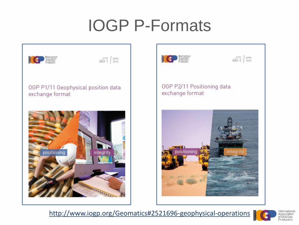
IOGP P-Formats
http://www.iogp.org/Geomatics#2521696-geophysical-operations
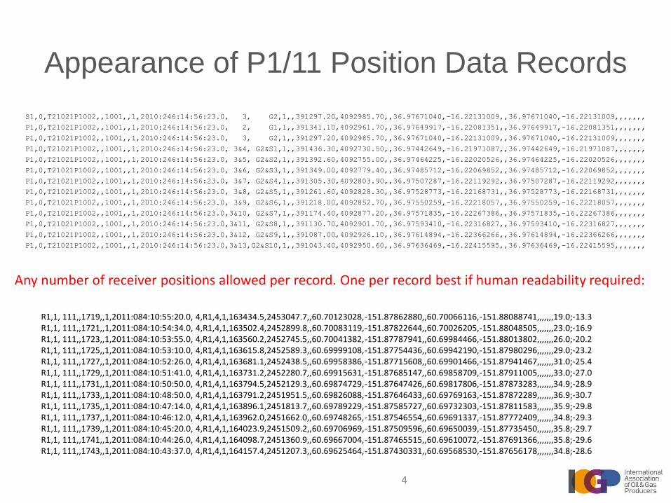
Appearance of P1/11 Position Data Records
S1,0,T21021P1002,,1001,,1,2010:246:14:56:23.0, 3, G2,1,,391297.20,4092985.70,,36.97671040,-16.22131009,,36.97671040,-16.22131009,,,,,,,
P1,0,T21021P1002,,1001,,1,2010:246:14:56:23.0, 2, G1,1,,391341.10,4092961.70,,36.97649917,-16.22081351,,36.97649917,-16.22081351,,,,,,,
P1,0,T21021P1002,,1001,,1,2010:246:14:56:23.0, 3, G2,1,,391297.20,4092985.70,,36.97671040,-16.22131009,,36.97671040,-16.22131009,,,,,,,
P1,0,T21021P1002,,1001,,1,2010:246:14:56:23.0, 3&4, G2&S1,1,,391436.30,4092730.50,,36.97442649,-16.21971087,,36.97442649,-16.21971087,,,,,,,
P1,0,T21021P1002,,1001,,1,2010:246:14:56:23.0, 3&5, G2&S2,1,,391392.60,4092755.00,,36.97464225,-16.22020526,,36.97464225,-16.22020526,,,,,,,
P1,0,T21021P1002,,1001,,1,2010:246:14:56:23.0, 3&6, G2&S3,1,,391349.00,4092779.40,,36.97485712,-16.22069852,,36.97485712,-16.22069852,,,,,,,
P1,0,T21021P1002,,1001,,1,2010:246:14:56:23.0, 3&7, G2&S4,1,,391305.30,4092803.90,,36.97507287,-16.22119292,,36.97507287,-16.22119292,,,,,,,
P1,0,T21021P1002,,1001,,1,2010:246:14:56:23.0, 3&8, G2&S5,1,,391261.60,4092828.30,,36.97528773,-16.22168731,,36.97528773,-16.22168731,,,,,,,
P1,0,T21021P1002,,1001,,1,2010:246:14:56:23.0, 3&9, G2&S6,1,,391218.00,4092852.70,,36.97550259,-16.22218057,,36.97550259,-16.22218057,,,,,,,
P1,0,T21021P1002,,1001,,1,2010:246:14:56:23.0,3&10, G2&S7,1,,391174.40,4092877.20,,36.97571835,-16.22267386,,36.97571835,-16.22267386,,,,,,,
P1,0,T21021P1002,,1001,,1,2010:246:14:56:23.0,3&11, G2&S8,1,,391130.70,4092901.70,,36.97593410,-16.22316827,,36.97593410,-16.22316827,,,,,,,
P1,0,T21021P1002,,1001,,1,2010:246:14:56:23.0,3&12, G2&S9,1,,391087.00,4092926.10,,36.97614894,-16.22366266,,36.97614894,-16.22366266,,,,,,,
P1,0,T21021P1002,,1001,,1,2010:246:14:56:23.0,3&13,G2&S10,1,,391043.40,4092950.60,,36.97636469,-16.22415595,,36.97636469,-16.22415595,,,,,,,
R1,1, 111,,1719,,1,2011:084:10:55:20.0, 4,R1,4,1,163434.5,2453047.7,,60.70123028,-151.87862880,,60.70066116,-151.88088741,,,,,,,19.0;-13.3R1,1, 111,,1721,,1,2011:084:10:54:34.0, 4,R1,4,1,163502.4,2452899.8,,60.70083119,-151.87822644,,60.70026205,-151.88048505,,,,,,,23.0;-16.9R1,1, 111,,1723,,1,2011:084:10:53:55.0, 4,R1,4,1,163560.2,2452745.5,,60.70041382,-151.87787941,,60.69984466,-151.88013802,,,,,,,26.0;-20.2R1,1, 111,,1725,,1,2011:084:10:53:10.0, 4,R1,4,1,163615.8,2452589.3,,60.69999108,-151.87754436,,60.69942190,-151.87980296,,,,,,,29.0;-23.2R1,1, 111,,1727,,1,2011:084:10:52:26.0, 4,R1,4,1,163681.1,2452438.5,,60.69958386,-151.87715608,,60.69901466,-151.87941467,,,,,,,31.0;-25.4R1,1, 111,,1729,,1,2011:084:10:51:41.0, 4,R1,4,1,163731.2,2452280.7,,60.69915631,-151.87685147,,60.69858709,-151.87911005,,,,,,,33.0;-27.0R1,1, 111,,1731,,1,2011:084:10:50:50.0, 4,R1,4,1,163794.5,2452129.3,,60.69874729,-151.87647426,,60.69817806,-151.87873283,,,,,,,34.9;-28.9R1,1, 111,,1733,,1,2011:084:10:48:50.0, 4,R1,4,1,163791.2,2451951.5,,60.69826088,-151.87646433,,60.69769163,-151.87872289,,,,,,,36.9;-30.7R1,1, 111,,1735,,1,2011:084:10:47:14.0, 4,R1,4,1,163896.1,2451813.7,,60.69789229,-151.87585727,,60.69732303,-151.87811583,,,,,,,35.9;-29.8R1,1, 111,,1737,,1,2011:084:10:46:12.0, 4,R1,4,1,163962.0,2451662.0,,60.69748265,-151.87546554,,60.69691337,-151.87772409,,,,,,,34.8;-29.3R1,1, 111,,1739,,1,2011:084:10:45:20.0, 4,R1,4,1,164023.9,2451509.2,,60.69706969,-151.87509596,,60.69650039,-151.87735450,,,,,,,35.8;-29.7R1,1, 111,,1741,,1,2011:084:10:44:26.0, 4,R1,4,1,164098.7,2451360.9,,60.69667004,-151.87465515,,60.69610072,-151.87691366,,,,,,,35.8;-29.6R1,1, 111,,1743,,1,2011:084:10:43:37.0, 4,R1,4,1,164157.4,2451207.3,,60.69625464,-151.87430331,,60.69568530,-151.87656178,,,,,,,34.8;-28.6
Any number of receiver positions allowed per record. One per record best if human readability required:
4

Exchange Format for Position Data – Legacy vs. NewP1/90:VT21021P1002 1 1001365847.20N01613 9.03W 391491.54093323.6 17.3246145623
P1/11:P1,0,T21021P1002,,1001,,1,2010:246:14:56:23.0,1,V1,2,,391491.50,4093323.60,,36.97977813
,-16.21917611,,36.97974444,-16.21916422,,,,,,,17.30

P-/11 more accurateP1/90 files write time to nearest integer second due to fixed field length.
P1/11 files write time and position to the precision recorded.
A simple example of the effects of position and time precision differences between the P1/90 and P1/11 formats is demonstrated below:
Vessel speed
derived from
P1/90 time &
position data
Vessel speed
derived from
P1/11 time &
position data
(Data from same line)
Image courtesy Midpoint Geo

Common Header
• Common across all P-/11 Formats
• Contains the key metadata about a survey
– Survey summary
– Reference Systems definition
• Units of measure
• Time reference systems
• Coordinate reference systems
– Survey configuration
• Object definition including sources and receivers
• Denoted by ‘HC’ at start of each record
7

Common Header: CRS example
HC,1,3,0,CRS Number/EPSG Code/Name/Source...,1, 4326,WGS 84,8.2,2013:05:14,EPSG,Loaded from EPSG_v8_2.mdb
HC,1,3,0,CRS Number/EPSG Code/Name/Source...,2, 4230,ED50,8.2,2013:05:14,EPSG,Loaded from EPSG_v8_2.mdb
HC,1,3,0,CRS Number/EPSG Code/Name/Source...,3,23030,ED50 / UTM zone 30N,8.2,2013:05:14,EPSG,Loaded from
EPSG_v8_2.mdb
HC,1,3,0,CRS Number/EPSG Code/Name/Source...,4, 5831,Instantaneous Water Level depth, 8.6,
2012:08:10,EPSG,Loaded from EPSG_v8_6.mdb
HC,1,3,0,CRS Number/EPSG Code/Name/Source...,5, ,ED50 / UTM zone 30N / Instantaneous Water Level
depth,,,,
HC,1,3,0,CRS Number/EPSG Code/Name/Source...,6, 5715,MSL depth,8.2,2013:05:14,EPSG,Loaded from
EPSG_v8_2.mdb
CRS implicit identification record block for a typical North Sea survey:

Coordinate Reference Systems
Relationships
Full explicit definition is contained in records HC,1,4,0 through HC,1,8,4
Coordinate DATUM Coordinate
DATUM System European System
WGS 84 Ellipsoidal 2D Datum 1950 Ellipsoidal 2D
CRSREF1 Geog CRS Coordinate Operation Geog CRS CRSREF2
CRS C WGS 84 Pos'n Vector Trans'fn ED 50 CRS B
DATUM Coordinate Coordinate Operation
Instant. WL System Transverse Mercator DATUM Coordinate
Vertical Mean Sea Level System
Vertical
CRSREF4 PROJECTED CRS CRSREF3
ED50 / UTM zone 30N CRS A
CRSREF6
CRSREF5 Coordinate Map Projection DATUM
System UTM zone 30N European
Cartesian 2D Datum 1950
Instantaneous WLD
Vertical CRS
Vertical CRS
MSL depth
Compound CRS
Projected + vertical
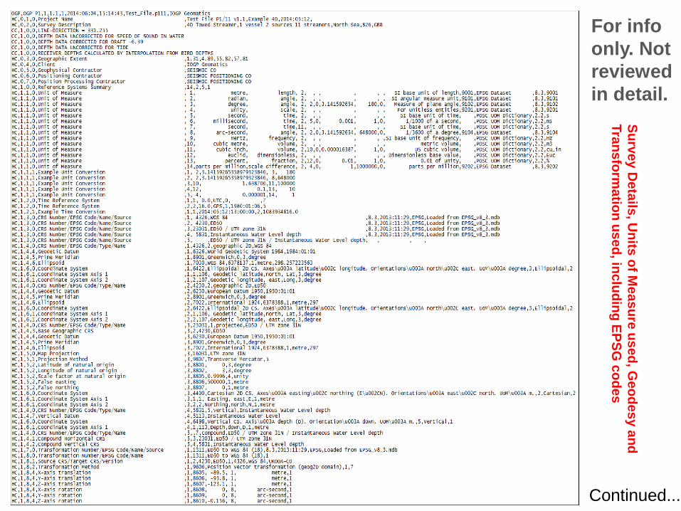
For info
only. Not
reviewed
in detail.
Su
rve
y D
eta
ils, U
nits
of M
ea
su
re u
se
d, G
eo
de
sy a
nd
Tra
ns
form
atio
n u
se
d, in
clu
din
g E
PS
G c
od
es
Continued...
Stre
am
er, G
un
Arra
y, Gu
n S
tring
, Tailb
uo
y,
Fro
nt flo
at, G
un
strin
g flo
at O
ffsets
E/S
Offs
et
& Q
C
ele
me
nts

Common Header: Survey Configuration
example - 3D Marine SurveyHC,2,3,0,Seismic Vessel , 1,SVL,1,Vessel,,1&2,,0,0,0,Vessel Reference Point,15,7,23
HC,2,3,0,Streamer S1 , 2,S01,2,Streamer,,,1, 150,-633,-8,Centre First Group,2,, 84
HC,2,3,0,Streamer S2 , 3,S02,2,Streamer,,,1, 112.5,-633,-8,Centre First Group,2,, 85
HC,2,3,0,Streamer S3 , 4,S03,2,Streamer,,,1, 37.5,-633,-8,Centre First Group,2,, 91
HC,2,3,0,Streamer S4 , 5,S04,2,Streamer,,,1, -37.5,-633,-8,Centre First Group,1,,106
HC,2,3,0,Streamer S5 , 6,S05,2,Streamer,,,1,-112.5,-633,-8,Centre First Group,1,, 79
HC,2,3,0,Streamer S6 , 7,S06,2,Streamer,,,1, -150,-633,-8,Centre First Group,1,, 80
HC,2,3,0,Gun Array G1 ,14,G01,4,Air Gun Array,,,1, 18.75,-458,-7,Centre of Source,3,,1
HC,2,3,1,Number of Sub Arrays ,14,30,2,12,euclid
HC,2,3,0,Gun Array G2 ,15,G02,4,Air Gun Array,,,1,-18.75,-458,-7,Centre of Source,3,,1
HC,2,3,1,Number of Sub Arrays ,15,30,2,12,euclid
HC,2,3,0,Gun String GS1 ,16,GS01,9,Gun String,,,14, 4,7.5,0,Centre of First Gun Cluster,2,,
HC,2,3,0,Gun String GS2 ,17,GS02,9,Gun String,,,14,-4,7.5,0,Centre of First Gun Cluster,2,,
HC,2,3,0,Gun String GS4 ,19,GS04,9,Gun String,,,15, 4,7.5,0,Centre of First Gun Cluster,2,,
HC,2,3,0,Gun String GS5 ,20,GS05,9,Gun String,,,15,-4,7.5,0,Centre of First Gun Cluster,2,,
HC,2,3,0,Tailbuoy on S1 ,23,F01,10,Float,,, 2,0,-3100.0,8,Float Reference Point,,,3
HC,2,3,0,Tailbuoy on S2 ,25,F02,10,Float,,, 3,0,-3100.0,8,Float Reference Point,,,3
HC,2,3,0,Tailbuoy on S3 ,27,F03,10,Float,,, 4,0,-3100.0,8,Float Reference Point,,,3
HC,2,3,0,Tailbuoy on S4 ,28,F04,10,Float,,, 5,0,-3100.0,8,Float Reference Point,,,3
HC,2,3,0,Tailbuoy on S5 ,29,F05,10,Float,,, 6,0,-3100.0,8,Float Reference Point,,,3
HC,2,3,0,Tailbuoy on S6 ,30,F06,10,Float,,, 7,0,-3100.0,8,Float Reference Point,,,3
HC,2,3,0,Front Float FF2 ,24,FF02,10,Float,,,3,0, 68.5,8,Float Reference Point,,,3
HC,2,3,0,Front Float FF5 ,36,FF05,10,Float,,,6,0, 68.5,8,Float Reference Point,,,3
HC,2,3,0,Gun String Float F1 on Gun String GS1 ,40,GS01F01,10,Float,,,16,0, -6,7,Float Reference Point,,,3
HC,2,3,0,Gun String Float F2 on Gun String GS1 ,41,GS01F02,10,Float,,,16,0,-15,7,Float Reference Point,,,3
HC,2,3,0,Gun String Float F1 on Gun String GS2 ,42,GS02F01,10,Float,,,17,0, -6,7,Float Reference Point,,,3
HC,2,3,0,Gun String Float F2 on Gun String GS2 ,43,GS02F02,10,Float,,,17,0,-15,7,Float Reference Point,,,3
HC,2,3,0,Gun String Float F1 on Gun String GS4 ,46,GS04F01,10,Float,,,19,0, -6,7,Float Reference Point,,,3
HC,2,3,0,Gun String Float F2 on Gun String GS4 ,47,GS04F02,10,Float,,,19,0,-15,7,Float Reference Point,,,3
HC,2,3,0,Gun String Float F1 on Gun String GS5 ,48,GS05F01,10,Float,,,20,0, -6,7,Float Reference Point,,,3
HC,2,3,0,Gun String Float F2 on Gun String GS5 ,49,GS05F02,10,Float,,,20,0,-15,7,Float Reference Point,,,3
HC,2,3,0,Echo Sounder ES1 on SVL ,52,SVL.ES1,11,Echo Sounder,,,1,-1.62,-14.97,-7.28,Transducer Position,,,
HC,2,3,0,Gun Array Mean ,54,GAM,12,Mid Point,,,14&15,0,-458,-7,,,,
12

HC,2,3,0 Record Interpretation
13
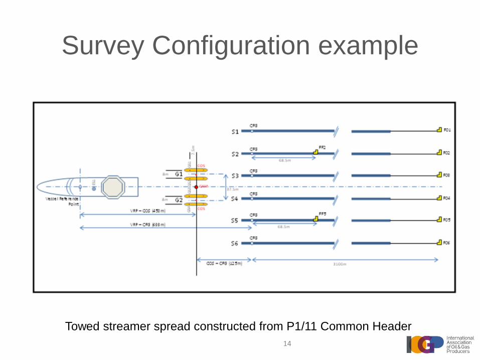
Survey Configuration example
Towed streamer spread constructed from P1/11 Common Header
14

Adaptable to any environment
15

Applicable to many types of survey
• Seismic– 2D
– 3D
– 4D
– Multiple component
– EMGS
• Geophysical surveys• Marine site & route surveys
• Seabed clearance surveys
• Hydrographic surveys
16
Other uses of P1/11
• To exchange pre-plot data
• To define survey outlines and perimeters
• To record relational data – P1/11 can replace SEG’s SPS format
17

Collaboration with SEG
• The latest version of SEG-D (field tape format) supports the Common Header CRS definition
• The next version of SEG-Y (processed data format) will support the Common Header CRS definition
• IOGP Geomatics Committee and SEG TSC are collaborating on the next version of SPS
18

IOGP Library and Contact details
Download the Documents from www.iogp.org or via direct
links below:
http://www.iogp.org/pubs/483-1.pdf (P1/11 Format Specification)
http://www.iogp.org/pubs/483-1u.pdf (P1/11 User Guide)
http://www.iogp.org/pubs/483-2.pdf (P2/11 Format Specification)
http://www.iogp.org/pubs/483-6.pdf (P6/11 Format Specification)
Formal Questions or Comments:
Lucyna Kryla-Straszewska [email protected]
Walter Jardine [email protected]
19