institutionen för datavetenskap - diva...
TRANSCRIPT

Institutionen för datavetenskap Department of Computer and Information Science
Final thesis
A Location Based Service Framework for
Pedestrian Navigation
by
Natalia Wieczorek
LIU-IDA/LITH-EX-A--11/015--SE
2011-04-27
Linköpings universitet
SE-581 83 Linköping, Sweden
Linköpings universitet
581 83 Linköping

Linköping University
Department of Computer and Information Science
2
Final Thesis
A Location Based Service Framework for
Pedestrian Navigation
by
Natalia Wieczorek
LIU-IDA/LITH-EX-A--11/015--SE
2011-04-27
Supervisor: Peter Bunus
IDA, Linköpings University Linköpings, Sweden
Examiner: Peter Bunus
IDA, Linköpings University
Linköpings, Sweden

Linköping University
Department of Computer and Information Science
3

Linköping University
Department of Computer and Information Science
4
Abstract
Pedestrian navigation is an emerging technology with high growth market potential. In this
report, we present a location based service framework for pedestrian navigation that uses
smart phones as client devices and is deployed on an existing Wi-Fi infrastructure in a
building. The thesis describes methods and technologies that are used for pedestrian
navigation and how they can be combined to achieve an accurate and reliable solution to the
navigation problem. A final evaluation indicated that the service can be used in variety of
places like university campuses, shopping malls and dense urban areas.

Linköping University
Department of Computer and Information Science
5
Acknowledgments
I would like to thank my supervisor and examiner Peter Bunus for his kind help and
insightful comments about this report.
Also, my thanks go to Joakim Nejdeby and Fredrike Wagnsgård from Linköping University
IT Department.
Finally, to my opponent, Pawel Suwala, for his valuable advice and evaluation.

Linköping University
Department of Computer and Information Science
6
Table of content
1 Introduction ......................................................................................................................... 9
1.1 Problem description................................................................................................... 10
1.2 Purpose ...................................................................................................................... 11
1.3 Thesis objective ......................................................................................................... 11
1.4 Thesis outline ............................................................................................................ 11
2 Market value ..................................................................................................................... 12
2.1 Location based services ............................................................................................. 13
2.2 Maturity and growth potential for location based services ....................................... 13
2.3 Areas of appliance ..................................................................................................... 14
2.4 Positioning systems requirements ............................................................................. 15
2.5 Platforms ................................................................................................................... 17
3 Background ....................................................................................................................... 19
3.1 Positioning techniques............................................................................................... 20
3.2 Indoor positioning algorithms ................................................................................... 23
3.3 Indoor propagation models........................................................................................ 25
3.4 Inertial navigation ..................................................................................................... 27
3.5 Visualization.............................................................................................................. 27
4 Technical overview of existing local positioning systems ............................................... 28
4.1 Radio-based systems ................................................................................................. 29
4.2 Cell-ID ....................................................................................................................... 31
4.3 Inertial navigation ..................................................................................................... 31
4.4 Global navigation satellite systems ........................................................................... 32
4.5 PSEUDOLITES ........................................................................................................ 33
4.6 Other solutions .......................................................................................................... 33
4.7 Comparison of existing methodologies ..................................................................... 34
5 Prototype application ........................................................................................................ 35
5.1 Environment .............................................................................................................. 36
5.2 Goal ........................................................................................................................... 36
5.3 Requirements ............................................................................................................. 36
5.4 Application architecture ............................................................................................ 37
5.5 First stage prototype .................................................................................................. 37
Linköping University
Department of Computer and Information Science
7
5.6 Improvements ............................................................................................................ 39
6 Design of indoor navigation for Linköping University .................................................... 41
6.1 Goal ........................................................................................................................... 42
6.2 Objectives .................................................................................................................. 42
6.3 Requirements ............................................................................................................. 42
6.4 Mobile platform......................................................................................................... 43
6.5 Design........................................................................................................................ 43
6.6 User Interface ............................................................................................................ 44
6.7 Database .................................................................................................................... 45
6.8 Positioning Technique ............................................................................................... 45
6.9 Navigation System .................................................................................................... 46
6.10 Mapping System ........................................................................................................ 48
6.11 Overall view .............................................................................................................. 48
7 Conclusions ....................................................................................................................... 49
7.1 Conclusions ............................................................................................................... 50
Bibliography ............................................................................................................................. 51

Linköping University
Department of Computer and Information Science
8
Table of figures
Figure 1 Expected market potential for location based services according to [2] ................... 14
Figure 2 Areas of appliance according to [2] ........................................................................... 15
Figure 3 Requirements and how they are met according to [2] ............................................... 16
Figure 4 Requirements for end users [2].................................................................................. 17
Figure 6 AOA .......................................................................................................................... 22
Figure 7 TOA ........................................................................................................................... 22
Figure 8 TDOA ........................................................................................................................ 23
Figure 9 Ideal environment for radio propagation ................................................................... 25
Figure 10 Typical environment for radio propagation ............................................................. 26
Figure 11 Comparison of existing positioning systems[2] ...................................................... 34
Figure 12 Marked entrance ...................................................................................................... 38
Figure 13 Floor plan................................................................................................................. 39
Figure 14 Subsystems .............................................................................................................. 44
Figure 15 Example floor plan .................................................................................................. 47
Figure 16 Floor plan with nodes and links............................................................................... 47
Figure 17 Graph consists of nodes and links ........................................................................... 48

Linköping University
Department of Computer and Information Science
9
1 Introduction
In this chapter we cover issues like problem description, the purpose of this thesis and the
objectives; there is also a brief outline of the thesis’s content.
1.1 Problem description.................................................................................................... 10
1.2 Purpose ....................................................................................................................... 11
1.3 Thesis objective .......................................................................................................... 11
1.4 Thesis outline ............................................................................................................. 11
Linköping University
Department of Computer and Information Science
10
1.1 Problem description The technological advances in the past decades have caused a huge progress in the domain of
locating services. When thinking of navigation, the Global Navigation Satellite Systems
(GNNS) are the first to consider. The only publicly available GNNS is Global Positioning
System (GPS) which determines the position of objects using time signals received from the
satellites. Because of its characteristics – coverage, accuracy, signal strength, line-of-sight
transmission – the technology imposes limitations on the environment where it can be used.
Namely, it cannot provide the data needed to position objects indoors. The growing market
for the Internet-enabled phones equipped with locating technologies and powerful
communication and computational abilities have allowed software vendors to readdress
problems of indoor navigation. This thesis is broadly concerned with the limitations of
solutions and technologies available for the indoor usage in the form of location based
services such as pedestrian navigation, social networking, tracking assets and humans and
location enabled marketing.
Possible technologies were identified when conducting research into indoor navigation but
most of them were not released for the consumers. One possibility is to use beacons and
triangulate device’s position. Different types of signal can be used; radio frequency,
Bluetooth and Ultra-Wide Band are the most common. Another alternative is to recreate the
GPS technology inside buildings by installing pseudolites and thus reaching a satisfactory
accuracy [3][8]. The trade off is in cost and implementation complexity. Infrared and
ultrasound technology provides a high accuracy when in proximity to the sensors but requires
a new infrastructure to be built. Combining technologies ensures that the requirements on
coverage, availability and accuracy are met.
Pedestrian navigation is often used to aid visitors in large dense urban areas such as
university campuses, hospitals, museums and shopping malls where getting lost is a common
enough occurrence to consider it a problem.
This problem also exists at Linköping University. Students and visitors face the problem of
finding the sought locations.
While the benefits to the users are obvious, accurate navigation saves time and helps to avoid
losing one’s way, there are also advantages for the companies or organizations which provide
the navigation service. The indoor navigation application can be used to display other
information such as advertisement of shops located in the proximity of the user, sales
promotions (in case of shopping malls), lectures, labs and room reservations (at the
universities), present interactive content (in museums), track items in warehouses and to
locate people in buildings.
The thesis proposes a pedestrian navigation solution that can be deployable on smartphones.
A prototype implementation demonstrates the functionality and usability of the proposed
pedestrian navigation system in a university campus environment.

Linköping University
Department of Computer and Information Science
11
1.2 Purpose The purpose of the thesis is to examine and evaluate different solutions for the indoor
navigation problem at large complexes of buildings.
1.3 Thesis objective The main deliverable of the thesis is the solution for location based services and in particular
pedestrian navigation. The thesis objectives are:
- To introduce the concept of location based services and their benefits.
- To present the available solutions.
- To answer the question how the smart phone can be used for locating purposes.
- To demonstrate the concepts of pedestrian navigation on a prototype application.
1.4 Thesis outline The thesis is organized in 7 chapters. Chapter 1 gives an introduction with an overview of the
thesis scope and goal. The remainder of the thesis is structured to provide background
information about the local positioning services and areas of appliance (Chapter 2). Chapter 3
provides information on positioning algorithms, propagation models and positioning
techniques. An overview of existing solutions is given in Chapter 4. A prototype application
of the proposed solution is presented in Chapter 5. In Chapter 6, we propose a framework for
the indoor navigation service for the Linköping University. Finally, Chapter 7 concludes the
thesis.

Linköping University
Department of Computer and Information Science
12
2 Market value
In this chapter we provide background information on local positioning systems and location
based services and present the current state-of-art and future of the local positioning services
market.
2.1 Location based services ............................................................................................. 13
2.2 Maturity and growth potential for location based services ....................................... 13
2.3 Areas of appliance ..................................................................................................... 14
2.4 Positioning systems requirements ............................................................................. 15
2.5 Platforms ................................................................................................................... 17

Linköping University
Department of Computer and Information Science
13
2.1 Location based services A location-based service (LBS)[1] is an information and entertainment service, accessible
with mobile devices through the mobile network and utilizing the ability to make use of the
geographical position of the mobile device.
LBSs are provided for informative and entertainment purposes that utilize the data about the
device location. Below, we list most common services that are currently used or under
development.
Outdoor navigation. Navigation provided by Global Navigation Satellite Systems is
a mature and well-established technology for a variety of services, including outdoor
navigation, navigation for drivers, fleet management and tourism.
Indoor navigation. There is a satisfactory solution for outdoor navigation; indoor
navigation is still in development phase. The indoor navigation can be helpful in
environments like universities, shopping centers, museums and airports. Technologies
addressing the indoor applications requirements include: WiFi, Ultra-Wide Band,
Radio Frequency identification, pseudolites and Inertial navigation
Advertising and marketing. Location based advertising (LBA) and location based
marketing (LBM) are dependent on the location of a user to display the information
about a company and its product. The needs of LBA and LBM can be met by WiFi
technology.
Location-based social networking. For social networking, the locating services
provide a link between the virtual and real world.
Asset and human tracking. Thanks to the combined outdoor and indoor localization
services, it is possible to track assets or humans. The typical example could be
tracking the goods to ensure proper delivery and continuous information or tracking
patients in hospitals.
2.2 Maturity and growth potential for location based services The following diagram taken from [2] presents the current state and the potential growth of
selected location-based services. It is assumed that in the future indoor location based
services will have the highest growth potential and thus can be assumed to create a great
market for vendors and providers of such services.

Linköping University
Department of Computer and Information Science
14
Figure 1 Expected market potential for location based services according to [2]
2.3 Areas of appliance The following diagram taken from [2] presents the state of different location-based services
divided into categories of where the service is used.

Linköping University
Department of Computer and Information Science
15
Figure 2 Areas of appliance according to [2]
2.4 Positioning systems requirements When choosing a positioning solution, it is important to analyze the following criteria[2]:
- Coverage – defined in a geographical sense is a percentage of the area where the
service can be used successfully;
- Accuracy – the ability of a system to precisely locate the user/device to an expected
margin for error.
- Reliability – is the amount of time when the service is available and the data provided
by it are expected to be correct; the reliability is difficult to measure and little
information is provided by the navigation systems’ vendors as to the expected
reliability; a system with good coverage and accuracy is deemed unusable if the
service cannot be provided for a prolonged time of use
- Time-to-first-fix (TTFF) – is a time at which the first location data is obtained by a
receiver
- Privacy – the use of positioning technology should not impose on its users’ privacy;
while most users are accepting the passive tracking done by GSM service providers,
the situation often changes when the positioning is to be used actively to trace a
certain person
- Cost of implementation – there are solutions that are hardly found in the market
today because of the high cost of implementation of the infrastructure

Linköping University
Department of Computer and Information Science
16
- Power consumption – depending on where the analysis is done, the positioning
technology may involve serious power consumption on the device used for
navigation.
The following figure [2] lists the current solutions to the common areas where the positioning
technology is used with the graded information as to how the requirements are met.
Figure 3 Requirements and how they are met according to [2]

Linköping University
Department of Computer and Information Science
17
A research done by PTOLEMEUS Group [2] also identified the most important criteria for
the end user from three points of view: users, location technology providers and vendors. The
results are presented below.
Figure 4 Requirements for end users [2]
Users require the system to be accurate and have a good coverage while operators concentrate
mostly on speed and power consumption and providers on accuracy, power consumption and
coverage.
2.5 Platforms A mobile platform is a hand held, portable device such as smart phone equipped with cellular
networking, Internet access and high-resolution display. There are three operating systems in
use: POSIX-compatible (Apple Inc. iOS[9], Google Inc. Android[10]), Symbian[11] (Nokia)
and Windows[12] (Microsoft Inc.). From the thesis perspective only the first one is
considered because of it open source nature and market share.
Typical equipment found in the smart phone include Wi-Fi card, assisted GPS receiver,
Bluetooth with Enhanced Data Rate (EDR) and microelectro-mechanical systems.
Wi-Fi technology: Smart phones are typically equipped with one of the WiFi
standards 802.11 b/g/n. While it is mostly used to access the Internet resources, it
opens a new possibility for the indoor navigation. Most buildings have a wide
network of access points used for wireless Internet which can also serve the role of
static beacons (fixed points) in wireless positioning system. Since the coverage of the

Linköping University
Department of Computer and Information Science
18
access points overlaps to allow the user to freely roam between the networks as one
passes the corridors and alleys, the user’s position can be found out accurately by
comparing the signal strength of all access points that the device can connect to at a
certain moment in time. Each access point has a known position on a map and a MAC
address which uniquely identifies it in the network.
GPS and Assisted GPS: GPS and Assisted GPS technology can be used for
navigation purposes when the user is located in an outdoor environment. As opposed
to the wireless technology, the signal loss and the inaccuracy level when the satellite
view is obstructed, do not allow for this technology to be used to locate the user
indoor. The main goal of the GPS navigation in pedestrian navigation would be to
provide the directions to the user when outside. In case of LIU campuses which are
spread over three locations (Campus Valla, University Hospital Campus and Campus
Norrkoping) with multiple buildings, the GPS coordinates are used to guide the user
to the entrance of the buildings.
Bluetooth: Originally, Bluetooth technology was developed to allow wireless data
exchange on short distances between devices but soon evolved to be a wireless tool
for creating networks. Depending on the standard, the Bluetooth have a range up to
100m and since it uses radio waves to transmit signal, is not obstructed by walls
inside the building. Bluetooth uses a technology known as frequency-hopping spread
spectrum, which transmits the chunks of data on up to 79 bands in the range 2402-
2480. Using Bluetooth indoor would require a special infrastructure of Bluetooth
receivers, which is a serious drawback compared to WiFi technology.
Microelectro-mechanical systems: Many smart phones vendors are now adding
micro electro-mechanical systems (MEMS) to the devices as a standard. Those
MEMS include gyroscopes, accelerometers, pressure sensors and compasses.

Linköping University
Department of Computer and Information Science
19
3 Background
There are many methods for determining the object’s location. In the following chapter we
provide a formal classification of the LPSs based on the types of sensors, place where the
position estimation takes place, type of signal and estimation method.
3.1 Positioning techniques............................................................................................... 20
3.2 Indoor positioning algorithms ................................................................................... 23
3.3 Indoor propagation models........................................................................................ 25
3.4 Inertial navigation ..................................................................................................... 27
3.5 Visualization.............................................................................................................. 27

Linköping University
Department of Computer and Information Science
20
3.1 Positioning techniques The following diagram presents the general classification of LPSs[1] Choosing the place of
location estimation and the type of used sensors will guide the vendors’ choice of signal
metrics and how they are going to be processed.
Figure 5 Classification of local positioning systems [1]
Positioning systems can be first divided into two main categories: those with external and
internal sensing. External sensing systems use signals originated from other than the device
parts of the infrastructure. The example includes Wi-Fi positioning systems. Internal sensing
systems depends only on the information from the device and the typical case is inertial
navigation that uses data from installed accelerometers, gyroscopes and pressure sensors to
calculate the location from the last known position.
The location estimation can be performed either locally on the device whose position is
estimated (receptive or self-positioning system) or remotely in a network (transmissive
positioning). In the first case, a device receives the information from one or many sensors and
computes its location. The location data does not need to be propagated to any third party
devices in a system infrastructure. In the second case, fixed stations estimate the device
location. Stations receive the signal from a device and send the data to a reasoning tool that
Location sensing
Place of location estimation
Self positioning
Remote positioning
Sensor type
Passive
Active
Metric processing
Proximity
Triangulation
Location fingerprinting
Map-matching
Trilateriation
Signal metrics
RSS
AOA
TOA/TDOA
Type of location sensing
External sensing
Internal sensing

Linköping University
Department of Computer and Information Science
21
locate the device. The results may or may not have been presented to the user. There are also
some hybrid solutions such as assisted GPS. The first solution is preferred in the
environments where the user is supposed to maintain a certain level of privacy and disclosure
of his location. The main disadvantage is the need to install an application on the mobile
device for the locating purposes. The second solution does not typically require the user to
install any programs for detection and tracking (since both are done on the server-side) but an
identity of a user also needs to be maintained.
3.1.1 Received Signal Strength Method
This method estimates the distance to the transmitter solely on the basis of signal strength
received at the receiver.
The advantages of this method include:
The easiest metrics to obtain,
Does not require any additional hardware and/or software
Typically does not need any changes in the existing infrastructure.
The main disadvantages are:
Metric is not very accurate and prone to multipath fading and shadowing
Uses rather average values of signal
3.1.2 Angle of Arrival Method
By making use of directional antennas and simple geometric rules it is possible to calculate
the distance to a transmitter by computing the angle of arrival of a signal. Only two
transmitters are needed to accurately estimate the receiver’s position.
The advantages include:
Simple computation
The disadvantages include:
Need for additional hardware not typically found in the infrastructure
Only works with line-of-sight conditions
The performance is not acceptable
Linköping University
Department of Computer and Information Science
22
Figure 6 AOA [15]
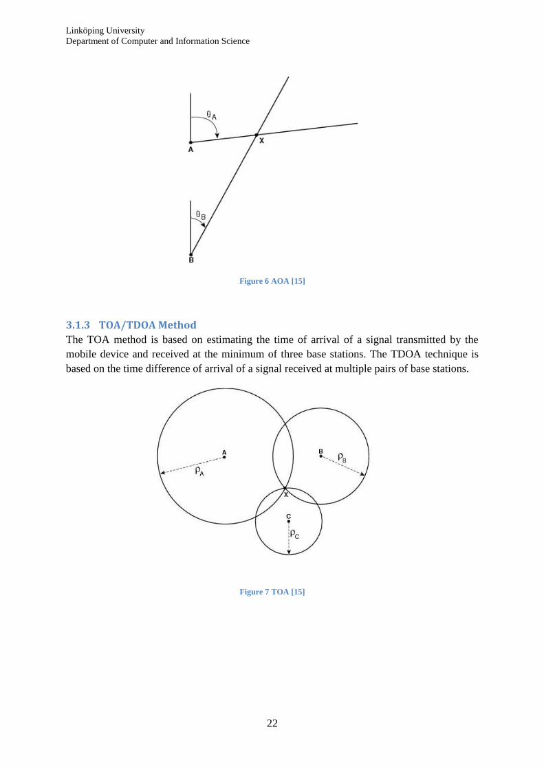
3.1.3 TOA/TDOA Method
The TOA method is based on estimating the time of arrival of a signal transmitted by the
mobile device and received at the minimum of three base stations. The TDOA technique is
based on the time difference of arrival of a signal received at multiple pairs of base stations.
Figure 7 TOA [15]

Linköping University
Department of Computer and Information Science
23
Figure 8 TDOA [15]
3.2 Indoor positioning algorithms A variety of algorithms are applied to calculate the location of a device based on the signal
metrics. Often more than one algorithm is used.
3.2.1 Cell-ID based systems
One of the most widespread technologies for network-based positioning is to identify in
which cell and sector the user currently is. This can be done by checking which antenna
receives the signal from a device. The accuracy of a method depends heavily on a size of cell
and can be used both outside and inside the buildings. This approach is commonly used in
GSM but can also be also with other system. The location estimation can take place both on
the device and in the network.
3.2.2 VoIP
Voice-Over Internet Protocol can be used to transmit voice information over the network. In
order to use that method, the location of each Ethernet socket or access point needs to be
mapped. The usage of this technology is limited.
3.2.3 Proximity
It is the simplest method used to locate the user in the network of access points based on the
assumption that the user is closest to the access points to which he is connected. The accuracy
of this method is low and with growing coverage area for access points becomes unusable.
3.2.4 Triangulation
Triangulation is most commonly used method for indoor navigation. It uses both data about
the distances and angles to calculate the position of a device. The system draws circles
around each access point with the information of received signal strength indicator. It is
assumed that the user is located at the intersection of those circles.

Linköping University
Department of Computer and Information Science
24
The advantages include:
- COTS approach
- Nearly no additional overhead
Disadvantages include:
- The result is prone to errors in environments with many physical barriers that
obstruct the signal
- Standard WLAN infrastructure may not provide sufficient accuracy
- Signal strength measurement can be nearly identical when using a radius of up to
5 m
- High deviation in signal strength
Lateration
Lateration calculates the position of an object by measuring the distance from multiply fixed
stations. To calculate the object position in three dimensions, four reference nodes are
needed. Lateration uses two approaches to measure the distances from known nodes:
- Time of flight that measures the time difference in transmission
- Attenuation which is a decrease in the emitted signal strength in relation to the
original intensity
Angulation
Angulation uses angles to determine the position of an object. In three dimensions, two angle
measurements, one length measurement (such as the distance between the reference nodes)
and one azimuth measurement are required to specify a precise location.
3.2.5 Trilateration
Trilateration is similar to triangulation but depends only on distances for its calculations and
uses RSSI data.
3.2.6 CENTROID
Centroid is one of the simplest algorithms that require a training phase during which all the
readings from a fixed station are combined and an arithmetic mean of the positions is
calculated. In the end, there is one record for each node and a map for the network can be
created. When the system locates the user, it computes the average of the estimated positions
of all stations heard during the network scan.
3.2.7 Pattern matching
This method is also known as location fingerprinting and consists of offline phase (site
survey that results in creating the reading map) and online phase (the actual real time
positioning of objects). During the offline phase, information about the signal strength for the
map of grid is recorded for every fixed station. A high grid density will result in higher
accuracy.

Linköping University
Department of Computer and Information Science
25
3.3 Indoor propagation models Wireless received signal strengths are prone to disruption when meeting obstacles like walls,
roofs, furniture and people. Therefore, an accurate propagation model is considered. In an
ideal environment without any physical interferences (see figure 9), the proximity to the
source of a signal (in this case access point) can be computed merely on the distance from the
signal transmitter by assuming that the closer device is to the access point, the stronger signal
is received.
Figure 9 Ideal environment for radio propagation
In practice, such environment is never encountered. Figure 10 shows a more expected signal
strength pattern in an environment with physical interferences where the signal is prone to
absorption, attenuation and reflection.

Linköping University
Department of Computer and Information Science
26
Figure 10 Typical environment for radio propagation
Another factor that needs to be taken into account when measuring the signal metrics is the
radio wave propagation. It is defined as “the transfer of energy by electromagnetic radiation
at radio”[1]. Walls, terrain, air and other obstacles affect the time that it takes for the signal to
reach a receiver.
3.3.1 Free space model
In free space path loss (FSPL) model it is assumed that no obstacles exist between the
transmitter and the receiver and there exists only one line-of-sight. The signal strength is
inversely proportional to the square of the distance from receiver to transmitter.
3.3.2 One Slope Model
One slop model is based on the free space model but takes into consideration environments
with non-free space by adding path-loss exponent to the calculations. This model treats
buildings as uniform structures.
3.3.3 Multi-Wall Model
Multi-Wall Model is an improvement of the one slope model and considers heterogeneous
structure of buildings taking into consideration free space, walls, floors and ceilings.
3.3.4 Multipath Effect
All propagation models presented above assume the existence of one direct path from the
transmitter to receiver. In real environments (that is non-free space ones), other paths from
transmitter to receiver have to be considered.

Linköping University
Department of Computer and Information Science
27
3.4 Inertial navigation Signal metrics, algorithms and propagation models described above are valid for the locating
technologies with external sensing. Inertial navigation depends on the internal sensing.
Current position of a device is estimated according to the acceleration, velocity, direction and
initial position. Such systems require an accelerometer to measure the speed of motion,
gyroscope to measure direction and compass. Currently available smart phones built on a
UNIX platforms are assumed to have enough computational capacity to perform calculations.
3.4.1 Dead reckoning
Dead reckoning (DR) is a process of estimating device’s current location relative to last
known position by measuring speed and direction of the object over elapsed time. The main
disadvantage of DR is that the error becomes very large because of its cumulative nature. DR
also requires sensors of high quality to ensure correct measurement.
3.4.2 Map matching
Map matching is a technique used to merge the data regarding device’s position form
device’s sensors and the digital map. This method is especially used when the device is
expected to be on a certain path to fix the estimation of dead reckoning.
3.5 Visualization A visual presentation of device’s location is a part of the navigation system for pedestrians
just like the positioning techniques. Typically, user is presented with either 2D or 3D plans of
buildings with rooms, walls, entrances and floors which are decomposed into layers. When
calculating the path between device’s current location and its user’s destination, the graphic
representation of a plan has to be converted into graphs; routing algorithms such as Dijkstra’s
Algorithm, Bellman-Ford Algorithm or A* Algorithm are used to find the shortest path
between two points.

Linköping University
Department of Computer and Information Science
28
4 Technical overview of existing local positioning systems
In the following chapter we discuss existing local positioning systems and discuss areas of
appliance, pros and cons of each solution.
4.1 Radio-based systems ................................................................................................. 29
4.2 Cell-ID ....................................................................................................................... 31
4.3 Inertial navigation ..................................................................................................... 31
4.4 Global navigation satellite systems ........................................................................... 32
4.5 PSEUDOLITES ........................................................................................................ 33
4.6 Other solutions .......................................................................................................... 33
4.7 Comparison of existing methodologies ..................................................................... 34

Linköping University
Department of Computer and Information Science
29
4.1 Radio-based systems
4.1.1 WiFi navigation system
WiFi is a common name used for 802.11 wireless local area networks (WLAN) set of
standards from Institute of Electrical and Electronic Engineers (IEEE). WLAN consists of
one or several transceiver devices connected to a wired network, called access points (AP).
WLAN uses electromagnetic waves (radio, optical or infrared light) for communication with
the users. 802.11 standard uses radio waves only. There exist several sub-standards (a,b,g, n
being the most common ones, d, e, f, h, i) which differs on the radio frequency and available
bandwidth. 802.11 standard network can be either configured as an ad hoc or an
infrastructure network.
The rapid development of wireless network technology is crucial to the development of
wireless navigation. Despite the underlying implementation which requires a considerable
effort (see next chapter), the idea behind wireless navigation is simple. A central part of the
application is a database with a list of access points’ precise location and MAC addresses.
This data is used to triangulate the user’s location. When the user starts the navigation
application, the device first collects a list of available access points within the connectivity
range. A list is then compared against the database to get the information on which access
points are in range of the device. A reasoning tool determines the location of a user using an
algorithm and the information from the database. The Wi-Fi technology can be combined
with other technologies like Cell-ID (as implemented by Google for Android users [4],[5]) or
GPS (Skyhook Wireless[6], Navizon[7]).
The first issue is how to collect the data about the available access points from a device.
There are two methodologies to collect the data in a WiFi positioning systems:
Active scanning – when a device sends a request signal to all access points within its
reach to ask for a response
Passive sniffing – when a device listens to all the packets in active wireless network
Data can be collected via an application installed on the device and sent to the reasoning tool
to compare against the database.
In many cases, there would be already wireless infrastructure in a building that composes of
many access points placed in the corridors and rooms. The minimum data that has to be
collected includes the MAC (physical) addresses of wireless devices and their coordinates.
Additional information that is specific to the implementation of the visual display (type of
maps, plans, etc.) may be added. Typically such data can be stored in a central database but it
is possible that all the layers of an application are to be installed on a client device.
Benefits for this type of positioning include:
- Pervasiveness of technology
- Very flexible, self-learning configuration

Linköping University
Department of Computer and Information Science
30
- High availability, accuracy and reliability which can be further improved by users
mapping the network
The WiFi positioning systems’ disadvantages include:
- Lack of access points density outside urban areas
- Lack of indoor mapping
4.1.2 Radio Frequency Identification
Radio Frequency Identification uses radio frequency transmission to detect, identify and track
assets, vehicles or humans carrying a transponder (tag). A tag holds information that is
retrieved by a reader. The tag can either be passive (when activated by the magnetic field of
reader) or active (when having its own power source). A reader emits a signal at the
frequency band. When a tag is within the reader’s signal range, it decodes the received signal
and, if valid, it will send the response by modulating the reader field. The read range of a
reader depends on frequency that is used (RFID can operate in low, high, ultra high
frequency), power of the readers, whether the used tags are passive or active and the
environment where is it used.
Benefits
- Technology is already widely used and mature
- Very accurate and reliable
- The cost is relatively small compared to other methods
Problems:
- The technology is patchy, i.e. it can only detect and identify the object in certain,
fixed locations
- If there are many tags in the reader’s field at the same time which try to reply, a
collision is detected and a collision-resolving algorithm needs to be implemented
- It requires an infrastructure that consists of fixed readers and tags
4.1.3 Bluetooth
Bluetooth is an open wireless standard developed at Ericsson in 1994 to exchange data over
short distances using the radio technology called frequency-hopping spread spectrum that
transmits chunks of data in the range 2402-2480 MHz This range is in the globally unlicensed
Industrial, Scientific and Medical (ISM) 2.4 GHz short-range radio frequency band.
Benefits:
- Technology is widely used and mature
- Bluetooth is a standard equipment found in mobile phones, laptops and other devices
- Does not require line of sight
- A good resistance to interference

Linköping University
Department of Computer and Information Science
31
- An accepted level of accuracy
Problems:
- Bluetooth requires additional infrastructure in a form of Bluetooth access points
4.1.4 Ultra Wideband
Ultra Wideband (UWB) is a radio technology that uses large radio spectrum to transmit high
bandwidth communication in short range. A typical system will consists of a set of sensors
(usually 4 per cell) and tags using UWB for communication. To estimate the location, mostly
TDOA and AOA are used.
Benefits
- High accuracy when used indoors
Problems
- Requires additional infrastructure
4.2 Cell-ID The Cell-Id positioning technique determines user’s location in relation to nearby GSM base
stations by triangulating between cells.
Benefits
- Can be used in indoor environment
- Does not require additional infrastructure
- Reliable
Problems
- Very low accuracy
4.3 Inertial navigation
4.3.1 Micro electro-mechanical systems (MEMS)
Micro electro-mechanical systems are small electronics fused to sensors and can be used in
electronic and mechanical measurements and processes. Nowadays they are often added to
standard equipment mounted in a smart phone.
Gyroscopes - are devices used for measuring or maintaining orientation, based on the
principles of conservation of angular momentum. A typical MEMS-gyroscope uses a
vibrating element to measure the orientation

Linköping University
Department of Computer and Information Science
32
Accelerometers – are devices that measure proper acceleration; high-quality accelerometers
can be used to determine the distance travelled when GPS signal is not available
Pressure sensors – are devices that measure pressure; a typical silicon MEMS-sensor
measures the changes in resonant frequency to calculate the stress induced on a device; the
barometric pressure sensors can be used to determine the level of a building where a user is
located
Electronic compasses – are devices used to determine the direction according to the Earth’s
magnetic poles. They are often built-in in GPS receivers as an error-correcting tool.
Benefits:
- Does not require any additional infrastructure
- Can be used indoor
- Can be run on many platforms
Problems:
- Prone to errors
- Requires a phone equipped with MEMS so may not be available to everyone
4.4 Global navigation satellite systems
4.4.1 Global Positioning System
The Global Positioning System (GPS) is a satellite-based navigation system that consists of
24 satellites placed into orbit. Originally created for the military purposes, became available
to the civilians in 2000. The GPS receiver estimates the position by calculating the distance to
4 or more satellites. To obtain the distance, it calculates the time required for the signal to go
from GPS receiver to a satellite. The GPS calculate the position by trilateration; corrective
means are added to dispose of errors, like noise, propagation delays, etc.
Benefits
There are certain benefits related to the use of GPS which include:
- Functioning infrastructure
- Low price
- Existing solutions for mobile phones
Problems
GPS is not a technology successfully used for indoor navigation. Because of its
characteristics, the signal cannot be received or is distorted when used inside the buildings.

Linköping University
Department of Computer and Information Science
33
4.4.2 Assisted GPS (A-GPS)
GPS technology accuracy and TTFF can be greatly improved with the use of data from the
database to which the device can connect via cellular networks or fixed networks to obtain
additional orbital data.
4.5 PSEUDOLITES Pseudolite (from pseudo satellite) is typically a radio transmitter used to create the local,
ground-based GPS alternative i.e. to re-create the signal of the same properties as GPS
signals.
Benefits
- Very accurate
Problems
- The infrastructure is expensive
4.6 Other solutions
4.6.1 Ultrasound
Ultrasound uses the frequencies above the audible level to determine the distance to the
objects.
Benefits:
- High reliability
- Robust
- Simple to implement
Problems:
- Ultrasonic waver are influenced by temperature and humidity
- Works on much shorter distances than infrared technology
4.6.2 Infrared
Infrared radiation (IR) is an electromagnetic radiation in the wave length of 1 to 1000
micrometers. The typical devices used to emit the infrared light are thermal emitters and
semiconductor-based devices like LED diodes. Most systems use active tags and optical
devices (cameras) to track the objects. Typically, position estimation is done by measuring
angle of arrival and then triangulation is used to calculate the actual position of the tag.
Benefits
- Very accurate

Linköping University
Department of Computer and Information Science
34
- Inexpensive, robust
Problems
- Require direct line of sight
- Difficult to install when covering a large area
4.7 Comparison of existing methodologies The following diagram maps the different existing location systems on a matrix of
positioning accuracy and type of environment.
Figure 11 Comparison of existing positioning systems[2]
The highest accuracy can be achieved with UWB technology but the coverage is too small to
serve as a pedestrian navigation alone. On the other hand, Cell-ID has a great coverage but
the accuracy is not satisfactory. The type of environment which is interesting from the thesis
point of view is dense urban and indoor, while the accuracy is expected to be below 5 meters
of standard error. Such result can be obtained by combining two solutions. In the next
chapters we will present the design of a system based on Wi-Fi signals measurements and
inertial navigation.

Linköping University
Department of Computer and Information Science
35
5 Prototype application
In this chapter we present a solution for the Linköping University that would provide location
based services to the students, lecturers and visitors at the university campuses. A simple
prototype application that uses GPS to locate mobile phones’ users is also discussed.
5.1 Environment .............................................................................................................. 36
5.2 Goal ........................................................................................................................... 36
5.3 Requirements ............................................................................................................. 36
5.4 Application architecture ............................................................................................ 37
5.5 First stage prototype .................................................................................................. 37
5.6 Improvements ............................................................................................................ 39

Linköping University
Department of Computer and Information Science
36
5.1 Environment Linköping University has three campuses: two located in Linköping and one in a twin city
Norrkoping. The University uses its own campus bus service which links those three
locations. The density of buildings is not very high, which allows for the GPS signal to be
easily received by the mobile devices when using location service outside buildings. There
are two wireless networks: Netlogon and Eduroam. A network of access points covers all
rooms in every building.
5.2 Goal
The goal of the prototype is to provide following services:
Location searching
Outdoor navigation to the location’s closest entrance
Displaying buildings’ plans with marked locations
Displaying bus timetables depending on the location
5.3 Requirements After the study, a list of requirements was proposed:
Web application for both mobile and desktop browsers. A web-based solution that
would serve as a help tool for visitors and students at Linköping University and could
be used for both mobile and desktop browsers for navigating purposes
Localization and internationalization. Application needs to be available in two
languages (Swedish and English)
Outdoor navigation service for GPS-capable devices. In case of mobile devices that
are equipped with GPS receiver, it should be possible to locate the device using the
GPS. Since the application is web based, it uses W3C Geo Location standard to obtain
the coordinates from the smart phone
Different types of locations. A location has a broad meaning; the following types are
considered: campuses, buildings, entrances, rooms and objects inside buildings
(laboratories, offices, vending machines, restaurant, libraries, etc.), locations outside
buildings, bus stops
Use of plans provided by LIU administration.
Backend technology is Java. Java Server Pages (JSP) framework was chosen because
of its maturity. The requirement comes from the applications management
department. Object-relational mapping Hibernate library was chosen as at the
database access layer to persist and retrieve objects from a database.
JavaScript Google Maps API was used to show the user’s location and his destination
on a map.
PostgreSQL database was used to store data.

Linköping University
Department of Computer and Information Science
37
5.4 Application architecture A Model-View-Controller (MVC) architecture is a standard architecture for web applications.
Model is responsible for managing the data which is rendered by a view to act as an user
interface in a form of HTML or XHTML. Controller interacts both with a Model and a View,
responding to the user input in a GET or POST and handling it over to the Model.
In the prototype, the Views are standard JSP pages, Controller is a Java class that receives
HTTP requests and Model consists of a set of Plain Old Java Objects (POJOs) that map to the
tables in a database plus a business logic to handle persistence.
5.5 First stage prototype The first stage prototype includes a graphical user interface accessible via web browser.
Information about user’s current position is provided by Geolocation API. The techniques
involved in locating the device through Geolocation include:
- GPS signal
- IP addressing
- Known wireless networks
- Routing information
Geolocation only provides the estimation of the position and the accuracy differs a lot,
depending on the device equipment and environment. User is able to block a browser from
sharing information about current location with applications requesting it. If the data access is
granted, current position is displayed on a Google Map. Searching for a location is made
convenient by providing auto complete field; if the match is found, one or more marks are
displayed on a Google Map; when clicked a building plan with marked location is shown.
Another part of the application finds the nearest bus stop and displays the timetable. Current
position is checked every second. Figures 12 and 13 present the current look of an
application.

Linköping University
Department of Computer and Information Science
38
Figure 12 Marked entrance

Linköping University
Department of Computer and Information Science
39
Figure 13 Floor plan
5.6 Improvements In the following chapter we discuss the possible improvements of the application.
Application development. Shifting to a more advanced and web oriented framework like
Django or Ruby on Rails would speed up the development process and make the application
easier to maintain because of the built-in support for the Object Relational Mapping (ORM),
good available tool supporting database migration and internationalization of user data
Different design. Currently, each location has its own plan of the building where it is marked.
When the user searches for the location, the entrances closest to it is marked and upon
clicking on one of it, a plan for the location is displayed. Another design could mark the
location on the map as well if the location had its coordinates stored in a database. Upon

Linköping University
Department of Computer and Information Science
40
clicking on a location, a plan with a shortest path from the current location could be
displayed.
Different map provider. Because of its popularity and convenient API and license, Google
Maps was chosen as a map provider. Because of the limitations of Google Maps it was not
possible to deliver a turn-by-turn navigation for the locations at Campus Valla. There are
other provides; among them the Open Route Planner provider based on Open Street service
which is developed by Internet users. Open Route Planner data and algorithms allow for turn-
by-turn navigation from any location in Sweden to all locations at Linköping University. The
coverage in this case is better than that of Google Maps.
Indoor navigation service. The key area where the location based services are applied is the
indoor navigation. Currently, a solution is developed for the iPhone that provides indoor
navigation. The main goal could be set to provide a J2ME application for all popular smart
phones’ platform that would use the existing infrastructure of access points and triangulation
and GPS receivers to provide indoor and outdoor navigation.

Linköping University
Department of Computer and Information Science
41
6 Design of indoor navigation for Linköping University
This chapter explains how the indoor navigation system for Linköping University can be
designed.
6.1 Goal ........................................................................................................................... 42
6.2 Objectives .................................................................................................................. 42
6.3 Requirements ............................................................................................................. 42
6.4 Mobile platform......................................................................................................... 43
6.5 Design........................................................................................................................ 43
6.6 User Interface ............................................................................................................ 44
6.7 Database .................................................................................................................... 45
6.8 Positioning Technique ............................................................................................... 45
6.9 Navigation System .................................................................................................... 46
6.10 Mapping System ........................................................................................................ 48
6.11 Overall view .............................................................................................................. 48

Linköping University
Department of Computer and Information Science
42
6.1 Goal The goal is to provide turn-by-turn indoor navigation for the employees, students and visitors
at the Linköping University. The system would be easy to implement for two main platforms:
Apple’s iPhone on iOS 4 and HTC Desire Z on Android and deployed with the existing WiFi
network.
6.2 Objectives The following objectives must be met to implement the system:
Application is installed on the mobile device of choice that is Internet-enabled,
equipped with accelerometer, gyroscope and GPS receiver
Device needs to be able to determine its location indoors and outdoors
Device needs to be able to calculate the shortest path to the destination
6.3 Requirements The complete system consists of five parts: user interface, database, positioning system,
navigation system and visualization.
User interface
Graphical User Interface (GUI) presents the data from the indoor navigation system to the
user.
Database
All locations and data about people affiliated with the university have to be stored in a
database for easy search and retrieval of information. Database can be installed locally on a
device and updated periodically or can be accessed through the network. The second solution
ensures that the data is always updated and correct but user’s device needs to have access to
the Internet; the other solution requires additional implementation of a synchronizing service.
Positioning system
System should be able to efficiently and timely locate the device. The meaning of efficiently
and timely depends on the requirements. The process includes three sources of information:
received signals from access points, inertial navigation system and GPS coordinates.
Navigation system
The main task of application is to find the shortest/most convenient path between two points:
current location and destination. Navigation system is based on a route planning algorithm
with simplified graph of the building. The nodes are mapped to entrances, locations, stairs
and elevators; the edges are mapped to existing paths between nodes. There are several
algorithms that are used to find the path between two nodes (see Chapter 3).
Mapping system

Linköping University
Department of Computer and Information Science
43
User should be able to trace his position on a plan in real time. Output from the device’s
calculation is mapped to a building plan.
6.4 Mobile platform Application is ported to the following operating systems platforms: Android and iOS. The
following table compares two devices: iPhone 4[14] and HTC Desire Z[13].
iPhone 4 HTC Desire Z
Operating System iOS 4 Android™ 2.2 (Froyo) with
HTC Sense™
CPU 1 GHz 800 MHz
Display 960 x 640 480 x 800
GPS Internal antenna Internal antenna
Sensors Three-axis gyro
Accelerometer
Proximity sensor
Ambient light sensor
G-Sensor
Digital compass
Proximity sensor
Ambient light sensor
Internet IEEE 802.11 b/g/n
GPRS
EDGE
3G
IEEE 802.11 b/g/n
GPRS
3G
EDGE
Location Assisted GPS
Digital compass
Cellular
GPS
Locations
6.5 Design
In Chapter 6.3 we specified 5 main parts of the system. The following diagram presents
subsystems.

Linköping University
Department of Computer and Information Science
44
Figure 14 Subsystems
6.6 User Interface Application interface part enables communication between device’s user and underlying
systems. It provides three main functions:
- Location or person searching service – to improve usability user is able to search for
both typical location as well as people affiliated with the university to find their
offices. An auto-complete list of all available places and persons is a best choice
- Displaying directions – system provides user with turn-by-turn navigation with
directions; it is recommended that the system is equipped with the voice assistance to
reduce the needs to look constantly at the display; in a more advances system user is
able to choose which path to take – this option is mostly helpful for users with body
impairments who could specify that only the paths without stairs are accepted
- Visualization – user is able to track the path in real time on a building plan or a map;
it is advisable to display user’s current position, destination and a path to go and
provide zoom out/zoom in functionality
User interface is characterized by the following properties:
- Usability
- User-friendliness
- Interface well scaled to fit the limited space on a display while maintaining clarity
- Easy to use as in intuitive
- Quick to switch on and off

Linköping University
Department of Computer and Information Science
45
6.7 Database User is able to search for names of locations or people specified in a database. The database
components include:
- Storing names of locations and people for the searching purposes
- Storing floor plans
- Storing graphs of floor plans
- Storing additional information about locations and people; in case of Linköping
University it may be a description of the location, opening hours, type of location, list
of events for that location, etc.
Database file is either stored on a device itself and updated periodically (the solution does not
require that the device is connected to the Internet) or stored on a server in network. The
second solution would use the bandwidth to retrieve the data but it is ensured that the
information is always updated and correct as no synchronization is required. Depending on
the expected cost the user is supposed to pay to use the service and the availability of the
space on a device (which is typically not an issue for the current smart phones in general),
shipping the whole application with a database may be preferred.
6.8 Positioning Technique To achieve higher accuracy, three methods are combined: the measured signal strength from
the access points located in a building with measurement from the device’s sensors to
calculate the change in position and the GPS navigation when used outside the buildings.
GPS navigation
Both iPhone 4 and HTC Desire Z have a built in GPS navigation service. When navigating
outdoors, the GPS is a reliable and simple technology to gather information about user’s
current position. When user enters the building, navigation system switches to indoor mode.
WiFi technology
WiFi technology requires a propagation model and positioning algorithm to estimate user’s
location. Simulated propagation model is used to model the possible signal strengths at each
location. Instead of a propagation model (see Chapter 3), a location fingerprinting technique
could be used (check the Chapter 3 for details); this would require a large effort on the
system creators to collect information and re-create the locations’ map and then store this
information in a database. A simulated propagation model uses a map structure derived from
the floor plans, known locations of access points and a chosen propagation model. By
introducing a simulated propagation model we can deduct the location of a device by
comparing the received signal strengths from two or more access points to the information
stored in a database. Since the computation is done on the smart phone, advanced empirical-
based models are expected not to deliver the results in a timely manner. Improved versions of
free-space model are acceptable. Upon completing the process, an estimation of device’s
location is known.

Linköping University
Department of Computer and Information Science
46
Inertial navigation
Inertial system is responsible for detecting movements and compute a new position based on
the data from sensors and previous location. The previous location data is derived from the
WiFi positioning system. Inertial system consists of three processes:
- Motion detection
- Inertial system measurement
- Next location evaluation system
Movement is detected by sensors installed on the phone. The measurements taken by sensors
are bound to introduce an error; therefore, a calibration is needed. To calculate the
displacement from the reference position, application maps the obtained results from sensors
to Earth’s coordination system by calculating a rotating matrix. By applying Newton’s law of
motion, application is able to estimate the next position.
6.9 Navigation System Assuming that the device’s location and the destination are known, the system is ready to
compute the shortest path between these two points. In order to find the shortest path the
system needs a graphing functionality and routing algorithm. The database component stores
graphs for all possible paths in a building. Such a graph consists of nodes and links. In most
building we can highlight the following types of nodes:
- Hallways
- Rooms
- Elevators
- Stairs
- Turns
Links connect those nodes and are used to represent the possible paths between them.
The following figure presents the example plan of building D located at the Valla Campus.

Linköping University
Department of Computer and Information Science
47
Figure 15 Example floor plan
A partial graph for the building is presented below. Green nodes depicts hallways, blue ones
– rooms and red ones – staircase. The graph is not complete.
Figure 16 Floor plan with nodes and links

Linköping University
Department of Computer and Information Science
48
We decided to use Djikstra algorithm to traverse it and find the path. Upon implementation it
allows the system to always find the shortest path while its complexity (O(nlogn)) is
satisfactory for the computational purposes. For the above example the following graph is
used to find the shortest path:
Figure 17 Graph consists of nodes and links
6.10 Mapping System Assuming that the path was correctly found, the system displays the current location and a
path in a human-readable format. In order to do that, paths are matched to a floor plan.
However, user is not typically placed directly on the computed path. The link between two
nodes is the shortest path between two nodes but during typical navigating, the current
position of a user differs; a normalization of the user position is required.
6.11 Overall view
A complete system for indoor navigation uses many sources of information (signals from
access points, measurements from sensors, coordinates from GPS receiver) to precisely locate
a device and reduce errors. Cost of implementing and maintaining solution is expected to be
below that of pseudolites system by making use of the components which are common
(access points, smart phones with sensors, Wi-Fi adapters and GPS receivers).

Linköping University
Department of Computer and Information Science
49
7 Conclusions
In the last chapter we summarize the thesis and draw conclusions.
7.1 Conclusions ............................................................................................................... 50

Linköping University
Department of Computer and Information Science
50
7.1 Conclusions The subject of location based services is broad and there is much to consider when designing
and implementing a system providing LBS. In this thesis, we mostly focused on local
positioning systems and their applications. Nowadays, there is a variety of methods available
for indoor positioning that differs in accuracy, range, implementation cost and infrastructure.
According to the study conducted by PTOLEMEUS group, indoor and urban location based
services are expected to have a huge potential on the market in a near future which is the
reason why so many vendors invest now in developing new technologies and improving
existing solutions.
To reach the largest number of users with a service and to avoid the need to carry additional
equipment (like tags, cards), three solutions are appropriate: WiFi based system, inertial
navigation using MEMSs and Bluetooth based system. System that combines different
solutions (like the exemplary system in chapter 6) makes the positioning more accurate and
reliable. In chapter 5 we summed up most of the existing solutions for location based services
and concluded that best results for pedestrian navigation can be obtained by combining GPS
technology, Wi-Fi navigation and inertial navigation.

Linköping University
Department of Computer and Information Science
51
Bibliography
[1] Krzysztof W. Kołodziej, Johan Hjelm Local Positioning Systems, LBS Applications and
Services, 2006
[2] PTOLEMEUS Consulting Group European Location Study, 2010
[3] Stuart Cobb GPS Pseudolites: Theory, Design and Implementation, 1997
[4] Google Hotspot lets friends share hotspots
http://www.google.com/hostednews/afp/article/ALeqM5gZGnqAKIvfGQcEkptg4aM7n-
l1qg?docId=CNG.f786f35478d537ce7ea65301a98c7313.581, accessed February, 2011
[5] Google Hotspot database http://www.mobilemarketingwatch.com/google-using-mobile-
apps-to-crowdsource-a-massive-database-of-wifi-hot-spots-7659/, accessed February, 2011
[6] Skyhook Wireless http://www.skyhookwireless.com/, accessed February, 2011
[7] Navizon http://www.navizon.com/, accessed February, 2011
[8] Changdon Kee et al. Centimeter-Accuracy Indoor Navigation, GPS World, 2001
[9] iOS http://www.apple.com/iphone/ios4/, accessed February, 2011
[10] Android http://www.android.com/, accessed February, 2011
[11] Symbian http://blog.symbian.org/2010/12/17/symbian-foundation-is-completing-its-
transition-to-a-licensing-body/, accessed February, 2011
[12] Windows Phone 7 http://www.microsoft.com/windowsphone/en-us/default.aspx,
accessed February, 2011
[13] HTC Desire Specification http://www.htc.com/www/product/desirez/specification.html,
accessed March, 2011
[14] iPhone 4 Specification, http://www.apple.com/iphone/specs.html, accessed March, 2011
[15] http://www.cisco.com/en/US/docs/solutions/Enterprise/Mobility/wifich2.html, accessed
March, 2011

Linköping University
Department of Computer and Information Science
52

Linköping University
Department of Computer and Information Science
53
På svenska
Detta dokument hålls tillgängligt på Internet – eller dess framtida ersättare – under
en längre tid från publiceringsdatum under förutsättning att inga extra-ordinära
omständigheter uppstår.
Tillgång till dokumentet innebär tillstånd för var och en att läsa, ladda ner,
skriva ut enstaka kopior för enskilt bruk och att använda det oförändrat för
ickekommersiell forskning och för undervisning. Överföring av upphovsrätten vid
en senare tidpunkt kan inte upphäva detta tillstånd. All annan användning av
dokumentet kräver upphovsmannens medgivande. För att garantera äktheten,
säkerheten och tillgängligheten finns det lösningar av teknisk och administrativ art.
Upphovsmannens ideella rätt innefattar rätt att bli nämnd som upphovsman i
den omfattning som god sed kräver vid användning av dokumentet på ovan
beskrivna sätt samt skydd mot att dokumentet ändras eller presenteras i sådan form
eller i sådant sammanhang som är kränkande för upphovsmannens litterära eller
konstnärliga anseende eller egenart.
För ytterligare information om Linköping University Electronic Press se
förlagets hemsida http://www.ep.liu.se/
In English
The publishers will keep this document online on the Internet - or its possible
replacement - for a considerable time from the date of publication barring
exceptional circumstances.
The online availability of the document implies a permanent permission for
anyone to read, to download, to print out single copies for your own use and to use
it unchanged for any non-commercial research and educational purpose.
Subsequent transfers of copyright cannot revoke this permission. All other uses of
the document are conditional on the consent of the copyright owner. The publisher
has taken technical and administrative measures to assure authenticity, security and
accessibility.
According to intellectual property law the author has the right to be
mentioned when his/her work is accessed as described above and to be protected
against infringement.
For additional information about the Linköping University Electronic Press
and its procedures for publication and for assurance of document integrity, please
refer to its WWW home page: http://www.ep.liu.se/
© Natalia Wieczorek