highway 427 industrial secondary plan area 47 schedule … environmental... · highway 427...
TRANSCRIPT

Highway 427 Industrial Secondary Plan Area 47Class Environmental Assessment for Arterial Roads
Welcome to Pubic Information Centre #1
Highway 427 Industrial Secondary Plan Area 47
Schedule ‘C’ Class Environmental Assessment
For Arterial Roadways

Highway 427 Industrial Secondary Plan Area 47Class Environmental Assessment for Arterial Roads
Your feedback is important, and will be incorporated and considered in the preferred alignment selection process!
Comment Deadline is Thursday December 8th, 2016
WelcomeL
Welcome to Open House # 1
Sign-in and take a comment
sheet
01
Learn about the Environmental Assessment
process.
02
Review work completed in
previous studies.
03
Discover the problems and opportunities
being addressed by the current
study.
04
Learn about future
development and traffic patterns.
05
Ask questions of, and provide insight to, City
and design team members.
06
WELCOME
Review preliminary
alternatives and provide
feedback.
07
Let us know what is most
important to you, your family and/or your business.
08
Find out where the study is going next…
09
Tonight, we invite you to….
2

Highway 427 Industrial Secondary Plan Area 47Class Environmental Assessment for Arterial Roads
Study Area
• Located in the northeast area of the City of Brampton
• Strategically located at the York/Peel Boundary and in close proximity to Highway 427, and the CP Railway Terminal.
Study Structure
This Schedule ‘C’ Class Environmental Assessment is being carried out in twoparts, as illustrated in the figure above.
Study Area and Structure
CITY OF BRAMPTON
Part ‘A”
•Arterial A2 – a new north-south major arterial roadway between Mayfield Road and Regional Road 50 at Major Mackenzie Drive
• Improvements and realignment of Coleraine Drive
Part ‘B”
• Improvements to Countryside Drive • Improvements to Clarkway Drive•East-West Arterial – a new minor arterial connecting The Gore Road to future Arterial A2.
3

Highway 427 Industrial Secondary Plan Area 47Class Environmental Assessment for Arterial Roads
Project Timeline and Environmental Assessment Process
Phase 1Problem or Opportunity
Phase 2Alternative Solutions
Phase 3 Alternative
Design Concepts
for the Preferred Solution
Phase 4Environmental Study Report
Phase 5Implementation
The City of Brampton’s Secondary Plan Area 47 Transportation Master Plan (TMP
Technical experts are working with the City of Brampton and
Region of Peel to confirm findings of previous studies and develop the preferred arterial roadway designs.
Public input is an important and mandated component of the EA process. Your opinions matter.
To stay up-to-date with project progress and join the discussion, please consider signing up for the
Stakeholder Group.
Nov. 2016PIC # 1
Spring 2017PIC # 2
To be completed by the end of this project, and will include:
• Existing and future conditions;
• Confirmation of need and opportunities;
• Record of all public input;• Alternative road designs
and evaluation• Preliminary designs for all
arterial roads within the study area
• Environmental impacts and mitigations
Winter 201730 Day Review
4

Highway 427 Industrial Secondary Plan Area 47Class Environmental Assessment for Arterial Roads
Planning and Policy Context
Provincial document that forecasts Peel’s population will grow to 1.77 million by 2031.
Forecasts the City of Brampton population to increase from 430,000 in 2006 to 725,000 by 2031.
Identifies stormwater and natural heritage management strategies for future development
Recommends Arterial A2 and identifies intersection issues along Regional Road 50.
Future road network recommendations, planning horizons and budgets for road improvements, active transportation and transit.
Identifies city road network needs to 2041, including road widening and construction of arterial roads within SP 47.
Identifies road network requirements within SP47 Area
The current EA Study builds upon the following earlier consultative planningand policy studies:
Identifies Regional population growth and required road network to 2021.
5

Highway 427 Industrial Secondary Plan Area 47Class Environmental Assessment for Arterial Roads
Planning Vision
To achieve this vision, the following guiding principles were established:• A sustainable and multi-modal transportation network• Minimization of impacts on the natural and cultural environment• Accommodation of all users• Road system with enhanced connectivity in support of:
Provincial, Regional, and local municipal initiatives Efficient movement of people Reduction in air pollution and GHG (green house gas)
emissions Integrated transit and active transportation Streetscape / landscape enhancements Mixed-use, main street areas.
EA Problem/Opportunity StatementThe following problems and opportunities will be addressed through the current Class Environmental Assessment Study:
• Provide enhanced inter-regional connectivity;• Provide access to proposed development;• Address anticipated traffic capacity issues resulting from extension of
Highway 427 to Major Mackenzie Drive, as well as development of the study area;
• Improve roadway geometrics to meet or exceed City and Regional standards;
• Provide transit, pedestrian and cycling facilities;
• Improve traffic, pedestrian and cyclist safety;• Improve intersection safety and operations;• Design watercourse crossings to enhance hydraulics, stream function and
fisheries and wildlife passage;• Address structural deficiencies; and• Improve pavement conditions.
6

Highway 427 Industrial Secondary Plan Area 47Class Environmental Assessment for Arterial Roads
Existing and Future Land Use
Existing Land Use
• Primarily agricultural and rural residential
• Some industrial and commercial developments
• Currently less than 100 households and 300 jobs within Secondary Plan Area 47
• Identified as residential, industrial and Corridor Protection Areas in the City of Brampton’s Official Plan
Future Land Use
Population
2021 2031 2041
SP 47 5,080 23,480 25,970
Brampton 686,800 836,800 888,600
Employment
2021 2031 2041
SP 47 1,960 9,960 13,650
Brampton 244,030 292,430 321,960
SP47 TMP- Employment Forecast
SP47 TMP- Population Forecast
7

Highway 427 Industrial Secondary Plan Area 47Class Environmental Assessment for Arterial Roads
Existing and Future Traffic VolumesAnticipated changes to traffic patterns in the study area were previously studied as components of:
• Peel Region’s Highway 427 Extension Area Transportation Master Plan (2009)• City of Brampton’s Transportation and Transit Master Plan (2009, 2015);• City of Brampton’s Highway 427 Industrial Secondary Plan Area 47
Transportation Master Plan (2013).
Future Traffic VolumesSecondary Plan Area 47 will experience almost 19,000 trips by 2031 and 21,400 trips by 2041 during the critical p.m. peak period.
As a result, road network improvements as recommended in the Highway 427Industrial Secondary Plan Area 47 Transportation Master plan study arerequired.
Existing Traffic Volumes
• Currently functions well with exception of the following locations, at which some turning movements are becoming congested:
Coleraine Drive at Mayfield Road; Regional Road 50 at Countryside Drive; Clarkway Drive at Castlemore Road; Clarkway Drive at Mayfield Road; and Regional Road 50 at Major Mackenzie Drive/Coleraine Drive.
Southbound Regional Road 50 at Coleraine Drive during the p.m. peak period
Northbound Regional Road 50 at Coleraine Drive during the a.m. peak period.
8

Highway 427 Industrial Secondary Plan Area 47Class Environmental Assessment for Arterial Roads
RoadwayFuture # of Lanes
Right-of-Way (m)
Active Transportation TypeTransit
Multi-UseCycle Lanes &
Sidewalks
Arterial A2 (NEW!) 6 45-50 X X
Coleraine Drive 4 40-45 X X
Cla
rkw
ay D
rive Castlemore Road to
East-West Arterial 4 36 X X
East-West Arterial to Countryside Drive
2 30 X X
Countryside Drive to Mayfield Road 2-4 30 X X
Countryside Drive 4 36 X X
East-West Arterial (NEW!) 4 36 X X
Recommendations for basic lane requirements from the SP 47 TMP have been confirmed through updated traffic modelling.!
Existing and Future Transportation Network
Future Network
The future transportation network will include increased roadway capacity, newarterials, intersection and alignment improvements, as well as enhanced facilitiesfor all road users including pedestrians, cyclists and transit.
Existing Network
The existing road networkconsists of two-lane ruralroadways with narrowshoulders.
There are currently no Active Transportation
(cycling, pedestrian) or transit facilities within the
study area.
Coleraine Drive
Clarkway Drive
Countryside Drive
SP47 TMP-Recommended Arterial Road Infrastructure
Existing Traffic Control Within the Study Area
9

Highway 427 Industrial Secondary Plan Area 47Class Environmental Assessment for Arterial Roads
Planned Active Transportation and TransitThe following Active Transportation (AT) and transit networks were recommended in the SP47 Transportation Master Plan:
10

Highway 427 Industrial Secondary Plan Area 47Class Environmental Assessment for Arterial Roads
Widening of Regional Road 50
to 6 lanes.
Extension of Highway 427 to Major
Mackenzie by 2019 (by MTO)
Widening to 4 lanes and then to 6 lanes
Widening north of Castlemore
Road
Study Area
Planned Improvements to Existing Roads
Widening east of Coleraine Drive
to 4 lanes.
Widening of Major Mackenzie Drive
to 6 lanes(by York Region)
Covered Under This Study
Peel and York Region Projects
MTO Projects
Widening of portions to 4 lanes.
Realignment and widening to 4 lanes
Widening of Countryside Drive to
4 lanes.
All City and Regional road improvement projects will be AODA-compliant, and will include pedestrian and cycling facilities.
!
Col
erai
ne D
rive
Cla
rkw
ay D
rive
The
Gor
e R
oad
11

Highway 427 Industrial Secondary Plan Area 47Class Environmental Assessment for Arterial Roads
Technical Studies Being CompletedThe following investigations and inventories are being completed as part of the current Class EA:
• Transportation and Traffic• Archaeology• Built and Cultural Heritage • Natural Environment, including: Aquatics and Fish Habitat Terrestrial Environment
• Geomorphology
• Structural Assessment• Drainage and Stormwater
Management • Geotechnical and Hydrogeology• Contamination Overview Study• Traffic Noise Assessment
Based on the outcome of some of these studies, the following mapping was developed to identify primary constraints. Where updated data is not available, other sources were employed.
12

Highway 427 Industrial Secondary Plan Area 47Class Environmental Assessment for Arterial Roads
Archaeology
Stage 1 Archaeological Assessment was completed • ~ 7% of land adjacent to the study corridors have no
archaeological potential• ~ 93% of land adjacent to the study corridors exhibit
archaeological potential
Built and Cultural Heritage Adjacent to Study Corridors
• 2 Designated heritage properties • 8 Listed heritage properties
Preliminary Technical Study Findings
Natural Heritage
Natural heritage has been well documented within the SP47 Master Environmental Servicing Plan. Targeted field studies have found the following:
White-Tailed Deer
Snapping Turtle
Barn Swallow
Bobolink
• 49 species of birds
• The following wildlife White-tailed deer Snapping and other turtles Green frogs
• Species at Risk (SAR) Bobolink Barn Swallow Snapping Turtle
13

Highway 427 Industrial Secondary Plan Area 47Class Environmental Assessment for Arterial Roads
Existing ConditionsNatural Environment
Vegetative Communities
• Mainly agricultural fields, maintained lawns and hedgerows• Some cultural meadows, thickets, savannahs and woods• Marshes are found throughout, with most containing invasive species• No identified Areas of Natural or Scientific Interest (ANSI)• Field investigations are in progress to confirm locations of rare and/or
endangered plant species
Preliminary Technical Study Findings
Drainage and Stormwater
• Part of the Humber River Watershed which includes: The Gore Road Tributary Clarkway Tributary Rainbow Creek
• Sizing will be determined for new culvert/bridges to meet current Municipaland Provincial design criteria
• Stormwater management will be required to mitigate potential impacts towater balance, water quality, erosion and flooding
• Use of Low Impact Development (LID) stormwater techniques (i.e. swales,dry ponds, permeable pavements) will be investigated
The Gore Road Tributary
ClarkwayTributary
Rainbow Creek Tributary
14

Highway 427 Industrial Secondary Plan Area 47Class Environmental Assessment for Arterial Roads
Structural Assessment
Structural inspection was completed for existing structural culverts and bridges.
Based on visual inspection and analysis of structural capacity, the following structures will need replacement:• The following bridges will need replacement:Countryside Drive east of Coleraine DriveCountryside Drive east of Clarkway DriveColeraine Drive Culvert
• Evaluation from a hydrological and geomorphological perspective will be required to determine if the remaining two structures can be maintained
Geomorphology (Creek Form and Evolution)
An evaluation of creek geomorphology has been completed.
The evaluation considered:• 10 major watercourse crossings of Rainbow Creek, The Gore Road
Tributary and Clarkway Tributary
Field observations:• Watercourses range from well-defined systems to agricultural drainage
features• Low to intermitted flow was observed in late June• Potential localized channel realignment on the Clarkway Tributary at
Countryside Drive and north of the proposed East-West Arterial• MESP recommends the restoration/enhancement of Rainbow Creek
Preliminary Technical Study Findings
Countryside Drive over Rainbow Creek Tributary
Countryside Drive over Clarkway Tributary
Clarkway Drive over Clarkway Tributary
15

Highway 427 Industrial Secondary Plan Area 47Class Environmental Assessment for Arterial Roads
Preliminary Technical Study Findings
SP47 TMP – Recommended Transportation Network
2031 a.m. Peak Period LOS 2031 p.m. Peak Period LOS
LOS Description of Operations LOS Description of Operations
A Little to no delay at intersections D Frequent queuing and delay (< 55 sec/vehicle)
BMinimal delay
ESignificant delay and queuing, occasionallyvehicles may need to wait for a second green
C Some queuing and delay (<35 sec/vehicle) F Intolerable delays and queues.
Traffic
• Traffic analysis has been conducted at strategic and operational levels.
• Analysis concluded that the future road network recommended by SP47 TMP was appropriate.
• Overall levels of service are acceptable for all locations and turning movements to 2031, as shown in the plots below.
16

Highway 427 Industrial Secondary Plan Area 47Class Environmental Assessment for Arterial Roads
Preliminary Technical Study Findings
LOS Description of Operations LOS Description of Operations
A Little to no delay at intersections D Frequent queuing and delay (< 55 sec/vehicle)
BMinimal delay
ESignificant delay and queuing, occasionallyvehicles may need to wait for a second green
C Some queuing and delay (<35 sec/vehicle) F Intolerable delays and queues.
Traffic
• With exception of some turning movements, the overall levels of service are acceptable at all intersections to beyond 2041 during the peak hours.
• With the exception of a few turning movements, the overall intersection level of service in 2041 is acceptable.
• Levels of service of critical turning movements can be improved by adjusting intersection spacing and signal timing.
17
2041 a.m. Peak Period LOS 2041 p.m. Peak Period LOS

Highway 427 Industrial Secondary Plan Area 47Class Environmental Assessment for Arterial Roads
Moving Towards a Preferred Design
Natural Heritage Feature Impacts
Vegetation and Wetland Impacts
Avian and Wildlife Environment Impacts
Species at Risk ImpactWatercourses and Aquatic
Environment ImpactsGroundwater Impacts
Conformance to Planning Objectives
Residential / Business Access and Displacement
Emergency Services Noise Levels Impacts Archaeological, Built Heritage and
Cultural Landscape Impacts Agricultural Impacts Property Impacts Land Use Impacts
Utility RelocationCapital CostsOperating CostsProperty Acquisition
Addresses Problem and Opportunity Statement
Transportation Network Safety Transportation Network
Connectivity Transportation Network Capacity Promotion of Active
Transportation Transit Supportive Development Structural Impacts Stormwater Management and
Low Impact Development Hydraulic and Hydrology Impacts
(Creeks) Geometric Design Standards
Evaluation Criteria
Social / Cultural
Natural Environment
Technical Financial
Technical Engineering
The current EA study will help move the City of Brampton and Region of Peel closer to delivering a robust arterial road network that will meet the needs of all users within Secondary Plan Area 47.
A critical component of this study is the determination of preferred alignments, intersection configurations and cross-sections for new and widened roadways. This will be carried out through a detailed evaluation process that considers the criteria summarized below.
A preliminary screening of alignments, intersection configurations and cross-sections is provided on the following boards for your comment.
18

Highway 427 Industrial Secondary Plan Area 47Class Environmental Assessment for Arterial Roads
Alternative Alignments – East-West Arterial
High-Level Evaluation
CriteriaAlternative 1
(Blue)Alternative 2
(Red)Alternative 3
(Orange)Alternative 4
(Green)
Description As presented in the SP47 TMP.
Aligned with opening between woodlots.
North of the Trans-Canada Pipeline
Moved north of curve in A2 and branching of The Gore Tributary.
Social-Cultural
Would require removal of one residence.
Would require removal of one residence/farm.Would create a strip of property with limited development potential.
Would require removal of two residences and have impacts on 1 or more adjacent properties.
Would require removal of four residences/farms.
Natural Environment
Would require removal of a mature woodlot, and crossing of Clarkway Creek within a wide section of floodplain.
Crosses The Gore Road and Clarkway Tributaries at their narrowest points.
Crosses The Gore Road and Clarkway Tributaries at narrow points.
Crosses The Gore Road and Clarkway Tributaries at narrow points, but also impacts four headwater drainage features.
Technical (Engineering)
Would require a large bridge structure to cross Clarkway Creek.Good opportunities to employ LID techniques due to proximity to Trans-Canada easement.
Good opportunities to employ LID techniques due to proximity to Trans-Canada easement.
Would require the shortest crossing structures over The Gore Road and ClarkwayTributaries.
Would provide an east-west link at the mid-point between Countryside Drive and Castlemore Road. Could tie in to a tangent section of Arterial A2.
Economic Most costly due to requiredbridges.
Lower cost alternative due to shorter span bridges.
Lower cost alternative due to shorter span bridges.
High cost due to property acquisition, two bridges and culverts over headwater drainage features.
Level of Impact
Moderate Minor Minor High
19
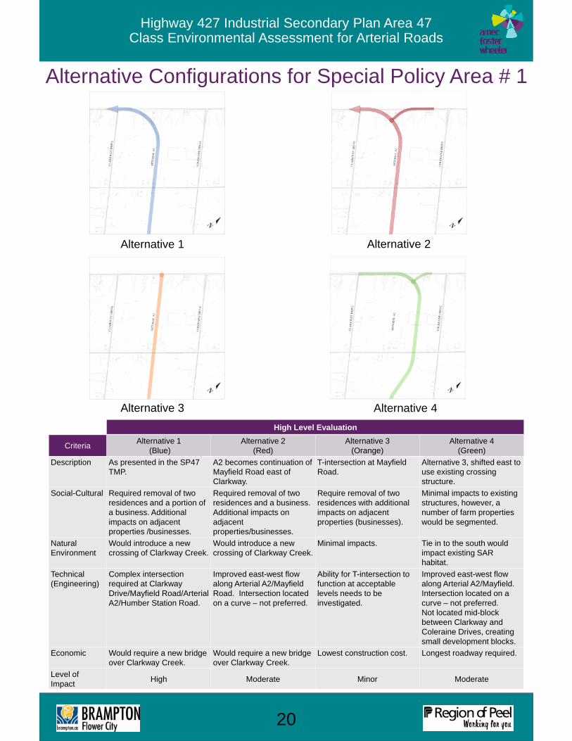
Highway 427 Industrial Secondary Plan Area 47Class Environmental Assessment for Arterial Roads
Alternative Configurations for Special Policy Area # 1
High Level Evaluation
CriteriaAlternative 1
(Blue)Alternative 2
(Red)Alternative 3
(Orange)Alternative 4
(Green)
Description As presented in the SP47 TMP.
A2 becomes continuation of Mayfield Road east of Clarkway.
T-intersection at MayfieldRoad.
Alternative 3, shifted east to use existing crossing structure.
Social-Cultural Required removal of two residences and a portion of a business. Additional impacts on adjacent properties /businesses.
Required removal of two residences and a business. Additional impacts on adjacent properties/businesses.
Require removal of two residences with additional impacts on adjacent properties (businesses).
Minimal impacts to existingstructures, however, a number of farm properties would be segmented.
Natural Environment
Would introduce a new crossing of Clarkway Creek.
Would introduce a new crossing of Clarkway Creek.
Minimal impacts. Tie in to the south would impact existing SAR habitat.
Technical (Engineering)
Complex intersection required at ClarkwayDrive/Mayfield Road/Arterial A2/Humber Station Road.
Improved east-west flow along Arterial A2/Mayfield Road. Intersection located on a curve – not preferred.
Ability for T-intersection tofunction at acceptable levels needs to be investigated.
Improved east-west flow along Arterial A2/Mayfield.Intersection located on a curve – not preferred.Not located mid-block between Clarkway and Coleraine Drives, creating small development blocks.
Economic Would require a new bridge over Clarkway Creek.
Would require a new bridge over Clarkway Creek.
Lowest construction cost. Longest roadway required.
Level of Impact
High Moderate Minor Moderate
20
Alternative 1
Alternative 3
Alternative 2
Alternative 4

Highway 427 Industrial Secondary Plan Area 47Class Environmental Assessment for Arterial Roads
Alternative Configurations for Special Policy Area # 2
High-Level Evaluation
CriteriaAlternative 1
(Blue)Alternative 2
(Red)Alternative 3
(Orange)Alternative 4
(Green)Alternative 5
(Purple)
Description As presented in the SP47 TMP.
Four-way intersection along SP47 TMP alignment of Coleraine
Four-way intersection at narrowest point on Rainbow Creek.
Increased offset between EW Arterial and Coleraine Drive.
Crossing midway between Alternatives 2 and 3.
Social-Cultural
Required removal of an existing residence.Provides balanced development blocksizes between arterial roads.
Required removal of an existing residence and a commercial property.Would isolate ~ 4.5 ha between the new arterials and existing commercial/industrial.
Limited impacts to existing properties.Would create larger development blocks.
Required removal of four residences/farms.Improved development potential southwest of Arterial A2 and E-W Arterial; but, E-W link is removed from south development block.
Required removal of an existing residence. Provides balanced development blocksizes between arterial roads.
Natural Environment
Single crossing of Rainbow Creek.
Two separate crossings of RainbowCreek.
Single, crossing of Rainbow Creek.
Single crossing of Rainbow Creek.
Two separate crossings of RainbowCreek.
Technical (Engineering)
Potential traffic issues due to closely spaced intersections.
Improved intersectionplacement on tangent section of A2. Potential traffic issues due to proximity to Regional Road 50.
Improved intersection function due to single intersection and greater spacing.Large bridge will be required.
Improved intersection spacing.
Improved intersection function due to single intersection and greater spacing.Two bridges will be required.
Economic Increased cost due to need for two intersections.
Substantial bridge costs (two required).
Increased cost due to potentially larger bridge.
Increased cost due to need for two intersections.
Substantial bridge costs (two required).
Level of Impact
Minor High Minor Moderate High
21
Alternative 1 Alternative 2 Alternative 3
Alternative 4 Alternative 5

Highway 427 Industrial Secondary Plan Area 47Class Environmental Assessment for Arterial Roads
Arterial A2 (NEW !)Jurisdiction To Be DeterminedRequired number of lanes 6SP47 TMP-Recommended Active Transportation Facilities
Multi-use path
Alternative Cross-Sections
22

Highway 427 Industrial Secondary Plan Area 47Class Environmental Assessment for Arterial Roads
Coleraine DriveJurisdiction Region of PeelRequired number of lanes 4SP47 TMP-Recommended Active Transportation Facilities
Multi-use path
Alternative Cross-Sections
23

Highway 427 Industrial Secondary Plan Area 47Class Environmental Assessment for Arterial Roads
East – West Arterial (NEW !)Jurisdiction City of BramptonRequired number of lanes 4SP47 TMP-Recommended Active Transportation Facilities
Multi-use path, sidewalk opposite side from multi-use path
Alternative Cross-Sections
24

Highway 427 Industrial Secondary Plan Area 47Class Environmental Assessment for Arterial Roads
Countryside DriveJurisdiction City of BramptonRequired number of lanes 4SP47 TMP-Recommended Active Transportation Facilities
On-road cycle lanes and sidewalks on both sides.
Alternative Cross-Sections
25

Highway 427 Industrial Secondary Plan Area 47Class Environmental Assessment for Arterial Roads
Clarkway Drive, Castlemore Road to “Main Street”Jurisdiction City of BramptonRequired number of lanes 4SP47 TMP-Recommended Active Transportation Facilities
On road cycles lanes, sidewalks on both sides
Alternative Cross-Sections
26

Highway 427 Industrial Secondary Plan Area 47Class Environmental Assessment for Arterial Roads
Clarkway Drive, “Main Street”Jurisdiction City of BramptonRequired number of lanes 4SP47 TMP-Recommended Active Transportation Facilities
On road cycles lanes, sidewalks on both sides
Alternative Cross-Sections
27
This Section of Clarkway is Subject to More Detailed Evaluation!

Highway 427 Industrial Secondary Plan Area 47Class Environmental Assessment for Arterial Roads
Clarkway Drive, East-West Arterial to Countryside DriveJurisdiction City of BramptonRequired number of lanes 2SP47 TMP-Recommended Active Transportation Facilities
On road cycle lanes, 1.5 m sidewalk on both sides
Alternative Cross-Sections
28

Highway 427 Industrial Secondary Plan Area 47Class Environmental Assessment for Arterial Roads
Clarkway Drive, Countryside Drive to Mayfield RoadJurisdiction City of BramptonRequired number of lanes 2-4SP47 TMP-Recommended Active Transportation Facilities
Multi-use path, sidewalks opposite side from multi-use path
Alternative Cross-Sections
29

Highway 427 Industrial Secondary Plan Area 47Class Environmental Assessment for Arterial Roads
Thank-you for your Participation!
Next Steps
1. Your input is important! The project team will be determining preferred alternatives based on feedback from this PIC, technical investigations, and consultation with technical and regulatory agencies.
2. Complete the Environmental Inventory through field investigations to confirm findings of the SP47 Master Environmental Servicing Plan, particularly along the preferred alignments.
3. Develop the preferred design concepts and cross-sections. Using comments received at this PIC, as well as input from stakeholders and agencies, the conceptual designs for each arterial will be developed.
4. Present and gather input on the preliminary designs at PIC #2. The preliminary designs will be presented for further comment at:
5. Complete the preliminary designs. Based on feedback from PIC#2, as well as consultation with stakeholder groups and agencies, the conceptual designs will be modified and advanced to the preliminary design stage. Anticipated impacts and mitigation methods will be fully documented.
6. Prepare and file the Environmental Study Report. The Environmental Study Report will be prepared and available for review and comment during a 30 day review period.
Let us know what is most important to you, your family and/or your business.
Please complete the comment sheet and place it in the Comment Box or send your comments to one of the mailing or email addresses listed
on the comment sheet.
We Want to Hear From You!
Comment Deadline
December 8th
PIC # 2 planned for spring 2017!
30