high-resolution 2d seismic - ths design • water depth • type of installation • expected...
TRANSCRIPT

www.fugro.com
HIGH-RESOLUTION 2D SEISMIC

www.fugro.com
HIGH-RESOLUTION 2D SEISMIC

www.fugro.com
DATA PROCESSING
TEST/MAIN PROCESSING
Geometry Specification
Deconvolution
Sorted into CMP’s
Filtered
Amplified
Velocity Analysis
NMO
Stacked
FINAL PROCESSING
Migration
EDITING
Demultiplexed
Edited
www.fugro.com
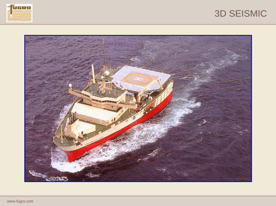
3D SEISMIC

www.fugro.com
3D SEISMIC

www.fugro.com
www.fugro.com
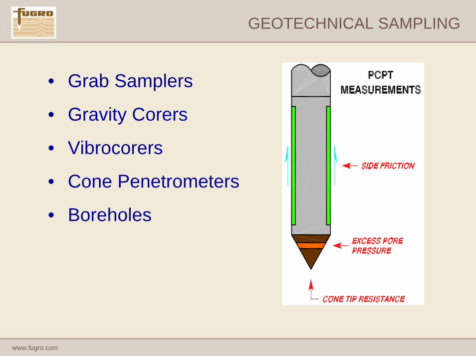
GEOTECHNICAL SAMPLING
• Grab Samplers
• Gravity Corers
• Vibrocorers
• Cone Penetrometers
• Boreholes

www.fugro.com
INTERPRETATION AND PRESENTATION

www.fugro.com
SEABED FEATURES CHART
• Distribution of seabed sediments• Topographic features (sands waves
etc)• Rock outcrops• Pockmarks• Existing infrastructure; pipelines,
cables etc• Wrecks• Items of debris• Seabed Features Chart should
comprise interpretation of Echo Sounder, magnetometer and side scan sonar data with seabed samples

www.fugro.com
• Entire well assembly is supported on 30” conductor casing, which is set between 20m-40m sub-seabed
• Identify soil profile in the required depth zone
• Locate potential obstructions to installation of conductor; boulders, gravel layers etc
• Identify potential unconsolidated soils / loose sands – geotechnical weak units

www.fugro.com
ALIGNMENT SHEET FORMAT
www.fugro.com
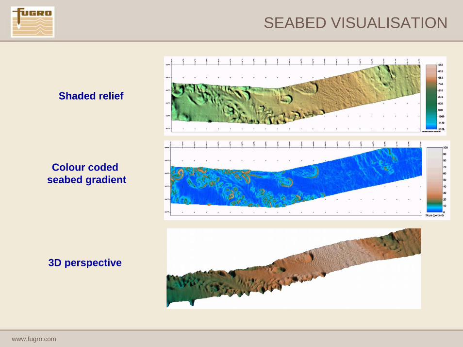
SEABED VISUALISATION
Shaded relief
Colour coded seabed gradient
3D perspective
www.fugro.com
SITE SURVEYOPERATIONS

www.fugro.com
THE SURVEYORS ROLE
• Construction of Survey Programme
• Positioning of Vessel
• Positioning of Sensors
• Quality Control of Bathymetry data

www.fugro.com
SURVEY LINE PLAN FOR JACK-UP RIG
Distances in metres1 km
Plus tie line to adjacent borehole or survey area
www.fugro.com
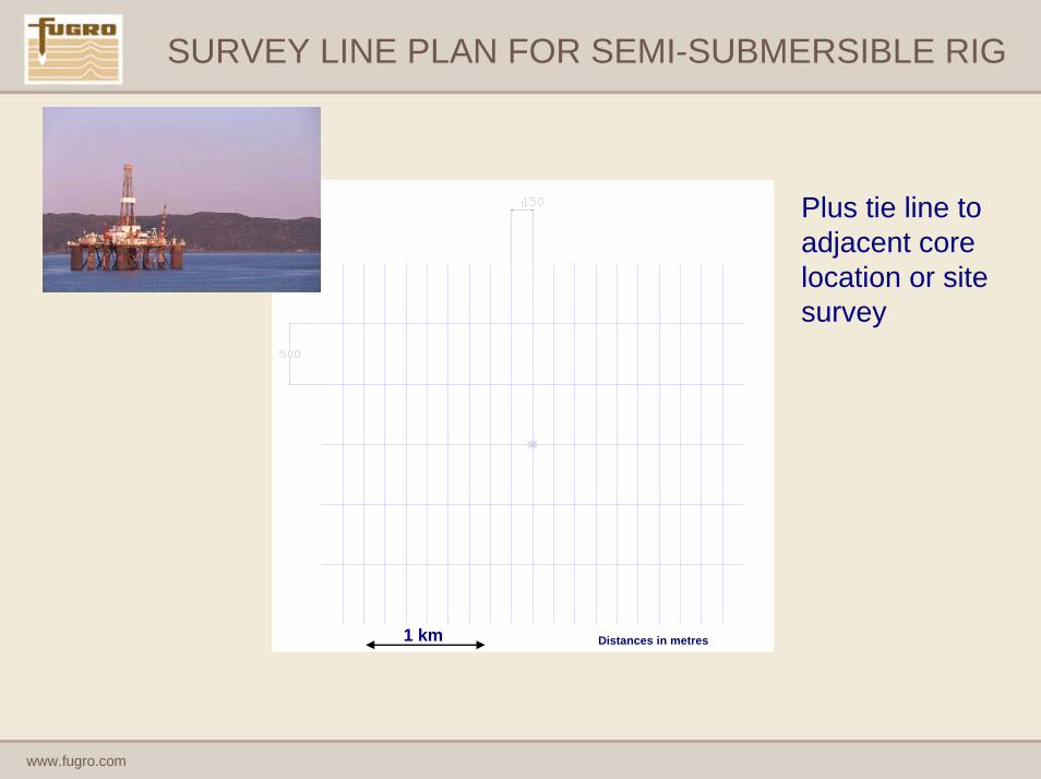
SURVEY LINE PLAN FOR SEMI-SUBMERSIBLE RIG
Distances in metres1 km
Plus tie line to adjacent core location or site survey
www.fugro.com
SURVEY DESIGN
• Water Depth
• Type of Installation
• Expected Hazards
• Flexibility of Location
• Environmental Conditions
• Time and Cost
www.fugro.com
SURVEY DESIGN
• Dual Pass Survey
• Integrated Surveys
• Dual Streamers
• High Resolution 3D

www.fugro.com
THE SURVEY PLATFORM
Vessel antenna position
(reference point)Back deck where side scan sonar, boomer and digital
seismic equipment is launched
Bridge
Instrument room
(below water line)Living quarters

www.fugro.com
AUV SURVEYS

www.fugro.com
THE DEEP WATER SOLUTION
• Traditional survey methods have numerous drawbacks to the acquisition of geophysical data in Deep Water areas.
• Clients and subsea engineering companies are demanding more resolute and accurately positioned data which these traditional methods cannot provide.
• A significant change in the way that geophysical data is acquired was needed by the survey companies.
• The survey industry’s solution:
The Autonomous Underwater Vehicle (AUV)

www.fugro.com
AUV OPERATIONS

www.fugro.com
AUV OPERATIONS
Fugro’s “Echo Surveyor” AUV
• Kongsberg HUGIN 3000.
• Semi-autonomous vehicle independently powered and controlled (cable free).
• Depth rated to 3000 metres.
• Aided Inertial Navigation System provides extremely accurate positioning.
• Positional accuracy of the AUV is less than 5 metres, significantly better than towed systems.

www.fugro.com
AUV DATA QUALITY
• So what are the improvements in data quality when using an AUV?
www.fugro.com
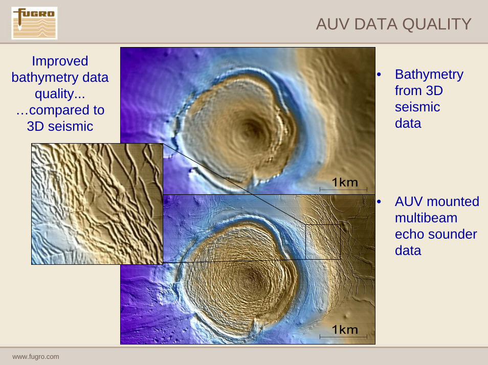
AUV DATA QUALITY
Improved bathymetry data
quality... …compared to
3D seismic
• Bathymetry from 3D seismic data
• AUV mounted multibeam echo sounder data

www.fugro.com
AUV DATA QUALITY
1 km
• AUV mounted multibeam echo sounder data
• Vessel mounted multibeam echo sounder data
Improved bathymetry data
quality...…compared to vessel mounted bathymetry data

www.fugro.com
AUV DATA QUALITY
1km
High quality bathymetry data
in all water depths

www.fugro.com
AUV DATA QUALITY
250 m
Improved side scan sonar data quality...
• The AUV assures high quality data is always acquired
• Better positional accuracy in all water depths
• Higher quality sonar mosaics

www.fugro.com
AUV DATA QUALITY
1 km
• Stunning images can be obtained of complex features such as this mud volcano
• This could never be achieved by traditional towfish data in Deep Water.

www.fugro.com
AUV DATA QUALITY
Improved sub-bottom profiler data quality...
2DHR Data AUV Chirp Data

www.fugro.com
2 km
www.fugro.com
WHY CARRY OUT AN AUV SURVEY?
• Improved data quality, coverage, positional accuracy.
• Greater confidence in interpretation of seabed & shallow geohazards and definition of geological conditions.
• This increased certainty over the geological conditions aids in deciding the best engineering solutions.
• Hazards are avoided.
• Over-engineering reduced.
• Field development can be completed earlier.
• Significant potential cost savings.
• HOWEVER: This can only be achieved through an integrated interpretation approach using all available data and with competent, experienced staff.

www.fugro.com
INTEGRATED INTERPRETATION STRATEGY
• Bring together all data types and background information together on one platform – SMT Kingdom Suite
SMT
Multi-layer Sonar Mosaics
Shaded Relief Bathymetry
Chirp
2DHR / 3D
Contoured BathymetryCultural Data
www.fugro.com
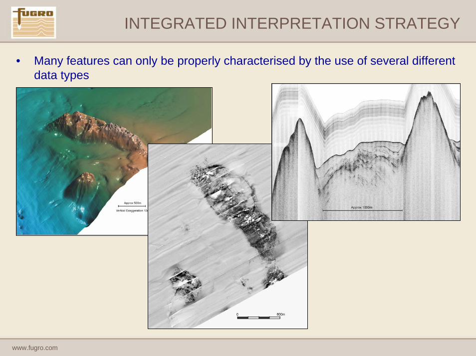
INTEGRATED INTERPRETATION STRATEGY
• Many features can only be properly characterised by the use of several different data types
www.fugro.com
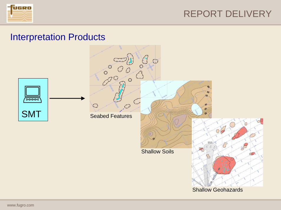
REPORT DELIVERY
Interpretation Products
Seabed FeaturesSMT
Shallow Soils
Shallow Geohazards

www.fugro.com
Thank You