zemira 3d seismic survey
TRANSCRIPT
Zemira 3D Seismic Survey Section 38 Referral Supplementary Information
Regulatory Approvals
CDN/ID W-5000-05-RP-0002
Review record (record the last 3 revisions here or the revisions required to achieve current approval version)
Revision Date Reason for issue Reviewer/s Consolidator Approver
0 28/02/2020 Issued for use T Flowers
W Mothershaw
S Nunan
T Stehbens
T Stehbens T Flowers
1 27/03/2020 Revised following DWER comments T Stehbens T Stehbens T Flowers
Review due Review frequency
N/A N/A
For internal use and distribution only. Subject to employee
confidentiality obligations. Once printed, this is an uncontrolled
document unless issued and stamped Controlled Copy or issued
under a transmittal.
THE THREE WHATS
What can go wrong?
What could cause it to go wrong?
What can I do to prevent it?
Zemira 3D Seismic Survey
Released on 27/03/2020 - Revision 1 - Status Issued for use
Document Custodian is Head of Environment
Beach Energy Limited: ABN 20 007 617 969
Once printed, this is an uncontrolled document unless issued and stamped Controlled Copy or issued under a transmittal.
Based on template: AUS 10 IMT TMP 14376462_Revision 3_Issued for Use _06/03/2019_LE-SystemsInfo-Information Mgt.
CDN/ID W-5000-05-RP-0002
1 of 29
Table of contents
1 Introduction 3
1.1 Purpose 3
1.2 Proposal summary 3
1.3 Proponent details 3
2 Proposal Overview 5
2.1 Key proposal characteristics 5
2.1.1 Survey design 7
2.1.2 Survey line preparation 8
2.1.3 Survey method 8
2.1.4 Survey line rehabilitation 9
2.2 Land tenure 9
2.3 Existing land use 12
2.4 Native title 12
3 Potential Environmental Impacts 13
3.1 Key Environmental Factors 14
3.1.1 Flora and vegetation 14
3.1.2 Terrestrial fauna 16
3.1.3 Social surroundings 18
3.2 Other Environmental Factors 20
4 Required Work for Preliminary Key Environmental Factors 22
5 Other Approvals and Regulations 24
5.1 Environmental Protection and Biodiversity Conservation Act 1999 24
5.2 Petroleum and Geothermal Energy Resources Act 1967 24
6 Definitions/Acronyms 26
7 References/Associated documents 27
8 Document information and history 29

Zemira 3D Seismic Survey
Released on 27/03/2020 - Revision 1 - Status Issued for use
Document Custodian is Head of Environment
Beach Energy Limited: ABN 20 007 617 969
Once printed, this is an uncontrolled document unless issued and stamped Controlled Copy or issued under a transmittal.
Based on template: AUS 10 IMT TMP 14376462_Revision 3_Issued for Use _06/03/2019_LE-SystemsInfo-Information Mgt.
CDN/ID W-5000-05-RP-0002
2 of 29
Table of figures
Figure 1-1: Location of the Zemira 3D Seismic Survey 4
Figure 2-1: Preliminary seismic survey design 7
Figure 2-2: Land Tenure for northern portion of the survey area 10
Figure 2-3: Land Tenure for southern portion of the survey area 11
List of tables
Table 1-1: Petroleum permits within the acquisition area of the proposed Zemira 3D Seismic Survey 3
Table 1-2: Proponent contact details 3
Table 2-1: Summary of the proposal 5
Table 2-2: Location and proposed extent of physical and operational elements of the proposed Zemira 3D Seismic Survey 6
Table 3-1: Identification of key environmental factors (potential significant impact) for the proposed Zemira 3D Seismic Survey 13
Table 3-2: Potential environmental impacts of the proposed Zemira 3D Seismic Survey on flora and vegetation 14
Table 3-3: Potential environmental impacts of the proposed Zemira 3D Seismic Survey on terrestrial fauna 16
Table 3-4: Potential environmental impacts of the proposed Zemira 3D Seismic Survey on social surroundings 18
Table 3-5: Relevance of other environmental factors to the proposed Zemira 3D Seismic Survey 20
Table 4-1: Preliminary key environmental factors and required work 22
Table 5-1: Summary of regulatory approval requirements for the proposed Zemira 3D Seismic Survey 25

Zemira 3D Seismic Survey
Released on 27/03/2020 - Revision 1 - Status Issued for use
Document Custodian is Head of Environment
Beach Energy Limited: ABN 20 007 617 969
Once printed, this is an uncontrolled document unless issued and stamped Controlled Copy or issued under a transmittal.
Based on template: AUS 10 IMT TMP 14376462_Revision 3_Issued for Use _06/03/2019_LE-SystemsInfo-Information Mgt.
CDN/ID W-5000-05-RP-0002
3 of 29
1 Introduction
1.1 Purpose
This document has been prepared to support referral of the proposal under Section 38 of the Environmental Protection
Act 1986 (EP Act). This document provides supplementary information on the proposal characteristics (Section 2),
potential environmental impacts (Section 3), work required for assessment of the preliminary key environmental factors
(Section 4) and other key environmental and regulatory approvals (Section 5).
1.2 Proposal summary
The proposal is to undertake an onshore three-dimensional (3D) seismic survey (the ‘Zemira 3D Seismic Survey’) within
petroleum exploration permit EP 320 and adjoining permits and licences in the northern Perth Basin. Beach Energy (Perth
Basin) Pty Ltd (Beach Energy) is the titleholder of EP 320 which comprises ~75% of the survey area. The remainder of the
survey area is within portions of other Beach Energy or other operator’s petroleum titles (Table 1-1, Figure 1-1).
The intent of the Zemira 3D Seismic Survey is to collect a high-quality 3D dataset that can be used to map geological
formations to assist in the identification of conventional gas reserves and detailed reservoir development. The seismic
survey is targeting potential reserves in the Kingia, Highcliff and Cattamurra formations at depths of ~1,500–5,000 m.
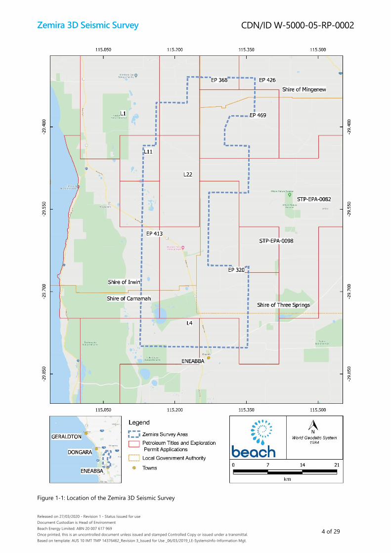
The survey area (or acquisition area) is ~300 km north of Perth, and at its nearest boundary the survey area is located
~4.5 km north of the town of Eneabba and ~25 km southeast of the town of Dongara (Figure 1-1). The survey area is
~970 km2 (97,000 ha) and comprises an estimated disturbance footprint of up to ~15 km2 (1,500 ha), including up to
1,000 ha of native vegetation clearing. The seismic survey is expected to occur over a 12–15 week period, during a
preferred survey acquisition window of December to May. Line preparation, including vegetation clearing, may occur
prior to this acquisition window.
Table 1-1: Petroleum permits within the acquisition area of the proposed Zemira 3D Seismic Survey
Petroleum Titles Operator
EP 320, L1, L11, L22 Beach Energy
L4 Australian Worldwide Exploration
EP 368, EP 426 Energy Resources Limited
EP 413 Norwest Energy
EP 469 Strike Energy
STP-EPA-0082, STP-EPA-0098 UIL Energy
Notes: EP = Exploration permit; STP-EPA = Exploration permit application; L = Production licence
1.3 Proponent details
Beach Energy Limited is the proponent for the proposal; contact details are provided in Table 1-2. Beach Energy (Perth
Basin) Pty Ltd is a wholly owned subsidiary of Beach Energy Limited, and will be the operator for the proposed Zemira 3D
Seismic Survey.
Table 1-2: Proponent contact details
Name Tim Flowers
Position Head of Environment
Organisation Beach Energy Limited
Address 80 Flinders Street, Adelaide SA 5000
Email [email protected]
Zemira 3D Seismic Survey
Released on 27/03/2020 - Revision 1 - Status Issued for use
Document Custodian is Head of Environment
Beach Energy Limited: ABN 20 007 617 969
Once printed, this is an uncontrolled document unless issued and stamped Controlled Copy or issued under a transmittal.
Based on template: AUS 10 IMT TMP 14376462_Revision 3_Issued for Use _06/03/2019_LE-SystemsInfo-Information Mgt.
CDN/ID W-5000-05-RP-0002
4 of 29
Figure 1-1: Location of the Zemira 3D Seismic Survey

Zemira 3D Seismic Survey
Released on 27/03/2020 - Revision 1 - Status Issued for use
Document Custodian is Head of Environment
Beach Energy Limited: ABN 20 007 617 969
Once printed, this is an uncontrolled document unless issued and stamped Controlled Copy or issued under a transmittal.
Based on template: AUS 10 IMT TMP 14376462_Revision 3_Issued for Use _06/03/2019_LE-SystemsInfo-Information Mgt.
CDN/ID W-5000-05-RP-0002
5 of 29
2 Proposal Overview
2.1 Key proposal characteristics
Beach Energy is proposing to undertake an onshore 3D seismic survey within EP 320 and adjoining permits and licences
in the northern Perth Basin (Figure 1-1). Currently, the survey area is predominantly covered by a coarse grid of multi-
vintage 2D seismic of very low-quality data. This 2D grid is unsuitable for accurate mapping of faults and lacks the
resolution for resource evaluation. The intent of the Zemira 3D Seismic Survey is to provide a high-quality 3D dataset that
ties into existing surveys, creating a regional dataset that is suitable for detailed reservoir development for the life of the
fields. The overlap with the existing surveys is required to effectively merge the data into one contiguous volume.
The survey area is approximately 300 km north of Perth, and at its nearest boundary the survey area is located
approximately 4.5 km north of the town of Eneabba and 25 km southeast of the town of Dongara (Figure 1-1). The survey
area lies across four local government areas: Shire of Irwin, Shire of Three Springs, Shire of Mingenew and Shire of
Carnamah, and is intersected by the Arrowsmith River, the Brand Highway and the Dampier to Bunbury Natural Gas
Pipeline (DBNGP).
The proposed survey area is ~970 km2 (97,000 ha), with an estimated disturbance footprint within this survey area of up
to ~15 km2 (1,500 ha), including clearing up to 1,000 ha of native vegetation. The disturbance footprint is considered
temporary as the entire footprint will be rehabilitated (via natural regeneration) upon completion of the seismic survey.
The seismic survey is expected to occur over a 12–15 week period, during a preferred survey window of December to
May. The preferred survey window takes into account avoiding the peak flowering period of orchids that are present
within the survey area and fits in with the cropping schedule of the local farmers. Line preparation, including vegetation
clearing, may occur prior to this preferred acquisition window.
Table 2-1 and Table 2-2 summarise the key elements of the Zemira 3D Seismic Survey; with additional information
regarding survey design and methods given in Sections 2.1.1 to 2.1.4.
Table 2-1: Summary of the proposal
Proposal Title Zemira 3D Seismic Survey
Proponent Name Beach Energy Limited
Short Description The proposal is to undertake an onshore 3D seismic survey (the ‘Zemira 3D Seismic Survey’) within
EP 320 and adjoining permits and licences within the northern Perth Basin. The survey area is ~300 km
north of Perth, and at its nearest boundary the survey area is located ~4.5 km north of the town of
Eneabba and ~25 km southeast of the town of Dongara.
The intent of the Zemira 3D Seismic Survey is to collect a high-quality 3D dataset that can be used to
map geological formations to assist in the identification of conventional gas reserves and detailed
reservoir development. The seismic survey is targeting potential reserves in the Kingia, Highcliff and
Cattamurra formations at depths of approximately 1,500–5,000 m.
The survey area (or acquisition area) is ~970 km2 (97,000 ha), with an estimated disturbance footprint
within this survey area of up to ~15 km2 (1,500 ha). The seismic survey is expected to occur over a 12–15
week period, during a preferred survey window of December to May. Line preparation, including
vegetation clearing, may occur prior to this preferred acquisition window.
Zemira 3D Seismic Survey
Released on 27/03/2020 - Revision 1 - Status Issued for use
Document Custodian is Head of Environment
Beach Energy Limited: ABN 20 007 617 969
Once printed, this is an uncontrolled document unless issued and stamped Controlled Copy or issued under a transmittal.
Based on template: AUS 10 IMT TMP 14376462_Revision 3_Issued for Use _06/03/2019_LE-SystemsInfo-Information Mgt.
CDN/ID W-5000-05-RP-0002
6 of 29
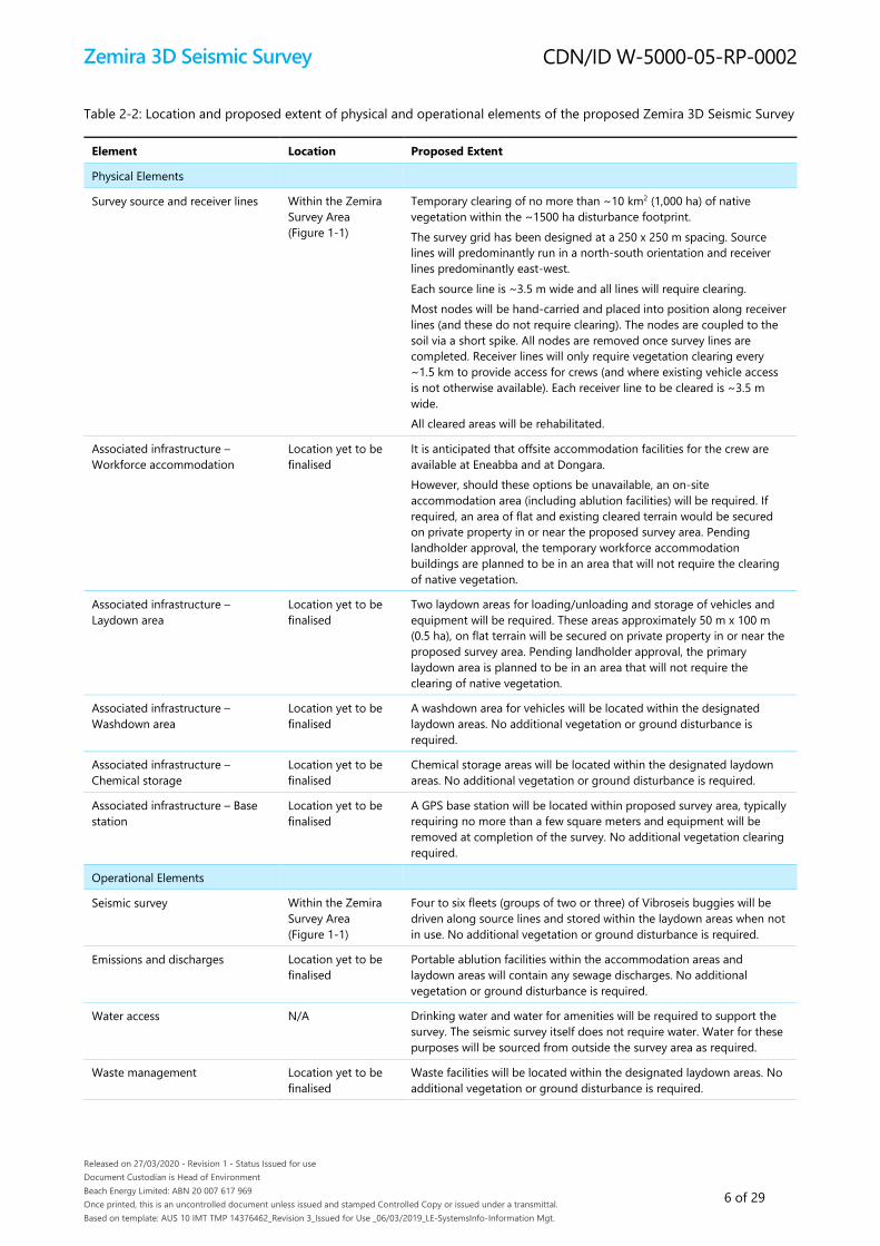
Table 2-2: Location and proposed extent of physical and operational elements of the proposed Zemira 3D Seismic Survey
Element Location Proposed Extent
Physical Elements
Survey source and receiver lines
Within the Zemira
Survey Area
(Figure 1-1)
Temporary clearing of no more than ~10 km2 (1,000 ha) of native
vegetation within the ~1500 ha disturbance footprint.
The survey grid has been designed at a 250 x 250 m spacing. Source
lines will predominantly run in a north-south orientation and receiver
lines predominantly east-west.
Each source line is ~3.5 m wide and all lines will require clearing.
Most nodes will be hand-carried and placed into position along receiver
lines (and these do not require clearing). The nodes are coupled to the
soil via a short spike. All nodes are removed once survey lines are
completed. Receiver lines will only require vegetation clearing every
~1.5 km to provide access for crews (and where existing vehicle access
is not otherwise available). Each receiver line to be cleared is ~3.5 m
wide.
All cleared areas will be rehabilitated.
Associated infrastructure –
Workforce accommodation
Location yet to be
finalised
It is anticipated that offsite accommodation facilities for the crew are
available at Eneabba and at Dongara.
However, should these options be unavailable, an on-site
accommodation area (including ablution facilities) will be required. If
required, an area of flat and existing cleared terrain would be secured
on private property in or near the proposed survey area. Pending
landholder approval, the temporary workforce accommodation
buildings are planned to be in an area that will not require the clearing
of native vegetation.
Associated infrastructure –
Laydown area
Location yet to be
finalised
Two laydown areas for loading/unloading and storage of vehicles and
equipment will be required. These areas approximately 50 m x 100 m
(0.5 ha), on flat terrain will be secured on private property in or near the
proposed survey area. Pending landholder approval, the primary
laydown area is planned to be in an area that will not require the
clearing of native vegetation.
Associated infrastructure –
Washdown area
Location yet to be
finalised
A washdown area for vehicles will be located within the designated
laydown areas. No additional vegetation or ground disturbance is
required.
Associated infrastructure –
Chemical storage
Location yet to be
finalised
Chemical storage areas will be located within the designated laydown
areas. No additional vegetation or ground disturbance is required.
Associated infrastructure – Base
station
Location yet to be
finalised
A GPS base station will be located within proposed survey area, typically
requiring no more than a few square meters and equipment will be
removed at completion of the survey. No additional vegetation clearing
required.
Operational Elements
Seismic survey Within the Zemira
Survey Area
(Figure 1-1)
Four to six fleets (groups of two or three) of Vibroseis buggies will be
driven along source lines and stored within the laydown areas when not
in use. No additional vegetation or ground disturbance is required.
Emissions and discharges Location yet to be
finalised
Portable ablution facilities within the accommodation areas and
laydown areas will contain any sewage discharges. No additional
vegetation or ground disturbance is required.
Water access N/A Drinking water and water for amenities will be required to support the
survey. The seismic survey itself does not require water. Water for these
purposes will be sourced from outside the survey area as required.
Waste management Location yet to be
finalised
Waste facilities will be located within the designated laydown areas. No
additional vegetation or ground disturbance is required.

Zemira 3D Seismic Survey
Released on 27/03/2020 - Revision 1 - Status Issued for use
Document Custodian is Head of Environment
Beach Energy Limited: ABN 20 007 617 969
Once printed, this is an uncontrolled document unless issued and stamped Controlled Copy or issued under a transmittal.
Based on template: AUS 10 IMT TMP 14376462_Revision 3_Issued for Use _06/03/2019_LE-SystemsInfo-Information Mgt.
CDN/ID W-5000-05-RP-0002
7 of 29
2.1.1 Survey design
3D seismic surveys require a grid of “source” and “receiver” lines over a very large area to collect the data required to
create a picture of the geology many kilometres below the surface. Vibroseis buggies are used to send sound energy into
the ground at many thousands of points along the source lines. The sound energy travels into the earth and bounces
back (reflects) from different rock layers. This reflected energy is recorded by a grid of thousands of receivers (or sensors
or nodes) to create an image of the subsurface. The receiver equipment will be in the form of cable-free nodes. Nodal
technology eliminates the need for cables, strings of geophones, line batteries and the requirement for a separate
recorder vehicle to follow the vibroseis vehicles.
Source and receiver line spacing is typically in the order of 100–360 m, depending on project objectives and data quality
in the area. Smaller line spacings are generally preferred as they provide significantly clearer images of the subsurface
geology. The source and receiver lines for the Zemira 3D Seismic Survey will be on a 250 m x 250 m grid. Source lines for
the Zemira 3D Seismic Survey will predominantly run in a north-south orientation, and receiver lines run predominantly
east-west (Figure 2-1); although a small number may be needed in alternate orientations to allow lines to avoid obstacles
and/or make up for missing data.
Figure 2-1: Preliminary seismic survey design
1500m
250m
Source Lines
Receiver Lines
Access Lines
Zemira 3D Seismic Survey
Released on 27/03/2020 - Revision 1 - Status Issued for use
Document Custodian is Head of Environment
Beach Energy Limited: ABN 20 007 617 969
Once printed, this is an uncontrolled document unless issued and stamped Controlled Copy or issued under a transmittal.
Based on template: AUS 10 IMT TMP 14376462_Revision 3_Issued for Use _06/03/2019_LE-SystemsInfo-Information Mgt.
CDN/ID W-5000-05-RP-0002
8 of 29
2.1.2 Survey line preparation
The source lines will be a maximum of 3.5 m wide and most receiver lines will be hand-carried rather than cleared to
reduce clearing. Approximately 2,850 km of lines (up to ~1,000 ha of native vegetation) will be temporarily cleared during
line preparation. All areas cleared for the survey will be rehabilitated at completion. The disturbance footprint is yet to be
finalised, but the 1,000 ha figure is a conservative estimate and the actual area cleared will be less than this.
Line preparation for the survey will be restricted to temporarily clearing vegetation by mulching or rolling (final method
to be determined) to a maximum width of 3.5 m. Both rolling and mulching methods do not require ground disturbance,
ensuring that the vegetation root mass and seed bank remains in the soil allowing rapid regeneration at the completion
of the survey. The selection of the final method (or a combination of methods) will be informed by an independent
review of rehabilitation success of previous clearing in the region by an experienced third-party; but also take into
consideration other operational (e.g. safety) considerations.
The line preparation machinery will be fitted with a real-time sub-1 m accuracy positioning solution to allow the line
clearing equipment to accurately follow the path of the line data provided, which will incorporate avoidance of sensitive
environmental areas identified during flora surveys of the area. Wherever the survey lines terminate at public roads,
Beach Energy will endeavour to design the lines to have ‘dog-legs’, with the length of these dog-legs to be determined
by the spotting crews. This eliminates the straight-line corridor effect, which in turn reduces the visual impact associated
with line clearing.
2.1.3 Survey method
The type of vehicle proposed for use on this survey is a Vibroseis buggy. The articulated buggies are approximately 10 m
long and 3.4 m wide with a maximum peak force of 27,216 kg (60,000 lb). They are fitted with a hydraulic piston and a
base plate. The baseplate has an area of approximately 2.5 m2 with a clearance of approximately 46 cm.
Once at the source point the operator lowers the base plate and the recording truck is informed that the Vibroseis
buggyis ready at its position. As long as it is safe to do so, the recording truck then sends a radio signal to start the
vibration. Each vibration will last up to 16 seconds, depending on the in-field testing and the frequency range selected to
best image the subsurface target reflectors. There is minimal disturbance left by this action, with the ground impression
typically less than 10 mm in depth.
Once the vibration is complete, the base plate will be raised and the Vibroseis buggy is then driven to the next source
point, which may be anywhere between 5–20 m apart depending on data requirements. The buggies can be steered to
avoid obstacles and sensitive environmental areas.
The survey will involve the use of four to six fleets of Vibroseis buggies. Each fleet will consist of two to three buggies
positioned nose-to-tail that will be synchronised to acquire each source point simultaneously. The Vibroseis buggies will
be fitted with a global positioning system (GPS) to allow them to follow pre-determined paths. In agricultural areas
(e.g. grazing and cropping properties) balloon tyres will be fitted to minimise the potential for soil compaction (balloon
tyres will not be used in native vegetation areas due to increased risk of tyre damage). The ambient noise of the Vibroseis
vehicles is approximately 79 dB(A)@7 m from the vehicles.
A grid of sensors consisting tens of thousands of nodes will be used to record the Vibroseis signal being reflected from
the layers of rock. These sensors (also called receivers or nodes) will be laid along the receiver lines in a predominantly
east-west orientation. Most of the sensors will be deployed by foot, without any vehicle access (requiring no vegetation
clearing). One line will be cleared approximately every 1.5 km (i.e. approximately every sixth receiver line) to provide
access for crews.
The receiver equipment will be in the form of cable-free nodes. Nodes are electronic devices that detect and store
information about very small imperceptible vibrations for up to 50 days. They are light-weight and typically not much
larger than a mobile phone. Each node consists of a single internal geophone sensor, battery, data storage and GPS
Zemira 3D Seismic Survey
Released on 27/03/2020 - Revision 1 - Status Issued for use
Document Custodian is Head of Environment
Beach Energy Limited: ABN 20 007 617 969
Once printed, this is an uncontrolled document unless issued and stamped Controlled Copy or issued under a transmittal.
Based on template: AUS 10 IMT TMP 14376462_Revision 3_Issued for Use _06/03/2019_LE-SystemsInfo-Information Mgt.
CDN/ID W-5000-05-RP-0002
9 of 29
timing card in high-impact rugged casing. They are deployed using a short spike that is pushed into the soil manually by
foot, or they can be inserted completely into the oil so that the top of the node is flush with the soil surface.
2.1.4 Survey line rehabilitation
Upon completion of the survey, cleared survey lines will be closed and no further vehicle access will be permitted.
Signage will be used to reduce the risk of third-party access to closed lines where necessary.
Beach Energy is currently investigating the merits of both rolling and mulching clearing methods to understand which
technique provides the best rehabilitation outcomes. This study is planned to be completed during 2020 and will inform
the final method of clearing for the proposal. However, it is noted that the selection of the final clearing method/s will
also take into consideration other operational (e.g. safety) considerations.
Both rolling and mulching methods do not require ground disturbance, ensuring that the vegetation root mass and seed
bank remains in the soil allowing rapid regeneration at the completion of the survey. As both techniques will minimise
disturbance to topsoil and rootstock, natural regeneration of the cleared survey lines is expected to occur. Monitoring of
the survey lines will occur to measure the success of the natural regeneration and identify if any additional active
rehabilitation (such as infill planting, direct seeding or targeted weed control) is required.
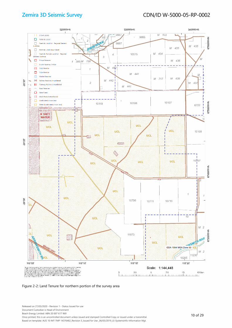
2.2 Land tenure
Beach Energy is the titleholder of EP 320 which comprises ~75% of the survey area (Figure 1-1). The remainder of the
survey area is within portions of other Beach Energy or other operator’s petroleum titles (Table 1-1, Figure 1-1). Access to
these areas will be sought via an Access Authority to be granted under the Petroleum and Geothermal Energy Resources
Act 1967 (PGER Act).
An overview of land tenure within the survey area is provided in Figure 2-2 and Figure 2-3. Specifically, land tenure within
the survey area comprise a mixture of Crown Reserve, Crown Lease, Unallocated Crown Land and Freehold Land. Beach
Energy will require arrangements for access to Crown Land and land access agreements with the relevant lease holders of
the Freehold Land. Where land access cannot be successfully negotiated, the property in question will be removed from
the survey area.
Zemira 3D Seismic Survey
Released on 27/03/2020 - Revision 1 - Status Issued for use
Document Custodian is Head of Environment
Beach Energy Limited: ABN 20 007 617 969
Once printed, this is an uncontrolled document unless issued and stamped Controlled Copy or issued under a transmittal.
Based on template: AUS 10 IMT TMP 14376462_Revision 3_Issued for Use _06/03/2019_LE-SystemsInfo-Information Mgt.
CDN/ID W-5000-05-RP-0002
10 of 29
Figure 2-2: Land Tenure for northern portion of the survey area

Zemira 3D Seismic Survey
Released on 27/03/2020 - Revision 1 - Status Issued for use
Document Custodian is Head of Environment
Beach Energy Limited: ABN 20 007 617 969
Once printed, this is an uncontrolled document unless issued and stamped Controlled Copy or issued under a transmittal.
Based on template: AUS 10 IMT TMP 14376462_Revision 3_Issued for Use _06/03/2019_LE-SystemsInfo-Information Mgt.
CDN/ID W-5000-05-RP-0002
11 of 29
Figure 2-3: Land Tenure for southern portion of the survey area

Zemira 3D Seismic Survey
Released on 27/03/2020 - Revision 1 - Status Issued for use
Document Custodian is Head of Environment
Beach Energy Limited: ABN 20 007 617 969
Once printed, this is an uncontrolled document unless issued and stamped Controlled Copy or issued under a transmittal.
Based on template: AUS 10 IMT TMP 14376462_Revision 3_Issued for Use _06/03/2019_LE-SystemsInfo-Information Mgt.
CDN/ID W-5000-05-RP-0002
12 of 29
2.3 Existing land use
Although a large portion of the survey area is comprised of native vegetation, only a small portion of this is located
within Crown Reserves with the remaining areas of native vegetation located within Unallocated Crown Land or Crown
Leased Land (Figure 2-2 and Figure 2-3). Whilst Beach Energy plan to access these reserves, no ground disturbance or
vegetation clearing is proposed; with access to reserves limited to existing tracks only.
Cleared properties within the survey area are predominately used for agricultural purposes. Within the survey area,
agricultural properties comprise a mixture of broadacre farming mainly comprised of wheat crops, and stock (sheep)
farming. The farming calendar runs from March - May (seeding), shearing (July - September), lambing (August - October)
and harvest (October - December). Beach Energy will negotiate access to these properties via land access agreements
(Section 5) and conduct the activity in way that best fits in with the farming calendar to minimise impacts wherever
possible.
The DBNGP traverses diagonally through the centre of the survey area (Figure 1-1). The easement for the pipeline varies
along its length but is generally 30 m wide. The Brand Highway also traverses the survey area, along with a number of
other roads and a disused railway line. The seismic survey will not be undertaken within the road reserves, railway line
reserve or DBNGP easement.
Three mining tenements intersect the survey area. Activities conducted within these tenements comprise a mixture of
exploration, mining and mine site rehabilitation. Beach Energy will negotiate access to these tenements as required.
Access to these areas will be sought via an Access Authority to be granted under the PGER Act (Section 5).
Western Flora Caravan Park (along Brand Highway, adjacent to Arrowsmith River) is located within the survey area;
however, the seismic survey will not be undertaken within this property thus access is not required.
2.4 Native title
The Zemira 3D Seismic Survey is within an area subject to the active registered native title claim the Southern Yamatji
(Tribunal File No WC2017/002), and also the determined native title area Yamatji Nation (Tribunal File No WCD2020/001).
Beach Energy has a native title agreement for production licence permit L22 and is currently finalising a native title
agreement for production licence permit L11. Beach Energy also holds a Heritage Protection Agreement for exploration
permit EP 320.
Beach Energy will consult and engage with the relevant native title party to ensure all cultural, heritage and native title
matters are complied with in accordance with existing agreements or relevant legislation.

Zemira 3D Seismic Survey
Released on 27/03/2020 - Revision 1 - Status Issued for use
Document Custodian is Head of Environment
Beach Energy Limited: ABN 20 007 617 969
Once printed, this is an uncontrolled document unless issued and stamped Controlled Copy or issued under a transmittal.
Based on template: AUS 10 IMT TMP 14376462_Revision 3_Issued for Use _06/03/2019_LE-SystemsInfo-Information Mgt.
CDN/ID W-5000-05-RP-0002
13 of 29
3 Potential Environmental Impacts
Environmental factors and objectives have been defined by the EPA (EPA 2018a; EPA 2019). With respect to the Zemira
3D Seismic Survey proposal, Beach Energy has classified each of the 13 environmental factors as either ‘key’, ‘other’ or
‘not applicable’ (Table 3-1), where:
• ‘Key Environmental factors’ are those parts of the environment that may be significantly impacted by an aspect of the
proposal
• ‘Other Environmental factors’ are those parts of the environment that will not be significantly impacted by an aspect
of the proposal
• ‘Not applicable’ are those parts of the environment that are not relevant to any aspect of the proposal.
These preliminary key environmental factors are further discussed in Section 3.1 and other environmental factors
summarised in Section 3.1.3.
Table 3-1: Identification of key environmental factors (potential significant impact) for the proposed Zemira 3D Seismic
Survey
Factor Preliminary Classification of Factor Further Information
Theme: Sea
Benthic communities and habitats Not applicable Not applicable
Coastal processes Not applicable Not applicable
Marine environmental quality Not applicable Not applicable
Marine fauna Not applicable Not applicable
Theme: Land
Flora and vegetation Key environmental factor Section 3.1.1
Landforms Other environmental factor Section 3.1.3
Subterranean fauna Other environmental factor Section 3.1.3
Terrestrial environmental quality Other environmental factor Section 3.1.3
Terrestrial fauna Key environmental factor Section 3.1.1
Theme: Water
Inland waters Other environmental factor Section 3.1.3
Theme: Air
Air quality Other environmental factor Section 3.1.3
Theme: People
Social surroundings Key environmental factor Section 3.1.2
Human health Not applicable Section 3.1.3
Zemira 3D Seismic Survey
Released on 27/03/2020 - Revision 1 - Status Issued for use
Document Custodian is Head of Environment
Beach Energy Limited: ABN 20 007 617 969
Once printed, this is an uncontrolled document unless issued and stamped Controlled Copy or issued under a transmittal.
Based on template: AUS 10 IMT TMP 14376462_Revision 3_Issued for Use _06/03/2019_LE-SystemsInfo-Information Mgt.
CDN/ID W-5000-05-RP-0002
14 of 29
3.1 Key Environmental Factors
3.1.1 Flora and vegetation
Beach Energy’s preliminary assessment of the potential environmental impacts on flora and vegetation from activities
associated with the proposal is summarised in Table 3-2.
Table 3-2: Potential environmental impacts of the proposed Zemira 3D Seismic Survey on flora and vegetation
EPA Factor Flora and vegetation
EPA Objective To protect flora and vegetation so that biological diversity and ecological integrity are maintained
EPA Policy and Guidance Flora and vegetation was identified as a preliminary key factor following EPA factor guidelines (EPA
2016a).
Survey type has been assessed in the context of the guidance provided in ‘Technical Guide - Terrestrial
Flora and Vegetation Surveys’ (EPA 2016b), and in consultation with EPA Services (August 2019), with
the determination that a Reconnaissance and Targeted survey is required. The proposal is an
exploration project requiring temporary vegetation clearing with no soil disturbance. There will be no
vegetation clearing within nature reserves or parks. A number of previous flora and vegetation surveys
conducted within the acquisition area and the surrounding region will also be used to inform the flora
and vegetation assessment. It is also noted that the intensity of the Targeted Survey, where every line
proposed to be cleared will be surveyed on foot by botanists, will provide a very good understanding
of the vegetation across the survey area, despite not involving quadrat-based data collection
A flora and vegetation survey commenced during spring of 2019 within part of the proposed survey
area. The remainder of the flora and vegetation survey is scheduled for completion during 2020.
Consultation Pre-referral consultation meetings were held with EPA Services, where the scope of the referral, likely
key environmental factors and survey work required were discussed.
Beach Energy is aware of the need to consult with other relevant stakeholders (including Traditional
Owners, State government agencies, local Shires, agricultural lease holders, mining tenement holders
etc.) during the impact assessment of this environmental factor. Consultation with some of these
stakeholders has commenced and will continue to progress, in accordance with the Stakeholder
Consultation Plan for the proposal.
Receiving Environment The survey area is within the Geraldton Sandplains bioregion and Lesueur Sandplain subregion of the
national Interim Biogeographic Regionalisation for Australia (IBRA) system. The Geraldton Sandplains
bioregion comprises proteaceous scrub-heaths, rich in endemics, with extensive York Gum and Jam
woodlands on outwash plains and drainage lines (Desmond and Chant 2001). Within the Lesueur
Sandplain subregion, diverse shrub-heaths occur on a mosaic of lateritc mesas, sandplains, coastal
sands and limestones (Desmond and Chant 2001). The area exhibits extremely high floristic endemism,
with over 250 species of sandplain flora endemic to the subregion (Desmond and Chant 2001). The
survey area is located within the Mount Lesueur-Eneabba (Western Australia) biodiversity hotspot
which supports a large number of distinct, species-rich and endemic communities.
Based upon Beard (1976) and Shepherd et al. (2002) the predominant vegetation systems present
within the survey area are: Tathra 379, Illyarrie 377 and Erridoon 378, all of which are mixed heath with
scattered tall shrubs vegetation systems. Smaller proportions of Erridoon 393, Erridoon 392, Eridoon
126 and Tathra 49 vegetation systems are also present within the survey area.
No threatened ecological communities (TEC) are expected to be present within the survey area. One
priority ecological community (PEC), Lesueur-Coomallo Floristic Community M2 (Melaleuca preissiana
woodland) was identified during the desktop study as having the potential to occur within the survey
area. Preliminary results from the first stage of the flora and vegetation surveys identified Melaleuca
preissiana as present within an ephemeral within Beekeeper’s Reserve.
A desktop search of the Department of Agriculture, Water and the Environment (DAWE) Species Profile
and Threats Database (SPRAT) and the Department of Biodiversity, Conservation and Attractions
(DBCA) Naturemap database identified that a number of protected flora species may be present within
the survey area. Preliminary results from the first stage of the flora and vegetation surveys has
confirmed the presence of 23 priority (P1 to P4) flora species, and two endangered species (listed
under both the Biodiversity Conservation Act 2016 [BC Act] and Environmental Protection and
Biodiversity Act 1999 [EPBC Act]). The two endangered species are the Hidden Beard-heath
(Leucopogon obtectus) and Sandplain Duck Orchid (Paracaleana dixonii). An additional threatened flora
species, Laterite Mallee (Eucalyptus lateritica), is currently pending specialist identification at the W.A.
Herbarium.
Zemira 3D Seismic Survey
Released on 27/03/2020 - Revision 1 - Status Issued for use
Document Custodian is Head of Environment
Beach Energy Limited: ABN 20 007 617 969
Once printed, this is an uncontrolled document unless issued and stamped Controlled Copy or issued under a transmittal.
Based on template: AUS 10 IMT TMP 14376462_Revision 3_Issued for Use _06/03/2019_LE-SystemsInfo-Information Mgt.
CDN/ID W-5000-05-RP-0002
15 of 29
A desktop search of the DAWEs SPRAT database identified that weed species may also be present
within the survey area, listing four weeds as potentially occurring within the survey area including:
including Bridal creeper (Asparagus asparagoides) Buffel grass (Cenchrus ciliaris), African boxthorn
(Lycium ferocissium), and Athel pine (Tamarix aphylla).
Proposal Activities The aspects of the proposal that may impact on flora and vegetation include:
• Clearing of flora and vegetation to accommodate the survey lines
• Movement of plant and equipment to, from and around the survey site
Mitigation Mitigation measures that will be implemented to minimise impacts on flora and vegetation will follow
the Western Australian mitigation hierarchy (Avoid, Minimise, Rehabilitate, Offset [Government of
Western Australia 2014]) and will comprise:
• Avoidance of threatened or priority flora populations during survey design wherever possible
• Reduction of vegetation clearing footprint during the design stage to the minimum practicable
(e.g. not clearing all receiver lines, co-location of seismic lines to any existing cleared areas etc.)
• Selection of final clearing method/s to be informed by an independent third-party review of
rehabilitation success of previous clearing in the region and a consideration of other operational
(e.g. safety) risks
• Development and implementation of a Terrestrial Environmental Management Plan (EMP)
addressing:
◦ Hygiene management
◦ Vegetation clearing methods and management
◦ Rehabilitation protocols
• Development and implementation of Post-rehabilitation Monitoring Plan addressing:
◦ Sampling design
◦ Completion criteria
◦ Contingency measures
Impacts The potential impacts arising from the proposal include:
• Habitat loss or degradation as a result of temporary clearing of up to ~1,000 ha of native
vegetation within the ~1,500 ha disturbance footprint, in the 970 km2 (97,000 ha) survey area
along a series of gridded seismic lines
• Habitat loss or degradation as a result of the loss of conservation significant flora (if this occurs
within a cleared seismic line)
• Degradation of vegetation ecology and biodiversity as a result of the introduction and/or spread
of a non-indigenous weed species and / or dieback
• Habitat loss or degradation as a result of an unplanned fire event
Existing data indicate that no TECs or PECs will be impacted by the proposal. Existing data does
indicate that threatened flora may be present within the survey area, however potential impacts are
expected to be mitigated where possible (e.g. known areas of threatened flora avoided).
The risk of introducing and/or spreading weeds or dieback is expected to be mitigated (e.g. hygiene
procedures).
Beach Energy considers that the proposal is likely to meet the EPA objective for the flora and
vegetation environmental factor.
Assumptions This preliminary assessment of impacts on flora and vegetation assumes:
• The vegetation descriptions from regional mapping are representative of the full range of
vegetation types present
• That no currently unidentified species or communities of conservation significance occur within
the survey area (this will be further confirmed after completion of the second stage of the detailed
flora and vegetation survey in 2020)
• That environmental management measures intended to mitigate or minimise impacts on flora and
vegetation are effective

Zemira 3D Seismic Survey
Released on 27/03/2020 - Revision 1 - Status Issued for use
Document Custodian is Head of Environment
Beach Energy Limited: ABN 20 007 617 969
Once printed, this is an uncontrolled document unless issued and stamped Controlled Copy or issued under a transmittal.
Based on template: AUS 10 IMT TMP 14376462_Revision 3_Issued for Use _06/03/2019_LE-SystemsInfo-Information Mgt.
CDN/ID W-5000-05-RP-0002
16 of 29
3.1.2 Terrestrial fauna
Beach Energy’s preliminary assessment of the potential environmental impacts on terrestrial fauna from activities
associated with the proposal is summarised in Table 3-3.
Table 3-3: Potential environmental impacts of the proposed Zemira 3D Seismic Survey on terrestrial fauna
EPA Factor Terrestrial fauna
EPA Objective To protect terrestrial fauna so that biological diversity and ecological integrity are maintained
EPA Policy and Guidance Terrestrial fauna was identified as a preliminary key factor following EPA factor guidelines (EPA 2016c).
Survey type has been assessed in the context of the guidance provided in ‘Technical Guide - Terrestrial
Fauna Surveys’ (EPA 2016d).
Fauna habitat mapping along with a desktop and a reconnaissance study of Carnaby’s Black Cockatoo
(Calyptorhynchus latirostris) commenced during 2019 and further work will be conducted in 2020.
Consultation Pre-referral consultation meetings were held with EPA Services, where the scope of the referral, likely
key environmental factors and survey work required were discussed.
Beach Energy is aware of the need to consult with other relevant stakeholders (including Traditional
Owners, State government agencies, local Shires, agricultural lease holders, mining tenement holders
etc.) during the impact assessment of this environmental factor. Consultation with some of these
stakeholders has commenced and will continue to progress, in accordance with the Stakeholder
Consultation Plan for the proposal.
Receiving Environment A search of the DAWE SPRAT database and the DBCA Naturemap database identified that protected
fauna species may be present within or within the vicinity of the proposed survey area.
Based on the database searches and known habitat types present within the survey area, preliminary
results for the desktop study indicate that two protected bird species may be present within survey
area: Carnaby’s Black Cockatoo (Calyptorhynchus latirostris) and Malleefowl (Leipoa ocellata). Carnaby’s
Black Cockatoo is listed as an endangered species under the EPBC Act and a threatened species under
the BC Act; the Malleefowl is listed as Vulnerable under the EPBC Act. However, it is noted that the
Naturemap database shows no records of the Malleefowl having been recorded within (or around) the
survey area since 2011.
Other protected fauna species (including other bird, mammal, reptile and invertebrates) were identified
in the database searches; however, there is no evidence of these species occurring within the survey
area.
Pest species may also be present within the survey area, including goats, cats, house mouse, rabbit and
foxes.
Proposal Activities The aspects of the proposal that may impact on terrestrial fauna include:
• Clearing of flora and vegetation to accommodate the survey lines
• Noise and vibration from the seismic survey
• Movement of plant and equipment to, from and around the survey site
Mitigation Mitigation measures that will be implemented to minimise impacts on terrestrial fauna will follow the
Western Australian mitigation hierarchy (Avoid, Minimise, Rehabilitate, Offset [Government of Western
Australia 2014]) and will comprise:
• Avoidance of key threatened fauna habitats / populations during survey design wherever possible
• Reduction of vegetation clearing footprint during the design stage to the minimum practicable
(e.g. not clearing all receiver lines, co-location of seismic lines to any existing cleared areas etc.)
• Selection of final clearing method/s to be informed by an independent third-party review of
rehabilitation success of previous clearing in the region and a consideration of other operational
(e.g. safety) risks
• Restricting work onsite to daylight hours
• Development and implementation of a Terrestrial Environmental Management Plan (EMP)
addressing:
◦ Hygiene management
◦ Vegetation clearing methods and management
◦ Rehabilitation protocols
• Development and implementation of Post-rehabilitation Monitoring Plan addressing:
Zemira 3D Seismic Survey
Released on 27/03/2020 - Revision 1 - Status Issued for use
Document Custodian is Head of Environment
Beach Energy Limited: ABN 20 007 617 969
Once printed, this is an uncontrolled document unless issued and stamped Controlled Copy or issued under a transmittal.
Based on template: AUS 10 IMT TMP 14376462_Revision 3_Issued for Use _06/03/2019_LE-SystemsInfo-Information Mgt.
CDN/ID W-5000-05-RP-0002
17 of 29
◦ Sampling design
◦ Completion criteria
◦ Contingency measures
Impacts The potential impacts arising from the proposal include:
• Habitat loss or degradation as a result of temporary clearing of up to ~1,000 ha of native
vegetation within the ~1,500 ha disturbance footprint, in the 970 km2 (97,000 ha) survey area
along a series of gridded seismic lines
• Degradation of habitat ecology and biodiversity as a result of the introduction and/or spread of a
non-indigenous weed species and/or dieback
• Habitat loss or degradation as a result of an unplanned fire event resulting from survey activities
• Mortality or displacement of fauna due to physical interaction (e.g. vehicle strike), and/or
unplanned fire event.
Existing data does indicate that threatened fauna may be present within the survey area, however any
potential impacts are expected to be mitigated (e.g. key sensitive habitat for threatened fauna avoided
where possible).
The risks of introducing and/or spreading weeds or dieback and of causing a fire are expected to be
mitigated (e.g. hygiene procedures, fire prevention and response measures).
Beach Energy considers that the proposal is likely to meet the EPA objective for the terrestrial fauna
environmental factor.
Assumptions This preliminary assessment of impacts on terrestrial fauna assumes:
• The vegetation descriptions (i.e. habitat types) from regional mapping are representative of the
full range of vegetation types present
• That no currently unidentified species or communities of conservation significance occur within
the survey area
• That environmental management measures intended to mitigate or minimise impacts on flora and
vegetation are effective
Zemira 3D Seismic Survey
Released on 27/03/2020 - Revision 1 - Status Issued for use
Document Custodian is Head of Environment
Beach Energy Limited: ABN 20 007 617 969
Once printed, this is an uncontrolled document unless issued and stamped Controlled Copy or issued under a transmittal.
Based on template: AUS 10 IMT TMP 14376462_Revision 3_Issued for Use _06/03/2019_LE-SystemsInfo-Information Mgt.
CDN/ID W-5000-05-RP-0002
18 of 29
3.1.3 Social surroundings
Beach Energy’s preliminary assessment of the potential environmental impacts on social surroundings from activities
associated with the proposal is summarised in Table 3-4.
Table 3-4: Potential environmental impacts of the proposed Zemira 3D Seismic Survey on social surroundings
EPA Factor Social surroundings
EPA Objective To protect social surroundings from significant harm
EPA Policy and Guidance Social surroundings was identified as a preliminary key factor following EPA factor guidelines (EPA
2016e).
Consultation Pre-referral consultation meetings were held with EPA Services, where the scope of the referral, likely
key environmental factors and survey work required were discussed.
Beach Energy is aware of the need to consult with other relevant stakeholders (including Traditional
Owners, State government agencies, local Shires, agricultural lease holders, mining tenement holders
etc.) during the impact assessment of this environmental factor. Consultation with some of these
stakeholders has commenced and will continue to progress, in accordance with the Stakeholder
Consultation Plan for the proposal.
Beach Energy will also negotiate access to the proposed survey area via Access Authorities (for
petroleum permit and licence areas), land access agreements (for Freehold Land) and licence arranges
(for Crown Land).
Receiving Environment The survey area is located within four local government areas: the Shires of Irwin, Three Springs,
Mingenew and Carnamah. Land tenure within the survey area comprises Crown Reserve, Crown Lease,
Unallocated Crown land and Freehold Land.
Four nature reserves are located (wholly or in part) within the proposed survey area. Two are within the
Shire of Carnamah (Unnamed Reserve R39744, Lake Logue Nature Reserve) and two within the Shire of
Irwin (Unnamed Reserve R25495, Unnamed Reserve R47436).
Within the survey area, agricultural properties comprise a mixture of broadacre farming mainly
comprised of wheat crops, and stock (sheep) farming. The farming calendar runs from March - May
(seeding), shearing (July - September), lambing (August - October) and harvest (October - December)
A number of existing petroleum permits/licences and mining tenements also occur within the survey
area. The DBNGP also traverses diagonally through the survey area.
The Western Flora Caravan Park (along Brand Highway between Arrowsmith and Eneabba) is located
within the survey area. The 160 acre park has walking tracks, and is a viewing spot for wildflowers
during the season (approximately July to November) as well as birds and other native animals.
The Zemira 3D Seismic Survey is within an area subject to the active registered native title claim the
Southern Yamatji (Tribunal File No WC2017/002), and also the determined native title area Yamatji
Nation (Tribunal File No WCD2020/001).
A search of the Department of Planning, Lands and Heritage (DPLH) Aboriginal Heritage Inquiry System
(AHIS) identified that two registered Aboriginal Heritage sites are present within the survey area:
Arrowsmith River and an artefact scatter.
No World, National or Commonwealth listed heritage sites are known to occur within the survey area.
Proposal Activities The aspects of the proposal that may impact on social surroundings include:
• Clearing of flora and vegetation to accommodate the survey lines
• Noise and vibration from the seismic survey
• Movement of plant and equipment to, from and around the survey site
Mitigation Mitigation measures that will be implemented to minimise impacts on social surroundings will follow
the Western Australian mitigation hierarchy (Avoid, Minimise, Rehabilitate, Offset [Government of
Western Australia 2014]) and will comprise:
• Avoidance of known areas of Aboriginal cultural significance during survey design (including the
Arrowsmith river) wherever possible
• Reduction of vegetation clearing footprint during the design stage to the minimum practicable
(e.g. not clearing all receiver lines, co-location of seismic lines to any existing cleared areas etc.)
• Selection of final clearing method/s to be informed by an independent third-party review of
rehabilitation success of previous clearing in the region in consideration of other operational (e.g.
safety) risks.
Zemira 3D Seismic Survey
Released on 27/03/2020 - Revision 1 - Status Issued for use
Document Custodian is Head of Environment
Beach Energy Limited: ABN 20 007 617 969
Once printed, this is an uncontrolled document unless issued and stamped Controlled Copy or issued under a transmittal.
Based on template: AUS 10 IMT TMP 14376462_Revision 3_Issued for Use _06/03/2019_LE-SystemsInfo-Information Mgt.
CDN/ID W-5000-05-RP-0002
19 of 29
• Restricting work onsite to daylight hours
• Development and implementation of a relevant procedures, including:
◦ Traffic management arrangements
◦ Heritage protocols to be enacted in the event heritage material is uncovered
◦ Dust management measures
◦ A system for managing complaints
Impacts The potential impacts arising from the proposal include:
• Disturbance or damage to unknown heritage sites/artefacts as a result of clearing up to ~1,000 ha
of native vegetation within the ~1,500 ha disturbance footprint, in the 970 km2 (97,000 ha) survey
area along a series of gridded seismic lines
• Decrease in amenity of the area as a result of noise, vibration and/or dust
• Disturbance or disruption of surrounding land users due to increased vehicle traffic
Existing data indicate that no known areas of cultural or heritage significance or sensitive premises will
be impacted by the proposal.
The risk of increased noise, vibration and dust is expected to be minimal and mitigated (e.g.
implementation of management procedures).
Beach Energy considers that the proposal is likely to meet the EPA objective for the social surroundings
environmental factor.
Assumptions This preliminary assessment of impacts on social surroundings assumes:
• No impacts to sites of cultural or heritage significance within the survey area
• That environmental management measures intended to mitigate or minimise impacts on flora and
vegetation are effective
Zemira 3D Seismic Survey
Released on 27/03/2020 - Revision 1 - Status Issued for use
Document Custodian is Head of Environment
Beach Energy Limited: ABN 20 007 617 969
Once printed, this is an uncontrolled document unless issued and stamped Controlled Copy or issued under a transmittal.
Based on template: AUS 10 IMT TMP 14376462_Revision 3_Issued for Use _06/03/2019_LE-SystemsInfo-Information Mgt.
CDN/ID W-5000-05-RP-0002
20 of 29
3.2 Other Environmental Factors
Beach Energy has identified the following other environmental factors or matters relevant to the proposal:
• Landforms
• Subterranean fauna
• Terrestrial environmental quality
• Inland waters
• Air quality
• Human health.
Due to the low level of impact, application of industry standard controls and other regulatory mechanisms (Table 3-5),
these factors are not expected to be required to be assessed in detail by the EPA.
Table 3-5: Relevance of other environmental factors to the proposed Zemira 3D Seismic Survey
EPA Factor EPA Objective Summary of Factor and Expected Residual Impact
Theme: Land
Landforms To maintain the variety
and integrity of significant
physical landforms so that
environmental values are
protected
There are no known significant physical landforms (as defined in EPA
2016f) present within the survey area.
Based on the nature and scale of aspects and impacts, the proposal is
not expected to result in a significant impact on lands, and variety and
integrity of physical landforms will be protected. Therefore, it is expected
that the EPA’s objective for landforms will be met.
Subterranean fauna To protect subterranean
fauna so that biological
diversity and ecological
integrity are maintained
Investigations conducted for previous projects in the area indicate that
although there is the potential for subterranean fauna to be present
(given that suitable habitat is linked to groundwater), they are not
expected to be present in the survey area much deeper than 30 m (Halse
et al. 2014).
In accordance with the EPA factor guideline (EPA 2016g), the proposal
does not pose major threats to subterranean fauna given no excavation,
groundwater extraction or reinjection of waste or excess water is
required.
Based on the nature and scale of aspects and impacts, the proposal is
not expected to result in a significant impact on subterranean fauna, and
biological diversity and ecological integrity will be maintained. Therefore,
it is expected that the EPA’s objective for subterranean fauna will be met.
Terrestrial environmental
quality
To maintain the quality of
land and soils so that
environmental values are
protected
The EPA defines terrestrial environmental quality as ‘the chemical,
physical, biological and aesthetic characteristics of soils’ (EPA 2016h).
In accordance with the EPA factor guideline (EPA 2016h), the proposal
does not pose major threats to terrestrial environmental quality given no
excessive irrigation or discharge disposal, disturbance of acid sulphate
soils or permanent industrial land uses is required. Minor disturbance to
surface layer during vegetation clearing will occur.
Based on the nature and scale of aspects and impacts, the proposal is
not expected to result in a significant impact on terrestrial environmental
quality, and quality of land and soils will be maintained. Therefore, it is
expected that the EPA’s objective for terrestrial environmental quality will
be met.
Theme: Water
Inland waters To maintain the
hydrological regimes and
quality of groundwater
and surface water so that
There are three key groundwater aquifers that occur below the survey
area: Yarragadee Formation, Leederville Formation and Superficial Swan
Aquifer. There are also two surface water expressions within the survey
area: Arrowsmith River and Sand Plain Creek.

Zemira 3D Seismic Survey
Released on 27/03/2020 - Revision 1 - Status Issued for use
Document Custodian is Head of Environment
Beach Energy Limited: ABN 20 007 617 969
Once printed, this is an uncontrolled document unless issued and stamped Controlled Copy or issued under a transmittal.
Based on template: AUS 10 IMT TMP 14376462_Revision 3_Issued for Use _06/03/2019_LE-SystemsInfo-Information Mgt.
CDN/ID W-5000-05-RP-0002
21 of 29
EPA Factor EPA Objective Summary of Factor and Expected Residual Impact
environmental values are
protected
In accordance with the EPA factor guideline (EPA 2016i), the proposal
does not pose major threats to inland waters given no significant
discharge or alteration to the hydrological regime or water dependent
ecosystems will occur.
Based on the nature and scale of aspects and impacts, the proposal is
not expected to result in a significant impact on inland waters, and the
hydrological regime of groundwater and surface water will be
maintained. Therefore, it is expected that the EPA’s objective for inland
waters will be met.
Theme: Air
Air quality To maintain air quality and
minimise emissions so that
environmental values are
protected
The EPA defines air quality as ‘the chemical, physical, biological and
aesthetic characteristics of air’ (EPA 2016j).
In accordance with the EPA factor guideline (EPA 2016j), the proposal
does not pose major threats to air quality given no industrial discharges
from manufacturing, processing or refining processes, no bulk handling,
transport or storage of materials, and no waste incineration is required.
Minor generation of dust from increased vehicle traffic may occur during
the proposal.
Based on the nature and scale of aspects and impacts, the proposal is
not expected to result in a significant impact on air quality. Therefore, it
is expected that the EPA’s objective for air quality will be met.
Zemira 3D Seismic Survey
Released on 27/03/2020 - Revision 1 - Status Issued for use
Document Custodian is Head of Environment
Beach Energy Limited: ABN 20 007 617 969
Once printed, this is an uncontrolled document unless issued and stamped Controlled Copy or issued under a transmittal.
Based on template: AUS 10 IMT TMP 14376462_Revision 3_Issued for Use _06/03/2019_LE-SystemsInfo-Information Mgt.
CDN/ID W-5000-05-RP-0002
22 of 29
4 Required Work for Preliminary Key Environmental Factors
Based upon the preliminary key environmental factors as identified in Section 3, Table 4-1 outlines the work that Beach
Energy has identified as being required as part of an environmental impact assessment.
Beach Energy has already commenced a large portion of this work with plans for completion by the end of 2020.
Table 4-1: Preliminary key environmental factors and required work
EPA Factor: Flora and Vegetation
EPA objective To protect flora and vegetation so that biological diversity and ecological integrity are maintained
Required work Beach Energy will address the following:
1. Identify and characterise the flora and vegetation of areas that may be directly or indirectly impacted by
the proposal in accordance with ‘Technical Guidance – Flora and Vegetation Surveys for Environmental
Impact Assessment’ (EPA 2016b).
2. Biodiversity survey reports conducted for the proposal will be submitted and accompanied by an
electronic appendix known as the Index of Biodiversity Surveys for Assessments (IBSA) data package.
3. Identify and describe the vegetation and significant flora species present and likely to be present within
the survey area, and any areas that may be indirectly impacted by the proposal beyond the disturbance
footprint.
4. Provide a map depicting the recorded locations of the significant flora, ecological communities and
significant vegetation in relation to the disturbance footprint.
5. Assess the potential direct, indirect and cumulative impacts of the proposal to flora and vegetation.
Provide figures and tables showing the predicted extent of loss of vegetation and significant flora species
from both direct and indirect impacts.
6. Provide discussion of the proposed management, monitoring and mitigation methods to be implemented
to demonstrate that the design of the proposal has addressed the mitigation hierarchy to avoid and
minimise impacts to flora and vegetation.
7. Provide details of the inherent and residual impacts to flora and vegetation before and after applying the
mitigation hierarchy and identify whether the residual impacts are significant by applying the Significant
Residual Impact Model in the ‘WA Environmental Offsets Guideline’ (Government of Western Australia
2014).
8. Where significant residual impacts remain, propose an appropriate offsets package that is consistent with
the ‘WA Environmental Offsets Policy’ (Government of Western Australia 2011) and ‘WA Environmental
Offsets Guidelines’ (Government of Western Australia 2014) and where residual impacts relate to EPBC Act
listed threatened and/or migratory species the ‘Environment Protection and Biodiversity Conservation Act
1999 Environmental Offsets Policy’ (DSEWPaC 2012).
9. Prepare a Terrestrial Environmental Management Plan and Post-rehabilitation Monitoring Plan.
10. Provide a statement of how the Beach Energy considers the EPA’s objective for this factor has been
addressed.
EPA Factor: Terrestrial Fauna
EPA objective To protect terrestrial fauna so that biological diversity and ecological integrity are maintained
Required work Beach Energy will address the following:
1. Identify and characterise the terrestrial fauna in areas that may be directly or indirectly impacted by the
proposal in accordance with ‘Technical Guidance – Terrestrial Fauna Surveys’ (EPA 2016d) and ‘Technical
Guidance – Sampling Methods for Terrestrial Vertebrate Fauna’ (EPA 2016l).
2. Identify and describe the terrestrial fauna including conservation significant and migratory species present
and likely to be present within the survey area, and any areas that may be indirectly impacted by the
proposal beyond the disturbance footprint.
3. Provide a map depicting the recorded locations of the significant fauna and/or fauna habitat in relation to
the disturbance footprint.
4. Assess the potential direct, indirect and cumulative impacts of the proposal to terrestrial fauna. Provide
figures and tables showing the predicted extent of loss or disturbance to terrestrial fauna and/or fauna
habitat from both direct and indirect impacts.
5. For each conservation significant species, including matters of national environmental significance (MNES)
recorded or likely to occur within the disturbance footprint, provide where possible:
Zemira 3D Seismic Survey
Released on 27/03/2020 - Revision 1 - Status Issued for use
Document Custodian is Head of Environment
Beach Energy Limited: ABN 20 007 617 969
Once printed, this is an uncontrolled document unless issued and stamped Controlled Copy or issued under a transmittal.
Based on template: AUS 10 IMT TMP 14376462_Revision 3_Issued for Use _06/03/2019_LE-SystemsInfo-Information Mgt.
CDN/ID W-5000-05-RP-0002
23 of 29
a. Baseline information on their distribution (including know occurrences), ecology and habitat
preferences at the site level
b. Information on the conservation value of each habitat type from a local and regional perspective
c. If a population of a conservation significant species is present on the site, its size and the importance
of that population from a local and regional perspective
d. Maps illustrating the known recorded locations of conservation significant species
e. Quantification of the area of habitat that is likely to be directly or indirectly impacted by the proposal,
broken down by habitat use where appropriate (e.g. breeding habitat, foraging habitat).
6. Provide discussion of the proposed management, monitoring and mitigation methods to be implemented
to demonstrate that the design of the proposal has addressed the mitigation hierarchy to avoid and
minimise impacts to terrestrial fauna.
7. Provide details of the inherent and residual impacts to terrestrial fauna before and after applying the
mitigation hierarchy and identify whether the residual impacts are significant by applying the Significant
Residual Impact Model in the ‘WA Environmental Offsets Guideline’ (Government of Western Australia
2014).
8. Where significant residual impacts remain, propose an appropriate offsets package that is consistent with
the ‘WA Environmental Offsets Policy’ (Government of Western Australia 2011) and ‘WA Environmental
Offsets Guidelines’ (Government of Western Australia 2014) and where residual impacts relate to EPBC Act
listed threatened and/or migratory species the ‘Environment Protection and Biodiversity Conservation Act
1999 Environmental Offsets Policy’ (DSEWPaC 2012).
9. Prepare a Terrestrial Environmental Management Plan and Post-rehabilitation Monitoring Plan.
10. Provide a statement of how the Beach Energy considers the EPA’s objective for this factor has been
addressed.
EPA Factor: Social Surroundings
EPA objective To protect social surroundings from significant harm
Required work Beach Energy will address the following:
1. Conduct appropriate consultation to identify concerns with regards to environmental impacts as they
affect matters relating to social surroundings.
2. Conduct appropriate Aboriginal heritage surveys to identify Aboriginal sites, values and/or cultural
associations.
3. Identify and characterise the heritage and cultural values of the survey area, and any other areas that may
be indirectly impacted by the proposal beyond the disturbance footprint. Describe any sites of significance
and their relevance within a wider regional context.
4. Provide a map depicting the identified significant cultural and heritage features in relation to the
disturbance footprint.
5. Assess the potential direct, indirect and cumulative impacts of the proposal to heritage values and sites.
6. Provide discussion of the proposed management, monitoring and mitigation methods to be implemented
to demonstrate that the design of the proposal has addressed the mitigation hierarchy to avoid and
minimise impacts to social surroundings.
7. Provide details of the inherent and residual impacts to social surroundings before and after applying the
mitigation hierarchy and identify whether the residual impacts are significant by applying the Significant
Residual Impact Model in the ‘WA Environmental Offsets Guideline’ (Government of Western Australia
2014).
8. Where significant residual impacts remain, propose an appropriate offsets package that is consistent with
the ‘WA Environmental Offsets Policy’ (Government of Western Australia 2011) and ‘WA Environmental
Offsets Guidelines’ (Government of Western Australia 2014) and where residual impacts relate to EPBC Act
listed threatened and/or migratory species the ‘Environment Protection and Biodiversity Conservation Act
1999 Environmental Offsets Policy’ (DSEWPaC 2012).
9. Provide a statement of how the Beach Energy considers the EPA’s objective for this factor has been
addressed.
Zemira 3D Seismic Survey
Released on 27/03/2020 - Revision 1 - Status Issued for use
Document Custodian is Head of Environment
Beach Energy Limited: ABN 20 007 617 969
Once printed, this is an uncontrolled document unless issued and stamped Controlled Copy or issued under a transmittal.
Based on template: AUS 10 IMT TMP 14376462_Revision 3_Issued for Use _06/03/2019_LE-SystemsInfo-Information Mgt.
CDN/ID W-5000-05-RP-0002
24 of 29
5 Other Approvals and Regulations
In addition to the required approvals under Part IV of the EP Act, a summary of the other key environmental and
regulatory approvals is provided in Table 5-1. The list of approvals in this document is not extensive, and additional
approval requirements (such as Aboriginal Heritage Approvals) will be identified through consultation and engagement
with relevant stakeholders throughout the project planning stage.
5.1 Environmental Protection and Biodiversity Conservation Act 1999
A proposal may be deemed a ‘Controlled Action’ under the Environment Protection and Biodiversity Conservation Act
1999 (EPBC Act) if it impacts on MNES. Beach Energy plan to refer the proposal to the Commonwealth DAWE under the
EPBC Act.
Further details of the impacts on flora and fauna are provided in Sections 3.1.1 and3.1.2.
Outcomes of the initial flora survey conducted in 2019 indicated two endangered species (listed under the EPBC Act) are
present and may be impacted by the proposal. These two species are the Hidden Beard-heath (Leucopogon obtectus) and
Sandplain Duck Orchid (Paracaleana dixonii).
Based on the database searches, two protected bird species may be present within survey area: Carnaby’s Cockatoo
(Calyptorhynchus latirostris) and Malleefowl (Leipoa ocellata). Although other protected fauna species (including other
bird, mammal, reptile and invertebrates) were identified in the database searches, there is currently no evidence to
suggest these species occur within the survey area.
The proposal has not yet been referred to the DAWE, and therefore a decision on whether the proposal is a controlled
action under the EPBC Act is not yet available.
5.2 Petroleum and Geothermal Energy Resources Act 1967
The WA Department of Mines, Industry Regulation and Safety (DMIRS) is responsible for the administration of various
acts including the Petroleum and Geothermal Energy Resources Act 1967 (PGER Act). Under this act, various subsidiary
legislation has been enacted, which require Beach Energy to seek additional approvals from DMIRS pertaining
implementation of the Proposal.
Under the Petroleum and Geothermal Energy Resources (Environment) Regulations 2012, an Environment Plan (EP) must
be accepted by DMIRS for petroleum related activities before such activities can commence. The EP must evaluate all
impacts and risks that are associated with an activity, and demonstrate that with the control measures identified, the
impacts and risks are reduced to levels that are as low as reasonably practicable (ALARP). Further to this, the EP must
demonstrate that the environmental impacts and risks are acceptable. Included as part of an EP is the requirement to
submit an Oil Spill Contingency Plan (OSCP) for approval. An EP cannot be approved without an approved OSCP. The
OSCP covers all spill scenarios associated with the activity. Activities cannot commence without an approved EP.
Zemira 3D Seismic Survey
Released on 27/03/2020 - Revision 1 - Status Issued for use
Document Custodian is Head of Environment
Beach Energy Limited: ABN 20 007 617 969
Once printed, this is an uncontrolled document unless issued and stamped Controlled Copy or issued under a transmittal.
Based on template: AUS 10 IMT TMP 14376462_Revision 3_Issued for Use _06/03/2019_LE-SystemsInfo-Information Mgt.
CDN/ID W-5000-05-RP-0002
25 of 29
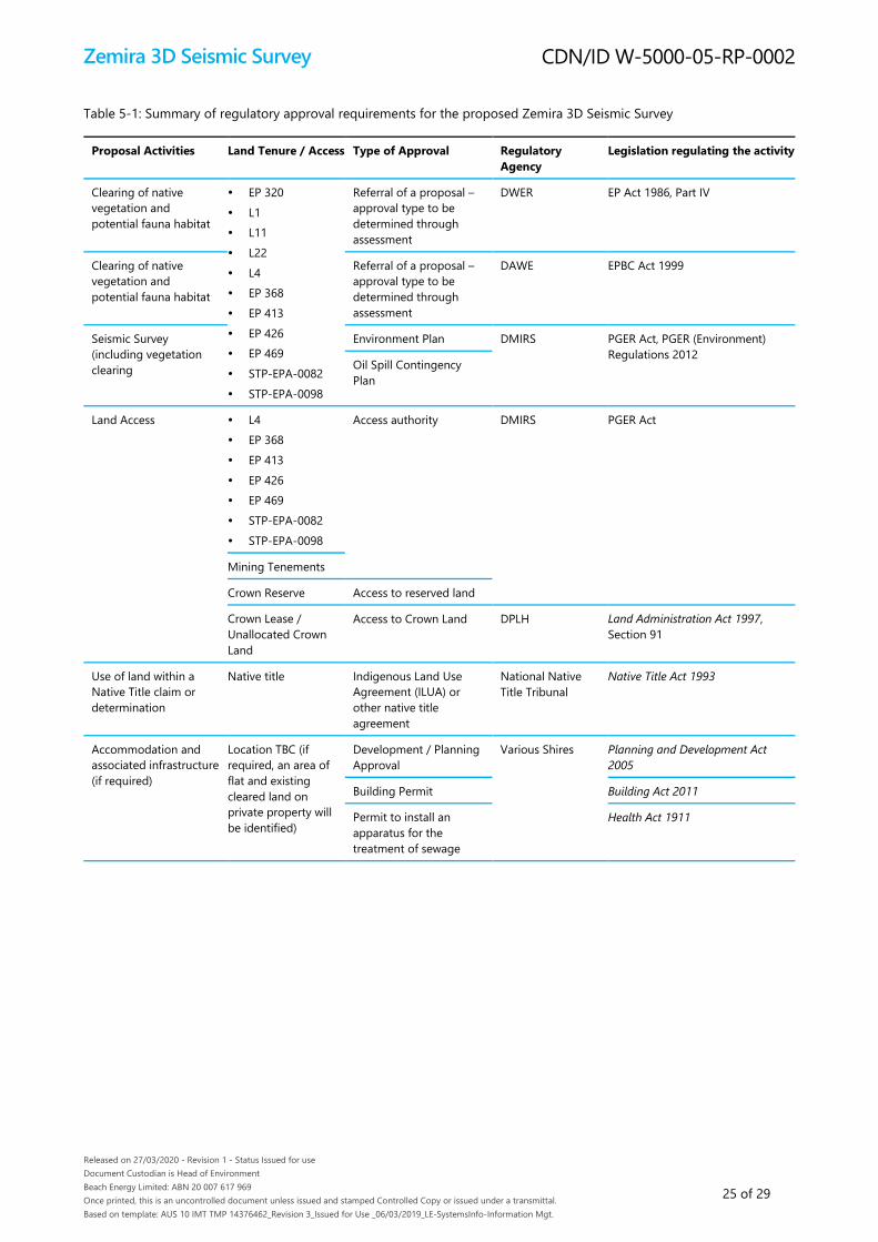
Table 5-1: Summary of regulatory approval requirements for the proposed Zemira 3D Seismic Survey
Proposal Activities Land Tenure / Access Type of Approval Regulatory
Agency
Legislation regulating the activity
Clearing of native
vegetation and
potential fauna habitat
EP 320
L1
L11
L22
L4
EP 368
EP 413
EP 426
EP 469
STP-EPA-0082
STP-EPA-0098
Referral of a proposal –
approval type to be
determined through
assessment
DWER EP Act 1986, Part IV
Clearing of native
vegetation and
potential fauna habitat
Referral of a proposal –
approval type to be
determined through
assessment
DAWE EPBC Act 1999
Seismic Survey
(including vegetation
clearing
Environment Plan DMIRS PGER Act, PGER (Environment)
Regulations 2012 Oil Spill Contingency
Plan
Land Access L4
EP 368
EP 413
EP 426
EP 469
STP-EPA-0082
STP-EPA-0098
Access authority DMIRS PGER Act
Mining Tenements
Crown Reserve Access to reserved land
Crown Lease /
Unallocated Crown
Land
Access to Crown Land DPLH Land Administration Act 1997,
Section 91
Use of land within a
Native Title claim or
determination
Native title Indigenous Land Use
Agreement (ILUA) or
other native title
agreement
National Native
Title Tribunal
Native Title Act 1993
Accommodation and
associated infrastructure
(if required)
Location TBC (if
required, an area of
flat and existing
cleared land on
private property will
be identified)
Development / Planning
Approval
Various Shires Planning and Development Act
2005
Building Permit Building Act 2011
Permit to install an
apparatus for the
treatment of sewage
Health Act 1911
Zemira 3D Seismic Survey
Released on 27/03/2020 - Revision 1 - Status Issued for use
Document Custodian is Head of Environment
Beach Energy Limited: ABN 20 007 617 969
Once printed, this is an uncontrolled document unless issued and stamped Controlled Copy or issued under a transmittal.
Based on template: AUS 10 IMT TMP 14376462_Revision 3_Issued for Use _06/03/2019_LE-SystemsInfo-Information Mgt.
CDN/ID W-5000-05-RP-0002
26 of 29
6 Definitions/Acronyms
Definitions of terms/acronyms used in this document:
Terms/acronym Definition/expansion
3D Three-dimensional
AHIS Aboriginal Heritage Inquiry System
ALARP As low as reasonably practicable
Beach Energy Beach Energy (Perth Basin) Pty Ltd
BC Act (WA) Biodiversity Conservation Act 2016
DAWE (Commonwealth) Department of Agriculture, Water and the Environment
DBCA (WA) Department of Biodiversity, Conservation and Attractions (DBCA) Naturemap database
DBNGP Dampier to Bunbury Natural Gas Pipeline
DMAs Decision-making authorities
DMIRS Department of Mines, Industry Regulation and Safety
DPLH Planning, Lands and Heritage
DSEWPaC Department of Sustainability, Environment, Water, Population and Communities
EMP Environmental Management Plan
EP Environment Plan
EP Act (WA) Environmental Protection Act 1986
EPA (WA) Environmental Protection Authority
EPBC Act (Commonwealth) Environment Protection and Biodiversity Conservation Act 1999
ERD Environmental Review Document
ESD Environmental Scoping Document
GPS Global positioning system
IBRA Interim Biogeographic Regionalisation for Australia
ILUA Indigenous Land Use Agreement
MNES Matters of national environmental significance
OSCP Oil Spill Contingency Plan
PEC Priority ecological community
PGER Act (WA) Petroleum and Geothermal Energy Resources Act 1967
SPRAT Species Profile and Threats Database
SRE Short range endemics
TEC Threatened ecological community
WA Western Australia
Zemira 3D Seismic Survey
Released on 27/03/2020 - Revision 1 - Status Issued for use
Document Custodian is Head of Environment
Beach Energy Limited: ABN 20 007 617 969
Once printed, this is an uncontrolled document unless issued and stamped Controlled Copy or issued under a transmittal.
Based on template: AUS 10 IMT TMP 14376462_Revision 3_Issued for Use _06/03/2019_LE-SystemsInfo-Information Mgt.
CDN/ID W-5000-05-RP-0002
27 of 29
7 References/Associated documents
1. Beard, J.S. 1976. Vegetation of the Dongara Area, Western Australia. Map and Explanatory Memoir, 1:250,000 Series,
Vegmap Publications, Perth.
2. Desmond, A. and Chant, A. 2001. ‘Geraldton Sandplains 3 (GS3 – Lesueur Sandplain subregion)’ in A Biodiversity
Audit of Western Australia’s 53 Biogeographic Subregions in 2002. Department of Conservation and Land
Management, Western Australia.
3. DSEWPaC. 2012. Environment Protection and Biodiversity Conservation Act 1999 - Environmental Offsets Policy.
Department of Sustainability, Environment, Water, Population and Communities, Canberra, Australia.
4. EPA. 2016a. Environmental Factor Guideline: Flora and Vegetation. Environmental Protection Authority, Western
Australia.
5. EPA. 2016b. Technical Guidance: Flora and Vegetation Surveys for Environmental Impact Assessment. Environmental
Protection Authority, Western Australia.
6. EPA. 2016c. Environmental Factor Guideline: Terrestrial Fauna. Environmental Protection Authority, Western Australia.
7. EPA. 2016d. Technical Guidance: Terrestrial Fauna Surveys. Environmental Protection Authority, Western Australia.
8. EPA. 2016e. Environmental Factor Guideline: Social Surroundings. Environmental Protection Authority, Western
Australia.
9. EPA. 2016f. Environmental Factor Guideline: Landforms. Environmental Protection Authority, Western Australia.
10. EPA. 2016g. Environmental Factor Guideline: Subterranean Fauna. Environmental Protection Authority, Western
Australia.
11. EPA. 2016h. Environmental Factor Guideline: Terrestrial Environmental Quality. Environmental Protection Authority,
Western Australia.
12. EPA. 2016i. Environmental Factor Guideline: Inland Waters. Environmental Protection Authority, Western Australia.
13. EPA. 2016j. Environmental Factor Guideline: Air Quality. Environmental Protection Authority, Western Australia.
14. EPA. 2016k. Environmental Factor Guideline: Human Health. Environmental Protection Authority, Western Australia.
15. EPA. 2016l. Technical Guidance – Sampling Methods for Terrestrial Vertebrate Fauna. Environmental Protection
Authority, Western Australia.
16. EPA. 2018a. Statement of Environmental Principles, Factors and Objectives. Environmental Protection Authority,
Western Australia.
17. EPA. 2018b. Environmental Impact Assessment (Part IV Divisions 1 and 2) Procedures Manual. Environmental
Protection Authority, Western Australia.
18. EPA. 2019. DRAFT Environmental Factor Guideline: Greenhouse Gas Emissions. Environmental Protection Authority,
Western Australia.
19. EPA. 2019. Technical Report. Carnaby’s Cockatoo in Environmental Impact Assessment in the Perth and Peel Region.
Environmental Protection Authority, Western Australia.

Zemira 3D Seismic Survey
Released on 27/03/2020 - Revision 1 - Status Issued for use
Document Custodian is Head of Environment
Beach Energy Limited: ABN 20 007 617 969
Once printed, this is an uncontrolled document unless issued and stamped Controlled Copy or issued under a transmittal.
Based on template: AUS 10 IMT TMP 14376462_Revision 3_Issued for Use _06/03/2019_LE-SystemsInfo-Information Mgt.
CDN/ID W-5000-05-RP-0002
28 of 29
20. Government of Western Australia. 2011. WA Environmental Offsets Policy. Government of Western Australia, Western
Australia.
21. Government of Western Australia. 2014. WA Environmental Offsets Guidelines. Government of Western Australia,
Western Australia.
22. Halse, S.A., Scanlon, M.D., Cocking, J.S., Barron, H.J., Richardson, J.B., and Eberhard, S.M. 2014. Pilbara stygofauna:
deep groundwater of an arid landscape contains globally significant radiation of biodiversity. Records of the Western
Australian Museum Supplement 78, 443-483
23. Shepherd, DP, Beeston, GR, and Hopkins, AJM 2002, Native Vegetation in Western Australia – Extent, Type and
Status, Resource Management Technical Report 249, Perth, Department of Agriculture, Western Australia

Zemira 3D Seismic Survey
Released on 27/03/2020 - Revision 1 - Status Issued for use
Document Custodian is Head of Environment
Beach Energy Limited: ABN 20 007 617 969
Once printed, this is an uncontrolled document unless issued and stamped Controlled Copy or issued under a transmittal.
Based on template: AUS 10 IMT TMP 14376462_Revision 3_Issued for Use _06/03/2019_LE-SystemsInfo-Information Mgt.
CDN/ID W-5000-05-RP-0002
29 of 29
8 Document information and history
Document custodian group
Title Name/s
Head of Environment Tim Flowers
Document author
Position Name/s
Environmental Consultant Ashley Fertch, Michelle Carey
Document history
Rev Date Changes made in first document Reviewer/s Consolidator Approver
A 05/02/2020 Issued for internal review T Flowers
W Mothershaw
S Nunan
T Stehbens
T Stehbens
B 26/02/2020 Issued for final review T Flowers
W Mothershaw
S Nunan
T Stehbens
T Stehbens
0 28/02/202 Issued for use T Flowers
W Mothershaw
S Nunan
T Stehbens
T Stehbens T Flowers