gps – mcrm integration solution - meu
TRANSCRIPT

GPS – MCRM INTEGRATION SOLUTION
A Thesis Submitted in Partial Fulfillment of the
Requirements for the Degree of Master of Science in Computer Information System
By Maram Ayoub Da’ana
Supervisor Professor Mohammad A. Al‐Fayoumi (PhD)
Faculty of Information Technology Middle East University for Graduate Studies
Amman ‐ Jordan June, 2009

تفويض
انا مرام أيوب دعنا افوض جامعة الشرق الاوسط للدراسات العليا بتزويد نسخ من رسالتي للمكتبات او الهيئات او الافراد عند طلبها
:التوقيع :التاريخ
Middle East University for Graduate Studies Authorization Statement
I Maram Ayoub Da'ana, authorize the Middle East University for Graduate Studies to supply copies of my Thesis to libraries or establishments or individuals on request. Signature: Date:
II

Committee Decision
This is a certify that the thesis entitled "GPS–MCRM
INTEGRATION SOLUTION" was successfully defended and
approved on ‐‐‐‐‐‐
Examination Committee Signature
Professor Mohammad A. Al‐Fayoumi (PhD) Department of Computer Information Systems Faculty of Information Technology Middle East University for Graduate Studies Dr. Musbah Aqel Department of Computer Science Faculty of Information Technology Middle East University for Graduate Studies Dr. Hazim Farhan Department of Computer Information Systems Faculty of Information Technology Middle East University for Graduate Studies Dr. Mezher Al A'ani Department of Computer Information Systems Faculty of Information Technology Amman University for graduate studies
III

Dedication This is dedicated to my family, for their encouragement and love.
IV

Acknowledgments First of all, I would like to thank God for his graces and for his guidance. I would like to express my sincere appreciation to Professor Mohammad Al‐Fayoumi for his guidance, assistance, scientific hints that lightened my road during my writing this Thesis. I would further like to acknowledge all of the Information Technology faculty members at the Middle East University for Graduate Studies, for helping and encouraging my efforts especially at the beginning of the thesis. Above all, I would like to especially thank my parents for supporting me during the time I was writing this thesis. Without them nothing of this thesis would have been possible.
V

Table of Contents Dedication IV Acknowledgments V Table of Contents VI List of Tables IX List of Figures X Abstract XI Chapter 1: Introduction
1.1 Overview 1 1.2 Problem Definition 2 1.3 Objectives 3 1.4 Motivations 3 1.5 Significance 4 1.6 Thesis Delimitations 5 1.7 Related Work 5
1.8 Thesis Organization 9
Chapter 2: Theorical Framework 2.1 Introduction 11 2.1.1 Customer Relationship Management (CRM) 11 2.1.2 The "C" in CRM 12 2.1.3 CRM Aspects 13 2.1.4 CRM Life Cycle 15 2.1.5 Objectives of CRM 16 2.1.6 CRM relation with customer satisfaction, loyalty and business performance 17 2.1.7 CRM Applications 18 2.2 Mobile CRM 20 2.2.1 Areas getting value of mCRM 21 2.2.2 Benefits of mCRM 22 2.2.3 mCRM obstacles 23
VI

2.3 GPS 25 2.3.1 GPS Objective 26 2.3.2 How GPS work 26 2.3.3 GPS Signal 27 2.3.4 Sources of GPS signal errors 28 2.3.5 GPS segments 30 2.3.5.1 Space segment 30 2.3.5.2 Control segment 30 2.3.5.3 User segment 30 2.3.6 GPS positioning services 31 2.3.6.1 Precise positioning service (PPS) 31 2.3.6.2 Standard positioning service 31
2.3.7 GPS Applications 33 2.3.8 Location Coordinates 33
Chapter 3: Proposed System Analysis 3.1 Introduction 36 3.2 Requirements determination 36 3.2.1 Company requirements with respect to the system 37 3.3 Formalizing the requirements using Use Case Diagram 38 3.4 Process Breakdown Using UML 39 3.5 Feasibility study for the proposed solution 42 3.5.1 Business Feasibility 42 3.5.2 Technical Feasibility 43 3.6 Evaluation of the proposed solution SWOT analysis approach 44 3.6.1 Strengths 44 3.6.2 Weaknesses 45 3.6.3 Opportunities 45 3.6.4 Threats 45 Chapter 4: Proposed System Design 4.1 Introduction 48 4.2 Proposed system architecture 48 4.3 Service integration 52
VII

4.3.1 Web services standards required for integration 53 4.3.2 Web services required in the system 54 4.3.3 Technical system components 55 4.3.3.1 Mobile client 55 4.3.3.2 Enterprise web service server 57 4.3.3.3 Enterprise security firewall and active directory 57 4.3.3.4 Enterprise database server 58 4.3.4 Tools and Techniques used 58 4.3.4.1 GPS API 58 4.3.4.2 Web services 59 4.3.4.3 XML 60 4.3.4.4 Oracle data manipulation language (DML) 61 4.3.4.5 The Harversine Formula 62 4.4 User Interface Design 63 Chapter 5: The Proposed Solution 5.1 Introduction 65 5.2 Field sales and services professionals process scenario 66 5.3 Proposed system Architecture 67
5.4 Proposed Integration technique phases 68 5.4.1 Introduction 68 5.4.2 Get field sales representatives location coordinates 69 5.4.3 Transmit Location Coordinates to enterprise servers 72 5.4.4 Search for Customers in the radius of the field sales representative location 74 5.4.4.1 CRM Location Query 74
Chapter 6: Conclusions and Future Work 6.1 Conclusions 77 6.2 Future Work 79
VIII

References 80 Appendices Appendix A: Source Code 84 A.1 GPS application Code 84 A.2 Web services definition 88
IX

List of Tables
Table 2.1: CRM applications in CRM life cycle 20
Table 3.1: SWOT analysis 47
Table 3.2: TOWZ strategy 47
Table 4.1: E‐TEN device specifications 56
Table 4.2: GPS Intermediate Driver structure 59
X
List of Figures
Figure 1.2: Outline of the study 9
Figure 2.1: CRM Life Cycle 15
Figure 2.2: Company value through CRM 16
Figure 2.3: Customer satisfaction, loyalty and business performance 17
Figure 2.4: Mobile CRM benefits 23
Figure 2.5: GPS Signals 29
Figure 2.6: Latitudes and Longitudes 34
Figure 3.1: System requirements using “Use case” diagram 39
Figure 3.2: Process breakdown 42
Figure 4.1: GPS‐mCRM Proposed Solution Overview 51
Figure 4.2: User interface design 64
Figure 5.1: Functionality of the proposed solution 68
XI

الملخص
إدارة علاقات العملاء تعرف على نطاق واسع بأنها الإستراتيجية التجارية التي ترآز على العملاء
حيث يجري تطبيقات و حلول جديدة في هذا المجال بالإضافة إلى أن المنظمات تطالب بمزيد من
.أدوات و أنظمة متطورة لتعزيز علاقاتها مع العملاء
يتها في الأعمال التجارية وجد الباحث أن دراسة المواقف الحالية للشرآات و و نظراً لازدياد أهم
.ميولها للاستثمار من شأنه أن يحسن هذه العلاقات و بعض التقنيات الجديدة
إن الغرض من هذه الرسالة هو تصميم تقنية تدمج بين نظام إدارة علاقات العملاء و النظام
لأجهزة المحمولة من أجل التقليل والحد من الوقت للبحث و الوصول العالمي لتحديد المواقع على ا
إلى معلومات العملاء وتحديث البيانات المتعلقة بهم في نظام إدارة علاقات العملاء و يتم ذلك من
خلال الاعتماد على موقع الشخص الذي يملك الجهاز المتحرك باستخدام النظام العالمي لتحديد
و باستخدام تكنولوجيا شبكات المحمول لتوفير التفاعل لتبادل البيانات بين , المواقع والإحداثيات
الأجهزة النقالة والحاسوب الرئيسي للمؤسسات، وآذلك عن طريق استخدام تكنولوجيا الإنترنت
.وقاعدة البيانات لأداء عمليات البحث في قاعدة البيانات و حواسيب الشبكة الرئيسية
رأي الباحث هو نظام متحرك وقابل للتوسع وآفوء و يرى الباحث من انه النظام المقترح في
لذا فان الباحث يوصي بتطبيق النظام على .يضيف مزايا وقيم جديدة للنظم المتوفرة في الأسواق
و الحواسيب الرئيسية التي Windows Operating System الأجهزة النقالة التي تستخدم نظام
Net Framework.تحتوي على
: النتائج المستخلصة ترسم صورة من أن النظام الجديد الذي يحمل العنوان
" GPS – mCRM Integration Solution"
يمكن أن يساهم في زيادة آبيرة في إنتاجية وآفاءة المؤسسات التي تستخدم نظام إدارة علاقات .العملاء الذي يحتوي على هذه التقنية
XII

Abstract Customer relationship management (CRM) has been widely recognized as a customer centered business strategy. New CRM applications and solutions are rapidly being developed and organizations are demanding more powerful tools to enhance their relationship with customers. Since customer relations is getting more important in business; the author found that it would be interesting to study current attitudes of corporations to invest in system that would improve such relations and some new trends to improve current technologies. The purpose of this thesis is to design a technique for integrating CRM application with Global positioning system (GPS) on mobile devices in order to ease and reduce time of accessing and updating customers data through mobile CRM application depending on the location of the person holding the mobile device, by using the global positioning system to determine the location coordinates, and by using mobile networks technology to provide interaction of exchanging data between the device and enterprise servers, and also by using internet HTTP technologies and database queries to perform the transaction performed on enterprise database and web servers. The proposed scheme is dynamic, flexible, secure and efficient and it claims to add new values and advantages to the already existing schemes in the market. The author recommends implementing a scheme on mobile devices that uses windows operating system and .Net framework web servers. Results are given from which the conclusion is drawn that developing a new scheme entitled "GPS – mCRM Integration Solution" can increase significantly in the productivity and efficiency of enterprises adopting mobile CRM applications with this technology.
XIII

Chapter 1
Introduction
1.1 Overview
This introductory chapter will provide the reader with an insight to
the research area. The thesis begins by briefly discussing the problem
definition followed by motivations and the overall purpose of the study.
Demarcations and the disposition of the study are presented later in
the chapter.
Business nowadays doesn't stand still, also employees in
organizations such as field sales and service staff who are on the move
every hour of every day, for leading-edge companies looking for an
advantage in a competitive global business environment. Also mobile
devices and wireless technologies have become important tools.
With today's mobile devices, wireless technologies and applications
enables field and mobile professionals to keep business moving no
matter where they are, with instant access to their key people,
processes, information and products.
The business need to keep field professionals linked to corporate
information systems due to the need to improve business gains in
productivity, customer satisfaction, and real-time updates; many
leading enterprises work on real-time mobile customer relationship
management to provide access to corporate business applications and
1

data stores with information that helps field professionals work at the
pace that customers and business demand.
Market and sales strategy is becoming more customer-oriented, and
due to the need to gain competitive edge and more customer
satisfaction; new technology trends are capable to add value and
enhance on current mobile customer relationship management tools
and applications.
1.2 Problem Definition
Mobile Customer Relationship Management (mCRM) is a relatively
new area of research. The empirical studies that have been made
within this field are merely focused on defining mCRM and finding its
benefits [28].
Since customer relations is getting more important in contemporary
business it would be interesting to study current attitudes of
corporations to invest in system that would improve such relations and some new trends to improve current technologies [28].
However, customers today are more highly educated, under higher
stress, more specialized, living longer, and more influenced by global
culture. Understanding customers is now much harder, which
increases the complexity of customer relationships. Therefore, fast,
new, real-time and interactive technologies must be used to combat
these forces [14].
2
In this research, we would propose a mobile customer relationship
integration technique with Global positioning system, it’s barriers, it’s
adoption benefits in the market for customer oriented companies.
1.3 Objectives
Based on the discussion above, the purpose of this research is to
take advantage of new technology trends to increase the effectiveness
of mobile CRM application, which can be achieved by integrating
mobile CRM with GPS; so in this thesis the objectives are as follows:
• To generate a method to integrate GPS with Mobile CRM application
• To provide a way we claim to ease, enhance and automate
customers information instant access to field sales representatives.
1.4 Motivations
The motivations of this study are as follows:
1. To know what are the measurable benefits for an investment of
Mobile CRM and what enterprise needs to do to go mobile.
2. Due to the great interest of organizations to empower their sale
forces with tools to work remotely.
3. Due to the need of real-time update of customer’s information
on the spot by providing access to corporate business
applications and data stores with invaluable information that
helps employees work at the pace that customers and business
demand.
4. Due to today’s technology in mobile devices, applications, and
network speeds enables field and mobile professionals to keep
3

business moving no matter where they are, with instant, fast
and automatic access to their key people, processes, information
and products.
In addition to the above motivations, for many people in the field a
laptop is not a realistic option for quick access to information, as it
doesn’t provide the same real-time or convenience level as a small
device. Keeping a company mobile professionals connected to reduce
downtime and keep them productive by providing them with a mobile
device capable of connecting to and interacting with key corporate
applications in more effective, fast, automatic and online interaction.
A Forrester research performed on 324 company in north America
showed that 84% from the companies polled have equipped key
personnel with handheld devices that can receive voice and data,
where 30% company have equipped key personnel with handheld
devices for field sales applications, so adding value and increasing
their effectiveness and productivity will increase number of companies
who equip their field sales representatives with mobile devices
1.5 Significance
This thesis serves both the CRM vendors and the CRM users in the
following points:
1. The CRM solution vendors who will redirect their focus on
customer satisfaction and more effective real-time solutions
rather than focusing only on the customer.
4
2. The CRM users will benefit from taking CRM solutions and
mobility to the next level by taking mobility seriously and
integrating it into their corporate and IT infrastructure.
3. Users will benefit from increasing the performance and efficiency
of field sales tasks by integrating GPS services to mCRM in
retrieving customers data.
4. Wireless medium as an element of CRM is rarely taken into
consideration and the literature concerning mCRM is scarce. In
an attempt to fill this void, this dissertation provides insights into
mCRM integration with GPS, the new trend and it’s benefits to
enterprises.
1.6 Thesis Delimitations
This study focus is on the technologies and tools used to integrate
GPS (Global positioning system) with mCRM (Mobile Customer
Relationship Management). The study does not cover discussing GPS
and mCRM applications development and design due to time
limitations and also since many leading information systems
companies have those applications in the market.
1.7 Related Work
In this section, a brief view of research and studies done in topics
related to this thesis is presented.
In year 2001 Günther Retscher and Esmond Mok [8] proposed
scheme entitled "Integration of mobile phone location services into
5

intelligent GPS vehicle navigation systems". This research provided an
integration method of mobile phone location services for temporary
position determination into the intelligent vehicle navigation system.
One of the main topics of the research is the integration of mobile
phone location services (MPLS) into vehicle navigation systems in
addition to GPS and dead reckoning for the development of intelligent
land vehicle navigation and tracking system suitable for urban areas.
This integration enhanced the accuracy and reliability for position
determination in urban canyons where no GPS positions are available
for a long period of time to update the dead reckoning system, the
proposed scheme in this dissertation uses GPS location positioning and
makes it relevant by using technology for improving business
productivity.
In 2003 Wu Tie [27] did a research entitled "Implementing CRM in
SMEs: An Exploratory Study on the Viability of Using the ASP Model",
in this study the author aimed to study the viability of using the
ASP(Application Service Providers) model for SMEs (Small and
Medium-sized Enterprises) to implement CRM. The study involves
intensive review and induction of relevant theories on CRM, SMEs and
ASPs, as well as empirical research on comparing currently prominent
ASPs products: Upshot and Salesforce.com. The findings in the study
show that according to characteristics of SMEs and ASP products
offerings, it is practically viable for SMEs to implement CRM by using
ASP product offerings from business and technical perspectives, a
major limitation of this study is a lack of investigation into the
difference of user experience in using applications. The proposed
scheme offers a new service that could be implemented in ASP
products to enhance it and add more value to it.
6

In 2004 Mohammad AAmir Turk [14] did a research entitled "Data
Mining and Mobile CRM", in this study they divide the dissertation into
two segments. The first segment investigates a new data mining
technique and compares it with the classification based on associations
(CBA) for mining classification rules from different data sets. A new
approach, LCA (Look At the Class Approach) is introduced and rules
are generated with both CBA and LCA approach by using the Apriori
algorithm. The LCA is very effective in terms of reducing the number
of combinations of the item sets in each iteration; hence will be
capable of reducing the system response time for generating rules
from mobile customer opt-in database. The second segment is
oriented around mCRM. The study endeavoures to build an empirically
grounded framework of the initiation stage of (mCRM) in retailing. The
main result of this study indicates that mCRM may be an effective
element to CRM strategy, if customer relation is based on permission
marketing and trust. Another result is that by collecting and
maintaining useful information through data mining from the
customers’ database, stores can offer their customers interesting
services via the mobile medium (SMS/MMS) (Short Message
Service/Multimedia Messaging Service), in the proposed scheme the
purpose is to retain customers not only by services via SMS/MMS, in
addition to that organization members can access customers data fast
and automatically from anywhere in a more flexible and reliable
method. One of the main disadvantages of SMS/MMS advertising this
research is proposing is that companies prediction of the customers
who are willing to participate in this kind of advertising is not accurate
and the prediction rules will never be a guaranteed “yes” from
customers to participate in mobile advertising but those rules and
7

predictions can save companies a lot of time by contacting right
customers at the right time.
In the year 2005 Jeff Dutrizac [9] did a study entitled "Mobile CRM
Increases Productivity", in this study the author described he
measurable and quantifiable benefits that a mobile CRM solution can
provide workers accessing and sharing enterprise information from the
field. Although those benefits vary from industry to industry, they
typically include increased productivity, improved customer
satisfaction, enhanced inventory management and faster revenue
recognition. Also the author guides organizations to what to do in
order to go mobile by describing the components of CRM solutions, the
author encourages organizations to mobilize CRM in order to increase
ROI. An advantage of this study that it encourages companies to
mobalize their CRM solutions by expressing the many benefits for
going to mobility. In addition to all mobile CRM benefits mentioned by
the author, the propose scheme adds more value to using mobile CRM
solutions by increasing productivity and ease in accessing and
updating customers data in real time in more effective way.
In the year 2007 Yohannes Belachew, Amanda Hoang, Joseph
Kourieh [28] did a research entitled "Mobile Customer Relationship
Management A study of barriers and facilitators to mCRM adoption", In
this study, the main focus is to find out why companies chose to
adopt or not adopt mCRM systems. The authors gathered and
examined theories about CRM, mCRM and the spreading of technology
(The Technology Acceptance Model). Also authors used a qualitative
approach and interviews were conducted in order to find barriers and
8

facilitators to mCRM adoption. The research resulted in several reasons
for mCRM acceptance and rejection. The primary reason for investing
mCRM, or considering investing in mCRM, was found to be the need to
reach customers and sales force anytime and anywhere. One major
obstacle to the research was finding companies willing to participate
in the research. The proposed scheme in this dissertation eases and
enhances sales force processes and needs to reach customers
information anywhere.
1.8 Thesis Organization
This study is divided into two parts. In part one we focus on CRM,
mCRM and GPS systems, and in the second part we focus on the
integration technique technologies and phases. By now, the content of
the first chapter is already presented and familiar to the reader,
consequently, only the content of the following chapters will be briefly
discussed below. Figure 1.2 visualizes the outline of the study.
Chapter 1: Introduction
Chapter 2: Theorical Framework
Chapter 3: Proposed System Analysis
Chapter 4: Proposed System Design
Chapter 5: The Proposed Solution
Chapter 6: Conclusions and Future Work
Figure 1.2: Outline of the study
9

The second chapter provides the reader with an overview of the
literature related to customer relation ship management and mobile
CRM in addition to a literature related to Global positioning system.
Chapter three provides the analysis phase of the system development.
Furthermore, chapter four describes the GPS and mCRM integration
solution design phases including technical system components and
technologies used in this research. Chapter five describes the GPS-
mCRM integration technique system phases and processes. Finally,
chapter six contains the overall conclusions that can be drawn form
the research.
10

Chapter 2
Theorical Framework
2.1 Introduction
This chapter is based on the first part of the literature study in this
thesis. This chapter will begin with the definition of CRM, its aspects,
life cycle and objectives. In order to use CRM in a best practice
scenario, there are CRM applications and softwares that help and
assists in managing CRM processes, therefore mobile CRM will be
discussed and its benefits for customers and organizations.
2.1.1 Customer Relationship Management (CRM)
According to Jill Dyche definition of customer relationship
management (CRM) is the infrastructure that enables the delineation
of and increase in customer value, and the correct means by which to
motivate valuable customers to remain loyal-indeed, to buy again.
CRM is about more than simply managing customers and monitoring
their behavior. CRM has the potential to change a customer's
relationship with a company and increase the revenues in the bargain
[11].
Wu Tie, 2003, defined CRM as a comprehensive approach that
integrates every business process that touches customers, namely
sales, marketing and customer service and field support through
11

integration of people, process and technology. In other words, CRM is
neither a product nor a service, but a business philosophy aiming to
maximize customer value in the long run [27].
From the above definition of customer relationship management, for
this research CRM can be defined as the broad category of concepts,
tools, and processes that allows an organization to understand and
serve everyone with whom it comes into contact. CRM is about
gathering information that is used to serve customers—basic
information, such as name, address, meeting and purchase history,
and service and support contacts. In a supplier relationship it might be
procurement history, terms and conditions, or contact information.
This information is then used to better serve the clients.
2.1.2 The "C" in CRM
For the purposes of discussing CRM, we need to think of the
“customer” in the broadest sense. Our definition needs to include
suppliers, partners, investors, employees, and others we deal with in
our definition. Each of these groups has specific and unique
requirements when dealing with an organization. Customers need to
be able to find out about the products and services and be able to
make purchases. An Organization needs to track each customer’s
activity in order to make offers of complimentary products and new
products that may provided. Keeping in mind that eighty percent of
the company's business will come from twenty percent of its Customer
Relationship Management toward customers.
12

Investors will have needs that relate to the operation of the business
and the performance of their investment. Making some of that
information available on a central customers data base will accomplish
two things:
(1) Investors will be better informed, and they will be able to find out
the information they require without making specific inquires that take
time to provide.
(2) Investors will get the same information at the same time.
Suppliers and partners want to be connected with the organization.
Creating special places where these strategic partners can participate
is valuable. Providing them with information, such as product
promotions, press releases, and advertising campaigns will build
strong relationships.
2.1.3 CRM Aspects
Customers see the organization from outside and interact with it
from their point of view as one single entity, despite often most
services need interaction with a number of employees in different roles
and departments. CRM is a combination of policies, processes, and
strategies implemented by an organization to unify its customer
interactions and provide a means to track customer information. It
involves the use of technology in attracting new and profitable
customers, while forming tighter bonds with existing ones.
There are many aspects included in CRM; they are all related to each
other
13

• Front office operations: those are operations and processes that
involve direct interaction with customers, e.g. face to face
meetings, phone calls, e-mail, online services etc.
The proposed integration technique in this research is to assist the
front office operations such as direct sales field and field services
operations.
• Back office operations: those are operations that ultimately
affect the activities of the front office (e.g., billing, maintenance,
planning, marketing, advertising, finance, manufacturing, etc.)
• Business relationships: CRM in an organization involves
interaction with other companies and partners, such as
suppliers/vendors and retail outlets/distributors, industry
networks. This external network supports front and back office
activities.
• Analysis: Key CRM data can be analyzed in order to plan target-
marketing campaigns, conceive business strategies, and judge
the success of CRM activities (e.g., market share, number and
types of customers, revenue and profitability).
From these aspects we notice that CRM adds and satisfies the
customer, and also it adds value and benefits the organization because
CRM for customers is a software that includes their information and
14

history, where for organizations it's strategic policies that are customer
centered.
2.1.4 CRM Life cycle
CRM life cycle includes three phases, each phase has a great role is
supporting and increasing the good relationship and trust between the
company and its customers, these CRM phases include:
1. Acquisition: The Company acquires new customers by promoting
new products and services
2. Enhancement: The Company enhances the profitability and
relationship of existing customers by encouraging excellence in cross
selling and up selling, thereby deepening and broadening the
relationship.
3. Retention: the Company retains profitable customers for life by
focusing on serving not what the market wants but what customers
want.
Acquisition
En
han
cem
en
t
Rete
nti
on
Figure 2.1: CRM Life Cycle
15
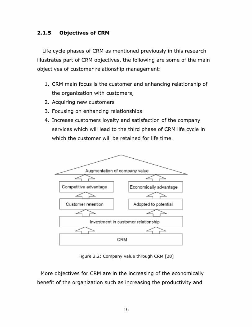
2.1.5 Objectives of CRM
Life cycle phases of CRM as mentioned previously in this research
illustrates part of CRM objectives, the following are some of the main
objectives of customer relationship management:
1. CRM main focus is the customer and enhancing relationship of
the organization with customers,
2. Acquiring new customers
3. Focusing on enhancing relationships
4. Increase customers loyalty and satisfaction of the company
services which will lead to the third phase of CRM life cycle in
which the customer will be retained for life time.
Figure 2.2: Company value through CRM [28]
More objectives for CRM are in the increasing of the economically
benefit of the organization such as increasing the productivity and
16
gaining a competitive edge between competitors as represented in
figure 2.2.
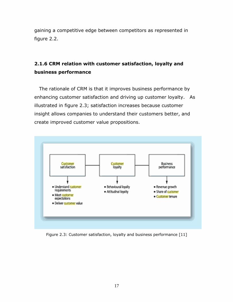
2.1.6 CRM relation with customer satisfaction, loyalty and
business performance
The rationale of CRM is that it improves business performance by
enhancing customer satisfaction and driving up customer loyalty. As
illustrated in figure 2.3; satisfaction increases because customer
insight allows companies to understand their customers better, and
create improved customer value propositions.
Figure 2.3: Customer satisfaction, loyalty and business performance [11]
17

As customer satisfaction rises, so does customer repurchase
intention, this turn influences actual purchasing behavior, which has a
significant impact on business performance. [11]
Author Francis Buttle, 2004, mentioned that many companies
research requirements and expectations to find out what is important
for customers, and then measure the customer's perception of their
performance compared with the performance of competitors. The focus
in CRM is on the elements of the value proposition that create value
for customers. From this author's opinion Companies have to do well
at meeting these important values using new technologies and trends
in assisting the improvement of customer's relation [6].
2.1.7 CRM Applications
CRM application is software that helps an enterprise manage
customer relationships in an organized way. For example, an
enterprise might build a database about its customers that described
relationships in sufficient detail so that management, sales people,
people providing service, and perhaps the customer directly could
access information, match customer needs with product plans and
offerings, remind customers of service requirements, know what other
products a customer had purchased, and so forth.
CRM software helps organizations manage their relationship customers
by several applications:
18

• Helping an enterprise to enable its marketing departments to
identify and target their best customers, manage marketing
campaigns and generate quality leads for the sales team.
• Assisting the organization to improve telesales, account, and
sales management by optimizing information shared by multiple
employees, and streamlining existing processes (for example,
taking orders using mobile devices)
• Allowing the formation of individualized relationships with
customers, with the aim of improving customer satisfaction and
maximizing profits; identifying the most profitable customers
and providing them the highest level of service.
• Providing employees with the information and processes
necessary to know their customers, understand and identify
customer needs and effectively build relationships between the
company, its customer base, and distribution partners.
Due to the need of providing employees which could be field sales
or field services professionals with updated information about their
customers, providing CRM applications on mobile devices which is the
mobile CRM, and equipping field professionals with them was in the
purpose of easing access to customers information and serve the
customer faster on the spot.
19
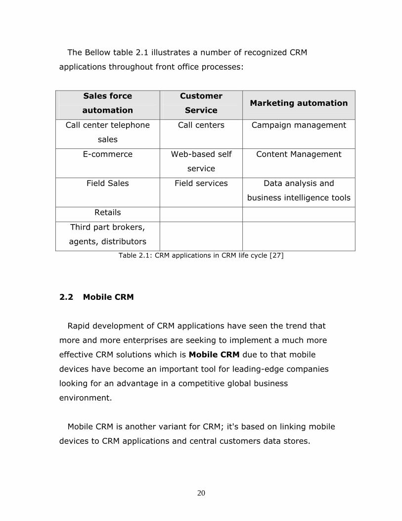
The Bellow table 2.1 illustrates a number of recognized CRM
applications throughout front office processes:
Sales force
automation
Customer
Service Marketing automation
Call center telephone
sales
Call centers Campaign management
E-commerce Web-based self
service
Content Management
Field Sales Field services Data analysis and
business intelligence tools
Retails
Third part brokers,
agents, distributors
Table 2.1: CRM applications in CRM life cycle [27]
2.2 Mobile CRM
Rapid development of CRM applications have seen the trend that
more and more enterprises are seeking to implement a much more
effective CRM solutions which is Mobile CRM due to that mobile
devices have become an important tool for leading-edge companies
looking for an advantage in a competitive global business
environment.
Mobile CRM is another variant for CRM; it's based on linking mobile
devices to CRM applications and central customers data stores.
20

Wu Tie (2003) described the objective of mCRM that the aim of
mCRM is to enable two-way interactivity between the customer and
the enterprise continuously at anywhere, whether in an office o
walking down the street. It also can be seen as a means to make CRM
more powerful with utilization of advanced wireless communication
tools [11].
Organizations are looking for more ease in looking up records, update
records and more efficiency in using the mobile device on the field, so
now market is moving toward mobility and mobilizing their processes,
this reason was one of the drivers for this dissertation to develop and
design a new technique that will fulfill those requirements.
2.2.1 Areas getting value of mCRM
Organization areas that are getting value of mobility and using
mCRM applications on mobile devices such as (blackberry, PDAs.
Windows mobile…etc) are:
1. Information users:
These will typically be sales or service managers who might be
occasional or frequent travelers and want to have access to
information on the road and to have the ability to respond more
quickly to decisions or approvals they might need to do.
2. Field workers:
These are people who spend most of their time on the road, could
include field sales representatives and service field professionals.
21

For that class of workers, the benefit of using mCRM is that those
workers are able to have real time access to information about
customers such as past customer history, customer preferences. Also
they can go ahead and update information in real time as they finish a
certain task whether it’s a sales call/appointment or a service request.
2.2.2 Benefits of mCRM
Extending the value of CRM through mobility by having real time
access to customer's data has many benefits; these are some of those
benefits:
• The enterprise can be more aware of what is going on and have
more real time insight into what activities and sales calls have
been completed and what interactions field representatives are
having with customers.
• Way for the organization to get more accurate information due
to that sales field representatives are able to update information
and type information about the customer, which puts in more
information and higher quality information than they are while they
are waiting till end of the day or end of the week probably to login
to the CRM application in the company and try to summarize all
those notes.
The following figure 2.2 shows further benefits for mobile CRM:
22

Figure 2.4: Mobile CRM benefits [9]
2.2.3 mCRM obstacles
Mobilizing CRM has several benefits for organization. However, there
are certain obstacles related to mCRM adoption by companies, some of
those obstacles are:
1. Security: loosing the mobile device could make is a worry since
it could have a lot of important information on it and has access
to the enterprise data bases.
2. Cost: cost of mobile devices needed to equip field people with it
in addition to extra charges could be an obstacle to mobalizing
CRM.
23

3. Usability of mobile devices: sometimes taking notes on a mobile
device can be harder; also searching for customer in the
application can take extra time sometimes due to several factors
such as spelling issues.
One way to improve the capability of mobile devices to be more
user friendly and ease the real time access and searching for
customers in the application is the proposed schema of this
dissertation in which the customer will be automatically recognized and
his data will be retrieved depending on the location, which will ease
the way data is accessed and updated.
24

2.3 GPS
The Global Positioning System (GPS) is a global navigation satellite
system (GNSS) developed by the United States Department of Defense
and managed by the United States Air Force 50th Space Wing. It is the
only fully functional GNSS in the world, can be used freely by anyone,
anywhere, and is often used by civilians for navigation purposes. [25]
The Global Positioning System (GPS) includes 24 satellites (21 active,
3 spare), in circular orbits around Earth with orbital period of 12 hours,
distributed in six orbital planes equally spaced in angle. Each satellite
carries an operating atomic clock (along with several backup clocks)
and emits timed signals that include a code telling its location. By
analyzing signals from at least four of these satellites, a receiver on
the surface of Earth with a built-in microprocessor can display the
location of the receiver (latitude, longitude, and altitude). [3]
GPS, formally known as the NAVSTAR (Navigation Satellite Timing
and Ranging), it was developed for the military because of its popular
navigation capabilities and because it could access GPS technology
using small, inexpensive equipment.
Some of the interesting facts about GPS satellites are:
• The first GPS satellite was launched in 1978.
• A full constellation of 24 satellites was achieved in 1994.
• Each satellite is built to last about 10 years. Replacements are
constantly being built and launched into orbit.
• A GPS satellite weighs approximately 2,000 pounds and is about
17 feet across with the solar panels extended.
25

• Transmitter power is only 50 watts or less.
GPS technology requires the following three segments:
• Space segment
• Control segment
• User segment
2.3.1 GPS Objective
The goal of the Global Positioning System (GPS) is to determine
a position on Earth in three dimensions: east-west, north-south, and
vertical (longitude, latitude, and altitude). [3]
2.3.2 How GPS work
Signals from three overhead satellites provide three dimensions
(east-west, north-south, and vertical longitude, latitude, and altitude).
Each satellite sends a signal that codes where the satellite is and
the time of emission of the signal. The receiver clock times the
reception of each signal, then subtracts the emission time to
determine the time lapse and hence how far the signal has traveled (at
the speed of light).
This is the distance the satellite was from the position point when it
emitted the signal. In effect, three spheres are constructed from these
distances, one sphere centered on each satellite. The position is
located at the single point at which the three spheres intersect. [3]
26
The position is displayed, perhaps with a moving map display or
latitude and longitude. Many GPS units also show derived information
such as direction and speed, calculated from position changes.
2.3.3 GPS Signal
GPS satellites transmit two low power radio signals, designated L1 and
L2. Civilian GPS uses the L1 frequency of 1575.42 MHz in the UHF
band. The signals travel by line of sight, meaning they will pass
through clouds, glass and plastic but will not go through most solid
objects such as buildings and mountains.
A GPS signal contains three different bits of information:
• A pseudorandom code, ephemeris data and almanac data. The
pseudorandom code is simply an I.D. code that identifies which
satellite is transmitting information.
• Ephemeris data tells the GPS receiver where each GPS satellite
should be at any time throughout the day. Each satellite
transmits ephemeris data showing the orbital information for
that satellite and for every other satellite in the system.
• Almanac data, which is constantly transmitted by each satellite,
contains important information about the status of the satellite
(healthy or unhealthy), current date and time. This part of the
signal is essential for determining a position.
27

2.3.4 Sources of GPS signal errors
Factors that can degrade the GPS signal and thus affect accuracy
include the following:
• Ionosphere and troposphere delays — The satellite signal
slows as it passes through the atmosphere. The GPS system
uses a built-in model that calculates an average amount of delay
to partially correct for this type of error.
• Signal multipath — This occurs when the GPS signal is
reflected off objects such as tall buildings or large rock surfaces
before it reaches the receiver. This increases the travel time of
the signal, thereby causing errors. Figure 2.5 shows the path of
signals in the case of multipath, blocked signal and correct
signal.
• Receiver clock errors — A receiver's built-in clock is not as
accurate as the atomic clocks onboard the GPS satellites.
Therefore, it may have very slight timing errors.
• Orbital errors — Also known as ephemeris errors, these are
inaccuracies of the satellite's reported location.
• Number of satellites visible — The more satellites a GPS
receiver can "see," the better the accuracy. Buildings, terrain,
28

electronic interference, or sometimes even dense foliage can
block signal reception, causing position errors or possibly no
position reading at all. GPS units typically will not work indoors,
underwater or underground.
• Satellite geometry/shading — This refers to the relative
position of the satellites at any given time. Ideal satellite
geometry exists when the satellites are located at wide angles
relative to each other. Poor geometry results when the satellites
are located in a line or in a tight grouping.
• Intentional degradation of the satellite signal — Selective
Availability (SA) is an intentional degradation of the signal once
imposed by the U.S. Department of Defense. SA was intended to
prevent military adversaries from using the highly accurate GPS
signals. The government turned off SA in May 2000, which
significantly improved the accuracy of civilian GPS receivers.
Figure 2.5: GPS Signals [7]
29

2.3.5 GPS Segments
GPS consists of three major segments, these are:
2.3.5.1 Space Segment
The SPACE segment consists of 24 operational satellites in six orbital
planes (four satellites in each plane). The satellites operate in circular
20,200 km (10,900 nm) orbits at an inclination angle of 55 degrees
and with a 12-hour period. The position is therefore the same at the
same sidereal time each day, i.e. the satellites appear 4 minutes
earlier each day. [7]
2.3.5.2 Control Segment
The Control segment consists of five Monitor Stations (Hawaii,
Kwajalein, Ascension Island, Diego Garcia, Colorado Springs), three
Ground Antennas, (Ascension Island, Diego Garcia, Kwajalein), and a
Master Control Station (MCS) located at Schriever AFB in Colorado.
The monitor stations passively track all satellites in view, accumulating
ranging data. This information is processed at the MCS to determine
satellite orbits and to update each satellite's navigation message.
Updated information is transmitted to each satellite via the Ground
Antennas. [7]
2.3.5.3 User Segment
The User segment consists of antennas and receiver-processors that
provide positioning, velocity, and precise timing to the user.
30

2.3.6 GPS positioning services
GPS provides two levels of service which are:
2.3.6.1 Precise Positioning Service (PPS)
PPS is a highly accurate military positioning, velocity and timing
service which will be available on a continuous, worldwide basis to
users authorized by the U.S. P(Y) code capable military user
equipment provides a predictable positioning accuracy of at least 22
meters (95 percent) horizontally and 27.7 meters vertically and time
transfer accuracy to UTC within 200 nanoseconds (95 percent). PPS
will be the data transmitted on the GPS L1 and L2 frequencies. PPS
was designed primarily for U.S. military use. It will be denied to
unauthorized users by the use of cryptography. [7]
2.3.6.2 Standard Positioning Service (SPS)
• Civil users worldwide use the SPS without charge or restrictions.
Most receivers are capable of receiving and using the SPS signal.
The SPS accuracy is intentionally degraded by the DOD by the
use of Selective Availability.
• SPS Predictable Accuracy
o 100 meter horizontal accuracy
o 156 meter vertical accuracy
o 340 nanoseconds time accuracy
31

• These GPS accuracy figures are from the 1999 Federal Radio
navigation Plan. The figures are 95% accuracies, and express
the value of two standard deviations of radial error from the
actual antenna position to an ensemble of position estimates
made under specified satellite elevation angle (five degrees) and
PDOP (less than six) conditions.
• For horizontal accuracy figures 95% is the equivalent of 2drms
(two-distance root-mean-squared), or twice the radial error
standard deviation. For vertical and time errors 95% is the value
of two-standard deviations of vertical error or time error.
• Receiver manufacturers may use other accuracy measures.
Root-mean-square (RMS) error is the value of one standard
deviation (68%) of the error in one, two or three dimensions.
Circular Error Probable (CEP) is the value of the radius of a
circle, centered at the actual position that contains 50% of the
position estimates. Spherical Error Probable (SEP) is the
spherical equivalent of CEP, that is the radius of a sphere,
centered at the actual position, that contains 50% of the three
dimension position estimates. As opposed to 2drms, drms, or
RMS figures, CEP and SEP are not affected by large blunder
errors making them an overly optimistic accuracy measure
32

• Some receiver specification sheets list horizontal accuracy in
RMS or CEP and without Selective Availability, making those
receivers appear more accurate than those specified by more
responsible vendors using more conservative error measures.
2.3.7 GPS applications
GPS application falls in five main categories:
• Location: determining a basic position
• Navigation: getting from one location to another
• Tracking: monitoring the movement of people and things
• Mapping: creating maps of the world
• Timing: bringing precise timing to the world
2.3.8 Location Coordinates
Location coordinates format varies according to the GPS receiver
that calculates the position coordinates, location of a point on the
earth is referenced by latitude and longitude, the figure 2.6 shows the
longitude and latitude for a point on earth
33

Figure 2.6: Latitudes and Longitudes [7]
GPS location coordinates format are viewed in decimal number
format or in Degrees minute seconds format.
• Degrees Minutes Seconds format [N/W dd mm ss]:
The hemisphere is indicated by 'N' and 'W'
dd : is the degree
mm: minutes
ss: second in decimal formal
Example: 37°19′29″N LAT, 121°54′59″E LON
• In Decimal coordinates "South" latitudes and "West" longitudes
convert to negative decimal numbers
Example: 37.3248 LAT, 121.9163 LON
34

Most GPS systems use the degree minutes second format, but some
GPS systems can be configured to use decimal format to display the
location coordinates.
To convert Degrees-Minutes-Seconds to Decimal Degrees:
Location in decimal: degrees + (minutes/60) + (seconds/3600)
Example:
Location: N24 20 10
24 + (20/60) + (10/3600) = 46.33611111
35
Chapter 3
Proposed System Analysis
3.1 Introduction
Before starting in developing and initializing the solution,
requirements for developing such solution should be collected and
analyzed, also a look to the stakeholders should be taken and how
they think about and expect from the solution from their prospective.
In terms of analyzing the requirements “UML Use Case” methodology
was used to show how each part of the solution is used and reacts
toward the requirements. And then will break down these
requirements to process level to show how the solution will work to
deal with requirements.
3.2 Requirements determination
To have a full picture about the business requirement of this
solution, we will start with the requirements to develop this solution
which is considered as e-business solution. The requirements of the
regarding solution fall into two categories:
1. Business-to-Consumer (B2C): in which the company will
introduce their services to the end user.
36

2. Business-to-Business (B2B): in which the company will
introduce their services to enterprise companies.
So, this solution is aimed to enhance the relationships with all
customers, increase customer satisfaction, and Speed up their services
and making these services available anywhere. The proposed solution
to achieve these aims is building a system that supports both B2C and
B2B services. Also the company requirement will be translated to the
proposed system as shown in the next section.
3.2.1 Company requirements with respect to the
system
Stakeholder's requirements regarding the solution can be summarized
as the following:
1. The mCRM should have the ability to operate in the mobile
regarding the mobile vendor.
2. The size of the mCRM installed in the mobile shouldn’t be big
3. When the mCRM sends traffic through GPRS it should be
small traffic to avoid the high cost.
4. mCRM application should be assisted by the GPS to view
customer's information based on the location of the field sales
professional.
5. An integration technique between mCRM and GPS should
provide customers information remotely according to the GPS
location coordinates.
6. The solution carries both B2C and B2B services.
37

3.3 Formalizing the requirements using Use Case
Diagram
The development of Use-Case diagrams will be for formalization of
the requirements and description of the system.
1. Actors. There are four types of actors in the system:
• The user of the system
• mCRM
• GPS
• Web service and database
2. The use case diagram below describes the interaction between
the system actors and the related use cases. As seen in Figure
3.1 , the "Mobile user" is quering using the system services . On
the other hand, the "mCRM" will coordinate with “GPS” asking
for the location coordinates of the user.The "mCRM" has the
tasks to coordinate with the “Web Service,DB” to get the
customer data and then showing this output to the “Mobile
user”.
Figure 3.1 bellow shows the Use case diagram :
38
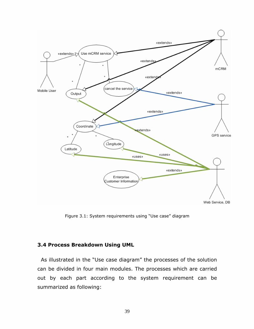
Figure 3.1: System requirements using “Use case” diagram
3.4 Process Breakdown Using UML
As illustrated in the “Use case diagram” the processes of the solution
can be divided in four main modules. The processes which are carried
out by each part according to the system requirement can be
summarized as following:
39
1. Mobile user module
• This module of the solution has mCRM and deals with user
regarding the services required.
• In this module the user can initiate the service or even
stop it.
• This module will be used to show out the information
required.
• To accomplish the processes, this part is integrated with
GPS module and Web Service module.
2. GPS module
• This module contains the GPS intermediate driver API
which is exposed through a native code library provided in
windows mobile SDK, and contains the get location
function ( GPSPosition).
• The module calculates the location coordinates of the user
regarding latitude and longitude.
• This part will be integrated with mobile user module and
web service module.
3. Web service module
• This module works in receiving request from the above
module and sends the location coordinates to the database
module.
40

• This module integrates with database module to return the
customer data to the mobile user module.
4. Database module
• This module processes a query for the customer data
regarding certain values (latitude and longitude values).
• This module integrates with the Web service module only
to maintain security for the database and also to return
the customer's data to the mobile user module.
Regarding the above points; figure 3.2 shown below represents the
breakdown process for the services that are provided by the solution:
41
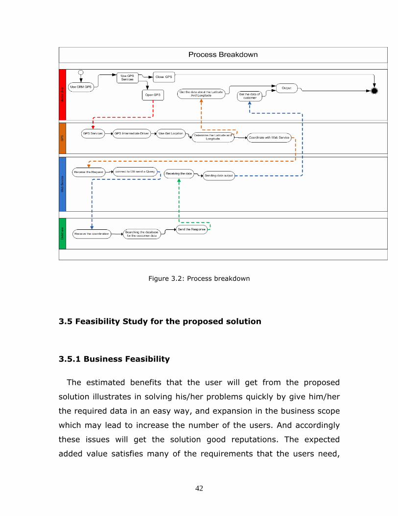
Figure 3.2: Process breakdown
3.5 Feasibility Study for the proposed solution
3.5.1 Business Feasibility
The estimated benefits that the user will get from the proposed
solution illustrates in solving his/her problems quickly by give him/her
the required data in an easy way, and expansion in the business scope
which may lead to increase the number of the users. And accordingly
these issues will get the solution good reputations. The expected
added value satisfies many of the requirements that the users need,
42
so after the expected solution is developed it will be an important
achievement and provide important profits for both users and
enterprise companies that will register their data in the system , this
profit includes reputation and also the money.
For the cost of the proposed solution it depends on the services, for
the GPS services, web service and the system itself. the cost may be
expensive because the web services and databases may be developed
by a third party, not to mention that Connection with the web service
needs networking levels( Firewall, Router, and Connection) and
services to increase security features and this will also increase the
cost of the proposed solution. It is possible to get alternative
scenarios and decrease the cost; this may happen if we look for the
required features without the needs for additional features.
Mentioning the risks which may face the implementation of our
solution. There are many fields of risks; technology risks and business
risks are the major examples. Risks in this project illustrate in time,
cost, and resources. Taking into consideration the marketing risks that
the project would face since not all mobile devices can use the solution
which will lead to limit the user customer slice that may affect the
enterprise customers point of view towards the solution.
3.5.2 Technical Feasibility
Time, quality, and resources of the services are considered critical
issues for both enterprise customers and users. It is very important for
the user to get a successful and high performance solution, therefore
43

success measures depend on the quality and validity of the output,
and does the solution satisfies the user needs or not.
The interaction between the solution services and the user through
the interface system is very important so the interface should be easy
to use and cover all users requirements, otherwise it might be more
confusing. Also the integration between the web system and the
database should be clear to make it easy to search what is needed.
During all processes and requirements security should be taken into
consideration.
3.6 Evaluation of the proposed solution a SWOT analysis
approach
3.6.1 STRENGHTS
• The geographic place for accessibility is irrelevant which means
that the access can be anytime and anywhere.
• Can be used by the enterprise customer for decision making
process in e-commerce.
• Investment cost is reduced since the implementation cost
becomes less. For example, it might become less cost especially
when a large number of users base is achieved.
• Using of mCRM has Continuous viral growth
• High user retention
44

• Many features can be added to the companies cross through
various platforms which may be used by individuals and other
companies.
3.6.2 WEAKNESSES
• Accessing all points needs high speed access, which isn’t
available everywhere and might be costly.
• Accessibility & Reliability, Limited to secure GPS connections.
• The solution currently only supports English which lead to limit
the market where it can be used.
3.6.3 OPPORTUNITIES
• Companies can use the solution as marketing, advertisement
and sales tool.
• Using the solution as e-business opens up different segments
of marketing
• Companies can invest in the solution in e-marketing to
increase company revenue
• Can be used to create a human resource database
3.6.4 THREATS
• The platforms may be damaged due to Security gaps, or
Hackers.
• User reluctance; social, culture and technical points may prevent
some people from using the solution.
45
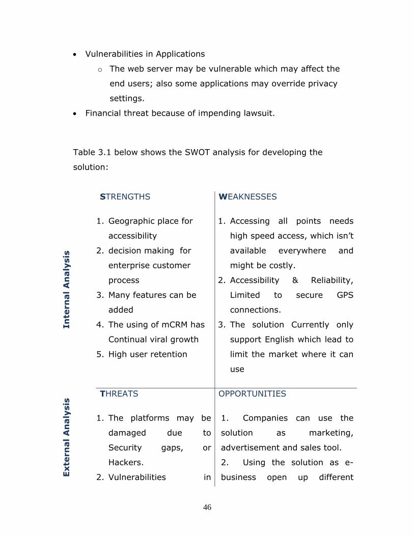
• Vulnerabilities in Applications
o The web server may be vulnerable which may affect the
end users; also some applications may override privacy
settings.
• Financial threat because of impending lawsuit.
Table 3.1 below shows the SWOT analysis for developing the
solution:
Inte
rnal A
naly
sis
STRENGTHS
1. Geographic place for
accessibility
2. decision making for
enterprise customer
process
3. Many features can be
added
4. The using of mCRM has
Continual viral growth
5. High user retention
WEAKNESSES
1. Accessing all points needs
high speed access, which isn’t
available everywhere and
might be costly.
2. Accessibility & Reliability,
Limited to secure GPS
connections.
3. The solution Currently only
support English which lead to
limit the market where it can
use
Exte
rnal A
naly
sis
THREATS
1. The platforms may be
damaged due to
Security gaps, or
Hackers.
2. Vulnerabilities in
OPPORTUNITIES
1. Companies can use the
solution as marketing,
advertisement and sales tool.
2. Using the solution as e-
business open up different
46
Applications
3. Financial threat because
of impending lawsuit
segments of marketing
3. Companies can invest in
the solution in e-marketing to
increase company revenue
Table 3.1: SWOT analysis
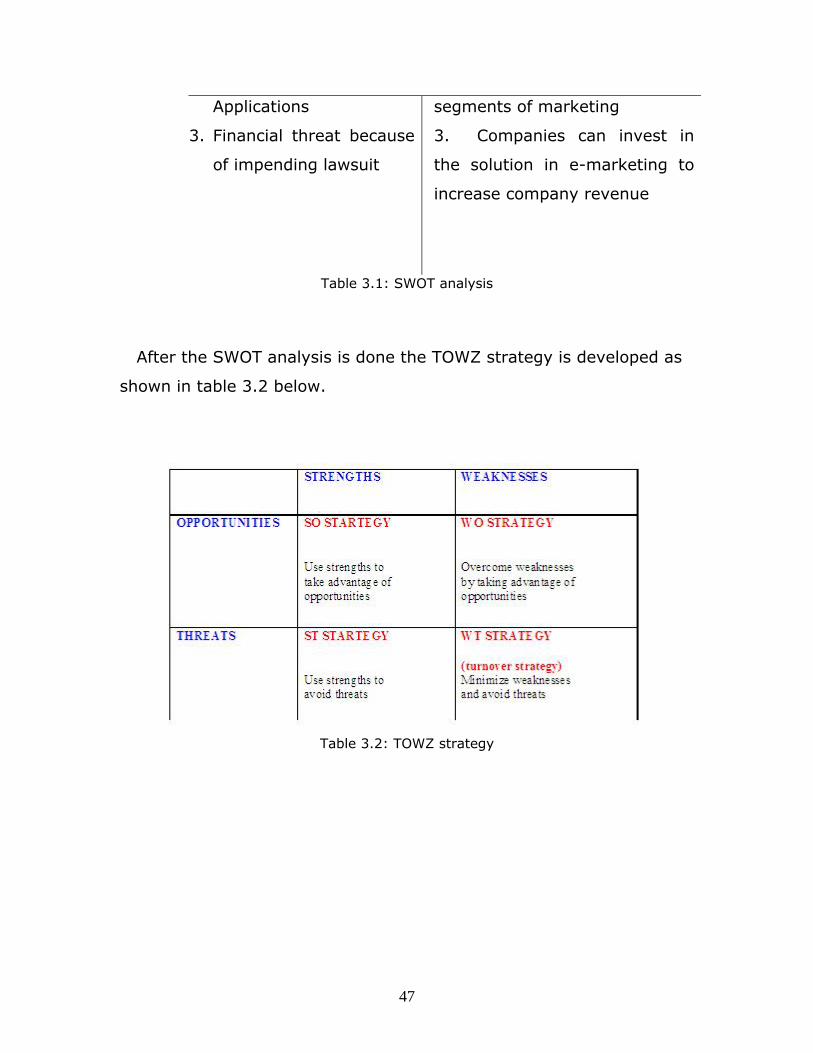
After the SWOT analysis is done the TOWZ strategy is developed as
shown in table 3.2 below.
Table 3.2: TOWZ strategy
47
Chapter 4
Proposed System Design
4.1 Introduction
The proposed scheme in this study can be described as a multi-tier
client-server architecture where clients are mobile devices and they
handle the presentation of information, where servers handle the data
management and business logic. The communication between servers
and between mobile clients and servers are realized using web
services. This technique is further described in this chapter. Data
management is accomplished using database and business logic
queries in the servers.
4.2 Proposed System Architecture
Once the business solution is developed, then Web services,
business logic, Database structures, and network structure need to be
developed changed accordingly. The proposed system architecture
consists of four main areas; the first area is concentrates on the
relation between the CRM services and the GPS through specific
services, and functions. In this part the user will use the mCRM in
his/her mobile to get the coordinates (latitude and longitude).
48

The second main part is concentrated in the connection between GPS
services and the web services. In this connection GPS services will
coordinate with the webs services and request for the installed
enterprise customers in a specific location.
The third part concentrates on the connection between the web
services and the database. In this connection the web services will
coordinate with the database which will create a query to search for
the information of the enterprise customer and then send the output
back to the web services.
The fourth part is concentrated in the connection web services and
our CRM services. In this connection the web services will coordinate
with the CRM and send the output which will appear on the user
interface.
The points mentioned above provide a justification to the need to
propose the three tier architecture for the proposed system:
1. The first Tier contains the CRM installed in a mobile
device, the user will deal only with this tier
2. The Second tier contains GPS services and Web services
3. The third tier contains the database services.
Regarding the three tiers used to design the architecture of the
solution, the following systems are parts of the solution:
49

1. Web Server: this Server will carry the Web services that will
integrate between the mCRM and the database. The integration
is shown in the sections below.
2. Database server: this server will have the databases related to
all services and the customers data. Oracle 10g, or MSSQL 7.0
may be used for such servers that may carry huge data that are
needed to be secure.
3. GPS service: this service will be responsible to calculate the
user's locations coordinates.
4. mCRM: This will be the tool that will be installed in the user
mobile and will send the coordinates for the web server to get
the data of the customers.
Since the solution's environment will be mainly concentrated on
GPS services and web service services; then many risks related to
security will be facing the business architecture, many security levels
will be added such as ( Firewall, VPN connection,…etc) not to mention
that the web server needs to have a security certificate from a high
authority like VeriSign.
Figure 4.1 illustrates GPS-mCRM system architecture including
technical components and technologies used.
50

Figure 4.1: GPS-mCRM Proposed Solution Overview
After proposing the system architecture and its components, one of
the important points is to know which system components are needed
to be developed from scratch and which components are to be bought-
in and customized based on the requirement s.
The nature of solution process and its transactions imposes to buy a
mCRM tool and customize it to include all the user's requirements in
addition to connecting GPS services and Web services. Regarding the
web server it will not be developed from scratch but has some
customization to accomplish the process carried by the web services.
This point came as a result for the disadvantage that may face the
solution if a new Web server was built and developed, these
disadvantages are:
1. It requires more cost and time.
51

2. The need for infrastructure knowledge and their might be lack in
experience in such field.
4.3 Service integration
Business integration is related to connect external-facing processes
of the system to the processes of other system process. This can
profoundly change the way business is conducted between systems
that are based on different techniques and different standards . The
potential benefits of business integration do not only include
improvement in operational efficiency, but also greater strategic
flexibility and market responsiveness.
As we discussed in the system architecture, the main integration
part will be concentrated in the mCRM, and web server. The mCRM will
integrate with GPS service from one side and with the Web server from
the other side. The web server is also the main part of the integration
since it will integrate with mCRM and the database server.
Information needs to be exchanged between mCRM and other parts of
the solution step by step are as follows:
1. The mobile user runs the system service, running this services
generates a request for customer data.
2. GPS calculates the location coordinates using GPS traffic
52

3. The web service system receives quotes from different suppliers.
The communication is based on SOAP (Simple Object Access
Protocol) over the Internet.
4. The web server gets information about the coordinate from the
mCRM to look up in the private UDDI (Universal Description,
Discovery, and Integration) registry located in the database
server.
5. The location coordinates and the WSDL (Web Services
Description Language) binding information for the Web Services
is sent to the web server.
6. The information is then analyzed by the web server, and sent to
mCRM to be outputted to the user.
4.3.1 Web services standards required for integration
UDDI (Universal Description, Discovery, and Integration) is the
global registry of web services. It allows providers of web services to
advertise their offerings in a standard way on the Internet. UDDI uses
APIs to define a programmatic interface. The APIs used for publishing
Web Services is called publication API when the one used for
discovering Web Services is called inquiry API Web services. The core
component of UDDI is the business registry which is an XML repository
where businesses advertise services so that other businesses can find
them. [17]
53

SOAP (Simple Object Access Protocol) is a lightweight messaging
framework for exchanging data among Web services. The data are
XML formatted. SOAP can be used with different transport protocols
such as HTTP, SMTP, and FTP. The structure of a SOAP message is
very simple structure: it is composed by an XML element which is
called envelope and which has two child elements. The first element
named the header includes features such as security and transactions.
The second element named the body includes the actual exchanged
data. [18]
WSDL (Web Services Description Language) is an XML-based
language for describing operational features of Web services. WSDL
descriptions are composed of interface and implementation definitions.
The interface is an abstract and reusable service definition that can be
referenced by multiple implementations. The implementation describes
how the interface is implemented by a given service provider. [2]
4.3.2 Web Services required in the system
Specific scripting environment such as JSP, ASP, and PHP should be
used, also other tools for editing the web site and the pages will used.
For databases MYSQL, Oracle, and SQL Server could be used.
54

There are several technologies that may be used for enabling web
services [18]:
• Apache Axis.
• JAVA.
• .NET
• BEA Web Logic.
• And others.
As shown in the section above, many services, tools, will be used
for the integration and these tools are shown in the sections below.
4.3.3 Technical system components
The proposed solution consists of the following technical components:
4.3.3.1 Mobile Client
Wireless networking has evolved greatly over the last 15 years,
communication and technological industries have a large focus on
wireless mobile devices and developing wireless mobility technologies,
Tablet PCs, Pocket PCs and Smart phones could be adopted in our
integration technique.
Pocket PCs are versatile PDAs (Personal Digital Assistants) that act
like miniaturized computers in terms of running applications on top of
a mobile operating system, but they also provide the user with many
key characteristics to facilitate mobile usage in the field [12]. In terms
of this research E-TEN pocket PCs are adopted to illustrate and
elaborate the integration technique which is the topic of this research.
E-TEN is a Windows Mobile Pocket PC Phone manufactured by E-
TEN. Which is electronics manufacturing company based in Taiwan,
55

specializing in sophisticated handheld devices such as smart phones.
The device specifications as listed in the table 4.1:
Function Component
OS Microsoft Windows Mobile 5.0 Pocket PC Phone Edition AKU 3.2.0 or Microsoft
Processor Samsung SC32442 400 MHz
Memory Flash ROM: 128 MB, RAM: 64 MB, MicroSD
Screen 2.8", 64 000 colors, TFT LCD, 480x640
Dimensions 113mm x 59.5mm x 15.5mm
Battery Litium-Ion 1530mAH
GSM 850, 900, 1800, 1900
GPS Integrated 20 channel SiRF Star III, A-GPS
Connectivity GSM, Class 10 GPRS, EDGE, Bluetooth 2.0, IEEE 802.11b, IEEE 802.11g, FM
Connections USB Mini-B, 2.5mm audio jack, external GPS antenna
Camera 2.0 Mpix, video, flash
Table 4.1: E-TEN device specifications [24]
E-TEN mobile phone has a built in GPS application that uses
Assisted-GPS (A-GPS) receiver that locates the phone by which cell
site it is connected to on the cellular network or by satellite signals it
receives. This GPS receiver will locate the field sales representative
and provide the coordinates to be used by the CRM application on the
mobile device as will be discussed later in this research.
56

CRM application which will be installed on the mobile device needs
.Net compact framework to be installed in order to operate; E-TEN
mobile device supports .NET compact framework
4.3.3.2 Enterprise Web service server
The web service server is an intermediate between mobile device
application and the enterprise DB server, by exposing a Web server
running Internet Information Server (IIS) as the main mobile
gateway to the corporate network, mobile devices can open secure
Web connections over the wireless Internet to get authenticated
and access existing systems from the field, directly or indirectly,
such as backend systems, application servers, legacy systems,
databases and shared repositories. [12]
4.3.3.3 Enterprise Security Firewall and Active
directory
When organizations consider mobile enterprise solutions, one key
evaluation point is security. Since mobility introduces more security
risks and requires special security due to their portability.
Security firewall will block any unauthorized access to enterprise
servers, authorization credentials for users will pass through the
firewall and will be checked with the active directory software which
store all users logging authorization, its necessary to know that
authorization credentials will be held by the web service to
authorize the mobile device to login to the corporate data stored on
the servers.
57

4.3.3.4 Enterprise database server
The enterprise database server contains the corporate data the
mobile device will be seeking to view or update, there are many
database management software in market, commonly organizations
which has large database data installs Oracle database
management tool which has proven over the years its high
efficiency in managing corporate data in securely manner.
Customers data in which CRM system processes and manipulates
including their location coordinates will be saved in the database
4.3.4 Tools and Technologies used
The integration technique combines several mobile technologies to
achieve the goals. Rather than creating an environment that is not
widely applicable we’re presenting an environment that can work on
any handheld device (PDA, Windows Mobile, Blackberry…etc) since
it’s based on GPS software installed on a device with a GPS receiver
and .Net web-based CRM application.
4.3.4.1 GPS API
GPS Intermediate Driver is a Windows Mobile DLL providing a
GPS API (Application Programming Interface). Instead of
accessing the GPS hardware directly via serial ports, through GPS
Intermediate driver GPS functions are called to get the data via
the Operating System of the mobile device [16].
58

The structure of the GPS Intermediate Driver consists of two
functions.
Structures Description
GPS_POSITION Contains location information, including latitude and longitude, as well as other related information like heading, speed, the satellites used to retrieve the location information, and so on.
GPS_DEVICE Contains information about the GPS Intermediate Driver and GPS hardware used by the GPS Intermediate Driver.
Table 4.2: GPS Intermediate Driver structure [16]
The GPS Intermediate Driver provides two main advantages: [16]
• Enable multiple applications to use GPS hardware at the same
time. The GPS Intermediate Driver makes it appear that each
application has its own dedicated GPS hardware.
• Remove the need for applications to parse NMEA strings to
obtain meaningful data. The GPS Intermediate Driver internally
parses the NMEA strings obtained from the GPS hardware and
makes the parsed information available through a friendly API.
4.3.4.2 Web Services
Web services provide a simple and flexible method for transmitting
and returning data between clients and data sources. If an application
must access data from multiple sources, interoperate with other
applications, and work frequently in a disconnected state, consider
using Web services to exchange various data structures with the
59
server, including standard data types, objects, DataSets, XML
documents and other complex data types. [13]
Web services do have their place in mobility scenarios. Their
flexibility in crossing Internet boundaries for remote communications
makes them ideal for mobile applications to converse with corporate
servers from the field [13]. They are frequently just Internet
application programming interfaces (API) that can be accessed over a
network, such as the Internet, and executed on a remote system
hosting the requested services [21].
Web services are used in the integration technique proposed in this
research since their technology is based on open Internet standards,
such as HTTP and XML and their flexibility in crossing Internet
boundaries for remote.
In this proposed solution web services are built to transmit the field
sales representative location coordinates (longitude & latitude) in
addition to the user authentication credentials from the mobile device
through the GPRS cloud to the web service server, and then returns
the data which is returned from the enterprise servers database to the
web service server back to the mobile device.
4.3.4.3 XML
XML stands for Extensible Markup Language, it is a markup
language much like HTML, XML was designed to transport and store
data [19]
60
The .NET Compact Framework on the mobile device provides basic
XML functionality, including the XML Document Object Model (DOM)
[12], which is an in-memory representation of an XML document. The
DOM allows to programmatically read, manipulate, and modify an XML
document. [15]
As previously mentioned web services are sort of a transportation
method for the data sent by the mobile device to the enterprise
servers and back from it, this data is stored in Extensible Markup
Language (XML) documents, although internet and HTTP protocols
are used as part of the system communication architecture; it's
important to know that HTML markup language is totally different than
XML, the more significant difference is that HTML was designed to
display data where XML was designed to carry out data.
Using XML in mobile systems is desirable and this is the reason why
it was adopted in this research, due to its independency of hardware,
software and applications and its data is stored in text format makes
more available and available to use in addition to its small size which
will reduce cost and increases the efficiency of transmitting data
between different and incompatible platforms in the mobile system
architecture we are proposing.
4.3.4.4 Oracle data manipulation language (DML)
On Enterprise database servers; customers data and related
information will be stored, this data will be retrieved by field sales
representatives and updated in online manner so fast, efficient and
secure database management system should be adopted.
61

Oracle is one of the world's leading software developing enterprises
that has one of the most reliable collection of programs that enables
you to store, modify, and extract information from a database so it's
the best candidate to for an online extraction system that need data to
be extracted/updated in a quick, flexible and secure manner.
Requests to retrieve the corresponding customer's data to location
coordinates received by the GPS mobile device needs a query to run
on the database that contains all customers data and search for
needed information according to the coordinates as parameters for the
running query.
Updating a current customer profile or inserting a new customer
record to the database requires another type of query which
updates/inserts data entered by field sales professionals for a specific
customer based on the location coordinates the field sales
representative GPS device is receiving.
4.3.4.5 The Haversine Formula
The Haversine formula noted that for two points on a sphere (of radius R) with latitudes φ1 and φ2, latitude separation ∆φ = φ1 − φ2, and longitude separation ∆λ = λ1 = λ2, the distance d between the two points is related to their locations by the formula [22]:
62

Knowing that:
R = earth’s radius = 3956 Mile = 6.371 km
d = distance between two sphere points
∆lat = lat2 – lat1;
∆long = long2 – long1
a = sin²(∆lat/2) + cos(lat1) * cos(lat2) * sin²(∆long/2)
c = 2*atan2(√a, √(1−a));
d = R*c ;
d = 3956 * 2 * ASIN ( SQRT (
POWER(SIN((orig.lat - dest.lat)*pi()/180 / 2), 2) +
COS(orig.lat * pi()/180) * COS(dest.lat * pi()/180) *
POWER(SIN((orig.lon - dest.lon) * pi()/180 / 2), 2) ) )
Where pi() = 3.14159
4.4 User interface design
Figure 4.2 shows the user interface screen and it specifications:
63

Figure 4.2: User interface design
From figure above the component of the screen as follow:
1: Exit: Used to exit the application
2: GPS: this button can be used to accomplish two services
o Open GPS services which are used to request the
GPS data .
o Close GPS Service which used to cancel the GPS
request
3: Output: this area is also used to show the output for the GPS data
request.
64

Chapter 5
The Proposed Solution
5.1 Introduction
Previous studies focused on defining mCRM by detailing CRM
definitions and technologies and finding its benefits, barriers and its
adoption in the market for customer oriented companies. Other studies
focused on defining GPS, methods of navigation, methods and
integration techniques to enhance accuracy of positioning a location on
the map and integrating GPS with other systems and technologies to
enhance and make better efficiency of its usage.
Due to the above; in this research, an efficient method from the
author's opinion was designed to integrate GPS with Mobile CRM in
order to provide a way to ease, enhance and automate customers
information instant (online) access to sales field representatives for
large organizations.
So what was done is that an integration technique between Mobile
CRM application and GPS application was designed where both are on
a handheld device (PDA). This technique combines several mobile
technologies to achieve the goals. Rather than creating an
environment that is not widely applicable; the study presents an
environment that can work on any handheld device since it’s based
on a GPS software installed on a device with a GPS receiver and .Net
web-based CRM application.
65
5.2 Field Sales and services professionals process
scenario
This research assumes the following scenario which uses part of CRM
processes:
An organization that has a large number of current and potential
customers, back office team ( group of people that supports and
contacts customers indirectly) collects potential (proposed) enterprise
customers in addition to currents ones and enters their information
including their location coordinates into customer data base on
enterprise servers.
Mainly the objective from such process is to manage, coordinate and
organize customer’s information such as company name, contact
person (fleet manager) address, email, industry …etc, in addition to
that customer relationship software helps to manage and monitor all
field sales representatives visits, calls, deals, offers, services taken and
contracts status.
The information part that the field sales representative’s
responsibility to manage is calls, visits done to the customer and the
result of each communication including the customer response, time
and date of the visit, offers(services) customer bought from the
company, renewal/cancelling a contract with the company (information
varies according to the type of services and the company’s industry).
mCRM applications help the field sales representatives to manage
entering all these data which avoids the mass number of paper work
and working back in the office after a long day of car driving seeking
customers.
66

Once the sales representative reaches a customer and in order to be
able to view online detailed customer information he should perform a
search on the customer's name, address or contact person's name,
several searched could be done until he achieves the customer's profile
he was seeking.
After viewing the customer's profile, necessary entries such as time
of the visit and the result of it should be entered and instantly updated
in the customer's data on the organization's server.
5.3 Proposed System architecture
The integration technique system combines different technical parts in
order to determine the location of field sales and travelling
professionals, and based on the location determined a customer will be
recognized and processes (view/ update) could be performed on his
profile in the customer relationship knowledge database based on the
latitude and longitude coordination's of his location.
Figure 5.1 illustrates the functionality of the proposed scheme:
67

Figure 5.1: Functionality of the proposed solution
5.4 Proposed Integration technique phases
5.4.1 Introduction
Mobile devices that the enterprise will equip sales field
professionals and representatives with on the road will have GPS
software and mCRM application both installed on the device, as
previously mentioned GPS location coordinates change according
to the field sales movement and location, the new coordinates
received by the GPS device receiver will be passed to the mCRM
68

application which on its turn will send these coordinates using web
services to enterprise servers, web services will be further
discussed in next sections.
5.4.2 Get field sales representative Location coordinates
As previously mentioned in this research; sales representative
location coordinates will be passed by from GPS device receiver to
mCRM application, but how will the GPS device receiver pass the
field sales rep location coordinates to the mCRM application
knowing that the two applications has different interfaces and
each application is a stand-alone?
In order to pass the coordinates parameters from the GPS
device receiver to the mCRM application; GPS Intermediate Driver
functions are used to do this functionality since it is the software
layer that sits between mCRM and the device driver for GPS
hardware. This layer of abstraction allows mCRM application to
invoke GPS application data and use it [16].
For windows mobiles The GPS Intermediate Driver API is exposed
through a native code library.
Using GPS Intermediate Driver API from mCRM application:
In order to start using GPS Intermediate Driver API from mCRM
application to get location coordinates, a reference to the GPS
assembly should be added to mCRM code, the command line is as
the following:
69

using Microsoft.WindowsMobile.Samples.Location;
Once the reference is added to the application code, GPS device
can be accessed through the Gps object, both functions
GpsDeviceState and GpsPosition can be accessed now too:
Gps gps = new Gps(); GpsDeviceState device = null; GpsPosition position = null;
Field sales professionals are on the move constantly so their location
will keep changing, mCRM application should know when the
coordinates are changed in order to send the coordinates as
parameters to the enterprise servers and inquiry if the coordinates are
within the range of one of the customers location coordinates in the
enterprise server database, this raises a necessary requirement to Add
event handlers for the DeviceStateChanged and LocationChanged
events of the Gps object so that the mCRM application is alerted when
either of the device status or the location data is updated by the
device:
updateDataHandler = new System.EventHandler(UpdateData); gps.DeviceStateChanged += new Microsoft.WindowsMobile.Samples. Location.DeviceStateChangedEventHandler(gps_DeviceStateChanged); gps.LocationChanged += new Microsoft.WindowsMobile.Samples. Location.LocationChangedEventHandler(gps_LocationChanged);
70

To get the GPS position information the updateDataHandler will be
invoked with the LocationChangedEventArgs which are predefined
objects in the GPS API [16]:
protected void gps_LocationChanged(object sender, LocationChangedEventArgs args) { position = args.Position; Invoke(updateDataHandler); }
In mCRM application's event handler for GPS data, the
GpsDeviceState and GpsPosition helper objects are used to access the
data [16]:
void UpdateData(object sender, System.EventArgs args) { if (gps.Opened) { // verify that the device object is not null if (device != null) { // display device status StatusLabel.Text = device.FriendlyName + "Status: " + device.ServiceState + ", " + device.DeviceState; } // verify that the position object is not null if (position != null) { //The position object exposes // additional properties that indicate //which properties are currently valid. if (position.LatitudeValid) { // display latitude LatitudeLabel.Text = "Latitude(D,M,S): " + position.LatitudeInDegreesMinutesSeconds; } if (position.longtitudeValid)
71

{ // display latitude longtitudeLabel.Text = "longtitude(D,M,S): " + position.longtitudeInDegreesMinutesSeconds; } }
The previous event handler will get the position coordinates of the
field sales representative to the mCRM application which can now
check if the field sales representative is near a customer saved in
the enterprise database to be alerted.
5.4.3 Transmit Location Coordinates to enterprise
servers
In the previous phase mCRM application got the location coordinates
of the field sales representative from the GPS; those coordinates will
be saved as parameters in an XML file, user login authentication
information (such as username and password) are saved in the XML
file as well.
Web services as mentioned in previous section in this research is a
method for transmitting data between clients and data source, in this
research C# web service was implemented, to manage the interaction
of exchanging data between E-TEN mobile client and the enterprise
severs over the GPRS network cloud.
General packet radio service (GPRS) is a packet oriented mobile data
service available to users of global system for mobile communications
72

(GSM), GPRS provides data rates of 56-114 kbit/s. Its data transfer is
typically charged per megabyte of traffic transferred. [20]
Once the web service is hosted on the enterprise web server which is
already connected to the internet; it can transmit the XML file that
includes parameters sent from the mobile device through the GPRS
cloud to the enterprise web server.
Web service will pass through the enterprise firewall according to
enterprise security policies and so user authentication is checked to
assure a secure login to enterprise servers, login information is
authenticated by active directory software which stores all
authentication data and on a central database. If authentication is
validated the web service holding the latitude and longitude
parameters will transmit those values to enterprise database servers
and inform inquiry for the customer –if exists- that is within the range
of 0.5 Km radius.
Web services which are responsible to get the location coordinates
form the GPS intermediate driver and transfer them to enterprise
servers are defined on two sides; the web service is defined on the
GPS application which is on the mobile device to enable the mobile
CRM application to call those web services using the location
parameters. Also the web services should be defined on the web
server.
73

5.4.4 Search for Customers in the radius of the field
sales representative location
In the previous phase latitude and longitude values are transmitted via
the web service to enterprise database servers. a database query will
receive those parameters and search the CRM application database for
customers that are in the range of 0.5 KM (0.3106855 Miles). The
query calculates the distance between the latitude and longitude of the
field sales representative and the longitude and latitude values for
customers in the CRM application database.
To calculate a distance between two location The Haversine formula is
used.
5.4.4.1 CRM Location Query:
Location parameters as received form the web service to the CRM
application database:
Lat in decimal format (ex. Lat = 122.4058)
Lng in decimal format (ex. Lng = 37.7907)
According the received longitude and latitude the CRM Database
query will calculate the distance between their location coordinates
and location coordinates of the enterprise customers which are in the
CRM database using the haversine formula, the search criteria is based
on finding customers in the range of 0.5KM (0.3106855 Miles) from
the sales representative location.
74
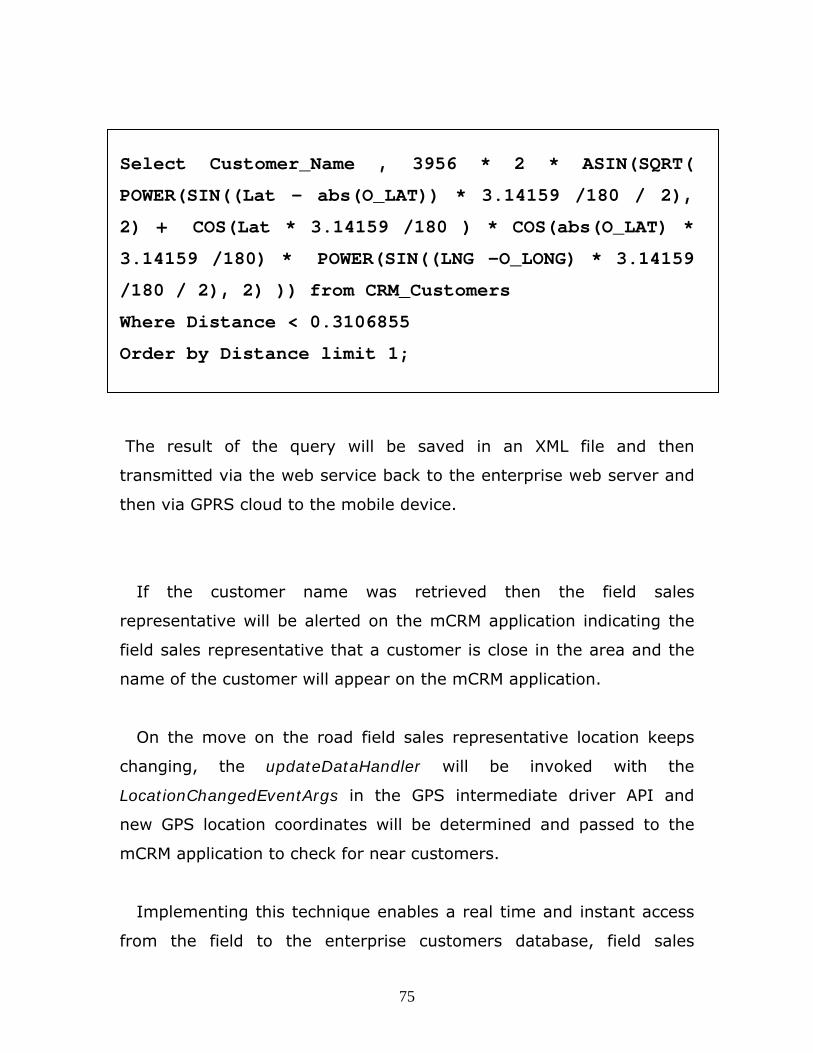
Select Customer_Name , 3956 * 2 * ASIN(SQRT(
POWER(SIN((Lat - abs(O_LAT)) * 3.14159 /180 / 2),
2) + COS(Lat * 3.14159 /180 ) * COS(abs(O_LAT) *
3.14159 /180) * POWER(SIN((LNG -O_LONG) * 3.14159
/180 / 2), 2) )) from CRM_Customers
Where Distance < 0.3106855
Order by Distance limit 1;
The result of the query will be saved in an XML file and then
transmitted via the web service back to the enterprise web server and
then via GPRS cloud to the mobile device.
If the customer name was retrieved then the field sales
representative will be alerted on the mCRM application indicating the
field sales representative that a customer is close in the area and the
name of the customer will appear on the mCRM application.
On the move on the road field sales representative location keeps
changing, the updateDataHandler will be invoked with the
LocationChangedEventArgs in the GPS intermediate driver API and
new GPS location coordinates will be determined and passed to the
mCRM application to check for near customers.
Implementing this technique enables a real time and instant access
from the field to the enterprise customers database, field sales
75

professionals who are constantly waiting and seeking for appointments
with current or potential customers can now access their data online
and update their CRM profiles by entering the transactions instantly,
faster response will be managed by field sales professionals in front of
the customers since the customer's profile is automatically retrieved
without having to perform search queries on site.
76

Chapter 6
Conclusions and Future Work
6.1 Conclusions
In this dissertation an integration technique between two stand-
alone systems on a mobile device was proposed and designed; the key
tools and technologies used in the integration between Global
positioning system and Mobile customer relationship management
were discussed, the key technologies were GPS hardware and
intermediate driver API, XML data storage files, web services, GPRS
cloud and GPS coordinates distance query.
Nowadays sales and service professionals in the field must be
equipped with the best possible information and access to customer-
facing business processes.
This work concludes that the integration technique between global
positioning system and mobile CRM application is feasible and obtained
using current technologies and an organization can use it's current
back end systems and networks infrastructure to deploy this
technique.
Also we believe that the designed integration technique in this
dissertation will add value and will be considered as an enhancement
on current CRM strategy, the following are some benefits for the
integration between GPS and mobile CRM applications on field sales
mobile devices:
77

1. Help mobile professionals accomplish more in less time – Freeing
up evenings and weekends that were previously spent on
administrative tasks that could not be achieved in the field.
2. Enable sales and service people in the field equipped with mobile
CRM integrated with GPS to find out what has happened with a
customer account anytime, on-the-fly since the customer profile
will be automatically retrieved on the spot.
3. Keep sales professionals connected even without them asking;
reduces downtime and keep them productive by providing them
with a mobile device capable of connecting to and interacting
with key corporate applications constantly along when they are
moving on roads.
4. When reps can answer questions and find information more
quickly and automatically once they are in the location of the
customer than competitors, the enterprise gains a significant
competitive edge
5. Keep sales professionals connected to reduce downtime and
keep them productive by providing them with customers
information to every place they go and being capable of
connecting to and interacting with customer relationship
management system.
78

6. For management empowering a field force with mobile CRM that
uses location coordinates as reference to customers helps
monitor performance through Real-time updates.
6.2 Future work
The basis for business intelligence and performance management is
that the underlying data in corporate systems such as CRM and ERP
are up-to-date. The integration technique discussed in this dissertation
added great value and advantages for the enterprise, this directs the
focus to develop similar integration techniques with other back end
systems to stay connected to and interacting with key corporate
applications such as ERP and enterprise financial systems to improve
their efficiency, performance and return on investment.
A potential investigation presents itself, if there was not much
limitation on time, there should be a more intelligent system which
provides in addition to the above illustrated integration technique
between GPS and mCRM, an intelligent technique to guide field and
sales professionals to the nearest customer recorded in the enterprise
data base according to their position as determined by the GPS, this
should be less time consuming, and more effective and reliable way of
doing sales filed tasks. Also studying the benefits and the efficiency of
the proposed scheme in this research on real organizations and how it
would improve their field tasks is another future work for us.
79
References
[1] Alberta efuture Centere, Customer Relationship management, eFuture Centere, Customer Relationship Management, http://www.e-future.ca/pdf/efc_customer_relationship_management.pdf (accessed in January 2009)
[2] Chaffey, D. (2007). "E-Business and e-Commerce Management -
Strategy, Implementation and Practice" (3rd ed.). England: Pearson
Education Limited.
[3] Clifford Will, Global Positioning system, http://www.eftaylor.com/pub/projecta.pdf (accessed in April, 2009)
[4] Don Panek, What is CRM?
www.crmdirectory.com/index.php/2006050610/FAQs/Examples/What-
is-CRM.html (accessed in March, 2009)
[5] Eric Williams, What is CRM?
http://searchcrm.techtarget.com/sDefinition/0,,sid11_gci213567,00.ht
ml , September 2008
[6] Francis Buttle, "Customer relationship management: concepts and tools", Published by Butterworth-Heinemann, 2004 [7] Garmin, "GPS beginners guide", 2008
http://www8.garmin.com/manuals/GPSGuideforBeginners_Manual.pdf [8] Günther Retscher and Esmond Mok," Integration of mobile phone location services into intelligent GPS vehicle navigation systems ", Vienna University of Technology, 2001 http://info.tuwien.ac.at/ingeo/pub/papers/cairo.pdf
80

[9] Jeff Dutrizac, Customer Think, "Mobile CRM Increases
Productivity", June 2005
http://www.customerthink.com/article/mobile_crm_increases_producti
vity
[10] Jerry Fjermestad, Nicholas Romano, "Electronic Customer
relationship management", published by M.E. Sharpe, 2006
[11] Jill Dyché, "The CRM handbook: a business guide to customer relationship management", Published by Addison-Wesley, 2001
[12] Microsoft Download site, Building the Business Case for Mobilizing Your Enterprise with Windows Mobile and .NET, December 2007
http://www.microsoft.com/downloads/details.aspx?familyid=437F3BBD-1FEE-4508-A607-02DE36A1600A&displaylang=en
[13] Microsoft Download site, Mobile Enterprise Application Architecture Guidance for Remote Communications in an Occasionally-Connected World, November 2006
http://www.microsoft.com/downloads/details.aspx?FamilyId=3C406E26-70AF-40F0-AA82-9AC924740368&displaylang=en
[14] Mohamamd Aamir Turk, "Data Mining and Mobile CRM: An Update", Blekinge Institute of Technology, April 2004 http://www.bth.se/fou/cuppsats.nsf/all/3e577380a9bb6901c12572d7004202b9/$file/MBA_Thesis.pdf
81

[15[ msdn Windows Embedded Developer Center,
http://msdn.microsoft.com/en-us/library/hf9hbf87(VS.71).aspx
(accessed in April 2009)
[16] msdn Windows Embedded Developer Center,
http://msdn.microsoft.com/en-us/library/bb202086.aspx (accessed in
April 2009)
[17] Puttre, J.(1997)."Can Internet standards bring EDI to everyone?"
Business Communications Review. 27(8).PP 23
[18] Sun Tutorials, The Jave TM Web Services Tutorial, http://java.sun.com/webservices/docs/1.6/tutorial/doc/JavaWSTutorial.pdf, (Accessed 25th Jan 2009) [19] w3schools, XML Separates Data from HTML http://www.w3schools.com/XML/xml_usedfor.asp , (accessed in April
2009)
[20] Wikipedia, GPRS
http://en.wikipedia.org/wiki/GPRS , (accessed in May 2009)
[21] Wikipedia, Web Service
http://en.wikipedia.org/wiki/Web_service , (accessed in April 2009)
[22] Wikipedia, Harversine Formula
http://en.wikipedia.org/wiki/Haversine_formula , (accessed in April
2009)
82

[23] Wikipedia, Global Positioning System
http://en.wikipedia.org/wiki/Global_Positioning_System , (accessed in
February 2009)
[24] Wikipedia, E-TEN glofish X500
http://en.wikipedia.org/wiki/E-TEN_glofiish_X500 , (accessed in
February 2009)
[25] Wikipedia, A-GPS
http://en.wikipedia.org/wiki/A-GPS , (accessed in February 2009)
[26] Wikipedia, Customer Relationship Management
http://en.wikipedia.org/wiki/Customer_Relationship_Management
(accesses in April, 2009)
[27] Wu Tie, "Implementing CRM in SMEs: An Exploratory Study on the Viability of Using the ASP Model", Swedish School of Economics and Business Administration 2003 http://www.pafis.shh.fi/graduates/tiewu01.pdf
[28] Yohannes Belachew, Amanda Hoang, Joseph Kourieh, "Mobile
Customer Relationship Management A study of barriers and facilitators
to mCRM adoption", February 2007
http://hj.diva-portal.org/smash/record.jsf?pid=diva2:4531
83

Appendix A Source Code
This appendix provides the source code of the proposed system in this thesis: A.1 GPS Application Code
The following is the GPS application code that uses the previously
described GPS functions and event handlers to receive the location
coordinates of the field sales representative, and sends the coordinates
to the enterprise servers through web services:
static void Main() { Application.Run(new Form1()); } private void exitMenuItem_Click(object sender, EventArgs e) { if (gps.Opened) { gps.Close(); } Close(); } private void Form1_Load(object sender, System.EventArgs e) { updateDataHandler = new EventHandler(UpdateData); status.Text = ""; status.Width = Screen.PrimaryScreen.WorkingArea.Width; status.Height = Screen.PrimaryScreen.WorkingArea.Height;
84
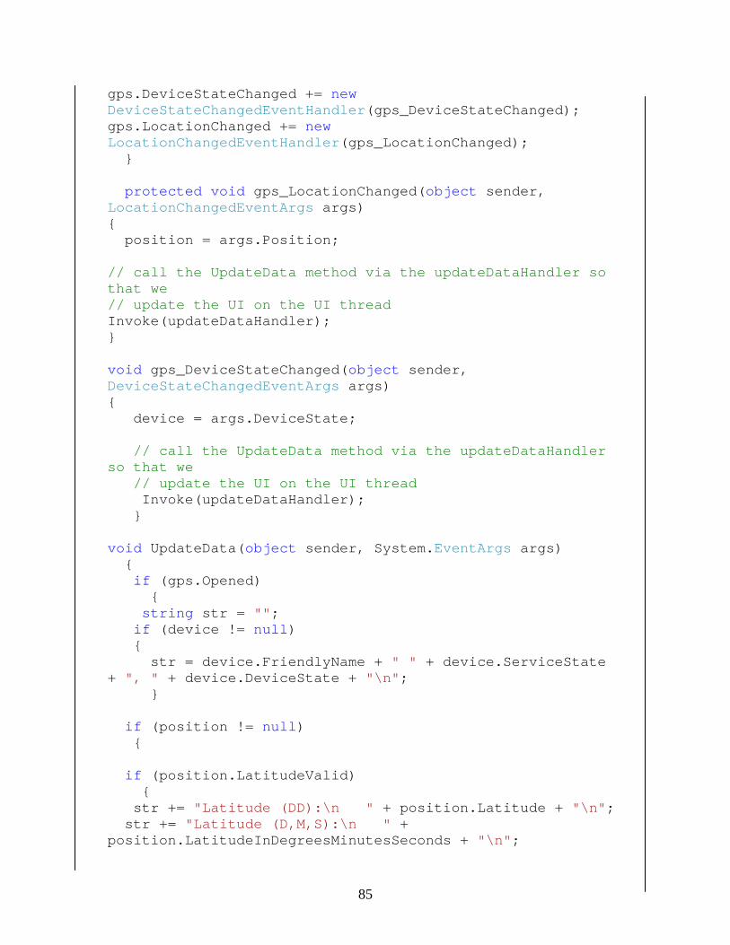
gps.DeviceStateChanged += new DeviceStateChangedEventHandler(gps_DeviceStateChanged); gps.LocationChanged += new LocationChangedEventHandler(gps_LocationChanged); } protected void gps_LocationChanged(object sender, LocationChangedEventArgs args) { position = args.Position; // call the UpdateData method via the updateDataHandler so that we // update the UI on the UI thread Invoke(updateDataHandler); } void gps_DeviceStateChanged(object sender, DeviceStateChangedEventArgs args) { device = args.DeviceState; // call the UpdateData method via the updateDataHandler so that we // update the UI on the UI thread Invoke(updateDataHandler); } void UpdateData(object sender, System.EventArgs args) { if (gps.Opened) { string str = ""; if (device != null) { str = device.FriendlyName + " " + device.ServiceState + ", " + device.DeviceState + "\n"; } if (position != null) { if (position.LatitudeValid) { str += "Latitude (DD):\n " + position.Latitude + "\n"; str += "Latitude (D,M,S):\n " + position.LatitudeInDegreesMinutesSeconds + "\n";
85

} if (position.LongitudeValid) { str += "Longitude (DD):\n " + position.Longitude + "\n"; str += "Longitude (D,M,S):\n " + position.LongitudeInDegreesMinutesSeconds + "\n"; } if (position.SatellitesInSolutionValid && position.SatellitesInViewValid && position.SatelliteCountValid) { str += "Satellite Count:\n " + position.GetSatellitesInSolution().Length + "/" + position.GetSatellitesInView().Length + " (" + position.SatelliteCount + ")\n"; } if (position.TimeValid) { str += "Time:\n " + position.Time.ToString() + "\n"; } valuestr= TestWeb.GetName(lat1, lng1); //str contains the position PNO2 = TestWeb.GetInfo(valuestr); } //status.Text = str; txtlat.Text = Convert.ToString(lat1); txtlong.Text = Convert.ToString(lng1); Name.Text = valuestr; PNO.Text = PNO2; } } private void Form1_Closed(object sender, System.EventArgs e) { if (gps.Opened) {
86

gps.Close(); } } private void stopGpsMenuItem_Click(object sender, EventArgs e) { if (gps.Opened) { gps.Close(); } startGpsMenuItem.Enabled = true; stopGpsMenuItem.Enabled = false; } private void startGpsMenuItem_Click(object sender, EventArgs e) { if (!gps.Opened) { gps.Open(); } startGpsMenuItem.Enabled = false; stopGpsMenuItem.Enabled = true;
}
87

A.2 Web services Definition
Define Web service in GPS Application:
public class Service :System.Web.Services.Protocols.SoapHttpClientProtocol {
/// <remarks/> public Service() { this.Url =
"http://86.108.14.195:81/Service.asmx"; } /// <remarks/> [System.Web.Services.Protocols.SoapDocumentMethodAttribute(
"http://tempur .org/HelloWorld", RequestNamespace="http://tempuri.org/", ResponseNamespace="http://tempuri.org/", Use=System.Web.Services.Description.SoapBindingUse.Literal, ParameterStyle=System.Web.Services.Protocols.SoapParameterS
tyle.Wrapped)] public string GetName(double Lat, double LNG) { object[] results = this.Invoke("GetName", new
object[] { Lat, LNG}); return ((string)(results[0])); }
Call the web service in GPS Application: Name= TestWeb.GetName(lat1, lng1); //Name contains
the Customer Name Phone = TestWeb.GetInfo(Name); //Phone contains the
customer's phone number Name.Text = Name; PNO.Text = Phone;
88

Web service Definition on the Web Server public class Service : System.Web.Services.WebService { public Service () { //Uncomment the following line if using designed components //InitializeComponent(); } [WebMethod] public string GetName(double Lat, double LNG) { double Distance = 0; OleDbConnection Myconnection = default(OleDbConnection); double _dbLat = 0; double _dbLng = 0; /*Myconnection = new OleDbConnection("Provider=Microsoft.Jet.OLEDB.4.0; User Id=; Password=; Data Source=C:\\Users\\user\\Documents\\test.mdb");*/ this is the connection string for microsoft access database /*OracleConnection Myconnection = new OracleConnection(); oOracleConn.ConnectionString = "Data Source=CRMDB;" + "Integrated Security=SSPI";*/ this is the connection string for oracle CRM database Myconnection.Open(); OleDbCommand cmd = new OleDbCommand(); { cmd.Connection = Myconnection; cmd.CommandText = "Select Customer_Name , 3956 * 2 * ASIN(SQRT( POWER(SIN((Lat - abs(O_LAT)) * 3.14159 /180 / 2), 2) + COS(Lat * 3.14159 /180 ) * COS(abs(O_LAT) * 3.14159 /180) * POWER(SIN((LNG -O_LONG) * 3.14159 /180 / 2), 2) )) from CRM_Customers
89

Where Distance < 0.3106855 Order by Distance limit 1"; cmd.CommandType = CommandType.Text; } OleDbDataReader myReader = cmd.ExecuteReader(); while (myReader.Read()) { try { Myconnection.Close(); return (string)myReader["Customer_Name"]; } catch (Exception ex) { Myconnection.Close(); return "Internal System Error, Please try later!"; } } Myconnection.Close(); return string.Empty; } }
90