georgia fire weather services operations plan fire weather services operations plan january 31, 2010...
TRANSCRIPT

Georgia Fire Weather Services Operations Plan
January 31, 2010
NWS Peachtree City, GA NWS Jacksonville, FL NWS Tallahassee, FL NWS Charleston, SC NWS Columbia, SC
NWS Greenville-Spartanburg, SC
Purpose
This Operating Plan serves as the official document governing interaction and relationships between the National Weather Service (NWS) offices that serve Georgia, and the federal, state and local land management agencies that rely on weather support in Georgia.
Relationship between the AOP and the Interagency Agreement
This Operating Plan is issued in lieu of a formal Memorandum of Understanding (MOU) between the National Weather Service, Forest Service, Fish and Wildlife Service, and other land management agencies that rely on fire weather support. The plan will also outline forecast operations and services available to customers. This includes products and formats, dissemination and coordination, and the responsibilities of customers.
This Operating Plan will be the governing document for fire weather procedures and cooperation among the following agencies:
National Weather Service
U.S. Forest Service
U.S. Fish and Wildlife Service
National Park Service
Department of Defense, U.S. Army
Georgia Forestry Commission
This Operating Plan for Fire Weather Services conforms with the Interagency Agreement for Meteorological Services, recertified in March, 2007. The Southern Area Mobilization Guide and the National Mobilization Guide further define the relationship between the wildland fire agencies and the NWS Incident Meteorologist.
Partners, Customers and Users
Partners, customers and users shall be defined as any person, group, agency or body which uses the products and services provided by the NWS in support of fire operations.
Service Area and Organizational Directory
Fire Weather Forecast Area
Forecast areas are tied to the "radar umbrella" of the WSR-88D Doppler Radar. The umbrella is the area which is covered by the radar volume scan. What this means is that forecasts are not bound by state political borders, although county borders are generally observed. The Georgia forecast areas are each covered by a different NWS office.
The counties covered by the WFO FFC (Peachtree City) include: Baldwin, Banks, Barrow, Bartow, Bibb, Bleckley, Butts, Carroll, Catoosa, Chattahoochee, Chattooga, Cherokee, Clarke, Clayton, Cobb, Coweta, Crawford, Crisp, Dade, Dawson, DeKalb, Dodge, Dooly, Douglas, Emanuel, Fannin, Fayette, Floyd, Forsyth, Fulton, Gilmer, Glascock, Gordon, Greene, Gwinnett, Hall, Hancock, Haralson, Harris, Heard, Henry, Houston, Jackson, Jasper, Jefferson, Johnson, Jones, Lamar, Laurens, Lumpkin, Macon, Madison, Marion, Meriwether, Montgomery, Monroe, Morgan, Murray, Muscogee, Newton, Oconee, Oglethorpe, Paulding, Peach, Pickens, Pike, Polk, Pulaski, Putnam, Rockdale, Schley, Spalding, Stewart, Sumter, Talbot, Taliaferro, Taylor, Telfair, Toombs, Towns, Treutlen, Troup, Twiggs, Union, Upson, Walker, Walton, Warren, Washington, Webster, Wheeler, White, Whitfield, Wilcox, Wilkes, Wilkinson
The counties covered by the WFO TAE (Tallahassee) include:
Baker, Ben Hill, Berrien, Brooks, Calhoun, Clay, Colquitt, Cook, Decatur, Dougherty, Early, Grady, Irwin, Lanier, Lee, Lowndes, Miller, Mitchell, Quitman, Randolph, Seminole, Terrell, Thomas, Tift, Turner, Worth
The counties covered by the WFO JAX (Jacksonville) include:
Appling, Atkinson, Bacon, Brantley, Camden, Charlton, Clinch, Coffee, Echols, Glynn, Jeff Davis, Pierce, Ware, Wayne
The counties covered by the WFO CHS (Charleston) include:
Bryan, Bulloch, Candler, Chatham, Effingham, Evans, Jenkins, Liberty, Long, McIntosh, Screven, Tattnall
The counties covered by the WFO GSP (Greenville-Spartanburg) include:
Elbert, Franklin, Habersham, Hart, Rabun, Stephens
The counties covered by the WFO CAE (Columbia) include:
Burke, Columbia, Lincoln, McDuffie, Richmond
National Weather Service Headquarters
NWS Headquarters, located in Silver Spring, Maryland, establishes policies and coordinates the national fire weather program. The national program manager coordinates the program with the regional program managers. The national program manager also works with the national headquarters of the Federal forestry and land management agencies and the Association of State Foresters in determining overall forestry and land management requirements for meteorological support. The national program manager coordinates national training in forestry and fire weather for NWS forecasters.

National Weather Service Regional Headquarters
Regional Headquarters manage the technical operational aspects of the fire weather program within each region. They also provide guidance and assistance to meteorologists-in-charge (MIC) on program operations and problems through Supplements to Directives and conferences. Regional Headquarters advise National Headquarters on matters pertaining to technical planning and operations. The regional program managers coordinate the regions' fire weather programs and advise the Regional Directors on the operational and administrative aspects of the regions' programs.
Weather Forecast Office (WFO)
Weather Forecast Offices prepare and disseminate forecast products for all sectors of the population, including those for the Fire Weather program. These offices are responsible for providing forecasts for user agencies within their County Warning and Forecast Area (CWFA). Most offices have a designated fire weather focal point or fire weather program leader. The National Weather Service Warning and Forecast Offices in Georgia will provide 24-hour, 365 days a year service. The NWS can be reached at:
National Weather Service 4 Falcon Drive Peachtree City, GA 30269 770-486-1133
National Weather Service Love Building Florida State University 116 Palmetto Drive Tallahassee, FL 32306 850-942-8833
National Weather Service 13701 Fang Drive Jacksonville, FL 32218 904-741-4370
National Weather Service 5777 South Aviation Avenue Charleston, South Carolina 29406 843-744-0303
National Weather Service 2909 Aviation Way West Columbia, South Carolina 29170 803-822-8135
National Weather Service 1549 GSP Drive Greer, South Carolina 29651 864-848-3859

Meteorologist-in-Charge (MIC)
The MIC is responsible for the provision of adequate forestry and fire weather services for the office's assigned area of program responsibility. The MIC will ensure that the focal point or program leader is provided adequate time for user liaison and assistance activities.
Lans P. Rothfusz, Peachtree City, GA
Paul Duval, Tallahassee, FL
Stephen Letro, Jacksonville, FL
Michael Emlaw, Charleston, SC
Kim Campbell, Columbia, SC
Larry Gabric, Greenville-Spartanburg, SC
Program Leader
Fire weather program leaders are the "customer service representatives" for the program. The program leader, as the representative of the MIC, is in regular contact with land management agencies, helping them assess their meteorological needs, informing them of NWS products and services available to meet these needs, and educating them in the most effective use of the various NWS products and resources, including NOAA Weather Radio (NWR). Program leaders will work with users to utilize existing NWS products and services produced for other programs that could meet the requirements of wildland management. The program leaders are also tasked with ensuring staff meteorologists are trained and remain proficient in preparing forecast products for support of the fire weather program.
Brian D. Lynn, Peachtree City, GA
Tim Barry, Tallahassee, FL
Marie Trabert, Jacksonville, FL
Bob Bright, Charleston, SC
Mike Proud, Columbia, SC John Tomko, Greenville-Spartanburg, SC
NOTE: Unlisted telephone numbers used for coordination cannot be listed here. All user agencies have been or will be provided voice and fax numbers to be used for official purposes only.

Services Provided by the National Weather
Service
Fire Weather Season
The fire weather season for Georgia is year round, with two distinct peak periods. The first begins in October, usually with the first killing frost of the season, and ends in early December with the beginning of the late autumn and early winter rain season. The second begins in late winter around the first of February and ends around mid to late May when full greening occurs. Since Georgia extends from the Appalachian Mountains to the Atlantic Ocean, and has an elevation range of over 4500 feet, these dates vary for different parts of the state. Despite the two distinct seasons for which fire weather support is required, planning forecasts will be prepared year round.
Fire Weather Forecasts
The National Weather Service issues three types of forecasts for Georgia: planning forecasts (or routine or daily forecasts), spot forecasts, and NFDRS forecasts
Planning Forecasts
The planning forecast (routine or daily forecast) is a general forecast issued at least twice daily, by 0700 LT in the morning and by 1530 LT in the afternoon. This forecast is used for day-to-day planning of land management operations and for determining general weather trends which might impact fire behavior. Counties usually will be grouped into distinct, climatologically homogeneous zones. Certain weather situations, however, will require changes in groupings to account for changing or unusual weather conditions. The planning forecast issued by a WFO will contain forecast values for the following weather elements: sky condition and weather; maximum and minimum temperatures; maximum and minimum relative humidities; wind speeds and directions; probability of precipitation and precipitation type. The forecast may also provide precipitation duration and amount; mixing heights; transport winds; inversion onset and burnoff times; inversion burnoff temperatures; ventilation rates; stability indices (i.e. Haines index and Davis index); Atmospheric Dispersion Index by Lavdas (ADI) , Low Visibility Occurrence Risk Index (LVORI) and Lightning Activity Levels (LAL).
Spot Forecasts
Spot forecasts are special, non-routine forecasts prepared upon request from user agencies that need site-specific weather forecasts for: 1) controlling the spread of wildfire; 2) planning and managing prescribed fires; or 3) other specialized forest management activities. Spot forecasts are highly detailed forecasts prepared for a specific location within the forecast area. The forecasts may contain any or all of the following weather elements: sky condition; maximum and minimum temperatures; maximum and minimum relative humidities; wind speeds and directions; probability of precipitation; precipitation type, duration and amount; mixing heights; transport winds; inversion heights; inversion onset and burnoff times; ventilation or smoke management levels; wind profiles; stability indices and lightning activity levels (LAL). In addition, the Hysplit computer model can be run for additional aid to smoke management. However, keep in mind this will take extra time and should be requested the previous day when possible.

Requests for Spot Forecasts
Spot forecasts for wildfire and prescribed burns will be prepared at any time when requested by a user agency, either by internet, phone, by fax or by some other agreed upon mode of communication. Because of the detailed and specific nature of this forecast product, it is imperative that the user provide the forecaster with necessary and sufficient information so that a reliable forecast can be prepared.
Requests for spot forecasts should be made by internet on the appropriate NWS WFO webpage, or as backup, on the Fire Weather Special Forecast Request form, WS_Form D-1. Required information on the request form should be filled out as completely as possible by the user agency prior to submitting the request to the forecast office. If the request is made verbally (by phone), all the essential information should be provided to the forecast office.
While there is no dedicated fire weather forecaster, the forecast office will give a high priority to spot forecasts in the absence of weather phenomena in the CWA that pose a threat to life and property. To ensure that the request for a spot forecast is handled promptly and appropriately, user agencies should adhere to the following guidelines.
1. Allow adequate time for the forecaster to prepare the forecast. This will normally be between twenty to thirty minutes. On particularly busy fire weather days, spot forecasts will be handled on a first-come, first-served basis, with wildfires taking the highest priority. 2. Provide as much on-site or near-site weather information as is possible. At a minimum, the user must provide at least one observation within an hour of the request. This observation must contain the following: location of observation; elevation at observation site; time of observation; wind direction and speed and level (eye or 20-foot); dry and wet bulb temperatures; any remarks about the state of the weather, especially anything that might affect the fire behavior. If possible, include some observations from the previous day that might give the forecaster an indication of daily trends. 3. Specify, as much as possible, the time period for which the forecast is needed. 4. Specify, as much as possible, the weather elements of most importance for which a forecast is needed and/or critical values of these elements. 5. Provide a contact point name and phone number where the forecaster can call back, if necessary. Also include a fax number for returning completed forecasts as a backup to internet. 6. When faxing requests, call the office to let them know the fax is on its way. The forecaster is not always near the fax machine and might not discover the request in a timely manner.
National Fire Danger Rating System (NFDRS) Forecasts
Issuance
The land management agencies will determine which observation sites (normally RAWS sites) will be NFDRS sites. Initiation of NFDRS forecasts for a new site will be coordinated with the NWS, and the agency requesting new NFDRS service will provide the NWS with information about the site location.

Contents
The NFDRS forecast will be a forecast of the next day observation at 1300 LST. The forecast will include expected state of weather, temperature, relative humidity, wind speed and direction at 1300 LST. The forecast also includes the expected lightning activity level for the next day and a half, the 24 hour maximum and minimum temperature and relative humidity, the 24 hour precipitation duration, and whether fuels will be wet (wet flag) at 1300 LST.
Procedures
The land management agencies are responsible for taking, quality controlling, transmitting and archiving the NFDRS observations. Forecasts will only be prepared for predetermined sites. The NWS will prepare and transmit the NFDRS forecasts no later than 1530 LT. Although the data cutoff time for ingest into the NFDRS software is 1900 LT, preliminary calculations based on the forecast are used by the land managers to make staffing decisions by shift briefing time(1600 LT).
Fire Weather Watches and Warnings
During periods in which critical fire weather conditions are expected or are imminent, the NWS will issue watches and warnings to describe the level of urgency to the appropriate user agencies. These are usually coordinated with the land management agencies.
Definition of Red Flag Event
A Red Flag Event occurs when critical weather conditions develop which could lead to extensive wildfire occurrences or to extreme fire behavior. Red Flag Events represent a threat to life and property and may adversely impact fire fighting personnel and resources. While there are not uniformly accepted criteria for a red flag event in the Southeast, these criteria represent the requests of many user agencies. Critical weather conditions include combinations of the following: strong and/or gusty winds; low relative humidities; significant wind shifts; dry lightning. Typically, these weather conditions must be coupled with low fuel moistures, as determined by the appropriate land management agency.
For Red Flag Criteria in Georgia, the following weather criteria must be occurring or forecast to occur, in addition to the fuel moisture criteria: For WFOs Peachtree City, GA and Greenville-Spartanburg, SC: 1. Minimum relative humidity of 25 percent or less for 4 or more consecutive hours. OR 2. Sustained ASOS* surface winds of 20 mph or greater and/or frequently gusting 25 mph or greater. AND 3. 10 Hour fuel moisture of 10 percent or less. For WFO Columbia, SC: 1. Minimum relative humidity of 25 percent or less for 4 or more consecutive hours. AND

2. Sustained ASOS* surface winds of 20 mph or greater and/or frequently gusting 25 mph or greater. AND 3. 10 Hour fuel moisture of 10 percent or less. For WFO Charleston, SC: 1. Minimum relative humidity of 25 percent or less. AND 2. Sustained ASOS* surface winds of 20 mph or greater and/or frequently gusting 30 mph or greater. AND 3. 10 Hour fuel moisture of 10 percent or less. For WFO Jacksonville, FL: 1. Minimum relative humidity of 30 percent or less.** AND 2. Sustained ASOS* surface winds of 20 mph or greater and/or frequently gusting 25 mph or greater. For WFO Tallahassee, FL: Cool Season criteria (November 1 - April 30): 1. Minimum relative humidity less than 25 percent for 4 or more consecutive hours.** OR 2. Relative humidity less than 25 percent concurrent with sustained ASOS* surface winds of 20 mph or greater and/or frequently gusting 25 mph or greater (no time restrictions).** Warm Season criteria (May 1 - October 31): 1. Minimum relative humidity of 30 percent or less.** AND 2. Sustained ASOS* surface winds of 20 mph or greater and/or frequently gusting 25 mph or greater. *Note: ASOS stands for “Automated Surfacing Observing System”. This is a 10 meter 2 minute average wind system at airports and is the most representative of the large scale winds.

**Note: For WFOs Jacksonville and Tallahassee: Critically dry fuels in south Georgia are highly dependant on one hour fuel moisture, which is directly determined by the relative humidity. Therefore, critically dry relative humidities are equivalent to critically dry fuels.
The forecaster should usually coordinate with the affected customers, and come to an agreement on a Red Flag decision. Fuel moisture is usually determined by the land management agencies, however the forecaster should use 10 hour fuel moistures of 10 percent or less as a first guess for critically dry fuels. The exception to this is the Tallahassee and Jacksonville Florida areas of South Georgia where relative humidities determine critically dry fuels.
Red Flag Warning
A Red Flag Warning shall be issued, usually after coordination with the appropriate land management agencies, when a Red Flag Event is occurring or is imminent. The warning shall be issued for all or a portion of the forecast area. It shall be issued as soon as possible, usually within 15 minutes, once the forecaster has determined that a Red Flag Event is ongoing. Otherwise, it shall be issued for impending Red Flag conditions when there is a high degree of confidence that conditions will develop within the next 24 hours but not more than 36 hours. The warning shall continue until the conditions cease to exist or fail to develop as forecast. At such time, the warning shall be cancelled.
Fire Weather Watch
A Fire Weather Watch shall be issued, usually after coordination with the appropriate land management agencies, to advise of the possible development of a Red Flag Event in the near future. It shall be issued for all or a portion of the forecast area. The Fire Weather Watch is issued when the forecaster is reasonably confident that a Red Flag Event will occur. A watch should be issued 12 to 96 hours in advance of the expected onset of the critical weather conditions. The watch shall remain in effect until the forecaster determines that either the Red Flag Event will not develop or that the watch should be upgraded to a warning. If conditions are not expected to occur as forecast, the watch shall be cancelled.
Fire Danger Statement
When fuels are critically dry and near-critical fire weather conditions are expected, the NWS may issue a Fire Danger Statement, usually after coordination with the appropriate land management agencies. General weather criteria for such statements will be RH less than 30% (35% for parts of South Georgia) and/or 15 mph or greater sustained winds. The NWS will use the Special Weather Statement (SPS) product for issuing Fire Danger Statements. A Fire Danger Statement will NOT be issued if a Red Flag Warning or Fire Weather Watch is in effect.
Communications
The primary means of communication used by the NWS is Advanced Weather Interactive Processing System (AWIPS). Products transmitted through AWIPS include: planning forecasts, NFDRS forecasts, Fire Weather Watches, Red Flag Warnings and Fire Danger Statements.
Spot forecasts will be disseminated only to the requesting agency by means of internet, or as a backup, telefax (FAX). Therefore, anytime a request for a spot forecast is made, the requesting agency must include a FAX number. A voice number should also be included in the event problems arise with the FAX transmission.

Public products produced by the National Weather Service are available over NOAA Weather Radio (NWR). As of January 31, 2010, the following NWR transmitters service Georgia.
Site Call Sign Frequency NWS office
Americus WXJ30 162.425 Peachtree City, GA
Ashburn KWN50 162.450 Tallahassee, FL
Athens WXK56 162.400 Peachtree City, GA
Atlanta KEC80 162.550 Peachtree City, GA
Augusta WXK54 162.550 Columbia, SC
Baxley WXM65 162.525 Jacksonville, FL
Blakely KZZ70 162.525 Tallahassee, FL
Blue Ridge KXI75 162.475 Peachtree City, GA
Brasstown Bald Mtn KXI22 162.500 Peachtree City, GA
Brunswick WWH39 162.425 Jacksonville, FL
Buchanan WWH23 162.425 Peachtree City, GA
Chatsworth WXK52 162.400 Peachtree City, GA
Chattanooga, TN WXK48 162.550 Knoxville/Tricities, TN
Clayton KXI81 162.450 Greenville/Spartanburg, SC
Cleveland WXJ53 162.525 Peachtree City, GA
Columbus WXM32 162.400 Peachtree City, GA
Eastman KXI77 162.400 Peachtree City, GA
Eatonton KXI89 162.525 Peachtree City, GA
Jesup WXJ28 162.450 Jacksonville, FL
La Grange KXI76 162.450 Peachtree City, GA
Macon WXK71 162.475 Peachtree City, GA
Metter WWH25 162.425 Charleston, SC
Mt. Cheaha, AL KIH58 162.475 Birmingham, AL
Greenville, SC WXJ21 162.550 Greenville/Spartanburg, SC
Pelham WXK53 162.550 Tallahassee, FL
Sandersville KXI28 162.450 Peachtree City, GA
Savannah KEC85 162.400 Charleston, SC
Taylor's Ridge WXJ72 162.450 Peachtree City, GA
Thomaston WXJ31 162.500 Peachtree City, GA
Toccoa WWH24 162.425 Greenville/Spartanburg, SC
Valdosta WXM79 162.500 Tallahassee, FL
Waycross WXK75 162.475 Jacksonville, FL
Waynesboro WXM88 162.425 Columbia, SC
Washington KPS506 162.500 Peachtree City, GA
Other means of communications may be utilized upon mutual agreement with user agencies.

Participation in Interagency Groups
The NWS and its customers will meet from time to time, for the purpose of reviewing the operational relationships agreed to in this plan, and as partners in other interagency meetings.
Meetings may be between one NWS office and all of its customers from several states, a state meeting of all NWS offices and fire weather customers within one state, or a meeting conducted by a customer group with the NWS offices invited either individually or collectively.
Customers may at times invite NWS representatives to serve on an interagency group at either the state or national level. These groups may serve a variety of purposes, such as program review, service evaluation, scientific advisory or joint decision making.
Specialized Services
Special Fire Weather Services
Special fire weather services are those services that are uniquely required by land management agencies and go beyond the normal forecast operations of the NWS. Special services include Advanced Technology Meteorological Unit (ATMU), All-Hazards Meteorological Response System (AMRS) and Incident Meteorologist (IMET) deployment, station visits, weather observer training, participation in user agency personnel training, and other pertinent meteorological services.
Typically, special services require NWS personnel to be away from the Forecast Office and, in some instances, be in overtime status. User agencies are responsible for covering the cost of NWS overtime, travel and per diem expenses. Reimbursement of costs for special services will be as outlined in the Interagency Agreement for Meteorological Services.
ATMU, AMRS, IMET Services
The Advanced Technology Meteorological Unit (ATMU) is a modularized and mobile system of equipment used by an Incident Meteorologist (IMET) for data collection and product preparation. The ATMU is a national resource. ATMUs are cached around the country, mostly in the western states. The nearest ATMU cache to Georgia is London, KY, where two are maintained.
The ATMU consists of a theodolite with a tripod, a belt weather kit, Pibal weather balloons, a nozzle and regulator for a helium tank. A second module, known as the All-hazards Meteorological Response System (AMRS), contains a laptop computer, a portable satellite communication system for obtaining weather data, a printer and office supplies and miscellaneous expendables. This module is also a national resource, but is located at the National Weather Service offices that have an IMET on station.
Requests for the ATMU, AMRS, and IMET should be made through the USDA Forest Service Region 8 Dispatch. Typically, the IMET nearest the incident will be deployed. However, during times of limited resources, IMETs from other areas of the country may be called. The decision will be made by the National Fire Weather Operations Coordinator (NFWOC) in conjunction with the MIC and IMET from the affected offices.
The mobilization of the ATMU, AMRS and the IMET is coordinated through the Southern Area Interagency Coordination Center, the Southern Area Interagency Fire Cache, and the Interagency State Coordination Center. Demobilization is coordinated at the incident. For more specific information, reference the Southern Area and the National Interagency Mobilization Guides.

The requesting agency is responsible for any storage of the unit while in transit, and shelter for the IMET and unit at the site. A sheltered work area, of at least 50 square feet with a table and chair, must be protected from excessive dust, free of standing water or condensation, and must be heated and/or cooled sufficiently to allow efficient operation of equipment. Power (120V AC) must be provided for the AMRS electrical equipment and priority telephone access during certain short periods each day must be made available.
Upon arrival at the incident and after going through the appropriate check-in procedures, the IMET will:
1. Brief the Fire Behavior Analyst (FBAN), Planning Section Chief (PSC), and the Incident Commander (IC) on current and expected weather as it affects the fire. 2. Establish a schedule with the PSC and the FBAN for written forecasts and formal briefings. 3. Request a briefing of the fire situation and potential behavior problems from the FBAN. As time and resources permit, incident management should arrange for an areal inspection trip for the meteorologist and should provide the forecaster with current fireline maps. If possible, the IMET should be assigned a radio with the fireline frequency. 4. Arrange for a schedule of observations from key points around the fire and from nearby lookouts and fire danger stations, in cooperation with the FBAN and PSC. On large fires, some personnel (at least two) should be permanently assigned to this duty. On smaller fires, this information can be provided by Division Supervisors equipped with belt weather kits.
Fire Weather Training
NWS meteorologists will be available to assist in user-oriented training, such as at fire behavior schools (e.g. S-290, S-390, S-490), and weather related courses. Requests should be made through the Meteorologist-in-Charge as early as possible after dates for such training have been determined.
Other Special Services
Other special services include weather station visits by user agency personnel, weather observer training, and course development work. These activities would typically be at the full expense of the requesting agency unless other arrangements have been made.

Wildland Fire Agency Responsibilities
Operational Support and Predictive Services
Program Management
The wildland fire agencies will oversee the fire weather observation program, including the siting and maintenance of the observing equipment, fire weather training of their personnel, and the proficiency of their personnel in the use of the NWS Spot software.
Monitoring, Feedback and Improvement
Land management agencies will monitor the quality and timeliness of NWS fire weather products, and provide feedback to the NWS in order to improve services to the agencies.
Technology Transfer
The wildland fire agencies may from time to time advise the NWS of new technologies being implemented to monitor meteorological or fuel parameters, or to improve communication, coordination, training or reference. Wildland fire agency personnel may, with prior arrangement, visit a NWS office to acquire knowledge of NWS technologies used in the monitoring of weather, or the preparation of products.
Agency Computer Resources
Internet will be the primary method of obtaining the Fire Weather Forecast, Red Flag Warning, Fire Weather Watch, and for both requesting and receiving a Spot Forecast. As a backup method, a request can be made to the weather service for a product to be faxed to the customer agency. NFDRS can be accessed through the WIMS website.
Fire Weather Observation Stations
Fire weather observation stations provide the specialized weather observations for fire weather forecasts, wildfire control and suppression, and various other land management operations. These stations were selected very carefully in each state and federal district. Sites were chosen to represent homogeneous weather conditions across a district. Stations may either be manned sites operated by land management agencies, or unmanned Remote Automated Weather Stations (RAWS) maintained by any of the federal or state land management agencies in the area.
All observation stations are assigned a 6-digit identification/location number. The first two digits indicate the state, the second two digits indicate the county, and the last two digits indicate the consecutively-assigned station number for that county. Land managers who wish to have a number assigned to a station should contact the GACC meteorologist at SACC in Atlanta.
RAWS stations are also assigned an 8 character alphanumeric identifier based on satellite transmission time (the DCP number, issued by the National Environmental Satellite Service (NESS)).
Observations from a satellite telemetered RAWS will automatically flow into WIMS via the NESDIS ID. Observations are only entered manually if the RAWS is a manual station. The RAWS owner currently must enter WIMS and manually change a recorded observation (an R ob) to an

observed observation (an O ob), manually enter the state of the weather, and save the observation to WIMS. This action is generally applied only to the daily 1300 hour observation.
As a part of the ongoing reprogramming efforts in WIMS, the change from R to O will soon be completely automated and a State of the Weather (SOW) will be computed (in part) from solar radiation data. Once that change is implemented, manual daily entry in WIMS will no longer be necessary for satellite telemetered stations. If a station is not satellite telemetered, the entire 1300 hour observation must be manually entered into WIMS. Non-NFDRS stations are naturally exempt from these procedures.
Even with automated conversion to O type observations, the responsibility still rests with the RAWS owner to ensure that observations are being transmitted, recorded, and archived properly in WIMS. The additional automation will greatly simplify the daily process, however there will still be the need for observations to be checked for integrity and consistency. Managing the NFDRS model parameters will still be a manual process in WIMS. Automation of O type observations will help streamline the WIMS collective that is distributed to the NWS via AWIPS. NFDRS forecasts are based on RAWS observations that appear on the daily collective.
Sensor failure will often result in erroneous or (at best) suspicious values. If the NWS becomes aware of such a situation, it is prudent to contact the station owner. Similarly, if a station owner becomes aware of a sensor failure, he should relay that information to the appropriate NWS office. It is that station owner's responsibility to make sure that their station is and remains in good working order and that repairs are made in a timely manner. Owners of NFDRS stations can still (and should) correct any errors in their respective observations.
Training Personnel and Maintaining Sites
The responsibility of training observers will be with the user agencies. However, the NWS will be available to assist when requested to do so. Any expenses incurred by the NWS will normally be charged to the user agency, unless other arrangements have been made.
The user agencies are also responsible for maintaining observation site equipment. NWS personnel may accompany the user on maintenance trips or for annual inspection visits which could also serve as liaison with the users.
Supplies
Most items for taking and recording observations will be furnished by the user agency. The NWS will furnish a few select forms and/or charts upon request.

Joint Responsibilities
Joint responsibilities include the following:
Meetings between the NWS offices and the land management agencies
Periodic meetings should be held between the National Weather Service program leaders and representatives of the land management agencies.
Maintenance and revision of the Georgia Annual Operating Plan
The AOP should be revised each year by the end of January, with cooperation and participation from each NWS office and land management agency.
Agreements on services provided
Agreements may be achieved by a series of meetings or by other means such as telephone or e-mail. NWS offices and land managers should be aware of the ripple effect an agreement might have on other NWS offices or customers.
Training
Land management agencies and the NWS collaborate on training of personnel in each others fields of expertise, operations, and equipment. Visits to offices and work centers, as well as field job sites can meet part of these training requirements.
Service evaluation
Services provided by the NWS, and delivery of observations and information from the land management agencies to the NWS in support of these services, shall be under constant evaluation by both parties.
Numbering and archiving of observation stations
The GACC, when requested to do so by a land management agency, shall assign a station ID number for fire weather observation platforms.
The land management agency will provide the station name, location (county, latitude, and longitude), and elevation to the GACC meteorologist.
The GACC meteorologist will assign the number and assist the station owner in establishing a station catalog in WIMS.
The numbering convention uses a six digit number, starting with 09 (for GA). The following two digit number designates the county, and the counties are numbered from 01 in the northwest, to 99 in the southeast.
The GACC meteorologist is responsible for maintaining a database of RAWS stations in his area. This information can be provided to the NWS regional program manager upon request.

The master list for the state will be the list included in the appendix of this operating plan, which will be updated at least annually with any new or changed stations. A copy of the county numbering map for the state of GA will be kept on file at the GACC and each NWS office serving GA.

Effective Date of the AOP
This Operating Plan will be effective through the calendar year specified. It will be revised annually by January 31, or more frequently as operations warrant.

Signature Page
The following signatories have accepted this Annual Operating Plan for Georgia, dated January 31, 2009. Terms and conditions in this plan are subject to review by the National Weather Service and the land management agency customers on at least an annual basis, or more frequently as operations require.
Appendices
Interagency Agreement for Meteorological Services
Map of Fire Weather Zones
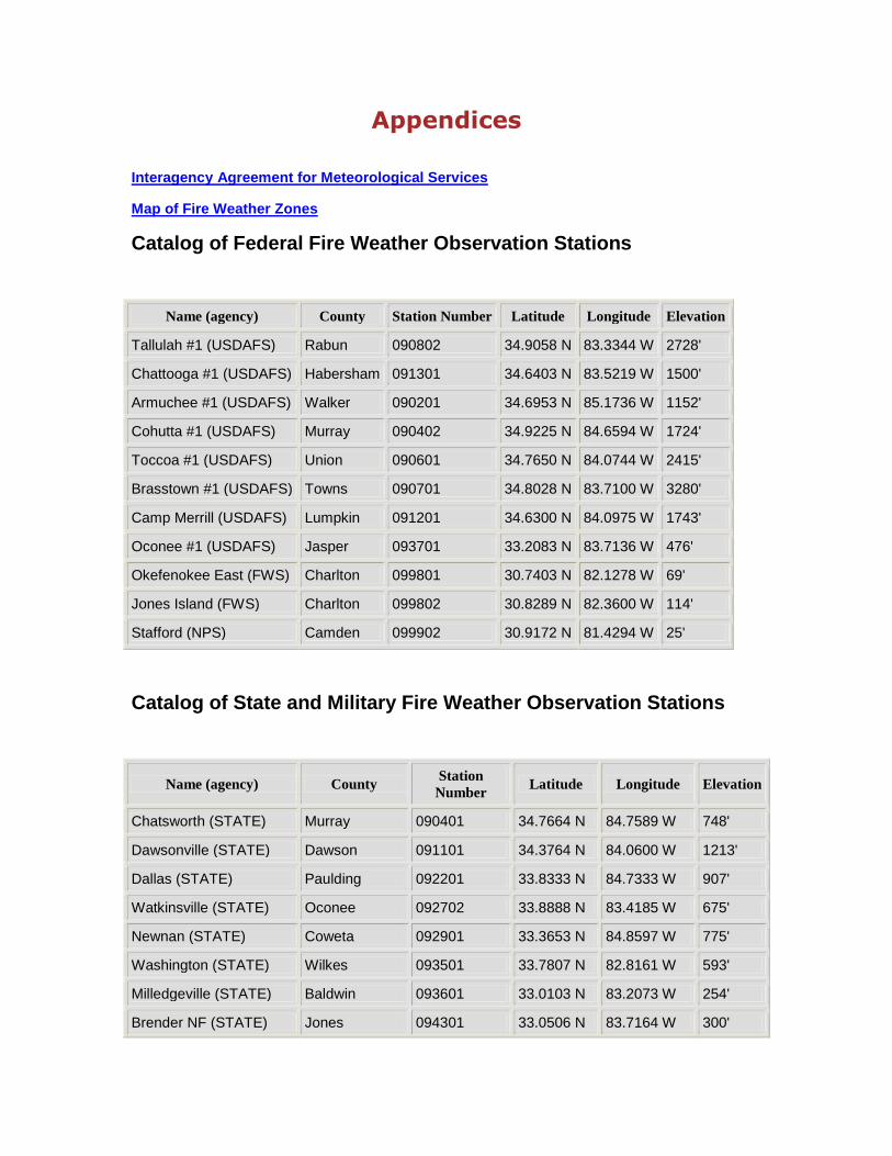
Catalog of Federal Fire Weather Observation Stations
Name (agency) County Station Number Latitude Longitude Elevation
Tallulah #1 (USDAFS) Rabun 090802 34.9058 N 83.3344 W 2728'
Chattooga #1 (USDAFS) Habersham 091301 34.6403 N 83.5219 W 1500'
Armuchee #1 (USDAFS) Walker 090201 34.6953 N 85.1736 W 1152'
Cohutta #1 (USDAFS) Murray 090402 34.9225 N 84.6594 W 1724'
Toccoa #1 (USDAFS) Union 090601 34.7650 N 84.0744 W 2415'
Brasstown #1 (USDAFS) Towns 090701 34.8028 N 83.7100 W 3280'
Camp Merrill (USDAFS) Lumpkin 091201 34.6300 N 84.0975 W 1743'
Oconee #1 (USDAFS) Jasper 093701 33.2083 N 83.7136 W 476'
Okefenokee East (FWS) Charlton 099801 30.7403 N 82.1278 W 69'
Jones Island (FWS) Charlton 099802 30.8289 N 82.3600 W 114'
Stafford (NPS) Camden 099902 30.9172 N 81.4294 W 25'
Catalog of State and Military Fire Weather Observation Stations
Name (agency) County Station
Number Latitude Longitude Elevation
Chatsworth (STATE) Murray 090401 34.7664 N 84.7589 W 748'
Dawsonville (STATE) Dawson 091101 34.3764 N 84.0600 W 1213'
Dallas (STATE) Paulding 092201 33.8333 N 84.7333 W 907'
Watkinsville (STATE) Oconee 092702 33.8888 N 83.4185 W 675'
Newnan (STATE) Coweta 092901 33.3653 N 84.8597 W 775'
Washington (STATE) Wilkes 093501 33.7807 N 82.8161 W 593'
Milledgeville (STATE) Baldwin 093601 33.0103 N 83.2073 W 254'
Brender NF (STATE) Jones 094301 33.0506 N 83.7164 W 300'

Louisville (STATE) Jefferson 094501 32.9752 N 82.3528 W 197'
Americus/Plains(STATE) Sumter 095501 32.1106 N 84.1841 W 526'
Byromville (STATE) Dooly 095701 32.1681 N 83.9747 W 500'
McRae (STATE) Wheeler 096201 32.0964 N 82. 8841 W 250'
Metter (STATE) Candler 096301 32.3913 N 82.0373 W 99'
Midway (STATE) Liberty 096801 31.7842 N 81.4386 W 20’
Baxley (STATE) Appling 097701 31.7136 N 82.4211 W 109'
Camilla (STATE) Mitchell 098201 31.2141 N 84.2362 W
62'
Adel (STATE) Cook 098401 31.1097 N 83.4269 W 154'
Sterling (STATE) Glynn 098801 31.2569 N 81.6106 W 7'
Waycross (STATE) Ware 099701 31.2466 N 82.4014 W 125'
Fort Benning (Military) Chattahoochee None 32.3967 N 84.8700 W 467’
List of Contacts
U.S. Forest Service Chattahoochee-Oconee National Forests 1755 Cleveland Highway Gainesville, GA 30501 770-297-3000 / 3036 770-534-7480 (FAX) Drag B. Sharp, Fire Management Officer Mike A. Davis, Assistant Fire Management Officer
Southern Area Coordination Center (SACC) 1200 Ashwood Parkway Suite 230 Atlanta, GA 30338 678-320-3000 678-320-3036 (FAX) Denver Ingram, Predictive Services Kevin Scasny, Predictive Services
US Fish and Wildlife Service Savannah Coastal Refuges 694 Beech Hill Lane Hardeeville, SC 29927 Terri Jenkins, 843-784-9911 X 105 Keith Penrose, 843-784-6351
Okefenokee National Wildlife Refuge Rt. 2 Box 3330

Folkston, GA 31537 912-496-7366 Mike Housh, Supervisory Forester/Fire Management Officer Vacant, Asst. Fire Management Officer
DPW, Environmental Division Forestry Branch Fort Stewart 2031 GA Highway 144 East Fort Stewart, GA 31314-4928 912-435-8063 912-435-8025 (fax) [email protected] David Pope
Georgia Forestry Commission Macon Office 5645 Riggins Mill Road Dry Branch, GA 31020 or P. O. Box 819 Macon, GA 31202-0819 478-751-3508 Daniel Chan