geographic information and services developments...
TRANSCRIPT

IDEE
1
Consejo Superior Geográfico
Sebastián Mas
Chairman Geomatic Commision
National Geographic High Council
Geographic Information and ServicesDevelopments on a National Level,
what the future holds.
04.06.2007 CROSS SIS Closure Meeting

IDEE
2
Consejo Superior GeográficoSummary
At this moment.IDEE
Architecture
Organisation and NSDI Authority
The Game Rules and Components
IDEE Geoportal
Harmonisation on data policies. NationalProjects.
PNOA
PNT
SIOSE
CARTOCIUDAD
The future04.06.2007 CROSS SIS Closure Meeting

IDEE
3
Consejo Superior Geográfico
GI structure composed of data distributed in different GIS systems.
Accessible via Internet with a minimum of protocols and standardized specifications.
Spatial Data Infrastructure
It includes:Data & MetadataSearch and access
technologiesCommon Standards &
SpecificationsAgreements among data
producers and betweenproducers and stakeholders.
04.06.2007 CROSS SIS Closure Meeting

IDEE
4
Consejo Superior GeográficoAccording to INSPIRE principles
DG ENV
04.06.2007 CROSS SIS Closure Meeting

IDEE
5
Consejo Superior Geográfico
Data gathers once and maintained in the level where maximum effectiveness is achieved.It should be possible to combine GI from diverse sources, seamless over a wide territoryIt should be possible to share the GI among users and applications.It should be possible that the information gathers in a level or sector is shared by the other ones.It should be easy to discover the available GI and the price and conditions to use it.GI should be abundant and available under conditions that they don't inhibit its extensive use
BCN25
SIGCA
Inventario forestal
SITNA
IGN
Cadastre
G.D.Biodiversity
Navarra Government
INSPIRE principles
Streets & Pois
Zaragoza
04.06.2007 CROSS SIS Closure Meeting
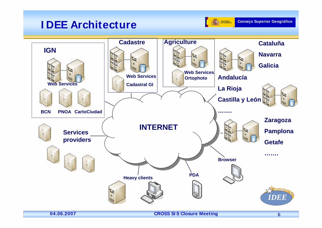
IDEE
6
Consejo Superior Geográfico
IGN
Web Services
BCN PNOA CartoCiudad
Cadastre Agriculture
Web Services
Cadastral GI
Web ServicesOrtophoto
Cataluña
Navarra
Galicia
Andalucía
La Rioja
Castilla y León
…….Zaragoza
Pamplona
Getafe
…….
Servicesproviders
INTERNET
Heavy clients PDA
Browser
IDEE Architecture
04.06.2007 CROSS SIS Closure Meeting

IDEE
7
Consejo Superior Geográfico
Public Administration in Spain
1) National LevelA.G.E
2) Regional Level17 AutonomousRegions2 Autonomous Cities
3) Local Level8 111 Municipalities47 Provincial Gov.Consells InsularsCabildos
Spanish distributed GI production & management
04.06.2007 CROSS SIS Closure Meeting

IDEE
8
Consejo Superior Geográfico
National: IDEE (Infraestructura de Datos Espaciales de España)Regional: Cataluña, Navarra, La Rioja, Galicia, País Vasco, Andalucía, C. Valenciana, Castilla y León, Castilla-La Mancha, Aragón, Extremadura, Madrid, Baleares, CanaryIslands, Murcia, Asturias, Cantabria.Local: Zaragoza, Pamplona, Getafe, Cataloniamunicipalities, Geopista …Sectorial: Cadastre, Environment, Civil Protection & Emergencies, Public Health, Tourism, Universities, Public& Private Companies, …
¿Who need to set up a SDI in Spain?.
04.06.2007 CROSS SIS Closure Meeting

IDEE
9
Consejo Superior GeográficoIDEE: The National SDI
According to the Spanish AdministrativeOrganisation:
• Who can develop and coordinate an NSDI that gathers the every government level´s interests?● Who can act as authority of the NSDI and to coordinate and guarantee its development in front of European Union, United Nations, etc?
CONSEJO SUPERIOR GEOGRÁFICO(National Geographic High Council)
04.06.2007 CROSS SIS Closure Meeting

IDEE
10
Consejo Superior Geográfico
“Consejo Superior Geográfico”(National Geographical High Council)
Advisory collegiate body supported by the Ministry of Infrastructures and Transports.Setting up by R.D. 1792/1999Members:
President: SubSecretary Ministry of Infrastructures and Transports1st VicePresident: Director General of Nat. Geographic Institute2nd VicePresident: Director of Hydrographic Institute of ArmyRepresentatives from Ministries:Foreign Affaires, Public Administration, Economy & Finances(Cadastre, National Statistical Institute), Environment, Agriculture, Interior (State Civil Defence Office), Defence, Education.17 Representatives from Regional Governments2 Representatives from Federation of Provinces and Municipalities (Local Authorities)
Technical Secretariat: IGN Spain
04.06.2007 CROSS SIS Closure Meeting

IDEE
11
Consejo Superior Geográfico
Commission on Geomatic(Executive Board to implement
NSDI (IDEE))Objective:
To define a Spanish NDSI joining initiatives and GI producersAccording a decentralised transparent architectureBased on data harmonisation and systemsinteroperability
Commission on Geomatic set up WG IDEE Report and advise NGHC
WG IDEE members: Experts from NGHC members, academia and companies dealing with SDI technology
04.06.2007 CROSS SIS Closure Meeting

IDEE
12
Consejo Superior GeográficoThe Game Rules
INSPIRE Principles & guidelinesISO 19100 standards
Adopted as EN (CEN/TC287) and UNE (AEN/CTN148)
OGC specificationsWMS, CWS, GAZ, WFS, WCS, SWE, GLDS, InterClient,…
NGHC WG recommendations (proposed by IDEE WG)Based on consensusIDEE ArchitectureSDI Minimum ServicesSpanish Core Metadata (NEM)Spanish Gazetteer Model (MNE)
04.06.2007 CROSS SIS Closure Meeting

IDEE
13
Consejo Superior Geográfico
Spanish NSDI GeoPortal (IDEE): www.idee.es

IDEE
14
Consejo Superior GeográficoIDEE Components
GI Information:Reference Information (Annexes I & II INSPIRE)
Harmonisation on data policies, licensing and pricing, agreements fordata availability and accessibility.
Thematic Information (Annexe III INSPIRE)MetadataStandardsArchitecture:
Metadata Catalogue,Service Catalogue,Gazetteer,WMS,WCS, WFS.
IDEE Architecture
GEOPORTAL NACIONAL
GEOPORTAL COM. AUTÓNOMA
GEOPORTAL COM. AUTÓNOMA
GEOPORTAL ENT. LOCAL
GEOPORTAL ENT. LOCAL
NNDR1 NNDR2 NNDT1
NRDR1 NRDR2 NRDT1
NLDR1 NLDR2 NLDT1
...
...
...
04.06.2007 CROSS SIS Closure Meeting
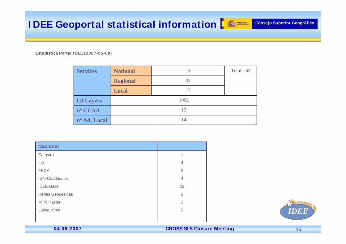
IDEE
15
Consejo Superior Geográfico
14nº Ad. Local
13nº CCAA
1002GI Layers
17Local
32Regional
Total= 6213NationalServices
Estadística Portal IDEE (2007-05-08)
IDEE Geoportal statistical information
2Ladsat-Spot
1MTN Raster
5Redes Geodesicas
22IDEE-Base
4IGN-Cuadriculas
2FEGA
4Ine
1Catastro
Nacional
04.06.2007 CROSS SIS Closure Meeting

IDEE
16
Consejo Superior Geográfico
Valencia
Pais Vasco
140Navarra
31Murcia
9La Rioja
30Galicia
1Cataluña 1:25000 Ortofoto
1Cataluña 1:5000 Ortofoto
27Cataluña 1:5000
Castilla y León: Ortofoto 1:10.000 e información Raster
Castilla y León:Cartografía escalas regionales
22Castilla y León (1:10,000)
16Castilla la Mancha
1Cantabria
16P.Asturias Ortofotos 1:5,000
40P.Asturias 1:5,000
46P.Asturias 1:10,000
4Andalucia Ortofoto 1998
4Andalucia Ortofoto 2001
4Andalucia Ortofoto 2004
1Andalcía 1:5000
4Andalucía 1:10,000
Andalucía
Regional

IDEE
17
Consejo Superior Geográfico
273Zaragoza Urbana
5Zaragoza municipal
24Pamplona
9Torrecilla (La Rioja)
14Santo Domingo (La Rioja)
12San Asensio (La Rioja)
14Najera (La Rioja)
12Haro (La Rioja)
13Cervera del Rio (La Rioja)
10Calahorra (La Rioja)
11Arnedo (La Rioja)
13Alfaro (La Rioja)
10Ajamil(La Rioja)
15La Palma (Canarias)
Albacete
Local

IDEE
18
Consejo Superior Geográfico
12Sombreado del Relieve
3CORINE
2C.Valenciana (Lics)
3C.Valenciana (Humedales)
29C.Valenciana (Urbanismo)
18Cataluña 1:50,000
13Cartografía Parque de Doñana
1Andalucía Mosaico 1991
1Andalucía Mosaico 1995
1Andalucía Mosaico 1999
1Andalucía Mosaico 2003
1Andalucía Mosaico 2004
29Atlas climatológico Digital
1IGME
Temáticos

IDEE
19
Consejo Superior Geográfico
Harmonisation on data policies
To get national coverage of Reference and Thematic Data at the three levels(National, Regional, Local).To harmonize data specification among the three levelsTo agree to jointly produce and share GI
From ED50 to ETRS89National Gazetteer: IGN-E,MAP, INE, RegionsMunicipalities GeoReferencing National Plan: High ResolutionAdministrative Boundaries (Regions, IGN-E, MAP) Close Cooperation National + Regional governments
Territory Observation National Plan:PNOA: Aerial Orthophotography National Plan (0,25 m. pixel, 4 yearsupdating/ quick 0,5 m. pixel, 4 years updating)PNOT: Remote Sensing National Plan (Spot5, 2,5 m./ Landsat5)
SIOSE: Land Cover & Use System 1/25.000 Mapping harmonisation and common updating
Regional data 1:5.000/1:10.000 & National data 1:25.000CartoCiudad: IGN, Cadastre, Statistical Office, Post Office, Regions, Local Authorities
04.06.2007 CROSS SIS Closure Meeting

IDEE
20
Consejo Superior Geográfico
NATIONAL PLAN ON AERIAL ORTHOPHOTOGRAFY (PNOA)
National Goverment:National Geographic InstituteMinistry of Infrastructures & TransportsMinistry of AgricultureMinistry of EnvironmentMinisterio de Economía y Hacienda Cadastre
17 Comunidades Autónomas
PNOA
04.06.2007 CROSS SIS Closure Meeting

IDEE
21
Consejo Superior Geográfico

IDEE
22
Consejo Superior Geográfico
Remote Sensing National Plan (PNT)
PNT
IGN/CNIG + Min. Environment:
Acquire the rigth to use Landsat & Spot 5 images
Ministries+Regions+Local Authorities can use theorthoimages
04.06.2007 CROSS SIS Closure Meeting

IDEE
23
Consejo Superior GeográficoPNT Uses
Agriculture
Forest applications
Geology
Hidrology
Land Cover/Land Use GI (Corine Land Cover, SIOSE,…)
Mapping Updating
04.06.2007 CROSS SIS Closure Meeting

IDEE
24
Consejo Superior GeográficoSIOSE Project Organization
Project management(NRC Terrestrial Cover) IGN MFOM +MMA
Thematic working groups (Thematic/sectorial criteria)
1. Urban2. Agricultural 3. Forestry4. Methodology and GIS5. Reference images6. Data dissemination
Production teams (19)(Geographic criteria)
Decentralised and cooperative production
REGIONS:Regional coordinator (19)
National Technical Team (AGE y CAA)
Spanish Geographic
High Council -CSGMINISTERIO DE AGRICULTURA
MINISTERIO DE ECONOMÍAY HACIENDA
MINISTERIO DE DEFENSA
MINISTERIO DE EDUCACIÓNY CIENCIA
MINISTERIO DE LA VIVIENDA
MINISTERIO DE MEDIOAMBIENTE
MINISTERIO DE FOMENTO
04.06.2007 CROSS SIS Closure Meeting

IDEE
25
Consejo Superior Geográfico
To get the National Government´s “Official” Digital Cartography. Assuring the complete continuity between urban and rural area and to be use as reference GI for all.The Database CARTOCIUDAD will allow:
Routing with geographical continuity in the whole national territory. BCN25 of the IGN will be used as infrastructure to assure continuity.
Positioning:
Direct: Coordinate Assignation:Reverse: Assign
Urban and rural areas displaying.
Thematic Uses. Dinamic features simbolisation.
- Postal Address- Place name- Points of interest (POIs)
x, y
- Postal Address- Place name- Points of interest (POIs)- Postal Distrit- Census Section
x,y
Objectives (I)
CARTOCIUDAD
04.06.2007 CROSS SIS Closure Meeting

IDEE
26
Consejo Superior Geográfico
Data sourcesNational/Regional (Navarra&Euskadi) Cadastre:
BlocksUrban ParcelsBuildingsStreet AxesPostal address numbersToponymy
Statistical Office (INE): Street Names, Census Districts & Sections.
Post Office: Postal Codes (tablas con rangos de direcciones postales de un Código Postal).
IGN: BCN25 & PNOA Orthophotografies (performes complete integration).
CARTOCIUDAD
04.06.2007 CROSS SIS Closure Meeting

IDEE
27
Consejo Superior Geográfico
Cartociudad layers generation:Cartociudad: Image of joined & integrated layers
CARTOCIUDAD
04.06.2007 CROSS SIS Closure Meeting

IDEE
28
Consejo Superior Geográfico
Cartociudad layers generation:Cartociudad superimposed to PNOA orthophoto.
Santiago de Compostela
CARTOCIUDAD
04.06.2007 CROSS SIS Closure Meeting

IDEE
29
Consejo Superior Geográfico
CARTOCIUDAD Services & CapabilitiesWeb Service having access to CartoCiudad database:
Web Map Service (WMS):Mapping Visualisatión
Geolinking Service
Gazetteer Service (WFS-MNE)Direct Positioning
Reverse Positioning
Web Feature Service (WFS)
• CartoCiudad features selective downloading
Web Geoprocessing Services (WPS)Proximity Search (Area of Influence)
Routing
Route downloading in GML to a GPS navigator
Georeferencing & geocoding Toolsinversa por digitalización.
CARTOCIUDAD
04.06.2007 CROSS SIS Closure Meeting

IDEE
30
Consejo Superior Geográfico
Ex. Gazetteer direct application
CARTOCIUDAD
04.06.2007 CROSS SIS Closure Meeting

IDEE
31
Consejo Superior Geográfico
Gazetter Service (WFS-MNE)Ejemplo:
Herramienta de Nomenclátor Inverso
Latitud:
Longitud:
Tipo vía: Nombre: Número:
40º25’17’’ N
3º40’40’’ W
Calle O’Donnell 12
CARTOCIUDAD
04.06.2007 CROSS SIS Closure Meeting

IDEE
32
Consejo Superior Geográfico
Web Geoprocessing Services
Proximity Search (Area of Influence).
From a position or postal address look for Points of Interestaccording feature class, distance or weigth.
Lat: 40.4190, Long: -3.6964 ó
Calle Alcalá, 34 (Madrid)
POI: Oficina HaciendaCriterios (distancia máx., etc.)
+
CARTOCIUDAD
04.06.2007 CROSS SIS Closure Meeting

IDEE
33
Consejo Superior Geográfico
Ex. Routing & GML download
CARTOCIUDAD
04.06.2007 CROSS SIS Closure Meeting

IDEE
34
Consejo Superior GeográficoThe Future
IncreasingSDIs
National level (Min. Environment, CSIC, …)Regional (Extremadura, Madrid, Canarias, Illes Balears)Local (Municipalities, Provinces, Islands)
Data servers (PNOA, CartoCiudad, SIOSE, Nature Data Bank, Regional Data, Local Data, University ResearchData, Public&Private Companies, Cooperative PrivateInitiatives (Open Street Map, Geonames), ….)Services
04.06.2007 CROSS SIS Closure Meeting

IDEE
35
Consejo Superior GeográficoNext Services to Implement in IDEE (I)
Remote analysis utilities:Stereo visualizing analysis on WMS imagesWeb Processing Services (WPS)
Network analysisRoutingPOIs (close to you)
Analysis on surfaces (Superficies)Slopes, orientation, …Overlay, buffers, …Analysis based on GRASS (Raster SIG with WPS interface)SQL based computer joining:
CORINE + DEM + Slopes + Orientation + Municipalities
¿Which polígons at the Municipality X have the land use Y over a height of 500 m and Northwards oriented?
Geographical & statistical analysis (GDAS, GLS)
04.06.2007 CROSS SIS Closure Meeting

IDEE
36
Consejo Superior GeográficoNext Services to Implement in IDEE (II)
Sensor Web EnablementReal time standard access to sensor data
Road traffic gaugingRiver flow gaugingMeteorological sensors (rain gauging)Environmental pollution
WPS Utilities on these dataReal time overflow calculation based on rain, DEM and land coverageMinimal routing depending on traffic density or problems
WPS service for cartographical filtering (generalisation)
04.06.2007 CROSS SIS Closure Meeting

IDEE
37
Consejo Superior GeográficoNext Services to Implement in IDEE (III)
Conflaction ServiceGet adjusted geometrical object 1 to geometricalobject 2 (refernca data), using n equivalent points.
Quality Control ServiceGeonames checking using a Gazetteer
DEMs checking using WCS services
Geometrical accuracy (Checking the same featureon to different services)
04.06.2007 CROSS SIS Closure Meeting

IDEE
38
Consejo Superior GeográficoIDE promoting services
ProvidersDataServices
Consultancy
IntegratorDataServices
Management
ServicesUsers
04.06.2007 CROSS SIS Closure Meeting

IDEE
39
Consejo Superior Geográfico
Sebastián Mas-MayoralDeputy Director for Geographic Information Applications
General Directorate of National Geographic InstituteIGN-Spain
Instituto Geográfico NacionalTel.: +34 91 5979646
E-mail: [email protected]
Thank you for yourattention
04.06.2007 CROSS SIS Closure Meeting