gas reservoir of the michigan basin - the usgs
TRANSCRIPT

U.S. DEPARTMENT OF THE INTERIOR U.S. GEOLOGICAL SURVEY
Fracture patterns and their origin in the Upper Devonian Antrim Shale gas reservoir of the Michigan basin: A review
Robert T. Ryder*
Open-File Report 96-23
This report is preliminary and has not been reviewed for conformity with U.S. Geological Survey editorial standards and stratigraphic nomenclature. Any use of trade names is for descriptive purposes only and does not imply endorsement by the USGS.
U.S. Geological Survey, Reston, Virginia 22092
CONTENTS
Page in LI oduciion -i-Fracture characteristics............................................... 3
Outcrop measurements................................... 3Subsurface measurements................................ 5
Regional and local structural domains accompanying Antrim Shalegas accumulation J.u
Proterozoic basement terranes and tectonic trends....... 11Structural trends in Devonian strata...................... 13Effects of Alleghanian compression....................... 17Modern in situ stresses of the northern Midcontinent.... 17Post-Paleozoic uplift of the Michigan basin............... 18
Unusual stratigraphic features underlying the Antrim Shale gasaccumulation................................................... 18
Mineralogy of fractured intervals.................................... 19Patterns of gas production and chemistry of associated reservoir
water........................................................... 20Summary and discussion of fracturing mechanisms.................. 23References cited ..................................................... 26
ILLUSTRATIONS
Figure 1. Map of Michigan showing the Antrim Shale gasaccumulation and the approximate outcrop patternof the Antrim Shale and equivalent strata................ 2
Figure 2. Correlation chart showing Upper Devonian and adjoining strata in the Michigan basin (Gutschick andSandberg, 1991).......................................... 4

Figure 3. Map of part of Otsego County, Michigan showing location of Antrim Shale gas wells used for fracture studies by Cain (1991), Decker and others (1992), Caramanica (1993), Dellapenna (1991), and Dellapenna andHarrison (1993) .......................................... 7
Figure 4. Borehole map of the Latuszak Bl-32 well, Otsego County, Michigan (Cain, 1991) showing fracture intensity in the
..... o....................................
Figure 5. Borehole map of the Rachow B3-3 1 well, Otsego County, Michigan (Caramanica, 1993) showing fracture intensityin oie Antrim ^naie ./
Figure 6. Michigan basin and adjoining area showing Proterozoic basement provinces and major structures (Budai andWilson (1991) ........................................... 12
Figure 7. Michigan basin and structure contour map drawn on the top of the Traverse Group (Fisher andothers, 1988) ............................................ 14
Figure 8. Structure contour map on top of the Traverse Group across a 28-township area of the Antrim Shale gas-producing trend in Otsego County and adjoining Antrim and Montmorency Counties, Michigan (Deckerand others, 1992)........................................ 15
Figure 9. Structure contour map on top of the Lachine Memberof the Antrim Shale in a four-township area in southernOtsego County, Michigan (Manger and others, 1990) .... 16
Figure 10. Average gas production rates from the Antrim Shale in a four-township area in southern Otsego County,Michigan (Decker and others, 1992) ..................... 22
11

INTRODUCTION
Black shale members of the Upper Devonian Antrim Shale are both the source and reservoir for a regional gas accumulation that presently extends across parts of six counties in the northern part of the Michigan basin (fig. 1). Natural fractures are considered by most petroleum geologists and oil and gas operators who work the Michigan basin to be a necessary condition for commercial gas production in the Antrim Shale. Fractures provide the conduits for free gas and associated water to flow to the borehole through the black shale which, otherwise, has a low matrix permeability. Moreover, the fractures assist in the release of gas adsorbed on mineral and(or) organic matter in the shale (Curtis, 1992). Depths to the gas-producing intervals (Norwood and Lachine Members) generally range from 1,200 to 1,800 ft (Oil and Gas Journal, 1994). Locally, wells that produce gas from the accumulation are as deep as 2,200 (Oil and Gas Journal, 1994). Even though natural fractures are an important control on Antrim Shale gas production, most wells require stimulation by hydraulic fracturing to attain commercial production rates (Kelly, 1992). In the U.S. Geological Survey's National Assessment of United States oil and gas, Dolton (1995) estimates that, at a mean value, 4.45 trillion cubic feet (TCP) of gas are recoverable as additions to already discovered quantities from the Antrim Shale in the productive area of the northern Michigan trend. Dolton (1995) also suggests that undiscovered Antrim Shale gas accumulations exist in other parts of the Michigan basin.
The character, distribution, and origin of natural fractures in the Antrim Shale gas accumulation have been studied recently by academia and industry. The intent of these investigations is to: 1) predict "sweet spots", prior to drilling, in the existing gas-producing trend, 2) improve production practices in the existing trend, 3) predict analogous fracture- controlled gas accumulations in other parts of the Michigan basin, and 4) improve estimates of the recoverable gas in the Antrim Shale gas plays (Dolton, 1995). This review of published literature on the characteristics of Antrim Shale fractures, their origin, and their controls on gas production will help to define objectives and goals in future U.S. Geological Survey studies of Antrim Shale gas resources.

LAKE MICHIGAN
Paxton quarry
LAKE HURON
Limit of Shale
*Limit of Shale
MONTMORENCY;:: : : :
*GRAND I/I TRAVERSE JKALKASKA! I OSCODA
IWEXFORD; ROSCOMMON I IOSCQ
LAKE ' ; CLARE
|OSCEOLA| IGLADWIN, ' ' L [ __
ISABELLA '
J I KENT ! H- -1 |
I JACKSON |
Antrim Shale Shale Subcrop
Gas Accumulation
Figure 1. Map of Michigan showing the Antrim Shale gas accumulation and the approximate outcrop pattern of the Antrim Shale and equivalent strata (after Komar, 1981; Walters and others, 1993).

FRACTURE CHARACTERISTICS
Outcrop Measurements
The Antrim Shale crops out along the northern margin of the Michigan basin within 10 to 15 mi updip of the regional gas accumulation (Komar, 1981; Walter and others, 1993)(fig. 1). Locally, there is partial overlap between the outcrop belt and the gas accumulation. Given these conditions, a reasonable first approximation of fracture characteristics in the Antrim Shale gas reservoir can be obtained from fractures observed in Antrim Shale (-200 ft thick) outcrops and in underlying limestone outcrops of the Middle Devonian Traverse Group (-750 ft thick) and Middle and Upper Devonian Squaw Bay Limestone (-30 ft thick) (fig. 2). Nearly 5000 measurements by Hoist and Foote (1981) and Hoist (1982) at 43 localities across northern Michigan show that the dominant joint sets in Devonian strata are oriented northeast-southwest (average orientation 052°) and northwest-southeast (average orientation 314°). Two additional, but subordinate, joint sets are oriented north-south (average orientation 002°) and east-west (average orientation 272°). These four joint sets maintain consistent orientations across the northern margin of the basin irrespective of geographic and stratigraphic position (Hoist and Foote, 1981; Hoist, 1982). Approximately 95% of the measured joints have vertical or sub- vertical dips.
Fracture orientation, fracture spacing, and fracture aperature width were measured at the Paxton quarry (fig. 1) at the east end of the northern Antrim Shale outcrop belt in Michigan (Richards, Walter, and others, 1994). The same dominant northeast-southwest and northwest- southeast fracture sets recognized by Hoist and Foote (1981) and Hoist (1982) were identified at the quarry in the Norwood and Lachine (-15 and 60 ft thick, respectively)(black shale) Members of the Antrim Shale (fig. 2). Only the northeast-southwest fracture set was recognized in the Paxton (gray shale) (-15 ft thick) Member (fig. 2) of the Antrim Shale at the quarry. The observed fracture spacing in the northeast-southwest set is 0.4 m (±0.02) for the Norwood Member, 0.2 m (±0.1) for the Paxton Member, and 1.1 m (±0.2) for the Lachine Member (Richards, Walter, and others, 1994). In the northwest-southeast set, the fracture spacing is 0.9 m (±0.3) for the Norwood Member and 2.0 m (±0.5) for the Lachine Member. For each of these three members of the Antrim Shale, the fracture spacing is always greater in the northwest-southeast set. The

SYSTEM SERIES
C/)
^^
o
UJ
Q
trLU
o
o:LJ
Q.
Q.
^
LJ»JQ O
2
M I
. ___ p^B^l
C
o
c c a>E0
UL
c oc
ol_u.
c o
0)
0
357-
360
365-
-370
-
375-
CH
- E *- P
= 'E NUJ 3 r
C
R
9
6 cIA; t4 ^
3 «/
3 ^
2
«
IA 1V
IB .!L.
1C <
Jo
w"R
GAN BASINLower MICHIGAN <
llsworth Sholt Paxton it >X Quarry" V orwood Partridge
old water Sha ed Rock
A
, L
e KomtSunbury Shale
millhiatus
Illili.......LPsr-v--: Seireq
THAfHA STRAIT
SAG
2 0
:.:S$":
Bedford Shole^
^v_: 1 ^ ~^=B_
i-J^^r-f^ Upper member a
*t& trLachine Member
»
i .!L.
'. Paxton Member c
* 4ft^b
: Norwood Member 3,9
rdan River Fn
tiiskey Creek Fmitoskey Ls.
not dltcutod)
sim -- - O-g* 1 1 1 H 1 1 1 Ml it"'CD Zoophycos bed
1 II hiatus
IIIThunder Bay Ls.
Potter Farm L*."a. 3> O ("<>' di«cuff«d) O 1- -0
Kettle Point Formation
9uf '
I
Figure 2. Correlation chart showing Upper Devonian and adjoining strata in the Michigan basin (from Gutschick and Sandberg, 1991). Closed black circles indicate conodont collections identified by CA. Sandberg.

aperture width of fractures measured in the quarry ranges from about 0.3 mm to about 8 mm (Richards, Walter, and others, 1994).
Subsurface Measurements
Natural fractures in the subsurface part of the Antrim Shale can be detected and characterized with oriented and open-hole logging tools (acoustic, resistivity, and televiewer) (Decker, 1992, Caramanica, 1993). In wells where both core and fracture identification logs are available, fractures identified by each method have comparable spacing, orientation, and openness; however, the number of fractures detected in the core is usually greater than the number of fractures detected from the well logs (Manger and Curtis, 1991; Decker, 1992; Decker and others, 1992). Probably, more fractures are identified in core than by well logs because, with well logs, horizontal fractures are difficult to distinguish from bedding planes (Manger and Curtis, 1991; Decker and others, 1992).
Richards, Walter, and others (1994) measured over 600 fractures from oriented core, fracture identification logs, and outcrop along the Antrim Shale gas-producing trend. Results of the outcrop measurements at the Paxton quarry are summarized in the previous section. Stratigraphic intervals involved in the study are the lower three members of the Antrim Shale (Norwood, Paxton, and Lachine), the overlying Upper Devonian Ellsworth Shale, and the underlying Middle Devonian Traverse Group and Middle and Upper Devonian Squaw Bay Limestone (fig. 2). Fracture and joint types measured by Richards, Walter, and others (1994) consist of major (dip >80°), intermediate (dip >80°), and small joints (dip >60°); bedding joints (dip <30°); and microfractures (dip variable). The joint surfaces are relatively smooth and commonly are lined with calcite cement. Large joints and fractures are rarely occluded by cement.
Two dominant fracture sets are noted in the study by Richards, Walter, and others (1994): the set with the highest relative frequency has a northeast-southwest orientation (average orientation 052° ±5°) and the second set has a northwest-southeast orientation (average orientation 312° ±5°). Although there are slight variations, the orientation of each dominant fracture set remains very consistent between stratigraphic intervals. These fracture orientations are nearly identical to those reported in outcrop by Hoist and Foote (1981), Hoist (1982), and Richards, Walter, and others (1994). Moreover, the spacing of subsurface fractures in the northeast-southwest (0.4-0.7 m ±0.2) and northwest-southeast (0.5 m ±0.2 to 2.3 m ±1.0) fracture sets in the Norwood, Paxton, and Lachine Members of the Antrim Shale are very similar to those measured in the Antrim

Shale at the Paxton quarry (Richards, Walter, and others, 1994). Whereas subsurface fractures in the Antrim Shale, Squaw Bay Limestone, and Traverse Group have similar spacing, those in the Ellsworth Shale (2.9 m ±0.7 for the northeast-southwest set and 3.5 m ±0.8 for the northwest- southeast set) have a much greater spacing. For a given stratigraphic interval, fracture spacing measured in the subsurface and in outcrop at the Paxton quarry as noted in the previous section-is always greatest in the northwest-southeast fracture set. The aperture width of the subsurface fractures reported by Richards, Walter, and others (1994) ranges from less than 0.001 mm to about 0.75 mm and the mean width is a function of stratigraphic interval.
Based on these fracture-spacing and aperture-width measurements, Richards, Budai, and others (1994) calculated that the Norwood Shale Member has the largest intrinsic permeability (2.0 x 10'11 m2 for the northeast-southwest set and 1.4 x 10'11 m2 for the northwest-southeast set) and the Ellsworth Shale has the lowest intrinsic permeability (4.0 x 10~15 m2 for the northeast-southwest set and 1.3 x 10~15 m2 for the northwest-southeast set). In all the stratigraphic intervals, the northeast- southwest fracture set is associated with the highest intrinsic fracture permeability.
Additional fractures were described and interpreted from six wells in Otsego County, Michigan (fig. 3) using core and formation microscanner logs (Cain, 1991; Decker and others, 1992; Caramanica, 1993). Fractures in one of the wells, the Latuszak Bl-32, also were included in the analysis by Richards, Walter, and others (1994). Borehole maps of the Latuszak Bl-32 well (Cain, 1991) and the Rachow B3-31 well (Caramanica, 1993) illustrate many of the complexities of the fracture patterns such as spacing, dip angle and direction, diversity of orientation, and fracture intersections (figs. 4, 5). Decker and others (1992) and Caramanica (1993) conclude that a northeast-southwest oriented fracture set is dominant in four of the six wells studied; in a fifth well, both northeast-southwest and northwest- southeast fracture sets are dominant and in a sixth well, the dominant fracture set is oriented east-west. The dip angle of the fractures range from subvertical to horizontal. An analysis of open fractures vs. total fractures indicates that the most abundant total fractures and open fractures are in the Lachine Member (Caramanica, 1993). Moreover, Decker and others (1992) conclude that the Lachine Member has the greatest diversity of fracture orientations.
Dellapenna (1991) and Dellapenna and Harrison (1993) report fracture characteristics in the cored MI-2 State Chester 18 well in southern Otsego County (fig. 3). Fractures are most common in the Norwood and Lachine Members where they show a dominant northeast-southwest set and a secondary northwest-southeast set. Most of the fractures are

DO
VE
R
1
TO
WN
SH
IP
1 R
2
W
BA
QLE
Y
TO
WN
SH
IP
©B
A
OT
<
L
AT
OW
GLE
Y B
3
EQO
KE
NSH
IP
-11
CH
E
TO
W
CH
ES
TE
R
NO
RT
H
TO
WN
SH
IP
ST
ER
NS
HIP
MI-
2.rT
AT
EC
I
RA
HA
CK
ESTE
R 1
,'
-
CH
OW
A 2 ti
O
W B
3-3
©
-31
l@(
LLAT
USZ
Sf
LATu
sz
STAT
E a
C4
-31
CH
AR
LT
ON
N
OR
TH
TO
WN
SH
IP
R
1 W
CH
AR
LT
ON
C
EN
TF
TO
WN
SH
IP
AK
A1
-33
"
AK
B
1-3
2
4A
RLT
ON
1
CH
AR
LT
ON
S
OU
T
TO
WN
SH
IP
CR
AW
FOR
D C
OU
NT
Y
.AT
US
ZA
K
DR
ILL
ED
C
AL
H A1
-3J f
t
N B
AM
E P
B1
-32
AD
T 30
N >- § g UJ
(C o 3
O T N
Stud
y A
rea
IMi. - F
MS
Logs
-Cor
e
Figu
re 3
. M
ap o
f par
t of O
tseg
o C
ount
y, M
ichi
gan
show
ing
loca
tion
of A
ntri
m S
hale
gas
wel
ls u
sed
for
frac
ture
stu
dies
by
Cai
n (1
991)
, Dec
ker
and
othe
rs (
1992
), C
aram
anic
a (1
993)
, Del
lape
nna
(199
1) a
nd D
ella
penn
a an
d H
arri
son
(199
3).

BOREHOLE MAP LATUSZAK B1-32 WELL
Greatest Fracture Intensity
Greatest Fracture Intensity
1* NO FRACT.
Lachine (Black Shale)
Paxton (Gray Shale)
Norwood (Black Shale)
Figure 4. Borehole map of the Latuszak Bl-32 well, Otsego County Michigan (Cain, 1991) showing fracture intensity in the Antrim Shale. See fig. 3 for location.

BOREHOLE MAP RACHOW B3-31 WELL
148°
PLANE OF PROJECTION328*
1400'MD
0* 5' 10* HORIZONTAL SCALE
5f
10*
VERTICAL SCALE
5' fromWellbore«
\
Figure 5. Borehole map of the Rachow B3-31 well, Otsego County, Michigan (Caramanica,1993) showing fracture intensity in the Antrim Shale. See fig. 3 for location.

subvertical and several are lined with calcite. The small number of fractures in the Squaw Bay Limestone, Paxton Member, and Ellsworth Shale are characterized by a dominant east-west set and secondary northeast-southwest and northwest-southeast sets. Fracture frequency, expressed in fractures/ft, is 1.33 in the Norwood Member and 0.87 in the lower part of the Lachine Member. Fracture frequency is much lower in the Squaw Bay Limestone (0.29), Paxton Member (0.09), upper part of the Lachine Member (0.31), and the Ellsworth Shale (0.06 to 0.11).
Fractures in Antrim Shale cores from the Amoco No. 1-28 Swift and No. MI-1 Union wells, Otsego County (not located on fig. 3) have been recorded by Nelson (1985). The orientations of fourteen calcite- mineralized, vertical fractures in the No. MI-21 Union well show a dominant northeast-southwest set and a secondary northwest-southeast set. Nonvertical fractures in the No. 1-28 Swift well, plotted on a stereographic projection of poles to fracture planes, demonstrate a high diversity of fracture intersections in the well bore.
REGIONAL AND LOCAL STRUCTURAL DOMAINS
ACCOMPANYING THE ANTRIM SHALE GAS ACCUMULATION
Regional and local tectonic events in the vicinity of the Michigan basin, and their resultant structural styles, must be carefully evaluated as possible controls on fractures in the Antrim Shale. Very likely, one or more of these events have had an impact on the nature and origin of the Antrim Shale fractures. First, pre-Michigan basin Proterozoic tectonics may have left diagnostic structures in basement rocks that became reactived by later tectonic events. Secondly, Paleozoic compressional stresses imposed on the sedimentary sequence of the Michigan basin by distant erogenic events, such as the Alleghenian orogeny, may have reactivated the pre-basin structures and(or) introduced new structural fabrics. Thirdly, post-basin uplift and cooling of the crust in Mesozoic and post-Pleistocene times and modern intraplate compression may have accentuated pre-existing fracture patterns or, by modifying existing stress trajectories, may have created additional sets of fractures. These suggested tectonic events and terranes that may be linked to fractures in the Antrim Shale are summarized briefly in this section.
10
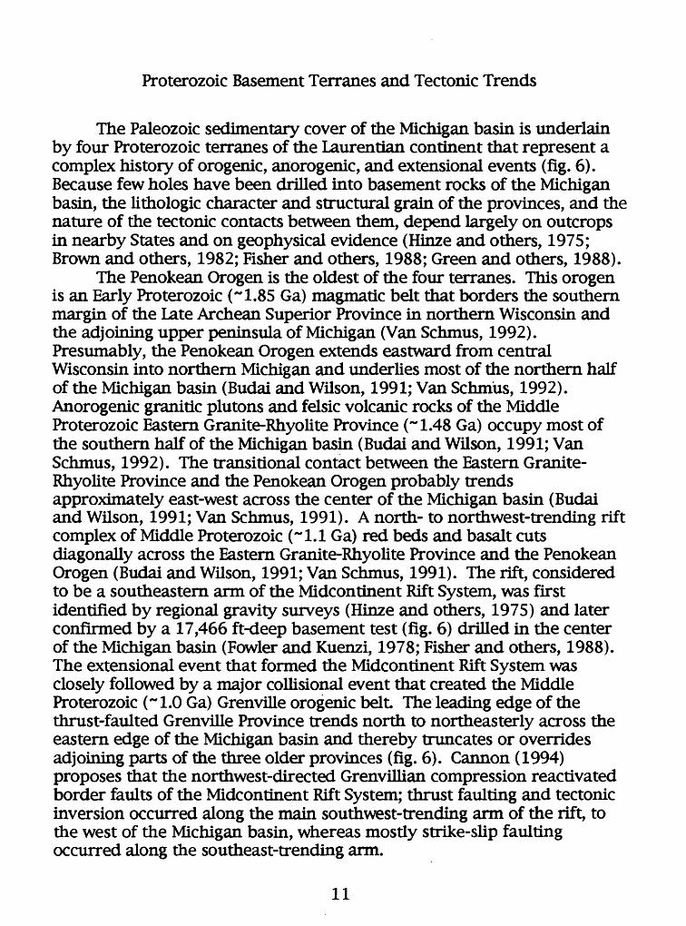
Proterozoic Basement Terranes and Tectonic Trends
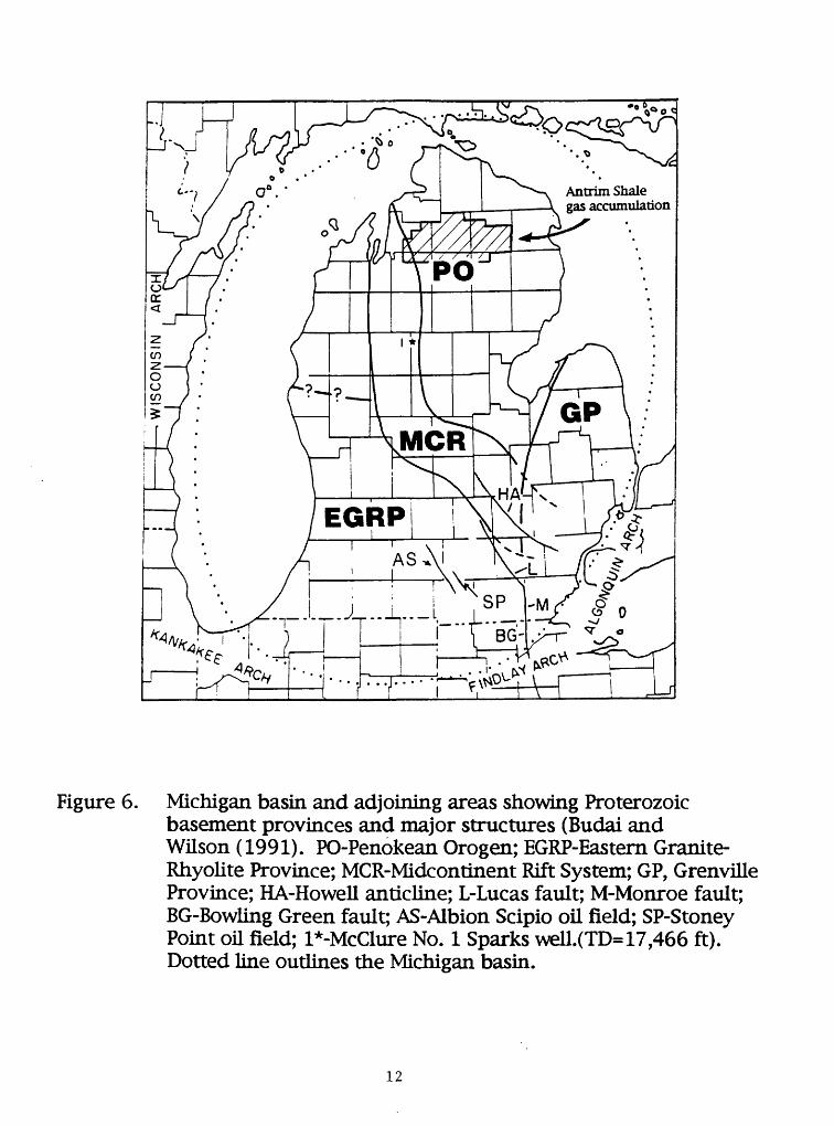
The Paleozoic sedimentary cover of the Michigan basin is underlain by four Proterozoic terranes of the Laurentian continent that represent a complex history of orogenic, anorogenic, and extensional events (fig. 6). Because few holes have been drilled into basement rocks of the Michigan basin, the lithologic character and structural grain of the provinces, and the nature of the tectonic contacts between them, depend largely on outcrops in nearby States and on geophysical evidence (Hinze and others, 1975; Brown and others, 1982; Fisher and others, 1988; Green and others, 1988).
The Penokean Orogen is the oldest of the four terranes. This orogen is an Early Proterozoic (~1.85 Ga) magmatic belt that borders the southern margin of the Late Archean Superior Province in northern Wisconsin and the adjoining upper peninsula of Michigan (Van Schmus, 1992). Presumably, the Penokean Orogen extends eastward from central Wisconsin into northern Michigan and underlies most of the northern half of the Michigan basin (Budai and Wilson, 1991; Van Schmus, 1992). Anorogenic granitic plutons and felsic volcanic rocks of the Middle Proterozoic Eastern Granite-Rhyolite Province (~1.48 Ga) occupy most of the southern half of the Michigan basin (Budai and Wilson, 1991; Van Schmus, 1992). The transitional contact between the Eastern Granite- Rhyolite Province and the Penokean Orogen probably trends approximately east-west across the center of the Michigan basin (Budai and Wilson, 1991; Van Schmus, 1991). A north- to northwest-trending rift complex of Middle Proterozoic (-1.1 Ga) red beds and basalt cuts diagonally across the Eastern Granite-Rhyolite Province and the Penokean Orogen (Budai and Wilson, 1991; Van Schmus, 1991). The rift, considered to be a southeastern arm of the Midcontinent Rift System, was first identified by regional gravity surveys (Hinze and others, 1975) and later confirmed by a 17,466 ft-deep basement test (fig. 6) drilled in the center of the Michigan basin (Fowler and Kuenzi, 1978; Fisher and others, 1988). The extensional event that formed the Midcontinent Rift System was closely followed by a major collisional event that created the Middle Proterozoic (~1.0 Ga) Grenville orogenic belt. The leading edge of the thrust-faulted Grenville Province trends north to northeasterly across the eastern edge of the Michigan basin and thereby truncates or overrides adjoining parts of the three older provinces (fig. 6). Cannon (1994) proposes that the northwest-directed Grenvillian compression reactivated border faults of the Midcontinent Rift System; thrust faulting and tectonic inversion occurred along the main southwest-trending arm of the rift, to the west of the Michigan basin, whereas mostly strike-slip faulting occurred along the southeast-trending arm.
11
Antrim Shale gas accumulation
Figure 6. Michigan basin and adjoining areas showing Proterozoic basement provinces and major structures (Budai and Wilson (1991). PO-Penokean Orogen; EGRP-Eastern Granite Rhyolite Province; MCR-Midcontinent Rift System; GP, Grenville Province; HA-Howell anticline; L-Lucas fault; M-Monroe fault; BG-Bowling Green fault; AS-Albion Scipio oil field; SP-Stoney Point oU field; l*-McClure No. 1 Sparks well.(TD= 17,466 ft). Dotted line outlines the Michigan basin.
12

Structural Trends in Devonian Strata
Structure contour maps drawn on top of the Traverse Group and the Antrim Shale (Fisher, 1980; Fisher and others, 1988) show that Devonian strata in the Michigan basin have been folded into prominant anticlines with northwest-southeast trending axes (fig. 7). Many of the anticlines can be traced for over 50 mi and closely spaced contour lines along their flanks suggest that some of them have faulted limbs (Decker and others, 1992). One of these anticlines, a southeast-plunging anticlinal nose with a steeply dipping or faulted western limb, runs through the center of the Antrim gas-producing trend in western Otsego County and adjoining Crawford County (Decker, 1992). Fisher and others (1988), based on their east-west oriented diagrammatic cross section across the southern Michigan basin, suggest that the anticlines are underlain by horst blocks in the Proterozoic basement rocks. Although many of the large anticlines, anticlinal noses, and monoclines on the structure contour map (fig. 7) probably are underlain by basement fault blocks, their dominant northwest-southeast trend is not strongly aligned with any of the recognized tectonic trends of the Proterozoic basement, but most closely matches the north- and northwest-trending eastern arm of the Midcontinent rift system. Perhaps the anticlinal structures and the probable fracture sets associated with them were inherited from reactivated fault zones that originally were created or modified along the margins of the Midcontinent rift by later Grenvillian compression (Cannon, 1994).
Structure contours (C.I.=100 ft) on the Traverse Group across a 28- township area of the gas-producing trend in Otsego County and adjoining Antrim and Montmorency Counties (Decker and others, 1992)(fig. 8) show numerous small-scale flexures in addition to the larger southeast-plunging anticlinal nose recognized on the 1:1,000,000 scale maps of Fisher (1980). Decker (1992) and Decker and others (1992) suggest that these small-scale structures may be a primary cause of Antrim Shale fractures. An even more detailed structure contour map (Manger and others, 1990), drawn on top of the Lachine Member (C.I.=25 ft) for a four-township area in southern Otsego County near the center of the previous map, shows a broad southward-plunging anticlinal nose whose general trend is interupted by numerous small-scale structural terraces and flexures (fig. 9). Five of the six wells used for fracture studies by Decker and others (1992) and Caramanica (1993) are located on the anticlinal nose. Variations in gas production across the 28- and 4-township structural
13

Antrim Shale gas accumulation
LAKE ERIE
C.I.-IOO1MILES
0 O 20 30
Figure 7. Michigan basin and structure contour map drawn onthe top of the Traverse Group (Fisher and others, 1988),
14

X
-v
''00
-rfs?>
fiy \
/0
s* o
,.
4 To
wns
hip
Stud
y A
rea
- Pr
oduc
tion
> 10
0 M
CFGP
D
Stru
ctur
e co
ntou
rs o
n Tr
aver
se L
imes
tone
^\-
"/ C
onto
ur I
nter
val =
100
feet
79
) Ave
rage
Pro
duct
ion
Rat
e pe
r Qua
rter T
owns
hip
(MCF
GPD)
Figu
re 8
. St
ruct
ure
cont
our
map
on
top
of th
e T
rave
rse
Gro
up a
cros
s a
28-t
owns
hip
area
of t
heA
ntri
m S
hale
gas
-pro
duci
ng t
rend
in O
tseg
o C
ount
y an
d ad
join
ing
Ant
rim
and
Mon
tmor
ency
C
ount
ies,
Mic
higa
n. A
lso
show
n is
the
aver
age
gas
prod
uctio
n ra
te (
MCF
GPD
) pe
r qu
arte
r to
wns
hip
(Dec
ker a
nd o
ther
s, 1
992)
.

R
2 W
HE
9T
£R
NO
RT
H
R
1 W
Stu
dy
Ar»
i
I M
l
Con
tour
Inte
rval
= 2
5 ft.
Syn
clin
e
Ant
iclin
e
Figu
re 9
. S
truc
ture
con
tour
map
on
top
of th
e L
achi
ne M
embe
r of
the
Ant
rim
Sha
le i
n a
four
- to
wns
hip
area
in s
outh
ern
Ots
ego
Cou
nty,
Mic
higa
n (M
ange
r an
d ot
hers
, 19
90).
See
fig
ure
8 fo
r th
e lo
catio
n of
the
area
.

contour maps and their implications for the distribution of open fractures in the Antrim Shale are presented in a subsequent section.
Effects of Alleghanian Compression
Numerical Theological models of eastern North America by Qjiinlan and Beaumont(1984) suggest that lithospheric downwarping and flexure of the Appalachian foreland basin is caused by loading of the crust by Alleghanian overthrusts. Hexural interactions between the Appalachian basin and the craton very likely influenced sedimentation patterns and structural features in the Michigan basin. Craddock and van der Pluijm (1989) have measured subhorizontal shortening fabrics in Paleozoic strata as much as 500 mi away from the Appalachian-Ouachita orogenic front They suggest that these fabrics were caused by late Paleozoic compressional stresses due to the Alleghanian orogeny rather than by stresses due to lithospheric loading of the craton. Thus, far-field Alleghanian compressional stress and associated strains may have had an important effect on Michigan basin tectonics and, consequently, on fractures in the Antrim Shale (van der Pluijm and Craddock, 1993).
Modern In Situ Stresses of the Northern Midcontinent
Modern in situ maximum horizontal compressional stress in the crust of the midcontinent region is oriented northeast-southwest (Haimson, 1978; Zoback and Zoback, 1980). Hoist (1982) concludes that the present- day stress orientation is certainly younger than early Mesozoic (Sbar and Sykes, 1973) and is best explained by lithosphere-asthenosphere drag beneath the North American plate or by a ridge-push force from the Mid- Atlantic Ridge (Voight, 1969; Zoback and Zoback, 1980). Although the present in situ stress is oriented normal to fold axes in the Devonian strata (fig. 7), it seems to be clearly too young to have caused the folds. However, the modern in situ stress field may be the cause of the prominent northeast-southwest fracture set observed in the outcrop and subsurface. The orientation of the modern stress field and the northeast-southwest fracture set are closely aligned and the timing, although less constrained, is certainly plausible. Possibly, the northeast-southwest fracture set is very young (Hoist, 1982).
17

Post-Paleozoic Uplift of the Michigan Basin
Maturation indices (0.54 to 0.60% RO) of the Pennsylvanian Saginaw coal and Lopatin modeling of the burial and thermal history of the Michigan basin suggest as much as to 3,280 ft of Carboniferous and(or) Permian strata were removed prior to the Late Jurassic (Cercone, 1984). Using similar vitrinite reflectance data, Apotria and others (1993) suggest that a net uplift of over 4,000 ft has occurred in the northern part of the Michigan basin since the Permian. This amount of uplift may significantly alter the magnitude and possibly the orientation of pre-existing principal horizontal stresses and associated fractures in the basin.
Post-Pleistocene isostatic adjustment of the crust following glacial retreat accounts for as much as 200 ft of uplift in the northern Michigan basin (Farrand, 1962). Goldthwait (1908) explained raised beach terraces of earlier glacial lakes according to a model that involves a single southern outlet and a west-northwest oriented hinge line that extended across the center of the Michigan basin. The hinge line separates the northern part of the Michigan basin having active post-glacial rebound from the southern part of the basin having little or no rebound. However, in a recent study, Larson (1987) interprets the array of raised beach ridges in terms of multiple lake outlets that preclude the need for a glacial hinge zone. Larsonfs (1987) study places in question the hypothesis by Matthews and Jones (1994) that preferred areas of fracturing in the Antrim Shale are coincident with one or more glacial hinge lines. Unloading of stored elastic strain in the Antrim Shale caused by glacial rebound may create horizontal (sheeting) fractures and open and(or) enlarge pre-existing sub-vertical fractures.
UNUSUAL STRATIGRAPHIC FEATURES UNDERLYING
THE ANTRIM SHALE GAS ACCUMULATION
Abrupt stratigraphic changes caused by fades changes, diagenesis, irregular erosion, and truncation in units underlying or equivalent to the Antrim Shale may have contributed to the development of flexures and fractures through differential compaction. Several unusual stratigraphic features in the vicinity of the Antrim Shale gas accumulation are identified here as possible causes of differential compaction in the Antrim Shale.
The oil- and gas-bearing Upper Silurian (Niagaran) pinnacle reef trend that crosses northern Michigan directly underlies large areas of the
18

Antrim Shale gas accumulation. Decker and others (1992) suggest that differential compaction over the 400- to 500-ft-thick, 3,000- to 3,500-ft- diameter pinnacle reefs (Gill, 1979) may have created some of the flexures and fractures in the Antrim Shale. However, given that the pinnacle reefs are 4,500 to 5,000 ft beneath the Antrim Shale, this hypothesis seems rather improbable.
Halite units in the Upper Silurian Salina Group have been differentially leached along several margins of the Michigan basin and areas having the greatest dissolution are commonly the sites of salt- collapse in overlying carbonate units (Mesolella and Weaver, 1975). In northern Michigan, the lowermost salt beds of the Salina Group pinch out northwestward against a carbonate-shelf margin that borders the shoreward limit of the pinnacle-reef tract. The 150- to 200-ft-thick lower salt bed (A-l evaporite) occupies the inter-reef areas whereas a slightly younger 150- to 300-ft-thick salt bed (A-2 evaporite) occupies inter-reef areas of the pinnacle reef tract as well as forming a continuous seal over the entire reef tract (Gill, 1979). To date there have been no reports of Salina Group salt dissolution in the pinnacle-reef trend of northern Michigan.
The Ellsworth Shale is a greenish gray shale that intertongues eastward with the upper member of the Antrim Shale (fig. 2). An isopach map by Fisher (1980) shows the EUsworth Shale to be restricted to the west side of the Michigan basin and that its pinch-out edge trends northward through the Antrim Shale gas-producing trend in western Otsego County. Moreover, the thickest part of the Ellsworth Shale (greater than 900 ft) is in adjoining Antrim County. Conceivably, fractures in the Antrim Shale may be concentrated along this fades change because of the contrast between the ductile EUsworth Shale and the brittle Antrim Shale. This mechanism, however, cannot easily explain the well-fractured Antrim Shale east of Otsego County.
MINERALOGY OF FRACTURED INTERVALS
X-ray diffraction analysis indicates that the major mineral constituents of the Antrim and Ellsworth Shales are quartz, carbonate (calcite and dolomite), muscovite, and illite; secondary mineral constituents are pyrite, kerogen, feldspar (potassium and plagioclase varieties), kaolinite, and chlorite (Dellapenna, 1991; Manger and Curtis, 1991; Dellapenna and Harrison, 1993). Of the strata that constitute the Antrim Shale and the Ellsworth Shale, the black shale members of the Antrim Shale have the highest quartz content (40-60%) and the lowest carbonate
19

content (0-5%). In contrast, the gray shale units in the Antrim and Msworth Shales have less quartz (30-40%) and significantly more carbonate minerals (15-30%) than the black shale units. Total organic carbon content in weight percent (TOG) ranges from about 5 to 14 in the black shale units and generally is less than 1 in the gray shale units. Dellapenna (1991), Manger and CurtLs (1991), and Dellapenna and Harrison (1993) suggest that the quartz-rich black shale units are brittle and, thus, should be more heavily fractured than the ductile caicite-rich gray shale units. A similar conclusion was reached by Nelson (1985) but, in addition to quartz, he considers feldspar and dolomite to be brittle constituents of the black shale units.
The most variable mineral constituents in the Antrim Shale samples collected at the Paxton quarry are quartz, day, carbonate, and organic matter (Richards, Walter, and others, 1994). Both frequency and aperature width of fractures show a direct relationship to TOG and carbonate content and an inverse relationship to clay content These relationships apply to both the northeast-southwest and northwest-southeast fracture sets. Judging from the lower fracture frequency (higher fracture spacing) of the northwest-soutneast fracture set and the direct relationship between TOG and mean aperture width, Richards, Walter, and others (1994) suggest that the northwest-southeast fracture set has been generated by a natural hydraulic mechanism during peak thermal maturation of Antrim Shale organic matter.
Stable carbon and oxygen isotopic compositions of concretions, calcite fracture fillings, and host rock were measured in outcrop and core samples by Richards, Walter, and others (1994). Compositions are tightly clustered around mean values of 613C ~-10 and 618O ~-10 for concretions and mean values of 613C ~-5 and 618O ~-5 for host rocks. In contrast, isotopic compositions are widely scattered for the fracture fillings: 613C values range from about +26 to -42 and 618O values range from about -3 to -10. Richards, Walter, and others (1994) suggest that the calcite cement was precipitated from late Pleistocene glacial water that percolated through the fractures.
PATTERNS OF GAS PRODUCTION AND
CHEMISTRY OF ASSOCIATED RESERVOIR WATER
The influence of fractures on gas production is demonstrated by a plot of fracture frequency, measured from fracture-detection logs in three wells in Otsego County, against gas production from these wells (Decker,
20

1992). The plot shows a direct relationship between fracture frequency and gas production. The three wells used in the plot were also used in fracture studies by Decker and others (1992) and Caramanica (1993). Gas production from the three wells, measured over 24 hours, ranged from 243 to 500 thousand cubic feet of gas per day (MCFGPD). Accompanying water production from the wells ranged from 25 to 85 barrels of water per day (BWPD). All the wells are vertical, received similar stimulation treatment, and were tested for their gas yield at similar times in their production history.
Average gas production for Otsego County wells in March 1993 was contoured by Richards, Walter, and others (1994). A strong northeast- southwest trend in the 100- and 200-MCFGPD contours imply that "sweet spots" in the producing trend are controlled by the northeast-southwest fracture set Moreover, contoured variations in water chemistry (e.g.HCO3~ ion) across the gas-producing trend show the same northeast- southwest trend as the gas production (Walter and others, 1993; Richards, Walter, and others, 1994).
Gas production superimposed on the 28-township regional structure map of Decker and others (1992)(fig. 8) provides an insight to the influence of large- and small-scale structures on gas production and fracture frequency. Because most gas production in the Antrim Shale is reported by lease or project rather than by well, it is expressed on the map as average gas flow rates per quarter township. The highest gas production per quarter township in the region, 100 to 225 MCFGPD, is in south-central to southeastern Otsego County (fig. 8) where structures are characterized by small-scale flexures and terraces (Decker and others, 1992). Somewhat surprisingly, the production is rather low (12 to 86 MCFGPD) along the prominent southeast-plunging anticlinal nose in western Otsego County shown on 1:1,000,000 scale maps by Fisher (1980). The one exception is an 8 sq mi area in western Otsego County and adjoining Antrim County where gas production ranges from 113 to 123 MCFGPD (fig. 8).
A comparison of gas production and structural configuration in the 4- township "sweet spot" of southern Otsego County also shows that the best gas production, and probably the highest fracture frequency, is not necessarily associated with the most obvious anticlines and anticlinal noses(fig. 9). Production assigned to each of the 200+ wells in the data set was prorated from net production data for a given lease. Although good production rates in the 4-township area are associated with the easily recognized south- to southwest-plunging anticlinal nose interrupted by small-scale flexures and terraces, better production is generally located on the west flank of the structure (fig. 10).
21

R 2
WR
1
WS
tud
y A
rt!
N>
N>
1 M
l.
Con
tour
Inte
rval
= 2
0 M
CPGP
D
o
Ant
rim P
rodu
ctio
n W
ells
Prod
uctio
n >1
00 M
CFG
PD
CR
AW
FO
RD
CO
UN
TY
Figu
re 1
0.
Ave
rage
gas
pro
duct
ion
rate
s fr
om th
e A
ntri
m S
hale
in a
fou
r-to
wns
hip
area
in s
outh
ern
Ots
ego
Cou
nty,
Mic
higa
n (D
ecke
r and
oth
ers,
199
2).
Not
e th
e di
scre
panc
y be
twee
n th
e >1
00
MCF
GPD
pro
duct
ion
outli
ne in
this
fig
ure
and
that
on
figu
re 8
.

SUMMARY AND DISCUSSION OF FRACTURING MECHANISMS
The consistent northwest-southeast and northeast-southwest orientations of fracture sets in the Antrim Shale and adjacent Devonian strata across the northern margin of the Michigan basin probably originated from continent-scale compressional stress fields (Hoist, 1982; Decker and others, 1992). The most plausible of the continent-scale stress fields are: 1) a northwest-southeast oriented far-field compressional stress caused by late Paleozoic Alleghanian plate collision (Craddock and van der Pluijm, 1989) and 2) a northeast-southwest oriented post-early Mesozoic compressional stress caused by lithosphere-asthenosphere interactions (Hoist, 1982). The latter stress orientation is expressed by the modern in situ state of stress in the midcontinent region (Zoback and Zoback, 1980). Additional factors contributing to the origin or accentuation of the fracture sets may be post-Paleozoic uplift of the Michigan basin and abnormally high formation pressures created by hydrocarbon generation in the organic-rich Antrim Shale during maximum burial (Apotria and others, 1993, 1994; Richards, Walter, and others, 1994).
According to Apotria and others (1993, 1994), the northwest- southeast fracture set is the oldest as shown by its continuity and abutting relationships. They further suggest that fractures in this set formed as natural hydraulic fractures during northwest-southeast oriented Alleghanian compressive stress near peak burial and thermal maturation. Fracturing occurred preferentially in the black shales because of their low Poisson's ratio and their probable high fluid pressure owing to gas generation (Apotria and others, 1993,1994). The northeast-southwest fracture set, according to Apotria and others (1993,1994), formed during post-Alleghanian uplift of the Michigan basin under a state of northeast- southwest oriented maximum horizontal compression. Cooling and unloading reduced the minimum horizontal stress to form extension fractures (Apotria and others, 1993, 1994). This thermoelastic contraction mechanism is strongly influenced by Young's modulus (Apotria and others, 1993,1994).
Northwest-directed Alleghanian compression, suggested by Apotria and others (1993,1994) as a primary cause of the regional northwest- southeast fracture set, is supported by regional petrofabric studies of Craddock and van der Pluijm (1989). Moreover, northwest-directed Alleghanian compression may have created the dominant, basement-cored, northwest-trending anticlines. One possible mechanism is that an unrecognized Proterozoic basement fabric-such as one formed during
23
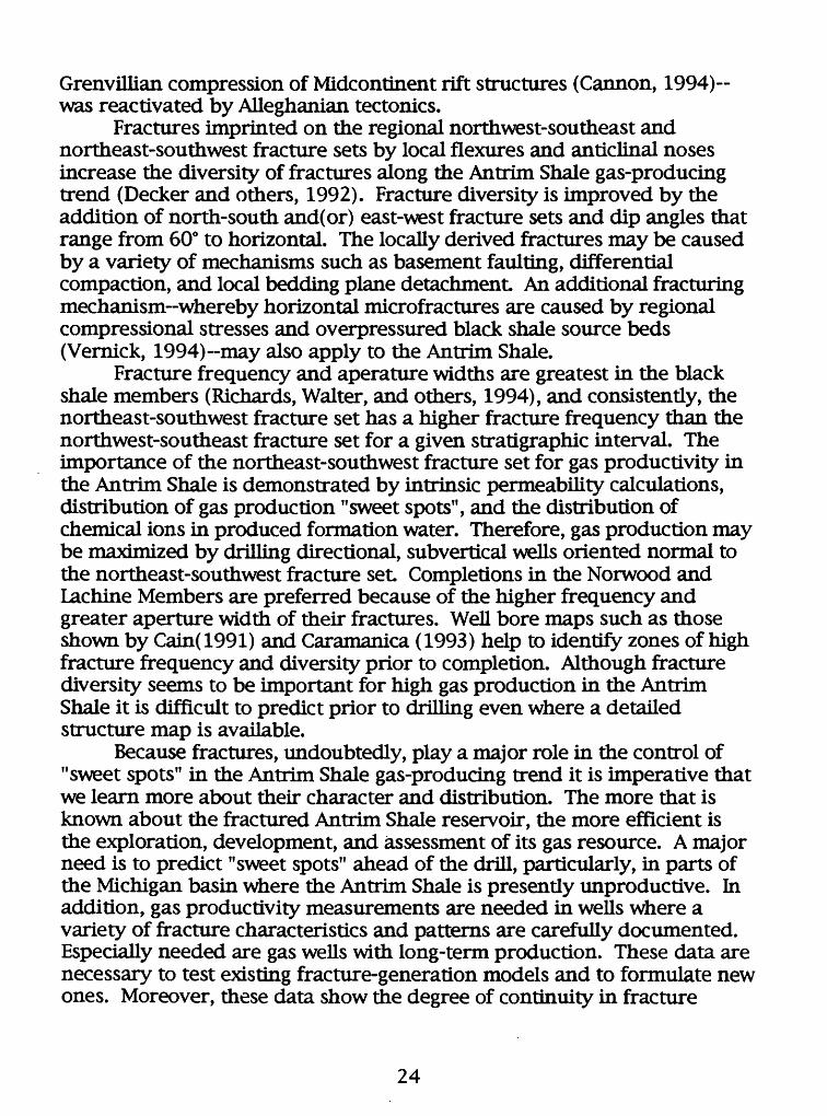
Grenvillian compression of Midcontinent rift structures (Cannon, 1994)- was reactivated by Alleghanian tectonics.
Fractures imprinted on the regional northwest-southeast and northeast-southwest fracture sets by local flexures and anticlinal noses increase the diversity of fractures along the Antrim Shale gas-producing trend (Decker and others, 1992). Fracture diversity is improved by the addition of north-south and(or) east-west fracture sets and dip angles that range from 60° to horizontal. The locally derived fractures may be caused by a variety of mechanisms such as basement faulting, differential compaction, and local bedding plane detachment An additional fracturing mechanism-whereby horizontal microfractures are caused by regional compressional stresses and overpressured black shale source beds (Vernick, 1994)-may also apply to the Antrim Shale.
Fracture frequency and aperature widths are greatest in the black shale members (Richards, Walter, and others, 1994), and consistently, the northeast-southwest fracture set has a higher fracture frequency than the northwest-southeast fracture set for a given stratigraphic interval. The importance of the northeast-southwest fracture set for gas productivity in the Antrim Shale is demonstrated by intrinsic permeability calculations, distribution of gas production "sweet spots", and the distribution of chemical ions in produced formation water. Therefore, gas production may be maximized by drilling directional, subvertical wells oriented normal to the northeast-southwest fracture set Completions in the Norwood and Lachine Members are preferred because of the higher frequency and greater aperture width of their fractures. Well bore maps such as those shown by Cain(1991) and Caramanica (1993) help to identify zones of high fracture frequency and diversity prior to completion. Although fracture diversity seems to be important for high gas production in the Antrim Shale it is difficult to predict prior to drilling even where a detailed structure map is available.
Because fractures, undoubtedly, play a major role in the control of "sweet spots" in the Antrim Shale gas-producing trend it is imperative that we learn more about their character and distribution. The more that is known about the fractured Antrim Shale reservoir, the more efficient is the exploration, development, and assessment of its gas resource. A major need is to predict "sweet spots" ahead of the drill, particularly, in parts of the Michigan basin where the Antrim Shale is presently unproductive. In addition, gas productivity measurements are needed in wells where a variety of fracture characteristics and patterns are carefully documented. Especially needed are gas wells with long-term production. These data are necessary to test existing fracture-generation models and to formulate new ones. Moreover, these data show the degree of continuity in fracture
24
trends and associated gas production across a given part of the accumulation.
25

CITED
Apotria, T.G., Kaiser, C.J., and Cain, B.A., 1993, The origin of fractures in the Devonian Antrim Shale, Michigan basin (abs.): Geological Society of America abstracts with programs, v. 25, no. 6, p. A-279
_______, 1994, Fracturing and stress history of the Devonian Antrim Shale, Michigan basin, m Nelson, P.P. and Laubach, S.E., eds., Proc. of the 1st North American Rock Mechanics Symposium (Univ. of Texas at Austin, June 1-3, 1994): A.A. Balkema, Rotterdam, p.809-816.
Brown, L, Jensen, L, Oliver, J., Kaufman, S., and Steiner, D., 1982, Riftstructure beneath the Michigan Basin from COCORP profiling: Geology, v. 10, no. 12, p. 645-649.
Budai, J.M. and Wilson, J.L, 1991, Diagenetic history of the Trenton andBlack River Formations in the Michigan Basin, in Catacosinos, PA. and Daniels, P.A., Jr., eds., Early sedimentary evolution of the Michigan Basin: Geological Society of America Special Paper 256, p. 73-88.
Cain, B.,1991, Fracture intensity in the Latuszak Bl-32 well, in, Decker, D., Coates, J.-M.P., and Wicks, D., 1992, Stratigraphy, gas, occurance [sic], formation evaluation and fracture characterization of the Antrim Shale, Michigan basin: Gas Research Institute Topical Report GRI- 92/0258, Contract No. 5091-213-2305, p.91.
Cannon, W.F., 1994, Closing of the Midcontinent rift-A far-field effect of Grenvillian compression: Geology, v. 22, no. 2, p. 155-158.
Caramanica, F., 1993, Natural fracture identification and implications for production, in Gas Research Institute Antrim Shale workshop [Mount Pleasant, Michigan, Dec. 14,1993], 17 p.
Cercone,K.R., 1984, Thermal history of the Michigan Basin: AmericanAssociation of Petroleum Geologists Bulletin, v. 68, no. 2 p. 130-136.
Craddock, J.P. and van der Pluijm, BA., 1989, Late Paleozoic deformation of the cratonic carbonate cover of eastern North America: Geology, v. 17, no. 5, p. 416-419.
Curtis, J.B., 1992, Natural Controls on gas occurrence in the Antrim Shale reservoir, in Antrim Shale workshop [Mount Pleasant, Michigan, Dec. 15, 1992]: Gas Research Institute Report 92/0555, 10 p.
26

Decker, D., 1992, Fracture identification, in Antrim Shale Workshop [Mount Pleasant, Michigan, Dec. 15,1992]: Gas Research Institute Report 92/0555, 11 p.
Decker, D., Coates, J.-M.P., and Wicks, D., 1992, Stratigraphy, gas, occurance [sic], formation evaluation and fracture characterization of the Antrim Shale, Michigan basin: Gas Research Institute Topical Report GRI-92/0258, Contract No. 5091-213-2305,101 p., appendix
Dellapenna, T.M., 1991, Sedimentological, structural, and organicgeochemical controls on natural gas occurrences in the Antrim Formation in Otsego County, Michigan: unpublished M.S. thesis, Western Michigan University, Kalamazoo, 147 p.
Dellapenna, T.M. and Harrison, W.B., 1993, Mineralogic, petrophysical, and organic properties, Antrim Shale, Michigan, in Antrim Shale Workshop [December 14,1993, Mt Pleasant, Michigan]: Gas Research Institute Report GRI-9310485, 34 p.
Dolton, G.L., 1995, Michigan basin province (063), in Gautier, D.L, Dolton, G.L, Takahashi, K.I., and Varnes, K.L, eds., 1995 national assessment of United States oil and gas resources-Results, methodology, and supporting data: U.S. Geological Survey Digital Data Series DDS-30, 62 p., 25 figs.
Ells, G.D., 1979, Stratigraphic cross sections extending from DevonianAntrim Shale to Mississippian Sunbury Shale in the Michigan basin: Michigan Department of Natural Resources, Geological Survey Division Report of Investigations 22, 186 p.
Farrand, W.R., 1962, Postglacial uplift in North America: American Journal of Science, v. 260, no. 3, p. 181-199.
Fisher, J.H., 1980, Stratigraphy of the Upper Devonian-Lower Mississippian of Michigan: U.S. Department of Energy Report No. FE-2346-80,151 p., includes structure contour maps of the Traverse Limestone and Antrim Shale at 1:1,000,000).
Fisher, J.H., Barratt, M.W., Droste, J.B., and Shaver, R.H., 1988, Michigan Basin, in Sloss, L.L., ed., Sedimentary cover-North American craton: U.S.: The Geology of North America, v. D-2: Geological Society of America, Boulder, Colorado, p. 361-382.
27

Fowler, J.H. and Kuenzi, W.D., 1978, Keweenawan turbidites in Michigan (deep borehole red beds): a foundered basin sequence developed during evolution of a proto-oceanic rift system: Journal of Geophysical Research, v. 83, no. 12, p. 5833-5843.
Gill, D., 1979, Differential entrapment of oil and gas in Niagaran pinnacle- reef belt of northern Michigan: American Association of Petroleum Geologists Bulletin, v. 63, no. 4, p. 608-620.
Goldthwait, J.W., 1908, A reconstruction of water planes of the extinctglacial lakes in the Lake Michigan basin: Journal of Geology, v. 16, p. 459-576.
Green, A.G., Milkereit, B., Davidson, A., Spencer, C., Hutchinson, D. R.,Cannon, W.F., Lee, M.W., Agena, W.F., Behrendt, J.C., and Hinze, W.J., 1988, Crustal structure of the Grenville front and adjacent terranes: Geology, v. 16, no. 9, p. 788-792.
Gutschick, R.C. and Sandberg, CA, 1991, Late Devonian history of Michigan Basin, in Catacosinos, PA and Daniels, PA, Jr., eds., Early sedimentary evolution of the Michigan Basin: Geological Society of America Special Paper 256, p. 181-202.
Haimson, B.C., 1978, Crustal stress in the Michigan Basin: Journal of Geophysical Research, v. 83, no. 12, p. 5857-5863.
Hinze, WJ., Kellogg, R.L., and OfHara, N.W., 1975, Geophysical studies of basement geology of southern peninsula of Michigan: American Association of Petroleum Geologists Bulletin, v. 59, no. 9, p. 1562- 1584.
Hoist, T.B., 1982, Regional jointing in the northern Michigan Basin: Geology, v. 10, no. 5, p. 273-277.
Hoist, T.B. and Foote, G.R., 1981, Joint orientation in Devonian rocks in the northern portion of the lower peninsula of Michigan: Geological Society of America Bulletin, pt. 1, v. 92, p. 85-93.
Kelly, J., 1992, Improved techniques boost Antrim Formation wells: Northeast Oil World, v.12, no. 9, p. 16-18, 20.
28

Komar, CA., 1981, Evaluation of Devonian shale potential in the Michigan basin: DOE/METC Report 123, Contract Number DE-AC-21- 79MC10389, 26 p.
Larson, C.E., 1987, Geological history of glacial lake Algonquin and the upper Great Lakes: U.S. Geological Survey Bulletin 1801, 36 p.
Manger, K.C. and Curtis, J.B., 1991, Geologic influences on location and production of Antrim Shale gas: Devonian Gas Shales Technology Review (GRI), v. 7, no. 2, p. 5-16.
Manger, K.C., Oliver, S J.P., Curtis, J.B., and Scheper, RJ., 1990, Structure map on the Lachine in the four township study area, in Decker, D., Coates, J.-M.P., and Wicks, D., 1992, Stratigraphy, gas, occurance [sic], formation evaluation and fracture characterization of the Antrim Shale, Michigan basin: Gas Research Institute Topical Report GRI- 92/0258, Contract No. 5091-213-2305, p.74.
Matthews, R.D. and Jones, M.W., 1994, A prediction investigated: Antrim gas fields in central and southern Michigan (abs.): American Association of Petroleum Geologists Bulletin, v. 78, no. 8, p. 1331
Mesolella, K.J. and Weaver, O.W., 1975, What is the effect of salt-collapse structures on finds in Michigan basin arena?: Oil and Gas Journal, v. 73, p. 166-168.
Nelson, RA., 1985, Geologic analysis of naturally fractured reservoirs: Contributions in Petroleum Geology and Engineering 1, Gulf Publishing Company, Houston, 320 p.
Oil and Gas Journal, 1994, Antrim gas play, production expanding in Michigan: Oil and Gas Journal, v. 92, no. 22, p. 97-98.
Quinlan, G.M. and Beaumont, C., 1984, Appalachian thrusting, lithospheric flexure, and the Paleozoic stratigraphy of the Eastern Interior of North America: Canadian Journal of Earth Science, v. 21, p. 973-996.
Richards, JA., Budai, J.M., Walter, L.M., and Abriola, L.M., 1994, Fracture analysis of the Upper Devonian Antrim Shale, Michigan Basin (abs.): American Association of Petroleum Geologists Bulletin, v. 78, no. 8, p. 1333.
29

Richards, JA., Walter, LM., Budai, J.M., and Abriola, LM., 1994, Large and small scale structural controls on fluid migration in the Antrim Shale, northern Michigan basin, in Advances in Antrim Shale Technology: Gas Research Institute in cooperation with the Michigan section SPE [Mount. Pleasant, Michigan, Dec. 13,1994], 23 p.
Sbar, M.L and Sykes, L.R., 1973, Contemporary compressive stress and seismicity in eastern North America: An example of intra-plate tectonics: Geological Society of America Bulletin, v. 84, p. 1861-1882.
Van der Pluijm, BA. and Craddock, J.P., 1993, Paleozoic far-field stresstransmission in cratonic eastern North America: Evidence from calcite twinning analysis and some implications for cratonic stability (abs.), in Catacosinos, P., Dickas, A., Forsyth, D., Hinze, W., and van der Pluijm, B., co-conveners, Basement and basins of eastern North America: AAPG Hedberg Research Conference [November 10-13, 1993, Ann Arbor, Michigan]: American Association of Petroleum Geologists, Tulsa, Oklahoma, 1 p.
Van Schmus, W.R., 1992, Tectonic setting of the Midcontinent rift system: Tectonophysics, v. 213, p. 1-15.
Vernick, L, 1994, Hydrocarbon-generation-induced microcracking of source rocks: Geophysics, v. 59, no. 4, p. 555-563.
Voight, B., 1969, Evolution of North Atlantic Ocean: Relevance of rock- pressure measurements, in North Atlantic-Geology and Continental Drift: American Association of Petroleum Geologists Memoir 12, p. 955-962.
Walter, L. Budai, J., Richards, Martini, A., and Abriola, L, 1993, Regional hydrogeochemistry of the Antrim Shale, in Antrim Shale Workshop [December 14,1993, Mount Pleasant, Michigan]: Gas Research Institute Report GRI-93/0485, 40 p.
Zoback, M.L. and Zoback, M.D., 1980, State of stress in the conterminous United States: Journal of Geophysical Research, v. 85, p. 6113-6156.
30