federal metadata coordinators’ webinar: iso geospatial ... · 1/8/2014 · offer a webinar...
TRANSCRIPT

Introduction
to the Forum J e n n i f e r C a r l i n o
j c a r l i n o @ us g s . g o v
*
Why
Implement ISO
Metadata? L y n d a W a y n e
L y n d a @ G e o M a x i m . c o m
Wednesday
January 8, 2014
FEDERAL METADATA COORDINATORS’ WEBINAR:
ISO GEOSPATIAL METADATA
IMPLEMENTATION FORUM
Jennifer Carlino
Acting FGDC Metadata Coordinator
INTRODUCTION TO
THE FORUM
January 8, 2014 ISO Metadata Implementation Forum 2

Forum concept initiated during FGDC
Metadata Summit breakout groups
Build upon knowledge & experiences
Share use cases
Reinforced during the ISO
Implementation Webinar discussion &
follow up survey
Interest in establishing community of
practice to learn from others
Engage in presentation & discussion
January 8, 2014 ISO Metadata Implementation Forum
BACKGROUND
Metadata Summit
October 2011
ISO Implementation
Webinar April 2013
3

Offer a webinar information series for the presentation & discussion of ISO geospatial metadata standards implementation
efforts through shared experiences, strategies, topics, & resources.
Audience: FGDC Metadata Working Group & other interested participants
Presenters: Community participants will ing to share their expertise in common interest areas
Anticipated Outcome: Each session documented & available at the FGDC Metadata website; stimulate ideas and promote use
http://www.fgdc.gov/metadata/events/iso -geospatial -metadata-implementat ion -forum/index_html
January 8, 2014 ISO Metadata Implementation Forum
PURPOSE
4

January 8, 2014 ISO Metadata Implementation Forum
ISO Metadata Implementation Model Workflow
5

ISO 119115: Geospatial Metadata
ISO 19115-2: Imagery & Gridded Data Extension
ISO 19115-1: Metadata: Part 1 – Fundamentals
(pending revision to 19115)
ISO 19119: Geospatial Services
ISO 19110: Feature Catalog
ISO 19139: Geographic Information – XML Schema
ISO 19157: Data Quality
ISO 19115 North American Profile (NAP) best practices
& others
February 12, 2014 ISO Metadata Implementation Forum 6
WHICH ISO STANDARDS?

January 8, 2014 ISO Metadata Implementation Forum
2014 SCHEDULE
Date (Wednesdays) Title
January 8 Why Implement ISO Metadata?
February 12 Why We Implemented ISO metadata
March 12 Metadata Working Group Meeting
April 9 ISO Metadata Implementation Tools - Federal
May 14 ISO Metadata Implementation Tools - Commercial
June 11 Metadata Working Group Meeting
July 9 ISO Metadata Implementation Workflow Model
August 13 ISO Metadata Implementation Workflow Experience
September 10 Metadata Working Group Meeting
October 8 To Be Announced
November 12 To Be Announced
December 10 Metadata Working Group Meeting
Time: 3:00-4:30 PM ET with 60 minutes presentation & 30 minutes discussion
7
• Community Profile Development
• Transforming CSDGM to ISO
• Other?

If you are interested in presenting or have other topic
suggestions, please send ideas to Lynda Wayne
([email protected]) or Jennifer Carlino ( [email protected])
Presentation Materials & Information will be available at:
http://www.fgdc.gov/metadata/events/iso -geospatial-
metadata-implementation-forum/index_html
January 8, 2014 ISO Metadata Implementation Forum
MORE INFORMATION
8

Use Lecture Mode during presentations
Please use the chat box for questions
Will answer as many questions as possible
Distribute summary of questions/answers afterwards
Forum will be recorded
Participate in as many Forum sessions as you like
Presentations, Questions/Answers, and Recordings
will be posted at:
http://www.fgdc.gov/metadata/events/iso -geospatial -metadata-
implementation-forum/index_html
January 8, 2014 ISO Metadata Implementation Forum 9
LOGISTICS

Lynda Wayne
GeoMaxim / FGDC Support
content contributions from Kathy Martinol ich, NOAA CDDC
WHY IMPLEMENT ISO
METADATA STANDARDS?
January 8, 2014 ISO Metadata Implementation Forum 10

Metadata
digital geospatial metadata
Data Resource
dataset, service, application, model, attribute, tile, or other geospatial entity being described
comparatives (‘more’, ‘fewer’, ‘new’, etc.)
differences between ISO Metadata and the FGDC-authored Content Standard for Digital Geospatial Metadata (CSDGM)
External Content
information that is documented elsewhere and is referenced within the metadata record by use of a citation, identifier or link/href
External Standard
standard other then the base metadata standard (19115/-1) that provides additional elements
January 8, 2014 ISO Metadata Implementation Forum 11
TERMS OF USE

REASONS FOR IMPLEMENTING
ISO METADATA
1. Specified in many policies & initiatives related to data management & access
2. Supports effective documentation of range of geospatial resources
3. Enables custom implementation of a modular suite of standards
January 8, 2014 ISO Metadata Implementation Forum 12

1. SPECIFIED IN GEOSPATIAL
POLICIES & INITIATIVES
13
Native metadata format data.gov, US GeoScience Information Network (USGIN), & other data catalogs
Topic Categories utilized as standard search themes in NSGIC GISInventory & other data inventories
Referenced as geospatial extension to Project Open Data Common Core Metadata
ISO Metadata Implementation Forum January 8, 2014
Emerging as the basis for many current policy guidelines,
requirements & applications, particularly for Federal Agencies

CIRCULAR NO. A -119 Revised
Federal agencies are directed to:
use voluntary consensus standards in lieu of government -unique standards
except where inconsistent with law or otherwise impractical
reduce government costs to develop standards and burden of complying
with government specific regulations
Incentivize the development of national, vs. federal, standards
Promote private enterprise growth and efficient, economic competition
Increase reliance on private sector to supply goods and services
As such, the FGDC has adopted more than 60 ISO/ANSI standards
related to geographic information
http://www.fgdc.gov/standards/fgdc -endorsed-external-standards/
1. SPECIFIED IN GEOSPATIAL
POLICIES & INITIATIVES
14 ISO Metadata Implementation Forum January 8, 2014

2. EFFECTIVE DOCUMENTATION
15
More Standardized & Flexible Content
New Content
Expanded Values
January 8, 2014 ISO Metadata Implementation Forum

Fewer Mandatory Elements
Enforces standardized content across
resource types
More Optional Elements
Provides more flexibility in applying the
standard
16
2. EFFECTIVE DOCUMENTATION:
STANDARDIZED CONTENT
Mandatory for Datasets
• Title
• Date
• Geographic Location
• Language
• Topic Category
• Abstract
• Metadata Contact
• Metadata Date
January 8, 2014 ISO Metadata Implementation Forum

Code Lists (27+)
Fixed Domains
Extendable
Example: Keyword Types
January 8, 2014 ISO Metadata Implementation Forum 17
2. EFFECTIVE DOCUMENTATION:
STANDARDIZED CONTENT
code #’s eliminated in 19115-1

Code Lists (cont’d)
May apply to multiple elements
Example: Scope Code
Can apply to:
Metadata
Data Quality
Maintenance Information
January 8, 2014 ISO Metadata Implementation Forum 18
2. EFFECTIVE DOCUMENTATION:
STANDARDIZED CONTENT
MD_ScopeCode • attribute
• attributeType
• collectionHardware
• collectionSession
• dataset
• series
• nonGeogDataset
• dimensionsGroup
• feature
• featureType
• propertyType
• fieldSession
• software
• service
• model
• tile
19115-1: + metadata
+ initiative
+ sample
+ document
+ repository
+ aggregate
+ product
+ collection
+ coverage
+ application

Sample Code Lists Date Type (publication, creation, revision, last update, etc.)
Online Function (download, info, search, complete metadata, etc.)
Responsible Party Role (distributor, originator, point of contact, etc.)
Date Series Association Type (cross-reference, larger work, etc.)
Coverage Content Type (image, thematic, measurement)
Data Type (class, enumeration, integer, character string, etc.)
Geometric Object Type (point, solid, surface, etc.)
Imaging Condition (cloud, night, shadow, etc.)
Maintenance Frequency
Progress
Restrictions (copyright, patent, license, etc.)
Spatial Representation Type (vector, grid, text, tin, stereo, model )
January 8, 2014 ISO Metadata Implementation Forum 19
2. EFFECTIVE DOCUMENTATION:
STANDARDIZED CONTENT

New Code Lists in ISO 19115-1
Telephone Type (voice, fax, sms)
DCPList (xml, html, soap, java, sql, etc.)
Reference System Type (local xy, lat/lon, bearing, etc.)
Topology Level (geometry, chain-node, 1D planar graph, 2D surface
graph, 3D coordinate space)
Coupling Type - Services (loose, mixed, tight)
Parameter Direction - Services (input, output, both)
January 8, 2014 ISO Metadata Implementation Forum 20
2. EFFECTIVE DOCUMENTATION:
STANDARDIZED CONTENT

Topic Category
Only new mandatory element (datasets)
19 high-level subject headings
21 categories proposed in 19115-1
extraTerrestrial
disaster
Select all that apply
Facil itates search & discovery
Used by many geospatial resource catalogs
Incorporate into CSDGM Theme Keywords to facil itate conversion
For guidance see ‘Preparing for International Metadata’ http://www.fgdc.gov/metadata/documents
January 8, 2014 ISO Metadata Implementation Forum 21
2. EFFECTIVE DOCUMENTATION:
NEW CONTENT

International Scope
Data Set Language & Character Set
Metadata Language & Character Set
Service Metadata
(web maps, catalogs, etc.)
Service Type
Access Properties
Operated Data Set & Operations
Online Resources
Name & Description
Connection Protocol
Applications Used by the Resource
Function (code list)
download, information, order, search, metadata, email, browse, access, etc .
January 8, 2014 ISO Metadata Implementation Forum 22
2. EFFECTIVE DOCUMENTATION:
NEW CONTENT

Vertical Extent
Minimum & Maximum Values
Maintenance Information
User Defined Update Frequency
Scope & Description of the Update
Maintenance Contact
Usage
Description
Date/Time
User Determined Limitations
User Contact
Portrayal Catalog (symbology)
Citation
January 8, 2014 ISO Metadata Implementation Forum 23
2. EFFECTIVE DOCUMENTATION:
NEW CONTENT
15000
4000
0
-100

Application Schemas (data & process models)
Citation
Data Quality*
Scope
Temporal Accuracy
Various QA/QC report parameters & descriptors
Lineage:
Process Step Rationale
Source Reference System & Extent
*Data Quality elements, except for Lineage,
externally referenced in 19115-1 to 19157
January 8, 2014 ISO Metadata Implementation Forum 24
2. EFFECTIVE DOCUMENTATION:
NEW CONTENT
National Hydrography Dataset (NHD) Model v2.1

Multiple Responsible Parties
Better reflects cooperative data development efforts
Can clearly define contribution of each
Responsible Party Role (code list)
Better reflects data partnerships among resource:
custodian, distributor, author, sponsor, point of contact, etc.
Multiple Range of Dates
Better reflects multi-staged data
collection efforts such as surveys,
cruises, change detections periods,
orthophoto, etc.
January 8, 2014 ISO Metadata Implementation Forum 25
2. EFFECTIVE DOCUMENTATION:
EXPANDED VALUES

Expanded Use of Citations
Document once, reference many
Less duplication of effort
Greater consistency of content – single edit space
Elements include:
Title, Date, Responsible Party, Presentation Form, Identifier, etc.
Can be applied to:
Keyword Thesauri
Spatial Representation
QA/QC Procedures & Conformance Specifications
Reference System
Feature Catalogs
Portrayal Catalogs (symbols sets)
Applications Schemas (data models & standardized analyses )
Identifier Authorities (coding systems, unique identifiers, etc)
January 8, 2014 ISO Metadata Implementation Forum 26
2. EFFECTIVE DOCUMENTATION:
EXPANDED VALUES

Identifiers
Unique short reference (UUID, DOI, etc.) for an associated resource
Should be referenced in Citation
Can be applied to:
Aggregated Data Sets
DQ – Measure Type
Geographic Location
Standardized Process Step
Platforms
Instruments
January 8, 2014 ISO Metadata Implementation Forum 27
2. EFFECTIVE DOCUMENTATION:
EXPANDED VALUES

Identifiers (cont’d)
NOAA Example: A Hypercube of Deep Sea Drilling Project (DSDP) Marine
Geological and Geophysical Data
28
2. EFFECTIVE DOCUMENTATION:
EXPANDED VALUES

3. MODULAR SUITE OF STANDARDS
29
Use only those standards that apply to your data &/or organization
Document once & reuse Feature Catalogs, Data Quality practices, linked Services, etc.
Distribute metadata creation among specialists (Systems Manager, QA/QC staff, Database Manager, Field Scientist, etc.)
January 8, 2014 ISO Metadata Implementation Forum

3. MODULAR SUITE OF STANDARDS
ISO 19115:2003 Geographic information - Metadata (corrigendum 1)
ISO 19115–2: Geographic information - Metadata Part 2: Extensions for imagery & gridded data
North American Profile (NAP) of ISO 19115
ISO 19110: Geographic information – Methodology for Feature Cataloging
ISO 19139: Geographic information -- Metadata -- XML schema implementation
ISO 19119: Geographic information - Services - Amend 1
ISO 19157: Geographic information – Data Quality
30 January 8, 2014 ISO Metadata Implementation Forum

31
3. MODULAR SUITE OF STANDARDS
enco
ded
by
enco
ded
by
enco
ded
by
updated by extended by
19115-2 Imagery & Gridded
Geo Metadata 2009
19139 XML Schema
2007
19115-3 XML Schema
2015
19139-2 XML Schema
2012
19157 Data Quality
2013
19110 Feature Catalog
2005
19119 Geo Services
2005
profiled by
NAP North American Profile of 19115
2009
19115 Geographic Metadata
2003
directs to
pending
directs to
January 8, 2014 ISO Metadata Implementation Forum
directs to (external or embed)
incorporates
19115-1 Fundamental
Geo Metadata 2013 FDIS / 2014 IS

1. Start with 2. select all 3. add one or more
that apply
32
3. MODULAR SUITE OF STANDARDS:
WHICH SHOULD I USE?
19115
Imagery, grid, collection data
19115-2
Services 19119
Entity/ Attributes
19110
Data Quality Assessment
19157
Custom Data Conventions
19111 – Coordinate System 19109 – Application Schema
(see full list of endorsed standards) January 8, 2014

The ISO Metadata Suite of Standards:
current to technological applications &
capabilities
small set of standardized mandatory elements
large set of potential elements
adaptable to organizational needs
efficient use of external references, e.g.
metadata roll-up
actively implemented by all sectors
ISO Metadata Implementation Forum 33
SUMMARY
January 8, 2014

What expectations or experiences do you have
with respect to ISO metadata to:
address policies and initiatives
support robust, effective documentation of
geospatial resources
adapt to organizational & thematic needs?
ISO Metadata Implementation Forum 34
DISCUSSION
January 8, 2014

Where can I access notes and information from previous FGDC metadata outreach activities? 2011 Metadata Summit:
http://www.fgdc.gov/metadata/events/metadata -summit/index_html
2013 Fed Metadata Coordinator ISO Metadata Webinar
http://www.fgdc.gov/metadata/events/ISO_Implementation_Webinar/index_html
With ISO 19115-1, will the Data Quality information (19157) be a separate file? The ISO 19115-3 XML schema under development for ISO 19115-1 provides for the inclusion of Data Quality Information (ISO 19157) within the metadata record.
ISO Metadata Implementation Forum 35
DISCUSSION:
PARTICIPANT INPUT
January 8, 2014
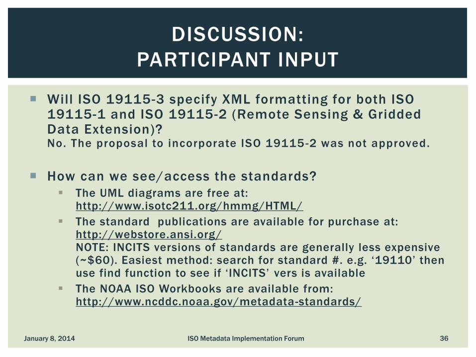
Will ISO 19115-3 specify XML formatting for both ISO 19115-1 and ISO 19115-2 (Remote Sensing & Gridded Data Extension)? No. The proposal to incorporate ISO 19115 -2 was not approved.
How can we see/access the standards?
The UML diagrams are free at: http://www.isotc211.org/hmmg/HTML/
The standard publications are available for purchase at: http://webstore.ansi.org/ NOTE: INCITS versions of standards are generally less expensive (~$60). Easiest method: search for standard #. e.g. ‘19110’ then use find function to see if ‘INCITS’ vers is available
The NOAA ISO Workbooks are available from: http://www.ncddc.noaa.gov/metadata-standards/
ISO Metadata Implementation Forum 36
DISCUSSION:
PARTICIPANT INPUT
January 8, 2014

Creating metadata has always been a challenge. ISO metadata is more complicated. How do you simplify the process for staff?
Improved availability to effective ISO Metadata editors and other tools will go a long way in addressing the complexity. Watch the FGDC website and MWG email list for information about an updated ISO Metadata Editor Review
It is helpful to identify and assign an organizational metadata master/guru who can stay current with the standards, tools and training resources and be a resource to the staff.
Templates can be developed to customize the standard to your organization and trim the elements and values to relevant content. Templates can be broken into components that may be distributed among staff/functions, e.g. database manager documents feature catalogs, network manager documents services, research staff document identification information, field staff lineage, etc.
ISO Metadata Implementation Forum 37
DISCUSSION:
PARTICIPANT INPUT
January 8, 2014

Does ESRI ArcGIS support Feature Catalog documentation?
We are not the software experts but please attend the May 14 Forum ‘Commercial Metadata Implementation Tools’. ESRI has committed to participate in the session.
Please see the ESRI OGC & ISO/TC211 Standards Implementation Whitepaper: http://www.esri.com/library/whitepapers/pdfs/supported -ogc-iso-standards.pdf
ISO Metadata Implementation Forum 38
DISCUSSION:
PARTICIPANT INPUT
January 8, 2014

Should we use 19115 or 19115-1? It seems most tool development, such as data.gov, is focusing on 19115 & 19115-2
Given the 5 year review cycle of ISO standards some measure of flexibility will be needed. The key is to remain current with the community and shared resources for moving forward together
You will be in good company with ISO 19115/-2. The tools are becoming stable and there is a growing community of support. Transforms are already under development to convert ISO 19115/-2 to 19115-1
Given the Final Draft status of ISO 19115-1 and forthcoming changes that may better support your data, organizations are strongly encouraged to explore the standard and poise themselves for implementation
Efforts such as data.gov are aware of the impending ISO 19115-1 update and will present their approach at the April 9 Forum ‘Community Metadata Implementation Tools’
ISO Metadata Implementation Forum 39
DISCUSSION:
PARTICIPANT INPUT
January 8, 2014

Why aren’t you promoting the use of North American Profile (NAP)?
The NAP increases some domains and conditionality and provides best practices for populating most elements. It was developed prior to significant ISO 19115 implementation experience.
The best practices have been embraced by the US metadata community but most US implementers apply them using the source standard, ISO 19115/-2. The resources and community are not focused on NAP.
As such, there are no plans at this time by INCITS to update the NAP standard. However, INCITS is considering republishing the NAP as a guidance document. If embraced and codified by the community, the republished document can be submitted as a fully vetted profile.
NOAA comparison of ISO 19115 to NAP ftp://ftp.ncddc.noaa.gov/pub/Metadata/Online_ISO_Training/Intro_to_ISO/handouts/Comparison_between_NAP_and_ISO.pdf
ISO Metadata Implementation Forum 40
DISCUSSION:
PARTICIPANT INPUT
January 8, 2014

FGDC 2011 Metadata Summit http://www.fgdc.gov/metadata/events/metadata -
summit/index_html
FGDC 2013 ISO Webinar http://www.fgdc.gov/metadata/events/ISO_Implementation_Webi
nar/index_html
ISO UML Diagrams http://www.isotc211.org/hmmg/HTML/
ANSI Webstore http://webstore.ansi.org/ (search for cheaper INCITS versions)
The NOAA ISO Workbooks http://www.ncddc.noaa.gov/metadata -standards/
ISO Metadata Implementation Forum 41
DISCUSSION:
ONLINE RESOURCE SUMMARY
January 8, 2014

NOAA ISO Metadata Webinar Training Series
http://www.ncddc.noaa.gov/metadata-standards/metadata-
training/course-three/
NOAA comparison of ISO 19115 to NAP
ftp://ftp.ncddc.noaa.gov/pub/Metadata/Online_ISO_Training/Intro_to
_ISO/handouts/Comparison_between_NAP_and_ISO.pdf
NOAA XML Templates
ftp://ftp.ncddc.noaa.gov/pub/Metadata/Online_ISO_Training/Intro_to
_ISO/templates/
Support fo ISO metadata standards in ArcGIS Desktop
http://resources.arcgis.com/en/help/main/10.2/index.html#//003t0
0000039000000
ESRI OGC & ISO/TC211 Standards Implementation Whitepaper:
http://www.esri.com/library/whitepapers/pdfs/supported -ogc-iso-
standards.pdf
ISO Metadata Implementation Forum 42
DISCUSSION:
ONLINE RESOURCE SUMMARY
January 8, 2014

If you are an experienced ISO implementer interested in
presenting in this session please contact:
or
January 8, 2014 ISO Metadata Implementation Forum 43
NEXT SESSION
February 12, 2014 - 3:00-4:30 PM (E)
Why We Implemented ISO Metadata Implementers discuss their reasons for implementing the new standard and the
benefits/challenges of their experience