epa geospatial/non geospatial metadata style guide geospatial/non-geospatial metadata style guide...
TRANSCRIPT
EPA Geospatial/Non-Geospatial Metadata Style Guide
Version 1.1, May 4, 2015
May 4, 2015 Page i EPA Metadata Style Guide v1.1
Document Change Control
The following is the document control for revisions to this document.
Version Number
Date of Issue
Author(s) Brief Description of Change
V1.0 October 7, 2014
Steven Jett, Suzanne Pierson, Torrin Hultgren, Innovate!, Inc.
Initial Version.
V1.1 May 4, 2015
Steven Jett, Suzanne Pierson, Torrin Hultgren, Innovate!, Inc.
Updates for changes to Distribution Liability in order to comply with OMB Project Open Data requirements.

May 4, 2015 Page ii EPA Metadata Style Guide v1.1
Contents
Introduction .................................................................................................................................................. 1
Metadata Preparation for Geospatial Resources ......................................................................................... 2
Prepare FGDC-Compliant Metadata for a Geospatial Resource ............................................................... 4
Types of geospatial resources ............................................................................................................... 4
Helpful metadata templates ................................................................................................................. 4
The EPA Metadata Editor (EME) ........................................................................................................... 4
Additional metadata preparation considerations ................................................................................ 5
Instructions for using this section of the guide .................................................................................... 6
EME Tab 1: Basic Dataset Information .................................................................................................. 7
EME Tab 2: Quality, Coordinate System, and Attribute Information ................................................. 14
EME Tab 3: Distribution & Metadata Information .............................................................................. 21
Prepare ArcMap MXD Documentation for Web Service Metadata ....................................................... 25
Instructions for using this section of the guide .................................................................................. 25
ArcMap Map Document Properties .................................................................................................... 25
ArcMap Data Frame Properties .......................................................................................................... 32
ArcMap Group and Layer Properties .................................................................................................. 33
Prepare Metadata for an EPA GeoPlatform Online Content Item .......................................................... 36
Metadata Preparation for Non-Geospatial Resources ............................................................................... 41
Appendix 1: Keywords ................................................................................................................................ 42
Appendix 2: EPA Organization Names ........................................................................................................ 43
May 4, 2015 Page 1 EPA Metadata Style Guide v1.1
Introduction This guide provides suggestions on metadata preparation for EPA geospatial and non-geospatial
resources for internal and external sharing. Detailed guidance on metadata requirements, standard
language, and naming conventions are provided with the goal of simplifying the documentation process
and standardizing (to the extent possible) EPA dataset metadata and documentation. This guidance is
rooted in the publishing guidelines set forth in the documents Geospatial Metadata Technical
Specification and EPA’s Implementation of the Data.gov Standard: Creating Metadata for EPA Non-
geospatial Datasets (currently in revision due to recent OMB Open Data Policy standards). The goal of
this guide is to help users create metadata that has a consistent appearance and, where applicable,
conforms to all Project Open Data requirements that make the metadata record sharable in the
Environmental Dataset Gateway (EDG) and in Data.gov.
This guide is divided into two main sections, one pertaining to metadata for geospatial resources, the
other pertaining to metadata for non-geospatial resources. There are also two appendices: A keywords
appendix which provides suggested keywords for fields requiring keywords or tags, and an organization
names appendix which provides acceptable abbreviated EPA organization names that the creator of the
metadata may use in fields requiring the name of the Office, Region, or Research Laboratory.
This guide does not detail the process to publish metadata records in the Environmental Dataset
Gateway (EDG), nor does it provide instructions on creating web services. Please consult documents at
the EDG About page for help on publishing metadata and the EPA GeoPlatform Data Publishing
Standard Operating Procedure (SOP) for instructions on web service creation. For additional assistance,
please contact the appropriate group or team:
Metadata records: EDG Administrative Group ([email protected])
Documenting and publishing web services: National Geospatial Support (NGS) Team
EPA GeoPlatform Online: EPA GeoPlatform Team at [email protected].
May 4, 2015 Page 2 EPA Metadata Style Guide v1.1
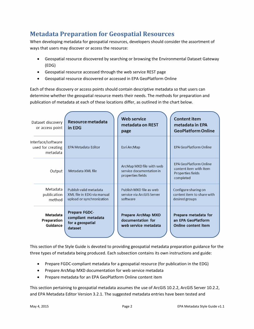
Metadata Preparation for Geospatial Resources When developing metadata for geospatial resources, developers should consider the assortment of
ways that users may discover or access the resource:
Geospatial resource discovered by searching or browsing the Environmental Dataset Gateway
(EDG)
Geospatial resource accessed through the web service REST page
Geospatial resource discovered or accessed in EPA GeoPlatform Online
Each of these discovery or access points should contain descriptive metadata so that users can
determine whether the geospatial resource meets their needs. The methods for preparation and
publication of metadata at each of these locations differ, as outlined in the chart below.
This section of the Style Guide is devoted to providing geospatial metadata preparation guidance for the
three types of metadata being produced. Each subsection contains its own instructions and guide:
Prepare FGDC-compliant metadata for a geospatial resource (for publication in the EDG)
Prepare ArcMap MXD documentation for web service metadata
Prepare metadata for an EPA GeoPlatform Online content item
This section pertaining to geospatial metadata assumes the use of ArcGIS 10.2.2, ArcGIS Server 10.2.2,
and EPA Metadata Editor Version 3.2.1. The suggested metadata entries have been tested and

May 4, 2015 Page 3 EPA Metadata Style Guide v1.1
confirmed to function properly with these software versions. However, it is recognized that the
recommendations in this section may not meet the needs of all users. For additional assistance, please
contact the appropriate group or team:
Metadata records: EDG Administrative Group ([email protected])
Documenting and publishing web services: National Geospatial Support (NGS) Team
EPA GeoPlatform Online: EPA GeoPlatform Team at [email protected].
May 4, 2015 Page 4 EPA Metadata Style Guide v1.1
Prepare FGDC-Compliant Metadata for a Geospatial Resource This subsection of the Style Guide provides detailed documentation on how to create metadata for each
type of geospatial resource that is suitable for publishing in the EDG. The documentation is designed to
be used with metadata templates that accompany the EPA Metadata Editor (EME).
Types of geospatial resources FGDC-compliant metadata for geospatial resources is published in the EDG to facilitate discovery of the
resource. Geospatial resources include the following:
Geospatial dataset – shapefile, feature class, imagery file, etc.
Data download package – dataset or group of datasets made available as a download (often
compressed into a zip file).
Web service – geospatial data, accessible via a web URL, consumable in client applications such
as web maps.
Helpful metadata templates Three downloadable templates are designed to be used with this Style Guide:
MetadataTemplateLayerLevel.xml – designed to be used to create metadata for a geospatial
dataset such as a shapefile, individual feature class, imagery file, etc.
MetadataTemplateDownloadPkg.xml – designed to be used to create metadata for a data
download package
MetadataTemplateWebService.xml – designed to be used to create metadata for a web service
The templates contain required text for each metadata element along with text prompts for data-
specific text. The text prompts are enclosed in brackets and asterisks {***ENTER HERE***} which the
user must replace with text that describes the data layer.
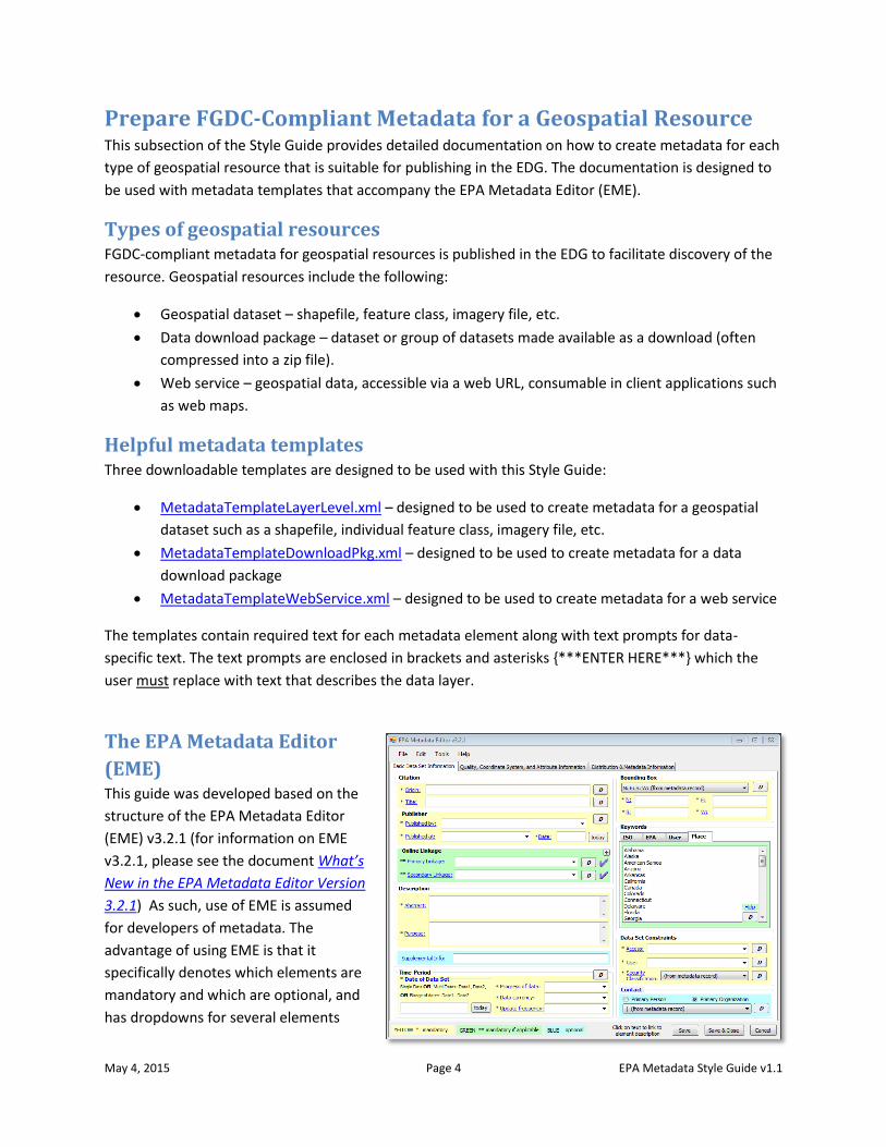
The EPA Metadata Editor
(EME) This guide was developed based on the
structure of the EPA Metadata Editor
(EME) v3.2.1 (for information on EME
v3.2.1, please see the document What’s
New in the EPA Metadata Editor Version
3.2.1) As such, use of EME is assumed
for developers of metadata. The
advantage of using EME is that it
specifically denotes which elements are
mandatory and which are optional, and
has dropdowns for several elements
May 4, 2015 Page 5 EPA Metadata Style Guide v1.1
that may be populated with standardized text. The user may also validate the metadata record directly
within EME to ensure it complies with standards. Developers with considerable metadata editing
experience may find a text editor more efficient than using EME, but need to be cognizant of elements
requiring specific language in order for the metadata record to pass validation to be published in the
EDG. Some developers might find that initial editing within the EME followed by final editing in a text
editor will produce the desired results. Download the EME and review EME training materials at the EPA
Metadata Editor web page.
Additional metadata preparation considerations Review these considerations for preparing metadata based on the geospatial resource type.
Preparing FGDC metadata for a dataset (layer-level metadata):
NOTE: in this document, “layer-level” metadata refers to metadata prepared for an individual
geospatial dataset such as a shapefile, individual feature class within a geodatabase, raster
dataset, imagery file, etc.
Metadata preparation should occur in the EME extension of ArcCatalog.
If the dataset has accompanying original metadata, use this guide to edit the original metadata.
If no accompanying metadata exists, use this guide to create new metadata. In both cases, list
whether the dataset has been value-added in the Supplemental Information metadata element
and details about improvements to the dataset in the Processing Steps metadata element.
This guide assumes that metadata is linked to the geospatial dataset. In ArcCatalog, use the EME
Import function to link a metadata XML file to the dataset. If metadata is being created for the
first time, link a copy of the MetadataTemplateDataset.xml file to the dataset to begin the
editing process. Linking metadata to the dataset takes advantage of EME’s metadata
synchronization function, which automatically writes certain properties of the geospatial dataset
(Bounding Box, Coordinate System, and Lineage) to the appropriate elements in the metadata,
eliminating the need to update these manually.
To ensure that the Bounding Box and Coordinate System fields are properly populated, make
sure to set the EME Sync Settings as follows:
o In ArcCatalog, click the Manage Metadata Synchronization button on the EME toolbar.
o Click the EPA Sync Settings tab.
o Check Remove ESRI tags, Coordinate System, and Spatial Extent.
o Uncheck Attributes, Online Linkage, and Retain PublishedDocID.
o Click OK.
o Perform synchronization.
Preparing FGDC metadata for a data download package:
Metadata preparation should occur in the standalone version of EME.
It is recommended that a data download package consist of a zip file containing the following:
o A file geodatabase.
o An Esri ArcMap map document (MXD).
o An XML file of the FGDC-compliant metadata for the download package.
May 4, 2015 Page 6 EPA Metadata Style Guide v1.1
Additionally, a duplicate copy of the XML metadata file should be placed alongside the zip file
(external to the zip file) to provide an easily-accessible indication of the zip file contents. This
arrangement allows data users to preview the metadata and ensure the package contains the
desired contents before commencing a download session.
As a best practice, layer-level metadata should exist in the file geodatabase for each feature
class.
Preparing FGDC metadata for a web service:
NOTE: EPA web services require two types of metadata: A FGDC metadata record that is
published in the EDG to facilitate discovery of the web service, and metadata at the web service
REST endpoint page that results from publishing the web service in ArcGIS Server. This section
pertains to creating the FGDC metadata record. Please refer to the following section, “Prepare
ArcMap MXD documentation for web service metadata,” for REST endpoint metadata.
Metadata preparation should occur in the standalone version of EME.
As a best practice, layer-level metadata should be published in the EDG for each layer in the web
service. The link to the layer-level metadata should be made available at each layer’s REST
endpoint.
It is strongly recommended that data download packages be made available for geospatial
datasets that are published as web services.
Instructions for using this section of the guide This guide has instructions and recommendations for creating FGDC metadata for all three geospatial
resource types. Specific instructions are included for specific resource types where appropriate. For
example, separate instructions for completing the Description elements in EME are included and
denoted as “FOR LAYER-LEVEL METADATA,” “FOR DATA DOWNLOAD PACKAGE METADATA”, and “FOR
WEB SERVICE METADATA.”
Open the metadata file in EME and follow along in the guide which steps through each EME tab,
element by element, with instructions. While most elements are pre-populated with text prompts, other
elements may be optionally edited as needed. Elements in this guide denoted with light gray text should
not be edited. In addition, help with individual EME elements is available directly in the EME interface by
clicking on the link for the element or selecting the Help menu item.
May 4, 2015 Page 7 EPA Metadata Style Guide v1.1
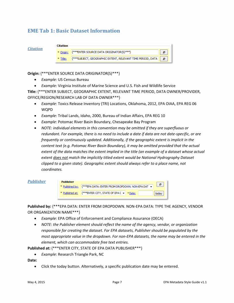
EME Tab 1: Basic Dataset Information
Citation
Origin: {***ENTER SOURCE DATA ORIGINATOR(S)***}
Example: US Census Bureau
Example: Virginia Institute of Marine Science and U.S. Fish and Wildlife Service
Title: {***ENTER SUBJECT, GEOGRAPHIC EXTENT, RELEVANT TIME PERIOD, DATA OWNER/PROVIDER,
OFFICE/REGION/RESEARCH LAB OF DATA OWNER***}
Example: Toxics Release Inventory (TRI) Locations, Oklahoma, 2012, EPA OIAA, EPA REG 06
WQPD
Example: Tribal Lands, Idaho, 2000, Bureau of Indian Affairs, EPA REG 10
Example: Potomac River Basin Boundary, Chesapeake Bay Program
NOTE: individual elements in this convention may be omitted if they are superfluous or
redundant. For example, there is no need to include a date if data are not date-specific, or are
frequently or continuously updated. Additionally, if the geographic extent is implicit in the
content text (e.g. Potomac River Basin Boundary), it may be omitted provided that the actual
extent of the data matches the extent implied in the title (an example of a dataset whose actual
extent does not match the implicitly titled extent would be National Hydrography Dataset
clipped to a given state). Geographic extent should always refer to a place name, not
coordinates.
Publisher
Published by: {***EPA DATA: ENTER FROM DROPDOWN. NON-EPA DATA: TYPE THE AGENCY, VENDOR
OR ORGANIZATION NAME***}
Example: EPA Office of Enforcement and Compliance Assurance (OECA)
NOTE: the Publisher element should reflect the name of the agency, vendor, or organization
responsible for creating the dataset. For EPA datasets, Publisher should be populated by the
most appropriate value in the dropdown. For non-EPA datasets, the name may be entered in the
element, which can accommodate free text entries.
Published at: {***ENTER CITY, STATE OF EPA DATA PUBLISHER***}
Example: Research Triangle Park, NC
Date:
Click the today button. Alternatively, a specific publication date may be entered.
May 4, 2015 Page 8 EPA Metadata Style Guide v1.1
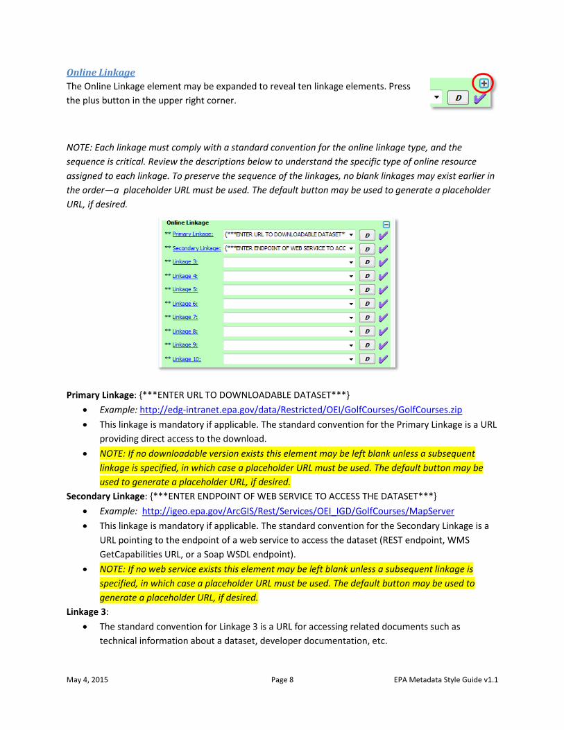
Online Linkage
The Online Linkage element may be expanded to reveal ten linkage elements. Press
the plus button in the upper right corner.
NOTE: Each linkage must comply with a standard convention for the online linkage type, and the
sequence is critical. Review the descriptions below to understand the specific type of online resource
assigned to each linkage. To preserve the sequence of the linkages, no blank linkages may exist earlier in
the order—a placeholder URL must be used. The default button may be used to generate a placeholder
URL, if desired.
Primary Linkage: {***ENTER URL TO DOWNLOADABLE DATASET***}
Example: http://edg-intranet.epa.gov/data/Restricted/OEI/GolfCourses/GolfCourses.zip
This linkage is mandatory if applicable. The standard convention for the Primary Linkage is a URL
providing direct access to the download.
NOTE: If no downloadable version exists this element may be left blank unless a subsequent
linkage is specified, in which case a placeholder URL must be used. The default button may be
used to generate a placeholder URL, if desired.
Secondary Linkage: {***ENTER ENDPOINT OF WEB SERVICE TO ACCESS THE DATASET***}
Example: http://igeo.epa.gov/ArcGIS/Rest/Services/OEI_IGD/GolfCourses/MapServer
This linkage is mandatory if applicable. The standard convention for the Secondary Linkage is a
URL pointing to the endpoint of a web service to access the dataset (REST endpoint, WMS
GetCapabilities URL, or a Soap WSDL endpoint).
NOTE: If no web service exists this element may be left blank unless a subsequent linkage is
specified, in which case a placeholder URL must be used. The default button may be used to
generate a placeholder URL, if desired.
Linkage 3:
The standard convention for Linkage 3 is a URL for accessing related documents such as
technical information about a dataset, developer documentation, etc.
May 4, 2015 Page 9 EPA Metadata Style Guide v1.1
NOTE: If an appropriate URL does not exist this element may be left blank unless a subsequent
linkage is specified, in which case a placeholder URL must be used. The default button may be
used to generate a placeholder URL, if desired.
Linkage 4:
The standard convention for Linkage 4 is a URL for an alternative landing page used to redirect
user to a contextual, Agency-hosted “homepage” for the dataset. This field is not intended for
an agency’s homepage, but rather related to resources tied to the dataset.
NOTE: If an appropriate URL does not exist this element may be left blank unless a subsequent
linkage is specified, in which case a placeholder URL must be used. The default button may be
used to generate a placeholder URL, if desired.
Other Linkages:
Any other URLs related to this dataset. These may be left blank if no additional URLs exist.
NOTE: It is recommended that these elements remain blank if no linkages are provided in the
Primary Linkage, Secondary Linkage, Linkage 3, and/or Linkage 4 elements.
Description
FOR LAYER-LEVEL METADATA:
Abstract: This {***raster (IF APPLICABLE)***} GIS dataset contains {***POINTS/LINES/POLYGONS/
CELLS***} depicting {***CONTENT FROM TITLE***}. {***ADDITIONAL CONTEXTUAL INFORMATION.***}
This element is pre-populated with suggested text. Change the text to fit specific needs to
describe the dataset as thoroughly as possible. Use clear and concise language, keeping in mind
that different portals and clearinghouses that harvest metadata show only a portion of the
abstract as a preview. As such, structure the abstract content in decreasing order of importance.
Any additional contextual information that helps inform the user about the dataset is helpful.
Example: This raster GIS dataset contains 100-meter-resolution cells depicting mean surface
salinity (parts per thousand) in the Chesapeake Bay and its tidal tributaries during Fall season.
Salinity was measured annually from 1985 to 2006.
Purpose: {***TEXT DESCRIBING THE GENERAL PURPOSE OF THE GIS DATASET***} The overall goal of
the Chesapeake Bay Program is to lead and direct Chesapeake Bay restoration and protection.
Populate this element with text describing the general purpose of the geospatial dataset.
May 4, 2015 Page 10 EPA Metadata Style Guide v1.1
Example: The purpose of this dataset is to show the differences in salinity throughout the
Chesapeake Bay during the Fall season. The overall goal of the Chesapeake Bay Program is to
lead and direct Chesapeake Bay restoration and protection.
Supplemental Info:
This element is frequently used to denote whether the dataset is EPA-created or EPA-Value-
added, or for other information that should be communicated to the end user such as caveats.
This element may be completed with such information or may be left blank.
FOR DATA DOWNLOAD PACKAGE METADATA:
Abstract: This downloadable data package contains the following layers: {***DEFINE LAYERS HERE***}.
Included in this package are a file geodatabase, Esri ArcMap map document, and a XML file of this
metadata record. Full FGDC metadata records for each layer are contained in the database.
This element is pre-populated with suggested text which may be changed to fit specific needs.
Complete the element using clear and concise language, keeping in mind that different portals
and clearinghouses that harvest metadata show only a portion of the abstract as a preview. As
such, structure the abstract content in decreasing order of importance.
Purpose: {***TEXT DESCRIBING THE GENERAL PURPOSE OF THE DOWNLOAD PACKAGE***}
Populate this element with text describing the purpose of the data download package.
Example: These data provide information about Toxic Release Inventory (TRI) locations in EPA
Region 4 and are intended for geographic display and analysis at regional, state, and local levels.
Supplemental Info:
This element is frequently used for data caveats or other information that should be
communicated to the end user. This element may be completed with such information or may
be left blank.
FOR WEB SERVICE METADATA:
Abstract: This web service contains the following map layers: {***DEFINE LAYERS HERE***}. Layers are
drawn at scales of {***DEFINE THIS IF MAP CONTAINS SCALE DEPENDENCIES***}. Data used to create
this web service are available as a separate download at the Primary Linkage listed. Full FGDC metadata
records for each layer may be found by clicking the layer name at the web service endpoint (available
through the online link provided above) and viewing the layer description.
This element is pre-populated with suggested text which may be changed to fit specific needs.
Complete the element using clear and concise language, keeping in mind that different portals
and clearinghouses that harvest metadata show only a portion of the abstract as a preview. As
such, structure the abstract content in decreasing order of importance. Once completed, review
for errors and content prior to validating and publishing.
Purpose: {***TEXT DESCRIBING THE GENERAL PURPOSE OF THE WEB SERVICE***}
Populate this element with text describing the general purpose of the web service.
Example: These data provide information about Toxic Release Inventory (TRI) locations in EPA
Region 4 and are intended for geographic display and analysis at regional, state, and local levels.
Supplemental Info:
May 4, 2015 Page 11 EPA Metadata Style Guide v1.1
This element is frequently used for data caveats or other information that should be
communicated to the end user. This element may be completed with such information or may
be left blank.
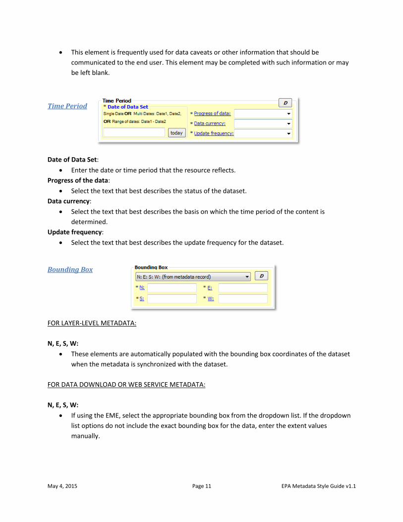
Time Period
Date of Data Set:
Enter the date or time period that the resource reflects.
Progress of the data:
Select the text that best describes the status of the dataset.
Data currency:
Select the text that best describes the basis on which the time period of the content is
determined.
Update frequency:
Select the text that best describes the update frequency for the dataset.
Bounding Box
FOR LAYER-LEVEL METADATA:
N, E, S, W:
These elements are automatically populated with the bounding box coordinates of the dataset
when the metadata is synchronized with the dataset.
FOR DATA DOWNLOAD OR WEB SERVICE METADATA:
N, E, S, W:
If using the EME, select the appropriate bounding box from the dropdown list. If the dropdown
list options do not include the exact bounding box for the data, enter the extent values
manually.
May 4, 2015 Page 12 EPA Metadata Style Guide v1.1
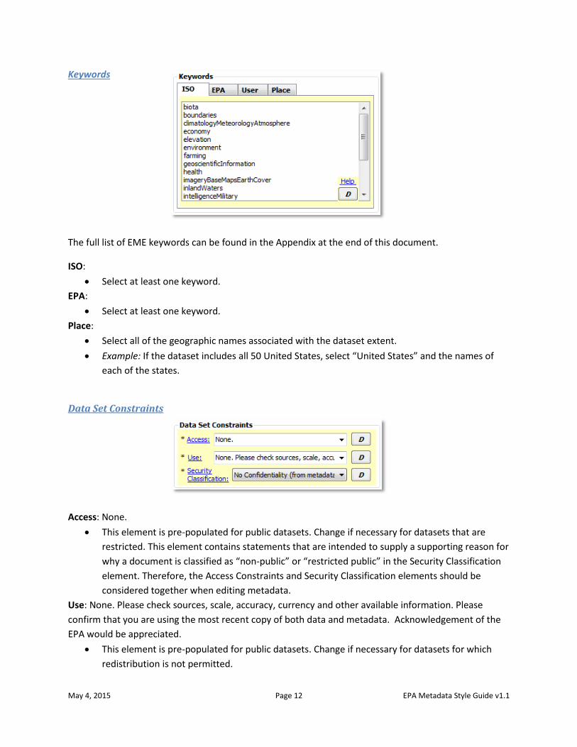
Keywords
The full list of EME keywords can be found in the Appendix at the end of this document.
ISO:
Select at least one keyword.
EPA:
Select at least one keyword.
Place:
Select all of the geographic names associated with the dataset extent.
Example: If the dataset includes all 50 United States, select “United States” and the names of
each of the states.
Data Set Constraints
Access: None.
This element is pre-populated for public datasets. Change if necessary for datasets that are
restricted. This element contains statements that are intended to supply a supporting reason for
why a document is classified as “non-public” or “restricted public” in the Security Classification
element. Therefore, the Access Constraints and Security Classification elements should be
considered together when editing metadata.
Use: None. Please check sources, scale, accuracy, currency and other available information. Please
confirm that you are using the most recent copy of both data and metadata. Acknowledgement of the
EPA would be appreciated.
This element is pre-populated for public datasets. Change if necessary for datasets for which
redistribution is not permitted.
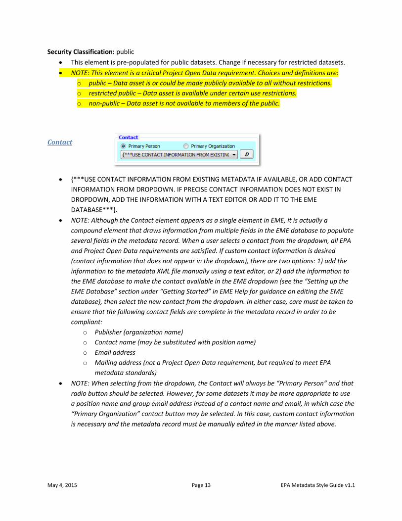
May 4, 2015 Page 13 EPA Metadata Style Guide v1.1
Security Classification: public
This element is pre-populated for public datasets. Change if necessary for restricted datasets.
NOTE: This element is a critical Project Open Data requirement. Choices and definitions are:
o public – Data asset is or could be made publicly available to all without restrictions.
o restricted public – Data asset is available under certain use restrictions.
o non-public – Data asset is not available to members of the public.
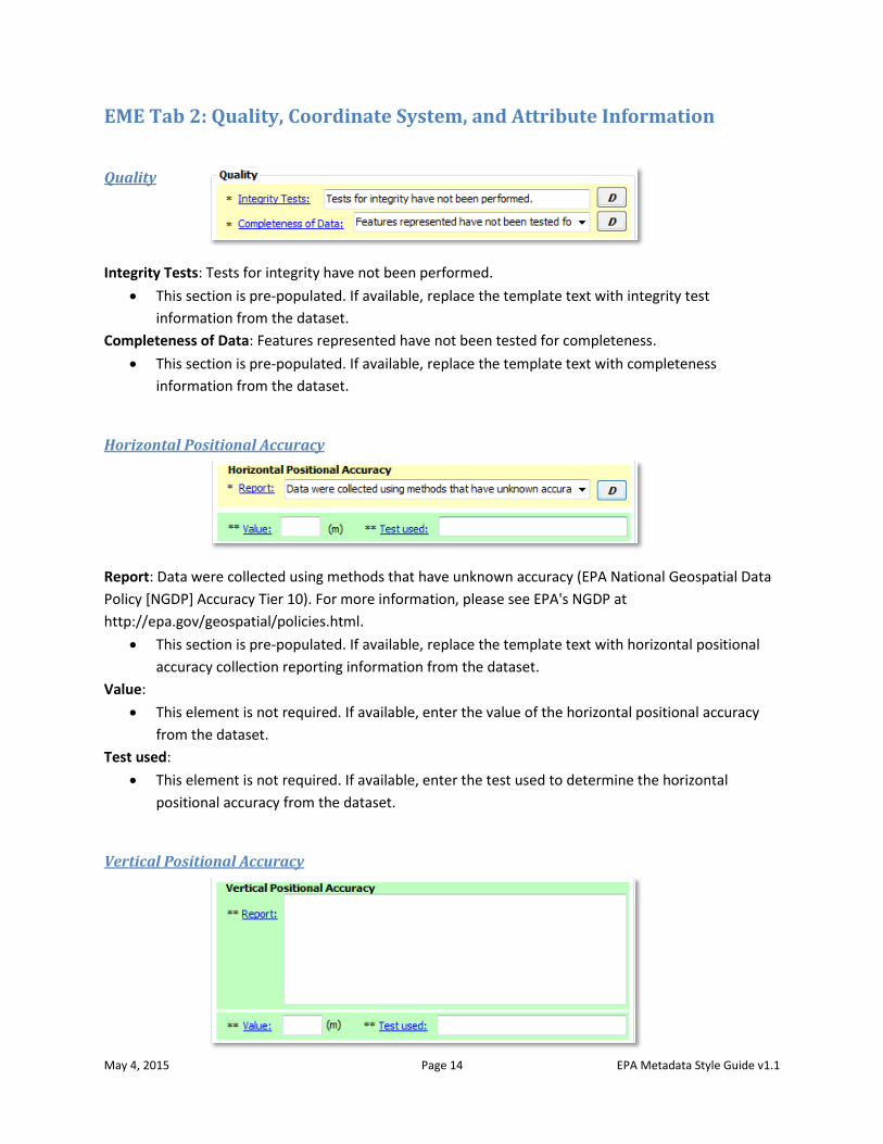
Contact
{***USE CONTACT INFORMATION FROM EXISTING METADATA IF AVAILABLE, OR ADD CONTACT
INFORMATION FROM DROPDOWN. IF PRECISE CONTACT INFORMATION DOES NOT EXIST IN
DROPDOWN, ADD THE INFORMATION WITH A TEXT EDITOR OR ADD IT TO THE EME
DATABASE***}.
NOTE: Although the Contact element appears as a single element in EME, it is actually a
compound element that draws information from multiple fields in the EME database to populate
several fields in the metadata record. When a user selects a contact from the dropdown, all EPA
and Project Open Data requirements are satisfied. If custom contact information is desired
(contact information that does not appear in the dropdown), there are two options: 1) add the
information to the metadata XML file manually using a text editor, or 2) add the information to
the EME database to make the contact available in the EME dropdown (see the “Setting up the
EME Database” section under “Getting Started” in EME Help for guidance on editing the EME
database), then select the new contact from the dropdown. In either case, care must be taken to
ensure that the following contact fields are complete in the metadata record in order to be
compliant:
o Publisher (organization name)
o Contact name (may be substituted with position name)
o Email address
o Mailing address (not a Project Open Data requirement, but required to meet EPA
metadata standards)
NOTE: When selecting from the dropdown, the Contact will always be “Primary Person” and that
radio button should be selected. However, for some datasets it may be more appropriate to use
a position name and group email address instead of a contact name and email, in which case the
“Primary Organization” contact button may be selected. In this case, custom contact information
is necessary and the metadata record must be manually edited in the manner listed above.
May 4, 2015 Page 14 EPA Metadata Style Guide v1.1
EME Tab 2: Quality, Coordinate System, and Attribute Information
Quality
Integrity Tests: Tests for integrity have not been performed.
This section is pre-populated. If available, replace the template text with integrity test
information from the dataset.
Completeness of Data: Features represented have not been tested for completeness.
This section is pre-populated. If available, replace the template text with completeness
information from the dataset.
Horizontal Positional Accuracy
Report: Data were collected using methods that have unknown accuracy (EPA National Geospatial Data
Policy [NGDP] Accuracy Tier 10). For more information, please see EPA's NGDP at
http://epa.gov/geospatial/policies.html.
This section is pre-populated. If available, replace the template text with horizontal positional
accuracy collection reporting information from the dataset.
Value:
This element is not required. If available, enter the value of the horizontal positional accuracy
from the dataset.
Test used:
This element is not required. If available, enter the test used to determine the horizontal
positional accuracy from the dataset.
Vertical Positional Accuracy
May 4, 2015 Page 15 EPA Metadata Style Guide v1.1
Report:
This element is not required. If available, enter vertical positional accuracy collection reporting
information from the dataset.
Value:
This element is not required. If available, enter the value of the vertical positional accuracy from
the dataset.
Test used:
This element is not required. If available, enter the test used to determine the vertical
positional accuracy from the dataset
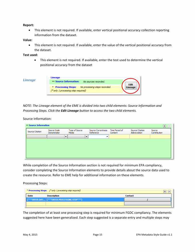
Lineage
NOTE: The Lineage element of the EME is divided into two child elements: Source Information and
Processing Steps. Click the Edit Lineage button to access the two child elements.
Source Information:
While completion of the Source Information section is not required for minimum EPA compliancy,
consider completing the Source Information elements to provide details about the source data used to
create the resource. Refer to EME help for additional information on these elements.
Processing Steps:
The completion of at least one processing step is required for minimum FGDC compliancy. The elements
suggested here have been generalized. Each step suggested is a separate entry and multiple steps may
May 4, 2015 Page 16 EPA Metadata Style Guide v1.1
contain the same value for Date if they were performed on the same date. Modify these suggested
entries and create additional entries if necessary.
PROCESSING STEPS FOR LAYER-LEVEL METADATA:
Date: {***ENTER DATE PROCESSING STEP WAS PERFORMED***}
Description: {***ENTER PROCESSING STEP***)
Example Processing Steps:
o Converted Excel spreadsheet with latitude/longitude coordinates to GIS shapefile.
o Projected GIS Shapefile to UTM Zone 18, NAD 83 projection.
o Standardized attribute units from acres to hectares.
o Created FGDC-compliant metadata for GIS shapefile.
o Imported GIS shapefile into SDE as new feature class.
PROCESSING STEPS FOR DATA DOWNLOAD PACKAGE METADATA:
Date: {***ENTER DATE PROCESSING STEP WAS PERFORMED***}
Description: {***ENTER PROCESSING STEP***)
Example Processing Steps:
o Imported shapefiles into file geodatabase as new feature classes.
o Created FGDC-compliant metadata for each file geodatabase feature class.
o Created Esri ArcMap map document (MXD).
o Created FGDC-compliant metadata for the data download package.
o Zipped data, map document, and metadata.
PROCESSING STEPS FOR WEB SERVICE METADATA:
Date: {***ENTER DATE PROCESSING STEP WAS PERFORMED***}
Description: {***ENTER PROCESSING STEP***)
Example Processing Steps:
o Imported data into file geodatabase as new feature classes in Web Mercator projection.
o Created FGDC-compliant metadata for each file geodatabase feature class.
o Created Esri ArcMap map document (MXD).
o Published the web service.
o Created FGDC-compliant metadata for the web service.
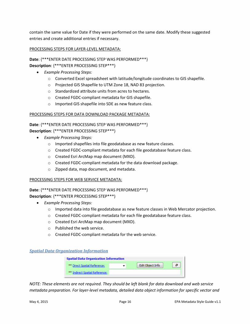
Spatial Data Organization Information
NOTE: These elements are not required. They should be left blank for data download and web service
metadata preparation. For layer-level metadata, detailed data object information for specific vector and
May 4, 2015 Page 17 EPA Metadata Style Guide v1.1
raster formats may be entered by clicking the Edit Object Info button. Refer to EME help for more
information on these elements.
FOR LAYER-LEVEL METADATA:
Direct Spatial Reference:
This element is not required. If desired, use the dropdown to select the system used to
represent the objects in the dataset.
Indirect Spatial Reference:
This element is not required. If desired, enter the name of the types of geographic features,
addressing schemes, or other means through which locations are referenced in the dataset.
Coordinate System Information (Horizontal)
FOR LAYER-LEVEL METADATA:
Projection:
SPCS Zone / UTM Zone / Projection Name:
Units:
Datum:
Resolution: X: / Y:
These elements are automatically populated with the coordinate system information of the
dataset when the metadata is synchronized with the dataset.
FOR DATA DOWNLOAD OR WEB SERVICE METADATA:
Projection:
Use the dropdown to select the projection reference system for the dataset. If the reference
system is not in the list, use a text editor to populate this field.
SPCS Zone / UTM Zone / Projection Name:
Use the dropdown to select the State Plane Coordinate System Zone, UTM Zone, or Projection
Name for the dataset. If the zone or name is not in the list, use a text editor to populate this
field.
NOTE: The dropdown selections in this field will correspond with the projection reference system
selected in the Projection field.
Units:
Use the dropdown to select the coordinate system units. If the correct entry for units is not in
the list, use a text editor to populate this field.
May 4, 2015 Page 18 EPA Metadata Style Guide v1.1
NOTE: The dropdown selection(s) in this field will correspond with the entry in the Projection field
and the entry in the SPCS Zone, UTM Zone, or Projection Name field.
Datum:
Use the dropdown to select the coordinate system datum. If the correct entry for the datum is
not in the list, use a text editor to populate this field.
NOTE: The dropdown selection(s) in this field will correspond with the entries in the other fields
in this section.
Resolution: X: / Y:
Enter the coordinate resolution (minimum distance between two adjacent points). For vector
data, these values usually correspond to the fuzzy tolerance of the dataset. For raster data,
these values usually correspond to the raster cell size.
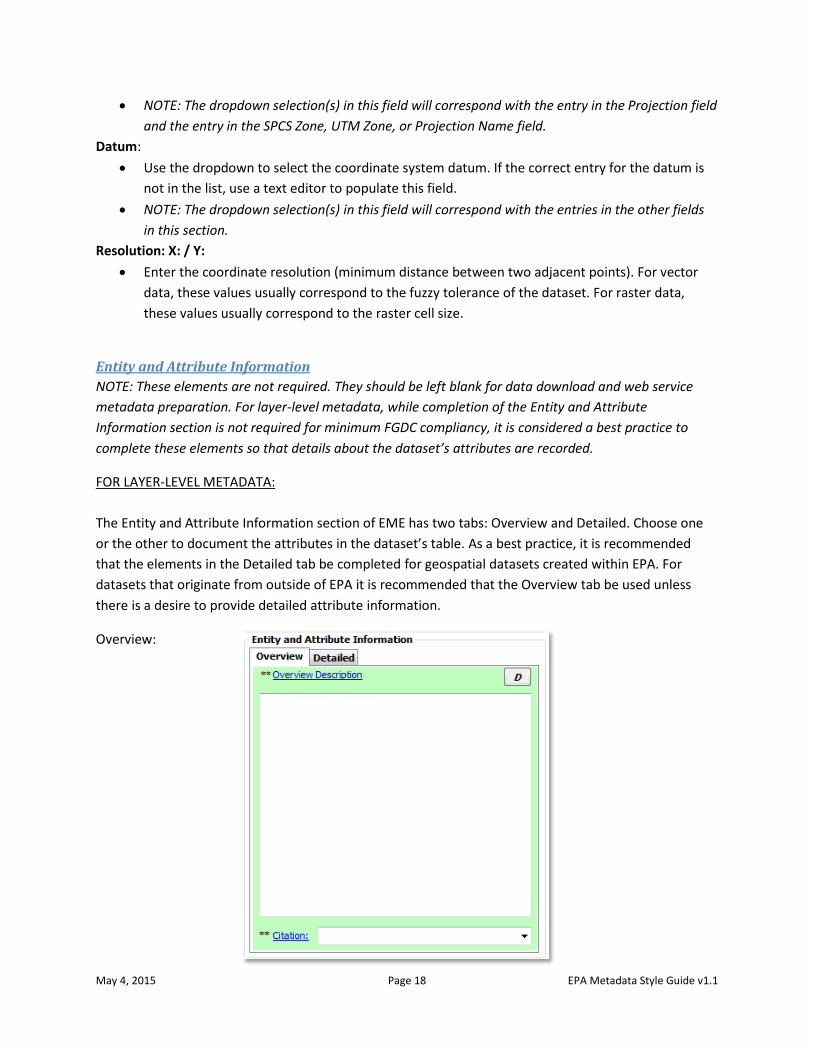
Entity and Attribute Information
NOTE: These elements are not required. They should be left blank for data download and web service
metadata preparation. For layer-level metadata, while completion of the Entity and Attribute
Information section is not required for minimum FGDC compliancy, it is considered a best practice to
complete these elements so that details about the dataset’s attributes are recorded.
FOR LAYER-LEVEL METADATA:
The Entity and Attribute Information section of EME has two tabs: Overview and Detailed. Choose one
or the other to document the attributes in the dataset’s table. As a best practice, it is recommended
that the elements in the Detailed tab be completed for geospatial datasets created within EPA. For
datasets that originate from outside of EPA it is recommended that the Overview tab be used unless
there is a desire to provide detailed attribute information.
Overview:
May 4, 2015 Page 19 EPA Metadata Style Guide v1.1
The Overview tab provides two metadata elements: Overview Description and Citation. The Overview
Description element is a free-text block in which to enter a description of the geospatial dataset
attributes. This is useful if “official” definitions of the attributes were not provided with the source data
from which the geospatial dataset was created. If descriptive text about the dataset was provided, that
may be transferred to this tab. Additionally, hyperlinks that point to an online resource with additional
information about the dataset may be used. Note that if the Overview Description element is
completed, the Citation element becomes required. The metadata will not validate if the Citation
element is left blank.
Overview Description:
Provide a summary of the information contained in the dataset. Use the descriptive text that
accompanied the original data if any existed, or make a best effort to summarize the contents.
Example: Zebra mussel sightings from 1991 to 2010 data provided to the Chesapeake Bay
Program for use in GIS analysis and visualization. Data provided by US Geological Survey
Nonindigenous Aquatic Species (NAS) Program. Inquiries regarding attribute data may be
addressed to the Metadata Contact.
Citation:
Provide a citation if available, or minimally the name of the source data provider.
Example: Pawlitz, R.J., and David, K.D., 2012, The National Nonindigenous Aquatic Species
Program: U.S. Geological Survey Fact Sheet 2012-3100, 4 p.
Example: National Register of Historic Places, US Department of the Interior National Parks
Service
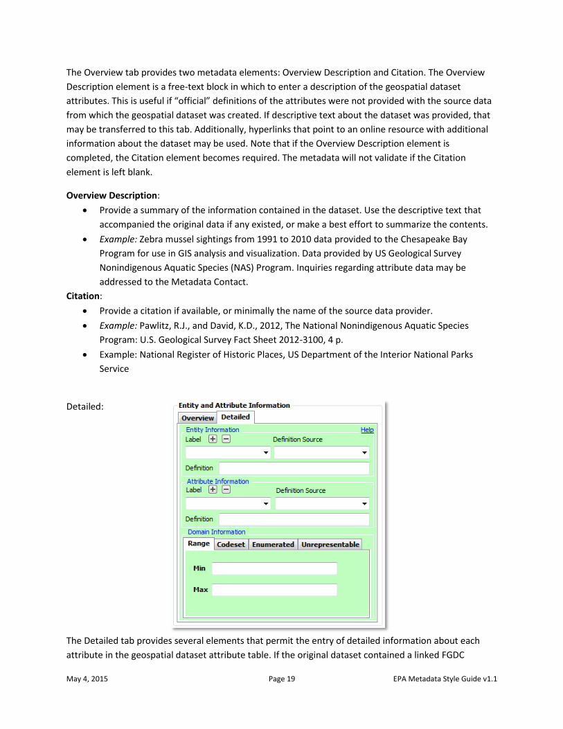
Detailed:
The Detailed tab provides several elements that permit the entry of detailed information about each
attribute in the geospatial dataset attribute table. If the original dataset contained a linked FGDC
May 4, 2015 Page 20 EPA Metadata Style Guide v1.1
metadata record with defined Entity and Attribute information, these elements are automatically
populated with that information. If these fields are all blank, synchronizing the metadata with the
dataset will populate these elements with information from the metadata record. If no metadata record
exists, performing synchronization will populate the Attribute Information – Label element with the
names of all of the attributes.
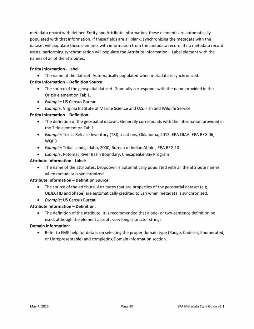
Entity Information - Label:
The name of the dataset. Automatically populated when metadata is synchronized.
Entity Information – Definition Source:
The source of the geospatial dataset. Generally corresponds with the name provided in the
Origin element on Tab 1.
Example: US Census Bureau
Example: Virginia Institute of Marine Science and U.S. Fish and Wildlife Service
Entity Information – Definition:
The definition of the geospatial dataset. Generally corresponds with the information provided in
the Title element on Tab 1.
Example: Toxics Release Inventory (TRI) Locations, Oklahoma, 2012, EPA OIAA, EPA REG 06,
WQPD
Example: Tribal Lands, Idaho, 2000, Bureau of Indian Affairs, EPA REG 10
Example: Potomac River Basin Boundary, Chesapeake Bay Program
Attribute Information - Label:
The name of the attributes. Dropdown is automatically populated with all the attribute names
when metadata is synchronized.
Attribute Information – Definition Source:
The source of the attribute. Attributes that are properties of the geospatial dataset (e.g.
OBJECTID and Shape) are automatically credited to Esri when metadata is synchronized.
Example: US Census Bureau
Attribute Information – Definition:
The definition of the attribute. It is recommended that a one- or two-sentence definition be
used, although the element accepts very long character strings.
Domain Information:
Refer to EME help for details on selecting the proper domain type (Range, Codeset, Enumerated,
or Unrepresentable) and completing Domain Information section.
May 4, 2015 Page 21 EPA Metadata Style Guide v1.1
EME Tab 3: Distribution & Metadata Information
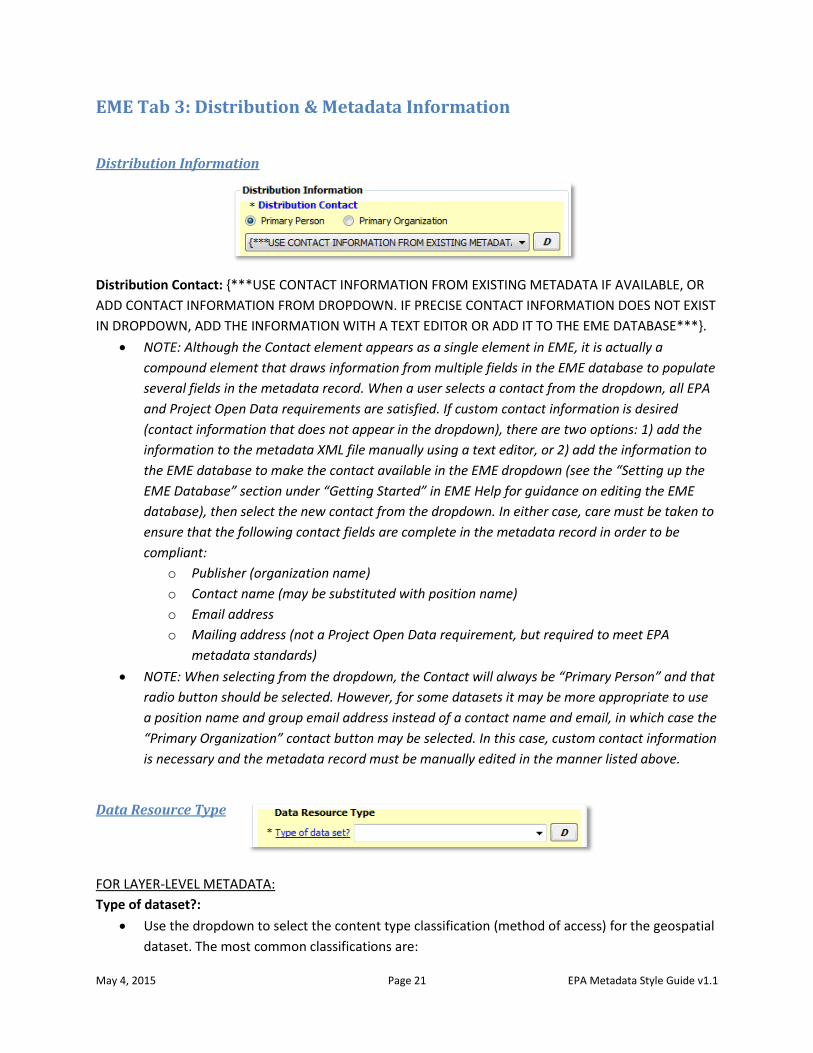
Distribution Information
Distribution Contact: {***USE CONTACT INFORMATION FROM EXISTING METADATA IF AVAILABLE, OR
ADD CONTACT INFORMATION FROM DROPDOWN. IF PRECISE CONTACT INFORMATION DOES NOT EXIST
IN DROPDOWN, ADD THE INFORMATION WITH A TEXT EDITOR OR ADD IT TO THE EME DATABASE***}.
NOTE: Although the Contact element appears as a single element in EME, it is actually a
compound element that draws information from multiple fields in the EME database to populate
several fields in the metadata record. When a user selects a contact from the dropdown, all EPA
and Project Open Data requirements are satisfied. If custom contact information is desired
(contact information that does not appear in the dropdown), there are two options: 1) add the
information to the metadata XML file manually using a text editor, or 2) add the information to
the EME database to make the contact available in the EME dropdown (see the “Setting up the
EME Database” section under “Getting Started” in EME Help for guidance on editing the EME
database), then select the new contact from the dropdown. In either case, care must be taken to
ensure that the following contact fields are complete in the metadata record in order to be
compliant:
o Publisher (organization name)
o Contact name (may be substituted with position name)
o Email address
o Mailing address (not a Project Open Data requirement, but required to meet EPA
metadata standards)
NOTE: When selecting from the dropdown, the Contact will always be “Primary Person” and that
radio button should be selected. However, for some datasets it may be more appropriate to use
a position name and group email address instead of a contact name and email, in which case the
“Primary Organization” contact button may be selected. In this case, custom contact information
is necessary and the metadata record must be manually edited in the manner listed above.
Data Resource Type
FOR LAYER-LEVEL METADATA:
Type of dataset?:
Use the dropdown to select the content type classification (method of access) for the geospatial
dataset. The most common classifications are:
May 4, 2015 Page 22 EPA Metadata Style Guide v1.1
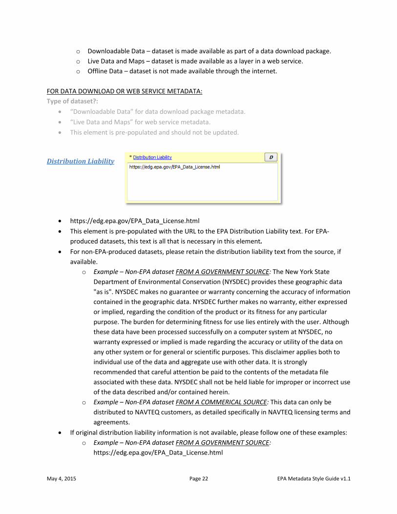
o Downloadable Data – dataset is made available as part of a data download package.
o Live Data and Maps – dataset is made available as a layer in a web service.
o Offline Data – dataset is not made available through the internet.
FOR DATA DOWNLOAD OR WEB SERVICE METADATA:
Type of dataset?:
“Downloadable Data” for data download package metadata.
“Live Data and Maps” for web service metadata.
This element is pre-populated and should not be updated.
Distribution Liability
https://edg.epa.gov/EPA_Data_License.html
This element is pre-populated with the URL to the EPA Distribution Liability text. For EPA-
produced datasets, this text is all that is necessary in this element.
For non-EPA-produced datasets, please retain the distribution liability text from the source, if
available.
o Example – Non-EPA dataset FROM A GOVERNMENT SOURCE: The New York State
Department of Environmental Conservation (NYSDEC) provides these geographic data
"as is". NYSDEC makes no guarantee or warranty concerning the accuracy of information
contained in the geographic data. NYSDEC further makes no warranty, either expressed
or implied, regarding the condition of the product or its fitness for any particular
purpose. The burden for determining fitness for use lies entirely with the user. Although
these data have been processed successfully on a computer system at NYSDEC, no
warranty expressed or implied is made regarding the accuracy or utility of the data on
any other system or for general or scientific purposes. This disclaimer applies both to
individual use of the data and aggregate use with other data. It is strongly
recommended that careful attention be paid to the contents of the metadata file
associated with these data. NYSDEC shall not be held liable for improper or incorrect use
of the data described and/or contained herein.
o Example – Non-EPA dataset FROM A COMMERICAL SOURCE: This data can only be
distributed to NAVTEQ customers, as detailed specifically in NAVTEQ licensing terms and
agreements.
If original distribution liability information is not available, please follow one of these examples:
o Example – Non-EPA dataset FROM A GOVERNMENT SOURCE:
https://edg.epa.gov/EPA_Data_License.html
May 4, 2015 Page 23 EPA Metadata Style Guide v1.1
o Example – Non-EPA dataset FROM A COMMERCIAL SOURCE: This is a licensed product
by [insert licensor here] for use within the U.S. EPA. No third party copy of this product
will be permitted.
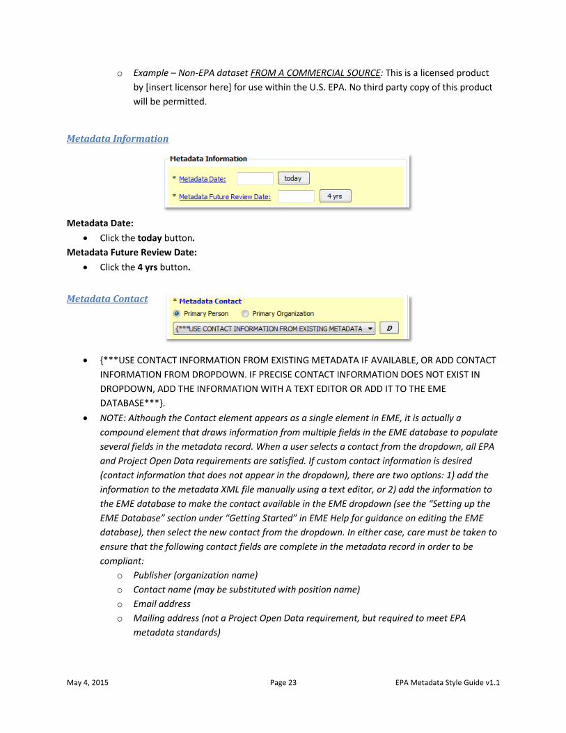
Metadata Information
Metadata Date:
Click the today button.
Metadata Future Review Date:
Click the 4 yrs button.
Metadata Contact
{***USE CONTACT INFORMATION FROM EXISTING METADATA IF AVAILABLE, OR ADD CONTACT
INFORMATION FROM DROPDOWN. IF PRECISE CONTACT INFORMATION DOES NOT EXIST IN
DROPDOWN, ADD THE INFORMATION WITH A TEXT EDITOR OR ADD IT TO THE EME
DATABASE***}.
NOTE: Although the Contact element appears as a single element in EME, it is actually a
compound element that draws information from multiple fields in the EME database to populate
several fields in the metadata record. When a user selects a contact from the dropdown, all EPA
and Project Open Data requirements are satisfied. If custom contact information is desired
(contact information that does not appear in the dropdown), there are two options: 1) add the
information to the metadata XML file manually using a text editor, or 2) add the information to
the EME database to make the contact available in the EME dropdown (see the “Setting up the
EME Database” section under “Getting Started” in EME Help for guidance on editing the EME
database), then select the new contact from the dropdown. In either case, care must be taken to
ensure that the following contact fields are complete in the metadata record in order to be
compliant:
o Publisher (organization name)
o Contact name (may be substituted with position name)
o Email address
o Mailing address (not a Project Open Data requirement, but required to meet EPA
metadata standards)
May 4, 2015 Page 24 EPA Metadata Style Guide v1.1
NOTE: When selecting from the dropdown, the Contact will always be “Primary Person” and that
radio button should be selected. However, for some datasets it may be more appropriate to use
a position name and group email address instead of a contact name and email, in which case the
“Primary Organization” contact button may be selected. In this case, custom contact information
is necessary and the metadata record must be manually edited in the manner listed above.
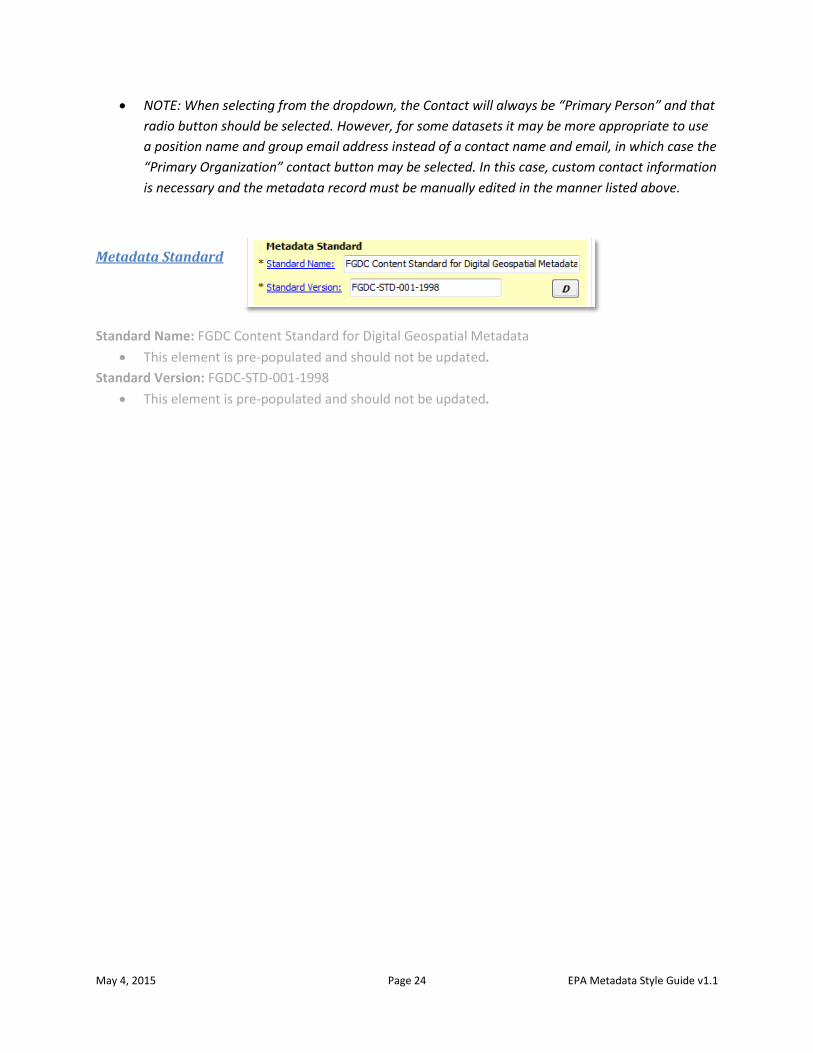
Metadata Standard
Standard Name: FGDC Content Standard for Digital Geospatial Metadata
This element is pre-populated and should not be updated.
Standard Version: FGDC-STD-001-1998
This element is pre-populated and should not be updated.
May 4, 2015 Page 25 EPA Metadata Style Guide v1.1
Prepare ArcMap MXD Documentation for Web Service Metadata This subsection of the Style Guide is intended to guide developers through the preparation of an Esri
ArcMap map document (MXD), focusing on documentation of the MXD as it relates to associated map
service REST page metadata. Where applicable, this guide provides common language intended to make
EPA REST pages more consistent.
This guide assumes that, while the individual layers in a web service may have different themes, all
layers will represent the same geographic extent, temporal extent, and data source. This simplifies the
naming conventions for the overall web service name, group layer names, and individual layer names. It
is recommended that layers which represent different geographic extents, temporal extents, and/or
data sources not be combined in a web service, but rather be separated into individual web services.
This modular approach is preferred by most web map developers because web services with numerous
divergent layers are often difficult to incorporate into web maps and applications. Modularity also
promotes consistency in naming conventions so the web services are easier to maintain.
It is also assumed that ArcGIS Server services will be given brief and intuitive names and be grouped
logically into folders at the discretion of the developer. No standard convention for service name, folder,
or hostname will be instituted.
Instructions for using this section of the guide Open the MXD in ArcMap and follow along in the guide which steps through Map Document Properties,
Data Frame Properties, and Group and Layer Properties, element by element, with instructions.
Suggested text is provided for most elements; the text prompts are enclosed in brackets and asterisks
{***ENTER HERE***} which the user must replace with text that describes the data layer.
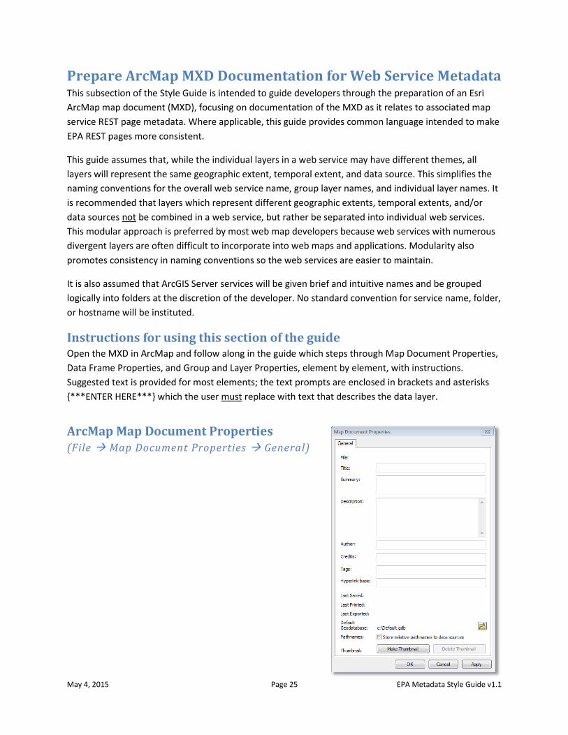
ArcMap Map Document Properties (File Map Document Properties General)
May 4, 2015 Page 26 EPA Metadata Style Guide v1.1
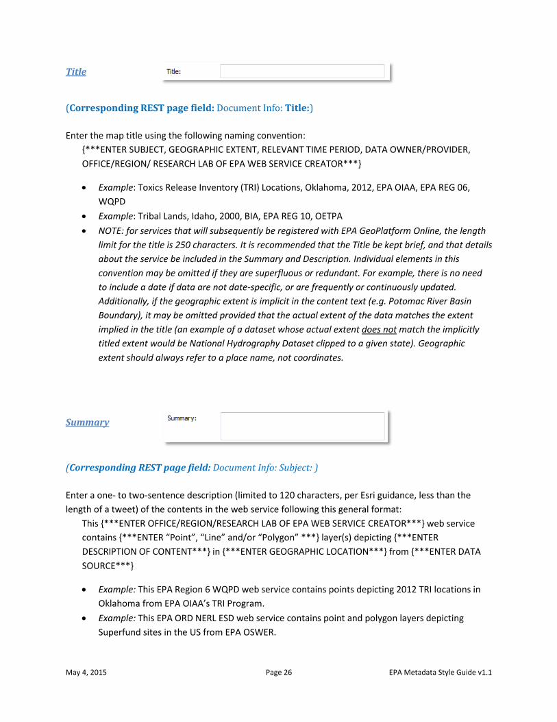
Title
(Corresponding REST page field: Document Info: Title:)
Enter the map title using the following naming convention:
{***ENTER SUBJECT, GEOGRAPHIC EXTENT, RELEVANT TIME PERIOD, DATA OWNER/PROVIDER,
OFFICE/REGION/ RESEARCH LAB OF EPA WEB SERVICE CREATOR***}
Example: Toxics Release Inventory (TRI) Locations, Oklahoma, 2012, EPA OIAA, EPA REG 06,
WQPD
Example: Tribal Lands, Idaho, 2000, BIA, EPA REG 10, OETPA
NOTE: for services that will subsequently be registered with EPA GeoPlatform Online, the length
limit for the title is 250 characters. It is recommended that the Title be kept brief, and that details
about the service be included in the Summary and Description. Individual elements in this
convention may be omitted if they are superfluous or redundant. For example, there is no need
to include a date if data are not date-specific, or are frequently or continuously updated.
Additionally, if the geographic extent is implicit in the content text (e.g. Potomac River Basin
Boundary), it may be omitted provided that the actual extent of the data matches the extent
implied in the title (an example of a dataset whose actual extent does not match the implicitly
titled extent would be National Hydrography Dataset clipped to a given state). Geographic
extent should always refer to a place name, not coordinates.
Summary
(Corresponding REST page field: Document Info: Subject: )
Enter a one- to two-sentence description (limited to 120 characters, per Esri guidance, less than the
length of a tweet) of the contents in the web service following this general format:
This {***ENTER OFFICE/REGION/RESEARCH LAB OF EPA WEB SERVICE CREATOR***} web service
contains {***ENTER “Point”, “Line” and/or “Polygon” ***} layer(s) depicting {***ENTER
DESCRIPTION OF CONTENT***} in {***ENTER GEOGRAPHIC LOCATION***} from {***ENTER DATA
SOURCE***}
Example: This EPA Region 6 WQPD web service contains points depicting 2012 TRI locations in
Oklahoma from EPA OIAA’s TRI Program.
Example: This EPA ORD NERL ESD web service contains point and polygon layers depicting
Superfund sites in the US from EPA OSWER.
May 4, 2015 Page 27 EPA Metadata Style Guide v1.1
NOTE: developers have some discretion on the formatting of the Summary element due to the
character limit imposed. Individual elements in this convention may be omitted if they are
superfluous or redundant, as with the Title (i.e. date, geographic extent, etc.).
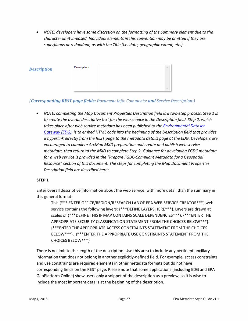
Description
(Corresponding REST page fields: Document Info: Comments: and Service Description:)
NOTE: completing the Map Document Properties Description field is a two-step process. Step 1 is
to create the overall descriptive text for the web service in the Description field. Step 2, which
takes place after web service metadata has been published to the Environmental Dataset
Gateway (EDG), is to embed HTML code into the beginning of the Description field that provides
a hyperlink directly from the REST page to the metadata details page at the EDG. Developers are
encouraged to complete ArcMap MXD preparation and create and publish web service
metadata, then return to the MXD to complete Step 2. Guidance for developing FGDC metadata
for a web service is provided in the “Prepare FGDC-Compliant Metadata for a Geospatial
Resource” section of this document. The steps for completing the Map Document Properties
Description field are described here:
STEP 1
Enter overall descriptive information about the web service, with more detail than the summary in
this general format:
This {*** ENTER OFFICE/REGION/RESEARCH LAB OF EPA WEB SERVICE CREATOR***} web
service contains the following layers: {***DEFINE LAYERS HERE***}. Layers are drawn at
scales of {***DEFINE THIS IF MAP CONTAINS SCALE DEPENDENCIES***}. {***ENTER THE
APPROPRIATE SECURITY CLASSIFICATION STATEMENT FROM THE CHOICES BELOW***}.
{***ENTER THE APPROPRIATE ACCESS CONSTRAINTS STATEMENT FROM THE CHOICES
BELOW***}. {***ENTER THE APPROPRIATE USE CONSTRAINTS STATEMENT FROM THE
CHOICES BELOW***}.
There is no limit to the length of the description. Use this area to include any pertinent ancillary
information that does not belong in another explicitly-defined field. For example, access constraints
and use constraints are required elements in other metadata formats but do not have
corresponding fields on the REST page. Please note that some applications (including EDG and EPA
GeoPlatform Online) show users only a snippet of the description as a preview, so it is wise to
include the most important details at the beginning of the description.
May 4, 2015 Page 28 EPA Metadata Style Guide v1.1
Security classification statements:
For data that is or can be made publicly available to all without restrictions, paste the following
statement into this element:
Security classification: Public.
For data that is or can be made available to a restricted audience under certain use restrictions,
paste the following statement into this element:
Security classification: Restricted public.
For data that may not be made available to members of the public, paste the following statement
into this element:
Security classification: Non-public.
Access constraints statements:
For public data that has no access restrictions, paste the following statement into this element:
Access constraints: None.
For data that are intended for EPA use only, review the following specific access constraints
statements to determine if one would be appropriate for the restricted-access dataset:
- Access constraints: EPA Category: Mission Sensitive, NARA Category: Critical Infrastructure
- Access constraints: EPA Category: Drinking Water Vulnerability Assessments, NARA
Category: Critical Infrastructure-Water Assessments
- Access constraints: EPA Category: Sensitive Drinking Water Related, NARA Category:
Critical Infrastructure-Water Assessments
- Access constraints: EPA Category: IT Security, NARA Category: Information Systems
Vulnerability Information
- Access constraints: EPA Category: Law Enforcement Sensitive, NARA Category: Law
Enforcement
- Access constraints: EPA Category: Attorney Client Privilege, NARA Category: Legal-Privilege
- Access constraints: EPA Category: Attorney Work Product, NARA Category: Legal-Privilege
- Access constraints: EPA Category: Deliberative Process Privilege, NARA Category: Legal-
Privilege
- Access constraints: EPA Category: Personally Identifiable Information (PII), NARA
Category: Privacy
- Access constraints: EPA Category: Proprietary, NARA Category: Proprietary
- Access constraints: EPA Category: Confidential Business Information, NARA Category:
Proprietary-Manufacturer
- Access constraints: EPA Category: Source Selection Information, NARA Category:
Proprietary-Source Selection
May 4, 2015 Page 29 EPA Metadata Style Guide v1.1
For data that are restricted, but for which none of the above statements suitably describe the
reason for restriction, paste one of the following general access constraints statements into this
element:
- Access constraints: Data are restricted to internal EPA personnel only.
- Access constraints: Data are restricted to internal EPA personnel only and state partners.
Use constraints statements:
For public data that has no use or distribution restrictions, paste the following statement into the
element:
Use constraints: None. Please check sources, scale, accuracy, currency and other available
information. Please confirm that you are using the most recent copy of both data and
metadata. Acknowledgement of the EPA would be appreciated.
For data that are intended for EPA use only, except where distribution is explicitly granted to other
users, paste the following statement into the element:
Use constraints: These data should not be distributed to users unless distribution is explicitly
granted. Please check sources, scale, accuracy, currency and other available information.
Please confirm that you are using the most recent copy of both data and metadata.
Acknowledgement of the EPA would be appreciated.
For data that are intended for EPA use only and must not be distributed, paste the following
statement into the element:
Use constraints: These data should not be distributed. Please check sources, scale,
accuracy, currency and other available information. Please confirm that you are using the
most recent copy of both data and metadata. Acknowledgement of the EPA would be
appreciated.
Example Description: This EPA Office of Enforcement and Compliance Assurance, Office of Site
Remediation Enforcement, Policy and Program Evaluation Division (OECA, OSRE, PPED) web
service contains the following layers related to 2012 enforcement actions and cases: Federal
Facility, Criminal, CleanUp, Air, Waste, Water, and Chemical. Layers are drawn at all scales.
Security classification: Public. Access constraints: None. Use constraints: None. Please check
sources, scale, accuracy, currency and other available information. Please confirm that you are
using the most recent copy of both data and metadata. Acknowledgement of the EPA would be
appreciated.
STEP 2
Once web service metadata is created and published to the EDG, insert the following HTML code at
the beginning of the Description field. This provides a hyperlink directly from the REST page to the
web service metadata record in the Environmental Dataset Gateway (EDG). Replace the
ENLARGED text with the universally unique identifier (UUID) of the metadata record:
May 4, 2015 Page 30 EPA Metadata Style Guide v1.1
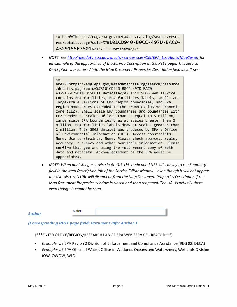
<A href="https://edg.epa.gov/metadata/catalog/search/resou
rce/details.page?uuid=%7B101CD940-B0CC-497D-BAC0-A329155F7501%7D">Full Metadata</A>
NOTE: see http://geodata.epa.gov/arcgis/rest/services/OEI/EPA_Locations/MapServer for
an example of the appearance of the Service Description at the REST page. This Service
Description was entered into the Map Document Properties Description field as follows:
<A href="https://edg.epa.gov/metadata/catalog/search/resource/details.page?uuid=%7B101CD940-B0CC-497D-BAC0-A329155F7501%7D">Full Metadata</A> This SEGS web service contains EPA facilities, EPA facilities labels, small- and large-scale versions of EPA region boundaries, and EPA region boundaries extended to the 200nm exclusive economic zone (EEZ). Small scale EPA boundaries and boundaries with EEZ render at scales of less than or equal to 5 million, large scale EPA boundaries draw at scales greater than 5 million. EPA facilities labels draw at scales greater than 2 million. This SEGS dataset was produced by EPA's Office of Environmental Information (OEI). Access constraints: None. Use constraints: None. Please check sources, scale, accuracy, currency and other available information. Please confirm that you are using the most recent copy of both data and metadata. Acknowledgement of the EPA would be appreciated.
NOTE: When publishing a service in ArcGIS, this embedded URL will convey to the Summary
field in the Item Description tab of the Service Editor window – even though it will not appear
to exist. Also, this URL will disappear from the Map Document Properties Description if the
Map Document Properties window is closed and then reopened. The URL is actually there
even though it cannot be seen.
Author
(Corresponding REST page field: Document Info: Author:)
{***ENTER OFFICE/REGION/RESEARCH LAB OF EPA WEB SERVICE CREATOR***}
Example: US EPA Region 2 Division of Enforcement and Compliance Assistance (REG 02, DECA)
Example: US EPA Office of Water, Office of Wetlands Oceans and Watersheds, Wetlands Division
(OW, OWOW, WLD)
May 4, 2015 Page 31 EPA Metadata Style Guide v1.1
Credits
(Corresponding REST page field: Copyright Text:)
Enter credits for the EPA web service creator as the web service provider and the name of data source.
Spell out abbreviations unless text length constraints dictate that an abbreviation must be used.
Map Service: {*** ENTER OFFICE/REGION/RESEARCH LAB OF EPA WEB SERVICE CREATOR***}. Data:
{***ENTER DATA SOURCE***}.
Example: Map Service: US EPA Office of Water, Office of Ground Water and Drinking Water,
Drinking Water Protection Division (OW, OGWDW, DWPD). Data: US Geological Survey.
NOTE: it is recommended that the Credits text not exceed 250 characters, as that is the length
limit for the corresponding Credits field in EPA GeoPlatform Online.
Tags
(Corresponding REST page field: Document Info: Keywords:)
Enter relevant keywords (limited to 250 characters). A list of potential keywords, matching those in the
EPA Metadata Editor, can be found in Appendix 1 at the end of this document. At a minimum, include:
US EPA, {***ENTER OFFICE/REGION/RESEARCH LAB OF EPA WEB SERVICE CREATOR***}, {***ENTER
SUBJECT***}, {***ENTER DATA SOURCE***}, {***ENTER GEOGRAPHIC EXTENT***}, {***ENTER
TIME PERIOD***}
Example: US EPA, EPA Region 7, Environmental Services Division, REG 07, ESD, Toxics Release
Inventory, TRI, EPA Office of Information Analysis and Access, OIAA, Iowa, Kansas, Missouri,
Nebraska, 2012
NOTE: it is recommended that the Tags text not exceed 250 characters, as that is the length limit
for the corresponding Tags field in EPA GeoPlatform Online.
May 4, 2015 Page 32 EPA Metadata Style Guide v1.1
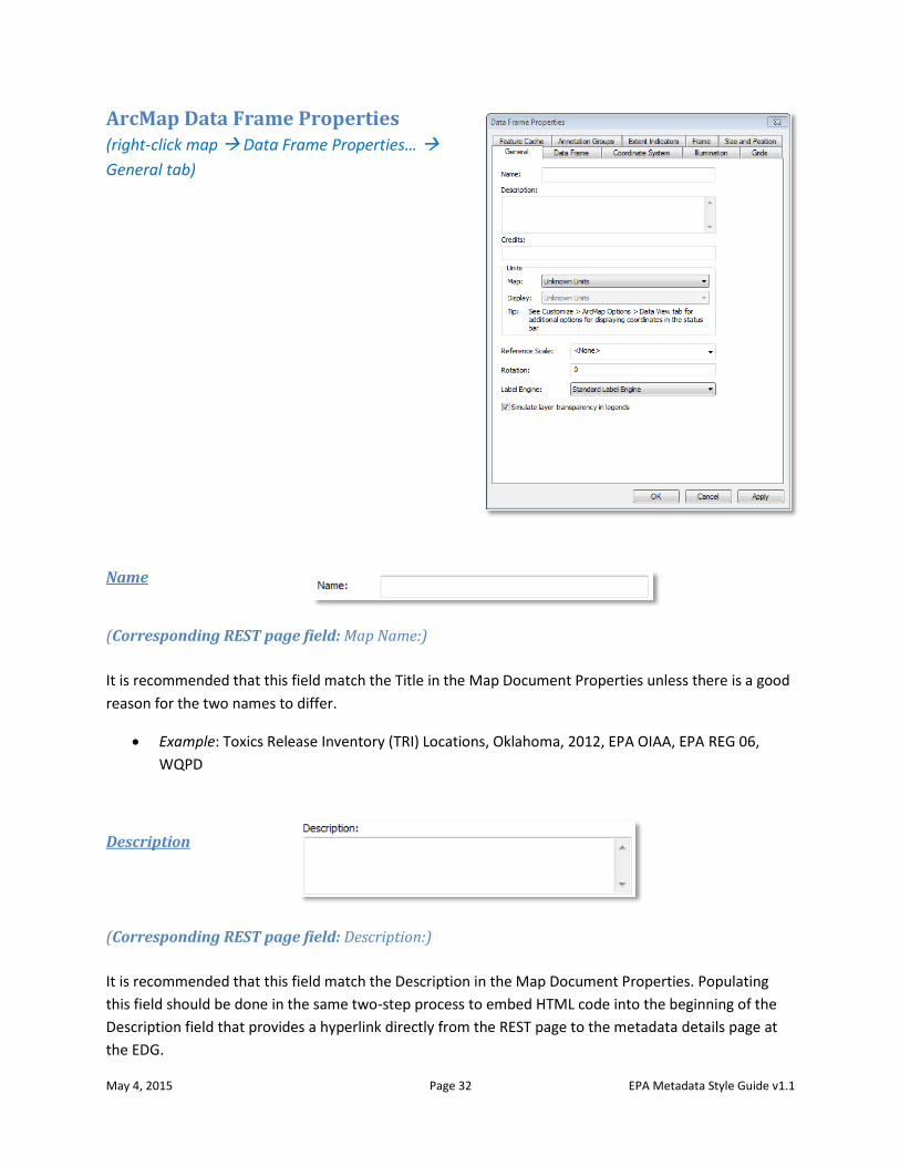
ArcMap Data Frame Properties (right-click map Data Frame Properties…
General tab)
Name
(Corresponding REST page field: Map Name:)
It is recommended that this field match the Title in the Map Document Properties unless there is a good
reason for the two names to differ.
Example: Toxics Release Inventory (TRI) Locations, Oklahoma, 2012, EPA OIAA, EPA REG 06,
WQPD
Description
(Corresponding REST page field: Description:)
It is recommended that this field match the Description in the Map Document Properties. Populating
this field should be done in the same two-step process to embed HTML code into the beginning of the
Description field that provides a hyperlink directly from the REST page to the metadata details page at
the EDG.
May 4, 2015 Page 33 EPA Metadata Style Guide v1.1
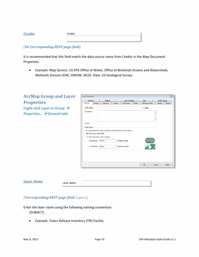
Credits
(No Corresponding REST page field)
It is recommended that this field match the data source name from Credits in the Map Document
Properties.
Example: Map Service: US EPA Office of Water, Office of Wetlands Oceans and Watersheds,
Wetlands Division (OW, OWOW, WLD). Data: US Geological Survey.
ArcMap Group and Layer
Properties (right-click Layer or Group
Properties… General tab)
Layer Name
(Corresponding REST page field: Layers:)
Enter the layer name using the following naming convention:
{SUBJECT}
Example: Toxics Release Inventory (TRI) Facility
May 4, 2015 Page 34 EPA Metadata Style Guide v1.1
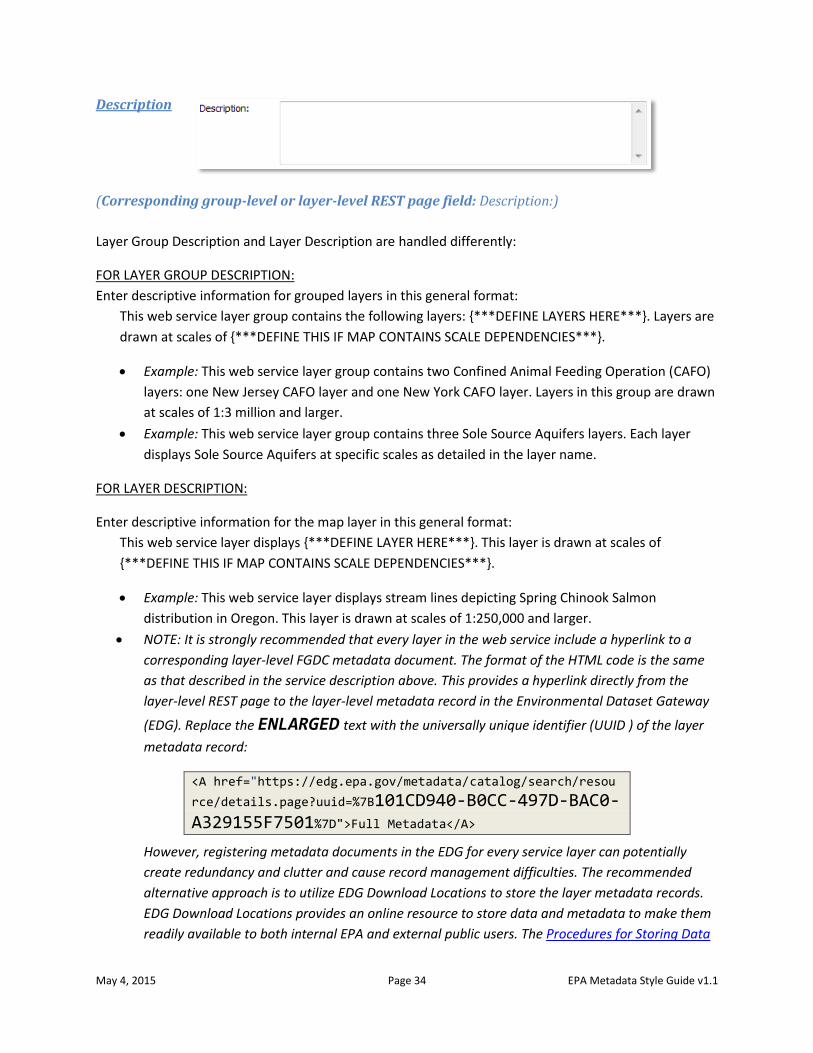
Description
(Corresponding group-level or layer-level REST page field: Description:)
Layer Group Description and Layer Description are handled differently:
FOR LAYER GROUP DESCRIPTION:
Enter descriptive information for grouped layers in this general format:
This web service layer group contains the following layers: {***DEFINE LAYERS HERE***}. Layers are
drawn at scales of {***DEFINE THIS IF MAP CONTAINS SCALE DEPENDENCIES***}.
Example: This web service layer group contains two Confined Animal Feeding Operation (CAFO)
layers: one New Jersey CAFO layer and one New York CAFO layer. Layers in this group are drawn
at scales of 1:3 million and larger.
Example: This web service layer group contains three Sole Source Aquifers layers. Each layer
displays Sole Source Aquifers at specific scales as detailed in the layer name.
FOR LAYER DESCRIPTION:
Enter descriptive information for the map layer in this general format:
This web service layer displays {***DEFINE LAYER HERE***}. This layer is drawn at scales of
{***DEFINE THIS IF MAP CONTAINS SCALE DEPENDENCIES***}.
Example: This web service layer displays stream lines depicting Spring Chinook Salmon
distribution in Oregon. This layer is drawn at scales of 1:250,000 and larger.
NOTE: It is strongly recommended that every layer in the web service include a hyperlink to a
corresponding layer-level FGDC metadata document. The format of the HTML code is the same
as that described in the service description above. This provides a hyperlink directly from the
layer-level REST page to the layer-level metadata record in the Environmental Dataset Gateway
(EDG). Replace the ENLARGED text with the universally unique identifier (UUID ) of the layer
metadata record:
<A href="https://edg.epa.gov/metadata/catalog/search/resou
rce/details.page?uuid=%7B101CD940-B0CC-497D-BAC0-A329155F7501%7D">Full Metadata</A>
However, registering metadata documents in the EDG for every service layer can potentially
create redundancy and clutter and cause record management difficulties. The recommended
alternative approach is to utilize EDG Download Locations to store the layer metadata records.
EDG Download Locations provides an online resource to store data and metadata to make them
readily available to both internal EPA and external public users. The Procedures for Storing Data
May 4, 2015 Page 35 EPA Metadata Style Guide v1.1
at the Environmental Dataset Gateway (EDG) Download Locations document offers step-by-step
instructions on setting up an EDG Download Location for your organization.
Once the metadata records are placed in a metadata folder on the EDG Data Download
Locations, a hyperlink can be created to link to the layer metadata record. To include the
metadata link in the Layer Description text, copy the following HTML code, replacing the
ENLARGED text with the path to the metadata record, and place the code at the beginning of
the layer description:
Intranet example (restricted metadata record):
<A href="http://edg-intranet.epa.gov/metadata/rest/documen
t?xsl=esri_fgdc&xml=/restricted/OrganizationAcronym/DatasetName/layer_metadata/LayerName.xml">Full Metadata</A>
Internet example:
<A href="http://edg.epa.gov/metadata/rest/document?xsl=esr
i_fgdc&xml=/public/OrganizationAcronym/DatasetName/layer_metadata/LayerName.xml">Full Metadata</A>
NOTE: see http://geodata.epa.gov/arcgis/rest/services/OEI/EPA_Locations/MapServer/2 for an
example of the appearance of the Layer Description at the REST page. This Layer Description was
entered into the ArcMap Layer Properties Description field as follows:
<A href=" https://edg.epa.gov/metadata/rest/document?xsl=esri_fgdc&xml=/Public/OEI/EPA_Facilities/layer_metadata/RegionBoundaries.XML">Full Metadata</A> This web service layer shows the boundaries of EPA regions based on 2011 TIGER/Line geometry. This layer is drawn at scales of 5,000,001 or less. This SEGS dataset was produced by EPA through the Office of Environmental Information (OEI).
Credits
(Corresponding group-level or layer-level REST page field: Copyright Text)
It is recommended that this field match the data source name from Credits in the Map Document
Properties.
Example: Map Service: US EPA Office of Water, Office of Wetlands Oceans and Watersheds,
Wetlands Division (OW OWOW WLD). Data: US Geological Survey.
May 4, 2015 Page 36 EPA Metadata Style Guide v1.1
Prepare Metadata for an EPA GeoPlatform Online Content Item This subsection of the Style Guide is intended to guide users through EPA GeoPlatform Online
documentation. Where applicable, this guide provides common language intended to make EPA
GeoPlatform Online content more consistent.
EPA GeoPlatform Online stewardship requires that all shared content contain descriptive metadata.
Additionally, it is good practice to complete metadata for every item, including items that are not
shared.
Metadata in EPA GeoPlatform Online.
Metadata and other characteristics of an EPA GeoPlatform Online content item may be viewed at the
item’s details page. General information about the details page may be found on the ArcGIS Online help
page at http://doc.arcgis.com/en/arcgis-online/share-maps/item-details.htm. Content item
characteristics contained on the details page are collectively referred to as “item properties.” This
subsection of the Style Guide focuses on the properties that allow descriptive metadata entries; refer to
the ArcGIS Online help document for more information about the other item properties found on the
details page.
Metadata in EPA GeoPlatform Online may be edited by the owner of the content item. Navigate to Edit
item details at ArcGIS Online help for instructions on how to edit the item properties. This document
provides guidance for content provided in the metadata fields.
Adding metadata to a content item
Metadata is defined and created for each web map or content item added to EPA GeoPlatform Online.
In most cases when the details page for a new content item is accessed, metadata properties such as the
Description and the Access and Use Constraints fields will be blank and must be completed. However, if
the item added is a web resource such as an ArcGIS Server web service, some properties may be pre-
populated with metadata text from the web service. This will be the case if the web service preparer
followed the guidance in the subsection of this Style Guide titled “Prepare ArcMap MXD documentation
for web service metadata.”
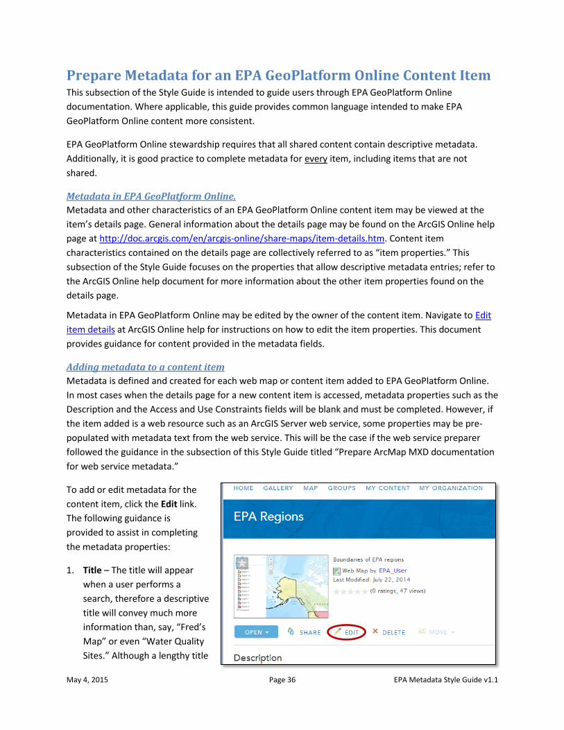
To add or edit metadata for the
content item, click the Edit link.
The following guidance is
provided to assist in completing
the metadata properties:
1. Title – The title will appear
when a user performs a
search, therefore a descriptive
title will convey much more
information than, say, “Fred’s
Map” or even “Water Quality
Sites.” Although a lengthy title
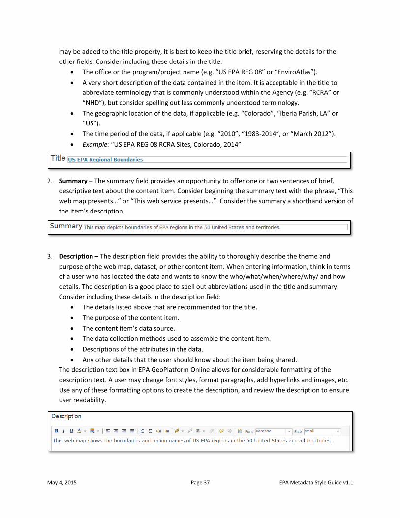
May 4, 2015 Page 37 EPA Metadata Style Guide v1.1
may be added to the title property, it is best to keep the title brief, reserving the details for the
other fields. Consider including these details in the title:
The office or the program/project name (e.g. “US EPA REG 08” or “EnviroAtlas”).
A very short description of the data contained in the item. It is acceptable in the title to
abbreviate terminology that is commonly understood within the Agency (e.g. “RCRA” or
“NHD”), but consider spelling out less commonly understood terminology.
The geographic location of the data, if applicable (e.g. “Colorado”, “Iberia Parish, LA” or
“US”).
The time period of the data, if applicable (e.g. “2010”, “1983-2014”, or “March 2012”).
Example: “US EPA REG 08 RCRA Sites, Colorado, 2014”
2. Summary – The summary field provides an opportunity to offer one or two sentences of brief,
descriptive text about the content item. Consider beginning the summary text with the phrase, “This
web map presents…” or “This web service presents…”. Consider the summary a shorthand version of
the item’s description.
3. Description – The description field provides the ability to thoroughly describe the theme and
purpose of the web map, dataset, or other content item. When entering information, think in terms
of a user who has located the data and wants to know the who/what/when/where/why/ and how
details. The description is a good place to spell out abbreviations used in the title and summary.
Consider including these details in the description field:
The details listed above that are recommended for the title.
The purpose of the content item.
The content item’s data source.
The data collection methods used to assemble the content item.
Descriptions of the attributes in the data.
Any other details that the user should know about the item being shared.
The description text box in EPA GeoPlatform Online allows for considerable formatting of the
description text. A user may change font styles, format paragraphs, add hyperlinks and images, etc.
Use any of these formatting options to create the description, and review the description to ensure
user readability.
May 4, 2015 Page 38 EPA Metadata Style Guide v1.1
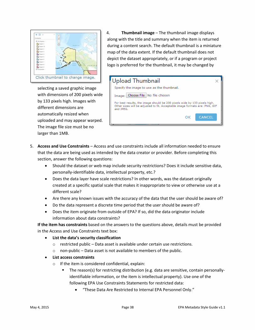
4. Thumbnail image – The thumbnail image displays
along with the title and summary when the item is returned
during a content search. The default thumbnail is a miniature
map of the data extent. If the default thumbnail does not
depict the dataset appropriately, or if a program or project
logo is preferred for the thumbnail, it may be changed by
selecting a saved graphic image
with dimensions of 200 pixels wide
by 133 pixels high. Images with
different dimensions are
automatically resized when
uploaded and may appear warped.
The image file size must be no
larger than 1MB.
5. Access and Use Constraints – Access and use constraints include all information needed to ensure
that the data are being used as intended by the data creator or provider. Before completing this
section, answer the following questions:
Should the dataset or web map include security restrictions? Does it include sensitive data,
personally-identifiable data, intellectual property, etc.?
Does the data layer have scale restrictions? In other words, was the dataset originally
created at a specific spatial scale that makes it inappropriate to view or otherwise use at a
different scale?
Are there any known issues with the accuracy of the data that the user should be aware of?
Do the data represent a discrete time period that the user should be aware of?
Does the item originate from outside of EPA? If so, did the data originator include
information about data constraints?
If the item has constraints based on the answers to the questions above, details must be provided
in the Access and Use Constraints text box:
List the data’s security classification
o restricted public – Data asset is available under certain use restrictions.
o non-public – Data asset is not available to members of the public.
List access constraints
o If the item is considered confidential, explain:
The reason(s) for restricting distribution (e.g. data are sensitive, contain personally-
identifiable information, or the item is intellectual property). Use one of the
following EPA Use Constraints Statements for restricted data:
“These Data Are Restricted to Internal EPA Personnel Only.”
May 4, 2015 Page 39 EPA Metadata Style Guide v1.1
“These Data Are Restricted to Internal EPA Personnel Only and State
Partners.”
“EPA Category: Mission Sensitive, NARA Category: Critical Infrastructure”
“EPA Category: Drinking Water Vulnerability Assessments, NARA Category:
Critical Infrastructure-Water Assessments”
“EPA Category: Sensitive Drinking Water Related, NARA Category: Critical
Infrastructure-Water Assessments”
“EPA Category: IT Security, NARA Category: Information Systems
Vulnerability Information”
“EPA Category: Law Enforcement Sensitive, NARA Category: Law
Enforcement”
“EPA Category: Attorney Client Privilege, NARA Category: Legal-Privilege”
“EPA Category: Attorney Work Product, NARA Category: Legal-Privilege”
“EPA Category: Deliberative Process Privilege, NARA Category: Legal-
Privilege”
“EPA Category: Personally Identifiable Information (PII), NARA Category:
Privacy”
“EPA Category: Proprietary, NARA Category: Proprietary”
“EPA Category: Confidential Business Information, NARA Category:
Proprietary-Manufacturer”
“EPA Category: Source Selection Information, NARA Category: Proprietary-
Source Selection”
List use constraints
o For data originating from within EPA, make a best effort to list:
Scale constraints – Example: “Data are intended to be used at scales of 1:24,000 or
smaller.”
Accuracy constraints – Example: “Data were collected with a horizontal accuracy of
30 meters.”
Temporal constraints – Example: “Data represent ground condition on April 24,
1998.”
o For data originating from outside of EPA:
Retain the originator’s use constraints information (if provided in their metadata or
documentation).
Include the following EPA General Use Constraints Statement:
“Please check sources, scale, accuracy, currency and other available
information. Please confirm that you are using the most recent copy of both
data and metadata.”
o If use constraints details cannot be ascertained for the data, use the EPA General Use
Constraints Statement.
If there are no known access and/or use constraints for the data based on the answers to the
questions above:
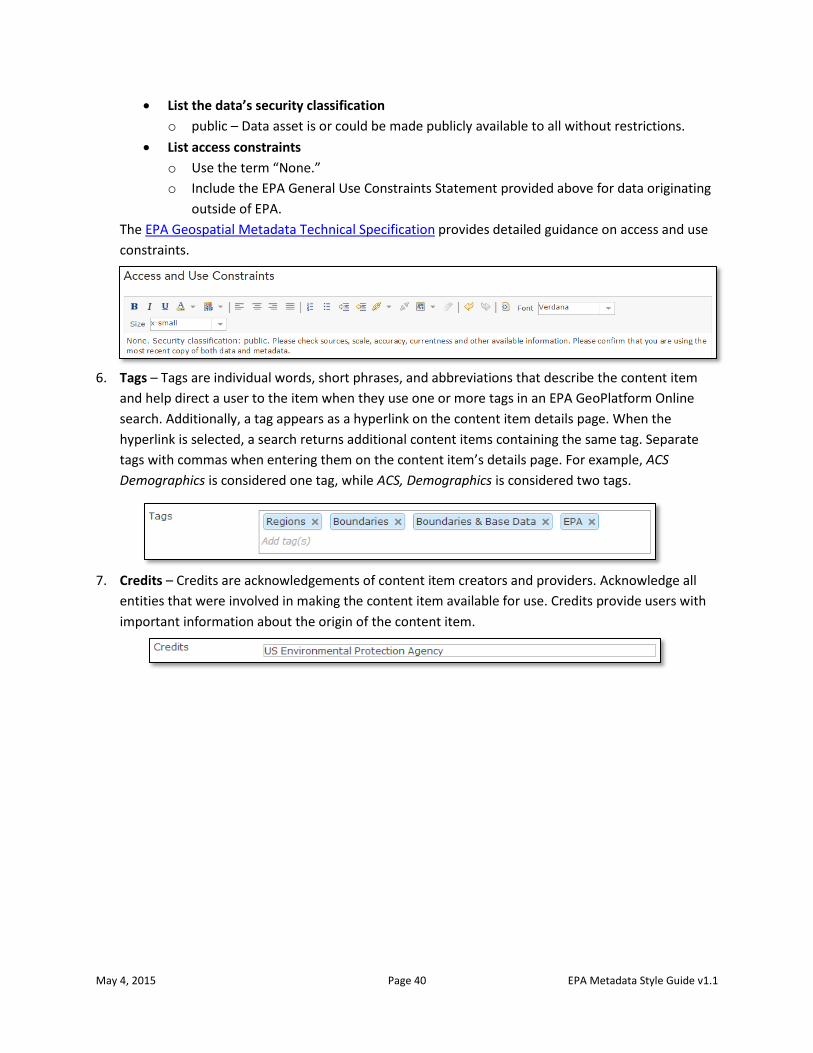
May 4, 2015 Page 40 EPA Metadata Style Guide v1.1
List the data’s security classification
o public – Data asset is or could be made publicly available to all without restrictions.
List access constraints
o Use the term “None.”
o Include the EPA General Use Constraints Statement provided above for data originating
outside of EPA.
The EPA Geospatial Metadata Technical Specification provides detailed guidance on access and use
constraints.
6. Tags – Tags are individual words, short phrases, and abbreviations that describe the content item
and help direct a user to the item when they use one or more tags in an EPA GeoPlatform Online
search. Additionally, a tag appears as a hyperlink on the content item details page. When the
hyperlink is selected, a search returns additional content items containing the same tag. Separate
tags with commas when entering them on the content item’s details page. For example, ACS
Demographics is considered one tag, while ACS, Demographics is considered two tags.
7. Credits – Credits are acknowledgements of content item creators and providers. Acknowledge all
entities that were involved in making the content item available for use. Credits provide users with
important information about the origin of the content item.
May 4, 2015 Page 41 EPA Metadata Style Guide v1.1
Metadata Preparation for Non-Geospatial Resources On May 9th, 2013, the White House issued Memo M-13-13, entitled “Open Data Policy—Managing
Information as an Asset” which outlined a set of policy requirements designed to make federal data
more open and accessible. One component of this policy was the adoption of a new metadata format
based on international standards. Relative to the old Data.gov DMS standard for non-spatial metadata,
this new “Project Open Data” standard is both simpler and more reflective of the way data is published
and consumed in a modern, service-oriented enterprise. Full details on the memo, the other
components of the Open Data Policy (ODP), and Project Open Data metadata are available on the
Project Open Data website.
EME v4.0 and non-geospatial metadata
The metadata standard continues to be refined and improved as of the date of this document, and OEI is
continuing to develop tools and associated guidance in response to OMB’s changes in order to help
metadata stewards produce and maintain non-geospatial metadata. Specifically, the EPA Metadata
Editor Version 4.0 (EME v4.0) was designed to handle non-geospatial metadata in the new metadata
format.
Review the following documents for more information on EME v4.0 and the creation of non-geospatial
metadata:
About the EPA Metadata Editor Version 4.0 provides an overview of EME v4.0 and general
information on how it works.
Getting Started with the EPA Metadata Editor Version 4.0 provides a thorough description of
EME v4.0 including how to download and install the application, entering values and how to
validate them, and customizing the database.
Updating non-geospatial metadata in the old format
If you have existing metadata records in the old DMS format, contact the EDG Administrative Group at
[email protected]. The EDG Administrative Group can help with an initial bulk import of those records into
this new format.
May 4, 2015 Page 42 EPA Metadata Style Guide v1.1
Appendix 1: Keywords Keywords (also known as Tags) are descriptive words that describe aspects of the dataset, including its
subject, purpose, geographic extent, originator, etc. For GeoPlatform web services, keywords are used in
the ArcMap MXD to create REST page documentation, in the EPA Metadata Editor to create FGDC
metadata for the web service, and when registering the data in the EPA GeoPlatform Online. Keywords
assist in locating data when a search is performed.
The following list of words and phrases (mostly derived from the EPA Metadata Editor database) should
be considered potential keywords. This is not an exhaustive list. Specific datasets may require additional
keywords not included in this list. Where allowed, take advantage of free text to create specific
keywords that are not included in this list.
EPA KEYWORDS
Agriculture Ecosystem Impact Regulated Facilities
Air Emergency Indicator Regulatory
Biology Emergency Response Indoor Air Remediation
Boundaries and Base Data Energy Inspections Response
Chemicals Enforcement Land Risk
Cleanup Environment Management Sites
Climate Environmental Justice Marine Spills
Climate Change Estuary Modeling Surface Water
Compliance Exposure Monitoring Sustainability
Conservation Facilities Natural Resources Toxics
Contaminant Grants Permits Transportation
Disaster Ground Water Pesticides Waste
Drinking Water Hazards Quality Water
Ecological Health Radiation Ecology Human Recreation
ISO KEYWORDS
biota geoscientificInformation planningCadastre
boundaries health society
climatologyMeteorologyAtmosphere imageryBaseMapsEarthCover structure
economy inlandWaters transportation
elevation intelligenceMilitary utilitiesCommunication
environment location
farming oceans
May 4, 2015 Page 43 EPA Metadata Style Guide v1.1
PLACE KEYWORDS
United States Delaware Mississippi Rhode Island
Canada Florida Missouri South Carolina
Mexico Georgia Montana South Dakota
Alaska Idaho Nebraska Tennessee
Hawaii Illinois Nevada Texas
Washington DC Indiana New Hampshire Utah
American Samoa Iowa New Jersey Vermont
Puerto Rico Kansas New Mexico Virginia
Virgin Islands Kentucky New York Washington
Alabama Louisiana North Carolina West Virginia
Arizona Maine North Dakota Wisconsin
Arkansas Maryland Ohio Wyoming
California Massachusetts Oklahoma
Colorado Michigan Oregon
Connecticut Minnesota Pennsylvania
Appendix 2: EPA Organization Names In several instances throughout this document, developers are required to enter the “OFFICE/REGION/
RESEARCH LAB OF EPA WEB SERVICE CREATOR”. In an effort to standardize the abbreviations of the
office names, the following comprehensive list of approved office abbreviations is provided.
OFFICE OF THE ADMINISTRATOR:
OA OA, OCIR, OIR, NEPPS OA, OEX, ECS OA, OP, OSC, IO
OA, EAB OA, OCIR, OIR, SL OA, OEX, IO OA, OP, OSEM
OA, IO OA, OCIR, ORO OA, OEX, RMOS OA, OP, OSEM, ESD
OA, OALJ OA, OCR OA, OHS OA, OP, OSEM, IESD
OA, OCEM OA, OCR, AEDS OA, OP OA, OP, OSEM, IO
OA, OCEM, CMO OA, OCR, ECRS OA, OP, IO OA, OP, OSEM, PSS
OA, OCEM, CPOS OA, OCR, ECS OA, OP, NCEE OA, OP, OSEM, SMD
OA, OCEM, IO OA, OCR, IO OA, OP, NCEE, BAMDD OA, OPEI, ASIS
OA, OCEM, PTOS OA, ODA OA, OP, NCEE, IO OA, OPEI, NCEI
OA, OCHP OA, OEAEE OA, OP, NCEE, RPSD OA, OPEI, NCEI, IO
OA, OCHP, IO OA, OEAEE, IO OA, OP, NCEE, SPAD OA, OPEI, NCEI, OBCI
OA, OCHPEE, CAHPD OA, OEAEE, OLRCP OA, OP, ORPM OA, OPEI, NCEI, OEPI
OA, OCHPEE, EED OA, OEAEE, OMMCT OA, OP, ORPM, IO OA, OPEI, RMS
OA, OCIR OA, OEAEE, OMR OA, OP, ORPM, PRAD OA, OSBP
OA, OCIR, IMD OA, OEAEE, OPE OA, OP, ORPM, RMD OA, OSBP, IO
OA, OCIR, IO OA, OEAEE, OS OA, OP, OSC OA, OSDBU, ODD

May 4, 2015 Page 44 EPA Metadata Style Guide v1.1
OA, OCIR, OCA OA, OEAEE, OWC OA, OP, OSC, CARD OA, SAB
OA, OCIR, OIR OA, OES OA, OP, OSC, CSSDD OA, SAB, IO
OA, OCIR, OIR, IO OA, OEX OA, OP, OSC, FSD
OFFICE OF AIR AND RADIATION:
OAR, OAA OAR, OAQPS, AQPD, OPG OAR, OAQPS, SPPD, IO
OAR, OAA, CSIPS OAR, OAQPS, AQPD, SLPG OAR, OAQPS, SPPD, MICG
OAR, OAA, IO OAR, OAQPS, CORE OAR, OAQPS, SPPD, MMG
OAR, OAA, OPAR OAR, OAQPS, HEID OAR, OAQPS, SPPD, MPG
OAR, OAA, OPMO OAR, OAQPS, HEID, AEG OAR, OAQPS, SPPD, PSG
OAR, OAP OAR, OAQPS, HEID, ASG OAR, OAQPS, SPPD, RCG
OAR, OAP, CAMD OAR, OAQPS, HEID, ATAG OAR, ORIA
OAR, OAP, CCD OAR, OAQPS, HEID, CIMG OAR, ORIA, IED
OAR, OAP, CPPD OAR, OAQPS, HEID, IO OAR, ORIA, NAREL-MTG
OAR, OAP, OD OAR, OAQPS, HEID, RBG OAR, ORIA, OD
OAR, OAP, SPD OAR, OAQPS, OD OAR, ORIA, RIENL-LV
OAR, OAQPS OAR, OAQPS, OID OAR, ORIA, RPD
OAR, OAQPS, AQAD OAR, OAQPS, OID, CTPG OAR, ORIA, RSD
OAR, OAQPS, AQAD, AAMG OAR, OAQPS, OID, IO OAR, OTAQ
OAR, OAQPS, AQAD, AQAG OAR, OAQPS, OID, IPOG OAR, OTAQ, ASD
OAR, OAQPS, AQAD, AQMG OAR, OAQPS, OID, ITG OAR, OTAQ, ATD
OAR, OAQPS, AQAD, EIAG OAR, OAQPS, OID, NADG OAR, OTAQ, CD
OAR, OAQPS, AQAD, IO OAR, OAQPS, OID, RDPAG OAR, OTAQ, OD
OAR, OAQPS, AQAD, MTG OAR, OAQPS, PACS OAR, OTAQ, TATD
OAR, OAQPS, AQPD OAR, OAQPS, SPPD OAR, OTAQ, TCD
OAR, OAQPS, AQPD, GSG OAR, OAQPS, SPPD, NRG OAR, OTAQ, TRPD
OAR, OAQPS, AQPD, IO OAR, OAQPS, SPPD, ESG
OAR, OAQPS, AQPD, NSRG OAR, OAQPS, SPPD, FIG
OFFICE OF ADMINISTRATION AND RESOURCES MANAGEMENT:
OARM OARM, OAM, RTPPOD OARM, OARM-RTP, IRMD
OARM, OA OARM, OAM, SRRPOD OARM, OGD
OARM, OA, FMSD OARM, OARM-CINC OARM, OGD, GIAMD
OARM, OA, IO OARM, OARM-CINC, FMSD OARM, OGD, IO
OARM, OA, SHEMD OARM, OARM-CINC, HRMD OARM, OGD, SDD
OARM, OA, SMD OARM, OARM-CINC, HRMD-LV OARM, OHR, EDSD
OARM, OAA OARM, OARM-CINC, HRMD-LV, IO OARM, OHR, ERD
OARM, OAA, IO OARM, OARM-CINC, IO OARM, OHR, HCMD
OARM, OAA, OPRM OARM, OARM-CINC, IRMD OARM, OHR, HQOPERS
OARM, OAM OARM, OARM-CINC-LV, HRSSC OARM, OHR, HRPD
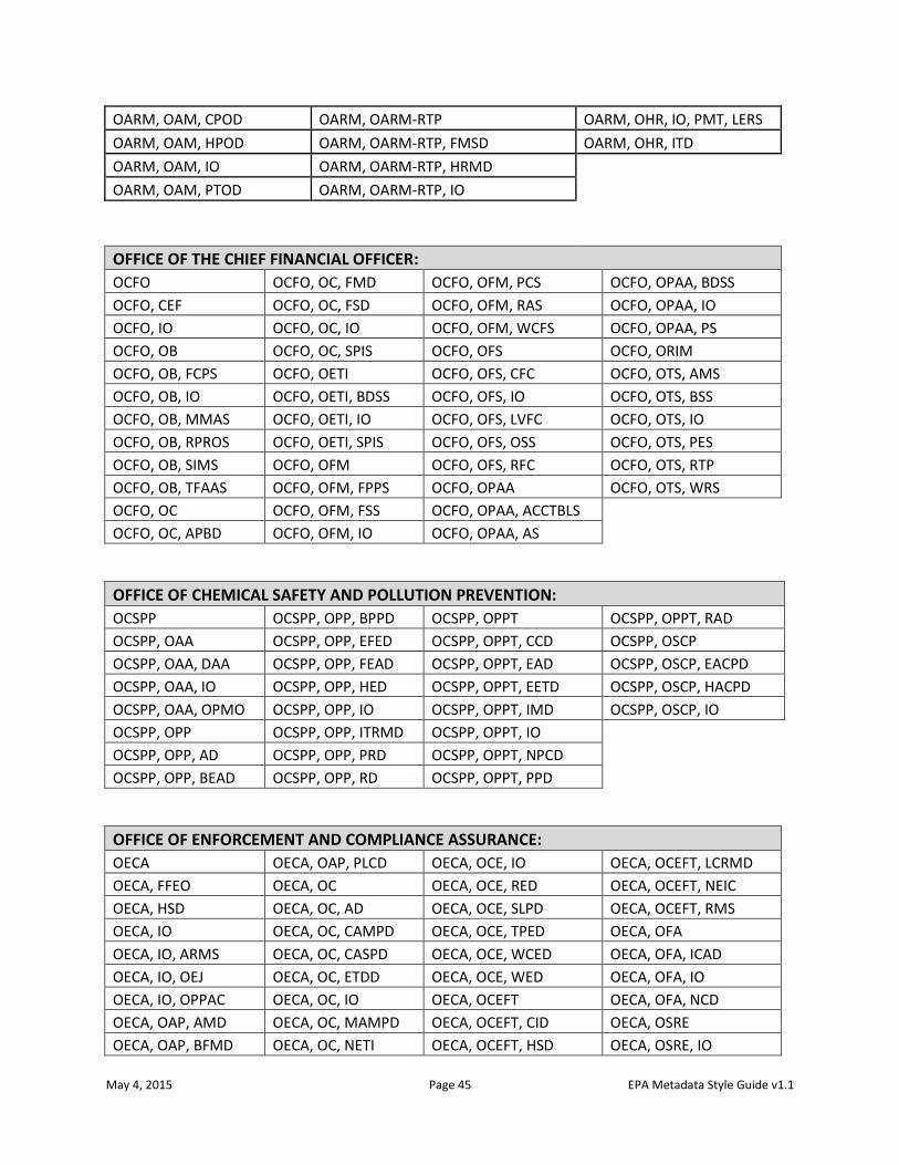
May 4, 2015 Page 45 EPA Metadata Style Guide v1.1
OARM, OAM, CPOD OARM, OARM-RTP OARM, OHR, IO, PMT, LERS
OARM, OAM, HPOD OARM, OARM-RTP, FMSD OARM, OHR, ITD
OARM, OAM, IO OARM, OARM-RTP, HRMD
OARM, OAM, PTOD OARM, OARM-RTP, IO
OFFICE OF THE CHIEF FINANCIAL OFFICER:
OCFO OCFO, OC, FMD OCFO, OFM, PCS OCFO, OPAA, BDSS
OCFO, CEF OCFO, OC, FSD OCFO, OFM, RAS OCFO, OPAA, IO
OCFO, IO OCFO, OC, IO OCFO, OFM, WCFS OCFO, OPAA, PS
OCFO, OB OCFO, OC, SPIS OCFO, OFS OCFO, ORIM
OCFO, OB, FCPS OCFO, OETI OCFO, OFS, CFC OCFO, OTS, AMS
OCFO, OB, IO OCFO, OETI, BDSS OCFO, OFS, IO OCFO, OTS, BSS
OCFO, OB, MMAS OCFO, OETI, IO OCFO, OFS, LVFC OCFO, OTS, IO
OCFO, OB, RPROS OCFO, OETI, SPIS OCFO, OFS, OSS OCFO, OTS, PES
OCFO, OB, SIMS OCFO, OFM OCFO, OFS, RFC OCFO, OTS, RTP
OCFO, OB, TFAAS OCFO, OFM, FPPS OCFO, OPAA OCFO, OTS, WRS
OCFO, OC OCFO, OFM, FSS OCFO, OPAA, ACCTBLS
OCFO, OC, APBD OCFO, OFM, IO OCFO, OPAA, AS
OFFICE OF CHEMICAL SAFETY AND POLLUTION PREVENTION:
OCSPP OCSPP, OPP, BPPD OCSPP, OPPT OCSPP, OPPT, RAD
OCSPP, OAA OCSPP, OPP, EFED OCSPP, OPPT, CCD OCSPP, OSCP
OCSPP, OAA, DAA OCSPP, OPP, FEAD OCSPP, OPPT, EAD OCSPP, OSCP, EACPD
OCSPP, OAA, IO OCSPP, OPP, HED OCSPP, OPPT, EETD OCSPP, OSCP, HACPD
OCSPP, OAA, OPMO OCSPP, OPP, IO OCSPP, OPPT, IMD OCSPP, OSCP, IO
OCSPP, OPP OCSPP, OPP, ITRMD OCSPP, OPPT, IO
OCSPP, OPP, AD OCSPP, OPP, PRD OCSPP, OPPT, NPCD
OCSPP, OPP, BEAD OCSPP, OPP, RD OCSPP, OPPT, PPD
OFFICE OF ENFORCEMENT AND COMPLIANCE ASSURANCE:
OECA OECA, OAP, PLCD OECA, OCE, IO OECA, OCEFT, LCRMD
OECA, FFEO OECA, OC OECA, OCE, RED OECA, OCEFT, NEIC
OECA, HSD OECA, OC, AD OECA, OCE, SLPD OECA, OCEFT, RMS
OECA, IO OECA, OC, CAMPD OECA, OCE, TPED OECA, OFA
OECA, IO, ARMS OECA, OC, CASPD OECA, OCE, WCED OECA, OFA, ICAD
OECA, IO, OEJ OECA, OC, ETDD OECA, OCE, WED OECA, OFA, IO
OECA, IO, OPPAC OECA, OC, IO OECA, OCEFT OECA, OFA, NCD
OECA, OAP, AMD OECA, OC, MAMPD OECA, OCEFT, CID OECA, OSRE
OECA, OAP, BFMD OECA, OC, NETI OECA, OCEFT, HSD OECA, OSRE, IO
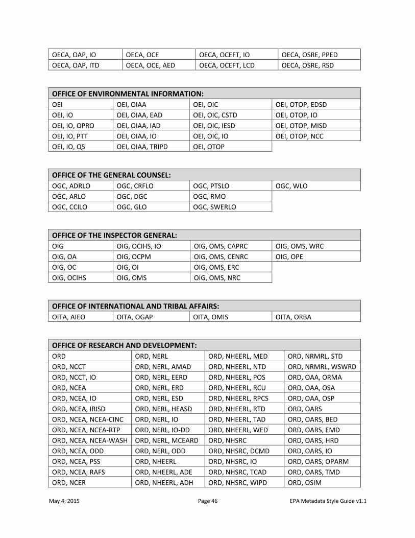
May 4, 2015 Page 46 EPA Metadata Style Guide v1.1
OECA, OAP, IO OECA, OCE OECA, OCEFT, IO OECA, OSRE, PPED
OECA, OAP, ITD OECA, OCE, AED OECA, OCEFT, LCD OECA, OSRE, RSD
OFFICE OF ENVIRONMENTAL INFORMATION:
OEI OEI, OIAA OEI, OIC OEI, OTOP, EDSD
OEI, IO OEI, OIAA, EAD OEI, OIC, CSTD OEI, OTOP, IO
OEI, IO, OPRO OEI, OIAA, IAD OEI, OIC, IESD OEI, OTOP, MISD
OEI, IO, PTT OEI, OIAA, IO OEI, OIC, IO OEI, OTOP, NCC
OEI, IO, QS OEI, OIAA, TRIPD OEI, OTOP
OFFICE OF THE GENERAL COUNSEL:
OGC, ADRLO OGC, CRFLO OGC, PTSLO OGC, WLO
OGC, ARLO OGC, DGC OGC, RMO
OGC, CCILO OGC, GLO OGC, SWERLO
OFFICE OF THE INSPECTOR GENERAL:
OIG OIG, OCIHS, IO OIG, OMS, CAPRC OIG, OMS, WRC
OIG, OA OIG, OCPM OIG, OMS, CENRC OIG, OPE
OIG, OC OIG, OI OIG, OMS, ERC
OIG, OCIHS OIG, OMS OIG, OMS, NRC
OFFICE OF INTERNATIONAL AND TRIBAL AFFAIRS:
OITA, AIEO OITA, OGAP OITA, OMIS OITA, ORBA
OFFICE OF RESEARCH AND DEVELOPMENT:
ORD ORD, NERL ORD, NHEERL, MED ORD, NRMRL, STD
ORD, NCCT ORD, NERL, AMAD ORD, NHEERL, NTD ORD, NRMRL, WSWRD
ORD, NCCT, IO ORD, NERL, EERD ORD, NHEERL, POS ORD, OAA, ORMA
ORD, NCEA ORD, NERL, ERD ORD, NHEERL, RCU ORD, OAA, OSA
ORD, NCEA, IO ORD, NERL, ESD ORD, NHEERL, RPCS ORD, OAA, OSP
ORD, NCEA, IRISD ORD, NERL, HEASD ORD, NHEERL, RTD ORD, OARS
ORD, NCEA, NCEA-CINC ORD, NERL, IO ORD, NHEERL, TAD ORD, OARS, BED
ORD, NCEA, NCEA-RTP ORD, NERL, IO-DD ORD, NHEERL, WED ORD, OARS, EMD
ORD, NCEA, NCEA-WASH ORD, NERL, MCEARD ORD, NHSRC ORD, OARS, HRD
ORD, NCEA, ODD ORD, NERL, ODD ORD, NHSRC, DCMD ORD, OARS, IO
ORD, NCEA, PSS ORD, NHEERL ORD, NHSRC, IO ORD, OARS, OPARM
ORD, NCEA, RAFS ORD, NHEERL, ADE ORD, NHSRC, TCAD ORD, OARS, TMD
ORD, NCER ORD, NHEERL, ADH ORD, NHSRC, WIPD ORD, OSIM
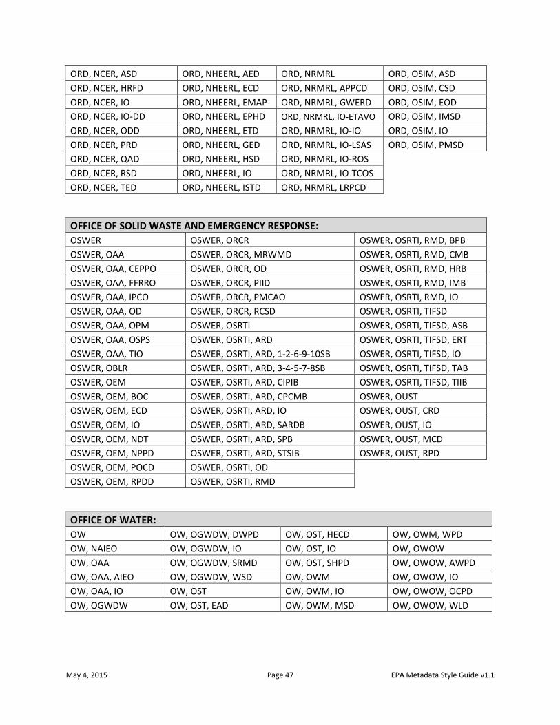
May 4, 2015 Page 47 EPA Metadata Style Guide v1.1
ORD, NCER, ASD ORD, NHEERL, AED ORD, NRMRL ORD, OSIM, ASD
ORD, NCER, HRFD ORD, NHEERL, ECD ORD, NRMRL, APPCD ORD, OSIM, CSD
ORD, NCER, IO ORD, NHEERL, EMAP ORD, NRMRL, GWERD ORD, OSIM, EOD
ORD, NCER, IO-DD ORD, NHEERL, EPHD ORD, NRMRL, IO-ETAVO ORD, OSIM, IMSD
ORD, NCER, ODD ORD, NHEERL, ETD ORD, NRMRL, IO-IO ORD, OSIM, IO
ORD, NCER, PRD ORD, NHEERL, GED ORD, NRMRL, IO-LSAS ORD, OSIM, PMSD
ORD, NCER, QAD ORD, NHEERL, HSD ORD, NRMRL, IO-ROS
ORD, NCER, RSD ORD, NHEERL, IO ORD, NRMRL, IO-TCOS
ORD, NCER, TED ORD, NHEERL, ISTD ORD, NRMRL, LRPCD
OFFICE OF SOLID WASTE AND EMERGENCY RESPONSE:
OSWER OSWER, ORCR OSWER, OSRTI, RMD, BPB
OSWER, OAA OSWER, ORCR, MRWMD OSWER, OSRTI, RMD, CMB
OSWER, OAA, CEPPO OSWER, ORCR, OD OSWER, OSRTI, RMD, HRB
OSWER, OAA, FFRRO OSWER, ORCR, PIID OSWER, OSRTI, RMD, IMB
OSWER, OAA, IPCO OSWER, ORCR, PMCAO OSWER, OSRTI, RMD, IO
OSWER, OAA, OD OSWER, ORCR, RCSD OSWER, OSRTI, TIFSD
OSWER, OAA, OPM OSWER, OSRTI OSWER, OSRTI, TIFSD, ASB
OSWER, OAA, OSPS OSWER, OSRTI, ARD OSWER, OSRTI, TIFSD, ERT
OSWER, OAA, TIO OSWER, OSRTI, ARD, 1-2-6-9-10SB OSWER, OSRTI, TIFSD, IO
OSWER, OBLR OSWER, OSRTI, ARD, 3-4-5-7-8SB OSWER, OSRTI, TIFSD, TAB
OSWER, OEM OSWER, OSRTI, ARD, CIPIB OSWER, OSRTI, TIFSD, TIIB
OSWER, OEM, BOC OSWER, OSRTI, ARD, CPCMB OSWER, OUST
OSWER, OEM, ECD OSWER, OSRTI, ARD, IO OSWER, OUST, CRD
OSWER, OEM, IO OSWER, OSRTI, ARD, SARDB OSWER, OUST, IO
OSWER, OEM, NDT OSWER, OSRTI, ARD, SPB OSWER, OUST, MCD
OSWER, OEM, NPPD OSWER, OSRTI, ARD, STSIB OSWER, OUST, RPD
OSWER, OEM, POCD OSWER, OSRTI, OD
OSWER, OEM, RPDD OSWER, OSRTI, RMD
OFFICE OF WATER:
OW OW, OGWDW, DWPD OW, OST, HECD OW, OWM, WPD
OW, NAIEO OW, OGWDW, IO OW, OST, IO OW, OWOW
OW, OAA OW, OGWDW, SRMD OW, OST, SHPD OW, OWOW, AWPD
OW, OAA, AIEO OW, OGWDW, WSD OW, OWM OW, OWOW, IO
OW, OAA, IO OW, OST OW, OWM, IO OW, OWOW, OCPD
OW, OGWDW OW, OST, EAD OW, OWM, MSD OW, OWOW, WLD
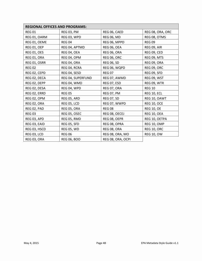
May 4, 2015 Page 48 EPA Metadata Style Guide v1.1
REGIONAL OFFICES AND PROGRAMS:
REG 01 REG 03, PM REG 06, CAED REG 08, ORA, ORC
REG 01, OARM REG 03, WPD REG 06, MD REG 08, OTMS
REG 01, OEME REG 04 REG 06, MPPD REG 09
REG 01, OEP REG 04, APTMD REG 06, OEA REG 09, AIR
REG 01, OES REG 04, OEA REG 06, ORA REG 09, CED
REG 01, ORA REG 04, OPM REG 06, ORC REG 09, MTS
REG 01, OSRR REG 04, ORA REG 06, SD REG 09, ORA
REG 02 REG 04, RCRA REG 06, WQPD REG 09, ORC
REG 02, CEPD REG 04, SESD REG 07 REG 09, SFD
REG 02, DECA REG 04, SUPERFUND REG 07, AWMD REG 09, WST
REG 02, DEPP REG 04, WMD REG 07, ESD REG 09, WTR
REG 02, DESA REG 04, WPD REG 07, ORA REG 10
REG 02, ERRD REG 05 REG 07, PM REG 10, ECL
REG 02, OPM REG 05, ARD REG 07, SD REG 10, OAWT
REG 02, ORA REG 05, LCD REG 07, WWPD REG 10, OCE
REG 02, PAD REG 05, ORA REG 08 REG 10, OE
REG 03 REG 05, OSEC REG 08, OECEJ REG 10, OEA
REG 03, APD REG 05, RMD REG 08, OEPR REG 10, OETPA
REG 03, EAID REG 05, SFD REG 08, OPRA REG 10, OMP
REG 03, HSCD REG 05, WD REG 08, ORA REG 10, ORC
REG 03, LCD REG 06 REG 08, ORA, MO REG 10, OW
REG 03, ORA REG 06, BOO REG 08, ORA, OCPI