february 2015: a month to remember in new … [email protected] eastern region technical...
TRANSCRIPT

*Corresponding author address: Corey A. Bogel, NOAA/National Weather Service, 810 Main Street, Caribou, ME 04736. E-
mail: [email protected]
Eastern Region Technical Attachment
No. 2016-02
May 2016
February 2015: A Month to Remember in New England for Record
Cold
Corey A. Bogel* and Victor J. Nouhan
NOAA/National Weather Service
Caribou, Maine
Abstract
February 2015 was one of the coldest months on record across the Northeast U.S., and in a
number of locations was the all-time coldest month observed. Some of the possible causes of this
extreme cold air outbreak are shown to be ENSO, MJO, positive SST anomalies, and persistent
cyclogenesis along the east coast of the U.S. A review of the offical National Weather Service
Climate Prediction Center’s temperature forecasts and Heidke skill scores for February along
with two climate models that provided temperature forecast guildance for such an extreme event
are examined. Lastly, a comparison with previous extreme cold months since 1948 across the
Northeast U.S. showed that 500 hPa geopotential height composite anomalies had different
distributions; however, the 500 hPa geopotenital height composite means all had an upper level
trough across the Northeast U.S. This event review will hopefully provide forecasters with more
confidence in predicting or assessing the potential for future extreme cold air outbreaks.
_________________________________________________________

2
1. Introduction
An extreme cold air outbreak affected all of
the Northeast U.S. during February 2015
(Northeast Regional Climate Center
(NRCC) 2015). In some locations it was
the all time coldest month ever observed.
This was in sharp contrast to the start of the
winter that featured well above normal
temperatures in December 2014 (Fig. 1).
Temperatures in January 2015 averaged
below normal across the Northeast U.S.
(Fig. 2), but there was not a persistent
extreme cold air outbreak. The mild start to
the winter made the conditions more harsh
in February 2015, which was one of the
coldest, and in some locations the all-time
coldest month of record in parts of the
Northeast U.S. (NRCC; Figs. 3, 4 and Table
1). The extreme cold led to ice buildup on
waterways and made navigation difficult,
slowed commerce, and forced ferry services
to be suspended. Boat traffic was restricted
as far south as parts of the upper Chesapeake
Bay for about a week due to icy conditions,
and the start of maple season was delayed by
up to three weeks in New England, New
York, and Ohio because the extreme cold
kept sap from flowing (Quarterly Climate
Impacts and Outlooks 2015).
The first section of this paper will examine
the temperature records that were
established in a historical context. Next, the
surface and upper air patterns associated
with the February 2015 extreme cold
outbreak will be examined. The upper air
patterns associated with the top 5 coldest
outbreaks since 1948 will also be examined.
The possible causes of the record cold will
be discussed, and finally a review of the
offical forecast and forecast skill from the
Climate Prediction Center (CPC), along with
the forecasts from two climate models will
be presented.

3
Figure 1. December 2014 departure from normal temperature (°F) from the Northeast Regional
Climate Center.

4
Figure 2. January 2015 departure from normal temperature (°F). Figure from the Northeast
Regional Climate Center.

5
Figure 3. February 2015 departure from normal temperature (°F). Figure from the Northeast
Regional Climate Center.

6
Figure 4. The observed average mean temperature rankings for February 2015. Figure from the
Southeast Regional Climate Center.

7
Table 1. February 2015 temperature rankings (°F) across the Northeast U.S. Source - Northeast
Regional Climate Center.

8
2. The Record Cold
February 2015 was one of the coldest
Februaries on record, and in some locations
the all-time coldest month on record across
the Northeast U.S (NRCC). For the
purposes of this event review the Northeast
U.S. includes the six New England States,
along with Delaware, Maryland, New
Jersey, New York, Pennsylvania, and West
Virgina. Average temperatures were 9° to
15° F below normal (Fig. 3). February 2015
ranked as the 2nd
coldest month across the
Northeast U.S. since 1948 behind only
January 1977 (NRCC). It was the coldest
month across the Northeast U.S. since
January 1994, which was the 4th
coldest
month on record (NRCC). In Maine,
Caribou observed its all-time coldest
February on record with an average
temperature of just 2.8° F, which surpassed
1993 when the average temperature was 4.1°
F. Bangor, Maine set an all-time coldest
monthly record. The average temperature at
Bangor of 6.1° F smashed the previous
record for February of 11.3° F in 1993, and
also broke the all-time coldest month record
by more than 2° F. The old record of 8.4° F
was established in January 1994.
Across New England and the greater
Northeast U.S., there were many impressive
monthly temperature records broken.
Portland, Maine, observed its coldest
February on record, and the 2nd
coldest
month of all-time. Boston, Massachusetts,
and Providence, Rhode Island, each had
their 2nd
coldest February and 2nd
coldest
month of all time. Hartford and Bridgeport,
Connecticut, as well as Syracuse, New
York, observed their coldest month ever.
Elsewhere in the Northeast U.S., Buffalo,
Rochester, and Islip, New York, observed
their coldest months on record (Fig. 4).
Fifteen long term climate sites had a record
cold February, and seven long term climate
sites had their all-time coldest month on
record. Most of the climate sites in the
Northeast U.S. had either their coldest or 2nd
coldest February on record (Table 1). What
was remarkable was the persistence of the
cold weather. While not unusual to have a
week or two with below normal
temperatures, every day featured below and
in many cases well below normal
temperatures at Bangor, Maine (Applied
Climate Information System (ACIS); Fig.
5). A similar temperature pattern was noted
at Syracuse, New York (ACIS; Fig. 6).
Boston, Massachusetts, had only one day
with above normal temperatures, and
Buffalo, New York, experienced above
average temperatures on just 2 days during
the entire month of February (ACIS).

9
Figure 5. Daily temperature data (°F) for Bangor, Maine for February 2015.
Figure 6. Daily temperature data (°F) for Syracuse, New York for February 2015.
3. Upper Air and Surface Patterns
The upper air and surface weather patterns
that produced the persistent cold weather
across all of the Northeast U.S. were
investigated to provide a synoptic overview
of the event. In order to do this, a reanalysis
of upper air and surface patterns were
examined using the NCEP/NCAR
Reanalysis courtesy of NOAA’s Earth
System Research Laboratory (ESRL; Kalnay
et al. 1996).
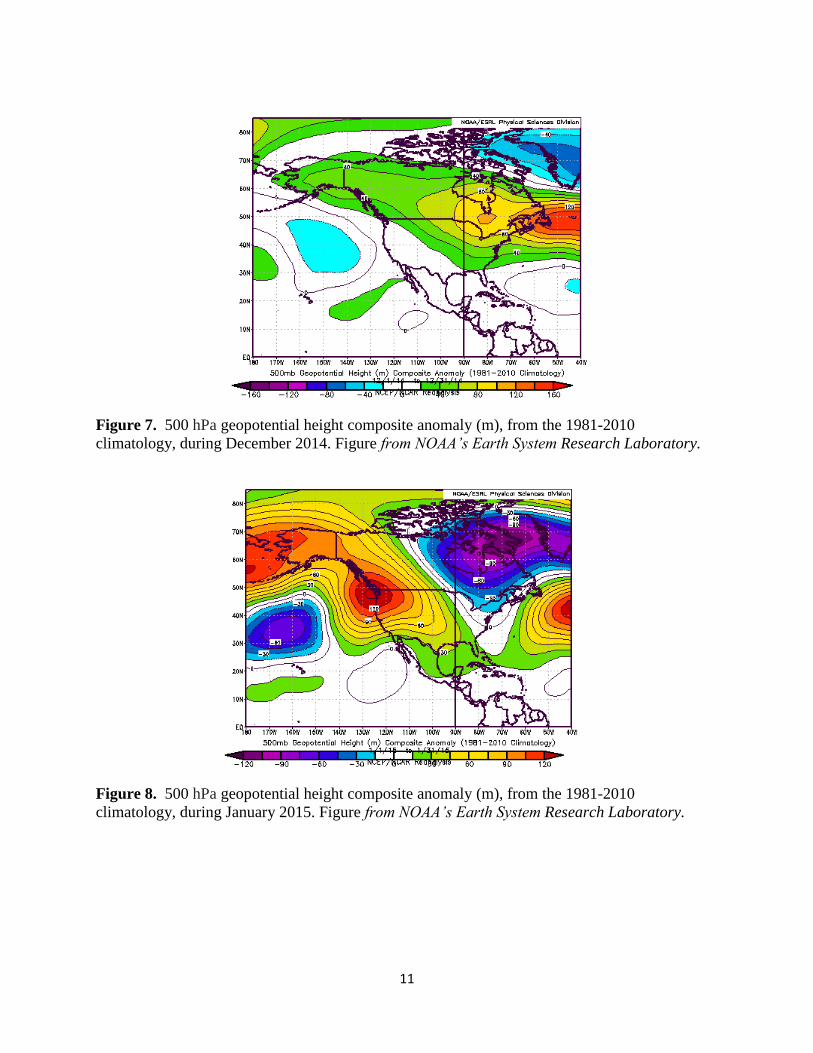
The winter began in December 2014 with
positive 500 hPa geopotential height
anomalies across the Northeast U.S. (Fig. 7).

10
By January 2015, weakly negative 500 hPa
geopotential height anomalies were
observed across the Northeast U.S; however,
strong positive anomalies were noted across
the Pacific Northwest as well as the Bering
Sea and strong negative anomalies were
noted in the vicinity of the Davis Strait (Fig.
8). By February 2015, there were
persistently low 500 hPa heights across
central Siberia, northern Canada, and into
the Great Lakes and Northeast U.S.
Examining the 500 hPa composite
anomalies (1981-2010 climatology),
negative anomalies on the order of 90 to 120
meters were noted across the greater
Northeast U.S. including all of New England
(Fig. 9a). At the same time, strong positive
height anomalies were observed west of the
Continental Divide. The 500 hPa composite
mean for February 2015 (Fig. 9b) showed
strong ridging along the west coast of the
U.S. with a deep trough across the eastern
U.S. In the Northeast U.S., the persistence
of the upper air pattern led to well below
normal temperatures at the surface, which
corresponded well with the upper air
anomalies (Fig. 10).
Next, the surface patterns in February 2015
were examined. The sea level pressure
composite anomaly showed that surface
pressures were lower than the climatological
mean just off the Northeast U.S. coast (Fig.
11). This was due to a series of surface
lows that moved toward the Northeast U.S.
coast from the west and intensified across
the Canadian Maritimes (Weather Prediction
Center’s surface analysis archive,
http://www.wpc.ncep.noaa.gov/archives/we
b_pages/sfc/sfc_archive.php). The
persistence of this pattern led to favorable
conditions for pulling cold Canadian air into
the Northeast U.S. on the back side of the
surface lows.
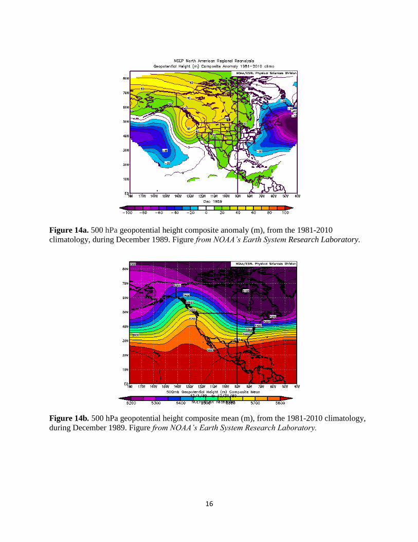
Lastly, a comparison with the top five
coldest months is shown. February 2015
ranked as the second coldest month across
the Northeast U.S. since 1948 (NRCC). The
top 5 coldest months across the Northeast
U.S. in order since 1948 were; January
1977, February 2015, December 1989,
January 1994, and January 1970 (Fig. 12a-
c). The 500 hPa geopotential height
composite mean and anomalies associated
with these other extreme cold months are
shown in Figs. 13-16. In all cases, the 500
hPa geopotential height composite mean
showed a similar pattern of an upper level
trough across the Northeast U.S. The 500
hPa geopotential height composite
anomalies had different distributions with
cold anomalies showing up across the Great
Lakes, the Northeast U.S., and in some cases
off the New England coast.
11
Figure 7. 500 hPa geopotential height composite anomaly (m), from the 1981-2010
climatology, during December 2014. Figure from NOAA’s Earth System Research Laboratory.
Figure 8. 500 hPa geopotential height composite anomaly (m), from the 1981-2010
climatology, during January 2015. Figure from NOAA’s Earth System Research Laboratory.

12
Figure 9a. 500 hPa geopotential height composite anomaly (m), from the 1981-2010
climatology, during February 2015. Figure from NOAA’s Earth System Research Laboratory.
Figure 9b. 500 hPa geopotential height composite mean (m), from the 1981-2010 climatology,
during February 2015. Figure from NOAA’s Earth System Research Laboratory.

13
Figure 10. Surface air temperature composite anomaly (K), from the 1981-2010 climatology,
during February 2015. Figure from NOAA’s Earth System Research Laboratory.
Figure 11. Sea level pressure composite anomaly (mb), from the 1981-2010 climatology, during
February 2015. Figure from NOAA’s Earth System Research Laboratory.

14
(a)
(b)
(c)
Figure 12. The average monthly temperature (°F) across the Northeast U.S. during (a) the month
of December, (b) the month of January, (c) the month of February. Figure from the Northeast
Regional Climate Center.

15
Figure 13a. 500 hPa geopotential height composite anomaly (m), from the 1981-2010
climatology, during January 1977. Figure from NOAA’s Earth System Research Laboratory.
Figure 13b. 500 hPa geopotential height composite mean (m), from the 1981-2010 climatology,
during January 1977. Figure from NOAA’s Earth System Research Laboratory.
16
Figure 14a. 500 hPa geopotential height composite anomaly (m), from the 1981-2010
climatology, during December 1989. Figure from NOAA’s Earth System Research Laboratory.
Figure 14b. 500 hPa geopotential height composite mean (m), from the 1981-2010 climatology,
during December 1989. Figure from NOAA’s Earth System Research Laboratory.

17
Figure 15a. 500 hPa geopotential height composite anomaly (m), from the 1981-2010
climatology, during January 1994. Figure from NOAA’s Earth System Research Laboratory.
Figure 15b. 500 hPa geopotential height composite mean (m), from the 1981-2010 climatology,
during January 1994. Figure from NOAA’s Earth System Research Laboratory.

18
Figure 16a. 500 hPa geopotential height composite anomaly (m), from the 1981-2010
climatology, during January 1970. Figure from NOAA’s Earth System Research Laboratory.
Figure 16b. 500 hPa geopotential height composite mean (m), from the 1981-2010 climatology,
during January 1970. Figure from NOAA’s Earth System Research Laboratory.
4. Possible Causes of the Record Cold
To help determine possible causes of the
record cold, atmospheric and oceanic
conditions were examined for February
2015 as well as the CPC’s forecaster
reasoning behind the montly forecasts. A
comparison is made to January 1977, which
was the all-time coldest month across the
Northeast U.S. since 1948.
During February 2015, weak El Niño
conditions were observed (CPC’s monthly

19
El Niño/Southern Oscillation (ENSO)
diagnostic discussion,
www.cpc.ncep.noaa.gov/products/analysis_
monitoring/enso_disc_feb2015/). Above
average sea surface temperatures (SSTs)
were observed across the western and
central equatorial Pacific, and the low level
easterly trade winds remained weaker than
average across much of the equatorial
Pacific (CPC). The above average SSTs may
have become weakly coupled to the tropical
atmosphere. The largest postive SST
anomaly of +0.75 °C (CPC’s indices page,
www.cpc.ncep.noaa.gov/data/indices/sstoi.i
ndices)) was observed in Niño region 4 (5N-
5S, 160E-150W), with near zero
temperature anomalies in the Niño 1+2
regions (Figs. 17-18). Positive SST
anomalies were also noted along the west
coast of North America and across parts of
the north Atlantic Basin (Fig. 19). The
positive SST anomalies along the west coast
of North America potentially helped to
amplify the mean long wave ridge over the
western North America coast, and were
likely a significant factor in the long wave
pattern at mid and upper latitudes. The
Climate Prediction Center indicated in their
monthly discussion for February 2015
issued on 15 January 2015 that there was “a
continued lack of a robust atmospheric
response to the near to above average
equatorial pacific SSTs.” The positive SST
anomalies in the north Atlantic may have
been an additional source of latent heat for
enhanced east coast cyclogenesis for the
New England coast. Additional reinforcing
shots of cold air followed the passage of the
cyclones and also likely aided in keeping the
cold air in place throughout the month.
The Madden-Julian Oscillation (MJO) was
weak with no coherent MJO pattern
observed during the month of February
(CPC’s MJO discussion,
www.cpc.ncep.noaa.gov/products/precip/C
Wlink/MJO/ARCHIVE/). The upper air
pattern slowly retrograded during the month
(Fig. 20). Arctic air extended from central
Siberia and across the Canadian Archipelago
and into New England. What was
remarkable was the persistence of this
pattern during the entire month. The fact
that the MJO was not coherent and did not
disrupt the quasi-stationary position of
anomalous convection across the western
equatorial Pacific may have been a driver in
the persistence of the upper air pattern, but
this is beyond the scope of this manuscript
and would be worthy of future research by
the climate research community. There was
also a lack of well organized convection
across the eastern equatorial Pacific. Strong
negative OLR anomalies indicative of the
enhanced convection were observed across
the western Pacific with much weaker
anomalies across the central and western
equatorial Pacific (Fig. 21). These strong
anomalies across the western Pacific may
have become weakly tied to the tropical
atmosphere and potentially played a role in
the persistent ridge that was centered along
the west coast of North America and the
downstream trough across the Eastern U.S.
Konrad and Colucci (1989) investigated the
cold outbreak of January 1977, which was
the only month in the Northeast U.S. to be
more severe than the February 2015 cold
outbreak since 1948. They investigated a
total of 17 strong cold air outbreaks and
found that the strongest outbreaks were
associated with rapid surface cyclogenesis
which followed the outbreak onset. This is
consistent with what was noted in February
2015 when reinforcing shots of cold air
followed the passage of offshore cyclones,
and likely aided in keeping the cold air in
place throughout the month on a large scale
across all of the Northeast U.S.
Examining the CPC’s archive of Nino
region SST anomalies, a similar analog was
found with January 1977. Both February

20
2015 and January 1977 featured nearly
identical values in the Nino 3 and 3.4
regions across the west central and central
tropical north Pacific with less warming
noted in the far eastern tropical Pacific in
Nino region 1+ 2 (CPC, Table 2).
Most, if not all, past literature regarding
impacts of El Nino on North America
winters only reference stronger El Nino
events where significant positive SST
anomalies are distributed across all Nino
regions. During these events, enhanced
convection further east energizes the Hadley
Cell circulation over a large portion of the
central and eastern tropical North Pacific
Ocean. This in turn energizes the
subtropical jet originating from the south
side of a stronger sub-tropical ridge over
these regions, resulting in an injection of
wave train energy into the Pacific polar jet
stream. This enhanced Pacific polar jet
enters the west coast of the U.S. during the
winter, resulting in a split flow pattern over
North America, displacing a more northern
jet stream along with deep arctic air further
north than average into northern Canada,
frequently resulting in the observance of a
negative Tropical Northern Hemisphere
(TNH) teleconnection pattern (CPC,
www.cpc.ncep.noaa.gov/data/teledoc/teleco
ntents.shtml).
It is proposed that the more western
displaced Pacific equatorial positive SST
anomalies and associated enhanced
convection observed during February 2015
and January 1977 potentially resulted in a
more regional (rather than basin wide)
enhancement of the Hadley Cell circulation
over the west central and central tropical
north Pacific. Namias et al. (1978) noted
that a strengthened Hadley circulation
transports high-level momentum so as to
increase the extratropical westerlies. During
the January 1977 extreme cold outbreak
Namias et al. (1978) noted that there was a
quasi-stationary long wave pattern, similar
to February 2015, that developed from the
North Pacific eastward through North
America, which was in phase with the
climatological normal flow pattern, although
greatly amplified. This helped lock in the
anomalous pattern because seasonal forcing
did not oppose the factors leading to the
abnormal forcing. This in turn, may have
resulted in an enhanced sub-tropical jet that
resulted in wave energy into a polar jet
stream tied with the maintenance of
anomalously strong Aleutian mid
tropospheric vortex, rather than a Pacific
polar jet stream entering the U.S. west coast
and continuing eastward across the country.
Subsequently, the downstream impacts on
the long wave pattern over North America
become quite different, with anomalously
deep mid tropospheric ridging along all of
the North America west coast resulting in
anomalously deep troughing over eastern
North America. This then results in the
observance of very positive Pacific-North
America (PNA) and/or East Pacific (EP-NP)
teleconnection patterns rather than the
negative TNH patterns seen with strong,
more distributed equatorial SST anomalies
across all Nino regions (CPC
Teleconnection page,
www.cpc.ncep.noaa.gov/data/teledoc/teleco
ntents.shtml). Highly positive PNA and
especially EP-NP patterns result in deep
mid-tropospheric northeast anomalous
component flow (Nouhan 1999) over
significant portions of the arctic source
region of North America extending into the
CONUS. This leads to a much greater
supply of arctic air into the eastern U.S., via
an anomalously meridional component of
the jet stream. Walsh et al. (2001) noted
that the trajectories of the coldest air are
southward or southeastward over North
America during extreme cold outbreaks in
the United States. Meanwhile, an
anomalously northward displacement of a

21
single mean jet stream well north of
California and the southwest U.S. results in
above normal temperatures and below
normal precipitation. The weak El-
Nino conditions mostly indicated in Nino
regions 3.4 and 4 during February 2015 did
not match the conceptual model of winter
impacts of typical (especially strong) basin
wide (with positive SST anomalies affecting
all Nino regions) El-Ninos on California, the
southwest U.S., and across the northern tier
of the U.S. El-Nino conditions occurring
with February 2015,
however, did significantly resemble weak
El-Nino conditions that occurred in January
1977, another month that featured bitterly
cold temperatures for New England (as well
as other portions of the eastern U.S.) and
very dry conditions for California and the
southwest U.S. To further examine the
varying magnitudes of different El-Ninos on
winter impacts across New England and
other portions of the U.S. is beyond the
scope of this manuscript, but would be
worthy future research within the
climate modeling community.
Figure 17. El Niño regions. Figure from the CPC.

22
Figure 18. Niño Region SST Departures (°C). Figure from the CPC.

23
Figure 19. Global sea surface temperature anomalies (°C) during February 2015. Figure from
NCEP -
http://www.emc.ncep.noaa.gov/research/cmb/sst_analysis/images/archive/monthly_anomaly/mo
nanomv2_201502.png.

24
Figure 20. Clockwise, the composite 500 hPa geopotential heights (m) across the northern hemisphere
for February 1-7, 8-14, 14-21, and 21-28. . Figure from NOAA’s Earth System Research Laboratory.
Figure 21. ORL anomalies Feb 7-Mar 04, 2015. Figure from the CPC.

25
Table 2. SST anomalies January 1977 versus February in the Nino 1+2, Nino 3, Nino 4, and
Nino 3.4 regions.
Month/Year Nino 1+2 Nino 3 Nino 4 Nino 3.4
January 1977 +0.20 +0.67 -0.06 +0.66
February 2015 -0.03 +0.46 +0.75 +0.50
5. Case Review: Climate Models and the CPC Forecast
The North American Multi-Model Ensemble
(NMME) is an experimental multi-model
seasonal forecasting system consisting of
coupled models from US modeling centers
including NOAA/NCEP, NOAA/GFDL,
IRI, NCAR, NASA, and Canada’s CMC
(Kirtman et al. 2014). The forecast graphics
are updated on the 9th
of each month and are
based on the models that are run before the
8th
of the month. The NMME lead 2
monthly forecast for February 2015 was thus
available on 9 December 2014, and is
displayed in terciles (Fig. 22). The
Northeast U.S. was in an area where above
normal temperatures were favored. The
next outlook issued on 9 January 2015,
indicated that no one class was dominant,
and thus there was no strong signal that
pointed toward February being a record cold
month (Fig. 23). However, there was a
month over month trend toward a colder
forecast indicated.
The CFSv2 is run once daily at NCEP and is
comprised of 16 ensemble members (Saha et
al. 2014). The forecast that was issued
closest in time to the issuance of the NMME
and was based on initial conditions from 1-
10 January 2015 indicated cold anomalies
on the order of 1-2 degrees (K) across the
Northeast U.S. (Fig. 24). Figures 25 & 26
are the CFSv2 forecast based on the initial
conditions from 12-21 January 2015, and the
final forecast that was issued for February
based on the initial conditions from 22-31
January 2015. There was a clear trend
toward increased cold anomalies, which by
the final outlook were on the order of 4+
degrees (K). The daily CFSv2 2-m
temperature anomalies from 23-31 January
2015 showed that by late January the model
indicated that there was a high likelihood
that February would have significantly
below normal temperatures across the
Northeast U.S. (Fig. 27). There was a strong
trend during the month of January that
pointed toward warmer temperature
anomalies in February across western North
America. It is not possible to discern from
the CFSv2 that this would necessarily be an
indication that all-time record cold monthly
temperatures were forecast by the model
across the Northeast U.S.
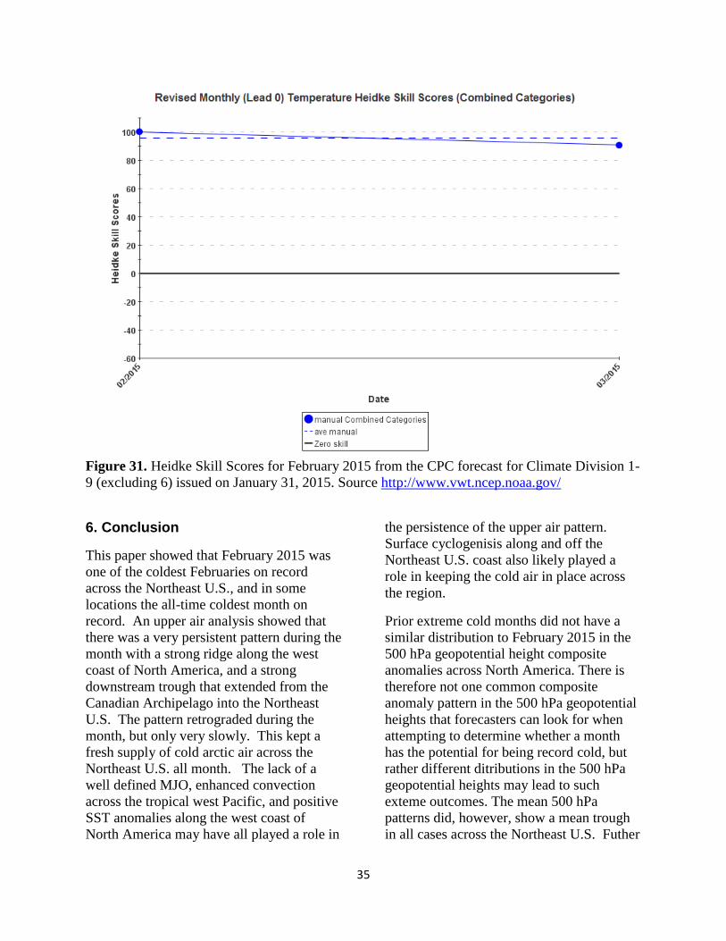
The official NWS forecast from the CPC
that was issued on 15 January 2015,
indicated that there were no strong climate
signals that would point toward an unusually
cold February (Fig. 28). The February
outlook “reflects a fairly high amount of
uncertainty, given significant differences
among the various climate models, and the
continued lack of a robust atmospheric
response to the near to above average
equatorial pacific SSTs.” The Heidke skill
score of the CPC forecast was zero (Fig. 29),
which indicated no skill compared to a
random forecast. The final issuance of the
monthly outlook for February that was
issued on 31 January 2015 was significantly
different from the previous 0.5-month lead
outlook and indicated an increased
likelihood that temperatures would average
below normal across the Northeast U.S.
during the month of February (Fig. 30). The
CPC forecaster noted that there were

26
“enhanced odds of below normal
temperatures for much of the eastern third of
the continental U.S. which was well
supported by most of the long range tools,
and was consistent with the idea that a large
scale trough would dominate the mid-
tropospheric circulation in the east.” The
Heidke skill score of the revised CPC
forecast (Fig. 31) was 100, which indicates a
perfect forecast. It seems likely that during
the 2nd
half of January 2015 that the climate
models, and in particular the CFSv2, picked
up on the idea that an upper trough would
dominate during the month of February
across the Northeast U.S.
Figure 22. NMME forecast issued December 9, 2014, valid for February 2015. 2-m
temperature tercile probabilities.

27
Figure 23. NMME forecast issued January 9, 2015, valid for February 2015. 2-m temperature
tercile probabilities.

28
Figure 24. CFSv2 2-m temperature anomalies (K) based on initial conditions from January 1-
10, 2015.

29
Figure 25. CFSv2 2-m temperature anomalies (K) based on initial conditions from January 12-
21, 2015.

30
Figure 26. CFSv2 2-m temperature anomalies (K) based on initial conditions from January 22-
31, 2015.

31
Figure 27. The daily CFSv2 2-m temperature anomalies (K) from January 23-31, 2015.

32
Figure 28. The official National Weather Service’s Climate Prediction Center temperature
forecast for February 2015 from the CPC that was issued January 15, 2015

33
Figure 29. The final official National Weather Service’s Climate Prediction Center temperature
forecast for February 2015 from the CPC that was issued January 31, 2015.

34
Figure 30. Heidke Skill Scores for February 2015 from the CPC forecast for Climate Division 1-
9 (excluding 6) issued on January 15, 2015. Source http://www.vwt.ncep.noaa.gov/
35
Figure 31. Heidke Skill Scores for February 2015 from the CPC forecast for Climate Division 1-
9 (excluding 6) issued on January 31, 2015. Source http://www.vwt.ncep.noaa.gov/
6. Conclusion
This paper showed that February 2015 was
one of the coldest Februaries on record
across the Northeast U.S., and in some
locations the all-time coldest month on
record. An upper air analysis showed that
there was a very persistent pattern during the
month with a strong ridge along the west
coast of North America, and a strong
downstream trough that extended from the
Canadian Archipelago into the Northeast
U.S. The pattern retrograded during the
month, but only very slowly. This kept a
fresh supply of cold arctic air across the
Northeast U.S. all month. The lack of a
well defined MJO, enhanced convection
across the tropical west Pacific, and positive
SST anomalies along the west coast of
North America may have all played a role in
the persistence of the upper air pattern.
Surface cyclogenisis along and off the
Northeast U.S. coast also likely played a
role in keeping the cold air in place across
the region.
Prior extreme cold months did not have a
similar distribution to February 2015 in the
500 hPa geopotential height composite
anomalies across North America. There is
therefore not one common composite
anomaly pattern in the 500 hPa geopotential
heights that forecasters can look for when
attempting to determine whether a month
has the potential for being record cold, but
rather different ditributions in the 500 hPa
geopotential heights may lead to such
exteme outcomes. The mean 500 hPa
patterns did, however, show a mean trough
in all cases across the Northeast U.S. Futher

36
evaluation of the composite anomalies
associated with extreme cold months would
be a worthy endevour. Rapid surface
cyclogenesis along and off the Northeast
U.S. coast does appear to play an important
role in reinforcing the cold air.
The NMME did not have a signal pointing
toward an unusually cold February, and in
fact the lead 2 outlook in December
indicated an increased likelihood of above
normal temperatures. The CFSv2, which is
one of the component members of the
NMME, did have an increasing cold signal
during the month of January. The offical
NWS forecast from the CPC issued on 15
January 2015 had no skill compared to a
random forecast; however, the CPC forecast
issued on 31 January 2015, accurately
forecasted an increased likelihood of below
normal temperatures in February. The
climate models gave little lead time for such
a significant event, and were unable to
provide any guidance to the forecaster as to
whether the anomalies would be record
breaking. There are still a significant amount
of unknowns that affect monthly climate
forecasts and more work is needed to better
predict these events.
Acknowledgments
The authors would like to thank Todd Foisy
(Science and Operations officer) of the
NWS forecast office in Caribou, Maine and
Brian Miretzky (Scientific Services
Division) of the NWS Eastern Region
Headquarters for their thoughtful reviews
and suggestions related to this publication.
References
ACIS, 2015. NOAA Regional Climate
Centers. [Available online at
http://xmacis.rcc-acis.org/]
Climate Prediction Center. [Available online
at http://www.cpc.ncep.noaa.gov/]
Earth System Research Laboratory, 2015.
[Available online at
http://www.esrl.noaa.gov/psd/]
Kalnay, E., and Coauthors, 1996: The
NCEP/NCAR Reanalysis 40-year
Project. Bull. Amer. Meteor. Soc., 77,
437-471.
Kirtman, B.P., and Coauthors, 2014. The
North American Multimodel Ensemble:
Phase-1 Seasonal-to-interannual
prediction; Phase-2 toward developing
intraseasonal prediction. Bull. Amer.
Meteor. Soc., 95, 585-601.
Konrad, C.E., and S.J. Colucci, 1989: An
examination of extreme cold air
outbreaks over Eastern North America.
Mon Wea. Rev., 117, 2687-2700.
Namias, J., 1978: Multiple Causes of the
North American Abnormal Winter 1976-
77. Mon. Wea. Rev., 106, 279-295.
National Weather Service Eastern Region
Quarterly Climate Impacts and
Outlooks, March 2015. [Available online
at
http://www1.ncdc.noaa.gov/pub/data/pa
pers/RCSD/NIDIS-pdf/ER-Winter-2014-
15-Quarterly-updated-v2.pdf]
Northeast Regional Climate Center.
[Available online at
http://www.nrcc.cornell.edu/]
Nouhan, V., 1999: The use of 500 mb Non-
Teleconnection area indicies over North
America in determining arctic air mass
potential east of the Rockies. NWS

37
Central Region Applied Research Paper,
20, National Weather Service, NOAA,
Department of Commerce, Kansas City,
MO.
Saha, S., and Coauthors, 2014: The NCEP
Climate Forecast System version 2. J.
Climate, 27, 2185–2208.
Southeast Regional Climate Center.
[Available online at
http://www.sercc.com/]
Walsh, J. E., A.S. Phillips, D.H. Portis and
W.L. Chapman, 2001: Extreme cold
outbreaks in the United States and
Europe, 1948-99. J. Climate, 14, 2642-
2658.