entry for asla student awards 2011 competition
DESCRIPTION
These slides were assembled for my Masters work on South Grand Boulevard for the research category of the 2011 ASLA Student Awards Competition.TRANSCRIPT

ASLA 2011 Student Awards Research Category Descriptive Data Summary Entry Number: SA-593G Level of Study: Graduate Individual or Team Entry: Individual Project Title: South Grand Boulevard: user orientation as a catalyst for resiliency Project Statement: The economic and environmental costs of aging stormwater infrastructure are increasing in cities all across this country and world. This study proposes a new theoretical framework that identifies how and at what time the introduction of ecological processes into the urban right-of-way is likely to be successful in the long-term. From this research, it is possible to design streets that surpass current “green street” and “complete street” initiatives and achieve a high level of resiliency. Project Narrative: Introduction Contemporary design of the urban environment focuses increasingly upon the quality of space found within the public right-of-way. Landscape architects and urban planners are beginning to ask new questions that deviate from the conventional streetscape designs of the latter half of the 20th century. Under the mantra “complete the streets,” communities all across America are calling for a paradigm shift towards multimodal, pedestrian-scaled urban rights-of-way. At the same time, existing stormwater and combined sewer infrastructure is nearing the end of its productive lifespan in cities all across the country and world. The direct costs associated with repairing this infrastructure combined with the indirect costs of poor water quality and a greater frequency and intensity of flooding events downstream present a strong argument for developing new, innovative ideas about how to best design tomorrow’s infrastructure. The reintegration of ecological processes into the urban fabric will act as a catalyst for the appreciation of genius loci (spirit of the place) and user meaning while mitigating downstream flooding, increasing water quality, and extending the lifespan of existing stormwater infrastructure. By studying the hierarchical categorization of urban rights-of-way according to increased levels of user orientation, this research project aims to clearly articulate a new theoretical framework for expanding upon the current discourse surrounding “complete streets” and “green streets” theory. In early 2006, the East-West Gateway Council of Governments introduced the St. Louis Great Streets Initiative with the goal of promoting “complete street” design principles in St. Louis, Missouri. South Grand Boulevard, selected as one of four pilot projects, seeks to be a demonstration project for socially and economically sustainable streets in the region; however, current concepts are not progressing far enough towards providing a model of future infrastructural design. With the allocation of $2.7 million of federal stimulus money towards the project, a huge opportunity presents itself for testing the Hierarchy of User-oriented Streets framework as a viable model for solving the stated dilemma. Hierarchy of User-oriented Streets Framework Innovation often comes through stepping outside the typical boundaries of the design professions to look at theories developed within other fields of research. During the 1940s and 1950s, a psychologist named Abraham Maslow was studying the differences among human needs as a way to understand what motivates human behavior. Through his research, he realized that some needs take precedence over others acting as prerequisites for attaining higher level needs. In a day when supervisors viewed their factory workers as “replaceable parts,” Maslow’s Hierarchy of Needs Framework proved to be a successful utility for increasing the productivity of workers. He discovered that as supervisors satisfied the

ASLA 2011 Student Awards Research Category Descriptive Data Summary higher-level needs of their workers, they would respond with greater outputs. Drawing a strong parallel, this study asks the question: How can identifying a hierarchy of user-oriented street types lead to greater productivity, therefore resiliency, in the design, construction, and maintenance of urban rights-of-way? While this question prompted the initial idea of formulating the proposed framework, the articulation of five distinct levels, their definitions, the associated subcomponents, contemporary urbanisms, and street design movements all came from a rich exploration of existing literature. Notable sources of literature include Echols and Pennypacker’s “From Stormwater Management to Artful Rainwater Design” (2008), Lynch and Hack’s Site Planning (1984), Meyer’s “Sustaining Beauty” manifesto (2008), Mossop’s “Landscapes of Infrastructure” (2006), Olin’s “Form, Meaning, and Expression in Landscape Architecture” (1988), and Treib’s “Must Landscapes Mean?” (1995). The Hierarchy of User-oriented Streets framework contains five levels: function, safety, ecology, genius loci, and meaning. Function is the lowest level of user-orientation in which an urban right-of-way provides the most basic levels of service to users for their efficient movement from one point of reference unto another. Safety is the next to lowest level of user-orientation in which an urban right-of-way promotes equal opportunity and experience through the health, safety, and welfare of all users. Ecology is the essential, median level of user-orientation in which an urban right-of-way reintegrates natural processes into the urban fabric through eco-technologies that promote healthier environments and an improved quality of life for the users. Genius loci is the next to highest level of user-orientation in which an urban right-of-way uses ecological processes through time to engender its distinctive character and unique identity toward a community of users. Meaning is the highest level of user-orientation in which an urban right-of-way cultivates educated “dynamic users” who voluntarily take ownership of the public space and engage in actions that promote resiliency within the corridor. Similar to Maslow’s framework, a street must fulfill the lower levels before higher levels can be attained. Methods
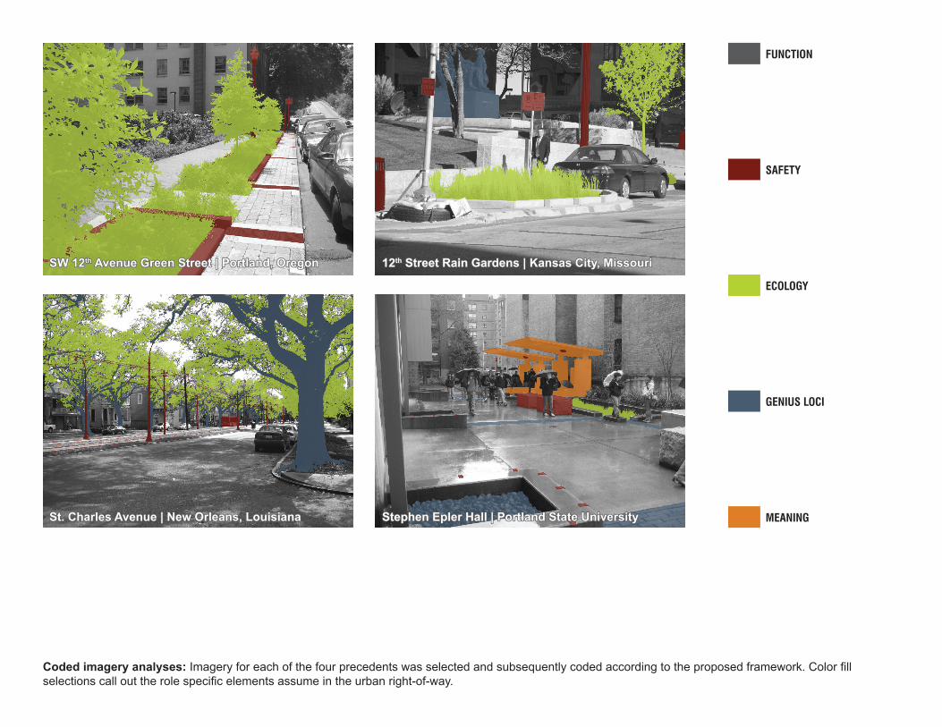
This study investigated four precedents: SW the 12th Avenue Green Street (located in Portland, Oregon), the 12th Street Rain Gardens (located in Kansas City, Missouri), St. Charles Avenue (located in New Orleans, Louisiana, and Stephen Epler Hall (located at Portland State University). In order to further develop the ideas represented in the proposed framework, each of the selected precedents were qualitatively evaluated using the framework as a metric. The specific methods for this assessment included using a coded imagery analysis to identify individual components with the appropriate level of the framework. During the precedent study, the theoretical framework established a set of criteria with which to evaluate three precedent projects and one existing place. Because of its utility, the framework was employed for organizing the site inventory and analysis; however, this time, it was used as a point of departure for generating specific methods rather than serving as a metric for evaluation. Seeking to maintain the hierarchical ordering within the proposed framework, the site analysis methodology consistently categorizes each of its steps into the five framework divisions of function, safety, ecology, genius loci, and meaning. In this way, landscape architects and urban planners can look to this study as a guide for which type of analysis questions they should ask depending on where their project is intended to hit upon the framework. If your end goal is to design a “complete street,” there is little to no reason for you to spend time analyzing hydrological watersheds and existing impervious surfaces. These are two examples of site analysis tasks found within the ecology level of the proposed framework. Only in designing a “green street,” “destination street,” or “resilient street” would you address these tasks. Higher level analysis is not needed for a lower level design. The first step of the site analysis methodology included completing a user analysis for each level of the theoretical framework. Following the user analysis, three project goals were selected for each level of the framework. While these goals would eventually be used to guide the conceptual thinking for design explorations, they served an immediate function to break down the subcomponents of each level of the

ASLA 2011 Student Awards Research Category Descriptive Data Summary framework for the development of site appropriate programmatic elements. An ongoing literature review and precedent study feedback loop aided in the selection of additional programmatic elements for South Grand. The next step in the methodology formalized specific analysis questions that related and referenced the given user group, project goals, and programmatic elements to South Grand as an existing site. In many cases, these questions were quite complex requiring the formalization of subsequent inventory questions to further delineate an appropriate path of inquiry for answering the original question. In the end, task sheets outlining the inputs, source data, methods, and potential outputs were assembled to guide the production work of South Grand’s inventory and analysis. Results The application of the framework to the design proposal for South Grand yields several unique, site appropriate design strategies. At the function level, the design strategies include transforming the arterial corridor from four travel lanes to two travel lanes separated by a middle turn lane and incorporating concrete wet vaults underneath the sidewalk. In addition to serving many ecology-related services, the wet vaults protect the limestone foundations of the adjacent buildings from unwanted subsurface water. At the safety level, design strategies include raised intersections acting as “speed tables,” a dispersion of bike parking throughout the district, radiant heating of sidewalk and on-street parking spaces, extra-wide parking stalls for users with disabilities, and a 3” tall safety curb around all stormwater infiltration planters. At the ecology level, design strategies include stormwater infiltration planters and a significant investment in the district’s urban forest. Disregarding soil infiltration rates, the stormwater planters can accommodate 9,410 cubic feet (CF) of the total runoff volume leaving 5,489 CF to enter into the underground wet vaults. In terms of the investment in the urban forest, this study’s design proposal for South Grand, obtains a net annual benefit of $12,255.18 (Davey Resource Group 2009). This is a substantial increase in value as the existing urban forest is only valued at a net annual benefit of $3,920.62. At the genius loci level, design strategies include painted spherical bollards at the raised intersections, electric car charging stations, the use of local materials, expressive paving patterns, and the incorporation of lighting into the stormwater planters. Finally, at the meaning level, design strategies include incorporating a cast iron pump within the right-of-way to provide users the opportunity to physically interact with the eco-technologies and the design of an interactive and educational pocket park intended to encourage the development of a “community of users” and a “user land ethic.” Conclusions In this study, the proposed framework was utilized throughout the precedent study, the site inventory and analysis, the development of program, the design proposal, and the project evaluation. As evidenced through its application at South Grand, the incorporation of this framework into one’s design process yields a substantial return towards attaining resiliency in urban rights-of-way. The Hierarchy of User-oriented Streets framework provides the road map for how landscape architects and urban planners can lead the movement that transforms our cities’ infrastructure from functional thoroughfares to resilient places. Future Research Two important opportunities exist for future research in relation to this study. First, future investigations could establish performance baselines for each level of the framework allowing for a quantified measure of success. Second, though presented within the scope of urban rights-of-way, the proposed framework could be easily adapted to other project types (parks, golf courses, community planning, suburban sprawl, gardens, greenways, brownfield sites, etc.) as a design process model that effectively addresses the creation of productive, resilient landscapes.

metrics
client
project type
future aspirations
student awards entry
definitions
legacy
lifespan of project
explorations
available data
cost-benefit analysisorganizations
interests
feasibility
time
technology
resourcestheories
issues
past experiences
end product
design philosophy
gray literature
site
scale
???
???
Project Goals and Intentions
Design G
oals and IntentionsPersonal Goa
ls an
d In
tent
ions
pap
METHODOLOGY
PRECEDENTS
GATHER EXISTINGKNOWLEDGE
FORMULATEQUESTIONS
SITE INVENTORY +ANALYSIS
PROGRAM
CONCEPTUALIZEPTPALTERNATIVESNATER
DESIGNGDES
REFINEINEF
PRODUCE
COST-BENEFITANALYSIS
IDENTIFYUNANSWERED
QUESTIONS?
APPLY METRIC TO DESIGN
DILEMMA
THESIS
d
efifit
ne
so eaje t
DEF
INE
INV
ESTI
GAT
ESY
NTH
ESIZ
EA
PPLY
EVA
LUAT
E
Des
ign
proc
ess
diag
ram
: The
ove
rall
desi
gn p
roce
ss u
tiliz
ed in
this
stu
dy b
egin
s w
ith a
hig
hly
cycl
ical
defi
niti
on s
tage
bef
ore
prog
ress
ing
thro
ugh
the
rem
aini
ng
inve
stig
atio
n, s
ynth
esis
, app
licat
ion,
and
eva
luat
ion
stag
es in
a p
redo
min
antly
line
ar m
anne
r.

user education,
user creation, dynamic users, user
interaction, user ownership, social engineering,
user “action” response, develop-ment of user land ethic
diversity of surrounding land use, form, experiential design , local materiality, district
cohesion, recycled materiality, user recreation, destination placemaking, PR branding: “we are progres-
sive,” high design urban space, district gateway, community of users, local region visibility, hyper-nature, human-centric vs.
bio-centric, aesthetics, appropriate noise level, culture, neighborhood identity, artistic expression, local community engagement in design process
subsurface infiltration of stormwater runoff, recycle receptacles, eco-technologies, native plant species selection, introduction of natural processes, increase in surface porosity,
reduction of urban heat island effect, energy savings to adjacent structures, cyclical maintenance plan, no permanent irrigation system, “cradle to cradle” design philosophy, maximize soil volume per
street tree, site-specificity, incorporation of solar panels on adjacent structures, energy efficient lighting and controls, preservation of existing vegetation, celebration of stormwater as a “value-added amenity,”
emulation of local hydrological and geomorphological conditions, treatment train thinking, green infrastructure, air quality improvement, sequestration of carbon (CO2)
degrees of security, reduction of criminal activity, visual and textural changes in ground surface, multiple modes of movement, noise reduction, numerous pedestrian amenities, adequate vehicular parking in accordance with existing utilization rates, cyclist circulation:
bike lanes or sharrows, street beautification tree plantings, “shared parking” concept, ”defensible space theory,” user interaction with other users, “park-once district,” clearly identified crosswalks, reduction of vehicular traffic speeds, connectivity, mass transit circulation: bus or
streetcar, wayfinding and signage, walkability, lighting, use of low volatile paints, trash receptacles, pedestrian buffer from vehicular traffic, treatment of severe weather road conditions, universal design for all users, emergency access, promotion of local commerce, potential for “themed” sense of place,
pedestrian-oriented, proper allowance of sight lines at intersections where modes of movement cross, smaller block sizes with more intersections
supports adjacent land use, traffic lights at intersections, clear delineation of vehicular traffic lanes, necessary roadway signage, grey infrastructure, efficient, auto-oriented travel, separation of land uses through zoning ordinances and regulations, storm sewer infrastructure, vehicular circulation, retail signage scaled for motorists, traffic lane configura-tion, utilitarian design, AASHTO street classification, larger block sizes with fewer intersections, contributes to point source pollution of downstream water bodies and ecosystems,
access to adjacencies, ADA compliant, pedestrian circulation, functional maintenance such as roadway resurfacing, increased frequency and magnitude of flooding downstream, public vs. private separation
Time (cyclical)
Shor
t-ter
m C
ost Long-term
Cost
resi
lienc
y an
d su
stai
nabi
lity
(incr
ease
with
hig
her l
evel
s of
use
r orie
ntat
ion)
new urbanism “complete streets”To what extent does the urban right-of-way promote equal opportunity and experience through the health, safety, and welfare of all users?
SAFETY
landscape urbanism “green streets”To what extent does the urban right-of-way reintegrate natural processes into the urban fabric through eco-technologies that promote healthier environments and an improved quality of life for its users?
ECOLOGY
landscape urbanism “destination streets”To what extent does the urban right-of-way use ecological processes through time to engender its distinctive character and unique identity toward a community of users?
GENIUS LOCI
ecological urbanism “resilient streets”To what extent does the urban right-of-way cultivate educated, “dynamic users” who inherently take ownership of the public space and engage in actions that promote resiliency within the corridor?
MEANING
“conventional streets”To what extent does the urban right-of-way provide the most basic levels of service to users for their efficient movement from one point of reference to another?
FUNCTION
Hierarchy of User-oriented Streets framework: Central to this study is the above framework and its application throughout all stages of the design process. Attached to each level is a defi ning question, contemporary urbanism, street design movement, and associated subcomponents.

COST: · Cashman, A. 2008. “Costing the Long-term Demand for Water Sector Infrastructure.”
EVALUATION: Shirvani, Hamid. 1990. Beyond Public Architecture: Strategies for Design Evaluatio
ns
divdd ersity of surrounding land uselocal community engagement in design processoc
hyper-nature
aesthetics
appropriate noise level
neighborhood identity
human-centric vs. bio-centric
artistic expression
expexpexppperierieriee ential design for userppppeeeppe
destination place ce ce makmakmakmakmakmakingininmakmmakmakmake e e
recycled materiality
high quality urban space
design elements promote district cohesion
user recreation
public relations brandingg: “we are progressive”
district gateway
local regional visibility
formmm
community of usseers
culululturturturrurureeeerrrreeeetututu
local materiality
user interactionuser “action” response
dynamic users
user creation
development of user land ethic
user ownership
user educationnnnn
social engineering
introduction of natural processes
nnative plant spspecie es selectionspspeet s
eco-technologies
site-specificity
reduce urban heat island effect
no permanent irrigation system
energy efficient lighting and controls
emulation of local hydrological and geomorphology conditions
solar panels
celebration of stormwater as an value-added amenity
maximize soil volume per street tree
sequester carbon (CO2)
“green” infrastructure
air quality improvement
subsurface infiltration of stormwater runoffwater runo
adjacent land-use energy savings
recycle receptacles “cradle to cradle” philosophyhilo
increase in surface porositye in s
treatment train
prep servation of existing vegetationpp
cyclical maintenance plan
degrees of securityquate vehicular parking (according to utilization rates)eqade
cyclist circulation: bike lanes
“shared parking” conceptuser interaction with other users
potential for “themed” sense of place
promotion of loooooocalcalalalcaca cccoc mmerceooocccaa
ground surface visual and textural changesl c
“park-once district”
crosswalksedclearly identifie
fewer vehicular lanes and wider sidewalks
street beautification tree plantings
noise reduction
reductioonono ofofofof ccrc iminal activityo
defensible space theory”“d le sp
lighting
emergency access
e paintsileuseuseuseuseuseuse ooofof low volatiususeuseusee o
wayfinding and signage
walkabilityconnectivity
trash receptacles
numerous pedestrian amenitiestie
ntedenpedestrian-orie
nsit circulation: bus or streetcaranmass tra
reduction of vehicular traaafafffficficficfic spspppeedsafffficficficcc ss
atment of severe road conditionsreatr
consideration of sight lines at intersectionssssssspedestrian buffer from vehicular traffic
allows multiple modes of movement
universal design for all usersfo
public vs. private separationse
surs plus of vehicular parking based upon peak volumes
traffic lane configuration
access to adjacenciess
utilitarian design
separation of land uses through zoning regulations
increased frequency and magnitude of flooding downstream
ada compliant
supports adjacent land usecen
pedestrian circulation
contributbuteses too poipoipo nt source pollution of downstream water bodiesoo popot s t urce
retail signage scaled for motorists vehicular circulation
land use zoning
traffic lights, painted stripes, and roadway signage
“grey” infrastructure
aashto street classificationlarger block sizes with fewer intersections
functional maintenance
storm sewer infrastructure
efficient, auto-oriented travel
· Waldheim, Charles. 2006. The Landscape Urbanism Reader
· Engler, Mira. 2004. Designing America’s Waste Landscapes
· White, Edward T. 1999. Path, Portal, Place: Appreciating Public Space in Urban Environments
· Olin, Laurie. 1988. “Form, Meaning, and Expression in Landscape Architecture”
· Lynch, Kevin, and Gary Hack. 1984. Site Planning
· Mostafavi, Mohsen, ed. 2010. Ecological Urbanism
· Echols, Stuart. 2007. “Artful Rainwater Design in the Urban Landscape”
· Echols, Stuart, and Eliza Pennypacker. 2008. “From Stormwater Management to Artful Rainwater Design”
· Treib, Mark. 1995. “Must Landscapes Mean?: Approaches to Significance in Recent Landscape Architecture”
· Mennel, Timothy (ed.). 2009. “Smart Codes: Model Mixed Use Zoning District” · Moughtin, Cliff. 2003. Urban Design: Street and Square
· Krieger, Alex. 2009. “Where and How Does Urban Design Happen?” Urban Design
· Meyer, Elizabeth K. 2008. “Sustaining Beauty. The Performance of Appearance: A Manifesto in Three Parts”
· Mennel, Timothy (ed.). 2009. “Smart Codes: Model Affordable Housing Density Bonus Ordinance”
· Mennel, Timothy (ed.). 2009. “Smart Codes: Innovative Approaches to Encourage Meaningful Citizen Participation in the Development Process”
· Mennel, Timothy (ed.). 2009. “Smart Codes: Model Pedestrian Overlay District (POD) Ordinance”
· Ching, Francis D.K. 1996. Architecture: Form, Space, Order
· Mossop, Elizabeth. 2006. “Landscapes of Infrastructure”
· Wright, Richard T. 2008. Environmental Science: Toward a Sustainable Future
· Karl, Thomas, R., Melillo, Jerry M., and Peterson, Thomas C. (eds.). 2009. Global Climate Change Impacts in the United States
· McHarg, Ian L. 1992. Design with Nature
· Ellin Nan. 2006. Integral Urbanism
· Davey Resource Group. 2009. City of St. Louis, Missouri Street Tree Resource Analysis
· Grigg, N. S. 2003. Water, Wastewater and Stormwater Infrastructure Management
· AASHTO. 2010. Standard Specifications for Transportation Materials and Methods of Sampling and Testing
· Beatley, Timothy. 2000. Green Urbanism: Learning from European Cities
· Beatley, Timothy, Peter Newman. 2009. Green Urbanism Down Under: Learning from Sustainable Communities in Australia
· Newman, Peter, Timothy Beatley, and Heather Boyer. 2009. Resilient Cities: Responding to Peak Oil and Climate Change
· Fremling, Calvin R. 2005. Immortal River: The Upper Mississippi in Ancient and Modern Times
· Gurnell, A. 2007. “Urban Rivers: Hydrology, Geomorphology, Ecology, and Opportunities for Change”
· Mitchell, V. G. 2006. “Applying Integrated Urban Water Management Concepts: A Review of Australian Experience”· Farrelly, M., R. Brown, and C. Davis. 2009. “Can Demonstration Projects Act as a Mechanism for Promoting a Transition” · Carson, Rachel. 1994. Silent Spring
· Leopold, Aldo. 1966. A Sand County Almanac
· Jacobs, Allan B. 1993. Great Streets
· Design Workshop. 2009. South Grand Boulevard Great Streets Initiative
· Bohl, Charles C. 2000. “New Urbanism and the City: Potential Applications and Implications for Distressed Inner-City Neighborhoods”
· Mennel, Timothy (ed.). 2009. “Smart Codes: Model Shared Parking Ordinance”
· Mennel, Timothy (ed.). 2009. “Smart Codes: Model Policy Promoting Complete Streets”· Mennel, Timothy (ed.). 2009. “Smart Codes:
Model Street Connectivity Standards Ordinance”
SAFETY
ECOLOGY
GENIUS LOCI
MEANING
FUNCTION
Literature map: Instrumental to the formation of the proposed framework, an ongoing literature review categorized existing literature into the fi ve levels. The result is a hierarchical classifi cation of relevant literature indicative of which sources address “higher level” topics.

PREC
EDEN
TS
METRIC
EVAL
UATI
ON
CONT
EMPO
RARY
LA T
HEOR
IES
feedback loop
possibilitiesimagery
previous site visits
available data
project type
project location
relevanceexisting knowledge
design strategies
users
plant species selection
materiality
design program elements
maintenance requirements over time
timeframeproject goals
questions
technologies
obstacles
CODED IMAGERY ANALYSIS
D IED IMAMAGER
GERY AY ANNALNAL
SAFETY
ECOLOGY
GENIUS LOCI
MEANING
FUNCTION
· SW 12th Avenue Green Street located in Portland, Oregon
· 12th Street Rain Gardens located in Kansas City, Missouri
· St. Charles Avenue located in New Orleans, Louisiana
· Stephen Epler Hall @ PSU located in Portland, Oregon
ongoing literature review
observationspotential precedents filter a filter b
Precedent study methodology diagram: In the precedent study, the framework was utilized as a metric from which coded observations could be extracted from imagery of each precedent.
FUNCTION
SAFETY
ECOLOGY
GENIUS LOCI
MEANING
Coded imagery analyses: Imagery for each of the four precedents was selected and subsequently coded according to the proposed framework. Color fi ll selections call out the role specifi c elements assume in the urban right-of-way.
SW 12SW 12thth Avenue Green Street | Portland, Oregon Avenue Green Street | Portland, Oregon
St. Charles Avenue | New Orleans, LouisianaSt. Charles Avenue | New Orleans, Louisiana
1212thth Street Rain Gardens | Kansas City, Missouri Street Rain Gardens | Kansas City, Missouri
Stephen Epler Hall | Portland State UniversityStephen Epler Hall | Portland State University

SAFETY
ECOLOGY
GENIUS LOCI
MEANING
FUNCTION SITE-S
PECIF
ICITYI
FE
ST
ITICICIITTTFFIFFIFFICC
ECEEPEECCC
SSSSESSPPP
TTETTITTEEEIIIII
FFFFFEEEEE
SSSSSTTTTT
proj
ect g
oals
and
inte
ntio
ns
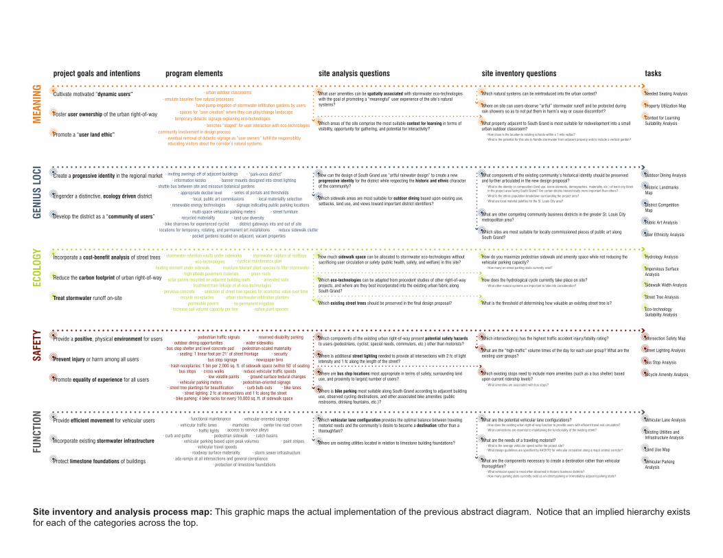
program elements site analysis questions site inventory questions tasksuser analysistheoretical framework
???
???
???
???
???
Site inventory and analysis methodology diagram: The framework is utilized as a point of departure for deriving the specifi c methods and end tasks to be completed in the site inventory and analysis.
SAFE
TYEC
OLOG
YGE
NIUS
LOC
IM
EANI
NGFU
NCTI
ON
site analysis questionsproject goals and intentions program elements site inventory questions tasks
What user amenities can be spatially associated with stormwater eco-technologies with the goal of promoting a “meaningful” user experience of the site’s natural systems?
Which natural systems can be reintroduced into the urban context? Needed Seating Analysis
Property Utilization Map
Context for Learning Suitability Analysis
Where on site can users observe “artful” stormwater runoff and be protected during rain showers so as to not put them in harm’s way or cause discomfort?
What property adjacent to South Grand is most suitable for redevelopment into a small urban outdoor classroom?
Which areas of the site comprise the most suitable context for learning in terms of visibility, opportunity for gathering, and potential for interactivity?
Which components of the existing urban right-of-way present potential safety hazards to users (pedestrians, cyclist, special needs, commuters, etc.) other than motorists?
Which intersection(s) has the highest traffic accident injury/fatality rating? Intersection Safety Map
Street Lighting Analysis
Bus Stop Analysis
Bicycle Amenity Analysis
What are the “high-traffic” volume times of the day for each user group? What are the existing user groups?
Which existing street trees should be preserved in the final design proposal? What is the threshold of determining how valuable an existing street tree is?
Which eco-technologies can be adapted from precedent studies of other right-of-way projects, and where are they best incorporated into the existing urban fabric along South Grand?
How much sidewalk space can be allocated to stormwater eco-technologies without sacrificing user circulation or safety (public health, safety, and welfare) in this site?
How do you maximize pedestrian sidewalk and amenity space while not reducing the vehicular parking capacity?
Hydrology Analysis
Impervious Surface Analysis
Sidewalk Width Analysis
Street Tree Analysis
Eco-technology Suitability Analysis
How does the hydrological cycle currently take place on site?
How can the design of South Grand use “artful rainwater design” to create a new progressive identity for the district while respecting the historic and ethnic character of the community?
What components of the existing community’s historical identity should be preserved and further articulated in the new design proposal?
Outdoor Dining Analysis
Historic Landmarks Map
District Competition Map
Public Art Analysis
User Ethnicity Analysis
What are other competing community business districts in the greater St. Louis City metropolitan area?
Which sites are most suitable for locally commissioned pieces of public art along South Grand?
Which sidewalk areas are most suitable for outdoor dining based upon existing use, setbacks, land use, and views toward important district identifiers?
Where are bus stop locations most appropriate in terms of safety, surrounding land use, and proximity to largest number of users?
Which existing stops need to include more amenities (such as a bus shelter) based upon current ridership levels?
Where is bike parking most suitable along South Grand according to adjacent building use, observed cycling destinations, and other associated bike amenities (public restrooms, drinking fountains, etc.)?
Where is additional street lighting needed to provide all intersections with 2 fc of light intensity and 1 fc along the length of the street?
Which vehicular lane configuration provides the optimal balance between traveling motorist needs and the community’s desire to become a destination rather than a thoroughfare?
Where are existing utilities located in relation to limestone building foundations?
What are the potential vehicular lane configurations? Vehicular Lane Analysis
Existing Utilities and Infrastructure Analysis
Land Use Map
Vehicular ParkingAnalysis
· What is the average vehicular speed within the project site? · What design guidelines are specified by AASHTO for vehicular circulation along a major arterial corridor?
· What vehicular speed is most often observed in historic business districts? · How many parking stalls currently exist as on-street parking or immediately adjacent parking stalls?
· How does the existing urban right-of-way function to provide users with efficient travel and circulation?
· What amenities are associated with bus stops?
· What is the identity or composition (land use, iconic elements, demographics, materiality, etc.) of each city block in the project area facing South Grand? Are certain blocks hierarchically more important than others?
· How close is the location to existing schools within a 1 mile radius? · What is the potential for this site to handle stormwater from adjacent property and/or include a vertical garden?
· What is the ethnic population breakdown surrounding the project area? · What are local material palettes for the St. Louis City area?
· How many on-street parking stalls currently exist?
· What other natural systems are important to take into consideration?
· What connections are essential to maintaining the functionality of the existing street?
What are the needs of a traveling motorist?
What are the components necessary to create a destination rather than vehicular thoroughfare?
Incorporate a cost-benefit analysis of street trees
Reduce the carbon footprint of urban right-of-way
Promote equality of experience for all users
Prevent injury or harm among all users
Provide a positive, physical environment for users
Cultivate motivated “dynamic users”
Foster user ownership of the urban right-of-way
Promote a “user land ethic”
Create a progessive identity in the regional market
Engender a distinctive, ecology driven district
Develop the district as a “community of users”
Incorporate existing stormwater infrastructure
Protect limestone foundations of buildings
Treat stormwater runoff on-site
Provide efficient movement for vehicular users · functional maintenance
· access to service alleys
· bike parking: 4 bike racks for every 10,000 sq. ft. of sidewalk space
· pedestrian-scaled materiality· seating: 1 linear foot per 21’ of street frontage
· protection of limestone foundations
· local, public art commissions
· locations for temporary, rotating, and permanent art installations
· information kiosks
· street furniture· land use diversity
· appropriate decibel level
· multi-space vehicular parking meters· signage indicating public parking locations
· reduce sidewalk clutter
· banner mounts designed into street lighting
· district gateways into and out of site
· local materiality selection· renewable energy technologies
· series of portals and thresholds
· “park-once district”
· recycled materiality
· inviting awnings off of adjacent buildings
· bike sharrows for experienced cyclist
· pocket gardens located on adjacent, vacant properties
· shuttle bus between site and missouri botanical gardens
· benches “staged” for user interaction with eco-technologies· community involvement in design process
· temporary didactic signage explaining eco-technologies· spaces for “user creation” where they can play/change landscape
· eventual removal of didactic signage as “user owners” fulfill the responsiblitiy educating visitors about the corridor’s natural systems
· hand pump irrigation of stormwater infiltration gardens by users· emulate baseline flow natural processes
· urban outdoor classrooms
· security
· vehicular parking meters
· cross walks· trash receptacles: 1 bin per 2,000 sq. ft. of sidewalk space (within 50’ of seating
· curb bulb-outs· street tree plantings for beautification · bike lanes· street lighting: 2 fc at intersections and 1 fc along the street
· reduce vehicular traffic speeds· ground surface textural changes
· newspaper bins
· wider sidewalks
· pedestrian-oriented signage
· reserved disability parking
· low volatile paints· bus stops
· bus stop signage
· bus stop shelter and level concrete pad· outdoor dining opportunities
· pedestrian traffic signals
· eco-technologies
· recycle receptacles· permeable pavers
· pervious concrete· urban stormwater infiltration planters
· treatment train linkage of all eco-technologies· solar panels mounted on adjacent building roofs
· high albedo pavement materials · green roofs
· native plant species
· cyclical maintenance plan· stormwater retention vaults under sidewalks · stormwater capture of rooftops
· heating element under sidewalk
· amended soils
· moisture tolerant plant species to filter stormwater
· no permanent irrigation· increase soil volume capacity per tree
· selection of street tree species for economic value over time
· ada ramps at all intersections and general compliance
· vehicular traffic lanes· vehicular-oriented signage
· traffic lights
· paint stripes
· center line road crown
· catch basins
· manholes
· vehicular parking based upon peak volumes· pedestrian sidewalk· curb and gutter
· storm sewer infrastructure· roadway surface materiality· vehicular travel speeds
Site inventory and analysis process map: This graphic maps the actual implementation of the previous abstract diagram. Notice that an implied hierarchy exists for each of the categories across the top.

1/4 Mile
1/2 Mile
1 Mile
Arsenal Street
Hartford Street
Juniata Street
Connecticut Street
Wyoming Street
Humphrey Street
Utah Street
MetropolitanChristian Worship
Carpenter Branch Library
St. Pius V Catholic Church12
30
14
Fellowship Center
First Divine Church of St. Louis
St. John’s Episcopal Church
23
49
9662
48
Fanning Middle School
Grand Islamic Center
Schnucks Groceryand Pharmacy
Rent-a-Center
St. Louis Auto Parts
Grand ChineseGrocery
St. Paul’s GermanEvangelical Church
New City Fellowshipof St. Louis
BrooksBible Institute
Walgreens
White Castle
Gravois Park
Roosevelt High School
St. Elizabeth Academy
Body of Christ Temple
Messiah Lutheran Church
Saint Luke’s Church
Shenandoah Elementary School
Missouri School for the Blind
B’nai El Congregation
Compton Heights
Beauvais Manor on the ParkSt. Andrews Episcopal-Presbyterian Church
Messiah Lutheran School
Tower Grove Park
SOUTH GRAND BOULEVARD
GRAV
OIS
AVEN
UE
N
LEGEND:
Bus RoutesBike LanesExisting Shared Traffic Lanes
Cross Street
Major Arterial Street
Distance Indicator
Institutional Preservation and Development Area
Public Parks
Neighborhood Commercial Area
National Historic District
Local Historic District
Specialty Mixed Use Area
Bus Stop Average Daily Ridership49
National Historic Register
Bus Stop
National Historic Landmark
Neighborhood context map: The project site is located in St. Louis, Missouri, along South Grand Boulevard from Arsenal Street to Utah Street. Tower Grove Park provides a substantial recreational amenity within walking distance of the site.

A
B
C
D E
F
G
H
I
J
K L
M
N
0
P
Q
R
S T U
V
Arsenal St.
Hartford St.
Juniata St.
Connecticut St.
Wyom
ing St.
Humphrey St.
Utah St.
South Grand Blvd.
46% Off-site Pickup [86,168 SF]
54% On-site Pickup [99,405 SF]
total catchment area: 185,573 SF
780841
1,498741574744638586608
1,296585688
1,769760628
1,0671,6461,074622475499234
18,352
0.650.701.250.620.480.620.530.490.511.080.490.571.470.630.520.891.370.900.520.400.420.20
15.29
CA DISCHARGE (CF/S) VOLUME (CF)
TOTAL:
ABCDEFGHIJKLMNOPQRSTUV
CATCHMENT AREAS (CA)
TOTAL: 185,573 SF
ABCDEFGHIJKLMNOPQRSTUV
0’ 75’ 150’ 300’
N
Building Footprint
On-site Catchment
Off-site Catchment
Flow LineStorm Sewer
Estimated Storm Sewer
Manhole
Drain Inlet
A Catchment Area Label
Roadway CurbOverhead Canopy
Legend:
Hydrology analysis: This analysis is an example of one of the tasks completed at the ecology level of South Grand’s site analysis. The discharge rates recorded in the table on the right pertain to a 20 year, 20 minute storm event.

SAFE
TYEC
OLOG
YGE
NIUS
LOC
IM
EANI
NGFU
NCTI
ON
Incorporate a cost-benefit analysis of street trees
Reduce the carbon footprint of urban right-of-way
Promote equality of experience for all users
Prevent injury or harm among all users
Provide a positive, physical environment for users
Cultivate motivated “dynamic users”
Foster user ownership of the urban right-of-way
Promote a “user land ethic”
Create a progessive identity in the regional market
Engender a distinctive, ecology driven district
Develop the district as a “community of users”
Incorporate existing stormwater infrastructure
Protect limestone foundations of buildings
Treat stormwater runoff on-site
Provide efficient movement for vehicular users
functional maintenance
access to service alleys
bike parking: 4 bike racks for every 10,000 sq. ft. of sidewalk space
pedestrian-scaled materiality
seating: 1 linear foot per 21’ of street frontage
protection of limestone foundations
local, public art commissions
locations for temporary, rotating, and permanent art installations
information
street furniture
land use diversity
appropriate decibel level
multi-space vehicular parking meters
signage indicating public parking locations
reduce sidewalk clutter
banner mounts designed into street lighting
district gateways into and out of site
local materiality selection
renewable energy technologies
series of portals and thresholds “park-once district”
recycled materiality
inviting awnings off of adjacent buildings
bike sharrows for experienced cyclist
pocket gardens located on adjacent, vacant properties
shuttle bus between site and missouri botanical gardens
benches “staged” for user interaction with eco-technologies
community involvement in design process
temporary didactic signage explaining eco-technologies spaces for “user creation” where they can play/change landscape
eventual removal of didactic signage as “user owners” fulfill the responsiblitiy educating visitors about the corridor’s natural systems
hand pump irrigation of stormwater infiltration gardens by users emulate baseline flow natural processes
urban outdoor classrooms
security
vehicular parking meters
cross walks trash receptacles: 1 bin per 2,000 sq. ft. of sidewalk space (within 50’ of seating
curb bulb-outs
street tree plantings for beautification bike lanes street lighting: 2 fc at intersections and 1 fc along the street
reduce vehicular traffic speeds ground surface textural changes
newspaper bins
wider sidewalks
pedestrian-oriented signage reserved disability parking low volatile paints
bus stops
bus stop signage bus stop shelter and level concrete pad
outdoor dining opportunities
pedestrian traffic signals
eco-technologies
recycle receptacles permeable pavers
pervious concrete urban stormwater infiltration planters
treatment train linkage of all eco-technologies
solar panels mounted on adjacent building roofs
high albedo pavement materials green roofs
native plant species
cyclical maintenance plan
stormwater retention vaults under sidewalks
stormwater capture of rooftops
heating element under sidewalk
amended soils
moisture tolerant plant species to filter stormwater
no permanent irrigation
increase soil volume capacity per tree selection of street tree species for economic value over time
ada ramps at all intersections and general compliance
vehicular traffic lanes vehicular-oriented signage
traffic lights
paint stripes
center line road crown
catch basins
manholes
vehicular parking based upon peak volumes pedestrian sidewalk curb and gutter
storm sewer infrastructure
roadway surface materiality
vehicular travel speeds
project goals and intentions coded program elements
Hierarchy of programmatic elements coded to project goals: Each program element is coded to the project goal to which it most closely relates. In order for an urban right-of-way to attain a higher level, all lower level program elements must be addressed.

0’ 37.5’ 75’ 150’
N
South Grand Boulevard
Utah Street
Humphrey Street
Wyom
ing Street
Connecticut Street
Proposed master plan for southern portion of project site: Design area included the public right-of-way along South Grand Boulevard and the conversion of an underutilized surface parking lot into an educational pocket park.

0’ 10’ 20’ 40’
N
Detail plan of street block containing the educational pocket park: The adjacent parcel was selected as an underutilized parcel most suitable for conversion. One of the primary factors was its current ownership by the city of St. Louis.

Coded imagery analysis for detail plan of street block: This coded application of the framework to the design imagery reveals that function, safety, and ecology are easier to accomplish within the narrow right-of-way than genius loci and meaning.

Perspective view from within the educational pocket park: The design of the park promotes user interaction with the site and the development of a “community of users.”

Coded imagery analysis for pocket park: This coded application of the framework reveals the incorporation of higher level programmatic elements within the pocket park. In order to experience the full manifestation of the fountains, users must interact with one another.