wisbech conservation area appraisal march 2016 - fenland
TRANSCRIPT
Wisbech Conservation AreaAppraisal
March 2016
Prepared: E James
Checked: J Burton
Beacon Planning Ltd
8 Quy Court,
Colliers Lane
Stow-cum-Quy
CAMBRIDGE
CB25 9AU
T 01223 810990
www.beaconplanning.co.uk
© Beacon Planning Ltd 2016
This document has been prepared in accordance with the scope of Beacon Planning Limited’s appointment with
its client and is subject to the terms of that appointment. It is addressed to and for the sole and confidential use
and reliance of Beacon Planning Limited’s client. Beacon Planning Limited accepts no liability for any use of this
document other than by its client and only for the purposes for which it was prepared and provided. No person other
than the client may copy (in whole or in part) use or rely on the contents of this document, without the prior written
permission of the Company Secretary of Beacon Planning Limited. Any advice, opinions, or recommendations
within this document should be read and relied upon only in the context of the document as a whole.
S Hetherington
Heritage Consultant
Graduate Heritage Consultant
Senior Consultant
Project Ref: 15-1129
Date: 11 March 2016
Wisbech Conservation Area Appraisal V. Issued 11 March 2016
CONTENTS
1.0 Introduction
2.0 Planning Policy Framework, Legislation and Guidance
3.0 Summary of Special Interest
4.0 Assessing Special Interest
5.0 Issues and Boundary Considerations
6.0 Community Feedback
References
Appendices
1. Development Framework and Planning Policies
2. Conservation Area Maps
3. List of Statutory and Local Designations
Wisbech Conservation Area Appraisal V. Issued 11 March 2016
War
d Bd
yED & Ward Bdy
Ward Bdy
ED & Ward Bdy
ED & Ward Bdy
ED & Ward Bdy
ED & W
ard B
dy
Ward Bdy
ED &
War
d Bd
y
ED &
War
d Bd
y
Scho
ol
Nor
th
Hos
pita
l
Brid
ge
Car
Par
k
PO
9
4
8
7
3
5
6
2
1
Wks
Inn
PH
York
Row
Clu
b
Wor
ks
Trus
t
Hal
l
Cou
rt
Bank
Home
Hot
el
Churc
h
Empi
re
Cen
tre
Dep
ot
Nen
e
Cita
del
Libr
ary
Falc
on
St P
aul's
Thea
tre
LB
Station
Mus
eum
Nap
ier
Hou
se
Tel E
x
1l
to
Tow
n
Wis
bech
Boyd
en C
ourt
Albi
on H
ouse
Elm
Roa
d Pr
imar
y S
choo
l
8c
6c
7c
Hanch
ant C
ourt
Agen
oria
Hou
se
The
Peck
over
Hou
se
Blencowe Terrace
Tele
phon
e Ex
chan
ge
33
32
35
12
1a
17
91
10
65
36
13
40
74
44
70
72
42
4a
15
18
38
26
57
14
31
34
20
43
29
30
21
76
25
16
59
1b
48
23
87
45
39
24
56
27
66
83
55
22
64
37
54
60
46
2a
19
90
51
41
28
85
47
88
61
98
3a
7a
78
50
52
58
97
71
53
68
49
69
9a
6a
8a
El
32
enila
Lodg
e
Tk
11
Hud
son
5 6
6 4
1 2
2 3
Tow
er
FS
Mon
ica
32c
Russe
t Ho
Sta
Bol
icar
age
The Castle
33a
23b
46a
104
18a
34a
31a
47a
12a
57b
16a
20a
108 17b
10a
13a
15a
43a
WB
Palm
ers
Plac
e
Edin
a C
ourt
Som
ers
Cou
rt
Chap
el
ate
War
as
Chy
Ric
hmon
d C
ourt
Chu
rch
iew
ing
ohn'
s H
ouse
The
Cas
e PH
1 6
PC
Bols
9 10
115
11a
Scho
oner
Wha
r
PW
Mar
lbor
ough
Cou
rt
Old Convent Fields
ACF
t0 17
to 1
8
to 15
21 to
to 2
1
Brew
ery
Wr T
r
7 to 8
9 to
7
1 to 3
1 to 5
1 to
8
2 to 7
1 to 6
1 to
2
1 to 9
2 to 8
5 to 8
6 to
8
1 to 7
8 to 9
2 to 4
2 to 3
1 to 4
22 23
48 49
21 2
3
16 1
4
43 4
4
TCB
L Tw
r's
TCBs
Fact
ory
icto
ria
11 12
49 57
Nur
sery
Surg
ery
SCC
1 to
21
1 to
12
2 to 3
2
1 to 2
5
1 to 32
6 to 22
1 to 3a
1 to
16
9 to 10
9 to 16
1 to
10
1 to 17
9 to 15
Tank
Selw
ood
Park
Tank
s
Brac
ken
Lourena
The
Old
1 to
11
9 to
11
12 to 14
13 to
14
62 to
68
21 to 24
20 to
26
50 to
54
18 to 21
33 to
39
10 to 16
22 to
25
26 to 30
15 to
17
19 to
22
12 to 15
31 to 39
12 to
18
24 to 27
Supe
rsto
re
11 to 15
Pavi
lion
Pavi
lions
Cin
ema
Frie
nds
Mas
cotte
El S
ub S
ta
Smal
l Mea
dow
Trin
ity M
etho
dist
Hai
g B
uild
ings
Tallo
w
Cla
rkso
n M
eml
Beec
hwoo
d Lo
dge
Fiel
dvie
w H
ouse
Oakwoods
Cor
ner C
otta
ge
1a to 1c
Sigg
ees P
assa
ge
Furriers
Warren
7
18
1 23
34
41
12
2
7
19
1
6
PH
29
27
6
9
70
PH
4
3
14
21
10
16a
7
43
9
38
8
17
2
85
30
26
PH
30
14
27
4
18
16a
25
37
60
39
20
36
18a
33
11
1 to 5
4W
orks
1
45
1
8
Clu
b
18
12
2
2
TCB
2
7
20
36
14
31
31
1 to 8
20
6
14
36
30
24
1
6
20
83
9 10
54
22
6
Tank
s
8
29
7
Hal
l
34
19
6
17
1
4
12
18
7
2
9
15
Hal
l
5
2
5
3a
17
2
4
1
7
36
34
17
4
22
18
14
16
47
20
8
26
12
6
1
27
2
22
2
4
Chu
rch
3
23
7a
30
16
PH
16
21
2
4
30
18
7
61
44
19
7
7
16
50
1
71
3
1
5
43
6
PC
4
7
Tank
18
2
717
24
5
33
42
11
28
3
22
6
15
15
88
52
Pavi
lion
20
1
34
8
5
8
13
El S
ub S
ta
15
7
19
13
16
PH
21
1
64
15
9
8
2
Wor
ks
19
5
39
18
5
38
12
1 to
3
3
1 to
3
15
2
1
37
56
9 10
17
18
34
10
34
16
20
8
5
40
5
11
1
8
1
65
32
32
1
3
7
4
11a
El S
ub S
ta
11
13
25
1
17
7
11
1
6
4
11
Bol
Bank
4a
2
27
3
2 to
4
9
6
9
33
12
23
2
27
1
25
10
10
2
4
33
14
5
1
11
50
13
2
17
44
6
PC
225
1
4
8
44
10
37
2
18
1
59
24
13
2
PH
7
26
Clu
b
10
35
5
66
78
60
21
29
6
29
23
48
Hotel
8
26
21
32
3
17
1
1
4
1
10
1
24
7a
3
8
33
7
7
6
12
11
Wor
ks
8
1
9
27
13
Churc
h
16
17
21
15
31
19
6
10
2
14
51
15
8
25
42
12
10 to 16
22
4
Hal
l
7
40
Tank
1
1
70
74
20
10
2
2
1
4
1
40
13
59
15
32
30
19
2
5
2Ba
nk
1
34
72
1
1
1 to 7
11
1 to
3
11
13
61
24
4
46
7
9
9
1b
12
1
10
14
6
38
15
10
Clu
b
22
3
45
8
8
39
23
3913
28
1a
55
El S
ub S
ta
12
1
6
1
1
26
1
2
1
5
87
18
PC
14
TCB
54
23
2
3
28
22
37
1
9
Clu
b
LB
20
1
4
1
10
12
6.1m
3.4m
7.0m
5.8m
5.5m
5.2m
4.9m
4.6m
4.3m
3.0m
3.7m
3.1m
2.4m
4.0m
2.7m
3.4m
4.3m
5.2m
5.8m
3.7m
5.8m
3.4m
5.5m
3.1m
4.6m
3.7m
4.3m
3.7m
3.4m
4.3m
4.6m
4.3m
3.7m
5.5m
3.0m
5.2m
3.4m
3.7m
3.7m
5.8m
3.1m
3.4m
3.7m
5.5m
5.5m
3.7m
4.9m
4.3m
5.2m
5.8m
3.7m
5.2m
WIS
BE
CH
Sm
all M
eado
w F
ield
Rec
reat
ion
roun
d
Dep
ot
Cou
rts
Car
Par
k
Car
Play
ing
Fiel
d
Spor
ts
roun
d
Wis
bech
Par
k
Rug
by F
ootb
all
roun
d
Par
k
El
Ramp
Yard
Yd
Sta
Pla
ygro
und
El S
ub S
ta
Tenn
is C
ourts
Are
a
Bow
ling
reen
Pla
y A
rea
Bre
wer
y
ES
S
Whi
te C
ross
Car
El S
ub S
ta
Car
Par
k
Car Park
El S
ub S
ta
El S
ub S
ta
Tenn
is C
ourts
Par
k
Pla
y A
rea
Car
El S
ub S
ta
Bow
ling
reen
Car
Par
k
Car
Par
k
Mar
ket P
lace
HORSE FAIR
CHURCHILL ROAD
THE
Bus
Sta
tion
Post
UN
ION
CHURCH
ROAD
Squa
re
MEW
S
CHESTNUT
SQUA
RE
THE CHASE
DUKE STREET
NORTH BRINK
SOUTH BRINK
WEST STREET
KING STREET
Mar
sh W
alk
ONYX COURT
PUR
BEC
K C
LOSE
EARL
STR
EET
PRINCE'S ROAD
BURDETT R
OAD
QUEEN'S ROAD
King's Walk
HIL
LBU
RN
RO
AD
SAN
DYL
AN
D
LOVE
LAN
E
SOMERS ROAD
Mar
ket M
ews
WH
ITB
Y ST
REE
T
OLD MARKET
BALDING CLOSE
CROMWELL ROAD
JOHN F KENNEDY COURT
COALWHARF
FALCON ROAD
BR
AM
PTO
N C
LOSE
FARDEL
L ROAD
WOODCOTE PARK
STATION DRIVE
KINGSLE
Y AVENUE
PARK AVENUE
ALEXANDRA ROAD
Walk
Trac
k
LANE
Post
s
Path (um)
KING'S WALK
ST P
AUL'
S CL
OSE
Post
s
Post
s
Post
s
SOUT
H BR
INK
Post
s
Post
NORT
H BR
INK
NORTH BRINK
River Nene
Mud
Mea
n Hi
gh W
ater
MLW
Drai
n
Mean Low Water
Drain
Mean High Water
MLW
Mea
n Hi
gh W
ater
Drai
n
Drain
Mean High Water
MLW
MLW
Mud
Drain
MLW
Drain
© C
row
n C
opyr
ight
and
dat
abas
erig
hts
2013
Ord
nanc
e S
urve
y 10
0237
78
WIS
BEC
H1:
1 25
0S
cale
THE
CO
NS
ER
VATI
ON
AR
EA
BO
UN
DA
RY
1
Wisbech Conservation Area Appraisal V. Issued 11 March 2016
1.0 INTRODUCTION
Context
1.01 Conservation Areas are areas within our historic environment that are considered to possess special architectural or historic characteristics that are desirable to be preserved for the enjoyment of future generations. This seeks to establish the special architectural and historic interest of the Wisbech Conservation Area Appraisal to help inform and guide its future management to ensure that its positive characteristics are preserved into the future. The intention of this report is to help local owners and occupiers as well as decision-makers to manage change in a positive, proactive manner that will preserve and where possible enhance its special interest.
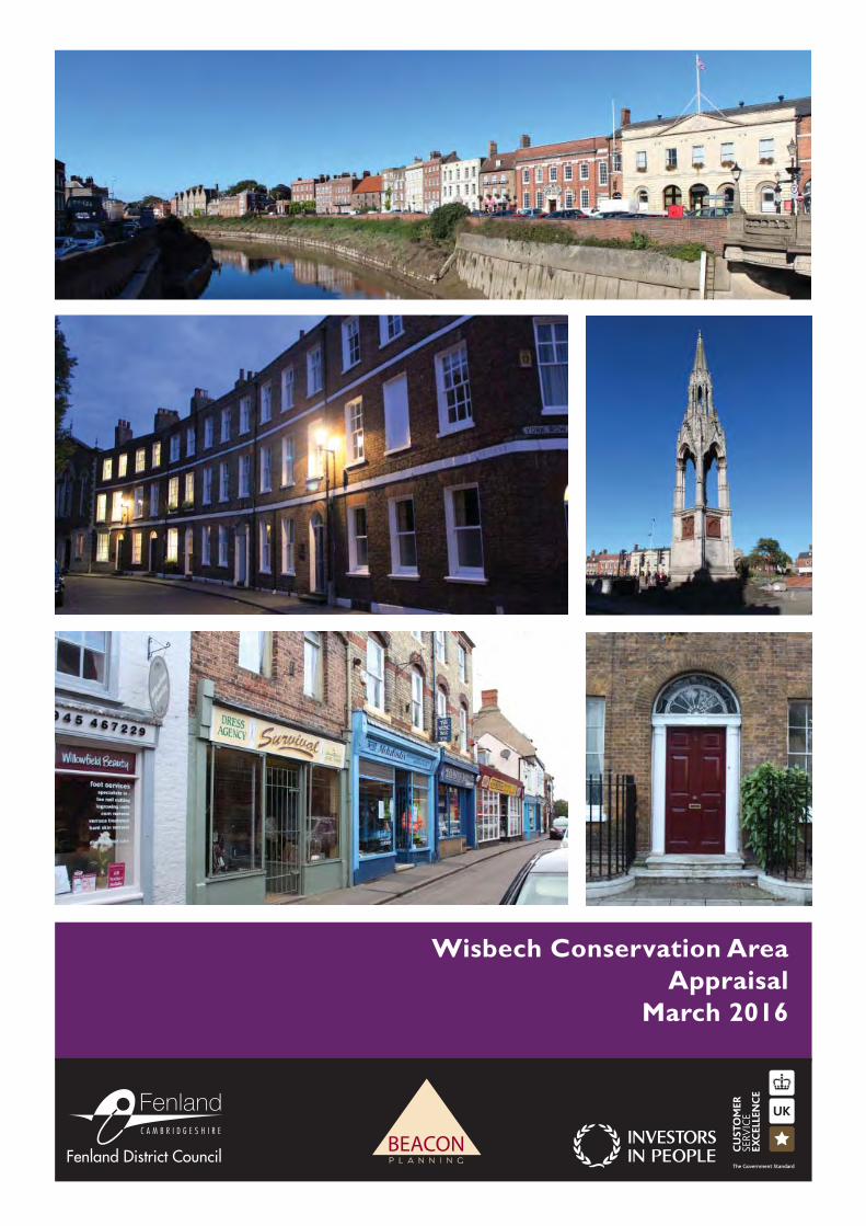
1.02 Wisbech Conservation Area was designated in February 1972, updated in 1979 and was last appraised in 2008. The designated area covers the town centre, with an extension encompassing the iconic Brinks. Within the boundary is a diverse wealth of historic buildings and structures documenting the changing commercial, industrial and residential fortunes of Wisbech over the centuries. This diversity is reflected in five character areas within the Conservation Area, each with their own distinct historic environments.
The Appraisal Process
1.03 This appraisal has been prepared following the methodology set out in English Heritage (as was) guidance document ‘Understanding Place: Conservation Area Designation, Appraisal and Management’ (2011). It will set out the legislative background, before appraising the special historic and architectural interest of the Conservation Area. The character of the whole will first be summarised, before analysing the character of individual character areas with reference to such considerations as land uses, green spaces, views, and others.
1.04 The appraisal has been informed by extensive primary and secondary research, as well as by site surveys undertaken in October 2015.
1.05 Any omission from this appraisal should not be taken to mean that those particular features make no contribution to the character and appearance of the Conservation Area. The appraisal is intended to be a summary and does not make reference to all positive contributors.
1.06 This Conservation Area Appraisal was approved by Fenland District Council’s Full Council on 25th February 2016. Prior to its adoption it was subject to local consultation as required by S71 (2) Planning (Listed Buildings and Conservation Areas) Act 1990. Full details of the public consultation process are set out under Section 6.0.
2
Wisbech Conservation Area Appraisal V. Issued 11 March 2016
2.0 PLANNING POLICY FRAMEWORK, LEGISLATION AND GUIDANCE
Legislative Background
2.01 Conservation Areas are defined as ‘areas of special architectural or historic interest, the character or appearance of which it is desirable to preserve or enhance’ (Planning [Listed Buildings and Conservation Areas] Act 1990, section 69). In contrast to residential zones, Conservation Areas are judged to be exceptional in terms of their architectural and/or historic interest and therefore justify a higher degree of planning control. It is the duty of a Local Planning Authority (LPA) to determine which parts of their borough or district are areas of special architectural and/or historic interest and to designate these as Conservation Areas accordingly.
2.02 Central Government introduced the power for LPAs to designate Conservation Areas in 1967. This included provisions to restrict some types of development that can usually be carried out without planning permission (permitted development) and it allowed LPAs to better control the quality and type of development that they would accept. It also afforded LPAs the opportunity to protect important trees in Conservation Areas. However, it places a duty on these authorities to prepare preservation or enhancement proposals for any Conservation Areas that they chose to designate.
2.03 Once a Conservation Area has been designated, it increases the LPA’s controls over the demolition of buildings and structures whilst the rights that owners have to do works to their properties without the need to obtain planning permission (known as ‘permitted development rights’) are slightly reduced, and can be further restricted through the use of an Article 4 Direction (See the accompanying Management Plan for details of Article 4 Directions in Wisbech Conservation Area).
2.04 Stricter controls are also exercised over the design of new buildings, and owners must
give the Council six weeks’ notice of their intention to carry out works to trees. Planning applications affecting a Conservation Area must be advertised on site and in the local press to give people the opportunity to comment.
2.05 Historic England are consulted on development proposals that are considered to affect the character or appearance of a Conservation Area or where a material change of use is proposed where the application site is over 1,000 square metres. Historic England is also a statutory consultee on applications for the erection of a building greater than 20 metres in height, or where the demolition of a building is proposed within such an area.
2.06 Once designated, Local Planning Authorities have a statutory duty to regularly review the reasons for designation and designated boundaries to ensure that the area is still of value, and to consider whether any areas have been overlooked or changes have occurred which require the boundaries to be redrawn.
2.07 This duty, laid out in Section 69 of the Planning (Listed Buildings and Conservation Areas) Act 1990, requires Local Planning Authorities to: “determine which parts of their area are areas of special architectural or historic interest the character or appearance of which it is desirable to
3
Wisbech Conservation Area Appraisal V. Issued 11 March 2016
preserve or enhance, and designate those areas as conservation areas”. This is expanded upon by Section 71 of the Act, which requires Local Planning Authorities to “formulate and publish proposals for the preservation and enhancement of any parts of their area which are conservation areas.”
2.08 The frequency with which Local Planning Authorities are required by the 1990 Planning (Listed Buildings and Conservation Areas) Act to review their Conservation Area Appraisals is not specified. Paragraph 025 of Conserving and enhancing the historic environment states that such reviews ‘must’ be undertaken ‘from time to time’, as a strong Conservation Area Appraisal facilitates the identification of ‘opportunities for beneficial change or the need for planning protection.’
2.09 Guidance issued in 2011 by English Heritage (now Historic England) advised that ‘good practice’ is generally accepted to involve the undertaking of a review of such documents ‘every 5 years’. The purpose of the review is to ascertain how the conservation area has changed and to confirm or redefine the special interest that warrants designation.
2.10 During the review process any pressures for change can be identified and enhancement opportunities highlighted. These will form the basis of the Conservation Area Management Plan which accompanies this document, and which sets out a strategy to manage change in the Conservation Area.
Local Planning Policy
2.11 Fenland District Council’s Local Planning Policy with regards to the preservation of the historic environment is found in Policy LP18 of the Fenland Local Plan, which was adopted in May 2014. The policy makes clear that the LPA should keep up to date conservation appraisals and management plans and use them in the determination of planning applications, as well as making use of Article 4 Directions to prevent unsympathetic alterations to buildings in Conservation Areas. The policy also notes that the LPA will prepare and maintain a list of buildings of local importance and take active steps to reduce the number of heritage assets on the Historic England Heritage at Risk Register.
2.12 Also of note in reference to the Historic Environment is Policy LP8 – Wisbech, which notes that ‘all development’ in Wisbech should preserve and enhance the ‘unique historic character’ of the area, ‘making appropriate use of its heritage assets to benefit its regeneration, tourism potential and sense of place.’
2.13 Similarly, Policy LP16 addresses the delivery and protection of high quality environments in the Fenland district. Specifically, Policy LP16(a) requires that any proposed development will only be approved if it demonstrably ‘protects and enhances and affected heritage assets and their settings to an extent commensurate with policy in the National Planning Policy Framework and in accordance with Policy LP18.’
4
Wisbech Conservation Area Appraisal V. Issued 11 March 2016
National Planning Policy
2.14 National planning policy on Conservation Areas is contained within the National Planning Policy Framework (NPPF, March 2012). This document states that when designating Conservation Areas, Local Planning Authorities should ensure than an area is of sufficient special architectural or historic interest to warrant Conservation Area status. When determining planning applications local planning authorities are directed to take into account the desirability of sustaining and enhancing the significance of heritage assets – including Conservation Areas – as well as the desirability of new development making a positive contribution to local character and distinctiveness. These issues are also addressed in Planning Practice Guidance including Conserving and enhancing the Historic Environment. Proposals for designation of, and development within Conservation Areas should be judged against paragraphs 126, 127, 131-134, 137 and 138 (please see Appendix D).
2.15 Paragraph 137 instructs Local Planning Authorities to seek opportunities for new development within Conservation Areas and their settings to enhance or better reveal their significance. Paragraph 138 recognises that not all elements of Conservation Areas will necessarily contribute to its significance, but that the loss of buildings that make a positive contribution should be treated as substantial harm, or less than substantial harm depending on the contribution which it makes to the Conservation Area.
Guidance
2.16 Historic England (then English Heritage) guidance is found in Understanding Place: Conservation Area Designation, Appraisal and Management (March 2011), which updated earlier Conservation Area guidance documents following legislative and policy developments.
2.17 Regarding Conservation Area designation, this document states that:
‘There are many different types of special architectural and historic interest which can lead to
designation. A Conservation Area might be focused on parts of a town where there are a high
number of nationally designated heritage assets and a variety of architectural styles and historic
associations. Others may be more homogenous, linked to a particular industry or philanthropist, for
example, and/or may have a particular local interest. They can include parts of settlements where
the original layout is visible in the modern street pattern, where a particular style of architecture
prevails, or traditional building materials predominate. Some exceptionally are designated because
of the quality of the public realm, green spaces and historic parks and gardens, and some seek to
protect agricultural landscapes of special interest.’
5
Wisbech Conservation Area Appraisal V. Issued 11 March 2016
3.0 SUMMARY OF SPECIAL INTEREST
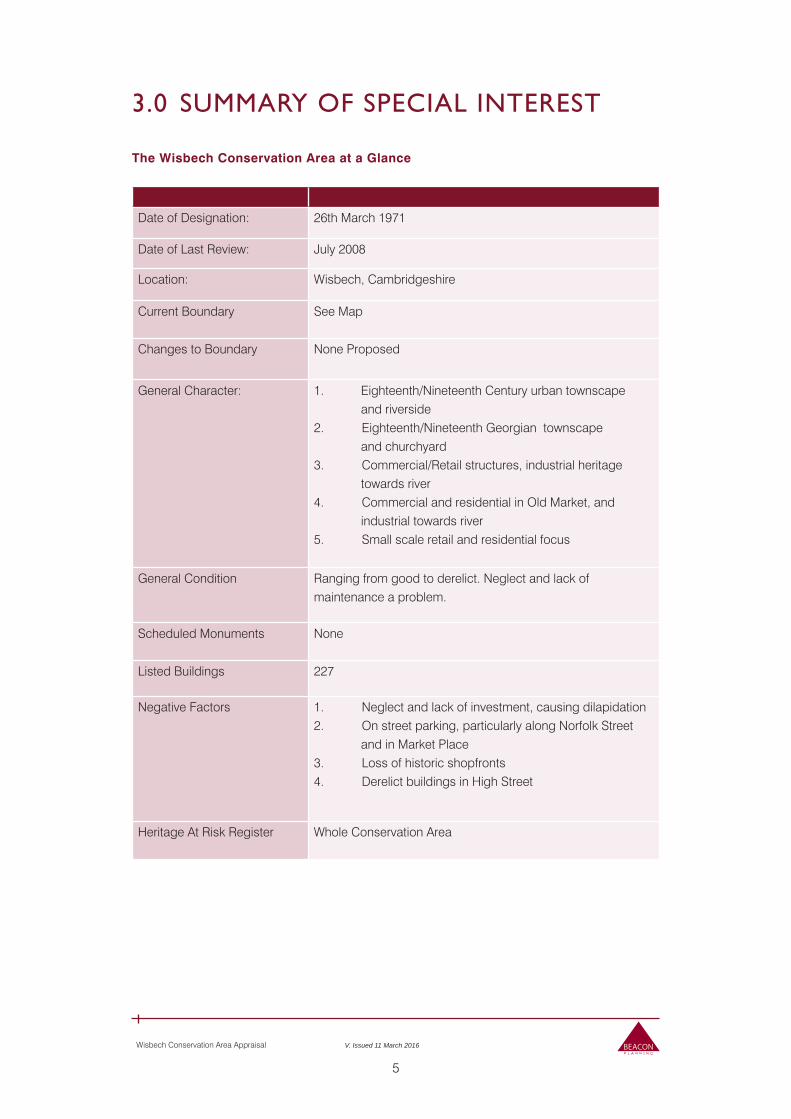
The Wisbech Conservation Area at a Glance
Date of Designation: 26th March 1971
Date of Last Review: July 2008
Location: Wisbech, Cambridgeshire
Current Boundary See Map
Changes to Boundary None Proposed
General Character: 1. Eighteenth/Nineteenth Century urban townscape and riverside2. Eighteenth/Nineteenth Georgian townscape and churchyard3. Commercial/Retail structures, industrial heritage towards river4. Commercial and residential in Old Market, and industrial towards river5. Small scale retail and residential focus
General Condition Ranging from good to derelict. Neglect and lack of maintenance a problem.
Scheduled Monuments None
Listed Buildings 227
Negative Factors 1. Neglect and lack of investment, causing dilapidation2. On street parking, particularly along Norfolk Street and in Market Place3. Loss of historic shopfronts4. Derelict buildings in High Street
Heritage At Risk Register Whole Conservation Area
6
Wisbech Conservation Area Appraisal V. Issued 11 March 2016
4.0 ASSESSING SPECIAL INTEREST
Location and Topography
4.01 Wisbech is located in northeast Cambridgeshire, approximately 40 miles north of Cambridge and adjacent to the A47 trunk road between Peterborough and Kings Lynn. It is bisected by the A1101, which partially follows the route of the former Wisbech-Outwell Canal. The town stands on the banks of the River Nene, in topographically flat fenland which has now been drained to provide a mixture of arable farmland and orchards, divided by numerous drainage channels to the east, west and north. Landscape characterisation maps indicate that Wisbech is surrounded by fen to the south, and marsh to the north.
Landscape and Geology
4.02 Geologically, Wisbech sits atop layers of Flandrian deposits of marine clay, silts and sands, with a layer of peat at a depth of 1.5m. To the south of the town is mainly freshwater peat fen, whilst to the north lies a band of silt that stretches from King’s Lynn to Lincolnshire. The tidal River Nene is a saltwater intrusion into the freshwater fenland, with the tidal forces overcoming the outflow to drive silty deposits upstream. The many tidal floods across the flat fenlands over the preceding few millennia have contributed to a thick silty overburden.
Historical Development and Archaeology
Archaeology
4.03 The 2011 Cambridgeshire Green Infrastructure Strategy noted that Wisbech has ‘retained high quality archaeological remains and buildings that are nationally and locally distinctive’ (Appendix 8). There are no Scheduled Monuments within the immediate vicinity of the town, the nearest being two round barrows and the ‘Roman Bank’, an ancient sea defence wall to the northwest of the town. Despite this lack of designated archaeology, a wealth of archaeological material has been found in the town, including artefacts from the Roman era, the remains of a medieval crypt in Market Street, and also evidence of an earlier Norman Castle subsequently flooded in 1236. This is in contrast to the surrounding area, where the underlying topographical and geological conditions mean little archaeological evidence has been uncovered, although there has been limited investigation into this.
History of Wisbech
4.04 Wisbech has its origins as a riverside Saxon market, but its development was encouraged by the construction of a Norman fortification following the conquest of the Fenland by William the Conqueror. A stone castle constructed by 1087 likely replaced an earlier timber structure at the meeting of the estuary with the Old Nene and the Wellstream. This provided a platform which informed the town’s later growth, with the marketplace adjacent to the Norman castle providing a blueprint for the marketplace in existence today. Consequently, the earlier Saxon marketplace has been identified as the ‘Old Market’ since the early thirteenth century.
7
Wisbech Conservation Area Appraisal V. Issued 11 March 2016
4.05 The boundary of the Norman castle informed the location of bridges providing crossing-points when the estuary reached high tide. The first stone bridge was established in 1758; this was later demolished in 1855 to permit the construction of an iron swing bridge which opened in 1857. This too was later replaced with the current concrete bridge which opened in 1931.
4.06 Wisbech developed around the Church, Castle and two marketplaces throughout the medieval period, with the river becoming the main conduit for wealth and trade during this time. A charter making Wisbech a corporate borough was granted in 1549. The town had its own weights and measures from at least 1662 and in the same decade the production of Wisbech farthings was authorised, demonstrating the town’s ongoing prosperity through the seventeenth century.
4.07 It was the banking industry that drove Wisbech’s post-eighteenth century development. The town’s first bank, the ‘Wisbech and Lincolnshire Bank’ founded by Jonathan Peckover in 1782, was informal, and later partnered with Gurneys & Co. of Norwich. The Peckover family managed the bank until 1893, and it was absorbed into Barclays Bank in 1896. Nonetheless, the bank and the authority of the Peckover family was central to the town’s socio-economic development, with the Peckovers’ patronage supporting the construction of buildings and town institutions. One particular example is that of Priscilla Hannah Peckover, who started the Wisbech Local Peace Association in 1878, and who was nominated four times for the Nobel Peace Prize.
4.08 Commercial enterprise dominated the town by 1796, and the legacy of Wisbech’s eighteenth century commercial buoyancy is visible in the construction of grand houses along The Brinks from c1720 onwards. A Parliamentary Act of 1810 granted the Corporation of Wisbech power to improve the market and port areas, leading to the rebuilding of the Town Hall, and the widening of Union Street.
4.09 The town’s growth, primarily around the port, was driven by the corn, coal and timber trades which dominated the late eighteenth century and the nineteenth century (although soft-fruit growing was a long-term agricultural interest). It is thought that during the 1840s, the corn market of Wisbech was one of the largest in the country. In 1882, Kelly’s Directory notes that 154 foreign vessels brought over 41,000 tons of goods into Wisbech. The legacy of this industry can be seen in warehouses along the historic quayside, including south of the bridge, which now stops larger vessels from entering the River Nene channel any further than Wisbech. Milling also contributed to commercial industry before the advent of the First World War, with nine mills recorded as having stood in the town.
4.10 Similar growth occurred in the direction of the railway stations after 1847, and around the Wisbech and Upwell Tramway in the late nineteenth century. Traffic on the Wisbech Canal ceased by 1922, and it became a landfill site during the 1960-70s, before a road was constructed that overlaps the infilled canal in some areas. The location of this road has informed further development, as well as traffic flow through and around Wisbech.
4.11 Small-scale industries such as boot making, and photographic and picture-framing studios, are recorded from the nineteenth century and undoubtedly predate this. Later commercial activity and production took place on a larger scale, in tandem with agricultural growth: for instance, canning and punnet factories provided employment to many in the early twentieth century. Newspaper articles from 1921 also describe the market as thriving, running past 10pm, with a significant crowd of shoppers attending ‘all day’. The late nineteenth century
8
Wisbech Conservation Area Appraisal V. Issued 11 March 2016
and early twentieth century saw the emergence of the Wisbech area as one of the key market garden locations in England and the town soon developed industries ancillary to this such as fruit canning, all of which led to a substantial increase in population of about 30 percent throughout the first half of the twentieth century. In 1951 the number of people living in the town was 17,430, up from 9,276 in 1891. This later prosperity and growth manifests itself in the built environment in a number of significant Art Deco buildings such as the Empire Cinema, parts of the High Street and in pastiche historical buildings at the top of North Brink.
4.12 During the Second World War, Wisbech hosted a significant number of evacuees from London, The later twentieth century saw the decline of Port and river traffic due to a combination of the advent of the shipping container and the greater size and sustainability of ports to the north in Lincolnshire. Today the town does retain some of its industry, including brewing and fruit packaging, and it is currently developing and expanding marina and pleasure boat facility in place of some of the former dock area north of the bridge. The Port of Wisbech does still see seaborne trade traffic however, with one significant import being timber from Scandinavia.
Key Characteristics of Architectural Quality and Built Form
Character Area 1 – The Brinks
4.13 The Brinks character area is strongly characterised by its mix of high quality eighteenth and nineteenth century riverside townhouses and civic buildings, but also has important elements of its industrial riverside past still evident, as well as smaller scale and lower status two storey housing and hostelries. Much of the Brinks area’s appearance is influenced by the use of brick in various shades, but often using the local ‘brown brick’, as well as the use of elegant sash windows, regularly positioned in ostensibly symmetrical bays. Another influencing factor is the use of formal boundary treatments such as iron railings to demarcate public and private space.
4.14 Chapel Road is, in contrast to the domestic facades facing the river, principally characterised by its subservient relationship to the buildings facing the River Nene, either through the tall garden wall, stables or other outbuildings to the rear of North Brink’s townhouses or hotels. It is also characterised by its links to the town’s market town history due to the historic location of the cattle market remaining an open space. Key characteristics are the use of rustic brown brick in structures including the long garden walls, and the influence of green open space and the significant trees within the Peckover House gardens.
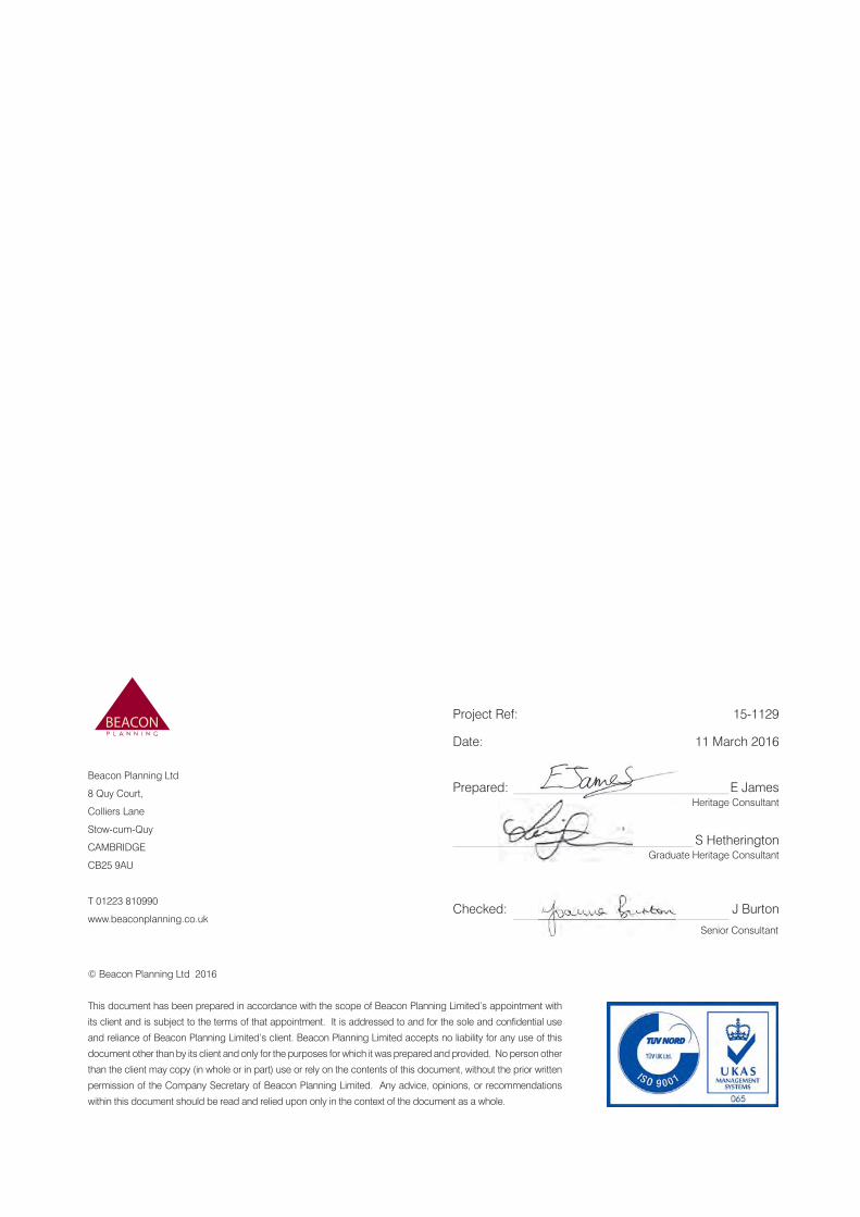
Character Area 2 – The Medworth Development and Church Area
4.15 The Medworth and Church character area is of course characterised particularly strongly by the genteel, regular and repetitive rhythm of the Medworth circus, a high class residential and civic part of Wisbech of typically Georgian appearance and highly architecturally significant. The colour palate of the area is influenced by the use of local brown brick, although some gault clay brick marks out the higher status buildings of the town’s Museum and the Castle Lodge, whilst The Castle itself contrasts through its reuse of the former Thurloe Mansion’s high quality stone dressings and architectural detailing. The regular bays of the residential and civic buildings are punctured by sash windows, most of which are original and which, alongside often understated
9
Wisbech Conservation Area Appraisal V. Issued 11 March 2016
but nonetheless classically inspired doorcases, provide much of the genteel character and historic appearance of the area.
4.16 The area also benefits strongly from some of the town centre’s only publically accessible green open spaces of the church yard and the memorial gardens, whilst both the Norman church and the ancient street pattern associated with the castle’s bailey and medieval rights of way link this area very strongly into the town’s deeper history.
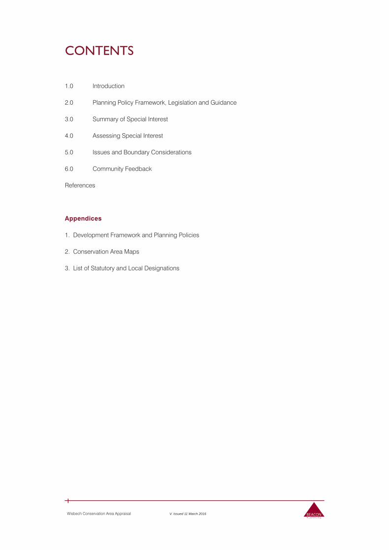
Character Area 3 - Commercial Centre, High Street, and Market Place
4.17 This area is principally characterised by the architecture of commercial, retail and hostelry activity, an exception being the obvious focal point of civic pride personified in the magnificent gothic Clarkson Memorial by Sir George Gilbert Scott. Where they survive intact, much of the High Street’s character is centred upon narrow shopfronts of two or three bays with, historically, belljar shop entrances, large glazed windows and sashes on up to three storeys above. However, many historic shopfronts have been lost to neglect or inappropriate development in this area. This area also contains important examples of twentieth century architecture in the town including what was historically a large Art Deco Woolworths in the Market Place, and a similarly ostentatious Art Deco cinema. Nene Quay links the area back to its trading history, with large brown brick warehouses with arched windows and deep passage ways leading to further industrial buildings back from the riverside.
Character Area 4 – The Old Market
4.18 This area is influenced strongly by large, well-appointed financial and banking sector architecture, often displaying ostentatious classism and high quality finishes towards the Old Market itself. To the rear, facing the River Nene, this character morphes, like Nene Quay on the opposite side of the river, into a much more industrial and subservient character in line with its former use as part of Wisbech’s port area.
Character Area 5 – Norfolk Street
4.19 The town’s second retail area, Norfolk Street itself is characterised by a charming mix of small scale retail and residential buildings with narrow plots and most of which are two storeys in height. Some of the buildings are suffering from neglect but nonetheless retain much of their character and the area bustles with activity. The buildings are mostly brick, with sash or casement windows to the street at upper floor level.
Open/Green Spaces, Parks and Gardens, and Trees
4.20 There are a number of key open spaces and gardens which are of particular importance to the character and appearance of the area, and trees often play an important role too in softening views or the character of a particular area, or indeed simply improving the public realm.
10
Wisbech Conservation Area Appraisal V. Issued 11 March 2016
4.21 In particular, open spaces of importance include:
The garden serving The Castle, in the heart of the town, which contributes positively to the character of the circus as it widens out around The Castle and its grounds, which also has a number of large significant trees suggestive of a green oasis in the midst of the town.
The Octavia Hill Birthplace Museum’s recently constructed public open space and garden, providing much needed green open space and tranquillity next to the busy South Brink road.
Peckover House gardens, Grade II registered, which contribute fundamentally to the character of Chapel Road and to the plot layout of this part of the Conservation Area.
The churchyard, an important public open space and amenity which provides a pleasant and well maintained open green space with several significant trees, and a route through to the centre of the town.
On the east side of the A1101 is the main park of Wisbech which forms part of the adjoining Bowthorpe Conservation Area.
Key Views and Vistas within the Conservation Area
4.22 Views and vistas are an important part of how a Conservation Area is appreciated and understood, and Wisbech is no exception with several particularly important views contributing fundamentally to its character. These are:
The view from, and towards, the Town Bridge up and down the River Nene, taking in the grandeur of North Brink and its assembled high quality town houses and civic buildings. This is probably one of the finest Georgian townscapes in England, and the view contributes enormously to the appreciation of the town’s architectural special interest and understanding of its history and development in the eighteenth century.
The view out of the High Street, past the Clarkson Memorial, with North Brink in the background. This view provides an appropriate background for Clarkson’s grand memorial.
View north from Town Bridge. This view, while not as splendidly genteel as that to the south, provides a useful counterpoint to the residential charm of North and South Brink, illuminating the town’s historically thriving riverside port and its solid brick warehouses with painted signs.
View past the Church of St Peter and St Paul, from Church Terrace. The church and its churchyard provide a pleasant vista, with glimpses of Museum Square inviting the viewer to take the route through and explore the area beyond.
View along York Row into the Medworth circus: punctuated by the Celtic memorial
cross, this view introduces the viewer to the heart of Wisbech’s Georgian high class residential centre and to explore its ancient street pattern.
View from the north (Boathouse and old police station) where the clock tower is a distinctive feature highlighting the historic character and core of the town.
11
Wisbech Conservation Area Appraisal V. Issued 11 March 2016
Public Realm
4.23 Public realm furniture includes street lighting (including ‘heritage lamposts’ in some areas such as North Brink), signage, advertising boards, telephony cable boxes, cycle parking and grit bins – all fairly standard townscape street furniture and in much of the area it does not make a great positive or negative impact. Areas where the public realm has a negative impact are detailed below. Particularly positive areas are public benches around the War Memorial and the top end of North Brink.
Boundary Considerations
4.24 This appraisal does not undertake a review of the current boundary of the Conservation Area. The management of change to the boundary will be included in the Conservation Area Management Plan being produced alongside this document, and will be reviewed from time to time as is the statutory duty of local authorities under the Planning (Listed Buildings and Conservation Areas) Act 1990.
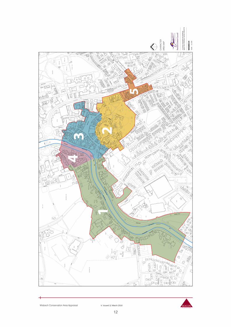
Character Analysis
4.25 The Wisbech Conservation Area can be divided into five character areas. Their purpose is to simplify the identification of general characteristics in terms of built form, layout, land uses and historic and architectural features.
4.26 The formal identification of specific features that contribute to the special interest of the area enables them to be given due consideration in the planning process. The character area identification process assists development management by drawing attention to significant features that are worthy of preservation and enhancement.
4.27 The areas identified in this appraisal are The Brinks; The Medworth Development and Church; the Commercial Centre, High Street and Market Place; The Old Market; and the Norfolk Street area to the southeast.
12
Wisbech Conservation Area Appraisal V. Issued 11 March 2016
War
d Bd
yED & Ward Bdy
Ward Bdy
ED & Ward Bdy
ED & Ward Bdy
ED & Ward Bdy
ED & W
ard B
dy
Ward Bdy
ED &
War
d Bd
y
ED &
War
d Bd
y
Scho
ol
Nor
th
Hos
pita
l
Brid
ge
Car
Par
k
PO
9
4
8
7
3
5
6
2
1
Wks
Inn
PH
York
Row
Clu
b
Wor
ks
Trus
t
Hal
l
Cou
rt
Bank
Home
Hot
el
Churc
h
Empi
re
Cen
tre
Dep
ot
Nen
e
Cita
del
Libr
ary
Falc
on
St P
aul's
Thea
tre
LB
Station
Mus
eum
Nap
ier
Hou
se
Tel E
x
1l
to
Tow
n
Wis
bech
Boyd
en C
ourt
Albi
on H
ouse
Elm
Roa
d Pr
imar
y S
choo
l
8c
6c
7c
Hanch
ant C
ourt
Agen
oria
Hou
se
The
Peck
over
Hou
se
Blencowe Terrace
Tele
phon
e Ex
chan
ge
33
32
35
12
1a
17
91
10
65
36
13
40
74
44
70
72
42
4a
15
18
38
26
57
14
31
34
20
43
29
30
21
76
25
16
59
1b
48
23
87
45
39
24
56
27
66
83
55
22
64
37
54
60
46
2a
19
90
51
41
28
85
47
88
61
98
3a
7a
78
50
52
58
97
71
53
68
49
69
9a
6a
8a
El
32
enila
Lodg
e
Tk
11
Hud
son
5 6
6 4
1 2
2 3
Tow
er
FS
Mon
ica
32c
Russe
t Ho
Sta
Bol
icar
age
The Castle
33a
23b
46a
104
18a
34a
31a
47a
12a
57b
16a
20a
108 17b
10a
13a
15a
43a
WB
Palm
ers
Plac
e
Edin
a C
ourt
Som
ers
Cou
rt
Chap
el
ate
War
as
Chy
Ric
hmon
d C
ourt
Chu
rch
iew
ing
ohn'
s H
ouse
The
Cas
e PH
1 6
PC
Bols
9 10
115
11a
Scho
oner
Wha
r
PW
Mar
lbor
ough
Cou
rt
Old Convent Fields
ACF
t0 17
to 1
8
to 15
21 to
to 2
1
Brew
ery
Wr T
r
7 to 8
9 to
7
1 to 3
1 to 5
1 to
8
2 to 7
1 to 6
1 to
2
1 to 9
2 to 8
5 to 8
6 to
8
1 to 7
8 to 9
2 to 4
2 to 3
1 to 4
22 23
48 49
21 2
3
16 1
4
43 4
4
TCB
L Tw
r's
TCBs
Fact
ory
icto
ria
11 12
49 57
Nur
sery
Surg
ery
SCC
1 to
21
1 to
12
2 to 3
2
1 to 2
5
1 to 32
6 to 22
1 to 3a
1 to
16
9 to 10
9 to 16
1 to
10
1 to 17
9 to 15
Tank
Selw
ood
Park
Tank
s
Brac
ken
Lourena
The
Old
1 to
11
9 to
11
12 to 14
13 to
14
62 to
68
21 to 24
20 to
26
50 to
54
18 to 21
33 to
39
10 to 16
22 to
25
26 to 30
15 to
17
19 to
22
12 to 15
31 to 39
12 to
18
24 to 27
Supe
rsto
re
11 to 15
Pavi
lion
Pavi
lions
Cin
ema
Frie
nds
Mas
cotte
El S
ub S
ta
Smal
l Mea
dow
Trin
ity M
etho
dist
Hai
g B
uild
ings
Tallo
w
Cla
rkso
n M
eml
Beec
hwoo
d Lo
dge
Fiel
dvie
w H
ouse
Oakwoods
Cor
ner C
otta
ge
1a to 1c
Sigg
ees P
assa
ge
Furriers
Warren
7
18
1 23
34
41
12
2
7
19
1
6
PH
29
27
6
9
70
PH
4
3
14
21
10
16a
7
43
9
38
8
17
2
85
30
26
PH
30
14
27
4
18
16a
25
37
60
39
20
36
18a
33
11
1 to 5
4W
orks
1
45
1
8
Clu
b
18
12
2
2
TCB
2
7
20
36
14
31
31
1 to 8
20
6
14
36
30
24
1
6
20
83
9 10
54
22
6
Tank
s
8
29
7
Hal
l
34
19
6
17
1
4
12
18
7
2
9
15
Hal
l
5
2
5
3a
17
2
4
1
7
36
34
17
4
22
18
14
16
47
20
8
26
12
6
1
27
2
22
2
4
Chu
rch
3
23
7a
30
16
PH
16
21
2
4
30
18
7
61
44
19
7
7
16
50
1
71
3
1
5
43
6
PC
4
7
Tank
18
2
717
24
5
33
42
11
28
3
22
6
15
15
88
52
Pavi
lion
20
1
34
8
5
8
13
El S
ub S
ta
15
7
19
13
16
PH
21
1
64
15
9
8
2
Wor
ks
19
5
39
18
5
38
12
1 to
3
3
1 to
3
15
2
1
37
56
9 10
17
18
34
10
34
16
20
8
5
40
5
11
1
8
1
65
32
32
1
3
7
4
11a
El S
ub S
ta
11
13
25
1
17
7
11
1
6
4
11
Bol
Bank
4a
2
27
3
2 to
4
9
6
9
33
12
23
2
27
1
25
10
10
2
4
33
14
5
1
11
50
13
2
17
44
6
PC
225
1
4
8
44
10
37
2
18
1
59
24
13
2
PH
7
26
Clu
b
10
35
5
66
78
60
21
29
6
29
23
48
Hotel
8
2621
32
3
17
1
1
4
1
10
1
24
7a
3
8
33
7
7
6
12
11
Wor
ks
8
1
9
27
13
Churc
h
16
17
21
15
31
19
6
10
2
14
51
15
8
25
42
12
10 to 16
22
4
Hal
l
7
40
Tank
1
1
70
74
20
10
2
2
1
4
1
40
13
59
15
32
30
19
2
5
2Ba
nk
1
34
72
1
1
1 to 7
111
to 3
11
13
61
24
4
46
7
9
9
1b
12
1
10
14
6
38
15
10
Clu
b
22
3
45
8
8
39
23
3913
28
1a
55
El S
ub S
ta
12
1
6
1
1
26
1
2
1
5
87
18
PC
14
TCB
54
23
2
3
28
22
37
1
9
Clu
b
LB
20
1
4
1
10
12
6.1m
3.4m
7.0m
5.8m
5.5m
5.2m
4.9m
4.6m
4.3m
3.0m
3.7m
3.1m
2.4m
4.0m
2.7m
3.4m
4.3m
5.2m
5.8m
3.7m
5.8m
3.4m
5.5m
3.1m
4.6m
3.7m
4.3m
3.7m
3.4m
4.3m
4.6m
4.3m
3.7m
5.5m
3.0m
5.2m
3.4m
3.7m
3.7m
5.8m
3.1m
3.4m
3.7m
5.5m
5.5m
3.7m
4.9m
4.3m
5.2m
5.8m
3.7m
5.2m
WIS
BEC
H
Sm
all M
eado
w F
ield
Rec
reat
ion
roun
d
Dep
ot
Cou
rts
Car
Par
k
Car
Play
ing
Fiel
d
Spor
ts
roun
d
Wis
bech
Par
k
Rug
by F
ootb
all
roun
d
Par
k
El
Ramp
Yard
Yd
Sta
Pla
ygro
und
El S
ub S
ta
Tenn
is C
ourts
Are
a
Bow
ling
reen
Pla
y A
rea
Bre
wer
y
ES
S
Whi
te C
ross
Car
El S
ub S
ta
Car
Par
k
Car Park
El S
ub S
ta
El S
ub S
ta
Tenn
is C
ourts
Par
k
Pla
y A
rea
Car
El S
ub S
ta
Bow
ling
reen
Car
Par
k
Car
Par
k
Mar
ket P
lace
HORSE FAIR
CHURCHILL ROAD
THE
Bus
Sta
tion
Post
UN
ION
CHURCH
ROAD
Squa
re
MEW
S
CHESTNUT
SQUA
RE
THE CHASE
DUKE STREET
NORTH BRINK
SOUTH BRINK
WEST STREET
KING STREET
Mar
sh W
alk
ONYX COURT
PUR
BEC
K C
LOSE
EARL
STR
EET
PRINCE'S ROAD
BURDETT R
OAD
QUEEN'S ROAD
King's Walk
HIL
LBU
RN
RO
AD
SAN
DYL
AN
D
LOVE
LAN
E
SOMERS ROAD
Mar
ket M
ews
WH
ITB
Y ST
REE
T
OLD MARKET
BALDING CLOSE
CROMWELL ROAD
JOHN F KENNEDY COURT
COALWHARF
FALCON ROAD
BR
AM
PTO
N C
LOSE
FARDEL
L ROAD
WOODCOTE PARK
STATION DRIVE
KINGSLE
Y AVENUE
PARK AVENUE
ALEXANDRA ROAD
Walk
Trac
k
LANE
Post
s
Path (um)
KING'S WALK
ST P
AUL'
S CL
OSE
Post
s
Post
s
Post
s
SOUT
H BR
INK
Post
s
Post
NORT
H BR
INK
NORTH BRINK
River Nene
Mud
Mea
n Hi
gh W
ater
MLW
Drai
n
Mean Low Water
Drain
Mean High Water
MLW
Mea
n Hi
gh W
ater
Drai
n
Drain
Mean High Water
MLW
MLW
Mud
Drain
MLW
Drain
5
234
1
© C
row
n C
opyr
ight
and
dat
abas
erig
hts
2013
Ord
nanc
e S
urve
y 10
0237
78
WIS
BEC
H1:
1 25
0S
cale
CH
AR
AC
TER
AR
EA
MA
P
13
Wisbech Conservation Area Appraisal V. Issued 11 March 2016
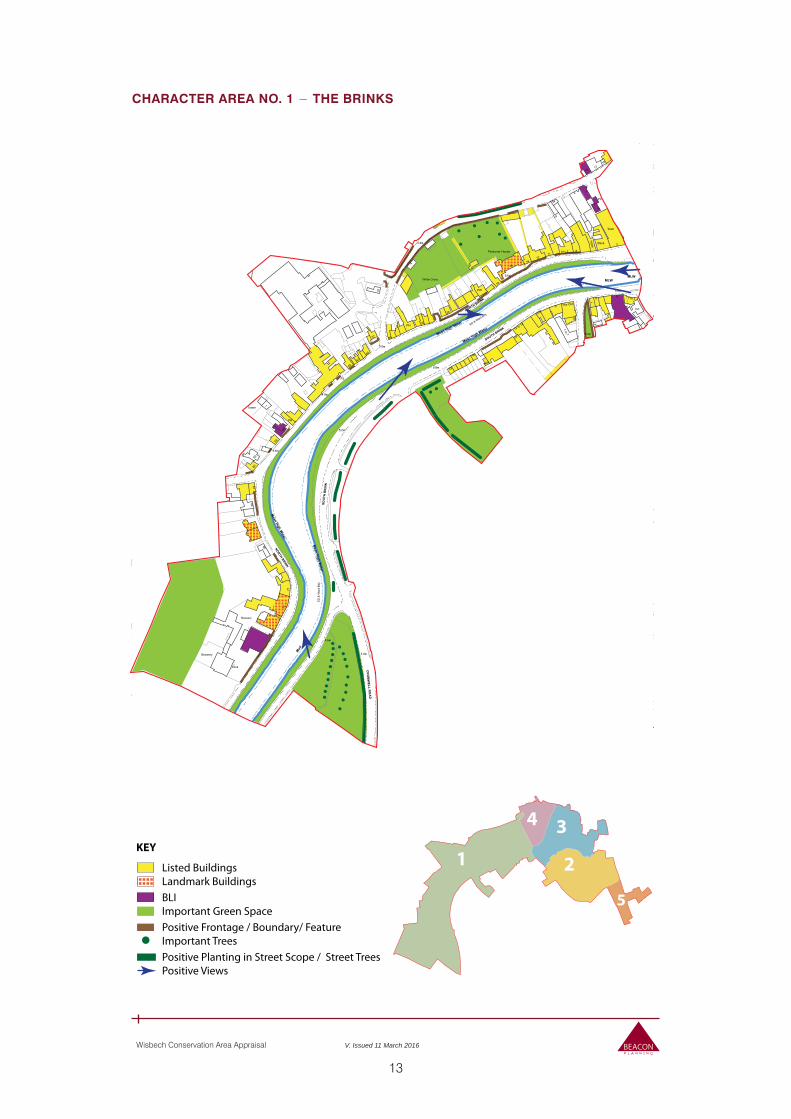
KEY
Listed BuildingsLandmark Buildings
Positive Planting in Street Scope / Street TreesPositive Views
Positive Frontage / Boundary/ FeatureImportant Trees
BLIImportant Green Space
5
2
34
1
ED &
War
d Bd
y
ED & Ward Bdy
School
8
3
Inn
Centre
Depot
Tel Ex
1l
Town
Wi
Peckover House
Telephone Exchange
57
31
20
43
25
16
87
24
56
83
64
2a
90
61
68
Hudson
Tower
FS
Sta
31a
57b
16a
10a
WB
Somers Court
as
Chy
PC
Scho
PW
Brewery
Wr Tr
9 to 7
6 to
2 to 4
Factory
Tank
Park
Tanks
The Old
13 to 14
Pavilion
Small Meadow
Beechwood Lodge
Fieldview House
18
6
PH
PH
16a
30
30
18
36
Works
12
2
2
2
7
6
36
30
54
6
Tanks
17
18
15
3a
17
1
22
16
21
7
7
1671
7
Tank
24
22
6
88
El Sub Sta
15
19
13
1
9
19
5
18
2
17
10
16
5
32
32
11a
11
Bank
2 to 4
9
6
33
23
1
2
14
11
5
37
1
10
60
21
Hotel
32
1
4
10
24
7a
12
11
27
17
15
15
12
40
Tank
1
1
59
30
2Bank
72
1 to 7
1 to 3
4
10
14
38
15
45
8
39
28
El Sub Sta
26
2
3
22
Club
LB
20
1
5.2m
4.0m
5.2m
3.4m
3.1m
4.6m
4.3m
3.4m
4.6m
5.2m
3.4m
3.7m3.7m
5.8m
3.1m
3.4m
5.5m
5.5m
4.9m
4.3m
5.2m
5.8m
3.7m
Depot
Sta
Brewery
White Cross
El Sub Sta
Car Park
Car Park
Play Area
Car Park
Post
NORT
H BR
INK
SOU
TH B
RIN
K
BURDETT
HILLBURN
SOMER
S ROAD
OLD
MA
RK
ET
CR
OM
WELL R
OA
D
COALWHARF
KINGSLEY AVENUE
SOUTH BRINK
Post
NORTH BRINK
NORTH BRINK
Mean High Water
Mean High W
ater
ML
Mean High Water
Mean High W
ater
MLW
Mud
Drai
n
MLW
Drain
CHARACTER AREA NO. 1 − THE BRINKS
14
Wisbech Conservation Area Appraisal V. Issued 11 March 2016
Summary
4.28 This character area encompasses the North and South Brinks, extending westwards from the Town Bridge taking both the north and south sides of the river as it runs southwest and curves southwards towards the edge of the town and out into the fens. It also takes in the plots to the rear of North Brink and Chapel Road (historically called Pickards Road along its full length), which runs parallel to the North Brink from the north end of Old Market, eventually curving round to the south to meet North Brink. The area also encompasses the land occupied by the grammar school, part of Barton Road, and extent of Elgood’s Brewery (Grade II).
4.29 On the south side of the river the character area includes the buildings immediately to the west of Alexandra Road including the plots to the rear. The area then follows the line of Somers Road, explicitly excluding the modern development of Somers Court, up to Coal Wharf Road including the area of scrubby woodland that was historically the rear garden of a townhouse known as ‘The Woodlands’. Beyond this the boundary of the Conservation Area follows the line of the road on its south side past the junction with Cromwell Road, taking in the triangular open space between it and South Brink, skirting the edge of the modern housing estate, before crossing the river to the south of Elgoods Brewery.
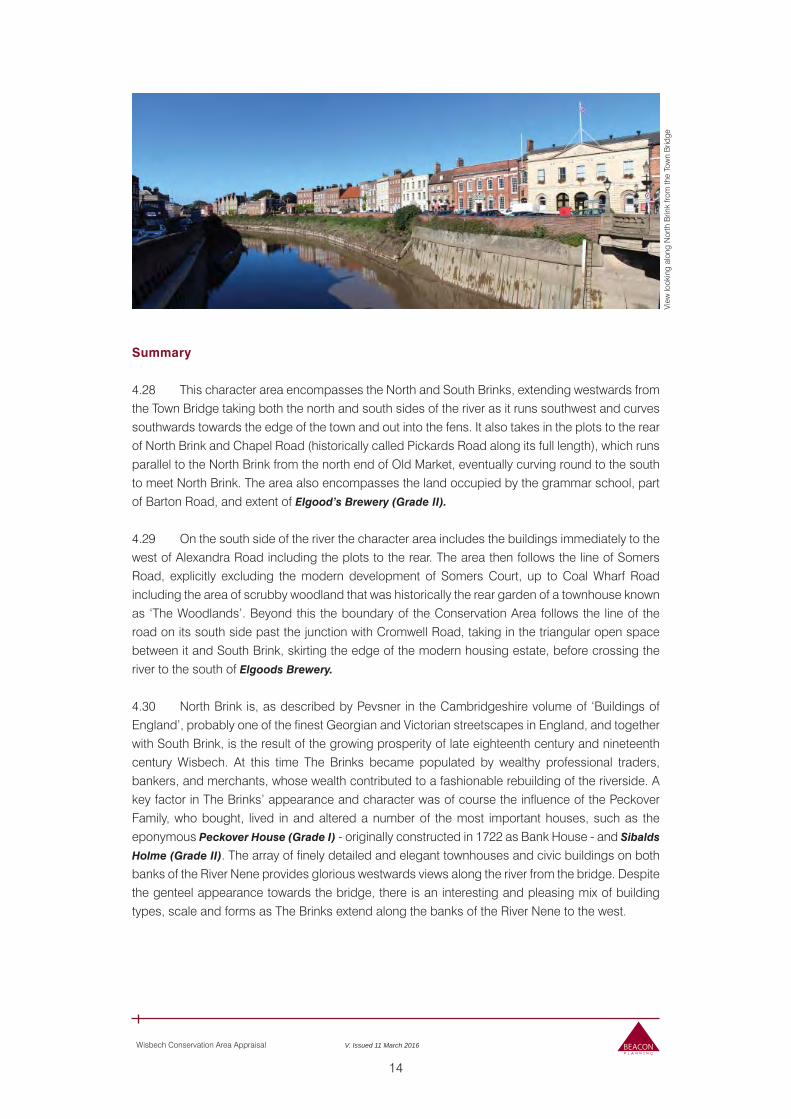
4.30 North Brink is, as described by Pevsner in the Cambridgeshire volume of ‘Buildings of England’, probably one of the finest Georgian and Victorian streetscapes in England, and together with South Brink, is the result of the growing prosperity of late eighteenth century and nineteenth century Wisbech. At this time The Brinks became populated by wealthy professional traders, bankers, and merchants, whose wealth contributed to a fashionable rebuilding of the riverside. A key factor in The Brinks’ appearance and character was of course the influence of the Peckover Family, who bought, lived in and altered a number of the most important houses, such as the eponymous Peckover House (Grade I) - originally constructed in 1722 as Bank House - and Sibalds
Holme (Grade II). The array of finely detailed and elegant townhouses and civic buildings on both banks of the River Nene provides glorious westwards views along the river from the bridge. Despite the genteel appearance towards the bridge, there is an interesting and pleasing mix of building types, scale and forms as The Brinks extend along the banks of the River Nene to the west.
View
look
ing
alon
g N
orth
Brin
k fro
m th
e To
wn
Brid
ge
15
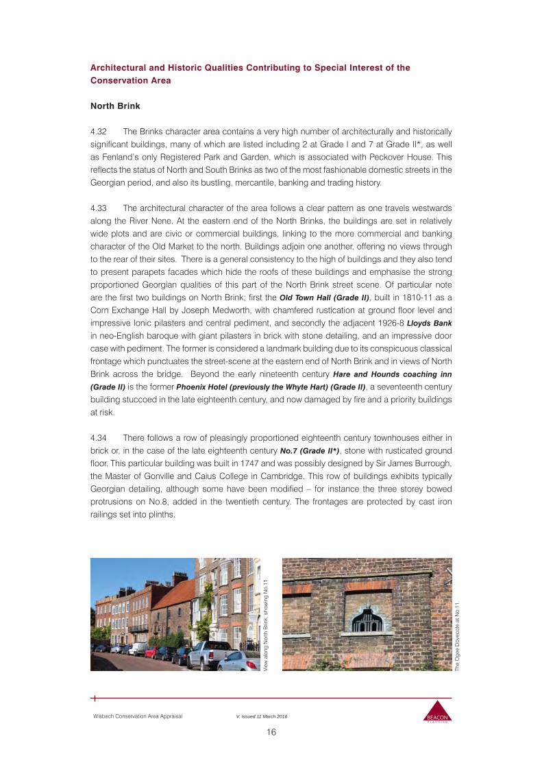
Wisbech Conservation Area Appraisal V. Issued 11 March 2016
Current and Former Uses, Street Pattern and Buildings
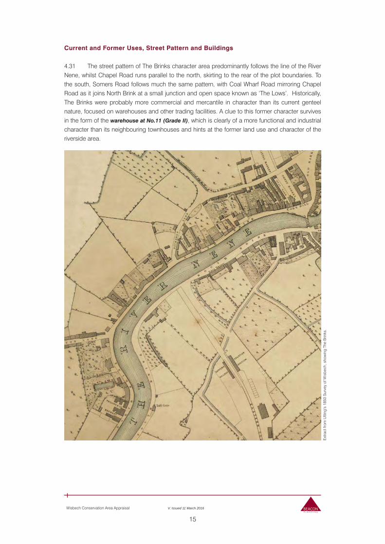
4.31 The street pattern of The Brinks character area predominantly follows the line of the River Nene, whilst Chapel Road runs parallel to the north, skirting to the rear of the plot boundaries. To the south, Somers Road follows much the same pattern, with Coal Wharf Road mirroring Chapel Road as it joins North Brink at a small junction and open space known as ‘The Lows’. Historically, The Brinks were probably more commercial and mercantile in character than its current genteel nature, focused on warehouses and other trading facilities. A clue to this former character survives in the form of the warehouse at No.11 (Grade II), which is clearly of a more functional and industrial character than its neighbouring townhouses and hints at the former land use and character of the riverside area.
Ext
ract
from
Utti
ng’s
185
0 S
urve
y of
Wis
bech
, sho
win
g Th
e B
rinks
.
16
Wisbech Conservation Area Appraisal V. Issued 11 March 2016
Architectural and Historic Qualities Contributing to Special Interest of the Conservation Area
North Brink
4.32 The Brinks character area contains a very high number of architecturally and historically significant buildings, many of which are listed including 2 at Grade I and 7 at Grade II*, as well as Fenland’s only Registered Park and Garden, which is associated with Peckover House. This reflects the status of North and South Brinks as two of the most fashionable domestic streets in the Georgian period, and also its bustling, mercantile, banking and trading history.
4.33 The architectural character of the area follows a clear pattern as one travels westwards along the River Nene. At the eastern end of the North Brinks, the buildings are set in relatively wide plots and are civic or commercial buildings, linking to the more commercial and banking character of the Old Market to the north. Buildings adjoin one another, offering no views through to the rear of their sites. There is a general consistency to the high of buildings and they also tend to present parapets facades which hide the roofs of these buildings and emphasise the strong proportioned Georgian qualities of this part of the North Brink street scene. Of particular note are the first two buildings on North Brink; first the Old Town Hall (Grade II), built in 1810-11 as a Corn Exchange Hall by Joseph Medworth, with chamfered rustication at ground floor level and impressive Ionic pilasters and central pediment, and secondly the adjacent 1926-8 Lloyds Bank
in neo-English baroque with giant pilasters in brick with stone detailing, and an impressive door case with pediment. The former is considered a landmark building due to its conspicuous classical frontage which punctuates the street-scene at the eastern end of North Brink and in views of North Brink across the bridge. Beyond the early nineteenth century Hare and Hounds coaching inn
(Grade II) is the former Phoenix Hotel (previously the Whyte Hart) (Grade II), a seventeenth century building stuccoed in the late eighteenth century, and now damaged by fire and a priority buildings at risk.
4.34 There follows a row of pleasingly proportioned eighteenth century townhouses either in brick or, in the case of the late eighteenth century No.7 (Grade II*), stone with rusticated ground floor. This particular building was built in 1747 and was possibly designed by Sir James Burrough, the Master of Gonville and Caius College in Cambridge. This row of buildings exhibits typically Georgian detailing, although some have been modified – for instance the three storey bowed protrusions on No.8, added in the twentieth century. The frontages are protected by cast iron railings set into plinths.
View
alo
ng N
orth
Brin
k, s
how
ing
No.
11.
The
Oge
e D
ovec
ote
at N
o.11
.
17
Wisbech Conservation Area Appraisal V. Issued 11 March 2016
4.35 The early eighteenth century warehouse at No.11 (Grade II) is the exception to the otherwise genteel character of this part of the North Brinks, and represents the street before the influx of mid eighteenth century money and fashion. The building is built using a red brick set in English Bond with a steep Orange Pantile roof, and has quirky details such as the Gothic ogee-arched dovecote set into one of its blocked windows of a diminutive later Georgian house built into the main structure. Despite this later alteration, it remains charmingly functional in character by contrast to the more polite and fashionable architecture of its lofty neighbours.
4.36 Two large 3 storey multiple bay Georgian townhouses fill the space between No.11 and North Brinks’ undoubted centrepiece, Peckover House (with its Grade I & Grade II Registered Park and Garden). These two houses are relatively restrained in style with only moderate levels of architectural flamboyance in the form of a first floor balcony and second floor apron detailing at No. 12 North Brink (Grade II*), and a classic Gibbs doorcase on No.14 (Grade I). No. 14 is one of only three grade I listed buildings within the town, a composition of three eighteenth century symmetrical bays and two additional nineteenth century bays added to match on the west side. These two properties sit back from the footpath edge and, like Peckover House to the west, railings form the street-fronting boundary.
4.37 Peckover House was built c.1722 and originally named ‘Bank House’; it was bought by Jonathan Peckover in the 1790s. It was lived in by the family for several successive generations of the Peckover Family, but it is now managed by the National Trust, having been given to them in 1943 by Alexandrina Peckover, the last member of the Peckover banking dynasty to live there. It forms one of the landmark buildings on North Brink and indeed wider town. It is set back from the street with a garden and curved gravel driveway to the front of the house. The central three storey form of the building is flanked and emphasised by the curved late 19th century single storey side wings either side which served as the former banking room on the west and the library on the east. The carriage drive to the west also displays the social status of this particular property. Planting within the front garden of this property and views through the space around the building, taking in a subtle back drop of mature trees within its rear garden, emphasis this buildings standing within the street scene. The presence of the greenery and trees around Peckover House contributes positively to the character and appearance of the conservation area and marks a change in the character of North Brink between the western end of this brink and its eastern end. It is a fine Palladian house of three storeys with two single storey wings in gault and red brick, with elegant proportions and a rusticated doorcase with a heavy entablature and curved pediment supported on Doric half-columns.
4.38 To the west of Peckover House, North Brink’s character is notably different to that of the east end of this Brink; building heights and their forms are more varied and the roofs of buildings are
Peck
over
Hou
se
Nos
. 23-
24 N
orth
Brin
k
18
Wisbech Conservation Area Appraisal V. Issued 11 March 2016
more prominent features of the street scene. The resulting roofscape makes a strong contribution to the character and appearance of this part of the conservation area. Views between properties and over lower rooflines take in the canopies of mature trees found in rear gardens and this subtle natural backdrop contributes the character and appearance of this part of North Brink. No. 23-24
North Brink (Grade II) is a fine mid-nineteenth century building of the Jacobean-Gothic style which was designed by Algernon Peckover. It is of particular note within the street scene because of its steeply pitched cross-stepped gables mounted with finials that face the street, particularly fine diaper pattern chimney stacks, and fishscale roof tiles.
4.39 A feature of interest beyond the Victorian semi-detached Nos. 26-27 (Grade II) is a small red brick gazebo (Grade II and one of a pair, the other is at No.54) with terracotta perpendicular-Gothic windows, blue engineering brick detailing. As one of two gazebos fronting this brink, the structure is an oddity built in the nineteenth century by the Peckovers, probably to watch over their commercial enterprises on the river below. 4.40 Beyond the gazebo, the character of North Brink is defined by earlier eighteenth century and even seventeenth century domestic and hostelry buildings – including Elgood’s Red Lion Inn
(Grade II) with its distinctive pantile roof. These buildings, of differing widths and heights with a range of roof forms, all exhibit the characteristics scars of multiple changes of use and activity, with some having had shop fronts added in the nineteenth century, additional storeys added, or in one case the incongruous addition of a classical pedimented doorcase to a small terrace, perhaps illustrating the occupant at the time’s aspirations and pretentions during the eighteenth century. At the end of this row is a two storey early nineteenth century building with a corner shop on its extreme west end, a slightly unusual element of nineteenth century retail character in this otherwise mostly residential section.
The
Red
Lio
n In
n an
d ne
ighb
ourin
g bu
ildin
gs, i
llust
ratin
g th
e ch
ange
in s
cale
furth
er a
long
Nor
th B
rink.
The
Peck
over
Gaz
ebo
No.
36
Nor
th B
rink
Look
ing
north
east
alo
ng N
orth
Brin
k pa
st
the
Ros
e Ta
vern
, illu
stra
ting
the
smal
l sca
le
char
acte
r of t
his
sect
ion
of th
e ro
ad, a
nd a
lso
the
solid
ity o
f the
floo
d de
fenc
e w
all.
19
Wisbech Conservation Area Appraisal V. Issued 11 March 2016
4.41 As North Brink continues alongside the river, its relatively low key residential character continues until the much larger Palladian form of Harecroft House (Grade II), also attributed to Algernon Peckover and since 1905 in educational use, first as the Girls High School and now Wisbech Grammar School with modern buildings having been added to the rear of the plot in the former garden.
4.42 Beyond Harecroft House the character of North Brink is strongly linked to its eighteenth century/nineteenth century vernacular domestic trend, with principally two storey buildings. The Rose Tavern (Grade II), a sleepy and diminutive nineteenth century hostelry, and the adjacent gazebo – the twin of that at No.27 – punctuate the street scene. At Barton Road junction two earlier red brick houses (60-61 North Brink, both Grade II) were evidently façaded in the first part of the nineteenth century, with typically Georgian parapetted elevations and thick white rendered string course matching on either side of the junction.
4.43 Beyond the junction with Barton Road the area has a mixed character, with a number of later nineteenth century and early nineteenth century houses with small front gardens forming the predominant building type but set between them is the much altered Sibalds Holme (Grade II), which was the house of Algernon Peckover himself. Dating from the eighteenth century, Algernon bought it in 1827, and altered it to suit his own tastes, adding the wings to the side, the austere Doric portico and entablature, and the canted bay windows in turn.
4.44 Sibalds Holme’s more flamboyant architectural style and greater scale contrasts with the subdued forms of the early twentieth century houses next to it, setting it apart in views across the river and west along North Brink. North Brink’s retains its principally residential character up to this point. 4.45 North Brink continues south past a small warehouse and more two storey eighteenth century houses and arriving at the landmark building of Elgoods Brewery (Grade II). Originally built in c.1795 for Denis Herbert of Royston, it has an elegant Palladian façade facing onto the river with a large central carriageway with stone jambs, and surmounted by a large false pediment. It is the first large structure entering the town along North Brink, contrasting with the residential scale of its immediate neighbours. It overlooks the river from a prominent position on the bend in the river and is especially prominent in views from South Brink, across the river.
4.46 The building’s front elevation obscures the fact the brewery actually comprises a collection of different buildings beneath this outward uniformity. Brewery House itself, No.72,
Sib
alds
Hol
me
and
its s
mal
ler n
eigh
bour
s.
Elg
ood’
s B
rew
ery
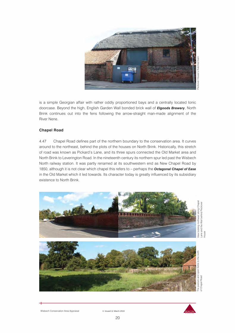
20
Wisbech Conservation Area Appraisal V. Issued 11 March 2016
is a simple Georgian affair with rather oddly proportioned bays and a centrally located Ionic doorcase. Beyond the high, English Garden Wall bonded brick wall of Elgoods Brewery, North Brink continues out into the fens following the arrow-straight man-made alignment of the River Nene.
Chapel Road
4.47 Chapel Road defines part of the northern boundary to the conservation area. It curves around to the northeast, behind the plots of the houses on North Brink. Historically, this stretch of road was known as Pickard’s Lane, and its three spurs connected the Old Market area and North Brink to Leverington Road. In the nineteenth century its northern spur led past the Wisbech North railway station. It was partly renamed at its southwestern end as New Chapel Road by 1850, although it is not clear which chapel this refers to – perhaps the Octagonal Chapel of Ease
in the Old Market which it led towards. Its character today is greatly influenced by its subsidiary existence to North Brink.
Peck
over
Hou
se’s
that
ched
bar
nTh
e pa
stur
e an
d op
en fi
elds
to th
e no
rth
of C
hape
l Roa
dVi
ew lo
okin
g no
rthea
st a
long
Cha
pel
Lane
and
the
Wal
l beh
ind
Peck
over
H
ouse
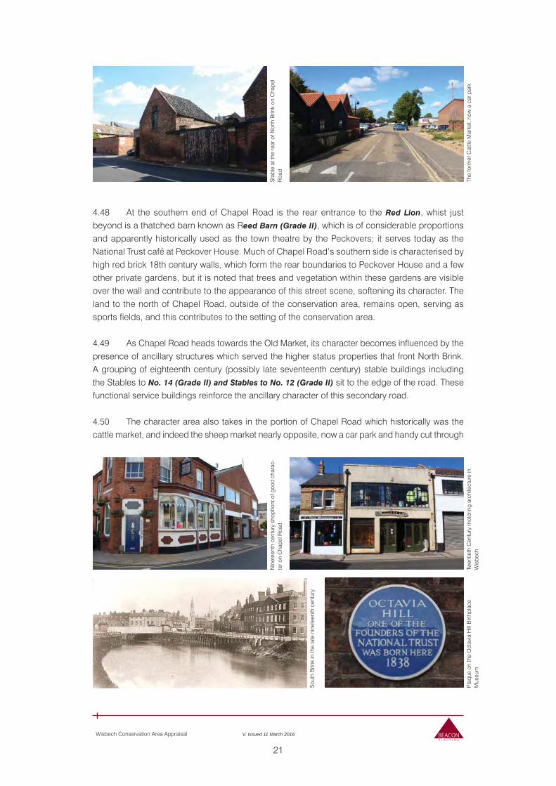
21
Wisbech Conservation Area Appraisal V. Issued 11 March 2016
4.48 At the southern end of Chapel Road is the rear entrance to the Red Lion, whist just beyond is a thatched barn known as Reed Barn (Grade II), which is of considerable proportions and apparently historically used as the town theatre by the Peckovers; it serves today as the National Trust café at Peckover House. Much of Chapel Road’s southern side is characterised by high red brick 18th century walls, which form the rear boundaries to Peckover House and a few other private gardens, but it is noted that trees and vegetation within these gardens are visible over the wall and contribute to the appearance of this street scene, softening its character. The land to the north of Chapel Road, outside of the conservation area, remains open, serving as sports fields, and this contributes to the setting of the conservation area.
4.49 As Chapel Road heads towards the Old Market, its character becomes influenced by the presence of ancillary structures which served the higher status properties that front North Brink. A grouping of eighteenth century (possibly late seventeenth century) stable buildings including the Stables to No. 14 (Grade II) and Stables to No. 12 (Grade II) sit to the edge of the road. These functional service buildings reinforce the ancillary character of this secondary road.
4.50 The character area also takes in the portion of Chapel Road which historically was the cattle market, and indeed the sheep market nearly opposite, now a car park and handy cut through
Sta
ble
at th
e re
ar o
f Nor
th B
rink
on C
hape
l R
oad
Sou
th B
rink
in th
e la
te n
inet
eent
h ce
ntur
y
Nin
etee
nth
cent
ury
shop
front
of g
ood
char
ac-
ter o
n C
hape
l Roa
d
The
form
er C
attle
Mar
ket,
now
a c
ar p
ark
Pla
que
on th
e O
ctav
ia H
ill B
irthp
lace
M
useu
mTw
entie
th C
entu
ry m
otor
ing
arch
itect
ure
in
Wis
bech
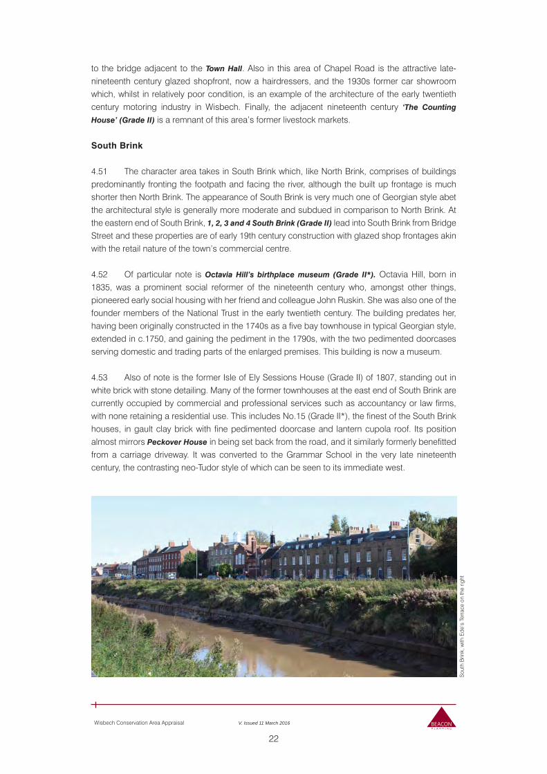
22
Wisbech Conservation Area Appraisal V. Issued 11 March 2016
to the bridge adjacent to the Town Hall. Also in this area of Chapel Road is the attractive late-nineteenth century glazed shopfront, now a hairdressers, and the 1930s former car showroom which, whilst in relatively poor condition, is an example of the architecture of the early twentieth century motoring industry in Wisbech. Finally, the adjacent nineteenth century ‘The Counting
House’ (Grade II) is a remnant of this area’s former livestock markets.
South Brink
4.51 The character area takes in South Brink which, like North Brink, comprises of buildings predominantly fronting the footpath and facing the river, although the built up frontage is much shorter then North Brink. The appearance of South Brink is very much one of Georgian style abet the architectural style is generally more moderate and subdued in comparison to North Brink. At the eastern end of South Brink, 1, 2, 3 and 4 South Brink (Grade II) lead into South Brink from Bridge Street and these properties are of early 19th century construction with glazed shop frontages akin with the retail nature of the town’s commercial centre. 4.52 Of particular note is Octavia Hill’s birthplace museum (Grade II*). Octavia Hill, born in 1835, was a prominent social reformer of the nineteenth century who, amongst other things, pioneered early social housing with her friend and colleague John Ruskin. She was also one of the founder members of the National Trust in the early twentieth century. The building predates her, having been originally constructed in the 1740s as a five bay townhouse in typical Georgian style, extended in c.1750, and gaining the pediment in the 1790s, with the two pedimented doorcases serving domestic and trading parts of the enlarged premises. This building is now a museum. 4.53 Also of note is the former Isle of Ely Sessions House (Grade II) of 1807, standing out in white brick with stone detailing. Many of the former townhouses at the east end of South Brink are currently occupied by commercial and professional services such as accountancy or law firms, with none retaining a residential use. This includes No.15 (Grade II*), the finest of the South Brink houses, in gault clay brick with fine pedimented doorcase and lantern cupola roof. Its position almost mirrors Peckover House in being set back from the road, and it similarly formerly benefitted from a carriage driveway. It was converted to the Grammar School in the very late nineteenth century, the contrasting neo-Tudor style of which can be seen to its immediate west.
Sou
th B
rink,
with
Ede
’s T
erra
ce o
n th
e rig
ht
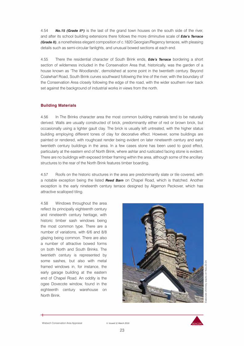
23
Wisbech Conservation Area Appraisal V. Issued 11 March 2016
4.54 No.15 (Grade II*) is the last of the grand town houses on the south side of the river, and after its school building extensions there follows the more diminutive scale of Ede’s Terrace
(Grade II), a nonetheless elegant composition of c.1820 Georgian/Regency terraces, with pleasing details such as semi-circular fanlights, and unusual bowed sections at each end.
4.55 There the residential character of South Brink ends, Ede’s Terrace bordering a short section of wilderness included in the Conservation Area that, historically, was the garden of a house known as ‘The Woodlands’, demolished at some point in the twentieth century. Beyond Coalwharf Road, South Brink curves southward following the line of the river, with the boundary of the Conservation Area closely following the edge of the road, with the wider southern river back set against the background of industrial works in views from the north.
Building Materials
4.56 In The Brinks character area the most common building materials tend to be naturally derived. Walls are usually constructed of brick, predominantly either of red or brown brick, but occasionally using a lighter gault clay. The brick is usually left untreated, with the higher status building employing different tones of clay for decorative effect. However, some buildings are painted or rendered, with roughcast render being evident on later nineteenth century and early twentieth century buildings in the area. In a few cases stone has been used to good effect, particularly at the eastern end of North Brink, where ashlar and rusticated facing stone is evident. There are no buildings with exposed timber framing within the area, although some of the ancillary structures to the rear of the North Brink features timber boarding.
4.57 Roofs on the historic structures in the area are predominantly slate or tile covered, with a notable exception being the listed Reed Barn on Chapel Road, which is thatched. Another exception is the early nineteenth century terrace designed by Algernon Peckover, which has attractive scalloped tiling.
4.58 Windows throughout the area reflect its principally eighteenth century and nineteenth century heritage, with historic timber sash windows being the most common type. There are a number of variations, with 6/6 and 8/8 glazing being common. There are also a number of attractive bowed forms on both North and South Brinks. The twentieth century is represented by some sashes, but also with metal framed windows in, for instance, the early garage building at the eastern end of Chapel Road. An oddity is the ogee Dovecote window, found in the eighteenth century warehouse on North Brink.
Ela
bora
te c
him
ney
stac
ks o
n N
os.2
3-24
24
Wisbech Conservation Area Appraisal V. Issued 11 March 2016
4.59 In common with the windows, the predominant type of doors evident throughout the area tend to be timber and of panelled form, with varying number of panels evident depending on their provenance or date. Doorways on higher status townhouses on The Brinks often feature elaborate fanlights. Doors on the more functional or ancillary structures to the rear of North Brink, or on buildings whose former use was more commercial than residential, tend to be timber ‘barn door’ type, often arched. Gates within the long brick wall along Chapel Road are also timber.
4.60 Chimney stacks are predominantly brick, often with clay or sometimes terracotta pots, and built in a brick matching the principal structure. End and/or axial stacks are the commonest type. The chimney pots on Nos. 23-25 North Brinks appear to be an early form of cast concrete.
Public Realm
4.61 The public realm in the character area is generally tidy and well kept, with ‘heritage lamposts’ contributing positively to The Brinks’ appearance. The pavements towards the eastern end of the North Brinks are paved with Yorkstone paving, whilst that further west is block paved, and the road surface benefits from a tarmac flecked with red chippings, features commensurate with its status as the part of the area of highest civic status. Frontages to the road often feature a low brick plinth with cast metal railings – some of these are historic, but others are modern reproductions. South Brinks is more suburban in character, with standard lampposts and lower quality surface treatments. Attractive planting at junctions such as that between Harecroft Road and Chapel Road is considered to contribute positively to the appearance of the area.
Buildings of Local Importance in the Character Area
4.62 Unlisted buildings of importance to the character of the area, noted on the Character Area map and listed in the appendices, are the following buildings:
1 Exchange Square – nineteenth century public house of red brick with tripartite-glazed sash windows and a characterful glazed late nineteenth century or early twentieth century frontage as noted above. At the time of writing in use as a hairdressers.
Public Toilets, Exchange Square – late nineteenth century public conveniences in gault clay brick, red dressings including alternating voussoirs with stone keystones and window cills. Hipped slate roof. Keystone in doorway keystone embossed with crossed keys – denoting St Peter.
5-7 Exchange Square – adjacent and connected to public conveniences. Nineteenth century buildings of red brick, with stone dressings including cross-key keystones in window vossoirs. Hipped slate roof to main block, with mono-pitch lean to on north side with entrance door. Modern windows.
15-16 Chapel Road – Early twentieth century motorcar garage, with typical features including large rectangular metal framed window, concrete rendered elevation, and large sliding door. Now in use as an outdoor shop. Adjacent building (No.17) also probably associated with motorcar trade.
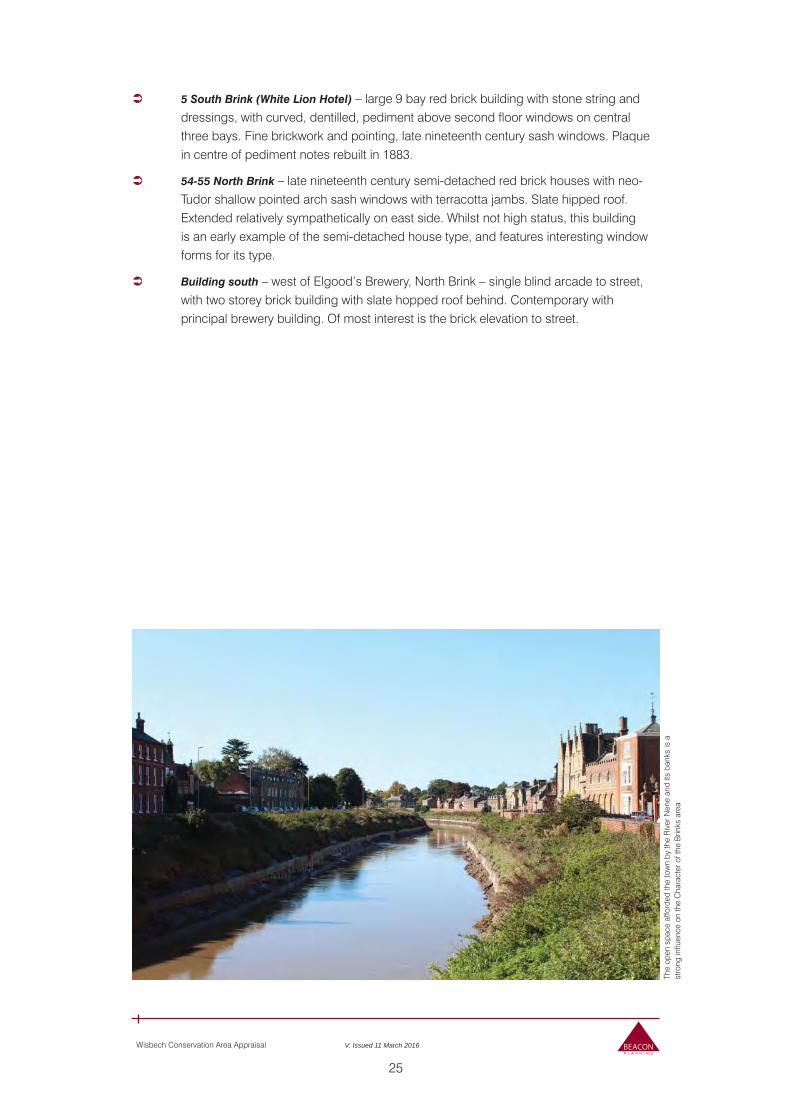
25
Wisbech Conservation Area Appraisal V. Issued 11 March 2016
5 South Brink (White Lion Hotel) – large 9 bay red brick building with stone string and dressings, with curved, dentilled, pediment above second floor windows on central three bays. Fine brickwork and pointing, late nineteenth century sash windows. Plaque in centre of pediment notes rebuilt in 1883.
54-55 North Brink – late nineteenth century semi-detached red brick houses with neo-Tudor shallow pointed arch sash windows with terracotta jambs. Slate hipped roof. Extended relatively sympathetically on east side. Whilst not high status, this building is an early example of the semi-detached house type, and features interesting window forms for its type.
Building south – west of Elgood’s Brewery, North Brink – single blind arcade to street, with two storey brick building with slate hopped roof behind. Contemporary with principal brewery building. Of most interest is the brick elevation to street.
The
open
spa
ce a
fford
ed th
e to
wn
by th
e R
iver
Nen
e an
d its
ban
ks is
a
stro
ng in
fluen
ce o
n th
e C
hara
cter
of t
he B
rinks
are
a
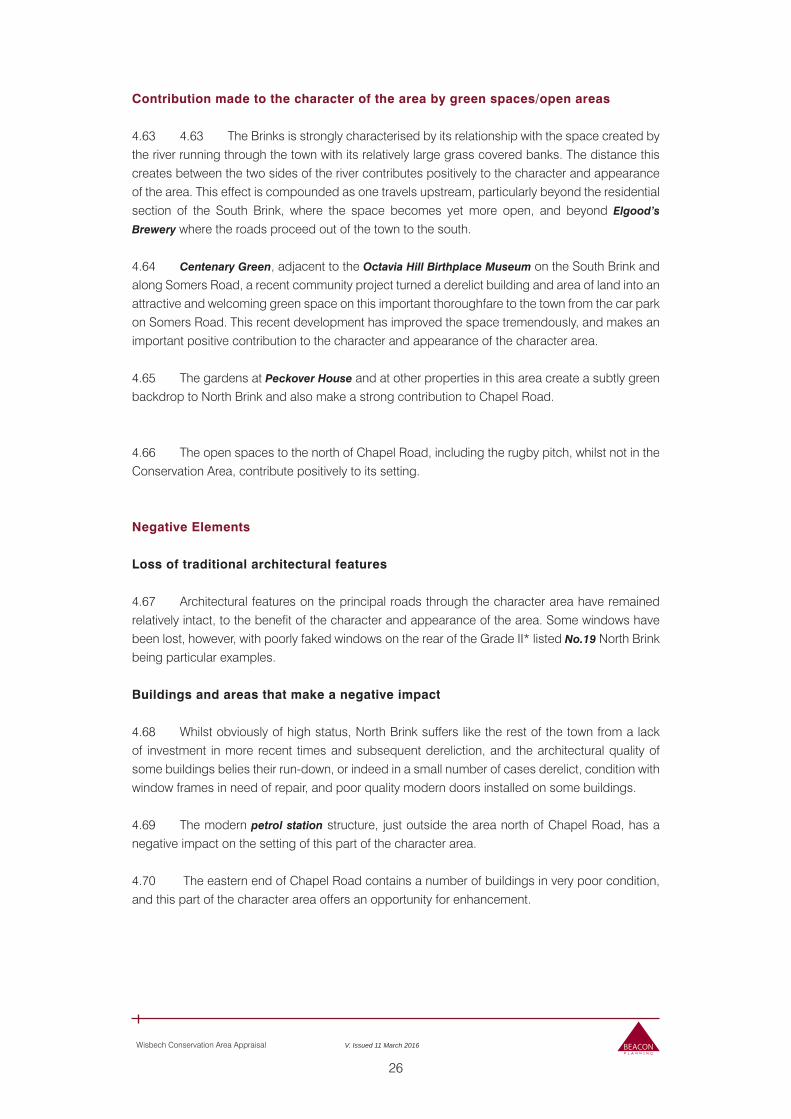
26
Wisbech Conservation Area Appraisal V. Issued 11 March 2016
Contribution made to the character of the area by green spaces/open areas
4.63 4.63 The Brinks is strongly characterised by its relationship with the space created by the river running through the town with its relatively large grass covered banks. The distance this creates between the two sides of the river contributes positively to the character and appearance of the area. This effect is compounded as one travels upstream, particularly beyond the residential section of the South Brink, where the space becomes yet more open, and beyond Elgood’s
Brewery where the roads proceed out of the town to the south.
4.64 Centenary Green, adjacent to the Octavia Hill Birthplace Museum on the South Brink and along Somers Road, a recent community project turned a derelict building and area of land into an attractive and welcoming green space on this important thoroughfare to the town from the car park on Somers Road. This recent development has improved the space tremendously, and makes an important positive contribution to the character and appearance of the character area.
4.65 The gardens at Peckover House and at other properties in this area create a subtly green backdrop to North Brink and also make a strong contribution to Chapel Road.
4.66 The open spaces to the north of Chapel Road, including the rugby pitch, whilst not in the Conservation Area, contribute positively to its setting.
Negative Elements
Loss of traditional architectural features
4.67 Architectural features on the principal roads through the character area have remained relatively intact, to the benefit of the character and appearance of the area. Some windows have been lost, however, with poorly faked windows on the rear of the Grade II* listed No.19 North Brink being particular examples.
Buildings and areas that make a negative impact
4.68 Whilst obviously of high status, North Brink suffers like the rest of the town from a lack of investment in more recent times and subsequent dereliction, and the architectural quality of some buildings belies their run-down, or indeed in a small number of cases derelict, condition with window frames in need of repair, and poor quality modern doors installed on some buildings.
4.69 The modern petrol station structure, just outside the area north of Chapel Road, has a negative impact on the setting of this part of the character area.
4.70 The eastern end of Chapel Road contains a number of buildings in very poor condition, and this part of the character area offers an opportunity for enhancement.
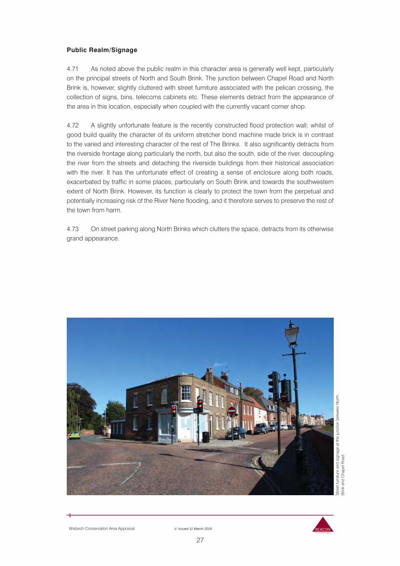
27
Wisbech Conservation Area Appraisal V. Issued 11 March 2016
Public Realm/Signage
4.71 As noted above the public realm in this character area is generally well kept, particularly on the principal streets of North and South Brink. The junction between Chapel Road and North Brink is, however, slightly cluttered with street furniture associated with the pelican crossing, the collection of signs, bins, telecoms cabinets etc. These elements detract from the appearance of the area in this location, especially when coupled with the currently vacant corner shop.
4.72 A slightly unfortunate feature is the recently constructed flood protection wall; whilst of good build quality the character of its uniform stretcher bond machine made brick is in contrast to the varied and interesting character of the rest of The Brinks. It also significantly detracts from the riverside frontage along particularly the north, but also the south, side of the river, decoupling the river from the streets and detaching the riverside buildings from their historical association with the river. It has the unfortunate effect of creating a sense of enclosure along both roads, exacerbated by traffic in some places, particularly on South Brink and towards the southwestern extent of North Brink. However, its function is clearly to protect the town from the perpetual and potentially increasing risk of the River Nene flooding, and it therefore serves to preserve the rest of the town from harm.
4.73 On street parking along North Brinks which clutters the space, detracts from its otherwise grand appearance.
Stre
et fu
rnitu
re a
nd s
igna
ge a
t the
junc
tion
betw
een
Nor
th
Brin
k an
d C
hape
l Roa
d
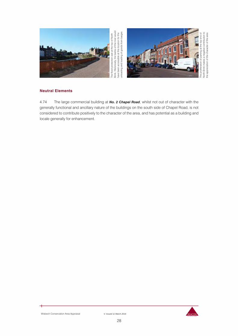
28
Wisbech Conservation Area Appraisal V. Issued 11 March 2016
Neutral Elements
4.74 The large commercial building at No. 2 Chapel Road, whilst not out of character with the generally functional and ancillary nature of the buildings on the south side of Chapel Road, is not considered to contribute positively to the character of the area, and has potential as a building and locale generally for enhancement.
The
flood
pro
tect
ion
wal
l at t
he to
p of
Nor
th
Brin
k. H
isto
rical
ly, th
e ba
nks
of th
e riv
er w
ould
ha
ve b
een
acce
ssib
le a
t thi
s lo
catio
n fo
r the
un
load
ing
and
load
ing
of g
oods
from
bar
ges
The
prol
ifera
tion
of p
arki
ng a
t the
top
end
of
Nor
th B
rink
mak
es a
neg
ativ
e co
ntrib
utio
n to
th
e ap
prec
iatio
n of
the
char
acte
r of t
he a
rea
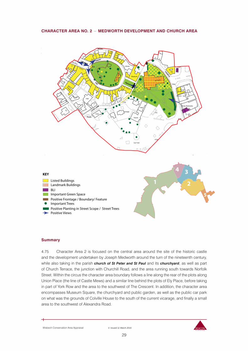
29
Wisbech Conservation Area Appraisal V. Issued 11 March 2016
CHARACTER AREA NO. 2 − MEDWORTH DEVELOPMENT AND CHURCH AREA
Summary
4.75 Character Area 2 is focused on the central area around the site of the historic castle and the development undertaken by Joseph Medworth around the turn of the nineteenth century, while also taking in the parish church of St Peter and St Paul and its churchyard, as well as part of Church Terrace, the junction with Churchill Road, and the area running south towards Norfolk Street. Within the circus the character area boundary follows a line along the rear of the plots along Union Place (the line of Castle Mews) and a similar line behind the plots of Ely Place, before taking in part of York Row and the area to the southwest of The Crescent. In addition, the character area encompasses Museum Square, the churchyard and public garden, as well as the public car park on what was the grounds of Colville House to the south of the current vicarage, and finally a small area to the southwest of Alexandra Road.
KEY
Listed BuildingsLandmark Buildings
Positive Planting in Street Scope / Street TreesPositive Views
Positive Frontage / Boundary/ FeatureImportant Trees
BLIImportant Green Space 5
2
34
1
PO
9
1
PH
York Row
Hall
Library
Falcon
St Paul's
Theatre
Museum
House
The
Blencowe Terrace
10
3
14 54
19
98
3a
32
Lodge
1
32c
icarage
The
Cas
tle
104
108
War
Church iew
ing ohn's House
1 6
9 10
115
Old Convent Fields
1 to 3
1 to 2
2 to
3
11 12
1 to 10
9 to 15
18 to 21
Cinema
Trinity Methodist
Clarkson Meml
urrie
rs W
arre
n
34
425
4
Club
9 10
8
7
Hall
6
4
Hall
5
1
20
4
PH
6
4
20
1
5
8
16
PH
12
1 to 3
1 to 3
1
9 10
40 8
4
7
1
6
4
2
10
5
1
6
PC
12
18
7
1
33
7
1
9
Church
31
7
10
2
2
5
1
13
7
Club 3
8
6
1 1
TCB
37
12
6.1m
5.8m
4.9m
4.3m
4.3m
5.5m
3.7m
Park
El
ESS
El Sub Sta
Car Park
THE
UNION
CHURCH
Square
MEWS
SQUARE
Walk
LOVE LANE
ALEXANDRA ROAD
Walk
LAN
E
KING'S W
ALK
Posts
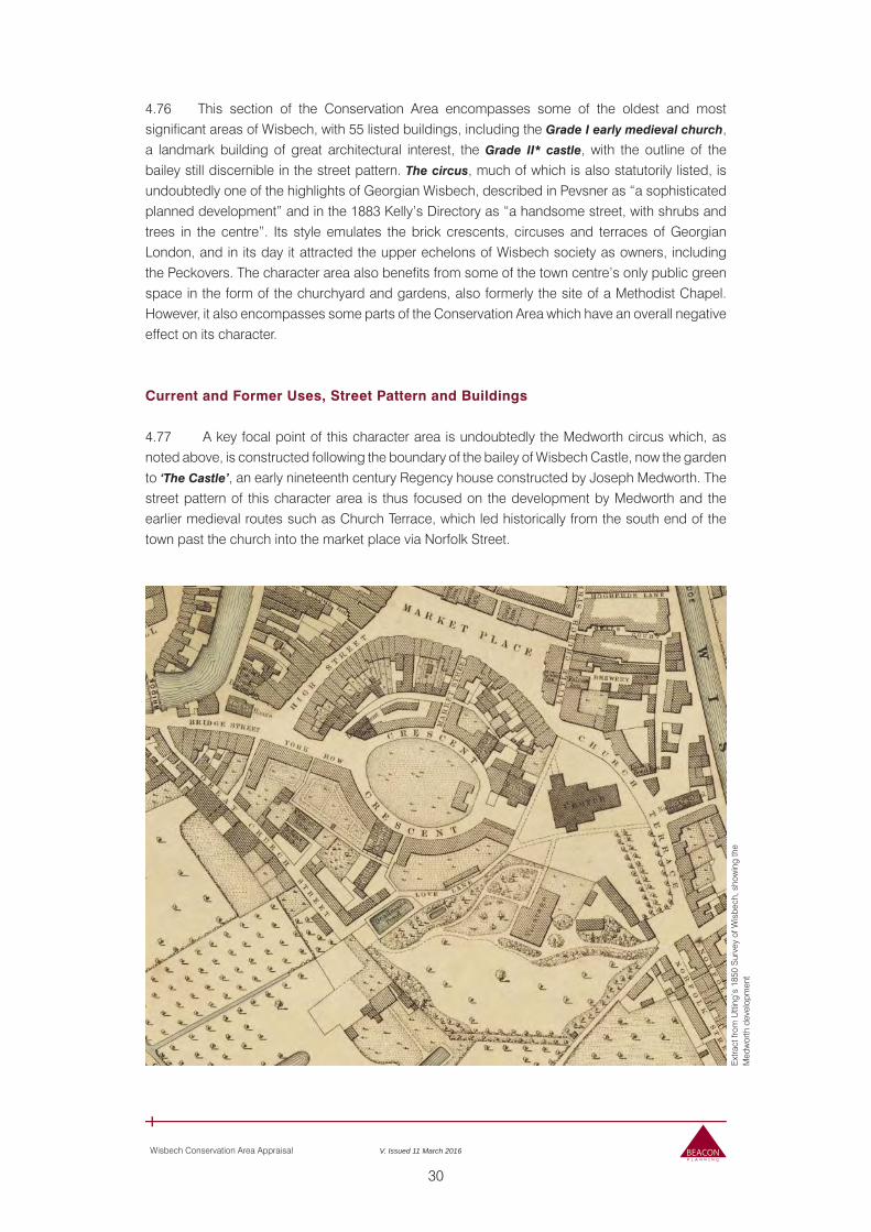
30
Wisbech Conservation Area Appraisal V. Issued 11 March 2016
4.76 This section of the Conservation Area encompasses some of the oldest and most significant areas of Wisbech, with 55 listed buildings, including the Grade I early medieval church, a landmark building of great architectural interest, the Grade II* castle, with the outline of the bailey still discernible in the street pattern. The circus, much of which is also statutorily listed, is undoubtedly one of the highlights of Georgian Wisbech, described in Pevsner as “a sophisticated planned development” and in the 1883 Kelly’s Directory as “a handsome street, with shrubs and trees in the centre”. Its style emulates the brick crescents, circuses and terraces of Georgian London, and in its day it attracted the upper echelons of Wisbech society as owners, including the Peckovers. The character area also benefits from some of the town centre’s only public green space in the form of the churchyard and gardens, also formerly the site of a Methodist Chapel. However, it also encompasses some parts of the Conservation Area which have an overall negative effect on its character.
Current and Former Uses, Street Pattern and Buildings
4.77 A key focal point of this character area is undoubtedly the Medworth circus which, as noted above, is constructed following the boundary of the bailey of Wisbech Castle, now the garden to ‘The Castle’, an early nineteenth century Regency house constructed by Joseph Medworth. The street pattern of this character area is thus focused on the development by Medworth and the earlier medieval routes such as Church Terrace, which led historically from the south end of the town past the church into the market place via Norfolk Street.
Ext
ract
from
Utti
ng’s
185
0 S
urve
y of
Wis
bech
, sho
win
g th
e M
edw
orth
dev
elop
men
t
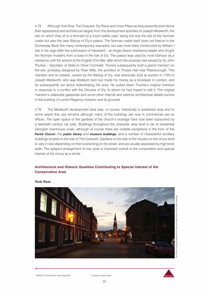
31
Wisbech Conservation Area Appraisal V. Issued 11 March 2016
4.78 Although York Row, The Crescent, Ely Place and Union Place as they presently exist derive their appearance and architecture largely from the development activities of Joseph Medworth, the site on which they sit is a remnant of a much earlier past, being not only the site of the Norman castle but also the later Bishop of Ely’s palace. The Norman castle itself does not feature in the Domesday Book like many contemporary examples, but was most likely constructed by William I late in his reign after the submission of Hereward – an Anglo-Saxon resistance leader who fought the Norman invaders from a base in the Isle of Ely. The palace was used by most bishops as a residence until the advent of the English Civil War, after which the property was seized by Sir John Thurloe – Secretary of State to Oliver Cromwell. Thurloe subsequently built a grand mansion on the site, probably designed by Peter Mills, the architect of Thorpe Hall near Peterborough. This mansion and its estates, owned by the Bishop of Ely, was eventually sold at auction in 1793 to Joseph Medworth, who was Wisbech born but made his money as a bricklayer in London, and he subsequently set about redeveloping the area. He pulled down Thurloe’s original mansion in response to a conflict with the Diocese of Ely, to whom he had hoped to sell it. The original mansion’s elaborate gateposts and some other internal and external architectural details survive in the building of current Regency mansion and its grounds.
4.79 The Medworth development area was, of course, historically a residential area and to some extent this use remains although many of the buildings are now in commercial use as offices. The open space of the gardens of the church’s vicarage have now been subsumed by a twentieth century car park. Buildings throughout the character area tend to be of residential Georgian townhouse scale, although of course there are notable exceptions in the form of the Parish Church, the public library and museum buildings, and a number of characterful ancillary buildings located to the rear of The Crescent. Gardens to the rear of the houses on the circus tend to vary in size depending on their positioning on the street, and are usually separated by high brick walls. The splayed arrangement of rear plots is important overall to the composition and special interest of the circus as a whole.
Architectural and Historic Qualities Contributing to Special Interest of the Conservation Area
York Row
York
Row
, loo
king
tow
ards
the
Cla
rkso
n M
emor
ial i
n th
e ea
rly e
veni
ng
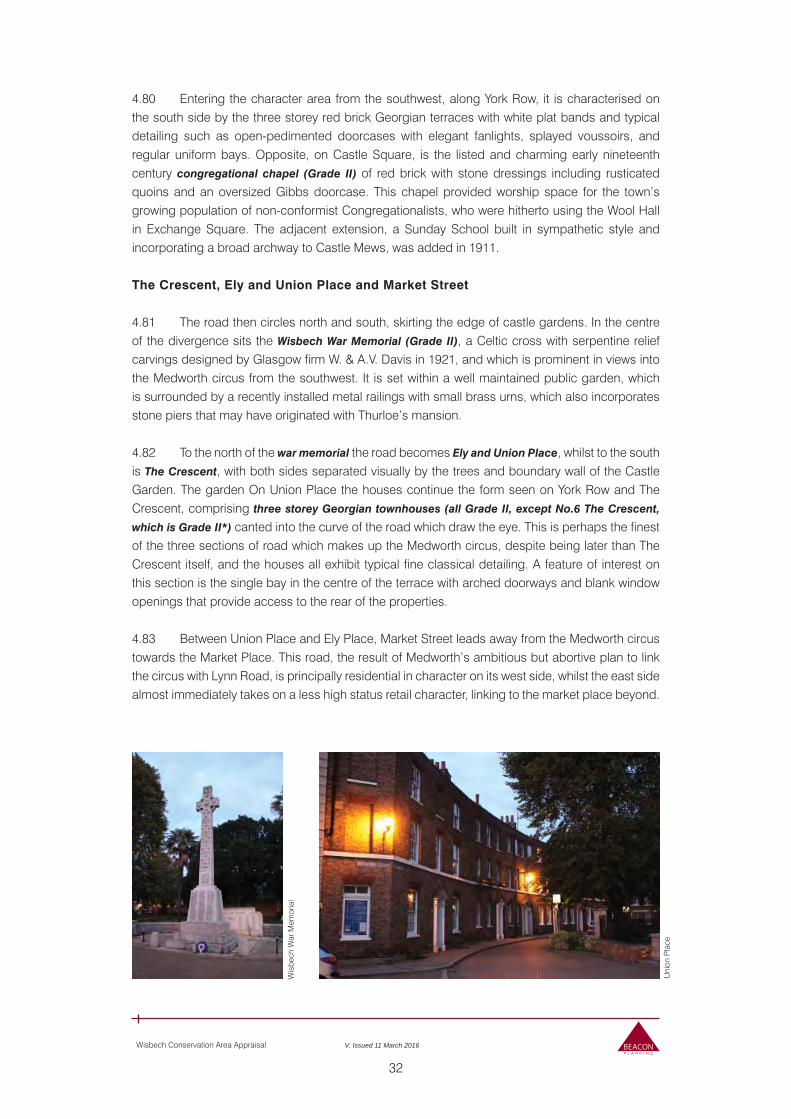
32
Wisbech Conservation Area Appraisal V. Issued 11 March 2016
4.80 Entering the character area from the southwest, along York Row, it is characterised on the south side by the three storey red brick Georgian terraces with white plat bands and typical detailing such as open-pedimented doorcases with elegant fanlights, splayed voussoirs, and regular uniform bays. Opposite, on Castle Square, is the listed and charming early nineteenth century congregational chapel (Grade II) of red brick with stone dressings including rusticated quoins and an oversized Gibbs doorcase. This chapel provided worship space for the town’s growing population of non-conformist Congregationalists, who were hitherto using the Wool Hall in Exchange Square. The adjacent extension, a Sunday School built in sympathetic style and incorporating a broad archway to Castle Mews, was added in 1911. The Crescent, Ely and Union Place and Market Street
4.81 The road then circles north and south, skirting the edge of castle gardens. In the centre of the divergence sits the Wisbech War Memorial (Grade II), a Celtic cross with serpentine relief carvings designed by Glasgow firm W. & A.V. Davis in 1921, and which is prominent in views into the Medworth circus from the southwest. It is set within a well maintained public garden, which is surrounded by a recently installed metal railings with small brass urns, which also incorporates stone piers that may have originated with Thurloe’s mansion.
4.82 To the north of the war memorial the road becomes Ely and Union Place, whilst to the south is The Crescent, with both sides separated visually by the trees and boundary wall of the Castle Garden. The garden On Union Place the houses continue the form seen on York Row and The Crescent, comprising three storey Georgian townhouses (all Grade II, except No.6 The Crescent,
which is Grade II*) canted into the curve of the road which draw the eye. This is perhaps the finest of the three sections of road which makes up the Medworth circus, despite being later than The Crescent itself, and the houses all exhibit typical fine classical detailing. A feature of interest on this section is the single bay in the centre of the terrace with arched doorways and blank window openings that provide access to the rear of the properties.
4.83 Between Union Place and Ely Place, Market Street leads away from the Medworth circus towards the Market Place. This road, the result of Medworth’s ambitious but abortive plan to link the circus with Lynn Road, is principally residential in character on its west side, whilst the east side almost immediately takes on a less high status retail character, linking to the market place beyond.
Wis
bech
War
Mem
oria
l
Uni
on P
lace
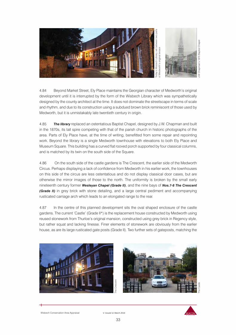
33
Wisbech Conservation Area Appraisal V. Issued 11 March 2016
4.84 Beyond Market Street, Ely Place maintains the Georgian character of Medworth’s original development until it is interrupted by the form of the Wisbech Library which was sympathetically designed by the county architect at the time. It does not dominate the streetscape in terms of scale and rhythm, and due to its construction using a subdued brown brick reminiscent of those used by Medworth, but it is unmistakably late twentieth century in origin.
4.85 The library replaced an ostentatious Baptist Chapel, designed by J.W. Chapman and built in the 1870s, its tall spire competing with that of the parish church in historic photographs of the area. Parts of Ely Place have, at the time of writing, benefitted from some repair and repointing work. Beyond the library is a single Medworth townhouse with elevations to both Ely Place and Museum Square. This building has a curved flat rooved porch supported by four classical columns, and is matched by its twin on the south side of the Square.
4.86 On the south side of the castle gardens is The Crescent, the earlier side of the Medworth Circus. Perhaps displaying a lack of confidence from Medworth in his earlier work, the townhouses on this side of the circus are less ostentatious and do not display classical door cases, but are otherwise the mirror images of those to the north. The uniformity is broken by the small early nineteenth century former Wesleyan Chapel (Grade II), and the nine bays of Nos.7-8 The Crescent
(Grade II) in grey brick with stone detailing, and a large central pediment and accompanying rusticated carriage arch which leads to an elongated range to the rear.
4.87 In the centre of this planned development sits the oval shaped enclosure of the castle gardens. The current ‘Castle’ (Grade II*) is the replacement house constructed by Medworth using reused stonework from Thurloe’s original mansion, constructed using grey brick in Regency style, but rather squat and lacking finesse. Finer elements of stonework are obviously from the earlier house, as are its large rusticated gate posts (Grade II). Two further sets of gateposts, matching the
Toda
y’s
Wis
bech
Lib
rary
, set
bet
wee
n tw
o pa
rts
of M
edw
orth
’s o
rigin
al te
rrac
e
The
Cre
scen
t
J.W
Cha
pman
’s 1
870
Bap
tist C
hape
lTh
e C
astle
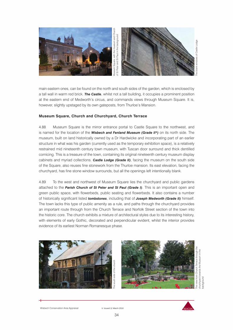
34
Wisbech Conservation Area Appraisal V. Issued 11 March 2016
main eastern ones, can be found on the north and south sides of the garden, which is enclosed by a tall wall in warm red brick. The Castle, whilst not a tall building, it occupies a prominent position at the eastern end of Medworth’s circus, and commands views through Museum Square. It is, however, slightly upstaged by its own gateposts, from Thurloe’s Mansion.
Museum Square, Church and Churchyard, Church Terrace
4.88 Museum Square is the mirror entrance portal to Castle Square to the northwest, and is named for the location of the Wisbech and Fenland Museum (Grade II*) on its north side. The museum, built on land historically owned by a Dr Hardwicke and incorporating part of an earlier structure in what was his garden (currently used as the temporary exhibition space), is a relatively restrained mid nineteenth century town museum, with Tuscan door surround and thick dentilled cornicing. This is a treasure of the town, containing its original nineteenth century museum display cabinets and myriad collections. Castle Lodge (Grade II), facing the museum on the south side of the Square, also reuses fine stonework from the Thurloe mansion. Its east elevation, facing the churchyard, has fine stone window surrounds, but all the openings left intentionally blank.
4.89 To the west and northwest of Museum Square lies the churchyard and public gardens attached to the Parish Church of St Peter and St Paul (Grade I). This is an important open and green public space, with flowerbeds, public seating and flowerbeds. It also contains a number of historically significant listed tombstones, including that of Joseph Medworth (Grade II) himself. The town lacks this type of public amenity as a rule, and paths through the churchyard provides an important route through from the Church Terrace and Norfolk Street section of the town into the historic core. The church exhibits a mixture of architectural styles due to its interesting history, with elements of early Gothic, decorated and perpendicular evident, whilst the interior provides evidence of its earliest Norman Romanesque phase.
Mus
eum
Squ
are,
with
the
mus
eum
and
Chu
rch
of S
t Pet
er a
nd S
t Pau
l in
the
back
grou
ndTh
e so
uth
side
of t
he c
hurc
h
The
blan
k w
indo
ws
of C
astle
Lod
geTh
e vi
ew fr
om C
hurc
h Te
rrac
e th
roug
h th
e ch
urch
yard
tow
ards
the
Mus
eum
in th
e ba
ckgr
ound
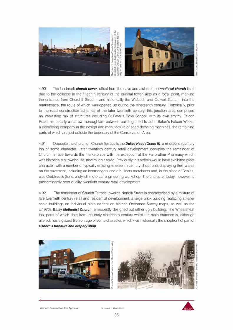
35
Wisbech Conservation Area Appraisal V. Issued 11 March 2016
4.90 The landmark church tower, offset from the nave and aisles of the medieval church itself due to the collapse in the fifteenth century of the original tower, acts as a focal point, marking the entrance from Churchill Street – and historically the Wisbech and Outwell Canal – into the marketplace, the route of which was opened up during the nineteenth century. Historically, prior to the road construction schemes of the later twentieth century, this junction area comprised an interesting mix of structures including St Peter’s Boys School, with its own smithy. Falcon Road, historically a narrow thoroughfare between buildings, led to John Baker’s Falcon Works, a pioneering company in the design and manufacture of seed dressing machines, the remaining parts of which are just outside the boundary of the Conservation Area.
4.91 Opposite the church on Church Terrace is the Dukes Head (Grade II), a nineteenth century Inn of some character. Later twentieth century retail development occupies the remainder of Church Terrace towards the marketplace with the exception of the Fairbrother Pharmacy which was historically a townhouse, now much altered. Previously this stretch would have exhibited great character, with a number of typically enticing nineteenth century shopfronts displaying their wares on the pavement, including an ironmongers and a builders merchants and, in the place of Beales, was Crabtree & Sons, a stylish motorcar engineering workshop. The character today, however, is predominantly poor quality twentieth century retail development.
4.92 The remainder of Church Terrace towards Norfolk Street is characterised by a mixture of late twentieth century retail and residential development, a large brick building replacing smaller scale buildings on individual plots evident on historic Ordnance Survey maps, as well as the c.1970s Trinity Methodist Church, a modestly designed but rather ugly building. The Wheatsheaf Inn, parts of which date from the early nineteenth century whilst the main entrance is, although altered, has a glazed tile frontage of some character, which was historically the shopfront of part of Osborn’s furniture and drapery shop.
The
junc
tion
betw
een
Chu
rch
Terr
ace
and
Chu
rchi
ll R
oad,
his
toric
ally
the
loca
tion
of th
e W
isbe
ch-O
utw
ell C
anal
, and
bef
ore
that
the
orig
inal
cou
rse
of th
e R
iver
Ous
e
Chu
rch
Terr
ace
tow
ards
the
Mar
ket P
lace
toda
y
The
Duk
e’s
Hea
d P
ublic
Hou
seC
hurc
h Te
rrac
e in
the
mid
nin
etee
nth
cent
ury
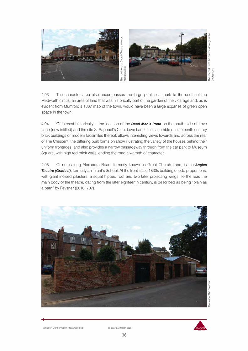
36
Wisbech Conservation Area Appraisal V. Issued 11 March 2016
4.93 The character area also encompasses the large public car park to the south of the Medworth circus, an area of land that was historically part of the garden of the vicarage and, as is evident from Mumford’s 1867 map of the town, would have been a large expanse of green open space in the town.
4.94 Of interest historically is the location of the Dead Man’s Pond on the south side of Love Lane (now infilled) and the site St Raphael’s Club. Love Lane, itself a jumble of nineteenth century brick buildings or modern facsimiles thereof, allows interesting views towards and across the rear of The Crescent, the differing built forms on show illustrating the variety of the houses behind their uniform frontages, and also provides a narrow passageway through from the car park to Museum Square, with high red brick walls lending the road a warmth of character.
4.95 Of note along Alexandra Road, formerly known as Great Church Lane, is the Angles
Theatre (Grade II), formerly an Infant’s School. At the front is a c.1830s building of odd proportions, with giant incised pilasters, a squat hipped roof and two later projecting wings. To the rear, the main body of the theatre, dating from the later eighteenth century, is described as being “plain as a barn” by Pevsner (2010, 707).
The
sout
h en
d of
Chu
rch
Terr
ace
tow
ards
N
orfo
lk S
treet
The
car p
ark,
with
the
hist
oric
vic
arag
e in
the
back
grou
ndTh
e re
ar o
f The
Cre
scen
t
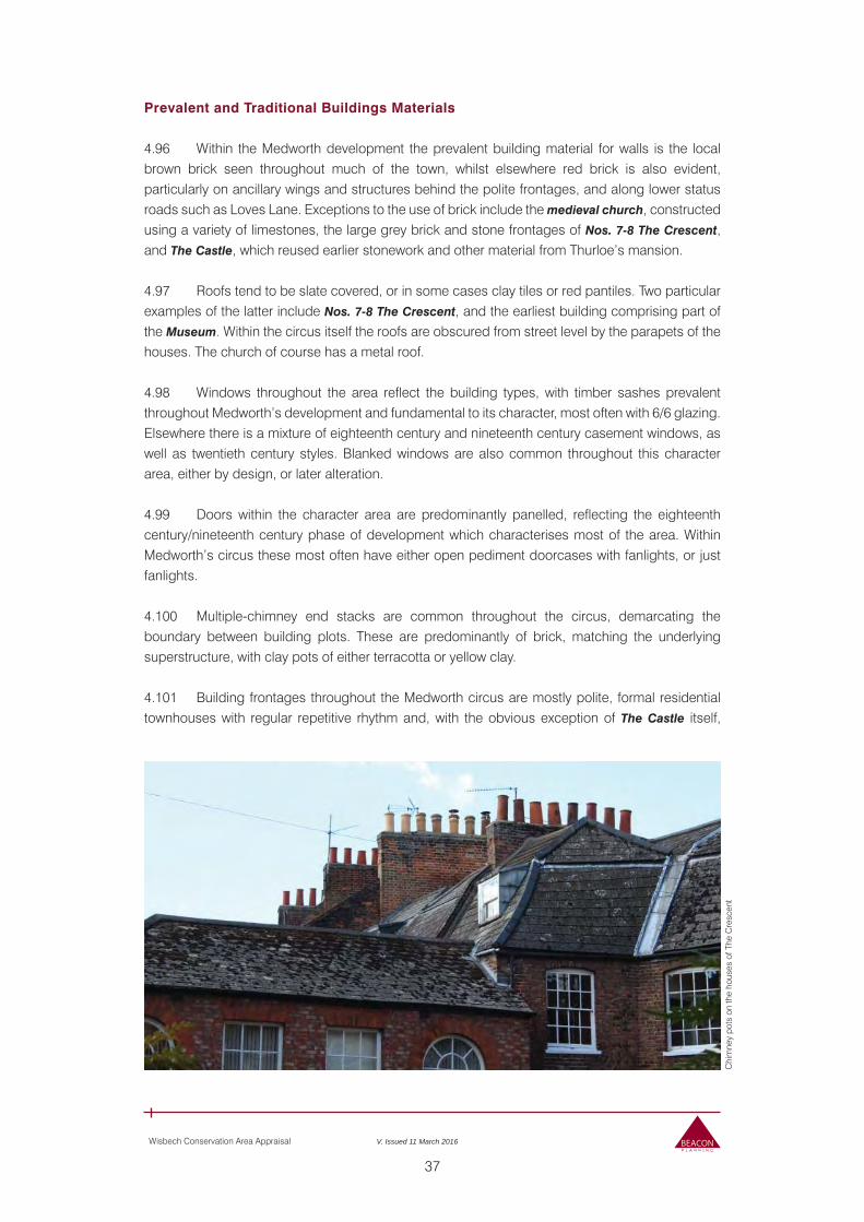
37
Wisbech Conservation Area Appraisal V. Issued 11 March 2016
Prevalent and Traditional Buildings Materials
4.96 Within the Medworth development the prevalent building material for walls is the local brown brick seen throughout much of the town, whilst elsewhere red brick is also evident, particularly on ancillary wings and structures behind the polite frontages, and along lower status roads such as Loves Lane. Exceptions to the use of brick include the medieval church, constructed using a variety of limestones, the large grey brick and stone frontages of Nos. 7-8 The Crescent, and The Castle, which reused earlier stonework and other material from Thurloe’s mansion.
4.97 Roofs tend to be slate covered, or in some cases clay tiles or red pantiles. Two particular examples of the latter include Nos. 7-8 The Crescent, and the earliest building comprising part of the Museum. Within the circus itself the roofs are obscured from street level by the parapets of the houses. The church of course has a metal roof.
4.98 Windows throughout the area reflect the building types, with timber sashes prevalent throughout Medworth’s development and fundamental to its character, most often with 6/6 glazing. Elsewhere there is a mixture of eighteenth century and nineteenth century casement windows, as well as twentieth century styles. Blanked windows are also common throughout this character area, either by design, or later alteration.
4.99 Doors within the character area are predominantly panelled, reflecting the eighteenth century/nineteenth century phase of development which characterises most of the area. Within Medworth’s circus these most often have either open pediment doorcases with fanlights, or just fanlights.
4.100 Multiple-chimney end stacks are common throughout the circus, demarcating the boundary between building plots. These are predominantly of brick, matching the underlying superstructure, with clay pots of either terracotta or yellow clay.
4.101 Building frontages throughout the Medworth circus are mostly polite, formal residential townhouses with regular repetitive rhythm and, with the obvious exception of The Castle itself,
Chi
mne
y po
ts o
n th
e ho
uses
of T
he C
resc
ent
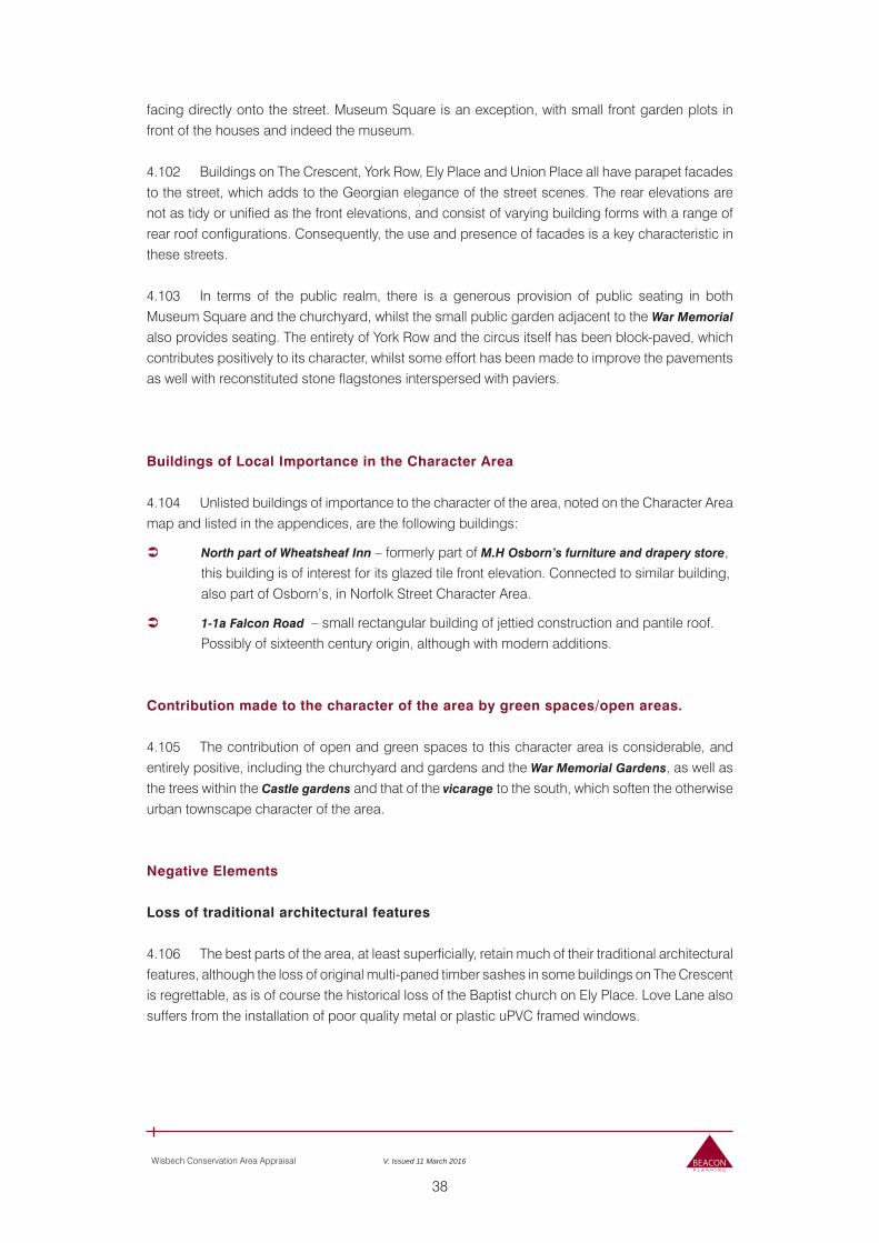
38
Wisbech Conservation Area Appraisal V. Issued 11 March 2016
facing directly onto the street. Museum Square is an exception, with small front garden plots in front of the houses and indeed the museum.
4.102 Buildings on The Crescent, York Row, Ely Place and Union Place all have parapet facades to the street, which adds to the Georgian elegance of the street scenes. The rear elevations are not as tidy or unified as the front elevations, and consist of varying building forms with a range of rear roof configurations. Consequently, the use and presence of facades is a key characteristic in these streets.
4.103 In terms of the public realm, there is a generous provision of public seating in both Museum Square and the churchyard, whilst the small public garden adjacent to the War Memorial also provides seating. The entirety of York Row and the circus itself has been block-paved, which contributes positively to its character, whilst some effort has been made to improve the pavements as well with reconstituted stone flagstones interspersed with paviers.
Buildings of Local Importance in the Character Area
4.104 Unlisted buildings of importance to the character of the area, noted on the Character Area map and listed in the appendices, are the following buildings:
North part of Wheatsheaf Inn – formerly part of M.H Osborn’s furniture and drapery store, this building is of interest for its glazed tile front elevation. Connected to similar building, also part of Osborn’s, in Norfolk Street Character Area.
1-1a Falcon Road – small rectangular building of jettied construction and pantile roof. Possibly of sixteenth century origin, although with modern additions.
Contribution made to the character of the area by green spaces/open areas.
4.105 The contribution of open and green spaces to this character area is considerable, and entirely positive, including the churchyard and gardens and the War Memorial Gardens, as well as the trees within the Castle gardens and that of the vicarage to the south, which soften the otherwise urban townscape character of the area.
Negative Elements
Loss of traditional architectural features
4.106 The best parts of the area, at least superficially, retain much of their traditional architectural features, although the loss of original multi-paned timber sashes in some buildings on The Crescent is regrettable, as is of course the historical loss of the Baptist church on Ely Place. Love Lane also suffers from the installation of poor quality metal or plastic uPVC framed windows.
39
Wisbech Conservation Area Appraisal V. Issued 11 March 2016
Elements that make a negative impact
4.107 Areas such as Alexandra Road and Love Lane have suffered from inappropriate and poor quality new structures which do not contribute positively to the character of the area. A key negative contribution is, however, the extensive car park to the south of Love Lane, the incongruous appearance of which is not successfully negated by the retention of the large trees from its former garden existence. The prevalence of poor quality shop frontages along Church Terrace also has a negative impact on the wider character of this part of the area, as well as of the listed Nos. 11-13
Church Terrace.
Public Realm/Signage
4.108 Various signage associated with the Churchill Road junction and public car park detracts from the quality of the urban environment.
Traffic
4.109 Traffic, particularly around the busy and exposed Churchill Road junction and into and out of the car park, is a negative contribution to the character of the area, as is the prevalence of parking around the circus itself which detracts from the appreciation of its architectural character and uniform appearance.
Neutral Elements
4.110 The public library is considered to be a neutral element in the streetscape. Its scale and form sits unobtrusively within its polite Georgian surroundings, but it does not contribute positively to the prevailing character of the area.
Bui
ldin
gs a
long
Lov
e La
ne h
as s
uffe
red
from
a n
umbe
r of i
napp
ropr
iate
alte
ratio
ns w
hich
det
ract
fro
m th
e hi
stor
ic c
hara
cter
of t
he b
uild
ings
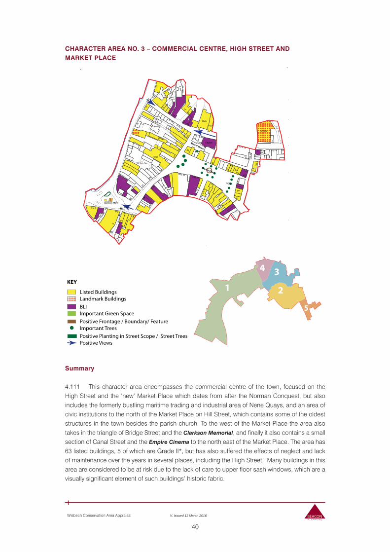
40
Wisbech Conservation Area Appraisal V. Issued 11 March 2016
CHARACTER AREA NO. 3 – COMMERCIAL CENTRE, HIGH STREET ANDMARKET PLACE
Summary
4.111 This character area encompasses the commercial centre of the town, focused on the High Street and the ‘new’ Market Place which dates from after the Norman Conquest, but also includes the formerly bustling maritime trading and industrial area of Nene Quays, and an area of civic institutions to the north of the Market Place on Hill Street, which contains some of the oldest structures in the town besides the parish church. To the west of the Market Place the area also takes in the triangle of Bridge Street and the Clarkson Memorial, and finally it also contains a small section of Canal Street and the Empire Cinema to the north east of the Market Place. The area has 63 listed buildings, 5 of which are Grade II*, but has also suffered the effects of neglect and lack of maintenance over the years in several places, including the High Street. Many buildings in this area are considered to be at risk due to the lack of care to upper floor sash windows, which are a visually significant element of such buildings’ historic fabric.
KEY
Listed BuildingsLandmark Buildings
Positive Planting in Street Scope / Street TreesPositive Views
Positive Frontage / Boundary/ FeatureImportant Trees
BLIImportant Green Space
5
2
34
1
*
ED &
War
d Bd
y
ED & W
a
PO
4
7
Inn
PH
York Row
ClubCourt
Bank
Hotel
Empire
Library
Falcon
St Paul's
MuseumTel Ex
Wisbech
The
10
13
42
4a
14
34
29 22
54
19
28
50
9a
11
5 6
6 4
2 3
The
Cast
le
47a
43a
War
The Case PH
9 10
Schooner Whar
to 18
to 1
5
7 to
8
1 to 3
6 to 8
1 to
7
8 to 9
2 to
3
22 2
3
48 4
9
21 23
16 14
43 44
TCBs
22
9 to
10
1 to
17
12 to
14
20 to 26
50 to 54
15 to 17
19 to 22
Friends
Tallow
Clarkson Meml
1a to
1c
Furri
ers W
arre
n
12
4
3
1410
38
PH
4
25
4
2
9 10
34
19
17
4
1
18
2
2
4
Church
30
PH
2
7
3
1
4
2
7 17
28
3
20
8
5
13
16
15
1 to 3
1 to 3
9 10
34
5
11
1
4
El Sub Sta
13
7
1
4
Bank
2
9
23
27
10
5
6
1
44
2
Club
5
6
3
1
3
Church
16
6
2
7
10
1
13
2
5
34
1
3
46
7
12
8
6
1 1
PC
1
4
1
12
7.0m
5.8m
5.5m
W
El
El Sub Sta
ESS
Market Place
HORSE FAIR
THE
Bus Station
UNION
CHURCH
Square
MEWS
SQUARE
Market Mews
OLD
MA
RK
ET
F
Walk
LAN
E
Posts
Rive
r Nen
e Mud
Mea
n Lo
w W
ater
MLW
W
41
Wisbech Conservation Area Appraisal V. Issued 11 March 2016
Current and Former Uses, Street Pattern and Buildings
4.112 The street pattern of this character area is fundamentally informed by the layout of the post-Norman settlement on the peninsula between the former line of the River Ouse (which was to become the Wisbech-Outwell Canal) and the River Nene. The market place is just to the north of the historic location of the Norman castle, and its southern edge is curved in reference to the shape of the bailey. Nene Quay, originally a dockland area of warehouses and now a busy road, naturally follows the line of the Nene navigation, with the building plots of warehouses and other structures along this stretch of road mainly being perpendicular to the line of the Road.
4.113 Hill Street, divided into Upper and Lower portions at Union Street, historically divided the market place to the south and the Horse Fair locality to the north, with many of the houses on its northern side historically having extensive paddocks at their rear.
4.114 At the eastern end of Hill Street is Little Church Street which links the northern part of the town centre with the church, to some extent bypassing the Market Place itself. The street pattern and buildings in this area reflect its historical connections to the canal, with “Hogherd’s Lane” being perhaps the most obvious example of this.
4.115 The High Street and Market Place form the core the town’s commercial and retail activities. Despite the fact the market continues, however, both the High Street and Market Place have suffered from a lack of prosperity in the later twentieth century, and much of the retail space is under-utilised or in some cases derelict. The Market Place, formerly a very busy and bustling social space with many family owned shops and a large number of drinking establishments, is now dominated by large discount stores, banks and charity shops, although there are one or two small independent concerns surviving.
Architectural and Historic Qualities Contributing to Special Interest of the Conservation Area
Bridge Street and York Row
4.116 Bridge Street, so called due to its relationship with the historic crossing of the River Nene that has been in this location since at least the tenth century, is perhaps the focal point of the entire town, connecting the commercial centre of the town and High Street, Nene Quays, South Brink and, via the bridge, North Brink, as well as providing the route towards the castle in historic times, and more recently the fashionable formerly residential quarter of the Medworth circus, and the church area beyond. Today, the street is characterised by a mixture of mainly nineteenth century and twentieth century commercial buildings, usually of two or three storeys, housing enterprises such as estate agents or retail outlets.
4.117 The triangle of Bridge Street is dominated by the Clarkson Memorial (Grade II*). This is a magnificent Gothic canopy of red and white Ancaster stone, designed by Sir George Gilbert Scott and dedicated to Thomas Clarkson, born the son of the Wisbech Grammar School Headmaster in 1760, and who was the famous abolitionist campaigner who worked alongside William Wilberforce and others to end the Atlantic Slave Trade. This structure is an important part of key views into the town towards the church from North Brink, and is a landmark building. Beneath the monument,
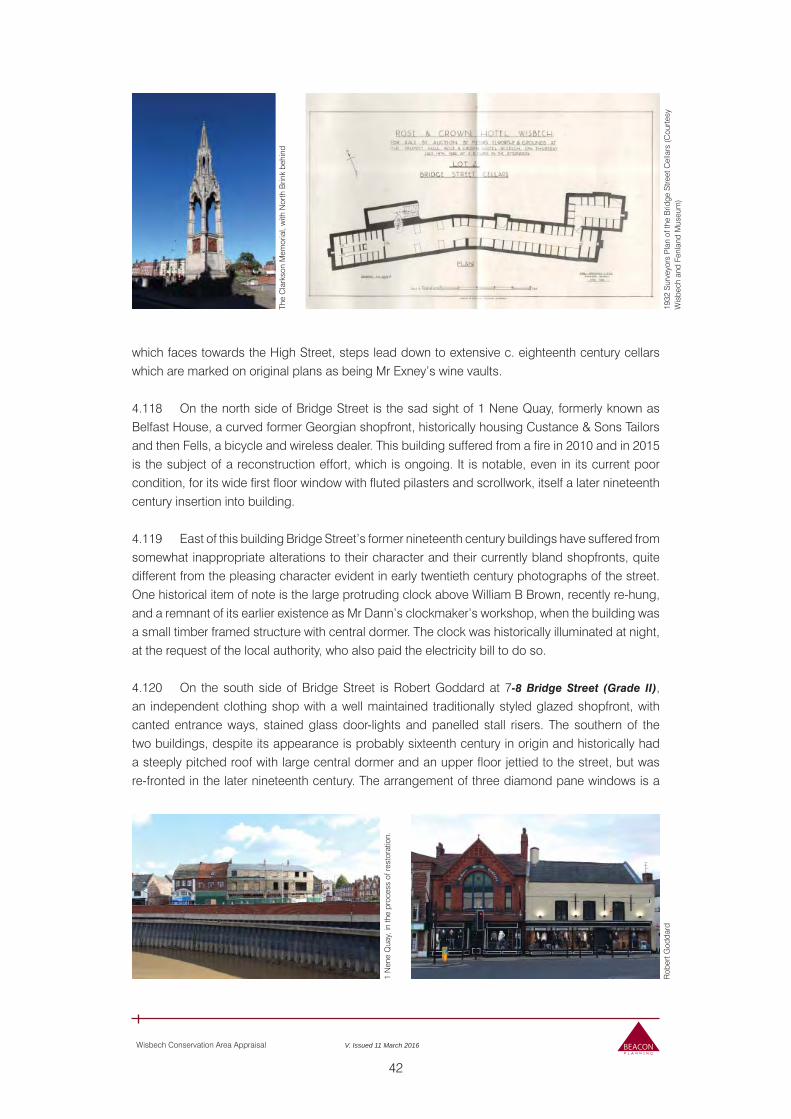
42
Wisbech Conservation Area Appraisal V. Issued 11 March 2016
which faces towards the High Street, steps lead down to extensive c. eighteenth century cellars which are marked on original plans as being Mr Exney’s wine vaults. 4.118 On the north side of Bridge Street is the sad sight of 1 Nene Quay, formerly known as Belfast House, a curved former Georgian shopfront, historically housing Custance & Sons Tailors and then Fells, a bicycle and wireless dealer. This building suffered from a fire in 2010 and in 2015 is the subject of a reconstruction effort, which is ongoing. It is notable, even in its current poor condition, for its wide first floor window with fluted pilasters and scrollwork, itself a later nineteenth century insertion into building. 4.119 East of this building Bridge Street’s former nineteenth century buildings have suffered from somewhat inappropriate alterations to their character and their currently bland shopfronts, quite different from the pleasing character evident in early twentieth century photographs of the street. One historical item of note is the large protruding clock above William B Brown, recently re-hung, and a remnant of its earlier existence as Mr Dann’s clockmaker’s workshop, when the building was a small timber framed structure with central dormer. The clock was historically illuminated at night, at the request of the local authority, who also paid the electricity bill to do so.
4.120 On the south side of Bridge Street is Robert Goddard at 7-8 Bridge Street (Grade II), an independent clothing shop with a well maintained traditionally styled glazed shopfront, with canted entrance ways, stained glass door-lights and panelled stall risers. The southern of the two buildings, despite its appearance is probably sixteenth century in origin and historically had a steeply pitched roof with large central dormer and an upper floor jettied to the street, but was re-fronted in the later nineteenth century. The arrangement of three diamond pane windows is a
1 N
ene
Qua
y, in
the
proc
ess
of re
stor
atio
n.
Rob
ert G
odda
rd
The
Cla
rkso
n M
emor
ial,
with
Nor
th B
rink
behi
nd
1932
Sur
veyo
rs P
lan
of th
e B
ridge
Stre
et C
ella
rs (C
ourte
sy
Wis
bech
and
Fen
land
Mus
eum
)
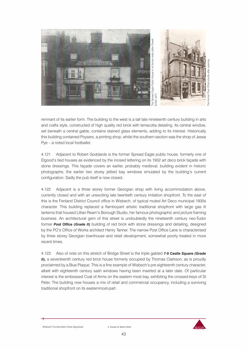
43
Wisbech Conservation Area Appraisal V. Issued 11 March 2016
remnant of its earlier form. The building to the west is a tall late nineteenth century building in arts and crafts style, constructed of high quality red brick with terracotta detailing. Its central window, set beneath a central gable, contains stained glass elements, adding to its interest. Historically this building contained Poysers, a printing shop, whilst the southern section was the shop of Jesse Pye – a noted local footballer.
4.121 Adjacent to Robert Goddards is the former Spread Eagle public house, formerly one of Elgood’s tied houses as evidenced by the incised lettering on its 1932 art deco brick façade with stone dressings. This façade covers an earlier, probably medieval, building evident in historic photographs, the earlier two storey jettied bay windows emulated by the building’s current configuration. Sadly the pub itself is now closed.
4.122 Adjacent is a three storey former Georgian shop with living accommodation above, currently closed and with an unexciting late twentieth century imitation shopfront. To the east of this is the Fenland District Council office in Wisbech, of typical muted Art Deco municipal 1930s character. This building replaced a flamboyant artistic traditional shopfront with large gas lit lanterns that housed Lillian Ream’s Borough Studio, her famous photographic and picture framing business. An architectural gem of this street is undoubtedly the nineteenth century neo-Tudor former Post Office (Grade II) building of red brick with stone dressings and detailing, designed by the PO’s Office of Works architect Henry Tanner. The narrow Post Office Lane is characterised by three storey Georgian townhouse and retail development, somewhat poorly treated in more recent times.
4.123 Also of note on this stretch of Bridge Street is the triple gabled 7-9 Castle Square (Grade
II), a seventeenth century red brick house formerly occupied by Thomas Clarkson, as is proudly proclaimed by a Blue Plaque. This is a fine example of Wisbech’s pre eighteenth century character, albeit with eighteenth century sash windows having been inserted at a later date. Of particular interest is the embossed Coat of Arms on the eastern most bay, exhibiting the crossed-keys of St Peter. The building now houses a mix of retail and commercial occupancy, including a surviving traditional shopfront on its easternmost-part.
The
Spr
ead
Eag
le P
ublic
Hou
se in
its
form
er s
tate
(afte
r Pow
ell
& B
ell,
p27)
The
form
er P
ost O
ffice
sho
rtly
afte
r ope
ning
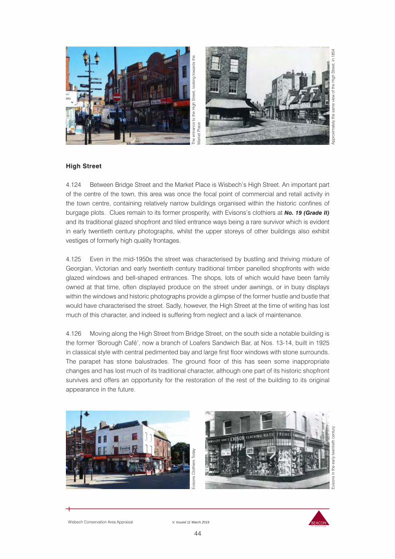
44
Wisbech Conservation Area Appraisal V. Issued 11 March 2016
The
entra
nce
to th
e H
igh
Stre
et, l
ooki
ng to
war
ds th
e M
arke
t Pla
ceE
viso
ns C
loth
iers
Tod
ay
App
roxi
mat
ely
the
sam
e vi
ew o
f the
Hig
h S
treet
, in
1854
Evi
sons
in th
e ea
rly tw
entie
th c
entu
ry
High Street 4.124 Between Bridge Street and the Market Place is Wisbech’s High Street. An important part of the centre of the town, this area was once the focal point of commercial and retail activity in the town centre, containing relatively narrow buildings organised within the historic confines of burgage plots. Clues remain to its former prosperity, with Evisons’s clothiers at No. 19 (Grade II)
and its traditional glazed shopfront and tiled entrance ways being a rare survivor which is evident in early twentieth century photographs, whilst the upper storeys of other buildings also exhibit vestiges of formerly high quality frontages.
4.125 Even in the mid-1950s the street was characterised by bustling and thriving mixture of Georgian, Victorian and early twentieth century traditional timber panelled shopfronts with wide glazed windows and bell-shaped entrances. The shops, lots of which would have been family owned at that time, often displayed produce on the street under awnings, or in busy displays within the windows and historic photographs provide a glimpse of the former hustle and bustle that would have characterised the street. Sadly, however, the High Street at the time of writing has lost much of this character, and indeed is suffering from neglect and a lack of maintenance.
4.126 Moving along the High Street from Bridge Street, on the south side a notable building is the former ‘Borough Café’, now a branch of Loafers Sandwich Bar, at Nos. 13-14, built in 1925 in classical style with central pedimented bay and large first floor windows with stone surrounds. The parapet has stone balustrades. The ground floor of this has seen some inappropriate changes and has lost much of its traditional character, although one part of its historic shopfront survives and offers an opportunity for the restoration of the rest of the building to its original appearance in the future.
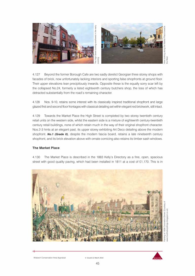
45
Wisbech Conservation Area Appraisal V. Issued 11 March 2016
Pain
ting
of 1
838
Cor
onat
ion
Din
ner (
Cou
rtesy
of
ww
w.fo
odhi
stor
jotti
ngs.
blog
spot
.co.
uk)
View
look
ing
alon
g th
e M
arke
t Pla
ce to
war
ds
the
Wes
t
The
Hig
h S
treet
look
ing
sout
hwes
t in
the
early
ev
enin
g
4.127 Beyond the former Borough Cafe are two sadly derelict Georgian three storey shops with facades of brick, now unfortunately lacking interiors and sporting false shopfronts at ground floor. Their upper elevations lean precipitously inwards. Opposite these is the equally sorry scar left by the collapsed No.24, formerly a listed eighteenth century butchers shop, the loss of which has detracted substantially from the road’s remaining character. 4.128 Nos. 9-10, retains some interest with its classically inspired traditional shopfront and large glazed first and second floor frontages with classical detailing set within elegant red brickwork, still intact.
4.129 Towards the Market Place the High Street is completed by two storey twentieth century retail units on the western side, whilst the eastern side is a mixture of eighteenth century-twentieth century retail buildings, none of which retain much in the way of their original shopfront character. Nos.2-3 hints at an elegant past, its upper storey exhibiting Art Deco detailing above the modern shopfront. No.1 (Grade II), despite the modern fascia board, retains a late nineteenth century shopfront, and its brick elevation above with ornate cornicing also retains its timber sash windows.
The Market Place 4.130 The Market Place is described in the 1883 Kelly’s Directory as a fine, open, spacious street with good quality paving, which had been installed in 1811 at a cost of £1,170. This is in
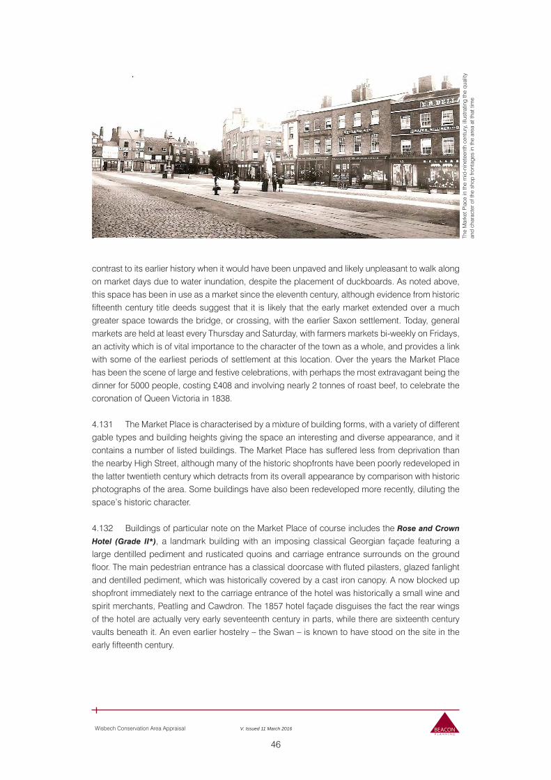
46
Wisbech Conservation Area Appraisal V. Issued 11 March 2016
The
Mar
ket P
lace
in th
e m
id-n
inet
eent
h ce
ntur
y, il
lust
ratin
g th
e qu
ality
an
d ch
arac
ter o
f the
sho
p fro
ntag
es in
the
area
at t
hat t
ime
contrast to its earlier history when it would have been unpaved and likely unpleasant to walk along on market days due to water inundation, despite the placement of duckboards. As noted above, this space has been in use as a market since the eleventh century, although evidence from historic fifteenth century title deeds suggest that it is likely that the early market extended over a much greater space towards the bridge, or crossing, with the earlier Saxon settlement. Today, general markets are held at least every Thursday and Saturday, with farmers markets bi-weekly on Fridays, an activity which is of vital importance to the character of the town as a whole, and provides a link with some of the earliest periods of settlement at this location. Over the years the Market Place has been the scene of large and festive celebrations, with perhaps the most extravagant being the dinner for 5000 people, costing £408 and involving nearly 2 tonnes of roast beef, to celebrate the coronation of Queen Victoria in 1838.
4.131 The Market Place is characterised by a mixture of building forms, with a variety of different gable types and building heights giving the space an interesting and diverse appearance, and it contains a number of listed buildings. The Market Place has suffered less from deprivation than the nearby High Street, although many of the historic shopfronts have been poorly redeveloped in the latter twentieth century which detracts from its overall appearance by comparison with historic photographs of the area. Some buildings have also been redeveloped more recently, diluting the space’s historic character.
4.132 Buildings of particular note on the Market Place of course includes the Rose and Crown
Hotel (Grade II*), a landmark building with an imposing classical Georgian façade featuring a large dentilled pediment and rusticated quoins and carriage entrance surrounds on the ground floor. The main pedestrian entrance has a classical doorcase with fluted pilasters, glazed fanlight and dentilled pediment, which was historically covered by a cast iron canopy. A now blocked up shopfront immediately next to the carriage entrance of the hotel was historically a small wine and spirit merchants, Peatling and Cawdron. The 1857 hotel façade disguises the fact the rear wings of the hotel are actually very early seventeenth century in parts, while there are sixteenth century vaults beneath it. An even earlier hostelry – the Swan – is known to have stood on the site in the early fifteenth century.
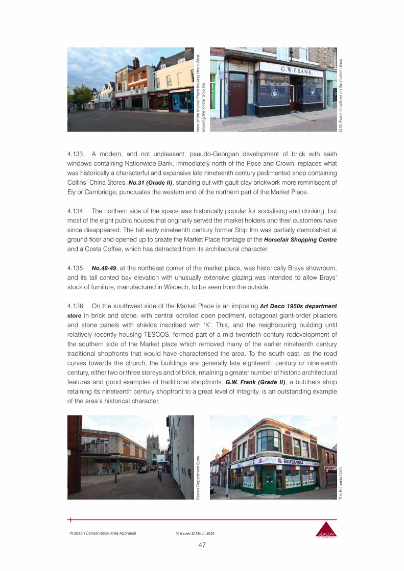
47
Wisbech Conservation Area Appraisal V. Issued 11 March 2016
View
of t
he M
arke
t Pla
ce lo
okin
g N
orth
Wes
t, sh
owin
g th
e fo
rmer
Shi
p In
n
G.W
. Fra
nk s
hopf
ront
on
the
mar
ket p
lace
4.133 A modern, and not unpleasant, pseudo-Georgian development of brick with sash windows containing Nationwide Bank, immediately north of the Rose and Crown, replaces what was historically a characterful and expansive late nineteenth century pedimented shop containing Collins’ China Stores. No.31 (Grade II), standing out with gault clay brickwork more reminiscent of Ely or Cambridge, punctuates the western end of the northern part of the Market Place.
4.134 The northern side of the space was historically popular for socialising and drinking, but most of the eight public houses that originally served the market holders and their customers have since disappeared. The tall early nineteenth century former Ship Inn was partially demolished at ground floor and opened up to create the Market Place frontage of the Horsefair Shopping Centre
and a Costa Coffee, which has detracted from its architectural character.
4.135 No.48-49, at the northeast corner of the market place, was historically Brays showroom, and its tall canted bay elevation with unusually extensive glazing was intended to allow Brays’ stock of furniture, manufactured in Wisbech, to be seen from the outside.
4.136 On the southwest side of the Market Place is an imposing Art Deco 1950s department
store in brick and stone, with central scrolled open pediment, octagonal giant-order pilasters and stone panels with shields inscribed with ‘K’. This, and the neighbouring building until relatively recently housing TESCOS, formed part of a mid-twentieth century redevelopment of the southern side of the Market place which removed many of the earlier nineteenth century traditional shopfronts that would have characterised the area. To the south east, as the road curves towards the church, the buildings are generally late eighteenth century or nineteenth century, either two or three storeys and of brick, retaining a greater number of historic architectural features and good examples of traditional shopfronts. G.W. Frank (Grade II), a butchers shop retaining its nineteenth century shopfront to a great level of integrity, is an outstanding example of the area’s historical character.
Bea
les
Dep
artm
ent S
tore
The
Brit
anni
a C
afé
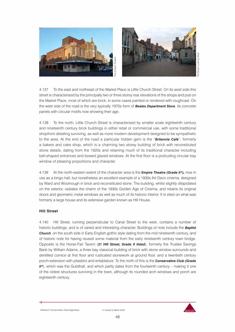
48
Wisbech Conservation Area Appraisal V. Issued 11 March 2016
The
Em
pire
The
atre
Hill
Stre
et L
ooki
ng W
est
4.137 To the east and northeast of the Market Place is Little Church Street. On its west side this street is characterised by the principally two or three storey rear elevations of the shops and pub on the Market Place, most of which are brick, in some cases painted or rendered with roughcast. On the west side of the road is the very typically 1970s form of Beales Department Store, its concrete panels with circular motifs now showing their age.
4.138 To the north, Little Church Street is characterised by smaller scale eighteenth century and nineteenth century brick buildings in either retail or commercial use, with some traditional shopfront detailing surviving, as well as more modern development designed to be sympathetic to the area. At the end of the road a particular hidden gem is the “Britannia Café”, formerly a bakers and cake shop, which is a charming two storey building of brick with reconstituted stone details, dating from the 1920s and retaining much of its traditional character including bell-shaped entrances and bowed glazed windows. At the first floor is a protruding circular bay window of pleasing proportions and character. 4.139 At the north-eastern extent of the character area is the Empire Theatre (Grade II*), now in use as a bingo hall, but nonetheless an excellent example of a 1930s Art Deco cinema, designed by Ward and Woolnough in brick and reconstituted stone. The building, whilst slightly dilapidated on the exterior, radiates the charm of the 1930s Golden Age of Cinema, and retains its original doors and geometric metal windows as well as much of its historic interior. It is sited on what was formerly a large house and its extensive garden known as Hill House.
Hill Street
4.140 Hill Street, running perpendicular to Canal Street to the west, contains a number of historic buildings, and is of varied and interesting character. Buildings of note include the Baptist
Church on the south side in Early English gothic style dating from the mid nineteenth century, and of historic note for having reused some material from the early nineteenth century town bridge. Opposite is the Horse-Fair Tavern (31 Hill Street, Grade II listed), formerly the Trustee Savings Bank by William Adams, a three bay classical building of brick with stone window surrounds and dentilled cornice at first floor and rusticated stonework at ground floor, and a twentieth century porch-extension with pilasters and entablature. To the north of this is the Conservative Club (Grade
II*), which was the Guildhall, and which partly dates from the fourteenth century – making it one of the oldest structures surviving in the town, although its rounded arch windows and porch are eighteenth century.
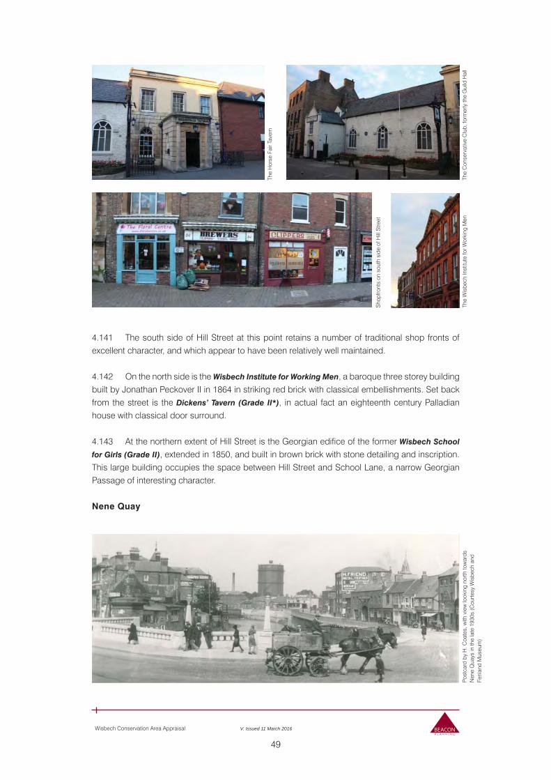
49
Wisbech Conservation Area Appraisal V. Issued 11 March 2016
The
Hor
se F
air T
aver
n
The
Con
serv
ativ
e C
lub,
form
erly
the
Gui
ld H
all
The
Wis
bech
Inst
itute
for W
orki
ng M
enPo
stca
rd b
y H
. Coa
tes,
with
vie
w lo
okin
g no
rth to
war
ds
Nen
e Q
uays
in th
e la
te 1
930s
(Cou
rtesy
Wis
bech
and
Fe
nlan
d M
useu
m)
Sho
pfro
nts
on s
outh
sid
e of
Hill
Stre
et
4.141 The south side of Hill Street at this point retains a number of traditional shop fronts of excellent character, and which appear to have been relatively well maintained.
4.142 On the north side is the Wisbech Institute for Working Men, a baroque three storey building built by Jonathan Peckover II in 1864 in striking red brick with classical embellishments. Set back from the street is the Dickens’ Tavern (Grade II*), in actual fact an eighteenth century Palladian house with classical door surround.
4.143 At the northern extent of Hill Street is the Georgian edifice of the former Wisbech School
for Girls (Grade II), extended in 1850, and built in brown brick with stone detailing and inscription. This large building occupies the space between Hill Street and School Lane, a narrow Georgian Passage of interesting character.
Nene Quay
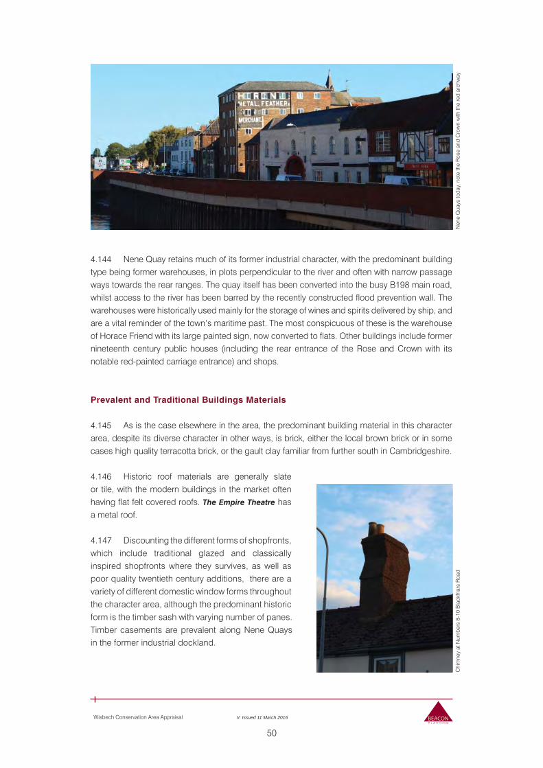
50
Wisbech Conservation Area Appraisal V. Issued 11 March 2016
Nen
e Q
uays
toda
y, n
ote
the
Ros
e an
d C
row
n w
ith th
e re
d ar
chw
ayC
him
ney
at N
umbe
rs 8
-10
Bla
ckfri
ars
Roa
d
4.144 Nene Quay retains much of its former industrial character, with the predominant building type being former warehouses, in plots perpendicular to the river and often with narrow passage ways towards the rear ranges. The quay itself has been converted into the busy B198 main road, whilst access to the river has been barred by the recently constructed flood prevention wall. The warehouses were historically used mainly for the storage of wines and spirits delivered by ship, and are a vital reminder of the town’s maritime past. The most conspicuous of these is the warehouse of Horace Friend with its large painted sign, now converted to flats. Other buildings include former nineteenth century public houses (including the rear entrance of the Rose and Crown with its notable red-painted carriage entrance) and shops.
Prevalent and Traditional Buildings Materials
4.145 As is the case elsewhere in the area, the predominant building material in this character area, despite its diverse character in other ways, is brick, either the local brown brick or in some cases high quality terracotta brick, or the gault clay familiar from further south in Cambridgeshire.
4.146 Historic roof materials are generally slate or tile, with the modern buildings in the market often having flat felt covered roofs. The Empire Theatre has a metal roof.
4.147 Discounting the different forms of shopfronts, which include traditional glazed and classically inspired shopfronts where they survives, as well as poor quality twentieth century additions, there are a variety of different domestic window forms throughout the character area, although the predominant historic form is the timber sash with varying number of panes. Timber casements are prevalent along Nene Quays in the former industrial dockland.
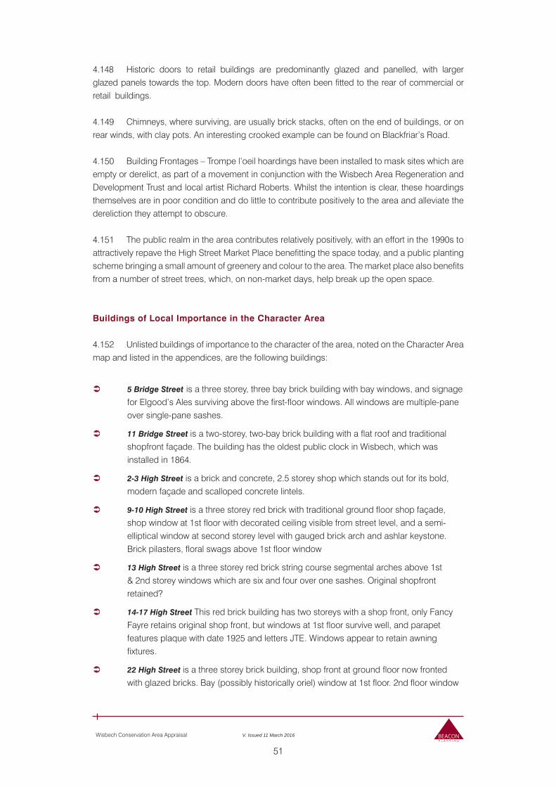
51
Wisbech Conservation Area Appraisal V. Issued 11 March 2016
4.148 Historic doors to retail buildings are predominantly glazed and panelled, with larger glazed panels towards the top. Modern doors have often been fitted to the rear of commercial or retail buildings.
4.149 Chimneys, where surviving, are usually brick stacks, often on the end of buildings, or on rear winds, with clay pots. An interesting crooked example can be found on Blackfriar’s Road.
4.150 Building Frontages – Trompe l’oeil hoardings have been installed to mask sites which are empty or derelict, as part of a movement in conjunction with the Wisbech Area Regeneration and Development Trust and local artist Richard Roberts. Whilst the intention is clear, these hoardings themselves are in poor condition and do little to contribute positively to the area and alleviate the dereliction they attempt to obscure.
4.151 The public realm in the area contributes relatively positively, with an effort in the 1990s to attractively repave the High Street Market Place benefitting the space today, and a public planting scheme bringing a small amount of greenery and colour to the area. The market place also benefits from a number of street trees, which, on non-market days, help break up the open space.
Buildings of Local Importance in the Character Area
4.152 Unlisted buildings of importance to the character of the area, noted on the Character Area map and listed in the appendices, are the following buildings:
5 Bridge Street is a three storey, three bay brick building with bay windows, and signage for Elgood’s Ales surviving above the first-floor windows. All windows are multiple-pane over single-pane sashes.
11 Bridge Street is a two-storey, two-bay brick building with a flat roof and traditional shopfront façade. The building has the oldest public clock in Wisbech, which was installed in 1864.
2-3 High Street is a brick and concrete, 2.5 storey shop which stands out for its bold, modern façade and scalloped concrete lintels.
9-10 High Street is a three storey red brick with traditional ground floor shop façade, shop window at 1st floor with decorated ceiling visible from street level, and a semi-elliptical window at second storey level with gauged brick arch and ashlar keystone. Brick pilasters, floral swags above 1st floor window
13 High Street is a three storey red brick string course segmental arches above 1st & 2nd storey windows which are six and four over one sashes. Original shopfront retained?
14-17 High Street This red brick building has two storeys with a shop front, only Fancy Fayre retains original shop front, but windows at 1st floor survive well, and parapet features plaque with date 1925 and letters JTE. Windows appear to retain awning fixtures.
22 High Street is a three storey brick building, shop front at ground floor now fronted with glazed bricks. Bay (possibly historically oriel) window at 1st floor. 2nd floor window
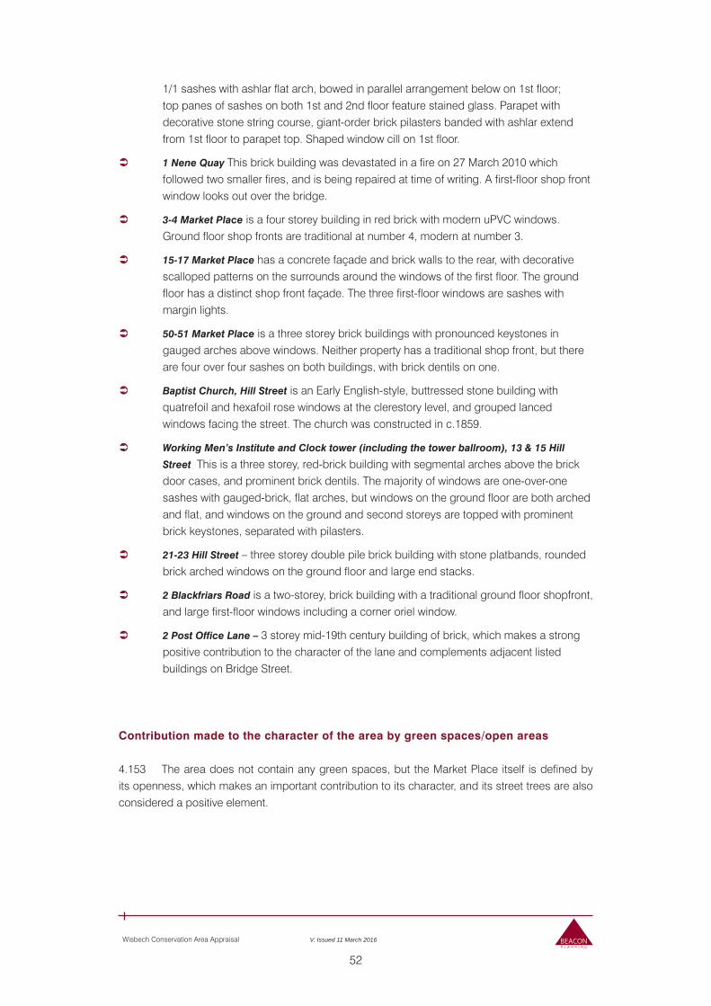
52
Wisbech Conservation Area Appraisal V. Issued 11 March 2016
1/1 sashes with ashlar flat arch, bowed in parallel arrangement below on 1st floor; top panes of sashes on both 1st and 2nd floor feature stained glass. Parapet with decorative stone string course, giant-order brick pilasters banded with ashlar extend from 1st floor to parapet top. Shaped window cill on 1st floor.
1 Nene Quay This brick building was devastated in a fire on 27 March 2010 which followed two smaller fires, and is being repaired at time of writing. A first-floor shop front window looks out over the bridge.
3-4 Market Place is a four storey building in red brick with modern uPVC windows. Ground floor shop fronts are traditional at number 4, modern at number 3.
15-17 Market Place has a concrete façade and brick walls to the rear, with decorative scalloped patterns on the surrounds around the windows of the first floor. The ground floor has a distinct shop front façade. The three first-floor windows are sashes with margin lights.
50-51 Market Place is a three storey brick buildings with pronounced keystones in gauged arches above windows. Neither property has a traditional shop front, but there are four over four sashes on both buildings, with brick dentils on one.
Baptist Church, Hill Street is an Early English-style, buttressed stone building with quatrefoil and hexafoil rose windows at the clerestory level, and grouped lanced windows facing the street. The church was constructed in c.1859.
Working Men’s Institute and Clock tower (including the tower ballroom), 13 & 15 Hill
Street This is a three storey, red-brick building with segmental arches above the brick door cases, and prominent brick dentils. The majority of windows are one-over-one sashes with gauged-brick, flat arches, but windows on the ground floor are both arched and flat, and windows on the ground and second storeys are topped with prominent brick keystones, separated with pilasters.
21-23 Hill Street – three storey double pile brick building with stone platbands, rounded brick arched windows on the ground floor and large end stacks.
2 Blackfriars Road is a two-storey, brick building with a traditional ground floor shopfront, and large first-floor windows including a corner oriel window.
2 Post Office Lane – 3 storey mid-19th century building of brick, which makes a strong positive contribution to the character of the lane and complements adjacent listed buildings on Bridge Street.
Contribution made to the character of the area by green spaces/open areas
4.153 The area does not contain any green spaces, but the Market Place itself is defined by its openness, which makes an important contribution to its character, and its street trees are also considered a positive element.
53
Wisbech Conservation Area Appraisal V. Issued 11 March 2016
Negative Elements
Loss of traditional architectural features
4.154 The loss of traditional shopfronts in their entirety, or merely historical fixtures such as awnings or blinds, throughout the area severely affects the character of what was historically a much more attractive and enticing retail district. The prevalence of poor quality modern frontages, or indeed just general dereliction, is one of the key issues placing this character area at risk.
Buildings and areas that make a negative impact
4.155 The High Street, although an area of great potential and, at the time of writing, the subject of a regeneration scheme, currently has a negative impact on the character and appearance of the area due to the poor condition of many of the buildings and empty shops.
Public Realm/Signage
4.156 The use of the Market Place for parking detracts from the character and appearance of the area, meaning the space cannot be used for the enjoyment of the pedestrian or for public events as would have been historically more the case. It also creates a sense of unfriendliness and untidiness.
4.157 Bridge Street suffers, despite the civic planting around the Clarkson Memorial, from too much street furniture and signage, the clutter detracting from the appearance of the memorial space itself.
Neutral Elements
4.158 Modern buildings along Little Church Street, whilst designed to be sympathetic to their surroundings, are not considered to be of architectural or historic interest in their own right and therefore make a neutral contribution to the area.
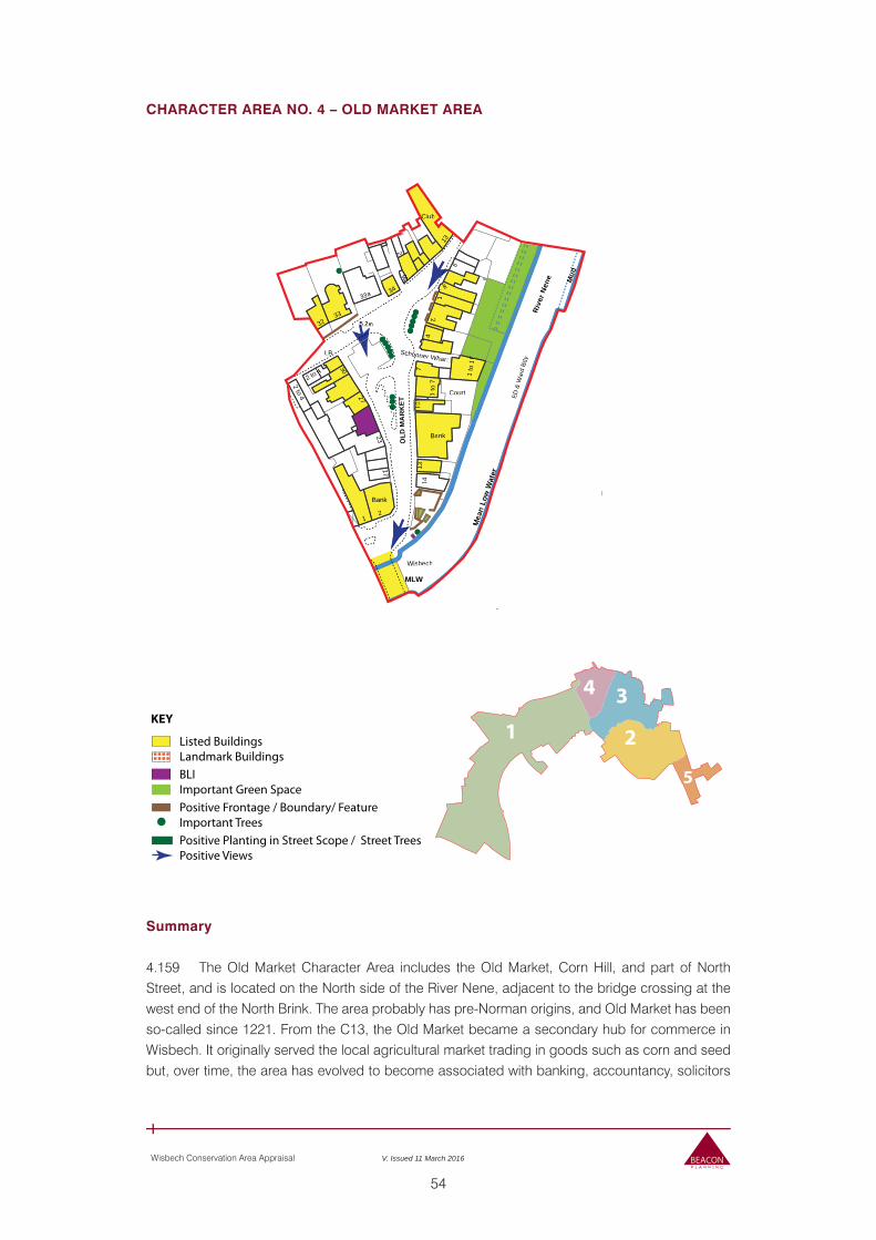
54
Wisbech Conservation Area Appraisal V. Issued 11 March 2016
CHARACTER AREA NO. 4 – OLD MARKET AREA
Summary
4.159 The Old Market Character Area includes the Old Market, Corn Hill, and part of North Street, and is located on the North side of the River Nene, adjacent to the bridge crossing at the west end of the North Brink. The area probably has pre-Norman origins, and Old Market has been so-called since 1221. From the C13, the Old Market became a secondary hub for commerce in Wisbech. It originally served the local agricultural market trading in goods such as corn and seed but, over time, the area has evolved to become associated with banking, accountancy, solicitors
KEY
Listed BuildingsLandmark Buildings
Positive Planting in Street Scope / Street TreesPositive Views
Positive Frontage / Boundary/ FeatureImportant Trees
BLIImportant Green Space
5
2
34
1
ED &
War
d Bd
y
4
7
Court
Bank
HTown
Wisbech
18
28
9a
11
33a
PC
9 10
Schooner Whar
t0 17
to15
1 to
72 to 4
6 to 22
1 to
17
Fri
18
1410
4
25
2
306
17
15
1
2
7
7
3
1
8
132
9 10
34
1
32
El Sub Sta
13
Bank
2
2 to 4
33
23
10
1
Club
5
6
Hotel
27
17
2
2Bank
12
LB
5.2m
5.8m
Yd
OLD
MA
RK
ET
Rive
r Nen
e Mud
Mea
n Lo
w W
ater
MLW
MLWMLW
ED &
War
d Bd
y
7
Court
Bank
Wisbech
9a9aa9aa
33a
C
Schooneo r Whar
1 to
72 to 4
1to
1777
141100
4
2
3300
17
1
2
8
1313
34
1
32
13
Bank
2
2 to 44
33
2323
ClC ub
66
2727
LBB
5.2m5
OLD
MA
RK
ET
Rive
r Nen
e Mu
Mudd
Mea
n Lo
w W
aterer
MLM WLL
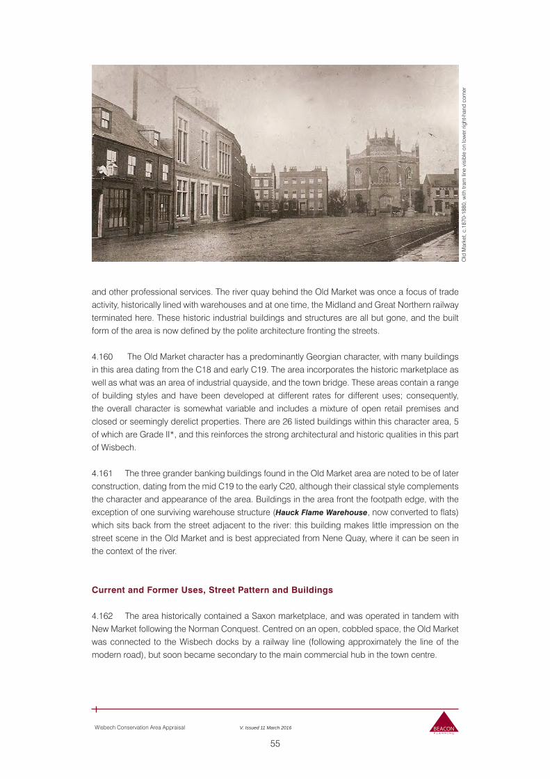
55
Wisbech Conservation Area Appraisal V. Issued 11 March 2016
Old
Mar
ket,
c.18
70-1
880,
with
tram
line
vis
ible
on
low
er ri
ght-h
and
corn
er
and other professional services. The river quay behind the Old Market was once a focus of trade activity, historically lined with warehouses and at one time, the Midland and Great Northern railway terminated here. These historic industrial buildings and structures are all but gone, and the built form of the area is now defined by the polite architecture fronting the streets.
4.160 The Old Market character has a predominantly Georgian character, with many buildings in this area dating from the C18 and early C19. The area incorporates the historic marketplace as well as what was an area of industrial quayside, and the town bridge. These areas contain a range of building styles and have been developed at different rates for different uses; consequently, the overall character is somewhat variable and includes a mixture of open retail premises and closed or seemingly derelict properties. There are 26 listed buildings within this character area, 5 of which are Grade II*, and this reinforces the strong architectural and historic qualities in this part of Wisbech.
4.161 The three grander banking buildings found in the Old Market area are noted to be of later construction, dating from the mid C19 to the early C20, although their classical style complements the character and appearance of the area. Buildings in the area front the footpath edge, with the exception of one surviving warehouse structure (Hauck Flame Warehouse, now converted to flats) which sits back from the street adjacent to the river: this building makes little impression on the street scene in the Old Market and is best appreciated from Nene Quay, where it can be seen in the context of the river.
Current and Former Uses, Street Pattern and Buildings
4.162 The area historically contained a Saxon marketplace, and was operated in tandem with New Market following the Norman Conquest. Centred on an open, cobbled space, the Old Market was connected to the Wisbech docks by a railway line (following approximately the line of the modern road), but soon became secondary to the main commercial hub in the town centre.
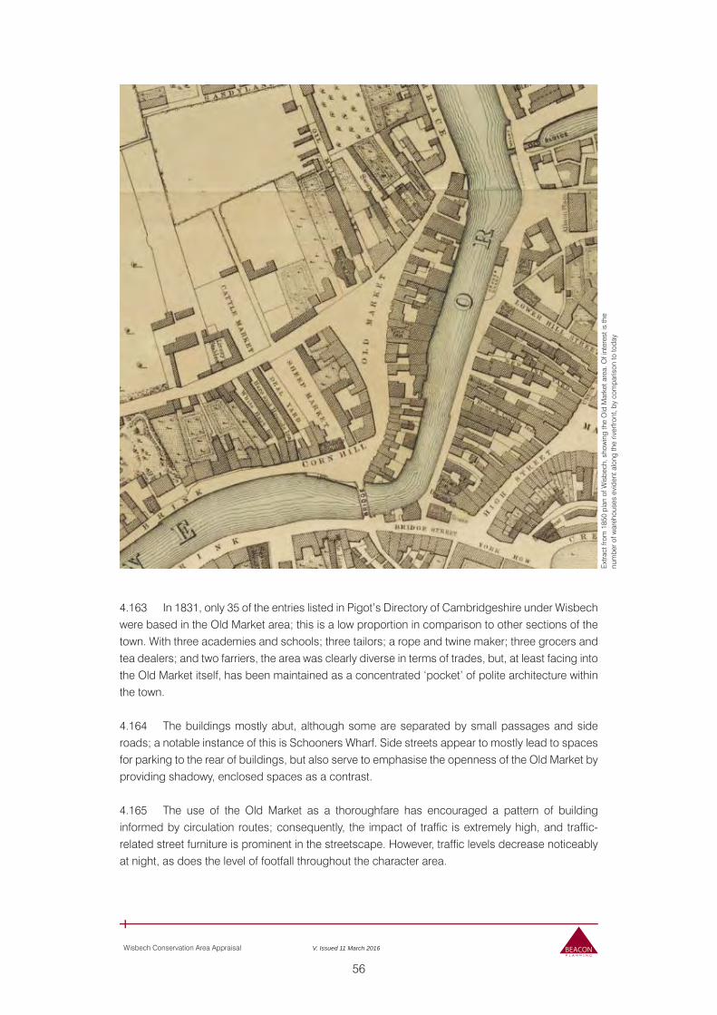
56
Wisbech Conservation Area Appraisal V. Issued 11 March 2016
4.163 In 1831, only 35 of the entries listed in Pigot’s Directory of Cambridgeshire under Wisbech were based in the Old Market area; this is a low proportion in comparison to other sections of the town. With three academies and schools; three tailors; a rope and twine maker; three grocers and tea dealers; and two farriers, the area was clearly diverse in terms of trades, but, at least facing into the Old Market itself, has been maintained as a concentrated ‘pocket’ of polite architecture within the town.
4.164 The buildings mostly abut, although some are separated by small passages and side roads; a notable instance of this is Schooners Wharf. Side streets appear to mostly lead to spaces for parking to the rear of buildings, but also serve to emphasise the openness of the Old Market by providing shadowy, enclosed spaces as a contrast.
4.165 The use of the Old Market as a thoroughfare has encouraged a pattern of building informed by circulation routes; consequently, the impact of traffic is extremely high, and traffic-related street furniture is prominent in the streetscape. However, traffic levels decrease noticeably at night, as does the level of footfall throughout the character area.
Ext
ract
from
185
0 pl
an o
f Wis
bech
, sho
win
g th
e O
ld M
arke
t are
a. O
f int
eres
t is
the
num
ber o
f war
ehou
ses
evid
ent a
long
the
river
front
, by
com
paris
on to
toda
y
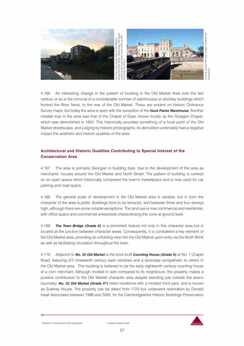
57
Wisbech Conservation Area Appraisal V. Issued 11 March 2016
The
rear
of t
he s
outh
sid
e of
Old
Mar
ket,
faci
ng th
e R
iver
Nen
e. H
isto
rical
ly, th
is g
reen
sp
ace
wou
ld h
ave
been
mor
e bu
ilt u
p w
ith
indu
stria
l stru
ctur
es
Look
ing
acro
ss th
e to
wn
brid
ge, t
owar
ds th
e O
ld M
arke
t
4.166 An interesting change in the pattern of building in the Old Market Area over the last century or so is the removal of a considerable number of warehouses or ancillary buildings which fronted the River Nene, to the rear of the Old Market. These are evident on historic Ordnance Survey maps, but today the area is open with the exception of the Huck Flame Warehouse. Another notable loss in the area was that of the Chapel of Ease, known locally as the Octagon Chapel, which was demolished in 1952. This historically provided something of a focal point of the Old Market streetscape, and judging by historic photographs, its demolition undeniably had a negative impact the aesthetic and historic qualities of the area.
Architectural and Historic Qualities Contributing to Special Interest of the Conservation Area
4.167 The area is primarily Georgian in building style, due to the development of the area as merchants’ houses around the Old Market and North Street. The pattern of building is centred on an open space which historically comprised the town’s marketplace and is now used for car parking and road space.
4.168 The general scale of development in the Old Market area is variable, but in form the character of the area is polite. Buildings tend to be terraced, and between three and four storeys high, although there are some notable exceptions. The land use is now commercial and residential, with office space and commercial enterprises characterising the zone at ground level.
4.169 The Town Bridge (Grade II) is a prominent feature not only in this character area but is located at the junction between character areas. Consequently, it is considered a key element of the Old Market area, providing an unfolding view into the Old Market upon entry via the North Brink as well as facilitating circulation throughout the town.
4.170 Adjacent to No. 32 Old Market is the brick-built Counting House (Grade II) at No. 1 Chapel Road, featuring 2/2 nineteenth century sash windows and a doorcase sympathetic to others in the Old Market area. This building is believed to be the early eighteenth century counting house of a corn merchant. Although modest in size compared to its neighbours, the property makes a positive contribution to the Old Market character area despite standing just outside the area’s boundary. No. 32 Old Market (Grade II*) listed residence with a modest front yard, and is known as Sulehay House. The property can be dated from 1723 but underwent restoration by Donald Insall Associates between 1998 and 2000, for the Cambridgeshire Historic Buildings Preservation
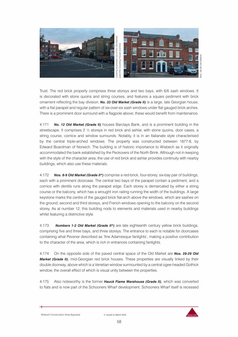
58
Wisbech Conservation Area Appraisal V. Issued 11 March 2016
Look
ing
sout
hwes
t out
of t
he O
ld M
arke
t, pa
st th
e C
ount
ing
Hou
se (c
entra
l)
Nos
. 28-
29 O
ld M
arke
t
Trust. The red brick property comprises three storeys and two bays, with 6/6 sash windows. It is decorated with stone quoins and string courses, and features a square pediment with brick ornament reflecting the bay division. No. 33 Old Market (Grade II) is a large, late Georgian house, with a flat parapet and regular pattern of six-over-six sash windows under flat gauged brick arches. There is a prominent door surround with a flagpole above; these would benefit from maintenance.
4.171 No. 12 Old Market (Grade II) houses Barclays Bank, and is a prominent building in the streetscape. It comprises 2 ½ storeys in red brick and ashlar, with stone quoins, door cases, a string course, cornice and window surrounds. Notably, it is in an Italianate style characterised by the central triple-arched windows. The property was constructed between 1877-8, by Edward Boardman of Norwich. The building is of historic importance to Wisbech as it originally accommodated the bank established by the Peckovers of the North Brink. Although not in keeping with the style of the character area, the use of red brick and ashlar provides continuity with nearby buildings, which also use these materials.
4.172 Nos. 8-9 Old Market (Grade II*) comprise a red-brick, four-storey, six-bay pair of buildings, each with a prominent doorcase. The central two bays of the parapet contain a pediment, and a cornice with dentils runs along the parapet edge. Each storey is demarcated by either a string course or the balcony, which has a wrought iron railing running the width of the buildings. A large keystone marks the centre of the gauged brick flat-arch above the windows, which are sashes on the ground, second and third storeys, and French windows opening to the balcony on the second storey. As at number 12, this building nods to elements and materials used in nearby buildings whilst featuring a distinctive style.
4.173 Numbers 1-2 Old Market (Grade II*) are late eighteenth century yellow brick buildings, comprising five and three bays, and three storeys. The entrance to each is notable for doorcases containing what Pevsner described as ‘fine Adamesque fanlights’, making a positive contribution to the character of the area, which is rich in entrances containing fanlights.
4.174 On the opposite side of the paved central space of the Old Market are Nos. 28-29 Old
Market (Grade II), mid-Georgian red brick houses. These properties are visually linked by their double doorway, above which is a Venetian window surmounted by a central ogee-headed Gothick window, the overall effect of which is visual unity between the properties.
4.175 Also noteworthy is the former Hauck Flame Warehouse (Grade II), which was converted to flats and is now part of the Schooners Wharf development. Schooners Wharf itself is recessed
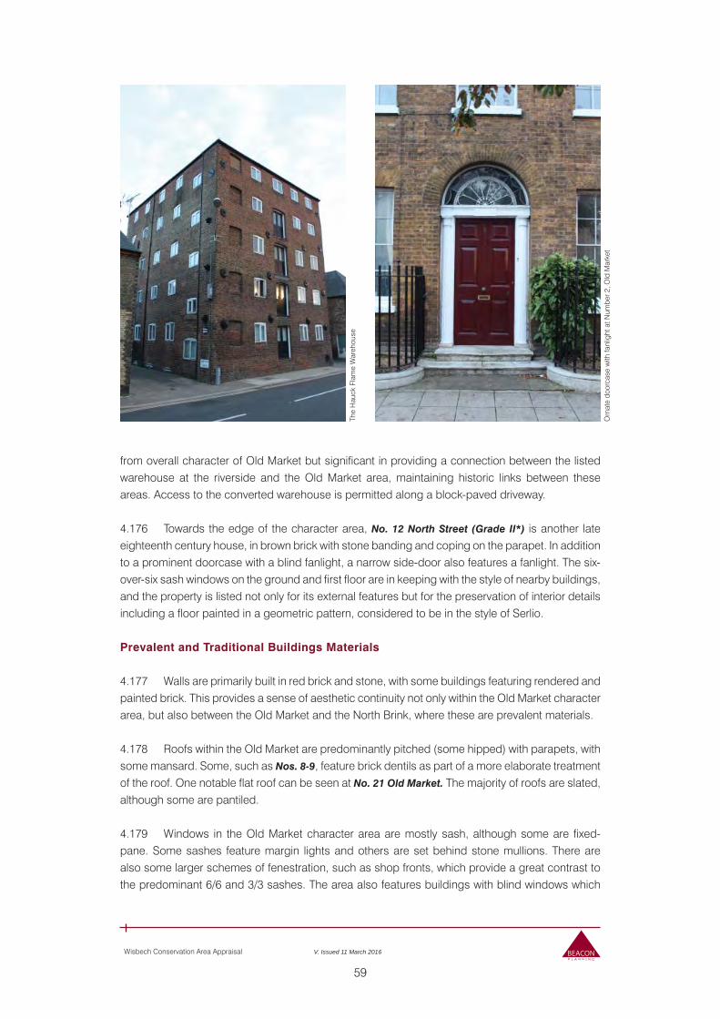
59
Wisbech Conservation Area Appraisal V. Issued 11 March 2016
The
Hau
ck F
lam
e W
areh
ouse
Orn
ate
door
case
with
fanl
ight
at N
umbe
r 2, O
ld M
arke
t
from overall character of Old Market but significant in providing a connection between the listed warehouse at the riverside and the Old Market area, maintaining historic links between these areas. Access to the converted warehouse is permitted along a block-paved driveway.
4.176 Towards the edge of the character area, No. 12 North Street (Grade II*) is another late eighteenth century house, in brown brick with stone banding and coping on the parapet. In addition to a prominent doorcase with a blind fanlight, a narrow side-door also features a fanlight. The six-over-six sash windows on the ground and first floor are in keeping with the style of nearby buildings, and the property is listed not only for its external features but for the preservation of interior details including a floor painted in a geometric pattern, considered to be in the style of Serlio.
Prevalent and Traditional Buildings Materials
4.177 Walls are primarily built in red brick and stone, with some buildings featuring rendered and painted brick. This provides a sense of aesthetic continuity not only within the Old Market character area, but also between the Old Market and the North Brink, where these are prevalent materials.
4.178 Roofs within the Old Market are predominantly pitched (some hipped) with parapets, with some mansard. Some, such as Nos. 8-9, feature brick dentils as part of a more elaborate treatment of the roof. One notable flat roof can be seen at No. 21 Old Market. The majority of roofs are slated, although some are pantiled.
4.179 Windows in the Old Market character area are mostly sash, although some are fixed-pane. Some sashes feature margin lights and others are set behind stone mullions. There are also some larger schemes of fenestration, such as shop fronts, which provide a great contrast to the predominant 6/6 and 3/3 sashes. The area also features buildings with blind windows which
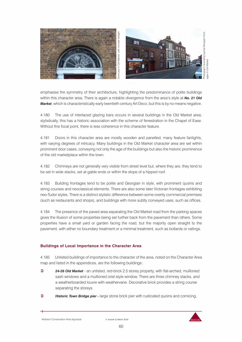
60
Wisbech Conservation Area Appraisal V. Issued 11 March 2016
Doo
rcas
e in
Old
Mar
ket,
with
intri
cate
fanl
ight
Pho
togr
aph
illus
tratin
g ty
pica
l Geo
rgia
n fro
nt-
ages
in O
ld M
arke
t
emphasise the symmetry of their architecture, highlighting the predominance of polite buildings within this character area. There is again a notable divergence from the area’s style at No. 21 Old
Market, which is characteristically early twentieth century Art Deco, but this is by no means negative.
4.180 The use of interlaced glazing bars occurs in several buildings in the Old Market area; stylistically, this has a historic association with the scheme of fenestration in the Chapel of Ease. Without this focal point, there is less coherence in this character feature.
4.181 Doors in this character area are mostly wooden and panelled; many feature fanlights, with varying degrees of intricacy. Many buildings in the Old Market character area are set within prominent door cases, conveying not only the age of the buildings but also the historic prominence of the old marketplace within the town.
4.182 Chimneys are not generally very visible from street level but, where they are, they tend to be set in wide stacks, set at gable ends or within the slope of a hipped roof.
4.183 Building frontages tend to be polite and Georgian in style, with prominent quoins and string courses and neoclassical elements. There are also some later Victorian frontages exhibiting neo-Tudor styles. There is a distinct stylistic difference between some overtly commercial premises (such as restaurants and shops), and buildings with more subtly conveyed uses, such as offices.
4.184 The presence of the paved area separating the Old Market road from the parking spaces gives the illusion of some properties being set further back from the pavement than others. Some properties have a small yard or garden facing the road, but the majority open straight to the pavement, with either no boundary treatment or a minimal treatment, such as bollards or railings.
Buildings of Local Importance in the Character Area
4.185 Unlisted buildings of importance to the character of the area, noted on the Character Area map and listed in the appendices, are the following buildings:
24-26 Old Market - an unlisted, red-brick 2.5 storey property, with flat-arched, mullioned sash windows and a mullioned oriel-style window. There are three chimney stacks, and a weatherboarded louvre with weathervane. Decorative brick provides a string course separating the storeys.
Historic Town Bridge pier - large stone brick pier with rusticated quoins and cornicing,
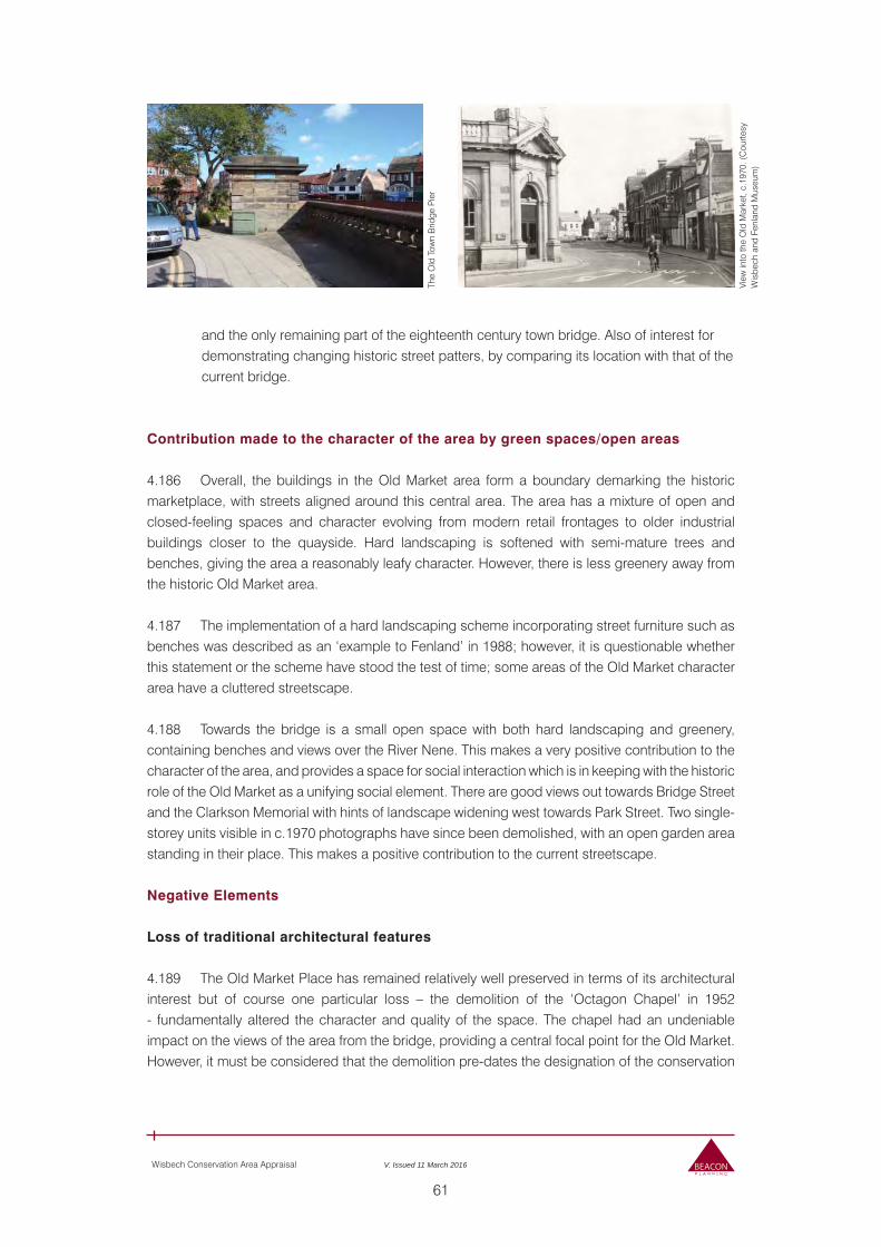
61
Wisbech Conservation Area Appraisal V. Issued 11 March 2016
The
Old
Tow
n B
ridge
Pie
r
View
into
the
Old
Mar
ket,
c.19
70. (
Cou
rtesy
W
isbe
ch a
nd F
enla
nd M
useu
m)
and the only remaining part of the eighteenth century town bridge. Also of interest for demonstrating changing historic street patters, by comparing its location with that of the current bridge.
Contribution made to the character of the area by green spaces/open areas
4.186 Overall, the buildings in the Old Market area form a boundary demarking the historic marketplace, with streets aligned around this central area. The area has a mixture of open and closed-feeling spaces and character evolving from modern retail frontages to older industrial buildings closer to the quayside. Hard landscaping is softened with semi-mature trees and benches, giving the area a reasonably leafy character. However, there is less greenery away from the historic Old Market area.
4.187 The implementation of a hard landscaping scheme incorporating street furniture such as benches was described as an ‘example to Fenland’ in 1988; however, it is questionable whether this statement or the scheme have stood the test of time; some areas of the Old Market character area have a cluttered streetscape.
4.188 Towards the bridge is a small open space with both hard landscaping and greenery, containing benches and views over the River Nene. This makes a very positive contribution to the character of the area, and provides a space for social interaction which is in keeping with the historic role of the Old Market as a unifying social element. There are good views out towards Bridge Street and the Clarkson Memorial with hints of landscape widening west towards Park Street. Two single-storey units visible in c.1970 photographs have since been demolished, with an open garden area standing in their place. This makes a positive contribution to the current streetscape.
Negative Elements
Loss of traditional architectural features
4.189 The Old Market Place has remained relatively well preserved in terms of its architectural interest but of course one particular loss – the demolition of the ‘Octagon Chapel’ in 1952 - fundamentally altered the character and quality of the space. The chapel had an undeniable impact on the views of the area from the bridge, providing a central focal point for the Old Market. However, it must be considered that the demolition pre-dates the designation of the conservation
62
Wisbech Conservation Area Appraisal V. Issued 11 March 2016
area; while the chapel certainly influenced the pattern of building in the area, it should not be an active consideration when evaluating the features of this area.
Buildings and areas that make a negative impact
4.190 Some more recent buildings, such as No.33a, make a negative contribution to the streetscape, due to unsympathetic frontages that neither preserve nor enhance the aesthetic of the surrounding area.
Public Realm/Signage
4.191 The 1980s landscaping scheme incorporated the existing division of the historic marketplace and accommodated both traffic and footfall. Trees help soften hard landscaping measures.
Neutral Elements
4.192 There are neutral buildings in the streetscape due to their state of disrepair, and the neglect of the shop frontages. Of particular detriment to the area is the poor state of sash windows on some properties. However, were these problems rectified, such properties could make a positive contribution to the character area, retaining clear visual links to the commercial origins of the area.
4.193 In some cases the poor condition of a building’s render, and excessive signage, prevents it from making a positive contribution to the character area.
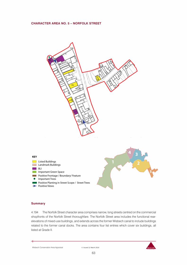
63
Wisbech Conservation Area Appraisal V. Issued 11 March 2016
CHARACTER AREA NO. 5 – NORFOLK STREET
Summary
4.194 The Norfolk Street character area comprises narrow, long streets centred on the commercial shopfronts of the Norfolk Street thoroughfare. The Norfolk Street area includes the functional rear-elevations of mixed-use buildings, and extends across the former Wisbech canal to include buildings related to the former canal docks. The area contains four list entries which cover six buildings, all listed at Grade II.
KEY
Listed BuildingsLandmark Buildings
Positive Planting in Street Scope / Street TreesPositive Views
Positive Frontage / Boundary/ FeatureImportant Trees
BLIImportant Green Space 5
2
34
1
Ward Bdy
ED & W
ard Bdy
ED & Ward
Bdy
ED & Ward Bdy
1
Nene
NapierBoyden C
Hanchan
t Court
1a91
44
38
55
37
41
85
88
98
3a
52
97
E
1 2
23b
104
18a
108
Palmers Place
Chapel ate
n's House
1 6
115
21 to
to 21o 5
1 to 9
Nursery
1 to 21
1 to 12
2 to 3
2
1
9 to 15
1 to 11
21 to 24
18 to 21
26 to 30
39
11 to 15
Trinity Methodist
Siggees Passage
7
20
83
1
7
4
36
34
16
30
42
PH
39
18 34
1
3
25
273
10
33
50
44
1835
2917
13
51
42
1
22
87
TCB6.1m
4.9m
5.8m
Car
Park
KING STREET
EARL STREE
ALK
ST PAUL'S CLOSE
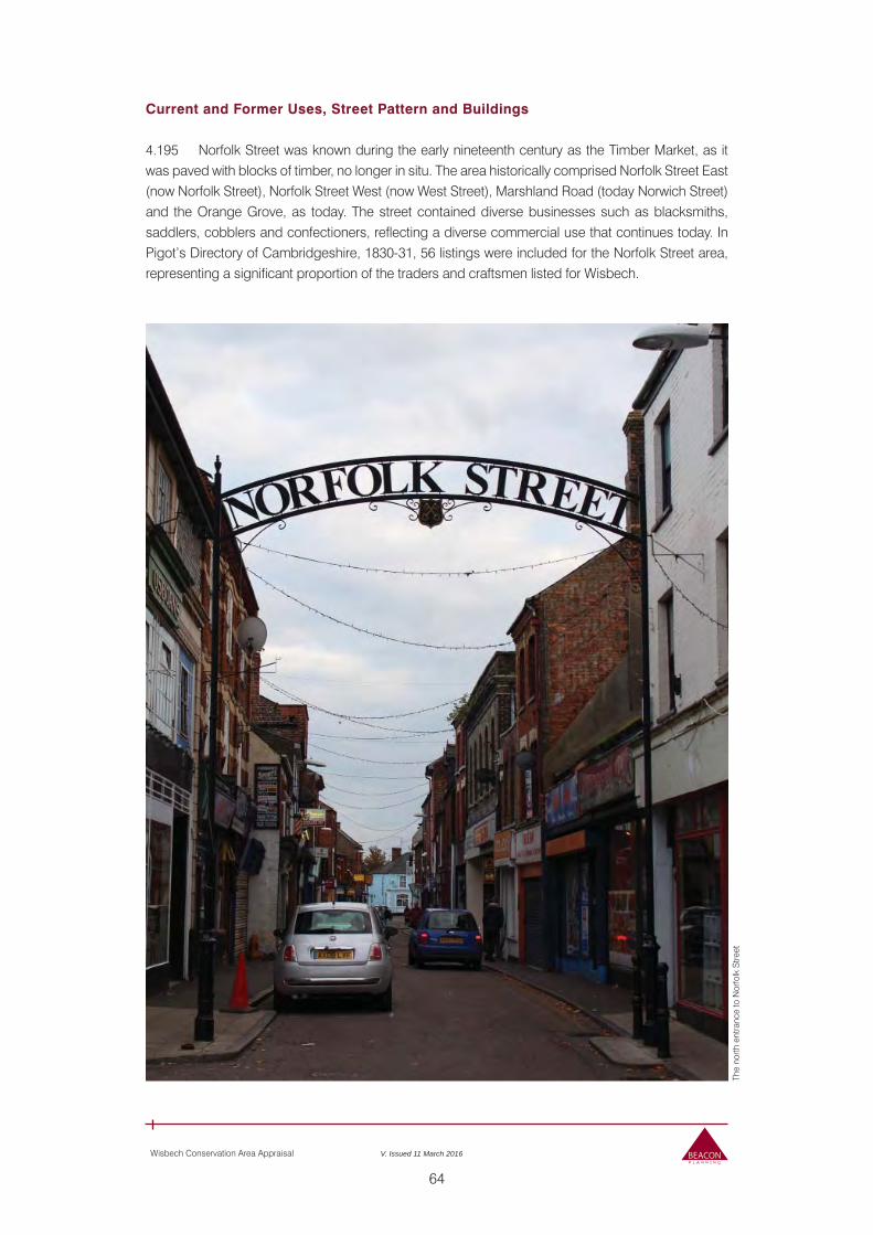
64
Wisbech Conservation Area Appraisal V. Issued 11 March 2016
Current and Former Uses, Street Pattern and Buildings
4.195 Norfolk Street was known during the early nineteenth century as the Timber Market, as it was paved with blocks of timber, no longer in situ. The area historically comprised Norfolk Street East (now Norfolk Street), Norfolk Street West (now West Street), Marshland Road (today Norwich Street) and the Orange Grove, as today. The street contained diverse businesses such as blacksmiths, saddlers, cobblers and confectioners, reflecting a diverse commercial use that continues today. In Pigot’s Directory of Cambridgeshire, 1830-31, 56 listings were included for the Norfolk Street area, representing a significant proportion of the traders and craftsmen listed for Wisbech.
The
north
ent
ranc
e to
Nor
folk
Stre
et
65
Wisbech Conservation Area Appraisal V. Issued 11 March 2016
Ext
ract
from
188
9 O
rdna
nce
Sur
vey
Map
sho
win
g N
orfo
lk S
treet
Are
a (C
ourte
sy o
f Wis
bech
and
Fe
nlan
d M
useu
m)
4.196 The properties remaining in the area today are used for predominantly retail or commercial use, with residences above shops in some buildings. Norfolk Street has been described as the secondary retail area of Wisbech, with the ‘majority of occupiers’ being local businesses.
4.197 West Street, adjacent to Norfolk Street, is a more residential road and features the rear of commercial buildings, but far fewer shop fronts. The street is not as built up as Norfolk Street, likely as a result of its residential use.
4.198 Norwich Road, historically Marshland Road, is a continuation of the character area on the opposite side of Churchill Road / the A1101. Historically this street was once linked to Norfolk Street
Nor
folk
Stre
et s
ign
ackn
owle
dgin
g hi
stor
ic n
ame
66
Wisbech Conservation Area Appraisal V. Issued 11 March 2016
The
Ora
nge
Gro
ve
Roy
al P
lace
, with
arc
hway
at e
ntra
nce
to N
or-
folk
Stre
et v
isib
le a
t the
ext
rem
e rig
ht
by a bridge over the canal, and the canal’s replacement with the dual carriage has disconnected it somewhat from the historic core of the town. The street is primarily residential in character, with some small commercial enterprises such as a hair salon, take-away restaurant and convenience store. In terms of the ratio between commercial and residential building use, Norwich Road is most similar to West Street. Nos. 13 and 15 Norwich Road (Grade II) are two early nineteenth century shops on the corner of Norwich Road, and are notable in their surroundings, although their setting is compromised by their proximity to Churchill Road.
4.199 The Wisbech-Outwell canal, dug in 1794 and opened in 1796, took the pre-medieval route of the River Ouse. However, the canal closed in 1939 following years of difficulty maintaining a head of water, as well as silting, and was infilled during the 1960s to form the A1101 Churchill Road link. As a major route circumnavigating the historic centre of Wisbech, the road and former canal has informed patterns of building.
4.200 The Orange Grove road comprises the predominantly brick-built rear of residences, commercial enterprises and restaurants, with the distinctive canopied-entrance to the Bengal Spice Take-Away a striking, albeit negative, feature. There are several areas in which bins and refuse appears to be stored, and around these spaces were considerable deposits of litter, punctuating a generally negative streetscape dominated by the busy A1101 road.
4.201 Royal Place, adjacent to the entrance of Norfolk Street, is a small road with several buildings which are currently in a neglected state, featuring mixed materials and boarded-up shop windows. These make a negative contribution to the streetscape and to the entrance of the Norfolk Street Conservation Area.
Architectural and Historic Qualities Contributing to Special Interest of the Conservation Area
4.202 The Norfolk Street area is of special interest to the Wisbech Conservation Area as a historic commercial hub, and the streetscape of shop fronts along Norfolk Street with the residential use to the rear of these buildings along West Street and Orange Grove maintains this link.
4.203 The area was diverse historically in terms of the acvitities and businesses that occupied the street, and this is reflected in the interesting range of structures arrayed along the road, including historic inns, shops, residential units, and even a thatched building evoking an earlier fens architectural tradition.
67
Wisbech Conservation Area Appraisal V. Issued 11 March 2016
Nor
folk
Stre
et lo
okin
g no
rth, d
ispl
ayin
g so
met
hing
of
the
hist
oric
sho
pfro
nt c
hara
cter
of t
he s
treet
No.
8 N
orfo
lk S
treet
Prevalent and Traditional Buildings Materials
4.204 The prevalent building material in the Norfolk Street area is brick; this material is displayed painted, rendered and untreated. Although constructed with this material in common, the shopfronts and decorative schemes on Norfolk Street are visually diverse and colourful, creating a busy and vibrant atmosphere through the use of bright paint and ornamental shop façades.
4.205 Roofs in the Norfolk Street area are predominantly clay tiled, although there is one notable thatched roof at No. 8 Norfolk Street (Grade II). This is anomalous in the predominantly tiled roofscape, but speaks to a historic fenland building style which is now under-represented in the town. Most roofs are pitched, except for a flurry of mansard roofs with dormer windows along Norwich Road, and some flat-roofed residential buildings.
4.206 The treatment of eaves and parapets within the character area varies with building-styles; brick dentils and painted soffit boards are found alongside square parapets, and of course the projecting eaves under the thatched roof of number 8 Norfolk Street. The decorative corbel brackets of numbers 1-2 Norfolk Street are a positive detail unique in the Norfolk Street roofscape.
4.207 Chimneys are not very visible from Norfolk Street due to the constrained views of high building at each side of the road. However, where they are visible, chimneys tend to be formed in wide brick stacks at gable ends and feature relatively plain chimney-pots.
4.208 Window styles vary in this character area. Facing Norfolk Street, fenestration is mostly characterised by single- or large-panes in shop windows at ground floor level, and sash windows at first floor and above. However, uPVC windows – some of a low quality - are also prevalent within the street scene, with a particularly high concentration in the Norwich Road area.
Win
dow
s at
firs
t flo
or le
vel
Nos
. 1-2
Nor
folk
Stre
et
68
Wisbech Conservation Area Appraisal V. Issued 11 March 2016
No.
114
Nor
folk
Stre
et
Trad
ition
al s
hop
front
sty
le o
f num
ber 9
3 N
orfo
lk S
treet
4.209 A notable exception to this style is found at Nos. 1-2 Norfolk Street, which features early twentieth century shopfront fenestration in a style that is markedly different to that of nearby buildings, making a positive contribution to the entrance of Norfolk Street and emphasising the commercial nature of the road.
4.210 No. 114 Norfolk Street, opposite Nos. 1-2, also features interesting early twentieth century-style fenestration at ground floor level; while it is not as striking as Nos. 1-2, the use of leaded margin lights and crossed leading to create a central glazed diamond in the fanlight and top panes of the shop-front windows is visually different to patterns of fenestration along the street. No. 93
Norfolk Street also features differentiated fenestration at a ground floor level, with small lead panes above larger shop window panes in a traditional style.
4.211 Similarly, the Crittall-style casement windows above No. 106 Norfolk Street are visually interesting due to its contrast with the neighbouring sash styles, and the variation between the oriel window of No. 9 and the mullion-and-transom style windows of Nos. 10 Norfolk Street emphasise how stylistic diversity feeds into the character of the street.
4.212 Doors are mostly glazed shop doors or six-panelled doors in a modern style, but do not reflect a coherent local or period style, and are not all of a type in keeping with the character of the building.
4.213 Buildings are largely terraced, but some feature passageways between properties at a ground-floor level only. These passages between buildings tend to be gated, with either metal or wooden gates. Where metal is used, this emphasises the presence of the space by permitting passers-by to view the extent of the passageway; the use of gates which obscure this view limit public understanding of the spatial relationship between buildings and passageways.
4.214 Building frontages in the Norfolk Street character area fall functionally into two categories: commercial and residential. Commercial shop frontages vary; some are glazed with shop interior visible, but some windows obscured with retail signage. Where windows are obscured with signage, this is not necessarily detrimental; the use of colour emphasises the architectural variations in the size and shape of buildings and of building plots. However, in instances such as at Nos. 10
and 110-112 Norfolk Street, this signage can become distracting in a manner detrimental to the streetscape. Similarly, the closure of openings in the Norfolk Street Post Office with red hoardings detracts from the open commercial presentation of the rest of Norfolk Street.

69
Wisbech Conservation Area Appraisal V. Issued 11 March 2016
97a
Nor
folk
Stre
et
Aw
ning
arm
s vi
sibl
e on
num
ber 2
9 N
orfo
lk S
treet
H. C
undy
’s re
ar e
ntra
nce,
at t
he b
ack
of N
um-
ber 9
4 N
orfo
lk S
treet
4.215 Nos. 93 and 94 Norfolk Street are interesting examples of commercial frontages as they present two architecturally connected shop fronts, with a stylistic unity in the retention of shopfront proportions, the initial ‘R’ on the console brackets between the shopfronts, and a pinwheel design on both the inside and outside console brackets of each shopfront. The retention of these details is a positive contribution to the streetscape; however, the contrast between the higher rate of retention at No. 93 and the modifications made to No. 94 are a notable contrast. This is particularly clear in relation to the loss of the decorated stallriser, (replaced at No. 94 with a feature evocative of a record player), horizontal astragals at fanlight level, and tiled mosaic entrance, all retained at No. 93.
4.216 The retention of traditional architectural features such as the arms of awnings and sun blinds from shop fronts is inconsistent, with such fixtures visible on 29 Norfolk Street but absent from other premises, which is regrettable. Similarly, the presence of the lobby gate and tiled entrance at 106 Norfolk Street is a positive example of the retention of a feature in a manner sympathetic to the architecture’s history and the existing business’s need to promote their name.
4.217 Norfolk Street retains some traditional shop-fronts with tiled entrances and decorated windows. Examples of this can be seen at Nos. 97 and 97a Norfolk Street (Grade II), which feature matching window frames and stylised fleur-de-lis entrance mosaics. However, the unauthorised uPVC windows detract from the historic interest of the building and undermine its contribution to the character area, due to the unsympathetic replacement of historic fabric.
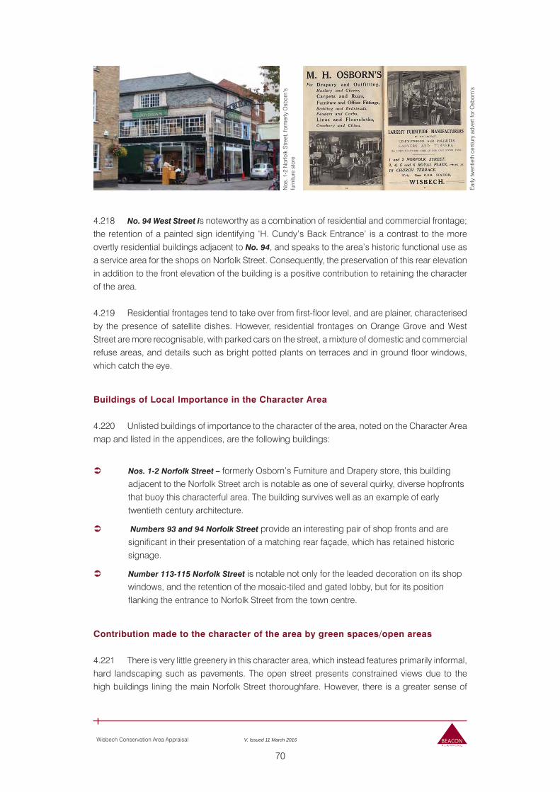
70
Wisbech Conservation Area Appraisal V. Issued 11 March 2016
4.218 No. 94 West Street is noteworthy as a combination of residential and commercial frontage; the retention of a painted sign identifying ‘H. Cundy’s Back Entrance’ is a contrast to the more overtly residential buildings adjacent to No. 94, and speaks to the area’s historic functional use as a service area for the shops on Norfolk Street. Consequently, the preservation of this rear elevation in addition to the front elevation of the building is a positive contribution to retaining the character of the area.
4.219 Residential frontages tend to take over from first-floor level, and are plainer, characterised by the presence of satellite dishes. However, residential frontages on Orange Grove and West Street are more recognisable, with parked cars on the street, a mixture of domestic and commercial refuse areas, and details such as bright potted plants on terraces and in ground floor windows, which catch the eye.
Buildings of Local Importance in the Character Area
4.220 Unlisted buildings of importance to the character of the area, noted on the Character Area map and listed in the appendices, are the following buildings:
Nos. 1-2 Norfolk Street – formerly Osborn’s Furniture and Drapery store, this building adjacent to the Norfolk Street arch is notable as one of several quirky, diverse hopfronts that buoy this characterful area. The building survives well as an example of early twentieth century architecture.
Numbers 93 and 94 Norfolk Street provide an interesting pair of shop fronts and are significant in their presentation of a matching rear façade, which has retained historic signage.
Number 113-115 Norfolk Street is notable not only for the leaded decoration on its shop windows, and the retention of the mosaic-tiled and gated lobby, but for its position flanking the entrance to Norfolk Street from the town centre.
Contribution made to the character of the area by green spaces/open areas
4.221 There is very little greenery in this character area, which instead features primarily informal, hard landscaping such as pavements. The open street presents constrained views due to the high buildings lining the main Norfolk Street thoroughfare. However, there is a greater sense of
Nos
. 1-2
Nor
folk
Stre
et, f
orm
erly
Osb
orn’
s fu
rnitu
re s
tore
Ear
ly tw
entie
th c
entu
ry a
dver
t for
Osb
orn’
s
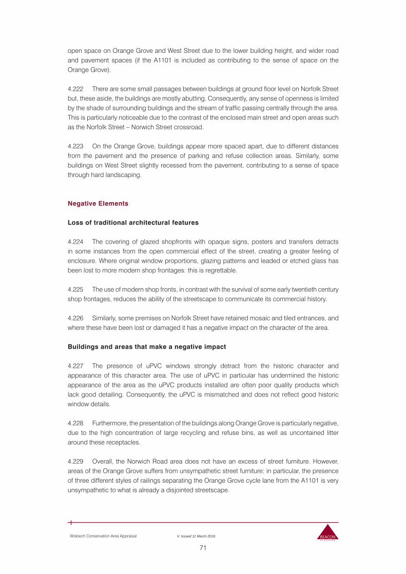
71
Wisbech Conservation Area Appraisal V. Issued 11 March 2016
open space on Orange Grove and West Street due to the lower building height, and wider road and pavement spaces (if the A1101 is included as contributing to the sense of space on the Orange Grove).
4.222 There are some small passages between buildings at ground floor level on Norfolk Street but, these aside, the buildings are mostly abutting. Consequently, any sense of openness is limited by the shade of surrounding buildings and the stream of traffic passing centrally through the area. This is particularly noticeable due to the contrast of the enclosed main street and open areas such as the Norfolk Street – Norwich Street crossroad.
4.223 On the Orange Grove, buildings appear more spaced apart, due to different distances from the pavement and the presence of parking and refuse collection areas. Similarly, some buildings on West Street slightly recessed from the pavement, contributing to a sense of space through hard landscaping.
Negative Elements
Loss of traditional architectural features
4.224 The covering of glazed shopfronts with opaque signs, posters and transfers detracts in some instances from the open commercial effect of the street, creating a greater feeling of enclosure. Where original window proportions, glazing patterns and leaded or etched glass has been lost to more modern shop frontages: this is regrettable.
4.225 The use of modern shop fronts, in contrast with the survival of some early twentieth century shop frontages, reduces the ability of the streetscape to communicate its commercial history.
4.226 Similarly, some premises on Norfolk Street have retained mosaic and tiled entrances, and where these have been lost or damaged it has a negative impact on the character of the area.
Buildings and areas that make a negative impact
4.227 The presence of uPVC windows strongly detract from the historic character and appearance of this character area. The use of uPVC in particular has undermined the historic appearance of the area as the uPVC products installed are often poor quality products which lack good detailing. Consequently, the uPVC is mismatched and does not reflect good historic window details.
4.228 Furthermore, the presentation of the buildings along Orange Grove is particularly negative, due to the high concentration of large recycling and refuse bins, as well as uncontained litter around these receptacles.
4.229 Overall, the Norwich Road area does not have an excess of street furniture. However, areas of the Orange Grove suffers from unsympathetic street furniture: in particular, the presence of three different styles of railings separating the Orange Grove cycle lane from the A1101 is very unsympathetic to what is already a disjointed streetscape.
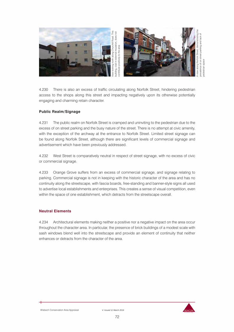
72
Wisbech Conservation Area Appraisal V. Issued 11 March 2016
4.230 There is also an excess of traffic circulating along Norfolk Street, hindering pedestrian access to the shops along this street and impacting negatively upon its otherwise potentially engaging and charming retain character.
Public Realm/Signage
4.231 The public realm on Norfolk Street is cramped and uninviting to the pedestrian due to the excess of on street parking and the busy nature of the street. There is no attempt at civic amenity, with the exception of the archway at the entrance to Norfolk Street. Limited street signage can be found along Norfolk Street, although there are significant levels of commercial signage and advertisement which have been previously addressed.
4.232 West Street is comparatively neutral in respect of street signage, with no excess of civic or commercial signage.
4.233 Orange Grove suffers from an excess of commercial signage, and signage relating to parking. Commercial signage is not in keeping with the historic character of the area and has no continuity along the streetscape, with fascia boards, free-standing and banner-style signs all used to advertise local establishments and enterprises. This creates a sense of visual competition, even within the space of one establishment, which detracts from the streetscape overall.
Neutral Elements
4.234 Architectural elements making neither a positive nor a negative impact on the area occur throughout the character area. In particular, the presence of brick buildings of a modest scale with sash windows blend well into the streetscape and provide an element of continuity that neither enhances or detracts from the character of the area.
View
look
ing
north
alo
ng C
hurc
hill
Roa
d. T
his
build
ing,
cla
d in
ext
erna
l ins
ulat
ion,
doe
s no
t co
ntrib
ute
posi
tivel
y to
the
area
A v
iew
alo
ng N
orfo
lk S
treet
, dem
onst
ratin
g th
e pr
eval
ence
of o
n st
reet
par
king
and
lack
of
pede
stria
n sp
ace
73
Wisbech Conservation Area Appraisal V. Issued 11 March 2016
5.0 ISSUES AND BOUNDARY CONSIDERATIONS
Current Issues
5.01 Despite the Conservation Area’s undoubtedly interesting, varied and in some cases high quality architectural interest, one of the key issues currently facing the area as a whole – although some parts more than others – is the number of Buildings At Risk (BaRs), some of which are listed. Whilst in many cases the buildings, if repaired and/or stabilised, would contribute positively to the character and appearance of the area, their current condition is a matter of concern for the preservation of the Conservation Area. These BaRs are detailed at length in the accompanying Conservation Management Plan, which provides information on the ongoing management of the Conservation Area and should be read alongside this document.
The Conservation Area Boundary
5.02 During the process of appraisal, consideration was given to whether any changes to the boundary of the Conservation Area would be necessary. It was considered that there was not a need to consider a boundary alteration at this time, although future assessments undertaken from time to time as part of the ongoing management of the area will consider this issue afresh.
74
Wisbech Conservation Area Appraisal V. Issued 11 March 2016
6.0 COMMUNITY FEEDBACK
6.01 In accordance with S71 Planning (Listed Buildings and Conservation Areas) Act 1990, the Conservation Area Appraisal (2015) and Conservation Area Management Plan (2015) were put to public consultation from Monday 23rd November 2015 to Monday 11th January 2016. The consultation was undertaken in the following way:
Public Display – A public display was presented in the One Stop Shop, Bridge Street, Wisbech during the consultation period. The display consisting of information boards with copies of the documents available for review. The public were able to leave feedback within the One Stop Shop.
Public Event – On Thursday 26th November 2015 members of Fenland District Council’s Conservation Team alongside Beacon Planning were available at the One Stop Shop in Wisbech to answer any questions regarding this document.
Web Site Publicity – Copies of the Conservation Area Appraisal (2015) and the Conservation Area Management Plan (2015) were available to download on Fenland District Council’s website via the following link:www.fenland.gov.uk/wisbechconservationareaconsultation
In addition to this, feedback was able to be left via e mailing: [email protected]
Advertising – The consultation period was advertised at the beginning by means of a press release. Within the press release the dates of the consultation period were cited alongside the details of where the documents can be viewed. This press release was covered by the local papers and was also picked up through social media.
Advertising – The consultation period has been advertised by means of a public notice with the local paper, Fenland Citizen. The public notice was issued as a timely reminder on Wednesday 18th December 2015. It cited the dates of the consultation period, where documents could be reviewed and how comments could be made.
E Mail – The Wisbech High Street Consultative Group have also been informed of the consultation period via e mail. This group is concerned with the development of the Wisbech High Street HLF bid and has a specific interest in the interests and management of the Wisbech Conservation Area.
6.02 Following the consultation, feedback from the community was taken into account and this document amended where appropriate. A summary of the responses to the consultation can be found in the Fenland District Council Cabinet Report dated 11 January 2016.
75
Wisbech Conservation Area Appraisal V. Issued 11 March 2016
REFERENCES
Books and Archive Documents
Bell, R (2001) Wisbech: a photographic history of your town. Teffont: Black Horse Books
Bell, R (2005) Wisbech. Salisbury: Francis Frith Collection.
Bradley, S & Pevsner, N (2014) Buildings of England Series: Cambridgeshire. New Haven: Yale University Press
Darby, H.C. (1938) The Cambridge Region. Cambridge: Cambridge University Press
Galloway, B (1938) A History of Cambridgeshire. Chichester: Phillimore
Gardiner, F. J (1898) History of Wisbech and Neighbourhood, During the Last Fifty Years - 1848-1898. London: Marlborough & Co
Powell, R & Bell, R (1997) Britain in Old Photographs: Wisbech. Stroud: Sutton Publishing.
Walker, N & Craddock, T (1849) The History of Wisbech, and the Fens. Wisbech: R.Walker
Articles and Pamphlets
Burall, Paul, ‘The LA in context: Wisbech dices with Death’, Design Journal (1971), pp.66-69.
Minnis, John, ‘The Clarkson Memorial, High Street, Wisbech, Cambridgeshire: Historical Analysis’, Research Department Report Series no. 33/2007 (English Heritage: 2006).
The Story of Wainman House (The National Trust: 2013).
Cambridgeshire Extensive Urban Survey: Wisbech, Draft Report (10/05/2002).
Maps
1850 - Plan of the Town of Wisbech with New Walsoken from Actual Survey by Fred J. Utting. (Courtesy of the Wisbech and Fenland Museum)
1867 – Map of the Town of Wisbech with New Walsoken reduced from The Board of Health Map and Revised and Corrected by Charles Mumford (Courtesy of Wisbech and Fenland Museum)
1888 1:2500 Ordnance Survey
1902 1:2500 Ordnance Survey
1927 1:2500 Ordnance Survey
1959 1:10560 Ordnance Survey
76
Wisbech Conservation Area Appraisal V. Issued 11 March 2016
1970 1:2500 Ordnance Survey
1973 1:10000 Ordnance Survey
1977 1:2500 Ordnance Survey
1991 1:10000 Ordnance Survey
Current Ordnance Survey (Courtesy of Fenland District Council)
Websites
• http://risk.historicengland.org.uk/register.aspx?id=1267727&rt=0&pn=1&st=a&ctype=all&crit=wisbech
• http://www.bbc.co.uk/history/domesday/dblock/GB-544000-309000/page/17
• http://www.britainfromabove.org.uk/ (http://www.britainfromabove.org.uk/asearch?name=WISBECH&gazetteer=WISBECH&POPULATED_PLACE=WISBECH&COUNTY=Cambridgeshire&ADMIN_AREA=Fenland)
• http://www.british-history.ac.uk/vch/cambs/vol4/pp238-243
• http://www.buildingpreservation.org.uk/sulehay.html
• http://www.eafa.org.uk/catalogue/2977
• http://www.fenland.gov.uk/article/2173/Wisbech-History
• http://www.francisfrith.com/wisbech
• http://www.genuki.org.uk/big/eng/CAM/Wisbech/
• http://www.localhistories.org/wisbech.html
• http://www.nationaltrust.org.uk/peckover-house/visitor-information/
• http://www.nationaltrustcollections.org.uk/
• http://www.octaviahill.org/centenary-green-appeal/
• http://www.specialcollections.le.ac.uk/cdm/landingpage/collection/p16445coll4
• http://www.strideguides.com/Wisbech/index.html
• http://www.visionofbritain.org.uk/place/431
• http://www.wisbech.ccan.co.uk/
• http://www.wisbechmuseum.org.uk/
• http://www.wisbech-society.co.uk/
• https://content.historicengland.org.uk/images-books/publications/understanding-place-conservation-area/understanding-place-ca-designation-appraisal-management.pdf/
• https://www.historicengland.org.uk/listing/the-list/