appraisal technology, llc - adot
TRANSCRIPT
APPRAISAL TECHNOLOGY, LLC
220 South River Drive Tempe, Arizona 85281 (480) 446-9600 Fax: (480) 446-9615
AN APPRAISAL REPORT OF THE VACANT LAND LOCATED ON THE NORTHEAST
CORNER OF 14TH STREET AND WAHALLA LANE IN PHOENIX, MARICOPA
COUNTY, ARIZONA.
PREPARED FOR
ARIZONA DEPARTMENT OF TRANSPORTATION
RIGHT OF WAY OPERATIONS SECTION
205 SOUTH 17TH AVENUE, ROOM 331, MAIL DROP 612E
PHOENIX, ARIZONA 85007
ATTENTION
MR. TIMOTHY O'CONNELL
R/W PROJECT MANAGEMENT SECTION
CONTRACT: 2016-018.01
APPRAISAL ASSIGNMENT NO: TO-19-040
PROJECT: M697201X
HIGHWAY: SR 101 – NORTHEAST OUTER LOOP
SECTION: I-17 – CAVE CREEK ROAD
PARCEL: L-M-486
A.T. I. FILE NO.: VZZ56219O
DATE OF REPORT
AUGUST 5, 2019
EFFECTIVE DATE OF APPRAISAL
AUGUST 14, 2019
PREPARED BY
ZACH SINAY, MAI, R/W-AC
CERTIFIED GENERAL REAL ESTATE APPRAISER CERTIFICATE NO. 31199
August 14, 2019
A.T.I. File No.: VZZ56219O
TO: ARIZONA DEPARTMENT OF TRANSPORTATION
Right of Way Operations Section
205 South 17th Avenue, Room 331, Mail Drop 612E
Phoenix, Arizona 85007
RE: PROJECT: M697201X
HIGHWAY: SR 101 – NORTHEAST OUTER LOOP
SECTION: I-17 – CAVE CREEK ROAD
PARCEL: L-M-486
ATTN: Mr. Timothy O'Connell
R/W Project Management Section
RE: An Appraisal Report of the vacant land located on the northeast corner of 14th Street and
Wahalla Lane in Phoenix, Maricopa County, Arizona.
Dear Mr. O'Connell:
As requested, I have appraised the “As Is” Market Value of the aforementioned property. The
intended use for this appraisal is to assist in decisions regarding the disposition of the property for
eminent domain purposes, as of the effective date of value, or August 5, 2019.
The value estimate is supported by market analysis, which is communicated through a Narrative
Appraisal Report plus exhibits, which describes and identifies methods of approach and valuation.
The appraisal and report were prepared in conformity with the appraisal requirements of the Arizona
Department of Transportation and the Federal Highway Administration., Uniform Standards of
Professional Appraisal Practice, 2018-2019 (USPAP), and Uniform Relocation Assistance and Real
Property Acquisition Policies Act of 1970, as Amended (URA), as described in part 49 CFR
24.2(a)(3).
I have performed no services, as an appraiser or in any other capacity, regarding the property that is
the subject of this report within the three-year period immediately preceding acceptance of this
assignment.
APPRAISAL TECHNOLOGY, LLC
220 South River Drive Tempe, Arizona 85281 (480) 446-9600 Fax: (480) 446-9615
Appraisal Technology, LLC 3
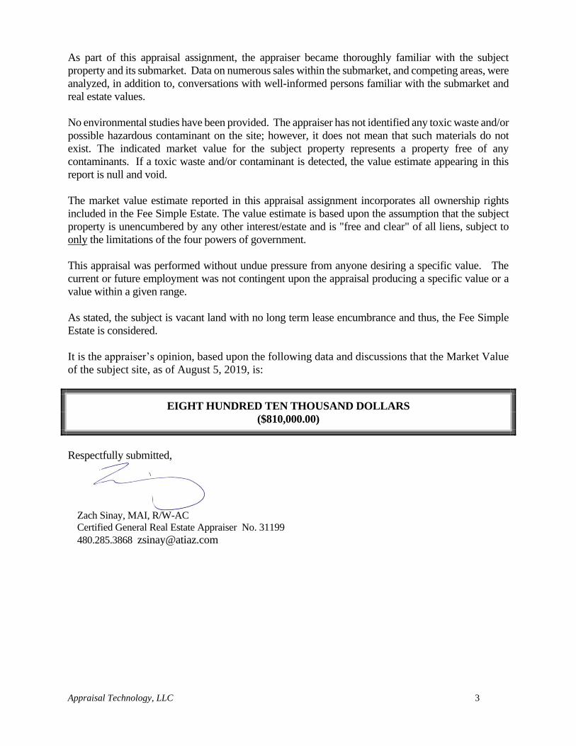
As part of this appraisal assignment, the appraiser became thoroughly familiar with the subject
property and its submarket. Data on numerous sales within the submarket, and competing areas, were
analyzed, in addition to, conversations with well-informed persons familiar with the submarket and
real estate values.
No environmental studies have been provided. The appraiser has not identified any toxic waste and/or
possible hazardous contaminant on the site; however, it does not mean that such materials do not
exist. The indicated market value for the subject property represents a property free of any
contaminants. If a toxic waste and/or contaminant is detected, the value estimate appearing in this
report is null and void.
The market value estimate reported in this appraisal assignment incorporates all ownership rights
included in the Fee Simple Estate. The value estimate is based upon the assumption that the subject
property is unencumbered by any other interest/estate and is "free and clear" of all liens, subject to
only the limitations of the four powers of government.
This appraisal was performed without undue pressure from anyone desiring a specific value. The
current or future employment was not contingent upon the appraisal producing a specific value or a
value within a given range.
As stated, the subject is vacant land with no long term lease encumbrance and thus, the Fee Simple
Estate is considered.
It is the appraiser’s opinion, based upon the following data and discussions that the Market Value
of the subject site, as of August 5, 2019, is:
EIGHT HUNDRED TEN THOUSAND DOLLARS
($810,000.00)
Respectfully submitted,
Zach Sinay, MAI, R/W-AC
Certified General Real Estate Appraiser No. 31199
480.285.3868 [email protected]
Appraisal Technology, LLC 4
TABLE OF CONTENTS
FACTS AND CONCLUSIONS ................................................................................................... 5
SCOPE OF WORK....................................................................................................................... 6
AREA MAP ................................................................................................................................. 13
NEIGHBORHOOD MAP .......................................................................................................... 30
NEIGHBORHOOD DATA ANALYSIS ................................................................................... 30
SUBJECT PHOTOGRAPHS .................................................................................................... 36
PLAT MAP .................................................................................................................................. 41
AERI AL VIEW .......................................................................................................................... 43
SITE DATA ANALYSIS ............................................................................................................ 45
GENERAL PLAN ....................................................................................................................... 49
ZONING MAP ............................................................................................................................ 50
HIGHEST AND BEST USE ...................................................................................................... 51
VALUATION PROCESS ........................................................................................................... 57
SALES COMPARISON APPROACH ..................................................................................... 59
CERTIFICATION ...................................................................................................................... 82
ADDENDA
Engagement Letter ..........................................................................................................EXHIBIT 1
Title Report .....................................................................................................................EXHIBIT 2
Zoning Designation .........................................................................................................EXHIBIT 3
Contingent and Limiting Conditions ..............................................................................EXHIBIT 4
Appraisal Technology, LLC 5
FACTS AND CONCLUSIONS
TYPE OF PROPERTY Vacant land zoned for single family residential
development.
LOCATION The subject is located on the on the northeast
corner of 14th Street and Wahalla Lane in
Phoenix, Maricopa County, Arizona.
REPORT PURPOSE The purpose of this report is to provide an esti-
mate of the market value of the Fee Simple Estate
of the subject site.
INTENDED USE OF REPORT The intended use of the appraisal report is to assist
in decisions regarding the disposition of the
property.
TAX PARCEL NUMBER (S) The subject property currently does not have an
assigned parcel number, however it was previosly
identified as Parcel #213-23-007B & 010B.
SITE AREA According to information provided by the client,
the subject site totals 3.24 acres or 141,190 square
feet in size.
ZONING R1-8, Single Family Residential; City of Phoenix
FLOOD ZONE The location is within an area denoted as being in
an "X" Flood Hazard Area, as found on Federal
Emergency Management Agency Flood
Insurance Rate Map number 04013C1295L dated
October 16, 2013.
IMPROVEMENTS None
HIGHEST & BEST USE Single family residential development
EFFECTIVE DATE OF VALUE
August 5, 2019
INSPECTION DATE August 5, 2019
MARKET VALUE CONCLUSION $810,000
Appraisal Technology, LLC 6
SCOPE OF WORK
The practice of appraisal can be considered to be less of a science dictated by strict rules and more
of an art, in which rules guide the appraiser towards a trustworthy, responsible and credible
valuation. The Uniform Standards of Professional Appraisal Practice (USPAP) provides
guidelines for this process to be undertaken through the Scope of Work Rule, to which all appraisal
professionals must adhere.
The appraisal and report were prepared in conformity with the appraisal requirements of the Arizona
Department of Transportation and the Federal Highway Administration, Uniform Standards of
Professional Appraisal Practice, 2018-2019 (USPAP), and Uniform Relocation Assistance and Real
Property Acquisition Policies Act of 1970, as Amended (URA), as described in part 49 CFR
24.2(a)(3).
The USPAP 2018-2019 SCOPE OF WORK RULE states:
For each appraisal and appraisal review assignment, an appraiser must:
1. identify the problem to be solved;
2. determine and perform the scope of work necessary to develop credible assignment results;
and
3. disclose the scope of work in the report.
An appraiser must properly identify the problem to be solved in order to determine the appropriate
scope of work. The appraiser must be prepared to demonstrate that the scope of work is sufficient
to produce credible assignment results. (The Appraisal Foundation, USPAP 2018-2019 edition, Pg. U-13)
Comment: Scope of work includes, but is not limited to:
the extent to which the property is identified;
the extent to which tangible property is inspected;
the type and extent of data researched; and
the type and extent of analyses applied to arrive at opinions or conclusions.
Appraiser has broad flexibility and significant responsibility in determining the appropriate scope
of work for an appraisal, appraisal review, and appraisal consulting assignment.
Credible assignment results require support by relevant evidence and logic. The credibility of
assignment results is always measured in the context of the intended use.
For this individual assignment, the appraiser shall address the three aspects of the Scope of Work
Rule; Problem Identification, Scope of Work Acceptability and Disclosure Obligations.
PROBLEM IDENTIFICATION (PURPOSE):
An appraiser must gather and analyze information about those assignment elements that are
necessary to properly identify the appraisal or appraisal review problem to be solved. (The Appraisal
Foundation, USPAP 2018-2019 edition, Pg. U-13)
Appraisal Technology, LLC 7
The purpose of this appraisal is to estimate the Market Value of the subject site, as of August 5, 2019
(Date of Inspection).
INTENDED USE/USERS:
The use of this appraisal report is to assist in decisions regarding the disposition of the property for
eminent domain purposes. The intended users of this report are the Arizona Department of
Transportation and the Federal Highway Administration. This report is not intended for any other use
or any other users.
EFFECTIVE DATE OF APPRAISAL:
August 5, 2019
DATE OF INSPECTION:
August 5, 2019
INTEREST VALUED:
The subject property is vacant land with no known lease encumbrances and thus, the Fee Simple
Estate is considered.
The Fee Simple Estate is defined as follows:
Absolute ownership unencumbered by any other interest or estate, subject only to the limitations
imposed by the governmental powers of taxation, eminent domain, police power, and escheat.
Appraisal Institute, The Dictionary of Real Estate Appraisal, 6th ed. (Chicago: Appraisal Institute,
2015).
In the estimate of value, typically four interdependent factors must be considered as follows:
• Utility - the ability of a product to satisfy a human want, need or desire.
• Scarcity - the present or anticipated supply of an item relative to the demand for it.
• Desire - a purchaser's wish for an item to satisfy human needs (e.g., shelter, clothing,
food, companionship) or individual wants beyond the essentials to support life.
• Effective Purchasing Power - the ability of an individual or group to participate in a
market, i.e., to acquire goods and services with cash or its equivalent.
Appraisal Technology, LLC 8
MARKET VALUE DEFINITION:
Market Value shall be determined by ascertaining the most probable price estimated in terms of
cash in United States dollars or comparable market financial arrangements that the property
would bring if exposed for sale in the open market, with reasonable time allowed in which to find
a purchaser, buying with knowledge of all of the uses and purposes to which it was adapted and
for which it was capable. (Arizona Revised Statutes § 12-1122)
EXTRAORDINARY ASSUMPTION: An assumption, directly related to a specific assignment, as of the effective date of the assignment
results, which, if found to be false, could alter the appraiser’s opinions or conclusions.
Comment: Extraordinary assumptions presume as fact otherwise uncertain information about physical,
legal, or economic characteristics of the subject property; or about conditions external to the property, such
as market conditions or trends; or about the integrity of data used in an analysis. he Appraisal Foundation,
USPAP 2018-2019 edition. U-3)
HYPOTHETICAL CONDITION: A condition, directly related to a specific assignment, which is contrary to what is known by the
appraiser to exist on the effective date of the assignment results, but is used for the purpose of
analysis.
Comment: Hypothetical conditions are contrary to known facts about physical, legal, or economic
characteristics of the subject property; or about conditions external to the property, such as market
conditions or trends; or about the integrity of data used in an analysis. (The Appraisal Foundation, USPAP
2018-2019 edition. U-3)
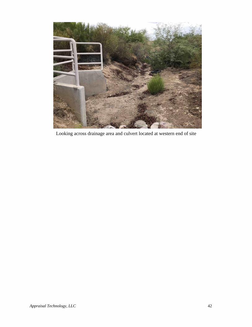
In addition to the existing easements, there is a proposed easement for a pipe culvert along the northern
border of the site. This easement will likely be put in place prior to the disposition of the property and
it is therefore a Hypothetical Condition that this easement is currently in place. This easement is not
considered to have a significant impact on the future development of the site.
SCOPE OF WORK ACCEPTABILITY:
The scope of work must include the research and analyses that are necessary to develop credible
assignment results.
An appraiser must not allow assignment conditions to limit the scope of work to such a degree that
the assignment results are not credible in the context of the intended use.
An appraiser must not allow the intended use of an assignment or a client’s objectives to cause
the assignment results to be biased. (The Appraisal Foundation, USPAP 2018-2019 edition. U-14)
The client has requested that the appraiser estimates the Market Value of the subject property. In
order to credibly perform this task, the appraiser has followed these general guidelines:
Appraisal Technology, LLC 9
- determination of problem and applicable Hypothetical Conditions or Extraordinary
Assumptions
- research on the subject property, including but not limited to: ownership history,
applicable leans and easements, physical characteristics (i.e. size, topography), relevant
subject data (i.e. leases and financial statements for income producing properties)
- selection of, research on and collection of market data for the subject neighborhood
- site inspection
- analysis and synthesis of Highest and Best Use of the subject property
- selection of valuation methodology, subsequent research as is applicable, including
market participant and market expert research (i.e. Sales Comparison Approach, Cost
Approach, Income Approach, sales or rent comparable properties)
- analysis and conclusion of valuation methodology(ies)
- reconciliation of valuation methodology results
- conclusion of probable estimated market value
DISCLOSURE OBLIGATIONS:
The report must contain sufficient information to allow intended users to understand the scope of
work performed. (The Appraisal Foundation, USPAP 2018-2019 edition. U-14)
AREA ANALYSIS DATA SOURCES:
As part of this appraisal assignment, the appraiser made a number of independent investigations
and analyses. Data retained in office files, which are updated regularly, were also relied upon.
Affidavits of Property Value were checked, along with maps, aerials and zoning obtained from the
City of Phoenix and ADOT were checked and also information provided by the client.
The Arizona State and Phoenix Metro area data was taken from many sources including, without
limitation, Arizona State University, Arizona State Department of Economic Security and the U.S.
Census Bureau.
All market data was confirmed from one or more of the following sources as indicated on the
individual sales: Maricopa County Assessor's Office (www.mcassessor.maricops.gov), Affidavit
of Property Value, Real Quest (www.realquest.com), CoStar Realty Information
(www.costar.com), FLEXMLS Data Systems (www.flexmls.com), owners or their representatives
and/or Real Estate Brokers and/or Agents.
IMPROVEMENT DESCRIPTION AND ANALYSIS:
The subject was personally inspected by Zach Sinay, MAI, R/W-AC and the conclusions are his
own. The subject description and analysis was based on my personal physical inspection,
information obtained from the client as well as Maricopa County and/or the City of Phoenix
Engineering, Planning and Zoning Departments.
LEGAL DESCRIPTION:
The subject legal description is defined in the Title Report within the addenda of this report.
Appraisal Technology, LLC 10
OWNERSHIP:
The owner of record as provided by Maricopa County is:
State of Arizona by and through its Department of Transportation
A title search has been furnished. It is an Extraordinary Assumption that there are no adverse
restrictions or easements which would affect the utility or marketability of the property.
OWNER CONTACT:
The appraiser was in contact with Mr. Tim O’Connell, a representative of the property owner, and
inspected the property without owner representation on August 5, 2019.
HISTORY:
The subject property has been under the current ownership since 1994 and 1997 for varying portions
of the subject site and was acquired for construction of the Loop 101 Freeway. It is also noted that a
portion of the site along 14th Street, has been abandoned to the City of Phoenix. This abandonment is
for future off-site and right of way construction of the eastern side of 14th Street and to retain the
drainage culvert structure located within the abandoned area.
The appraiser is unaware of any other transactions over the previous five years and the property has
not been reported as being listed for sale previously.
SCOPE OF VALUATION METHODOLOGY:
The valuation process is an orderly program in which data used to estimate value of the subject
property is acquired, classified, analyzed, and presented. The first step in the process is to define the
appraisal problem, i.e., identify the real estate, the effective date of the value estimate, the property
rights being appraised, and the type of value sought.
Once this has been accomplished, the appraiser collects and analyzes the factors that affect the fair
market value of the subject property. These factors are addressed in the area and neighborhood
analysis, the site and improvement analysis, and the highest and best use analysis. They are then
applied to the subject property in the discussion of the three approaches to value.
The Sales Comparison, Cost, and Income Capitalization Approaches are widely accepted methods of
estimating value of an income producing property. Each approach is described briefly here and
discussed in detail in the analysis of each.
To apply the Cost Approach, the depreciated replacement cost of the improvements is added to the
value of the land as though vacant, derived through sales comparison, to arrive at a value estimate for
the subject property. This approach is most reliable when the improvements are new or nearly new
and represent the highest and best use of the site. The subject is considered to be vacant land with no
improvements, thus the Cost Approach will not be utilized.
Appraisal Technology, LLC 11
The Sales Comparison Approach is an approach through which an appraiser derives a value indication
by comparing the property being appraised to similar properties that have been sold recently, applying
appropriate units of comparison and making adjustments, based on the elements of comparison, to
the sale prices of the comparable sales. The Sales Comparison Approach will be utilized in valuation
of the subject property.
The Income Capitalization Approach can be analyzed by one of two methods: 1) Direct Capitalization
or 2) Discounted Cash Flow.
The subject property is vacant land with no vertical improvements, with no income production, thus
the Income Capitalization Approach will not be utilized.
Only the Sales Comparison Approach will be utilized to estimate a market value for the subject.
MARKETING TIME:
1. The time it takes an interest in real property to sell on the market sub-sequent to the date of
an appraisal.
2. An opinion of the amount of time it might take to sell a real or personal property interest at
the concluded market value level during the period immediately after the effective date of an
appraisal. Marketing time differs from exposure time, which is always presumed to precede
the effective date of an appraisal. (Advisory Opinion 7 of the Appraisal Standards Board of
The Appraisal Foundation and Statement on Appraisal Standards No. 6, “Reasonable
Exposure Time in Real Property and Personal Property Market Value Opinions” address the
determination of reasonable exposure and marketing time.) Appraisal Institute, The
Dictionary of Real Estate Appraisal, 6th ed. (Chicago Appraisal Institute, 2015).
Based on market evidence, if the subject is placed on the market for sale at the appraised market value,
with an intensive marketing program, the property should be sold and closed within six to twelve
months. If a property is priced considerably above market it will stay on the market for a considerably
longer period of time than if it is priced at market levels. This can be shown within the market by
examining the comparable sales’ time on the market given their respective sale prices.
EXPOSURE TIME:
Estimated length of time that the property interest being appraised would have been offered on the
market prior to the hypothetical consummation of a sale at market value on the effective date of
the appraisal.
Comment: Exposure time is a retrospective opinion based on an analysis of past events assuming a
competitive and open market. Source: USPAP 2018-2019 Edition, Page U-3
The appraiser researched the subject’s market area for similar type properties that were exposed with
an intense marketing program and considered to be marketed within a reasonable exposure time.
Based on market evidence, properties similar to that of the subject, and within the subject’s
neighborhood, sold and closed within six to twelve months.
Appraisal Technology, LLC 12
HAZARDOUS WASTES:
The appraiser was not provided with a copy of any environmental studies. If toxic waste and/or
contaminants are detected on the subject property, the value estimate appearing in this report is null
and void. If a re-appraisal is required, it will be made at an additional charge and upon receipt of any
additional information requested (i.e., what the toxic waste and/or contaminate is and the cost of
removal) by the appraiser. No other nuisances or hazards were recognized during my on-site
inspection of the subject property.
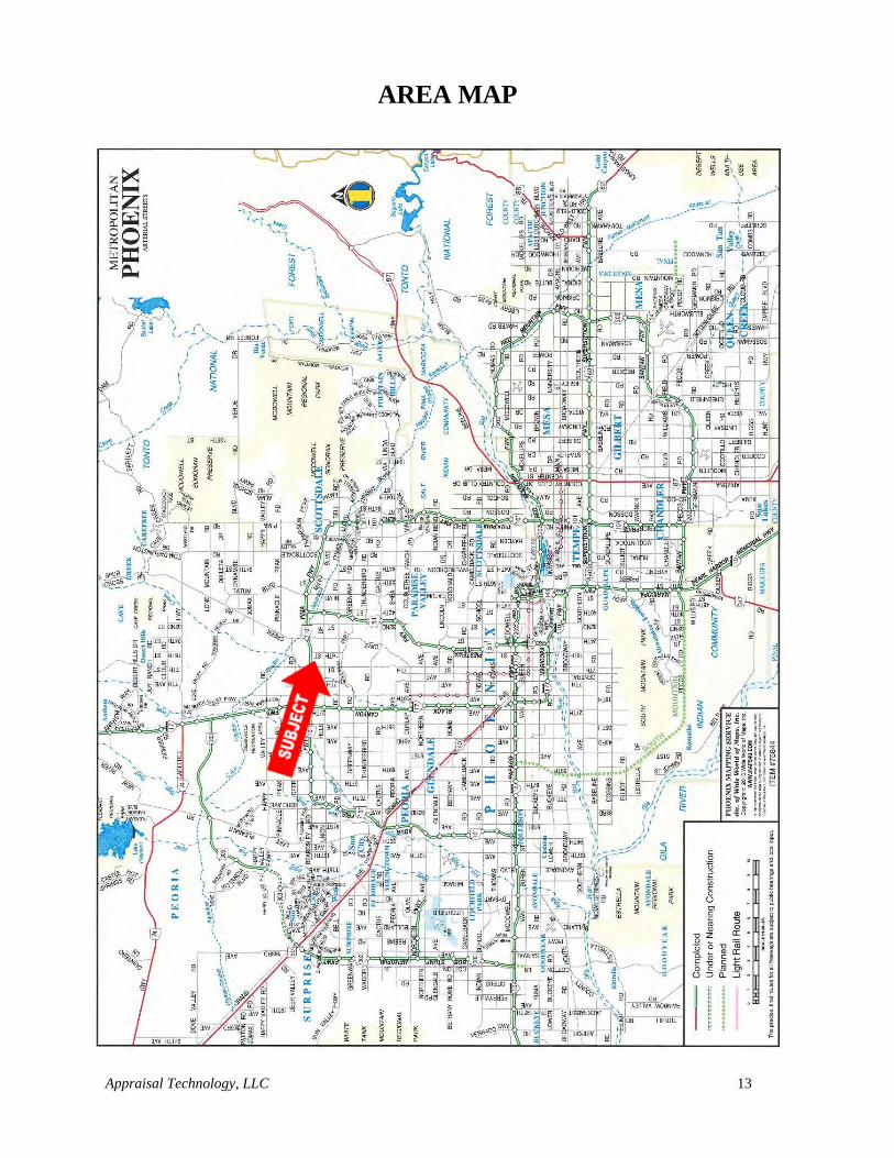
Appraisal Technology, LLC 13
AREA MAP
Appraisal Technology, LLC 14
REGIONAL AND CITY DATA
LOCATION:
The State of Arizona is located within the southwestern region of the United States. The July 2018
population estimate puts the population of Arizona at 4,341,386. Maricopa County is located in the
south central part of the State of Arizona. Maricopa County consists of numerous cities, towns and
communities that are inter-connected through transportation corridors, economic affiliations, and
physical/location characteristics.
The cities, towns, and communities that make up the Phoenix Metropolitan area include: Apache
Junction, Avondale, Buckeye, Carefree, Chandler, El Mirage, Fountain Hills, Gila Bend, Gilbert,
Glendale, Goodyear, Guadalupe, Litchfield Park, Mesa, New River, Paradise Valley, Peoria,
Phoenix, Scottsdale, Sun City/Sun City West, Surprise, Tempe, Tolleson, Wickenburg, and
Youngtown.
The subject property is located in the northern portion of the Metropolitan Phoenix area, Maricopa
County, Arizona. The subject property is considered part of the greater Metropolitan Phoenix area
and will be examined within the following regional data analysis.
The appraiser has identified basic regional factors that may have an impact on the value of the
subject property which includes: location, population, employment, income characteristics, cost of
living, education, quality of life, and real estate trends. This section will focus and analyze these
recognized basic regional factors as they influence or affect real estate value.
SOCIAL FORCES:
Social forces primarily have to do with population and demographic trends. The demographics of
the population indicate the potential basic demand for real estate services. Arizona has experienced
rapid population growth continuously for the last seven years, largely due to the extended period
of strong economic growth. The state added 100,000 residents last year which translated into a rate
of growth of 1.6%. Continued job and population growth have contributed to personal income
gains of 6.4 % in 2019.
Appraisal Technology, LLC 15
Arizona Office of Economic Opportunity
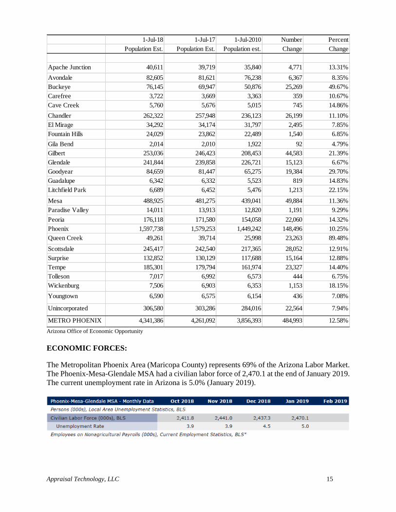
ECONOMIC FORCES:
The Metropolitan Phoenix Area (Maricopa County) represents 69% of the Arizona Labor Market.
The Phoenix-Mesa-Glendale MSA had a civilian labor force of 2,470.1 at the end of January 2019.
The current unemployment rate in Arizona is 5.0% (January 2019).
1-Jul-18 1-Jul-17 1-Jul-2010 Number Percent
Population Est. Population Est. Population est. Change Change
Apache Junction 40,611 39,719 35,840 4,771 13.31%
Avondale 82,605 81,621 76,238 6,367 8.35%
Buckeye 76,145 69,947 50,876 25,269 49.67%
Carefree 3,722 3,669 3,363 359 10.67%
Cave Creek 5,760 5,676 5,015 745 14.86%
Chandler 262,322 257,948 236,123 26,199 11.10%
El Mirage 34,292 34,174 31,797 2,495 7.85%
Fountain Hills 24,029 23,862 22,489 1,540 6.85%
Gila Bend 2,014 2,010 1,922 92 4.79%
Gilbert 253,036 246,423 208,453 44,583 21.39%
Glendale 241,844 239,858 226,721 15,123 6.67%
Goodyear 84,659 81,447 65,275 19,384 29.70%
Guadalupe 6,342 6,332 5,523 819 14.83%
Litchfield Park 6,689 6,452 5,476 1,213 22.15%
Mesa 488,925 481,275 439,041 49,884 11.36%
Paradise Valley 14,011 13,913 12,820 1,191 9.29%
Peoria 176,118 171,580 154,058 22,060 14.32%
Phoenix 1,597,738 1,579,253 1,449,242 148,496 10.25%
Queen Creek 49,261 39,714 25,998 23,263 89.48%
Scottsdale 245,417 242,540 217,365 28,052 12.91%
Surprise 132,852 130,129 117,688 15,164 12.88%
Tempe 185,301 179,794 161,974 23,327 14.40%
Tolleson 7,017 6,992 6,573 444 6.75%
Wickenburg 7,506 6,903 6,353 1,153 18.15%
Youngtown 6,590 6,575 6,154 436 7.08%
Unincorporated 306,580 303,286 284,016 22,564 7.94%
METRO PHOENIX 4,341,386 4,261,092 3,856,393 484,993 12.58%
Appraisal Technology, LLC 16
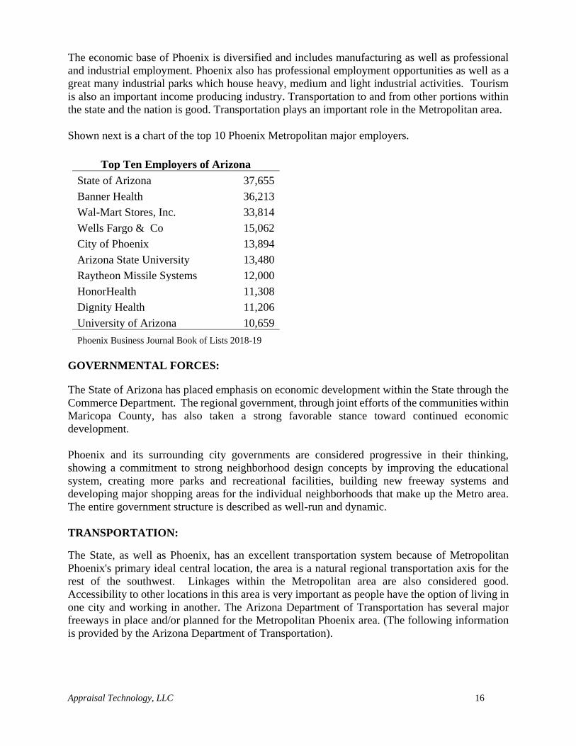
The economic base of Phoenix is diversified and includes manufacturing as well as professional
and industrial employment. Phoenix also has professional employment opportunities as well as a
great many industrial parks which house heavy, medium and light industrial activities. Tourism
is also an important income producing industry. Transportation to and from other portions within
the state and the nation is good. Transportation plays an important role in the Metropolitan area.
Shown next is a chart of the top 10 Phoenix Metropolitan major employers.
Top Ten Employers of Arizona
State of Arizona 37,655
Banner Health 36,213
Wal-Mart Stores, Inc. 33,814
Wells Fargo & Co 15,062
City of Phoenix 13,894
Arizona State University 13,480
Raytheon Missile Systems 12,000
HonorHealth 11,308
Dignity Health 11,206
University of Arizona 10,659
Phoenix Business Journal Book of Lists 2018-19
GOVERNMENTAL FORCES:
The State of Arizona has placed emphasis on economic development within the State through the
Commerce Department. The regional government, through joint efforts of the communities within
Maricopa County, has also taken a strong favorable stance toward continued economic
development.
Phoenix and its surrounding city governments are considered progressive in their thinking,
showing a commitment to strong neighborhood design concepts by improving the educational
system, creating more parks and recreational facilities, building new freeway systems and
developing major shopping areas for the individual neighborhoods that make up the Metro area.
The entire government structure is described as well-run and dynamic.
TRANSPORTATION:
The State, as well as Phoenix, has an excellent transportation system because of Metropolitan
Phoenix's primary ideal central location, the area is a natural regional transportation axis for the
rest of the southwest. Linkages within the Metropolitan area are also considered good.
Accessibility to other locations in this area is very important as people have the option of living in
one city and working in another. The Arizona Department of Transportation has several major
freeways in place and/or planned for the Metropolitan Phoenix area. (The following information
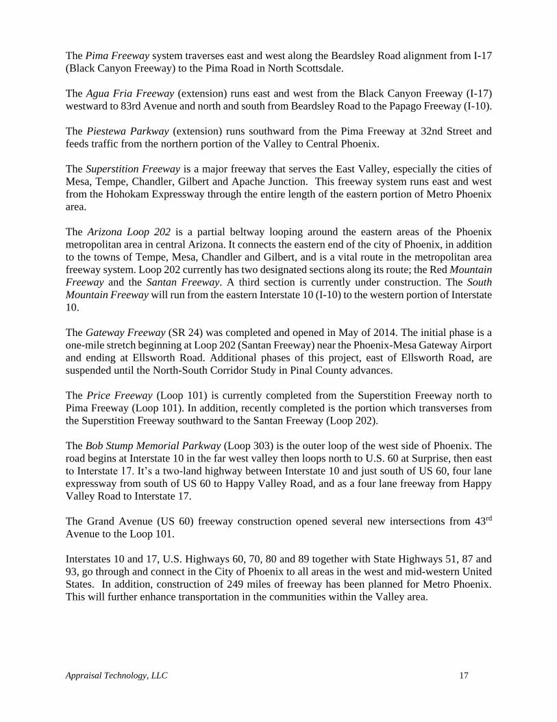
is provided by the Arizona Department of Transportation).
Appraisal Technology, LLC 17
The Pima Freeway system traverses east and west along the Beardsley Road alignment from I-17
(Black Canyon Freeway) to the Pima Road in North Scottsdale.
The Agua Fria Freeway (extension) runs east and west from the Black Canyon Freeway (I-17)
westward to 83rd Avenue and north and south from Beardsley Road to the Papago Freeway (I-10).
The Piestewa Parkway (extension) runs southward from the Pima Freeway at 32nd Street and
feeds traffic from the northern portion of the Valley to Central Phoenix.
The Superstition Freeway is a major freeway that serves the East Valley, especially the cities of
Mesa, Tempe, Chandler, Gilbert and Apache Junction. This freeway system runs east and west
from the Hohokam Expressway through the entire length of the eastern portion of Metro Phoenix
area.
The Arizona Loop 202 is a partial beltway looping around the eastern areas of the Phoenix
metropolitan area in central Arizona. It connects the eastern end of the city of Phoenix, in addition
to the towns of Tempe, Mesa, Chandler and Gilbert, and is a vital route in the metropolitan area
freeway system. Loop 202 currently has two designated sections along its route; the Red Mountain
Freeway and the Santan Freeway. A third section is currently under construction. The South
Mountain Freeway will run from the eastern Interstate 10 (I-10) to the western portion of Interstate
10.
The Gateway Freeway (SR 24) was completed and opened in May of 2014. The initial phase is a
one-mile stretch beginning at Loop 202 (Santan Freeway) near the Phoenix-Mesa Gateway Airport
and ending at Ellsworth Road. Additional phases of this project, east of Ellsworth Road, are
suspended until the North-South Corridor Study in Pinal County advances.
The Price Freeway (Loop 101) is currently completed from the Superstition Freeway north to
Pima Freeway (Loop 101). In addition, recently completed is the portion which transverses from
the Superstition Freeway southward to the Santan Freeway (Loop 202).
The Bob Stump Memorial Parkway (Loop 303) is the outer loop of the west side of Phoenix. The
road begins at Interstate 10 in the far west valley then loops north to U.S. 60 at Surprise, then east
to Interstate 17. It’s a two-land highway between Interstate 10 and just south of US 60, four lane
expressway from south of US 60 to Happy Valley Road, and as a four lane freeway from Happy
Valley Road to Interstate 17.
The Grand Avenue (US 60) freeway construction opened several new intersections from 43rd
Avenue to the Loop 101.
Interstates 10 and 17, U.S. Highways 60, 70, 80 and 89 together with State Highways 51, 87 and
93, go through and connect in the City of Phoenix to all areas in the west and mid-western United
States. In addition, construction of 249 miles of freeway has been planned for Metro Phoenix.
This will further enhance transportation in the communities within the Valley area.
Appraisal Technology, LLC 18
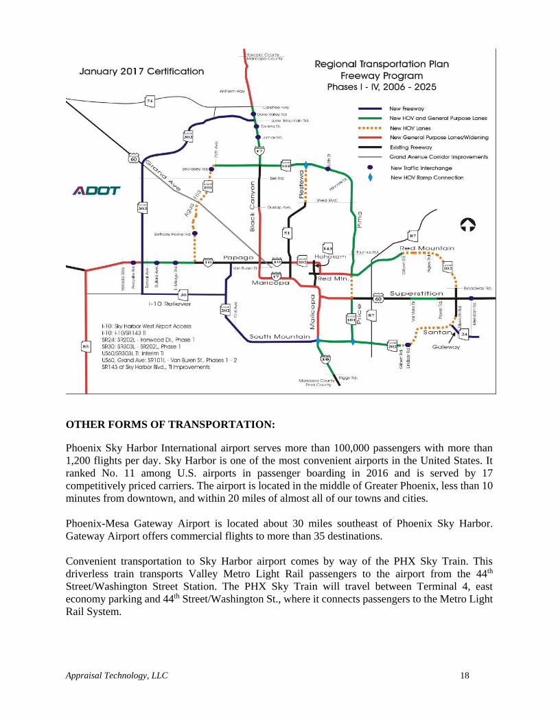
OTHER FORMS OF TRANSPORTATION:
Phoenix Sky Harbor International airport serves more than 100,000 passengers with more than
1,200 flights per day. Sky Harbor is one of the most convenient airports in the United States. It
ranked No. 11 among U.S. airports in passenger boarding in 2016 and is served by 17
competitively priced carriers. The airport is located in the middle of Greater Phoenix, less than 10
minutes from downtown, and within 20 miles of almost all of our towns and cities.
Phoenix-Mesa Gateway Airport is located about 30 miles southeast of Phoenix Sky Harbor.
Gateway Airport offers commercial flights to more than 35 destinations.
Convenient transportation to Sky Harbor airport comes by way of the PHX Sky Train. This
driverless train transports Valley Metro Light Rail passengers to the airport from the 44th
Street/Washington Street Station. The PHX Sky Train will travel between Terminal 4, east
economy parking and 44th Street/Washington St., where it connects passengers to the Metro Light
Rail System.
Appraisal Technology, LLC 19
Light Rail
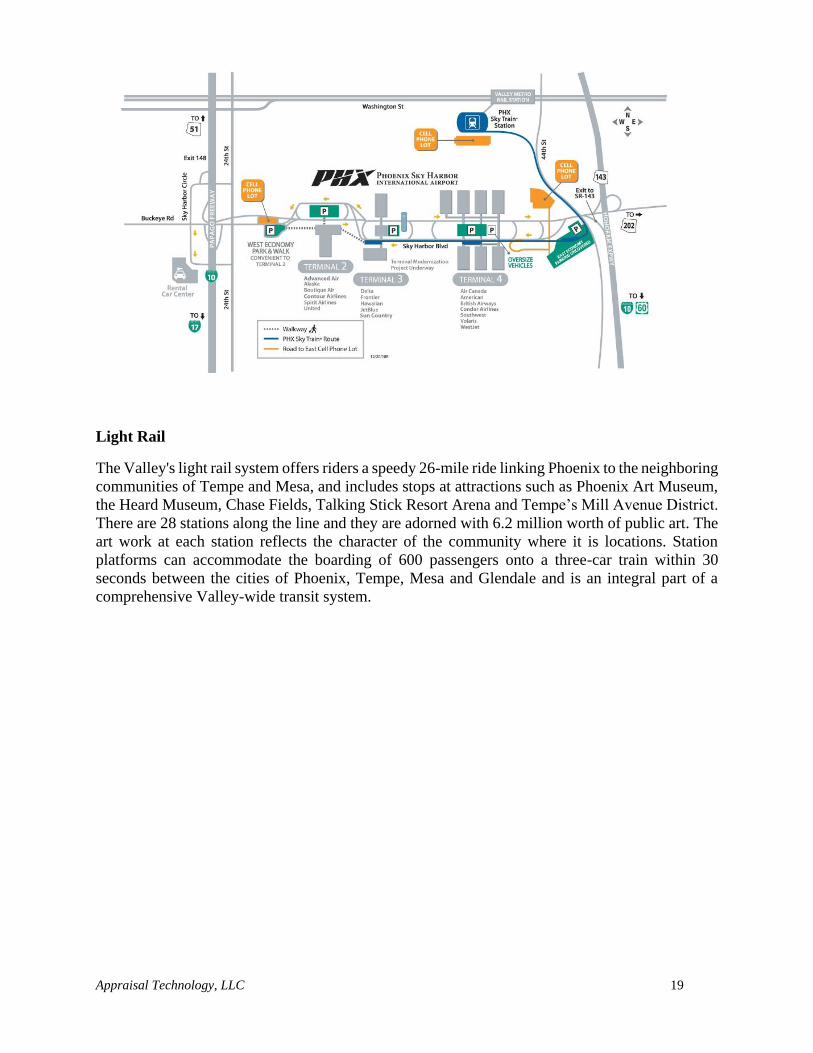
The Valley's light rail system offers riders a speedy 26-mile ride linking Phoenix to the neighboring
communities of Tempe and Mesa, and includes stops at attractions such as Phoenix Art Museum,
the Heard Museum, Chase Fields, Talking Stick Resort Arena and Tempe’s Mill Avenue District.
There are 28 stations along the line and they are adorned with 6.2 million worth of public art. The
art work at each station reflects the character of the community where it is locations. Station
platforms can accommodate the boarding of 600 passengers onto a three-car train within 30
seconds between the cities of Phoenix, Tempe, Mesa and Glendale and is an integral part of a
comprehensive Valley-wide transit system.
Appraisal Technology, LLC 20
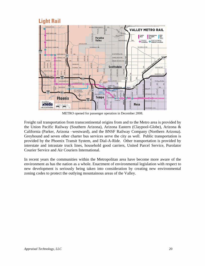
METRO opened for passenger operation in December 2008.
Freight rail transportation from transcontinental origins from and to the Metro area is provided by
the Union Pacific Railway (Southern Arizona), Arizona Eastern (Claypool-Globe), Arizona &
California (Parker, Arizona –westward), and the BNSF Railway Company (Northern Arizona).
Greyhound and seven other charter bus services serve the city as well. Public transportation is
provided by the Phoenix Transit System, and Dial-A-Ride. Other transportation is provided by
interstate and intrastate truck lines, household good carriers, United Parcel Service, Purolator
Courier Service and Air Couriers International.
In recent years the communities within the Metropolitan area have become more aware of the
environment as has the nation as a whole. Enactment of environmental legislation with respect to
new development is seriously being taken into consideration by creating new environmental
zoning codes to protect the outlying mountainous areas of the Valley.
Appraisal Technology, LLC 21
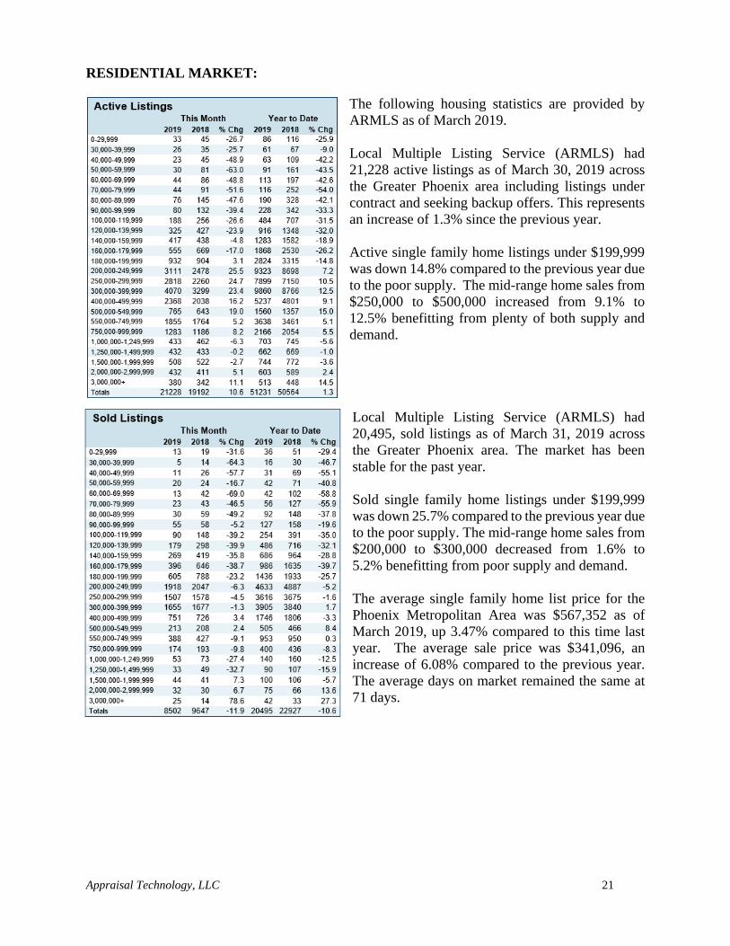
RESIDENTIAL MARKET:
The following housing statistics are provided by
ARMLS as of March 2019.
Local Multiple Listing Service (ARMLS) had
21,228 active listings as of March 30, 2019 across
the Greater Phoenix area including listings under
contract and seeking backup offers. This represents
an increase of 1.3% since the previous year.
Active single family home listings under $199,999
was down 14.8% compared to the previous year due
to the poor supply. The mid-range home sales from
$250,000 to $500,000 increased from 9.1% to
12.5% benefitting from plenty of both supply and
demand.
Local Multiple Listing Service (ARMLS) had
20,495, sold listings as of March 31, 2019 across
the Greater Phoenix area. The market has been
stable for the past year.
Sold single family home listings under $199,999
was down 25.7% compared to the previous year due
to the poor supply. The mid-range home sales from
$200,000 to $300,000 decreased from 1.6% to
5.2% benefitting from poor supply and demand.
The average single family home list price for the
Phoenix Metropolitan Area was $567,352 as of
March 2019, up 3.47% compared to this time last
year. The average sale price was $341,096, an
increase of 6.08% compared to the previous year.
The average days on market remained the same at
71 days.

Appraisal Technology, LLC 22
Following are the summary statistics for single family residential sales activity within Maricopa
County.
Following are multiple charts relating to single family residential activity in the Phoenix
Metropolitan Area.
Appraisal Technology, LLC 23
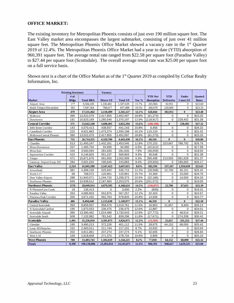
OFFICE MARKET:
The existing inventory for Metropolitan Phoenix consists of just over 190 million square feet. The
East Valley market area encompasses the largest submarket, consisting of just over 41 million
square feet. The Metropolitan Phoenix Office Market showed a vacancy rate in the 1st Quarter
2019 of 12.4%. The Metropolitan Phoenix Office Market had a year to date (YTD) absorption of
960,391 square feet. The average rental rate ranged from $22.58 per square foot (Paradise Valley)
to $27.44 per square foot (Scottsdale). The overall average rental rate was $25.00 per square foot
on a full service basis.
Shown next is a chart of the Office Market as of the 1st Quarter 2019 as compiled by CoStar Realty
Information, Inc.
Existing Inventory Vacancy
Market
# of
Bldgs Total RBA Direct SF Total SF Vac %
YTD Net
Absorption
YTD
Deliveries
Under
Const SF
Quoted
Rates
Airport Area 177 9,584,100 1,330,482 1,507,639 15.7% 265,966 82,951 0 $23.60
South Tempe/Ahwatukee 302 7,947,364 788,017 837,488 10.5% 360,078 220,000 0 $23.35
Airport Area 479 17,531,464 2,118,499 2,345,127 12.1% 626,044 302,951 0 $23.48
Midtown 390 13,022,079 2,417,855 2,452,097 18.8% (61,273) 0 0 $23.25
Downtown 181 10,620,169 1,280,546 1,370,197 12.9% (118,917) 0 228,402 $31.38
Central Corridor 571 23,642,248 3,698,401 3,822,294 15.6% (180,190) 0 228,402 $27.32
44th Street Corridor 143 4,070,413 438,557 441,143 10.8% 6,456 0 0 $26.32
Camelback Corridor 222 9,621,863 1,473,374 1,550,198 16.1% 115,133 0 0 $31.02
Midtown/Central Phoenix 390 13,022,079 2,417,855 2,452,097 18.8% (61,273) 0 0 $23.25
East Phoenix 755 26,714,355 4,329,786 4,443,438 16.2% 60,316 0 0 $26.86
Chandler 513 11,400,247 1,432,261 1,453,545 12.8% 270,153 323,667 786,792 $26.76
Mesa Downtown 207 1,465,704 94,990 94,990 6.5% (42,612) 0 0 $17.58
Mesa East 434 3,560,094 281,635 281,635 7.9% (46,059) 0 0 $18.50
Superstition Corridor 415 6,146,825 551,237 569,963 9.3% 35,548 0 0 $21.39
Tempe 471 15,871,676 991,655 1,002,999 6.3% 395,498 213,500 961,628 $31.37
Gateway Airport/Loop 202 284 2,601,034 195,645 243,883 9.4% (29,934) 0 185,600 $26.17
East Valley 2,324 41,045,580 3,547,423 3,647,015 8.6% 582,594 537,167 1,934,020 $23.63
Arrowhead 381 4,399,159 525,942 535,715 12.2% (28,568) 22,700 30,151 $25.42
North I-17 58 768,572 120,961 120,961 15.7% 15,369 0 23,000 $24.76
Deer Valley/Airport 288 11,943,571 1,244,732 1,258,373 10.5% (22,186) 0 14,500 $24.33
Northwest Phoenix 849 10,938,612 2,187,960 2,253,575 20.6% (201,572) 0 0 $19.05
Northwest Phoenix 1576 28,049,914 4,079,595 4,168,624 14.5% (236,957) 22,700 67,651 $23.39
N Phoenix/Cave Creek 18 136,413 0 3,000 2.2% (600) 0 0 $19.31
Paradise Valley 263 4,686,803 552,875 567,257 12.1% 32,453 0 0 $24.67
Piestewa Peak Corridor 205 3,671,432 562,763 578,820 15.8% 14,506 0 0 $23.77
Paradise Valley 486 8,494,648 1,115,638 1,149,077 13.1% 46,359 0 0 $22.58
Central Scottsdale 393 8,859,937 958,576 1,019,761 11.5% 16,963 21,657 8,400 $26.13
N Scottsdale/Carefree 195 1,873,553 236,475 236,475 12.6% 12,887 0 0 $24.01
Scottsdale Airpark 395 13,390,462 1,524,480 1,730,543 12.9% (27,772) 0 48,514 $29.21
Scottsdale South 508 7,132,982 781,542 839,296 11.8% (17,671) 0 274,338 $30.42
Scottsdale 1,491 31,256,934 3,501,073 3,826,075 11.2% (15,593) 21,657 331,252 $27.44
Glendale 195 3,490,213 372,226 401,112 11.5% 28,975 64,152 68,000 $25.42
Loop 303/Surprise 152 2,483,011 211,744 217,101 8.7% 10,932 0 0 $23.93
Southwest Phoenix 202 4,811,861 247,274 247,274 5.1% 32,005 0 0 $26.84
West I-10 159 2,618,658 271,375 278,734 10.6% 5,906 0 0 $25.10
West Phoenix 708 13,403,743 1,102,619 1,144,221 8.2% 77,818 64,152 68,000 $25.32
Totals 8,390 190,138,886 23,493,034 24,545,871 12.4% 960,391 948,627 2,629,325 $25.00
Appraisal Technology, LLC 24
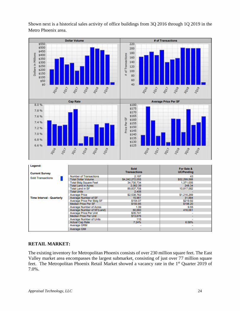
Shown next is a historical sales activity of office buildings from 3Q 2016 through 1Q 2019 in the
Metro Phoenix area.
RETAIL MARKET:
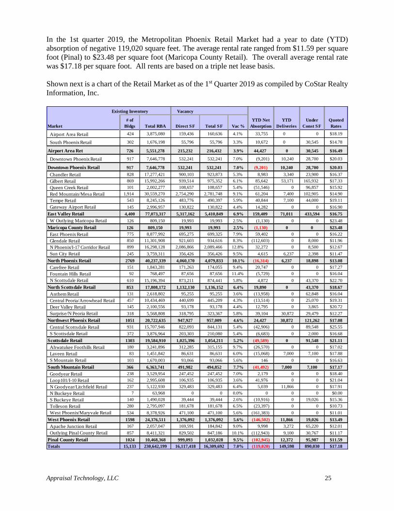
The existing inventory for Metropolitan Phoenix consists of over 230 million square feet. The East
Valley market area encompasses the largest submarket, consisting of just over 77 million square
feet. The Metropolitan Phoenix Retail Market showed a vacancy rate in the 1st Quarter 2019 of
7.0%.
Appraisal Technology, LLC 25
In the 1st quarter 2019, the Metropolitan Phoenix Retail Market had a year to date (YTD)
absorption of negative 119,020 square feet. The average rental rate ranged from $11.59 per square
foot (Pinal) to $23.48 per square foot (Maricopa County Retail). The overall average rental rate
was $17.18 per square foot. All rents are based on a triple net lease basis.
Shown next is a chart of the Retail Market as of the 1st Quarter 2019 as compiled by CoStar Realty
Information, Inc.
Existing Inventory Vacancy
Market
# of
Bldgs Total RBA Direct SF Total SF Vac %
YTD Net
Absorption
YTD
Deliveries
Under
Const SF
Quoted
Rates
Airport Area Retail 424 3,875,080 159,436 160,636 4.1% 33,755 0 0 $18.19
South Phoenix Retail 302 1,676,198 55,796 55,796 3.3% 10,672 0 30,545 $14.78
Airport Area Ret 726 5,551,278 215,232 216,432 3.9% 44,427 0 30,545 $16.49
Downtown Phoenix Retail 917 7,646,778 532,241 532,241 7.0% (9,201) 10,240 28,700 $20.03
Downtown Phoenix Retail 917 7,646,778 532,241 532,241 7.0% (9,201) 10,240 28,700 $20.03
Chandler Retail 828 17,277,421 900,103 923,873 5.3% 8,983 3,340 23,900 $16.37
Gilbert Retail 869 15,992,266 939,514 975,352 6.1% 85,642 53,171 165,932 $17.33
Queen Creek Retail 101 2,002,277 108,657 108,657 5.4% (51,546) 0 96,857 $15.92
Red Mountain/Mesa Retail 1,914 30,559,270 2,754,290 2,781,748 9.1% 61,204 7,400 102,905 $14.90
Tempe Retail 543 8,245,126 483,776 490,397 5.9% 40,844 7,100 44,000 $19.11
Gateway Airport Retail 145 2,996,957 130,822 130,822 4.4% 14,282 0 0 $16.90
East Valley Retail 4,400 77,073,317 5,317,162 5,410,849 6.9% 159,409 71,011 433,594 $16.75
W Outlying Maricopa Retail 126 809,150 19,993 19,993 2.5% (1,130) 0 0 $23.48
Maricopa County Retail 126 809,150 19,993 19,993 2.5% (1,130) 0 0 $23.48
East Phoenix Retail 775 8,877,992 695,275 699,325 7.9% 59,402 0 0 $16.22
Glendale Retail 850 11,301,908 921,603 934,616 8.3% (112,603) 0 8,000 $11.96
N Phoenix/I-17 Corridor Retail 899 16,298,128 2,086,866 2,089,466 12.8% 32,272 0 8,500 $12.67
Sun City Retail 245 3,759,311 356,426 356,426 9.5% 4,615 6,237 2,398 $11.47
North Phoenix Retail 2769 40,237,339 4,060,170 4,079,833 10.1% (16,314) 6,237 18,898 $13.08
Carefree Retail 151 1,843,281 171,263 174,055 9.4% 20,747 0 0 $17.27
Fountain Hills Retail 92 768,497 87,656 87,656 11.4% (5,729) 0 0 $16.04
N Scottsdale Retail 610 15,196,394 873,211 874,441 5.8% 4,872 0 43,370 $22.70
North Scottsdale Retail 853 17,808,172 1,132,130 1,136,152 6.4% 19,890 0 43,370 $18.67
Anthem Retail 131 2,618,802 95,255 95,255 3.6% (13,958) 0 62,848 $16.04
Central Peoria/Arrowhead Retail 457 10,434,469 440,699 445,209 4.3% (13,514) 0 25,070 $19.31
Deer Valley Retail 145 2,100,556 93,178 93,178 4.4% 12,795 0 3,865 $20.72
Surprise/N Peoria Retail 318 5,568,808 318,795 323,367 5.8% 39,104 30,872 29,479 $12.27
Northwest Phoenix Retail 1051 20,722,635 947,927 957,009 4.6% 24,427 30,872 121,262 $17.08
Central Scottsdale Retail 931 15,707,946 822,093 844,131 5.4% (42,906) 0 89,548 $25.55
S Scottsdale Retail 372 3,876,964 203,303 210,080 5.4% (6,683) 0 2,000 $16.68
Scottsdale Retail 1303 19,584,910 1,025,396 1,054,211 5.2% (49,589) 0 91,548 $21.11
Ahwatukee Foothills Retail 180 3,241,896 312,285 315,155 9.7% (26,570) 0 0 $17.02
Laveen Retail 83 1,451,842 86,631 86,631 6.0% (15,068) 7,000 7,100 $17.88
S Mountain Retail 103 1,670,003 93,066 93,066 5.6% 146 0 0 $16.63
South Mountain Retail 366 6,363,741 491,982 494,852 7.7% (41,492) 7,000 7,100 $17.17
Goodyear Retail 238 3,529,954 247,452 247,452 7.0% 2,179 0 0 $18.40
Loop101/I-10 Retail 162 2,995,608 106,935 106,935 3.6% 41,976 0 0 $21.04
N Goodyear/Litchfield Retail 237 5,122,930 329,483 329,483 6.4% 5,039 11,866 0 $17.91
N Buckeye Retail 7 63,968 0 0 0.0% 0 0 0 $0.00
S Buckeye Retail 140 1,490,028 39,444 39,444 2.6% (10,916) 0 19,026 $15.36
Tolleson Retail 280 2,795,097 181,678 181,678 6.5% (23,397) 0 0 $10.73
West Phoenix/Maryvale Retail 534 8,378,926 471,100 471,100 5.6% (161,383) 0 0 $11.01
West Phoenix Retail 1598 24,376,511 1,376,092 1,376,092 5.6% (146,502) 11,866 19,026 $13.49
Apache Junction Retail 167 2,057,047 169,591 184,842 9.0% 9,998 3,272 65,220 $12.01
Outlying Pinal County Retail 857 8,411,321 829,502 847,186 10.1% (112,943) 9,100 30,767 $11.17
Pinal County Retail 1024 10,468,368 999,093 1,032,028 9.5% (102,945) 12,372 95,987 $11.59
Totals 15,133 230,642,199 16,117,418 16,309,692 7.0% (119,020) 149,598 890,030 $17.18
Appraisal Technology, LLC 26
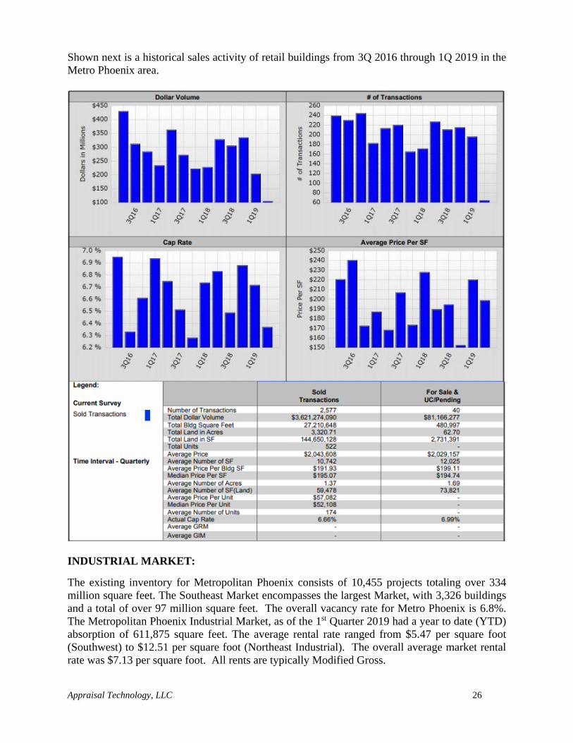
Shown next is a historical sales activity of retail buildings from 3Q 2016 through 1Q 2019 in the
Metro Phoenix area.
INDUSTRIAL MARKET:
The existing inventory for Metropolitan Phoenix consists of 10,455 projects totaling over 334
million square feet. The Southeast Market encompasses the largest Market, with 3,326 buildings
and a total of over 97 million square feet. The overall vacancy rate for Metro Phoenix is 6.8%.
The Metropolitan Phoenix Industrial Market, as of the 1st Quarter 2019 had a year to date (YTD)
absorption of 611,875 square feet. The average rental rate ranged from $5.47 per square foot
(Southwest) to $12.51 per square foot (Northeast Industrial). The overall average market rental
rate was $7.13 per square foot. All rents are typically Modified Gross.
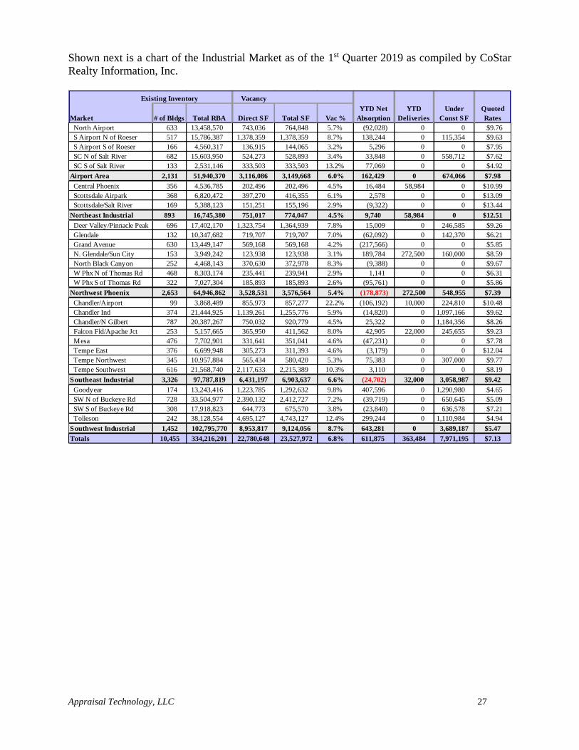
Appraisal Technology, LLC 27
Shown next is a chart of the Industrial Market as of the 1st Quarter 2019 as compiled by CoStar
Realty Information, Inc.
Existing Inventory Vacancy
Market # of Bldgs Total RBA Direct SF Total SF Vac %
YTD Net
Absorption
YTD
Deliveries
Under
Const SF
Quoted
Rates
North Airport 633 13,458,570 743,036 764,848 5.7% (92,028) 0 0 $9.76
S Airport N of Roeser 517 15,786,387 1,378,359 1,378,359 8.7% 138,244 0 115,354 $9.63
S Airport S of Roeser 166 4,560,317 136,915 144,065 3.2% 5,296 0 0 $7.95
SC N of Salt River 682 15,603,950 524,273 528,893 3.4% 33,848 0 558,712 $7.62
SC S of Salt River 133 2,531,146 333,503 333,503 13.2% 77,069 0 0 $4.92
Airport Area 2,131 51,940,370 3,116,086 3,149,668 6.0% 162,429 0 674,066 $7.98
Central Phoenix 356 4,536,785 202,496 202,496 4.5% 16,484 58,984 0 $10.99
Scottsdale Airpark 368 6,820,472 397,270 416,355 6.1% 2,578 0 0 $13.09
Scottsdale/Salt River 169 5,388,123 151,251 155,196 2.9% (9,322) 0 0 $13.44
Northeast Industrial 893 16,745,380 751,017 774,047 4.5% 9,740 58,984 0 $12.51
Deer Valley/Pinnacle Peak 696 17,402,170 1,323,754 1,364,939 7.8% 15,009 0 246,585 $9.26
Glendale 132 10,347,682 719,707 719,707 7.0% (62,092) 0 142,370 $6.21
Grand Avenue 630 13,449,147 569,168 569,168 4.2% (217,566) 0 0 $5.85
N. Glendale/Sun City 153 3,949,242 123,938 123,938 3.1% 189,784 272,500 160,000 $8.59
North Black Canyon 252 4,468,143 370,630 372,978 8.3% (9,388) 0 0 $9.67
W Phx N of Thomas Rd 468 8,303,174 235,441 239,941 2.9% 1,141 0 0 $6.31
W Phx S of Thomas Rd 322 7,027,304 185,893 185,893 2.6% (95,761) 0 0 $5.86
Northwest Phoenix 2,653 64,946,862 3,528,531 3,576,564 5.4% (178,873) 272,500 548,955 $7.39
Chandler/Airport 99 3,868,489 855,973 857,277 22.2% (106,192) 10,000 224,810 $10.48
Chandler Ind 374 21,444,925 1,139,261 1,255,776 5.9% (14,820) 0 1,097,166 $9.62
Chandler/N Gilbert 787 20,387,267 750,032 920,779 4.5% 25,322 0 1,184,356 $8.26
Falcon Fld/Apache Jct 253 5,157,665 365,950 411,562 8.0% 42,905 22,000 245,655 $9.23
Mesa 476 7,702,901 331,641 351,041 4.6% (47,231) 0 0 $7.78
Tempe East 376 6,699,948 305,273 311,393 4.6% (3,179) 0 0 $12.04
Tempe Northwest 345 10,957,884 565,434 580,420 5.3% 75,383 0 307,000 $9.77
Tempe Southwest 616 21,568,740 2,117,633 2,215,389 10.3% 3,110 0 0 $8.19
Southeast Industrial 3,326 97,787,819 6,431,197 6,903,637 6.6% (24,702) 32,000 3,058,987 $9.42
Goodyear 174 13,243,416 1,223,785 1,292,632 9.8% 407,596 0 1,290,980 $4.65
SW N of Buckeye Rd 728 33,504,977 2,390,132 2,412,727 7.2% (39,719) 0 650,645 $5.09
SW S of Buckeye Rd 308 17,918,823 644,773 675,570 3.8% (23,840) 0 636,578 $7.21
Tolleson 242 38,128,554 4,695,127 4,743,127 12.4% 299,244 0 1,110,984 $4.94
Southwest Industrial 1,452 102,795,770 8,953,817 9,124,056 8.7% 643,281 0 3,689,187 $5.47
Totals 10,455 334,216,201 22,780,648 23,527,972 6.8% 611,875 363,484 7,971,195 $7.13
Appraisal Technology, LLC 28
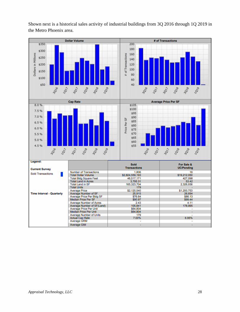
Shown next is a historical sales activity of industrial buildings from 3Q 2016 through 1Q 2019 in
the Metro Phoenix area.
Appraisal Technology, LLC 29
SUMMARY AND CONCLUSION:
The Arizona economy is generating solid economic growth, with job gains above the national rate
but well below the long-run state average. The housing market is improving, with total housing
sales in the Phoenix area totaling 20,495 (MLS) as of March 2019. Overall, the state is on pace to
generate job, income, population and retails sales gains in 2019, with faster growth expected during
the next two years. The long-run outlook calls for the state to outpace national growth for many
indicators. However, it also calls for slower growth during the next 30 years as compared to the
robust growth of the past 30 years. That reflects in large part the aging of the baby boom
generation, which slows labor force growth and ultimately gains in potential output. Nonetheless,
the economy is expected to expand during the next 30 year period due to continued innovation and
capital investment. (Arizona Economic and Business Research Center)
The Phoenix Market is continuing to show signs of growth. As shown, single family detached and
attached homes have started to increase. Building permits and sales activity continue to increase
and values are on the rise. It is expected that the second half of 2019 will continue in a similar
fashion.
The office market for the 1st Quarter 2019 has increased at 12.4% compared to the 4th Quarter 2018
of 11.8%. Quoted rental rates increased slightly to $25.00 per square foot in the 1st Quarter 2019
as compared to the previous quarter at $24.59 per square foot.
The retail market vacancy for the 1st Quarter 2019 has increased at 7.0% compared to the 4th
Quarter of 2018 of 6.8%. Rental rates have slightly decreased to $17.18 per square foot in the 1st
Quarter 2019 from $17.90 per square foot in the 4th Quarter 2018.
In the 1st Quarter 2019 the industrial market vacancy has seen a slight decrease in vacancy to 6.8%
compared to 7.1% in the 4th Quarter 2018. Quoted rental rates has increased to $7.13 per square
foot in the 1st Quarter 2019 as compared to the previous quarter at $7.00 per square foot.
The State of Arizona and regional governmental agencies have a forward looking, progressive
attitude toward more mutual and joint efforts at economic development in the Metropolitan area.
However, even in the midst of such economic turnaround the cost of living in Phoenix can still be
viewed as a bright spot. Though Phoenix residents have seen an increase in the price of day-to-
today expenses, the area remains one of the more affordable places to live and work in comparison
to the rest of the United States. It is in part because of our cost of living that we continue to see
individuals and businesses choose Phoenix as a relocation destination.
Appraisal Technology, LLC 30
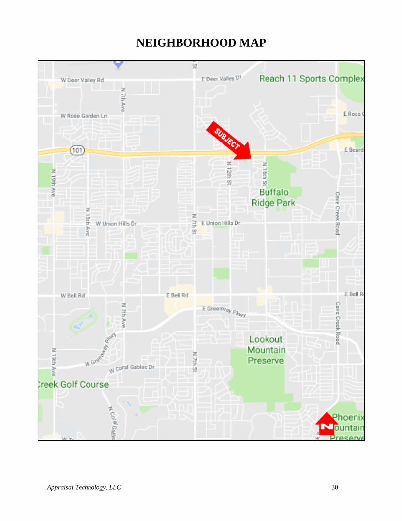
NEIGHBORHOOD MAP
Appraisal Technology, LLC 31
NEIGHBORHOOD DATA ANALYSIS
This section involves an analysis of the environmental, economic, social and governmental forces
within the subject neighborhood.
An area of influence is commonly called a "neighborhood", is defined as a group of complementary
land uses; a congruous grouping of inhabitants, buildings, or business enterprises or can be A
developed residential super pad within a master planned community usually having a
distinguishing name and entrance. (Appraisal Institute, The Dictionary of Real Estate Appraisal, 6th ed.
(Chicago: Appraisal Institute, 2015).
The neighborhood analysis is the objective analysis of observable and/or quantifiable data
indicating discernible patterns of urban growth, structure, and change that may detract from or
enhance property values; focuses on four sets of considerations that influence value: social,
economic, governmental, and environmental factors. Appraisal Institute, The Dictionary of Real Estate
Appraisal, 6th ed. (Chicago: Appraisal Institute, 2015).
Neighborhood boundaries identify the physical limits of a neighborhood, which may be delineated
by natural, man-made, or geopolitical features. Appraisal Institute, The Dictionary of Real Estate Appraisal,
6th ed. (Chicago: Appraisal Institute, 2015).
The neighborhood which is described as that area beyond which a change in land use would not
affect the subject property, is an area bounded on the North by Deer Valley Road, on the South by
Bell Road, on the East by Cave Creek Road and on the West by 19th Avenue in Phoenix, Maricopa
County, Arizona. The major arterials for the subject include Beardsley Road (Loop 101 Freeway)
to the north and 16th Street to the east.
Refer to the Neighborhood Map on the preceding page illustrating the subject in relation to the
boundaries of the neighborhood.
LAND USE:
Overall, the subject is located in an area that consists mainly of residential uses along the secondary
streets and commercial uses along the major roadways.
Single Family Residential
The appraiser researched the subject zip code (85024) to determine single family residential supply
and demand factors. According to Arizona Multi List Service the current single family median
sales price is up 12.72% compared to the same time period last year. The median list price for
homes in the subject’s zip code was up 32.30% from the previous year’s median list price.
Absorption rates for single family homes are also up 20.16%.
Following are the summary statistics for single family residential sales activity within the subject’s
zip code.

Appraisal Technology, LLC 32
Following are multiple charts relating to single family residential activity in the subject’s zip
code including:
- Number of listings
- Listing Prices
- Absorption Rate, in Months
- Sold to List Ratio
- Days on Market
- Price Volume
-
Appraisal Technology, LLC 33
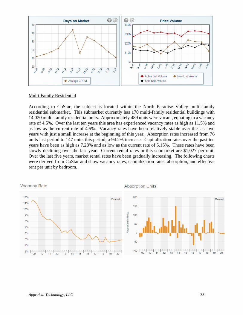
Multi-Family Residential
According to CoStar, the subject is located within the North Paradise Valley multi-family
residential submarket. This submarket currently has 170 multi-family residential buildings with
14,020 multi-family residential units. Approximately 489 units were vacant, equating to a vacancy
rate of 4.5%. Over the last ten years this area has experienced vacancy rates as high as 11.5% and
as low as the current rate of 4.5%. Vacancy rates have been relatively stable over the last two
years with just a small increase at the beginning of this year. Absorption rates increased from 76
units last period to 147 units this period, a 94.2% increase. Capitalization rates over the past ten
years have been as high as 7.28% and as low as the current rate of 5.15%. These rates have been
slowly declining over the last year. Current rental rates in this submarket are $1,027 per unit.
Over the last five years, market rental rates have been gradually increasing. The following charts
were derived from CoStar and show vacancy rates, capitalization rates, absorption, and effective
rent per unit by bedroom.
Appraisal Technology, LLC 34
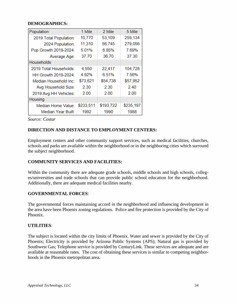
DEMOGRAPHICS:
Source: Costar
DIRECTION AND DISTANCE TO EMPLOYMENT CENTERS:
Employment centers and other community support services, such as medical facilities, churches,
schools and parks are available within the neighborhood or in the neighboring cities which surround
the subject neighborhood.
COMMUNITY SERVICES AND FACILITIES:
Within the community there are adequate grade schools, middle schools and high schools, colleg-
es/universities and trade schools that can provide public school education for the neighborhood.
Additionally, there are adequate medical facilities nearby.
GOVERNMENTAL FORCES:
The governmental forces maintaining accord in the neighborhood and influencing development in
the area have been Phoenix zoning regulations. Police and fire protection is provided by the City of
Phoenix.
UTILITIES:
The subject is located within the city limits of Phoenix. Water and sewer is provided by the City of
Phoenix; Electricity is provided by Arizona Public Systems (APS); Natural gas is provided by
Southwest Gas; Telephone service is provided by CenturyLink. These services are adequate and are
available at reasonable rates. The cost of obtaining these services is similar to competing neighbor-
hoods in the Phoenix metropolitan area.
Appraisal Technology, LLC 35
CONCLUSION:
The subject neighborhood is in a stable stage of development and located within an area of Phoenix
that is comprised of an adequate amount of retail centers, schools, medical facilities, and other
goods and services that will promote the marketability of the subject neighborhood.
Appraisal Technology, LLC 36
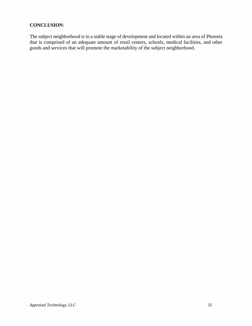
SUBJECT PHOTOGRAPHS
Looking north along 14th Street with subject to the right
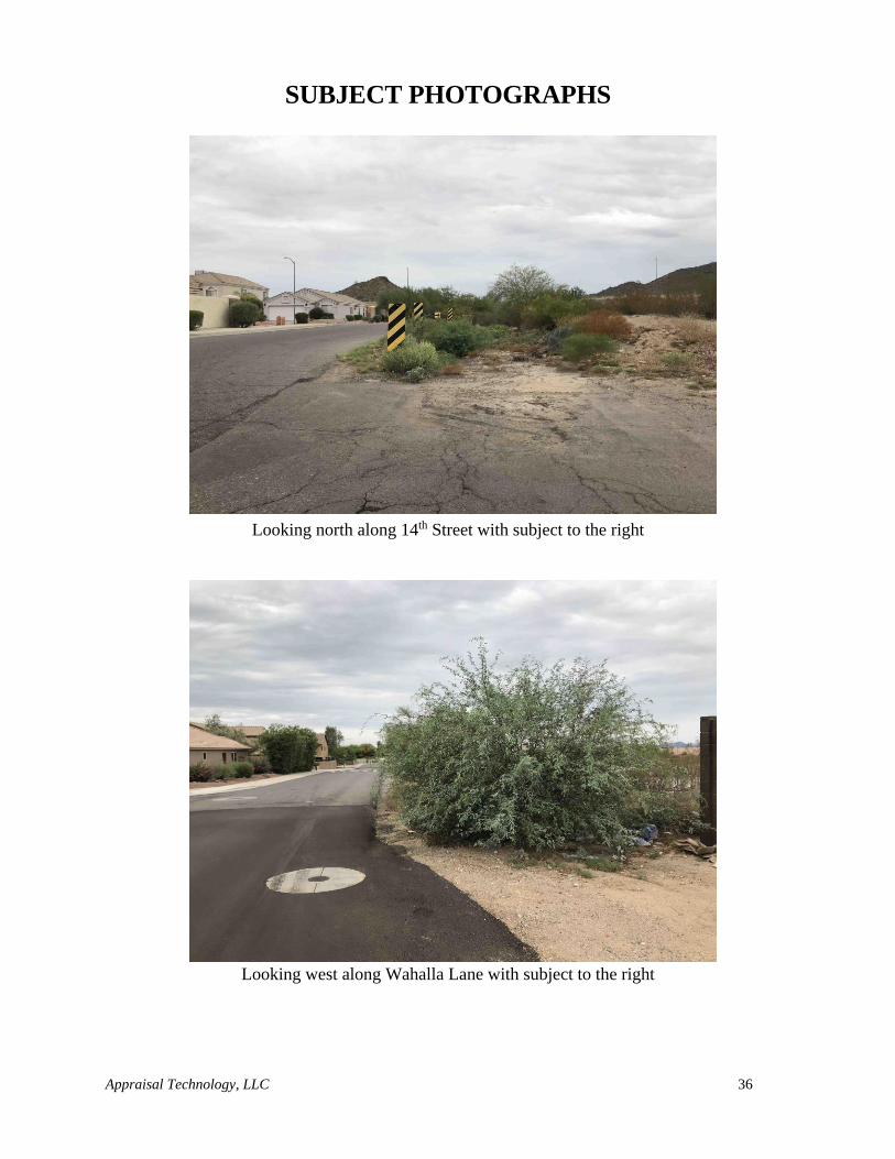
Looking west along Wahalla Lane with subject to the right
Appraisal Technology, LLC 37
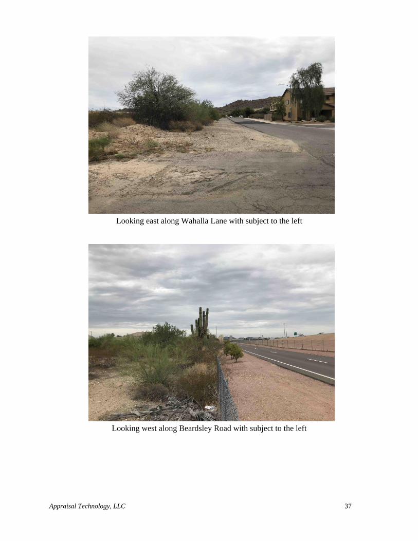
Looking east along Wahalla Lane with subject to the left
Looking west along Beardsley Road with subject to the left
Appraisal Technology, LLC 38
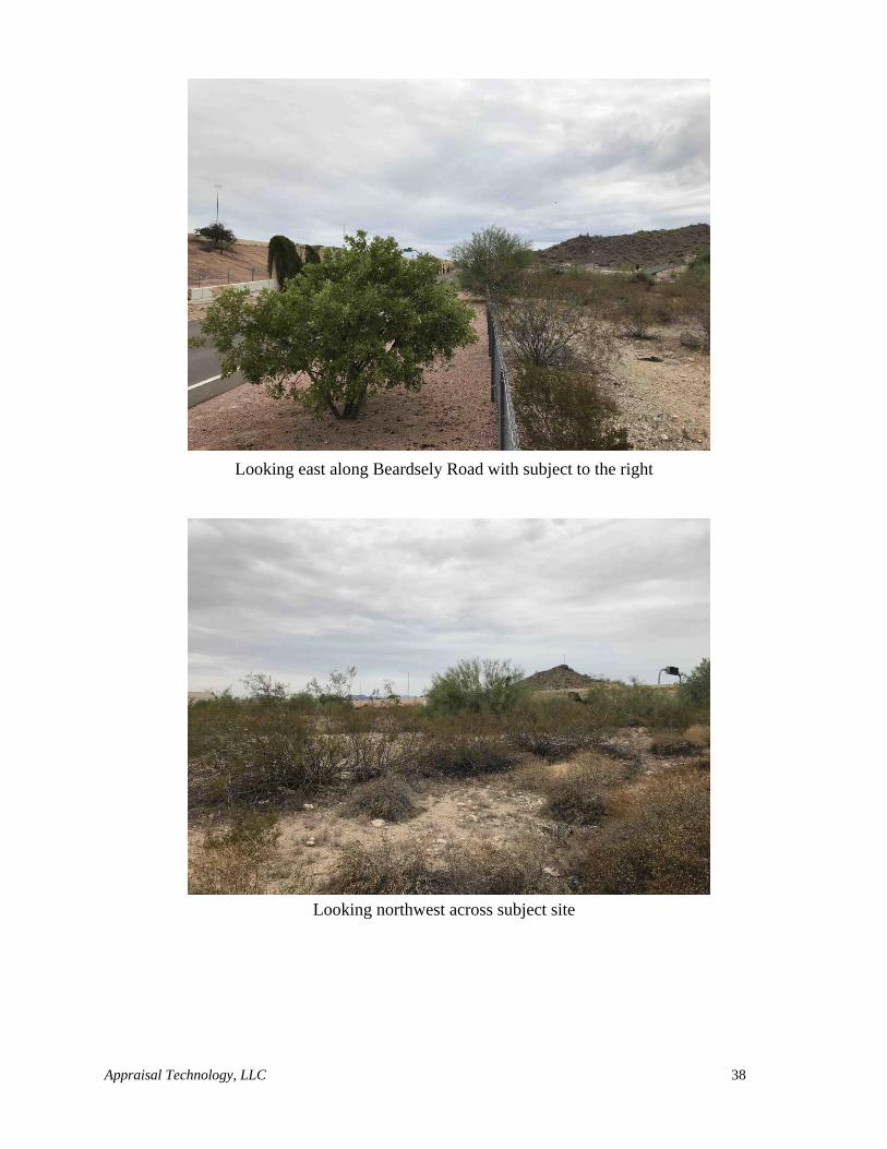
Looking east along Beardsely Road with subject to the right
Looking northwest across subject site
Appraisal Technology, LLC 39
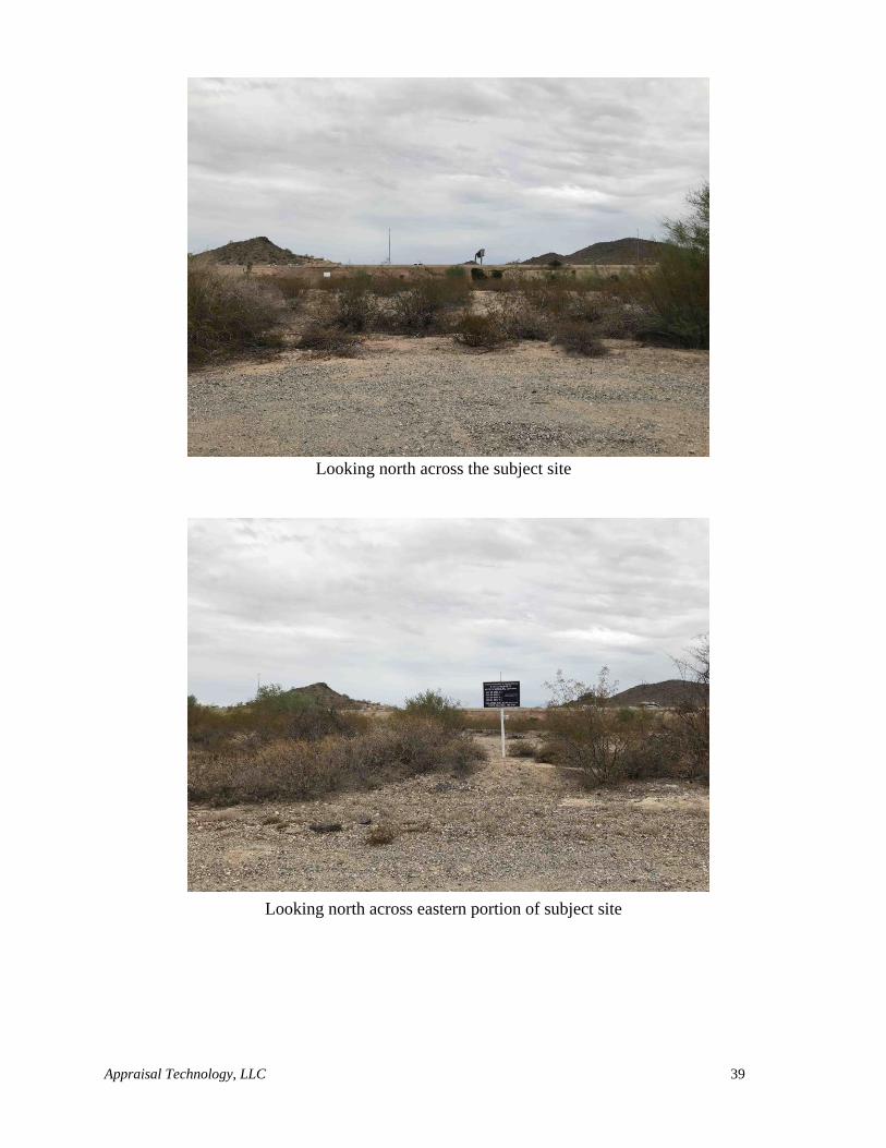
Looking north across the subject site
Looking north across eastern portion of subject site
Appraisal Technology, LLC 40
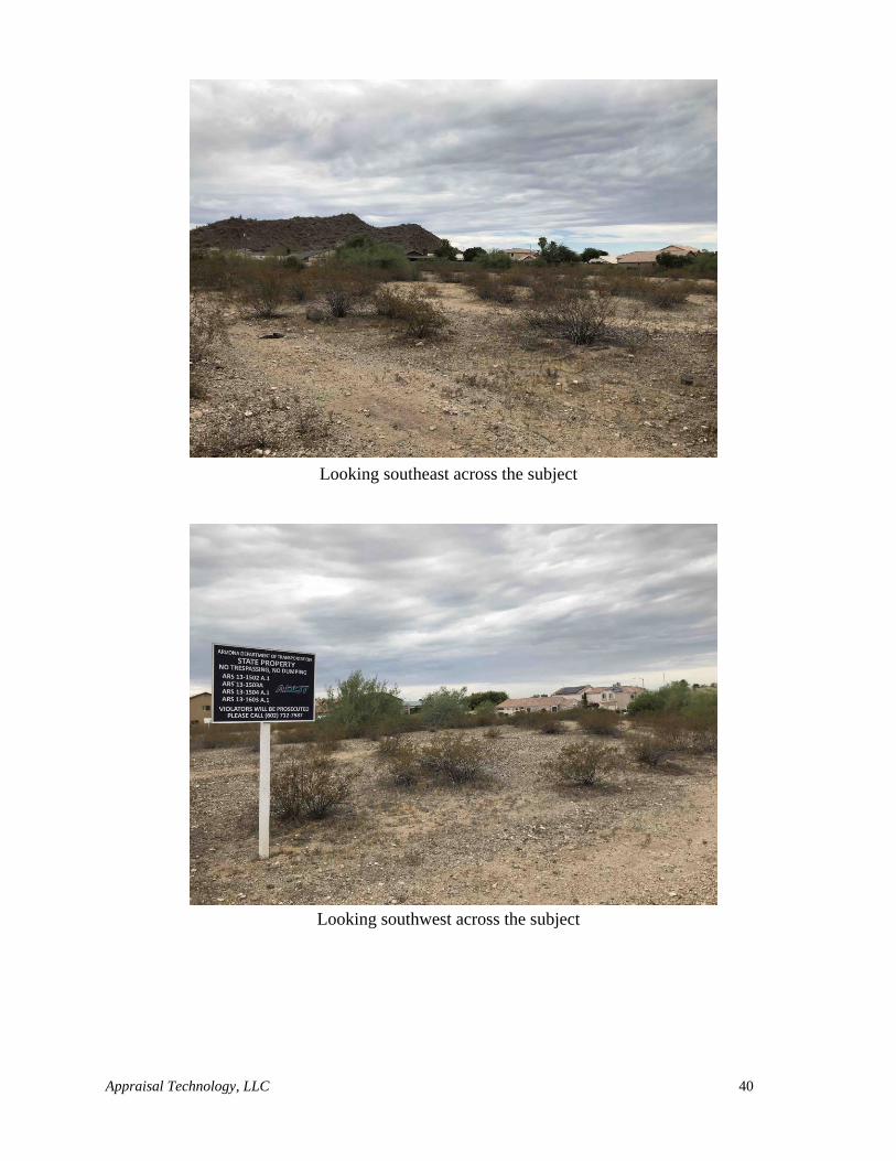
Looking southeast across the subject
Looking southwest across the subject
Appraisal Technology, LLC 41
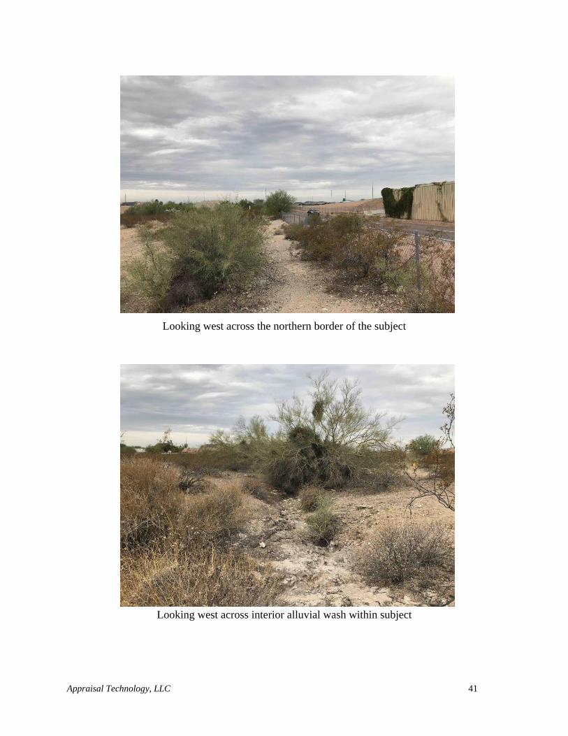
Looking west across the northern border of the subject
Looking west across interior alluvial wash within subject
Appraisal Technology, LLC 42
Looking across drainage area and culvert located at western end of site
Appraisal Technology, LLC 43
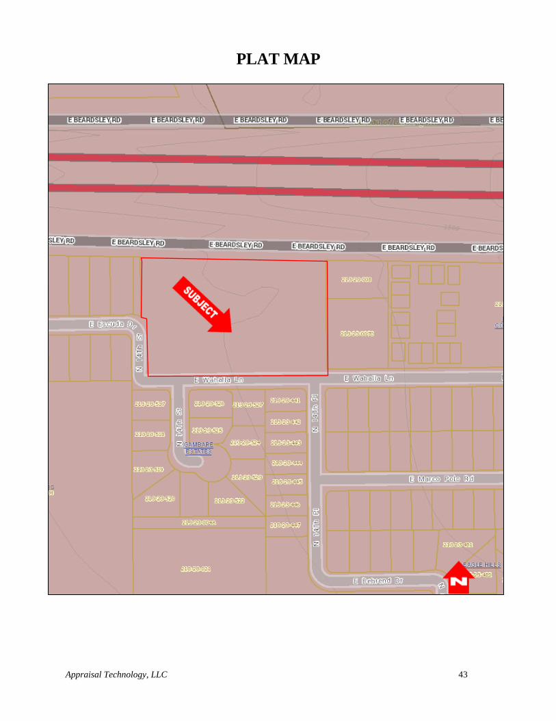
PLAT MAP
Appraisal Technology, LLC 44
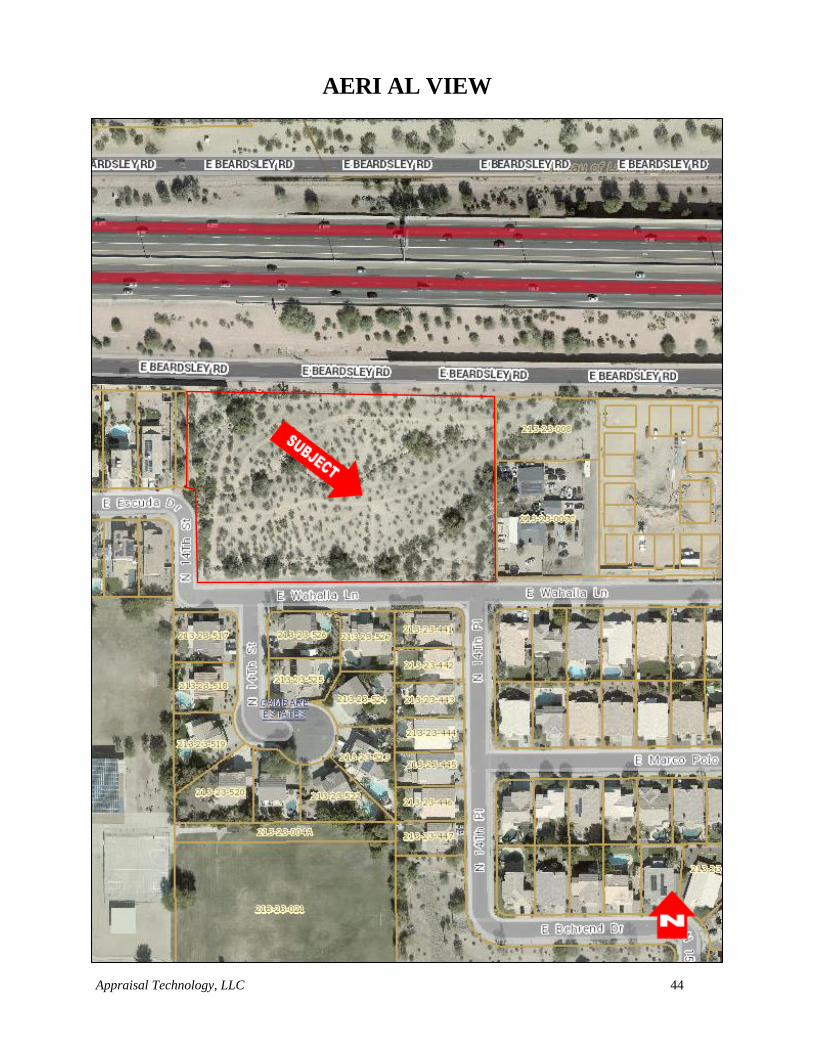
AERI AL VIEW
Appraisal Technology, LLC 45
SITE DATA ANALYSIS
LOCATION:
The subject property is located on the northeast corner of 14th Street and Wahalla Lane in Phoenix,
Arizona.
SITE DIMENSIONS AND SHAPE:
The subject site is generally rectangular in shape considered to be functionally adequate for most
types of development. As per information supplied for this assignment along with the Maricopa
County Assessor’s map, the site is of 3.24 acres or 141,190 square feet in size. The site has
approximately 493.49 feet of frontage along Beardsley Road (Loop 101 frontage road) to the north,
882 feet of frontage along Wahalla Lane to the south, and approximately 131 feet of frontage along
14th Street.
IMPROVEMENTS:
The subject is vacant land with no improvements.
NUISANCES OR HAZARDS:
The appraiser has not been provided with any environmental studies. The appraiser is without the
expertise to identify and/or detect such substances, upon physical inspection of the site, there are no
known hazards that would affect the development of the property. Because of the liability generated
if toxic wastes and/or contaminants are found on the site, it is strongly recommended that a specialist
in the detection of toxic waste be retained to check for possible contamination.
If a toxic waste and/or contaminant is detected, the value estimate appearing in this report is null and
void. If a re-appraisal is required, it will be made at an additional charge and upon receipt of any
additional information requested (i.e., what the toxic waste and/or contaminant is and the cost of
removal) by the appraiser.
VISIBILITY AND ACCESS:
The subject property has visibility from Beardsley Road, Wahalla Lane, 14th Street, and the Loop
101 Freeway, access to the site is only available from 14th Street and Wahalla Lane. Roadway
improvements adjacent to the subject site are as follows:
Street: Beardsley Road (Loop 101 frontage road)
Road Surface: Paved
Lanes: Two lanes (One way only eastbound)
Curbs/Gutters: Yes
Sidewalks: No
Street Lights: Yes
Speed Limit: 45 mph
Traffic Count (vpd): 47,000
Appraisal Technology, LLC 46
Street: Wahalla Lane
Road Surface: Paved
Lanes: Two lanes
Curbs/Gutters: Partial
Sidewalks: Partial
Street Lights: Yes
Speed Limit: 25 mph
Traffic Count (vpd): N/Av
Street: 14th Street
Road Surface: Paved
Lanes: Two lanes
Curbs/Gutters: Partial
Sidewalks: Partial
Street Lights: Yes
Speed Limit: 25 mph
Traffic Count (vpd): N/Av
TOPOGRAPHY, DRAINAGE AND SOIL CONDITIONS:
Elevations are generally level with a slight slope with elevation decreasing from the northeast to
the southwest. A soils study has not been provided. The load bearing capacity of the top soil and
sub-soils is unknown, but is assumed to be sufficient to support existing improvements.
There are two prominent alluvial washes that run through the property from the northeast to the
southwest of the property. Any development that occurs on the site would likely need to address
the presence of these washes.
FLOOD ZONE:
The location is within an area denoted as being in an "X" Flood Hazard Area, as found on Federal
Emergency Management Agency Flood Insurance Rate Map number 04013C1295L dated October
16, 2013. The "X" designation indicates:
Areas of 500-year flood; areas of 100-year flood with average depths of less than 1 foot or
with drainage areas less than 1 square mile; and areas projected by levees from 100-year flood.
UTILITIES:
All utilities including electrical, sewer, water and telephone services are available to the site.
EASEMENTS:
A title search was provided. Based upon a review of the available property information, there does
not appear to be any easements, encroachments, or restrictions other than those that are typical for
Appraisal Technology, LLC 47
the property type. my valuation assumes (see extraordinary assumptions) no adverse impacts from
easements, encroachments, or restrictions, and further assumes that the subject has a clear and
marketable title. In addition to the existing easements, there is a proposed easement for a pipe culvert
along the northern border of the site. This easement will likely be put in place prior to the disposition
of the property and it is therefore a Hypothetical Condition that this easement is in place on the subject
site. This easement is not considered to have a significant impact on the future development of the
site.
ZONING:
The purpose of zoning is to provide for orderly growth and harmonious development. Zoning is
intended to provide a common ground of understanding and a sound and equitable working
relationship between public and private interests to the end that both independent and mutual
objectives can be achieved.
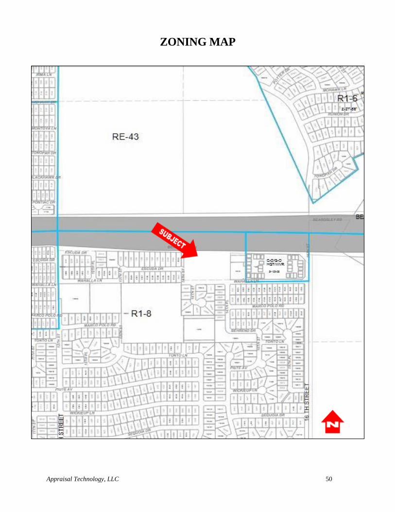
The subject site is zoned R1-8; Single Family Residential according the City of Phoenix Planning
and Zoning Department.
The basic purpose of these regulations is to foster the creation of living areas which can assist the
establishment of stable, functional neighborhoods. An established pattern of living in this
metropolitan area reflects a tradition of single family occupied dwellings which also emphasize
outdoor living. Many of these dwellings are thereby located on relatively large urban or suburban
lots.
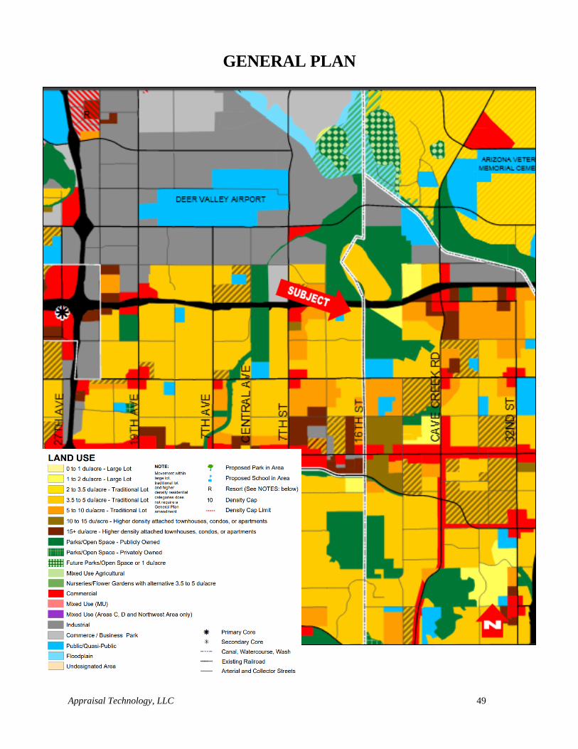
Additionally, the subject is located within an area planned for single family residential
development according to the City of Phoenix General Plan.
Although zoned for single family residential development, it is possible that due to its size and
location, the site could potentially be rezoned for a slightly higher density. Although possible, this
potential re-zoning was not considered imminent or guaranteed and the site was valued as single
family residential land.
TAX AND ASSESSMENT DATA:
Presently, the subject property is owned by ADOT and currently does not have an assigned Maricopa
County Tax I.D. number. Additionally, due to the fact that the site is owned by a government entity,
it is exempt from property taxes.
The appraiser is unaware of any known special assessments which would affect the value of the
property.
Appraisal Technology, LLC 48
CONCLUSION:
In conclusion, the physical and functional characteristics of the site are considered to have adequate
street visibility and access. The site is located in an area predominantly made up of residential
development with some commercial development located along the major roadways. The subject site
has adequate access to the goods and services of Metropolitan Phoenix. The site is at grade with the
adjoining properties with no evidence of drainage problems or soil contamination. All city
utilities/services and electricity are available to the site.
Appraisal Technology, LLC 49
GENERAL PLAN
Appraisal Technology, LLC 50
ZONING MAP
Appraisal Technology, LLC 51
HIGHEST AND BEST USE
Highest and best use is a market driven concept that focuses on market forces as each relates to the
subject site identifying the most profitable and competitive use to which the property can be put.
Following is the definition of highest and best use as used in this report:
1. The reasonably probable use of property that results in the highest value. The four criteria
that the highest and best use must meet are legal permissibility, physical possibility,
financial feasibility, and maximum productivity.
2. The use of an asset that maximizes its potential and that is possible, legally permissible,
and financially feasible. The highest and best use may be for continuation of an asset’s
existing use or for some alternative use. This is determined by the use that a market
participant would have in mind for the asset when formulating the price that is would be
willing to bid. (IVS)
3. The highest and most profitable use for which the property is adaptable and needed or
likely to be needed in the reasonably near future. (Uniform Appraisal Standards for
Federal Land Acquisitions) Appraisal Institute, The Dictionary of Real Estate Appraisal,
6th ed. (Chicago: Appraisal Institute, 2015).
Highest and Best Use as a Vacant Site
Highest and best use of a site as vacant assumes that a parcel of land is vacant or can be vacated by
demolishing existing improvements, as of the date valuation.
The purpose of determining the use of the site as vacant is to identify its potential. The goal of the
analysis is to ascertain the optimum use of the land as vacant, and what variety or type of improve-
ment, if any, is warranted given present market conditions.
In growth areas and neighborhoods in transition or where a change in the near term is expected, an
interim use could be utilized. An interim use may be the existing use, a proposed development, an
assemblage or to hold as a speculative investment.
Highest and best use implies contribution of that specific use (ideal improvements) to the community
environment or to community development goals in addition to wealth maximization of individual
property owners. Also implied, is that the determination of highest and best use results from the
appraiser’s judgment and analytical skill, i.e., the use determined from analysis represents an opinion,
not fact to be found. In appraisal practice, the concept of highest and best use represents the premise
upon which value is based.
The highest and best use conclusion may be identical to the one permitted by either zoning ordinances
or private restrictions. In some instances land has a more valuable use than that permitted by law.
When there is a strong possibility that a change in the legal use would be permitted, then it could
properly be considered as a factor affecting value. Conversely, zoning could legally permit a use
more intense than the site could reasonably be expected to perform. In such cases, if zoning will not
Appraisal Technology, LLC 52
permit a less intense use, then it is necessary to determine whether or not the zoning could be changed
and the effect of this factor upon the ultimate utilization of the property.
Although homogenetic use and compatibility are general considerations for developers, city and
county planners and the basis of more intense land use studies, they do not usually indicate the Highest
and Best Use of a property.
The Highest and Best Use is considered after analyzing current market conditions relating to the
positive and negative attributes of the subject site, significant limitations to the future use and current
relationship to other uses in the immediate neighborhood. Specifically, the use must be reasonable
within the following areas:
Legally Permissible: The use must be a legal use of the land, meeting all regulatory
approvals from national to local levels.
Physically Possible: The use must be physically feasible and appropriate for the site.
Financially Feasible: This area incorporates tests for both financial feasibility and
maximum profitability. There must be a proven market demand for any use. Further, the
present worth of the economic benefits provided by the demand must be in excess of devel-
opment costs. The use which returns the greatest profit to the land is considered the highest
and best use.
Maximally Productive: The most reasonable use which returns the greatest profit to the
land is considered the highest and best use.
Each of these areas will be discussed in more detail in the following section of my analysis of Highest
and Best Use.
To test highest and best use for the land as vacant, an appraiser analyzes all logical, feasible
alternatives with legal permissibility and physical possibilities considered first.
LEGALLY PERMISSIBLE
Legal permissibility is indicated by land use regulations and current zoning code of the controlling
governmental agency.
The subject site is zoned R1-8; Single Family Residential according the City of Phoenix Zoning
Map.
The basic purpose of these regulations is to foster the creation of living areas which can assist the
establishment of stable, functional neighborhoods. An established pattern of living in this
metropolitan area reflects a tradition of single family occupied dwellings which also emphasize
outdoor living. Many of these dwellings are thereby located on relatively large urban or suburban
lots.
In conclusion, the subject site has a legally permissible use for single family residential development.
Appraisal Technology, LLC 53
PHYSICALLY POSSIBLE
Physical possibility is shown by indicating the capabilities and adaptability of the site for the
proposed improvement (project) together with the availability of utilities and community services,
modifications that may be required and limitations caused by physical characteristics of the site.
The subject site is rectangular in shape considered to be functionally adequate for most types of
development. As per information supplied for this assignment along with the Maricopa County
Assessor’s map, the site is of 3.24 acres or 141,190 square feet in size. The site has approximately
493.49 feet of frontage along Beardsley Road (Loop 101 frontage road) to the north, 882 feet of
frontage along Wahalla Lane to the south, and approximately 131 feet of frontage along 14th Street.
There are no indicated development limitations observed from my inspection with exception to
development limitations imposed by the planning department and zoning code of the City of
Phoenix with respect to lot/building ratios and property line set-backs.
In conclusion, most types of residential development are physically possible on the subject site.
FINANCIAL FEASIBILITY
At this point of the Highest and Best Use analysis, the appraiser can conclude that the subject,
from legal, physical and appropriate considerations, could be developed with a single family
residential use. This conclusion statement considers the type of uses that are deemed to be the most
reasonable and prudent uses for the subject, as of the date of valuation. Now at this point, one must
divert the analysis with regards to the economic feasibility that may affect the subject site.
To do this task, a market study was conducted. For the purposes of this appraisal report, Market Study is defined as follows: Market Study, a macroeconomic analysis that examines the general market conditions of supply, demand, and pricing or the demographics of demand for a specific area or property type. A market study may also include analyses of construction and absorption trends. Appraisal Institute, The Dictionary of Real Estate Appraisal, 6th ed. (Chicago: Appraisal Institute, 2015).
As indicated, the subject is currently zoned for single family residential development. Therefore,
the appraiser has searched the market to determine if single family residential type development is
currently feasible in the marketplace.
Single Family Residential
The appraiser researched the subject zip code (85024) to determine single family residential supply
and demand factors. According to Arizona Multi List Service the current single family median
sales price is up 12.72% compared to the same time period last year. The median list price for
homes in the subject’s zip code was up 32.30% from the previous year’s median list price.
Absorption rates for single family homes are also up 20.16%.
Following are the summary statistics for single family residential sales activity within the subject’s
zip code.
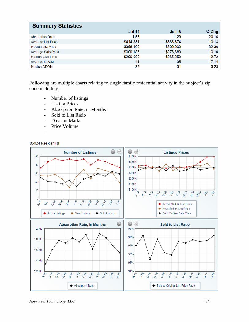
Appraisal Technology, LLC 54
Following are multiple charts relating to single family residential activity in the subject’s zip
code including:
- Number of listings
- Listing Prices
- Absorption Rate, in Months
- Sold to List Ratio
- Days on Market
- Price Volume
-
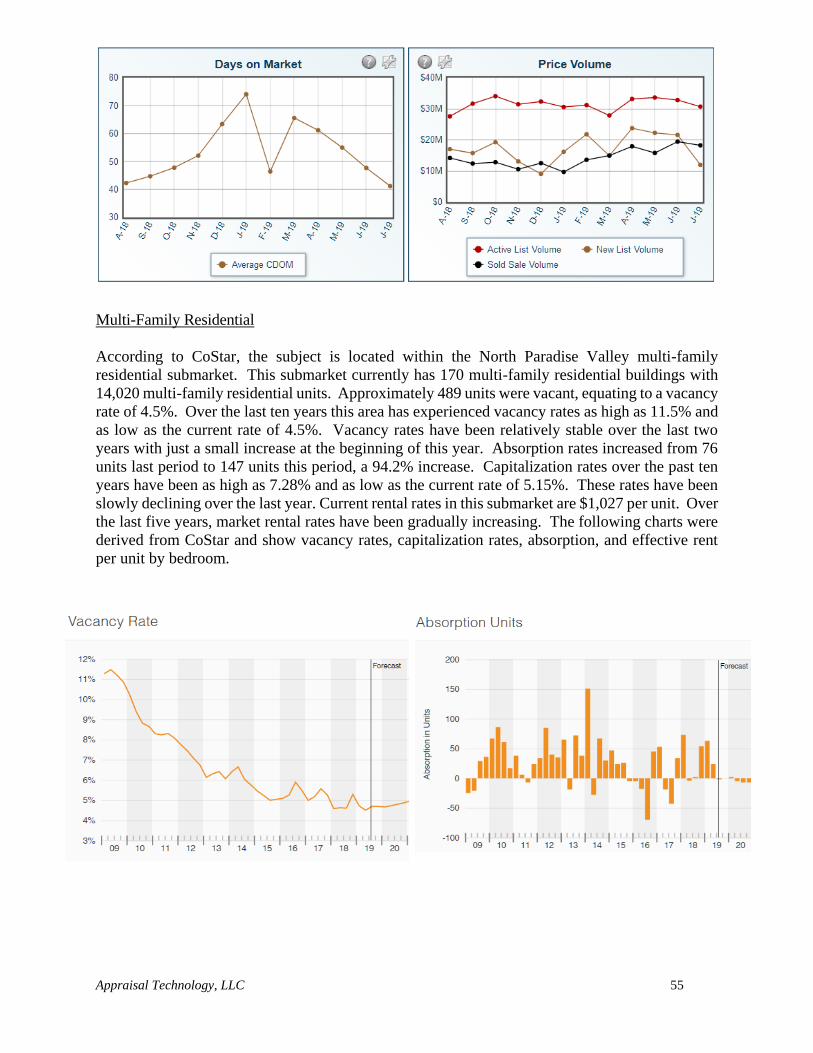
Appraisal Technology, LLC 55
Multi-Family Residential
According to CoStar, the subject is located within the North Paradise Valley multi-family
residential submarket. This submarket currently has 170 multi-family residential buildings with
14,020 multi-family residential units. Approximately 489 units were vacant, equating to a vacancy
rate of 4.5%. Over the last ten years this area has experienced vacancy rates as high as 11.5% and
as low as the current rate of 4.5%. Vacancy rates have been relatively stable over the last two
years with just a small increase at the beginning of this year. Absorption rates increased from 76
units last period to 147 units this period, a 94.2% increase. Capitalization rates over the past ten
years have been as high as 7.28% and as low as the current rate of 5.15%. These rates have been
slowly declining over the last year. Current rental rates in this submarket are $1,027 per unit. Over
the last five years, market rental rates have been gradually increasing. The following charts were
derived from CoStar and show vacancy rates, capitalization rates, absorption, and effective rent
per unit by bedroom.
Appraisal Technology, LLC 56
Based on the appraiser’s research and the previously mentioned statistics, the appraiser concludes
that single family residential development is considered financially feasible as demand appears to
be outpacing supply as can be seen in the low vacancy rates and increasing rental rates.
From the preceding analysis, it is evident the single family residential use that is physically
possible and legally permissible is currently financially feasible.
MAXIMALLY PRODUCTIVE:
From the preceding analysis, it is evident the single family residential use that is physically
possible and legally permissible is currently financially feasible and/or maximally productive at
this time.
CONCLUSION:
Based on an evaluation of the four criteria in determining a property's Highest and Best Use, it has
been concluded that the Highest and Best Use of the subject would be for single family residential
development.
Appraisal Technology, LLC 57
VALUATION PROCESS
The principles and concepts of real estate appraisal are basic to the valuation process. The principles
of real estate are based on anticipation, change, supply and demand, competition, substitution,
opportunity cost, balance, contribution, conformity and externalities.
The valuation process is:
A systematic set of procedures an appraiser follows to provide answers to a client’s questions about
real property value. Appraisal Institute, The Dictionary of Real Estate Appraisal, 6th ed. (Chicago:
Appraisal Institute, 2015)
The first step in the procedure is to define the appraisal problem: i.e., identify the real estate, the
effective date of the value estimate, the property rights being appraised, and definition of value sought.
The next step is an overview of the character and scope of the assignment. Once accomplished, factors
that affect market value are collected and analyzed. These factors are addressed in the regional, city
and neighborhood analysis, the site and improvement analysis, the highest and best use analysis, and
in the application of the three approaches to value (the Sales Comparison, the Cost, and Income
Capitalization Approaches) which follows.
SALES COMPARISON APPROACH - The process of deriving a value indication for the subject
property by comparing sales of similar properties to the property being appraised, identifying
appropriate unites of comparison, and making adjustments to the sale prices (or unite prices, as
appropriated) of the comparable properties based on relevant, market-derived elements of
comparison. The sales comparison approach may be used to value improved properties, vacant
land, or land being considered as through vacant when an adequate supply of comparable sales
is available. Appraisal Institute, The Dictionary of Real Estate Appraisal, 6th ed. (Chicago:
Appraisal Institute, 2015)
A Comparative analysis is the process by which a value indication is derived in the sales comparison
approach. Comparative analysis may employ quantitative or qualitative techniques, either separately
or in combination. The process by which a rental value indication is derived in a rental comparison
analysis. Comparative analysis may employ quantitative or qualitative techniques, either separately
or in combination. Appraisal Institute, The Dictionary of Real Estate Appraisal, 6th ed. (Chicago:
Appraisal Institute, 2015)
COST APPROACH - A set of procedures through which a value indication is derived for the fee
simple estate by estimating the current cost to construct a reproduction of (or replacement for) the
existing structure, including an entrepreneurial incentive or profit; deducting depreciations from
the total cost; and adding the estimated land value. Adjustments may then be made to the indicated
value of the fee simple estate in the subject property to reflect the value of the property interest
being appraised. Appraisal Institute, The Dictionary of Real Estate Appraisal, 6th ed. (Chicago:
Appraisal Institute, 2015)
One of the approaches to value commonly applied in Market Value estimates and many other
valuation situations. A comparative approach to the value of property or another asset that
considers, as a substitute for the purchase of a given property, the possibility of constructing
Appraisal Technology, LLC 58
another property that is an equivalent to the original or one that could furnish equal utility with no
undue cost resulting from delay. The Appraiser’s estimate is based on the reproduction or
replacement cost of the subject property or asset, less total (accrued) depreciation. The Cost
Approach establishes the value of a real property by estimating the cost of acquiring land and
building a new property with equal utility or adapting an old property to the same use with no
undue cost due to delay. An estimate of entrepreneurial incentive or developer’s profit/loss is
commonly added to land and construction costs. For older properties, the cost approach develops
an estimate of depreciation including items of physical deterioration and functional obsolescence.
INCOME CAPITALIZATION APPROACH – A set of procedures through which an appraiser
derives a value indication for an income-producing property by converting its anticipated benefits
(cash flows and reversion) into property value. This conversion can be accomplished in two ways.
One year’s income expectancy can be capitalized at a market-derived capitalization rate or at a
capitalization rate that reflects a specified income pattern, return on investment, and change in
the value of the investment. Alternatively, the annual cash flows for the holding period and the
reversion can be discounted at a specified yield rate.
A comparative approach to value that considers income and expense data relating to the property
being valued and estimates value through a capitalization process. Capitalization relates income
(usually net income) and a defined value type by converting an income amount into a value
estimate. This process may consider direct relationships (whereby an overall capitalization rate or
all risks yield is applied to a single year’s income), yield or discount rates (reflecting measures of
return on investment) applied to a series of incomes over a projected period, or both. The Income
Approach reflects the principles of substitution and anticipation.
As the subject is vacant land with no improvements and only the Sales Comparison Approach is
considered in this report in order to determine a value of the subject site.
Appraisal Technology, LLC 59
SALES COMPARISON APPROACH
In the sales comparison approach, market value is estimated by comparing the subject property to
similar properties that have been sold recently or for which offers to purchase have been made. A
major premise of the sales comparison approach is that the market value of a property is directly
related to the prices of comparable, competitive properties.
There are five basic steps in the Sales Comparison Approach:
1. Research the market to locate sales of properties similar to the subject.
2. Confirm and verify the sales price, terms of sale, physical characteristics, income
characteristics and that the sale represents an arms-length transaction.
3. Identify relevant elements of comparison and analyze each sale for each unit.
4. Compare the subject property to the comparable sales and adjust each for relevant
differences to establish comparability.
5. Reconcile the various indications of value into a market value estimate for the subject
property.
Public records of Maricopa County, Arizona have been searched for recent sales of comparable
properties in the market. Additionally, market participants have been consulted regarding market
sales and how participants analyze property for purchase. Sales have been confirmed with the seller,
buyer, real estate broker or other persons knowledgeable about each transaction and verified by
Affidavit of Property Value which is a sworn statement as to the validity of the transaction.
The appraiser has searched the market place for similar sized sites with similar utility and zoning as
the subject. The sales utilized are considered the best comparable data available.
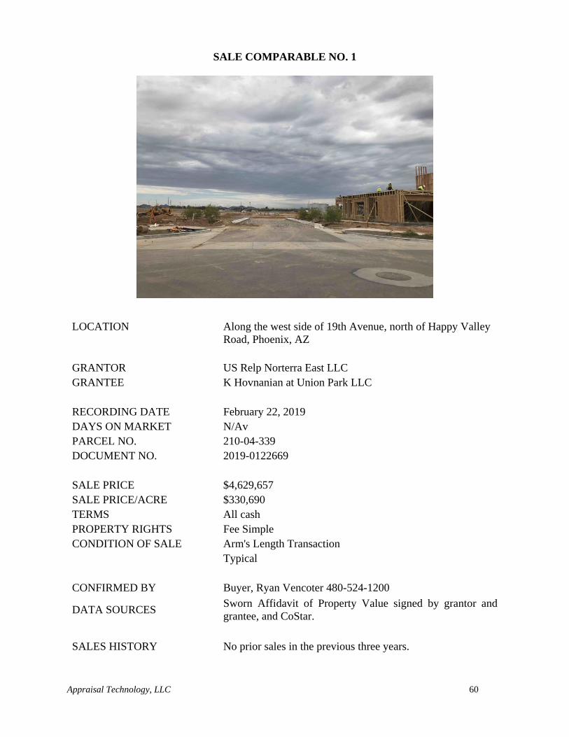
Appraisal Technology, LLC 60
SALE COMPARABLE NO. 1
LOCATION
Along the west side of 19th Avenue, north of Happy Valley
Road, Phoenix, AZ
GRANTOR US Relp Norterra East LLC
GRANTEE K Hovnanian at Union Park LLC
RECORDING DATE February 22, 2019
DAYS ON MARKET N/Av
PARCEL NO. 210-04-339
DOCUMENT NO. 2019-0122669
SALE PRICE $4,629,657
SALE PRICE/ACRE $330,690
TERMS All cash
PROPERTY RIGHTS Fee Simple
CONDITION OF SALE Arm's Length Transaction
Typical
CONFIRMED BY Buyer, Ryan Vencoter 480-524-1200
DATA SOURCES Sworn Affidavit of Property Value signed by grantor and
grantee, and CoStar.
SALES HISTORY No prior sales in the previous three years.
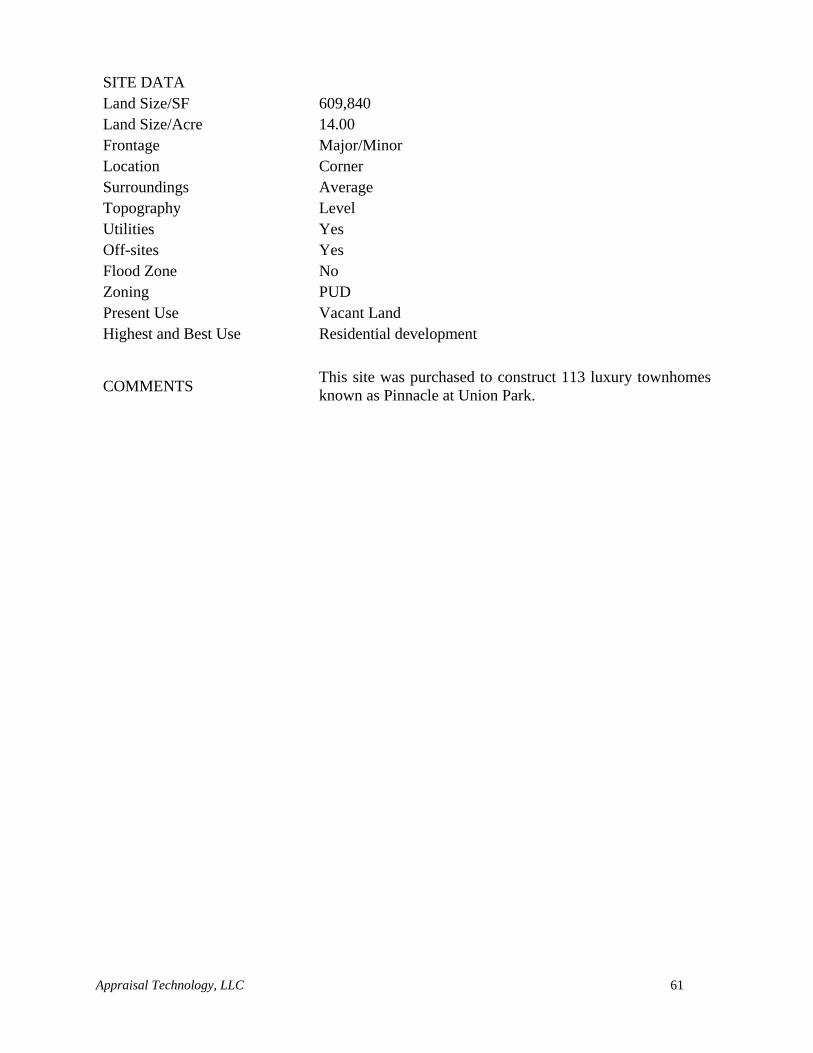
Appraisal Technology, LLC 61
SITE DATA
Land Size/SF 609,840
Land Size/Acre 14.00
Frontage Major/Minor
Location Corner
Surroundings Average
Topography Level
Utilities Yes
Off-sites Yes
Flood Zone No
Zoning PUD
Present Use Vacant Land
Highest and Best Use Residential development
COMMENTS This site was purchased to construct 113 luxury townhomes
known as Pinnacle at Union Park.
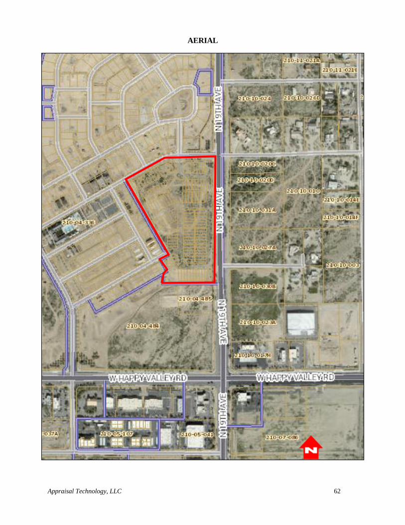
Appraisal Technology, LLC 62
AERIAL
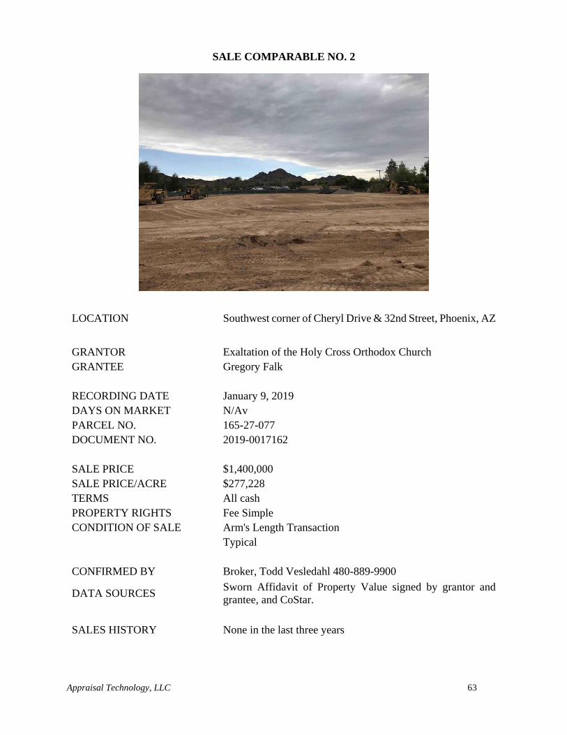
Appraisal Technology, LLC 63
SALE COMPARABLE NO. 2
LOCATION Southwest corner of Cheryl Drive & 32nd Street, Phoenix, AZ
GRANTOR Exaltation of the Holy Cross Orthodox Church
GRANTEE Gregory Falk
RECORDING DATE January 9, 2019
DAYS ON MARKET N/Av
PARCEL NO. 165-27-077
DOCUMENT NO. 2019-0017162
SALE PRICE $1,400,000
SALE PRICE/ACRE $277,228
TERMS All cash
PROPERTY RIGHTS Fee Simple
CONDITION OF SALE Arm's Length Transaction
Typical
CONFIRMED BY Broker, Todd Vesledahl 480-889-9900
DATA SOURCES Sworn Affidavit of Property Value signed by grantor and
grantee, and CoStar.
SALES HISTORY None in the last three years
Appraisal Technology, LLC 64
SITE DATA
Land Size/SF 219,978
Land Size/Acre 5.05
Frontage Major/Minor
Location Corner
Surroundings Average
Topography Level
Utilities Yes
Off-sites Yes
Flood Zone No
Zoning R1-10
Present Use Vacant Land
Highest and Best Use Residential development
COMMENTS
This site was improved with a church at the time of sale.
However, the site was purchased for its land value only and
was purchased for the construction of an assisted living
facility.
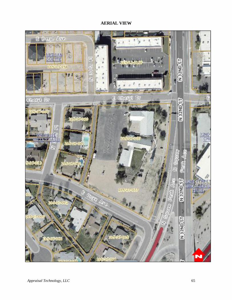
Appraisal Technology, LLC 65
AERIAL VIEW
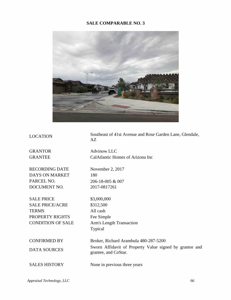
Appraisal Technology, LLC 66
SALE COMPARABLE NO. 3
LOCATION Southeast of 41st Avenue and Rose Garden Lane, Glendale,
AZ
GRANTOR Advinow LLC
GRANTEE CalAtlantic Homes of Arizona Inc
RECORDING DATE November 2, 2017
DAYS ON MARKET 180
PARCEL NO. 206-18-005 & 007
DOCUMENT NO. 2017-0817261
SALE PRICE $3,000,000
SALE PRICE/ACRE $312,500
TERMS All cash
PROPERTY RIGHTS Fee Simple
CONDITION OF SALE Arm's Length Transaction
Typical
CONFIRMED BY Broker, Richard Arambula 480-287-5200
DATA SOURCES Sworn Affidavit of Property Value signed by grantor and
grantee, and CoStar.
SALES HISTORY None in previous three years
Appraisal Technology, LLC 67
SITE DATA
Land Size/SF 418,176
Land Size/Acre 9.60
Frontage Minor
Location Interior
Surroundings Average
Topography Level
Utilities Yes
Off-sites Yes
Flood Zone No
Zoning R1-8
Present Use Platted & Engineered Lots
Highest and Best Use Residential development
COMMENTS
This site was platted & engineered for 43 single family
residential lots at the time of sale. The buyer plans to construct
a single family residential subdivision.
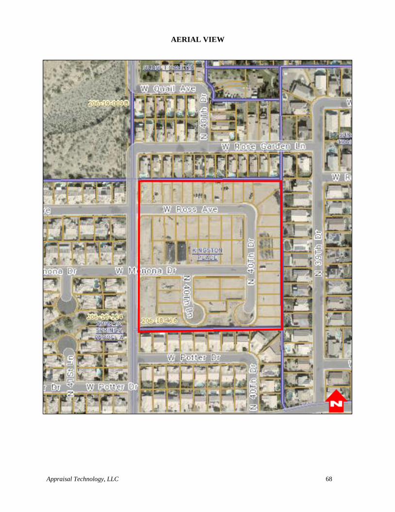
Appraisal Technology, LLC 68
AERIAL VIEW
Appraisal Technology, LLC 69
SALE COMPARABLE NO. 4
LOCATION Southeast corner of Cave Creek Road & Utopia Road,
Phoenix, AZ
GRANTOR Marbella Homes, Inc
GRANTEE Utopia 2017, LLC
RECORDING DATE August 4, 2017
DAYS ON MARKET 758
PARCEL NO. 213-26-324
DOCUMENT NO. 2017-0573298
SALE PRICE $275,000
SALE PRICE/ACRE $218,254
TERMS All cash
PROPERTY RIGHTS Fee Simple
CONDITION OF SALE Arm's Length Transaction
Typical
CONFIRMED BY Broker, Gene Montemore. 480-529-4363
DATA SOURCES Sworn Affidavit of Property Value signed by grantor and
grantee, and CoStar.
SALES HISTORY None in previous three years
Appraisal Technology, LLC 70
SITE DATA
Land Size/SF 54,947
Land Size/Acre 1.26
Frontage Major
Location Corner
Surroundings Average
Topography Sloping
Utilities Yes
Off-sites Yes
Flood Zone No
Zoning M-H
Present Use Vacant Land
Highest and Best Use Residential development
COMMENTS This site was purchased for investment. The buyer will
develop townhomes on the site.
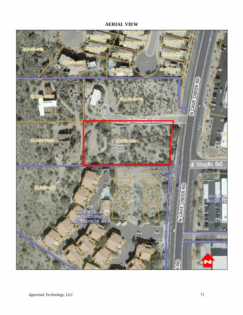
Appraisal Technology, LLC 71
AERIAL VIEW
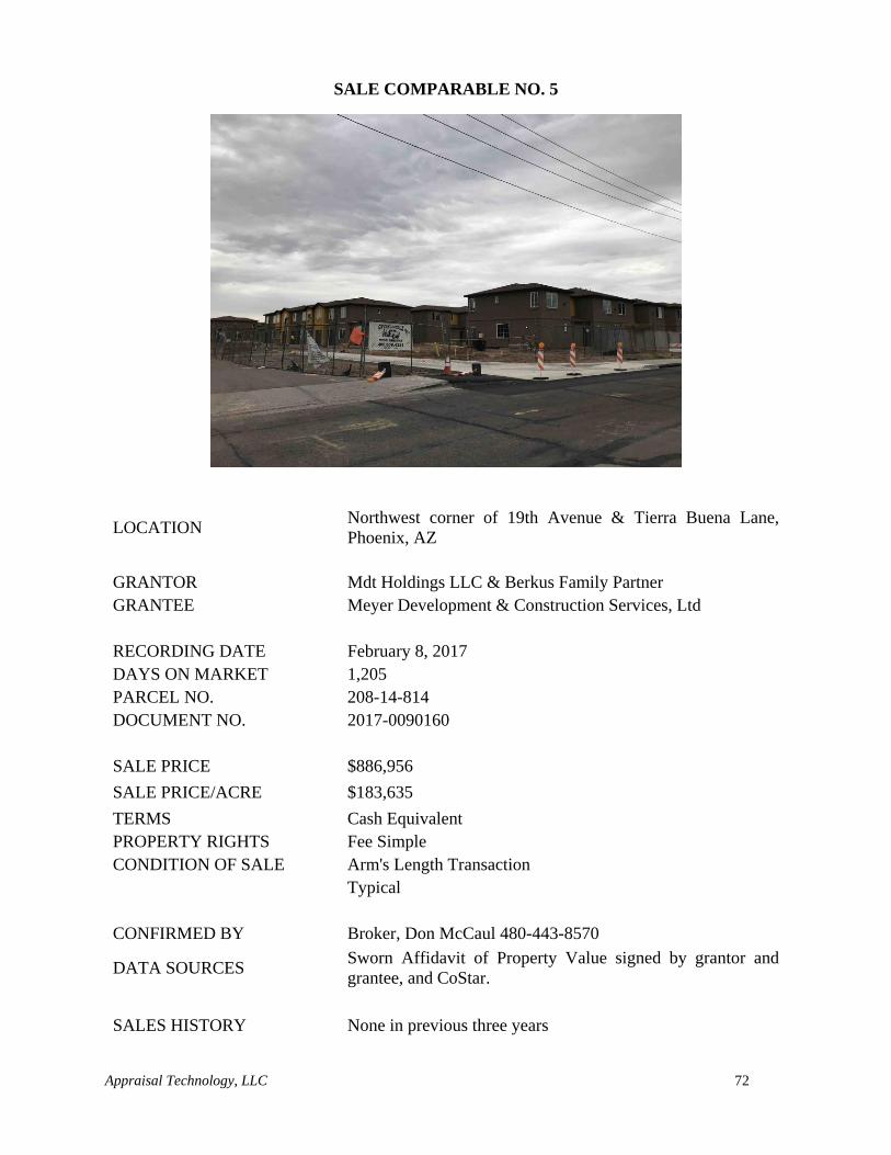
Appraisal Technology, LLC 72
SALE COMPARABLE NO. 5
LOCATION
Northwest corner of 19th Avenue & Tierra Buena Lane,
Phoenix, AZ
GRANTOR Mdt Holdings LLC & Berkus Family Partner
GRANTEE Meyer Development & Construction Services, Ltd
RECORDING DATE February 8, 2017
DAYS ON MARKET 1,205
PARCEL NO. 208-14-814
DOCUMENT NO. 2017-0090160
SALE PRICE $886,956
SALE PRICE/ACRE $183,635
TERMS Cash Equivalent
PROPERTY RIGHTS Fee Simple
CONDITION OF SALE Arm's Length Transaction
Typical
CONFIRMED BY Broker, Don McCaul 480-443-8570
DATA SOURCES Sworn Affidavit of Property Value signed by grantor and
grantee, and CoStar.
SALES HISTORY None in previous three years
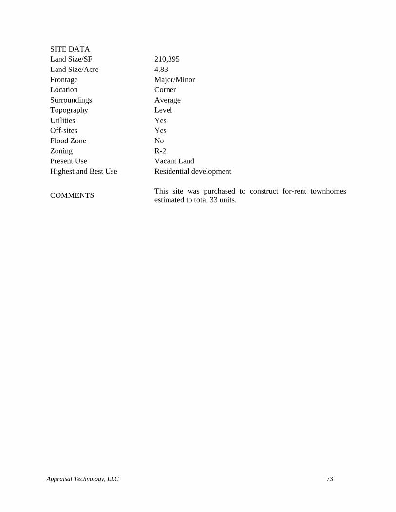
Appraisal Technology, LLC 73
SITE DATA
Land Size/SF 210,395
Land Size/Acre 4.83
Frontage Major/Minor
Location Corner
Surroundings Average
Topography Level
Utilities Yes
Off-sites Yes
Flood Zone No
Zoning R-2
Present Use Vacant Land
Highest and Best Use Residential development
COMMENTS This site was purchased to construct for-rent townhomes
estimated to total 33 units.
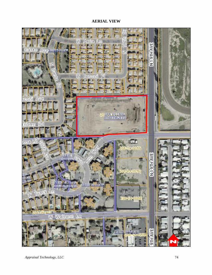
Appraisal Technology, LLC 74
AERIAL VIEW
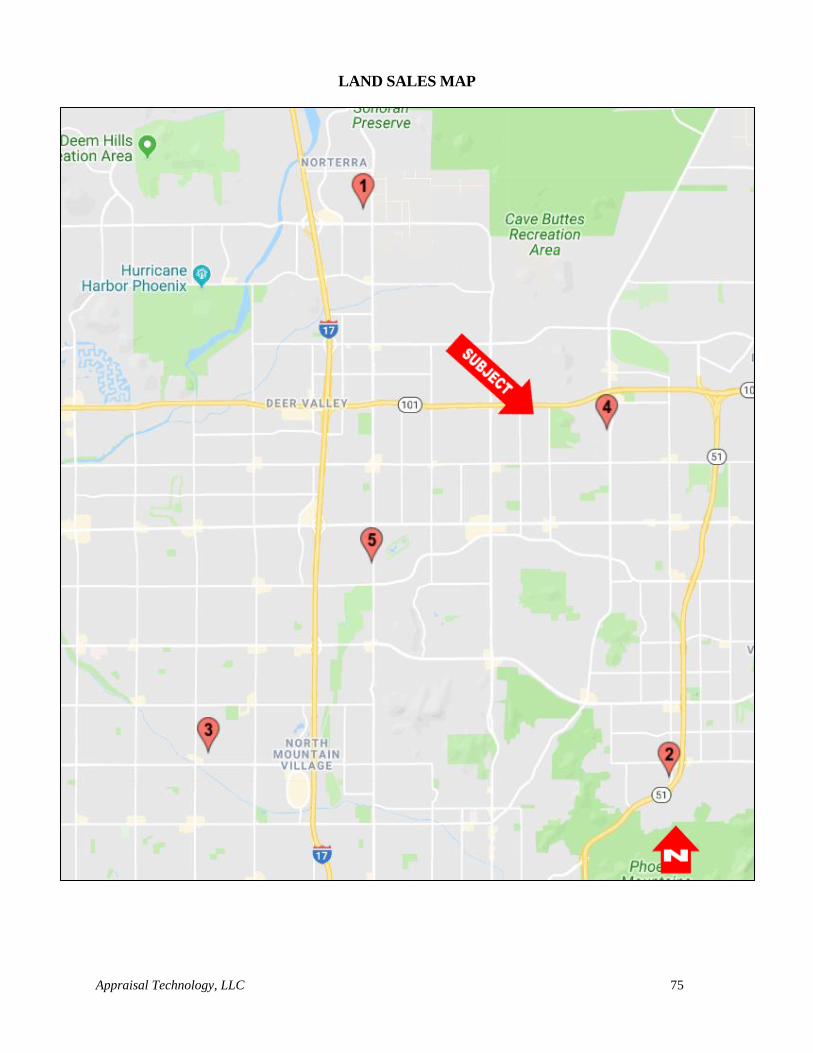
Appraisal Technology, LLC 75
LAND SALES MAP
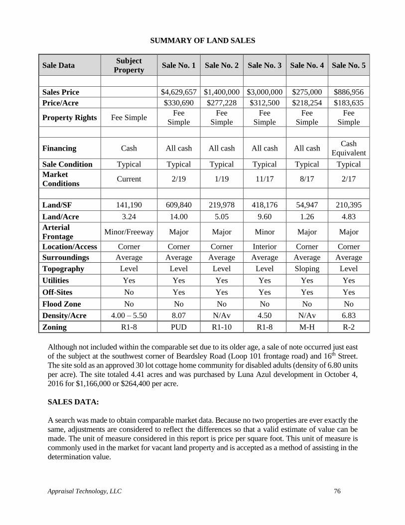
Appraisal Technology, LLC 76
SUMMARY OF LAND SALES
Sale Data Subject
Property Sale No. 1 Sale No. 2 Sale No. 3 Sale No. 4 Sale No. 5
Sales Price $4,629,657 $1,400,000 $3,000,000 $275,000 $886,956
Price/Acre $330,690 $277,228 $312,500 $218,254 $183,635
Property Rights Fee Simple Fee
Simple
Fee
Simple
Fee
Simple
Fee
Simple
Fee
Simple
Financing Cash All cash All cash All cash All cash Cash
Equivalent
Sale Condition Typical Typical Typical Typical Typical Typical
Market
Conditions Current 2/19 1/19 11/17 8/17 2/17
Land/SF 141,190 609,840 219,978 418,176 54,947 210,395
Land/Acre 3.24 14.00 5.05 9.60 1.26 4.83
Arterial
Frontage Minor/Freeway Major Major Minor Major Major
Location/Access Corner Corner Corner Interior Corner Corner
Surroundings Average Average Average Average Average Average
Topography Level Level Level Level Sloping Level
Utilities Yes Yes Yes Yes Yes Yes
Off-Sites No Yes Yes Yes Yes Yes
Flood Zone No No No No No No
Density/Acre 4.00 – 5.50 8.07 N/Av 4.50 N/Av 6.83
Zoning R1-8 PUD R1-10 R1-8 M-H R-2
Although not included within the comparable set due to its older age, a sale of note occurred just east
of the subject at the southwest corner of Beardsley Road (Loop 101 frontage road) and 16th Street.
The site sold as an approved 30 lot cottage home community for disabled adults (density of 6.80 units
per acre). The site totaled 4.41 acres and was purchased by Luna Azul development in October 4,
2016 for $1,166,000 or $264,400 per acre.
SALES DATA:
A search was made to obtain comparable market data. Because no two properties are ever exactly the
same, adjustments are considered to reflect the differences so that a valid estimate of value can be
made. The unit of measure considered in this report is price per square foot. This unit of measure is
commonly used in the market for vacant land property and is accepted as a method of assisting in the
determination value.
Appraisal Technology, LLC 77
Adjustments to a property may be made either in terms of a percentage or dollars per square foot.
There is no “proper” method of adjustment to strictly adhere to since adjustments depend on how the
relationship between the two properties is perceived by the market. A market value estimate is not
determined by a set of precise calculations. Appraisal has an art aspect in that an appraiser uses their
judgment to analyze and interpret quantitative data.
Adjustments to the comparable sales are made as follows:
PROPERTY RIGHTS CONVEYED:
All of the comparable sales are believed to be unencumbered and the ownership rights transferred
were Fee Simple Estate.
FINANCING:
All of the comparable sales were all cash to the seller or equivalent and no adjustment is necessary
for financing.
CONDITIONS OF SALE:
All of the comparable sales were reported to be arms-length transactions and no adjustments were
made.
MARKET CONDITIONS:
The comparable sales were transacted between February 2017 and February 2019 and are considered
to generally reflect current market conditions. It is noted that sale prices have been moving upwards
slightly over the last several years as residential development demand increases. The appraiser
researched single family residential land sales and have found that prices have remained relatively
stable over the past year and no adjustment is warranted for the comparable sales one and two.
Comparables three, four, and five however are slightly older and will be adjusted upward.
LOCATION:
An adjustment for location is necessary when the location characteristics of a comparable property
are different from those of the subject property. Factors analyzed include roadway frontage, freeway
accessibility, access, and surrounding development and/or access to goods and services.
The subject property has visibility from Beardsley Road, Wahalla Lane, 14th Street, and the Loop
101 Freeway, access to the site is only available from 14th Street and Wahalla Lane. The property
has good frontage and access to the Metropolitan Phoenix transportation network.
The subject property has direct frontage along the Loop 101 frontage road (Beardsley Road) as well
as Wahalla Lane and 14th Street. Each of the comparable sales had major roadway frontage with the
exception of comparable three, which was an interior parcel within an existing larger subdivision.
Although residential users don’t necessarily require or prefer major roadway frontage, this does allow
for easy (quicker) access to the transportation network and in general is not a negative attribute.
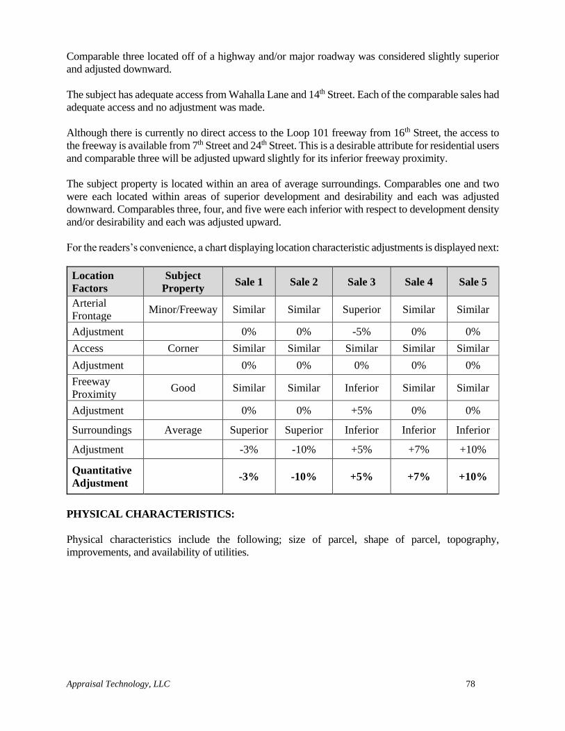
Appraisal Technology, LLC 78
Comparable three located off of a highway and/or major roadway was considered slightly superior
and adjusted downward.
The subject has adequate access from Wahalla Lane and 14th Street. Each of the comparable sales had
adequate access and no adjustment was made.
Although there is currently no direct access to the Loop 101 freeway from 16th Street, the access to
the freeway is available from 7th Street and 24th Street. This is a desirable attribute for residential users
and comparable three will be adjusted upward slightly for its inferior freeway proximity.
The subject property is located within an area of average surroundings. Comparables one and two
were each located within areas of superior development and desirability and each was adjusted
downward. Comparables three, four, and five were each inferior with respect to development density
and/or desirability and each was adjusted upward.
For the readers’s convenience, a chart displaying location characteristic adjustments is displayed next:
Location
Factors
Subject
Property Sale 1 Sale 2 Sale 3 Sale 4 Sale 5
Arterial
Frontage Minor/Freeway Similar Similar Superior Similar Similar
Adjustment 0% 0% -5% 0% 0%
Access Corner Similar Similar Similar Similar Similar
Adjustment 0% 0% 0% 0% 0%
Freeway
Proximity Good Similar Similar Inferior Similar Similar
Adjustment 0% 0% +5% 0% 0%
Surroundings Average Superior Superior Inferior Inferior Inferior
Adjustment -3% -10% +5% +7% +10%
Quantitative
Adjustment -3% -10% +5% +7% +10%
PHYSICAL CHARACTERISTICS:
Physical characteristics include the following; size of parcel, shape of parcel, topography,
improvements, and availability of utilities.
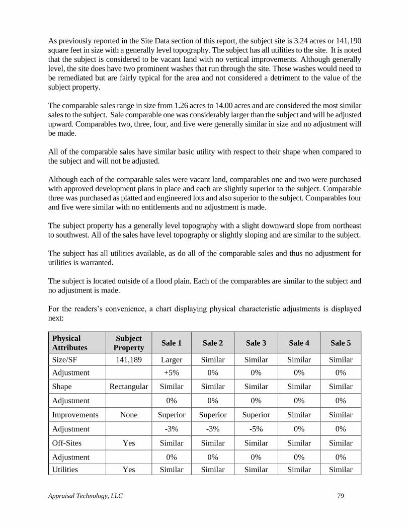
Appraisal Technology, LLC 79
As previously reported in the Site Data section of this report, the subject site is 3.24 acres or 141,190
square feet in size with a generally level topography. The subject has all utilities to the site. It is noted
that the subject is considered to be vacant land with no vertical improvements. Although generally
level, the site does have two prominent washes that run through the site. These washes would need to
be remediated but are fairly typical for the area and not considered a detriment to the value of the
subject property.
The comparable sales range in size from 1.26 acres to 14.00 acres and are considered the most similar
sales to the subject. Sale comparable one was considerably larger than the subject and will be adjusted
upward. Comparables two, three, four, and five were generally similar in size and no adjustment will
be made.
All of the comparable sales have similar basic utility with respect to their shape when compared to
the subject and will not be adjusted.
Although each of the comparable sales were vacant land, comparables one and two were purchased
with approved development plans in place and each are slightly superior to the subject. Comparable
three was purchased as platted and engineered lots and also superior to the subject. Comparables four
and five were similar with no entitlements and no adjustment is made.
The subject property has a generally level topography with a slight downward slope from northeast
to southwest. All of the sales have level topography or slightly sloping and are similar to the subject.
The subject has all utilities available, as do all of the comparable sales and thus no adjustment for
utilities is warranted.
The subject is located outside of a flood plain. Each of the comparables are similar to the subject and
no adjustment is made.
For the readers’s convenience, a chart displaying physical characteristic adjustments is displayed
next:
Physical
Attributes
Subject
Property Sale 1 Sale 2 Sale 3 Sale 4 Sale 5
Size/SF 141,189 Larger Similar Similar Similar Similar
Adjustment +5% 0% 0% 0% 0%
Shape Rectangular Similar Similar Similar Similar Similar
Adjustment 0% 0% 0% 0% 0%
Improvements None Superior Superior Superior Similar Similar
Adjustment -3% -3% -5% 0% 0%
Off-Sites Yes Similar Similar Similar Similar Similar
Adjustment 0% 0% 0% 0% 0%
Utilities Yes Similar Similar Similar Similar Similar
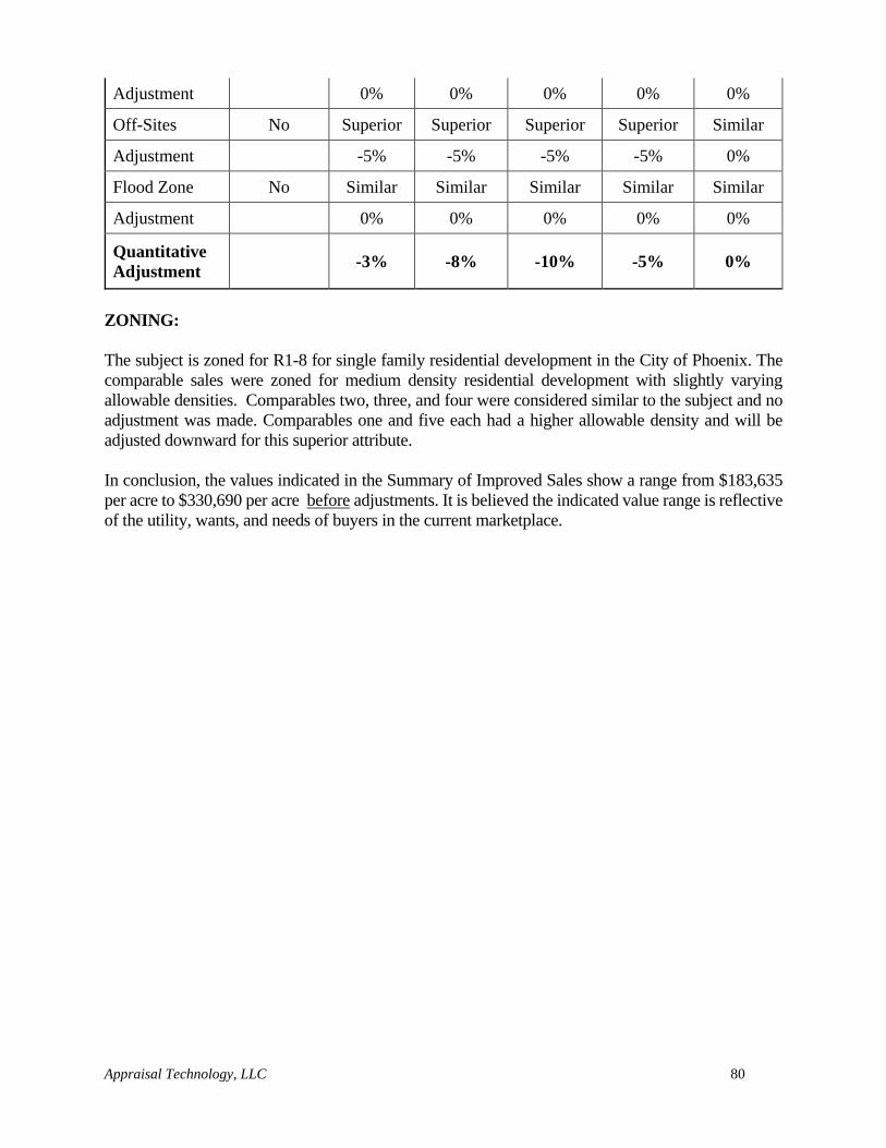
Appraisal Technology, LLC 80
Adjustment 0% 0% 0% 0% 0%
Off-Sites No Superior Superior Superior Superior Similar
Adjustment -5% -5% -5% -5% 0%
Flood Zone No Similar Similar Similar Similar Similar
Adjustment 0% 0% 0% 0% 0%
Quantitative
Adjustment -3% -8% -10% -5% 0%
ZONING:
The subject is zoned for R1-8 for single family residential development in the City of Phoenix. The
comparable sales were zoned for medium density residential development with slightly varying
allowable densities. Comparables two, three, and four were considered similar to the subject and no
adjustment was made. Comparables one and five each had a higher allowable density and will be
adjusted downward for this superior attribute.
In conclusion, the values indicated in the Summary of Improved Sales show a range from $183,635
per acre to $330,690 per acre before adjustments. It is believed the indicated value range is reflective
of the utility, wants, and needs of buyers in the current marketplace.
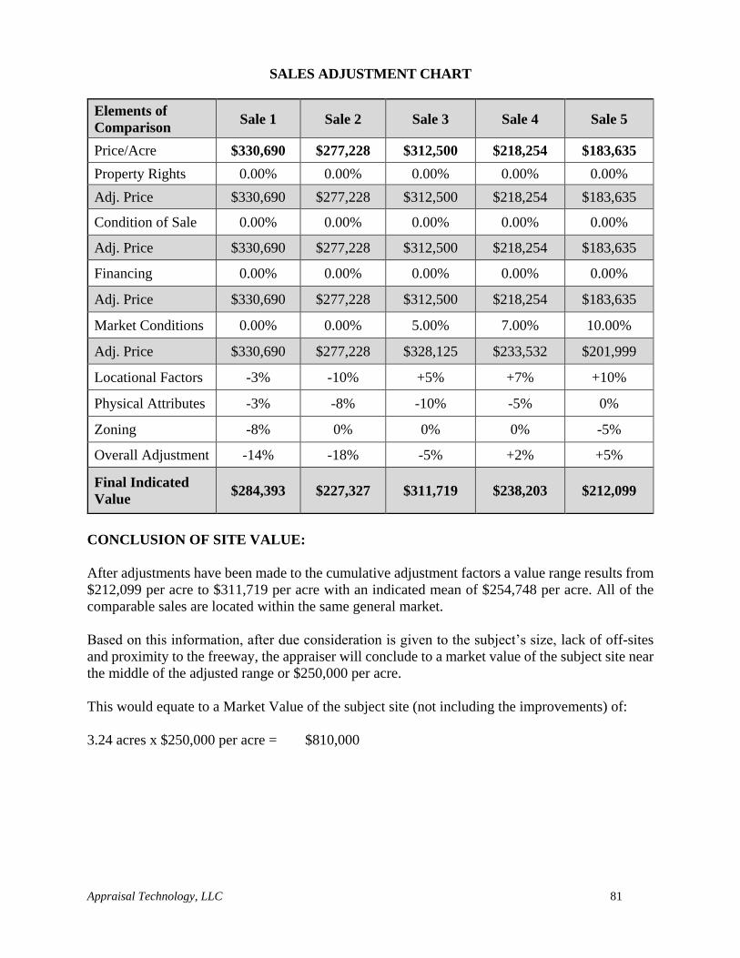
Appraisal Technology, LLC 81
SALES ADJUSTMENT CHART
Elements of
Comparison Sale 1 Sale 2 Sale 3 Sale 4 Sale 5
Price/Acre $330,690 $277,228 $312,500 $218,254 $183,635
Property Rights 0.00% 0.00% 0.00% 0.00% 0.00%
Adj. Price $330,690 $277,228 $312,500 $218,254 $183,635
Condition of Sale 0.00% 0.00% 0.00% 0.00% 0.00%
Adj. Price $330,690 $277,228 $312,500 $218,254 $183,635
Financing 0.00% 0.00% 0.00% 0.00% 0.00%
Adj. Price $330,690 $277,228 $312,500 $218,254 $183,635
Market Conditions 0.00% 0.00% 5.00% 7.00% 10.00%
Adj. Price $330,690 $277,228 $328,125 $233,532 $201,999
Locational Factors -3% -10% +5% +7% +10%
Physical Attributes -3% -8% -10% -5% 0%
Zoning -8% 0% 0% 0% -5%
Overall Adjustment -14% -18% -5% +2% +5%
Final Indicated
Value $284,393 $227,327 $311,719 $238,203 $212,099
CONCLUSION OF SITE VALUE:
After adjustments have been made to the cumulative adjustment factors a value range results from
$212,099 per acre to $311,719 per acre with an indicated mean of $254,748 per acre. All of the
comparable sales are located within the same general market.
Based on this information, after due consideration is given to the subject’s size, lack of off-sites
and proximity to the freeway, the appraiser will conclude to a market value of the subject site near
the middle of the adjusted range or $250,000 per acre.
This would equate to a Market Value of the subject site (not including the improvements) of:
3.24 acres x $250,000 per acre = $810,000
Appraisal Technology, LLC 82
RECONCILIATION
The Final Reconciliation is the process of coordinating and integrating related facts to form a unified
conclusion. Final Reconciliation is defined as: The last phase in the development of a value opinion
in which two or more value indications derived from market data are resolved into a final value
opinion, which may be either a range of value, in relation to a benchmark, or a single point
estimate. Appraisal Institute, The Dictionary of Real Estate Appraisal, 6th ed. (Chicago: Appraisal
Institute, 2015)
The orderly connection of interdependent elements is a prerequisite of proper reconciliation. This
requires a re-examination of specific data, procedures, and techniques within the framework of
approaches used to derive preliminary estimates. The approach utilized to conclude to a value
estimate considered appraisal techniques which encompassed: (1) reviewed to make sure that the data
is authentic and reflects pertinent market activity and (2) the analytical techniques used and the logic
followed are valid, realistic, and consistent. In addition, all mathematical calculations have been
checked by someone other than the appraiser in an attempt to eliminate errors.
One approach to value have been employed in the analysis. The data together with the line of
reasoning followed for each approach is clearly set forth.
Sales Comparison Approach $810,000
The reconciliation considers and evaluates alternate value indication to arrive at a final value estimate.
Each value indication is weighted according to relative significance, applicability, and defensibility
and relies most heavily on the approach that is most appropriate to the purpose of the appraisal.
In an appraisal report, the final value estimate may be stated as a single figure or as a range of values.
Or an appraiser may choose to show the range and then cite the final value as a single figure within
the range. Traditionally, a point estimate is typically regarded as the most probable number, not the
only possible number, and is often required for revenue and compensation purposes and for lending
purposes. Appraisal Institute, The Dictionary of Real Estate Appraisal, 6th ed. (Chicago: Appraisal Institute, 2015).
A point estimate concept is utilized in this reconciliation.
The Sales Comparison Approach was based upon sales of similar properties considered comparable
to the subject. These sales, after adjustments for the various elements of comparison, were analyzed
from which an indication of value was derived. Sales were selected that were considered the most
representative properties that could be located in the market. This approach is considered a good
indication of value and a reflection of the motivations of market participants and was utilized.
It is the appraiser’s opinion, based upon the following data and discussions that the Market Value
of the subject site, as of August 5, 2019, is:
EIGHT HUNDRED TEN THOUSAND DOLLARS
($810,000.00)
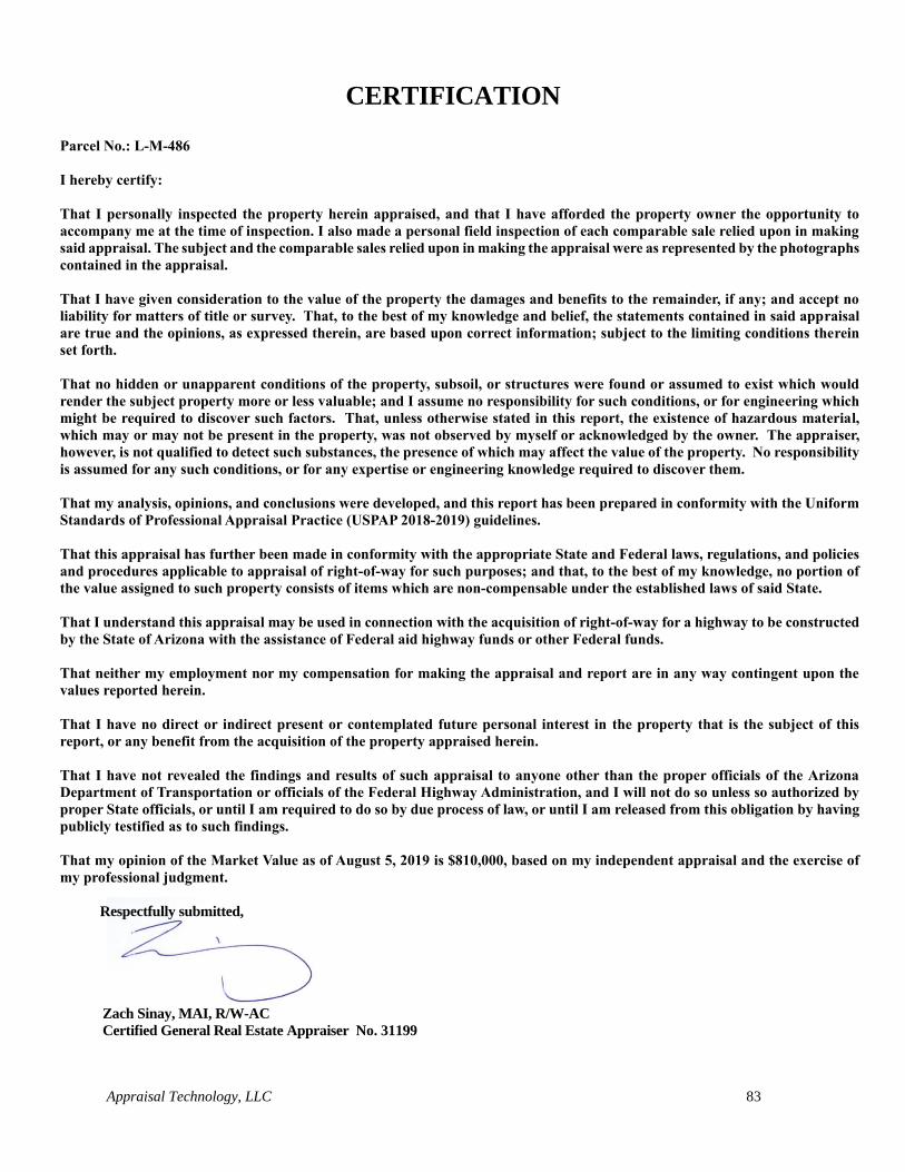
Appraisal Technology, LLC 83
CERTIFICATION
Parcel No.: L-M-486
I hereby certify:
That I personally inspected the property herein appraised, and that I have afforded the property owner the opportunity to
accompany me at the time of inspection. I also made a personal field inspection of each comparable sale relied upon in making
said appraisal. The subject and the comparable sales relied upon in making the appraisal were as represented by the photographs
contained in the appraisal.
That I have given consideration to the value of the property the damages and benefits to the remainder, if any; and accept no
liability for matters of title or survey. That, to the best of my knowledge and belief, the statements contained in said appraisal
are true and the opinions, as expressed therein, are based upon correct information; subject to the limiting conditions therein
set forth.
That no hidden or unapparent conditions of the property, subsoil, or structures were found or assumed to exist which would
render the subject property more or less valuable; and I assume no responsibility for such conditions, or for engineering which
might be required to discover such factors. That, unless otherwise stated in this report, the existence of hazardous material,
which may or may not be present in the property, was not observed by myself or acknowledged by the owner. The appraiser,
however, is not qualified to detect such substances, the presence of which may affect the value of the property. No responsibility
is assumed for any such conditions, or for any expertise or engineering knowledge required to discover them.
That my analysis, opinions, and conclusions were developed, and this report has been prepared in conformity with the Uniform
Standards of Professional Appraisal Practice (USPAP 2018-2019) guidelines.
That this appraisal has further been made in conformity with the appropriate State and Federal laws, regulations, and policies
and procedures applicable to appraisal of right-of-way for such purposes; and that, to the best of my knowledge, no portion of
the value assigned to such property consists of items which are non-compensable under the established laws of said State.
That I understand this appraisal may be used in connection with the acquisition of right-of-way for a highway to be constructed
by the State of Arizona with the assistance of Federal aid highway funds or other Federal funds.
That neither my employment nor my compensation for making the appraisal and report are in any way contingent upon the
values reported herein.
That I have no direct or indirect present or contemplated future personal interest in the property that is the subject of this
report, or any benefit from the acquisition of the property appraised herein.
That I have not revealed the findings and results of such appraisal to anyone other than the proper officials of the Arizona
Department of Transportation or officials of the Federal Highway Administration, and I will not do so unless so authorized by
proper State officials, or until I am required to do so by due process of law, or until I am released from this obligation by having
publicly testified as to such findings.
That my opinion of the Market Value as of August 5, 2019 is $810,000, based on my independent appraisal and the exercise of
my professional judgment.
Respectfully submitted,
Zach Sinay, MAI, R/W-AC
Certified General Real Estate Appraiser No. 31199

Appraisal Technology, LLC 84
QUALIFICATIONS OF ERIC ZACHARY SINAY
Certified General Real Estate Appraiser No. 31199
FORMAL EDUCATION:
Graduated from Arizona State University, May 1998, Bachelor of Science.
PROFESSIONAL EDUCATION:
Arizona School of Real Estate, Real Estate Valuation 101, Scottsdale, AZ, 1999
Arizona School of Real Estate, Real Estate Valuation 102, Scottsdale, AZ, 1999
Arizona School of Real Estate, Real Estate Valuation 103, Scottsdale, AZ, 2001
Arizona School of Real Estate, Real Estate Valuation 104, Part B, Scottsdale, AZ, 2001
Arizona School of Real Estate, Real Estate Valuation 104, Part A, Scottsdale, AZ, 2002
International Right of Way Association, Environmental Issues C-600, Tempe AZ, 2004
International Right of Way Association, The Appraisal of Partial Acquisitions C-401, San Diego, CA, 2004
International Right of Way Association, The Principles of Real Estate Law C-800, Las Vegas, NV, 2004
International Right of Way Association, The Principles of Real Estate Engineering C-900, Las Vegas, NV,
2004
McKissock, Construction Details & Trends, Continuing Online Education Course, 2008
McKissock, Cost Approach, Continuing Online Education Course, 2008
McKissock, Income Approach, Continuing Online Education Course, 2008
International Right of Way Association, Introduction to the Income Capitalization Approach, C-402, 2009
International Right of Way Association, Ethics and the Right of Way Profession C-103, 2009
McKissock, How to Analyze and Value Income Properties, 2009
McKissock, Land and Site Valuation, 2009
McKissock, Introduction to Expert Witness Testimony, 2009
International Right of Way Association, Easement Valuation C-403, 2009
McKissock, Evolution of Finance & The Mortgage Market, 2011
McKissock, Nuts and Bolts of Green Building, 2011
McKissock, Foundations in Sustainability: Greening the Real Estate and Appraisal Industry, 2011
Appraisal Institute, Business Practices and Ethics, 2013
Appraisal Institute, Advanced Income Capitalization, 2013
Appraisal Institute, General Appraiser Report Writing and Case Studies, 2013
Appraisal Institute, Quantitative Analysis, 2013
Appraisal Institute, Advanced Market Analysis and Highest and Best Use, 2013
Appraisal Institute, Advanced Concepts & Case Studies, 2014
McKissock, Appraisal of Self Storage Facilities 2018
McKissock, Appraisal of Land Subject to Ground Lease, 2018
7-Hour Uniform Standards of Professional Appraisal Practice (USPAP) – Current
PROFESSIONAL AFFILIATIONS:
Appraisal Institute - MAI designated member. "The Appraisal Institute conducts a voluntary program of
continuing education for its designated members. MAIs and SRAs who meet the minimum standards of
this program are awarded periodic educational certification. I am certified under this program."
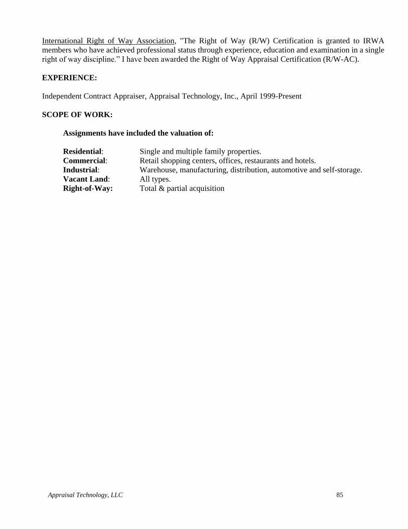
Appraisal Technology, LLC 85
International Right of Way Association, "The Right of Way (R/W) Certification is granted to IRWA
members who have achieved professional status through experience, education and examination in a single
right of way discipline.” I have been awarded the Right of Way Appraisal Certification (R/W-AC).
EXPERIENCE:
Independent Contract Appraiser, Appraisal Technology, Inc., April 1999-Present
SCOPE OF WORK:
Assignments have included the valuation of:
Residential: Single and multiple family properties.
Commercial: Retail shopping centers, offices, restaurants and hotels.
Industrial: Warehouse, manufacturing, distribution, automotive and self-storage.
Vacant Land: All types.
Right-of-Way: Total & partial acquisition
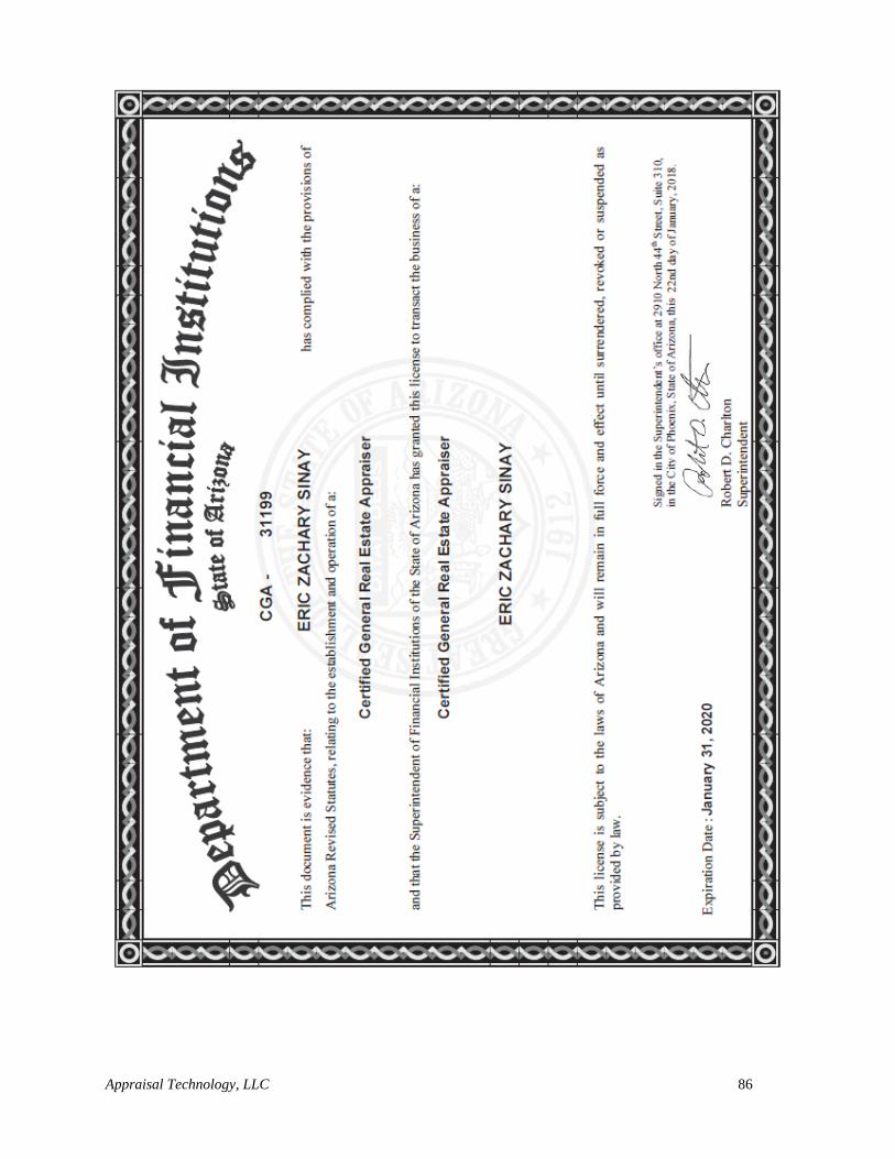
Appraisal Technology, LLC 86

ADDENDA

EXHIBIT 1
Engagement Letter
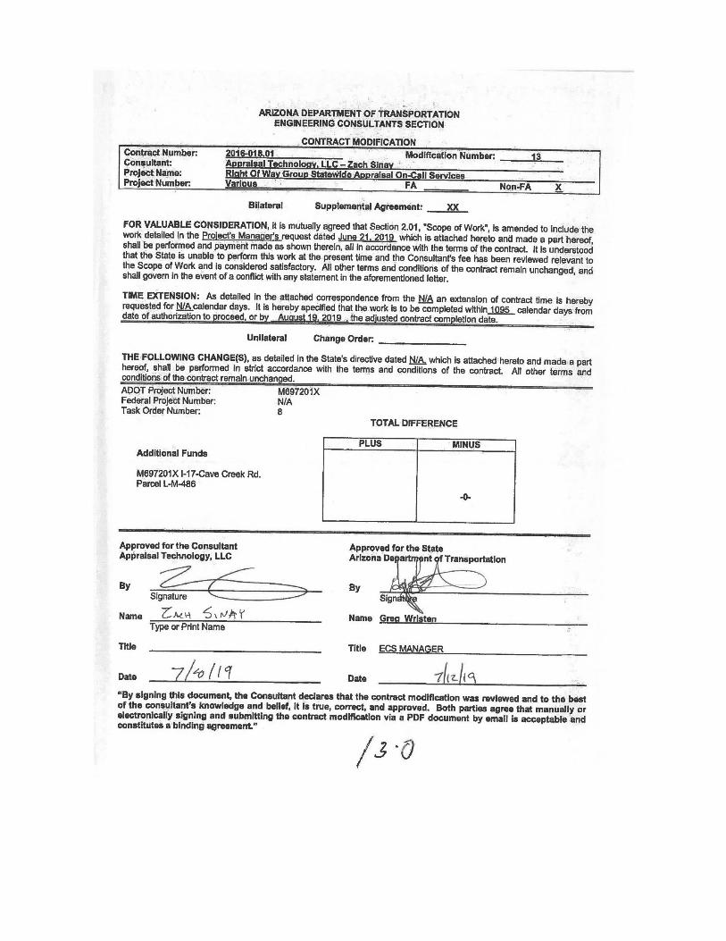
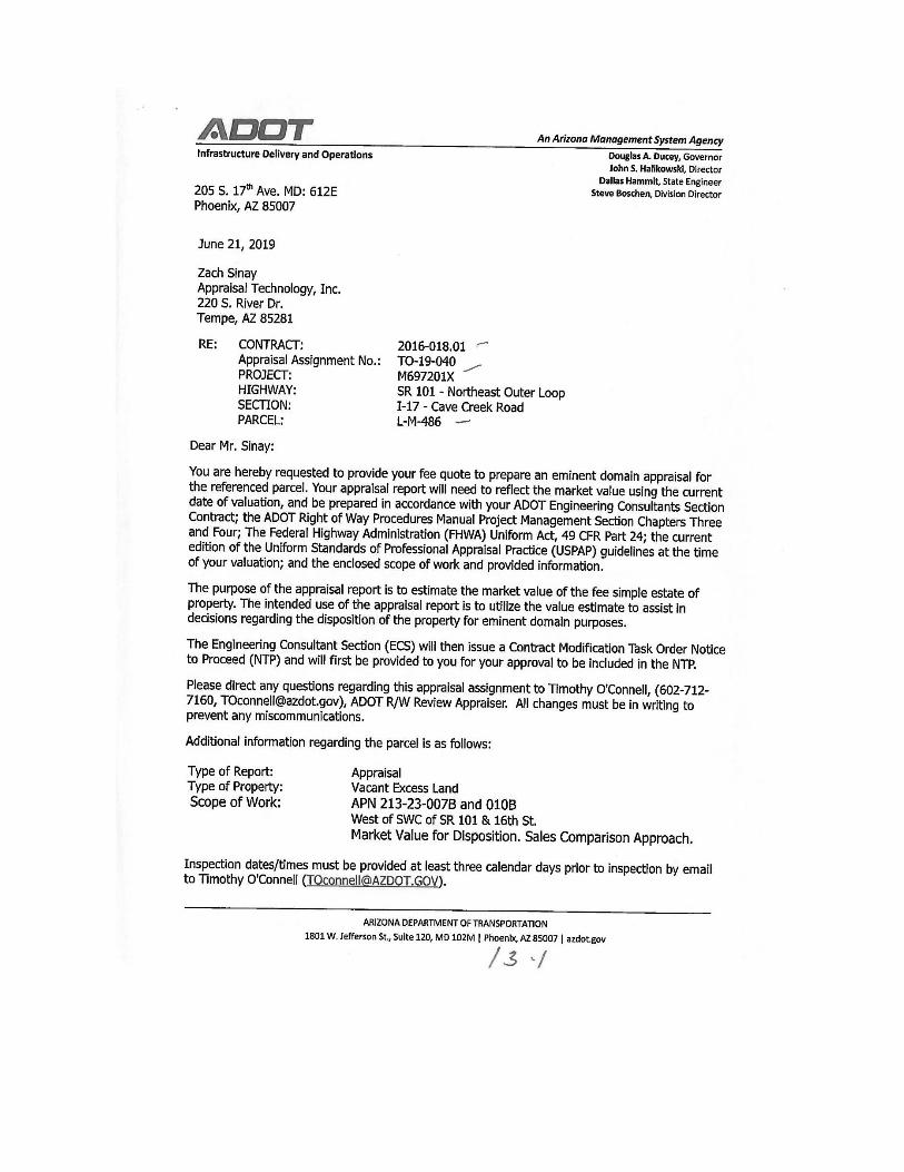
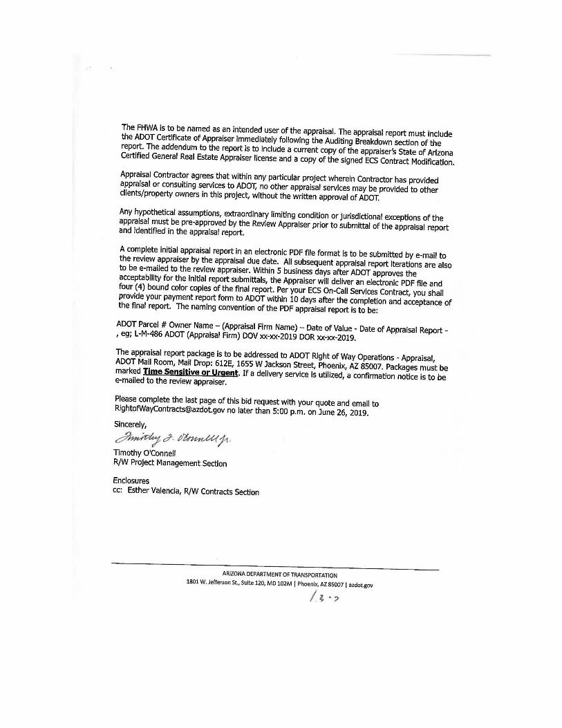
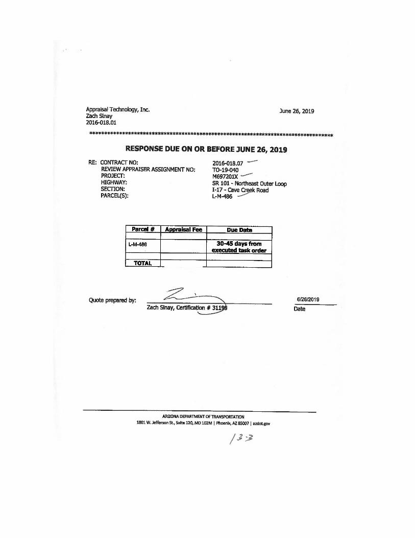

EXHIBIT 2
Zoning Designation
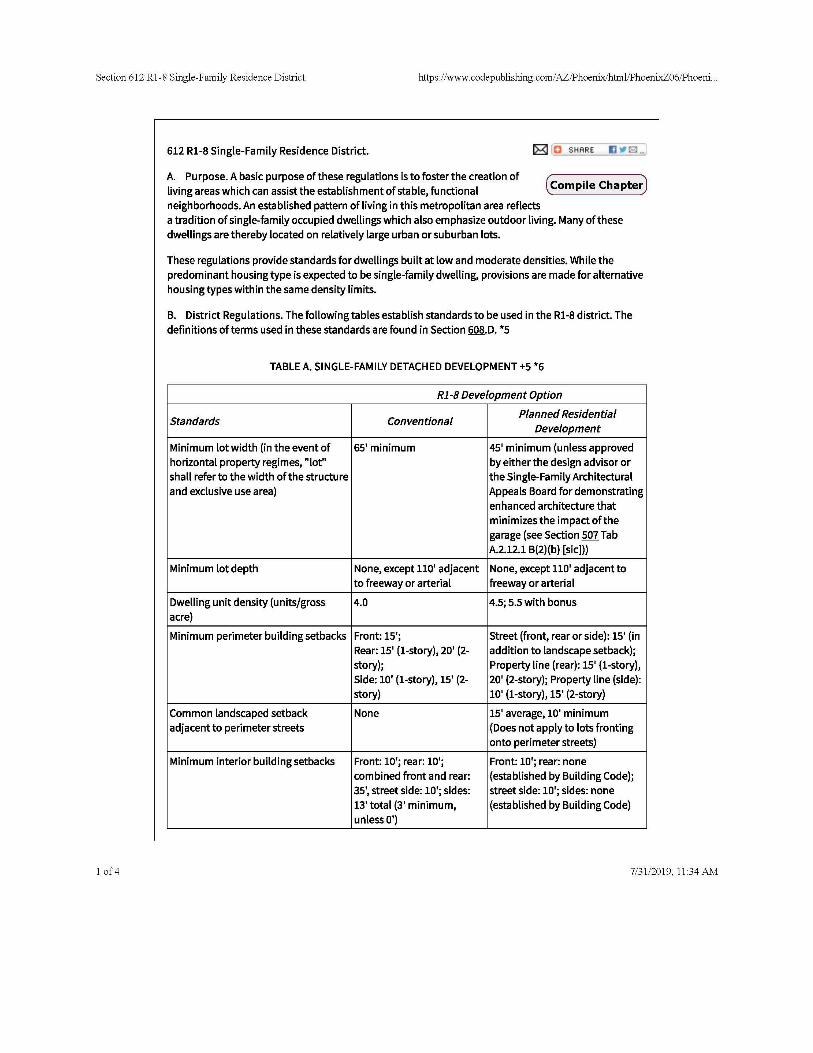
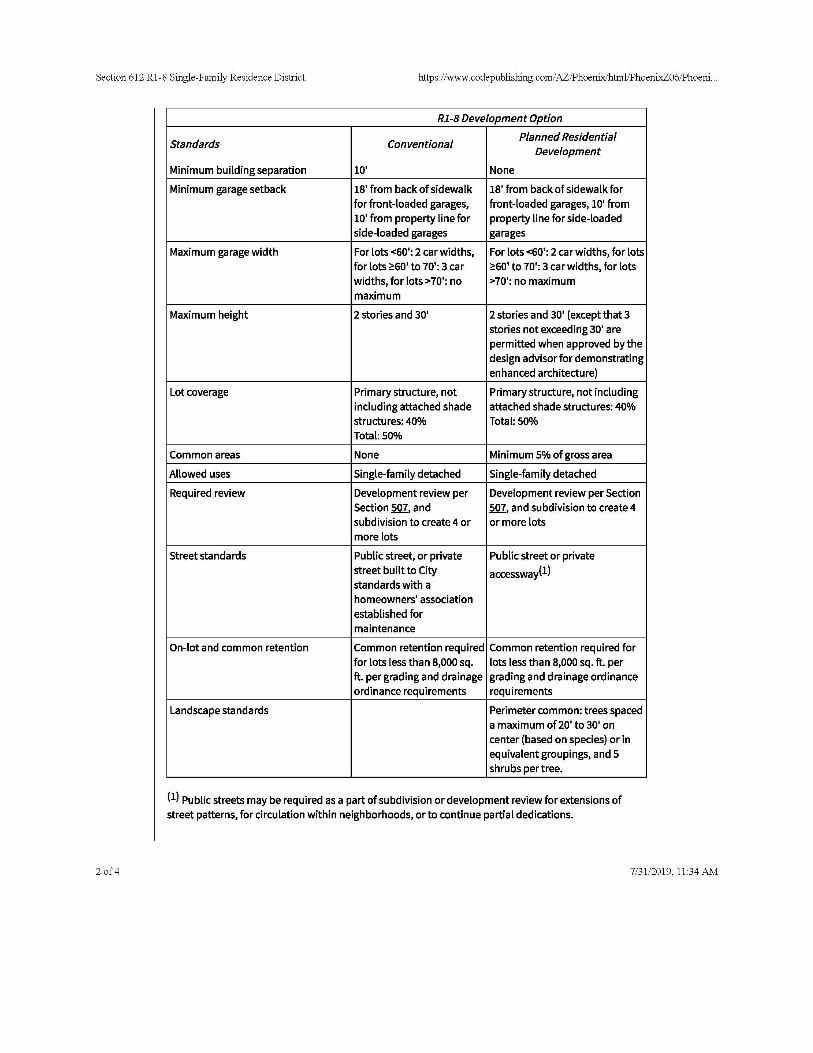
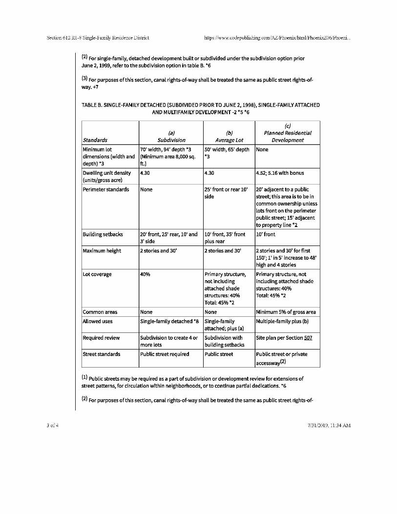

EXHIBIT 3
Title Report
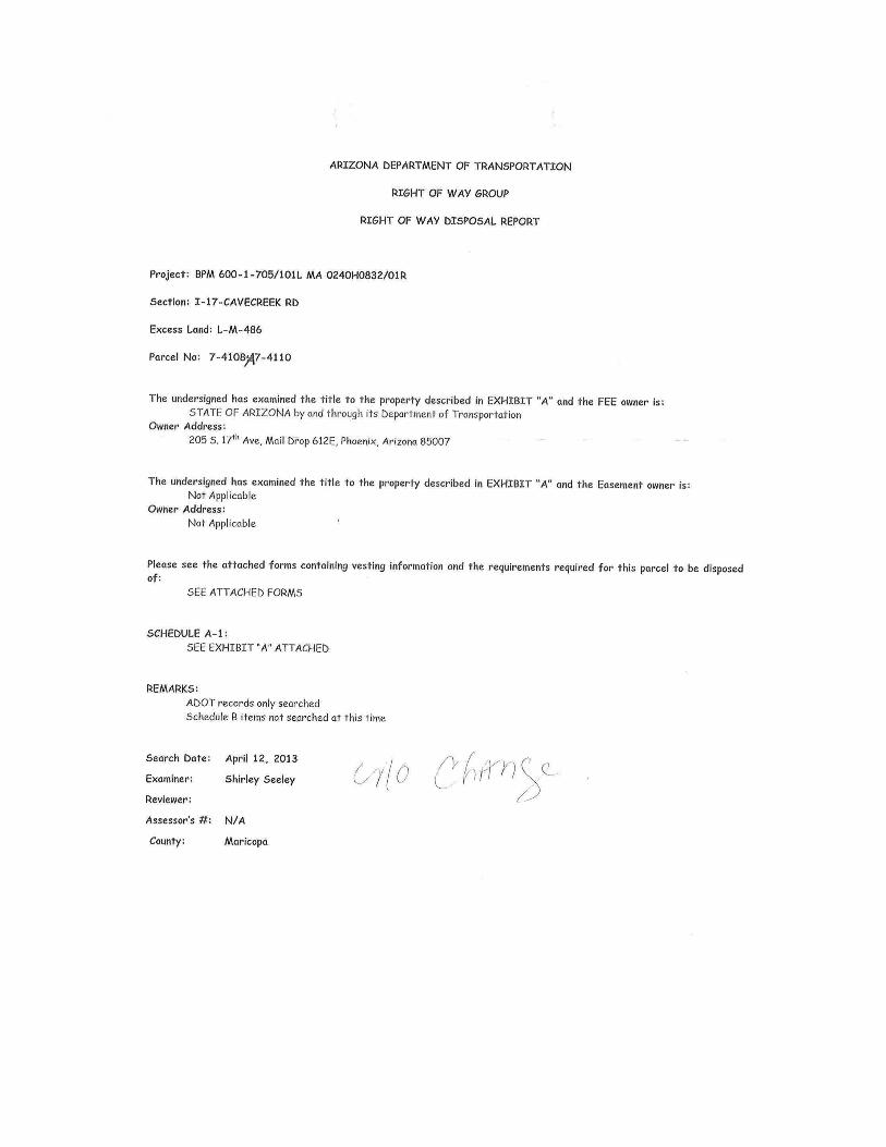
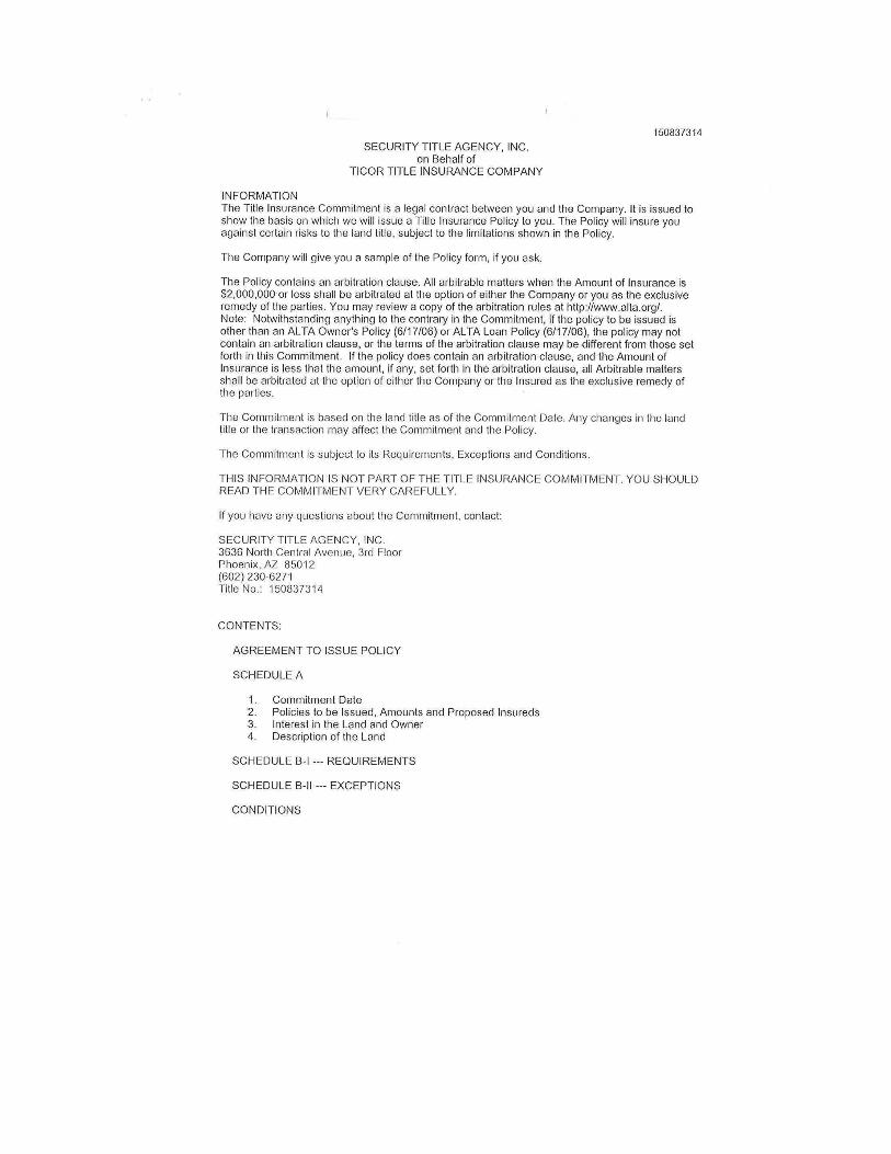
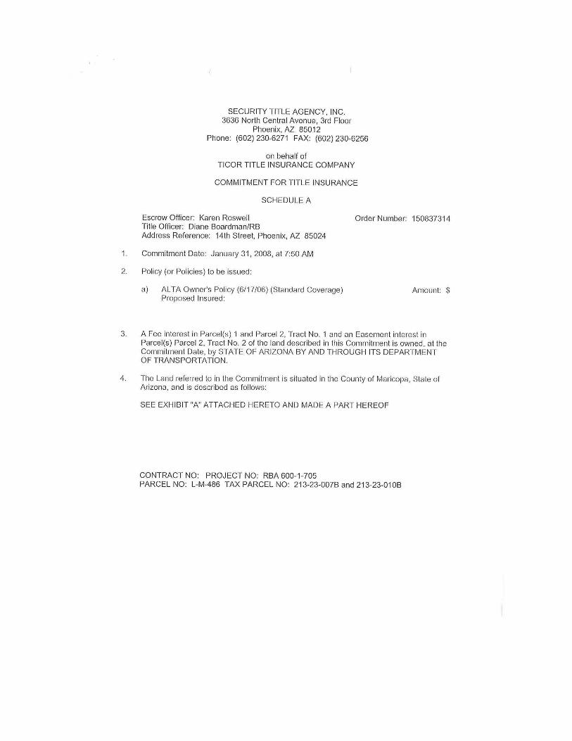

EXHIBIT 4
Contingent and Limiting Conditions
CONTINGENT AND LIMITING CONDITIONS
1. LIMITS OF LIABILITY: The liability of Appraisal Technology, LLC, and/or Independent
Contractor(s) is limited to the client only and to the fee actually received by them. Further, there
is no accountability, obligation, or liability to any third party. If this report is placed in the hands of
anyone other than the client, the client shall make such party aware of all limiting conditions and
assumptions of the assignment and related discussions. The appraiser is in no way to be responsible
for any costs incurred to discover or correct any deficiencies of any type present in the property;
physically, financially, and/or legally. In the case of limited partnerships or syndication offering or
stock offerings in real estate, the client agrees that in case of lawsuit (brought by lender, partner or
part-owner in any form of ownership, tenant, or any other party), any and all awards, settlements of
any type in such suit, regardless of outcome, the client will hold the appraiser completely harmless
in any such action.
2. COPIES, PUBLICATION, DISTRIBUTION, USE OF REPORT: Possession of this report
or any copy thereof does not carry with it the right of publication. It is a privileged communication.
It may not be used for other than its intended use; the physical report(s) remain the property of the
appraiser for the use of the client, the fee being for the analytical services only.
All valuations in the report are applicable only under the stated program of Highest and Best Use
and are not necessarily applicable under other programs of use. The valuation of a component part
of the property is applicable only as a part of the whole property. The distribution of the total
valuation in this report between land and improvements applies only under the existing or proposed
program of utilization. The separate valuations for land and building must not be used in conjunction
with any other appraisal and are invalid if so used.
The Bylaws and Regulations of the Appraisal Institute requires each Member and Candidate to
control the use and distribution of each appraisal report signed by such Member or Candidate; except
as here-in-after provided, the client may distribute copies of this appraisal report in its entirety to
such third parties as he may select; however, selected portions of this appraisal report shall not be
given to third parties without the prior written consent of the signatories of the report. Neither all nor
any part of this appraisal report shall be disseminated to the general public by the use of advertising
media, public relations, news, sales or other media for public communication without the prior
written consent of the appraiser(s), particularly as to valuation conclusions, the identity of the
appraiser(s), the firm, or any reference to the Appraisal Institute, the M.A.I., or SRA designations.
(See last item in following list for client agreement/consent).
3. CONFIDENTIALITY AND TRADE SECRETS: This appraisal is to be used only in its
entirety and no part is to be used without the whole report. All conclusions and opinions concerning
the analysis as set forth in the report were prepared by the Appraiser(s) whose signature(s) appear
on the appraisal report, unless indicated as "Review Appraiser". No change of any item in the report
shall be made by anyone other than the appraiser. The appraiser and firm shall have no responsibility
if any such unauthorized change is made. The appraiser may not divulge the material (evaluation)
contents of the report, analytical findings or conclusions, or give a copy of the report to anyone other
than the client or his designee as specified in writing except as may be required by the Appraisal
Institute as they may request in confidence for ethics enforcement, or by a court of law or body with
the power of subpoena.
This appraisal was prepared by the appraisers signing this report and/or related independent
contractor(s) and consists of "trade secrets and commercial or financial information" which is
privileged and confidential and exempted from disclosure under 5 U.S.C. 552 (b) (4). Notify the
appraiser(s) signing this report, Appraisal Technology, LLC of any request to reproduce this
appraisal in whole or in part.
4. INDEPENDENT CONTRACTORS: Be advised that the people associated with Appraisal
Technology, LLC are independent contractors.
5. INFORMATION AND DATA: The comparable data relied upon in this report has been con-
firmed with one or more parties familiar with the transaction or from affidavit or other source thought
reliable; all are considered appropriate for inclusion to the best of our factual judgment and
knowledge. An impractical and uneconomic expenditure of time would be required in attempting to
furnish unimpeachable verification in all instances, particularly as to engineering and market-related
information. It is suggested that the client consider independent verification as a prerequisite to any
transaction involving sale, lease, or other significant commitment of funds or property.
6. TESTIMONY, CONSULTATION, COMPLETION OF INVOICE FOR APPRAISAL
SERVICES: When the invoice for appraisal, consultation or analytical service is fulfilled, the
total fee is payable upon completion. The appraiser(s) or those assisting in preparation of the report
will not be asked or required to give testimony in court or hearing because of having made the
appraisal (unless arrangements have previously been made). Any post appraisal consultation with
the client or third parties will be at an additional fee. If testimony or deposition is required because
of any subpoena, the client shall be responsible for any additional time, fees, and charges regardless
of issuing party.
7. STATEMENT OF POLICY: The following statement represents official policy of Appraisal
Institute with respect to neighborhood analysis and the appraisal of residential real estate:
a. It is improper to base a conclusion or opinion of value upon the premise that the racial,
ethnic or religious homogeneity of the inhabitants of an area or of a property is
necessary for maximum value.
b. Racial, religious and ethnic factors are deemed unreliable predictors of value trends or
price variance.
c. It is improper to base a conclusion or opinion of value, or a conclusion with respect to
neighborhood trends, upon stereotyped or biased presumptions relating to race, color, religion,
sex or national origin or upon unsupported presumptions relating to the effective age or
remaining life of the property or the life expectancy of the neighborhood in which it is located.
8. MANAGEMENT OF THE PROPERTY: The appraisers have no control over management;
however, the appraisers consider the management of this investment of prime importance.
Reasonable and prudent (not exceptional) management practices and expertise is assumed
(anticipated) in the appraisal.
Should the present/prospective owner be unable and/or unwilling to take those actions required by
reasonable and prudent management practices (see appraiser's observations at time of inspection

following the purpose of appraisal) to meet financial goals and/or reasonable expectations, we
recommend a careful reconsideration of the investment risk.
9. APPRAISAL IS NOT A LEGAL OPINION: No responsibility is assumed for matters of legal
nature affecting title to the property nor is an opinion of title rendered. The title is assumed to be
good and marketable. The value estimated is given without regard to any questions of title,
boundaries, encumbrances, or encroachments.
It is assumed that there is full compliance with all applicable federal, state, and local environmental
regulations and laws unless noncompliance is stated, defined, and considered in the appraisal report.
It is assumed that all applicable zoning and use of regulations and restrictions have been complied
with, unless a non-conformity has been stated, defined, and considered in the appraisal report.
It is assumed that all required licenses, consents, or other legislative or administrative authority from
any local, state, or national government or private entity or organization have been or can be obtained
or renewed for any use on which the value estimate contained in this report is based.
If the Appraiser has not been supplied with a termite inspection, survey or occupancy permit(s), no
responsibility or representation is assumed or made for any costs associated with obtaining same or
for any deficiencies discovered before or after they are obtained. No representation or warranties
are made concerning obtaining the above mentioned items.
It is assumed that adequate municipal services including disposal are available and will continue to
be.
Virtually all land in Arizona is affected by pending or potential litigation by Indian Tribes claiming
superior water rights for their reservations. The amounts claimed and the effects on other water users
are largely undetermined; but the claims could result in some curtailment of water usage or ground
water pumping on private land. The State's New Ground Water 99Management Act may also restrict
future ground water pumping in various parts of Arizona. Given this uncertainty, neither the
appraiser(s) nor any of his representatives can make warranties concerning rights to or adequacy of
the water supply with respect to the property being appraised, although, the sale of premises include
such water rights as are appurtenant thereto.
10. FEDERAL AND STATE REGULATIONS: Further, the value reported is based upon cash,
or its equivalent, and was drafted to adhere to the standards and practices of the Appraisal Institute,
plus the guidelines and recommendations set forth in the Uniform Standards of Professional
Appraisal Practice (USPAP) by the Appraisal Foundation and in accordance with appraisal standard
required by Title XI of Federal Financial Institutions Reform, Recovery and Enforcement Act of
1989 (FIRREA) and the Office of the Comptroller of the Currency (OCC).
Under federal mandate, state licensing and/or certification of appraiser is required on or before
August 1, 1991. Permission is hereby granted by the client for the appraiser to furnish the appropriate
governmental authority or their authorized designated representative(s) any and all materials
requested for oversight review.
11. CHANGES, MODIFICATIONS, FEE: The appraiser(s) reserves the right to alter statements,
analysis, conclusion or value estimate contained in the appraisal if a fact(s) pertinent to the appraisal
process unknown prior to the completion of the appraisal is/are discovered.
The fee for this appraisal or study is for the service rendered and not for the time spent on the physical
report or the physical report itself.
Compensation is not contingent upon the reporting of a predetermined value or direction in value
that favors the cause of the client, the amount of the value estimate, the attainment of a stipulated
result, or the occurrence of a subsequent event.
The writing of this report to meet the requirements of the Competitive Equality Banking Act of 1987
("CEBA") and in adherence with the standards and practices of the Appraisal Institute, plus the
guidelines and recommendations set forth in the Uniform Standards of Professional Appraisal
Practice (USPAP) by the Appraisal Foundation involves an interpretation of the phase "totally self-
contained".
Because no report regardless of length or the extent of documentation is "totally self-contained", the
appraiser has tried to furnish sufficient documentation, analysis and detail to meet a "reasonableness
criteria". Should the client reviewing this report require additional information, analysis,
documentation, etc., it will be supplied in an expeditious manner at no charge to the client, following
receipt of a written critique (within 2 months of the date of this letter), in the form of a new report.
12. APPRAISAL IS NOT A SURVEY: It is assumed that the utilization of the land and
improvements is within the boundaries of the property lines of the property described and that there
is no encroachment or trespass unless noted with the report.
The legal description is assumed to be correct as used in this report as furnished by the client, his
designee, or when not supplied, as derived by the appraiser. The appraiser(s) assume no
responsibility for such a survey, or for encroachments or overlapping that might be revealed thereby.
The sketches and maps in this report are included to assist the reader in visualizing the property and
are not necessarily to scale. Photos, if any, are included for the same purpose. Site plans are not
surveys unless shown from a separate surveyor.
13. APPRAISAL IS NOT AN ENGINEERING REPORT: This appraisal should not be considered
a report on the physical items that are a part of this property. Although the appraisal may contain
information about the physical items being appraised (including their adequacy and/or condition), it
should be clearly understood that this information is only to be used as a general guide for property
valuation and not as a complete or detailed physical report. The appraisers are not construction,
engineering, or legal experts, and any opinion given on these matters in this report should be considered
preliminary in nature.
The observed condition of the foundation, roof, exterior walls, interior walls, floors, heating and/or
cooling system, plumbing, insulation, electrical service, and all mechanical and construction is based
on a casual inspection only and no detailed inspection was made. For instance, we are not experts

on heating and/or cooling systems and no attempt was made to inspect the interior of the heating
and/or cooling equipment. The structures were not checked for building code violations and it is
assumed that all buildings meet the building codes unless so stated in the report.
Items such as conditions behind walls, above ceiling, behind locked doors, or under the ground are
not exposed to casual view and, therefore, were not inspected. The existence of insulation (if any is
mentioned) was found by conversation with others and/or circumstantial evidence.
Since it is not exposed to view, the accuracy of any statements about insulation cannot be guaranteed.
It is assumed that there are no hidden or unapparent conditions of the property, sub-soil, or structures
which would render it more or less valuable. No responsibility is assumed for such conditions or the
engineering which may be required to discover such factors. Since no engineering or percolation
tests were made, no liability is assumed for soil conditions. Sub-surface rights (mineral and/or
energy related) were not considered in making this appraisal.
Because no detailed inspection was made, and because such knowledge goes beyond the scope of
this appraisal, any observed condition comments given in this appraisal report should not be taken
as a guarantee that a problem does not exist. Specifically, no guarantee is made as to the adequacy
or condition of the foundation, roof, exterior walls, interior walls, floors, heating system, air-
conditioning system, plumbing, electrical service, insulation, or any other detailed construction
matters. If any interested party is concerned about the existence, condition, or adequacy of any
particular item, we strongly suggest that a construction expert be hired for a detailed investigation.
Although a walk-through inspection has been performed, an appraiser is not an expert in the field of
building inspection and/or engineering. An expert in the field of engineering/seismic hazards
detection should be consulted if an analysis of seismic safety and seismic structural integrity is
desired.
The appraisers are not seismologists. The appraisal should not be relied upon as to whether a seismic
problem exists, or does not actually exist on the property. The appraisers assume no responsibility
for the possible effect on the subject property of seismic activity and/or earthquakes.
14. PROPOSED IMPROVEMENT, CONDITIONED VALUE: Improvements proposed, if
any, on or off-site, as well as any repairs required are considered, for purposes of this appraisal, to
be completed in a good and workmanlike manner according to information submitted and/or consi-
dered by the appraiser(s). In cases of proposed construction, the appraisal is subject to change upon
inspection of the property after construction is completed. This estimate of value is as of the date
shown, as proposed, as if completed and operating at levels shown and projected unless otherwise
set forth.
15. INSULATION AND TOXIC MATERIALS: The existence of potentially hazardous
materials used in the construction or maintenance of the structure, such as urea formaldehyde
foam insulation, and/or the existence of toxic waste on or in the ground, which may or may not
be present has not been considered (unless otherwise set forth). The appraiser(s) is not qualified
to detect such substances. The client should retain an expert in this field. If such is present, the
value of the property may be adversely affected; therefore, if a toxic waste and/or contaminant
is detected, the value indicated in this report is Null and Void. A re-appraisal at an additional
cost may be necessary to estimate the effects of hazardous materials.
16. AUXILIARY AND RELATED STUDIES: No environmental or impact studies, special
market study or analysis, highest and best use analysis study or feasibility study has been requested
or made unless otherwise specified in an invoice for services or in the report.
17. APPRAISAL IS MADE UNDER CONDITIONS OF UNCERTAINTY: Information
(including projections of income and expenses) provided by informed local sources, such as
government agencies, financial institutions, Realtors, buyers, sellers, property owners, bookkeepers,
accountants, attorneys, and others is assumed to be true, correct, and reliable. No responsibility for
the accuracy of such information is assumed by the appraiser.
The comparable sales data relied upon in the appraisal is believed to be from reliable sources.
Though all the comparable sales were examined, it was not possible to inspect them all in detail.
The value conclusions are subject to the accuracy of said data.
Engineering analyses of the subject property were neither provided or used nor made as a part of this
appraisal contract. Any representation as to the suitability of the property for uses suggested in this
analysis is therefore based only on a rudimentary investigation by the appraiser and the value
conclusions are subject to said limitations.
All values shown in the appraisal report are projections based on our analysis as of the date of the
appraisal. These values may not be valid in other time periods or as conditions change. Since the
projected mathematical models are based on estimates and assumptions which are inherently subject
to uncertainty and variation depending upon evolving events, we do not represent them as results
that will actually be achieved.
This appraisal is an estimate of value based on an analysis of information known to us at the time
the appraisal was made. The appraisers do not assume any responsibility for incorrect analysis
because of incorrect or incomplete information. If new information of significance comes to light
and/or becomes known, the value given in this report is subject to change without notice.
18. AMERICANS WITH DISABILITIES ACT: The Americans with Disabilities Act ("ADA")
became effective January 26, 1992. The appraiser(s) have not made an analysis of this property to
determine whether or not it is in conformity with the ADA requirements. It is possible that a
compliance survey of the property, together with a detailed analysis of the ADA requirements could
reveal that the property is not in compliance for one or all requirements. If so, this fact could have a
negative effect upon the value of the property. The appraiser(s) have no direct evidence relating to
this issue and did not consider possible non-compliance with the requirement of the ADA in
estimating the value of the property.
19. INSURABLE VALUE: At the Client's request (if applicable), the appraiser(s) have provided
an insurable value estimate. The estimate is based on figures derived from a national cost estimating
service and is developed consistent with industry practices. However, actual local and regional
construction costs may vary significantly from our estimate and individual insurance policies and
underwriters have varied specifications, exclusions, and non-insurable items. As such, we strongly
recommend that the Client obtain estimates from professionals experienced in establishing insurance
coverage for replacing any structure. The appraiser(s) make no warranties regarding the accuracy of
this estimate. Insurable Value is directly related to the portion of the real estate that is covered under
the asset’s insurance policy. The appraiser(s) have based this opinion on the building’s replacement
cost new (RCN) which has no direct correlation with its actual market value. The appraiser(s)
developed an opinion of RCN using the Calculator Cost Method developed by Marshall & Swift.
The RCN is the total construction cost of a new building with the same specifications and utility as
the building being appraised, but built using modern technology, materials, standards and design.
For insurance purposes, RCN includes all direct costs necessary to construct the building
improvements. Items that are not considered include land value, individual site improvements or
accrued depreciation. To develop an opinion of insurable value, exclusions for below-grade
improvements, some site work/improvements, foundations and architectural fees must be deducted
from RCN.
20. ACCEPTANCE OF, AND/OR USE OF, THIS APPRAISAL REPORT BY CLIENT OR
ANY THIRD PARTY CONSTITUTES ACCEPTANCE OF THE FOREGOING CONDIT-
IONS. APPRAISER(S) LIABILITY EXTENDS ONLY TO STATED CLIENT, NOT SUB-
SEQUENT PARTIES OR USERS AND IS LIMITED TO THE AMOUNT OF THE FEE
RECEIVED BY THE APPRAISER(S).