broadway - conservation area appraisal - wychavon district
TRANSCRIPT
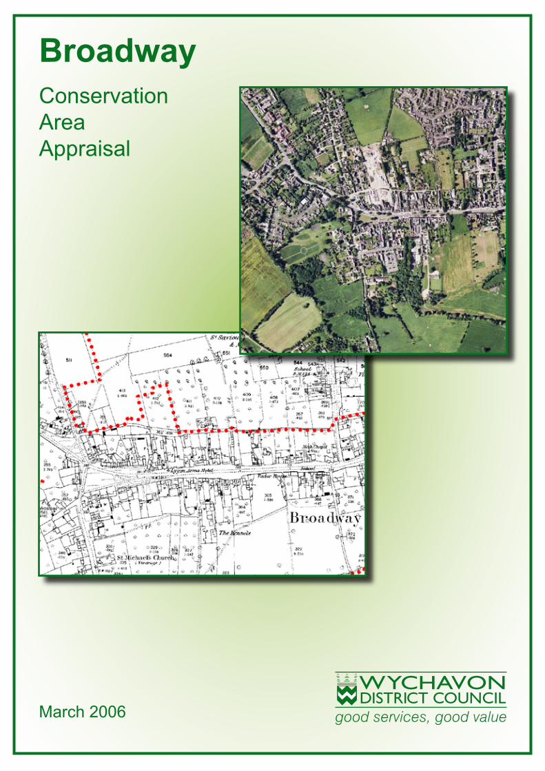
March 2006
Conservation Area Appraisal
Broadway
Not to Scale
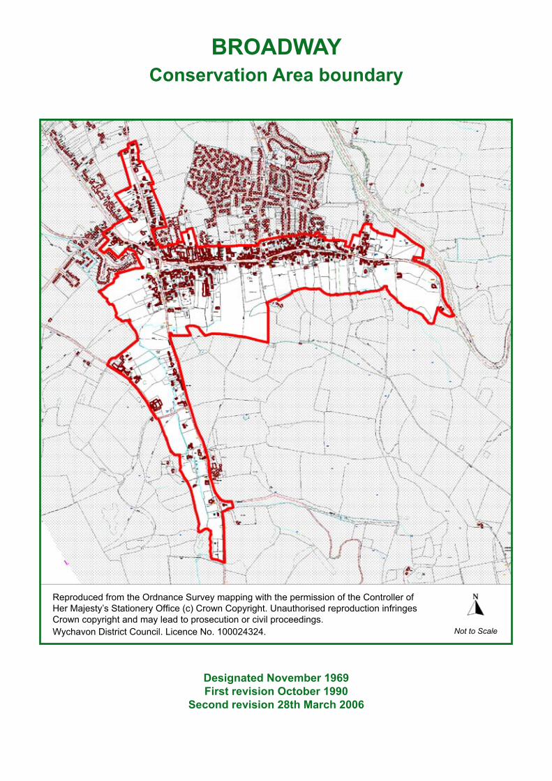
BROADWAYConservation Area boundary
Reproduced from the Ordnance Survey mapping with the permission of the Controller of Her Majesty’s Stationery Office (c) Crown Copyright. Unauthorised reproduction infringes Crown copyright and may lead to prosecution or civil proceedings.Wychavon District Council. Licence No. 100024324.
Designated November 1969 First revision October 1990
Second revision 28th March 2006
�Broadway Conservation Area Appraisal
CONTENTSWHAT IS THIS APPRAISAL FOR? ................................................................ 4BROADWAY CONSERVATION AREA ........................................................... 5ITS SPECIAL ARCHITECTURAL & HISTORIC INTEREST .......................... 5LANDSCAPE SETTING .................................................................................. 5HISTORICAL DEVELOPMENT ...................................................................... 7
Archaeology ..................................................................................................................... 7
Origins and Development ................................................................................................. 7
CHARACTER AND APPEARANCE ............................................................ 19The Medieval Core ......................................................................................................... 19
Upper High Street .......................................................................................................... 23
Snowshill Road, Pye Corner and West End Lane ...................................................... 26
Springfield Lane ............................................................................................................. 27
DETAILED ASSESSMENT ........................................................................... 27Layout ............................................................................................................................ 27
Architecture .................................................................................................................... 31
Houses and Cottages ................................................................................................ 31
Medieval ..................................................................................................................... 32
Post-medieval to early 18th century ............................................................................ 33
18th and 19th centuries ............................................................................................. 35
Early 20th Century ..................................................................................................... 36
Modern ................................................................................................................... 37
Other Buildings ......................................................................................................... 37
Farm Buildings ........................................................................................................... 37
Ancillary Buildings ...................................................................................................... 37
Shop Windows and Signage .......................................................................................... 39
Materials ...................................................................................................................... 42
Local Details ................................................................................................................... 45
Boundary Treatments ..................................................................................................... 46
Natural Environment ...................................................................................................... 48
Views ............................................................................................................................. 53
Negative Factors ............................................................................................................ 55
Neutral Areas ................................................................................................................. 56
•
•
•
•
•
•
•
•
-
-
-
-
-
-
-
-
-
•
•
•
•
•
•
•
•

� Broadway Conservation Area Appraisal
�Broadway Conservation Area Appraisal
CONTENTS continued...PRESERVATION AND ENHANCEMENT ..................................................... 56
New Development .......................................................................................................... 56
Design Guidance ............................................................................................................ 57
Listed Buildings .............................................................................................................. 57
Unlisted Buildings ........................................................................................................... 57
Trees .............................................................................................................................. 59
Enhancement Opportunities ........................................................................................... 59
NOTE ............................................................................................................ 60REFERENCES .............................................................................................. 60FURTHER READING .................................................................................... 60USEFUL WEBSITES .................................................................................... 60FURTHER ADVICE & INFORMATION ......................................................... 60ADOPTION STATEMENT ............................................................................. 61STATEMENT OF CONSULTATION .............................................................. 62
•
•
•
•
•
•

� Broadway Conservation Area Appraisal
WHAT IS THIS APPRAISAL FOR?
A conservation area is an area of special architectural or historic interest, usually the historic part of a town or village, where we wish to preserve or enhance its character or appearance. Part of Broadway is a conservation area. This appraisal identifies the special interest of the Broadway Conservation Area, and provides guidance on how the preservation or enhancement of its character or appearance can be achieved.
In making a decision on an application for development in a conservation area, we must, under the Planning (Listed Buildings and Conservation Areas) Act 1990, give special attention to the desirability of preserving or enhancing the character or appearance of the area. While this should ensure that harmful change is not allowed, some changes, normally not requiring planning permission (known as “permitted development”) can still damage the special qualities of a conservation area. We can make directions to limit the permitted development rights of residential properties and have done this in the Broadway Conservation Area.
We also have to review the boundaries of our conservation areas from time to time. The Broadway Conservation Area was first designated in November 1969 and extended in 1990. The boundary was reviewed in 2005 during the preparation of this appraisal. The current conservation area boundary is shown on the attached appraisal map.
Broadway: a medieval settlement with much evidence of its early origins
�Broadway Conservation Area Appraisal
BROADWAY CONSERVATION AREAITS SPECIAL ARCHITECTURAL & HISTORIC INTEREST
The special architectural or historic interest of a place depends upon more than just its buildings. The layout of streets, spaces between buildings, views, ground surfaces, boundary treatments and trees are also important. The uses of buildings and spaces contribute to the special interest of a place, and the level of noise and activity, such as traffic, will also contribute or detract from that special interest.
The special interest of Broadway includes:
Its long history, still evident in the layout of the village, in its buildings, in visible archaeological remains and in other surviving features
The survival of a clear demonstration of historic social hierarchy within the village, evident in the size, design and siting of buildings
The survival of the historic form of buildings, plots, and village layout
The number and quality of historic buildings
The consistency and high level of survival of architectural detail
The strong relationship between the village and its surrounding rural landscape
The built skyline of the village set against the Cotswold escarpment
The prevalence of Cotswold stone as a building material for walls, roofs and boundaries of buildings of all sizes and status
The contribution of trees, gardens, open spaces and views
The conservation area boundary is drawn to reflect this special interest.
•
•
•
•
•
•
•
•
•
LANDSCAPE SETTING
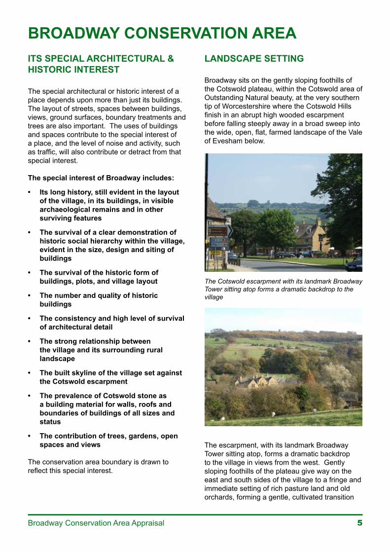
Broadway sits on the gently sloping foothills of the Cotswold plateau, within the Cotswold area of Outstanding Natural beauty, at the very southern tip of Worcestershire where the Cotswold Hills finish in an abrupt high wooded escarpment before falling steeply away in a broad sweep into the wide, open, flat, farmed landscape of the Vale of Evesham below.
The Cotswold escarpment with its landmark Broadway Tower sitting atop forms a dramatic backdrop to the village
The escarpment, with its landmark Broadway Tower sitting atop, forms a dramatic backdrop to the village in views from the west. Gently sloping foothills of the plateau give way on the east and south sides of the village to a fringe and immediate setting of rich pasture land and old orchards, forming a gentle, cultivated transition
� Broadway Conservation Area Appraisal
between the wooded backdrop of the escarpment above and the buildings of the village below. Numerous watercourses emerge as springs below the plateau and descend to the village, threading the landscape with tree-lined streams and ponds.
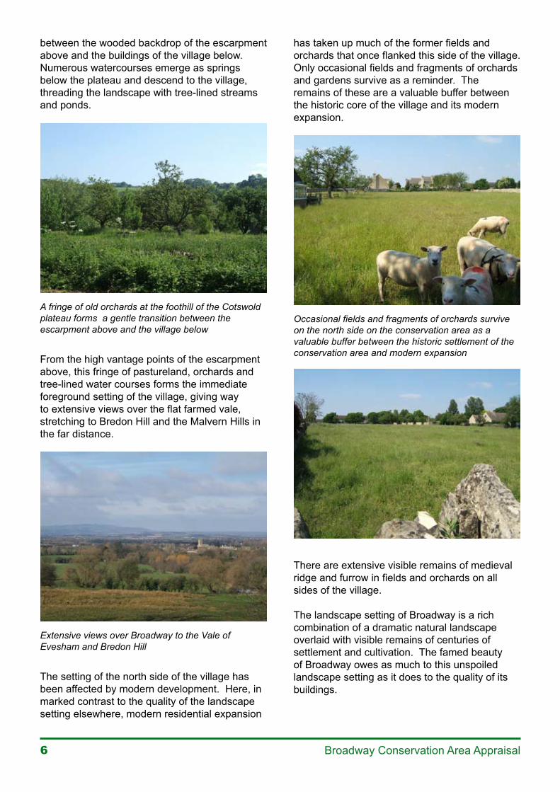
A fringe of old orchards at the foothill of the Cotswold plateau forms a gentle transition between the escarpment above and the village below
From the high vantage points of the escarpment above, this fringe of pastureland, orchards and tree-lined water courses forms the immediate foreground setting of the village, giving way to extensive views over the flat farmed vale, stretching to Bredon Hill and the Malvern Hills in the far distance.
Extensive views over Broadway to the Vale of Evesham and Bredon Hill
The setting of the north side of the village has been affected by modern development. Here, in marked contrast to the quality of the landscape setting elsewhere, modern residential expansion
has taken up much of the former fields and orchards that once flanked this side of the village. Only occasional fields and fragments of orchards and gardens survive as a reminder. The remains of these are a valuable buffer between the historic core of the village and its modern expansion.
Occasional fields and fragments of orchards survive on the north side on the conservation area as a valuable buffer between the historic settlement of the conservation area and modern expansion
There are extensive visible remains of medieval ridge and furrow in fields and orchards on all sides of the village.
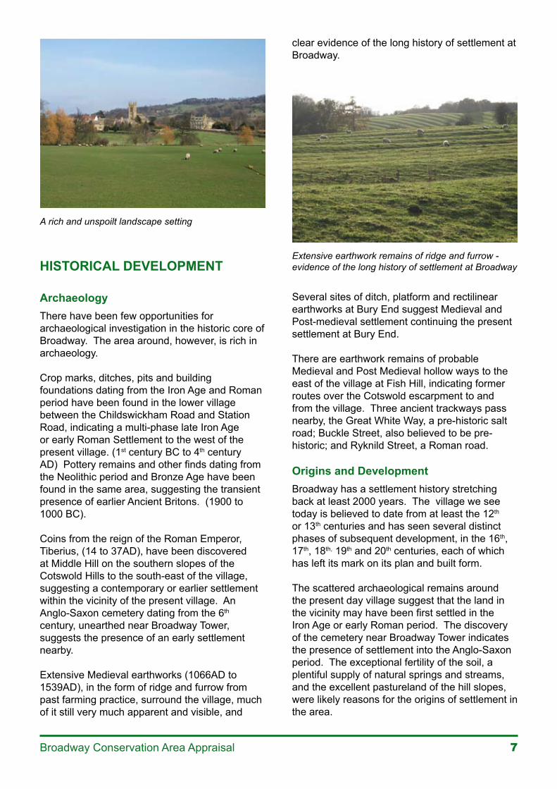
The landscape setting of Broadway is a rich combination of a dramatic natural landscape overlaid with visible remains of centuries of settlement and cultivation. The famed beauty of Broadway owes as much to this unspoiled landscape setting as it does to the quality of its buildings.
�Broadway Conservation Area Appraisal
A rich and unspoilt landscape setting
HISTORICAL DEVELOPMENT
ArchaeologyThere have been few opportunities for archaeological investigation in the historic core of Broadway. The area around, however, is rich in archaeology.
Crop marks, ditches, pits and building foundations dating from the Iron Age and Roman period have been found in the lower village between the Childswickham Road and Station Road, indicating a multi-phase late Iron Age or early Roman Settlement to the west of the present village. (1st century BC to 4th century AD) Pottery remains and other finds dating from the Neolithic period and Bronze Age have been found in the same area, suggesting the transient presence of earlier Ancient Britons. (1900 to 1000 BC).
Coins from the reign of the Roman Emperor, Tiberius, (14 to 37AD), have been discovered at Middle Hill on the southern slopes of the Cotswold Hills to the south-east of the village, suggesting a contemporary or earlier settlement within the vicinity of the present village. An Anglo-Saxon cemetery dating from the 6th century, unearthed near Broadway Tower, suggests the presence of an early settlement nearby.
Extensive Medieval earthworks (1066AD to 1539AD), in the form of ridge and furrow from past farming practice, surround the village, much of it still very much apparent and visible, and
clear evidence of the long history of settlement at Broadway.
Extensive earthwork remains of ridge and furrow - evidence of the long history of settlement at Broadway
Several sites of ditch, platform and rectilinear earthworks at Bury End suggest Medieval and Post-medieval settlement continuing the present settlement at Bury End.
There are earthwork remains of probable Medieval and Post Medieval hollow ways to the east of the village at Fish Hill, indicating former routes over the Cotswold escarpment to and from the village. Three ancient trackways pass nearby, the Great White Way, a pre-historic salt road; Buckle Street, also believed to be pre-historic; and Ryknild Street, a Roman road.
Origins and DevelopmentBroadway has a settlement history stretching back at least 2000 years. The village we see today is believed to date from at least the 12th or 13th centuries and has seen several distinct phases of subsequent development, in the 16th, 17th, 18th, 19th and 20th centuries, each of which has left its mark on its plan and built form.
The scattered archaeological remains around the present day village suggest that the land in the vicinity may have been first settled in the Iron Age or early Roman period. The discovery of the cemetery near Broadway Tower indicates the presence of settlement into the Anglo-Saxon period. The exceptional fertility of the soil, a plentiful supply of natural springs and streams, and the excellent pastureland of the hill slopes, were likely reasons for the origins of settlement in the area.
� Broadway Conservation Area Appraisal
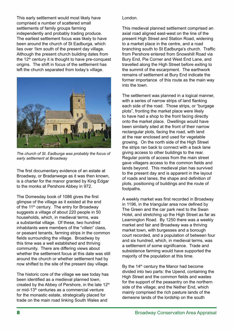
This early settlement would most likely have comprised a number of scattered small settlements of family groups farming independently and probably trading produce. The earliest settlement focus was likely to have been around the church of St Eadburga, which lies over 1km south of the present day village. Although the present church building dates from the 12th century it is thought to have pre-conquest origins. The shift in focus of the settlement has left the church separated from today’s village.
The church of St. Eadburga was probably the focus of early settlement at Broadway
The first documentary evidence of an estate at Broadway, or Bradanwege as it was then known, is a charter for the manor granted by King Edgar to the monks at Pershore Abbey in 972.
The Domesday book of 1086 gives the first glimpse of the village as it existed at the end of the 11th century. The entry for Broadway suggests a village of about 220 people in 50 households, which, in medieval terms, was a substantial village. Of these, two hundred inhabitants were members of the “villein” class, or peasant tenants, farming strips in the common fields surrounding the village. Broadway by this time was a well established and thriving community. There are differing views about whether the settlement focus at this date was still around the church or whether settlement had by now shifted to the site of the present day village.
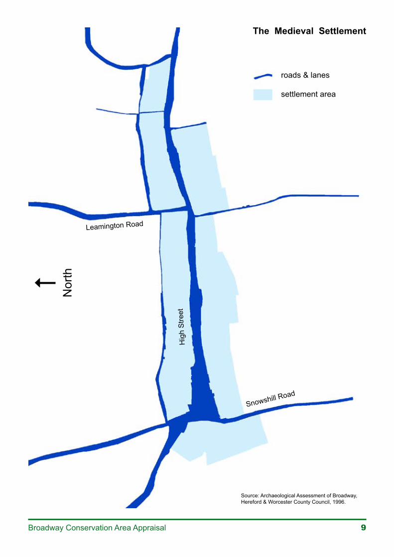
The historic core of the village we see today has been identified as a medieval planned town, created by the Abbey of Pershore, in the late 12th or mid-13th centuries as a commercial venture for the monastic estate, strategically placed for trade on the main road linking South Wales and
London.
This medieval planned settlement comprised an axial road aligned east-west on the line of the present High Street and Station Road, widening to a market place in the centre, and a road branching south to St Eadburga’s church. Traffic from Pershore entered from Snowshill Road via Bury End, Pie Corner and West End Lane, and travelled along the High Street before exiting to the summit of the escarpment. The earthwork remains of settlement at Bury End indicate the former importance of this route as the main way into the town.
The settlement was planned in a logical manner, with a series of narrow strips of land flanking each side of the road. Those strips, or “burgage plots”, fronting the market place were likely to have had a shop to the front facing directly onto the market place. Dwellings would have been similarly sited at the front of their narrow rectangular plots, facing the road, with land at the rear enclosed and used for vegetable growing. On the north side of the High Street the strips ran back to connect with a back lane giving access to other buildings to the rear. Regular points of access from the main street gave villagers access to the common fields and lands beyond. This medieval plan has survived to the present day and is apparent in the layout of roads and lanes, the shape and definition of plots, positioning of buildings and the route of footpaths.
A weekly market was first recorded in Broadway in 1196, in the triangular area now defined by The Green and the car park next to the Swan Hotel, and stretching up the High Street as far as Leamington Road. By 1250 there was a weekly market and fair and Broadway was a thriving market town, with burgesses and a borough court recorded, and a population of between four and six hundred, which, in medieval terms, was a settlement of some significance. Trade and subsistence farming would have supported the majority of the population at this time.
By the 14th century the Manor had become divided into two parts: the Upend, containing the High Street and the common fields and wastes for the support of the peasantry on the northern side of the village; and the Nether End, which mainly comprised the rich pasture lands of the demesne lands of the lordship on the south
�Broadway Conservation Area Appraisal
The Medieval Settlement
Nor
th
Source: Archaeological Assessment of Broadway, Hereford & Worcester County Council, 1996.
roads & lanes
settlement area
Leamington Road
Snowshill Road
Hig
h S
treet
�0 Broadway Conservation Area Appraisal
side of the village. The Manor House of the village sat within the demesne lands opposite St Eadburgha’s church until its demolition in 1773. This area of land is recognisable today as open pastureland at the foot of the escarpment.
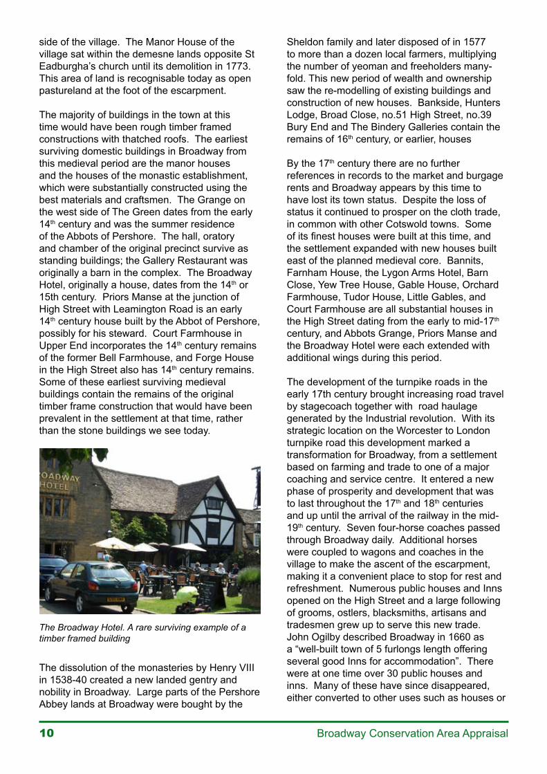
The majority of buildings in the town at this time would have been rough timber framed constructions with thatched roofs. The earliest surviving domestic buildings in Broadway from this medieval period are the manor houses and the houses of the monastic establishment, which were substantially constructed using the best materials and craftsmen. The Grange on the west side of The Green dates from the early 14th century and was the summer residence of the Abbots of Pershore. The hall, oratory and chamber of the original precinct survive as standing buildings; the Gallery Restaurant was originally a barn in the complex. The Broadway Hotel, originally a house, dates from the 14th or 15th century. Priors Manse at the junction of High Street with Leamington Road is an early 14th century house built by the Abbot of Pershore, possibly for his steward. Court Farmhouse in Upper End incorporates the 14th century remains of the former Bell Farmhouse, and Forge House in the High Street also has 14th century remains. Some of these earliest surviving medieval buildings contain the remains of the original timber frame construction that would have been prevalent in the settlement at that time, rather than the stone buildings we see today.
The Broadway Hotel. A rare surviving example of a timber framed building
The dissolution of the monasteries by Henry VIII in 1538-40 created a new landed gentry and nobility in Broadway. Large parts of the Pershore Abbey lands at Broadway were bought by the
Sheldon family and later disposed of in 1577 to more than a dozen local farmers, multiplying the number of yeoman and freeholders many-fold. This new period of wealth and ownership saw the re-modelling of existing buildings and construction of new houses. Bankside, Hunters Lodge, Broad Close, no.51 High Street, no.39 Bury End and The Bindery Galleries contain the remains of 16th century, or earlier, houses
By the 17th century there are no further references in records to the market and burgage rents and Broadway appears by this time to have lost its town status. Despite the loss of status it continued to prosper on the cloth trade, in common with other Cotswold towns. Some of its finest houses were built at this time, and the settlement expanded with new houses built east of the planned medieval core. Bannits, Farnham House, the Lygon Arms Hotel, Barn Close, Yew Tree House, Gable House, Orchard Farmhouse, Tudor House, Little Gables, and Court Farmhouse are all substantial houses in the High Street dating from the early to mid-17th century, and Abbots Grange, Priors Manse and the Broadway Hotel were each extended with additional wings during this period.
The development of the turnpike roads in the early 17th century brought increasing road travel by stagecoach together with road haulage generated by the Industrial revolution. With its strategic location on the Worcester to London turnpike road this development marked a transformation for Broadway, from a settlement based on farming and trade to one of a major coaching and service centre. It entered a new phase of prosperity and development that was to last throughout the 17th and 18th centuries and up until the arrival of the railway in the mid-19th century. Seven four-horse coaches passed through Broadway daily. Additional horses were coupled to wagons and coaches in the village to make the ascent of the escarpment, making it a convenient place to stop for rest and refreshment. Numerous public houses and Inns opened on the High Street and a large following of grooms, ostlers, blacksmiths, artisans and tradesmen grew up to serve this new trade. John Ogilby described Broadway in 1660 as a “well-built town of 5 furlongs length offering several good Inns for accommodation”. There were at one time over 30 public houses and inns. Many of these have since disappeared, either converted to other uses such as houses or
��Broadway Conservation Area Appraisal
shops, or demolished and replaced. Evidence of some of them is still apparent in remaining buildings. The old yard of the Bell Inn, now Picton House, has been converted to cottages. The frame of the inn sign of the former Coach and Horses Inn in the upper High street still stands on the verge as a reminder of its former use as an inn.
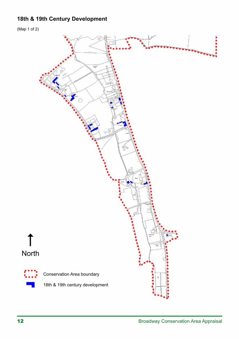
The prosperity of the 16th, 17th and 18th centuries was a time of consolidation of the street frontages in Broadway into something resembling the built up form we would recognise today, with permanent buildings replacing a likely accumulation of generations of small sheds and cottages. Much of the area of The Green, the High Street, Station Road and Snowshill Road had, by the end of 18th century, developed into the built appearance we see today. The smaller houses and the cottages largely date from the 18th century, probably replacing earlier buildings or, in many cases, incorporating them into the new constructions. The street pattern established in the medieval period, however, continued in use throughout this period, with no new roads identified.
Enclosure in 1771, brought an end to the old way of farming in Broadway. Individual strips were amalgamated into fewer, larger holdings, leading to the eviction of the poorer peasants and tenant farmers. These enclosures are still recognisable today in the field boundaries around the village. Enclosure acted as a catalyst for further expansion of the village’s commercial base. Broadway was by now a busy, thriving and expanding village comprising a mix of farms around The Green, the upper High Street and Pye Corner, inns, public houses, stable yards, blacksmiths, shops, businesses, tradesman, workers’ cottages and houses of the wealthy. It was also a place of society. Notable large houses built at this time are Austin House, Russell House, Picton House, Broad Close and Pye Corner. Between 1770 and 1840 the population doubled to almost seventeen hundred, five times the population of the medieval town.
The arrival of the railway in the mid -19th century signalled the end of the former era of road travel and the prosperity of Broadway as a coaching centre. The new Worcester to London railway line by-passed the village, bringing a severe decline in passing trade. Broadway quickly faded into obscurity and became a quiet backwater
cut off from the outside world. Many of its inns and public houses closed and the society and prosperity it had previously enjoyed disappeared. Buildings fell into a dilapidated state. A Mr Collett wrote in 1866 “No credible person of small means will come to reside here, and most of the better houses are occupied by almost solitary widows and old maids and bachelors; the farmhouses by labourers or baliffs”.
It was its air of forgotten tranquillity and beautiful buildings that, toward the end of the 19th century, attracted Victorian artists and writers to Broadway, looking to escape the dirt and squalor of the industrial revolution. Broadway was seen as a rural idyll, the ideal of the perfect English village, and became a fashionable retreat of the artistic world with patronage from the likes of Alfred Parsons, Henry James, Frank Millet and John Sargent, soon making it famous at home and abroad.
By the beginning of the 20th century increasing numbers of tourists were arriving, facilitated by the introduction of the motor car and the opening of a branch line. Broadway entered a new era as a fashionable place to live and to visit, bringing with it a new phase of development. The Arts and Crafts Movement, with a centre in the Cotswolds, influenced the design of new houses and alterations, with a renewed emphasis on the Cotswold vernacular. Of particular note is Luggers Hall in Springfield Lane, built for Sir Alfred Parsons.
Many buildings were altered and refurbished, new houses were built, and houses and cottages were converted to shops, cafes and hotels. The gentrification of the settlement begun in the 18th century, was resumed as cottages, farmhouses and farm buildings in the High Street were converted into residences for wealthy newcomers. Occasional houses in Church Street and the upper High Street date from the early 20th century, further consolidating development in these parts of the settlement, and consolidation of development in Springfield Lane began at this time. Luggers Hall, 154 High Street, Thistle Lodge and nos. 15 and 17 High Street date from this period and show the influence of the Arts and Crafts movement in their Cotswold vernacular style. The former mix of residential, commercial and farming activities in the village became polarised into the pattern of uses we see today, with the upper High Street becoming primarily
�� Broadway Conservation Area Appraisal
Conservation Area boundary
18th & 19th century development
18th & 19th Century Development(Map 1 of 2)
North
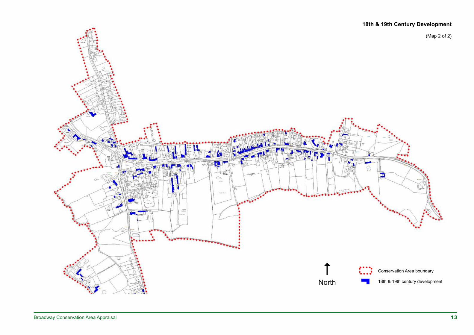
13Broadway Conservation Area Appraisal
Conservation Area boundary
18th & 19th century development
18th & 19th Century Development
(Map 2 of 2)
North
14 Broadway Conservation Area Appraisal
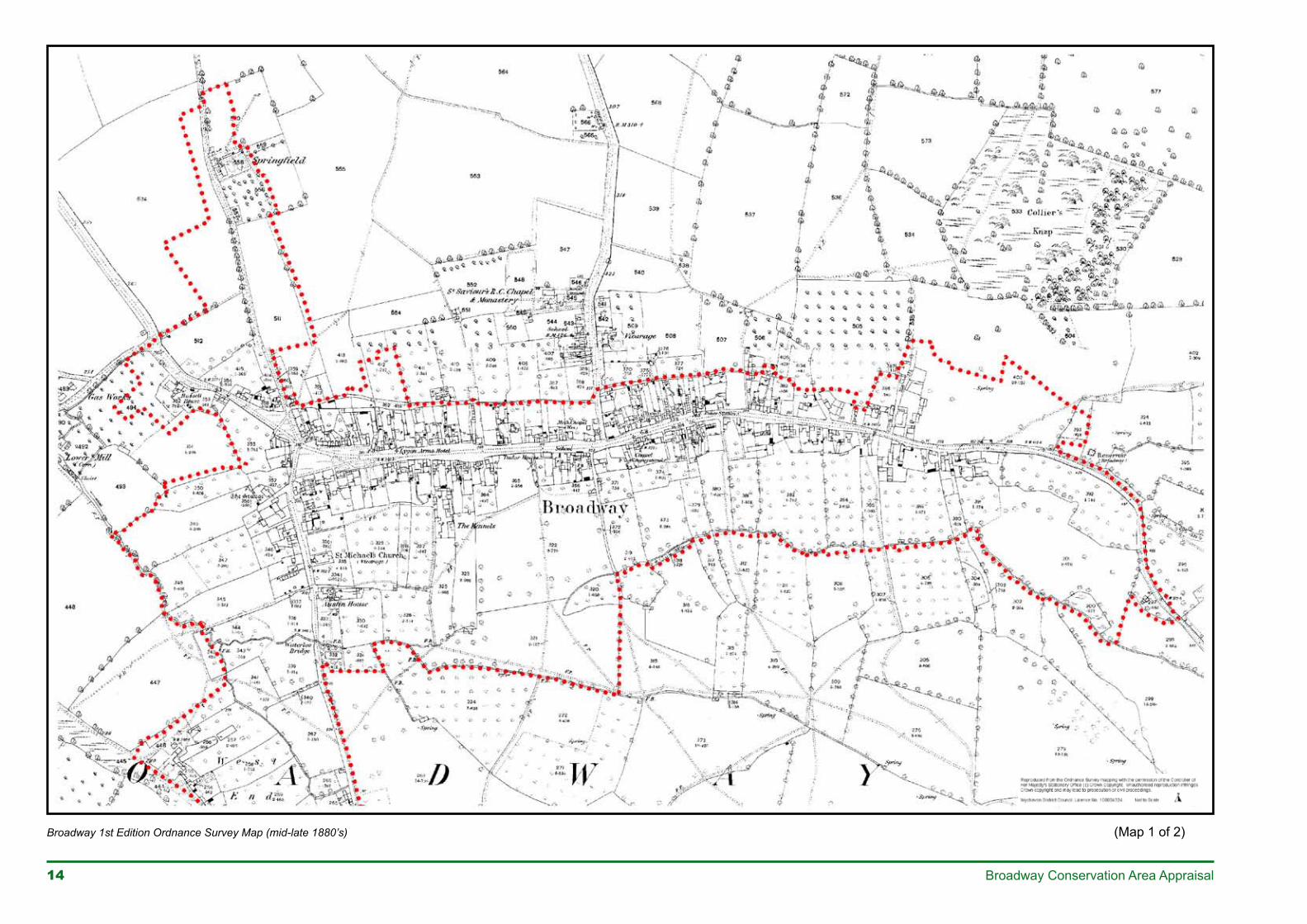
Broadway 1st Edition Ordnance Survey Map (mid-late 1880’s) (Map 1 of 2)
��Broadway Conservation Area Appraisal
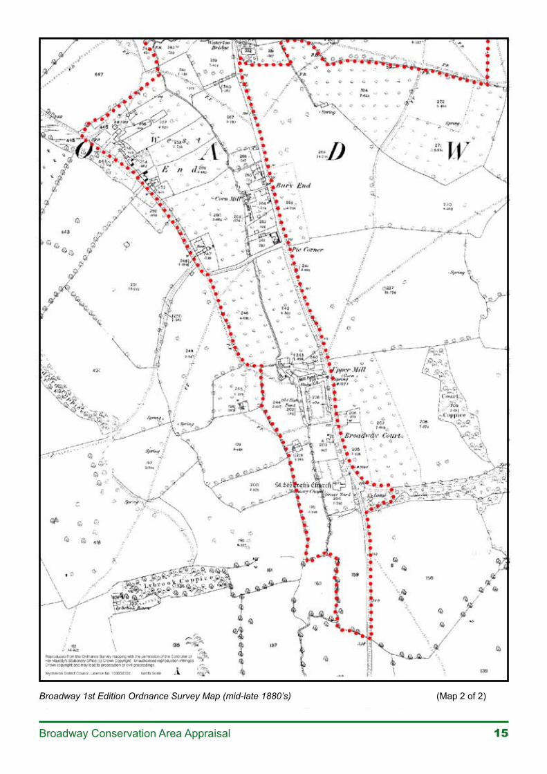
Broadway 1st Edition Ordnance Survey Map (mid-late 1880’s) (Map 2 of 2)
�� Broadway Conservation Area Appraisal
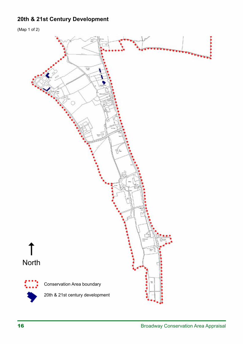
Conservation Area boundary
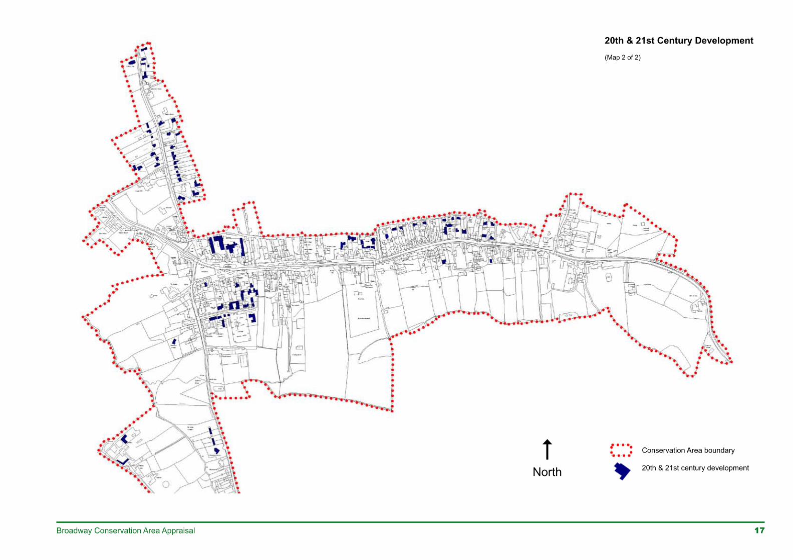
20th & 21st century development
North
20th & 21st Century Development(Map 1 of 2)
17Broadway Conservation Area Appraisal
North
Conservation Area boundary
20th & 21st century development
20th & 21st Century Development(Map 2 of 2)
18 Broadway Conservation Area Appraisal
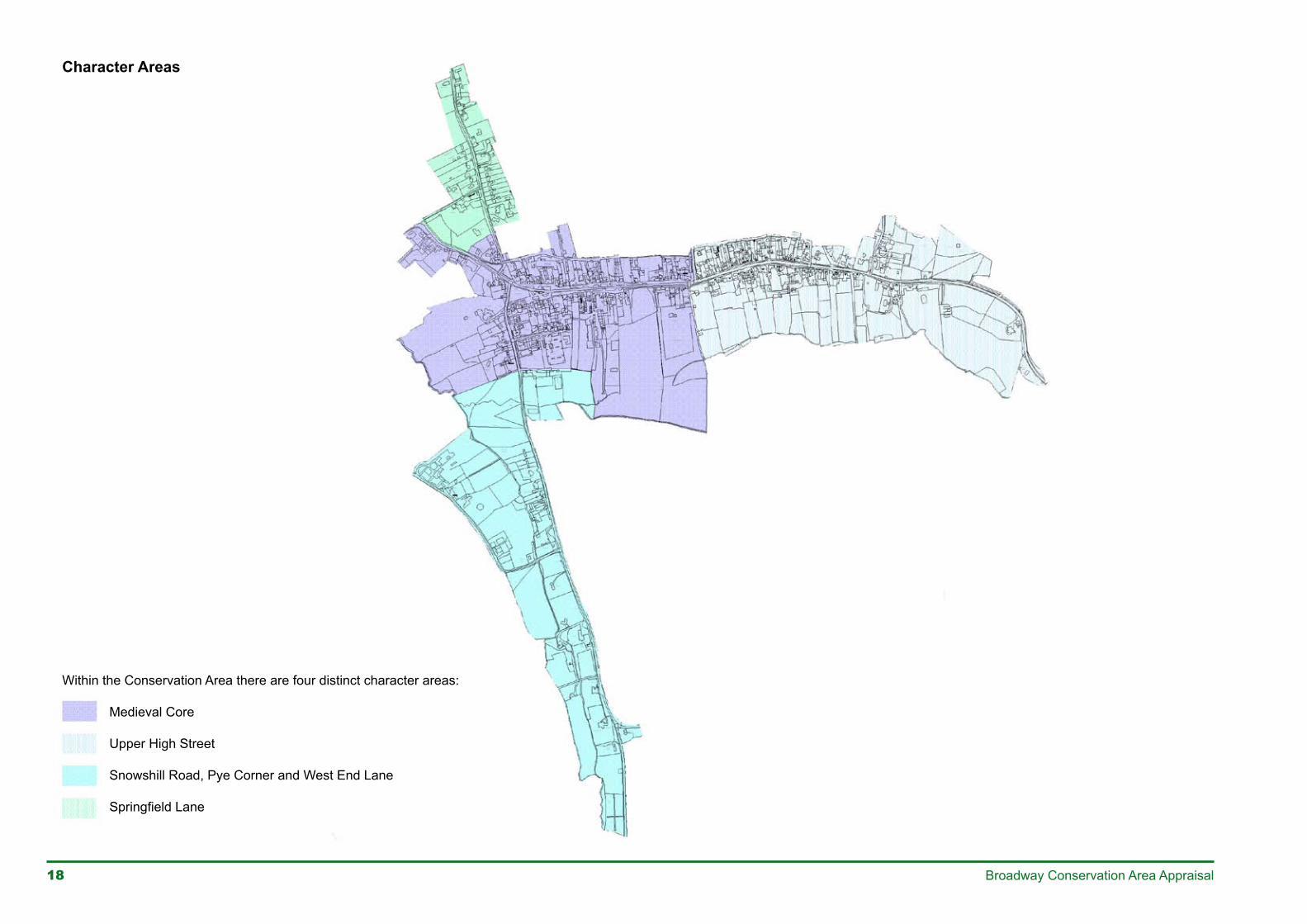
Character Areas
Within the Conservation Area there are four distinct character areas:
Medieval Core
Upper High Street
Snowshill Road, Pye Corner and West End Lane
SpringfieldLane
��Broadway Conservation Area Appraisal
residential, the lower High Street primarily commercial, and farms located at the outskirts, at West End Lane and Snowshill Road.
The later 20th century has seen the expansion of housing into much of the common fields on the north side of the village, outside the conservation area. Within the conservation area 20th century infill has consolidated earlier development in Springfield Lane and extended the pocket of development in Snowshill Road. New houses have been built in the rear of medieval plots off Colletts Fields, and occasionally in the rear of plots off upper High Street, obscuring in these parts of the village part of the back lane and the linear rectangular plots of the medieval town plan. On the north and south sides of The Green rear yards have been re-developed and rear plots filled with new residential and shopping developments, again obscuring in part some of the medieval plan in this area.
The construction of the Broadway by-pass in 1998 removed through traffic from the High Street, ending its function as the principal route through the village. Although the High Street remains the main axis of the village it is now a quieter thoroughfare for local and visitor traffic.
Despite these more recent changes Broadway retains much of its original medieval plan form, a wealth of historic buildings and evidence in its buildings and surrounds of its changing role and fortunes through history.
CHARACTER AND APPEARANCE
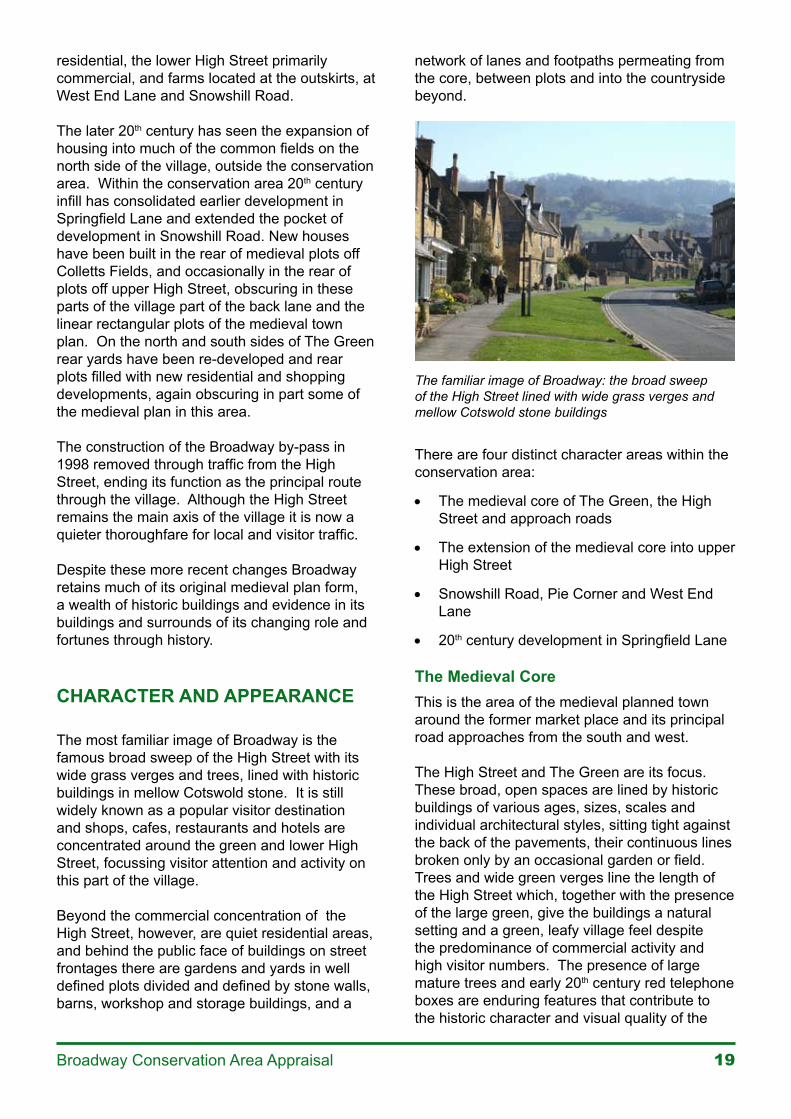
The most familiar image of Broadway is the famous broad sweep of the High Street with its wide grass verges and trees, lined with historic buildings in mellow Cotswold stone. It is still widely known as a popular visitor destination and shops, cafes, restaurants and hotels are concentrated around the green and lower High Street, focussing visitor attention and activity on this part of the village.
Beyond the commercial concentration of the High Street, however, are quiet residential areas, and behind the public face of buildings on street frontages there are gardens and yards in well defined plots divided and defined by stone walls, barns, workshop and storage buildings, and a
network of lanes and footpaths permeating from the core, between plots and into the countryside beyond.
The familiar image of Broadway: the broad sweep of the High Street lined with wide grass verges and mellow Cotswold stone buildings
There are four distinct character areas within the conservation area:
• The medieval core of The Green, the High Street and approach roads
• The extension of the medieval core into upper High Street
• Snowshill Road, Pie Corner and West End Lane
• 20th century development in Springfield Lane
The Medieval CoreThis is the area of the medieval planned town around the former market place and its principal road approaches from the south and west.
The High Street and The Green are its focus. These broad, open spaces are lined by historic buildings of various ages, sizes, scales and individual architectural styles, sitting tight against the back of the pavements, their continuous lines broken only by an occasional garden or field.Trees and wide green verges line the length of the High Street which, together with the presence of the large green, give the buildings a natural setting and a green, leafy village feel despite the predominance of commercial activity and high visitor numbers. The presence of large mature trees and early 20th century red telephone boxes are enduring features that contribute to the historic character and visual quality of the
�0 Broadway Conservation Area Appraisal
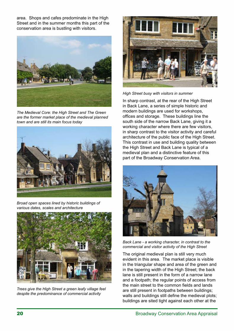
area. Shops and cafes predominate in the High Street and in the summer months this part of the conservation area is bustling with visitors.
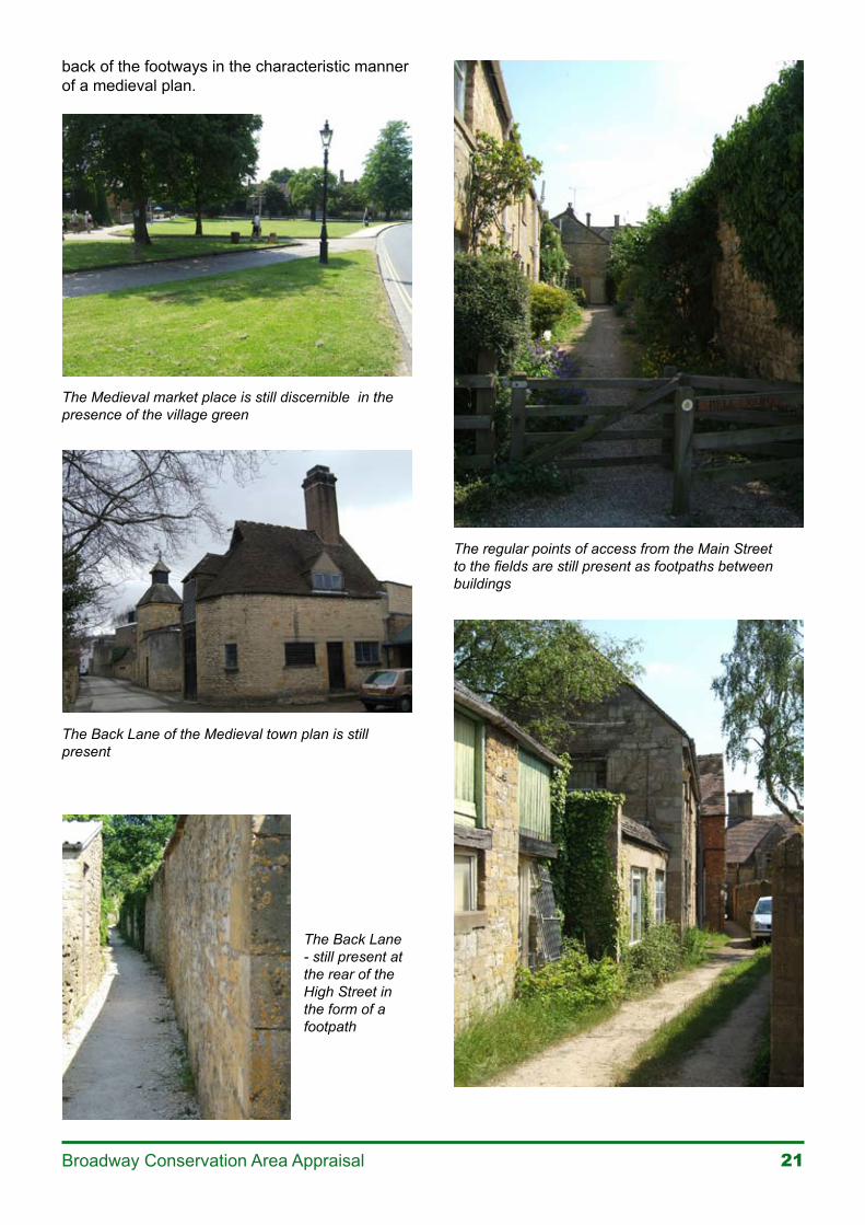
The Medieval Core: the High Street and The Green are the former market place of the medieval planned town and are still its main focus today
Broad open spaces lined by historic buildings of various dates, scales and architecture
Trees give the High Street a green leafy village feel despite the predominance of commercial activity
High Street busy with visitors in summer
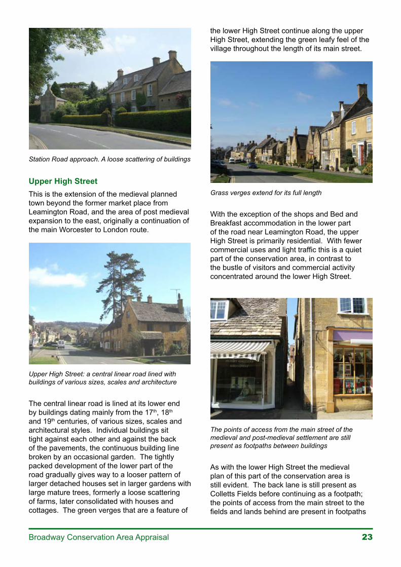
In sharp contrast, at the rear of the High Street in Back Lane, a series of simple historic and modern buildings are used for workshops, offices and storage. These buildings line the south side of the narrow Back Lane, giving it a working character where there are few visitors, in sharp contrast to the visitor activity and careful architecture of the public face of the High Street. This contrast in use and building quality between the High Street and Back Lane is typical of a medieval plan and a distinctive feature of this part of the Broadway Conservation Area.
Back Lane - a working character, in contrast to the commercial and visitor activity of the High Street
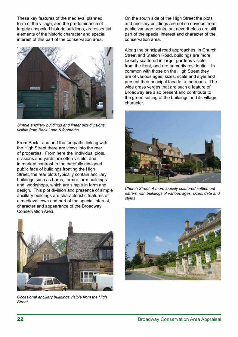
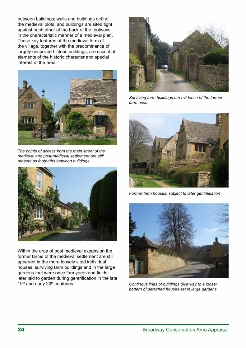
The original medieval plan is still very much evident in this area. The market place is visible in the triangular shape and area of the green and in the tapering width of the High Street; the back lane is still present in the form of a narrow lane and a footpath; the regular points of access from the main street to the common fields and lands are still present in footpaths between buildings; walls and buildings still define the medieval plots; buildings are sited tight against each other at the
��Broadway Conservation Area Appraisal
back of the footways in the characteristic manner of a medieval plan.
The Medieval market place is still discernible in the presence of the village green
The Back Lane of the Medieval town plan is still present
The Back Lane - still present at the rear of the High Street in the form of a footpath
The regular points of access from the Main Street to the fields are still present as footpaths between buildings
�� Broadway Conservation Area Appraisal
These key features of the medieval planned form of the village, and the predominance of largely unspoiled historic buildings, are essential elements of the historic character and special interest of this part of the conservation area.
Simple ancillary buildings and linear plot divisions visible from Back Lane & footpaths
From Back Lane and the footpaths linking with the High Street there are views into the rear of properties. From here the individual plots, divisions and yards are often visible, and, in marked contrast to the carefully designed public face of buildings fronting the High Street, the rear plots typically contain ancillary buildings such as barns, former farm buildings and workshops, which are simple in form and design. This plot division and presence of simple ancillary buildings are characteristic features of a medieval town and part of the special interest, character and appearance of the Broadway Conservation Area.
Occasional ancillary buildings visible from the High Street
On the south side of the High Street the plots and ancillary buildings are not so obvious from public vantage points, but nevertheless are still part of the special interest and character of the conservation area.
Along the principal road approaches, in Church Street and Station Road, buildings are more loosely scattered in larger gardens visible from the front, and are primarily residential. In common with those on the High Street they are of various ages, sizes, scale and style and present their principal façade to the roads. The wide grass verges that are such a feature of Broadway are also present and contribute to the green setting of the buildings and its village character.
Church Street. A more loosely scattered settlement pattern with buildings of various ages, sizes, date and styles
��Broadway Conservation Area Appraisal
Station Road approach. A loose scattering of buildings
Upper High StreetThis is the extension of the medieval planned town beyond the former market place from Leamington Road, and the area of post medieval expansion to the east, originally a continuation of the main Worcester to London route.
Upper High Street: a central linear road lined with buildings of various sizes, scales and architecture
The central linear road is lined at its lower end by buildings dating mainly from the 17th, 18th and 19th centuries, of various sizes, scales and architectural styles. Individual buildings sit tight against each other and against the back of the pavements, the continuous building line broken by an occasional garden. The tightly packed development of the lower part of the road gradually gives way to a looser pattern of larger detached houses set in larger gardens with large mature trees, formerly a loose scattering of farms, later consolidated with houses and cottages. The green verges that are a feature of
the lower High Street continue along the upper High Street, extending the green leafy feel of the village throughout the length of its main street.
Grass verges extend for its full length
With the exception of the shops and Bed and Breakfast accommodation in the lower part of the road near Leamington Road, the upper High Street is primarily residential. With fewer commercial uses and light traffic this is a quiet part of the conservation area, in contrast to the bustle of visitors and commercial activity concentrated around the lower High Street.
The points of access from the main street of the medieval and post-medieval settlement are still present as footpaths between buildings
As with the lower High Street the medieval plan of this part of the conservation area is still evident. The back lane is still present as Colletts Fields before continuing as a footpath; the points of access from the main street to the fields and lands behind are present in footpaths
�� Broadway Conservation Area Appraisal
between buildings; walls and buildings define the medieval plots, and buildings are sited tight against each other at the back of the footways in the characteristic manner of a medieval plan. These key features of the medieval form of the village, together with the predominance of largely unspoiled historic buildings, are essential elements of the historic character and special interest of the area.
The points of access from the main street of the medieval and post-medieval settlement are still present as footpaths between buildings
Within the area of post medieval expansion the former farms of the medieval settlement are still apparent in the more loosely sited individual houses, surviving farm buildings and in the large gardens that were once farmyards and fields, later laid to garden during gentrification in the late 19th and early 20th centuries.
Surviving farm buildings are evidence of the former farm uses
Former farm houses, subject to later gentrification
Continous lines of buildings give way to a looser pattern of detached houses set in large gardens
��Broadway Conservation Area Appraisal
Continous lines of buildings give way to a looser pattern of detached houses set in large gardens
Early 20th century infill development has been in the form of detached houses in large gardens, maintaining the loose development pattern in this part of the conservation area of scattered detached buildings in large green plots.
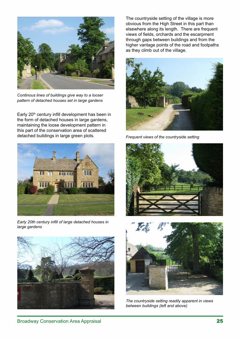
Early 20th century infill of large detached houses in large gardens
The countryside setting of the village is more obvious from the High Street in this part than elsewhere along its length. There are frequent views of fields, orchards and the escarpment through gaps between buildings and from the higher vantage points of the road and footpaths as they climb out of the village.
Frequent views of the countryside setting
The countryside setting readily apparent in views between buildings (left and above)

�� Broadway Conservation Area Appraisal
There are frequent views into the rear of properties, from Colletts Fields, the footpaths linking with the High Street and those to the south of the High Street. From here, as in the lower High Street, individual plots and divisions are often visible. The rear of plots in this part are more typically gardens associated with residential properties rather than the yards found in the lower High Street at the rear of commercial properties.
Views into the rear of properties often reveal the plot divisions of the medieval town plan
Snowshill Road, Pye Corner and West End Lane This is the area between the medieval core of the village and St Eadburgha’s church to the south and includes the historic routes into Broadway from Pershore and Worcester.
This part of the conservation area is a linear development of scattered houses, cottages and farms stretching into the countryside. With the exception of a cluster of houses and cottages near Pye Corner, buildings are otherwise very loosely spaced and interspersed with significant areas of open spaces in the form of fields, large gardens and orchards. There are views of the surrounding countryside to and from all directions and the prevailing character of this part of the conservation area is rural, with buildings constantly viewed in context with surrounding countryside.
Snowshill Road, Pye Corner and West End Lane: a loose scattering of buildings in the countryside
Snowshill Road, Pye Corner and West End Lane: where buildings are loosely spaced and interspersed with large areas of open space
The cluster of houses and cottages near Pye Corner are the exception to the otherwise loose scattering of buildings
��Broadway Conservation Area Appraisal
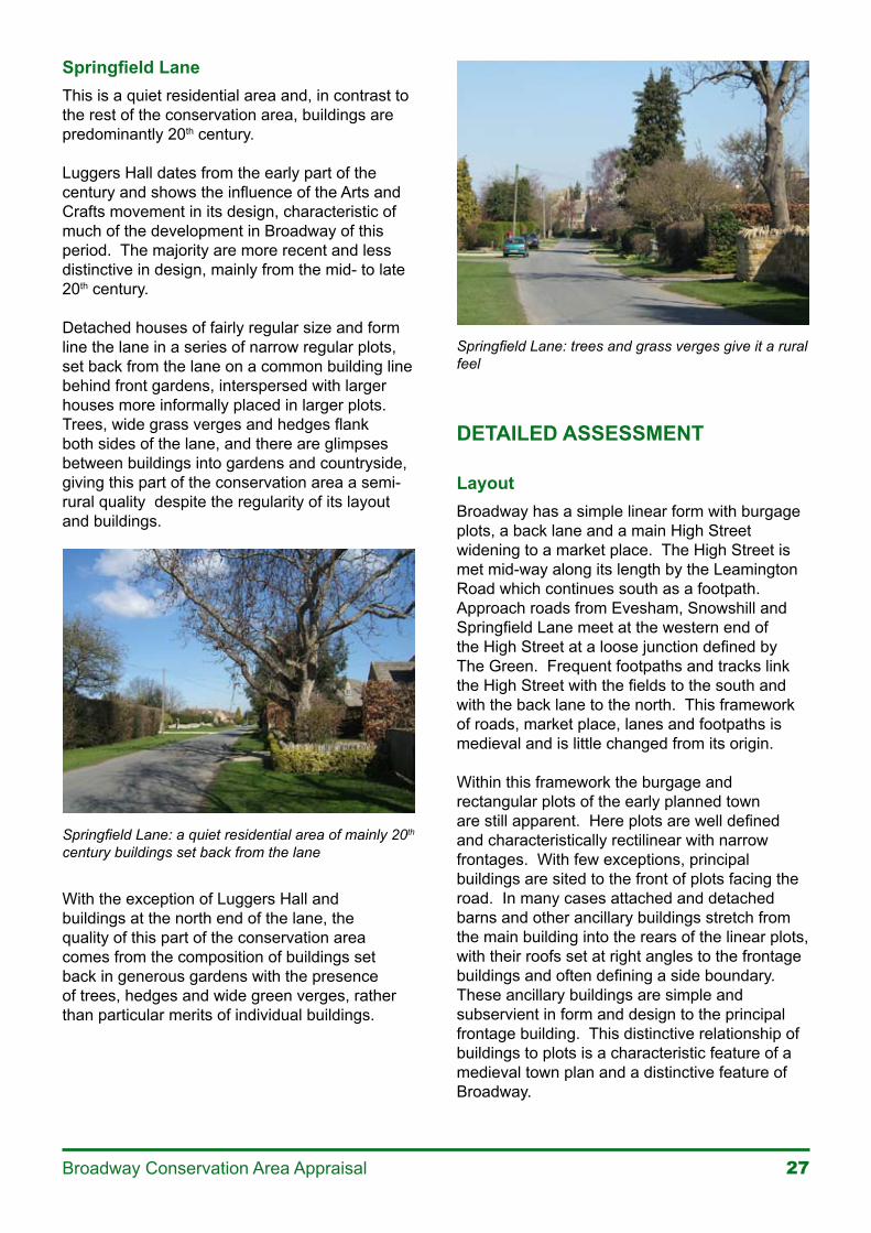
Springfield LaneThis is a quiet residential area and, in contrast to the rest of the conservation area, buildings are predominantly 20th century.
Luggers Hall dates from the early part of the century and shows the influence of the Arts and Crafts movement in its design, characteristic of much of the development in Broadway of this period. The majority are more recent and less distinctive in design, mainly from the mid- to late 20th century.
Detached houses of fairly regular size and form line the lane in a series of narrow regular plots, set back from the lane on a common building line behind front gardens, interspersed with larger houses more informally placed in larger plots. Trees, wide grass verges and hedges flank both sides of the lane, and there are glimpses between buildings into gardens and countryside, giving this part of the conservation area a semi-rural quality despite the regularity of its layout and buildings.
Springfield Lane: a quiet residential area of mainly 20th century buildings set back from the lane
With the exception of Luggers Hall and buildings at the north end of the lane, the quality of this part of the conservation area comes from the composition of buildings set back in generous gardens with the presence of trees, hedges and wide green verges, rather than particular merits of individual buildings.
Springfield Lane: trees and grass verges give it a rural feel
DETAILED ASSESSMENT
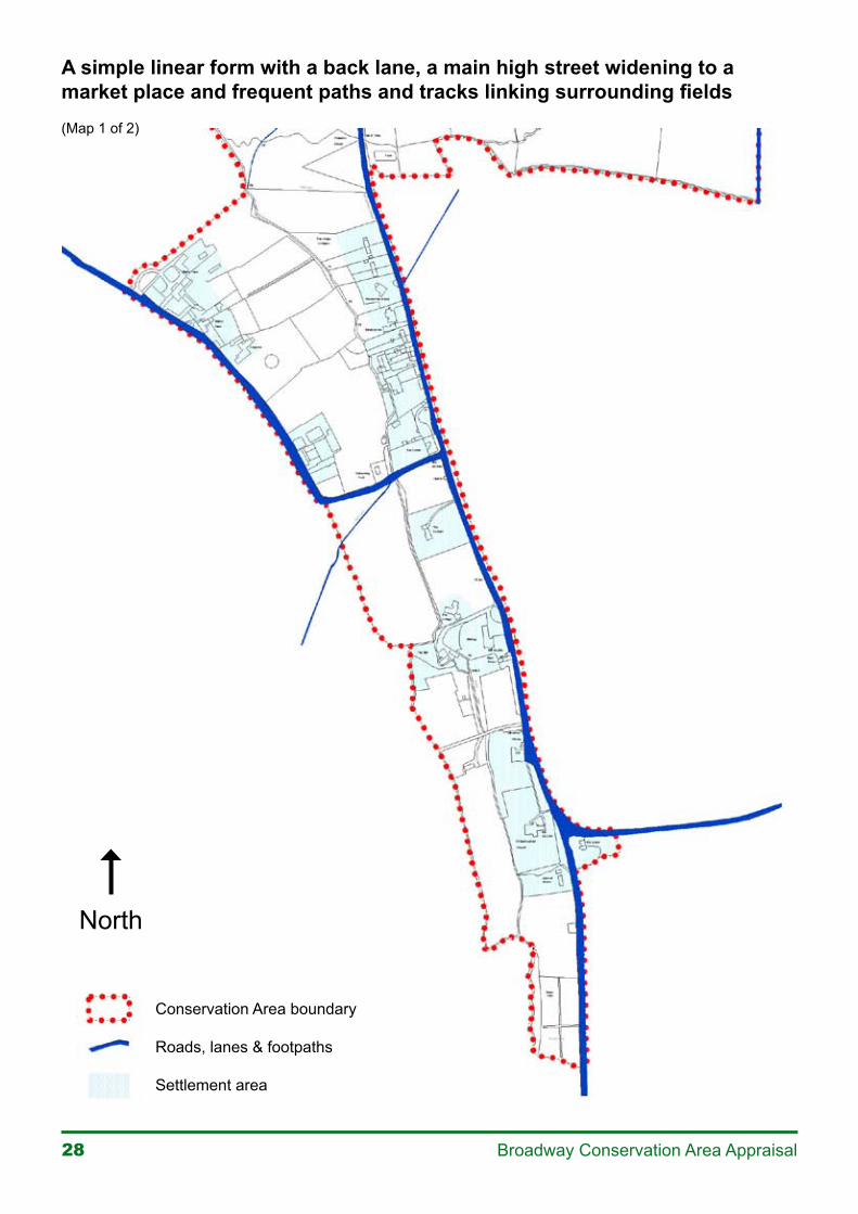
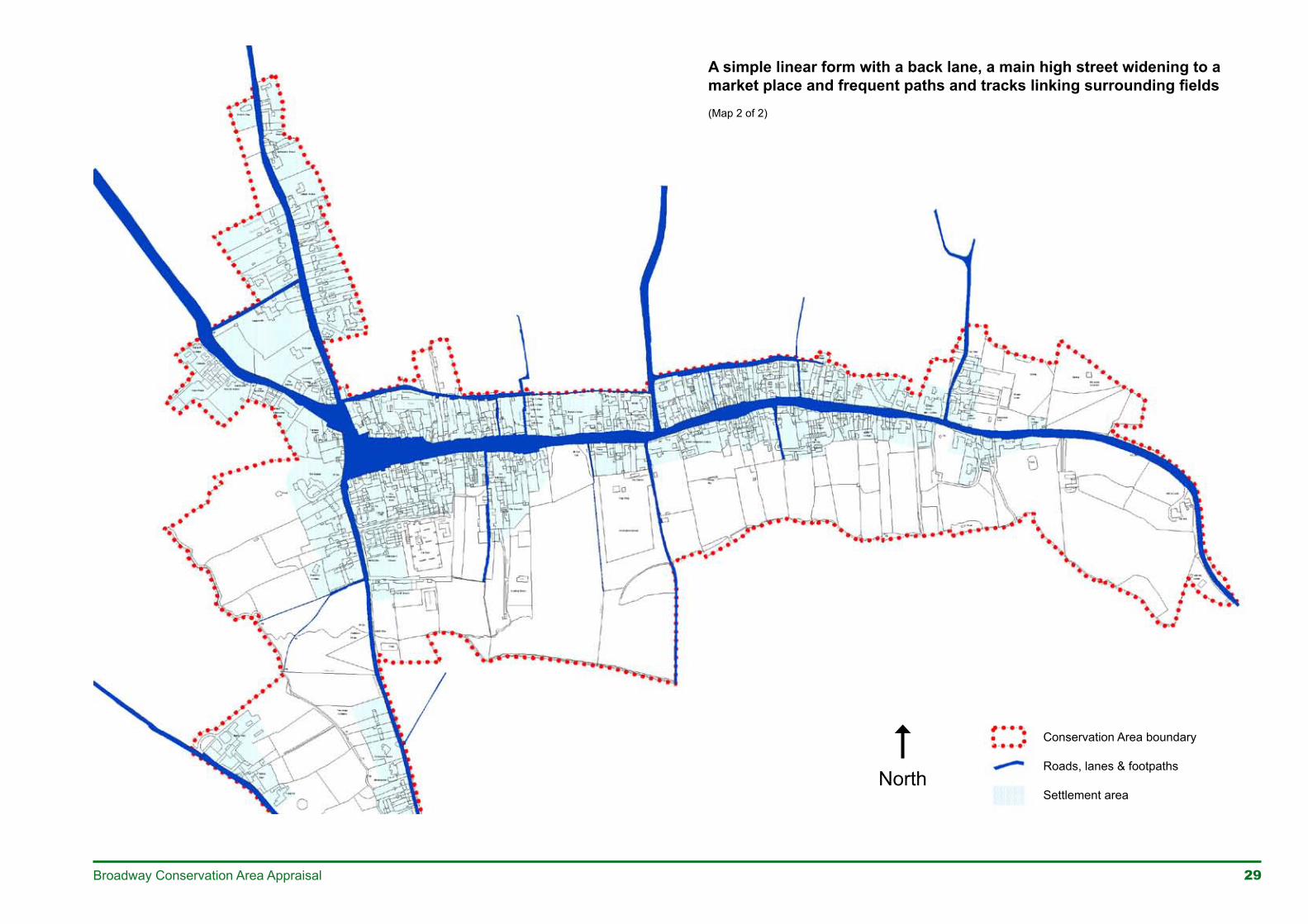
LayoutBroadway has a simple linear form with burgage plots, a back lane and a main High Street widening to a market place. The High Street is met mid-way along its length by the Leamington Road which continues south as a footpath. Approach roads from Evesham, Snowshill and Springfield Lane meet at the western end of the High Street at a loose junction defined by The Green. Frequent footpaths and tracks link the High Street with the fields to the south and with the back lane to the north. This framework of roads, market place, lanes and footpaths is medieval and is little changed from its origin.
Within this framework the burgage and rectangular plots of the early planned town are still apparent. Here plots are well defined and characteristically rectilinear with narrow frontages. With few exceptions, principal buildings are sited to the front of plots facing the road. In many cases attached and detached barns and other ancillary buildings stretch from the main building into the rears of the linear plots, with their roofs set at right angles to the frontage buildings and often defining a side boundary. These ancillary buildings are simple and subservient in form and design to the principal frontage building. This distinctive relationship of buildings to plots is a characteristic feature of a medieval town plan and a distinctive feature of Broadway.
�� Broadway Conservation Area Appraisal
A simple linear form with a back lane, a main high street widening to a market place and frequent paths and tracks linking surrounding fields(Map 1 of 2)
Conservation Area boundary
Roads, lanes & footpaths
Settlement area
North
29Broadway Conservation Area Appraisal
North
A simple linear form with a back lane, a main high street widening to a market place and frequent paths and tracks linking surrounding fields(Map 2 of 2)
Conservation Area boundary
Roads, lanes & footpaths
Settlement area
30 Broadway Conservation Area Appraisal
Please see part two of the document to viewpages 31 to 64, and Appraisal Map