u.s. 101 improvement project between monterey street ... - vta
TRANSCRIPT
May 2013
Prepared by the Santa Clara Valley Transportation Authority
U.S. 101 Improvement Projectbetween
Monterey Street and State Route 129Santa Clara and San Benito Counties, California
Caltrans District 4 - SCL - 101 (PM 0.0 - 5.0),Caltrans District 5 - SBT - 101 (PM 4.9 - 7.5),Caltrans District 4 - SCL - 25 (PM 1.6 - 2.5)
SCH 2007102141
FINAL ENVIRONMENTAL IMPACT REPORT
Preface to theFinal
Environmental Impact Report
************************************************************************************************************************************************
This Final Environmental Impact Report (EIR) for the U.S. 101 Improvement
Project was prepared in compliance with the California Environmental Quality
Act (CEQA). This document contains the following:
> Text of the Final EIR
> Summary of the Scoping/Outreach/Coordination Process (Chapter 3)
> Responses to Comments on the Draft EIR (Chapter 4)
> Copies of Written Comments on the Draft EIR (Appendix F)
> Copy of Public Hearing Transcript (Appendix G)
To assist the reader, any changes made to the text of the Draft EIR are
indicated in this Final EIR as follows: Text additions are underlined. Text
deletions show the original text with a strikeout running through the part of
the text to be deleted.

Summary
The Santa Clara Valley Transportation Authority (VTA) has prepared this Environmental Impact
Report (EIR) in its role as the Lead Agency under the California Environmental Quality Act (CEGA).
The VTA, in cooperation with the California Department of Transportation (Caltrans), proposes
improvements to U.S. 101, as described below.
OVERVIEW OF PROJECT AREA
The proposed project is located on U.S. 101 in southern Santa Clara County/northern San Benito
County, California. The northerly project limit is Monterey Street in the City of Gilroy and the
southerly project limit is State Route (SR) 129. Within the project limits, U.S. 101 is currently a
4-lane expressway in Santa Clara County and a 4-lane freeway in San Benito County. Existing
interchanges on U.S. 101 are located at Monterey Street, SR 25, Betabel Road/Y Road, and SR 129.
Within Santa Clara County, there is also access between U.S. 101 and a number of local roadways
and driveways.
PURPOSE AND NEED
The purpose of the proposed project is to accomplish the following objectives:
• Complete the upgrade of U.S. 101 to freeway standard in Santa Clara County, and improve
system connectivity to SR 25 and SR 129.
• Accommodate projected traffic demand along U.S. 101, including growth anticipated under
adopted land use plans, thereby reducing future congestion and delay, especially during
peak travel periods.
• Improve safety along the project segment of U.S. 101, including the reduction of conflicts
with agricultural traffic.
• Improve traffic operations on the project segment of U.S. 101, including those associated
with connections between U.S. 101 and SR 25, SR 129, local roads, and adjacent land uses.
• Enhance the movement of goods along the U.S. 101 transportation corridor.
• Maintain and enhance bicycle access in the U.S. 101 corridor.
U.S. 101 Improvement Project:Monterey Street to SR 129
Final EIRMay 2013
Summary
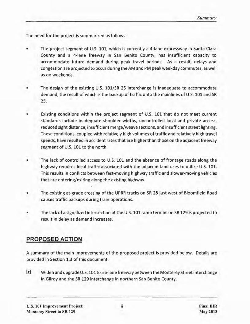
The need for the project is summarized as follows:
• The project segment of U.S. 101, which is currently a 4-lane expressway in Santa Clara
County and a 4-lane freeway in San Benito County, has insufficient capacity to
accommodate future demand during peak travel periods. As a result, delays and
congestion are projected to occur during the AM and PM peak weekday commutes, as well
as on weekends.
• The design of the existing U.S. 101/SR 25 interchange is inadequate to accommodate
demand, the result of which is the backup of traffic onto the mainlines of u.s. 101 and SR
25.
• Existing conditions within the project segment of U.S. 101 that do not meet current
standards include inadequate shoulder widths, uncontrolled local and private access,
reduced sight distance, insufficient merge/weave sections, and insufficient street lighting.
These conditions, coupled with relatively high volumes of traffic and relatively high travel
speeds, have resulted in accident rates that are higher than those on the adjacent freeway
segment of U.S. 101 to the north.
• The lack of controlled access to U.S. 101 and the absence of frontage roads along the
highway requires local traffic associated with the adjacent land uses to utilize U.S. 101.
This results in conflicts between fast-moving highway traffic and slower-moving vehicles
that are entering/exiting along the existing highway.
• The existing at-grade crossing of the UPRR tracks on SR 25 just west of Bloomfield Road
causes traffic backups during train operations.
• The lack of a signalized intersection at the U.S. 101 ramp termini on SR 129 is projected to
result in delay as demand increases.
PROPOSED ACTION
A summary of the main improvements of the proposed project is provided below. Details are
provided in Section 1.3 of this document.
[B Widen and upgrade U.S. 101to a6-lane freeway between the Monterey Street interchange
in Gilroy and the SR 129 interchange in northern San Benito County.
U.S. 101 Improvement Project:Monterey Street to SR 129
ii Final EIRMay 2013

Summary
[E Reconstruct the U.S. 101/SR 25 interchange. There are two design options for the
reconstructed interchange being considered. Design Option A would reconstruct the U.S.
101/SR 25 interchange at a location approximately 0.2 miles north of the existing
interchange. Design Option B would reconstruct the U.S. 101/SR 25 interchange at
essentially the same location as the existing interchange.
[E Construct an auxiliary lane in each direction on U.S. 101 between the Monterey Street and
SR 25 interchanges.
[E Extend Santa Teresa Boulevard approximatelyO.5 miles from Castro Valley Road tothe new
U.S. 101/SR 25 interchange.
[E Construct improvements at the southbound U.S. 101 off-ramp to SR 129.
[E Construct frontage roads, as needed, to replace existing access to U.S, 101 from adjacent
properties.
IE Grade-separate the Union Pacific Railroad (UPRR) crossing on SR 25 just west of Bloomfield
Avenue.
IE Construct bicycle facilities, as needed, to replace access that will be lost when U.S. 101 is
upgraded to a freeway and to improve bicycle access in the project area,
PROJECT IMPACTS
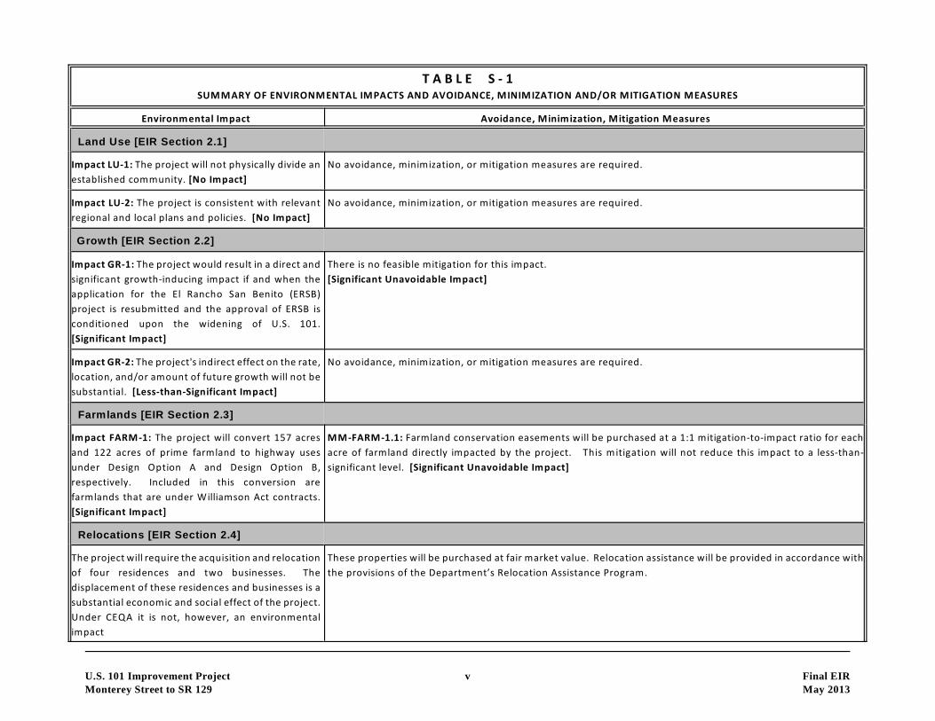
Table 5-1 provides a brief summary of the environmental impacts of the project, as well as
avoidance, minimization, and/or mitigation measures. The reader is referred to Chapter 2 ofthis
EIR for detailed discussions of the existing setting, impacts, and avoidance, minimization, and/or
mitigation measures.
COORDINATION WITH PUBLIC AND OTHER AGENCIES
Construction of the proposed project will require permits/approvals from the governmental
agencies listed in Table 5-2.
During the planning and preliminary design for the project, VTA and Caltrans have undertaken
substantial outreach to the public and to affected governmental agencies. This outreach, which
U.S. 101 Improvement Project:Monterey Street to SR 129
iii Final EIRMay 2013

Summary
is described in detail in Section 3, focused on soliciting input on a wide variety of issues, most
notably the following:
a local property access and local traffic circulation given the proposed upgrade of U.S. 101
from an expressway to a freeway in the Santa Clara County portion ofthe project.
a Bicycle and pedestrian access and circulation in the project area, including maximizing
connections to existing and future trails.
o The substantial amount of right-of-way needed for the project, including the acquisition
and relocation of four residences and two businesses.
o Coordination of the project's design to be compatible with other planned improvements,
including a separate project to upgrade SR 25 to an expressway.
a The relationship of the project to the planned Santa Clara Valley Habitat Conservation
Plan/Natural Communities Conservation Plan viz a viz mitigation for the project's impacts
to wetlands and aquatic habitat, riparian habitat, oak woodland habitat., and a number of
special-status animal species.
o Measures to facilitate wildlife movement across the U.S. 101 corridor given the project's
location in an area of importance to habitat connectivity and wildlife movement.
o The location of the project in proximity to a number of historical and archaeological
resources, including the Bloomfield Ranch.
o Measures to address the existing hydrological issues, including the fact that much of the
area and portions of U.S. 101 are su bject to flooding. There are floodplain issues along the
Pajaro River that are particularly important. requiring coordination with the Pajaro River
Watershed Flood Prevention Authority.
o The impacts of the project on prime agricultural lands, including those under Williamson
Act contracts. The purchase of agricultural conservation easements is proposed.
Issues to be Resolved
The one substantial project-related issue to be resolved centers on the proposed reconstruction
of the U.S. 101/SR 25 interchange, specifically whether to choose Design Option A or Design
Option B. This decision will involve the consideration and weighing of a number of factors
including their differences in construction costs and environmental impacts.
U.S. 101 Improvement Project:Monterey Street to SR 129
iv Final EIRMay 2013
U.S. 101 Improvement Project v Final EIR
Monterey Street to SR 129 May 2013
T A B L E S - 1SUMMARY OF ENVIRONMENTAL IMPACTS AND AVOIDANCE, MINIMIZATION AND/OR MITIGATION MEASURES
Environmental Impact Avoidance, Minimization, Mitigation Measures
Land Use [EIR Section 2.1]
Impact LU-1: The project will not physically divide an
established community. [No Impact]
No avoidance, minimization, or mitigation measures are required.
Impact LU-2: The project is consistent with relevant
regional and local plans and policies. [No Impact]
No avoidance, minimization, or mitigation measures are required.
Growth [EIR Section 2.2]
Impact GR-1: The project would result in a direct and
significant growth-inducing impact if and when the
application for the El Rancho San Benito (ERSB)
project is resubmitted and the approval of ERSB is
conditioned upon the widening of U.S. 101.
[Significant Impact]
There is no feasible mitigation for this impact.
[Significant Unavoidable Impact]
Impact GR-2: The project's indirect effect on the rate,
location, and/or amount of future growth will not be
substantial. [Less-than-Significant Impact]
No avoidance, minimization, or mitigation measures are required.
Farmlands [EIR Section 2.3]
Impact FARM-1: The project will convert 157 acres
and 122 acres of prime farmland to highway uses
under Design Option A and Design Option B,
respectively. Included in this conversion are
farmlands that are under Williamson Act contracts.
[Significant Impact]
MM-FARM-1.1: Farmland conservation easements will be purchased at a 1:1 mitigation-to-impact ratio for each
acre of farmland directly impacted by the project. This mitigation will not reduce this impact to a less-than-
significant level. [Significant Unavoidable Impact]
Relocations [EIR Section 2.4]
The project will require the acquisition and relocation
of four residences and two businesses. The
displacement of these residences and businesses is a
substantial economic and social effect of the project.
Under CEQA it is not, however, an environmental
impact
These properties will be purchased at fair market value. Relocation assistance will be provided in accordance with
the provisions of the Department’s Relocation Assistance Program.

T A B L E S - 1SUMMARY OF ENVIRONMENTAL IMPACTS AND AVOIDANCE, MINIMIZATION AND/OR MITIGATION MEASURES
Environmental Impact Avoidance, Minimization, Mitigation Measures
U.S. 101 Improvement Project vi Final EIR
Monterey Street to SR 129 May 2013
Utilities & Emergency Services [EIR Section 2.5]
Impact UTIL-1:The project will not result in the
disruption of utility services. The project will not
hinder emergency vehicle response times. The
project will not sever or alter any emergency
evacuation routes. [No Impact]
No avoidance, minimization, or mitigation measures are required.
Transportation & Traffic, Bicycle & Pedestrian Facilities [EIR Section 2.6]
Impact TRAN-1: The project will improve peak-period
traffic operations along the project segment of U.S.
101. [Beneficial Impact]
No avoidance, minimization, or mitigation measures are required.
Impact TRAN-2: The project will not result in a
significant impact at any of the study intersections.
[Less-than-Significant Impact]
No avoidance, minimization, or mitigation measures are required.
Impact TRAN-3: Although the project will eliminate
bicycle access along the shoulder of U.S. 101 and SR
25 within the project limits, this access will be
replaced with a system of new north-south and east-
west bike lanes and bike paths, providing a safe and
direct means for bicycle travel in this area.
[Beneficial Impact]
No avoidance, minimization, or mitigation measures are required.
Visual/Aesthetics [EIR Section 2.7]
Impact VISUAL-1: The proposed retaining walls will
not result in a substantial change to the existing
visual and aesthetic environment along the project
segment of U.S. 101. [Less-than-Significant Impact]
No avoidance, minimization, or mitigation measures are required.
Impact VISUAL-2: Under Design Option A, the visual
impact of the project from a vantage point along U.S.
101, 0.6 miles north of the 101/25 interchange, will
be substantial. [Significant Impact]
MM-VISUAL-2.1: The visual effect of the new SR 25 overcrossing will be lessened through the incorporation of
architectural design features (i.e., use of colors and textures that reduce visual impacts) into the structure.
Landscaping will also be added to the interchange to lessen this impact. This mitigation will not reduce this impact
to a less-than-significant level. [Significant Unavoidable Impact]

T A B L E S - 1SUMMARY OF ENVIRONMENTAL IMPACTS AND AVOIDANCE, MINIMIZATION AND/OR MITIGATION MEASURES
Environmental Impact Avoidance, Minimization, Mitigation Measures
U.S. 101 Improvement Project vii Final EIR
Monterey Street to SR 129 May 2013
Impact VISUAL-3: Under Design Option B, the visual
impact of the project from a vantage point along U.S.
101, 0.6 miles north of the 101/25 interchange, will
not be substantial. [Less-than-Significant Impact]
No avoidance, minimization, or mitigation measures are required.
Impact VISUAL-4: Under Design Option A, the visual
impact of the project from a vantage point along
Santa Teresa Boulevard near Gavilan College will not
be substantial. [Less-than-Significant Impact]
No avoidance, minimization, or mitigation measures are required.
Impact VISUAL-5: Under Design Option B, the visual
impact of the project from a vantage point along
Santa Teresa Boulevard near Gavilan College will not
be substantial. [Less-than-Significant Impact]
No avoidance, minimization, or mitigation measures are required.
Impact VISUAL-6: Under Design Option A, the visual
impact of the project from a vantage point at the
intersection of SR 25 and Bloomfield Avenue will not
be substantial. [Less-than-Significant Impact]
No avoidance, minimization, or mitigation measures are required.
Impact VISUAL-7: Under Design Option B, the visual
impact of the project from a vantage point at the
intersection of SR 25 and Bloomfield Avenue will not
be substantial. [Less-than-Significant Impact]
No avoidance, minimization, or mitigation measures are required.
Impact VISUAL-8: Under Design Option A, the visual
impact of the project from a vantage point to the
west of the existing 101/25 interchange will not be
substantial. [Less-than-Significant Impact]
No avoidance, minimization, or mitigation measures are required.
Impact VISUAL-9: Under Design Option B, the visual
impact of the project from a vantage point to the
west of the existing 101/25 interchange will be
substantial. [Significant Impact; reduced to Less-than
Significant with Mitigation]
MM-VISUAL-9.1: Small trees will be planted along the north side of Santa Teresa Boulevard in order to screen views
of this roadway from the adjacent event center. The trees will function as large screening shrubs. Species that grow
into tall trees will not be planted as they would block views of the Diablo Range in the distance

T A B L E S - 1SUMMARY OF ENVIRONMENTAL IMPACTS AND AVOIDANCE, MINIMIZATION AND/OR MITIGATION MEASURES
Environmental Impact Avoidance, Minimization, Mitigation Measures
U.S. 101 Improvement Project viii Final EIR
Monterey Street to SR 129 May 2013
Impact-VISUAL-10: The removal of vegetation by the
project will not result in a significant visual impact.
[Less-than-Significant Impact]
No avoidance, minimization, or mitigation measures are required.
Cultural Resources [EIR Section 2.8]
Impact CUL-1: Construction-related activities will
adversely impact one or more of the archaeological
resources in the Project Area Limits (PAL).
[Significant Impact; reduced to Less-than Significant
with Mitigation]
MM-CUL-1.1: To resolve construction-related activities that will adversely impact one or more of the historical
resources in the PAL, an Archaeological Treatment Plan (ATP) will be developed that details procedures and
mechanisms that will be followed by Caltrans and VTA to ensure both agencies satisfy their regulatory requirements
under CEQA. The ATP will outline the process for completing the identification and evaluation phase of the
regulatory process on parcels not yet acquired by the project where access was denied. When data recovery
through excavation is the only feasible mitigation, provisions in the ATP for adequate recovery of scientifically
consequential information from and about the historical resource, shall be implemented prior to any project-related
construction or other activities being undertaken.
MM-CUL-1.2: If cultural materials are discovered during construction, all earth-moving activity within and around
the immediate discovery area will be diverted until a qualified archaeologist can assess the nature and significance
of the find.
Impact CUL-2: The project will not have a substantial
effect on the Bloomfield Ranch. [Less-than-
Significant Impact]
No avoidance, minimization, or mitigation measures are required.
Impact CUL-3: The project will have no adverse effect
on the San Felipe Church. [No Impact]
No avoidance, minimization, or mitigation measures are required.
Impact CUL-4: The project will have no adverse effect
on the Mayock House. [No Impact]
No avoidance, minimization, or mitigation measures are required.
Hydrology & Floodplains [EIR Section 2.9]
Impact HYDRO-1: Under both Design Option A and
Design Option B, the project will result in substantial
flooding impacts within the 100-year floodplain of
Carnadero Creek. [Significant Impact; reduced to
Less-than Significant with Mitigation]
MM-HYDRO-1.1: The project will construct a 100-foot wide trapezoidal flood control channel along the north side
of the proposed Santa Teresa Boulevard extension. It will also install three new double 14' x 8' RCB culverts under
the ramps and U.S. 101. The flood control channel will divert water on the west side of U.S. 101 to the three double
RCB culverts. (Design Option A only)
MM-HYDRO-1.2: The project will install nine new 12-foot x 6-foot RCB culverts under U.S. 101 to divert flows from
Gavilan Creek to the east side of U.S. 101. (Design Option B only)
T A B L E S - 1SUMMARY OF ENVIRONMENTAL IMPACTS AND AVOIDANCE, MINIMIZATION AND/OR MITIGATION MEASURES
Environmental Impact Avoidance, Minimization, Mitigation Measures
U.S. 101 Improvement Project ix Final EIR
Monterey Street to SR 129 May 2013
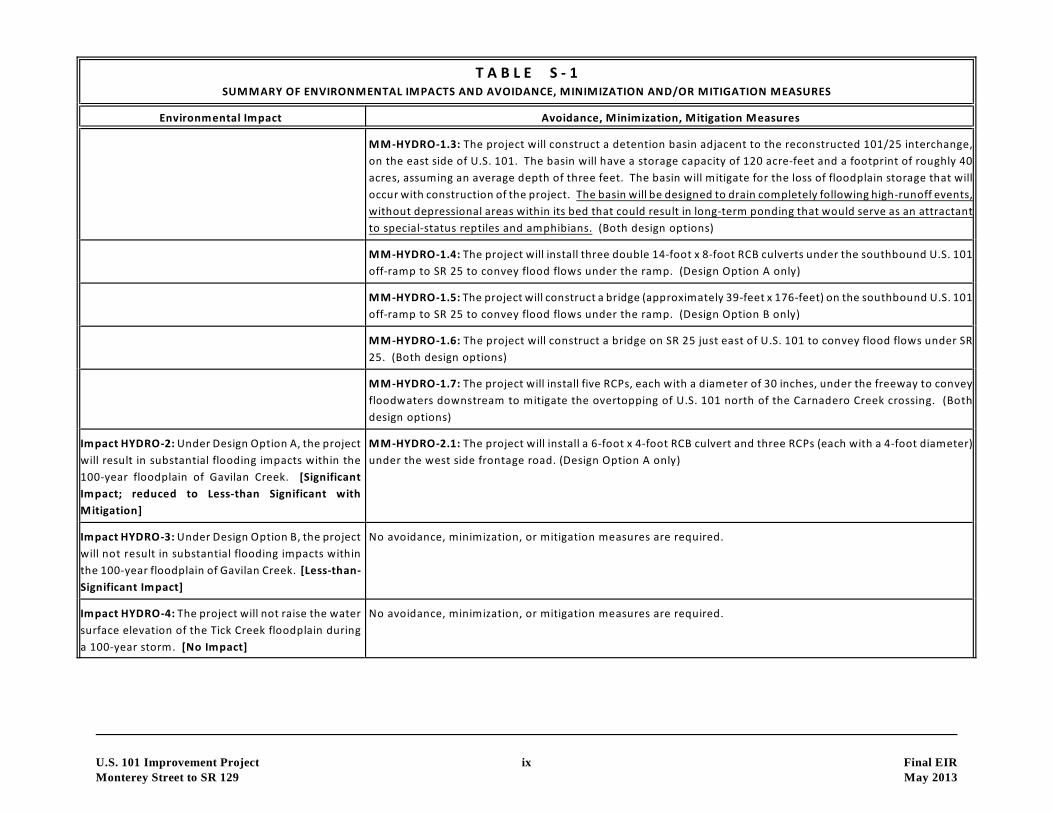
MM-HYDRO-1.3: The project will construct a detention basin adjacent to the reconstructed 101/25 interchange,
on the east side of U.S. 101. The basin will have a storage capacity of 120 acre-feet and a footprint of roughly 40
acres, assuming an average depth of three feet. The basin will mitigate for the loss of floodplain storage that will
occur with construction of the project. The basin will be designed to drain completely following high-runoff events,
without depressional areas within its bed that could result in long-term ponding that would serve as an attractant
to special-status reptiles and amphibians. (Both design options)
MM-HYDRO-1.4: The project will install three double 14-foot x 8-foot RCB culverts under the southbound U.S. 101
off-ramp to SR 25 to convey flood flows under the ramp. (Design Option A only)
MM-HYDRO-1.5: The project will construct a bridge (approximately 39-feet x 176-feet) on the southbound U.S. 101
off-ramp to SR 25 to convey flood flows under the ramp. (Design Option B only)
MM-HYDRO-1.6: The project will construct a bridge on SR 25 just east of U.S. 101 to convey flood flows under SR
25. (Both design options)
MM-HYDRO-1.7: The project will install five RCPs, each with a diameter of 30 inches, under the freeway to convey
floodwaters downstream to mitigate the overtopping of U.S. 101 north of the Carnadero Creek crossing. (Both
design options)
Impact HYDRO-2: Under Design Option A, the project
will result in substantial flooding impacts within the
100-year floodplain of Gavilan Creek. [Significant
Impact; reduced to Less-than Significant with
Mitigation]
MM-HYDRO-2.1: The project will install a 6-foot x 4-foot RCB culvert and three RCPs (each with a 4-foot diameter)
under the west side frontage road. (Design Option A only)
Impact HYDRO-3: Under Design Option B, the project
will not result in substantial flooding impacts within
the 100-year floodplain of Gavilan Creek. [Less-than-
Significant Impact]
No avoidance, minimization, or mitigation measures are required.
Impact HYDRO-4: The project will not raise the water
surface elevation of the Tick Creek floodplain during
a 100-year storm. [No Impact]
No avoidance, minimization, or mitigation measures are required.

T A B L E S - 1SUMMARY OF ENVIRONMENTAL IMPACTS AND AVOIDANCE, MINIMIZATION AND/OR MITIGATION MEASURES
Environmental Impact Avoidance, Minimization, Mitigation Measures
U.S. 101 Improvement Project x Final EIR
Monterey Street to SR 129 May 2013
Impact HYDRO-5: The project will not result in
substantial flooding impacts within the 100-year
floodplain of Tar Creek. [Less-than-Significant
Impact]
No avoidance, minimization, or mitigation measures are required.
Impact HYDRO-6: The project will not result in
substantial flooding impacts within the 100-year
floodplain of the Pajaro River. [Less-than-Significant
Impact]
No avoidance, minimization, or mitigation measures are required.
Impact HYDRO-7: The project will not result in
substantial flooding impacts within the 100-year
floodplain of the San Benito River. [Less-than-
Significant Impact]
No avoidance, minimization, or mitigation measures are required.
Impact HYDRO-8: The project will not result in
substantial flooding impacts within the 100-year
floodplain of San Juan Creek. [Less-than-Significant
Impact]
No avoidance, minimization, or mitigation measures are required.
Water Quality and Stormwater Runoff [EIR Section 2.10]
Impact WQ-1: Construction of the project will
increase impervious surfaces by approximately 75
acres, which will increase stormwater runoff. This
could lead to the degradation of water quality in
nearby creeks and rivers. [Significant Impact;
reduced to Less-than Significant with Mitigation]
MM-WQ-1.1: The project will create approximately 32.4 acres of biofiltration strips and swales along U.S. 101
within the project limits. The strips/swales will be located along the edges of the roadways and interchange ramps.
This acreage represents the maximum practicable extent of treatment for this project within the constraints of the
site.
Geology/Soils/Seismicity/Topography [EIR Section 2.11]
Impact GEO-1: Construction of the project will not
expose people to significant geologic hazards or risks.
[Less-than-Significant Impact]
No avoidance, minimization, or mitigation measures are required.

T A B L E S - 1SUMMARY OF ENVIRONMENTAL IMPACTS AND AVOIDANCE, MINIMIZATION AND/OR MITIGATION MEASURES
Environmental Impact Avoidance, Minimization, Mitigation Measures
U.S. 101 Improvement Project xi Final EIR
Monterey Street to SR 129 May 2013
Paleontology [EIR Section 2.12]
Impact PALEO-1: Construction of the proposed
project could impact paleontological resources and
could destroy scientifically important fossils.
[Significant Impact; reduced to Less-than Significant
with Mitigation]
MM-PALEO-1.1: A nonstandard special provision for paleontology mitigation will be included in the construction
contract special provisions section to advise the construction contractor of the requirement to cooperate with the
paleontological salvage.
MM-PALEO-1.2: A qualified principal paleontologist will be retained to prepare a detailed Paleontological Mitigation
Plan (PMP) prior to the start of construction. See Section 2.12 for the details as to the required contents of the
PMP.
Hazardous Waste/Materials [EIR Section 2.13]
Impact HAZ-1: Construction of the proposed project
could expose construction workers to hazardous
substances in concentrations that exceed regulatory
thresholds. [Significant Impact; reduced to Less-than
Significant with Mitigation]
MM-HAZ-1.1: If construction activities occur within 50' of the Chevron Service Station located at 5887 Monterey
Rd and groundwater is encountered, the groundwater will be sampled and analyzed for constituents of concern
related to the Chevron Station contaminants prior to disposal. If groundwater is contaminated, it will be contained
and either treated and discharged to the sanitary sewer or transported to a licensed groundwater treatment facility.
MM-HAZ-1.2: Prior to project development, a soil investigation will be conducted to determine whether ADL has
affected soils that will be excavated as part of the proposed project. This applies to all locations where such testing
has not already been completed. The investigation for ADL will be performed in accordance with the Caltrans' Lead
Testing Guidance Procedure. The analytical results will be compared against applicable hazardous waste criteria.
Based on analytical results, the investigation will provide recommendations regarding management and disposal
of affected soils in the project area including the reuse potential of ADL-affected soil during project development.
The provisions of a variance granted to the Department by the California Department of Toxic Substances Control
on September 22, 2000 (or any subsequent variance in effect when the project is constructed) regarding
aerially-deposited lead will be followed.
MM-HAZ-1.3: If contaminated soil is encountered (based on physical observation) during trenching activities along
the alignment, the soil will be stockpiled and analyzed for potential contaminants. If the soil can not be reused
onsite, it will be transported to the appropriate landfill pending waste classification. In addition, if contaminated
groundwater is encountered during construction, similar steps should be taken to characterize and dispose of the
groundwater as was discussed in MM-HAZ-1.2, above.
T A B L E S - 1SUMMARY OF ENVIRONMENTAL IMPACTS AND AVOIDANCE, MINIMIZATION AND/OR MITIGATION MEASURES
Environmental Impact Avoidance, Minimization, Mitigation Measures
U.S. 101 Improvement Project xii Final EIR
Monterey Street to SR 129 May 2013
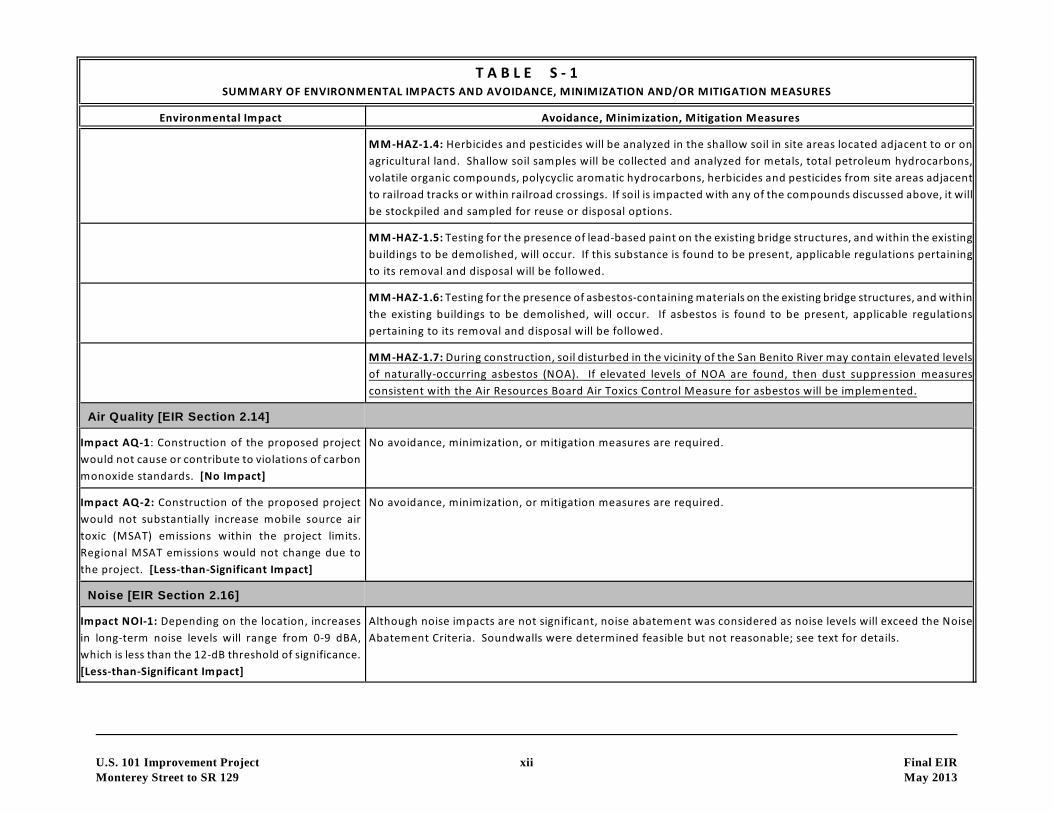
MM-HAZ-1.4: Herbicides and pesticides will be analyzed in the shallow soil in site areas located adjacent to or on
agricultural land. Shallow soil samples will be collected and analyzed for metals, total petroleum hydrocarbons,
volatile organic compounds, polycyclic aromatic hydrocarbons, herbicides and pesticides from site areas adjacent
to railroad tracks or within railroad crossings. If soil is impacted with any of the compounds discussed above, it will
be stockpiled and sampled for reuse or disposal options.
MM-HAZ-1.5: Testing for the presence of lead-based paint on the existing bridge structures, and within the existing
buildings to be demolished, will occur. If this substance is found to be present, applicable regulations pertaining
to its removal and disposal will be followed.
MM-HAZ-1.6: Testing for the presence of asbestos-containing materials on the existing bridge structures, and within
the existing buildings to be demolished, will occur. If asbestos is found to be present, applicable regulations
pertaining to its removal and disposal will be followed.
MM-HAZ-1.7: During construction, soil disturbed in the vicinity of the San Benito River may contain elevated levels
of naturally-occurring asbestos (NOA). If elevated levels of NOA are found, then dust suppression measures
consistent with the Air Resources Board Air Toxics Control Measure for asbestos will be implemented.
Air Quality [EIR Section 2.14]
Impact AQ-1: Construction of the proposed project
would not cause or contribute to violations of carbon
monoxide standards. [No Impact]
No avoidance, minimization, or mitigation measures are required.
Impact AQ-2: Construction of the proposed project
would not substantially increase mobile source air
toxic (MSAT) emissions within the project limits.
Regional MSAT emissions would not change due to
the project. [Less-than-Significant Impact]
No avoidance, minimization, or mitigation measures are required.
Noise [EIR Section 2.16]
Impact NOI-1: Depending on the location, increases
in long-term noise levels will range from 0-9 dBA,
which is less than the 12-dB threshold of significance.
[Less-than-Significant Impact]
Although noise impacts are not significant, noise abatement was considered as noise levels will exceed the Noise
Abatement Criteria. Soundwalls were determined feasible but not reasonable; see text for details.
T A B L E S - 1SUMMARY OF ENVIRONMENTAL IMPACTS AND AVOIDANCE, MINIMIZATION AND/OR MITIGATION MEASURES
Environmental Impact Avoidance, Minimization, Mitigation Measures
U.S. 101 Improvement Project xiii Final EIR
Monterey Street to SR 129 May 2013
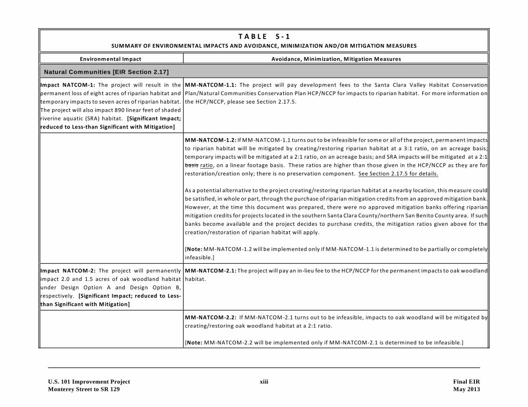
Natural Communities [EIR Section 2.17]
Impact NATCOM-1: The project will result in the
permanent loss of eight acres of riparian habitat and
temporary impacts to seven acres of riparian habitat.
The project will also impact 890 linear feet of shaded
riverine aquatic (SRA) habitat. [Significant Impact;
reduced to Less-than Significant with Mitigation]
MM-NATCOM-1.1: The project will pay development fees to the Santa Clara Valley Habitat Conservation
Plan/Natural Communities Conservation Plan HCP/NCCP for impacts to riparian habitat. For more information on
the HCP/NCCP, please see Section 2.17.5.
MM-NATCOM-1.2: If MM-NATCOM-1.1 turns out to be infeasible for some or all of the project, permanent impacts
to riparian habitat will be mitigated by creating/restoring riparian habitat at a 3:1 ratio, on an acreage basis;
temporary impacts will be mitigated at a 2:1 ratio, on an acreage basis; and SRA impacts will be mitigated at a 2:1
basis ratio, on a linear footage basis. These ratios are higher than those given in the HCP/NCCP as they are for
restoration/creation only; there is no preservation component. See Section 2.17.5 for details.
As a potential alternative to the project creating/restoring riparian habitat at a nearby location, this measure could
be satisfied, in whole or part, through the purchase of riparian mitigation credits from an approved mitigation bank.
However, at the time this document was prepared, there were no approved mitigation banks offering riparian
mitigation credits for projects located in the southern Santa Clara County/northern San Benito County area. If such
banks become available and the project decides to purchase credits, the mitigation ratios given above for the
creation/restoration of riparian habitat will apply.
[Note: MM-NATCOM-1.2 will be implemented only if MM-NATCOM-1.1 is determined to be partially or completely
infeasible.]
Impact NATCOM-2: The project will permanently
impact 2.0 and 1.5 acres of oak woodland habitat
under Design Option A and Design Option B,
respectively. [Significant Impact; reduced to Less-
than Significant with Mitigation]
MM-NATCOM-2.1: The project will pay an in-lieu fee to the HCP/NCCP for the permanent impacts to oak woodland
habitat.
MM-NATCOM-2.2: If MM-NATCOM-2.1 turns out to be infeasible, impacts to oak woodland will be mitigated by
creating/restoring oak woodland habitat at a 2:1 ratio.
[Note: MM-NATCOM-2.2 will be implemented only if MM-NATCOM-2.1 is determined to be infeasible.]
T A B L E S - 1SUMMARY OF ENVIRONMENTAL IMPACTS AND AVOIDANCE, MINIMIZATION AND/OR MITIGATION MEASURES
Environmental Impact Avoidance, Minimization, Mitigation Measures
U.S. 101 Improvement Project xiv Final EIR
Monterey Street to SR 129 May 2013
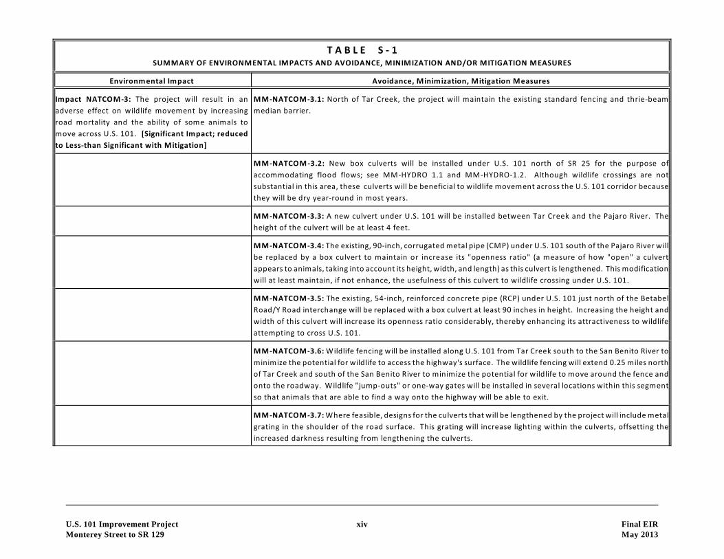
Impact NATCOM-3: The project will result in an
adverse effect on wildlife movement by increasing
road mortality and the ability of some animals to
move across U.S. 101. [Significant Impact; reduced
to Less-than Significant with Mitigation]
MM-NATCOM-3.1: North of Tar Creek, the project will maintain the existing standard fencing and thrie-beam
median barrier.
MM-NATCOM-3.2: New box culverts will be installed under U.S. 101 north of SR 25 for the purpose of
accommodating flood flows; see MM-HYDRO 1.1 and MM-HYDRO-1.2. Although wildlife crossings are not
substantial in this area, these culverts will be beneficial to wildlife movement across the U.S. 101 corridor because
they will be dry year-round in most years.
MM-NATCOM-3.3: A new culvert under U.S. 101 will be installed between Tar Creek and the Pajaro River. The
height of the culvert will be at least 4 feet.
MM-NATCOM-3.4: The existing, 90-inch, corrugated metal pipe (CMP) under U.S. 101 south of the Pajaro River will
be replaced by a box culvert to maintain or increase its "openness ratio" (a measure of how "open" a culvert
appears to animals, taking into account its height, width, and length) as this culvert is lengthened. This modification
will at least maintain, if not enhance, the usefulness of this culvert to wildlife crossing under U.S. 101.
MM-NATCOM-3.5: The existing, 54-inch, reinforced concrete pipe (RCP) under U.S. 101 just north of the Betabel
Road/Y Road interchange will be replaced with a box culvert at least 90 inches in height. Increasing the height and
width of this culvert will increase its openness ratio considerably, thereby enhancing its attractiveness to wildlife
attempting to cross U.S. 101.
MM-NATCOM-3.6: Wildlife fencing will be installed along U.S. 101 from Tar Creek south to the San Benito River to
minimize the potential for wildlife to access the highway's surface. The wildlife fencing will extend 0.25 miles north
of Tar Creek and south of the San Benito River to minimize the potential for wildlife to move around the fence and
onto the roadway. Wildlife "jump-outs" or one-way gates will be installed in several locations within this segment
so that animals that are able to find a way onto the highway will be able to exit.
MM-NATCOM-3.7: Where feasible, designs for the culverts that will be lengthened by the project will include metal
grating in the shoulder of the road surface. This grating will increase lighting within the culverts, offsetting the
increased darkness resulting from lengthening the culverts.
T A B L E S - 1SUMMARY OF ENVIRONMENTAL IMPACTS AND AVOIDANCE, MINIMIZATION AND/OR MITIGATION MEASURES
Environmental Impact Avoidance, Minimization, Mitigation Measures
U.S. 101 Improvement Project xv Final EIR
Monterey Street to SR 129 May 2013
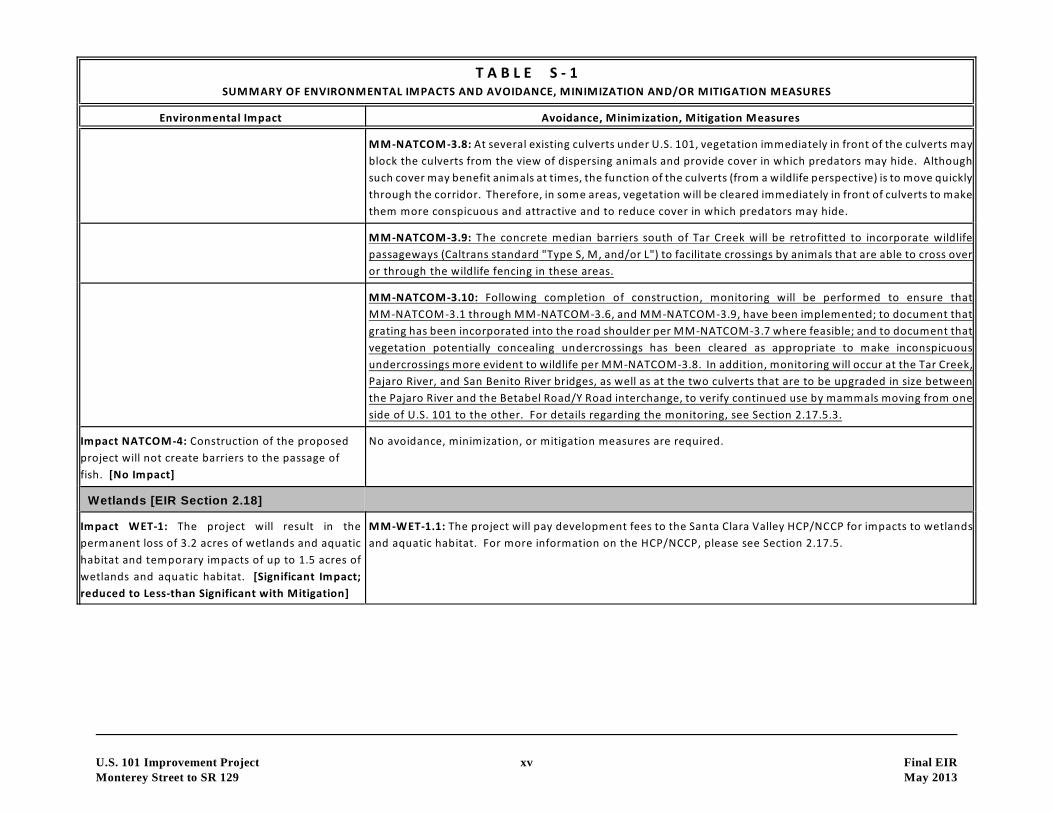
MM-NATCOM-3.8: At several existing culverts under U.S. 101, vegetation immediately in front of the culverts may
block the culverts from the view of dispersing animals and provide cover in which predators may hide. Although
such cover may benefit animals at times, the function of the culverts (from a wildlife perspective) is to move quickly
through the corridor. Therefore, in some areas, vegetation will be cleared immediately in front of culverts to make
them more conspicuous and attractive and to reduce cover in which predators may hide.
MM-NATCOM-3.9: The concrete median barriers south of Tar Creek will be retrofitted to incorporate wildlife
passageways (Caltrans standard "Type S, M, and/or L") to facilitate crossings by animals that are able to cross over
or through the wildlife fencing in these areas.
MM-NATCOM-3.10: Following completion of construction, monitoring will be performed to ensure that
MM-NATCOM-3.1 through MM-NATCOM-3.6, and MM-NATCOM-3.9, have been implemented; to document that
grating has been incorporated into the road shoulder per MM-NATCOM-3.7 where feasible; and to document that
vegetation potentially concealing undercrossings has been cleared as appropriate to make inconspicuous
undercrossings more evident to wildlife per MM-NATCOM-3.8. In addition, monitoring will occur at the Tar Creek,
Pajaro River, and San Benito River bridges, as well as at the two culverts that are to be upgraded in size between
the Pajaro River and the Betabel Road/Y Road interchange, to verify continued use by mammals moving from one
side of U.S. 101 to the other. For details regarding the monitoring, see Section 2.17.5.3.
Impact NATCOM-4: Construction of the proposed
project will not create barriers to the passage of
fish. [No Impact]
No avoidance, minimization, or mitigation measures are required.
Wetlands [EIR Section 2.18]
Impact WET-1: The project will result in the
permanent loss of 3.2 acres of wetlands and aquatic
habitat and temporary impacts of up to 1.5 acres of
wetlands and aquatic habitat. [Significant Impact;
reduced to Less-than Significant with Mitigation]
MM-WET-1.1: The project will pay development fees to the Santa Clara Valley HCP/NCCP for impacts to wetlands
and aquatic habitat. For more information on the HCP/NCCP, please see Section 2.17.5.

T A B L E S - 1SUMMARY OF ENVIRONMENTAL IMPACTS AND AVOIDANCE, MINIMIZATION AND/OR MITIGATION MEASURES
Environmental Impact Avoidance, Minimization, Mitigation Measures
U.S. 101 Improvement Project xvi Final EIR
Monterey Street to SR 129 May 2013
MM-WET-1.2: If MM-WET-1.1 turns out to be infeasible for some or all of the project, permanent impacts to
wetlands and aquatic habitat will be mitigated by the purchase of credits from the Pajaro River Mitigation Bank that
services both Santa Clara and San Benito Counties. If credits are no longer available at this bank, and if there are
no other approved mitigation banks whose service area includes the project area, then mitigation will occur through
on-site or off-site creation of wetland and aquatic habitat at a 2:1 ratio, on an acreage basis.
[Note: MM-WET-1.2 will be implemented only if MM-WET-1.1 is determined to be partially or completely
infeasible.]
MM-WET-1.3: The temporary wetland and aquatic habitat impacts will be mitigated at a 1:1 acreage ratio within
the impact footprint through the restoration of pre-construction grades, hydrology, and soil conditions in situ to
any wetland and aquatic areas temporarily disturbed during construction. Wetland vegetation, structure, and
function are expected to regenerate naturally following the restoration of grades, hydrology, and soils. For further
details regarding this measure, please see Section 2.18.5.
Plant Species [EIR Section 2.19]
Impact PLANT-1: The project will not impact any
special-status plant species. [No Impact]
No avoidance, minimization, or mitigation measures are required.
Animal Species [EIR Section 2.20]
Impact ANIMAL-1: The project will result in both
short- and long-term adverse impacts to Pacific
lampreys and Monterey roach. [Significant Impact;
reduced to Less-than Significant with Mitigation]
MM-ANIMAL-1.1: The project will fully mitigate for impacts to SRA, riparian, and aquatic habitats. This mitigation
is summarized above [see Natural Communities and Wetlands].
MM-ANIMAL-1.2: Any construction activities within the low-flow channels of waterways where Pacific lamprey and
Monterey roach are known or likely to occur will be limited to the period of June 15 - October 15.
MM-ANIMAL-1.3: For waterways where Pacific lamprey and Monterey roach are known or likely to occur, measures
will be taken to ensure that movement of fish is not prevented by any water diversion structures used during
construction, regardless of when construction occurs. Water will be diverted through the construction site by way
of an open ditch or other method approved by the regulatory agencies.
MM-ANIMAL-1.4: The project will implement measures during construction to avoid and minimize the potential
degradation of water quality within any waterways where Pacific lamprey and Monterey roach are known or likely
to occur. These measures are summarized subsequently in this table [see Construction Impacts].
T A B L E S - 1SUMMARY OF ENVIRONMENTAL IMPACTS AND AVOIDANCE, MINIMIZATION AND/OR MITIGATION MEASURES
Environmental Impact Avoidance, Minimization, Mitigation Measures
U.S. 101 Improvement Project xvii Final EIR
Monterey Street to SR 129 May 2013
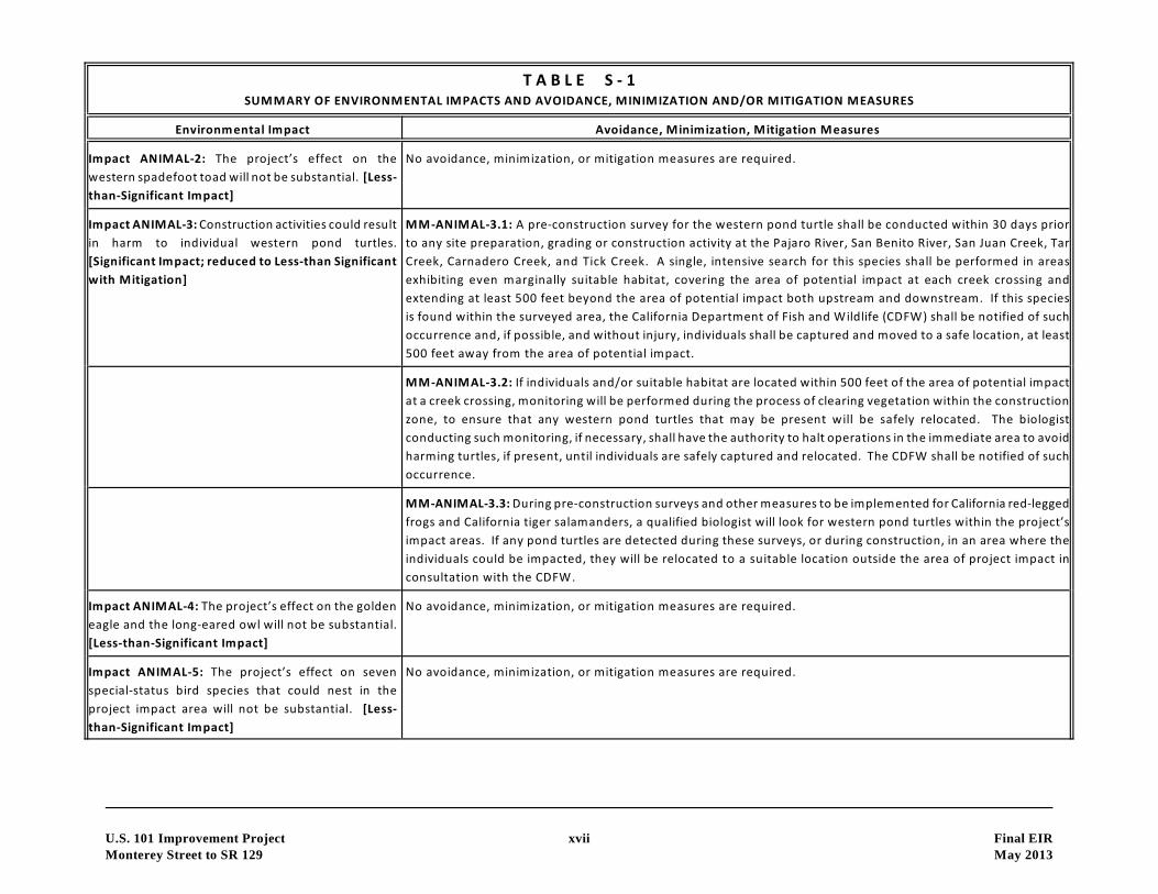
Impact ANIMAL-2: The project’s effect on the
western spadefoot toad will not be substantial. [Less-
than-Significant Impact]
No avoidance, minimization, or mitigation measures are required.
Impact ANIMAL-3: Construction activities could result
in harm to individual western pond turtles.
[Significant Impact; reduced to Less-than Significant
with Mitigation]
MM-ANIMAL-3.1: A pre-construction survey for the western pond turtle shall be conducted within 30 days prior
to any site preparation, grading or construction activity at the Pajaro River, San Benito River, San Juan Creek, Tar
Creek, Carnadero Creek, and Tick Creek. A single, intensive search for this species shall be performed in areas
exhibiting even marginally suitable habitat, covering the area of potential impact at each creek crossing and
extending at least 500 feet beyond the area of potential impact both upstream and downstream. If this species
is found within the surveyed area, the California Department of Fish and Wildlife (CDFW) shall be notified of such
occurrence and, if possible, and without injury, individuals shall be captured and moved to a safe location, at least
500 feet away from the area of potential impact.
MM-ANIMAL-3.2: If individuals and/or suitable habitat are located within 500 feet of the area of potential impact
at a creek crossing, monitoring will be performed during the process of clearing vegetation within the construction
zone, to ensure that any western pond turtles that may be present will be safely relocated. The biologist
conducting such monitoring, if necessary, shall have the authority to halt operations in the immediate area to avoid
harming turtles, if present, until individuals are safely captured and relocated. The CDFW shall be notified of such
occurrence.
MM-ANIMAL-3.3: During pre-construction surveys and other measures to be implemented for California red-legged
frogs and California tiger salamanders, a qualified biologist will look for western pond turtles within the project’s
impact areas. If any pond turtles are detected during these surveys, or during construction, in an area where the
individuals could be impacted, they will be relocated to a suitable location outside the area of project impact in
consultation with the CDFW.
Impact ANIMAL-4: The project’s effect on the golden
eagle and the long-eared owl will not be substantial.
[Less-than-Significant Impact]
No avoidance, minimization, or mitigation measures are required.
Impact ANIMAL-5: The project’s effect on seven
special-status bird species that could nest in the
project impact area will not be substantial. [Less-
than-Significant Impact]
No avoidance, minimization, or mitigation measures are required.

T A B L E S - 1SUMMARY OF ENVIRONMENTAL IMPACTS AND AVOIDANCE, MINIMIZATION AND/OR MITIGATION MEASURES
Environmental Impact Avoidance, Minimization, Mitigation Measures
U.S. 101 Improvement Project xviii Final EIR
Monterey Street to SR 129 May 2013
Impact ANIMAL-6: The project could result in a loss
of burrowing owl habitat and harm to individual owls
if the owls are found to occupy the project site prior
to construction. [Significant Impact; reduced to Less-
than Significant with Mitigation]
MM-ANIMAL-6.1: Pre-construction surveys will be undertaken to determine if owls utilize the habitat to be
impacted by the project.
MM-ANIMAL-6.2: Prior to construction, during the non-nesting season, any owls occupying burrows within
construction zones shall be passively relocated under the authorization of the CDFW. Passive relocation is an
intensive process that involves the installation of one-way doors in all ground squirrel burrows occurring on the
site, which allow owls to leave their burrows but do not allow them to return, thereby forcing owls to move to a
different area. Owl doors shall be monitored by a qualified biologist daily for a period of no less than three days
and after that period, burrows shall be destroyed to preclude owls from returning to the burrows, and grading of
these areas shall commence within seven days. The passive relocation will be repeated if owls move back to the
construction areas.
MM-ANIMAL-6.3: Burrows within the construction zone that are occupied by owls shall not be disturbed during
the nesting season (February 15 through September 1) unless a qualified biologist verifies that either the owls have
not begun laying and incubating eggs, or that juvenile owls have fledged and are able to live independently of their
parents. If construction will occur during the nesting season, the project shall establish and maintain a minimum
of a 250-foot buffer around any active nest.
MM-ANIMAL-6.4: If, based on pre-construction surveys, it is determined that owls utilize habitat that will be
impacted by the project, mitigation for the loss of such habitat will take the form of the payment of development
fees to the Santa Clara Valley HCP/NCCP. For more information on the HCP/NCCP, please see Section 2.17.5.
MM-ANIMAL-6.5: If MM-ANIMAL-6.4 turns out to be infeasible for some or all of the project, mitigation will consist
of the purchase of credits from a mitigation bank that serves the project area. If no banks or credits are available,
then the project will develop and implement a plan for the creation or enhancement of burrows, maintenance of
burrows and management of foraging habitat, monitoring procedures, funding assurance, annual reporting
requirements, and contingency and remediation measures. The extent of the mitigation lands (either for the
purchase of mitigation credits or for project-specific mitigation), enhancement measures, and other details will be
determined based on the circumstances surrounding the owls to be impacted and their habitat, in consultation with
the CDFW.
[Note: MM-ANIMAL-6.5 will be implemented only if MM-ANIMAL-6.4 is determined to be partially or completely
infeasible.]

T A B L E S - 1SUMMARY OF ENVIRONMENTAL IMPACTS AND AVOIDANCE, MINIMIZATION AND/OR MITIGATION MEASURES
Environmental Impact Avoidance, Minimization, Mitigation Measures
U.S. 101 Improvement Project xix Final EIR
Monterey Street to SR 129 May 2013
Impact ANIMAL-7: The project’s effect on the
tricolored blackbird will not be substantial. [Less-
than-Significant Impact]
No avoidance, minimization, or mitigation measures are required.
Impact ANIMAL-8: While the impact of the project on
habitat used by the San Francisco dusky-footed
woodrat will not be substantial, construction
activities are likely to harm or kill woodrats that nest
within the construction zone. [Significant Impact;
reduced to Less-than Significant with Mitigation]
MM-ANIMAL-8.1: Prior to any clearing of - or work within - riparian, oak woodland, or coyote brush scrub habitat,
or the removal of any oak trees located outside these habitats, a qualified biologist will conduct a survey for San
Francisco dusky-footed woodrat nests.
MM-ANIMAL-8.2: Where nests are found, and if feasible, the project will maintain a buffer of at least several feet
(preferably as much as 10 feet) around these nests. The purpose of the buffer is to avoid moving or bumping the
nests or logs or branches on which the nests rest.
If avoidance of nests is not feasible, the nests will be dismantled and the nesting material moved to a new location
outside the project’s impact areas so that it can be used by woodrats to construct new nests. The process by which
this mitigation will occur is described in Section 2.20.5.
Impact ANIMAL-9: During the construction phase,
the project could adversely affect roosting bats,
potentially resulting in temporary loss of day-roost
habitat and harm to individual bats. [Significant
Impact; reduced to Less-than Significant with
Mitigation]
MM-ANIMAL-9.1: A pre-construction/pre-demolition survey for roosting bats will be conducted prior to any
construction on the U.S. 101 southbound span over Tar Creek, which is the only bridge with potential for (and
known) day roosting by bats. Such a survey will also be conducted in any trees and buildings within or immediately
adjacent to the impact area that are identified by a qualified bat biologist (i.e., a biologist holding a CDFW collection
permit allowing the biologist to handle and collect bats) as being high-potential roost sites. For details regarding
this measure, please see Section 2.20.5.
MM-ANIMAL-9.2: Because the aforementioned survey will be conducted prior to the breeding season, several
months may pass between that survey and the initiation of construction or demolition in a given area. Therefore,
a second preconstruction/ pre-demolition survey for roosting bats, following the methods described above, will
be conducted within 15 days prior to the commencement of these activities in a given area to determine whether
bats have occupied a roost in or near the project’s impact areas. This survey should be facilitated considerably by
information (e.g., on potential roost trees) gathered during the previous survey.
MM-ANIMAL-9.3: If a maternity roost of any bat species is present, the bat biologist will determine the extent of
a construction-free buffer around the active roost that will be maintained. This buffer would will be maintained
from April 1 until the young are flying, typically after August 31 .st st

T A B L E S - 1SUMMARY OF ENVIRONMENTAL IMPACTS AND AVOIDANCE, MINIMIZATION AND/OR MITIGATION MEASURES
Environmental Impact Avoidance, Minimization, Mitigation Measures
U.S. 101 Improvement Project xx Final EIR
Monterey Street to SR 129 May 2013
MM-ANIMAL-9.4: If a day roost is found on a bridge, in a building, or in a tree that is to be completely removed
or replaced, individual bats will be safely evicted under the direction of a qualified bat biologist. Eviction of bats
will occur at night, so that bats will have less potential for predation compared to daytime roost abandonment.
Eviction will occur between September 1 and March 31 , outside the maternity season, but will not occur duringst st
long periods of inclement or cold weather (as determined by the bat biologist) when prey are not available or bats
are in torpor. For details regarding this measure, please see Section 2.20.5.
MM-ANIMAL-9.5: If a day roost will be impacted, an alternative bat roost structure will be provided. The design
and placement of this structure will be determined by a bat biologist, in consultation with the CDFW, based on the
species of bat to be displaced, the location of the original roost, and the habitat conditions in the vicinity. For
details regarding this measure, please see Section 2.20.5.
MM-ANIMAL-9.6: In some circumstances, it may be beneficial to allow roosting bats to continue using a roost while
construction is occurring on or near the roost site. For details regarding this measure and a description of the
process that will be used to determine if bats should continue to roost during construction, please see Section
2.20.5.
Impact ANIMAL-10: While the impact of the project
on habitat used by the ringtail will not be substantial,
construction activities could harm or kill ringtails if
they are found to be nesting within the construction
zone. [Significant Impact; reduced to Less-than
Significant with Mitigation]
MM-ANIMAL-10.1: If a ringtail nest is detected incidentally (i.e., during the woodrat surveys described above in
MM-ANIMAL-8.1), a qualified mammalogist will determine the extent of a construction-free buffer zone that should
be maintained around the den. Construction activities within this zone will not occur during the period March 1st
through August 31 to avoid potential construction disturbance to the ringtail during the breeding season. Afterst
August 31 , individuals will be safely evicted, under the direction of a qualified mammalogist, by disturbing the denst
site under the cover of darkness to allow the ringtail(s) to abscond safely to a new location without being exposed
considerably to predators or competitors.
Impact ANIMAL-11: While the impact of the project
on habitat used by the badger will not be substantial,
construction activities could harm or kill badgers if
they are found to be denning within the construction
zone. [Significant Impact; reduced to Less-than
Significant with Mitigation]
MM-ANIMAL-11.1: A qualified mammalogist will conduct preconstruction surveys for badger dens on and within
300 ft of the site (as access permits), within two weeks prior to ground-breaking in any given area currently
occupied by grassland or ruderal habitat. If the mammalogist identifies any dens that appear suitable for this
species (based on size, shape, or other features), such "potential dens" will be monitored via tracking media or
camera for a period of at least three days to determine occupancy, then excavated if no evidence of occupancy is
detected. If an active maternity badger den is located, the mammalogist will determine the measures (e.g., buffers)
that will be taken to avoid impacts to the den during the pupping season (i.e., February 15 through July 1 , or asth st
otherwise determined through surveys and monitoring of the den), in consultation with the CDFW. After the
pupping season, if a den is located in an onsite impact area, the badgers will be evicted by excavation of the den
using hand tools, in consultation with the CDFW and under the supervision of a qualified mammalogist.
T A B L E S - 1SUMMARY OF ENVIRONMENTAL IMPACTS AND AVOIDANCE, MINIMIZATION AND/OR MITIGATION MEASURES
Environmental Impact Avoidance, Minimization, Mitigation Measures
U.S. 101 Improvement Project xxi Final EIR
Monterey Street to SR 129 May 2013
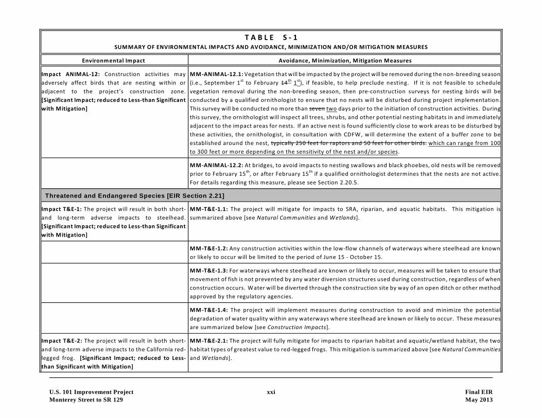
Impact ANIMAL-12: Construction activities may
adversely affect birds that are nesting within or
adjacent to the project’s construction zone.
[Significant Impact; reduced to Less-than Significant
with Mitigation]
MM-ANIMAL-12.1: Vegetation that will be impacted by the project will be removed during the non-breeding season
(i.e., September 1 to February 14 1 ), if feasible, to help preclude nesting. If it is not feasible to schedulest th st
vegetation removal during the non-breeding season, then pre-construction surveys for nesting birds will be
conducted by a qualified ornithologist to ensure that no nests will be disturbed during project implementation.
This survey will be conducted no more than seven two days prior to the initiation of construction activities. During
this survey, the ornithologist will inspect all trees, shrubs, and other potential nesting habitats in and immediately
adjacent to the impact areas for nests. If an active nest is found sufficiently close to work areas to be disturbed by
these activities, the ornithologist, in consultation with CDFW, will determine the extent of a buffer zone to be
established around the nest, typically 250 feet for raptors and 50 feet for other birds. which can range from 100
to 300 feet or more depending on the sensitivity of the nest and/or species.
MM-ANIMAL-12.2: At bridges, to avoid impacts to nesting swallows and black phoebes, old nests will be removed
prior to February 15 , or after February 15 if a qualified ornithologist determines that the nests are not active.th th
For details regarding this measure, please see Section 2.20.5.
Threatened and Endangered Species [EIR Section 2.21]
Impact T&E-1: The project will result in both short-
and long-term adverse impacts to steelhead.
[Significant Impact; reduced to Less-than Significant
with Mitigation]
MM-T&E-1.1: The project will mitigate for impacts to SRA, riparian, and aquatic habitats. This mitigation is
summarized above [see Natural Communities and Wetlands].
MM-T&E-1.2: Any construction activities within the low-flow channels of waterways where steelhead are known
or likely to occur will be limited to the period of June 15 - October 15.
MM-T&E-1.3: For waterways where steelhead are known or likely to occur, measures will be taken to ensure that
movement of fish is not prevented by any water diversion structures used during construction, regardless of when
construction occurs. Water will be diverted through the construction site by way of an open ditch or other method
approved by the regulatory agencies.
MM-T&E-1.4: The project will implement measures during construction to avoid and minimize the potential
degradation of water quality within any waterways where steelhead are known or likely to occur. These measures
are summarized below [see Construction Impacts].
Impact T&E-2: The project will result in both short-
and long-term adverse impacts to the California red-
legged frog. [Significant Impact; reduced to Less-
than Significant with Mitigation]
MM-T&E-2.1: The project will fully mitigate for impacts to riparian habitat and aquatic/wetland habitat, the two
habitat types of greatest value to red-legged frogs. This mitigation is summarized above [see Natural Communities
and Wetlands].
T A B L E S - 1SUMMARY OF ENVIRONMENTAL IMPACTS AND AVOIDANCE, MINIMIZATION AND/OR MITIGATION MEASURES
Environmental Impact Avoidance, Minimization, Mitigation Measures
U.S. 101 Improvement Project xxii Final EIR
Monterey Street to SR 129 May 2013
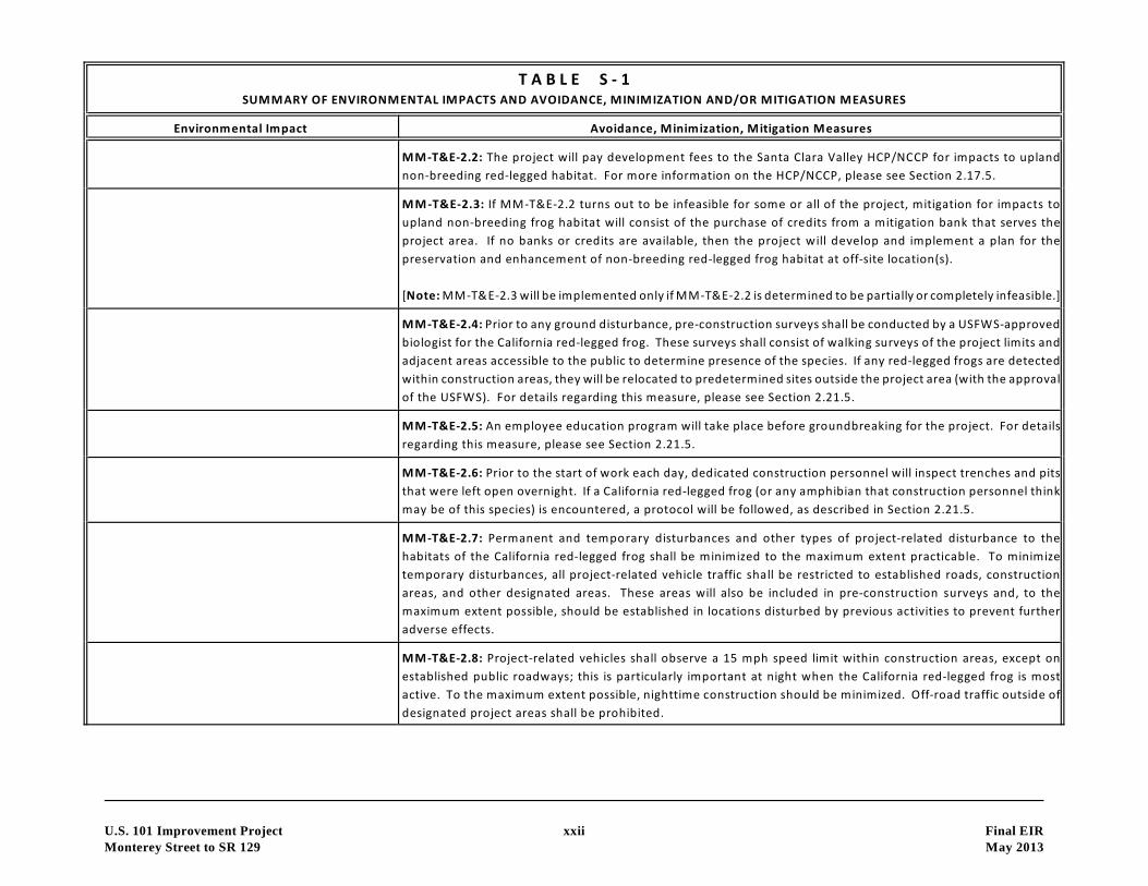
MM-T&E-2.2: The project will pay development fees to the Santa Clara Valley HCP/NCCP for impacts to upland
non-breeding red-legged habitat. For more information on the HCP/NCCP, please see Section 2.17.5.
MM-T&E-2.3: If MM-T&E-2.2 turns out to be infeasible for some or all of the project, mitigation for impacts to
upland non-breeding frog habitat will consist of the purchase of credits from a mitigation bank that serves the
project area. If no banks or credits are available, then the project will develop and implement a plan for the
preservation and enhancement of non-breeding red-legged frog habitat at off-site location(s).
[Note: MM-T&E-2.3 will be implemented only if MM-T&E-2.2 is determined to be partially or completely infeasible.]
MM-T&E-2.4: Prior to any ground disturbance, pre-construction surveys shall be conducted by a USFWS-approved
biologist for the California red-legged frog. These surveys shall consist of walking surveys of the project limits and
adjacent areas accessible to the public to determine presence of the species. If any red-legged frogs are detected
within construction areas, they will be relocated to predetermined sites outside the project area (with the approval
of the USFWS). For details regarding this measure, please see Section 2.21.5.
MM-T&E-2.5: An employee education program will take place before groundbreaking for the project. For details
regarding this measure, please see Section 2.21.5.
MM-T&E-2.6: Prior to the start of work each day, dedicated construction personnel will inspect trenches and pits
that were left open overnight. If a California red-legged frog (or any amphibian that construction personnel think
may be of this species) is encountered, a protocol will be followed, as described in Section 2.21.5.
MM-T&E-2.7: Permanent and temporary disturbances and other types of project-related disturbance to the
habitats of the California red-legged frog shall be minimized to the maximum extent practicable. To minimize
temporary disturbances, all project-related vehicle traffic shall be restricted to established roads, construction
areas, and other designated areas. These areas will also be included in pre-construction surveys and, to the
maximum extent possible, should be established in locations disturbed by previous activities to prevent further
adverse effects.
MM-T&E-2.8: Project-related vehicles shall observe a 15 mph speed limit within construction areas, except on
established public roadways; this is particularly important at night when the California red-legged frog is most
active. To the maximum extent possible, nighttime construction should be minimized. Off-road traffic outside of
designated project areas shall be prohibited.
T A B L E S - 1SUMMARY OF ENVIRONMENTAL IMPACTS AND AVOIDANCE, MINIMIZATION AND/OR MITIGATION MEASURES
Environmental Impact Avoidance, Minimization, Mitigation Measures
U.S. 101 Improvement Project xxiii Final EIR
Monterey Street to SR 129 May 2013
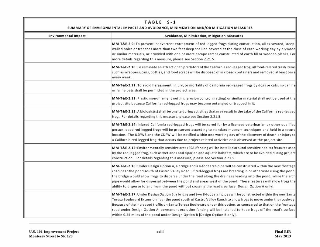
MM-T&E-2.9: To prevent inadvertent entrapment of red-legged frogs during construction, all excavated, steep-
walled holes or trenches more than two feet deep shall be covered at the close of each working day by plywood
or similar materials, or provided with one or more escape ramps constructed of earth fill or wooden planks. For
more details regarding this measure, please see Section 2.21.5.
MM-T&E-2.10: To eliminate an attraction to predators of the California red-legged frog, all food-related trash items
such as wrappers, cans, bottles, and food scraps will be disposed of in closed containers and removed at least once
every week.
MM-T&E-2.11: To avoid harassment, injury, or mortality of California red-legged frogs by dogs or cats, no canine
or feline pets shall be permitted in the project area.
MM-T&E-2.12: Plastic monofilament netting (erosion control matting) or similar material shall not be used at the
project site because California red-legged frogs may become entangled or trapped in it.
MM-T&E-2.13: A biologist(s) shall be onsite during activities that may result in the take of the California red-legged
frog. For details regarding this measure, please see Section 2.21.5.
MM-T&E-2.14: Injured California red-legged frogs will be cared for by a licensed veterinarian or other qualified
person; dead red-legged frogs will be preserved according to standard museum techniques and held in a secure
location. The USFWS and the CDFW will be notified within one working day of the discovery of death or injury to
a California red-legged frog that occurs due to project-related activities or is observed at the project site.
MM-T&E-2.15: Environmentally sensitive area (ESA) fencing will be installed around sensitive habitat features used
by the red-legged frog, such as wetlands and riparian and aquatic habitats, which are to be avoided during project
construction. For details regarding this measure, please see Section 2.21.5.
MM-T&E-2.16: Under Design Option A, a bridge and a 4-foot arch pipe will be constructed within the new frontage
road near the pond south of Castro Valley Road. If red-legged frogs are breeding in or otherwise using the pond,
the bridge would allow frogs to disperse under the road along the drainage leading into the pond, while the arch
pipe would allow for dispersal between the pond and areas west of the pond. These features will allow frogs the
ability to disperse to and from the pond without crossing the road's surface [Design Option A only].
MM-T&E-2.17: Under Design Option B, a bridge and two 8-foot arch pipes will be constructed within the new Santa
Teresa Boulevard Extension near the pond south of Castro Valley Ranch to allow frogs to move under the roadway.
Because of the increased traffic on Santa Teresa Boulevard under this option, as compared to that on the frontage
road under Design Option A, permanent exclusion fencing will be installed to keep frogs off the road's surface
within 0.25 miles of the pond under Design Option B [Design Option B only].

T A B L E S - 1SUMMARY OF ENVIRONMENTAL IMPACTS AND AVOIDANCE, MINIMIZATION AND/OR MITIGATION MEASURES
Environmental Impact Avoidance, Minimization, Mitigation Measures
U.S. 101 Improvement Project xxiv Final EIR
Monterey Street to SR 129 May 2013
Impact T&E-3: The project will result in both short-
and long-term adverse impacts to the California tiger
salamander. [Significant Impact; reduced to Less-
than Significant with Mitigation]
MM-T&E-3.1: The project will fully mitigate for impacts to aquatic/wetland habitat, the habitat type of greatest
value to tiger salamanders. This mitigation is described above [see Wetlands].
MM-T&E-3.2: The project will pay development fees to the Santa Clara Valley HCP/NCCP for impacts to upland
non-breeding tiger salamander habitat. For more information on the HCP/NCCP, please see Section 2.17.5.
MM-T&E-3.3: If MM-T&E-3.2 turns out to be infeasible for some or all of the project, mitigation for impacts to
upland non-breeding tiger salamander habitat will consist of the purchase of credits from a mitigation bank that
serves the project area. If no banks or credits are available, then the project will develop and implement a plan for
the preservation and enhancement of non-breeding tiger salamander habitat at off-site location(s). [Note: MM-
T&E-3.3 will be implemented only if MM-T&E-3.2 is determined to be partially or completely infeasible.]
MM-T&E-3.4: The 12 mitigation measures listed above (i.e., MM-T&E-2.4 through MM-T&E-2.15) that are designed
to prevent harm to individual California red-legged frogs will also serve to prevent harm to individual California tiger
salamanders.
Construction Impacts [EIR Section 2.22]
Impact CON-1: Traffic impacts during construction
will not be substantial. Street closures and detours
are not anticipated. [Less-than-Significant Impact]
No avoidance, minimization, or mitigation measures are required.
Impact CON-2: Access to businesses will not be
affected during construction of the proposed project.
[No Impact]
No avoidance, minimization, or mitigation measures are required.
Impact CON-3: Disruption of utility service during
construction will not be substantial. [Less-than-
Significant Impact]
No avoidance, minimization, or mitigation measures are required.
Impact CON-4: Without proper emissions control
measures in place, air quality impacts during
construction could be substantial. [Significant
Impact; reduced to Less-than Significant with
Mitigation]
MM-CON-4.1: During construction, the project will follow the Department’s Standard Specification 14-8.02,
Standard Specification 10, and Standard Specification 18, which address the requirements of BAAQMD and dust
control and dust palliative application, respectively.

T A B L E S - 1SUMMARY OF ENVIRONMENTAL IMPACTS AND AVOIDANCE, MINIMIZATION AND/OR MITIGATION MEASURES
Environmental Impact Avoidance, Minimization, Mitigation Measures
U.S. 101 Improvement Project xxv Final EIR
Monterey Street to SR 129 May 2013
10MM-CON-4.2: The project will implement all feasible PM construction emissions control measures required by
the BAAQMD, as indicated in Table 36 in Section 2.22.4.
Impact CON-5: Noise from construction activities is
likely to constitute a temporary annoyance at
residences located along U.S. 101. Construction
activities may also generate noticeable ground
vibration at nearby residences, with pile driving being
the construction source that could produce the
greatest ground vibrations. [Significant Impact;
reduced to Less-than Significant with Mitigation]
MM-CON-5.1: All internal combustion engine driven equipment will be equipped with intake and exhaust mufflers
that are in good condition and appropriate for the equipment.
MM-CON-5.2: Unnecessary idling of internal combustion engines within 100 feet of residences will be strictly
prohibited.
MM-CON-5.3: Staging of construction equipment within 200 feet of residences shall not occur. All stationary
noise-generating construction equipment, such as air compressors and portable power generators, will be located
as far practical from residences.
MM-CON-5.4: All construction equipment will be required to conform to Section 14-08.02 - Sound Control
Requirements of the latest Caltrans Standard Specifications.
MM-CON-5.5: Nighttime construction work within 450 feet of residential land uses will be avoided where feasible.
MM-CON-5.6: Demolition and pile driving activities should be limited to daytime hours only. If nighttime, impulsive
work is required, a construction noise monitoring program will be implemented to provide additional mitigation
as necessary (in the form of noise control blankets or other temporary noise barriers, etc.) for affected receivers.
Impact CON-6: Construction activities have the
potential to adversely affect water quality in nearby
creeks. [Significant Impact; reduced to Less-than
Significant with Mitigation]
MM-CON-6.1: Active paved construction areas will be swept as needed.
MM-CON-6.2: Silt fencing or straw wattles will be used to retain sediment on the project site.
MM-CON-6.3: Temporary cover of disturbed surfaces or temporary slope protection measures will be provided per
regulatory requirements and the Department’s guidelines to help control erosion. Permanent cover/revegetation
will be provided to stabilize the disturbed surfaces after construction has been completed.

T A B L E S - 1SUMMARY OF ENVIRONMENTAL IMPACTS AND AVOIDANCE, MINIMIZATION AND/OR MITIGATION MEASURES
Environmental Impact Avoidance, Minimization, Mitigation Measures
U.S. 101 Improvement Project xxvi Final EIR
Monterey Street to SR 129 May 2013
MM-CON-6.4: No debris, soil, silt, sand, bark, slash, sawdust, cement, concrete, washings, petroleum products, or
other organic or earthen material shall be allowed to enter into or be placed where it may be washed by rainfall
or runoff into any waterways.
MM-CON-6.5: Best Management Practices (BMPs) will be utilized by the contractor(s) during construction. The
BMPs will be incorporated into a Stormwater Pollution Prevention Plan for the project, as required by the
Department’s NPDES permit.
Cumulative Impacts [EIR Section 2.23]
Impact CUMUL-1: Construction of the proposed
project will not result in any significant cumulative
impacts. [Less-than-Significant Impact]
No avoidance, minimization, or mitigation measures are required.

Summary
I
TAB LE 5-2
IPERMITS AND APPROVALS NEEDED
I Agency I Permit!Approval I Status ICity of Gilroy Encroachment permit for work extending onto Application to be submitted
local streets within Gilroy during final design.
Santa Clara County Encroachment permit for work extending onto Application to be submittedlocal streets within unincorporated areas of during final design.Santa Clara County
San Benito County Encroachment permit for work extending onto Application to be submittedlocal streets within unincorporated areas of San during final design.Benito County
Santa Clara Valley Permit for work in Carnadero Creek, Gavilan Application to be submittedWater District Creek, Tick Creek, Tar Creek, and Pajaro River during final design.
San Benito County Permit for work in Pajaro River, Murphy Creek, Application to be submittedWater District San Benito River, and San Juan Creek during final design.
California Public Permit for any work affecting the UPRR crossings Application to be submittedUtilities Commission at Tar Creek/U.S. 101 & SR 25 during final design.
NOAA Fisheries Section 7 Consultation for Threatened and(National Marine Endangered Species;Fisheries Service) Review and Comment on 404 Permit
U.S. Fish & Wildlife Section 7 Consultation for Threatened andService Endangered Species;
Review and Comment on 404 Permit
U.S. Army Corps of Section 404 permit for temporary and/or Application to be submittedEngineers permanent work in low-flow channels of during final design.
Carnadero Creek, Gavilan Creek, Tick Creek, TarCreek, Pajaro River, Murphy Creek, San BenitoRiver, and San Juan Creek
Regional Water Section 401 Water Quality Certification for Application to be submittedQuality Control temporary and/or permanent work in low-flow during final design.Board channels of Carnadero Creek, Gavilan Creek, Tick
Creek, Tar Creek, Pajaro River, Murphy Creek,San Benito River, and San Juan Creek
California Streambed Alteration Agreement for work in Application to be submittedDepartment of Fish Carnadero Creek, Gavilan Creek, Tick Creek, Tar during final design.& Wildlife Creek, Pajaro River, Murphy Creek, San Benito
River, and San Juan Creek; Incidental Take Permitfor impacts to endangered/threatened species.
u.s. 101 Improvement Project:Monterey Street to SR 129
xxvii Final EIRMay 2013

TABLE OF CONTENTS
SUMMARy 1
1.0 PROPOSED PROJECT 1
1.1 INTRODUCTION 1
1.2 PURPOSE AND NEED FOR THE PROPOSED PROJECT 1
1.2.1 Purpose ofthe Proposed Project 1
1.2.2 Need for the Proposed Project 5
1.3 PROJECT DESCRIPTION 8
1.3.1 Build Alternative 9
1.3.2 TDM/TSM Alternatives 26
1.3.3 No Build Alternative 27
1.3.4 Comparison of Alternatives 27
1.3.5 Alternatives Considered but Eliminated from Further Discussion 32
1.4 PERMITS AND APPROVALS NEEDED 34
2.0 AFFECTED ENVIRONMENT, ENVIRONMENTAL CONSEQUENCES,
& AVOIDANCE, MINIMIZATION, AND/OR MITIGATION MEASURES .... 36
HUMAN ENVIRONMENT 36
2.1 LAND USE 36
2.2 GROWTH 43
2.3 FARMLANDS 49
2.4 RELOCATIONS 60
2.5 UTILITIES/EMERGENCY SERVICES 62
2.6 TRAFFIC & TRANSPORTATION/PEDESTRIAN & BICYCLE FACILITIES 63
2.7 VISUAL/AESTHETICS 75
2.8 CULTURAL RESOURCES 90
PHYSICAL ENVIRONMENT 98
2.9 HYDROLOGY AND FLOODPLAINS 98
2.10 WATER QUALITY AND STORMWATERRUNOFF 106
2.11 GEOLOGY/SOILS/SEISMICITOPOGRAPHY 112
2.12 PALEONTOLOGy 114
2.13 HAZARDOUS WASTEIMATERIALS 117
2.14 AIR QUALITY 122
2.15 CLIMATE CHANGE 129
2.16 NOISE 146
U.S. 101 Improvement Project:Monterey Street to SR 129
xxviii Final EIRMay 2013
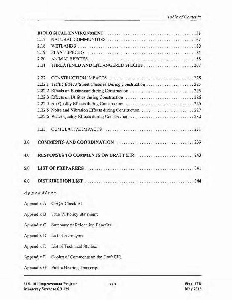
Table a/Contents
BIOLOGICAL ENVIRONMENT 158
2.17 NATURAL COMMUNITIES 167
2.18 WETLANDS 180
2.19 PLANT SPECIES 184
2.20 ANIMAL SPECIES 188
2.21 THREATENED AND ENDANGERED SPECIES 207
2.22 CONSTRUCTION IMPACTS 225
2.22.1 Traffic Effects/Street Closures During Construction 225
2.22.2 Effects on Businesses during Construction 225
2.22.3 Effects on Utilities during Construction 226
2.22.4 Air Quality Effects during Construction 226
2.22.5 Noise and Vibration Effects during Construction 227
2.22.6 Water Quality Effects during Construction 230
2.23 CUMULATIVE IMPACTS 231
3.0 COMMENTS AND COORDINATION 239
4.0 RESPONSES TO COMMENTS ON DRAFT EIR 243
5.0 LIST OF PREPARERS 341
6.0 DISTRIBUTION LIST 344
Appendices
Appendix A CEQA Checklist
Appendix B Title VI Policy Statement
Appendix C Summary of Relocation Benefits
Appendix D List of Acronyms
Appendix E List ofTechnical Studies
Appendix F Copies of Comments on the Draft EIR
Appendix G Public Hearing Transcript
U.S. 101 Improvement Project:Monterey Street to SR 129
xxix Final EIRMay 2013

Table ofContents
Figures
Figure 1
Figure 2
Figure 3
Figure 4
Figure 5
Figure 6
Figure 7
Figure 8
Figure 9
Figure 10
Figure 11
Figure 12
Figure 13
Figure 14
Figure IS
Figure 16
Figure 17
Figure 18
Figure 19
Figure 20
Figure 21
Tables
Table 1
Table 2
Table 3
Table 4
Table 5
Table 6
Table 7
Regional Location 2
Vicinity Map 3
Proposed Project with Design Option A 14
Proposed Project with Design Option B 15
Proposed Bike & Trail Facilities - Alternative 1 18
Proposed Bike & Trail Facilities - Alternative 2 19
Important Farmlands SO
Existing Views in the Project Area 77
Locations of Key Viewpoints 81
Key View Number 1 82
Key View Number 2 84
Key View Number 3 85
Key View Number 4A 87
Key View Number 4B 88
Existing Floodplains in Santa Clara County 100
Existing Floodplains in San Benito County 101
Effect of Traffic Operation Strategies in Reducing On-Road CO2 Emissions . 134
Mobility Pyramid 141
Noise Receptor and Potential Soundwall Locations 150
Biological Study Area 159
Wildlife Corridors 169
Summary of Accident Data in Project Area 6
Existing and Proposed Structures 10
Preliminary Right-of-Way Requirements 22
Comparison of Alternatives 28
Permits and Approvals Needed 35
Projected Population and Employment Growth 38
Land Use Changes Resulting from the Project 40
U.S. 101 Improvement Project:Monterey Street to SR 129
xxx Final EIRMay 2013

Table 8
Table 9
Table 10
Table 11
Table 12
Table 13
Table 14
Table 15
Table 16
Table 17
Table 18
Table 19
Table 20
Table 21
Table 22
Table 23
Table 24
Table 25
Table 26
Table 27
Table 28
Table 29
Table 30
Table 31
Table 32
Table 33
Table 34
Table 35
Table 36
Table 37
Table 38
Table ofContents
Important Farmlands in Santa Clara & San Benito Counties in 2006 51
Agricultural Acreage to Be Acquired by the Project 52
Williamson Act Acreage to Be Acquired by the Project 53
LESA Model Significance Criteria 55
Final LESA Scoresheet 56
Relocations Resulting from the Project 61
Existing Peak-hour Traffic Volumes 66
Intersection Level of Service Definitions for Signalized Intersections 68
Intersection Level of Service Definitions for Unsignalized Intersections 68
Existing Peak-Hour Intersections Levels of Service 69
Year 2035 Peak-hour Traffic Volumes 70
Travel Times Estimates on U.S. 101 between Monterey St. and SR156 71
Year 2035 Peak-Hour Intersections Levels of Service 72
List of Proposed Retaining Walls 79
Archaeological Sites in the Project Are~ 93
Additional Impervious Surface Created by the Project III
Projected Worst-case Carbon Monoxide Concentrations 127
Comparison of Mobile Source Air Toxics Emissions 128
California Greenhouse Gas Forecast 133
Comparison of CO2 Emissions 135
Model Year 2015 Required Miles per Gallon by Alternative 137
Climate Change/C02 Reduction Strategies 144
Noise Abatement Criteria of the Federal Highway Administration 147
Noise Levels Associated with Common Activities 148
Comparison of Existing and Future Noise Levels 152
Evaluation of Noise Abatement Soundwalls 155
Impacts to Biological Habitats 166
Assessment of Special-status Plant Species for Their Potential 186
to Occur Within the Project's Biological Study Area
Assessment of Special-status Animal Species for Their Potential 189
to Occur Within the Project's Biological Study Area
Feasible Control Measures for Construction Emissions of PM 10 228
Construction Equipment Noise Levels at 50 Feet 229
U.S. 101 Improvement Project:Monterey Street to SR 129
xxxi Final EIRMay 2013

CHAPTERl PROPOSED PROJECT
1.1 INTRODUCTION
The Santa Clara Valley Transportation Authority (VTA) has prepared this Environmental Impact Report(EIR) in its role as the Lead Agency under CEQA. The VTA, in cooperation with the CaliforniaDepartment ofTransportation (Caltrans), proposes to widen and upgrade a 7.6-mile project segment ofU.S. 101 in southern Santa Clara County/northern San Benito County to a 6-lane freeway. The northerlyproject limit is Monterey Street l in the City ofGilroy and the southerly project limit is State Route (SR)129. The project location is shown on Figures 1 and 2.
Other improvements will include the reconstruction of the existing U.S. 10l/SR 25 interchange,construction ofa grade separation on SR25 atthe Union Pacific Railroad (UPRR) crossing, constructionof frontage roads, addition of auxiliary lanes, extension of Santa Teresa Boulevard to the U.S. 10l/SR25 interchange, and construction of bicycle facilities. For project details, see Section 1.3.
Within the project limits, U.S. 101 is currently a 4-lane expressway in Santa Clara County and a 4-lanefreeway in San Benito County. Existing interchanges on U.S. 101 are located at Monterey Street, SR25, Betabel RoadIY Road, and SR 129. Within Santa Clara County, there is also access between U.S.101 and a number of local roadways and driveways.
The proposed project will I) complete the upgrade of U.S. 101 to freeway standard in Santa ClaraCounty, 2) accommodate projected traffic demand along U.S. 101, 3) improve safety along the projectsegment of U.S. 101,4) improve traffic operations on the project segment of U.S. 101,5) enhance themovement of goods along the U.S. 101 transportation corridor, and 6) maintain and enhance bicycleaccess in the U.S. 101 corridor.
The northerly portion of the project, including the reconstruction of the 101/25 interchange, is includedin the Metropolitan Transportation Commission's (MTC) Regional Transportation Plan 2035. Thesegment of the project between SR 25 and the Santa Clara /San Benito County line is not currentlyincluded in MTC's RTP, but will be added prior to project approval. The portion of the project in SanBenito County is included in the Council of San Benito County Government's 20 I0 RegionalTransportation Plan.
The project has independent utility, meaning that the proposed improvements can be implementedwithin the project limits and completion of other projects would not be required in order to realize the
lin the project area, various publications and governmental databases refer to Monterey Street as Monterey
Road or Monterey Highway. The names are used interchangeably, but all refer to the same facility.
U.S. 101 Improvement Project:Monterey Street to SR 129
1 Final EIRMay 2013

MORGAN HILL
GILROY
HOLLISTER
WATSONVILLE
SAN JOSE
SANTA CRUZ
SCOTTSVALLEY
FELTON
LOSGATOS
SANTA CLARA
SUNNYVALE
FREMONT
HAYWARD
MILPITAS
OAKLAND
SAN MATEO
REDWOODCITY
280
680
880
580
101
10117
1
237
156
152
25
129
CAMPBELL 87
N.T.S.
SANFRANCISCO
SAN
FRANCISCO
BAY
MONTEREY
BAY
PROJECT REACH
REGIONAL MAP FIGURE 1
N

GILROY
SAN BENITO COUNTY
SANTA CLARA COUNTY
SANTA CRUZCOUNTY
SANTA TERESA BLVD.
SHORE RD.
PACHECO PASS RD.
E. 10TH ST.
FRAZIER LAKE RD.
BLOOMFIELD AVE.
MIL
LER
AVE.
THOM
AS R
D.
CASTRO VALLEY
RD.
MESARD.
BETA
BEL
RD.
Y
RD.
CASTRO VALLEY
RD.
MONTEREY ST.
U.P.R.R.
U.P
.P.R
.
CHITTENDEN RD . SAN JUAN HWY.
RD.
SAN JUS TO
MESARD.
BOLSA RD .
BETA
BEL
RD.
Y
RD.
VICINITY MAP FIGURE 2
Project Limits
Scale: 1" = ±1.25 Miles N
101
156
152
129
152
156
25
25

Chapter 1 - Proposed Project
operational benefits of the proposed improvements. Establishing independent utility is important toavoid "project segmentation".2
The project has logical starting and ending points or termini. The end points were selected to allow forconstruction of the proposed improvements and the integration ofsuch improvements with the existingfreeways and local street system.
1.2 PURPOSE AND NEED
1.2.1 Purpose of the Proposed Project
The purpose of the proposed project is to accomplish the following objectives:
• Complete the upgrade of U.S. I0 I to freeway standard in Santa Clara County, and improvesystem connectivity to SR 25 and SR 129.
• Accommodate projected traffic demand along U.S. 101, including growth anticipated underadopted land use plans, thereby reducing future congestion and delay, especially during peaktravel periods.
• Improve safety along the project segment ofU.S. 101, including the reduction ofconflicts withagricultural traffic.
• Improve traffic operations on the project segment of U.S. 101, including those associated withconnections between U.S. 101 and SR 25, SR 129, local roads, and adjacent land uses.
• Enhance the movement of goods along the U.S. 101 transportation corridor.
• Maintain and enhance bicycle access in the U.S. 101 corridor.
2project Segmentation would occur if a project were defined such that the proposed improvements
(and/or benefits resulting from the proposed improvements) would be contingent upon the completion ofadditionalprojects. NEPA and CEQA require agencies to analyze "the whole of the action" and do not allow a project to
be broken into smaller segments unless it can be demonstrated that each of the segments has independent utility.
U.S. 101 Improvement Project:Monterey Street to SR 129
4 Final EIRMay 2013

1.2.2
1.2.2.1
Chapter J - Proposed Project
Need for the Proposed Project
Capacity, Transportation Demand and Safety
The project segment of U.S. 101, which is currently a 4-lane expressway in Santa Clara Countyand a 4-lane freeway in San Benito County, has insufficient capacity to accommodate futuredemand during peak travel periods. As a result, delays and congestion are projected to occurduring the AM and PM peak weekday commutes, as well as on weekends. Since U.S. 101 is theprimary north-south highway between the San Francisco Bay Area and the Monterey Bay Area,this congestion will result in substantial social, economic, and environmental impacts associatedwith delays in the movement of people and goods.3
• The design of the existing U.S. 101/SR 25 interchange is inadequate to accommodate demand,the result of which is the backup of traffic onto the mainlines ofU,S. 101 and SR 25.
Accident Data
Table I presents a summary of accidents that occurred on the project segment of U.S. 101 during the3-year period ofOctober 1,2007 through September 30, 20 10. Summaries ofthese data are as follows:
For the segment of U.S. 101 between Monterey Street and the Santa Clara/San Benito Countyline, 307 collisions were reported. The accident rates along this segment of U.S. 101 representconditions better than the statewide average for similar facilities.
For SR 25,38 collisions were reported for the portion of the roadway between U.S. 101 and ashort distance beyond Bloomfield Road, with no fatal accidents. The accident rates along thissegment of SR 25 represent conditions better than the statewide average for similar facilities.
For the segment of U.S. 101 between the Santa Clara/San Benito County line and SR 129,104collisions were reported, with no fatal accidents. The accident rates along this segment of U.S.101 represent conditions better than the statewide average for similar facilities.
• For the on-ramp to southbound U.S. 101 from SR 25, both the total and fatal accident rates arehigher than the statewide average for similar facilities.
JU.S. 10 J is part ofthe Freeway and Expressway System, National Truck Network, and Interregional RoadSystem (lRRS). U.S. 101 is a focus route identified by Caltrans in the J998 Interregional Transportation StrategicPlan and is on the Freeway and Expressway System (F&E) "... whose completion has been declared essential tothe future development ofthe State, with provision for control ofaccess to the extent necessary to preserve thevalue and utility ofthe facilities. II
U.S. 101 Improvement Project:Monterey Street to SR 129
5 Final EIRMay 2013

Chapter J - Proposed Project
TABLE 1
SUMMARY OF FREEWAY ACCIDENT DATA IN THE PROJECT AREA[October 2007 - September 2010]
Accident Rates (accidents per million vehicle miles)
Actual Statewide Average
Fatal FatalTotal + +
Location Number Iniurv Fatal Total Iniurv Fatal Total
ILLS. 101: Monterey St. to Co. Line 307 0.15 0.007 0.55 0.32 0.016 0.88
Iu.s. 101: County Line to SR 129 104 0.12 0 0.36 0.19 0.01 0.52
SR25: U.S. 101 to just East38 0.12 0 0.63 0.33 0.025 0.77
Iof Bloomfield Road
Southbound U.S. 101 On-Ramp from2 0 0.52 1.04 0.1 0.003 0.4
SR25
1N0rthbound U.S. 101 On-Ramp fromI 0 0 0.9 0.1 I 0.003 0.35
SR 25
Southbound U.S. 101 Off-Ramp to3 0 0 0.25 0.19 0.006 0.75
SR 25
1N0rthbound U.S. 101 Off-Ramp to3 0.61 0 1.83 0.1 0.003 0.3
SR 25
!Northbound U.S. 101 Off-Ramp to3 0.17 0 0.34 0.18 0.002 0.6
lMonterey St.
Southbound U.S. 101 Off-Ramp to2 0/42 0 0.85 0.42 0.004 1.20
!Monterey St.
1N0rthbound U.S. 101 On-Ramp from3 0.23 0 0.68 0.26 0.002 0.8
1M0nterey St.
Southbound U.S. 101 On-Ramp from0 0 0 0 0.26 0.002 0.75
1M0nterey St.
Southbound U.S. 101 Off-Ramp to2 0 0 0.45 0.19 0.006 0.75
SR 129
Southbound U.S. 101 On-Ramp from0 0 0 0 0.18 0.004 0.6
Betabel Rd.
Northbound U.S. 101 Off-Ramp to0 0 0 0 0.37 0.007 1.2
Betabel Rd.
Southbound U.S. 101 Off-Ramp to0 0 0 0 0.37 0.007 1.2
Betabel Rd.
Northbound U.S. 101 On-Ramp from0 0 0 0 0.18 0.004 0.6
Betabel Rd.
ISource: Caltrans' Traffic Accident Surveillance and Analysis Systems I
U.S. 101 Improvement Project:Monterey Street to SR 129
6 Final EIRMay 2013
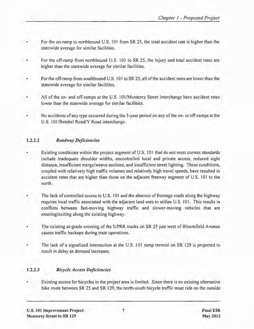
Chapter 1 - Proposed Project
For the on-ramp to northbound U.S. 101 from SR 25, the total accident rate is higher than thestatewide average for similar facilities.
• For the off-ramp from northbound U.S. 101 to SR 25, the injury and total accident rates arehigher than the statewide average for similar facilities.
For the off-ramp from southbound U.S. 101 to SR 25, all ofthe accident rates are lower than thestatewide average for similar facilities.
All of the on- and off-ramps at the U.S. 10 I/Monterey Street interchange have accident rateslower than the statewide average for similar facilities.
No accidents ofany type occurred during the 3-year period on any of the on- or off-ramps at theU.S. 10 I/Betabel Road/Y Road interchange.
1.2.2.2 Roadway Deficiencies
• Existing conditions within the project segment of U.S. 101 that do not meet current standardsinclude inadequate shoulder widths, uncontrolled local and private access, reduced sightdistance, insufficient merge/weave sections, and insufficient street lighting. These conditions,coupled with relatively high traffic volumes and relatively high travel speeds, have resulted inaccident rates that are higher than those on the adjacent freeway segment of U.S. 101 to thenorth.
The lack ofcontroJled access to U.S. 101 and the absence of frontage roads along the highwayrequires local traffic associated with the adjacent land uses to utilize U.S. 101. This results inconflicts between fast-moving highway traffic and slower-moving vehicles that areentering/exiting along the existing highway.
• The existing at-grade crossing of the UPRR tracks on SR 25 just west of Bloomfield Avenuecauses traffic backups during train operations.
The lack of a signalized intersection at the U.S. 101 ramp termini on SR 129 is projected toresult in delay as demand increases.
1.2.2.3 Bicycle Access Deficiencies
Existing access for bicycles in the project area is limited. Since there is no existing alternativebike route between SR 25 and SR 129, the north-south bicycle traffic must ride on the outside
U.S. 101 Improvement Project:Monterey Street to SR 129
7 Final EIRMay 2013

Chapter I - Proposed Project
shoulders of U.S. 101 between Monterey Street and SR 129. The west-to-east bicycle trafficuses Mesa Road, the southbound U.S. 101 shoulder, the U.S. 101 to SR 25 off-ramp and thenalong the shoulder ofSR 25. East-to-west bicycle traffic travels along the SR 25 shoulder, theSR 25 to U.S. 101 on-ramp, the northbound U.S. 101 shoulder, and exits at the Monterey Streetinterchange.
Future access for bicycles in the project area will be eliminated when U.S. 101 (and the west endof SR 25) is upgraded to a freeway.
1.3 PROJECT DESCRIPTION
This section describes the proposed action and the design alternatives that were developed to meet theidentified need through accomplishing the defined purpose(s), while avoiding or minimizingenvironmental impacts. The alternatives are the "Build Alternative" and the "No Build Alternative."Within the Build Alternative, there are two design options evaluated for the proposed reconstruction ofthe U.S. 10 I/SR 25 interchange.
In addition to the Build and No Build Alternatives, this section summarizes six design and locationalternatives that were evaluated for their potential to meet the project's purpose and need, but whichhave been eliminated from further evaluation in this EIR due to one or more ofthe following reasons:I) failure to adequately meet the purpose and need, 2) failure to meet minimum roadway design criteria,3) substantial right-of-way needs that would require significant residential and/or business acquisitionsand relocations, 4) substantial environmental impacts, and 5) substantial cost.
The proposed project is located along a 7.6-mile segment of U.S. 101 in southern Santa ClaraCounty/northern San Benito County. Within the project limits, U.S. 101 is currently a4-lane expresswayin Santa Clara County and a 4-lane freeway in San Benito County.4 Existing interchanges on U.S. 101are located at Monterey Street, SR 25, Betabel Road/Y Road, and SR 129. Within Santa Clara County,there is also access between U.S. 101 and a number of local roadways and driveways.
As described in Section 1.2, the purposes of the project are to I) complete the upgrade of U.S. 101 tofreeway standard in Santa Clara County, 2) accommodate projected traffic demand along U.S. 101,3)improve safety and operations along the project segment ofU.S. 101,4) enhance the movement ofgoodsalong the U.S. 101 transportation corridor, and 5) maintain and enhance bicycle access in the U.S. 101corridor.
4A freeway is a divided highway with full access control, meaning the owners of abutting lands have noright or easement of access to or from their abutting lands. An expressway is a divided highway with partialaccess control, meaning there may be limited driveways and/or at-grade intersections.
U.S. 101 Improvement Project:Monterey Street to SR 129
8 Final EIRMay 2013
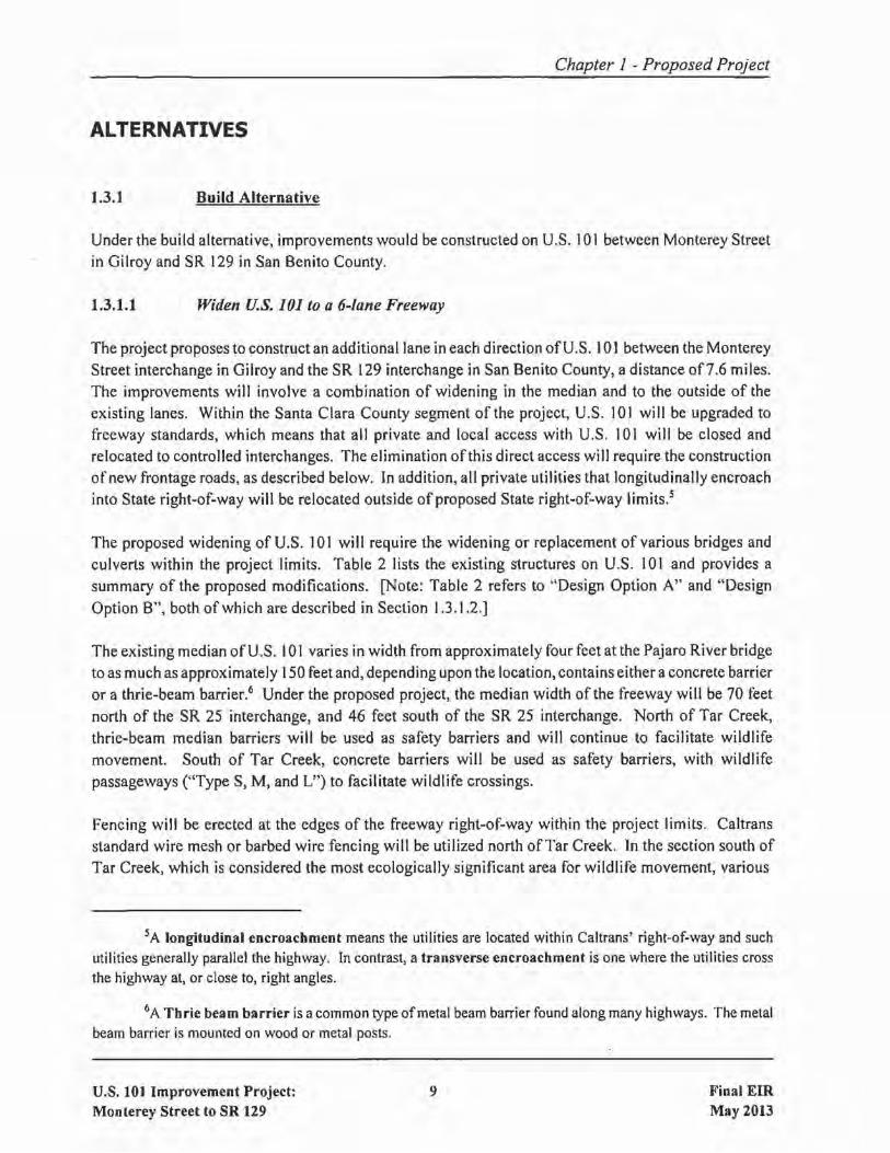
Chapter 1 - Proposed Project
ALTERNATIVES
1.3.1 Build Alternative
Under the build alternative, improvements would be constructed on U.S. 101 between Monterey Streetin Gilroy and SR 129 in San Benito County.
1.3.1.1 Widen U.S. 101 to a 6-lane Freeway
The project proposes to construct an additional lane in each direction ofU.S. 101 between the MontereyStreet interchange in Gilroy and the SR 129 interchange in San Benito County, a distance of7.6 miles.The improvements will involve a combination of widening in the median and to the outside of theexisting lanes. Within the Santa Clara County segment of the project, U.S. 101 will be upgraded tofreeway standards, which means that all private and local access with U.S. 101 will be closed andrelocated to controlled interchanges. The elimination ofthis direct access will require the constructionofnew frontage roads, as described below. In addition, all private utilities that longitudinally encroachinto State right-of-way will be relocated outside of proposed State right-of-way limits.s
The proposed widening of U.S. 101 will require the widening or replacement of various bridges andculverts within the project limits. Table 2 lists the existing structures on U.S. 101 and provides asummary of the proposed modifications. [Note: Table 2 refers to "Design Option A" and "DesignOption B", both of which are described in Section 1.3.1.2.]
The existing median of U.S. 101 varies in width from approximately four feet at the Pajaro River bridgeto as much as approximately 150 feet and, depending upon the location, contains either a concrete barrieror a thrie-beam barrier.6 Under the proposed project, the median width of the freeway will be 70 feetnorth of the SR 25 interchange, and 46 feet south of the SR 25 interchange. North of Tar Creek,thrie-beam median barriers will be used as safety barriers and will continue to facilitate wildlifemovement. South of Tar Creek, concrete barriers will be used as safety barriers, with wildlifepassageways ("Type S, M, and L") to facilitate wildlife crossings.
Fencing will be erected at the edges of the freeway right-of-way within the project limits. Caltransstandard wire mesh or barbed wire fencing will be utilized north ofTar Creek. In the section south ofTar Creek, which is considered the most ecologically significant area for wildlife movement, various
5A longitudinal encroachment means the utilities are located within Caltrans' right-of-way and suchutilities generally parallel the highway. In contrast, a transverse encroachment is one where the utilities crossthe highway at, or close to, right angles.
6A Thrie beam barrier is acommon type ofmetal beam barrier found along many highways. The metalbeam barrier is mounted on wood or metal posts.
U.S. 101 Improvement Project:Monterey Street to SR 129
9 Final EIRMay 2013

Chapter 1 - Proposed Project
TABLE 2
EXISTING AND PROPOSED STRUCTURES WITHIN PROJECT LIMITS[Listed North to South]
Modifications Proposed by Project
Location Existine: Deshm ODtion A Desi!!n ODtion B
U.S. 101 at Two bridges: 4-span NB bridge, Existing NB bridge to be used by newCarnadero Creek 37' in width and 140 feet in frontage road; existing SB bridge to be
length; 4-span SB bridge, 34' in widened by 37' and used for NB traffic;width and 141' in length new 4-span bridge (71' x 122') to be
constructed for SB traffic.
U.S. 101 at SR 25 nfa New bridge to be constructed to convey SR(proposed) 25 over U.S. 101.
Flood Passage None. U.S. 101 currently Three double 14' x 8' Nine 12' x 6' x 600'Culverts on U.S. 101 floods. x 689' RCB culverts RCB culverts aretnorth of proposed are proposed under proposed under U.S.101/25 interchange U.S. 101 to channel 101 to channel
floodplain flow from floodplain flow fromwest to east of the west to east of thefreeway. freeway.
Flood Passage Cul- None. Three double 14' x 8' New bridge (39' x~ert/Bridge on OfT- x 316' RCB culverts 176') to be built tolRamp from SB U.S. are proposed under convey flood flow101 to EB SR 25 the sa U.S. 101 under ramp.
off-ramp to SR 25.
1Fl00d Passage None. No bridge needed. New bridge (39' xBridge on On-Ramp 400') to be built toIfrom WB SR 25 to convey flood flowINB U.S. 101 under ramp.
1Fi00d Passage None. SR 25 currently floods. New bridge (56' to New bridge (73' toBridge on SR 25, 63' x 450') to be 86' x 400') to beUust east of U.S. 101 built to convey flood built to convey flood
flow under SR 25. flow under SR 25.
SR 25 at UPRR None; at-grade crossing New bridge (51' x New bridge (58' to295') to be 66' x 310') to beconstructed to constructed toconvey SR 25 over convey SR 25 overthe UPRR. the UPRR.
SR 25 at Existing bridge 40' x 444'. No changes proposed.Carnadero Creek
U.S. 101 Improvement Project:Monterey Street to SR 129
10 Final EIRMay 2013

Chapter 1 - Proposed Project
TABLE 2
EXISTING AND PROPOSED STRUCTURES WITHIN PROJECT LIMITS[Listed North to South]
Modifications Proposed by Project
Location Existing Desien Option A Desien Option B
Santa Teresa Blvd. None New 6' x 4' X 45' None needed.~t RCB culvert.Gavilan Creek
IFrontage Road n/a Bridge (approximately 100 feet in length)(Option A) or Santa will be constructed near stock pond toIreresa Blvd. (Option facilitate dispersal by threatened species;B) near Pond see Section 2.21.
1M0nterey Road at None New 6' x 4' x 50' None needed.Gavilan Creek RCB culvert.
101/25 off-ramp at 14-span bridge (27' x 545') Existing bridge to be removed.Gavilan Creek
ru.S. 101 at 8' x 6' x 185' RCB culvert Existing culvert to Existing culvert toGavilan Creek be extended to a be extended to a
length of 425'. length of 650'.
U.S. 101 at SR 25 Existing bridge (44' x 212') over Existing bridge to be removed.(existing) U.S. 101
Monterey Rd at Tick Double 5' x 3' X 31' RCB culvert Existing culvert to be replaced with doubleCreek (location #1) 5' x 3' x 56' RCB culvert.
Monterey Rd at Tick Single 7' x 6' x 32' RCB culvert Existing culvert to be replaced with singleCreek (location #2) 7' x 6' X 59' RCB culvert.
Access Driveway at None. New double 8' x 4' x 110' RCB culvert.Tick Creek (eastsideof U.S. 101)
U.S. 101 at Double 8' x 4' X 163' RCB Existing culvert to be extended to a lengthTick Creek culvert of220'.
U.S. 101 at Sargent! Two bridges: II-span NB bridge Remove NB bridge; widen sa bridge byUPRRlTar Creek (34' x 607'); 7-span SB bridge 113' to accommodate both NB and SB
(41' x 672') traffic; build new single-span (20' x 40')bridge over Tar Creek (under the widenedSB bridge) for bike access road.
Tar Creek Access None. New bridge (19' x 40') to be constructed forRoad access road.
U.S. 101 Improvement Project:Monterey Street to SR 129
11 Final EIRMay 2013

Chapter 1 - Proposed Project
TABLE 2
EXISTING AND PROPOSED STRUCTURES WITHIN PROJECT LIMITS[Listed North to South]
Modifications Proposed by Project
Location Existine: Desien Option A I Design Option B
Betabel Road at No existing crossing; former New 3-span bridge (43' x 360') to bePajaro River bridge removed in 1940 when constructed for access road/bike path.
current U.S. 101 bridge wasbuilt.
U.S. 101 at 4-span bridge (60' x 340') Existing bridge to be replaced with 3-spanPajaro River bridge (141' x 381').
lV.s. 101 at Betabel Existing bridge over U.S. 101 Existing bridge wi 11 be widened byRoad/Y Road (37' x 215') approximately 12'.
U.S. 101 at Two bridges: 13-span NB bridge Existing NB bridge to be widened by 25';San Benito River (34' x 722'); 13-span SB bridge existing SB bridge to be widened by 33'.
(38' x 710')
Y Road at No existing crossing; former New 3-span bridge (13' x 300') to beSan Benito River low-flow crossing washed away constructed for bicyclists.
during storm in 1990s.
101/129 ofT-ramp at Triple 8' x S' X 174' RCB culvert No changes proposed.San 1uan Creek
lV.s. 101 at 3-span bridge (82' x 142') Existing bridge will be widened to the westSan Juan Creek by approximately 17'.
lV.s. 101 at Existing bridge over U.S. 101 No changes proposed.SR 129 (59' x 210')
Note: All proposed dimensions are approximations based on preliminary engineering and aresubject to refinement during final design.
RCB ::: reinforced concrete box
NB = northbound SB = southbound EB =eastbound WB =westbound
undercrossing additions, enlargements, and/or enhancements will be combined with wildlife fencing toreduce wildlife-vehicle collisions while simultaneously increasing the permeability of the highway.
U.S. 101 Improvement Project:Monterey Street to SR 129
12 Final EIRMay 2013

1.3.1.2 Reconstruct U.S. IOllSR 251nterchange
Chapter 1 - Proposed Project
The proposed project includes the reconstruction ofthe existing U.S. 10 IISR 25 interchange. There aretwo design options under consideration for this component of the project:
IE Design Option A - Reconstruct Interchange North ofExisting Location: Design Option A willreconstruct the U.S. 10 l/SR 25 interchange at a location approximately 0.2 miles north of theexisting interchange. The interchange will include a new bridge to convey SR 25 over U.S. 101.It will also include ramps to allow all traffic movements between U.S. 101 and SR 25, as shownon Figure 3. The proposed work at the reconstructed U.S. 101/SR 25 interchange will includethe realignment of SR 25 to a location just east of the UPRR crossing, at which point it willeither transition to existing SR 25 or will tie into an upgraded 4-lane SR 25.7
[E Design Option B - Reconstruct Interchange at Existing Location: Design Option B willreconstruct the U.S. 10 I/SR 25 interchange at essentially the same location as the existinginterchange. The interchange will include a new bridge to convey SR 25 over U.S. 101. It willalso include ramps to allow all traffic movements between U.S. 101 and SR 25, as shown onFigure 4. The proposed work at the reconstructed U.S. IOl/SR 25 interchange will include aminor realignment ofSR 25 to a location just east of the UPRR crossing, at which point it willeither transition to existing SR 25 or will tie into an upgraded 4-lane SR 25.
As a separate project, Caltrans is evaluating the upgrade of SR 25 to a 4-lane expressway between theUPRR crossing (just west of Bloomfield Avenue) and San Felipe Road in Hollister.
1.3.1.3 Construct Auxiliary Lanes 8
The project proposes to construct an auxiliary lane in each direction on U.S. 101 between the MontereyStreet interchange in Gilroy and the SR 25 interchange. The auxiliary lane will be constructed adjacentto the outside lane in each direction.
1.3.1.4 Extend Santa Teresa Boulevard
The existing southerly terminus of Santa Teresa Boulevard is at Castro Valley Road in Gilroy. Theproject proposes to extend Santa Teresa Boulevard from Castro Valley Road to the reconstructed U.S.I01/SR 25 interchange, a distance ofapproximately 0.5 miles. The extended roadway will include onetraffic lane in each direction, two 8-foot wide shoulders, and a 4-foot wide median. The extension will
7As aseparate project, Caltrans is evaluating the upgrade ofSR 25 to a four-lane expressway between theUPRR crossing Oust west of Bloomfield Avenue) and San Felipe Road in Hollister.
8An auxiliary lane typically extends between two adjacent interchanges. It improves weaving and overallfreeway operations. It is not a "thru" lane; traffic in an auxiliary lane must either merge into the adjacent thru laneor exit the freeway at the next offwramp.
u.s. 101 Improvement Project:Monterey Street to SR 129
13 Final EIRMay 2013

NN
Y ROAD
BETABEL ROADPAJARO RIVER
S AN JUAN
SAN BENITO SR 129
TAR CREEK
TICK
CR
EEK
U.P.R.R.
GAV
ILAN
CR
EE
K
CARNADERO CREEK
BLOO
MFIELD
AVENUE
BOLSA ROAD
CA
STRO
VALLEY
RO
AD
MESA
RO
AD
SANTA TERESA GAVILANCOLLEGE
Y ROAD
BETABEL ROADPAJARO RIVER
S AN JUAN
SAN BENITO SR 129
SOUTHERLYPROJECT LIMIT
NORTHERLYPROJECT LIMIT
TAR CREEK
TICK
CR
EEK
U.P.R.R.
GAV
ILAN
CR
EE
K
CARNADERO CREEK
BLOO
MFIELD
AVENUE
BOLSA ROAD
MESA
RO
AD
SANTA TERESA GAVILANCOLLEGE
PROPOSED DETENTION BASIN
0 1,300' 2,600'
CA
STRO
VALLEY
RO
AD
PROPOSED PROJECT PLANS (DESIGN OPTION A) FIGURE 3

PROPOSED PROJECT PLANS (DESIGN OPTION B) FIGURE 4
Scale: 1" = ± 1,800'
N
U.P.R.R.
GAV
ILAN
CR
EE
K
CARNADERO CREEK
BLOO
MFIELD
AVENUE
BOLSA ROAD
CA
STRO
VALLEY
R
OA
D
MESA
RO
AD
SANTA TERESA
GAVILANCOLLEGE
NORTHERLYPROJECT LIMIT
U.P.R.R.
GAV
ILAN
CR
EE
K
CARNADERO CREEK
BLOO
MFIELD
AVENUE
BOLSA ROAD
GAVILANCOLLEGE
US101
US101
PROPOSED DETENTION BASIN
SANTA TERESA
MESA
RO
AD
VALLEY
C
ASTR
ORO
AD

Chapter 1 - Proposed Project
meet minimum design standards for an expressway (i.e., 50 miles-per-hour [mph] design speed). It alsoincludes a new traffic signal on Santa Teresa Boulevard at the driveway entrance to Gavilan College.
Under Design Option A, proposed work will include constructing Santa Teresa Boulevard on anembankment that will connect the new U.S. 10 I/SR 25 overcrossing to a slightly realigned Santa TeresaBoulevard north of Castro Valley Road. As shown on Figure 3, the new alignment of Santa TeresaBoulevard will be to the east of the existing alignment, which will improve traffic operations byproviding for a straighter roadway.
Under Design Option B, the alignment for the Santa Teresa Boulevard extension will be along a hillsidethat is located on the south side ofGavilan Creek. The extension will connect to the new U.S. 101 /SR25 overcrossing, as shown on Figure 4.
Under both design options, this connection between U.S. 101 and Santa Teresa Boulevard will provideimproved access to nearby Gavilan College and areas of southern Gilroy, as identified in the City ofGilroy General Plan, the Southern Gateway Transportation and Land Use Study (VTA, 2006), and theValley Transportation Plan 2035 (VTA, 2009).
1.3.1.5 Construct Improvements at the U.S. 1011SR 129 Southbound Off-Ramp
A traffic signal will be installed at the intersection of the U.S. 101 southbound off-ramp and SR 129.The off-ramp will be widened to provide for a second right-turn lane, which will include minorimprovements on SR 129 to receive this lane. In addition, an auxiliary lane ofapproximately 1,300 feetin length will be constructed in the southbound direction of U.S. 10 I, creating a 2-lane exit to SR 129.
1.3.1.6 Construct Frontage Roads
The proposed upgrade of U.S. 101 to freeway standards, which is described in Section 1.3. LI, willrequire that all private and local access with U.S. 101 be closed and relocated to controlled interchanges.The loss of this access, which in most cases is the only access to/from adjacent properties, will bemitigated by the project's construction/realignment of the following frontage roads:
o Monterey Road will be extended to the south along the east side of U.S. 101. This roadwayextension will run through the northeast quadrant of the U.S. 101/SR 25 interchange, thenparallel to the UPRR tracks, then east across the UPRR tracks utilizing the existing SR 25 atgrade crossing, and terminate at the SR 25/B100mfield Avenue intersection. The extension wi IIinclude a crossing ofCarnadero Creek on the bridge that is now used for northbound U.S. 101traffic.
The existing Monterey Frontage Road (also known as the Farman Frontage Road) that runsalong the west side of U.S. 101 between Carnadero Creek on the south and Monterey Road onthe north will be realigned to the west.
u.s. 101 Improvement Project:Monterey Street to SR 129
16 Final EIRMay 2013

Chapter 1 - Proposed Project
o Under Design Option A, a new frontage road will be constructed on the west side of U.S. 101,extending from Castro Valley Road on the north and connecting to the Old Monterey Road thatprovides access to the existing Granite ConstructionlFreeman Quarry. The new frontage roadwill include an intersection with the extended Santa Teresa Boulevard. Under Design Option
. B, this frontage road will not extend north of Santa Teresa Boulevard; instead, a joint usedriveway will be constructed south of Castro Valley Road to provide replacement access to anumber of properties.
o Betabel Road will be extended northerly from its current terminus on the south side ofthe PajaroRiver. The extension will cross the Pajaro River on a new bridge and connect to an existingfrontage road that parallels the west side of U.S. 101 north to Tar Creek. At this point, thefrontage road will extend under the 10 I/Sargent bridges overcrossings and across Tar Creek ona new bridge to provide access to the property and utilities located on the east side ofU.S. 101.9
A joint access driveway will extend north of this frontage road, terminating on the north side ofTick Creek.
1.3.1.7 Grade-Separate the SR 25IUPRR Crossing
SR 25 currently crosses the UPRR tracks "at~grade" just west of Bloomfield Avenue, meaning thattraffic is halted when trains are passing. The project will construct a bridge to convey the realigned SR25 over the UPRR tracks.
1.3.1.8 Construct Bicycle Facilities
Within the project limits, bicycle travel occurs in both the north-south and east-west directions. BecauseU.S. 101 is designated as an expressway between Monterey Street and the southern limits ofSanta ClaraCounty, and since there is no existing alternative bike route between SR 25 and SR 129, the north-southbicycle traffic is allowed to ride on the outside shoulders of U.S. 101 between Monterey Street and SR129. The west-to-east bicycle traffic uses Mesa Road, the southbound U.S. 101 shoulder, the U.S. 101to SR 25 off-ramp and then along the shoulder of SR 25. East-to-west bicycle traffic travels along theSR 25 shoulder, the SR 25 to U.S. 101 on-ramp, the northbound U.S. 101 shoulder, and exits at theMonterey Street interchange.
The project will eliminate bicycle access on U.S. 101 within the project limits, as well as access on SR25 within the project limits. The project, therefore, includes replacement of north-south and east-westbicycle access, which is described below and illustrated on Figures 5 and 6.
9The existing U.S. 101 Sargent bridges include two U.S. 101 bridges (northbound and southbound) overthe UPRR railroad and Tar Creek near Sargent Ranch. Under the proposed project, the northbound bridge willbe removed and the southbound bridge will be widened to accommodate both northbound and southbound traffic.Therefore, the proposed project will include a single bridge at this location, known as the U.S. 101ISargent bridgeovercrossing.
U.S. 101 Improvement Project:Monterey Street to SR 129
17 Final EIRMay 2013
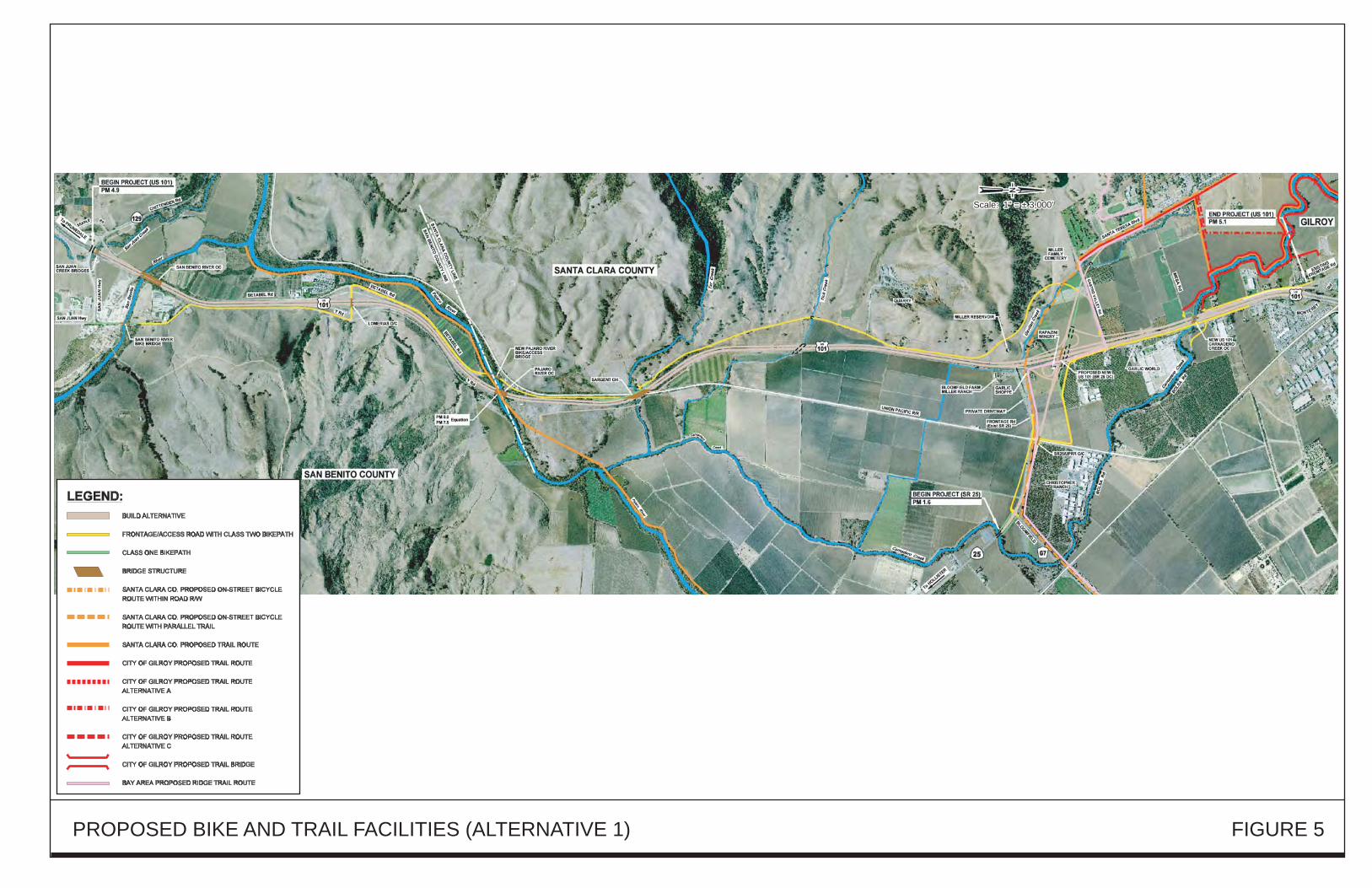
PROPOSED BIKE AND TRAIL FACILITIES (ALTERNATIVE 1) FIGURE 5
Scale: 1" = ± 3,000'Scale: 1" = ± 3,000'
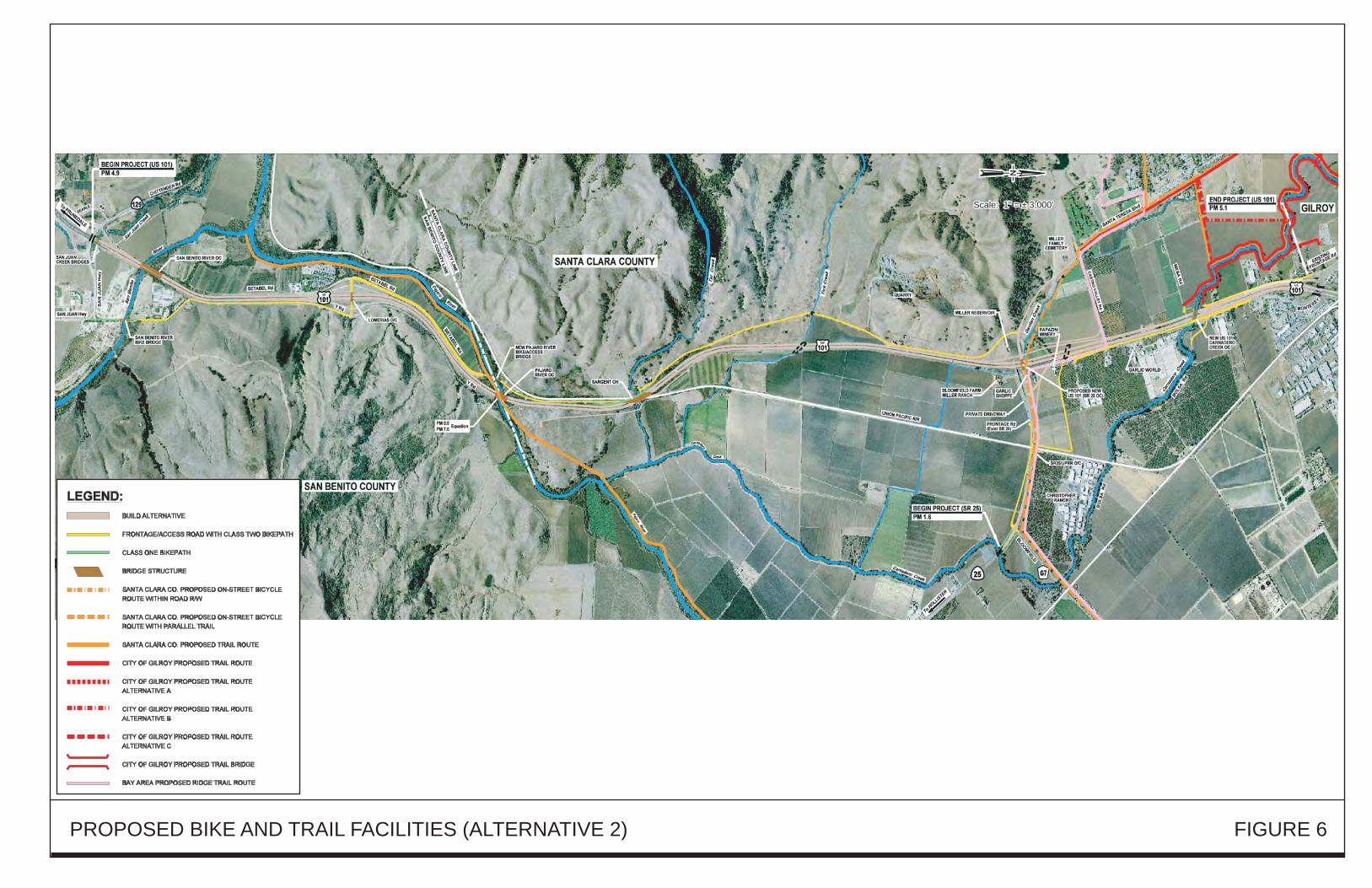
PROPOSED BIKE AND TRAIL FACILITIES (ALTERNATIVE 2) FIGURE 6
Scale: 1" = ± 3,000'Scale: 1" = ± 3,000'

Chapter 1 - Proposed Project
North-South Bicycle Facilities
The north-south route will connect to Santa Teresa Boulevard on the north, which is a north-southroadway with Class 2 bike lanes. lo Between Santa Teresa Boulevard and Tar Creek, it will consist ofClass 2 bike lanes on the existing and proposed frontage roads along the west side of U.S. 101.Bicyclists will cross Tar Creek and the UPRR on the U.S. IOI/Sargent bridge overcrossing, separatedfrom traffic by a barrier (Le., a Class 1 bike path). Between Tar Creek and the U.S. 101IBetabel Road/YRoad interchange, there will be Class 2 bike lanes along Betabel Road, which as described above, willbe extended over the Pajaro River. Beginning at the U.S. IOIlBetabel RoadN Road interchange, thebike route will transition to the east side ofU.S. 101 via the overcrossing at the U.S. IOl/Betabel RoadNRoad interchange, which will require the widening ofthe overcrossing by approximately 10 feet. Class2 bike lanes will be constructed on Y road. South of the terminus ofY road, a Class I bike path will beconstructed to the San Juan Highway, including a new bicycle bridge over the San Benito River.
East-West Bicycle Facilities
The east-west bicycle route will connect to Santa Teresa Boulevard on the west and SR 25 at BloomfieldAvenue on the east. Starting at a point east of the SR 251B100mfield Avenue intersection, there will beClass 1 bike lanes that run along both sides of SR 25 and under the Carnadero Creek bridge, which willallow non-motorized users to travel from one side ofSR 25 to the other side without having to cross SR25 traffic. These Class 1 bike lanes will connect to the extended Monterey Road (as described above)where they will become Class 2 bike lanes. West of the UPRR crossing, Monterey Road will beconstructed around the perimeter ofa proposed detention basin and will extend to the new U.S. 101 /SR25 interchange. At this point, two alternatives are being considered for connecting bike lanes to SantaTeresa Boulevard:
Under Design Option A, Alternative 1will route bicyclists under U.S. 101 and the U.S. 1Ol/SR 25 rampsvia large box culverts that will be installed as part of the project for flood passage purposes (Figure 5).Alternative 2 will continue on Monterey Road along the east side of U.S. 101 between the newinterchange and Camadero Creek (Figure 6). The route will then cross under U.S. 101 along the southbank ofCarnadero Creek, where it will connect to Mesa Road on the west side ofU.S. 101. Alternative2 avoids routing cyclists through long culverts under the freeway. However, the Alternative 2 alignmentis approximately 1.2 miles longer than the Alternative 1 alignment.
Under Design Option B, the lack ofvertical clearance in the culverts does not accommodate Alternative1, and therefore only Alternative 2 is proposed.
IOBicycle facilities generally are categorized as follows: Class 1 refers to a bike lane or path that isphysically separated from vehicular traffic by open space or a barrier. Class 2 is a lane on a roadway that isdesignated by striping, signing and pavement markings for the preferential or exclusive use of bicyclists. Class3 is commonly referred to as a bike route on an existing roadway wherein there are no markings or striping thatdelineate an area for the preferential or exclusive bicycle use.
U.S. 101 Improvement Project:Monterey Street to SR 129
20 Final EIRMay 2013

1.3.1.9 Other Project Features
Chapter 1 - Proposed Project
The project will include utility relocations, as necessary, to construct the above-described improvements.Where necessary to avoid or minimize impacts on adjacent properties and/or sensitive environmentalresources, retaining walls will be utilized to reduce the amount of fill slopes, thereby reducing thefootprint of the project. Lighting will be provided at interchange ramps in accordance with Caltrans'design standards. The project will also include the installation of landscaping in accordance with thepolicies ofCaltrans. Metal beam guardrails or similar barriers will be installed, as needed, to preservetrees and vegetation located within 30 feet of the edge of the outside traffic lanes of the freeway, suchvegetation that would otherwise need to be removed to comply with requirements for an object freesafety/recovery zone.
1.3.1.10 Right-of-Way Requirements
Construction of the above-described improvements will necessitate the acquisition of a substantialamount of right-of-way. Most of the additional right-of-way required will be from properties locatednorth ofTar Creek. South ofTar Creek, only minor right-of-way is needed (i.e., less than one acre total)from two parcels.
Based on preliminary designs, Table 3 provides data regarding the properties from which right-of-waywill be needed for the project. The table includes information on the current use(s) ofeach property, theamount ofright-of-way required, and the effects ofthe acquisition. In some cases, the required right-ofway will result in the demolition ofresidences or businesses; such information is also contained in Table3. Please note that the data in Table 3 are preliminary and are subject to revision during the final designof the project.
1.3.1.11 Construction Schedule
The schedule for construction ofthe proposed project has not been determined because funding has notbeen secured. Further, recognizing the uncertainties associated with highway funding from variousfederal, state, and local programs, it is probable that the project will be constructed in phases as fundingpermits. Phasing is common on large capital improvement projects such as the proposed project.
If funding for the project or an initial phase of the project is secured in the near future, the soonestconstruction would commence would be in yearWH 2015.
1.3.1.12 Compatibility with Other Future Projects
All of the above-described improvements will be designed so as to not preclude other planned andpotential future regional and local highway projects, as well as potential future bicycle/pedestrian trailprojects, in the vicinity. Such projects include the following:
U.S. 101 Improvement Project:Monterey Street to SR 129
21 Final EIRMay 2013
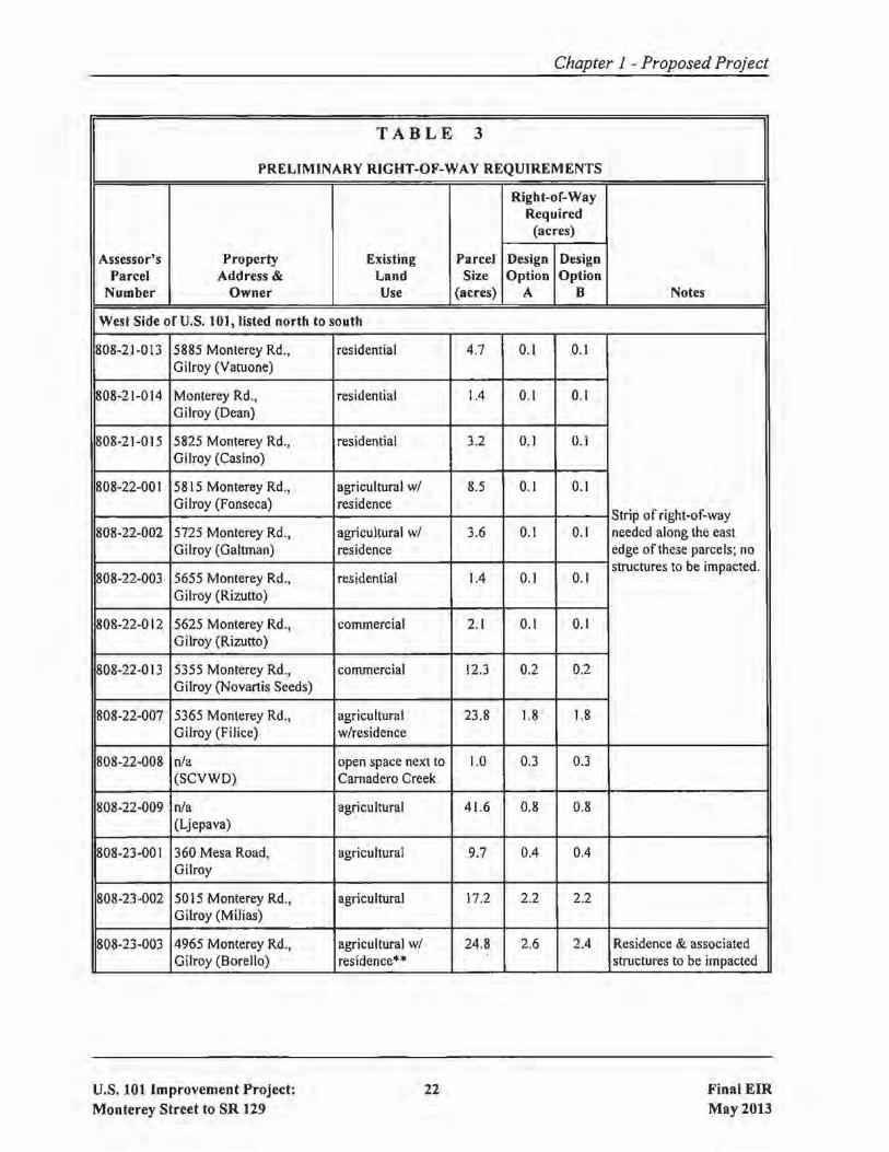
Chapter 1 - Proposed Project
TABLE 3
PRELIMINARY RIGHT-OF-WAY REQUIREMENTS
Right-of-WayRequired
(acres)
Assessor's Property Existing Parcel Design DesignParcel Address & Land Size Option Option
Number Owner Use (acres) A B Notes
West Side of U.S. 101, listed north to south
808-21-013 5885 Monterey Rd., residential 4.7 0.1 O. IGilroy (Yatuone)
808-21-014 Monterey Rd., residential 1.4 0.1 0.1Gilroy (Dean)
808-21-015 5825 Monterey Rd., residential 3.2 0.1 0.1Gilroy (Casino)
808-22-001 5815 Monterey Rd., agricultural wi 8.5 0.1 0.1Gilroy (Fonseca) residence
Strip of right-of-way808-22-002 5725 Monterey Rd., agricultural wi 3.6 0.1 0.1 needed along the east
Gilroy (Galtman) residence edge of these parcels; no
808-22-003 5655 Monterey Rd., residential 1.4 0.1 0.1structures to be impacted.
Gilroy (Rizutto)
808-22-012 5625 Monterey Rd., commercial 2.1 0.1 0.1Gilroy (Rizutto)
808-22-013 5355 Monterey Rd., commercial 12.3 0.2 0.2Gilroy (Novartis Seeds)
808-22-007 5365 Monterey Rd., agricultural 23.8 1.8 1.8Gilroy (Filice) w/residence
808-22-008 nla open space next to 1.0 0.3 0.3(SCYWD) Camadero Creek
808-22-009 nla agricultural 4 \.6 0.8 0.8(Ljepava)
808-23-001 360 Mesa Road, agricultural 9.7 0.4 0.4Gilroy
808-23-002 5015 Monterey Rd., agricultural 17.2 2.2 2.2Gilroy (Milias)
808-23-003 4965 Monterey Rd., agricultural wi 24.8 2.6 2.4 Residence & associatedGilroy (Borello) residence" structures to be impacted
U.S. 101 Improvement Project:
Monterey Street to SR 12922 Final EIR
May 2013

Chapter 1 - Proposed Project
TABLE 3 Icontinuedl
Right-of-WayRequired
(acres)
Assessor's Property Existing Parcel Design DesignParcel Address & Land Size Option Option
Number Owner Use (acres) A B Notes
808-23-004 4395 Monterey Rd., agricultural wI 46.1 4.1 2.8 Residence & associatedGilroy (Pelliccione) residence" structures to be impacted.
808-23-005 55 Castro Valley Rd., agricultural wI 49.2 7.9 3.4 Residence & associatedGilroy (Borello) residence & farm- structures & farmworker
worker cottages'" cottages to be impacted.
808-24-001 410 Mesa Rd., agricuItural·· 17.9 0.4 0.4Gilroy (Chang)
808-23-006 Santa Teresa Blvd., agricultural 0.5 0.4 0.1Gilroy (Gavilan College)
810-34-005 nla agricultural" 60.7 40.2 9.9(Castro Valley Properties)
810-34-007 Santa Teresa Blvd. agricultural·· 77.9 1.3 4.1(Castro Valley Properties)
810-35-008 4355 Monterey Rd., agricultural 41.3 7.9 16.4 Residencelevent centerGilroy (Wingens) w/residence" will not be impacted.
810-35-007 3201 Monterey Rd. agricultural 1,186.6 13.1 14.2 Bam will be impacted;(Castro Valley Properties) w/residence & residence will not be
bam" impacted.
810-35-004 3405-A Monterey Rd. agricultural 29.5 8.1 8.1Gilroy
810-38-002 Monterey Rd., agricultural·· 17.3 10.0 10.0Gilroy
810-38-017 2775 Monterey Rd., agricultural·· 325.1 1.1 J.JGilroy (Sargent Ranch)
13-110-009 nla open space 2.4 2.4 2.4(Rancho Gavilan)
nla strip of land owned by San Benito County 0.2 0.2between Betabel Road and U.S. 101
12-010-024 Chittenden Rd. agricultural 74.9 0.5 0.5(Lavagnino)
U.S. 101 Improvement Project:
Monterey Street to SR 129
23 Final EIRMay 2013
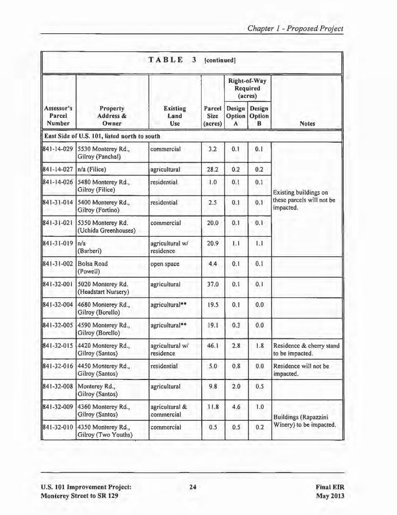
Chapter 1 - Proposed Project
TABLE 3 Icontinued)
Right-or-WayRequired
(acres)
Assessor's Property Existing Parcel Design DesignParcel Address & Land Size Option Option
Number Owner Use (acres) A B Notes
East Side of U.S. 101, listed north to south
841-14-029 5530 Monterey Rd., commercial 3.2 0.1 0.1Gilroy (Panchal)
841-14-027 nla (Filice) agricultural 28.2 0.2 0.2
841-14-026 5480 Monterey Rd., residential 1.0 0.1 0.1Gilroy (Filice) Existing buildings on
841-31-014 5400 Monterey Rd., residential 2.5 0.1 0.1 these parcels will not be
Gilroy (Fortino) impacted.
841-31-021 5350 Monterey Rd. commercial 20.0 0.1 0.1(Uchida Greenhouses)
841-31-019 nla agricultural wi 20.9 1.1 1.\(Barberi) residence
841-31-002 Bolsa Road open space 4.4 0.1 0.1(Powell)
841-32-001 5020 Monterey Rd. agricultural 37.0 0.1 0.1(Headstart Nurse!)')
841-32-004 4680 Monterey Rd., agricultural·· 19.5 0.1 0.0Gilroy (Borello)
841-32-005 4590 Monterey Rd., agricultural" 19.1 0.3 0.0Gilroy (Borello)
841-32-015 4420 Monterey Rd., agricultural wi 46.1 2.8 1.8 Residence & chefi)' standGilroy (Santos) residence to be impacted.
841-32-016 4450 Monterey Rd., residential 5.0 0.8 0.0 Residence will not beGilroy (Santos) impacted.
841-32-008 Monterey Rd., agricultural 9.8 2.0 0.5Gilroy (Santos)
841-32-009 4360 Monterey Rd., agricultural & 11.8 4.6 1.0Gilroy (Santos) commercial Buildings (Rapazzini
841-32-010 4350 Monterey Rd., commercial 0.5 0.5 0.2 Winery) to be impacted.
Gilroy (Two Youths)
U.S. 101 Improvement Project:Monterey Street to SR 129
24 Final EIRMay 2013

Chapter 1 - Proposed Project
TABLE 3 Icontinuedl
Right-of-WayRequired
(acres)
Assessor's Property Existi"ng Parcel Design DesignParcel Address & Land Size Option Option
Number Owner Use (acres) A B Notes
841-32-011 4340 Monterey Hwy., agricultural 28.9 28.9 28.9Gilroy (Torres)
841-32-013 nla agricultural & 19.0 19.0 19.0(Filice Estate Vineyards) commercial Buildings (Garlic Shoppe)
841-32-014 4310 Monterey Hwy. commercial 1.2 0.3 1.2 to be impacted.
(Filice Estate Vineyards)
841-33-008 415 Bloomfield Ave. agricultural·· 59.8 3.5 3.2(Christopher Ranch)
841-35-002 200 Bloomfield Ave., agricultural·· 25.8 0.3 0.3Gilroy (Pura)
84 I-35-003 Bloomfield Ave., Gilroy agricultural** 175.4 2.4 2.3(Pura)
841-35-004 nla agricultural*· 123.9 3.5 3.5(Young)
841-34-002 nla agricultural 264.7 5.5 5.5(Bloomfield Ranch)
84 I·36~O 16 nla agricultural" 231.5 0.1 0.1(JB Ltd Partnership)
841-36-019 nla agricultural·· 32.6 5.4 5.4(JB Ltd Partnership)
nfa nla (SCVWD) Camadero Creek 0.4 0.4
841-36-013 nla agricultural*· 120.0 1.7 1.7(Sargent Ranch)
nla strip of land owned by San Benito County 0.2 0.2between Y Road and U.S. 101
Totals: 190.8 159.5
Notes:I. Information in this table is preliminary and is subject to minor revision during final design.2. SCVWD::::: Santa Clara Valley Water District3. .. ::::: parcel is under California Land Conservation (Williamson) Act contract.
U.S. 101 Improvement Project:Monterey Street to SR 129
25 Final EIRMay 2013

Chapter 1 - Proposed Project
o Upgrade/widening of SR 25 to a 4-lane expressway between the UPRR crossing Gust west ofBloomfield Avenue) and San Felipe Road in Hollister
o Widening of U.S. 101 to eight lanes, to extend high occupancy vehicle (HOY) lanes fromCochrane Road to SR 25
o Possible real ignment of SR 152 (East) to provide a more direct connection between the SRI52/SR 156 and U.S. 10 I/SR 25 interchanges
o Extension of Mesa Road over U.S. 10 I, to connect to Bolsa Road
o Future trails identified in the Santa Clara County Countywide Trails Master Plan (see Section2.1.2.2 for a discussion of this topic)
1.3.2 Transportation System Management (TSM) and Transportation DemandManagement (TDM) Alternatives
Transportation systems management (TSM) strategies increase the efficiency of existing facilities byaccommodating a greater number ofvehicle trips on a facility without increasing the number of throughlanes. Transportation demand management (TOM) focuses on regional means of reducing the numberof vehicle trips and vehicle miles traveled (YMT), as well as increasing vehicle occupancy.
The project need could not be adequately satisfied by reasonable TSM and TOM strategies. The projectis located in a rural area that is not served by existing or future high capacity transit systems that wouldhave the capacity to lure motorists out oftheir vehicles in sufficient numbers so as to eliminate the needfor the project. Likewise, neither ramp metering nor the provision of auxiliary or HOY lanes wouldprovide sufficient benefit and none ofthese improvements would address the deficiencies ofthe existingU.S. 101/SR 25 interchange.
Although TSM and TOM measures alone could not satisfy the purpose and need for the project, thefollowing TSM and TOM measures have been incorporated into the Build Alternative for this project:
• To increase the efficiency of the freeway system during peak travel periods, ramp meteringequipment will be installed on the on-ramps at the reconstructed U.S. 101/SR 25 interchange.The 70-foot median width for U.S. 101 north ofSR 25 will accommodate HOY lanes that areplanned for U.S. 101 between Cochrane Road and SR 25 in the future.The new bicycle facilities that will be constructed as part ofthe project (see Section 1.3.1.8) willfacilitate bicycle travel.
U.S. 101 Improvement Project:Monterey Street to SR 129
26 Final EIRMay 2013

1.3.3 No Build Alternative
Chapter 1 - Proposed Project
The No Build Alternative would consist of not constructing the project, which would avoid theenvironmental impacts ofthe project, as described in this document However, the No Build Alternativewould not meet any ofthe purposes ofthe project, which are listed in Section 1.2.1. Under the No BuildAlternative, projected increases in traffic would cause congestion to worsen and the existing problemsthat are described in Section 1.2.2 would be exacerbated. For additional information on future trafficconditions in the project area under the No Build Alternative, please see Section 2.6.2.5.
1.3.4 Comparison of Alternatives
This section highlights the differences between the Build Alternative, including the two design options,and the No Build Alternative. Key similarities and differences are also highlighted in Table 4.
Under the Build Alternative, the primary difference between Design Option A and Design Option B isthe location ofthe reconstructed U.S. 101/SR 25 interchange. Under Design Option A, the interchangewould be reconstructed approximately 0.2 miles north of its existing location, while under DesignOption B, the interchange would be reconstructed at essentially the same location as the existing facility.Both interchange design options would continue to allow all traffic movements between U.S. 101 andSR 25, and both options would include the connection to Santa Teresa Boulevard.
Under the No Build Alternative, none of the purposes and needs would be met. Under the BuildAlternative, both design options would meet the purposes and needs equally.
As shown in Table 4, for many of the project design features and the majority of the environmentalimpacts, the differences between Design Options A and B are not substantial. There are severalcategories, however, where the differences between the two design options are more substantial, andthese are summarized as follows:
lE Amount ofRight-of-Way Needed for Project: The amount ofadditional right-of-way neededto construct the project under Design Option A is approximately 191 acres, as compared toapproximately 160 acres under Design Option B.
[E Impacts to Prime and Unique Farmlands: Direct impacts to lands designated as PrimeFarmland or Unique Farmland will total approximately 157 acres under Design Option A, ascompared to approximately 122 acres under Design Option B.
lE Construction Phasing: Design Option A cannot be phased into smaller construction packagesand, therefore, requires a large initial phase investment to reconstruct the U.S. 101/SR 25interchange. In contrast, Design Option B can be phased into smaller construction packages and,therefore, requires a smaller initial investment.
U.S. 101 Improvement Project:Monterey Street to SR 129
27 Final EIRMay 2013

Chapter 1 - Proposed Project
TABLE 4
COMPARISON OF ALTERNATIVES
Build Alternativewith
Design Option Afor U.S. lOllSR 25
InterchaDi~e
Build Alternativewith
Design Option Bfor U.S. lOllSR 25
Interchane:eNo Build
Alternative
Summary ofHighwayImprovements
Summary ofNorth-SouthBicycleImprovements
Summary ofEast-WestBicycleImprovements
Widen 101 to 6 lanes between Widen 101 to 6 lanes between No improvementsMonterey St. & SR 129; Monterey S1. & SR 129;upgrade 101 to freeway upgrade 101 to freewayincluding frontage roads; including frontage roads;construct grade-separation on construct grade-separation onSR 25 at UPRR; extend Santa SR 25 at UPRR; extend SantaTeresa Blvd. to 101125 Teresa Blvd. to 101/25interchange; construct interchange; constructimprovements at 101/129 SB improvements at 101/129 SBoff-ramp; reconstruct 101/25 off-ramp; reconstruct 101/25interchange 0.2 miles north of interchange at same locationexisting interchange. as existing interchange.
From Santa Teresa Blvd. to San Juan Hwy, construct a No improvements.combination of new Class 1 bike paths and Class 2 bike lanesalong frontage roads, Betabel Rd., and Y Rd. Sameimprovements under both design options.
From Santa Teresa Blvd. to From Santa Teresa Blvd. to No improvements.SR 25 at Bloomfield Ave., SR 25 at Bloomfield Ave.,construct a combination of construct a combination ofnew Class I bike paths and new Class 1 bike paths andClass 2 bike lanes; there are Class 2 bike lanes.two alternatives beingconsidered for segmentbetween 101/25 & SantaTeresa Blvd.
Cost $ 482 million $ 487 million $0
Ability to MeetPurpose & Need
Both design options meet the purpose and need equally. Does not meet thepurpose & need
Overall changes inraffic patterns
Connecting Santa Teresa Blvd. to 101125 interchange will shift No changesome traffic from Monterey S1. in Gilroy to Santa Teresa Blvd.Same effect under both design options.
U.S. 101 Improvement Project:Monterey Street to SR 129
28 Final EIRMay 2013

Chapter 1 - Proposed Project
TABLE 4 [continued]
Build Alternative Build Alternativewith with
Design Option A Design Option Bfor U.S. lOl/SR 25 for U.s. lOl/SR 25 No Build
Interchange Interchange Alternative
Effect on existing Reduction in congestion, delay and peak-period travel times. Congestion will~ongestion & delay Similar benefit under both design options. worsen over time a~
planned growt~
continues.
lRelocations 4 residences and 2 businesses. Same impact under both design Noneoptions.
lRight-of-Way Needed Total of approximately 191 Total of approximately 160 None~or Project acres from 56 properties. acres from 53 properties
Growth-inducing Significant impact if and when the application for the EI NoneImpacts Rancho San Benito (ERSB) project is resubmitted and the
approval of ERSB is conditioned upon the widening of U.S.101. Same impact under both design options.
Prime & Unique 156.8 acres 121.8 acres NoneFarmland Impacts
Williamson Act Lands 105.1 acres 77.6 acres Noneo be Impacted
Floodplain Project lies within multiple floodplains .. Design includes a Historical floodingImpacts combination ofpipes, culverts, channels, and detention basins of 101 will continue;
to avoid adverse flooding impacts. Similar effect under both no change fromdesign options. existing.
View of Diablo Range Significant and Unavoidable Less-than-Significant Impact No impactfrom Vicinity of ImpactResidence & Business
Visual Impact near Less-than-Significant Impact Significant Impact No impactEvent Center inVicinity of 101/25
U.S. 101 Improvement Project:Monterey Street to SR 129
29 Final EIRMay 2013
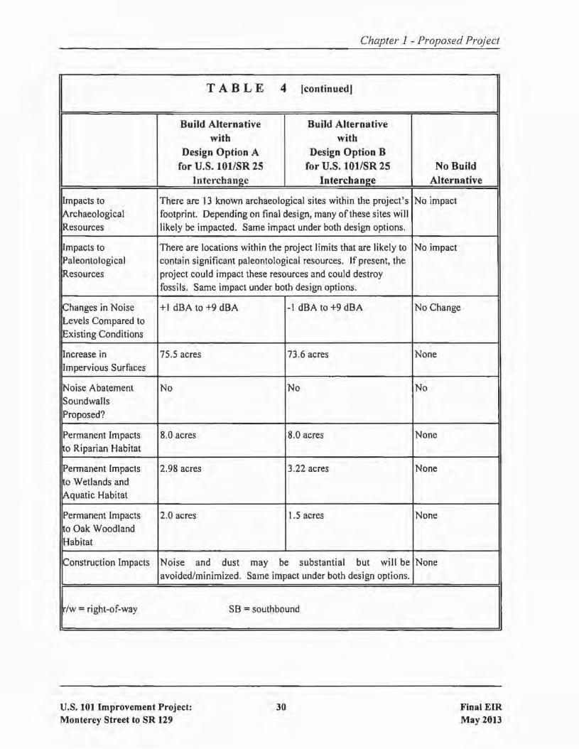
Chapter 1 - Proposed Project
TABLE 4 [continued]
Build Alternative Build Alternative
with with
Design Option A Design Option B
for U.S. lOllSR 25 for U.S. 101lSR 25 No Build
Interchange Interchange Alternative
Impacts to There are 13 known archaeological sites within the project's No impact
~rchaeological footprint. Depending on final design, many of these sites willResources likely be impacted. Same impact under both design options.
Impacts to There are locations within the project limits that are likely to No impactPaleontological contain significant paleontological resources. If present, theResources project could impact these resources and could destroy
fossils. Same impact under both design options.
~hanges in Noise +1 dBA to +9 dBA -1 dBA to +9 dBA No Change
Levels Compared to
iExisting Conditions
~ncrease in 75.5 acres 73.6 acres NoneImpervious Surfaces
!Noise Abatement No No No
Soundwalls
Proposed?
Permanent Impacts 8.0 acres 8.0 acres None
o Riparian Habitat
lPermanent Impacts 2.98 acres 3.22 acres Nonea Wetlands and
iAquatic Habitat
Permanent Impacts 2.0 acres 1.5 acres None
a Oak Woodland
lHabitat
Construction Impacts Noise and dust may be substantial but will be None
avoided/minimized. Same impact under both design options.
/w =right-of-way SB =southbound
U.S. 101 Improvement Project:Monterey Street to SR 129
30 Final EIRMay 2013

Chapter I - Proposed Project
[E Construction Staging: Design Option A will have less construction staging issues than DesignOption B because it is located farther from the existing interchange.
IE U.S. 1OllSR 2S Interchange Traffic Operations: Under Design Option A, northbound SR 25to southbound U.S. 101 traffic is put through a loop on-ramp instead of having to make a leftturn. Under Design Option B, left-turn pockets are needed at both ends of the bridge toaccommodate the left-turning traffic onto southbound and northbound U.S. 101.
After tlte public circulatioli period, all COliiliiellts will be cOlisidcred, alld VTA, in coopelCltion withCaltralis, will select a preferred desigli optioli alld l11ake the filial deteniiination of the project's effect01' the em irorilllent. In accordance with CEQA, VTA will eertify thanhe project eorllplies with CEQA,prepaiC filldiligs for all significant impacts identified, prepare a Staternellt ofOyetridillg COlisideratiolisfor impacts that will not be Initigated below a leyel ofsignifieanee, and certify that the findiligs andStatement ofOyeiliding Considerations haye beell eonsidered prior to project approyal. VTA \'\I ill thenfile a Notice ofDeteilnination \'\I ith the State Clearinghouse and the Sallta Clara Count) ClerkaRecordelthat will idelitiry \'\Ihetherthe project will haye significant impacts, iflllitigation measures were includedas conditions of project apployal, that findings were made, alid that a Statement of OyelTidiligConsiderations \'\las adopted.
Identification of a Preferred Alternative
On May 7,2013. the U.S. 101 Improvement Project Development Team (PDT), consisting ofVTA andCaltrans design, environmental. and management staff and consultants, met to identify a preferredalternative. The PDT identified the Build Alternative Design Option B as the preferred alternative, witha recommendation to the VTA Board ofDirectors (i.e.. the decision-making body of the Lead Agency)that Build Alternative Design Option B be approved. The PDT also recommended the approval of Bike
Alternative 2. This recommendation was made after considering comments from outside agencies andthe public, as well as input from the PDT itself. Relevant factors that led to this recommendation include
the following:
o The Build Alternative Design Option B meets the purpose and need for the project. whereas theNo Build Alternative does not meet the purpose and need.
o The amount of right-of-way needed to construct the project under Design Option B isapproximately 160 acres. as compared to approximately 191 acres under Design Option A.
o Direct impacts to lands designated as Prime Farmland or Unigue Farm land is approximately 122acres under Design Option B, as compared to approximately 157 acres under Design Option A.
o Design Option A cannot be phased into individual construction packages and, therefore, reguiresa large initial investment to reconstruct the U.S. 101/SR 25 interchange. In contrast. Design
U.S. 101 Improvement Project:Monterey Street to SR 129
31 Final EIRMay 2013
Chapter 1 - Proposed Project
Option B can be phased into individual construction packages and. therefore. requires a smallerinitial investment.
o The Bay Area Ridge Trail Council. Central Coast Regional Water Qual ity Board. Council ofSanBenito County Governments, and members of the public have stated preference for DesignOption B due to less environmental impacts overall. No commentor on the Draft EIR indicatedpreference for Design Option A.
o The National Park Service. Bay Area Ridge Trail Council. Santa Clara County Open SpaceAuthority. and Santa Clara County Parks and Recreation have stated preference for BikeAlternative 2. No commentor on the Draft EIR indicated preference for Bike Alternative I.
If the VTA Board of Directors approves the project. it will include the adoption of a MitigationMonitoring Plan, Findings. and a Statement ofOverriding Considerations. as required under CEOA. ACEQA Notice of Determination will be filed with the State Clearinghouse and the Santa Clara CountyClerk-Recorder.
1.3.5 Alternatives Considered but Eliminated from Further Discussion
The purposes of the project, as described in Section 1.2. I, consist of safety and operationalimprovements to the U.S. 101 highway facility, which is an existing major north-south transportationroute in California. As such, the various alternatives that were evaluated focused on design options forachieving these purposes through various improvements to U.S. 101 itself. Alternatives such as
constructing a new highway in a different corridor were not evaluated since they would not meet thebasic project objectives and purposes.
1.3.5.1 Outside Widening ofU,S. 101 between SR 25 and Monterey Street
When compared to the proposed project, this design option would involve outside widening on bothsides of existing U.S. 101, in lieu of the westerly shift of U.S. 101 between the U.S. 101/SR 25 and U.S.10 I/Monterey Street interchanges to add one more through lane and one auxiliary lane in each direction.This alternative was studied as a way to minimize the construction footprint of the proposed project.Although this design option would achieve the same objectives as the proposed project in enhancing
traffic operations, reducing congestion, and improving safety, it impacts a large number of businessesand requires the relocation of major utilities located east of U.S. 101, thus increasing the project costssignificantly. It also precludes future plans to build carpool or HQT lanes in the existing median of U.S.101 due to width limitations.
1.3.5.2 Easterly Widening of u.s. 101, South ofSR 25
This design option would involve outside widening on both sides of existing U.S. 101 between SR 25and the Tar Creek crossing (U.S. lOt/Sargent bridges) to add one more through lane in each direction.
U.S. 101 Improvement Project:Monterey Street to SR 129
32 Final EIRMay20n
Chapter 1 - Proposed Project
Similar to the option discussed above, this design option was studied as a way to minimize theconstruction footprint of the proposed project. Although this design option would achieve the sameobjectives as the build alternative in enhancing traffic operations, reducing congestion, and improvingsafety, it was determined that it is not feasible because it would directly impact the Bloomfield Ranch,which is a significant historic resources that is eligible for the National Register ofHistoric Places.Further, this option would impact an archaeological site that was identified during the cultural resourcesinvestigation phase, thus increasing the project environmental impacts significantly. Unless significantdesign exceptions can be approved, this option will also preclude future plans to widen U.S. 101 in themedian due to the lack of sufficient width.
1.3.5.3 Widen Northbound U.S. 101 into the Existing Median between SR 25 and Tar Creek
This design option would widen existing U.S. 101 northbound into the median between Tar Creek (U.S.10 I/Sargent bridges) and the reconstructed U.S. 10lISR 25 interchange, which would leave an existingmedian width ofapproximately 31 feet. This design option has a smaller overall footprint, and thereforea lesser environmental impact, than the proposed project. However, it was rejected since a 3I-footmedian width would be unacceptable because I) it would require design exceptions to median shoulderwidths standards when/if the freeway is widened to 8 lanes south of SR 25, and 2) it would not beconsistent with the 46-foot median width south ofTar Creek. The standard width for freeway mediansin rural areas is 62 feet and discussions with Caltrans' engineers resulted in a determination that theminimum acceptable median width is 46 feet at this location.
1.3.5.4 Alternative Median Widths on U.S. 101 between Tar Creek and SR 129
Under the proposed project, the median width on U.S. 101 between Tar Creek (Sargent Overhead) andSR 129 will be 46 feet. This design option explored alternative median widths of22 feet, 36 feet, and62 feet.
The 22-foot wide median has the advantage of having a smaller footprint than the proposed project,which in turn reduces environmental impacts. However, this design was rejected because the width issubstantially below the 62-foot design standard for rural freeways and because it would preclude theconstruction of future lanes in the median.
The 62-foot wide median has the advantage ofmeeting the Caltrans Highway Design Manual standardsfor freeway median width in rural areas. However, it would have a larger footprint than the proposedproject and would require extensive right-of-way acquisition. The larger footprint would also result insignificantly greater archaeological, biological, floodplain, and visual impacts. Finally, this desigT\,would significantly increase the project's capital construction cost.
A 36-foot wide median was also considered. That option was rejected because it would require amandatory design exception for non-standard shoulder widths when future median widening (i.e., addingone more lane in each direction) is needed. In other words, the ability to undertake the future median
U.S. 101 Improvement Project:Monterey Street to SR 129
33 Final EIRMay 2013

Chapter J - Proposed Project
widening would be questionable because the width of the shoulders would be only five feet instead ofthe ten foot width that is the design standard.
1.3.5.5 Construct a Separate U.S. lOllSanta Teresa Boulevard Interchange
This design option would extend Santa Teresa Boulevard south from its current terminus at CastroValley Road through a new frontage road that runs behind Miller Reservoir and ties into Old MontereyRoad, where a proposed second interchange would be built approximately 1.3 miles south of thereconstructed U.S. 101lSR 25 interchange. This design option was considered because it has theadvantage ofseparating local (i.e., Santa Teresa Boulevard) traffic from freeway-to-freeway traffic. Thisdesign option was rejected because I) it requires significant right-of-way acquisition; 2) it has a largeenvironmental footprint that would require a significant amount of mitigation; 3) it does not meet theminimum interchange spacing requirement 'l , which would potentially impact traffic operations; and 4)
it would be less desirable by the local communities due to the extended length oftravel distance neededto get from Santa Teresa Boulevard to SR 25.
1.3.5.6 Reconstruct U.S.lOllSR 25 Interchange withoutSanta Teresa Boulevard Connection
The project initially considered a design for the reconstruction of the U.S. 101 /SR 25 interchange thatdid not include the Santa Teresa Boulevard connection. This proposal generated significant oppositionfrom local residents and businesses, the City ofGilroy, and Santa Clara County. This design option wasrejected in response to the comments received during the public scoping meeting that was held inNovember 2007. In addition, the Santa Teresa Boulevard connection to the U.S. 1Ol/SR 25 interchangewas included in the project as it is identified in the City ofGilroy General Plan, the Southern GatewayTransportation and Land Use Study (VTA, 2006), and the Valley Transportation Plan 2035 (VTA,2009).
1.4 PERMITS AND APPROVALS NEEDED
Construction of the proposed project will require permits/approvals from the governmental agencieslisted in Table 5.
llFHWA and Caltrans have criteria that establish minimum distances between adjacent interchanges ona freeway. These minimums are designed to avoid the operational problems that occur as vehicles are mergingon and off a freeway within relatively short distances.
U.S. 101 Improvement Project:Monterey Street to SR 129
34 Final EIRMay 2013

Chapter I - Proposed Project
TABLE 5
PERMITS AND APPROVALS NEEDED
I Agency I PermitlApproval I Status ICity of Gilroy Encroachment permit for work extending onto local Application to be submitted
streets within Gilroy. during final design.
Santa Clara County Encroachment permit for work extending onto local Application to be submittedstreets in unincorporated areas of Santa Clara Co. during final design.
San Benito County Encroachment permit for work extending onto local Application to be submittedstreets in unincorporated areas of San Benito Co. during final design.
Santa Clara Valley Permit for work in Carnadero Creek, Gavilan Creek, Application to be submittedWater District Tick Creek, Tar Creek, and Pajaro River. during final design.
San Benito County Permit for work in Pajaro River, Murphy Creek, San Application to be submittedWater District Benito River, and San Juan Creek. during final design.
California Public Permit for any work affecting the UPRR crossings Application to be submittedUtilities Commission at Tar CreeklU.S. 101 & SR 25. during final design.
National Marine Section 7 Consultation for Threatened and Consultation to be undertakenFisheries Service Endangered Species; by U.S. Army Corps of
Review and Comment on 404 Permit. Engineers during processing
U.S. Fish & Wildlife Section 7 Consultation for Threatened and of Section 404 permit.
Service Endangered Species;Review and Comment on 404 Permit.
U.S. Army Corps of Section 404 permit for temporary and/or permanent Application to be submittedEngineers work in low-flow channels ofCarnadero Creek, during final design.
Gavilan Creek, Tick Creek, Tar Creek, Pajaro River,Murphy Creek, San Benito River, and San JuanCreek.
Regional Water Section 40 I Water Quality Certification for Application to be submittedQuality Control Board temporary and/or permanent work in low-flow during final design.
channels ofCarnadero Creek, Gavilan Creek, TickCreek, Tar Creek, Pajaro River, Murphy Creek, SanBenito River, and San Juan Creek.
California Department Streambed Alteration Agreement for work in Application to be submittedof Fish & Wildlife Carnadero Creek, Gavilan Creek, Tick Creek, Tar during final design.
Creek, Pajaro River, Murphy Creek, San BenitoRiver, and San Juan Creek; Incidental Take Permitfor impacts to endangered/threatened species
U.S. 101 Improvement Project:Monterey Street to SR 129
35 Final EIRMay 2013

CHAPTER 2 AFFECTED ENVIRONMENT, ENVIRONMENTALCONSEQUENCES, & AVOIDANCE, MINIMIZAnON,AND/OR MITIGATION MEASURES
Introductorv Note: Aspart ofthe scoping and environmental analysis conductedforthe project, the following environmental issues were considered but no adverseimpacts were identified. Consequently, there is nofurther discussion regarding theseissues in this document: .
• Parks and Recreational Facilities: There are no parks or recreationalfacilities within or adjacent to the project impact area. The alignments fora number ofplanned trails do, however, cross the u.s. 101 corridor. Theproject's consistency with the future trails is discussed in Section 2.1.2.2.
• Timberlands: There are no timberlands located in the project vicinity.• Community Cohesion: The project will construct improvements to an existing
highway. The improvements will not divide any community or neighborhood.• Coastal Zones: The project site is not within or near areas covered by the
Coastal Zone Management Act of1972.Wild and Scenic Rivers: There are no waterways designated as Wild andScenic Rivers in the project area. The closest rivers with this designation areover 100 miles from the project area.
• Energy: When balancing energy used during construction and operationagainst energy saved by relieving congestion and improving othertransportation effiCiencies, the project would not have substantial energyimpacts.
HUMAN ENVIRONMENT
2.1 LAND USE
2.1.1 Existing and Future Land Use
Existing Land Use
The project is located in a rural/agricultural area of southern Santa Clara County/northern San BenitoCounty. As shown on Figure 3, land uses along the project segment of U.S. 101 are predominantly
associated with agriculture and grazing. Other land uses include low-density residential and commercial.
U.S. 101 Improvement Project:Monterey Street to SR 129
36 Final EIRMay 2013
Chapter 2 - Environmental Setting, Impacts, Mitigation
At the northerly end of the project, in the area adjacent to the U.S. 101/Monterey Street interchange,existing land uses are primarily commercial on the east side of U.S. 101 and primarily low-densityresidential on the west side of U.S. 101. The commercial uses include restaurants, service stations, amotel (National 9 Inn), and a recreational vehicle (RY) Park (Garlic Farm RY Park).
In the vicinity of the U.S. 101/SR 25 interchange, the primary land use is agricultural. Other land usesinclude a number of single-family residences and several commercial uses related to agricultural (e.g.,a cherry stand, Rapazzini Winery, the Garlic Shoppe, and Garlic World). Approximately on-half milewest of this location, adjacent to the southerly end of Santa Teresa Boulevard, is Gavilan College.
South of the U.S. 101/SR 25 interchange, the existing land use is almost entirely agricultural andgrazing. One exception is a rock and sand quarry (Freeman Quarry) that is located approximately 1,500feet west of U.S. 101,0.7 miles south of the U.S. 10l/SR 25 interchange. Another exception is a RYpark (Betabel RY Park) that is located along the west side of U.S. 101 adjacent to the Betabel Road/YRoad interchange.
Several commercial uses, as well as a number of single-family residences, are located at the southerlyend of the project in the area adjacent to the U.S. 101/SR 129 interchange.
The UPRR parallels the project segment of U.S. 101. South ofTar Creek, the tracks are on the west sideof U.S. 101, and north of this location the tracks are on the east side of U.S. 101. This UPRR line is oneof the primary north-south rail lines in California and it carries both passenger and freight traffic.
Future Land Use
At the time this ErR was prepared, there were no proposed or approved projects that would change theland uses on parcels located along the project segment ofU.S. 101. [Note: An application for a proposed
development on an approximately 5,800-acre site located on the west side of U.S. 101, south ofSR 25,was fi led with San Benito County. Ifapproved, the project, known as the EI Rancho San Benito SpecificPlan, would have included up to 6,800 residences, 550,000 square feet of commercial uses, and 1.1million square feet ofemployment uses. In May of2009, the application forthis project was withdrawnand the project is no longer being considered by the County. See also Section 2.2, Growth.]
There is one development application on file that would expand an existing land use adjacent to U.S.
101. The application would increase the size ofthe existing Freeman Quarry from 60 acres to 120 acres.
Although there are no proposed changes in land use on the parcels located along the project segment ofU.S. 101, regional growth is projected to continue. Table 6 summarizes projected growth in bothpopulation and employment at the regional, county, and local levels, and the data show that substantialgrowth in both population and employment is projected throughout the region over the next 30 years.In Santa Clara County, population and employment growth between 2005 and 2035 is projected to be38% and 62%, respectively. During this same period, population and employment growth in San Benito
U.S. 101 Improvement Project:Monterey Street to SR 129
37 Final EIRMay 2013

Chapter 2 - Environmental Setting, Impacts, Mitigation
TABLE 6
PROJECTED POPULATION AND EMPLOYMENT GROWTH
Population Employment
0/0 0/0
2005 2035 Chanl!e 2005 2035 Chanee
Monterey Bay Area 740,000 920,700 24 326,300 404,300 24
San Francisco Bay 7,096,500 9,073,700 28 3,449,700 5,107,400 48Area
San Benito County 57,300 94,700 65 16,900 21,700 28
Santa Clara County 1,763,000 2,431,400 38 872,900 1,412,600 62
City of Gilroy 48,200 69,600 44 17,400 26,400 52
City of Hollister 37,000 62,800 70 10,500 13,900 32
Notes:
· The Monterey Bay Area consists of Monterey, San Benito, and Santa Cruz Counties.
• The San Francisco Bay Area consists of Alameda, Contra Costa, Marin, Napa, San
Francisco, San Mateo, Santa Clara, Solano, and Sonoma Counties.
• All numbers are rounded to the nearest 100.
Sources: Projections 2009 (Association of Bay Area Governments); Monterey Bay Area 2008Re1(ional Forecast (Association of Monterey Bay Area Governments).
County is projected to be 65% and 28%, respectively. The growth that is projected to occur will result
in increased demand on services, utilities, and public infrastructure, including highways. This increaseddemand is reflected in the year 2035 traffic volumes that are shown in Section 2.6, Transportation and
Traffic.
2.1.2
2.1.2.1
Environmental Consequences of the Build Alternative
Land Use Changes
Although the proposed project will construct improvements to an existing highway facility, theimprovements will necessitate the acquisition of additional right-of-way from numerous parcels (seeTable 3). In many cases, the right-of-way needed for the project would affect only a portion ofa givenparcel and the existing land use would remain viable and intact. In some cases, however, the entire
U.S. 101 Improvement Project:Monterey Street to SR 129
38 Final EIRMay 2013

Chapter 2 - Environmental Setting, impacts, Mitigation
parcel would be acquired for the project and the existing land use would be removed. In other cases,while only part ofthe parcel will be acquired, the portion being acquired will impact the underlying landuse. Table 7 lists those properties where the project would result in the existing land use being changedto highway purposes.
Although the project will require the acquisition of the four residences and three businesses listed inTable 7, it will not have the effect of physically dividing an established community. The existing U.S.101 facility, as well as the UPRR that parallels U.S. 10 I, already function as a divide between the landuses located in this area. The affected residences and businesses are scattered along both sides of U.S.101.
The owners ofany properties acquired for project right-of-way will be compensated for the loss and/oruse in accordance with Federal and State right-of-way requirements. Caltrans' relocation benefits aresummarized in Appendix C of this document.
Indirect land use impacts such as noise and visual/aesthetics are discussed under their own headings inthis document.
Impact LV-I: The project will not physically divide an established community. [No Impact}
2.1.2.2 Consistency with State, Regional, and Local Plans and Programs
Highway Plans and Policies
The project is listed in, and therefore consistent with, VTA's Valley Transportation Plan 2035, whichis the transportation plan for Santa Clara County that was adopted in January 2009. 12
The portion of the project within San Benito County is listed in the 2010 San Benito County RegionalTransportation Plan. 13
The project includes the extension of Santa Teresa Boulevard to the U.S. 10 I/SR 25 interchange, animprovement project that is identified in both the Gilroy General Plan and the Southern GatewayTransportation and Land Use Study (VTA, 2006).
12The portion ofthe project between Monterey Street and SR 25, including the extension ofSanta TeresaBoulevard, is listed in VTP 2035 as Project H18. The portion of the project between SR 25 and SR 129 is listedin VTP 2035 as Project H56.
131t is identified in the Plan as Project # Cal-6, Widening of U.S. 101 to a6-lane Freeway from the SantaClara County to SR 156. [Note: These limits are slightly larger than the proposed project as SR 156 is located 1.7miles south of SR 129.]
U.S. 101 Improvement Project:Monterey Street to SR 129
39 Final EIRMay 2013

Chapter 2 - Environmental Setting, Impacts, Mitigation
TABLE 7
LAND USE CHANGES RESULTING FROM THE PROJECT
Right-or-Way
Required
(acres)
Assessor's Existing Parcel Design Design LandParcel Property Land Size Option Option Use
Number Address Use (acres) A B Change
808-23-003 4965 agricultural wi 24.8 2.6 2.4 Residence & associatedMonterey residence structures to be acquired;Rd., Gilroy agriculture use to remain.
808-23-004 4395 agricultural wi 46.1 4.1 2.8 Residence & associated
Monterey residence structures to be acquired;
Rd., Gilroy agriculture use to remain.
808-23-005 55 Castro agricultural wi 49.2 7.9 3.4 Residence & associated
Valley Rd., residence & structures & farmworker
Gilroy farmworker cottages to be acquired;
cottages agriculture use to remain.
810-35-007 3201 agricultural 1,186.6 13.1 14.2 Barn will be acquired; residence
Monterey wlresidence & will not be impacted;
Rd., Gilroy barn agriculture use to remain.
841-32-015 4420 agricultural wi 46.1 2.8 1.8 Residence & cherry stand to be
Monterey residence acquired; agriculture use to
Rd., Gilroy remain.
841-32-009 4360 agricultural & 11.8 4.6 1.0
Monterey commercial Buildings (Rapazzini Winery)Rd., Gilroy to be acquired; agriculture use
841-32-010 4350 commercial 0.5 0.5 0.2 to remain on residual portion of
Monterey 841-32-009.
Rd., Gilroy
841-32-011 4340 agricultural 28.9 28.9 28.9 Agriculture use to be impacted.
Monterey
Hwy., Gilroy
841-32-013 n/a agricultural & 19.0 19.0 19.0
commercial
841-32-014 4310 commercial 1.2 0.3 1.2Buildings (Garlic Shoppe) to be
acquired.Monterey
Hwy., Gilroy
INote: Information in this table is preliminary and is subject to minor revision during final design. I
U.S. 101 Improvement Project:
Monterey Street to SR 12940 Final EIR
May 2013

Chapter 2 - Environmental Setting, Impacts, Mitigation
There are a number of transportation-related policies in the Santa Clara County General Plan that arerelevant to the proposed project. The policies support the expansion of the County's transportationnetwork to meet projected demand, recognizing the importance oftransportation to a healthy economyand the quality of life for residents. The General Plan does not contain a list of specific roadwayimprovements, but instead contains policies that support the implementation of VTA's ValleyTransportation Plan 2035.
The Transportation Element of the San Benito County General Plan (1994) contains a policy thatsupports the preparation of a countywide transportation master plan, so as to identify transportationneeds within the County. The 2010 San Benito County Regional Transportation Plan, which isreferenced above, and which identifies the proposed project as a needed improvement, fulfills this policyof the General Plan. The project is, therefore, consistent with the San Benito County General Plan..
Bicycle Plans and Policies
The Gilroy General Plan, Santa Clara County General Plan, San Benito County General Plan, andVTA's Valley Transportation Plan 2035 all contain policies that promote the completion ofthe plannedbicycle network to facilitate bicycling for both commuting and recreational purposes. In addition,Section 888 of the California Streets and Highways Code states that Caltrans will not construct a Statehighway as a freeway that will result in the severance or destruction of an existing major route forbicyclists unless it provides a reasonable, safe, and convenient alternate route or unless such a routealready exists.
The project will eliminate bicycle access on U.S. 101 within the project limits, as well as access on SR25 within the project limits. The project, therefore, includes replacement of north-south and east-westbicycle access, which is described in Section 1.3.1.8. The replacement facilities will provide safe anddirect routes for bicyclists in the project area.
Trails Plans and Policies
The Santa Clara Countywide Trails Master Plan (1995) identifies a network ofexisting and future trailsthroughout the County. Although there are no existing trails that cross the project segment of U.S. 101,several trails are planned to cross the highway in the future:
The alignment for the Mount Madonna/Coyote Lake segment of the Bay Area Ridge Trail isshown as crossing U.S. 101 in the vicinity of the U.S. 10l/SR 25 interchange.
• The alignment for the Northern Recreation Retracement Route of the Juan Bautista de AnzaNational Historic Trail is shown as crossing U.S. 101 at the Pajaro River.
• The alignment for the Monterey - Yosemite Trail is shown as crossing U.S. 101 at the PajaroRiver.
u.s. 101 Improvement Project:Monterey Street to SR 129
41 Final EIRMay 2013

Chapter 2 - Environmental Setting, Impacts, Mitigation
• The alignment for the Benito - Clara Trail is shown as crossing U.S. 101 at the Pajaro River.
These same trails are also identified and referenced in the Gilroy General Plan.
The project will facilitate the future Bay Area Ridge Trail by constructing a Class I bike path under U.S.101 in the vicinity ofthe U.S. 10 I/SR 25 interchange. As described in Section) .3.1.8, two alternativesare being considered:
Alternative I would route bicyclists and trail users, including eguestrians, under U.S. 101 and the U.S.10 I/SR 25 ramps via the large box culverts that will be installed as part ofthe project for flood passagepurposes. This alternative is only viable under Design Option A as there would be insufficient verticalclearance in the culverts under Design Option B.
Alternative 2 would route bicyclists and trail users, including eguestrians, under U.S. 101 at CarnaderoCreek via a path to be constructed on the south bank of the creek. Alternative 2 is viable under bothDesign Option A and Design Option B. Alternative 2 is preferred by both the Santa Clara County Parksand Recreation Department and the Bay Area Ridge Trail Council. 14
In addition to the crossing of U.S. 101, there are other bike path and frontage road improvements beingproposed by the project in the vicinity of the U.S. 10 l/SR 25 interchange, all of which are described inSection 1.3.1.8. These improvements will not only facilitate travel by bicycle, but will facilitate accessby all trail users.
The project would facilitate the future trail crossing of U.S. 101 at the Pajaro River because the newfreeway bridge will be designed so as to provide adequate clearance for the trail. In addition, the projectproposes a new bridge on Betabel Road over the Pajaro River, which will provide the opportunity forbicyclists, pedestrians, and equestrians to access the future trail from this location.
Habitat Conservation PlanslNatural Community Conservation Plans
The Santa Clara Valley Habitat Conservation PlanlNatural Community Conservation Plan (HCP/NCCP)is currelltl, uildei de velopltient was adopted in late 2012/early 2013 by six "local partners" (VTA,County ofSanta Clara, Santa Clara Valley Water District, and the Cities of San Jose, Morgan Hill, andGilroy), in cooperation with the California Department ofFish & Wildlife (CDFW)IS and the U.S. Fish& Wildlife Service (USFWS). The Santa Clara Valley HCP/NCCP covers approximately 520,000 acres,primarily within southern Santa Clara County, and several special status plant and animal species (called
14 Letters to VTA from the Santa Clara County Parks & Recreation Department and the Bay Area RidgeTrail Council dated 2/20109 and 2/23/09. respectively.
15Formerly the California Department of Fish and Game (CDFG).
U.S. 101 Improvement Project:Monterey Street to SR 129
42 Final EIRMay 2013

Chapter 2 - Environmental Setting, Impacts. Mitigation
"covered species" in the HCP/NCCP). The current schedule anticipates that the approvalimplementation of the HCP/NCCP will occur in late 2013.
The proposed project is a "covered" activity, meaning that it is a project whose impacts are describedand accounted for in the proposed Santa Clara Valley HCPINCCP. The project is, therefore, consistentwith this plan. [Note: For a detailed discussion as to how many of the biological impacts of the projectwill be mitigated by the HCPINCCP, see Section 2.17.5.]
Impact LU-2: The project is consistent with relevant regional and local plans and policies. [NoImpact]
2.1.3 Environmental Consequences oUhe No Build Alternative
Under the No Build Alternative, the existing facilities along the project segment of U.S. 101 wouldremain and no improvements to U.S. 101 would be built. No conflict with existing land uses wouldoccur.
The No Build Alternative would, however, be inconsistent with the regional transportation plans thatare described in Section 2.1.2.2. This statement is based on the fact that those plans identify theimprovements that comprise the Build Alternative as a component of the planned highway system.Therefore, not implementing the improvements would be inconsistent with the plans.
2.1.4 Avoidance, Minimization, and/or Mitigation Measures
No avoidance, minimization, or mitigation measures are required.
2.2
2.2.1
GROWTH
Regulatory Setting
CEQA requires the analysis of a project's potential to induce growth. CEQA guidelines, Section15126.2(d), require that environmental documents" ...discuss the ways in which the proposed projectcould foster economic or population growth, or the construction of additional housing, either directlyor indirectly, in the surrounding environment."
U.S. 101 Improvement Project:Monterey Street to SR 129
43 Final EIRMay 2013

2.2.2
2.2.2.1
Chapter 2 - Environmental Setting, Impacts, Mitigation
Environmental Consequences of the Build Alternative
Introduction
The purpose ofthis section ofan EIR is to disclose whether or not the construction ofa project is likelyto foster additional growth, either directly or indirectly. This information can be an important factor ina decision to approve a project because such approval can .lead to additional projects that may haveenvironmental consequences.
The fact that a project may result in additional growth does not imply that such growth is eitherdetrimental or beneficial. For example, a project that furthers growth consistent with the adopted goalsand policies ofa city's general plan would likely be considered as beneficial. Conversely, a project thatfosters growth that would conflict with such goals and policies would likely be considered asdetrimental.
Finally, projects can induce growth directly or indirectly or both. A direct growth-inducing impactoccurs when the construction of one or more projects is "conditioned on"16 the construction of anotherproject. An indirect growth-inducing impact occurs when a project fosters such growth but there is notdirect linkage to future projects. An indirect growth-inducing impact can also occur if a project suchas a new highway provides access to an area that was previously inaccessible.
Numerous factors other than increased freeway capacity affect growth in the vicinity of U.S. 101 andin the region as a whole. These include the adopted general plans ofcities and counties; the availabilityof other existing, new, and/or expanded arterial, highway, or transit facilities; the availability of otherinfrastructure such as utilities, solid waste, domestic water, wastewater treatment and schools; marketdemand for housing, employment, and commercial services; and the strength of the area economy andemployment levels. The majority of these factors are independent ofany decision to improve U.S. 101and these factors would influence future growth in this area with or without the project.
2.2.2.2 Direct Growth Inducement
The proposed improvements to U.S. 101 will not result in any direct growth-inducement because thereare no pending or recently-approved projects whose construction is conditioned upon the implementationofthe project. Similarly, the project does not include any new roadways or connections that will provideaccess to areas that are currently unaccessible.
16Cities and counties frequently place conditions on a project at the time it is approved. These conditions cantake the form of restrictions, project modifications, and/or prerequisites to construction. An example of aprerequisite would be where the construction of a shopping center cannot proceed until the local wastewatertreatment plant has been expanded to accommodate the wastewater to be generated by that facility.
U.S. 101 Improvement Project:Monterey Street to SR 129
44 Final EIRMay 2013

Chapter 2 - Environmental Setting, Impacts, Mitigation
EI Rancho San Benito Specific Plan
The above paragraph notwithstanding, it is important to note the connection between the proposedproject and a development project that was proposed on an approximately 5,800-acre site located on thewest side of U.S. 101, south ofSR 25, in northern San Benito County. If approved, the project, known
as the El Rancho San Benito (ERSB) Specific Plan, would include up to 6,800 residences, 550,000square feet of commercial uses, and 1.1 million square feet of employment uses. The ERSB projectwould also include the construction of a 4-lane divided parkway through the site, which would extendfrom the U.S. 101/Betabel Road/Y Road interchange to SR 25, east ofShore Road. In May of2009, theapplication for this project was withdrawn.
According to a May 7,2009 letter from the applicant, DMB Associates, Inc., the decision to withdrawthe application was that "these unprecedented economic times have caused the ERSB team to reassessthe possibilities and business strategies for the property". The letter concludes with the statement "welook forward to a time when economic conditions recover to a point where we can again consider aproject on the property."
Thus, while the ERSB project is currently not under active consideration by San Benito County, thereis the possibility that the project will be resubmitted in the future. This is relevant to the discussion ofthe U.S. 101 Improvement Project's growth-inducing impacts because it is widely believed that theCounty would not approve ERSB without the widening ofU.S. 101. In fact, in an effort to facilitate thewidening of U.S. 101, OMB Associates, Inc. is funding a portion of the cost of both the preliminarydesign and this EIR for the U.S. 101 Improvement Project. The May 7, 2009 application withdrawalletter from OMB alludes to the importance of future roadway improvements when it states that "the
State's budget woes are anticipated to significantly reduce state and county transportation improvementresources that are essential for ERSB to move forward."
The projected growth for San Benito County that is shown in Table 6 does not include ERSB. Theprojected year 2035 traffic volumes that are used in various analyses in this EIR do not include trafficassociated with development on the ERSB site. This is due to the fact that development of the ERSBsite is not planned for, or included in, the County's adopted General Plan. Approval of ERSB wouldrequire the County to amend the General Plan land use designations for the ERSB site from AgriculturalProductive and Agricultural Rangeland and to rezone the site from Agricultural Productive District andAgricultural Rangeland District. 17
Similarly, the purpose and need for the proposed U.S. 10) Improvement Project, which is described inSection 1.2, is independent of, and does not include traffic generated by, ERSB. Further, approval andconstruction of the proposed project by Caltrans and VTA would not require the County to approve theERSB project. Nonetheless, to the extent that the absence of the U.S. )01 improvements are an
17Source: Notice of Preparation of an EIR for the ERSB Master Community Specific Plan, San BenitoCounty Planning & Building Department, December 2008.
U.S. 101 Improvement Project:Monterey Street to SR 129
45 Final EIRMay 2013

Chapter 2 - Environmental Setting, Impacts. Mitigation
impediment to the implementation of the ERSB project, then the construction of the U.S. 101improvements will remove that impediment.
To summarize, if the application for the ERSB project is resubmitted, and the proposed magnitude ofdevelopment is the same as, or similar to, that of the previous application, it is probable that approvaland implementation of the ERSB project would be conditioned on the widening of the project segmentof U.S. 101. If this were to occur, it would be a direct and significant growth-inducing effect ofthe U.S.101 Improvement Project.
Impact GR-l: The U.S. 101 Improvement Project would result in a direct and significantgrowth-inducing impact if and when the application for the ERSB project isresubmitted and the approval ofERSB is conditioned upon the widening ofU.S.
101. [Significant Impact]
2.2.2.3 Indirect Growth Inducement
As shown in Table 6, substantial growth is projected to occur during the coming decades in the vicinityof the project, as well as in the region. Such growth is projected based upon forecasted economicconditions, as well as the adopted general plans ofeach jurisdiction. The degree to which the proposedimprovements to U.S. 101 will affect this planned growth is discussed below. Three aspects ofthis issueare examined:
1. The potential for the project to affect the rate of future growth,2. The potential for the project to affect the location of future growth, and3. The potential for the project to affect the amount of future growth.
Potential for the Project to Affect the Rate of Future Growth
As stated above, the rate of growth is driven in large part by economic, housing and employmentpressures and local jurisdictions' responses to those demands. Santa Clara and San Benito Counties, theadjoining counties, and incorporated cities in each county have general plans that include detailed landuse designations for their respective jurisdictions. How quickly or slowly the buildout of the land usesidentified in each general plan is achieved is based on a complex combination ofeconomic conditions;demand for housing and employment; local support or opposition for development; availability of keyinfrastructure including potable water, sewers and schools; availability of public services and otherrelated factors.
The proposed project wi II increase capacity on the project segment of U.S. 101 and the increasedcapacity is being proposed based on the desire to accommodate existing and future traffic demand. Theforecasted traffic volumes are based on the planned land uses identified in each jurisdiction's adoptedgeneral plan. The implementation of the proposed improvements on this segment of U.S. 101 by
U.S. 101 Improvement Project:Monterey Street to SR 129
46 Final EIRMay 2013

Chapter 2 - Environmental Setting. Impacts, Mitigation
themselves are not likely to substantially affect the regionwide pressure or rate of growth in responseto economic conditions and the demand for employment and housing. Specifically, although theproposed improvements will increase capacity on the project segment of U.S. 101, decisions to alter therate of growth by approving development faster than would occur without the improvements would besolely the responsibility of the applicable local jurisdictions.
While these proposed improvements to U.S. 101 may make southern Santa Clara County and northernSan Benito County somewhat more attractive for development because of reduced congestion on U.S.101, local land use policies, land prices and availability, developer interest, other economic factors, andthe availability of water, sewer, and public services will have a much greater role in affecting the rateofgrowth in these areas. Ofparticular importance in this process is the interest ofeach local jurisdictionin increasing the rate of growth in their communities. While it is possible that a jurisdiction coulddetermine that the increased capacity resulting from the project will support accelerated growth, sucha decision is unlikely. Increasing the rate ofgrowth in these jurisdictions solely in response to additionalcapacity on the project segment of U.S. 101 is not likely to occur as each of these cities and countieswould be much more likely to pursue a faster rate of growth based on a large number of factors,including economic conditions, local desires for increased housing orjobs, developer interest, and otherfactors, and would not make this decision based solely on the improvements to the project segment ofU.S. 101.
Therefore, the proposed project will not result in a substantial impact related to changes in the rate oflocal or regional growth.
Potential for the Project to Affect the Location of Future Growth
The locations for future growth in the greater project area are identified in the adopted general plans ofthe surrounding cities and counties. Other than the extension of Santa Teresa Boulevard, the proposedproject does not include any new connections to U.S. 101. The extension ofSanta Teresa Boulevard tothe U.S. 101/SR 25 interchange is identified in Gilroy's General Plan and the City'S land use planassumes that extension will be in place to support planned growth. Based on these facts, the project willnot result in pressure to relocate general plan land uses to the vicinity of new ramps or access points.
It is possible that a local jurisdiction could perceive that the proposed project provides improved accessto/from U.S. 101 and could, th'erefore, modify its general plan to shift certain planned land uses closerto existing ramps serving the project segment of US. 101. However, the general plan land uses wereplanned with consideration ofa number of factors, including the existing access provided to/from U.S.101 and major arterials, the distribution of land uses in the area, and the appropriateness of identifiedland uses for specific areas in southern Santa Clara/northern San Benito Counties. Therefore, if a localjurisdiction chooses to shift the locations of its general plan land uses, it would likely be in response toa number of factors and not solely to due to the increased capacity on U.S. 101.
U.S. 101 Improvement Project:Monterey Street to SR 129
47 Final EIRMay 2013

Chapter 2 - Environmental Setting, Impacts, Mitigation
Potential for the Project to Affect the Amount of Future Growth
The total amount of growth in any jurisdiction is based on the land uses designated in its general planand local approvals ofspecific land uses consistent with those land use designations. Caltrans and VTAhave no authority to adopt, modify or approve local land use plans or decisions. Each city and countyhas land use planning and approval for the area within its specific jurisdiction.
As discussed earlier, one or more ofthese land planning agencies may perceive that the proposed project
provides capacity that would be adequate for additional land uses beyond those already included in theiradopted general plans. As a result, those agencies could approve additional growth beyond that includedin their adopted general plans. However, as discussed earlier, local land use policies, land prices andavailability, developer interest, other economic factors, local support/opposition and the availability ofwater, sewer and public services will have a much greater role in affecting the amount of growth in anarea than the provision offreeway capacity. Nonetheless, one or more of these land planning agenciescould decide to amend its general plan to accommodate an increase in the total amount of growth in itsjurisdiction, based in part on its assumption of increased capacity on the project segment of U.S. 101.
Therefore. there is some potential that the proposed project could contribute to an increase in the amountoftotal growth in the area. However, this potential impact is not expected to be significant because thedecision to increase the amount ofgrowth allowed within a specific jurisdiction wi II be based on a largenumber of factors, only one of which would be the increased capacity on the project segment of U.S.101.
Impact GR-2: The project's indirect effect on the rate, location, and/or amount of future
growth will not be substantial. [Less-than-Significant Impact]
2.2.3 Environmental Consequences ofthe No Build Alternative
Under the No Build Alternative, the improvements to U.S. 101 that comprise the Build Alternativewould not be constructed. Therefore, no direct or indirect project-related growth would occur in theproject area.
2.2.4 Avoidance, Minimization. and/or Mitigation Measures
As discussed in Section 2.2.2.2, the U.S. 101 Improvement Project would result in a direct andsignificant growth-inducing impact ifand when the application for the ERSB project is resubmitted andthe approval of ERSB is conditioned upon the widening of U.S. 101. There are no feasible measuresthat would avoid or minimize this impact, should it occur. The responsibility for mitigating the effectsof the ERSB project would fall to the County ofSan Benito, the Lead Agency for that project. Caltrans
U.S. 101 Improvement Project:Monterey Street to SR 129
48 Final EIRMay 2013

Chapter 2 - Environmental Setting, Impacts, Mitigation
would have no authority orjurisdiction over the ERSB project and/or any other future project that wouldbe subject to the land use regulations of a local agency.
Conclusion: The project would result in a direct and significant growth-inducingimpact if and when the application for the ERSB project is resubmitted and theapproval of ERSB is conditioned upon the widening of u.s. 101. {SignificantUnavoidable Impact}
2.3
2.3.1
FARMLANDS
Regulatory Setting
CEQA requires the review of projects that would convert Williamson Act contract land tonon-agricultural uses. The main purposes of the Williamson Act are to preserve agricultural land andto encourage open space preservation and efficient urban growth. The Williamson Act providesincentives to landowners through reduced property taxes to deter the early conversion ofagricultural andopen space lands to other uses.
2.3.2 Affected Environment
The information in this section is based primarily on the Land Evaluation & Site Assessment (LESA)Report (April20ll) that was prepared for the project. A copy of this report is available for review atthe locations listed inside the front cover of this document.
As shown on the aerial photograph (see Figure 3), the project segment of U.S. 101 is located in an areathat is predominantly agricultural. Extensive farmland is present along both sides ofU.S. 10l, with mostof the farmland cultivated for cherries and row/vegetable crops. Areas adjacent to U.S. 101 that are notfarmland are identified as having vegetation that is suited for the grazing of livestock (CaliforniaDepartment of Conservation, 2007).
As shown on Figure 7, much of the farmland in the project vicinity has been designated by the State ofCalifornia as either Prime Farmland or Farmland of Statewide Importance on the Santa Clara CountyImportant Farmland 2006 and San Benito County Important Farmland 2006 maps.18 Table 8 provides
18Prime Farmland is defined as having "the best combination of physical and chemical features able to
sustain long-term agricultural production. This land has the soil quality, growing season, and moisture supply
needed to produce sustained high yields." Farmland of Statewide Importance is defined as "similar to PrimeFarmland but with minor shortcomings, such as greater slopes or less ability to store soil moisture." Source:
U.S. 101 Improvement Project:Monterey Street to SR 129
49 Final EIRMay 2013

IMPORTANT FARMLANDS FIGURE 7
NN
1 Inch = ± 4,700 Feet
Source: California Department of Conservation

Chapter 2 - Environmental Setting, Impacts, Mitigation
a summary ofexisting acreage in Santa Clara and San Benito Counties that is designated as importantfarmland.
TABLE 8
IMPORTANT FARMLANDS IN SANTA CLARA AND SAN BENITO COUNTIES IN 2006
Santa Clara County San Benito County
Prime Farmland 20,766 acres 30,432 acres
Farmland of Statewide Importance 4,460 acres 9,106 acres
Unique Farmland 2,452 acres 2,580 acres
Farmland of Local Importance 6,113 acres 26,482 acres
Total 33,791 acres 68,600 acres
Source: 2004-2006 Land Use Conversion Tables, California Department of Conservation,Division of Land Resource Protection, 2007.
Within the Santa Clara County segment of the project, all of the grazing lands and the vast majority ofthe agricultural lands on the west side of U.S. 101 are under Williamson Act contracts. On the east sideof U.S. 101, it is estimated that approximately 50% ofthe lands within a 0.25-mile radius ofthe projectare under Williamson Act contracts. Many parcels are also within an area designated as the Santa ClaraCounty Agricultural Preserve. Within the San Benito County segment ofthe project, only the lands eastof the Betabel RoadlY Road interchange are under Williamson Act contracts.
2.3.3 Environmental Consequences of the Build Alternative
Table 9 quantifies the acreage of farmland that would be impacted by the proposed project, all ofwhichwill be within Santa Clara County. Under Design Option A (Le., relocate the U.S. 10 IISR 25interchange to the north ofthe existing interchange), the project will directly impact approximately 157acres of farmland. Under Design Option B (i.e., reconstruct the U.S. 10llSR 25 interchange at itsexisting location), the project will directly impact approximately 122 acres of farmland.
The acreage of land under Williamson Act contracts that would be converted to highway use by theproposed project is shown in Table 10. The acreage to be converted under Design Options A and 8 isapproximately 105 and 78 acres, respectively. Note that several ofthe parcels listed in Table 10 are used
U.S. 101 Improvement Project:Monterey Street to SR 129
51 Final EIRMay 2013

Chapter 2 - Environmental Setting, Impacts, Mitigation
TABLE 9
AGRICULTURAL ACREAGE TO BE ACQUIRED BY THE PROJECT
Assessor's Parcel Dept. Of Conservation Design DesignParcel Number Size (Acres) Farmland Desi2nation Option A Option B
808-22-001 8.5 Prime 0.1 0.1
808-22-002 3.6 Prime 0.1 0.1
808-22-007 23.9 Prime 1.8 1.8
808-22-009 41.6 Prime 0.8 0.8
808-23-001 9.7 Prime 0.4 0.4
808-23-002 17.2 Prime 2.2 2.2
808-23-003 24.8 Prime 2.6 2.4
808-23-004 46.1 Prime 4.1 2.8
808-23-005 49.2 Prime 7.9 3.4
808-23-006 0.5 Prime 0.4 0.1
808-24-001 17.9 Prime 0.4 0.4
810-34-005 60.7 Prime 40.2 9.9
810-35-004 29.5 Prime 8.1 8.1
810-35-008 41.3 Prime 7.9 16.4
841-14-027 26.2 Prime 0.2 0.2
841-31-019 20.9 Prime 1.1 1.1
841-32-001 37.0 Unique 0.1 0.1
841-32-004 19.4 Prime 0.1 0.0
841-32-005 19.1 Prime 0.3 0.0
841-32-015 46.1 Prime 2.8 1.8
841-32-008 9.8 Prime 2.0 0.5
841-32-009 11.8 Prime 4.6 1.0
841-32-011 28.9 Prime 28.9 28.9
841-32-013 19.0 Prime 19.0 19.0
841-33-008 59.8 Prime 3.5 3.2
u.s. 101 Improvement Project:Monterey Street to SR 129
52 Final EIRMay 2013

Chapter 2 - Environmental Setting, Impacts, Mitigation
TABLE 9 [continued]
Assessor's Parcel Dept. Of Conservation Design DesignParcel Number Size (Acres) Farmland Desil!nation Option A Option B
841-35-002 25.8 Prime 0.3 0.3
841-35-003 175.4 Prime 2.4 2.3
841-35-004 123.9 Prime 3.5 3.5
841-34-002 264.7 Prime 5.5 5.5
841-36-016 231.5 Prime 0.1 0.1
841-36-019 32.6 Prime 5.4 5.4
Total: 156.8 121.8
TABLE 10
WILLIAMSON ACT ACREAGE TO BE ACQUIRED BY THE PROJECT
Acreage to beAcquired
Assessor's Parcel Dept. Of Conservation Design DesignParcel Size Farmland Option Option
Number Property Address (Acres) Designation A B
808-23-003 4965 Monterey Rd. 24.8 Prime 2.6 2.4
808-23-004 4395 Monterey Rd. 46.1 Prime 4.1 2.8
808-23-005 55 Castro Valley Rd. 49.2 Prime 7.9 3.4
808-24-001 410 Mesa Rd. 17.9 Prime 0.4 0.4
810-34-005 n/a 60.7 Prime 40.2 9.9
810-34-007 Santa Teresa Blvd. 77.9 Grazing 2.2 2.2
810-35-008 4355 Monterey Rd. 41.3 Prime 7.9 16.4
810-35-007 3201 Monterey Rd. 1,186.6 Grazing 13.1 14.2
810-38-002 Monterey Rd. 17.3 Grazing 10.0 10.0
810-38-017 2775 Monterey Rd. 325.1 Grazing 1.1 1.1
841-32-004 4680 Monterey Rd. 19.4 Prime 0.1 0.0
841-32-005 4590 Monterey Rd. 19.1 Prime 0.3 0.0
U.S. 101 Improvement Project:Monterey Street to SR 129
53 Final EIRMay 2013

·Chapter 2 - Environmental Setting, Impacts, Mitigation
TABLE 1 0 [continued]
Acreage to beAcquired
Assessor's Parcel Dept. Of Conservation Design DesignParcel Size Farmland Option Option
Number Property Address (Acres) Desie:nation A B
841-33-008 415 Bloomfield Ave. 59.8 Prime 3.5 3.2
841-35-002 200 Bloomfield Ave. 25.8 Prime 0.3 0.3
841-35-003 Bloomfield Ave. 175.4 Prime 2.4 2.3
841-35-004 nfa 123.9 Prime 3.5 3.5
841-36-016 n/a 231.5 Prime 0.1 0.1
841-36-019 nfa 32.6 Prime 5.4 5.4
Total: 105.1 77.6
Data source for parcels that are under Williamson Act contracts is the Office of the Santa ClaraCounty Assessor.
APNs 84) -36-016 and 84) -36-019 are part of the 282-acre Wang Farm Agricultural ConservationEasement that is held by the Silicon Valley Land Conservancy. Funding for this easementincluded both federal and state grant sources. Any changes or impacts would require approvalfrom the California Denartment of Conservation and the U.S. Denartment of A~riculture.
for grazing, as opposed to farmlands. It is also important to note that acquiring a portion ofa parcel thatis under a Williamson Act contract does not typically nullify the contract on the portion not beingacquired. According to California Government Code § 51295, when a project would condemn oracquire only a portion of a parcel of land subject to a Williamson Act contract, the contract is deemednull and void only as to that portion of the contracted farmland taken. The remaining land continues tobe subject to the contract unless it is adversely affected by the condemnation. In such cases, the contract
for the remaining portion may be canceled.
In order to determine the significance of the project's impacts on farmlands, a LESA report wasprepared. The LESA model was developed by the California Department of Conservation to provideCEQA Lead Agencies with an optional methodology to ensure that significant effects ofagricultural landconversions are quantitatively and consistently considered in the environmental review process. Themodel takes a variety of factors into account including the capability of the land itself, project size,availability of water, the agricultural land rating of surrounding properties, and the degree to whichsurrounding areas are protected from development.
U.S. 101 Improvement Project:Monterey Street to SR 129
54 Final EIRMay 2013

Chapter 2 - Environmental Setting, Impacts, Mitigation
The 1997 instruction manual for the LESA model, which is published by the Department ofConservation's Office of Land Conservation; provides a step-by-step process to be followed for theLESA. In this process, each of the above factors is assigned a score. Each factor's score is multipliedby its respective factor weight. The weighted factor scores are summed, yielding a Total LESA Score(100 points maximum). For the purpose of determining the significance of a project's conversion ofagricultural lands, the LESA instruction manual correlates that determination with the Total LESA Scoreand the subscores, as shown in Table 11.
TABLE 1 1
LESA MODEL SIGNIFICANCE CRITERIA
Total LESA Score Significance Determination
oto 39 points Not Significant
40 to 59 points Significant only if Land Evaluation and Site Assessment subscores areeach greater than or equal to 20 points
60 to 79 points Significant unless either Land Evaluation or Site Assessment subscoreis less than 20 points
80 to 100 points Significant
Source: Instruction Manual for California Land Evaluation and Site Assessment (LESA) Model,California Department of Conservation, Office of Land Conservation, 1997.
The determination of significance is based upon both the total score and the component LESAsubscores. ]n this manner the determination is not the result ofheavily skewed subscores (i.e., a site witha very high Land Evaluation score, but a very low Site Assessment score, or vice versa). As shown inTable 12, the Total LESA Scores for this project under Design Option A and Design Option Bare 92.5and 92.1, respectively. Therefore, using the LESA criteria shown in Table 11, the conversion offarmlandby the project under either of the two design options is considered a significant impact under CEQA.
For those parcels under Williamson Act contracts and/or located within the Santa Clara CountyAgricultural Preserve. acguisition of right-of-way by the project will necessitate compliance withspecific noticing and procedural reguirements established by the California Department ofConservation.
Impact FARM-I: The proposed project will convert prime farmland to transportation uses.Included in this conversion are farmlands that are under Williamson Actcontracts. [Significant Impact]
U.S. 101 Improvement Project:Monterey Street to SR 129
55 Final EIRMay 2013

Chapter 2 - Environmental Setting, Impacts, Mitigation
TABLE 1 2
FINAL LESA SCORESHEET
Factor Factor Weighted
Factor Rating Weighting = FactorName (0-100 points) X (Tota1=1.00) Ratin!!
DESIGN OPTION A
Land Evaluation
I. Land Capability Classification 98.05 X 0.25 = 24.51
2. Storie Index Rating 91.96 X 0.25 = 22.99
Land Evaluation Subtotal: 47.5
Site Assessment
1. Project Size 100 X 0.15 = 15.0
2. Water Resource Availability 100 X 0.15 = 15.0
3. Surrounding Agricultural Lands 80 X 0.15 = 12.0
4. Protected Resource Lands 60 X 0.05 = 3.0
Site Assessment Subtotal: 45.0
Total LESA Score for Desi2D Option A: 92.5
DESIGN OPTION B
Land Evaluation
1. Land Capability Classification 97.93 X 0.25 = 24.48
2. Storie Index Rating 90.48 X 0.25 = 22.62
Land Evaluation Subtotal: 47.10
Site Assessment
1. Project Size 100 X 0.15 = 15.0
2. Water Resource Availability 100 X 0.15 = 15.0
3. Surrounding Agricultural Lands 80 X 0.15 = 12.0
4. Protected Resource Lands 60 X 0.05 = 3.0
Site Assessment Subtotal: 45.0
Total LESA Score for Design Option B: 92.10
: LESA Report for the U.S. 101 Improvement Project: Monterey Street to SR 129, 2011.
U.S. 101 Improvement Project:Monterey Street to SR 129
56 Final EIRMay 2013
Chapter 2 - Environmental Setting, Impacts, Mitigation
2.3.4 Environmental Consequences of the No Build Alternative
Under the No Build Alternative, the improvements to U.S. 101 that comprise the Build Alternativewould not be constructed. Therefore, no impacts to farmland will occur and parcels that are under
Williamson Act contracts will not be affected.
2.3.5 Avoidance, Minimization, and/or Mitigation Measures
Avoidance Measures
As described above, farmland is present along both sides of U.S. 101 within the project limits.Therefore, any increase in the footprint of the highway for the purpose of adding lanes andreconstructing the U.S. 10 I/SR 25 interchange, as well as the construction offrontage roads, will impactfarmland to some degree.
The above paragraph notwithstanding, there are differences between the two design options underconsideration as to the degree to which farmland will be impacted. When compared to Design OptionA, Design Option B would avoid impacts to 35 acres of farmland (see Table 9).
Minimization Measures
The proposed project has been designed to minimize impacts to farmland by utilizing designs that
require the smallest possible footprint. For example, south ofthe U.S. 10 I1SR 25 interchange, a reducedmedian width of46 feet, instead of the 62 feet standard width, is proposed. Similarly, fill slopes of2:1are proposed, instead of the standard 4:1 slopes, which reduces the footprint.
Mitigation Measures
The discussion of mitigation for the above-described conversion offarmland to highway uses is guidedby the following:
• CEQA defines "mitigation" to include: "a) avoiding the impact altogether by not taking a certainaction or parts of an action, b) minimizing impacts by limiting the degree or magnitude of the
action and its implementation, c) rectifying the impact by repairing, rehabilitating, or restoringthe impacted environment, d) reducing or eliminating the impact over time by preservation andmaintenance activities during the life of the action, and e) compensating for the impact byreplacing or providing substitute resources or environments." (Guidelines Section 15370)
U.S. 101 Improvement Project:Monterey Street to SR 129
57 Final EIRMay 2013

Chapter 2 - Environmental Setting. Impacts, Mitigation
CEQA states that an EIR must include a discussion offeasible mitigation measures that couldlessen an impact, even if the measures would not reduce the impact to a less-than-significantlevel. (Public Resources Code Section 21002)
For the reasons described above, it is not feasible to improve U.S. 101 without impacting farmland and,therefore, avoidance of this impact is not possible except by selecting the No Project Alternative.Similarly, as discussed above, the project has been designed to minimize the footprint of theimprovements, thereby minimizing the impact to farmland, as compared to a footprint using standarddesign features.
The purchase of conservation easements is a form of mitigation used by various agencies for projectsthat impact farmland because the easements are a form of preservation. Easements can be particularlyeffective when used in conjunction with a project that will facilitate future growth. In South CountyCitizens for Responsible Growth v. the City ofElk Grove, the California Court of Appeals stated:
Under CEQA, mitigation is not limited to measures that would entirely avoid theenvironmental impacts of a project; rather, mitigation includes measures that wouldsubstantially lessen the significant environmental effects of the project (§ 21002).Obviously, when farmland is converted to urban use, a requirement that conservationeasements be obtained on other land will not replace the converted land. However,conservation easements can diminish the development pressures created by theconversion of farmland and can provide important assistance to the public and privatesectors in preserving other farmland against the danger ofthe domino effect created bythe project. In this respect, conservation easements fall well within the concept ofmitigation under CEQA.
The use of conservation easements for impacts to farmland is a mitigation option included in Caltrans'Environmental Handbook. The California Department of Conservation recommends that agenciesconsider the use of farmland conservation easements at a I: 1 ratio.
There are a number of agencies and programs that strive to preserve farmland, including:
The Santa Clara County Open Space Authority (OSA) is a public agency that is charged withthe preservation of undeveloped land in Santa Clara County, including the preservation ofagricultural lands. A specific goal ofthe OSA is acquiring farmland conservation easements insouthern Santa Clara County to help preserve the area's remaining prime farmland.The Silicon Valley Land Conservancy (formerly the Land Trust for Santa Clara County) is aprivate non-profit agency whose goal is the preservation ofopen space and agricultural land inSanta Clara County.The California Farmland Conservancy Program, which is administered by the CaliforniaDepartment ofConservation, encourages the long-term, private stewardship ofagricultural landsthrough the use of agricultural conservation easements.
U.S. 101 Improvement Project:Monterey Street to SR 129
58 Final EIRMay 2013

MM-FARM-l.l:
Chapter 2 - Environmental Setting, Impacts, Mitigation
Farmland conservation easements will be acquired at a I: 1mitigation-to-impactratio. As shown in Table 9, the acreage of farmland directly impacted by theproject will be 157 acres under Design Option A or 122 acres under DesignOption 8.
The purchase ofthe farmland conservation easements (or similar instruments)will be undertaken by the OSA, with the costs of the easements to be borne bythe U.S. 101 Improvement Project. The acquisition area for the conservationeasements will be within Santa Clara County.
The conservation easements will comply with the following:
a) Properties on which the conservation easement are obtained will be thosedesignated as Prime Farmland, Farmland of Statewide Importance, or UniqueFarmland.b) All owners of the agricultural mitigation land will execute the documentencumbering the land.c) The document wi II be recordable and contain an accurate legal description ofthe agricultural mitigation land.d) The document will prohibit any activity which substantially impairs ordiminishes the agricultural productivity ofthe land.e) The document will protect any existing water rights necessary to maintainagricultural uses on the land covered by the document, and retain such waterrights for ongoing use on the agricultural mitigation land.t) The easement will be held by the OSA or by an entity acceptable to the OSAin perpetuity. The entity will not sell, lease, or convey any interest in agriculturalmitigation land which it will acquire without the prior written approval of theOSA.g) If the OSA or other qualifying entity owning an interest in agriculturalmitigation land ceases to exist, the duty to hold, administer, monitor and enforcethe interest will be transferred to another entity acceptable to the OSA.
Implementation of the above-listed measure will partially mitigate for the impact of the project tofarmland. However, because the project would still result in a net loss of prime farmland, the impactwould not be reduced to a less-than-significant level.
Conclusion: The project will directly result in the conversion ofprimefarmland andlands under Williamson Actcontracts to non-agricultural uses. Mitigation is includedin theproject, which willpartially reduce this impact, but not to a less-than-significantlevel. {Significant Unavoidable Impact/
U.S. 101 Improvement Project:Monterey Street to SR 129
S9 Final EIRMay 2013

Chapter 2 - Environmental Setting, Impacts, Mitigation
2.4 RELOCATIONS AND REAL PROPERTY ACQUISITION
2.4.1 Regulatory Setting
Caltrans' Relocation Assistance Program (RAP) is based on the Federal Uniform Relocation Assistanceand Real Property Acquisition Policies Act of 1970 (as amended) and Title 49 Code of FederalRegulations (CFR) Part 24. The purpose of RAP is to ensure that persons displaced as a result of atransportation project are treated fairly, consistently, and equitably so that such persons will not sufferdisproportionate injuries as a result ofprojects designed for the benefit ofthe public as a whole. Pleasesee Appendix C for a summary of the RAP.
All relocation services and benefits are administered without regard to race, color, national origin, or .sex in compliance with Title VI ofthe Civil Rights Act (42 U.S.c. 2000d, et seq.). Please see Appendix
B for a copy ofCaltrans' Title VI Policy Statement.
2.4.2 Affected Environment
The project is located in a rural/agricultural area of southern Santa Clara County/northern San BenitoCounty. Land uses along the project segment ofU.S. 101 are predominantly associated with agriculture
and grazing. Other land uses include low-density residential and commercial.
2.4.3 Environmental Consequences of the Build Alternative
Under both design options, the project will require the acquisition and relocation offour residences andthree businesses (Rapazzini Winery, the Garlic Shoppe and a cherry stand). The affected residences andbusinesses are scattered along both sides of the U.S. 101 corridor and are not part of any definedresidential neighborhoods or business districts.
The descriptions and locations ofthe four residences and three businesses to be acquired by the projectare found in Table 13. These properties will be purchased at fair market value. Residents will receiverelocation assistance in accordance with the provision of Caltrans' RAP. The type of relocationassistance provided will vary on a case-by-case basis, depending on such factors as whether the occupantis an owner or renter, how long the occupant has lived in the home, cost differential between existingand replacement housing, etc. Businesses will also receive relocation assistance in accordance withCaltrans' RAP. Business displacees will receive information on comparable properties for lease orpurchase. For a summary of the RAP, please see Appendix C of this document.
The displacement of these residences and businesses is a substantial economic and social effect of theproject. Under CEQA it is not, however, an environmental impact. Nonetheless, this information ispresented in this document in accordance with § 15131 of the CEQA Guidelines.
U.S. 101 Improvement Project:Monterey Street to SR 129
60 Final EIRMay 2013

Chapter 2 - Environmental Setting, Impacts, Mitigation
2.4.4 Environmental Consequences of the No Build Alternative
Under the No Build Alternative, the improvements to U.S. 101 that comprise the Build Alternativewould not be constructed. No temporary andlor permanent removal of buildings in the project areawould occur. Therefore, there would be no relocations of any residences or businesses.
TABLE 13
RELOCATIONS RESULTING FROM THE PROJECT
Assessor's ExistingParcel Property Land
Number Address Use Relocations
808~23-003 4965 Monterey agricultural wi Residence and associated structures toRd., Gilroy residence be acquired; agriculture use to remain.
808-23-004 4395 Monterey agricultural wi Residence and associated structures toRd., Gilroy residence be acquired; agriculture use to remain.
808-23-005 55 Castro Valley agricultural wi Residence and associated structures andRd., Gilroy residence and farmworker cottages to be acquired;
farmworker agriculture use to remain.cottages
810-35-007 3201 Monterey agricultural Barn will be acquired; residence will noRd., Gilroy wlresidence and be impacted; agriculture use to remain.
barn
841-32-015 4420 Monterey agricultural wi Residence and cherry stand to beRd., Gilroy residence acquired; agriculture use to remain.
841-32-009 4360 Monterey agricultural andRd., Gilroy commercial Buildings (Rapazzini Winery) to be
acquired; agriculture use to remain on841-32-010 4350 Monterey commercial residual portion of 841-32-009.
Rd., Gilroy
841-32-013 nla agricultural andcommercial Buildings (Garlic Shoppe) to be
841-32-014 4310 Monterey commercial acquired.
Hwy., Gilroy
Note: Information in this table is preliminary and is subject to minor revision during final design.
U.S. 101 Improvement Project:Monterey Street to SR 129
61 Final EIRMay 2013

Chapter 2 - Environmental Setting, Impacts, Mitigation
2.5 UTILITIES/EMERGENCY SERVICES
2.5.1 Affected Environment
Various utility lines (e.g., gas, electric, water, communications, sanitary sewer, stormwater, etc.) crossU.S. 101 and SR 25 and are located along/within the local streets that cross or parallel these highways.The existing utilities include a fiber optic line owned by Charter Communications and a gas line ownedby Pacific Gas & Electric Company (PG&E), which are located within Caltrans' right-of-way on the eastside of U.S. 10 I. There is also an existing lIS-kilovolt PG&E high voltage electric line that runsparallel to the UPRR tracks and crosses SR 25 adjacent to the at-grade crossing of the tracks.
Emergency services at the northerly end of the project alignment are provided by the City of Gilroy'sFire and Police Departments. The Gilroy Fire Department operates three fire stations, the closest to theproject located at 7070 Chestnut Street, which is approximately one mile north ofthe U.S. 10 I/MontereyStreet interchange. The Gilroy Police Department is located on Hanna Street near Downtown Gilroy.
The California Department of Forestry and Fire Protection (Cal Fire) provides fire protection servicesin the project area in the unincorporated portions of Santa Clara and San Benito Counties. The closestCal Fire stations are located in Morgan Hill and Hollister.
Police services in the project area in the unincorporated portions ofSanta Clara and San Benito Countiesare provided by the Santa Clara County Sheriff's Department and the San Benito County Sheriff'sDepartment, respectively. The South County Substation ofthe Santa Clara County Sheriff's Departmentis located in San Martin, about ten miles from the north end of the project area. The San Benito CountySheriff's Department is located in Hollister.
Police services on U.S. 101 and SR 25 are primarily provided by the California Highway Patrol (CHP).
Ambulance and medical transport services in the project area are provided by American MedicalResponse. The closest hospital is St. Louise Regional Hospital in Gilroy.
2.5.2 Environmental Consequences of the Build Alternative
A number ofthe existing utility lines are located in areas where they will conflict with the improvementsthat will be constructed by the project. Therefore, where necessary, some ofthe existing utility lines willbe relocated to avoid such conflicts, as is commonplace for projects ofthis nature. Such utility work willnot result in disruption of utility services in the project area because existing lines will not bedisconnected prior to the relocated lines being in place.
u.s. 101 Improvement Project:Monterey Street to SR 129
62 Final EIRMay 2013

Chapter 2 - Environmental Setting, Impacts, Mitigation
The existing fiber optic and gas lines that are located within the Caltrans right-of-way on the east sideof U.S. 101 will be relocated to adjacent frontage roads or to within easements on the adjacent privateproperties.
At the location where the existing 115-kilovolt electric transmission line crosses SR 25, the project willraise the profile of SR 25 in order to create a grade-separation at the UPRR crossing. In order tomaintain the required vertical clearance between the elevated roadway and the transmission line, the
transmission line will be raised. This will involve replacement of the PG&E towers closest to SR 25with higher towers in order to achieve this clearance. Up to four towers will be replaced. Thismodification will not result in the electric lines being moved closer to any residences, schools, or othersensitive areas.
Emergency services would indirectly benefit from the proposed project in that, by reducing peakcommute period congestion, emergency vehicle response times will be reduced. The project will notsever or alter any emergency evacuation routes.
Impact UTIL-l: The project will not result in the disruption of utility services. The project willnot hinder emergency vehicle response times. The project will not sever or alter
any emergency evacuation routes. [No Impact]
2.5.3 Environmental Consequences of the No Build Alternative
Under the No Build Alternative, the improvements to U.S. 101 that comprise the Build Alternativewould not be constructed. Therefore, there would be no effect on utilities or emergency services in the
project area.
2.5.4 Avoidance, Minimization, and/or Mitigation Measures
No avoidance, minimization, or mitigation measures are required.
2.6 TRAFFIC AND TRANSPORTATIONIPEDESTRIAN AND BICYCLE FACILITIES
2.6.1 Regulatory Setting
The VTA and Caltrans are committed to carrying out the 1990 Americans with Disabi Iities Act (ADA)by building transportation facilities that provide equal access for all persons. The same degree ofconvenience, accessibility, and safety available to the general public will be provided to persons withdisabilities.
U.S. 101 Improvement Project:Monterey Street to SR 129
63 Final EIRMay 2013
Chapter 2 - Environmental Setting, Impacts, Mitigation
2.6.2 Affected Environment
The information in this section is based primarily on a technical Traffic Operations Analysis Report(2013) that was prepared for the project. A copy of this study is available for review at the locationslisted inside the front cover of this document.
2.6.2.1 Existing Roadway Network
U.S. 101 is a major north-south highway in California, and is a key facility in Santa Clara and SanBenito Counties. Within the project limits, U.S. 101 is currently a 4-lane expressway in Santa ClaraCounty and a 4-lane freeway in San Benito County. Existing interchanges on U.S. 101 are located atMonterey Street, SR 25, Betabel Road/Y Road, and SR 129. Within Santa Clara County, there is alsoaccess between U.S. 101 and a number oflocal roadways and driveways.
SR 25 is a conventional 2-lane highway that is 75 miles in length. It extends southeasterly from U.S.101 to the City of Hollister and terminates at the junction of SR 198 in Monterey County. Caltrans iscurrently studying the upgrade/widening ofSR 25 to a 4-lane expressway between the UPRR crossingOust west of Bloomfield Avenue) and San Felipe Road in Hollister.
SR 129 is a 2- to 4-lane highway that extends in an east-west direction. Its westerly terminus is at SRI in Watsonville and its easterly terminus is at U.S. 101 in San Benito County.
Santa Teresa Boulevard is a north-south arterial street that extends from Watsonville Road in MorganHill on the north to Castro Valley Road in Gilroy on the south.
Monterey Street (also known as Monterey Highway and Monterey Road) is a main north-south streetin Gilroy. In the northerly portion ofthe project area, it provides access to properties located along bothsides of U.S. 101.
Other local roadways in the project area include Betabel Road, Y Road, Castro Valley Road, Mesa Road,Bolsa Road, and Bloomfield Avenue.
2.6.2.2 Existing Public Transit
Public transit bus service in the project area is provided by several agencies:
VTA operates bus routes throughout Santa Clara County, including the City of Gilroy. Theclosest bus line to the project is Route 18, which runs between the downtown Gilroy TransitCenter and Gavilan College.
U.S. 101 Improvement Project:Monterey Street to SR 129
64 Final EIRMay 2013
Chapter 2 - Environmental Setting, Impacts, Mitigation
• San Benito County Express operates bus service between Hollister and Gavilan College inGilroy, as well as between Hollister and the Gilroy Transit Center.
• Monterey-Salinas Transit operates one bus route through the project area. Route 55 operates onU.S. 101 between Monterey and San Jose, with a stop at the Gilroy Transit Center.
The closest rail service is Caltrain, which operates between Gilroy and San Francisco. All of the abovebus routes connect with Caltrain at the Gilroy Transit Center.
Amtrak's Coast Starlight passenger trains traverse the project area on the UPRR tracks that generallyparallel U.S. 101. These trains provide daily service between Los Angeles and Seattle. The closest stopsto the project area are located in Salinas and San Jose.
2.6.2.3 Existing Bicycle and Pedestrian Facilities
Within the project limits, bicycle travel occurs in both the north-south and east-west directions. BecauseU.S. 101 is designated as an expressway between Monterey Street and the southern limits ofSanta ClaraCounty, and since there is no existing alternative bike route between SR 25 and SR 129, the north-southbicycle traffic is allowed to ride on the outside shoulders of U.S. 101 between Monterey Road and SR129. The west-to-east bicycle traffic uses Mesa Road, the southbound U.S. 101 shoulder, the U.S. 101to SR 25 off-ramp and then along the shoulder ofSR 25. East-to-west bicycle traffic travels along theSR 25 shoulder, the SR 25 to U.S. 101 on-ramp, the northbound U.S. 101 shoulder, and exits at theMonterey Street interchange.
2.6.2.4 Existing Traffic Conditions
Existing AM and PM peak-hour traffic volumes on roadways located in the project area are shown inTable 14. Existing peak-hour conditions on the project segment of U.S. 101 are generally uncongestedas the existing volumes are well within the capacity of the highway.
Intersection Levels of Service
Local street performance is measured using the "level of service" (LOS) concept, whereby traffic
demand is evaluated in the context of capacity. Since intersections are a key factor in determining thecapacity of local streets, traffic impact analyses focus on peak-hour operations at intersections. Theimpact methodology computes a level ofservice taking into account factors such as the demand for eachtraffic movement (i .e., left turns, straight, right turns), the number oflanes, and (where applicable) signaltiming. Based on these factors, the methodology computes the average delay per vehicle at theintersection using software known as Synchro, to which a corresponding level of service is assigned.
U.S. lOt Improvement Project:Monterey Street to SR 129
65 Final EIRMay 2013

Chapter 2 - Environmental Setting, Impacts, Mitigation
TABLE 14
EXISTING PEAK-HOUR TRAFFIC DEMAND VOLUMES
Seement Direction AM PM
U.S. 101: North of Northbound 3,300 2,700Monterey Street Southbound 1,750 3,250
U.S. 10 I: South of Northbound 2,950 2,550Monterey Street Southbound 1,850 3,400
U.S. 101: South of Northbound 1,700 2,100SR25 Southbound 1,350 2,250
U.S. 101: South of Northbound 1,550 1,950SR 129 Southbound 1,250 2,250
SR 25: West of Eastbound 450 1,400Bloomfield Avenue Westbound 1,300 550
SR 129: West of Eastbound 350 450U.S. 101 Westbound 250 400
Santa Teresa Boulevard: North Northbound 50 50
of Castro Valley Road Southbound 150 150
Santa Teresa Boulevard: North Northbound 50 100of Mesa Road Southbound 250 150
Santa Teresa Boulevard: North Northbound 350 200of Thomas Road Southbound 500 250
Thomas Road: North Northbound 400 200
of Santa Teresa Boulevard Southbound 350 200
Luchessa Boulevard: West of Eastbound 300 100Thomas Road Westbound 300 100
Monterey Street: South of Northbound 700 550Luchessa Boulevard Southbound 600 650
Monterey Road: South of Northbound 200 200Travel Park Circle Southbound 150 200
All volumes are rounded to the nearest 50.
Source: Traffic Operations Analysis Report for the U.S. 101 Improvement Project(Monterey Street to SR 129),2013.
U.S. 101 Improvement Project:Monterey Street to SR 129
66 Final EIRMay 2013

Chapter 2 - Environmental Setting, Impacts, Mitigation
As summarized in Tables 15 and 16, level of service can range from "LOS A", representing free-flowconditions, to "LOS F", representingjammed/over-saturated conditions.
Santa Clara County's minimum acceptable LOS for peak-hour operations at local intersections is LOSD. The City ofGilroy's standard is LOS C, except in designated commercial and industrial areas whereLOS 0 is acceptable. San Benito County's standard is LOS C.
The traffic analysis prepared for this project evaluated the peak-hour operations at 15 intersections inthe project area. The study intersections, which are listed in Table 17, were chosen based on theirproximity to the proposed improvements. Five of the study intersections are signalized and the rest arecontrolled by stop signs on one or more approaches.
Table 17 shows the existing peak-hour levels of service at each of the study intersections. The levelsof service were calculated using the above-described methodology. As shown in Table 17, four of thestudy intersections are operating below acceptable levels of service under existing conditions:
2.6.2.5
o
o
o
o
SR 25/U.S. 101 Southbound Ramps (AM and PM peak-hours)SR 25/U .S. 101 Northbound Ramps (PM peak-hour)SR 25/Bloomfield Avenue (AM and PM peak-hours)Luchessa Boulevard/Thomas Road (AM peak-hour)
Future IINo Build Alternative" Traffic Conditions
VTA's Countywide travel demand model was used to forecast future traffic volumes in the project area.Consistent with standard practice, the year 2035 was chosen for the long-term horizon year as it is 20
years beyond the estimated 2015 project completion date. [Note: The 2015 completion date is subjectto the availability of funding.]
The benefit of the travel demand model is that it provides projections of future traffic volumes, takinginto account traffic from future development planned for in the approved general plans of the cities inSanta Clara County. The model also accounts for planned growth in the region, including the MontereyBay Area, as well as planned improvements to the transportation network. The projected year 2035
volumes are shown in Table 18.
When compared to existing conditions, key findings as to future (2035) travel demand in the project area
are as follows:
• As indicated by comparing the "existing" volumes (Table 14) to the "2035 no project" volumes(Table 18), increases in traffic will be substantial as a result of planned growth.
U.S. 101 Improvement Project:Monterey Street to SR 129
67 Final EIRMay 2013

Chapter 2 - Environmental Setting, Impacts, Mitigation
TABLE 1 5
LEVEL OF SERVICE DEFINITIONS FOR SIGNALIZED INTERSECTIONS
Level Averageof Control Delay·
Service Description of Operations (seconds/vehicle)
AInsignificant Delays: No approach phase is fully utilized and no vehicle waits
~ 10longer than one red indication.
BMinimal Delays: An occasional approach phase is fully utilized. Drivers begin
> 10 to 20to feel restricted.
CAcceptable Delays: Major approach phase may become fully utilized. Most
> 20 to 35drivers feel somewhat restricted.
DTolerable Delays: Drivers may wait through no more than one red light.
> 35 to 55Queues may develop but dissipate rapidly, without excessive delays.
ESignificant Delays: Volumes approaching capacity. Vehicles may wait through
> S5 to 80several signal cycles and long vehicle queues from upstream.
FExcessive Delays: Represents conditions at capacity, with extremely long
> 80delays. Queues may block upstream intersections.
Average Control Delay includes the time for initial deceleration delay, queue move-up time, stopped delay,
~nd final acceleration. It is measured for the whole intersection.
Source: Transportation Research Board, 2000 Highway Capacity Manual.
TABLE 1 6
LEVEL OF SERVICE DEFINITIONS FOR UNSIGNALIZED INTERSECTIONS
Level of Control Delay·
Service Description of Operations (seconds/vehicle)
A Little or no delay for controlled movements. s 10
B Some delay for controlled movements. > 10 to 15
C Moderate delay for controlled movements. > 15t025
D Significant delay for controlled movements. > 25 to 35
E Severe delay and congestion. > 35 to 50
F Total breakdown with extreme delays. > 50
a Control Delay includes the time for initial deceleration delay, queue move-up time, stopped delay, and
final acceleration. It is measured for the worst turning movement.
Source: Transportation Research Board, 2000 Highway Capacity Manual.
U.S. 101 Improvement Project:
Monterey Street to SR 12968 Final EIR
May 2013

Chapter 2 - Environmental Setting, Impacts, Mitigation
TABLE 1 7
EXISTING PEAK-HOUR INTERSECTION LEVELS OF SERVICE
AM Peak PM Peak
Delay DelayIntersection Type (sec.) LOS (sec.) LOS
Monterey Street/SB 101 Ramps Signalized 9 A II B
Monterey Street/NB 101 Ramps Signalized 27 C 32 C
SR 25/SB 101 Ramps Unsignalized 40 E >50 F
SR25INB 101 Ramps Unsignalized 13 B >50 F
SR 129/SB 101 Ramps Unsignalized 9 A 12 B
SR 129INB 101 Ramps Unsignalized 10 B 11 B
SR 156INB 101 Ramp Unsignalized I A 0 A
SR 251BIoomfieid Avenue Unsignalized 37 E 40 E
Santa Teresa Boulevard/Thomas Road Signalized 26 C 24 C
Santa Teresa BoulevardlMesa Road Signalized 12 B 12 B
Santa Teresa Boulevard/Gavilan Driveway Unsignalized 9 A 10 A
Santa Teresa Boulevard/Castro Valley Road Unsignalized 11 B 13 B
Luchessa BoulevardlThomas Road Unsignalized 40 E 10 A
Luchessa Boulevard/Monterey Street Signalized 38 D 35 C
Searle Road/SR 129 Unsignalized 11 B 18 C
Source: Traffic Operations Report for the U.S. 101 Improvement Project(Monterey Street to SR 129), 2013.
U.S. 101 Improvement Project:Monterey Street to SR 129
69 Final EmMay 2013

Chapter 2 - Environmental Setting, Impacts, Mitigation
TABLE 18
YEAR 2035 PEAK-HOUR TRAFFIC DEMAND VOLUMES
No Project With Project
Se2ment Direction AM PM AM PM
U.S. 10 1: North of Northbound 4,350 4,650 4,650 5,050Monterey Street Southbound 4,300 5,400 4,650 6,750
U.S. 101: South of Northbound 4,300 4,950 4,750 5,300Monterey Street Southbound 4,150 4,950 4,850 6,550
U.S. 101: South of Northbound 2,900 3,750 3,950 4,700SR25 Southbound 3,750 4,000 4,700 5,300
U.S. 101: South of Northbound 3,150 3,200 3,550 3,700SR 129 Southbound 2,700 3,600 3,050 4,400
SR 25: West of Eastbound 1,450 1,950 1,550 1,950Bloomfield Westbound 1,850 1,450 1,850 1,750
SR 129: West of Eastbound 850 2,100 1,050 2,200U.S. 101 Westbound 2,350 1,650 2,500 1,900
Santa Teresa BI: N Northbound 150 150 400 950of Castro Valley Rd Southbound 650 550 650 500
Santa Teresa BI: N Northbound 200 450 350 1,050of Mesa Road Southbound 1,000 650 1,050 500
Santa Teresa BI: N Northbound 700 500 700 800of Thomas Road Southbound 1,350 900 1,350 700
Thomas Road: N Northbound 700 450 650 700of Santa Teresa BI. Southbound 650 450 550 350
Luchessa BI: Wof Eastbound 700 250 600 250Thomas Road Westbound 550 550 450 600
Monterey St: S of Northbound 1,300 1,350 1,050 1,050Luchessa BI. Southbound 950 1,250 900 1,300
Monterey Rd: S of Northbound 450 700 600 650Travel Park Circle Southbound 300 600 200 500'
All volumes are rounded to the nearest 50.
Source: Traffic Operations Report for the U.S. 101 Improvement Project (Monterey St. to SR129),2013.
U.S. 101 Improvement Project:Monterey Street to SR 129
70 Final EIRMay 2013

Chapter 2 - Environmental Setting, Impacts, Mitigation
• By 2035, peak-hour travel demand will exceed capacity at various locations along the projectsegment of U.S. 101. The resulting congestion will substantially increase travel times. Asshown in Table 19, the time it takes to drive the 9.4 miles between SR 156 and Monterey Streetwill increase by up to approximately six minutes during the AM peak-hour and up toapproximately three and one-half minutes during the PM peak-hour.
TABLE 1 9
COMPARISON OF YEAR 2035 TRAVEL TIME ESTIMATESON U.S. 101 BETWEEN MONTEREY STREET AND SR 156
[Expressed in Minutes:Seconds]
AM Peak Hour PM Peak Hour
No With Project No With ProjectProject Design Design Project Design Design
Option A Option B Option A Option B
Northbound 11 :48 9:24 10:00 11 :30 9:24 9:24
Southbound 14:24 8:06 12:24 11 :54 11 :06 11 :54
Distance between Monterey Street and SR 156 is approximately 9.4 miles. For reference, driving
this distance at 65 mph would take approximately 8 minutes and 20 seconds (8:20).
Source: Traffic Operations Analysis Report for the U.S. 101 Improvement Project(Monterey Street to SR 129),2013.
• By 2035, as shown in Table 20, nine ofthe study intersections will be operating under congestedconditions (i.e., LOS E or F) during the AM and/or PM peak-hours.
2.6.3 Environmental Consequences of the Build Alternative
This section describes the effects ofthe project on traffic, transit, and pedestrian/bicycles facilities.
2.6.3.1 Impacts to U.S. 101
Key findings with regard to the effect of the project on U.S. 101 are as follows:
• The improvements to U.S. 101 that are proposed by the project will increase the capacity ofthehighway within the project limits. This increased capacity will allow U.S. 101 to accommodatemore of the projected traffic demand, as indicated by the data in Table 18.
U.S. 101 Improvement Project:Monterey Street to SR 129
71 Final EIRMay 2013

Chapter 2 - Environmental Setting, Impacts, Mitigation
TABLE 20YEAR 2035 PEAK-HOUR INTERSECTION LEVELS OF SERVICE
2035 - No Project 2035 - With Project
Intersection Type Delay LOS Delay LOS
Monterey Street! Signalized AM 14 B 17 BSB 101 Ramps PM 28 C 19 B
Monterey Street! Signalized AM 26 C 37 DNB 101 Ramps PM 47 D 39 D
SR 251 Unsignalized; AM >50 F Option A-IS Option A - BSB 101 Ramps project to add signal Option B - 54 Option B - D
PM >50 F Option A - 15 Option A - BOption B - 34 Option B - C
SR 251 Unsignalized; AM 39 E Option A - II Option A - BNB 101 Ramps project to add signal Option B - 13 Option B - B
PM >50 F Option A - 10 Option A - BOption B - 15 Option B - B
SR 1291 Unsignal ized; AM >50 F >80 FSB 101 Ramps project to add signal PM >50 F >80 F
SR 1291 Unsignalized AM >50 F 44 ENB 101 Ramps PM 46 E >50 F
SR 1561 Unsignalized AM I A I ANB 101 Ramp PM 0 A 0 A
SR251 Unsignalized; no left AM >50 F >50 FBloomfield Ave. turns under project PM >50 F 47 E
Santa Teresa Blvdl Signalized AM 45 D 46 DThomas Road PM 30 C 34 C
Santa Teresa Blvdl Signalized AM 42 D 45 DMesa Road PM 22 C 26 C
Santa Teresa Blvdl Unsignalized; AM 15 B 7 AGavilan Driveway project to add signal PM 31 D 11 B
Santa Teresa Blvdl Unsignalized AM >50 F 23 CCastro Valley Rd PM 47 E >50 F
Luchessa Blvdl Unsignalized AM >50 F >50 FThomas Road PM >50 F >50 F
Luchessa BIvdl Signalized AM >80 F 76 EMonterey Street PM 80 E 71 E
Searle Roadl Unsignalized AM >50 F >50 FSR 129 PM >50 F >50 F
I Source: Traffic Operations Report for the U.S. 101 Improvement Project (Monterey St. to SR 129),2013. I
U.S. 101 Improvement Project:Monterey Street to SR 129
72 Final EIRMay 2013

Chapter 2 - Environmental Setting, Impacts, Mitigation
• As shown in Table 19, when compared to "no project" conditions, the project will reduce peakperiod travel times along the project segment ofU.S. 101. This savings in travel times is a directresult of the reduction in congestion due the increased capacity that wi II be provided by theproposed improvements.
Impact TRAN-l: The project will improve peak-period traffic operations along the project
segment of U.S. 101. [Beneficial Impact]
2.6.3.2 Impact on Operations at Intersections
Table 20 shows future levels of service/delay at the study intersections with the project in place and
compares those results to "no project" conditions. The data in Table 20 show that the project will reducedelays at some ofthe study intersections, but increase delays at other intersections. This variation is dueto several factors including 1) improvements in freeway operations that allow more vehicles to reach anintersection, 2) changes in circulation due to the extension ofSanta Teresa Boulevard to the U.S. 101/SR25 interchange, and 3) project-related changes to an intersection such as the addition ofa traffic signal.
When compared to "no project" conditions, the project will improve the peak-hour level of service atthe following intersections:
o Monterey Street/U.S. 101 Southbound Ramps: LOS will improve from "c" to "B"during the PM peak-hour.
o SR 25/U.S. 101 Southbound Ramps: LOS will improve from "F" to "B" (Design OptionA) or "0" (Design Option B) during the AM peak-hour. LOS will improve from 'IF" to"B" (Design Option A) or "C" (Design Option B) during the PM peak-hour.
o SR 25/U.S. 101 Northbound Ramps: LOS will improve from "E" to "B" during the AMpeak-hour (both design options). LOS will improve from "F" to "B" during the PMpeak-hour (both design options).
c Santa Teresa Boulevard/GaviJan College Driveway: LOS will improve from "B" to "A"during the AM peak-hour and will improve from "0" to "B" during the PM peak-hour.This improvement will be due to the fact that the project will install a traffic signal atthis intersection.
o Santa Teresa Boulevard/Castro Valley Road: LOS will improve from 'IF" to "C" duringthe AM peak-hour.
o Monterey StreetlLuchessa Boulevard: LOS will improve from "F" to "E" during the AMpeak-hour.
At the Santa Teresa Boulevard/Castro Valley Road intersection, the project will cause the LOS to dropfrom "E" to "F" during the PM peak-hour. This is not a significant impact because the corresponding
U.S. 101 Improvement Project:Monterey Street to SR 129
73 Final EIRMay 2013

Chapter 2 - Environmental Setting, Impacts, Mitigation
increase in delay would be minimal. [Note: Increases of less than 13 seconds are under the thresholdof significance used for this assessment.]
At the SR 129/U.S. 101 Southbound Ramps intersection. the data in Table 20 appear to indicate that,when compared to "no project" conditions, the project will increase delay from >50 seconds to >80seconds. This apparent increase is misleading because the methodology. as well as the LOS ElFthreshold. used for an unsignalized intersection for the "no project" scenario is different than themethodology and threshold used for a signalized intersection for the "with project" scenario. Althoughthis appears at face value as a substantial adverse impact, in reality the delay at this intersection will beless with the project constructed because it will install a traffic signal and it will construct a second rightturn lane on the off-ramp, both of which will increase capacity. The precise delays are not reported inthe table because calculations in both methodologies can lead to unreasonable delay values whendemand is greater than capacity.
Impact TRAN-2: The project will not result in a significant impact at any of the studyintersections. [Less-than-Significant Impact]
2.6.3.3 Impact on Pedestrian and Bicycle Facilities
As described in Section 2.6.2.3, within the project limits, bicyclists are allowed to ride on the shoulderof U.S. 101 and SR 25. The project will eliminate bicycle access on both U.S. 101 and SR 25 withinthe project limits.
The project will, however, replace this access with new north-south and east-west bicycle and pedestrianfacilities in the project area. The new facilities will consist ofa combination of Class I bike paths andClass 2 bike lanes, as described in Section 1.3.1.8. See also the discussion in Section 2.1.2.2, whichdescribes these new facilities in the context of existing plans and policies that pertain to bicycles andtrails. These new facilities will provide safe and direct bicycle and pedestrian access in the project area,which would represent an improvement over existing conditions.
Impact TRAN-3: Although the project will eliminate bicycle access along the shoulder of U.S.101 and SR 25 within the project limits, this access will be replaced with asystem of new north-south and east-west bike lanes and bike paths, providing asafe and direct means for both bicycle and pedestrian travel in this area.[Beneficial Impact]
2.6.4 Environmental Consequences of the No Build Alternative
Please see Section 2.6.2.5, Future "No Build Alternative" Traffic Conditions.
U.S. 101 Improvement Project:Monterey Street to SR 129
74 Final EIRMay 2013

Chapter 2 - Environmental Setting, Impacts, Mitigation
2.6.5 Avoidance, Minimization, and/or Mitigation Measures
No avoidance, minimization, or mitigation measures are required.
2.7 VISUAUAESTHETICS
2.7.1 Regulatory Setting
CEQA establishes that it is the policy of the state to take all action necessary to provide the people ofthe state "with ... enjoyment of aesthetic, natural, scenic and historic environmental qualities." (CAPublic Resources Code Section 21001 [bJ)
Various state, regional, and local agencies have regulations and policies that are designed to protectscenic resources. Caltrans, for example, administers the California Scenic Highway Program and alsodesignates certain highways as Landscaped Freeways, which sets limits on locations oflarge advertisingsigns next to the highway. ]n addition, both Santa Clara and San Benito Counties, as well as the Cityof Gilroy, have designations for scenic corridors and ordinances that govern tree removal and
replacement. Although Caltrans is not subject to local regulations, projects are designed to avoid orminimize visual impacts, including tree removal, to the greatest extent practicable. In addition, it isCaltrans' policy to replace highway plantings that are removed by a project with new planting, whichis consistent with the intent and objectives of the local regulations and policies.
2.7.2 Affected Environment
The information in this section is based primarily on a technical Visual Impact Assessment (January2011) that was prepared for the project. A copy of this study is available for review at the locationslisted inside the front cover of this document.
2.7.2.1 Methodology
The viewshed for the project was determined by a visual inspection of the proposed features. Theexisting U.S. 101 highway, U.S. 101lSR25 interchange, U.S. 1OIlSR 129 interchange, SR25, and SantaTeresa Boulevard with vehicles, signs, lights, utility poles, bridges and roadway pavement were usedto calibrate the distances from which the proposed project could be seen from a half mile radius. TheVisual environment was assessed from public road vantage points, some adjacent to sensitive receptorsand some within the U.S. 101, SR 25 and SR 129 rights-oF-way that would be representative ofthe rangeof views of the proposed improvements.
U.S. 101 Improvement Project:Monterey Street to SR 129
75 Final EIRMay 2013

Chapter 2 - Environmental Setting. Impacts, Mitigation
Characteristics were grouped into two categories: urban structures and natural features. Urban structurestend to be relatively uniform in character compared with natural features that tend to be random anddiverse. The presence, combination and massing of these features in the views were analyzed.Characteristics were described in terms of line, form, color and texture.
The quality of the existing visual environment was determined using a combination of three criteria:• Vividness: "...the visual power or memorability of landscape components as they
combine in striking and distinctive visual patterns..."Intactness: "...the visual integrity ofthe natural and man-built landscape and its freedomfrom encroaching elements..."
• Unity: "...the visual coherence and compositional harmony ofthe landscape concernedas a whole..."
Viewer sensitivity or response was estimated based on their "use" ofthe viewshed. Sensitive receptorsin the vicinity of the project include single-family residents, and users of Gavilan College and theGavilan GolfCourse. Somewhat sensitive viewers are visitors to the area and staying at the recreationalvehicle parks located to the north and south central areas of the project. Residents are particularlysensitive because oftheir relatively prolonged exposure to visible features in their environment, and theextent to which those features are familiar and define the character oftheir neighborhoods. Recreationusers are also sensitive receptors because of their prolonged use of the site while recreating, and thedegree to which the site has been chosen as a destination for various reasons which may includeenjoyment derived from the setting while recreating.
Viewers considered to be not as sensitive are within commercial and industrial sites where their primaryvisual focus is on job-related tasks. Motorists within transportation rights-of-way in general have atime-limited exposure to visual features and are considered not as sensitive as residential or recreationsite viewers who have prolonged views ofthe environment. Motorists within scenic corridors would beconsidered sensitive receptors since scenic resources may contribute to the pleasure of the drivingexperience. Within the project limits, motorists are considered somewhat sensitive. Bicyclists are alsoconsidered somewhat sensitive viewers as they bicycle for recreation and to enjoy the scenic vistas ofthe valley and mountains.
2.7.2.2 Existing Visual Environment
The project segment ofU.S. 101 is located in valley and foothill terrain in southern Santa Clara/northernSan Benito Counties. The Santa Cruz Mountains are located to the south and southwest, while theDiablo Range is located to the east. The predominant character ofthe area is rural agriculture with urbanfeatures concentrated at the northerly end of the project in the City of Gilroy. The photos shown onFigure 8 are representative of the project's visual setting.
The urbanized features at the northerly end of the project consist of commercial, industrial, andresidential buildings along U.S. 101 in the City ofGilroy. As one travels south from Gilroy along U.S.
U.S. 101 Improvement Project:Monterey Street to SR 129
76 Final EIRMay 2013

EXISTING VIEWS FIGURE 8
Aerial photograph at north end of project showing urbanized uses adjacent to US 101
US 101, looking south from Sargent overcrossing
US 101, looking south, in vicinity ofCastro Valley Road
US 101, looking south at Pajaro River bridge
US 101, looking south toward the SR 25 overcrossing
US 101, looking south, with SR 129 overcrossingvisible in distance

Chapter 2 - Environmental Setting, Impacts, Mitigation
101, the urbanized environment gives way to rural agricultural and open space features. The visualenvironment includes large expanses ofcultivated fields, as well as views ofboth nearby hills and moredistant mountains. The environment includes residences, barns, and other buildings that are typicallyassociated with rural agricultural settings. Overhead utility lines are visible from many locations, as isthe UPRR line that generally parallels U.S. 101.
Other notable man-made structures are the bridges that convey U.S. 101 over various creeks and rivers,retaining walls, and a number of overpass structures. The latter includes overpasses at SR 25, BetabelRoad/Y Road, and SR 129.
A RV park (Betabel RV Park) is located along the west side ofU.S. 101 adjacent to the Betabel Road/YRoad interchange. Several commercial uses, as well as a numberofsingle-family residences, are locatedat the southerly end of the project in the area adjacent to the U.S. 10 IISR 129 interchange.
The project segments of U.S. 10 I, SR 25, and SR 129 are not designated as State Scenic Highways. Inaddition, none ofthese roadway segments are classified as Landscaped Freeways, a designation that setslimits on the locations of large advertizing signs next to the highway in order to preserve the visualquality of the highway from the perspective of motorists.
2.7.3
2.7.3.1
Environmental Consequences of the Build Alternative
Overview
Implementation ofthe roadway improvements that comprise the proposed project will result in a varietyofchanges to the existing visual environment. The changes will include the removal offour residencesand two businesses that are located along U.S. 101 in the vicinity ofthe U.S. 1Ol/SR 25 interchange, theconstruction of new frontage roads, the extension ofSanta Teresa Boulevard, the construction ofa newU.S. IOl/SR25 interchange, the construction ofnew and widened bridges, and a wider roadway on U.S.101 to accommodate the new lanes oftraffic. Other changes will result from the removal ofvegetationand the construction ofretaining walls. The following text describes the visual impacts of the projectfrom several perspectives:
The visual effects of new retaining walls,The net visual effects of the project from four key vantage points in the area, andThe visual effect due to the removal of vegetation
2.7.3.2 Visual Effects ofRetaining Walls
Based on the preliminary project design, the project will include nine retaining walls, the locations,heights, and lengths of which are shown in Table 21. Motorists are accustomed to seeing these
U.S. 101 Improvement Project:Monterey Street to SR 129
78 Final EIRMay 2013

Chapter 2 - Environmental Setting. Impacts, Mitigation
structures as they are common along many highways. Forthis project, the new walls will be visible froma number of vantage points, including U.S. 101, other roadways, and at nearby land uses.
TABLE 21
LIST OF PROPOSED RETAINING WALLS
Wall Wall SignificantWall Length Height Design Visual
# (feet) (feet) Option Location Impact?
I 390 4-10 A&B Southbound U.S. 101 off~ramp to SR 129 No
2 600 4-17 A&B South approach to San Benito River bike bridge No
3 550 4-17 A&B North approach to San Benito River bike bridge No
4 1,130 4-11 A&B Between 101 & frontage road, north ofPajaro River No
5 900 4-9 A&B Northbound U.S. 101, north of Tar Creek No
6 1,645 6-12 A&B Southbound U.S. 101 on-ramp from Monterey S1. No
7 121 3 B Southbound U.S. 101 at SR 25 No
8 510 8-35 B Eastbound Santa Teresa Blvd,just west of U.S. 101 No
9 257 5-23 B Southbound U.S. 101 on-ramp from SR 25 No
Note: All proposed wall dimensions and locations are approximations based on preliminaryengineering and are subject to refinement during final design.
Ofthe nine new retaining walls, wall #8 would be most visible as it will be constructed along the hillsideto the west of the existing U.S. 10 I/SR 25 interchange. This wall, which would only be built if DesignOption B is chosen, will be noticeable from vantage points along U.S. 101, Santa Teresa Boulevard, andCastro Valley Road. By its nature, the wall structure will contrast with the existing grassy slopes andoak trees. Despite this contrast, the overall impact to the visual environment will not be significant.
Based on the assessment of each retaining wall by the landscape architect who prepared the project'sVisual Impact Assessment, the character and quality ofthe visual environment will not be enhanced ordegraded to a substantial degree from the perspective of the viewers of the walls.
Although the visual impact of the retaining walls will not be significant, the impact could be furtherreduced by adding brown color to the concrete. A formliner/texture could also be used. Landscapingcould also be added to soften the appearance of the structures. Landscaping should be consistent with
U.S. 101 Improvement Project:Monterey Street to SR 129
79 Final EfRMay 2013
Chapter 2 - Environmental Setting, Impacts, Mitigation
the character of the rural environment and in accordance with Caltrans standards for replacementplanting and plant materials and installation guidelines. If implemented, these measures would reducethe contrast between the walls and the surrounding natural environment, thereby diminishing theirvisibility from the surrounding areas.
Impact VISUAL-I: The proposed retaining walls will not result in a substantial change to theexisting visual and aesthetic environment along the project segment ofU.S. 101.
[Less-than-Significant Impact]
2.7.3.3 Visual Effects/rom Key Vantage Points along U.S. 101
Four key vantage points were selected to assess the visual effect of the project from locations adjacentto the highway. These locations, which are shown on Figure 9, represent those areas where the project
will have its greatest visual impact due to new/wider roads, new structures, vegetation removal, or a
combination thereof.
Key View #1
Figure 10 depicts the existing and future "with project" views from Key View #1, a vantage point alongnorthbound U.S. 101, approximately 0.6 miles north of the existing U.S. 101/SR 25 interchange. Thisvantage point is adjacent to an existing single-family residence and a retail business (Garlic World). Theexisting hills are visible in the forefront, the Diablo Range is visible in the distance, and the existing SR25 overcrossing is barely visible. This view would be seen by persons at the adjacent residence andbusiness as well as by motorists on southbound U, S. 101.
Under Design Option A, a high level ofadverse change will occur as views ofthe Diablo Range will beintruded upon by the new SR 25 overcrossing structure. This change will be pennanent and cannot bemitigated to a less-than-significant level through architectural and/or landscape design solutions.
Under Design Option B, a low level ofadverse visual change will occur as only the lower portion oftheviews of the Diablo Range will be intruded upon by the new SR 25 overcrossing structure.
Impact VISUAL-2: Under Design Option A, the visual impact of the project from a vantage pointalong U.S. 101,0.6 miles north of the U.S. 10l/SR 25 interchange, will be
substantial. [Significant Impact]
Impact VISUAL-3: Under Design Option B, the visual impact of the project from a vantage pointalong U.S. 101,0.6 miles north of the U.S. 101/SR 25 interchange, will not be
substantial. [Less-than-Significant Impact]
U.S. 101 Improvement Project:Monterey Street to SR 129
80 Final EIRMay 2013

KEY VIEW #3
KEY VIEW #2
KEY VIEW #4KEY VIEW #1
LOCATIONS OF KEY VIEWPOINTS FIGURE 9
N
U.P.R.R.
GAV
ILAN
CR
EE
K
CARNADERO CREEK
BLOO
MFIELD
AVENUE
BOLSA ROAD
CA
STRO
VALLEY
R
OA
D
MESA
RO
AD
SANTA TERESA GAVILANCOLLEGE
NORTHERLYPROJECT LIMIT
U.P.R.R.
GAV
ILAN
CR
EE
K
CARNADERO CREEK
BLOO
MFIELD
AVENUE
BOLSA ROAD
CA
STRO
VALLEY
R
OA
D
MESA
RO
AD
SANTA TERESA GAVILANCOLLEGE
US101
US101
0 900' 1,800'

KEY VIEW #1 - VIEW LOOKING SOUTH ALONG U.S. 101 FROM A POINT JUST NORTH OF CASTRO VALLEY ROAD (VICINITY OF GARLIC WORLD) FIGURE 10
xx
Existing
Proposed - Design Option A
Proposed - Design Option B

Chapter 2 - Environmental Setting, Impacts, Mitigation
Key View #2
Figure II depicts the existing and future "with project" views from Key View #2, a vantage point along
Santa Teresa Boulevard near Gavilan College. The view looks to the southeast towards U.S. 101 at thelocation where the U.S. 10 I/SR 25 interchange would be located under Design Option A. The buildings
visible in the background are commercial structures associated with the Rapazzini Winery. This viewwould be seen by motorists on southbound Santa Teresa Boulevard.
Under Design Option A, minor changes to the existing visual environment will occur. Santa Teresa
Boulevard will be shifted to the east in the foreground and the new U.S. 101 /SR 25 interchange wi II be
visible in the background. The overall view will remain similar to the existing view.
Under Design Option B, minor changes to the existing visual environment will occur. In the foreground,
Santa Teresa Boulevard will be improved in the same general alignment as the existing road. In the
distance, Santa Teresa Boulevard will be extended, with a retaining wall visible in the lower portion of
the hillside. At night, lights from vehicles driving along the extended Santa Teresa Boulevard will also
be visible. The overall view will remain similar to the existing view.
Impact VISUAL-4: Under Design Option A, the visual impact of the project from a vantage point
along Santa Teresa Boulevard near Gavilan College will not be substantial.
[Less-than-Significant Impact]
Impact VISUAL-5: Under Design Option B, the visual impact of the project from a vantage point
along Santa Teresa Boulevard near Gavilan College will not be substantial.
[Less-than-Significant Impact]
Key View #3
Figure 12 depicts the existing and future "with project" views from Key View #3, a vantage point at the
intersection ofSR 25 and Bloomfield Avenue. The view looks to the west towards U.S. 101. A row of
eucalyptus trees and cultivated crops are visible in the foreground and the Santa Cruz Mountains are
visible in the distance. This view would be seen by motorists on westbound SR 25 ..
Under Design Option A, minor changes to the existing visual environment will occur. The removal of
a number of eucalyptus trees will open up the view of the Santa Cruz Mountains, resulting in a positive
visual impact.
Under Design Option B, minor changes to the existing visual environment will occur. The removal of
a number ofeucalyptus trees will open up the view ofthe Santa Cruz Mountains. resulting in a positivevisual impact. The reconstructed U.S. lOI/SR 25 interchange will be visible in the distance, as will a
retaining wall adjacent to the interchange.
U.S. 101 Improvement Project:Monterey Street to SR 129
83 Final EIRMay 2013

KEY VIEW #2 - VIEW LOOKING SOUTHEAST FROM SANTA TERESA BOULEVARD NEAR GAVILAN COLLEGE FIGURE 11
Existing
Proposed - Design Option A
Proposed - Design Option B

KEY VIEW #3 - VIEW LOOKING WEST FROMINTERSECTION OF S.R. 25 AND BLOOMFIELD AVENUE FIGURE 12
Existing
Proposed - Design Option A
Proposed - Design Option B

Chapter 2 - Environmental Setting, Impacts. Mitigation
Impact VISUAL-6: Under Design Option A, the visual impact of the project from a vantage pointat the intersection of SR 25 and Bloomfield Avenue will not be substantial.[Less-than-Significant Impact]
Impact VISUAL-7: Under Design Option B, the visual impact of the project from a vantage pointat the intersection of SR 25 and Bloomfield Avenue will not be substantial.[Less-than-Significant Impact]
Key View #4
Figures 13 and 14 depict the existing and future "with project" views from Key View #4, a vantage pointalong a road that serves properties located on the west side of the existing U.S. 101/SR 25 interchange.Views 4a and 4b are taken from the same location, the difference between the two is that View 4b isshifted slightly to the right (i.e., south) of View 4a to show the full effect of the project under DesignOption B. The buildings in the foreground are part of a private event center (Adagio Event Center).U.S. 101 is visible through the trees. The red-painted buildings in View 4b are a retail business (GarlicShoppe). The Diablo Range is clearly visible in the background. This view would be seen by users ofthe existing road that serves properties located on the west side of the existing U.S. 101 ISR 25interchange.
Under Design Option A, minor changes to the existing visual environment will occur. Views ofcultivated fields to the east will be partially replaced with contrasting embankment slopes within theU.S. 101/SR 25 interchange. Additional pavement associated with the widening of U.S. 101 will alsobe visible.
Under Design Option B, the change in the visual environment will be substantial. With the project,moderate changes will be made to the existing visual resources resulting in a high viewer response fromthe perspective ofvantage points to the north and east ofthe project. High viewer response impacts willoccur from vantage points to the north and east with views of vehicles and lights on SR 25 within theslopes of the Carlyle Hills. High viewer response changes will also occur with a southbound off-rampshifting approximately 278 feet to the west of the existing off-ramp in the view assessed. A retainingwall will be visible on the uphill side of the west extension of SR 25, which will result in moderateviewer response impacts. In addition to high and moderate viewer response changes, minor visualimpacts wi II occur as views ofcultivated fields to the east are replaced with views of contrasting bareearth embankment slopes within the interchange.
Impact VlSUAL-8: Under Design Option A, the visual impact ofthe project from a vantage pointto the west of the existing U.S. 101/SR 25 interchange will not be substantial.[Less-than-Significant Impact)
U.S. 101 Improvement Project:Monterey Street to SR 129
86 Final EIRMay 2013

KEY VIEW #4A - VIEW LOOKING EAST FROM A ROAD THAT SERVES PROPERTIES LOCATED ON THE WEST SIDE OF EXISTING U.S. 101 / S.R. 25 INTERCHANGE (PHOTO TAKEN FROM SAME LOCATION AS KEY VIEW #4B) FIGURE 13
Existing
Proposed - Design Option A

KEY VIEW #4B - VIEW LOOKING SOUTHEAST FROM A ROAD THAT SERVES PROPERTIES LOCATED ON THE WEST SIDE OF EXISTING U.S. 101 / S.R. 25 INTERCHANGE (PHOTO TAKEN FROM SAME LOCATION AS KEY VIEW #4A) FIGURE 14
Existing
Proposed - Design Option B

Chapter 2 - Environmental Setting, Impacts, Mitigation
Impact VISUAL-9: Under Design Option B, the visual impact of the project from a vantage point
to the west ofthe existing U.S. 10 I/SR 25 interchange will be substantial. [Lessthan-Significant with Mitigation Listed in Section 2.7.5]
2.7.3.4 Visual Effects from Removal of Vegetation
Construction ofthe project will require the removal ofexisting vegetation at various locations along the7.6-mile project segment ofU.S. 101. Based on preliminary design, it is estimated that the footprint ofthe project will affect approximately 432 acres ofunpaved earth area, ofwhich roughly 326 acres wouldbe in Santa Clara County and roughly 106 acres would be in San Benito County. The majority of thisacreage is covered with grasses. A small percentage includes trees and shrubs. Areas cultivated withcrops are also part of the acreage to be impacted. Trees to be removed are part of a larger grove orhedgerow and the trees that would remain will continue to provide a visual amenity.
As discussed subsequently in Section 2.17, Natural Communities, the project will remove a total ofapproximately 15 acres of native riparian vegetation at the many creeks and rivers that are crossed byU.S. 101 within the 7.6-mile project limits. While the biological impact ofthe removal ofthis vegetationwill be significant, and mitigation is being provided, the visual impact from this loss of vegetation willnot be significant as the impacts are limited at each waterway crossing. With the project in place, theriparian vegetation of each creek/river corridor will remain visible to motorists traveling on U.S. 101.
The loss of vegetation due to the project will not result in a significant visual impact. Nonetheless, itis Caltrans' policy to replace highway plantings that are removed by a project with new planting.Replacement planting will be provided where warranted under separate contract and will include 3-yearsof plant establishment.
Impact-VISUAL-10: The removal of vegetation by the project will not result in a significant visual
impact. [Less-than-Significant Impact]
2.7.4 Environmental Conseguences of the No Build Alternative
Under the No Build Alternative, the improvements to U.S. 101 that comprise the Build Alternativewould not be constructed. Existing landscaping and vegetation would not be removed and noconstruction would occur. Therefore, there would be no change to the visual/aesthetic environment inthe project area.
2.7.5 Avoidance, Minimization, and/or Mitigation Measures
The following measures will be impleme~ted as mitigation for the identified significant visual impacts(Le., Visual Impacts #2 and #9):
U.S. 101 Improvement Project:Monterey Street to SR 129
89 Final EIRMay 2013

Chapter 2 - Environmental Setting, Impacts, Mitigation
MM·VISUAL-2.1: The visual effect of the new SR 25 overcrossing will be lessened through theincorporation ofarchitectural design features (Le., use ofcolors and textures thatreduce visual impacts) into the structure. Highway planting will also be addedto the interchange to lessen this impact (Design Option A only). Planting andthree years of plant establishment will be implemented under separate contractwithin two years following completion of roadwork.
This mitigation will somewhat lessen the visual impact of the project at thislocation, but there is no feasible mitigation that can reduce the blocking ofthescenic vista by the overcrossing to a less-than·significant level.
MM-VISUAL-9.1: Small trees will be planted along the north side of Santa Teresa Boulevard inorder to screen views of this roadway from the adjacent event center. The treeswill function as large screening shrubs. Species that grow into tall trees will notbe planted as they would block views of the Diablo Range in the distance(Design Option B only). Planting and three years ofplant establishment will beimplemented under separate contract within two years following completion ofroadwork.
This mitigation will reduce the visual impact at this location to a less-thansignificant level.
Conclusion: The project will result in a significant adverse change to the visualenvironment at one location each under Design Options A and B. For Design OptionA, mitigation MM-VISUAL-2.1 will partially reduce this impact, but not to a lessthan-significant level. For Design Option B, mitigation MM-VISUAL-9.1 will reducethis impact to a less-than-significant level. {Significant Unavoidable Impact underDesign Option A Only}
2.8 CULrURAL RESOURCES
2.8.1 Regulatory Setting
"Cultural resources" as used in this document refers to all historical and archaeological resources,regardless of significance.
Historical resources are considered under CEQA, as well as California Public Resources Code (PRC)Section 5024.1, which established the California Register of Historical Resources. PRC Section 5024
U.S. 101 Improvement Project:Monterey Street to SR 129
90 Final EIRMay 2013

Chapter 2 - Environmental Setting, Impacts, Mitigation
requires state agencies to identify and protect state-owned resources that meet National Register ofHistoric Places listing criteria. It further specifically requires Caltrans to inventory, evaluate forsignificance, and assess effects on state-owned structures in its rights-of-way early in the planningprocess, including providing an opportunity for comment to the SHPO.
CEQA Guidelines Section 15064.5 states that a "historical resource" shall not only include resourceslisted on, or eligible for, the California Register of Historic Resources, but also those listed on a localregister ofhistoric resources. This Guidelines section also notes that a resource may be deemed historicby a Lead Agency even if it is not listed on a local register of historic resources, provided that suchdetermination is supported by substantial evidence in light of the whole record.
2.8.2 Affected Environment
The information in this section is based primarily on a technical Archaeological Survey Report(September 20 I0) and Historical Resources Evaluation Report (March 20 10) that were prepared for theproject. With the exception ofthe Archaeological Survey Report, these studies are available for reviewat the locations listed inside the front cover of this document. The Archaeological Survey Reportcontains information regarding the locations of archaeological resources, which by law is confidentialand not available to the public.
2,8.2,1 Methodology
The project area limits (PAL) were studied to determine whether cultural resources are present and, ifso, to assess the impacts of the project on those resources. The PAL consists of the area within thefootprint of the project, as well as those areas directly adjacent to the project where indirect impacts tohistoric resources could occur. Several methodologies were employed for the purpose of determiningthe presence of cultural resources:
Existing databases, records, and historic resources inventories were consulted. This includeda prehistoric and historic site record and literature search at the California Historical ResourcesInformation System, Northwest Information Center at Sonoma State University.
Consultation with the Native American Heritage Commission and local Native Americancommunities and individuals was undertaken.
For archaeological resources, areas that had not been recently studied were surveyed in the fieldby archaeologists. In combination with areas that had been previously studied, this surveyresulted in all but approximately 3% (32 acres) of the PAL being examined.
U.S. 101 Improvement Project:Monterey Street to SR 129
91 Final EIRMay 2013

Chapter 2 - Environmental Setting, Impacts, Mitigation
Geoarchaeological backhoe trenching was undertaken at eight locations at which previousstudies had indicated there was a high potential for buried archaeological resources. At theselocations, 71 individual trenches were excavated.
All structures within the PAL that were constructed prior to 1964 (i.e., those 45 years of age orolder) were evaluated to determine their eligibility as a historic resource.
2.8.2.2 Archaeological Resources
There are 12 locations within the PAL where archaeological resources have been found. Most of theseresources include both prehistoric and historic-era components. The most important resources haveprehistoric components with human remains, features, and/or intact midden deposits, and historic-eracomponents dating to the Mission or Rancho periods. These 12 resources are summarized in Table 22.
Of the resources listed in Table 22, three have been determined eligible (with SHPO concurrence onJanuary 28, 1994) for the National Register ofHistoric Places (NRHP) and the California Register ofHistoric Resources (CRHR) and, therefore are historic resources for purposes of CEQA. These threeeligible resources are SCL-308/H, SCL-577/H, and SCL-698.
Of the resources listed in Table 22, the following three have been determined ineligible (with SHPOconcurrence on January 28, 1994) for the NRHP and CRHR: SCL-92/H, SCL-578/H, and SCL-699/H.Access to the properties where SCL-92H and SCL-578H are located was not permitted during thepreparation of this EIR. At such time as access is permitted, the reevaluation ofthe historic componentsof these sites, which were previously determined as ineligible, may be required.
2.8.2.3 Historical Resources
There are three historical resources located within the PAL: the Bloomfield Ranch, San Felipe Church,and the Mayock Residence. These resources are described below. All other structures (includingbridges) and buildings within the PAL have been determined to not be historical resources.
Bloomfield Ranch
The main portion of the Bloomfield Ranch is located on a large parcel of land (APN 841-34-002)bounded by U.S. 10 I on the west, SR 25 on the north, the UPRR tracks on the east, and the grant line
boundary between the Las Animas and Juristac ranchos to the south. The ranch was determined to beeligible for the NRHP and CRHR as a historic district, with SHPO concurrence in March 2007.Additionally, the Miller Reservoir, located on the west side of U.S. 101 (on APN 810-35-008) on a hillthat overlooks the Bloomfield Ranch, and a 30-foot-wide area surrounding the reservoir, complete theboundary of this discontiguous historic district.
U.S. 101 Improvement Project:Monterey Street to SR 129
92 Final EIRMay 2013

Chapter 2 - Environmental Setting, Impacts, Mitigation
TABLE 22
ARCHAEOLOGICAL SITES WITHIN THE PROJECT AREA LIMITS
esource Feature Study CalifornialNationalIdentifier Type Findin2s Re2ister Eli2ibilitv
SCL-92/HPrehistoric Sparse scatter of flaked & ground -- Ineligible; SHPO
stone concurrence
Historic Sargent Station Buried trash feature found intrenching 2-3 feet belowsurFace; 1920s-1940
SCL-308/HPrehistoric Occupation debris with As described Eligible; SHPO
housefloor feature concurrence
Historic Rancho period residencelMiller Artifacts from 1993 testingCemetery indicate a domestic residence
ca. 1810- J830
SCL-577/HPrehistoric Intact occupation area with As described Eligible; SHPO
burials concurrence
Historic Vicinity of 1803 Mission Ranch Artifacts from 1993 testing(La Brea); later J832 rancho indicate a domestic residenceadobe; Carlisle House J850s ca. 1810-1900
SCL-578/HPrehistoric Highly disturbed midden As described Ineligible; SHPO
concurrence
Historic Vicinity of F. German rancho Documentary research(1835) conducted; access denied
SCL-698 Multi-component midden site As described Eligible; SHPOwith burials concurrence
SCL-699/HPrehistoric Very sparse lithic scatter -- Ineligible; SHPO
concurrence
Historic Trash dump Modem rubbish Ineligible; SHPOconcurrence
U.S. 101 Improvement Project:Monterey Street to SR 129
93 Final EIRMay 2013

Chapter 2 - Environmental Setting, Impacts, Mitigation
TABLE 22 (continued]
Resource Feature Study CalifornialNationalIdentifier Type Findings Register Elhdbilitv
SBN-149/H Sanchez Adobe Rancho Period refuse depositidentified in 1985
P-43-002462 Camadero School Location in study area
P-43-002463Prehistoric Buried fire-cracked rock Exposed in backhoe trench 1-3
ft below surface; identified asbackground scatter
Historic Ranch trash deposit Exposed in backhoe trench 1-3ft below surface
P-35-000528 Buried deposit consisting of Found during backhoeflakes, bone, shell and a mortar trenching 10-12.5 ft below
surface
P-35-000535 Buried deposit consisting of fire- Found during backhoeaffected rock. Charcoal, and trenching 10.5- I1.8 ft belowburned soil surface
P-43-002464 Buried deposit consisting of fire- Found during backhoeaffected rock and bone trenching 1-5 ft below surface
SHPO =State Historic Preservation Officer
Source: Archaeological Survey RepOI1 for the U.S. 101 Improvement Proiect, 2010.
As the headquarters ofthe Miller & Lux Company cattle ranching empire, which extended over several
western states, the Bloomfield Ranch is eligible for the NRHP under Criterion A at the state level ofsignificance. 19 It is also eligible for the NRHP under Criterion B at the state level of significance for itsassociation with Henry Miller. Furthermore, the contributing buildings and structures at the BloomfieldRanch are eligible for the NRHP under Criterion C at the local level of significance because theyembody distinctive characteristics oftheir type. Contributing features include Miller's Original Office,Miller Station, Miller's Second Office, the Stone Masonry Culvert, and Miller Reservoir. Its period of
significance is between 1859 and 1916.
19Criteria have been established to determine eligibility for the NRHP. Criterion A is for resources thatare associated with events that have made significant contribution to the broad patterns of our history. Criterion8 is for resources that are associated with the lives of persons significant in our past. Criterion C is for resourcesthat embody the distinctive characteristics of a type, period, or method ofconstruction, or that represent the workof a master, or that possess high artistic values, or that represent a significant and distinguishable entity whosecomponents may lack individual distinction. Criterion D is for resources that have yielded, or may be likely toyield, information important in prehistory or history.
U.S. 101 Improvement Project:Monterey Street to SR 129
94 Final EIRMay 2013
Chapter 2 - Environmental Setting. Impacts, Mitigation
Mayock House
The Mayock House is located on the Gavilan College campus approximately 1,000 feet west of SantaTeresa Boulevard. The house appears to be eligible for listing in the CRHR at the local level ofsignificance under Criterion 2, for its association with the Mayocks, an early and prominent Gilroyfamily, and Criterion 3, as a distinctive example of nineteenth century Folk Victorian residentialarchitecture. Its period of significance spans 48 years, from 1886, when it was constructed, to 1934,when the Mayock family sold the property.
San Felipe Church
San Felipe Church is located on the Gavilan College campus approximately 1,300 feet west of SantaTeresa Boulevard. San Felipe Church appears to be eligible for listing in the CRHR at the local levelofsignificance under Criterion 3 as an example ofQueen Anne architecture with Gothic Revival details.
2.8.3
2.8.3.1
Environmental Consequences of the Build Alternative
Impacts to Archaeological Resources
As described in Section 2.8.2, there are 12 known archaeological sites within the project's PAL. Three
ofthese sites have been determined to be eligible for the NRHP and CRHR and, therefore, are resourcesfor purposes of CEQA. Three of the sites have been determined to be ineligible for the NRHP and
CRHR.
The extent of impacts on these archaeological resources has not yet been fully determined. Projectrefinement during the subsequent design phase may minimize the extent of construction relatedactivities, but it is reasonable to conclude that some of these archaeological resources will be subject toimpacts that constitute substantial adverse change given their location in the PAL and the nature ofthe
proposed improvements. These construction related impacts will probably derive from (but are notlimited to) subsurface excavation such as utility work, foundation/ bridge pier trenches and drilling orsurface related construction activities, such as staging to adversely impact buried archaeologicalresources and those exposed at ground surface.
Impact CUL-l: Construction-related activities will adversely impact one or more of the
archaeological resources in the PAL. [Less-than-Significant with Mitigation
Listed in Section 2.8.5]
U.S. 101 Improvement Project:Monterey Street to SR 129
9S Final EIRMay 2013

2.8.3.2
Chapter 2 - Environmental Setting. Impacts, Mitigation
Impacts to Historical Resources
Impacts to the Bloomfield Ranch
For the following reasons, the project will not result in a substantial effect on the historic significance
or historic integrity of the Bloomfield Ranch:
l:J Under both design options, implementation ofthe proposed project will require construction ofa new driveway or access road for the Bloomfield Ranch property. This construction activitywi II replace a short segment ofan existing dirt farm access road with a paved road that will serveas primary access to the property. The driveway will extend approximately 600 feet in lengthbeginning near the property's northeast corner, which will require grading ofland immediatelyadjacent to SR 25. The location of this frontage road is more than one-quarter mile from boththe main complex and Miller's Station. The buffer zone at this location extends approximately·
25 feet from the proposed driveway. This impact will not demolish, damage, relocate or alterany of the buildings and structures that contribute to the property's significance, nor will it
materially impact the existing setting of the ranch.
D Under both design options, the proposed project will require construction ofa frontage road fromCastro Valley Road to Old Monterey Road. Under neither option would the frontage road be
located within the boundaries of the Bloomfield Ranch historic district. No visual impacts tothe historic district will result from this frontage road.
D No work will occur within the boundaries of the Miller Reservoir, including the 30-foot bufferarea that surrounds the reservoir. There will also be no visual impacts to this resource.
D Under Design Option B, the U.S. 101/SR 25 interchange would be reconstructed at its existinglocation, which is adjacent to the Bloomfield Ranch. This reconstruction will somewhat alterthe visual environment, but the change will not be substantial since it will not affect the physicalcharacteristics that convey historical significance of the Bloomfield Ranch and that justifY itseligibility for listing in the NRHP and CRHR.
Impact CUL-2: The project will not have a substantial effect on the Bloomfield Ranch. [Less
than-Significant ImpactJ
Impacts to San Felipe Church
This resource is located on the Gavilan College campus, approximately 1,300 feet west ofSanta TeresaBoulevard. Project-related improvements to Santa Teresa Boulevard will not directly or indirectly affectthe San Felipe Church. Santa Teresa Boulevard is not visible from the church.
Impact CUL-3: The project will have no adverse effect on the San Felipe Church. [No Impact]
U.S. 101 Improvement Project:Monterey Street to SR 129
96 Final EIRMay 2013

Chapter 2 - Environmental Setting. Impacts, Mitigation
Impacts to the Mayock House
This resource is located on the Gavilan College campus, approximately 1,000 feet west ofSanta TeresaBoulevard. Project-related improvements to Santa Teresa Boulevard will not directly or indirectly affectthe Mayock House. Santa Teresa Boulevard is not visible from this building.
Impact CUL-4: The project will have no adverse effect on the Mayock House. [No Impact}
2.8.4 Environmental Consequences of the No Build Alternative
Under the No Build Alternative, the improvements to U.S. 101 that comprise the Build Alternativewould not be constructed. Therefore, there would be no effect on cultural resources in the project area.
2.8.5 Avoidance. Minimization. and/or Mitigation Measures
The following measures are included as part of the project as mitigation for the identified significantimpacts to archaeological resources:
MM-CUL-1.1:
MM-CUL-1.2:
To resolve construction-related activities that will adversely impact one or moreofthe historical resources in the PAL, an Archaeological Treatment Plan (ATP)will be developed that details procedures and mechanisms that will be followedby Caltrans and VTA to ensure both agencies satisfy their regulatoryrequirements under CEQA. The ATP will outline the process for completing theidentification and evaluation phase of the regulatory process on parcels not yetacquired by the project where access was denied. When data recovery throughexcavation is the only feasible mitigation, provisions in the ATP for adequaterecovery of scientifically consequential information from and about thehistorical resource, shall be implemented prior to any project-relatedconstruction or other activities being undertaken.
Ifcultural materials are discovered during construction, all earth-moving activitywithin and around the immediate discovery area will be diverted until a qualifiedarchaeologist can assess the nature and significance of the find.
U.S. 101 Improvement Project:Monterey Street to SR 129
97 Final EIRMay 2013

Chapter 2 - Environmental Setting, Impacts, Mitigation
PHYSICAL ENVIRONMENT
2.9 HYDROLOGY AND FLOODPLAIN
The infonnation in this section is based primarily on a technical Location Hydraulic Study (September
2010) that was prepared for the project. A copy of this study is available for review at the locationslisted inside the front cover of this document.
2.9.1 Affected Environment
The project alignment is located within the Pajaro River watershed20 and is surrounded by open space,
ranchland, agricultural uses, commercial uses, and native and non-native vegetation. Based on the
Federal Emergency Management Agency (FEMA) Flood Insurance Rate Maps (FIRMs), most of theproject segment of U.S. 101 is within or adjacent to 100-year floodplains. 21 Flooding in the area occurs
in the vicinity of creeks and rivers.
The project segment of U.S. 101 crosses the following waterways (from north to south): Carnadero
Creek, Gavilan Creek, Tick Creek, Tar Creek, Pajaro River, San Benito River, and San Juan Creek.
Most ofthe project segment ofU.S. 101 Iies within or adjacent to floodplains. The floodplains exist due
to inadequate capacity within a number of the surrounding waterways, which results in floodwatersovertopping banks/levees, and the flooding of surrounding areas. Historical flooding has occurred in
the project area in 1938, 1955, 1958, 1962, 1982, 1983, 1986, and 1997. Damage to buildings and
agricultural fields has occurred, as well as temporary road closures including U.S. 10 l.
From north to south, the project is in the existing IOO-year floodplains both west and east of U.S. 101
in the vicinity of the Carnadero Creek and Gavilan Creek crossings. In the vicinity of the Tick Creek
and Tar Creek crossings, the existing IOO-year floodplain is only on the east side of U.S. 101. The
project is in the existing IOO-year floodplain (both west and east of U.S. 101) for the Pajaro River, SanBenito River. and San Juan Creek,
Floodplain maps ofthe project area in Santa Clara County and San Benito County are shown in Figures
15 and 16, respectively. The flooding at each waterway crossed by U.S. 101 within the project limitsis described in more detail below.
20 The Pajaro River watershed includes watershed areas of all the rivers/creeks that are crossed by theproject segment of U.S. 101. as well as the watershed area downstream of the project location.
21 The tOO-Year Floodplain is the area subject to flooding by the IOO-year flood or the area subject toinundation by the I% annual chance flood. The IDO-year flood is the flood having a I % chance ofbeing equaledor exceeded in any given year..
u.s. lOt Improvement Project:Monterey Street to SR 129
98· Final EIRMay 2013

Chapter 2 - Environmental Setting, Impacts, Mitigation
Carnadero Creek and Gavilan Creek: Carnadero Creek at and upstream of the U.S. 101 crossing isundersized. During a IDO-year flood event, floodwaters overtop the highway. Most ofthe floodwatersfrom Carnadero Creek travel south in the vicinity of U.S. 101 on both the east and west sides of thefreeway and enters the Gavilan Creek watershed. The remaining Carnadero Creek floodwaters travelnortheast ofthe creek and overtop U.S. 10 I, north ofthe Carnadero Creek bridge. Gavilan Creek crossesunder V.S. 101 through an existing 8-foot x 6-foot reinforced concrete box (RCB) culvert. This culvert
has insufficient capacity to convey water from its watershed as well as the flood flows from CarnaderoCreek. As a result, the flow overtops U.S. 101 north of the Gavilan Creek crossing. Downstream of theU.S. 101 overflow, the flood flow also overtops SR 25 at its low point.
Tick Creek: The existing double 8-foot x 4-foot reinforced concrete box (RCB) culvert for Tick Creek
under V.S. 101 has insufficient capacity to discharge flows during the IDO-year flood, causing a shallowspill flow over U.S. 101. West of the frontage road, Tick Creek has insufficient capacity to convey the1DO-year flood event; therefore, floodwaters overtop the frontage road at its low point.
Tar Creek: The U.S. 101 bridge over Tar Creek is approximately 30 feet above the creek flowlineelevation; therefore, highway overtopping at this location is unlikely to occur.
Pajaro River and San Benito River: The V.S. 101 bridges over Pajaro River and San Benito Riverwould not be overtopped during the 1DO-year flood event by floodwaters, but the bridge would be under
pressure from flood flows.
San Juan Creek: The U.S. 101 bridge over San Juan Creek would not be overtopped by floodwatersduring the 1DO-year flood event. However, the existing triple la-foot x 7-foot ReB culvert under theU.S. 101 northbound on-ramp and upstream ofthe U.S. 101 bridge cannot pass the 1DO-year peak flow.The water that does not pass through this triple RCB culvert flows to the San Benito River to the north.
The double 10-foot x 8-foot RCB culvert under SR 129, immediately downstream ofthe triple RCBculvert is also undersized. As a result, U.S. 101 overtops with approximately 0.6 feet of water during
a 1DO-year flood event. This excess water flows northwest through the SR 129 bridge opening towardsU.S. 101, overtops U.S. 101, and then rejoins San Juan Creek main channel,just east of U.S. 101.
2.9.2 Environmental Consequences of the Build Alternative
The following text describes the impacts ofthe proposed project within each of the floodplains crossedby the project segment of V.S. 101. These impacts include 1) the placement of fill in floodplains thatreduces floodplain storage capacity, 2) the blockage of floodwaters due to the construction ofembankments and/or structures, and 3) increases in the peak flow rate due to an increase in impervious
surfaces. Impacts were quantified using the hydraulic modeling methodologies that are described in theLocation Hydraulic Study.
U.S. 101 Improvement Project:Monterey Street to SR 129
99 Final EIRMay 2013

g j ySanta Clara and San B enito Counties, California 04-SCL -25-1.6/2.5 E A 04-3A1600
July 2009
F igur e 26. F loodplain M ap of Pr oject V icinity at Santa C lar a C ounty, E xisting C ondition
Sources: FE MA, SCV W D
Project L imit: US 101 PM 5.0 (SCL )
Uvas-Carnadero Creek/US 101 Crossing: US 101 PM 4.2 (SCL )
T ick Creek/US 101 Crossing: US 101
PM 1.96 (SCL )
Gavilan Creek/US 101 Crossing: US 101 PM 3.2 (SCL )
EXISTING FLOODPLAIN MAP OF PROJECT VICINITY IN SANTA CLARA COUNTY FIGURE 15
NGVD = National Geodetic Vertical DatumSCVWD = Santa Clara Valley Water District

Draft L ocation Hydraulic Study R eport 04-SCL -101-0.0/5.0 US 101 W idening Project: Monterey R d to SR 129 05-SB T -101-4.9/7.5 Santa Clara and San B enito Counties, California 04-SCL -25-1.6/2.5 E A 04-3A1600
July 2009
F igur e 27. F loodplain M ap of Pr oject V icinity at San B enito C ounty, E xisting C ondition
Sources: Google, FE MA
Project L imit: US 101 PM 4.9 (SB T )
Pajaro R iver/US 101 Crossing: US 101
PM 0.01 (SCL )
San B enito R iver/US 101 Crossing: US 101
PM 5.2 (SB T )
San Juan Creek/US 101 Crossing: US
101 PM 4.93 (SB T )
Tar Creek/US 101 Crossing: US 101 PM 0.77(L )/0.81(R ) (SCL )
EXISTING FLOODPLAIN MAP OF PROJECT VICINITY IN SAN BENITO COUNTY FIGURE 16

2.9.2.1
Chapter 2 - Environmental Setting, Impacts, Mitigation
Impacts to the Carnadero Creek Floodplain
Under Design Option A, the proposed Santa Teresa Boulevard extension will be elevated on a newembankment. This embankment will create a loss of floodplain storage capacity west of U.S. 101 asfloodwaters from Carnadero Creek flowing south will no longer be able to pass through to the GavilanCreek watershed.
As occurs under existing conditions, approximately 200 cubic-feet-per-second of floodwaters willovertop U.S. 101 at a location roughly 600 feet north of the Carnadero Creek bridge.
The increase in impervious surfaces due to the proposed highway improvements (e.g., ramps, frontageroads, additional lanes, etc.) will reduce the floodplain storage capacity. This could lead to additionalflooding in the project area and/or increased depth of flooding.
Under both design options, the proposed SR 25 alignment will be elevated on an embankment to passover the UPRR tracks and continue to the U.S. 10 I/SR 25 interchange. This embankment wouldobstruct the flood flows from Carnadero Creek and reduce the floodplain storage capacity east of U.S.101 and disrupt the flood flow pattern.
Impact HYDRO-I: Under both Design Option A and Design Option B, the project will result insubstantial flooding impacts within the IDO-year floodplain ofCarnadero Creek.[Less-than-Significant with Mitigation Listed in Section 2.9.41
2.9.2.2 Impacts to the Gavilan Creek Floodplain
Under Design Option A, the increase in impervious surfaces due to new ramps, frontage roads, andadditional freeway lanes in the Carnadero Creek watershed will reduce the floodplain storage capacityand disrupt the flood flow pattern in the vicinity of Gavilan Creek and U.S. 101. This impact will notoccur under Design Option B.
Impact HYDRO-2: Under Design Option A, the project will result in substantial flooding impactswithin the IDO-year floodplain of Gavilan Creek. [Less-than-Significant withMitigation Listed in Section 2.9.4]
Impact HYDRO-3: Under Design Option B, the project will not result in substantial floodingimpacts within the 1DO-year floodplain of Gavilan Creek. [Less-thanSignificant Impact]
2.9.2.3 Impacts to the Tick Creek Floodplain
The project will widen the U.S. 101 and adjacent west side frontage road crossings ofTick Creek. Thiswidening will require extensions of the existing culverts. The project will also construct ajoint access
U.S. 101 Improvement Project:Monterey Street to SR 129
102 Final EIRMay 2013

Chapter 2 - Environmental Setting, Impacts, Mitigation
driveway adjacent to the east side of U.S. 101, which will include a crossing of Tick Creek on double
8-foot x 4-foot RCB culverts. Although the project will slightly raise the elevation of the pavement on
U.S. 101, the project will not cause the base floodplain elevation to increase.
Because the existing culverts are undersized, floodwaters from Tick Creek would continue to overtopU.S. 101 during a laO-year flood with the project in place, as they do under existing conditions. To
prevent the freeway from flooding in the future, the project includes the installation of two reinforcedconcrete pipes (RCPs), each 3 feet in diameter, under U.S. 101. The Reps will be placed adjacent to
the existing double 8-foot x 4-foot RCB culvert.
Impact HYDRO-4: The project will not raise the water surface elevation of the Tick Creek
floodplain during a 1DO-year flood. [No Impact]
2.9.2.4 Impacts to the Tar Creek Floodplain
The project will construct a new access road that will cross Tar Creek on a single-span bridge. The
bridge will be above the elevation of the IDO-year flood flow. Hydraulic analysis determined that the
effect of the bridge would be a rise in the elevation of the base floodplain by less than 0.1 feet for adistance of approximately 200 feet upstream of the bridge, which would be insignificant.
Impact HYDRO-5: The project will not result in substantial flooding impacts within the 100-year
floodplain of Tar Creek. [Less-than-Significant Impact]
2.9.2.5 Impacts to the Pajaro River Floodplain
The project will replace the existing U.S. 101 bridge over the Pajaro River. Betabel Road will also
extended and will include a new 3-span bridge over the Pajaro River. The new bridges will fill
approximately 20.5 acre-feet of the floodplain of the river.22 For the Pajaro River, the proposed
condition will raise the floodplain by 0.1 feet between the Betabel Road bridge and the U.S. 101 bridge.
The water surface elevation increase upstream of the U.S. 101 bridge will be less than 0.1 feet. The
proposed bridge construction above Pajaro River will have an insignificant impact to the base floodelevation.
Impact HYDRO-6: The project will not result in substantial flooding impacts within the 100-year
floodplain of the Pajaro River. [Less-than-Significant Impact]
22 One acre-foot is defined as the quantity ofwater that would cover one acre to a depth ofone foot. Oneacre~foot of water equals approximately 325,851 gallons.
U.S. 101 Improvement Project:Monterey Street to SR 129
103 Final EIRMay 2013
2.9.2.6
Chapter 2 - Environmental Setting. Impacts, Mitigation
Impacts to the San Benito River Floodplain
The project will widen the existing U.S. 101 bridges over the San Benito River. It will also constructa new 3-span bicycle bridge over the San Benito River upstream of U.S. 101. The bicycle bridge willobstruct the 1OO-year flow within the floodplain, resulting in an increase the base flood elevation by 0.8feet, which in turn will cause a negligible widening ofthe floodplain upstream ofthe bridge. Fill for theembankment for the bicycle bridge will decrease the water storage capacity of the floodplain byapproximately 5.6 acre-feet, which would represent an inconsequential loss in the overall capacity ofthe floodplain.
The bicycle bridge will include ten 12-foot x 6-foot RCB culverts at its northerly abutment to provideadditional discharge capacity for flood flows. These culverts will concentrate flood flows and, therefore,such flows will be dissipated by a basin and conveyed back to the San Benito River. The basin will beconstructed along the north side of the river between the bicycle bridge and U.S. 101, on a portion of
a parcel that is currently bare ground. The location of the basin is depicted on Figure 3.
Impact HYDRO-7: The project will not result in substantial flooding impacts within the 100-year
floodplain of the San Benito River. [Less-than-Significant Impact]
2.9.2.7 Impacts to the San Juan Creek Floodplain
The project will widen the existing U.S. 101 bridge over San Juan Creek in order to accommodate theadditional lanes of traffic. Based on the hydraulic analysis, the widened bridge's effect on the watersurface elevation of the floodplain will be minimal (Le., no more than 0.1 feet).
Impact HYDRO-8: The project will not result in substantial flooding impacts within the lOa-year
floodplain of San Juan Creek. [Less-than-Significant Impact]
2.9.3 Environmental Consequences of the No Build Alternative
Under the No Build Alternative, the improvements to U.S. 101 that comprise the Build Alternative
would not be constructed. The existing hydrologic and flooding conditions would remain unchanged.Portions of U.S. 101 within the project limits would remain subject to flooding, as described under"Affected Environment" in Section 2.9.1.
2.9.4 Avoidance, Minimization. and/or Mitigation Measures
The following measures are included in the project. Implementation of these measures will reducefloodplain-related impacts to a less-than-significant level.
U.S. 101 Improvement Project:Monterey Street to SR 129
104 Final EIRMay 2013

2.9.4.1
Chapter 2 - Environmental Setting, Impacts, Mitigation
Mitigation Measures for Impacts to Carnadero Creek Floodplain
MM-HYDRO-l.l: The project will construct a 100-foot wide trapezoidal flood control channelalong the north side of the proposed Santa Teresa Boulevard extension. It willalso install three new double 14-foot x 8-foot RCB culverts under U.S. 101. Theflood control channel will divert water on the west side of U.S. 101 to the threedouble RCB culverts. (Design Option A only)
MM-HYDRO-1.2: The project will install nine new 12-foot x 6-foot RCB culverts under U.S. 101to divert flows from Gavilan Creek to the east side ofU.S. 101. (Design OptionB only)
MM-HYDRO-1.3: The project will construct a detention basin adjacent to the reconstructed U.S.10l/SR25 interchange, on the east side of U.S. 101 (see Figures 3 and 4). Thedetention basin will have a storage capacity of 120 acre-feet and a footprint ofroughly 40 acres, assuming an average depth of three feet. The basin willmitigate for the loss offloodplain storage that will occur with construction oftheproject. The basin will be designed to drain completely following high-runoffevents, without depressional areas within its bed that could result in long-term
ponding that would serve as an attractant to special-status reptiles andamphibians. (Both design options)
MM-HYDRO-l.4: The project will install three double 14-foot x 8-foot RCB culverts under thesouthbound U.S. 101 off-ramp to SR 25 to convey flood flows under the ramp.(Design Option A only)
MM-HYDRO-1.5: The project will co~struct a bridge (approximately 39-feet x 176-feet) on thesouthbound U.S. 101 off-ramp to SR 25 to convey flood flows under the ramp.(Design Option B only)
MM-HYDRO-1.6: The project will construct a bridge on SR 25 just east of U.S. 101 to conveyflood flows under SR 25. (Both design options)
MM-HYDRO-1.7: The project will install five RCPs, each with a diameter ono inches, under thefreeway to convey floodwaters downstream to mitigate the overtopping ofU.S.101 north of the Carnadero Creek crossing. (Both design options)
Hydraulic modeling with the above-described measures in place determined that these measures willreduce the impacts of the project on the Carnadero Creek floodplain to a less-than-significant level.Specific findings are as follows:
The IOO-year flood flow will not overtop U.S. 101.
U.S. 101 Improvement Project:Monterey Street to SR 129
105 Final EIRMay 2013

Chapter 2 - Environmental Setting. Impacts, Mitigation
The increase in the water surface level ofthe 1DO-year flood on the west side ofU.S. 101will be less than 0.8 feet under Design Option A.There will be no increase in the water surface level of the 1DO-year flood on the westside of U.S. 101 under Design Option B.
2.9.4.2 Mitigation Measures for Impacts to Gavilan Creek Floodplain
MM-HYDRO-2.1: The project will install a 6-foot x 4-foot RCB culvert and three RCPs(each witha 4-foot diameter) under the west side frontage road. (Design Option A only)
These culverts will allow floodwaters to pass under the frontage road, thereby maintaining the existingflood flow pattern.
2.10
2.10.1
2.10.1.1
WATER QUALITY AND STORMWATER RUNOFF
Regulatory Setting
Federal Requirements: Clean Water Act
In 1972, Congress amended the Federal Water Pollution Control Act, making the addition ofpollutants
to the waters of the United States (U.S.) from any point source unlawful unless the discharge is incompliance with a National Pollutant Discharge Elimination System (NPDES) permit. Known todayas the Clean Water Act (CWA), Congress has amended it several times. In the 1987 amendments,Congress directed dischargers of stormwater from municipal and industrial/construction point sourcesto comply with the NPDES permit scheme. Important CWA sections are:
• Sections 303 and 304 require states to promulgate water quality standards, criteria, andguidelines.Section 401 requires an applicant for a federal license or permit to conduct any activity, whichmay result in a discharge to waters of the U.S. to obtain certification from the State that thedischarge wi II compIy with other prov isions 0 fthe act. (Most freq uently requ ired in tandem witha Section 404 permit request. See below.)Section 402 establishes the NPDES, a permitting system for the discharges (except for dredgeor fill material) of any pollutant into waters ofthe U,S. Regional Water Quality Control Boards(RWQCB) administer this permitting program in California. Section 402(p) requires permitsfor discharges of stormwater from industrial/construction and municipal separate storm sewersystems (MS4s).
Section 404 establishes a permit program for the discharge ofdredge or fi II material into watersof the U.S. This permit program is administered by the U.S. Army Corps of Engineers(USACE).
U.S. 101 Improvement Project:Monterey Street to SR 129
106 Final EIRMay 2013

Chapter 2 - Environmental Setting, impacts, Mitigation
The objective of the CWA is "to restore and maintain the chemical, physical, and biological integrity
of the Nation's waters."
USACE issues two types of404 permits: Standard and General permits. There are two types ofGeneralpermits, Regional permits and Nationwide permits. Regional permits are issued for a general categoryof activities when they are similar in nature and cause minimal environmental effect. Nationwidepermits are issued to authorize a variety of minor project activities with no more than minimal effects.
There are two types of Standard permits: Individual permits and Letters of Permission. Ordinarily,projects that do not meet the criteria for a Nationwide Permit may be permitted under one of USACE'sStandard permits. For Standard permits, the USACE decision to approve is based on compliance withU.S. EPA's Section 404 (b)(l) Guidelines (U.S. EPA CFR 40 Part 230), and whether permit approvalis in the public interest. The Section 404(b)(I) Guidelines were developed by the U.S. EPA inconjunction with USACE, and allow the discharge of dredged or fill material into the aquatic system(waters ofthe U.S.) only ifthere is no practicable alternative which would have less adverse effects. TheGuidelines state that USACE may not issue a permit if there is a least environmentally damaging
practicable alternative (LEDPA), to the proposed discharge that would have lesser effects on waters ofthe U.S., and not have any other significant adverse environmental consequences. Per Guidelines,documentation is needed that a sequence of avoidance, minimization, and compensation measures hasbeen followed, in that order. The Guidelines also restrict permitting activities that violate water qualityor toxic effluent standards,jeopardize the continued existence oflisted species, violate marine sanctuaryprotections, or cause "significant degradation" to waters ofthe U.S. [n addition every permit from theUSACE, even ifnot subject to the Section 404(b)(I) Guidelines, must meet general requirements. See33 CFR 320.4. A discussion of the LEDPA determination, if any, for the document is included in
Section 2.18, Wetlands and Other Waters.
2.10.1.2 State Requirements: Porter-Cologne Water Quality Control Act(California Water Code)
California's Porter-Cologne Act, enacted in 1969, provides the legal basis for water quality regulationwithin California. This Act requires a "Report of Waste Discharge" for any discharge ofwaste (liquid,solid, or gaseous) to land or surface waters that may impair beneficial uses for surface and/orgroundwater of the State. It predates the CWA and regulates discharges to waters of the State. Watersof the State include more than just Waters of the U.S., like groundwater and surface waters notconsidered Waters of the U.S. Additionally, it prohibits discharges of "waste" as defined and this
definition is broader than the CWA definition of"polIutant". Discharges under the Porter-Cologne Actare permitted by Waste Discharge Requirements (WDRs) and may be required even when the dischargeis already permitted or exempt under the CWA.
The State Water Resources Control Board (SWRCB) and RWQCBs are responsible for establishing thewater quality standards (objectives and beneficial uses) required by the CWA, and regulating dischargesto ensure compliance with the water quality standards. Details regarding water quality standards in a
U.S. 101 Improvement Project:Monterey Street to SR 129
107 Final EIRMay 2013

Chapter 2 - Environmental Setting, Impacts, Mitigation
project area are contained in the applicable RWQCB Basin Plan. States designate beneficial uses forall water body segments, and then set criteria necessary to protect these uses. Consequently, the waterquality standards developed for particular water segments are based on the designated use and varydepending on such use. In addition, each state identifies waters failing to meet standards for specificpollutants, which are then state-listed in accordance with CWA Section 303(d). If a state determinesthat waters are impaired for one or more constituents and the standards cannot be met through pointsource controls, the CWA requires the establishment ofTotal Maximum Daily Loads (TMDLs). TMDLsspecify allowable pollutant loads from all sources (point, non-point, and natural) for a given watershed.
2.10.1.3 State Water Resources Control Board and Regional Water Quality Control Boards
The SWRCB administers water rights, water pollution control, and water quality functions throughoutthe state. RWCQBs are responsible for protecting beneficial uses of water resources within theirregional jurisdiction using planning, permitting, and enforcement authorities to meet this responsibility.
2.10.1.4 NPDES Program
Municipal Separate Storm Sewer Systems
Section 402(p) of the CWA requires the issuance ofNPDES permits for five categories of stormwaterdischargers, including Municipal Separate Storm Sewer Systems (MS4s). The U.S. EPA defines an MS4as any conveyance or system of conveyances (roads with drainage systems, municipal streets, catchbasins, curbs, gutters, ditches, human-made channels, and storm drains) owned or operated by a state,city, town, county, or other public body having jurisdiction over stormwater, that are designed or usedfor collecting or conveying storm water. The SWRCB has identified Caltrans as an owner/operator ofan MS4 by the SWRCB. This permit covers all Caltrans rights-of-way, properties, facilities, andactivities in the state. The SWRCB or the RWQCB issues NPDES permits for five years, and permitrequirements remain active until a new permit has been adopted.
Caltrans' MS4 Permit, under revision at the time of this update, contains three basic requirements:
• Caltrans must comply with the requirements of the Construction General Permit (see below);• Caltrans must implement a year-round program in all parts of the State to effectively control
stormwater and non-stormwater discharges; andCaltrans' stormwater discharges must meet water quality standards through implementation ofpermanent and temporary (construction) Best Management Practices (BMPs) and othermeasures.
To comply with the permit, Caltrans developed the Statewide Stormwater Management Plan (SWMP)to address stormwater pollution controls related to highway planning, design, construction, andmaintenance activities throughout California. The SWMP assigns responsibilities within Caltrans forimplementing stormwater management procedures and practices as well as training, public education
U.S. 101 Improvement Project:Monterey Street to SR 129
108 Final EIRMay 2013

Chapter 2 - Environmental Setling, Impacts, Mitigation
and participation, monitoring and research, program evaluation, and reporting activities. The SWMPdescribes the minimum procedures and practices Caltrans uses to reduce pollutants in stonnwater andnon-stonnwater discharges. It outlines procedures and responsibilities for protecting water quality,including the selection and implementation of BMPs. The proposed Project will be programmed tofollow the guidelines and procedures outlined in the latest SWMP to address stonnwater runoff.
Part ofand appended to the SWMP is the Stormwater Data Report (SWDR) and its associated checklists.The SWDR documents the relevant stonnwater design decisions made regarding project compliancewith the MS4 NPDES pennit. The preliminary information in the SWDR prepared during the ProjectInitiation Document (PID) phase will be reviewed, updated, confinned, and if required, revised in theSWDR prepared for the later phases of the project. The infonnation contained in the SWDR may beused to make more informed decisions regarding the selection ofBMPs and/or recommended avoidance,minimization, or mitigation measures to address water quality impacts.
Construction General Permit
Construction General Pennit (Order No. 2009-009-DWQ), adopted on September 2, 2009, becameeffective on July I, 20 10. The permit regulates stonnwater discharges from construction sites whichresult in a Disturbed Soil Area (DSA) of one acre or greater, and/or are smaller sites that are part of alarger common plan of development. By law, all stormwater discharges associated with constructionactivity where clearing, grading, and excavation results in soil disturbance of at least one acre mustcomply with the provisions ofthe General Construction Permit. Construction activity that results in soildisturbances ofless than one acre is subject to this Construction General Pennit ifthere is potential forsignificant water quality impairment resulting from the activity as determined by the RWQCB.
Operators of regulated construction sites are required to develop stormwater pollution prevention plans;to implement sediment, erosion, and pollution prevention control measures; and to obtain coverageunder the Construction General Permit.
The 2009 Construction General Permit separates projects into Risk Levels 1, 2, or 3. Risk levels aredetennined during the planning and design phases, and are based on potential erosion and transport toreceiving waters. Requirements apply according to the Risk Level determined. For example, a RiskLevel 3 (highest risk) project would require compulsory stormwater runoffpH and turbidity monitoring,and before construction and after construction aquatic biological assessments during specified seasonalwindows. For all projects subject to the pennit, applicants are required to develop and implement aneffective Stormwater Pollution Prevention Plan (SWPPP). In accordance with Caltrans' StandardSpecifications, a Water Pollution Control Plan (WPCP) is necessary for projects with a DSA less thanone acre.
Section 401 Permitting
Under Section 401 ofthe Clean Water Act (CWA), any project requiring a federal license or permit thatmay result in a discharge to a water body must obtain a 401 Certification, which certifies that the project
U.S. 101 Improvement Project:Monterey Street to SR 129
109 Final EIRMay 2013

Chapter 2 - Environmental Setting, Impacts, Mitigation
will be in compliance with State water quality standards. The most common federal permits triggering40 I Certification are CWA Section 404 permits issued by the U.S. Army Corps ofEngineers (USACE).The 40 I pennit certifications are obtained from the appropriate Regional Water Quality Control Board(RWQCB), dependent on the project location, and are required before USACE issues a 404 permit.
In some cases the RWQCB may have specific concerns with discharges associated with a project. Asa result, the RWQCB may issue a set ofrequirements known as Waste Discharge Requirements (WDRs)under the State Water Code that define activities, such as the inclusion of specific features, effluentlimitations, monitoring, and plan submittals that are to be implemented for protecting or benefittingwater quality. WDRs can be issued to address both permanent and temporary discharges of a project.
2.10.2 Affected Environment
The information in this section is based primarily on a technical Stormwater Data Report (August 20 I0)
that was prepared for the project. This study is available for review at the locations listed inside the frontcover of this document.
Some ofthe stormwater runoff from the project area percolates into the ground, but much of it flows intolocal waterways. As noted previously, the project segment of U.S. 101 crosses Carnadero Creek,Gavilan Creek, Tick Creek, Tar Creek, Pajaro River, San Benito River, and San Juan Creek. All ofthesestreams eventually flow into the Pajaro River, which in tum flows into Monterey Bay. The water qualityin the creeks depends upon the volume of water at a given time of the year. Water quality is alsodependent upon the concentration of contaminants, which flow into the creeks (either overland orthrough storm drains) as a component of agricultural or urban runoff. These contaminants include suchitems as oil and grease, fuel residues, tire particles, agricultural byproducts (fertilizers, herbicides, andpesticides), plant and animal debris (e.g., leaves, dust, animal feces, etc.) litter, and heavy metals. Insufficient concentrations, these pollutants have been found to adversely affect the aquatic habitat ofthese
streams and Monterey Bay, into which the streams flow.
Section 303(d) ofthe Clean Water Act requires that states develop a list ofwater bodies that do not meetwater quality standards. According to the latest list developed by the Central Coast RWQCB in 2006,the Pajaro River is listed as an impaired water body for boron, fecal coliform, nitrate, nutrients andsedimentation/siltration. The San Benito River is also listed as an impaired water body for fecalcoliform and sedimentation/siltration.
2.10.3 Environmental Consequences of the Build Alternative
The proposed project may affect water quality during the short~term (Le., construction phase) and duringthe long~term (i.e., operational phase). The short-term effects are described in Section 2.22.6. Thelong-term effects are described below.
U.S. 101 Improvement Project:Monterey Street to SR 129
110 Final EIRMay 2013
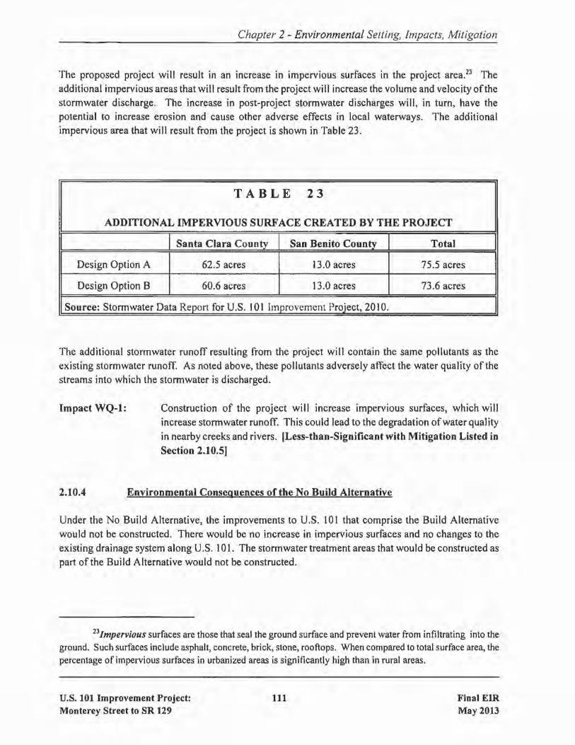
Chapter 2 - Environmental Setting, Impacts, Mitigation
The proposed project will result in an increase in impervious surfaces in the project area.23 Theadditional impervious areas that will result from the project will increase the volume and velocity ofthestormwater discharge. The increase in post-project stormwater discharges will, in turn, have thepotential to increase erosion and cause other adverse effects in local waterways. The additionalimpervious area that will result from the project is shown in Table 23.
TABLE 23
ADDITIONAL IMPERVIOUS SURFACE CREATED BY THE PROJECT
I I Santa Clara County I San Benito County I Total IDesign Option A 62.5 acres 13.0 acres 75.5 acres
Design Option B 60.6 acres 13.0 acres 73.6 acres
Source: Stormwater Data Report for U.S. 101 Improvement Project, 2010.
The additional stormwater runoff resulting from the project will contain the same pollutants as theexisting stormwater runoff. As noted above, these pollutants adversely affect the water quality of the
streams into which the stormwater is discharged.
Impact WQ-l: Construction of the project will increase impervious surfaces, which will
increase stormwater runoff. This could lead to the degradation ofwater quality
in nearby creeks and rivers. [Less-than-Significant with Mitigation Listed in
Section 2.10.5J
2.10.4 Environmental Conseguences of the No Build Alternative
Under the No Build Alternative, the improvements to U.S. 101 that comprise the Build Alternativewould not be constructed. There would be no increase in impervious surfaces and no changes to the
existing drainage system along U.S. 101. The stormwater treatment areas that would be constructed aspart ofthe Build Alternative would not be constructed.
23Impervious surfaces are those that seal the ground surface and prevent water from infiltrating into theground. Such surfaces include asphalt, concrete, brick, stone, rooftops. When compared to total surface area, thepercentage of impervious surfaces in urbanized areas is significantly high than in rural areas.
U.S. 101 Improvement Project:Monterey Street to SR 129
III Final EIRMay 2013
2.10.5
Chapter 2 - Environmental Setting, Impacts, Mitigation
Avoidance, Minimization, and/or Mitigation Measures
To minimize post-construction water quality effects, post-construction best management practices(BMPs) have been considered for incorporation into the project. Those considered include infiltrationdevices, biofiltration strips and swales, wet basins, media filters, detention devices, and multichambertreatment devices (often referred to as "treatment trains"). Biofiltration strips or swales have beenidentified as the most feasible BMPs for this project.24 Therefore, the following measures are includedin the project. Implementation of these measures will reduce water quality impacts due to the projectto a less-than-significant level.
MM-WQ-l.l: The project will create approximately 32.4 acres of biofiltration strips and
swales along U.S. 101 within the project limits. The strips/swales will belocated along the edges ofthe roadways and interchange ramps. Consistent withthe requirements of Caltrans' NPDES permit, this acreage represents themaximum practicable extent of treatment for this project within the constraintsof the site. This acreage is based upon preliminary design and will be updatedduring final design. (Both Design Options)
2.11 GEOLOGY/SOILS/SEISMICITOPOGRAPHY
2.11.1 Regulatory Setting
For geologic and topographic features, the key federal law is the Historic Sites Act of 1935, whichestablishes a national registry of natural landmarks and protects "outstanding examples of majorgeological features." Topographic and geologic features are also protected under CEQA.
This section also discusses geology, soils, and seismic concerns as they relate to public safety and projectdesign. Earthquakes are prime considerations in the design and retrofit of structures. Caltrans' Officeof Earthquake Engineering is responsible for assessing the seismic hazard for its projects. The currentpolicy is to use the anticipated Maximum Credible Earthquake (MCE), from young faults in and nearCalifornia. The MCE is defined as the largest earthquake that can be expected to occur on a fault over
a particular period of time.
24Biojiltration strips andswales are vegetated surfaces that remove pollutants by filtration through grass,sedimentation, adsorption to soil or grass and infiltration through the soil. Strips and swales are mainly effectiveat removing debris and solid particles, although some constituents are removed by adsorption into the soil.
U.S. 101 Improvement Project:Monterey Street to SR 129
112 Final EIRMay 2013

2.11.2 Affected Environment
Chapter 2 - Environmental Setting, Impacts, Mitigation
The information in this section is based primarily on a Geotechnical Assessment Report (December2009) that was prepared for the project. A copy of this report is available for review at the locationslisted inside the front cover of this document.
The project segment of U.S. 101 is relatively flat (with elevations gradually climbing in certain areas)and bound by moderately steep to steep slopes and agricultural fields. Existing slope failures have beenmapped and observed on the cut and natural slopes that are present along the project alignment. Theground surface elevation in the project area ranges from approximately 140 to 190 feet above mean sealevel (msl).
The project alignment is generally underlain by alluvial soils associated with southern Santa ClaraValley, the Pajaro River and San Benito River floodplains, and fill soils associated with roadway andbridge construction. On-site soils have a high expansion potential. Expansive soil can be detrimentalto slope stability, pavements, retaining structures, and other improvements. The on-site soils also have
potential to corrode or weaken concrete structures and uncoated steel.
The project alignment is located within the seismically active San Francisco Bay Area. A complex zone
of interconnecting, northwest-trending faults, known as the Sargent fault zone, crosses through thecentral portion of the project alignment. The Sargent Fault (Northwestern section) is considered anactive fault and crosses beneath the U.S. 10 I /Sargent bridges. The Sargent Fault (Southeastern section),which crosses beneath the Pajaro River, is not considered "active" at this time; however, it is possiblethat it will be zoned as such in the future. Other nearby active faults include the San Andreas Faultlocated approximately 0.5 miles southwest ofthe project alignment, the Zayante-Vergeles Fault located
approximately 4.8 miles south of the project alignment, and the Calaveras Fault zone (SouthernCalaveras section) located approximately 4.5 miles east ofthe project alignment.
The Sargent, San Andreas, Zayante-Vergeles, and Calaveras Faults have Maximum Credible Earthquake(MCE) magnitudes of6.75, 7.9, 7.0, and 7.4, respectively. Significant seismic events with respect toexisting and/or proposed structures would be associated with the Sargent (MCE =6.75) or San Andreas(MCE = 8.0) fault zones due, in part, to their proximity to the project alignment. Generally, hazardsassociated with seismic activity include ground surface rupture, strong ground motion, liquefaction,seismically-induced settlement, and seismically-included slope instability. The project area is subject
to all of these hazards.
2.11.3 Environmental Consequences of the Build Alternative
The proposed project will involve typical highway excavation and grading practices necessary to widenthe highway (which requires the widening or replacement of bridges and culverts within the projectlimits), reconstruction of the U.S. 10 I/SR 25 interchange, extension of Santa Teresa Boulevard, and
u.s. 101 Improvement Project:Monterey Street to SR 129
113 Final EIRMay 2013
Chapter 2 - Environmental Setting, Impacts, Mitigation
construction of auxiliary lanes, bicycle facilities, ramp improvements, and a grade-separated railroadcrossing. There are no geologic features within the project alignment that would pose special or uniquehazards to users of the proposed improvements. The project will implement standard engineeringpractices to ensure that geotechnical and soil hazards do not result from its construction or operation andcomply with Caltrans' Standard Specifications.
The site is within the seismically active San Francisco Bay Area and severe ground shaking is probableduring the anticipated life of the project. Users of the highway, interchanges, roadways, bridges, andbicycle facilities would be exposed to hazards associated with severe ground shaking during a majorearthquake on one ofthe region's active faults. This hazard is not unique to the project because it appliesto all locations throughout the greater Bay Area. The proposed project will not increase the existingexposure to hazards associated with earthquakes; the hazards in the area will be the same with or withoutthe project.
The project will be designed and constructed in accordance with Caltrans' Seismic Design Criteria toavoid or minimize potential damage from seismic shaking on the site. The structures and roadways willbe built to withstand a peak bedrock acceleration ofO.5g. Potential seismic effects will be minimizedby the use of standard engineering techniques mandated by the California Building Code and Caltrans'Design Standards.
Impact GEO-l: Construction of the project will not expose people to significant geologic
hazards or risks. [Less-than-Significant Impact]
2.11.4 Environmental Consequences of the No Build Alternative
Under the No Build Alternative, the improvements to U.S. 101 that comprise the Build Alternativewould not be constructed. The existing environment would remain unchanged.
2.11.5 Avoidance, Minimization, and/or Mitigation Measures
No avoidance, minimization, or mitigation measures are required.
2.12
2.12.1
PALEONTOLOGY
Regulatory Setting
Paleontology is the study of life in past geologic time based on fossil plants and animals. UnderCalifornia law, paleontological resources are protected under CEQA.
U.S. 101 Improvement Project:Monterey Street to SR 129
114 Final EIRMay 2013

2.12.2 Affected Environment
Chapter 2 - Environmental Setting, Impacts, Mitigation
The information in this section is based primarily on a technical Paleontological Evaluation Report(November 2008, with May 2011 Addendum). A copy of this report is available for review at thelocations listed inside the front cover of this document.
Locations were identified within the project limits where there is a high potential for constructionactivities to impact paleontological resources. The following locations include rock types which, basedon previous studies, contain or are likely to contain significant animal and/or plant fossils.
Miocene-Pliocene sedimentary rocksPlio-Pleistocene continental depositsQuaternary alluvium that includes Pleistocene older alluvium and Holocene alluvium25
Miocene-Pliocene sedimentary rocks contain fossils ofmammals, fish, sharks and birds, and are highlysensitive.
Plio-Pleistocene continental deposits contain fossils ofbison, camels, horses and mammoths. Mammothfossils have been recovered from these continental deposits near the project area at two locations justnorth and south of Hollister. These fossils are also highly sensitive.
The Pleistocene older alluvium contains fossils of bison, peccaries (similar to a large pig) and
mammoths. Although the uppermost few feet of Holocene alluvium are not very sensitive, deeper
excavation may encounter scientifically important fossils. These fossils are considered highly sensitive.
Miocene-Pliocene mammal, fish, shark, and bird fossils, the upper Pliocene to lower Pleistocene cameland horse fossils, and the Pleistocene mammoth and peccary fossils are scientifically important forseveral reasons. Fossils found here could provide important data for the interpretation ofthe relationshipbetween species and their evolution. Fossils have also been very important in establishing the ages of,and relationships between, sedimentary rock units in central California, and thus have played an
important role in deciphering the history of faulting in this region.
2.12.3 Environmental Consequences of the Build Alternative
As described in the previous section, there are locations within the project limits that are likely tocontain significant paleontological resources. Under both design options, construction ofthe project will
2SThese terms represent geologic time spans. Miocene is the period from 23 million to 5 million yearsago. Pliocene is the period from 5 million to 2.5 million years ago. Pleistocene is the period from 2.5 million to10 thousand years ago. Holocene is the period from 10 thousand years ago to the present.
U.S. 101 Improvement Project:Monterey Street to SR 129
115 Final EIRMay 2013
Chapter 2 - Environmental Setting, Impacts, Mitigation
involve excavation in these sensitive locations. Ifpaleontological resources are present, the constructionactivities would impact those resources and could destroy scientifically important fossils.
Impact PALEO-I: Construction ofthe proposed project could impact paleontological resources and
could destroy scientifically important fossils. [Less-than-Significant with
Mitigation Listed in Section 2.12.5]
2.12.4 Environmental Consequences of the No Build Alternative
Under the No Build Alternative, the improvements to U.S. 101 that comprise the Build Alternativewould not be constructed and no ground-disturbing activities would occur. Therefore, there would beno impact on paleontological resources that might be present in the project area.
2.12.5 Avoidance. Minimization. and/or Mitigation Measures
The following measures are included in the project. Implementation of these measures will reduce
impacts to paleontological resources to a less-than-significant level.
MM-PALEO-l.1:
MM-PALEO-l.2:
A nonstandard special provision for paleontology mitigation will be included inthe construction contract special provisions section to advise the constructioncontractor of the requirement to cooperate with the paleontological salvage.
A qualified principal paleontologist (M.S. or PhD in paleontology or geology
familiar with paleontological procedures and techniques) will be retained toprepare a detailed Paleontological Mitigation Plan (PMP) prior to the start of
construction. The PMP will include the following elements and stipulations:
Areas where preconstruction survey and salvage are needed will beidentified. This will apply to any areas where paleontologically sensitivestrata are exposed at the surface and will be disturbed by projectconstruction.
• A monitoring plan that will identify all areas where excavation willdisturb in situ surface exposures of strata assigned to geologic unitsidentified as highly sensitive for paleontological resources. Monitoringwill be required for all disturbance ofhighly sensitive units. Monitoringwill not be needed for shallow (less than about three feet deep)disturbance in areas mapped as underlain by units oflow paleontologicalsensitivity, or where disturbance would be entirely confined (in threedimensions) within existing artificial fill. However, monitoring will berequired where disturbance more than three feet deep, including drilling
U.S. 101 Improvement Project:Monterey Street to SR 129
116 Final EIRMay 2013
2.13
2.13.1
Chapter 2 - Environmental Setting, Impacts, Mitigation
for cast-in~place foundation piers or pilings, will be required in areaswhere highly sensitive strata are present in the subsurface beneath aveneer of low-sensitivity material.All geologic work will be performed under the supervision of aCalifornia Professional Geologist.The qualified principal paleontologist will be present at pre-gradingmeetings to consult with grading and excavation contractors.Before excavation begins, a training session in employee environmentalawareness and fossil identification will be conducted by the principalpaleontologist for all personnel involved in earthmoving for the project.A paleontological monitor, approved by the qualified principalpaleontologist, will be on-site to inspect cuts for fossils at all timesduring original grading involving sensitive geologic formations.When fossils are discovered, the paleontologist (or paleontologicalmonitor) will be called to recover them. Construction work in theseareas will be halted or diverted to allow recovery of fossil remains in atimely manner.Bulk sediment samples will be recovered from fossiliferous horizonsand processed for microvertebrate remains as determined necessary bythe principal paleontologist.Fossil remains collected during the monitoring and salvage portion ofthe mitigation program will be cleaned, repaired, sorted, and cataloged.Prepared fossils, along with copies of all pertinent field notes, photos,and maps, will then be deposited in a scientific institution withpaleontological collections. The repository institution should beidentified in advance of construction (typically as part of PMPdevelopment), and the PMP should include info on the repositoryagreement.A final report will be completed that outlines the results of themitigation program and will be signed by the Principal Paleontologistand Professional Geologist. Copies of the final report will be sentappropriate institutions so that the documentation will be available tothe scientific community going forward.
HAZARDOUS WASTE/MATERIALS
Regulatory Setting
Hazardous materials and hazardous wastes are regulated by many state and federal laws. These includenot only specific statutes governing hazardous waste, but also a variety oflaws regulating air and waterquality, human health and land use.
U.S. 101 Improvement Project:Monterey Street to SR 129
117 Final EIRMay 2013

Chapter 2 - Environmental Setting, Impacts, Mitigation
The primary federal laws regulating hazardous wastes/materials are the Resource Conservation andRecovery Act of 1976 (RCRA) and the Comprehensive Environmental Response, Compensation andLiability Act of 1980 (CERCLA). The purpose ofCERCLA, often referred to as Superfund, is to cleanup contaminated sites so that public health and welfare are not compromised. RCRA provides for"cradle to grave" regulation of hazardous wastes. Other federal laws include:
• Community Environmental Response Facilitation Act of 1992Clean Water Act
• Clean Air ActSafe Drinking Water Act
• Occupational Safety and Health Act (OSHA)Atomic Energy ActToxic Substances Control ActFederal Insecticide, Fungicide, and Rodenticide Act
Hazardous waste in California is regulated primarily under the authority of the federal ResourceConservation and Recovery Act of 1976, and the California Health and Safety Code. Other Californialaws that affect hazardous waste are specific to handling, storage, transportation, disposal, treatment,reduction, cleanup and emergency planning.
Worker health and safety and public safety are key issues when dealing with hazardous materials thatmay affect human health and the environment. Proper disposal of hazardous material is vital if it isdisturbed during project construction.
2.13.2 Affected Environment
The information in this section is based primarily on a technical Initial Site Assessment (December2009) that was prepared for the project. A copy of this study is available for review at the locationslisted inside the front cover of this document.
Historically, the project area has been developed with a highway (Le., U.S. 101), local roadways, arailroad, bridges, agriculture including agricultural bui Idings and orchards, a sand quarry, and businesses
including a Chevron Service Station, a concrete product manufacturing facility, a school, and a RV park.The land uses today are much the same with the addition of commercial and residential developments.
Sites with Known Contamination
There are several sites within a 0.25-mile radius ofthe project alignment where some type of hazardousmaterials spill/leakage/contamination has occurred. Based on the status ofthe sites (e.g., remediationcomplete/closed case, plume contained on-site) and the direction ofgroundwater flow at the sites, onlyone of the identified sites has the potential to adversely affect the project.
U.S. 101 Improvement Project:Monterey Street to SR 129
118 Final EIRMay 2013
Chapter 2 - Environmental Setting, Impacts, Mitigation
The one site is the Chevron Service Station at 5887 Monterey Road in Gilroy, which is adjacent to thenorthbound U.S. 101 off-ramp to Monterey Street. At that site, a leaking underground storage tankresulted in contaminated soil and groundwater. There are 13 groundwater monitoring wells at the sitethat monitor the concentrations ofvarious pollutants and the direction ofgroundwater flow. At present,contamination does not appear to have migrated off-site, but monitoring is continuing.
Sites with Potential Contamination
An abandoned truck scale is located along U.S. 101 at the U.S. 10 I/Sargent bridges. There is a potentialthat hydraulic oil was used during the time the scale was in operation. While staining was not observedaround the scale, there is a potential for oil to impact unseen areas of adjacent soil in the immediatevicinity of the scale.
Agricultural uses are present, and have historically been present, along much of the project segment ofU.S. 101. Soil, surface water, and groundwater in these agricultural areas may be impacted with
herbicide and pesticides.
Based on the estimated date ofconstruction (pre-I 990) ofthe Wi II is Construction Company, a concreteproduct manufacturing faci lity situated on the northwest comer ofthe SR I29/Y Road intersection, thereis a potential for asbestos to have been added to concrete products at this facility. Asbestos-containingdust emanating from this facility may have impacted surficial soils near the property.
Railroads use lubricants containing petroleum hydrocarbons for train maintenance and herbicides andpesticides to control weeds and insects along their tracks. Railroad ties are also coated with creosotein many cases. Therefore, the three railroads intersecting the alignment (plus one former railroad) mayhave used chemicals associated with maintaining the track and train, which may have impacted shallowsoils on-site.
During the preparation ofthe Initial Site Assessment, a debris pile was observed near U.S. 101 Post Mile
1.2 (Le., between the Tick Creek and Tar Creek crossings), adjacent to and east of where the UPRRcrosses an access road. The pile contained concrete, metal, and wood debris, as well as approximately40 linear feet of 8-inch piping that likely contains asbestos.
Aerially-Deposited Lead
Until recently, lead was commonly added to gasoline.26 As a result, lead was emitted as a componentof motor vehicle exhaust. Soil sampling along many roadways has found that concentrations of leadexceed applicable thresholds for classification as a hazardous material. This phenomenon known as
26Lead is a heavy metal that is found in many products. Lead is poisonous to humans. It is especially toxic
to the nervous system, although it can adversely affect many systems and organs. In recent years, lead has been
removed from certain products such as paint and gasoline in order to reduce the potential for chronic exposure.
U.S. 101 Improvement Project:Monterey Street to SR 129
119 Final EIRMay20n

Chapter 2 - Environmental Setting, Impacts, Mitigation
"aerially-deposited lead" (ADL) is widespread. Because the project segment of U.S. 101 was built priorto the phaseout of lead as a gasoline additive, elevated concentrations oflead are likely to be present inthe soil along the freeway. In fact prior sampling and testing within portions of the project alignmentfound elevated concentrations of ADL in the soil.
Asbestos-Containing Materials and Lead-Based Paint
Due to the age of the buildings and bridge structures located within the project limits, there is a highpotential for the presence ofasbestos-containing materials27 andlor lead-based paint. Lead-based paintmay also be present in the lane striping and other pavement markings on the highways located withinthe project limits. Naturally occurring asbestos may also be contained in the aggregate used in bridge
construction materials.
2.13.3 Environmental Consequences of the Build Alternative
As discussed above, there is one site (the Chevron Service Station at 5887 Monterey Road) adjacent toU.S. 101 where there is known groundwater contamination. If construction occurs near that site andcontaminated groundwater is encountered, construction workers could be exposed.
Based on the ages ofthe buildings to be demolished by the project, it is likely that asbestos-containing
materials and lead-based paints are present. Asbestos-containing materials and lead-based paints arealso likely to be present in the existing highway bridges. Demolition and construction activities at theselocations could expose construction workers to unsafe levels of these substances.
Aerially-deposited lead is present within the project alignment. Based on testing completed to date,there are a number of locations where the concentrations of lead in the soil are such that the soil meetsthe definition of a hazardous waste.
Construction activities within or immediately adjacent to the UPRR could expose construction workersto various hazardous substances (e.g., petroleum hydrocarbons, pesticides, herbicides, creosote) thatwere commonly used by the railroad.
Construction activities within soils that are used, and were historically used, for agricultural purposescould expose construction workers to various hazardous substances (e.g., pesticides and herbicides) that
were commonly associated with crop production.
27Asbestos is a mineral that is found in many products because afits resistance to damage from chemicalsand heat, as well as its noise absorption properties. However, asbestos is toxic, especially when inhaled. It cancause diseases such as lung cancer, mesothelioma, and asbestosis.
U.S. 101 Improvement Project:Monterey Street to SR 129
120 Final EIRMay 2013
Chapter 2 - Environmental Setting, Impacts, Mitigation
If construction occurs within the site of the former truck scale, and the soil is determined to becontaminated with hydraulic oil, construction workers could be exposed to the hazards associated withthat substance.
Impact HAZ-l: Construction of the proposed project could expose construction workers tohazardous substances in concentrations that exceed regulatory thresholds.
[Less-than-Significant with Mitigation Listed in Section 2.13.5]
2.13.4 Environmental Consequences of the No Build Alternative
Under the No Build Alternative, the improvements to U.S. 101 that comprise the Build Alternative
would not be built and no construction activities would occur. Therefore, by definition, there would beno potential for encountering hazardous waste or materials that might be present in the project area.
2.13.5 Avoidance, Minimization, and/or Mitigation Measures
The following measures are included in the project. Implementation of these measures will reduce
hazardous materials impacts to a less-than-significant level.
MM-HAZ-l.l:
MM-HAZ-1.2:
If construction activities occur within 50 feet of the Chevron Service Station
located at 5887 Monterey Road and groundwater is encountered, thegroundwater will be sampled and analyzed for constituents of concern relatedto the Chevron Service Station contaminants prior to disposal. If groundwateris contaminated, it will be contained and either treated and discharged to thesanitary sewer (ifsample analytical results meet local sanitary sewer acceptancecriteria) or transported to a licensed groundwater treatment facility.
Priorto project development, a soil investigation will be conducted to determinewhether aerially deposited lead (ADL) has affected soils that will be excavated
as part ofthe proposed project. This applies to locations where such testing hasnot already been completed. The investigation for ADL will be performed inaccordance with Caltrans' Lead Testing Guidance Procedure. The analyticalresults will be compared against applicable hazardous waste criteria. Based onanalytical results, the investigation will provide recommendations regardingmanagement and disposal ofaffected soi Is in the project area including the reusepotential of ADL-affected soil during project development. The provisions ofa variance granted to Caltrans by the California Department ofToxic SubstancesControl on September 22,2000 (or any subsequent variance in effect when theproject is constructed) regarding aerially-deposited lead will be followed.
U.S. 101 Improvement Project:Monterey Street to SR 129
121 Final EIRMay20n

Chapter 2 - Environmental Setting, Impacts, Mitigation
MM-HAZ-1.3: If contaminated soil is encountered (based on physical observation) during
trenching activities along the alignment, the soil will be stockpiled and analyzedfor potential contaminants. If the soil can not be reused on-site, the analyses
will be sent to a permitted landfill for profiling and waste characterization priorto transport to the landfill. In addition, if contaminated groundwater is
encountered during construction, similar steps should be taken to characterizeand dispose of the groundwater as was discussed in MM-HAZ-l.2.
MM-HAZ-1.4: Herbicides and pesticides will be analyzed in the shallow soil within the project
limits in site areas located adjacent to or on agricultural land. Shallow soil
samples will be collected and analyzed for metals, total petroleum hydrocarbons,volatile organic compounds, polycyclic aromatic hydrocarbons, herbicides and
pesticides from areas adjacent to railroad tracks or within railroad crossings. If
soil is impacted with any of the compounds discussed above, it will be
stockpiled and sampled for reuse or disposal options.
MM-HAZ-1.5: Testing for the presence of lead-based paint will be undertaken on the existing
bridge structures, in pavement markings, and within the existing buildings to be
demolished. If this substance is found to be present, applicable regulations
pertaining to its removal and disposal will be followed.
MM-HAZ-1.6: Testing for the presence of asbestos-containing materials on the existing bridge
structures, and within the existing buildings to be demolished, will occur. If
asbestos is found to be present, applicable regulations pertaining to its removal
and disposal will be followed.
MM-HAZ-1.7: During construction, soil disturbed in the vicinity of the San Benito River may
contain elevated levels ofnaturally-occurring asbestos CNOA). Ifelevated levels
of NOA are found, then dust suppression measures consistent with the Air
Resources Board AirToxics Control Measure for asbestos wi II be implemented.
2.14 AIR QUALITY
2,14,( Regulatory Setting
The Federal Clean Air Act (FCAA) as amended in 1990 is the federal law that governs air quality. TheCalifornia Clean Air Act of 1988 is its companion state law. These laws, and related regulations by the
United States Environmental Protection Agency (U.S. EPA) and the California Air Resources Board(ARB), set standards for the quantity of pollutants that can be in the air. At the federal level, these
standards are called National Ambient Air Quality Standards (NAAQS). NAAQS and State ambient air
U,S, 101 Improvement Project:Monterey Street to SR 129
122 Final EIRMay 2013

Chapter 2 - Environmental Setting, Impacts, Mitigation
quality standards have been established for six transportation-related criteria pollutants that have beenlinked to potential health concerns. The criteria pollutants are: carbon monoxide (CO), nitrogen dioxide(N02)' ozone (03), particulate matter (PM, broken down for regulatory purposes into particles of 10micrometers or smaller - PM IO and particles of 2.5 micrometers and smaller - PM2s), lead (Pb), andsulfur dioxide (S02)' In addition, State standards exist for visibility reducing particles, sulfates,hydrogen sulfide (H2S), and vinyl chloride. The NAAQS and State standards are set at a level thatprotects public health with a margin of safety, and are subject to periodic review and revision. BothState and Federal regulatory schemes also cover toxic air contaminants (air toxics); some criteriapollutants are also air toxics or may include certain air toxics within their general definition.
Federal and State air quality standards and regulations provide the basic scheme for project-level airquality analysis under the National Environmental Policy Act (NEPA) and the California EnvironmentalQuality Act (CEQA). In addition to this type of environmental analysis, a parallel "Conformity"requirement under the FCAA also applies.
FCAA Section I76(c) prohibits the U.S. Department ofTransportation and other Federal agencies fromfunding, authorizing, or approving plans, programs or projects that are not first found to conform to State
Implementation Plan (SIP) for achieving the goals ofClean Air Act requirements related to the NAAQS."Transportation Conformity" takes place on two levels: the regional, or planning and programming,level, and the project level. The proposed project must conform at both levels to be approved.Conformity requirements apply only in nonattainment and "maintenance" (former nonattainment) areasfor the NAAQS, and only for the specific NAAQS that are or were violated. U.S. EPA regulations at40 CFR 93 govern the conformity process.
Regional conformity is concerned with how well the regional transportation system supports plans forattaining the standards set for carbon monoxide (CO), nitrogen dioxide (N02), ozone (03), particulate
matter (PM IO and PM2.S)' and in some areas sulfur dioxide (S02)' California has attainment ormaintenance areas for all of these transportation-related "criteria pollutants" except S02, and also hasa nonattainment area for lead (Pb). However, lead is not currently required by the FCAA to be covered
in transportation conformity analysis. Regional conformity is based on Regional Transportation Plans(RTPs) and Federal Transportation Improvement Programs (FTIPs) that include all ofthe transportationprojects planned for a region over a period of at least 20 years (for the RTP), and 4 years (for the FTIP).RTP and FTIP conformity is based on use oftravel demand and air quality models to determine whetheror not the implementation of those projects would conform to emission budgets or other tests showingthat requirements ofthe Clean Air Act and the SIP are met. Ifthe conformity analysis is successful, theMetropolitan Planning Organization (MPO), and the Federal Highway Administration (FHWA) andFederal TransitAdministration (FTA), make the determinations that the RTP and FTIP are in conformity
with the SIP for achieving the goals of the Clean Air Act. Otherwise, the projects in the RTP and/orFTIP must be modified until conformity is attained. If the design concept, scope, and "open-to-traffic"schedule ofa proposed transportation project are the same as described in the RTP and the FTIP, thenthe proposed project is deemed to meet regional conformity requirements for purposes of project-levelanalysis.
u.s. 101 Improvement Project:Monterey Street to SR 129
123 Final EIRMay 2013

Chapter 2 - Environmental Setting, Impacts, Mitigation
Conformity at the project-level also requires "hot spot" analysis if an area is "nonattainment" or"maintenance" for carbon monoxide (CO) and/or particulate matter (PM IO or PM2.s). A region is"nonattainment" if one or more of tlie monitoring stations in the region measures violation of therelevant standard, and U.S. EPA officially designates the area nonattainment. Areas that were previouslydesignated as nonattainment areas but subsequently meet the standard may be officially redesignated to
attainment by U.S. EPA, and are then called "maintenance" areas. "Hot spot" analysis is essentially thesame, for technical purposes, as CO or particulate matter analysis performed for NEPA purposes.Conformity does include some specific procedural and documentation standards for projects that requirea "hot spot" analysis. In general, projects must not cause the "hot spot"-related standard to be violated,and must not cause any increase in the number and severity of violations in nonattainment areas. If aknown CO or particulate matter violation is located in the project vicinity, the project must includemeasures to reduce or eliminate the existing violation(s) as well.
2.14.2 Affected Environment
The information in this section is based primarily on an Air Quality Report (October 20 I0) and a MobileSource Air Toxics Emissions Report (October 20 I0) that were prepared for the project. Copies ofthesestudies are available for review at the locations listed inside the front cover of this document.
San Francisco Bay Air Basin
The Santa Clara County portion of the project is in the San Francisco Bay Area Air Basin28, which has
been designated by the U.S. EPA as nonattainment for ground level ozone and PM2S and as anattainment/maintenance area for CO. The Air Basin does not meet State ozone and PM standards setby the California Air Resources Board (CARB). The Bay Area Air Quality Management District(BAAQMD), along with MTC and the Association of Bay Area Governments, are the agenciesresponsible for developing plans to attain and maintain ambient air quality standards in the SanFrancisco Bay Area.
The San Francisco Bay Area is considered to be one of the cleanest metropolitan areas in the countrywith respect to air quality. BAAQMD monitors air quality conditions at over 30 locations throughoutthe Bay Area. The monitoring stations closest to the project site are in Gilroy and San Jose. The Gilroystation monitors only ozone.
Ozone is the air pollutant ofgreatest concern in summer. Prevailing summertime wind conditions tendto cause a build-up ofozone in Santa Clara County. Ozone levels measured in Gilroy exceeded the stateI-hour standard from zero to four times in 2003-2007. Exceedances of the national 8-hour standardoccurred two times in 2003. The new state 8-hour standard was exceeded two times in 2006.
28The San Francisco Bay Area Air Basin encompasses the following nine counties: Alameda, ContraCosta, Marin, Napa, San Francisco, San Mateo, Santa Clara. Solano, and Sonoma.
u.S. 101 Improvement Project:Monterey Street to SR 129
124 Final EIRMay 2013

Chapter 2 - Environmental SeWng, Impacts, Mitigation
The combination of vehicle exhaust and wood smoke under stagnant air quality conditions leads to abuild up ofparticulates in late fall and winter and, therefore, PM is another pollutant ofconcern in SantaClara County.29 The Gilroy station does not measure PM 10 or PM2s' so data from the San Jose station,where PM is measured every sixth day. are reported. Measured exceedances of the state PM 10 standardhave occurred two to four measurement days in recent years in San Jose, therefore PM lO standards areexceeded about 12 to 24 days per year. Although the PM2 s levels did not exceed standards during thisperiod, the new national 24-hour standard would have been exceeded each year in San Jose.
North Central Coast Air Basin
The San Benito County portion of the project is in the North Central Coast Air BasinJO, which has been
designated by EPA as attainment/unclassified for ground level ozone and as an attainment/unclassifiedfor CO. The North Central Coast Air Basin does not meet state ozone and PM standards set by CARB.The Monterey Bay Unified Air Pollution Control District (MBUAPCD) and Association of MontereyBay Area Governments are the agencies responsible for developing plans to attain and maintain ambientair quality standards in the North Central Coast Air Basin.
Similar to the San Francisco Bay Area, the Monterey Bay Area is considered to be one of the cleanestmetropolitan areas in the country with respect to air quality. The MBUAPCD monitors air qualityconditions at nine locations throughout the North Central Coast Area. The monitoring station closestto the project site is in Hollister.
Ozone is the air pollutant ofgreatest concern in summer in San Benito County. Ozone levels measuredin Hollister exceeded the state I-hour standard from zero to four times in 2003-2007. Exceedances ofthe national 8-hour standard occurred once in 2006. The new state 8-hour standard was exceeded fivetimes once in 2006. The current state 8-hour ozone standard was exceeded 77 times between 2003 and2007 at a monitoring station located in Pinnacles National Park. There have been no PM 10 exceedancesmeasured since 2003 at the Hollister station.
29EPA's website (www.epa.gov)defines particulate matter (PM) as acomplex mixture ofextremely smallparticles and liquid droplets, including acids (such as nitrates and sulfates), organic chemicals, metals, and soil ordust particles. The size ofparticles is directly linked to their potential for causing health problems. Small particlesless than I0 micrometers in diameter pose the greatest problems, because they can get deep into your lungs, andsome may even get into your bloodstream. Exposure to such particles can affect both your lungs and your heart.Small particles of concern include "inhalable coarse particles" (such as those found near roadways and dustyindustries), which are larger than 2.5 micrometers and smaller than I0 micrometers in diameter; and "fine particles"(such as those found in smoke and haze), which are 2.5 micrometers in diameter and smaller.
30The North Central Coast Air Basin encompasses Monterey, San Benito, and Santa Cruz Counties.The North Central Coast Air Basin is sometimes referred to as the Monterey Bay Air Basin.
U.S. 101 Improvement Project:Monterey Street to SR 129
125 Final EIRMay20n

Chapter 2 - Environmental Setting. Impacts, Mitigation
Mobile Source Air Toxics
Mobile source air toxics (MSATs) are compounds emitted from highway vehicles and non-roadequipment that are known or suspected to cause cancer or other serious health and environmental effects.Some toxic compounds are present in fuel and are emitted to the air when the fuel evaporates or passesthrough the engine unburned. 'Other toxics are emitted from the incomplete combustion of fuels or asby-products. Metal air toxics result from engine wear or from impurities in oil or gasoline.
The EPA and CARB have identi tied six priority MSATs. These are I) benzene, 2) formaldehyde, 3)acetaldehyde, 4) diesel particulate matter/diesel exhaust organic gases, 5) acrolein, and 6) 1,3-butadiene.CARB has found that diesel PM contributes over 70% of the known risk from air toxics and poses thegreatest cancer risks among all identified air toxics. Diesel trucks contribute more than halfofthe totaldiesel combustion sources. However, the CARB has adopted a Diesel Risk Reduction Plan with controlmeasures that would reduce the overall diesel PM emissions by about 85% from 2000 to 2020.
2.14.3 Environmental Consequences of the Build Alternative
The short-term (i.e., construction phase) air quality effects of the proposed project are described inSection 2.22.4. The project's long-term (i.e., operational phase) effects are described below.
Clean Air Act Conformity
The Santa Clara County portion ofthe project is located in the San Francisco Bay Area Air Basin, which
does not meet federal ambient air quality standards for 0 3 and PM2 s. Due to the nonattainmentdesignation for 0 3 and PM25, and because the project is a regionally significant project, the Santa ClaraCounty portion of the project is subject to federal regional conformity rules.
The San Benito County portion of the project is located in the North Central Coast Air Basin, which isclassified by EPA as attainment under the 8-hour NAAQS for ground level ozone. The area is alsoclassified by the EPA as unclassified/attainment under the NAAQS for CO. Therefore, the San BenitoCounty portion of the project is not subject to federal conformity rules.
The northerly portion of the proposed project, including the reconstruction of the U.S. IOI/SR 25interchange, is included in MTC's 2035 RTP as Project Number 21714, which was approved on April22, 2009. That same portion of the project is also included in the 2009 Transportation ImprovementProgram (TIP) as Project Number SCL070003. The 2009 TIP was found to conform by FHWA and theFederal Transit Administration (FTA) in November 2008.
The segment of the project between SR 25 and the Santa Clara County/San Benito County line is notcurrently included in MTC's RTP or TIP. A regional conformity analysis that includes this portion ofthe project will be undertaken before the project is approved.
U.S. 101 Improvement Project:Monterey Street to SR 129
126 Final EIRMay 2013

Chapter 2 - Environmental Setting, Impacts, Mitigation
According to MTC, the project is not subject to project-level conformity for PM2 5 because no federal
approvals and/or federal funds are involved.
Traffic-Related Carbon Monoxide (CO) Impacts
Project impacts from local traffic were evaluated by the quantitative method, which is modeling roadside
CO concentrations associated with the project and comparing them to federal and state CO Standards.
A total of five locations along the U.S. 101 alignment in the project area, where there would be a
combination ofthe 1) highest traffic volumes, 2) greatest project traffic contribution, and 3) highest level
of congestion, were modeled. This is because high volume freeways and congested intersections with
a large volume of traffic have the greatest potential to cause high-localized concentrations of CO.
Predicted CO concentrations, which include background levels, are shown in Table 24. This assessmentwas conducted for future No-Build and Build conditions in 2015 and 2035. The results indicate that
future CO levels with or without the project would remain well below both federal and state standards.
TABLE 24
PROJECTED WORST-CASE CARBON MONOXIDE CONCENTRATIONSrExll ressed in parts-per-million1
Year 2015 Year 2035
Location No Build Build No Build Build
along U.S. 101 I-hr. 8-hr. I-hr. 8-hr. I-hr. 8-hr. I-hr. 8-hr.
North of Monterey Street 4.6 3.3 4.6 3.3 4.5 3.2 4.5 3.2
North of SR 25 4.6 3.3 4.7 3.4 4.4 3.1 4.5 3.2
North of San Benito County Line 4.5 3.2 4.6 3.3 4.4 3.1 4.5 3.2
North ofY Road 4.7 3.4 4.8 3.5 4.6 3.3 4.7 3.4
North of SR 129 4.7 3.4 4.7 3.4 4.6 3.3 4.6 3.3
The I-hour state standard is 20 parts-per-million. The I-hour federal standard is 35 parts-per-million. Both thestate and federal 8-hour standards are 9 parts-per-million
Source: Air Quality Study for the U.S. 101 Improvement Project, 20 IO.
Comparing the No-Build and Build alternatives at the five modeled locations, CO concentrations wouldbe the same or the difference would be negligible (i.e., one-tenth of one part-per-million).
Impact AQ-I: Implementation of the proposed project would not cause or contribute to
violations of CO standards. [No Impact]
U.S. 101 Improvement Project:Monterey Street to SR 129
127 Final EIRMay 2013

Chapter 2 - Environmental Setting, Impacts, Mitigation
Mobile Source Air Toxics Impacts
While there are existing uncertainties that do not allow quantitative estimates of health effects fromMSAT emissions in the project area, MSAT emissions can be examined in the project area and therelative impacts of these emissions can be estimated under different scenarios. The University ofCalifornia, Davis, under contract to Caltrans developed a project-level MSAT analysis spreadsheet tool.This tool was developed with cooperation of Caltrans, CARB and FHWA. This analysis predictsemissions of the six priority MSATs using project-specific traffic information and vehicle emissionsfactors.
Table 25 represents the total MSAT emissions from traffic on the project segment of U.S. 101 undervarious scenarios, both with and without the project. The data in Table 25 provide information as to 1)how MSAT emissions will decrease between existing conditions and the year 2035, and 2) the effect ofthe project on MSAT emissions. The data show that, with or without the project, emissions for all sixMSATs are projected to decrease considerably over existing conditions as a result more stringentemissions standards mandated by EPA and CARE. Diesel PM is projected to experience a decrease of82% from 2005 to 2035, while the other MSATs are projected to decrease by between 50% and 83%.
TABLE 25
COMPARISON OF MOBILE SOURCE AIR TOXICS EMISSIONS[Expressed in Pounds per Dayl
Diesel PM Benzene 1,3-Butadiene Acetaldehyde Acrolein Formaldehyde
Base Year 75.3 10.9 2.1 10.5 0.4 23.8(2005)
2015 - No 40.0 4.9 0.9 4.8 0.2 11.0Project (-47%) (-55%) (-57%) (-54%) (-50%) (-54%)
2015 - With 45.6 5.7 1.1 5.5 0.2 12.5
Project (-39%) (-48% (-48%) (-48%) (-50%) (-47%)
2035 - No 13.7 3.2 0.6 1.8 0.1 4.5Project (-82%) (-71%) (-69%) (-83%) (-75%) (-81%)
2035 - With 13.9 3.5 0.7 2.0 0.2 5.0Project (-82%) (-68%) (-67%) (-81 %) (-50%) (-79%)
Numbers in ( ) represent the percentage change from the 2005 base year.
Source: U.S. 101 Improvement Project Mobile Source Air Toxics Report, 2010.
U.S. 101 Improvement Project:Monterey Street to SR 129
128 Final EIRMay 2013

Chapter 2 - Environmental Setting, Impacts, Mitigation
When the "with project" scenario is compared to the "no project" scenario, the data in Table 25 indicate
that MSAT emissions would be slightly higher within the project limits if the project is implemented.The reason for this increase is that the increase in capacity provided by the proposed roadwayimprovements will accommodate more ofthe traffic demand within the project limits, which correlatesto higher emissions. However, the project would not increase regional MSAT emissions because overalltraffic demand would not be affected by the project. In other words, the project will accommodate moretraffic within the project limits, but overall traffic demand will remain constant.
Impact AQ-2: Implementation ofthe proposed project would not substantially increase MSATemissions within the project limits. Regional MSAT emissions would not
change due to the project. [Less-than-Significant Impact]
2.14.4 Environmental Consequences of the No Build Alternative
Under the No Build Alternative, the improvements to U,S. 101 that comprise the Build Alternative
would not be constructed. As shown in Table 24, future CO levels under the No Build Alternative wouldremain well below both federal and state standards. With regard to MSAT emissions, the data in Table25 show that under the No Build Alternative, emissions for all six MSATs are projected to decreaseconsiderably over existing conditions as a result more stringent emissions standards mandated by EPAand CARB. Diesel PM is projected to experience a decrease of82% from 2005 to 2035, while the otherMSATs are projected to decrease by between 50% and 83%.
2.14.5 Avoidance, Minimization, and/or Mitigation Measures
No avoidance, minimization, or mitigation measures are required.
2.15 CLIMATE CHANGE
Climate change refers to long-term changes in temperature, precipitation, wind patterns, and otherelements of the earth's climate system. An ever-increasing body of scientific research attributes theseclimatological changes to greenhouse gases (OHGs), particularly those generated from the productionand use of fossil fuels.
While climate change has been a concern since at least 1988, as evidenced by the establishment of theUnited Nations and World Meteorological Organization's Intergovernmental Panel on Climate Change,the efforts devoted to greenhouse gas (OHO) emissions reduction and climate change research andpolicy have increased dramatically in recent years. These efforts are primarily concerned with theemissions ofGHG related to human activity that include carbon dioxide (C02), methane, nitrous oxide,
U.S. 101 Improvement Project:Monterey Street to SR 129
129 Final EIRMay 2013
Chapter 2 - Environmental Setting. Impacts, Mitigation
tetrafluoromethane, hexafluoroethane, sulfur hexafluoride, HFC-23 (fluoroform), HFC~134a (s, s, s, 2-tetrafluoroethane), and HFC-152a (difluoroethane).
There are typically two terms used when discussing the impacts of climate change. "Greenhouse Gas(GHG) Mitigation" is a term for reducing GHG emissions in order to reduce or "mitigate" the impactsof climate change. "Adaptation," refers to the effort of planning for and adapting to impacts due toclimate change (such as adjusting transportation design standards to withstand more intense storms andhigher sea levels).3l
Transportation sources (passenger cars, light duty trucks, other trucks, buses and motorcycles) in thestate of California make up the largest source (second to electricity generation) of greenhouse gasemitting sources. Conversely, the main source of GHG emissions in the United States is electricity
generation followed by transportation. The dominant GHG emitted is CO2, mostly from fossil fuelcombustion.
There are four primary strategies for reducing GHG emissions from transportation sources: I) improvesystem and operation efficiencies, 2) reduce growth of vehicle miles traveled (VMT), 3) transition tolower GHG fuels, and 4) improve vehicle technologies. To be most effective all four should be pursuedcollectively. The following regulatory setting section outlines state and federal efforts tocomprehe~ively reduce GHG emissions from transportation sources.
2.15.1
2.15.1.1
Regulatory Setting
State
With the passage of several pieces of legislation including State Senate and Assembly Bills andExecutive Orders, California launched an innovative and pro-active approach to dealing with greenhousegas emissions and climate change at the state level.
Assembly Bill 1493 CAB 1493), Pavley - Vehicular Emissions: Greenhouse Gases CAB 1493),2002:
requires the California Air Resources Board (ARB) to develop and implement regulations to reduceautomobile and light truck greenhouse gas emissions. These stricter emissions standards were designedto apply to automobiles and light trucks beginning with the 2009-model year. In June 2009, the UnitedStates Environmental Protection Agency (U.S. EPA) Administrator granted a Clean Air Act waiver ofpreemption to California. This waiver allowed California to implement its own GHG emission standardsfor motor vehicles beginning with model year 2009. California agencies will be working with Federalagencies to conduct joint rulemaking to reduce GHG emissions for passenger cars model years2017-2025.
31 http://c1imatechange.transportation.org/ghg_mitigation
U.S. 101 Improvement Project:Monterey Street to SR 129
130 Final EIRMay 2013

Chapter 2 - Environmental Setting, Impacts, Mitigation
Executive Order S-3-05: (signed on June 1,2005, by Governor Arnold Schwarzenegger) the goal ofthisExecutive Order is to reduce California's GHG emissions to: 1) 2000 levels by 2010, 2) 1990 levels bythe 2020 and 3) 80 percent below the 1990 levels by the year 2050. In 2006, this goal was furtherreinforced with the passage of Assembly Bill 32.
AB32 (AB 32), the Global Warming Solutions Act of 2006: AB 32 sets the same overall GHGemissions reduction goals as outlined in Executive Order S-3-05, while further mandating that ARBcreate a plan, which includes market mechanisms, and implement rules to achieve "real, quantifiable,cost-effective reductions of greenhouse gases." Executive Order S-20-06 further directs state agenciesto begin implementing AB 32, including the recommendations made by the State's Climate ActionTeam.
Executive Order 5-01-07: Governor Schwarzenegger set forth the low carbon fuel standard forCalifornia. Under this Executive Order, the carbon intensity ofCalifornia's transportation fuels is to bereduced by at least ten percent by 2020.
Senate Bill 97 (Chapter 185,2007): required the Governor's Office ofPlanning and Research (OPR) to
develop recommended amendments to the State CEQA Guidelines for addressing greenhouse gasemissions. The Amendments became effective on March 18, 2010.
2.15.1.2 Federal
Although climate change and GHG reduction is a concern at the federal level; currently there are noregulations or legislation that have been enacted specifically addressing GHG emissions reductions andclimate change at the project level. Climate change and its associated effects are being addressedthrough various efforts at the federal level to improve fuel economy and energy efficiency, such as the
"National Clean Car Program" and Executive Order 13514- Federal Leadership in Environmental,Energy and Economic Performance.
Executive Order 13514 is focused on reducing greenhouse gases internally in federal agency missions,programs and operations, but also direct federal agencies to participate in the interagency ClimateChange Adaptation Task Force, which is engaged in developing a U.S. strategy for adaptation to climatechange.
On April 2, 2007, in Massachusetts v. EPA, 549 U.S. 497 (2007), the Supreme Court found that
greenhouse gases are air pollutants covered by the Clean Air Act and that the U.S. EPA has the authorityto regulate GHG. The Court held that the U.S. EPA Administrator must determine whether or notemissions ofgreenhouse gases from new motor vehicles cause or contribute to air pollution which mayreasonably be anticipated to endanger public health or welfare, or whether the science is too uncertainto make a reasoned decision.
U.S. 101 Improvement Project:Monterey Street to SR 129
131 Final EIRMay 2013

Chapter 2 - Environmental Setting, Impacts. Mitigation
On December 7, 2009, the U.S. EPA Administrator signed two distinct findings regarding greenhousegases under section 202(a) of the Clean Air Act:
• Endangerment Finding: The Administrator found that the current and projected concentrationsof the six key well-mixed greenhouse gases - carbon dioxide (C02), methane (CH4), nitrousoxide (N20), hydrofluorocarbons (HFCs), perfluorocarbons (PFCs), and sulfur hexafluoride(SF6) - in the atmosphere threaten the public health and welfare of current and futuregenerations.
Cause or Contribute Finding: The Administrator found that the combined emissions of thesewell-mixed greenhouse gases from new motor vehicles and new motor vehicle enginescontribute to the greenhouse gas pollution which threatens public health and welfare.
Although these findings did not themselves impose any requirements on industry or other entities, thisaction was a prerequisite to finalizing the U.S. EPA's Proposed Greenhouse Gas Emission Standardsfor Light-Duty Vehicles, which was published on September 15, 2009.32 On May 7, 2010 the finalLight-Duty Vehicle Greenhouse Gas Emissions Standards and Corporate Average Fuel EconomyStandards was published in the Federal Register.
U.S. EPA and the National Highway Traffic Safety Administration (NHTSA) are taking coordinatedsteps to enable the production ofa new generation of clean vehicles with reduced GHG emissions andimproved fuel efficiency from on-road vehicles and engines. These next steps include developing thefirst-ever GHG regulations for heavy-duty engines and vehicles, as well as additional light-duty vehicleGHG regulations. These steps were outlined by President Obama in a memorandum on May 21,20 I0.33
The final combined U.S. EPA and NHTSA standards that make up the first phase of this nationalprogram apply to passenger cars, light-duty trucks, and medium-duty passenger vehicles, covering modelyears 2012 through 2016. The standards require these vehicles to meet an estimated combined averageemissions level of 250 grams of carbon dioxide per mile, equivalent to 35.5 miles per gallon if theautomobile industry were to meet this carbon dioxide level solely through fuel economy improvements.Together, these standards will cut GHG emissions by an estimated 960 million metric tons and 1.8billion barrels of oil over the lifetime of the vehicles sold under the program (model years 2012-2016).
On January 24,2011, the U.S. EPA along with the U.S. Department ofTransportation and the State ofCalifornia announced a single timeframe for proposing fuel economy and greenhouse gas standards formodel years 2017-2025 cars and light-trucks. Proposing the new standards in the same timeframe(September 1, 20 11) signals continued collaboration that could lead to an extension of the currentNational Clean Car Program.
32 http://www.epa.gov/climatechange/endangerment.htmI
33 http://epa.gov/otaq/c1imate/regulations.htm
U.S. 101 Improvement Project:Monterey Street to SR 129
132 Final EIRMay 2013
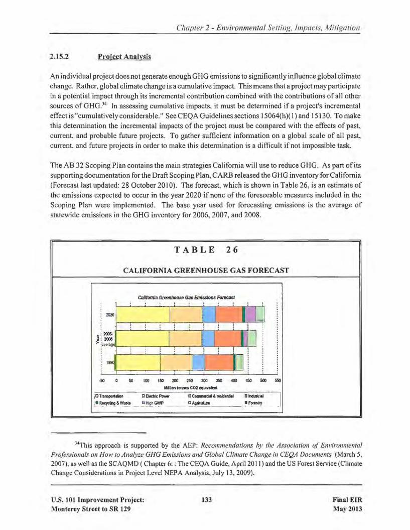
2.15.2 Project Analysis
Chapter 2 - Environmental Setting, Impacts, Mitigation
An individual project does not generate enough GHG emissions to significantly influence global climatechange. Rather, global climate change is a cumulative impact. This means that a project may participatein a potential impact through its incremental contribution combined with the contributions of all othersources of GHG.~4 In assessing cumulative impacts, it must be determined if a project's incrementaleffect is "cumulatively considerable." See CEQA Guidelines sections 15064(h)( 1) and 15130. To makethis detennination the incremental impacts of the project must be compared with the effects of past,current, and probable future projects. To gather sufficient information on a global scale of all past,current, and future projects in order to make this determination is a difficult if not impossible task.
The AB 32 Scoping Plan contains the main strategies California will use to reduce GHG. As part of itssupporting documentation for the Draft Scoping Plan, CARB released the GHG inventory for California(Forecast last updated: 28 October 20 10). The forecast, which is shown in Table 26, is an estimate ofthe emissions expected to occur in the year 2020 if none of the foreseeable measures included in theScoping Plan were implemented. The base year used for forecasting emissions is the average ofstatewide emissions in the GHG inventory for 2006,2007, and 2008.
TABLE 26
CALIFORNIA GREENHOUSE GAS FORECAST
CalifornIa GTeetlhou5fI Gas Emissions FoI1lUS1
2020
~ 200&-: 2008>- ,avera9r_~__~_'-r-_~__---'-~_,-,"--,!"----'
199
·50 0 50 100 150 200 250 300 350 400Miltion1_C02 equlvalmt
450 SOO S50
iD Tramportllion CElectric Powtf a COIl'I1\lIIWlI & residllllill 0I~
:.R~&W~~ __ ~~~ __ ~~ricu1lllnl ~ F~nllY J
~4This approach is supported by the AEP: Recommendations by tIll! Association (~r Environmental
Professionals on How to Analyze GHG Emissions and Global Climate Change in CEQA Documents (March 5,2007), as well as the SCAQMD ( Chapter 6: : The CEQA Guide, April 20 11) and the US Forest Service (ClimateChange Considerations in Project Level NEPA Analysis, July 13, 2009).
U.S. 101 Improvement Project:Monterey Street to SR 129
133 Final EIRMay 2013

Chapter 2 - Environmental Setting, Impacts, Mitigation
Caltrans and its parent agency, the Business, Transportation, and Housing Agency, have taken an activerole in addressing GHG emission reduction and climate change. Recognizing that 98 percent ofCalifornia's GHG emissions are from the burning of fossil fuels and 40 percent ofall human made GHGemissions are from transportation, Caltrans has created and is implementing the Climate Action Programat Caltrans that was published in December 2006 (see Climate Action Program at Caltrans (December2006). ~5
One of the main strategies in Caltrans' Climate Action Program to reduce GHG emissions is to makeCalifornia's transportation system more efficient. The highest levels of carbon dioxide from mobilesources, such as automobiles, occur at stop-and-go speeds (0-25 miles per hour) and speeds over 55 mph;the most severe emissions occur from 0-25 miles per hour (see Figure 17). To the extent that a projectrelieves congestion by enhancing operations and improving travel times in high congestion travelcorridors GHG emissions, particularly CO2, may be reduced.
, 000 ...--.......--r-..----r---r____,r--.,._-r-.......~T"""""""_r__._____,-.,.___r____._-r_o\1\
900 .J-...t,-l-\-l\ ....'",...+-j~+-+--+-t---1--+-jHIr.:::='n.Re;;;atl-;;:;w:;;;or~ldl:a;;ct:;:i,iV;;;;ity~r800 t--r-\t-~":-i t-t---t----jr-t--t-t-i..;:·=--:,s~te::a~d~y-:;st;:at~e;a~et:::lv~ity~'~,\ I'\.. COl ge t10= 700 +--+'.rll\r--t--''Id..t-i.m:;:;:lIrtf;;g:='.~I'A'OI;t--+-t-+--+---f--t--+--+--+-+-----i
~ 600 +--+-':-i\~-+-...,I~""-t--+--+-t-+--+---iI-~:±:,":gPle=d=-t:-:=+~t--Tl- \ \ ~ mcna~em nt V I/'e- 500 +---+-~-+C--+--t---iI--1--+---+-+---+---+---1I--1--t-7"T----:;1"'---1
400 -I--+--+-'..-...+-I"'-..~""<::"'-1I--l-+--+--+--+---+-----';I---l-+--:lV~F-V-+---i. _ 1 1"1-- L--"P""'
300 +--1--+~:":""'~W::::::j~:F==I==I===!:~=P=:+=+--+--+-H200 +--+---if--¥tr!..!!.lfff!:i'~ii-c"i---+__+-+-+--+---if--+--+--+-+-+--+---i
stnoc thi 9, 00 +--+--+-+-+---f---if--+--+__+-+-+--1----iI-+--+-+-t---1
O+--+--+~+--+---f---,I-+--+__+-+-+-...-+.........,I--1--+-_+-t___f
o 5 10 15 20 25 30 as 40 4S SO SS 60 6S 70 7S 80 85 90Average Speed {mph)
FIGURE 17: POSSIBLE EFFECT OF TRAFFIC OPERATION STRATEGIESIN REDUCING ON-ROAD CO, EMISSIONS~6
The project alignment between Monterey Street and SR 129 will help relieve congestion in the peaktraffic periods. With the construction of the project, vehicle-miles-traveled (VMT) in project area willbe higher due to an eight percent increase in average daily traffic volumes. During the peak hours, thespeeds in some areas would decrease slightly, 2-3 mph, and in other areas the speeds would increase byas much as 20 to 25 mph to a maximum speed of 70 mph. The speed during the offpeak hours wouldgenerally remain the same. These changes will have an overall negative effect on the GHG emissions
~5Caltrans Climate Action Program is located at the following web address:http://www.dot.ca.gov/hq/tpp/officeslogmlkeyJeports_files/State_Wide_Strategy/Caltrans_Climate_Action_Program.pdf
"Drraffic Congestion and Greenhouse Gases: Matthew Barth and Kanok Boriboonsomsin (TR News 268May-June 20 I0) <http://onlinepubs.trb.org/onlinepubs/tmews/trnews268.pdf>
U.S. 101 Improvement Project:Monterey Street to SR 129
134 Final EIRMay 2013

Chapter 2 - Environmental Setting. Impacts, Mitigation
generated in the project area, as compared with the No-Build scenario. Table 27 shows the GHG, asexpressed in tons per day of CO2,
TABLE 27
COMPARISON OF CARBON DIOXIDE (COl) EMISSIONS[Expressed in Tons per Day]
Year 2009 Year 2015 Year 2035
Existing 217
No Build 271 350
Build 315 402
Source: U.S. 101 Improvements Project Air Quality Report, 2010.
The CO2 emissions numbers shown in Table 27 are only useful for a comparison between alternatives.The numbers are not necessarily an accurate reflection of what the true CO2 emissions will be becauseCO2 emissions are dependent on other factors that are not part ofthe model such as the fuel mix37, rateofacceleration, and the aerodynamics and efficiency ofthe vehicles. Further, this project level analysisshows only the CO2 levels associated with the travel on the project segment ofU.S. 101; the traffic datadid not include detailed information on alternate routes where the travel may be reduced. The analysisalso does not take into account the reductions that would occur with the passage of AB 1493(approximately 2 percent reduction).
Future no-build scenarios as well as future build scenarios are expected to cause an increase in CO2
emissions when compared to existing conditions. In the year 2035, when comparing No Build to BuildAlternatives, the daily CO2 emissions are expected to increase by approximately 15%, from 350 tons perday to 402 tons per day (see Table 27).
The purpose ofthe proposed project is to accommodate future planned growth and to reduce congestion,delay and peak period travel times and is part of a regional plan to reduce congestion and provideimprovements to local bike trails to enhance multi-modal travel.
MTC, in the preparation ofit's regional Transportation 2035 Plan for the San Francisco Bay Area EIR,discussed the potential impacts of the overall Plan, which includes the proposed project. According toMTC's EIR, the current daily emission ofCO2 from the existing regional transportation system is close
37EMFAC model emission rates are only for direct engine-out C02 emissions, not the full fuel cycle; fuelcycle emission rates can vary dramatically depending on the amount ofadditives like ethanol and the source ofthefuel components.
U.S. 101 Improvement Project:Monterey Street to SR 129
135 Final EIRMay 2013

Chapter 2 - Environmental Setting, Impacts, Mitigation
to 90,000 tons per day. With the enactment of AB 1493 and the buildout of the Transportation 2035Plan, the future CO2 emissions are expected to drop to 75,600 tons per year. The project-level analysisthat yielded the results contained in Table 27, shows only the CO2 levels associated with travel on U.S.101; the traffic data did not include detailed information on alternate routes where the travel may bereduced. The analysis also does not take into account the reductions that would occur with the passageof AB 1493 (approximately 2% reduction). With the construction of the proposed project, the totalcontribution of CO2 is less than 0.05% of the projected CO2 emissions in the San Francisco Bay Areain the year 2035.
Limitations and Uncertainties with Modeling
Emissions Factors (EMFAC) Model
Although EMFAC can calculate CO2 emissions from mobile sources, the model does have limitationswhen it comes to accurately reflecting CO2 emissions. According to the National Cooperative HighwayResearch Program report, Development of a Comprehensive Modal Emission Model (April 2008),studies have revealed that briefbut rapid accelerations can contribute significantly to a vehicle's carbonmonoxide and hydrocarbon emissions during a typical urban trip. Current emission-factor models areinsensitive to the distribution of such modal events (i.e., cruise, acceleration, deceleration, and idle) inthe operation ofa vehicle and instead estimate emissions by average trip speed. This limitation createsan uncertainty in the model's results when compared to the estimated emissions of the variousalternatives with baseline in an attempt to determine impacts. Although work by EPA and the CARBis underway on modal-emission models, neither agency has yet approved a modal emissions model thatcan be used to conduct this more accurate modeling. In addition, EMFAC does not include speedcorrections for most vehicle classes for CO2; for most vehicle classes emission factors are held constant,which means that EMFAC is not sensitive to the decreased emissions associated with improved trafficflows for most vehicle classes. Therefore, unless a project involves a large number of heavy-dutyvehicles, the difference in modeled CO2 emissions due to speed change will be slight.
CARB is currently not using EMFAC to create its inventory of greenhouse gas emissions. It is unclear
why the CARB has made this decision. Their website only states:
REVISION: Both the EMFACand OFFROAD Models develop CO2 andCH4 [methane]emission estimates; however, they are not currently used as the basis for [CARB's]official [greenhouse gas] inventory which is based on fuel usage information...However, ARB is working towards reconciling the emission estimates from the fuelusage approach and the models.
Other Variables
With the current science, project-level analysis of greenhouse gas emissions is limited. Although agreenhouse gas analysis is included for this project, there are numerous key greenhouse gas variables
U.S. 101 Improvement Project:Monterey Street to SR 129
136 Final EIRMay 2013

Chapter 2 - Environmental Setting, Impacts, Mitigation
that are likely to change dramatically during the design life of the proposed project and would thusdramatically change the projected CO2 emissions.
First, vehicle fuel economy is increasing. The EPA's annual report, "Light-Duty Automotive Technologyand Fuel Economy Trends: 1975 through 2008 (http://www.epa.gov/oms/fetrends.htm)... which providesdata on the fuel economy and technology characteristics of new light-duty vehicles including cars,minivans, sport utility vehicles, and pickup trucks, confirms that average fuel economy has improvedeach year beginning in 2005, and is now the highest since 1993. Most ofthe increase since 2004 is dueto higher fuel economy for light trucks, following a long-term trend of slightly declining overall fueleconomy that peaked in 1987. These vehicles also have a slightly lower market share, peaking at 52percent in 2004 with projections at 48 percent in 2008. Table 28 shows the alternatives for vehicle fueleconomy increases studied by the National Highway Traffic Safety Administration in its Final EIS forNew Corporate Average Fuel Economy (CAFE) Standards (October 2008).
TABLE 28
MODEL YEAR 2015 REQUIRED MILES PER GALLON BY ALTERNATIVE
25% 25% 50% Total CostsNo Below Optimized Above Above Equal Total Technology
Action Optimized (Preferred) Optimized Optimized Benefits Exhaustion
Cars 27.5 33.9 35.7 37.5 39.5 43.3 52.6
Trucks 23.5 27.5 28.6 29.8 30.9 33.1 34.7
Second, near zero carbon vehicles will come into the market during the design life of this project.According to a March 2008 report released by University of California Davis (UC Davis), Institute ofTransportation Studies:
"Large advancements have occurred in fuel cell vehicle and hydrogen infrastructuretechnology over the past 15 years. Fuel cell technology has progressed substantiallyresulting in power density, efficiency, range, cost, and durability all improving eachyear. In another sign of progress, automotive developers are now demonstrating over100 fuel cell vehicles (FCVs) in California - several in the hands of the general public- with configurations designed to be attractive to buyers. Cold-weather operation andvehicle range challenges are close to being solved, although vehicle cost and durabilityimprovements are required before a commercial vehicle can be successful withoutincentives. The pace of development is on track to approach pre-commercializationwithin the next decade.
U.S. 101 Improvement Project:Monterey Street to SR 129
137 Final EIRMay 2013
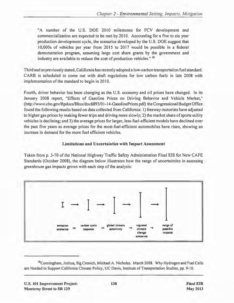
Chapter 2 - Environmental Setting, Impacts, Mitigation
"A number of the U.S. DOE 20[0 milestones for FCY development andcommercialization are expected to be met by 20 IO. Accounting for a five to six yearproduction development cycle, the scenarios developed by the U.S. DOE suggest that10,000s of vehicles per year from 2015 to 2017 would be possible in a federaldemonstration program, assuming large cost share grants by the government andindustry are availab[e to reduce the cost of production vehicles." 38
Third and as previously stated, California has recently adopted a low-carbon transportation fuel standard.CARB is scheduled to come out with draft regulations for low carbon fuels in late 2008 withimplementation of the standard to begin in 20 IO.
Fourth, driver behavior has been changing as the U.S. economy and oil prices have changed. In itsJanuary 2008 report, "Effects of Gasoline Prices on Driving Behavior and Vehicle Market,"(hnp://www.cbo.gov/ftpdocs/88xxJdoc8893/01-14-GasolinePrices.pdt) the Congressional Budget Officefound the following results based on data collected from California: I) freeway motorists have adjustedto higher gas prices by making fewer trips and driving more slowly; 2) the market share ofsports utilityvehicles is declining; and 3) the average prices for larger, less-fuel-efficient models have declined overthe past five years as average prices for the most-fuel-efficient automobiles have risen, showing an
increase in demand for the more fuel efficient vehicles.
Limitations and Uncertainties with Impact Assessment
Taken from p. 3-70 of the National Highway Traffic Safety Administration Fina[ EIS for New CAFEStandards (October 2008), the diagram below illustrates how the range of uncertainties in assessinggreenhouse gas impacts grows with each step of the analysis:
I ......... I ......... I .........
emiuion Qlrbon eycle global ehmale reglClnll range orlCenanos ~ response :) seftSltivtty :::> chmale ~ possible
chanae Impactsscenanos
38Cunningham, Joshua, Sig Cronich, Michael A. Nicholas. March 2008. Why Hydrogen and Fuel Cellsare Needed to Support California Climate Policy, UC Davis, Institute of Transportation Studies, pp. 9~10.
U.S. 101 Improvement Project:Monterey Street to SR 129
138 Final EIRMay 2013
Chapter 2 - Environmental Setting, Impacts, Mitigation
"Cascade of uncertainties typical in impact assessments showing the "uncertaintyexplosion" as these ranges are multiplied to encompass a comprehensive range of futureconsequences, including physical, economic, social, and political impacts and policyresponses. It
Much of the uncertainty in assessing an individual project's impact on climate change surrounds theglobal nature of the climate change. Even assuming that the target of meeting the 1990 levels ofemissions is met, there is no regulatory or other framework in place that would allow for a readyassessment of what any modeled increase in CO2 emissions would mean for climate change given theoverall California greenhouse gas emissions inventory of approximately 430 million tons of CO2
equivalent. This uncertainty only increases when viewed globally. The IPCC has created multiplescenarios to project potential future global greenhouse gas emissions as well as to evaluate potentialchanges in global temperature, other climate changes, and their effect on human and natural systems.These scenarios vary in terms of the type of economic development, the amount ofoverall growth, and
the steps taken to reduce greenhouse gas emissions. Non-mitigation IPCC scenarios project an increasein global greenhouse gas emissions by 9.7 up to 36.7 billion metric tons CO2 from 2000 to 2030, whichrepresents an increase of between 25 and 90%.39
The assessment is further complicated by the fact that changes in greenhouse gas emissions can bedifficult to attribute to a particular project because the projects often cause shifts in the locale for sometype of greenhouse gas emissions, rather than causing "new" greenhouse gas emissions. It is difficultto assess the extent to which any project level increase in CO2 emissions represents a net global increase,reduction, or no change; there are no models approved by regulatory agencies that operate at the global
or even statewide scale.
The complexities and uncertainties associated with project level impact analysis are further borne outin the recently released Final EIS completed by the National Highway Traffic Safety Administration forNew CAFE standards (October 2008). As the text quoted below shows, even when dealing withgreen~ouse gas emission scenarios on a national scale for the entire passenger car and light truck fleet,the numerical differences among alternatives is very small and well within the error sensitivity of the
model.
"In analyzing across the CAFE 30 alternatives, the mean change in the global meansurface temperature, as a ratio ofthe increase in warming between the B I (low) to A IB(medium) scenarios, ranges from 0.5 percent to 1.1 percent. The resulting change in sealevel rise (compared to the No Action Alternative) ranges, across the alternatives, from0.04 centimeter to 0.07 centimeter. In summary, the impacts of the model year2011-2015 CAFE alternatives on global mean surface temperature, sea level rise, andprecipitation are relatively small in the context ofthe expected changes associated with
391ntergovemmental Panel on Climate Change (lpeC). February 2007. Climate Change 2007: ThePhysical Science Basis: Summary for Policy Makers. http://www.ipcc.ch/SPM2feb07.pdf.
U.S. 101 Improvement Project:Monterey Street to SR 129
139 Final EIRMay 2013

Chapter 2 - Environmental Setting, Impacts, Mitigation
the emission trajectories. This is due primarily to the global and multi-sectoral natureof the climate problem. Emissions ofCO2, the primary gas driving the climate effects,from the United States automobile and light truck fleet represented about 2.5 percent oftotal global emissions of all greenhouse gases in the year 2000 (EPA, 2008; CAIT,2008). While a significant source, this is a still small percentage of global emissions,and the relative contribution of CO2 emissions from the United States light vehicle fleetis expected to decline in the future, due primarily to rapid growth of emissions fromdeveloping economies (which are due in part to growth in global transportation sectoremissions)." [NHTSA Draft EIS for New CAFE Standards, June 2008, pp.3-77 to 3-78]
2.15.3 Construction Emissions
GHG emissions for transportation projects can be divided into those produced during construction andthose produced during operations. Construction GHG emissions include emissions produced as a resultof material processing, emissions produced by on-site construction equipment, and emissions arisingfrom traffic delays due to construction. These emissions will be produced at different levels throughoutthe construction phase; their frequency and occurrence can be reduced through innovations in plans andspecifications and by implementing better traffic management during construction phases. In addition,with innovations such as longer pavement lives, improved traffic management plans, and changes inmaterials, the GHG emissions produced during construction can be mitigated to some degree by longerintervals between maintenance and rehabilitation events.
The project includes measures that will reduce GHG emissions during construction, including thefollowing:
• A traffic management plan (TMP) will be prepared and implemented. Among other benefits,the TMP will reduce traffic congestion during construction.
Unnecessary idl ing of internal combustion engines will be strictly prohibited.
2.15.4 CEQA Conclusion regarding Climate Change
As discussed above, both the future with project and future no build show increases in CO2 emissionsover the existing levels; the future build CO2 emissions are higher than the future no build emissions.In addition, as discussed above, there are also limitations with EMFAC and with assessing what a givenCO2 emissions increase means for climate change. Therefore, it is Caltrans determination that in theabsence of further regulatory or scientific information related to greenhouse gas emissions and CEQAsignificance, it is too speculative to make a determination regarding significance of the project's directimpact and its contribution on the cumulative scale to climate change. However, Caltrans is firmly
U.S. 101 Improvement Project:Monterey Street to SR 129
140 Final EIRMay 2013
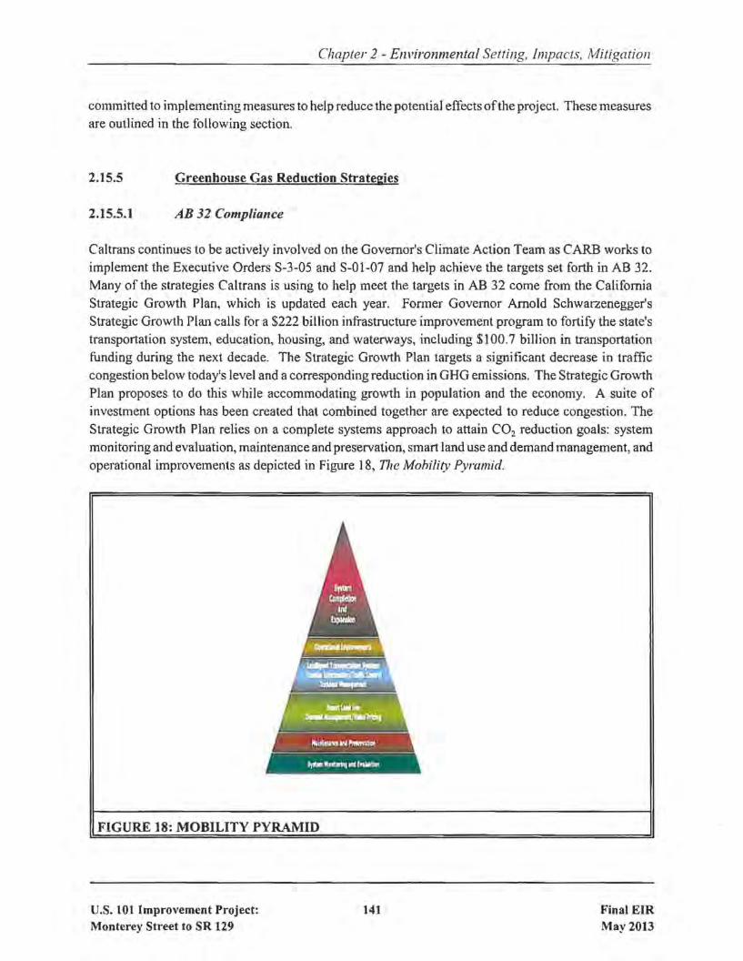
Chapter 2 - Environmental Setting, Impacts, Mitigation
committed to implementing measures to help reduce the potential effects ofthe project. These measuresare outlined in the following section.
2.15.5
2.15.5.1
Greenhouse Gas Reduction Strategies
AB 32 Compliance
Caltrans continues to be actively involved on the Governor's Climate Action Team as CARB works toimplement the Executive Orders S-3-05 and S-OI-07 and help achieve the targets set forth in AB 32.Many of the strategies Caltrans is using to help meet the targets in AS 32 come from the CaliforniaStrategic Growth Plan, which is updated each year. Former Governor Arnold Schwarzenegger'sStrategic Growth Plan calls for a $222 billion infrastructure improvement program to fortify the state'stransportation system, education, housing, and waterways, including $100.7 billion in transportationfunding during the next decade. The Strategic Growth Plan targets a significant decrease in trafficcongestion below today's level and a corresponding reduction in GHG emissions. The Strategic GrowthPlan proposes to do this while accommodating growth in population and the economy. A suite ofinvestment options has been created that combined together are expected to reduce congestion. TheStrategic Growth Plan relies on a complete systems approach to attain CO2 reduction goals: systemmonitoring and evaluation, maintenance and preservation, smart land use and demand management, andoperational improvements as depicted in Figure 18, The Mobility Pyramid.
FIGURE 18: MOBILITY PYRAMID
u.s. 101 Improvement Project:Monterey Street to SR 129
141 Final EIRMay 2013
Chapter 2 - Environmental Setting, Impacts, Mitigation
Caltrans is supporting efforts to reduce vehicle miles traveled by planning and implementing smart landuse strategies: job/housing proximity, developing transit-oriented communities, and high density housingalong transit corridors. Caltrans is working closely with local jurisdictions on planning activities;however, Caltrans does not have local land use planning authority. Caltrans is also supporting effortsto improve the energy efficiency ofthe transportation sector by increasing vehicle fuel economy in newcars, light and heavy-duty trucks; Caltrans is doing this by supporting on-going research efforts atuniversities, by supporting legislative efforts to increase fuel economy, and by its participation on theClimate Action Team. It is important to note, however, that the control of the fuel economy standardsis held by U.S. EPA and ARB. Lastly, the use ofaltemative fuels is also being considered; Caltrans isparticipating in funding for alternative fuel research at the UC Davis.
Table 28 summarizes the Caltrans and statewide efforts that Caltrans is implementing in order to reduceGHG emissions. More detailed information about each strategy is included in the Climate ActionProgram at Caltrans (December 2006).
To the extent that it is applicable or feasible for the project and through coordination with the projectdevelopment team, the following measures will also be included in the project to reduce the GHGemissions and potential climate change impacts from the project:
o Caltrans and the California Highway Patrol are working with regional agencies to implementintelligent transportation systems (ITS) to help manage the efficiency of the existing highwaysystem. ITS is commonly referred to as electronics, communications, or information processingused singly or in combination to improve the efficiency or safety of a surface transportationsystem.
o In addition, the VTA provides ridesharing services and park-and-ride facilities to help managethe growth in demand for highway capacity.
o Landscaping reduces surface warming, and through photosynthesis, decreases CO2, The projectproposes planting, as described in Section 2.7, Visual/Aesthetics
o The project will incorporate the use of energy efficient lighting, such as LED traffic signals.LED bulbs - or balls, in the stoplight vernacular - cost $60 to $70 apiece but last five to six years,compared to the one-year average lifespan ofthe incandescent bulbs previously used. The LEDballs themselves consume 10 percent ofthe electricity of traditional Iights, which will also helpreduce the projects CO2 emissions.
2.15.6 Adaptation Strategies
"Adaptation strategies" refer to how Caltrans and others can plan for the effects of climate change onthe state's transportation infrastructure and strengthen or protect the facilities from damage. Climatechange is expected to produce increased variability in precipitation, rising temperatures, rising sea levels,
U.s. 101 Improvement Project:Monterey Street to SR 129
142 Final EIRMay 2013

Chapter 2 - Environmental Setting, Impacts, Mitigation
storm surges and intensity, and the frequency and intensity of wildfires. These changes may affect thetransportation infrastructure in various ways, such as damaging roadbeds by longer periods of intenseheat; increasing storm damage from flooding and erosion; and inundation from rising sea levels. Theseeffects will vary by location and may, in the most extreme cases, require that a facility be relocated orredesigned. There may also be economic and strategic ramifications as a result ofthese types ofimpacts
to the transportation infrastructure.
At the Federal level, the Climate Change Adaptation Task Force, co-chaired by the White House Councilon Environmental Quality (CEQ), the Office of Science and Technology Policy (OSTP), and theNational Oceanic and Atmospheric Administration (NOAA), released its interagency report October 14,20 I0 outlining recommendations to President Obama for how Federal Agency policies and programscan better prepare the United States to respond to the impacts of climate change. The Progress Report
of the Interagency Climate Change Adaptation Task Force recommends that the Federal Governmentimplement actions to expand and strengthen the Nation's capacity to better understand, prepare for, andrespond to climate change.
Climate change adaption must also involve the natural environment as well. Efforts are underway ona statewide-level to develop strategies to cope with impacts to habitat and biodiversity through planningand conservation. The results of these efforts will help California agencies plan and implementmitigation strategies for programs and projects.
On November 14,2008, Governor Schwarzenegger signed Executive Order S-13-08 which directed a
number ofstate agencies to address California's vulnerability to sea level rise caused by climate change.This Executive Order set in motion several agencies and actions to address the concern ofsea level rise.
The California Natural Resources Agency (Resources Agency) was directed to coordinate with local,regional, state and federal public and private entities to develop. The California Climate AdaptationStrategy (Dec 2009)40, which summarizes the best known science on climate change impacts to
California, assesses California's vulnerability to the identified impacts, and then outlines solutions thatcan be implemented within and across state agencies to promote resiliency.
The strategy outline is in direct response to Executive Order S-13-08 that specifically asked theResources Agency to identify how state agencies can respond to rising temperatures, changingprecipitation patterns, sea level rise, and extreme natural events. Numerous other state agencies wereinvolved in the creation of the Adaptation Strategy document, including Environmental Protection;Business, Transportation and Housing; Health and Human Services; and the Department ofAgriculture.The document is broken down into strategies for different sectors that include: Public Health;Biodiversity and Habitat; Ocean and Coastal Resources; Water Management; Agriculture; Forestry; andTransportation and Energy Infrastructure. As data continues to be developed and collected, the state'sadaptation strategy will be updated to reflect current findings.
40http://www.energy.ca.gov/2009publ ications/CNRA-1000-2009-027/CNRA- t000-2009-027-F.PDF
U.S. 101 Improvement Project:Monterey Street to SR 129
143 Final EIRMay 2013

Chapter 2 - Environmental Setting, Impacts, Mitigation
TABLE 29
CLIMATE CHANGE/CO, REDUCTION STRATEGIES
Estimated CO2 SavingsPartnership (Million Metric Tons)
Stratein' Pro2ram Lead Agency MethodlProcess 2010 2020
Intergovem- Caltrans Local Review and seek to Not Notmental governments mitigate develop- Estimated EstimatedReview ment proposals
SmartPlanning Caltrans LocallRegional Competitive selection Not Not
LandGrants Agencies, other process Estimated Estimated
Usestakeholders
Regional Regional Caltrans Regional plans andPlans & Agencies application process 0.975 7.8BlueprintPlanning
Operational Strategic Caltrans Regions State ITS; CongestionImprovements Growth Plan Management Plan& Intelligent .07 2.17
TransportationSystem (ITS)Deployment
Office of Interdepartmental effort Policy establishment,Mainstream Policy guidelines, technicalEnergy & Analysis & assistance Not NotGHG into Research; Estimated EstimatedPlans & Division ofProjects Environmenta
I Analysis
Educational &Office of Interdepartmental, Analytical report,
InformationPolicy CaIEPA, CARS, CEC data collection, Not Not
ProgramAnalysis & publication, Estimated EstimatedResearch workshops, outreach
Fleet Greening Division of Department of General Fleet Replacement 0.0065& Fuel Equipment Services B20 0.0045 0.045
Diversification Bl00 0.0225
Non-vehicular Energy Green Action Team Energy ConservationConservation Conservation Opportunities 0.117 .34
Measures Program
U.S. 101 Improvement Project:Monterey Street to SR 129
144 Final EmMay 2013
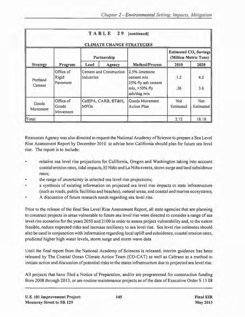
Chapter 2 - Environmental Setting, Impacts, Mitigation
TABLE 29 [continued]
CLIMATE CHANGE STRATEGIES
Estimated CO2 SavingsPartnership (Million Metric Tons)
Stratein' Proe:ram Lead I A~ency MethodlProcess 2010 2020
Office of Cement and Construction 2.5% limestone
PortlandRigid Industries cement mix 1.2 4.2
CementPavement 25% fly ash cement
mix, >50% fly .36 3.6ash/slag mix
GoodsOffice of CalEPA, CARB, BT&H, Goods Movement Not Not
MovementGoods MPOs Action Plan Estimated EstimatedMovement
rrotal: 2.72 18.18
Resources Agency was also directed to request the National Academy ofScience to prepare a Sea LevelRise Assessment Report by December 2010 to advise how California should plan for future sea levelrise. The report is to include:
• relative sea level rise projections for California, Oregon and Washington taking into accountcoastal erosion rates, tidal impacts, El Nino and La Nina events, storm surge and land subsidencerates;
the range of uncertainty in selected sea level rise projections;• a synthesis of existing information on projected sea level rise impacts to state infrastructure
(such as roads, public facilities and beaches), natural areas, and coastal and marine ecosystems;A discussion of future research needs regarding sea level rise.
Prior to the release of the final Sea Level Rise Assessment Report, all state agencies that are planningto construct projects in areas vulnerable to future sea level rise were directed to consider a range of sealevel rise scenarios for the years 2050 and 2100 in order to assess project vulnerability and, to the extentfeasible, reduce expected risks and increase resiliency to sea level rise. Sea level rise estimates should
also be used in conjunction with information regarding local uplift and subsidence, coastal erosion rates,predicted higher high water levels, storm surge and storm wave data
Until the final report from the National Academy of Sciences is released, interim guidance has beenreleased by The Coastal Ocean Climate Action Team (CO-CAT) as well as Caltrans as a method toinitiate action and discussion ofpotential risks to the states infrastructure due to projected sea level rise.
All projects that have filed a Notice of Preparation, and/or are programmed for construction fundingfrom 2008 through 2013, or are routine maintenance projects as of the date of Executive Order S 13 08
U.S. 101 Improvement Project:Monterey Street to SR 129
145 Final EIRMay 2013

Chapter 2 - Environmental Setting, Impacts, Mitigation
may, but are not required to, consider these planning guidelines. This project is exempt from theseplanning guidelines because a Notice of Preparation was filed on October 31,2007, which was prior tothe date of Executive Order S-13-08.
Furthermore Executive Order S-13-08 directed the Business, Transportation, and Housing Agency toprepare a report to assess vulnerability of transportation systems to sea level affecting safety,maintenance and operational improvements ofthe system and economy ofthe state. Caltrans continuesto work on assessing the transportation system vulnerability to climate change, including the effect ofsea level rise.
Currently, Caltrans is working to assess which transportation facilities are at greatest risk from climatechange effects. However, without statewide planning scenarios for relative sea level rise and otherclimate change impacts, Caltrans has not been able to determine what change, if any, may be made toits design standards for its transportation facilities. Once statewide planning scenarios become avai lable,Caltrans will be able review its current design standards to determine what changes, if any, may bewarranted in order to protect the transportation system from sea level rise.
Climate change adaptation for transportation infrastructure involves long-term planning and riskmanagement to address vulnerabilities in the transportation system from increased precipitation andflooding; the increased frequency and intensity of storms and wildfires; rising temperatures; and risingsea levels. Caltrans is an active participant in the efforts being conducted in response to Executive OrderS-13-08 and is mobilizing to be able to respond to the National Academy ofScience report on Sea LevelRise Assessment, which is due to be released in 2012.
2.16
2.16.1
NOISE
Introduction
Noise is measured in "decibels" (dB), which is a numerical expression ofsound levels on a logarithmicscale. A noise level that is 10 dB higher than another noise level has ten times as much sound energyand is perceived as being twice as loud. A sound change of less than 3 dB is just barely perceptible, andthen only in the absence ofother sounds. Intense sounds of 140 dB are so loud that they are painful andcan cause damage with only brief exposure. These extremes are not commonplace in our normalworking and living environments. An "A-weighted decibel" (dBA) approximates the frequency responseof the average young ear when listening to most ordinary everyday sounds. Thus, traffic noise impactanalyses commonly use the dBA.
With regard to traffic-generated noise, noise levels rise as vehicle speeds, overall volumes, and truckvolumes increase. In general, a doubling of traffic results in a 3 dBA increase in noise at a nearbyreceptor, assuming a relatively homogeneous traffic composition (i.e., mainly passenger cars). The peaknoise hour is typically not the peak commute hour due to lower operating speeds during the latter. The
U.S. 101 Improvement Project:Monterey Street to SR 129
146 Final EIRMay 2013

Chapter 2 - Environmental Setting, Impacts, Mitigation
combination of volumes and speeds that produces the peak noise hour is that which is associated withlevel of service C/O.
2.16.2 Regulatory Setting
CEQA provides the broad basis for analyzing and abating highway traffic noise effects. The intent ofthis law is to promote the general welfare and to foster a healthy environment. CEQA requires a strictlybaseline versus build analysis to assess whether a proposed project will have a noise impact. If aproposed project is determined to have a significant noise impact under CEQA, then CEQA dictates thatmitigation measures must be incorporated into the project unless such measures are not feasible.
The regulations of the FHWA and Caltrans require that potential noise impacts in areas of frequenthuman use be identified during the planning and design of a highway project. The regulations containnoise abatement criteria (NAC) that are used to determine when a noise impact would occur. As shownin Table 30, the NAC differ depending on the type of land use under analysis. For example, the NACfor residences (67 dBA) is lower than the NAC for commercial areas (72 dBA).
TABLE 30
NOISE ABATEMENT CRITERIA OF THE FEDERAL HIGHWAY ADMINISTRATIONrExpressed in dBAl
Activity Peak-HourCategory Leq(h) Description of Activity Cate~ory
A Lands on which serenity and quiet are of extraordinary57 significance and serve an important public need and where
(Exterior) the preservation ofthose qualities is essential ifthe area isto continue to serve its intended purpose.
B67
Picnic areas, recreation areas, playgrounds, active sports
(Exterior)areas, parks, residences, motels, hotels, schools, churches,libraries, and hospitals.
C 72 Developed lands, properties, or activities not included in(Exterior) Categories A or B above.
D --- Undeveloped lands.
E 52 Residences, motels, hotels, public meeting rooms,(Interior) schools, churches, libraries, hospitals, and auditoriums.
Table 31 lists the noise levels ofcommon activities to enable readers to compare the actual and predictedhighway noise-levels discussed in this section with common activities.
U.S. 101 Improvement Project:Monterey Street to SR 129
147 Final EIRMay 2013
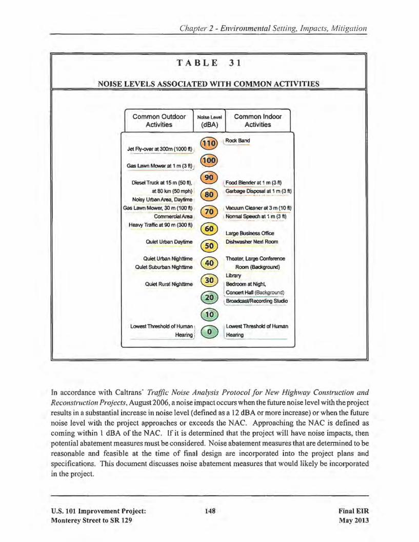
Chapter 2 - E1ll'ironmental Setting, Impacts, Mitigation
TABLE 31
NOISE LEVELS ASSOCIATED WITH COMMON ACTIVITIES
Common Outdoor Noise level Common IndoorActivities (dBA) Activities
(§) \ Rock Band
Jet F1y~at300m(1000 ft)j
Gas Lawn Mower~_1_~ i~ftJ.,(@)
Diesel Truck at 15 m (SO It). ® ,Food Blender at 1 m (3 It)
at 80 km (50 mph) @ Garbage Disposal at 1 m (3 1\)----_ .. - --- _.._---Noisy Urban Area, Daytime
Gas Lawn MaNer. 30 m (100 fl) ® Vacuum Cleaner at 3 m (10 Il)----_.._-CommereialAlea I Normal Speech at 1 m (3 II)----- -- ----.
Heavy Traffic at 90 m (300 II) @ latge Business 0lIice
Quiet Urban Daytime ® Dishwasher Next Room
Quiet Urban Nighttime ® Theater. Large Conference
Qulat Suburban Nighttime Room (Bad<ground)
® Library
Quiet Rural Nighttime IBedroom at Nigh~
® ' Concert HaD (Background)
, 8foadcastIReoording Studio
@Lowest Threshold of Human I
CD ILowest Threshold or Human
Hearing)L
Hearing
In accordance with Caltrans' Traffic Noise Analysis Protocol for New Highway COllstruction alldReconstruction Projects, August 2006, a noise impact occurs when the future noise level with the projectresults in a substantial increase in noise level (defined as a 12 dBA or more increase) or when the futurenoise level with the project approaches or exceeds the NAC. Approaching the NAC is defined ascoming within 1 dBA of the NAC. If it is determined that the project will have noise impacts, thenpotential abatement measures must be considered. Noise abatement measures that are determined to bereasonable and feasible at the time of final design are incorporated into the project plans andspecifications. This document discusses noise abatement measures that would likely be incorporatedin the project.
U.S. 101 Improvement Project:Monterey Street to SR 129
148 Final EIRMay 2013

Chapter 2 - Environmental Setting, Impacts, Mitigation
Caltrans' Traffic Noise Analysis Protocol sets forth the criteria for determining when an abatementmeasure is reasonable and feasible. Feasibility of noise abatement is basically an engineering concern.A minimum 5 dBA reduction in the future noise level must be achieved for an abatement measure to beconsidered feasible. Other considerations include topography, access requirements, other noise sourcesand safety considerations. The reasonableness determination is basically a cost-benefit analysis. Factorsused in determining whether a proposed noise abatement measure is reasonable include: residentsacceptance, the absolute noise level, build versus existing noise, environmental impacts of abatement,public and local agencies input, newly constructed development versus development pre-dating 1978,and the cost-per-benefitted-residence.
2.16.3 Affected Environment
The information in this section is based primarily on a technical Noise Report (July 20 I0) that wasprepared for the project. This study is available for review at the locations listed inside the front cover
of this document.
The existing noise environment throughout the project corridor varies by location, depending on sitecharacteristics such as proximity to U.S. 101, SR 25, or other local roadways, the relative elevationdifference between the highways and receivers, and any intervening topography, structures, or barriers.There is a mix of single-family and multi-family residential, commercial, industrial, and agriculturalland-uses throughout the project area.
U.S. 101 is a major source of noise in the project vicinity. Vehicles traveling on U.S. 101 produceLeq(h) noise levels that exceed FHWA's noise abatement criteria at various land uses that are locatedin proximity to the highway. At the northerly end of the project, vehicles using Monterey Street andother local roadways, as well as the adjacent commercial and residential land uses, contribute to theexisting noise environment.
There are no soundwalls along U.S. 101 within the project limits. There are, however, existing noisebarriers at the two RV parks located within the project limits. The Garlic Farm RV Park, which islocated adjacent to the U.S. 10 I/Monterey Street interchange in Gilroy, is shielded with a 7-footberm/wall. The Betabel RV Park, which is located adjacent to the U.S. 101 /Betabel Road/Y Roadinterchange, is shielded from U.S. 101 traffic noise by a IOta 12-foot earth berm.
Existing peak-hour noise levels were measured and quantified along U.S. 101 within the project limitswhere there are existing residences, as well as at a motel and the two RV parks. These locations areshown on Figure 19. The existing noise levels range from 57 to 75 dBA Leq(h), as shown in Table 32.The existing noise levels shown in Table 32 take into account the existing noise barriers adjacent to thetwo RV parks.
U.S. 101 Improvement Project:Monterey Street to SR 129
149 Final EIRMay 2013

NOISE RECEPTOR AND SOUNDWALL EVALUATION LOCATIONS FIGURE 19A
NN
0 425' 850'
APPROXIMATE
PROPOSED DETENTION BASIN
SOUNDWALL
GA
VILA
NC
REEK
CARNADERO
CREEK
BOLSA ROAD
CA
STRO
VALLEY
RO
AD
MESA
RO
AD
SANTA TERESA BLVD.
GAVILAN
COLLEGE
GA
VILA
NC
REEK
CARNADERO
CREEK
BOLSA ROAD
CA
STRO
VALLEY
RO
AD
MESA
RO
AD
SANTA TERESA BLVD.
GAVILAN
COLLEGE
R22
SW7SW6
R21
R16R13
R12 R11
R20 R19R15
R14SW5
SW3
R18
R17
SW4
SW2
SW1A
SW1B
R10
R9
R7 R6R5
R8
R2R3
R4
R1

NOISE RECEPTOR AND POTENTIAL SOUNDWALL LOCATIONS FIGURE 19B
NN
0 425' 850'
APPROXIMATE
Y ROAD
BETABEL ROAD
PAJARO RIVER
TAR CREEK
Y ROAD
PAJARO RIVER
PROPOSED DETENTION BASIN
SOUNDWALL
R28 R26R27
SW9
SW8
R25
R23
R24

Chapter 2 - Environmental Setting, Impacts, Mitigation
TABLE 32
COMPARISON OF EXISTING AND FUTURE NOISE LEVELS(Expressed in Loudest Hour Noise Levels, Leq(h), dBA]
Year 2035
Build Alternative Build AlternativeNo with with Noise
Existing Build Design Option A Design Option B LevelRecep- Sound- Existing Alt. Noise Level Noise Level Approach
tor Land wall in Noise Noise (change from (change rrom or ExceedII Use place? Level Level Existing/No Build) ExistingINo Build) NAC?
I Single-family No 63 63 67 (+ 4) 67 (+ 4) Yes
2 Single-family No 66 66 75 (+ 9) 75 (+ 9) Yes
3 Single-family No 67 67 76 (+ 9) 76 (+ 9) Yes
4 RV Park Yes 64 64 68 (+ 4) 68 (+ 4) Yes
5 Motel No 67 67 71 (+ 4) 71 (+ 4) No
6 Single-family No 64 64 68 (+ 4) 68 (+ 4) Yes
7 Single-family No 68 68 72 (+ 4) 72 (+ 4) Yes
8 Single-family No 67 67 75 (+ 8) 75 (+ 8) Yes
9 Single-family No 62 62 68 (+ 6) 68 (+ 6) Yes
10 Single-family No 70 70 73 (+ 3) 73 (+ 3) Yes
I I Single-family No 74 74 receptor removed by project
12 Single-family No 72 72 receptor removed by project
13 Single-family No 74 74 receptor removed by project
14 Single-family No 71 71 72 (+ I) 70 (- I) Yes
15 Single-family No 67 67 68 (+ I) 68 (+ I) Yes
16 Multi-family No 63 63 receptor removed by project
17 Single-family No 65 65 66 (+ I) 67 (+ 2) Yes
18 Single-family No 74 74 receptor removed by project
19 Multi-family No 75 75 receptor removed by project
20 Single-family No 73 73 receptor removed by project
21 Single-family No 61 61 66 (+ 5) 62 (+ t) Yes*
U.S. 101 Improvement Project:Monterey Street to SR 129
152 Final EIRMay 2013

Chapter 2 - Environmental Setting, Impacts, Mitigation
TABLE 32 [continued]
Year 2035
Build Alternative Build AlternlltiveNo with with Noise
Existing Build Design Option A Design Option B LevelRecep- Sound- Existing Alt. Noise Level Noise Level Approach
tor Land wall in Noise Noise (change from (change from or Exceed#I Use place? Level Level ExistingINo Build) ExistingINo Build) NAC?
22 Single-family No 70 70 73 (+ 3) 73 (+ 3) Yes
23 Single-family No 66 66 67 (+ 1) 67 (+ 1) Yes
24 Single-family No 71 71 76 (+ 5) 76 (+ 5) Yes
25 Multi-family No 63 63 66 (+ 3) 66 (+ 3) Yes
26 RV Park Yes 58 58 61 (+3) 61 (+3) No
27 RV Park Yes 57 57 60 (+ 3) 60 (+ 3) No
28 RV Park Yes 60 60 63 (+ 3) 63 (+ 3) No
*NAC approached under Design Option A only.
NAC = noise abatement criteria of FHWA Receptors are shown on Figure 19.
Source: U.S. 101 Improvements Project Noise Study Report, 2010.
2.16.4 Environmental Consequences of the Build Alternative
The short-term (Le., construction phase) noise effects ofthe proposed project are described in Section2.22.5. The project's long-term (Le., operational phase) effects are described below.
Future traffic-related noise levels at land uses adjacent to U.S. 101 within the project limits were
quantified in accordance with FHWA and Caltrans procedures. Projected noise levels were thencompared to FHWA's noise abatement criteria shown in Table 30 to determine whether the consideration
of noise abatement measures was warranted. Projected noise levels were also compared with existingnoise levels to determine whether the increase (if any) would be substantial.
As shown in Table 32, the effect of the project on noise levels will vary by location. The location thatwould experience the largest increase in noise is at the residences located along the frontage road on thewest side of U.S. 101, just south of the U.S. IOl/Monterey Street interchange. At that location(represented by receptors #2, #3, #8, and #9 in Table 32), the noise increase due to the project would be6 to 9 dBA under either design option. At other locations, the change in noise levels due to the projectwould range from a decrease of 1dBA to an increase of 5 dBA.
U.S. 101 Improvement Project:Monterey Street to SR 129
153 Final EIRMay 2013
Chapter 2 - Environmental Setting, Impacts. Mitigation
[n all cases, projected increases in noise levels would not be substantial because the increase would beless than the 12-dB increase described above.
Impact NOI-!: Depending on the location, changes in long-term noise levels will range from adecrease of I dBA to an increase of 9 dBA, which is less than the 12-dBincrease that would be considered substantial. (Less-than-Significant Impact]
2.16.5 Environmental Conseguences ofthe No Build Alternative
Under the No Build Alternative, the improvements to U.S. 101 that comprise the Build Alternativewould not be constructed. Table 32 quantifies the projected future noise levels under the No BuildAlternative. The data show that noise levels under the No Build Alternative from traffic on V.S. 101would be unchanged from the existing noise levels.
2.16.6 Avoidance, Minimization, and/or Mitigation Measures
Although the project would not result in a substantial increase in traffic-related noise, projected noiselevels will, however, exceed FHWA's noise abatement criteria at many locations, as some locationscurrently do under existing conditions. As a result, the feasibility and reasonableness allowances ofnoise abatement measures were considered. This process involved an evaluation of the feasibility andreasonableness allowance for constructing a new soundwall at each location where the noise abatementcriteria will be approached or exceeded.
The feasibility of soundwalls was detennined by the 5-d8A minimum reduction in noise level as wellas overall constructability. The reasonableness allowances for the soundwalls were detennined usingcriteria contained in Caltrans' Traffic Noise Analysis Protocol.
Based on the studies, Caltrans has determined that the construction of nine new soundwalls, as shownin Table 33 and on Figure 19, would be feasible (i.e., they would meet the minimum 5-dBA noisereduction criterion). However, the cost estimate for each of the nine soundwalls substantially exceedsthe calculated reasonableness allowance. These soundwalls are described in the following paragraphs.
Soundwall #1
Soundwall # I is actually two 16-foot soundwalls, both of which would be needed to achieve a 5-dBreduction in traffic noise at two adjacent single-family residences. As shown on Figure 19, Soundwall#IA would be 800 feet in length and would be constructed along the edge-of-shoulder of southboundV.S. 101. Soundwall #18 would be 600 feet in length and would be constructed along the edge-ofshoulder of the southbound U.S. 101 on-ramp from Monterey Street.
U.S. 101 Improvement Project:Monterey Street to SR 129
154 Final EIRMay 2013

Chapter 2 - Environmental Setting, Impacts, Mitigation
TABLE 33
EVALUATION OF NOISE ABATEMENT SOUNDWALLS
Soundwall Approximate Amount of #ofNumber Soundwall Reduction Residences Reason- Preliminary
and HeightlLength in Noise Benefitting able CostLocation (feet) (dBA) by:<!:5 dBA Allowance Estimate
#1: SW quadrantof 10 IlMonterey 16/ 1,400 5 2 $90,000 $1,210,000
St. Interchange
#2: Westside8/1,300 5 to 6 3 $157,000 $562,000
of 101, S of10/ 1,300 7 to 8 3 $159,000 $702,00012/1,300 8 to 10 3 $163,000 $842,000
Monterey14/1,300 9 to 10 3 $165,000 $983,000
Street16/1,300 9 to 11 3 $165,000 $1,123,000
#3: Eastside 10/ 1,900 5 2 $94,000 $1,026,000of 101, N of 12/ 1,900 6 to 7 4 $194,000 $1,231,000Carnadero 14/1,900 7 to 8 4 $194,000 $1,436,000
Creek 16/1,900 7 to 8 4 $194,000 $1,642,000
#4: Westside8/ 1,400 6 1 $53,000 $605,000
of 10 1, N of10 / 1,400 7 1 $53,000 $756,00012/ 1,400 5 to 10 2 $100,000 $907,000
Camadero14/1,400 5 to II 2 $100,000 $1,058,000
Creek16/1,400 6 to 12 2 $104,000 $1,210,000
#5A: Eastside 10/2,600 5 2 $88,000 $1,404,000of 101, vicinity 12/2,600 5 to 7 3 $135,000 $1,685,000
of 14/2,600 6 to 8 3 $137,000 $1,966,000Garlic World 16/2,600 6 to 8 3 $137,000 $2,246,000
#58: Eastside 10/2,600 5 2 $88,000 $1,404,000of 10 I, vicinity 12/2,600 5 to 8 3 $139,000 $1,685,000
of 14/2,600 6 to 9 3 $143,000 $1,966,000Garlic World 16/2,600 6 to 9 3 $143,000 $2,246,000
#6: Westside12/900 5 1 $45,000 $583,000
of 101, vicinity14/900 5 1 $45,000 $680,000
of 101/2516/900 6 1 $47,000 $778,000
interchange
U.S. 101 Improvement Project:Monterey Street to SR 129
155 Final EIRMay 2013

Chapter 2 - Environmental Setting, Impacts, Mitigation
TABLE 33 [continued]
Soundwall Approximate Amount of # ofNumber Soundwall Reduction Residences Reason- Preliminary
and HeightlLength in Noise Benefitting able CostLocation (feet) (dBA) by ~5 dBA Allowance Estimate
#7: Westside 10 /1,000 5 2 $94,000 $540,000of 101, N of 12/1,000 6 2 $98,000 $648,000driveway to 14/1,000 9 2 $102,000 $756,000
quarry 16/1,000 10 2 $102,000 $864,000
8/800 ft. 7 1 $51,000 $346,000#8: Westside 10/800 ft. 8 1 $51,000 $432,000
of 101, at 12/800 ft. 8 1 $51,000 $518,000Tar Creek 14/800 ft. 9 1 $53,000 $605,000
16/800 ft. 9 I $53,000 $691,000
#9: Eastside 12/1,200 6 5 $235,000 $778,000of 101, S of 14/ 1,200 6 5 $235,000 $907,000Pajaro River 16/ 1,200 7 5 $235,000 $1,037,000
0 All of the above soundwalls are feasible, meaning they provide a minimum of fivedecibels of noise reduction at one or more receptors.
0 Wall SA is applicable to Design Option A and Wall 58 is applicable to Design Option 8.0 Wall 6 is applicable to Design Option A only.0 $40 per square foot is the current unit cost being used for conceptual estimates for
soundwalls. Cost estimates include 25% contingency + 10% mobilization allowances.• Soundwall locations are shown on Figure 19.
Source: U.S. 101 Improvement Project Noise Study Report, 2010.
Soundwall #2
Soundwall #2 would be constructed along the westside of U.S. 101, south of the 10 I/Monterey Streetinterchange. It's length would be approximately 1,300 feet and it would benefit three single-familyresidences. As shown in Table 33, wall heights ranging from 8 to 16 feet are feasible. A minimum wallheight of 12 feet would, however, be required to intercept the line ofsight between a truck exhaust stackand a 5-foot high receiver.4J
4ITruck exhaust stacks are a notable source of noise. Therefore, breaking the line of sight between thetop of an exhaust stack and an adjacent receptor is typically desired as it serves to reduce this noise source.
U.S. 101 Improvement Project:Monterey Street to SR 129
156 Final EIRMay 2013

Chapter 2 - Environmental Setting, Impacts, Mitigation
Soundwall #3
Soundwall #3 would be constructed along the eastside ofU.S. 101, north ofCarnadero Creek. It's lengthwould be approximately 1,900 feet and it would benefit up to four single-family residences. As shownin Table 33, soundwall heights ranging from IO to 16 feet are feasible. A minimum wall height of 12feet would, however, be required to intercept the line ofsight between a truck exhaust stack and a 5-foothigh receiver.
Soundwall #4
Soundwall #4 would be constructed along the westside of U.S. 101, north of Carnadero Creek. It'slength would be approximately 1,400 feet and it would benefit up to two single-family residences. Asshown in Table 33, soundwall heights ranging from 8 to 16 feet are feasible. A minimum wall heightof 12 feet would, however, be required to intercept the line of sight between a truck exhaust stack anda 5-foot high receiver.
Soundwall #5
Soundwall #5 would be constructed along the eastside of U.S. 101, north of the U.S. IOl/SR 25interchange. It's length would be approximately 2,600 feet and it would benefit up to three single-familyresidences. As shown in Table 33, soundwall heights ranging from 10 to 16 feet are feasible. Aminimum wall height of 12 feet would, however, be required to intercept the line of sight between atruck exhaust stack and a 5-foot high receiver. [Note: Table 33 shows Soundwalls #5A and #5B. Thisdoes not mean that two soundwalls would be built. Rather, Soundwall #5A illustrates the noisereduction that would occur if Design Option A is chosen and Soundwall #5B illustrates the noisereduction that would occur if Design Option B is chosen.]
Soundwall #6
Soundwall #6 would be constructed along the westside of U.S. IO I, near the U.S. 10 I/SR 25interchange. It's length would be approximately 900 feet and it would benefit one single-familyresidence. As shown in Table 33, soundwall heights ranging from 12 to 16 feet are feasible. Soundwall#6 would be constructed only ifDesign Option A is selection; noise levels at this receptor under DesignOption B do not warrant consideration of a soundwall.
Soundwall #7
Soundwall #7 would be constructed along the westside of U.S. 101, north of the driveway that leads tothe nearby quarry. It's length would be approximately 1,000 feet and it would benefit two single-familyresidences. As shown in Table 33, soundwall heights ranging from 10 to 16 feet are feasible.
U.S. 101 Improvement Project:Monterey Street to SR 129
157 Final EIRMay 2013

Chapter 2 - Environmental Setting, Impacts, Mitigation
Soundwall #8
Soundwall #8 would be constructed along the westside of U.S. 101 at Tar Creek. It's length would beapproximately 800 feet and it would benefit one single-family residence. As shown in Table 33,soundwall heights ranging from 8 to 16 feet are feasible.
Soundwall #9
Soundwall #9 would be constructed along the eastside ofU.S. 101, south ofthe Pajaro River. It's lengthwould be approximately 1,200 feet and it would benefit five multi-family residences. As shown in Table33, soundwall heights ranging from 12 to 16 feet are feasible.
Final Decision on Soundwalls
As stated above, while all nine soundwalls are feasible (i.e., they would meet the minimum 5-dB noise
reduction criterion), the costs of each of the soundwalls substantially exceed the calculatedreasonableness allowance. Based on this information, a preliminary decision has been made to notconstruct any of these soundwalls as a part of the project. A final decision on which, ifany, of the ninesoundwalls will be constructed will be made upon completion of the public involvement process.
BIOLOGICAL ENVIRONMENT
The information in this section is based primarily on a Natural Environment Study (April 2011) that wasprepared for the project. A copy of this study is available for review at the locations listed inside thefront cover of this document.
Overall Methodology
In order to identify the biological resources that are discussed in each of the following sections (e.g.,natural communities, wetlands, special-status plant and animal species, and threatened and endangered
species), a biological study area (BSA) for the proposed project was delineated. The BSA was drawnto include all areas that could be temporarily or permanently impacted by the project. In addition, inorder to ensure that all resources were adequately identified, the BSA was conservatively delineated toinclude an area somewhat larger than that where direct impacts will occur. Therefore, the project'simpacts, as quantified in the following sections, are a subset of the acreage of each habitat identified inTable 34 as occurring within the BSA. .
Figures 20a through 20g on the following pages depict the BSA and the habitats that occur within it.
U.S. 101 Improvement Project:Monterey Street to SR 129
158 Final EIRMay 2013

Figure 18bFigure 20b
Figure 20gFigure 20g
Figure 20fFigure 20f
Figure 20cFigure 20c
Figure 20bFigure 20b
Figure 20eFigure 20e
Figure 20dFigure 20d
Figure 20aFigure 20a
Figure 20g
Figure 20f
Figure 20c
Figure 20b
Figure 20e
Figure 20d
Figure 20a
BIOLOGICAL STUDY AREA FIGURE 20a
XX
X

Figure 18gFigure 18a
Figure 18c
Figure 18gFigure 20a
Figure 20c
Figure 20gFigure 20g
Figure 20fFigure 20f
Figure 20cFigure 20c
Figure 20bFigure 20b
Figure 20eFigure 20e
Figure 20dFigure 20d
Figure 20aFigure 20a
Figure 20g
Figure 20f
Figure 20c
Figure 20b
Figure 20e
Figure 20d
Figure 20a
BIOLOGICAL STUDY AREA FIGURE 20b
XX
X

Figure 18gFigure 18dFigure 18gFigure 20d
Figure 18gFigure 18dFigure 18bFigure 20b
Figure 20gFigure 20g
Figure 20fFigure 20f
Figure 20cFigure 20c
Figure 20bFigure 20b
Figure 20eFigure 20e
Figure 20dFigure 20d
Figure 20aFigure 20a
Figure 20g
Figure 20f
Figure 20c
Figure 20b
Figure 20e
Figure 20d
Figure 20a
BIOLOGICAL STUDY AREA FIGURE 20c
XX
X

Figure 18c
Figure 18e
Figure 20c
Figure 20e
Figure 20gFigure 20g
Figure 20fFigure 20f
Figure 20cFigure 20c
Figure 20bFigure 20b
Figure 20eFigure 20e
Figure 20dFigure 20d
Figure 20aFigure 20a
Figure 20g
Figure 20f
Figure 20c
Figure 20b
Figure 20e
Figure 20d
Figure 20a
BIOLOGICAL STUDY AREA FIGURE 20d
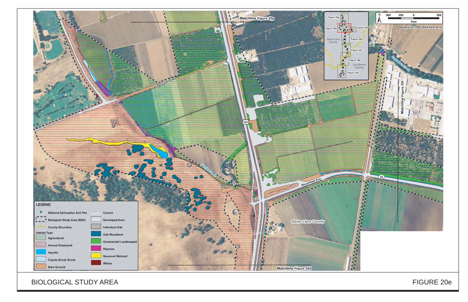
Figure 18g
Figure 18d
Figu
re 1
8f
Figure 20g
Figure 20d
Figu
re 2
0f
Figure 20gFigure 20g
Figure 20fFigure 20f
Figure 20cFigure 20c
Figure 20bFigure 20b
Figure 20eFigure 20e
Figure 20dFigure 20d
Figure 20aFigure 20a
Figure 20g
Figure 20f
Figure 20c
Figure 20b
Figure 20e
Figure 20d
Figure 20a
Figure 20eFigure 20eFigure 20e
BIOLOGICAL STUDY AREA FIGURE 20e
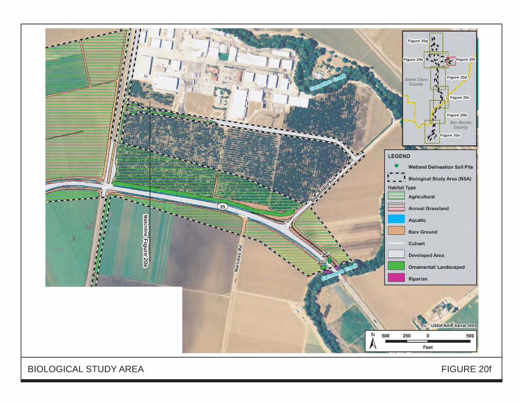
Figure 18eFigure 20e
Figure 20gFigure 20g
Figure 20fFigure 20f
Figure 20cFigure 20c
Figure 20bFigure 20b
Figure 20eFigure 20e
Figure 20dFigure 20d
Figure 20aFigure 20a
Figure 20g
Figure 20f
Figure 20c
Figure 20b
Figure 20e
Figure 20d
Figure 20a
BIOLOGICAL STUDY AREA FIGURE 20f

Figure 20gFigure 20g
Figure 20fFigure 20f
Figure 20cFigure 20c
Figure 20bFigure 20b
Figure 20eFigure 20e
Figure 20dFigure 20d
Figure 20aFigure 20a
Figure 20g
Figure 20f
Figure 20c
Figure 20b
Figure 20e
Figure 20d
Figure 20a
Figure 20eFigure 20eFigure 20e
BIOLOGICAL STUDY AREA FIGURE 20g
XX
X

Chapter 2 - Environmental Setting, Impacts, Mitigation
TABLE 34
IMPACTS TO BIOLOGICAL HABITATS[Expressed in Acres]
Impacts or the Build Alternative
Existing Within BSA Temporary Permanent
Santa San Santa San Santa SanHabitat Clara Benito Design Clara Benito Clara Benito
Type County County Total Option County County Total County County Total
Annual218.3 95.9 314.2
A 75.0 59.0 134.0 34.0 11.0 45.0Grassland B 81.5 59.0 140.5 38.0 11.0 49.0
Riparian 16 19 35A 2.0 5.0 7.0 3.5 4.5 8.0B 2.0 5.0 7.0 3.5 4.5 8.0
Freshwater Emer-.11 .35 .46
A 0.01 0.05 0.06 0.05 0.04 0.09gent Wetlands B 0.01 0.05 0.06 0.05 0.04 0.09
Seasonal4.25 .07 4.32
A 0.26 0.03 0.29 1.12 0.03 1.15Wetlands B 0.46 0.03 0.49 1.29 0.03 1.32
Aquatic 6.59 1.65 8.24A 0.74 0.24 0.98 1.49 0.25 1.74B 0.74 0.24 0.98 1.56 0.25 1.81
Coyote4.8 5.9 10.7
A 5.5 3.0 8.5 1.0 1.0 2.0Brush Scrub B 5.0 3.0 8.0 1.0 1.0 2.0
Oak8.7 .06 8.76
A 0.0 0.0 0.0 2.0 0.0 2.0Woodland B 0.0 0.0 0.0 1.5 0.0 1.5
Ornamental!12.4 4.7 17.1
A 6.0 3.5 9.5 2.5 0.5 3.0Landscaped B 5.5 3.5 9.0 2.5 0.5 3.0
Agriculture 327.8 9.2 337A 95.5 4.0 99.5 40.0 0.5 40.5B 77.0 4.0 81.0 23.5 0.5 24.0
Developed 105.4 66.6A -- -- -- -- -- --172B -- -- -- -- -- --
Bare34.2 12.7 46.9
A 13.0 11.5 24.5 6.0 0.5 6.5Ground B 14.5 II.5 26.0 6.0 0.5 6.5
BSA =Biological Study Area
Source: Natural Environment Study for the U.S. 101 Improvement Project, April 2011.
U.S. 101 Improvement Project:Monterey Street to SR 129
166 Final EIRMay20n

2.17
2.17.1
Chapter 2 - Environmental Setting, Impacts. Mitigation
NATURAL COMMUNITIES
Introduction
This section of the document discusses natural communities ofconcern. The focus ofthis section is onbiological communities, not individual plant or animal species. This section also includes informationon wildlife corridors and habitat fragmentation. Wildlife corridors are areas ofhabitat used by wildlifefor seasonal or daily migration. Habitat fragmentation involves the potential for dividing sensitivehabitat and thereby lessening its biological value.
Habitat areas that have been designated as critical habitat under the Federal Endangered Species Act arediscussed in Section 2.21, Threatened and Endangered Species. Wetlands and other waters are alsodiscussed in Section 2.18, Wetlands and Other Waters.
2.17.2 Affected Environment
The following sensitive habitats are listed by the California Natural Diversity Rarefind Database asoccurring in the region42
: I) northern maritime chaparral; 2) central maritime chaparral; 3) maritimecoast ponderosa pine forest; 4) northern coastal salt marsh; and 5) and coastal brackish marsh. Theproject site does not present suitable soil substrates or microclimatic regimes for any of these sensitivehabitats, and none of these habitats was observed to occur within the BSA.
The BSA does, however, contain other natural communities of special importance, including riparianhabitat and oak woodland habitat, both of which are discussed in this section. Wetlands and aquatichabitat, which are also natural communities of special importance, are discussed in Section 2.18,Wetlands and Other Waters. Wildlife corridors and fish passage issues are discussed in this section.
2.17.2.1 Riparian Habitat
The project segment of U.S. 101 crosses the following waterways (from north to south); CarnaderoCreek, Gavilan Creek, Tick Creek, Tar Creek, Pajaro River, San Benito River, and San Juan Creek.Habitat along these waterways, commonly referred to as riparian habitat, comprises approximately 35acres within the BSA. The majority of riparian habitat within the BSA consists ofhigh-quality riparianforest dominated by willow trees and understory shrubs. The Pajaro River, the San Benito River, andCarnadero Creek support the largest areas ofhigh-quality riparian habitat within the project alignment.Riparian vegetation within these drainages is dominated by a well-developed overstory canopy of redwillow trees and occasional coast live oak, valley oak, and sycamore trees. The majority of the rivers,creeks, and drainages on-site also support a lush understory of riparian shrub vegetation including red
42"Region" is the United States Geological Survey quadrangle map where the project is located (Le.,Chittenden Quadrangle) and all of the surrounding quadrangle maps.
U.S. tOt Improvement Project:Monterey Street to SR 129
167 Final EIRMay 2013

Chapter 2 - Environmental Setting, Impacts. Mitigation
willow, yellow willow, and narrow-leaved willow. These shrubs form a rather dense layer ofvegetationbeneath the overstory tree canopy. Other associate shrubs within the riparian understory include poisonoak, blue elderberry, California coffeeberry, California rose, coyote brush, and Himalayan blackberry.
An herbaceous ground layer ofannual native and non-native plant species is also present where gaps inthe tree canopy permit sunlight to reach the forest floor. Native herbaceous plants include Californiasagebrush, stinging nettle, fiesta flower, California man-root, willow herbs, virgin's bower, andhoneysuckle. The rivers, creeks, and intermittent drainages on-site also support aquatic habitat,freshwater emergent wetlands, and seasonal wetlands that are described in Section 2.18, Wetlands andOther Waters.
2.17.2.2 Oak Woodland Habitat
Oak woodland habitat occupies approximately 8.76 acres in the BSA, most ofwhich occurs as relativelysmall and fragmented patches of mature trees dominated by California coast live oak and valley oak(Figures 20b - 20e) or of individual trees ofthe same species. The majority ofthe oak woodland habitatoccurring within the BSA is located within Santa Clara County (8.7 acres), with only 0.06 acres of oakwoodland habitat occurring in San Benito County. However, there are areas of more substantial andhigher quality oak woodland habitat immediately south of Gavilan Creek (outside of the BSA)"that
support a dense understory shrub layer of vegetation that includes coyote brush, poison oak, Californiacoffeeberry, Himalayan blackberry, and California rose (Figure 20e).
2.17.2.3 Wildlife Movement Corridors
The project is located in an area of importance to habitat connectivity and wildlife movement. Anassessment of potential landscape linkages, observations of road-killed animals, and four months ofmonitoring of U.S. 101 undercrossings with motion-sensor cameras provided information on existingwildlife use of the roadway and undercrossings, and the likely effects of the project on wildlifemovement.
Overview
The Santa Cruz Mountains to the north/northwest, the Gabilan Range to the south, and the Diablo Rangeacross the Santa Clara Valley to the east provide vast areas of natural habitat that support sizeablepopulations ofcommon and special-status plant and animal species. Exchange of individuals and genesamong the populations in these three ranges is important to the long-term maintenance of populationsand genetic diversity in these three ranges and in central California as a whole. Due to the scarcity ofurban development and other barriers to wildlife dispersal, natural habitats in southern Santa ClaraCounty and northern San Benito County provide landscape linkages between the Santa Cruz Mountainsand Diablo Range, and between these mountain ranges and the Gabilan Range. Figure 21 illustratesthese landscape linkages.
U.S. 101 Improvement Project:Monterey Street to SR 129
168 Final EIRMay 2013

POTENTIAL WILDLIFE MOVEMENT PATHWAYS FIGURE 21
Chapter 2 - Environmental Setting, Impacts, Mitigation
For birds and larger, more mobile mammals such as the black-tailed deer, mountain lion, and coyote,it may be possible for individuals to move among these mountain ranges. Such movements may occurin briefdispersal events (e.g., a juvenile mountain lion dispersing from its natal area to establish its ownhome range) or over a period of weeks. months, or years. For smaller, less mobile species such asreptiles, amphibians, and small mammals, such "dispersal" can occur over many generations as genesare exchanged throughout a population, as long as habitat connectivity across the valleys separatingthese mountain ranges is maintained.
Ideally, such connectivity would consist of broad. continuous areas of "core" habitat that are largeenough to support multiple home ranges of each species. However, given the presence of roads,agricultural habitats, and low-density development within the habitat mosaic of the project area, suchcontinuous core habitat is currently lacking for many species. Sub~optimal habitat (e.g., narrow corridorsor "stepping stones" ofsuitable habitat separated by less suitable areas) linking areas ofcore habitat aresuitable for movement as long as they provide sufficient resources (e.g., cover, food, and water) to allowfor dispersal and lack significant impediments to dispersal.
Assessment of Existing Linkages and Impediments
Within the immediate vicinity ofthe project, there are two main areas ofhabitat connectivity importantto wildlife. Immediately west ofthe project area, the Santa Cruz Mountains narrow from north to south,ending at the Pajaro River Valley and SR 129. South ofSR 129 and the Pajaro River, the Gabilan Range
begins. Although the river and SR J29 (as well as low density development) both represent impedimentsto wildlife movement, there are many opportunities for wildlife to move across these two impediments.Larger animals can easily move between the two ranges in this area, and this linkage is considered veryimportant for the movement of mountain lions. Also, there is sufficient core habitat for many of thesmaller, less mobile species that genetic exchange can occur over a series ofgenerations. Because thisprimary linkage between the Santa Cruz Mountains and the Gabilan Range lies entirely west of theproject area, it will not be adversely affected by the proposed project.
The second important landscape linkage, which is bisected by U.S. 101, lies between the Santa CruzMountains to the west and the Diablo Range to the east. Unlike the Santa Cruz and Gabilan Ranges,which are contiguous, the distance between the eastern foothills of the Santa Cruz Mountainsimmediately west of U.S. 101 and the western foothills ofthe Diablo Range varies from approximatelyfour miles at U.S. 101 and SR 25 to six to seven miles at U.S. 101 and the Pajaro River. Due to thecover and habitat connectivity provided by riparian vegetation along the Pajaro River itself; the coverprovided by riparian vegetation along tributaries such as Camadero and L1agas Creek; and relativelynatural habitat (e.g., fallow fields and ranchlands rather than heavily cultivated agricultural habitats inmany areas), the Pajaro River connection is likely very important in maintaining this linkage.
A smaller-scale and more local, but still important area of potential wildlife movement is provided bythe proximity ofthe southern Santa Cruz Mountains and the Lomerias Muertas (i.e., the hills east ofU.S.101 between the Pajaro and San Benito Rivers). The foothills ofthe Santa Cruz Mountains are separated
U.S. 101 Improvement Project:Monterey Street to sa 129
170 Final EmMay 2013

Chapter 2 - Environmental Setting, Impacts, Mitigation
from the Lomerias Muertas by the Pajaro River, a narrow strip of mostly agricultural land, U.S. 101,Betabel Road, and Y Road. From U.S. 101, the Lomerias Muertas stretch to the southeast. As indicatedon Figure 21, these hills provide potentially important secondary linkages between the Santa CruzMountains and the GabBan Range, and between the GabBan Range and the Diablo Range. For a numberof species, including the California red-legged frog, California tiger salamander, and grassland speciessuch as the American badger, the Lomerias Muertas also provide a vast area of core habitat that canserve as the source or recipient of dispersing individuals and genes.
Although larger mammals may be capable of traversing the median barrier and undercrossings areavailable and used by mammals and fish, V.S. 101 does restrict surface movements of many species,particularly where continuous concrete median barriers are present. Therefore, V.S. 101 is likely asubstantial impediment to the movement of wildlife. Due to development, cultivation, a fairly highchain-link fence along the highway north ofCarnadero Creek, and a concrete median barrier betweenCarnadero Creek and SR 25, the area north ofSR 25 is likely not very permeable for regional wildlifemovements. Despite the presence of high-quality habitat west of U.S. 101, the area from SR 25 southto Tar Creek is likewise not as critical a wildlife crossing area given the inhospitable character of theheavily cultivated fields to the east, but should not be discounted altogether. Overall, the mostsuccessful and ecologically significant movement by wildlife across U.S. 101 occurs from Tar Creeksouth to the San Benito River. However, because most of this segment contains a median barrier,successful movement by most species in this segment likely relies on the use of the existingundercrossings.
2.17.2.4 Fish Passage
Fish are able to move through the project area along the Pajaro River, San Benito River, Carnadero
Creek, Tar Creek, and San Juan Creek, and (at least a short distance, due to low flow) up Tick Creek.The ability of these species to move through the project area depends on flow conditions rather than oninfrastructure associated with U.S. 101. Although piers for the Carnadero Creek bridges are locatedwithin the middle ofthe channel, piers for other bridges are located outside of, or right at the edges of,the stream channels. Fish passage assessments performed for the existing bridges and culverts did notidentify any substantial impediments to fish movement within the BSA.
2.17.3
2.17.3.1
Environmental Consequences of the Build Alternative
Impacts to Riparian Habitat
The project has been designed to avoid and minimize impacts to riparian habitat to the greatest extentfeasible. Given the number ofcreek and river crossings within the project segment, protection of theseresources was accorded a high priority during design. As an example, temporary construction impactswill be limited to 10 feet beyond the edge ofeach new or widened bridge, beyond which access will beprohibited by the use of temporary construction fencing.
U.S. 101 Improvement Project:Monterey Street to SR 129
171 Final EIRMay 2013

Chapter 2 - Environmental Setting. Impacts, Mitigation
The above statement notwithstanding, construction of the project will result in the permanent loss ofeight acres ofriparian habitat. Such impacts will occur due to the construction ofnew bridges, widenedbridges, new culverts, and lengthened culverts at the creeks and rivers crossed by the project. In additionto this permanent impact ofeight acres, seven acres of riparian habitat will be temporarily impacted byconstruction activities. These impacts will be the same under Design Option A and Design Option B.
Riparian habitat impacts will include the loss ofapproximately 890 linear feet ofshaded riverine aquatic(SRA) habitat on the San Benito and Pajaro Rivers and Carnadero Creek. The loss of SRA habitat willresult in the loss of some shading of these creeks, which could have a minor impact on habitat qualityfor aquatic species such as steelhead, which thrive in cooler streams. The loss ofSRA habitat will alsoreduce the input oforganic matter and coarse woody debris into these streams, thus affecting the aquaticfood chain and aquatic habitat structure, respectively.
Impact NATCOM-l: The project will result in the permanent loss ofeight acres ofriparian habitat andtemporary impacts to seven acres of riparian habitat. The project will alsoimpact 890 linear feet ofSRA habitat. [Less-than-Significant with MitigationListed in Section 2.17.5]
2.17.3.2 Impacts to Oak Woodland Habitat
As part of the project, a new frontage road will be constructed south ofGavilan Creek. This frontageroad will permanently impact 2.0 and 1.5 acres of oak woodland habitat under Design Option A andDesign Option B, respectively. The loss of oak woodland habitat will result in a loss of breeding,foraging, and resting opportunities for several common and special-status wildlife species.
The project will not result in any temporary impacts to oak woodland habitat.
Impact NATCOM-2: The project will permanently impact 2.0 and 1.5 acres ofoak woodland habitatunder Design Option A and Design Option B, respectively. ILess-thanSignificant with Mitigation Listed in Section 2.17.5]
2.17.3.3 Impacts to Wildlife Movement Corridors
The proposed project will provide for an increase in vehicle capacity. In addition, by increasing thenumber of lanes and improving interchanges, particularly at SR 25, the project will result in an increasein the speed of traffic on U.S. 101 and the segment of SR 25 near U.S. 101 during peak commuteperiods. The project will also increase the number of traffic lanes that individual animals would haveto cross in order to safely cross these roads. Furthermore, the project includes the construction of amedian barrier along portions of U.S. 101 where no such barrier currently exists. Collectively, theincreased width ofthe roadway, increased speed oftraffic, and presence ofa median barrier wi II increaseroad mortality and reduce the ability of some animals to move across U.S. 101.
U.S. 101 Improvement Project:Monterey Street to SR 129
172 Final EIRMay 2013
Chapter 2 - Environmental Setting. Impacts, Mitigation
Culverts and bridges providing wildlife undercrossings currently exist in the project area. Of these, themost valuable wildlife undercrossings are located at the bridges over the larger streams. These areexpected to maintain their value to wildlife after construction. Though the bridges at these locations willbe slightly wider, the use ofthese undercrossings by wildlife is not expected to be reduced. The increasein length and corresponding decrease in openness ratios ofthe culverts under U.S. 101 may discouragesome individual animals from moving through these culverts. However, given that numerous animalsare currently using these culverts for movement, despite their length (more than 900 feet in the case ofthe culvert immediately south ofthe Betabel Road/Y Road interchange) and the dark conditions insidethese existing culverts, an increase in their length is expected to have little effect on wildlife use. Also,the use ofgrates on the road shoulders at the ends ofthese culvert extensions, where feasible, will allowmore light into the culverts, encouraging their use by wildlife.
Wildlife is expected to move under the new Betabel Road bridge over the Pajaro River (or over the roaditself), and under the footbridge that will span the San Benito River at Y Road. Therefore, these newroads will provide only minor impediments to wildlife movement.
However, the new segment of frontage road south of Castro Valley Road (under Design Option A), orthe new extension of Santa Teresa Boulevard (under Design Option B), will pass near a potentialCalifornia tiger salamander and California red-legged frog breeding pond. These proposed newroadways have the potential to hinder movement, causing mortality ofand/or reduced immigration andemigration by both amphibians. See Sections 2.21.3 and 2.21.5 for a discussion of this impact and thecorresponding avoidance measures that are included as part of the project.
Impact NATCOM-3: The project will result in an adverse effect on wildlife movement by increasing
road mortality and the ability ofsome animals to move across U.S. 101. [Less
than-Significant with Mitigation Listed in Section 2.17.5]
2.17.3.4 Impacts to Fish Passage
The project has been designed to maintain stream continuity and fish (and other aquatic organism)passage by avoiding placing new obstacles within stream channels. Although bridge piers withinCarnadero Creek will be enlarged somewhat longitudinally (i.e., along the length of the stream), theywill not substantially reduce the ability of aquatic organisms to move along the stream.
Impact NATCOM-4: Construction of the proposed project will not create permanent barriers to the
passage of fish. [No Impact]
2.17.4 Environmental Consequences of the No Build Alternative
Under the No Build Alternative, the improvements to U.S. 101 that comprise the Build Alternativewould not be constructed. There would be no modification to existing facilities or to the existingenvironment. There would, therefore, be no impacts to any natural communities.
U.S. 101 Improvement Project:Monterey Street to SR 129
173 Final EIRMay 2013
2.17.5
Chapter 2 - Environmental Setting. Impacts, Mitigation
Avoidance, Minimization, and/or Mitigation Measures
Santa Clara Valley Habitat Conservation Plan/Natural Community Conservation Plan 43
A Habitat Conservation Plan (HCP) is a document that supports issuance of an incidental take permitconsistent with the federal Endangered Species Act. A Natural Community Conservation Plan (NCCP)is the state counterpart to the federal HCP and provides a means of complying with the CaliforniaEndangered Species Act. The NCCP goes further than the HCP in that it not only addresses mitigationof development impacts, but also includes actions necessary to promote the long-term conservation ofspecies at a regional scale. Thus, the State requirements go above and beyond the federal mitigationrequirements. The Santa Clara Valley HCPINCCP will allow local agencies to approve projects inendangered species' habitat in exchange for identifying a maximum level of impacts permitted underthe HCPINCCP and mitigation strategies based on a coordinated regional plan for conserving naturalcommunities and endangered species.
HCPs and NCCPs are tools for the protection of endangered species and represent an importantintegration of land-use planning and habitat conservation. The plans provide an efficient process for
protecting the environment and processing applications for local public and private projects that mayaffect endangered species. Without such plans, project proponents, including local governments, mustevaluate projects individually in consultation with a variety of federal and state regulators to mitigatefor habitat loss, which is a lengthy process that can cost both parties considerable time and money. Inaddition, the absence ofthese plans also does less to protect wildlife because project-specific mitigationmeasures result in land being set aside on a piecemeal basis, resulting in fragmented habitats that are lessecologically viable and more difficult to manage.
The Santa Clara VaJ.ley HCP/NCCP is Gnil end)' nudeI de~e1opntent was adopted in late 20 12/early 20 13by six "local partners" (VTA, County of Santa Clara, Santa Clara Valley Water District, and the CitiesofSan Jose, Morgan Hill, and Gilroy), in cooperation with the California Department ofFish & Wildlife(CDFW) and the U.S. Fish & Wildlife Service (USFWS). The Santa Clara Valley HCP/NCCP coversapproximately 520,000 acres, primarily within southern Santa Clara County, and several special statusplant and animal species (called "covered species" in the HCPINCCP). The current schedule anticipatesthat the appro~al implementation of the HCPINCCP will occur in late 2013.
The proposed project is a "covered" activity, meaning that it is a project whose impacts are describedand accounted for in the HCP/NCCP. For such projects, a variety of development-based fees are paid
to the HCP/NCCP program to fund mitigation that will offset take of covered species, covered specieshabitat, and loss of other biological values. These one-time fees pay for the full cost of mitigatingproject effects on covered species and natural communities. Once paid, project proponents do not need
43Much of the information and text in this overview is excerpted from the official website for the SantaClara Valley Habitat Conservation PlanlNatural Communities Conservation Plan: www.scv-habitatplan.org.
U.S. 101 Improvement Project:Monterey Street to SR 129
174 Final EIRMay 2013

Chapter 2 - Environmental Setting, Impacts, Mitigation
to implement their own mitigation to satisfy state and federal endangered species laws. Therefore, it isthe intent of this project to mitigate for impacts to biological resources using the HCPINCCP to thegreatest extent feasible. The discussion ofmitigation, below, as well as in subsequent sections, followsthis approach.
While it is the intent to mitigate for impacts to endangered species and their habitat due to the entireproject using the Santa Clara Valley HCPINCCP, it is recognized that the southerly portion ofthe projectsegment extends approximately 2.5 miles into San Benito County, an area just outside the HCPINCCPboundaries. However, based on coordination to date, it is anticipated that approval for mitigating theproject's impacts in San Benito County using the Santa Clara Valley HCPINCCP will be granted by theregulatory agencies.
In addition, while approval of the HCPINCCP is likely, there is no guarantee that it will be approved.
Therefore, if mitigation through the HCPINCCP is not feasible for impacts in one or both counties,on-site or off-site habitat restoration will be implemented, as described below.
2.17.5.1 Mitigation/or Impacts to Riparian Habitat
The project includes the following mitigation, which will reduce the above-described impacts to riparianhabitat to a less-than-significant level:
MM-NATCOM-1.1: The project wi II pay development fees to the Santa Clara Valley HCPINCCP forimpacts to riparian habitat. For more information on the HCPINCCP, please see
Section 2.17.5.
MM-NATCOM-1.2: IfMM-NATCOM-I.I turns out to be infeasible for some or all of the project,permanent impacts to riparian habitat will be mitigated by creating/restoringriparian habitat at a 3: 1 ratio, on an acreage basis; temporary impacts will bemitigated at a 2: 1 ratio, on an acreage basis; and SRA impacts will be mitigatedat a 2:1 basts ratio, on a linear footage basis. These ratios are higher than thosegiven in the HCPINCCP as they are for restoration/creation only; there is nopreservation component.
A search for appropriate locations for this mitigation revealed that there arenumerous nearby locations where riparian habitat could be created or restored.These areas include the proposed staging area along the San Benito River, aswell as numerous agricultural parcels along the Pajaro River corridor. Off-siteSRA mitigation opportunities are also present on adjacent properties along TarCreek." The Pajaro River system is large, important and impaired in manyareas, and there are riparian and wetland restoration opportunities along theriver, as well as Tequisquita Slough. Restoration of riparian habitat is neededon an easement property adjacent to The Nature Conservancy's property near the
U.S. 101 Improvement Project:Monterey Street to SR 129
175 Final EIRMay 2013

Chapter 2 - Environmental Setting, Impacts, Mitigation
Pajaro River. The Uvas watershed. a tributary to the Pajaro River. has asteelhead run, and several segments are in need of restoration. Millers Canal.San Felipe Lake. and Pacheco Creek are identified as steelhead bearing streamsin the National Marine Fisheries Service steelhead recovery plan. and haveopportunity for restoration. There are many in-kind or out-of-kind. on-site oroff-site, opportunities. If desired. numerous old and poorly functioning fishladders in the Uvas system could be replaced. with riparian restoration as acomponent of a project.
As a potential alternative to the project creating/restoring riparian habitat at anearby location, this measure could be satisfied, in whole or part, through thepurchase of riparian mitigation credits from an approved mitigation bank.However, at the time this document was prepared, there were no approvedmitigation banks offering riparian mitigation credits for projects located in thesouthern Santa Clara County/northern San Benito County area. If such banksbecome available and the project decides to purchase credits, the mitigationratios given above for the creation/restoration of riparian habitat will apply.
If on-site or off-site riparian habitat creation or restoration is necessary, arestoration ecologist will develop a Riparian Habitat Mitigation and MonitoringPlan (HMMP), which shall contain the following components (or as otherwisemodified by regulatory agency permitting conditions):1. Summary of habitat impacts and proposed mitigation ratios.2. Goal of the restoration to achieve no net loss of habitat functions and values.3. Location of mitigation site(s) and description ofexisting site conditions.4. Mitigation design:• Existing and proposed site hydrology
Grading plan if appropriate. including bank stabilization or other sitestabilization featuresSoil amendments and other site preparation elements as appropriatePlanting planIrrigation and maintenance planRemedial measures/adaptive management. etc.
5. Monitoring plan (including performance and final success criteria. monitoringmethods, data analysis. reporting requirements, monitoring schedule. etc.). Ata minimum. success criteria will include quantifiable measurements ofvegetation type (e.g.. dominance by native riparian species) and extentappropriate for the restoration location, and provision of ecological functionsand values equal to or exceeding those in the riparian habitats that are impacted.6. Contingency plan for mitigation elements that do not meet performance orfinal success criteria.
U.S. 101 Improvement Project:Monterey Street to SR 129
176 Final EIRMay 2013
Chapter 2 - Environmental Setting. Impacts, Mitigation
At least five years of monitoring shall be conducted to document whether thesuccess criteria are achieved, and to identify any remedial actions that must betaken if the identified success criteria are not met.
[Note: MM-NATCOM-1.2 will be implemented only ifMM-NATCOM-l.1 isdetermined to be partially or completely infeasible.]
2.17.5.2 Mitigation for Impacts to Oak Woodland Habitat
The project includes the following mitigation, which will reduce the above-described impacts to oakwoodland habitat to a less-than-significant level:
MM-NATCOM-2.1: The project will pay development fees to the Santa Clara Valley HCP/NCCP forimpacts to oak woodland habitat. For more information on the HCPINCCP,please see Section 2.17.5.
MM-NATCOM-2.2: If MM-NATCOM-2.1 turns out to be infeasible, impacts to oak woodlandhabitat will be mitigated by creating/restoring oak woodland habitat at a 2: 1ratio. A search for appropriate locations for this mitigation revealed that thereare numerous nearby locations where oak woodland habitat could be created orrestored.
[Note: MM-NATCOM-2.2 will be implemented only ifMM-NATCOM-2.1 is
determined to be infeasible.]
Ifproject-specific oak woodland restoration is necessary, a restoration ecologistwill develop an Oak Woodland HMMP. This plan will contain the same typesof information described in MM-NATCOM-I.2, but will focus on oakwoodlands instead of riparian habitat. At a minimum, success criteria will
include quantifiable measurements ofoak survival and abundance. At least fiveyears ofmonitoring will be conducted to document whether the success criteriaare achieved, and to identify any remedial actions that must be taken if theidentified success criteria are not met.
2.17.5.3 Mitigation for Impacts to Wildlife Movement Corridors
Recognizing the importance of wildlife movement in the project area, the project's design team andbiologists undertook extensive coordination with personnel from the CDFW to I) determine thoselocations along the U.S. 101 corridor where wildlife movement was most critical, and 2) determine thebest options for maintaining or improving habitat connectivity in light of the project. This coordination
focused on improving connectivity in the most important crossing locations while reducing mortalityin areas where even successful wildlife crossings may be unlikely to result in a substantial population
U.S. 101 Improvement Project:Monterey Street to SR 129
177 Final EIRMay 2013
Chapter 2 - Environmental Setting, Impacts, Mitigation
benefit. Two strategies emerged, one for the project segment north ofTar Creek, and the other for theproject segment south ofTar Creek.
For the project segment north of Tar Creek, the approach to allowing wi Idlife movement will be tomaintain the ability of wildlife to access the highway surface, and to cross the median, that currentlyexists. For human safety reasons, wildlife access to U.S. 101 will not be enhanced, but to maintainhabitat connectivity, the existing fencing and median designs will remain in place. For example,between Tar Creek and SR 25, standard fencing44 will be used along the highway, and a thrie-beammedian barrier will be used. North ofSR 25, where wildlife movement is not very important to regionalconnectivity, a continuous concrete median barrier (which is currently present from SR 25 to CamaderoCreek) will be used.
For the project segment south of Tar Creek, the approach to allowing wildlife movement will be toimprove connectivity across U.S. 101. Most important is the segment between Tar Creek and the SanBenito River since this area represents the juncture of the Santa Cruz Mountain foothills and theLomerias Muertas. Currently, the large undercrossings at Tar Creek, the Pajaro River, and the SanBenito River receive heavy wildlife use. In addition, several culverts along this segment are used byfairly large numbers ofmammals. However, the existing median barrier prevents many mammals fromsuccessfully making surface crossings on the road, and a disproportionately large number of roadkillswas observed in this segment during opportunistic surveys.
In the context of the above-stated strategies, the following avoidance, minimization, and mitigationmeasures are included in the project for the purposes of I) reducing wildlife movement impacts of theproject to a less-than-significant level, and 2) improving wildlife connectivity across the U.S. 101corridor.
MM-NATCOM-3.1: North ofTar Creek, the project will maintain the existing standard fencing andthrie-beam median barrier.
MM-NATCOM-3.2: New box culverts will be installed under U.S. 101 north of SR 25 for thepurpose of accommodating flood flows; see MM-HYDRO 1.1 and MMHYDRO-l.2. Although wildlife crossings are not substantial in this area, theseculverts will be beneficial to wildlife movement across the U.S. 101 corridorbecause they wi II be dry year-round in most years.
44"Standard Fencing" may include wire mesh or barbed-wire fencing. This t)pe offelleilig is hot expeetedto inhibit most wildlife mOvemelit tllld is eonsideled "ellneable. This type offencing is currently present alongmost of the project alignment, and thus maintaining the presence of standard fencing is not expected to inhibitwildlife movement, relative to existing conditions. Standard fencing is also considered relatively permeablebecause many wildlife species can jump over or cross through/under this fencing.
u.s. 101 Improvement Project:Monterey Street to SR 129
178 Final EIRMay 2013

Chapter 2 - Environmental Setting, Impacts, Mitigation
MM-NATCOM-3.3: A new culvert under U.S. 101 will be installed between Tar Creek and thePajaro River. The height of the culvert will be at least 4 feet.
MM-NATCOM-3.4: The existing, 90-inch, corrugated metal pipe (CMP) under U.S. 101 south ofthePajaro River will be replaced by a box culvert to maintain or increase its"openness ratio" (a measure of how "open" a culvert appears to animals, takinginto account its height, width, and length) as this culvert is lengthened. Thismodification will at least maintain, ifnot enhance, the usefulness ofthis culvertto wildlife crossing under U.S. 101.
MM-NATCOM-3.5: The existing, 54-inch, reinforced concrete pipe (Rep) under U.S. 101 just northof the Betabel RoadlY Road interchange will be replaced with a box culvert atleast 90 inches in height. Increasing the height and width of this culvert willincrease its openness ratio considerably, thereby enhancing its attractiveness towildlife attempting to cross U.S. 101.
MM-NATCOM-3.6: Wildlife fencing4S will be installed along U.S. 101 from Tar Creek south to theSan Benito River to minimize the potential for wildlife to access the highway'ssurface. The wildlife fencing will extend 0.25 miles north of Tar Creek andsouth of the San Benito River to minimize the potential for wildlife to movearound the fence and onto the roadway. Wildlife "jump-outs" or one-way gateswill be installed in several locations within this segment so that animals that areable to find a way onto the highway will be able to exit.
MM-NATCOM-3.7: Where feasible, designs for the culverts that will be lengthened by the projectwill include metal grating in the shoulder of the road surface. This grating willincrease lighting within the culverts, offsetting the increased darkness resultingfrom lengthening the culverts.
MM-NATCOM-3.8: At several existing culverts under U.S. 101, vegetation immediately in front ofthe culverts may block the culverts from the view of dispersing animals andprovide cover in which predators may hide. Although such cover may benefitanimals at times, the function of the culverts (from a wildlife perspective) is tomove quickly through the corridor. Therefore, in some areas, vegetation wi 11 becleared immediately in front of culverts to make them more conspicuous andattractive and to reduce cover in which predators may hide.
4S"Wildlife Fencing" consists ofsmall-gauge mesh at the base (to reduce the potential for mammals largerthan mice and voles to pass through) and barbed wire at the top for a height of at least 7 feet. Wildlife fencing isused to guide wildlife to undercrossings for safe movement across the highway.
U.S. 101 Improvement Project:Monterey Street to SR 129
179 Final EIRMay 2013

Chapter 2 - Environmental Setting, Impacts, Mitigation
MM-NATCOM-3.9: The concrete median barriers south of Tar Creek will be retrofitted toincorporate wildlife passageways (Caltrans standard "Type S, M, and/or L") to
facilitate crossings by animals that are able to cross over or through the wildlifefencing in these areas.
MM-NATCOM-3.10: Following completion of construction, monitoring will be performed to ensurethatMM-NATCOM-3.1 through MM-NATCOM-3.6, and MM-NATCOM-3.9,have been implemented: to document that grating has been incorporated into theroad shoulder per MM-NATCOM-3.7 where feasible: and to document thatvegetation potentially concealing undercrossings has been cleared as appropriateto make inconspicuous undercrossings more evident to wildlife perMM-NATCOM-3.8.
In addition, monitoring will occur at the Tar Creek, Pajaro River, and SanBenito River bridges, as well as at the two culverts that are to be upgraded insize between the Pajaro River and the Betabel Road/Y Road interchange, to
verify continued use by mammals moving from one side of U.S. 101 to theother. Such monitoring may be performed via remote cameras, track plates,observation ofmammal tracks in existing sediment. or other means to verify use.Success will be measured by verification ofuse ofeach of these undercrossingsby mammals. If verification of use of all five of these undercrossings bymammals cannot be provided within six months following the initiation ofmonitoring, VTA will consult with Caltrans and the COFW regarding furthermonitoring.
2.18
2.18.1
WETLANDS AND OTHER WATERS
Regulatory Setting
Wetlands and other waters are protected under a number ofJaws and regulations, At the federal level,the Federal Water Pollution Control Act, more commonly referred to as the Clean Water Act [CWA (33U.S.c. 1344)] is the primary law regulating wetlands and surface waters. The CWA regulates the
discharge ofdredged or fill material into waters of the United States (U .S.), including wetlands. Watersofthe U.S. include navigable waters, interstate waters, territorial seas and other waters that may be usedin interstate or foreign commerce. To classify wetlands for the purposes ofthe CWA, a three-parameterapproach is used that includes the presence ofhydrophytic (water-loving) vegetation, wetland hydrology,and hydric soils (soils formed duringsaturationlinundation). All three parameters must be present, undernormal circumstances, for an area to be designated as a jurisdictional wetland under the CWA.
U.S. 101 Improvement Project:Monterey Street to SR 129
180 Final EIRMay 2013
Chapter 2 - Environmental Setting, Impacts, Mitigation
Section 404 of the CWA establishes a regulatory program that provides that discharge ofdredged or fillmaterial cannot be permitted if a practicable alternative exists that is less damaging to the aquaticenvironment or if the nation's waters would be significantly degraded. The Section 404 permit programis run by the U.S. Army Corps of Engineers (USACE) with oversight by the U.S. EnvironmentalProtection Agency (U.S. EPA).
USACE issues two types of 404 permits: Standard and General permits. Nationwide permits, a typeofGeneral permit, are issued to authorize a variety ofminor project activities with no more than minimaleffects. Ordinarily, projects that do not meet the criteria for a Nationwide Permit may be permittedunder one ofUSACE's Standard permits. For Standard permits, the USACE decision to approve is basedon compliance with U.S. EPA's Section 404(b)(1) Guidelines (U.S. EPA 40 CFR Part 230), and whetherpermit approval is in the public interest. The 404 (b)(l) Guidelines were developed by the U.S. EPAin conjunction with USACE, and allow the discharge ofdredged or fi II material into the aquatic system(waters ofthe U.S.) only ifthere is no practicable alternative which would have less adverse effects. TheGuidelines state that USACE may not issue a permit if there is a least environmentally damagingpracticable alternative (LEOPA) to the proposed discharge that would have lesser effects on waters ofthe U.S., and not have any other significant adverse environmental consequences.
At the state level, wetlands and waters are regulated primarily by the California Department ofFish andWildlife (CDFW), the State Water Resources Control Board (SWRCB) and the Regional Water QualityControl Boards (RWQCB). In certain circumstances, the Coastal Commission (or Bay Conservation and
Development Commission or the Tahoe Regional Planning Agency) may also be involved. Sections1600-1607 of the California Fish and Game Code require any agency that proposes a project that willsubstantially divert or obstruct the natural flow of or substantially change the bed or bank of a river,stream, or lake to notify COFW before beginning construction. If CDFW determines that the projectmay substantially and adversely affect fish or wildlife resources, a Lake or Streambed AlterationAgreement will be required. CDFW jurisdictional limits are usually defined by the tops of the streamor lake banks, or the outer edge of riparian vegetation, whichever is wider. Wetlands under jurisdictionof the USACE mayor may not be included in the area covered by a Streambed Alteration Agreementobtained from the CDFW.
The RWQCBs were established under the Porter-Cologne Water Quality Control Act to oversee waterquality. The RWQCB also issues water quality certifications for impacts to wetlands and waters incompliance with Section 401 ofthe CWA. Please see Section 2.1 0, Water Quality, for additional detai Is.
2.18.2 Affected Environment .
As shown in Table 34, seasonal wetland habitat occupies approximately 4.32 acres of the BSA withinseveral of the unnamed intermittent drainages and agricultural irrigation ditches as isolated patches ofwetlands. Of this total, 0.07 acres occurs in San Benito County and 4.25 acres occurs in Santa Clara
U.S. 101 Improvement Project:Monterey Street to SR 129
181 Final EIRMay 2013

Chapter 2 - Environmental Setting, Impacts, Mitigation
County. These wetlands receive water from seasonal irrigation runoff, native springs, adjacent livestockponds, or culverts and storm drains associated with U.S. 101 (Figures 20a - 20t).
Freshwater emergent wetland habitat occurs within approximately 0.46 acres ofthe BSA in two separatelocations along the outer bed and lower banks of the Pajaro River and San Benito River (Figures 20a20c). The high-quality freshwater emergent wetlands are dominated by tall, dense, perennial stands ofbroad-leaved cattail, acute bulrush, and bur-reed. These patches of wetland vegetation expandconsiderably in area and size during the spring and summer months due to a continuous supply ofwaterand adequate sunlight.
Aquatic habitat occurs within approximately 8.24 acres in the BSA and includes all of the water withinthe beds of the rivers, creeks, and intermittent drainages (Figures 20a - 20t). Of this total, 1.65 acresoccurs in San Benito County and 6.59 acres occurs in Santa Clara County. Aquatic habitat also includesthe agricultural irrigation ditches and culvert undercrossings beneath U.S. 101 and SR 25. The majorityof the aquatic habitat on-site does not support aquatic vegetation as it is either perennial and deep, orseasonally dry. A stock pond located south of Castro Valley Road is also within the BSA.
2.18.3 Environmental Consequences of the Build Alternative
The project will result in the removal of wetland and aquatic habitat due to relocation of bridgeabutments and piers, addition of new bridge abutments and piers, and shifting of road alignments andassociated fill. In Santa Clara County, these actions will result in permanent impacts to 1.49 acres ofaquatic habitats, 0.05 acres offreshwater emergent wetlands, and 1.12 acres ofseasonal wetlands underDesign Option A, or 1.56 acres ofaquatic habitats, 0.05 acres offreshwater emergent wetlands, and 1.29
acres of seasonal wetlands under Design Option B. In San Benito County, under either option, theseactions will permanently impact 0.25 acres of aquatic habitats, 0.04 acres of freshwater emergentwetlands, and 0.03 acres of seasonal wetlands. The loss of wetland and aquatic habitats will result ina loss of breeding, foraging, resting, rearing, and migration opportunities for numerous common andspecial-status wildlife species.
Temporary impacts to wetland and aquatic habitat will result from operating equipment in andimmediately adjacent to these areas and removal of herbaceous vegetation, but will not result in anyplacement of fill within these habitat areas. Temporary impacts to these habitats will be avoided
whenever possible. In Santa Clara County, these actions will result in temporary impacts to 0.74 acresof aquatic habitats, 0.01 acres of freshwater emergent wetlands, and 0.26 acres of seasonal wetlandsunder Design Option A, or 0.74 acres of aquatic habitats, 0.01 acres of freshwater emergent wetlands,and 0.46 acres ofseasonal wetlands under Design Option B. In San Benito County, under either option,these actions will result in temporary impacts to 0.24 acres ofaquatic habitats, 0.05 acres offreshwateremergent wetlands, and 0.03 acres of seasonal wetlands.
U.S. 101 Improvement Project:Monterey Street to SR 129
182 Final EIRMay 2013
Impact WET-I:
Chapter 2 - Environmental Setting, Impacts. Mitigation
The project will result in the permanent loss of up to 3.2 acres of wetlands and
aquatic habitat and temporary impacts ofup to 1.5 acres ofwetlands and aquatic
habitat. [Less-than-Significant with Mitigation Listed in Section 2.18.5]
2.18.4 Environmental Consequences of the No Build Alternative
Under the No Build Alternative, the improvements to U.S. 101 that comprise the Build Alternativewould not be constructed. There would be no modification to existing facilities or to the existingenvironment. There would, therefore, be no impacts to any wetlands or aquatic habitat.
2.18.5 Avoidance, Minimization, and/or Mitigation Measures
The project includes the following mitigation, which will reduce the above-described impacts towetlands and aquatic habitat to a less-than-significant level:
MM-WET-l.l:
MM-WET-1.2:
The project will pay development fees to the Santa Clara Valley HCP/NCCP forimpacts to wetlands and aquatic habitat. For more information on theHCP/NCCP, please see Section 2.17.5.
If MM-WET-I.I turns out to be infeasible for some or all of the project,permanent impacts to wetlands and aquatic habitat will be mitigated by thepurchase of credits from the Pajaro River Mitigation Bank that services bothSanta Clara and San Benito Counties. If credits are no longer available at thisbank, and if there are no other approved mitigation banks whose service areaincludes the project area, then mitigation will occur through on-site or ofT-sitecreation of wetland and aquatic habitat at a 2: I ratio, on an acreage basis. Asearch for appropriate locations for this mitigation revealed that there arenumerous nearby locations where wetlands and aquatic habitat could be createdor expanded.
[Note: MM-WET-1.2 will be implemented only ifMM-WET-l.I is determinedto be partially or completely infeasible.]
If project-specific wetland creation or restoration is necessaQ', a restoration
ecologist will develop an HMMP for wetlands and other waters. This plan willcontain the same types of information described in MM-NATCOM-I.2. but willfocus on wetlands and other waters instead of riparian habitat. At a minimum.success criteria will include quantifiable measurements ofvegetation type (e.g.,dominance by native hydrophytes) and extent appropriate for the restorationlocation. and provision ofecological functions and values equal to or exceeding
U.S. 101 Improvement Project:Monterey Street to SR 129
183 Final EIRMay 2013

Chapter 2 - Environmental Setting, Impacts, Mitigation
those in the wetlands and other waters that are impacted. At least five years ofmonitoring shall be conducted to document whether the success criteria areachieved. and to identify any remedial actions that must be taken ifthe identifiedsuccess criteria are not met.
MM-WET-1.3: The temporary wetland and aquatic habitat impacts will be mitigated at a 1: 1acreage ratio through the restoration ofpre-construction grades, hydrology, andsoil conditions at the location of the impact to wetland and aquatic areastemporarily disturbed during construction. Wetland vegetation, structure, andfunction are expected to regenerate naturally fo 1I0wing the restoration ofgrades,hydrology, and soils. To ensure that restoration of temporarily impacted areasis successful, a restoration plan will be developed for temporarily impactedwetlands and aquatic habitats. This plan will include a discussion or depictionof grading to restore wetland hydrology; soil amendments; planting/seeding or
justification regarding why planting or seeding is unnecessary (e.g" in the eventthat a wetland vegetation seed source is present in immediately adjacent areas);monitoring; and success criteria. as necessary.
2.19
2.19.1
PLANT SPECIES
Regulatory Setting
The U.S. Fish and Wildlife Service (USFWS) and the CDFW share regulatory responsibility for theprotection of special-status plant species. "Special-status" species are selected for protection becausethey are rare andlor subject to population and habitat declines. Special status is a general term forspecies that are afforded varying levels of regulatory protection. The highest level ofprotection is givento threatened and endangered species; these are species that are formally listed or proposed for listingas endangered or threatened under the Federal Endangered Species Act (FESA) andlor the CaliforniaEndangered Species Act (CESA). Please see Section 2.21, Threatened and Endangered Species, fordetailed information regarding these species.
This section ofthe document discusses all the other special-status plant species, including CDFW fullyprotected species and species of special concern, USFWS candidate species, and non-listed CaliforniaNative Plant Society (CNPS) rare and endangered plants.
The regulatory requirements for FESA can be found at United States Code 16 (USC), Section 1531, etseq. See also 50 CFR Part 402. The regulatory requirements for CESA can be found at California Fishand Game Code, Section 2050, et seq. Caltrans projects are also subject to the Native Plant ProtectionAct, found at Fish and Game Code, Section 1900-1913, and CEQA, Public Resources Code, Sections2100-21177.
U.S. 101 Improvement Project:Monterey Street to SR 129
184 Final EIRMay 2013

2.19.2 Affected Environment
Chapter 2 - Environmental Setting, impacts, Mitigation
An initial list of 32 special-status plants were identified as occurring (either currently or historically)within the general area in a wide variety of different habitat types (defined by the Chittenden UnitedStates Geological Survey [USGS] quadrangle map in which the project occurs, the eight adjacentquadrangle maps, and the Santa Clara County/San Benito County search area).46 Of the 32 species, 23were dismissed outright due to a total lack of habitat (such as serpentine soils, alkaline soils, etc.) forthese species within the project's BSA. The remaining 9 species were further considered for theiroccurrence because suitable habitat was observed within the BSA or because the database noted anhistorical occurrence of the species within the BSA. Table 35 lists these species, as well as the resultsof the additional study that was undertaken to determine their presence or absence within the BSA. For
all 9 species, the additional study included protocol-level, blooming period surveys during 2007 and2008 by a botanist. Informal surveys were also conducted during numerous site visits.
As summarized in Table 35, none of the nine special-status plant species was detected during multiplefocused surveys conducted during the appropriate blooming period for each plant. These special-statusplant species are therefore considered absent from the BSA and further surveys are not warranted.
2.19.3 Environmental Conseguences of the Build Alternative
Since no special-status plant species are present within the project area, the project will not impact anyspecial-status plant species.
Impact PLNT-l: The project will not impact any special-status plant species. [No Impact)
2.19.4 Environmental Conseguences of the No Build Alternative
Under the No Build Alternative, the improvements to U.S. 101 that comprise the Build Alternativewould not be constructed. There would be no modification to existing facilities or to the existingenvironment. There would, therefore, be no impacts to any special status plant species.
2.19.5 Avoidance, Minimization, and/or Mitigation Measures
No avoidance, minimization, or mitigation measures are required.
46This excludes those plant species listed under the Federal Endangered Species Act and/or the CaliforniaEndangered Species Act, as those species are discussed separately in Section 2.21, Threatened and EndangeredSpecies.
U.S. 101 Improvement Project:Monterey Street to SR 129
185 Final EIRMay 2013

Chapter 2 - Environmental Setting, Impacts, Mitigation
TABLE 35
ASSESSMENT OF SPECIAL-STATUS PLANT SPECIES FOR THEIR POTENTIALTO OCCUR WITHIN THE PROJECT'S BIOLOGICAL STUDY AREA
I Species I Habitat I Conclusion I Rationale IBent-flowered Coastal bluff scrub, cismontane habitat present; Although low-quality valley and foothillfjddleneck woodland, valley and foothill species absent grassland habitat and limited oak woodlandAmsinckia grassland. CNDDB records habitat occurs within the BSA, due tounaris) document a single occurrence for degraded site conditions, this species is
this species in the adjacent unlikely to occur within the BSA. Plant wasUSGS Laurel Quadrangle at Polo not detected during surveys conducted duringRanch in Scotts Valley. the March - June blooming period.
Big-scale Chaparral, cismontane habitat present; Low-quality valley and foothill grassland
Ibalsamroot woodland, valley and foothill species absent habitat and limited oak woodland habitati(Ba/samorhiza grassland (sometimes on occur within the BSA. However, this habitatIfnacro/epis var. serpentine): No CNDDB records is of poor quality and this species is unlikelymacro/epis) occur in the vicinity of the BSA to occur within the BSA. Plant was not
for this species. detected during surveys conducted during theMarch - June blooming period.
Round-leaved Cismontane woodland, Valley habitat present; Low-quality valley and foothill grasslandfjlaree and foothill grassland (clay). species absent habitat and limited oak woodland habitatCalifornia CNDDB records document a occur within the BSA. However, this habitat
macrophyllum) single occurrence for this species is of poor quality and this species is unlikelyin the adjacent USGS Hollister to occur within the BSA. Plant was not
Quadrangle near San Justo detected during surveys conducted during the
Reservoir. March - May blooming period.
Fragrant Valley and foothill grassland, habitat present; Low-quality valley and foothill grasslandfritillary coastal scrub, coastal prairie species absent habitat and limited oak woodland habitat(Fritillaria (often on serpentine). CNDDB occur within the BSA. However, this habitatliliacea) records document a single is of poor quality and this species is unlikely
occurrence for this species in the to occur within the BSA. In addition, noadjacent USGS Prunedale serpentine soils occur on-site. This plant wasQuadrangle one mile south of the not detected during surveys conducted duringCity of Aromas. the February - April blooming period.
Lorna Prieta Riparian woodland, cismontane habitat present; High-quality riparian forest habitat and
~oita (Hoita woodland, riparian woodland species absent limited oak woodland habitat occur within
~trobilina) (serpentine and mesic sites). the BSA. However, this species was notCNDDB records document a detected during surveys conducted in thesingle occurrence for this species May - October blooming period.in the BSA ChittendenQuadrangle), and twooccurrences in the adjacentGilroy & Lorna Prietaquadrangles.
U.S. 101 Improvement Project:Monterey Street to SR 129
186 Final EIRMay 2013

Chapter 2 - Environmental Setting, Impacts, Mitigation
TABLE 35 [continuedISpecies Habitat Conclusion Rationale
Santa Cruz Valley and foothill grassland, habitat present; Low-quality valley and foothill grasslandarplant coastal prairie (sandy soil or species absent habitat and limited oak woodland habitat
Holocarpha sandy clay). CNDDB records occur within the BSA. This plant was notrnacradenia) document numerous occurrences detected during surveys conducted in the
for this species in the adjacent June - October bloomin~ period.USGS Watsonville East,Prunedale, Felton & Laurelquadrangles. The nearestoccurrence to the BSA is nearthe Santa Cruz CountyFairgrounds.
lHooked Chaparral, cismontane habitat present; Low-quality valley and foothill grassland[popcorn-flower woodland, valley and foothill species absent habitat and limited oak woodland habitat(Plagiobothrys grassland. There are no CNDDB occur within the BSA. However, this habitatuncinatus) records of occurrences for this is of poor quality and this species is unlikely
species in the vicinity of the to occur within the BSA. This species wasBSA. not detected during surveys conducted in the
April - May blooming period.
Saline clover Marshes and swamps, valley and habitat present; Low-quality valley and foothill grasslandTrifolium foothill grassland, vernal pools species absent habitat occur within the BSA. However, this
depaupertQum (mesic and alkaline sites). habitat is of poor quality and this species is
Ivar. CNDDB records document two unlikely to occur within the BSA. Thisl;Jydrophilium) occurrences for this species in species was not detected during surveys
the Chinenden Quadrangle, conducted in the April - June blooming
between Millers Canal and the period and alkaline soils do not occur on-site.Pajaro River near the SanBenito/Santa Clara County lineand at Soda Lake just north of
SR 129 in Santa Cruz County.
Showy madia Cismontane woodland, Valley habitat present; Low-quality valley and foothill grasslandMadia radiata) and foothill grassland. No species absent habitat and limited oak woodland habitat
CNDDB records occur in the occur within the BSA. However, this habitatvicinity of the BSA for this is of poor quality and this species is unlikelyspecies. to occur within the BSA. This species was
not detected during surveys conducted duringthe March - May blooming period.
CNDDB :::: California Natural Diversity Data Base
USGS:::: United States Geological Survey
Source: Natural Environment Study for the U.S. 101 Improvement Project. 2011.
U.S. 101 Improvement Project:Monterey Street to SR 129
187 Final EIRMay 2013

2.20
2.20.1
ANIMAL SPECIES
Regulatory Setting
Chapter 2 - Environmental Setting, Impacts, Mitigation
Many state and federal laws regulate impacts to wildlife. The USFWS, NOAA Fisheries and the CDFWare responsible for implementing these laws. This section discusses potential impacts and permitrequirements associated with wildlife not listed or proposed for listing under the state or federalEndangered Species Acts. Species listed or proposed for listing as threatened or endangered arediscussed below in Section 2.21, Threatened and Endangered Species. All other special-status animalspecies are also discussed here, including CDFW fully protected species and species ofspecial concern,and USFWS or NOAA Fisheries candidate species.
Federal laws and regulations pertaining to wildlife include the following:
• National Environmental Policy Act
• Migratory Bird Treaty ActFish and Wildlife Coordination Act
State laws and regulations pertaining to wildlife include the following:California Environmental Quality Act
• Sections 1600 - 1603 of the Fish and Game Code• Section 4150 and 4152 of the Fish and Game Code
2.20.2 Affected Environment
An initial list of28 special-status animals (other than state or federally threatened or endangered species)
were identified as occurring (either currently or historically) within the general project area in a widevariety ofdifferent habitat types (defined by the Chittenden USGS quadrangle map in which the projectoccurs, the eight adjacent quadrangle maps, and the Santa Clara County/San Benito County searcharea).47 Ofthe 28 species, 8 were dismissed outright due to a lack ofhabitat for these species within theproject's BSA and/or because the BSA is outside of the range of the species. The remaining 20 specieswere further considered for their occurrence because suitable habitat is present within the BSA orbecause the database noted an historical occurrence of the species within or in the vicinity of the BSA.Table 36 lists these species, as well as the results of the additional study that was undertaken todetermine their presence or absence within the BSA.
As summarized in Table 36, of the 20 special-status species (other than state or federally threatened orendangered species) evaluated in greater detail, 9 are present within the BSA. These consist of twospecies offish (Pacific lamprey and Monterey roach), four species of birds (white-tailed kite, northernharrier, yellow warbler, and yellow-breasted chat), and three species of mammals (pallid bat, San
47This excludes those animal species listed under FESA and/or CESA, as those species are discussedseparately in Section 2.21, Threatened and Endangered Species.
U.S. 101 Improvement Project:Monterey Street to SR 129
188 Final EIRMay 2013
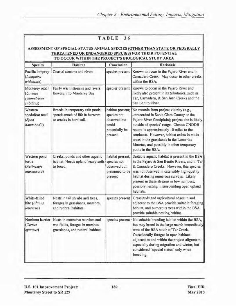
Chapter 2 - Environmental Setting. Impacts. Mitigation
TABLE 36
ASSESSMENT OF SPECIAL-STATUS ANIMAL SPECIES (OTHER THAN STATE OR FEDERALLYTHREATENED OR ENDANGERED SPECIES) FOR THEIR POTENTIAL
TO OCCUR WITHIN THE PROJECT'S BIOLOGICAL STUDY AREA
I Species I Habitat I Conclusion I Rationale IPacific lamprey Coastal streams and rivers species present Known to occur in the Pajaro River and in(Lampetra Carnadero Creek. May occur in other creeksridentate) within the BSA.
Monterey roach Fairly warm streams and rivers species present Known to occur in the Pajaro River andLavinia flowing into Monterey Bay likely also present in its tributaries, such as~ymmetricus Tar, Carnadero, & San Juan Creeks and the~ubditus) San Benito River.
lWestern Breeds in temporary rain pools; habitat present; No records from project vicinity (e.g.,
~padefoot toad spends much of life in burrows species not .unrecorded in Santa Clara County or theSpea or cracks in hard soil. observed but Pajaro River floodplain); project site is likely
~ammondii) could outside of species' range. Closest CNDDBpotentially be record is approximately 10 miles to thepresent southeast. However, habitat exists in moist
areas in the grasslands in the LomeriasMuertas, and possibly in other temporarypools in the BSA.
IWestern pond Creeks, ponds and other aquatic habitat present; Suitable aquatic habitat is present in the BSAurtle habitat. Needs upland heavy soils species not in the Pajaro & San Benito Rivers, and in Tar
(Actinemys to breed. observed but & Carnadero Creeks. However, this speciesIpJarmorata) presumed to be was not observed in ostensibly high-quality
present habitat during numerous surveys. Likelypresent in these streams in low numbers,possibly nesting in surrounding open uplandhabitats.
White-tailed Nests in tall shrubs and trees, species present Grasslands and agricultural edges in andkite (Elanus forages in grasslands, marshes, adjacent to the BSA provide suitable foragingeucurus) and ruderal habitats. habitat, and numerous trees within the BSA
provide suitable nesting habitat.
Northern harrier Nests in extensive marshes and species present No suitable breeding habitat within the BSA,
Circus wet fields, forages in marshes, but may breed in the large marsh immediatelycyaneus) grasslands, and ruderal habitats. west ofthe BSA south ofTar Creek.
Occasionally forages in open habitatsadjacent to and within the project alignment,especially during migration and winter, butconsidered "special status" only whenbreeding.
U.S. 101 Improvement Project:Monterey Street to SR 129
189 Final EIR
May 2013

Chapter 2 - Environmental Setting, Impacts, Mitigation
TABLE 36 Icontinuedl II Species I Habitat I Conclusion I Rationale IGolden eagle Nests in tall trees or on cliffs, habitat present; Expected to forage in grasslands on and nearAquila forages in grasslands and other species not the BSA. No nesting habitat on or near site.
rhrysaetos) open habitats. observed butcould occas-ionally forage
~estem Grasslands and ruderaJ habitats habitat present; Not observed during the 2007 breeding~urrowing owl where ground squirrel burrows species not season protocol-level survey that coveredAthene or other burrows are present. observed but most of the BSA. Known to breed nearby at~unicu/aria) . could be Bluestone Quarry. Habitat is present in the
present BSA, and areas with highest potential foroccurrence (e.g., extensive grasslands southof Castro Valley Road) were not included inthe protocol-level survey. Could breed orroost in grasslands and at the edges ofagricultural fields within the BSA.
Long-eared owl Nests in dense woodland, habitat present; Riparian habitat along creeks providesAsia atus) including riparian woodland, species not potential nesting habitat, but this species has
forages in open habitats observed; may not been recorded breeding (and has rarelyoccur as a rare been recorded at all) in valley-floor areas innonbreeding the project vicinity; likely absent, or at bestvisitor occurs as an infrequent forager during the
non-breeding season.
Loggerhead Nests in tall shrubs and dense habitat present; Though not observed during project surveys,~hrike (Lanius trees, forages in grasslands, species not shrubs and trees in open habitats providel/udavicianus) marshes, and ruderal habitats. observed; may suitable nesting sites, and ruderal habitats and
nest or forage grasslands in the BSA provide foragingin BSA habitat. May occur in low numbers.
lYeliow warbler Nests in dense stands of willow species present Nests and forages in willow- and(Dendroica and other riparian habitat. sycamore-dominated riparian habitat in thepetechia) BSA along the Pajaro River, San Benito
River, Tar Creek, and Camadero Creek.
IYellow-breasted Nests in dense stands of willow species present A single singing male was recorded in~hat (Icteria and other riparian habitat. willow-dominated riparian habitat along theIvirens) San Benito River during least Bell's vireo
protocol-level surveys. Expected to nest insuch habitats in low numbers.
U.S. 101 Improvement Project:Monterey Street to SR 129
190 Final EIRMay 2013

Chapter 2 - Environmental Setting, Impacts, Mitigation
TABLE 36 !continued)
Species Habitat Conclusion Rationale
Bryant's Breeds and forages in meadows, habitat present; Nests in extensive grassland adjacent to the:;avannah fallow fields, pastures, and salt species not BSA to the west of U.S. 101 and in thesparrow marshes. observed but Lomerias Muertas to the east. Unlikely toPasserculus could nest nest in the BSA due to proximity to
sandwichensis within BSA. disturbance and other habitats, but breedingalaudinus) could occur in the more extensive grassland
in the BSA south of Castro Vaney Road, andbirds breeding outside the BSA elsewherecould forage on-site during the breedingseason and during other seasons.
Grasshopper Breeds and forages in meadows, habitat present; Nests in extensive grassland adjacent to thesparrow fallow fields, and pastures. species not BSA to the west of U.S. 101 and in the(Ammondramus observed but Lomerias Muertas to the east. Unlikely tosavannarum) could nest nest in the BSA due to proximity to
within BSA. disturbance and other habitats, but breedingcould occur in the more extensive grasslandin the BSA south of Castro Valley Road, andbirds breeding outside the BSA elsewherecould forage on-site during the breedingseason and during other seasons.
~ricolored Nests colonially in cattails or foraging Emergent wetlands within the BSA are not~Iackbird other emergent vegetation habitat present; extensive enough to support a colony of thisAgelaius around freshwater ponds. species not species, though birds breeding in adjacent
Ifricolor) Considered "special-status" only observed but areas, and non-breeding birds, may forage inwhen breeding. could forage agricultural, ruderal, and grassland habitats in
within BSA. the BSA. A marsh south ofTar Creek andwest of the BSA provides potential breedinghabitat.
Western red bat This species is often found in foraging Likely present within riparian areas of theLasiurus forest or woodlands, especially habitat present; BSA during migration and winter months, but
~lossevillii) in or adjacent to riparian habitat. species not the habitats on-site are not suitable forobserved but breeding, as species is not known to breed incould forage the greater Bay Area and they prefer wide,within BSA. relatively pristine riparian areas for breeding.
Pallid bat Forages over many habitats; species present Evidence of night roosting activity under theIIAntrozous roosts in buildings, large oaks or NB 101 span of the San Benito River BridgeIpallidus) redwoods, rocky outcrops and was found during spring 2007 surveys.
rocky crevices in mines and Cavities in larger trees in the BSA providecaves. potential day-roosting habitat. Could roost
and breed on-site.
u.s. 101 Improvement Project:Monterey Street to SR 129
191 Final EIRMay 2013
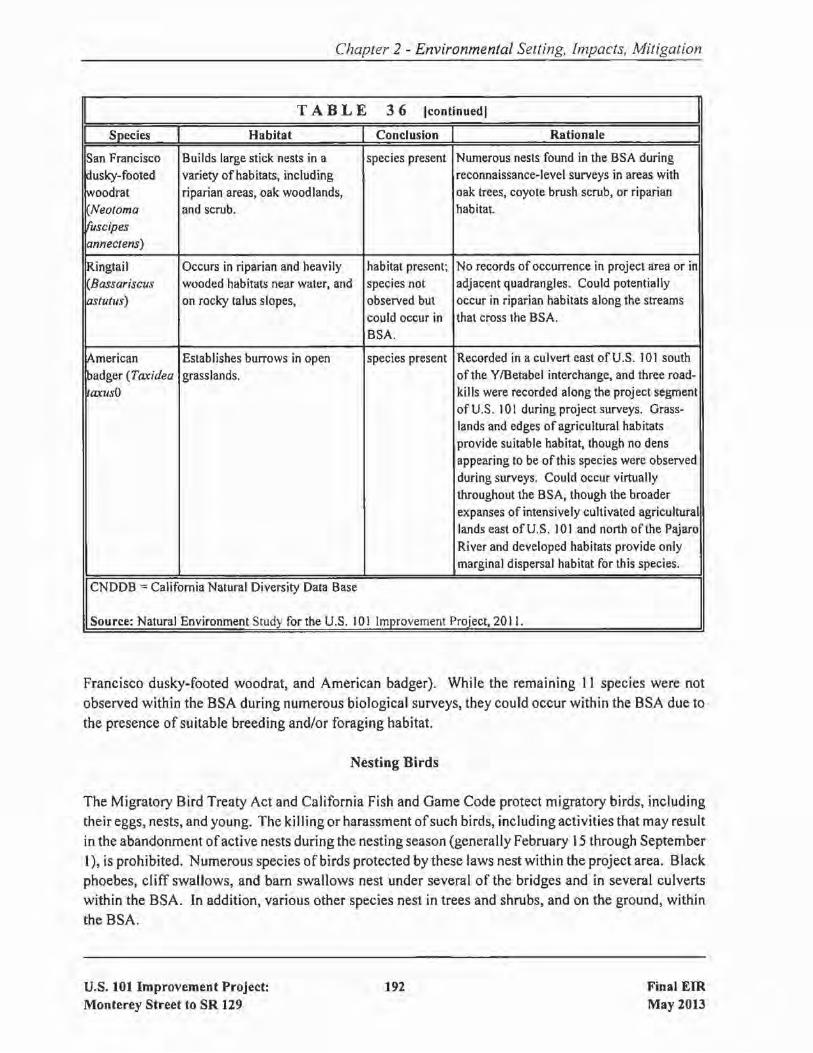
Chapter 2 - Environmental Setting, Impacts, Mitigation
TABLE 36 Icontinued] II Species I Habitat I Conclusion I Rationale ISan Francisco Builds large stick nests in a species present Numerous nests found in the BSA during
dusky-footed variety of habitats, including reconnaissance-level surveys in areas with
woodrat riparian areas, oak woodlands, oak trees, coyote brush scrub, or riparian
Neotoma and scrub. habitat."uscipesanneclens)
Ringtail Occurs in riparian and heavily habitat present; No records of occurrence in project area or in(Bassariscus wooded habitats near water, and species not adjacent quadrangles. Could potentiallyastutlls) on rocky talus slopes, observed but occur in riparian habitats along the streams
could occur in that cross the BSA.BSA.
~merican Establishes burrows in open species present Recorded in a culvert east of U.S. 101 south
padger (Taxidea grasslands. of the Y/Betabel interchange, and three road-ItaxusO kills were recorded along the project segment
of U.S. 10\ during project surveys. Grass-lands and edges of agricultural habitatsprovide suitable habitat, though no densappearing to be of this species were observedduring surveys. Could occur virtuallythroughout the BSA, though the broaderexpanses of intensively cultivated agriculturallands east of U.S. 101 and north of the PajaroRiver and developed habitats provide onlymarginal dispersal habitat for this species.
CNDDB =California Natural Diversity Data Base
Source: Natural Environment Study for the U.S. 101 Improvement Proiect, 2011.
Francisco dusky-footed woodrat, and American badger). While the remaining II species were notobserved within the BSA during numerous biological surveys, they could occur within the BSA due to
the presence of suitable breeding and/or foraging habitat.
Nesting Birds
The Migratory Bird Treaty Act and California Fish and Game Code protect migratory birds, including
their eggs, nests, and young. The killing or harassment ofsuch birds, including activities that may resultin the abandonment ofactive nests during the nesting season (generally February 15 through SeptemberI), is prohibited. Numerous species of birds protected by these laws nest within the project area. Blackphoebes, cliff swallows, and bam swallows nest under several of the bridges and in several culvertswithin the BSA. In addition, various other species nest in trees and shrubs, and on the ground, within
the BSA.
U.S. 101 Improvement Project:Monterey Street to SR 129
192 Final EIRMay 2013
Chapter 2 - Environmental Setting, Impacts, Mitigation
Roosting Bats
Focused surveys for roosting bats were conducted on six occasions from April to July 2007. Each bridgewithin the BSA was evaluated for its potential for bat habitat and visually surveyed for the presence ofbats and/or signs of bats. Bridges with potential for night and/or day roosting were also surveyedacoustically with the use of Anabat and Z-Caim recorders, which are devices used to detect vocalizing
bats.
Only three of the 10 bridges surveyed had bat use or potential roosting habitat for bats. Pallid bat guanowas found under the U.S. 101 northbound span over the San Benito River during the summer 2007surveys. This location is used as a night roost, and no evidence of day-roosting by pallid bats wasobserved. Additionally, two other bridges, the U.S. 101 southbound span over Tar Creek and U.S. 101northbound span over Camadero Creek, were confirmed night roost habitat based on the presence ofnight-roosting non-special-status bats during an evening survey. Pallid bats could also use these twobridges for roosting habitat.
The Yuma bat forages over permanent streams, such as Camadero and Tar Creeks in the BSA. Nightroosts of Yuma myotis were observed on all three bridges on the site that had evidence of bat use (i.e.,U.S. 101 southbound span over Tar Creek, the U.S. 101 northbound span over Camadero Creek, and theU.S. 101 northbound span over the San Benito River). Because several Yuma myotis were observedentering and leaving mud nests from an active cliff swallow colony within about an hour after sunset,this species likely day roosts and night roosts at the southbound U.S. 101 bridge over Tar Creek and theUPRR. Based on the low numbers of bats observed leaving and entering these nests, the roosts were
likely occupied by males (and not breeding females). These bats were not day-roosting under theCamadero Creek bridge, and thus their maternity colony is likely located in an off-site structure or ina tree.
2.20.3 Environmental Consequences of the Build Alternative
This section of the EIR describes the impact of the project on the 20 special-status animal species thatare known to be present, or could be present, within the BSA. For some of these species, impacts arediscussed separately, while impacts to other species are grouped into one discussion due to the similarity
of habitat, impacts, and (if warranted) mitigation.
2.20.3.1 Impacts to Pacific Lamprey and Monterey Roach
Project-related impacts to aquatic habitats have been avoided to the maximum extent feasible. Thebridge improvements have been designed so that no new piers or structures will be placed in the lowflow channel of any waterway supporting the Monterey roach and Pacific lamprey, although inCarnadero Creek, existing piers will be extended upstream to support the new span.
U.S. 101 Improvement Project:Monterey Street to SR 129
193 Final EIRMay 2013

Chapter 2 - Environmental Setting, Impacts, Mitigation
The detention basin proposed adjacent to the San Benito River just upstream from U. S. 101 is beingdesigned to minimize the risk of fish entrapment. The entire basin will be graded so that it drainscompletely through an outlet to the river, with no depressional areas that would support long-termponding. The outlet will be elevated above the ordinary flow of the river. Therefore the pipe's outletwould not be accessible to fish except during very high flows, when water would be flowing out ofthepipe, thus limiting the ability offish to enter the basin. Fish would only be able to enter the basin duringflood flows and would be expected to exit the basin as water levels drop. They will thus spend little timewithin the basin and there is little chance of entrapment when retained water recedes.
Removal ofriparian vegetation by the project will adversely affect fish because it provides cover for fish,shade to reduce water temperatures, and food input (i.e., terrestrial invertebrates), and is considered a
very valuable component of fish habitat.
The removal of approximately 890 linear feet ofSRA habitat at the Pajaro River, San Benito River, andCarnadero Creek may reduce habitat quality within and downstream from affected stream reaches dueto slightly increased water temperatures and reduction in inputs of organic matter and coarse woodydebris, thus affecting the aquatic food chain and aquatic habitat structure, respectively. However,shading from widened bridge structures will offset impacts to water temperatures somewhat, and giventhe sizes of the watersheds contributing to the stream reaches in the BSA, the small-scale, localizedeffects ofreduction in SRA habitat are expected to be minimal.
Approximately 0.02 acres of aquatic habitat in Carnadero Creek will be lost due to the extension ofexisting piers upstream to support the new U.S. 101 bridge span. This impact will result in the loss ofa small amount ofaquatic habitat for the Pacific lamprey and Monterey roach. On the scale ofthe PajaroRiver watershed, or even on the scale of Carnadero Creek itself, such impacts will have minimal effectson these species. These structures will not impede fish movement, and no individuals are expected tobe impacted due to the minor loss of foraging opportunities associated with the new structures.
There is some potential for Pacific lampreys or Monterey roach to be killed or injured duringconstruction of cofferdams used to dewater reaches of creek where work will occur (if these reachescontain water during the construction period). Construction activities adjacent to waterways coulddisturb soils and cause sediment to be transported into and through the channel, which would result intemporary increases in turbidity and sedimentation downstream ofconstruction sites. In addition, fuel,concrete, and other contaminants could spill into the waterway during construction.
Pacific lampreys or Monterey roach may suffer higher predation rates swimming through bypasschannels constructed around cofferdams. The fish could also be adversely impacted by noise andvibrations related to pile driving during installation of bridge supports. Noise and vibration from piledriving, jack-hammering, or other percussive activities could cause the mortality of individual fish orcould cause sensory damage. The loss ofhearing sensitivity may adversely affect the ability of the fishto orient themselves, detect predators, locate prey, or sense their acoustic environment. Fish also mayexhibit noise-induced avoidance behavior that causes them to move into less suitable habitat.
U.S. 101 Improvement Project:Monterey Street to SR 129
194 Final EIRMay 2013

Chapter 2 - Environmental Setting, Impacts, Mitigation
Impact ANIMAL-l: The project will result in both short- and long-term adverse impacts to Pacificlampreys and Monterey roach. [Less-than-Significantwith Mitigation Listedin Section 2.20.5]
2.20.3.2 Impacts to Western Spadefoot Toad
The western spadefoot toad is not expected to occur in the Santa Clara County portion of the BSA. Asa result, impacts to ponds and seasonal wetlands in the Santa Clara County portion of the BSA will notaffect this species. There is a low potential for the western spadefoot to occur in the San Benito Countyportion of the BSA, and even if it does occur there, the project will not impact any potential westernspadefoot breeding habitat in the San Benito County part of the project. Some upland habitat for thespecies could be impacted along the eastern side of the BSA in the vicinity of the Lomerias Muertas;however, quantification of these habitat impacts is not possible given the uncertainty regarding wherethe species occurs, if it occurs in the project area at all.
To summarize, there is a very low potential for impacts to western spadefoot toads, and if impacts dooccur, they will affect only a small amount of habitat (and small number of individuals). As a result,project impacts to this species will not be substantial.
Impact ANIMAL-2: The project's effect on the western spadefoot toad will not be substantial. [Lessthan-Significant Impact)
2.20.3.3 Impacts to Western Pond Turtle
Although no western pond turtles were observed during surveys that were undertaken during thepreparation of this EIR, this species is expected to occur within the BSA in very low numbers in thePajaro River, San Benito River, San Juan Creek, Tar Creek, Camadero Creek, and possibly Tick Creek.As a result, construction-related activities at these locations could result in harm to individual turtles ifthey are trampled by personnel or equipment.
The project's impact to the wetland and aquatic habitat that is utilized by the western pond turtle willnot constitute a substantial loss ofthis species' habitat. In any event, as described in Section 2.18.5, theproject's impacts to wetland and aquatic habitat will be mitigated.
Impact ANIMAL-3: Construction activities could result in harm to individual western pond turtles.[Less-than-Significant with Mitigation Listed in Section 2.20.5)
2.20.3.4 Impacts to Non-Breeding Special-Status Bird Species
Impacts to the golden eagle and long-eared owl are grouped together because I) they are not expectedto nest in the project vicinity, and 2) they will be minimally affected by the project.
U.S. 101 Improvement Project:Monterey Street to SR 129
195 Final EIRMay 2013

Chapter 2 - Environmental Setting, Impacts, Mitigation
A very small amount of potential foraging habitat for the golden eagle and long-eared owl will be lostdue to grading and paving associated with the project. In addition, small numbers of individuals ofthesespecies may be disturbed during construction by construction personnel, heavy equipment. and noise,and such individuals may avoid foraging in the BSA during construction as a result. However, the BSAdoes not provide important foraging habitat used regularly or by large numbers of individuals of eitherof these species, and the project will have no long-term or large-scale effects on populations of thesespecies. In addition, riparian, wetland, aquatic, and oak woodland habitats impacted by this project willbe mitigated by the provision of such habitat elsewhere (see Sections 2.17.5 and 2.18.5). Suchmitigation habitat will provide foraging habitat for these bird species.
Impact ANIMAL-4: The project's effect on the golden eagle and the long-eared owl will not be
substantial. [Less-than-Significant Impact]
2.20.3.5 Impacts to Breeding Special-Status Bird Species ofLimited Occurrence
Impacts to the following seven special-status bird species are grouped together because they are expectedto nest in or adjacent to the BSA, but in numbers so low that the proposed project will have a limitedimpact on regional populations: white-tailed kite, northern harrier, loggerhead shrike, yellow warbler,yellow-breasted chat, Bryant's savannah sparrow, and grasshopper sparrow.
A relatively small amount of potential nesting and foraging habitat for these seven species will be lostdue to the project, and small numbers offoraging individuals of these species may be disturbed duringconstruction. However, riparian, wetland, aquatic, and oak woodland habitats impacted by this project
will be mitigated by the provision of such habitat elsewhere (see Sections 2.17.5 and 2.18.5). Suchmitigation habitat will provide nesting and foraging habitat for these bird species.
Impacts to individual birds that could be nesting in trees that will be removed during construction, ortrees immediately adjacent to the construction zone, are described in Section 2.20.3.12, Impacts toNesting Birds.
Impact ANIMAL-5: The project's effect on seven special-status bird species that could nest in the
project impact area will not be substantial. ILess-than-Significant Impact]
2.20.3.6 Impacts to the Western Burrowing Owl
Protocol-level surveys for the burrowing owl were conducted in 2007 for a portion of the BSA.Although no owls were found during the surveys, owls are known to be present in the vicinity of theBSA. Further, the portion of the BSA that was not accessible for the 2007 surveys contains burrowingowl habitat. Therefore, owls could be present within the project area at the time of construction.
Ifwestern burrowing owls occupy the project site prior to construction, the project will result in a lossofnesting and/or roosting habitat; such impacts could be substantial given the low size ofthe burrowing
U.S. 101 Improvement Project:Monterey Street to SR 129
196 Final EIRMay 2013

Chapter 2 - Environmental Setting, Impacts, Mitigation
owl population in southern Santa Clara County and northern San Benito County. Construction activitiescould also harm individual owls if they are nesting within the project's impact area at the time ofconstruction.
Impact ANIMAL-6: The project could result in a loss of burrowing owl habitat and harm toindividual owls if the owls are found to occupy the project site prior toconstruction. [Less-than-Significant with Mitigation Listed in Section2.20.5]
2.20.3.7 Impacts to the Tricolored Blackbird
Habitat located within the BSA is not suitable for breeding by tricolored blackbirds and, therefore, nobreeding habitat for this species will be impacted by the project. Although the project will result in theloss ofgrassland, wetland, and agricultural habitat that could be used by foraging tricolored blackbirds,foraging habitat for this species is regionally abundant. Therefore, project impacts to tricoloredblackbird foraging habitat will not result in substantial impacts to this species.
Impact ANIMAL-7: The project's effect on the tricolored blackbird will not be substantial. [Less
than-Significant Impact]
2.20.3.8 Impacts to the San Francisco Dusky-footed Woodrat
During biological surveys undertaken for this EIR, suitable woodrat habitat containing woodrat nestswas found in most ofthe oak woodland, riparian, and coyote brush scrub habitats in the BSA, and nestswere observed even in isolated oaks. Woodrats are semi-colonial species and often more than one nestwas detected in a relatively small area within suitable habitat. Although nests were not counted ormapped, the density and widespread nature of woodrat nests suggests that 100 or more woodrat nestsmay be present within the BSA.
Construction activities within riparian, oak woodland, and coyote brush habitats will likely result in thedestruction of woodrat nests and harm to nesting woodrats.
Construction of the proposed project will also result in the loss of oak woodland, riparian, and coyotebrush habitat that is utilized by the woodrat. As shown in Table 34, permanent impacts to these habitatswill be up to 12 acres and temporary impacts to these habitats will be up to 15.5 acres. Despite the highnumber of woodrat nests that will be impacted, and the extent of occupied woodrat habitat that will belost, these impacts will affect only a very small proportion ofthe regional population/habitat. Biologistshave documented very high densities ofwoodrats using oak woodland and riparian habitats in the PajaroRiver Valley, and this project will not appreciably reduce regional populations of this species.
Impact ANIMAL-8: While the impact of the project on habitat used by the San Francisco duskyfooted woodrat will not be substantial, construction activities are likely to harm
U.S. 101 Improvement Project:Monterey Street to SR 129
197 Final EIRMay 2013

Chapter 2 - Environmental Setting, Impacts, Mitigation
or kill woodrats that nest within the construction zone. [Less-than-Significant
with Mitigation Listed in Section 2.20.5]
2.20.3.9 Impacts to Bats
As described in Section 2.20.2, the only known bat roosts within the BSA are night roosts on the U.S.101 northbound span over Camadero Creek and the U.S. 101 northbound span over the San BenitoRiver, and a day roost for small numbers ofYuma myotis and Mexican free-tailed and/or big brown batson the U.S. 101 southbound span over Tar Creek. Construction-related disturbance from the projectwould only temporarily impact these roosts, as the new or modified structures are expected to provide
night-roosting habitat ofsimilar quality to that currently present. Bats may continue to use bridges thatare not demolished during construction as long as night work involving bright lighting under the bridgesis not used. Ifthe bats are displaced (e.g., due to demolition), sufficient alternative night-roosting habitatis present that displacement during construction will not result in substantial loss of individuals fromlocal and regional populations.
Ifbats are day-roosting in trees or buildings in the BSA (which were not surveyed), the removal ofthese
trees and structures will result in the permanent loss ofday-roost habitat and may result in the injury or
mortality of individual bats. Ifbats establish a maternity colony in one of the project's bridges prior tothe initiation ofconstruction, project activities could result in the temporary loss ofday-roost habitat and
may result in the injury or mortality of individual bats.
Impact ANIMAL-9: During the construction phase, the project could adversely affect roosting bats,potentially resulting in temporary loss of day-roost habitat and hann to
individual bats. [Less-than-Significant with Mitigation Listed in Section
2.20.5]
2.20.3.10 Impacts to the Ringtail
There are no CNDDB records of the ringtail in the project area and none was observed during wildlifesurveys. Ringtails are, however, secretive by nature and not easy to detect. Therefore, since habitat usedby the ringtail is present within the BSA, it is possible that ringtails are present.
If present within the project's construction zone, ringtail dens could be destroyed, possibly causing theinjury or mortality of ringtails and their young.
Loss of ringtail habitat due to the project will constitute only a very small proportion of the habitatlocally available forthis species. Therefore, project impacts will not substantially affect local or regionalringtail populations.
Impact ANIMAL-I0: While the impact of the project on habitat used by the ringtail will not besubstantial, construction activities could hann or kill ringtails if they are found
U.S. 101 Improvement Project:Monterey Street to SR 129
198 Final EIRMay 2013
Chapter 2 - Environmental Setting, Impacts, Mitigation
to be nesting within the construction zone. [Less-than-Significant withMitigation Listed in Section 2.20.5]
2.20.3.11 Impacts to the American Badger
The primary effects ofthe project on American badgers will be a potential increase in road mortality andthe potential effects of the project on badger movement across U.S. 101. This impact is discussed inSection 2.17.3.3, Impacts to Wildlife Movement Corridors.
Loss of badger habitat due to the project will constitute only a very small proportion of the habitatlocally available for this species. Additionally, badger habitat to be impacted by the project is of lowerquality than the extensive grasslands adjacent to the BSA. Therefore, project impacts will notsubstantially affect local or regional American badger populations.
If present within the project's construction zone, badger dens could be destroyed, possibly causing theinjury or mortality of badgers and their young. If badgers have to be evicted from their dens, there issome potential that they may be exposed to greater predation risk or greater road mortality while theyare seeking out new denning sites, especially if suitable habitat in adjacent areas is already occupied bybadgers.
Impact ANIMAL-11: While the impact of the project on habitat used by the badger will not besubstantial, construction activities could harm or kill badgers if they are found
to be denning within the construction zone. [Less-than-Significant withMitigation Listed in Section 2.20.5]
2.20.3.12 Impacts to Nesting Birds
Construction activities could adversely impact birds that nest under the existing bridges, andlor in thetrees and shrubs that are within or adjacent to the project impact area. Potential impacts include thedestruction of active nests, the incidental loss of fertile eggs or nestlings, or the abandonment of nests.
Impact ANIMAL-12: Construction activities may adversely affect birds that are nesting within oradjacent to the project's construction zone. [Less-than-Significant withMitigation Listed in Section 2.20.5]
2.20.4 Environmental Consequences of the No Build Alternative
Under the No Build Alternative, the improvements to U.S. 101 that comprise the Build Alternativewould not be constructed. There would be no modification to existing facilities or to the existingenvironment. There would, therefore, be no impacts to any special status animal species.
U.S. 101 Improvement Project:Monterey Street to SR 129
199 Final EIRMay 2013

2.20.5
Chapter 2 - Environmental Setting, Impacts, Mitigation
Avoidance, Minimization, and/or Mitigation Measures
The following measures, which are included in the project, will reduce the project's significant effectson the Pacific lamprey and Monterey roach to a less-than-significant level:
MM-ANIMAL-l.l: The project wi II fully mitigate for impacts to SRA, riparian, and aquatic habitats.This mitigation is described in Sections 2.17.5 and 2.18.5.
MM-ANIMAL-1.2: Any construction activities within the low-flow channels of waterways wherePacific lamprey and Monterey roach are known or likely to occur will be limitedto the period of June 15 to October 15.
MM-ANIMAL-1.3: For waterways where Pacific lamprey and Monterey roach are known or likelyto occur, measures will be taken to ensure that movement of fish is notprevented by any water diversion structures used during construction regardlessof when construction occurs. Water will be diverted through the constructionsite by way ofan open ditch, enclosed culvert (which further protects fish frompressure waves created during pile driving [see MM-T&E-l.5]), or other methodapproved by the regulatory agencies.
MM-ANIMAL-l.4: The project will implement measures during construction to avoid and minimizethe potential degradation of water quality within any waterways where Pacificlamprey and Monterey roach are known or likely to occur. These measures aredescribed in Section 2.22.6.
The following measures, which are included in the project, will reduce the project's significant effectson the western pond turtle to a less-than-significant level:
MM-ANIMAL-3.1: A pre-construction survey for the western pond turtle will be conducted within30 days prior to any site preparation, grading or construction activity at thePajaro River, San Benito River, San Juan Creek, Tar Creek, Carnadero Creek,and Tick Creek. A single, intensive search for this species will be performed inareas exhibiting even marginally suitable habitat, covering the area ofpotentialimpact at each creek crossing and extending at least 500 feet beyond the area ofpotential impact both upstream and downstream. (fthis species is found withinthe surveyed area, the CDFW will be notified of such occurrence and, ifpossible, and without injury, individuals will be captured and moved to a safelocation by a qualified biologist, at least 500 feet away from the area ofpotentialimpact.
MM-ANIMAL-3.2: If individuals and/or suitable habitat are located within 500 feet of the area ofpotential impact at a creek crossing, monitoring will be performed during the
U.S. 101 Improvement Project:Monterey Street to SR 129
200 Final EIRMay 2013

Chapter 2 - Environmental Setting, Impacts, Mitigation
process of clearing vegetation within the construction zone, to ensure that anywestern pond turtles that may be present will be safely relocated. The biologistconducting such monitoring, if necessary, will have the authority to haltoperations in the immediate area to avoid harming turtles, if present, untilindividuals are safely captured and relocated. The CDFW will be notified ofsuch occurrence.
MM-ANIMAL-3.3: During pre-construction surveys and other measures to be implemented forCalifornia red-legged frogs and California tiger salamanders (see Section2.21.5), a qualified biologist will look for western pond turtles within theproject's impact areas. Ifany pond turtles are detected during these surveys, orduring construction, in an area where the individuals could be impacted, theywill be relocated to a suitable location outside the area of project impact inconsultation with the CDFW.
The following measures, which are included in the project, will reduce the project's significant effectson the western burrowing owl to a less-than-significant level:
MM-ANIMAL-6.1: Pre-construction surveys will be undertaken to determine if owls utilize thehabitat to be impacted by the project.
MM-ANIMAL-6.2: Prior to construction, during the non-nesting season (September 2 - Februaryill, any owls occupying burrows within construction zones will be passivelyrelocated under the authorization of the CDFW. Passive relocation is anintensive process that involves the installation of one-way doors in all groundsquirrel burrows occurring on the site; such doors allow owls to leave theirburrows but do not allow them to return, thereby forcing owls to move to adifferent area. The doors will be monitored by a qualified biologist daily for aperiod ofno less than three days and after that period, burrows wi II be destroyedto preclude owls from returning to the burrows, and grading of these areas willcommence within seven days. The passive relocation will be repeated if owlsmove back to the construction areas.
MM-ANIMAL-6.3: Burrows within the construction zone that are occupied by owls will not bedisturbed during the nesting season (February IS through September I) unlessa qualified biologist verifies that either the owls have not begun laying andincubating eggs, or that juvenile owls have fledged and are able to liveindependently of their parents. If construction will occur during the nestingseason, the project will establish and maintain a minimum ofa 250-foot bufferaround any active nest.
U.S. 101 Improvement Project:Monterey Street to SR 129
201 Final EIRMay 2013

Chapter 2 - Environmental Setting, Impacts, Mitigation
MM-ANIMAL-6.4: If, based on pre-construction surveys, it is determined that owls utilize habitatthat will be impacted by the project, mitigation for the loss of such habitat willtake the form of the payment of development fees to the Santa Clara ValleyHCPINCCP. For more information on the HCPINCCP, please see Section2.17.5.
MM-ANIMAL-6.5: If MM-ANIMAL-6.4 turns out to be infeasible for some or all of the project,mitigation will consist of the purchase of credits from a mitigation bank thatserves the project area. Ifno banks or credits are available, then the project will
develop and implement a plan for the creation or enhancement of burrows,maintenance of burrows and management of foraging habitat, monitoringprocedures, funding assurance, annual reporting requirements, and contingencyand remediation measures. The extent of the mitigation lands (either for thepurchase ofmitigation credits or for project-sponsored mitigation). enhancementmeasures, and other details will be determined based on the circumstancessurrounding the owls to be impacted and their habitat. in consultation with the
CDFW. Mitigation ~otJld be provided at a ratio of6.5 acres ofburrowil1g o \'V Ihabitat per pair or unpaired o\'V1 that will be impacted by the project.
[Note: MM-ANIMAL-6.5 will be implemented only if MM-ANIMAL-6.4 isdetermined to be partially or completely infeasible.]
Ifproject-sponsored burrowing owl mitigation is necessary, a wildlife ecologistwill develop an HMMP for burrowing owls, in consultation with the CDFW.which will contain the following components:I. Summary of habitat impacts and proposed mitigation ratios.
2. Goal of the habitat mitigation.3. Location of mitigation site(s) and description of existing site conditions.4. Mitigation design:
• Habitat enhancement measuresRemedial measures/adaptive management. etc.
5. Monitoring plan (including performance and final success criteria, monitoringmethods, data analysis, reporting requirements, monitoring schedule, etc.), Ata minimum, success criteria will include the presence of burrowing owls,suitable burrows for owls. and Quantitative measures of vegetationcharacteristics for suitable owl habitat.
6. Contingency plan for mitigation elements that do not meet performance orfinal success criteria.
At least five years of monitoring shall be conducted to document whether thesuccess criteria are achieved, and to identify any remedial actions that must betaken if the identified success criteria are not met.
U.S. 101 Improvement Project:Monterey Street to SR 129
202 Final EIRMay 2013

Chapter 2 - Environmental Setting, Impacts, Mitigation
The following measures, which are included in the project, will reduce the project's significant effectson the San Francisco dusky-footed woodrat to a less-than-significant level:
MM-ANIMAL-8.1: Prior to any clearing of - or work within - riparian, oak woodland, or coyotebrush scrub habitat, or the removal of any oak trees located outside thesehabitats, a qualified biologist will conduct a survey for San Franciscodusky-footed woodrat nests.
MM-ANIMAL-8.2: .Where nests are found, and if feasible, the project will maintain a buffer of atleast several feet (preferably as much as 10 feet) around these nests. Thepurpose of the buffer is to avoid moving or bumping the nests or logs orbranches on which the nests rest.
Ifavoidance ofnests is not feasible, the nests will be dismantled and the nestingmaterial moved to a new location outside the project's impact area. Prior todismantling, understory vegetation will be cleared within the project site or inthe area immediately surrounding the nest. Then, each active nest will bedisturbed by a qualified wildlife biologist to the degree that the woodrats leavethe nest and seek refuge out of the impact area. Whether the nest is on theground or in a tree, the nest would be nudged to cause the woodrats to flee, andthen dismantled. For tree nests, a tarp will be placed below the nest and the nestdismantled using hand tools (either from the ground or from a lift).
Nesting material will be located outside the project's impact area in a way thatit can be used by woodrats to construct new nests. The nest material will bepiled at the base of a nearby hardwood tree (preferably an oak, willow, or otherappropriate tree species, with refuge sites among the tree roots). If nearbyhabitat outside the impact area lacks suitable structure, logs (e.g., 4 feet long and6 inches in diameter) will be placed in undisturbed riparian or oak woodland
habitat nearby and the sticks from the dismantled nests will be placed amongthese logs. Ideally, the spacing distance between the newly placed piles ofsticks
should not be less than 100 feet, unless a qualified wildlife biologist hasdetermined that a specific habitat can support higher densities of nests.
The following measures, which are included in the project, will reduce the project's significant effectson roosting bats to a less-than-significant level:
MM-ANIMAL-9.1: A pre-construction/pre-demolition survey for roosting bats will be conductedprior to any construction on the U.S. 101 southbound span over Tar Creek,which is the only bridge with day roosting by bats. Such a survey will also beconducted in any trees and buildings within or immediately adjacent to theproject impact area that are identified by a qualified bat biologist (i.e., a
U.S. 101 Improvement Project:Monterey Street to SR 129
203 Final EIRMay 2013

Chapter 2 - Environmental Setting, Impacts, Mitigation
biologist holding a CDFW collection permit allowing the biologist to handle andcollect bats) as being high-potential roost sites. If suitable roost sites are foundbut a visual survey is not adequate to determine presence or absence of bats,acoustical equipment will be used to determine occupancy. This survey will beconducted prior to the beginning of the breeding season (i.e., prior to March 1)in the year in which construction or demolition in a given area is scheduled tooccur so that adequate measures can be implemented, if feasible, to evict thebats during the non-breeding season.
MM-ANIMAL-9.2: Because the aforementioned survey will be conducted prior to the breedingseason, several months may pass between that survey and the initiation ofconstruction or demolition in a given area. Therefore, a second preconstruction!pre-demolition survey for roosting bats, following the methods described above,will be conducted within 15 days prior to the commencement ofthese activitiesin a given area to determine whether bats have occupied a roost in or near theproject's impact areas. This survey should be facilitated considerably byinformation (e.g., on potential roost trees) gathered during the previous survey.
MM-ANIMAL-9.3: Ifa maternity roost ofany bat species is present, the bat biologist will determinethe extent of a construction-free buffer around the active roost that will bemaintained. This buffer wot:ttd will be maintained from April 1 until the youngare flying, typically after August 31.
MM-ANIMAL-9.4: If a day roost is found on a bridge, in a building, or in a tree that is to becompletely removed or replaced, individual bats will be safely evicted under thedirection ofa qualified bat biologist. Eviction of bats will occur at night, so thatbats will have less potential for predation compared to daytime roostabandonment. Eviction will occur between September 1sl and March 31 S\
outside the maternity season, but will not occur during long periods of inclementor cold weather (as determined by the bat biologist) when prey are not availableor bats are in torpor. No day roosts are currently known to occur in crevices onbridges in the BSA, but ifsuch a roost is found during preconstruction surveys,one-way doors will be inserted into the crevices to allow bats to exit, but notre-enter, the crevices. These one-way doors will be inspected regularly untildemolition commences, and will be removed the morning of demolition.
If a day roost is found within a building, eviction will occur by opening theroosting area to allow airflow through the cavity. Demolition should then followno sooner than the following day (i.e., there should be no less than one nightbetween initial disturbance for airflow and the demolition). This action shouldallow bats to leave during dark hours, thus increasing their chance of findingnew roosts with a minimum of potential predation during daylight.
U.S. 101 Improvement Project:Monterey Street to SR 129
204 Final EIRMay 2013

Chapter 2 - Environmental Setting, Impacts, Mitigation
Iffeasible, one-way doors will also be used to evict bats from tree roosts. Ifuseofa one-way door is not feasible, or the exact location of the roost entrance ina tree is not known, the trees with roosts that need to be removed should first bedisturbed by removal of some of the trees' limbs not containing the bats. Suchdisturbance will occur at dusk to allow bats to escape during the darker hours.These trees would then be removed the following day. All of these activitieswill be performed under the supervision of the bat biologist.
MM-ANIMAL-9.5: If a day roost will be impacted, an alternative bat roost structure will beprovided. The design and placement of this structure will be determined by abat biologist, in consultation with the CDFW, based on the species of bat to bedisplaced, the location of the original roost, and the habitat conditions in thevicinity. The roost structure will be built to specifications as detennined by abat biologist and CDFW, or it may be purchased from an appropriate vendor.The structure will be placed as close to the impacted roost site as feasible, whichmay include placement within trees, on bridge structures, or other locations asdetennined by a bat biologist and CDFW. This bat structure will be erected atleast one month (and preferably a year or more) prior to removal ofthe originalroost structure. A bat biologist will monitor this structure during the breedingseason for up to three years following completion of the project, or until it isfound to be occupied by bats, to provide infonnation for future projectsregarding the effectiveness of such structures in minimizing impacts to bats.
MM-ANIMAL-9.6: In some circumstances, it may be beneficial to allow roosting bats to continueusing a roost while construction is occurring on or near the roost site. Forexample, if a bridge found to contain a day roost is being widened but is notbeing demolished, and if pile-driving, jack-hammering, or other sources of"extreme" disturbance will not occur, a qualified bat biologist (in consultationwith the CDFW) will detennine whether the bats should be evicted or whetherthey should remain in place. If it is determined that the risks to bats fromeviction (e.g., increased predation or exposure, or competition for roost sites) are
greater than the risk of colony abandonment, then the bats will not be evicted.In the case of non-maternity colonies, no alternative roost structures will needto be provided, and no monitoring of the colony during construction will benecessary.
However, if a maternity colony is maintained in place while construction on orimmediately adjacent to the colony takes place, some minimal infonnation onthe increase in disturbance to which bats are subjected during construction andon the bats' response to that disturbance will be collected. This information willhelp to inform the impact assessment of, and the development of impactminimization measures for, similar projects in the future. Baseline data on the
U.S. 101 Improvement Project:Monterey Street to SR 129
205 Final EIRMay 2013

Chapter 2 - Environmental Setting, Impacts, Mitigation
vibration and sound levels at the bridge site will also be collected for a minimumof 2 days within 5 days of construction commencement. Following thispre-construction, baseline monitoring, the colony will then be monitored everynight during construction using acoustic surveying methods, such as Anabatequipment, to determine the status of the colony (i.e. to determine if the colonyabandons the roost). Monitoring equipment will also be used to sampleconstruction-related increases in noise and vibration.
Project implementation will not have to be modified based on the findings ofthis monitoring, even if the bats abandon the roost. However, these data wi IIallow for a determination of whether or not the bats remained at the bridgeduring construction and/or changed their activity patterns in relation to varyinglevels of noise and vibration.
The following measure, which is included in the project, will reduce the project's significant effects onnesting ringtails to a less-than-significant level:
MM-ANIMAL-IO.l: If a ringtail nest is detected incidentally (Le., during the woodrat surveysdescribed in MM-ANIMAL-8.1), a qualified mammalogist will determine theextent of a construction-free buffer zone that should be maintained around theden. Construction activities within this zone will not occur during the periodMarch 1 through August 31 to avoid potential construction disturbance to theringtail during the breeding season. After August 31, individuals will be safelyevicted, under the direction of a qualified mammalogist, by disturbing the densite under the cover ofdarkness to allow the ringtail(s) to move safely to a newlocation without being exposed considerably to predators or competitors.
The following measure, which is included in the project, will reduce the project's significant effects onnesting badgers to a less-than-significant level:
MM-ANIMAL-ll.l: A qualified mammalogist will conduct preconstruction surveys for badger denson and within 300 feet of the site (as access permits), within two weeks prior togroundbreaking in any given area occupied by grassland or ruderal habitat. Ifthe mammalogist identifies any dens that appear suitable for this species (basedon size, shape, or other features), such "potential dens" will be monitored viatracking media or camera for a period of at least three days to determineoccupancy, then excavated ifno evidence ofoccupancy is detected. Ifan activematernity badger den is located, the mammalogist will determine the measures(e.g., buffers) that will be taken to avoid impacts to the den during the puppingseason (i.e., February 15 through July 1, or as otherwise determined throughsurveys and monitoring of the den), in consultation with the CDFW. After thepupping season, if a den is located in the project impact area, the badgers will
u.s. 101 Improvement Project:Monterey Street to SR 129
206 Final EIRMay 2013

Chapter 2 - Environmental Setting, Impacts, Mitigation
be evicted by excavation of the den using hand tools under the supervision of aqualified mammalogist, in consultation with the CDFW.
The following measures, which are included in the project, will reduce the project's significant effectson nesting birds to a less-than-significant level:
MM-ANIMAL-12.1: Vegetation that will be impacted by the project will be removed during the nonbreeding season (Le., September 1to February1+4), iffeasible, to help precludenesting. If it is not feasible to schedule vegetation removal during the nonbreeding season, then pre-construction surveys for nesting birds will beconducted by a qualified ornithologist to ensure that no nests will be disturbedduring project implementation. This survey will be conducted no more thanseven two days prior to the initiation of construction activities. During thissurvey, the ornithologist will inspect trees, shrubs. and other potential nestinghabitats in and immediately adjacent to the project impact areas for nests. Ifanactive nest is found sufficiently close to work areas to be disturbed by theseactivities, the ornithologist, in consultation with CDFW, will determine theextent ofa buffer zone to be established around the nest, which can range from
50 to 250 100 to 300 feet or more depending on the sensitivity ofthe nest and/orspecies.
MM-ANIMAL-12.2: At bridges, to avoid impacts to nesting swallows and black phoebes, old nests
will be removed prior to February 15, or after February 15 if a qualifiedornithologist determines that the nests are not active. Maintaining bridges freefrom nesting birds may require the placement ofnetting or other structures overthe underside ofthe bridges to prevent swallows and other birds from accessingsuitable nesting substrate. Alternatively. nest starts may be removed on aregular basis (e.g., every other day) to prevent active nests from becomingestablished. Because both roosting bats and nesting swallows occur on at leastone bridge (the southbound U.S. 101 span over the UPRRlTar Creek),
coordination of exclusion efforts may be necessary. Thus, if exclusion devicessuch as netting will be installed prior to February 15 to prevent swallows fromnesting, and if measures are taken to exclude roosting bats, all these measureswill need to be implemented prior to February 15.
2.21
2.21.1
THREATENED AND ENDANGERED SPECIES
Regulatory Setting
The primary federal law protecting threatened and endangered species is the Federal Endangered SpeciesAct (FESA): 16 USC Section 1531, et seq. See also 50 CFR Part 402. This act and subsequent
U.S. 101 Improvement Project:Monterey Street to SR 129
207 Final EIRMay 2013
Chapter 2 - Environmental Setting, Impacts, Mitigation
amendments provide for the conservation ofendangered and threatened species and the ecosystems uponwhich they depend. Under Section 7 of this act, federal agencies. such as the Federal HighwayAdministration (FHWA), are required to consult with the US Fish and Wildlife Service (USFWS) andthe National Oceanic and Atmospheric Administration's National Marine Fisheries Service (NOAAFisheries Service) to ensure that they are not undertaking, funding, permitting or authorizing actionslikely to jeopardize the continued existence of listed species or destroy or adversely modify designatedcritical habitat. Critical habitat is defined as geographic locations critical to the existence ofa threatenedor endangered species. The outcome of consultation under Section 7 is a Biological Opinion or anIncidental Take statement. Section 3 ofFESA defines take as "harass, harm, pursue, hunt, shoot, wound,kill, trap, capture or collect or any attempt at such conduct."
California has enacted a similar law at the state level, the California Endangered Species Act (CESA),California Fish and Game Code Section 2050, et seq. CESA emphasizes early consultation to avoidpotential impacts to rare, endangered, and threatened species and to develop appropriate planning tooffset project caused losses of listed species populations and their essential habitats. The CaliforniaDepartment ofFish and Wildlife (CDFW) is the agency responsible for implementing CESA. Section2081 ofthe Fish and Game Code prohibits "take" ofany species determined to be an endangered speciesor a threatened species. Take is defined in Section 86 of the Fish and Game Code as "hunt, pursue,catch, capture, or kill, or attempt to hunt, pursue, catch, capture, or kill." CESA allows for takeincidental to otherwise lawful development projects; for these actions an incidental take permit is issuedby CDFW. For species listed under both FESA and CESA requiring a Biological Opinion under Section7 of the FESA, CDFW may also authorize impacts to CESA species by issuing a Consistency
Determination under Section 2080.1 of the Fish and Game Code.
Another federal law, the Magnuson-Stevens Fishery Conservation and Management Act of 1976, was
established to conserve and manage fishery resources found offthe coast, as well as anadromous speciesand Continental Shelf fishery resources of the United States, by exercising (A) sovereign rights for thepurposes ofexploring, exploiting, conserving, and managing all fish within the exclusive economic zoneestablished by Presidential Proclamation 5030, dated March 10, 1983, and (B) exclusive fisherymanagement authority beyond the exclusive economic zone over such anadromous species, ContinentalShelf fishery resources, and fishery resources in special areas.
2.21.2
2.21.2.1
Affected Environment
Threatened and Endangered Plants
An initial list of 12 threatened or endangered plants were identified as occurring (either currently orhistorically) within the general project area in a wide variety of different habitat types. Of the 12species, the following 11 species were dismissed outright due to a total lack of habitat (such asserpentine soils, alkaline soils, etc.) for these species within the project's BSA:
U.S. 101 Improvement Project:Monterey Street to SR 129
208 Final EIRMay 2013

Chapter 2 - Environmental Setting, Impacts. Mitigation
0 Coyote ceanothus0 Ben Lomond spineflower[] Monterey spineflower[] Scotts Valley spineflower[] Robust spineflower[] Santa Cruz cypress0 Santa Cruz wallflower0 White-rayed pentachaeta0 Yadon's rein orchid[] San Francisco popcorn-flower0 Scotts Valley polygonum
The one species for which habitat is present within the BSA, the showy Indian Clover, is discussed inthe following paragraph.
The habitat for the showy Indian clover is coastal bluff scrub, as well as valley and foothill grassland.Although low-quality valley and foothill grassland habitat occurs within the BSA, due to degraded siteconditions, this species is unlikely to occur within the BSA. CNDDB records document a singleoccurrence for this species in the project's Chittenden quadrangle from 1903, but the species is believedextirpated. Showy Indian clover was not detected during surveys conducted during the appropriateblooming period, and this species is determined absent from the BSA.
2.21.2.2 Threatened and Endangered Animals
An initial list of 11 threatened and endangered animals were identified as occurring (either currently orhistorically) within the general area in a wide variety of different habitat types (defined by theChittenden USGS quadrangle map in which the project occurs, the eight adjacent quadrangle maps, and
the Santa Clara County/San Benito County search area). Of these 11 species, the following 6 weredetermined absent from the BSA due to a lack ofsuitable habitat and/or the fact that there are no knownhistoric or current records of the species occurring within or near the BSA:
o Bay checkerspot butterflyo Coho salmon, Central California Coast Evolutionary Significant Unit (ESU)~g
[] Chinook salmon, Sacramento River Winter-Run ESU[] Chinook salmon, Central Valley Spring-Run ESUo Willow flycatcher[] Bank swallow
~8An evolutionary significant unit (ESU) is a population that is distinct from other populations, suchdistinction being geogr~phic and/or genetic.
U.S. 101 Improvement Project:Monterey Street to SR 129
209 Final EIRMay 2013

Chapter 2 - Environmental Setting, Impacts, Mitigation
The remaining five species are discussed below.
San Joaquin Kit Fox (Vu/pes macrotis mutica)
During the preparation ofthis EIR, a kit fox habitat evaluation survey was undertaken per the USFWS'sSan Joaquin Kit Fox Survey Protocol to detennine habitat suitability for the kit fox within and aroundthe BSA. No evidence of kit fox was observed during the habitat evaluation. Furthermore, no SanJoaquin kit faxes were detected by motion-sensor cameras during the four-month wi ldl ife crossing studyof the various bridges and culverts within the project limits.
Historically, there have been a number ofsightings ofkit fox east and southeast ofthe project alignment,mostly in the Hollister area, but numerous San Joaquin kit foxes surveys conducted in the 1980s andI990s in northern San Benito County and Santa Clara County produced negative results. In 2003, anextensive survey with scent dogs was conducted along SR 25, a possible corridor for kit fox betweenHollister and U.S. 101 near Gilroy; this survey also produced negative results. Since 1975, there hasbeen only one CNDDB report of a San Joaquin kit fox in Santa Clara County in an outlying area ofHenry Coe State Park, many miles from the proposed project. Habitat modeling conducted for theHCPINCCP identified no habitat for the kit fox in the BSA.
In summary, there is no evidence that San Joaquin kit foxes currently occur in, nor any historical recordsfrom, the immediate vicinity ofthe project, and the habitat evaluation conducted forthis project reachedthe conclusion that this species should be considered absent from the project site.
Least Bell's Vireo (Vireo belli; pusi/lus)
The least Bell's vireo is a small migratory bird that breeds in riparian habitats. In the Pajaro RiverValley, the willow-dominated riparian habitat along streams such as L1agas Creek, the Pajaro River, andthe San Benito River provides potentially suitable breeding habitat for least Bell's vireos. However, theabundance ofbrown-headed cowbirds throughout the region may prevent the colonization ofthe projectarea by successfully breeding least Bell's vireos, unless a cowbird control program is initiated.Furthermore, because there is no historical evidence ofa widespread breeding population in the PajaroRiver watershed even before this species decline in the 20lh century, it is possible that some other factorslimit the potential for this species to become established in the project area.
Protocol-level surveys for the least Bell's vireo were conducted in 2007 as part ofthe preparation ofthisEIR. No least Bell's vireos were recorded during these surveys. Further, this species has not beenrecorded in the project area since 1932.
U.S. 101 Improvement Project:Monterey Street to SR 129
210 Final EIRMay 2013
Chapter 2 - Environmental Setting, Impacts, Mitigation
Steelhead, South-Central California Coast Distinct Population Segment (DPS)49
The steelhead is a form of rainbow trout that migrates upstream from the ocean to spawn in late fall orearly winter, when flows are sufficient to allow them to reach suitable habitat in far upstream areas. Inthe Pajaro River system, spawning occurs between December and June. Steelhead usually spawn inclear, cool, perennial sections of relatively undisturbed streams.
Steelhead are known to spawn in Uvas Creek (which becomes Carnadero Creek near the project's BSA),Tar Creek, and other tributaries to the Pajaro River located well upstream from the project site.Steelhead have been found in the San Benito River and its tributaries in wet years, but temperatures arelikely too high for successful rearing. The Pajaro and San Benito rivers, Tar Creek, and CarnaderoCreek are all designated critical habitat in the BSA.
Within the BSA, the Pajaro River provides suitable passage for fish migration to and from spawning andrearing habitats in the upper watershed. However, aquatic habitat within the portion ofthe Pajaro Riverin the BSA is not suitable spawning and rearing habitat due to the wann turbid water, silt substrate,likely eutrophic condition, and lack of habitat complexity, such as riffle pool complexes.
Steelhead are able to access the portion of the San Benito River within the BSA. However during the2007 surveys, this portion of the river was largely stagnant, lacking channel integrity and complexitywith a silt substrate rendering it suitable to provide passage only in high flow years. Steelhead may enterthe San Benito River in wet years, but temperatures are likely too high for successful rearing.
Tar Creek supports spawning steelhead in reaches upstream from the BSA, and steelhead migratethrough the BSA between those spawning areas and the Pajaro River. The reach of Tar Creek withinthe BSA possesses water qual ity and habitat complexity suitable for steelhead migration, though due tothe low amount of flow and warm temperatures within this portion of the creek during the dry season,suitable steelhead rearing habitat is likely absent.
Aquatic conditions in lower San Juan Creek are similar to those in the Pajaro River and as such aquatichabitat within the portion of San Juan Creek in the BSA is not suitable for spawning and rearing, butsteelhead may enter the creek. Other creeks in the BSA, such as Tick Creek and Gavilan Creek, do notprovide suitable hydrology or substrate to support spawning steelhead, and thus the species is notexpected to occur in these creeks.
California Red-legged Frog (Rana draytonil)
The California red-legged frog is California's largest native frog. The species is generally restricted toriparian and lake habitats in California and northern Baja California. Red-legged frogs prefer deep, calm
49Under the Endangered Species Act, a distinct population segment (DPS) is a subset of a species thatis both genetically discrete and significant.
U.S. 101 Improvement Project:Monterey Street to SR 129
211 Final EIRMay 2013

Chapter 2 - Environmental Setting, Impacts, Mitigation
pools in creeks, rivers, or lakes below 5,000 feet in elevation. The USFWS listed the Californiared-legged frog as threatened in 1996, due to continued habitat degradation throughout the species' rangeand population declines. The USFWS has designated critical habitat for the California red-legged frog.However, no portion ofthe BSA is within designated critical habitat. This species is a "covered species"under the proposed Santa Clara Valley HCP/NCCP.
Habitat surveys in the BSA and vicinity were conducted in April, October, and November 2007. Thepurpose of the surveys was to docul11ent potential amphibian habitat within, and adjacent to, the BSAas well as assess potential impacts ofthe project on California red-legged frogs. Prior to these site visits,the CNDDB was queried for information on the distribution of California red-legged frogs within theproject vicinity. The California red-legged frog has not been recorded within the BSA. However, thereare seven CNDDB records of Califomia red-legged frogs within 2 miles of the BSA. Four records arefrom ponds at Bluestone Quarry and on Castro Valley Ranch immediately west of the northern portionof the BSA, and two records are from ponds east of the San Benito County portion of the BSA. All ofthese locations could serve as breeding sites. The seventh record is from the confluence of the PajaroRiver and Carnadero Creek. In addition, a single adult frog was also observed in Carnadero Creekapproximately 985 feet downstream from the confluence of Tick and Carnadero Creeks in September2007. This locality is approximately 650 feet northeast of the project BSA.
Many ofthe numerous ponds distributed throughout the annual grassland surrounding the BSA are likelyto provide suitable breeding habitat for California red-legged frogs. Whether or not reproduction issuccessful in a particular pond largely depends upon the duration the pool remains wet and whether ornot introduced predators, such as bullfrogs, are present. Based on the surveys, along with CNDDB
accounts, the highest quality potential breeding habitats within close proximity to the BSA are:
The stock pond within the BSA south of Castro Valley Road (marked as aquatic habitat onFigure 20e);
• A large wetland just south ofTar Creek and west of the BSA; and• A series of ponds located west of the BSA on Bluestone Quarry and Castro Valley Ranch.
While isolated and off-channel ponds throughout the project region represent potential breeding habitat
for California red-legged frogs, the creeks and rivers themselves are unlikely to support successfulbreeding ofCali fornia red-legged frogs due to high predator populations (especially in perennial streams)and/or short hydroperiods in intermittent creeks such as Tick Creek and Gavilan Creek.
Adult California red-legged frogs spend the majority of their time either in close proximity to theirbreeding habitat or in other moist habitats; however, they will disperse across a wide variety ofhabitats.Thus, potential California red-legged frog dispersal habitat within the general project vicinity includesareas adjacent to ponds, depressional wetlands, and rivers as well as grasslands, scrub habitat, forestedareas, and even agricultural lands. Essentially, all non-developed habitat has the potential to be used byCalifornia red-legged frogs, at least for upland dispersal between aquatic habitats.
U.S. 101 Improvement Project:Monterey Street to SR 129
212 Final EIRMay 2013

Chapter 2 - Environmental Setting, Impacts, Mitigation
Although suitable non-breeding habitat for California red-legged frogs exists throughout the project area,dispersal across U.S. 101 is impeded by heavy traffic and concrete median barriers that separate southand northbound traffic along much of the project alignment. However, the riparian habitats along thePajaro River, San Benito River, Tick Creek, Gavilan Creek, Carnadero Creek, Tar Creek, and San JuanCreek, and the culverts that drain seasonal tributaries, represent potential dispersal routes for Californiared-legged frogs between the western and eastern boundaries of the BSA.
California Tiger Salamander (Ambystoma californiense)
The California tiger salamander occurs in areas ofthe Central Valley and California Coast Ranges wheretemporary ponded environments (e.g., vernal pools or human-made ponds providing water for at leastthree months) are surrounded by uplands that support small mammal burrows, which salamanders usefor aestivation (i.e., a state of dormancy during the summer) and refuge. Breeding pools are usuallyephemeral pools (e.g., vernal pools), but they must retain water long enough for metamorphosis to occur.Permanent ponds are also used for breeding, but larger ponds often contain predators that consume eggsand larvae, and prevent successful breeding.
In 2004, the USFWS listed the California tiger salamander as threatened throughout its range. Noportion of the project BSA, however, is within designated critical habitat for this species. Iii rebil:Jl!lj2ee9, the CDrW accepted a petition to list the species as endangered tllider tlte Califontia EndaligeredSpecies Act, titus, tlte species is currently l! cl!iididate for state listiiig. In 2010, the CDFW listed thespecies as threatened under the California Endangered Species Act. The California tiger salamander isconsidered a "covered species" by the Santa Clara Valley HCPINCCP.
Habitat assessments in the BSA and vicinity were conducted in April, October, and November 2007.The purpose of the surveys was to document potential amphibian habitat within, and adjacent to, theBSA as well as assess potential impacts of the project on California tiger salamanders. Prior to thesesite visits, the CNDDB was queried for information on the distribution ofCalifornia tiger salamanderswithin the project vicinity. There are numerous CNDDB records of California tiger salamanders nearthe BSA. A seasonal wetland depression located within the BSA west ofOld Monterey Road on SargentRanch was inaccessible during surveys for this project, but according to the CNDDB, tiger salamandershave bred in this pool. Also within the BSA, the stock pond south of Castro Valley Road providessuitable breeding habitat for tiger salamanders, though the pond has not been surveyed. Severaladditional CNDDB records are from ponds immediately west of the BSA near Bluestone Quarry and
elsewhere on Castro Valley Ranch. There are also known tiger salamander breeding ponds both eastand west of the southern terminus of the project.
No surveys for California tiger salamanders were conducted for this project. Rather, presence in areaswith suitable breeding ponds was assumed, and the location ofpotential habitat was assessed on the basisof the locations of these ponds, the type and quality of upland habitat, and the presence of barriers todispersal. It was also assumed that all suitable upland habitat within 1.2 miles of potential breeding
U.S. 101 Improvement Project:Monterey Street to SR 129
213 Final EIRMay 2013
Chapter 2 - Environmental Setting, Impacts, Mitigation
ponds was upland dispersal or aestivation habitat for California tiger salamanders unless the uplandhabitat was separated from these ponds by insunnountable barriers.
Many of the numerous ponds distributed throughout annual grassland surrounding the BSA are likelyto provide suitable breeding habitat for California tiger salamanders. The vast areas ofannual grasslandsurrounding the BSA provide high-quality upland habitat that may be used for dispersal and aestivation.In contrast, agricultural areas within the BSA are unsuitable for use as aestivation habitat due to thefrequency of disturbance and lack of small mammal burrows. The majority of habitat within andadjacent to the BSA (with the exception of developed areas) represents potential dispersal habitat forCalifornia tiger salamanders. However, the following areas are unlikely to provide high quality habitatfor tiger salamanders due to their isolation from potential breeding sites, significant impediments todispersal (e.g., heavy traffic, large rivers, and highway median barriers), and/or frequent disturbance andlack of refuge:
Annual grassland along the eastern side of U.S. 101 between the southern boundary of theproject and the San Benito River agricultural lands, and associated small pockets of annualgrassland that flank U.S. 101 along the western edge ofthe highway between the San Benito andPajaro Rivers.
• Much ofthe habitat in the northern and eastern regions of the BSA consists ofagricultural landand iso lated pockets ofannual grassland. Although dispersing tiger salamanders could walk overthese areas, they do not provide breeding habitat and in most areas do not provide suitable refuge(e.g., small mammal burrows) due to intensive small mammal control efforts.
Generally, the habitat on the east side of U.S. 101 north ofSR 25 is not considered potential Californiatiger salamander habitat due to the lack of suitable aestivation habitat and presence of significantimpediments to dispersal (e.g., U.S. 101, developed areas, and heavily cultivated lands) between thoseareas and tiger salamander breeding locations.
2.21.3
2.21.3.1
Environmental Conseguences of the Build Alternative
Impacts to Steelhead
Project-related impacts to aquatic habitats have been avoided to the maximum extent feasible. Thebridge improvements have been designed so that no new piers or structures will be placed in the lowflow channel ofany waterway supporting steelhead, although in Camadero Creek, existing piers will beextended upstream to support the new span.
The detention basin proposed adjacent to the San Benito River just upstream from U.S. 101 is beingdesigned to minimize the risk of fish entrapment. The entire basin will be graded so that it drainscompletely through an outlet to the river, with no depressional areas that would support long-tennponding. The outlet will be elevated above the ordinary flow of the river. Therefore, the pipe's outlet
U.S. 101 Improvement Project:Monterey Street to SR 129
214 Final EIRMay 2013

Chapter 2 - Environmental Setting. Impacts, Mitigation
would not be accessible to fish except during very high flows, when water would be flowing out of thepipe, thus limiting the ability offish to enter the basin. Fish would only be able to enter the basin duringflood flows and would be expected to exit the basin as water levels drop. They will thus spend little timewithin the basin and there is little chance ofentrapment when retained water recedes.
Removal ofriparian vegetation by the project will adversely affect fish because it provides cover for fish,shade to reduce water temperatures, and food input (Le., terrestrial invertebrates), and is considered avery valuable component of fish habitat.
The removal ofapproximately 890 linear feet ofSRA habitat at the Pajaro River, San Benito River, andCamadero Creek may reduce habitat quality within and downstream from affected stream reaches dueto slightly increased water temperatures and reduction in inputs of organic matter and coarse woodydebris, thus affecting the aquatic food chain and aquatic habitat structure, respectively. However,shading from widened bridge structures will offset impacts to water temperatures somewhat, and giventhe sizes of the watersheds contributing to the stream reaches in the BSA, the small-scale, localizedeffects of reduction in SRA habitat are expected to be minimal.
Approximately 0.02 acres of aquatic habitat in Carnadero Creek will be lost due to the extension ofexisting piers upstream to support the new U.S. 101 bridge span. This impact will result in the loss ofa small amount ofaquatic habitat for steelhead. On the scale ofthe Pajaro River watershed, or even onthe scale of Camadero Creek itself, such impacts will have minimal effects on steelhead. Thesestructures will not impede fish movement, and no individuals are expected to be impacted due to theminor loss of foraging opportunities associated with the new structures.
There is some potential for steelhead to be killed or injured during construction ofcofferdams used todewater reaches ofcreek where work will occur (ifthese reaches contain water during the constructionperiod). Construction activities adjacent to waterways could disturb soils and cause sediment to betransported into and through the channel, which would result in temporary increases in turbidity andsedimentation downstream of construction sites. In addition, fuel, concrete, and other contaminantscould spill into the waterway during construction.
Steelhead may suffer higher predation rates swimming through bypass channels constructed aroundcofferdams. Steelhead could also be adversely impacted by noise and vibrations related to pile drivingduring installation of bridge supports. Noise and vibration from pile driving, jack-hammering, or otherpercussive activities could cause the mortality of individual fish or could cause sensory damage. Theloss of hearing sensitivity may adversely affect the ability of salmonids to orient themselves, detectpredators, locate prey, or sense their acoustic environment. Fish also may exhibit noise-inducedavoidance behavior that causes them to move into less suitable habitat.
Impact T&E-I: The project will result in both short- and long-term adverse impacts to steelhead.[Less-than-Significant with Mitigation Listed in Section 2.21.5]
U.S. 101 Improvement Project:Monterey Street to SR 129
215 Final EIRMay 2013
2.21.3.2
Chapter 2 - Environmental Setting, Impacts, Mitigation
Impacts to California Red-legged Frog
Construction and maintenance activities associated with the project could result in the direct loss andindirect disturbance ofCalifomi a red-legged frogs and their habitats. The project could affect individualred-legged frogs as a result of:
• Direct mortality during construction as a result of trampling by construction personnel orequipment;
• Increased mortality due to roadkill caused by the increase in traffic speed and increase in numberof lanes within project roadways;
• Increased mortality due to roadkill caused by the construction and vehicular use of either afrontage road (under Design Option A) or the Santa Teresa Boulevard Extension (under DesignOption B) between a potential breeding pond south ofCastro Valley Road and upland dispersalhabitat to the north and west;Potential reduction in dispersal to and from the pond south of Castro Valley Road due to thephysical impediment posed by, and vehicular use of, either a frontage road (under Design OptionA) or the Santa Teresa Boulevard Extension (under Design Option B);
• Direct mortality from the collapse of underground burrows (which may be used as refuges inupland areas by red-legged frogs), resulting from soil compaction; and
• Direct mortality or loss of suitable habitat resulting from the loss of dispersal habitat, fill ofwetland and aquatic habitats, and removal of riparian vegetation
No known red-legged frog breeding habitat will be directly impacted by the project's constructionactivities. However, it is possible that red-legged frogs breed in some of the aquatic or freshwateremergent wetlands that will be impacted by the project; see Section 2.18 for detai Is. Other potentialbreeding habitat, such as the stock pond south of Castro Valley Road and the wetlands south of TarCreek, will not be directly impacted. The new frontage road/extension ofSanta Teresa Boulevard nearthe stock pond south ofCastro Valley Road will not impact any aquatic breeding habitat within the ponditselfand will bridge any aquatic habitat in the inlet to the pond. However, as described in the followingparagraph, this project feature may limit dispersal to and from the pond, as well as potentially increasingmortality due to roadkill.
Under Design Option A, a new frontage road would be constructed to the east of the stock pond southof Castro Valley Road. Under Design Option B, the extension of Santa Teresa Boulevard would beconstructed to the east of the pond. In both cases, the new roadway would limit dispersal of red-leggedfrogs to and from the pond. In addition, any frogs attempting to cross over the roadway would risk harmfrom vehicular traffic. The impact would be greater under Design Option B because traffic volumes willbe higher.
The proposed project could result in impacts to as much as 394 acres ofpotential red-legged frog habitatincluding aquatic and wetland habitat that may serve as breeding habitat, riparian habitat that may serveas cover for frogs associated with aquatic habitat, and upland grassland, agricultural, coyote brush scrub
U.S. 101 Improvement Project:Monterey Street to SR 129
216 Final EIRMay 2013

Chapter 2 - Environmental Selling, Impacts, Mitigation
and oak woodland habitat that may serve as dispersal habitat for red-legged frogs. Because it wasassumed that red-legged frogs could occur virtually anywhere in the BSA, all impacted natural habitat(i.e., areas that were not already paved orotherwise developed) was considered impacted red-legged froghabitat. Two categories of habitat impacts were identified:
Permanent Impacts
Under Design Option A, approximately 110 acres ofpotential red-legged frog habitat, including 92 acresin Santa Clara County and 18 acres in San Benito County, will be pennanently lost due to theconstruction ofpavement and other improvements in areas that currently provide natural habitat that maybe used by red-legged frogs. Under Design Option B, this impact would total approximately 97 acres,of which 79 acres would be in Santa Clara County and 18 acres would be in San Benito County.
Temporary Impacts
Under Design Option A, approximately 284 acres of potential red-legged frog habitat, including 198acres in Santa Clara County and 86 acres in San Benito County, will be used for construction access andstaging while the project is being constructed or will be impacted by grading activities as part of theproject. Under Design Option B, this impact would total approximately 273 acres, of which 187 acreswould be in Santa Clara County and 86 acres would be in San Benito County. Areas used forconstruction access and staging during construction will not be subject to grading and will not be pavedor otherwise pennanently altered. These areas are expected to provide habitat of similar quality toexisting conditions shortly (i.e., in less than one year) after the completion of construction. Areas thatwill be temporarily impacted by grading will not be paved, and instead will be revegetated following thecompletion ofconstruction; such areas are expected to provide habitat of similar quality to the existinghabitat that will be impacted within approximately one year (for grassland habitat) to five years (forriparian habitat) after the completion of construction.
Impact T&E-2: The project will result in both short- and long-tenn adverse impacts to theCalifornia red-legged frog. {Less-than-Significant with Mitigation Listed inSection 2.21.5]
2.21.3.3 Impacts to California Tiger Salamander
Construction and maintenance activities associated with the project could result in the direct loss andindirect disturbance of California tiger salamanders and their habitats. The project could affectindividual tiger salamanders as a result of:
Direct mortality during construction as a result of trampling by construction personnel orequipment;
• Increased mortality due to roadkill caused by the increase in traffic speed and increase in numberof lanes within project roadways;
U.S. 101 Improvement Project:Monterey Street to SR 129
217 Final EIRMay 2013

Chapter 2 - Environmental Setting, Impacts, Mitigation
Increased mortality due to roadkill caused by the construction and vehicular use of either afrontage road (under Design Option A) or the Santa Teresa Boulevard Extension (under DesignOption B) between a potential breeding pond south of Castro Valley Road and upland dispersalhabitat to the north and west;Potential reduction in dispersal to and from the pond south of Castro Valley Road due to thephysical impediment posed by, and vehicular use of, either a frontage road (under Design OptionA) or the Santa Teresa Boulevard Extension (under Design Option B);
• Direct mortality from the collapse ofunderground burrows, resulting from soil compaction; andDirect mortality or loss of suitable habitat resulting from the loss of dispersal habitat, loss ofrefuge areas, and fill of wetland and aquatic habitats.
No known or potential tiger salamander breeding habitat will be directly impacted by the project'sconstruction activities. Although the known breeding pond on Sargent Ranch and the potential breedingpond south of Castro Valley Road are located in the BSA, they will not be directly impacted by theproject. The new frontage road/extension ofSanta Teresa Boulevard near the stock pond south ofCastroValley Road will not impact any aquatic breeding habitat within the pond itselfand will span any aquatichabitat in the inlet to the pond. However, as described in the following paragraph, this project featuremay limit dispersal to and from the pond, as well as potentially increasing mortality due to roadkill.
Under Design Option A, a new frontage road would be constructed to the east of the stock pond southof Castro Valley Road. Under Design Option B, the extension of Santa Teresa Boulevard would beconstructed to the east of the pond. In both cases, the new roadway would limit dispersal of tigersalamanders to and from the pond. In addition, any salamanders attempting to cross over the roadwaywould risk harm from vehicular traffic. The impact would be greater under Design Option B becausetraffic volumes will be higher.
The project could result in impacts to as much as 281 acres of non-breeding habitat including aquatic,wetland, and riparian habitat, as well as upland grassland, agricultural, coyote brush scrub and oakwoodland habitat that may serve as upland habitat for California tiger salamanders. The reader will note
that the impact assessments for California red-legged frogs and California tiger salamanders differsomewhat. The California red-legged frog impact assessment, described above, assumes that allimpacted natural habitat (Le., areas that were not already paved or otherwise developed) is considered
impacted red-legged frog habitat. For the California tiger salamander, areas on the east side ofU.S. 101north ofSR 25 are not considered potential California tiger salamander habitat due to the lack ofsuitableaestivation habitat and presence ofsignificant impediments to dispersal (e.g., U.S. 101, developed areas,and heavily cultivated lands) between those areas and tiger salamander breeding locations. Twocategories of habitat impacts were identified:
Permanent Impacts
Under Design Option A, approximately 76 acres ofpotential tiger salamander habitat, including 58 acresin Santa Clara County and 18 acres in San Benito County, will be permanently lost due to the
U.S. 101 Improvement Project:Monterey Street to SR 129
218 Final EIRMay 2013

Chapter 2 - Environmental Setting, Impacts, Mitigation
construction ofpavement and other improvements in areas that currently provide natural habitat that maybe used by tiger salamanders. Under Design Option B, this impact would total approximately 74 acres,ofwhich 56 acres would be in Santa Clara County and 18 acres would be in San Benito County. Thesepermanent habitat impacts include both upland and non-breeding wetland/aquatic habitat impacts.
Temporary Impacts
Under Design Option A, approximately 215 acres of potential tiger salamander habitat, including 129acres in Santa Clara County and 86 acres in San Benito County, will be used for construction access andstaging while the project is being constructed or will be impacted by grading activities as part of theproject. Under Design Option B, this impact would total approximately 205 acres, of which 119 acreswould be in Santa Clara County and 86 acres would be in San Benito County. Areas used forconstruction access and staging during construction will not be subject to grading and will not be pavedor otherwise permanently altered. These areas are expected to provide habitat of similar quality toexisting conditions shortly (I.e., in less than one year) after the completion of construction. Areas thatwill be temporarily impacted by grading will not be paved, and instead will be revegetated following thecompletion ofconstruction; such areas are expected to provide habitat of similar quality to the existinghabitat that will be impacted within approximately one year (for grassland habitat) to five years (forriparian habitat) after the completion of construction.
Impact T&E-3: The project will result in both short- and long-term adverse impacts to theCalifornia tiger salamander. [Less-than-Significantwith Mitigation Listed inSection 2.21.5]
2.21.4 Environmental Consequences of the No Build Alternative
Under the No Build Alternative, the improvements to U.S. 101 that comprise the Build Alternativewould not be constructed. There would be no modification to existing facilities or to the existingenvironment. There would, therefore, be no impacts to any threatened or endangered species.
2.21.5 Avoidance, Minimization, and/or Mitigation Measures
The following measures, which are included in the project, will reduce the project's significant effectson steelhead to a less-than-significant level:
MM-T&E-l.l:
MM-T&E-1.2:
The project will fully mitigate for impacts to SRA, riparian, and aquatic habitats.This mitigation is described in Sections 2.17.5 and 2.18.5.
Any construction activities within the low-flow channels of waterways wheresteelhead are known or likely to occur will be limited to the period of June 15to October 15.
U.S. 101 Improvement Project:Monterey Street to SR 129
219 Final EIRMay 2013

MM-T&E-1.3:
MM-T&E-1.4:
MM-T&E-1.5:
Chapter 2 - Environmental Setting, Impacts, Mitigation
For waterways where steelhead are known or likely to occur, measures will betaken to ensure that movement of fish is not prevented by any water diversionstructures used during construction, regardless of when construction occurs.Water will be diverted through the construction site by way of an open ditch,enclosed culvert (which further protects fish from pressure waves created duringpile driving [see MM-T&E-l.5}), or other method approved by the regulatoryagencies.
The project will implement measures during construction to avoid and minimizethe potential degradation ofwater quality within any waterways where steelheadare known or likely to occur. These measures are described in Section 2.22.6.
To avoid and minimize impacts to fish resulting from pressure waves createdduring pile driving, the following measures will be implemented: (a) pile drivingwork will be limited to the period of June 15 to October 15; (b) in-waterinstallation of piles will be avoided either by placing piles outside the low-flowchannel or by driving the piles in an area that has been de-watered; (c) wherepractical, lOW-impact pile driving equipment such as vibratory hammers orhydraulic casing oscillators, which minimize underwater sound pressure levels,or press-in pile installation will be used instead of impact hammers; (d) wherepractical, steel piles will be avoided; (e) construction-related underwater soundexposure levels will be limited to less than 187 dB accumulated sound exposurelevels and peak sound pressure levels of less than 208 dB; and (t) if necessary,other sound reduction measures, such as air bubble curtains or coffer dams, wi II
be implemented to attenuate noise levels.
The following measures, which are included in the project, will reduce the project's significant effectson the California red-legged frog to a less-than-significant level:
MM-T&E-2.1:
MM-T&E-2.2:
MM-T&E-2.3:
The project will fully mitigate for impacts to riparian habitat andaquatic/wetland habitat, the two habitat types of greatest value to red-leggedfrogs. This mitigation is described in Sections 2.17.5 and 2.18.5.
The project will pay development fees to the Santa Clara Valley HCP/NCCP for
impacts to upland non-breeding red-legged habitat. For more information on theHCP/NCCP, please see Section 2.17.5.
If MM-T&E-2.2 turns out to be infeasible for some or all of the project,mitigation for impacts to upland non-breeding frog habitat will consist of thepurchase of credits from a mitigation bank that serves the project area. If nobanks or credits are available, then the project will develop and implement a
U.S. 101 Improvement Project:Monterey Street to SR 129
220 Final EIRMay 2013
MM-T&E-2.4:
MM-T&E-2.5:
Chapter 2 - Environmental Setting, Impacts, Mitigation
plan for the preservation and enhancement of non-breeding red-legged froghabitat at off-site location(s).
[Note: MM-T&E-2.3 will be implemented only ifMM-T&E-2.2 is determinedto be partially or completely infeasible.]
If project-specific mitigation for impacts to California red-legged frog habitatis necessary, a wildlife ecologist will develop a California red-legged frogHMMP. This plan will contain the same types of information described abovein MM-ANIMAL-6.5, but will focus on the red-legged frog instead of theburrowing owl. At a minimum, success criteria will include the presence ofsuitable habitat conditions for the red-legged frog, and provision of ecologicalfunctions and values eQual to or exceeding those in the red-legged frog habitat
that is impacted.
Prior to any ground disturbance, pre-construction surveys shall be conducted bya USFWS-approved biologist for the California red-legged frog. These surveysshall consist of walking surveys of the project limits and adjacent areasaccessible to the public to determine presence of the species. All aquatic,wetland, and riparian habitats within construction areas will be surveyed by thequalified biologist for the presence of larval and adult California red-leggedfrogs prior to construction activities. Ifany red-legged frogs are detected withinconstruction areas, they will be relocated to predetermined sites outside theproject area (with the approval of the USFWS). Only USFWS-approvedbiologist(s) who are familiar with the biology and ecology of the Californiared-legged frog shall capture or handle this listed species. Generally, if anindividual needs to be relocated, it will be moved outside the project area andplaced in appropriate habitat providing adequate cover.
An employee education program will take place before groundbreaking for theproject, and a USFWS-approved biologist will explain to construction workers
how best to avoid the accidental take of California red-legged frogs. Theapproved biologist will train construction workers on recognition ofthis species,their potential for occurrence in the project area, measures to avoid take, andpenalties for take. The program will consist ofa briefpresentation by the on-sitebiologist to explain endangered species concerns to all contractors, theiremployees, and agency personnel involved in the project. The program shouldinclude a description of the California red-legged frog and its habitat needs; anexplanation of the status ofthis species and its protection under the EndangeredSpecies Act; and a description of the measures being taken to reduce effects tothis species during project construction and implementation. Documentation ofthe training, including individual signed affidavits, will be kept on file,
U.S. 101 Improvement Project:Monterey Street to SR 129
221 Final EIRMay 2013

MM-T&E-2.6:
MM-T&E-2.7:
MM-T&E-2.8:
MM-T&E-2.9:
MM-T&E-2.10:
MM-T&E-2.1l:
Chapter 2 - Environmental Setting, Impacts, Mitigation
Prior to the start ofwork each day, dedicated construction personnel will inspecttrenches and pits that were left open overnight. If a California red-legged frog(or any amphibian that construction personnel think may be of this species) isencountered, the following protocol will be implemented: I) All work that couldresult in direct injury, disturbance, or harassment of the individual animal willimmediately cease; 2) the resident engineer or inspector will be immediatelynotified; 3) the resident engineer or inspector will immediately notify theappropriate Construction Environmental Coordinator, or similar responsibleparty, who in turn will immediately notify the USFWS and CDFW; and 4) aqualified biologist approved by the USFWS to handle the individual frog will becontacted to remove the individual to a safe location nearby.
Permanent and temporary disturbances and other types of project-relateddisturbance to the habitats of the California red-legged frog shall be minimizedto the maximum extent practicable. To minimize temporary disturbances, allproject-related vehicle traffic shall be restricted to established roads,construction areas, and other designated areas. These areas will also be included
in pre-construction surveys and, to the maximum extent possible, should beestablished in locations disturbed by previous activities to prevent furtheradverse effects.
Project-related vehicles shall observe a 15 mph speed limit within constructionareas, except on established public roadways; this is particularly important atnight when the California red-legged frog is most active. To the maximumextent possible, nighttime construction should be minimized. Off-road trafficoutside of designated project areas shall be prohibited.
To prevent inadvertent entrapment of red-legged frogs during construction, allexcavated, steep-walled holes or trenches more than two feet deep shall becovered at the close of each working day by plywood or similar materials, orprovided with one or more escape ramps constructed of earth fill or woodenplanks. Before such holes or trenches are filled, they will be inspected fortrapped animals. [f at any time a trapped listed animal is discovered, theprocedure described in MM-T&E-2.6 will be followed.
To eliminate an attraction to predators of the California red-legged frog, allfood-related trash items such as wrappers, cans, bottles, and food scraps will bedisposed of in closed containers and removed at least once every week.
To avoid harassment, injury, or mortality ofCalifornia red-legged frogs by dogsor cats, no canine or feline pets shall be permitted in the project area.
U.S. 101 Improvement Project:Monterey Street to SR 129
222 Final EIRMay 2013

MM-T&E-2.12:
MM-T&E-2.14:
MM-T&E-2.15:
Chapter 2 - Environmental Setting, Impacts, Mitigation
Plastic monofilament netting (erosion control matting) or similar material shallnot be used at the project site because California red-legged frogs may becomeentangled or trapped in it. Acceptable substitutes include coconut coir mattingor tackified hydroseeding compounds.
A qualified biologist(s) shall be on-site during activities that may result in thetake of the California red-legged frog. The qualifications of the biologist(s)must be presented to the USFWS for review and written approval prior togroundbreaking at the project site. The biologist(s) shall be given the authorityto stop any work that may result in take of frogs. If the biologist(s) exercisesthis authority, the USFWS and the CDFW shall be notified by telephone andelectronic mail within one working day. The need for the monitor may bedetermined at the discretion of your environmental coordinator. The biologistshould be on-site during initial clearing and grubbing and during rainy periods
when frogs are most likely to be dispersing.
Injured California red-legged frogs will be cared for by a licensed veterinarianor other qualified person; dead red-legged frogs will be preserved according tostandard museum techniques and held in a secure location. The USFWS and theCDFW will be notified within one working day of the discovery of death orinjury to a California red-legged frog that occurs due to project-related activitiesor is observed at the project site. Notification must include the date, time, and
location of the incident or of the finding of a dead or injured animal clearlyindicated on a USGS 7.5 minute quadrangle and other maps at a finer scale, asrequested by the USFWS, and any other pertinent information.
Environmentally sensitive area (ESA) fencing will be installed around sensitivehabitat features used by the red-legged frog, such as wetlands and riparian andaquatic habitats, which are to be avoided during project construction. The ESAfencing will be installed at a minimum distance from the edge of the resourceas determined through coordination with the CDFW and USFWS. Theconstruction specifications will contain clear language stating thatconstruction-related activities, vehicle operation, material and equipmentstorage, and other surface-disturbing activities are prohibited within the fencedESA.
[Note: Construction of wildlife exclusion fencing around a project's impactareas is a standard practice to minimize the potential for red-legged frogs (orother species, such as the California tiger salamander) to enter, and be injuredor killed in, construction areas. However, such fencing over such a long, linearproject area would adversely affect the dispersal of some smaller mammals
u.s. 101 Improvement Project:Monterey Street to SR 129
223 Final EfRMay 2013

MM-T&E-2.16:
MM-T&E-2.17:
Chapter 2 - Environmental Setting, Impacts, Mitigation
through the project area. Such fencing is not required by the HCPINCCP, andis not proposed for this project.]
Under Design Option A, a bridge and a 4-foot arch pipe will be constructedwithin the new frontage road near the pond south of Castro Valley Road. Ifred-legged frogs are breeding in or otherwise using the pond, the bridge wouldallow frogs to disperse under the road along the drainage leading into the pond,while the arch pipe would allow for dispersal between the pond and areas westof the pond. These features will allow frogs the ability to disperse to and fromthe pond without crossing the road's surface [Design Option A only].
Under Design Option B, a bridge and two 8-foot arch pipes will be constructedwithin the new Santa Teresa Boulevard Extension near the pond south ofCastroValley Ranch to allow frogs to move under the roadway. Because of theincreased traffic on Santa Teresa Boulevard under this option, as compared tothat on the frontage road under Design Option A, permanent exclusion fencingwill be installed to keep frogs off the road's surface within 0.25 miles of thepond under Design Option B [Design Option B only].
The following measures, which are included in the project, will reduce the project's significant effectson the California tiger salamander to a less-than-significant level:
MM-T&E-3.1:
MM-T&E-3.2:
MM-T&E-3.3:
As described in Section 2.18.5, the project will fully mitigate for impacts toaquatic/wetland habitat, the habitat type of greatest value to tiger salamanders.
The project will pay development fees to the Santa Clara Valley HCPINCCP forimpacts to upland non-breeding tiger salamander habitat. For more information
on the HCPINCCP, please see Section 2.17.5.
If MM-T&E-3.2 turns out to be infeasible for some or all of the project,mitigation for impacts to upland non-breeding tiger salamander habitat willconsist of the purchase ofcredits from a mitigation bank that serves the projectarea. If no banks or credits are available, then the project will develop andimplement a plan for the preservation and enhancement of non-breeding tigersalamander habitat at off-site location(s).
[Note: MM-T&E-3.3 will be implemented only ifMM-T&E-3.2 is determinedto be partially or completely infeasible.]
Ifproject-specific mitigation for impacts to California tiger salamander habitatis necessary, a wildlife ecologist will develop a California tiger salamanderHMMP. This plan will contain the same types of information described above
U.S. 101 Improvement Project:Monterey Street to SR 129
224 Final EIRMay 2013

Chapter 2 - Environmental Setting, Impacts, Mitigation
in MM-ANIMAL-6.5, but will focus on the tiger salamander instead of theburrowing owl. At a minimum, success criteria will include the presence ofsuitable habitat conditions for the tiger salamander. and provision ofecologicalfunctions and values egual to or exceeding those in the tiger salamander habitat
that is impacted.
MM-T&E-3.4: The 12 mitigation measures listed above (i.e., MM-T&E-2.4 through MM-T&E2.15) that are designed to prevent harm to individual California red-legged frogswill also serve to prevent harm to individual California tiger salamanders.
2.22 CONSTRUCTION IMPACTS
This section describes the impacts ofthe Build Alternative that will occur during the construction phaseofthe project. The No Build Alternative will not result in any changes to existing facilities or conditionsand, therefore, there would be no construction impacts.
2.22.1 Traffic Effects/Street Closures During Construction
Except for temporary off-peak lane closures, the same number oftraffic lanes will be maintained on U.S.101 and local streets during the construction period. Narrowed lanes on U.S. 101 through the
construction zone will be likely.
Prior to construction, a Transportation Management Plan (TMP) will be prepared. The TMP willaddress all traffic-related aspects of construction including, but not limited to: traffic handling in eachstage of construction, pedestrian safety/access, emergency access, and bicycle safety/access. Acomponent of the TMP will involve public dissemination of construction-related information through
notices to the neighborhoods, press releases, and the use of changeable message signs.
The effect of the project on emergency vehicle response times during construction will be minimal
because road closures are not anticipated and lane closures will be limited to off-peak periods.Coordination with emergency services regarding lane closures, etc. will be part of the TMP.
Impact CON-I: Traffic impacts during construction will not be substantial. Street closures and
detours are not anticipated. [Less-than-Significant Impact]
2.22.2 Effects on Businesses during Construction
No roadway or driveway access to businesses is expected to be severed during the construction of theproject.
U.S. 101 Improvement Project:Monterey Street to SR 129
225 Final EIRMay 2013

Impact CON-2:
Chapter 2 - Environmental Setting, Impacts, Mitigation
Access to businesses will not be affected during construction of the proposedproject. [No Impact]
2.22.3 Effects on Utilities during Construction
The project will require the relocation of a number of overhead and underground utility lines (e.g.,electric poles, telephone poles, anchor poles, gas pipelines, water lines, fiber-optic cables, etc.) that arelocated within the footprint of the project. However, no disruption of any utility service(s) for anextended period of time (i.e., more than 24 hours) is expected to be necessary.
Impact CON-3: Disruption of utility service during construction will not be substantial. [Lessthan-Significant Impact]
2.22.4 Air Ouality Effects during Construction
Construction-related emissions are generally short-term in duration but may still cause adverse airquality impacts unless proper emission control measures are implemented.
Construction activities such as earthmoving, excavation and grading operations, construction vehicletraffic and wind blowing over exposed earth will generate exhaust emissions and fugitive particulatematter emissions that would affect local and regional air quality. Construction activities are also asource of organic gas emissions. Asphalt used in paving is a source of organic gases for a short timeafter its application. Solverits in adhesives, non-waterbase paints, and thinners would also evaporate intothe atmosphere and would participate in the photochemical reaction that creates urban ozone. Manytypes ofconstruction equipment emit diesel exhaust, which is known to result in adverse health effects.
Construction dust could affect local air quality at various times during construction of the project. Thedry, windy climate of the area during the summer months creates a high potential for dust generationwhen and if underlying soils are exposed to the atmosphere.
The effects of construction activities would be increased dustfall and locally elevated levels of PM 10downwind ofconstruction activity. Construction dust has the potential for creating a nuisance at nearbyproperties, and may constitute a health effect for children or persons with chronic health problems.
Standard Caltrans construction management practices are adequate to assure that associated air qualityimpacts will be minimal. These include requiring emission controls on construction equipment andspraying water on exposed surfaces to minimize dust.
Impact CON-4: Without proper emissions control measures in place, air quality impacts duringconstruction could be substantial. [Less-than-Significant with MitigationListed Below]
U.S. 101 Improvement Project:Monterey Street to SR 129
226 Final EIRMay 2013
Chapter 2 - Environmental Setting, Impacts, Mitigation
The following measures wi II be implemented by the project for the purpose of avoiding or minimizingair quality effects during construction:
MM-CON-4.1: During construction, the project will follow Caltrans' Standard Specification 148.02, Standard Specification 10, and Standard Specification 18, which addressthe requirements ofBAAQMD and dust control and dust palliative application,
respectively.
MM-CON-4.2: The project will implement all feasible PMI0 construction emissions controlmeasures required by the BAAQMD, as indicated in Table 37.
2.22.5 Noise and Vibration Effects during Construction
Construction phases anticipated with the project would include demolition, clearing and grubbing,
earthwork, construction of bridges and ramps (including pile driving), and paving. Each constructionphase would require a different combination of construction equipment necessary to complete the task
and differing usage factors for such equipment.
Highway construction activities typically occur for relatively short periods of time as constructionproceeds along the project's alignment. Construction noise would mostly be ofconcem in areas whereimpulse-related noise levels from construction activities would be concentrated for extended periods oftime (e.g., U.S. 10l/SR 25 interchange, bridge widening or replacement), where noise levels fromindividual pieces ofequipment are substantially higher than ambient conditions, or when impulse-relatednoise levels occur during noise-sensitive nighttime hours. Noise associated with the construction oftheproject would be a temporary effect that will cease upon completion of construction activities.
Construction of the project is anticipated to occur during daytime and nighttime hours. During thedaytime, ambient traffic noise levels are on average about 69 dBA Leq(h) at the nearest unshieldedlocations. Construction activities proposed by the project would generate hourly average noise levelsabove ambient average daytime traffic noise levels when these activities occur within approximately 315
feet of existing sensitive receivers. At night, ambient average traffic noise levels are approximately 66dBA Leq(h). Construction activities occurring within about 450 feet ofreceivers would generate hourlyaverage noise levels above ambient traffic noise conditions.
Project-generated construction noise would primarily result from the operation of vehicles andequipment. The highest noise levels would result from impulsive construction techniques such as piledriving and demolition activities including the use ofhoe rams. FHWA's Roadway Construction NoiseModel was used to calculate the maximum and average noise levels anticipated during each phase ofconstruction at a distance of50 feet. Table 38 presents the construction noise levels calculated for eachmajor phase of the project. Noise generated by construction equipment drops off at a rate of 6 dB perdoubling ofdistance. Shielding by terrain or existing noise barriers could provide an additional 5 to 10dBA of noise reduction.
U.S. 101 Improvement Project:Monterey Street to SR 129
227 Final EIRMay 2013
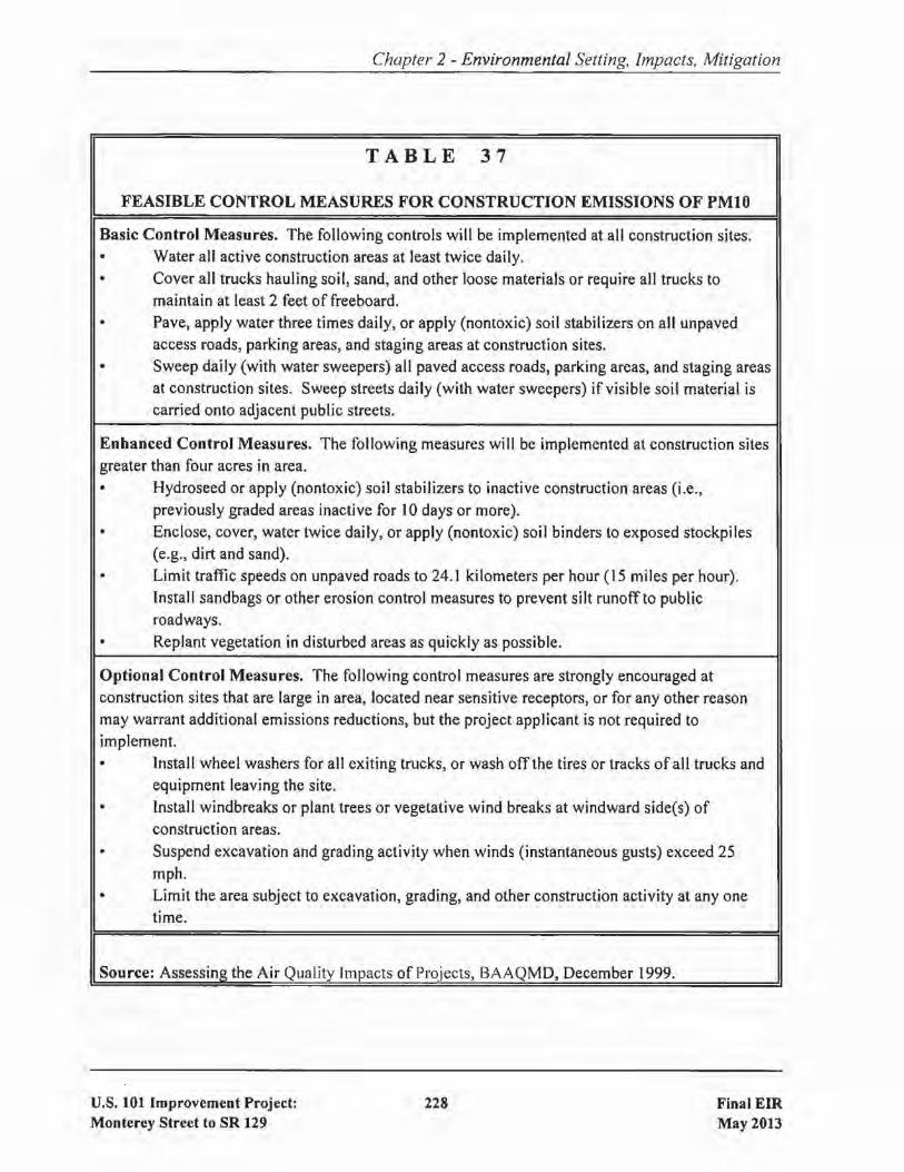
Chapter 2 - Environmental Setting, Impacts. Mitigation
TABLE 37
FEASIBLE CONTROL MEASURES FOR CONSTRUCTION EMISSIONS OF PMIO
Basic Control Measures. The following controls will be implemented at all construction sites.• Water all active construction areas at least twice daily.• Cover all trucks hauling soil, sand, and other loose materials or require all trucks to
maintain at least 2 feet of freeboard.• Pave, apply water three times daily, or apply (nontoxic) soil stabilizers on all unpaved
access roads, parking areas, and staging areas at construction sites.• Sweep daily (with water sweepers) all paved access roads, parking areas, and staging areas
at construction sites. Sweep streets daily (with water sweepers) if visible soil material iscarried onto adjacent public streets.
Enhanced Control Measures. The following measures will be implemented at construction sitesgreater than four acres in area.• Hydroseed or apply (nontoxic) soil stabilizers to inactive construction areas (i.e.,
previously graded areas inactive for 10 days or more).• Enclose, cover, water twice daily, or apply (nontoxic) soil binders to exposed stockpiles
(e.g., dirt and sand).• Limit traffic speeds on unpaved roads to 24. J kilometers per hour (15 miles per hour).
Install sandbags or other erosion control measures to prevent silt runotfto publicroadways.
• Replant vegetation in disturbed areas as quickly as possible.
Optional Control Measures. The following control measures are strongly encouraged atconstruction sites that are large in area, located near sensitive receptors, or for any other reasonmay warrant additional emissions reductions, but the project applicant is not required toimplement.• Install wheel washers for all exiting trucks, or wash otfthe tires or tracks of all trucks and
equipment leaving the site.• Install windbreaks or plant trees or vegetative wind breaks at windward side(s) of
construction areas.• Suspend excavation and grading activity when winds (instantaneous gusts) exceed 25
mph.• Limit the area subject to excavation, grading, and other construction activity at anyone
time.
Source: Assessing the Air Quality Impacts of Projects, BAAQMD, December 1999.
U.S. 101 Improvement Project:Monterey Street to SR 129
228 Final EIRMay 2013

Chapter 2 - Environmental Setting, Impacts, Mitigation
TABLE 38
CONSTRUCTION EQUIPMENT NOISE LEVELS AT 50 FEET
Maximum Noise Level Hourly Average Noise LevelConstruction Phase (Lmax dBA) (LeQ dBA)
Demolition 90 84
Clear and Grub 81 79
Earthwork 82 84
Paving 85 85
Structures (with pile driving) 101 95
Structures (without pile driving) 83 84
Source: U.S. 101 Improvement Project Noise Study Report, 2009.
Impact CON-5: Noise from construction activities is likely to constitute a temporary annoyance
at residences located along U.S. 101. Construction activities may also generatenoticeable ground vibration at nearby residences, with pile driving being theconstruction source that could produce the greatest ground vibrations. [Less
than-Significant with Mitigation Listed Below]
The following measures will be implemented by the project for the purpose of avoiding or minimizingnoise and vibration effects during construction:
MM-CON-5.1 :
MM-CON-5.2:
MM-CON-5.3:
MM-CON-5.4:
All internal combustion engine driven equipment will be equipped with intakeand exhaust mufflers that are in good condition and appropriate for theequipment.
Unnecessary idling of internal combustion engines within 100 feet ofresidenceswill be strictly prohibited.
Staging ofconstruction equipment within 200 feet ofresidences will be avoided.All stationary noise-generating construction equipment, such as air compressorsand portable power generators, will be located as far as practical fromresidences.
All construction equipment will be required to conform to Section 14-8.02 Sound Control Requirements of the latest Standard Specifications.
U.S. 101 Improvement Project:Monterey Street to SR 129
229 Final EIRMay 2013

Chapter 2 - Environmental Setting, Impacts, Mitigation
MM-CON-5.5: Nighttime construction work within 450 feet of residential land uses will beavoided where feasible.
MM-CON-5.6: Demolition and pile driving activities will be limited to daytime hours to thegreatest extent possible. If nighttime, demolition or pile driving is required, aconstruction noise monitoring program will be implemented to provideadditional mitigation as necessary (in the form ofnoise control blankets or othertemporary noise barriers, etc.) for affected receivers.
2.22.6 Water Ouality Effects during Construction
The project will involve excavating and grading activities for the purpose of widening U.S. 101,constructing frontage roads, extending Santa Teresa Boulevard, reconstructing the U.S. 10l/SR 25interchange, and constructing related improvements (e.g., retaining walls, detention basins, etc.). Theseactivities have the potential to degrade water quality in the form of sedimentation, erosion, andfuelsllubricants from equipment. In the project area, the water quality ofvarious creeks and rivers couldbe affected by construction activities. Since these waterways support numerous wildlife and plantspecies, a short-term degradation of water quality could adversely affect such species.
Impact CON-6: Construction activities have the potential to adversely affect water quality innearby creeks. [Less-than-Significant with Mitigation Listed Below]
In order to avoid or minimize the potential for water quality impacts to occur, the project will implementthe following measures:
MM-CON-6.1:
MM-CON-6.2:
MM-CON-6.3:
MM-CON-6.4:
MM-CON-6.5:
Active paved construction areas will be swept as needed.
Silt fencing or straw wattles will be used to retain sediment on the project site.
Temporary cover of disturbed surfaces or temporary slope protection measureswill be provided per regulatory requirements and Caltrans' guidelines to helpcontrol erosion. Permanent cover/revegetation will be provided to stabilize thedisturbed surfaces after construction has been completed.
No debris, soil, silt, sand, bark, slash, sawdust, cement, concrete, washings,petroleum products, or other organic or earthen material will be allowed to enterinto or be placed where it may be washed by rainfall or runoff into anywaterways.
Best Management Practices (BMPs) will be utilized by the contractor(s) duringconstruction. The BMPs will be incorporated into a Stonnwater PollutionPrevention Plan for the project, as required by Caltrans' NPDES permit.
u.s. 101 Improvement Project:Monterey Street to SR 129
230 Final EIRMay 2013

2.23
2.23.1
Chapter 2 - Environmental Setting. Impacts, Mitigation
CUMULATIVE IMPACTS
Regulatory Setting
. Cumulative impacts are those that result from past, present, and reasonably foreseeable future actions,combined with the potential impacts of this project. A cumulative effect assessment looks at thecollective impacts posed by individual land use plans and projects. Cumulative impacts can result fromindividually minor, but collectively substantial impacts taking place over a period of time.
Cumulative impacts to resources in the project area may result from residential, commercial, industrial,and highway development, as well as from agricultural development and the conversion to moreintensive types of agricultural cultivation. These land use activities can degrade habitat and speciesdiversity through consequences such as displacement and fragmentation of habitats and populations,alteration of hydrology, contamination, erosion, sedimentation, disruption of migration corridors,changes in water quality, and introduction or promotion of predators. They can also contribute topotential community impacts identified for the project, such as changes in community character, trafficpatterns, housing availability, and employment.
CEQA Guidelines, Section 15 I30, describes when a cumulative impact analysis is warranted and whatelements are necessary for an adequate discussion ofcumulative impacts. The definition ofcumulativeimpacts, under CEQA, can be found in Section 15355 of the CEQA Guidelines.
2.23.2 Impacts of the Build Alternative
In a cumulative impacts analysis, the identification of "past, present, and reasonably foreseeable futureactions" can utilize either the "list approach" or the "adopted plan" approach. The list approach
identifies specific projects in the vicinity, typically provided by a local planning department. Theadopted plan approach relies on a general plan or transportation plan or other planning document, whichby definition accounts for cumulative growth in a defined area.
For this analysis, the adopted plan approach was utilized for the assessment ofcumulative traffic, noise,and air quality impacts as it is compatible with the nature of the proposed infrastructure project, whichis to accommodate projected transportation demand over the long term. As examples, VTA'sCountywide traffic model, which was utilized to project future build and no build conditions, is basedon the planned growth of Santa Clara County, as contained in the adopted general plans of eachjurisdiction within that county. The model also accounts for planned growth in adjacent areas, includingthe Monterey Bay Area.
In addition to the adopted plan approach, local agencies were contacted to determine if there were anyrecent and/or reasonably foreseeable projects adjacent to U.S. 101 that could contribute to one or morecumulative impacts. Two proposed projects were identified:
U.S. 101 Improvement Project:Monterey Street to SR 129
231 Final EIRMay 2013
Chapter 2 - Environmental Setting, Impacts, Mitigation
• The owners ofthe existing Freeman Quarry, which is located approximately 1,500 feet west ofU.S. 101 and roughly 0.7 miles south of the U.S. I01/SR 25 interchange, have applied to SantaClara County for approval to expand. [Note: The quarry is visible on Figures 3 and 4.] Ifapproved, the area ofthe quarry's operations would expand from 60 acres to 150 acres and theannual volume ofmaterial to be extracted would increase from 500,000 tons to 1.5 million tons.This project is discussed below for subject areas. where cumulative impacts could occur: traffic,visual, biology, and noise.
• Caltrans is proposing to upgrade/widen SR 25 to a 4-lane expressway between the UPRRcrossing (just west ofBloomfield Avenue) and San Felipe Road in Hollister. The SR 25 projectis adjacent to the U.S. 101 Improvement; the UPRR crossing ofSR 25 is the boundary betweenthe two projects. That project is currently undergoing environmental review. The SR 25 projectis discussed below for the subject areas where cumulative impacts could occur: traffic, visual,biological resources, and farmlands.
The discussion, below, addresses only those resource areas where the project will result in an impactand, therefore, there is a potential for a cumulative impact. Per CEQA, if a project would not causedirect or indirect impacts on a resource, it would not contribute to a cumulative impact on that resourceand need not be further evaluated.
2.23.2.1 Cumulative Traffic Impacts
For traffic, the Resource Study Area (RSA) was defined as the area within the project limits, as well asthe surrounding area where the project will result in measurable changes in traffic patterns. Thus, theRSA includes the freeway segments, arterial streets, and intersections identified in the tables shown inSection 2.6.
Cumulative development has resulted in a significant increase in traffic on U.S. 101, SR 25, and in theproject area as a whole, and future increases are projected to occur. As described in Section 2.6.2.5, thetraffic forecasts that were prepared for year 2035 take into account traffic from future developmentplanned for in the approved general plans ofthe cities in Santa Clara County. The forecasts also accountfor planned growth in the region, including the Monterey Bay Area, as well as planned improvementsto the transportation network including the adjacent project that proposes to upgrade SR 25 to a 4-laneexpressway.
The proposed expansion of Freeman Quarry will add up to approximately 40 additional AM peak-hourtruck trips. There is no PM peak-hour traffic associated with the quarry as the quarry is prohibited fromoperating during that timeframe. Under existing conditions, all quarry-related traffic enters and exitsU.S. 101 via a driveway located south ofthe U.S. 10 I/SR 25 interchange. Since there is a center divideron U.S. 101, traffic desiring to head north must first drive south on U.S. 101 to the Y Road/Betabel Roadinterchange before heading north. Under the No Build Alternative, this pattern will remain in place.
u.s. 101 Improvement Project:Monterey Street to SR 129
232 Final EIRMay 2013

Chapter 2 - Environmental Setting, Impacts, Mitigation
Under the Build Alternative, all quarry-related traffic will access U.S. 101 via the reconstructed U.S.10 l/SR 25 interchange, which will be safer and will eliminate the existing circuitous route.
The improvements that would be constructed under the proposed project would not contribute towardany increase in traffic volumes on the roadway network. This statement is based on the fact that, unlikea development project that generates traffic (e.g., a shopping center, residential subdivision, industrialpark, etc.), this project will not add traffic to the roadway network. Instead, this project, like mostinfrastructure projects, is intended to accommodate traffic demand.
As described in Section 2.6. the facilities to be constructed by the project will improve traffic safety andoperations. Therefore, by definition, the project would not result in an adverse cumulative traffic impactbecause the project's overall traffic effect would be beneficial.
Impact CU-l: The project's overall effect on traffic will be beneficial and, therefore, theproject will not result in an adverse cumulative traffic impact. [No CumulativeImpact]
2.23.2.2 Cumulative Loss ofAgricultural Land
For agricultural lands, the RSA is defined as Santa Clara County, as that is the jurisdiction where theproject will result in the loss of prime farmland. Although Santa Clara County encompasses more than1,300 square miles, most of the County's prime farmland is located in the southern portion along bothsides of U.S. 10 I, including the project segment.
Lands with soils that support prime agricultural uses are a finite resource. Cumulative development hasresulted in a significant loss of prime farmland in Santa Clara County. Between 1984 and 2008, theacreage of prime farmland in Santa Clara County decreased from 38,000 acres to 18,800 acres, whichis an average annual loss of approximately 800 acres.50 Although programs such as Williamson Actcontracts and the purchase of farmland conservation easements are in place to preserve this resource,the conversion of prime farmland to non-agricultural uses is typically a significant and unmitigableimpact.
In the immediate project area, a project that would widen SR 25 to a 4-lane expressway is currentlybeing evaluated by Caltrans. According to that project's Draft EIRJEIS, the upgrade of SR 25 to anexpressway will result in the loss of 85 acres of prime farmland in Santa Clara County.
As discussed in Section 2.3, the proposed project wi II result in the loss of 156.8 acres ofprime farmlandunder Design Option A and 121.8 acres ofprime farmland under Design Option B. Although the project
50Source: Califomia Department of Conservation, Farmland Mapping & Monitoring Program, HistoricLand Use Conversion for Santa Clara County (1984 - Present) [www.conservation.ca.gov].
U.S. 101 Improvement Project:Monterey Street to SR 129
233 Final EIRMay 2013

Chapter 2 - Environmental Setting, Impacts, Mitigation
proposes to purchase farmland conservation easements, this impact cannot be mitigated to a less-thansignificant level.
Impact CU-2:
2.23.2.3
The loss of agricultural lands from cumulative development would besignificant, and the contribution ofthe proposed project to this impact would be
considerable. [Significant Cumulative Impact]
Cumulative Impacts to Biological Resources
For biological resources, the RSA encompasses the project footprint and those adjacent lands where anindirect effect could occur.
Historically, cumulative development has resulted in a substantial loss of valuable ecological habitats
in the greater project area including wetlands, oak woodlands, riparian and aquatic. The loss of theseand other habitats has directly impacted many plant and animal species, resulting in direct threats to thecontinued existence ofa number ofspecies. Another related effect ofcumulative development has beenthe creation of barriers and hazards to the migration of animals along various wildli fe corridors.
All of these factors led to the enactment of various statutes, regulations, and policies whose goals areto halt, and in many cases reverse, this trend. These include the federal Endangered Species Act, theCalifornia Endangered Species Act, the Clean Water Act, the Porter-Cologne Water Quality Control Act,NEPA, and CEQA. These statutes require private and public projects to include measures that avoidand/or fully mitigate for impacts to sensitive habitats and the special-status species that are found withinthem. The proposed Santa Clara Valley HCPINCCP, in which this U.S. 101 Improvement Project is a"covered activity", is an effort to address this issue on a large-scale, as opposed to a piecemeal, basis.
In the case ofthe proposed project, while it would result in impacts to various habitats and special statusanimal species, it would not contribute to cumulative impacts because mitigation and avoidancemeasures are included in the project. Specifically, all loss of sensitive habitats resulting from theproposed highway improvements will be fully mitigated by the creation ofreplacement habitats. In fact,replacement-to-impact ratios are greater than I: I. See Section 2. I7, Natural Communities, Section 2.18,Wetlands, Section 2.20, Animal Species, and Section 2.21, Threatened & Endangered Species.
The proposed project would also include measures that would not only mitigate for impacts to wildlifemovement, but would improve the ability ofwildlife to traverse the U.S. 101 corridor relative to existingconditions. These measures include the replacement of existing culverts with those that are moreconducive to use by wildlife, the construction of additional undercrossings, and the use of "wildlifefencing". Please see Section 2.17, Natural Communities, for details. The net effect of these measuresis that the project would not contribute to cumulative impacts to wildlife movement.
U.S. 101 Improvement Project:Monterey Street to SR 129
234 Final EmMay 2013

Chapter 2 - Environmental Setting, Impacts, Mitigation
Similarly, the proposed improvements to SR 25 and the expansion of Freeman Quarry, if approved,would not contribute to the cumulative loss of sensitive habitats because mitigation and avoidancemeasures will be required by regulatory agencies as conditions of approval.
Impact CU-3:
2.23.2.4
The project would not contribute to a cumulative impact on important biological
resources. [No Cumulative Impact]
Cumulative Air Quality Impacts
For air quality, the RSA was defined as the land uses adjacent to the freeway segments within the projectlimits. These land uses are those where project-related changes, coupled with increased traffic fromongoing growth, could result in cumulatively substantial increases in emissions of air pollutants.
Cumulative development has resulted in a substantial degradation in ambient air quality in the greaterproject area. However, due to emissions control technology, overall air quality has been improving inrecent years. Although most present and future development will likely increase emissions,improvements in technology are largely expected to offset such increases. Regulatory strategies,
including compliance with California's AB 32 (see Section 2.15), will also lead to a reduction in
emissions.
The proposed project will not contribute to the region's emissions because it will not generate additionalvehicle trips. Further, as described in Section 2.14, exceedances of federal and state carbon monoxidestandards are not expected in the project are, either with or without the proposed project.
Impact CU-4:
2.23.2.5
Although growth in the region will continue, improvements in technology andthe implementation of regulations aimed at emissions reductions are expected
to offset the air quality effects of such growth. [Less-than-Significant
Cumulative Impact]
Cumulative Noise Impacts
For noise, the RSA was defined as the land uses adjacent to U.S. 101 within the project limits. Theseland uses are those where project-related changes, coupled with increased traffic from ongoing growth,
could result in cumulatively substantial increases in noise.
As discussed in Section 2.16, the primary source of noise in the project area is traffic on U.S. 101. Theimprovements that will be implemented under the proposed project, including the highway widening,new U.S. 10 I/SR 25 interchange, and the new frontage roads, will affect noise levels at adjacent landuses. The change in noise will vary by location, and will range from a decrease of 1 dBA to an increaseof 9 dBA, which is less than the 12-dB increase that would be considered substantial. These changesin noise account for both the improvements proposed by the project and the increase in traffic that willresult from cumulative development.
U.S. 101 Improvement Project:Monterey Street to SR 129
235 Final EIRMay 2013

Chapter 2 - Environmental Setting, Impacts, Mitigation
If approved, any additional noise from expanded mining activities at the Freeman Quarry will notcombine with noise from U.S. 101 at any given receptor. This conclusion is based on the fact that thequarry is separated from U.S. 101 by elevated terrain and 1,500 feet horizontally. Therefore, noise fromthese two noise sources will not be cumulative.
The previous paragraph notwithstanding, it is estimated that there will be approximately 40 additionalpeak-hour truck trips associated with expanded quarry operations. These trucks will use the newfrontage road to travel between the quarry and U.S. 101, which will add to the noise increases associatedwith the proposed project at two single-family residences, Receptors 21 and 22 in Table 32. Noiseassociated with these truck trips will add roughly 1 dBA to the noise levels shown in Table 32 for thesereceptors. This increase would not be cumulatively significant.
Impact CU-5:
2.23.2.6
Noise increases from the proposed project, ongoing development in the region,and the proposed Freeman Quarry expansion will not be cumulatively
significant. [Less-than-Significant Cumulative Impact)
Cumulative Visual Impacts
For visual impacts, the RSA consists of the area encompassing the four key viewpoints described inSection 2.7. The key viewpoints were chosen to help evaluate the project's visual impact as experiencedby viewers at various locations in the vicinity of U.S. 10 l. These viewpoints are representative of the
visual environment experienced by a cross-section of viewers.
As discussed in Section 2.7, changes to the visual setting due to the proposed project will primarily occurin the vicinity of the reconstructed U.S. 101/SR 25 interchange. Such changes, which are representedin the four key views, will result from the new SR 25 structure over U.S. 101, new ramps, new frontageroads, the extension ofSanta Teresa Boulevard, and new retaining walls. Visual impacts associated withcomponents of the project unrelated to the U.S. 101/SR 25 interchange would not be substantial.
The visual changes associated with the adjacent proposed SR 25 Expressway Project will not occur inthe same location as the four key viewpoints that comprise the RSA.
Freeman Quarry is not visible from the segment of U.S. 101 that is in the vicinity of the U.S. IOI/SR 25interchange as there is intervening elevated terrain. The quarry is only visible from U.S. 101 at greaterdistances such as near the U.S. 101ISargent bridges over the UPRR and Tar Creek. Therefore, anychanges in the visual setting that will result from the expansion of the quarry will not combine withvisual changes due to the proposed project to create cumulative effects.
Impact CU-6: Visual impacts from the proposed project will not occur in the same viewshedas the visual impacts from the expansion of Freeman Quarry and the upgrade of
SR 25 to an expressway. [No Cumulative Impact]
U.S. 101 Improvement Project:Monterey Street to SR 129
236 Final EIRMay 2013

2.23.2.7
Chapter 2 - Environmental Setting, Impacts, Mitigation
Cumulative Hazardous Materials Impacts
The RSA for hazardous materials is defined as the footprint ofthe project as the effect ofthe project withregard to exposure to hazardous materials is limited to the construction area.
The proposed project, along with other development, has the potential to expose construction workersto the adverse effects ofhazardous materials (e.g., ADL, lead-based paint, asbestos-containing buildingmaterials, etc.). However, implementation of mitigation and avoidance measures, such as those listedin Section 2.13, Hazardous Materials, are required on a project-by-project basis to avoid or reduce
hazardous materials impacts to a less than significant level. Specifically, regulations set forth by theOccupational Safety & Health Administration (OSHA), EPA, and other agencies are designed to preventconstruction workers from exposure to hazardous materials at levels that would be cumulativelysignificant. Therefore, cumulative development will not result in a significant cumulative hazardousmaterials impact and the proposed project will not contribute towards a significant cumulative impact.
Impact CU-7:
2.23.2.8
Exposure to hazardous materials from the proposed project and ongoing
development in the region will not be cumulatively significant. [Less-thanSignificant Cumulative Impact]
Cumulative Water Quality Impacts
The RSA for water quality is defined as the watersheds within which the project is located.
Runofffrom past and existing development, as well as from agricultural operations, has been identifiedas a significant source ofwater pollution. Runoff flows untreated to local creeks, rivers, San Franciscoand Monterey Bays, and the ocean, carrying pollutants that are detrimental to the beneficial uses ofthese
water bodies. Examples of pollutants commonly generated include: sediment from construction sites;pesticides, herbicides, and fertilizers from agricultural fields; products of internal combustion engineoperation such as hydrocarbons from automobiles; heavy metals, such as copper from automobile brakepad wear and zinc from tire wear; dioxin as a product of combustion; mercury resulting fromatmospheric deposition; and naturally-occurring minerals from local geology.
In addition to the pollution issue, the increased peak flows and volumes of stormwater associated withurbanization have led to adverse impacts such as bank erosion, channel widening, flooding, channel
modification and loss of the natural floodplain. This occurs because development typically increasesthe amount of impervious surface area within a watershed by converting natural ground cover toimpervious surfaces such as paved highways, streets, rooftops, and parking lots, thereby diminishing thestormwater retention, detention and purification characteristics provided by the vegetated soils.
In the project area, runoff from U.S. 101, SR 25, and local roadways contributes to the degradation ofwater quality, as does runofffrom the many acres offarmland in the project area. The proposed projectwill add to the amount of impervious surfaces in the area, which will contribute to a degradation in water
U.S. 101 Improvement Project:Monterey Street to SR 129
237 Final EIRMay 2013

Chapter 2 - Environmental Setting. Impacts, Mitigation
quality for the reasons stated above. The proposed improvements to SR 25 will have similar impacts.The proposed expansion of Freeman Quarry will also have the potential to affect water quality due tothe increase in mining activities.
In recent years, however, new regulations promulgated by the U.S. EPA and California Department ofWater Resources have gone into effect that are requiring individual projects to incorporate measures thatwill offset these impacts. For example, as discussed in Section 2.10, the proposed project isincorporating biofiltration strips and swales into its design for the purpose of treating highway runoffbefore discharge into local waterways. Ifapproved and constructed, the SR 25 project will be requiredto incorporate water treatment features into its design. Similarly, Freeman Quarry will be required tocomply with an industrial NPDES permit that contains specific provisions related to avoiding the waterquality impacts associated with quarrying activities. The intent of the new regulations is that eachproject should be responsible for treatment of its water quality impacts, thereby avoiding a cumulativedegradation of water quality over the long-term.
Impact CU-8:
2.23.2.9
In view ofthe applicability ofordinances, laws and regulations that would avoidthe occurrence of significant water quality impacts, it is concluded thatcumulative water quality impacts will not be significant.(Less-than-Significant Cumulative Impact]
Cumulative Floodplain Impacts
For floodplains, the RSA is defined as the floodplains crossed by the project segment of U.S. 101.
As discussed in Section 2.9, the proposed project has been designed to avoid and mitigate impacts to thefloodplains that will be affected by the highway improvements. Further, upon completion ofthe project,the degree to which U.S. 101 is subject to flooding will be less than that which occurs under existingconditions. This has been achieved through a combination ofculverts, pipes, bridges, detention basins,and a flood control channel that will be constructed as an integral part of the project. Therefore, theproject will not contribute to any cumulative floodplain impacts.
Impact CU-9: The project has been designed to avoid floodplain impacts. [No CumulativeImpact]
2.23.3 Impacts of the No Build Alternative
Under the No Build Alternative, there would be no changes to existing facilities and, therefore, noenvironmental impacts on the existing environment. Since the No Build Alternative would not resultin environmental impacts, by definition there would be no cumulative impacts.
U.S. 101 Improvement Project:Monterey Street to SR 129
238 Final EIRMay 2013

CHAPTER 3 COMMENTS AND COORDINATION
Early and continuing coordination with the general public and appropriate public agencies is an essentialpart of the environmental process to determine the scope of environmental documentation, the level ofanalysis, potential impacts and mitigation measures and related environmental requirements. Agencyconsultation and public participation for this project have been accomplished through a variety offonnaland infonnal methods, including: project development team meetings, interagency coordinationmeetings, a scoping meeting, presentations to neighborhood groups, and meetings with commercialproperty owners. This chapter summarizes the results of Caltrans' and VTA's efforts to fully identify,address and resolve project-related issues through early and continuing coordination.
Substantial coordination, outreach, and public participation regarding the proposed project haveoccurred, which is summarized as follows:
» On June 7,2007, a coordination meeting was held with the City of Gilroy regarding floodplainissues. Additional coordination meetings with the City of Gilroy were held on February 12,2008 and December 6, 2008.
» On December 13, 2007, the project team met with the staff of the Santa Clara Valley WaterDistrict to discuss floodplain and hydrologic issues and concerns.
» On June 12, 2007, a coordination meeting was held with PG&E to discuss the relocation of anumber of electrical transmission towers.
» On February 27,2008, a field meeting was held with PG&E to discuss utility coordination andrelocation issues.
» The project team met with the following stakeholders to discuss the project and to solicit input:Rapazzini Winery (August 15,2007, September 21 , 2007, and June 12,2008); Gavi Ian College(August 9,2007 and October 25, 2007); and Christopher Ranch (August 9, 2007).
» A Notice of Preparation of an EIR was circulated to local, regional, state, and federal agenciesfrom October 31,2007 through November 30, 2007.
» An Environmental Scoping Meeting was held in Gilroy on November 15,2007. Approximately40 persons attended the meeting.
» A coordination meeting between the project team and the San Benito County Planning andPublic Works Departments was held on April 25, 2008.
» On May 21,2008 and December 5, 2008. coordination meetings were held between the projectteam and the Santa Clara County Roads & Airports Department.
U.S. 101 Improvement Project:Monterey Street to SR 129
239 Final EIRMay 2013

Chapter 3 - Comments & Coordination
» During 2007, Native American consultation was undertaken for the project by VTA on behalfof Caltrans. The Native American Heritage Commission (NAHC) was contacted. Based on alist provided by the NAHC, 13 members of the local Native American community were alsocontacted. Members of the Ohlone community were also kept informed of the backhoe trenchwork that was undertaken for the project.
» On March 27, 2007, VTA and the project's designers met with Chris Nagano and Cori Mustinof the USFWS and David Johnston of the CDFW at the VTA offices to go over the project andthen tour the project site. Comments received during the meeting and site visit were noted.
» On November 15,2007, VTA submitted the project through the Interim Project Review Processofthe Santa Clara Valley HCPINCCP. This submittal included the Notice ofPreparation forthisEIR, a map of the project, a project description, biotic habitats map based on the BSA, and thepreliminary information on the biological resources within the BSA. This information was alsosent via e-mail to Cori Mustin of the USFWS, Jonathan Ambrose of the NMFS, and DavidJohnston of the CDFW.
» On December 5, 2007, VTA received a written response from the NMFS to the Interim Project
Review Process submittal. This letter was similar to that received during the EIR scopingperiod.
» On December 12,2007, VTA staffand the project's biologists attended an HCPINCCP meeting
held at Mare Island. Verbal comments were received on the project from Jonathon Ambrose ofthe NMFS and Cori Mustin & Chris Nagano of the USFWS and were noted.
» On December 18, 2007, VTA staff, Caltrans staff, the project's biologists, and the project'sdesigners met with David Johnston and Laura Diaz-Anderson of the CDFW to tour the projectsite. Comments received during the site visit were noted.
» On February 25, 2008, a follow-up e-mail to the 15 November 2007 e-mail was sent through the
HCPINCCP Interim Project Review Process to the same resource agency staff. The purpose wasto provide updated project information including a new project map that incorporated designchanges, which also changed the BSA, revised information on the biological resources withinthe BSA, and a table describing existing and future creek crossing and median designs.
» On February 26, 2008, VTA staff, Caltrans staff, the project's biologists, and the project'sdesigners met with David Johnson ofthe CDFW to discuss wildlife connectivity. The designershave refined the design to the extent feasible to address issues raised by Mr. Johnston.
» On July 18,2008, a second follow up e-mail to the November 15,2007 and February 25,2008e-mails was sent to Jonathan Ambrose of the NMFS. The purpose was to provide updated
U.S. 101 Improvement Project:Monterey Street to SR 129
240 Final EIRMay 2013

Chapter 3 - Comments & Coordination
project information, in particular the updated information included in the table describingexisting and future creek crossing and median designs (previously sent on February 25, 2008).
» Ongoing e-mail coordination with CDFWregardingthecontents of the project's biologicalstudies.
» On September 11,2007, December 5, 2007, and January 18,2008, meetings were held with theSanta Clara County Parks & Recreation Department to solicit input regarding trails and bicyclefacilities.
» On January 23, 2009, the project team met with the statTs of the Santa Clara County Parks &Recreation Department and the Bay Area Ridge Trail Council to ensure consistency between theproposed improvements and existing/planned trails, bikeways, and recreational facilities.
» On November 9,2010, VTA statT, Caltrans statT, the project's biologists, and the project'sdesigners met with David Johnson of the CDFW to discuss wildlife connectivity, as well as todiscuss impacts to the California tiger salamander.
» The VTA website (www.vta.org) contains an overview of the project, a project "FAQ", andinformation about the schedule for the project's approval and construction (including a listingof upcoming public meetings). The website also provides an opportunity for people to submitcomments and questions regarding the project.
Noticing. Circulation. and Review of the Draft EIR
The Draft EIR was made available for public review and comment from March 14.2013 to April 29.2013. In addition. a public hearing was held at the Gilroy Public Library on March 28. 2013. Noticesof the availability of the Draft EIR and the public hearing were provided to the public via multiplemethods including:
Notices were printed in local newspapers including the Morgan Hill Times. the Gilroy Dispatchthe Hollister Freelance News. Viet Nam, Philippines Today. Sing Tao Daily. Korea Times. andEI Observador.
Notices were mailed to approximately 950 business and residential addresses (landlord andtenant) located within a one-half mile radius of the project alignment.Notices were electronically mailed to federal. state, and local agencies and organizations, as wellas interested stakeholders
Notices were posted on VTA's Twitter and Facebook links. as well as on VTA's website.Notices were posted with the County of Santa Clara. the County of San Benito. and the StateOffice of Planning and Research (State Clearinghouse).News releases were provided to local media outlets.
U.S. 101 Improvement Project:Monterey Street to SR 129
241 Final EIRMay 2013
Chapter 3 - Comments & Coordination
Notices were provided to the Gilroy Public Library, Morgan Hill Public Library, San BenitoCounty Library, and San Juan Bautista Library.
The March 28th hearing was attended by approximately 25 members of the public from San JuanBautista, Gilroy, and San Jose. A representative from the office ofSanta Clara County Supervisor MikeWasserman also attended, as did a member of the Gilroy Planning Commission and the Gilroy TrafficEngineer.
Materials provided at the hearing included Fact Sheets in English and Spanish. Copies ofthe Draft EIR
were available at the hearing and were provided to members ofthe public, on request. Comment cardswere also provided. The hearing included display boards, as well as a PowerPoint presentation by VTAstaff on the project and its environmental effects.
All comments on the Draft EIR, both written and oral. are responded to in Chapter 4 of this document.A copy ofeach written comment is contained in Appendix F. A copy of the public hearing transcript,which contains the verbatim oral comments, is contained in Appendix G.
U.S. 101 Improvement Project:Monterey Street to SR 129
242 Final EIRMay 2013

CHAPTER 4 RESPONSES TO COMMENTS ON DRAFT EIR
The Draft EIR was made available for public review and comment from March 14,2013 to April 29,2013. Comments received, including the page on which the response(s) to comments begins, are shownbelow. A copy ofeach written comment is contained in Appendix F. The transcript, which contains theverbatim oral comments from the March 28, 2013 public meeting, is contained in Appendix G.
Comment & ResponseBegin on Page
Government AgenciesComment #1 California Department of Conservation 244Comment #2 Caltrans - District 4 244Comment #3 Caltrans - District 5 246Comment #4 Gavilan College 250Comment #5 Monterey Bay Unified Air Pollution Control District 252Comment #6 National Park Service 258Comment #7 Pajaro River Watershed Flood Prevention Authority 259Comment #8 Regional Water Quality Control Board 261Comment #9 Council of San Benito County Governments 268Comment #10 Santa Clara County 269Comment # 11 Santa Clara County Open Space Authority 281Comment #12 Santa Clara Valley Water District 287
Businesses and OrganizationsComment #13 Bay Area Ridge Trail Council 291Comment #14 Castro Valley Properties 292Comment # 15 The Nature Conservancy 299Comment # 16 Pacific Gas & Electric (PG&E) 302Comment #17 Sierra Club & Santa Clara Valley Audubon Society 303
IndividualsComment #18 Chatty, Omar 324Comment #19 Cisneros, Jesus 325Comment #20 Cripps, Rich 325Comment #21 Galtman, Jimmy 325Comment #22 Lucas, Libby 327Comment #23 Renzel, Emily " 334Comment #24 Scales, Bob 334Comment #25 Thoeny, Ted 334Comment #26 Thompson, Joseph 335Comment #27 Chatty, Omar 336Comment #28 Tognetti, Carol 337Comment #29 Galtman, Jimmy 338Comment #30 Cosio, Jolene 339Comment #31 Larson, Alex 339Comment #32 Rizutto, Joe 340
U.S. 101 Improvement Project:Monterey Street to SR 129
243 Final EIRMay20lJ

Chapter 4 - Responses to Comments on Draft EIR
RESPONSE TO COMMENT #1:CALIFORNIA DEPARTMENT OF CONSERVATION
Comment I-A: The VTA DEIR does not acknowledge that 282-acre Wang Farm AgriculturalConservation Easement ("Wang Farm") may be impacted by the proposed project. The Wang Farm(Figure 1) is under a permanent agricultural conservation easement held by the Silicon Valley LandConservancy.
The Department's CFCP and the United States Department of Agricultural, National ResourceConservation Service, Farm and Ranch Land Protection Program provided grant funding to purchase ofthe Wang Farm in 2005. As part of the original application, both the City Council of the City of Gilroyand the Santa Clara County Board ofSupervisors passed resolutions ofsupport on July 7, 2003 and June24,2003, respectively, supportingestablishmentofthe Wang Farm Agricultural Conservation Easement,which was designated to be held in perpetuity. Terminating portions ofthe easement and fragmentationof the remaining agricultural property is directly at odds with the intent of the easement and the City'sand County's support of the easement. Any future changes to use of this property would require
permission of the United States Department of Agriculture.
The implications ofthis potential easement disruption are beyond the scope ofthe DEIR itself, but must
be addressed if VTA chooses to continue with the project as described.
Response I-A: Thankyoufor this information. Table 10 has been revised in the Final EIR todisclose the fact that two ofthe parcelsfrom which right-of-way would be required are part ofthe 282-acre Wang Farm Agricultural Conservation Easement. This impact wouldbe associatedwith the upgrade ofthe existing property access road (which is currently partially paved) to afull standard access road. This was included in the project because an upgrade is typicallyrequired by property owners when an adjacent highway is improved to freeway standards.
In light of this comment, there are alternatives that VTA can discuss with the owners of theparcels: 1) eliminate the access road upgrade altogether and construct a retaining wall in lieuof the embankment along the existing right-of-way line, or 2) undertake a more limitedimprovement to the access road that would minimize impacts. These options can be discussedwith the owners and the easement holder during the final design phase ofthe project.
RESPONSE TO COMMENT #2:
CALTRANS - DISTRICT 4
Comment 2-A: Section 1.2 - The second purpose "Accommodate projected traffic demand along U.S.101 ..." and the fifth purpose "Enhance the movement of ..." have no correlating need statement or data.Information demonstrating the future congestion and delay needs to be included in the need section of
U.S. 101 Improvement Project:Monterey Street to SR 129
244 Final EmMay 2013

Chapter 4 - Responses to Comments on Draft EJR
the document. The same information is lacking to demonstrate that the movement of goods along U.S.101 is a problem.
Response 2-A: VTA disagrees that there is no correlating need statement or data. Section/.2.2.1 discusses the fact that the project segment of u.s. 101 "has insufficient capacity toaccommodate future demand... " That same section states that the insufficient capacity willresult in delays and congestion, which will result in "substantial social, economic, andenvironmental impacts associated with delays in the movement ofpeople and goods." Thediscussion in Section 1.2.2.1 is supported by the data in Section 2.6.
Comment 2~B: Section 2.6 - All tables and information (including but not exclusively Tables 19 and20) in this section should be updated so the information in the Final Environmental Impact Report(FEIR) matches and is consistent with the information in the Project Report and TOAR. The informationin the Draft Environmental Impact Report does not match/is not consistent with that in the Draft ProjectReport and TOAR.
Response 2-B: VTA compared the data in all ofthe tables in Section 2.6 ofthe EIR (includingTables 19 and20) to the tables in the TOAR, which was made availablefor public review duringcirculation ofthe Draft EIR. No inconsistencies were found.
Comment 2~C: Section 2.8.1 - Please edit the final sentence ofthe section to read: It further specificallyrequires Caltrans to inventory, evaluate for significance, assess effects, and early in the planning processgive notice and opportunity to comment to the SHPO.
Response 2~C: This edit has been made, as requested. See Section 2.8.1 ofthe Final EIR.
Comment 2-D: Section 2.8.2.2 - The numbers of resources discussed do not add up. 12 resources arementioned, but only six are discussed as eligible or ineligible. This document as currently writtenobfuscates which resources are of maybe in State Right of Way, and are thus subject to PRC 5024.6.
Eligible and potential effects for the remaining six sites not specifically have not been completed andthe SHPO has not been consulted. This process must be completed prior to approval of the FEIR, to bein compliance with PRC 5024.5.
Response 2-D: VTA disagrees that the document obfuscates those resources that are in theexisting/proposed right-of-way. Section 2.8.2.2 states that there are 12 such resources, each ofwhich is identified and described in the accompanying Table 22. Further, MM-CUL-1.1 inSection 2.8.5 sets forth the process to be followed by VTA for follow-up identification,evaluation, and mitigation (if warranted) of ail historical resources prior to construction.Consultation with the SHPO will occur during this process, consistent with PRC 5024.5. Thereis no requirement in PRC 5024.5 that such consultation be undertaken prior to completion ofa FEIR.
U.S. 101 Improvement Project:Monterey Street to SR 129
245 Final EIRMay 2013

Chapter 4 - Responses to Comments on Draft EIR
RESPONSE TO COMMENT #3:
CALTRANS - DISTRICT 5
Comment 3-A: Page XIV: Impact NATCOM-4: By adding the word "permanent" in the followingsentence it precludes barriers that might be used during construction such as cofferdams and diversions."Construction of the proposed project will not create permanent barriers to the ..."
Response 3-A: The text in Impact NATCOM-4 has been revised to clarify that the project willnot create permanent barriers to the passage offish.
Comment 3-8: Page XIX: MM-Animal - 9: The project is permanently removing up to 5.5 acres ofriparian and oak woodland. This will undoubtedly have an impact on bats that use the area for bothforaging and roosting. It is tremendously difficult to detect a bat roost in a tree (personal communicationwith 1. Szewczak during tree removal on another project I had), therefore there may be roosts that goundetected during tree removal. Bat habitat should be provided as part of this project to help offsetpermanent impacts to them as a result of this project. This habitat may be incorporated into new bridge
structures (several have been constructed or are in the process of being constructed in District 5) ormerely an Oregon wedge type design has also been found to be successful on an existing or newstructure. Off-bridge habitats have not been found to be very successful in CentrallNorthern California.
Response 3-8: As shown in Table 34, under Design Option A, 8 acres ofriparian habitat and2 acres ofoak woodland habitat are permanently impacted. Under Design Option B, 8 acresofriparian habitat and 1.5 acres ofoak woodlandhabitat are permanently impacted. Avoidanceand minimization measures to address roosting bats occupying these habitats includepreconstruction surveys by a qualifiedbat biologist, buffers aroundactive maternity roosts, andeviction ofbats only under certain conditions, as described in MM-ANlMAL-9.4. Overall, theloss ofpotential roost sites in trees will affect only a very small proportion ofavailable habitatin the project vicinity and regional area, and alternative roosts will be provided ifa day roostis impacted, as described in MM-ANlMAL-9.5.
Three ofthe 10 bridges surveyed showed evidence ofbat use or potential roosting habitat: 1)northbound Us. 101 bridge over Carnadero Creek, 2) southbound Us. 101 bridge over theSouthern Pacific Railroad and Tar Creek, and 3) northbound u.s. 101 span ofthe San BenitoRiver bridge. Under both design options, the northbound Us. 101 bridge over CarnaderoCreek will be used for the new frontage road. The southbound Us. 101 bridge over theSouthern Pacific Railroad and Tar Creek will be widened by over 100feet. The northboundUs. 101 span of the San Benito River bridge will be widened by 25 feet. Therefore, thesestructures will remain suitable as bat habitat.
For the remaining bridge structures that are to be modifiedor replaced, Caltrans has expressedconcerns over creating bat habitat that increases costs and safety precautions necessary for
U.S. 101 Improvement Project:Monterey Street to SR 129
246 Final EIRMay 2013

Chapter 4 - Responses to Comments on Draft EIR
inspecting bridges. and reduces the flexibility in the timing of those inspections (Caltrans,Division ofResearch and Innovation, "The Effectiveness ofOff-Structure Bat Houses MeetingAttraction/Mitigation Regulatory Agency Requirementsfor State Highway Projects"). Duringfinal engineering, VTA will revisit the potential for bat habitat on the bridge structures;however, this would be an enhancement to the project and not required mitigation.
According to H. T. Harvey & Associates bat biologist Dave Johnston, Ph.D., detection ofbatroosts in trees is feasible ifperformed by a qualified biologist using appropriate techniques.First, a qualified bat biologist would inspect all trees that are to be removed visually todetermine which provide potential roost sites. Acoustic monitoring equipment would then bedeployed to determine whether bats are roosting in the vicinity of these potential roosts.Because such acoustic monitoring equipment cannot detect the precise roost location (onlywhether concentrations ofbats are present in a given area), the bat biologist would then use acombination ofacoustic and visual monitoring (e.g., using the acoustic equipment to detectwhen bats are emergingfrom a roost and night-vision equipment to see bats moving to andfroma roost) to identify the roost site. Dr. Johnston has used this technique to perform surveys fortree roosts ofbats as described in MM-ANIMAL-9. J.
Thus, detecting whether the project will impact a day roost isfeasible, and MM·ANIMAL-9.5identifies compensatory mitigation to offset the loss ofany day roost.
Comment 3-C: Page XX: MM-Animal~ 12.1: Permits that are currently being issues from CDFW havenest butTers for passerines and raptors of250 and 500 feet, respectively.
Response 3-C: It is not necessarily the case that all permits issued by the CaliforniaDepartment ofFish and Wildlife (CDFW) incorporate buffersforpasserines and raptors of250and 500feet, respectively. The standard used in Santa Clara County is generally J00 feet forpasserines and 300feet for raptors. In addition, buffer zones may be adjusted to reflect existingconditions including ambient noise, topography, and disturbance, with the approval ofCDFW(personal communication with Dave Johnston, CDFW, May 6, 2013).
The text in MM-ANIMAL-12.1 has been revisedto reflect the recent communication with CDFWregarding buffers, timing ofpreconstruction surveys, and the start ofthe nesting season.
Comment 3-D: Page XXI: MM·T&E-2.4: Although the creeks and rivers are not expected to providegood breeding habitat for frogs, frogs could still be present during dewatering or diversion activities.There is no mention of appropriate methods to put in place during dewatering or diversion as isdiscussed in the steelhead section.
Response 3-D: It is unknown what the commentor means by "appropriate methods. "
U.S. 101 Improvement Project:Monterey Street to SR 129
247 Final EIRMay 2013
Chapter 4 - Responses to Comments on Draft EIR
Measures to protect steelhead during dewatering or diversion would also protect Californiared-legged frogs. MM-T&E-2.4 requires that a Us. Fish and Wildlife Service (USFWS)approved biologist conducts preconstruction surveysfor red-leggedfrogs in aquatic habitat, aswell as other habitats where frogs may be found. Iffrogs are found, they are relocated outsidethe work area in appropriate habitat. Measures to protect California red-legged frogs, andother aquatic vertebrates, are also included in Chapter 6 (Fable 6-2) ofthe Santa Clara ValleyHabitat Conservation PlaniNatural Community Conservation Plan (RCP/NCCP), which states,"Ifnativefish or non-covered, native aquatic vertebrates are present when cofferdams. waterbypass structures, and silt barriers are to be installed, a native fish and aquatic vertebraterelocation plan shall be implemented when ecologically appropriate as determined by aqualified biologist to ensure that significant numbers ofnativefish and aquatic vertebrates arenot stranded." This information is included in the Natural Environment Study, Appendix C. Asthe project is included in the HCP/NCCP as a covered activity, the conditions on projects, asapplicable, will be implemented.
Comment 3-E: Page XXII: MM-T&E-2.15: Silt fencing or Ertec fencing should be considered toexclude species from the construction zone, especially around the Castro Valley area.
Response 3-E: As stated in this mitigation measure, "Construction ofwildlife exclusionfencingaround a project's impact areas is a standardpractice to minimize the potentialfor red-leggedfrogs (or other species, such as the California tiger salamander) to enter, and be injured orkilled in, construction areas. However, suchfencingover such a long, linearproject area wouldadversely affect the dispersal ofsome smaller mammals through the project area. Suchfencingis not required by the HCP/NCCP, and is not proposedfor this project."
Ifthe USFWS or CDFW choose at a later date (e.g., during Federal or California EndangeredSpecies Act consultation, ifportions of the project are not covered by the RCP/NCCP), torequire temporary wildlife exclusionfencing, the type offencingwill be determined at that time.For VTA's recent projects, the USFWS/CDFWand Caltrans have refrainedfrom requiring aparticular brand name offence, such as Ertec, and instead have requiredfencing that is simplyapproved by the USFWS/CDFW.
It shouldbe noted that this issue is addressed in the Natural Environment Study (NES). Caltransapproved the NES on April 8, 2011.
Comment 3-F: Page 173: 2.17.3.4: Same comment as #1.
Response 3-F: Please see Response 3-A.
U.S. 101 Improvement Project:Monterey Street to SR 129
248 Final EIRMay 2013

Chapter 4 - Responses to Comments on Draft EIR
Comment 3-G: Page 177-178: The new and enhanced culverts for wildlife crossing should havepost-construction monitoring to determine ifthe methods were successful and ways to improve in the
future.
Response 3-G: Please see Response 17-D.
Comment 3-H: Page 196: 2.20.3.9 Impacts to Bats: See Comment #2. Removal of riparian andwoodlands has a direct impact on bats, bridges are not the only bat habitat type in the project area.
Response 3-H: Please see Response 3-B. In addition to impacts to natural habitats and bridgestructures, buildings can serve as bat habitat. This is also discussed in the EIR and NaturalEnvironment Study (NES). VTA believes the discussion ofbats and the inclusion ofseveralavoidance, minimization, and mitigation measures in the project adequately addressespotentialimpacts to individual bats and bat habitat. VTA was under the impression the Caltrans reviewerofthe NES, who is also the author ofthese comments on the Draft EIR, was in agreement withthe analysis included in the NES, which is summarized in the EIR, as Caltrans approved the NESon April 8. 2011. The issues regarding bats the commentor is raising at this time have beenreviewed by VTA's biological consultant, who has determined that the extensive considerationbats have received in the analysis is appropriate.
Comment 3-1: Page 202: MM-Animal - 9.5: See Comment #2. The document refers to the dayroosting areas on the Tar Creek Bridge that will be impacted, yet no mitigation is being offered for thisroost. Just because it is not a maternity roost does not mean that it is not important for bats. Even nightroosts, when disturbed, can impact the distance that bats have to fly to and from their foraging locations,therefore lowering productivity - so it should not be discounted.
Response 3-1: Several bat species androosts were identifiedon the southbound u.s. 101 bridgeover Tar Creek during biological surveys including Yuma myotis (small numbers day roosting,'night roost), big brown bat (possible night roost), and Mexican fre e-tailed bat (small numbersday roosting; night roost). The analysis in the NES and EJR does not discount the importanceofany ofthe bat species and roosts in the project area. Even though the species potentiallyday-roosting on the Tar Creek bridge are regionally common, and even though only smallnumbers of these bats are expected to day-roost on this bridge (since they roost in and/orbetween swallow nests rather than in high-quality sites such as extensive cavities), alternativeroosts will be provided ifa day roost ofany bat species will be impacted, even if the impact istemporary, and will be erected at least one month (preferably one year or more) prior toremoval ofthe original roost structure.
In some circumstances, it may be beneficial to allow roosting bats to continue using a roost ona bridge structure during construction, rather than evict the bats. It should be noted that VTA'srecent experience with the US. 101 Auxiliary Lanes Project (Route 85 to Embarcadero Rd)
U.s. 101 Improvement Project:Monterey Street to SR 129
249 Final EIRMay 2013

Chapter 4 - Responses to Comments on Draft EIR
indicated that bats did not use the alternative roost structures provided, but did return to thebridge after construction was completed.
Comment 3-J: Page 203: MM-Animal-9.6: Just because a non-maternity colony of bats are using astructure does not justify not providing alternative roosts or lack of monitoring.
Response 3-J: Please see Responses 3-B. 3-H, and 3-1.
Comment 3-K: Page 204: MM-Animal - 12.1: Same as Comment #3.
Response 3-K: Please see Response 3-C.
Comment 3-L: Page 210: CTS Section: CTS is no longer a candidate - it is state listed as threatened.
Response 3-L: The text in Section 2.21.2 a/the EIR has been revised to reflect the change instatus/or the California tiger salamander.
Comment 3-M: Section 2.17.4, Pg 174, discussion on the HCP, 3rd paragraph: The HCP was adoptedin August 2012 and the EIR should reflect that it's no longer a work in progress.
Response 3-M: The text in Sections 2.1.2. / and 2.17.5 ofthe EIR has been revised to reflectthe recent activity related to the Santa Clara Valley HCPINCCP, including the adoption o/thePlan and pending implementation. Note that there are six Local Partners involved withpreparation and implementation o/the Plan. Each Local Partner adopted the Plan separately.The VTA Board a/Directors adopted the Plan on December /3,20/2. The City a/San Jose wasthe last Local Partner to adopt the Plan on January 29, 2013. Implementation 0/the Plan isanticipated in late 2013.
Comment 3-N: Section 2.21.2.2, Pg 210, California Tiger Salamander, 2nd paragraph: CTS are nolonger a "candidate species" they were State listed under CESA in 2010.
Response 3-N: Please see Response 3-L.
RESPONSE TO COMMENT #4:GAVILAN COLLEGE
Comment 4-A: I am writing on behalfofGavilan College, located at 5055 Santa Teresa Blvd in Gilroy.Most ofour statTand students will be directly impacted by the proposed project: U.S. 101 ImprovementProject between Monterey Street and State Route 129. In reviewing the EIR, our priority was continuedaccess to, and egress from, the existing college campus. We considered the peak traffic times to and
u.s. 101 Improvement Project:Monterey Street to SR 129
250 Final EIRMay 2013

Chapter 4 - Responses to Comments on Draft EIR
from the campus under the proposed scenarios. The location ofour primary concern is the Hwy 25/Hwy101 interchange, and the portion ofSanta Teresa Blvd from this interchange to the college entrance. Wewould like to make sure the following considerations are noted and addressed:
Both options show a single lane in each direction on Santa Teresa Blvd between the college and theproposed highway 25/ I0 1 interchange. Given the large numbers of staff and students who arrive oncampus (and leave) at the same time, we question whether one lane will be sufficient in this location.As it stands now, many staff and students approaching the Gavilan College campus from the north useeither Mesa Road or Castro Valley Road to exit Hwy 101. When both of these are closed, the students
coming from the north (as well as those from San Benito County) will use the Santa Teresa Blvd exit.
Response 4-A: The trips generated to and from Gavilan College were accountedfor in thetraffic modeling conductedfor the project and the analysis showed that the proposed numberof lanes on Santa Teresa Boulevard will be sufficient to accommodate the projected trafficgrowth in the area. The project also maintains the existing right-oJ-way width available alongSanta Teresa Boulevard, which would allow future widening ofthis roadway ifand when theneed arises in the future.
Comment 4-8: Large numbers ofcars (described above) will be making a left tum from Santa TeresaBlvd onto campus during the morning commute, and a right tum from campus onto Santa Teresa during
the afternoon commute. This intersection will be upgraded with a traffic light in the proposal. We askthat consideration be made ofadequate space in tum lanes to accommodate the high traffic to and from
campus at peak commute times.
Response 4-8: VTA concurs with this comment. The specific intersection layout with theappropriate length of turn lanes and turn pockets will be undertaken during the final designphase ofthe project. The design will take projected peak-hour demand into account.
Comment 4-C: Access to northbound Santa Teresa Blvd from Southbound 101 must be assured.
Access to northbound 101 from southbound Santa Teresa Blvd. must be assured. It does not look asthough Option 2 provides for this.
Response 4-C: Design Option B provides both ofthe movements mentioned in this comment.The southbound Us. 10J to northbound Santa Teresa Boulevard traffic will make a right turnat the intersection ofthe off-ramp with Santa Teresa Boulevard. The southbound Santa TeresaBoulevard to northbound Us. /OJ traffic will be allowed to make a left turn at the intersectionof the loop-off ramp with Santa Teresa Boulevard and merge with the northbound SR 25 tonorthbound Us. JOJ diagonal ramp to enter northbound US. J01. Please see Figure 4 in theEIR.
U.S. 101 Improvement Project:Monterey Street to SR 129
251 Final EIRMay 2013

Chapter 4 - Responses to Comments on Draft EIR
Comment 4-D: Signage to Gavilan College from Hwy 25, northbound 101, southbound 101, and SantaTeresa Blvd. should be incorporated for the pennanent plan and during construction.
Response 4-D: VTA concurs with this suggestion. Appropriate signage will be installed, bothduring construction and on a permanent basis.
Comment 4-E: It will be important to consider access to and from the campus during construction.
Response 4-E: VTA concurs with this comment. As described in Section 2.22.1 ofthe EIR, aTransportation Management Plan (TMP) will be preparedprior to the start ofconstruction. TheTMP will address all traffic-related aspects ofconstruction including, but not limited to: traffichandling in each stage ofconstruction, pedestrian safety/access, emergency access, andbicyclesafety/access. Safe access to andfrom Gavilan College will be an important component oftheTMP. The TMP will also involve public dissemination of construction-related informationthrough notices to Gavilan College and the neighborhoods, press releases, and the use ofchangeable message signs.
RESPONSE TO COMMENT #5:MONTEREY BAY UNIFIED AIR POLLUTION CONTROL DISTRICT
Comment 5-A: The Air Quality DEIR section and the Air Quality Report are outdated and should beupdated to reflect current air quality. For example, both documents reference air quality data which isfive years out of date. Additionally, the linkage between the Air Quality Report and Section 2.14 AirQuality in the DEIR is unclear. The DEIR should summarize the Air Quality Report so the findings areconsistent.
Response 5-A: Under CEQA guidelines Section 15125, the environmental baseline isestablished at the lime the Notice ofPreparation (NOP) ofan EIR is circulated, which in thiscase was 2007. The technical studiesfor this EIR commenced at that time and utilized the mostcurrent data available. For large infrastructure projects such as this, it often takes severalyears for all studies to be completed and the DEIR to be written. CEQA does not, however.require a lead agency to continually update :s,tudies during this time as the process would neverbe completed. The CEQA statutes notwithstanding. VTA is not aware ofany new informationthat would change the conclusions ofthe air quality analysis undertakenfor this project and nosuch information has been provided by MBUAPCD.
VTA is not aware ofany discrepancies between the air quality technical analysis and the airquality section in the main body ofthe EIR.
U.S. 101 Improvement Project:Monterey Street to SR 129
252 Final EIRMay 2013

Chapter 4 - Responses to Comments on Draft EIR
Comment 5-B: The air quality aspects of the project should be considered in relation to the District's
2008 California Environmental Quality Act (CEQA) Air Quality Guidelines. Emissions associated withthe construction and operational phases of the project should be estimated and compared to thesignificance thresholds in the document. The guidelines can be accessed at:http://www.mbuapcd.orglmbuapcd/pdf/mbuapcd/pd f/CEQA fu II.pdf.
Response 5-B: For the analysis ofprojects on the state highway system under both CEQA andNEPA, Caltrans has prepared and adopted guidelines andprocedures, which are published onthe Caltrans website (www.dot.ca. gov) andare known as the StandardEnvironmental Reference(SER). For air quality, the SER includes specific procedures and requirementsfor determiningconformity with the Clean Air Act, as required by EPA and FHWA. Since the U.S. 101Improvement Project is on the state highway system, the Caltrans' procedures were required tobe utilized.
Comment 5-C: For CEQA evaluations, project impacts should be evaluated compared to existingconditions. Section 2.14 compares No Build and Build alternatives but does not compare eitheralternative to existing conditions. Please also confirm what was considered as the year for existingconditions. The year 2005 was reported as the base year in Table 25 while the year 2009 was reported
as existing in Table 27.
Response 5-C: Section 2.14 includes data and information regarding existing, "Future NoBuild", and "Future Build" conditions. For example, the text notes that CO concentrations willnot exceed standards under any ofthese scenarios. In addition, Section 2.14.4 comparesfutureemissions ofmobile source air toxics (MSATs) to existing conditions. With regard to the baseyear, Table 25 references 2005 as that was the latest yearfor which MSAT data was availableat the time the air quality analysis was undertaken. Similarly, Table 27 used 2009 as that wasthe most current data availablefor CO2 when the analysis was undertaken.
Comment 5-D: The following specific comments address the Summary, Section 2.14 Air Quality,Section 2.15 Climate Change, and Air Quality Report.
Table S-I, Summary of Environmental Impacts, Air Quality on page xii: Construction of the proposedproject could cause or contribute to exceedances of the Californian 24-hour PM 10 standard, as well aslocal nuisance, if appropriate fugitive dust management measures are not implemented. Mitigationmeasure MM-CON-4 on page xxiv indicates that the project will employ CALTRANS StandardSpecifications to reduce construction dust, as well as the BAAQMD dust control measures as listed inTable 37 of the DEIR. Therefore, mitigation measure MM-CON-4 should also be listed under AirQuality and applied to construction ofthe entire length ofthe project, including the portion in San Benito
County.
U.S. 101 Improvement Project:Monterey Street to SR 129
253 Final EIRMay 2013
Chapter 4 - Responses to Comments on Draft EIR
Response 5-D: The EIR was organized to group all of the short-term, construction-relatedimpacts in one location. This is the reason why fugitive dust emissions are addressed under"Construction Impacts." Although MM-CON-4.1 and 4.2 reference BAAQMD measures, theintent is that the mitigation will be implemented at all project locations.
Comment 5-E: 2.13 Hazardous WastelMaterials starting on Page 117 - Figure 3 on page 14 shows the
San Benito River passing under Highway 101 project near Highway 129. The San Benito River isknown to contain elevated levels ofnaturalIy occurring asbestos (NOA). Consequently, soil disturbedduring construction activity may contain elevated levels ofNOA. Ifelevated levels ofNOA are found,then dust suppression measures consistent with ARB Air Toxics Control Measure (ATCM) for asbestosshould be applied. The ATCM can be found at: www.arb.ca.gov/toxics/atcm/asb2atcm.htm.
Response 5-E: VTA appreciates this information. MM-HAZ-I. 7has been added to Section 2.13ofthe Final EIR to address this potential.
Comment 5-F: Section 2.14.1, Regulatory Setting, page 122: This section focuses on federalrequirements, such as, the Federal Clean Air Act and has no mention of the California Clean Air Act of1988, which drives many California air quality planning activities. This section should be updated toinclude the California Clean Air Act.
Response 5-F: The California Clean Air Act, as well as the California Air Resources Boardand various California regulations, are described in the first paragraph ofSection 2.14.1.
Comment 5-G: The regulatory setting section should describe applicable local Air District rules. For
example, Section 2.13 Hazardous Waste/Materials, identifies the potential for asbestos-containingmaterials to be present in buildings to be demolished. If asbestos-containing material is present, theproject will be required to comply with the Air District Rule 424 and any demolition will be subject toDistrict Rule 439.
Response 5-G: Rule 424pertains to control ofasbestos-containingmaterial during its removal.Compliance with this rule is covered by MM-HAZ-1.6 in Section 2.13.5 ofthe EIR. Rule 439pertains to the control ofparticulates during building demolition. Compliance with this rule iscovered by MM-CON-4.1 in Section 2.22.4 ofthe EIR.
Comment 5-H: Section 2.14.2, Affected Environment, NCCAB, page 125: The text should be updatedto include a discussion of ozone transport. Studies conducted by the California Air Resources Boardindicate that exceedances of the state ozone standard in the North Central Coast Air Basin (NCCAB)are caused primarily by transport from the Bay Area. Although San Benito County only representsapproximately nine percent of the population of the NCCAB, the attainment status of the entire regionis often linked to conditions in San Benito County.
U.S. 101 Improvement Project:Monterey Street to SR 129
254 Final EIRMay 2013

Chapter 4 - Responses to Comments on Draft EJR
Response 5-H: For highway projects, ozone is addressed through the regional conformityprocess. However, as stated in Section 2.14.3, the San Benito County portion ofthe project islocated in the North Central Coast Air Basin, which is classified by EPA as an attainment area.Therefore, a regional conformity analysis is not required.
Comment 5-1: The transport impacted ozone monitor at Pinnacles National Park in San Benito Countyshould also be mentioned in the third paragraph. This station is key to the attainment status ofthe entire
NCCAB so activities, such as major highway widening projects, along the upwind corridor can be
important. The current state 8-hour ozone standard was exceeded 77 times between 2003 and 2007 atPinnacles National Park. Also, the text indicates that the new state 8-hour ozone standard was only
exceeded once at Hollister in 2006. Actually, the current 8-hour standard was exceeded five times in
2006.
Response 5-1: As requested, the monitor located at Pinnacles National Park has been addedto the thirdparagraph under "North Central Coast Air Basin" in Section 2. J4.2.
Comment 5-J: Section 2.14, Impact AQ·l, page 126: The project's potential impact to cause or
contribute to a violation ofan ambient air quality standard does not only apply to CO standards. More
importantly, the impact ofthe project on ozone precursor emissions should also be evaluated. The entire
section fails to address the potential impacts of the project to the nonattainment pollutant ozone.
Therefore, in order to be more complete, the DEIR should assess project operation emissions in relationto applicable District thresholds, as outlined in the District's 2008 CEQA Guidelines.
Response 5-J: As stated in Response 5-B, the air quality effects ofthe project were analyzedin accordance with the requirements ofthe Caltrans SER. As stated in Response 5-H, ozone wasaddressed per the regional conformity process.
Comment 5-K: The impact analysis should also address state particulate matter air quality standards.
Re-entrained road dust is a major contributor to PM 10 emissions. Therefore, the Air District suggests
that the following measures for minimizing re-entrained road dust also be considered whenever feasible:
I) Construct shoulders with a minimum width ofeight feet; 2) Construct medians with minimum offourfoot wide shoulders; 3) Plant ground cover to paved edge of roadway to stabilize shoulders and reduce
fire hazard from dry weeds; 4) Pave or use non-toxic surfactants on unpaved shoulders and turnouts; 5)
Plant hedges or shrubs along the Right of Way to reduce offsite migration of "dust devils" caused by
large trucks traveling at high speeds; 6) Plant hedges in medians; 7) Promptly remove soil deposits after
wind or storm events.
Response 5-K: Measures #1 - #5 are already incorporated into the proposed design. Forexample, the freeway shoulders will exceed the widths listed in Measures #1 and #2. Shoulderswill be paved as suggested in Measure #4. Landscaping will be included consistent with
U.S. 101 Improvement Project:Monterey Street to SR 129
255 Final EIRMay 2013

Chapter 4 - Responses to Comments on Draft EIR
Measures #3 and #5. Measure #7 is a standard maintenance practice. Measure #6, however,is not feasible given the median widths in this segment ofu.s. 101.
Comment 5-L: Fig 17, Possible Effect of Traffic Operation Strategies in Reducing On-Road CO2
Emissions on Pg. 134: This figure and the supporting text immediately under it indicate that speedscould increase by as much as 20 to 25 mph to a maximum of 70 mph. Since CO2, as well as otherpollutants such as NOx increase above 55 mph, excess emissions associated with this change should beestimated and compared to the applicable Air District CEQA significance thresholds.
Response 5-L: The purpose for including Figure J7 in the EIR is to show that reducingcongestion can result in the reduction ofCO} emissions. Therefore, to the extent that the projectwill reduce peak-period congestion, there will be benefits with regard to CO] emissions.However, emissions associated with motorists traveling at speeds up to 65 mph, which is thespeed limit on this segment ofu.s. 10J, is not an impact ofthe project as the project does notinclude a change in the speed limit.
Comment 5-M: Section 2.15.4, CEQA Conclusion regarding Climate Change, page 140: CEQA wasamended in 2010, in accordance with SB 97, because California's lawmakers recognized the need toanalyze greenhouse gas emissions as a part of the CEQA process. The CEQA Guidelines were updatedto direct lead agencies to analyze the greenhouse gas emissions ofproposed projects (see §15064.4) andthis analysis is not necessarily restricted to whether the impact would be cumulatively considerable.Other Air Districts have established thresholds indicating GHG emissions ranging from 1,150 to 10,000metric tons C02 per year would result in a significant impact. Table 27 reports the potential annual C02emissions for this project of 133,084 metric tons and the text on page 134 states, "These changes willhave an overall negative effect on the GHG emissions generated in the project area, as compared withthe No-Build scenario."
Please explain how a project with annual emissions that far exceed any established Air District thresholdand that would have a negative effect on GHG emissions is considered too speculative to make asignificance determination.
Response 5-M: The text in Section 2. J5.4 setsforth the basisfor the determination that it is toospeculative for determining the significance of the project with regard to climate change.Further, while it is acknowledged that various air districts have established thresholdsfor CO2
emissionsfrom various development projects, this type ofproject is different in that it does notgenerate traffic; rather, it accommodates traffic generated by the full range ofland uses in theregion's cities and counties. Although the project will accommodate more traffic, which allowsfor the comparison ofemissions in the project area between the No Build and BuildAlternativesshown in Table 27, the project is not creating such emissions because those vehicle trips will bemade with or without the project. Thus,from the perspective ofmaking a determination ofthe
u.s. 101 Improvement Project:Monterey Street to SR 129
256 Final EIRMay 2013

Chapter 4 - Responses to Comments on Draft EIR
project's cumulative effect on the scale ofglobal climate change. there is no basisfor concludingthat the project's contribution would be cumulatively considerable or significant.
Comment 5-N: Air Quality Report, Table 3-1, Air Quality Standards on Page 10: Table 3 needs to becompletely updated. Incorrect standards are reported for many ofthe pollutants which appears to be dueto a table formatting problem. Please refer to the link below to ARB's current standards table for theserevisions: http://www.arb.ca.gov/research/aaqs/aaqs2.pdf.
Response 5-N: Thank youfor this comment. There were some formatting problems in Table3.1 ofthe air quality technical report, which have been corrected.
Comment 5-0: Air Quality Report, Air Quality Planning, MBUAPCD on Page 23: The list ofapplicable air quality plans at the top of this page should be updated to include the 2012 Triennial PlanRevision to the Air District's Air Quality Management Plan for the California ambient air qualitystandard for ozone. The plan is available on the Air District's website at:http://www.mbuapcd.org/programs/planning.
Response 5-0: Thankyoufor this update. As noted earlier, the list ofplans on page 23 oftheair quality report was accurate at the time the analysis was undertaken. The addition of2012Triennial Report does not affect the findings ofthe analysis.
Comment 5-P: Air Quality Report, Significance Criteria, MBUAPCD on Page 33: Please explain whythe Air District's significance criteria are listed on page 33 and then not used as part of the impactassessment in Section 5.1. The operational impact assessment should include an evaluation of thenonattainment pollutant ozone by using the ozone precursor emission thresholds (NOx and VOC).
Response 5-P: As stated in Response 5-B, the air quality effects ofthe project were analyzedin accordance with the requirements ofthe Caltrans SER. As stqted in Response 5-H, ozone wasaddressed per the regional conformity process. The MBUAPCD standards were included asbackground information.
Comment 5-Q: Air Quality Report, Appendix A - Air Quality Monitoring Sites: Please note, themonitoring stations shown in the figure for Scotts Valley, Davenport, Watsonville and Moss Landinghave been closed. A current map ofthe Air District's monitoring sites can be found on page 10 of theAir District's 2012 Triennial Plan referred to in the previous comment.
Response 5-Q: Thank you for this update. As noted earlier, the information regarding thelocations of the MBUAPCD monitoring stations was accurate at the time the analysis wasundertaken. The closure ofthese stations does not affect the findings ofthe analysis.
U.S. 101 Improvement Project:Monterey Street to SR 129
257 Final EIRMay 2013

Chapter 4 - Responses to Comments on Draft EIR
RESPONSE TO COMMENT #6:
NATIONAL PARK SERVICE
Comment 6-A: Please accept these comments from the National Park Service (NPS) in response to theDraft Environmental Impact Report (DEIR) for the proposed improvements to US 101 in south SantaClara and north San Benito counties. The project area faIls within the recognized historic corridor ofthe Juan Bautista de Anza National Historic Trail (Anza Trail), and also overlaps with segments of theRecreational Retracement Route of Anza Trail. The Juan Bautista de Anza National Historic Trailcommemorates the 1775-76 Spanish expedition of the more than 240 men, women and children whojourneyed across the frontier ofNew Spain to settle Alta California. The Anza Trail connects history,culture and outdoor recreation along a 1,200-mile corridor extending from Nogales, Arizona to the SanFrancisco Bay Area.
The Anza Trail Comprehensive Management and Use Plan (1996) envisions a continuous recreation trailfrom Nogales, Arizona to the San Francisco Bay Area. The Santa Clara Countywide Trails Master Planidentifies the planned recreational trail segments within the Santa Clara County. Within the project area,an east-west segment of the Anza Trail is intended to foIlow the same alignment as the Bay Area RidgeTrail. The north-south spine of the Anza Trail is intended to connect through the project area to anexisting trail segment, located on Old Stage Road in San Juan Bautista. Some of these trail alignmentsare shown in Figures 5 and 6 of the Draft EIR.
Due to the Anza Trail's planned alignment with the Bay Area Ridge Trail for the east-west connectionacross the valley, NPS concurs the Bay Area Ridge Trail Council's recommendation that VTA adoptAlternative 2, which includes a multiuse trail connection along Carnadero Creek under the freewaybridges.
NPS also supports the planned extension of bicycle facilities along Highway 101 where the wideningproject is planned. Santa Clara County's Trails Master Plan identifies Santa Theresa Boulevard (at thenorth end of the project area) as the Anza Trail bicycle route. At the southern end of the projectboundary, the planned bicycle path to the San Juan Highway would connect with a proposed trail routeto San Juan Bautista State Park and the popular trail segment on Old Stage Road. Draft EIR Figures 5
& 6 also depict the proposed Pajaro River Trail, which is planned to be a multi-use north-south segmentofthe Anza Trail. We are supportive ofthe eventual development of the Pajaro River Trail, as it wouldprovide a superior multi-use recreational trail route for pedestrians and equestrians. We are pleased tosee that the Highway 101 improvement project incorporates trail undercrossings to accommodate thisfuture trai I.
Response 6-A: The recommendation of the National Park Service for the selection ofBicycle/Trail Alternative 2 is notedfor the record. This recommendation is consistent with thatofthe project development team, as discussed in Section 1.3.4 ofthe Final EJR.
U.S. 101 Improvement Project:Monterey Street to SR 129
258 Final EJRMay 2013
Chapter 4 - Responses to Comments on Draft EIR
RESPONSE TO COMMENT #7:PAJARO RIVER WATERSHED FLOOD PREVENTION AUTHORITY
Comment 7-A: On behalfofthe Pajaro River Watershed Flood Prevention Authority (Authority), [ ampleased to submit this comment letter on the Draft Environmental Impact Report (EIR) for the proposedUS 101 Improvement Project. Unfortunately, the EIR notification was addressed to retired AuthorityExecutive Directors and this comment letter is based only on a cursory review of the document, giventhe time available. A more thorough review of the Draft EIR and Appendix B Hydrology and WaterQuality Environmental Impact Analysis may result in additional comments to be submitted for yourconsideration.
Response 7-A: VTA acknowledges receipt of this comment letter and notes that no furthercomments were receivedfrom the Pafaro River Watershed Flood Prevention Authority duringthe Draft EIR circulation period.
Comment 7-8: Summary Page iii - Coordination with Public and Other Agencies: In addition to thenotable issues listed that require focused input from public and other agencies, please add the significant
flooding issues along the Lower Pajaro River that are affected by floodplain impacts in the upperwatershed, including the loss of floodplain storage. Please also list the Authority as an agency thatrequires focused coordination.
The Authority was established in July 2000 by State Assembly Bill 807 in order to "identify, evaluate,fund, and implement flood prevention and control strategies in the Pajaro River Watershed, on anintergovernmental basis." The watershed covers areas of four counties and four water districts and theboard is comprised of one representative from each:
County of MontereylMonterey County Water Resources AgencyCounty of San Benito/San Benito County Water DistrictCounty of Santa Clara/Santa Clara Valley Water DistrictCounty of Santa Cruz/Santa Cruz County Flood Control Water Conservation District, Zone 7
Response 7-8: As requested, thejloodplain issues along the Pajaro River have been added topage iv ofthe Summary, and the Flood Prevention Authority has been listed. In addition, asnoted in Section 3 ofthe EIR, VTA met with the SCVWD (a member ofthe Flood PreventionAuthority) during the development of the preliminary design and to obtain the most currenthydraulic data for use in the Location Hydraulic Study.
Comment 7-C: The Authority is implementing the Soap Lake Floodplain Preservation Project (SoapLake Project) to build upon the Pajaro River Risk Reduction Project being developed by the U.S. ArmyCorps of Engineers (Corps) on the Lower Pajaro River. Soap Lake is a floodplain within the watershedthat has been found to be an extremely important flood protection feature. It acts like a natural detentionbasin, storing water and reducing peak flows that would otherwise increase flooding in the lower Pajaro
U.S. 101 Improvement Project:Monterey Street to SR 129
259 Final EIRMay 2013

Chapter 4 - Responses to Comments on Draft EIR
River in the Watsonville area. The Soap Lake Project does not involve building any structural facilities,but instead would include financially supporting the purchase of land or flood easements for the landwithin the Soap Lake floodplain. The objective is to maintain the current flood protection benefitsprovided by the Soap Lake floodplain by protecting the area from changes that would impact the floodprotection properties of the floodplain.
The purchase of land or floodplain easements would restrict development and preserve agriculture andopen space in the approximately 9,000 acre floodplain with the goal of preserving the floodplainattenuation benefits. Several conservation easements have already been obtained within the Soap Lakeproject area totaling over 1,000 acres and funding has been secured for another 1,200 acres.
The Soap Lake Project would maintain the current hydrologic and hydraulic conditions at the projectsite and adjacent properties. The floodplain limits would not be changed. This Project is an outcomeof the Authority's Watershed Study, which investigated the Pajaro River Watershed land-use plans,existing and planned flood protection infrastructure, and alternative strategies to assure effectivecoordination of the former. The Soap Lake Project was selected as the preferred alternative, and theWatershed Study's Technical Appendices, and HECRAS Model provide details regarding the Project'sflood attenuate functionality and perfonnance. This Watershed Study is available via the Authority'slink http://www.pajaroriverwatershed.orgl
Response 7-C: Thank you for this information on the Soap Lake Floodplain PreservationProject. VTA is aware ofthe Soap Lake Project and its importance with regard to floodplainissues in the Pajaro River Watershed. As noted on page 28 ofthe Location Hydraulic Study, theSoap Lake Model was obtainedfrom the SCVWD and was used in the analysis ofthe Us. 101Improvement Project's impacts on floodplains.
Comment 7-D: Summary Page x - Impact HYDRO-6 and Section 2.9.2.5 - Impacts to the Pajaro RiverFloodplain: The U.S. 101 Improvement Project will include replacement ofthe existing U.S. 101 bridge
over the Pajaro River. Betabel Road will also be extended and will include a new 3-span bridge over thePajaro River. The new bridges will fill approximately 20.5 acre-feet of the floodplain of the river. Forthe Pajaro River, the proposed condition will raise the floodplain by O. I feet between the Betabel Roadbridge and the U.S. 101 bridge. The water surface elevation increase upstream of the U.S. 101 bridgewill be less than 0.1 feet. These floodplain and water surface impacts within the IDO-year floodplainof the Pajaro River are designated as less than significant and no mitigation measures are proposed.
Given the high flood risks along the Lower Pajaro River, any loss of floodplain storage or increase inwater surface elevations should be considered significant and should require mitigation. Floodingthroughout the reaches of the Lower Pajaro River is a hazard to public and private property includingresidences, agriculture, highways, watercourses, and environmental resources. Flooding has beenrecorded in 1955, 1982, 1986, 1995, 1997 and 1998 causing millions of dollars in damage. The floodevent of February 1998 produced the highest flows ever recorded on the Pajaro River at the U.S.
U.S. 101 Improvement Project:Monterey Street to SR 129
260 Final EIRMay 2013

Chapter 4 - Responses to Comments on Draft EIR
Geological Survey gage at Chittenden. These high flows resulted in overtopping and a subsequent leveebreak downstream of Highway 1 on the Santa Cruz side of the river (Santa Cruz County 1998).
The Pajaro River Risk Reduction Project currently being developed by the U.S. Army Corps ofEngineers (Corps) on the Lower Pajaro River assumes a functioning Soap Lake floodplain as part ofthebaseline condition. Thus, the purpose of the Authority's project is to protect the Soap Lake floodplain .so as not to exacerbate flooding downstream and any loss offloodplain storage is considered significantand requiring mitigation.
Response 7-D: The hydraulic analysis undertakenfor theproject, which is described in Section2.9 ofthe EIR and in the accompanying technical Location Hydraulic Study, determined thatthe proposed new Us. 101 bridge over the Pajaro River would have an insignificant effect onthe I DO-yearflood water sur/ace elevation (WSE). The new Betabel Road bicycle bridge acrossthe Pajaro River, which would be located 600/eet downstream o/the us. 101 bridge, wouldcause an increase in the 100-year WSE a/D. 1feet (1.2 inches) between the bridges. Upstreamofthe bridges, the increase in WSE would be less than 0.1 feet. Based on this analysis, VTAbelieves this increase would not be significant under CEQA.
The above paragraph notwithstanding, VTA understands the sensitive issues with regard toflooding along the Pajaro River. Therefore, duringfinal design, VTA will work with the FloodPrevention Authority toward an objective ofhaving no increase in WSE. This will most likelybe achieved by slightly revising the design ofthe Betabel Road bicycle bridge.
RESPONSE TO COMMENT #8:REGIONAL WATER QUALITY CONTROL BOARD
Comment 8-A: This project has the potential to impact water quality and beneficial uses of waters ofthe State. Therefore Central Coast Water Board staff offers the following recommendations forimproving the environmental value and environmental review of the Project.
Design Option B: Central Coast Water Board staff recommends that the Santa Clara ValleyTransportation Authority (SCVTA) .select Design Option B, since it appears to result in fewerenvironmental impacts than Design Option A. Design Option A involves two additional crossings of
natural drainage features/swales which can be avoided through implementation of Design Option B.
Response 8-A: The recommendation ofthe Water Board/or the selection 0/Design Option Bis noted/or the record. This recommendation is consistent with that ofthe project developmentteam, as discussed in Section 1. 3.4 ofthe Final EIR.
U.S. 101 Improvement Project:Monterey Street to SR 129
261 Final EmMay 2013

Chapter 4 - Responses to Comments on Draft EIR
Comment 8-8: Riparian Impacts: The Project will result in permanent loss ofeight acres of riparianhabitat, temporary impacts to seven acres of riparian habitat, and impacts to 890 linear feet of shadedriverine aquatic (8RA) habitat. This impact will occur in two rivers (Pajaro and San Benito), four namedcreeks (Uvas, Gavilan, Tick, and Tar), and numerous unnamed streams, drainage features, and otherwaters of the State. There is likely to be variation in the type, robustness, and environmental value ofhabitat in these various waterbodies. Therefore the final EIR should contain a more comprehensive anddifferentiated analysis of impacts to riparian habitat. This information is necessary to evaluate theadequacy of avoidance and mitigation measures.
Response 8-8: The Natural Environment Study (NES) and EIR discuss the broad categoriesofhabitat types in the project area. Impacts to these habitats are shown in Table 6 in the NESand Table 34 in the EIR. Some ofthese habitats are considered more sensitive than others. Forsensitive habitats, the mitigation proposed is not determined based on high quality, moderatequality, or low quality habitat. It is assumed to be ofhigh quality, with correspondingfunctionsand values. Avoidance and minimization measures are applied to all riparian habitats.
The project is currently early in the design phase and considerable attention has been given toavoid and minimize impacts to sensitive habitats to the greatest extent feasible. As the designmovesforward, avoidance and minimization will continue to be paramount.
Comment 8-C: Mitigation for Riparian Impacts: The DEIR proposes to mitigate for impacts to riparianhabitat through payment of development fees to the Santa Clara Valley Habitat ConservationlNaturalCommunities Conservation Plan (HCPINCCP). However, the HCPINCCP was not established toprovide mitigation for impacts to riparian habitat and has not been approved by the Central Coast WaterBoard for this purpose. Therefore MM-NATCOM-l.l will not mitigate for the Project's riparianimpacts. As a second option, the DEIR proposes to mitigate for Project impacts to riparian habitat bycreating/restoring riparian habitat. However, the DEIR does not provide sufficient information todemonstrate that appropriate mitigation areas will be available. Therefore the DEIR fails to providemitigation for this significant impact, and the statement in the DEIR that Impact NATCOM-I has beenreduced to less than significant is unsupported. The final EIR must provide for adequate and feasiblemitigation for all Project impacts.
Response 8-C: VTA is a Local Partner in the development and implementation ofthe SantaClara Valley HCPINCCP, and the project is a "covered activity" under the HCPINCCP. As aresult, VTA has included payment ofa base fee to the Implementing Entity ofthe HCPINCCP(known as the Santa Clara Valley Habitat Agency) to offset impacts to habitat through thecreation or restoration ofeqUivalent habitat on a regional basis. For highly sensitive habitats,there are additional fees that must be paid beyond the base fee to offset impacts to thesehabitats.
U.S. 101 Improvement Project:Monterey Street to SR 129
262 Final EIRMay 2013

Chapter 4 - Responses to Comments on Draft EIR
The HCPINCCP has established requirementsfor both preservation and restoration/creationof riparian habitats to guide the use of impact fees paid to the Santa Clara Valley HabitatAgency. According to Table 5-12 oft~e HCP/NCCP (part ofthe conservation strategy), theHCP/NCCP is required to provide mitigationfor impacts to riparian habitats via preservationand enhancement at a 2:1 ratio and restoration at a J:1 ratio. Thus, VTA's payment ofimpactfeesfor this project will directly support a conservation program that includes riparian habitatpreservation, enhancement, and restoration. As a key part of its conservation strategy, theHCPINCCP will create, restore, and preserve hundreds of acres of riparian habitat, asdiscussed in Section 5 of the HCPINCCP. This will occur on a large~scale, regional basis,which will havefar greater ecological value than "traditional" mitigation that relies on isolated,piecemeal, mitigation sites. This holistic strategy is strongly endorsed by the CaliforniaDepartment ofFish & Wildlife and the u.s. Fish & Wildlife Service, which are the state andfederal trustee agencies, respectively, that have stewardship over these resources. Both oftheseagencies are partners in, and strong proponents of the HCPINCCP as they see its value as atool for the mitigation ofimpacts and the long-term protection and recovery ofthe importantresources.
VTA understands that the RWQCB is not currently a HCP partner andhas not approved the useofan HCP for purposes of its regulatory permitting authority under the Clean Water Act orPorter-Cologne Act. However, the purpose ofthe EIR is to evaluate the project's impacts, andspecify mitigation measures, under CEQA rather than under any state or federal waters andwetlands regulations. For th.e purposes ofadequate mitigation under CEQA, the HCPINCCPmeets all requirements: 1) in-kind habitat will be created, 2) the general locations for themitigation have been identified, and 3) there is a mechanism for its funding, implementation,maintenance, and monitoring.
However, the EIR also acknowledges that project-specific mitigation ofimpacts may be neededin the unlikely event that the HCPINCCP is not ultimately implemented, or ifthe HCPINCCPcannot be used to cover the entire project (such as impacts occurring in San Benito County).As a result, MM-NATCOM-1.2 includes project-specific mitigation (please see Response 17-Mfor the revised text applicable to MM-NATCOM-l. 2), as well as the potential to purchase creditsin a mitigation bank.
The NES, which was the technical report on which the text in the biology section ofthe EIR isbased and made available for public review, identifies possible mitigation opportunities forproject-specific mitigation. Asstated in the NES, "A searchfor appropriate mitigation locationsnear the impacts sites was conducted, and numerous opportunities were identified to create orexpandexistingriparian habitat within or immediately adjacent to the BSA. These areas includethe proposedstaging area along the San Benito River as well as numerous agricultural parcelsalong the Pajaro River corridor. Off-site SRA mitigation opportunities are also present onadjacent properties along Tar Creek. II The Pajaro River system is large, important, and
U.S. 101 Improvement Project:Monterey Street to SR 129
263 Final EIRMay 2013

Chapter 4 - Responses to Comments on Draft EIR
impaired in many areas, and there are riparian andwetlandrestoration opportunities along theriver, as well as Tequisquita Slough. Restoration ofriparian habitat is needed on an easementproperty adjacent to The Nature Conservancy's property near the Pajaro River. The Uvaswatershed, a tributary to the Pajaro River, has a steelhead run, and several segments are inneed of restoration. Millers Canal, San Felipe Lake, and Pacheco Creek are identified assteelhead bearing streams in the National Marine Fisheries Service steelhead recovery plan,and have opportunityfor restoration. There are many in-kind or out-ol-kind, on-site or off-site,opportunities. Ifdesired, numerous old andpoorlyfunctioningfish ladders in the Uvas systemcould be replaced, with riparian restoration as a component ofa project.
The text in Section 2.17.5. J ofthe EIR has been revised to reflect these potential opportunitiesas examples of mitigation that could be implemented. In any case, VTA is committed toimplementing mitigation to offset impacts to riparian habitat, and this commitment is includedin the EIR.
It should be noted that the project is unfunded beyond the environmental clearance phase.Whenfunding is obtained, it will be to advance the design and then enter construction. It isunknown when this would occur. Furthermore, the project development team recommends theselection ofDesign Option Bfor the interchange configuration. One ofthe advantages ofthisoption is the ability to phase construction. Phases may be implemented over a short or longperiod. That remains to be determined. Any mitigation sites identified today may not beavailable in the future. VTA has considered doing advance mitigationfor certain projects, butthat has been met with some resistance due to the lack ofadvanced design for the civil projectand precise impact calculations to various habitat types.
As already stated, and as evidenced by VTA 's longstanding involvement and commitment to theHCPINCCP. VTA is committed to mitigating impacts to riparian habitat. However, in the eventthe HCPINCCP cannot provide sufficient mitigation, and project-sponsored mitigation isneeded, it is premature to identify a particular site at this time due to funding constraints,schedule issues, and site availability in the future. Sho'uld project-sponsored mitigation benecessary, during the final design phase and when permit applications are preparedfor theproject. the details ofsuch mitigation will be identified.
Comment 8-D: Wetland Impacts: The Project will result in permanent loss of3.2 acres of wetlandsand aquatic habitat, and temporary impacts to as much as 1.5 acres ofwetlands and aquatic habitat. Thefinal EIR should include a more comprehensive and differentiated analysis ofwetland impacts, includingidentification and delineation of each wetland area, and a description of type (including vegetation),robustness, and environmental value of the habitat in each wetland area. This information is necessaryto evaluate the adequacy of avoidance and mitigation measures.
U.S. 101 Improvement Project:Monterey Street to SR 129
264 Final EIRMay 2013

Chapter 4 - Responses to Comments on Draft EIR
Response 8-D: As discussed in Response 8-B, the NES and EIR discuss the broad categorieso/habitat types in the project area. Impacts to these habitats are shown in Table 6 in the NESand Table 34 in the EIR. Wetlands are categorized as eitherfreshwater emergent or seasonal.For these sensitive habitats, the mitigation proposed is not determined based on high quality,moderate quality, or low quality habitat. It is assumed to be ofhigh quality, with correspondingfunctions and values. Avoidance and minimization measures are applied to all wetland andaquatic habitats. Also as stated in Response 8-8, the project is currently early in the designphase and considerable attention has been given to avoid and minimize impacts to sensitivehabitats to the greatest extent feasible. As the design moves forward, avoidance andminimization will continue to be paramount.
Comment 8-E: Wetland Mitigation: The DEIR proposes to mitigate for impacts to wetlands andaquatic habitat through payment of development fees to the Santa Clara Valley HabitatConservationlNatural Communities Conservation Plan (HCPINCCP). However, the HCPINCCP wasnot established to provide mitigation for impacts to wetlands and aquatic habitat and has not beenapproved by the Central Coast Water Board for this purpose. Therefore MM-WET-l.l will not mitigatefor the Project's wetlands and aquatic habitat impacts. As a second option, the DEIR proposes tomitigate for Project impacts to wetlands and aquatic habitat by purchasing credits from the PajaroWetland Mitigation Bank or by creating/restoring wetlands. However, the DEIR does not providesufficient information to demonstrate that appropriate mitigation areas will be available. Therefore theDEIR fails to provide mitigation for this significant impact, and the statement in the DEIR that ImpactWET-l has been reduced to less than significant is unsupported. The final ErR must provide foradequate and feasible mitigation for all Project impacts.
Response 8-E: Please also see Response 8-C. Several ofthe areas mentioned in Response 8-Ccertainly wouldserve as project-specific mitigationfor aquatic impacts, andmany ofthe creekscouldprovide wetland mitigation as well, particularly iffloodplains need to be restored. VTAhas completed three floodplain restoration projects recently, and there are plenty ofopportunitiesfor this type ofmitigation. As with impacts to riparian habitat, VTA is committedto implementing mitigation to offset aquatic and wetland impacts, and this commitment isincluded in the EIR.
It should be noted that the project is unfunded beyond the environmental clearance phase.When funding is obtained, it will be to advance the design and then enter construction. It isunknown when this would occur. Furthermore, the project development team recommends theselection ofDesign Option B for the interchange co'!figuration. One ofthe advantages ofthisoption is the ability to phase construction. Phases may be implemented over a short or longperiod. That remains to be determined. Any mitigation sites identified today may not beavailable in the future. VTA has considered doing advance mitigationfor certain projects, butthat has been met with some resistance due to the lack ofadvanced design for the civil projectand precise impact calculations to various habitat types.
U.S. 101 Improvement Project:Monterey Street to SR 129
265 Final EIRMay20n

Chapter 4 - Responses to Comments on Draft EIR
As already stated, andas evidenced by VTA 's longstanding involvement and commitment to theHCP/NCCP, VTA is committedto mitigating impacts to aquatic andwetlandhabitats. However,in the event the HCPINCCP cannot provide sufficient mitigation, and project-sponsoredmitigation is needed, it is premature to identify a particular site at this time due to fundingconstraints, schedule issues, and site availability in the future. Should project-sponsoredmitigation be necessary, during the final design phase and when permit applications arepreparedfor the project, the details ofsuch mitigation will be identified.
Comment 8-F: Mitigation for Temporary Wetland Impacts: The DEIR proposes to mitigate fortemporary impacts to wetlands through the restoration of pre-construction grades, hydrology, and soilconditions, but proposes to let wetland vegetation structure, and function regenerate without furtherhuman intervention. This is not adequate to ensure mitigation of these significant impacts to less thansignificant levels. Temporarily impacted areas must be fully restored, including revegetation, andmonitored over time to ensure that mitigation efforts result in wetlands that replace lost habitat functionsand benefits. The final EIR must provide complete mitigation for all Project impacts.
Response 8-F: As discussed in the response to comment 8-C, VTA is a Local Partner in thedevelopment and implementation ofthe Santa Clara Valley RCP/NCCP. and the project is a"covered activity" under the HCPINCCP. As a result, VTA has includedpayment ofa base feeto the Implementing Entity ofthe HCPINCCP (known as the Santa Clara Valley Habitat Agency)to offset impacts to habitat through the creation or restoration of equivalent habitat on aregional basis. For highly sensitive habitats such as wetlands, there are additional fees thatmust be paid beyond the base fee to offset impacts to these habitats. The HCPINCCP evenrequires payment of impact fees for temporary wetland impacts, and thus, the project'scontribution to the HCP/NCCP's conservation program. through payment ofimpact fees, willhelp to compensate for its impacts.
Nevertheless, in order for those impacts to be considered temporary, wetlands and aquatichabitats that are temporarily impacted will need to be restored in situ. This restoration isdescribed in MM- WET-I. 3 in the EIR. However, in response to this comment. MM-WET-I.3 hasbeen revised; see Section 2.18.5 ofthis Final EIR.
Comment 8-G: Floodplain Basin: Mitigation measure MM-HYDRO-l.3 describes construction of a120-acre-foot basin to mitigate for lost floodplain volume resulting from the Project. The DEIRproposes placing the basin in agricultural fields northeast of the existing U.S. 10 lIS.R. 25 interchange.However, this location is isolated from the creeks and rivers flowing through the project site. Whatprocess and criteria were used to select the location for the floodplain basin? Central Coast Water Boardstaff recommends locating the basin in land adjacent to Uvas Creek to provide connectivity betweencreek and floodplain. In addition, Central Coast Water Board staff recommends that the basin bedesigned and vegetated in a manner that provides full-fledged floodplain habitat, and that it be protected
U.S. 101 Improvement Project:Monterey Street to SR 129
266 Final EIRMay 2013
Chapter 4 - Responses to Comments on Draft EIR
as such through a permanent conservation easement. In any event, please provide information in thefinal EIR describing how this basin will be designed, revegetated, and used.
Response 8-G: The purpose ofthe detention basin, as well as the system ofculverts, bridges,and channel described in MM-HYDRO-I.l through MM-HYDRO-I. 7 is to accommodatejloodjlowsfrom Carnadero Creek through the SR 251US. 101 interchange area without resulting innew jlooding impacts. The basin is intended to mitigate the loss of the jloodplain storagevolume from the geometric modificationsfor the proposed Us. 101 modifications and SantaTeresa Boulevard Extension. As shown on Figures 3 and 4 of the EIR, the culverts that willaccommodatejloodjlows under the freeway will connect to the detention basin. Thus, it wasnecessary to locate the basin in this area. In addition, locating the basin near Uvas Creek is notviable in terms ofachieving the purpose ofpreventingjloodimpacts due to the Carnadero Creekoverflow. For additional details regarding the jlooding issues at this location, as well as thediscussion ofhow the hydrologicalfeatures ofthe project willfunction to prevent any significantjloodplain impacts, please see the Location Hydraulic Study, which is the technical study onwhich Section 2.9 ofthe EIR is based.
Details regarding the detention basin will be worked out when funding for the project isobtainedandthe project moves into thefinal design phase. The design willfocus on the primaryfunction of the basin. which is flood control. Other features, including vegetation, will bechosen to be consistent with this objective. VTA will coordinate the design with the Santa ClaraValley Water District, as that agency has primary responsibility for jlood control at thislocation.
Comment 8-H: Stormwater Quality Treatment. The DEIR proposes to create 34.2 acres ofbiofiltrationstrips and swales to mitigate for stonnwater quality impacts resulting from increased impervioussurfaces. However, it is not clear that this amount adequately mitigates for runoff volume, rate, andquality conditions caused by the Project. Therefore it is not possible to determine whether the DEIR
provides sufficient mitigation to support the statement in Impact WQ-l that Project stonnwater qualityimpacts have been reduced to a less than significant level.
Response 8-H: The US. 101 Improvement Projectfollows Caltrans' policies andprocedures,as it is a project on the state highway system. As stated in Section 2.10.1.4, Caltrans developedthe Statewide Stormwater Management Plan (SWMP) to address stormwater pollution controlsrelated to highway planning, design. construction, and maintenance activities throughoutCalifornia. The SWMP describes the minimum procedures and practices Caltrans uses toreduce pollutants in stormwater and non-stormwater discharges. It outlines procedures andresponsibilities for protecting water quality, including the selection and implementation ofBMPs. The proposed project will follow the guidelines and procedures outlined in the latestSWMP to address stormwater runoff.
U.S. 101 Improvement Project:Monterey Street to SR 129
267 Final EIRMay 2013

Chapter 4 - Responses to Comments on Draft EJR
The Stormwater Data Report (SWDR), which is the technical report on which Section 2.10 ofthis EIR is based, was prepared to implement the SWMP. Per the SWDR, the project isobligated to include treatment BMPsfor stormwater runoffto the maximum extent practicable.Compliance with this requirementforms the basisfor concluding that stormwater impacts havebeen reducedto a less-than-significant level. In this case, basedon preliminaryplans, MM- WQ1.1 states "the project will create approximately 32.4 acres ofbiofiltration strips and swalesalong U.S. 101 within the project limits. The strips/swales will be locatedalong the edges oftheroadways and interchange ramps. Consistent with the requirements of Caltrans' NPDESpermit, this acreage represents the maximum practicable extent oftreatment for this project
. within the constraints ofthe site. This acreage is based upon preliminary design and will beupdated duringfinal design. "
RESPONSE TO COMMENT #9:COUNCIL OF SAN BENITO COUNTY GOVERNMENTS
Comment 9-A: The Council of Governments would like to extend its support for the US 101Improvement Project especially the new interchange connection at US 101 and SR 25. This newinterchange is a critical safety improvement for thousands ofmotorists who commute between Hollisterand San Benito County and Santa Clara County, whether for work, recreation, or school. The extension
of Santa Teresa Boulevard will be a benefit to Gavilan College students who drive or ride the bus toschool. This new Santa Teresa Boulevard connection will cut travel time and improve safety.
Response 9-A: The support ofthe Council ofSan Benito County Governmentsfor the project,including the Santa Teresa Boulevard connection, is notedfor the record.
Comment 9-B: The Council ofGovernments is committed to preserving agriculture and the rural andhistoric character of San Benito County. Given this commitment, the Council of Governmentsrecommends that the project preserve agricultural lands by requiring agricultural mitigation easementsto occur within the general vicinity of the project site.
Response 9-B: The purchase ofconservation easements for impacts to prime farmland is amitigation measure that is included in the project. VTA intends to work with the Open SpaceAuthority to identify potential easements. For details, please see MM-FARM-I.I in Section2.3.5 of the EIR. While MM-FARM-J.J states these easements "will be within Santa ClaraCounty, " locating easements as close to the project site is also preferred by VTA.
Comment 9-C: The Council of Governments also supports the State Route 152 project andrecommends that Design Option B accommodate the future connection ofState Route 152. The Counci IofGovernments supports Design Option B because the impact to prime and unique farmland is less thanwith Design Option A.
U.S. 101 Improvement Project:Monterey Street to SR 129
268 Final EIRMay 2013

Chapter 4 - Responses to Comments on Draft EIR
Response 9-C: The support ofthe Council ofSan Benito County Governmentsfor the selectionofDesign Option B is notedfor the record. This recommendation is consistent with that oftheproject development team, as discussed in Section 1.3.4 ofthis Final EIR.
RESPONSE TO COMMENT #10:
SANTA CLARA COUNTY
Comment to-A: Cultural Resources -Issue 1- Section 2.8.1: Regulatory Setting: Under the RegulatorySetting in Page 89, the DEIR does not include adequate language addressing all applicable federal, stateand local laws and ordinances that apply for this project.
Federal: The National Historic Preservation Act of 1966, as amended, (NHPA) sets the national policy
and procedures regarding historic properties, defined as districts, sites, buildings, structures, and objectsincluded in or eligible for the National Register ofHistoric Places. In addition, properties eligible to theNational Register are also subject to Section 106 ofNHPA and Section 4(t) of the U.S. Department ofTransportation Act.
State: Include all applicable state laws that govern the project for review ofimpacts to historic resources.
Local: The Santa Clara County General Plan and Historic Preservation Ordinance (Division C1'J) wouldapply for properties in unincorporated Santa Clara County as stated below:
Santa Clara County General Plan: The following County General Plan Heritage Resource Policies(1994) are applicable to the proposed project:
R-RC 81: Cultural heritage resources within the rural unincorporated areas ofSanta Clara County shouldbe preserved, restored wherever possible, and commemorated as appropriate for their scientific, cultural,historic, and place values.
R-RC-85: The following strategies should provide overall direction to efforts to preserve heritageresources: I) Inventory and evaluate heritage resources; 2) Prevent, or minimize, adverse impacts onheritage resources; 3) Restore, enhance, and commemorate resources as appropriate.
R-RC-85: No heritage resource shall knowingly be allowed to be destroyed or lost through adiscretionary action (zoning, subdivision, site approval, grading permit, building permit, etc.) of theCounty of Santa Clara unless: a) The site or resources has been reviewed by experts and the CountyHistoric Heritage Commission and has been found to be of insignificant value; or b) There is anoverriding public benefit from the project and compensating mitigation to offset the loss is made partof the project.
U.S. 101 Improvement Project:Monterey Street to SR 129
269 Final EIRMay 2013

Chapter 4 - Responses to Comments on Draft EIR
R-RC-86: Projects in areas found to have heritage resources shalI be conditioned and designed to avoidloss or degradation of the resources. Where conflict with the resource is unavoidable mitigationmeasures that offset the impact may be imposed.
R-RC-87: Land divisions in areas with heritage resources shall be encouraged to cluster building sitesin locations, which wilI minimize the impacts to heritage resources.
R-RC-88: For projects receiving environmental assessment, expert opinions and field reconnaissancemay be required ifneeded at the applicant's expense to determine the presence, extent and condition ofsuspected heritage resources and the likely impact of the project upon the resources.
Santa Clara County Historic Preservation Ordinance: Santa Clara County established a HistoricPreservation Ordinance (Division C 17) on October 17, 2006. The ordinance was established for thepreservation, protection, enhancement, and perpetuation of resources of architectural, historical, andcultural merit within Santa Clara County and to benefit the social and cultural enrichment, and generalwelfare of the people.
Issue 2: Identifying Historic Resources - Discrepancy - Difference between Public Resources Code(5024.1) and Office ofHistoric Preservation Listed Criteria: The DEIR does not clearly state the criteriathat identify potential historic resources as required under CEQA. There is a slight difference ordiscrepancy between the CEQA historic resource criteria cited in Public Resources Code 5024.1 and thedesignation criteria for the California Register of Historical Resources posted on the web site for theOffice of Historic Preservation.
Public Resources Code (PRe) 5024.1 (c) cites the criteria as needing to meet the criteria for the National
Register ofHistoric Places, but refers that significance level to California. In addition, PRC 5024.1 : U)states "Historical resource" includes, but is not limited to, any object, building, structure, site, area,place, record, or manuscript which is historicalIy or archaeologicalIy significant, or is significant in thearchitectural, engineering, scientific, economic agricultural, educational, social, political, military, orcultural annals of California.
The California Register criteria (under Office of Historic Preservation), is much more inclusive andconsiders a resource to be a historic resource if it meets at least one of the criteria listed below:
Criterion 1 - Associated with events that have made a significant contribution to the broad
patterns of local or regional history or the cultural heritage of California or the United StatesCriterion 2 - Associated with the lives of persons important to local, California or nationalhistory
Criterion 3 - Embodies the distinctive characteristics of a type, period, region or method ofconstruction or represents the work of a master or possesses high artistic valuesCriterion 4 - Has yielded or has the potential to yield information important to the prehistory orhistory of the local area, California or the nation.
U.S. 101 Improvement Project:Monterey Street to SR 129
270 Final EIRMay 2013
Chapter 4 - Responses to Comments on Draft EIR
Include appropriate language for the Criteria for identifying historic resources as relevant for the projectunder CEQA.
Response lO-A: VTA concurs that the discussion in Section 2.8.1 of the Draft EIR did notdescribe all of the criteria that is relevant to identifying historic resources under CEQA. Inresponse to this comment, Section 2.8.1 of this Final EIR has been revised to include anexpanded discussion ofthe criteria for determination ofa historic resource under CEQA.
This comments mentions compliance with Section 4(f) ofthe Department ofTransportation Actand Section 106 ofthe National Historic Preservation Act. These requirements apply only toprojects withfederal approvals and/orfunding, neither ofwhich are applicable to this project.
Since this is a project on the state highway system, it is not subject to local plans and policiessuch as those listed in this comment. Nonetheless, VTA acknowledges that the criteria used todetermine the significance ofresources under CEQA might not have been clearly described inthe Draft EIR andthe accompanyingHistoric Resources Evaluation Report (HRER). Therefore,the responses to the following comments, which pertain to the process used to determine thehistoric significance ofspecific resources located within or adjacent to the project footprint,provide a discussion ofsuch criteria.
Comment lO-B: Issue 3 - Section 2.8.2.3 Historical Resources (Page 91): The Draft EIR does notinclude evaluation of impacts to the historic Castro Valley Ranch/Calhoun Ranch (SCL-112) locatedat 4355 Monterey Road (APN 810-35-008), a resource listed in the Santa Clara County HeritageResource Inventory. Under PRC 5024.1 (k): "Local register of historic resources" means a list ofproperties officially designated or recognized as historically significant by a local government pursuantto a local ordinance or resolution. Calhoun Ranch is a locally significant historic resource listed in theCounty Heritage Resource Inventory. Include evaluation and adequate mitigation as applicable for the
property.
Issue 4 - Review of the Technical Report - Cultural Resources (Attachment B) Historic ResourcesEvaluation Report (Webb and Wee 20 I0): The following are commentslconcerns related to the HistoricResource Evaluation Reports prepared by JRP and Webb and Wee (dated March 2010).
Comment 1: The remark under footnote on Page 7 of the report states: 9 Dana Peak, HistoricPreservation Program Manager, Santa Clara County, personal communication with Tony Webb, July2007 and December 11,2009. Santa Clara County recently adopted a historic preservation ordinancein 2006 that provides for landmark designation as well as a listing of potential or known historicresources (Heritage Resources Inventory). The County is currently in the process of updating (byre-evaluating those resources listed in) the Heritage Resource Inventory and will, at later day, adopt thisupdated inventory. To date. the Miller Cemetery and Calhoun Ranch. are not officially designatedcounty landmarks. and therefore have no standing as historical resources in terms of CEQA. This
U.S. 101 Improvement Project:Monterey Street to SR 129
271 Final EIRMay 2013

Chapter 4 - Responses to Comments on Draft EIR
statement is incorrect. A historic resource does not have to be designated as a Landmark forconsideration under CEQA. As stated under CERES:
"...resources which are listed in a local historic register or deemed significant in a historical resourcesurvey as provided under Section 5024.1 (g) are to be presumed historically or culturally significantunless "the preponderance of evidence" demonstrates they are not. The next step is to consult thepertinent existing local register and survey. Because a local register or survey may not employ the samecriteria as the California Register, listing or identification in a local survey does not necessarily establishifthe property is eligible for listing on the Register. The Lead Agency will need to evaluate the resourcein light of the Register's listing criteria (these will be included in guidelines expected to be released bySHPO in June 1994). The Lead Agency may determine that the preponderance ofevidence demonstratesthat the property in question is not historically or culturally significant despite being listed on a localregister or identified in a local historic survey. When making this determination, OPR stronglyrecommends that the agency cite for the record the specific, concrete evidence which supports thatdetermination."
"Third, a resource that is not listed in, or determined to be eligible for listing in, the California Registerof Historic Resources, not included in a local register of historic resources, or not deemed significantin a historical resource survey may nonetheless be historically significant, pursuant to Section 21084.1."
Hence Calhoun Ranch and Miller Cemetery should be considered historic resources and evaluated forimpacts under CEQA per PRC Code 5024.1.
Response lO-B: This comment asserts that VTA erred in its conclusion that neither the CalhounRanch nor the Miller Cemetery is a historic resource under CEQA. For the reasons stated inthefolloWing paragraphs, VTA believes that its conclusions were correct. At the conclusion ofthis response, VTA explains that even ifone were to assume that the Calhoun Ranch and MillerCemetery were historic resources, the impact ofthe project on those resources would not besignificant and, therefore, no mitigation is warranted.
Process and Criteria Used to Evaluate Calhoun Ranch and Miller Cemetery
VTA, as CEQA LeadAgencyfor the proposedproject, in consultation with Caltrans, determinedthat neither the Calhoun Ranch property nor the Henry Miller family cemetery were historicalresources as defined under CEQA [California Code ofRegulations, CEQA guidelines Section15064.5(aJ] because the preponderance ofevidence (outlined below) demonstrated that theseproperties were not culturallyor historically significant [California Code ofRegulations, CEQAguidelines Section 15064.5(a)(2)].
Both the cemetery and Calhoun Ranch were listed in the Santa Clara County Heritage ResourceInventory before 1999. Neither the cemetery nor the Calhoun property is currently designated
U.S. 101 Improvement Project:Monterey Street to SR 129
272 Final EIRMay 2013

Chapter 4 - Responses to Comments on Draft EIR
as a county landmark. The Heritage Resource Inventory was adopted by the County as the localregister ofhistorical resources in its Preservation Ordinance in 2006 [Sec. C17-4j. Accordingto the ordinance, a historic resource is an evaluated building, structure, object, or site thatpotentially meets the County's designation criteriafor landmarks [Sec. C17-5]. The County'slandmark designation criteria mimics the California Register of Historical Resources(California Register) criteria, and as a Certified Local Government, is consistent with theNational Register ofHistoric Places (National Register) criteria.
The Calhoun Ranch and the Henry Millerfamily cemetery were previously inventoried andevaluated on two separate occasions,first by Caltrans between 1989 and 1991 and then byJRPHistorical Consulting, LLC, in 2003, three years before the County adopted its PreservationOrdinance. Both Caltrans and JRP concluded the neither ofthese properties were eligibleforinclusion in either the National Register or the California Register because the propertieslackedsignificance or integrity. The State Historic Preservation Officer (SHPO) concurredwitheach determination ofineligibility in 1994 and 2007. These surveys conducted by Caltrans andJRP werepreparedaccording to the Secretary ofthe Interior's Standards and Guidelinesfor theidentification andevaluation ofculturalresources, conformingwith state standardsfor intensivesurveys [California Public Resource Code 5024.1 (g}), and meet the definition of a historicresources survey under the County's Historic Preservation Ordinance [Sec. C17-3.(K)j.
Consultation with Santa Clara County's Historic Preservation Program Manager in 2009provided further clarification of the CEQA status of these properties. Both properties weredetermined ineligible for listing in the National Register and California Register during anupdate ofthe Santa Clara County Heritage Resource Inventory prepared by Dill Design Group(Dill) in 2003 for the County ofSanta Clara.
Project's Effect on Calhoun Ranch and Miller Cemetery Would Not be Significant
For the reasons statedabove, VTA, as CEQA LeadAgency, believes that the Calhoun Ranch andMiller Cemetery are not historic resources under CEQA. This conclusion notwithstanding,given the County's current conclusion that the Calhoun Ranch and Miller Cemetery should beconsidered historical resources under CEQA, the following text provides the assessment ofpotential impacts to these properties in accordance with CEQA Guidelines Section 15064.5(b).
The project has no potential to directly impact the Henry Miller family cemetery or the twobuildings that currently make up the former Calhoun Ranch. In the vicinity ofthese properties,the proposed project would include the widening of u.s. 101, reconstruction of the u.s.101/SR25 interchange, extension ofSanta Teresa Boulevard, and construction ofnewfrontageroads. There are no predicted vibration or audible impactsfrom the construction or operationofthe proposed project that would alter the characteristics ofeither historical resource thatqualify themfor inclusion in a local register ofhistorical resources. The only potential impact
u.s. 101 Improvement Project:Monterey Street to SR 129
273 Final EIRMay 2013

Chapter 4 - Responses to Comments on Draft EIR
from this project are indirect visual impacts; however. these impacts are negligible and do notdiminish the historic integrity of the resources' locations. setting, feeling. association,workmanship. design, or materials for the historical resource.
Under Design Option A, the Miller family cemetery would be located more than 300feet westof the proposed frontage road that would extend southwest from Castro Valley Road, andapprOXimateLy 500 feet west of the Santa Teresa BouLevard extension and the northernmostportion ofthe proposed interchange. Under Design Option B, the cemetery would be locatedapproximately 75 feet west of the proposed Santa Teresa BouLevard extension andapproximately a halfmile northwest ofthe proposed interchange that would be reconstructedat the same Location as the current interchange.
While the newfrontage road and Santa Teresa Boulevard extension under both design optionswould be visibLe from the cemetery, neither ofthese project elements would cause a substantialadverse change to the cemetery property because they do not materially alter in an adversemanner the view or setting ofthe cemetery. The proposed interchange under Design Option Amay be partially visible from the cemetery when looking northeast; however, it would be nearlyat-grade at its closest point and would not materially alter the view or setting in an adversemanner. The reconstructed interchange under Design Option B would be a considerabledistance away from the cemetery and would not be visible from the cemetery. Therefore. theU.S. 101 Improvement Project would not result in a substantial adverse change to the HenryMiller family cemetery.
Under Design Option A, a new interchange would be constructed northeast of the Calhounproperty. The closest component ofthe proposed interchange would be an on-ramp that wouldbe sited approximately 280feet east ofthe property's main and secondary residences. The onramp wouLd be at-grade and while it would be visible when looking eastfrom both residences,it would not materially alter in an adverse manner the view or setting ofthese buildings. Thenew view from these building would be similar to the existing view when looking east to themodern. at-grade highway andthe view to the northeast towardthe proposedinterchange wouLdbe partially blockedby existing landscaping bordering the north side ofthe main residence anddriveway. While a portion ofthis parcel's eastern edge adjacent to the existing highway wouldbe acquiredfor the wideningofu.s. 101 and construction ofthe on-ramp. the acquisition ofthisvacant land would accountfor less than 20percent ofthe entire parceL andwouldnot materiallyalter in any adverse manner the physicalfeatures ofthis property that may convey its potentialhistorical significance that may justify its poientiaL eligibility for listing in a local register ofhistorical resources.
Design Option A would also include the construction ofa new access road for the Calhounproperty. The location and design ofthe new access road will be determined at a later date bythe property owner and the project proponent and will be designed and constructedso as to not
U.S. 101 Improvement Project:Monterey Street to SR 129
274 Final EIRMay20l3

Chapter 4 - Responses to Comments on Draft EIR
cause any substantial adverse changes to either residence on this property. Lastly, neither theextension ofSanta Teresa Boulevard nor the construction ofa proposedfrontage road wouldadversely impact this property. The Santa Teresa Boulevard extension would be more than aquarter mile northwest of this property and would not be visible from either building. Theproposedjrontage road would be sitedmore than 350feet west ofthe property and while it maybe visible when looking from the west (secondary) sides of the residences, it would notmaterially alter in an adverse manner the view or setting ofthese buildings. Therefore, theconstruction of the Us. 101 Improvement Project would not result in a substantial adversechange to the Calhoun property.
Comment lO-C: Technical Report - OPR 523 Series - SPRR - Watsonville Branch (Railroad 2) (Page2 of 6): The OPR for the Southern Pacific Railroad (Railroad 2) included the following underEvaluation of Significance (Page 2 of 6): The Coast Line of the Southern Pacific Railroad (SPRR) isone ofthe major railroad trunk lines in California and was important in opening many areas ofthe coastcounties between San Francisco and Los Angeles to settlement; it was also instrumental in the foundingof many new towns and in the economic development of industries relying upon shipping goods andproducts to distant markets. The economy of Gilroy, for example, with its agricultural food products,the mainstay of its economy, relied upon the branch to export its products to distant markets at a timewhen the area was hampered by the lack ofgood roads or navigabl~ rivers for commercial transportation(Criterion A). This seems to conclude that the Railroad was significant under Criterion A (Events). Butthe Historic Resource Evaluation report and the OEIR do not address or include its evaluation as ahistoric resource. A structure would be considered significant if it meets anyone of the criteria listedunder the Office of Historic Preservation.
Criterion 1 - Associated with events that have made a significant contribution to the broad patterns oflocal or regional history or the cultural heritage of Cali fomia or the United States. The OEIR does notaddress this as a potential historic resource and does not evaluate impacts under CEQA.
Response.10-C: 1. As stated in the DPR 523 forms preparedfor the Southern Pacific Railroadin the HRER, the segment ofthe Watsonville Branch ofthe Southern Pacific Railroad and itsassociated bridges located within the project study area have been previously inventoried andevaluated on two separate occasions and found not eligible for inclusion in the NationalRegister and California Register. The SHPO concurred with these findings in 1994 and 2007.
Eligibility to the National Register and California Register rests on twin factors: significanceand integrity. A property must have both significance and integrity to be considered eligibleforlisting on the National Register or California Register. Loss ofintegrity, ifsufficiently great,will overwhelm the historical Significance ofa resource and render it ineligible. While theWatsonville branch has potential significance under National Register Criterion A andCalifornia Register Criterion 1, the segment ofthe railroad within the project study area hasbeen heavily altered by the replacement oftracks. ties. ballast, andsignals andno longer retains
U.S. 101 Improvement Project:Monterey Street to SR 129
275 Final EIRMay 2013

Chapter 4 - Responses to Comments on Drafl EIR
integrity of materials, design, and workmanship. Because this segment of railroad lacksintegrity, it is not eligible for inclusion in the National Register or California Register andrequires no further consideration under California Public Resource Code 5024.1.
Comment lO-D: Pacific Gas and Electric Transmission Towers: (DPR 523 - Page 2 of 5) - The DPRfor Pacific Gas & Electric Transmission Towers & Sargent Substation: liThe transmission line (andtowers) do appear to meet the criteria for listing in the National Register of Historic Places (NRHP) orthe California Register of Historical Resources (CRHR), nor do they appear to be a historical resourcefor the purposes of CEQA." This is probably a typo? Correct as necessary.
Response lO-D: This is a typo. These faCilities do not meet the criteria for listing in theNational Resister or California Register.
Comment lO-E: Evaluation of Impacts and Mitigation Measures: The DEIR needs to provideclarification and additional documentation regarding the following:
Under Table S-1 : Summary of Environment Impacts and Avoidance, Minimization and/or MitigationMeasures: (Page viii) Impact CUL-2: Bloomfield Ranch: A project eligible to the National Register issubject to Section 4(f). No mitigation has been provided to protect the resources during constructionrelated activities. Although the report addresses that a 25 feet buffer zone is provided from the accessroad improvement, it is not included as a mitigation measure. Adoption of a TransportationManagement Plan (TMP) during construction activities around Bloomfield Ranch that addressesconstruction impacts may be a possible mitigation.
Response lO-E: As noted in Response 10-A, this project is not subject to Section 4(f) as it is nota federal project. The buffer zone is nf!t identified as a mitigation measure as it is a designfeature of the project itself. As described in Section 2.22.1 of the EIR, a TransportationManagement Plan (I'MP) will be prepared to address construction-related impacts. The TMPwill address access issues to allproperties that may be impactedduring construction, includingthe Bloomfield Ranch.
Comment lO-F: Include SPRR - Watsonville Branch (Railroad 2): Evaluation of the Southern PacificRailroad (Railroad 2) indicates the structure to be a historic resource significant under Criterion All(Events) and eligible to the California Register. The DEIR does not evaluate nor provide mitigationsfor impacts to the resource.
Response lO-F: For the reasons described previously in Response 10-C, the railroad is not ahistoric resource and, therefore, no mitigation is required.
Comment lO-G: Include Calhoun Ranch/Castro Valley Ranch: Castro Valley Ranch/Calhoun Ranch(SCL-112) located at 4355 Monterey Road (APN 810-35-008) is a resource listed in the Santa Clara
U.S. 101 Improvement Project:Monterey Street to SR 129
276 Final ElRMay 2013

Chapter 4 - Responses to Comments on Draft EIR
County Heritage Resource Inventory. The DEIR does not evaluate nor provide mitigation measures forimpacts to the resource.
Response lO-G: This comment is a repeat ofComment 10-8. Please see Response 1O-B.
Comment lO-H: Land Conservation (WilIiamson Act) contracted land and land under an AgriculturalPreserve: Any public agency (as defined by Gov. Code §51291, subd. (a» considering locating a publicimprovement on land restricted by a Land Conservation (Williamson Act) contract or land within anagricultural preserve is required to notify the Director of the Department of Conservation, of its
intentions (Gov. Code §51291, subd.(b». In addition, tennination of a WilIiamson Act contract for apublic improvement by acquisition can only be accomplished by a public agency which has the powerofeminent domain. The State Department ofConservation must be notified in advance ofany proposedpublic acquisition (Government Code §51290 - 51292), and specific findings must be made. Thisnotification shalI be submitted separately from the CEQA process and CEQA documentation. It wouldbe advised that VTA contact the Department of Conservation directly and speak to Jacquelyn Ramseyat (916) 323-2379 for technical assistance. She can also be reached via email at:Jacguelyn.Ramseyla),conservation.ca.goY.
The Santa Clara County Planning Office has identified several parcels in both option A and option B
either restricted by a WilIiamson Act contract or under an Agricultural Preserve. As you can see in theenclosed map under Option A, 41 parcels are under the Santa Clara County Agricultural Preserve andsix (6) parcels are under a Williamson Act contact and within an agricultural preserve. Under OptionS, the map identifies 40 parcels under an Agricultural Preserve and 4 parcels restricted by a WilliamsonAct Contract and within an Agricultural Preserve. We have attached the two maps to assist VTAidentify alI the parcels subject to the State Department ofConservation noticing requirements for publicacquisition. AlI Williamson Act restricted parcels and parcels under an Agricultural Preserve identifiedin the Draft EIR are subject to Williamson State Law noticing requirements.
Enclosed are detailed noticing requirements along with instructions. Although the project may not beconstructed in the near future, once WilIiamson Act restricted parcels or parcels within an AgriculturalPreserve have been identified as part ofthe scope ofwork they are subject to the Williamson Act publicacquisition notification process as described in the enclosed Land Conservation (Williamson) Act PublicAcquisition Notification Process. Please contact the State Department of Conservation for furtherassistance on this matter.
Response lO-H: Thank youfor this information, including the maps that show properties withWilliamson Act contracts and/or within the Santa Clara County Agricultural Preserve. VTAacknowledges andunderstands that there arepublic noticingandotherprocedural requirementsassociated with such parcels. Whenfunding is obtained and the project moves into the finaldesign/right-olway phase, VTA will coordinate with the Department ofConservation and otheragencies, as appropriate, to implement all ofthe required noticing and procedures.
U.S. 101 Improvement Project:Monterey Street to SR 129
277 Final EIRMay 2013

Chapter 4 - Responses to Comments on Draft EIR
Comment lO-l: Additional Recommended Agricultural Mitigations: In addition to the proposedAgricultural Mitigation measures in the Draft EIR the County would highly recommend VTA followthe LAFCO adopted agricultural mitigation policies that best address local concerns to protect andpreserve agricultural land. Please see the enclosed LAFCO "Agricultural Mitigation Policies."
Due to the net loss of prime farmland we would recommend the purchase of agricultural conservationeasements be located within Santa Clara County within the Sphere ofInfluence of a local City. Primefarmlands are generally located on the valley floor within the Sphere ofInfluence of local Cities. Thisin tum will help preserve the remaining prime agricultural land within Santa Clara County whilepreventing urban sprawl.
Other innovative forms ofagricultural mitigations can also be incorporated into the EIR. For example,given the rich agricultural heritage and legacy of the Santa Clara Valley, public art work such asengraved cement work depicting agricultural symbols such as garlic, row crops, cherry orchards orslogans such as the Valley of Hearts Delight can face traffic along the freeway overpasses or onramps.This would be a unique form of preserving the rich agricultural history in the area given the significantand unavoidable loss of prime farmland caused by the proposed project.
Response 10-1: As described in MM-FARM-I. I J the project will acquirefarmland conservationeasements at a I: I mitigation-to-impact ratio. The easements will be held by the Open SpaceAuthority and will be for farmland within Santa Clara County. This mitigation measure is thesame as that identified on page 3 of the LAFCO Agricultural Mitigation Policies that wereattached to this comment.
At the time the project moves into final design, VTA will work with the County and/or otheragencies such as the Open Space Authority to explore the feasibility of implementing thesuggestions pertaining to someform ofpublic art with an agricultural history theme. Althoughsuch ideas would not be true mitigation for the project's impact to farmlands, there may beopportunities to incorporate such features into the design ofthe project.
Comment 10-J: The Santa Clara County Parks and Recreation Department, in partnership with otherpublic agencies, is charged with furthering the implementation of the Santa Clara Countywide TrailsMaster Plan Update. Under Section 2. I .2.2, the DEIR correctly identifies the Trails Plans and Policiesof the Countywide Trails Master Plan Update~ adopted as part of the County's General Plan in 1995.However, for clarity the DEIR must characterize these regional trails as shared-use (equestrian, bicycle,pedestrian uses on shared alignment) to be in full compliance Countywide Trails Master Plan Update'spolices for regionally significant routes.
Per our prior preliminary plan review and correspondence with VTA in 2008 and 2009, werecommended implementation oftrail routes that would result in readily accessible and safe alignments
U.S. 101 Improvement Project:Monterey Street to SR 129
278 Final EIRMay 2013

Chapter 4 - Responses to Comments on Draft EIR
for all users. As such, we recommend that the project implement Alternative 2 (trail crossing under Hwy
101 at Uvas-Carnadero Creek) as the preferred alternative under either Freeway Design Option A or B.
Response lO-J: The recommendation of the Santa Clara County Parks and RecreationDepartment for the selection of Bicycle/Trail Alternative 2 is noted for the record. Thisrecommendation is consistent with that ofthe project development team, as discussed in Section1.3.4 ofthe Final EIR.
Comment lO-K: While recommended trail widths can be modified to suit final site conditions,
Alternative 2 should be designed to accommodate equestrians as well as hikers and cyclists (see
recommended Trail Design Guidelines Figure G-2 and G-7 attached). Similarly, we also recommend
that future trail crossing of U.S. 101 at the Pajaro River accommodate all users in compliance with itsdesignation as a national historic trail.
We appreciate your efforts to provide safe and accessible trail routes as part of this project's design
objectives. Santa Clara County Parks and Recreation Department looks forward to working closely with
VTA and other interested agencies to finalize design development for this project.
Response lO-K: VTA concurs with this recommendation. The facilities will be designed toaccommodate pedestrian. bicyclist, and equestrian users. During final design, VTA willcoordinate with the County in the design ofthese facilities.
Comment lO-L: Chapter 1.3.1.11 (Page 21): Construction Schedule states, "If funding for the project
or an initial phase ofthe project is secured in the near future, the soonest construction would commence
would be in the year 2013." The construction year seems to be in error; please provide the corrected
scheduled construction year.
Response lO-L: Thankyoufor this comment. The date in Section 1.3.1.1 J has been revised inthe Final EIR to state that the earliest construction would commence would be in the year 2015.
Comment lO-M: With the completion ofthe SR-25 interchange improvements, Santa Teresa Boulevardwill become the major connecting link from SR-25 WestINorthbound and us-tO1 Northbound to
SR-152 Westbound. The EIR needs to identify traffic impacts to the SR-152 Westbound/Santa Teresa
Boulevard intersection.
Response lO-M: The traffic analysis evaluated the impacts of the project at variousintersections along Santa Teresa Boulevard including Castro Valley Road, Gavilan College,Mesa Road, and Thomas Road (see Table 20 in the EIR). However, the Santa Teresa/SR 152intersection, which is north ofthese intersections, was not includedbecause the analysis showedthat the impacts ofthe project beyond these intersections would not be substantial.
U.S. 101 Improvement Project:Monterey Street to SR 129
279 Final EIRMay 2013

•••
Chapter 4 - Responses to Comments on Draft EIR
Comment 10-N: The extension of the Santa Teresa Boulevard will become part ofthe County Roadssystem when completed, and we look forward to working with the Valley Transportation Authorityduring the design phase of the project.
Response 10-N: VTA will work with the County's Roads and Airports Department during thefinal design ofthe extension ofSanta Teresa Boulevard.
Comment 10-0: A section of the Pajaro River from'just north of the existing US 101 bridges runningsouth to parallel with SR 129 toward Chittenden is identified as a Floodway on the current FIRM panels.Please see the attached FIRMettes. These facilities have been identified in the current FederallnsuranceStudy (FIS) as a regulatory floodway and floodplain of known and unknown base flood elevation andare located in the unincorporated Santa Clara County. Pursuant to Title 44 Code ofFederal Regulation,Section 65.3 all improvements that will affect the base flood elevations in the Pajaro River through thatportion ofthe unincorporated County floodway will require the submittal and issuance of a FloodplainDevelopment Permit through the Santa Clara County Building Office.
Though the DEIR does speak to Federal Emergency Management Agency's (FEMA) floodplain issueson Carnadero, Gavilan, Tar, and Tick Creeks and the Pajaro River, and briefly discusses impacts to thewater surface impacts, most of this area has been identified in Flood Zone A where the Base FloodElevation has not been determined. Pursuant to Title 44 Code of Federal Regulation, Section 60.3(b)
and the Santa Clara County Floodplain Ordinance, Santa Clara County requires that the aboveFloodplain Development Permit include base flood elevation data for the above Zone A areas.
The above Floodplain Development Permit (FOP) application will require a Conditional Letter of MapRevision (CLOMR) be prepared to the FEMA requirements with review and approval by County andFEMA staff prior to issuance of the FOP. The permit application will also require a Letter of MapRevision (LOMR) be prepared to the FEMA requirements, with review and approval by the County, theSanta Clara Valley Water District, and FEMA staff six months prior to the completion of construction.When you submit plans for the Floodplain Development Permit, please make sure you submit thefollowing information:
Two full sets of construction improvement plans including erosion control.Two complete CLOMR applications with all required hard copies and electronic copies.Clearance Letters or copies of permits as applicable from Army Corp (404 permit), RegionalBoard (401), NOAA Fisheries, Fish 8, Wildlife, Fish 8, Game, and any other state, local orfederal agencies, including San Benito and Santa Cruz Counties. Per FEMA requirements ofthe local floodplain administrator, Santa Clara County will review the plans and check forconformance with the local, state, and federal agencies.A signed and stamped No Rise Certificate prepared by a Registered Civil Engineer.No Adverse Impact Certificate I Statement prepared by a Registered Civil Engineer.A No Impact 10 Structures Statement prepared by a registered Civil Engineer. The SCVTA canuse the FEMA example No Rise language on SCVTA letterhead. No Impact to Structures
u.s. 101 Improvement Project:Monterey Street to SR 129
280 Final EIRMay 2013

Chapter 4 - Responses to Comments on Draft EIR
statement should state that there are no structures located in areas that could be impacted by theproposed development and/or be affected by the increased BFE (unless they have beenpurchased for relocation or demolition).The SCVTA can also include the following statements on the same letter to address the NoAdverse Impact and No Impact to Structures. The No Adverse Impact statement should statethat the proposed project does not: I) Increase the flow velocities of "Pajaro River"; 2) Expandor change the limits of the floodplain; 3) Alter or change the physical characteristics of thefloodplain, and 4) Decrease the flood storage capacity.
The lead time for CLOMR approval can vary from six months to two years.
Response 10-0: Thank you for this information. Per standard procedure, when funding is
secured and the project moves into thefinal design phase, all ofthe hydraulic data and studieswill be revisited, as necessary, to ensure that the project meets all applicable requirements,
including those described in this comment. Modifications to various project elements (e.g., sizeofculverts, capacityofdetention basins, bridge dimensions, roadway elevations, etc.) may occur
to ensure that the project does not result in significant floodplain impacts. The most current
hydraulic data available will be used. As applicable, permits will be obtained.
RESPONSE TO COMMENT #11:
SANTA CLARA COUNTY OPEN SPACE AUTHORITY
Comment ll-A: Farmlands: Per the DEIR the project will convert 157 acres and 122 acres of prime
farmland to highway uses under Design Options A and B, respectively; and will convert farmlands thatare under Williamson Act contracts or held under conservation easement. The County's last remaining
prime cultivated croplands on large economically viable farms occurs in the area south of Gilroy wherethe Project is proposed. The area is part ofa very fertile agricultural region that extends south ofGilroyinto San Benito County. Its deep alluvial soils are fed by numerous streams, which in tum provide arelatively high and stable water table that is ideal for irrigation. As part of the upper Pajaro Riverfloodplain the south Gilroy farmlands playa critical role in retaining floodwaters that would otherwiseinundate downstream farmlands and portions of Watsonville and the unincorporated town of Pajaro.Due to its critical importance to the agricultural economy, Santa Clara County's General Plan hasdesignated this area as an "Agricultural Preserve." It has been recognized as a conservation priority bythe both the California Department of Conservation and the United States Natural ResourceConservation Service, which provided funding for agricultural conservation easements that protect over1,100 acres of south Gilroy's fannlands.
Given the importance ofthe south Gilroy farmlands to the region's agricultural economy, heritage andfor community health, the Authority recommends:
u.s. 101 Improvement Project:Monterey Street to SR 129
281 Final EIRMay 2013

Chapter 4 - Responses to Comments on Draft EIR
Increase the mitigation ratio from I: I to 2: I due to the unique and vital importance of this area to SantaClara's agricultural economy, and the potential for cumulative impacts. Please note that 2: I is the policyof many agricultural communities with similar, predominantly prime agricultural lands at stake,including the cities of Davis in Yolo County and Hughson in Stanislaus County. The need for 2: Imitigation is further justified by the fact that the project will result in significant growth inducingimpacts ifand when the application forthe EI Rancho San Benito Development is re-submitted. Thoughthe Project improvements are needed independent of the ERSB, the freeway widening will likely be acondition of ERSB approval, and thus help facilitate the ERSB project. The cumulative impacts toagriculture need to be taken into account. The ERSB project will not only result in an increase in trafficalong local roads in this productive agricultural region, but further erode the agricultural economy byplacing additional pressures for more ranches in the vicinity to be developed for non-agricultural uses.
Response 11-A: As noted in Section 2.3.5 of the EIR, the California Department ofConservation recommends that agencies consider the use offarmland conservation easementsat a 1:1 ratio. VTA is proposing the 1: I ratio consistent with this recommendation, recognizingthat there is no feasible mitigation that will avoid the net loss ofprime farmland. Despite thisfact, VTA believes that the I: I ratio is appropriate because it recognizes (per Section 2.2 oftheEIR) that the project willfacilitatefuture growth - including ERSB should its application be resubmitted and approved - and the easements are a tool for preserving farmland fromdevelopment pressures associated with such growth. As stated in Section 2.3.5, this approachhas been recognized as a valid approach to CEQA mitigation by the California Court ofAppeals.
VTAfurther notes that the project itselfhas been designed to minimize itsfootprint and, therebyminimize impacts to farmland; see discussion of "Minimization Measures" in Section 2.3.5.Finally, the project development team is recommendingDesign Option E, which when comparedto Design Option A will avoid impacts to 35 acres o.ffarmland.
For the above reasons, VTA believes that the purchase offarmland conservation easements ata ratio greater than 1: I is not justified.
Comment 11-8: Increase the total mitigation acreage due to cumulative impacts from new frontageroads. Consider adding to the proposed mitigation ratio additional acreage based upon the proposed orsimilar formula: multiply the linear feet of new frontage roads by a depth of likely conversion frompotential non-agricultural uses (150 to 200 feet).
Response 11-8: The calculations of the project's impact to agricultural lands that arecontained in Section 2.3 already account for the footprints ofthe new frontage roads.
Comment tl-C: Provide up front funding for project and stewardship costs to the agencies that willtransact and hold the farmland conservation easements in order to ensure that the mitigation ratio is met.
U.S. 101 Improvement Project:Monterey Street to SR 129
282 Final EIRMay 2013

Chapter 4 - Responses to Comments on Draft EIR
Project costs and long-term stewardship costs borne by the agency or agencies purchasing and holdingfuture easements should be reimbursed by the VTA. It is not clear in the DEIR that these costs areincluded in the "costs of the easements", or if these refer to just the easement acquisition costs. Werecommend that an amount be set aside for the agency that is 18% of total estimated easement value,which represents 5% for transactions, 5% for an easement stewardship endowment and 8% for otheroverhead costs. This is a standard practice used by the Central Valley Farmland Trust, SequoiaRiverlands Trust, Yolo Land Trust and other nonprofits engaged in mitigation transactions.
Response ll-C: The intent ofMM-FARM-I.1 is that the project would be responsible for allofthe direct costs associatedwith the purchase ofthe conservation easements. Consistent withthat intent, VTA will work with the OSA to determine an appropriate value for the costs oflong-term stewardship. It is VTA general policy to implement mitigation simultaneously withthe construction ofeach phase ofthe project.
Comment ll-D: Due to the fact that the project will impact 5.9 acres of the JB Limited Partnersproperty, which is protected by an agricultural conservation easement funded by local, state and federal
agencies, consider shifting the freeway widening to the west to completely avoid this property. TheSilicon Valley Land Conservancy holds a conservation easement over property. The taking ofa portionofthis property by eminent domain will result in substantial costs to the easement holder and landowner,
as well as the various agencies which funded the easement. For example, one such recent taking of aportion of an easement-encumbered farm in Solano County, in which the landowners could not agreeon the transportation authority's appraised value, has resulted in a two-month-Iong litigation process thathas severely depleted the legal defense funds of the local land trust which holds the easement. In thecase ofthis Project, the parties will also be required to engage an appraiser to determine both the currentconservation easement value and the encumbered value of the portion of the property involved in thetaking and reimburse the various agencies that were involved in the funding of the conservationeasement. As an alternative, VTA should explore the feasibility of shifting the Project to the west sothat none ofthe easement-encumbered property held by JB Limited Partners is impacted by the Project.Ifthe project cannot be shifted west, costs borne by the various parties due to the eminent domain takingshould be provided separately and in addition to the funding for the farmland mitigation.
Response ll-D: As shown in Table 3 ofthe EIR, the right-ai-way impact ofthe project to theJB Limited Partners parcels (APNs 841-36-016 and 841-36-019) is estimated to be 5.5 acres.This impact would be associated with the upgrade ofthe existingproperty access road (whichis currently partially paved) to afull standard access road. This was included in the projectbecause an upgrade is typically required by property owners when an adjacent highway isimproved to freeway standards.
In light ofthis comment, there are alternatives that VTA can discuss with the owners ofthe JBLimited Partners parcels: 1) eliminate the access road upgrade altogether and construct aretaining wall in lieu ofthe embankment along the existing right-of-way line, or 2) undertake
U.S. 101 Improvement Project:Monterey Street to SR 129
283 Final EIRMay 2013

Chapter 4 - Responses to Comments on Draft EJR
a more limited improvement to the access road that wouldminimize impacts. These options canbe discussed with JB Limited Partners during the final design ofthe project.
Comment ll-E: Revisit the farmland impact analysis to account for potentially underrepresentedimpacts to prime farm lands. The Project DEIR (Table 10, p.52) identifies APN 810-34-007 as grazingland. This appears to be incorrect, as the 20 I0 Important Farmland Mapping and Monitoring Programclassifies this area as Farmland of Local Importance. Note that there is no longer a record of this APNin the County GIS parcel database. This parcel is listed in the 2011 GIS parcel database as APN810-82-002. Likewise, APN 810-38-017 (Table 10 pg. 52) is identified as grazing land, but a portionofthis parcel is classified as Farmland ofLocal Importance and is described as prime farmland accordingto the Natural Resource Conservation Service SSURGO dataset.
Response ll-E: It is acknowledged that the Assessor has recently changed some ofthe parcelnumbers. However, the Land Evaluation andSuitability Evaluation (LESA) model, which is thebasis for the impact assessment in Section 2.3, did not rely on the parcel numbers or theImportant Farmlands Map, but rather on the soils and other properties ofthe land with regardto agricultural suitability. Therefore, impacts were not underreported.
VTA also notes that the right-ol-way and associatedfarmland impacts ofthe project will likelychange as the project elements are refinedduring thefinal design phase. Aspart ofthisprocess,the LESA report will be updated to reflect the revised data, changes infarmland mapping, etc.This process will also allow for a final calculation offarmland impacts, which in turn willdictate the conservation easement requirements using the J: J ratio.
Comment Il-F: Natural Communities: The Upper Pajaro River corridor has been identified in the BayArea Critical Linkages Project and other studies as an important regional landscape linkage between theSanta Cruz Mountains and Gabilan and Diablo Ranges. It is vital to design infrastructure improvementsthat maintain ifnot enhance the ability ofwildlife to travel between core habitat areas. Researchers withConnectivity for Wildlife have documented numerous road kills along the entire stretch of Highwayincluded in the Project area, as well as use of existing culverts by many wildlife species. While theDEIR identifies improvements and culvert upgrades that should improve wildlife connectivity, use ofdirectional fencing is limited to about half of the project area (MM-NATCOM-3.6). To enhanceconnectivity, the Authority recommends:
Directional fencing be installed and maintained to span all ofthe crossing structures associated with theproject. Given the abundant wildlife in this area and its regional significance for connectivity, additionaldirectional fencing will increase the likelihood that species will be able to successfully pass through thislandscape.
Response Il-F: We appreciate the recommendationfor directionalfencingfrom SR 25 southto the San Benito River to direct animals to undercrossings and reduce road mortality. As
U.S. 101 Improvement Project:Monterey Street to SR 129
284 Final EIRMay 2013

· Chapter 4 - Responses to Comments on Draft EIR
described in MM-NATCOM-3.6. suchfencing will be installedfrom a point 0.25 mile north of
Tar Creek south to the San Benito River bridge. However, such fencing is not proposed northofthe point 0.25 mile north ofTar Creek, for reasons discussed below.
When planning this project and assessing its potential impacts, VTA and the design team
coordinated extensively with Caltrans District 5 biologists (including Nancy Siepel, CaltransBiologist/Mitigation Specialist in the Environmental Stewardship Branch, who is extremely
knowledgeable about wildlife movement issues on road projects), CDFW staff (particularly
Santa Clara County biologist DavidJohnston), USFWSstaff, andpersonnelpreparing the SantaClara Valley HCP/NCCP to incorporate design elements that would continue to allow wildlife
movement through the project area, or even enhance wildlife movement, while reducing road
mortality ofwildl(fe in key areas and maintaining public safety. Multiple field visits with thesepersonnel were conducted to examine the existing conditions, including existing crossings of
u.s. 101 and adjacent land uses conducive to wildlife movement, to assess and discuss how the
project might affect wildlife movement through the project area, and to consider measures to
maintain or improve wildlife movement across the U.S. 101. In addition, a number ofmeetings
and conference calls were held with those staffto discuss these issues.
Wildlife movement across U.s. 101 in the project area is expected to be relatively low north of
SR 25 due to developed land uses in some areas and the presence ofa solid median barriernorth ofSR 25. Between SR 25 and Tar Creek, the presence ofextensive areas ofintensively
cultivated lands east of U.s. 101, which do not provide high-quality habitat or cover for
dispersing animals, likely limits the importance ofthis area for dispersal as compared to the
area from Tar Creek south to the San Benito River. In the segment between Tar Creek and SR
25, it was determined that because no changes to fencing or the median were necessary to
construct the project, and because wildlife movement across this segment is not as important to
regional habitat connectivity as the areas south ofTar Creek, there would be no need to changethe existingfencing or median designsfor wildlife movementfrom 0.25 mile north ofTar Creek
northward.
Comment ll-G: For all other described impacts to natural communities, animals, plants, riparianresources and wetlands, the Authority recommends focusing mitigation in areas that are in closeproximity to the Project location. Where feasible, in-lieu fees to the HCP/NCCP for permanent impactsto natural communities or species should be directed to the southernmost areas in the County identifiedas high conservation priorities in the HCP/NCCP Conservation Strategy. Where in-lieu fees are notfeasible, mitigation measures should be restricted to locations that are within the Pajaro RiverWatershed.
Response Il-G: VTA concurs with the Open Space Authority's recommendation that mitigationpriorities should be focused as close to the project site as possible, whether the mitigation is
through the HCP/NCCP, mitigation banks, or project-specific mitigation, whenever feasible.
U.S. 101 Improvement Project:Monterey Street to SR 129
285 Final EIRMay 2013
Chapter 4 - Responses to Comments on Draft EIR
Sometimes, benefits may be achieved locally even if the mitigation is implemented on awatershed or regional scale. Nevertheless, for biological impacts that require compensatorymitigation including impacts to natural communities. special status animals, riparian andwetland habitat (there are no impacts to special status plants due to the project), VTA will paydevelopmentfees to the Santa Clara Valley HCPINCCP, as the project is a covered activity inthis Plan. As stated in the RCP/NCCP. potential restoration sites will be evaluated incoordination with local agencies or organizations active in restoration. such as the Open SpaceAuthority and The Nature Conservancy.
For compensatory mitigation of wetlands. an alternative approach to the HCP involvespurchasing credits in a wetland mitigation bank. The closest bank to the project site is thePajaro River Wetland Mitigation Bank.
If the use of the HCP is not viable as mitigation for all impacts, another alternative forcompensatory mitigationfor biological impacts is project-sponsored mitigation. Ifthis type ofmitigation is implemented. VTA will also coordina.te with local agencies and organizationsactive in habitat restoration. such as those mentioned above. An early inquiry into potentialmitigation sites revealed numerous opportunities in the project vicinity (see Response 8-C).
Please also see Responses 15-B, 8-E, and 17-M
Comment ll-H: Bicycle and Pedestrian Facilities: An important element of the Authority's missionis to provide public recreational access to open spaces. The Authority works in close partnership withother agencies and organizations to implement regionally significant trail and public access projects.The Authority supports the recommendations from the Bay Area R~dge Trail Council and the SantaClara County Parks and Recreation Department to establish a multiple-use trail route that will supportsafe, enjoyable access across U.S. 101 via a new trail to be built along Carnadero Creek, under thefreeway bridges.
Incorporate Alternative 2 in the final Project plans. This alternative appears to be viable under either
Freeway Design Option A or B. Where feasible, we recommend integrating design elements and nativelandscaping along all trail routes, and especially at road crossings, that will help facilitate wildlifemovement.
Response Il-H: The recommendation ofthe Santa Clara County Open Space Authorityfor theselection of Bicycle/Trail Alternative 2 is noted for the record. This recommendation isconsistent with that ofthe project development team. as discussed In Section 1.3.4 ofthis FinalEIR. Where landscaping will be provided, it is VTA and Caltrans policy to utilize native plantsand to avoid the use ofany invasives.
U.S. 101 Improvement Project:Monterey Street to SR 129
286 Final EIRMay 2013

Chapter 4 - Responses to Comments on Draft EIR
Comment 11-1: Direct Growth Inducement: As mentioned earlier, the Project area is part of a veryproductive agricultural region that extends south of Gilroy into San Benito County as far as Hollister.Santa Clara County's last remaining prime cultivated croplands on large economically viable farms occurin the area south of Gilroy where the Project is proposed. Growth inducement and cumulative impactsfrom potential developments on surrounding ranches facilitated by the freeway widening could overtimeerode the agricultural economy of this region.
Response 11-1: This comment mirrors the conclusion in Section 2.2 ofthe EIR, namely that theproject will result in asignificant anddirect growth-inducing impact ifandwhen the applicationfor the ERSB project is resubmittedand ifthe approval ofERSB is conditioned on the wideningofus. 101.
RESPONSE TO COMMENT #12:SANTA CLARA VALLEY WATER DISTRICT
Comment 12-A: Hydrology and Floodplain, Section 2.9: General Comment No.1: In general, thissection does not address the difference between Federal Emergency Management Agency (FEMA)hydrology and floodplain mapping which is regulated by the National Flood Insurance Program (NFIP)and the local floodplain administrators, such as the City ofGilroy and the County ofSanta Clara (for theportion of the project located within the County of Santa Clara) and the use ofbest available or currenthydrology and mapping for the project. This project proposes changes to the FEMA floodplain and mustfollow NFIP regulations as administered by the local floodplain administrators. For NFIP purposes, the
project must use FEMA effective map hydrology to determine impacts of the project on the effectiveFEMA floodplain or apply to change the map to reflect new existing conditions and then analyze theproject to address changes in the existing condition. The Location Hydraulic Study utilizes some FEMAinformation, but does not use FEMA flow rates for Uvas Creek at Highway 101, the Uvas Creek-EastOverbank Above Highway 101 at Highway 101, or the Uvas Creek-South Spill. As another exampleof inconsistence with FEMA information, it was noted that the 1OO-year water surface elevations on
Uvas Creek at Highway 101 calculated in the Location Hydraulic Study are approximately 2.5 feet lowerusing a flow rate of8400 cfs than FEMA maps show using the incorrect (and low) flow rate of8000 cfs.
General Comment No.2 - The District has information that the hydrology currently used by FEMA forUvas Creek is incorrect. Additionally, during the 2009 FEMA re-mapping process to convert papermaps to Digital FIRMs, the Uvas Creek watershed, in addition to adjoining watersheds in Gilroy, weremapped incorrectly. The correct Uvas Creek 100-year flow rate at Highway 101, without spills takeninto consideration, is 16,900 cubic feet per second (cfs). In order to calculate the actual flow from UvasCreek, the full flow rate needs to be routed through the channel and the overbank flows need to becalculated (such as for the area FEMA calls Uvas Creek-East Overbank Above Highway 101 and theoverflow from the south bank ofUvas Creek, which flows towards Gavilan Creek, and the flows whichovertop Highway 101). Similarly, the flows which currently cross Highway 101 and form the floodplain
u.s. 101 Improvement Project:Monterey Street to SR 129
287 Final EIRMay 2013

Chapter 4 - Responses to Comments on Draft EIR
FEMA calls Uvas Creek-East Overbank Above SPRR, the Uvas Creek floodplain in Uvas Creek, andFEMA's Uvas Creek-South Spill all join the floodplain which currently floods Highway 25. Detailedflow routing for this area should be provided using current hydrology, in addition to performing thenecessary NFIP modeling. These flows should be calculated for the existing and proposed condition.
Response 12-A: As noted in Chapter 3 ofthe EIR, VTA met with both the SCVWD and the CityofGilroy on various occasions in 2007and 2008for the purpose ofdiscussingjloodplain andhydraulic issues that were relevant to the project. During these meetings, VTA was informedthat there was concern that the FEMA hydraulic model hadjlow rates less than those being usedby the SCVWD for Uvas-Carnadero Creek. This concern was also conveyed to VTA in theSCVWD's response to the EIR Notice ofPreparation (NOP) dated November 30, 2007. As aresult, SCVWD provided its model to VTA, which was used instead ofthe FEMA model in thepreparation ofthe project's Location Hydraulic Study.
Comparing the FEMA andSCVWD models, the channeljlowline elevation ofUvas-CarnaderoCreek at Us. 101 in the FEMA Flood Insurance Study's (FIS) jlood profiles and SCVWDhydraulic model is approximately 172 feet NA VD and approximately 167 feet NAVD,respectively. The difference in the channeljlowline elevation causedthe 1OO-year watersurfaceelevation ofUvas-Carnadero Creek in the Project's hydraulic analysis to be 2.5feet lower thanthe elevationfrom the FEMA FISjloodprofiles. In layman's terms, because the SCVWD modelused a higherjlow and a lower jlowline than the FEMA model, it was more conservative.
To summarize, VTA utilized the most current data available to quantify the existing hydrologicconditions as they existedat the time the NOP was circulated, as required by CEQA GuidelinesSection 15125(a). The data used was provided by the SCVWD and the model itselfwas the oneused by the SCVWD on its projects.
The above notwithstanding, per standard procedure, when funding is secured and the projectmoves into the final design phase, all of the hydraulic data and studies will be revisited, asnecessary, to ensure that the project meets all applicable requirements. Modifications tovariousproject elements (e.g., size ofculverts, capacity ofdetention basins, bridge dimensions,roadway elevations, etc.) may occur to ensure that the project does not result in significantjloodplain impacts. The most current hydraulic data available will be used. VTA will coordinatewith the SCVWD at that time.
Comment 12-B: General Comment No.3 - The post-project analysis did not include new flow ratecalculations for flow routing changes due to the raising ofHighway 10 I, the reduction in bridge capacityand freeboard at the proposed Highway 101 bridge at Uvas Creek, the added culvert capacity or additionof new culverts at the Tick Creek, Tar Creek, Gavilan Creek and State Route 25 floodplaincrossings/bridges to allow more 1OO-year flow to cross Highway 101 and State Route 25 at an early timein the hydrograph which currently backs-up and pools floodwaters until they eventually weir flow over
U.S. 101 Improvement Project:Monterey Street to SR 129
288 Final EIRMay 2013

Chapter 4 - Responses to Comments on Draft EIR
the highways under existing conditions. These hydrograph changes can change the peak flow rate in thereceiving stream, as well as the downstream receiving streams. The post-project flow rates wereassumed to be the same for existing and post-project scenarios with the only change being the newcross-section geometry. This does not show how the post-project geometry and cross-section changeswill change the flow rates and flood routing in the watershed.
General Comment No.4 - The Location Hydraulic Study only looked at mitigations for increased runofffrom increased impervious surfaces to the peak 1OO-year flow rate. The analysis did not show how theproject will change the hydrographs in the various downstream watersheds and how the project willmitigate for increased flood flow volumes, as well as peak flows, to the downstream receiving waterbodies and the Soap Lake floodplain under various flow events.
Response 12-B: The analyses in the Location Hydraulic Study utilized steady state models atthe request ofthe SCVWD. The steady state models were provided to VTA by the SCVWD foruse in the analysis. No other modeling, such as that now being requested in this comment, wasrequested by the SCVWD at the time ofthe coordination meetings in 2007 and 2008. VTA notesthat the steady state modeling used in the Location Hydraulic Study is a conservative approachbased on an assumption ofno storage ofwater.
Comment 12-C: General Comment No.5 - The Location Hydraulic Study only analyzed the lOO-yearflood flow event. There is no study identifying the existing capacity of downstream receivingwaterbodies to contain flood waters. Downstream receiving waterbodies currently flood during morefrequent events, such as the 2-year event, lO-year event, etc. based on information obtained from thePajaro River Watershed Flood Prevention Authority. There was no analysis showing the impacts oftheproject on the frequency of flooding downstream or on the lateral extent offlooding during these morefrequent flood events or how the project will impact the hydrograph for downstream receivingwaterbodies and the Soap Lake floodplain in order to avoid flooding Highway 101 or State Route 25.
Response 12-C: The analysis in the Location Hydraulic Study was basedon the 1OO-yearfloodevent, which is the standard used in most analyses and referenced in the CEQA Checklist. TheSCVWD response to the EIR NOP did not request analyses ofmorejrequent events such as the2-year or lO-year storms.
During the final design phase, VTA will continue its coordination with the SCVWD (and otherentities such as the Pajaro River Watershed Flood Prevention Authority) onfloodplain andhydrological issues to ensure that the project design meets all applicable requirements at thattime.
Comment 12-D: Section 2.9.2.3 - Impacts to the Tick Creek Floodplain: The DEIR states that thereis no impact since the water surface in the Tick Creek floodplain will not raise. Please see GeneralComment No.3. The District is concerned that post-project hydrology may change and that the
U.S. 101 Improvement Project:Monterey Street to SR 129
289 Final EIRMay 2013

Chapter 4 - Responses to Comments on Draft EIR
hydrograph in Tick Creek and the downstream receiving waterbodies such as Uvas Creek and the PajaroRiver may be impacted without further analysis.
Response 12-D: This comment raises the same issue as Comment 12-B regarding the requestfor the use ofsupplemental non-steady state analyses. Please refer to Response 12-B.
Comment 12-E: Section 2.9.3.1 - Mitigation Measures for Impacts to Camadero Creek Floodplain Please see General Comments No.1 through 5. Additionally, the Location Hydraulic Study only
recommends purchasing flooding easements where the water surface increases up to 0.8 feet underDesign Option A. Depending on an analysis ofexisting structures in the watershed, any increase in floodelevations can adversely impact existing properties and cause structures that are at or above the existing1DO-year water surface elevation to be below the 1DO-year water surface elevation which triggers NFIPcompliance, flood insurance, and more onerous building requirements. This does not appear to havebeen analyzed. Also, the County ofSanta Clara has a policy ofzero-increase in the floodplain for areasoutside a project's right of way limits. The Location Hydraulic Study shows several areas, utilizing itsexisting analysis, where the 1DO-year water surface elevations will increase. If the flood flows arere-analyzed based on our General Comments, this may change again. The proposed detention basin onlymitigates for increased runoffdue to the new impervious surface area for the freeway and only addresses1DO-year flooding. Again, existing studies show that flooding in downstream receiving water bodiesoccurs during more frequent events. Any unmitigated flows during those more frequent events may
increase the frequency of flooding downstream.
Response 12-E: The water surface increase up to O.8leet in the hydraulic modellor DesignOption A is local; it only occurs between the downstream side. ofCastro Valley Road and theupstream face ofthe cross-culverts underneath the proposed u.s. 101 on/off-ramp.cloverleafUpstream of Castro Valley Road, Design Option A would not increase the IOO-year watersurface elevation ofthe Uvas-Carnadero Creek overbankflowflowing into Gavilan Creek. Theproject includes purchasing the right-ol-way between Castro Valley Road and the proposedinterchange under Design Option A where an increase in water surface elevation is anticipated.
VTA notes that this increase in water surface elevation would not occur under Design OptionB, which is recommendedfor approval by the project development team, as discussed in Section1.3.4 ofthe Final E1R.
Comment 12-F: Section 2.10.1.4 - NPDES Program: This section only identifies the Caltrans MS4municipal NPDES permit and does not include mention of the Santa Clara County MS4 municipalNPDES pennit. This section should make clear whether any portion of the project will drain fromCaltrans right ofway into the Santa Clara County stonn sewer system or if the Caltrans stonn waters willdischarge directly into waters ofthe state or waters of the U.S. The Stonn Water Data Report states thatthe "...Project is not located within any Municipal Separate Storm Sewer System (MS4)." It also statesthat the ", ..Project is currently not within a municipality or RWQCB that requires hydromodification
U.S. 101 Improvement Project:Monterey Street to SR 129
290 Final EIRMay 2013

Chapter 4 - Responses to Comments on Draft EIR
mitigation." However, it does not state how it came to that conclusion since there is no discussion ofthe Phase II municipal NPDES pennit for Santa Clara County and the City of Gilroy.
Section 2.10.3 - Environmental Consequences of the Build Altemative: This section does not discusshow Tick Creek, Gavilan Creek, Uvas Creek and the Pajaro River will be impacted byhydromodification and increased erosion due to the constriction and/or expansion of the culverts orbridges along Highway 101 and along State Route 25. The Storm Water Data Report for the projectstates that peak attenuation basins will be designed to avoid downstream erosion from increased flowrates from the new impervious surface areas. This is a separate issue from increased flow rates from thechanges in the culvert and bridge capacities at the various stream crossings and floodplain crossings.
Response 12-F: At the time the NOP for the EJR was circulated and the hydraulic analyseswere prepared, there were no hydromodification requirements in either the Santa Clara Countyor City ofGilroy Phase II municipal NPDESpermits. For this reason, the EIR does not includea hydromodification analysis. Nonetheless, as statedpreviously in Response 12-A, VTA will berevisiting and updating the hydrological analyses during the final design phase. That processwill include compliance with the latest NPDES requirements and the use ofthe most currenthydraulic data and models. All such analysis will include coordination with the SCVWD.
RESPONSE TO COMMENT #13:BAY AREA RIDGE TRAIL COUNCIL
Comment 13-A: Please accept these comments from the Bay Area RiQge Trail Council (Council) inresponse to the Draft Environmental Impact Report (DEIR) for the proposed improvements to US 101in south Santa Clara and north San Benito counties. The Ridge Trail, a planned 550+mile multiple useregional trail, will cross US 101 within the footprint of the Improvement Project. The Council iscommitted to preserving the best possible trail alignment in VTA's plan.
Some years back, representatives from the Council and planners from the Santa Clara County ParksDepartment met with VTA staff and consultants to review preliminary plans for the project. Throughthose meetings and subsequent site visits we identified a route that will support safe, enjoyable accessacross US 101 via a trail to be bui It along Camadero Creek, under the freeway bridges. The alignmentis incorporated in your DEIR as Altemative 2. This altemative would be viable under either FreewayDesign Option A or B.
The Council recommends adoption of Altemative 2 in the final project plans. We also recommendadding text stating that the trail will accommodate equestrians as well as hikers and cyclists. Regardingthe Design Options generally, the Council supports an option that allows for safe passage parallel to thefreeway frontage, and through the various interchanges. These parallel trails, paths and bike lanes are
U.S. 101 Improvement Project:Monterey Street to SR 129
291 Final EIRMay 2013

Chapter 4 - Responses to Comments on Draft EIR
important for continuity of through passage for non-motorized travel, and connection to the regionaltrails.
Based on my analysis of the two Options, there does not appear to be much difference between them onthat point. However, there seems to be a significant difference regarding impacts to the agriculturalfeatures of the south Santa Clara region. Option A would require taking 30 acres (about 20%) morefarmland than Option B. Though the Council does not have a specific policy regarding farmlandpreservation, we do stand for preservation ofopen space (that could include working landscapes). Thus,the Council recommends ranking Option B higher than Option A.
Response 13~A: The recommendation ofthe Bay Area Ridge Trail Councilfor the selection ofDesign Option B and Bicycle/Trail Alternative 2 is notedfor the record. This recommendationis consistent with that oftheproject development team, as discussed in Section 1.3.4 ofthis FinalEIR. Finally, as suggested. equestrians have been added to the list oftrail users; see Section2.1.2.2 ofthis Final EIR.
RESPONSE TO COMMENT #14:
CASTRO VALLEY PROPERTIES
Comment 14-A: Castro Valley Ranch is committed to respectful stewardship of the land and we valuethis opportunity to comment on the Draft Environmental Impact Report prepared regarding the 101expansion and the 101/25 interchange. We understand the need to improve the transportationinfrastructure, but believe it must be done with sensitivity to the unique character and agriculturalheritage of the area.
Castro Valley Ranch has 8,400 acres and a long history of operating as a cattle ranch, farm andtimberland in an environmentally sensitive manner. Much of the 101/25 interchange will be built on ornear agricultural and pasture lands owned by Castro Valley Ranch and we are concerned that the DraftEnvironmental Impact Report inadequately addresses many of the impacts that would be caused byDesign Option A.
Design Option A and Design Option B have such different environmental impacts, that we question whythey are designated as "Design Options" rather than alternatives. We believe the final EnvironmentalImpact Report should consider each ofthe options as alternatives and weigh the relative impact ofeachand choose one as preferred.
Response 14-A: VTA chose to use the term "design option" instead of "alternative" becausein the context ofthe project as a whole, the only difference between the options is the locationofthe reconstructed U.S. JOJ/SR 25 interchange. More important than the way these optionsare identified. however, is the fact that they are treated as alternatives throughout the EIR, in
U.S. 101 Improvement Project:Monterey Street to SR 129
292 Final EIRMay 2013

Chapter 4 - Responses to Comments on Draft EIR
that the environmental impacts ofeach are broken out. Throughout Chapter 2 ofthe EIR, theanalyses clearly differentiate between each option. Examples include, but are not limited to,farmlands, right-ofway, traffic, hydrology, visual, noise, and biology.
Comment 14-B: Pursuant to section 15126.6(d) of the CEQA Guidelines the EIR must includesufficient information to allow meaningful evaluation, analysis and comparison of the options. We donot believe the EIR in its current form meets this standard. However, in our review ofwhat informationis included in the EIR and its technical reports, the negative impacts of Design Option A seem muchgreater than Design Option B, and we suggest Design Option B as the preferred alternative. In the listbelow we have selected a few of the areas where the report must be revised to allow a meaningfulcomparison between Design Option A and Design Option B.
Table 4 on pages 28 through 30 of the report has several errors that imply both design options havesimilar or identical environmental impacts, when in fact Design Option A creates significantly morenegative environmental impacts. For example, while Design Option A has significant visual impactsthat cannot be mitigated, all of Design Option Bls visual impacts can be mitigated to a lessthan-significant level. (See page 89 of the Draft EIR). Table 4 must be revised to note that there is aSignificant Unavoidable Impact on views under Design Option A only.
Although Table 4 notes that Design Option A increases the impervious surfaces by 1.9 acres, nowheredoes the table indicate that Design Option A also increases the Disturbed Soil Area by more than 20acres versus Design Option B. All of these acres are in the northern area of the project, where the riskof soil erosion is highest, according to the Storm Water Data Report (page 7).
Design Option A takes significantly more prime and unique farmland but the report does not adequatelyconsider potential mitigations. For example, the use of engineered walls rather than sloped fill mightpreserve much ofthe agricultural land, but this possibility does not seem to have been considered in thedraft EIR.
Response 14-B: Table 4 in the EIR is intended to provide a summary comparison betweenDesign Option A, Design Option B, and the No Build Alternative. It is not intended to take theplace ofthe detailed analyses contained throughout Chapter 2 ofthe EIR, nor is it intended tobe all-inclusive.
With regard to visual effects, the comment is correct in that the visual impactfrom Key View #1(see Section 2.7) is significant and unavoidable under Design Option A but is less-thanSignificant under Design Option B. The word "unavoidable" has been added to Table 4 in thisFinal EIR.
The amount ofdisturbed soil was not called-out in Table 4 as it is not a significantfactor withregard to environmental impacts in this case because the topography is relativelyjIat and the
U.S. 101 Improvement Project:Monterey Street to SR 129
293 Final EIRMay 2013

Chapter 4 - Responses to Comments on Draft EIR
soil erosion potential is low. Even if the potential for soil erosion were high. that potentialcould be addressed through the use of standard engineering design and construction bestmanagement practices.
With regard to minimizingfarmland impacts, Section 2.3.5 ofthe EIR notes that the projectdesign has been modified to reduce itsfootprint to the greatest extent practicable. This includesthe use ofretaining walls.
Finally, it is important to note thatJrom the perspective ofthe project as a whole, VTA concursthat there are fewer environmental impacts under Design Option B than under Design OptionA. This fact is one of the reasons why the project development team is recommending thatDesign Option B be selected, as discussed in Section 1.3.4 ofthis Final EIR.
Comment 14-C: Design Option A permanently alters the floodplain and severs the connection between
the Carnadero Creek and Gavilan Creek watersheds so that overspill from the Carnadero Creek neverreaches Gavilan Creek whereas Design Option B does not. (Location Hydraulic Study Report, pg. 50.)
Response 14-C: As stated in Section 2.9.2.1 ofthe EIR, both design options would result insignificant impacts within the Carnadero Creek lOO-year floodplain. However, mitigation isincluded in the project under both options to reduce the impact to a less-than-significantlevel.The net result will be an increase in the water surface level ofthe 1OO-year flood on the westside of us. 101 by less than 0.8 feet under Design Option A, with no increase under DesignOption B. As noted previously, the project development team is recommending that DesignOption B be selected.
Comment 14-D: We note with great concern that Design Option A places the new 101/SR25interchange in a location highly susceptible to liquefaction (Preliminary Geotechnical Report, Figure17) and a high level ofearthquake hazard (Preliminary Geotechnical Report, Figure 18) whereas DesignOption B places the extension of Santa Theresa Boulevard outside of these hazard areas. In spite ofincluding the maps identifying these hazards, the Preliminary Geotechnical Report defers any discussionof these hazards or their possible mitigation to a future date. (pg. 27)
Response 14-D: This comment is incorrect. Figure 17 ofthe Preliminary Geotechnical Reportshows both interchange options in locations having the same earthquake shaking potential.Similarly, Figure 18 ofthe Preliminary Geotechnical Report shows both interchange optionsin locations having the same susceptibility to liquefaction.
Comment 14-E: The draft EIR notes that Design Option A destroys more acres of habitat for both theCalifornia Red-Legged Frog and the California Tiger Salamander, but fails to identify Design OptionB as potential mitigation of this impact.
U.S. 101 Improvement Project:Monterey Street to SR 129
294 Final EIRMay 2013

Chapter 4 - Responses to Comments on Draft EIR
Response 14-E: Both Design Options have been analyzedfor impacts to California red-leggedfrog and the California tiger salamander habitats, with mitigation identifiedfor these impacts.DeSign Option B cannot serve to mitigate for impacts under Design Option A. However, itshould be noted that the project development team recommends the selection ofDesign OptionB for the interchange configuration, as this option avoids or minimizes many ofthe impactsidentified under Design Option A, including impacts to red-Ieggedfrog and tiger salamanderhabitats.
Comment 14-F: Design Option A will disturb far more alluvium deposits than Design Option Bandwe question why, at least with respect to Design Option A, Caltrans allowed reliance on a Paleontologyreport developed for another project covering a different area and which did not consider the potentialdifferences in effect between the two design options.
Response 14-F: The paleontological report that was originallyprepared in 2008for the StateRoute 25 Project covered thefootprint ofthe US. 101 Improvement Project, with the exceptionofthe southernmost segment. Therefore, in 2011, an addendum to the 2008 report waspreparedto address the missing segment. The addendum also reviewed and updated the findings andrecommendations of the 2008 report, as necessary, to specifically address the Us. 101Improvement Project. There are no substantial differences between Design Option A andDesign Option B with regard to paleontology as both pass through the same soil types that havethe potential to contain paleontological resources.
Comment 14-G: Design Option A requires two new culverted crossings ofGavilan Creek (one northofand one south ofCastro Valley Road) and one new culverted crossing ofFarman Canyon Creek, noneof which are required by Design Option B. The environmental impact of, and potential mitigations for,these alterations to riparian habitats and stream beds do not appear to be detailed in the draft report.
Response 14-G: The impacts of these new crossings on wetland and aquatic habitats wereincluded in the impact acreages provided in Section 2.18.3 ofthe EIR. Under Design OptionA, a new 6-100t x 4-foot x 45-100t reinforced concrete box culvert (RCB) would be required atthe Santa Teresa crossing ofGavilan Creek and a new 6-100t x 6-100t x 50-100t RCB culvert atthe Monterey Street crOSSing. There is no culvert required at Farman Canyon Creekfor theSanta Teresa Extension. These structures are not required under Design Option B.
The EIR and associated Natural Environment Study (NES) note that the majority ofsensitivehabitats, including wetland, riparian, andaquatic habitats, within the study area are associatedwith the bed and banks of the several creeks and rivers that cross the alignment includingGavilan Creek, and/or several unnamed intermittent drainages. Impacts to these sensitivehabitats and associated mitigation are described in Section 2.17 ofthe EIR. Please also see theresponses to comments 8-F and 17-M, which include additional text that has been added to theEIR to provide more detail on wetland and aquatic habitat mitigation. Typically, duringfinal
U.S. 101 Improvement Project:Monterey Street to SR 129
295 Final EIRMay 2013

Chapter 4 - Responses to Comments on Draft EIR
engineering, when the design of the project is better defined and impacts are preciselycalculated at each creek crossing, the details ofcompensatory mitigation, which are based onthe information presented in the EIR, are refined in cooperation with the regulatory agencieshaving jurisdiction over biological resources; this information is then included in the permitapplications. VTA has a strong record ofworking cooperatively with the resource agencies toidentify mitigation that best offsets the impacts and ultimately provides environmental benefitsat a local, watershed, or regional scale, depending on the biological objectives ofeach agency.
The recommendation for the selection of Design Option B is noted for the record. Thisrecommendation is consistent with that ofthe project development team, as this option avoidsmany ofthe impacts identified under Design Option A, including those to biological resources,as discussed in Section 1.3.4 ofthis Final EIR.
Comment 14-H: The coyote brush scrub, aquatic and riparian habitats located north ofCastro ValleyRoad (see the Natural Environment Study appendix Figure 2e) would be impacted only by DesignOption A. Design Option B does not seem to have any impacts on these areas, especially if Design
Option B is revised to eliminate the unnecessary eastern shift of Santa Teresa Blvd from its currentalignment. Design Option A would not only directly impact these biologically valuable environments,but would leave them surrounded on all sides by roads permanently disconnecting them from thesurrounding area.
Response 14-H: Coyote brush scrub habitat is located in the northwest quadrant ofthe CastroValley Road/Santa Teresa Boulevard intersection. This habitat is impacted under both designoptions, with the total permanent impacts to this type ofhabitat shown in Table 34 ofthe EIR.Permanent impacts to aquatic habitats are greater under Design Option Bfor the project as awhole. Permanent impacts to riparian habitat are the same under both design options. Thestock pond (aquatic habitat) located south ofCastro Valley Road, as shown on Figure 20e inthe EIR, has been identified as suitable breeding habitat for California red-leggedfrogs andCalifornia tiger salamanders. This pond is not directly impacted by either design option.However, to facilitate moment ofthese species and reduce potential mortality associated withcrossing roads, the project includes a bridge and one or two culverts to allow animals to crossunder the frontage road (under Design Option A) or Santa Teresa Boulevard (under DesignOption B), as described in Section 4.3.3.2 of the NES and Section 2.21.5 in the EIR. Thealignment (easterly shift) under Design Option B is necessary to meet the design speed criterionfor the road and avoid the Miller Family Cemetery.
Comment 14-1: High intensity night lights may affect the behavior, biology, and ecology ofnoctumalanimals, such as bats, frogs and salamanders. Under Design Option A high intensity night lights willaffect a much larger area than Design Option B both because the interchange would be significantlylarger and because the additional connecting loops and ramps would cause headlights to be cast in more
U.S. 101 Improvement Project:Monterey Street to SR 129
296 Final EIRMay 2013

Chapter 4 - Responses to Comments on Draft EIR
directions. The Draft EIR needs to address this potentially significant impact and identify possible mitigations.
Response 14-1: Lighting will be provided in accordance with Caltrans design standards.Where possible, the project will include low intensity, low-glare. or no-glare lighting to reducelight pollution. Lighting will be directed away from natural areas (to the greatest extentpracticable considering safety issues) and vegetation will be planted to minimize long distanceglare. No artificial lighting will be installed under bridges or within culverts to minimizeimpacts to bats and other nocturnal wildlife.
Comment 14-J: Design Option A significantly alters the topography ofthe interchange site and createsmore opportunities for the creation ofpermanent standing water which could attract nonnative predatorsand adversely impact protected amphibian species such as frogs and salamanders.
In addition to the potential for new permanent bodies ofwater, the alterations in topography may createsmall temporary bodies ofwater that attract breeding California Red-legged Frogs and California TigerSalamanders, but which may not hold water long enough to support these species through the completionoftheir metamorphosis and thus significantly reduce the breeding success ofthese sensitive species. Wedo not believe that the draft EIR adequately addresses these potential impacts of Design Option A.
Response 14-J: It is difficult to assess why the commentor believes standing water will resultwith implementation ofthe project, as no details or specific examples are given. Under DesignOption A, any water that accumulates within the interchange footprint will drain to the largeculverts that ultimately discharge into the detention basin. The detention basin under DesignOption A is larger than under Design Option B; however, under both options, the basin includesdesign features that allow the water to discharge to Carnadero Creek.
As mentioned under Response 14-H, to faCilitate moment ofCalifornia red-legged frogs andCalifornia tiger salamanders, the project includes a bridge and one or two culverts to allowanimals to cross under the frontage road under Design Option A (or Santa Teresa Boulevardunder Design Option B). These features not only serve for wildlife connectivity but also allowfor drainage.
Comment 14-K: In Design Option A, the destruction ofone or more wells on Castro Valley Ranch landnorth ofthe current interchange will significantly impact the area's resource base and may also result in
as yet unexplored impacts on the ecological systems that are directly or indirectly dependent on thewater from that well, or water that will now need to be taken from other sources of supply. The draftEIR should identify this as a significant impact and list possible mitigation measures.
Response 14-K: To VTA's knowledge, the wells located on Castro Valley Ranch serveagricultural purposes. Any well closed due to implementation ofthe project will be replacedin-kind and as close to the original location as possible with minimal or no downtime. It is
U.S. 101 Improvement Project:Monterey Street to SR 129
297 Final EIRMay 2013

Chapter 4 - Responses to Comments on Draft EIR
anticipated that due to relocation and minimallno downtime, these wells will continue to servetheir original junction.
Comment 14-L: The items listed above are just some of the differences in environmental impacts
between Design Option A and Design Option B. Even for those items where the EIR mentions a
difference between the two design options, it fails to satisfy section 15126.6(a) ofthe CEQA Guidelines
because the options are not identified as alternatives to be compared and fails to satisfy section
15126.6(d) because there is insufficient information in the EIR to allow a meaningful evaluation.
Perhaps most importantly, the draft EIR fails to comply with section 15126.6(b) and undermines the verypurpose of an Environmental Impact Report because it fails to compare the options to identify ifone of
the two options can mitigate or avoid some of the environmental impacts of the project.
Response 14-L: VTA disagrees with this comment. As noted in Response I4-A, the differencesbetween Design Option A and Design Option B are clearly described throughout Chapter 2 ojthe EIR, including the technical analyses upon which Chapter 2 is based. Injact. both optionsare analyzedjully and equally throughout the EIR, which exceeds the requirements ojSectionI5I26.6(d) ofthe CEQA Guidelines, which states that alternatives shall be discussed at lesserdetail than a proposedproject. The jact that the term "design option" insteadof "alternative ..is used does not change thejact that both options are evaluatedjully and equally in the EIR.
Comment 14-M: We have several additional concerns with the Draft Environmental Impact Report
beyond its treatment ofthe design options. In reviewing the travel time analysis, we would like the final
EIR to provide more detail regarding how the travel times were calculated. If these are intended to be
U.S. 101 mainline travel times, they seem inconsistent with the results in Table 1 (US 101 Bottleneck
Locations and Queuing) and Table 2 (Ramp Junction Level ofService) in the Traffic Operations Report
and inconsistent with the results in Appendix E and F.
Response 14-M: The travel times shown in Table 19 ojthe EIR arejor the mainline on u.s.101. The travel times take into account projected bottlenecks - ifany - under each scenario.In other words, they take into account delays as a result ofthe bottlenecks and queuing shownin Table I of the traffic report. Table 2, Ramp Junction Levels ofService, depicts how theintersection ofeach freeway ramp with the local streets will operate. The data in Table 2 arenot used in the travel time calculations. Appendices E and F contain input used to calculate thedata shown in Tables I and 2. It is important to note that these numbers are only approximatecalculations ofthe anticipated travel times through the project corridor and are intended toprovide the public an indication ofthe anticipated travel times under the build and no-buildscenarios in 2035.
Comment 14-N: The draft EIR does not address the impact of the destruction of our large bam nearthe Freeman Quarry entrance. The removal ofthis agricultural building (which is also host to a seasonal
U.S. 101 Improvement Project:Monterey Street to SR 129
298 Final EIRMay 2013

Chapter 4 - Responses to Comments on Draft EIR
fruit stand) is a significant change in the use of the land and should be considered in the draft EIR asrequired by section 15126.2(a) of the CEQA Guidelines. We are concerned also that the plannedroadways will encroach on several residences near the barn and would like the draft EIR to disclose howclose the edge of the new roadways will be to the residences and perimeter fence and discuss possiblemitigation measures.
The proposed project will significantly impede access to our land at several points including limitingaccess to Castro Valley Road. We would like the draft EIR to discuss access to ranch lands andfarmlands as access limitations may change the land use and have a significant impact on theenvironment. At a minimum Castro Valley Ranch will require roads sufficient for farm access ofheavytractors and routine farm operations and right of ways consistent with the new upgraded road requiredunder the Castro Valley Ranch Subdivision Environmental Impact Report.
Response 14-N: The removal ofthe barn is addressed in Section 2.4 ofthe EJR. The projectwill not require removal ofany other residences on the property. The edge ofpavement will be37 feet away from the nearest residence. The project will enhance access to Castro ValleyRanch by providing the owner with multiple optionsfor connecting to the newfrontage road atvarious locations along the property line. as best suitedfor the farming operations. AII newpublicly-ownedroadways will have standardroadway geometry that can accommodatefarmingvehicles. Turn radii are also designed to accommodate farm vehicles.
RESPONSE TO COMMENT #15:
THE NATURE CONSERVANCY
Comment IS-A: Provide directional wildlife fencing throughout the Project to ensure wildlifeconnectivity: TNC supports the Valley Transportation Authority's (VTA) efforts to provide for wildlife
movement across the improved section of U.S. 101 in Santa Clara and San Benito counties, given theProject's location in an area of importance for both habitat connectivity and wildlife passage. TNC has
invested significant resources in identifying and preserving important properties and wildlife connectionsin this region, and has participated in regional planning processes that have identified the Projectlocation as crucial to the survival ofwildlife populations moving between the Gabilan, Santa Cruz, andMount Hamilton ranges.
Based on this work, TNC recommends that EIR Mitigation Measure NATCOM-3.6 be revised to specifythat directional wildlife fencing be installed at the following specific locations which will encompassall crossing structures within the study area:
From the San Benito Bridge to the U.S. 101 - Pajaro Bridge;From U.S. 101 - Pajaro Bridge to the Tar Creek Culvert;
• From the Tar Creek Culvert to the Tick Creek Culvert; and
U.S. 101 Improvement Project:Monterey Street to SR 129
299 Final EIRMay 2013
Chapter 4 - Responses to Comments on Draft EIR
Up to Hwy 25 from Tick Creek.
This recommendation is based on the high volume ofmultiple species animal movement recorded at theU.S. - 101 Pajaro Bridge, Tar Creek, and Tick Creek, as shown by camera installations commissionedby TNC at each of these locations. Furthermore, TNC has tracked a high number of animals hit byvehicles along this stretch of road, including a North American Badger, a species designated by theCalifornia Department ofFish and Wildlife as a California Species of Special Concern.
Response lS-A: Please refer to the response to Comment 11-F above.
Comment lS-B: Direct compensatory mitigation funding to conservation priorities in the region:Where there is a need for compensatory mitigation, we recommend the VTA engage in strategicmitigation to achieve better conservation outcomes. There exists a wealth ofdata and plans in the regionthat identify conservation priorities embraced by the environmental community and wildlife agencies.Examples include: the Bay Area Critical Linkages project, the California Department of Fish andWildlife Conservation Action Plan and the conservation reserve design in the Santa Clara Valley HabitatConservation Plan I Natural Communities Conservation Plan.
We urge the VTA to direct mitigation funds to protect conservation priorities that contribute toecosystem function and in places that most closely reflect the type and location of project impacts.Although the Project may proceed in phases, to the extent practicable given funding availability, VTAshould secure mitigation for the entire project as soon as possible in order to ensure the mostcomprehensive conservation outcome. As an added benefit, securing property for mitigation at an earlystage will achieve cost savings and avoid conversion to other land uses.
Response lS-B: VTA concurs with The Nature Conservancy's recommendation to fundconservation priorities in the region. Consistent with that intent, VTA is one of six localpartners in the just-approved Santa Clara Valley HCPINCCP. As described in Sections 2.17through 2.21 ofthe EIR, the project is a "covered activity" under the HCPINCCP andmitigationfor all biological impacts will utilize the HCPINCCP to the greatest extent permitted.
For biological impacts that require compensatory mitigation including impacts to wetlands andaquatic habitat, riparian habitat, oak woodland habitat, and a number ofspecial-status animalspecies, VTA will pay development fees to the HCPINCCP. The Implementing Entity (formallyknown as the Santa Clara Valley Habitat Agency) will use the funds to offset project impactswithin the Plan's reserve system or, in some cases, outside the reserve system if theenvironmental benefits are greater and the conservation goals ofthe Plan are met. As statedin the HCPINCCP, potential restoration sites will be evaluated in coordination with localagencies or organizations active in restoration, such as the Open Space Authority and TheNature Conservancy.
U.S. 101 Improvement Project:Monterey Street to SR 129
300 Final EIRMay 2013

Chapter 4 - Responses to Comments on Draft EIR
For compensatory mitigation of wetlands, an alternative approach to the HCP involvespurchasing credits in a wetland mitigation bank. The closest bank to the project site is thePajaro River Wetland Mitigation Bank.
Another alternative for compensatory mitigation for biological impacts is project~sponsoredmitigation. Typically, this type ofmitigation is implemented on a smaller scale, whereas theHCPINCCP and mitigation banks are on a larger in scale. Nevertheless, if this type ofmitigation is implemented, VTA will coordinate with local agencies and organizations active inhabitat restoration, such as those mentioned above. An early inquiry into potential mitigationsites revealed numerous opportunities in the project vicinity (see Response 8-C).
The project is currently unfunded beyond the environmental clearance phase. Whenfunding isobtained, it will be to advance the design andthen enter construction. Depending on the amountoffunding identified, the project may be implemented in phases. Phases may be years apart.It is likely thatfunding would only include enough money to implement mitigation requirementsrelated to a particular phase. However, (fthere is opportunity to do additional mitigation thatthe regulatory agencies would accept as "credit"for future project phases, or for other VTAprojects in the area, then VTA may consider implementing a larger mitigation project. VTA'sexperience is that "credit" is not easily given by the regulatory agencies. Alternatively, ifgrantfunding is available to do additional mitigation, VTA is open to discussing this with The NatureConservancy, or other interested organizations. However, grant funding cannot typically beusedfor mitigation purposes.
Please also see Responses ll-G, 8-E, 17-M
Comment 15-C: Ensure proper mitigation for growth-inducing impacts with respect to potential futuredevelopment: While the EIR makes a finding of significant unavoidable impacts with respect to thegrowth-inducing impacts ofthe EI Rancho San Benito (ERSB) development (Impact GR~1), it concludeswithout further explanation that no feasible mitigation measures exist to lessen this impact. The EIRstates that as of May 2009, the application for the ERSB Specific Plan had been withdrawn and was nolonger under consideration by San Benito County. However, TNC believes that the ERSB project maybe resubmitted to the County in the near future, potentially as part of the San Benito County GeneralPlan update process which is currently underway.
We understand that the Project will go forward regardless ofthe ERSB development, and that approvalof the ERSB development lies within the jurisdiction of other regulatory entities. But the widening ofU.S. 101 and improvements to the U.S. 101/Betabei Road/Y Road interchange remain a necessarycomponent of any eventual ERSB development. Despite this, the EIR's current traffic model does nottake into account the ERSB development's additional vehicle trips or other related impacts. TNCbelieves traffic~related impacts from the ERSB development may present threats to important habitatand to the ability of wildlife to move through the region. Given that the ERSB development may
U.S. 101 Improvement Project:Monterey Street to SR 129
301 Final EIRMay 2013

Chapter 4 - Responses to Comments on Draft EIR
currently be under consideration again, TNC believes that that Project's indirect effect on regionalgrowth (Impact GR-2) merits further analysis.
Response 15-C: As noted in the EIR and as acknowledged in this comment, there is currentlyno ERSB application onfile. It is not known if the ERSB developer willfile a new applicationand, if that occurs, what the ERSB project will be proposing. Therefore, an analysis ofERSBtraffic, or any other environmental effect, is neitherfeasible nor required under CEQA. Suchanalysis would be speculation. The traffic forecast used in the EIR does, however, accountforthe growth identified in the approved San Benito County General Plan.
RESPONSE TO COMMENT #16:
PACIFIC GAS & ELECTRIC COMPANY (PG&E)
Comment 16-A: Section 2.5.1 (Utilities/Emergency Services) ofthe EIR explains that a PG&E gas lineis "located within Caltrans' right-of-way on the east side of U.S. 10 l. There is also an existinglIS-kilovolt PG&E high voltage electric line that runs parallel to the UPRR tracks and crosses SR 25adjacent to the at-grade crossing of the tracks." The EIR's effects analysis concludes that "some of theexisting utility lines will be relocated" and that "replacement ofthe PG&E towers closest to SR 25 withhigher towers" will be needed to maintain vertical clearance requirements.
PG&E is subject to the jurisdiction of the California Public Utilities Commission (CPUC) and mustcomply with CPUC General Order 131-D on the construction, modification, alteration, or addition ofall electric transmission facilities (Le., lines, substations, switchyards, etc.). In most cases wherePG&E's electric facilities are under 200 kV and are part ofa larger project (e.g., highway project), G.O.131-0 exempts PG&E from obtaining an approval from the CPUC provided its planned facilities havebeen included in the larger project's CalifomiaEnvironmental Quality Act (CEQA) review. PG&E mayproceed with construction once PG&E has filed notice with the CPUC and the public on the project'sexempt status, and the public has had a chance to protest PG&E's claim of exemption. If PG&Efacilities are not adequately evaluated in the larger project's CEQA review, or if the project does notqualify for the exemption, PG&E may need to seek approval from the CPUC (i.e., Pennit to Construct),taking as long as 2 years or more since the CPUC would need to conduct its own environmentalevaluation (e.g., Initial Study).
PG&E therefore offers the VTA the following recommendations:Coordinate as early as possible with PG&Eils Environmental Management on the developmentand review of required agency pennits and authorizationsInclude impacted PG&E facilities in its project description and evaluate under CEQA all impactscaused by PG&E facilities relocationInclude construction work and design of utility facilities impacted in any penn its andauthorizations required by resource agencies
U.S. 101 Improvement Project:Monterey Street to SR 129
302 Final EIRMay 2013

Chapter 4 - Responses to Comments on Draft EIR
• Coordinate with PG&E on plans to alleviate "temporary" impacts and avoid accidental impactsto PG&E facilities during construction.
The above recommendations could reduce the project's cost and schedule by avoiding the need foradditional environmental evaluation or permitting for the relocation, replacement, and/or modification
ofPG&E facilities. PG&E is committed to working with VTA on this project, while maintaining itscommitment to provide timely, reliable, and cost effective electric service to its PG&E customers.
Response 16-A: VTA concurs with these recommendations. This EIR is intended to provideCEQA clearancefor utility relocations associatedwith the project. In that regard. the analysescontained in the EIR accountfor the environmental impacts ofthe relocations ofutilities, to theextent that the project will necessitate such relocations. As described in Section 2.5.2, utilitieswill be relocated to adjacentfrontage roads or within easements on adjacentprivate properties.The text also notes that up to four towers supporting an existing 115-kV electric line will bereplaced. The limits ofdisturbance delineatedfor the various technical analyses (e.g., cultural,biology, farmlands, etc.) include the areas where utility lines would be relocated.
When the project enters the final design phase. VTA will work closely with PG&E regardingimpacts to, or relocations of, its utility lines.
RESPONSE TO COMMENT #17:
SIERRA CLUB & AUDUBON SOCIETY
Comment 17-A: I. Incomplete Species List: The DEIR provides an incomplete list of special status
species that may be impacted by the Project. Table 36 (Assessment of Special-Status Animal Species
for their Potential to Occur Within the Project's Biological Study Area) does not include the California
redlegged frog and California tiger salamander, although these species are discussed in the text of the
document. Other species that should be included are: coast horned lizard, Swainson' s hawk, least Bell's
vireo, and legless lizard.
Response 17-A: Section 2.20 in the EIR, in which Table 36 appears, is applicable to "wildlifenot Listed or proposedfor listing under the state orfederal Endangered Species Acts. " Speciesthat are listed as threatened or endangered under either the Federal or State EndangeredSpecies Act, and that could potentially be impacted by the project, such as the Californiared-leggedfrog, California tiger salamander, and least Bell's vireo, are discussed in Section2.21.2.2.
As described in the Natural Environment Study (NES) for the project, the habitat for coasthorned lizard consists ofsandy soils, usually in dry creek channels, or coastal dunes. Habitatwithin the Biological Study Area (BSA) for the project is not consistent with the dry, sandy
U.S. 101 Improvement Project:Monterey Street to SR 129
303 Final EIRMay 2013

Chapter 4 - Responses to Comments on Draft EIR
habitat in which this species typically occurs; therefore, the species is considered absentfromthe project area. Likewise, suitable sandy habitat for the silvery legless lizard is absent fromthe project area, and this species is not known to occur in the project vicinity. Because both ofthese California species ofspecial concern are absentfrom the project area, they did not needto be included in Table 36.
Swainson's hawk, which is state-listed as threatened, occurs as an occasional migrant throughSanta Clara and San Benito counties, but it is not known or expected to nest anywhere in theproject area (e.g., there are no recent nest recordsfor Santa Clara or San Benito Counties), andit is not expected to forage frequently orfor long periods in the project area during migration.Therefore, this species will not be affected by the project, and its inclusion in the Draft EIR wasunnecessary.
To clarify the use ofthe term "special-status species" in Section 2.20 as not including state orfederally threatened or endangered species, the text of the EIR and the title of Table 36 havebeen revised.
Comment 17-B: Impacts to Wildlife Movement: The importance ofthis region for wi Idlife movementand linkage between the Santa Cruz, Diablo, and Gabilan ranges via Lomerias Muertas is acknowledgedin the DEIR, and has been documented by numerous agency and planning organization projects (MissingLinkages project, 2001; California Essential Habitat Connectivity Project (CEHCP), 2010). We askedDr. Fraser Shilling, Co-Director of the Road Ecology Center at the University of California, Davis, toprovide us with a map of wildlife movement through the study area. The map he prepared (Figure 1)
is based on research and documents from Caltrans and the California Department ofFish and Wildlife(CDFW). It clearly shows that US 101 at the project area cuts right through an area that Caltrans andthe CDFW have designated as important for wildlife movement.
[Note: Figure 1 submitted with this comment is reproduced in Appendix F of this Final EIR.]
Response 17-B: Figure 21 in the EIR depicts important wildlife movement pathways matchingthose in the figure provided with this comment, and the EIR discusses the importance ofthesepathwaysfor regional wildlife movements. It shouldbe noted that the crossing ofthe movementpathway along the Pajaro River by u.s. 101 is an existing condition; thus, Caltrans and CDFWhave designated this movement pathway as important even in the presence of u.s. 101. Theproject will maintain important zmdercrossings, such as those at Tar Creek and the PajaroRiver, to allow wildlife to continue to move under U.S. 101 at this point, and it incorporatesdirectional fencing to guide wildlife to these undercrossings.
Comment 17-C: We consider it unfortunate that the DEIR proposes inadequate mitigations rather thanthe incorporation of Best Management Practices (BMPs) for wildlife movement in the evaluation,design, construction, operations, maintenance, development of success criteria, and monitoring for this
U.S. 101 Improvement Project:Monterey Street to SR 129
304 Final EmMay 2013

Chapter 4 - Responses to Comments on Draft EIR
project. North of Gilroy, US 101 creates a formidable barrier to wildlife movement. The proposedproject would extend this barrier south, all the way to highway 129. This would be a great loss toCalifornia's wildlife. We recommend these documents be consulted to better evaluate the project'simpacts and reduce impacts:• Vermont's Best Management Practices for Highways & Wildlife Connectivity• Wildlife Crossings Guidance Manual, California Department of Transportation
Response 17-C: When planning this project and assessing its potential impacts, VTA and thedesign team coordinatedextensively with Caltrans District5 biologists (including Nancy Siepel.Caltrans Biologist/Mitigation Specialist in the Environmental Stewardship Branch, who isextremely knowledgeable about wildlife movement issues on road projects), CDFW staff(particularly Santa Clara County biologist David Johnston), USFWS staff, and personnelpreparing the Santa Clara Valley HCP/NCCP to incorporate design elements that wouldcontinue to allow wildlife movement through the project area, or even enhance wildlifemovement, while reducing road mortality ofwildlife in key areas andmaintainingpublic safety.Multiple field visits with these personnel were conducted to examine the existing conditions,including existing crossings of u.s. 101, to assess and discuss how the project might affectwildlife movement through the project area, and to consider measures to maintain or improvewildlife movement across u.s. 101. In addition, a number ofmeetings and conference callswere held with those staffto discuss these issues. With respect to ecological issues, more timewas spent by the team investigating solutions to wild/(fe movementlconnectivity issues than anyother issue.
A number ofreferences on wildlife crossings and best management practices for road designwere consulted to determine measures tHat couldfeasibly be incorporated into the project tomeet the aforementioned goals of maintaining or enhancing wildlife movement whilemaintaining public safety. These references included:
Caltrans' Wildlife Crossings Guidance ManualBarnum, S. A. 2003. Identifying the best locations to prOVide safe highway crossingopportunities for wildlife. International Conference on Ecology and Transportation,2003 Proceedings.Forman, R. T T, D. Sperling, J. A. Bissonette, A. P. Clevenger, C. D. Cutshall, V. H.Dale, L. Fahrig, R. France, C. R. Goldman, K. Heanue, J A. Jones, F. J Swanson, TTurrentine, and T C. Winter. 2003. Road Ecology: Science andSolutions. Island Press,Washington, D. C.
• Jackson, S. D. and C. R. Griffin. 2000. A strategy for mitigating highway impacts onwildlife. Pages 143-159 in Messmer, T A. and B. West (eds), Wildlife and highways:seeking solutions to an ecological and socio-economic dilemma. The Wildlife Society.
U.S. 101 ]mprovement Project:Monterey Street to SR 129
305 Final EIRMay 2013

Chapter 4 - Responses to Comments on Draft EIR
Ng, S. J., J. W. Dole, R. M Sauvajot, S. P. D. Riley. and T J. Valone. 2004. Use ofhighway undercrossings by wildlife in southern California. Biological Conservation115:499-507.Ruediger, B. 2007. Safe passage: a user's guide to developing effective highwaycrossings for carnivores and other wildlife. Southern Rockies Ecosystem Project.
Wildlife movement requirements of the Santa Clara Valley HCPINCCP, which was indevelopment at the time ofdesign andenvironmental review ofthe project, were also referenced.The design team then took a segment-by-segment approach to implementing such measures, asfeasible, to avoid and minimize adverse effects on the ability ofwildlife to move successfullyacross u.s. 101, focusing on the following:
• Minimizing thefootprint ofexpansion areas, particularly where bridges will be widenedand culverts will be lengthened.Reducing road mortality in areas where wildlife movement across the highway is (orwill be) ofless benefit to populations.Increasing connectivity where wildlife movement across the highway is of greatestbenefit to populations.
Using this approach, best management practices were applied with the individualcharacteristics ofexisting crossings, medians, and adjacent habitats in mind. The resultingapproaches couldhave been simply incorporatedinto theproject design, or considered "BMPs",to support a less-than-significant impact determination. However, VTA took the moreconservative approach ofconsidering the impact to be less than significant with mitigation, andthe segment-by-segment measures that were developed to maintain and enhance wildlifemovement were included as mitigation measures.
We disagree that the project will extend a barrier to wildlife movement south to SR 129. Evenwithout the implementation of mitigation measures, wildlife use of existing undercrossingswould continue. Mitigation measures specified in the EIR willprovide additional opportunitiesfor wildlife movement.
Additional detail regarding existing conditions and project impacts with respect to wildlifemovement, including an assessment ofmeasures to maintain/enhance wildlife movement, canbefound in the project's NES, which is the technical study on which Sections 2.17 through 2.21ofthe EIR were based, and which was made available for public review.
Comment 17-D: The DEIR proposed mitigation for wildlife movement is haphazard, with little focuson the species to be impacted, design and placement of fences and crossings, monitoring to determinewhether or not the goals ofmaintaining connectivity across suitable habitats will be achieved, or successcriteria.
U.S. 101 Improvement Project:Monterey Street to SR 129
306 Final EIRMay20n
Chapter 4 - Responses to Comments on Draft EIR
Response 17-D: The mitigation for impacts to wildlife movement is not haphazard. Asdiscussed in the response to comment 17-C, extensive discussion ofwildlife movement issues andmitigation/enhancement measures occurred during the project design and initial impactassessment process. Species-specific connectivity issues were assessed in the project's NES,which is the te.chnical study on which Sections 2.17 through 2.21 ofthe EIR were based, andwhich was made available for public review. This species-specific assessment allowedfor anexamination of where certain focal species move through the project area under existingconditions, what types ofcrossings they use, and what types ofcrossings (and modifications ofcrossings) might be needed to maintain connectivity with construction ofthe project.
The design andplacement offencing, as well as the design ofmedians, was carefully considered,taking into account existing conditions in each segment. For example, as described inMM-NATCOM-3.6, wildlife fencing will be installedfrom a point 0.25 mile north ofTar Creeksouth to the San Benito River to direct wildlife to undercrossings. Under existing conditions,a solid median barrier throughout the majority ofthis segment currentlyprevents most animalsfrom being able to make surface crossings, and thus keeping animals offthe road and directingthem toward undercrossings will reduce road mortality ofanimals and increase public safetywhile enabling animals to more easilyfind undercrossings. In the segmentfrom 0.25 mile northof Tar Creek north to SR 25. existing standard fencing and the existing thrie-beam medianbarrier will be maintained.
The project is included in the HCP/NCCP as a covered activity; therefore, the conditions oncovered projects, as applicable, will be implemented. In the case of post-constructionmonitoringofnew andenhancedculvertsfor wildlife connectivity, the HCP/NCCP states, " ... allstructures constructedfor wildlife movement (tunnels, culverts, underpasses. fences) will bemonitored at regular intervals by the Local Partnerfacility owner and repairs made promptlyto ensure that the structure is in proper condition. For facilities owned by entities notparticipating in the Habitat Plan (e.g., California DepartmentofTransportation [Caltrans)) andwherefeasible, the Implementing Entity will secure access anddata collection agreements withthese entities to allow the Implementing Entity to conduct this monitoring. " (See Chapters 6 and7 in the HCP/NCCP). Also applicable to wildlife connectivity, the HCP/NCCP further states,"Fencing must be monitored regularly by the facility owner and repairs made promptly toensure effectiveness. "
Caltrans owns the project facility, exqept for any local roads in the project footprint such asSanta Teresa Boulevard. However, Caltrans is not a Partner to the HCP/NCCP. Therefore, theHCPINCCP Implementing Entity, formally titled the Santa Clara Valley Habitat Agency, willbe responsible for monitoring the performance ofundercrossings following construction. Thefees VTA will pay into the HCPINCCP as a Local Partner and for this covered project willcontribute to the funding ofthis effort.
U.S. 101 Improvement Project:Monterey Street to SR 129
307 Final EIRMay 2013

Chapter 4 - Responses to Comments on Draft EIR
As described in detail in the project's NES, monitoring using remote cameras documentedwildlife use ofa wide variety ofundercrossings in the project area. Although the project willlengthen most ofthese undercrossings slightly as the highway is Widened. there is no expectationthat wildlife use of undercrossings, particularly the large. well-lit features such as the TarCreek, Pajaro River, and San Benito River undercrossings, will decline substantially due towidening ofthe road or other project elements. Further, the upgrading oftwo culverts southofthe Pajaro River to larger sizes (solely to enhance wildlife movement), the installation ofanadditional culvert between Tar Creek and the Pajaro River specificallyfor wildlife movement,and other mitigation measures described in the EIR are expected to allow wildlife movement tocontinue to occur at rates similar to existing rates. However, absent years ofintensive study,existing rates ofmovement through the project area by various species cannot be determinedwith any statistical robustness for comparison with future rates ofmovement. Such intensivepre-project study is not necessary given that (aJ this project's CEQA assessment is required todetermine the impact ofthe project relative to existing conditions (which include the presenceof the existing highway), rather than relative to a condition in which wildlife can moveunimpededby the existingroads, and (bJ the project will not remove any existing undercrossingsor substantially reduce the utility ofthe largest, most important undercrossings relied upon bydispersing animals. As a result, we do not believe that intensive, quantitative monitoring isnecessary to document that the project has not had a Significant impact on wildlife movement.
Nevertheless, in response to this comment, a new mitigation measure (MM-NATCOM-3.10)related to wildlife movement has been added to this Final EIR.
Comment 17-E: Specific information regarding the species of animals that were detected by remotecamera and other surveys was not provided in the DEIR, nor were locations of animal detectionsdescribed. It is stated that cameras surveys were conducted over a 4-month period. This may not havebeen sufficient to capture data from animals moving during breeding seasons and juvenile dispersal.Road kill information is also lacking in the DEIR.
Response 17-E: More detailed information regarding the results ofthe remote camera studyand road kill surveys can be found in the project's NES These studies assisted in thedeterminations regarding locations ofexisting animalmovements andthe types ofcrossings thatare used by different species, and the resulting information informed the design with respect toinstallation or enhancement ofundercrossings and placement ofdirectional fencing. In ouropinion, extension ofcamera studies into different seasons wouldnot have substantively alteredthe strategies for maintaining and enhancing wildlife movement through the project area orreducing road mortality ofanimals. For example,finding thatjuveniles ofa given species (e.g.,American badger or coyote) occur more widely than those observedduring the road kill surveysor camera study, or that juveniles use a specific type of undercrossing, would not alter thestrategyfor facilitating wildlife movement over or under u.s. 101 as described in the EIR. Avariety ofundercrossing types and sizes are currently present, and will be present following
u.s. 101 Improvement Project:Monterey Street to SR 129
308 Final EIRMay 2013

Chapter 4 - Responses to Comments on Draft EJR
addition/modification ofselected crossings as described in the EIR's mitigation measures, toenable movement by a wide varietyofwildlife species andage classes. The project's design withrespect to median andfencing types reflects a desire to maintain existing conditions.
Road kill data indicated primarily that numerous animals die attempting to make surfacecrossings (a) where there is a solid concrete median, and (b) near some of the largerundercrossings, such as at the Pajaro River and Tar Creek. As a result, mitigation measureMM-NATCOM-3.6 describes wildlife fencing to minimize the ability of wildlife to enter theroadway in these areas.
Comment 17-F: The mitigations proposed for wildlife protection (and avoiding roadkill) and forwildlife crossing and connectivity are grossly inadequate and do not come close to what is currentlyaccepted as Best Management Practices for wildlife connectivity. The DEIR proposes to:• replace 2 existing pipe culverts with box culverts (one 90" in height; height of the other not
specified)install I new culvert; unspecified design, "at least" 4 feet in heightinstall new box culverts north of Hwy 25 (these are for flood flows, not designed for wildlifepassage, and are of unspecified size or location)install wildlife fencing 0.25 miles south from Tar Creek and 0.25 miles north from the SanBenito River to minimize animal movement onto the highway, and to install several one-waygates to allow egress from the highwayclear vegetation from in front of existing culverts
We do not consider these mitigations adequate to reduce impacts to wildlife movements in this importantlinkage area to a level of less-than-significant, and ask for a reevaluation of project design to allow foradequate wildlife connectivity:
MM-NATCOM-3.1 proposes to maintain existing standard fencing and thrie-beam barrier north ofTarCreek. Because this does not result in any improvement in conditions for wildlife movement, it shouldnot be considered a mitigation measure. Furthermore, the DEIR erroneously states that wire mesh andbarbed-wire fencing will not inhibit wildlife movement. This is only true if the fence is no higher than42", and has a smooth bottom wire; no lower than 16" from the ground.
Response 17-F: We disagree that the mitigation measures are inadequate. As discussed in theresponse to comment 17-C, extensive discussion of wildlife movement issues andmitigation/enhancement measures occurred during the project design and initial impactassessment process to identify measures appropriate for specific project segments and specificspecies known or expectedto be crossing the project area. Biologistsfrom the CDFW, USFWS,and Caltrans assisted VTA and its consultants in determining the appropriate fencing, median,and undercrossing design for this project.
U.S. 101 Improvement Project:Monterey Street to SR 129
309 Final EIRMay 2013

Chapter 4 - Responses to Comments on Draft EJR
As discussed in the response to comment 17-C, measures applied to individual segments oftheproject to maintain or enhance wildlife movement were conservatively considered mitigationmeasures rather than being incorporated into the project, to allow for a more transparentdescription of the approach to enabling wildlife movement through the project area. Thecommenter is correct that maintainingstandardfencing and the thrie-beam barrier north ofTarCreek is not a new measure. However, wildlife movement through this area was carefullyconsidered, and it was determined that no changes to the existingfencing or median designswere necessary in this segment.
Footnote number 44 ofthe EJR has been revised to clarify the statement regarding the effect ofstandardfencing on wildlife movement.
Comment 17-G: The DEIR does not rely on state-of-the-art BMPs and design criteria to allow adequatewildlife crossings. It is not clear that the proposed box culverts are favorable for movement of allaffected wildlife species. For example, underpasses for deer should be at least 20 feet wide and 8 feethigh, and deer should be able to see the horizon as they go through the underpass. Location, substrate,internal light and vegetation are all important considerations for design of wildlife undercrossingstructures and of course - locations are of critical importance.
Focal species need to be identified, and references need to be cited to assure that crossing designs utilizethe best available infonnation regarding species' needs.
Response 17-G: As discussed in the response to comment 17-C, the project's design team, VTAand its consultants, and biologistsfrom Caltrans and wildlife agencies referred to a number ofsources ofinformation on design criteria for wildlife movement, taking into account existingconditions andpublic safety issues. All the criteria listed in this comment were considered. Forexample, MM-NATCOM-3. 7 indicates that, where feasible, culverts that are to be lengthenedwill include metal grating in the shoulder to increase internal lighting.
Deer were recordedbyremote cameras usingfour existing undercrossings (Jar Creek/SouthernPacific Railroad, Pajaro River, San Benito River, and a 90-incfi corrugated metal pipe northofthe Pajaro River); although the criteria listed in this comment (e.g., ability ofdeer to see thehorizon as they use an undercrossing) are ideal, deer in the project area regularly useundercrossings, basedon the camerastudy andobservations oftracks, where the horizon cannotbe seen. There is no expectation that deer will not continue to use the very wide/high TarCreek/Southern Pacific Railroad, Pajaro River, andSan Benito River undercrossings even afterthe project is constructed. Replacement of the 90-inch corrugated metal pipe north of thePajaro River with a box culvert that is at least as high as the existing culvert, but that isbroader, will increase the "openness ratio" of the culvert, which is expected to maintain orenhance its attractiveness for wildlife movement. Similarly, replacement of the 54-inchreinforced concrete pipe culvert under Us. 101 just north of the Betabel RoadlY Road
U.S. 101 Improvement Project:Monterey Street to SR 129
310 Final EIRMay 2013

Chapter 4 - Responses to Comments on Draft EIR
interchange with a box culvert at least 90 inches high will improve the ability ofdeer to crossunder u.s. 101 at this location.
Species-specific connectivity issues were assessed in the NES, which is the project 's technicalbiology report that is part ofthis EIR.
Comment 17-H: In the approximately 5 Y2 mile distance between Hwy 25 and the San Benito Riverthere are 2 stretches of over 2 miles with no undercrossings. More undercrossing structures must beprovided, designed and located specifically as wildlife crossings, not primarily as flood control structureswith utilization by wildlife as a secondary consideration. Existing culverts will be virtually unusableduring periods ofhigh flows. Wildlife crossing structures should be placed in locations with little humantraffic or access, and where wildlife movement is favored by habitat and topography. Bridges, as wellas culverts, may need to be re-designed to facilitate animal movement. The Caltrans/Calif. Dept. ofFishand Game 20 I0 CEHCP suggests spacing of crossing structures suitable for large animals such as deerat one per mile, and culvert-type structures suitable for small animals such as amphibians and smallmammals at one per quarter-mile.
Response 17-H: Figure 5 in the project's NES depicts the locations ofexisting bridges andculverts that couldpotentially be used by wildlife crossing under u.s. 101 (crossings that wereconfirmed in the case ofmany culverts by the camera study). As indicated on this figure, thelongest segment between existing undercrossings, between SR 25 and the San Benito River, isapproximately 1.25 miles (between Gavilan Creek near SR 25 and Tick Creek to the south). Noother segments without undercrossings occur between SR 25 and the San Benito River thatexceed O. 8 miles. Therefore, we disagree with the statement that there are two segments ofovertwo miles in length without undercrossings.
We agree that existing undercrossings have limited utility during high flows; however. this isthe case both with the current project and with the proposed project. A new culvert to beinstalled between Tar Creek and the Pajaro River, described by MM-NATCOM-3. 3, will not belocated within a drainage and thus will provide an undercrossing that will not be inundatedduring high flows.
Both existing and proposed wildlife crossing structures are located in a variety ofareas andhabitat types,facilitating use by numerous wildlife species. As indicated by the camera study,many ofthese crossings receive considerable wildlife use. Many occur along drainages thatprovide cover for dispersing wildlife, and whose natural topography is conducive to wildlifemovement. As indicated by Figure 5 in the project's NES. many ofthese undercrossings occurin areas with little human activity.
The project team attempted to locate large undercrossings at intervals that did nol exceed oneper mile. However, existing topography constrains the project's ability to provide such
u.s. 101 Improvement Project:Monterey Street to SR 129
311 Final EIRMay 2013

Chapter 4 - Responses to Comments on Draft EIR
undercrossings in relatively level areas where the road is not elevated. For example,replacement of the 54-inch reinforced concrete pipe culvert under u.s. 101 just north oftheBetabel RoadlY Road interchange with a box culvert at least 90 inches high will improve thisculvert's utility to movement by large animals. However, in the 1.3-mile segment between thisculvert and the San Benito River to the south, the existing topography is not conducive toproviding a tall culvert, as the highway is not elevatedfar enough above the lands to the west.Nevertheless, in the 3-mile segmentfrom Tar Creek to the San Benito River,jive undercrossingsat least 90 inches high (and much higher at Tar Creek, the Pajaro River, and the San BenitoRiver) will be present following project construcNon. Between Tar Creek and SR 25, theexisting topography is not conducive to providing a tall culvert. but the project is not expectedto result in a substantial change in the ability oflarge animals to move through the project areain this segment. In the 5.3-mile segment between SR 25 and the San Benito River, culverts willbe present in 15 locations, for an average ofone culvert every 0.35 mile. Given the existingimpediments to wildlife movement due to u.s. 101, the relatively low increase (relative toexisting conditions) in impacts to wildlife movement that would result from the project. and thedispersion and number of undercrossings, it is our opinion that the project will not have asignificant impact on the movement oflarge or small wildlife species.
Comment 17-1: Success criteria should be specified in the Final EIR, and Project plans must includeongoing monitoring ofundercrossings, with funding available for remediation ifthey are not used by allimpacted wildlife species. Monitoring ofcrossing locations should be conducted both before and afterstructures are installed so that effectiveness can be assessed. Maintenance ofculverts or other crossingstructures also needs to be included in project plans.
Response 17-1: Please see the response to Comment 17-D regarding monitoringofwildlife useofundercrossings.
Comment 17-J: Wildlife barrier fencing adjacent to Tar Creek and the San Benito River should beextended. The proposed one-quarter mile barrier fencing is not a sufficient distance to guide animalsaway from the highway to the creek crossings. A more thorough assessment oftopography, habitat, andanimal use of the locations is needed to determine appropriate fence length, north and south of bothdrainages, and at a minimum, fencing should stretch several miles on both sides of the crossing.
Response 17-J: As discussed in Response 17-C, extensive discussion ofwildlife movementissues and mitigation/enhancement measures occurred during the project design and initialimpact assessment process to identify measures appropriate for specific project segments andspecific species known or expected to be crossing the project area. The extent/location offencing to exclude wildlife from the road's surface was considered in detail. Ofconcern werethe number ofroad-killed animals observed near large undercrossings such as Tar Creek andthe Pajaro River, and it was determined that directional fencing was necessary near thesestructures not onLy to direct animals to the undercrossings, but also to minimize the number that
U.S. 101 Improvement Project:Monterey Street to SR 129
312 Final EIRMay 2013

Chapter 4 - Responses to Comments on Draft EIR
move onto the road's surface at these locations. However, there was also a need to balance the
value of this fencing in keeping animals off the road's surface with the desire to maintain
existing conditions with respect tofencing and median design in the northernportion ofthe site.
It was determined that 0.25 miles ofdirectionalfencing would be sufficient to achieve both setsofobjectives.
Comment 17-K: It is stated in the DEIR that new median barriers will be installed where they do notcurrently exist. Solid median barriers make it virtually impossible for an animal to get across thehighway. Thrie-beam barriers, as are to be maintained north of Tar Creek, or other median structuresthat allow animal movement, should be used throughout the project site.
Response 17-K: The project's strategy with respect to median barriers is to generally maintain
the types of barriers that currently exist in a given segment. Given the number of large,
high-qualityundercrossingspresent in the segment between Tar Creek andthe San Benito River,
it was determined that directing animals to undercrossings would best facilitate wildlife
movement and maintain public safety. As a result, in that segment, replacement ofthe existing
solidmedian barrier with a thrie-beam barrier was determined to be unnecessary. Nevertheless,
the solid median barriers will be fitted with wildlife passageways (Caltrans standard "Type S,M, and/or L") so that, in the event that animals cross through the directional fencing and
attempt to cross the highway, their probability ofa successful crossing will improve relative to
existing conditions. The presence ofsuch passageways will actually enhance the ability of
animals that get onto this segment of u.s. 101 to cross the highway, as currently, no such
passageways exist on the road's surface. The Draft EIR refers to these passageways in Section
/.3.1; because they are an important component ofthe measures being implemented to maintain
and enhance wildlife movement, a new mitigation measure related to wildlife movement hasbeen added to this Final EIR.
Comment 17-L: We ask for the project to incorporate a comprehensive set of BMPs in evaluation,design, construction, operations, maintenance, defining success criteria and monitoring. At the veryleast, design should include and specify locations for:
Fences several miles long on each side of each crossing.At least four (4) crossing structures to accommodate large mammals, with no more than one
mile between large crossing structures, and no more than one-quarter mile between crossingstructures appropriate for small animals.For constructed crossings to be effective in maintaining wildlife connectivity, mitigation shouldinclude permanent protection of suitable wildlife habitat adjacent to the crossings.
Response 17-L: Please see Responses 17-D, 17-H, and 17-J Undercrossings that willaccommodate large mammals will be located at Uvas/Carnadero Creek, just north ofSR 25, at
Tar Creek, at the Pajaro River, in two locations where existing culverts will be replaced with
U.S. 101 Improvement Project:Monterey Street to SR 129
313 Final EIRMay 2013
Chapter 4 - Responses to Comments on Draft EIR
box culverts at least 90 inches high between the Pajaro River and the Betabel Road/Y Roadinterchange, and at the San Benito River.
Permanent protection ofsuitable wildlife habitat adjacent to the crossings is not necessaryforthisproject to mitigate its impacts to less-than-significant levels. It is important to note that thisproject's impacts under CEQA are evaluated relative to existing conditions, and relative toexisting £onditions, this project would not alter the land use or ownership of lands in areasadjacent to the project area. The project's design and mitigation measures will reduce impactsto less-than-significant levels given the existing conditions of wildlife habitat adjacent tocrossings in the project area.
Comment 17-M: Proposed Mitigation for Biological Resources: For virtually every potential impacton wildlife species and habitats, the proposed mitigation is either reliance upon payment of fees to theSanta Clara Valley Habitat Conservation Plan / Natural Communities Conservation Plan (SCVHCP),or, if that is infeasible, purchase ofcredits in an unidentified mitigation bank that serves the project area,or if no banks or credits are available, development of unspecified project-specific mitigation. TheSCVHCP provides a permit from the wildlife agencies for the 'take' ofseveral listed species. It shouldnot be used as blanket coverage for any and all impacts to biological resources. This nebulous plan formitigation for the many potential impacts of the project is not acceptable. Deference of a clearmitigation plan until after approval of the EIR violates the disclosure intent ofCEQA. The DEIR alsoneeds to include mechanisms for monitoring and funding, as well as success criteria and enforceableremediation should goals not be achieved.
Response 17-M: The Santa Clara Valley HCPINCCP is not used as blanket coverage for allimpacts to biological resources. Other biological resources, such as nesting birds, have specificmitigation associatedwith theirprotection. The HCP/NCCP is described as thefirst alternativeapproachfor mitigationfor special status species and their habitats that are covered under thePlan, with other alternatives (mitigation banks or project-sponsored mitigation) given in thecase ofnon-approval ofthe HCPINCCP (highly unlikely) or the inability to use the HCP/NCCPin San Benito County (likely). For project-sponsored mitigation, the text in several measureshas been revised to include additional detail:
MM-NATCOM-i.2 has been revised to include additional detail regarding theproject-specific mitigation that will be performed in the event that MM-NATCOM-i.iand the purchase of credits in a mitigation bank are both infeasible, necessitatingproject-specific mitigation.
• Text has been added at the end ofMM-NATCOM-2. 2 for oak woodland habitat.Text has been added at the end ofMM- WET-i. 2 for wetlands and other waters.Text has been added at the end ofMM-ANIMAL-6.5 for burrowing owls.Text has been added at the end ofMM-T&E-2.3 for California red-leggedfrogs.Text has been added at the end ofMM-T&E-3.3 for California tiger salamanders.
U.S. 101 Improvement Project:Monterey Street to SR 129
314 Final EmMay 2013
Chapter 4 - Responses to Comments on Draft EIR
Also see Responses 8-C, 8-E, 8-F, and 17-S
Comment 17-N: Exclusive Reliance upon the SCYHCP is inappropriate because: At this time, theparticipating partners in the SCYHCP have approved the plan. However, implementation is stillconditional upon agreements that mayor may·not be achieved, an implementation body has yet to becreated, and the SCYHCP has yet to secure a "take" pennit for the covered species from the CaliforniaDepartment ofFish and Wildlife and the US Fish and Wildlife Service.
Response 17-N: The six Local Partners involved with preparation and implementation ofthePlan have adopted the HCPINCCP, as the commentor has noted, and have signed theMemorandum ofUnderstanding. Four ofthe Local Partners with land use authority have signedthe Joint Powers Agreement. Each ofthe Local Partners has appointed representatives to theGoverning BoardandImplementation Boardofthe Implementing EntityJormally known as theSanta Clara Valley Habitat Agency. On May 16,2013, the two Boards met to begin the businessofthe Habitat Agency including electing Presiding Officers, appointing an interim ExecutiveDirector, adopting a budget, and executing other start-up actions. The Wildlife Agencies, alsoPartners in the HCPINCCP, have yet to issue incidental take permits; however, after manyyearsofeffort to develop the Plan, it is extremely unlikely incidental take permits wouldnot be issued.Once the permits are issued, the Local Partners with land use authority will adopt implementingordinances. Implementation of the Plan by the Santa Clara Valley Habitat Agency isanticipated in late 2013.
The EIR recognizes the possibility that mitigation via payment offees to the HCPINCCP maynotfully satisfy mitigation requirements to reduce impacts to less-than-significant levels underCEQA, eitherfor impacts within San Benito County (which may not be covered by payment offees to the HCPINCCP) orfor all impacts, in the unlikely event that the USFWS and CDFW donot issue incidental take permits as expected. Therefore, the EIR's biological resourcesmitigation measures describe alternative mitigation that wouldbe implementedfor impacts thatare not mitigated through the HCPINCCP. Thus, the EIR is not relying exclusively on theHCPINCCP. Please also see the responses to Comments 8-F and 17-M
Comment 17-0: The SCVHCP does not cover all species and habitats that would be impacted by thisproject: (the only mammal covered is the San Joaquin kit fox; not badger, special status bats, or ringtail- a Fully Protected species). Impacts to habitat ofspecial status species, including the American badgerand other California Species ofSpecial Concern need to be addressed under CEQA. The only mitigationprovided for the badger are steps to avoid disturbance ofmaternity dens during the pupping season, andeviction ofbadgers after the pupping season. For a number ofspecies, including special status birds andringtail, no mitigation for loss of habitat is proposed, based on the unsubstantiated assumption that lownumbers of animals will be impacted. Mitigation for habitat loss of badgers and other special statusspecies is needed.
U.S. 101 Improvement Project:Monterey Street to SR 129
315 Final EIRMay 2013

Chapter 4 - Responses to Comments on Draft EIR
Response 17-0: Correct, the HCPINCCP does not cover all special-status species that couldbe impacted by the project. However, all special-status species that do occur or couldpotentially occur in the project area are included in the detailed analysis in the NES with asummation ofthe analysis given in the EJR. Thus, ifhabitat mitigation was not proposedfor agiven species, such mitigation was determined to be unnecessary by the CEQA analysis.Nevertheless, it should be noted that the project's mitigationfor impacts to other species willprovide benefits to some ofthe special-status speciesfor which species-specific mitigation wasnot required. For example, whether through payment of impact fees or project-sponsoredmitigation, the project will compensate for its impacts to habitat of the California tigersalamander and California red-legged frog. Such mitigation will include preservation.enhancement, and management ofupland habitat ofthese species, and that upland habitat willbenefit species such as the American badger.
Comment 17-P: Species without special status are not covered by the SCVHCP, but impacts tomovement corridors for all species need to be addressed under CEQA.
Response 17-P: The analysis ofproject impacts on wildlife movement in the EJR did notfocusonly on special-status species, but rather addressed the array ofspecies for which movementthrough the project area is important. Additional detail (beyond that discussed in the EJR)regarding existing conditions andproject impacts with respect to wildlife movement, includingan assessment ofthese issues for certain species, can be found in the NES.
Even though species without special status are not covered by the HCPINCCP, the mitigationmeasures to minimize impacts on wildlife movement described in the EJR are intendedto benefitboth special-status and non-speCial-status species.
Please also see the Responses 17-C through 17-L, which pertain to both special-status andnon-special-status species.
Comment 17-Q: Although it is stated in the DEIR that regulatory agencies are likely to acceptmitigation through SCVHCP for impacts to special status species that occur in San Benito County, thereis no assurance that this is the case, nor that it is legally defensible to do so. A separate HabitatConservation Plan may be needed for take of listed species in San Benito County, as well as additionalavoidance and mitigation measures for other impacts covered under CEQA.
Response 17-Q: The HCPINCCP is described as the proposed approach for mitigation forspecial status species and their habitats that are covered under the Plan, with other alternatives(mitigation banks or project-sponsored mitigation) given in the case of non-approval of theHCPINCCP or the inability to use the HCP/NCCP in Scm Benito County. Forproject-sponsoredmitigation, the text in several measures has been revised to include additional detail (please seeResponse 17-M).
U.S. 101 Improvement Project:Monterey Street to SR 129
316 Final EIRMay 2013

Chapter 4 - Responses to Comments on Draft EIR
As the project elements in San Benito County will impact waters ofthe Us. including wetlands,an Army Corps ofEngineers Section 404permit will be required, as stated in Table 5 ofthe EIR.In this case, consultation with the USFWS (and National Marine Fisheries Service) will occurpursuant to Section 7 ofthe federal Endangered Species Act. The Section 7 process does notrequire the development and implementation ofan HCP. Infact, Section 7only legally requiresavoidance and minimization of impacts to federally-listed species. However, under theCalifornia Endangered Species Act (CESA) and CEQA, compensatory mitigation is alsorequired.
In San Benito County, VTA is committed to providingjunds to the HCPINCCP for impacts tospecial status species and habitats, even through the Section 7 process; however, as thecommentor notes, this may not be possible (e.g., the USFWS and/or CDFW may determineduring Federal and State Endangered Species Act consultation that this is not appropriate). Ifproject-specific mitigation is required, there are ample opportunities to implement mitigationin the project vicinity (see Response 8-C). It should be noted that environmental benefits maybe achieved locally even if the mitigation is implemented on a watershed or regional scale,meaning potentially in Santa Clara County.
The avoidance and minimization measures included in the EIR for biological resources areappropriate/or both Santa Clara County and San Benito County. VTA's commitment to thesemeasures, whether derivedjrom the HCPINCCP or not, is stated in the EIR. It is not anticipatedthat additional avoidance andminimization measuresfor impacts to species andhabitats, whichare not defined by County lines, would be required in San Benito County.
Comment 17-R: The mitigations proposed as alternatives if payment of fees to the SCVHCP isinfeasible are inadequate. Creation or restoration of sensitive habitats, riparian, wetland, and oakwoodland needs to be achieved prior to impacting existing habitat, or pennanent protection ofadditionalexisting habitat is needed to compensate for temporal loss ofhabitat. Similarly, roosting or other habitatoccupied by special status species, including bats and burrowing owls needs to be created andsuccessfully used by the species in question before habitat is impacted on the project site.
Response 17-R: Please see Response 17-M for revised text in the EIR applicable toproject-sponsoredmitigationfor impacts to riparfan habitat, oakwoodlands, wetlands andotherwaters. With inclusion of the revised text, the mitigation measures are adequate to reduceimpacts to these habitats to less-than-significant levels. For example, the text revisions includeadditional detail regarding the details ofmitigation plans and success criteria, which may ormay not specify when occupancy of mitigation lands must occur. Mitigation does notnecessarily need to be provided before habitat is impacted by a project; for example, duringCalifornia Endangered Species Act permitting, it is standard practice for the CDFW to allowapplicants up to 18 months between issuance ofan Incidental Take Permit and satisfaction ofcompensatory mitigation.
u.s. 101 Improvement Project:Monterey Street to SR 129
317 Final EIRMay 2013

Chapter 4 - Responses to Comments on Draft EIR
Certainly, it is preferred to create, restore, or enhance habitats in advance ofthe impacts tooffset the functions and values lost due to the project. As the commentor notes, when there isa temporal loss, there is often additional mitigation required. However, to offset temporal loss,typically there is an increase in the mitigation ratio between the loss of habitat and themitigation rather than permanentlyprotecting (or preserving) existing habitat. The mitigationsite is usually under a conservation easement to ensure permanent protection. One of thebenefits ofthe HCPINCCP is the "stay-aheadprovision" whereby conservation ofhabitats mustbe implemented at orfaster than the rate at which impacts on habitat or coveredspecies occur.
A stated in the EIR (MM-ANlMAL-9;5), alternative roosts structures will be provided ifa dayroost of any bat species will be impacted on a bridge or in a tree, even if the impact istemporary, and will be erected at least one month (preferably one year or more) prior toremoval ofthe original structure. In some circumstances, it may be beneficial to allow roostingbats to continue using a roost on a bridge structure during constructi9n, rather than evict thebats. MM-ANIMAL-9.5 requires that a bat biologist monitor the alternative roost structureforup to three yearsfollowing completion ofthe construction, or until the structure is occupied bybats in order to determine the effectiveness of the structures. It should be noted that VTA'srecent experience with the u.s. 101 Auxiliary Lanes Project (Route 85 to Embarcadero Road),which is in post-construction monitoring, indicated that bats did not use the alternative rooststructures provided, but did return to the bridge after construction was completed. For batsroosting in trees, the loss ofpotential roost sites will affect only a very small proportion ofavailable habitat in the project vicinity and regional area; therefore, there is ample habitatforbats to find new roosts.
Please see Responses 17-Mand I 7-Sfor revised text in the EIR applicable to project-sponsoredmitigationfor impacts to burrowing owls, which complies with the 2012 CDFWStaffReport onBurrowing Owl Mitigation.
Comment 17-8: In lieu of SCVHCP participation, proposed mitigation for loss of burrowing owlhabitat is creation of burrows and management of foraging habitat at a ratio of 6.5 acres per unpairedowl or owl pair. In 2012, CDFW issued new guidelines for burrowing owl mitigation that specificallyacknowledges the older one(s) are ineffective and no longer acceptable to CDFW. The alternative tomitigation via the SCVHCP should follow the 2012 CDFW StaffReport on Burrowing Owl Mitigation.
Response 17-8: No burrowing owls are known to occur in the project area. Based on thenegative results ofthe protocol-level survey conductedon the majorityofthe project area duringthis project's planning, the known distribution of this species in the region (i.e., with owlsoccasionally wintering in the project vicinity but with breeding burrowing owls currentlyunknown there), and the relatively low habitat quality for this species present in the projectarea, as opposed to grasslandsfurther removedfrom U.S. 101, there is a low probability thatindividual owls or occupied habitat will be impacted. As a result, mitigation for impacts to
U.S. 101 Improvement Project:Monterey Street to SR 129
318 Final EIRMay 2013

Chapter 4 - Responses to Comments on Draft EIR
burrowing owls and their habitat will be required only if owls are observed during habitatmappingfor this species (required by the HCPINCCP) or during pre-construction surveys. Asdescribed in MM-ANIMAL-6. 4, mitigation ofimpacts to burrowing owls will be providedvia thepayment ofimpact fees to the HCPINCCP to the extentfeasible. Project-specific mitigation ofimpacts to this species will be necessary only in the case ofnon-approval ofthe HCPINCCP(highly unlikely) or the inability to use the HCPINCCP in San Benito County (likely).
We agree that it is appropriate to incorporate the 2012 CDFWStaffReport on Burrowing OwlMitigation into MM-ANIMAL-6.5 in the event that burrowing owls are detected and impacts toburrowing owls cannot be mitigatedentirely via the HCPINCCP. The 2012 CDFWStaffReportindicates that the mitigation to be provided should be based on the permanent impacts toburrowingowl habitat, requiringa site-specific assessment that cannot be conductednow (sinceowls are not currently known to be present), but that would rather be conducted ifand whenburrowing owls are detected. Therefore, MM-ANIMAL-6.5 has been revised in this Final EIR.
Please also see Response 17-M
Comment 17-T: Several detention basins are proposed near the highway. These may attract wildlife,including Cal ifornia red-legged frogs, tiger salamanders, and western pond turtles, and may increase thepotential for road mortalities. This potential impact needs to be addressed.
Response 17-T: Two new detention basins are proposed - one on the north side ofthe SanBenito River east of u.s. 101 and one in the existing northeast quadrant of the 101125interchange. The basin north ofthe San Benito River is not in an area very close to knownoccurrences of California tiger salamanders or California red-legged frogs, or to likelybreedingponds for these species. As indicated in Section 2.20.3 ofthe EIR, this basin will begraded to drain completely. It will not have depressional areas that could support long-termponding. Rather, this basin will drain completelyfollowing high-runoffevents, and thus it willnot provide an attractant to California tiger salamanders, California red-legged frogs, orwestern pond turtles. The text in Sections 2.20.3 and 2.21.3 ofthis Final EIR has been revisedto clarify this.
Owing to the absence ofsuitable habitat on the east side ofthe existing 101/25 interchange (dueto development and intensive cuWvation), these three species are not expected to be present in,or to easily reach, the area where the new detention basin will be constructed near thatinterchange. However, all three species may be present in a pond on the west side of thisinterchange, and a few individuals may be able to disperse to the basin through the new boxculverts proposed. This basin has also been designed to drain quickly (within afew days ofahigh-runoffevent, like the basin proposed north ofthe San Benito River). Additional text hasbeen added to the end ofMM-HYDRO-l.3 in this Final EIR to reflect this.
U.s. 101 Improvement Project:Monterey Street to SR 129
319 Final EIRMay20n

Chapter 4 - Responses to Comments on Draft EIR
Comment 17-U: Impacts ofloss of riparian habitat and wetlands (NATCOM-I, WET-I) are not limitedto the endangered species that are covered by the SCVHCP - the impacts are to beneficial uses of asdescribed in the Basin Plan for the stream. The project must secure permits from the US Army Corpsof Engineers and the California Water Quality Control Board (404,40 I), and may require increasingefforts to avoid or minimize the Project's impact, and to provide local mitigation in addition to or in lieuof payment to the SCVHCP.
Response 17-U: Impacts to riparian habitats and wetlands are well described in the EJR. VTAagrees that impacts ofloss ofriparian habitat and wetlands are not limited to the endangeredspecies that are covered by the HCPINCCP. However, the benefits ofrestoration, creation,enhancement, and protection of these habitats by the HCPINCCP extend well beyond theHCPINCCP-covered species to all species that use these habitats, and to the other ecologicalfunctions that these habitats provide. As a result, contribution of development fees to theHCPINCCPfor impacts to these habitats will compensatefor impacts to beneficial uses ofthesehabitats. Please also see Responses to Comments #8-B through 8-F and Response 17-M
VTA acknowledges that the project will need to obtain permits from the Us. Army Corps ofEngineers and Regional Water Quality ControL Board. These regulatory requirements areseparate from the CEQA process, however, and therefore any conditions ofthese permits thatare not aLso addressed in the EIR and in these responses to comments are not relevant to theadequacy ofthe CEQA assessment.
Comment 17-V: The SCVHCP does not provide mitigation for loss ofOak Woodland (NATCOM-2),
since the species covered by the plan do not utilize oak woodland habitat. Payment to the SCVHCP doesnot provide in-kind mitigation.
Response 17-V: The Natural Communities Conservation Act requires that natural communitieswithin a study area be identified in a Natural Communities Conservation Plan. The Santa ClaraValley HCPINCCP identifies oak woodland as one ofthe vegetative communities, or land covertypes, covered in the Plan irrespective ofany covered species that may use this habitat. Mostof the bioLogical goals and objectives in the HCPINCCP "are designed at least to conservecurrent popuLations ofcovered and other native species in the study area." One ofthese goaLsis to "maintain and enhance functional oak woodland communities to benefit covered speciesand promote native biodiversity." Section 5.3.5 of the HCPINCCP's conservation strategycontains extensive discussion of oak woodland conservation and management, includingdiscussion ofenhancement measures (which may include oak pLanting).
The project will avoid or minimize impacts to oak woodlandto the extentfeasible. Basedon thecurrent LeveL ofdesign, 2acresofoak woodLandhabitat are permanently impacted under DesignOption A and 1.5 acres are permanently impacted under Design Option B (see Table 34 in theEJR). All of these impacts are in Santa Clara County. It should be noted that the project
U.S. 101 Improvement Project:Monterey Street to SR 129
320 Final EIRMay 2013

Chapter 4 - Responses to Comments on Draft EIR
development team recommends the selection of Design Option B for the interchangeconfiguration.
VTA is a Local Partner in the development and implementation of the Santa Clara ValleyHCPINCCP, andthe project is a "covered activity" under the HCPINCCP. As a result, VTA hasincluded payment ofa base fee to the Implementing Entity ofthe HCPINCCP (known as theSanta Clara Valley Habitat Agency) to offset impacts to habitat through the creation orrestoration ofequivalent habitat on a regional basis. Fees must be paid into the HCPINCCPto protect oak woodland through either fee title purchase or conservation easement and thenenhancing and managing that land as part ofthe HCPINCCP Reserve System. Once land isacquired or a conservation easement is established, "an additional objective is to enhance oakwoodlands using specific management actions to promote regeneration that will in turn sustainbeneficial processes and native species diversity. "
In the unlikely event that the HCPINCCP is not ultimately approved. MM-NATCOM-2.2includes project-specific mitigation for impacts (also see Response 17-Mfor the revised textapplicable to MM-NATCOM-2.2).
Comment 17-W: Impacts to fish species are not covered by the SCVHCP. The project couldpotentially have a significant impact to Pacific Lamprey and Monterey Roach, and thus requires thedevelopment of specific mitigation measures and a pennit from National Marine Fisheries Service(NMFS).
Response 17-W: The EIR acknowledges that theproject will result in both short- and long-termadverse impacts to Pacific lampreys and Monterey roach. Mitigation measures are includedin the project to reduce impacts to a less than significant level pursuant to CEQA.
Some of the project elements will impact waters of the Us.; therefore, an Army Corps ofEngineers Section 404 permit will be required, as stated in Table 5 ofthe EIR. In this case,consultation with the National Marine Fisheries Service (NMFS) will occurpursuant to Section7ofthe federal Endangered Species Act owing to the presence ofthe South-Central CaliforniaCoast steelhead; neither the Pacific lamprey nor the Monterey roach isfederally listed, and thusconsultation with NMFS regarding these species is not necessary. VTA will include themeasures identified in the EIR in the Biological Assessmentfor the Project. !ftake ofsteelheadis assumed, which is likely, NMFS will issue a Biological Opinion (BO) for the project.
Please also see response 17-Mforrevised text applicable to mitigationfor riparian andaquatichabitats.
Comment 17-X: Growth-Inducing effects and Other Impacts: The DEIR acknowledges that the projectwill have a direct and significant growth-inducing impact if and when the application for the massive
U.S. 101 Improvement Project:Monterey Street to SR 129
321 Final EIRMay 2013

Chapter 4 - Responses to Comments on Draft EIR
EI Rancho San Benito (ERSB) new community development project is approved. The approval of theERSB project is conditioned upon the widening of U.S. 101 (Impact GR-l). Because of this directdependency, this project's EIR needs to include disclosure of all the reasonably foreseeable potentialimpacts ofERSB including impacts to special status species and habitats, wildlife movement corridorsand other biological resources; air quality; hydrology and water quality; cl imate change; regional traffic,etc. The fact that the ERSB project proponents (OMB) are helping to fund this Highway 101 wideningproject underscores the link between the two projects.
Response 17-X: The statement that the "approval ofERSB is conditioned upon the wideningofus. 101" is a misstatement ofthe language in Section 2.2 ofthe EIR. The EIR text states thatthe Us. 101 Improvement Project would have a direct and significant growth-inducing impactifandwhen the applicationfor the ERSB is resubmitted and ifthe approval ofthe ERSB projectis conditioned on the wideningojUS. 101. It is important to note that neither ofthe events hasoccurred. There is currently no ERSB application onfile. Further, it is not known ifthe ERSBdeveloper will in fact file a new application and, if that occurs, what the project will beproposing. Therefore, a cumulative analysis taking into account the environmental effects ofan ERSB project, is neither feasible nor required under CEQA. Such analysis would bespeculation.
Regarding the comment that DMB, the ERSBproponent, is helping tofund the Us. 101 project,that funding consistedofpayingfor aportion ofthe cost ofthe preliminary design andthis EIR.VTA is unaware ofany funding ofthe actual construction ofthe project by DMB.
Comment 17-Y: In the OEIR, it is stated that the "The project's indirect effect on the rate, location,and/or amount of future growth will not be substantial." (Impact GR-2). We do not agree. The OEIRfor the San Benito County 2035 General Plan, now available for public review, makes provisions for"New Communities" in the northern part of the County, several of them adjacent to Highway 101.Among the New Community Location Requirements listed is that "They are accessible to existing majortransportation routes and corridors, such as State highways..." It is reasonable to assume that, like theERSB development, other "New Communities" placement near Highway 101 will depend upon thiswidening project.
Response 17-Y: The relevant questionfor a Significant indirect growth-inducement impact isnot whether this or any other infrastructure will facilitate growth. By their very nature, allinfrastructure projects serve/accommodate development to some degree. Ifthat were not true,no public agency would consider, fund, or construct an infrastructure project. The relevantquestion under CEQA for significant growth-inducement is whether a project wouldsubstantially affect the rate, location, and/or amount offuture growth. Each of these threeaspects is anaLyzed in Section 2.2.2.3 ofthe EIR and the analyses concluded that there is nobasis for concluding that the project's indirect growth-inducing effect would be significant.
U.S. 101 Improvement Project:Monterey Street to SR 129
322 Final EIRMay 2013
Chapter 4 - Responses to Comments on Draft EIR
Comment 17-Z: The DEIR contends that the project is not expected to have significant impact on airquality in the region. We believe that more information is needed to substantiate this assumption. Airpollutants from Highway 101 in the Coyote Valley of Santa Clara County, and their impact on listedspecies triggered the need for that County's HCP. Widening of Highway 101 and resultant increases intraffic in this project site may have similar effect.
Response 17-Z: The conclusion in Section 2.14 ofthe EIR that the project will not result in a
significant impact on air quality is based on the results oftwo technical reports preparedfor the
project: Air Quality Report (October 2010) and Mobile Source Air Toxics Emissions Report
(October 2010). Both ofthese reports were available for public review during the circulation
ofthe Draft EIR. Although this comment requests more information, it does not specify what
aspect(sj ofthe analyses it believes are deficient and/or what information is needed.
With regard to the indirect air quality effect of the project on listed species, that impact is
addressed and accountedfor in the recently-approved HCPINCCP, ofwhich this project is a"covered activity". The HCPINCCP includes an extensive analysis ofthe air quality effects of
development (including this project) on the serpentine habitat that is used by endangered
species. The analysis concluded that the nitrogen component ofsuch emissions does have an
adverse effect on such habitat and, as a result, the HCPINCCP includes a fee specifically
related to nitrogen deposition. The fee covers such costs as the management of serpentine
habitat to mitigate these adverse effects (e.g.. increased invasive species control). For more
information, please see Section 9.4.1 ofthe HCPINCCP.
Comment 17-AA: Cumulative impacts ofthis project on biological resources, air quality, water qualityand hydrology, and noise have not been addressed adequately. Impacts of increased traffic volumes onbiological resources, air quality, water quality and hydrology, and noise have not been addressedadequately.
Response 17-AA: Section 2.23 ofthe EIR analyzes the cumulative impacts ofthe project for
each of the subject areas identified in this comment. The comment provides no data,
information, or analysis to support the assertion that these impacts have not been adequatelyaddressed. Absent such supporting information, a detailed response is not possible.
Comment 17-8B: Conclusions and Recommendations: We oppose approval ofthe DEIR in it's currentform. We believe that the project as proposed will result in significant impacts to wildlife movementcorridors and to special status species. At a minimum, Best Management Practices for wildlifemovement corridors should be incorporated into the project design; whether these could reduce impactsto wildlife movement to a level of less-than-significant cannot be determined with the information thathas been provided. Impacts to species that are not covered by the SCVHCP need to be disclosed,analyzed and mitigated. Mitigation for impacts to all biological resources need to be developed for SanBenito County portion of the project, and alternative mitigation for species covered by the SCVHCP
U.S. 101 Improvement Project:Monterey Street to SR 129
323 Final EIRMay 2013

Chapter 4 - Responses to Comments on Draft EIR
needs to be developed for Santa Clara for the potential risk that the SCVHCP is not implemented, or theimplementation is delayed.
Growth inducing impacts and cumulative impacts of the project require further study and analysis, aswell as impacts to air quality and climate change. While we recognize the problem oftraffic congestionthroughout the region, investing in mass transit systems and community planning to reduce sprawl ofurbanized areas offer better long-term solutions than continuing to widen and expand our existinghighways.
Response 17-BB: This comment is a summary ofthe detailed comments contained in this letter.Please refer to the above responses to each ofthe detailed comments.
RESPONSE TO COMMENT #18:OMARCHATTY
Comment IS-A: In addition to my comments made at the March 28, 20 t3 public meeting, I would liketo encourage, restate and emphasize the following:
This document is excellent in its breadth, depth, thorough, and comprehensive detail from not onlyenvironmental perspectives, but also human issues, and animal protection and road safety.
This EIR ought to make Caltrans and VTA management very proud of its excellence as produced byVTA and Caltrans statT.
In peer conferences such as ASHTOO and ASCE and others, I would recommend this as a templatemodel for other jurisdictions to use as a baseline of completeness and environmental sensitivity whileexercising the best in engineering standards for highway construction in the 21 st century.
This EIR should serve as a baseline model for a future direct SR130 route from San Jose to Interstate5, where environmental considerations, such as those exhibited here, are of paramount importance.
A key point of this project from a financial and human sensitivity perspective is that it has no economicdislocation outcome due to the wrong-headedness ofToll Road or Toll Lane. This road must be fundedby existing motorist-generated sources.
Response IS-A: Thankyoufor your comment. This input will be considered by the VTA BoardofDirectors when considering certification ofthe EIR and approval ofthe project.
U.S. 101 Improvement Project:Monterey Street to SR 129
324 Final EIRMay 2013

Chapter 4 - Responses to Comments on Draft EIR
RESPONSE TO COMMENT #19:JESUS CISNEROS
Comment 19-A: I want to tell them that if they are going to connect 25 to Santa Teresa, it should gostraight through. I have seen lots ofaccidents and there are a lot ofstudents who come from Castrovillewho can use this.
Response 19-A: Thankyoufor your comment. Both Design Option A and Design Option Bwould directly connect SR 25 to Santa Teresa Boulevard.
RESPONSE TO COMMENT #20:RICH CRIPPS
Comment 20-A: I'm all for it. That is a very dangerous section of road that carries way too muchtraffic. The 25 interchange is a joke. Anyone trying to go Southbound 2S to 101 is out of luck becauseof traffic. 25 merge to Northbound 101 is Russian Roulette. Improvements along that entire corridor
are definitely needed.
Response 20-A: Thank youforyour comment. This input will be considered by the VTA BoardofDirectors when considering certification ofthe EIR and approval ofthe project.
RESPONSE TO COMMENT #21:JIMMY GALTMAN
Comment 21-A: Add comments that the 100 year flood map does not include our property 5725MONTEREY FRONTAGE ROAD PARCEL #80822002 and the properties adjacent properties#80822003, 80822012, 80822013, 8082200 I, 80822007, 80822008, 8082115. 8082114, 8082113,8082127,8082126,8082128,8082129,8082130,8082131, and 8082133 all had -2ft. ofstanding wateron our properties in the 1986 flood. The design team needs to make sure that the additional flood waterculverts will be large enough to handle more than just an 100 year storm because in 1997 the only reasonwe didn't get flooded again was that the Camadero Creek over ran its banks near where it meets the
Pajaro River and relieved the Camadero Creek and only the end of Monterey frontage road had gotflooded by the highway 101 bridge. This was a close call for us just eleven years from the previousflood. Another point that needs to be considered is that debris from the Camadero Creek that flowsdown the stream during heavy stonns and can pile up under neat the W Luchessa Ave bridge and thehighway 101 bridge. This is due to Santa Clara Water District not cleaning up the over growthvegetation of the Camadero Creek banks and creek bed, which was one of the conditions they said theywere going to do when we give up property easements in the year 1987 so that the Corps ofEngineering
U.S. 101 Improvement Project:Monterey Street to SR 129
325 Final EIRMay 2013

Chapter 4 - Responses to Comments on Draft EIR
would build the levee on the west side ofCity ofGilroy. The Carnadero Creek banks and creek bed have
not been maintained and this is the existing condition.
Response 21-A: The first part of this comment consists ofa request to design facilities toaccommodate flows larger than those from a 100-year storm. The 1OO-year flood is thestandard used by the Santa Clara Valley Water District, the agency withflo0 dplainjurisdictionat tMs location. The 1OO-yearflood is also the standard usedby other agencies including FEMAand the us. Army Corps ofEngineers. Therefore, the project will be designed based on the1OO-yearflood.
The second part of this comment states that there are problems associated with debris inCarnadero Creek that need to be addressed. This problem is not an impact associated with theproject. Instead, as acknowledged in the comment, it is a maintenance issue that needs to beaddressed with the Santa Clara Valley Water District.
Comment 21-B: Add comments that all property owners of parcels including our property 5725MONTEREY FRONTAGE ROAD PARCEL #80822002 and the properties adjacent properties#80822003, 80822012, 80822013, 80822001 want the sound wall SW2. Note that because of theexisting 101 highway bridge overpass of southern paci fic RR tracks higher elevation and the existingTruck stop on the eastern side of high way 101 the large semi-trucks are using their air operated Jaketo slow down instead ofapplying their conventional brakes which creates a large amount of excessivenoise at all times of the day. Another point is that the vegetation along highway 101 in front of our
properties have grew to a level that acts as addition sound barrier to our 40 year oldPine/Walnut/Sequoia/Oak trees and looking at your plans to build an retention wall on the west side ofhighway 101 would probably remove that vegetation hence more noise problems.
Response 21-B: As stated in Section 2.16.6 ofthe EIR, the costs ofeach ofthe nine soundwallsconsidered (including Soundwall #2), substantially exceed the calculated reasonablenessallowance. Based on this information, a preliminary decision has been made to not constructthe soundwalls. However, during the final design phase for the project. VTA implements aprocess whereby a letter is sent to allproperty owners adjacent to potential soundwalls to solicittheir input on the construction ofthe soundwalls. This input will be considered by VTA whenafinal decision on the soundwalls is made.
Basedon thepreliminaryplans developed to date, only some vegetation may need to be removedto accommodate the width ofthe roadway, as well as to maintain an adequate clearance zonebetween the travel lanes and the treesfor safety purposes. It is expected that the majority ofthetrees will remain.
Comment 21-C: Add comment that we are opposed about proposed Bike path behind our properties5725 MONTEREY FRONTAGE ROAD PARCEL #80822002 and the properties adjacent properties
U.S. 101 Improvement Project:Monterey Street to SR 129
326 Final EIRMay ~013

Chapter 4 - Responses to Comments on Draft EIR
#80822003,80822012,80822013,80822001,80822007, and 80822008. We give up property easementsin the year 1987 of 50 feet from the middle ofCamadero Creek across the back of our properties so thatthe Carnadero Creek would be able to be cleaned of over growth vegetation. The Corp of Engineeringwould not have built the levee on the west side ofCity ofGilroy without these property easements beinggranted and the cleaning of the over growth vegetation has not been maintain. To build the proposedBike path behind our properties 5725 MONTEREY FRONTAGE ROAD PARCEL #80822002 and theproperties adjace"nt properties #80822003,80822012,80822013,80822001,80822007, and 80822008the existing trees and old growth vegetation along the Carnadero Creek banks would be disturbed andfences would need to be taken down along property lines. We feel that the city ofGilroy and this project
should use the existing right ofway on Farman Ln dirt road that can be used to reach the same end pointof the bike path at highway 10 I/Carnadero Creek bridge and would cost less than trying to follow thetwisted Carnadero Creek banks behind our properties 5725 MONTEREY FRONTAGE ROAD PARCEL#80822002 and the properties adjacent properties #80822003, 80822012, 80822013, 80822001,80822007, and 80822008.
Response 21-C: The project is not proposing to bring any bike lanes behind the subjectproperties or along the banks ofCarnadero Creek north of the Carnadero Creek/Us. 101crossing. The project only proposes to construct a new bike path on the southern bank ofCarnadero Creek under us. 101. This new bike path would connect Mesa Road to thefrontageroad on the east side ofus. 101. The right-ofway impact to the properties listed is needed toaccommodate shifting the alignment of us. 101 to the west and widening the freeway tosix-lanes.
RESPONSE TO COMMENT #22:
LIBBY LUCAS
Comment 22-A: In regards VTA's proposed project to widen # 101 between Monterey Street in Gilroyto State Route 129, I would like to submit comment, with a qualification that I have not attended PajaroRiver task force meetings recently and so do not know present status of COE flood control designs in
this particular reach of the river.
In that Pajaro River has been said to have the most extensive acreage of upper watershed of anyCalifornia river system, it would appear that with eight tributaries joining Pajaro's main channel in this101 project area that San Francisco District Army Corps of Engineers's flood control design must be
given the top priority.
Figure 16 ofa Google map ofFEMA 100 year Pajaro River, San Benito and San Juan Creeks' floodplainin San Benito County gives some idea of flood flows to be contended with in project area. It wouldsuggest to me that generous setback levees would perhaps be the only feasible flood control design.
U.S. 101 Improvement Project:Monterey Street to SR 129
327 Final EIRMay 2013

Chapter 4 - Responses to Comments on Draft EIR
COE flood control criteria cannot come in after the fact and so not to have it front and center in thisDEIR is a deficiency. There is also the constraint of the railroad line that flood control mustaccommodate. 101 upgrade is the more flexible element of infrastructure in project area.
At a SCVWD workshop last Thursday FEMA staffacknowledged that their flood maps do not accountfor back to back storm systems as with a Pacific Ocean pineapple express weather front or for anyincreased intensity ofstorm systems that might be anticipated due to climate change or global warming.Therefore, it might be prudent for this DEIR to reference FEMA 500 year floodplain parameters ratherthan I DO-year ones.
Response 22-A: Under numerous federal, state, and local regulations, including CEQA,projects are designed and assessed using the lOa-year flood event as this event typicallyrepresents a reasonable worst-case scenario. The lOa-yearflood is the standard used by mostagencies including, but not limited to, FEMA, the Army Corps ofEngineers, the Pajaro RiverWatershed Flood Prevention Authority. the SCVWD, Caltrans, and numerous counties andcities.
Comment 22-B: On DEIR biological study area maps it appears that magenta purple areas designateriparian removal. This impact would result in critical loss ofriparian corridor flood retention capabilityas well as critical habitat loss. Please avoid this impact entirely in the proposed # 10 I project design.Do not believe such an impact can be mitigated except by replanting riparian corridor on site. [n highwater, biofiltration strips and swales provide no retention capability. They can only improve waterquality by filtering out freeway contaminants. (2.10.5)
Response 22-B: The purple areas shown on Figures 20a through 20g depict the riparianhabitat in the Biological Study Area (BSA); these areas do not necessarily represent riparianremoval. The BSA is an area that is greater than that expected to be directly impacted by theproject in order to identify biological resources adjacent to the project. Table 34 in the EJRshows the total acreage in the BSA for various habitat types, as well as the permanent andtemporary impacts to these habitats due to the project. For example, the BSA includes 35 acresofriparian habitat. Under either Design Option A or Bfor the interchange, 8 acres ofriparianhabitat would be permanently impacted and 7 acres would be temporality impacted. Section2. J7.5. Jofthe EIR describes the proposedmitigation to offsetpermanent and temporary impactsto riparian habitat. Please also see the response to comment J7-M, which includes additionaltext that will be added to the EIR to provide more detail on riparian habitat mitigation.
Biofiltration strips and swales would be included in the project to address water quality issues,in accordance with State water quality requirements. The project also includes two detentionbasins to retain and release floodwaters. We do not agree that the impacts to riparian habitatscannot be mitigatedexcept byplanting on-site. The extent ofriparian habitat impacted is smallenough, relative to the abundance ofthis habitat type elsewhere along the creeks and rivers
U.S. 101 Improvement Project:Monterey Street to SR 129
328 Final EIRMay 2013

Chapter 4 - Responses to Comments on Draft EIR
flowing through the project area, that riparian habitat loss due to the project will not result insubstantial impairment ofwater quality orflood retention capability in and along these creeks.Nevertheless. mitigation ofimpacts to riparian habitat will be providedas described in the EJR,and as clarified in the response to Comment 17-M, to compensate for all the impacted riparianfunctions and values resultingfrom the project.
Comment 22-C: ]n regards Threatened and Endangered species, the proposed loss of riparian SRA bythis project design, will have a cumulative impact on water temperature in the Pajaro River and all itstributary steelhead streams such as Liagas, Pacheco, Uvas/Camadero and Tar Creek. Gavilan and TickCreeks will be contributing more warm waters due to their loss of riparian cover. San Benito River mayalso suffer degradation of SRA habitat. As steelhead travel in cooler conditions and at night they arenot always observed in a stream system so a conservative design should be a preferred managementprotocol. (Please note that in implementing #85 flyover with #101 at Bernal Road and Coyote Creekin 1992 Caltrans dryback killed off all fish by flawed plan).
Response 22-C: Approximately 890 linearfeet ofshaded riverine aquatic (SRA) habitat at thePajaro River, San Benito River, and Carnadero Creek will be permanently impacted by theproject. The permanent impacts to this habitat are due to new or widened bridge structures.The water. therefore, will be shaded by the structures. It is not anticipated that the temperatureof the water will change. In addition, it is unlikely that such a relatively small impact areacompared to the quantity ofwater present andflowingpast the project site would cumulativelyimpact the Pajaro River and tributaries. Please see Section 2.21.3. 1 in the EIR.
Although conventional wisdom has held that very cool, highly shaded creeks might providebetter habitat for steelhead, there is some evidence that extensive shading may reduceproductivity for fish. even "cold-water" fish such as steelhead. Casagrande (Casagrande, 1.2010. Distribution, abundance, growth and habitat use ofsteeIhead in Uvas Creek, CA. MS.Thesis, San Jose State University), studying steelhead in Uvas CreekJound that steelhead grewmuch more quickly, and thus were much larger by their first winter, at less shaded, somewhatwarmer sites, which had higher prey abundance, than at densely shaded, cooler sites.Casagrande verified that invertebrate biomass was considerably higher at less heavily shadedsites than under a dense forest canopy. His findings confirm those of other studiesdemonstrating greater stream productivity, andgreater salmonidproduction, alongreaches withlower canopy closure and higher light levels. Although we are not suggesting that removal ofriparian habitat necessarily benefits steelhead, it is unlikely that removal ofapproximately 890linear feet ofSRA habitat would have substantial adverse effects on these fish. Nevertheless,permanent impacts to SRA habitat will be mitigatedat a 2:1 ratio, on a linearfootage basis, andalong streams that support South-Central California Coast steelhead, which may also benefitPacific lamprey and Monterey roach. Temporary impacts to SRA habitat will be mitigated byrestoring the habitat on-site.
U.S. 101 Improvement Project:Monterey Street to SR 129
329 Final EIRMay 2013

Chapter 4 - Responses to Comments on Draft EIR
VTA was not involved in the construction ofthe Route 85 project in the early 1990s. VTA isunaware ofa "Caltrans dryback that killed allfish" associated with that project. In any case,any impactsfrom that project at Coyote Creek are unrelated to the proposedproject, which isin a different location and different watershed.
Comment 22-D: At some point in DEIR read that mitigation for impacts to steelhead would be throughpayments to Santa Clara County HCP mitigation bank. Fisheries are not included in final Santa ClaraCounty HCP so this is invalid option. Also, this reach of Pajaro River, if sufficiently degraded withwarm water, can so stress the indigenous run of steelhead as to affect their health and reproductivecapability. (2.17.5)
Response 22-D: Please see Response 22-C regarding steelhead and water temperature.
MM-T&E-1.1, which describes mitigation for the loss ofSRA, riparian, and aquatic habitats.refers to Section 2.17.5 and Section 2.18.5. Section 2.17.5 describes mitigationfor impacts tothese habitats. not necessarily for direct impacts to steelhead. Nonetheless, mitigation forimpacts to SRA, riparian, and aquatic habitats will offset impacts to steelhead habitat. whetherthat mitigation occurs via payment of impact fees to the HCPINCCP or project-specificmitigation.
Also. please see Response 17-M for the revised text applicable to MM-NATCOM-1.2 forriparian and SRA habitat impacts and MM-WET-1.2for wetland and aquatic habitat impacts.
Comment 22-E: Cumulative impacts on the species need to include aforementioned COE flood controlproject's loss of SRA for the Pajaro River system, as it has been ongoing for over a decade with allaffected jurisdictions. Do not find cumulative impacts sufficiently addressed or an alternative ofavoidance of impact seriously considered.
Response 22-E: It is acknowledged that projects by the u.s. Army Corps ofEngineers andothers along the lower Pajaro River have the potential to impact steelhead. However, the U.S.iO] Improvement Project will avoid, minimize, and mitigate its impacts on steelhead so that itwill not result in a considerable contribution to cumulative impacts to the species.
Comment 22-F: Wetlands are not sufficiently clear as to location on biological study maps so cannotcomment on extent of impacts. Perhaps on further study I will be able to understand this elementappropriately.
Response 22-F: This concern may be similar to that expressed in Comment 22-B regardingriparian impacts in the BSA,' therefore, please see Response 22-B, as this response also appliesto wetlands shown on Figures 20a through 20g.
U.S. 101 Improvement Project:Monterey Street to SR 129
330 Final EIRMay 2013

Chapter 4 - Responses to Comments on Draft EIR
The BSA includes 4.78 acres ofwetland habitat, which includesfreshwater emergent wetlandsand seasonal wetlands. Under Design Option A for the interchange, 1.24 acres of wetlandhabitat would be permanently impacted and 0.35 acres would be temporality impacted. UnderDesign Option B, 1.41 acres o.fwetland habitat would be permanently impacted and 0.55 acreswould be temporality impacted. MM-WET-1.1 and MM-WET-1.2 in the EIR describes theproposed mitigation to offset permanent impacts to wetland habitat. Please also see Response17-M, which includes revised text in the EIR that provides details on wetland mitigation forpermanent impacts. MM-WET-1.3 describes the proposed mitigation to offset temporaryimpacts to wetlandhabitat. Please also see the Response 8-F, which includes revised text in theEIR that provides details on wetland mitigation for temporary impacts.
Comment 22-G: The Figure 21 Potential Wildlife Movement Pathways is one of the most importantconsiderations in the #10I Improvement Project. It clearly illustrates how the project area is crossroadsfor wildlife from Diablo Range, Santa Cruz Range, Gabilan Range and Lomerias Muertas. This canmean essential revitalization ofgene pools for all species of the region, as well as sustaining migratoryflight paths for butterflies, hummingbirds and a myriad ofbirds ofthe Pacific Flyway. Native grasslandsand oak woodlands are equally important to be preserved in and adjacent to project and natural bridgesneed to be designed to provide crossover facility to allow large animals like elk and kit fox, as well assmall mammals safe continuity of wildlife corridor.
Response 22-G: Please see Response 17-Cfor a discussion ofthis project's consideration ofwildlife movement impacts and mitigation measures. We disagree that a crossover facility isnecessaryfor elk or kitfox. It is important to note that this project's impacts under CEQA areevaluatedrelative to existing conditions, andneither the elk nor the kitfox are currentlypresentin the project area. Nevertheless. most ofthe existing undercrossings would be suitable for useby kitfoxes, ifpresent, and the larger undercrossings (such as those at Tar Creek andthe PajaroRiver) would accommodate animals as large as elk.
Comment 22-H: Culverts serve opportunity for inter-range exchange but provide predators withexceptional hunting options so not ideal.
Response 22-H: The project alignment includes many culverts andcreek crossings that providepassage for wildlife under Us. 101. Culverts serve primarily to provide drainage, with safepassage by wildlife a secondary benefit. Numerous species were documented with remotecameras using the culverts successfully. With project implementation, wildlife use of theculverts and creek crossings would continue.
On the other hand, road kill data indicated that numerous animals die on Us. 101 attemptingto make the surface crossings (a) where there is a solid concrete median, and (b) near some ofthe larger undercrossings, such as at the Pajaro River and Tar Creek. As a result, mitigation
U.S. 101 Improvement Project:Monterey Street to SR 129
331 Final EIRMay 2013

Chapter 4 - Responses to Comments on Draft EIR
measure MM-NATCOM-3. 6 describes wildlifefencing to minimize the ability ofwildlife to enterthe roadway in these areas and, therefore, reduce road kill mortality.
For additional information on wildlife connectivity, please see Responses 17-C through 17-L,and 17-P.
Comment 22-1: Also, in 1980 public hearings on #10 1 upgrades along Coyote Creek,horsemen/horsewomen were promised equestrian underpasses which were never implemented. Bel ievenatural bridge could accommodate ether man on horseback or man leading horse. Precedent would beDe Anza Trail implementation facility. Believe that Canada has designed exceptionally appealingnatural bridges so please reference them here.
Response 22-1: Section 2.1.2.2 of the EIR describes the elements of the project that willfacilitate and accommodate planned trails. These elements will be designed to accommodateequestrians. See also Responses 6A and 13A.
It is not known what the commentor means by the term "natural" bridge. Ifthe commentor isreferring to vegetated bridges that cannot be usedfor motorized vehicles, these types ofbridgesare prohibitively expensive. Regardless, the project includes facilities that will accommodateequestrians.
Comment 22-J: Other studies that might be included in this DEIR is the nitrogen deposition study thatevaluated conversion of native grasses and incursion of invasives into natural grassland communitiesdue to emissions from increased auto traffic, and archeological/paleontological studies that have recentlyunearthed camels as well as mammoths in region.
Response 22-J: With regard to the effects ofnitrogen deposition on certain habitats, thatimpact is addressed and accounted for in the recently-approved HCPINCCP, of which thisproject is a "covered activity 1/. The HCP/NCCP includes an extensive analysis ofthe air qualityeffects of development (including this project) on the serpentine habitat that is used byendangeredspecies. The analysis concludedthat the nitrogen component ofsuch emissions doeshave an adverse effect on such habitat and, as a result, the HCP/NCCP includes a feespecifically related to nitrogen deposition. The fee covers such costs as the management ofserpentine habitat to mitigate these adverse effects (e.g., increased invasive species control).For more information, please see Section 9.4.1 ofthe HCP/NCCP.
With regard to the potentialfor the project to unearthfossils, that issue is addressed in Section2.12 ofthe EIR and the accompanying technical Paleontological Evaluation Report. The EIRconcludes that the project has the potential to impact paleontological resources and, as a result,a series ofavoidance, minimization, and/or mitigation measures will be implemented. For thecomplete list ofthese measures, please see Section 2.12.5 ofthis EIR.
U.S. 101 Improvement Project:Monterey Street to SR 129
332 Final EIRMay 2013

Chapter 4 - Responses to Comments on Draft EIR
Comment 22-K: Geology element needs to provide stronger evaluation of geologic and plate tectonicimpacts on Pajaro River watershed and channel evolution. Believe Coyote Creek once flowed intoPajaro and some other major river system is supposed to have dug out Monterey Bay's canyon, but notthrough here? Reason I feel this might be important is that whole nest ofearthquake faults seem to focuson this crossover point ofmountain range which might imply that upgrade design needs to be as resilientas possible to natural catastrophe.
Response 22-K: As part ofthe preparation ofthis EIR, a Preliminary Geotechnical Report(PGR) was preparedfor the purpose ofidentifying all geologic and soils conditions - includingseismic risks -that could affect the project. The PGR included the mapping ofactive faults andan assessment ofthe magnitude ofground shaking that would be associated with the MaximumCredible Earthquake on each fault. Considering these data, the project will be designed andconstructedin accordance with Caltrans' Seismic Design Criteria to avoidor minimizepotentialdamage from seismic shaking on the site. Please see Section 2. JJ ofthis EIRfor a discussionofthis issue; technical details can befound in the PGR.
Comment 22-L: Finally, please restore as much riparian forest as possible for flood retentioncapabilities as well as for under flow supplied by tree roots and prevention of erosion.
Response 22-L: The goal ofcreating, restoring, or enhancing riparian habitat is to achieve nonet loss of habitat functions and values, such as erosion control. In many cases, however,mitigation for riparian habitat impacts can often improve functions and values on a local,watershed, and/or regional scale.
Please see Responses 8-C and J7-M, which provide details ofriparian mitigationfor the project.
Comment 22-M: Trees should be noise reduction element, rather than sound walls which would onlyaugment flood hazards both on and adjacent to freeway.
Response 22-M: There is a common perception that trees can be substitutedfor soundwallsbecause trees are effective in lowering noise. However, the planting oftrees has been shownto have little value with regard to noise reduction. The reason is that a noise reduction barriershould be a solid structure without holes in order to effectively block the transmission ofsoundwaves. A row oftrees would provide a visual screen but only a very limited noise reduction.
U.S. 101 Improvement Project:Monterey Street to SR 129
333 Final EIRMay 2013
Chapter 4 - Responses to Comments on Draft EIR
RESPONSE TO COMMENT #23:EMILY RENZEL
Comment 23-A: I completely agree with the comments submitted by Libby Lucas re widening 101from Monterey Street in Gilroy to Highway 129.
Response 23-A: Thank youfor this comment. Please see the above responses to the commentssubmitted by Libby Lucas.
RESPONSE TO COMMENT #24:
BOB SCALES
Comment 24-A: How much of the $480 mi II ion cost estimate is for the portion of the project from
Monterey Road to the SR 25 interchange including the connection to Old Monterey Road?
Response 24-A: The following table provides the requested cost information.
Project Cost - Monterey St to SR 25 Including Connection to Old Monterey Rd.
Item Description Design Option A Design Option B
Roadway $ 132.5 million $ 134.5 million
Structures $ 62.0 million $ 66.5 million
Right-of-Way $ 27.5 million $ 24.5 million
Escalation to 2017 $ 12.0 million $ 12.5 million
Design Phase (PS&E) $ 16.0 million $ 16.5 million
Construction Administration $ 16.0 million $ 16.5 mil/ion
TOTAL.. $ 266 million $ 271 million
RESPONSE TO COMMENT #25:TEDTHOENY
Comment 25-A: We would appreciate your consideration in the design ofan interchange for S.H. 152
at the present intersection of US 101 and S.H.25 for traffic traveling north and east over the PachecoPass. This would help alleviate the present and future traffic impacts on northern San Benito County,
U.S. 101 Improvement Project:Monterey Street to SR 129
334 Final EIRMay 2013

Chapter 4 - Responses to Comments on Draft EIR
especially the small historic Mission town of San Juan Bautista and the farming community of the SanJuan Valley. None ofthe interstate truck traffic traveling east or west, nor most of the commuter trafficusing S.H. 156, stops in San Benito County. Utilizing highway tax dollars designated for S.H. 156 couldbe better spent supplementing your US 101 funding. Your consideration ofkeeping interstate traffic onUS 101 would be greatly appreciated and would save the town of San Juan Bautista.
Response 25-A: VTA concurs with the suggestion regarding SR 152. As stated in Section1.3.1.12 ofthe EIR, the design ofthe reconstructed Us. lOJ/SR 25 interchange will notprecludea possible realignment ofSR 152 to provide a more direct connection between the SR 152/SR156 and Us. 101/SR 25 interchanges.
Thankyoufor your comment suggesting a shift infundingfrom SR 156 to Us. 101. SR 156 liesprimarily in the counties ofSan Benito and Monterey. The proposed SR 156 ImprovementsProject near San Juan Bautista is entirely within San Benito County, and the development andfunding ofthe project is being led by Caltrans in coordination with San Benito County. VTAdoes not have the authority to program or redirect another agency's funding.
RESPONSE TO COMMENT #26:
JOSEPH THOMPSON
Comment 26-A: Thanks for sending me the notice. Iwill submit a response as Idid previously on Hwy101, 25, 152 proposals. Based on VTA's conduct, one would think you had your own window on theground floor ofthe Capitol. It's no wonder why VTA earned "worst in the Nation" ranking among yourpeers from the MIT Study ofall the Nation's transit agencies. It is obvious why the Editorial Board ofthe Gilroy Dispatch has voted to terminate the VTA. I second their motion, again.
Response 26-A: Thank youfor your comment. This input will be considered by the VTA BoardofDirectors when considering certification ofthe EIR and approval ofthe project.
U.S. 101 Improvement Project:Monterey Street to SR 129
335 Final EIRMay 2013

Chapter 4 - Responses to Comments on Draft E/R
Note: The following com ments were made in the form of verbal testimony at the public hearing
held on December 4, 2012. For each comment, a synopsis of each speaker's comments is
shown. A copy of the public hearing transcript, which contains the verbatim oral comments, is
contained in Appendix G.
RESPONSE TO COMMENT #27:OMARCHATTY
Comment 27-A: Please consider the impacts of the project on SR 25, SR 129, SR 152, and SR 156.
Response 27-A: The study area for traffic impacts is depicted on Figure 3 in the technicalTraffic Operations Analysis Report that was preparedfor this project. The study area includedthose portions ofSR 25, SR 129, SR 152, and SR 156 where the data indicate that this projectcould result in an impact. The analysis did not identify any substantial adverse effects on anyofthese highways.
Comment 27-8: There may be a legal issue with VTA money being spent in San Diego County. Thismay need to be addressed.
Response 27-B: This comment does not prOVide any information as to how or where VTAmoney is being spent in San Diego County. VTA is unaware ofany ofits monies being spentin San Diego County and believes that this statement is not correct.
Comment 27-C: Please, no tolls on this project.
Response 27-C: Thankyoufor this comment. There are no plansfor tolls associated with thisproject.
Comment 27-D: Please address the effects of the sun in drivers' eyes. Will some type of mitigationfor this impact be necessary?
Response 27-D: It is understood that there are certain times of the day and certaincircumstances (e.g., direction oftravel) where the sun can interfere with drivers' vision. It isalso acknowledged that there are some projects that build facilities that direct glare fromsunlight into drivers' eyes, a prime example of which would be a high-rise building withreflective glass on its exterior. However. this project is not building any such faCilities orcreating any circumstances that would create new sources ofglare and/or exacerbate existingproblems associated with sunlight. Therefore. no mitigation will be necessary.
U.S. 101 Improvement Project:Monterey Street to SR 129
336 Final EIRMay 2013

Chapter 4 - Responses to Comments on Draft EIR
Comment 27-E: Please consider berms with vegetation instead of soundwalls.
Response 27-E: For a berm to be as effective as a soundwal/ in terms ofreducing noise, itwould need to be the same height. For a berm, this would require a large footprint toaccommodate slopes in a manner that does not cause erosion or slopefailure. Thus, berms arepractical only at locations where there is a substantial amount ofroom between the highway andthe adjacent land use. Further, when comparing berms with soundwalls, other impacts such asgreater right-of-way cost, increased land use impacts (e.g., greater loss offarmland), andmaintenance costs need to be considered. In this case, in reviewing the locations wheresoundwalls were evaluated, the use ofberms would not be a practical alternative.
Comment 27-F: Please consider the impact of the project on emergency vehicles.
Response 27-F: This issue is evaluated in Section 2.5 of the EIR. As stated in that section,"emergency services would indirectly benefit from the proposed project in that, by reducingpeak commute period congestion, emergency vehicle response times will be reduced. Theproject will not sever or alter any emergency evacuation routes." In addition, with regard tothe construction phase, Section 2.22.1 of the EIR states that "the effect of the project onemergency vehicle response times during construction will be minimal because road closuresare not anticipated and lane closures will be limited to off-peak periods. Coordination withemergency services regarding lane closures, etc. will be part ofthe Traffic Management Plan. "
Comment 27-G: Regarding relocations, do you relocate businesses near otT-ramps?
Response 27-G: VTA does not physically relocate businesses. Section 2.4 discusses realproperty acquisition and relocations. Relocationsfrom the project are identified in Table J3.Properties involving relocations would receive fair market value and relocation assistance inaccordance with the provisions ofthe Caltran's Relocation Assistance Program; see AppendixC ofthe EIR.
RESPONSE TO COMMENT #28:CAROL TOGNETTI
Comment 28-A: I am concerned about farmland impacts, especially Design Option A that takes morefarmland. What about the agricultural properties where only a portion ofthe parcel will be taken? Willthe remainder be usable and, in particular, will there be access?
Response 28-A: As stated in Section 2.3.5 ofthe EIR, the project has been designed to reduceits footprint to the greatest extent practicable so as to minimize impacts to farmland Whereright-of-way will be neededfrom agricultural properties, only the minimum amount neededfor
U.S. 101 Improvement Project:Monterey Street to SR 129
337 Final EIRMay 2013

Chapter 4 - Responses to Comments on Draft EIR
the project will be acquired. The intent is that the remainder ofthe parcel would still be viablefor farming and, ifwarranted, replacement access will be provided by the project. In certainlimited cases, the remainder ofaparcel may not be viable, in which case the entire parcel wouldbe acquired atfair market value. The calculations offarmland impacts contained in Section 2.3have accountedfor such situations.
Comment 28-B: I am concerned about greenhouse gases. Did you comply with regulations related toclimate change?
Response 28-B: Section 2.15 ofthe EIR is devoted entirely to the subject ofgreenhouse gasesandclimate change andwas written to comply with applicable regulations. The section includesan analysis ofgreenhouse gas emissions associated with the project. For an overview ofcurrentregulations and policies pertaining to this issue, please see Section 2./5./.
Comment 28-C: I am glad that the project is addressing the issue of wildlife connectivity.
Response 28-C: Thankyoufor this comment. This input will be considered by the VTA BoardofDirectors when considering certification ofthe EIR and approval ofthe project.
RESPONSE TO COMMENT #29:JIMMY GALTMAN
Comment 29-A: I am concerned about noise. There is a truck stop directly across from my property.Noise from trucks, especially their ''jake brakes" is annoying. We would like a soundwall even thoughit's probably not cost-effective.
Response 29-A: Mr. Galtman also submitted this comment in writing. Please see Comment#21-B and the accompanying response.
Comment 29-B: When they built U.S. 101 around Gilroy it created a dam. We were flooded in 1986.I'm concerned that if you elevate the area between where I live and Carnadero Creek, you will create
a dam and water won't be able to get though. Please consider the bridge you're going to rebuild overCarnadero Creek; will the grade level stay the same?
Response 29-B: The project will not result in an increase in flooding or the water surfaceelevation at this location under either Design Option A or Design Option B. For detailsregarding the effect of the project onjlooding in this area, please see the technical LocationHydraulic Study.
U.S. 101 Improvement Project:Monterey Street to SR 129
338 Final EIRMay 2013
Chapter 4 - Responses to Comments on Draft EIR
Comment 29-C: Will there be an easement on the frontage road that I live on? I have a bunch of pinetrees across the front of my property, which essentially are there for a sound barrier. They're dying dueto pitch canker and I've already removed about one dozen. Will these trees be impacted by the project?
Response 29-C: Based on the preliminary plans developed to date, only some vegetation mayneed to be removed to accommodate the width of the roadway, as well as to maintain anadequate clearance zone between the travel lanes and the trees for safety purposes. It isexpectedthat the majority ofthe trees will remain. Note that while treesprovide a visual screen,they have been shown to provide very little noise reduction
RESPONSE TO COMMENT #30:JOLENE COSIO
Comment 30-A: I live in San Juan Bautista and I do not understand why Design Option A would evenbe considered since Option B uses up so much less prime farmland. It appears that Design Option Bshould be the preferred option.
Response 30-A: Thank you for this comment. Your preference for the selection of DesignOption B is notedfor the record. This preference is consistent with the recommendation oftheproject development team, as discussed in Section 1.3.4 ofthis Final EIR.
Comment 30-B: I don't know that driveways on a highway are as bad as Caltrans and VTA think theyare. With proper acceleration and deceleration lanes, I think you can accommodate businesses alonga highway.
Response 30-B: Us. 101 is a designatedfreeway north and south ofthe project site; thereforethis segment ofthe corridor needs to be upgraded to freeway standards to match the adjacentsegments. Freeways are known as "access-controlled" highways, with driveways andat-gradeintersections not allowed. This control facilitates the safe movement of large numbers ofvehicles at higher speeds without issues associated with ingress/egress except at interchanges.
RESPONSE TO COMMENT #31:ALEX LARSON
Comment 31-A: My brother and lawn Rapazzini Winery and The Garlic Shoppe. The EIR says wewill receive fair market value. However, in 1985, you constructed an overpass right in front ofus, whichresulted in a loss of 50% ofour business. Then, you put a median down the middle of the road, whichtook away our southbound access, which resulted in another 30% loss of business. So, will youcompensate us for the total effect of everything you've done in a piecemeal fashion over the years?
U.S. 101 Improvement Project:Monterey Street to SR 129
339 Final EIRMay 2013

Chapter 4 - Responses to Comments on Draft EIR
Response 31-A: Thefair market value ofthese businesses will be determined during the rightof-way phase. The procedure for acquiring right-of-way. including the determination offairmarket value, is based on the Real Property Acquisition Policies Act of 1970. The processincludes appraisals and procedures to be followed if there is a disagreement over value. Inaddition, businesses will also receive relocation assistance in accordance with Caltrans'Relocation Assistance Program, a copy ofwhich is reproduced in Appendix Cofthis document.
RESPONSE TO COMMENT #32:
'DE RIZUTTO
Comment 32-A: We've been at 5625-5655 Monterey Frontage Road since 1908. They took 90 feetfrom us the first time, then 150 feet the second time. Are they going to take more this time?
Response 32-A: According to Table 3 ofthe EIR, the project will require O. J acre ofright-ofway from APN 808-22-003 at 5655 Monterey Road, as well as O. I acre ofright-of-way fromAPN 808-22-0J2 at 5625 Monterey Road. No structures on either parcel will be impacted.
Comment 32-B: I don't know what they're going to do with the frontage road. Ifthey raise the bridgeat Camadero Creek, the water will back up and flood us.
Response 32-8: The project will not result in an increase in flooding or the water surfaceelevation at this location under either Design Option A or Design Option B. For detailsregarding the effect ofthe project on flooding in this area, please see the technical LocationHydraulic Study.
U.S. 101 Improvement Project:Monterey Street to SR 129
340 Final EIRMay 2013

CHAPTERS LIST OF PREPARERS
The following individuals were principally responsible for preparing this EIR and/or the technicalstudies upon which the EIR is based:
California Department of Transportation, District 4 [Oversight]
Howell Chan, Branch Chief, Office of Environmental Analysis
Jared Goldfine, Branch Chief, Office of Environmental Analysis
Cristin Hallissy, Branch Chief, Office of Environmental Analysis
Kathy Boltz, Associate Environmental Planner, Office of Environmental Analysis
Nick Saleh, District Branch Chief, Office of Project Development
Kevin Melanephy, Associate Biologist, Office of Biological Resources
Jennifer Moonjian, Associate Environmental Planner, District 5
Bryan Walker, Senior Landscape Architect, Office of Landscape Architecture
Lance Hall, Senior Traffic Engineer, Office of Highway Operations
Benjamin Harris, Associate Environmental Planner, Office of Cultural Resource Studies
Michelle Squyer, Associate Environmental Planner, Office of Cultural Resource Studies
Glenn Kinoshita, Senior Environmental Engineer, Office of Environmental Engineering
Santa Clara Valley Transportation Authority [Oversight]
Margaret Simmons-Cross, Highway Program Manager
Darrell Vice, Project Manager
Tom Fitzwater, Manager, Environmental Programs & Resources Management
Ann Calnan, Senior Environmental Planner
Lauren Bobadilla, Senior Environmental Planner
David Kobayashi, Senior Transportation Planner
David J. Powers & Associates, Inc. [EIR Preparation. LESA Report]
John M. Hesler, PrincipallProject Manager
Kristy Le, Project Manager
Tanya Cottle, Researcher
Stephanie Francis and Zachary Dill, Graphic Artists
DRS Corporation, Inc. [Project Design - North Segment)
Chadi Chazbek, Project Manager
Minyoung Kim, Design Engineer
U.S. 101 Improvement Project:Monterey Street to SR 129
341 Final EIRMay 2013

Chapter 5 - List ofPreparers
HDR Corporation. Inc. [Project Design - South Segment]
Erica Olander, Project Manager
Peter DeStefano, Design Engineer
Laurie Warner-Herson, Environmental Manager
DRS Corporation. Inc. [Traffic Report)
Phong Vo, Senior Transportation Engineer
Far Western Anthropological Research Group. Inc. [Cultural Resourcesl
Patricia Mikkelsen, Principal Investigator
Jack Meyer, Geoarchaeologist
Michael Darcangelo, Project Director
JRP Historical Consulting, LLP [Cultural Resources)
Toni Webb, Architectural Historian
Stephen R. Wee, Historian
H.T. Harvey & Associates, Inc. [Natural Environment Study)
Dan Stephens, B.S., PrincipallRestoration Ecologist
.John Bourgeois, M.S., Project Manager/Restoration Ecologist
Steve Rottenborn, Ph.D., Senior Wildlife Ecologist
Patrick Boursier, Ph.D., Senior Plant Ecologist/Permitting Specialist
Brian Cleary, M.S., Plant Ecologist
Gage Dayton, Ph.D., Herpetologist
Randy Sisk, M.S., Herpetologist
Jennifer Gworek, M.S., Wildlife Ecologist
Darren Newman, M.S., Wildlife Ecologist
Donna Ball, M.S., Restoration Ecologist
Robin Carle, M.S., Wildlife Ecologist
Bat biologist Dave Johnston, Ph.D., Bat Biologist
Jennifer Brown, Ph.D., Fisheries Ecologist
Sharon Kramer, Ph.D., Fisheries Ecologist
Illingworth & Rodkin, Inc. [Noise, Air Quality, & MSAT Studies]
Michael S. Thill, Senior Consultant
U.S. 101 Improvement Project:Monterey Street to SR 129
342 Final EIRMay 2013

Chapter 5 - List ofPreparers
James Reyff, Senior Consultant
Alina Pommerenck, Consultant
Keith Pommerenck, Consultant
Ninyo & Moore [Preliminary Geotechnical Report and Initial Site Assessment)
Greg Corson, Project Geologist
Mark Caruso, Principal Engineering Geologist
Terence Wang, Principal Engineer
D. Blair Bridges, Senior Staff Environmental Geologist
Kristopher Larson, Senior Environmental Geologist
Infrastructure Engineering Corporation [Paleontological Evaluation Report Addenduml
Anna Buising, Principal
Haygood & Associates (Visual Impact Assessment)
Leah Haygood, Principal
Charlene Saito, Photosimulations
WRECO, Inc. (Stormwater Data Report and Location Hydraulic Study)
Han-Bin Liang, Principal
Analette A. Ochoa, Senior Associate
U.S. 101 Improvement Project:Monterey Street to SR 129
343 Final EIRMay 2013

CHAPTER 6 DISTRIBUTION LIST
This EIR was distributed to the following legislators, public officials, agencies and organizations:
Legislators and Public OUicials
U.S. Senator Dianne Feinstein
U.S. Senator Barbara Boxer
U.S. Representative Mike Honda
U.S. Representative Sam Farr
• California Senator Elaine Alquist
• California Senator Anthony Cannella
• California Assemblyman Luis Alejo
• Santa Clara County Supervisor Mike Wasserman
San Benito County Supervisor Anthony Botelho
City of Gilroy Mayor AI Pinheiro
Federal Agencies
U.S. Fish & Wildlife Service (Sacramento Office)
U.S. Army Corps of Engineers (San Francisco District)
NOAA Fisheries Service (Santa Rosa & Long Beach Offices)
National Park Service (De Anza National Historic Trail, Oakland)
State Agencies (via State Clearinghouse)
• California Highway Patrol
• California Department of Fish & Wildlife (Region 3)
California Department of Toxic Substances Control
• California Department of Conservation
• Regional Water Quality Control Board (Central Coast Region)
California Public Utilities Commission
State Historic Preservation Office
California Transportation Commission
Regional Agencies
Metropolitan Transportation Commission
Association of Bay Area Governments
• Association of Monterey Bay Area Governments
• Council of San Benito County Governments
• Bay Area Air Quality Management District
U.S. 101 Improvement Project:Monterey Street to SR 129
344 Final EIRMay 2013
• Monterey Bay Unified Air Pollution Control District
Santa Clara Valley Water District
Pajaro River Watershed Flood Prevention Authority
San Benito County Express
Monterey-Salinas Transit
Local Agencies
• City of Gilroy
City of Hollister
San Benito County Planning Department
Santa Clara County Planning Department
Santa Clara County Parks & Recreation Department
• Santa Clara County Roads & Airports Department
Santa Clara County Open Space Authority
Organizations
Pacific Gas & Electric Company
• Bay Area Ridge Trail Council
GaviJan College
Chapter 6 - Distribution List
u.s. 101 Improvement Project:Monterey Street to SR 129
345 Final EIRMay 2013

Appendix A
CEQA Checklist

Appendix A - Page 1 of 9 CEQA Checklist (revised March 18, 2010)
CEQA Environmental Checklist 04-SCL-101-25 05-SBT-101
0.0-5.0; 1.6-2.5 4.9-7.5
3A1600
Dist.-Co.-Rte. P.M/P.M. E.A. This checklist identifies physical, biological, social and economic factors that might be affected by the proposed project. In many cases, background studies performed in connection with the projects indicate no impacts. A NO IMPACT answer in the last column reflects this determination. Where there is a need for clarifying discussion, the discussion is included either following the applicable section of the checklist or is within the body of the environmental document itself. The words "significant" and "significance" used throughout the following checklist are related to CEQA, not NEPA, impacts. The questions in this form are intended to encourage the thoughtful assessment of impacts and do not represent thresholds of significance. Potentially
Significant Impact
Less Than Significant with Mitigation
Less Than Significant Impact
No Impact
I. AESTHETICS: Would the project:
a) Have a substantial adverse effect on a scenic vista
b) Substantially damage scenic resources, including, but not limited to, trees, rock outcroppings, and historic buildings within a state scenic highway
c) Substantially degrade the existing visual character or quality of the site and its surroundings?
d) Create a new source of substantial light or glare which would adversely affect day or nighttime views in the area?
II. AGRICULTURE AND FOREST RESOURCES: In determining whether impacts to agricultural resources are significant environmental effects, lead agencies may refer to the California Agricultural Land Evaluation and Site Assessment Model (1997) prepared by the California Dept. of Conservation as an optional model to use in assessing impacts on agriculture and farmland. In determining whether impacts to forest resources, including timberland, are significant environmental effects, lead agencies may refer to information compiled by the California Department of Forestry and Fire Protection regarding the state’s inventory of forest land, including the Forest and Range Assessment Project and the Forest Legacy Assessment Project; and the forest carbon measurement methodology provided in Forest Protocols adopted by the California Air Resources Board. Would the project:
a) Convert Prime Farmland, Unique Farmland, or Farmland of Statewide Importance (Farmland), as shown on the maps prepared pursuant to the Farmland Mapping and Monitoring Program of the California Resources Agency, to non-agricultural use?
b) Conflict with existing zoning for agricultural use, or a Williamson Act contract?

Appendix A - Page 2 of 9 CEQA Checklist (revised March 18, 2010)
Potentially Significant Impact
Less Than Significant with Mitigation
Less Than Significant Impact
No Impact
c) Conflict with existing zoning for, or cause rezoning of, forest land (as defined in Public Resources Code section 12220(g)), timberland (as defined by Public Resources Code section 4526), or timberland zoned Timberland Production (as defined by Government Code section 51104(g))?
d) Result in the loss of forest land or conversion of forest land to non-forest use?
e) Involve other changes in the existing environment which, due to their location or nature, could result in conversion of Farmland, to non-agricultural use or conversion of forest land to non-forest use?
III. AIR QUALITY: Where available, the significance criteria established by the applicable air quality management or air pollution control district may be relied upon to make the following determinations. Would the project:
a) Conflict with or obstruct implementation of the applicable air quality plan?
b) Violate any air quality standard or contribute substantially to an existing or projected air quality violation?
c) Result in a cumulatively considerable net increase of any criteria pollutant for which the project region is non- attainment under an applicable federal or state ambient air quality standard (including releasing emissions which exceed quantitative thresholds for ozone precursors)?
d) Expose sensitive receptors to substantial pollutant concentrations?
e) Create objectionable odors affecting a substantial number of people?
IV. BIOLOGICAL RESOURCES: Would the project:
a) Have a substantial adverse effect, either directly or through habitat modifications, on any species identified as a candidate, sensitive, or special status species in local or regional plans, policies, or regulations, or by the California Department of Fish and Game or U.S. Fish and Wildlife Service?
b) Have a substantial adverse effect on any riparian habitat or other sensitive natural community identified in local or regional plans, policies, regulations or by the California Department of Fish and Game or US Fish and Wildlife Service?

Appendix A - Page 3 of 9 CEQA Checklist (revised March 18, 2010)
Potentially
Significant Impact
Less Than Significant with Mitigation
Less Than Significant Impact
No Impact
c) Have a substantial adverse effect on federally protected wetlands as defined by Section 404 of the Clean Water Act (including, but not limited to, marsh, vernal pool, coastal, etc.) through direct removal, filling, hydrological interruption, or other means?
d) Interfere substantially with the movement of any native resident or migratory fish or wildlife species or with established native resident or migratory wildlife corridors, or impede the use of native wildlife nursery sites?
e) Conflict with any local policies or ordinances protecting biological resources, such as a tree preservation policy or ordinance?
f) Conflict with the provisions of an adopted Habitat Conservation Plan, Natural Community Conservation Plan, or other approved local, regional, or state habitat conservation plan?
V. CULTURAL RESOURCES: Would the project:
a) Cause a substantial adverse change in the significance of a historical resource as defined in §15064.5?
b) Cause a substantial adverse change in the significance of an archaeological resource pursuant to §15064.5?
c) Directly or indirectly destroy a unique paleontological resource or site or unique geologic feature?
d) Disturb any human remains, including those interred outside of formal cemeteries?
VI. GEOLOGY AND SOILS: Would the project:
a) Expose people or structures to potential substantial adverse effects, including the risk of loss, injury, or death involving:
i) Rupture of a known earthquake fault, as delineated on the most recent Alquist-Priolo Earthquake Fault Zoning Map issued by the State Geologist for the area or based on other substantial evidence of a known fault? Refer to Division of Mines and Geology Special Publication 42?
ii) Strong seismic ground shaking?
iii) Seismic-related ground failure, including liquefaction?

Appendix A - Page 4 of 9 CEQA Checklist (revised March 18, 2010)
Potentially Significant Impact
Less Than Significant with Mitigation
Less Than Significant Impact
No Impact
iv) Landslides?
b) Result in substantial soil erosion or the loss of topsoil?
c) Be located on a geologic unit or soil that is unstable, or that would become unstable as a result of the project, and potentially result in on- or off-site landslide, lateral spreading, subsidence, liquefaction or collapse?
d) Be located on expansive soil, as defined in Table 18-1-B of the Uniform Building Code (1994), creating substantial risks to life or property?
e) Have soils incapable of adequately supporting the use of septic tanks or alternative waste water disposal systems where sewers are not available for the disposal of waste water?
VII. GREENHOUSE GAS EMISSIONS: Would the project:
a) Generate greenhouse gas emissions, either directly or indirectly, that may have a significant impact on the environment?
An assessment of the greenhouse gas emissions and climate change is included in the body of environmental document. While Caltrans has included this good faith effort in order to provide the public and decision-makers as much information as possible about the project, it is Caltrans determination that in the absence of further regulatory or scientific information related to GHG emissions and CEQA significance, it is too speculative to make a significance determination regarding the project’s direct and indirect impact with respect to climate change. Caltrans does remain firmly committed to implementing measures to help reduce the potential effects of the project. These measures are outlined in the body of the environmental document.
b) Conflict with an applicable plan, policy or regulation adopted for the purpose of reducing the emissions of greenhouse gases?
VIII. HAZARDS AND HAZARDOUS MATERIALS: Would the project:
a) Create a significant hazard to the public or the environment through the routine transport, use, or disposal of hazardous materials?
b) Create a significant hazard to the public or the environment through reasonably foreseeable upset and accident conditions involving the release of hazardous materials into the environment?
c) Emit hazardous emissions or handle hazardous or acutely hazardous materials, substances, or waste within one-quarter mile of an existing or proposed school?

Appendix A - Page 5 of 9 CEQA Checklist (revised March 18, 2010)
Potentially
Significant Impact
Less Than Significant with Mitigation
Less Than Significant Impact
No Impact
d) Be located on a site which is included on a list of hazardous materials sites compiled pursuant to Government Code Section 65962.5 and, as a result, would it create a significant hazard to the public or the environment?
e) For a project located within an airport land use plan or, where such a plan has not been adopted, within two miles of a public airport or public use airport, would the project result in a safety hazard for people residing or working in the project area?
f) For a project within the vicinity of a private airstrip, would the project result in a safety hazard for people residing or working in the project area?
g) Impair implementation of or physically interfere with an adopted emergency response plan or emergency evacuation plan?
h) Expose people or structures to a significant risk of loss, injury or death involving wildland fires, including where wildlands are adjacent to urbanized areas or where residences are intermixed with wildlands?
IX. HYDROLOGY AND WATER QUALITY: Would the project:
a) Violate any water quality standards or waste discharge requirements?
b) Substantially deplete groundwater supplies or interfere substantially with groundwater recharge such that there would be a net deficit in aquifer volume or a lowering of the local groundwater table level (e.g., the production rate of pre-existing nearby wells would drop to a level which would not support existing land uses or planned uses for which permits have been granted)?
c) Substantially alter the existing drainage pattern of the site or area, including through the alteration of the course of a stream or river, in a manner which would result in substantial erosion or siltation on- or off-site?
d) Substantially alter the existing drainage pattern of the site or area, including through the alteration of the course of a stream or river, or substantially increase the rate or amount of surface runoff in a manner which would result in flooding on- or off-site?
e) Create or contribute runoff water which would exceed the capacity of existing or planned stormwater drainage systems or provide substantial additional sources of polluted runoff?
f) Otherwise substantially degrade water quality?
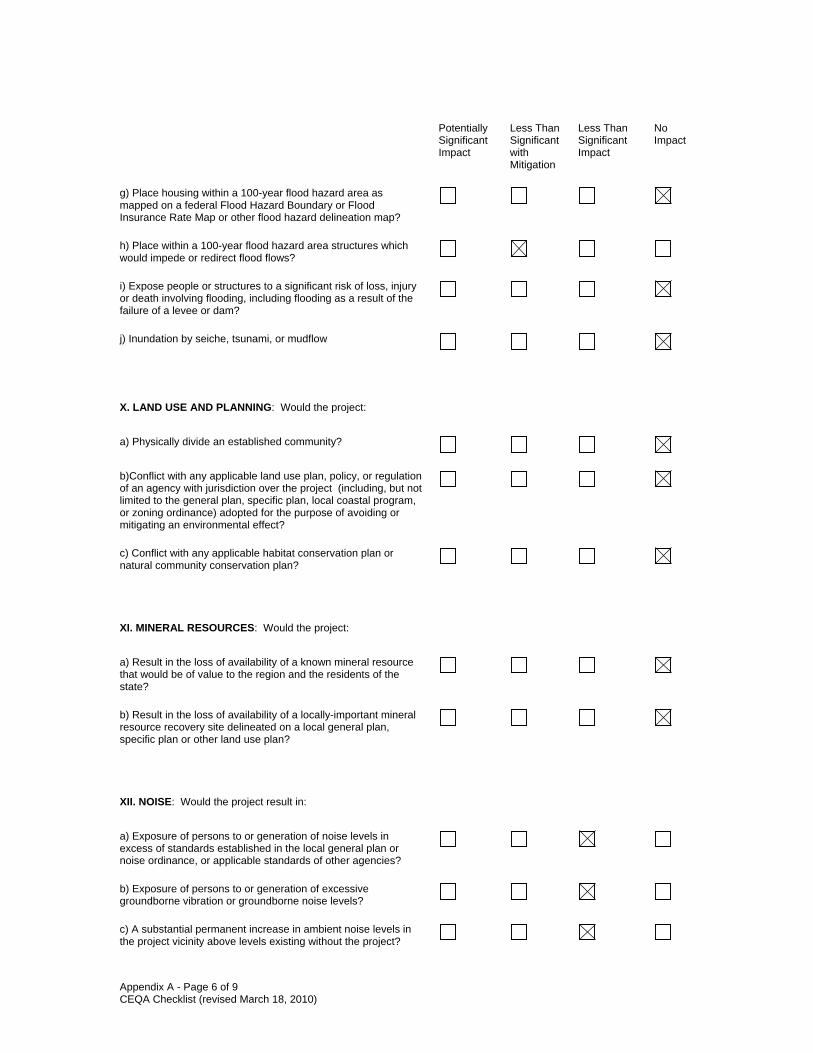
Appendix A - Page 6 of 9 CEQA Checklist (revised March 18, 2010)
Potentially
Significant Impact
Less Than Significant with Mitigation
Less Than Significant Impact
No Impact
g) Place housing within a 100-year flood hazard area as mapped on a federal Flood Hazard Boundary or Flood Insurance Rate Map or other flood hazard delineation map?
h) Place within a 100-year flood hazard area structures which would impede or redirect flood flows?
i) Expose people or structures to a significant risk of loss, injury or death involving flooding, including flooding as a result of the failure of a levee or dam?
j) Inundation by seiche, tsunami, or mudflow
X. LAND USE AND PLANNING: Would the project:
a) Physically divide an established community?
b)Conflict with any applicable land use plan, policy, or regulation of an agency with jurisdiction over the project (including, but not limited to the general plan, specific plan, local coastal program, or zoning ordinance) adopted for the purpose of avoiding or mitigating an environmental effect?
c) Conflict with any applicable habitat conservation plan or natural community conservation plan?
XI. MINERAL RESOURCES: Would the project:
a) Result in the loss of availability of a known mineral resource that would be of value to the region and the residents of the state?
b) Result in the loss of availability of a locally-important mineral resource recovery site delineated on a local general plan, specific plan or other land use plan?
XII. NOISE: Would the project result in:
a) Exposure of persons to or generation of noise levels in excess of standards established in the local general plan or noise ordinance, or applicable standards of other agencies?
b) Exposure of persons to or generation of excessive groundborne vibration or groundborne noise levels?
c) A substantial permanent increase in ambient noise levels in the project vicinity above levels existing without the project?

Appendix A - Page 7 of 9 CEQA Checklist (revised March 18, 2010)
Potentially Significant Impact
Less Than Significant with Mitigation
Less Than Significant Impact
No Impact
d) A substantial temporary or periodic increase in ambient noise levels in the project vicinity above levels existing without the project?
e) For a project located within an airport land use plan or, where such a plan has not been adopted, within two miles of a public airport or public use airport, would the project expose people residing or working in the project area to excessive noise levels?
) For a project within the vicinity of a private airstrip, would the project expose people residing or working in the project area to excessive noise levels?
XIII. POPULATION AND HOUSING: Would the project:
a) Induce substantial population growth in an area, either directly (for example, by proposing new homes and businesses) or indirectly (for example, through extension of roads or other infrastructure)?
b) Displace substantial numbers of existing housing, necessitating the construction of replacement housing elsewhere?
c) Displace substantial numbers of people, necessitating the construction of replacement housing elsewhere?
XIV. PUBLIC SERVICES:
a) Would the project result in substantial adverse physical impacts associated with the provision of new or physically altered governmental facilities, need for new or physically altered governmental facilities, the construction of which could cause significant environmental impacts, in order to maintain acceptable service ratios, response times or other performance objectives for any of the public services:
Fire protection?
Police protection?
Schools?
Parks?
Other public facilities?

Appendix A - Page 8 of 9 CEQA Checklist (revised March 18, 2010)
Potentially Significant Impact
Less Than Significant with Mitigation
Less Than Significant Impact
No Impact
XV. RECREATION:
a) Would the project increase the use of existing neighborhood and regional parks or other recreational facilities such that substantial physical deterioration of the facility would occur or be accelerated?
b) Does the project include recreational facilities or require the construction or expansion of recreational facilities which might have an adverse physical effect on the environment?
XVI. TRANSPORTATION/TRAFFIC: Would the project:
a) Conflict with an applicable plan, ordinance or policy establishing measures of effectiveness for the performance of the circulation system, taking into account all modes of transportation including mass transit and non-motorized travel and relevant components of the circulation system, including but not limited to intersections, streets, highways and freeways, pedestrian and bicycle paths, and mass transit?
b) Conflict with an applicable congestion management program, including, but not limited to level of service standards and travel demand measures, or other standards established by the county congestion management agency for designated roads or highways?
c) Result in a change in air traffic patterns, including either an increase in traffic levels or a change in location that results in substantial safety risks?
d) Substantially increase hazards due to a design feature (e.g., sharp curves or dangerous intersections) or incompatible uses (e.g., farm equipment)?
e) Result in inadequate emergency access?
f) Conflict with adopted policies, plans or programs regarding public transit, bicycle, or pedestrian facilities, or otherwise decrease the performance or safety of such facilities?
XVII. UTILITIES AND SERVICE SYSTEMS: Would the project:
a) Exceed wastewater treatment requirements of the applicable Regional Water Quality Control Board?
b) Require or result in the construction of new water or wastewater treatment facilities or expansion of existing facilities, the construction of which could cause significant environmental effects?

Appendix A - Page 9 of 9 CEQA Checklist (revised March 18, 2010)
Potentially Significant Impact
Less Than Significant with Mitigation
Less Than Significant Impact
No Impact
c) Require or result in the construction of new storm water drainage facilities or expansion of existing facilities, the construction of which could cause significant environmental effects?
d) Have sufficient water supplies available to serve the project from existing entitlements and resources, or are new or expanded entitlements needed?
e) Result in a determination by the wastewater treatment provider which serves or may serve the project that it has adequate capacity to serve the project’s projected demand in addition to the provider’s existing commitments?
f) Be served by a landfill with sufficient permitted capacity to accommodate the project’s solid waste disposal needs?
g) Comply with federal, state, and local statutes and regulations related to solid waste?
XVIII. MANDATORY FINDINGS OF SIGNIFICANCE
a) Does the project have the potential to degrade the quality of the environment, substantially reduce the habitat of a fish or wildlife species, cause a fish or wildlife population to drop below self-sustaining levels, threaten to eliminate a plant or animal community, substantially reduce the number or restrict the range of a rare or endangered plant or animal or eliminate important examples of the major periods of California history or prehistory?
b) Does the project have impacts that are individually limited, but cumulatively considerable? ("Cumulatively considerable" means that the incremental effects of a project are considerable when viewed in connection with the effects of past projects, the effects of other current projects, and the effects of probable future projects)?
c) Does the project have environmental effects which will cause substantial adverse effects on human beings, either directly or indirectly?

Appendix B
Title VI Policy
Statement

DEPART'lENT OFTRA:'lSPORTATIONOFFICE Or- THE DIRECTOR[' O. Bo't 942873. MS.-49SACRA\1F.STO, CA 94273-0001I'HO\E (9. 6} 654-5266F,\X t9;(i}654·660liny 7:1
hly 20,2010
Flrx .v'Jllr po''''w'fir cnc'l1V rf!i~Jrnl'
TITLE VIPOLICY STATEMENT
The California Department ofTransportation, under Title VI of the Civil Rights Actof 1964 and related statutes, ensures that no person in the State of California shall, onthe grounds of race, color, national origin, sex, disability, or age. be excluded fromparticipation in, be denied the benefits of, or be otherwise subjected to discriminationunder any program or activity it administers.
For infonnation or guidance on how to file a complaint based on the grounds of race,color, national origin, sex, disability, or age, please visil the following web page:http://www.dot.ca.gov/hqtbep/titlc_vi/t6_violated.htm.
Additionally, if you need this infonnation in an alternate fonnat, such as in Braille orin a language other than English, picase contact Charles Walmon, Manager, Title VIand Americans with Disabilities Act Program, California Department of Transportation.1823 14th Street, MS-79, Sacramento, CA 95811. Phone: (916) 324-1353 or toll freeJ-S66-8IO-6346 (voice), TTY 711, fax (916) 324-1869. orvia email:[email protected].
g~l~~Director
Cui" 1"1 ;mprnW!1 mo/l,/iT)' ~a"'l ("(l!~fu".,a·
Appendix C
Summary
of
Relocation
Benefits

Appendix C - Relocation Assistance Program
California Department of Transportation
Relocation Assistance Program
DECLARATION OF POLICY
“The purpose of this title is to establish a uniform policy for fair and equitable treatment of
persons displaced as a result of federal and federally assisted programs in order that such persons
shall not suffer disproportionate injuries as a result of programs designed for the benefit of the
public as a whole.”
The Fifth Amendment to the U.S. Constitution states, “No Person shall…be deprived of life, liberty,
or property, without due process of law, nor shall private property be taken for public use without
just compensation.” The Uniform Act sets forth in statute the due process that must be followed
in Real Property acquisitions involving federal funds. Supplementing the Uniform Act is the
government-wide single rule for all agencies to follow, set forth in 49 Code of Federal Regulations,
Part 24. Displaced individuals, families, businesses, farms, and nonprofit organizations may be
eligible for relocation advisory services and payments, as discussed below.
FAIR HOUSING
The Fair Housing Law (Title VIII of the Civil Rights Act of 1968) sets forth the policy of the United
States to provide, within constitutional limitations, for fair housing. This Act, and as amended,
makes discriminatory practices in the purchase and rental of most residential units illegal.
Whenever possible, minority persons shall be given reasonable opportunities to relocate to any
available housing regardless of neighborhood, as long as the replacement dwellings are decent,
safe, and sanitary and are within their financial means. This policy, however, does not require
Caltrans to provide a person a larger payment than is necessary to enable a person to relocate to
a comparable replacement dwelling.
Any persons to be displaced will be assigned to a relocation advisor, who will work closely with
each displacee in order to see that all payments and benefits are fully utilized, and that all
regulations are observed, thereby avoiding the possibility of displacees jeopardizing or forfeiting
any of their benefits or payments. At the time of the initiation of negotiations (usually the first
written offer to purchase), owner-occupants are given a detailed explanation of the state's
relocation services. Tenant occupants of properties to be acquired are contacted soon after the
initiation of negotiations, and also are given a detailed explanation of the Caltrans Relocation
Assistance Program. To avoid loss of possible benefits, no individual, family, business, farm, or
nonprofit organization should commit to purchase or rent a replacement property without first
contacting a Caltrans relocation advisor.
Appendix C - Relocation Assistance Program
RELOCATION ASSISTANCE ADVISORY SERVICES
In accordance with the Uniform Relocation Assistance and Real Property Acquisition Policies Act
of 1970, as amended, Caltrans will provide relocation advisory assistance to any person, business,
farm or nonprofit organization displaced as a result of the acquisition of real property for public use,
so long as they are legally present in the United States. Caltrans will assist eligible displacees in
obtaining comparable replacement housing by providing current and continuing information on the
availability and prices of both houses for sale and rental units that are "decent, safe and sanitary."
Nonresidential displacees will receive information on comparable properties for lease or purchase
(For business, farm and nonprofit organization relocation services, see below).
Residential replacement dwellings will be in a location generally not less desirable than the
displacement neighborhood at prices or rents within the financial ability of the individuals and
families displaced, and reasonably accessible to their places of employment. Before any
displacement occurs, comparable replacement dwellings will be offered to displacees that are open
to all persons regardless of race, color, religion, sex, national origin, and consistent with the
requirements of Title VIII of the Civil Rights Act of 1968. This assistance will also include the
supplying of information concerning Federal and State assisted housing programs, and any other
known services being offered by public and private agencies in the area.
Persons who are eligible for relocation payments and who are legally occupying the property
required for the project will not be asked to move without first being given at least 90 days written
notice. Residential occupants eligible for relocation payment(s) will not be required to move unless
at least one comparable "decent, safe and sanitary" replacement dwelling, available on the market,
is offered to them by Caltrans.
RESIDENTIAL RELOCATION PAYMENTS
The Relocation Assistance Program will help eligible residential occupants by paying certain costs
and expenses. These costs are limited to those necessary for or incidental to the purchase or
rental of a replacement dwelling and actual reasonable moving expenses to a new location within
50 miles of the displacement property. Any actual moving costs in excess of the 50 miles are the
responsibility of the displacee. The Residential Relocation Assistance Program can be
summarized as follows:
Moving Costs
Any displaced person, who lawfully occupied the acquired property, regardless of the length of
occupancy in the property acquired, will be eligible for reimbursement of moving costs.
Displacees will receive either the actual reasonable costs involved in moving themselves and
personal property up to a maximum of 50 miles, or a fixed payment based on a fixed moving cost
Appendix C - Relocation Assistance Program
schedule. Lawful occupants who move into the displacement property after the initiation of
negotiations must wait until the Department obtains control of the property in order to be eligible
for relocation payments.
Purchase Differential
In addition to moving and related expense payments, fully eligible homeowners may be entitled to
payments for increased costs of replacement housing.
Homeowners who have owned and occupied their property for 180 days or more prior to the date
of the initiation of negotiations (usually the first written offer to purchase the property), may qualify
to receive a price differential payment and may qualify to receive reimbursement for certain
nonrecurring costs incidental to the purchase of the replacement property. An interest differential
payment is also available if the interest rate for the loan on the replacement dwelling is higher than
the loan rate on the displacement dwelling, subject to certain limitations on reimbursement based
upon the replacement property interest rate. The maximum combination of these three
supplemental payments that the owner-occupant can receive is $22,500. If the total entitlement
(without the moving payments) is in excess of $22,500, the Last Resort Housing Program will be
used (See the explanation of the Last Resort Housing Program below).
Rent Differential
Tenants and certain owner-occupants (based on length of ownership) who have occupied the
property to be acquired by Caltrans prior to the date of the initiation of negotiations may qualify to
receive a rent differential payment. This payment is made when Caltrans determines that the cost
to rent a comparable "decent, safe and sanitary" replacement dwelling will be more than the
present rent of the displacement dwelling. As an alternative, the tenant may qualify for a down
payment benefit designed to assist in the purchase of a replacement property and the payment of
certain costs incidental to the purchase, subject to certain limitations noted under the Down
Payment section below. The maximum amount payable to any eligible tenant and any
owner-occupant of less than 180 days, in addition to moving expenses, is $5,250. If the total
entitlement for rent supplement exceeds $5,250, the Last Resort Housing Program will be used.
In order to receive any relocation benefits, the displaced person must buy or rent and occupy a
"decent, safe and sanitary" replacement dwelling within one year from the date the Department
takes legal possession of the property, or from the date the displacee vacates the displacement
property, whichever is later.
Down Payment
The down payment option has been designed to aid owner-occupants of less than 180 days and
tenants in legal occupancy prior to Caltrans' initiation of negotiations. The down payment and
incidental expenses cannot exceed the maximum payment of $5,250. The one-year eligibility

Appendix C - Relocation Assistance Program
period in which to purchase and occupy a "decent, safe and sanitary" replacement dwelling will
apply.
Last Resort Housing
Federal regulations (49 CFR 24) contain the policy and procedure for implementing the Last Resort
Housing Program on federal-aid projects. Last Resort Housing benefits are, except for the
amounts of payments and the methods in making them, the same as those benefits forstandard
residential relocation as explained above. Last Resort Housing has been deigned primarily to cover
situations where a displacee cannot be relocated because of lack of available comparable
replacement housing, or when the anticipated replacement housing payments exceed the $22,500
and $5,250 limits of the standard relocation procedure, because either the displacee lacks the
financial ability or other valid circumstances.
After the initiation of negotiations, Caltrans will within a reasonable length of time, personally
contact the displacees to gather important information, including the following:
• Number of people to be displaced;
• Specific arrangements needed to accommodate any family member(s) with special needs;
• Financial ability to relocate into comparable replacement dwelling which will adequately
house all members of the family;
• Preferences in area of relocation;
" Location of employment or school.
NONRESIDENTIAL RELOCATION ASSISTANCE
The Nonresidential Relocation Assistance Program provides assistance to businesses, farms and
nonprofit organizations in locating suitable replacement property, and reimbursement for certain
costs involved in relocation. The Relocation Advisory Assistance Program will provide current lists
of properties offered for sale or rent, suitable for a particular business's specific relocation needs.
The types of payments available to eligible businesses, farms and nonprofit organizations are:
searching and moving expenses, and possibly reestablishment expenses; or a fixed in lieu payment
instead of any moving, searching and reestablishment expenses. The payment types can be
summarized as follows:
Moving Expenses
Moving expenses may include the following actual, reasonable costs:
• The moving of inventory, machinery, equipment and similar business-related property,
including: dismantling, disconnecting, crating, packing, loading, insuring, transporting,
unloading, unpacking, and reconnecting of personal property. Items acquired in the Right
Appendix C - Relocation Assistance Program
of Way contract may not be moved under the Relocation Assistance Program. If the
displacee buys an Item Pertaining to the Realty back at salvage value, the cost to move that
item is borne by the displacee.
• Loss of tangible personal property provides payment for actual, direct loss of personal
property that the owner is permitted not to move.
• Expenses related to searching for a new business site, up to $2,500, for reasonable
expenses actually incurred.
Reestablishment Expenses
Reestablishment expenses related to the operation of the business at the new location, up to
$10,000 for reasonable expenses actually incurred.
Fixed In Lieu Payment
A fixed payment in lieu of moving, searching, and reestablishment payments may be available to
businesses which meet certain eligibility requirements. This payment is an amount equal to half
the average annual net earnings for the last two taxable years prior to the relocation and may not
be less than $1,000 nor more than $20,000.
ADDITIONAL INFORMATION
Reimbursement for moving costs and replacement housing payments are not considered income
for the purpose of the Internal Revenue Code of 1954, or for the purpose of determining the extent
of eligibility of a displacee for assistance under the Social Security Act, or any other law, except for
any Federal law providing local "Section 8" Housing Programs.
Any person, business, farm or nonprofit organization which has been refused a relocation payment
by the Caltrans relocation advisor or believes that the payment(s) offered by the agency are
inadequate, may appeal for a special hearing of the complaint. No legal assistance is required.
Information about the appeal procedure is available from the relocation advisor.
California law allows for the payment for lost goodwill that arises from the displacement for a pubic
project. A list of ineligible expenses can be obtained from Caltrans Right of Way. California's law
and the federal regulations covering relocation assistance provide that no payment shall be
duplicated by other payments being made by the displacing agency.
RESIDENTIAL RELOCATION PAYMENTS PROGRAM
The links below are to the Relocation Assistance for Residential Relocation Brochure.
• http://www.dot.ca.gov/hq/row/pubs/residential_english.pdf
• http://www.dot.ca.gov/hq/row/pubs/residential_spanish.pdf

Appendix D
List
of
Acronyms

List of Acronyms
ABAG Association of Bay Area Governments
AMBAG Association of Monterey Bay Area Governments
BAAQMD Bay Area Air Quality Management District
BSA biological study area
CalEPA California Environmental Protection Agency
CARB California Air Resources Board
CEC California Energy Commission
CEQA California Environmental Quality Act
CERCLA Comprehensive Environmental Response, Compensation and
Liability Act
CFR Code of Federal Regulations
CO carbon monoxide
2CO carbon dioxide
CRHR California Register of Historic Resources
CWA Clean Water Act
EB eastbound
EPA Environmental Protection Agency
ESU evolutionary significant unit
FEMA Federal Emergency Management Agency
FHWA Federal Highway Administration
FIRM Flood Insurance Rate Map
GHG greenhouse gas
HCP habitat conservation plan
HOV high occupancy vehicle
ISA Initial Site Assessment
LESA Land Evaluation & Site Assessment
LOS level of service
MBUAPCD Monterey Bay Unified Air Pollution Control District
MCE maximum credible earthquake
MPO metropolitan planning organization
MS4 municipal separate storm sewer system
MSATs mobile source air toxics
MTC Metropolitan Transportation Commission

NAAQS National Ambient Air Quality Standards
NB northbound
NCCP natural communities conservation plan
NEPA National Environmental Policy Act
NHPA National Historic Preservation Act
2NO nitrogen dioxide
NPDES National Pollutant Discharge Elimination System
NRHP National Register of Historic Places
3O ozone
PM particulate matter
POC pedestrian overcrossing
PRC (California) Public Resources Code
RAP Relocation Assistance Program
RCB reinforced concrete box
RCP reinforced concrete pipe
RCRA Resource Conservation and Recovery Act
RTP Regional Transportation Plan
RWQCB Regional Water Quality Control Board
SB southbound
SCVWD Santa Clara Valley Water District
SHPO State Historic Preservation Officer
2SO sulfur dioxide
SR State Route
SWMP Stormwater Management Plan
SWPPP Stormwater Pollution Prevention Plan
SWRCB State Water Resources Control Board
TMDL total maximum daily load
WB westbound
WDR waste discharge requirement
VOC volatile organic compound
VTA Santa Clara Valley Transportation Authority
VTP 2035 Valley Transportation Plan 2035

Appendix E
List
of
Technical Studies

List of Technical Studies
The following technical studies were prepared during the preparation of this EIR for this project.
These studies are available for review at the locations listed inside the front cover of this document.
• Traffic Operations Assessment Report (Dowling Associates)
• Visual Impact Assessment (Haygood & Associates)
• Land Evaluation Suitability Assessment (LESA) Report (David J. Powers & Associates)
• Historic Properties Compliance Report (Far Western Anthropological Research Group)
• Historic Resources Evaluation Report (JRP Historical Consulting)
• Archaeological Survey Report (Far Western Anthropological Research Group)
• Location Hydraulic Study (WRECO)
• Stormwater Data Report (WRECO)
• Preliminary Geotechnical Report (Ninyo & Moore)
• Paleontological Evaluation Report Addendum (Infrastructure Engineering Corporation)
• Initial Site Assessment (Ninyo & Moore)
• Air Quality Report (Illingworth & Rodkin)
• Mobile Source Air Toxics Report (Illingworth & Rodkin)
• Noise Study Report (Illingworth & Rodkin)
• Natural Environment Study (H.T. Harvey & Associates)

Appendix F
Comments Receivedon the Draft EIR

NATURAL RESOURCES AGENCY EDMUND G. BROWN, JR., GOVERNOR
DEPARTMENT OF CONSERVATION
DIVISION OF LAND RESOURCE PROTECTION
801 K STREET. MS 18-01 • SACRAMENTO. CALIFORNIA 95814
PHONE 916/324-0850 • FAX 916/327-3430 • TOO 916/324-2555 • WEBSITE conservation.ca.goY
April 29, 2013
VIA EMAIL to 101 [email protected] at (408) 321-7535Santa Clara Valley Transportation AuthorityEnvironmental Programs and Resources Management Dept.3331 North First Street - Building B-2San Jose, CA 95134-1927Attn: Ann Calnan
Subject: U.S. 101 IMPROVEMENT PROJECT BETWEEN MONTEREY STREET AND STATEROUTE 129; DRAFT ENVIRONMENTAL IMPACT REPORT (SANTA CLARA AND SAN BENITOCOUNTIES) SCH# 2007102141; WANG FARM AGRICULTURAL CONSERVATION EASEMENT
Dear Ms. Calnan:
The Department of Conservation's Division of Land Resource Protection has reviewed the DraftEnvironmental Impact Report (DEIR) for the referenced project. The Department's Division of LandResource Protection monitors farmland conversion on a statewide basis and administers the CaliforniaLand Conservation Act (Williamson Act), the California Farmland Conservancy Program (CFCP), theFarmland Mapping and Monitoring Program (FMMP); and other agricultural land conservation programs.We offer the following comments.
Project Description
The Santa Clara Valley Transportation Authority (VTA) has prepared this DEIR in its role as the LeadAgency under the California Environmental Quality Act (CEQA). The VTA, in cooperation with theCalifornia Department of Transportation (Caltrans), proposes improvements to U.S. 101 in southernSanta Clara County and northern San Benito County.
Impacts to Agricultural Conservation Easements
The VTA DEIR does not acknowledge that 282-acre Wang Farm Agricultural Conservation Easement1("Wang Farm") may be impacted by the proposed project. The Wang Farm (Figure 1) is under apermanent agricultural conservation easement held by the Silicon Valley Land Conservancy.
1 Wang Farm Agricultural Conservation Easement APN 841-036-011 (portion)
The Department ofConservation's mission is to balance today's needs with tomorrow's challenges andfoster intelligent, sustainable,and efficient use ofCalifornia's energy, land, and mineral resources.

Santa Clara Valley Transportation AuthorityApril 29, 2013Page 2 of 3
The Department's CFCP and the United States Department of Agricultural, National ResourceConservation Service, Farm and Ranch Land Protection Program provided grant funding to purchaseof the Wang Farm in 2005. As part of the original application, both the City Council of the City ofGilroy and the Santa Clara County Board of Supervisors passed resolutions of support on July 7,2003 and June 24, 2003, respectively, supporting establishment of the Wang Farm AgriculturalConservation Easement, which was designated to be held in perpetuity. Terminating portions of theeasement and fragmentation of the remaining agricultural property is directly at odds with the intent ofthe easement and the City's and County's support of the easement. Any future changes to use of thisproperty would require permission of the United States Department of Agriculture.
Figure 1:
The implications of this potential easement disruption are beyond the scope of the DEIR itself, but mustbe addressed ifVTA chooses to continue with the project as described.
Santa Clara Valley Transportation AuthorityI.pril 29, 2013r">age 3 of 3
Thank you for giving us the opportunity to comment on this DEIR. If you have questions on ourcomments, please contact Tim Bryant, CFCP Grant Manager, at (209) 742-6191; or for WilliamsonAct related questions Meri Meraz at (916) 445-9411, 801 K Street, MS 18-01, Sacramento, California95814.
Sincerely,
Molly A. Penberth, ManagerDivision of Land Resource ProtectionConservation Program Support Unit
cc:State Clearinghouse
Silicon Valley Land Conservancy, 117 Bernal Rd, #70-181, San Jose, CA 95119
USDA-NRCS-Farm and Ranchland Protection Program 430 G Street, #4164Davis, California 95616

To:
From:
State ofCalifomiaDEPARTMENT OF TRANSPORTATION
Memorandum
NICK SALEHRegional Project ManagerProject Management South
CRISTIN HALLISSYI ~Branch Chief VOffice of Environmental Analysis
Business, Transportation and Housing Agency
f'ltx your pOWtr!
Be energy efficient!
Date: April 25, 2013
File: JAI60
Subject: US 1011mprovement Project Between Monterey St. and SR 129 DEIR OEA Comments
The Office of Environmental Analysis offers the following comments on the DraftEnvironmental Impact Report for the U.S. 101 Improvement Project between Monterey Streetand State Route 129 in Santa Clara and San Benito Counties. The Santa Clara ValleyTransportation Agency (VTA) is the CEQA lead agency for this project, and the CaliforniaDepartment ofTransportation (Caltrans) is a CEQA responsible agency.
Section 1.2 - The second purpose "Accommodate projected traffic demand along U.S. 101 .....and the fifth purpose "Enhance the movement of. .... have no correlating need statement or data.Infonnation demonstrating the future congestion and delay needs to be included in the needsection of the document. The same infonnation is lacking to demonstrate that the movement ofgoods along U.S. IOI is a problem.
Section 2.6 - All tables and infonnation (including but not exclusively Tables 19 and 20) in thissection should be updated so the infonnation in the Final Environmental Impact Report (FEIR)matches and is consistent with the infonnation in the Project Report and TOAR. Theinfonnation in the Draft Environmental Impact Report does not match/is not consistent with thatin the Draft Project Report and TOAR.
Section 2.8.1 - Please edit the final sentence of the section to read: It further specifically requiresCaltrans to inventory, evaluate for significance, assess effects, and early in the planning processgive notice and opportunity to comment to the SHPO.
Section 2.8.2.2 ~ The numbers of resources discussed do not add up. 12 resources arementioned, but only six are discussed as eligible or ineligible. This document as currentlywritten obfuscates which resources are of may be in State Right of Way, and are thus subject toPRC 5024.6. Eligible and potential effects for the remaining six sites not specifically have notbeen completed and the SHPO has not been consulted. This process must be completed prior toapproval of the FEIR, to be in compliance with PRC 5024.5.
c: File
"Cal/ram improvt$ mobility aCTO.I$ CalifQrIlia"

From: Moonjian, Jennifer M@DOT Sent: Thursday, April 25, 2013 2:18 PM To: Olejnik, John@DOT Cc: Siepel, Nancy R@DOT; Bonner, Larry E@DOT Subject: Hwy 101 Improvement Project - DEIR Comments from D-5 Bio Dear John, Below are my comments for the 101 Widening Project. Let me know if you have any questions or concerns. Thank you, Jennifer Moonjian Biologist (District 5) 805‐542‐4763 Highway 101 Improvement Project between Monterey Street and State Route 129 Draft Environmental Impact Report Comments from Jennifer Moonjian 25 April 2013 1. Page XIV: Impact NATCOM‐4: By adding the word "permanent" in the following sentence it precludes barriers
that might be used during construction such as cofferdams and diversions. "Construction of the proposed project
will not create permanent barriers to the..." 2. Page XIX: MM‐Animal ‐ 9: The project is permanently removing up to 5.5 acres of riparian and oak
woodland. This will undoubtedly have an impact on bats that use the area for both foraging and roosting. It is
tremendously difficult to detect a bat roost in a tree (personal communication with J. Szewczak during tree
removal on another project I had), therefore there may be roosts that go undetected during tree removal. Bat
habitat should be provided as part of this project to help offset permanent impacts to them as a result of this
project. This habitat may be incorporated into new bridge structures (several have been constructed or are in the
process of being constructed in District 5) or merely an Oregon wedge type design has also been found to be
successful on an existing or new structure. Off‐bridge habitats have not been found to be very successful in
Central/Northern California. 3. Page XX: MM‐Animal‐12.1: Permits that are currently being issues from CDFW have nest buffers for passerines
and raptors of 250 and 500 feet, respectively. 4. Page XXI: MM‐T&E‐2.4: Although the creeks and rivers are not expected to provide good breeding habitat for
frogs, frogs could still be present during dewatering or diversion activities. There is no mention of appropriate
methods to put in place during dewatering or diversion as is discussed in the steelhead section. 5. Page XXII: MM‐T&E‐2.15: Silt fencing or Ertec fencing should be considered to exclude species from the
construction zone, especially around the Castro Valley area. 6. Page 173: 2.17.3.4 : Same comment as #1. 7. Page 177‐178: The new and enhanced culverts for wildlife crossing should have post‐construction monitoring
to determine if the methods were successful and ways to improve in the future. 8. Page 196: 2.20.3.9 Impacts to Bats: See Comment #2. Removal of riparian and woodlands has a direct impact
on bats, bridges are not the only bat habitat type in the project area. 9. Page 202: MM‐Animal ‐ 9.5: See Comment #2. The document refers to the day roosting areas on the Tar Creek
Bridge that will be impacted, yet no mitigation is being offered for this roost. Just because it is not a maternity
roost does not mean that it is not important for bats. Even night roosts, when disturbed, can impact the distance

that bats have to fly to and from their foraging locations, therefore lowering productivity ‐ so it should not be
discounted. 10. Page 203: MM‐Animal‐9.6: Just because a non‐maternity colony of bats are using a structure does not justify
not providing alternative roosts or lack of monitoring. 11. Page 204: MM‐Animal ‐ 12.1: Same as Comment #3. 12. Page 210: CTS Section: CTS is no longer a candidate ‐ it is state listed as threatened.

From: Jan Bernstein-Chargin [mailto:[email protected]] Sent: Friday, April 12, 2013 1:02 PM To: 101_Widening Subject: Comments on Draft EIR: U.S. 101 Improvement Project between Monterey Street and State Route 129 Attn: Ann Calnan I am writing on behalf of Gavilan College, located at 5055 Santa Teresa Blvd in Gilroy. Most of our staff and students will be directly impacted by the proposed project: U.S. 101 Improvement Project between Monterey Street and State Route 129. In reviewing the EIR, our priority was continued access to, and egress from, the existing college campus. We considered the peak traffic times to and from the campus under the proposed scenarios. The location of our primary concern is the Hwy 25/Hwy 101 interchange, and the portion of Santa Teresa Blvd from this interchange to the college entrance. We would like to make sure the following considerations are noted and addressed: 1. Both options show a single lane in each direction on Santa Teresa Blvd between the college and the proposed highway 25/101 interchange. Given the large numbers of staff and students who arrive on campus (and leave) at the same time, we question whether one lane will be sufficient in this location. As it stands now, many staff and students approaching the Gavilan College campus from the north use either Mesa Road or Castro Valley Road to exit Hwy 101. When both of these are closed, the students coming from the north (as well as those from San Benito County) will use the Santa Teresa Blvd exit. 2. Large numbers of cars (described above) will be making a left turn from Santa Teresa Blvd onto campus during the morning commute, and a right turn from campus onto Santa Teresa during the afternoon commute. This intersection will be upgraded with a traffic light in the proposal. We ask that consideration be made of adequate space in turn lanes to accommodate the high traffic to and from campus at peak commute times. 3. Access to northbound Santa Teresa Blvd from Southbound 101 must be assured. 4. Access to northbound 101 from southbound Santa Teresa Blvd. must be assured. It does not look as though option 2 provides for this. 5. Signage to Gavilan College from Hwy 25, northbound 101, southbound 101, and Santa Teresa Blvd. should be incorporated for the permanent plan and during construction. 6. It will be important to consider access to and from the campus during construction. Thank you for your consideration. Jan Bernstein Chargin Director, Public Information Gavilan College (408) 848-4724

MBUAPCD Monterey Bay Unified Air Pollution Control District 24580 Silver Cloud Court Serving Monterey, San Benito, and Santa Cruz Counties Monterey, CA 93940 PHONE: (831) 647-9411 • FAX: (831) 647-8501
April 29, 2013 Submitted Via E-mail Santa Clara Valley Transportation Authority Environmental Programs and Resources Management Dept. Attn: Ann Calnan 3331 North First Street - Building B-2 San Jose, California 95134-1927 [email protected] Subject: U.S. 101 Improvement Project between Monterey Street and State Route 129
Draft Environmental Impact Report (SCH 2007102141) Dear Ms. Calnan:
Thank you for providing the Monterey Bay Unified Air Pollution Control District (Air District) the opportunity to comment on the above-referenced document. The Air District has reviewed the document and has the following general and specific comments to address the air quality and climate change sections.
General Comments on Section 2.14 Air Quality and Air Quality Report
• The Air Quality DEIR section and the Air Quality Report are outdated and should be updated to reflect current air quality. For example, both documents reference air quality data which is five years out of date. Additionally, the linkage between the Air Quality Report and Section 2.14 Air Quality in the DEIR is unclear. The DEIR should summarize the Air Quality Report so the findings are consistent.
• The air quality aspects of the project should be considered in relation to the District’s 2008
California Environmental Quality Act (CEQA) Air Quality Guidelines. Emissions associated with the construction and operational phases of the project should be estimated and compared to the significance thresholds in the document. The guidelines can be accessed at: http://www.mbuapcd.org/mbuapcd/pdf/mbuapcd/pdf/CEQA_full.pdf.
• For CEQA evaluations, project impacts should be evaluated compared to existing conditions. Section 2.14 compares No Build and Build alternatives but does not compare either alternative to existing conditions. Please also confirm what was considered as the year for existing conditions. The year 2005 was reported as the base year in Table 25 while the year 2009 was reported as existing in Table 27.
Specific Comments The following specific comments address the Summary, Section 2.14 Air Quality, Section 2.15 Climate Change, and Air Quality Report.
Richard A. Stedman, Air Pollution Control Officer Page 1 of 4
Table S-1, Summary of Environmental Impacts, Air Quality on page xii • Construction of the proposed project could cause or contribute to exceedances of the Californian 24-
hour PM10 standard, as well as local nuisance, if appropriate fugitive dust management measures are not implemented. Mitigation measure MM-CON-4 on page xxiv indicates that the project will employ CALTRANS Standard Specifications to reduce construction dust, as well as the BAAQMD dust control measures as listed in Table 37 of the DEIR. Therefore, mitigation measure MM-CON-4 should also be listed under Air Quality and applied to construction of the entire length of the project, including the portion in San Benito County.
2.13 Hazardous Waste/Materials starting on Page 117
• Figure 3 on page 14 shows the San Benito River passing under Highway 101 project near Highway 129. The San Benito River is known to contain elevated levels of naturally occurring asbestos (NOA). Consequently, soil disturbed during construction activity may contain elevated levels of NOA. If elevated levels of NOA are found, then dust suppression measures consistent with ARB Air Toxics Control Measure (ATCM) for asbestos should be applied. The ATCM can be found at: http://www.arb.ca.gov/toxics/atcm/asb2atcm.htm.
Section 2.14.1, Regulatory Setting, page 122
• This section focuses on federal requirements, such as, the Federal Clean Air Act and has
no mention of the California Clean Air Act of 1988, which drives many California air quality planning activities. This section should be updated to include the California Clean Air Act.
• The regulatory setting section should describe applicable local Air District rules. For example, Section 2.13 Hazardous Waste/Materials, identifies the potential for asbestos-containing materials to be present in buildings to be demolished. If asbestos-containing material is present, the project will be required to comply with the Air District Rule 424 and any demolition will be subject to District Rule 439.
Section 2.14.2, Affected Environment, NCCAB, page 125
• The text should be updated to include a discussion of ozone transport. Studies conducted
by the California Air Resources Board indicate that exceedances of the state ozone standard in the North Central Coast Air Basin (NCCAB) are caused primarily by transport from the Bay Area. Although San Benito County only represents approximately nine percent of the population of the NCCAB, the attainment status of the entire region is often linked to conditions in San Benito County.
• The transport impacted ozone monitor at Pinnacles National Park in San Benito County should also be mentioned in the third paragraph. This station is key to the attainment status of the entire NCCAB so activities, such as major highway widening projects, along the upwind corridor can be important. The current state 8-hour ozone standard was exceeded 77 times between 2003 and 2007 at Pinnacles National Park. Also, the text indicates that the new state 8-hour ozone standard was only exceeded once at Hollister in 2006. Actually, the current 8-hour standard was exceeded five times in 2006.
Richard A. Stedman, Air Pollution Control Officer Page 2 of 4

Section 2.14, Impact AQ-1, page 126
• The project’s potential impact to cause or contribute to a violation of an ambient air quality standard does not only apply to CO standards. More importantly, the impact of the project on ozone precursor emissions should also be evaluated. The entire section fails to address the potential impacts of the project to the nonattainment pollutant ozone. Therefore, in order to be more complete, the DEIR should assess project operation emissions in relation to applicable District thresholds, as outlined in the District’s 2008 CEQA Guidelines.
• The impact analysis should also address state particulate matter air quality standards. Re-
entrained road dust is a major contributor to PM10 emissions. Therefore, the Air District suggests that the following measures for minimizing re-entrained road dust also be considered whenever feasible:
o Construct shoulders with a minimum width of eight feet. o Construct medians with minimum of four foot wide shoulders. o Plant ground cover to paved edge of roadway to stabilize shoulders and reduce fire hazard
from dry weeds. o Pave or use non-toxic surfactants on unpaved shoulders and turnouts. o Plant hedges or shrubs along the Right of Way to reduce offsite migration of “dust devils”
caused by large trucks traveling at high speeds. o Plant hedges in medians. o Promptly remove soil deposits after wind or storm events
Fig 17, Possible Effect of Traffic Operation Strategies in Reducing On-Road CO2 Emissions on Pg. 134
• This figure and the supporting text immediately under it indicate that speeds could increase by as
much as 20 to 25 mph to a maximum of 70 mph. Since CO2, as well as other pollutants such as NOx increase above 55 mph, excess emissions associated with this change should be estimated and compared to the applicable Air District CEQA significance thresholds.
Section 2.15.4, CEQA Conclusion regarding Climate Change, page 140
• CEQA was amended in 2010, in accordance with SB 97, because California’s lawmakers recognized the need to analyze greenhouse gas emissions as a part of the CEQA process. The CEQA Guidelines were updated to direct lead agencies to analyze the greenhouse gas emissions of proposed projects (see §15064.4) and this is analysis is not necessarily restricted to whether the impact would be cumulatively considerable. Other Air Districts have established thresholds indicating GHG emissions ranging from 1,150 to 10,000 metric tons CO2 per year would result in a significant impact. Table 27 reports the potential annual CO2 emissions for this project of 133,084 metric tons and the text on page 134 states, “These changes will have an overall negative effect on the GHG emissions generated in the project area, as compared with the No-Build scenario.” Please explain how a project with annual emissions that far exceed any established Air District threshold and that would have a negative effect on GHG emissions is considered too speculative to make a significance determination.
Richard A. Stedman, Air Pollution Control Officer Page 3 of 4

Air Quality Report, Table 3-1, Air Quality Standards on Page 10
• Table 3 needs to be completely updated. Incorrect standards are reported for many of the pollutants which appears to be due to a table formatting problem. Please refer to the link below to ARB’s current standards table for these revisions: http://www.arb.ca.gov/research/aaqs/aaqs2.pdf
Air Quality Report, Air Quality Planning, MBUAPCD on Page 23
• The list of applicable air quality plans at the top of this page should be updated to include the 2012 Triennial Plan Revision to the Air District’s Air Quality Management Plan for the California ambient air quality standard for ozone. The plan is available on the Air District’s website at: http://www.mbuapcd.org/programs/planning.
Air Quality Report, Significance Criteria, MBUAPCD on Page 33
• Please explain why the Air District’s significance criteria are listed on page 33 and then not used as part of the impact assessment in Section 5.1. The operational impact assessment should include an evaluation of the nonattainment pollutant ozone by using the ozone precursor emission thresholds (NOx and VOC).
Air Quality Report, Appendix A – Air Quality Monitoring Sites
• Please note, the monitoring stations shown in the figure for Scotts Valley, Davenport, Watsonville and Moss Landing have been closed. A current map of the Air District’s monitoring sites can be found on page 10 of the Air District’s 2012 Triennial Plan referred to in the previous comment.
Please contact me if you have questions, I can be reached at (831) 647-9418 ext. 227 or [email protected]. Best regards,
Amy Clymo Supervising Air Quality Planner cc: Mike Gilroy, Deputy Air Pollution Control Officer
Richard A. Stedman, Air Pollution Control Officer Page 4 of 4
United States Department of the Interior
NATIONAL PARK SERVICEPucific West Region
Juan Bautista de Anza National Historic Trail333 Bush Street, Suite 500
Sun Fruncisco, Culifomiu 94104
IN REPLY REFER TO:
April 25, 2013
VTA Environmental Programs/Resources Management Dept.Attn: Ann Calnan3331 N. First St., Bldg. B-2San Jose, CA 95134
RE: US 101 Improvement Project - Monterey St. to State Route 129
Dear Ms. Calnan:
Please accept these comments from the National Park Service (NPS) in response to the DraftEnvironmental Impact Report (DEIR) for the proposed improvements to US 101 in south Santa Clara andnorth San Benito counties. The project area falls within the recognized historic corridor of the JuanBautista de Anza National Historic Trail (Anza Trail), and is also overlaps with segments of theRecreational Retracement Route of Anza Trail.
The Juan Bautista de Anza National Historic Trail commemorates the 1775-76 Spanish expedition of themore than 240 men, women and children who journeyed across the frontier of New Spain to settle AltaCalifornia. The Anza Trail connects history, culture and outdoor recreation along a l,200-mile corridorextending from Nogales, Arizona to the San Francisco Bay Area.
The Anza Trail Comprehensive Management and Use Plan (1996) envisions a continuous recreation trailfrom Nogales, Arizona to the San Francisco Bay Area. The Santa Clara Countywide Trails Master Planidentifies the planned recreational trail segments within the Santa Clara County. Within the projectarea, an east-west segment of the Anza Trail is intended to follow the same alignment as the Bay AreaRidge Trail. The north-south spine of the Anza Trail is intended to connect through the project area toan existing trail segment, located on Old Stage Road in San Juan Bautista. Some of these trail alignmentsare shown in Figures 5 and 6 of the Draft EIR.
Due to the Anza Trail's planned alignment with the Bay Area Ridge Trail for the east-west connectionacross the valley. NPS concurs the Bay Area Ridge Trail Council's recommendation that VTA adoptAlternative 2. which includes a multiuse trail connection along Carnadero Creek. under the freewaybridges.
NPS also supports the planned extension of bicycle facilities along Highway 101 where the wideningproject is planned. Santa Clara County's Trails Master Plan identifies Santa Theresa Boulevard (at thenorth end of the project area) as the Anza Trail bicycle route. At the southern end of the projectboundary, the planned bicycle path to the San Juan Highway would connect with a proposed trail route

to San Juan Bautista State Park and the popular trail segment on Old Stage Road. Draft EIR Figures 5 &6 also depict the proposed Pajaro River Trail, which is planned to be a multi-use north-south segment ofthe Anza Trail. We are supportive of the eventual development of the Pajaro River Trail, as it wouldprovide a superior multi-use recreational trail route for pedestrians and equestrians. We are pleased tosee that the Highway 101 improvement project incorporates trail undercrossings to accommodate thisfuture trail.
Thank you for your consideration of our comments.
Sincerely,
~~o~?E:ent-Juan Bautista de Anza National Historic Trail
Cc: Bern Smith, Bay Area Ridge Trail CouncilJane Mark, Santa Clara County Parks and Recreation DepartmentJanelle Cox, San Benito County Parks and Recreation Commission

April 29, 2013
Ann Calnan VTA Environmental Programs/ Resources Management 3331 North First Street, Bldg. B-2 San Jose, CA 95134-1927
Dear Ms. Calnan: On behalf of the Pajaro River Watershed Flood Prevention Authority (Authority), I am pleased to submit this comment letter on the Draft Environmental Impact Report (EIR) for the proposed US 101 Improvement Project. Unfortunately, the EIR notification was addressed to retired Authority Executive Directors and this comment letter is based only on a cursory review of the document, given the time available. A more thorough review of the Draft EIR and Appendix B Hydrology and Water Quality Environmental Impact Analysis may result in additional comments to be submitted for your consideration. Comment No. 1 Summary Page iii – Coordination with Public and Other Agencies In addition to the notable issues listed that require focused input from public and other agencies, please add the significant flooding issues along the Lower Pajaro River that are affected by floodplain impacts in the upper watershed, including the loss of floodplain storage. Please also list the Authority as an agency that requires focused coordination. The Authority was established in July 2000 by State Assembly Bill 807 in order to “identify, evaluate, fund, and implement flood prevention and control strategies in the Pajaro River Watershed, on an intergovernmental basis.” The watershed covers areas of four counties and four water districts and the board is comprised of one representative from each:
• County of Monterey / Monterey County Water Resources Agency • County of San Benito / San Benito County Water District • County of Santa Clara / Santa Clara Valley Water District • County of Santa Cruz / Santa Cruz County Flood Control and Water Conservation District, Zone 7
P.O. Box 809, Marina, CA 93933 Phone: 831.883.3750 FAX: 831.883.3755 www.pajaroriverwatershed.org Member Agencies: County of Monterey County of San Benito County of Santa Clara County of Santa Cruz Monterey County Water Resources Agency San Benito County Water District Santa Clara Valley Water District Santa Cruz County Zone 7 Flood Control District

The Authority is implementing the Soap Lake Floodplain Preservation Project (Soap Lake Project) to build upon the Pajaro River Risk Reduction Project being developed by the U.S. Army Corps of Engineers (Corps) on the Lower Pajaro River. Soap Lake is a floodplain within the watershed that has been found to be an extremely important flood protection feature. It acts like a natural detention basin, storing water and reducing peak flows that would otherwise increase flooding in the lower Pajaro River in the Watsonville area. The Soap Lake Project does not involve building any structural facilities, but instead would include financially supporting the purchase of land or flood easements for the land within the Soap Lake floodplain. The objective is to maintain the current flood protection benefits provided by the Soap Lake floodplain by protecting the area from changes that would impact the flood protection properties of the floodplain. The purchase of land or floodplain easements would restrict development and preserve agriculture and open space in the approximately 9,000 acre floodplain with the goal of preserving the floodplain attenuation benefits. Several conservation easements have already been obtained within the Soap Lake project area totaling over 1,000 acres and funding has been secured for another 1,200 acres.
The Soap Lake Project would maintain the current hydrologic and hydraulic conditions at the project site and adjacent properties. The floodplain limits would not be changed. This Project is an outcome of the Authority’s Watershed Study, which investigated the Pajaro River Watershed land-use plans, existing and planned flood protection infrastructure, and alternative strategies to assure effective coordination of the former. The Soap Lake Project was selected as the preferred alternative, and the Watershed Study’s Technical Appendices, and HECRAS Model provide details regarding the Project’s flood attenuate functionality and performance. This Watershed Study is available via the Authority’s link http://www.pajaroriverwatershed.org/ . Comment No. 2 Summary Page x - Impact HYDRO-6 and Section 2.9.2.5 – Impacts to the Pajaro River Floodplain The US 101 Improvement Project will include replacement of the existing U.S. 101 bridge over the Pajaro River. Betabel Road will also be extended and will include a new 3-span bridge over the Pajaro River. The new bridges will fill approximately 20.5 acre-feet of the floodplain of the river. For the Pajaro River, the proposed condition will raise the floodplain by 0.1 feet between the Betabel Road bridge and the U.S. 101 bridge. The water surface elevation increase upstream of the U.S. 101 bridge will be less than 0.1feet. These floodplain and water surface impacts within the 100-year floodplain of the Pajaro River are designated as less than significant and no mitigation measures are proposed.

Given the high flood risks along the Lower Pajaro River, any loss of floodplain storage or increase in water surface elevations should be considered significant and should require mitigation. Flooding throughout the reaches of the Lower Pajaro River is a hazard to public and private property including residences, agriculture, highways, watercourses, and environmental resources. Flooding has been recorded in 1955, 1982, 1986, 1995, 1997 and 1998 causing millions of dollars in damage. The flood event of February 1998 produced the highest flows ever recorded on the Pajaro River at the U.S. Geological Survey gage at Chittenden. These high flows resulted in overtopping and a subsequent levee break downstream of Highway 1 on the Santa Cruz side of the river (Santa Cruz County 1998). The Pajaro River Risk Reduction Project currently being developed by the U.S. Army Corps of Engineers (Corps) on the Lower Pajaro River assumes a functioning Soap Lake floodplain as part of the baseline condition. Thus, the purpose of the Authority’s project is to protect the Soap Lake floodplain so as not to exacerbate flooding downstream and any loss of floodplain storage is considered significant and requiring mitigation. Thank you for your consideration. Sincerely, Maura Twomey Executive Coordinator PRWFPA
April 29, 2013 Ann Calnan BY ELECTRONIC MAIL Santa Clara Valley Transportation Authority Environmental Programs and Resources Management Department 3331 North First Street, Building B-2 San Jose, CA 65134-1927 Email: [email protected] Dear Ms. Calnan: CENTRAL COAST WATER BOARD COMMENTS ON THE MARCH 2013 DRAFT ENVIRONMENTAL IMPACT REPORT FOR THE U.S. 101 IMPROVEMENT PROJECT BETWEEN MONTEREY STREET AND STATE ROUTE 129, SANTA CLARA AND SAN BENITO COUNTIES, FILE NO. 430313CQ1 Thank you for the opportunity to review the Draft Environmental Impact Report (DEIR) for the above-referenced project. The Central Coast Regional Water Quality Control Board (Central Coast Water Board) is a responsible agency under the California Environmental Quality Act (CEQA). Central Coast Water Board staff understands that the proposed U.S. Highway 101 Improvement Project between Monterey Street and State Route 129 (Project) includes the following elements:
• Widen U.S. 101 from four lanes to six lanes between the Monterey Street interchange in Gilroy and the S.R. 129 interchange in San Benito County (approximately 7.6 miles);
• Upgrade U.S. 101 to a freeway within the same bounds by removing connections to surface streets and adjacent properties;
• Reconstruct the U.S. 101/S.R. 25 interchange, either at the current location or 0.2 mile further north;
• Construct an additional auxiliary lane in each direction on U.S. 101 between the Monterey Street and S.R. 25 interchanges;
• Extend Santa Teresa Boulevard approximately 0.5 miles from Castro Valley Road to the new U.S. 101/S.R. 25 interchange;
• Construct new frontage roads to replace existing connections to surface streets and adjacent properties;
• Grade-separate the Union Pacific Railroad crossing on S.R. 25 west of Bloomfield Avenue;
• Construct bicycle facilities, as needed, to replace access lost due to upgrading U.S. 101 to a freeway; and
• Construct new or widened crossings over Uvas Creek, Tick Creek, Tar Creek, Gavilan Creek, Pajaro River, San Benito River, and numerous unnamed streams, drainage features, and other waters of the State.

Santa Clara Valley Transportation - 2 - April 29, 2013 Authority This project has the potential to impact water quality and beneficial uses of waters of the State. Therefore Central Coast Water Board staff offers the following recommendations for improving the environmental value and environmental review of the Project. 1) Design Option B. Central Coast Water Board staff recommends that the Santa Clara Valley
Transportation Authority (SCVTA) select Design Option B, since it appears to result in fewer environmental impacts than Design Option A. Design Option A involves two additional crossings of natural drainage features/swales which can be avoided through implementation of Design Option B.
2) Riparian Impacts. The Project will result in permanent loss of eight acres of riparian habitat,
temporary impacts to seven acres of riparian habitat, and impacts to 890 linear feet of shaded riverine aquatic (SRA) habitat. This impact will occur in two rivers (Pajaro and San Benito), four named creeks (Uvas, Gavilan, Tick, and Tar), and numerous unnamed streams, drainage features, and other waters of the State. There is likely to be variation in the type, robustness, and environmental value of habitat in these various waterbodies. Therefore the final EIR should contain a more comprehensive and differentiated analysis of impacts to riparian habitat. This information is necessary to evaluate the adequacy of avoidance and mitigation measures.
3) Mitigation for Riparian Impacts. The DEIR proposes to mitigate for impacts to riparian habitat
through payment of development fees to the Santa Clara Valley Habitat Conservation/Natural Communities Conservation Plan (HCP/NCCP). However, the HCP/NCCP was not established to provide mitigation for impacts to riparian habitat and has not been approved by the Central Coast Water Board for this purpose. Therefore MM-NATCOM-1.1 will not mitigate for the Project’s riparian impacts. As a second option, the DEIR proposes to mitigate for Project impacts to riparian habitat by creating/restoring riparian habitat. However, the DEIR does not provide sufficient information to demonstrate that appropriate mitigation areas will be available. Therefore the DEIR fails to provide mitigation for this significant impact, and the statement in the DEIR that Impact NATCOM-1 has been reduced to less than significant is unsupported. The final EIR must provide for adequate and feasible mitigation for all Project impacts.
4) Wetland Impacts. The Project will result in permanent loss of 3.2 acres of wetlands and
aquatic habitat, and temporary impacts to as much as 1.5 acres of wetlands and aquatic habitat. The final EIR should include a more comprehensive and differentiated analysis of wetland impacts, including identification and delineation of each wetland area, and a description of type (including vegetation), robustness, and environmental value of the habitat in each wetland area. This information is necessary to evaluate the adequacy of avoidance and mitigation measures.
5) Wetland Mitigation. The DEIR proposes to mitigate for impacts to wetlands and aquatic
habitat through payment of development fees to the Santa Clara Valley Habitat Conservation/Natural Communities Conservation Plan (HCP/NCCP). However, the HCP/NCCP was not established to provide mitigation for impacts to wetlands and aquatic habitat and has not been approved by the Central Coast Water Board for this purpose. Therefore MM-WET-1.1 will not mitigate for the Project’s wetlands and aquatic habitat impacts. As a second option, the DEIR proposes to mitigate for Project impacts to wetlands and aquatic habitat by purchasing credits from the Pajaro Wetland Mitigation Bank or by creating/restoring wetlands. However, the DEIR does not provide sufficient information to demonstrate that appropriate mitigation areas will be available. Therefore the DEIR fails to

Santa Clara Valley Transportation - 3 - April 29, 2013 Authority
provide mitigation for this significant impact, and the statement in the DEIR that Impact WET-1 has been reduced to less than significant is unsupported. The final EIR must provide for adequate and feasible mitigation for all Project impacts.
6) Mitigation for Temporary Wetland Impacts. The DEIR proposes to mitigate for temporary
impacts to wetlands through the restoration of pre-construction grades, hydrology, and soil conditions, but proposes to let wetland vegetation structure, and function regenerate without further human intervention. This is not adequate to ensure mitigation of these significant impacts to less than significant levels. Temporarily impacted areas must be fully restored, including revegetation, and monitored over time to ensure that mitigation efforts result in wetlands that replace lost habitat functions and benefits. The final EIR must provide complete mitigation for all Project impacts.
7) Floodplain Basin. Mitigation measure MM-HYDRO-1.3 describes construction of a 120-
acre-foot basin to mitigate for lost floodplain volume resulting from the Project. The DEIR proposes placing the basin in agricultural fields northeast of the existing U.S. 101/S.R. 25 interchange. However, this location is isolated from the creeks and rivers flowing through the project site. What process and criteria were used to select the location for the floodplain basin? Central Coast Water Board staff recommends locating the basin in land adjacent to Uvas Creek to provide connectivity between creek and floodplain. In addition, Central Coast Water Board staff recommends that the basin be designed and vegetated in a manner that provides full-fledged floodplain habitat, and that it be protected as such through a permanent conservation easement. In any event, please provide information in the final EIR describing how this basin will be designed, revegetated, and used.
8) Stormwater Quality Treatment. The DEIR proposes to create 34.2 acres of biofiltration
strips and swales to mitigate for stormwater quality impacts resulting from increased impervious surfaces. However, it is not clear that this amount adequately mitigates for runoff volume, rate, and quality conditions caused by the Project. Therefore it is not possible to determine whether the DEIR provides sufficient mitigation to support the statement in Impact WQ-1 that Project stormwater quality impacts have been reduced to a less than significant level.
If we may clarify any of our comments or be of further assistance, please contact Jon Rohrbough at (805) 549-3458, or via email at [email protected], or Phil Hammer at (805) 549-3882. Sincerely, for Kenneth A. Harris, Jr. Interim Executive Officer

April 18, 2013
Santa Clara Valley Transportation AuthorityEnvironmental Programs and Resources Management Dept.Attn: Ann Calnan3331 North First Street - Building B-2San Jose, CA 95134-1927
RE: Comments or. the US 101 Itnp'wvement Project Environmental Impact Report
Dear Ms. Calnan:
The Council of San Benito County Governments submits this letter for comment on the draftEnvironmental Impact Report for the US 101 Improvement Project between Monterey Street and StateRoute 129.
The Council of Governments would like to extend its support for the US 101 Improvement Projectespecially the new interchange connection at US 101 and SR 25. This new interchange is a critical safetyimprovement for thousands of motorists who commute between Hollister and San Benito County andSanta Chi.ra County, whether for work, recreation, or school. The extension of Santa Teresa Boulevardwill be a benefit to Gavilan College students who drive or ride the bus to school. This new Santa TeresaBoulevard connection will cut travel time and improve safety.
The Council of Governments is committed to preserving agriculture and the rural and historic characterof San Benito County. Given this commitment, the Council of Governments recommends that theproject preserve agricultural lands by requiring agricultural mitigation easements to occur within thegeneral vicinity of the project site.
The Council of Governments also supports the State Route 152 project and recommends that DesignOption B accommodate the future connection of State Route 152.
The Council of Governments supports Design Option B because the impact to prlffie and uruquefarmland is less than with Design Option A.
Thank you for the opportunity to comment on the US 101 Improvement Project. If you have anyquestions, please contact Lisa Rheinheimer, Executive Director, at (831) 637-7665.
Sinc~ /";;--+''''''''''1'-'
-~ntt:~y~l~~Chair
cc: Tim Gubbins, Caltrans District 5
Council ofGovernments +Measure A AuthorityAirport Land Use Commission +Service Authority for Freeways and Expressways
330 Tres Pinos Road, Suite C7+ Hollister, CA 95023 +Phone: 831.637.7665 +Fax: 831.636.4160www.sanbenitocog.org
County of Santa ClaraDepartment of Planning and DevelopmentPlanning Office
county Government Center, East Wing, 7th Floor70 West Hedding StreetSan Jose, California 95 I 10- J 705(4081209,5770 FAX (408) 288·9108www.sccplanning.org
April 29, 2013Ms. Ann CalnanSanta Clara Valley Transportation AuthorityEnvironmental Programs and Resources Management Dept.3331 N. First Street, Building B-2San Jose, CA 95134-1927
RE: Comments regarding Draft Environmental Impact Report (DEIR) for US 101Improvement Project Between Monterey Street and State Route 129
Dear Ms. Calnan:
Please find enclosed comments from the County regarding the Draft Environmental Impact Report (DEIR)for the US 101 Improvement Project Between Monterey Street and State Route 129. These includecomments from Planning, Land Development Engineering, Roads and Airports, and Parks & RecreationDept.
The attached comments include concerns the County has regarding agriculturallWiliiamson Act, historical,floodplain, traffic, and recreational trails.
If you have any questions regarding coordination of comments on the DEIR from the County, please contactPriya Cherukuru, Historical Heritage Coordinator at (408) 299-5787, Sylvia Ornelas Wise, Williamson ActProgram Manager at (408) 299-5759, Chris Freitas at (408) 299-5732, in Land Development Engineering,Dawn Cameron at (408) 573-2465, in Roads & Airports Dept. and Elish Ryan at (408) 355-2236 in Parks &Recreation Dept.
We look forward to reviewing the Final Environmental Impact Report (FEIR), and working with the VTAduring the design phase of the project.
Sincerely,
c= c--"?~ ::>Ignacio GonzalezDirector of Planning and Development
cc:Rob Eastwood, Priya Cherukuru, Sylvia Ornelas-Wise - PlanningChris Freitas, Darrell Wong - Land Development EngineeringDawn Cameron -Roads &Airports Dept.Elish Ryan, Jane Mark - Parks &Recreation Dept.Roland Velasco, Mike Wasserman - Board of Supervisors District 1Sylvia Gallegos - Deputy County Executive, County Executive Office
Board of Supervisors: Mike Wasserman. District 2 Vacant. Dave Cortese. Ken Yeager. S. Joseph SimilianCounty Executive: Jeffrey V. Smith


County of Santa ClaraDepartment of Planning and DevelopmentPlanning Office
county Government Center, East Wing, 7th Floor70 West Hedding StreetSan Jose, California 951 10-1705(408) 299-5770 FAX (408)288-9 I 98www.sccplanning.org
April 25, 2013
Ann CalnanSanta Clara Valley Transportation AuthorityEnvironmental Programs and Resources Management Dept.3331 N. First Street, Building B-2San Jose, CA 95134-1927
RE: Comments regarding Draft Environmental Impact Report (DEIR) for US 101Improvement Project Between Monterey Street and State Route 129
Dear Ms. Calnan:
Thank you for the opportunity to comment on the Draft Environmental Impact Report (DEIR) for US 101Improvement Project Between Monterey Street and State Route 129. The County Planning Office hascomments related to environmental impacts associated historical resources, and agriculturallWiliiamson Actimpacts as detailed below.
Please contact Priya Cherukuru, Historical Heritage Coordinator at (408) 299·5787,[email protected] regarding the following:
The following are comments from County Planning Department for review of Historic Resources- CulturalResources Section (2.8) in the Draft EIR and the related Technical Report - Cultural Resources(Affachmenf B) Historic Resources Evaluation Repori (Webb and Wee 2010):
2.8 : Cultural Resources
Issue 1:Section 2.8.1: Regulatory SettingUnder the Regulatory Setting in Page 89, the DEIR does not include adequate language addressing allapplicable federal, state and local laws and ordinances that apply for this project.
FederalThe National Historic Preservation Act of 1966, as amended, (NHPA) sets the national policy andprocedures regarding historic properties, defined as districts, sites, bUildings, structures, and objectsincluded in or eligible for the National Register of Historic Places.
In addition, properties eligible to the National Register are also subject to Section 106 of NHPA and Section4(D of the U.S. Department of Transportation Act.
StateInclude all applicable state laws that govern the project for review of impacts to historic resources.
Board of SupelVisofs: Mike Wasserman. District 2 Vacant. Dave Qonese. Ken Yeager. S. Josepll SimitianCounty Execlltive: Jeffrey V. Smitll

LocalThe Santa Clara County General Plan and Historic Preservation Ordinance (Division C17) would apply forproperties in unincorporated Santa Clara County as stated below:
Santa Clara County General PlanThe following County General Plan Heritage Resource Policies (1994) are applicable to the proposedproject:
R-RC 81
R-RC 85
R-RC 85
R-RC86
R-RC87
R-RC 88
Cultural heritage resources within the rural unincorporated areas of Santa Clara Countyshould be preserved, restored wherever possible, and commemorated as appropriate fortheir scientific, cultural, historic, and place values.The following strate9ies should provide overall direction to efforts to preserve heritageresources
1. Inventory and evaluate heritage resources.2. Prevent, or minimize, adverse impacts on heritage resources.3. Restore, enhance, and commemorate resources as appropriate.
No heritage resource shall knowingly be allowed to be destroyed or lost through adiscretionary action (zoning, subdivision, site approval, grading permit, building permit,etc.) of the County of Santa Clara unless:
a. The site or resources has been reviewed by experts and the County HistoricHeritage Commission and has been found to be of insignificant value; or
b. There is an overriding public benefit from the project and compensatingmitigation to offset the loss is made part of the project.
Projects in areas found to have heritage resources shall be conditioned and designed toavoid loss or degradation of the resources. Where conflict with the resource isunavoidable mitigation measures that offset the impact may be imposed.Land divisions in areas with heritage resources shall be encouraged to cluster buildingsites in locations, which will minimize the impacts to heritage resources.For projects receiving environmental assessment, expert opinions and fieldreconnaissance may be required if needed at the applicant's expense to determine thepresence, extent and condition of suspected heritage resources and the likely impact ofthe project upon the resources.
Santa Clara County Historic Preservation OrdinanceSanta Clara County established a Historic Preservation Ordinance (Division C17) on October 17, 2006. Theordinance was established for the preservation, protection, enhancement, and perpetuation of resources ofarchitectural, historical, and cultural merit within Santa Clara County and to benefit the social and culturalenrichment, and general welfare of the people.
Issue 2:Identifying Historic Resources: Discrepancy I Difference between Public Resources Code (5024.1)and Office of Historic Preservation Listed Criteria.
The DEIR does not clearly state the criteria that identify potential historic resources as required underCEQA.
2

There is a slight difference or discrepancy between the CEQA historic resource criteria cited in PublicResources Code 5024.1 and the designation criteria for the California Register of Historical Resourcesposted on the web site for the Office of Historic Preservation.
Public Resources Code (PRe) 5024.1(c) cites the criteria as needing to meet the criteria for the NationalRegister of Historic Places, but refers that significance level to California. In addition,
PRC 5024.1: lj) states "Historical resource" includes, but is not limited to, any object, building,structure, site, area, place, record, or manuscript which is historically or archaeologicallysignificant, or is significant in the architectural, engineering, scientific, economic agricultural,educational, social, political, military, or cultural annals of California.
The California Register criteria (under Office of Historic Preservation), is much more inclusive and considersa resource to be ahistoric resource if it meets at least one of the criteria listed below:
Criterion 1- Associated with events that have made a significant contribution to the broad patternsof local or regional history or the cultural heritage of California or the United States
Criterion 2 - Associated with the lives of persons important to local, California or national history
Criterion 3- Embodies the distinctive characteristics of a type, period, region or method ofconstruction or represents the work of a master or possesses high artistic values
Criterion 4 - Has yielded or has the potential to yield information important to the prehistory orhistory of the local area, California or the nation.
Include appropriate language for the Criteria for identifying historic resources as relevant for the projectunderCEQA.
Issue 3:Section 2.8.2.3 Historical Resources (Page 91)
The Draft EIR does not include evaluation of impacts to the historic Castro Valley Ranchl Calhoun Ranch(SCl 112) located at 4355 Monterey Road (APN 810-35-008), a resource listed in the Santa Clara CountyHeritage Resource Inventory.
Under PRC 5024.1 (k): "local register of historic resources' means a list of properties officiallydesignated or recognized as historically significant by a local government pursuant to a localordinance or resolution.
Calhoun Ranch is a locally significant historic resource listed in the County Heritage Resource Inventory.Include evaluation and adequate mitigation as applicable for the property.
Issue 4:Review of the Technical Report- Cultural Resources (Attachment B) Historic Resources Evaluationreport (Webb and Wee 2010)
The fof/owing are comments! concerns related to the Historic Resource Evaluation Reports prepared byJRP and Webb and Wee (dated March 2010).
Comment 1: The remark under footnote on Page 7of the report states:
3

9 Dana Peak, Historic Preservation Program Manager, Santa Clara County, personalcommunication with Tony Webb, July 2007 and December 11, 2009. Santa Clara County recentlyadopted a historic preservation ordinance in 2006 that provides for landmark designation as well asa listing of potential or known historic resources (Heritage Resources Inventory). The county iscurrently in the process of updating (by re-evaluating those resources listed in) the HeritageResource Inventory and will, at later day, adopt this updated inventory. To date, the MillerCemetery and Calhoun Ranch, are not officially designated county landmarks, and thereforehave no standing as historical resources in terms of CEQA.
This statement is incorrect. A historic resource does not have to designated as a Landmark forconsideration under CEQA. As stated under CERES:
" .. resources which are listed in a local historic register or deemed significant in a historicalresource survey as provided under Section 5024.1 (g) are to be presumed historically or culturallysignificant unless "the preponderance of evidence" demonstrates they are not. The next step is toconsult the pertinent existing local register and survey. Because a local register or survey may notemploy the same criteria as the California Register, listing or identification in a local survey doesnot necessarily establish if the property is eligible for listing on the Register. The Lead Agency willneed to evaluate the resource in light of the Register's listing criteria (these will be included inguidelines expected to be released by SHPO in June 1994). The Lead Agency may determine thatthe preponderance of evidence demonstrates that the property in question is not historically orculturally significant despite being listed on a local register or identified in a local historic survey.When making this determination, OPR strongly recommends that the agency cite for the record thespecific, concrete evidence which supports that determination."
"Third, a resource that is not listed in, or determined to be eligible for listing in, the CaliforniaRegister of Historic Resources, not included in a local register of historic resources, or not deemedsignificant in a historical resource survey may nonetheless be historically significant, pursuant toSection 21084.1."
Hence Calhoun Ranch and Miller Cemetery should be considered historic resources and evaluated forimpacts under CEQA per PRC Code 5024.1.
Technical Report - DPR 523 Series
1. SPRR - Watsonville Branch (Railroad 2) (Page 2 of 6)
The DPR for the Southern Pacific Railroad (Railroad2) included the following under Evaluation ofSignificance (Page 2of 6).
The Coast Line of the Southern Pacific Railroad (SPRR) is one of the major railroad trunk lines inCalifornia and was important in opening many areas of the coast counties between San Franciscoand Los Angeles to settlement; it was also instrumental in the founding of many new towns and inthe economic development of industries relying upon shipping goods and products to distantmarkets. The economy of Gilroy, for example, with its agricultural food products, the mainstay of itseconomy, relied upon the branch to export its products to distant markets at a time when the areawas hampered by the lack of good roads or navigable rivers for commercial transportation(Criterion A).
4

This seems to conclude that the Railroad was significant under Criterion A (Events). But the HistoricResource Evaluation report and the OEIR do not address or include its evaluation as a historic resource.
A structure would be considered significant if it meets anyone of the criteria listed under the Office ofHistoric PreselVation.
Criterion 1- Associated with events that have made a significant contribution to the broad patternsof local or regional history or the cultural heritage of California or the United States.
The OEIR does not address this as a potential historic resource and does not evaluate impacts underCEQA
2. Pacific Gas and Electric Transmission Towers: (OPR 523 - Page 2of 5)
The OPR for Pacific Gas &Electric Transmission Towers & Sargent Substation
"The transmission line (and towers) do appear to meet the criteria for listing in the NationalRegister of Historic Places (NRHP) or the California Register of Historical Resources (CRHR), nordo they appear to be a historical resource for the purposes of CEQA."
This is probably a typo? Correct as necessary.
Issue 5:Evaluation of Impacts and Mitigation Measures:
The OEIR needs to provide clarification and addition documentation regarding the following:
Under Table S-1: Summary of Environment Impacts and Avoidance, Minimization and/or MitigationMeasures: (Page viii)
Impact CUL -2: Bloomfield Ranch:A project eligible to the National Register is subject to Section 4(0. No mitigation has been provided toprotect the resources during construction related activities. Although the report addresses that a 25 feetbuffer zone is prOVided from the access road improvement, it is not included as a mitigation measure.
Adoption of aTransportation Management Plan (TMP) during construction activities around BloomfieldRanch that addresses construction impacts may be a possible mitigation.
Include SPRR - Watsonville Branch (Railroad 2)Evaluation of the Southern Pacific Railroad (Railroad 2) indicates the structure to be a historic resourcesignificant under Criterion A/1 (Events) and eligible to the California Register.
The OEIR does not evaluate nor provide mitigations for impacts to the resource.
Include Calhoun Ranch/Castro Valley RanchCastro Valley Ranch/ Calhoun Ranch (SCL 112) located at 4355 Monterey Road (APN 810-35-008) is aresource listed in the Santa Clara County Heritage Resource Inventory.
The OEIR does not evaluate nor provide mitigation measures for impacts to the resource.
5

Please contact Sylvia Ornelas-Wise, Williamson Act Program Manager at (408) 299·5759,[email protected] regarding the following:
Land Conservation (Williamson Act) contracted land and land under an Agricultural Preserve
Any public agency (as defined by Gov. Code §51291, subd. (a)) considering locating a public improvementon land restricted by a Land Conservation (Williamson Act) contract or land within an agricultural preserve isrequired to notify the Director of the Department of Conservation, of its intentions (Gov. Code §51291,sUbd.(b)). In addition, termination of aWilliamson Act contract for a public improvement by acquisition canonly be accomplished by a public agency which has the power of eminent domain. The State Department ofConservation must be notified in advance of any proposed public acquisition (Government Code §5129051292), and specific findings must be made. This notification shall be submitted separately from the CEQAprocess and CEQA documentation. It would be advised that VTA contact the Department of Conservationdirectly and speak to Jacquelyn Ramsey at (916) 323-2379 for technical assistance. She can also bereached via email [email protected].
The Santa Clara County Planning Office has identified several parcels in both option Aand option Seitherrestricted by a Williamson Act contract or under an Agricultural Preserve. As you can see in the enclosedmap under Option A, 41 parcels are under the Santa Clara County Agricultural Preserve and six (6) parcelsare under aWilliamson Act contact and within an agricultural preserve. Under Option S, the map identifies40 parcels under an Agricultural Preserve and 4 parcels restricted by a Williamson Act Contract and withinan Agricultural Preserve. We have attached the two maps to assist VTA identify ali the parcels subject tothe State Department of Conservation noticing requirements for public acquisition. All Williamson Actrestricted parcels and parcels under an Agricultural Preserve identified in the Draft EIR are subject toWilliamson State Law noticing requirements.
Enclosed are detailed noticing requirements along with instructions. Although the project may not beconstructed in the near future, once Williamson Act restricted parcels or parcels within an AgriculturalPreserve have been identified as part of the scope of work they are subject to the Williamson Act publicacquisition notification process as described in the enclosed Land Conservation (Williamson) Act PublicAcquisition Notification Process.Please contact the State Department of Conservation for further assistance on this matter.
Additional Recommended Agricultural Mitigations:In addition to the proposed Agricultural Mitigation measures in the Draft EIR the County would highlyrecommend VTA follow the LAFCO adopted agricultural mitigation.policies that best address local concemsto protect and preserve agricultural land. Please see the enclosed LAFCO 'Agricultural Mitigation Policies.'Due to the net loss of prime farmland we would recommend the purchase of agricultural conservationeasements be located within Santa Clara County within the Sphere of Influence of a local City. Primefarmlands are generally located on the valley floor within the Sphere of Influence of local Cities. This in turnwill help preserve the remaining prime agricultural land within Santa Clara County while preventing urbansprawl.
Other innovative forms of agricultural mitigations can also be incorporated into the EIR. For example, giventhe rich agricultural heritage and legacy of the Santa Clara Valley, public art work such as engraved cementwork depicting agricultural symbols such as garlic, row crops, cherry orchards or slogans such as the Valleyof Hearts Delight can face traffic along the freeway overpasses or onramps. This would be a unique form ofpreserving the rich agricultural history in the area given the significant and unavoidable loss of primefarmland caused by the proposed project.
6

If you have any questions of the comments, please contact Priya Cherukuru and/or Sylvia Ornelas-Wise;contact information provided above. The Planning Office would appreciate notification of the FinalEnvironmental Impact Report to review when it is available.
cc: Planning - Priya Cherukuru, Sylvia Ornelas-WiseLAFCO - Dunia Noel, Neelima PalacherlaDept. of Conservation - Jacquelyn Ramsey
Enclosures:• Williamson Act Contract/Agricultural Preserve Maps• State Dept. of Conservation Williamson Act Public Acquisition Notification process and notification
packet guidelines• LAFCO Agricultural Mitigation Policies
7

/
]
*APNs and configurations have changed for the following parcels:1.810-34-007,810-35-007 now 810-82-002, -003, -0042.810-34-005 now 810-82-001
Parcels Under Williamson Act Contract/Agricultural Preserve in Santa Clara CountyImpacted by U.S. 101 Improvement Project, Option A
Agricultural Preserve (41 parcels) Ag. PreservelWiliiamson Act (6 parcels) 0 Neither (6 parcels)

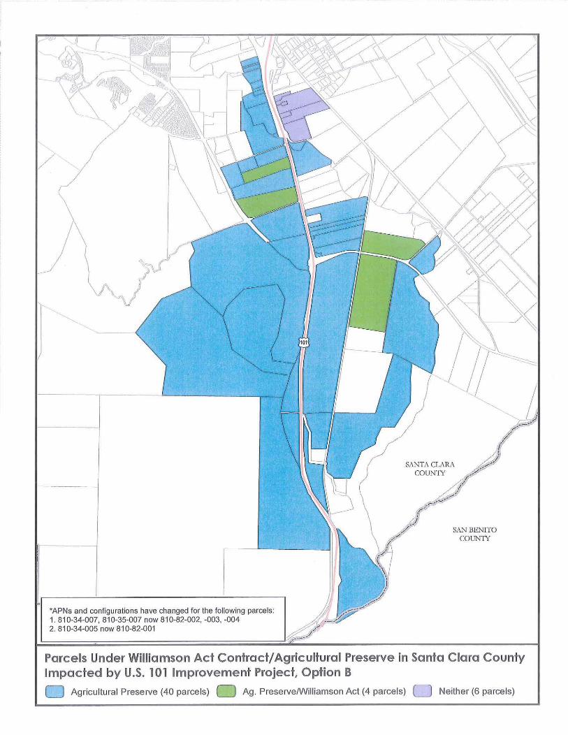
/
"APNs and configurations have changed for the following parcels:1.810-34-007,810-35-007 now 810-82-002, -003, -0042.810-34-005 now 810-82-001 V'
SAN BENITOCOUNTY
/
Parcels Under Williamson Act Contract/Agricultural Preserve in Santa Clara CountyImpacted by U.S. 101 Improvement Project. Option B
o Agricultural Preserve (40 parcels) Ag. PreserveIWiliiamson Act (4 parcels) 0 Neither (6 parcels)

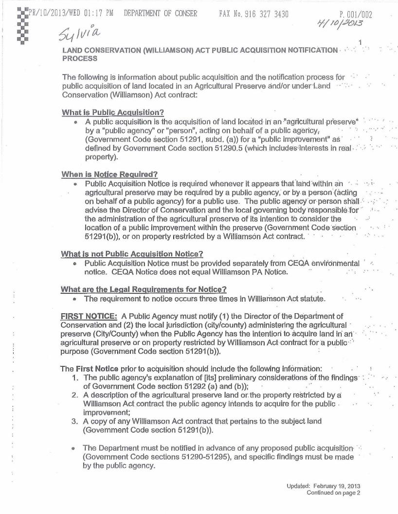
P,001/0027"lltJ/,:;1013
FAX No, 916 327 3430:::PR/IO/2013IWED 01: 17 PM DEPARTMENT OF COI'ISER
::: 6'4 Ii/ f~LAND CONSERVATiON (WILLIAMSON) ACT PUBLIC ACQUISITION NOTIFICATION· •PROCESS
1
The following is information about public acquisitio'n and the notification process forpublic acquisition of land located in an Agricultural Preserve andfor underHmd .Conservation (Williamson) Act contract:
What is Public Acquisition?• A public acquisition is the acquisition of land located in an !'agriclilturalpreserve"
by a "public agency" or "person", acting on behaif of a pUblic agericy,.(Government Code section 51291, 6ubd, (a)) for a "public imptbvement" as'defined by Government Code section 51290.5 (which includes'interests in real, ..property).
When is Notice Required?• Public Acquisition Notice is required whenever it appears thatlahd 'withln ah .'.. ,
agricultural preserite may be required by a public agency; or bya person'-(acting .... on behalf of a pUblic agency) for a pUblic use. The public agency·oT·person sh·all·'· . -0:'
advise the Director of Conservation and the local governing bodyresponsible:for"'· ..the administration of the agricultural' preserve of its intention to consider thelocation of a public improvement within the preserve (Government Code section .51291(b)). or on property restricted by a Williamson Act contract. .
What is not Public Acquisition Notice?• Public Acquisition Notice must be provided separately ·from CEQA environmental "
notice. CEQA Notice does not equal Williamson PA Notice.
What are the legal Requirements for Notice?• The requirement to notice occurs three times in Williamson Act statute.
FIRST NOTICE: A PubliC Agency must notify (1) the Director of the Department ofConservation and (2) the local jurisdiction (city/county) administering the' agricultural preserve (CityfCounty) when the Public Agency has the intention to acquire land in' arr·agriCUltural preserve or on property restricted by Williamson Act· contract for'a public""purpose (Government Code section 51291(b». -
The First Notice prior to acquisition should include the following information:1. The public agency's explanation of [its] preliminary co'nsiderations ofthe findings' ".
of Government Code section 51292 (a) and (b));2. A description of the agricultural preserve land or. the property restricted by a:
Williamson Act contract the public agency intends to' acquire for the public improvement;
3. A copy of any Williamson Act contract that pertains to the subject land(Government Code section 51291 (b»).
• The Department must be notified in advance of any proposed -public acquisition- (Government Code sections 51290-51295), and specific findings must be madeby the pUblic agency.
Updated: February 19, 2013Con~nued on page 2
: .


APRil 0/20 l3/WED 0I: 17 PM DEPARTMEI~T OF COI~SER FAX No, 916 327 3430 P, 002/002
LAND CONSERVATiON (WILLIAMSON) ACT PUBLIC ACQUISITION NOTIFICATiONPROCESS (Continued)
2
• The public agency must consider the Department of Conservation's commentsprior to taking action on the acquisition.
• The Public Agency must acquire the property via eminent domain or in lieu ofeminent domain in order to void the contract (Government Code section 51295).The Public Agency is required to provide evidence that the acquisition actuallyoccurred via eminent domain or in lieu of eminent domain (e.g., documents suchas copies of condemnation orders or a copy of the offer letter made to thelandowner to purchase the land in lieu of eminent domain to complete theadministrative record).
SECOND NOTICE:
A Second Notice is required within 10 working days after acquisition (escrow hasclosed), (Government Code Section 51291 (c». The Notice shall include the following:
1. The notice shall include a general explanation of the decision and the findingsmade pursuant to section 51292.
2. A general description, in text or by diagram, of the agricultural preserve landacquired (a vicinity map is good); and
3. A copy of any applicable Williamson Act contract(s).
Note: If the information and documents, noted above, were provided to the Department In the originalnotification then the Second Notice need only list the documents previously provided and reference thedate of the Public Agency's originalleller to the Department, unless the Department requestsresubmlssion of the documentation in its comment response letter.
THIRD NOTICE (if necessitated):• If there is a significant change in the public improvement, the Public Agency must
provide Notice to the Department and the local jurisdiction (city/county)regardingthe actual land acquired, increases or decreases in the amount of land acquired,or any changes in the project (Government Code section 51291(d)); OR
• If the Public Agency decides not to acquire the property and/or decides to retumthe property to private ownership;
• If the Public Agency decides not use the land it acquired for the pUblicimprovement that it originally notified the Department it intended to locate on theproperty it acquired, the land~ be reenrolled under a contract that is asrestrictive as the one it was unde~ before acquisition occurred (Government CodeSection 51295).
All required Notices should be sent to:
Mark Nechodom, DirectorDepartment of ConservationDivision of Land Resource Protection801 K Street, MS 18-01Sacramento, CA 95814-3528
Updated: February 19, 2013


CALIfORNIA DEPARTMENT OfCONSERVATION
Division of Land Resource Protection
Public Acquisition of land within agricultural preserves and/or enrolled in theWilliamson Act:
What to include in notilication packet
The following material is provided to assist you in compiling and submitting informationto the Department of Conservation (Department) when your agency plans to acquireland that is located within an agricultural preserve, or is enrolled in the Williamson Act,for public improvements. It is the Department's goal to ensure your project movesforward in a streamlined manner, by providing technical assistance toward meeting therequirements of Government Code §51291.
If you have additional questions, or suggestions for improvement of this document,please contact the Williamson Act Program at 916-324-0850.
Public Acquisition Notification, published May 2012 Page 1 of 7

(Agency letterhead)
NOTIFICATION OF PUBLIC ACQUISITION OF WILLIAMSON ACT LAND
Date of Notification
Mark Nechodom, DirectorDepartment of Conservationc/o Division of Land Resource Protection801 K Street, MS 18-01Sacramento, CA 95814
Subject:
Dear Director Nechodom,
1. What is the total number of acres of Williamson Act contracted land and/oragricultural preserve land being considered for acquisition?
Contracted land must be located within an agricultural preserve. Some jurisdictions make thecontracted land co-terminus with the agricultural preserve, so that the boundary of the preserve is thesame as the contracted parcel(s). An acquisition usually will involve contracted land only, in whichcase, specify the number of acres under contract(s). However, if the acquisition involves agriculturalpreserve land not under contract, make that distinction and specify the number of acres. Identify theAssessor Parcel Number (APN) of each parcel (or portion of a parcel) to be acquired and the numberof acres per parcel. A table can be inciuded if multiple APNs are to be acquired.
2. Is the land considered prime or nonprime agricultural land according toGovemment Code §51201(c)?
Customarily, the City or County Assessor's Office or Planning Department will have this information.If the acquisition will involve both prime and nonprime land, specify the number of acres under eachdesignation and which APNs are included within each designation. A table can be included if multipleAPNs are to be acquired.
3. What is the purpose ofthe acquisition?
Describe the planned public improvement - the project or reason for acquiring the property.
4. Where is the land located?
Describe the location of the property using a street address, if available, nearest roads or landmarkswith approximate distance and direction from the roads or landmarks, the city, if applicable, and thecounty. Submit a vicinity map and a location map (see #8, below).
Public Acquisition Notification, published May 2012 Page 2 of7

5. What are the characteristics of the adjacent land?
Describe the characteristics of the land adjacent to the Williamson Act/agricultural preserve property.Is the adjacent land Williamson Act contracted land, noncontract agricultural land, open-space, urbandevelopment, etc.?
6. Why was this land identified as necessary for the public improvement?
Describe the reasons for selecting this particular property. This description should be consistent withthe findings indicated below. Describe the steps that will be taken or that have been taken to acquirethe property by eminent domain or in lieu of eminent domain pursuant to Government Codes§7267.1, 7267.2 and 51295.
As a public agency, the Authority to acquire property through the eminent domain process should beexpressed in statute. Please provide for the administrative record the relevant citations codified instatute through which your agency derives the authority to acquire property using the power ofeminent domain.
7. How does this acquisition meet the findings required under Government Code§51292(a) and 51292(b)?
Describe how the findings would be met and submit any supporting documentation. A simpledeclarative statement that the findings have been or would be met; or repeating or paraphrasing thefindings; is not sufficient. There must be an explanation or rationale in support of the findings.The descriptions above and documents submitted must be consistent with this explanation. Somepoints to keep in mind:
• "The location is not based primarily on a consideration of the lower cost ofacquiring land in an agricultural preserve (§51292(a»."
The cost of land under contract or within an agricultural preserve is presumed to be lessbecause of its restricted status. The explanation should make it clear whether cost wasor will be a primary consideration and provide evidence in support of this.
• "If the land is agricultural land covered under a contract pursuant to this chapterfor any public improvement, that there is no other land within or outside thepreserve on which it is reasonably feasible to locate the public improvement(§51292(b». "
The second finding requires that there are "no other" locations, not under contract, thatare "reasonably feasible" for the public improvement. Consideration of the areaimmediately adjacent to or surrounding the selected property may not be sufficient inmeeting this finding. Because the area of consideration is determined by the nature ofthe public improvement, it may be restricted by very limited boundaries or may be open toany county or regional land. This area should be well defined and justified. In thisregard, a map showing the selected property, the area of consideration, and a descriptionof the geographic context, should be submitted. It should denote the selected propertyand land uses within the defined area by parcel or some other boundary. Land usesshould be described in terms of agricultural, residential, commercial, industrial, vacant,etc. If the land is planned for a particular use, specify planned residential, plannedcommercial, etc. Local zoning designations are not sufficient unless they distinguish
Public Acquisition Notification, published May 2012 Page 3 of 7

between current and planned use. In addition, identify land that is under Williamson Actcontract or within an agricultural preserve.
Preferences generally cannot support the second finding. CEQA analysis, for example,may be expressed in terms of a preferred location and feasible altematives. Such ananalysis often does not support the finding for public acquisition because it does notspeak in terms of "reasonable feasibility." The explanation should focus on the feasibilityor infeasibility of other locations in comparison to the selected property. It is theresponsibility of the public agency to define and support what is feasible or infeasible.
Although local zoning and general plans are important considerations in locating thepublic improvement, they can change and do not necessarily define feasibility orinfeasibility. Moreover, the Williamson Act is the prevailing authority governingcontracted land and agricUltural preserves.
Many public agencies wish to avoid an acquisition by eminent domain and, therefore,seek a negotiated purchase. However, the fact that a location is not for sale or cannot benegotiated for purchase does not, in itself, make it infeasible.
Exemptions Under Government Code §51293
Public agencies may avoid the requirements of Government Code §51292 if the publicimprovement is exempt from the requirements pursuant to Government Code §51293. Severaltypes of public improvements are identified under Government Code §51293 as exempt from therequirements to make the findings required by Government Code §51292. These exemptionsare described in Attachment A. However, even if the Government Code §51293 exemptionsapply, the requirement to provide notice to the Department under Government Code §51291(b)remains in place. Furthermore, Government Code §51293's exemption does not eliminate apublic agency's responsibility under State policy, which is to avoid locating public improvementsin agricultural preserves or upon land that is subject to a Williamson Act contract (GovernmentCode §51290(a) and (b)), and to give consideration to the value to the public of such land as setforth in the Williamson Act (Government Code §51290(c) Prime Farmland).
If it is determined that the public improvement is exempt under Government Code §51293, pleaseexplain the nature of the contemplated public improvement and why the improvement would beexempt from the findings stipulated in Government Code §51292 pursuant to Government Code§51293.
8. Submit a vicinity map and a location map.
Include a map of the proposed site and an area of surrounding land identified by characteristics andlarge enough to help clarify that no other, noncontractland is reasonably feasible for the publicimprovement. The vicinity map should include the entire project outline and the area of consideration(described under #7, above). The location map should include the parcel outlines, APNs, and identifywhich parcel(s) (or portion of parcel(s» are being considered for the public improvement.
9. Submit a copy of the contract(s) covering the land.
Contracts are held by the landowner and local jurisdiction (city or county) with administrative authorityfor the agricultural preserve. The Department does not maintain individual contracts. Submit copiesof the entire contract(s). If the acquisition involves preserve land not under contract, submit a copy of
Public Acquisition Notification, published May 2012 Page 4 of7

the Agricultural Preserve Resolution. Make sure the contract(s)/resolution is an official recorded copythat includes the date stamp from the county Assessor's Office.
10. Submit copies of all related Environmental Impact Reviews pursuant to theCEQA process.
Please submit a copy of the Title Page, Project Summary, and the Agricultural Resources sections ofthe CEQA document. Listing a link to the document on the Internet is also sufficient. If the project isexempt, submit the supporting document for exemption. If a document has not been completed,describe the plan for its completion.
11. Submit copies of all related Eminent Domain (or in lieu of Eminent Domain)documents pursuant to Government Code §51295.
A Williamson Act contract is an enforceable restriction pursuant to Article XIII, §8 of the CaliforniaConstitution and Government Code §51252. Pursuant to Government Code section 51295, onlypublic acquisitions made via eminent domain (or in-lieu of) will nullify a Williamson Act contract(assuming other necessary requirements are met). Unless the public acquisition is purchased viaeminent domain or in-lieu of it, the use of the property will remain limited by the terms of the existingcontract and the provisions of the Williamson Act.
Submit copies of any documents supporting acquisition by eminent domain, such as the Resolution ofNecessity, eminent domain proceedings and copies of any other pertinent documents. If in lieu ofeminent domain, submit copies of the property appraisai and written offer and copies of any otherpertinent documents. If the acquisition will not be by eminent domain or in lieu of eminent domain,describe the steps that will be taken or that have been taken and submit any supporting documents. Ifa document has not been completed, describe the plan for its completion.
Signature
Contact PersonTitle
cc: County Board of Supervisors or the local governing body (i.e. City Council)responsible for the administration of the agricultural preserve.
Note: The local governing body responsible for the administration of the agricultural preserve must alsobe notified. The local governing body is usually the County, but may be a City or other local agency. Acopy of this notification will serve as notice to the local governing body.
Public Acquisition Notification, published May 2012 Page 5 of7

Attachment A
Exemptions Under Government Code §51293:
(a) The location or construction of improvements where the boardor council administering the agricultural preserve approves or agreesto the location thereof, except when the acquiring agency andadministering agency are the same entity.
(b) The acquisition of easements within a preserve by the board orcouncil administering the preserve.
(c) The location or construction of any public utility improvementwhich has been approved by the Public Utilities Commission.
(d) The acquisition of either (1) temporary construction easementsfor public utility improvements, or (2) an interest in real propertyfor underground public utility improvements. This subdivision shallapply only where the surface of the land subject to the acquisitionis returned to the condition and use that immediately predated theconstruction of the public improvement, and when the construction ofthe public utility improvement will not significantly impairagricultural use of the affected contracted parcel or parcels.
(e) The location or construction of the following types ofimprovements, which are hereby determined to be compatible with or toenhance land within an agricultural preserve:
(1) Flood control works, including channel rectification andalteration.
(2) Public works required for fish and wildlife enhancement andpreservation.
(3) Improvements for the primary benefit of the lands within thepreserve.
(I) Improvements for which the site or route has been specified bythe Legislature in a manner that makes it impossible to avoid theacquisition of land under contract.
(g) All state highways on routes as described in Sections 301 to622, inclusive, of the Streets and Highways Code, as those sectionsread on October 1, 1965.
(h) All facilities which are part of the State Water Facilities asdescribed in subdivision (d) of Section 12934 of the Water Code,
Public Acquisition Notification, published May 2012 Page60f7

except facilities under paragraph (6) of subdivision (d) of thatsection.
(i) Land upon which condemnation proceedings have been commencedprior to October 1, 1965.
(j) The acquisition of a fee interest or conservation easement fora term of at least 10 years, in order to restrict the land toagricultural or open space uses as defined by subdivisions (b) and(0) of Government Code Section 51201.
Public Acquisition Notification, published May 2012 Page 7 of7

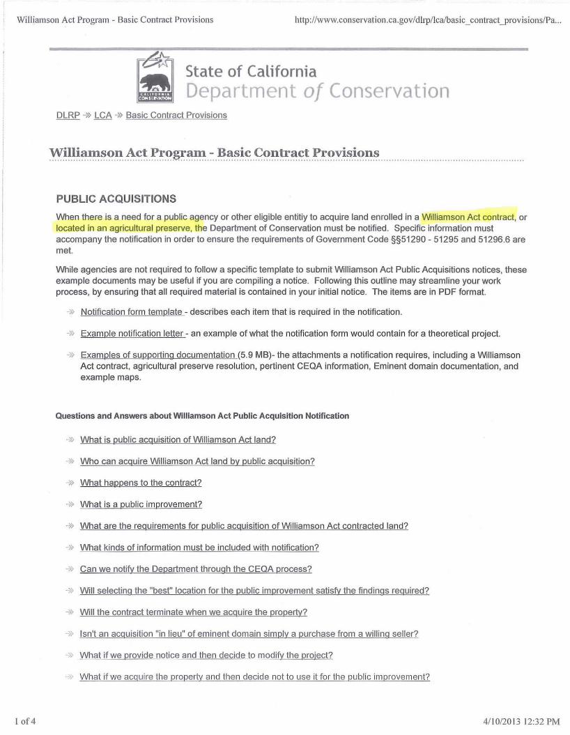
Williamson Act Program - Basic Contract Provisions http://www.conservation.ca.gov/dlJl./lcaibasic_conh·act_prov isions/Pa...
State of CaliforniaDepar ment of Conservation
lof4
DLRP ..~) LCA ..~) Basic Contract Provisions
:'Y~I.I~~.'!1~.():'l: .~.c.t..J?,~()~~:".l:.::.~.~~.i~..<:;?~~~I:l~~ ..J?r.?y.i~.i():n,.~ .
PUBLIC ACQUISITIONS
When there is a need for a public agency or other eligible entitiy to acquire land enrolled in a Williamson Act contract. orlocated in an agricultural preserve, the Department of Conservation must be notified. Specific information mustaccompany the notification in order to ensure the requirements of Government Code §§51290 - 51295 and 51296.6 aremet.
While agencies are not required to follow a specific template to submit Williamson Act Public Acquisitions notices, theseexample documents may be useful if you are compiling a notice. Following this outline may streamline your workprocess, by ensuring that all required material is contained in your initial notice. The items are in PDF format.
.» Notification form template - describes each item that is required in the notification.
.» Example notification letter - an example of what the notification form would contain for a theoretical project.
..» Examples of supporting documentation (5.9 MB)- the attachments a notification requires, including a WilliamsonAct contract. agricultural preserve resolution, pertinent CEQA information, Eminent domain documentation, andexample maps.
Questions and Answers about Williamson Act Public Acquisition Notification
..~) What is public acquisition of Williamson Act land?
..» Who can acquire Williamson Act land by public acquisition?
..» What happens to the contract?
..» What is a public improvement?
.) What are the requirements for public acquisition of Williamson Act contracted land?
.~) What kinds of information must be included with notification?
.) Can we notify the Department through the CEQA process?
..» Will selecting the "best" location for the public improvement satisfy the findings required?
._}} Will the contract terminate when we acqUire the property?
» Isn't an acquisition "in lieu" of eminent domain simply a purchase from a willing seller?
» What if we provide notice and then decide to modify the project?
What if we acguire the property and then decide not to use it for the public improvement?
4/1012013 12:32 PM

Williamson Act Program - Basic Contract Provisions
Once we provide notice, does our responsibility end?
What is public acquisition of Williamson Act land?
http://www.conservation.ca.gov/d Irp/lcalbasic_contract_provisions!Pa...
2 of4
Public acquisition of Williamson Act land is acquisition, by provision in the Act (Government Code §§51290 - 51295,51296.6), of land located within an agricultural preserve or enforceably restricted by a Williamson Act or FarmlandSecurity Zone contract by a public agency or person for a public improvement.
Who can acquire Williamson Act land by public acquisition?
A public agency or person may acquire Williamson Act land by public acquisition. As defined by the Williamson Act,
"(1) 'public agency' means any department or agency of the United States or the state, and any county,city, school district, or other local public district, agency, or entity, and (2) 'person' means any personauthorized to acquire property by eminent domain (Government Code §51291 (a)."
A school district cannot acquire iand that is under a Farmland Security Zone contract (§51296.6).
What happens to the contract?
If requirements for public acquisition of Williamson Act land are met, the land may be acquired and the contract may beterminated. If requirements are not met, the acquisition may not be valid, and the contract may remain in force andcontinue to restrict use of the land. If the acquired property remains within an agricultural preserve, land use remainssubject to the rules of the preserve.
What is a public improvement?
As defined,
'''public improvement' means facilities or interests in real property, including easements, rights-of-way, andinterests in fee title, owned by a public agency or person, as defined in subdivision (a) of Section 51291(Government Code §51290.5)."
What are the requirements for public acquisition of Williamson Act contracted land?
The policy of the state, consistent with the purpose of the Williamson Act to preserve and protect agricultural land, is toavoid, whenever practicable, locating public improvements and any public utilities improvements in agriCUlturalpreserves. If it is necessary to locate within a preserve, it shall be on land that is not under contract (Government Code§51290(a)(b». More specifically, the basic requirements are:
..» Whenever it appears that land within a preserve or under contract may be required for a public improvement, thepublic agency or person shall notifv the Department of Conservation (Department) and the city or countyresponsible for administering the preserve (§51291(b».
..» Within 30 days of being notified, the Department and city or county shall forward comments, which shall beconsidered by the public agency or person (§51291(b».
..) "No public agency or person shall locate a public improvement within an agricultural preserve unless the followingfindings [emphasis added] are made (§51292):"
"(a) The location is not based primarily on a consideration of the lower cost of acquiring land in anagricultural preserve (§51292(a».b) If the land is agricultural land covered under a contract pursuant to this chapter for any publicimprovement, that there is no other land within or outside the preserve on which it is reasonably feasible tolocate the public improvement (§51292(a)(b»."
4/10/2013 12:32 PM

Williamson Act Program - Basic Contract Provisions http://www.coJ1servatioJ1.ca.gov/dlrp/lca/basic_coJ1tractJlrovisioJ1s/Pa...
3 of4
.• The contract shall be terminated when land is acquired by eminent domain or in lieu of eminent domain (§51295).
,> The Department and city or county shall be notified before project completion of any proposed, significantchanges to the public improvement (§51291(d».
» The Department shall be notified within 10 working days upon completion of the acquisition (§51291 (c».
.» If, after acquisition, the acquiring public agency determines that the property will not be used for the proposedpublic improvement, before returning the land to private ownership, the Department and city or countyadministering the involved preserve shall be notified. The land shall be reenrolled in a new contract orencumbered by an enforceable restriction at least as restrictive as that provided by the Williamson Act (§51295).
What kinds of information must be included with notification?
Pursuant to Government Code §51291(b), the notice shall include:
;, The total number of acres of Williamson Act land to be acquired and whether the land is considered primeagricultural land according to §51201 .
..J) The purpose of the acquisition and why the land was identified for acquisition.
.. J> A description of where the parcel(s) is located.
..J) Characteristics of adjacent land (urban development, Williamson Act, noncontract agricultural, etc.) .
.. J> A vicinity map and a location map (see below also) .
.•J) A copy of the contract(s) covering the land.
.. J> CEQA documents for the project.
..J) The findings required under Government Code §51292, an explanation of the preliminary consideration of§51292 and documentation to support the findings. (Include a map of the proposed site showing an area ofsurrounding land identified by characteristics and large enough to demonstrate, along with the explanation, thatno other, noncontracted land is reasonably feasible for the public improvement.)
..J> Documentation to support acqUisition by eminent domain or in lieu of eminent domain to void the contractpursuant to §51295. (Inciude copies of eminent domain proceedings, if applicable, a property appraisal andwritten offer pursuant to Government Code §§7267.1 and 7267.2, a chronology of steps taken or planned toeffect acquisition by eminent domain or in lieu of eminent domain and copies of any other pertinent documents,such as a Resolution of Necessity.)
Can we notify the Department throu9h the CEQA process?
No, it is not permissible to provide notice through CEQA. Notification must be made separately to the Department(Government Code §51291(b».
Will selecting the "best" location for the public improvement satisfy the finding required?
No, selecting the "best" or "preferred" location will not satisfy the finding. The criterion to locate on contract land is thatthere is no other location that is not under contract and reasonably feasible for the public improvement (GovernmentCode §51292(b».
Will the contract terminate when we acqUire the property?
4/1 0/20 13 12:32 PM

Williamson Act Program - Basic Contract Provisions http://www.conservation.ca.govId1rp/lca/bas ic_contractyrovisions/Pa...
4of4
Not necessarily. The contract will be terminated or voided when the property is acquired by eminent domain or in lieu ofeminent domain (Government Code §51295). If these requirements are not met, the contract will remain in force andcontinue to restrict use of the land.
Isn't an acquisition "in lieu" of eminent domain simply a purchase from a willing seller?
No, an acquisition "in lieu" of eminent domain must follow eminent domain law. The Department does not providecounsel as to the requirements of eminent domain law. We recommend that the public agency or person obtain legalcounsel for this purpose.
What if we provide notice and then decide to modify the project?
The Department and city or county responsible for administering the involved agricultural preserve shall be notifiedbefore project completion of any proposed significant changes to the public improvement (Government Code§51291(d).
What if we acquire the property and then decide not to use it for the public improvement?
If, after acquisition, the acquiring public agency determines that the property will not be used for the proposed publicimprovement, before returning the land to private ownership, the Department and city or county administering theinvolved agricultural preserve shall be notified. The land shall be reenrolled in a new contract or encumbered by anenforceable restriction at least as restrictive as that provided by the Williamson Act (Government Code §51295).
Once we provide notice, does our responsibility end?
No. The notice may be incomplete, in which case the Department will request additional information to complete propernotice. The public agency or person is required to consider the Department's comments (Government Code §51291 (b)and to adhere to the Williamson Act statute in determining whether to complete the acquisition. As noted above,additional notice is required if significant changes are proposed and if the property will not be used for the proposedpublic improvement. In addition, when the land is acquired, the Department shall be notified within 10 working days, andthe notice shall include a general expianation of the decision and findings made (§51291 (c).
Conditions of Use I Privacy PolicyCopyright © 2007 State of California
4/1 0/20 13 12:32 PM

Effective April 4, 2007
AGRICULTURAL MITIGATION POLICIES
Background
LAFCO's mission is to encourage orderly growth and development, discourageurban sprawl, preserve open space and prime agricultural lands, promote theefficient provision of govet'nrnent set'vices and encourage the orderly formation oflocal agencies, LAFCO will consider impacts to agricultmallands along with otherfactors in its evaluation of proposals, LAFCO's Urban Service Area (USA)Amendment Policies discourage premature conversion of agricultural lands, guidedevelopment away from existing agricultural lands and require the development ofexisting vacant lands within city boundaries prior to conversion of additionalagricultural lands. In those cases where LAFCO proposals involve conversion ofagt'iculturallands, LAFCO's USA Amendment Policies requiI'e an explanation ofwhy the inclusion of agt'iculturallands is necessary and how such loss will bemitigated.
Purpose of Policies
The purpose of these policies is to provide guidance to property owners, potentialapplicants and cities on how to address agt'icultural mitigation for LAFCO proposalsand to provide a framework for LAFCO to evaluate and process in a consistentmanner, LAFCO proposals that involve or impact agricultural lands.
General Policies
1, LAFCO recommends provision of agricultural mitigation as specified hereinfor all LAFCO applications that impact or result in a loss of prime agricultmallands as defined in Policy #6, Variation from these policies should beaccompanied by information explaining the adequacy of the proposedmitigation,
2, LAFCO encourages cities with potential LAFCO applications involving orimpacting agricultural lands to adopt Citywide agt'icultural mitigation policiesand programs that are consistent with these policies,
3, When a LAFCO proposal impacts or involves a loss of prime agricultural lands,LAFCO encourages property owners, cities and agricultural conservationagencies to work together as early in the process as possible to initiate andexecute agricultural mitigation plans, in a manner that is consistent with thesepolicies,
4, LAFCO will work with agricultural entities, the County, cities and otherstakeholders to develop a progt'am and public education materials to improvethe community's understanding of the importance of agriculture in creatingsustainable communities within Santa Clara County.
Page I of 5

5. LAFCO will review and revise these policies as necessary.
Definition of Prime Agricultural Lands
6. "Prime agricultural land" as defined in the Cortese Knox Hertzbel'g Act meansan area of land, whether a single parcel or contiguous parcels, that has not beendeveloped for a use other than an agricultural use and that meets any of thefollowing qualifications:
a. Land that qualifies, if irrigated, for mting as class I or class II in the USDANatw'al Resources Conservation Service land use capability classification,whether or not land is actually irrigated, provided that irrigation isfeasible.
b. Land that qualifies for rating 80 tlu'ough 100 Storie Index Rating.
c. Land that supports livestock used for the production of food and fiberand that has an annual carrying capacity equivalent to at least one animalunit per acre as defined by the United States Department of Agriculture intlle National Handbook on Range and Related Grazing Lands, July, 1967,developed pursuant to Public Law 46, December 1935.
d. Land planted Witll fruit or nut-bearing trees, vines, bushes, or crops thathave a nonbearing period of less than five years and tllat will returnduring tlle commercial bearing period on an annual basis from tlleproduction of unprocessed agricultural plant production not less tllanfour hundred dollars ($400) per acre.
e. Land that has returned from the production of unprocessed agriculturalplant products an annual gross value of not less tllan four hundred dollars($400) per acre for tluee of the previous five calendar years.
Mitigation Recommendations
7. Proposals involving the conversion of prime agricultural lands should provideone of the following mitigations at a not less than 1:1 ratio (1 acre preserved forevery acre converted) along with the payment of funds as determined by thecity / agricultural conservation entity (whichever applies) to cover the costs ofprogram administration, land management, monitoring, enforcement andmaintenance of agriculture on the mitigation lands:
a. The acquisition and transfer of ownership of agricultural land to anagricultural conservation entity for permanent protection of theagricultural land.
b. The acquisition and transfer of agricultural conservation easements to anagricultural conservation entity for permanent protection of tlleagricultural land.
Page 2 of5S:\LafcolLAFCO\lssues\Ag Mitigation\5th revision\FlnaIAgMitlgalJonPolicles.doc

c. The payment of in-lieu fees to an agricultural conservation entity that aresufficient to fully fund*:
1. The cost of acquisition of agricultural lands or agriculturalconservation easements for permanent protection, and
2. The cost of administering, managing, monitoring and enforcing theagricultural lands 01" agt·icultural conservation easements, as well asthe costs of maintaining agriculture on the mitigation lands.
* with provisions f01" adjustment of in-lieu fees to reflect potential changesin land values at the time of actual payment
8. Agricultural lands or conservation easements acquired and transferred to anagt·icultural conservation entity should be located in Santa Clara County and belands deemed acceptable to the city and entity.
9. The agricultural mitigation should result in preservation of land that would be:
a. Prime agricultural land of substantially similar quality and character asmeasured by the Average St01"ie Index rating and the Land CapabilityClassification rating, and
b. Located within cities' spheres of influence in an area planned/envisionedf01" agriculture, and
c. That would preferably promote the definition and creation of apermanent urbaniagt·icultural edge.
10. Because urbaninon-agricultural uses affect adjacent agricultural practices andintroduce development pressures on adjacent agricultural lands, LAFCOencourages cities with LAFCO proposals impacting agricultural lands to adoptmeasures to protect adjoining agricultural lands, to prevent their prematureconversion to other uses, and to minimize potential conflicts between theproposed urban development and adjacent agricultural uses. Examples of suchmeasures include, but are not limited to:
a. Establishment of an agricultural buffer on the land proposed fordevelopment. The buffer's size, location and allowed uses must besufficient to minimize conflicts between the adjacent urban andagricultural uses.
b. Adoption of protections such as a Right to Farm Ordinance, to ensure thatthe new urban residents shall recognize the rights of adjacent propertyowners conducting agricultural operations and practices in compliancewith established standards.
c. Development of programs to promote the continued viability ofsurrounding agricultural land.
Page 3 of 5S:\LafcoILAFCO\lssues\Ag Miligalion\51h revision\FinaIAgMitigationPolicies.doc

Agricultural Conservation Entity Qualifications
11. The agricultural conservation entity should be a city or a public 01' non-profitagency. LAFCO encourages consideration of agricultural conservation entitiesthat:
a. Are committed to preserving local agriculture and have a clear missionalong with sh'ategic goals 01' programs for promoting agriculture in theareas that would be preserved through mitigation,
b. Have the legal and technical ability to hold and administer agriculturallands and agricultural conservation easements and in-lieu fees for thepurposes of conserving and maintaining lands in agricultural productionand preferably have an established record for doing so, and
c. Have adopted written standards, policies and practices (such as the Land TrustAlliance's "Standards and Practices") for holding and administeringagricultural lands, agricultural conservation easements and in-lieu fees and al'eoperating in compliance with those standal'ds.
Timing and Fulfillment of Mitigation
12. LAFCO prefers that agricultural mitigation be in place at the time of LAFCOapproval 01' as soon as possible after LAFCO approvaL The mitigation (asdetailed in the Plan for Mitigation) should be fulfilled no later than at the timeof city's approval of the final map, 01' issuance of a grading permit 01' buildingpermit, whichever occurs first.
13. Cities should provide LAFCO with information on how the city will ensurethat the agricultural mitigation is provided at the appropriate time.
14. Cities should provide LAFCO with a report on the status of agriculturalmitigation fulfillment every year following LAFCO approval of the proposaluntil the agricultural mitigation commihnents are fulfilled.
15. The agricultural conservation entity should report alIDually to LAFCO on theuse of the in-lieu fees until the fees have been fully expended.
Plan for Mitigation
16. A plan for agt'icultural mitigation that is consistent with these policies shouldbe submitted at the time that a proposal impacting agriculturallal1ds is filedwith LAFCO. The plan for mitigation should include all of the following:
a. An agt'eement between the property owner, city and agriculturalconservation entity (if such an entity is involved) that commits theproperty owner(s) to provide the mitigation for the loss of primeagricultural lands and establishes the specifics of the mitigation. UponLAFCO approval of the proposal, the agreement should be recorded with
Page 4 of5S:\LafcolLAFCOllssues\Ag Miligation\51h revisionlFinatAgMitigationPolicies,doc

the County Recorder's office against the property to be developed. Theagreement should specify:
1. The type of mitigation that will be provided in order to mitigate forconversion of agriculhuallands. (purchase of fee title or easement orpayment of in-lieu fees)
2. The agricultural conservation entity that will be involved in holdingthe lands, easements, or in-lieu fees.
3. The acreage that would be preserved through mitigation and / or theamount of in-lieu fees that would be paid (with provisions to adjustfees to reflect land values at time of payment) along with themethodology adopted by the entity for calculating the in-lieu fees.
4. The location of the mitigation lands, when possible.
5. Information on the specific measures adopted by the city asencomaged in Policy #10 (mitigation for impacts to adjacentagricultural lands)
6. The time-frame within which the mitigation will be fulfilled, whichshould be no later than at the time of city's approval of the final map,or issuance of the grading permit or building permit, whicheveroccurs firs t.
7. The mitigation agreement is to be contingent on LAFCO approval ofthe proposal.
b. Applicant should provide all other supporting documents andinformation to demonstrate compliance with these policies.
Page 5 of 5S:\LafcolLAFCO\ls5ues\Ag Miligalion\51h revision\FinaIAgMiligationPolicies.doc


County of Santa ClaraParks and Recreation Department
298 Garden Hill DriveLos Gatos, California 95032-7669(408) 355-2200 FAX 355-2290Reservations (408) 355-220 I
www.parkhere.org
April 23, 2013
VTA Environmental Programs/Resources Management Dept.Attention: Ms. Ann Calnan3331 N First St, Bldg. B-2San Jose CA 9S134
Subject: SCH 2007102141- Draft EIR for u.s. 101 Improvement Project between Monterey SI. and StateRoute 129, Santa Clara and San Benito Counties, California
Dear Ms. Calnan,
Thank you for the opportunity to provide comments on the DEIR for proposed improvements to U.S.Hwy 101 between the city of Gilroy and the Santa Clara/San Benito County line and improvedconnectivity to State Route 2S and Route 129 in response to projected traffic demand and need toimprove public safety.
Section 2.1.2.2 Compliance with State, Regional, and Local Plans and Programs
The Santa Clara County Parks and Recreation Department, in partnership with other public agencies,is charged with furthering the implementation ofthe Santa Clara Countywide Trails Master PlanUpdate. Under Section 2.1.2.2, the DEIR correctly identifies the Trails Plans and Policies of theCountywide Trails Master Plan Update, adopted as part of the County's General Plan in 1995.However, for clarity the DEIR must characterize these regional trails as shared- use (equestrian,bicycle, pedestrian uses on shared alignment) trail to be in full compliance Countywide Trails MasterPlan Update's polices for regionally significant routes.
Per our prior preliminary plan review and correspondence with VTA in 2008 and 2009, werecommended implementation of trail routes that would result in readily accessible and safealignments for all users. As such, we recommend that the project implement Alternative 2 (trailcrossing under Hwy 101 at Uvas-Carnadero Creek) as the preferred alternative under either FreewayDesign Option A or B.
While recommended trail widths can be modified to suit final site conditions, Alternative 2 shouldbe designed to accommodate equestrians as well as hikers and cyclists (see recommended TrailDesign Guidelines Figure G-2 and G-? attached). Similarly, we also recommend that future trailcrossing of U.S. 101 at the Pajaro River accommodate all users in compliance with its designation asa national historic trail.
Board of Supervisors: Mike Wasserman, Dave Cortese, Ken Yeager, S.loseph Simitian
County Executive: Jeffrey V. Smith
Participation in Ongoing Design Development
We appreciate your efforts to provide safe and accessible trail routes as part of this project's designobjectives. Santa Clara County Parks and Recreation Department looks forward to working closely withVTA and other interested agencies to finalize design development for this project.
Sincerely,
Elish RyanPlanner III
Attachments: Countywide Trails Master Plan Update Figure G-2 and Figure G-7
Cc: Colleen Oda, County Planning DepartmentNaomi Torres, NPS De Anza Traii SuperintendentBern Smith, Bay Area Ridge Trail Council
Board of Supervisors: Mike Wasserman, Dave Cortese, Ken Yeager, S. Joseph Simitian
County Executive: Jeffrey V. Smith

Shared-uae Traile
Native Materialor Bas8 RockEqu86trlanTread
Centerline,.
jpavementmarkIngs ontwo way
Ishared-USBtraila
I
I Optimum '-21.Croes-srope forDrainage~
2" Aephalt__ Paving on 4"
! Coml'actttdAeereaauSub·bs&8
Paved Tread - Double Track TrailEquestrians, Hikers & Bicycles5hared-U5e Trail Route: a trail route deelgned,developed, and managed for all type5 of user5. U5e wouldbe accommodated either on one 5h.ared-u9c Trail, or acombination of parallel Limlted-u"" (""e Figure G-4)andlor 5ingle-purpo5e Tral15 (5ee Figure G-5).
Shoulder or,---c:learfipace
2'·0" minimumvegetationclearance on esohside of'trall. Pruneall "rush over 12" inheleht & 1/2" indJamet8fthatextsnde intotrailway.
-#--,, I
I
I I
2' opt�mum_-' -"'2::'-toiJjP7t"lm;:u:::m::... ~-...:5"-'~0C!opt~lm'i:'u",m,,-.,~Width Width Width ~
~:
• "Optimum:" the best or most favorable condition for a particular trail situation fromthe perspective of reeponeible management.
• Should a situation be encountered when~ the optimum width indicated can not beachieved Qr a staged development. approach 19 used where narrower traiJa precede theoptimum I:?uildout width, mitigation messure5 ehould be used to provide for trail U5t:r
safety. Such measures could include. l1ut are not limited to: brush removal and clearingto augment lines-of-sight. trail pullouts at regular Intervals, one-way trail managment.slgnage, or di5mountlng r"'luirement5.
Santa Clara County Trails Master Plan Update: Oesl(3n Guidelines Figure G-2Noveml;oer, 19515
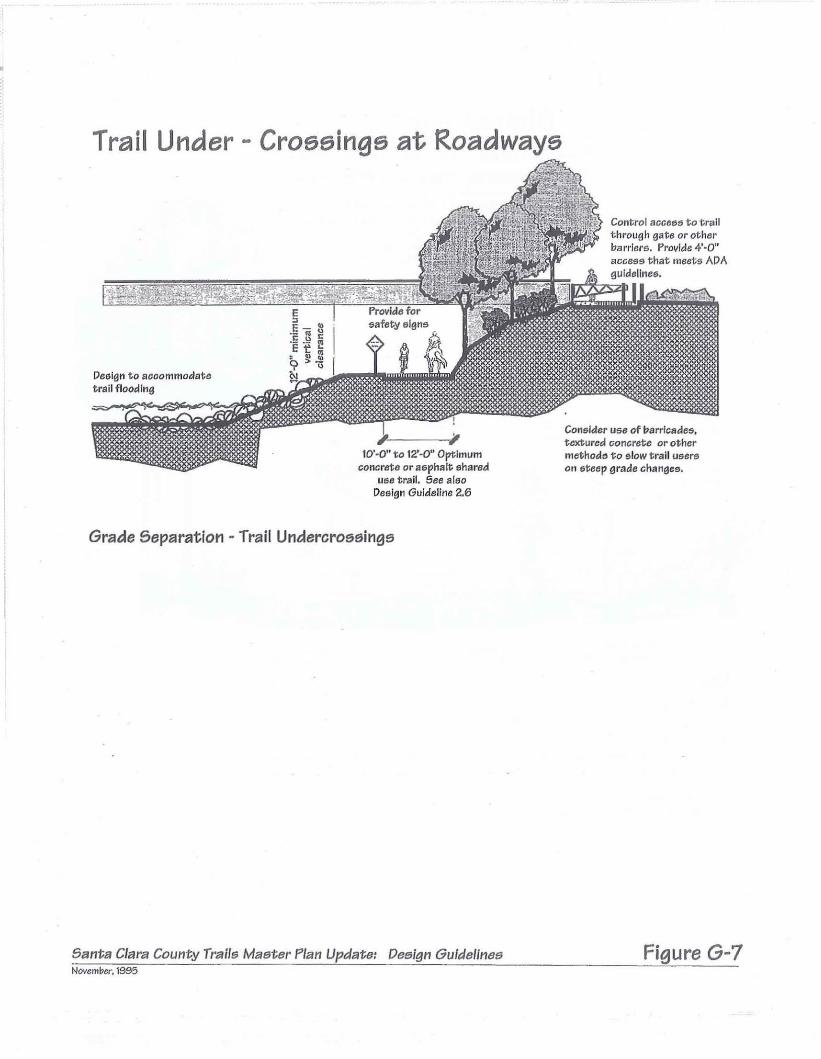
Trail Under - Crossings at Roadways
Consider US8 of barricades.textured concrete or othermethods 1;0 slow trail userson steep grade changes.
Control acce65 to tr",i1through gate or otherbarrlerlS. Provide 4'80"access that meets ADA
§jdJWiI~~~9;PUld'\I"e.'G!l~~
De6i!311 to acoommodat8trail flooding
10'·0" to 12'-0" OptImumconcrete or aephalt shared
UGe trail. See aleoDesign Guideline 2.6
Grade Separation' Trail Undercroaainga
Banta Clara County Trails Master Plan Update: Oeelgn GuIdelinesNovemi1cr, 1995
Figure G-7
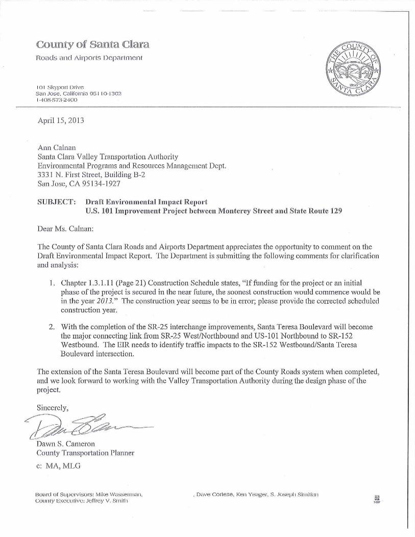
County of Santa ClaraHoads anel Airports Department
101 Skyporl DriveSan Jose. California 951 10-13021-408-573-2400
April 15,2013
Ann CalnanSanta Clara VaHey Transportation AuthorityEnvironmental Programs and Resources Management Dept.3331 N, First Street, Building B-2San Josc, CA 95134-1927
SUBJECT: Draft Envil"Onmental Impact ReportU.S. 101 Improvement Project between Monterey Street and State Route 129
Dear Ms, Calnan:
The County of Santa Clara Roads and AirpOlts Depmtment appreciates the opportunity to comment on theDraft Environmental Impact Report. The Department is submitting the following comments for clarificationand analysis:
I, Chapter 1,3, 1,11 (Page 21) Construction Schedule states, "Iffunding for the project or an initialphase of the project is secured in the near fiJture, the soonest construction would commence would bein the year 2013," The construction year seems to be in error; please provide the corrected scheduledconstruction year.
2, With the completion of the SR-25 interchange improvements, Santa Teresa Boulevard will becomethe major connecting link from SR-25 West/Northbound and US-101 Northbound to SR-152Westbound, The EIR needs to identify traffic impacts to the SR-152 Westbound/Santa TeresaBoulevard intersection.
The extension of the Santa Teresa Boulevard will become part of the County Roads system when completed,and we look forward to working with the Valley Transportation Authority during the design phase of theproject.
Sincerely,
Dawn S, CameronCounty Transportation Planner
c: MA,MLG
BO;:lr(1 of Supervisors: Ivlike Wasserman,coullty Executive: Jeffrey V. SmHll
. Dave Corlese. Ken Yeager. S. JOSepil Sir-nil ian


COOJlJlD.1l:y of Santa ClaraDepartment of Planning and DevelopmentCounty Government Center, East Wing70 West Hedding Street, 71h FloorSan Jose, Califol'l1ia 95 L10
Admin istratiol1
Ph: (408) 299-6740Fax: (408) 299-6757
Via USPS
April 9, 2013
AffordableHousing
(408) 299-5750(408) 299-6709
BuildingInspection
(408) 299-5700(408) 279-8537
Fire Marshal
(408) 299-5760(408) 299-6757
Land DevelopmentEngineering
(408) 299-5730(408) 279-8537
Planning
(408) 299-5770(408) 288-9198
Subject:
Ms. Ann CalnanVTA Environmental Programs/Resources Management Department3331 North First Street, Building B-2,San Jose, CA 95134-1927
Santa Clara County's review comments for theSanta Clara Valley Transportation Authority's Draft Environmental Impact Reportfor U.S. 101 Improvemenf Project Between Monterey Street and State Route 129.
Dear Ms. Calnan:
This letter is in response to your "US. 101/mprovement Project Between Monterey Street and StateROLite 129 Draft Environmental Impact Reporf' (DEIR), prepared by the Santa Clara Valley TransportationAuthority (SCVTA) and dated March, 2013. Tilis letter discusses floodplain issues only. Other lettersfrom Santa Clara County may be forthcoming.
A section of the Pajaro River from just north of the existing US 101 bridges running south to parailel withSR 129 toward Chittenden is identified as a Floodway on the current FIRM panels. Please see theattached FIRMettes. These facilities have been identified in the current Federal insurance Study (FIS) asa regulatory floodway and floodplain of known and unknown base flood elevation and are located in theunincorporated Santa Clara County. Pursuant to Title 44 Code of Federal Regulation, Section 65.3 allimprovements that will affect the base flood elevations in the Pajaro River through that portion of theunincorporated County floodway will require the submittal and issuance of a Floodplain DevelopmentPermit through the Santa Clara County Building Office.
Thougll the DEIR does speal< to Federal Emergency Management Agency's (FEMA) floodplain issues onCamadero, Gavilan, Tar, and Ticl< Creel<s and the Pajaro River, and briefly discusses impacts to thewater surface impacts, most of this area has been identified in Flood Zone A where the Base FloodElevation has not been determined. Pursuant to Title 44 Code of Federal Regulation, Section 60.3(b) andthe Santa Clara County Floodplain Ordinance, Santa Clara County requires that the above FloodplainDevelopment Permit include base flood elevation data for the above Zone A areas.
The above Floodplain Development Permit (FDP) application will require a Conditional Letter of MapRevision (CLOMR) be prepared to the FEMA requirements witll review and approval by County andFEMA staff prior to issuance of the FDP. The permit application will also require a Letter of Map Revision(LOMR) be prepared to the FEMA requirements, with review and approval by the County, the Santa ClaraValley Water District, and FEMA staff six months prior to the completion of construction.
When you submit plans fOI" the Floodplain Development Permit, please mal<e sure you submit tilefollowing information:
" Two full sets of construction impl'Ovement plans including erosion control.
" Two complete CLOMR applications with all required hard copies and electronic copies.
(~oard ofSllpe.rvi~ms: Mike Wasserman,County Executive: Icmcy V. Smith
, Dave Cortese, Ken YC<lgcr, S. Joseph Sitlliti~1l

Ms. I\nn CalnanApril 9, 2013Page 2 Df2
Santa Clara CDlmly CDmmentsDraft Environmental Impact RepDrt
U.S. 101 Improvement PrDject Between MDnterey Street and State RDute ·129
o Clearance Letters or cDpies Df permits as applicable from Army CDrI' (404 permit), RegionalBoard (40·1), NOAA Fisheries, Fish & Wildlife, Fisll & Game, and any other state, IDcal Drfederal agencies, including San BenitD and Santa Cruz Counties. Per FEMA requirements ofthe local flDDdplain administrator, Santa Clara County will review the plans and checlc forconformance with the local, state, and federal agencies.
o A signed and stamped No Rise Cerlificate prepared by a Registered Civil Engineer.
o Ne Adverse Impact Certificate / Statement prepared by a Registered Civil Engineer.
o A ~Io Impact to Structures Statement prepared by a l~egistere(1 Civil Engineer. The SCVTA canuse tile FEMA example No Rise language Dn SCVTA letterhead. No Impact to Structuresstatement should slate that there are no structures IDcated in areas lIlat could be impacted bytile proposed development and/or be affected by the increased BFE (unless they have beenpurchased for relocation or demolition).
o The SCVTA can also include tile following statements on the same letter to address the NoAdverse Impact and No Impact to Structures. The ~Io Adverse Impact statement Sllould statethat the proposed project does nDt:
1. Increase the flDw velocities Df"Pajaro River",
2. Expand Dr change the limits of the floodplain,
3. Alter or change the physical characteristics of the floodplain, and
4. Decrease the flood storage capacity.
The lead time for CLOMR approval can vary from si)( months to two years. If yDU have any questionsand/or when yDU are ready to submit, please contact me at (408) 299-5/32 orCHRIS. FREITAS P N.SCCGOV.ORG.
Christopher Freitas, P.E.SeniDf Civil EngineerCounty of Santa Clara
Attachments: Two (2) Firmettes
cc: Michael HarrisonDarrell WongColleen OdaSarah OwenRay Lee
Floodplain Administrator, Building DepartmentPrincIpal Civil Engineer, LDEPlanner Ill, Planning OFficeFEMA - by E~n1ail [email protected] State Depal1ment of Water Resources - by E-mail Ralee@wCller,ciJ.gov

MAP NUMBER06085C0770H
EFFECTIVE DATEMAY 18, 2009
!!!&& ~ ~00m' 0770 H
PANEL 0770H
Fedcnl Emcrgen~M:ln:l~ementAgency
SANTA CLARA COUNTY,CALIFORNIAAND INCORPORATED AREAS
•
PANEL 770 OF 830(SEE MAP It-DEX FOR Fr"", PANEL LAYOUT)
Hoke co \J$I!r; 1'1Ie M. Numbor _,."",,, belo,", s~ouId Ill!used ....n l1a::il'lg mlp ordus; 1110 C"""""nltl' Numb~SJ'OWlI!IO,,""'. til Ult~ onll'llU"::l .......P1o:.1liOIl: rcr tn.ntjtclr;olmlUflily.
FLOOD INSURANCE RATE MAP
MAP SCALE 1" = 1000'o 1000 ~OO
FEET
:3 METE
00
ThIs Is an ofIieiai copy 01 a portion of the Icove rl1l1ftlnclld ft~d mili=!. It_. was extraeted using F-MrT On-Wno. Thill mop doc:s not refteet ohan~os.. ··.·)1 or amendments wI11eh may have been made sutlsequcnt to tMe dille on the
~ ....:-:~_., tille bloc\(. For the latest producllnfcrrnation .bout Natlonlll Flood Insurance, -; Program ftood maps check the FEMA Flotld Millp Store It ~.msc.femL~Y
\.-
.1:"'~
-
......~-,."
'-
ZONEA~ ~ j !3U2174·IX
141""""'"
~
GU.2170144
~GlI\!.ED
,RAILROAD 12 J
MAP AREA SHOWN ON liHIS PANELCP.TED WITHlllI TOWNSHIP 11 SOWTH,E.4 EA,§J AND 'THE JURISTACGRAN;;" . ~...
744
TA CLARA COuNTY ~
INCORPORATED ARE~S
060337

~ PMoJEL SUfFIX
PANEL Q770H
o,,~
MAP NUMBER06085C0770H
="
EFFECTIVE DATEMAY 18, 2009
retlcral Emcrgc~cy i\'1~n:lgcmcntf\gCrlCY
•
PANEL 770 OF 830(SEE MAP INDEX FOR FIRVJ PANEL LAYOUT)
Nc\ic~ III U•.,.; TIle M~p N~mb", crn,y," boIew <h.LA~ ""used wI1e~ p':::i"9 "",p ord ....: the Community Number~ho""!1 abo~ sllt'Jd be CUd M II\S1.lf~r..I;' a;>pli::aij,ru; rortheS"~Od COlYl111rily,
SANTA CLARA COUNTY,CALIFORNIA.-\1\'1) INCORrQRATEDARE/\S
FLOOD INSURANCE RATE MAP
MAP SCALE 1" ~ 1000'
f::::::; 0 1000 200~EET
F3 METE
This Is an official COP'I of a portion of the abo\re referenced 1'Iood rna!=' It~I was ~ctcd using F·MrT On·Unoa This map docs not rcllcct changesJ::l or amendrncmts which may have been maee subsec:;uel1t to the d;:]~c on the
• title block. For the latest prod,_..;! information about National F1oodlrn;u'<Im:oProgl"ilm tlood maps check the FEMA F1o~d Map Store al www.msc.lema.gl;lv
".~'"~
'!~~""'.
1 >.
,
-,
(t-~~
"'~
.~~
-.
, ..\
\
~.'-';-
,,
,-'
.\
i/,
I,
,-.\ -.
.;.'\
•
@!J~1'ZO,
'1~~"
--.
C~
<D!'o...JWzit(f)
z(5...,
142
2900000 FT


6980 Santa Teresa Blvd., Suite 100 .. San Jose, CA 95119
tel 408.224.7476 .. fax 408.224.7548
www.openspaceauthority.org
April 29, 2013
Santa Clara Valley Transportation AgencyEnvironmental Programs/Resources Management DepartmentAttention: Ann Calnan3331 North First Street, Building B-2San Jose, CA 95134-1927
Re: Comments on US 101 Improvement Project Draft Environmental Impact Report
Dear Ms. Calnan,
Thank you for the opportunity to review and comment on the Draft Environmental Impact Report, US101 Improvement Project between Monterey Street and State Route 129 (Project). The Santa ClaraCounty Open Space Authority (Authority) is a special district created by the California Legislature in1993, responsible for protecting greenbelts, natural resources, agricultural lands, wildlife habitat andopen space within unincorporated Santa Clara County and the cities of Milpitas, Santa Clara, San Jose,Campbell and Morgan Hill. The Authority has protected nearly 16,000 acres to date through feepurchase, conservation easements, and partnerships with other conservation agencies and non-profits.The Authority's interest is in assuring the protection of natural resources, agricultural viability, andrecreation and other open space values that could be impacted by the Project. On behalf of theAuthority, I would like to provide feedback on a number of Project-related impacts addressed in theProject DEIR.
FarmlandsPer the DEIR the project will convert 157 acres and 122 acres of prime farmland to highway uses underDesign Options A and B, respectively; and will convert farmlands that are under Williamson Actcontracts or held under conservation easement.
The County's last remaining prime cultivated croplands on large economically viable farms occurs in thearea south of Gilroy where the Project is proposed. The area is part of a very fertile agricultural regionthat extends south of Gilroy into San Benito County. Its deep alluvial soils are fed by numerous streams,which in turn provide a relatively high and stable water table that is ideal for irrigation. As part of theupper Pajaro River floodplain the south Gilroy farmlands playa critical role in retaining floodwaters thatwould otherwise inundate downstream farmlands and portions of Watsonville and the unincorporatedtown of Pajaro. Due to its critical importance to the agricultural economy, Santa Clara County's GeneralPlan has designated this area as an "Agricultural Preserve." It has been recognized as a conservationpriority by the both the California Department of Conservation and the United States Natural ResourceConservation Service, which provided funding for agricultural conservation easements that protect over1,100 acres of south Gilroy's farmlands.
Given the importance of the south Gilroy farmlands to the region's agricultural economy, heritage andfor community health, the Authority recommends:
1

• Increase the mitigation ratio from 1:1 to 2:1 due to the unique and vital importance of this areato Santa Clara's agricultural economy, and the potential for cumulative impacts. Please note that2:1 is the policy of many agricultural communities with similar, predominantly prime agriculturallands at stake, including the cities of Davis in Yolo County and Hughson in Stanislaus County. Theneed for 2:1 mitigation is further justified by the fact that the project will result in significantgrowth inducing impacts if and when the application for the EI Rancho San Benito Developmentis re-submitted. Though the Project improvements are needed independent of the ESRB, thefreeway widening will likely be a condition of ESRB approval, and thus help facilitate the ERSBproject. The cumulative impacts to agriculture need to be taken into account. The ERSB projectwill not only result in an increase in traffic along local roads in this productive agriculturalregion, but further erode the agricultural economy by placing additional pressures for moreranches in the vicinity to be developed for non-agricultural uses.
• Increase the total mitigation acreage due to cumulative impacts from new frontage roads.Consider adding to the proposed mitigation ratio additional acreage based upon the proposedor similar formula: multiply the linear feet of new frontage roads by a depth of likely conversionfrom potential non-agricultural uses (150 to 200 feet).
• Provide up front funding for project and stewardship costs to the agencies that will transact andhold the farmland conservation easements in order to ensure that the mitigation ratio is met.Project costs and long-term stewardship costs borne by the agency or agencies purchasing andholding future easements should be reimbursed by the VTA. It is not clear in the DEIR that thesecosts are included in the "costs of the easements", or if these refer to just the easementacquisition costs. We recommend that an amount be set aside for the agency that is 18% oftotal estimated easement value, which represents 5% for transactions, 5% for an easementstewardship endowment and 8% for other overhead costs. This is a standard practice used bythe Central Valley Farmland Trust, Sequoia Riverlands Trust, Yolo Land Trust and other nonprofits engaged in mitigation transactions.
• Due to the fact that the project will impact 5.9 acres of the JB Limited Partners property, whichis protected by an agricultural conservation easement funded by local, state and federalagencies, consider shifting the freeway widening to the west to completely avoid this property.The Silicon Valley Land Conservancy holds a conservation easement over property. The takingof a portion of this property by eminent domain will result in substantial costs to the easementholder and landowner, as well as the various agencies which funded the easement. Forexample, one such recent taking of a portion of an easement-encumbered farm in SolanoCounty, in which the landowners could not agree on the transportation authority's appraisedvalue, has resulted in a two-month-Iong litigation process that has severely depleted the legaldefense funds of the local land trust which holds the easement. In the case of this Project, theparties will also be required to engage an appraiser to determine both the current conservationeasement value and the encumbered value of the portion of the property involved in the taking,and reimburse the various agencies that were involved in the funding of the conservationeasement. As an alternative, VTA should explore the feasibility of shifting the Project to thewest so that none of the easement-encumbered property held by JB Limited Partners isimpacted by the Project. If the project cannot be shifted west, costs borne by the variousparties due to the eminent domain taking should be provided separately and in addition to thefunding for the farmland mitigation.
2

• Revisit the farmland impact analysis to account for potentially underrepresented impacts toprime farmlands. The Project DEIR (Table 10, p.52) identifies APN 810-34-007 as grazing land.This appears to be incorrect, as the 2010 Important Farmland Mapping and Monitoring Programclassifies this area as Farmland of Local Importance. Note that there is no longer a record ofthis APN in the County GIS parcel database. This parcel is listed in the 2011 GIS parcel databaseas APN 810-82-002. Likewise, APN 810-38-017 (Table 10 pg. 52) is identified as grazing land, buta portion of this parcel is classified as Farmland of Local Importance and is described as primefarmland according to the Natural Resource Conservation Service SSURGO dataset.
Natural CommunitiesThe Upper Pajaro River corridor has been identified in the Bay Area Critical Linkages Project and otherstudies as an important regional landscape linkage between the Santa Cruz Mountains and Gabilan andDiablo Ranges. It is vital to design infrastructure improvements that maintain if not enhance the abilityof wildlife to travel between core habitat areas. Researchers with Connectivity for Wildlife havedocumented numerous road kills along the entire stretch of Highway included in the Project area, aswell as use of existing culverts by many wildlife species. While the DEIR identifies improvements andculvert upgrades that should improve wildlife connectivity, use of directional fencing is limited to abouthalf of the project area (MM-NATCOM-3.6). To enhance connectivity, the Authority recommends:
• Directional fencing be installed and maintained to span all of the crossing structures associatedwith the project. Given the abundant wildlife in this area and its regional significance forconnectivity, additional directional fencing will increase the likelihood that species will be ableto successfully pass through this landscape.
• For all other described impacts to natural communities, animals, plants, riparian resources andwetlands, the Authority recommends focusing mitigation in areas that are in close proximity tothe Project location. Where feasible, in-lieu fees to the HCP/NCCP for permanent impacts tonatural communities or species should be directed to the southernmost areas in the Countyidentified as high conservation priorities in the HCP/NCCP Conservation Strategy. Where in-lieufees are not feasible, mitigation measures should be restricted to locations that are within thePajaro River Watershed.
Bicycle and Pedestrian FacilitiesAn important element ofthe Authority's mission is to provide public recreational access to open spaces.The Authority works in close partnership with other agencies and organizations to implement regionallysignificant trail and public access projects. The Authority supports the recommendations from the BayArea Ridge Trail Council and the Santa Clara County Parks and Recreation Department to establish amultiple-use trail route that will support safe, enjoyable access across U.S. 101 via a new trail to be builtalong Carnadero Creek, under the freeway bridges.
• Incorporate Alternative 2 in the final Project plans. This alternative appears to be viable undereither Freeway Design Option A or B. Where feasible, we recommend integrating designelements and native landscaping along all trail routes, and especially at road crossings, that willhelp facilitate wildlife movement.
3

Direct Growth InducementAs mentioned earlier, the Project area is part of a very productive agricultural region that extends southof Gilroy into San Benito County as far as Hollister. Santa Clara County's last remaining prime cultivatedcroplands on large economically viable farms occur in the area south of Gilroy where the Project isproposed. Growth inducement and cumulative impacts from potential developments on surroundingranches facilitated by the freeway widening could over time erode the agricultural economy of thisregion.
We appreciate the opportunity to provide comments on this Project. Please feel free to contact myoffice at (408) 224-7476 if you would like more information about the Authority or to discuss our input.
Andrea MackenzieGeneral Manager
Cc: Board of Directors, Santa Clara County Open Space Authority
4

5750 ALMADEN EXPWYSAN JOSE, CA 95118-3686TELEPHONE1408J 265-2600FACSIMU rJ0'8f~~~t!lJ?)-HALwww.valleywater.org
AN EQUA:ftfi~~!~p~.xm:q:3
April 29, 2013
File: 31247Tick Creek
X-Fac: Uvas Carnadero CreekGavilan CreekTar Creek
Santa Clara Valley Transportation AuthorityEnvironmental Programs and Resources Management Dept.Attn: Ann Calnan3331 North First Street-Building B-2San Jose, CA 95134-1927
Subject: U.S. 101 Improvement Project: Monterey Street to SR 129
Dear Ms. Calnan:
The Santa Clara Valley Water District (District) has reviewed the Draft Environmental ImpactReport (DEIR) for the subject project. The District provides flood protection and wholesalewater supply to the County ofSanta Clara as well as providing stream stewardship inassociation with its flood protection and water supply purposes. Due to the project's regionalsize and impact, the flooding and watershed impacts should be looked at regionally rather thansite specifically. The District has concerns with the project as outlined below:
Hydrology and Floodplain, Section 2.9
General Comment NO.1-In general, this section does not address the difference betweenFederal Emergency Management Agency (FEMA) hydrology and floodplain mapping which isregulated by the National Flood Insurance Program (NFIP) and the local floodplainadministrators, such as the City of Gilroy and the County of Santa Clara (for the portion of theproject located within the County of Santa Clara) and the use of best available or currenthydrology and mapping for the project. This project proposes changes to the FEMA floodplainand must follow NFIP regulations as administered by the local floodplain administrators. ForNFIP purposes, the project must use FEMA effective map hydrology to determine impacts of theproject on the effective FEMA floodplain or apply to change the map to reflect new existingconditions and then analyze the project to address changes in the existing condition. TheLocation Hydraulic Study utilizes some FEMA information, but does not use FEMA flow rates forUvas Creek at Highway 101, the Uvas Creek-East Overbank Above Highway 101 at Highway101, or the Uvas Creek-South Spill. As another example of inconsistence with FEMAinformation, it was noted that the 1OO-year water surface elevations on Uvas Creek at Highway101 calculated in the Location Hydraulic Study are approximately 2.5 feet lower using a flowrate of 8400 cfs than FEMA maps show using the incorrect (and low) flow rate of 8000 cfs..
General Comment no. 2-The District has information that the hydrology currently used byFEMA for Uvas Creek is incorrect. Additionally, during the 2009 FEMA re-mapping process toconvert paper maps to Digital FIRMs, the Uvas Creek watershed, in addition to adjoining
The mission of the Santa Clara Valley Water District is a healthy, safe and enhanced quality of living in Santa Clara County through watershedstewardship and comprehensive management of water resources in a practical, cost-effective and environmentally sensitive manner.
~....,..,.

Ms. Ann Calnan
Page 2April 29, 2013
watersheds in Gilroy, were mapped incorrectly. The correct Uvas Creek 1OO-year flow rate atHighway 101, without spills taken into consideration, is 16,900 cubic feet per second (cfs). Inorder to calculate the actual flow from Uvas Creek, the full flow rate needs to be routed throughthe channel and the overbank flows need to be calculated (such as for the area FEMA callsUvas Creek-East Overbank Above Highway 101 and the overflow from the south bank of UvasCreek, which flows towards Gavilan Creek, and the flows which overtop Highway 101).Similarly, the flows which currently cross Highway 101 and form the floodplain FEMA calls UvasCreek-East Overbank Above SPRR, the Uvas Creek floodplain in Uvas Creek, and FEMA'sUvas Creek-South Spill all join the floodplain which currently floods Highway 25. Detailed flowrouting for this area should be provided using current hydrology, in addition to performing thenecessary NFIP modeling. These flows should be calculated for the existing and proposedcondition.
General Comment No. 3-The post-project analysis did not include new flow rate calculationsfor flow routing changes due to the raising of Highway 101, the reduction in bridge capacity andfreeboard at the proposed Highway 101 bridge at Uvas Creek, the added culvert capacity oraddition of new culverts at the Tick Creek, Tar Creek, Gavilan Creek and State Route 25floodplain crossings/bridges to allow more 1OO-year flow to cross Highway 101 and State Route25 at an early time in the hydrograph which currently backs-up and pools floodwaters until theyeventually weir flow over the highways under existing conditions. These hydrograph changescan change the peak flow rate in the receiving stream, as well as the downstream receivingstreams. The post-project flow rates were assumed to be the same for existing and post-projectscenarios with the only change being the new cross-section geometry. This does not show howthe post-project geometry and cross-section changes will change the flow rates and floodrouting in the watershed.
General Comment No. 4-The Location Hydraulic Study only looked at mitigations for increasedrunoff from increased impervious surfaces to the peak 1OO-year flow rate. The analysis did notshow how the project will change the hydrographs in the various downstream watersheds andhow the project will mitigate for increased flood flow volumes, as well as peak flows, to thedownstream receiving water bodies and the Soap Lake floodplain under various flow events.
General Comment No. 5-The Location Hydraulic StUdy only analyzed the 1OO-year flood flowevent. There is no study identifying the existing capacity of downstream receiving waterbodiesto contain flood waters. Downstream receiving waterbodies currently flood during more frequentevents, such as the 2-year event, 1O-year event, etc. based on information obtained from thePajaro River Watershed Flood Prevention Authority. There was no analysis showing theimpacts of the project on the frequency of flooding downstream or on the lateral extent offlooding during these more frequent flood events or how the project will impact the hydrographfor downstream receiving waterbodies and the Soap Lake floodplain in order to avoid floodingHighway 101 or State Route 25.
Section 2.9.2.3 Impacts to the Tick Creek Floodplain-The DEIR states that there is no impactsince the water surface in the Tick Creek floodplain will not raise. Please see GeneralComment NO.3. The District is concerned that post-project hydrology may change and that thehydrograph in Tick Creek and the downstream receiving waterbodies such as Uvas Creek andthe Pajaro River may be impacted without further analysis.

Ms. Ann Calnan
Page 3April 29, 2013
Section 2.9.3.1 Mitigation Measures for Impacts to Carnadero Creek Floodplain-Please seeGeneral Comments NO.1 through 5. Additionally, the Location Hydraulic Study onlyrecommends purchasing flooding easements where the water surface increases up to 0.8 feetunder Design Option A. Depending on an analysis of existing structures in the watershed, anyincrease in flood elevations can adversely impact existing properties and cause structures thatare at or above the existing 1DO-year water surface elevation to be below the 1DO-year watersurface elevation which triggers NFIP compliance, flood insurance, and more onerous buildingrequirements. This does not appear to have been analyzed. Also, the County of Santa Clarahas a policy of zero-increase in the floodplain for areas outside a project's right of way limits.The Locatiofl Hyclr'aulicStudy shows several areas, utilizing its existing analysis,where the 100year water surface elevations will increase. If the flood flows are re-analyzed based on ourGeneral Comments, this may change again. The proposed detention basin only mitigates forincreased runoff due to the new impervious surface area for the freeway and only addresses1DO-year flooding. Again, existing studies show that flooding in downstream receiving waterbodies occurs during more frequent events. Any unmitigated flows during those more frequentevents may increase the frequency of flooding downstream.
2.10 Water Quality and Stormwater Runoff
Section 2.10.1.4 NPDES Program-This section only identifies the Caltrans MS4 municipalNPDES permit and does not include mention of the Santa Clara County MS4 municipal NPDESpermit. This section should make clear whether any portion of the project will drain fromCaltrans right of way into the Santa Clara County storm sewer system of if the Caltrans stormwaters will discharge directly into waters of the state or waters of the U.S. The Storm WaterData Report states that the" ... Project is not located within any Municipal Separate Storm SewerSystem (MS4)." It also states that the" ... Project is currently not within a municipality orRWQCB that requires hydromodification mitigation." However, it does not state how it came tothat conclusion since there is no discussion of the Phase II municipal NPDES permit for SantaClara County and the City of Gilroy.
Section 2.10.3 Environmental Consequences of the Buil¢ Alternative-This section does notdiscuss how Tick Creek, Gavilan Creek, Uvas Creek and the Pajaro River will be impacted byhydromodification and increased erosion due to the constriction and/or expansion of the culvertsor bridges along Highway 101 and along State Route 25. The Storm Water Data Report for theproject states that peak attenuation basins will be designed to avoid downstream erosion fromincreased flow rates from the new impervious surface areas. This is a separate issue fromincreased flow rates from the changes in the culvert and bridge capacities at the various streamcrossings and floodplain crossings.

Ms. Ann Calnan
Page 4
April 29, 2013
If you have any questions, you may reach me at (408) 630-2319, or bye-mail [email protected]. Please reference District File No. 31247 on future correspondenceregarding this project.
Sincerely,
Yvonne ArroyoAssociate EngineerCommunity Projects Review Unit
cc: S. Tippets, S. Katric, L. Xu, C. Presley, J. Xu, ,J. Men Lo, B. Ahmadi, K. Lueneburger,File
Bay AreaRidgeT r a i lC o u n c i l
VTA Environmental Programs/Resources Management Dept. 22 April 2013 Attention: Ann Calnan 3331 N First St, Bldg. B-2 San Jose CA 95134 Re: US101 Improvement Project – Monterey St. to State Route 129 Dear Ms. Calnan – Please accept these comments from the Bay Area Ridge Trail Council (Council) in response to the Draft Environmental Impact Report (DEIR) for the proposed improvements to US 101 in south Santa Clara and north San Benito counties. The Ridge Trail, a planned 550+mile multiple use regional trail, will cross US 101 within the footprint of the Improvement Project. The Council is committed to preserving the best possible trail alignment in VTA’s plan. Some years back, representatives from the Council and planners from the Santa Clara County Parks Department met with VTA staff and consultants to review preliminary plans for the project. Through those meetings and subsequent site visits we identified a route that will support safe, enjoyable access across US 101 via a trail to be built along Carnadero Creek, under the freeway bridges. The alignment is incorporated in your DEIR as Alternative 2. This alternative would be viable under either Freeway Design Option A or B. The Council recommends adoption of Alternative 2 in the final project plans. We also recommend adding text stating that the trail will accommodate equestrians as well as hikers and cyclists. Regarding the Design Options generally, the Council supports an option that allows for safe passage parallel to the freeway frontage, and through the various interchanges. These parallel trails, paths and bike lanes are important for continuity of through passage for non-motorized travel, and connection to the regional trails. Based on my analysis of the two Options, there does not appear to be much difference between them on that point. However, there seems to be a significant difference regarding impacts to the agricultural features of the south Santa Clara region. Option A would require taking 30 acres (about 20%) more farmland than Option B. Though the Council does not have a specific policy regarding farmland preservation, we do stand for preservation of open space (that could include working landscapes). Thus, the Council recommends ranking Option B higher than Option A. Thank you for your consideration of our comments –
Bern Smith South Bay Trail Director

Castro Valley Properties2010 Castro Valley Road
Gilroy, CA 95020
April 29, 2013
Santa Clara Valley Transportation AuthorityEnvironmental Programs and Resources Management Dept.Attn: Ann Calnan3331 North First Street - Building B-2San Jose, CA 95134-1927
Dear Ms. Calnan:
RE: Comments on the Draft Environmental Impact Report, U.S. 101 Improvement Projectbetween Monterey Street and State Route 129 dated March 2013
Castro Valley Ranch is committed to respectful stewardship of the land and we value thisopportunity to comment on the Draft Environmental Impact Report prepared regarding the 101expansion and the 101/25 interchange. We understand the need to improve the transportationinfrastructure, but believe it must be done with sensitivity to the unique character andagricultural heritage of the area.
Castro Valley Ranch has 8,400 acres and a long history of operating as a cattle ranch, farm andtimberland in an environmentally sensitive manner. Much of the 101/25 interchange will be builton or near agricultural and pasture lands owned by Castro Valley Ranch and we are concernedthat the Draft Environmental Impact Report inadequately addresses many of the impacts thatwould be caused by Design Option A.
Design Option A and Design Option B have such different environmental impacts, that wequestion why they are designated as "Design Options" rather than alternatives. We believe thefinal Environmental Impact Report should consider each ofthe options as alternatives and weighthe relative impact of each and choose one as preferred.
Pursuant to section 15126.6(d) ofthe CEQA Guidelines the EIR must include sufficientinformation to allow meaningful evaluation, analysis and comparison of the options. We do notbelieve the ErR in its current form meets this standard. However, in our review of whatinformation is included in the EIR and its technical reports, the negative impacts of DesignOption A seem much greater than Design Option B, and we suggest Design Option B as theprefelTed alternative. In the list below we have selected a few of the areas where the report mustbe revised to allow a meaningful comparison between Design Option A and Design Option B.
1. Table 4 on pages 28 through 30 of the report has several errors that imply both designoptions have similar or identical environmental impacts, when in fact Design Option Acreates significantly more negative environmental impacts. For example, while Design
1

Option A has significant visual impacts that cannot be mitigated, all of Design OptionB's visual impacts can be mitigated to a less than-significant level. (See page 89 of theDraft EIR). Table 4 must be revised to note that there is a Significant Unavoidable Impacton views under Design Option A only.
2. Although Table 4 notes that Design Option A increases the impervious surfaces by 1.9acres, nowhere does the table indicate that Design Option A also increases the DisturbedSoil Area by more than 20 acres versus Design Option B. All of these acres are in thenorthern area of the project, where the risk of soil erosion is highest, according to theStorm Water Data Report (page 7).
3. Design Option A takes significantly more prime and unique farmland but the report doesnot adequately consider potential mitigations. For example, the use of engineered wallsrather than sloped fill might preserve much of the agricultural land, but this possibilitydoes not seem to have been considered in the draft EIR.
4. Design Option A permanently alters the floodplain and severs the connection between theCarnadero Creek and Gavilan Creek watersheds so that overspill from the CarnaderoCreek never reaches Gavilan Creek whereas Design Option B does not. (LocationHydraulic Study Report, pg. 50.)
5. We note with great concern that Design Option A places the new 101/SR25 interchangein a location highly susceptible to liquefaction (Preliminary Geotechnical Report, Figure17) and a high level of earthquake hazard (Preliminary Geotechnical Report, Figure 18)whereas Design Option B places the extension of Santa Theresa Boulevard outside ofthese hazard areas. In spite of including the maps identifying these hazards, thePreliminary Geotechnical Report defers any discussion of these hazards or their possiblemitigation to a future date. (pg. 27)
6. The draft EIR notes that Design Option A destroys more acres of habitat for both theCalifornia Red-Legged Frog and the California Tiger Salamander, but fails to identifyDesign Option B as potential mitigation of this impact.
7. Design Option A will disturb far more alluvium deposits than Design Option B and wequestion why, at least with respect to Design Option A, Caltrans allowed reliance on aPaleontology report developed for another project covering a different area and which didnot consider the potential differences in effect between the two design options.
8. Design Option A requires two new culverted crossings of Gavilan Creek (one north ofand one south of Castro Valley Road) and one new culverted crossing of Farman CanyonCreek, none of which are required by Design Option B. The environmental impact of,and potential mitigations for, these alterations to riparian habitats and stream beds do notappear to be detailed in the draft report.
9. The coyote brush scrub, aquatic and riparian habitats located north of Castro Valley Road(see the Natural Environment Study appendix Figure 2e) would be impacted only by
2

Design Option A. Design Option B does not seem to have any impacts on these areas,especially if Design Option B is revised to eliminate the unnecessary eastern shift ofSanta Teresa Blvd from its current alignment. Design Option A would not only directlyimpact these biologically valuable environments, but would leave them surrounded on allsides by roads permanently disconnecting them from the surrounding area.
10. High intensity night lights may affect the behavior, biology, and ecology of nocturnalanimals, such as bats, frogs and salamanders. Under Design Option A high intensity nightlights will affect a much larger area than Design Option B both because the interchangewould be significantly larger and because the additional connecting loops and rampswould cause headlights to be cast in more directions. The Draft EIR needs to address thispotentially significant impact and identify possible mitigations.
11. Design Option A significantly alters the topography of the interchange site and createsmore opportunities for the creation of permanent standing water which could attract nonnative predators and adversely impact protected amphibian species such as frogs andsalamanders.
12. In addition to the potential for new permanent bodies of water, the alterations intopography may create small temporary bodies of water that attract breeding CaliforniaRed-legged Frogs and California Tiger Salamanders, but which may not hold water longenough to support these species through the completion of their metamorphosis and thussignificantly reduce the breeding success of these sensitive species. We do not believethat the draft EIR adequately addresses these potential impacts of Design Option A.
13. In Design Option A, the destruction of one or more wells on Castro Valley Ranch landnorth of the current interchange will significantly impact the area's resource base andmay also result in as yet unexplored impacts on the ecological systems that are directly orindirectly dependent on the water from that well, or water that will now need to be takenfrom other sources of supply. The draft EIR should identify this as a significant impactand list possible mitigation measures.
The items listed above are just some of the differences in environmental impacts between DesignOption A and Design Option B. Even for those items where the EIR mentions a differencebetween the two design options, it fails to satisfy section l5126.6(a) of the CEQA Guidelinesbecause the options are not identified as alternatives to be compared and fails to satisfy sectionl5l26.6(d) because there is insufficient information in the EIR to allow a meaningful evaluation.Perhaps most importantly, the draft EIR fails to comply with section l5126.6(b) and underminesthe very purpose of an Environmental Impact Report because it fails to compare the options toidentify if one of the two options can mitigate or avoid some of the environmental impacts of theproject.
We have several additional concerns with the Draft Environmental Impact Report beyond itstreatment of the design options.
3

In reviewing the travel time analysis, we would like the final EIR to provide more detailregarding how the travel times were calculated. If these are intended to be U.S. 101 mainlinetravel times, they seem inconsistent with the results in Table 1 (US 101 Bottleneck Locations andQueuing) and Table 2 (Ramp Junction Level of Service) in the Traffic Operations Report andinconsistent with the results in Appendix E and F.
The draft EIR does not address the impact of the destruction of our large barn near the FreemanQuarry entrance. The removal of this agricultural building (which is also host to a seasonal fruitstand) is a significant change in the use of the land and should be considered in the draft EIR asrequired by section 15126.2(a) of the CEQA Guidelines. We are concerned also that the plannedroadways will encroach on several residences near the barn and would like the draft ErR todisclose how close the edge of the new roadways will be to the residences and perimeter fenceand discuss possible mitigation measures.
The proposed project will significantly impede access to our land at several points includinglimiting access to Castro Valley Road. We would like the draft EIR to discuss access to ranchlands and farmlands as access limitations may change the land use and have a significant impacton the environment. At a minimum Castro Valley Ranch will require roads sufficient for farmaccess of heavy tractors and routine farm operations and right of ways consistent with the newupgraded road required under the Castro Valley Ranch Subdivision Environmental ImpactReport.
Please contact Peter Morrissey at 650-566-6448 if you have any questions or would like furtherclarification regarding our comments.
Sincerely
LL-w.~Bruce W. MaddingChief Executive Officer
4

1
April 30, 2013 Ann Calnan, Senior Environmental Planner Environmental Programs and Resources Management Department Santa Clara Valley Transportation Authority Via e-mail: [email protected] Dear Ms. Calnan, Thank you for providing us with the opportunity to review the Draft Environmental Impact Report (EIR) for the proposed U.S. 101 Improvement Project (Project). The Nature Conservancy (TNC) is a global organization dedicated to conserving the lands and waters on which all life depends. TNC uses the best available science, a creative spirit, and a non-confrontational approach to craft innovative solutions to complex conservation problems at scales that matter and in ways that will endure. Our comments on the Draft EIR follow.
1) Provide directional wildlife fencing throughout the Project to ensure wildlife connectivity. TNC supports the Valley Transportation Authority's (VTA) efforts to provide for wildlife movement across the improved section of U.S. 101 in Santa Clara and San Benito counties, given the Project’s location in an area of importance for both habitat connectivity and wildlife passage. TNC has invested significant resources in identifying and preserving important properties and wildlife connections in this region, and has participated in regional planning processes that have identified the Project location as crucial to the survival of wildlife populations moving between the Gabilan, Santa Cruz, and Mount Hamilton ranges. Based on this work, TNC recommends that EIR Mitigation Measure NATCOM-3.6 be revised to specify that directional wildlife fencing be installed at the following specific locations which will encompass all crossing structures within the study area:
1) From the San Benito Bridge to the U.S. 101 - Pajaro Bridge; 2) From U.S. 101 - Pajaro Bridge to the Tar Creek Culvert; 3) From the Tar Creek Culvert to the Tick Creek Culvert; and 4) Up to Hwy 25 from Tick Creek.
tel [415] 777-0487 fax [415] 777-0244
nature.org
nature.org/california
California Regional Office 201 Mission Street, Fourth Floor San Francisco, CA 94105
2
This recommendation is based on the high volume of multiple species animal movement recorded at the U.S. - 101 Pajaro Bridge, Tar Creek, and Tick Creek, as shown by camera installations commissioned by TNC at each of these locations. Furthermore, TNC has tracked a high number of animals hit by vehicles along this stretch of road, including a North American Badger, a species designated by the California Department of Fish and Wildlife as a California Species of Special Concern.
2) Direct compensatory mitigation funding to conservation priorities in the region. Where there is a need for compensatory mitigation, we recommend the VTA engage in strategic mitigation to achieve better conservation outcomes. There exists a wealth of data and plans in the region that identify conservation priorities embraced by the environmental community and wildlife agencies. Examples include: the Bay Area Critical Linkages project, the California Department of Fish and Wildlife Conservation Action Plan and the conservation reserve design in the Santa Clara Valley Habitat Conservation Plan / Natural Communities Conservation Plan. We urge the VTA to direct mitigation funds to protect conservation priorities that contribute to ecosystem function and in places that most closely reflect the type and location of project impacts. Although the Project may proceed in phases, to the extent practicable given funding availability, VTA should secure mitigation for the entire project as soon as possible in order to ensure the most comprehensive conservation outcome. As an added benefit, securing property for mitigation at an early stage will achieve cost savings and avoid conversion to other land uses.
3) Ensure proper mitigation for growth-inducing impacts with respect to potential future development.
While the EIR makes a finding of significant unavoidable impacts with respect to the growth-inducing impacts of the El Rancho San Benito (ERSB) development (Impact GR-1), it concludes without further explanation that no feasible mitigation measures exist to lessen this impact. The EIR states that as of May 2009, the application for the ERSB Specific Plan had been withdrawn and was no longer under consideration by San Benito County. However, TNC believes that the ERSB project may be resubmitted to the County in the near future, potentially as part of the San Benito County General Plan update process which is currently underway. We understand that the Project will go forward regardless of the ERSB development, and that approval of the ERSB development lies within the jurisdiction of other regulatory entities. But the widening of U.S. 101 and improvements to the U.S. 101/Betabel Road/Y Road interchange
3
remain a necessary component of any eventual ERSB development. Despite this, the EIR’s current traffic model does not take into account the ERSB development’s additional vehicle trips or other related impacts. TNC believes traffic-related impacts from the ERSB development may present threats to important habitat and to the ability of wildlife to move through the region. Given that the ERSB development may currently be under consideration again, TNC believes that that Project’s indirect effect on regional growth (Impact GR-2) merits further analysis. Please feel free to contact me if TNC can provide further resources to support these recommendations, or if I may otherwise assist you with the environmental review process. Sincerely yours, Abigail Ramsden Mt. Hamilton Project Director The Nature Conservancy
Lonn Maier, Supervisor Environmental Management, Electric Transmission
2730 Gateway Oaks Drive Sacramento, CA 95818 Office: (916) 923-7020
April 17, 2013 VTA Environmental Programs/Resources Management Department Attention: Ann Calnan 3331 North First Street, Building B-2 San Jose, CA 95134-1927 RE: Comment to the Draft Environmental Impact Report (EIR) for the U.S. 101 Improvement Project
(Monterey Street to State Route 129) Dear Ms. Calnan: Thank you for the opportunity to review the EIR for the U.S. 101 Improvement Project. Pacific Gas and Electric Company (PG&E) has the following comments and suggestions to offer regarding the proposed project by Santa Clara Valley Transportation Authority (VTA). Section 2.5.1 (Utilities/Emergency Services) of the EIR explains that a PG&E gas line is “located within Caltrans’ right-of-way on the east side of U.S. 101. There is also an existing 115-kilovolt PG&E high voltage electric line that runs parallel to the UPRR tracks and crosses SR 25 adjacent to the at-grade crossing of the tracks.” The EIR’s effects analysis concludes that “some of the existing utility lines will be relocated” and that “replacement of the PG&E towers closest to SR 25 with higher towers” will be needed to maintain vertical clearance requirements. PG&E is subject to the jurisdiction of the California Public Utilities Commission (CPUC) and must comply with CPUC General Order 131-D on the construction, modification, alteration, or addition of all electric transmission facilities (i.e., lines, substations, switchyards, etc.). In most cases where PG&E’s electric facilities are under 200 kV and are part of a larger project (e.g., highway project), G.O. 131-D exempts PG&E from obtaining an approval from the CPUC provided its planned facilities have been included in the larger project’s California Environmental Quality Act (CEQA) review. PG&E may proceed with construction once PG&E has filed notice with the CPUC and the public on the project’s exempt status, and the public has had a chance to protest PG&E’s claim of exemption. If PG&E facilities are not adequately evaluated in the larger project’s CEQA review, or if the project does not qualify for the exemption, PG&E may need to seek approval from the CPUC (i.e., Permit to Construct), taking as long as 2 years or more since the CPUC would need to conduct its own environmental evaluation (e.g., Initial Study).

Ms. Calnan Page 2 April 11, 2013
PG&E therefore offers the VTA the following recommendations:
Coordinate as early as possible with PG&E’s Environmental Management on the development and review of required agency permits and authorizations
Include impacted PG&E facilities in its project description and evaluate under CEQA all impacts caused by PG&E facilities relocation
Include construction work and design of utility facilities impacted in any permits and authorizations required by resource agencies
Coordinate with PG&E on plans to alleviate “temporary” impacts and avoid accidental impacts to PG&E facilities during construction.
The above recommendations could reduce the project’s cost and schedule by avoiding the need for additional environmental evaluation or permitting for the relocation, replacement, and/or modification of PG&E facilities. PG&E is committed to working with VTA on this project, while maintaining its commitment to provide timely, reliable, and cost effective electric service to its PG&E customers. Please contact Doug Edwards, Senior Land Planner, by telephoning (916) 923-7060 or emailing at [email protected] if you have any questions concerning our comments or recommendations. Sincerely, Lonn Maier Supervisor, Environmental Management, Electric Transmission
1
April 29, 2013 via email Ann Calnan, Senior Environmental Planner Environmental Programs and Resources Management Santa Clara Valley Transportation Authority Re: US 101 Improvement Project Between Monterey Street and State Route129 Dear Ms. Calnan, The Loma Prieta Chapter of the Sierra Club and the Santa Clara Valley Audubon Society thank you for the opportunity to submit public comments on the Draft Environmental Impact Report for the Valley Transportation Authority (VTA) proposed US 101 Improvement Project Between Monterey Street and State Route 129 (DEIR). Our organizations share an interest in the preservation of natural landscapes, biodiversity and habitats. We are concerned with the proposed project and its potentially significant effects on the environment. We do not believe the DEIR fulfills the requirements of the California Environmental Quality Act (CEQA) to address, disclose and mitigate the impacts of the proposed widening of US 101. In our comments, we express our concerns, request additional disclosure and analysis, and propose additional mitigation measures that would better protect our natural resources. I. Incomplete Species List The DEIR provides an incomplete list of special status species that may be impacted by the Project. Table 36 (Assessment of Special-Status Animal Species for their Potential to Occur Within the Project’s Biological Study Area) does not include the California red-legged frog and California tiger salamander, although these species are discussed in the text of the document. Other species that should be included are: coast horned lizard, Swainson’s hawk, least Bell’s vireo, and legless lizard.
II. Impacts to Wildlife Movement The importance of this region for wildlife movement and linkage between the Santa Cruz, Diablo, and Gabilan ranges via Lomerias Muertas is acknowledged in the DEIR, and has been documented by numerous agency and planning organization projects (Missing Linkages project, 20011; California Essential Habitat Connectivity Project (CEHCP),
1 Missing Linkages Assessment, 2001. California Wilderness Coalition. www.calwild.org/linkages/
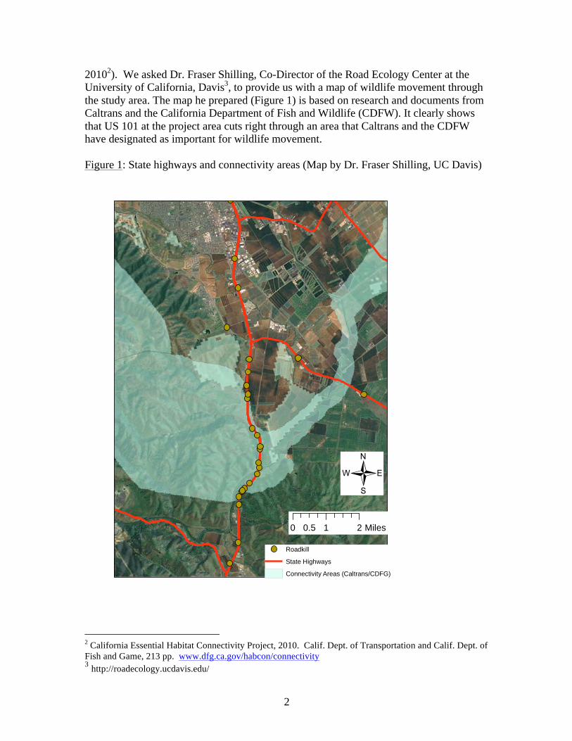
2
20102). We asked Dr. Fraser Shilling, Co-Director of the Road Ecology Center at the University of California, Davis3, to provide us with a map of wildlife movement through the study area. The map he prepared (Figure 1) is based on research and documents from Caltrans and the California Department of Fish and Wildlife (CDFW). It clearly shows that US 101 at the project area cuts right through an area that Caltrans and the CDFW have designated as important for wildlife movement. Figure 1: State highways and connectivity areas (Map by Dr. Fraser Shilling, UC Davis)
Roadkill
State Highways
Connectivity Areas (Caltrans/CDFG)
0 1 20.5 Miles
/
2 California Essential Habitat Connectivity Project, 2010. Calif. Dept. of Transportation and Calif. Dept. of Fish and Game, 213 pp. www.dfg.ca.gov/habcon/connectivity 3 http://roadecology.ucdavis.edu/

3
We consider it unfortunate that the DEIR proposes inadequate mitigations rather than the incorporation of Best Management Practices (BMPs) for wildlife movement in the evaluation, design, construction, operations, maintenance, development of success criteria, and monitoring for this project. North of Gilroy, US 101 creates a formidable barrier to wildlife movement. The proposed project would extend this barrier south, all the way to highway 129. This would be a great loss to California’s wildlife. We recommend these documents be consulted to better evaluate the project’s impacts and reduce impacts:
• Vermont’s Best Management Practices for Highways & Wildlife Connectivity4 • Wildlife Crossings Guidance Manual, California Department of Transportation5
The DEIR proposed mitigation for wildlife movement is haphazard, with little focus on the species to be impacted, design and placement of fences and crossings, monitoring to determine whether or not the goals of maintaining connectivity across suitable habitats will be achieved, or success criteria. Specific information regarding the species of animals that were detected by remote camera and other surveys was not provided in the DEIR, nor were locations of animal detections described. It is stated that cameras surveys were conducted over a 4-month period. This may not have been sufficient to capture data from animals moving during breeding seasons and juvenile dispersal. Road kill information is also lacking in the DEIR. The mitigations proposed for wildlife protection (and avoiding roadkill) and for wildlife crossing and connectivity are grossly inadequate and do not come close to what is currently accepted as Best Management Practices for wildlife connectivity. The DEIR proposes to:
• replace 2 existing pipe culverts with box culverts (one 90” in height; height of the other not specified)
• install 1 new culvert; unspecified design, “at least” 4 feet in height • install new box culverts north of Hwy 25 (these are for flood flows, not designed
for wildlife passage, and are of unspecified size or location) • install wildlife fencing 0.25 miles south from Tar Creek and 0.25 miles north
from the San Benito River to minimize animal movement onto the highway, and to install several one-way gates to allow egress from the highway
• clear vegetation from in front of existing culverts We do not consider these mitigations adequate to reduce impacts to wildlife movements in this important linkage area to a level of less-than-significant, and ask for a re-evaluation of project design to allow for adequate wildlife connectivity: 1) MM-NATCOM-3.1 proposes to maintain existing standard fencing and thrie-beam barrier north of Tar Creek. Because this does not result in any improvement in conditions 4 Vermont’s Best Management Practices for Highways & Wildlife Connectivity. 2012. 5 Wildlife Crossings Guidance Manual. 2009. California Department of Transportation www.dot.ca.gov/hq/env/bio/wildlife_crossings

4
for wildlife movement, it should not be considered a mitigation measure. Furthermore, the DEIR erroneously states that wire mesh and barbed-wire fencing will not inhibit wildlife movement. This is only true if the fence is no higher than 42”, and has a smooth bottom wire; no lower than 16” from the ground6. 2) The DEIR does not rely on state-of-the-art BMPs and design criteria to allow adequate wildlife crossings. It is not clear that the proposed box culverts are favorable for movement of all affected wildlife species. For example, underpasses for deer should be at least 20 feet wide and 8 feet high, and deer should be able to see the horizon as they go through the underpass7. Location, substrate, internal light and vegetation are all important considerations for design of wildlife undercrossing structures and of course – locations are of critical importance. Focal species need to be identified, and references need to be cited to assure that crossing designs utilize the best available information regarding species’ needs. 3) In the approximately 5 ½ mile distance between Hwy 25 and the San Benito River there are 2 stretches of over 2 miles with no undercrossings. More undercrossing structures must be provided, designed and located specifically as wildlife crossings, not primarily as flood control structures with utilization by wildlife as a secondary consideration. Existing culverts will be virtually unusable during periods of high flows. Wildlife crossing structures should be placed in locations with little human traffic or access, and where wildlife movement is favored by habitat and topography. Bridges, as well as culverts, may need to be re-designed to facilitate animal movement. The Caltrans/Calif. Dept. of Fish and Game 2010 CEHCP suggests spacing of crossing structures suitable for large animals such as deer at one per mile, and culvert-type structures suitable for small animals such as amphibians and small mammals at one per quarter-mile. 4) Success criteria should be specified in the Final EIR, and Project plans must include ongoing monitoring of undercrossings, with funding available for remediation if they are not used by all impacted wildlife species. Monitoring of crossing locations should be conducted both before and after structures are installed so that effectiveness can be assessed. Maintenance of culverts or other crossing structures also needs to be included in project plans. 5) Wildlife barrier fencing adjacent to Tar Creek and the San Benito River should be extended. The proposed one-quarter mile barrier fencing is not a sufficient distance to guide animals away from the highway to the creek crossings. A more thorough assessment of topography, habitat, and animal use of the locations is needed to determine
6 A Landowner’s Guide to Wildlife Friendly Fences, 2nd ed., 2012. Montana Fish, Wildlife and Parks, 56 pp. 7 Habitat Guidelines for Mule Deer, California Woodland Chaparral Ecoregion, 2007. Western Association of Fish and Wildlife Agencies, 52 pp. www.muledeerworkinggroup.com

5
appropriate fence length, north and south of both drainages, and at a minimum, fencing should stretch several miles on both sides of the crossing. 6) It is stated in the DEIR that new median barriers will be installed where they do not currently exist. Solid median barriers make it virtually impossible for an animal to get across the highway. Thrie-beam barriers, as are to be maintained north of Tar Creek, or other median structures that allow animal movement, should be used throughout the project site. We ask for the project to incorporate a comprehensive set of BMPs in evaluation, design, construction, operations, maintenance, defining success criteria and monitoring. At the very least, design should include and specify locations for:
• Fences several miles long on each side of each crossing. • At least four (4) crossing structures to accommodate large mammals, with no
more than one mile between large crossing structures, and no more than one-quarter mile between crossing structures appropriate for small animals.
• For constructed crossings to be effective in maintaining wildlife connectivity, mitigation should include permanent protection of suitable wildlife habitat adjacent to the crossings.
III. Proposed Mitigation for Biological Resources For virtually every potential impact on wildlife species and habitats, the proposed mitigation is either reliance upon payment of fees to the Santa Clara Valley Habitat Conservation Plan / Natural Communities Conservation Plan (SCVHCP), or, if that is infeasible, purchase of credits in an unidentified mitigation bank that serves the project area, or if no banks or credits are available, development of unspecified project-specific mitigation. The SCVHCP provides a permit from the wildlife agencies for the ‘take’ of several listed species. It should not be used as blanket coverage for any and all impacts to biological resources. This nebulous plan for mitigation for the many potential impacts of the project is not acceptable. Deference of a clear mitigation plan until after approval of the EIR violates the disclosure intent of CEQA. The DEIR also needs to include mechanisms for monitoring and funding, as well as success criteria and enforceable remediation should goals not be achieved. Exclusive Reliance upon the SCVHCP is inappropriate because: 1) At this time, the participating partners in the SCVHCP have approved the plan. However, implementation is still conditional upon agreements that may or may not be achieved, an implementation body has yet to be created, and the SCVHCP has yet to secure a “take” permit for the covered species from the California Department of Fish and Wildlife and the US Fish and Wildlife Service. 2) The SCVHCP does not cover all species and habitats that would be impacted by this project: (the only mammal covered is the San Joaquin kit fox; not badger, special status bats, or ringtail - a Fully Protected species). Impacts to habitat of special status species, including the American badger and other California Species of Special Concern need to

6
be addressed under CEQA. The only mitigation provided for the badger are steps to avoid disturbance of maternity dens during the pupping season, and eviction of badgers after the pupping season. For a number of species, including special status birds and ringtail, no mitigation for loss of habitat is proposed, based on the unsubstantiated assumption that low numbers of animals will be impacted. Mitigation for habitat loss of badgers and other special status species is needed. 3) Species without special status are not covered by the SCVHCP, but impacts to movement corridors for all species need to be addressed under CEQA. 4) Although it is stated in the DEIR that regulatory agencies are likely to accept mitigation through SCVHCP for impacts to special status species that occur in San Benito County, there is no assurance that this is the case, nor that it is legally defensible to do so. A separate Habitat Conservation Plan may be needed for take of listed species in San Benito County, as well as additional avoidance and mitigation measures for other impacts covered under CEQA. The mitigations proposed as alternatives if payment of fees to the SCVHCP is infeasible are inadequate. Creation or restoration of sensitive habitats, riparian, wetland, and oak woodland needs to be achieved prior to impacting existing habitat, or permanent protection of additional existing habitat is needed to compensate for temporal loss of habitat. Similarly, roosting or other habitat occupied by special status species, including bats and burrowing owls needs to be created and successfully used by the species in question before habitat is impacted on the project site. In lieu of SCVHCP participation, proposed mitigation for loss of burrowing owl habitat is creation of burrows and management of foraging habitat at a ratio of 6.5 acres per unpaired owl or owl pair. In 2012, CDFW issued new guidelines for burrowing owl mitigation that specifically acknowledges the older one(s) are ineffective and no longer acceptable to CDFW. The alternative to mitigation via the SCVHCP should follow the 2012 CDFW Staff Report on Burrowing Owl Mitigation8 Several detention basins are proposed near the highway. These may attract wildlife, including California red-legged frogs, tiger salamanders, and western pond turtles, and may increase the potential for road mortalities. This potential impact needs to be addressed. Impacts of loss of riparian habitat and wetlands (NATCOM-1, WET-1) are not limited to the endangered species that are covered by the SCVHCP – the impacts are to beneficial uses of as described in the Basin Plan for the stream. The project must secure permits from the US Army Corps of Engineers and the California Water Quality Control Board (404, 401), and may require increasing efforts to avoid or minimize the Project’s impact, and to provide local mitigation in addition to or in lieu of payment to the SCVHCP. 8 Staff Report on Burrowing Owl Mitigation. 2012. California department of Fish and Wildlife http://www.dfg.ca.gov/wildlife/nongame/docs/BUOWStaffReport.pdf

7
The SCVHCP does not provide mitigation for loss of Oak Woodland (NATCOM-2), since the species covered by the plan do not utilize oak woodland habitat. Payment to the SCVHCP does not provide in-kind mitigation. Impacts to fish species are not covered by the SCVHCP. The project could potentially have a significant impact to Pacific Lamprey and Monterey Roach, and thus requires the development of specific mitigation measures and a permit from National Marine Fisheries Service (NMFS) IV. Growth-Inducing effects and Other Impacts The DEIR acknowledges that the project will have a direct and significant growth-inducing impact if and when the application for the massive El Rancho San Benito (ERSB) new community development project is approved. The approval of the ERSB project is conditioned upon the widening of U.S. 101 (Impact GR-1). Because of this direct dependency, this project’s EIR needs to include disclosure of all the reasonably foreseeable potential impacts of ERSB including impacts to special status species and habitats, wildlife movement corridors and other biological resources; air quality; hydrology and water quality; climate change; regional traffic, etc. The fact that the ERSB project proponents (DMB) are helping to fund this Highway 101 widening project underscores the link between the two projects. In the DEIR, it is stated that the “The project’s indirect effect on the rate, location, and/or amount of future growth will not be substantial.” (Impact GR-2). We do not agree. The DEIR for the San Benito County 2035 General Plan, now available for public review, makes provisions for “New Communities” in the northern part of the County, several of them adjacent to Highway 101. Among the New Community Location Requirements listed is that “They are accessible to existing major transportation routes and corridors, such as State highways…” It is reasonable to assume that, like the ERSB development, other “New Communities” placement near Highway 101 will depend upon this widening project. The DEIR contends that the project is not expected to have significant impact on air quality in the region. We believe that more information is needed to substantiate this assumption. Air pollutants from Highway 101 in the Coyote Valley of Santa Clara County, and their impact on listed species triggered the need for that County’s HCP. Widening of Highway 101 and resultant increases in traffic in this project site may have similar effect. Cumulative impacts of this project on biological resources, air quality, water quality and hydrology, and noise have not been addressed adequately. Impacts of increased traffic volumes on biological resources, air quality, water quality and hydrology, and noise have not been addressed adequately.
8
Conclusions and Recommendations We oppose approval of the DEIR in it’s current form. We believe that the project as proposed will result in significant impacts to wildlife movement corridors and to special status species. At a minimum, Best Management Practices for wildlife movement corridors should be incorporated into the project design; whether these could reduce impacts to wildlife movement to a level of less-than-significant cannot be determined with the information that has been provided. Impacts to species that are not covered by the SCVHCP need to be disclosed, analyzed and mitigated. Mitigation for impacts to all biological resources need to be developed for San Benito County portion of the project, and alternative mitigation for species covered by the SCVHCP needs to be developed for Santa Clara for the potential risk that the SCVHCP is not implemented, or the implementation is delayed. Growth inducing impacts and cumulative impacts of the project require further study and analysis, as well as impacts to air quality and climate change. While we recognize the problem of traffic congestion throughout the region, investing in mass transit systems and community planning to reduce sprawl of urbanized areas offer better long-term solutions than continuing to widen and expand our existing highways. We thank you for the opportunity to comment on this DEIR. Please do not hesitate to contact us if you have questions.
Heyward Robinson Shani Kleinhaus Conservation Chair Environmental Advocate Sierra Club Loma Prieta Chapter Santa Clara Valley Audubon Society

From: Omar Chatty [mailto:[email protected]] Sent: Monday, April 29, 2013 5:01 PM To: 101_Widening Subject: Quick additional comments on US101-SR129 Widening Project EIR Hello, In addition to my comments made at the March 28, 2013 public meeting, I would like to encourage, restate and emphasize the following: This document is excellent in its breadth, depth, thorough, and comprehensive detail from not only environmental perspectives, but also human issues, and animal protection and road safety. This EIR ought to make Caltrans and VTA management very proud of its excellence as produced by VTA and Caltrans staff. In peer conferences such as ASHTOO and ASCE and others, I would recommend this as a template model for other jurisdictions to use as a baseline of completeness and environmental sensitivity while exercsing the best in engineering standards for highway construction in the 21st century. This EIR should serve as a baseline model for a future direct SR130 route from San Jose to Interstate 5, where environmental considerations, such as those exhibited here, are of paramount importance. A key point of this project from a financial and human sensitivity perspective is that it has no economic dislocation outcome due to the wrong‐headedness of Toll Road or Toll Lane. This road must be funded by existing motorist‐generated sources. Regards, Omar Chatty Member of a number of Transportation organizations and Taxpayer watchdog groups.
US 101 Improvement Project
Comment from Jesus Cisneros
I want to tell them that if they are going to connect 25 to Santa Teresa, it should go straight through. I
have seen lots of accidents and there are a lot of students who come from Castroville who can use this.

From: Richard Cripps [mailto:[email protected]] Sent: Tuesday, March 12, 2013 12:51 PM To: 101_Widening Subject: 101 Widening between Monterey St and 129 I'm all for it. That is a very dangerous section of road that carries way too much traffic. The 25 interchange is a joke. Anyone trying to go Southbound 25 to 101 is out of luck because of traffic. 25 merge to Northbound 101 is Russian Roulette. Improvements along that entire corridor are definitely needed. Rich Cripps -- 750 Babbs Creek Drive Gilroy, CA 95020

Things that need to be commented on for the US101 Highway/SR25 improvements
1. Add comments that the 100 year flood map does not include our property 5725 MONTEREY
FRONTAGE ROAD PARCEL #80822002 and the properties adjacent properties #80822003,
80822012, 80822013, 80822001, 80822007, 80822008, 8082115, 8082114, 8082113, 8082127,
8082126, 8082128, 8082129, 8082130, 8082131, and 8082133 all had ~2ft. of standing water
on our properties in the 1986 flood. The design team needs to make sure that the additional
flood water coverts will be large enough to handle more than just an 100 year storm because in
1997 the only reason we didn’t get flooded again was that the Carnadero Creek over ran its
banks near where it meets the Pajaro River and relieved the Canadero Creek and only the end of
Monterey frontage road had got flooded by the highway 101 bridge. This was a close call for us
just eleven years from the previous flood. Another point that needs to be considered is that
debris from the Carnadero Creek that flows down the steam during heavy storms and can
plies up under neat the W Luchessa Ave bridge and the highway 101 bridge. This is due to
Santa Clara water district not cleaning up the over growth vegetation of the Carnadero Creek
banks and creek bed, which was one of the conditions they said they going to do when we give
up property easements in the year 1987 so that the Corp of Engineering would built the levee on
the west side of City of Gilroy. The Carnadero Creek banks and creek bed have not been
maintained and this is the existing condition.
2. Add comments that all property owners of parcels including our property 5725 MONTEREY
FRONTAGE ROAD PARCEL #80822002 and the properties adjacent properties #80822003,
80822012, 80822013, 80822001 want the sound wall SW2. Note that because of the existing
101 highway bridge overpass of southern pacific RR tracks higher elevation and the existing
Truck stop on the eastern side of high way 101 the large semi‐trucks are using their air operated
Jake to slow down instead of applying their conventional brakes which creates a large amount of
excessive noise at all times of the day. Another point is that the vegetation along highway 101
in front of our properties have grew to a level that acts as addition sound barrier to our 40 year
old Pine/Walnut/Sequoia/Oak trees and looking at your plans to build an retention wall on the
west side of highway 101 would probably remove that vegetation hence more noise problems.
3. Add comment that we are opposed about proposed Bike path behind our properties 5725
MONTEREY FRONTAGE ROAD PARCEL #80822002 and the properties adjacent properties
#80822003, 80822012, 80822013, 80822001, 80822007, and 80822008. We give up property
easements in the year 1987 of 50 feet from the middle of Canadero Creek across the back of our
properties so that the Canadero Creek would be able to be cleaned of over growth vegetation.
The Corp of Engineering would not have built the levee on the west side of City of Gilroy without
these property easements being granted and the cleaning of the over growth vegetation has
not been maintain. To build the proposed Bike path behind our properties 5725 MONTEREY
FRONTAGE ROAD PARCEL #80822002 and the properties adjacent properties #80822003,
80822012, 80822013, 80822001, 80822007, and 80822008 the existing trees and old growth
vegetation along the Canadero Creek banks would be disturbed and fences would need to be
taken down along property lines. We feel that the city of Gilroy and this project should use the
existing right of way on Farman Ln dirt road that can be used to reach the same end point of the

bike path at highway 101/ Canadero Creek bridge and would cost less than trying to follow the
twisted Canadero Creek banks behind our properties 5725 MONTEREY FRONTAGE ROAD PARCEL
#80822002 and the properties adjacent properties #80822003, 80822012, 80822013, 80822001,
80822007, and 80822008.

From: [email protected] [mailto:[email protected]] Sent: Monday, April 29, 2013 4:07 PM To: 101_Widening Subject: DEIR US 101 Improvement Project Monterey Street to State Route 129 - comment VTA Environmental Programs/Resources Management Department April 29, 2013 Attention: Ann Calnan 3331 North First Street, Building B-2 San Jose, CA 95134-1927 RE: DEIR US 101 Improvement Project Between Monterey Street and State Route 129 Dear Ann Calnan, In regards VTA's proposed project to widen #101 between Monterey Street in Gilroy to State Route 129, I would like to submit comment, with a qualification that I have not attended Pajaro River task force meetings recently and so do not know present status of COE flood control designs in this particular reach of the river. In that Pajaro River has been said to have the most extensive acreage of upper watershed of any California river system, it would appear that with eight tributaries joining Pajaro's main channel in this 101 project area that San Francisco District Army Corps of Engineers's flood control design must be given the top priority. Figure 16 of a Google map of FEMA 100 year Pajaro River, San Benito and San Juan Creeks' floodplain in San Benito County gives some idea of flood flows to be contended with in project area. It would suggest to me that generous setback levees would perhaps be the only feasible flood control design. COE flood control criteria cannot come in after the fact and so not to have it front and center in this DEIR is a deficiency. There is also the constraint of the railroad line that flood control must accommodate. 101 upgrade is the more flexible element of infrastructure in project area. At a SCVWD workshop last Thursday FEMA staff acknowledged that their flood maps do not account for back to back storm systems as with a Pacific Ocean pineapple express weather front or for any increased intensity of storm systems that might be anticipated due to climate change or global warming. Therefore, it might be prudent for this DEIR to reference FEMA 500 year floodplain parameters rather than 100-year ones. On DEIR biological study area maps it appears that magenta purple areas designate riparian removal. This impact would result in critical loss of riparian corridor flood retention capability as well as critical habitat loss. Please avoid this impact entirely in the proposed #101 project design. Do not believe such an impact can be mitigated except by replanting riparian corridor on site. In high water, biofiltration strips and swales provide no retention capability. They can only improve water quality by filtering out freeway contaminants.(2.10.5) In regards Threatened and Endangered species, the proposed loss of riparian SRA by this project design, will have a cumulative impact on water temperature in the Pajaro River and all its tributary steelhead streams such as Llagas, Pacheco, Uvas/Carnadero and Tar Creek. Gavilan and Tick Creeks will be contributing more warm waters due to their loss of riparian cover. San Benito River may also suffer degradation of SRA habitat. As steelhead travel in cooler conditions and at night they are not always observed in a stream system so a conservative design should be a preferred management protocol. (Please note that in implementing #85 flyover with #101 at Bernal Road and Coyote Creek in 1992 Caltrans dryback killed off all fish by flawed plan).
At some point in DEIR read that mitigation for impacts to steelhead would be through payments to Santa Clara County HCP mitigation bank. Fisheries are not included in final Santa Clara County HCP so this is invalid option. Also, this reach of Pajaro River, if sufficiently degraded with warm water, can so stress the indigenous run of steelhead as to affect their health and reproductive capability. (2.17.5). Cumulative impacts on the species need to include aforementioned COE flood control project's loss of SRA for the Pajaro River system, as it has been ongoing for over a decade with all affected jurisdictions. Do not find cumulative impacts sufficiently addressed or an alternative of avoidance of impact seriously considered. Wetlands are not sufficiently clear as to location on biological study maps so cannot comment on extent of impacts. Perhaps on further study I will be able to understand this element appropriately. The Figure 21 Potential Wildlife Movement Pathways is one of the most important considerations in the #101 Improvement Project. It clearly illustrates how the project area is crossroads for wildlife from Diablo Range, Santa Cruz Range, Gabilan Range and Lomerias Muertas. This can mean essential revitalization of gene pools for all species of the region, as well as sustaining migratory flight paths for butterflies, hummingbirds and a myriad of birds of the Pacific Flyway. Native grasslands and oak woodlands are equally important to be preserved in and adjacent to project and natural bridges need to be designed to provide crossover facility to allow large animals like elk and kit fox, as well as small mammals safe continuity of wildlife corridor. Culverts serve opportunity for interrange exchange but provide predators with exceptional hunting options so not ideal. Also, in 1980 public hearings on #101 upgrades along Coyote Creek, horsemen/horsewomen were promised equestrian underpasses which were never implemented. Believe natural bridge could accommodate ether man on horseback or man leading horse. Precedent would be De Anza Trail implementation facility. Believe that Canada has designed exceptionally appealing natural bridges so please reference them here. Other studies that might be included in this DEIR is the nitrogen deposition study that evaluated conversion of native grasses and incursion of invasives into natural grassland communities due to emissions from increased auto traffic, and archeological/paleontological studies that have recently unearthed camels as well as mammoths in region. Geology element needs to provide stronger evaluation of geologic and plate tectonic impacts on Pajaro River watershed and channel evolution. Believe Coyote Creek once flowed into Pajaro and some other major river system is supposed to have dug out Monterey Bay's canyon, but not through here? Reason I feel this might be important is that whole nest of earthquake faults seem to focus on this crossover point of mountain range which might imply that upgrade design needs to be as resilient as possible to natural catastrophe. Finally, please restore as much riparian forest as possible for flood retention capabilities as well as for under flow supplied by tree roots and prevention of erosion. Trees should be noise reduction element, rather than sound walls which would only augment flood hazards both on and adjacent to freeway. Thank you for consideration of these concerns. Libby Lucas 174 Yerba Santa Ave., Los Altos, CA 94022

From: Emily Renzel [mailto:[email protected]] Sent: Monday, April 29, 2013 6:08 PM To: 101_Widening Subject: I agree 100% with Libby Lucas Dear Ann Calnan: I completely agree with the comments submitted by Libby Lucas re widening 101 from Monterey Street in Gilroy to Highway 129. Sincerely, Emily M. Renzel, 1056 Forest Avenue, Palo Alto, CA 94301 and also of San Juan Bautista (so I use this stretch of 101 regularly).

MARCH 2} 2013
ANN CALNAN
VTA} SANTA CLARA COUNTY
DEAR MS. CALNAN}
WE WOULD APPRECIATE YOUR CONSIDERATION IN THE
DESIGN OF AN INTERCHANGE FOR S.H. 152 AT THE
PRESENT INTERSECTION OF U.S. 101 AND S.H. 25 FOR
TRAFFIC TRAVELING NORTH AND EAST OVER THE
PACHECO PASS. THIS WOULD HELP ALLEVIATE THE
PRESENT AND FUTURE TRAFFIC IMPACTS ON NORTHERN
SAN BENITO OUNTY} ESPECIALLY THE SMALL HISTORIC
MISSION TOWN OF SAN JUAN BAUTISTA AND THE
FARMING COMMUNITY OF THE SAN JUAN VALLEY.
NONE OF THE INTERSTATE TRUCK TRAFFIC TRAVELING
EAST OR WEST} NOR MOST OF THE COMI\ll RTRAFFIC
USING S.H. 156} STOPS IN SAN BENITO CCUNTY.
UTILIZING HIGHWAY TAX DOLLARS DESIGNATED FOR S.H.
156 COULD BE BETTER SPENT SUPPLEMENTING YOUR
U.S.101 FUNDING.

YOUR CONSIDERATION OF KEEPING INTERSTATE TRAFFIC
ON U.S.10l WOULD BE GREATLY APPRECIATED AND
WOULD SAVE THE TOWN OF SAN JUAN BAUTISTA.
SINCERELY}
TED THOENY P.E.
MAP ENCLOSED


Mar 15 13 05:40prUUl
Joseph P. Thompson, ES9' 8316380151 p.1
YUVLfO (j:)jiJhJf!---- ,:e10IL
,",,"', C", OS '0; ,J"~"~""~"d'D"" '""ro"~".'""""m~'""'"'"' If{~.~.?From: Joseph Patrick Thompson ([email protected]) /V!(0To: [email protected];
.....I .....
IIJ'<d
~;J
'""~j
k
The Draft EIR and technical reports are available to download from this ftp site:http://www.· org/crna/environmental_public/10 1.lmprovement.Project!
Attached is the Notice of Availability of the Draft Environmental Impact Report (EIR) for theU.S. 101 Improvement Project (Monterey Street to State Route 129) prepared inaccordance with the California Environmental Quality Act. The Notice provides a briefdescription of the project and the location and time for the public meeting. The pUblic meetingserves to provide information and answer questions about the project, and to acceptcomments on the project as part of the formal environmental review process. All commentsreceived on the project at the public meeting and during the public review period will beaddressed in the Final EIR. The public review period begins on Thursday, March 14, 2013and ends on Monday, April 29, 2013 at 5 PM. You may submit your comments via e-rnail(101_Wideni'[email protected]), facsimile, postal mail, or at the public meeting, Details are providedin the attached Notice. (Note that the Notice is in multiple languages.)
Good morning/afternoon,
.From: "Calnan, Ann" <[email protected]>To: 101_Widening <1 [email protected]>Cc: 101_Widening <1 [email protected]>Sent: Thursday, March 14, 201311:14AMSubject: U.S. 101 Improvement Project· Draft Environmental Document Available!
[email protected]; [email protected]; [email protected]; [email protected];Ce: [email protected]; [email protected]; [email protected];
,-.. ! [email protected]; [email protected]; [email protected]: I... I [email protected]; Q AD I~ Date: Thursday, March 14,201311:49 PM /' I LLAA P78'Z vOA"'\. i
lu C:;;;" C De- b°tWJ)- ~"~ Dear Ms. Call1an, . /'v'c:: "f--7 ....•.N Yes. Thanks for sending me the notice. I will submit a response as I did~ previously on Ih\y 101,25, 152 proposals.
. Joseph P. Thompson\ ~ Past·Chair, Legislation Committee, Transportation Lawyers Ass_n.. -'J (408) 848·5506
,::-- P~asedon VTA's conduct, one would think you had your own window ,( ~~ ~:::t7~0~~d~:~:~~t~~~~i~~~~1~~Sy~~;;:~~:~~~~eT~I~m~~~~y 0 (2r:l/~ of all the Nation's transit agencies. It is obvious why the Editorial V~ Board of the Gilroy Dispatch has voted to terminate the VTA. ~
~~:cond their motion, again. (.:~. /'_.~.
3/14/2013
, /,,0;,(>1. /. "\.; t :-'Ij I,
http://us.mg20i.mail.yahoo.com/neo/launch7.partner=sbc&.rand=82foarvomfm1d
Compact disks (CDs) or hard copies of the Draft EIR are available upon request. Please call
/~. '. 5( ,", L I KcU55t{('~"'

Mar 15 13 05:40ppunt
Joseph P. Thompson, ES9. 8316380151
VTA Community Outreach at (408) 321-7575 or send an email tocommLiPlty.outreach@vta,org.
Thank you!
-",..,~
~3- Ann Calnan f Senior Environmental PlannerEnvironmental Programs and Resources Management / Santa Clara Valley Transportation Authority3331 North Firet Street, Bldg. B-2/ San Jose, CA 95134-1927http://www.vta.org/
http://us.mg205.maiLyahoo.comlneo/launch?.partner=sbc&.rand=82fo3l"vomfm1d 3114/2013
Mar 15 13 05:40p Joseph P. Thompson, ES9. 8316380151
JOSEPH P THOMPSONAttorney at Law
8339 Church Street, Gilroy, CA 95020Post Office Box 154, Gilroy, CA 95021-0154
Telephone (408) 848-5506; Fax (408) 848-4246E-maiL [email protected]
July 3,2005
p.3
Fax: 408-321-5787Mr. Torn FitzwaterValley Transportation AuthorityEnvironmental Planning3331 North First Street, Bldg. BSan Jose, CA 95134-1927
Re: Proposed Don Pacheco "Y" Project & Community Response Opportunity
Dear Mr. Fitzwater,
Referring to the VTA's invitation for public comment regarding the proposed interchangeimprovements for the intersection of State Highways 152 & 156, please refer to my letter to yourpredeeessor five years ago (copy enclosed).
Also, please find enclosed my position paper offered in response to your request.
Thank you for the opportunity to give you my opinion regarding the proposed projeet.
Due to the voluminous content ofmy response, I will not send it by fax, but rather, by mailonly. If there are questions, please do not hesitate to contact me.
Very tmly yours,
Ene!. JOSEPH P. THOMPSON
cc: Hon. Don Gage, Santa Clara County Board of Supervisorscc: Hon. Reb Monaco, San Benito County Board of Supervisorscc: COG Directorscc:AMBAG

Mar 15 13 05: 41p Joseph P. Thompson, ES9. 8316380151 p.4
Don Pacheco Y 2005: A Transportation Business and Logistics Perspectiveon the Proposed Highway 152 & 156 Intersection Changes
byJoseph P, Thompson, Esq,
PHOTO AVAILABLE UPON REQUEST
Aftermath of a head-on collision between a big-rig and a school bus on State Highway152, Gilroy, California, April 1994. Transportation planning must iucludeconsideration of the movement of goods and people.
1
Mar 15 13 05:41p Joseph P. Thompson, ES9' 8316380151 p.5
This reply, like the last one I wrote to the Valley Transportation Authority (VTA)regarding the proposed widening of U.S. Highway 101 between San Jose and Morgan Hill,is made in VTA's request for public comment to the proposed changes in the intersectionof State Highways 152 & 156, known as the "Don Pacheco Y," in Santa Clara County,California. A copy of my last paper, which was published in local newspapers andChamber of Commerce papers, is attached hereto as Exhibit "A."
The AuthorI volunteer this paper as a transportation policy student, not on behalf of any client, or
for any association or organization to which I belong. For some time now I have beendoing post-doctoral study of transportation policy at the Norman Y. Mineta InternationalInstitute for Surface Transportation Policy Studies at San Jose State University, theTransportation Research Board at Georgetown University, and at the Library of Congress.I was formerly a member of the Government Review Councils of the Gilroy and Hollisterlocal chambers of commerce. I am the past-president of the Gilroy-Morgan Hill Bar Assn.,and past-president of Vineyard Estates Mutual Water Co., Inc. I am the founder ofAbraham Lincoln Learning Fortress for Responsible Enterprise Education-SBC SmallBusiness Incubator, and have served as a member of the Executive Committee oftheDebtor-Creditor-Commercial Law Section of the SCCBA. I am a member of theConference ofFreight Counsel, Citizens for Reliable and Safe Highways, Citizens RailAdvisory Committee of San Benito County, Association for Transportation Law, Logistics& Policy (ATLLP), Transportation Lawyers Association (TLA), Safe Kids Coalition,Gavilan Employers Advisory Council, and other professional organizations within thegeographical region of the proposed project. I am a candidate for the American Society forTransportation & Logistics (AST&L). In 1997 I received the National Directors' BestResearch Paper Award from the AST&L. For more than 42 years I have been engaged inthe transportation industry either directly as a truck dispatcher, intcrmodal facilitysupervisor and railroad complaint clerk or indirectly by representing carriers and theircustomers on the Central California Coast before federal and state courts and agencies asan attorney in the private practice of transportation law. My reply is my personal opinionand should not be viewed as that of any organization or association to which 1 belong, andI am solely responsible for its content.
SummaryFocusing on the movement of goods through the Don Pacheco Y, and to and from the
Central California Coast Region, I conclude, as I have previously, that the Region needs anintermodal facility. Movement of people and goods in the arteries of commerce inevitablyincreases when obstacles are abated, yet shippers and receivers in this Region lack a viableoption to highways for their traffic. We must afford our commerce an economical andefficient option that presently existing technology has achieved in intermodalTOFC/COFC service.
Mar 15 13 05: 41p Joseph P. Thompson, ES9' 8316380151 p.6
BackgroundI here restate what I said to VTA about the U.S. 101 widening project, and refer the
reader to Exhibit "A."
HistoryI here restate what I said to VTA about the U.S. 101 widening project, and refer the
reader to Exhibit "A."
TodayToday is worse than the "today" I described in my last paper. Why? What is the
explanation for our extravagantly-funded MPO's failures? Why do we spend so much taxmoney furnishing the MPO's like VTA, AMBAG, MTC, TAMC, COG, SCCRTC, etc.,with unlimited resources ofhighly compensated personnel and incomprehensible sums, yetsee conditions in the highway arteries of the Region, State, and Nation, deteriorating?What are we doing wrong?
Again, I refer the reader to my earlier paper (Exhibit "A") for my analysis.Overall, I explained the strnctural flaws in our transport policy in my paper, "ISTEA
Reauthorization and the National Transportation Policy," 25 Transportation Law Journal,pp. 87-et seq. (1997), which was published in shortened version as "ISTEAReauthorization and the National Transportation Policy: Overlooked Externalities andForgotten Felt Necessities," Transportation Lawyer (Dec. 1997). Since then, othercommentators have ventured comparable analyzes. For example, Eno TransportationFoundation CEO & President Tom Downs, in a recent speech to the American Society ofCivil Engineers in Baltimore, said: "The reality of this issue is that our country has needsthat transcend the needs of any individual state, but parochial greed will outweigh nationalpurpose every time. The real problem is that it means that the program is just aboutrevenue distribution, and not about national transportation needs. The forces behind thismovement are so emotional and greed driven that I do not have much hope for a resolutionthat benefits the entire country."
The flaws identified by knowledgeable transportation people like Mr. Downs undermineour Region's ability to achieve sound, sustainable transportation solutions.
VTA and other MPO's waste so much money on irrational mass transit solutions thattheir greed make the Robber Barons seem like altar boys in comparison, yet our MPO'spoliticians and advocates describe such waste as "success." Is it really "success," ordreadful failure? It depends upon whether one is receiving the transit subsidies, or payingthem.
IntermodalOptionsWhat I said in the last paper is just as trne today. "Neither Silicon nor Salinas Valleys
have intennodal facilities. San Jose has the distinction of being the largest urban area in

Mar 15 13 05:41p Joseph P. Thompson, ES9. 8316380151 p.7
debate and forests of paper on how to achieve the best solution, private or public, but untilwe do, we will see future generations paying for this schizophrenic transportation policy,which I believe is the fundamental reason why we have arteriosclerosis in our arteries ofcommerce. Better minds than mine have reached this conclusion. For example, our formerMayor and Congressman, recently nominated by the President to become our nextSecretary of Commerce, said in 1995: "The cmcial question in transportation today is:What should government do? And what should it leave to others?" Quoted with my earlierthoughts on this in "ISTEA Reauthorization and the National Transportation Policy," 25Transportation Law Journal 87-et seq, (1997).
This project, as all others, will not happen in a vacuum. National and internationalforces will affect it. We may see, for example: (1) fuel prices continue to increase, (2)commercial drivers hours of service regulations modified to worsen the Nation's drivershortage, (3) vehicle weights "harmonized" with those of our NAFTA "partner" Mexico(107,000 lbs. vs. our present limit of 80,000 lbs.), (4) long combination vehicles (LCVs),i.e" triple short trailers and "freeway doubles" 2-53 footers, nationwide, or rather,throughout NOlih America under NAFTA's transportation "side agreements," and (5) moreaxles bearing greater concrete-cracking, bridge-buckling loads. Legislation now pending inCongress may make some of these developments arrive on our highways in the nearfuture." With TEA-21 reauthorization in the hands ofthe Congress, and our policy flawsunchanged, I see no hope to the deteriorating conditions. The MPO's leaders will continueto hopelessly tax people out of their cars as they Sovietize American transport policy.
RecommendationsMy recommendation to our leaders at VTA, and the other MPO's, and their so-called
"senior transport planners," who have co-opted the tenn "intermodal" to mean somethingentirely different than what earlier generations of transportation men understood it tomean, is the same as before:
"When there were more than 100 Class I railroads, the Nation had more than 2,000intermodal facilities. Today we have 5 Class 1's and about 200 intelTI10dal facilities. Togarner 10% of our Nation's freight revenue (bucks currently take 77%), the railroadindustry has been forced to contract to stay profitable. Although it takes four times asmuch fuel to move a ton with rubber tires over concrete highways than with steel wheelson steel rails, and although air pollution is vastly greater from one fully-loaded "big rig"than from an automobile, I do not see anyone at our MPOs promoting our intennodaloptions. Even studies like Jack Faucet & Associates 1995 Freight StUdy for AMBAG andBarton-Ashman Associates 1992 1-880 1ntermodal Corridor Study: Truck Travel in theSan Francisco Bay Area for Caltrans District 4 and Alameda County miss their mark or,sadly, are disregarded by our MPOs. I believe that it is wrong to restrict our senior
Mar 15 13 05:42p Joseph P. Thompson, ES9. 8316380151 p.8
North America without one. The closest ones are located in Richmond on the ATSF-BNand in Lathrop on the UP. Business must cope with the congested 1-880 corridor to gettraffic from our Region to ATSF-BN's ramp, or dray loads over the Gabilans throughPacheco Pass or Sunol Grade and Altamont Pass to catch UP's Lathrop intermodal facility.The former intermodal facility site on the SP at Taylor and Coleman Streets in San Jose isfor sale. The former intermodal yard in Salinas adjacent to the Amtrak Station off MarketStreet has been partly built upon. UP, SP's successor by merger, offers no intermodalservice from this Region. Union Pacific Railroad Company, Exempt Circular 20-B:Governing Publication ofRules and Charges Applying on TOFC/COFC Shipments(12/1/1997). So, as a result, the westbound tonnage to the Region moves primarily byhighway, and the eastbound tonnage, mostly produce from the Salad Bowl of America-Salinas Valley, also goes by truck. These commodity flows are constantly increasing,along with the population of motorists competing for space on the subject route, amongothers, e.g., State Highways 152, 156, 129, & 25. Increasing the capacity of the 101corridor will, like a wider drain, draw more ofthe same flows. How long can this go on?"Well, it is still going on today in 2005, underthe leadership of our MPO's planners anddirectors. 1 must ask, again, why? Are we planning for serfdom?
The FutureMy prediction, resulting from my analysis ofVTA's intransigence and greed for
socialist mass transit solutions like Lite Rail and BART, remains the same as I said before:"Our regional metropolitan planning organizations (MPOs) Metropolitan TransportationCommission (MTC) and Association Monterey Bay Area Governments (AMBAG) havetaken the position that they will not support residents' and GRC's efforts to restoreintermodal facilities in the Region. MTC's 1999 Transportation Improvement Programfor the Nine-County San Francisco Bay Area (9/23/98) mentions "multimodal" projects,but by this term it means only passenger transit operations linking, for example, transitbuses with passenger trains and BART. The tenn "internlOdal," which was the keystone ofthe Intermodal Surface Transportation Efficiency Act of 1991, Pub.L. 102-240 ("ISTEA"),supposedly renewed in the Transportation Efficiency Act for the 21 st Century ("TEA-21 "),H.R. 2400, has received little or no attention. This artificial division between public-sectorpassenger transit planners and private-sector transportation is a source of waste andinefficiency in our Nation. In this regard we are, I believe, a House Divided againstourselves.
The long-range congestion management plans for both Silicon and Salinas Valleys donot mention inte1modal facilities. This should not be surprising because their position hasbeen, since their inception, that they cannot support private sector transportation solutions,and are, in fact, in competition with them. Even the California TransportationCommission's (CTC) 1999 study of California's transportation infrastructure needs for thenext decade failed to mention them. We can continue to sacrifice countless hours of

Mar 15 13 05:42p Joseph P. Thompson, Es"l. 8316380151 p.9
transportation planners at our :MPOs from planning private sector options. While I do notfind any legislative support for their position, that is a fundamental assumption on whichthey operate. I believe that we ought to untie their hands and let them harness the privatesector solutions. I would recommend to our senior transportation planners and policymakers the TRB's Confercnce Proceedings No. 12, "National Conference on Setting anInte=odal Transportation Research Framework" (1997) for guidance on this strategy.
If the Southern California Association of County Governments can recommend "truckonly" lanes, we in Northern California ought to show them a better solution, i.e.,intennodal facilities. After all, the whole Nation looks to our Region as the leaders of the"new economy," so why not show us also to be brighter about transportation solutions?We ought to give our shippers and receivers an alternative to highways for their traffic,especially when truck brokers are claiming that "driver shortages" (real or imagined) exist,forcing-up the freight charges to sky-high rates. The freight savings can be passed along tothe ultimate consumers."
ConclusionAgain I repeat to the "senior transportation planners" and VTA's leaders, "We have here
in our Region what NAFTA calls a "barrier to trade." This barrier is a result of ourprevious decisions and our existing transportation policy. I think we are smart enough toremove it. Therefore, I urge you to consider these ideas in your endeavor to seek solutionsin your environmental impact report." My recent paper "Inte=odal Facility for theHollister Branch Line: A Private Sector, Sustainable, User-Fees Funded TransportationSolution for the 21st Century," was attached to the last paper I gave VTA, and which Ipresented to the CTC at their meeting at the PUC headquarters in San Francisco in 2002. Ibelieve that the ramifications of the proposed improvements to the Don Pacheco Youghtto be mitigated by the restoration of inte=odal facilities on the Central California Coast,and if neither MTC nor AMBAG want them in this Region, then I believe that the onlyplace to build one would be on the Hollister Branch Line beyond their jurisdiction in SanBenito County.
Joseph P. ThompsonC:\grc\DonPachecoY.wpdJuly 2005

Mr. Roy Molseed Fax: 408-321-5787Valley Transportation AuthorityEnvironmental Planning3331 North First Street, Bldg, BSan Jose, CA 95134
Mar 15 13 05:42p Joseph P. Thompson, ES9. 8316380151
JOSEPH P, THOMPSONAttorney at Law
8339 Chureh Street, Gilroy, CA 95020158 Central Avenue, Salinas, CA 93901
981 Fremont Street, Santa Clara, CA 95050Post Office Box 154, Gilroy, CA 95021-0154
Telephone (408) 848-5506; (408) 984-8555Te1ecopier (408) 848-4246
E-mail: TransLaw@PacBelLNetWWW: http://home,pacbeILnetiTransLaw
July 7, 2000Mr, Rob Oneto, Chair Fax: 831-384-0800Government Review CouncilGilroy Chamber of Commerce7174 Monterey StreetGilroy, CA 95020
p.10
Re: Proposed U.s. 101 Widening Project & Community Response Opportunity
Dear Messrs. Molseed and Oneto,
Confirming my telephone conversations with you, due to lIst alillual meeting of theAssociation for Transportation Law, Logistics & Policy (ATLLP) in Montreal, 1was unable to attendthe community workshops that were held in connection with this project, but as promised, I amsubmitting, tmder separate cover, my response to VTA's invitation for comments from the public.
While I am a member of GRC of both Gilroy and San Benito County Chambers ofCommerce, Citizens Rail Advisory Committee, Citizens for Reliable and Safe Highways, Safe KidsCoalition, TrallSportation Lawyers Assn" ATLLP, and President of the Morgan Hill-Gilroy BarAssn., among other things, my response should not be considered GRC's or that of any otherassociation or organization with which I aln affiliated, and I am solely responsible for its content.
My response is not sent on behalfofa client, but merely represents some ideas ofthis fmIDertransportation complaint clerk, truck dispatcher and intermodal facility supervisor in San Jose formallY yeal's, and now post-doctoral student of transportation law and policy.
Thmk you for giving me this opportunity to submit my thoughts on this vital endeavor. Dueto the voluminous content ofmy response, I will not send it by fax, but rather, by mail only. Iftherearc questions, please do not hesitate to contact me.
Very tndy yoms,
Enel. JOSEPH P THOMPSONcc: Hon. Don Gage, Santa Clara County Boatd of Supervisorscc: Susan Valenta, Gilroy Chalnber of Commercece: Carole Appling, Sail Benito County Chamber of Commerce
Mar 15 13 05:42p Joseph P. Thompson, ES9. 8316380151 p. 1 1
EI Camino Real 2000: A Transportation Business and Logistics Perspectiveon the Proposed Widening oiU.S. Highway 101
byJoseph P. Thompson, Esq.
Aftermath of a head-on collision between a big-rig and a school bus on a StateHighway, Gilroy, California, April 1994. TranspOl"tation planning must includeconsideration of the movement of goods and people.
1.

Mar 15 13 05:43p Joseph P. Thompson, Esg. 8316380151 p.12
This reply is gratefully offered at the invitation of the Valley Transportation Authority(VTA) to the public for comment on the proposed widening of U.S. Highway 101 betweenSan Jose and Morgan Hill in Santa Clara County, California.
The AuthorI volunteer this paper as a transportation policy student, not on behalf of any client, or
for any association or organization to which I belong. Recently I have been doing somepost-doctoral study oftransportation policy at the Norman Y. Mineta International Institutefor Surface TranspOliation Policy Studies at San Jose State University. I am a member ofthe Government Review Councils oftwo local chambers of commerce, Citizens forReliable and Safe Highways, Citizens Rail Advisory Committee of San Benito County,Association for Transportation Law, Logistics & Policy (ATLLP), Transportation LawyersAssociation (TLA), Safe Kids Coalition, Gavilan Employers Advisory Council, and otherprofessional organizations within the geographical region of the proposed project. I am thePresident of the Morgan Hill-Gilroy Bar Association, and a candidate for the AmericanSociety for TranspOliation & Logistics (AST&L). In 1997 I received the NationalDirectors' Best Research Paper Award from the AST&L. For more than 35 years I havebeen engaged in the transportation industry either directly as a truck dispatcher, intermodalfacility supervisor and railroad complaint clerk or indirectly by representing carriers andtheir customers on the Central California Coast before federal and state courts andagencies as an attorney in the private practice of transportation law. My reply is mypersonal opinion and should not be viewed as that of any organization or association towhich I belong, and I am solely responsible for its content.
SummaryFocusing on the movement of goods in the Hwy. 101 corridor, I conclude that the
Central Califomia Coast Region needs an intermodal facility. Movement of people andgoods in the arteries of commerce inevitably increases when obstacles are abated, yetshippers and receivers in this Region lack a viable option to highways for their traffic. Wemust afford our commerce an economical and efficient option that presently existingtechnology has achieved in intenllodal TOFC/COFC service.
BackgroundAt least since the Roman roads were built, people and goods have moved together on
highways. I will not dwell on the proposed project's consequences for commuters, exceptinsofar as passenger travel on the highway is affected by the movement ofgoods.Democracy, transportation, environment, fi'eedom, business and other major subjects ofimportance to society are undoubtedly intertwined in the proposed project, as are politics,

Mar 15 13 05:43p Joseph P. Thompson, ES9. 8316380151 p. 13
taxation, planning, zoning, housing, employment and myriad things that transportationtouches in our lives. Leaving to others the difficulties inherent in those aspects ofthisproject, giving VTA's talent pool its due, and other members of the public moreknowledgeable than me about those things, I think that we owe it to ourselves and futuregenerations of residents of this Region to consider what this project will mean for themovement of goods.
HistorySince its creation by the Spanish missionaries, the El Camino Real has seen a steady
increase of capacity. As the Interstate Highway System neared completion, Hwy. 101 wasimproved by previous generations from its trace dO\\l1 Monterey Road and old EI CaminoReal when the freeway portions were created east ofMorgan Hill and Gilroy andnorthward to link with older freeway sections in south San Jose. Concurrently, populationand commerce increased, swelling demand in the Region. During this period of highwayconstruction in the Region, we abandoned our intemlodal facilities in the Santa Clara andSalinas Valleys, while the rail option for travelers also ended. Automobile and truck trafficthus grew, no viable options being available. This Region was not alone in witnessingthese trends, which have culminated in us realizing that we need non-highwaytransportation options.
During the Vietnam War, when I was the graveyard shift supervisor at San Jose'sintermodal facility, local business owners could have their inbound loads spotted,deramped, and delivered to their doorsteps by 6AM. Cargoes as diverse as Trident missilesections and military material to domestic loads of every description moved long-haulsegments oftheir trips to Piggyback Ramps. Examples included U.S. Mail and "swingingbeef," two ofthe "hottest" commodities that we handled. Salinas Valley shippers andreceivers also had the benefit of the less-expensive intermodal option, giving rise to theinclusion ofBud Antle's 500 refrigerated trailers to the consist of the "Salad BowlExpress."
TodayToday the loads business needed by 6AM may still be out on the highways leading into
these Valleys on congested routes late into the morning. Although the Nation now utilizesthe services ofmore than 3 million "owner-operators," Just-in-Time logistics is backfiring, and freight charges are escalating.The resurgence in passenger rail illustrates howwe have gone back to the future, so to speak, in the movement ofpeople in the Region.What about with goods movement? vI/hat are the options? To reach the airports and pOlisof San Francisco Bay, our business owners must use Hwy. 101. No water or airtransportation options serve the Region even though agribusiness foreign sales dictatecontainerized freight. Even if shippers and receivers of overseas traffic utilize marine

Mar 15 13 05: 43p Joseph P. Thompson, Es~. 8316380151 p. 14
container service, the local legs of those international trips are on the Region's highwayconnection with the San Francisco Bay ports. Trans-Mississippi tonnage moves OTR bothEB and WE to and from this Region, mostly via long-haul trucks. Most ofthis tonnage isfunneled onto the Hwy. 101 corridor, moving together with automobile traffic in what hasbecome a badly congested route for both. Like other Bay Area highway corridors, e.g.,Sunol Grade, Altamont Pass, etc., goods movement in our clogged arteries of commerce isa pali of the problem generated by our unprecedented economic success in the Region.Free trade initiatives mean the trend will continue. Ifmass transit and passenger railoptions deserve our respect, our attention, and our tax dollars, then what about options for , It-movement of goods? Can we divert some of that tonnage to another mode? AJe' <~ i
/{,jjJll'~
j'i\D,lntermodal Options ./~ H !'t.- .... ::::-
Neither Silicon nor Salinas Valleys have intermodal facilities. San Jos~~lrtis the .~ I' j
/
distinction of being the largest urban area in North America without i:}l1e. The closest onesare located in Richmond on the ATSF-BN and in Lathrop on the DP: Business must copewith the congested 1-880 corridor to get traffic from our RegiBri'to ATSF-BN's ramp, ordray loads over the Gabilans through Pacheco Pass or Syn6i Grade and Altamont Pass tocatch UP's Lathrop intermodal facility. The former i.pte11ll0dal facility site on the SP atTaylor and Coleman Streets in San Jose is for sale."'The former intel1110dai yard in Salinasadjacent to the Amtrak Station off Market Street has been partly built upon. UP, SP'ssuccessor by merger, offers no intermodal service from this Region, Union PacificRailroad Company, Exempt Circular 20-B: Governing Publication ofRules andCharges Applying on TOFC/COFC Shipments (12/1/1997). So, as a result, thewestbound tonnage to the Region moves primarily by highway, and the eastbound tonnage,mostly produce from the Salad Bowl of America--Salinas Valley, also goes by truck. Thesecommodity flows al'e constantly increasing, along with the population of motoristscompeting for space on the subject route, among others, e.g., State Highways 152, 156,129, & 25. Increasing the capacity of the 101 COITidor will, like a wider drain, draw moreof the same flows. How long can this go on?
The FutureOur regional metropolitan planning organizations (MPOs) Metropolitan Transportation
Commission (MTC) and Association Monterey Bay Area Govel11ments (AMBAG) havetaken the position that they will not support residents' and GRC's efforts to restoreintermodal facilities in the Region. MTC's 1999 Transportation Improvement Programfor the Nine-County San Francisco Bay Area (9/23/98) mentions "multimodal" projects,but by this term it means only passenger transit operations linking, for example, transitbuses with passenger trains and BART. The term "intermodal," which was the keystone ofthe Intermodal Surface Transportation Efficiency Act of 1991, Pub.L. 102-240 ("ISTEA"),supposedly renewed in the Transportation Efficiency Act for the 21 st Century ("TEA-21 "),

Mar 15 13 05:44p Joseph P. Thompson, ES9. 8316380151 p. 15
H.R. 2400, has received little or no attention. This artificial division between public-sectorpassenger transit planners and private-sector transpOliation is a source ofwaste andinefficiency in our Nation. In this regard we are, I believe, a House Divided againstourselves.
The long-range congestion management plans for both Silicon and Salinas Valleys donot mention intennodal facilities. This should not be surprising because their position hasbeen, since their inception, that they cannot support private sector transportation solutions,and are, in fact, in competition with them. Even the California TranspOliationCommission's (CTC) 1999 study of California's transportation infrastructure needs for thenext decade failed to mention them. We can continue to sacrifice countless hours ofdebate and forests ofpaper on how to achieve the best solution, private or public, but untilwe do, we will see future generations paying for this schizophrenic transportation policy,which I believe is the fundamental reason why we have arteriosclerosis in our arteries ofcommerce. Better minds than mine have reached this conclusion. For example, our fonnerMayor and Congressman, recently nominated by the President to become our nextSecretary of Commerce, said in 1995: "The crucial question in transportation today is:What should government do? And what should it leave to others?" Quoted with my earlierthoughts on this in "ISTEA Reauthorization and the National Transportation Policy," 25Transportation Law Journal 87-et seq. (1997).
This project, as all others, will not happen in a vacuum. National and internationalforces will affect it. We may see, for example: (1) fuel prices continue to increase, (2)commercial drivers hours of service regulations modified to worsen the Nation's drivershortage, (3) vehicle weights "harmonized" with those ofour NAFTA "partner" Mexico(107,000 lbs. vs. our present limit of 80,000 Ibs.), (4) long combination vehicles (LCVs),i.e., triple short trailers and "freeway doubles" 2-53 footers, nationwide, or rather,throughout North America under NAFTA's transportation "side agreements," and (5) moreaxles bearing greater concrete-cracking, bridge-buckling loads. Legislation now pending inCongress may make some of these developments arrive on our highways in the near future.
RecommendationsWhen there were more than 100 Class I railroads, the Nation had more than 2,000
intermodal facilities. Today we have 5 Class lis and about 200 intennodal facilities. Togamer 10% of our Nation's freight revenue (trucks currently take 77%), the railroadindustry has been forced to contract to stay profitable. Although it takes four times asmuch fuel to move a ton with rubber tires over concrete highways than with steel wheelson steel rails, and although air pollution is vastly greater from one fully-loaded "big rig"than from an automobile, I do not see anyone at our MPOs promoting our intermodaloptions. Even studies like Jack Faucet & Associates 1995 Freight Study for AMBAG andBarton-Ashman Associates 19921-880 Intermodal Corridor Study: Truck Travel in the

Mar 15 13 05: 44p Joseph P. Thompson, ES9. 8316380151 p. 16
San Francisco Bay Area for Caltrans District 4 and Alameda County miss their mark or,sadly, are disregarded by our MPOs. I believe that it is wrong to restrict our seniortransportation planners at our MPOs from planning private sector options. While I do notfind any legislative support for their position, that is a fundamental assumption on whichthey operate. I believe that we ought to untie their hands and let them harness the privatesector solutions. I would recommend to our senior transportation planners and policymakers the TRB's Conference Proceedings No. 12, "National Conference on Setting anIntennodal Transportation Research Framework" (1997) for guidance on this strategy.
If the Southern California Association of County Governments can recommend "truckonly" lanes, we in Northern California ought to show them a better solution, i.e.,intennodal facilities. After all, the whole Nation looks to our Region as the leaders of thc"new economy," so why not show us also to be brighter about transportation solutions?We ought to give our shippers and receivers an alternative to highways for their traffic,especially when truck brokers are claiming that "driver shortages" (real or imagined) exist,forcing-up the freight charges to sky-high rates. The freight savings can be passed along tothe ultimate consumers.
ConclusionWe have here in our Region what NAFTA calls a "barrier to trade." This barrier is a
rcsult of our previous decisions and our existing transportation policy. I think we are smartenough to remove it. Therefore, I urge you to consider these ideas in your endeavor to seeksolutions in your environmental impact report. My recent paper "Intennodal Facility forthe Hollister Branch Line: A Private Sector, Sustainable, User-Fees Funded TransportationSolution for the 21st Century," is attached hereto. I believe that the ramifications of theproposed project on Hwy. 101 ought to be mitigated by the restoration of intermodalfacilities on the Central California Coast, and if neither MTC nor AMBAG want them inthis Region, then I believe that the only place to build one would be on the HollisterBranch Line beyond their jurisdiction in San Benito County.
FRA's administrator for policy announced last week at ATLLP's 71st annual meeting inMontreal that TEA-21 IS RRlF and TIFIA (see §7203 ofTEA-21) regulations were to bereleased (finally) by USDOT very shortly. When they are, then we ought to encourage ashort line railroad to seek that "seed money" from the federal government and use it toacquire the Hollister Branch Line from the UP and build the Central California Coast anintennodal facility like the one that the UP has at Lathrop. If that is done then the proposedHwy. 101 widening will not be so badly congested as it will bc without one. I believe thatwe could show the rest afthe Nation how to solve some of their highway congestion androad maintenance expenses if we did this.
Joseph P. ThompsonC:\grc\usIOl.vlJuly 2000
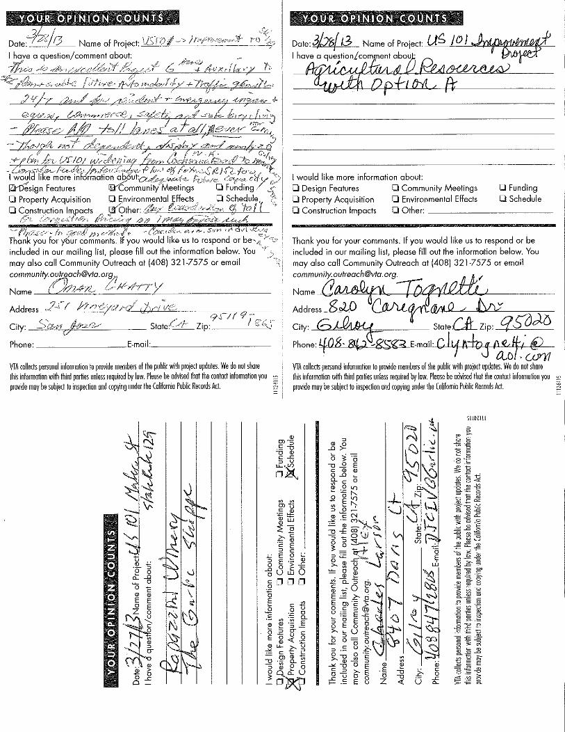
o Fundingo Schedule
'" f'-1,--rS~"'/ /t, f}-I c.-'YA01'" - .&)1''';: (i:-(,::-'" ad r..1. SI} V11 vt q \/1
Thank you for comments. If you would like us to respond or be".!j,
included in our moiling list, please fill out the information below. Youmay also call Community Outreach at (408) 321-7575 or [email protected];;
Name (~.i'A'·lZ., t> )1"4'7''1YAddress 2[r j-;- /)-GY;7"./ , lV--Ive
! ,", 9~ / r 9 -~ . _City: SQYJ/I -lif,.,kV State:C>l Zip: I t; 1",1oPhone: E-mail: _
VIA collects personal informanon to provide memhe" of the public with project updates. We do not sharethis information with third porties unless required by law. Please be advised that the cont"t information youprovide may he subject to inspecnan and copying under the (alifamia Puhlic Records Art. '"
Date3br413 Name of Project U~ !O)~~I have a que;tion.l.co~nt abo~ ~ I
=~~~~
I would like more information about:
o Design Features 0 Community Meetingso Property Acquisition 0 Environmental Effectso Construction Impacts 0 Other: _
Thank you for your comments. If you would like us to respond or be
included in our mailing list, please fill out the information below. Youmay also coil Community Outreach at (408) 321-7575 or emoil
[email protected]',.!JJ/
Name (J~ --ro1!-"--fV<(!::LL<":u.lI.A..-I~-Address g.w C(JA( ern M Q ./ t"--"JL;:~v-----=~City Gd!AlH.-! StateCflZip q.!:OJ-{)Phone: L{-Q8. 8\4;J~'l::< E-mail:-v-U4-A-LV-lf-J-L''"'-4--1----1~-
CLo 'UJYYlVIA collect pe"onal ioformation to provide memhers of the public with project updates. We do not shorethis informanan with third pornes unless required by law. Please be advised that the cont"t information youprovide may he suhject to inspection and copying under the (alifamia Puhlic Records Act. ~
i:Jo 0a:-go c
ID IDE Eo E
~2 E;0.£0_
51 lIHl II
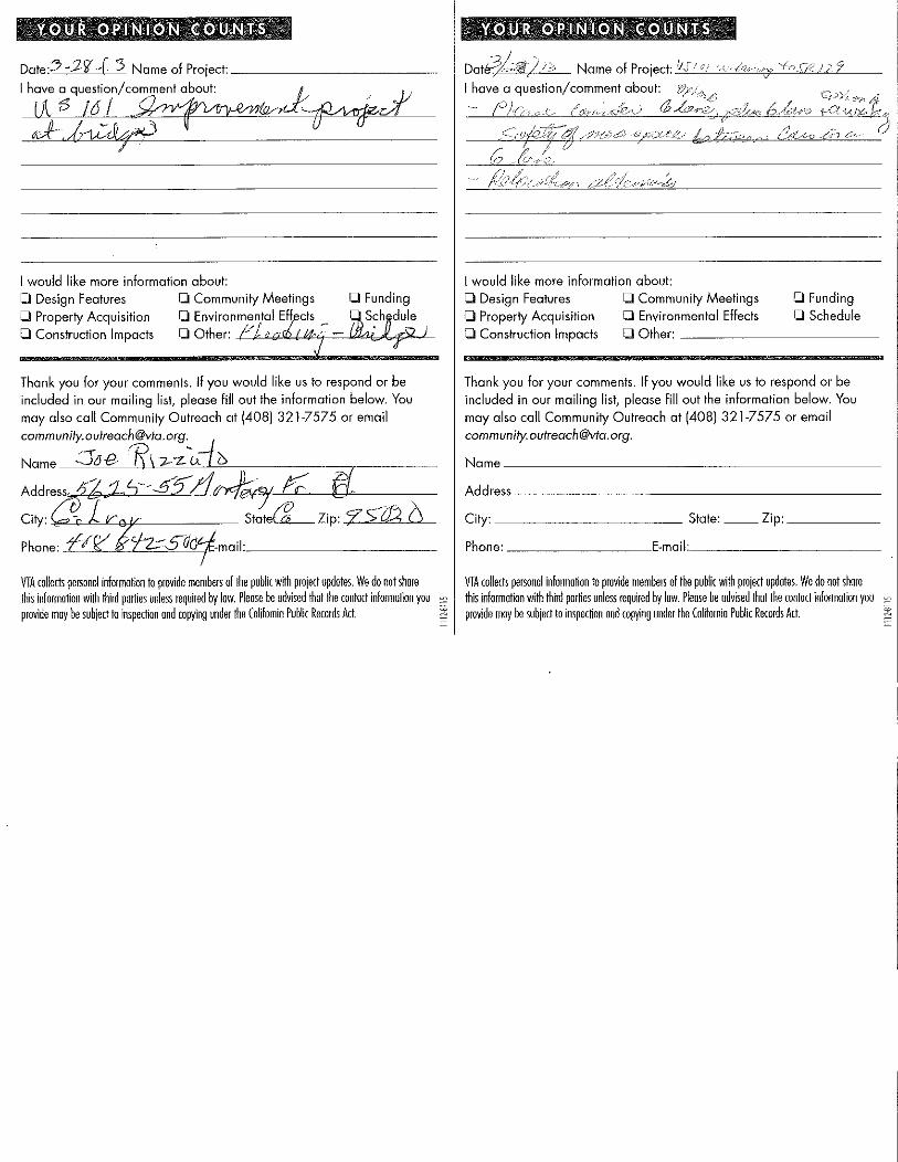
Q Fundingo Schedule
Date:5.J.){J( :> Name af Project: _
I have a qUestion/co.)(7::=t~~ O~M. ~. J ,1/[!Bl6}~~Jj~p
I would like more information about:o Design Features Q Community MeetingsQ Property Acquisition Q Environmental Eff cts
Q Canstructian Impacts 0 Other: -I--/~=""-,,,","T=-""""'A.'P~'-
Name of Prol'sd: Ii,:/ 0/ ~>u(!) rI,:? ''/oS./2,)29v
I have.o question/comment about: VI;"":..,,, C} "-
f) //';>1-,,,(', (0::>,/";.",,::;:1:"::..,,,") a h~:~;\ .'1'< ..tAO t, tf t' ",' -r;~;;~ it ~.? (, J
-'/::2 .~,p:,,</C(:> k{,) t~'-'-,>-C"_'-' C/lA9 _e:-;~} 0'- 0
I would like more information about:o Design Features 0 Community MeetingsQ Property Acquisition Q Environmental EffectsQ Construction Impacts Q Other: _
Thank you for your comments. If you would like us to respond or beincluded in our mailing list, please fill out the information below. Youmay also call Community Outreach at (408)321-7575 or [email protected].
Name _
Address _
City: State: __ Zip: _
Phone: E-mail: _
VIA collects personal informo~on to provide members of the puhlic with project updotes. We do not shorethis informotion with third porlies unless required by low. Ploose be ndvised that the contact information youprovide may be subject to inspec~on and copying under the California Puhlic Records Act. '"
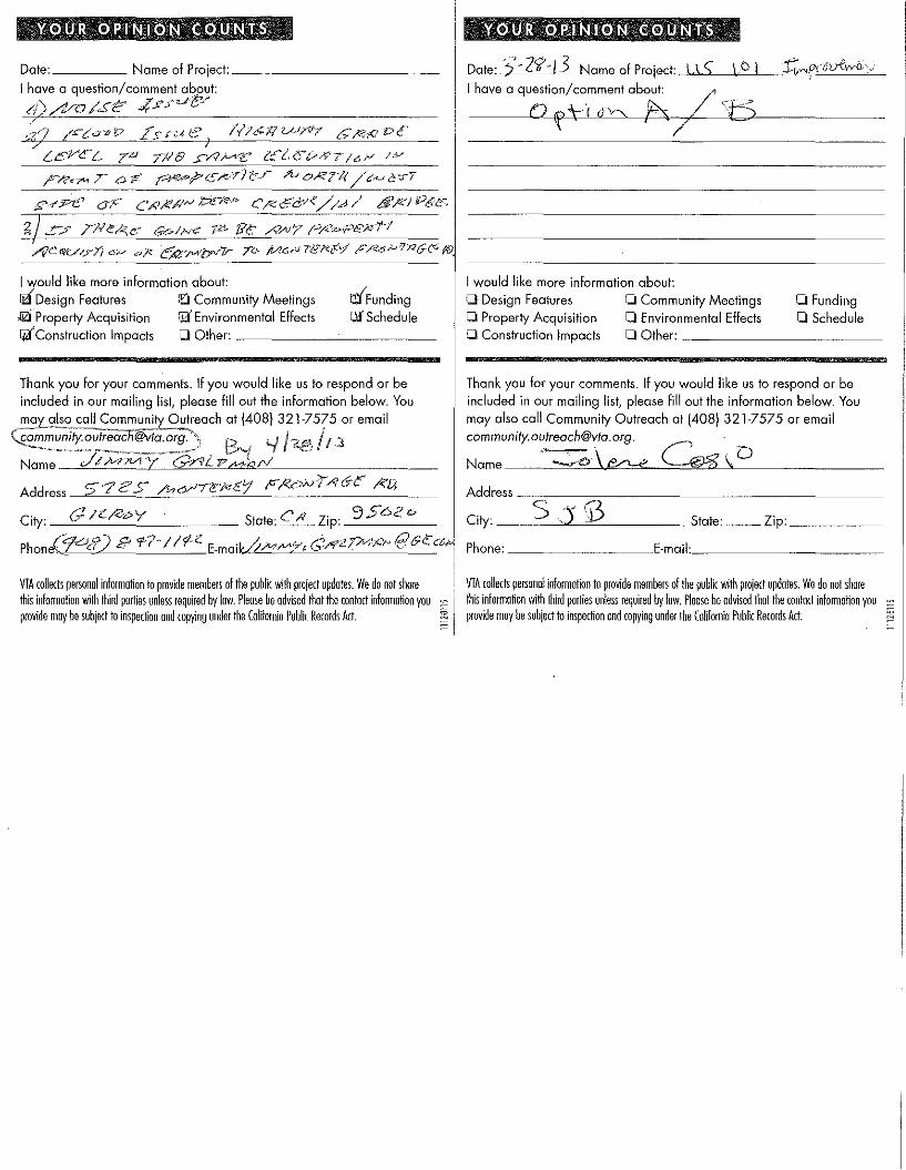
Date: Name of Project: _
I have a question/comment about:
d),/VV /Stf: .,fS,Fue:r
,t-Cl/ct- 7'" 7J18 £/.?Jv'v?: e:'ZCt/-'?{16~ /P
§'--'Fe oJ'" C Ai)!!/IN l:?£1~P C /<e 6':&8://.d / 0'/41 Pi'ft3'
;: :'" 7/-1<:/.<,<::: Go/H<' T6 IN; A'AI/" /;''/<='1'',;;-",r-1
r.:6undingllf Schedule
o Fundingo Schedule
I would like more information about:
IiDesign Features ttl Community Meetings;qzfProperty Acquisition Iil'Environmental EffectsI4tConstruction Impacts 0 Other: -'-- ~__
Thank you for your comments_ If you would like us to respond or beincluded in our mailing list, please fill out the information below, Youm"Y als~ coli Community Outreach at (408) 321-7575 or email
~!:!~~::~~~fi@::~~~~~f) B~I '-IName J/ />-nvr y GrvL 'P",,,,,,,r/
Address 5'72'S /,,,<;Y'Ti!:'i'<rl'1 F I<cW'r'/f de I<'Lj
City: Glc;e,py State:C,Q Zip: 9562<>
Phone(j1oP) 8' '1-7-//'1"- E-maikP"",MY, CrY";?""""!" @G~<4!
I would like more information about:o Design Features 0 Community Meetingso Property Acquisition 0 Environmental Effectso Construction Impacts 0 Other: _
Thank you for your comments. If you would like us to respond or be
included in our mailing list, please fill out the information below, Youmay also call Community Outreach at 14081 321-7575 or emailcommunity.oufreach@vfa,org.
Name -~\ f0--e G-g \,DAddress _=__-= _
City: _---'5"-_,"":)"-'""0'::.- State: __ Zip: _
Phone: E-mail: _
VIA collects pe"o,,1 information to provide members of the public with projea updotes_ We do not shorethis information with third porties unless required by low, Please be advised that the contoct information youprovide may be subject to inspecnon and copying under the California Public Records Act
VTA collects personal informotion to provide members of the public with projecl updates, We do not shore~ I iliis informonon with iliird pornes unless required by low_ Please be advised that the contact informanon you-_ provide may be subject to inspection and copying under the Califamia Public Records Act, ~

Appendix G
PublicHearing
Transcript

VALLEY TRANSPORTATION AUTHORITY
PUBLIC MEETING
U.S. 101 IMPROVEMENT PROJECT
BETWEEN MONTEREY STREET
AND STATE ROUTE 129
REPORTER'S TRANSCRIPT OF PUBLIC COMMENTS
Date:
Time:
Thursday, March 28, 2013
6:36 p.m.
Location: GILROY PUBLIC LIBRARY350 West Sixth StreetGilroy, CA 95020
Reported By: Noelia Espinola, CSRLicense Number #8060
#44852
1
2
3
4
5
6
7
8
9
10
11
12
13
14
15
16
17
18
19
20
21
22
23
24
25
REPORTER'S TRANSCRIPT OF PUBLIC COMMENTS2
A P P E A R A N C E S
Facilitator: CHERYL PHELPS
The Reporter: ADVANTAGE REPORTING SERVICESBY: NOELIA ESPINOLA,
CSR #80601083 Lincoln AvenueSan Jose, CA 95125(408) 920-0222
--o0o--

1
2
3
4
5
6
7
8
9
10
11
12
13
14
15
16
17
18
19
20
21
22
23
24
25
REPORTER'S TRANSCRIPT OF PUBLIC COMMENTS3
MS. PHELPS: Okay. So now we've learned more
about the project.
I've got one card, which I don't know, who's
got more comments. Does anybody else -- the gentleman
over in the aisle is getting ready to make a comment,
perhaps. What about anybody else? Any -- any other
comments tonight? Kathleen, the lady right here in the
pink. She said she's got a card too.
Okay. All right. So what I'd like for you
to do is that -- Kathleen here is going to be helping
us tonight with the timer. She's got it on her iPad.
You'll have three minutes to speak. And here's
Kathleen right here on the side, with the iPad. She'll
set it. We'll give you three minutes, and then it will
beep when the three minutes are up so you'll know it's
time for you to give the floor over to the next person.
So let's see. First I'd like to call Omar
Chatty. And if you would state your name for the
record. We have the court reporter right here, and she
will record your name and stuff.
MR. CHATTY: Okay. My name is Omar Chatty,
and I've been active in transportation in Santa Clara
Valley for well over 30 years.
Fighting for Highway 152 approvement that
happened 30 years ago, saved a lot of lives. And
1
2
3
4
5
6
7
8
9
10
11
12
13
14
15
16
17
18
19
20
21
22
23
24
25
REPORTER'S TRANSCRIPT OF PUBLIC COMMENTS4
hoping to get the rest of 152 finished without tolls.
So this is extra presentation. This is the
way -- this is the hallmark of VTA. Once this is
approved, I hope to take this on the road, to the
highway engineers and other transportation planners
around the country. This is the model, especially your
environmental sensitivity and your concern about the
neighbors and the businesses. So I just want to give
you that kudos.
This project plan is for future -- future
auto mobility. It's -- I do want to consider the
impacts on 156, 125, 152 and 129 in the future. What
happens is when you widen the road, there is some
impacts down the road. 156 is already -- and it is
already dangerous for the capacity. So be careful. We
may need to widen that.
I don't know if it's a legal issue with
respect to VTA money being spent in San Diego County.
That may need to be addressed to avoid a lawsuit.
Again, no tolls on this. This is pure --
what engineers do. This is the way California used to
be, for those old enough to remember, when we built
freeways. But now we do go for the aesthetic and
environmental sensitivity. I really appreciate the
animal concern. I know some people think that's funny,

1
2
3
4
5
6
7
8
9
10
11
12
13
14
15
16
17
18
19
20
21
22
23
24
25
REPORTER'S TRANSCRIPT OF PUBLIC COMMENTS5
but it's not. Because, as indicated, people die
because they hit deer or they hit small animals or try
to avoid them.
So I also hope you consider sun in the
driver's eye. I notice there is really bad accidents
down by the rocks where the sun -- people coming in
from Prunedale. I don't know if that's going to affect
here, but if there's any kind of mitigation that may be
necessary.
Let's see. So, again, thank you for not
being political in this. It's not a bus rapid transit.
It's not a road diet. It's really to do something.
But it does seem to also meet the SB 375 requirement
not to produce more vehicle miles traveled because we
now have to reduce it, based on our beloved
legislature.
I would also ask you to consider berms with
vegetation. Some kind of solid vegetation instead of
sound walls where you have to do that. You may have
already done that. I don't know. But berms are good
as long as you don't destroy the view, because then you
get into significant impacts.
So -- so, anyway, this is just great. This
is what -- this is really what VTA is about when you
guys really are responding to the public need, both

1
2
3
4
5
6
7
8
9
10
11
12
13
14
15
16
17
18
19
20
21
22
23
24
25
REPORTER'S TRANSCRIPT OF PUBLIC COMMENTS6
locally and regionally. And I just -- I just really,
really, really thank you, and I wish VTA would do more
of it. Especially further up in the county.
Thank you.
MS. PHELPS: Thank you. Next I'd like to
call Carolyn Tognetti.
MS. TOGNETTI: Carol Tognetti. I live in
Gilroy. We own Garlic World. I don't live out there,
but we have a business that is going to be affected
with the frontage road. We won't be taken.
But my concern is actually for agriculture
and looking at the two options. Especially on
Option A, which takes more of the farmland. I think my
question -- it's kind more of a question -- it's
comment and a question. But wondering, on the farmland
that is not taken and that is left that is to the
south, I guess it is, of where the road will be, will
there be access for that? Because if it's not, it's
gone as well. It won't be able to be farmed. So I
don't know if there's consideration for that, but I
hope there is. So that at least that isn't affected by
the road crossing through and then nobody can get to it
with tractors and all of those things.
And the other comment I have is just -- you
just mentioned greenhouse gases, gas emissions. But

1
2
3
4
5
6
7
8
9
10
11
12
13
14
15
16
17
18
19
20
21
22
23
24
25
REPORTER'S TRANSCRIPT OF PUBLIC COMMENTS7
that's a huge factor. So I don't know if you're
complying with the climate change things and all of
that with the State. Anyway, that's a big issue. Glad
to see you're paying attention to the critters and
their connectivity.
And thank you very much.
MS. PHELPS: Thank you.
And one more card. The name is Jimmy
Galtman.
MR. GALTMAN: My name is Jimmy Galtman. I
live on 5725 Monterey Frontage Road. That's right
where the southbound lane heading south on 101 meets.
My concern is noise issues. You know,
they're talking about how they -- okay. So, basically,
it's a noise issue. Right now they talk about how
they've done an environmental impact as far as the
noise. Right now, because there's a truck stop
directly across my property -- you've heard of a Jake
brake? Those trucks heading northbound, heading into
that truck stop, go off -- I don't know how you take
your sound, you know, levels, but it's very noisy.
Plus, on the southbound lanes of 101, just after you go
over the overpass, heading south over the railroad
tracks there, there is something in the highway that
when these big rigs hit it, my front windows rattle.

1
2
3
4
5
6
7
8
9
10
11
12
13
14
15
16
17
18
19
20
21
22
23
24
25
REPORTER'S TRANSCRIPT OF PUBLIC COMMENTS8
So -- you know, it's a big impact to me. So
now you're talking about widening the freeway all the
way down. The traffic -- the flow of traffic is going
to move faster in both directions. You know, you are
improving the flow. We're concerned about that. And
we would like a sound wall through that area. I know
it's probably not cost-effective, but that's our
suggestion.
The other thing has to do with flood control.
In 1986 we were flooded. Basically, when they did the
bypass of 101 around Gilroy, they created a dam. If
you look at the history, 100-year flood, water used to
go under that area there, just about where the bypass
starts, and goes in the east side of the Highway 101 in
Gilroy. Well, in '86 it flooded the southern part of
Gilroy, backed up towards our property, and I got two
inches of water into my home. My neighbor, Joe
Rizzuto, got a lot of water in his house. He's at the
apex. We're concerned that between that area where I
live and the Canadero bridge -- if that is elevated,
you're going to create a dam there and water isn't
going to go.
Even though you have an easement, the
so-called 100-year flood, you know how our climate has
been changing. There is exceptions, and there's a lot
1
2
3
4
5
6
7
8
9
10
11
12
13
14
15
16
17
18
19
20
21
22
23
24
25
REPORTER'S TRANSCRIPT OF PUBLIC COMMENTS9
of them that has been happening recently if you look at
our weather conditions. And the way they built
Gilroy, it's all going to the northwest. They're
covering more ground up there, towards the foothills.
So you're getting more water that is going to that
creek. And if you look at the graphics of that creek,
the way it meanders, it's a disaster in the making.
So you have to consider that part north of
Canadero Creek, that bridge that you're going to
rebuild, and if the grade level will stay where it's
at.
And I guess the other thing -- let's see.
There was one more point we wanted to make. Oh,
easement. Is there going to be an easement on that
frontage road that I live on now? I have a bunch of
pine trees that run across the front of my property,
and essentially they're there for a sound barrier. And
because of the pitch canker, they're dying. I've
already taken out a dozen trees. I put up some
sequoias. I kind of want to know -- they run along
frontage road there -- am I going to be impacted by
that also.
I think that's it. Thank you.
MS. PHELPS: Thank you very much.
I also have a card from Jolene Cosio.
1
2
3
4
5
6
7
8
9
10
11
12
13
14
15
16
17
18
19
20
21
22
23
24
25
REPORTER'S TRANSCRIPT OF PUBLIC COMMENTS10
MS. COSIO: I'm Jolene Cosio. I live in San
Juan Bautista. And we've had a pretty bad experience
there with Caltrans, with 156 eating up a great deal of
farmland in the plan that they have proposed. And I do
not understand why Option A would even be considered
when Option B uses up so much less prime ag land. It
just -- I don't know that much about the plan, but just
looking at it briefly today, it appears that Option B
should be the preferred option. I don't know. Maybe
somebody likes straight lines and that's what so great
about Option A. It doesn't look like a good idea to
me.
And then the other thing I'm just going to
mention: I don't know that driveways on a highway are
as bad a thing as Caltrans and maybe the VTA seems to
think they are. With proper acceleration and
deceleration lanes, I think that you can accommodate
businesses along a highway.
MS. PHELPS: Thank you.
Does anyone else have a comment they would
like to have recorded for the public record? Yes.
Charles Larson.
MR. LARSON: I'm Alex Larson.
MS. PHELPS:
MR. LARSON: My brother Charlie and I both

1
2
3
4
5
6
7
8
9
10
11
12
13
14
15
16
17
18
19
20
21
22
23
24
25
REPORTER'S TRANSCRIPT OF PUBLIC COMMENTS11
own Rapazzini Winery and The Garlic Shoppe. And on the
EIR deal it says that you guys are going to give us
fair market value. My concern is that fair market
value has been diminished because back in 1985 you put
an overpass right in front of us, so you took away 50
percent of our business. And a few years ago you put a
head-on median down the middle of the road so we no
longer had the southbound access. So you took away
another 30 percent of our business -- of our retail
business. So I want to make sure that we're being
compensated for everything that you're taking away from
us, not what you're taking away from us after you've
already piecemealed it and taken away over the years.
Thank you.
MS. PHELPS: Thank you.
So those are all of the comments that we have
tonight. I would like to encourage you -- yes:
MS. PODRASKEY: We have one more.
MS. PHELPS: Oh, one more? Mr. Chatty would
like to come back?
MR. CHATTY: May I use my last 20 seconds?
MS. PHELPS: Yes, you may.
MR. CHATTY: I failed to mention, I'm hoping
the EIR -- I haven't had a chance to look at it -- will
also consider the emergency services. That was vital

1
2
3
4
5
6
7
8
9
10
11
12
13
14
15
16
17
18
19
20
21
22
23
24
25
REPORTER'S TRANSCRIPT OF PUBLIC COMMENTS12
with Highway 85, for emergency vehicles to get back and
forth quickly to fires and other emergencies. And so
with this road, when we have a fire or a flood, either
here or Southern California, you can see the troops of
CDF or Cal Fire vehicles moving up and down. And we
will have another earthquake and fire, so I hope they
consider that as well as the issue of safety of a
six-lane freeway where automobiles have more space
between them. You're less likely to have an accident
as you do with a four-lane. And also the emergency
vehicles to get to an accident in that stretch once
it's widened, how much better that is than today. So I
hope you consider that.
And also, on the relocation issue, I think
that's important. Do you relo- -- and also consider:
Do you relocate businesses near off ramps? There are
other options including lanes.
MS. PHELPS: Thank you.
For anybody else that has a comment, I would
like to encourage you to fill out one of the comment
cards and leave it with us or send something in, e-mail
it like Ann suggested. You can fax it. Please get in
touch with us if you have comments that you would like
to share -- we have another comment?
MS. PODRASKEY: We have one more.

1
2
3
4
5
6
7
8
9
10
11
12
13
14
15
16
17
18
19
20
21
22
23
24
25
REPORTER'S TRANSCRIPT OF PUBLIC COMMENTS13
MS. PHELPS: Okay. Mr. Rizzuto.
MR. RIZZUTO: We've been on this property --
MS. PHELPS: Will you please state your name,
and will you move a little closer.
MR. RIZZUTO: All right. Thank you.
MS. PHELPS: Thank you.
MR. RIZZUTO: I'm Joe Rizzuto. We've been on
5625-5655 Monterey Frontage Road. We've been there
since 1908. They took 90-some feet the first time and
150 feet the second time. Now what worries me, they're
going to come back and take more now. But I gather
not.
Now, I don't know what they're going to do on
the frontage road. If they raise the Canadero bridge,
it's going to back up and flood us. Because if you
state guys just walk down along the railroad tracks --
they're used to be openings underneath, where it could
flood. That's the way the water always went. But if
they build that bridge up, it's going to back up to us.
Now, Jim, you had water in your house -- what
is it? In '83?
MR. GALTMAN: '86.
MR. RIZZUTO: '86. And it ran two inches
around the bottom vents, below it.
And this is our problem. I don't know what

1
2
3
4
5
6
7
8
9
10
11
12
13
14
15
16
17
18
19
20
21
22
23
24
25
REPORTER'S TRANSCRIPT OF PUBLIC COMMENTS14
they're going to do with the bridge. Are they going to
raise it all the way up in front, where the water can't
get across? I don't know. I don't know if an engineer
can tell us.
MS. PHELPS: They'll be able to tell you
after the meeting. We're just recording your comments
right now.
MR. RIZZUTO: All right. Thank you.
MS. PHELPS: Thank you. So if you have
comments, please let us know.
One thing I meant to ask earlier and I
forgot -- I know someone is here from San Juan
Bautista. But is there anybody else here from San Juan
Bautista? Can you raise your hand if you're from San
Juan Bautista. So a couple more. Two or three people.
What about Hollister?
From Gilroy?
Anybody here from Morgan Hill? No?
Okay. I just was curious to see. I live in
Hollister, so I was curious to see where everybody
lives.
MR. CHATTY: San Jose.
MS. PHELPS: San Jose. Mr. Chatty is from
San Jose. You made the drive.
Well, I would like to thank you all for

1
2
3
4
5
6
7
8
9
10
11
12
13
14
15
16
17
18
19
20
21
22
23
24
25
REPORTER'S TRANSCRIPT OF PUBLIC COMMENTS15
coming and let you know that your participation is
appreciated, and your comments are appreciated and will
be included -- they will be recorded, and they will be
included as part of this document.
And please don't hesitate to stay around and
ask more questions. We'll be here. So if you have any
questions -- especially your questions, Mr. Rizzuto,
that weren't answered -- you can ask those.
And get in touch with us -- we've given you
several different ways to do that -- about -- you can
contact me about just general information or about this
project or anything to do with VTA.
Yes? You have a question?
UNIDENTIFIED SPEAKER: Who are the key
individuals that you can ask right now that know how --
where the project is and what are they addressing like
our concerns? Are there individuals here that we can
talk to specifically?
MS. PHELPS: I think so. There's -- right
here, John. And also Darrell Vice. Margaret
Simmons-Cross. Yeah. So just stick around after the
meeting.
Yes.
UNIDENTIFIED SPEAKER: At what point will
they be choosing the options? That was kind of

1
2
3
4
5
6
7
8
9
10
11
12
13
14
15
16
17
18
19
20
21
22
23
24
25
REPORTER'S TRANSCRIPT OF PUBLIC COMMENTS16
confusing. Because you're commenting, but you're not
sure which option you're really commenting on exactly.
MS. PHELPS: Right. That would be another
question for the people who are here with the name
tags. So I'd like -- can I just direct you in any way
before we end.
Yes?
UNIDENTIFIED SPEAKER: I'm on the VTA
advisory committee --
MS. PHELPS: Yes.
UNIDENTIFIED SPEAKER: -- and I understand
that there is actually no funding for this project at
all and no funding on the horizon. So I am just
wondering -- you know, what more -- you know, you can
add to that -- you know, is there any hope for a
timeline or what funding options are they trying for?
MS. PHELPS: I think Darrell addressed that
when he was at the microphone, and he can probably
address that more --
UNIDENTIFIED SPEAKER: I'm sorry. I came
late.
MS. PHELPS: Oh, yes. That was part -- he
was talking a little bit about that. But we'll all be
around. If you want to address that on the microphone,
it's fine. Or you can just stay around after the

1
2
3
4
5
6
7
8
9
10
11
12
13
14
15
16
17
18
19
20
21
22
23
24
25
REPORTER'S TRANSCRIPT OF PUBLIC COMMENTS17
meeting, and we'll be at the boards.
This is Darrell Vice. He's the project
manager. And he did address that a little bit in his
presentation, so I'm sure he'd be happy to speak with
you.
So thank you again for coming, and please
stay around and ask more questions. And next time we
would like to have you participate as well, when we
have other projects. And thank you -- thanks for your
questions. Thanks for coming.
(Public comments were concluded at 6:54 p.m.)

1
2
3
4
5
6
7
8
9
10
11
12
13
14
15
16
17
18
19
20
21
22
23
24
25
REPORTER'S TRANSCRIPT OF PUBLIC COMMENTS18
STATE OF CALIFORNIA
COUNTY OF SANTA CLARA
I, NOELIA ESPINOLA, Certified Shorthand
Reporter in and for the State of California, do hereby
certify:
That said public comments was taken down by
me in shorthand at the time and place therein named,
and thereafter reduced to computerized transcription
under my direction.
I further certify that I am not interested in
the outcome of this matter.
Date: __________________________, 2013
_________________________________NOELIA ESPINOLACertified Shorthand ReporterLicense No. C-8060