urban granularities—a data structure for cognitively ergonomic route directions
TRANSCRIPT

Urban Granularities – A Data Structure for
Cognitively Ergonomic Route Directions
Alexander Klippela∗, Stefan Hansenb,c, Kai-Florian Richterd, Stephan Wintere
a Department of Geography, GeoVISTA Center, Penn State, PA, USAb CRC Spatial Information, The University of Melbourne, Australia
c LISAsoft, Australiad Transregional Collaborative Research Center SFB/TR 8 Spatial Cognition
Universitat Bremen, Germanye Department of Geomatics, The University of Melbourne, Australia
Abstract
This paper addresses a data structure specification for route di-rections that incorporates essential aspects of cognitive informationprocessing. Specifically, we characterize levels of granularity in routedirections as the result of the hierarchical organization of urban spatialknowledge. We discuss changes of granularity in route directions thatresult from combining elementary route information into higher-orderelements (so called spatial chunking). We provide a framework thatcaptures the pertinent aspects of spatial chunking. The framework isbased on established principles used—from a cognitive perspective—for changing the granularity in route directions. The data structure wespecify based on this framework allows us to bridge the gap betweenresults from behavioral cognitive science studies and requirements ofinformation systems. We discuss the theoretical underpinning of thecore elements of the data structure and provide examples for its appli-cation.
Keywords: route directions, spatial structure, granularity, spatial chunk-ing
1 Introduction
Cognitive processes that abstract from rich environmental information arean essential part of human information processing [6, 14]. This ability en-sures that humans are functioning in their environments. Not astonishingly,
∗Corresponding author: Alexander Klippel. Department of Geography, GeoVISTACenter, Penn State, PA, USA. Email: [email protected]
1
Prefinal draft: to appear inGeoInformatica

the topic has attracted researchers from different fields (providing a char-acterization for all of them would be prohibitive). Our work focuses onurban environments, specifically on how information on routes in such en-vironments can be structured by information systems in ways that reflectand support human cognitive processes, such as following a route, findingone’s way, or acquainting oneself with a city. How urban structures influ-ence cognitive processes and how they can be exploited in communicatingroute information needs to be formally characterized in order to apply theseprinciples in information systems. There is need for a data structure that isable to bridge the gap between high-level cognitive processes and low-leveldata that is available through various databases or online recordings suchas GPS.
A crucial aspect in dealing with spatial information is to successfullycope with different levels of granularity and changes among these levels.This issue will dominate the discussions throughout this paper. Generally,the following approaches to route information can be distinguished: a) thosethat take a complete route as input and optimize route directions for thisparticular route [9, 44, 28]; b) those that optimize the route choice basedon cognitive aspects, for example, to ease the description of the route or toreduce the likelyhood of getting lost [13, 5, 20]; c) those that differentiatebetween parts of the environment that are known to the wayfinder and partsthat are unknown. The idea here is to provide only coarse information forthe known parts (i.e., to abstract from a concrete route and only announce(intermediate) destinations), while being detailed in the unknown parts (i.e.,giving turn-by-turn instructions) there [41, 22, 47, 53, 49, 46].
All of these approaches deal with different levels of granularity in routedirections. The contribution of this paper is therefore twofold: on one hand,our characterization of route knowledge will provide a framework for spec-ifying a data structure for cognitively ergonomic route directions [26], thatis, route directions adapted to the cognitive capacities of human wayfind-ers. The focus is placed on changing the granularity in route directions. Onthe other hand, the presented data structure allows for specifying severalalternatives to reduce the amount of information in route directions. Wewill discuss how the data structure can interact with existing approaches toroute information to determine the most adequate level of granularity withrespect to cognitive ergonomics. One overall goal of our work is to define adata structure that cannot only be used to realize the design of informationsystems but also for exchanging information in mobile client-server archi-tectures. In defining this data structure, we therefore rely on existing openstandards.
The remainder of this paper is structured as follows: To provide somebackground, we start with an excursion into spatial information organiza-tion and a discussion of elements that structure the knowledge of a city inSection 2. We then discuss chunking as a process to change the granularity
2

in route knowledge and present different chunking mechanisms in Section3. This is followed by an introduction to the Urban Knowledge Data Struc-ture (UKDS) in Section 4 that captures these chunking mechanisms. Anexample of how UKDS captures these chunking mechanisms is provided inSection 4.5. Finally, Section 5 discusses different approaches to cognitivelyergonomic route directions in light of the work presented in this paper.
2 A Short Excursion into Spatial Information Or-
ganization
“It is that our knowledge consists of a global theory together witha large number of relatively simple, idealized, grain-dependent,local theories, interrelated by articulation axioms. In a complexsituation, we abstract the crucial features from the environment,determining a granularity, and select the corresponding local the-ory.” [21, p. 435]
The hierarchical organization of spatial information and the ability toflexibly change between different levels of granularity are key characteristicsof the cognitive organization of spatial knowledge [21, 29, 52, 14]. Consider-ing urban environments, hierarchical structures may result from categorizingparts of the environment into units (like districts, see below) or groupingseveral consecutive wayfinding actions, such as turns at intersections [33, 52].Such structuring of spatial information reflects not only cognitive conceptu-alization processes but also the organization of route knowledge in a cogni-tively ergonomic way. From the perspective of information systems design,providing a user with too much detail violates many findings in cognitivescience as discussed such as Clark’s 007 Principle:
“In general, evolved creatures will neither store nor process in-formation in costly ways when they can use the structure of theenvironment and their operations upon it as a convenient stand-in for the information-processing operations concerned. That is,know only as much as you need to know to get the job done.”[6, p. 64]
For built environments, Kevin Lynch [33] introduced a new viewpointto architecture with his pioneering work on imageability. Instead of lookingat cities architecturally, Lynch made an effort to explain cities as they areperceived and structured by their inhabitants. He proposed the conceptof imageability to characterize the way people create mental pictures oftheir environments. Lynch restricted himself to physical, perceptible objects.The key idea of his approach is that the images that are formed consistof a limited number of recurring elements, which may be understood as
3
conceptual spatial primitives. These primitives appear in different formswhich, nevertheless, possess the same inherent properties. They are thebuilding blocks of every image that people employ when they structure theircity environment. Lynch differentiates between five basic elements: paths,edges, districts, nodes, and landmarks.
Structuring route knowledge by taking into account environmental fea-tures can potentially provide a coarser perspective on the required wayfind-ing action than simple turn-by-turn directions [44, 32, 35]. This is eas-ier to cognize and often sufficient for successful wayfinding. Additionally,not only is the amount of information that has to be memorized and un-derstood reduced, but the information additionally is structured in a waythat is easy to perceive, for example, by using salient landmarks and struc-tures (compared to often hard to read street signs) [40]. The importanceof structuring environmental information for route following is pointed outby Allen [2] who discusses the importance of the general knowledge of en-vironmental structures and spatial terminology that a wayfinder possessesand that is activated (or primed) when route directions are remembered orfollowed. Verbal route directions, in this constructivist account of under-standing route directions, are the input for a linearly ordered representationthat in general corresponds to the perceptual experiences of a traveler alonga path (see also [23, 50]).
This is especially the case if the user is familiar with the environment,i.e., when a traveller has experienced a specific environment before [31, 30,7, 41, 51]. In navigation systems, however, the subsumed information shouldstill be made accessible in case a user needs more detailed information (or, asdiscussions on positioning technologies show, the user may want to re-querya new route from her/his new position).1 This may be made possible byzoom-in operations, i.e., by accessing a more detailed level of the hierarchy,or by (mental) inference processes. Such inferences extract information fromthe instruction to determine which action is to be performed in cases wherethis information is not explicitly specified. For example, from turn left at theend of the road information on which action to perform at all intersectionsbefore the road’s end, namely to continue straight can be inferred [36, 48].
Different parts of the route may require different levels of granularity.The approach by Dale and coworkers [8, 9] divides the route into three parts:a detailed beginning, a highly summarized middle part, and a more detailedending (cf. also [22]). A comparable tri-partion can be found in early workon linguistic aspects of route directions by [24, 57]. The rationale behindthis partition is that the origin and the destination of a route are special.The beginning of a route, i.e., getting on the right track starting from the
1This distinction is reflected by differentiating on-line—route directions given while anagent is traveling—and in advance route directions—route directions given prior to theactual travel [16, 44]. A classification of different route direction styles is provided by [27].
4

origin, and the end of a route, i.e., actually getting to your destination whilealready being near it, often involves several frequent changes in movement,while the middle part often requires only a few. In urban environments,typically this involves (1) getting on a main street from your current location,then (2) staying on that street for a considerable part of a route, and finallynavigating through smaller streets of the neighborhood that your destinationis located in. This distinction is also present in the work by Agrawala andStolte [1] who generate route maps with varying scales depending on thefrequency of changes in direction. Similarly in behavioral research, Michonand Denis [37] found that people giving route directions refer more frequentlyto landmarks at the beginning and end of a route than in the middle part.
To achieve this tri-partition, Dale and coworkers employ different meth-ods of segmenting a route: landmarks are used to structure specific routeparts (see also Section 3); paths, primarily based on the road status hi-erarchy identify the middle part; path length and turn typology (e.g., T-intersections) refine this approach [9]. These methods are well suited tostructure routes such that they result in the tri-partition (especially whenrelying on road status hierarchy).
3 Chunking and Segmenting: Processes to Change
the Granularity in Route Knowledge
The basic unit—the primitive—in our approach is a decision point with anassociated action identified as being pertinent by behavioral research [10, 2].A route is a sequence of such decision point / action pairs.
Abstracting from individual decision points leads to higher-order routedirection elements, HORDE [28]. We term this abstraction process spatialchunking [27]. In the context of this article the primary focus is placed onhow the chunking of primitives into larger units (chunks) changes the levelof granularity in route directions and thereby mimics cognitive processes ofabstracting from details to reduce the amount of information necessary tofollow a route. Alternatively, chunking may be employed in cases where partsof the route are unknown or only partially known. This plays a subordinaterole in this paper; however, we will discuss it where appropriate.
In the following section, we will introduce different ways to segment aknown route, i.e., to chunk consecutive decision points into HORDE. Thechunking principles we discuss reflect human conceptualizations of specificspatial situations; their applicability depend on environmental informationthat is available and the route–following actions to be performed. We willstart with an example that will be used throughout the paper to illustratechunking principles and the application of the data structure that we willintroduce in Section 4.
5

12
3 4 5 6
7 8
9
10
11
12
13
14
15
1617
18
19
2021
22
23
24
25
26
Train
Station
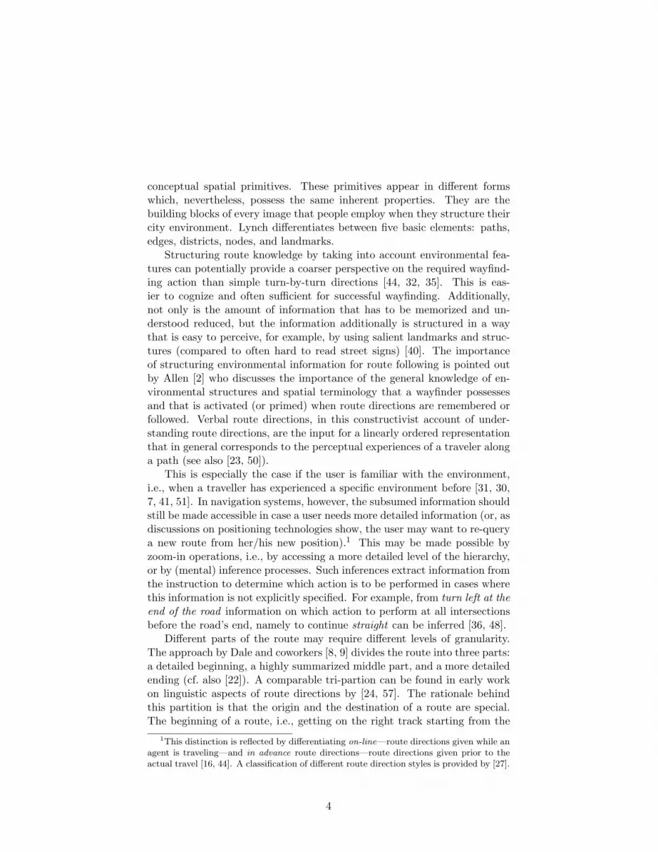
Figure 1: An example route used to illustrate the implemented automaticchunking procedures. The decision points are numbered (1-26). The poten-tial chunks are referred to by the decision points they contain (in the text),for example 4-6: turn right at the landmark.
3.1 An Illustrative Example
Since the aim of this section is to illustrate different ways of segmentingroutes, we chose a deliberately complex artificial example, as shown in Fig-ure 1. In particular, this route provides the possibility of applying alternativestrategies to structuring a route description.
The chosen route can be verbalized by the following directions, whichalready apply several chunking procedures that we will explain in detailbelow. The numbers after each verbalization correspond to the numbering ofeach decision point (and chunked decision points, respectively) as displayedin Figure 1:
• Start (1).
• Turn right at the T-intersection (2).
• Turn left at the next intersection (3).
• Go through the park (4-5) and turn right at the landmark (6).
• Turn twice left (7-8).
6
• Follow the rail tracks until you reach a roundabout. There you takethe first exit (9-12).
• At the next roundabout take the first exit (13-15).
• Turn right at the end of the road (16-17).
• Turn left at the landmark (18-19).
• Turn right at the T-intersection (20).
• At the second roundabout take the third exit (21-25).
• End (26).
As can be seen when tracing these instructions in Figure 1, consecutivedecision points are chunked into a single route instruction in different ways.In the following, we will look at chunking principles more systematically byenriching the example with approaches discussed in the literature; Section3.9 summarizes our findings and places them into a more general frameworkof chunking, i.e. granularity changes.
3.2 Numerical Chunking
Numerical chunking characterizes the chunking of decision points by count-ing them and summarizing them as a single instruction. Mostly, this is basedon nodes in street networks [33].Example: Turn left at the second intersection. (chunk 18-19 Figure 1)Example: Turn twice left. (chunk 7-8)Example: Turn right at the third intersection. (chunk 4-6 Figure 1, as onepossibility)
It is also conceivable to have second order numerical chunks on the basisof salient elements in the environment, such as roundabouts or landmarks(e.g., McDonalds).Example: At the second roundabout take the third exit. (chunk 21-25 Fig-ure 1)
3.3 Chunking Based on Structural Features
Salient structural characteristics of intersections and environmental elementsallow for identifying these locations uniquely with respect to a specific route.Mark [36] discussed this aspect in the context of inferring the navigationalcomplexity of intersections from their structural qualities. Duckham andKulik [13] used his approach to calculate a route with the least descrip-tional complexity. Within the context of a specific route, intersections canbe highly salient features, especially when they enforce a change in the
7

movement pattern or even block it. T-intersections are a dominant exam-ple. Reaching the end of the street, the current movement (going straight)is blocked. Such boundaries are reflected in the physical structures of theroad. Other examples are visually salient areas (districts) or visually salientchannels (see Figure 1).Example: Turn right at the T-intersection. (chunk 16-17 and 20 Figure 1)Example: At the next roundabout (following the train tracks) take the firstexit. (chunk 9-12)Example: Turn right just before the Botanical Garden. (example not presentin Figure 1)Example: Turn right just before the river.
3.4 Local Chunking Based on Point-like Landmarks along
the Route
Landmarks located along the route can be used to chunk specific parts ofa route. Such landmarks are considered point-like if they are located ata specific spot along the route, for example, an intersection, and are onlyfunctionally relevant for this one spot. When using such a landmark, explic-itly mentioning actions to be taken in-between start and end of the chunkis redundant. The principle is the same as discussed for chunking based onstructural features, although the location of a landmark at an intersectionmay need to be further specified, which might be difficult (see [45]).Example: Turn left at the landmark. (e.g., chunk 18-19 Figure 1)Example: Turn right at the Shell gas station.
3.5 Local Chunking Based on Linear Landmarks along the
Route
Linear landmarks are landmarks that spread along the route, such as ariver or railway tracks. They may be functionally relevant for more thanone decision point. Note that a linear landmark is not necessarily linear interms of its geometric characteristics, but in terms of its conceptualizationand its influence on organizing route knowledge. Linear landmarks thatdirectly influence decision points can be used to chunk route knowledge foras long as they are present along the route. Based on classifications foundin the literature [44, 9] we differentiate the following three cases:
• Linear landmarks close to the route. Example: Follow the rail tracks.(chunk 9-12 Figure 1)
• Virtually linear landmarks. Example: Follow the markers.
• The street level hierarchy. Example: Take Princess Highway.
8

In route directions, a wayfinder additionally needs to know until whichpoint a linear landmark can guide the movement pattern, i.e., how long alinear landmark (a landmark that can be referred to as along landmark) isto be followed.Example: Follow the rail tracks until you reach a roundabout. (chunk 9-12Figure 1)Example: Follow the tracks until they end.
3.6 Local Chunking Based on Area-Like Landmarks along
the Route
Area-like landmarks are similar to linear landmarks in that they spreadalong the route and may be functionally relevant for more than one decisionpoint. However, conceptually they have clear area-like characteristics. Wedistinguish two alternatives. In the first, an area-like landmark functions likea linear landmark that is present at consecutive decision points. This meansthat the action to be performed can be determined due to the presence ofan area-like landmark at several decision points. The second alternative ex-plicitly uses the area-like character of the landmark. It requires the travelerto traverse the landmark.Example. Around the park.Example. Go through the park. (chunk 4-5 Figure 1)
3.7 Global Chunking Based on Point-Like Landmarks
A similar situation as mentioned above occurs where a route does not al-ways have to be fully specified. Consider the following case: the landmarksat the end of chunk 13-15 (i.e. decision point 15, where additionally aroundabout is present, see Figure 1) is a well known train station. Whenproviding a route direction such as drive to the train station and from there...., one might have a specific route in mind, but this is not a prerequisite.Recently, several approaches based on, what we term super-chunks, haveemerged [41, 49, 53]. In these approaches, a landmark chunks part of theroute while the route is underspecified. Tomko and Winter [53, 54] aim foridentifying the environmental elements to be referenced in a route directiontask for knowlegdeable wayfinders by analyzing the given hierarchy of spatialinformation. Patel and collaborators [41] combine the analysis of movementpatterns with the possibility of providing personalized information.Example: Go to the train station. (see landmark at decision point 15 Fig-ure 1)
3.8 Global Chunking Based on Area-Like Landmarks
In this case, an area-like landmark covers part of the environment that di-rectly related to the route. An example would be the downtown area of a
9

city [39]: Drive downtown, at the corner ... Area-like landmarks potentiallyallow for chunking large parts of the route without the need of announc-ing intermediate decision points. They may be nested in order to provideinformation on the destination in decreasing levels of granularity [54], orthe wayfinder may need to traverse them somehow finding her own routeto reach the next segment of the way to take [42]. In the former case, thearea-like landmarks function as intermediate places to reach (with decreas-ing granularity and extension) on the way to the destination (see examplesbelow), in the latter they serve as environmental features that can be ex-ploited to guide the wayfinder toward her destination.Example: Get to Manhattan; that is in New York City, New York StateExample: Get {past, around, to the other side of} the park
3.9 Summary: Principles of Chunking
The chunking principles presented above can be summarized as belongingto two main categories. Within these two general categories, further distinc-tions can be made.
1. Part of a route is chunked and the involved decision point / actionpairs are explicit in both the representation of the route and a potentialroute instruction. We can distinguish two cases:
• The number of chunked elements is explicitly referred to (turnright at the second intersection).
• A chunk of turning actions has been assigned a specific namereflecting a specific turning concept (e.g., p-turn or hook turn).Although not explicitly referred to, the individual turning actionsthat are characteristic for these concepts are still inferable.
2. Organization principles that chunk route parts such that individualdecision point / action pairs are no longer identifiable. Here, we canadditionally distinguish whether we assume that wayfinders are on aspecific route and we need to keep them on this route, or if we assumethat wayfinders are able to find their way to the next specified placeon their own. There are several variations:
• The chunk is focused on its end point. This means that thefeature determining the endpoint of a chunk is salient enough tomake the specification of additional decisions between start andend of the chunk superfluous. There are several facets of thistype of chunk. Additionally we distinguish between global andlocal landmarks. This corresponds to the distinction made abovebetween the specification of a specific route (local) and specifying
10

an element on the way to the destination but without requiringa user to reach this element on a specific route (global).
• A landmark allows for structuring parts of a specific route di-rectly, i.e., the landmark is of linear or area-like character. Inthis case a succession of decision points is identifiable due to thepresence of the same landmark. Examples are follow the tracksor through the park (see Figure 1). These landmarks can alsobe only virtually linear. For example, markers along a specificroute, such as signs to the airport, function according to thisprinciple [44].
As our goal is to provide a formal characterization of route knowledgethat allows for communicating information on how to reach a destination(even if a specific route is not known), these general chunking principleshave to be incorporated into a data structure. One aspect important tokeep in mind is that we do not aim at mimicking human route directionsas such; especially, as experiments show that many people give bad routedirections. In contrast, we focus on cognitive structuring principles thatallow for organizing route and environmental knowledge on levels of differentgranularity. This approach has great appeal as we potentially have moreinformation available in spatial databases than people normally have abouttheir environment. At the same time, we can present route informationsuch that it eases human cognitive processing (see Section 2). Some of thediscussed principles are straightforward to implement while others dependon available information, either on individual cognitive processes or on theenvironmental data available.
4 An Urban Knowledge Data Structure
As demonstrated above, chunking is an important and omnipresent principlein organizing spatial knowledge that eases conceptualizing, memorizing, andcommunicating route information. Incorporating chunking into navigationalassistance systems is an important step for the generation of cognitively er-gonomic route directions. On the one hand, this requires algorithms thatsensibly combine elementary wayfinding actions, i.e., chunk according to theprinciples presented in the last section. On the other hand, a data structureis needed that captures the relevant information and enables chunking in thefirst place. We developed such a data structure for turn-by-turn directionsthat we term Urban Knowledge Data Structure (UKDS)2. UKDS is basedon the well established OGC OpenLS standard, which we illustrate in Sec-tion 4.2 after discussing the prerequisites of UKDS. Section 4.3 presents thegeneral architecture of UKDS; in Section 4.4 we outline its implementation.
2The complete specification of this data structure is available as a technical report [18].
11

After discussing UKDS in the light of our example route (see Figure 1) inSection 4.5, Section 5 relates the data structure to chunking approaches inthe literature.
4.1 UKDS Prerequisites
A data structure capturing all information relevant for chunking has severalprerequisites:
• The different kinds of urban structures that may be exploited for spa-tial chunking need to be representable and addressable. Different kindsof landmarks (point-like, linear, area-like), different types of salientintersections (e.g., T-intersections, roundabouts), and the street levelhierarchy need to be present in the data structure (see [19] for moredetails on representing point-like, linear-like, and area-like landmarksin OpenLS).
• Elementary route direction elements need to be represented. Theseneed to capture the necessary attributes and elements to describe therequired actions. For spatial chunking, these elements need to be com-binable, i.e., it is also necessary to offer attributes and elements whichrelate the elements to each other.
• The data structure needs to contain all the information about eachsubsumed element and needs to provide means to access this moredetailed information, i.e., enable switching between granularity levels.
• Computationally, it is desirable to treat higher order route segmentsthe same way as elementary route direction elements. This way, gener-ating second order route direction elements is straightforward becausethe same mechanisms as for first order route direction elements canbe used. Chunks on different levels of granularity can be combinedinto one segment. For example, an elementary route direction can bechunked together with an instruction that already subsumes severalother elementary route directions.
4.2 UKDS and OpenLS
The Urban Knowledge Data Structure is specified as an XML schema. Moreprecisely, we have extended XLS, a XML schema defined in the OpenLSspecification provided by the Open Geospatial Consortium (OGC) [34].OpenLS defines the GeoMobility Server (GMS), an open platform for location–based services and its core services (directory service, gateway service, loca-tion utility service, presentation service, route service). It consists of a setof specifications of interfaces and (XML) schema which define access to thecore services on a server and the abstract data types used in the documents
12

exchanged between server and client. OpenLS primarily specifies the inter-action between client and server (request and response schemas) and theformat in which the transferred data is encoded. The documents defined inthe request are encoded in XLS.
In addition to the five core services, there exists a sixth service, theNavigation Service [4]. It is based on the Route Service, but additionallyprovides the client with all information necessary to generate more elaborateroute directions. It does not transfer pre-generated route directions, butprovides all information needed to generate such directions on the client.This way, clients can adapt the presentation of route information accordingto their abilities without the server needing to know any details about theclient.
The OpenLS data structure used for encoding the data for generatingroute directions basically consists of a sequence of instructions. Each de-scribes the action a wayfinder has to perform at a decision point combinedwith the information about the next route segment. The original data struc-ture used in OpenLS is not able to store all information that is needed inorder to generate cognitively ergonomic route directions. For example, whilethere exists the possibility to integrate landmarks in the instructions, thiscan only be done in a very simple form that is insufficient to capture allpossible functions of landmarks in route directions. As will be further elab-orated in the next section, spatial chunking is also not possible with thebasic OpenLS specification.
4.3 General Architecture of the Data Structure
To enable the usage of chunking in OpenLS according to the principlesdiscussed in Section 3, several changes in the design of the data structure,i.e., the XLS–schema, have to be made. Subsuming a sequence of directionsin one single instruction has to be enabled to allow for spatial chunking.It is also necessary to offer attributes and elements which relate the singleinstructions to each other in order to build up a hierarchy of route directionelements. In the following, we briefly introduce the main concepts usedto realize spatial chunking in XLS. Figure 2 provides an overview on theUKDS-component that enables chunking; Section 4.4 further illustrates thispart and Section 4.5 presents some examples of specifying instructions inUKDS. The data structure is fully documented and specified in a technicalreport available for download [18].3 The schema consists of 1200 lines ofcode, and hence, we refer to that report and abstain from presenting anydetailed code snippets here.
The basic element of the data structure is termed maneuver. It is atuple representing a route segment and the decision point to which the
3http://www.sfbtr8.uni-bremen.de/papers/SFB TR 8 Rep 012-10 2006.pdf
13

Figure 2: UML-diagram of the UKDS-part that enables chunking.
14

route segment is leading. A route, then, is a list of maneuvers; specialmaneuvers are defined for the start and end of a route. Without applyingchunking, a route would consist of a start element providing informationfor the wayfinder’s orientation at the beginning of the route, a maneuverelement for each decision point along the route, and an element providinginformation for identifying the destination of the route. In the remainder ofthis section, we will introduce different chunking methods implemented inUKDS that are used to further structure this basic route representation.
4.4 Implementation of Chunking Principles
In UKDS, a chunk is represented as an element containing a list of thechunked maneuvers. The data type representing chunks is derived from thesame type as the maneuver type, namely from AbstractManeuver (see Fig.2). This allows for combining atomic elements (maneuvers) and higher-order elements (chunks) in any desired way. Also, this way a chunk maysubsume other chunks. Consequently, this results in a hierarchy of chunklevels. Each chunk contains a so–called ChunkingElement, which providesthe information required to identify the extent of the encoded type of chunk.For each of the chunking methods detailed below a specific ChunkingElement
is defined that stores the required information; these types are derived fromAbstractChunkingElementType.
4.4.1 Numerical Chunking
Numerical chunking can be performed in different ways; these differ mainlywith respect to the element that determines the counting. Typically, aturning action denotes the end of a chunk, as in turn left twice or turnright at the third intersection. Additionally, landmarks may be used as in atthe second roundabout, take the third exit or turn right at the second 7/11.Since such elements are conceptually different, for each of these elements aseparate class is defined.
A basic ChunkingElement for numerical chunking contains a counter tohold the number of subsumed elements and the element determining theend of the chunk itself. In some cases, this last element is not required, forexample, when a generic element without specific characteristics, such as aleft turn, is used. Chunking equal turns (e.g., turn left twice) is covered byNumericalChunkingTurnType, instructions such as “turn right at the thirdintersection” by NumericalChunkingStraightType. These differ in that theformer stores the number of equal turns (‘left’ or ‘right’), while the lattercounts the passed intersections until the intersection at which to turn willbe reached (i.e., the number of ‘going straight’ before the turn). Countingroundabouts and landmarks is implemented differently, as is explained next.
15

4.4.2 Structural Features
Structural features play an important role in the cognitively ergonomic de-scription of a route, especially in chunking. If a salient structure is used forchunking, all the subsumed maneuvers must represent going straight. Noother chunks or turns may be part of such chunks. Since this is the case,the subsumed elements need only be represented implicitly: the only infor-mation actually stored is an element representing the structural feature, forexample, a T-intersection. StructureChunkType covers this kind of chunk-ing. A special case, however, are roundabouts, since they can also be usedas elements in numerical chunking. Accordingly, a ChunkingElement spe-cific for roundabouts is derived from the general element used for structuralchunking.
4.4.3 Point-like Landmarks
In chunking based on point-like landmarks, the end of the chunk is de-fined by a point-like landmark; the maneuvers up to this landmark needto represent going straight. This is similar to structural chunking. Hence,PointLMChunkingType stores an element describing the landmark used forchunking. Additionally, a counter stores how many landmarks of the sametype are passed before reaching this landmark—to enable numerical chunk-ing based on landmarks (see above).
4.4.4 Linear Landmarks
A ChunkingElement for the use of linear landmarks contains an elementdescribing the linear landmark (NElementMChunkingType). However, thelinear landmark might not be sufficient to identify the end of the chunk (cf.[44], see Section 3.5). Therefore, an optional ChunkingElement for a point-like landmark is provided. This landmark may be used to indicate the endof the chunk.
Also, the street level hierarchy may be used for this kind of chunkingas discussed in Section 3.5. This is covered by RoadHierarchyChunkType,which stores the name of the current level in the hierarchy and an elementto indicate the end of the chunk.
4.5 Examples of Using UKDS
In the following, we will refer back to the example presented in Section 3.1(see also Figure 1).
4.5.1 Specifying Chunks in UKDS
In the following example, we list a UKDS specification for one of the in-structions used in the example, namely turn right at the T-intersection.
16

The listing is meant to illustrate the basic principles previously described.Space limitations do not allow for explaining every XML-element used inthese specifications. Again, the report containing the complete data struc-ture specification also contains extended examples of its application [18].
Listing 1: UKDS specification of a right turn at a T-intersection.<xls:ChunkedManeuver x s i : t y p e=”xls:XManeuverType” actionType=”Turn” id
=”dp1” direct ionOfTurn=”Right” junctionType=” I n t e r s e c t i o n ”><x l s : Junc t i onCategory x s i : t y p e=” x l s :T In t e r s e c t i onType ”
TurnDirect ion=” r i gh t ”><xls :RouteBranch>
<x l s :Ang l e uom=” degree ”>90</ x l s :Ang l e></ xls :RouteBranch>
<xls:NoRouteBranch>
<x l s :Ang l e uom=” degree ”>270</ x l s :Ang l e></xls:NoRouteBranch>
</ x l s : Junc t i onCategory>
<xls:Landmark x s i : t y p e=”xls:StructureLMType”><x l s :D e s c r i p t i o n x s i : t y p e=”xls:LMDescriptionExampleType ”></
x l s :D e s c r i p t i o n>
<x l s : I n t e r s e c t i o n x s i : t y p e=” x l s :T In t e r s e c t i onType ”TurnDirect ion=” r i gh t ”><xls :RouteBranch>
<x l s :Ang l e uom=” degree ”>90</ x l s :Ang l e></ xls :RouteBranch>
<xls:NoRouteBranch>
<x l s :Ang l e uom=” degree ”>270</ x l s :Ang l e></xls:NoRouteBranch>
</ x l s : I n t e r s e c t i o n>
</xls:Landmark>
<x l s :Prev iousSegment><x l s :D i s t an c e value=”10”></ x l s :D i s t an c e>
<xls :Trave lTime>P1Y2M3DT10H30M12. 3 S</ x l s :Trave lTime></ x l s :Prev iousSegment>
</xls:ChunkedManeuver>
4.5.2 Alternative Chunking Strategies
The example route of Figure 1 allows for employing a great variety of chunk-ing principles. It even offers different alternatives for some of the chunks. Inthe following, we discuss three of these alternatives: the segment that leadsthrough the park (chunk 4-5), the segment along the rail tracks (chunk 9-12), the segment just before the last roundabout (chunk 21-25). Note thatthe UKDS provides chunks in a data structure and is not concerned directlywith their verbalization. We present the chunks here in a verbalized manneronly for readability. Note also that systems using the UKDS need to choosepreferred chunks where alternatives are possible (see Section 5).
Through the Park After the second intersection along the route thetraveler has to follow the road without turning while passing two decisionpoints (4 and 5); at the third decision point, a right turn has to be performed.The two decision points where no turn is required are located within an area-like landmark, a park. The third decision point is identified by a point-like
17

landmark. This constellation offers three major possibilities to build a chunkcovering all three intersections:
• Using the area-like landmark for identifying the last decision pointas well as for reassuring the traveler while passing decision points with-out turning. The resulting verbalized chunk could read:Go straight through the park and turn right after you left the park.
• Using numerical chunking to describe how to follow the chunk.Since the turn is already at the third intersection, it is easy for thetraveler to pick the right decision point for turning by counting theintersections. The resulting verbalized chunk could read:Turn right at the third intersection.
• Using the point-like landmark to determine the end of the chunk.If there is a salient and unambiguously identifiable landmark available,this is always a good option to use. The resulting verbalized chunkcould read:Turn right at the landmark.
Follow the Rail Tracks The rail tracks (chunk 9-12 Figure 1) can beused as linear landmark to chunk part of the route. The only roundabouton this part of the route allows for identifying the end of the chunk; it leadsto a direction that is easy to follow and that bears no decision points wherethe traveler is likely to leave the route. This direction may be verbalized asFollow the rail track until you reach a roundabout. There you take the firstexit.
The characteristics of the linear landmark also allows for building up ahierarchy, with the above suggested direction on the top level. This top levelcould be split into two subsequent directions on the next lower hierarchicallevel: Turn right at the second intersection / at the landmark. Take the firstexit at the roundabout.
The first direction at this layer, turn right, uses a point-like landmark inits alternative form, and the second direction refers to the same roundaboutas the top layer direction. Both directions build chunks over intersectionsthat do not require a turn. Hence, theoretically a third, and lowest hierar-chical level can be provided, which uses single instruction for each decisionpoint instead of chunking them.
At the Last Roundabout A good example of numerical chunking can befound shortly before the route reaches its destination. Before turning the lasttime at a roundabout (chunk 21-25 Figure 1) the traveler passes four otherdecision points without changing direction. While going straight through thefour intersections before the final roundabout, the traveler passes anotherroundabout and a landmark. At the end of the chunk another landmark is
18

located, which is a possible alternative candidate for identifying the end ofthe chunk. Therefore, apart from the second roundabout and the turn thathas to be performed at this roundabout, there are three other elements thatcan be integrated in an instruction. These are:
• The first roundabout, which has to be mentioned; otherwise thesecond roundabout could not be identified unambiguously. It is suffi-cient to talk about a second roundabout.
• The landmark at the third decision point, which can be used inthe instruction describing the chunk to reassure the traveler. Its useis not mandatory.
• The landmark at the fifth decision point—the second round-about—can be used in the same way as the second roundabout itselfto identify the last intersection of the chunk. However, the roundabouthas to be mentioned since it is required to describe the turn directionproperly. Mentioning the roundabout is already a strong element toidentify the decision point for the next turn. Therefore, mentioningthe landmark is optional.
Thus, possible instructions are: At the second roundabout, take the thirdexit, Take the third exit at the second roundabout, after you passed a land-mark, or Take the third exit at the roundabout where the landmark is.
5 Integrating Chunking into Automatic Genera-
tion of Route Directions
The goal of this paper is to define a data structure that is as flexible as pos-sible in incorporating a plethora of different chunking alternatives employedby natural cognitive agents. Therefore, we defined a conceptual frameworkof granularities of urban knowledge as a guideline for the proposed UKDS. Inthe previous sections we have detailed this data structure for hierarchicallyorganizing urban knowledge to be employed in route directions.
In this section, we connect the UKDS to existing approaches that imple-ment different chunking principles. We will especially focus on the wayfind-ing choreme theory [28] and context-specific route directions [44], as a pos-sibility to define the best possible level of granularity for a specific route.
5.1 Theory of Wayfinding Choremes
The wayfinding choreme theory addresses the conceptualization and formalmodeling of route knowledge [28]. Comparable to the primitive (in thesense of being foundational, not atomic) in the UKDS, i.e. the maneuver,the wayfinding choreme theory builds on cognitive conceptual primitives
19

that structure route knowledge for wayfinding and route directions. Thisapproach is inspired by the toolbox idea for route directions introduced byTversky and Lee [56, 55]. The term wayfinding choreme is derived fromthe work of the French geographer Brunet [3] who proposed a limited setof abstract models for structuring geographic phenomena; these models aretermed choremes. The term is a made up word combining the root of theGreek expression for space, chor, and the linguistic suffix, -eme.
From the literature on route directions and wayfinding [11, 32] we knowthat decision points, whether with or without a direction change, are thepertinent part of route knowledge. Taking up the theme from the beginningof the article, we can observe from the way in which humans employ di-rectional knowledge that we do not conceptualize every potential directionthat our bodies could turn to. That is, we do not consider infinitely precisedirectional information. For most situations, qualitative information aboutdirections is sufficient—in the sense of a fairly small number of equivalenceclasses. We were able to show that the prototypical number for directionsused at decision points is seven [25].4 The wayfinding choreme theory buildson this set of conceptual primitives which could be linguistically character-ized as: left, right, and straight, and can be rendered more precise into sharpleft, sharp right, bear left and bear right. In a more formal notation we canwrite this as: wcl, wcr, wcs and wcsl, wcsr, wcbl, wcbr, respectively. Theseseven basic wayfinding choremes can be annotated further to capture aspectsof the environment, such as landmarks (turn left at the landmark, wcl
l) orsalient intersections (turn right at the T-intersection, wct
r). The route repre-sented in Figure 1 would be characterized as follows in wayfinding choremenotation.
wctrwclwsa
swsaswcl
rwclwclwclswcbr
lwclswcr
l wcswcswcrl wcswct
r
wcswcllwct
rwcswcrswcswcswcr
r
To formally handle transitions between different levels of granularitytwo concepts can be applied. First, the grouping of primitive elements intochunks, or higher order route direction elements (HORDE), is characterizedas the wayfinding choreme route grammar (WCRG) [28], which is formallydefined as a tuple (N, T, P, S). N is a finite set of nonterminal symbols,T is a finite set of terminal symbols (disjoint from N), P is a finite setof production rules, and S is the start symbol. The grammar allows thespecification of possible groupings of wayfinding choremes . These groupingscan be local route parts, such as turn right at the second intersection, or theycan be globally specified to chunk known parts of the route (see Srinivas and
4This observation holds for most intersections. Special cases such as highway exits orroundabouts where directions can be given in form or ordering information, e.g., third exit
require an extension
20
Hirtle [49] for a detailed description on how wayfinding choremes can be usedto model a wayfinder’s familiarity and the change in levels of granularityaccompanied with different degrees of familiarity).
Second, to actually process a route into specific route parts, term rewrit-ing rules can be applied [12]. This technique processes a route-string that isdefined using the formal grammar and identifies those parts of a route firstthat are deemed most important. For example, T-intersections are gener-ally thought of as valuable means to change the level of granularity. Hence,those route parts that are terminated by a T-intersection will be looked forfirst. Practically this means that the rule for identifying a T-intersectionwill be executed first. The wayfinding choremes that are chunked by thisprocedure are not available for further chunking. The resulting chunk, how-ever, can be part of even coarser levels of granularity, i.e. part of anotherchunk. For example, along the given route two roundabouts are encounteredwith a straight at the first roundabout (see Figure 1, decision point 22) anda right turn at the second roundabout (see Figure 1, decision point 25).Roundabouts are salient features along a route and classify as structuralfeatures usable as landmarks. A first iteration would identify two distinctchunks in the route: straight at the first roundabout and right at the secondroundabout. A second iteration applying further rules would, however, iden-tify these two consecutive chunks and group them to an even coarser chunk:right at the second roundabout.
In the notation of term rewriting rules this procedure can be specifiedas follows (this example is simplified, for more details see [28]). The termrewriting rule for the first roundabout asserts that all decision points of thetype straight, i.e., wcs, that precede a decision point that is a roundabout,in this case wcr
s, are transfered (rewritten) into a chunk, ras, a roundaboutwhere the performed action is to go straight. Assume here that the numberof wcs is not restricted (i.e., n ∈ N ).
(nwcs)wcrs −→ ras (1)
The second roundabout would serve the same purpose as a landmark andall decision points with a straight movement pattern, wcs, are subsumed intoa new chunk:
(nwcs)wcrr −→ rar (2)
A third term rewriting rule would then be employed to further coarsenthe granularity. In this example, the already existing chunks that werecreated on the basis of the roundabouts can be rewritten into an even coarserchunk, which can be verbalized as turn right at the second roundabout.
rasrar −→ ra2r (3)
21

This is only a short demonstration of how the wayfinding choreme the-ory can be employed to change the granularity of route information basedon findings from behavioral studies on how cognitive agents structure routeknowledge. The interesting aspect in the context of the present article isthat a wayfinding choreme corresponds to the AbstractManeuver in theUKDS. While wayfinding choremes allow for modeling route knowledge con-ceptually, UKDS handles the technical requirements for current navigationservices.
5.2 Context-Specific Route Directions
Richter and Klippel [44] introduced a computational process for generatingroute directions. The process is termed Guard, which stands for Generationof Unambiguous, Adapted Route Directions [43]. This reflects that the pro-cess generates directions that unambiguously identify each route–segmentand that adapt to a route’s properties and environmental characteristics,i.e., to the given environmental context. Accordingly, the route directionsgenerated by Guard are termed context-specific route directions.
The process integrates different environmental features, such as rivers(linear landmarks), salient buildings (point-like landmarks), and T-intersections(structural features), as referable elements in route directions. Generationof route directions is realized as an optimization process. The result ofan optimization clearly depends on the applied optimization criterion: inroute directions, a straightforward choice is to reduce the number of in-structions necessary to guide an agent from an origin to a destination. Thisapproach is in congruence with several theoretical frameworks in cognitivescience (e.g., the 007 principle [6], or the cognitive load theory [38, 17]).Further optimization strategies are conceivable, which could be induced byindividual characteristics of a wayfinder (e.g., his familiarity with the envi-ronment [41, 47]), or by the wayfinder’s mode of travel (e.g., a cyclist or apedestrian).
The basic elements in Guard are pairs of decision points and actions.This idea is related to the wayfinding choreme theory discussed previously.It is important to note that pairing decision points with actions is similarto the approach of defining basic actions as maneuvers. Thus, it is possibleto employ the presented data structure to incorporate a plethora of chunk-ing principles in Guard. Since Guard allows for the implementation ofdifferent optimization strategies, this can be used to, for example, adaptinstructions to the familiarity of a wayfinder with an environment (cf. also[46]).
22

5.3 Combining Optimization and Data Structure
The proposed data structure provides all the information needed for chunk-ing; in addition, it is structured such that it well supports the implementa-tion of chunking algorithms working on it. These chunks may be multi-level,i.e., as explained in Section 4.1 we can generate higher-level route directionelements by combining already chunked route information into new chunks.
The data structure also in a straightforward manner supports generat-ing route directions based on optimization (as in Guard). The proposedoptimization criterion of reducing the number of instructions corresponds togenerating directions with as few chunks as possible. Accordingly, based onthe data represented in UKDS, in generating route directions those chunksare preferred that cover a significant part of the route (cf. [44]). It is alsopossible to use other optimization criteria. For example, aiming for direc-tions that guide a wayfinder along a sequence of point-like landmarks (as itis done in the landmark-spider approach [5]) may be realized by preferringchunks based on point-like landmarks along a route over chunks employingother principles.
6 Conclusions and Outlook
The aim of this article is to lay the foundation for a data structure thata) allows for specifying cognitively ergonomic route directions, b) is basedon existing data standards, and c) links in with approaches to calculateroutes or generate route directions. To achieve this aim, a framework hasbeen offered for a data structure that explicitly allows for incorporating ur-ban knowledge in a similar way as a cognitive agent would apply it. Welimited the scope of this article to two fundamental aspects of cognitivespatial information processing: the creation of hierarchical knowledge struc-tures and the ability to operate and use different levels of granularity. Acentral aspect of this approach is the assumption, discussed by Allen [2] asa constructivist approach to route directions, that the input information isintegrated into existing knowledge structures to specify a situation model.These knowledge structures are the result of continuous interaction with theenvironment and the abstraction from individual instances to general spa-tial knowledge structuring principles. We briefly discussed one of the earliesttaxonomies of these structures, the elements of Lynch [33]. Based on thisinitial taxonomy, we developed a detailed specification for the most perti-nent structuring principles. The goal is to create a framework that providesflexibility with respect to the level of granularity with which informationnecessary for the generation of route directions can be specified. The datastructure, termed UKDS, is inspired by the OpenLS data standard and ex-tends and complements the main data types that are used in in this datastandard. The close relation to this existing data standard allows for a wide
23

application of this work and will help to solve interoperability problems.The data types of the OpenLS specification have the additional advantagethat they correspond to other existing formal approaches that allow for spec-ifying which route parts are actually used in giving route directions. Thiscombination is fruitful as it covers the two main aspects necessary for cog-nitively ergonomic route directions: specifying data in an easy to use butcomprehensive framework and applying algorithms to tailor route directionsto specific situations (including personal preferences).
This work features in several current research efforts and, in more generalterms, is a springboard for elaborating various aspects of specifications thatcapture the cognitive processing of spatial information in built environmentsrelevant for the specification of an agent’s movements [15]. These researchefforts add to filling the data structure with environmental information thatcan be used for creating cognitively ergonomic route directions relying onenvironmentally salient structures.
Acknowledgements
This work has been supported by the Transregional Collaborative ResearchCenter SFB/TR 8 Spatial Cognition, which is funded by the DeutscheForschungsgemeinschaft (DFG), by the Cooperative Research Centre forSpatial Information, whose activities are funded by the Australian Com-monwealth’s Cooperative Research Centres Programme, and by Lisasoft,Australia. OpenLS is a trademark of the Open Geospatial Consortium.
References
[1] M. Agrawala and C. Stolte. Rendering effective route maps: Improvingusability through generalization. In SIGGRAPH 2001, Los Angeles,California, USA, 2001.
[2] G.L. Allen. Principles and practices for communicating route knowl-edge. Applied Cognitive Psychology, 14(4):333–359, 2000.
[3] R. Brunet. La carte, mode d’emploi. Fayard–Reclus, Paris, 1987.
[4] T. Bychowski. OpenGIS location services (OpenLS): Part 6 – naviga-tion service. Technical report, Open GIS Consortium Inc., 2003. OGCImplementation Specification 03-007r1 (Version 0.5.0).
[5] D. Caduff and S. Timpf. The landmark spider: Representing land-mark knowledge for wayfinding tasks. In T. Barkowsky, C. Freksa,M. Hegarty, and R. Lowe, editors, Reasoning with mental and exter-nal diagrams: computational modeling and spatial assistance - Papers
24

from the 2005 AAAI Spring Symposium, pages 30–35, Menlo Park, CA,2005.
[6] A. Clark. Microcognition: Philosophy, Cognitive Science, and ParallelDistributed Processing. MIT Press, Cambridge, MA, 1989.
[7] E. H. Cornell, C. D. Heth, and D. M. Alberts. Place recognition andwayfinding by children and adults. Memory and Cognition, 22:633–643,1994.
[8] R. Dale, S. Geldof, and J.-P. Prost. Coral: Using natural lan-guage generation for navigational assistance. In M. Oudshoorn, edi-tor, Proceedings of the 26th Australasian Computer Science Conference(ACSC2003), Adelaide, Australia, 2003.
[9] R. Dale, S. Geldof, and J.-P. Prost. Using natural language generationin automatic route description. Journal of Research and Practice inInformation Technology, 37(1):89–105, 2005.
[10] M. P. Daniel and M. Denis. Spatial descriptions as navigational aids: Acognitive analysis of route directions. Kognitionswissenschaft, 7(1):45–52, 1998.
[11] M. Denis. The description of routes: A cognitive approach to the pro-duction of spatial discourse. Cahiers de Psychologie Cognitive, 16:409–458, 1997.
[12] N. Dershowitz. A taste of rewrite systems. In P. E. Layer, editor, Func-tional Programming, Concurrency, Simulation and Automated Reason-ing: International Lecture Series 1991-1992, pages 199–228. Springer,Berlin, 1993.
[13] M. Duckham and L. Kulik. ”Simplest” paths: Automated route se-lection for navigation. In W. Kuhn, M. Worboys, and S. Timpf, edi-tors, Spatial Information Theory. Foundations of Geographic Informa-tion Science, pages 169–185. Springer, Berlin, 2003. LNCS 2825.
[14] C. Freksa and T. Barkowsky. On the relation between spatial conceptsand geographic objects. In P. Burrough and A. U. Frank, editors, Geo-graphic Objects with Indeterminate Boundaries, pages 109–121. Taylor& Francis, London, 1996.
[15] A. Furlan, T. Baldwin, and A. Klippel. Landmark classificationfor route description generation. In Proceedings of the Fourth ACL-SIGSEM Workshop on Prepositions, Prague, Czech Republic, pages 9–16, 2007.
25

[16] C. Habel. Incremental generation of multimodal route instructions. InNatural Language Generation in Spoken and Written Dialogue, PaloAlto, CA, 2003. AAAI Spring Symposium 2003.
[17] G. S. Halford, W. H. Wilson, and S. Phillips. Processing capacitydefined by relational complexity: Implications for comparative, devel-opmental, and cognitive psychology. Behavioral and Brain Sciences,21(6):803–865, 1998.
[18] S. Hansen, A. Klippel, and K.-F. Richter. Cognitive OpenLS specifi-cation. Technical report 012-10/2006, SFB/TR 8 Spatial Cognition,Universitat Bremen, 2006.
[19] S. Hansen, K.-F. Richter, and A. Klippel. Landmarks in OpenLS — adata structure for cognitive ergonomic route directions. In M. Raubal,H. Miller, A. U. Frank, and M. F. Goodchild, editors, Geographic In-formation Science - Fourth International Conference, GIScience 2006,LNCS 4197, pages 128–144, Berlin, 2006. Springer.
[20] S. Haque, L. Kulik, and A. Klippel. Algorithms for reliable navigationand wayfinding. In T. Barkowsky, M. Knauff, G. Ligozat, and D.R.Montello, editors, Spatial Cognition V - Reasoning, Action, Interaction,LNAI 4387. Springer, Berlin, to appear.
[21] J. R. Hobbs. Granularity. In A.K. Joshi, editor, Proceedings of 9thInternational Joint Conference on Artificial Intelligence, pages 432–435. Morgan Kaufmann, San Francisco, 1985.
[22] K. Hook. An Approach to a Route Guidance Interface. Licentiate thesis,Dept. of Computer and System Sciences, Stockholm University, 1991.
[23] P. N. Johnson-Laird. Mental models. Harvard University Press, Cam-bridge, MA, 1983.
[24] W. Klein. Wegauskuenfte. Zeitschrift fur Literaturwissenschaft undLinguistik, 33:9–57, 1979.
[25] A. Klippel and D. R. Montello. Linguistic and nonlinguistic turn di-rection concepts. In Stephan Winter, B. Kuipers, M. Duckham, andL. Kulik, editors, Spatial Information Theory: 9th International Con-ference, COSIT 2007, Melbourne, Australia, September 19–23, 2007Proceedings, pages 354–372. Springer, Berlin, 2007.
[26] A. Klippel, K.-F. Richter, and S. Hansen. Cognitively ergonomic routedirections. In H. A. Karimi, editor, Encyclopedia of Geoinformatics.Idea Group Reference, to appear.
26

[27] A. Klippel, H. Tappe, and C. Habel. Pictorial representations ofroutes: Chunking route segments during comprehension. In C. Freksa,W. Brauer, C. Habel, and K. F. Wender, editors, Spatial Cognition III– Routes and Navigation, Human Memory and Learning, Spatial Rep-resentation and Spatial Learning, pages 11–33. Springer, Berlin, 2003.LNAI 2685.
[28] A. Klippel, H. Tappe, L. Kulik, and P. U. Lee. Wayfinding choremes -a language for modeling conceptual route knowledge. Journal of VisualLanguages and Computing, 16(4):311–329, 2005.
[29] B. Kuipers. The spatial semantic hierarchy. Artificial Intelligence,119(1-2):191–233, 2000.
[30] B. Kuipers and T. S. Levitt. Navigation and mapping in large scalespace. AI Magazine, 9(2):25–43, 1988.
[31] D. Leiser and A. Zilbershatz. The traveller: A computatonal model ofspatial network learning. Environment and Behavior, 21(4):435–463,1989.
[32] K. L. Lovelace, M. Hegarty, and D. R. Montello. Elements of goodroute directions in familiar and unfamiliar environments. In C. Freksaand D. M. Mark, editors, Spatial Information Theory. Cognitive andComputational Foundations of Geopraphic Information Science, pages65–82, Berlin, August 1999. International Conference COSIT, Springer.LNCS 1661.
[33] K. Lynch. The image of the city. MIT Press, Cambridge, 1960.
[34] M. Mabrouk. OpenGIS location services (OpenLS): Core services. Tech-nical report, Open GIS Consortium Inc., 2005. OGC ImplementationSpecification 05-016 Version 1.1.
[35] M. MacMahon, B. J. Stankiewicz, and B. Kuipers. Walk the talk:Connecting language, knowledge, and action in route instructions. InProceedings of the 21st National Conf. on Artificial Intelligence (AAAI’06), July 16–20, 2006, Boston, MA. 2006.
[36] D. M. Mark. Automated route selection for navigation. IEEE Aerospaceand Electronic Systems Magazine, 1:2–5, 1986.
[37] P.-E. Michon and M. Denis. When and why are visual landmarks usedin giving directions? In D. R. Montello, editor, Spatial InformationTheory - Cognitive and Computational Foundations of Geopraphic In-formation Science, LNCS 2205, pages 400–414, Berlin, 2001. Interna-tional Conference COSIT, Springer.
27

[38] G.A. Miller. The magical number seven, plus or minus two: Somelimits on our capacity for processing information. Psychological Review,63:81–97, 1956.
[39] D. R. Montello, M. F. Goodchild, J. Gottsegen, and P. Fohl. Where’sdowntown?: Behavioral methods for determining referents of vague spa-tial queries. Spatial Cognition and Computation, 3(2&3):185–204, 2003.
[40] E. L. Newman, J. B. Caplan, M. P. Kirschen, I. O. Koroley, R. Sekuler,and M. J. Kahana. Learning your way around town: How virtual taxi-cab drivers learn to use both layout and landmark information. Cogni-tion, 104:231–253, 2007.
[41] K. Patel, M. Y. Chen, I. Smith, and J. A. Landay. Personalizing routes.In UIST ’06: Proceedings of the 19th annual ACM symposium on Userinterface software and technology, pages 187–190, New York, NY, USA,2006. ACM Press.
[42] K.-F. Richter. From turn-by-turn directions to overview informationon the way to take. In G. Gartner, W. Cartwright, and M. P. Peterson,editors, Location Based Services and TeleCartography, pages 205–214.Springer, Berlin, 2007.
[43] K.-F. Richter. A uniform handling of different landmark types in routedirections. In S. Winter, M. Duckham, L. Kulik, and B. Kuipers, ed-itors, Spatial Information Theory, LNCS 4736, pages 373–389, Berlin,2007. Springer. International Conference COSIT.
[44] K.-F. Richter and A. Klippel. A model for context-specific route di-rections. In C. Freksa, M. Knauff, B. Krieg-Bruckner, B. Nebel, andT. Barkowsky, editors, Spatial Cognition IV. Reasoning, Action, Inter-action: International Conference Spatial Cognition 2004, LNAI 3343,pages 58–78, Berlin, 2005. Springer.
[45] K.-F. Richter and A. Klippel. Before or after: Prepositions in spatiallyconstrained systems. In T. Barkowsky, M. Knauff, G. Ligozat, and D.R.Montello, editors, Spatial Cognition V - Reasoning, Action, Interaction,LNAI 4387, pages 453–469, Berlin, to appear. Springer.
[46] Kai-Florian Richter, Martin Tomko, and Stephan Winter. A dialog-driven process of generating route directions. Computers, Environmentand Urban Systems, accepted.
[47] F. Schmid and K.-F. Richter. Extracting places from location datastreams. In UbiGIS 2006 - Second International Workshop on Ubiqui-tous Geographical Information Services, 2006. Workshop at GIScience2006.
28

[48] H. R. Schmidtke, L. Tschander, C. Eschenbach, and C. Habel. Changeof orientation. In E. van der Zee and Slack J., editors, RepresentingDirection in Language and Space, pages 166–190. Oxford UniversityPress, Oxford, 2003.
[49] Samvith Srinivas and Stephen C. Hirtle. Knowledge based schematiza-tion of routes. In Thomas Barkowsky, Markus Knauff, G’erad Ligozat,and Daniel R. Montello, editors, Spatial Cognition V Reasoning, Ac-tion, Interaction, LNAI 4387, pages 346–364, Berlin, 2007. Springer.
[50] H. A. Taylor and B. Tversky. Spatial mental models derived from surveyand route descriptions. Journal of Memory and Language, 31:261–292,1992.
[51] P. W. Thorndyke and B. Hayes-Roth. Differences in spatial knowledgeacquired from maps and navigation. Cognitive Psychology, 14:560–589,1982.
[52] S. Timpf and W. Kuhn. Granularity transformations for routes. InC. Freksa, W. Brauer, C. Habel, and K. F. Wender, editors, SpatialCognition III – Routes and Navigation, Human Memory and Learn-ing, Spatial Representation and Spatial Learning, pages 77–88. Springer,Berlin, 2003. LNAI 2685.
[53] M. Tomko and S. Winter. Identification of the initial entity in gran-ular route directions. In Andreas Riedl, Wolfgang Kainz, and Gre-gory A. Elmes, editors, Progress in Spatial Data Handling. 12th In-ternational Symposium on Spatial Data Handling, pages 43–60, Berlin,2006. Springer.
[54] M. Tomko and S. Winter. Recursive construction of granular routedirections. Journal of Spatial Science, 51(1):101–115, 2006.
[55] B. Tversky and P. U. Lee. How space structures language. In C. Freksa,C. Habel, and K. F. Wender, editors, Spatial Cognition: An interdisci-plinary approach to representing and processing spatial knowledge, pages157–175. Springer, Berlin, Heidelber, New York u. a., 1998.
[56] B. Tversky and P. U. Lee. Pictorial and verbal tools for conveyingroutes. In C. Freksa and D. M. Mark, editors, Spatial InformationTheory. Cognitive and Computational Foundations of Geographic In-formation Science, pages 51–64. Springer, Berlin, 1999.
[57] D. Wunderlich and R. Reinelt. How to get there from here. In R. J.Jarvella and W. Klein, editors, Speech, place, and action: Studies andrelated topics, pages 183–201. Wiley, Chichester, UK, 1982.
29