the oldest marine cretaceous sediments in west greenland (umiivik-1 borehole) - record of the...
TRANSCRIPT

128
The stratigraphic borehole Umiivik-1 on SvartenhukHalvø was drilled in August–September 1995 as partof a joint programme between the Government ofGreenland, Minerals Office (now Bureau of Minerals andPetroleum) and the Danish State (Mineral ResourcesAdministration for Greenland). The joint programme wasbased on a political decision from November 1994made in order to attract the oil and mineral industry toGreenland. The drilling of Umiivik-1 is one of severalpetroleum geological projects in West Greenland thatwere initiated early in 1995. Analyses on the core includedetailed sedimentological, palynological and organicgeochemical studies. The other petroleum geologicalprojects comprise: description and interpretation of thethree exploration boreholes on Nuussuaq, GANT#1,GANE#1 and GANK#1 that the Canadian oil companygrønArctic Energy Inc. drilled in the summer of 1995(e.g. Christiansen et al. 1996a, c; Dam 1996a–c; Nøhr-Hansen 1997a); seismic surveys in the fjords aroundDisko, Nuussuaq and Svartenhuk Halvø (FjordSeis 95);seismic surveys in the offshore area between 68° and71°N (DiskoSeis 95); and seismic surveys in the offshorearea south of 68°N (IkerSeis 95, KangaSeis 95 andExtraSeis 95; Chalmers et al. 1998, this volume; Skaarup& Chalmers 1998, this volume).
The prime objective of Umiivik-1 was to documentoil-prone source rocks in mid-Cretaceous strata. Althoughseveral types of crude oil have been found in seeps andslim-hole cores in West Greenland since 1992, there wasonly limited knowledge on actual source rocks when theproject was initiated. Detailed organic geochemistry,especially the distribution of biomarkers in seeping oils,provides important information on the type of organicmaterial, the depositional environment and the thermalhistory of the source rocks that generated these oils(Christiansen et al. 1996b, 1997b; Bojesen-Koefoed et al.in press). However, there are only limited data on thick-ness, areal distribution, generative potential, and strati-graphic age of the actual source rocks. Considering the
exploration possibilities in West Greenland, the pres-ence of source rocks seems to be one of the main riskelements, if not the most critical factor. It was thereforegenerally accepted in 1994 that the level of explorationinterest in West Greenland would strongly benefit fromthe actual demonstration of the existence, age and depo-sitional environment of oil-prone source rocks and byquantifying their generation potential. The most likelycandidate in this context was a possible mid-Cretaceousmarine source rock (Cenomanian–Turonian) that was firstsuggested in West Greenland by Chalmers et al. (1993)on the basis of world-wide analogies, but later sup-ported by direct data from Ellesmere Island in ArcticCanada (Núñez-Betelu 1994).
The Svartenhuk Halvø area is one of the few areaswhere Upper Cretaceous and Lower Tertiary marine sed-iments are exposed onshore West Greenland (Fig. 1),and the mudstones outcropping on Svartenhuk Halvøare the oldest known, fully marine deposits from WestGreenland (Birkelund 1965; Nøhr-Hansen 1996). Thesemudstones have recently been studied during fieldwork by the Geological Survey of Greenland in 1991and 1992, a programme which also included five shal-low boreholes between 66 and 86 m deep (Fig. 1;Christiansen 1993; Christiansen et al. 1994). Based onanalytical work from these cores and samples fromnearby outcrops, thermally immature mudstones ofConiacian to Early Santonian age have been docu-mented (Nøhr-Hansen 1996), thereby giving hope thatimmature or early mature sediments of Cenomanian–Turonian age could be reached by drilling to relativelyshallow depths along the southern shoreline of UmiiviupKangerlua (Fig. 1).
Drilling projectThe Umiivik-1 borehole is located on the southerncoast of the bay Umiiviup Kangerlua, Svartenhuk Halvø
The oldest marine Cretaceous sediments in WestGreenland (Umiivik-1 borehole) – record of theCenomanian–Turonian Anoxic Event?
Gregers Dam, Henrik Nøhr-Hansen, Flemming G. Christiansen, Jørgen A. Bojesen-Koefoed and Troels Laier
Geology of Greenland Survey Bulletin 180, 128–137 (1998) © GEUS, 1998
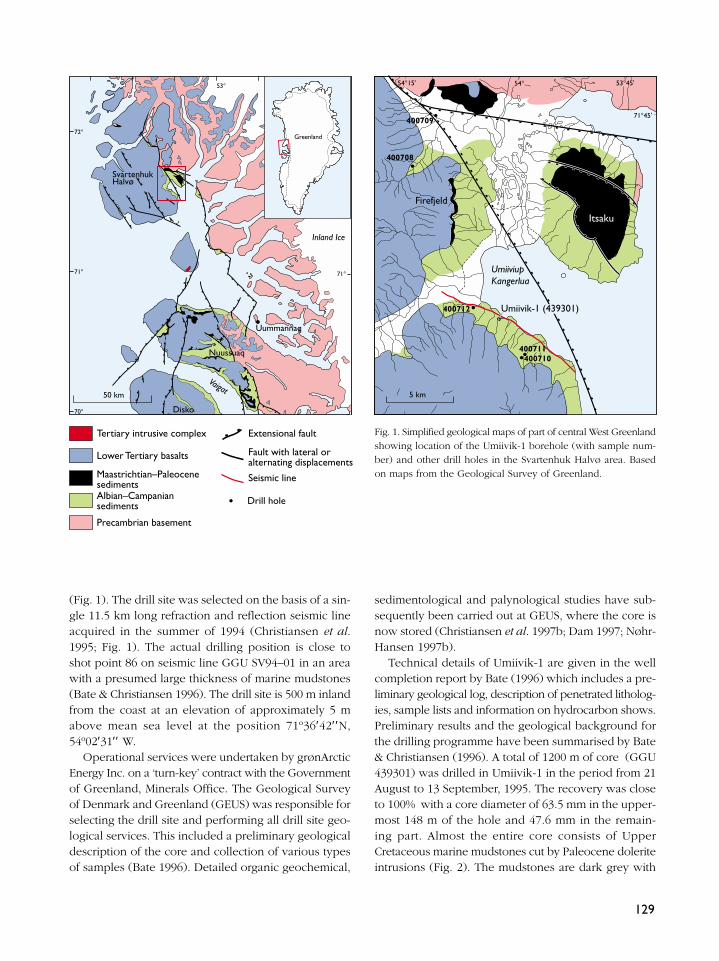
(Fig. 1). The drill site was selected on the basis of a sin-gle 11.5 km long refraction and reflection seismic lineacquired in the summer of 1994 (Christiansen et al.1995; Fig. 1). The actual drilling position is close toshot point 86 on seismic line GGU SV94–01 in an areawith a presumed large thickness of marine mudstones(Bate & Christiansen 1996). The drill site is 500 m inlandfrom the coast at an elevation of approximately 5 mabove mean sea level at the position 71º36′42′′N,54º02′31′′ W.
Operational services were undertaken by grønArcticEnergy Inc. on a ‘turn-key’ contract with the Governmentof Greenland, Minerals Office. The Geological Surveyof Denmark and Greenland (GEUS) was responsible forselecting the drill site and performing all drill site geo-logical services. This included a preliminary geologicaldescription of the core and collection of various typesof samples (Bate 1996). Detailed organic geochemical,
sedimentological and palynological studies have sub-sequently been carried out at GEUS, where the core isnow stored (Christiansen et al. 1997b; Dam 1997; Nøhr-Hansen 1997b).
Technical details of Umiivik-1 are given in the wellcompletion report by Bate (1996) which includes a pre-liminary geological log, description of penetrated litholog-ies, sample lists and information on hydrocarbon shows.Preliminary results and the geological background forthe drilling programme have been summarised by Bate& Christiansen (1996). A total of 1200 m of core (GGU439301) was drilled in Umiivik-1 in the period from 21August to 13 September, 1995. The recovery was closeto 100% with a core diameter of 63.5 mm in the upper-most 148 m of the hole and 47.6 mm in the remain-ing part. Almost the entire core consists of UpperCretaceous marine mudstones cut by Paleocene doleriteintrusions (Fig. 2). The mudstones are dark grey with
129
72°
71°
72°
51°53°
71°
70°
69°
54° 53°45'
71°45'
54°15'
400709
400711400710
5 km
UmiiviupKangerlua
2020
4040
400712
400708
Tertiary intrusive complex
Lower Tertiary basalts
Maastrichtian–PaleocenesedimentsAlbian–Campaniansediments
Precambrian basement
Extensional fault
Fault with lateral oralternating displacements
Seismic line
Drill hole
50 km
SvartenhukHalvø
Inland Ice
Nuussuaq
Uummannaq
Vaigat
Disko
Itsaku
Umiivik-1 (439301)
Firefjeld
Greenland
Fig. 1. Simplified geological maps of part of central West Greenlandshowing location of the Umiivik-1 borehole (with sample num-ber) and other drill holes in the Svartenhuk Halvø area. Basedon maps from the Geological Survey of Greenland.
130
700
800
900U
NIT
B
UN
IT
AU
NIT
B
UN
IT
CU
NIT
D
No
paly
nom
orph
s re
cord
ed d
ue t
o th
erm
al in
fluen
ce fr
om ig
neou
s in
trus
ions
Late
Con
iaci
an?L
ate
Turo
nian
Inte
rval
V
Late
Tur
onia
n -
?Lat
e C
onia
cian
Inte
rval
III
Late
Tur
onia
nIn
terv
al
IVIn
terv
al
IIIn
terv
al
I
VF VCSILT
SAND
CLAY
F M C1200
1100
1000
200
300
400
500
600
VF VCSILT
SAND
CLAY
F M C
0mm
100
Overburden
LithologyIgneous intrusives
Sandstone
Clay and siltstone
Muddy sandstone with pebbles and mudstone clasts
Sedimentary features
Parallel lamination
Slumping
Cross-lamination
Bioturbation
Concretion
Disturbed bedding
Biota
Ammonite
Belemnite
Logs
Moderately bioturbated
Heavily bioturbated
Planolites isp.
Pyrite
Gas
Fault
Coarsening-upwards cyde
Fining-upwards cyde
Bivalve
Weakly bioturbated
Plant and wood fragments
Helminthopsis horizontalis
LegendFacies associations
Mudstone with very thin sandstone streaks
Thinly interbedded sandstone and mudstoneHeavily bioturbated, thinly interbedded sandstone and mudstone
Structureless, muddy sandstone
Chaotic beds
Dewatering structures
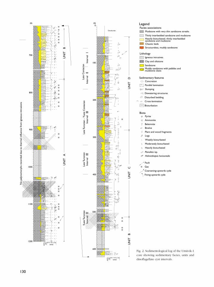
Fig. 2. Sedimentological log of the Umiivik-1core showing sedimentary facies, units anddinoflagellate cyst intervals.

abundant silty interbeds and only a few sandstone inter-vals are present. A total of 22 dolerite intrusions witha cumulative thickness of 240.2 m were intersectedthroughout the borehole. The thick intrusions from548.6 to 596.9 m, from 849.1 m to 890.2 m, and from
923.4 m to 1027.1 m have severely altered the marinemudstones, and have thereby limited the possibilitiesfor both detailed organic geochemical and palynolog-ical studies in the deeper part of the borehole.
131
Fig. 3. Range chart of selected palynomorphs from the Umiivik-1 borehole, with division of the core into five dinoflagellate cyst intervals.
132

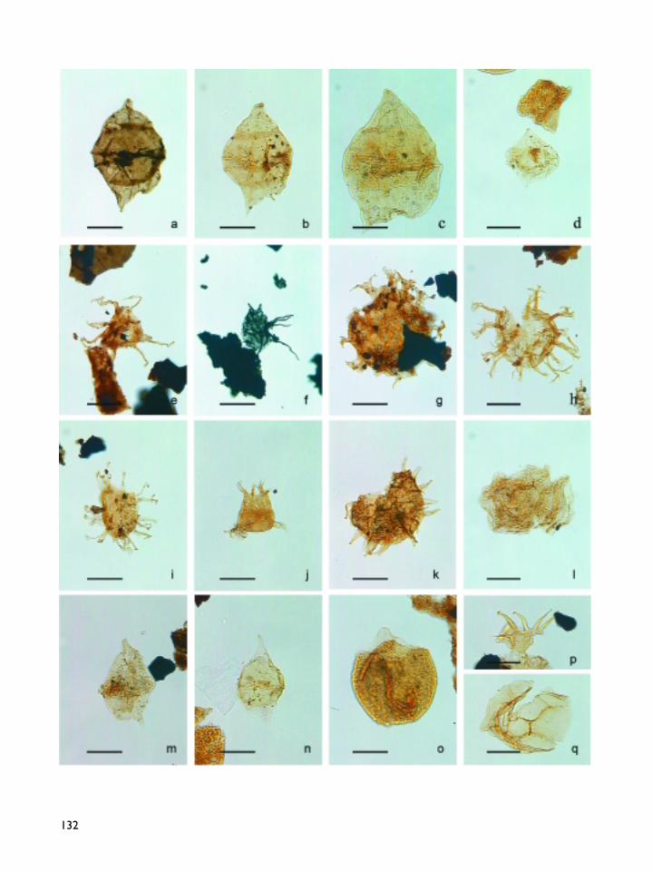
PalynostratigraphyThe dinoflagellate cyst stratigraphy of the Umiivik-1borehole is based on a study of material from 36 mud-stone samples (Fig. 3), of which the lowermost foursamples (below 658 m) were barren of dinoflagellate cystsdue to severe thermal alteration from dolerite intrusions(Nøhr-Hansen 1997b). The stratigraphic range of selecteddinoflagellate cysts is shown in Figure 3. Based on thestratigraphical important species (Fig. 4) the uppermost658 m of the borehole has been dated as Late Turonianto Early Coniacian. It is divided into five informal dinofla-gellate cyst intervals (Fig. 2, 3; Nøhr-Hansen 1997b), ofwhich the uppermost two intervals can be correlated withprevious studies on Svartenhuk Halvø (Nøhr-Hansen
1996, 1997b). Previous biostratigraphic studies of ammo-nites and dinoflagellate cysts from the Umiivik areadated the oldest deposits as Coniacian to Early Santonian(Birkelund 1965; Nøhr-Hansen, 1996). However, Nøhr-Hansen (1996) noted that a Late Turonian age of the sed-iments from two shallow cores (GGU 400709 and 400712;Fig. 1) could not be excluded.
The dinoflagellate cyst assemblages from Umiivik-1are characterised by a large number of specimens ofChatangiella and Isabelidinium. According to the lit-erature the genus Chatangiella ranges from the LateCenomanian to the Late Maastrichtian (Costa & Davey1992). The presence of Heterosphaeridium difficiledown to 540.3 m in Umiivik-1 indicates an Early Turonianto Early Santonian age according to e.g. Costa & Davey(1992), whereas Bell & Selnes (1997) suggest a firstappearance datum (FAD) for H. difficile close to the Earlyto Middle Cenomanian boundary based on data fromthe Norwegian shelf. The possible presence of Raphido-dinium fucatum down to 540.3 m dates the core as post-middle Middle Turonian according to Costa & Davey(1992) or post-early Late Turonian according to Foucher(1979). The presence of Pervosphaeridium truncatumin the uppermost part of the core suggests an age noyounger than Early Coniacian.
The lowermost recorded dinoflagellate cyst from658.7 m has been identified as a Chatangiella sp. sug-gesting a post-Middle Cenomanian age (Costa & Davey1992). The core from 687.7 m to 1191.4 m does not con-tain preserved dinoflagellate cysts. Thus the successionbetween 60.1 m and 540.3 m represents a Late Turonianto Early Coniacian age.
SedimentologyA detailed core description, based on measurement inscale 1:1000 has been given by Dam (1997). Five faciesassociations have been recognised (Fig. 2). These are:(1) mudstone with very thin sandstone streaks; (2) thinlyinterbedded sandstone and mudstone; (3) heavily bio-turbated thinly interbedded sandstone and mudstone;(4) chaotic beds; and (5) structureless, muddy sandstone.
The former three facies associations dominate the suc-cession. The mudstones of these facies associationswere all deposited from low-velocity, low-density tur-bidite currents dominated by Bouma D and E intervals.The sandstone streaks, laminae and beds are interpretedas deposits of traction and fall-out processes associatedwith sedimentation from waning, low-density turbititecurrents.
133
Facing pageFig. 4. Stratigraphically important species in the uppermost 658 mof the Umiivik-1 borehole. Bar scale is 20 µm.a. Isabelidinium sp. A, MGUH 24558 from GGU 439301-116-8,27.3–98.4; LVR 1.8255; MI 5978.b. Isabelidinium sp. A., MGUH 24559 from GGU 439301-110-4,51.5–103.7; LVR 1.8283; MI 6004.c. Isabelidinium sp. cf. I. magnum, MGUH 24560 from GGU439301-38-2, 22.5–110.1; LVR 1.8321; MI 6040.d. Alterbia sp. cf. A. minor, MGUH 24561 from GGU 439301-38.2, 19.4–105.5; LVR 1.8323; MI 6042.e. Raphidodinium fucatum, MGUH 24562 from GGU 439301-112-8, 40.5–98.0; LVR 1.8265; MI 5988.f. ?Raphidodinium fucatum, MGUH 24563 from GGU 439301-160-3, 24.1–99.1; LVR 1.8250; MI 5973.g. Heterosphaeridium difficile, MGUH 24564 from GGU 439301-112-8, 24.8–96.4; LVR 1.8263; MI 5986.h. Surculosphaeridium longifurcatum, MGUH 24565 from GGU439301-94-9, 45.3–103.6; LVR 1.8290; MI 6011.i. Tanyosphaeridium sp. cf. T. variecalamus, MGUH 24566 fromGGU 439301-110-2, 50.0–110.5; LVR 1.8282; MI 6003.j. Dorocysta litotes, MGUH 24567 from GGU 439301-38-2,31.6–108.5; LVR 1.8322; MI 6041.k. Pervosphaeridium truncatum, MGUH 24568 from GGU 439301-41-4, 40.3–95.6; LVR 1.8302; MI 6023.l. Senoniasphaera rotundata, MGUH 24569 from GGU 439301-15-3, 19.6–94.1; LVR 1.8368; MI 6085.m. Spinidinium echinoideum, MGUH 24570 from GGU 439301-36-2, 20.0–102.6; LVR 1.8308; MI 6027.n. Subtilisphaera pontis-mariae, MGUH 24571 from GGU 439301-38-4, 46.8–108.7; LVR 1.8339; MI 6057.o. Trithyrodinium suspectum, MGUH 24572 from GGU 439301-38-4, 48.9–96.7; LVR 1.8342; MI 6059.p. Ctenidodinium sp. aff. C. elegantulum, MGUH 24573 fromGGU 439301- 110-4, 45.9–97.4; LVR 1.8280; MI 6001.q. Ctenidodinium sp. aff. C. elegantulum, MGUH 24574 from GGU439301- 110-3, 26.0–98.6; LVR 1.8277; MI 6000.
The trace fossils Planolites isp. and Helminthopsis hori-zontalis, and possible Zoophycus isp. and Gyrochortecomosa, have been recognised in the bioturbated inter-vals. The chaotic beds have only been recognised inthe upper part of the core and consist of contortedbeds of mudstone and thinly interbedded sandstoneand mudstone of facies associations 1 and 2. The con-torted bedding is attributed to slumping in an unstableslope environment. Structureless muddy sandstonesdeposited from sandy debris flows have only beenrecognised at one level in the upper part of the core.Dinoflagellate cyst assemblages, ammonites and belem-nites, and the total sulphur content in the mudstonesindicate a marine depositional environment for the com-plete cored succession.
Deposition of the Umiivik-1 sedimentary successiontook place in the distal part of a major turbidite com-plex, probably the northern extension of the turbiditecomplex known from farther south in western andnorthern Nuussuaq (cf. Dam & Sønderholm 1994). Thesedimentary succession is divided into four depositional
units (Fig. 2; Dam 1997). The lower three units are 184m to 295 m thick and show an overall thickening- andcoarsening-upward trend interpreted as the result ofprogradation of the distal part of major submarine lobes.The overall coarsening-upward successions includewell-developed coarsening-upward cycles 2–57 m thick.These are interpreted to represent smaller lobes formedin front of minor distributaries or as channel-levee-over-bank complexes (Dam 1997). The uppermost Unit Dis 247 m thick and differs from the three underlying unitsby the lack of an overall coarsening-upward trend, bythe decrease in well-developed fining-upward cycles andthe relatively large amount of slump deposits. The scarcityof systematic vertical variations in the thinly interbed-ded sandstone and mudstone of Unit D, suggests thatthese deposits were not confined to channel-levee sys-tems, and that they more likely represent interchannelslope apron deposits. The increase of bioturbation fromUnit A to Units B and C and the possible steepening ofthe slope, represented by the topmost Unit D, suggestthat the cored succession in the Umiivik-1 borehole
134
Dep
th (
m)
00
-50
-100
-150
-200
-250
-300
-350
-400
-450
-500
-550
-600
-650
-700
-750
-800
-850
-900
-950
-1000
-1050
-1100
-1150
-1200
5 10 0 5 10 0 0 0 250 500 420 0 2 4500 5805 10 152.5 5
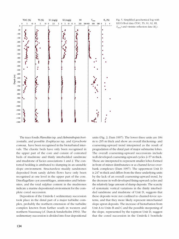
Ro (%)TOC (%) TS (%) S1 (mg/g) S2 (mg/g) HI Tmax Fig. 5. Simplified geochemical log withLECO/Rval data (TOC, TS, S1, S2, HI,Tmax) and vitrinite reflection data (Ro).

represents an overall progradation of a turbidite com-plex. However, the increase in slump and debris flowdeposits may also suggest that the area became tec-tonically more unstable.
Organic geochemistry of mudstonesA standard analytical programme has been undertakenon the Umiivik-1 core (Christiansen et al. 1997) whichincluded the following techniques: (1) LECO/Rock Evalpyrolysis (n = 98); (2) total sulphur analysis (n = 98);(3) vitrinite reflectance, Ro (n = 20); (4) extraction in aSoxtech apparatus with subsequent deasphalting andcolumn separation into saturated and aromatic hydro-carbons and NSO compounds (n = 9); (5) analysis ofsaturated hydrocarbons by gas chromatography/massspectrometry (GC/MS) (n = 9); (6) head space gas com-position (n = 27), C isotopes of methane (n = 17), insome cases of ethane (n = 8) and propane (n = 6).
There is a significant difference in thermal maturitybetween the upper part of the core (above 390 m), andthe deeper part below 405 m with only a thin transi-tion zone. In the upper part Tmax values range from427°C to 441°C whereas vitrinite reflectance valuesrange from 0.55% to 0.63% (Fig. 5). This suggests thatthe sediments are thermally immature or at a level cor-responding to the early part of the oil window. In thelower part Tmax values and vitrinite reflectance valuesare very high and seem to be controlled by the posi-tion of major intrusions.
The content of total organic carbon (TOC) of themudstones is moderate to high with most values between2% and 6% (Fig. 5). In the upper part, the HydrogenIndex (HI) varies from 63–136. These values suggest apoor to fair source rock potential for oil. In the lowerpost-mature part of the core HI values are typicallybelow 25, in many cases below 10. Total sulphur val-ues (TS) typically vary from 0.5% to 3.5% with a fewvery low and very high values. This range of values sug-gests a marine depositional environment for mudstones.
Due to the high thermal maturity below c. 405 m onlynine mudstones from the upper part of the core wereextracted and analysed by gas chromatography and gaschromatography/mass spectrometry. The analyticaldetails and interpretations are given in the report byChristiansen et al. (1997b). All data from these sam-ples are rather similar and suggest a significant inputof terrestrial organic matter and a relatively low ther-mal maturity. The biomarker distributions show very lowconcentrations of angiosperm biomarkers and a notable
concentration of bisnorhopane in several samples. Thiscomposition shows some similarities to the Itilli oil typedescribed by Bojesen-Koefoed et al. (in press) and tothe Kanguk Formation source rock from EllesmereIsland (Bojesen-Koefoed et al. 1997), although both theItilli oil type source rock and the Kanguk source rockseem to have been deposited during more restricted con-ditions than the analysed sediments from Umiivik-1.
Gas geochemistryHead space analyses on cans containing core samplesshow that considerable quantities of gas were releasedfrom some intervals (Christiansen et al. 1997b). Thehighest recorded gas values are from the intervals100–300 m and 1150–1200 m, but scattered high val-ues have been recorded throughout the core. Methaneis the most abundant hydrocarbon gas, the C1/C2 + C3
ratio being 3 to 200 with a general decrease with depth.Samples from deeper than 794 m in particular are verywet (C1/C2 + C3<10), and one interval from 1151 to1182 m shows very high concentrations of wet gases(including both normal and isobutane and pentane).
The isotope composition of the gases varies consid-erably, especially for methane (Fig. 6), whereas the vari-ation for ethane and propane is much smaller. Theseisotope values together with the often relatively high
135
Microbial gas
Coa
l gas
Gasassoc.withoil
–1001
10
102
103
104
105
–80 –60 –40 –20 0
C1/
C2+
C3
δ13 CCH4 (‰)
Fig. 6. C1/C2 + C3 (= wetness) versus 13C-isotope composition ofmethane.

wetness are in accordance with a thermogenetic originof the gases. Some of the samples have a compositiontypical of gas associated with oil, although the com-position is clearly affected by diffusion (see details inChristiansen et al. 1997b).
Conclusions and recommendations for future workAlthough Umiivik-1 did not give the ultimate break-through that was hoped for from this stratigraphic bore-hole, it has added important geological knowledge thatwill be useful in the evaluation of the exploration pos-sibilities on- and offshore West Greenland in the future.
The Umiivik-1 borehole penetrated the oldest marinesediments recorded so far in West Greenland, and thedocumentation of a thick prograding turbidite complexat this time in the basin development has importantimplications for deposition of source rocks and reser-voir sandstones in the Nuussuaq Basin, as well as inneighbouring offshore basins. The overall prograda-tional trend of the turbidite complex and the presenceof a thick mudstone unit at the base of the drilled suc-cession with very high concentrations of wet gases,suggest that the lower mudstone unit represents a majorcondensed section. Although it has not been possibleto date this mudstone due to the thermal influence fromthe nearby igneous intrusives, the presence of UpperTuronian strata c. 500 m above the mudstone might indi-cate that this is the interval which has been recognisedas a world wide Cenomanian–Turonian Oceanic AnoxicEvent (cf. Schlanger et al. 1987). This event occurs atthe base of a highstand systems tract, and occupies asimilar position in the Umiivik-1 borehole.
The palynological results obtained have extendedthe biostratigraphic correlation scheme into a consid-erably older succession than previously documented,results that will be important for correlation of futurewells in West Greenland. The combination of palyno-stratigraphy and organic geochemistry of the marinemudstones in the upper part of the core has given goodpossibilities for correlating biomarker distributions withstratigraphic age, and thereby making correlationsbetween seeping oils and presumed source rock inter-vals much more certain.
The organic geochemical results suggest the exis-tence of a possible source rock for condensate, perhapseven oil, in the deeper part of Umiivik-1. Due to thehigh thermal maturity (late part of oil window – early
part of gas window) this possible Cenomanian–Turoniansource rock cannot be dated in detail and it is not pos-sible to document the detailed composition of genera-tion products and the generative potential.
The results are encouraging for further studies onSvartenhuk Halvø, especially after the discovery of oilseepage there in 1997 (see Christiansen et al. 1998, thisvolume). New drilling is risky and is not recommendedwithout very careful planning of how intrusions can beavoided at an alternative drill site. Follow-up field workaiming at more detailed sedimentological and palyno-logical studies of outcropping Upper Cretaceous sedi-ments as well as systematic ‘oil hunting’ combined withstructural studies may give the most likely break-throughin coming years.
AcknowledgementsThe funding for the drilling project and subsequent core descrip-tion and analytical programmes was provided by the Governmentof Greenland, Minerals Office (now Bureau of Minerals andPetroleum) and the Danish State through the Mineral ResourcesAdministration for Greenland. Technical assistance was providedby John Boserup, Yvonne Desezar, Ditte Kiel-Dühring, CarstenGuvad, Eva Maria Grout, Jette Halskov, Lisbeth Nielsen, MikkelB. Simonsen and Kim Villadsen.
ReferencesBate, K.J. 1996: Well summary Umiivik-1, Svartenhuk Halvø, West
Greenland. Danmarks og Grønlands Geologiske UndersøgelseRapport 1996/27, 24 pp.
Bate, K.J. & Christiansen, F.G. 1996: The drilling of stratigraphicborehole Umiivik–1, Svartenhuk Halvø, West Greenland.Bulletin Grønlands Geologiske Undersøgelse 172, 22–27.
Bell, D.G. & Selnes, H. 1997: The First Appearance Datum (FAD)of Heterosphaeridium difficile (Manum & Cookson), dinofla-gellata in clastic deposits offshore Norway. Journal of Micro-palaeontology 16, 30 only.
Birkelund, T. 1965: Ammonites from the Upper Cretaceous of WestGreenland. Bulletin Grønlands Geologiske Undersøgelse 56,192 pp. (also Meddelelser om Grønland 179(7)).
Bojesen-Kofoed, J., Christiansen, F.G., Núñez-Betelu, L.K., Nytoft,H.P. & Pedersen, H.I. 1997: Source rocks in the Arctic: hydrouspyrolysis of Cretaceous shales from Ellesmere Island, NorthWest Territories, Canada. CPGP-SEPM Joint Convention, Sedi-mentary Events - Hydrocarbon Systems, Calgary, June 1–6, 1997,42 only.
Bojesen-Koefoed, J.A., Christiansen, F.G., Nytoft, H.P. & Pedersen,A.K. in press: Oil seepage onshore West Greenland: evidenceof multiple source rocks and oil mixing. In: Spencer, A.M.
136
137
(ed.): Petroleum geology of Northwest Europe. Proceedingsof the 5th conference. London: Geological Society.
Chalmers, J.A., Pulvertaft, T.C.R., Christiansen, F.G., Larsen, H.C.,Laursen, K.H. & Ottesen, T.G. 1993: The southern WestGreenland continental margin: rifting history, basin develop-ment and petroleum potential. In: Parker, J.R. (ed.): Petroleumgeology of Northwest Europe. Proceedings of the 4th con-ference, 915–931. London: Geological Society.
Chalmers, J.A., Pulvertaft, T.C.R., Marcussen, C. & Pedersen, A.K.1998: New structure maps over the Nuussuaq Basin, centralWest Greenland. Geology of Greenland Survey Bulletin 180,18–27 (this volume).
Christiansen, F.G. 1993: Disko Bugt Project 1992, West Greenland.Rapport Grønlands Geologiske Undersøgelse 159, 47–52 .
Christiansen, F.G., Dam, G., Nøhr-Hansen, H. & Sønderholm, M.1994: Shallow core drilling summary sheets: Cretaceous sed-iments of Nuussuaq and Svartenhuk Halvø (GGU 400701–400712). Open File Series Grønlands Geologiske Undersøgelse94/10, 31 pp.
Christiansen, F.G., Marcussen, C. & Chalmers, J.A. 1995: Geo-physical and petroleum geological activities in the Nuussuaq –Svartenhuk Halvø area 1994: promising results for an onshoreexploration potential. Rapport Grønlands Geologiske Under-søgelse 165, 32–41.
Christiansen, F.G., Bate, K.J., Dam, G., Marcussen, C. & Pulvertaft,T.C.R. 1996a: Continued geophysical and petroleum geologi-cal activities in West Greenland in 1995 and the start of onshoreexploration. Bulletin Grønlands Geologiske Undersøgelse 172,15–21.
Christiansen, F.G., Bojesen-Koefoed, J., Dam, G., Nytoft, H.-P.,Larsen, L.M., Pedersen, A.K. & Pulvertaft, T.C.R. 1996b: TheMarraat oil discovery on Nuussuaq, West Greenland: evidencefor a latest Cretaceous – earliest Tertiary oil-prone source rockin the Labrador Sea – Melville Bay region. Bulletin of CanadianPetroleum Geology 44, 39–54.
Christiansen, F.G., Bojesen-Koefoed, J., Nytoft, H.-P. & Laier, Y.1996c: Organic geochemistry of sediments, oils and gases inthe GANE#1, GANT#1 and GANK#1 wells, Nuussuaq, WestGreenland. Danmarks og Grønlands Geologiske UndersøgelseRapport 1996/23, 35 pp.
Christiansen, F.G., Boesen, A., Dalhoff, F., Pedersen, A.K., Pedersen,G.K., Riisager, P. & Zinck-Jørgensen, K. 1997a: Petroleum geo-logical activities onshore West Greenland in 1996, and drillingof a deep exploration well. Geology of Greenland SurveyBulletin 176, 17–23.
Christiansen, F.G., Bojesen-Koefoed, J. & Laier, T. 1997b: Organicgeochemistry of sediments and gases in the borehole Umiivik-1, Svartenhuk Halvø, West Greenland. Danmarks og GrønlandsGeologiske Undersøgelse Rapport 1997/33, 16 pp.
Christiansen, F.G., Boesen,A., Bojesen-Koefoed, J.A., Dalhoff, F.,Dam, G., Neuhoff, P.S., Pedersen, A.K., Stannius, L.S. & Zinck-Jørgensen, K. 1998: Petroleum geological activities onshore WestGreenland in 1997. Geology of Greenland Survey Bulletin180, 10–17 (this volume).
Costa, L.I. & Davey, R.J. 1992: Dinoflagellate cysts of the CretaceousSystem. In: Powell, A.J. (ed.): A stratigraphic index of dinofla-gellate cysts, 99–131. London: British MicropalaeontologicalSociety.
Dam, G. 1996a: Sedimentology of the GANE#1 and GANE#1A coresdrilled by grønArctic Energy Inc., Eqalulik, Nuussuaq, WestGreenland. Danmarks og Grønlands Geologiske UndersøgelseRapport 1996/82, 18 pp.
Dam, G. 1996b: Sedimentology of the GANK#1 and GANK#1Acores drilled by grønArctic Energy Inc., Kuussuaq, Nuussuaq,West Greenland. Danmarks og Grønlands GeologiskeUndersøgelse Rapport 1996/83, 15 pp.
Dam, G. 1996c: Sedimentology of the GANT#1 core drilled bygrønArctic Energy Inc., Tunorsuaq, Nuussuaq, West Greenland.Danmarks og Grønlands Geologiske Undersøgelse Rapport1996/96, 18 pp.
Dam, G. 1997: Sedimentology of the Umiivik-1 core, SvartenhukHalvø, West Greenland. Danmarks og Grønlands GeologiskeUndersøgelse Rapport 1997/136, 15 pp.
Dam, G. & Sønderholm, M. 1994: Lowstand slope channels ofthe Itilli succession (Maastrichtian – Lower Paleocene),Nuussuaq, West Greenland. Sedimentary Geology 94, 47–71.
Foucher, J.-C. 1979: Distribution stratigraphique des kystes dedinoflagellés et des acritarches dans le crétacé supérieur dubassin de Paris et de l’Europe septentrionale. PalaeontographicaAbteilung B 169, 78–105.
Nøhr-Hansen, H. 1996: Upper Cretaceous dinoflagellate cyststratigraphy, onshore West Greenland. Bulletin GrønlandsGeologiske Undersøgelse 170, 104 pp.
Nøhr-Hansen, H. 1997a: Palynology of the boreholes GANE#1,GANK#1 and GANT#1, Nuussuaq, West Greenland. Danmarksog Grønlands Geologiske Undersøgelse Rapport 1997/89,22 pp.
Nøhr-Hansen, H. 1997b: Palynology of the Umiivik-1 borehole,Svartenhuk Halvø, West Greenland. Danmarks og GrønlandsGeologiske Undersøgelse Rapport 1997/32, 16 pp.
Núñez-Betelu, L.K. 1994: Sequence stratigraphy of a coastal tooffshore transition, Upper Cretaceous Kanguk Formation: apalynological, sedimentological and Rock-Eval characterisa-tion of a depositional sequence, northeastern Sverdrup Basin,Canadian Arctic, 569 pp. Unpublished Ph.D. thesis, Departmentof Geology and Geophysics, University of Calgary, Calgary,Canada.
Schlanger, S.O., Arthur, M.A., Jenkyns, H.C. & Scholle, P.A. 1987:The Cenomanian–Turonian Oceanic Anoxic Event, I. Strati-graphy and distribution of organic carbon-rich beds and themarine delta-13C excursion. In: Brooks, J. & Fleet, A.J. (eds):Marine petroleum source rocks. Geological Society SpecialPublication (London) 26, 371–399.
Skaarup, N. & Chalmers, J.A. 1998: A possible new hydrocarbonplay, offshore central West Greenland. Geology of GreenlandSurvey Bulletin 180, 28–30 (this volume).
Authors’ address:Geological Survey of Denmark and Greenland, Thoravej 8, DK-2400 Copenhagen NV, Denmark.