the natufian site of nahal sekher vi: the 2009 excavation season
TRANSCRIPT

JOURNAL OF THE ISRAEL PREHISTORIC SOCIETY
Mitekufat HaevenVolume 45
Editors:Dani Nadel
Danny RosenbergDaniel Kaufman
Guy Bar-Oz
Supported by the Irene Levi-Sala CARE Archaeological Foundation
THE ISRAEL PREHISTORIC SOCIETY
2015

Table of Contents
Editors’ forward 4
Jordan River Dureijat - A New Epipaleolithic Site in the Upper Jordan Valley 5Ofer Marder, Rebecca Biton, Elisabetta Boaretto, Craig S. Feibel, Yoel Melamed, Henk K. Mienis, Rivka Rabinovich, Irit Zohar and Gonen Sharon
Renewed Fieldwork at the Geometric Kebaran Site of Neve David, Mount Carmel 31Reuven Yeshurun, Daniel Kaufman, Nurit Shtober-Zisu, Eli Crater-Gershtein, Yona Riemer, Arlene M. Rosen and Dani Nadel
Renewed Excavations at Site K7: A Final Report of the 2012 Salvage Excavation at Har Harif Plateau 55Jacob Vardi, Dmitry Yegorov, Onn Crouvi and Michal Birkenfeld
Sha’on Hol, Site 14 (HG14): A New Late Epipalaeolithic Site in the Central Negev Highlands 77Dmitry Yegorov, Alla Yaroshevich, Jacob Vardi and Michal Birkenfeld
The Natufian Site of Nahal Sekher VI: The 2009 Excavation Season 97Omry Barzilai, Nuha Agha, Hila Ashkenazy, Michal Birkenfeld, Elisabetta Boaretto, Naomi Porat, Polina Spivak and Joel Roskin
El-Hamam Cave: A New Natufian Site in the Samaria Hills 131Ofer Marder, Hila Ashkenazy, Amos Frumkin, Leore Grosman, Boaz Langford, Gonen Sharon, Micka Ullman, Reuven Yeshurun and Yuval Peleg
The Natufian Sequence of el-Wad Terrace: Seriating the Lunates 143Daniel Kaufman, Reuven Yeshurun and Mina Weinstein-Evron
Excavations at Holyland Park: An Underground Chalcolithic Complex in Jerusalem 158Ianir Milevski, Zvi Greenhut, Zinovi Matskevich, Uzi Ad, Anat Cohen-Weinberger and Liora Kolska Horwitz
Fazael 5: Soundings in a Chalcolithic Site in the Jordan Valley 193Shay Bar, Haggai Cohen-Klonymus, Sonia Pinsky, Guy Bar-Oz and Golan Shalvi
Motifs on the Nahal Mishmar Hoard and the Ossuaries: Comparative Observations and Interpretations 217Dina Shalem
Book reviewShalem D., Gal, Z. and Smithline H. 2013. Peqi’in: A Late Chalcolithic Burial Site, Upper Galilee, Israel (Land of Galilee 2). Tzemach: Ostracon 238Assaf Nativ
Note for authors 242
Hebrew abstracts 4*

97
Journal of the Israel Prehistoric Society 45 (2015), 97–130
97
The Natufian Site of Nahal Sekher VI: The 2009 Excavation Season
Omry Barzilai1, Nuha Agha2, Hila Ashkenazy3, Michal Birkenfeld4, Elisabetta Boaretto5, Naomi Porat6, Polina Spivak7 and Joel Roskin8
1 Israel Antiquities Authority, Jerusalem, Israel. [email protected] Israel Antiquities Authority, Jerusalem, Israel. [email protected] Archaeology Division, Ben-Gurion University of the Negev, Beer-Sheva, Israel. [email protected] Israel Antiquities Authority, Jerusalem, Israel. [email protected] Max Planck Society-Weizmann Institute Center for Integrative Archaeology and Anthropology, D-REAMS Radiocarbon
Laboratory, Weizmann Institute of Science, Rehovot, Israel. [email protected] Geological Survey of Israel, Jerusalem, Israel. [email protected] Israel Antiquities Authority, Jerusalem, Israel. [email protected] Department of Maritime Civilizations, Charney School of Marine Studies and the Leon Recanati Institute for Maritime
Studies (RIMS), University of Haifa, Haifa, Israel. Department of Marine Geosciences, Charney School of Marine Studies, University of Haifa, Haifa, Israel. School of Sciences, Achva Academic College, Israel. [email protected].
ABSTRACTNahal Sekher VI is a Natufian campsite located within the eastern edge of the northwestern Negev desert dunefield. The site was test excavated in the 1980’s and entirely re-excavated in 2009. The new excavation area (165 m²) consisted of a distinct Natufian horizon. The paper presents the new excavation and discusses its results in respect to paleoenvironments, site formation processes, site function and chronology.
Geoarchaeological analyses of depositional and post depositional processes and artifact characteristics, together with OSL ages and radiocarbon dates, suggests that the site was exposed for substantial time, and subjected to several deflation and sand accumulation events. In addition, sediments corresponding to short-lived standing-water bodies were identified near the site. Though organic remains were not preserved, hunting and related activities as well as plant processing took place at and around the site as suggested by the composition of the flint and stone tool assemblages. The mutual presence of Helwan lunates and backed lunates in the lithic assemblage is bewildering. It is uncertain if this represents repetitive visits to the site by Early and Late Natufians or a single Natufian occupation during which these two lunate types coexisted.
KEYWORDS: Natufian, Nahal Sekher, Negev Desert dunes, Lunates
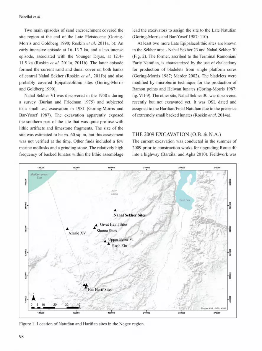
INTRODUCTIONNahal Sekher VI (map ref. 18352–5/55626–33) is located in the central section of Nahal Sekher (Wadi Mashash), ca. 20 km south of Beer Sheva (Figs. 1–2). The site is situated on the eastern edge of the northern Sinai–northwestern Negev erg (Sinai-Negev erg) that extends east of the Nile Delta (Roskin et al. 2014a). The region acts as the interface of distinct aeolian and fluvial and aeolian-fluvial
landforms and lithologies. More specifically, the site is positioned on stabilized sand overlain by slightly active sands and coppice dunes at an elevation of ca. 350 m above sea level. Nowadays the climate in the region is arid, with an average annual precipitation of ca. 200 mm. The landscape is covered by Tamarix trees planted in the beginning of the 20th century (Fig. 3).
98
Barzilai et al.
98
Figure 1. Location of Natufian and Harifian sites in the Negev region.
Two main episodes of sand encroachment covered the site region at the end of the Late Pleistocene (Goring-Morris and Goldberg 1990; Roskin et al. 2011a, b): An early intensive episode at 16–13.7 ka, and a less intense episode, associated with the Younger Dryas, at 12.4–11.5 ka (Roskin et al. 2011a, 2011b). The latter episode formed the current sand and dunal cover on both banks of central Nahal Sekher (Roskin et al., 2011b) and also probably covered Epipalaeolithic sites (Goring-Morris and Goldberg 1990).
Nahal Sekher VI was discovered in the 1950’s during a survey (Burian and Friedman 1975) and subjected to a small test excavation in 1981 (Goring-Morris and Bar-Yosef 1987). The excavation apparently exposed the southern part of the site that was quite profuse with lithic artifacts and limestone fragments. The size of the site was estimated to be ca. 60 sq. m, but this assessment was not verified at the time. Other finds included a few marine mollusks and a grinding stone. The relatively high frequency of backed lunates within the lithic assemblage
lead the excavators to assign the site to the Late Natufian (Goring-Morris and Bar-Yosef 1987: 110).
At least two more Late Epipalaeolithic sites are known in the Sekher area - Nahal Sekher 23 and Nahal Sekher 30 (Fig. 2). The former, ascribed to the Terminal Ramonian/Early Natufian, is characterized by the use of chalcedony for production of bladelets from single platform cores (Goring-Morris 1987; Marder 2002). The bladelets were modified by microburin technique for the production of Ramon points and Helwan lunates (Goring-Morris 1987: fig. VII-9). The other site, Nahal Sekher 30, was discovered recently but not excavated yet. It was OSL dated and assigned to the Harifian/Final Natufian due to the presence of extremely small backed lunates (Roskin et al. 2014a).
THE 2009 EXCAVATION (O.B. & N.A.)The current excavation was conducted in the summer of 2009 prior to construction works for upgrading Route 40 into a highway (Barzilai and Agha 2010). Fieldwork was

99
Journal of the Israel Prehistoric Society 45 (2015), 97–130
99
Figure 3. The south section of Nahal Sekher VI before the excavation (view to north). Note the archaeological horizon is located below active sands and modern Tamarix.
Figure 2. Location of Nahal Sekher VI, Nahal Sekher 23 and Nahal Sekher 30.

100
Barzilai et al.
100
carried out in three areas east of the route (Fig. 2). Remains of the Natufian campsite were exposed in Area A, but not in the other two Areas (B and C) that included strewn proto-historic flint artifacts and Byzantine and Ottoman pottery sherds (Barzilai and Agha 2010). The excavation of the Natufian site (Area A) was set north and adjacent to the 1981 excavation. A total of 165 sq. m were excavated (Fig. 4). A 0.5×0.5 m grid was used and all sediments were sifted through a 1 mm sieve. Lunates and cores were piece plotted before collection.
The excavation exposed a thin Natufian horizon (2–15 cm thick) situated ca. 50–80 cm below the current surface (Figs. 3, 5). The horizon rests on a compacted and encrusted palaeosurface. The horizon was composed mainly of flint artifacts and burnt limestone fragments, but also included two dentalium shell beads (Barzilai and Agha 2010: fig. 5). Additional material included small fragments of intrusive ostrich egg shells (see below) and a few Neolithic/Chalcolithic pottery sherds. The horizon’s topography was uneven; it had a flat area (Locus 101) at the north-east part of the excavation area that sloped to the south and to the west (Locus 102) (Fig. 4). The horizon extended to different depths beneath the undulating dunal surface and appeared to have only sporadic artifacts in its western part, probably marking the limits of the site. The presence of two broken limestone slabs (one is an anvil), hammer stones, a bladelet core and a few Helwan
Figure 5. The Natufian horizon with broken limestone slabs. A view to the East.
Figure 6. Close-up view of a fragment of one of the limestone slabs.
Figure 7. Concentration of lithic artifacts including three Helwan lunates (light chalcedony) found next to a stone anvil. Note carbonate nodules and land-snail shells are strewn on the surface.
Figure 4. A schematic plan of excavation area A. Red lines mark sections studied for geomorphology and OSL dating.

101
Journal of the Israel Prehistoric Society 45 (2015), 97–130
101
lunates in the flat Locus 101 suggested that here was a tool preparation post (Figs. 5–7). Small amounts of Natufian artifacts were also retrieved from the within the sand above (Locus 100) and below (Loci 103-104) the horizon, but were not included in the lithic analysis.
THE GEOMORPHOLOGICAL SETTING (J.R.)The geomorphic interpretation of the site relies on analyzing two stratigraphic sections (north and south) of the excavation area (Figs. 4, 8). The southern section was further trenched by a backhoe. Laboratory methods included particle-size analysis, carbonate content, spectroscopy and OSL dating that are described in Roskin et al. (2011a, 2012, 2014a, b). An ASD spectrometer provided spectral measurements of the sand samples. The spectral redness index (RI) RI=R2/(B*G3) (R=Red ban; B=blue band; G=green band) was calculated for each sample in order to establish the relative redness of its sand-grain ferric coatings. RI values often increases following pedogenic alterations. This index applied to the Negev dunes (Tsoar et al. 2008; Roskin et al. 2012) was used to estimate the relative stability/mobility of the site sand and possible changes in the sand due to anthropogenic inputs.
As described above, the stratigraphy of Nahal Sekher VI consists of a distinct archaeological horizon embedded between two sand units (Figs. 3, 8). Carbonate nodules and stains were evident in both sand units.
In addition to artifacts, the archaeological horizon included strewn carbonate nodules, surficial lag concretions, small limestone pebbles, and biogenic artifacts - mainly land-snail shells (Fig. 7). The limestone pebbles are sub-angular to sub-round. Polished pebbles are in the size range of 2–15 mm. Lag deposits occur in the form of sandy concretions cemented by calcium carbonate. They are round (<10 mm), sub-angular and oval (x-axis=5–15 mm; y-axis=2–5 mm). Some of the concretions may have developed or grown upon an exposed surface. Land-snail shell preservation and size ranged between broken and complete (2–40 mm).
The unimodal particle size distribution (PSD) of the Nahal Sekher VI sediments below, within and above the Natufian layer is characteristic of aeolian sand in the NW Negev dune field (Roskin et al. 2014b). The sand content is 89–93%, silt content 7–9%, while clays comprise only 1–2% of the samples (Fig. 9). Surprisingly, the PSD of the
mixed surface in the northern section of Nahal Sekher VI (NS-6) was no different from the underlying and overlying sand.
Two lag concretions were also found to have a unimodal PSD, though they contained ~30% clay and silt, which may be partially carbonate. The reflectance curves of the sands of the Nahal Sekher sites, ranging between 400 to 2,400 nm, were quite uniform, and fell within the range of sand reflectance for the Negev dune field (Fig. 9; Roskin et al., 2012).
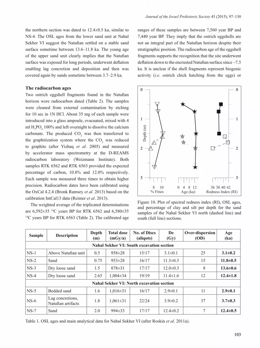
The redness index (RI) values along the sections were also quite uniform (RI=36–42) (Fig. 10). The fact that the spectroscopic uniformity of the sand complements the uniform PSD data suggests that the sand column has not undergone significant anthropogenic and pedogenic changes since its deposition.
CHRONOSTARTIGRAPHY (N.P. & E.B.)The archaeological and sedimentological depositions at Nahal Sekher VI were dated by optically stimulated luminescence (OSL) of quartz grains sampled from the two sand units (below and above the archaeological horizon), and by radiocarbon dating of ostrich eggshell fragments from the archaeological horizon (Fig. 8).
The OSL ages The OSL samples were prepared and measured at the Luminescence Laboratory of the Geological Survey of Israel (GSI), Jerusalem. Details of dating procedure, sample analysis and reliability for the Nahal Sekher VI are presented in Roskin et al. (2011a, 2014a). The OSL ages are within errors, in stratigraphic order (Table 1; Fig. 8). The ages, averaged from 17 measured aliquots, have narrow De distributions, and are relatively homogeneous. Low over dispersion (OD) values (OD<21) characterized the samples, with the exception of NS-1 (OD=25) and NS-6 (OD=37). Sample NS-1 was only 50 cm from the surface and may have undergone relatively intense bioturbation and mixing.
Two main OSL age groups were discerned in the Nahal Sekher VI sections: ~13.6–11.8 ka from below the Natufian unit and ~3.7–2.9 ka above it (Fig. 8). The lowest sand samples (NS-4 at 2.3 m and NS-3 at 1.6 m) were dated to 12.4±1.8 ka and 13.6±0.6 ka, respectively, essentially the same age within errors. Sample NS-7 from

102
Barzilai et al.
102
Figure 8. Stratigraphy and ages of the Sekher VI site. LFFD = Low-energy fine-grained fluvial deposits.
Figure 9. Particle-size distribution (PSD) curves of the Sekher VI site sediments. Note the addition of fine sand and silt to the lag deposits.
103
Journal of the Israel Prehistoric Society 45 (2015), 97–130
103
the northern section was dated to 12.4±0.5 ka, similar to NS-4. The OSL ages from the lower sand unit at Nahal Sekher VI suggest the Natufian settled on a stable sand surface sometime between 13.6–11.8 ka. The young age of the upper sand unit clearly implies that the Natufian surface was exposed for long periods, underwent deflation enabling lag concretion and deposition and then was covered again by sands sometime between 3.7–2.9 ka.
The radiocarbon ages Two ostrich eggshell fragments found in the Natufian horizon were radiocarbon dated (Table 2). The samples were cleaned from external contamination by etching for 10 sec in 1N HCl. About 35 mg of each sample were introduced into a glass ampoule, evacuated, mixed with 4 ml H3PO4 100% and left overnight to dissolve the calcium carbonate. The produced CO2 was then transferred to the graphitization system where the CO2 was reduced to graphite (after Yizhaq et al. 2005) and measured by accelerator mass spectrometry at the D-REAMS radiocarbon laboratory (Weizmann Institute). Both samples RTK 6562 and RTK 6563 provided the expected percentage of carbon, 10.8% and 12.0% respectively. Each sample was measured three times to obtain higher precision. Radiocarbon dates have been calibrated using the OxCal 4.2.4 (Bronk Ramsey et al. 2013) based on the calibration IntCal13 data (Reimer et al. 2013).
The weighted average of the triplicated determinations are 6,592±35 14C years BP for RTK 6562 and 6,580±35 14C years BP for RTK 6563 (Table 2). The calibrated age
ranges of these samples are between 7,560 year BP and 7,440 year BP. They imply that the ostrich eggshells are not an integral part of the Natufian horizon despite their stratigraphic position. The radiocarbon age of the eggshell fragments supports the recognition that the site underwent deflation down to the encrusted Natufian surface since ~7.5 ka. It is unclear if the shell fragments represent biogenic activity (i.e. ostrich chick hatching from the eggs) or
Figure 10. Plot of spectral redness index (RI), OSL ages, and percentage of clay and silt per depth for the sand samples of the Nahal Sekher VI north (dashed line) and south (full line) sections.
Sample Description Depth (m)
Total dose (mGy/a)
No. of Discs (aliqots)
De (Gy)
Over-dispersion (OD)
Age (ka)
Nahal Sekher VI: South excavation section
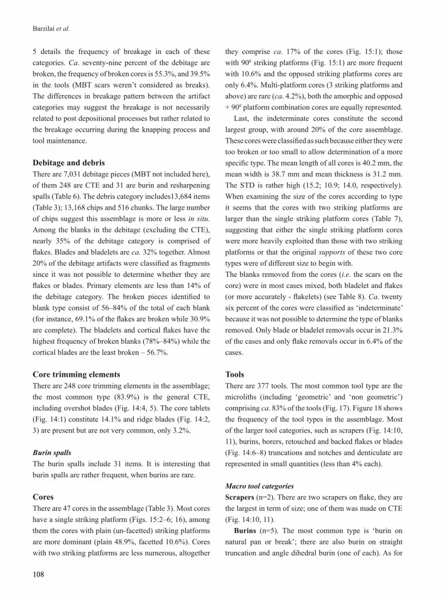
NS-1 Above Natufian unit 0.5 958±28 15/17 3.1±0.1 25 3.1±0.2
NS-2 Sand 0.75 953±28 16/17 11.3±0.3 15 11.8±0.5
NS-3 Dry loose sand 1.5 878±31 17/17 12.0±0.3 8 13.6±0.6
NS-4 Dry loose sand 2.65 1,004±34 19/19 11.4±1.6 12 12.4±1.8
Nahal Sekher VI: North excavation section
NS-5 Bedded sand 1.6 1,016±31 16/17 2.9±0.1 11 2.9±0.1
NS-6 Lag concretions, Natufian artifacts 1.8 1,061±31 22/24 3.9±0.2 37 3.7±0.3
NS-7 Sand 2.0 994±33 17/17 12.4±0.2 7 12.4±0.5
Table 1. OSL ages and main analytical data for Nahal Sekher VI (after Roskin et al. 2011a).

104
Barzilai et al.
104
anthropogenic activity (i.e. remains of a meal/a broken container). The latter explanation seems more likely due to the presence of several Neolithic/Chalcolithic pottery sherds at the eastern part of the excavation (Barzilai and Agha 2010).
SITE FORMATION PROCESESES (M.B.)Site formation processes were examined by a GIS analysis of the lithic artifacts from the archaeological horizon (Loci 101-102). All flint artifacts recorded during the excavation were plotted using ESRI ArcInfo software, based on their grid-square location. Distribution maps were then produced for each category (cores, debitage, tools, etc.) as well as for the total counts and the various tool types. Getis-Ord Gi* statistic (Hot-Spots Analysis) was used to evaluate the distribution of artifact types of which sufficient numbers were recorded. This method assesses local association among geo-referenced data, by comparing local (weighted) averages to global averages, and looking for statistically significant clusters of high and low values (Getis and Ord 1996). Artifact types for which the total counts did not enable the use of statistical tools (such as the lunates) are presented using the Natural Jenks, based on Jenk’s optimization method (1967) which seeks to reduce variance within groups and maximize variance between them. It partitions data into different classes using an algorithm that identifies breaks or gaps that naturally exist in the data. Thus, it calculates groupings of data values based on natural groups in the data distribution.
Examination of the general distribution of flint
artifacts in the excavated area (Fig. 11) shows two main concentrations, at the south and at the south-west parts of the excavation area. This pattern partly follows the micro-topography of the site but probably does not indicate slight downslope creep as the artifacts were not moved towards the steeper slope to the west. This observation is reflected also in the Hot-Spot distribution map of the flint chips (artifacts < 1.5 cm) (Fig. 12).
This scenario of post-depositional movement becomes questionable when examining the distribution pattern of specific artifact types. For example, a comparison between the distributions of the lunates, the typo-technological marker of the Natufian, shows differences between the Helwan and backed types (Fig. 13). The chronological implications of this distribution are addressed in the discussion.
Although both lunate types show some overlap at the southern part of the excavation area, the backed lunates are concentrated in the central and south-eastern part of the excavation area (Fig. 13:A), adjacent to the 1981 excavation area, where dominance of backed lunates was recorded (Goring-Morris and Bar-Yosef 1987). The Helwan lunates, on the other hand, are concentrated in the north, on the more leveled area and adjacent to the suggested tool preparation area (Fig. 13:B).
We suggest that the lunate distribution reflects an anthropogenic pattern; there is no apparent reason for post-depositional processes to affect these lunate types differently. The suggested tool preparation area was probably utilized more towards the making of Helwan lunates.
#14C Age ± 1σ
year BPCalibrated 14C range
± 1σ year BPCalibrated 14C range
± 2σ year BP Context C% δ13C PDB‰
RTKRTKRTK
6,562.16,562.26,562.3
6,625 ± 606,595 ± 606,555 ± 60
Sq G6cL-102B1330
10.8 -7.3
RTK 6,562 6,592 ± 35 7,550 (4.0%) 7,545 7,510 (64.2%) 7,440
7,565 (19.4%) 7,530 7,525 (76.0%) 7,430
RTKRTKRTK
6,563.16,563.26,563.3
6,555 ± 606,595 ± 606,590 ± 60
Sq. G14dL-102 B 1106
12.0 -7.4
RTK 6,563 6,580 ± 35 7,500 (68.2%) 7,435 7,565 (13.2%) 7,5357,520 (82.2%) 7,430
Table 2. Sample information, radiocarbon dates and calibrated ranges for the two ostrich eggshells measured.

105
Journal of the Israel Prehistoric Society 45 (2015), 97–130
105
Figure 11. Hot Spot distribution analysis of flint artifacts (n=4,807) in the excavated area.
Figure 12. Hot Spot distribution analysis of chips (n=2,976) in the excavated area.

106
Barzilai et al.
106
Figure 13. Distribution of Backed lunates (A, n=145) and Helwan lunates (B, n=74).

107
Journal of the Israel Prehistoric Society 45 (2015), 97–130
107
THE FLINT ASSEMBLAGE (H.A.)The lithic assemblage is comprised of 21,139 artifacts of which 64.7% are debris (Table 3). The rest are debitage, cores and tools. The cores and tools were analyzed using Goring-Morris’ typological list (1987).
State of preservationExamination of patina presence on flint artifacts as well as breakage patterns can enable assessments for the occurrence or non-occurrence of post-depositional processes (e.g. Ekshtain et al. 2011; Friedman et al. 1994). As recognized above, the main post depositional process evident at Nahal Sekher VI was deflation while there was little if any evidence of artifact rolling. These observations were compared with the patina pattern observed on all of the tools and cores (n=377) (Table 4). The examined items were split into a fully patina-covered, and non-patina covered groups (referring to the cases where the entire artifact is patinated). There are more patinated cores than those that bear no patina (63.8% patinated cores; 36.2% non-patinated). Most of the tools are patinated (75.3%). Notably no difference was found between Helwan and backed lunates (85% of the backed lunates and 74% of the Helwan lunates are patinated). In summary, the dominance of patinated artifacts indicates they were exposed for a significant time as indicated from the OSL ages and geomorphic analyses.
The breakage pattern was observed on the debitage (CTE and MBT not included), cores and tools. Table
Category n %
Tools 377 1.8
Cores 47 0.2
Debitage 7,031 33.3
Debris 13,684 64.7
Total 21,139 100.0
Table 3. Major typo-technological classes at Nahal Sekher VI.
Patination Tools Cores
n % n %
No 92 24.4 17 36.2
Yes 284 75.3 30 63.8
Indeterminate 1 0.3
Total 377 100.0 47 100.0
Table 4. Degree of patination on samples of cores and tools.
Complete Broken Totaln % n % n
Tools 228 60.5 149 39.5 377
Cores 21 44.7 26 55.3 47
Debitage 1,425 21.1 5,327 78.9 6,752
Table 5. State of preservation of the major artifact classes in Nahal Sekher VI.
Blank n n broken* % broken n complete* % complete
Flakes 2,341 1,618 69.1 723 30.9
Blades 843 584 69.3 259 30.7
Bladelets 1,322 1,121 84.8 201 15.2
Cortical flakes 711 559 78.6 152 21.4
Cortical blades 157 89 56.7 68 43.3
Cortical bladelets 70 48 68.6 22 31.4
CTE 248 - - - -
Burin and resharpening spalls 31 - - - -
Fragments 1,308 1,308 100.0 0 0.0
Total 7,031 5,327 1,425
Table 6. Debitage frequency.* CTE and burin spalls were not divided to broken and complete.
108
Barzilai et al.
108
5 details the frequency of breakage in each of these categories. Ca. seventy-nine percent of the debitage are broken, the frequency of broken cores is 55.3%, and 39.5% in the tools (MBT scars weren’t considered as breaks). The differences in breakage pattern between the artifact categories may suggest the breakage is not necessarily related to post depositional processes but rather related to the breakage occurring during the knapping process and tool maintenance.
Debitage and debris There are 7,031 debitage pieces (MBT not included here), of them 248 are CTE and 31 are burin and resharpening spalls (Table 6). The debris category includes13,684 items (Table 3); 13,168 chips and 516 chunks. The large number of chips suggest this assemblage is more or less in situ. Among the blanks in the debitage (excluding the CTE), nearly 35% of the debitage category is comprised of flakes. Blades and bladelets are ca. 32% together. Almost 20% of the debitage artifacts were classified as fragments since it was not possible to determine whether they are flakes or blades. Primary elements are less than 14% of the debitage category. The broken pieces identified to blank type consist of 56–84% of the total of each blank (for instance, 69.1% of the flakes are broken while 30.9% are complete). The bladelets and cortical flakes have the highest frequency of broken blanks (78%–84%) while the cortical blades are the least broken – 56.7%.
Core trimming elements There are 248 core trimming elements in the assemblage; the most common type (83.9%) is the general CTE, including overshot blades (Fig. 14:4, 5). The core tablets (Fig. 14:1) constitute 14.1% and ridge blades (Fig. 14:2, 3) are present but are not very common, only 3.2%.
Burin spallsThe burin spalls include 31 items. It is interesting that burin spalls are rather frequent, when burins are rare.
Cores There are 47 cores in the assemblage (Table 3). Most cores have a single striking platform (Figs. 15:2–6; 16), among them the cores with plain (un-facetted) striking platforms are more dominant (plain 48.9%, facetted 10.6%). Cores with two striking platforms are less numerous, altogether
they comprise ca. 17% of the cores (Fig. 15:1); those with 900 striking platforms (Fig. 15:1) are more frequent with 10.6% and the opposed striking platforms cores are only 6.4%. Multi-platform cores (3 striking platforms and above) are rare (ca. 4.2%), both the amorphic and opposed + 900 platform combination cores are equally represented.
Last, the indeterminate cores constitute the second largest group, with around 20% of the core assemblage. These cores were classified as such because either they were too broken or too small to allow determination of a more specific type. The mean length of all cores is 40.2 mm, the mean width is 38.7 mm and mean thickness is 31.2 mm. The STD is rather high (15.2; 10.9; 14.0, respectively). When examining the size of the cores according to type it seems that the cores with two striking platforms are larger than the single striking platform cores (Table 7), suggesting that either the single striking platform cores were more heavily exploited than those with two striking platforms or that the original supports of these two core types were of different size to begin with.The blanks removed from the cores (i.e. the scars on the core) were in most cases mixed, both bladelet and flakes (or more accurately - flakelets) (see Table 8). Ca. twenty six percent of the cores were classified as ‘indeterminate’ because it was not possible to determine the type of blanks removed. Only blade or bladelet removals occur in 21.3% of the cases and only flake removals occur in 6.4% of the cases.
ToolsThere are 377 tools. The most common tool type are the microliths (including ‘geometric’ and ‘non geometric’) comprising ca. 83% of the tools (Fig. 17). Figure 18 shows the frequency of the tool types in the assemblage. Most of the larger tool categories, such as scrapers (Fig. 14:10, 11), burins, borers, retouched and backed flakes or blades (Fig. 14:6–8) truncations and notches and denticulate are represented in small quantities (less than 4% each).
Macro tool categoriesScrapers (n=2). There are two scrapers on flake, they are the largest in term of size; one of them was made on CTE (Fig. 14:10, 11).
Burins (n=5). The most common type is ‘burin on natural pan or break’; there are also burin on straight truncation and angle dihedral burin (one of each). As for

109
Journal of the Israel Prehistoric Society 45 (2015), 97–130
109
Core type Length Width Thickness
Unfacetted single striking platform
Mean 39.4 36.7 27.5
n 23 23 23
Std. Dev. 8.9 8.1 9.3
Facetted single platform
Mean 37 36.3 31.4
n 5 5 5
Std. Dev. 2.6 5.7 6.1
Opposed striking platforms - opposite side
Mean 24.2 38.5 24.8
n 1 1 1
Std. Dev. . . .
Opposed striking platforms - same side
Mean 32.3 29.7 24.6
n 2 2 2
Std. Dev. 1.5 5.7 13
Opposed and 90’ striking platforms - 3 platforms
Mean 38.9 42.4 21.8
n 1 1 1
Std. Dev. . . .
90’ striking platforms
Mean 33.4 34.3 32.9
n 5 5 5
Std. Dev. 9.0 8.8 5.8
Amorphic
Mean 50.8 57.4 98.8
n 1 1 1
Std. Dev. . . .
Indeterminate
Mean 51.4 48.2 35.6
n 8 8 8
Std. Dev. 30.7 17.2 13.1
Total
Mean 40.2 38.7 31.2
n 46 46 46
Std. Dev. 15.3 11.0 14
Table 7. Measurements according to core types.n
n %
Flakes 3 6.4
Blades/ bladelets 10 21.3
Both 22 46.8
Indeterminate 12 25.5
Total 47 100.0
Table 8. Blanks removed from cores.
blanks, they were made on flakes, blades and on CTE.Retouched and backed blades (n=11). These include
partially retouched blades (n=4), fragments of backed blades (n=3), Helwan blade and varia of backed blades, one of each. There are no sickle blades.
Truncations (n=14). These are mostly oblique truncations, other truncations were classified as straight truncations and one concave truncation. Most of them were on blades.
Notches and denticulates (n=16). The only subtype represented in this assemblage is the ‘retouched notch’. Most of the notches are on blades and bladelets, but three were made on flakes.
Perforators (n=2). Only awls are present in this category. One awl was made on a blade of chalcedony, and the second was made on a flint flake.
Various (n=12). These include retouched flakes and varia – that were classified as such because they don’t fit any of the other tool categories, but still they were worked after their removal (Fig. 14:9).
Intrusive (n=1). A fragment of truncated blade seems to represent a Salibiya point, thus suggesting intrusive Pre-Pottery Neolithic A (Nadel et al. 1991).
Micro tool categories Microliths (n=66). Figure 19 shows the frequency of all the types present in the microliths category. The most common type is the ‘fragment of retouched or backed microlith’ (47%). The obliquely truncated bladelets with 12% are the next most common type and the Helwan bladelet with 9%. The rest of the types are represented by much lower frequencies. Some types (scalene bld., Ramon point) are indicative of earlier stages of the Epipaleolithic but these specific tools in this assemblage are rather rare and inconclusive with regard to earlier occupations. It is quite possible that the obliquely truncated bladelet, Helwan bladelet and some of the backed microliths fragments are actually broken or unfinished geometrics. The broken backed bladelet fragments are the most common type in the microliths category (47%).
Geometrics (n=249). The dominant type among these are the lunates (Figs. 17, 20). The other geometric type found is the triangle. The most frequent sub-type is the backed lunate (46.4%, Fig. 17:1–8), together with the atypical backed lunate (13.3%) and the triangles (10.5%, Fig. 17:9, 20–23). The typical and a-typical Helwan

110
Barzilai et al.
110
Figure 14. 1) core tablet; 2, 3) ridge blades; 4, 5) CTE/overshot; 6–8) retouched pieces; 9) varia; 10, 11) scrapers.

111
Journal of the Israel Prehistoric Society 45 (2015), 97–130
111
Figure 15. 1) change of orientation core; 2–6) single platform cores.
112
Barzilai et al.
112
lunates (12.5%, 17.3%, respectively, Fig. 17:24–37) are considerably less frequent but make up around 30% of the geometric category.
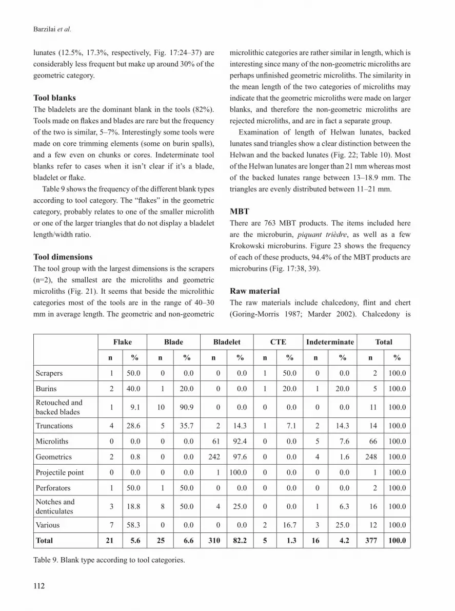
Tool blanks The bladelets are the dominant blank in the tools (82%). Tools made on flakes and blades are rare but the frequency of the two is similar, 5–7%. Interestingly some tools were made on core trimming elements (some on burin spalls), and a few even on chunks or cores. Indeterminate tool blanks refer to cases when it isn’t clear if it’s a blade, bladelet or flake.
Table 9 shows the frequency of the different blank types according to tool category. The “flakes” in the geometric category, probably relates to one of the smaller microlith or one of the larger triangles that do not display a bladelet length/width ratio.
Tool dimensionsThe tool group with the largest dimensions is the scrapers (n=2), the smallest are the microliths and geometric microliths (Fig. 21). It seems that beside the microlithic categories most of the tools are in the range of 40–30 mm in average length. The geometric and non-geometric
microlithic categories are rather similar in length, which is interesting since many of the non-geometric microliths are perhaps unfinished geometric microliths. The similarity in the mean length of the two categories of microliths may indicate that the geometric microliths were made on larger blanks, and therefore the non-geometric microliths are rejected microliths, and are in fact a separate group.
Examination of length of Helwan lunates, backed lunates sand triangles show a clear distinction between the Helwan and the backed lunates (Fig. 22; Table 10). Most of the Helwan lunates are longer than 21 mm whereas most of the backed lunates range between 13–18.9 mm. The triangles are evenly distributed between 11–21 mm.
MBTThere are 763 MBT products. The items included here are the microburin, piquant trièdre, as well as a few Krokowski microburins. Figure 23 shows the frequency of each of these products, 94.4% of the MBT products are microburins (Fig. 17:38, 39).
Raw materialThe raw materials include chalcedony, flint and chert (Goring-Morris 1987; Marder 2002). Chalcedony is
Flake Blade Bladelet CTE Indeterminate Total
n % n % n % n % n % n %
Scrapers 1 50.0 0 0.0 0 0.0 1 50.0 0 0.0 2 100.0
Burins 2 40.0 1 20.0 0 0.0 1 20.0 1 20.0 5 100.0
Retouched and backed blades 1 9.1 10 90.9 0 0.0 0 0.0 0 0.0 11 100.0
Truncations 4 28.6 5 35.7 2 14.3 1 7.1 2 14.3 14 100.0
Microliths 0 0.0 0 0.0 61 92.4 0 0.0 5 7.6 66 100.0
Geometrics 2 0.8 0 0.0 242 97.6 0 0.0 4 1.6 248 100.0
Projectile point 0 0.0 0 0.0 1 100.0 0 0.0 0 0.0 1 100.0
Perforators 1 50.0 1 50.0 0 0.0 0 0.0 0 0.0 2 100.0
Notches and denticulates 3 18.8 8 50.0 4 25.0 0 0.0 1 6.3 16 100.0
Various 7 58.3 0 0.0 0 0.0 2 16.7 3 25.0 12 100.0
Total 21 5.6 25 6.6 310 82.2 5 1.3 16 4.2 377 100.0
Table 9. Blank type according to tool categories.

113
Journal of the Israel Prehistoric Society 45 (2015), 97–130
113
Figure 16. Core types in the assemblage, n=47.
Subtype Length Width Thickness
Atypical Helwan lunateMean 25.0 8.0 2.4n 42 42 42Std. Dev. 3.3 1.0 0.5
LunateMean 16.4 5.8 2.2n 114 114 113Std. Dev. 2.8 1.0 0.5
Atypical lunateMean 16.7 6.3 2.2n 33 33 32Std. Dev. 3.2 1.4 0.6
Isocele triangleMean 15.2 6.0 2n 13 13.0 13Std. Dev. 2.2 1.1 0.5
Atypical triangleMean 18.3 9.2 2.6n 13 13 13Std. Dev. 2.8 1.9 0.5
Helwan lunateMean 25 8.1 2.4n 29 29 28Std. Dev. 4.7 0.8 0.6
TotalMean 19.0 6.7 2.3n 244 244 241Std. Dev. 5.0 1.6 0.6
Table 10. Lunate size according to type.

114
Barzilai et al.
114
Figure 17. 1–8, 10–19) backed lunates; 9, 20–23) triangles; 24–37) Helwan lunates; 38, 39) microburins.

115
Journal of the Israel Prehistoric Society 45 (2015), 97–130
115
0.5 1.3 2.9 3.7
17.5
65.8
0.3 0.54.2 3.2
0
10
20
30
40
50
60
70
Scrapers Burins Retouchedand backed
blades
Truncations Microliths Geometrics Projectilepoints
Perforators Notches anddenticulates
Various
%
3.01.5 1.5 1.5
4.5 3.01.5
12.1
3.01.5
3.01.5 1.5
9.1
4.5
47.0
0
5
10
15
20
25
30
35
40
45
50
%
parti
al fi
ne re
touc
h
com
plet
e fin
e re
touc
h
inve
rsly
reto
uche
d
alte
rnat
ly re
touc
hed
parti
ally
reto
uche
d
com
plet
e re
touc
hed
blun
t bac
ked
orsp
laye
d
obliq
uely
trun
cate
d
obliq
uely
trun
cate
d a
nd b
acke
d
Scal
ene
blad
elet
La M
ouill
lah
poin
t
Ram
on p
oint
doub
le tr
unca
ted
Hel
wan
Helw
an b
lade
let
var
ia- m
icro
liths
mic
rolit
h fr
agm
ents
Figure 18. Major tool categories.
Figure 19. Microlith subtype frequency.

116
Barzilai et al.
116
Figure 21. Tool dimensions, average in mm.
Figure 22. Helwan lunate, backed lunate and triangle length distribution in mm.
50.1
36.2
37.7
25.6
18.1
19.0
16.9
30.9
37.5
39.0
39.9
21.4
15.0
14.2
7.6
6.7 12
.3 19.9
20.8
37.4
17.6
10.1
4.5
3.7
2.3
2.3
2.1
8.2
5.7
12.6
Scrapers Burins Retouched and backed
blades
Truncations Microliths Geometrics Projectilepoints
Perforators Notches and denticulates
Various
length width thickness
0
10
20
30
40
50
60
Mea
n (in
mm
)
7.5
23.130.6
24.5
8.2 6.11.4 1.4
5.6 4.2
87.3
11.5 15.4
34.6
15.4 11.5 11.5
0-11 11.1 -12.9 13-14.9 15.1 -16.9 17.1 -18.9 19.1 -20.9 21-high
backed lunate Helwan lunate triangle
12.517.3
46.4
13.3
5.2 5.2
0
10
20
30
40
50
Helwanlunate
atypicalHelwanlunate
backedlunate
atypicalbacked lunate
isoceletriangle
atypicaltriangle
%
Figure 20. Geometrics subtype frequency.

117
Journal of the Israel Prehistoric Society 45 (2015), 97–130
117
Figure 23. Frequency of the MBT products.
the dominant raw material in the tool assemblage, comprising 80% of it. Flint and chert were used in much smaller quantities, the former comprising 15% of the total tool assemblage and the latter only 0.8%. Only in the ‘various’ category the flint outnumbers the chalcedony (Table 11). Most geometrics are made on chalcedony (82.7%) but it is not exclusive, as 13.7% were made on flint. Truncations were mostly made on chalcedony. Only 56.2% of the notches were made on chalcedony, the rest are on flint.
All three raw material types are represented in the cores - chalcedony, flint and chert, but the chalcedony is the most frequent. Seventy nine percent of the cores are on chalcedony, while only one core was made on chert (2%), the rest are on flint.
Nahal Sekher VI and other Natufian sites in the Negev lowlands – a lithic comparisonThere are several Natufian sites spanning from the Early Natufian to the Harifian phases in the Negev lowlands along the southern fringes of the NW Negev dunefield in similar geomorphic settings as Nahal Sekher VI (Goring-Morris 1987; 1991). The following discussion compares the Nahal Sekher VI tool assemblage to the following Natufian sites: Terminal Ramonian/ Early Natufian - Nahal Sekher 23 (NS23); Shunera VII (SHVII); Early Natufian - Azariq XV (AZXV); Late Natufian - Givat
Hayil I (GVHI) and Shunera XVIII (SHXVIII) (Goring-Morris 1987; 1997; Goring-Morris and Bar-Yosef 1987). The first two columns in Table 12 show the tools from the two seasons in Nahal Sekher VI (2009 and 1981).
There are a few differences in the frequency of specific tool types. First, scrapers seem to be rare in most of these assemblages, except for Azariq XV. Burins seem to be rare as well, except for Givat Hayil I. Perforators are very rare to nonexistent. Lastly, notches and denticulates are frequent in the assemblages, but in most they constitute less than 10%, except for Azariq XV. However these differences are merely a part of the typological variability known from other sites, both in the ‘periphery’ area and the ‘core area’ (Belfer-Cohen and Goring-Morris 2013; Goring-Morris 1987, Goring-Morris and Belfer-Cohen 2013).
The tools were divided to two groups – macroliths that include all tool categories except the microliths and geometric categories, and microliths, that include only the latter two categories. The ratio of macroliths to microliths may reflect the type of activity or activities done on site, mainly if there is a greater emphasis on hunting or a more diverse activities. The dominance of macroliths is more indicative of a higher diversity of activities, perhaps representing base camp or multi-purpose sites. The dominance of the microliths may reflect a stronger emphasis on one activity – possibly hunting. In all sites the microliths are the dominant group
94.4
3.7 1.40
10
20
30
40
50
60
70
80
90
100
microburin piquant trièdre krokowskI microburin
%

118
Barzilai et al.
118
Chalcedony Flint Chert Indeterminate Total n % n % n % n % n %
Scrapers 1 50.0 1 50.0 0.0 0.0 2 100.0Burins 3 60.0 2 40.0 0.0 0.0 5 100.0Retouched and backed blades 9 81.8 1 9.1 0.0 1 9.1 11 100.0Truncations 12 85.7 1 7.1 0.0 1 7.1 14 100.0Microliths 59 89.4 5 7.6 0.0 2 3.0 66 100.0Geometrics 205 82.7 34 13.7 1 0.4 8 3.2 248 100.0Projectile points 1 100.0 0.0 0.0 0.0 1 100.0Perforators 1 50.0 1 50.0 0.0 0.0 2 100.0Notches and denticulates 9 56.3 4 25.0 1 6.3 2 12.5 16 100.0Various 3 25.0 8 66.7 1 8.3 0.0 12 100.0Total 303 80.4 57 15.1 3 0.8 14 3.7 377 100.0
Table 11. Raw material according to tool types.
NSVI (2009) NSVI (1981) NS 23 SHVII AZXV GVHI SHXVIII
Scrapers 0.5 0.6 1.5 1.9 7.4 0.8 0.9
Burins 1.3 3.4 0.4 0.7 1.4 5.0
Multiple tools 0.4 0.9 0.3 0.9
Backed blades 2.9 3.4 2.3 4.7 5.5 6.8 5.5
Truncations 3.7 4.0 0.8 1.2 0.9 3.5
Microliths 17.5 13.6 68.7 46.8 25.8 42.1 29.1
Geometric microliths 65.8 65.0 20.8 27.5 25.3 22.3 53.6
Points 0.3
Perforators 0.5 1.5 0.9Notches and denticulates 4.2 7.9 4.9 13.3 20.7 9.3 3.6
Heavy duty tools 4.5
Various 3.2 2.3 0.8 3.8 12.0 8.5 5.4
Total 377 177 265 579 217 399 286
Table 12. Frequencies of the basic typological categories between Natufian sites in the Negev lowlands.
NSVI 2009 NSVI 1981 NS23 AZXV GVHI SHXVIII
n % n % n % n % n % n %
Tools 377 4.6 177 4.4 265 16.2 217 7.9 399 6.3 286 26.3
Cores 47 0.6 14 0.3 26 1.6 12 0.4 54 0.8 11 1.0
MBT 763 9.3 504 12.7 249 15.2 103 3.8 1,345 21.2 110 10.1
Debitage 7,031 85.6 3,286 82.5 1,095 66.9 2,408 87.9 4,543 71.6 681 62.6
Total 8,218 3,981 1,635 2,740 6,341 1,088
Table 13. Comparison of the main lithic components

119
Journal of the Israel Prehistoric Society 45 (2015), 97–130
119
Figure 25. Frequencies of Helwan and backed lunates at Nahal Sekher VI and other Natufian sites (Ashkenazy 2014; Goring-Morris 1987).
0
2030
50
70
90
10
40
60
80
100
NSVI 09 (n=222) NS23 (n=100) AZXV (n=64) GVHI (n=80) SHXVIII (n=59)
Helwan lunates Backed lunates
%
Figure 24. Ratio of macroliths and microliths.
0
10
20
30
40
50
60
70
80
90
100
NahalSekher VI
(2009)
NahalSekher VI
(1981)
NahalSekher 23
ShuneraVII
Azariq XV GivatHayil I
ShuneraXVIII
Microliths Macroliths
%
(Fig. 24). However, Azariq XV is unique in that there is an almost 50:50 ratio of the macroliths and microliths.
Table 13 gives the breakdown of the main lithic component of the assemblage from the previously
mentioned sites. A few interesting differences in the composition of these assemblages can be discerned.
First, the frequency of tools in the assemblage of most of the sites is no more than 10% let alone, Nahal Sekher

120
Barzilai et al.
120
10
12
14
16
18
20
22
24
26
4 4.5 5 5.5 6 6.5 7 7.5 8 8.5
NSVI 09 (Helwan and backed lunates) nsvi09 (Helwan lunates)nsvi09 (backed lunates) NS23GVHI
Figure 26. Size (average, mm) of Helwan and backed lunates from Nahal Sekher VI (NSVI 09) and other Natufian sites. NSVI 09 (n=222), GVHI (n=70) (Ashkenazy 2014); NS23 (n=42) (Goring-Morris 1987).
23, and Shunera XVIII where the tools comprise almost 30%. This is probably due to the function of the site and diversity of activities in and around the site. Second, the MBT products seem to have the highest frequency in Givat Hayil I, as either the site was occupied for a longer period of time or by several recurring habitations, or it was inhabited by a larger group. All these interpretations seem to fit with the suggestion that Givat Hayil I functioned more as a base camp than a hunting camp (Goring-Morris 1997). Nahal Sekher VI seems to fit with the majority of the other sites, suggesting that its main function was a short term encampment or hunting site.
Lastly, the size and retouch type of the lunate is compared (Fig. 25). Both Nahal Sekher 23 and Azariq XV have almost exclusively Helwan lunates, while backed lunates are dominant in Givat Hayil I and Shunera XVIII. In NSVI 2009 backed lunates dominate (67%) but Helwan lunates (33%) are abundant as well.
Figure 26 shows the mean length and width of the lunates at Nahal Sekher VI, Nahal Sekher 23 and Givat Hayil I. The lunates from Nahal Sekher VI show similar size to the ones from Givat Hayil I while the ones from Nahal Sekher 23 are slightly bigger. But when the lunates of Nahal Sekher VI are separated to two groups, the Helwan
lunates exceed those from Nahal Sekher 23 and the backed lunates have smaller size than those at Givat Hayil I.
Altogether, the dominance of microliths within the lithic assemblage at NSVI 2009 seems to be congruent with the other Natufian sites in the area. Accordingly the sites’ functions seem to fit with previous suggestions (Goring-Morris, 1987), as a hunting camp or other short duration and limited activity type camp. As for the chronological placement there seems to be a representation of both Early and Late Natufian traits – especially according to the lunate types found in the site. The presence of the two types could attest to two Natufian occurrences at the site (Early and Late) or a homogeneous assemblage containing the two types (and see discussion below).
THE STONE ASSEMBLAGE (P.S.)Limestone items of a wide size range were collected from all the excavated loci. Here we present stone items only from the excavation area (Locus 101; Fig. 4). The assemblage includes 4,899 limestone items, of which only seven were defined as tools or tool fragments. Ninety-seven percent of the limestone items were burnt. This

121
Journal of the Israel Prehistoric Society 45 (2015), 97–130
121
Figure 27. Geological formations at the vicinity of the studied area (after Roskin et al. 2014a). LFFDs are low energy fluvial fine-grained deposits.
study includes the description of unmodified stones and fire-cracked fragments, an aspect not commonly addressed in excavation reports.
A classification method was applied following the scheme developed for the stone assemblage of Ohalo II (Spivak 2008). All limestone artifacts were first sorted by size into four groups: (1) <15 mm, (2) 15–30 mm, (3) 30–50 mm and (4) >50 mm.
According to morphological and techno-typological parameters, specimens larger than 15 mm (n=2,545) were divided into four key groups: tools and tool fragments (n=7); production related implements and debitage (n=39); and as distinct categories: pebbles and their fragments (n=33) and fire-cracked fragments (n=2,468).
Raw materialThere is a linkage between the raw material type and the way in which it was used. A suitability level of
raw material depends on its physical characteristics: predominantly hardness, density, brittleness, flexibility and vesicularity (porousness). The studied limestone items are relatively hard and dense. Most of them were probably brought from geological exposures of Eocene Adulam Formation limestone, less than 250 m west and south of the site (Fig. 27).
The stone toolsThe term “stone tools” or “ground-stone tools” refers to stone implements that were made using mainly the technique of grinding and/or polishing (Adams 1996, 2002:1). It also refers to the tools used for grinding, polishing, knapping or pecking (Adams 1993, 2002:1; Wright 1991, 1993:93, 1994:240).
The modest Nahal Sekher VI limestone tool assemblage includes seven artifacts, only two of them are complete. Most of the tools can be categorized as handstones (Fig.

122
Barzilai et al.
122
# Type Locus Basket Size group (mm) Color Preservation state
1 Handstone (Bifacial rectilinear/wedged) 102 1240 50+ white complete
2 Possible trapezoidal axe? 102 1780 50+ reddish complete
3 Handstone (Bifacial irregular-discoidal/flat ) 102 1682 50+ white eroded
4 Handstone fragment (Bifacial rectilinear/semi-oval) 102 1928 50+ grey broken/fire-cracked
5 Miscellaneous fragment 102 1977 30-50 grey broken/fire-cracked
6 Handstone (Unifacial irregular/Plano-triangular) 102 1648 50+ white broken/fire-cracked
7 Unifacial grinding slab fragment 101 2012 50+ white broken/fire-cracked
Table 14. Ground-stone tools.
Figure 28. Limestone tools. 1) handstone (bifacial irregular-discoidal/flat); 2) handstone fragment (bifacial rectilinear/semi-oval); 3) miscellaneous fragment; 4) handstone (unifacial irregular/plano-triangular).

123
Journal of the Israel Prehistoric Society 45 (2015), 97–130
123
28:1, 2, 4) except for two (Table 14:2, 5; Fig. 28:3). They were classified using criteria developed by Wright (1992a, b). From a technological point of view the Nahal Sekher VI tool assemblage is characterized by a high level of secondary reduction processes - knapping, pecking and grinding.
The production related implements and debitageLike flint tools, the ground-stone tools are end products of a planned chain of actions. It includes a choice of suitable raw material of proper size and form; primary and secondary reduction stages; design, repair and improvement during the tool use.
Wright’s category of debitage includes flakes and flake cores, pecked preforms and indeterminate spalls (Wright
1992: 143). Here all implements indicative of ground-stone production are presented. The debitage group was subdivided into flakes (n=22) and flaked implements (n=7). Manuports (n=5) are presented separately. Another small group (n=5) includes fragments possibly carrying polish marks.
Debitage Flakes (n=22). Flakes were identified by the bulb of percussion or the striking point (Fig. 29). The flakes have 1–4 scars on their back. Most of the flakes are rounded and wide. All have an unmodified base. Although all flakes bear signs of fire, only 6 are broken. Most of the flakes fall within the 15–30 mm (n=8) and the 30–50 mm (n=9) size groups. All of the primary flakes (n=3) are larger than 50
Figure 29. Limestone flakes. 1, 4) primary flakes; 2) an elongated flake; 3) typical rounded and wide flake.

124
Barzilai et al.
124
Figure 30. Flaked stones. 1) modified limestone slab with slight flaking and pounding marks on its surfaces (possible anvil); 2) flat limestone slab with lateral flaking marks.
mm (a group containing a total of five flakes). Flaked stones. Flaked stones (7) are large (>50 mm)
fragments with flake scars, sometimes bifacial. Of notice are two remarkably big flat fragments (Fig. 30). One, from Locus 101 (Figs. 6; 30:1), was possible used as anvil.
ManuportsManuports (n=5) are big fragments representative of big stones deliberately brought to the site. These could have been used as (modified or not) anvils or as working tables (Wright 2008).
Implements with traces of polish These (n=5) have clear triangular section, possibly
achieved by polishing. It seems that these are not fragments of designed tools, but more likely were somehow involved in tool manufacture. Since in fact the polishing could be confirmed only by microscopic analysis, currently they are not to be counted with the tools.
Pebbles Twenty-five complete and 10 broken pebbles were identified. The average length of the complete pebbles
is 5.2 cm. Most of the pebbles are sub-angular to sub-round in shape. Based on negligible striking and polishing marks on some pebbles, it is possible they were used as hammerstones. Modern hunter/gatherers use a wide variety of natural undersigned pebbles as hammerstones (Cane 1989). As usable pebbles were easy to find along Nahal Sekher, they were probably used ad-hoc and carelessly replaced. This could be the main reason for the lack of more massive observable use-wear signs.
FragmentsFragments of a wide size range compose 97% of the total limestone specimens collected. Although fragments are fresh and sharp no working surface/edge identification is possible. Some fragments include elements of the outer face (cortex or designed/worked surfaces) so the original shape of the complete implement may be estimated. Such fragments were counted together with other components of the relevant group defined in the assemblage (tools, pebbles, etc.). However, most of the fragments derive from the inner section of the stones, so the original shape is lost.
All fragments share noticeable morphological properties according to which two types of fragments

125
Journal of the Israel Prehistoric Society 45 (2015), 97–130
125
Figure 31. The distribution pattern of the stone assemblage according to size groups: A) fragments from an experimental heat-treated exploded pebble; B) limestone and basalt assemblage documented in Ohalo II; C) Nahal Sekher VI current excavation limestone assemblage.
70%
60%
50%
40%
30%
20%
10%
0%
A
B
C
shape were defined: flat tabular fragments with two parallel (more or less) sides; and angular pieces with more than two fractured surfaces, sometimes the section line is zigzagged.
The high level of standardization of the fragments shapes suggests they were all produced during a single destructive event. Similar assumption regarding analogous stone fragments found at Ohalo II was tested in a series of experiments exposing basalt and limestone pebbles and boulders to open fire, resembling a burning camp (Spivak 2008). As a result of the fire all implements were damaged. A few cracked, but most of them had exploded resulting in tabular and angular fragments.
The size distribution of fragments from one experimentally exploded pebble (20 cm long) appears to be similar to size distributions documented at Ohalo II and Nahal Sekher VI (Fig. 31).
Summary and discussionStone assemblages with fire-damaged specimens from poorly preserved prehistoric camps, such as Nahal Sekher VI, are difficult to interpret. Despite its fragmented nature, the presented assemblage is entirely anthropogenic. As such, it deserves proper attention to all its components. Evidently, as a result of uncompromising collection and examination of all finds, a small tool assemblage and possible manufacture traces were revealed.
Most of the NSVI seven tools are flat and therefore should be associated with grinding, possibly related to food processing. Stone tools used for processing of plant food are widely presented in archaeological (Foxhall and Forbes 1982; Higgs and Jarman 1969; Hillman et al. 2001; Horsfall 1987; Wright 1991) and ethnographic records (Cane 1989; Hillman 1984; Stahl 1989). A direct association between the tool fragments and plant food processing would be possible only if microscopic use-wear analysis is conducted.
It seems that pounding tools, usually common in the Natufian (Garrod 1957; Kraybill 1977; Weinstein-Evron et al. 2001; Wright 1992a) were not recorded here. It may correspond with the general increase in the frequency of grinding stone tools in Late Natufian contrasted with the Early Natufian sites (Wright 1993). Although pounding stone tools in the Negev are

126
Barzilai et al.
126
associated with the Late Natufian (Goring-Morris 1987, 1991), a general absence of pestles and mobile mortars was noted at sites south of the Beer-Sheva Valley (Goring-Morris 1987:306). However, only few stone tools were reported from Natufian sites in the vicinity of NSVI. In fact Goring-Morris (1987) described rare perforated limestone discs from Azariq XV and Halutza 87 and anvils of angular limestone blocks from Nahal Sekher 23 and Shunera VII.
Rare evidence of production is present in the shape of flakes and flaked items. Pecking, chopping, pounding, incising and drilling waste, also associated with ground stone tools production (Wright 1992a, 1992b:105) usually cannot be identified. Fragments with possible polish marks could have been used for those tasks.
Comparable traces of ground stone manufacture were recorded at Ohalo II (Spivak 2008). Further occurrence of limestone and basalt debitage in Epipaleolithic and Natufian assemblages was hardly reported (Wright 1992a).
Since most of the studied stone assemblage is comprised of unidentifiable burnt fragments the exact number of tools, pebbles, flakes or manuports cannot be truly determined. Massive refitting efforts coupled with a correlated (with other finds) spatial distribution study would perhaps supply actual figures.
In any case, such a high percentage of widely spread fragments formed by fire indicate burning event/s at the camp. Deliberate burning of abandoned camps was reported from some Neolithic sites in Europe (Stevanovic 1997). Fire at a camp could of course occur unintentionally, and even be the reason for its abandonment. Additional research focused on limestone assemblage components, mainly the fragments, is of great potential for a better understanding of subsistence strategies that took place at the investigated site.
DISCUSSIONThe 2009 excavation at Nahal Sekher provides new data concerning palaeoenvironment, site formation process, site function and its chronology.
PalaeoenvironmentThe reconstruction of the paleoenvironments builds on the geomorphological study of the sites’ immediate
environments (Roskin et al. 2014a). The results attest to fluvial-aeolian fluctuations during the Late Pleistocene-Holocene interphase. The fluvial events are reflected by palaeo-water bodies similar to those recognized at Ramat Hovav (Enzel 1984; Magaritz and Enzel 1990) and immediately to the south of Nahal Sekher VI (Roskin et al. 2014a). The sedimentological analysis of the LFFDs next to Nahal Sekher VI suggest a series of short-lived standing-water bodies created by low-energy fluvial runoffs. These were caused due to temporary dune damming of the Nahal Sekher stream that substantially slowed the stream flow to form a unique and natural ever-emptying reservoir-like water body. We assume that these unique palaeo-water bodies attracted and concentrated waterfowl and mammals that in turn created an attractive niche for the Natufians. Although faunal remains were not preserved the lithic composition at the site support hunting and meat processing activities.
Site formation processes The Natufian site was affected mainly by long term exposure and aeolian activities – namely deflation and re-depositions of new sands on top of the archaeological horizon. This recognition is confirmed by the OSL ages of the upper sand unit, the radiocarbon dates of the ostrich eggshell fragments, and by the presence of intrusive artifacts.
The OSL ages of the lower sand units at Nahal Sekher set the terminus post quem of the Natufian horizon to 13.6-11.8 ka. After the abandonment of the Natufian site, the Sekher sands underwent several aeolian modifications and slight reworking. The Natufian surface was probably covered immediately by sands. This notion is supported by the “complete” lithic and stone assemblages (i.e. large quantities of flint chips and stone debitage and fragments). After its coverage, the site probably underwent several deflation events that are attested by the recovery of intrusive artifacts: a fragment of Salibiya point, a few Neolithic/Chalcolithic pottery sherds and several ostrich eggshell fragments radiocarbon dated to 7.5 ka. Thus it is assumed that the deflation and sand accumulations were short-termed and occurred continuously for several times. The assumption of an immediate sand coverage is supported by the large quantitates of small lithic components (chips) within the flint assemblage and also by the presence of non-patinated flint items. The last sand coverage of the

127
Journal of the Israel Prehistoric Society 45 (2015), 97–130
127
site is estimated to have occurred at ~3.7-2.9 ka following the OSL ages of the upper sand unit. Sand mobilization at this time in the NW Negev dunfefield has been reported for several single sand, dune and LFFD sections by Zilberman (1991), Ben-David (2003) and Roskin (2011a). It is assumed that this was the last coverage that sealed the site until present.
Role of site locationThe Natufian-Harifian settlement pattern included annual circulation between the highland areas where base camps with constructed dwellings were common to the lowland regions with its many ephemeral camps (Goring-Morris 1991). Nahal Sekher VI is one of many Natufian ephemeral camp sites in the Negev lowlands along the southern fringe of the NW Negev dunefield (Goring-Morris 1987). This type of site represents seasonal exploitation of the lowland areas, which probably was related to hunting, plant gathering and raw material exploitation. Such activities are usually reflected in the composition of the lithic assemblages. For example, raw material sources and knapping sites are represented by a high percent of cores and debitage (usually with refitted aggregates) and low percent of tools. In hunting sites there are higher frequencies of hunting weapons and other tools that are related to hide processing and butchering tusks. The overall characteristics of the tool kit found at Nahal Sekher VI support hunting tasks like many of the Natufian sites in the Negev. All are dominated by microliths and include few larger tool categories (Goring-Morris 1987). Still, the stone tools that were found at Nahal Sekher VI, although few in number, imply that plant processing also took place at the site.
Mixed Helwan and backed lunates One of the most interesting discoveries of the 2009 excavation at Nahal Sekher VI is the relatively high percentage of Helwan lunates (30%) along with backed lunates (70%) (Fig. 21). Notably, the two types were found in the same archaeological horizon. The presence of these two chronological markers (e.g. Valla 1984) could be interpreted in two ways. The 1st explanation is that the site has two chronological phases that were not recognized due to deflation process. An Early Natufian phase represented by large Helwan lunates and Late Natufian phase by smaller backed lunates. This explanation seems quite
reasonable in light of the recognition that site experienced several deflation episodes. Another parameter that would support two chronological phases is the clear distinction in the size of the two types. The Helwan lunates are significantly larger than the backed lunates and seem to have been modified on different blank types (Fig. 22). The spatial distribution of the two also partly supports such a distinction with the Helwan type being concentrated at the center of the site while the backed ones at the southern part (Fig. 13). If indeed the two types represent two chronological phases, it can be assumed there was a successive occupation of the same place by the Early and the Late Natufians.
The 2nd explanation could argue that the two lunate types coexist in the same assemblage. The first indication is the latest age of the surface on which the Natufian horizon was deposited upon that is dated to 11.8 +/- 0.5 ka (Fig. 8). If the horizon is one this means that the Natufian artifacts can fit the time range of the Late Natufian, but not the Early Natufian dated to 15-13.5 ka (e.g. Bar-Yosef 2011: fig. 3).
While the tendency to correlate Helwan lunates with the Early Natufian and backed lunates with the Late Natufian has been proven to be valid at certain stratified sites in the Mediterranean woodland area (e.g. Valla 1984; Weinstein-Evron et al. 2012: fig. 2), it is somehow less clear for the Negev lowland area where the sites are ephemeral and most do not have absolute dates. There are several obstacles in the Helwan-backed lunate paradigm. One is how to explain the other types of lunates. For example, it is not clear to which phase do the small Helwan lunates at Hof Shahaf correspond: the Early or the Late Natufian (Marder et al. 2013). Second is the “mixed assemblages”. There is a tendency to ascribe lithic assemblages as mixed whenever Helwan and backed lunates are found together. It might be right in some cases since mixing does occur in sites, but it should not be the only criteria to determine if a site is mixed.
“Clean” assemblages dominated by one lunate type (e.g. NS 23, GVHI) are rare and may have to do with short term task-specific activity. In fact many of the Natufian sites in the Negev have the two components (e.g. Ira 22, Rosh Horesha, Halutza 83 and 84, Upper Besor 6; Goring-Morris 1998). In some cases it seems to be indeed mixed, for example at Rosh Horesha where Geometric Kebaran, Late Natufian and Harifian components were

128
Barzilai et al.
128
identified together with different 14C dates (Goring-Morris 1987: 275). But in other cases such as Ira 22 it has been suggested that the presence of Helwan and backed lunate could reflect an “intermediate” Early and Late Natufian (Goring-Morris 1987:264). If we examine the Pre-Pottery Neolithic B arrowhead typology for the sake of the argument, it is quite accepted that different projectile types can coexist in one chronological phase (e.g. Gopher 1994). To summarize based on the above points it is proposed that such rational should be considered when analyzing Natufian assemblages with different lunate types.
Concerning Nahal Sekher VI, since no stratigraphic separation and no differences in the patina pattern exists between the lunates it is difficult to claim their presence marks two chronological phases. On the other hand, the spatial distribution differences and mainly the hypothesized deflation processes that took place at the site can support the two phase explanation. With the available evidence it is impossible to prefer one of these explanations.
ACNOWLEDGEMENTSNahal Sekher VI excavation (Permit No. A-5717) was directed by O. Barzilai and N. Agha on behalf of the Israel Antiquities Authority was conducted during August–September 2009. The excavation was sponsored by the Israel National Roads Company Ltd. We are grateful to the following students for their devoted work in the field during the excavation: D. Yegorov, Y. Radashkovski, S. Mizrahi (Ben-Gurion University), D. Shaham, N. Klein, A. Vered and A. Malinski-Buller (Hebrew University) and D. Bonus (Tel Aviv University). Thanks are extended to F. Sonntag, S. Lender and Y. el-Amor the Israel Antiquities Authority (administration). We thank A.N. Goring-Morris, I. Milevski, O. Marder, H. Khalaily, Y. Sharfi and K. Vardi for their advice during field work. Figures 14-15; 17 were illustrated by M. Smelanski (Artifacts Treatment Department, Israel Antiquities Authority); Figures 28-30 were prepared by A. Karasik (National digital Laboratory, Israel Antiquities Authority).
REFERENCESAdams J.L. 1993. Technological replication of the use of
ground stone tools. Kiva 54: 261–271.
Adams J.L. 1996. Manual for Technological Approach to Ground Stone Analysis. Tucson: Center for Desert Archaeology.
Adams J.L. 2002. Ground Stone Analysis: A Technological Approach. Salt Lake City: University of Utah Press.
Ashkenazy H. 2014. Lithic Production Processes in the Late Natufian of Israel: Core Area vs. Periphery. Unpublished Ph.D. Dissertation, The Hebrew University of Jerusalem, Jerusalem.
Bar-Yosef O. 2011. Climatic fluctuations and early farming in West and East Asia. Current Anthropology 52(4): S175–S193.
Barzilai O. and Agha N. 2010. Nahal Sekher, preliminary report. Hadashot Arkheologiyot 122. http://www.hadashot-esi.org.il/report_detail_eng.aspx?id=1545%26mag_id=117.
Belfer-Cohen A. and Goring Morris A.N. 2013. Breaking the mold: Phases and facies in the Natufian of the Mediterranean zone. In: Bar-Yosef O. and Valla F.R. (eds.), Natufian Foragers in the Levant: Terminal Pleistocene Social Changes in Western Asia, pp. 544–561. Ann Arbor: International Monographs in Prehistory.
Bronk Ramsey C. and Lee S. 2013. Recent and planned developments of the program OxCal. Radiocarbon 55(2–3): 720–730.
Burian F. and Friedman E. 1975. Prehistoric sites in the Nahal Sekher Area. Mitekufat Haeven - Journal of the Israel Prehistoric Society 11: 27–34 (Hebrew).
Cane S. 1989. Australian aboriginal seed grinding and its archaeological record: a case study from the Western Desert. In: Harris D.R. and Hillman G.C. (eds.), Foraging and Farming: The Evolution of Plant Exploitation, pp. 99–119. London: Unwin Hyman.
Ekshtain R., Barzilai O., Inbar M., Milevski I. and Ullman M. 2011. Givat Rabi East, a new Middle Paleolithic knapping site in the Lower Galilee (Israel). Paléorient 37 (2): 107–122.
Enzel Y. 1984. The Geomorphology of the Lower Nahal Sekher Wadi. Unpublished M.Sc. Dissertation. The Hebrew University of Jerusalem, Jerusalem (Hebrew).
Foxhall L. and Forbes H. 1982. The role of grain as a staple food in classical antiquity. Chiron 12: 41–90.
Friedman E., Goren-Inbar N., Rosenfeld A., Marder O. and Burian F. 1994. Hafting during Mousterian times - further indications. Mitekufat Haeven - Journal of the

129
Journal of the Israel Prehistoric Society 45 (2015), 97–130
129
Israel Prehistoric Society 26: 8–32.Garrod D.A.E. 1957. The Natufian culture: the life and
economy of a Mesolithic people in the Near East. Proceeding of the British Academy 43: 211–227.
Getis A. and Ord J.K. 1996. Local spatial statistics: an overview. In: P. Longley and M. Batty (eds.), Spatial Analysis: Modelling in a GIS Environment, pp. 261–277. Cambridge: GeoInformation International.
Gopher A. 1994. Arrowheads of the Neolithic Levant. ASOR Dissertation Series 10. Winona Lake, Ind.: Eisenbrauns.
Goring-Morris A.N. 1987. At the Edge: Terminal Pleistocene Hunter-Gatherers in the Negev and Sinai (BAR International Series 361). Oxford.
Goring-Morris A.N. 1991. The Harifian of the Southern Levant. In: Bar Yosef O. and Valla F.R. (eds.), The Natufian in the Levant, pp. 173–234. Ann Arbor: Michigan.
Goring-Morris A.N. 1997. A Late Natufian campsite at Givat Hayil I, western Negev Dunes, Israel. Mitekufat Haeven - Journal of the Israel Prehistoric Society 27: 43–61.
Goring-Morris A.N. 1998. Mobility art from the late Epipalaeolithic of the Negev, Israel. Rock Art Research 15(2): 81–88.
Goring-Morris A.N. and Bar-Yosef O. 1987. A Late Natufian campsite from the western Negev, Israel. Paléorient 13(1): 107–112.
Goring-Morris A.N. and Belfer-Cohen A. 2013. Ruminations on the role of periphery and centre in the Natufian. In: Bar-Yosef O. and Valla F.R. (eds.), Natufian Foragers in the Levant: Terminal Pleistocene Social Changes in Western Asia, pp. 562–583. Ann Arbor: International Monographs in prehistory.
Goring-Morris A.N. and Goldberg P. 1990 Late Quaternary dune incursions in the southern Levant: archaeology, chronology and palaeoenvironments. Quaternary International 5: 115–137.
Higgs E. and Jarman M. 1969. The origins of agriculture: a reconsideration. Antiquity 43: 31–41.
Hillman G.R. 1984. Interpretation of archaeological plant remains: the application of ethnographic models from Turkey. In: W. Van Zeist and Casparie W. (eds.), Plants and Ancient Man, pp. 1–42. Rotterdam and Boston.
Hillman G., Hedges R., Moore A., Colledge S. and Pettitt P. 2001. New evidence of Late glacial cereal cultivation
at Abu Hureyra on the Euphrates. The Holocene 11(4): 383–393.
Horsfall G.A. 1987. Design theory and grinding stones. In: B. Hayden (ed.), Lithic Studies among the Contemporary Highland Maya, pp. 332–377. Tucson: University of Arizona Press.
Jenks G.F. 1967. The data model concept in statistical mapping. International Yearbook of Cartography 7: 186–190.
Kraybill N. 1977. Pre-agricultural tools for the preparation of foods in the Old World. In: C. Reed (ed.), Origins of Agriculture, pp. 485–522. Mouton: The Hague.
Magaritz M. and Enzel Y. 1990. Standing-water deposits as indicators of Late Quaternary dune migration in the northwestern Negev, Israel. Climate Change 16: 307–318.
Marder O. 2002. The Lithic Technology of Epipalaeolithic Hunter-Gatherers in the Negev: The Implications of Refitting Studies. Unpublished Ph.D. Dissertation. The Hebrew University of Jerusalem, Jerusalem.
Marder O., Yeshurun R., Smithline H., Ackermann O., Bar-Yosef Mayer D.E., Belfer-Cohen A., Grosman L., Hershkovitz I., Klein N. and Weissbrod L. 2013. Hof Shahaf: A new Natufian site on the shore of Lake Kinneret. In: Bar-Yosef O. and Valla F.R. (eds.), Natufian Foragers in the Levant: Terminal Pleistocene Social Changes in Western Asia, pp. 505–526. Ann Arbor: International Monographs in prehistory.
Nadel D., Bar-Yosef O. and Gopher A. 1991. Early Neolithic arrowhead types in the southern Levant: A typological suggestion. Paléorient 17(1): 109–119.
Reimer P.J., Bard E., Bayliss A., Beck J.W., Blackwell P.G., Bronk Ramsey C., Grootes P.M., Guilderson T.P., Haflidason H., Hajdas I., Hattž C., Heaton T.J., Hoffmann D.L., Hogg A.G., Hughen, K.A., Kaiser, K.F., Kromer B., Manning S.W., Niu M., Reimer R.W., Richards D.A., Scott E.M., Southon J.R., Staff R.A., Turney C.S.M. and van der Plicht J. 2013. IntCal13 and Marine13 Radiocarbon Age Calibration Curves 0-50,000 Years cal BP. Radiocarbon 55(4): 1869–1887.
Roskin J., Porat N., Tsoar H., Blumberg D.G. and Zander A.M. 2011a. Age, origin and climatic controls on vegetated linear dunes in the northwestern Negev Desert (Israel). Quaternary Science Reviews 30(23–24): 3364–3380.

130
Barzilai et al.
130
Roskin J., Rozenstein O., Tsoar H., Blumberg D.G. and Porat N. 2011b. Palaeoclimate interpretations of Late Pleistocene vegetated linear dune mobilization episodes: evidence from the northwestern Negev dunefield, Israel. Quaternary Science Reviews 30(13–14): 1649–1674.
Roskin J., Rozenstein O., Blumberg D.G., Tsoar H. and Porat N. 2012. Do dune sands redden with age? – the case of the northwestern Negev dunefield, Israel. Aeolian Research 5: 63–75.
Roskin Y., Katra I., Agha N., Goring-Morris A.N. and Barzilai O. 2014a. Rapid anthropogenic response to short-term aeolian-fluvial palaeoenvironmental changes during the Late Pleistocene–Holocene transition in the northern Negev Desert, Israel. Quaternary Science Reviews 99: 176–192.
Roskin J., Katra I. and Blumberg D.G. 2014b. Particle-size fractionation of eolian sand along the Sinai - Negev erg of Egypt and Israel. Geological Society of America Bulletin 126(1-2): 47–65.
Spivak P. 2008. Limestone and Basalt Assemblage from the Epipaleolithic Site of Ohalo II, a 23,000 Years Old Fisher-Hunter-Gatherers’ Camp. Unpublished MA Dissertation. Haifa University, Haifa (Hebrew with English summary).
Stahl A.B. 1989. Plant-food processing: implications for dietary quality. In: Harris D.R. and G.C. Hillman (eds.), Foraging and Farming: the evolution of plant exploitation, pp. 172–194. London: Unwin Hyman.
Stevanovic M. 1997. The age of clay: the social dynamics of house destruction. Journal of Anthropological Archaeology 16: 334–395.
Valla F.R. 1984. Les Industries de Silex de Mallaha (Eynan) et du Natoufien dans le Levant. Paris: Mémoires et Travaux du Centre de Recherches Préhistoriques Françaises de Jerusalem 3.
Weinstein-Evron M., Kaufman D. and Bird-David N. 2001. Rolling stones: basalt implements as evidence for trade/exchange in the Levantine Epipalaeolithic. Mitekufat Haeven - Journal of the Israel Prehistoric Society 31: 25–42.
Weinstein-Evron M., Yeshurun R., Kaufman D., Eckmeier E. and Boaretto E. 2012. New 14C dates for the early Natufian of el-Wad Terrace, Mount Carmel, Israel. Radiocarbon 54(3–4): 813–822.
Wright K. 1991. The origins and development of ground stone assemblages in Late Pleistocene southwest Asia. Paléorient 17(1): 19–43.
Wright K. 1992a. A classification system for ground stone tools from the prehistoric Levant. Paléorient 18(2): 53–81.
Wright K. 1992b. Ground Stone Assemblage Variations and Subsistence Strategies in the Levant, 22,000 to 5,500 B.P. Unpublished Ph.D. Dissertation. Yale University, New Haven.
Wright K. 1993. Early Holocene ground stone assemblages in the Levant. Levant 25: 93–111.
Wright K. 1994. Ground stone tools and hunter-gatherer subsistence in Southwest Asia: implications for the transition to farming. American Antiquity 59(2): 238–263.
Wright K.I. 2008. Craft production and the organization of ground stone technologies. In: Rowan Y. and Ebeling J. (eds.), New Approaches to Old Stones: Recent Studies of Ground Stone Artefacts, pp. 130–143. London: Equinox Publishing Ltd.
Yizhaq M., Mintz, G., Cohen I., Khalally H., Weiner S. and Boaretto E. 2005. Quality controlled radiocarbon dating of bones and charcoal from the early Pre-Pottery Neolithic B (PPNB) of Motza (Israel). Radiocarbon 47: 193–206.