supplemental environmental impact assessment mumbai
TRANSCRIPT

As of 24th November 2015 Final (reviewed by JICA on 9th October 2015)
Mumbai Trans Harbor Link Project
Supplemental Environmental Impact Assessment
(Final, 24th of November 2015 2015)
Mumbai Metropolitan Region
Development Authority
(MMRDA)

Executive Summary
The Project for Construction of Mumbai Trans Harbour Link Supplemental EIA Report – Executive Summary
Summary-1
As of 24th November 2015 Final (based on 9th October version viewed by JICA)
Mumbai Trans Harbor Link Project
Supplemental Environmental Impact Assessment
Executive Summary
(Final, 24th November 2015)
Mumbai Metropolitan Region
Development Authority
(MMRDA)
The Project for Construction of Mumbai Trans Harbour Link Supplemental EIA Report – Executive Summary
Summary-2
VIRONMENTAL IMPACT ASSESSMENT
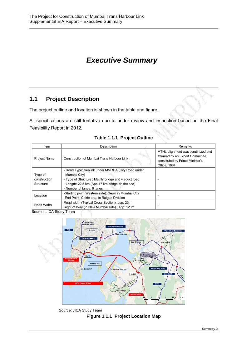
1.1 Project Description
The project outline and location is shown in the table and figure.
All specifications are still tentative due to under review and inspection based on the Final
Feasibility Report in 2012.
Table 1.1.1 Project Outline
Item Description Remarks
Project Name Construction of Mumbai Trans Harbour Link
MTHL alignment was scrutinized and affirmed by an Expert Committee constituted by Prime Minister’s Office, 1984
Type of construction Structure
- Road Type: Sealink under MMRDA (City Road under Mumbai City)
- Type of Structure : Mainly bridge and viaduct road - Length: 22.5 km (App.17 km bridge on the sea) - Number of lanes: 6 lanes
-
Location -Starting point(Western side): Sewri in Mumbai City -End Point: Chirle area in Raigad Division
-
Road Width Road width (Typical Cross Section): app. 25m Right of Way (in Navi Mumbai side) : app. 120m
-
Source: JICA Study Team
Source: JICA Study Team
Figure 1.1.1 Project Location Map
Executive Summary

The Project for Construction of Mumbai Trans Harbour Link Supplemental EIA Report – Executive Summary
Summary-3
Typical Cross Section (On the Land) Typical Cross Section (On the Sea) Source: JICA Study Team
Figure 1.1.2 Typical Structure of the Bridge and Road
The Project for Construction of Mumbai Trans Harbour Link Supplemental EIA Report – Executive Summary
Summary-4
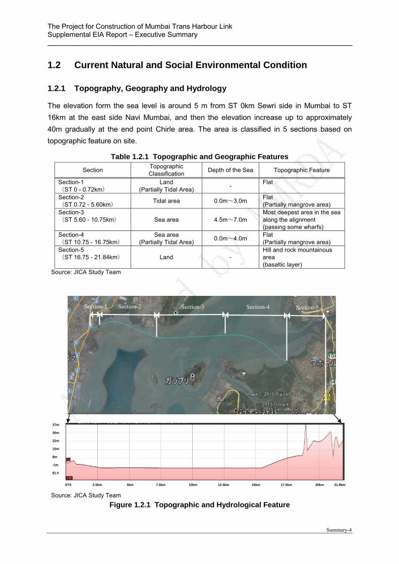
1.2 Current Natural and Social Environmental Condition
1.2.1 Topography, Geography and Hydrology
The elevation form the sea level is around 5 m from ST 0km Sewri side in Mumbai to ST
16km at the east side Navi Mumbai, and then the elevation increase up to approximately
40m gradually at the end point Chirle area. The area is classified in 5 sections based on
topographic feature on site.
Table 1.2.1 Topographic and Geographic Features
Section Topographic Classification
Depth of the Sea Topographic Feature
Section-1 (ST 0 - 0.72km)
Land (Partially Tidal Area)
- Flat
Section-2 (ST 0.72 - 5.60km)
Tidal area 0.0m~3.0m Flat (Partially mangrove area)
Section-3 (ST 5.60 - 10.75km) Sea area 4.5m~7.0m
Most deepest area in the sea along the alignment (passing some wharfs)
Section-4 (ST 10.75 - 16.75km)
Sea area (Partially Tidal Area)
0.0m~4.0m Flat (Partially mangrove area)
Section-5 (ST 16.75 - 21.84km) Land -
Hill and rock mountainous area (basaltic layer)
Source: JICA Study Team
Source: JICA Study Team
Figure 1.2.1 Topographic and Hydrological Feature
37m 30m 22m 15m 8m -1m ELV
ST0 2.5km 5km 7.5km 10km 12.5km 15km 17.5km 20km 21.9km
Section-1 Section-2 Section-3 Section-4 Section-5

The Project for Construction of Mumbai Trans Harbour Link Supplemental EIA Report – Executive Summary
Summary-5
With regard to geographic feature, a sediment clay layer with 3 to 20 m depth on the basalt
layer is located in the sea section in Sewri and the sea section. The basalt layer is exposed
in the Navi Mumbai Section.
Source: JICA Study Team
Figure 1.2.2 Geographic Feature
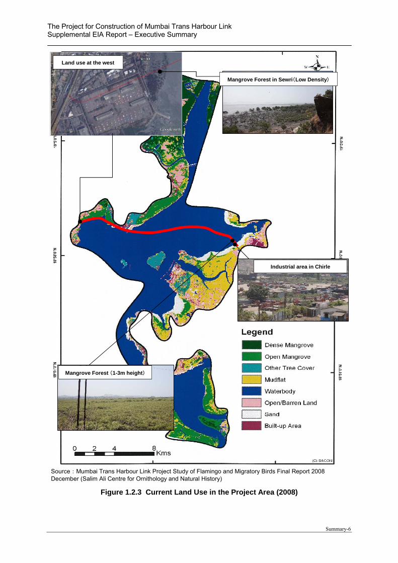
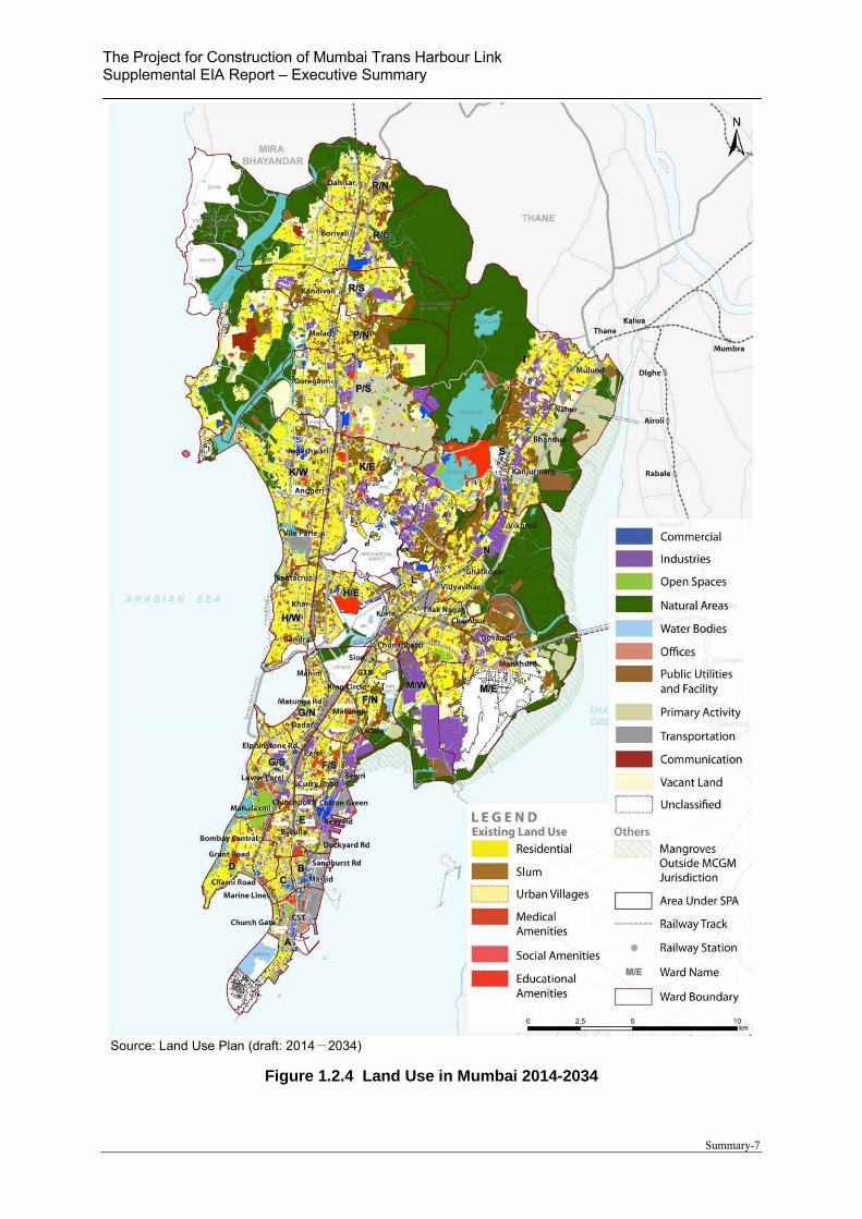
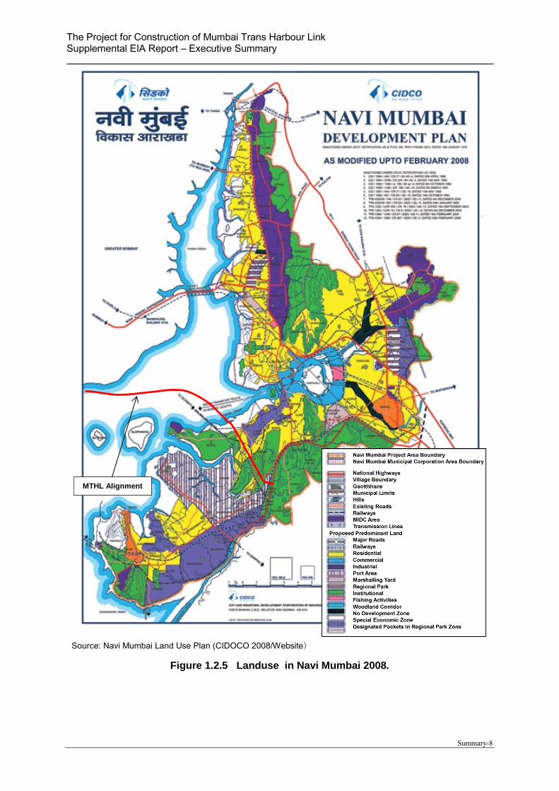
1.2.2 Land Use
The organization management for development plan is in the scope of the Municipal
Corporation of Greater Mumbai (MCGM) for Mumbai side and the City and Industrial
Development Corporation (CIDCO) in Navi Mumbai side, respectively. Current land use as of
2008 in the project area is shown in the Figure 1.2.3, and future’s land use is shown in Figure
1.2.4 & Figure 1.2.5 respectively.
The proposed MTHL starting point of the planned alignment is connected with the Eastern
Freeway, and then the alignment is passing through the private land of the Mumbai Port
Trust (MPT) which is affected by the Coastal Regulation Zone (CRZ). The stretch passing
through the MPT area is approximately 2km on Mumbai side. On the other hand, the
alignment in Navi Mumbai side is passing through CRZ in 0.65km, small residential area,
quarry area, container yard and then connect with Mumbai – JNPT highway.
Sediment clay layer (N-value:0-50) Depth: 3m - 20m
Weathering basalt layer Basalt layer (N≧50) (Bearing layer for the bridge)
The Project for Construction of Mumbai Trans Harbour Link Supplemental EIA Report – Executive Summary
Summary-6
Source:Mumbai Trans Harbour Link Project Study of Flamingo and Migratory Birds Final Report 2008 December (Salim Ali Centre for Ornithology and Natural History)
Figure 1.2.3 Current Land Use in the Project Area (2008)
Land use at the west
Mangrove Forest (1-3m height)
Mangrove Forest in Sewri(Low Density)
Industrial area in Chirle
The Project for Construction of Mumbai Trans Harbour Link Supplemental EIA Report – Executive Summary
Summary-7
Source: Land Use Plan (draft: 2014-2034)
Figure 1.2.4 Land Use in Mumbai 2014-2034
The Project for Construction of Mumbai Trans Harbour Link Supplemental EIA Report – Executive Summary
Summary-8
Source: Navi Mumbai Land Use Plan (CIDOCO 2008/Website)
Figure 1.2.5 Landuse in Navi Mumbai 2008.
MTHL Alignment
The Project for Construction of Mumbai Trans Harbour Link Supplemental EIA Report – Executive Summary
Summary-9
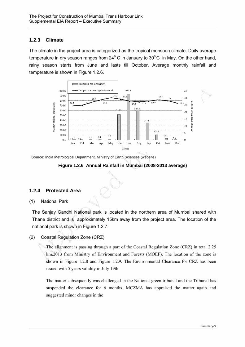
1.2.3 Climate
The climate in the project area is categorized as the tropical monsoon climate. Daily average
temperature in dry season ranges from 240 C in January to 300 C in May. On the other hand,
rainy season starts from June and lasts till October. Average monthly rainfall and
temperature is shown in Figure 1.2.6.
Source: India Metrological Department, Ministry of Earth Sciences (website)
Figure 1.2.6 Annual Rainfall in Mumbai (2008-2013 average)
1.2.4 Protected Area
(1) National Park
The Sanjay Gandhi National park is located in the northern area of Mumbai shared with
Thane district and is approximately 15km away from the project area. The location of the
national park is shown in Figure 1.2.7.
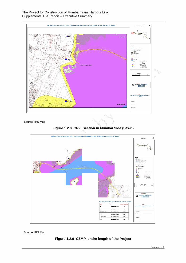
(2) Coastal Regulation Zone (CRZ)
The alignment is passing through a part of the Coastal Regulation Zone (CRZ) in total 2.25
km.2013 from Ministry of Environment and Forests (MOEF). The location of the zone is
shown in Figure 1.2.8 and Figure 1.2.9. The Environmental Clearance for CRZ has been
issued with 5 years validity in July 19th
The matter subsequently was challenged in the National green tribunal and the Tribunal has
suspended the clearance for 6 months. MCZMA has appraised the matter again and
suggested minor changes in the

The Project for Construction of Mumbai Trans Harbour Link Supplemental EIA Report – Executive Summary
Summary-10
Source: JICA Study Team
Figure 1.2.7 Location of Sanjay National Park
Ap
p.
15km
Sanjay Gandhi National Park
MTHL
The Project for Construction of Mumbai Trans Harbour Link Supplemental EIA Report – Executive Summary
Summary-11
Source: IRS Map
Figure 1.2.8 CRZ Section in Mumbai Side (Sewri)
Source: IRS Map
Figure 1.2.9 CZMP entire length of the Project
The Project for Construction of Mumbai Trans Harbour Link Supplemental EIA Report – Executive Summary
Summary-12
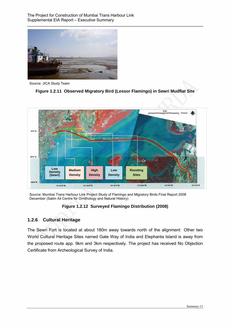
1.2.5 Fauna and Flora
The Sewri Mudflats along with entire Thane creek is identified as an Important Bird Area by
Birdlife International in 2004. Considering the ornithological value of this area, The Forest
Department notified Thane Creek area as Flamingo Sanctuary which excludes the alignment
of the proposed sea link.
A detailed plan is suggested to be designed and implemented for monitoring the impacts of
construction and operations phase on Birds in this region.
According to the study carried out during the Environmental past survey, 17 bird species has
been observed in the project area. Most of observed species are categorized as the Least
Concern (LC) class, but 2 species such as Black Headed Ibis and Lessor Flamingo are
categorized as Near Threatened (NT).
Sewri are in Mumbai side is widely known as industrial area, however Lessor Flamingos and
Greater Flamingos have been coming from the Gulf of Kutch in November since 1994 and
staying there until June. A small non breeding population remains in the monsoon but
scatters and moves inland.
According to the study report conducted by MMRDA in 2008, counted number of the
flamingos is approximately 10,000 to 15,000 a day. These flamingos eat algae and/or
plankton during low tidal.
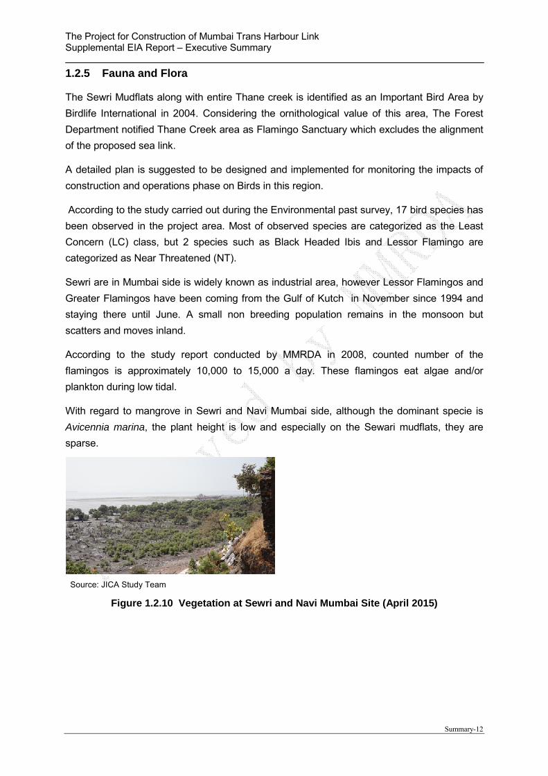
With regard to mangrove in Sewri and Navi Mumbai side, although the dominant specie is
Avicennia marina, the plant height is low and especially on the Sewari mudflats, they are
sparse.
Source: JICA Study Team
Figure 1.2.10 Vegetation at Sewri and Navi Mumbai Site (April 2015)
The Project for Construction of Mumbai Trans Harbour Link Supplemental EIA Report – Executive Summary
Summary-13
Source: JICA Study Team
Figure 1.2.11 Observed Migratory Bird (Lessor Flamingo) in Sewri Mudflat Site
Source: Mumbai Trans Harbour Link Project Study of Flamingo and Migratory Birds Final Report 2008 December (Salim Ali Centre for Ornithology and Natural History)
Figure 1.2.12 Surveyed Flamingo Distribution (2008)
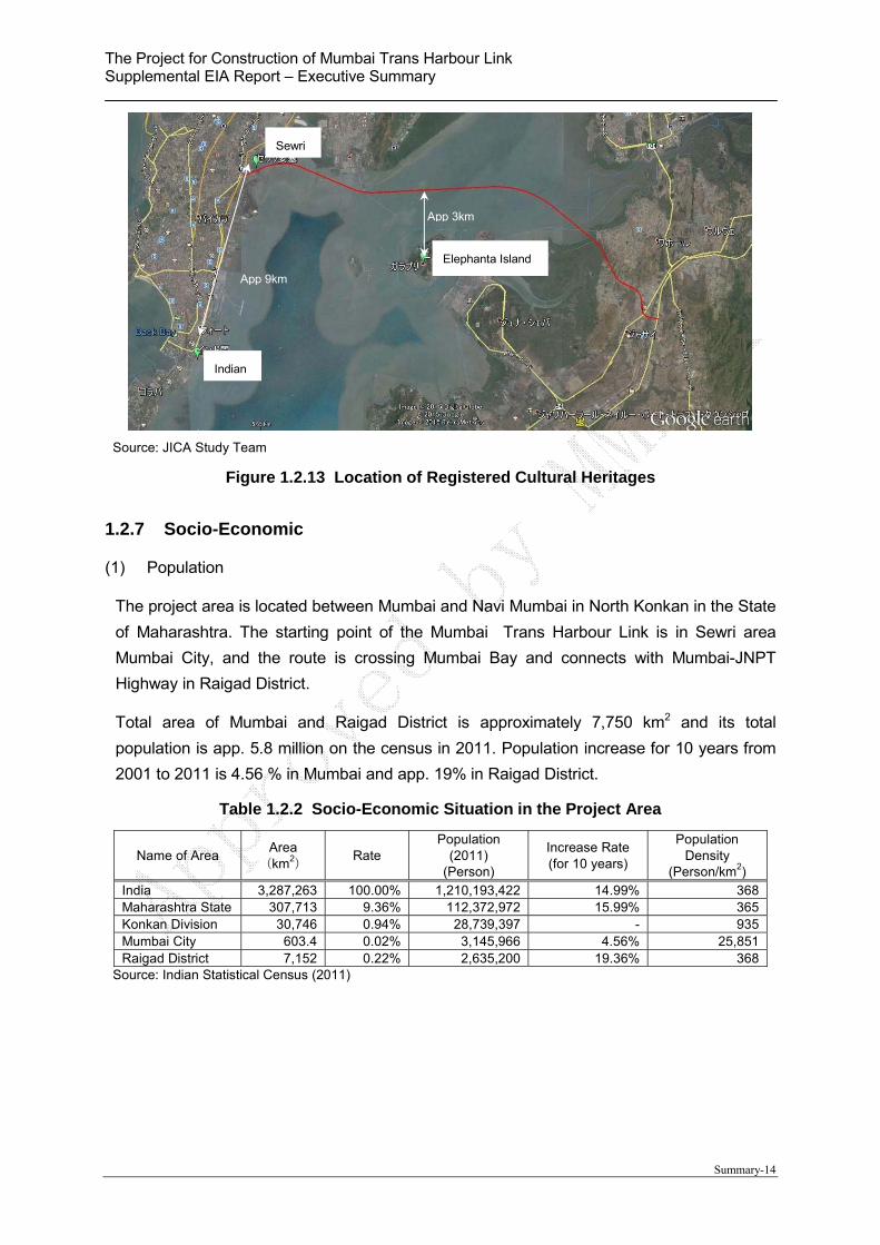
1.2.6 Cultural Heritage
The Sewri Fort is located at about 180m away towards north of the alignment Other two
World Cultural Heritage Sites named Gate Way of India and Elephanta Island is away from
the proposed route app. 9km and 3km respectively. The project has received No Objection
Certificate from Archeological Survey of India.
Low Density (Sewri)
Medium
Density
High
Density
Low
Density
Roosting
Sites
The Project for Construction of Mumbai Trans Harbour Link Supplemental EIA Report – Executive Summary
Summary-14
Source: JICA Study Team
Figure 1.2.13 Location of Registered Cultural Heritages
1.2.7 Socio-Economic
(1) Population
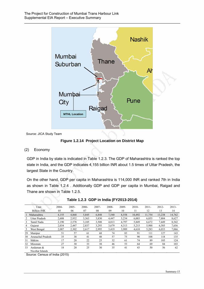
The project area is located between Mumbai and Navi Mumbai in North Konkan in the State
of Maharashtra. The starting point of the Mumbai Trans Harbour Link is in Sewri area
Mumbai City, and the route is crossing Mumbai Bay and connects with Mumbai-JNPT
Highway in Raigad District.
Total area of Mumbai and Raigad District is approximately 7,750 km2 and its total
population is app. 5.8 million on the census in 2011. Population increase for 10 years from
2001 to 2011 is 4.56 % in Mumbai and app. 19% in Raigad District.
Table 1.2.2 Socio-Economic Situation in the Project Area
Name of Area Area
(km2)
Rate Population
(2011) (Person)
Increase Rate (for 10 years)
Population Density
(Person/km2)
India 3,287,263 100.00% 1,210,193,422 14.99% 368Maharashtra State 307,713 9.36% 112,372,972 15.99% 365Konkan Division 30,746 0.94% 28,739,397 - 935Mumbai City 603.4 0.02% 3,145,966 4.56% 25,851Raigad District 7,152 0.22% 2,635,200 19.36% 368
Source: Indian Statistical Census (2011)
Sewri
Elephanta Island
Indian
App 3km
App 9km
The Project for Construction of Mumbai Trans Harbour Link Supplemental EIA Report – Executive Summary
Summary-15
Source: JICA Study Team
Figure 1.2.14 Project Location on District Map
(2) Economy
GDP in India by state is indicated in Table 1.2.3. The GDP of Maharashtra is ranked the top
state in India, and the GDP indicates 4,155 billion INR about 1.5 times of Uttar Pradesh, the
largest State in the Country.
On the other hand, GDP per capita in Maharashtra is 114,000 INR and ranked 7th in India
as shown in Table 1.2.4 . Additionally GDP and GDP per capita in Mumbai, Raigad and
Thane are shown in Table 1.2.5.
Table 1.2.3 GDP in India (FY2013-2014)
Unit: Billion INR.
2004- 05
2005- 06
2006- 07
2007- 08
2008- 09
2009- 10
2010- 11
2011- 12
2012- 13
2013- 14
1 Maharashtra 4,155 4,868 5,845 6,848 7,540 8,558 10,492 11,754 13,238 14,762 2 Uttar Pradesh 2,608 2,932 3,363 3,830 4,447 5,234 6,003 6,855 7,804 8,627 3 Tamil Nadu 2,190 2,578 3,105 3,508 4,013 4,797 5,849 6,672 7,449 8,542 4 Gujarat 2,034 2,447 2,837 3,293 3,679 4,313 5,215 5,988 6,585 7,656 5 West Bengal 2,087 2,302 2,617 2,995 3,419 3,989 4,610 5,283 6,033 7,066
29 Manipur 51 57 61 68 74 83 91 111 127 143 30 Arunachal Pradesh 35 38 41 48 57 75 90 108 118 135 31 Sikkim 17 20 22 25 32 61 74 89 105 124 32 Mizoram 27 30 33 38 46 53 64 69 84 103 33 Andaman &
Nicobar Islands 18 20 25 30 35 41 43 50 56 62
Source: Census of India (2015)
MTHL Location
The Project for Construction of Mumbai Trans Harbour Link Supplemental EIA Report – Executive Summary
Summary-16
Table 1.2.4 GDP PER CAPITA in India (FY2013-2014)
Unit: x 1,000 INR
2004- 05
2005- 06
2006- 07
2007- 08
2008- 09
2009- 10
2010- 11
2011- 12
2012- 13
2013- 14
1 Goa 77 85 95 109 136 149 168 212 201 224 2 Delhi 64 72 83 95 112 126 145 167 193 220 3 Sikkim 27 30 32 36 47 91 109 130 151 176 4 Chandigarh 74 85 98 103 108 117 127 137 142 157 5 Puducherry 48 67 69 74 79 97 101 103 114 144 6 Haryana 38 42 49 57 67 82 94 106 120 133 7 Maharashtra 36 42 50 58 62 70 85 94 104 114 8 Tamil Nadu 30 35 42 48 54 64 78 89 99 113 9 Andaman &
Nicobar Islands 41 45 54 61 69 79 81 90 98 107
10 Gujarat 32 38 43 50 55 64 77 86 93 107
31 Jharkhand 19 18 20 25 25 28 35 37 40 46 32 Assam 17 18 20 21 24 28 33 36 39 44 33 Manipur 19 20 21 23 24 27 28 34 38 42 Source: Census of India (2015)
Table 1.2.5 GDP PER CAPITA in the Project Area (FY2013-2014)
GDP (billion INR) GDP per capita (1,000 INR) 2012-2013 2013-2014 2012-2013 2013-2014
1 Mumbai 28.8 33.4 166 189 2 Thane 17.8 20.0 156 173 3 Raigad 3.5 3.8 120 132 Source: Maharashtra state plan division (2015)
(3) Industry
The key industries and sectors top three are shown in Table 1.2.6. The major industry in
Maharashtra state is a service industry and it indicates around 63% and has been
increasing.
On the other hand, the industrial production is about 26% in 2013-2014, and it has been
decreasing. The agricultural production is stabilized around 11-12 %.
Table 1.2.6 GDP on Major Industry in Maharashtra State
Unit: % (Billion INR)
2004- 05
2005- 06
2006- 07
2007- 08
2008- 09
2009- 10
2010- 11
2011- 12
2012- 13
2013- 14
Primary Industry 10.8 10.8 11.5 11.8 10.1 10.4 12.3 11.8 10.9 11.1
(449) (528) (672) (807) (758) (886) (1,293) (1,387) (1,442) (1,636)1 Agriculture 8.3 8.2 8.7 9.4 7.9 8.0 10.2 9.6 8.7 8.82 Forestry 2.2 2.3 2.5 2.1 2.0 2.1 1.9 1.9 1.9 2.03 Fishery 0.3 0.3 0.3 0.3 0.2 0.2 0.2 0.3 0.3 0.3
Secondary Industry 29.6 31.8 32.0 32.4 31.3 29.8 29.7 28.2 27.4 26.0
(1,230) (1,547) (1,869) (2,216) (2,361) (2,551) (3,116) (3,317) (3,622) (3,845)1 Registered
manufacturing 14.1 16.8 17.7 17.3 16.0 15.1 15.4 14.3 13.5 12.4
2 Construction 6.3 6.2 5.9 6.5 7.0 6.5 6.5 6.8 6.5 6.53 Not registered
manufacturing 6.5 6.4 6.3 6.4 6.2 6.0 5.7 5.1 4.8 4.3
Tertiary industries 59.6 57.4 56.5 55.9 58.6 59.8 58.0 60.0 61.7 62.9
(2,475) (2,793) (3,303) (3,826) (4,420) (5,121) (6,082) (7,050) (8,173) (9,282)1 Real Estate 12.8 12.9 12.7 13.0 14.1 14.9 14.9 15.9 16.7 17.82 Trading/Hotel/Rest
aurant 16.2 15.6 15.9 15.4 15.0 15.1 14.6 14.6 14.6 13.8
3 Insurance and 11.4 10.5 10.2 10.2 11.1 10.4 10.4 10.8 10.8 11.0

The Project for Construction of Mumbai Trans Harbour Link Supplemental EIA Report – Executive Summary
Summary-17
Unit: % (Billion INR)
2004- 05
2005- 06
2006- 07
2007- 08
2008- 09
2009- 10
2010- 11
2011- 12
2012- 13
2013- 14
financial Source: Census of India (2015)
Source: Census of India (2015)
Figure 1.2.15 GDP by Industry in Maharashtra State
(4) Poverty Line
The criteria for poverty have been revising by the central government non-periodically. Thus
the poverty line and the number under the poverty line are not accurate under the same
criteria. According to poverty line in 2011-2012 based on the criteria determined by the
India Planning Committee in 2014, the poverty line in Maharashtra is 1,078 INR in
agricultural areas and 1,560 INR in urban areas.
Table 1.2.7 Poverty Line in Maharashtra State
Poverty Line (INR/month-
capita) Poverty Ratio (%) Number of Poor (million)
Rural Urban Rural Urban Total Rural Urban Total
Lakdawala Methodology 1973-74 50.47 59.48 57.71 43.87 53.24 21.1 7.7 28.71977-78 58.07 73.99 63.97 40.09 55.88 25.0 8.0 33.01983-84 88.24 126.47 45.23 40.26 43.44 19.4 9.7 29.11987-88 115.61 189.17 40.78 39.78 40.41 18.6 10.9 29.61993-94 194.94 328.56 37.93 35.15 36.86 19.3 11.2 30.51999-00 318.63 539.71 23.72 26.81 25.02 12.5 10.3 22.82004-05 362.25 665.90 29.6 32.2 30.7 17.1 14.6 31.7
Tendulkar Methodology 2004-05 485 632 47.9 25.6 38.1 27.7 11.6 39.32009-10 744 961 29.5 18.3 24.5 18.0 9.1 27.12011-12 967 1,126 24.2 9.1 17.4 15.1 4.7 19.8
C.Rangarajan Methodology 2011-12 1,078.34 1,560.38 22.5 17.0 20.0 14.0 8.8 22.8
Source: India Planning Committee (2014)
The Project for Construction of Mumbai Trans Harbour Link Supplemental EIA Report – Executive Summary
Summary-18
1.3 Environmental Legislation
1.3.1 Environmental Impact Assessment (EIA Notification 2006)
The necessity of environmental impact assessment is stipulated on the Environmental
Protection Law in 1986, and concrete rules are described on the Environmental Impact
Assessment Notification in 2006 (EIA Notification). According to the notification, prescript
projects are required to obtain an Environmental Clearance before implementation of the
actual construction.
Category A projects in accordance with EIA notification are required to obtain the
Environmental Clearance from Ministry of Environment and Forests (MOEF) of the central
government, on the other hand, Category B project shall have the clearance from State
Government.
The mandatory list regarding road sector is shown in Table 1.3.1. MTHL is not required to
conduct comprehensive EIA because this road is city road, neither national highway nor state
highway.
Table 1.3.1 Mandatory List for EIA
Project Activity Category C
Other Condition
Category A (Central Government)
Category B (State Government)
7f Highway
i) New National Highways; and ii) Expansion of National High ways greater than 30 KM, involving additional right of way greater than 20m involving land acquisition and passing through more than one State.
i) New State High ways; and ii) Expansion of National / State Highways greater than 30 km involving additional right of way greater than 20m involving land acquisition.
General Condition shall apply
Source: EIA Notification (MOEF 2006)
1.3.2 Coastal Regulation Zone (CRZ Notification 2011)
According to CRZ notification 2011, following objectives for establishment of regulation are
described;
“Now, therefore, in exercise of the powers conferred by sub-section (1) and clause (v) of sub-
section (2) of section 3 of the Environment (Protection) Act, 1986 (29 of 1986), the Central
Government, with a view to ensure livelihood security to the fisher communities and other
local communities, living in the coastal areas, to conserve and protect coastal stretches, its
unique environment and its marine area and to promote development through sustainable
manner based on scientific principles taking into account the dangers of natural hazards in

The Project for Construction of Mumbai Trans Harbour Link Supplemental EIA Report – Executive Summary
Summary-19
the coastal areas, sea level rise due to global warming, does hereby, declare the coastal
stretches of the country and the water area up to its territorial water limit, excluding the
islands of Andaman and Nicobar and Lakshadweep and the marine areas surrounding these
islands up to its territorial limit, as Coastal Regulation Zone (hereinafter referred to as the
CRZ) and restricts the setting up and expansion of any industry, operations or processes and
manufacture or handling or storage or disposal of hazardous substances as specified in the
Hazardous Substances (Handling, Management and Transboundary Movement) Rules, 2009
in the aforesaid CRZ.”
In the designated CRZ, “allowed” and “Not allowed” activities are categorized and stipulated.
With regard to the Mumbai Harbor Trans Link, it is categorized as “Sealink” and it is a
permissible activity. and CRZ clearance with 5 years validity has been obtained by MMRDA
from MOEF in July 2013.
Relevant description regarding MHTL project on CRZ notification 2011 is show below.
The Project for Construction of Mumbai Trans Harbour Link Supplemental EIA Report – Executive Summary
Summary-20
Table 1.3.2 Relevant Description on CRZ Notification 2011
No. Name of Article
Contents
Clause “3 (iv) (Page 2).
Prohibited activities within CRZ
The activities such as Land reclamation, bunding or disturbing the natural course of seawater are declared as prohibited activities within the CRZ except those,- (a) required for setting up, construction or modernisation or expansion of foreshore facilities like ports, harbours, jetties, wharves, quays, slipways, bridges, sealink, road on stilts, and such as meant for defence and security purpose and for other facilities that are essential for activities permissible under the notification;”
Clause “7 (Pg 8)
Classification of the CRZ
For the purpose of conserving and protecting the coastal areas and marine waters, the CRZ area shall be classified as follows, namely:- (i) CRZ-I,– A. The areas that are ecologically sensitive and the geomorphological features which play a role in the maintaining the integrity of the coast,- (a) Mangroves, in case mangrove area is more than 1000 sq mts, a buffer of 50meters along the mangroves shall be provided; (b) Corals and coral reefs and associated biodiversity; (c) Sand Dunes; (d) Mudflats which are biologically active; (e) National parks, marine parks, sanctuaries, reserve forests, wildlife habitats and other protected areas under the provisions of Wild Life (Protection) Act, 1972 (53 of 1972), the Forest (Conservation) Act, 1980 (69 of 1980) or Environment (Protection) Act, 1986 (29 of 1986); including Biosphere Reserves; (f) Salt Marshes; (g) Turtle nesting grounds; (h) Horse shoe crabs habitats; (i) Sea grass beds; (j) Nesting grounds of birds; (k) Areas or structures of archaeological importance and heritage sites. B. The area between Low Tide Line and High Tide Line; (ii) CRZ-II,- The areas that have been developed up to or close to the shoreline.
Clause “8 (Pg 9)
Norms for regulation of activities permissible under this notification,-
(i) The development or construction activities in different categories of CRZ shall be regulated by the concerned CZMA in accordance with the following norms, namely:- I. CRZ-I,- (i) no new construction shall be permitted in CRZ-I except,- (e) Construction of trans harbour sea link and without affecting the tidal flow of water, between LTL and HTL.” “(ii) Areas between LTL and HTL which are not ecologically sensitive, necessary safety measures will be incorporated while permitting the following, namely:- (g) Construction of trans harbour sea links, roads on stilts or pillars without affecting the tidal flow of water.”
Source: Coastal Regulation Zone Notification (MOEF 2011)
CRZ Area affected by the Bridge
Sr No Zone Area of Bridge in CRZ in Sqm
No of Piers
Size of Pier
Total area of pier in CRZ in sqm
SEWRI SIDE
1 CRZ I
45000 62 3mX4m 744
2 CRZ II 4500 8 3mX4m 96 Total 49500 70 840
CHIRLE SIDE
1 CRZ I
15000 22 3mX4m 264
2 CRZ II 3000 6 3mX4m 72 Total 18000 28 336 Grand Total 67500 98 1176
The Project for Construction of Mumbai Trans Harbour Link Supplemental EIA Report – Executive Summary
Summary-21
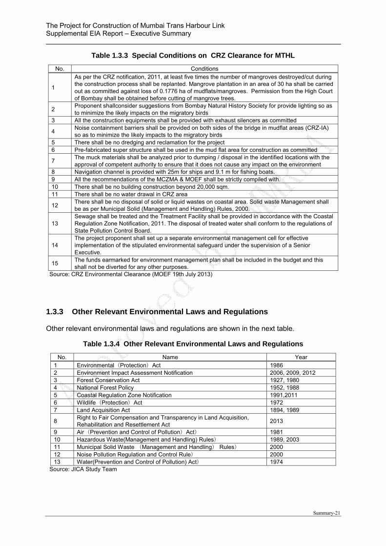
Table 1.3.3 Special Conditions on CRZ Clearance for MTHL
No. Conditions
1
As per the CRZ notification, 2011, at least five times the number of mangroves destroyed/cut during the construction process shall be replanted. Mangrove plantation in an area of 30 ha shall be carried out as committed against loss of 0.1776 ha of mudflats/mangroves. Permission from the High Court of Bombay shall be obtained before cutting of mangrove trees.
2 Proponent shallconsider suggestions from Bombay Natural History Society for provide lighting so as to minimize the likely impacts on the migratory birds
3 All the construction equipments shall be provided with exhaust silencers as committed
4 Noise containment barriers shall be provided on both sides of the bridge in mudflat areas (CRZ-IA) so as to minimize the likely impacts to the migratory birds
5 There shall be no dredging and reclamation for the project 6 Pre-fabricated super structure shall be used in the mud flat area for construction as committed
7 The muck materials shall be analyzed prior to dumping / disposal in the identified locations with the approval of competent authority to ensure that it does not cause any impact on the environment
8 Navigation channel is provided with 25m for ships and 9.1 m for fishing boats. 9 All the recommendations of the MCZMA & MOEF shall be strictly compiled with. 10 There shall be no building construction beyond 20,000 sqm. 11 There shall be no water drawal in CRZ area
12 There shall be no disposal of solid or liquid wastes on coastal area. Solid waste Management shall be as per Municipal Solid (Management and Handling) Rules, 2000.
13 Sewage shall be treated and the Treatment Facility shall be provided in accordance with the Coastal Regulation Zone Notification, 2011. The disposal of treated water shall conform to the regulations of State Pollution Control Board.
14 The project proponent shall set up a separate environmental management cell for effective implementation of the stipulated environmental safeguard under the supervision of a Senior Executive.
15 The funds earmarked for environment management plan shall be included in the budget and this shall not be diverted for any other purposes.
Source: CRZ Environmental Clearance (MOEF 19th July 2013)
1.3.3 Other Relevant Environmental Laws and Regulations
Other relevant environmental laws and regulations are shown in the next table.
Table 1.3.4 Other Relevant Environmental Laws and Regulations
No. Name Year 1 Environmental(Protection)Act 1986 2 Environment Impact Assessment Notification 2006, 2009, 2012 3 Forest Conservation Act 1927, 1980 4 National Forest Policy 1952, 1988 5 Coastal Regulation Zone Notification 1991,2011 6 Wildlife(Protection)Act 1972 7 Land Acquisition Act 1894, 1989
8 Right to Fair Compensation and Transparency in Land Acquisition, Rehabilitation and Resettlement Act
2013
9 Air(Prevention and Control of Pollution)Act) 1981 10 Hazardous Waste(Management and Handling) Rules) 1989, 2003 11 Municipal Solid Waste (Management and Handling) Rules) 2000 12 Noise Pollution Regulation and Control Rule) 2000 13 Water(Prevention and Control of Pollution) Act) 1974
Source: JICA Study Team

The Project for Construction of Mumbai Trans Harbour Link Supplemental EIA Report – Executive Summary
Summary-22
Table 1.3.5 Other Relevant Environmental Ratification Treaty
No. Name Effected Year
1 United Nations Framework Convention on Climate Change 1994 2 Kyoto Protocol 2001 3 Convention on Biological Diversity 1993 4 Cartagena Protocol on Biosafety 2003 5 Vienna Convention for the Protection of the Ozone Layer 1988 6 Montreal Protocol on Substances that Deplete the Ozone Layer 2002 7 Basel Convention 1992
8 The Rotterdam Convention on the Prior Informed Consent Procedure for Certain Hazardous Chemicals and Pesticides in International Trade
2004
9 Stockholm Convention on Persistent Organic Pollutants 2004
10 United Nations Convention to Combat Desertification in Those Countries Experiencing Serious Drought and/or Desertification, Particularly in Africa
1996
11 Convention on International Trade in Endangered Species of Wild Fauna and Flora(CITES)
1975
12 The Convention on Wetlands of International Importance especially as Waterfowl Habitat
1975
13 Antarctic Treaty / Protocol on Environmental Protection to the Antarctic Treaty 1961 14 Protocol on Environmental Protection to the Antarctic Treaty (Madrid Protocol) 1998
Source: Ministry of Foreign Affairs in Japan (website)
Table 1.3.6 Various other environmental clearances required for the project
Clearance Required Approving Authority Responsibility Obtained by when
Mangrove cutting Bombay High Court MMRDA Before start of the project
Tree Cutting Respective Tree Authorities
MMRDA/Contractor 6-7 days before cutting trees
Consent to Establish Maharashtra Pollution Control Board
MMRDA/Contractor When the contractor develops new quarry, borrow pits and camp site, if required.
Environmental Clearance under EIA notification 2006*
State SEIAA and/or MOEF
MMRDA Before Start of the Project
*If applicable
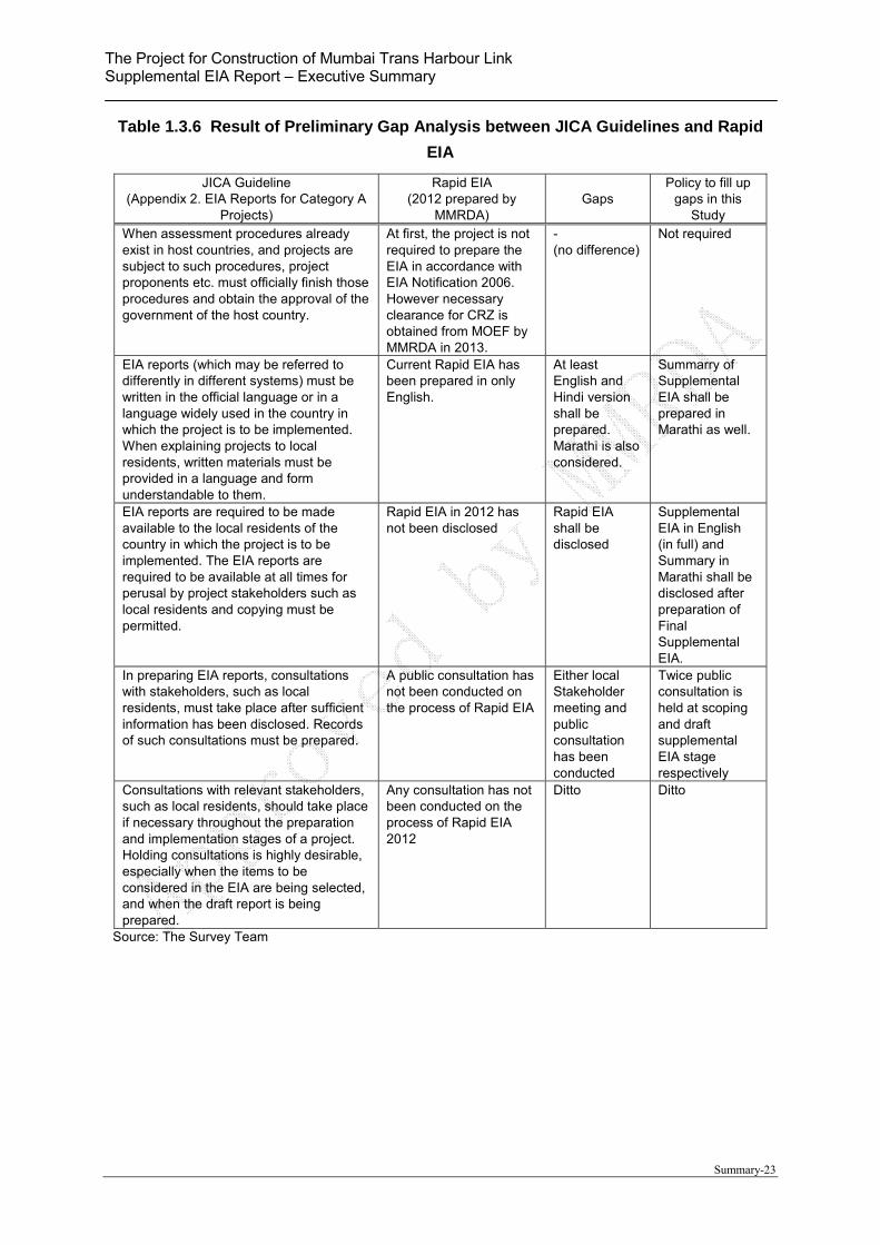
1.3.4 Gaps between Existing EIA and JICA’s Guideline
The project is categorized as Category A (as per JICA guidelines) which is required EIA level
based on JICA Guidelines, thus following preliminary comparative analysis has been
conducted between JICA Guidelines and “Rapid EIA in 2012” prepared by MMRDA for
obtaining of Environmental Clearance for CRZ from MOEF.
According to the gap analysis, the identified gaps are “NOT-Implementation” of Social Impact
Survey, Vibration Survey and Holding Public Consultation.
The Project for Construction of Mumbai Trans Harbour Link Supplemental EIA Report – Executive Summary
Summary-23
Table 1.3.6 Result of Preliminary Gap Analysis between JICA Guidelines and Rapid
EIA
JICA Guideline (Appendix 2. EIA Reports for Category A
Projects)
Rapid EIA (2012 prepared by
MMRDA) Gaps
Policy to fill up gaps in this
Study When assessment procedures already exist in host countries, and projects are subject to such procedures, project proponents etc. must officially finish those procedures and obtain the approval of the government of the host country.
At first, the project is not required to prepare the EIA in accordance with EIA Notification 2006. However necessary clearance for CRZ is obtained from MOEF by MMRDA in 2013.
- (no difference)
Not required
EIA reports (which may be referred to differently in different systems) must be written in the official language or in a language widely used in the country in which the project is to be implemented. When explaining projects to local residents, written materials must be provided in a language and form understandable to them.
Current Rapid EIA has been prepared in only English.
At least English and Hindi version shall be prepared. Marathi is also considered.
Summarry of Supplemental EIA shall be prepared in Marathi as well.
EIA reports are required to be made available to the local residents of the country in which the project is to be implemented. The EIA reports are required to be available at all times for perusal by project stakeholders such as local residents and copying must be permitted.
Rapid EIA in 2012 has not been disclosed
Rapid EIA shall be disclosed
Supplemental EIA in English (in full) and Summary in Marathi shall be disclosed after preparation of Final Supplemental EIA.
In preparing EIA reports, consultations with stakeholders, such as local residents, must take place after sufficient information has been disclosed. Records of such consultations must be prepared.
A public consultation has not been conducted on the process of Rapid EIA
Either local Stakeholder meeting and public consultation has been conducted
Twice public consultation is held at scoping and draft supplemental EIA stage respectively
Consultations with relevant stakeholders, such as local residents, should take place if necessary throughout the preparation and implementation stages of a project. Holding consultations is highly desirable, especially when the items to be considered in the EIA are being selected, and when the draft report is being prepared.
Any consultation has not been conducted on the process of Rapid EIA 2012
Ditto Ditto
Source: The Survey Team
The Project for Construction of Mumbai Trans Harbour Link Supplemental EIA Report – Executive Summary
Summary-24
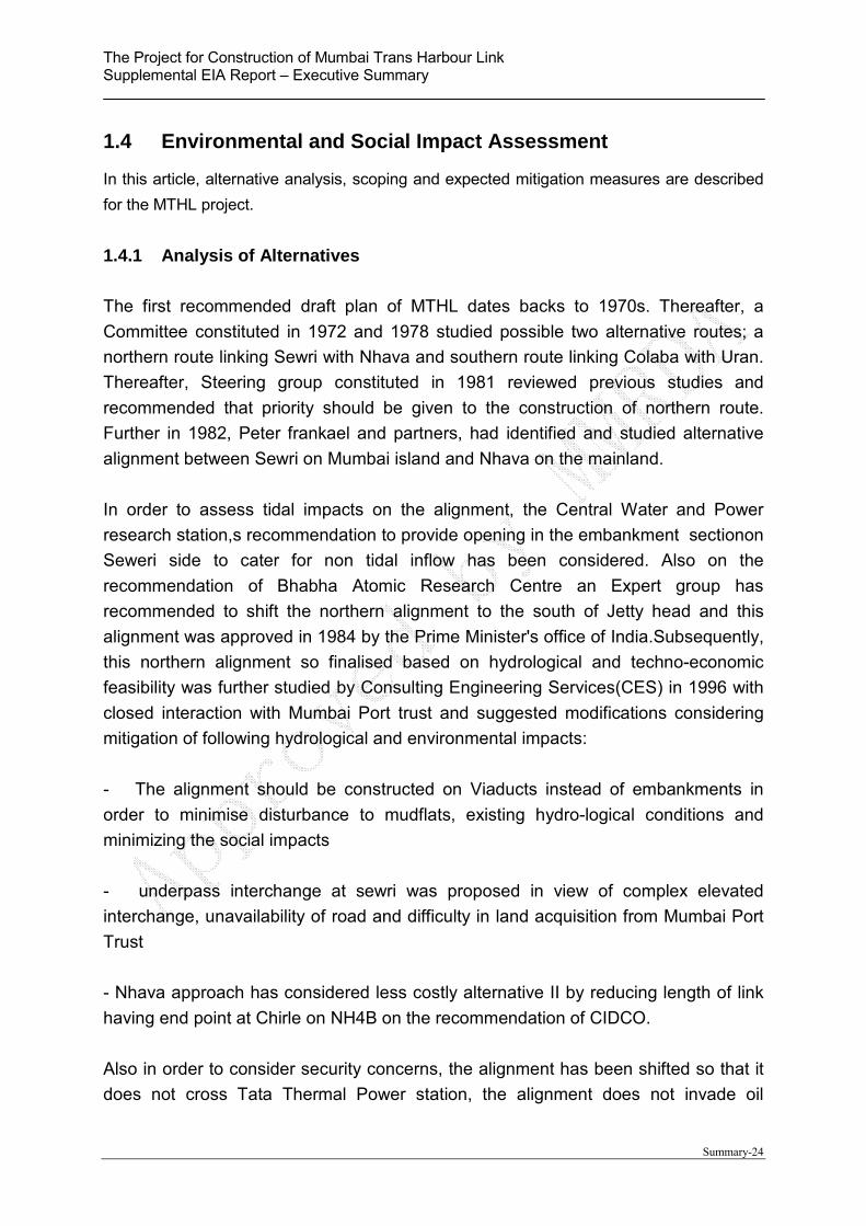
1.4 Environmental and Social Impact Assessment
In this article, alternative analysis, scoping and expected mitigation measures are described
for the MTHL project.
1.4.1 Analysis of Alternatives
The first recommended draft plan of MTHL dates backs to 1970s. Thereafter, a
Committee constituted in 1972 and 1978 studied possible two alternative routes; a
northern route linking Sewri with Nhava and southern route linking Colaba with Uran.
Thereafter, Steering group constituted in 1981 reviewed previous studies and
recommended that priority should be given to the construction of northern route.
Further in 1982, Peter frankael and partners, had identified and studied alternative
alignment between Sewri on Mumbai island and Nhava on the mainland.
In order to assess tidal impacts on the alignment, the Central Water and Power
research station,s recommendation to provide opening in the embankment sectionon
Seweri side to cater for non tidal inflow has been considered. Also on the
recommendation of Bhabha Atomic Research Centre an Expert group has
recommended to shift the northern alignment to the south of Jetty head and this
alignment was approved in 1984 by the Prime Minister's office of India.Subsequently,
this northern alignment so finalised based on hydrological and techno-economic
feasibility was further studied by Consulting Engineering Services(CES) in 1996 with
closed interaction with Mumbai Port trust and suggested modifications considering
mitigation of following hydrological and environmental impacts:
- The alignment should be constructed on Viaducts instead of embankments in
order to minimise disturbance to mudflats, existing hydro-logical conditions and
minimizing the social impacts
- underpass interchange at sewri was proposed in view of complex elevated
interchange, unavailability of road and difficulty in land acquisition from Mumbai Port
Trust
- Nhava approach has considered less costly alternative II by reducing length of link
having end point at Chirle on NH4B on the recommendation of CIDCO.
Also in order to consider security concerns, the alignment has been shifted so that it
does not cross Tata Thermal Power station, the alignment does not invade oil

The Project for Construction of Mumbai Trans Harbour Link Supplemental EIA Report – Executive Summary
Summary-25
company or oil tanks and the alignment is shifted such that separation of 1600 m
distance is secured from Bhabha Atomic Research Centre. Also the alignment is
finalised considering minimal volume of cutting soil and minimising the impact on
mangroves and maintaining minimum distance of 900 m from the Elephanta Island.
Also the care has been taken that the alignment would not interfere the navigation
channel for large vessels of JNPT.
(1) Alternative Analysis
As explained from main text of Supplemental EIA article 5.1.1 to 5.1.4, the route and
fundamental structure have concluded and approved by central government from the view of
natural & social environment, security and adjustment with other projects. Thus factor on
alternative analysis is limited as follows. As shown in below table, the Span length and
location of IC is listed up as factor of alternative analysis, however, in general, the location of
IC is planned at actual connected trunk road, and hence, there are not any options to shift
other area so long as the connected road plan does not change.
Table 1.4.1 Selected Factors on Alternative Analysis
Factor/ Condition Reason for adoption
Location of
Interchange
It is expected that changing of IC location may give positive impacts from the view of natural and social consideration. However since the location shall be set up at cross point with connected road, the location of IC cannot be shifted to other points. Thus “location of IC” is not appropriate factor on the analysis.
Span length (steel
girder bridge)
It is expected that changing span length reduce excavated area in mudflat and mangrove cutting area. Adoption of steel girder for superstructure provides long span and reduction of number of piers and piles. Thus this factor is selected as an appropriate factor on the analysis
Source: JICA Study Team
“Span length” is selected as a factor on the alternative analysis and evaluated from the view
of natural & social environment and economy & cost as shown in Table 1.4.2.
According to the result of analysis, option-2 with 80m span length has advantage slightly on
the all items on natural environment such as negative impacts on mudflat, mangrove,
Flamingo habitat, benthos, CRZ and tidal flow except land acquisition & resettlement.
Although differences of impacts between Option 1 and 2 are not significant from the view of
impacts on natural environment, Option-2 (80m) has extremely disadvantage from the view
of construction cost. Additionally, it is supposed the adverse impacts are minimized by
mitigation measures on management plan. Thus Option-1 (50m) should be selected from
comprehensive point of view.
Table 1.4.2 Alternative Analysis (Span Length)
Factor/ Condition (analyzed area)
Option-1 50m span with PC girder
Option-2 80m span with steel
girder
Differences between options, Evaluation and mitigation
measure
The Project for Construction of Mumbai Trans Harbour Link Supplemental EIA Report – Executive Summary
Summary-26
Factor/ Condition (analyzed area)
Option-1 50m span with PC girder
Option-2 80m span with steel
girder
Differences between options, Evaluation and mitigation
measure
1. Area of Cutting mangrove (ST0.6-0.8km and 16.5-17.9km)
App. 2,100m2 App. 1,300m2
800m2 5 times of cutting mangrove area shall be replanted in the designated area by MoEF
2. Impacts on Flamingo (ST0.6-5.6km)
Width of flying course under bridge is 50m
Width of flying course under bridge is 80m
It is supposed Flamingo fly over bridge not under bridge. Thus there are no significant differences.
3. Impacts on Benthos in Mudflat area (ST0.6-5.6km and 15-17.9km note1)
Excavated impacts area is App. 2,100m2
Excavated impacts area is app. 1,300m2
800m2 5 times of cutting mangrove area shall be replanted and created new habitat in the designated area by MoEF
4. Impact on CRZ (0.6-2.1km and 16.5-17.1km) note2)
Excavated and cutting mangrove area is App. 1,100 m2
Excavated and cutting mangrove area is App. 690 m2
410m Mitigation measures are committed on CRZ clearance.
6. Tidal flow note3) Few impacts (note3) Few impacts (note3) Same impacts and negligible
7. Land acquisition (ST0-0.6km and 16-22km)
Land acquisition area is same as Option-2
Land acquisition area is same as Option-1
Same impacts and compensation policy under Indian laws and JICA Guidelines
8. Construction Cost(entire of alignment) (Considered mudflat and mangrove area ST0.6-5.6km and 15-17.9km)
Approx. 1.640 crore INR
Approx. 2,490 crore INR
850 crore INR (= 15 billion yen)
Note 1) Mudflat and mangrove area is ST0.6km – 5.6km in Sewri side and 15.0 km – 17.9 km in Shivaji Nagar side Note 2) CRZ is located in the sea section from ST0.6-2.1km (CRZ-1) and 16.48 – 17.08km (CRZ I and II) Note 3) Adverse Impacts on tidal flow by construction of MTHL in case of 50m span length has been analyzed and
concluded as “negligible level” by The Central Water and Power Research Station (CWPRS). Thus degree of impacts in both case of 50m and 80m are evaluated as same level.
Source: JICA Study Team
(2) Zero Option
In case of “Zero Option” which does not implement the project, following adverse negative
and positive impacts are expected. Some positive impacts are expected, however, since
the expected negative impacts are serious from the view of economic and environment,
“With project case” is desirable comprehensively;
[Negative Impacts]
The congested situation must be accelerated and prevent from sound urban
development. Furthermore, this “without case” will not give a synergy effect on other
development plan such as a construction of Navi Mumbai Air Port.
The accelerated congestion must make all of vehicles decrease travelling speed, and
then volume of greenhouse gases increase from vehicles.
[Positive Impacts]
Mangrove and mud flat is conserved
Resettlement and land acquisition is not caused
1.4.2 Screening
As described in previous chapter, obtaining of EC for EIA is not required in accordance with
EIA Notification 2006, however Clearance for CRZ in accordance with CRZ Notification 2011

The Project for Construction of Mumbai Trans Harbour Link Supplemental EIA Report – Executive Summary
Summary-27
is required, and MMRDA has obtained this CRZ Clearance in 2013 by preparation of Rapid
EIA in 2012. On the other hand, JICA HQ has judged that some significant impacts on
natural and social environment are predicted on the MTHL project, thus the project has been
classified as “Category A” which is required to conduct EIA level study.
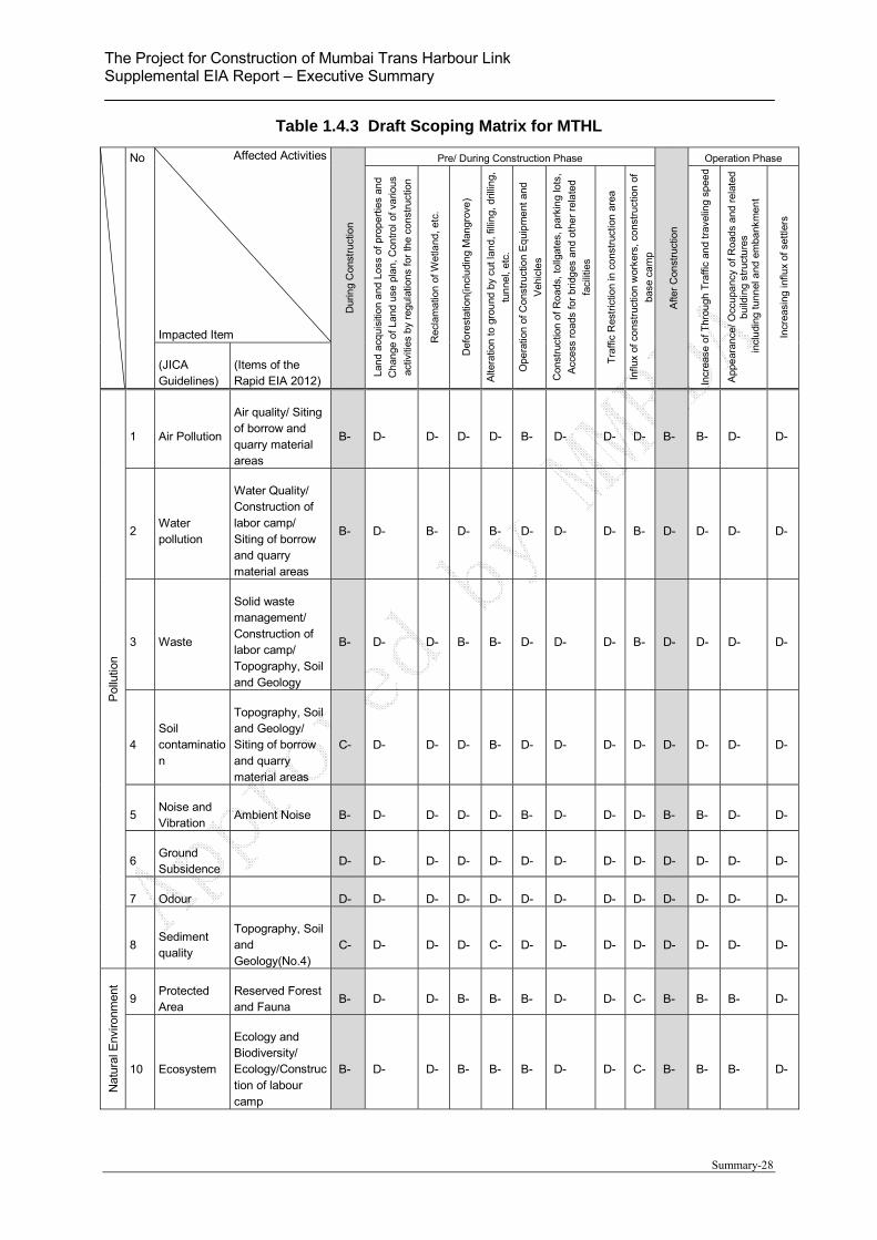
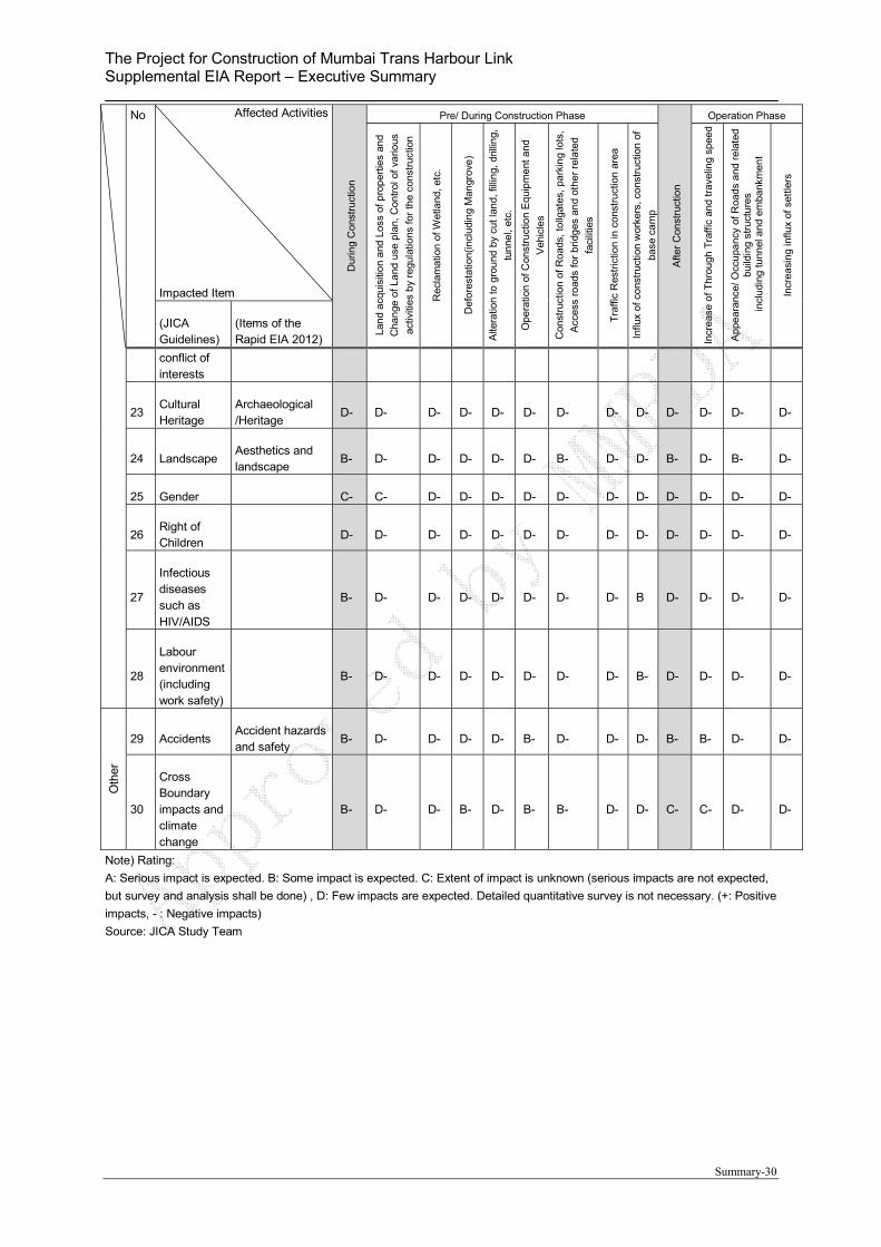
1.4.3 Scoping
Scope of the EIA study for the project is discussed in this section. The environmental scoping
is conducted based on an environmental reconnaissance by the JICA Study Team in April
2015.
The result of scoping is indicated on the Leopold scoping matrix and reason tables. First of
all, impact factors, impacted item and impact degree are shown on the following scoping
matrix based on JICA’s Guidelines.
(1) Scoping Matrix for MTHL
As the result of Scoping Analysis, 15 items such as Air, Water, Waste, Noise & Vibration,
Biology & protected area, Hydrology, Topography and Geography, Existing Infrastructures,
Misdistribution of benefit and damage, land scape, infectious diseases and accident are
selected as item of the Rating B which has some negative impacts.
Additionally mainly social items such as “involuntary resettlement” are evaluated as “Rating
C” which has unknown impacts.
The Project for Construction of Mumbai Trans Harbour Link Supplemental EIA Report – Executive Summary
Summary-28
Table 1.4.3 Draft Scoping Matrix for MTHL
No Affected Activities
Impacted Item D
urin
g C
onst
ruct
ion
Pre/ During Construction Phase
Afte
r C
onst
ruct
ion
Operation Phase
Lan
d acq
uisi
tion
and
Los
s of
pro
per
ties
and
Cha
nge
of
Land
use
pla
n, C
ontr
ol o
f va
rious
activ
ities
by
regu
latio
ns f
or th
e co
nstr
uctio
n
Rec
lam
atio
n of
Wet
land
, etc
.
Def
ore
stat
ion(
incl
udi
ng
Man
grov
e)
Alte
ratio
n to
gro
und
by
cut l
and,
filli
ng,
dril
ling,
tun
nel,
etc.
Ope
ratio
n of
Con
stru
ctio
n E
qui
pm
ent
and
Veh
icle
s
Con
stru
ctio
n o
f R
oad
s, to
llgat
es,
park
ing
lots
,
Acc
ess
road
s fo
r b
ridg
es a
nd
othe
r re
late
d
faci
litie
s
Tra
ffic
Res
tric
tion
in c
ons
truc
tion
area
Influ
x of
co
nstr
uctio
n w
orke
rs, c
ons
truc
tion
of
base
ca
mp
Incr
ease
of T
hrou
gh T
raffi
c an
d tr
avel
ing
spee
d
App
ear
ance
/ Occ
upa
ncy
of R
oad
s a
nd r
elat
ed
build
ing
stru
ctu
res
incl
udi
ng tu
nnel
and
em
bank
men
t
Incr
easi
ng in
flux
of s
ettle
rs
(JICA Guidelines)
(Items of the Rapid EIA 2012)
Pol
lutio
n
1 Air Pollution
Air quality/ Siting of borrow and quarry material areas
B- D- D- D- D- B- D- D- D- B- B- D- D-
2 Water pollution
Water Quality/ Construction of labor camp/ Siting of borrow and quarry material areas
B- D- B- D- B- D- D- D- B- D- D- D- D-
3 Waste
Solid waste management/ Construction of labor camp/ Topography, Soil and Geology
B- D- D- B- B- D- D- D- B- D- D- D- D-
4 Soil contamination
Topography, Soil and Geology/ Siting of borrow and quarry material areas
C- D- D- D- B- D- D- D- D- D- D- D- D-
5 Noise and Vibration
Ambient Noise B- D- D- D- D- B- D- D- D- B- B- D- D-
6 Ground Subsidence
D- D- D- D- D- D- D- D- D- D- D- D- D-
7 Odour D- D- D- D- D- D- D- D- D- D- D- D- D-
8 Sediment quality
Topography, Soil and Geology(No.4)
C- D- D- D- C- D- D- D- D- D- D- D- D-
Nat
ural
Env
ironm
ent
9 Protected Area
Reserved Forest and Fauna
B- D- D- B- B- B- D- D- C- B- B- B- D-
10 Ecosystem
Ecology and Biodiversity/ Ecology/Construction of labour camp
B- D- D- B- B- B- D- D- C- B- B- B- D-

The Project for Construction of Mumbai Trans Harbour Link Supplemental EIA Report – Executive Summary
Summary-29
No Affected Activities
Impacted Item
Dur
ing
Con
stru
ctio
n
Pre/ During Construction Phase
Afte
r C
onst
ruct
ion
Operation Phase
Lan
d a
cqui
sitio
n a
nd L
oss
of p
rop
ertie
s an
d
Cha
nge
of
Land
use
pla
n, C
ontr
ol o
f va
rious
activ
ities
by
regu
latio
ns f
or th
e co
nstr
uctio
n
Rec
lam
atio
n of
Wet
land
, etc
.
Def
ore
stat
ion(
incl
udi
ng
Man
grov
e)
Alte
ratio
n to
gro
und
by
cut l
and,
filli
ng,
dril
ling,
tun
nel,
etc.
Ope
ratio
n of
Con
stru
ctio
n E
qui
pm
ent
and
Veh
icle
s
Con
stru
ctio
n o
f R
oad
s, to
llgat
es,
park
ing
lots
,
Acc
ess
road
s fo
r b
ridg
es a
nd
othe
r re
late
d
faci
litie
s
Tra
ffic
Res
tric
tion
in c
ons
truc
tion
area
Influ
x of
co
nstr
uctio
n w
orke
rs, c
ons
truc
tion
of
base
ca
mp
Incr
ease
of T
hrou
gh T
raffi
c an
d tr
avel
ing
spee
d
App
ear
ance
/ Occ
upa
ncy
of R
oad
s a
nd r
elat
ed
build
ing
stru
ctu
res
incl
udi
ng tu
nnel
and
em
bank
men
t
Incr
easi
ng in
flux
of s
ettle
rs
(JICA Guidelines)
(Items of the Rapid EIA 2012)
11 Hydrology B- D- D- D- B- D- D- D- D- B- D- B- D-
12 Topography and geology
Topography, Soil and Geology
B- D- D- D- B- D- D- D- D- B- D- B- D-
Soc
ial
13 Involuntary resettlement
B- B- D- D- D- D- D- D- D- D- D- D- D-
14 The poor C- C- D- D- D- D- D- D- D- D- D- D- D-
15 Indigenous and ethnic people
D- D- D- D- D- D- D- D- D- D- D- D- D-
16
Local economy such as employment and livelihood
Quality of Life/Fisheries
C- C- D- D- D- D- D- D- D- D- D- D- D-
17
Land use and utilization of local resources
Land use/Fisheries
C- C- D- C- D- D- D- D- D- C- D- C- D-
18 Waste Usage
Water Quality D- D- D- D- D- D- D- D- D- D- D- D- D-
19
Existing social infrastructures and services
Utility services and community severance
B- B- D- D- D- D- D- D- D- D- D- D- D-
Soc
ial E
nviro
nmen
t
20
Social institutions such as local decision making institutions
D- D- D- D- D- D- D- D- D- D- D- D- D-
21 Misdistribution of benefit and damage
Quality of life D- D- D- D- D- D- D- D- D- D- D- D- D-
22 Local B- D- D- D- D- D- D- D- B- D- D- D- D-
The Project for Construction of Mumbai Trans Harbour Link Supplemental EIA Report – Executive Summary
Summary-30
No Affected Activities
Impacted Item
Dur
ing
Con
stru
ctio
n
Pre/ During Construction Phase
Afte
r C
onst
ruct
ion
Operation Phase
Lan
d a
cqui
sitio
n a
nd L
oss
of p
rop
ertie
s an
d
Cha
nge
of
Land
use
pla
n, C
ontr
ol o
f va
rious
activ
ities
by
regu
latio
ns f
or th
e co
nstr
uctio
n
Rec
lam
atio
n of
Wet
land
, etc
.
Def
ore
stat
ion(
incl
udi
ng
Man
grov
e)
Alte
ratio
n to
gro
und
by
cut l
and,
filli
ng,
dril
ling,
tun
nel,
etc.
Ope
ratio
n of
Con
stru
ctio
n E
qui
pm
ent
and
Veh
icle
s
Con
stru
ctio
n o
f R
oad
s, to
llgat
es,
park
ing
lots
,
Acc
ess
road
s fo
r b
ridg
es a
nd
othe
r re
late
d
faci
litie
s
Tra
ffic
Res
tric
tion
in c
ons
truc
tion
area
Influ
x of
co
nstr
uctio
n w
orke
rs, c
ons
truc
tion
of
base
ca
mp
Incr
ease
of T
hrou
gh T
raffi
c an
d tr
avel
ing
spee
d
App
ear
ance
/ Occ
upa
ncy
of R
oad
s a
nd r
elat
ed
build
ing
stru
ctu
res
incl
udi
ng tu
nnel
and
em
bank
men
t
Incr
easi
ng in
flux
of s
ettle
rs
(JICA Guidelines)
(Items of the Rapid EIA 2012)
conflict of interests
23 Cultural Heritage
Archaeological /Heritage
D- D- D- D- D- D- D- D- D- D- D- D- D-
24 Landscape Aesthetics and landscape
B- D- D- D- D- D- B- D- D- B- D- B- D-
25 Gender C- C- D- D- D- D- D- D- D- D- D- D- D-
26 Right of Children
D- D- D- D- D- D- D- D- D- D- D- D- D-
27
Infectious diseases such as HIV/AIDS
B- D- D- D- D- D- D- D- B D- D- D- D-
28
Labour environment (including work safety)
B- D- D- D- D- D- D- D- B- D- D- D- D-
Oth
er
29 Accidents Accident hazards and safety
B- D- D- D- D- B- D- D- D- B- B- D- D-
30
Cross Boundary impacts and climate change
B- D- D- B- D- B- B- D- D- C- C- D- D-
Note) Rating:
A: Serious impact is expected. B: Some impact is expected. C: Extent of impact is unknown (serious impacts are not expected,
but survey and analysis shall be done) , D: Few impacts are expected. Detailed quantitative survey is not necessary. (+: Positive
impacts, - : Negative impacts)
Source: JICA Study Team
The Project for Construction of Mumbai Trans Harbour Link Supplemental EIA Report – Executive Summary
Summary-31
Table 1.4.4 Reasons for Draft Scoping on MTHL
Area No. Impacted Item
(Item on the Rapid EIA)
Rating
Reasons of the Rating Pre/DuringConst
AfterConst
Po
llutio
n
1 Air Pollution (Air quality/ Siting of borrow and quarry material areas)
B- B-
Construction phase: Temporary negative impacts are expected on air quality due to construction machines and equipment.
Operation phase: Negative impact is expected due to the increase in traffic number.
2 Water Pollution (Water Quality/ Construction of labour camp/ Siting of borrow and quarry material areas)
B- D-
Construction phase: Turbid water may be generated by earth works and excavation in the water where bridges are planned. Additionally Organic polluted water may be discharged from base camp.
Operation phase: No serious impacts are expected( The service area is not planned on this project)
3 Waste (Solid waste management/ Construction of labour camp/ Topography, Soil and Geology)
B- D-
Construction phase: Construction waste such as waste soil and cutting trees are expected. Additionally domestic waste and night soil may be generated from construction base camp.
Operation phase: No serious impacts are expected( The service area is not planned on this project)
4 Soil Contamination (Topography, Soil and Geology/ Siting of borrow and quarry material areas)
C- D-
Construction phase: Excavated soil in the mudflat and mining area may contain polluted soil such as heavy metals.
Operation phase: No impacts are expected
5 Noise and Vibration (Ambient Noise)
B- B-
Construction phase: Noise generation is expected due to works of construction machines and equipment.
Operation phase: Traffic Noise and Vibration is expected because of the increase in traffic number and travelling speed.
6 Ground subsidence D- D-
Construction and operation phase: No impacts are expected since activities which cause ground subsidence not expected.
7 Odour D- D-
Construction and operation phase: No impacts are expected since activities which cause odour are not expected.
8 Sediment quality (Topography, Soil and Geology(No.4))
C- D-
Construction phase: Excavated soil in the mudflat and may contain polluted soil such as heavy metals.
Operation phase: No impacts are expected
Na
tura
l En
viro
nme
nt
9 Protected Area (Reserved Forest and Fauna) B- B-
Construction and operation phase: There are not any national parks on the alignment, however, the alignment is passing through a part of coastal regulation zone (CRZ). Although an environmental clearance (EC) of CRZ has been given from MOEF in 2013, the degree of impact should be confirmed.
10 Ecosystem (Ecology and Biodiversity/ Ecology/Construction of labor camp)
B- B-
Construction and Operation phase: Some considerable species are observed in the project area. The degree of impacts will be evaluated based on literature surveys and interview survey with specialists.
11 Hydrology B- B-
Construction and Operation phase: Construction of bridge may change hydrological situation of the rivers.
12 Topography and geology (Topography, Soil and Geology)
B- B-
Construction and operation phase: Considerable topography and geological sites are not located in the project area, thus no impact is expected. However embankment section may have risks of land slide.
So
cial
E
nvir
onm
ent
13 Involuntary resettlement
B- D-
Pre-Construction phase: Illegal occupants are observed in Sewri area, and number of affected persons will be identified on the SIA Survey.
Operation phase: No impact is expected
14 The Poor
C- D-
Pre-Construction phase: Impacts will be assessed based on the SIA Survey.
Operation phase: No impact is expected
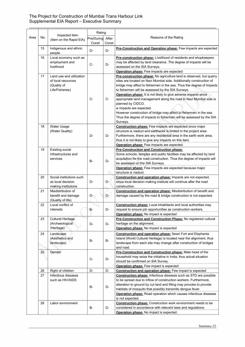
The Project for Construction of Mumbai Trans Harbour Link Supplemental EIA Report – Executive Summary
Summary-32
Area No. Impacted Item
(Item on the Rapid EIA)
Rating
Reasons of the Rating Pre/DuringConst
AfterConst
15 Indigenous and ethnic people
D- D- Pre-Construction and Operation phase: Few impacts are expected
16 Local economy such as employment and livelihood
C- D-
Pre-construction phase: Livelihood of residents and shopkeepers may be affected by land clearance. The degree of impacts will be assessed on the SIA Surveys.
Operation phase: Few impacts are expected
17 Land use and utilization of local resources (Quality of Life/Fisheries)
C- C-
Pre-construction phase: No agriculture land is observed, but quarry sites are located on Navi Mumbai side. Additionally construction of bridge may affect to fishermen in the sea. Thus the degree of impacts to fishermen will be assessed by the SIA Surveys.
Operation phase: It is not likely to give adverse impacts since appropriate land management along the road in Navi Mumbai side is planned by CIDCO. w impacts are expected However construction of bridge may affect to fishermen in the sea. Thus the degree of impacts to fishermen will be assessed by the SIA Surveys.
18 Water Usage (Water Quality)
D- D-
Construction phase: Few impacts are expected since major structure is viaduct and earthwork is limited in the project area. Furthermore, there are any residential area in the earth work area, thus it is not likely to give any impacts on this item.
Operation phase: Few impacts are expected.
19 Existing social infrastructures and services
B- D-
Pre-Construction and Construction phase: Some schools, temples and public facilities may be affected by land acquisition for the road construction. Thus the degree of impacts will be assessed on the SIA Surveys.
Operation phase: Few impacts are expected because major structure is viaduct.
20 Social institutions such as local decision making institutions
D- D- Construction and operation phase: Impacts are not expected, since local decision making institute will continue after the road construction.
21 Misdistribution of benefit and damage (Quality of life)
D- D- Construction and operation phase: Misdistribution of benefit and damage caused by the road & bridge construction is not expected.
22 Local conflict of interests B- D-
Construction phase: Local inhabitants and local authorities may request to ensure job opportunities as construction workers.
Operation phase: No impact is expected
23 Cultural Heritage (Archaeological /Heritage)
D- D-
Pre-Construction and Construction Phase: No registered cultural heritage on the alignment.
Operation phase: No impact is expected
24 Landscape (Aesthetics and landscape)
B- B-
Construction and operation phase: Sewri Fort and Elephanta Island (World Cultural Heritage) is located near the alignment, thus landscape from each site may change after construction of bridges and road.
25 Gender
C- D-
Pre-Construction and Construction phase: Male head of the household may seize the initiative in India, thus actual situation should be confirmed on SIA Survey.
Operation phase: Few impact is expected
26 Right of children D- D- Construction and operation phase: Few impact is expected
27 Infectious diseases such as HIV/AIDS
B- D-
Construction phase: Infectious diseases such as STD are possible to be spread due to inflow of construction workers. Furthermore, alteration to ground by cut land and filling may provoke to provide habitats of mosquito that possibly transmits dengue fever.
Operation phase: Road operation which causes infectious diseases is not expected.
28 Labor environment B- D-
Construction phase: Construction work environment needs to be considered in accordance with relevant laws and regulations.
Operation phase: No impact is expected.
The Project for Construction of Mumbai Trans Harbour Link Supplemental EIA Report – Executive Summary
Summary-33
Area No. Impacted Item
(Item on the Rapid EIA)
Rating
Reasons of the Rating Pre/DuringConst
AfterConst
Oth
er
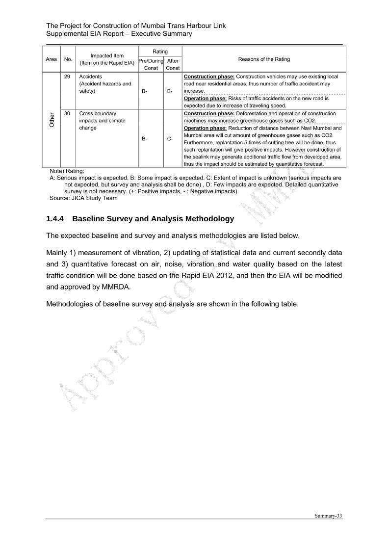
29 Accidents (Accident hazards and safety) B- B-
Construction phase: Construction vehicles may use existing local road near residential areas, thus number of traffic accident may increase.
Operation phase: Risks of traffic accidents on the new road is expected due to increase of traveling speed.
30 Cross boundary impacts and climate change
B- C-
Construction phase: Deforestation and operation of construction machines may increase greenhouse gases such as CO2.
Operation phase: Reduction of distance between Navi Mumbai and Mumbai area will cut amount of greenhouse gases such as CO2. Furthermore, replantation 5 times of cutting tree will be done, thus such replantation will give positive impacts. However construction of the sealink may generate additional traffic flow from developed area, thus the impact should be estimated by quantitative forecast.
Note) Rating: A: Serious impact is expected. B: Some impact is expected. C: Extent of impact is unknown (serious impacts are
not expected, but survey and analysis shall be done) , D: Few impacts are expected. Detailed quantitative survey is not necessary. (+: Positive impacts, - : Negative impacts)
Source: JICA Study Team
1.4.4 Baseline Survey and Analysis Methodology
The expected baseline and survey and analysis methodologies are listed below.
Mainly 1) measurement of vibration, 2) updating of statistical data and current secondly data
and 3) quantitative forecast on air, noise, vibration and water quality based on the latest
traffic condition will be done based on the Rapid EIA 2012, and then the EIA will be modified
and approved by MMRDA.
Methodologies of baseline survey and analysis are shown in the following table.
The Project for Construction of Mumbai Trans Harbour Link Supplemental EIA Report – Executive Summary
Summary-34
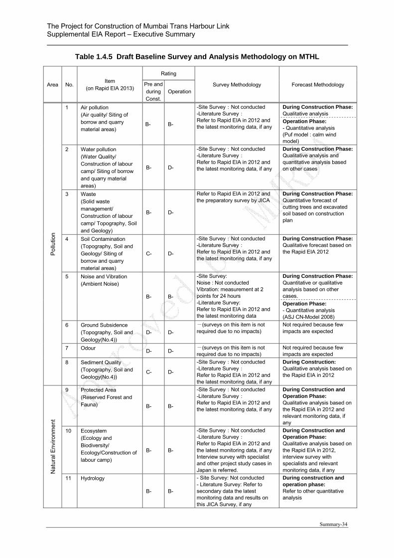
Table 1.4.5 Draft Baseline Survey and Analysis Methodology on MTHL
Area No. Item
(on Rapid EIA 2013)
Rating
Survey Methodology Forecast Methodology Pre and duringConst.
Operation
Po
llutio
n
1 Air pollution (Air quality/ Siting of borrow and quarry material areas)
B- B-
-Site Survey:Not conducted -Literature Survey: Refer to Rapid EIA in 2012 and the latest monitoring data, if any
During Construction Phase:Qualitative analysis
Operation Phase: - Quantitative analysis (Puf model : calm wind model)
2 Water pollution (Water Quality/ Construction of labour camp/ Siting of borrow and quarry material areas)
B- D-
-Site Survey:Not conducted -Literature Survey: Refer to Rapid EIA in 2012 and the latest monitoring data, if any
During Construction Phase:Qualitative analysis and quantitative analysis based on other cases
3 Waste (Solid waste management/ Construction of labour camp/ Topography, Soil and Geology)
B- D-
Refer to Rapid EIA in 2012 and the preparatory survey by JICA
During Construction Phase:Quantitative forecast of cutting trees and excavated soil based on construction plan
4 Soil Contamination (Topography, Soil and Geology/ Siting of borrow and quarry material areas)
C- D-
-Site Survey:Not conducted -Literature Survey: Refer to Rapid EIA in 2012 and the latest monitoring data, if any
During Construction Phase:Qualitative forecast based on the Rapid EIA 2012
5 Noise and Vibration (Ambient Noise)
B- B-
-Site Survey: Noise : Not conducted Vibration: measurement at 2 points for 24 hours -Literature Survey: Refer to Rapid EIA in 2012 and the latest monitoring data
During Construction Phase:Quantitative or qualitative analysis based on other cases.
Operation Phase: - Quantitative analysis (ASJ CN-Model 2008)
6 Ground Subsidence (Topography, Soil and Geology(No.4))
D- D-
-(surveys on this item is not required due to no impacts)
Not required because few impacts are expected
7 Odour D- D- -(surveys on this item is not required due to no impacts)
Not required because few impacts are expected
8 Sediment Quality (Topography, Soil and Geology(No.4))
C- D-
-Site Survey:Not conducted -Literature Survey: Refer to Rapid EIA in 2012 and the latest monitoring data, if any
During Construction: Qualitative analysis based on the Rapid EIA in 2012
Na
tura
l En
viro
nme
nt
9 Protected Area (Reserved Forest and Fauna) B- B-
-Site Survey:Not conducted -Literature Survey: Refer to Rapid EIA in 2012 and the latest monitoring data, if any
During Construction and Operation Phase: Qualitative analysis based on the Rapid EIA in 2012 and relevant monitoring data, if any
10 Ecosystem (Ecology and Biodiversity/ Ecology/Construction of labour camp)
B- B-
-Site Survey:Not conducted -Literature Survey: Refer to Rapid EIA in 2012 and the latest monitoring data, if any Interview survey with specialist and other project study cases in Japan is referred.
During Construction and Operation Phase: Qualitative analysis based on the Rapid EIA in 2012, interview survey with specialists and relevant monitoring data, if any
11 Hydrology
B- B-
- Site Survey: Not conducted - Literature Survey: Refer to secondary data the latest monitoring data and results on this JICA Survey, if any
During construction and operation phase: Refer to other quantitative analysis
The Project for Construction of Mumbai Trans Harbour Link Supplemental EIA Report – Executive Summary
Summary-35
Area No. Item
(on Rapid EIA 2013)
Rating
Survey Methodology Forecast Methodology Pre and duringConst.
Operation
12 Topography and geology (Topography, Soil and Geology)
B- B-
-Site Survey:Not conducted -Literature Survey: Refer to Rapid EIA in 2012, the latest monitoring data and topo. & geo. survey result on this JICA Survey
During construction and operation phase: Qualittive analysis
Soc
ial E
nvir
onm
ent
13 Involuntary resettlement B- D-
Refer to SIA survey During construction phase:Quantitative analysis based on SIA surveys
14 The poor C- D-
Refer to SIA survey During construction phase:Quantitative analysis based on SIA surveys
15 Indigenous and ethnic people
C- D- -(surveys on this item is not required due to no impacts)
Not required because few impacts are expected
16 Local economy such as employment and livelihood (Quality of Life/Fisheries)
C- D-
Refer to SIA survey During construction phase:Quantitative or qualitative analysis based on SIA surveys
17 Land use and utilization of local resources (Land use/Fisheries)
C- C-
Refer to SIA survey During construction phase:Quantitative or qualitative analysis based on SIA surveys
18 Water Usage (Water Quality) D- D-
-(surveys on this item is not required due to no impacts)
Not required because few impacts are expected
19 Existing social infrastructures and services (Utility services and community severance)
B- D-
Refer to SIA survey During construction phase:Qualitative analysis based on SIA surveys
20 Social institutions such as local decision making institutions
D- D-
-(surveys on this item is not required due to no impacts)
Not required because few impacts are expected
21 Misdistribution of benefit and damage (Quality of life)
D- D-
-(surveys on this item is not required due to no impacts)
Not required because few impacts are expected
22 Local conflict of interestsB- D-
Refer to SIA survey During construction phase:Qualitative analysis based on SIA surveys
23 Cultural Heritage (Archeological /Heritage)
D- D-
-(surveys on this item is not required due to no impacts)
Not required because few impacts are expected
24 Landscape (Aesthetics and landscape)
B- B-
-Site Survey: Visual Survey at Sewri and Elphanta Island (April 2015)
During Construction and Operation Phase: Qualitative analysis or preparation of Photo montage
25 Gender
C- D-
Refer to SIA survey During construction phase:Quantitative or qualitative analysis based on SIA surveys
26 Right of Children D- D- -(surveys on this item is not required due to no impacts)
Not required because few impacts are expected
27 Infectious diseases such as HIV/AIDS B- D-
Refer to SIA survey During construction phase:Qualitative analysis based on SIA surveys
28 Labour environment including work safety B- D-
Legal framework regarding labour environment and safety shall be clarified and the safety shall be
Qualitative and quantitative analysis based on the construction plan
The Project for Construction of Mumbai Trans Harbour Link Supplemental EIA Report – Executive Summary
Summary-36
Area No. Item
(on Rapid EIA 2013)
Rating
Survey Methodology Forecast Methodology Pre and duringConst.
Operation
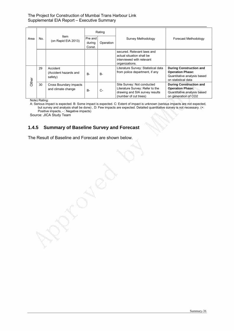
secured. Relevant laws and actual situation shall be interviewed with relevant organizations.
Oth
er
29 Accident (Accident hazards and safety)
B- B-
Literature Survey: Statistical data from police department, if any
During Construction and Operation Phase: Quantitative analysis based on statistical data
30 Cross Boundary impacts and climate change B- C-
Site Survey: Not conducted Literature Survey: Refer to the drawing and SIA survey results (number of cut trees)
During Construction and Operation Phase: Quantitative analysis based on generation of CO2
Note) Rating: A: Serious impact is expected. B: Some impact is expected. C: Extent of impact is unknown (serious impacts are not expected,
but survey and analysis shall be done) , D: Few impacts are expected. Detailed quantitative survey is not necessary. (+: Positive impacts, - : Negative impacts)
Source: JICA Study Team
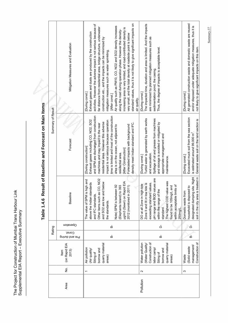
1.4.5 Summary of Baseline Survey and Forecast
The Result of Baseline and Forecast are shown below.
The
Pro
ject
for
Con
stru
ctio
n of
Mum
bai T
rans
Har
bour
Lin
k S
uppl
emen
tal E
IA R
epor
t – E
xecu
tive
Sum
mar
y
Sum
mar
y-37
Tab
le 1
.4.6
R
esu
lt o
f B
asel
ine
and
Fo
reca
st o
n M
ain
Item
s
Are
a N
o.
Item
(o
n R
apid
EIA
20
13)
Rat
ing
Sum
mar
y of
Res
ult
Pre and during Const.
Operation
Bas
elin
e F
orec
ast
Miti
gatio
n M
easu
res
and
Eva
luat
ion
Pol
lutio
n
1 A
ir po
llutio
n (A
ir qu
ality
/ S
iting
of
borr
ow
and
qu
arry
mat
eria
l ar
eas)
B
- B
-
The
val
ue o
f SP
M is
hig
h an
d ab
ove
the
Indi
an s
tand
ards
an
d IF
C s
tand
ards
. O
ther
item
s su
ch a
s C
O, N
O2
and
SO
2 ar
e lo
w a
nd b
elow
th
e st
anda
rds.
N
ote)
SP
M is
bet
wee
n 92
(E
leph
anta
Isla
nd)
to 3
93
µg/
m3
(Sew
ri) o
n R
apid
EIA
20
12 (
mon
itore
d in
201
1)
[Dur
ing
cons
truc
tion]
E
xhau
st g
ases
incl
udin
g C
O,
NO
2, S
O2
and
SP
M a
re d
isch
arge
d fr
om c
onst
ruct
ion
mac
hine
s an
d m
ay im
pact
to
the
near
re
side
ntia
l are
a. H
owev
er t
his
adve
rse
impa
ct is
not
ser
ious
bec
ause
ope
ratio
n tim
e is
lim
ited
and
mos
t of t
he c
onst
ruct
ion
area
is o
n th
e oc
ean,
not
adj
acen
t to
resi
dent
ial a
rea.
[A
fter
Con
stru
ctio
n]
For
ecas
ted
impa
cts
with
bac
kgro
und
dens
ity m
eet I
ndia
n st
anda
rd a
nd IF
C.
[Dur
ing
cons
t.]
Exh
aust
gas
es a
nd d
usts
are
pro
duce
d by
the
con
stru
ctio
n ac
tiviti
es.
How
ever
the
adv
erse
impa
ct is
not
ser
ious
bec
ause
of
far
dist
ance
fro
m r
esid
entia
l are
a, b
ridge
str
uctu
re, u
nder
wat
er
cons
truc
tion
etc.
, an
d th
e im
pact
s ca
n be
min
imiz
ed b
y m
itiga
tion
mea
sure
s su
ch a
s w
ater
spr
inkl
ing.
[
Aft
er c
onst
.] A
ir qu
ality
suc
h as
PM
10,
CO
, N
O2
and
SO
2 de
nsity
incr
ease
s al
ong
the
road
dur
ing
oper
atio
n ph
ase.
How
ever
the
den
sity
-in
crea
sing
are
a is
ver
y lim
ited,
and
roa
d-co
ntrib
uted
den
sity
is
very
sm
all,
and
the
tota
l den
sity
at r
oads
ide
poin
t is
bel
ow
stan
dard
val
ues,
thus
it is
not
like
ly t
o gi
ve s
igni
fican
t im
pact
s on
ai
r qu
ality
.
2 W
ater
pol
lutio
n (W
ater
Qua
lity/
C
onst
ruct
ion
of
labo
r ca
mp/
S
iting
of
borr
ow
and
qu
arry
mat
eria
l ar
eas)
B-
D-
DO
at
all Z
one
in h
igh
tide
Zon
e II
and
III in
low
tid
e is
ex
ceed
ing
stan
dard
val
ues.
pH
ran
ge a
nd B
OD
val
ues
are
with
in t
he r
ange
of t
he
stan
dard
. T
he h
ighe
st C
OD
val
ue w
as
foun
d to
be
105m
g/L
and
with
in a
ccep
tabl
e lim
its o
f 25
0mg/
L.
[Dur
ing
cons
t.]
Tur
bid
wat
er is
gen
erat
ed b
y ea
rth
wor
ks
and
exca
vatio
n.
Spi
llage
of
oil a
nd g
reas
e fr
om m
achi
nes
and
stor
age
is a
void
ed o
r m
itiga
ted
by
appr
opria
te m
anag
emen
t an
d m
aint
enan
ce.
[Dur
ing
cons
t.]
The
impa
cted
tim
e, d
urat
ion
and
area
is li
mite
d. A
nd t
he im
pact
s ar
e m
inim
ized
by
plan
ned
miti
gatio
n m
easu
res
such
as
sedi
men
tatio
n po
nd,
the
casi
ng.
Thu
s, t
he d
egre
e of
impa
cts
is a
ccep
tabl
e le
vel.
3 W
aste
(S
olid
was
te
man
agem
ent/
Con
stru
ctio
n of
B-
D-
Dom
estic
was
te f
rom
ho
useh
old
is d
ispo
sed
to
desi
gnat
ed d
umpi
ng s
ite.
Nig
ht
soil
in t
he c
ity a
rea
is t
reat
ed in
[Dur
ing
cons
t.]
Exc
avat
ed m
uck
soil
from
the
sea
sec
tion
is e
stim
ated
aro
und
99,0
00 m
3 . G
ener
al w
aste
soi
l on
the
land
sec
tion
is
[Dur
ing
cons
t.]
All
gene
rate
d co
nstr
uctio
n w
aste
and
dom
estic
was
te a
re r
euse
d an
d/or
dis
pose
d un
der
adeq
uate
miti
gatio
n m
easu
res,
thus
it is
no
t lik
ely
to g
ive
sign
ifica
nt im
pact
s on
this
item
.
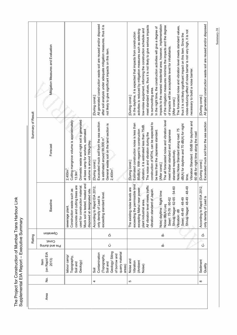
The
Pro
ject
for
Con
stru
ctio
n of
Mum
bai T
rans
Har
bour
Lin
k S
uppl
emen
tal E
IA R
epor
t – E
xecu
tive
Sum
mar
y
Sum
mar
y-38
Are
a N
o.
Item
(o
n R
apid
EIA
20
13)
Rat
ing
Sum
mar
y of
Res
ult
Pre and during Const.
Operation
Bas
elin
e F
orec
ast
Miti
gatio
n M
easu
res
and
Eva
luat
ion
labo
ur c
amp/
T
opog
raph
y,
Soi
l and
G
eolo
gy)
sew
erag
e pl
ant.
C
onst
ruct
ion
was
te s
uch
as
conc
rete
and
cut
ting
tree
s ar
e us
ed f
or c
onst
ruct
ion
mat
eria
l.
Muc
k so
il is
tes
ted,
trea
ted
and
disp
osed
at
desi
gnat
ed s
ite.
2,40
0m3 .
Cut
ting
man
grov
e vo
lum
e is
app
roxi
mat
ely
13.9
m3 .
Dom
estic
was
te a
nd n
ight
soi
l is
gene
rate
d at
bas
e ca
mp
for
wor
kers
, es
timat
ed
volu
me
is a
roun
d 76
0kg/
day.
4 S
oil
Con
tam
inat
ion
(Top
ogra
phy,
S
oil a
nd
Geo
logy
/ S
iting
of
bor
row
and
qu
arry
mat
eria
l ar
eas)
C-
D-
Acc
ordi
ng t
o R
apid
EIA
201
2,
only
den
sity
of
Lead
is
exce
edin
g st
anda
rd le
vel.
[Dur
ing
cons
t.]
Exc
avat
ed m
uck
soil
from
the
sea
sec
tion
is e
stim
ated
aro
und
99,0
00 m
3 . G
ener
al w
aste
soi
l on
the
land
sec
tion
is
2,40
0m3 .
[Dur
ing
cons
t.]
All
gene
rate
d co
nstr
uctio
n w
aste
soi
l are
reu
sed
and/
or d
ispo
sed
afte
r so
il an
alys
is u
nder
ade
quat
e m
itiga
tion
mea
sure
s, th
us it
is
not
likel
y to
giv
e si
gnifi
cant
impa
cts
on th
is it
em.
5 N
oise
and
V
ibra
tion
(Am
bien
t N
oise
)
B-
B-
The
exi
stin
g no
ise
leve
ls a
re
exce
edin
g th
e pe
rmis
sibl
e lim
it ex
cept
ing
Mah
ul n
ear
pow
er
plan
t in
dust
rial a
rea.
A
ll vi
brat
ion
leve
l mee
ts tr
affic
vi
brat
ion
stan
dard
of J
apan
. N
ote)
day
time
: N
ight
tim
e N
oise
dB
(A)
Leq
Sew
ri: 7
5-76
: 6
0-62
S
hiva
ji N
agar
: 62
-65
: 54
-60
Vib
ratio
n: d
B
Sew
ri: 4
8-49
: 4
8-49
S
hiva
ji N
agar
: 48
-49
: 48
-49
[Dur
ing
cons
t.]
Est
imat
ed c
onst
ruct
ion
nois
e is
less
than
85
dB(A
). W
ith r
egar
d to
con
stru
ctio
n vi
brat
ion,
it is
est
imat
ed le
ss t
han
75dB
. T
he n
oise
and
vib
ratio
n du
ring
the
cons
truc
tion
of M
TH
L ca
n be
exp
ecte
d to
be
less
than
the
Jap
anes
e st
anda
rd.
[Afte
r co
nst.]
T
he a
ll fo
reca
sted
noi
se a
nd v
ibra
tion
leve
l m
eet I
ndia
n st
anda
rd a
nd J
apan
ese
stan
dard
res
pect
ivel
y.
Not
e) N
oise
Sta
ndar
d al
ong
road
: 75
dB(A
) fo
r da
ytim
e an
d 70
dB
(A)
for
nigh
t tim
e,
Vib
ratio
n S
tand
ard
: 65
dB f
or d
aytim
e an
d 60
dB
for
nigh
t tim
e al
ong
the
road
[Dur
ing
cons
t.]
In t
he d
aytim
e, it
is e
xpec
ted
that
impa
cts
from
con
stru
ctio
n ac
tiviti
es is
red
uced
by
miti
gatio
n m
easu
res
such
as
sele
ctin
g lo
w-n
oise
equ
ipm
ent,
info
rmin
g th
e co
nstr
uctio
n sc
hedu
le a
nd
mee
t sta
ndar
d va
lues
, thu
s it
is n
ot li
kely
to g
ive
serio
us im
pact
s to
sur
roun
ding
are
a.
In t
he n
ight
tim
e, t
he c
onst
ruct
ion
activ
ities
will
giv
e a
degr
ee o
f im
pact
s to
the
nea
rest
res
iden
tial a
rea,
how
ever
, im
plem
enta
tion
of t
he m
itiga
tion
mea
sure
s m
inim
ize
the
impa
cts
and
the
degr
ee
of im
pact
s w
ill b
e ac
cept
able
leve
l for
inha
bita
nts.
[A
fter
cons
t.]
The
for
ecas
ted
nois
e an
d vi
brat
ion
leve
l mee
ts s
tand
ard
valu
es,
thus
it is
not
like
ly s
igni
fican
t im
pact
on
this
item
. Sin
ce th
e no
ise-
redu
cing
eff
ect o
f no
ise
barr
ier
is n
ot v
ery
high
, it i
s no
t ne
cess
ary
to b
uild
a n
oise
bar
rier.
8 S
edim
ent
Qua
lity
C-
D-
Acc
ordi
ng t
o R
apid
EIA
201
2,
only
den
sity
of
Lead
is
[Dur
ing
cons
t.]
Exc
avat
ed m
uck
soil
from
the
sea
sec
tion
[Dur
ing
cons
t.]
All
gene
rate
d co
nstr
uctio
n w
aste
soi
l are
reu
sed
and/
or d
ispo
sed

The
Pro
ject
for
Con
stru
ctio
n of
Mum
bai T
rans
Har
bour
Lin
k S
uppl
emen
tal E
IA R
epor
t – E
xecu
tive
Sum
mar
y
Sum
mar
y-39
Are
a N
o.
Item
(o
n R
apid
EIA
20
13)
Rat
ing
Sum
mar
y of
Res
ult
Pre and during Const.
Operation
Bas
elin
e F
orec
ast
Miti
gatio
n M
easu
res
and
Eva
luat
ion
(Top
ogra
phy,
S
oil a
nd
Geo
logy
(No.
4))
exce
edin
g st
anda
rd le
vel.
is e
stim
ated
aro
und
99,0
00 m
3 . af
ter
soil
anal
ysis
und
er a
dequ
ate
miti
gatio
n m
easu
res,
thus
it is
no
t lik
ely
to g
ive
sign
ifica
nt im
pact
s.
Nat
ura
l E
nvir
on
men
t
9 P
rote
cted
Are
a (R
eser
ved
For
est a
nd
Fau
na)
B-
C-
The
pro
pose
d al
ignm
ent
pass
es th
roug
h C
oast
al
Reg
ulat
ion
Zon
e.
Tot
ally
2.2
5km
of t
he a
lignm
ent
has
been
cl
assi
fied
as C
RZ
. C
RZ
-I :
2.0k
m
CR
Z-I
I: 0.
25km
It is
not
like
ly t
o gi
ve s
erio
us im
pact
s un
der
impl
emen
tatio
n of
ap
prop
riate
miti
gatio
n m
easu
res.
10
Eco
syst
em
(Eco
logy
and
B
iodi
vers
ity/
Eco
logy
/ C
onst
ruct
ion
of
labo
r ca
mp)
B-
C-
On
Rap
id
EIA
20
12,
17
bird
sp
ecie
s, 4
but
terf
lies,
7 f
auna
sp
ecie
s in
ben
thos
hav
e be
en
reco
rded
. O
n m
igra
tory
bi
rds
surv
ey i
n 20
08,
tota
lly 7
8 bi
rd
spec
ies
have
bee
n ob
serv
ed.
Out
of
78 b
ird s
peci
es i
n th
e su
rvey
20
08
and
2012
, 15
sp
ecie
s ar
e ca
tego
rized
as
m
igra
tory
bird
s, o
nly
1 sp
ecie
s Le
ssor
F
lam
ingo
is
ca
tego
rized
as
N
T
leve
l (N
early
Thr
eate
ned)
. In
oth
er 6
6 sp
ecie
s, 5
spe
cies
ar
e ca
tego
rized
as
NT
and
VU
(V
ulne
rabl
e)
How
eve
r it
is s
uppo
sed
that
su
ch 6
spe
cies
are
usi
ng t
he
proj
ect
area
as
feed
ing
area
, no
t ne
stin
g ar
ea.
Not
e)
NT
: 1)
Bla
ck H
eade
d Ib
is, 2
) P
aint
ed S
tork
, 3)
Bla
ck T
aile
d G
odw
it an
d 4)
Eur
asia
n C
urle
w
[Dur
ing
cons
t.]
Fau
na
Tur
bid
wat
er d
ue t
o ac
tiviti
es in
the
river
an
d in
flow
ing
from
con
stru
ctio
n ar
ea m
ay
impa
ct o
n aq
uatic
fau
na.
Par
t of
the
mud
flat e
cosy
stem
is lo
st b
y th
e im
plem
enta
tion
of d
evel
opm
ent
proj
ects
. The
dry
ing
of t
he m
udfla
t may
im
pact
on
food
res
ourc
es o
f mig
rato
ry
bird
s.
If th
e ba
se c
amp
and
cons
truc
tion
yard
are
in
stal
led
near
the
fee
ding
gro
unds
of
mig
rato
ry b
irds,
mig
rato
ry b
irds
may
avo
id
and
fly a
way
to
othe
r m
udfla
t in
Mum
bai
harb
our
tem
pora
rily.
How
ever
, in
gen
eral
, su
ch b
irds
may
com
e ba
ck s
ame
plac
e th
roug
hout
a p
erio
d of
tim
e.
Flo
ra
Def
ores
tatio
n m
ay im
pact
on
man
grov
e ar
ea.
How
eve
r, t
he d
ryin
g of
the
mud
flat
may
incr
ease
the
man
grov
e ar
ea in
som
e lim
ited
area
aro
und
pile
s.
[Afte
r co
nst.]
F
auna
[Dur
ing
cons
t.]
Con
stru
ctio
n ac
tiviti
es o
f MT
HL
may
cau
se n
oise
dur
ing
cons
truc
tion
stag
e, t
hus
som
e gr
oup
of m
igra
tory
bird
s m
ay
avoi
d th
e ad
jace
nt a
rea
and
flyaw
ay t
o ot
her
area
in M
umba
i ba
sin
tem
pora
rily.
How
ever
sin
ce s
ever
al m
itiga
tion
mea
sure
s w
ill b
e co
nduc
ted,
the
mig
rato
ry b
irds
may
get
bac
k ag
ain
grad
ually
. A
dditi
onal
ly t
urbi
dity
fro
m e
xcav
ated
are
a in
the
sea
and
cutti
ng m
angr
ove
area
will
be
min
imiz
ed b
y ap
prop
riate
m
itiga
tion
mea
sure
s.
[Afte
r co
nst.]
V
ehic
le t
rave
lling
, mak
ing
nois
e an
d ex
iste
nce
of v
iadu
ct m
ay
give
adv
erse
impa
cts
for
mig
rato
ry b
irds.
For
min
imiz
atio
n of
th
ese
impa
cts,
not
onl
y C
RZ
spe
cific
atio
n co
nditi
ons,
but
als
o ad
ditio
nal m
easu
res
such
as
cons
ider
atio
n of
ligh
ting
syst
em n
ot
to g
ive
impa
cts
on F
lam
ingo
’s r
oost
ing
area
are
pla
nned
. W
hen
unex
pect
ed e
vent
s an
d ph
enom
ena
has
been
con
firm
ed
afte
r co
nstr
uctio
n an
d du
ring
cons
truc
tion,
app
ropr
iate
to
take
ac
tion
in c
onsu
ltatio
n w
ith r
elev
ant o
rgan
izat
ions
. T
hus,
it is
not
like
ly to
giv
e se
rious
impa
cts
on p
roje
ct in
clud
ing
mud
flat e
cosy
stem
und
er im
plem
enta
tion
of a
ppro
pria
te
miti
gatio
n m
easu
res.
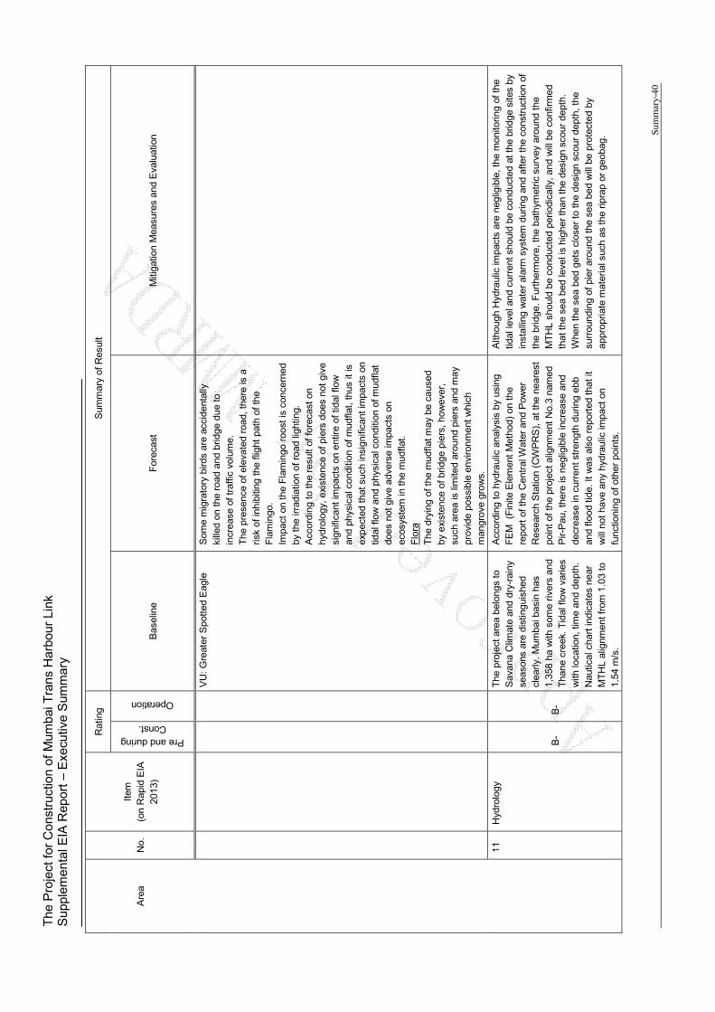
The
Pro
ject
for
Con
stru
ctio
n of
Mum
bai T
rans
Har
bour
Lin
k S
uppl
emen
tal E
IA R
epor
t – E
xecu
tive
Sum
mar
y
Sum
mar
y-40
Are
a N
o.
Item
(o
n R
apid
EIA
20
13)
Rat
ing
Sum
mar
y of
Res
ult
Pre and during Const.
Operation
Bas
elin
e F
orec
ast
Miti
gatio
n M
easu
res
and
Eva
luat
ion
VU
: G
reat
er S
pott
ed E
agle
S
ome
mig
rato
ry b
irds
are
acci
dent
ally
ki
lled
on t
he r
oad
and
brid
ge d
ue to
in
crea
se o
f tra
ffic
volu
me.
T
he p
rese
nce
of e
leva
ted
road
, the
re is
a
risk
of in
hibi
ting
the
fligh
t pa
th o
f th
e F
lam
ingo
. Im
pact
on
the
Fla
min
go r
oost
is c
once
rned
by
the
irra
diat
ion
of r
oad
light
ing.
A
ccor
ding
to
the
resu
lt of
for
ecas
t on
hydr
olog
y, e
xist
ence
of p
iers
doe
s no
t gi
ve
sign
ifica
nt im
pact
s on
ent
ire o
f tid
al f
low
an
d ph
ysic
al c
ondi
tion
of m
udfla
t, th
us it
is
exp
ecte
d th
at s
uch
insi
gnifi
cant
impa
cts
on
tidal
flow
and
phy
sica
l con
ditio
n of
mud
flat
does
not
giv
e ad
vers
e im
pact
s on
ec
osys
tem
in th
e m
udfla
t. F
lora
T
he d
ryin
g of
the
mud
flat m
ay b
e ca
used
by
exi
sten
ce o
f brid
ge p
iers
, ho
wev
er,
such
are
a is
lim
ited
arou
nd p
iers
and
may
pr
ovid
e po
ssib
le e
nviro
nmen
t w
hich
m
angr
ove
grow
s.
11
Hyd
rolo
gy
B-
B-
The
pro
ject
are
a be
long
s to
S
avan
a C
limat
e an
d dr
y-ra
iny
seas
ons
are
dist
ingu
ishe
d cl
early
. M
umba
i bas
in h
as
1,35
8 ha
with
som
e riv
ers
and
Tha
ne c
reek
. Tid
al fl
ow v
arie
s w
ith lo
catio
n, ti
me
and
dept
h.
Nau
tical
cha
rt in
dica
tes
near
M
TH
L al
ignm
ent f
rom
1.0
3 to
1.
54 m
/s.
Acc
ordi
ng t
o hy
drau
lic a
naly
sis
by u
sing
F
EM
(F
inite
Ele
men
t M
etho
d) o
n th
e re
port
of t
he C
entr
al W
ater
and
Pow
er
Res
earc
h S
tatio
n (C
WP
RS
), a
t the
nea
rest
po
int
of t
he p
roje
ct a
lignm
ent
No.
3 na
med
P
ir-P
au, t
here
is n
eglig
ible
incr
ease
and
de
crea
se in
cur
rent
str
engt
h du
ring
ebb
and
flood
tide
. It
was
als
o re
port
ed t
hat i
t w
ill n
ot h
ave
any
hydr
aulic
impa
ct o
n fu
nctio
ning
of o
ther
poi
nts.
Alth
ough
Hyd
raul
ic im
pact
s ar
e ne
glig
ible
, the
mon
itorin
g of
the
tidal
leve
l and
cur
rent
sho
uld
be c
ondu
cted
at
the
brid
ge s
ites
by
inst
allin
g w
ater
ala
rm s
yste
m d
urin
g an
d af
ter
the
cons
truc
tion
of
the
brid
ge. F
urth
erm
ore,
the
bat
hym
etric
sur
vey
arou
nd t
he
MT
HL
shou
ld b
e co
nduc
ted
perio
dica
lly, a
nd w
ill b
e co
nfirm
ed
that
the
sea
bed
leve
l is
high
er th
an t
he d
esig
n sc
our
dept
h.
Whe
n th
e se
a be
d ge
ts c
lose
r to
the
desi
gn s
cour
dep
th, t
he
surr
ound
ing
of p
ier
arou
nd t
he s
ea b
ed w
ill b
e pr
otec
ted
by
appr
opria
te m
ater
ial s
uch
as th
e rip
rap
or g
eoba
g.
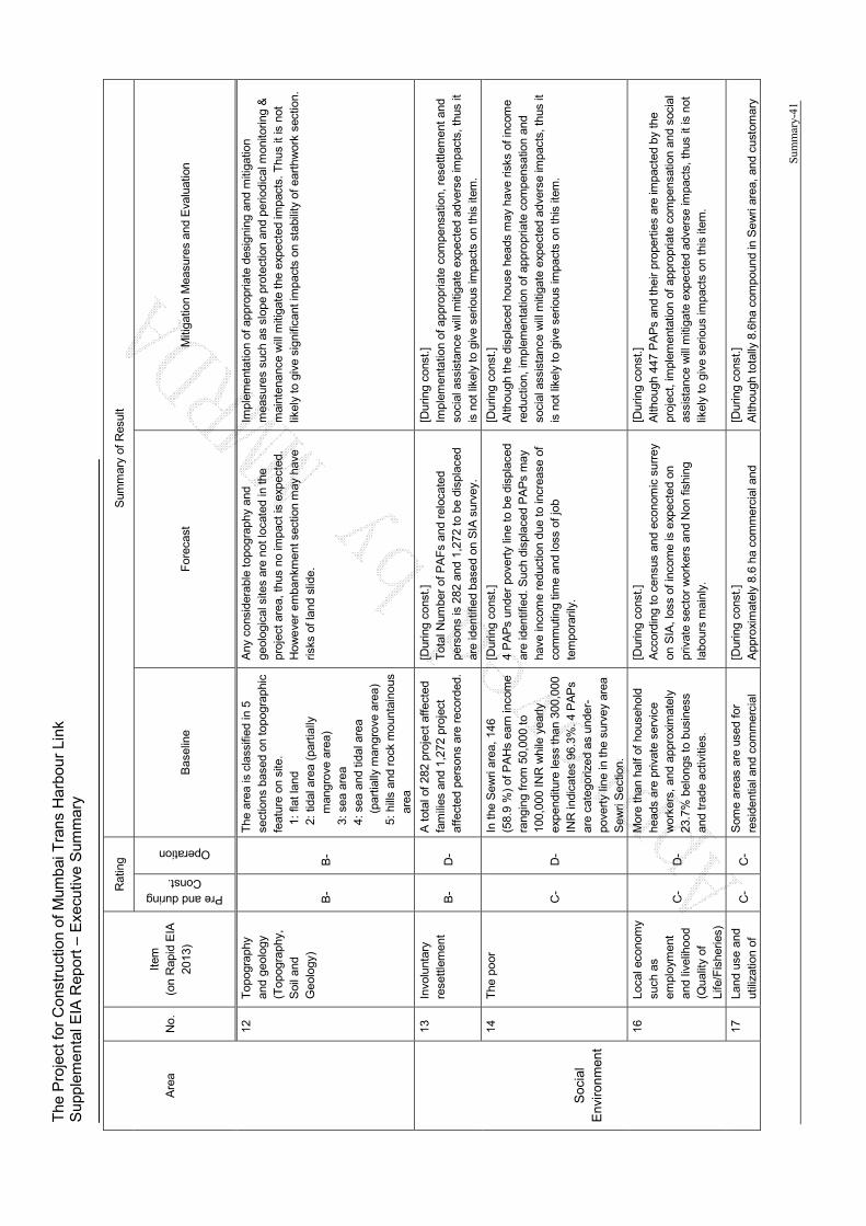
The
Pro
ject
for
Con
stru
ctio
n of
Mum
bai T
rans
Har
bour
Lin
k S
uppl
emen
tal E
IA R
epor
t – E
xecu
tive
Sum
mar
y
Sum
mar
y-41
Are
a N
o.
Item
(o
n R
apid
EIA
20
13)
Rat
ing
Sum
mar
y of
Res
ult
Pre and during Const.
Operation
Bas
elin
e F
orec
ast
Miti
gatio
n M
easu
res
and
Eva
luat
ion
12
Top
ogra
phy
and
geol
ogy
(Top
ogra
phy,
S
oil a
nd
Geo
logy
) B
- B
-
The
are
a is
cla
ssifi
ed in
5
sect
ions
bas
ed o
n to
pogr
aphi
c fe
atur
e on
site
. 1:
flat
land
2:
tida
l are
a (p
artia
lly
man
grov
e ar
ea)
3: s
ea a
rea
4: s
ea a
nd ti
dal a
rea
(p
artia
lly m
angr
ove
area
) 5:
hill
s an
d ro
ck m
ount
aino
us
area
Any
con
side
rabl
e to
pogr
aphy
and
ge
olog
ical
site
s ar
e no
t loc
ated
in th
e pr
ojec
t ar
ea, t
hus
no im
pact
is e
xpec
ted.
H
owe
ver
emba
nkm
ent s
ectio
n m
ay h
ave
risks
of l
and
slid
e.
Impl
emen
tatio
n of
app
ropr
iate
des
igni
ng a
nd m
itiga
tion
mea
sure
s su
ch a
s sl
ope
prot
ectio
n an
d pe
riodi
cal m
onito
ring
&
mai
nten
ance
will
miti
gate
the
exp
ecte
d im
pact
s. T
hus
it is
not
lik
ely
to g
ive
sign
ifica
nt im
pact
s on
sta
bilit
y of
ear
thw
ork
sect
ion.
Soc
ial
Env
iro
nm
ent
13
Invo
lunt
ary
rese
ttle
men
t B
- D
-
A t
otal
of
282
proj
ect a
ffect
ed
fam
ilies
and
1,2
72 p
roje
ct
affe
cted
per
sons
are
rec
orde
d.
[Dur
ing
cons
t.]
Tot
al N
umbe
r of
PA
Fs
and
relo
cate
d pe
rson
s is
282
and
1,2
72 t
o be
dis
plac
ed
are
iden
tifie
d ba
sed
on S
IA s
urve
y.
[Dur
ing
cons
t.]
Impl
emen
tatio
n of
app
ropr
iate
com
pens
atio
n, r
eset
tlem
ent a
nd
soci
al a
ssis
tanc
e w
ill m
itiga
te e
xpec
ted
adve
rse
impa
cts,
thu
s it
is n
ot li
kely
to g
ive
serio
us im
pact
s on
thi
s ite
m.
14
The
poo
r
C-
D-
In t
he S
ewri
area
, 14
6 (5
8.9
%)
of P
AH
s ea
rn in
com
e ra
ngin
g fr
om 5
0,00
0 to
10
0,00
0 IN
R w
hile
yea
rly
exp
endi
ture
less
tha
n 30
0,00
0 IN
R in
dica
tes
96.3
%. 4
PA
Ps
are
cate
goriz
ed a
s un
der-
pove
rty
line
in th
e su
rvey
are
a S
ewri
Sec
tion.
[Dur
ing
cons
t.]
4 P
AP
s un
der
pove
rty
line
to b
e di
spla
ced
are
iden
tifie
d. S
uch
disp
lace
d P
AP
s m
ay
have
inco
me
redu
ctio
n du
e to
incr
ease
of
com
mut
ing
time
and
loss
of j
ob
tem
pora
rily.
[Dur
ing
cons
t.]
Alth
ough
the
disp
lace
d ho
use
head
s m
ay h
ave
risks
of i
ncom
e re
duct
ion,
impl
emen
tatio
n of
app
ropr
iate
com
pens
atio
n an
d so
cial
ass
ista
nce
will
miti
gate
exp
ecte
d ad
vers
e im
pact
s, t
hus
it is
not
like
ly to
giv
e se
rious
impa
cts
on t
his
item
.
16
Loca
l eco
nom
y su
ch a
s em
ploy
men
t an
d liv
elih
ood
(Qua
lity
of
Life
/Fis
herie
s)
C-
D-
Mor
e th
an h
alf
of h
ouse
hold
he
ads
are
priv
ate
serv
ice
wor
kers
, an
d ap
prox
imat
ely
23.7
% b
elon
gs to
bus
ines
s an
d tr
ade
activ
ities
.
[Dur
ing
cons
t.]
Acc
ordi
ng t
o ce
nsus
and
eco
nom
ic s
urre
y on
SIA
, los
s of
inco
me
is e
xpec
ted
on
priv
ate
sect
or w
orke
rs a
nd N
on f
ishi
ng
labo
urs
mai
nly.
[Dur
ing
cons
t.]
Alth
ough
447
PA
Ps
and
thei
r pr
oper
ties
are
impa
cted
by
the
proj
ect,
impl
emen
tatio
n of
app
ropr
iate
com
pens
atio
n an
d so
cial
as
sist
ance
will
miti
gate
exp
ecte
d ad
vers
e im
pact
s, t
hus
it is
not
lik
ely
to g
ive
serio
us im
pact
s on
thi
s ite
m.
17
Land
use
and
ut
iliza
tion
of
C-
C-
Som
e ar
eas
are
used
for
resi
dent
ial a
nd c
omm
erci
al
[Dur
ing
cons
t.]
App
roxi
mat
ely
8.6
ha c
omm
erci
al a
nd
[Dur
ing
cons
t.]
Alth
ough
tota
lly 8
.6ha
com
poun
d in
Sew
ri ar
ea,
and
cust
omar
y
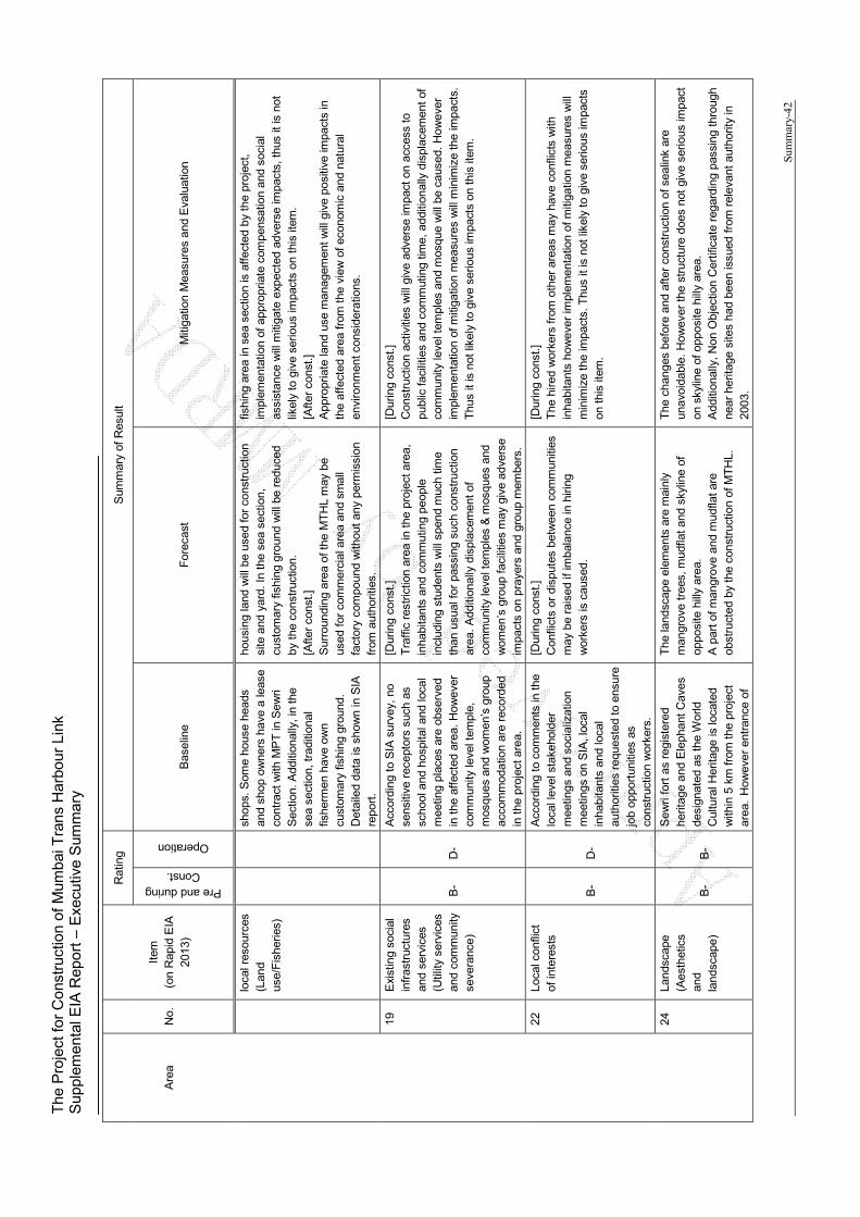
The
Pro
ject
for
Con
stru
ctio
n of
Mum
bai T
rans
Har
bour
Lin
k S
uppl
emen
tal E
IA R
epor
t – E
xecu
tive
Sum
mar
y
Sum
mar
y-42
Are
a N
o.
Item
(o
n R
apid
EIA
20
13)
Rat
ing
Sum
mar
y of
Res
ult
Pre and during Const.
Operation
Bas
elin
e F
orec
ast
Miti
gatio
n M
easu
res
and
Eva
luat
ion
loca
l res
ourc
es
(Lan
d us
e/F
ishe
ries)
shop
s. S
ome
hous
e he
ads
and
shop
ow
ners
hav
e a
leas
e co
ntra
ct w
ith M
PT
in S
ewri
Sec
tion.
Add
ition
ally
, in
the
sea
sect
ion,
tra
ditio
nal
fishe
rmen
hav
e ow
n cu
stom
ary
fishi
ng g
roun
d.
Det
aile
d da
ta is
sho
wn
in S
IA
repo
rt.
hous
ing
land
will
be
used
for
cons
truc
tion
site
and
yar
d. In
the
sea
sect
ion,
cu
stom
ary
fishi
ng g
roun
d w
ill b
e re
duce
d by
the
con
stru
ctio
n.
[Afte
r co
nst.]
S
urro
undi
ng a
rea
of th
e M
TH
L m
ay b
e us
ed f
or c
omm
erci
al a
rea
and
smal
l fa
ctor
y co
mpo
und
with
out
any
perm
issi
on
from
aut
horit
ies.
fishi
ng a
rea
in s
ea s
ectio
n is
affe
cted
by
the
proj
ect,
impl
emen
tatio
n of
app
ropr
iate
com
pens
atio
n an
d so
cial
as
sist
ance
will
miti
gate
exp
ecte
d ad
vers
e im
pact
s, t
hus
it is
not
lik
ely
to g
ive
serio
us im
pact
s on
thi
s ite
m.
[Afte
r co
nst.]
A
ppro
pria
te la
nd u
se m
anag
emen
t will
giv
e po
sitiv
e im
pact
s in
th
e af
fect
ed a
rea
from
the
view
of e
cono
mic
and
nat
ural
en
viro
nmen
t con
side
ratio
ns.
19
Exi
stin
g so
cial
in
fras
truc
ture
s an
d se
rvic
es
(Util
ity s
ervi
ces
and
com
mun
ity
seve
ranc
e)
B-
D-
Acc
ordi
ng t
o S
IA s
urve
y, n
o se
nsiti
ve r
ecep
tors
suc
h as
sc
hool
and
hos
pita
l and
loca
l m
eetin
g pl
aces
are
obs
erve
d in
the
aff
ecte
d ar
ea.
How
ever
co
mm
unity
leve
l tem
ple,
m
osqu
es a
nd w
omen
’s g
roup
ac
com
mod
atio
n ar
e re
cord
ed
in t
he p
roje
ct a
rea.
[Dur
ing
cons
t.]
Tra
ffic
res
tric
tion
area
in th
e pr
ojec
t are
a,
inha
bita
nts
and
com
mut
ing
peop
le
incl
udin
g st
uden
ts w
ill s
pend
muc
h tim
e th
an u
sual
for
pas
sing
suc
h co
nstr
uctio
n ar
ea.
Add
ition
ally
dis
plac
emen
t of
com
mun
ity le
vel t
empl
es &
mos
ques
and
w
omen
’s g
roup
faci
litie
s m
ay g
ive
adve
rse
impa
cts
on p
raye
rs a
nd g
roup
mem
bers
.
[Dur
ing
cons
t.]
Con
stru
ctio
n ac
tiviti
es w
ill g
ive
adve
rse
impa
ct o
n ac
cess
to
publ
ic fa
cilit
ies
and
com
mut
ing
time,
add
ition
ally
dis
plac
emen
t of
co
mm
unity
leve
l tem
ples
and
mos
que
will
be
caus
ed.
How
ever
im
plem
enta
tion
of m
itiga
tion
mea
sure
s w
ill m
inim
ize
the
impa
cts.
T
hus
it is
not
like
ly t
o gi
ve s
erio
us im
pact
s on
this
item
.
22
Loca
l con
flict
of
inte
rest
s
B-
D-
Acc
ordi
ng t
o co
mm
ents
in th
e lo
cal l
evel
sta
keho
lder
m
eetin
gs a
nd s
ocia
lizat
ion
mee
tings
on
SIA
, loc
al
inha
bita
nts
and
loca
l au
thor
ities
req
uest
ed t
o en
sure
jo
b op
port
uniti
es a
s co
nstr
uctio
n w
orke
rs.
[Dur
ing
cons
t.]
Con
flict
s or
dis
pute
s be
twee
n co
mm
uniti
es
may
be
rais
ed if
imba
lanc
e in
hiri
ng
wor
kers
is c
ause
d.
[Dur
ing
cons
t.]
The
hire
d w
orke
rs f
rom
oth
er a
reas
may
hav
e co
nflic
ts w
ith
inha
bita
nts
how
ever
impl
emen
tatio
n of
miti
gatio
n m
easu
res
will
m
inim
ize
the
impa
cts.
Thu
s it
is n
ot li
kely
to g
ive
serio
us im
pact
s on
thi
s ite
m.
24
Land
scap
e (A
esth
etic
s an
d la
ndsc
ape)
B
- B
-
Sew
ri fo
rt a
s re
gist
ered
he
ritag
e an
d E
leph
ant
Cav
es
desi
gnat
ed a
s th
e W
orld
C
ultu
ral H
erita
ge is
loca
ted
with
in 5
km
fro
m th
e pr
ojec
t ar
ea. H
owev
er
entr
ance
of
The
land
scap
e el
emen
ts a
re m
ainl
y m
angr
ove
tree
s, m
udfla
t and
sky
line
of
oppo
site
hill
y ar
ea.
A p
art o
f man
grov
e an
d m
udfla
t are
ob
stru
cted
by
the
cons
truc
tion
of M
TH
L.
The
cha
nges
bef
ore
and
afte
r co
nstr
uctio
n of
sea
link
are
unav
oida
ble.
How
ever
the
str
uctu
re d
oes
not
give
ser
ious
impa
ct
on s
kylin
e of
opp
osite
hill
y ar
ea.
Add
ition
ally
, Non
Obj
ectio
n C
ertif
icat
e re
gard
ing
pass
ing
thro
ugh
near
her
itage
site
s ha
d be
en is
sued
fro
m r
elev
ant
auth
ority
in
2003
.
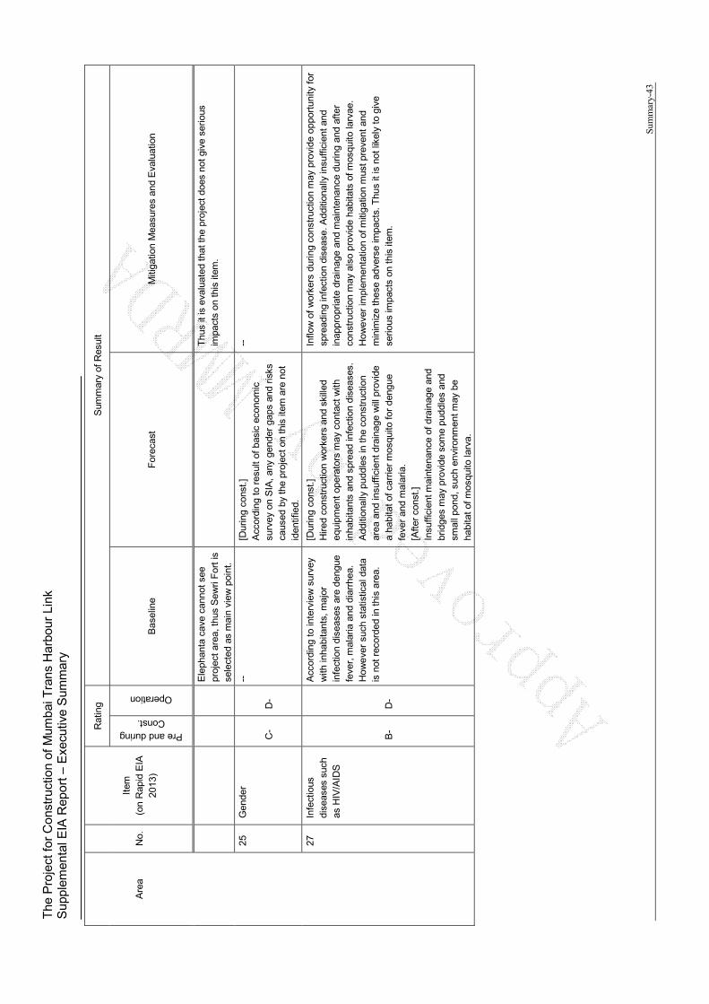
The
Pro
ject
for
Con
stru
ctio
n of
Mum
bai T
rans
Har
bour
Lin
k S
uppl
emen
tal E
IA R
epor
t – E
xecu
tive
Sum
mar
y
Sum
mar
y-43
Are
a N
o.
Item
(o
n R
apid
EIA
20
13)
Rat
ing
Sum
mar
y of
Res
ult
Pre and during Const.
Operation
Bas
elin
e F
orec
ast
Miti
gatio
n M
easu
res
and
Eva
luat
ion
Ele
phan
ta c
ave
cann
ot s
ee
proj
ect
area
, thu
s S
ewri
For
t is
se
lect
ed a
s m
ain
view
poi
nt.
Thu
s it
is e
valu
ated
that
the
proj
ect
does
not
giv
e se
rious
im
pact
s on
this
item
.
25
Gen
der
C-
D-
--
[Dur
ing
cons
t.]
Acc
ordi
ng t
o re
sult
of b
asic
eco
nom
ic
surv
ey o
n S
IA, a
ny g
ende
r ga
ps a
nd r
isks
ca
used
by
the
proj
ect o
n th
is it
em a
re n
ot
iden
tifie
d.
--
27
Infe
ctio
us
dise
ases
suc
h as
HIV
/AID
S
B-
D-
Acc
ordi
ng t
o in
terv
iew
sur
vey
with
inha
bita
nts,
maj
or
infe
ctio
n di
seas
es a
re d
engu
e fe
ver,
mal
aria
and
dia
rrhe
a.
How
eve
r su
ch s
tatis
tical
dat
a is
not
rec
orde
d in
this
are
a.
[Dur
ing
cons
t.]
Hire
d co
nstr
uctio
n w
orke
rs a
nd s
kille
d eq
uipm
ent
oper
ator
s m
ay c
onta
ct w
ith
inha
bita
nts
and
spre
ad in
fect
ion
dise
ases
. A
dditi
onal
ly p
uddl
es in
the
con
stru
ctio
n ar
ea a
nd in
suffi
cien
t dra
inag
e w
ill p
rovi
de
a ha
bita
t of c
arrie
r m
osqu
ito fo
r de
ngue
fe
ver
and
mal
aria
. [A
fter
cons
t.]
Insu
ffici
ent m
aint
enan
ce o
f dr
aina
ge a
nd
brid
ges
may
pro
vide
som
e pu
ddle
s an
d sm
all p
ond,
suc
h en
viro
nmen
t may
be
habi
tat
of m
osqu
ito la
rva.
Inflo
w o
f w
orke
rs d
urin
g co
nstr
uctio
n m
ay p
rovi
de o
ppor
tuni
ty fo
r sp
read
ing
infe
ctio
n di
seas
e. A
dditi
onal
ly in
suffi
cien
t and
in
appr
opria
te d
rain
age
and
mai
nten
ance
dur
ing
and
afte
r co
nstr
uctio
n m
ay a
lso
prov
ide
habi
tats
of m
osqu
ito la
rvae
. H
owe
ver
impl
emen
tatio
n of
miti
gatio
n m
ust p
reve
nt a
nd
min
imiz
e th
ese
adve
rse
impa
cts.
Thu
s it
is n
ot li
kely
to
give
se
rious
impa
cts
on t
his
item
.
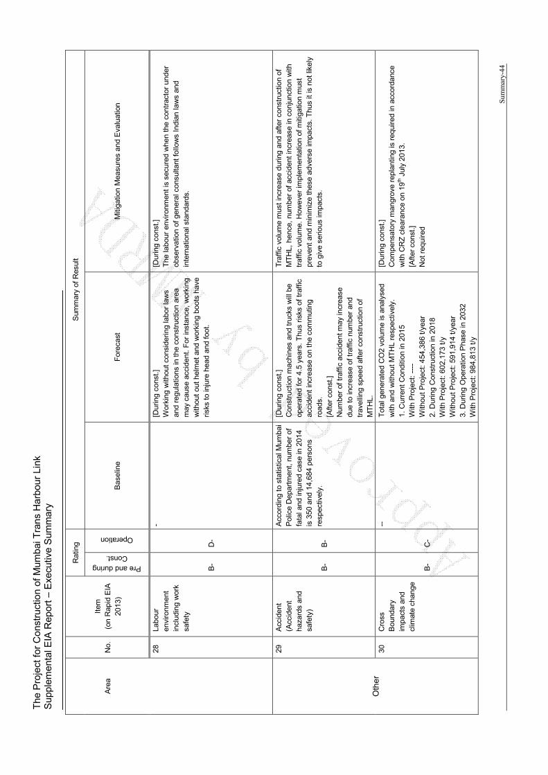
The
Pro
ject
for
Con
stru
ctio
n of
Mum
bai T
rans
Har
bour
Lin
k S
uppl
emen
tal E
IA R
epor
t – E
xecu
tive
Sum
mar
y
Sum
mar
y-44
Are
a N
o.
Item
(o
n R
apid
EIA
20
13)
Rat
ing
Sum
mar
y of
Res
ult
Pre and during Const.
Operation
Bas
elin
e F
orec
ast
Miti
gatio
n M
easu
res
and
Eva
luat
ion
28
Labo
ur
envi
ronm
ent
incl
udin
g w
ork
safe
ty
B-
D-
- [D
urin
g co
nst.]
W
orki
ng w
ithou
t con
side
ring
labo
r la
ws
and
regu
latio
ns in
the
cons
truc
tion
area
m
ay c
ause
acc
iden
t. F
or in
stan
ce, w
orki
ng
with
out
out
helm
et a
nd w
orki
ng b
oots
hav
e ris
ks to
inju
re h
ead
and
foot
.
[Dur
ing
cons
t.]
The
labo
ur e
nviro
nmen
t is
secu
red
whe
n th
e co
ntra
ctor
und
er
obse
rvat
ion
of g
ener
al c
onsu
ltant
follo
ws
Indi
an la
ws
and
inte
rnat
iona
l sta
ndar
ds.
Oth
er
29
Acc
iden
t (A
ccid
ent
haza
rds
and
safe
ty)
B-
B-
Acc
ordi
ng t
o st
atis
tical
Mum
bai
Pol
ice
Dep
artm
ent,
num
ber
of
fata
l and
inju
red
case
in 2
014
is 3
50 a
nd 1
4,68
4 pe
rson
s re
spec
tivel
y.
[Dur
ing
cons
t.]
Con
stru
ctio
n m
achi
nes
and
truc
ks w
ill b
e op
erat
ed f
or 4
.5 y
ears
. Thu
s ris
ks o
f tr
affic
ac
cide
nt in
crea
se o
n th
e co
mm
utin
g ro
ads.
[A
fter
cons
t.]
Num
ber
of tr
affic
acc
iden
t may
incr
ease
du
e to
incr
ease
of t
raffi
c nu
mbe
r an
d tr
avel
ling
spee
d af
ter
cons
truc
tion
of
MT
HL.
Tra
ffic
vol
ume
mus
t inc
reas
e du
ring
and
afte
r co
nstr
uctio
n of
M
TH
L, h
ence
, num
ber
of a
ccid
ent i
ncre
ase
in c
onju
nctio
n w
ith
traf
fic v
olum
e. H
owev
er
impl
emen
tatio
n of
miti
gatio
n m
ust
prev
ent
and
min
imiz
e th
ese
adve
rse
impa
cts.
Thu
s it
is n
ot li
kely
to
giv
e se
rious
impa
cts.
30
Cro
ss
Bou
ndar
y im
pact
s an
d cl
imat
e ch
ange
B-
C-
--
Tot
al g
ener
ated
CO
2 vo
lum
e is
ana
lyse
d w
ith a
nd w
ithou
t M
TH
L re
spec
tivel
y.
1. C
urre
nt C
ondi
tion
in 2
015
With
Pro
ject
: ---
- W
ithou
t Pro
ject
: 454
,386
t/ye
ar
2. D
urin
g C
onst
ruct
ion
in 2
018
With
Pro
ject
: 602
,173
t/y
With
out P
roje
ct: 5
91,9
14 t/
year
3.
Dur
ing
Ope
ratio
n P
hase
in 2
032
With
Pro
ject
: 984
,813
t/y
[Dur
ing
cons
t.]
Com
pens
ator
y m
angr
ove
repl
antin
g is
req
uire
d in
acc
orda
nce
with
CR
Z c
lear
ance
on
19th J
uly
2013
. [A
fter
cons
t.]
Not
req
uire
d

The
Pro
ject
for
Con
stru
ctio
n of
Mum
bai T
rans
Har
bour
Lin
k S
uppl
emen
tal E
IA R
epor
t – E
xecu
tive
Sum
mar
y
Sum
mar
y-45
Are
a N
o.
Item
(o
n R
apid
EIA
20
13)
Rat
ing
Sum
mar
y of
Res
ult
Pre and during Const.
Operation
Bas
elin
e F
orec
ast
Miti
gatio
n M
easu
res
and
Eva
luat
ion
With
out P
roje
ct: 9
86,5
74 t/
year
W
ith p
roje
ct c
ase,
CO
2 vo
lum
e du
ring
cons
truc
tion
is h
ighe
r th
an w
ithou
t pro
ject
ca
se,
how
ever
, th
is v
olum
e du
ring
oper
atio
n in
203
2 an
d 20
42 g
ives
pos
itive
im
pact
s.
Not
e)
Ra
ting
: A
: Se
rio
us im
pact
is e
xpe
cte
d. B
: S
om
e im
pac
t is
exp
ect
ed.
C:
Ext
en
t o
f im
pact
is u
nkn
ow
n (
serio
us im
pac
ts a
re n
ot e
xpe
cted
, b
ut s
urv
ey
an
d a
na
lysi
s sh
all b
e d
one
) ,
D:
Few
imp
act
s ar
e e
xpe
cted
. D
eta
iled
qua
ntit
ativ
e s
urv
ey
is n
ot n
ece
ssa
ry.
(+:
Po
sitiv
e im
pac
ts,
- :
Ne
ga
tive
imp
acts
) S
ourc
e: J
ICA
Stu
dy
Te
am
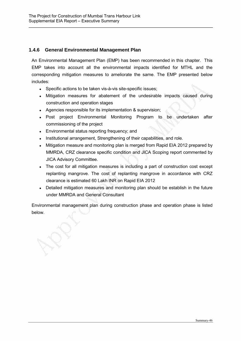
The Project for Construction of Mumbai Trans Harbour Link Supplemental EIA Report – Executive Summary
Summary-46
1.4.6 General Environmental Management Plan
An Environmental Management Plan (EMP) has been recommended in this chapter. This
EMP takes into account all the environmental impacts identified for MTHL and the
corresponding mitigation measures to ameliorate the same. The EMP presented below
includes:
Specific actions to be taken vis-à-vis site-specific issues;
Mitigation measures for abatement of the undesirable impacts caused during
construction and operation stages
Agencies responsible for its implementation & supervision;
Post project Environmental Monitoring Program to be undertaken after
commissioning of the project
Environmental status reporting frequency; and
Institutional arrangement, Strengthening of their capabilities, and role.
Mitigation measure and monitoring plan is merged from Rapid EIA 2012 prepared by
MMRDA, CRZ clearance specific condition and JICA Scoping report commented by
JICA Advisory Committee.
The cost for all mitigation measures is including a part of construction cost except
replanting mangrove. The cost of replanting mangrove in accordance with CRZ
clearance is estimated 60 Lakh INR on Rapid EIA 2012
Detailed mitigation measures and monitoring plan should be establish in the future
under MMRDA and General Consultant
Environmental management plan during construction phase and operation phase is listed
below.
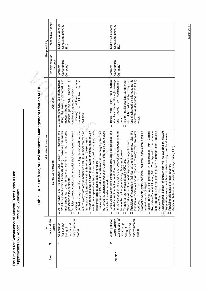
The
Pro
ject
for
Con
stru
ctio
n of
Mum
bai T
rans
Har
bour
Lin
k S
uppl
emen
tal E
IA R
epor
t – E
xecu
tive
Sum
mar
y
Sum
mar
y-47
Tab
le 1
.4.7
D
raft
Maj
or
En
viro
nm
enta
l Man
agem
ent
Pla
n o
n M
TH
L
Are
a N
o.
Item
(o
n R
apid
EIA
20
13)
Miti
gatio
n M
easu
res
Res
pons
ibili
ty
Dur
ing
Con
stru
ctio
n O
pera
tion
Impl
emen
tatio
n A
genc
y R
espo
nsib
le A
genc
y
Pol
lutio
n
1 A
ir po
llutio
n (A
ir qu
ality
/ S
iting
of
borr
ow
and
qu
arry
mat
eria
l ar
eas)
All
vehi
cles
an
d m
achi
nerie
s sh
all
obta
in
&
mai
ntai
n th
e ‘P
ollu
tion
unde
r C
ontr
ol C
ertif
icat
e (P
UC
)’. T
hese
veh
icle
s w
ill b
e m
aint
aine
d so
th
at
emis
sion
s co
nfor
m
to
the
stan
dard
s pr
escr
ibed
in t
he c
ertif
icat
e.
Veh
icle
s ca
rryi
ng c
onst
ruct
ion
mat
eria
l sha
ll be
cov
ered
to
avoi
d sp
illin
g A
spha
lt m
ixin
g pl
ant
(Hot
mix
and
bat
chin
g pl
ants
) sh
all b
e ov
er
500
m a
way
fro
m a
ny c
omm
uniti
es a
nd 3
00 m
fro
m t
he r
oad
as
far
as p
ossi
ble
to a
void
any
air
emis
sion
s fr
om t
hese
pla
nts.
W
ater
spr
inkl
ing
shal
l be
car
ried
out
twic
e or
thr
ice
each
day
on
eart
h ro
ad/u
npav
ed s
ectio
ns o
f ro
ad a
nd c
onst
ruct
ion
yard
nea
r re
side
ntia
l are
a to
avo
id d
ust
gene
ratio
n T
he e
xhau
st o
f D
G s
et w
ill b
e re
leas
ed a
t th
e he
ight
pre
scrib
ed
by M
PC
B (
Mah
aras
htra
Pol
lutio
n C
ontr
ol B
oard
) so
tha
t it
does
no
t af
fect
nea
rby
popu
latio
n.
App
ropr
iate
lan
d us
e m
anag
emen
t al
ong
the
road
(c
omm
erci
al
and
indu
stria
l are
a)
Mon
itor
perio
dica
lly
ambi
ent
air
qual
ity a
t sug
gest
ed lo
catio
ns
Enf
orci
ng
diffe
rent
co
ntro
l m
easu
res
to
min
imiz
e th
e ai
r po
llutio
n
Con
trac
tor
(Con
stru
ctio
n
Com
pany
)
MM
RD
A
& G
ener
al
Con
sulta
nt (
PM
C &
E
C)
2 W
ater
pol
lutio
n (W
ater
Qua
lity/
C
onst
ruct
ion
of
labo
r ca
mp/
S
iting
of
borr
ow
and
qu
arry
mat
eria
l ar
eas)
Tur
bid
was
te w
ater
fro
m c
onst
ruct
ion
area
sha
ll be
miti
gate
d an
d tr
eate
d in
sed
imen
tatio
n po
nd, i
f req
uire
d I
n th
e se
a se
ctio
n, t
he c
asin
g an
d ex
cava
tion
met
hodo
logy
sha
ll be
ado
pted
not
to
gene
rate
sig
nific
ant
turb
id w
ater
. T
here
sha
ll be
no
wat
er d
raw
l in
CR
Z a
rea
Was
te o
il sh
all b
e st
ored
and
dis
pose
d to
des
igna
ted
site
P
rovi
sion
of
sa
nita
tion
faci
litie
s at
th
e la
bor
cam
ps,
also
th
e lo
catio
n of
cam
ps w
ill b
e at
lea
st 2
00 m
aw
ay f
rom
any
wat
er
sour
ces.
D
omes
tic w
aste
wat
er a
nd n
ight
soi
l fr
om b
ase
cam
p sh
all
be
trea
ted
and
disc
harg
ed.
Sep
tic
tank
s w
ill
be
prov
ided
in
ac
cord
ance
w
ith
Coa
stal
R
egul
atio
n Z
one
Not
ifica
tion,
201
1. T
he d
ispo
sal o
f tr
eate
d w
ater
sh
all c
onfo
rm t
o th
e re
gula
tions
of
MP
CB
(M
ahar
asht
ra P
ollu
tion
Con
trol
Boa
rd).
U
ncon
trol
led
digg
ing
of b
orro
w p
its w
ill b
e av
oide
d to
pre
vent
w
ater
acc
umul
atio
n, w
hich
res
ults
in b
reed
ing
of v
ecto
r di
seas
e.
Pro
vidi
ng a
dequ
ate
drai
nage
str
uctu
re
Avo
idin
g ob
stru
ctio
n of
exi
stin
g dr
aina
ge d
urin
g fil
ling
Tur
bid
wat
er
from
ro
ad
surf
ace
shal
l be
col
lect
ed t
hrou
gh d
rain
age
and
trea
ted
by
sedi
men
tatio
n tr
ench
I
n th
e m
udfla
t se
ctio
n, s
torm
wat
er
shou
ld b
e co
llect
ed b
y ev
ery
pier
an
d di
scha
rged
on
pile
cap
s no
t to
ex
cava
te m
udfla
t ar
ea b
y th
e fa
lling
w
ater
.
Con
trac
tor
(Con
stru
ctio
n
Com
pany
)
MM
RD
A &
Gen
eral
C
onsu
ltant
(P
MC
&
EC
)

The
Pro
ject
for
Con
stru
ctio
n of
Mum
bai T
rans
Har
bour
Lin
k S
uppl
emen
tal E
IA R
epor
t – E
xecu
tive
Sum
mar
y
Sum
mar
y-48
Are
a N
o.
Item
(o
n R
apid
EIA
20
13)
Miti
gatio
n M
easu
res
Res
pons
ibili
ty
Dur
ing
Con
stru
ctio
n O
pera
tion
Impl
emen
tatio
n A
genc
y R
espo
nsib
le A
genc
y
3 W
aste
(S
olid
was
te
man
agem
ent/
Con
stru
ctio
n of
la
bor
cam
p/
Top
ogra
phy,
S
oil a
nd
Geo
logy
)
Afte
r co
nsid
erin
g th
e po
ssib
ility
of
re
use,
co
nstr
uctio
n w
aste
sh
all b
e di
spos
ed a
t des
igna
ted
disp
osal
site
with
the
app
rova
l of
com
pete
nt a
utho
rity
to e
nsur
e th
at it
do
not
caus
e an
y im
pact
to
the
envi
ronm
ent
Pro
per
sani
tatio
n fa
cilit
ies
such
as
sept
ic t
ank
shal
l be
pro
vide
d at
co
nstr
uctio
n w
orke
rs
cam
p.
Gar
bage
/muc
k m
ater
ials
ge
nera
ted
will
be
anal
yzed
prio
r to
dum
ping
/ d
ispo
sal
in t
he
iden
tifie
d lo
catio
ns w
ith t
he a
ppro
val
of c
ompe
tent
aut
horit
y to
en
sure
tha
t it
do n
ot c
ause
any
impa
ct to
the
envi
ronm
ent
The
re w
ill b
e no
dis
posa
l of
sol
id o
r liq
uid
was
tes
on c
oast
al
area
. S
olid
was
te M
anag
emen
t w
ill b
e as
per
Mun
icip
al S
olid
(M
anag
emen
t an
d H
andl
ing)
Rul
es, 2
000
Not
req
uire
d C
ontr
acto
r (C
onst
ruct
ion
C
ompa
ny)
MM
RD
A
& G
ener
al
Con
sulta
nt (
PM
C &
E
C)
4 S
oil
Con
tam
inat
ion
(Top
ogra
phy,
S
oil a
nd
Geo
logy
/ S
iting
of
bor
row
and
qu
arry
mat
eria
l ar
eas)
Pol
lute
d ex
cava
ted
soil
incl
udin
g m
uck
soil
shal
l be
dis
pose
d at
de
sign
ated
si
te
with
th
e ap
prov
al
of
com
pete
nt
auth
ority
to
en
sure
tha
t it
do n
ot c
ause
any
impa
ct to
the
envi
ronm
ent
Not
req
uire
d C
ontr
acto
r (C
onst
ruct
ion
C
ompa
ny)
MM
RD
A
& G
ener
al
Con
sulta
nt (
PM
C &
E
C)
5 N
oise
and
V
ibra
tion
(Am
bien
t N
oise
)
Ado
ptio
n of
low
-noi
se e
quip
men
t A
ll th
e co
nstr
uctio
n eq
uipm
ent’s
sha
ll be
pro
vide
d w
ith e
xhau
st
sile
ncer
s as
com
mitt
ed.
Noi
se c
onta
inm
ent
barr
iers
sha
ll be
pro
vide
d on
bot
h si
des
of th
e br
idge
in
mud
flat
area
s (C
RZ
-IA
) so
as
to m
inim
ize
the
likel
y im
pact
s to
the
mig
rato
ry b
irds
Avo
idin
g w
orks
of
heav
y eq
uipm
ent
durin
g ni
ght t
ime.
P
rovi
sion
of
usin
g ea
r pl
ugs
by w
orke
rs e
xpos
ed t
o hi
gh n
oise
le
vels
I
nfor
min
g th
e co
nstr
uctio
n sc
hedu
le t
o su
rrou
ndin
g co
mm
uniti
es
to o
btai
n th
eir
cons
ensu
s.
Pro
pone
nt w
ill p
ropo
se a
ppro
pria
te
land
use
pla
n su
ch a
s co
mm
erci
al
area
alo
ng t
he r
oad
Noi
se b
arrie
r sh
all
be i
nsta
lled
as
requ
ired
P
erio
dic
mon
itorin
g of
am
bien
t no
ise
leve
ls a
t sug
gest
ed lo
catio
ns
Ere
ctin
g si
gnbo
ards
at
se
nsiti
ve
and
resi
dent
ial
loca
tions
pro
hibi
ting
use
of h
orns
G
row
ing
road
si
de
plan
tatio
n to
pr
even
t th
e no
ise
leve
ls.
Con
trac
tor
(Con
stru
ctio
n
Com
pany
)
MM
RD
A
& G
ener
al
Con
sulta
nt (
PM
C &
E
C)
8 S
edim
ent
Qua
lity
(Top
ogra
phy,
S
oil a
nd
Geo
logy
(No.
4))
Pol
lute
d ex
cava
ted
soil
incl
udin
g m
uck
soil
shal
l be
trea
ted,
and
th
en r
euse
d an
d/or
dis
pose
d at
des
igna
ted
site
in
acco
rdan
ce
rele
vant
law
s an
d re
gula
tions
.
Not
req
uire
d C
ontr
acto
r (C
onst
ruct
ion
C
ompa
ny)
MM
RD
A
& G
ener
al
Con
sulta
nt (
PM
C &
E
C)
Nat
ura
l 9
Pro
tect
ed A
rea
(Res
erve
d
Ado
ptio
n of
ex
cava
tion
met
hodo
logy
fo
r th
e tu
rbid
w
ater
pr
even
tion
(i.e.
bor
e ca
sing
and
exc
avat
ion)
I
nsta
llatio
n of
noi
se b
arrie
r fo
r no
t to
cau
se “
Fly
-Kill
” on
the
via
duct
as
MM
RD
A &
C
ontr
acto
r M
MR
DA
&
Gen
eral
C
onsu
ltant
(P
MC
&
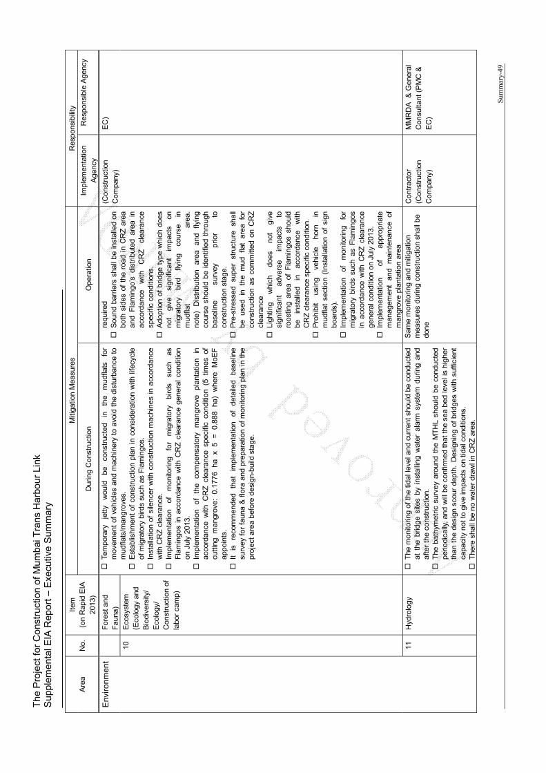
The
Pro
ject
for
Con
stru
ctio
n of
Mum
bai T
rans
Har
bour
Lin
k S
uppl
emen
tal E
IA R
epor
t – E
xecu
tive
Sum
mar
y
Sum
mar
y-49
Are
a N
o.
Item
(o
n R
apid
EIA
20
13)
Miti
gatio
n M
easu
res
Res
pons
ibili
ty
Dur
ing
Con
stru
ctio
n O
pera
tion
Impl
emen
tatio
n A
genc
y R
espo
nsib
le A
genc
y
Env
iro
nm
ent
For
est a
nd
Fau
na)
Tem
pora
ry
jett
y w
ould
be
co
nstr
ucte
d in
th
e m
udfla
ts
for
mov
emen
t of
veh
icle
s an
d m
achi
nery
to
avoi
d th
e di
stur
banc
e to
m
udfla
ts/m
angr
oves
. E
stab
lishm
ent
of c
onst
ruct
ion
plan
in
cons
ider
atio
n w
ith li
fecy
cle
of m
igra
tory
bird
s su
ch a
s F
lam
ingo
s.
Ins
talla
tion
of s
ilenc
er w
ith c
onst
ruct
ion
mac
hine
s in
acc
orda
nce
with
CR
Z c
lear
ance
. I
mpl
emen
tatio
n of
m
onito
ring
for
mig
rato
ry
bird
s su
ch
as
Fla
min
gos
in a
ccor
danc
e w
ith C
RZ
cle
aran
ce g
ener
al c
ondi
tion
on J
uly
2013
. I
mpl
emen
tatio
n of
th
e co
mpe
nsat
ory
man
grov
e pl
anta
tion
in
acco
rdan
ce w
ith C
RZ
cle
aran
ce s
peci
fic c
ondi
tion
(5 t
imes
of
cutti
ng
man
grov
e:
0.17
76
ha
x 5
=
0.88
8 ha
) w
here
M
oEF
ap
poin
ts.
It
is
reco
mm
ende
d th
at
impl
emen
tatio
n of
de
taile
d ba
selin
e su
rvey
for
fau
na &
flo
ra a
nd p
repa
ratio
n of
mon
itorin
g pl
an in
the
pr
ojec
t ar
ea b
efor
e de
sign
-bui
ld s
tage
.
requ
ired
S
ound
bar
riers
sha
ll be
ins
talle
d on
bo
th s
ides
of
the
road
in
CR
Z a
rea
and
Fla
min
go’s
dis
trib
uted
are
a in
ac
cord
ance
w
ith
CR
Z
clea
ranc
e sp
ecifi
c co
nditi
ons.
A
dopt
ion
of b
ridge
typ
e w
hich
doe
s no
t gi
ve
sign
ifica
nt
impa
cts
on
mig
rato
ry
bird
fly
ing
cour
se
in
mud
flat
area
. no
te)
Dis
trib
utio
n ar
ea
and
flyin
g co
urse
sho
uld
be i
dent
ified
thr
ough
ba
selin
e su
rvey
pr
ior
to
cons
truc
tion
stag
e.
Pre
-str
esse
d su
per
stru
ctur
e sh
all
be
used
in
th
e m
ud
flat
area
fo
r co
nstr
uctio
n as
com
mitt
ed o
n C
RZ
cl
eara
nce
Lig
htin
g w
hich
do
es
not
give
si
gnifi
cant
ad
vers
e im
pact
s to
ro
ostin
g ar
ea o
f F
lam
ingo
s sh
ould
be
in
stal
led
in
acco
rdan
ce
with
C
RZ
cle
aran
ce s
peci
fic c
ondi
tion.
P
rohi
bit
usin
g ve
hicl
e ho
rn
in
mud
flat
sect
ion
(Ins
talla
tion
of s
ign
boar
ds).
I
mpl
emen
tatio
n of
m
onito
ring
for
mig
rato
ry b
irds
such
as
Fla
min
gos
in a
ccor
danc
e w
ith C
RZ
cle
aran
ce
gene
ral c
ondi
tion
on J
uly
2013
. I
mpl
emen
tatio
n of
ap
prop
riate
m
anag
emen
t an
d m
aint
enan
ce
of
man
grov
e pl
anta
tion
area
(Con
stru
ctio
n
Com
pany
) E
C)
10
Eco
syst
em
(Eco
logy
and
B
iodi
vers
ity/
Eco
logy
/ C
onst
ruct
ion
of
labo
r ca
mp)
11
Hyd
rolo
gy
The
mon
itorin
g of
the
tidal
leve
l and
cur
rent
sho
uld
be c
ondu
cted
at
the
brid
ge s
ites
by i
nsta
lling
wat
er a
larm
sys
tem
dur
ing
and
afte
r th
e co
nstr
uctio
n.
The
bat
hym
etric
sur
vey
arou
nd t
he M
TH
L sh
ould
be
cond
ucte
d pe
riodi
cally
, an
d w
ill b
e co
nfirm
ed th
at t
he s
ea b
ed le
vel i
s hi
gher
th
an t
he d
esig
n sc
our
dept
h. D
esig
ning
of
brid
ges
with
suf
ficie
nt
capa
city
not
to
give
impa
cts
on t
idal
con
ditio
ns.
The
re s
hall
be n
o w
ater
dra
wl i
n C
RZ
are
a.
Sam
e m
onito
ring
and
miti
gatio
n m
easu
res
durin
g co
nstr
uctio
n sh
all b
e do
ne
Con
trac
tor
(Con
stru
ctio
n
Com
pany
)
MM
RD
A
& G
ener
al
Con
sulta
nt (
PM
C &
E
C)
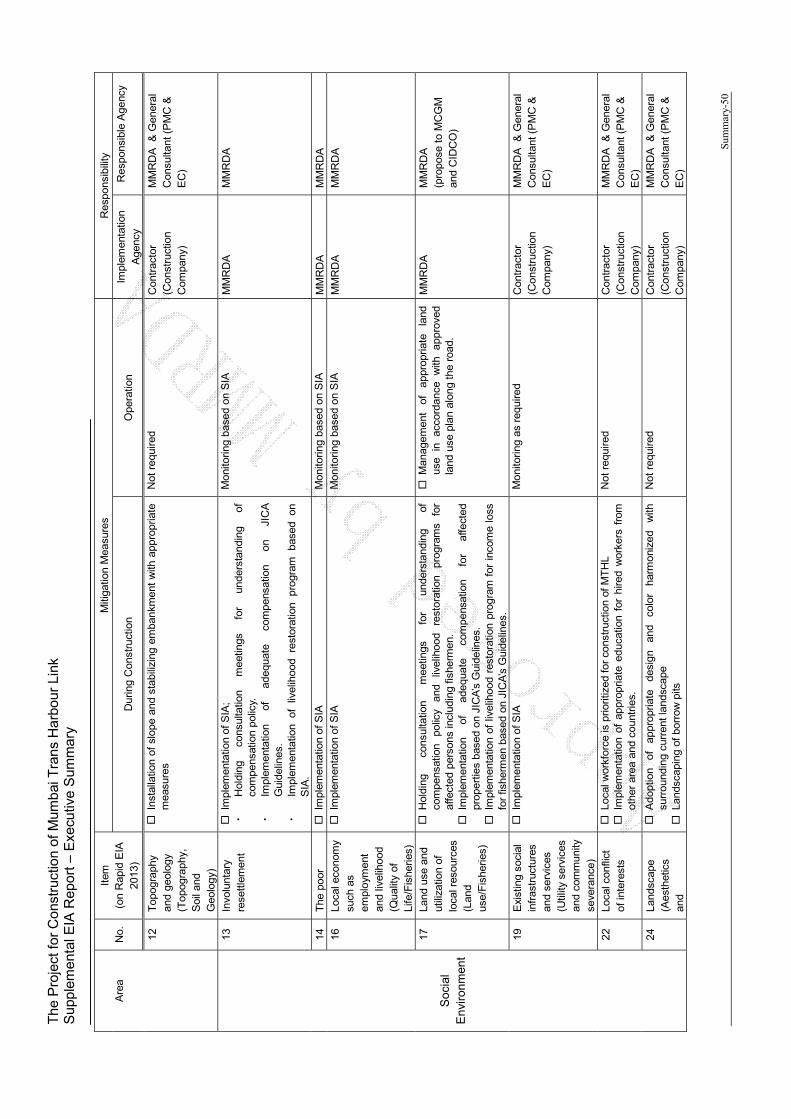
The
Pro
ject
for
Con
stru
ctio
n of
Mum
bai T
rans
Har
bour
Lin
k S
uppl
emen
tal E
IA R
epor
t – E
xecu
tive
Sum
mar
y
Sum
mar
y-50
Are
a N
o.
Item
(o
n R
apid
EIA
20
13)
Miti
gatio
n M
easu
res
Res
pons
ibili
ty
Dur
ing
Con
stru
ctio
n O
pera
tion
Impl
emen
tatio
n A
genc
y R
espo
nsib
le A
genc
y
12
Top
ogra
phy
and
geol
ogy
(Top
ogra
phy,
S
oil a
nd
Geo
logy
)
Ins
talla
tion
of s
lope
and
sta
biliz
ing
emba
nkm
ent
with
app
ropr
iate
m
easu
res
Not
req
uire
d C
ontr
acto
r (C
onst
ruct
ion
C
ompa
ny)
MM
RD
A
& G
ener
al
Con
sulta
nt (
PM
C &
E
C)
Soc
ial
Env
iro
nm
ent
13
Invo
lunt
ary
rese
ttle
men
t
Im
plem
enta
tion
of S
IA;
・
Hol
ding
co
nsul
tatio
n m
eetin
gs
for
unde
rsta
ndin
g of
co
mpe
nsat
ion
polic
y.
・
Impl
emen
tatio
n of
ad
equa
te
com
pens
atio
n on
JI
CA
G
uide
lines
. ・
Impl
emen
tatio
n of
liv
elih
ood
rest
orat
ion
prog
ram
ba
sed
on
SIA
.
Mon
itorin
g ba
sed
on S
IA
MM
RD
A
MM
RD
A
14
The
poo
r I
mpl
emen
tatio
n of
SIA
M
onito
ring
base
d on
SIA
M
MR
DA
M
MR
DA
16
Loca
l eco
nom
y su
ch a
s em
ploy
men
t an
d liv
elih
ood
(Qua
lity
of
Life
/Fis
herie
s)
Im
plem
enta
tion
of S
IA
Mon
itorin
g ba
sed
on S
IA
MM
RD
A
MM
RD
A
17
Land
use
and
ut
iliza
tion
of
loca
l res
ourc
es
(Lan
d us
e/F
ishe
ries)
Hol
ding
co
nsul
tatio
n m
eetin
gs
for
unde
rsta
ndin
g of
co
mpe
nsat
ion
polic
y an
d liv
elih
ood
rest
orat
ion
prog
ram
s fo
r af
fect
ed p
erso
ns in
clud
ing
fishe
rmen
. I
mpl
emen
tatio
n of
ad
equa
te
com
pens
atio
n fo
r af
fect
ed
prop
ertie
s ba
sed
on J
ICA
’s G
uide
lines
. I
mpl
emen
tatio
n of
liv
elih
ood
rest
orat
ion
prog
ram
for
inc
ome
loss
fo
r fis
herm
en b
ased
on
JIC
A’s
Gui
delin
es.
Man
agem
ent
of
appr
opria
te
land
us
e in
ac
cord
ance
w
ith
appr
oved
la
nd u
se p
lan
alon
g th
e ro
ad.
MM
RD
A
MM
RD
A
(pro
pose
to
MC
GM
an
d C
IDC
O)
19
Exi
stin
g so
cial
in
fras
truc
ture
s an
d se
rvic
es
(Util
ity s
ervi
ces
and
com
mun
ity
seve
ranc
e)
Im
plem
enta
tion
of S
IA
Mon
itorin
g as
req
uire
d C
ontr
acto
r (C
onst
ruct
ion
C
ompa
ny)
MM
RD
A
& G
ener
al
Con
sulta
nt (
PM
C &
E
C)
22
Loca
l con
flict
of
inte
rest
s
Loc
al w
orkf
orce
is p
riorit
ized
for
cons
truc
tion
of M
TH
L
Im
plem
enta
tion
of a
ppro
pria
te e
duca
tion
for
hire
d w
orke
rs f
rom
ot
her
area
and
cou
ntrie
s.
Not
req
uire
d C
ontr
acto
r (C
onst
ruct
ion
C
ompa
ny)
MM
RD
A
& G
ener
al
Con
sulta
nt (
PM
C &
E
C)
24
Land
scap
e (A
esth
etic
s an
d
Ado
ptio
n of
ap
prop
riate
de
sign
an
d co
lor
harm
oniz
ed
with
su
rrou
ndin
g cu
rren
t lan
dsca
pe
Lan
dsca
ping
of
borr
ow p
its
Not
req
uire
d C
ontr
acto
r (C
onst
ruct
ion
C
ompa
ny)
MM
RD
A
& G
ener
al
Con
sulta
nt (
PM
C &
E
C)
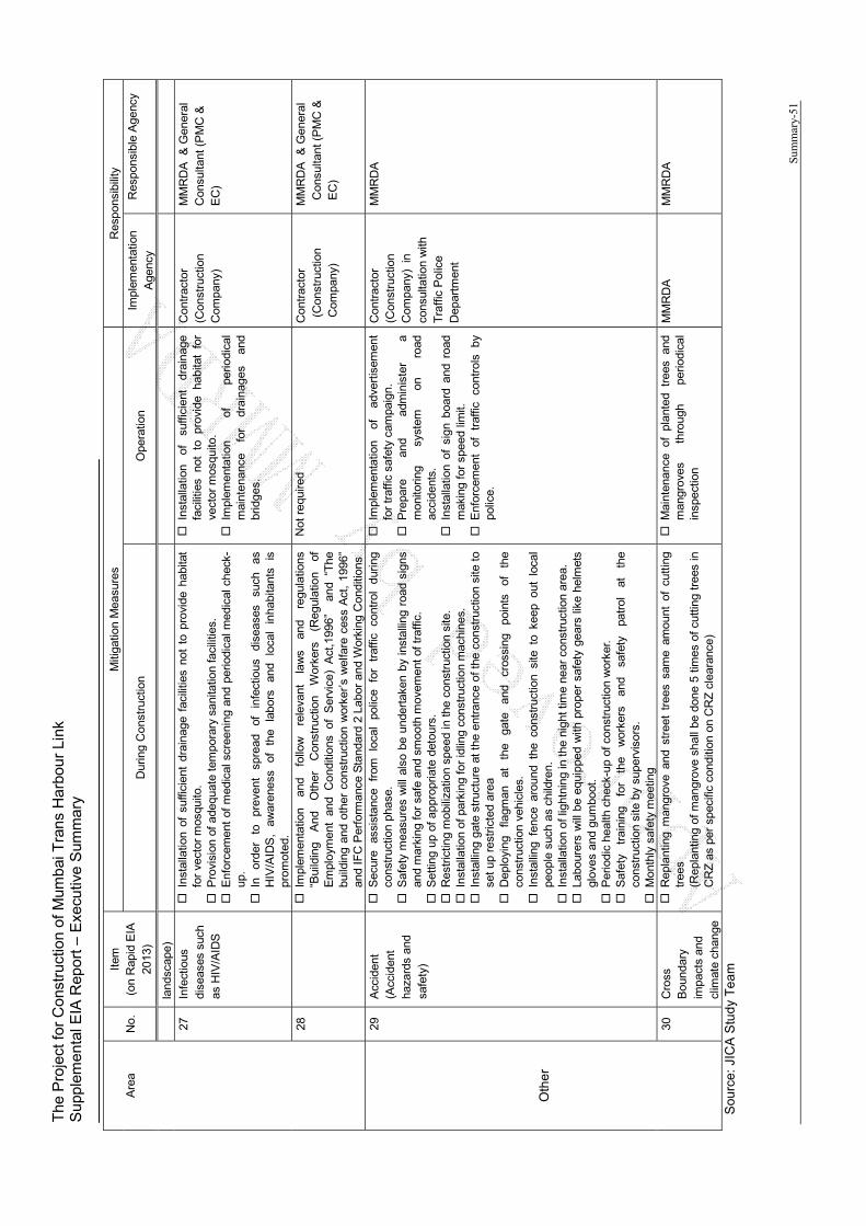
The
Pro
ject
for
Con
stru
ctio
n of
Mum
bai T
rans
Har
bour
Lin
k S
uppl
emen
tal E
IA R
epor
t – E
xecu
tive
Sum
mar
y
Sum
mar
y-51
Are
a N
o.
Item
(o
n R
apid
EIA
20
13)
Miti
gatio
n M
easu
res
Res
pons
ibili
ty
Dur
ing
Con
stru
ctio
n O
pera
tion
Impl
emen
tatio
n A
genc
y R
espo
nsib
le A
genc
y
land
scap
e)
27
Infe
ctio
us
dise
ases
suc
h as
HIV
/AID
S
Ins
talla
tion
of s
uffic
ient
dra
inag
e fa
cilit
ies
not
to p
rovi
de h
abita
t fo
r ve
ctor
mos
quito
. P
rovi
sion
of
adeq
uate
tem
pora
ry s
anita
tion
faci
litie
s.
Enf
orce
men
t of
med
ical
scr
eeni
ng a
nd p
erio
dica
l med
ical
che
ck-
up.
In
orde
r to
pr
even
t sp
read
of
in
fect
ious
di
seas
es
such
as
H
IV/A
IDS
, aw
aren
ess
of
the
labo
rs
and
loca
l in
habi
tant
s is
pr
omot
ed.
Ins
talla
tion
of
suffi
cien
t dr
aina
ge
faci
litie
s no
t to
pro
vide
hab
itat
for
vect
or m
osqu
ito.
Im
plem
enta
tion
of
perio
dica
l m
aint
enan
ce
for
drai
nage
s an
d br
idge
s.
Con
trac
tor
(Con
stru
ctio
n
Com
pany
)
MM
RD
A
& G
ener
al
Con
sulta
nt (
PM
C &
E
C)
28
I
mpl
emen
tatio
n an
d fo
llow
re
leva
nt
law
s an
d re
gula
tions
“B
uild
ing
And
O
ther
C
onst
ruct
ion
Wor
kers
(R
egul
atio
n of
E
mpl
oym
ent
and
Con
ditio
ns o
f S
ervi
ce)
Act
,199
6”
and
“The
bu
ildin
g an
d ot
her
cons
truc
tion
wor
ker’
s w
elfa
re c
ess
Act
, 19
96”
and
IFC
Per
form
ance
Sta
ndar
d 2
Labo
r an
d W
orki
ng C
ondi
tions
Not
req
uire
d C
ontr
acto
r (C
onst
ruct
ion
C
ompa
ny)
MM
RD
A
& G
ener
al
Con
sulta
nt (
PM
C &
E
C)
Oth
er
29
Acc
iden
t (A
ccid
ent
haza
rds
and
safe
ty)
Sec
ure
assi
stan
ce
from
lo
cal
polic
e fo
r tr
affic
co
ntro
l du
ring
cons
truc
tion
phas
e.
Saf
ety
mea
sure
s w
ill a
lso
be u
nder
take
n by
ins
talli
ng r
oad
sign
s an
d m
arki
ng f
or s
afe
and
smoo
th m
ovem
ent of
traf
fic.
Set
ting
up o
f ap
prop
riate
det
ours
. R
estr
ictin
g m
obili
zatio
n sp
eed
in th
e co
nstr
uctio
n si
te.
Ins
talla
tion
of p
arki
ng fo
r id
ling
cons
truc
tion
mac
hine
s.
Ins
talli
ng g
ate
stru
ctur
e at
the
ent
ranc
e of
the
con
stru
ctio
n si
te t
o se
t up
rest
ricte
d ar
ea
Dep
loyi
ng
flagm
an
at
the
gate
an
d cr
ossi
ng
poin
ts
of
the
cons
truc
tion
vehi
cles
. I
nsta
lling
fen
ce a
roun
d th
e co
nstr
uctio
n si
te t
o ke
ep o
ut l
ocal
pe
ople
suc
h as
chi
ldre
n.
Ins
talla
tion
of li
ghtn
ing
in th
e ni
ght t
ime
near
con
stru
ctio
n ar
ea.
Lab
oure
rs w
ill b
e eq
uipp
ed w
ith p
rope
r sa
fety
gea
rs li
ke h
elm
ets
glov
es a
nd g
umbo
ot.
Per
iodi
c he
alth
che
ck-u
p of
con
stru
ctio
n w
orke
r. S
afet
y tr
aini
ng
for
the
wor
kers
an
d sa
fety
pa
trol
at
th
e co
nstr
uctio
n si
te b
y su
perv
isor
s.
Mon
thly
saf
ety
mee
ting
Im
plem
enta
tion
of
adve
rtis
emen
t fo
r tr
affic
saf
ety
cam
paig
n.
Pre
pare
an
d ad
min
iste
r a
mon
itorin
g sy
stem
on
ro
ad
acci
dent
s.
Ins
talla
tion
of s
ign
boar
d an
d ro
ad
mak
ing
for
spee
d lim
it.
Enf
orce
men
t of
tr
affic
co
ntro
ls
by
polic
e.
Con
trac
tor
(Con
stru
ctio
n
Com
pany
) in
co
nsul
tatio
n w
ith
Tra
ffic
Pol
ice
Dep
artm
ent
MM
RD
A
30
Cro
ss
Bou
ndar
y im
pact
s an
d cl
imat
e ch
ange
Rep
lant
ing
man
grov
e an
d st
reet
tre
es s
ame
amou
nt o
f cu
tting
tr
ees
(Rep
lant
ing
of m
angr
ove
shal
l be
done
5 t
imes
of
cutti
ng t
rees
in
CR
Z a
s pe
r sp
ecifi
c co
nditi
on o
n C
RZ
cle
aran
ce)
Mai
nten
ance
of
plan
ted
tree
s an
d m
angr
oves
th
roug
h pe
riodi
cal
insp
ectio
n
MM
RD
A
MM
RD
A
Sou
rce:
JIC
A S
tud
y T
ea
m

The Project for Construction of Mumbai Trans Harbour Link Supplemental EIA Report – Executive Summary
Summary-52
Additionally all committed specific conditions on CRZ clearance on 2013 will be conducted by
MMRDA as shown in the next table.
Table 1.4.8 Mitigation Measures on CRZ Clearance for MTHL
No Conditions Response on Mitigation Measures
1
As per the CRZ notification, 2011, at least five times the number of mangroves destroyed/cut during the construction process shall be replanted. Mangrove plantation in an area of 30 ha shall be carried out as committed against loss of 0.1776 ha of mudflats/mangroves. Permission from the High Court of Bombay shall be obtained with respect to mangrove cutting.
MMRDA will replant 5 times of cutting mangrove in the appointed area by MoEF.
2 Proponent shall provide lighting in consulting in consulting with the Bombay Natural History Society so as to minimize the likely impacts to the migratory birds.
MMRDA will setup traffic light inside of bridge handrail especially in CRZ and flamingo roosting area.
3 All the construction equipment’s shall be provided with exhaust silencers as committed.
Low noise construction machines and with exhaust silencer is installed during construction.
4 Noise containment barriers shall be provided on both sides of the bridge in mudflat areas (CRZ-IA) so as to minimize the likely impacts to the migratory birds.
Noise barrier is installed in CRZ and roosting /feeding are of migratory birds such as flamingo.
5 There shall be no dreading and reclamation for the project. Dreading and reclamation is not
planned on this project in the CRZ.
6 Pre-stressed super structure shall be used in the mud flat area for construction as committed.
Pre-stressed super structure will be used in the mud flat area CRZ.
7
The muck materials shall be analyzed prior to dumping / disposal in the identified locations with the approval of competent authority to ensure that it do not cause any impact to the environment.
The muck soil is generated from excavated points of piles. The excavated soil is analyzed and disposed at designated and authorized dumping site.
8 Proponent informed that there is no fishing activity in the area since it is a navigation channel for the nearby ports. However, navigation channel is provided with 25m for ships and 9.1 m for fishing boats.
Sufficient prescript vertical clearance under discussion with relevant authorities.
9
All the recommendations of the MCZMA shall be strictly compiled with. All recommendation of the Maharashtra Coastal Zone Management Authority will be reflected to mitigation measures, if any.
10 There shall be no building construction beyond 20,000 sqm. No building is planned in CRZ.
Only toll gate is planned out of CRZ in Navi Mumbai side.
11 There shall be no water drawal in CRZ area. No polluted water from project in CRZ.
However storm water will be flow down from the road in monsoon season.
12 There shall be no disposal of solid or liquid wastes on coastal area. Solid waste Management shall be as per Municipal Solid (Management and Handling) Rules, 2000.
There is no activities to discharge and dispose solid and liquid waste from project activities in CRZ.
13
Sewage shall be treated and the Treatment Facility shall be provided in accordance with the Coastal Regulation Zone Notification, 2011. The disposal of treated water shall conform to the regulations of State Pollution Control Board.
Sewage including polluted water and night soil does not generate from project activities in CRZ.
14 The project proponent shall set up a separate environmental management cell for effective implementation of the stipulated environmental safeguard under the supervision of a Senior Executive.
MMRDA will setup environmental management cell for MTHLin MMRDA.
15 The funds earmarked for environment management plan shall be included in the budget and this shall not be diverted for any other purposes.
MMRDA will secure budge for MTHL.
Source: CRZ Environmental Clearance (MOEF 19th July 2913)
The Project for Construction of Mumbai Trans Harbour Link Supplemental EIA Report – Executive Summary
Summary-53
1.4.7 Environmental Monitoring Plan
Environmental Monitoring shall be done by the construction contractor under PW. The
contractor shall conduct prescript monitoring and report to the construction supervision
consultant monthly.
The expected environmental monitoring plans are shown below.

The
Pro
ject
for
Con
stru
ctio
n of
Mum
bai T
rans
Har
bour
Lin
k S
uppl
emen
tal E
IA R
epor
t – E
xecu
tive
Sum
mar
y
Sum
mar
y-54
Tab
le 1
.4.9
E
nvi
ron
men
tal
Mo
nit
ori
ng
Pla
n P
re a
nd
Du
rin
g C
on
stru
ctio
n P
has
e
Area
No.
It
em
(on
Rap
id E
IA
2012
) P
aram
eter
M
etho
d Lo
catio
n
Fre
quen
cy a
yea
r C
ost
(IN
R)
Sta
ndar
d
Pollution
1 A
ir po
llutio
n S
O2,
NO
2, P
M10
, P
M2.
5, O
3, P
b,
CO
, N
H3,
C6H
6,
BaP
, As,
Ni,
CH
4 an
d C
O2
(14
Item
s)
Sam
e m
etho
d as
bas
elin
e su
rvey
O
r E
stab
lis
fixed
m
onito
ring
stat
ion
at 2
lo
catio
ns
2 L
oca
tio
ns
whe
re b
asel
ine
mon
itorin
g w
as c
arrie
d ou
t. (2
loca
tions
: Sew
ri an
d S
hiva
ji N
agar
)
4 ti
mes
/ ye
ar x
4.5
yea
rs
(Onc
e ev
ery
quar
ter
–Sum
mer
, W
inte
r, p
ost-
mon
soon
) (2
4 hr
/day
for
2 c
onse
cutiv
e w
orki
ng
days
per
wee
k fo
r 2
wee
ks e
xcep
t C
O w
hich
is 8
hr/
day)
1800
,000
Nat
iona
l Am
bien
t Air
Qua
lity
Sta
ndar
ds (
NA
AQ
S)
by
Cen
tral
Pol
lutio
n C
ontr
ol B
oard
(C
PC
B)
(Sta
ndar
d fo
r 24
hrs:
Ind
ustr
ial a
nd R
esid
entia
l/ E
colo
gica
l Sen
sitiv
e ar
ea)
S
O2:
80
/ 80μ
g/m
3
NO
2: 8
0 /
80μ
g/m
3
PM
10:
100
/ 100μ
g/m
3
PM
2.5
:: 60
/ 60μ
g/m
3
O3:
180
/ 18
0μg/
m3
P
b: 1
.0 /
1.0μ
g/m
3
CO
: 0.
4 / 0
.4m
g/m
3
NH
3::
400
/ 40
0μg/
m3
C
6H6:
0.5
/ 0.
5μg/
m3(
anua
l)
BaP
: 0.1
/ 0.
1μg/
m3(
anua
l)
As:
0.6
/ 0.
6mg/
m3(
anua
l)
Ni:
20 /
20m
g/m
3(an
ual)
2 W
ater
po
llutio
n pH
, B
OD
, D
O,
Tur
bidi
ty a
nd
O&
G
Sam
e m
etho
d as
bas
elin
e su
rvey
3 Lo
catio
ns
Nea
r ex
cava
ted
area
in
Zon
e II
(Sew
ri m
udfla
t),
Zon
e III
and
Zon
e IV
whe
re
base
line
mon
itorin
g w
as
carr
ied
out.
4 tim
es /
year
x 4
.5 y
ears
O
nce
ever
y q
uart
er –
Sum
mer
, W
inte
r an
d po
st-m
onso
on
810,
000
Mar
ine
wat
er q
ual
ity
Sta
nd
ard
s –
Cla
ss S
W-I
V
Har
bo
ur
Wat
ers
(MP
CB
) pH
: 6
.5-9
D
O:
3 m
g/l
Tur
bidi
ty:
30 N
TU
B
OD
: 5
mg/
l O
& G
: 10
mg/
l
3 W
aste
V
olum
e of
w
aste
soi
l, cu
tting
tree
and
do
mes
tic
garb
age
Rec
ord
volu
me
of
gene
rate
d w
aste
3 L
ocat
ions
(1
. S
ewri
cam
p si
te
2. M
angr
ove
cutti
ng a
rea
3. N
avi M
umba
i cam
p si
te))
4 tim
es /
year
x 4
.5 y
ears
32
4,00
0 M
un
icip
al S
oild
Was
te M
anag
emen
t R
ule
s, 2
013
Gen
erat
ed w
aste
sha
ll be
reu
sed
or d
ispo
sed
at
desi
gnat
ed s
ite.
(The
con
stru
ctio
n w
aste
can
be
dum
ped
in le
gally
au
thor
ized
dum
ping
gro
unds
in N
avi M
umba
i by
CID
CO
w
ith a
ssoc
iatio
n of
Nav
i Mum
bai M
unic
ipal
Cor
pora
tion
(NM
MC
) w
hich
is lo
cate
d in
Tal
oja.
Rem
aini
ng i.
e. fr
om
Mum
bai s
ide,
MM
RD
A c
an b
e ta
ken
care
of a
nd d
umpe
d th
e co
nstr
uctio
n w
aste
in a
ssoc
iatio
n w
ith M
unic
ipal
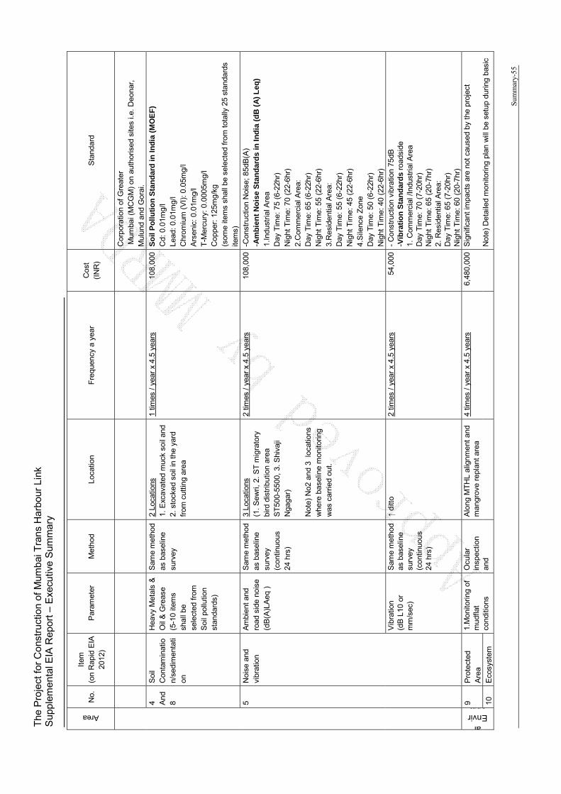
The
Pro
ject
for
Con
stru
ctio
n of
Mum
bai T
rans
Har
bour
Lin
k S
uppl
emen
tal E
IA R
epor
t – E
xecu
tive
Sum
mar
y
Sum
mar
y-55
Area
No.
It
em
(on
Rap
id E
IA
2012
) P
aram
eter
M
etho
d Lo
catio
n
Fre
quen
cy a
yea
r C
ost
(IN
R)
Sta
ndar
d
Cor
pora
tion
of G
reat
er
Mum
bai (
MC
GM
) on
aut
horis
ed s
ites
i.e.
Deo
nar,
M
ulun
d an
d G
orai
.
4 And
8
Soi
l C
onta
min
atio
n/se
dim
enta
tion
Hea
vy M
etal
s &
O
il &
Gre
ase
(5-1
0 ite
ms
shal
l be
sele
cted
from
S
oil p
ollu
tion
stan
dard
s)
Sam
e m
etho
d as
bas
elin
e su
rvey
2 Lo
catio
ns
1. E
xcav
ated
muc
k so
il an
d 2.
sto
cked
soi
l in
the
yard
fr
om c
uttin
g ar
ea
1 tim
es /
year
x 4
.5 y
ears
10
8,00
0 S
oil
Po
llu
tio
n S
tan
dar
d in
Ind
ia (
MO
EF
) C
d: 0
.01m
g/l
Lead
: 0.
01m
g/l
Chr
omiu
m (
VI)
: 0.0
5mg/
l A
rsen
ic: 0
.01m
g/l
T-M
ercu
ry:
0.00
05m
g/l
Cop
per:
125
mg/
kg
(som
e ite
ms
shal
l be
sele
cted
from
tot
ally
25
stan
dard
s ite
ms)
5 N
oise
and
vi
brat
ion
Am
bien
t and
ro
ad s
ide
nois
e (d
B(A
)LA
eq )
Sam
e m
etho
d as
bas
elin
e su
rvey
(c
ontin
uous
24
hrs
)
3 Lo
catio
ns
(1.
Sew
ri, 2
. ST
mig
rato
ry
bird
dis
trib
utio
n ar
ea
ST
500-
5500
, 3.
Shi
vaji
Nga
gar)
N
ote)
No2
and
3 l
ocat
ions
w
here
bas
elin
e m
onito
ring
was
car
ried
out.
2 tim
es /
year
x 4
.5 y
ears
10
8,00
0 -C
onst
ruct
ion
Noi
se;
85dB
(A)
- Am
bie
nt
No
ise
Sta
nd
ard
s in
Ind
ia (
dB
(A
) L
eq)
1.In
dust
rial A
rea
Day
Tim
e: 7
5 (6
-22h
r)
Nig
ht T
ime:
70
(22-
6hr)
2.
Com
mer
cial
Are
a:
Day
Tim
e: 6
5 (6
-22h
r)
Nig
ht T
ime:
55
(22-
6hr)
3.
Res
iden
tial A
rea:
D
ay T
ime:
55
(6-2
2hr)
N
ight
Tim
e: 4
5 (2
2-6h
r)
4.S
ilenc
e Z
one
Day
Tim
e: 5
0 (6
-22h
r)
Nig
ht T
ime:
40
(22-
6hr)
V
ibra
tion
(dB
L10
or
mm
/sec
)
Sam
e m
etho
d as
bas
elin
e su
rvey
(c
ontin
uous
24
hrs
)
di
tto
2 tim
es /
year
x 4
.5 y
ears
54
,000
-
Con
stru
ctio
n vi
brat
ion
75dB
-V
ibra
tio
n S
tan
dar
ds
road
side
1.
Com
mer
cial
/Ind
ustr
ial A
rea
Day
Tim
e: 7
0 (7
-20h
r)
Nig
ht T
ime:
65
(20-
7hr)
2.
Res
iden
tial A
rea:
D
ay T
ime:
65
(7-2
0hr)
N
ight
Tim
e: 6
0 (2
0-7h
r)
al Environm9
Pro
tect
ed
Are
a
1.M
onito
ring
of
mud
flat
cond
ition
s
Ocu
lar
insp
ectio
n an
d
Alo
ng M
TH
L al
ignm
ent an
d m
angr
ove
repl
ant a
rea
4
times
/ ye
ar x
4.5
yea
rs
6,48
0,00
0 S
igni
fican
t im
pact
s ar
e no
t cau
sed
by t
he p
roje
ct
Not
e) D
etai
led
mon
itorin
g pl
an w
ill b
e se
tup
durin
g ba
sic
10
Eco
syst
em
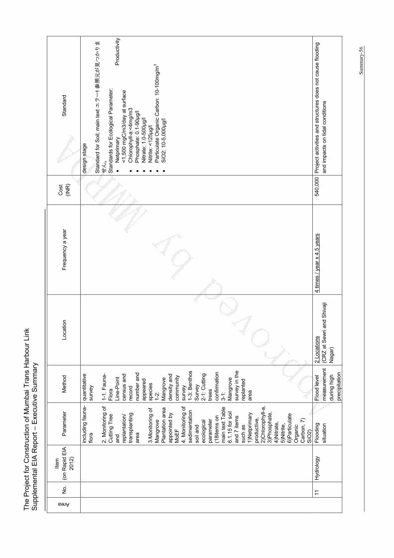
The
Pro
ject
for
Con
stru
ctio
n of
Mum
bai T
rans
Har
bour
Lin
k S
uppl
emen
tal E
IA R
epor
t – E
xecu
tive
Sum
mar
y
Sum
mar
y-56
Area
No.
It
em
(on
Rap
id E
IA
2012
) P
aram
eter
M
etho
d Lo
catio
n
Fre
quen
cy a
yea
r C
ost
(IN
R)
Sta
ndar
d
incl
udin
g fa
una-
flora
2.
Mon
itorin
g of
C
uttin
g T
ree
and
repl
anta
tion/
tr
ansp
lant
ing
area
3.
Mon
itorin
g of
M
angr
ove
Pla
ntat
ion
area
ap
poin
ted
by
MoE
F
4. M
onito
ring
of
sedi
men
tatio
n so
il an
d ec
olog
ical
pa
ram
eter
(1
8ite
ms
on
mai
n te
xt T
able
6.
1.15
for
soil
and
7 ite
ms
such
as
1)N
etpr
imar
y pr
oduc
tive,
2)
Chl
orop
hyll-
a,
3)P
hosp
hate
, 4)
Nitr
ate,
5)
Nitr
ite,
6)P
artic
ulat
e O
rgan
ic
Car
bon,
7)
SiO
2)
quan
titat
ive
surv
ey
1-1.
Fau
na-
Flo
ra
Line
-Poi
nt
cens
us a
nd
reco
rd
num
ber
and
appe
ared
sp
ecie
s 1-
2:
Man
grov
e de
nsity
and
co
mm
unity
su
rvey
1-
3: B
enth
os
Sur
vey
2-1:
Cut
ting
tree
s co
nfirm
atio
n 3-
1:
Man
grov
e su
rvey
in t
he
repl
ante
d ar
ea
desi
gn s
tage
S
tand
ard
for
Soi
l; m
ain
text
エラー
! 参
照元が見つかりま
せん。
S
tand
ards
for
Eco
logi
cal P
aram
eter
:
Net
prim
ary
Pro
duct
ivity
<
1,50
0 m
gC/m
3/da
y at
sur
face
Chl
orop
hyll-
a:<
4mg/
m3
P
hosp
hate
: 0.
1-90μ
g/l
N
itrat
e: 1
.0-5
00μ
g/l
N
itrite
: <12
5μg/
l
Par
ticul
ate
Org
anic
Car
bon:
10-
100m
g/m
3
SiO
2: 1
0-5,
000μ
g/l
11
Hyd
rolo
gy
Flo
odin
g si
tuat
ion
Flo
od le
vel
mea
sure
men
t du
ring
high
pr
ecip
itatio
n
2 Lo
catio
ns
(CR
Z a
t Sew
ri an
d S
hiva
ji N
agar
)
4 tim
es /
year
x 4
.5 y
ears
54
0,00
0 P
roje
ct a
ctiv
ities
and
str
uctu
res
does
not
cau
se fl
oodi
ng
and
impa
cts
on ti
dal c
ondi
tions
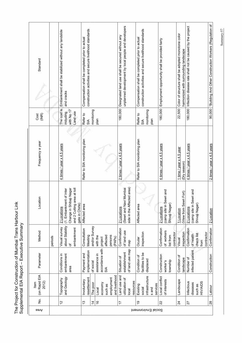
The
Pro
ject
for
Con
stru
ctio
n of
Mum
bai T
rans
Har
bour
Lin
k S
uppl
emen
tal E
IA R
epor
t – E
xecu
tive
Sum
mar
y
Sum
mar
y-57
Area
No.
It
em
(on
Rap
id E
IA
2012
) P
aram
eter
M
etho
d Lo
catio
n
Fre
quen
cy a
yea
r C
ost
(IN
R)
Sta
ndar
d
perio
ds
12
Top
ogra
phy
and
Geo
logy
C
ondi
tions
in
emba
nkm
ent
area
Vis
ual s
urve
y ab
out
Sta
bilit
y of
em
bank
men
t
2 Lo
catio
ns
(1.
Em
bank
men
t of
Inte
r C
hang
e in
Shi
baji
Nag
ar
and
2 C
uttin
g ar
ea a
t tol
l ga
te in
Chi
rle)
4 tim
es /
year
x 4
.5 y
ears
T
he c
ost i
s in
clud
ing
with
No
17
Land
use
Em
bank
men
t sha
ll be
sta
biliz
ed w
ithou
t an
y la
ndsl
ide
and
crac
ks
Social Environment
13
Invo
lunt
ary
rese
ttle
men
t P
aym
ent
and
impl
emen
tatio
n of
soc
ial
assi
stan
ce in
ac
cord
ance
with
S
IA
Con
sulta
tion
Mee
ting
and/
or S
urve
y w
ith t
he
proj
ect
affe
cted
pe
rson
s (P
AP
s)
Aff
ecte
d ar
ea
Ref
er t
o S
IA m
onito
ring
plan
R
efer
to
SIA
m
onito
ring
plan
Com
pens
atio
n sh
all b
e co
mpl
eted
prio
r to
act
ual
cons
truc
tion
activ
ities
and
sec
ure
livel
ihoo
d st
anda
rds
14
The
poo
r
16
Loca
l ec
onom
y su
ch a
s em
ploy
men
t an
d liv
elih
ood
17
Land
use
and
ut
iliza
tion
of
loca
l re
sour
ces
Situ
atio
n of
es
tabl
ishm
ent
of la
nd u
se m
ap
Con
firm
atio
n of
land
use
m
ap
2 Lo
catio
ns
(Sew
ri an
d N
avi M
umba
i si
de in
the
Aff
ecte
d ar
ea)
2 tim
es /
year
x 4
.5 y
ears
18
0,00
0 D
esig
nate
d la
nd u
se s
hall
be s
ecur
ed w
ithou
t an
y un
plan
ned
deve
lopm
ent b
y lo
cal p
eopl
e an
d de
velo
pers
19
Exi
stin
g so
cial
in
fras
truc
ture
s an
d se
rvic
es
Con
ditio
n of
fa
cilit
ies
to b
e di
spla
ced
Ocu
lar
insp
ectio
n A
ffec
ted
area
R
efer
to
SIA
mon
itorin
g pl
an
Ref
er t
o S
IA
mon
itorin
g pl
an
Com
pens
atio
n sh
all b
e co
mpl
eted
prio
r to
act
ual
cons
truc
tion
activ
ities
and
sec
ure
livel
ihoo
d st
anda
rds
22
Loca
l con
flict
of
inte
rest
s C
onst
ruct
ion
wor
ker’s
to
wns
hip
Con
firm
atio
n of
w
orke
rs
list
from
co
ntra
ctor
2 Lo
catio
ns
(cam
p si
te in
Sew
ri an
d S
hiva
ji N
agar
)
4 tim
es /
year
x 4
.5 y
ears
18
0,00
0 E
mpl
oym
ent o
ppor
tuni
ty s
hall
be p
rovi
ded
fairl
y
24
Land
scap
e C
ondi
tion
of
land
scap
e V
isua
l in
spec
tion
1 Lo
catio
n (V
iew
fro
m S
ewri
For
t)
1 tim
e / y
ear
x 4.
5 ye
ar
(Dry
sea
son)
22
,500
C
olor
of s
truc
ture
sha
ll be
ado
pted
mon
oton
e co
lor
harm
oniz
ed w
ith s
urro
undi
ng la
ndsc
ape
27
Infe
ctio
us
dise
ases
su
ch a
s H
IV/A
IDS
Num
ber
of
infe
cted
pat
ient
C
onfir
mat
ion
of h
ealth
ch
eck
list
from
co
ntra
ctor
2 Lo
catio
ns
(cam
p si
te in
Sew
ri an
d S
hiva
ji N
agar
)
4 tim
es /
year
x 4
.5 y
ears
18
0,00
0 In
fect
ion
dise
ase
rate
sha
ll no
t be
caus
ed b
y th
e pr
ojec
t
28
Labo
ur
Con
stru
ctio
n C
onfir
mat
ion
2 Lo
catio
n 2
times
/ ye
ar x
4.5
yea
rs
90,0
00
“Bui
ldin
g A
nd O
ther
Con
stru
ctio
n W
orke
rs (
Reg
ulat
ion
of

The
Pro
ject
for
Con
stru
ctio
n of
Mum
bai T
rans
Har
bour
Lin
k S
uppl
emen
tal E
IA R
epor
t – E
xecu
tive
Sum
mar
y
Sum
mar
y-58
Area
No.
It
em
(on
Rap
id E
IA
2012
) P
aram
eter
M
etho
d Lo
catio
n
Fre
quen
cy a
yea
r C
ost
(IN
R)
Sta
ndar
d
Env
ironm
ent
wor
ker’s
co
nditi
on
of s
afet
y de
vice
s an
d co
nditi
ons
via
inte
rvie
ws
(cam
p si
te in
Sew
ri an
d S
hiva
ji N
agar
) E
mlo
ymen
t an
d C
ondi
tions
of S
ervi
ce)
Act
,199
6”,
“The
bu
ildin
g an
d ot
her
cons
truc
tion
wor
ker’s
wel
fare
ces
s A
ct,
1996
” an
d in
tern
atio
nal s
tand
ards
suc
h as
“IF
C
Per
form
ance
Sta
ndar
d 2
Labo
r an
d W
orki
ng C
ondi
tions
”
Other
29
Acc
iden
t N
umbe
r of
ac
cide
nts
Con
firm
atio
n of
acc
iden
ts
list
from
loca
l go
vern
men
t an
d S
tate
T
raff
ic P
olic
e D
epar
tmen
t
2 Lo
catio
ns
(cam
p si
te in
Sew
ri an
d S
hiva
ji N
agar
)
4 tim
es /
year
x 4
.5 y
ears
18
0,00
0 A
ny a
ccid
ents
are
not
cau
sed
by c
onst
ruct
ion
30
Cro
ss
Bou
ndar
y im
pact
s an
d cl
imat
e ch
ange
Mon
itorin
g of
re
plan
ting
and
tran
spla
ntin
g tr
ees
and
man
grov
e
Ref
er t
o N
o.9
and
10
To
tal
Co
st d
uri
ng
Co
nst
ruct
ion
: 8
,140
,500
IN
R f
or
4.5
year
s (d
uri
ng
co
nst
ruct
ion
)
Sou
rce:
JIC
A S
tud
y T
ea
m
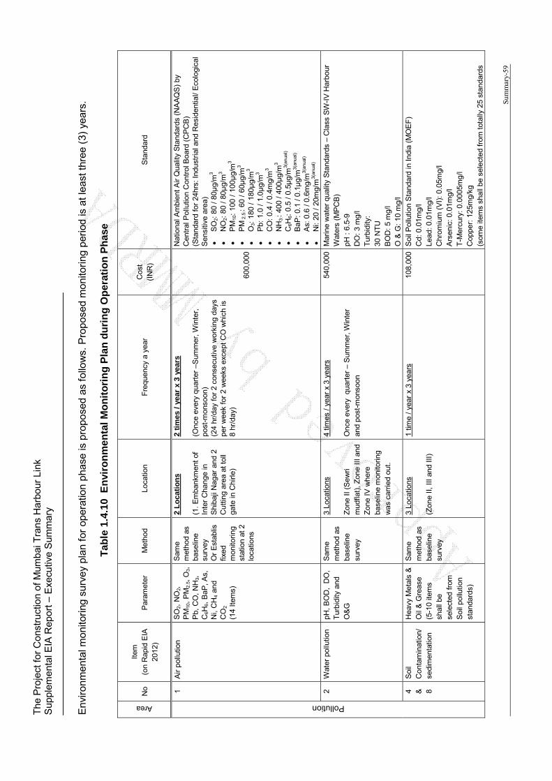
The
Pro
ject
for
Con
stru
ctio
n of
Mum
bai T
rans
Har
bour
Lin
k S
uppl
emen
tal E
IA R
epor
t – E
xecu
tive
Sum
mar
y
Sum
mar
y-59
Env
ironm
enta
l mon
itorin
g su
rvey
pla
n fo
r op
erat
ion
phas
e is
pro
pose
d as
fol
low
s. P
ropo
sed
mon
itorin
g pe
riod
is a
t lea
st t
hree
(3)
yea
rs.
Tab
le 1
.4.1
0 E
nvi
ron
men
tal
Mo
nit
ori
ng
Pla
n d
uri
ng
Op
erat
ion
Ph
ase
Area
No
Item
(o
n R
apid
EIA
20
12)
Par
amet
er
Met
hod
Loca
tion
F
requ
ency
a y
ear
Cos
t (I
NR
) S
tand
ard
Pollution
1 A
ir po
llutio
n S
O2,
NO
2,
PM
10,
PM
2.5,
O3,
P
b, C
O,
NH
3,
C6H
6, B
aP, A
s,
Ni,
CH
4 an
d C
O2
(14
Item
s)
Sam
e m
etho
d as
ba
selin
e su
rvey
O
r E
stab
lis
fixed
m
onito
ring
stat
ion
at 2
lo
catio
ns
2 L
oca
tio
ns
(1.
Em
bank
men
t of
In
ter
Cha
nge
in
Shi
baji
Nag
ar a
nd 2
C
uttin
g ar
ea a
t tol
l ga
te in
Chi
rle)
2 ti
mes
/ ye
ar x
3 y
ears
(O
nce
ever
y qu
arte
r –S
umm
er, W
inte
r,
post
-mon
soon
) (2
4 hr
/day
for
2 c
onse
cutiv
e w
orki
ng d
ays
per
wee
k fo
r 2
wee
ks e
xcep
t C
O w
hich
is
8 hr
/day
)
600,
000
Nat
iona
l Am
bien
t Air
Qua
lity
Sta
ndar
ds (
NA
AQ
S)
by
Cen
tral
Pol
lutio
n C
ontr
ol B
oard
(C
PC
B)
(Sta
ndar
d fo
r 24
hrs:
Ind
ustr
ial a
nd R
esid
entia
l/ E
colo
gica
l S
ensi
tive
area
)
SO
2: 8
0 / 8
0μg/
m3
N
O2:
80
/ 80μ
g/m
3
PM
10:
100
/ 100μ
g/m
3
PM
2.5
:: 60
/ 60μ
g/m
3
O3:
180
/ 18
0μg/
m3
P
b: 1
.0 /
1.0μ
g/m
3
CO
: 0.
4 / 0
.4m
g/m
3
NH
3::
400
/ 40
0μg/
m3
C
6H6:
0.5
/ 0.
5μg/
m3(
anua
l)
BaP
: 0.1
/ 0.
1μg/
m3(
anua
l)
As:
0.6
/ 0.
6mg/
m3(
anua
l)
Ni:
20 /
20m
g/m
3(an
ual)
2 W
ater
pol
lutio
n pH
, B
OD
, D
O,
Tur
bidi
ty a
nd
O&
G
Sam
e m
etho
d as
ba
selin
e su
rvey
3 Lo
catio
ns
Zon
e II
(Sew
ri m
udfla
t),
Zon
e III
and
Z
one
IV w
here
ba
selin
e m
onito
ring
was
car
ried
out.
4 tim
es /
year
x 3
yea
rs
Onc
e ev
ery
qua
rter
– S
umm
er, W
inte
r an
d po
st-m
onso
on
540,
000
Mar
ine
wat
er q
ualit
y S
tand
ards
– C
lass
SW
-IV
Har
bour
W
ater
s (M
PC
B)
pH :
6.5
-9
DO
: 3
mg/
l T
urbi
dity
: 30
NT
U
BO
D:
5 m
g/l
O &
G: 1
0 m
g/l
4 &
8
Soi
l C
onta
min
atio
n/
sedi
men
tatio
n
Hea
vy M
etal
s &
O
il &
Gre
ase
(5-1
0 ite
ms
shal
l be
sele
cted
from
S
oil p
ollu
tion
stan
dard
s)
Sam
e m
etho
d as
ba
selin
e su
rvey
3 Lo
catio
ns
(Zon
e II,
III
and
III)
1 tim
e / y
ear
x 3
year
s 10
8,00
0 S
oil P
ollu
tion
Sta
ndar
d in
Indi
a (M
OE
F)
Cd:
0.0
1mg/
l Le
ad:
0.01
mg/
l C
hrom
ium
(V
I): 0
.05m
g/l
Ars
enic
: 0.0
1mg/
l T
-Mer
cury
: 0.
0005
mg/
l C
oppe
r: 1
25m
g/kg
(s
ome
item
s sh
all b
e se
lect
ed fr
om t
otal
ly 2
5 st
anda
rds

The
Pro
ject
for
Con
stru
ctio
n of
Mum
bai T
rans
Har
bour
Lin
k S
uppl
emen
tal E
IA R
epor
t – E
xecu
tive
Sum
mar
y
Sum
mar
y-60
Area
No
Item
(o
n R
apid
EIA
20
12)
Par
amet
er
Met
hod
Loca
tion
F
requ
ency
a y
ear
Cos
t (I
NR
) S
tand
ard
item
s)
5 N
oise
and
vi
brat
ion
Am
bien
t and
ro
ad s
ide
nois
e (d
B(A
)LA
eq )
Sam
e m
etho
d as
ba
selin
e su
rvey
2 Lo
catio
ns
Sew
ri an
d S
hiva
ji N
agar
whe
re b
asel
ine
mon
itorin
g w
as
carr
ied
out.
2 tim
es /
year
x 3
yea
rs
48,0
00
Am
bien
t Noi
se S
tand
ards
in In
dia
(dB
(A
) Le
q)
1.In
dust
rial A
rea
Day
Tim
e: 7
5 (6
-22h
r)
Nig
ht T
ime:
70
(22-
6hr)
2.
Com
mer
cial
Are
a:
Day
Tim
e: 6
5 (6
-22h
r)
Nig
ht T
ime:
55
(22-
6hr)
3.
Res
iden
tial A
rea:
D
ay T
ime:
55
(6-2
2hr)
N
ight
Tim
e: 4
5 (2
2-6h
r)
4.S
ilenc
e Z
one
Day
Tim
e: 5
0 (6
-22h
r)
Nig
ht T
ime:
40
(22-
6hr)
V
ibra
tion
Sta
ndar
ds (
refe
r to
Jap
anes
e st
anda
rds
alon
g th
e ro
ad)
1. C
omm
erci
al /I
ndus
tria
l Are
a D
ay T
ime:
70
(7-2
0hr)
N
ight
Tim
e: 6
5 (2
0-7h
r)
2. R
esid
entia
l Are
a:
Day
Tim
e: 6
5 (7
-20h
r)
Nig
ht T
ime:
60
(20-
7hr)
Vib
ratio
n (d
B L
10 o
r m
m/s
ec)
Sam
e m
etho
d as
ba
selin
e su
rvey
2
times
/ ye
ar x
3 y
ears
24
,000
Natural Environment
9 &
10
Pro
tect
ed A
rea
/ E
cosy
stem
1.M
onito
ring
of
mud
flat
cond
ition
s in
clud
ing
faun
a-flo
ra
2. M
onito
ring
of
Cut
ting
Tre
e an
d re
plan
tatio
n/
tran
spla
ntin
g ar
ea
3.M
onito
ring
of
Man
grov
e P
lant
atio
n ar
ea
appo
inte
d by
Ocu
lar
insp
ectio
n an
d qu
antit
ativ
e su
rvey
1-
1. F
auna
-F
lora
Li
ne-P
oint
ce
nsus
and
re
cord
nu
mbe
r an
d ap
pear
ed
spec
ies
1-2:
Alo
ng M
TH
L al
ignm
ent
and
man
grov
e re
plan
t ar
ea
2 ti
mes
/ ye
ar x
3 y
ears
2,
160,
000
Sig
nific
ant i
mpa
cts
are
not c
ause
d by
the
pro
ject
N
ote
) D
etai
led
mo
nit
ori
ng
pla
n w
ill b
e se
tup
du
rin
g
bas
ic d
esig
n s
tag
e S
tand
ard
for
Soi
l; m
ain
text
エラー
! 参
照元が見つかりませ
ん。
S
anda
r fo
r E
colo
gica
l Par
amet
er:
N
etpr
imar
y P
rodu
ctiv
ity
<1,
500
mgC
/m3/
day
at s
urfa
ce
C
hlor
ophy
ll-a:
<4m
g/m
3
Pho
spha
te:
0.1-
90μ
g/l
N
itrat
e: 1
.0-5
00μ
g/l
N
itrite
: <12
5μg/
l
Par
ticul
ate
Org
anic
Car
bon:
10-
100m
g/m
3
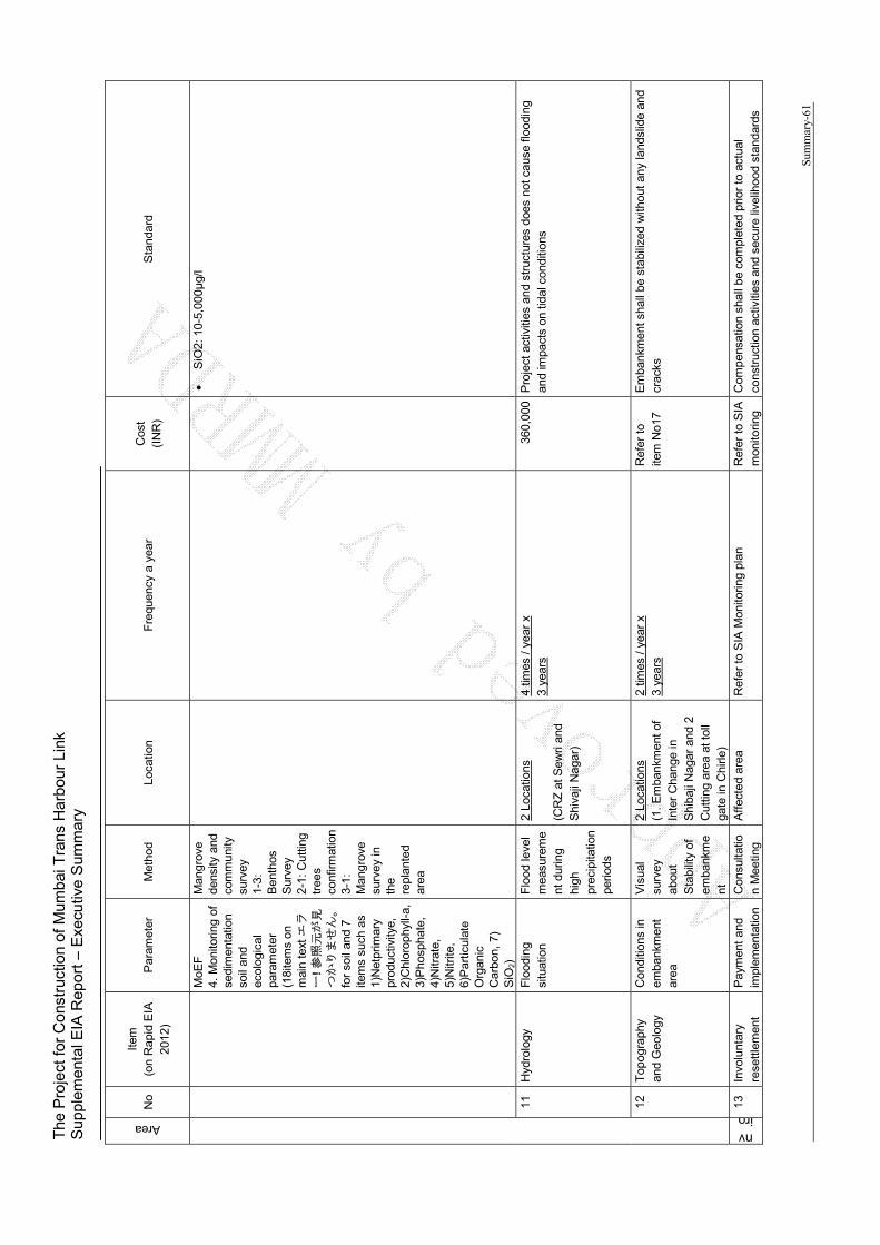
The
Pro
ject
for
Con
stru
ctio
n of
Mum
bai T
rans
Har
bour
Lin
k S
uppl
emen
tal E
IA R
epor
t – E
xecu
tive
Sum
mar
y
Sum
mar
y-61
Area
No
Item
(o
n R
apid
EIA
20
12)
Par
amet
er
Met
hod
Loca
tion
F
requ
ency
a y
ear
Cos
t (I
NR
) S
tand
ard
MoE
F
4. M
onito
ring
of
sedi
men
tatio
n so
il an
d ec
olog
ical
pa
ram
eter
(1
8ite
ms
on
mai
n te
xt エ
ラー
! 参照元が見
つかりません。
fo
r so
il an
d 7
item
s su
ch a
s 1)
Net
prim
ary
prod
uctiv
itye,
2)
Chl
orop
hyll-
a,
3)P
hosp
hate
, 4)
Nitr
ate,
5)
Nitr
ite,
6)P
artic
ulat
e O
rgan
ic
Car
bon,
7)
SiO
2)
Man
grov
e de
nsity
and
co
mm
unity
su
rvey
1-
3:
Ben
thos
S
urve
y 2-
1: C
uttin
g tr
ees
conf
irmat
ion
3-1:
M
angr
ove
surv
ey in
th
e re
plan
ted
area
S
iO2:
10-
5,00
0μg/
l
11
Hyd
rolo
gy
Flo
odin
g si
tuat
ion
Flo
od le
vel
mea
sure
me
nt d
urin
g hi
gh
prec
ipita
tion
perio
ds
2 Lo
catio
ns
(CR
Z a
t Sew
ri an
d S
hiva
ji N
agar
)
4 tim
es /
year
x
3 ye
ars
360,
000
Pro
ject
act
iviti
es a
nd s
truc
ture
s do
es n
ot c
ause
floo
ding
an
d im
pact
s on
tida
l con
ditio
ns
12
Top
ogra
phy
and
Geo
logy
C
ondi
tions
in
emba
nkm
ent
area
Vis
ual
surv
ey
abou
t S
tabi
lity
of
emba
nkm
ent
2 Lo
catio
ns
(1.
Em
bank
men
t of
In
ter
Cha
nge
in
Shi
baji
Nag
ar a
nd 2
C
uttin
g ar
ea a
t tol
l ga
te in
Chi
rle)
2 tim
es /
year
x
3 ye
ars
Ref
er t
o ite
m N
o17
Em
bank
men
t sha
ll be
sta
biliz
ed w
ithou
t an
y la
ndsl
ide
and
crac
ks
nviro
13
Invo
lunt
ary
rese
ttle
men
t P
aym
ent
and
impl
emen
tatio
n C
onsu
ltatio
n M
eetin
g A
ffec
ted
area
R
efer
to
SIA
Mon
itorin
g pl
an
Ref
er t
o S
IA
mon
itorin
g C
ompe
nsat
ion
shal
l be
com
plet
ed p
rior
to a
ctua
l co
nstr
uctio
n ac
tiviti
es a
nd s
ecur
e liv
elih
ood
stan
dard
s
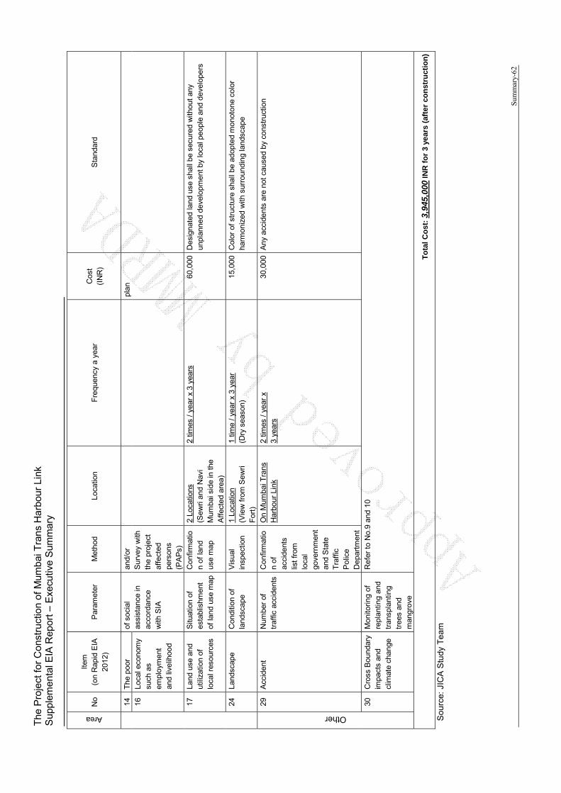
The
Pro
ject
for
Con
stru
ctio
n of
Mum
bai T
rans
Har
bour
Lin
k S
uppl
emen
tal E
IA R
epor
t – E
xecu
tive
Sum
mar
y
Sum
mar
y-62
Area
No
Item
(o
n R
apid
EIA
20
12)
Par
amet
er
Met
hod
Loca
tion
F
requ
ency
a y
ear
Cos
t (I
NR
) S
tand
ard
14
The
poo
r of
soc
ial
assi
stan
ce in
ac
cord
ance
w
ith S
IA
and/
or
Sur
vey
with
th
e pr
ojec
t af
fect
ed
pers
ons
(PA
Ps)
plan
16
Loca
l eco
nom
y su
ch a
s em
ploy
men
t an
d liv
elih
ood
17
Land
use
and
ut
iliza
tion
of
loca
l res
ourc
es
Situ
atio
n of
es
tabl
ishm
ent
of la
nd u
se m
ap
Con
firm
atio
n of
land
us
e m
ap
2 Lo
catio
ns
(Sew
ri an
d N
avi
Mum
bai s
ide
in th
e A
ffec
ted
area
)
2 tim
es /
year
x 3
yea
rs
60,0
00
Des
igna
ted
land
use
sha
ll be
sec
ured
with
out
any
unpl
anne
d de
velo
pmen
t by
loca
l peo
ple
and
deve
lope
rs
24
Land
scap
e C
ondi
tion
of
land
scap
e V
isua
l in
spec
tion
1 Lo
catio
n (V
iew
fro
m S
ewri
For
t)
1 tim
e / y
ear
x 3
year
(D
ry s
easo
n)
15,0
00
Col
or o
f str
uctu
re s
hall
be a
dopt
ed m
onot
one
colo
r ha
rmon
ized
with
sur
roun
ding
land
scap
e
Other
29
Acc
iden
t N
umbe
r of
tr
affic
acc
iden
ts
Con
firm
atio
n of
ac
cide
nts
list
from
lo
cal
gove
rnm
ent
and
Sta
te
Tra
ffic
P
olic
e D
epar
tmen
t
On
Mum
bai T
rans
H
arbo
ur L
ink
2 tim
es /
year
x
3 ye
ars
30,0
00
Any
acc
iden
ts a
re n
ot c
ause
d by
con
stru
ctio
n
30
Cro
ss B
ound
ary
impa
cts
and
clim
ate
chan
ge
Mon
itorin
g of
re
plan
ting
and
tran
spla
ntin
g tr
ees
and
man
grov
e
Ref
er t
o N
o.9
and
10
To
tal
Co
st: 3
,945
,000
INR
fo
r 3
year
s (a
fter
co
nst
ruct
ion
)
Sou
rce:
JIC
A S
tud
y T
ea
m
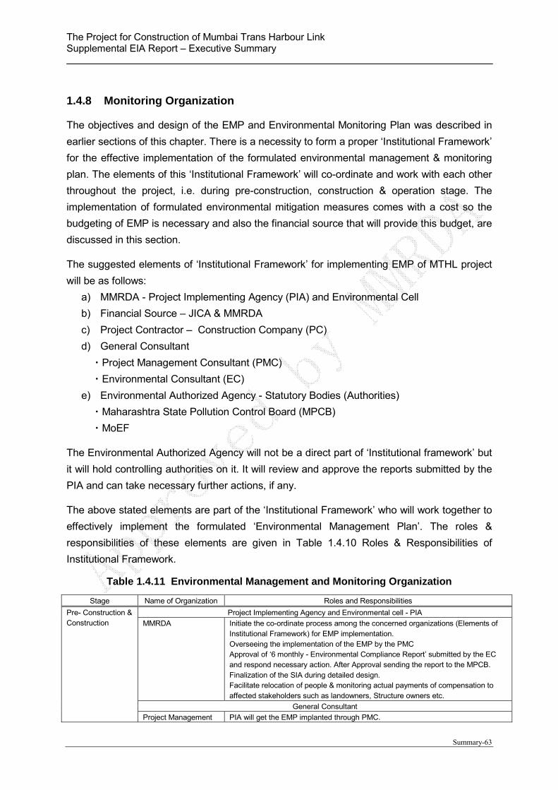
The Project for Construction of Mumbai Trans Harbour Link Supplemental EIA Report – Executive Summary
Summary-63
1.4.8 Monitoring Organization
The objectives and design of the EMP and Environmental Monitoring Plan was described in
earlier sections of this chapter. There is a necessity to form a proper ‘Institutional Framework’
for the effective implementation of the formulated environmental management & monitoring
plan. The elements of this ‘Institutional Framework’ will co-ordinate and work with each other
throughout the project, i.e. during pre-construction, construction & operation stage. The
implementation of formulated environmental mitigation measures comes with a cost so the
budgeting of EMP is necessary and also the financial source that will provide this budget, are
discussed in this section.
The suggested elements of ‘Institutional Framework’ for implementing EMP of MTHL project
will be as follows:
a) MMRDA - Project Implementing Agency (PIA) and Environmental Cell
b) Financial Source – JICA & MMRDA
c) Project Contractor – Construction Company (PC)
d) General Consultant
・Project Management Consultant (PMC)
・Environmental Consultant (EC)
e) Environmental Authorized Agency - Statutory Bodies (Authorities)
・Maharashtra State Pollution Control Board (MPCB)
・MoEF
The Environmental Authorized Agency will not be a direct part of ‘Institutional framework’ but
it will hold controlling authorities on it. It will review and approve the reports submitted by the
PIA and can take necessary further actions, if any.
The above stated elements are part of the ‘Institutional Framework’ who will work together to
effectively implement the formulated ‘Environmental Management Plan’. The roles &
responsibilities of these elements are given in Table 1.4.10 Roles & Responsibilities of
Institutional Framework.
Table 1.4.11 Environmental Management and Monitoring Organization
Stage Name of Organization Roles and Responsibilities
Pre- Construction & Construction
Project Implementing Agency and Environmental cell - PIA
MMRDA Initiate the co-ordinate process among the concerned organizations (Elements of Institutional Framework) for EMP implementation. Overseeing the implementation of the EMP by the PMC Approval of ‘6 monthly - Environmental Compliance Report’ submitted by the EC and respond necessary action. After Approval sending the report to the MPCB. Finalization of the SIA during detailed design. Facilitate relocation of people & monitoring actual payments of compensation to affected stakeholders such as landowners, Structure owners etc.
General Consultant
Project Management PIA will get the EMP implanted through PMC.

The Project for Construction of Mumbai Trans Harbour Link Supplemental EIA Report – Executive Summary
Summary-64
Stage Name of Organization Roles and Responsibilities
Consultant (PMC) PMC will work in association with Project Contractor (Construction Company) & the Environmental Consultant (EC) on a full time basis at the project site office. PMC will mainly look after managing engineering & construction related activities.
Environmental Consultant (EC)
EC will look after implementation of approved environment measures on site. EC will be in constant touch with PMC & Project Contractor. EC will facilitate PIA to obtain mandatory ‘Consent to Establish’ certificate from Maharashtra State Pollution Control Board (MPCB) before start of the Construction on site. EC will get the 6 monthly environmental monitoring done from the MoEF approved laboratory. EC will prepare an ‘Environmental Compliance Report (ECR)’ describing Status of approved Environmental Mitigation measures on site (submitted by PC) and Monitoring of Environmental Attributes (submitted by MoEF Approved Laboratory) on a six monthly basis and will submit it to the PIA for their approval. PIA will then submit the approved ECR to the MPCB.
Project Contractor - PC
Construction Company PC will implement approved EMP (mitigation measures) as directed by PMC & Environmental Consultant. The PC will submit the report for all conducted mitigation measures on site to the EC on a six monthly basis.
Operation (Twice in a year x 3 years)
Project Implementing Agency – PIA
MMRDA PIA will oversee the compliance status of all environmental measures through their appointed consultants.
Appointed Consultant by MMRDA
Periodical inspection & maintenance of the MTHL. EC will facilitate PIA to obtain mandatory ‘Consent to Operate’ certificate from Maharashtra State Pollution Control Board (MPCB) before start of operation of the project. EC will prepare annual ‘Environmental Statement (Form V)’ as mandated in CRZ clearance and submit to PIA for their approval. PIA after reviewing the same will submit to the MPCB.
Source: JICA Study Team
Source: JICA Study Team
Figure 1.4.1 Proposed Environmental Management and Monitoring Implementation
Organization
MMRDA (Environment Cell)(Project Implementation
Agency)
Funding Agency (JICA) Environmental Authorized Agency
Maharashtra Pollution Control Board MCB (Statutory Body)
Ministry of Environment and Forests MCB (Statutory Body)
General Consultant
Environmental Consultant
Project Contractor (Design-Built Company)
Reporting
Monitoring
Project Management Consultant
InspectionReporting
Inspection/ MonitoringReporting
Audit
Reporting
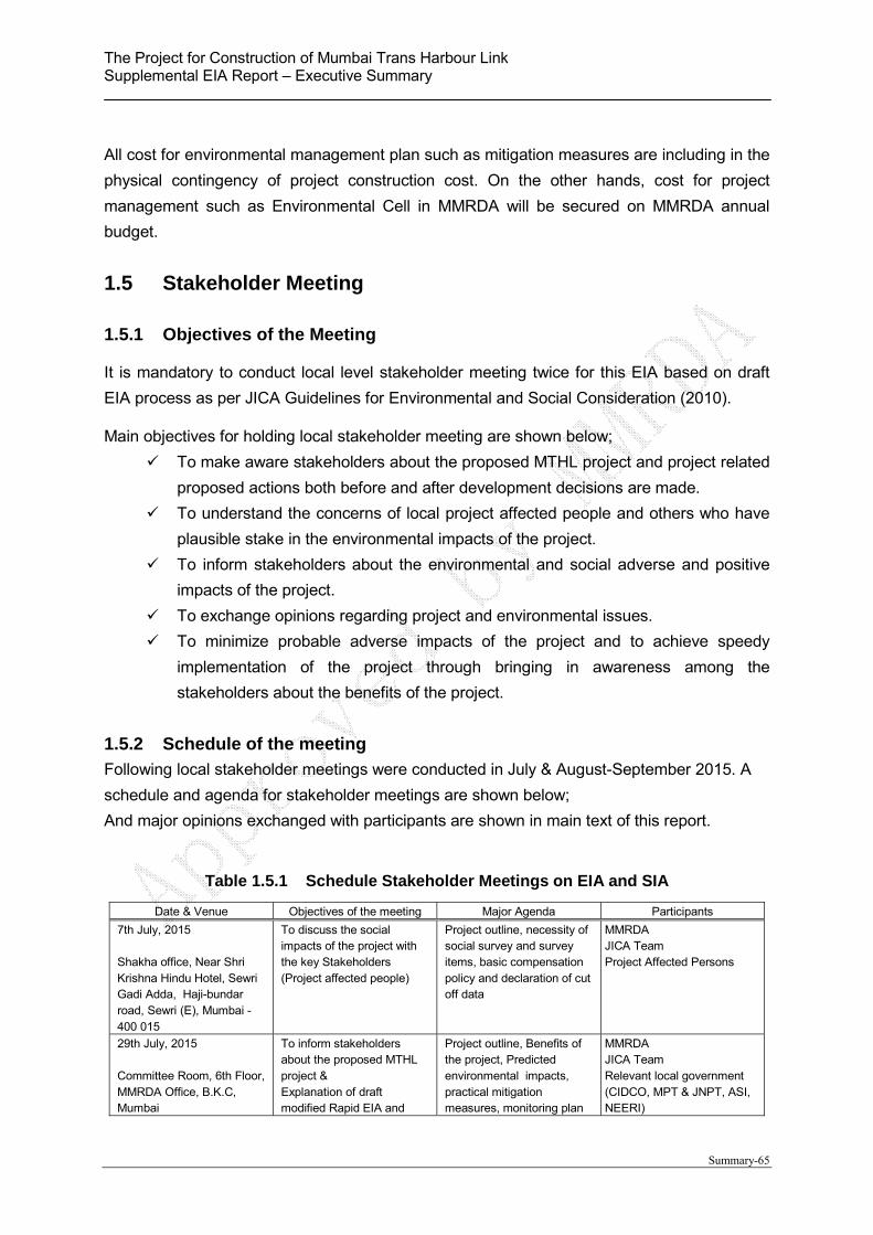
The Project for Construction of Mumbai Trans Harbour Link Supplemental EIA Report – Executive Summary
Summary-65
All cost for environmental management plan such as mitigation measures are including in the
physical contingency of project construction cost. On the other hands, cost for project
management such as Environmental Cell in MMRDA will be secured on MMRDA annual
budget.
1.5 Stakeholder Meeting
1.5.1 Objectives of the Meeting
It is mandatory to conduct local level stakeholder meeting twice for this EIA based on draft
EIA process as per JICA Guidelines for Environmental and Social Consideration (2010).
Main objectives for holding local stakeholder meeting are shown below;
To make aware stakeholders about the proposed MTHL project and project related
proposed actions both before and after development decisions are made.
To understand the concerns of local project affected people and others who have
plausible stake in the environmental impacts of the project.
To inform stakeholders about the environmental and social adverse and positive
impacts of the project.
To exchange opinions regarding project and environmental issues.
To minimize probable adverse impacts of the project and to achieve speedy
implementation of the project through bringing in awareness among the
stakeholders about the benefits of the project.
1.5.2 Schedule of the meeting
Following local stakeholder meetings were conducted in July & August-September 2015. A
schedule and agenda for stakeholder meetings are shown below;
And major opinions exchanged with participants are shown in main text of this report.
Table 1.5.1 Schedule Stakeholder Meetings on EIA and SIA
Date & Venue Objectives of the meeting Major Agenda Participants
7th July, 2015 Shakha office, Near Shri Krishna Hindu Hotel, Sewri Gadi Adda, Haji-bundar road, Sewri (E), Mumbai - 400 015
To discuss the social impacts of the project with the key Stakeholders (Project affected people)
Project outline, necessity of social survey and survey items, basic compensation policy and declaration of cut off data
MMRDA JICA Team Project Affected Persons
29th July, 2015 Committee Room, 6th Floor, MMRDA Office, B.K.C, Mumbai
To inform stakeholders about the proposed MTHL project & Explanation of draft modified Rapid EIA and
Project outline, Benefits of the project, Predicted environmental impacts, practical mitigation measures, monitoring plan
MMRDA JICA Team Relevant local government (CIDCO, MPT & JNPT, ASI, NEERI)
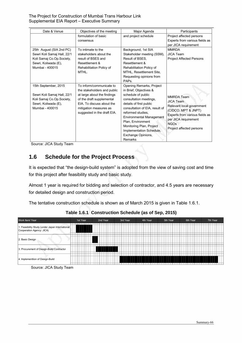
The Project for Construction of Mumbai Trans Harbour Link Supplemental EIA Report – Executive Summary
Summary-66
Date & Venue Objectives of the meeting Major Agenda Participants
formulation of basic consensus
and project schedule Project affected persons Experts from various fields as per JICA requirement
25th August (SIA 2nd PC) Sewri Koli Samaj Hall, 22/1 Koli Samaj Co.Op.Society, Sewri, Koliwada (E), Mumbai - 400015
To intimate to the stakeholders about the result of BSES and Resettlement & Rehabilitation Policy of MTHL.
Background, 1st SIA Stakeholder meeting (SSM), Result of BSES, Resettlement & Rehabilitation Policy of MTHL, Resettlement Site, Requesting opinions from PAPs.
MMRDA JICA Team Project Affected Persons
15th September, 2015 Sewri Koli Samaj Hall, 22/1 Koli Samaj Co.Op.Society, Sewri, Koliwada (E), Mumbai - 400015
To inform/communicate to the stakeholders and public at large about the findings of the draft supplemental EIA. To discuss about the mitigation measures as suggested in the draft EIA.
Opening Remarks, Project in Brief, Objectives & schedule of public consultation meetings, details of first public consultation of EIA, result of reformed studies, Environmental Management Plan, Environment Monitoring Plan, Project Implementation Schedule, Exchange Opinions, Remarks
MMRDA Team JICA Team Relevant local government (CIDCO, MPT & JNPT) Experts from various fields as per JICA requirement NGOs Project affected persons
Source: JICA Study Team
1.6 Schedule for the Project Process
It is expected that “the design-build system” is adopted from the view of saving cost and time
for this project after feasibility study and basic study.
Almost 1 year is required for bidding and selection of contractor, and 4.5 years are necessary
for detailed design and construction period.
The tentative construction schedule is shown as of March 2015 is given in Table 1.6.1.
Table 1.6.1 Construction Schedule (as of Sep, 2015)
Source: JICA Study Team
Work Item/ Year 1st Year 2nd Year 3rd Year 4th Year 5th Year 6th Year 7th Year
1. Feasibility Study (under Japan InternationalCooperation Agency: JICA)
2. Basic Design
3. Procurement of Design-Build Contractor
4. Implementtion of Design-Build

Main Text

i
Table of Contents
CHAPTER 1 PROJECT BACKGROUND .................................................................................................... 1
1.1. Preface ......................................................................................................................................................... 1 1.2. Need of the Project ..................................................................................................................................... 1 1.3. Need and Objective of EIA study ............................................................................................................. 2 1.4. Purpose of Study ........................................................................................................................................ 3 1.5. Project Benefits .......................................................................................................................................... 3 1.6. Structure of the Report ............................................................................................................................... 4
CHAPTER 2 PROJECT DESCRIPTION ....................................................................................................... 6
2.1. Project Description ..................................................................................................................................... 6 2.2. Project Location ......................................................................................................................................... 6 2.3. Structural Details of the Bridge and Road ............................................................................................... 7
CHAPTER 3 CURRENT NATURAL AND SOCIAL ENVIRONMENT CONDITIONS .................... 9
3.1. Topography, Geography and Hydrology ................................................................................................. 9 3.2. Land Use ................................................................................................................................................... 10 3.3. Climate ...................................................................................................................................................... 14 3.4. Protected area ........................................................................................................................................... 14 3.5. Fauna and Flora ........................................................................................................................................ 18 3.6. Cultural Heritage ...................................................................................................................................... 19 3.7. Socio-Economic ....................................................................................................................................... 20
CHAPTER 4 ENVIRONMENTAL LEGISLATION IN INDIA .............................................................. 24
4.1. EIA Notification 2006 ............................................................................................................................. 24 4.2. Coastal Regulation Zone (CRZ Notification 2011) .............................................................................. 24 4.3. Other relevant Environmental Laws and Regulations .......................................................................... 26 4.4. Gaps between Rapid EIA 2012 and JICA’s Guideline ........................................................................ 27
CHAPTER 5 Alternative Analysis, Screening and Scoping ........................................................................ 29
5.1. Alternative Analysis................................................................................................................................. 29 5.1.1. Route Analysis ..................................................................................................................................... 29 5.1.2. Control Points ....................................................................................................................................... 34 5.1.3. Summary of the Horizontal Alignment ............................................................................................. 35 5.1.4. Structure Type ...................................................................................................................................... 38 5.1.5. Alternative Analysis ............................................................................................................................ 39 5.1.6. Zero Option .......................................................................................................................................... 40
5.2. Screening .................................................................................................................................................. 40 5.3. Scoping ..................................................................................................................................................... 40 5.4. Baseline Survey and Analysis Methodology......................................................................................... 45
CHAPTER 6 RESULT OF BASELINE SURVEY AND IMPACT ANALYSIS ................................... 48
6.1. Pollution .................................................................................................................................................... 48 6.1.1. Air Pollution ......................................................................................................................................... 48 6.1.2. Water Pollution .................................................................................................................................... 55 6.1.3. Waste .................................................................................................................................................... 60 6.1.4. Soil Contamination and Sediment Quality ........................................................................................ 61 6.1.5. Noise and Vibration ............................................................................................................................. 63
6.2. Natural Environment ............................................................................................................................... 71

ii
6.2.1. Protected Area and Ecosystem ........................................................................................................... 71 6.2.2. Hydrology ............................................................................................................................................. 95 6.2.3. Topography and Geology ................................................................................................................. 100
6.3. Social Environment...................................................................................................................... …….103 6.3.1. Involuntary Resettlement .................................................................................................................. 103 6.3.2. The Poor ............................................................................................................................................. 104 6.3.3. Local economy such as employment and livelihood...................................................................... 106 6.3.4. Land use and Utilization of Local Resources .................................................................................. 107 6.3.5. Existing Social Infrastructure and Services ..................................................................................... 108 6.3.6. Local Conflicts ................................................................................................................................... 109 6.3.7. Landscape ........................................................................................................................................... 110 6.3.8. Gender................................................................................................................................................. 112 6.3.9. Infection Disease ................................................................................................................................ 113 6.3.10. Labor Environment ............................................................................................................................ 114 6.3.11. Accident .............................................................................................................................................. 115 6.3.12. Cross Boundary Impacts and Climate Change ............................................................................... 116
CHAPTER 7 ENVIRONMENTAL MANAGEMENT PLAN ................................................................ 120
7.1. Mitigation Measures .............................................................................................................................. 120 7.2. Environmental Monitoring Plan ........................................................................................................... 126
7.2.1. Construction Phase ............................................................................................................................ 126 7.2.2. Operation Phase ................................................................................................................................. 129
7.3. Cost, Financial Source and Frameworks ............................................................................................. 131
CHAPTER 8 STAKEHOLDER MEETINGS ............................................................................................ 135
8.1. Objectives of the Meeting ..................................................................................................................... 135 8.2. Meeting Notification and Language ..................................................................................................... 135 8.3. Schedule of the meetings ....................................................................................................................... 135 8.4. Summary of Stakeholder Meeting........................................................................................................ 136
CHAPTER 9 SCHEDULE AND OTHER RELEVANT ACTIVITIES ................................................. 142
9.1. Construction Schedule (as of September 2015) .................................................................................. 142 9.2. Other Necessary Permission to be obtained ........................................................................................ 142 9.3. Other Necessary Development Plan..................................................................................................... 143
Supplemental EIA Study Report for Mumbai Trans Harbor Link Project
1
CHAPTER 1 PROJECT BACKGROUND
1.1. Preface
Mumbai’s peculiar geographical spread imposes constraints on expansion; its great job potential has nevertheless attracted migrants from many parts of the country. The result has been severe housing shortages, lack of open spaces and civic amenities and transport bottlenecks. As per the 2011 census, the population of Mumbai is 12.25 Million.
The port, market, industries, offices and above all increasing population has considerably overloaded the rail and road transportation infrastructure of the city, causing innumerable commuting hardships as well as severe strain on the city’s civic services resulting in extremely poor living conditions for the majority of residents.
The northern & north eastern parts of Greater Mumbai are likely to be saturated in the near future. In that event, the only location for expansion (apart from Navi Mumbai) will be in areas to the north of Greater Mumbai up to Virar at the northern limit of the Mumbai Metropolitan Region. This northwards expansion however is aggravating problems of its own. With the augmentation of the north-south commuter movement it would not only keep increasing commuting time to the heart of the island city but also traffic congestion on the transport network.
The pressure on the rail and road network can be relieved only by redirecting part of the movement into an east-west (towards Navi Mumbai) orientation. Having known the geography of the city, this can only be achieved by taking positive steps to encourage the development of residential areas on the mainland on the coast.
1.2. Need of the Project
The need for the project arises from the undisputed fact that Greater Mumbai is already overcrowded and congested. The only solution to prevent the existing conditions from worsening is to expand on to the mainland, which to a limited extent, has already occurred in the northern half of Navi Mumbai. This is however, insufficient, and a major push to the development of the rest of Navi Mumbai can be given only by providing quick access to the southern half of Navi Mumbai.
The southern half of Navi Mumbai is having 2,500 hectares of land for housing, which will benefit most in terms of commuting time by the construction of the Link between mainland and south of Mumbai. When completed, MTHL will reduce the distance between the island and the mainland by 17km viz-a-viz the existing road link and will help save approximately an hour in travel time. Moreover, the MTHL is going to be main connectivity between Mumbai and the proposed International Airport at Navi Mumbai. In addition to the MTHL, the proposed Coastal Road in Mumbai is likely to resolve the traffic congestion for the islanders.
At present, there are two road links connecting Mumbai to Navi Mumbai:
The Thane Creek Bridge
Airoli Bridge
Both these links together are near saturation and are not equipped to meet the combined future projected traffic, thereby necessitating creation of additional links to meet traffic growth. In this context, the proposed Mumbai Trans Harbour Link has become a necessity for the state government.
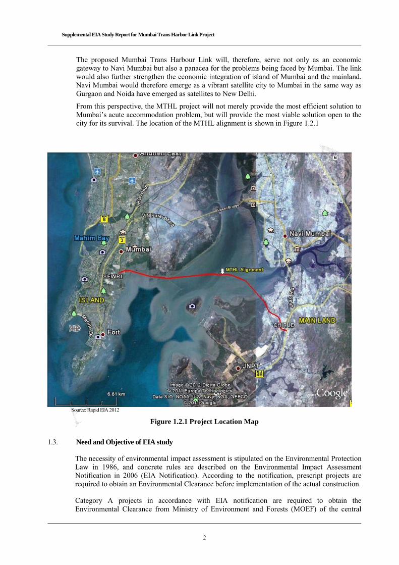
Supplemental EIA Study Report for Mumbai Trans Harbor Link Project
2
The proposed Mumbai Trans Harbour Link will, therefore, serve not only as an economic gateway to Navi Mumbai but also a panacea for the problems being faced by Mumbai. The link would also further strengthen the economic integration of island of Mumbai and the mainland. Navi Mumbai would therefore emerge as a vibrant satellite city to Mumbai in the same way as Gurgaon and Noida have emerged as satellites to New Delhi.
From this perspective, the MTHL project will not merely provide the most efficient solution to Mumbai’s acute accommodation problem, but will provide the most viable solution open to the city for its survival. The location of the MTHL alignment is shown in Figure 1.2.1
Source: Rapid EIA 2012
Figure 1.2.1 Project Location Map
1.3. Need and Objective of EIA study
The necessity of environmental impact assessment is stipulated on the Environmental Protection Law in 1986, and concrete rules are described on the Environmental Impact Assessment Notification in 2006 (EIA Notification). According to the notification, prescript projects are required to obtain an Environmental Clearance before implementation of the actual construction.
Category A projects in accordance with EIA notification are required to obtain the Environmental Clearance from Ministry of Environment and Forests (MOEF) of the central

Supplemental EIA Study Report for Mumbai Trans Harbor Link Project
3
government, on the other hand, Category B project shall have the clearance from State Government.
Since the mandatory projects which require environmental clearance in road sector prescript only National and State Highway, MTHL is not required to conduct comprehensive EIA because this road is city road, neither national highway nor state highway.
However MMRDA has prepared Rapid EIA 2012 based on Comprehensive EIA 2005 prepared by MSRDC for obtaining a CRZ Clearance in accordance with CRZ (Coastal Regulation Zone) Notification 2011. This Rapid EIA 2012 has been approved and issued CRZ Clearance in July 2013 by MOEF (Ministry of Environment and Forests). The matter subsequently was challenged in the National green tribunal and the Tribunal has suspended the clearance for 6 months. MMRDA has approached the MCZMA for fresh clearance and the appraisal has been carried out by MCZMA with minor changes in the Rapid EIA 2012.
In 2015, JICA (Japan International Cooperation Agency) is supporting of implementation of feasibility study. MTHL project is classified as Category A which requires full-scale EIA in accordance with JICA Guidelines for Environmental and Social Considerations (2010), thus MMRDA in association with JICA carries out EIA base on approved Rapid EIA 2012 in this feasibility study.
History regarding environmental and social considerations is shown below;
Table 1.3.1 History of Environment and Social Considerations on MTHL
Year Item Remarks
1984 MTHL alignment was scrutinized and affirmed by an Expert Committee constituted by Prime Minister’s Office.
-
1999/April and December
Public Hearing for MTHL was conducted and used as a base for Comprehensive EIA 2005
Based on EIA Notification 1994
2005/ March 11 Comprehensive EIA has approved by MOEF CRZ Clearance was issued
Based on EIA Notification 1994 and CRZ Notification 1991
2013 July 19 Rapid EIA has been approved by MOEF CRZ Clearance was issued (with 5 years validity)
Based on EIA Notification 2006 and CRZ Notification 2011
2015 Preparation of Supplemental EIA based on Rapid EIA 2012 approved by MOEF
Based on JICA Guidelines for Environmental and Social Considerations (2010)
1.4. Purpose of Study
The purpose of modification Rapid EIA (REIA) study is to adjust with requirements on JICA Guidelines for Environmental and Social Considerations 2010, and to ensure that the project option under consideration is environmentally sustainable and sound. EIA identifies ways and means for improving the project environmentally friendly by preventing, minimizing, mitigating or compensating for adverse impact, so as to achieve a sustainable development.
1.5. Project Benefits
MTHL will directly and indirectly lead to the betterment of MMR, both from an economic and social perspective.
(1) Direct Benefits from MTHL Savings in travel times for commuters. Improved comfort and accessibility between the island and the mainland. Reduced operating costs of vehicles due to lesser congestion.
Supplemental EIA Study Report for Mumbai Trans Harbor Link Project
4
Accelerated growth of Navi Mumbai. Smooth traffic flow from Navi Mumbai airport to Mumbai Island. Decrease generation of greenhouse gases such as CO2
(2) Indirect Benefits from MTHL
Rationalization of real estate prices in Greater Mumbai Increased demand for land in Navi Mumbai and consequent improvement of land prices. Accelerated economic development of Navi Mumbai and nearby regions Greater economic integration of Mumbai island with Navi Mumbai and extended regions of
Pune, Goa, Panvel and Alibaug Decongestion of Mumbai Island and dispersal of population to Navi Mumbai region and
beyond Environmental improvement and reduced pollution levels Improved safety due to reduction in accidents Improvement in trade and trade competitiveness through faster and improved logistics Facilitation for Coastal Road.
The proposed Mumbai Trans Harbour Link will therefore serve not only as an economic gateway to Navi Mumbai but also a panacea for the problems being faced by Mumbai. The link would also further strengthen the economic integration of Mumbai Island and Mainland Mumbai.
Navi Mumbai would therefore emerge as a vibrant satellite city to Mumbai in the same way as Gurgaon and Noida have emerged as satellites to New Delhi. Both Thane Creek Bridge and Airoli Bridge are near saturation, thereby necessitating creation of additional links to meet traffic growth. In this context, the proposed Mumbai Trans Harbour Link has become a necessity for the state government.
A number of developmental initiatives have been proposed in the Navi Mumbai region that will not only give rise to additional traffic movement, but also accentuate the need for greater economic integration of Mumbai Island with Mainland Mumbai. Some of the key infrastructures facilities proposed and / or already developed include:
Navi Mumbai Integrated Special Economic Zone (SEZ) International airport at Navi Mumbai New container terminals at Jawaharlal Nehru Port Trust at Nhava Sheva Thane Vashi, Thane-Nerul and Nerul-Uran Rail link CBD – Taloja-Khandeshwar-ring metro Trans Thane Creek Industrial Area
Navi Mumbai is also well connected through rail and road links with Pune, Nasik and Thane, indicating the potential for the region to develop into a satellite city.
In this context, the proposed Mumbai Trans Harbour Link (MTHL) connecting Sewri to Nhava Sheva is expected to be a key driver in the development of the city by promoting horizontal growth as against vertical growth that has been experienced over the past few years. The link would help reduce the problems of congestion and pollution in Mumbai Island.
1.6. Structure of the Report
The structure of the report is as follows:
Executive Summary Chapter 1 Project Background Chapter 2 Project Description
Supplemental EIA Study Report for Mumbai Trans Harbor Link Project
5
Chapter 3 Current Natural & Social Environment Conditions Chapter 4 Environmental Legislation in India Chapter 5 Alternative Analysis Chapter 6 Result of Baseline Survey & Impact Analysis Chapter 7 Environmental Management Plan Chapter 8 Stakeholder Meetings Chapter 9 Schedule Appendices
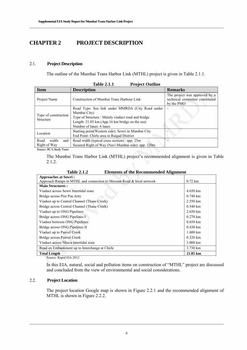
Supplemental EIA Study Report for Mumbai Trans Harbor Link Project
6
CHAPTER 2 PROJECT DESCRIPTION
2.1. Project Description
The outline of the Mumbai Trans Harbor Link (MTHL) project is given in Table 2.1.1.
Table 2.1.1 Project Outline Item Description Remarks
Project Name Construction of Mumbai Trans Harbour Link The project was approved by a technical committee constituted by the PMO
Type of construction Structure
Road Type: Sea link under MMRDA (City Road under Mumbai City) Type of Structure : Mainly viaduct road and bridge Length: 21.85 km (App.16 km bridge on the sea) Number of lanes: 6 lanes
-
Location Starting point(Western side): Sewri in Mumbai City End Point: Chirle area in Raigad District
-
Road width and Right of Way
Road width (typical cross section) : app. 25m Secured Right of Way (Navi Mumbai side): app. 120m
-
Source: JICA Study Team
The Mumbai Trans Harbor Link (MTHL) project’s recommended alignment is given in Table 2.1.2.
Table 2.1.2 Elements of the Recommended Alignment Approaches at Sewri : Approach Ramps to MTHL and connection to Messant Road & local network
0.72 km
Main Structures : Viaduct across Sewri Intertidal zone
Bridge across Pier Pau Jetty Viaduct up to Central Channel (Thane Creek)
Bridge across Central Channel (Thane Creek) Viaduct up to ONG Pipelines
Bridge across ONG Pipelines I Viaduct between ONG Pipelines
Bridge across ONG Pipelines II Viaduct up to Panvel Creek
Bridge across Panvel Creek Viaduct across Nhava Intertidal zone
4.650 km
0.740 km 2.550 km
0.540 km 2.650 km
0.270 km 0.650 km
0.430 km 1.600 km
0.320 km 3.000 km
Road on Embankment up to Interchange at Chirle 3.730 km
Total Length 21.85 km Source: Rapid EIA 2012
In this EIA, natural, social and pollution items on construction of “MTHL” project are discussed and concluded from the view of environmental and social considerations.
2.2. Project Location
The project location Google map is shown in Figure 2.2.1 and the recommended alignment of MTHL is shown in Figure 2.2.2.

Supplemental EIA Study Report for Mumbai Trans Harbor Link Project
7
Source: JICA Study Team
Figure 2.2.1 Project Location Map
Figure 2.2.2 Detailed Alignment of MTHL
2.3. Structural Details of the Bridge and Road
The typical structure and cross-section of the bridge and road is shown in Figure 2.3.1 below:
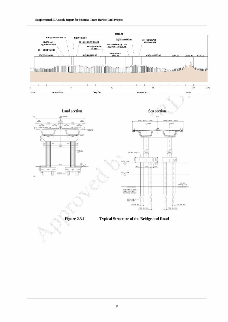
Supplemental EIA Study Report for Mumbai Trans Harbor Link Project
8
Land section Sea section
Typical Cross Section
(On the Land)
Figure 2.3.1 Typical Structure of the Bridge and Road
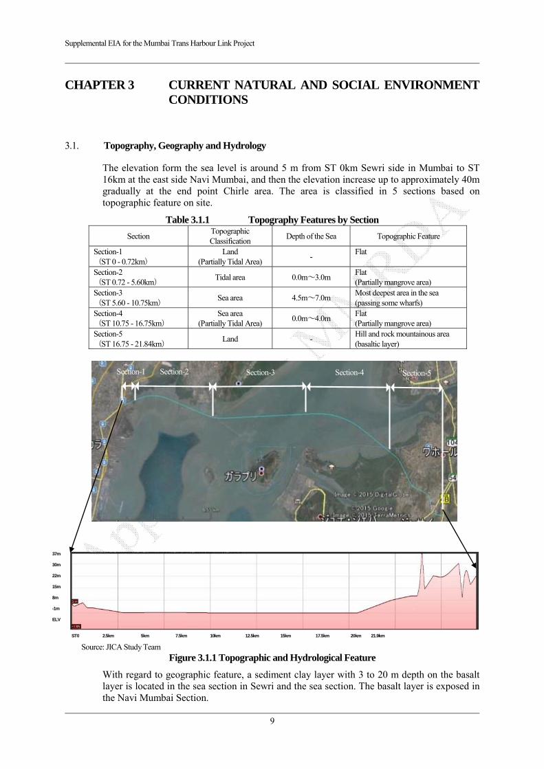
Supplemental EIA for the Mumbai Trans Harbour Link Project
9
CHAPTER 3 CURRENT NATURAL AND SOCIAL ENVIRONMENT CONDITIONS
3.1. Topography, Geography and Hydrology
The elevation form the sea level is around 5 m from ST 0km Sewri side in Mumbai to ST 16km at the east side Navi Mumbai, and then the elevation increase up to approximately 40m gradually at the end point Chirle area. The area is classified in 5 sections based on topographic feature on site.
Table 3.1.1 Topography Features by Section
Section Topographic Classification
Depth of the Sea Topographic Feature
Section-1 (ST 0 - 0.72km)
Land (Partially Tidal Area)
- Flat
Section-2 (ST 0.72 - 5.60km)
Tidal area 0.0m~3.0m Flat (Partially mangrove area)
Section-3 (ST 5.60 - 10.75km)
Sea area 4.5m~7.0m Most deepest area in the sea (passing some wharfs)
Section-4 (ST 10.75 - 16.75km)
Sea area (Partially Tidal Area)
0.0m~4.0m Flat (Partially mangrove area)
Section-5 (ST 16.75 - 21.84km)
Land - Hill and rock mountainous area (basaltic layer)
出典:JICA調査
Source: JICA Study Team Figure 3.1.1 Topographic and Hydrological Feature
With regard to geographic feature, a sediment clay layer with 3 to 20 m depth on the basalt layer is located in the sea section in Sewri and the sea section. The basalt layer is exposed in the Navi Mumbai Section.
37m 30m 22m 15m 8m -1m ELV
ST0 2.5km 5km 7.5km 10km 12.5km 15km 17.5km 20km 21.9km
Section-1 Section-2 Section-3 Section-4 Section-5
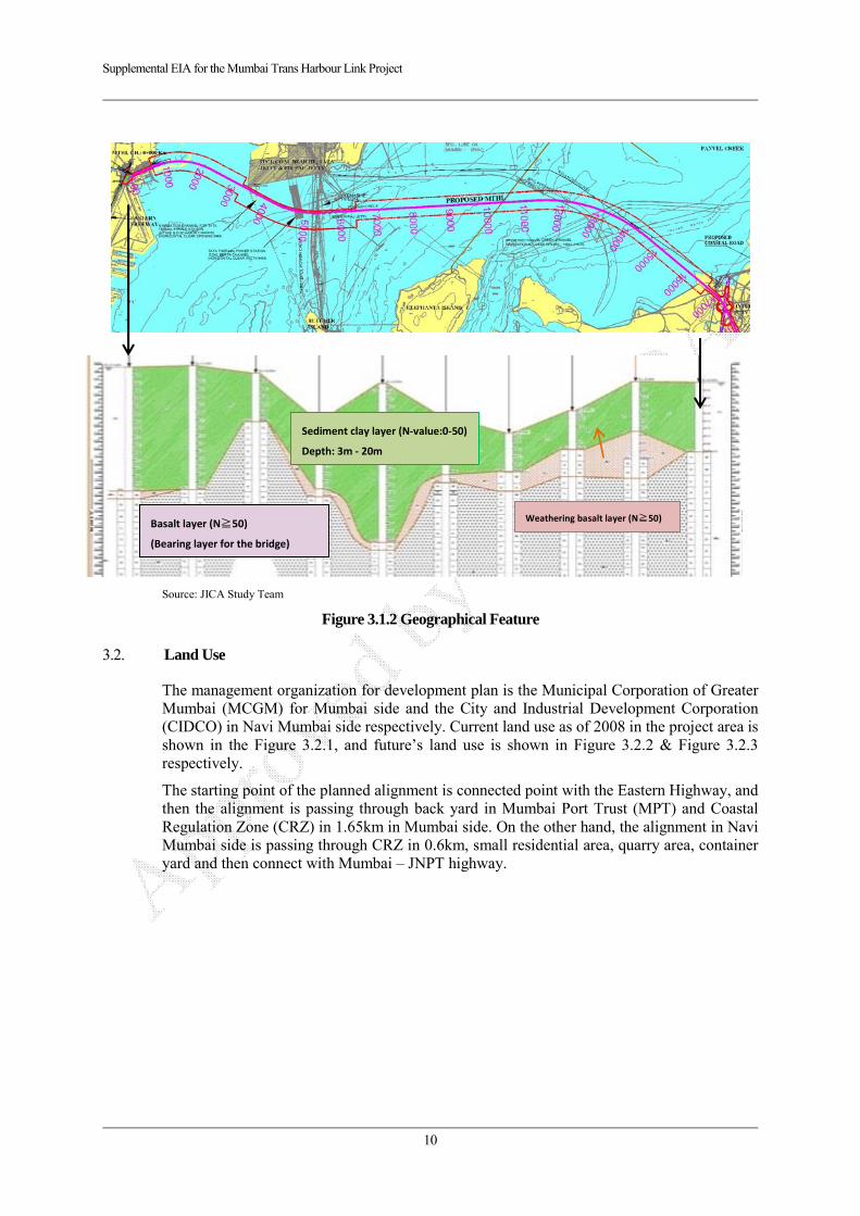
Supplemental EIA for the Mumbai Trans Harbour Link Project
10
Source: JICA Study Team
Source: JICA Study Team
Figure 3.1.2 Geographical Feature
3.2. Land Use
The management organization for development plan is the Municipal Corporation of Greater Mumbai (MCGM) for Mumbai side and the City and Industrial Development Corporation (CIDCO) in Navi Mumbai side respectively. Current land use as of 2008 in the project area is shown in the Figure 3.2.1, and future’s land use is shown in Figure 3.2.2 & Figure 3.2.3 respectively.
The starting point of the planned alignment is connected point with the Eastern Highway, and then the alignment is passing through back yard in Mumbai Port Trust (MPT) and Coastal Regulation Zone (CRZ) in 1.65km in Mumbai side. On the other hand, the alignment in Navi Mumbai side is passing through CRZ in 0.6km, small residential area, quarry area, container yard and then connect with Mumbai – JNPT highway.
Sediment clay layer (N‐value:0‐50)
Depth: 3m ‐ 20m
Weathering basalt layer (N≧50) Basalt layer (N≧50)
(Bearing layer for the bridge)

Supplemental EIA for the Mumbai Trans Harbour Link Project
11
Source:Mumbai Trans Harbour Link Project Study of Flamingo and Migratory Birds Final Report 2008 December (Salim
Ali Centre for Ornithology and Natural History) Figure 3.2.1 Current Land Use in the Project Area (2008)
Land use at the west bank
Mangrove Forest (1-3m height)
Mangrove Forest in Sewri(Low Density)
Industrial area in Chirle
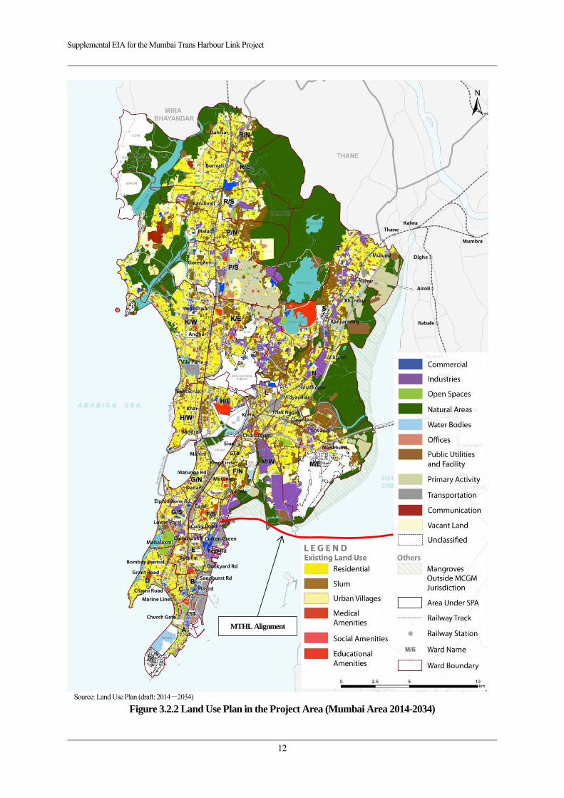
Supplemental EIA for the Mumbai Trans Harbour Link Project
12
Source: Land Use Plan (draft: 2014-2034)
Figure 3.2.2 Land Use Plan in the Project Area (Mumbai Area 2014-2034)
MTHL Alignment

Supplemental EIA for the Mumbai Trans Harbour Link Project
13
Source: Navi Mumbai Land Use Plan (CIDOCO 2008/Website)
Figure 3.2.3 Current Land in the Project Area (Mumbai Area 2008)
MTHL Alignment
Supplemental EIA for the Mumbai Trans Harbour Link Project
14
3.3. Climate
The project area is categorized as the tropical monsoon climate. Daily average temperature is from 24 in January to 30 degree in May, dry season. On the other hand, rainy season starts from June and lasts in October. Average monthly rainfall and temperature is shown in Figure 3.3.1.
Source: India Metrological Department, Ministry of Earth Sciences (website)
Figure 3.3.1 Annual Rainfall in Mumbai (2008-2013 average)
3.4. Protected area
(1) National Park
The Sanjay Gandhi National park is located in the northern area, approximately 15km away from the project area. The location of the national park is shown in Figure 3.4.1.
(2) Coastal Regulation Zone (CRZ)
The alignment is passing through a part of the Coastal Regulation Zone (CRZ) in total 2.25 km.
The Environmental Clearance for CRZ has been issued with 5 years validity in July 19th 2013 from Ministry of Environment and Forests (MOEF). The location of the zone is shown in Figure 3.4.2 and Figure 3.4.3. The matter subsequently was challenged in the National green tribunal and the Tribunal has suspended the clearance for 6 months. MCZMA has appraised the matter again and suggested minor changes in the
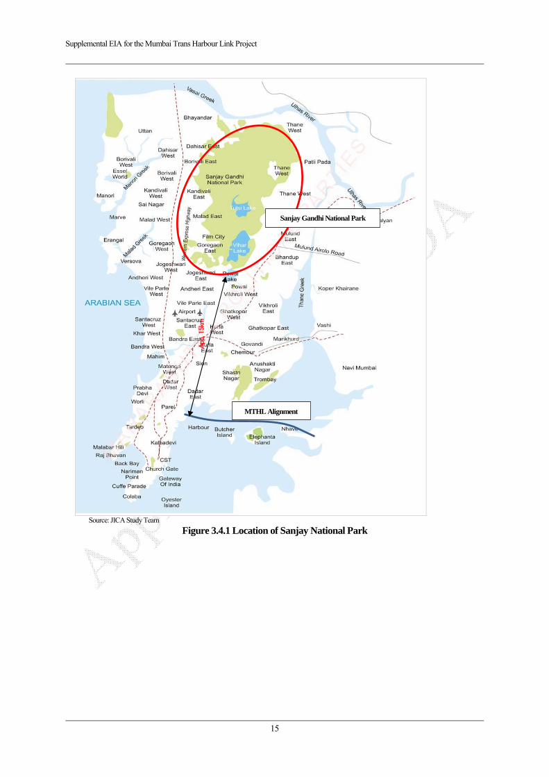
Supplemental EIA for the Mumbai Trans Harbour Link Project
15
Source: JICA Study Team
Figure 3.4.1 Location of Sanjay National Park
MTHL Alignment
Sanjay Gandhi National Park
App
. 15k
m

Supplemental EIA for the Mumbai Trans Harbour Link Project
16
Source: Rapid EIA (MMRDA 2013)
Figure 3.4.2 Location of CRZ in Mumbai Side (Sewri)
CR
Z-I
(1.5
km)
ST0.
6 -2.
1km
C
RZ
-II(
0.15
km)
ST0.
45-0
.6km
MT
HL
Pro
pose
d R
oute

Supplemental EIA for the Mumbai Trans Harbour Link Project
17
Source: Rapid EIA (MMRDA 2013)
Figure 3.4.3 Location of CRZ in Navi Mumbai Side
CR
Z-I
(0.5
km)
CR
Z-I
I(0.
1km
)
MT
HL
Pro
pose
d R
oute

Supplemental EIA for the Mumbai Trans Harbour Link Project
18
Figure 3.4.3a: CRZ Map prepared by IRS at 1:4000 scale
3.5. Fauna and Flora
The Coastal Regulation Zone is located in Sewri 1.65km and Navi Mumbai side 0.6 km in total 2.25km. According to the past survey, 17 bird species has been observed in the project area. Most of observed species are categorized as the Least Concern (LC) class, but 2 species such as Black Headed Ibis and Lesser Flamingo are categorized as Near Threatened (NT).
Sewri area in Mumbai side is widely known as industrial area, however Lesser Flamingos and Greater Flamingos have been coming from Europe and/or Eastern African countries in November since 1994 and staying there until June.
According to the study report conducted by MMRDA in 2008, counted number of the flamingos is approximately 10,000 to 15,000 a day. These flamingos eat algae and/or plankton during low tidal.
With regard to mangrove in Sewri and Navi Mumbai side, the dominant specie is Avicennia marina.
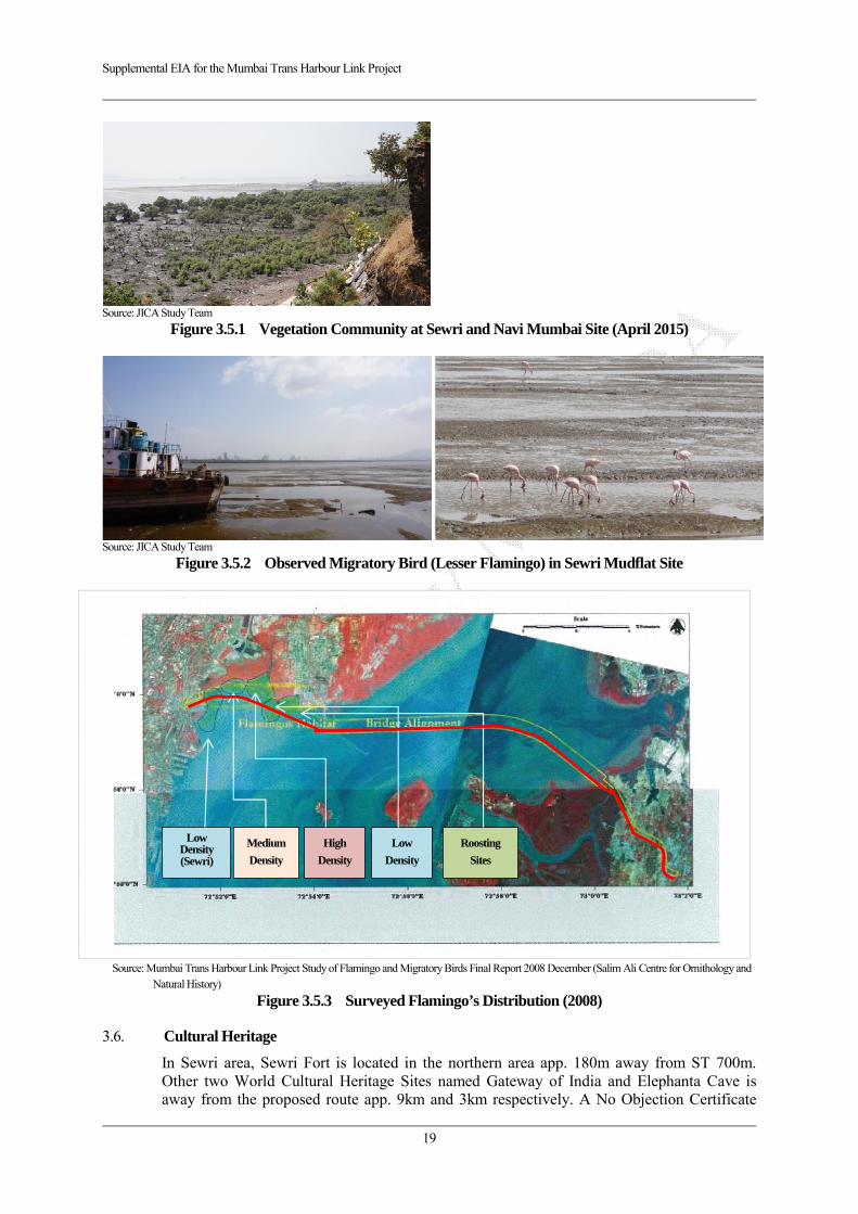
Supplemental EIA for the Mumbai Trans Harbour Link Project
19
Source: JICA Study Team
Figure 3.5.1 Vegetation Community at Sewri and Navi Mumbai Site (April 2015)
Source: JICA Study Team
Figure 3.5.2 Observed Migratory Bird (Lesser Flamingo) in Sewri Mudflat Site
Source: Mumbai Trans Harbour Link Project Study of Flamingo and Migratory Birds Final Report 2008 December (Salim Ali Centre for Ornithology and
Natural History)
Figure 3.5.3 Surveyed Flamingo’s Distribution (2008)
3.6. Cultural Heritage
In Sewri area, Sewri Fort is located in the northern area app. 180m away from ST 700m. Other two World Cultural Heritage Sites named Gateway of India and Elephanta Cave is away from the proposed route app. 9km and 3km respectively. A No Objection Certificate
Low Density (Sewri)
Medium
Density
High
Density
Low
Density
Roosting
Sites
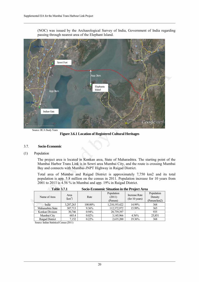
Supplemental EIA for the Mumbai Trans Harbour Link Project
20
(NOC) was issued by the Archaeological Survey of India, Government of India regarding passing through nearest area of the Elephant Island.
Source: JICA Study Team
Figure 3.6.1 Location of Registered Cultural Heritages
3.7. Socio-Economic
(1) Population
The project area is located in Konkan area, State of Maharashtra. The starting point of the Mumbai Harbor Trans Link is in Sewri area Mumbai City, and the route is crossing Mumbai Bay and connects with Mumbai-JNPT Highway in Raigad District.
Total area of Mumbai and Raigad District is approximately 7,750 km2 and its total population is app. 5.8 million on the census in 2011. Population increase for 10 years from 2001 to 2011 is 4.56 % in Mumbai and app. 19% in Raigad District.
Table 3.7.1 Socio-Economic Situation in the Project Area
Name of Area Area
(km2) Rate
Population (2011)
(Person)
Increase Rate (for 10 years)
Population Density
(Person/km2)India 3,287,263 100.00% 1,210,193,422 14.99% 368
Maharashtra State 307,713 9.36% 112,372,972 15.99% 365 Konkan Division 30,746 0.94% 28,739,397 - 935
Mumbai City 603.4 0.02% 3,145,966 4.56% 25,851 Raigad District 7,152 0.22% 2,635,200 19.36% 368
Source: Indian Statistical Census (2011)
Sewri Fort
Elephanta Island
Indian Gate
App 3km
App 9km
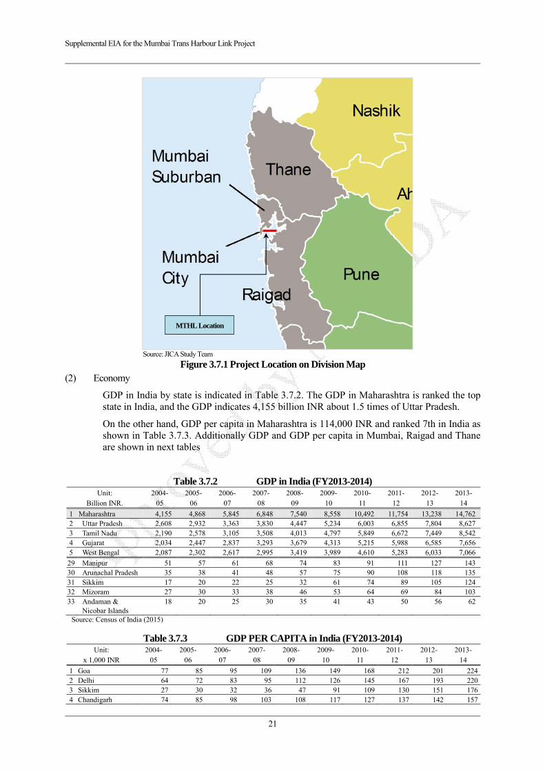
Supplemental EIA for the Mumbai Trans Harbour Link Project
21
Source: JICA Study Team
Figure 3.7.1 Project Location on Division Map (2) Economy
GDP in India by state is indicated in Table 3.7.2. The GDP in Maharashtra is ranked the top state in India, and the GDP indicates 4,155 billion INR about 1.5 times of Uttar Pradesh.
On the other hand, GDP per capita in Maharashtra is 114,000 INR and ranked 7th in India as shown in Table 3.7.3. Additionally GDP and GDP per capita in Mumbai, Raigad and Thane are shown in next tables
Table 3.7.2 GDP in India (FY2013-2014) Unit:
Billion INR. 2004-
05 2005-
06 2006-
07 2007-
08 2008-
09 2009-
10 2010-
11 2011-
12 2012-
13 2013-
14
1 Maharashtra 4,155 4,868 5,845 6,848 7,540 8,558 10,492 11,754 13,238 14,762 2 Uttar Pradesh 2,608 2,932 3,363 3,830 4,447 5,234 6,003 6,855 7,804 8,627 3 Tamil Nadu 2,190 2,578 3,105 3,508 4,013 4,797 5,849 6,672 7,449 8,542 4 Gujarat 2,034 2,447 2,837 3,293 3,679 4,313 5,215 5,988 6,585 7,656 5 West Bengal 2,087 2,302 2,617 2,995 3,419 3,989 4,610 5,283 6,033 7,066
29 Manipur 51 57 61 68 74 83 91 111 127 143 30 Arunachal Pradesh 35 38 41 48 57 75 90 108 118 135 31 Sikkim 17 20 22 25 32 61 74 89 105 124 32 Mizoram 27 30 33 38 46 53 64 69 84 103 33 Andaman &
Nicobar Islands 18 20 25 30 35 41 43 50 56 62
Source: Census of India (2015)
Table 3.7.3 GDP PER CAPITA in India (FY2013-2014) Unit:
x 1,000 INR 2004-
05 2005-
06 2006-
07 2007-
08 2008-
09 2009-
10 2010-
11 2011-
12 2012-
13 2013-
14
1 Goa 77 85 95 109 136 149 168 212 201 224 2 Delhi 64 72 83 95 112 126 145 167 193 220 3 Sikkim 27 30 32 36 47 91 109 130 151 176 4 Chandigarh 74 85 98 103 108 117 127 137 142 157
MTHL Location

Supplemental EIA for the Mumbai Trans Harbour Link Project
22
5 Puducherry 48 67 69 74 79 97 101 103 114 144 6 Haryana 38 42 49 57 67 82 94 106 120 133 7 Maharashtra 36 42 50 58 62 70 85 94 104 114 8 Tamil Nadu 30 35 42 48 54 64 78 89 99 113 9 Andaman &
Nicobar Islands 41 45 54 61 69 79 81 90 98 107
10 Gujarat 32 38 43 50 55 64 77 86 93 107
31 Jharkhand 19 18 20 25 25 28 35 37 40 46 32 Assam 17 18 20 21 24 28 33 36 39 44 33 Manipur 19 20 21 23 24 27 28 34 38 42
Source: Census of India (2015)
Table 3.7.4 GDP PER CAPITA in the Project Area (FY2013-2014) GDP (billion INR) GDP per capita (1,000 INR) 2012-2013 2013-2014 2012-2013 2013-2014
1 Mumbai 28.8 33.4 166 189 2 Thane 17.8 20.0 156 173 3 Raigad 3.5 3.8 120 132 Source: Maharashtra state plan division (2015)
(3) Industry
The key industries and sectors top three are shown in Table 3.7.5. The major industry in Maharashtra state is a service industry and it indicates around 63% and has been increasing.
On the other hand, the industrial production is about 26% in 2013-2014, and it has been decreasing. The agricultural production is stabilized around 11-12 %.
Table 3.7.5 GDP on Major Industry in Maharashtra State Unit: %
(Billion INR) 2004-
05 2005-
06 2006-
07 2007-
08 2008-
09 2009-
10 2010-
11 2011-
12 2012-
13 2013-
14
Primary Industry 10.8 10.8 11.5 11.8 10.1 10.4 12.3 11.8 10.9 11.1
(449) (528) (672) (807) (758) (886) (1,293) (1,387) (1,442) (1,636)1 Agriculture 8.3 8.2 8.7 9.4 7.9 8.0 10.2 9.6 8.7 8.82 Forestry 2.2 2.3 2.5 2.1 2.0 2.1 1.9 1.9 1.9 2.03 Fishery 0.3 0.3 0.3 0.3 0.2 0.2 0.2 0.3 0.3 0.3
Secondary Industry 29.6 31.8 32.0 32.4 31.3 29.8 29.7 28.2 27.4 26.0
(1,230) (1,547) (1,869) (2,216) (2,361) (2,551) (3,116) (3,317) (3,622) (3,845)1 Registered
manufacturing 14.1 16.8 17.7 17.3 16.0 15.1 15.4 14.3 13.5 12.4
2 Construction 6.3 6.2 5.9 6.5 7.0 6.5 6.5 6.8 6.5 6.53 Not registered
manufacturing 6.5 6.4 6.3 6.4 6.2 6.0 5.7 5.1 4.8 4.3
Tertiary industries 59.6 57.4 56.5 55.9 58.6 59.8 58.0 60.0 61.7 62.9
(2,475) (2,793) (3,303) (3,826) (4,420) (5,121) (6,082) (7,050) (8,173) (9,282)1 Real Estate 12.8 12.9 12.7 13.0 14.1 14.9 14.9 15.9 16.7 17.82 Trading/Hotel/Rest
aurant 16.2 15.6 15.9 15.4 15.0 15.1 14.6 14.6 14.6 13.8
3 Insurance and financial
11.4 10.5 10.2 10.2 11.1 10.4 10.4 10.8 10.8 11.0
Source: Census of India (2015)
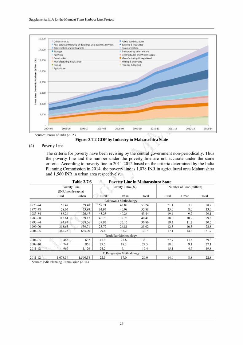
Supplemental EIA for the Mumbai Trans Harbour Link Project
23
Source: Census of India (2015)
Figure 3.7.2 GDP by Industry in Maharashtra State (4) Poverty Line
The criteria for poverty have been revising by the central government non-periodically. Thus the poverty line and the number under the poverty line are not accurate under the same criteria. According to poverty line in 2011-2012 based on the criteria determined by the India Planning Commission in 2014, the poverty line is 1,078 INR in agricultural area Maharashtra and 1,560 INR in urban area respectively.
Table 3.7.6 Poverty Line in Maharashtra State
Poverty Line
(INR/month-capita) Poverty Ratio (%) Number of Poor (million)
Rural Urban Rural Urban Total Rural Urban Total
Lakdawala Methodology 1973-74 50.47 59.48 57.71 43.87 53.24 21.1 7.7 28.71977-78 58.07 73.99 63.97 40.09 55.88 25.0 8.0 33.01983-84 88.24 126.47 45.23 40.26 43.44 19.4 9.7 29.11987-88 115.61 189.17 40.78 39.78 40.41 18.6 10.9 29.61993-94 194.94 328.56 37.93 35.15 36.86 19.3 11.2 30.51999-00 318.63 539.71 23.72 26.81 25.02 12.5 10.3 22.82004-05 362.25 665.90 29.6 32.2 30.7 17.1 14.6 31.7
Tendulkar Methodology 2004-05 485 632 47.9 25.6 38.1 27.7 11.6 39.32009-10 744 961 29.5 18.3 24.5 18.0 9.1 27.12011-12 967 1,126 24.2 9.1 17.4 15.1 4.7 19.8
C.Rangarajan Methodology 2011-12 1,078.34 1,560.38 22.5 17.0 20.0 14.0 8.8 22.8
Source: India Planning Commission (2014)

Supplemental EIA for the Mumbai Trans Harbour Link Project
24
CHAPTER 4 ENVIRONMENTAL LEGISLATION IN INDIA
The principal Environment Regulatory Agency in our country is the Ministry of Environment & Forest (MoEF). The environment policies and environment clearance process for various projects are laid down by MoEF. The State Pollution Control Board (SPCB) grants No Objection Certificate (NOC) and consent for establishment and operation of the project.
4.1. EIA Notification 2006
The necessity of environmental impact assessment is stipulated on the Environmental Protection Law in 1986, and concrete rules are described on the Environmental Impact Assessment Notification in 2006 (EIA Notification). According to the notification, prescript projects are required to obtain an Environmental Clearance before implementation of the actual construction.
Category A projects in accordance with EIA notification are required to obtain the Environmental Clearance from Ministry of Environment and Forests (MOEF) of the central government, on the other hand, Category B project shall have the clearance from State Government.
As per the EIA Notification of MoEF issued on 14th September, 2006, a National or State highway development or expansion projects fall in either Category A or B of the schedule of the notification. The proposed project does not completely fulfill either of the criterions described for Category A or B, i.e. the proposed alignment is a sea link which is 22km (less than 30km) and it is not a national/state highway. Hence, there is no need of obtaining Environment Clearance from Ministry of Environment and Forests (MoEF) for which an EIA/EMP study is a primary requirement.
Table 4.1.1 Mandatory List for EIA
Project ActivityCategory C
Other Condition Category A (Central Government) Category B (State Government)
7f Highway
i) New National Highways; and
ii) Expansion of National High ways greater
than 30 KM, involving additional right of
way greater than 20m involving land
acquisition and passing through more than
one State.
i) New State High ways; and
ii) Expansion of National / State Highways
greater than 30 km involving additional right of
way greater than 20m involving land
acquisition.
General Condition
shall apply
Source: EIA Notification (MOEF 2006)
However, the proposed alignment passes through coastal regulation zone (CRZ) as per the Coastal Zone Management Plans (hereafter referred to as the CZMPs) of Mumbai and Navi Mumbai. Though construction of ‘Sea link’ is a permissible activity as per CRZ notification, approval from Maharashtra Coastal Regulation Zone Management Authority (MCZMA) is required as per the MoEF Notification of January 2011.
4.2. Coastal Regulation Zone (CRZ Notification 2011)
According to CRZ notification 2011, following objectives for establishment of regulation are described;
“Now, therefore, in exercise of the powers conferred by sub-section (1) and clause (v) of sub-section (2) of section 3 of the Environment (Protection) Act, 1986 (29 of 1986), the

Supplemental EIA for the Mumbai Trans Harbour Link Project
25
Central Government, with a view to ensure livelihood security to the fisher communities and other local communities, living in the coastal areas, to conserve and protect coastal stretches, its unique environment and its marine area and to promote development through sustainable manner based on scientific principles taking into account the dangers of natural hazards in the coastal areas, sea level rise due to global warming, does hereby, declare the coastal stretches of the country and the water area upto its territorial water limit, excluding the islands of Andaman and Nicobar and Lakshadweep and the marine areas surrounding these islands upto its territorial limit, as Coastal Regulation Zone (hereinafter referred to as the CRZ) and restricts the setting up and expansion of any industry, operations or processes and manufacture or handling or storage or disposal of hazardous substances as specified in the Hazardous Substances (Handling, Management and Transboundary Movement) Rules, 2009 in the aforesaid CRZ.”
In the designated CRZ, “allowed” and “Not allowed” activities are categorized and stipulated. With regard to the Mumbai Harbor Trans Link, it is categorized as “Sealink” and allowed to construct roads and bridges in CRZ, and an Environmental Clearance for CRZ with 5 years validity has been obtained by MMRDA from MOEF in July 2013.
Relevant description regarding MHTL project on CRZ notification 2011 is show below.
Table 4.2.1 Relevant Description on CRZ Notification 2011 No. Name of Article Description
Clause “3 (iv) (Page 2).
Prohibited activities within CRZ
The activities such as Land reclamation, bunding or disturbing the natural course of seawater are declared as prohibited activities within the CRZ except those,- (a) required for setting up, construction or modernisation or expansion of foreshore facilities like ports, harbours, jetties, wharves, quays, slipways, bridges, sealink, road on stilts, and such as meant for defence and security purpose and for other facilities that are essential for activities permissible under the notification;”
Clause “7 (Pg 8)
Classification of the CRZ
For the purpose of conserving and protecting the coastal areas and marine waters, the CRZ area shall be classified as follows, namely:- (i) CRZ-I,– A. The areas that are ecologically sensitive and the geomorphological features which play a role in the maintaining the integrity of the coast,- (a) Mangroves, in case mangrove area is more than 1000 sq mts, a buffer of 50meters along the mangroves shall be provided; (b) Corals and coral reefs and associated biodiversity; (c) Sand Dunes; (d) Mudflats which are biologically active; (e) National parks, marine parks, sanctuaries, reserve forests, wildlife habitats and other protected areas under the provisions of Wild Life (Protection) Act, 1972 (53 of 1972), the Forest (Conservation) Act, 1980 (69 of 1980) or Environment (Protection) Act, 1986 (29 of 1986); including Biosphere Reserves; (f) Salt Marshes; (g) Turtle nesting grounds; (h) Horse shoe crabs habitats; (i) Sea grass beds; (j) Nesting grounds of birds; (k) Areas or structures of archaeological importance and heritage sites. B. The area between Low Tide Line and High Tide Line; (ii) CRZ-II,- The areas that have been developed upto or close to the shoreline.
Clause “8
(Pg 9)
Norms for
regulation of
activities
permissible
under this
notification,-
(i) The development or construction activities in different categories of CRZ shall be regulated by the concerned CZMA in accordance with the following norms, namely:- I. CRZ-I,- (i) no new construction shall be permitted in CRZ-I except,- (e) Construction of trans harbour sea link and without affecting the tidal flow of water, between LTL and HTL.”“(ii) Areas between LTL and HTL which are not ecologically sensitive, necessary safety measures will be incorporated while permitting the following, namely:- (g) Construction of trans harbour sea links, roads on stilts or pillars without affecting the tidal flow of water.”
Source: Coastal Regulation Zone Notification (MOEF 2011)
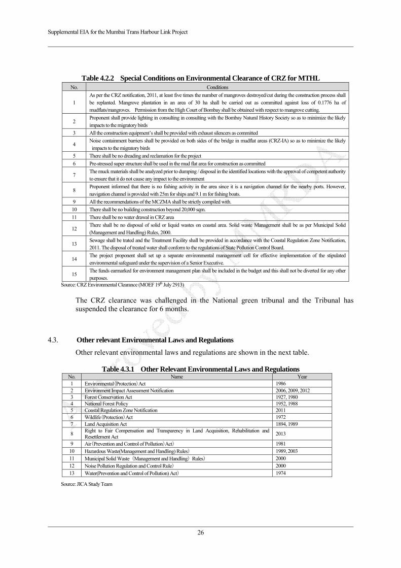
Supplemental EIA for the Mumbai Trans Harbour Link Project
26
Table 4.2.2 Special Conditions on Environmental Clearance of CRZ for MTHL No. Conditions
1 As per the CRZ notification, 2011, at least five times the number of mangroves destroyed/cut during the construction process shall be replanted. Mangrove plantation in an area of 30 ha shall be carried out as committed against loss of 0.1776 ha of mudflats/mangroves. Permission from the High Court of Bombay shall be obtained with respect to mangrove cutting.
2 Proponent shall provide lighting in consulting in consulting with the Bombay Natural History Society so as to minimize the likely impacts to the migratory birds
3 All the construction equipment’s shall be provided with exhaust silencers as committed
4 Noise containment barriers shall be provided on both sides of the bridge in mudflat areas (CRZ-IA) so as to minimize the likely impacts to the migratory birds
5 There shall be no dreading and reclamation for the project
6 Pre-stressed super structure shall be used in the mud flat area for construction as committed
7 The muck materials shall be analyzed prior to dumping / disposal in the identified locations with the approval of competent authority to ensure that it do not cause any impact to the environment
8 Proponent informed that there is no fishing activity in the area since it is a navigation channel for the nearby ports. However, navigation channel is provided with 25m for ships and 9.1 m for fishing boats.
9 All the recommendations of the MCZMA shall be strictly compiled with.
10 There shall be no building construction beyond 20,000 sqm.
11 There shall be no water drawal in CRZ area
12 There shall be no disposal of solid or liquid wastes on coastal area. Solid waste Management shall be as per Municipal Solid (Management and Handling) Rules, 2000.
13 Sewage shall be trated and the Treatment Facility shall be provided in accordance with the Coastal Regulation Zone Notification, 2011. The disposal of treated water shall conform to the regulations of State Pollution Control Board.
14 The project proponent shall set up a separate environmental management cell for effective implementation of the stipulated environmental safeguard under the supervision of a Senior Executive.
15 The funds earmarked for environment management plan shall be included in the budget and this shall not be diverted for any other purposes.
Source: CRZ Environmental Clearance (MOEF 19th July 2913)
The CRZ clearance was challenged in the National green tribunal and the Tribunal has suspended the clearance for 6 months.
4.3. Other relevant Environmental Laws and Regulations
Other relevant environmental laws and regulations are shown in the next table.
Table 4.3.1 Other Relevant Environmental Laws and Regulations No. Name Year 1 Environmental(Protection)Act 1986 2 Environment Impact Assessment Notification 2006, 2009, 2012 3 Forest Conservation Act 1927, 1980 4 National Forest Policy 1952, 1988 5 Coastal Regulation Zone Notification 2011 6 Wildlife(Protection)Act 1972 7 Land Acquisition Act 1894, 1989
8 Right to Fair Compensation and Transparency in Land Acquisition, Rehabilitation and Resettlement Act
2013
9 Air(Prevention and Control of Pollution)Act) 1981 10 Hazardous Waste(Management and Handling) Rules) 1989, 2003 11 Municipal Solid Waste (Management and Handling) Rules) 2000 12 Noise Pollution Regulation and Control Rule) 2000 13 Water(Prevention and Control of Pollution) Act) 1974
Source: JICA Study Team
Supplemental EIA for the Mumbai Trans Harbour Link Project
27
Table 4.3.2 Other Relevant Environmental Ratification Treaty No. Name Effected Year
1 United Nations Framework Convention on Climate Change 1994
2 Kyoto Protocol 2001
3 Convention on Biological Diversity 1993
4 Cartagena Protocol on Biosafety 2003
5 Vienna Convention for the Protection of the Ozone Layer 1988
6 Montreal Protocol on Substances that Deplete the Ozone Layer 2002
7 Basel Convention 1992
8 The Rotterdam Convention on the Prior Informed Consent Procedure for Certain Hazardous Chemicals and Pesticides in International Trade
2004
9 Stockholm Convention on Persistent Organic Pollutants 2004
10 United Nations Convention to Combat Desertification in Those Countries Experiencing Serious Drought and/or Desertification, Particularly in Africa
1996
11 Convention on International Trade in Endangered Species of Wild Fauna and Flora(CITES) 1975
12 The Convention on Wetlands of International Importance especially as Waterfowl Habitat 1975
13 Antarctic Treaty / Protocol on Environmental Protection to the Antarctic Treaty 1961
14 Protocol on Environmental Protection to the Antarctic Treaty (Madrid Protocol) 1998
Source: Ministry of Foreign Affairs in Japan (website)
4.4. Gaps between Rapid EIA 2012 and JICA’s Guideline
The project is categorized as Category A which is required EIA level based on JICA Guidelines, thus following preliminary comparative analysis has been conducted between JICA Guidelines and “Rapid EIA in 2012” prepared by MMRDA for obtaining of Environmental Clearance for CRZ from MOEF.
According to the gap analysis, the identified gaps are “NOT-Implementation” of Social Impact Survey, Vibration Survey and Holding Public Consultation.
Thus vibration survey and implementation of public consultation has been carried out on this modified Rapid EIA.
Table 4.4.1 Result of Preliminary Gap Analysis between JICA Guidelines and Rapid EIA JICA Guideline
(Appendix 2. EIA Reports for Category A Projects) Rapid EIA
(2012 prepared by MMRDA) Gaps Policy to fill up gaps
in this Study
1. When assessment procedures already exist in
host countries, and projects are subject to such
procedures, project proponents etc. must
officially finish those procedures and obtain the
approval of the government of the host country.
At first, the project is not required to prepare the EIA in accordance with EIA Notification 2006. However necessary environmental clearance for CRZ is obtained from MOEF by MMRDA in 2013.
- (no difference)
Not required
2. EIA reports (which may be referred to
differently in different systems) must be written
in the official language or in a language widely
used in the country in which the project is to be
implemented. When explaining projects to local
residents, written materials must be provided in
a language and form understandable to them.
Current Rapid EIA has been prepared in only English.
At least English and Hindi version shall be prepared
Supplemental EIA shall be prepared in English and Marathi (Syopsis)
3. EIA reports are required to be made available to
the local residents of the country in which the
project is to be implemented. The EIA reports
are required to be available at all times for
perusal by project stakeholders such as local
residents and copying must be permitted.
Rapid EIA in 2012 has not been disclosed
Rapid EIA shall be disclosed
Supplemental EIA in English and Hindi shall be disclosed after preparation of Final modified Rapid EIA.
4. In preparing EIA reports, consultations with
stakeholders, such as local residents, must take
A public consultation has not been conducted on the process of Rapid EIA
Either local Stakeholder meeting and public
Socialization prior to conducting a series of RAP survey and a public

Supplemental EIA for the Mumbai Trans Harbour Link Project
28
JICA Guideline (Appendix 2. EIA Reports for Category A Projects)
Rapid EIA (2012 prepared by MMRDA)
Gaps Policy to fill up gaps
in this Study
place after sufficient information has been
disclosed. Records of such consultations must be
prepared.
consultation has been conducted
consultation after preparation of draft Supplemental EIA will be held.
5. Consultations with relevant stakeholders,
such as local residents, should take place if
necessary throughout the preparation and
implementation stages of a project. Holding
consultations is highly desirable, especially
when the items to be considered in the EIA
are being selected, and when the draft report
is being prepared.
Any consultation has not been
conducted on the process of Rapid
EIA 2012
ditto ditto
Source: The Survey Team

Supplemental EIA for the Mumbai Trans Harbour Link Project
29
CHAPTER 5 Alternative Analysis, Screening and Scoping
5.1. Alternative Analysis
5.1.1. Route Analysis
The first recommended draft plan of MTHL dates back to 1970s. Subsequently, committees were formed in 1972 and 1978 to study the possible alternatives for establishing the communication links across the Mumbai bay. The committees identified two alternative routes, a northern route linking Sewri with Nhava and a southern route linking Colaba (southern tip of Mumbai Island) with Uran, and suggested to carry out necessary engineering studies for the alternative routes.
A Steering Group was constituted in 1981 and reviewed the previous studies and recommended that Priority should be given to the construction of a northern route.
(1) Alignment by Peter Frankael and Partners (PFP), 1982
Five alternative alignments between Sewri on Mumbai Island and Nhava on the main land were identified and studied. All the alignments started from Sewri.
The study recommended the northern most alignment for the communication link Sewri with Nhava through a low level bridge skirting the harbour to the north.
Total length is 22.61km and it is comprised of the following sections (refer to Figure 3.1.1):
Section 1: Sewri side Approach 0.7 km
Section 2: Embankment over Sewri mudflats 2.32 km
Section 3: Viaduct 13.19 km
Section 4: Embankment on Nhava mudflats 2.20 km
Section 5: Nhava side Approach 4.20 km
The embankment of Section 2 and 4 had a road level of +7.00m above Chart Datum (CD) considering run-up of wave approximately 1.0m above HHTL of 5.38m. The Central Water & Power Research Station (CWPRS) study had recommended that the embankment section shall be provided with an opening to cater for the non-tidal inflow. Accordingly, the embankment on Sewri side was proposed to terminate at 350m west of the Green Island.
Subsequently the recommended northern alignment was modified by Expert Group by shifting it to south of the jetty head in order to satisfy Bhabha Atomic Reserch Centre (BARC) requirements. This shifted alignment was approved by Prime Minister’s Office (PMO) in 1984.
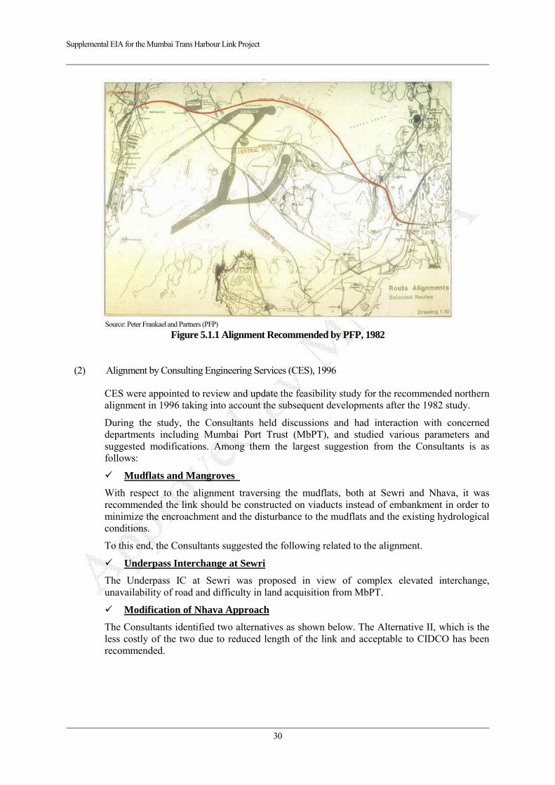
Supplemental EIA for the Mumbai Trans Harbour Link Project
30
Source: Peter Frankael and Partners (PFP)
Figure 5.1.1 Alignment Recommended by PFP, 1982
(2) Alignment by Consulting Engineering Services (CES), 1996
CES were appointed to review and update the feasibility study for the recommended northern alignment in 1996 taking into account the subsequent developments after the 1982 study.
During the study, the Consultants held discussions and had interaction with concerned departments including Mumbai Port Trust (MbPT), and studied various parameters and suggested modifications. Among them the largest suggestion from the Consultants is as follows:
Mudflats and Mangroves
With respect to the alignment traversing the mudflats, both at Sewri and Nhava, it was recommended the link should be constructed on viaducts instead of embankment in order to minimize the encroachment and the disturbance to the mudflats and the existing hydrological conditions.
To this end, the Consultants suggested the following related to the alignment.
Underpass Interchange at Sewri
The Underpass IC at Sewri was proposed in view of complex elevated interchange, unavailability of road and difficulty in land acquisition from MbPT.
Modification of Nhava Approach
The Consultants identified two alternatives as shown below. The Alternative II, which is the less costly of the two due to reduced length of the link and acceptable to CIDCO has been recommended.

Supplemental EIA for the Mumbai Trans Harbour Link Project
31
Source: Alignment by Consulting Engineering Services (CES)
Figure 5.1.2 Alternative Alignments on Nhava Side, 1998
Table 5.1.1 Elements of Alternative Alignments on Nhava Side, 1998
Source: Alignment by Consulting Engineering Services (CES)
(3) Alignment by Consulting Engineering Services (CES), 2004
The alignment proposed by the Consultants under Alternative II with end point on NH4B (north of Chirle) is finally accepted and proposed to be taken up for construction. This alignment satisfies various issue solved in previous study.
Sewri IC and Connection with Eastern Freeway
Sewri IC is the starting point of the proposed MTHL link. The MTHL link will have to be
Modified AlignmentAlternative I
Modified AlignmentAlternative II
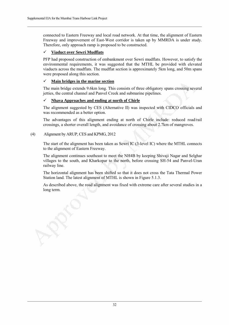
Supplemental EIA for the Mumbai Trans Harbour Link Project
32
connected to Eastern Freeway and local road network. At that time, the alignment of Eastern Freeway and improvement of East-West corridor is taken up by MMRDA is under study. Therefore, only approach ramp is proposed to be constructed.
Viaduct over Sewri Mudflats
PFP had proposed construction of embankment over Sewri mudflats. However, to satisfy the environmental requirements, it was suggested that the MTHL be provided with elevated viaducts across the mudflats. The mudflat section is approximately 5km long, and 50m spans were proposed along this section.
Main bridges in the marine section
The main bridge extends 9.6km long. This consists of three obligatory spans crossing several jetties, the central channel and Panvel Creek and submarine pipelines.
Nhava Approaches and ending at north of Chirle
The alignment suggested by CES (Alternative II) was inspected with CIDCO officials and was recommended as a better option.
The advantages of this alignment ending at north of Chirle include: reduced road/rail crossings, a shorter overall length, and avoidance of crossing about 2.7km of mangroves.
(4) Alignment by ARUP, CES and KPMG, 2012
The start of the alignment has been taken as Sewri IC (3-level IC) where the MTHL connects to the alignment of Eastern Freeway.
The alignment continues southeast to meet the NH4B by keeping Shivaji Nagar and Selghar villages to the south, and Kharkopar to the north, before crossing SH-54 and Panvel-Uran railway line.
The horizontal alignment has been shifted so that it does not cross the Tata Thermal Power Station land. The latest alignment of MTHL is shown in Figure 5.1.3.
As described above, the road alignment was fixed with extreme care after several studies in a long term.
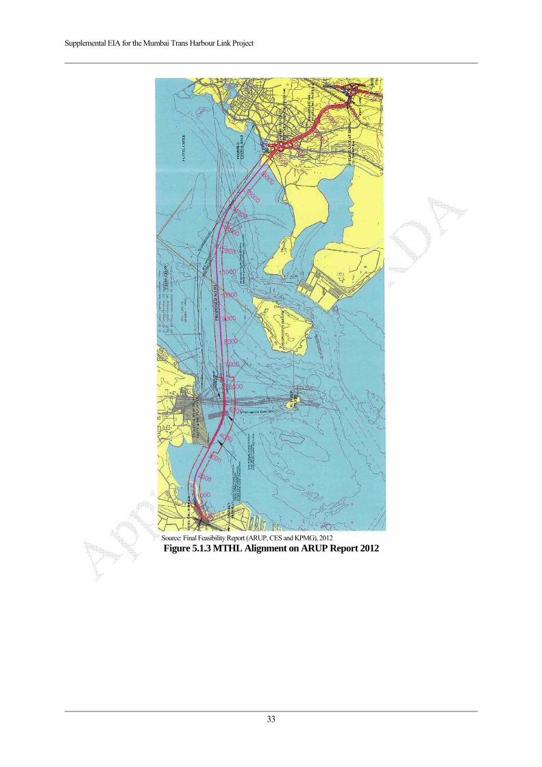
Supplemental EIA for the Mumbai Trans Harbour Link Project
33
Source: Final Feasibility Report (ARUP, CES and KPMG), 2012
Figure 5.1.3 MTHL Alignment on ARUP Report 2012
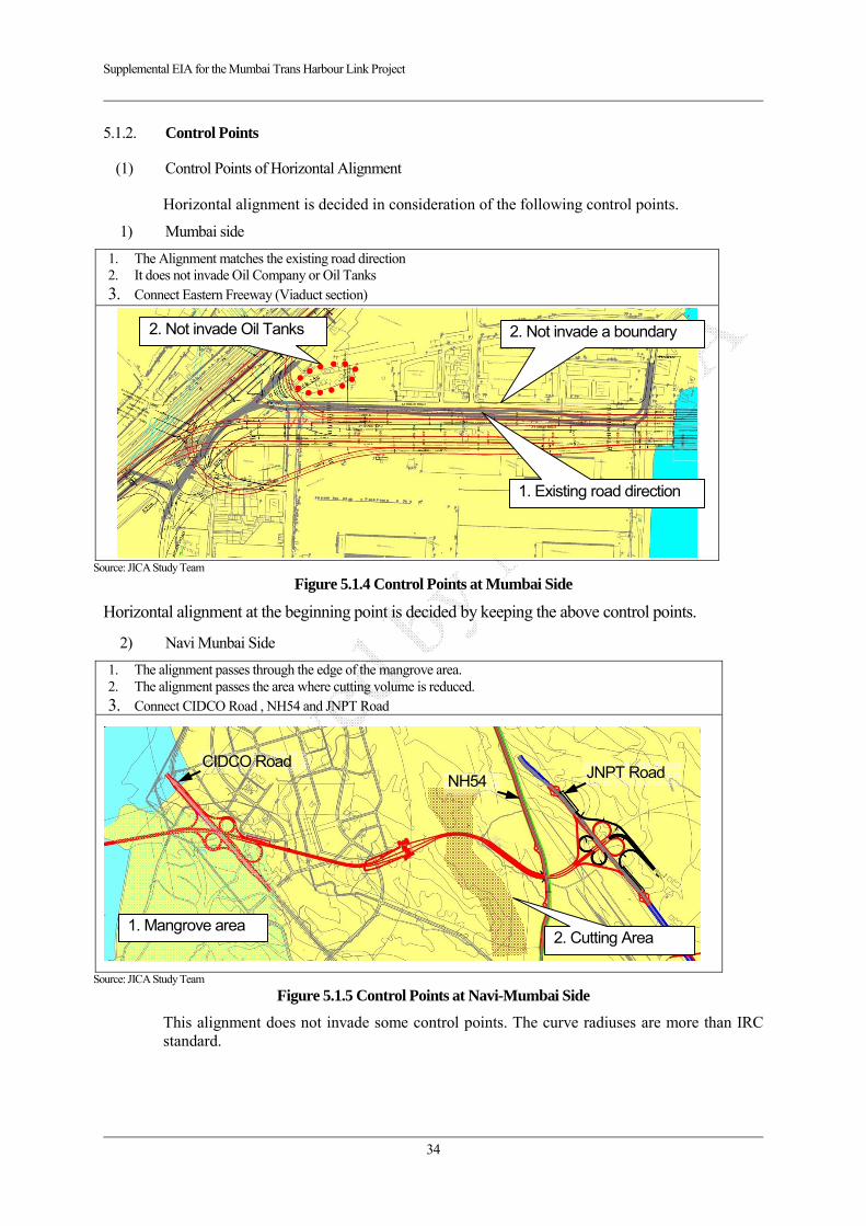
Supplemental EIA for the Mumbai Trans Harbour Link Project
34
5.1.2. Control Points
(1) Control Points of Horizontal Alignment
Horizontal alignment is decided in consideration of the following control points.
1) Mumbai side
1. The Alignment matches the existing road direction 2. It does not invade Oil Company or Oil Tanks 3. Connect Eastern Freeway (Viaduct section)
Source: JICA Study Team
Figure 5.1.4 Control Points at Mumbai Side
Horizontal alignment at the beginning point is decided by keeping the above control points.
2) Navi Munbai Side
1. The alignment passes through the edge of the mangrove area. 2. The alignment passes the area where cutting volume is reduced. 3. Connect CIDCO Road , NH54 and JNPT Road
Source: JICA Study Team
Figure 5.1.5 Control Points at Navi-Mumbai Side
This alignment does not invade some control points. The curve radiuses are more than IRC standard.
1. Existing road direction
2. Not invade Oil Tanks 2. Not invade a boundary
2. Cutting Area 1. Mangrove area
CIDCO Road JNPT Road NH54
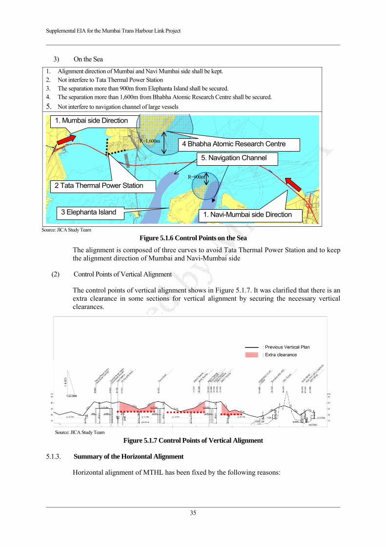
Supplemental EIA for the Mumbai Trans Harbour Link Project
35
3) On the Sea
1. Alignment direction of Mumbai and Navi Mumbai side shall be kept. 2. Not interfere to Tata Thermal Power Station 3. The separation more than 900m from Elephanta Island shall be secured. 4. The separation more than 1,600m from Bhabha Atomic Research Centre shall be secured.
5. Not interfere to navigation channel of large vessels
Source: JICA Study Team
Figure 5.1.6 Control Points on the Sea
The alignment is composed of three curves to avoid Tata Thermal Power Station and to keep the alignment direction of Mumbai and Navi-Mumbai side
(2) Control Points of Vertical Alignment
The control points of vertical alignment shows in Figure 5.1.7. It was clarified that there is an extra clearance in some sections for vertical alignment by securing the necessary vertical clearances.
Source: JICA Study Team
Figure 5.1.7 Control Points of Vertical Alignment
5.1.3. Summary of the Horizontal Alignment
Horizontal alignment of MTHL has been fixed by the following reasons:
1. Mumbai side Direction
2 Tata Thermal Power Station
R=1,600m 4 Bhabha Atomic Research Centre
5. Navigation Channel
R=900m
1. Navi-Mumbai side Direction 3 Elephanta Island

Supplemental EIA for the Mumbai Trans Harbour Link Project
36
(1) Bay Crossing Route
1) Beginning points at Mumbai side
Northern route (connected at Sewri) was recommended in 1981 by a steering group, however, the details of the study documents was not able to find out. Therefore, review was carried out in a current viewpoint.
According to the master plan of the Mumbai Metropolitan Region that is the upper plan, the MTHL on Mumbai side starts from Sewri in a road network in the future. The followings are the reason:
There is another plan on southern route linking Colaba (southern tip of Mumbai Island) with Uran in the master plan of the Mumbai Metropolitan Region.
There is a plan linking western freeway via east-west corridor.
There is a widening plan of Vashi Bridge on northern side of Sewri
Source: Comprehensive Transport Study for Mumbai Metropolitan Region
Figure 5.1.8 Future Road Network
In addition, regarding the connection to the northern Sewri, an alignment which satisfy the followings is impossible since there is not have space to construction new road.
Not interfere to Tata Thermal Power Station
The separation more than 1,600m from Bhabha Atomic Research Centre shall be secured.
Cutting mountain shall be avoided as much as possible.

Supplemental EIA for the Mumbai Trans Harbour Link Project
37
Source: JICA Study Team
Figure 5.1.9 Land Use Map on Northern Area of the Proposed Alignment
2) Ending points at Nhava (Navi-Mumbai) side
Regarding the alignment of Nhava side, the route comparison has been conducted in 1996 as described before. It is clear that the proposed alignment is fixed in consideration of the followings:
The connection with CIDCO Road connected to Navi-Mumbai Airport, NH54, and JNPT Road connected to Jawaharlal Nehru Port.
There is an upper plan of new road connected to Mumbai-Pune Expressway from Chirle (ending point of MTHL).
Alignment of MTHL passes the side of Planned Special Economic Zone.
Alignment of MTHL passes the side of residential area. In other words, the alignment is decided to minimize the resettlement.
Alignment is considered to minimize the volume of cutting soil.
Alignment is considered to minimize the impact on mangrove forest.
Mountain (Height 150-200m)
Tata Power Station
Mangrove
Mangrove
Bhabha Atomic Research Centre and required separation 1,600m
Residential Area
Sewri

Supplemental EIA for the Mumbai Trans Harbour Link Project
38
Source: JICA Study Team
Figure 5.1.10 Control Point of Alignment on Nhava (Navi-Mumbai) Side
3) Control of Alignment on Marine Section
As shown in Figure 5.1.9, alignment of marine section was decided in consideration of the following control points:
Not interfere to Tata Thermal Power Station
The separation more than 900m from Elephanta Island shall be secured.
The separation more than 1,600m from Bhabha Atomic Research Centre shall be secured.
Not interfere to navigation channel for large vessels of Jawaharlal Nehru Port
5.1.4. Structure Type
In general, there are 3 typical structures such as 1) viaduct bridges, 2) immersed tunnel and 3) shield tunnel are selected.
With regard to the tunnel, at least 1.5 to 2 times cost of bridge is expected since relevant utilities and facilities are required. Additionally construction period is longer than bridge, and maintenance cost is also higher than bridge. Thus bridge type is selected from the view of construction period and costs mainly.
Mangrove
SEZ(Planned)
Residential Area
Railway Station Mountain
(Height 70m)
Mountain (Height 50m)
Railway
Chirle IC NH54 IC
CIDCO Road
(Planned)
Shivaji Nagr IC
MHTL
Residential
Area
Residential Area
Supplemental EIA for the Mumbai Trans Harbour Link Project
39
5.1.5. Alternative Analysis
As explained from article 5.1.1 to 5.1.4, the route and fundamental structure have concluded and approved by central government from the view of natural & social environment, security and adjustment with other projects. Thus factor on alternative analysis is limited as follows. As shown in Table 5.1.2, Span length and location of IC is listed up as factor of alternative analysis, however, in general, the location of IC is planned at actual connected trunk road, and hence, there are not any options to shift other area so long as the connected road plan does not change.
Table 5.1.2 Selected Factors on Alternative Analysis Factor/ Condition Reason for adoption
Location of Interchange
It is expected that changing of IC location may give positive impacts from the view of natural and social consideration. However since the location shall be set up at cross point with connected road, the location of IC cannot be shifted to other points. Thus “location of IC” is not appropriate factor on the analysis.
Span length (steel girder
bridge)
It is expected that changing span length reduce excavated area in mudflat and mangrove cutting area. Adoption of steel girder for superstructure provides long span and reduction of number of piers and piles. Thus this factor is selected as an appropriate factor on the analysis
Source: JICA Study Team
“Span length” is selected as a factor on the alternative analysis and evaluated from the view of natural & social environment and economy & cost as shown in Table 5.1.3.
According to the result of analysis, option-2 with 80m span length has advantage slightly on the all items on natural environment such as negative impacts on mudflat, mangrove, Flamingo habitat, benthos, CRZ and tidal flow except land acquisition & resettlement. Although differences of impacts between Option 1 and 2 are not significant from the view of impacts on natural environment, Option-2 (80m) has extremely disadvantage from the view of construction cost. Additionally, it is supposed the adverse impacts are minimized by mitigation measures on management plan. Thus Option-1 (50m) should be selected from comprehensive point of view.
Table 5.1.3 Alternative Analysis (Span Length) Factor/ Condition (analyzed area)
Option-1 50m span with PC girder
Option-2 80m span with steel girder
Differences between options, Evaluation and mitigation measure
1. Area of Cutting mangrove (ST0.6-0.8km and 16.5-17.9km)
App. 2,100m2 App. 1,300m2
800m2 5 times of cutting mangrove area shall be replanted in the designated area by MoEF
2. Impacts on Flamingo (ST0.6-5.6km)
Width of flying course under bridge is 50m
Width of flying course under bridge is 80m
It is supposed Flamingo fly over bridge not under bridge. Thus there are no significant differences.
3. Impacts on Benthos in Mudflat area (ST0.6-5.6km and 15-17.9km note1)
Excavated impacts area is App. 2,100m2
Excavated impacts area is app. 1,300m2
800m2 5 times of cutting mangrove area shall be replanted and created new habitat in the designated area by MoEF
4. Impact on CRZ (0.6-2.1km and 16.5-17.1km) note2)
Excavated and cutting mangrove area is App. 1,100 m2
Excavated and cutting mangrove area is App. 690 m2
410m Mitigation measures are committed on CRZ clearance.
6. Tidal flow note3) Few impacts (note3) Few impacts (note3) Same impacts and negligible
7. Land acquisition (ST0-0.6km and 16-22km)
Land acquisition area is same as Option-2
Land acquisition area is same as Option-1
Same impacts and compensation policy under Indian laws and JICA Guidelines
8. Construction Cost(entire of alignment)(Considered mudflat and mangrove area ST0.6-5.6km and 15-17.9km)
Approx. 1.640 crore INR Approx. 2,490 crore INR 850 crore INR (= 15 billion yen)
Note 1) Mudflat and mangrove area is ST0.6km – 5.6km in Sewri side and 15.0 km – 17.9 km in Shivaji Nagar side

Supplemental EIA for the Mumbai Trans Harbour Link Project
40
Note 2) CRZ is located in the sea section from ST0.6-2.1km (CRZ-1) and 16.48 – 17.08km (CRZ I and II) Note 3) Adverse Impacts on tidal flow by construction of MTHL in case of 50-180m span length has been analyzed and concluded as “negligible level”
by The Central Water and Power Research Station (CWPRS). Thus degree of impacts in both case of 50m and 80m are evaluated as same level. Source: JICA Study Team
5.1.6. Zero Option
In case of “Zero Option” which does not implement the project, following adverse negative and positive impacts are expected. Some positive impacts are expected, however, since the expected negative impacts are serious from the view of economic and environment, “With project case” is desirable comprehensively;
Negative Impacts
The congested situation must be accelerated and prevent from sound urban development. Furthermore, this “without case” will not give a synergy effect on other development plan such as a construction of Navi Mumbai Air Port.
The accelerated congestion must make all of vehicles decrease travelling speed, and then volume of greenhouse gases increase from vehicles.
Positive Impacts
Mangrove and mud flat is conserved
Resettlement and land acquisition is not caused
5.2. Screening
As described in Chapter 4, obtaining of EC for EIA is not required in accordance with EIA Notification 2006, however EC for CRZ in accordance with CRZ Notification 2011 has been required, and MMRDA has obtained this EC in 2013 by preparation of Rapid EIA 2012. On the other hand, JICA HQ has judged that some significant impacts on natural and social environment are predicted on the MTHL project, thus the project has been classified as “Category A” which is required to conduct EIA level study.
5.3. Scoping
Scope of the EIA study for the project is discussed in this section. The environmental scoping is conducted based on an environmental reconnaissance by the JICA Study Team in April 2015.
The result of scoping is indicated on the Leopold scoping matrix and reason tables. First of all, impact factors, impacted item and impact degree are shown on the following scoping matrix based on JICA’s Guidelines.
(1) Scoping Matrix for MTHL
As the result of Scoping Analysis, 13 items such as Air, Water, Waste, Noise & Vibration, Biology, Hydrology, Topography and Geography, Existing Infrastructures, Misdistribution of benefit and damage, land scape, infection diseases and accident are selected as item of the Rating B which has some negative impacts.
Additionally mainly social items such as “involuntary resettlement” are evaluated as “Rating C” which has unknown impacts.
Supplemental EIA for the Mumbai Trans Harbour Link Project
41
Table 5.3.1 Draft Scoping Matrix for MTHL No Affected Activities
Impacted Item
Dur
ing
Con
stru
ctio
n
Pre/ During Construction Phase
Afte
r Con
stru
ctio
n
Operation Phase
Land
acq
uisi
tion
and
Los
s of p
rope
rties
and
Cha
nge
of
Land
use
pla
n, C
ontro
l of v
ario
us a
ctiv
ities
by
regu
latio
ns fo
r the
con
stru
ctio
n
Rec
lam
atio
n of
Wet
land
, etc
.
Def
ores
tatio
n(in
clud
ing
Man
grov
e)
Alte
ratio
n to
gro
und
by c
ut la
nd, f
illin
g, d
rillin
g, tu
nnel
,
etc.
Ope
ratio
n of
Con
stru
ctio
n Eq
uipm
ent a
nd V
ehic
les
Con
stru
ctio
n of
Roa
ds, t
ollg
ates
, par
king
lots
, Acc
ess
road
s for
brid
ges a
nd o
ther
rela
ted
faci
litie
s
Traf
fic R
estri
ctio
n in
con
stru
ctio
n ar
ea
Influ
x of
con
stru
ctio
n w
orke
rs, c
onst
ruct
ion
of b
ase
cam
p
Incr
ease
of T
hrou
gh T
raff
ic a
nd tr
avel
ing
spee
d
App
eara
nce/
Occ
upan
cy o
f Roa
ds a
nd re
late
d bu
ildin
g st
ruct
ures
i
nclu
ding
tunn
el a
nd e
mba
nkm
ent
Incr
easi
ng in
flux
of se
ttler
s
(JICA Guidelines)
(Items of the Rapid EIA 2012)
Pollu
tion
1 Air Pollution Air quality/ Siting of borrow and quarry material areas
B- D- D- D- D- B- D- D- D- B- B- D- D-
2 Water pollution
Water Quality/ Construction of labor camp/ Siting of borrow and quarry material areas
B- D- B- D- B- D- D- D- B- D- D- D- D-
3 Waste
Solid waste management/ Construction of labor camp/ Topography, Soil and Geology
B- D- D- B- B- D- D- D- B- D- D- D- D-
4 Soil contamination
Topography, Soil and Geology/ Siting of borrow and quarry material areas
C- D- D- D- B- D- D- D- D- D- D- D- D-
5 Noise and Vibration
Ambient Noise B- D- D- D- D- B- D- D- D- B- B- D- D-
6 Ground Subsidence
D- D- D- D- D- D- D- D- D- D- D- D- D-
7 Odor D- D- D- D- D- D- D- D- D- D- D- D- D-
8 Sediment quality
Topography, Soil and Geology(No.4)
C- D- D- D- C- D- D- D- D- D- D- D- D-
Nat
ural
Env
ironm
ent
9 Protected Area Reserved Forest and Fauna
B- D- D- B- B- B- D- D- C- B- B- B- D-
10 Ecosystem
Ecology and Biodiversity/ Ecology/Construction of labor camp
B- D- D- B- B- B- D- D- C- B- B- B- D-
11 Hydrology B- D- D- D- B- D- D- D- D- B- D- B- D-
12 Topography and geology
Topography, Soil and Geology
B- D- D- D- B- D- D- D- D- B- D- B- D-
Soci
al
13 Involuntary resettlement
B- B- D- D- D- D- D- D- D- D- D- D- D-
14 The poor C- C- D- D- D- D- D- D- D- D- D- D- D-
15 Indigenous and ethnic people
D- D- D- D- D- D- D- D- D- D- D- D- D-
16
Local economy such as employment and livelihood
Quality of Life/Fisheries
C- C- D- D- D- D- D- D- D- D- D- D- D-
17 Land use and utilization of local resources
Land use/Fisheries C- C- D- C- D- D- D- D- D- C- D- C- D-

Supplemental EIA for the Mumbai Trans Harbour Link Project
42
No Affected Activities
Impacted Item
Dur
ing
Con
stru
ctio
n
Pre/ During Construction Phase
Afte
r Con
stru
ctio
n
Operation Phase
Land
acq
uisi
tion
and
Los
s of p
rope
rties
and
Cha
nge
of
Lan
d us
e pl
an, C
ontro
l of v
ario
us a
ctiv
ities
by
regu
latio
ns fo
r the
con
stru
ctio
n
Rec
lam
atio
n of
Wet
land
, etc
.
Def
ores
tatio
n(in
clud
ing
Man
grov
e)
Alte
ratio
n to
gro
und
by c
ut la
nd, f
illin
g, d
rillin
g, tu
nnel
,
etc.
Ope
ratio
n of
Con
stru
ctio
n Eq
uipm
ent a
nd V
ehic
les
Con
stru
ctio
n of
Roa
ds, t
ollg
ates
, par
king
lots
, Acc
ess
road
s for
brid
ges a
nd o
ther
rela
ted
faci
litie
s
Traf
fic R
estri
ctio
n in
con
stru
ctio
n ar
ea
Influ
x of
con
stru
ctio
n w
orke
rs, c
onst
ruct
ion
of b
ase
cam
p
Incr
ease
of T
hrou
gh T
raff
ic a
nd tr
avel
ing
spee
d
App
eara
nce/
Occ
upan
cy o
f Roa
ds a
nd re
late
d bu
ildin
g st
ruct
ures
i
nclu
ding
tunn
el a
nd e
mba
nkm
ent
Incr
easi
ng in
flux
of se
ttler
s
(JICA Guidelines)
(Items of the Rapid EIA 2012)
18 Waste Usage Water Quality D- D- D- D- D- D- D- D- D- D- D- D- D-
19 Existing social infrastructures and services
Utility services and community severance
B- B- D- D- D- D- D- D- D- D- D- D- D-
Soci
al E
nviro
nmen
t
20
Social institutions such as local decision making institutions
D- D- D- D- D- D- D- D- D- D- D- D- D-
21 Misdistribution of benefit and damage
Quality of life D- D- D- D- D- D- D- D- D- D- D- D- D-
22 Local conflict of interests
B- D- D- D- D- D- D- D- B- D- D- D- D-
23 Cultural Heritage
Archeological /Heritage
D- D- D- D- D- D- D- D- D- D- D- D- D-
24 Landscape Aesthetics and landscape
B- D- D- D- D- D- B- D- D- B- D- B- D-
25 Gender C- C- D- D- D- D- D- D- D- D- D- D- D-
26 Right of Children
D- D- D- D- D- D- D- D- D- D- D- D- D-
27 Infectious diseases such as HIV/AIDS
B- D- D- D- D- D- D- D- B D- D- D- D-
28
Labor environment (including work safety)
B- D- D- D- D- D- D- D- B- D- D- D- D-
Oth
er
29 Accidents Accident hazards and safety
B- D- D- D- D- B- D- D- D- B- B- D- D-
30
Cross Boundary impacts and climate change
B- D- D- B- D- B- B- D- D- C- C- D- D-
Note) Rating: A: Serious impact is expected. B: Some impact is expected. C: Extent of impact is unknown (serious impacts are not expected, but survey and analysis shall be done) , D: Few impacts are expected. Detailed quantitative survey is not necessary. (+: Positive impacts, - : Negative impacts) Source: JICA Study Team

Supplemental EIA for the Mumbai Trans Harbour Link Project
43
Table 5.3.2 Reasons for Draft Scoping on MTHL
Area No. Impacted Item
(Item on the Rapid EIA)
Rating
Reasons of the Rating Pre/DuringConst
AfterConst
Pollu
tion
1 Air Pollution (Air quality/ Siting of borrow and quarry material areas)
B- B-
Construction phase: Temporary negative impacts are expected on air quality due to construction machines and equipment.
Operation phase: Negative impact is expected due to the increase in traffic number.
2 Water Pollution (Water Quality/ Construction of labor camp/ Siting of borrow and quarry material areas)
B- D-
Construction phase: Turbid water may be generated by earth works and excavation in the water where bridges are planned. Additionally Organic polluted water may be discharged from base camp if mitigation not provided.
Operation phase: No serious impacts are expected( The service area is not planned on this project)
3 Waste (Solid waste management/ Construction of labor camp/ Topography, Soil and Geology)
B- D-
Construction phase: Construction waste such as waste soil and cutting trees are expected. Additionally domestic waste and night soil may be generated from construction base camp.
Operation phase: No serious impacts are expected( The service area is not planned on this project)
4 Soil Contamination (Topography, Soil and Geology/ Siting of borrow and quarry material areas)
C- D-
Construction phase: Excavated soil in the mudflat and mining area may contain polluted soil such as heavy metals.
Operation phase: No impacts are expected
5 Noise and Vibration (Ambient Noise)
B- B-
Construction phase: Noise generation is expected due to works of construction machines and equipment.
Operation phase: Traffic Noise and Vibration is expected because of the increase in traffic number and travelling speed.
6 Ground subsidence D- D-
Construction and operation phase: No impacts are expected since activities which cause ground subsidence not expected.
7 Odor D- D-
Construction and operation phase: No impacts are expected since activities which cause odor are not expected.
8 Sediment quality (Topography, Soil and Geology(No.4))
C- D-
Construction phase: Excavated soil in the mudflat and may contain polluted soil such as heavy metals.
Operation phase: No impacts are expected
Nat
ural
Env
ironm
ent
9 Protected Area (Reserved Forest and Fauna)
B- B-
Construction and operation phase: There are not any national parks on the alignment, however, the alignment is passing through a part of coastal regulation zone (CRZ). Although an environmental clearance (EC) of CRZ has been given from MOEF in 2013, the degree of impact should be confirmed.
10 Ecosystem (Ecology and Biodiversity/ Ecology/Construction of labor camp)
B- B-
Construction and Operation phase: Some considerable species are observed in the project area. The degree of impacts will be evaluated based on literature surveys and interview survey with specialists.
11 Hydrology B- B- Construction and Operation phase: Construction of bridge may change hydrological situation of the creek and sea.
12 Topography and geology (Topography, Soil and Geology)
B- B-
Construction and operation phase: Considerable topography and geological sites are not located in the project area, thus no impact is expected. However embankment section may have risks of land slide.
Soci
al E
nviro
nmen
t
13 Involuntary resettlement
B- D-
Pre-Construction phase: Illegal occupants are observed in Sewri area, and number of affected persons will be identified on the SIA survey.
Operation phase: No impact is expected
14 The Poor C- D-
Pre-Construction phase: Impacts will be assessed based on the SIA survey.
Operation phase: No impact is expected
15 Indigenous and ethnic people D- D- Pre-Construction and Operation phase: Few impacts are expected
16 Local economy such as employment and livelihood C- D-
Pre-construction phase: Livelihood of residents and shopkeepers may be affected by land clearance. The degree of impacts will be assessed on the SIA surveys.
Operation phase: Few impacts are expected
17 Land use and utilization of local resources (Quality of Life/Fisheries) C- C-
Pre-construction phase: No agriculture land is observed, but quarry sites are located on Navi Mumbai side. Additionally construction of bridge may affect to fishermen in the sea. Thus the degree of impacts to fishermen will be assessed by the SIA surveys.
Operation phase: It is not likely to give adverse impacts since appropriate land management along the road in Navi Mumbai side is planned by CIDCO.

Supplemental EIA for the Mumbai Trans Harbour Link Project
44
Area No. Impacted Item
(Item on the Rapid EIA)
Rating
Reasons of the Rating Pre/DuringConst
AfterConst
w impacts are expected However construction of bridge may affect to fishermen in the sea. Thus the degree of impacts to fishermen will be assessed by the SIA surveys.
18 Water Usage (Water Quality)
D- D-
Construction phase: Few impacts are expected since major structure is viaduct and earthwork is limited in the project area. Furthermore, there are any residential area in the earth work area, thus it is not likely to give any impacts on this item.
Operation phase: Few impacts are expected.
19 Existing social infrastructures and services
B- D-
Pre-Construction and Construction phase: Some temples and public facilities may be affected by land acquisition for the road construction. Thus the degree of impacts will be assessed on the SIA surveys.
Operation phase: Few impacts are expected because major structure is viaduct.
20 Social institutions such as local decision making institutions
D- D- Construction and operation phase: Impacts are not expected, since local decision making institute will continue after the road construction.
21 Misdistribution of benefit and damage (Quality of life)
D- D- Construction and operation phase: Misdistribution of benefit and damage caused by the road & bridge construction is not expected.
22 Local conflict of interests
B- D-
Construction phase: Local inhabitants and local authorities may request to ensure job opportunities as construction workers.
Operation phase: No impact is expected
23 Cultural Heritage (Archeological /Heritage) D- D-
Pre-Construction and Construction Phase: No registered cultural heritage on the alignment.
Operation phase: No impact is expected
24 Landscape (Aesthetics and landscape) B- B-
Construction and operation phase: Sewri Fort and Elephanta Island (World Cultural Heritage) is located near the alignment, thus landscape from each site may change after construction of bridges and road.
25 Gender
C- D-
Pre-Construction and Construction phase: Male head of the household may seize the initiative in India, thus actual situation should be confirmed on SIA survey.
Operation phase: Few impact is expected
26 Right of children D- D- Construction and operation phase: Few impact is expected
27 Infectious diseases such as HIV/AIDS
B- D-
Construction phase: Infectious diseases such as STD are possible to be spread due to inflow of construction workers. Furthermore, alteration to ground by cut land and filling may provoke to provide habitats of mosquito that possibly transmits dengue fever.
Operation phase: Road operation which causes infectious diseases is not expected.
28 Labor environment
B- D-
Construction phase: Construction work environment needs to be considered in accordance with relevant laws and regulations.
Operation phase: No impact is expected.
Oth
er
29 Accidents (Accident hazards and safety)
B- B-
Construction phase: Construction vehicles may use existing local road near residential areas, thus risk of traffic accident may increase.
Operation phase: Increased speed may increase gravity of accidents.
30 Cross boundary impacts and climate change
B- C-
Construction phase: Deforestation and operation of construction machines may increase greenhouse gases such as CO2.
Operation phase: Reduction of distance between Navi Mumbai and Mumbai area will cut amount of greenhouse gases such as CO2. Furthermore, replantation 5 times of cutting tree will be done, thus such replantation will give positive impacts. However construction of the sealink may generate additional traffic flow from developed area, thus the impact should be estimated by quantitative forecast.
Note) Rating: A: Serious impact is expected. B: Some impact is expected. C: Extent of impact is unknown (serious impacts are not expected, but survey and analysis shall be done) , D: Few impacts are expected. Detailed quantitative survey is not necessary. Source: JICA Study Team
Supplemental EIA for the Mumbai Trans Harbour Link Project
45
5.4. Baseline Survey and Analysis Methodology
The expected baseline and survey and analysis methodologies are shown below.
Mainly,
1) Measurement of vibration base on Gap Analysis between Rapid EIA 2012 and JICA Guidelines,
2) Updating of statistical data and current secondly data and
3) Quantitative forecast on air, noise, vibration and water quality based on the latest traffic condition will be done based on the Rapid EIA 2012, and then the EIA will be modified and approved by MMRDA.
Methodologies of baseline survey and analysis are shown in the following Table 5.4.1
Table 5.4.1 Baseline Survey and Analysis Methodology
Area No. Item
(on Rapid EIA 2012)
Rating
Survey Methodology Forecast Methodology Pre and during Const.
Operation
Pollu
tion
1 Air pollution (Air quality/ Siting of borrow and quarry material areas) B- B-
-Site Survey:Not conducted -Literature Survey: Refer to Rapid EIA in 2012 and the latest monitoring data, if any
During Construction Phase: Qualitative analysis
Operation Phase: - Quantitative analysis (Puf model : calm wind model)
2 Water pollution (Water Quality/ Construction of labor camp/ Siting of borrow and quarry material areas)
B- D-
-Site Survey:Not conducted -Literature Survey: Refer to Rapid EIA in 2012 and the latest monitoring data, if any
During Construction Phase: Qualitative analysis and quantitative analysis based on other cases
3 Waste (Solid waste management/ Construction of labor camp/ Topography, Soil and Geology)
B- D-
Refer to Rapid EIA in 2012 and the preparatory survey by JICA
During Construction Phase: Quantitative forecast of cutting trees and excavated soil based on construction plan
4 Soil Contamination (Topography, Soil and Geology/ Siting of borrow and quarry material areas)
C- D-
-Site Survey:Not conducted -Literature Survey: Refer to Rapid EIA in 2012 and the latest monitoring data, if any
During Construction Phase: Qualitative forecast based on the Rapid EIA 2012
5 Noise and Vibration (Ambient Noise)
B- B-
-Site Survey: Noise : Not conducted Vibration: measurement at 2 points for 24 hours -Literature Survey: Refer to Rapid EIA in 2012 and the latest monitoring data
During Construction Phase: Quantitative or qualitative analysis based on other cases.
Operation Phase: - Quantitative analysis (ASJ CN-Model 2008)
6 Ground Subsidence (Topography, Soil and Geology(No.4))
D- D- -(surveys on this item is not required due to no impacts)
Not required because few impacts are expected
7 Odor D- D-
-(surveys on this item is not required due to no impacts)
Not required because few impacts are expected
8 Sediment Quality (Topography, Soil and Geology(No.4))
C- D-
-Site Survey:Not conducted -Literature Survey: Refer to Rapid EIA in 2012 and the latest monitoring data, if any
During Construction: Qualitative analysis based on the Rapid EIA in 2012
al
Env
iron
me 9 Protected Area
(Reserved Forest and Fauna) B- B- -Site Survey:Not conducted -Literature Survey: Refer to Rapid EIA in 2012 and the latest
During Construction and Operation Phase: Qualitative analysis based on the
Supplemental EIA for the Mumbai Trans Harbour Link Project
46
Area No. Item
(on Rapid EIA 2012)
Rating
Survey Methodology Forecast Methodology Pre and during Const.
Operation
monitoring data, if any Rapid EIA in 2012 and relevant monitoring data, if any
10 Ecosystem (Ecology and Biodiversity/ Ecology/Construction of labor camp)
B- B-
-Site Survey:Not conducted -Literature Survey: Refer to Rapid EIA in 2012 and the latest monitoring data, if any Interview survey with specialist and other project study cases in Japan is referred.
During Construction and Operation Phase: Qualitative analysis based on the Rapid EIA in 2012, interview survey with specialists and relevant monitoring data, if any
11 Hydrology
B- B-
- Site Survey: Not conducted - Literature Survey: Refer to secondary data the latest monitoring data and results on this JICA Survey, if any
During construction and operation phase: Refer to other quantitative analysis
12 Topography and geology (Topography, Soil and Geology) B- B-
-Site Survey:Not conducted -Literature Survey: Refer to Rapid EIA in 2012, the latest monitoring data and topo. & geo. survey result on this JICA Survey
During construction and operation phase: Qualittive analysis
Soci
al E
nviro
nmen
t
13 Involuntary resettlement B- D-
Refer to SIA survey During construction phase: Quantitative analysis based on SIA surveys
14 The poor C- D-
Refer to SIA survey During construction phase: Quantitative analysis based on SIA surveys
15 Indigenous and ethnic people D- D-
-(surveys on this item is not required due to no impacts)
Not required because few impacts are expected
16 Local economy such as employment and livelihood (Quality of Life/Fisheries)
C- D- Refer to SIA survey During construction phase:
Quantitative or qualitative analysis based on SIA surveys
17 Land use and utilization of local resources (Land use/Fisheries)
C- C-
Refer to SIA survey During construction phase: Quantitative or qualitative analysis based on SIA surveys
18 Water Usage (Water Quality) D- D-
-(surveys on this item is not required due to no impacts)
Not required because few impacts are expected
19 Existing social infrastructures and services (Utility services and community severance)
B- D-
Refer to SIA survey During construction phase: Qualitative analysis based on SIA surveys
20 Social institutions such as local decision making institutions
D- D- -(surveys on this item is not required due to no impacts)
Not required because few impacts are expected
21 Misdistribution of benefit and damage (Quality of life)
D- D- -(surveys on this item is not required due to no impacts)
Not required because few impacts are expected
22 Local conflict of interests B- D-
Refer to SIA survey During construction phase: Qualitative analysis based on SIA surveys
23 Cultural Heritage (Archeological /Heritage)
D- D- -(surveys on this item is not required due to no impacts)
Not required because few impacts are expected
24 Landscape (Aesthetics and landscape)
B- B-
-Site Survey: Visual Survey at Sewri and Elphanta Island (April 2015)
During Construction and Operation Phase: Qualitative analysis or preparation of Photo montage
25 Gender C- D-
Refer to SIA survey During construction phase: Quantitative or qualitative analysis

Supplemental EIA for the Mumbai Trans Harbour Link Project
47
Area No. Item
(on Rapid EIA 2012)
Rating
Survey Methodology Forecast Methodology Pre and during Const.
Operation
based on SIA surveys
26 Right of Children D- D-
-(surveys on this item is not required due to no impacts)
Not required because few impacts are expected
27 Infectious diseases such as HIV/AIDS B- D-
Refer to SIA survey During construction phase: Qualitative analysis based on SIA surveys
28 Labor environment including work safety
B- D-
Legal framework regarding labor environment and safety shall be clarified and the safety shall be secured. Relevant laws and actual situation shall be interviewed with relevant organizations.
Qualitative and quantitative analysis based on the construction plan
Oth
er
29 Accident (Accident hazards and safety)
B- B-
Literature Survey: Statistical data from police department, if any
During Construction and Operation Phase: Quantitative analysis based on statistical data
30 Cross Boundary impacts and climate change
B- C-
Site Survey: Not conducted Literature Survey: Refer to the drawing and SIA survey results (number of cut trees)
During Construction and Operation Phase: Quantitative analysis based on generation of CO2
Note) Rating: A: Serious impact is expected. B: Some impact is expected. C: Extent of impact is unknown (serious impacts are not expected, but survey and analysis shall be done) , D: Few impacts are expected. Detailed quantitative survey is not necessary. Source: JICA Study Team
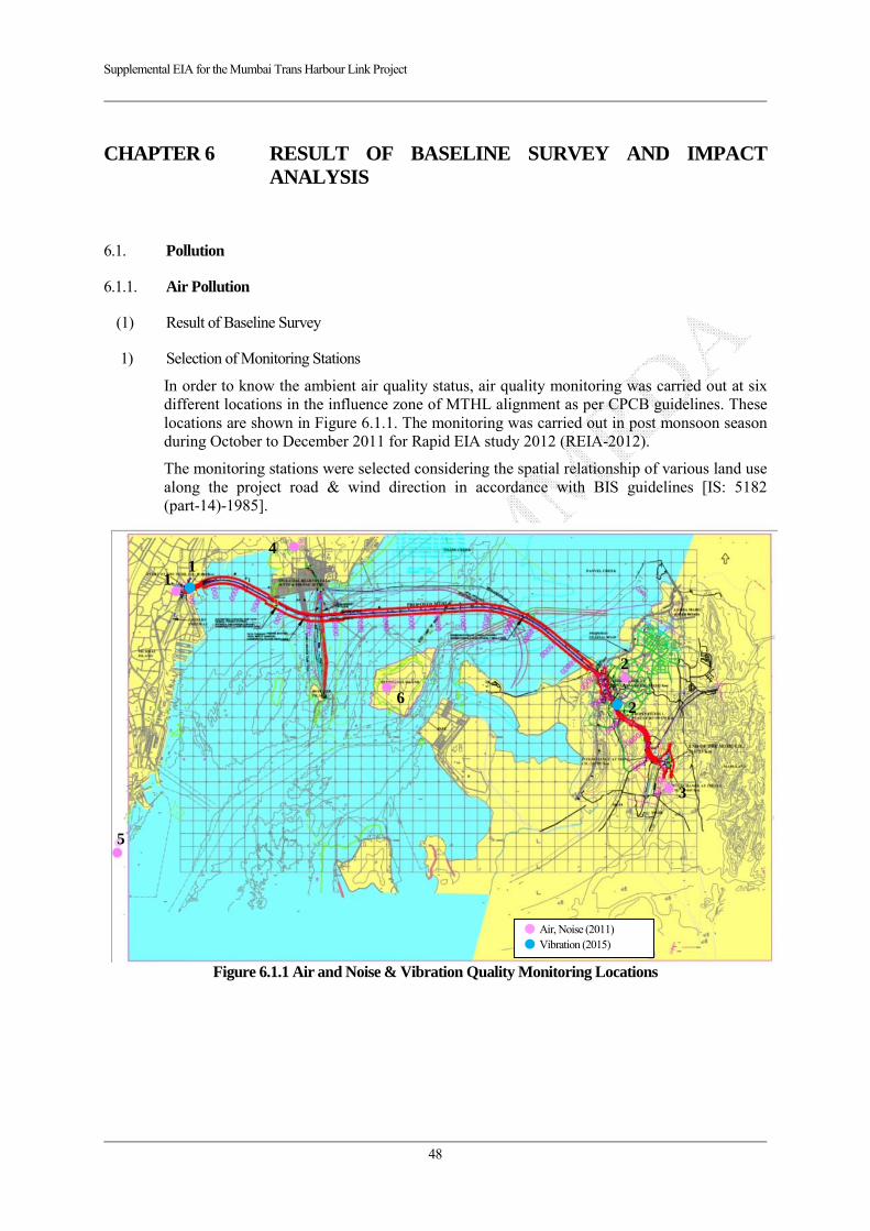
Supplemental EIA for the Mumbai Trans Harbour Link Project
48
CHAPTER 6 RESULT OF BASELINE SURVEY AND IMPACT ANALYSIS
6.1. Pollution
6.1.1. Air Pollution
(1) Result of Baseline Survey
1) Selection of Monitoring Stations
In order to know the ambient air quality status, air quality monitoring was carried out at six different locations in the influence zone of MTHL alignment as per CPCB guidelines. These locations are shown in Figure 6.1.1. The monitoring was carried out in post monsoon season during October to December 2011 for Rapid EIA study 2012 (REIA-2012).
The monitoring stations were selected considering the spatial relationship of various land use along the project road & wind direction in accordance with BIS guidelines [IS: 5182 (part-14)-1985].
Figure 6.1.1 Air and Noise & Vibration Quality Monitoring Locations
● Air, Noise (2011) ● Vibration (2015)
1
2
3
6
5
4 1
2
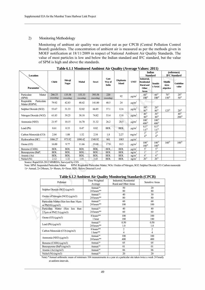
Supplemental EIA for the Mumbai Trans Harbour Link Project
49
2) Monitoring Methodology
Monitoring of ambient air quality was carried out as per CPCB (Central Pollution Control Board) guidelines. The concentration of ambient air is measured as per the methods given in MOEF notification at 18/11/2009 in respect of National Ambient Air Quality Standards. The value of most particles is low and below the Indian standard and IFC standard, but the value of SPM is high and above the standards.
Table 6.1.1 Monitored Ambient Air Quality (Average Values: 2011)
Location
Parameter
Chirle Shivaji Nagar
Mahul Sewri Gate
Way of India
Elephanta Island
UNIT
Indian Standard
(reference)IFC Standard
Industrial, Residential Rural and
Other Areas
Sensitive Areas
Middle term
objective
Guideline value
Particulate Matter (SPM)
266.33(exceeding)
135.58 (exceeding)
153.33 (exceeding)
393.58 (exceeding)
220 (exceeding)
92 µg/m3 601) 1002)
601) 1002)
701) 1502)
201) 502)
Respirable Particulate Matter (RSPM)
79.92 42.83 48.42 141.00 48.5 24 µg/m3
Sulphur Dioxide (SO2) 53.67 31.33 32.02 66.85 37.1 12.6 µg/m3 501) 802)
201) 802)
1252)
202)
Nitrogen Dioxide (NO2) 61.83 39.25 38.18 74.82 53.4 13.8 µg/m3 401) 802)
301) 802)
401) 2002)
Ammonia (NH3) 21.97 10.15 16.70 31.32 26.2 28.5 µg/m3 1001) 4002)
1001) 4002)
Lead (Pb) 0.61 0.33 0.47 0.82 BDL BDL µg/m3 0.51) 1.02)
0.51) 1.02)
Carbon Monoxide (CO) 2.04 1.08 1.52 2.54 1.8 2.27 mg/m3 23) 44)
23) 44)
Hydrocarbon (HC) 1086.27 973.92 1090.42 1348.92 861 1083 µg/m3
Ozone (O3) 16.00 9.77 11.66 19.68 17.8 10.5 µg/m3 1003) 1804)
1003) 1804)
1603) 1003)
Benzene (C6H6) BDL BDL BDL BDL BDL BDL µg/m3 51) 51)
Benzopyrene (BaP) BDL BDL BDL BDL BDL BDL ng/m3 11) 11)
Arsenic (As) BDL BDL BDL BDL BDL BDL ng/m3 61) 61)
Nickel (Ni) 2.12 1.32 1.81 3.43 BDL BDL ng/m3 201) 201)
Source: Rapid EIA 2012 MMRDA, Surveyed by CES Note: SPM: Suspended Particulate Matter RPM: Respirable Particulate Matter, NOx: Oxides of Nitrogen, SO2: Sulphur Dioxide, CO: Carbon monoxide 1)= Annual, 2)=24hours, 3)= 8hours, 4)=1hour, BDL: Below Detected Level
Table 6.1.2 Ambient Air Quality Monitoring Standards (CPCB)
Pollutant Time Weighted
Average Industrial, Residential Rural and Other Areas
Sensitive Areas
Sulphur Dioxide (SO2) ( g/m3) Annual *
24 hours** 50 80
20 80
Oxides of Nitrogen (NO2) ( g/m3) Annual *
24 hours** 40 80
30 80
Particulate Matter (Size less than 10 m or PM10) ( g/m3)
Annual * 24 hours**
60 100
60 100
Particulate Matter (Size less than 2.5 m or PM2.5) ( g/m3)
Annual * 24 hours**
40 60
40 60
Ozone (O3) ( g/m3) 8 hours**
1 hour 100 180
100 180
Lead (Pb) ( g/m3) Annual *
24 hours** 0.50 1.0
0.50 1.0
Carbon Monoxide (CO) (mg/m3) 8 hours** 1 hour**
2 4
2 4
Ammonia (NH3) ( g/m3) Annual *
24 hours** 100 400
100 400
Benzene (C6H6) ( g/m3) Annual * 05 05 Benzopyrene (BaP) (ng/m3) Annual * 01 01 Arsenic (As) (ng/m3) Annual * 06 06 Nickel (Ni) (ng/m3) Annual * 20 20 Note) *Annual arithmetic mean of minimum 104 measurements in a year at a particular site taken twice a week 24 hourly
at uniform intervals.
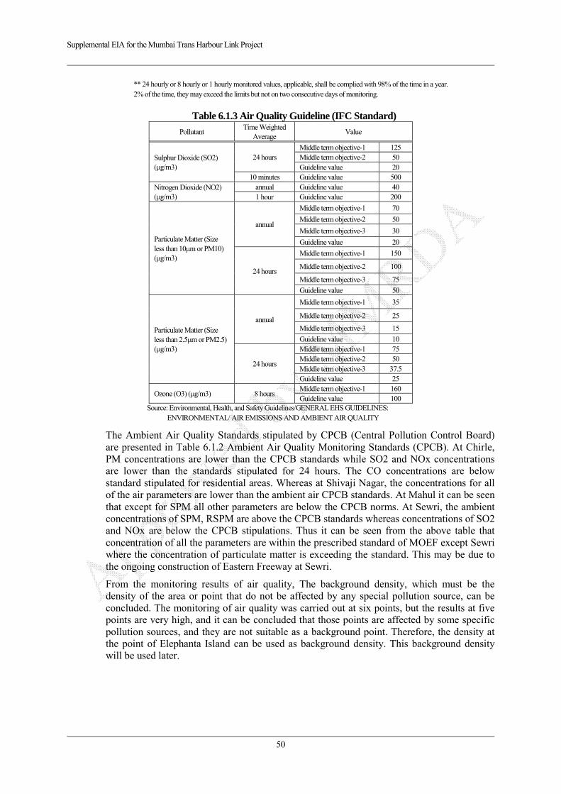
Supplemental EIA for the Mumbai Trans Harbour Link Project
50
** 24 hourly or 8 hourly or 1 hourly monitored values, applicable, shall be complied with 98% of the time in a year. 2% of the time, they may exceed the limits but not on two consecutive days of monitoring.
Table 6.1.3 Air Quality Guideline (IFC Standard)
Pollutant Time Weighted
AverageValue
Sulphur Dioxide (SO2) ( g/m3)
24 hours Middle term objective-1 125 Middle term objective-2 50 Guideline value 20
10 minutes Guideline value 500 Nitrogen Dioxide (NO2) ( g/m3)
annual Guideline value 40 1 hour Guideline value 200
Particulate Matter (Size less than 10 m or PM10) ( g/m3)
annual
Middle term objective-1 70
Middle term objective-2 50
Middle term objective-3 30
Guideline value 20
24 hours
Middle term objective-1 150
Middle term objective-2 100
Middle term objective-3 75
Guideline value 50
Particulate Matter (Size less than 2.5 m or PM2.5) ( g/m3)
annual
Middle term objective-1 35
Middle term objective-2 25
Middle term objective-3 15
Guideline value 10
24 hours
Middle term objective-1 75 Middle term objective-2 50 Middle term objective-3 37.5 Guideline value 25
Ozone (O3) ( g/m3) 8 hours Middle term objective-1 160 Guideline value 100
Source: Environmental, Health, and Safety Guidelines/GENERAL EHS GUIDELINES: ENVIRONMENTAL/ AIR EMISSIONS AND AMBIENT AIR QUALITY
The Ambient Air Quality Standards stipulated by CPCB (Central Pollution Control Board) are presented in Table 6.1.2 Ambient Air Quality Monitoring Standards (CPCB). At Chirle, PM concentrations are lower than the CPCB standards while SO2 and NOx concentrations are lower than the standards stipulated for 24 hours. The CO concentrations are below standard stipulated for residential areas. Whereas at Shivaji Nagar, the concentrations for all of the air parameters are lower than the ambient air CPCB standards. At Mahul it can be seen that except for SPM all other parameters are below the CPCB norms. At Sewri, the ambient concentrations of SPM, RSPM are above the CPCB standards whereas concentrations of SO2 and NOx are below the CPCB stipulations. Thus it can be seen from the above table that concentration of all the parameters are within the prescribed standard of MOEF except Sewri where the concentration of particulate matter is exceeding the standard. This may be due to the ongoing construction of Eastern Freeway at Sewri.
From the monitoring results of air quality, The background density, which must be the density of the area or point that do not be affected by any special pollution source, can be concluded. The monitoring of air quality was carried out at six points, but the results at five points are very high, and it can be concluded that those points are affected by some specific pollution sources, and they are not suitable as a background point. Therefore, the density at the point of Elephanta Island can be used as background density. This background density will be used later.
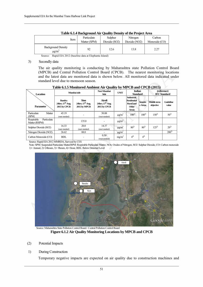
Supplemental EIA for the Mumbai Trans Harbour Link Project
51
Table 6.1.4 Background Air Quality Density of the Project Area
ItemParticulate
Matter (SPM) Sulphur
Dioxide (SO2) Nitrogen
Dioxide (NO2) Carbon
Monoxide (CO)
Background Density µg/m3
92 12.6 13.8 2.27
Source: Rapid EIA 2012 (baseline data at Elephanta Island)
3) Secondly data
The air quality monitoring is conducting by Maharashtra state Pollution Control Board (MPCB) and Central Pollution Control Board (CPCB). The nearest monitoring locations and the latest data are monitored data is shown below. All monitored data indicated under standard level due to monsoon season.
Table 6.1.5 Monitored Ambient Air Quality by MPCB and CPCB (2015)
Location
Parameter
Mumbai side Navi Mumbai
Side UNIT
IndianStandard
(reference)IFC Standard
Bandra 24hrs; 17th Aug. 2015 by CPCB
Sion 24hrs; 17th Aug. 2015 by MPCB
Airoli 24hrs; 17th Aug. 2015 by CPCB
Industrial, Residential Rural and
Other Areas
Sensitive Areas
Middle term objective
Guideline value
Particulate Matter (SPM)
45.19 (meet standard)
- 50.88 (meet standard)
µg/m3 1002) 1002) 1502) 502)
Respirable Particulate Matter (RSPM) 135.0 - µg/m3
Sulphur Dioxide (SO2) 16.33
(meet standard)
20.0 (meet standard)
14.37 (meet standard)
µg/m3 802) 802) 1252) 202)
Nitrogen Dioxide (NO2) 26.62 88.0 - µg/m3 2002)
Carbon Monoxide (CO) BDL - 0.50 (meet standard)
mg/m3 44) 44)
Source: Rapid EIA 2012 MMRDA, Survyed by CES Note: SPM: Suspended Particulate Matter RPM: Respirable Particulate Matter, NOx: Oxides of Nitrogen, SO2: Sulphur Dioxide, CO: Carbon monoxide 1)= Annual, 2)=24hours, 3)= 8hours, 4)=1hour, BDL: Below Detected Level
Source: Maharashtra State Pollution Control Board / Central Pollution Control Board
Figure 6.1.2 Air Quality Monitoring Locations by MPCB and CPCB
(2) Potential Impacts
1) During Construction
Temporary negative impacts are expected on air quality due to construction machines and
Bandra
Sion
Airoli
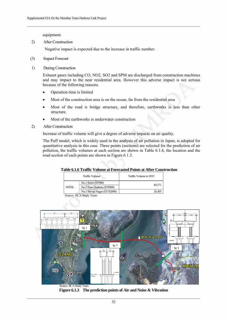
Supplemental EIA for the Mumbai Trans Harbour Link Project
52
equipment.
2) After Construction
Negative impact is expected due to the increase in traffic number.
(3) Impact Forecast
1) During Construction
Exhaust gases including CO, NO2, SO2 and SPM are discharged from construction machines and may impact to the near residential area. However this adverse impact is not serious because of the following reasons.
Operation time is limited
Most of the construction area is on the ocean, far from the residential area
Most of the road is bridge structure, and therefore, earthworks is less than other structure.
Most of the earthworks is underwater construction
2) After Construction
Increase of traffic volume will give a degree of adverse impacts on air quality.
The Puff model, which is widely used in the analysis of air pollution in Japan, is adopted for quantitative analysis in this case. Three points (sections) are selected for the prediction of air pollution, the traffic volumes at each section are shown in Table 6.1.6, the location and the road section of each points are shown in Figure 6.1.3.
Table 6.1.6 Traffic Volume at Forecasted Points at After Construction
Traffic Volume Traffic Volume in 2032
MTHL
No.1 Sewri (ST500)89,371
No.2 Near Elephata (ST8800)
No.3 Shivaji Nagar (ST182000) 26,505 Source: JICA Study Team
Source: JICA Study Team
Figure 6.1.3 The prediction points of Air and Noise & Vibration
St.1
St.2St.3
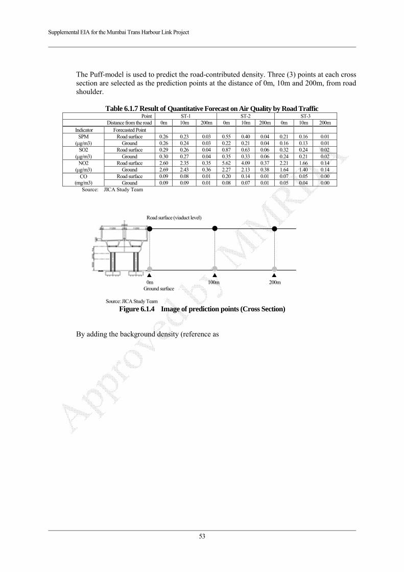
Supplemental EIA for the Mumbai Trans Harbour Link Project
53
The Puff-model is used to predict the road-contributed density. Three (3) points at each cross section are selected as the prediction points at the distance of 0m, 10m and 200m, from road shoulder.
Table 6.1.7 Result of Quantitative Forecast on Air Quality by Road Traffic Point ST-1 ST-2 ST-3
Distance from the road 0m 10m 200m 0m 10m 200m 0m 10m 200m Indicator Forecasted Point
SPM ( g/m3)
Road surface 0.26 0.23 0.03 0.55 0.40 0.04 0.21 0.16 0.01 Ground 0.26 0.24 0.03 0.22 0.21 0.04 0.16 0.13 0.01
SO2 ( g/m3)
Road surface 0.29 0.26 0.04 0.87 0.63 0.06 0.32 0.24 0.02 Ground 0.30 0.27 0.04 0.35 0.33 0.06 0.24 0.21 0.02
NO2 ( g/m3)
Road surface 2.60 2.35 0.35 5.62 4.09 0.37 2.21 1.66 0.14 Ground 2.69 2.43 0.36 2.27 2.13 0.38 1.64 1.40 0.14
CO (mg/m3)
Road surface 0.09 0.08 0.01 0.20 0.14 0.01 0.07 0.05 0.00 Ground 0.09 0.09 0.01 0.08 0.07 0.01 0.05 0.04 0.00
Source: JICA Study Team
Source: JICA Study Team
Figure 6.1.4 Image of prediction points (Cross Section)
By adding the background density (reference as
▲ ▲ ▲ 0m 100m 200m
Road surface (viaduct level)
Ground surface
Supplemental EIA for the Mumbai Trans Harbour Link Project
54
Table 6.1.4) to the road-contributed density, the comprehensive density of each station points is obtained as following. The density at all three points is below Indian standard and IFC standard.
Table 6.1.8 Result of Comprehensive Quantitative Forecast on Air Quality Point ST-1 ST-2 ST-3
Standard Distance from the road 0m 10m 200m 0m 10m 200m 0m 10m 200m
Indicator Forecasted Point SPM
( g/m3) Road surface 92.3 92.2 92.0 92.6 92.4 92.0 92.2 92.2 92.0
1001) Ground 92.3 92.2 92.0 92.2 92.2 92.0 92.2 92.1 92.0
SO2 ( g/m3)
Road surface 12.9 12.9 12.6 13.5 13.2 12.7 12.9 12.8 12.6 801)
Ground 12.9 12.9 12.6 12.9 12.9 12.7 12.8 12.8 12.6 NO2
( g/m3) Road surface 16.4 16.1 14.2 19.4 17.9 14.2 16.0 15.5 13.9
2002) Ground 16.5 16.2 14.2 16.1 15.9 14.2 15.4 15.2 13.9
CO (mg/m3)
Road surface 2.36 2.35 2.28 2.47 2.41 2.28 2.34 2.32 2.27 103)
Ground 2.36 2.36 2.28 2.35 2.34 2.28 2.32 2.31 2.27 Note: 1)= Indian standard 2)=IFC standard, 3)= Japan Standard Source: JICA Study Team
As a reference, the density of the monitoring points on Rapid EIA 2012 are also calculated, the results are shown below.

Supplemental EIA for the Mumbai Trans Harbour Link Project
55
Table 6.1.9 Quantitative Forecasted Air Quality Values at Monitored Points
Location Chirle Shivaji Nagar
Mahul Sewri Gate Way of India
Elephanta Island
Parameter composition
Particulate Matter (SPM, g/m3)
Observed(2011) 266.33 135.58 153.33 393.58 220 92 Road-contributed 0.04 0.01 0.04 0.03 0.04 0.04 Total 266.37 135.59 153.37 393.61 220.04 92.04
Sulphur Dioxide (SO2, g/m3)
Observed(2011) 53.67 31.33 32.02 66.85 37.1 12.6 Road-contributed 0.06 0.02 0.06 0.04 0.06 0.06 Total 53.73 31.35 32.08 66.89 37.16 12.66
Nitrogen Dioxide (NO2, g/m3)
Observed(2011) 61.83 39.25 38.18 74.82 53.4 13.8 Road-contributed 0.38 0.14 0.38 0.36 0.38 0.38 Total 62.21 39.39 38.56 75.18 53.78 14.18
Carbon Monoxide (CO, mg/m3))
Observed(2011) 2.04 1.08 1.52 2.54 1.8 2.27 Road-contributed 0.01 0.00 0.01 0.01 0.01 0.01 Total 2.05 1.08 1.53 2.55 1.81 2.28
Source: Baseline data is from Rapid EIA 2012, / Forecasted data : JICA Study Team
As shown above, the density at some observed points is higher than Indian standard since the current density (observed value on the Rapid EIA) is exceeding the standard values. However, the impact by the MTHL is negligible since the road-contributed density to the monitoring points is too low to be nearly zero.
(4) Mitigation Measures
1) During Construction
Water sprinkling shall be carried out on earth road and construction yard near residential area
2) After Construction
Appropriate land use management will be done along the road (commercial and industrial area)
(5) Evaluation
1) During Construction
Exhaust gases and dusts may be produced during construction. However the adverse impact is not serious because of far distance from residential area, bridge structure, underwater construction etc., and the impacts can be minimized further by mitigation measures.
2) After Construction
Air quality such as PM10, CO, NO2 and SO2 density increases along the road during operation phase. However the density-increasing area is very limited, and road-contributed density is very small, and the total density at roadside point is below standard values, thus it is not likely to give significant impacts on air quality in the future.
6.1.2. Water Pollution
(1) Result of Baseline Survey
1) Survey Area
The survey area of water quality includes Thane creek, flanked by Sewri mud-flats & Shivaji Nagar mud-flats on either side. For survey purpose, the area was divided into 3 zones:
Zone II : Sewri mud- flat
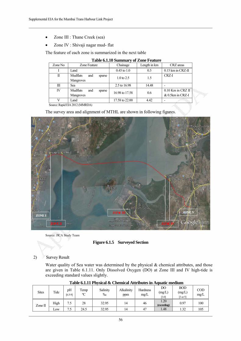
Supplemental EIA for the Mumbai Trans Harbour Link Project
56
Zone III : Thane Creek (sea)
Zone IV : Shivaji nagar mud- flat
The feature of each zone is summarized in the next table
Table 6.1.10 Summary of Zone Feature Zone No Zone Feature Chainage Length in km CRZ areas
I Land 0.45 to 1.0 0.5 0.15 km in CRZ-II
II Mudflats and sparse Mangroves
1.0 to 2.5 1.5 CRZ-I
III Sea 2.5 to 16.98 14.48 -
IV Mudflats and sparse Mangroves
16.98 to 17.58 0.6 0.10 Km in CRZ II & 0.5km in CRZ-I
V Land 17.58 to 22.00 4.42 - Source: Rapid EIA 2012 (MMRDA)
The survey area and alignment of MTHL are shown in following figures.
Source: JICA Study Team
Figure 6.1.5 Surveyed Section
2) Survey Result
Water quality of Sea water was determined by the physical & chemical attributes, and those are given in Table 6.1.11. Only Dissolved Oxygen (DO) at Zone III and IV high-tide is exceeding standard values slightly.
Table 6.1.11 Physical & Chemical Attributes in Aquatic medium
Sites Tide pH
[6.5-9]
Temp ºC
Salinity ‰
Alkalinityppm
Hardness mg/L
DO (mg/L)
[3.0]
BOD (mg/L) [3 or 5]
COD mg/L
Zone II High 7.5 28 32.95 14 46
1.20(exceeding)
0.97 100
Low 7.5 24.5 32.95 14 47 1.48 1.32 105
ZONE I
ZONE II
ZONE III
ZONE IV
ZONE V
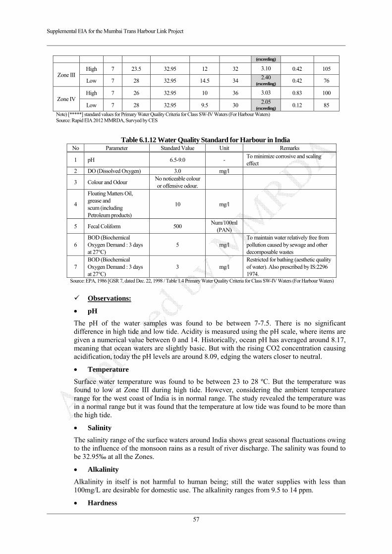
Supplemental EIA for the Mumbai Trans Harbour Link Project
57
(exceeding)
Zone III High 7 23.5 32.95 12 32 3.10 0.42 105
Low 7 28 32.95 14.5 34 2.40
(exceeding)0.42 76
Zone IV High 7 26 32.95 10 36 3.03 0.83 100
Low 7 28 32.95 9.5 30 2.05
(exceeding)0.12 85
Note) [*****] standard values for Primary Water Quality Criteria for Class SW-IV Waters (For Harbour Waters) Source: Rapid EIA 2012 MMRDA, Survyed by CES
Table 6.1.12 Water Quality Standard for Harbour in India No Parameter Standard Value Unit Remarks
1 pH 6.5-9.0 - To minimize corrosive and scaling effect
2 DO (Dissolved Oxygen) 3.0 mg/l
3 Colour and Odour No noticeable colour or offensive odour.
4
Floating Matters Oil, grease and scum (including Petroleum products)
10 mg/l
5 Fecal Coliform 500 Num/100ml
(PAN)
6 BOD (Biochemical Oxygen Demand : 3 days at 27°C)
5 mg/l To maintain water relatively free from pollution caused by sewage and other decomposable wastes
7 BOD (Biochemical Oxygen Demand : 3 days at 27°C)
3 mg/l Restricted for bathing (aesthetic quality of water). Also prescribed by IS:2296 1974.
Source: EPA, 1986 [GSR 7, dated Dec. 22, 1998 / Table 1.4 Primary Water Quality Criteria for Class SW-IV Waters (For Harbour Waters)
Observations:
pH
The pH of the water samples was found to be between 7-7.5. There is no significant difference in high tide and low tide. Acidity is measured using the pH scale, where items are given a numerical value between 0 and 14. Historically, ocean pH has averaged around 8.17, meaning that ocean waters are slightly basic. But with the rising CO2 concentration causing acidification, today the pH levels are around 8.09, edging the waters closer to neutral.
Temperature
Surface water temperature was found to be between 23 to 28 ºC. But the temperature was found to low at Zone III during high tide. However, considering the ambient temperature range for the west coast of India is in normal range. The study revealed the temperature was in a normal range but it was found that the temperature at low tide was found to be more than the high tide.
Salinity
The salinity range of the surface waters around India shows great seasonal fluctuations owing to the influence of the monsoon rains as a result of river discharge. The salinity was found to be 32.95‰ at all the Zones.
Alkalinity
Alkalinity in itself is not harmful to human being; still the water supplies with less than 100mg/L are desirable for domestic use. The alkalinity ranges from 9.5 to 14 ppm.
Hardness
Supplemental EIA for the Mumbai Trans Harbour Link Project
58
Hardness was found to be in the range of 30 to 47mg/L
DO
DO values range between 1.2 to 3.1 mg/l. Only Dissolved Oxygen (DO) at Zone III and IV high-tide is exceeding standard values slightly.
BOD
During the recent study the BOD1 varied from 0.12 mg/L to 1.32 mg/L. The BOD was found to be lowest at Zone III during low tide. The BOD values were found to be comparable to that of standard value. High BOD values results from high oxygen demanding substances disposed to coastal waters. It is suggested that the sewage contamination may be less in these areas.
COD
The COD was found to be highest at low tide at Zone II and high tide at Zone III with values 105 mg/L; and within acceptable limits of 250 mg/L.
(2) Potential Impacts
1) During Construction
Turbid water may be generated by earth works and excavation in the sea where bridges are planned to be constructed. Additionally spillage of oil and grease from construction machines and storage in the construction yard may be caused when maintenance of machines and storage is not appropriate. Organic polluted water will be generated from labor camp site.
2) After Construction
No permanent impact is anticipated on water quality due to no construction of service area.
(3) Impact Forecast
1) During Construction
Turbid water may be generated by earth works and excavation.
According to other casesNote 1), the impacted density of suspended solid (SS) in 250m from excavated point is around 4mg/l and 2mg/l out of 250m without any mitigation measures respectively.
Thus this turbid water may give impacts on fauna-flora spceies within 250m range from the excavated point since Japanese standard of Fisheries Water indicates 2 mg/l.
This standar value 2mg/l means additional impacted SS density, not absolute values in the water body.
Therefore, the impact on water quality during construction may give impact within 250m from the excavated point, however it is insignificant out of 250m. Thus appropriate mitigation measures for reduction of SS within 250m from excavated area shall be prepared.
Note1) Environmental impact assessment report of island-city motorway, Fukuoka Prefecture, June 2013.
With regard to impacts by labor campsite, leaking oil and grease from machines and storage, such adverse impacts will be avoided and/or mitigated by appropriate management and maintenance.
2) After Construction
No adverse impacts are expected due to no-activities which discharges polluted water from
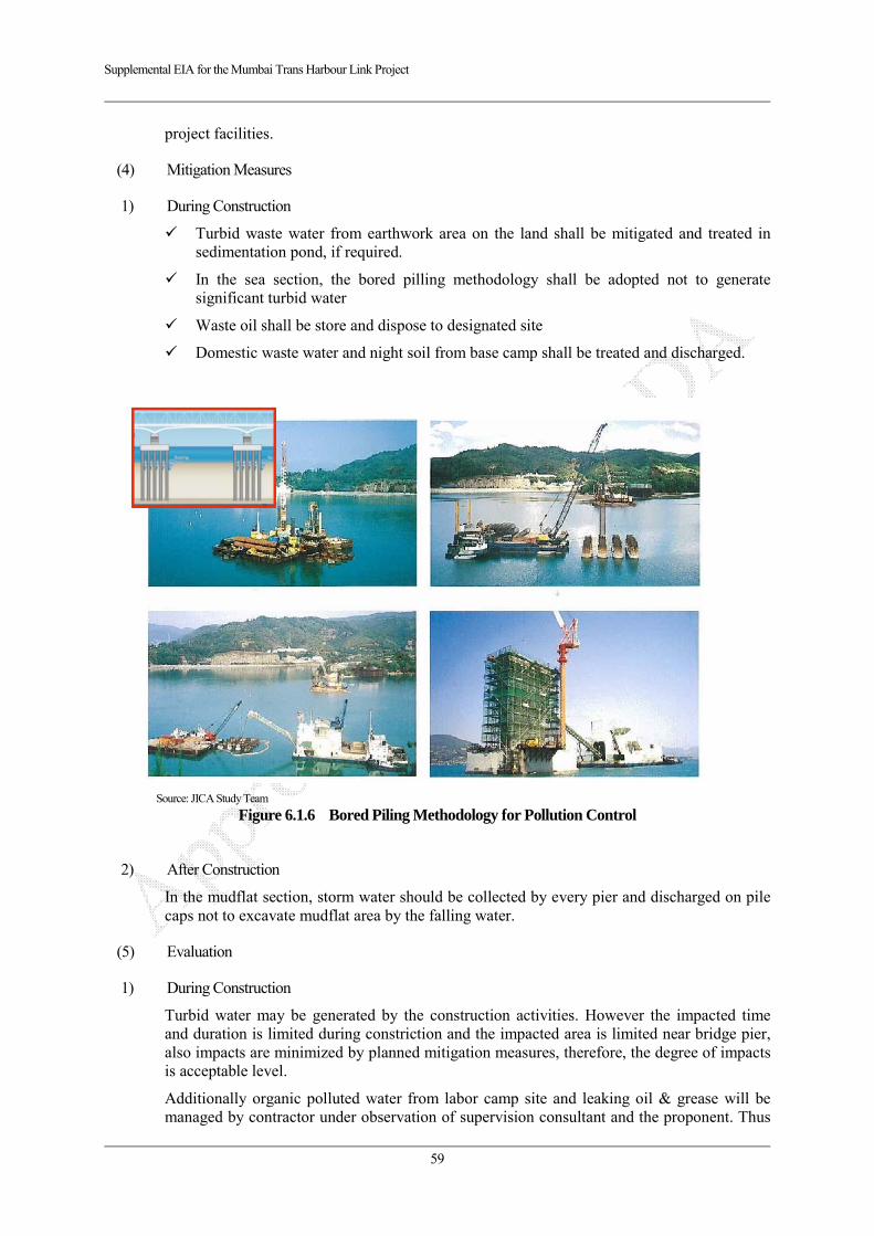
Supplemental EIA for the Mumbai Trans Harbour Link Project
59
project facilities.
(4) Mitigation Measures
1) During Construction
Turbid waste water from earthwork area on the land shall be mitigated and treated in sedimentation pond, if required.
In the sea section, the bored pilling methodology shall be adopted not to generate significant turbid water
Waste oil shall be store and dispose to designated site
Domestic waste water and night soil from base camp shall be treated and discharged.
Source: JICA Study Team
Figure 6.1.6 Bored Piling Methodology for Pollution Control
2) After Construction
In the mudflat section, storm water should be collected by every pier and discharged on pile caps not to excavate mudflat area by the falling water.
(5) Evaluation
1) During Construction
Turbid water may be generated by the construction activities. However the impacted time and duration is limited during constriction and the impacted area is limited near bridge pier, also impacts are minimized by planned mitigation measures, therefore, the degree of impacts is acceptable level.
Additionally organic polluted water from labor camp site and leaking oil & grease will be managed by contractor under observation of supervision consultant and the proponent. Thus

Supplemental EIA for the Mumbai Trans Harbour Link Project
60
these impacts are prevented appropriately.
6.1.3. Waste
(1) Result of Baseline Survey
In general, domestic waste from household is discharge to designated waste box, and the township collected all waste from the box and disposes them to designated dumping site, namely Deonar and Mulund dumping site in Mumbai and Turbhe in Navi Mumbai. Night soil in the city area is treated in sewerage plant namely Zone1-7 treatment plants in Mumbai and 7 sewerage treatment plants in Navi Mumbai respectively.
With regard to construction waste such as concrete and cutting trees are used for construction material. Muck soil also shall be tested, treated and disposed at designated site under relevant laws such as environmental protection law.
(2) Potential Impacts
1) During Construction
Construction waste such as muck soil & cut mangrove trees in the sea section, waste soil in the land section, temporary structures and cutting trees are expected. Additionally domestic waste, waste water and night soil may be generated from construction labor camp.
2) After Construction
No impacts are expected from project activities due to no facilities which generate liquid and solid waste such as a service area.
(3) Impact Forecast
1) During Construction
Estimated waste volume on each item is shown below.
Table 6.1.13 Estimated Waste in the Project Area Type of Waste Estimated Volume
1. Muck Soil in the Sea note1) 98,910 m3
2. Waste Soil on the Land note1) 2,374 m3
3. Trees in CRZ note2) 13.9 m3 4. Domestic waste and general waste (mainly from labor campsite) note3)
756 kg/day
Note1): Sea section: 17.5km/ 0.05km/span x 8piles/span x 20m/depth x pile area (0.75*0.75*PI) Note2): Mangrove lost area on CRZ clearance 0.1776 ha x 5000 trees/ha x 0.05m*0.05m*PI*2m Note3): 0.51 kg waste/person in Mumbai * number of labour in the camp site (3,000 x 0.5 workers/ day)
Excavated muck soil from the sea section is estimated around 99,000 m3, and general waste soil on the land section is 2,400m3 respectively. Additionally cutting mangrove volume is app. 13.9m3. Domestic waste and night soil is generated at base camp for workers, estimated volume is around 760kg/day.
2) After Construction
Basically no waste from MTHL project, thus almost no impacts on this item.

Supplemental EIA for the Mumbai Trans Harbour Link Project
61
(4) Mitigation Measures
1) During Construction
Construction waste (trees and waste soil including much soil)
After considering the possibility of reuse, construction waste shall be disposed at designated disposal site after treating (totally 14 designated direct landfill site in Mumbai and Navi Mumbai)
Garbage from base camp
Garbage at workers camp and waste oil shall be brought to designated disposal site or facility
Night soil
Water treatment facility such as septic tank shall be introduced to the workers camp.
(5) Evaluation
1) During Construction
All generated construction waste and domestic waste are reused and/or disposed under adequate mitigation measures, thus it is not likely to give significant impacts on this item.
6.1.4. Soil Contamination and Sediment Quality
(1) Result of Baseline Survey
According to Rapid EIA 2012, following monitored data is indicated. Only density of Lead is exceeding standard level.
Table 6.1.14 Soil Quality Survey Results on Rapid EIA 2012
Site
Monitored Item (Standard Values) Zinc mg/l
(no standard)
Copper µg/l
(no standard)
Total Manganese
mg/l
Lead mg/l
(0.01mg/l)
Cadmium mg/l
(0.01mg/l)
Iron µg/l
Cobalt mg/l
Zone I (Sewri: Land) 1,800 Absence AbsenceZone II (Sewri: Sea)
- 2,000 0.483(Exceeding)
0.00084 (Not exceed)
Absence Absence
Zone III (Sea) - 0.000053 Absence AbsenceZone IV(Shivaji Nagar)
250 1,500 Absence 0.498(Exceeding)
0.0006 (Not exceed)
Absence Absence
Zone V - Absence AbsenceNote) this table was made based on the description of Rapid EIA 2012 Source: Rapid EIA 2012
Table 6.1.15 Environmental Standard for Soil Pollution Substance Target level of soil quality examined through leaching and content tests
1. cadmium 0.01 mg/l in sample solution and less than 0.4mg/kg in rice for agricultural land
2. total cyanide not detectable in sample solution
3. organic phosphorus not detectable in sample solution
4. lead 0.01 mg/l or less in sample solution 5. chromium (VI) 0.05 mg/l or less in sample solution
6. arsenic 0.01 mg/l or less in sample solution, and less than 15 mg/kg in soil for agricultural land (paddy fields only)
7. total mercury 0.0005 mg/l or less in sample solution 8. alkyl mercury not detectable in sample solution 9. PCBs not detectable in sample solution 10. copper less than 125 mg/kg in soil for agricultural land (paddy fields only) 11. dichloromethane 0.02 mg/l or less in sample solution 12. carbon tetrachloride 0.002 mg/l or less in sample solution
Supplemental EIA for the Mumbai Trans Harbour Link Project
62
13. 1,2-dichloroethane 0.004 mg/l or less in sample solution 14. 1,1-dichloroethylene 0.02 mg/l or less in sample solution 15. cis-1,2-dichloroethylene 0.04 mg/l or less in sample solution 16. 1,1,1-trichloroethane 1 mg/l or less in sample solution 17. 1,1,2-trichloroethane 0.006 mg/l or less in sample solution 18. trichloroethylene 0.03 mg/l or less in sample solution 19. tetrachloroethylene 0.01 mg/l or less in sample solution 20. 1,3-dichloropropene 0.002 mg/l or less in sample solution 21. thiuram 0.006 mg/l or less in sample solution 22. simazine 0.003 mg/l or less in sample solution 23. thiobencarb 0.02 mg/l or less in sample solution 24. benzene 0.01 mg/l or less in sample solution 25. selenium 0.01 mg/l or less in sample solution The above standards are not applicable to:
1) Places where natural toxic substances exist such as near mineral veins, and 2) Places designated for storage of toxic materials such as waste disposal sites.
Note) Prescript treatment methodology for polluted soils is not established yet under Indian laws and regulation at the moment. Thus DUTCH Guidelines for Contamination Assessment of Soil is used in India.
Source: Ministry of Environment and Forests in India
Zinc : Zinc was found to be around 250 mg/l in Zone IV & around 1,800 mg/l in Zone I.
Copper: Zone II and Zone IV showed 2,000 and 1,500 µg/l.
Manganese: The total manganese was found to be absent in Zone IV. Zone III showed the presence of 0.000053 mg/L of Manganese.
Lead: Zone II and Zone IV showed 0.483 and 0.498 mg/l with exceeding standard value.
Cadmium: Cadmium was found to be around 0.00084 mg/L and 0.00061 mg/L in Zone II and Zone IV.
Iron: There was complete absence of iron in the sediments.
Cobalt: There was complete absence of iron in the sediments.
(2) Potential Impacts
1) During Construction
Construction waste soil such as muck soil from the piling points in the sea section and cutting soil from earthwork area is generated. The muck soil may be polluted based on the baseline survey and may give adverse impacts where dumping site of the waste soil.
2) After Construction
No impacts are expected from project activities.
(3) Impact Forecast
1) During Construction
Excavated muck soil from the sea section is estimated around 99,000 m3, and general waste soil on the land section is 2,400m3 respectively.
Table 6.1.16 Estimated Waste in the Project Area Type of Waste Estimated Volume
1. Muck Soil in the Sea note1) 98,910 m3
2. Waste Soil on the Land note1) 2,374 m3 Note1): Sea section: 17.5km/ 0.05km/span x 8piles/span x 20m/depth x pile area (0.75*0.75*PI)

Supplemental EIA for the Mumbai Trans Harbour Link Project
63
(4) Mitigation Measures
1) During Construction
Polluted excavated soil including muck soil shall be treated, and then reused and/or disposed at designated site in accordance relevant laws and regulations.
(5) Evaluation
1) During Construction
All generated construction waste soil are reused and/or disposed after soil analysis under relevant laws, thus it is not likely to give significant impacts on this item.
6.1.5. Noise and Vibration
(1) Result of Baseline Survey
1) Noise
Monitored Ambient Noise
Ambient noise monitoring was carried out as per IS: 3029-1980 to know the existing ambient noise levels in the study area of MTHL at the same locations as discussed in air quality as shown in Figure 6.1.1. The analysis of the monitoring is presented in Table 6.1.17. Permissible standards prescribed by CPCB are presented in Table 6.1.19.
It can be observed that the existing noise levels are exceeding the permissible limit excepting Mahul near power plant industrial area.
Table 6.1.17 Ambient Noise Level (Monitored in 2011)
Location (Area Code) Date
Noise Levels in dB(A) StandardLeq Leq
Lmax Lmin L90 L50 L10 Leq: day/night(Day) (Night)
1. Sewri (A)
03/10/11 to 05/10/11 76
(Exceeding)61.1 80 50 54 72 78 75/70
10/10/11 to 12/10/11 75.4
(Exceeding)60.5 80 50 53 72 78 75/70
20/10/11 to 22/10/11 75.4
(Exceeding)61.6 80 50 53 72 78 75/70
29/10/11 to 31/10/11 76
(Exceeding)62.6 80 50 54 72 79 75/70
1/12/11 to 03/12/11 75.8
(Exceeding)61.8 80 50 53 72 79 75/70
07/12/11 to 09/12/11 76
(Exceeding)61.9 80 50 52 73 79 75/70
14/12/11 to 16/12/11 75.8
(Exceeding)61.8 80 50 52 73 79 75/70
21/12/11 to 23/12/11 76
(Exceeding)61.9 80 50 52 73 79 75/70
2. Shivaji Nagar (C)
03/10/11 to 05/10/11 62.6
(Exceeding)54.6
(Exceeding)69 44 46 59 65 55/45
10/10/11 to 12/10/11 62.1
(Exceeding)56.2
(Exceeding)69 44 47 59 64 55/45
20/10/11 to 22/10/11 62.1
(Exceeding)56.4
(Exceeding)69 44 48 59 64 55/45
29/10/11 to 31/10/11 62.3
(Exceeding)54.4
(Exceeding)69 44 58 63 53 55/45
1/12/11 to 03/12/11 62.2
(Exceeding)55.3
(Exceeding)69 44 46 59 65 55/45
07/12/11 to 09/12/11 62.3
(Exceeding)55.6
(Exceeding)69 44 45 60 65 55/45
14/12/11 to 16/12/11 65.3
(Exceeding)59
(Exceeding)72 47 51 62 68 55/45
21/12/11 to 23/12/11 65.2
(Exceeding)60
(Exceeding)72 47 50 62 68 55/45
3. Chirle (C) 03/10/11 to 05/10/11
67(Exceeding)
60.4(Exceeding)
72 49 50 63 70 55/45
10/10/11 to 12/10/11 68 61.3 74 50 53 65 71 55/45
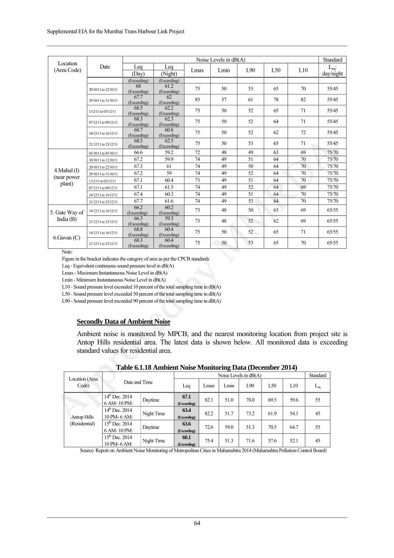
Supplemental EIA for the Mumbai Trans Harbour Link Project
64
Location (Area Code)
Date Noise Levels in dB(A) Standard
Leq LeqLmax Lmin L90 L50 L10 Leq:
day/night(Day) (Night)(Exceeding) (Exceeding)
20/10/11 to 22/10/11 68
(Exceeding)61.2
(Exceeding)75 50 53 65 70 55/45
29/10/11 to 31/10/11 67.7
(Exceeding)62
(Exceeding)85 57 61 78 82 55/45
1/12/11 to 03/12/11 68.5
(Exceeding)62.2
(Exceeding)75 50 52 65 71 55/45
07/12/11 to 09/12/11 68.3
(Exceeding)62.3
(Exceeding)75 50 52 64 71 55/45
14/12/11 to 16/12/11 68.7
(Exceeding)60.8
(Exceeding)75 50 52 62 72 55/45
21/12/11 to 23/12/11 68.5
(Exceeding)62.5
(Exceeding)75 50 53 65 71 55/45
4.Mahul (I) (near power
plant)
03/10/11 to 05/10/11 66.6 59.2 72 48 49 63 69 75/70 10/10/11 to 12/10/11 67.2 59.9 74 49 51 64 70 75/70
20/10/11 to 22/10/11 67.3 61 74 49 50 64 70 75/70
29/10/11 to 31/10/11 67.2 59 74 49 52 64 70 75/70
1/12/11 to 03/12/11 67.1 60.4 73 49 51 64 70 75/70
07/12/11 to 09/12/11 67.1 61.5 74 49 52 64 69 75/70
14/12/11 to 16/12/11 67.4 60.3 74 49 51 64 70 75/70
21/12/11 to 23/12/11 67.7 61.6 74 49 53 64 70 75/70
5. Gate Way of India (B)
14/12/11 to 16/12/11 66.2
(Exceeding)60.2
(Exceeding)73 48 50 63 69 65/55
21/12/11 to 23/12/11 66.3
(Exceeding)59.3
(Exceeding)73 48 52 62 69 65/55
6.Gavan (C) 14/12/11 to 16/12/11
68.8(Exceeding)
60.4(Exceeding)
75 50 52 65 71 65/55
21/12/11 to 23/12/11 68.3
(Exceeding)60.4
(Exceeding)75 50 53 65 70 65/55
Note:
Figure in the bracket indicates the category of area as per the CPCB standards Leq - Equivalent continuous sound pressure level in dB(A) Lmax - Maximum Instantaneous Noise Level in dB(A) Lmin - Minimum Instantaneous Noise Level in dB(A) L10 - Sound pressure level exceeded 10 percent of the total sampling time in dB(A) L50 - Sound pressure level exceeded 50 percent of the total sampling time in dB(A) L90 - Sound pressure level exceeded 90 percent of the total sampling time in dB(A)
Secondly Data of Ambient Noise
Ambient noise is monitored by MPCB, and the nearest monitoring location from project site is Antop Hills residential area. The latest data is shown below. All monitored data is exceeding standard values for residential area.
Table 6.1.18 Ambient Noise Monitoring Data (December 2014)
Location (Area Code)
Date and Time Noise Levels in dB(A) Standard
Leq Lmax Lmin L90 L50 L10 Leq
Antop Hills (Residential)
14th Dec. 2014 6 AM- 10 PM:
Daytime 67.1
(Exceeding) 82.1 51.0 78.0 69.5 59.6 55
14th Dec. 2014 10 PM- 6 AM:
Night Time 63.4
(Exceeding)82.2 51.7 73.2 61.9 54.1 45
15th Dec. 2014 6 AM- 10 PM:
Daytime 63.6
(Exceeding)72.6 59.0 51.3 70.5 64.7 55
15th Dec. 2014 10 PM- 6 AM
Night Time 60.1
(Exceeding)75.4 51.3 71.6 57.6 52.1 45
Source: Report on Ambient Noise Monitoring of Metropolitan Cities in Maharashtra 2014 (Maharashtra Pollution Control Board)
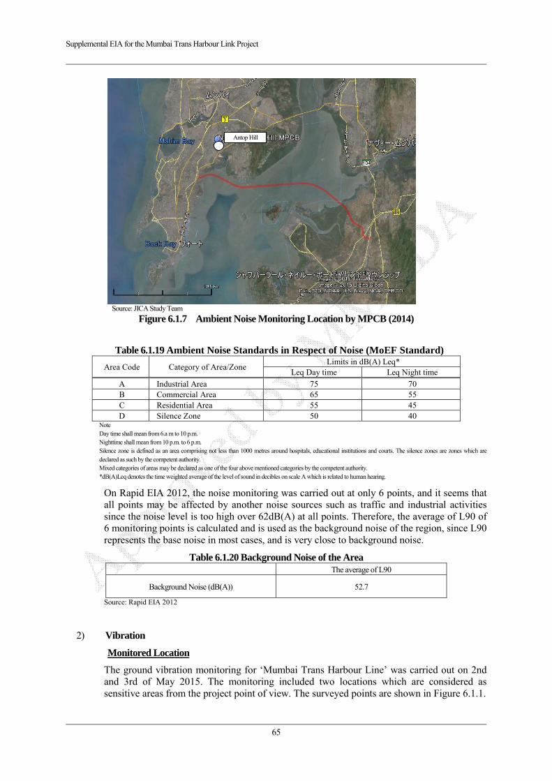
Supplemental EIA for the Mumbai Trans Harbour Link Project
65
Source: JICA Study Team
Figure 6.1.7 Ambient Noise Monitoring Location by MPCB (2014)
Table 6.1.19 Ambient Noise Standards in Respect of Noise (MoEF Standard)
Area Code Category of Area/Zone Limits in dB(A) Leq*
Leq Day time Leq Night time
A Industrial Area 75 70 B Commercial Area 65 55 C Residential Area 55 45 D Silence Zone 50 40
Note Day time shall mean from 6.a m to 10 p.m. Nighttime shall mean from 10 p.m. to 6 p.m. Silence zone is defined as an area comprising not less than 1000 metres around hospitals, educational institutions and courts. The silence zones are zones which are declared as such by the competent authority. Mixed categories of areas may be declared as one of the four above mentioned categories by the competent authority. *dB(A)Leq denotes the time weighted average of the level of sound in decibles on scale A which is related to human hearing.
On Rapid EIA 2012, the noise monitoring was carried out at only 6 points, and it seems that all points may be affected by another noise sources such as traffic and industrial activities since the noise level is too high over 62dB(A) at all points. Therefore, the average of L90 of 6 monitoring points is calculated and is used as the background noise of the region, since L90 represents the base noise in most cases, and is very close to background noise.
Table 6.1.20 Background Noise of the Area The average of L90
Background Noise (dB(A)) 52.7
Source: Rapid EIA 2012
2) Vibration
Monitored Location
The ground vibration monitoring for ‘Mumbai Trans Harbour Line’ was carried out on 2nd and 3rd of May 2015. The monitoring included two locations which are considered as sensitive areas from the project point of view. The surveyed points are shown in Figure 6.1.1.
Antop Hill
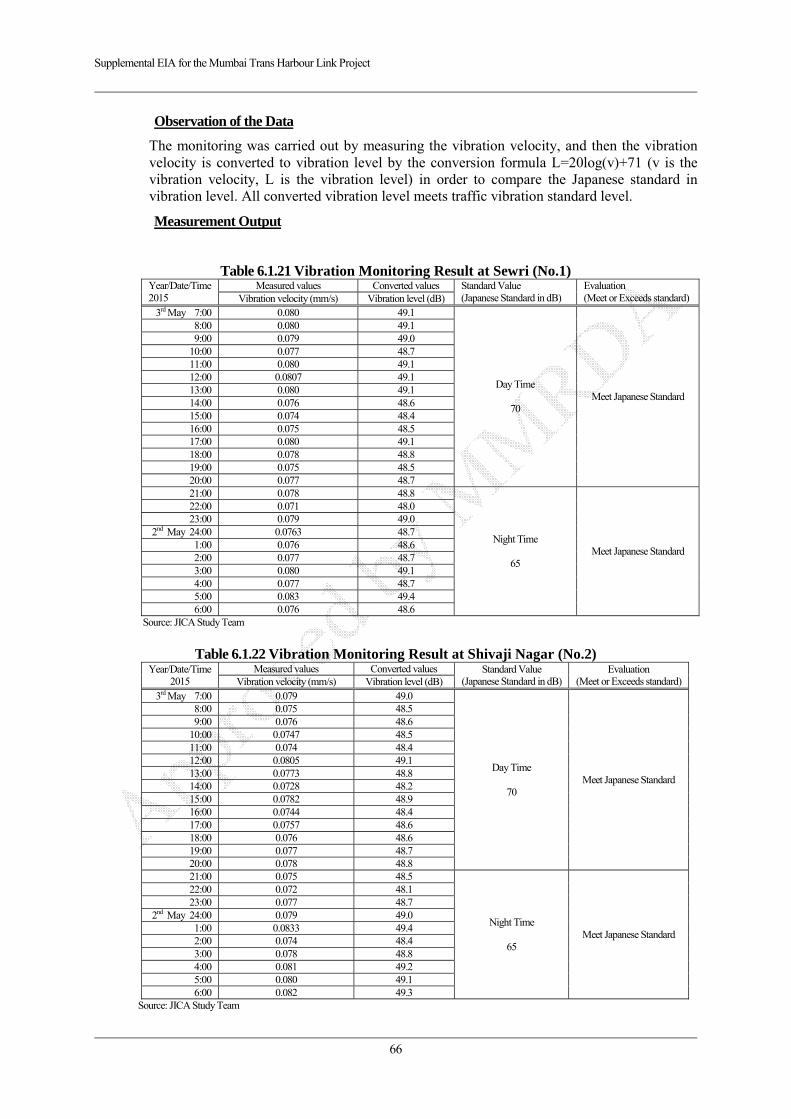
Supplemental EIA for the Mumbai Trans Harbour Link Project
66
Observation of the Data
The monitoring was carried out by measuring the vibration velocity, and then the vibration velocity is converted to vibration level by the conversion formula L=20log(v)+71 (v is the vibration velocity, L is the vibration level) in order to compare the Japanese standard in vibration level. All converted vibration level meets traffic vibration standard level.
Measurement Output
Table 6.1.21 Vibration Monitoring Result at Sewri (No.1) Year/Date/Time2015
Measured values Converted values Standard Value (Japanese Standard in dB)
Evaluation (Meet or Exceeds standard) Vibration velocity (mm/s) Vibration level (dB)
3rd May 7:00 0.080 49.1
Day Time
70 Meet Japanese Standard
8:00 0.080 49.1 9:00 0.079 49.0
10:00 0.077 48.7 11:00 0.080 49.1 12:00 0.0807 49.1 13:00 0.080 49.1 14:00 0.076 48.6 15:00 0.074 48.4 16:00 0.075 48.5 17:00 0.080 49.1 18:00 0.078 48.8 19:00 0.075 48.5 20:00 0.077 48.7 21:00 0.078 48.8
Night Time
65 Meet Japanese Standard
22:00 0.071 48.0 23:00 0.079 49.0
2nd May 24:00 0.0763 48.7 1:00 0.076 48.6 2:00 0.077 48.7 3:00 0.080 49.1 4:00 0.077 48.7 5:00 0.083 49.4 6:00 0.076 48.6
Source: JICA Study Team
Table 6.1.22 Vibration Monitoring Result at Shivaji Nagar (No.2)
Year/Date/Time2015
Measured values Converted values Standard Value (Japanese Standard in dB)
Evaluation (Meet or Exceeds standard)Vibration velocity (mm/s) Vibration level (dB)
3rd May 7:00 0.079 49.0
Day Time
70 Meet Japanese Standard
8:00 0.075 48.5 9:00 0.076 48.6
10:00 0.0747 48.5 11:00 0.074 48.4 12:00 0.0805 49.1 13:00 0.0773 48.8 14:00 0.0728 48.2 15:00 0.0782 48.9 16:00 0.0744 48.4 17:00 0.0757 48.6 18:00 0.076 48.6 19:00 0.077 48.7 20:00 0.078 48.8 21:00 0.075 48.5
Night Time
65 Meet Japanese Standard
22:00 0.072 48.1 23:00 0.077 48.7
2nd May 24:00 0.079 49.0 1:00 0.0833 49.4 2:00 0.074 48.4 3:00 0.078 48.8 4:00 0.081 49.2 5:00 0.080 49.1 6:00 0.082 49.3
Source: JICA Study Team
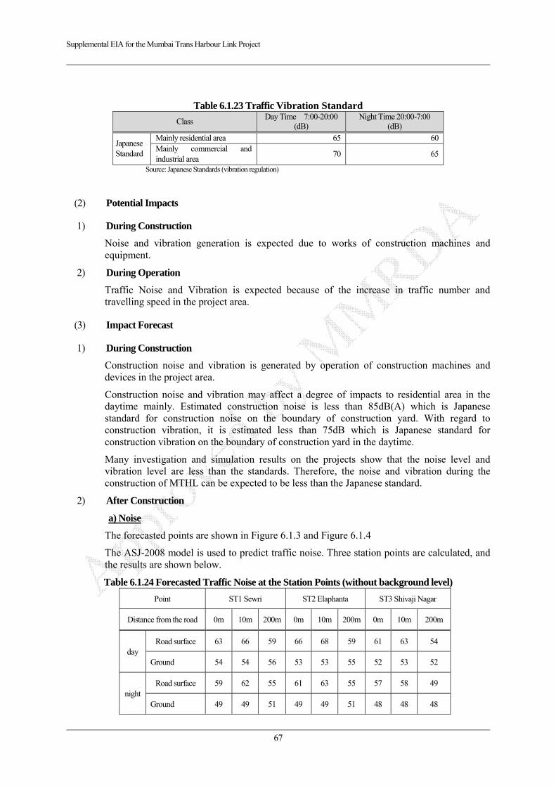
Supplemental EIA for the Mumbai Trans Harbour Link Project
67
Table 6.1.23 Traffic Vibration Standard
Class Day Time 7:00-20:00
(dB) Night Time 20:00-7:00
(dB)
Japanese Standard
Mainly residential area 65 60Mainly commercial and industrial area
70 65
Source: Japanese Standards (vibration regulation)
(2) Potential Impacts
1) During Construction
Noise and vibration generation is expected due to works of construction machines and equipment.
2) During Operation
Traffic Noise and Vibration is expected because of the increase in traffic number and travelling speed in the project area.
(3) Impact Forecast
1) During Construction
Construction noise and vibration is generated by operation of construction machines and devices in the project area.
Construction noise and vibration may affect a degree of impacts to residential area in the daytime mainly. Estimated construction noise is less than 85dB(A) which is Japanese standard for construction noise on the boundary of construction yard. With regard to construction vibration, it is estimated less than 75dB which is Japanese standard for construction vibration on the boundary of construction yard in the daytime.
Many investigation and simulation results on the projects show that the noise level and vibration level are less than the standards. Therefore, the noise and vibration during the construction of MTHL can be expected to be less than the Japanese standard.
2) After Construction
a) Noise
The forecasted points are shown in Figure 6.1.3 and Figure 6.1.4
The ASJ-2008 model is used to predict traffic noise. Three station points are calculated, and the results are shown below.
Table 6.1.24 Forecasted Traffic Noise at the Station Points (without background level)
Point ST1 Sewri ST2 Elaphanta ST3 Shivaji Nagar
Distance from the road 0m 10m 200m 0m 10m 200m 0m 10m 200m
day Road surface 63 66 59 66 68 59 61 63 54
Ground 54 54 56 53 53 55 52 53 52
night Road surface 59 62 55 61 63 55 57 58 49
Ground 49 49 51 49 49 51 48 48 48
Supplemental EIA for the Mumbai Trans Harbour Link Project
68
Source: JICA Study Team
The total noise of each station points is calculated by compositing the traffic noise and background noise (52.7dB, reference as in Table 6.1.20 ), the results are shown below. The forecasted noise level at all three points are below Indian standard and IFC standard.
Table 6.1.25 Forecasted Traffic Noise at the Station Points (with background level)
Point (landuse)
ST1 Sewri (0-200m: Industry)
ST2 Elaphanta (0-200m: Right of
way)
ST3 Shivaji Nagar (0-50m: Right of way
50-200m: Commercial)
Indian Standard dB(A) (Industrial and Commercial)
** IFC Standard Distance from road 0m 10m 200m 0m 10m 200m 0m 10m 200m
day Road surface 64 66 60 66 68 60 62 63 56
75 (Industrial) *65 (Commeicial)
** IFC: 70 (Industrial and
Commercial)
Ground (evaluated values)
56 56 57 56 56 57 55 56 *55
night Road surface 60 62 57 62 64 57 58 59 54
70 (Industrial) *55 (Commercial) ** IFC: 70 (Industrial and
Commercial)
Ground (evaluated values)
54 54 55 54 54 55 54 54 *54
Note) * : The actual land use at evaluated point 200m in Shivaji Nagar is commercial area. Other points are in the right of way, thus the standard for industrial area is adopted **: IFC Standard for Industrial and Commercial: day 70 dB(A)/ night 70 dB(A)
Source: JICA Study Team
As a reference, the noise of the monitoring points in EIA is also calculated by compositing the traffic noise and observed noise, the results are as following.
Table 6.1.26 Forecasted Traffic Noise at the Station Points (with background level)
Location Sewri Shivaji Nagar
Chirle Mahul Gate Way of
India Gavan
(Elephanta)
1. Observed average in 2011
Day 76 63 68 67 66 69
night 62 57 62 61 59 60
2. Forecasted Traffic noise (impacted by only traffic)
Day 56 52 56 56 56 56
night 51 48 51 51 51 51
Total (1+2: composed)
Day 76 64 68 67 67 69
night 62 57 62 61 60 61 Source: JICA Study Team
As shown above, the noise at some observed points is higher than Indian standard since the current noise (observed value in Rapid EIA) is higher than the standard already. However, the influence of MTHL is very small since the traffic noise caused by MTHL in monitoring points is so low that it can be ignored comparing with the current noise.
b) Vibration
The forecasted points are shown in Figure 6.1.3 and Figure 6.1.4. All they are same points as noise and air forecast points.
Then the vibration formula, which is widely used in the calculation of traffic vibration in Japan, is used to predict traffic vibration. Three station points are calculated, and the results are shown below. All forecasted vibration level are lower than the Japanese standard.

Supplemental EIA for the Mumbai Trans Harbour Link Project
69
Table 6.1.27 Forecasted Traffic Vibration at the Station Points (without background level) Point ST1 Sewri ST2 Elaphanta ST3 Shivaji Nagar
standardDistance from road 0m 10m 200m 0m 10m 200m 0m 10m 200m
Vibration Level (dB)
Day 48 47 45 50 48 45 46 45 42 65 Night 48 47 45 50 49 45 46 45 42 60
Source: JICA Study Team
(4) Mitigation Measures
1) During Construction
The expected noise and vibration does not give significant impacts, however, construction noise and vibration levels near residential area should be minimized by following mitigatiom measures;
Selecting low-noise equipment.
Avoiding works of heavy equipment during night time.
Informing the construction schedule to surrounding communities to obtain their consensus.
2) During Operation
Forecasted noise and vibration level does not give significant impacts along the road, however, following mitigation measures are proposed.
Proponent should propose appropriate land use plan such as commercial area along the road.
Although noise barrier is not necessary since the forecasted level is not exceeding the noise standard, as a reference, the noise level with noise barrier (height of 1m) is also calculated. The calculation results show that the noise level at ground height is almost the same with that of no-noise- barrier, and therefore it can be seen that the effect of noise barrier is very limited for the ground height. However the project proponent will monitor the noise level after construction and take necessary mitigation measures when the noise level exceeds standard level.
Table 6.1.28 Result of Comparison Analysis of the noise level with/without Mitigation Measure Point ST-1 Sewri ST-2 Elephanta Island ST-3 Shivaji Nagar
Distance from road 0m 10m 200m 0m 10m 200m 0m 10m 200m
With 1m height noise
barrier
1. Traffic noise level (daytime)
Road surface
60.0 63.4 57.9 62.4 64.6 56.7 57.9 59.5 51.3
Ground 53.5 53.6 54.2 52.7 52.9 53.5 51.6 51.7 49.9
2. Total composed noise level (daytime)
Road surface
60.7 63.8 59.0 62.8 64.9 58.2 59.0 60.3 55.1
Ground 56.1 56.2 56.5 55.7 55.8 56.1 55.2 55.2 54.5
Without noise barrier
Total composed noise level (daytime)
Road surface
63.6 66.5 60.2 66.0 67.8 60.0 61.8 63.0 56.2
Ground 56.1 56.2 57.3 55.9 56.1 57.3 55.4 55.7 55.4
Effect of noise barrier (change of noise level)
Road surface
-2.8 -2.7 -1.2 -3.2 -3.0 -1.8 -2.7 -2.7 -1.2
Ground 0.0 0.0 -0.8 -0.2 -0.3 -1.1 -0.2 -0.4 -0.8
Source: JICA Study Team
Supplemental EIA for the Mumbai Trans Harbour Link Project
70
(5) Evaluation
1) During Construction
In the daytime, it is expected that impacts from construction activities is reduced by mitigation measures and meet standard values such as 85 dB(A) noise and 75 dB vibration, thus it is not likely to give serious impacts to surrounding area.
In the night time, the construction activities will give a degree of impacts to the nearest residential area, however, implementation of mitigation measures minimize the impacts and the degree of impacts will be acceptable level for inhabitants.
2) After Construction
The forecasted noise and vibration level meets standard values, thus it is not likely significant impact on this item. Since the noise-reducing effect of noise barrier is not very high, it is not necessary to build a noise barrier. Especially necessity to build noise barrier in Thane Creek (sea) section is very low.

Supplemental EIA for the Mumbai Trans Harbour Link Project
71
6.2. Natural Environment
6.2.1. Protected Area and Ecosystem
(1) Result of Baseline Survey
1) Survey Item
The survey items on protected area and ecosystem are shown below;
Sensitivity test
Biodiversity Study
Migratory bird
CRZ Areas of the Alignment
2) Survey Area
The survey area includes Thane creek, flanked by Sewri mud-flats & Shivaji Nagar mud-flats on either side. For survey purpose, the area was divided into 3 zones as shown in Table 6.1.10 and Figure 6.1.5:
Zone II : Sewri mud- flat
Zone III : Thane Creek (sea)
Zone IV : Shivaji Nagar mud- flat
(2) Potential Impacts
1) Survey Methodology
6 sampling sites were considered in the survey area, keeping in view, tidal influences, and a holistic picture of the wetlands on both sides and the thane creek. These sites were distributed as two sites each in the mud- flat areas, & 2 sites in the Thane creek.
Quantitative Estimation of Flora in Wetland areas :
Flora in the wetland areas mainly included mangrove species. These were quantitatively estimated using quadrants of 10 x 10 m2 dimensions. The wetland areas were further divided as per the tidal influence viz. high tide, mid tide & low tide. Thus quadrants were laid accordingly in each tidal area, and species and count of flora was estimated.
Source: Rapid EIA 2012
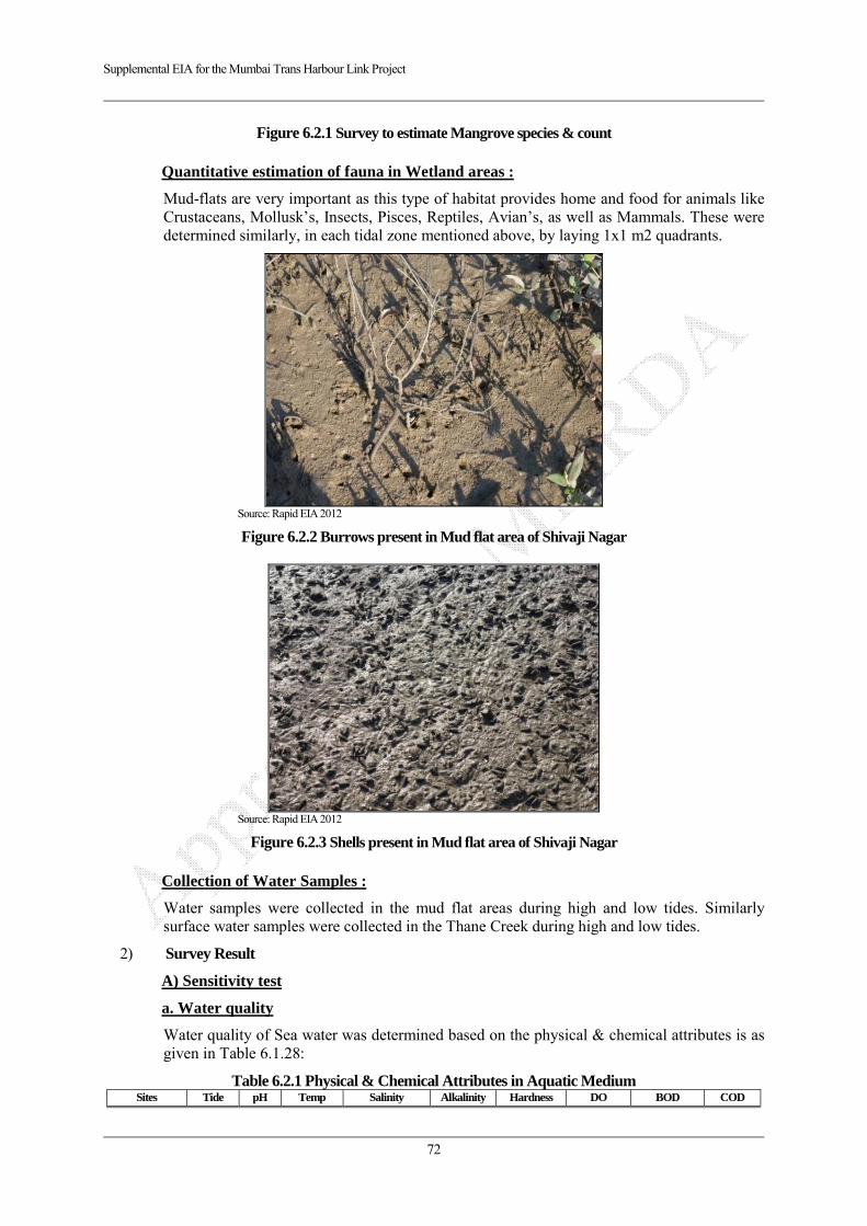
Supplemental EIA for the Mumbai Trans Harbour Link Project
72
Figure 6.2.1 Survey to estimate Mangrove species & count
Quantitative estimation of fauna in Wetland areas :
Mud-flats are very important as this type of habitat provides home and food for animals like Crustaceans, Mollusk’s, Insects, Pisces, Reptiles, Avian’s, as well as Mammals. These were determined similarly, in each tidal zone mentioned above, by laying 1x1 m2 quadrants.
Source: Rapid EIA 2012
Figure 6.2.2 Burrows present in Mud flat area of Shivaji Nagar
Source: Rapid EIA 2012
Figure 6.2.3 Shells present in Mud flat area of Shivaji Nagar
Collection of Water Samples :
Water samples were collected in the mud flat areas during high and low tides. Similarly surface water samples were collected in the Thane Creek during high and low tides.
2) Survey Result
A) Sensitivity test
a. Water quality
Water quality of Sea water was determined based on the physical & chemical attributes is as given in Table 6.1.28:
Table 6.2.1 Physical & Chemical Attributes in Aquatic Medium Sites Tide pH Temp Salinity Alkalinity Hardness DO BOD COD
Supplemental EIA for the Mumbai Trans Harbour Link Project
73
ºC ‰ ppm mg/L (mg/L) (mg/L) mg/L
Zone II High 7.5 28 32.95 14 46 1.20 0.97 100 Low 7.5 24.5 32.95 14 47 1.48 1.32 105
Zone III High 7 23.5 32.95 12 32 3.10 0.42 105
Low 7 28 32.95 14.5 34 2.40 0.42 76
Zone IV High 7 26 32.95 10 36 3.03 0.83 100 Low 7 28 32.95 9.5 30 2.05 0.12 85
Source: Rapid EIA 2012
Observations:
pH
The pH of the water samples was found to be between 7-7.5. There is no significant difference in high tide and low tide. Acidity is measured using the pH scale, where items are given a numerical value between 0 and 14. Historically, ocean pH has averaged around 8.17, meaning that ocean waters are slightly basic. But with the rising CO2 concentration causing acidification, today the pH levels are around 8.09, edging the waters closer to neutral.
Temperature
Surface water temperature was found to be between 23 to 28 ºC. But the temperature was found to low at Zone III during high tide. However, considering the ambient temperature range for the west coast of India is in normal range. The study revealed the temperature was in a normal range but it was found that the temperature at low tide was found to be more than the high tide.
Salinity
The salinity range of the surface waters around India shows great seasonal fluctuations owing to the influence of the monsoon rains as a result of river discharge. The salinity was found to be 32.95‰ at all the Zones.
Alkalinity
Alkanility in itself is not harmful to human beings, still the water supplies with less than 100mg/L are desirable for domestic use. The alkalinity ranges from 9.5 to 14 ppm.
Hardness
Hardness was found to be in the range of 30 to 47mg/L
DO
DO values ranges between 1.2 to 3.1 mg/L.
BOD
During the recent study the BOD1 varied from 0.12 mg/L to 1.32 mg/L. The BOD was found to be lowest at Zone III during low tide. The BOD values were found to be comparable to that of standard value. High BOD values results from high oxygen demanding substances disposed to coastal waters. It suggests that the sewage contamination may be less in these areas.
COD
The COD was found to be highest at low tide at Zone II and high tide at Zone III with values 105 mg/L; and within acceptable limits of 250 mg/L.
b. Determination of Nutrients
Nutrients in an aquatic medium encourage/ deplete the growth of biota. Three primary nutrients of the coastal aquatic medium, namely, nitrate, phosphate and silica, were determined.
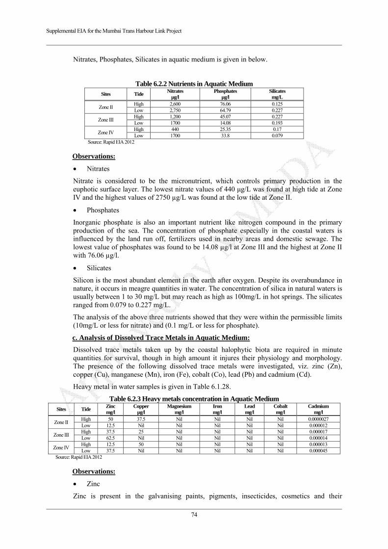
Supplemental EIA for the Mumbai Trans Harbour Link Project
74
Nitrates, Phosphates, Silicates in aquatic medium is given in below.
Table 6.2.2 Nutrients in Aquatic Medium Sites Tide
Nitrates µg/l
Phosphates µg/l
Silicates mg/L
Zone II High 2,600 76.06 0.125 Low 2,750 64.79 0.227
Zone III High 1,200 45.07 0.227 Low 1700 14.08 0.193
Zone IV High 440 25.35 0.17 Low 1700 33.8 0.079
Source: Rapid EIA 2012
Observations:
Nitrates
Nitrate is considered to be the micronutrient, which controls primary production in the euphotic surface layer. The lowest nitrate values of 440 μg/L was found at high tide at Zone IV and the highest values of 2750 µg/L was found at the low tide at Zone II.
Phosphates
Inorganic phosphate is also an important nutrient like nitrogen compound in the primary production of the sea. The concentration of phosphate especially in the coastal waters is influenced by the land run off, fertilizers used in nearby areas and domestic sewage. The lowest value of phosphates was found to be 14.08 µg/l at Zone III and the highest at Zone II with 76.06 µg/l.
Silicates
Silicon is the most abundant element in the earth after oxygen. Despite its overabundance in nature, it occurs in meagre quantities in water. The concentration of silica in natural waters is usually between 1 to 30 mg/L but may reach as high as 100mg/L in hot springs. The silicates ranged from 0.079 to 0.227 mg/L.
The analysis of the above three nutrients showed that they were within the permissible limits (10mg/L or less for nitrate) and (0.1 mg/L or less for phosphate).
c. Analysis of Dissolved Trace Metals in Aquatic Medium:
Dissolved trace metals taken up by the coastal halophytic biota are required in minute quantities for survival, though in high amount it injures their physiology and morphology. The presence of the following dissolved trace metals were investigated, viz. zinc (Zn), copper (Cu), manganese (Mn), iron (Fe), cobalt (Co), lead (Pb) and cadmium (Cd).
Heavy metal in water samples is given in Table 6.1.28.
Table 6.2.3 Heavy metals concentration in Aquatic Medium Sites Tide
Zinc mg/l
Copper µg/l
Magnesium mg/l
Iron mg/l
Lead mg/l
Cobalt mg/l
Cadmium mg/l
Zone II High 50 37.5 Nil Nil Nil Nil 0.0000027 Low 12.5 Nil Nil Nil Nil Nil 0.000012
Zone III High 37.5 25 Nil Nil Nil Nil 0.000017 Low 62.5 Nil Nil Nil Nil Nil 0.000014
Zone IV High 12.5 50 Nil Nil Nil Nil 0.000013 Low 37.5 Nil Nil Nil Nil Nil 0.000045
Source: Rapid EIA 2012
Observations:
Zinc
Zinc is present in the galvanising paints, pigments, insecticides, cosmetics and their
Supplemental EIA for the Mumbai Trans Harbour Link Project
75
discharge increases their concentration in the waste. The zinc values are ranging from 12 mg/l to 63 mg/l
Copper
Copper in the natural waters also results in higher concentration due to pollution. Samples from low tides at all the three Zones did not show any presence of copper whereas at high tide they were in the range of 25 to 50 µg/l.
Cadmium
Cadmium is present in the waste water from electroplating, chemical industries and milling and mining wastes from lead-zinc mines. It accumulates in various parts of the body. The concentration of cadmium varied between 0.0000027 to 0.000045 mg/l.
Magnesium, Iron, Lead and Cobalt were found to be absent in the water samples from all the Zones.
B) Biodiversity Study
a. Biodiversity for Defining of Ecology:
Biodiversity is the variety and differences among living organisms from all sources, including terrestrial, marine, and other aquatic ecosystems and the ecological complexes of which they are a part. Many variables are united in a common string of biosphere and the tiers of variability are :
Ecosystem tier
Community tier
Species tier
Genetic tier
Present study deals with studying diversity of flora & fauna at species level through Shannon Weaner Index, Index of dominance.
Shannon Weaner Index:
The Shannon Weaner Index (H'), is one of several diversity indices used to measure diversity in categorical data.
H'= - (Ni/N) × ln (Ni/N)
Where;
Ni= Number of individuals in a species
N= Total number of individuals of all the species in the quadrant
Index of dominance:
Index of dominance = (Ni2/N2)
Where;
Ni= Number of individuals in a species
N= Total number of individuals of all the species in the quadrant
Stress Index :
Stress Index (I) = K [(No- Ns)/N(Nt)]
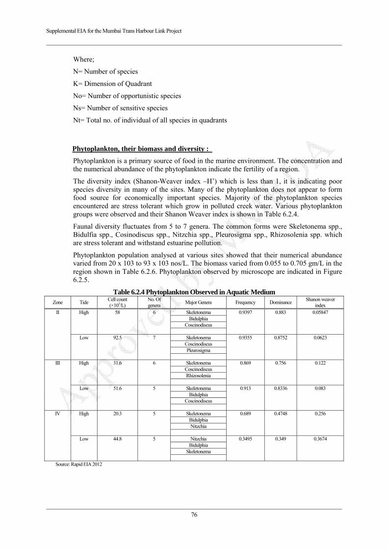
Supplemental EIA for the Mumbai Trans Harbour Link Project
76
Where;
N= Number of species
K= Dimension of Quadrant
No= Number of opportunistic species
Ns= Number of sensitive species
Nt= Total no. of individual of all species in quadrants
Phytoplankton, their biomass and diversity :
Phytoplankton is a primary source of food in the marine environment. The concentration and the numerical abundance of the phytoplankton indicate the fertility of a region.
The diversity index (Shanon-Weaver index –H’) which is less than 1, it is indicating poor species diversity in many of the sites. Many of the phytoplankton does not appear to form food source for economically important species. Majority of the phytoplankton species encountered are stress tolerant which grow in polluted creek water. Various phytoplankton groups were observed and their Shanon Weaver index is shown in Table 6.2.4.
Faunal diversity fluctuates from 5 to 7 genera. The common forms were Skeletonema spp., Bidulfia spp., Cosinodiscus spp., Nitzchia spp., Pleurosigma spp., Rhizosolenia spp. which are stress tolerant and withstand estuarine pollution.
Phytoplankton population analysed at various sites showed that their numerical abundance varied from 20 x 103 to 93 x 103 nos/L. The biomass varied from 0.055 to 0.705 gm/L in the region shown in Table 6.2.6. Phytoplankton observed by microscope are indicated in Figure 6.2.5.
Table 6.2.4 Phytoplankton Observed in Aquatic Medium Zone Tide
Cell count (×103/L)
No. Of genera
Major Genera Frequency Dominance Shanon weaver
index II High 58 6 Skeletonema 0.9397 0.883 0.05847
Bidulphia Coscinodiscus
Low 92.5 7 Skeletonema 0.9355
0.8752
0.0623
Coscinodiscus Pleurosigma
III High 31.6 6 Skeletonema 0.869 0.756 0.122
Coscinodiscus Rhizosolenia
Low 51.6 5 Skeletonema 0.913 0.8336 0.083
Bidulphia Coscinodiscus
IV High 20.3 5 Skeletonema 0.689 0.4748 0.256
Bidulphia Nitzchia
Low 44.8 5 Nitzchia 0.3495 0.349 0.3674
Bidulphia Skeletonema
Source: Rapid EIA 2012

Supplemental EIA for the Mumbai Trans Harbour Link Project
77
Bidulfia spp. Navicula spp. Diatylum spp. Cosinodiscus spp.
Source: Rapid EIA 2012
Figure 6.2.4 Phytoplankton Species
Zooplankton, their biomass and diversity
The concentration and the numerical abundance of the zooplankton indicate the fertility of a region. Various zooplankton groups were observed as indicated in Figure 6.2.6, and their Shanon Weaver index are shown in Table 6.2.5.
Table 6.2.5 Zooplankton observed in Aquatic Medium Zone Tide Cell count
(×103/L) No. Of genera
Major Genera Freq- uency
Domi-nance Shanon weaver index
II High 5.5
5 Tintinnopsis 0.6364 0.405 0.2876 Rhabdonellopsis
Low 2.5
5 Tintinnopsis 0.2667 0.01711 0.3525
fish eggs
III High 4
7 Sagitta 0.3334 0.1112 0.3662 Eutintinnus
Dyphis
Low 6.6
8 Fish eggs 0.2272
0.5165 0.33675 codonellopsis
copepods
IV High 5.66
5 tintinnopsis 0.3235 0.10467 0.3651 eutintinnus
Low 2.5
8 tintinnopsis 0.3334
0.1112 0.3662
barnacal nauplius
Source: Rapid EIA 2012
Copepod Mysis larva
Source: Rapid EIA 2012
Figure 6.2.5 Zooplankton Species
Faunal diversity showed 7 types of genera. The common forms were Nauplii spp., Zoea of crab, Copepods and Tintinids.
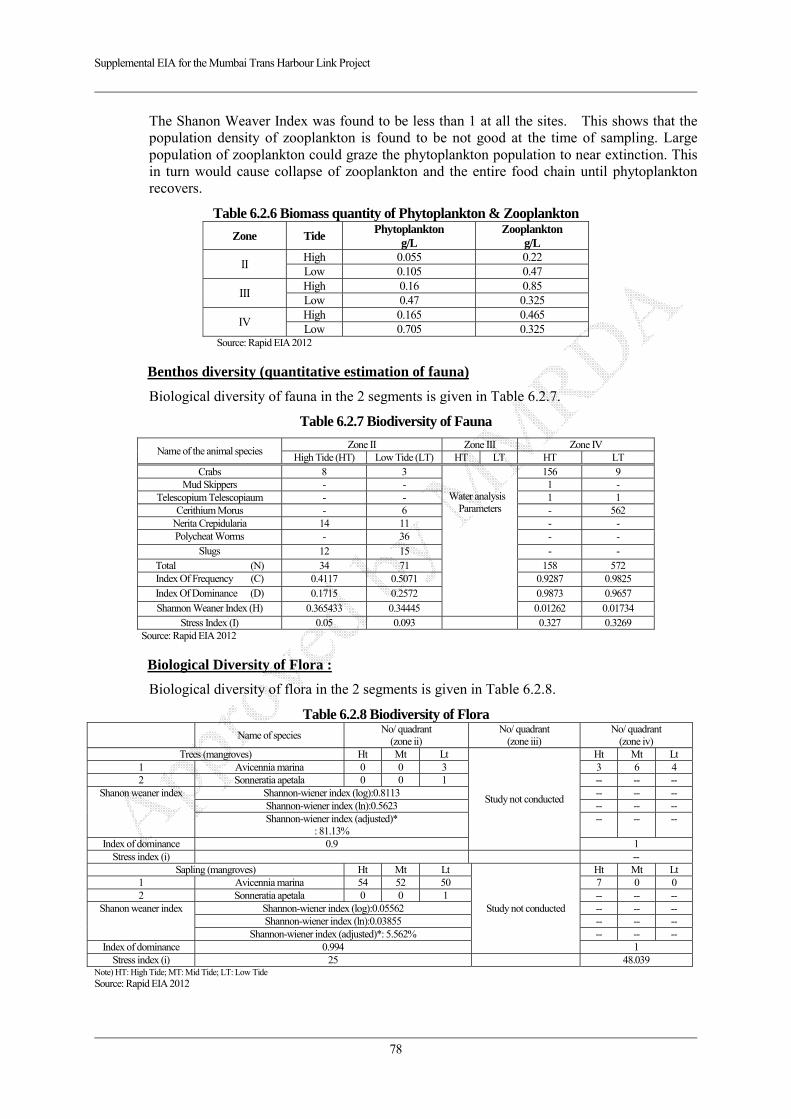
Supplemental EIA for the Mumbai Trans Harbour Link Project
78
The Shanon Weaver Index was found to be less than 1 at all the sites. This shows that the population density of zooplankton is found to be not good at the time of sampling. Large population of zooplankton could graze the phytoplankton population to near extinction. This in turn would cause collapse of zooplankton and the entire food chain until phytoplankton recovers.
Table 6.2.6 Biomass quantity of Phytoplankton & Zooplankton
Zone Tide Phytoplankton
g/L Zooplankton
g/L
II High 0.055 0.22 Low 0.105 0.47
III High 0.16 0.85 Low 0.47 0.325
IV High 0.165 0.465 Low 0.705 0.325
Source: Rapid EIA 2012
Benthos diversity (quantitative estimation of fauna)
Biological diversity of fauna in the 2 segments is given in Table 6.2.7.
Table 6.2.7 Biodiversity of Fauna
Name of the animal species Zone II Zone III Zone IV
High Tide (HT) Low Tide (LT) HT LT HT LT Crabs 8 3
Water analysis
Parameters
156 9 Mud Skippers - - 1 -
Telescopium Telescopiaum - - 1 1 Cerithium Morus - 6 - 562
Nerita Crepidularia 14 11 - - Polycheat Worms - 36 - -
Slugs 12 15 - - Total (N) 34 71 158 572 Index Of Frequency (C) 0.4117 0.5071 0.9287 0.9825 Index Of Dominance (D) 0.1715 0.2572 0.9873 0.9657 Shannon Weaner Index (H) 0.365433 0.34445 0.01262 0.01734
Stress Index (I) 0.05 0.093 0.327 0.3269 Source: Rapid EIA 2012
Biological Diversity of Flora :
Biological diversity of flora in the 2 segments is given in Table 6.2.8.
Table 6.2.8 Biodiversity of Flora Name of species
No/ quadrant (zone ii)
No/ quadrant (zone iii)
No/ quadrant (zone iv)
Trees (mangroves) Ht Mt Lt
Study not conducted
Ht Mt Lt 1 Avicennia marina 0 0 3 3 6 4 2 Sonneratia apetala 0 0 1 -- -- --
Shanon weaner index Shannon-wiener index (log):0.8113 -- -- -- Shannon-wiener index (ln):0.5623 -- -- -- Shannon-wiener index (adjusted)*
: 81.13% -- -- --
Index of dominance 0.9 1 Stress index (i) --
Sapling (mangroves) Ht Mt Lt
Study not conducted
Ht Mt Lt 1 Avicennia marina 54 52 50 7 0 0 2 Sonneratia apetala 0 0 1 -- -- --
Shanon weaner index Shannon-wiener index (log):0.05562 -- -- -- Shannon-wiener index (ln):0.03855 -- -- --
Shannon-wiener index (adjusted)*: 5.562% -- -- -- Index of dominance 0.994 1
Stress index (i) 25 48.039 Note) HT: High Tide; MT: Mid Tide; LT: Low Tide Source: Rapid EIA 2012

Supplemental EIA for the Mumbai Trans Harbour Link Project
79
Observations:
Phytoplankton, their biomass and diversity:
Phytoplankton is a primary source of food in the marine environment. The concentration and the numerical abundance of the phytoplankton indicate the fertility of a region. The diversity index (Shanon-Weaver index –H’) which is less than 1, indicates poor species diversity in many of the Zones. Many of the phytoplanktons do not appear to form food source for economically important species. Majority of the phytoplankton species encountered are stress tolerant which grow in polluted creek water.
Zooplankton, their biomass and diversity:
The concentration and the numerical abundance of the zooplankton indicate the fertility of a region. The shanon weaver index was found to be less than 1 at all the Zones. This shows that the population density of zooplankton is found not to be good at the time of sampling. Large population of zooplankton could graze the phytoplankton population to near extinction. This in turn would cause collapse of zooplankton and the entire food chain until phytoplankton recovers.
b. Analysis of Microbens in Aquatic Medium:
Microbial population
The water samples were collected at all sites using sterile 250 ml sterile polyvinyl bottles and preserve for analysis. Pour plate method was use to culture the organisms. The agar media used for analysis were Nutrient agar, MacConkey agar. Plates were incubated at 37°C for 24 hrs and total viable count was taken. Organisms were identified and counted on the basis of their colour characteristics.
Table 6.2.9 Bacterial population in surface waters (number × 103/ml)
Zone Tide Mac Conkey Agar
SPC/ml Nutrient Agar
SPC/ml
1 High Nil 80 Low Nil Nil
2 High Nil 0.5 Low Nil Nil
3 High Nil 2.4 Low Nil 9
Source: Rapid EIA 2012
Absence of coliform enteric in Mac Agar Presence of E.coli and other bacteria In NA
Source: Rapid EIA 2012
Figure 6.2.6 Bacterial Colonies
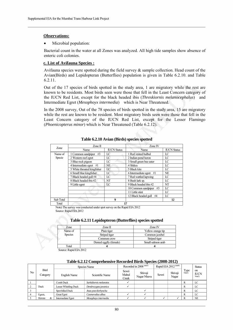
Supplemental EIA for the Mumbai Trans Harbour Link Project
80
Observations:
Microbial population:
Bacterial count in the water at all Zones was analyzed. All high tide samples show absence of enteric coli colonies.
c. List of Avifauna Species :
Avifauna species were spotted during the field survey & sample collection. Head count of the Avian(Birds) and Lepidopteran (Butterflies) population is given in Table 6.2.10. and Table 6.2.11.
Out of the 17 species of birds spotted in the study area, 1 are migratory while the rest are known to be residents. Most birds seen were those that fell in the Least Concern category of the IUCN Red List, except for the black headed ibis (Threskiornis melanocephalus) and Intermediate Egret (Mesophoyx intermedia) which is Near Threatened.
In the 2008 survey, Out of the 78 species of birds spotted in the study area, 15 are migratory while the rest are known to be resident. Most migratory birds seen were those that fell in the Least Concern category of the IUCN Red List, except for the Lesser Flamingo (Phoenicopterus minor) which is Near Threatened (Table 6.2.12).
Table 6.2.10 Avian (Birds) species spotted
Zone Zone II Zone IV
Name IUCN Status Name IUCN StatusName of Specie
1 Common sandpiper #3 LC 1 Red vented bulbul LC 2 Western reef egret LC 2 Indian pond heron LC 3 Blue rock pigeon LC 3 Small green bee eater LC 4 Intermediate egret #1 NE 4 Shikra LC 5 White throated kingfisher LC 5 Black kite LC 6 Small blue kingfisher LC 6 Intermediate egret #1 NE 7 Black headed gull #4 LC 7 Red wattled lapwing LC 8 Black headed ibis #2 NT 8 Bush lark sp. LC 9 Little egret LC 9 Black headed ibis #2 NT 10 Common sandpiper #3 LC 11 Little stint LC 12 Black headed gull #4 LC
Sub Total 9 12 Total 17
Note) The survey was conducted under spot survey on the Rapid EIA 2012 Source: Rapid EIA 2012
Table 6.2.11 Lepidopteron (Butterflies) species spotted
Zone Zone II Zone IV Name of Species
Plain tiger Yellow orange tip Striped tiger Common jezebel
Common crow Striped tiger Denied eggfly (female) Small salmon arab
Total 4 4 Source: Rapid EIA 2012
Table 6.2.12 Comprehensive Recorded Birds Species (2008-2012)
No Bird
Category
Species Name Recorded in 2008 note3) Rapid EIA 2012 note4)
Type Note1)
Status on IUCN Note2) English Name Scientific Name
Sewri Mahul Creek
Shivaji Nagar Nhava
Sewri Shivaji Nagar
1
Duck
Comb Duck Sarkidiornis melanotos R LC
2 Lesser Whistling Duck Dendrocygna javanica R LC
3 Spot-billed Duck Anas poecilorhyncha R LC 4 Egrets,
Herons & Great Egret Casmerodius albus R LC
5 Intermediate Egret Mesophoyx intermedia R NE

Supplemental EIA for the Mumbai Trans Harbour Link Project
81
6 Ibis Little Egret Egretta garzetta R LC 7 Western reef Egret Egretta sacra R LC 8 Grey Heron Ardea cinerea R LC 9 Little Heron Butorides striatus R LC 10 Indian Pond Heron Aedeola grayii R LC
11 Black headed Ibis Threskiornis melanocephalus*
R NT
12 Painted Stork Mycteria leucocephala* R NT 13
Bird of Prey
Greater Spotted eagle Aquila clanga** R VU 14 Pariah (Black) Kite Milvus migrans R LC 15 Brahminy Kite Haliatur Indus R LC 16 Eurasian Marsh Harrier Circus aeruginosus R LC 17 Osprey Pandion haliaetus R LC 18 Shikra Accipiter badius R LC 19 Barn Owl Tyto alba R LC 20 Roller Indian Roller Coracias benghalensis R LC 21
Waders
Lesser Sand Plover Charadrius mongolus R LC 22 Little Ringed Plover Charadrius dubius R LC 23 Black-tailed Godwit Limoaas limosa R NT 24 Eurasian Curlew Numenius arquata R NT 25 Whimbrel Neumenius phaeopus R LC 26 Common Redshank Trianga erythropus R LC 27 Common Greenshank Tringa nebularia R LC 28 Grey Plover Pluvialis squatarola R LC 29 Ruddy Turnstone Arenaria interpres R LC 30 Common sandpiper Actitis hypoleucos R LC 31 Terek Sandpiper Xenus cinereus R LC 32 Redwattled Lapwing Vanellus indicus R LC 33 Curlew Sandpiper Calidris ferruginea R LC 34 Little Stint Calidris minuta R LC 35 Black winged Stilt Himantopus himantopus R LC 36 Dunlin Calidris alpina M LC 37 Pied Avocet Recurvirostra avosetta R LC 38 Temminck’s Stint Calidris temminckii M LC 39 Sandpiper Tringa stagnatilis M LC 40
Gulls & Terns
Brown-headed Gull Larus brunnicephalus M LC 41 Black Headed Gull Larus ridibundus M LC 42 Gull billed Tern Gelochelidon nilotica M LC 43 Caspian Tern Sterna caspia M LC 44 Little tern Sterna albifrons M LC 45 Whiskered Tern Chlidonias hybridus R LC 46 Heuglin’s Gull Larus heuglini R LC 47
Flamingos Lesser Flamingo Phoenicopterus minor* M NT
48 Greater Flamingo Phoenicopterus rubber M LC 49
Pigeons, Parakeets & Coucal
Rock Pigeon Columba livia R LC 50 Rose ringed Parakeet Psittacula krameri R LC 51 Greater Coucal Centropus sinensis R LC 52 Blue Rock Pigeon R LC 53
Kingfisher
White throated Kingfisher Halycon smyrnensis R LC 54 Common Kingfisher Alcedo atthis R LC 55 Black capped Kingfisher Halycon pileata R/M LC 56 Small blue Kingfisher R LC 57
Passerines
Asian Pied Starling Sturnus contra R LC 58 Asian Keol Eudynamis scolopacia R LC 59 House Crow Corvus splendens R LC 60 Large-billed (Jungle) crow Coverus macrohynchos R LC 61 Golden Oriole Oriolus oriolus M LC 62 White throated Fantail Rhipidura albicollis R LC 63 Barn swallow Hirunda rustica M LC 64 Asian palm swift Cypsiurus balasiensis R LC 65 Red-vented Bulbul Pycnonotus cafer R LC 66 White eared Bulbul Pyycnonotus leucotis R LC 67 Ashy Prinia Prinia socialis R LC 68 Blyth’s Reed Warbler Acrocephalus dumetorum R LC 69 Common tailor Bird Orthotomus sutorius R LC 70 Oriental Magpie Robin Copsychus saularis R LC 71 Purple rumped Sunbird Nectarinia zeylonica R LC 72 Citrine Wagtail Motacilla citreola R LC 73 White Wagtail Motacilla alba R LC 74 Yellow Wagtail Motacilla flava M LC 75 House Sparrow Passer domesticus R LC 76 Spotted Dove Streptopelia chinensis R LC

Supplemental EIA for the Mumbai Trans Harbour Link Project
82
77 Small Green Bee-eater Merops orientalis R LC 78 Rufuous tailed Shrike Lanius isabellinus M LC 79 Indian Robin Saxicoloides fulicata R LC 80 Clamorous Reed Warbler Acrocephalus stentoreus R LC 81 Bush lark Mirafra erythroptera R LC
Sub Total 70 34 9 12 Total 78 17
Note 1) Type: Resident (R) or Migratory (M) Note2) IUCN status: Extinct (EX), Threatened (CR, EN, VU), Near Threatened (NT), Least Concern (LC), Not Evaluated (NE) Note3) The survey for avifauna was conducted from October 2006 to August 2008 at mainly 2 points Sewri Port and Tata power station. Note4) The survey for avifauna was conducted in Rapid EIA 2012
Source: Compiled from Study of Flamingos and Migratory Birds 2008 (MMRDA/Salim Ali Centre for Ornithology and Natural History)
d. Considerable Bird Species and Expected Impacts:
The Sewari area and the entire Thane Creek is declared as Important Bird Area by Birdlife International in 2004. The listed up considerable species such as NT and VU on IUCN Redlist are shown in Table 6.1.13. The 6 species out of 7 species are resident, only Lesser Flamingo is migratory bird. These 6 species are using the project area as a part of feeding area, not nesting area due to surrounding vegetation and land use. However only Lesser Flamingo is using the project area as not only feeding area, but also roosting site near ST5-5.5 km near TATA power plant. During construction, all of 7 species may avoid feed in the project area certain period of time due to construction activities, however, Sewri mudflat is located near industrial area with high noise level and human activities. Hence such considerable birds get back again and start to feed near project site gradually. However road lighting may give impacts on Flamingo’s roosting area located near ST5-5.5km, thus mitigation measures for minimizing impacts shall be considered.
Table 6.2.13 Recorded Considerable Bird Species and Impacts
No. English Name
(Scientific Name) Category
Note Nesting environment
Note3 General targets
for feeding Role of
project area Impact forecast
1 Black headed Ibis (Threskiornis melanocephalus)
NT/R A colony in waterside forests
Fish, Insecta etc. Feeding area [During Cost] This species may avoid project area, but get back gradually [Operation] Feeding area may change, but basically get back again in the project area and continue feeding
2 Painted Stork (Mycteria leucocephala)
NT/R A colony in waterside forests
Fish, Aquatic organism etc.
Feeding area [During Cost] This species may avoid project area, but get back gradually [Operation] Feeding area may change, but basically get back again in the project area and continue feeding
3 Greater Spotted eagle (Aquila clanga)
VU/R The forest of the waterfront (On the trees)
Small mammals, Birds, Fish etc.
Part of the Feeding area
[During Cost] This species may avoid project area, but get back gradually [Operation] Part of the Feeding area may change, but basically get back again in the project area and continue feeding
4 Black-tailed Godwit (Limoaas limosa)
NT/R A grass of the banks of the wetlands and lakes.
Crustacea, Bristle worm, Shellfish etc.
Feeding area [During Cost] This species may avoid project area, but get back gradually [Operation] Feeding area may change, but basically get back again in the project area and continue feeding
5 Eurasian Curlew (Numenius arquata)
NT/R Slightly dry grasslands and wetlands
Crustacea, Bristle worm etc.
Feeding area [During Cost] This species may avoid project area, but get back gradually [Operation] Feeding area may change, but basically get back again in the project area and continue feeding
6 Lesser Flamingo (Phoenicopterus minor)
NT/M Coastal zone of saltwater lakes and coastal lagoons.
Algae (Bule-greenalgae, diatoms etc.)
Feeding area, Roosting area
[During Cost] This species may avoid project area, but get back gradually [Operation] Flying course may change, but basically get back again in the project area and continue feeding
Note1) NT: Near Threatened, VU: V, R: Resident, M: Migratory Note2) Impacts on each listed considerable species are forecasted based on site survey, literature survey and interviews with Japanese and Indian mudflat and migratory bird specialists Note3) Any colonies and nesting areas have not been observed on Rapid EIA 2012. Additionally any nesting areas were not observed on 17-18th Sep 2015 in Sewri and Shivaji
Nagar.
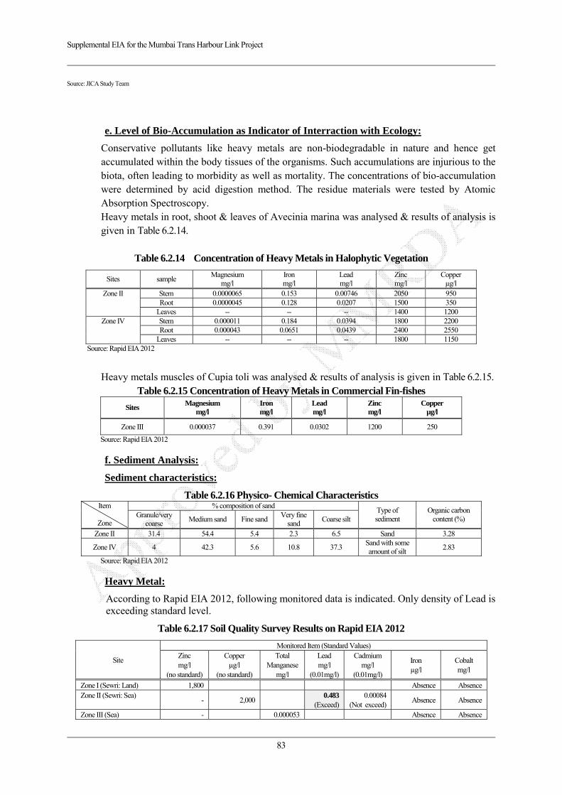
Supplemental EIA for the Mumbai Trans Harbour Link Project
83
Source: JICA Study Team
e. Level of Bio-Accumulation as Indicator of Interraction with Ecology:
Conservative pollutants like heavy metals are non-biodegradable in nature and hence get accumulated within the body tissues of the organisms. Such accumulations are injurious to the biota, often leading to morbidity as well as mortality. The concentrations of bio-accumulation were determined by acid digestion method. The residue materials were tested by Atomic Absorption Spectroscopy. Heavy metals in root, shoot & leaves of Avecinia marina was analysed & results of analysis is given in Table 6.2.14.
Table 6.2.14 Concentration of Heavy Metals in Halophytic Vegetation
Sites sample Magnesium
mg/l Iron mg/l
Lead mg/l
Zinc mg/l
Copper µg/l
Zone II Stem 0.0000065 0.153 0.00746 2050 950 Root 0.0000045 0.128 0.0207 1500 350
Leaves -- -- -- 1400 1200 Zone IV Stem 0.000011 0.184 0.0394 1800 2200
Root 0.000043 0.0651 0.0439 2400 2550 Leaves -- -- -- 1800 1150
Source: Rapid EIA 2012
Heavy metals muscles of Cupia toli was analysed & results of analysis is given in Table 6.2.15.
Table 6.2.15 Concentration of Heavy Metals in Commercial Fin-fishes
Sites Magnesium
mg/l Iron mg/l
Lead mg/l
Zinc mg/l
Copper µg/l
Zone III 0.000037 0.391 0.0302 1200 250
Source: Rapid EIA 2012
f. Sediment Analysis:
Sediment characteristics:
Table 6.2.16 Physico- Chemical Characteristics Item
Zone
% composition of sand Type of sediment
Organic carbon content (%) Granule/very
coarse Medium sand Fine sand
Very fine sand
Coarse silt
Zone II 31.4 54.4 5.4 2.3 6.5 Sand 3.28
Zone IV 4 42.3 5.6 10.8 37.3 Sand with some amount of silt
2.83
Source: Rapid EIA 2012
Heavy Metal:
According to Rapid EIA 2012, following monitored data is indicated. Only density of Lead is exceeding standard level.
Table 6.2.17 Soil Quality Survey Results on Rapid EIA 2012
Site
Monitored Item (Standard Values) Zinc mg/l
(no standard)
Copper µg/l
(no standard)
Total Manganese
mg/l
Lead mg/l
(0.01mg/l)
Cadmium mg/l
(0.01mg/l)
Iron µg/l
Cobalt mg/l
Zone I (Sewri: Land) 1,800 Absence AbsenceZone II (Sewri: Sea)
- 2,0000.483
(Exceed)0.00084
(Not exceed)Absence Absence
Zone III (Sea) - 0.000053 Absence Absence
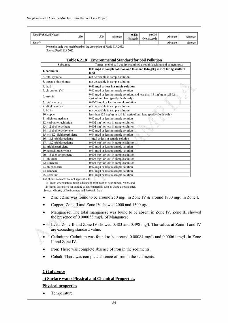
Supplemental EIA for the Mumbai Trans Harbour Link Project
84
Zone IV(Shivaji Nagar) 250 1,500 Absence
0.498(Exceed)
0.0006 (Not exceed)
Absence Absence
Zone V - Absence absenceNote) this table was made based on the description of Rapid EIA 2012 Source: Rapid EIA 2012
Table 6.2.18 Environmental Standard for Soil Pollution Substance Target level of soil quality examined through leaching and content tests
1. cadmium 0.01 mg/l in sample solution and less than 0.4mg/kg in rice for agricultural land
2. total cyanide not detectable in sample solution
3. organic phosphorus not detectable in sample solution
4. lead 0.01 mg/l or less in sample solution 5. chromium (VI) 0.05 mg/l or less in sample solution
6. arsenic 0.01 mg/l or less in sample solution, and less than 15 mg/kg in soil for agricultural land (paddy fields only)
7. total mercury 0.0005 mg/l or less in sample solution 8. alkyl mercury not detectable in sample solution 9. PCBs not detectable in sample solution 10. copper less than 125 mg/kg in soil for agricultural land (paddy fields only) 11. dichloromethane 0.02 mg/l or less in sample solution 12. carbon tetrachloride 0.002 mg/l or less in sample solution 13. 1,2-dichloroethane 0.004 mg/l or less in sample solution 14. 1,1-dichloroethylene 0.02 mg/l or less in sample solution 15. cis-1,2-dichloroethylene 0.04 mg/l or less in sample solution 16. 1,1,1-trichloroethane 1 mg/l or less in sample solution 17. 1,1,2-trichloroethane 0.006 mg/l or less in sample solution 18. trichloroethylene 0.03 mg/l or less in sample solution 19. tetrachloroethylene 0.01 mg/l or less in sample solution 20. 1,3-dichloropropene 0.002 mg/l or less in sample solution 21. thiuram 0.006 mg/l or less in sample solution 22. simazine 0.003 mg/l or less in sample solution 23. thiobencarb 0.02 mg/l or less in sample solution 24. benzene 0.01 mg/l or less in sample solution 25. selenium 0.01 mg/l or less in sample solution The above standards are not applicable to:
1) Places where natural toxic substances exist such as near mineral veins, and 2) Places designated for storage of toxic materials such as waste disposal sites.
Source: Ministry of Environment and Forests in India
Zinc : Zinc was found to be around 250 mg/l in Zone IV & around 1800 mg/l in Zone I.
Copper: Zone II and Zone IV showed 2000 and 1500 µg/l.
Manganese: The total manganese was found to be absent in Zone IV. Zone III showed the presence of 0.000053 mg/L of Manganese.
Lead: Zone II and Zone IV showed 0.483 and 0.498 mg/l. The values at Zone II and IV are exceeding standard value.
Cadmium: Cadmium was found to be around 0.00084 mg/L and 0.00061 mg/L in Zone II and Zone IV.
Iron: There was complete absence of iron in the sediments.
Cobalt: There was complete absence of iron in the sediments.
C) Inference
a) Surface water Physical and Chemical Properties.
Physical properties
Temperature
Supplemental EIA for the Mumbai Trans Harbour Link Project
85
Water temperature was measured at Zone II, III and IV. Temperature was measured at the top of water column between 11 am and 3 pm. The study revealed the temperature was in a normal range but it was found that the temperature at low tide was found to be more than the high tide.
pH
Acidity is measured using the pH scale, where items are given a numerical value between 0 and 14. Historically, ocean pH has averaged around 8.17, meaning that ocean waters are slightly basic. But with the rising CO2 concentration causing acidification, today the pH levels are around 8.09, edging the waters closer to neutral. In this study too, the pH was found to be between 7 – 7.5.
Salinity
The salinity was found to be in around 32.95‰.
DO
The DO values were found to be less in the Zone III as compared to the other two Zones.
BOD
The BOD values were found to be comparable to that of standard value. High BOD values results from high oxygen demanding substances disposed to coastal waters. It suggests that the sewage contamination may be less in these areas.
COD
COD values were found to be within the acceptable limits of 250mg/L.
Alkalinity
Alkalinity is important for fish and aquatic life because it protects or buffers against pH changes (keeps the pH fairly constant) and makes water less vulnerable to acid rain. The values of alkalinity were found to be almost similar to the earlier report.
Hardness
The hardness of all the three Zones was found to be low as compared to the previous data.
Chemical Properties of water
Nitrate, Phosphate and silicate
The analysis of the above three nutrients showed that they were within the permissible limits (10mg/L or less for nitrate) and (0.1 mg/L or less for phosphate).
Heavy metals
The amount of zinc present was found to be more than the standard limit of 0.1mg/L. Copper was found to be absent in low tide readings of all the three Zones. But it was found to be slightly higher in Zone II and IV and it was more than the standard limit of 0.02mg/L in Zone IV during high tide. Cadmium was also found to be very less as compared to the standard limit. Manganese, Iron, Lead and cobalt were absent in all the three Zones.
Heavy metals in sediments
Manganese was found to be absent in sediments from Zone IV and present in meagre amounts in Zone II. Lead was found to be more than the permissible limits (0.05mg/L). Cadmium was found to be less than the permissible limits (0.1mg/L). Iron and cobalt are absent in the sediments. Zinc and copper were found to be higher than their standard values.

Supplemental EIA for the Mumbai Trans Harbour Link Project
86
Heavy metals in mangrove vegetation
Stem, root, leaves of Avecinia marina were analysed for the presence of heavy metals. Zinc and copper were found to be high in all three parts of A. marina in both the Zones. Manganese, Iron and Lead were absent in the leaves from both the Zones. Iron and lead were found to be less than the permissible amount as compared to the sediment concentrations.
Heavy metals in commercial fin fishes
Iron and lead were found to be less than the permissible amount of 20mg/l and 0.05mg/l
respectively. Zinc and copper was found to be higher as seen similar to the sediments.
Sediment analysis and organic carbon content
The organic content of soil greatly influences the plant, animal and microorganism
populations in that soil. Decomposing organic material provides many necessary nutrients
to soil inhabitants. Both, Zone II and IV have poor organic content. The sediment type is
sandy having particle size + 0.2mm.
Analysis of phytoplankton
All these Zones show the presence of stress and pollutant related phytoplanktons. Shanon
weaver index and biomass were found to be less indicating poor diversity in this area. The
population of phytoplanktons was not healthy.
Analysis of zooplankton
The diversity of zooplankton was found to be poor. The biomass and Shanon weaver
index were also less.
Bacterial study
Enteric coliforms were found to be absent in all the three Zones. Nutrient agar showed the
presence of E.coli and some other types of bacteria.
D) Ecological Status Report:
a. Attributes of Zones:
Sewri Mud- flat (Zone II) :
Physiochemical conditions in this zone were found to be in the normal range.
Mangroves showed poor diversity, with presence of only Avicennia species.
Among the phytoplankton species, the Shanon Weaver Index was found to be less
than one. This indicates poor species diversity. Also, species found were stress
tolerant.
The zone showed absence of enteric coliforms. This indicates absence of fecal
contamination.
Thus the zone is found to be especially polluted due to presence of sea vessels, which
could add in Zn & Cu & such other heavy metal contamination.

Supplemental EIA for the Mumbai Trans Harbour Link Project
87
On the whole, the zone has relatively less organic contamination due to sewage or
such other effluent, but the heavy metal contamination was found in aquatic &
sediment medium, which was further found to be accumulated in mangrove species.
Thane Creek (Zone III) :
Water in this region receives effluent discharges from industries & CETPs in the area.
This may be one of the reasons for high levels of Cu, Zn & Cd in the zone.
Bioaccumulation was also found in fin- fish in the zone.
Specific enteric bacterial population was found to be absent in this zone.
Water in this zone is found to be polluted by heavy metals & the biodiversity is also
low.
Shivaji Nagar Mud- flat (Zone IV) :
Heavy metal concentration in this zone was similar to that observed in Sewri area.
Physiochemical characteristics of water were found to be conducive to the growth of
mangroves.
Mangroves diversity was mainly dominated by presence of Avicennia species, with a
few surviving Sonneratia species.
The area towards the high tide region, near the road, was found to be contaminated
due to anthropogenic activities; also the mangrove density was low at the periphery.
However, the mid tide & low tide regions appeared relatively untouched by
anthropogenic agtivities.
b. Levels of Stress:
Sewri Mud- flat (Zone II):
pH, temperature, Salinity, alkalinity was found to be normal.
Dissolved oxygen was found to be less as compared to the Shivaji Nagar Mudflat
area. However, the BOD & COD was found to be low, implying a lesser organic
load.
Heavy metal contamination was also found to be on the lower side in aquatic medium,
except the presence of Zn, Cu, & Cd. Lead was found in the sediments.
Nitrates concentration was found to be ranging from 2.6 – 2.75 mg/l. Phosphates &
Silicates concentration too was found to be on the lower side.
The mangrove density was found to be low as compared to the Shivaji Nagar
mud-flat.
Thane Creek (Zone III):
Zoo & Phytoplankton species showed diversity on the lower side.
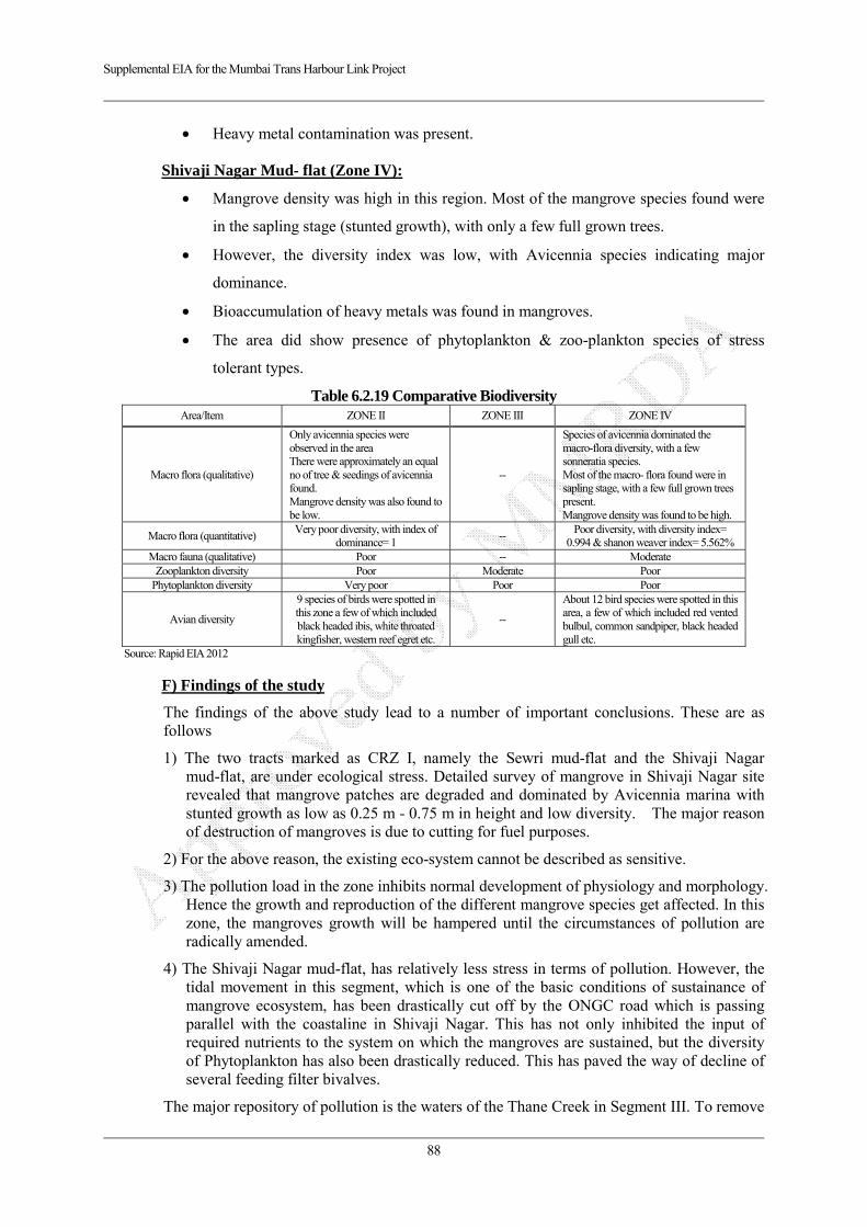
Supplemental EIA for the Mumbai Trans Harbour Link Project
88
Heavy metal contamination was present.
Shivaji Nagar Mud- flat (Zone IV):
Mangrove density was high in this region. Most of the mangrove species found were
in the sapling stage (stunted growth), with only a few full grown trees.
However, the diversity index was low, with Avicennia species indicating major
dominance.
Bioaccumulation of heavy metals was found in mangroves.
The area did show presence of phytoplankton & zoo-plankton species of stress
tolerant types.
Table 6.2.19 Comparative Biodiversity Area/Item ZONE II ZONE III ZONE IV
Macro flora (qualitative)
Only avicennia species were observed in the area There were approximately an equal no of tree & seedings of avicennia found. Mangrove density was also found to be low.
--
Species of avicennia dominated the macro-flora diversity, with a few sonneratia species. Most of the macro- flora found were in sapling stage, with a few full grown trees present. Mangrove density was found to be high.
Macro flora (quantitative) Very poor diversity, with index of
dominance= 1 --
Poor diversity, with diversity index= 0.994 & shanon weaver index= 5.562%
Macro fauna (qualitative) Poor -- Moderate Zooplankton diversity Poor Moderate Poor
Phytoplankton diversity Very poor Poor Poor
Avian diversity
9 species of birds were spotted in this zone a few of which included black headed ibis, white throated kingfisher, western reef egret etc.
--
About 12 bird species were spotted in this area, a few of which included red vented bulbul, common sandpiper, black headed gull etc.
Source: Rapid EIA 2012
F) Findings of the study
The findings of the above study lead to a number of important conclusions. These are as follows
1) The two tracts marked as CRZ I, namely the Sewri mud-flat and the Shivaji Nagar mud-flat, are under ecological stress. Detailed survey of mangrove in Shivaji Nagar site revealed that mangrove patches are degraded and dominated by Avicennia marina with stunted growth as low as 0.25 m - 0.75 m in height and low diversity. The major reason of destruction of mangroves is due to cutting for fuel purposes.
2) For the above reason, the existing eco-system cannot be described as sensitive.
3) The pollution load in the zone inhibits normal development of physiology and morphology. Hence the growth and reproduction of the different mangrove species get affected. In this zone, the mangroves growth will be hampered until the circumstances of pollution are radically amended.
4) The Shivaji Nagar mud-flat, has relatively less stress in terms of pollution. However, the tidal movement in this segment, which is one of the basic conditions of sustainance of mangrove ecosystem, has been drastically cut off by the ONGC road which is passing parallel with the coastaline in Shivaji Nagar. This has not only inhibited the input of required nutrients to the system on which the mangroves are sustained, but the diversity of Phytoplankton has also been drastically reduced. This has paved the way of decline of several feeding filter bivalves.
The major repository of pollution is the waters of the Thane Creek in Segment III. To remove

Supplemental EIA for the Mumbai Trans Harbour Link Project
89
the circumstances of pollution is in itself a difficult task. With all the will that the managers of environment can muster, cleaning up will take a long time, because the heavy metals already deposited in the soil are not going to disappear soon.
G) Migratory Birds
a) Findings on Rapid EIA 2012 (MMRDA)
The mudflats and mangroves constitute the ecological settings of the project area. have mudflats and mangrove area. The Sewri end of the mudflat experiences migratory birds during winter season.
The Sewri mudflat area is known to attract lesser flamingoes (Phoeniconaias minor) and a few number of greater flamingoes (Phoeniconaias rosues) from November to June every year. About 10,000 to 15,000 flamingoes which are Near Threatened on the IUCN’s Red List are known to visit this site.
Although important migratory birds have s not been confirmed in the survey of the 2012 survey, these migratory birds have a stay at this habitat for a limited period and leave the area in the beginning of summer back to their original habitat. They feed themselves on the minute aquatic creatures in the mudflats and also enjoy the high salinity nature. Monitoring programme will be taken up during construction phase to monitor the movement of the migratory birds. Due to slight increase in noise level during construction phase, it is supposed that the migratory bird colonies/areas will not have permanent shifting. It is expected that they may slightly shift, if at all, during construction phase, to avoid any disturbance. It has been observed during the study that during high tide period on the mudflats these birds shifts themselves to other areas and come back again during low tide. Even during movements of boats etc they tend to shift for temporary period. There are a few industries very near to these mudflats, which generate typical noise levels due to industrial operations. It is expected that construction of this project will not affect the habitation of the migratory birds permanently.
b) Findings on Study of Flamingos and Migratory Birds 2008 (MMRDA/Salim Ali Centre for Ornithology and Natural History)
Salim Ali Centre for Ornithology and Natural History studied the FlemingosFlamingos and other migratory birds in the Sewri - Mahul and Nhava Mudflats and the findings and recommendations of this study which will help build an appropriate to take necessary mitigation plan steps for the protection of birds in the area. Following are some of the observation in the report.
Observation
According to the report, number of recorded species are 70 species in Sewri Section
and 34 species in Shivaji Nagar Section in 2008 as shown in Table 6.2.12
Comprehensive Recorded Birds Species (2008-2012).
The average number of Black headed Ibis, a near threatened category species was
found to be 18 and four juvenile birds were observed in Sewri during February 2008.
The lesser flamingo started arriving in the area during December 2006 in small
numbers, and increased slowly in March 2007 and in large numbers in April
2007reaching the peak in May 2007. They started leaving the area in June with a few
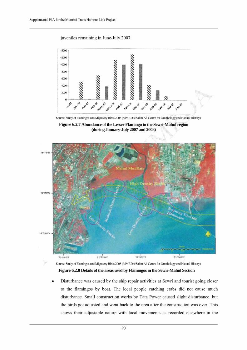
Supplemental EIA for the Mumbai Trans Harbour Link Project
90
juveniles remaining in June-July 2007.
Source: Study of Flamingos and Migratory Birds 2008 (MMRDA/Salim Ali Centre for Ornithology and Natural History)
Figure 6.2.7 Abundance of the Lesser Flamingo in the Sewri-Mahul region (during January-July 2007 and 2008)
Source: Study of Flamingos and Migratory Birds 2008 (MMRDA/Salim Ali Centre for Ornithology and Natural History)
Figure 6.2.8 Details of the areas used by Flamingos in the Sewri-Mahul Section
Disturbance was caused by the ship repair activities at Sewri and tourist going closer
to the flamingos by boat. The local people catching crabs did not cause much
disturbance. Small construction works by Tata Power caused slight disturbance, but
the birds got adjusted and went back to the area after the construction was over. This
shows their adjustable nature with local movements as recorded elsewhere in the
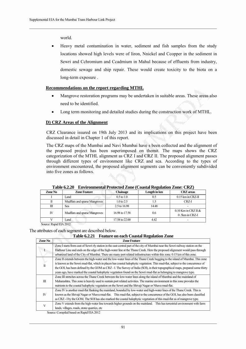
Supplemental EIA for the Mumbai Trans Harbour Link Project
91
world.
Heavy metal contamination in water, sediment and fish samples from the study
locations showed high levels were of Iiron, Nnickel and Ccopper in the sediment in
Sewri and Cchromium and Ccadmium in Mahul because of effluents from industry,
domestic sewage and ship repair. These would create toxicity to the biota on a
long-term exposure .
Recommendations on the report regarding MTHL
Mangrove restoration programs may be undertaken in suitable areas. These areas also
need to be identified.
Long term monitoring and detailed studies during the construction work of MTHL.
D) CRZ Areas of the Alignment
CRZ Clearance issured on 19th July 2013 and its implications on this project have been discussed in detail in Chapter 1 of this report.
The CRZ maps of the Mumbai and Navi Mumbai have s been collected and the alignment of the proposed project has been superimposed on themit. The maps shows the CRZ categorization of the MTHL alignment as CRZ I and CRZ II. The proposed alignment passes through different types of environment like CRZ and sea. According to the types of environment encountered, the proposed alignment segments can be conveniently subdivided into five zones as follows.
Table 6.2.20 Environmental Protected Zone (Coastal Regulation Zone: CRZ) Zone No Zone Feature Chainage Length in km CRZ areas
I Land 0.5 to 1.0 0.5 0.15 km in CRZ-II
II Mudflats and sparse Mangroves 1.0 to 2.5 1.5 CRZ-I III Sea 2.5 to 16.98 14.48 -
IV Mudflats and sparse Mangroves 16.98 to 17.58 0.6 0.10 Km in CRZ II &
0 .5km in CRZ-I
V Land 17.58 to 22.00 4.42 - Source: Rapid EIA 2012
The attributes of each segment are described below. Table 6.2.21 Feature on each Coastal Regulation Zone
Zone No Zone Feature
I Zone I starts from east of Sewri rly station in the east-central part of the city of Mumbai near the Sewri railway station on the Harbour Line and ends on the edge of the high-water line at the Thane Creek. Here the proposed alignment would pass through urbanized land of the City of Mumbai. There are many port related infrastructure within this zone. 0.15 km of this zone.
II
Zone II extends between the high-water and the low-water lines of the Thane Creek hugging to the island of Mumbai. This zone is known as the Sewri mud-flat, which in places has coastal halophytic vegetation. This mud-flat, subject to the concurrence of the GOI, has been defined by the GOM as CRZ - I. The Survey of India (SOI), in their topographical maps, prepared some thirty years ago, have marked the coastal halophytic vegetation found on the Sewri mud-flat as belonging to mangrove type.
III Zone III stretches across the Thane Creek between the low-water lines along the island of Mumbai and the mainland of Maharashtra. This zone is heavily used to sustain port related activities. The marine environment in this zone provides the nutrients to the coastal halophytic vegetation on the Sewri and the Shivaji Nagar or Nhava mud-flat.
IV Zone IV is another mud-flat flanking the mainland, bounded by low-water and high-water lines of the Thane Creek. This is known as the Shivaji Nagar or Nhava mud-flat. This mud-flat, subject to the concurrence of the GOI, has also been classified as CRZ - I by the GOM. The SOI has also marked the coastal halophytic vegetation of this mud-flat as of mangrove type.
V Zone V extends from the high-water line towards higher grounds on the mainland. This has terrestrial environment with farm lands, villages, roads, stone quarries, etc
Source: Compiled based on Rapid EIA 2012

Supplemental EIA for the Mumbai Trans Harbour Link Project
92
The statement of area for MTHL falling in CRZ is shown in the following table
Table 6.2.22 Area Statement of bridge/Viaduct in CRZ
Sr No
Zone Area of Bridge in
CRZ in Sqm No of Piers Size of Pier
Total area of pier in CRZ in sqm
Cost in Crore INR(x 10 mil)
SEWRI SIDE
1 CRZ I 45,000 62 3mX4m 744 481.5 2 CRZ II 4,500 8 3mX4m 96 48.15
Total 49,500 70 840 529.65
CHIRLE SIDE 1 CRZ I 15,000 22 3mX4m 264 160.5 2 CRZ II 3,000 6 3mX4m 72 32.1
Total 18,000 28 336 192.6 Grand Total 67,500 98 1,176 722.25
Source: Rapid EIA 2012
(3) Potential Impacts
1) During Construction
Fauna
Operation such as construction related vehicle and heavy equipment, also construction activities.
Inflow and installation of base camp construction officials
Flora
Cutting mangrove, other trees and vegetation
2) After Construction
Fauna
Increase in traffic number
The presence of viaduct and related facilities
Existence of bridge may give impacts on tidal flow and mudflat
Flora
Existence of bridge may give impacts on tidal flow and mudflat
(4) Impact Forecast
1) During Construction
Fauna
The items examined to forecast the impact are as below:
Loss of mudflat and mangrove and/or their habitats caused due to by excavation for the piles
Turbid water due to activities in the creek area and inflowing from construction area may impact on aquatic fauna.
Part of the mudflat ecosystem is likely to be temporarily lost during the construction of the project which may result in drying of the mudflat around pile area and concurrent reduction in the food resources of migratory birds.
If the base camp and construction yard are established installed near the feeding grounds

Supplemental EIA for the Mumbai Trans Harbour Link Project
93
of migratory birds(mainly Flamingo and black headed ibis), migratory birds may avoid the area and fly away to other mudflat in Mumbai harbour temporarily. However, in general, such birds may return to their habitat after completion of the work in those stretches.
Flora
A part of mangrove area will be cut by the construction activiteis, however, the drying of the mudflat may increase only around piles and provide habitas of the mangrove.
2) After Construction
Fauna
Some migratory birds are accidentally killed on the road and bridge due to increase of traffic volume.
The presence of elevated road, there is a risk of inhibiting the flight path of the Flamingo.
Impact on the Flamingo roost is concerned by due to the irradiation of lighting of the road and traffic noise
According to the result of forecast on hydology in article 6.2.2 Hydrology, existence of piers does not give significant impacts on entire of tidal flow and physical condition of mudflat, thus it is expected that such insignificant impacts on tidal flow and phisical condition of mudflat does not give adverse impacts on ecosystem in the mudflat.
Flora
The drying of the mudflat may be caused by existence of bridge piers, however, such area is limited around the piers and may provide possible environment for mangrove growth.
(5) Mitigation Measures
The proposed mitigation measures are set up based on CRZ clearance specific condition of MOEF, Rapid EIA 2012 approved by MMRDA, interview with specialists of mudflat and migratory birds in India and Japan and other project cases in Japan.
1) During Construction
Fauna
Adoption of excavation methodology for the minimal turbid water prevention (i.e. bore casing and excavation) (Referred project name: Shikoku Odan Expressway in Japan)
Minimization of affected area on mangrove area and mudflat by adoption of temporary jetty construction road (Referred project name: Lake Man of Okinawa in Japan)
Establishment of construction plan in consideration with lifecycle of migratory birds such as Flamingos, if possible. (i.e. Construction of temporary jetty may be constructed during rainy season) (Referred project name: Shikoku Odan Expressway in Japan, Isewangan Expressway in Japan)
Installation of silencer with construction machines and/or low-noise machines near CRZ and mudflat in accordance with CRZ clearance. (Referred project name: Shikoku Odan Expressway in Japan, Isewangan Expressway in Japan)
It is recommended that implementation of detailed baseline survey for fauna and preparation of monitoring plan in the project area before design-build stage

Supplemental EIA for the Mumbai Trans Harbour Link Project
94
Flora
Implementation of the compensatory mangrove plantation in accordance with CRZ clearance specific condition on July 2013 (5 times of cutting mangrove: 0.1776 ha x 5 = 0.888 ha) (Referred project name: Lake Man of Okinawa in Japan)
Implementation of monitoring for migratory birds such as Flamingos in accordance with CRZ clearance general condition on July 2013.
It is recommended that implementation of detailed baseline survey for flora and preparation of monitoring plan in the project area before design-build stage
2) After Construction
Fauna
Sound barriers shall be installed on both sides of the road in CRZ area and Flaming distributed area so as to minimize the adverse impacts to the migratory birds in accordance with CRZ clearance specific conditions. (Referred project name: Shin Meishin Expressway Asuka IC- Nabeta IC in Japan and Case of rail-kill the Keiyo Line in Japan)
Adoption of bridge type not to give significant impacts on migratory bird flying course in mudflat area. Distribution area and flying course for such as Flamingo should be identified through baseline survey prior to construction stage. (Referred project name: Shikoku Odan Expressway in Japan)
Pre-stressed super structure shall be used in the mud flat area for construction as committed on CRZ clearance
Lighting which does not give significant adverse impacts to roosting area of Flamingos should be installed in accordance with CRZ clearance specific condition. (Referred project name: Tokyo Bay Aquiline in Tokyo, Shin Meishin Expressway Asuka IC- Nabeta IC in Japan)
Prohibit to use vehicle horn in mudflat section (Referred project name: Shikoku Odan Expressway in Japan, Isewangan Expressway in Japan)
Implementation of periodical monitoring for migratory birds such as Flamingos in accordance with CRZ clearance general condition on July 2013
Flora
Implementation of replanting shall be done in accordance with CRZ specific condtion in Nahava area, however, detailed specific area, methodology and management & maintenance plan is not established yet at the moment. Thus detailed replanting and management shall be planed under considering surrounding vegetation and ecosystem during detailed design stage. (this management plan shall be prepared before construction stage under discussion with Ministry of Environment and Forests and Mahashtra State) (Referred project name: Lake Man of Okinawa in Japan)

Supplemental EIA for the Mumbai Trans Harbour Link Project
95
Source: Panasonic Eco-solutions (Project name: Shin Meishin Expressway Asuka IC- Nabeta IC in Japan)
Figure 6.2.9 Noise Barrier with Lighting System in the handrail/noise barrier/view barrier
(6) Evaluation
The existing information on the project area suggests that the project area does not have rich environment, mangrove vegetation and a plenty of migratory birds mainly Flamingos are feeding on the mudflat between from November to June. Construction activities of MTHL may cause noise during construction stage, thus some group of migratory birds may avoid the adjacent area and flyaway to other area in Mumbai basin temporarily. However since several mitigation measures will be conducted, the migratory birds may again get back to same habitat gradually. Additionally turbidity from excavated area in the sea and cutting mangrove area will be minimized by appropriate mitigation measures such as adoption of bored piling methodology and installation of temporary jetty in the mudflat.
On the other hand, during operation phase, travelling vehicles generate noise and existence of viaduct may give adverse impacts for migratory birds. For minimization of these impacts, not only CRZ specific conditions, but also additional measures such as consideration of lighting system not to give impacts on Flamingo’s roosting area are planned.
When unexpected events and phenomena has been confirmed after construction and during construction, appropriate to take action in consultation with relevant organizations such as MMRDA with general consultant and contractor, environmental department of Maharshtra and MoEF.
Thus, it is not likely to give serious impacts on project area including mudflat ecosystem under implementation of appropriate mitigation measures.
6.2.2. Hydrology
(1) Current Condition
Mumbai lies on the western coast of Arabian Sea, and is classified a “Tropical wet and dry or savanna climate” (by Köppen-Geiger classification: Aw). The climate of Aw have a pronounced dry season, with the driest month having rainfall less than 60 mm and less than 1/25 of the total annual rainfall. The summer and the winter climate are controlled by the south-west / north-east monsoons, and the autumn and spring seasons are practically indistinguishable. The Mumbai comes under the direct influence of the south-west monsoon
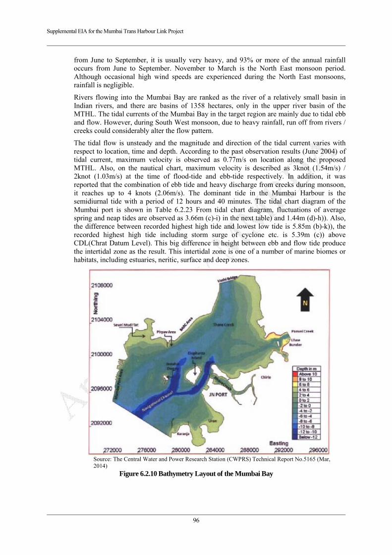
Supplemental EIA for the Mumbai Trans Harbour Link Project
96
from June to September, it is usually very heavy, and 93% or more of the annual rainfall occurs from June to September. November to March is the North East monsoon period. Although occasional high wind speeds are experienced during the North East monsoons, rainfall is negligible.
Rivers flowing into the Mumbai Bay are ranked as the river of a relatively small basin in Indian rivers, and there are basins of 1358 hectares, only in the upper river basin of the MTHL. The tidal currents of the Mumbai Bay in the target region are mainly due to tidal ebb and flow. However, during South West monsoon, due to heavy rainfall, run off from rivers / creeks could considerably alter the flow pattern.
The tidal flow is unsteady and the magnitude and direction of the tidal current varies with respect to location, time and depth. According to the past observation results (June 2004) of tidal current, maximum velocity is observed as 0.77m/s on location along the proposed MTHL. Also, on the nautical chart, maximum velocity is described as 3knot (1.54m/s) / 2knot (1.03m/s) at the time of flood-tide and ebb-tide respectively. In addition, it was reported that the combination of ebb tide and heavy discharge from creeks during monsoon, it reaches up to 4 knots (2.06m/s). The dominant tide in the Mumbai Harbour is the semidiurnal tide with a period of 12 hours and 40 minutes. The tidal chart diagram of the Mumbai port is shown in Table 6.2.23 From tidal chart diagram, fluctuations of average spring and neap tides are observed as 3.66m (c)-i) in the next table) and 1.44m (d)-h)). Also, the difference between recorded highest high tide and lowest low tide is 5.85m (b)-k)), the recorded highest high tide including storm surge of cyclone etc. is 5.39m (c)) above CDL(Chrat Datum Level). This big difference in height between ebb and flow tide produce the intertidal zone as the result. This intertidal zone is one of a number of marine biomes or habitats, including estuaries, neritic, surface and deep zones.
Source: The Central Water and Power Research Station (CWPRS) Technical Report No.5165 (Mar, 2014)
Figure 6.2.10 Bathymetry Layout of the Mumbai Bay
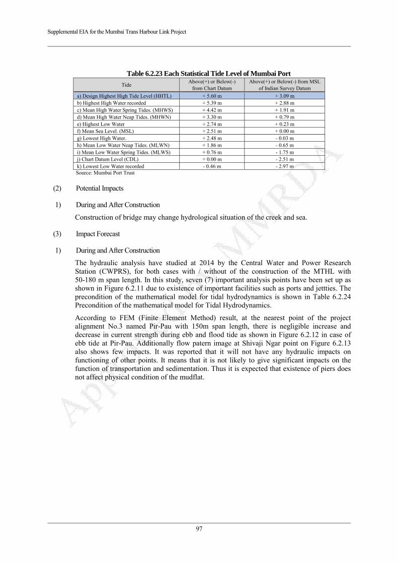
Supplemental EIA for the Mumbai Trans Harbour Link Project
97
Table 6.2.23 Each Statistical Tide Level of Mumbai Port
Tide Above(+) or Below(-)
from Chart Datum Above(+) or Below(-) from MSL
of Indian Survey Datum
a) Design Highest High Tide Level (HHTL) + 5.60 m + 3.09 m b) Highest High Water recorded + 5.39 m + 2.88 m c) Mean High Water Spring Tides. (MHWS) + 4.42 m + 1.91 m d) Mean High Water Neap Tides. (MHWN) + 3.30 m + 0.79 m e) Highest Low Water + 2.74 m + 0.23 m f) Mean Sea Level. (MSL) + 2.51 m + 0.00 m g) Lowest High Water. + 2.48 m - 0.03 m h) Mean Low Water Neap Tides. (MLWN) + 1.86 m - 0.65 m i) Mean Low Water Spring Tides. (MLWS) + 0.76 m - 1.75 m j) Chart Datum Level (CDL) + 0.00 m - 2.51 m k) Lowest Low Water recorded - 0.46 m - 2.97 m Source: Mumbai Port Trust
(2) Potential Impacts
1) During and After Construction
Construction of bridge may change hydrological situation of the creek and sea.
(3) Impact Forecast
1) During and After Construction
The hydraulic analysis have studied at 2014 by the Central Water and Power Research Station (CWPRS), for both cases with / without of the construction of the MTHL with 50-180 m span length. In this study, seven (7) important analysis points have been set up as shown in Figure 6.2.11 due to existence of important facilities such as ports and jettties. The precondition of the mathematical model for tidal hydrodynamics is shown in Table 6.2.24 Precondition of the mathematical model for Tidal Hydrodynamics.
According to FEM (Finite Element Method) result, at the nearest point of the project alignment No.3 named Pir-Pau with 150m span length, there is negligible increase and decrease in current strength during ebb and flood tide as shown in Figure 6.2.12 in case of ebb tide at Pir-Pau. Additionally flow patern image at Shivaji Ngar point on Figure 6.2.13 also shows few impacts. It was reported that it will not have any hydraulic impacts on functioning of other points. It means that it is not likely to give significant impacts on the function of transportation and sedimentation. Thus it is expected that existence of piers does not affect physical condition of the mudflat.

Supplemental EIA for the Mumbai Trans Harbour Link Project
98
Note) 7 points have been selected due to existence of important facilities such as ports and jetties Source: The Central Water and Power Research Station (CWPRS) Technical Report No.5165 (Mar, 2014)
Figure 6.2.11 Hydraulic Analysis Areas in the Mumbai Basin
Table 6.2.24 Precondition of the mathematical model for Tidal Hydrodynamics
Items Case-1
Without MTHL Case-2
With MTHL Remarks
Analysis Area 193 Bathymetry data Provided by CWPRS
Influence by MTHL bridge Not considered
Considered Span lengths are varied from 50m to 180m of same conditions as 2012 F/S study. In a similar way, pier shapes are taken in the analysis model as quasi-shapes by triangular finite elements.
Boundary Conditions and Reproduction Period
Observed tidal levels at Apollo bunder (Mumbai Port), Vashi bridge (Thane creek) and Ulwe Bundar (Panvel creek) from 08.05.2013 to 03.06.2013
Observed Tidal current for the calibration
Six locations in Analysis area from 27.05.2013 to 03.06.2013
Summary of FEM hydraulic model
No. of Nodes for finite element mesh
21,018 129,120
No. of Elements for finite element mesh
39,921 250,681 Triangular finite elements
Usage Software TELEMAC-2D
Analysis method Two-dimensional unsteady flow by hydrodynamic equations of Saint Venant's
Source: The Central Water and Power Research Station (CWPRS) Technical Report No.5165 (Mar, 2014)
No3. Pir-Pau Area
● No3
● No2
● No1
● No4
No5 ●
● No6
No7 ●
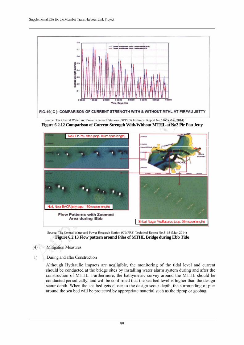
Supplemental EIA for the Mumbai Trans Harbour Link Project
99
Source: The Central Water and Power Research Station (CWPRS) Technical Report No.5165 (Mar, 2014)
Figure 6.2.12 Comparison of Current Strength With/Without MTHL at No3 Pir Pau Jetty
Source: The Central Water and Power Research Station (CWPRS) Technical Report No.5165 (Mar, 2014)
Figure 6.2.13 Flow pattern around Piles of MTHL Bridge during Ebb Tide
(4) Mitigation Measures
1) During and after Construction
Although Hydraulic impacts are negligible, the monitoring of the tidal level and current should be conducted at the bridge sites by installing water alarm system during and after the construction of MTHL. Furthermore, the bathymetric survey around the MTHL should be conducted periodically, and will be confirmed that the sea bed level is higher than the design scour depth. When the sea bed gets closer to the design scour depth, the surrounding of pier around the sea bed will be protected by appropriate material such as the riprap or geobag.
No3. Pir-Pau Area (app. 150m span length)
Shivaji Nagar Mudflat area (app. 50m span length)
No4. Near BACR jetty (app. 180m span length)
Supplemental EIA for the Mumbai Trans Harbour Link Project
100
(5) Evaluation
1) During and After Construction
The study of bridge hydraulics in the Mumbai Bay has been conducted on 2014 by the Central Water and Power Research Station (CWPRS). In the Study, the insignificant changes in flow speed and direction only around piers are indicated in Figure 6.2.13 graphically, however, the changes of ebb tidal flow speed at forecasted points are not significant as shown in Figure 6.2.12, thus it is not expected that construction of new bridge affects on entire of hydrological situation and physical condition of mudflat.
6.2.3. Topography and Geology
(1) Current Condition
The topographical and geological features are described in the chapter “3.1.Topography, Geography and Hydrology”.
(2) Potential Impacts
1) During and After Construction
Any considerable topography and geological sites are not located in the project area, thus no impact is expected. However embankment section may have risks of land slide.
(3) Impact Forecast
1) During and After Construction
The area of earthworks and embankment is shown in the next figure. An embankment section is located from ST 17+000 to 17+900 and from ST 21+300 to 21+800 as an interchange in Shivaji Nagar and Chirle, the cutting section is located from ST 19+500 to 19+900 as a Tollgate approach road.

Supplemental EIA for the Mumbai Trans Harbour Link Project
101
Figure 6.2.14 Major Earthwork Sections in the Project Area Embankment (Shivaji Nagar and Chirle) Cutting Section Source: JICA Study Team
Figure 6.2.15 Typical Cross Section on the Earthwork Area
Storm water may give adverse impacts on its stability due to surface water flow, and such rain water causes turbid water from earthwork area during monsoon season. However, the toll gate section is located on rock mountain, thus, it is expected that soil erosion and landslide is not caused during monsoon season.
Shivaji NagarCutting Section
Chirle
Chirle
Cutting Section
Shivaji Nagar
Median CarrigewayCarrigeway
CarrigewayCarrigeway Median
Embankment Material
Soft Rock
1:1.8 1:1.8
1:0.8 1:0.8
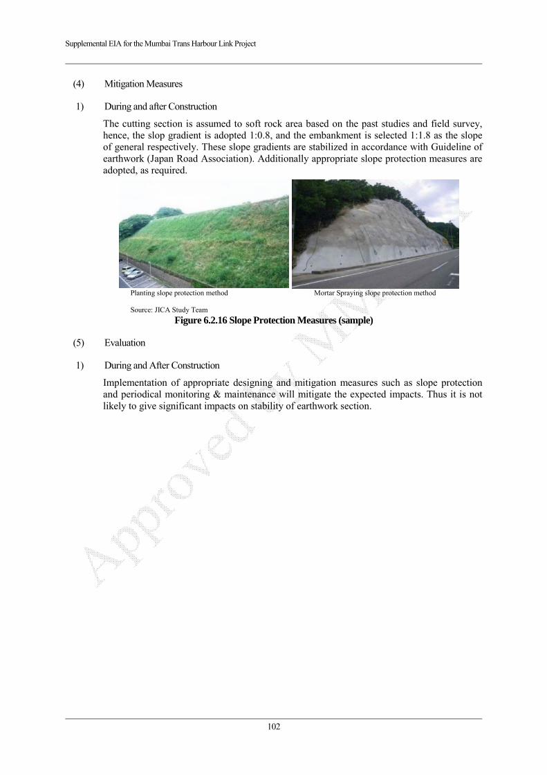
Supplemental EIA for the Mumbai Trans Harbour Link Project
102
(4) Mitigation Measures
1) During and after Construction
The cutting section is assumed to soft rock area based on the past studies and field survey, hence, the slop gradient is adopted 1:0.8, and the embankment is selected 1:1.8 as the slope of general respectively. These slope gradients are stabilized in accordance with Guideline of earthwork (Japan Road Association). Additionally appropriate slope protection measures are adopted, as required.
Planting slope protection method Mortar Spraying slope protection method Source: JICA Study Team
Figure 6.2.16 Slope Protection Measures (sample)
(5) Evaluation
1) During and After Construction
Implementation of appropriate designing and mitigation measures such as slope protection and periodical monitoring & maintenance will mitigate the expected impacts. Thus it is not likely to give significant impacts on stability of earthwork section.
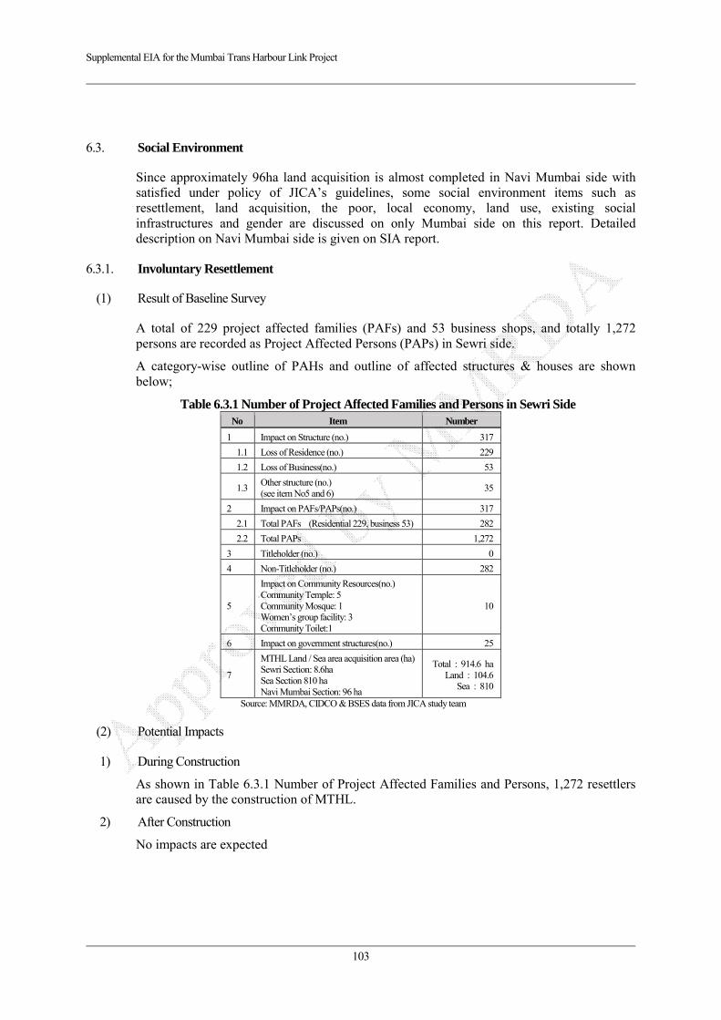
Supplemental EIA for the Mumbai Trans Harbour Link Project
103
6.3. Social Environment
Since approximately 96ha land acquisition is almost completed in Navi Mumbai side with satisfied under policy of JICA’s guidelines, some social environment items such as resettlement, land acquisition, the poor, local economy, land use, existing social infrastructures and gender are discussed on only Mumbai side on this report. Detailed description on Navi Mumbai side is given on SIA report.
6.3.1. Involuntary Resettlement
(1) Result of Baseline Survey
A total of 229 project affected families (PAFs) and 53 business shops, and totally 1,272 persons are recorded as Project Affected Persons (PAPs) in Sewri side.
A category-wise outline of PAHs and outline of affected structures & houses are shown below;
Table 6.3.1 Number of Project Affected Families and Persons in Sewri Side No Item Number
1 Impact on Structure (no.) 317
1.1 Loss of Residence (no.) 229
1.2 Loss of Business(no.) 53
1.3Other structure (no.) (see item No5 and 6)
35
2 Impact on PAFs/PAPs(no.) 317
2.1 Total PAFs (Residential 229, business 53) 282
2.2 Total PAPs 1,272
3 Titleholder (no.) 0
4 Non-Titleholder (no.) 282
5
Impact on Community Resources(no.) Community Temple: 5 Community Mosque: 1 Women’s group facility: 3 Community Toilet:1
10
6 Impact on government structures(no.) 25
7
MTHL Land / Sea area acquisition area (ha) Sewri Section: 8.6ha Sea Section 810 ha Navi Mumbai Section: 96 ha
Total : 914.6 ha Land : 104.6
Sea : 810
Source: MMRDA, CIDCO & BSES data from JICA study team
(2) Potential Impacts
1) During Construction
As shown in Table 6.3.1 Number of Project Affected Families and Persons, 1,272 resettlers are caused by the construction of MTHL.
2) After Construction
No impacts are expected

Supplemental EIA for the Mumbai Trans Harbour Link Project
104
(3) Impact Forecast
1) During Construction
As shown in Table 6.3.1 Number of Project Affected Families and Persons, number of PAFs and relocated persons is 282 and 1,272 to be displaced are identified based on SIA survey.
(4) Mitigation Measures
1) During Construction
Major mitigation measures are as follows;
Holding consultation meetings for understanding of compensation policy
Implementation of adequate compensation on JICA Guidelines
Implementation of livelihood restoration program based on Social Impact Assessment (SIA) (Detailed implementation programs are described in the SIA report)
2) After Construction
Monitoring and assessing will be conducted regarding livelihood of PAPs, appropriate restoration and enhancement of living standards will be considered in accordance with SIA.
(5) Evaluation
1) During Construction
Although 1,272 resettlers are caused by the project, implementation of appropriate compensation, resettlement and social assistance will mitigate expected adverse impacts, thus it is not likely to give serious impacts on this item.
6.3.2. The Poor
(1) Result of Baseline Survey
The annual family income of PAPs is shown in Table 6.3.2. In the Sewri area, 146 (58.9 %) of affected families earn income ranging from 50,000 to 100,000 INR. On the other hand, yearly expenditure less than 300,000 INR indicates 96.3%.
Table 6.3.2 Income of PAPs in Sewri Section Annual Income
Total No. %
Less than 50,000 28 11.3 50,000 K – 100,000 (1 Lakh.) 146 58.9 1 Lakh - 5 Lakh 71 28.6 5 Lakh & Above 3 1.2 Total 248 100.0
Source – BSES data from JICA study team
Table 6.3.3 Expenditure of PAPs in Sewri Section Annual Expenditure
Total No. %
Less than 100,000 (1 Lakh) 105 46.8100,000 to 300,000 (1 Lakh – 3 Lakh)
111 49.5
300,000 to 500,000 (3 Lakh – 5 Lakh)
8 3.7
500,000 and above (5 Lakh - )
0 0
Total 224 100.0
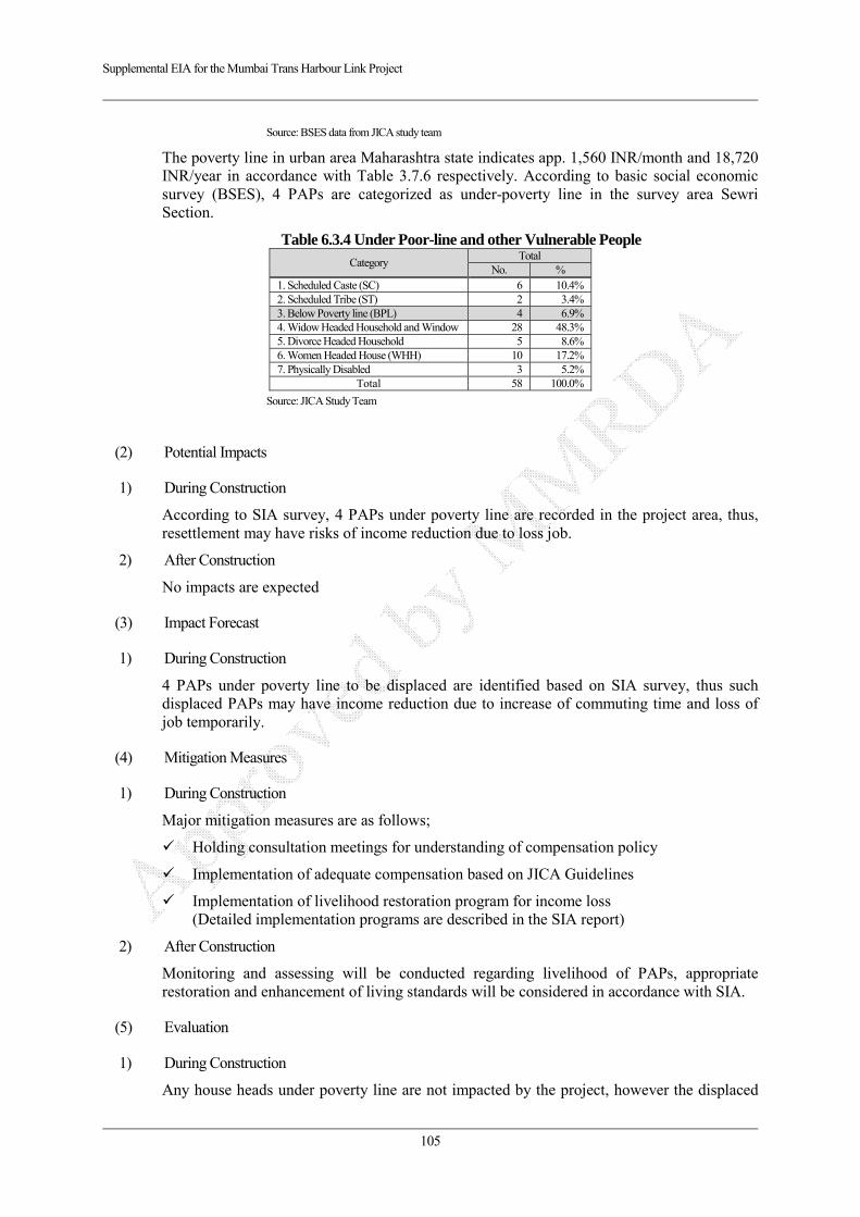
Supplemental EIA for the Mumbai Trans Harbour Link Project
105
Source: BSES data from JICA study team
The poverty line in urban area Maharashtra state indicates app. 1,560 INR/month and 18,720 INR/year in accordance with Table 3.7.6 respectively. According to basic social economic survey (BSES), 4 PAPs are categorized as under-poverty line in the survey area Sewri Section.
Table 6.3.4 Under Poor-line and other Vulnerable People Category
Total No. %
1. Scheduled Caste (SC) 6 10.4% 2. Scheduled Tribe (ST) 2 3.4% 3. Below Poverty line (BPL) 4 6.9% 4. Widow Headed Household and Window 28 48.3% 5. Divorce Headed Household 5 8.6%6. Women Headed House (WHH) 10 17.2%7. Physically Disabled 3 5.2%
Total 58 100.0%
Source: JICA Study Team
(2) Potential Impacts
1) During Construction
According to SIA survey, 4 PAPs under poverty line are recorded in the project area, thus, resettlement may have risks of income reduction due to loss job.
2) After Construction
No impacts are expected
(3) Impact Forecast
1) During Construction
4 PAPs under poverty line to be displaced are identified based on SIA survey, thus such displaced PAPs may have income reduction due to increase of commuting time and loss of job temporarily.
(4) Mitigation Measures
1) During Construction
Major mitigation measures are as follows;
Holding consultation meetings for understanding of compensation policy
Implementation of adequate compensation based on JICA Guidelines
Implementation of livelihood restoration program for income loss (Detailed implementation programs are described in the SIA report)
2) After Construction
Monitoring and assessing will be conducted regarding livelihood of PAPs, appropriate restoration and enhancement of living standards will be considered in accordance with SIA.
(5) Evaluation
1) During Construction
Any house heads under poverty line are not impacted by the project, however the displaced
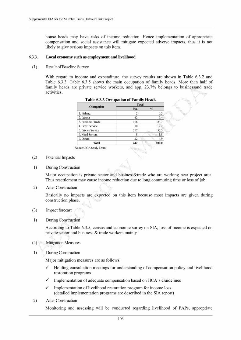
Supplemental EIA for the Mumbai Trans Harbour Link Project
106
house heads may have risks of income reduction. Hence implementation of appropriate compensation and social assistance will mitigate expected adverse impacts, thus it is not likely to give serious impacts on this item.
6.3.3. Local economy such as employment and livelihood
(1) Result of Baseline Survey
With regard to income and expenditure, the survey results are shown in Table 6.3.2 and Table 6.3.3. Table 6.3.5 shows the main occupation of family heads. More than half of family heads are private service workers, and app. 23.7% belongs to businessand trade activities.
Table 6.3.5 Occupation of Family Heads
Occupation Total
No. %
1. Fishing 2 0.52. Labour 42 9.43. Business /Trade 106 23.74. Govt. Service 10 2.25. Private Service 257 57.56. Maid Servant 8 1.87. Others 22 4.9
Total 447 100.0
Source: JICA Study Team
(2) Potential Impacts
1) During Construction
Major occupation is private sector and business&trade who are working near project area. Thus resettlement may cause income reduction due to long commuting time or loss of job.
2) After Construction
Basically no impacts are expected on this item because most impacts are given during construction phase.
(3) Impact forecast
1) During Construction
According to Table 6.3.5, census and economic surrey on SIA, loss of income is expected on private sector and business & trade workers mainly.
(4) Mitigation Measures
1) During Construction
Major mitigation measures are as follows;
Holding consultation meetings for understanding of compensation policy and livelihood restoration programs
Implementation of adequate compensation based on JICA’s Guidelines
Implementation of livelihood restoration program for income loss (detailed implementation programs are described in the SIA report)
2) After Construction
Monitoring and assessing will be conducted regarding livelihood of PAPs, appropriate
Supplemental EIA for the Mumbai Trans Harbour Link Project
107
restoration and enhancement of living standards will be considered in accordance with SIA.
(5) Evaluation
1) During Construction
Although 447 PAPs and their properties are impacted by the project, implementation of appropriate compensation and social assistance will mitigate expected adverse impacts, thus it is not likely to give serious impacts on this item.
6.3.4. Land use and Utilization of Local Resources
(1) Result of Baseline Survey
Approximately 8.6 ha compound of Mumbai Port Trust (MPT) will be affected by the project, and some areas are used for residential and commercial shops as shown in Table 6.3.1. Some house heads and shop owners have a lease contract with MPT in Sewri Section. Additionally, in the sea section, traditional fishermen have own customary fishing ground. Detailed data is shown in SIA report.
(2) Potential Impacts
1) During Construction
As described in Table 6.3.5, private service workers, fishermen and business & trade workers are working in the project area and near project area, thus such working space is reduced by the construction of MTHL.
2) After Construction
Development activities without any permission from the local government along the alignment may be caused and unplanned development may give adverse impacts from the view of social environment and natural conservation.
(3) Impact forecast
1) During Construction
Approximately 8.6 ha MPT compound including commercial and housing land with 229 families and 53 shops will be used for construction site and yard, additionally in the sea section between ST500 to ST17600, customary fishing ground will be reduced by the construction of MTHL.
2) After Construction
Surrounding area of the MTHL may be used for commercial area and small factory compound without any permission from authorities.
(4) Mitigation Measures
1) During Construction
Major mitigation measures are as follows;
Holding consultation meetings for understanding of compensation policy and livelihood restoration programs for affected persons including fishermen
Implementation of adequate compensation for affected properties based on JICA’s Guidelines

Supplemental EIA for the Mumbai Trans Harbour Link Project
108
Implementation of livelihood restoration program for income loss based on JICA’s Guidelines (detailed implementation programs are described in the SIA report)
2) After Construction
Management of appropriate land use in accordance with approved land use plan along the road.
(5) Evaluation
1) During Construction
Although totally 8.6 ha compound in Sewri area and customary fishing area is affected by the project in the sea section, implementation of appropriate compensation and social assistance will mitigate expected adverse impacts, thus it is not likely to give serious impacts on this item.
2) After Construction
Appropriate land use management by road management organization and local government will minimize expected adverse impacts. And such appropriate land use management will give positive impacts in the affected area from the view of economic and natural environment considerations.
6.3.5. Existing Social Infrastructure and Services
(1) Result of Baseline Survey
According to SIA survey, no sensitive receptors such as public school and public hospital and local meeting places are observed in the affected area. However community level temple, mosques and women’s group accommodation are recorded in the project area as shown in Table 6.3.1.
(2) Potential Impacts
1) During Construction
Construction of MTHL will affect to community temple & mosque and women’s group facility. Additionally traffic restriction in construction area may give impacts on commuting traffic and access in the project area.
2) After Construction
No adverse impacts are expected
(3) Impact forecast
1) During Construction
Traffic restriction area in the project area, inhabitants and commuting people including students will spend much time than usual for passing such construction area. Additionally displacement of community level temples & mosques and women’s group facilities may give adverse impacts on prayers and group members.
(4) Mitigation Measures
1) During Construction
Construction of diversion road adjacent to the constructed road is required from the view of
Supplemental EIA for the Mumbai Trans Harbour Link Project
109
traffic safety and smooth traffic flow. Additionally existing community road will be connected with new bypass for access to the public facilities.
On the other hand, following mitigation measures shall be implemented;
Holding consultation meetings for understanding of compensation policy
Implementation of adequate compensation or displacement in accordance with JICA Guidelines (Detailed implementation programs are described in the SIA report)
(5) Evaluation
1) During Construction
Construction activities will give adverse impact on access to public facilities and commuting time, additionally displacement of community level temples and mosque will be caused. However implementation of mitigation measures will minimize the impacts. Thus it is not likely to give serious impacts on this item.
6.3.6. Local Conflicts
(1) Result of Baseline Survey
According to comments in the local level stakeholder meetings and socialization meetings on Social Impact Assessment, local inhabitants and local authorities requested to ensure job opportunities as construction workers.
(2) Potential Impacts
1) During Construction
Conflicts or disputes between communities may be raised if imbalance in hiring workers is caused.
2) After Construction
No adverse impacts are expected
(3) Impact forecast
1) During Construction
Conflicts or disputes between communities may be raised if imbalance in hiring workers is caused.
(4) Mitigation Measures
1) During Construction
Followings are proposed mitigation measures;
Local workforce is prioritized for construction of the MTHL Implementation of appropriate education for hired workers from other area and countries
(5) Evaluation
1) During Construction
The hired workers from other areas may have conflicts with inhabitants, however

Supplemental EIA for the Mumbai Trans Harbour Link Project
110
implementation of mitigation measures will minimize the impacts. Thus it is not likely to give serious impacts on this item.
6.3.7. Landscape
(1) Result of Baseline Survey
As shown in Chapter 3, 2 sites are selected from the view of major viewpoints and landscape resources within 5 km from the project area. In this range, Sewri fort as registered heritage and Elaphant Caves designated as the World Cultural Heritage is located. The locations and features are shown below.
Source: JICA Study Team
Figure 6.3.1 Tourism Points near Project Area
Table 6.3.6 Features of Selected View Points and Landscape Site Name Feature Landscape from the site
1. Seweri Fort The Sewri Fort is a fort in Mumbai built by the British at Sewri. Built in 1680, fort served as a watch tower, atop a quarried hill overlooking the Mumbai harbour. The fort is currently owned by Maharashtra state's Department of Archaeology and Museums. It is classified as a Grade I heritage structure.
Mudflat, mangrove trees in the Mumbai bay is seen from the fort. Especially from November to May, migratory birds, particularly the lesser flamingoes are seen from this view point.
2. Elephanta Cave
The Elephanta Caves are a network of sculpted caves located on Elephanta Island, or Gharapuri in Mumbai Harbour, 10 kilometres to the east of the city of Mumbai in the Indian state of Maharashtra. The island, located on an arm of the Arabian Sea, consists of two groups of caves—the first is a large group of five Hindu caves, the second, a smaller group of two Buddhist caves. The Hindu caves contain rock cut stone sculptures, representing the Shaiva Hindu sect, dedicated to the Lord Shiva. The rock cut architecture of the caves has been dated to between the 5th and 8th centuries, although the identity of the original builders is still a subject of debate. The main cave (Cave 1, or the Great Cave) was a Hindu place of worship until Portuguese rule began in 1534, after which the caves suffered severe damage. This cave was renovated in the 1970s after years of neglect, and was designated a UNESCO World Heritage Site in 1987 to preserve the artwork.
The Elephant cave is registered as the World Cultural Heritage. This site is located near rock mountain, thus tourists cannot see outside from the entrance of the caves. Although sea view points are located on the approach path of the caves, the distance between the points where can see outside and project site is around 2km.
Source: JICA Study Team
1. Sewri Fort App. 200m from Alignment
2. Elephanta cave
App 3km
App 9km

Supplemental EIA for the Mumbai Trans Harbour Link Project
111
Source: JICA Study Team
Figure 6.3.2 Landscape from Viewpoint at Sewri Fort (No.1)
Source: JICA Study Team
Figure 6.3.3 Landscape from the Entrance of Elephanta Caves (World Cultural Heritage) (No.2)
(2) Potential Impacts
During and after construction of the sealink, landscape from the Sewri Fort maybe change due to appearance of viaduct after construction and related temporary jetty only during construction. On the other hand, landscape from entrance of the Elephanta Caves registered as the World Cultural Heritage does not change by the project because the rock mountain with the caves blocks tourists view.
(3) Impact Forecast
The degree of impact is forecasted by making a photomontage after construction. The photomontage is shown below

Supplemental EIA for the Mumbai Trans Harbour Link Project
112
Source: JICA Study Team
Figure 6.3.4 Photomontage from View Point at Sewri Fort The landscape elements are mainly mangrove trees, mudflat and skyline of opposite hilly area. According to the photomontage, a part of mangrove and mudflat are blocked or reduced by construction of the sealink, however the viaduct does not give impacts on the skyline of hilly area and the changed area is negligible on this photomontage.
(4) Mitigation Measures
To mitigate adverse impacts on the view, the monotone color harmonized with surrounding current landscape has been adopted shown in Figure 6.3.4.
(5) Evaluation
The changes before and after construction of sealink are unavoidable. However the structure does not give serious impact on skyline apposite hilly area, and the color of structure harmonize with surrounding mudflat and mangroves than other colors.
Additionally, Non Objection Certificate (NOC) regarding passing through near heritage sites such as Sewri Fort and Elephanta Caves had been issued from relevant authority in 2003.
Thus it is evaluated that the project does not give serious impacts on this item.
6.3.8. Gender
(1) Potential Impacts
1) During Construction
In other projects, compensated cash and properties are not provided to affected house family members fairly, and the men head or men family members spend the compensated money not

Supplemental EIA for the Mumbai Trans Harbour Link Project
113
for right purpose.
2) After Construction
No adverse impacts are expected
(2) Impact forecast
1) During Construction
According to result of basic economic survey on SIA, any gender gaps and risks caused by the project on this item are not identified. Thus it is not likely to give serious impacts on this item.
6.3.9. Infection Disease
(1) Result of Baseline Survey
According to interview survey with inhabitants, major infection diseases are dengue fever, malaria and diarrhea. However such statistical data is not recorded in this area.
(2) Potential Impacts
1) During Construction
Infectious diseases such as STDs are possible to be spread due to inflow of construction workers. Furthermore, alteration to ground by cut land and filling may provoke to provide habitats of mosquito that possibly transmits dengue and malaria fever.
2) After Construction
Inappropriate drainage maintenance may provide a habitat of carrier mosquito.
(3) Impact forecast
1) During and Construction
Hired construction workers and skilled equipment operators may contact with inhabitants and spread infection diseases.
Additionally puddles in the construction area and insufficient drainage will provide a habitat of carrier mosquito for dengue fever and malaria.
2) After Construction
Insufficient maintenance of drainage and bridges may provide some puddles and small pond, such environment may be habitat of mosquito larva.
(4) Mitigation Measures
1) During Construction
Followings are proposed mitigation measures;
Installation of sufficient drainage facilities not to provide habitat for vector mosquito
Provision of adequate temporary sanitation facilities
Enforcement of medical screening and periodical medical check-up
In order to prevent spread of infectious diseases such as HIV/AIDS, awareness of the labors is promoted
Supplemental EIA for the Mumbai Trans Harbour Link Project
114
2) After Construction
Followings are proposed mitigation measures;
Installation of sufficient drainage facilities not to provide habitat for vector mosquito
Implementation of periodical maintenance for drainages and bridges
(5) Evaluation
Inflow of workers during construction may provide opportunity for spreading infection disease. Additionally insufficient and inappropriate drainage and maintenance during and after construction may also provide habitats of mosquito larvae. However implementation of mitigation must prevent and minimize these adverse impacts. Thus it is not likely to give serious impacts on them.
6.3.10. Labor Environment
(1) Potential Impacts
1) During Construction
Inappropriate labour environment and working without safety measures in accordance with relevant laws and regulations may cause accident during construction.
2) After Construction
No impacts are expected
(2) Impact forecast
1) During and Construction
Working without considering labor laws and regulations in the construction area may cause accident. For instance, working without out helmet and working boots have risks to injure head and foot.
(3) Mitigation Measures
1) During Construction
Followings are relevant laws and regulations shall be followed by the contractor and workers;
Indian labour laws and regulations such as “Building And Other Construction Workers (Regulation of Emloyment and Conditions of Service) Act,1996” and “The building and other construction worker’s welfare cess Act, 1996”
IFC Performance Standard 2 Labor and Working Conditions
(4) Evaluation
The labour environment is secured when the contractor under observation of general consultant follows Indian laws such as “Building And Other Construction Workers (Regulation of Emloyment and Conditions of Service) Act,1996”, “The building and other construction worker’s welfare cess Act, 1996” and international standards such as “IFC Performance Standard 2 Labor and Working Conditions”.
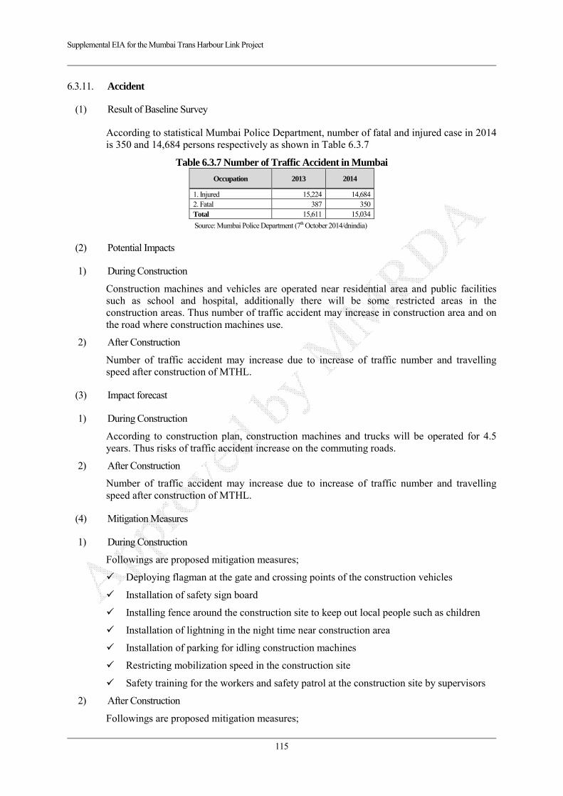
Supplemental EIA for the Mumbai Trans Harbour Link Project
115
6.3.11. Accident
(1) Result of Baseline Survey
According to statistical Mumbai Police Department, number of fatal and injured case in 2014 is 350 and 14,684 persons respectively as shown in Table 6.3.7
Table 6.3.7 Number of Traffic Accident in Mumbai
Occupation 2013 2014
1. Injured 15,224 14,684 2. Fatal 387 350 Total 15,611 15,034
Source: Mumbai Police Department (7th October 2014/dnindia)
(2) Potential Impacts
1) During Construction
Construction machines and vehicles are operated near residential area and public facilities such as school and hospital, additionally there will be some restricted areas in the construction areas. Thus number of traffic accident may increase in construction area and on the road where construction machines use.
2) After Construction
Number of traffic accident may increase due to increase of traffic number and travelling speed after construction of MTHL.
(3) Impact forecast
1) During Construction
According to construction plan, construction machines and trucks will be operated for 4.5 years. Thus risks of traffic accident increase on the commuting roads.
2) After Construction
Number of traffic accident may increase due to increase of traffic number and travelling speed after construction of MTHL.
(4) Mitigation Measures
1) During Construction
Followings are proposed mitigation measures;
Deploying flagman at the gate and crossing points of the construction vehicles
Installation of safety sign board
Installing fence around the construction site to keep out local people such as children
Installation of lightning in the night time near construction area
Installation of parking for idling construction machines
Restricting mobilization speed in the construction site
Safety training for the workers and safety patrol at the construction site by supervisors
2) After Construction
Followings are proposed mitigation measures;
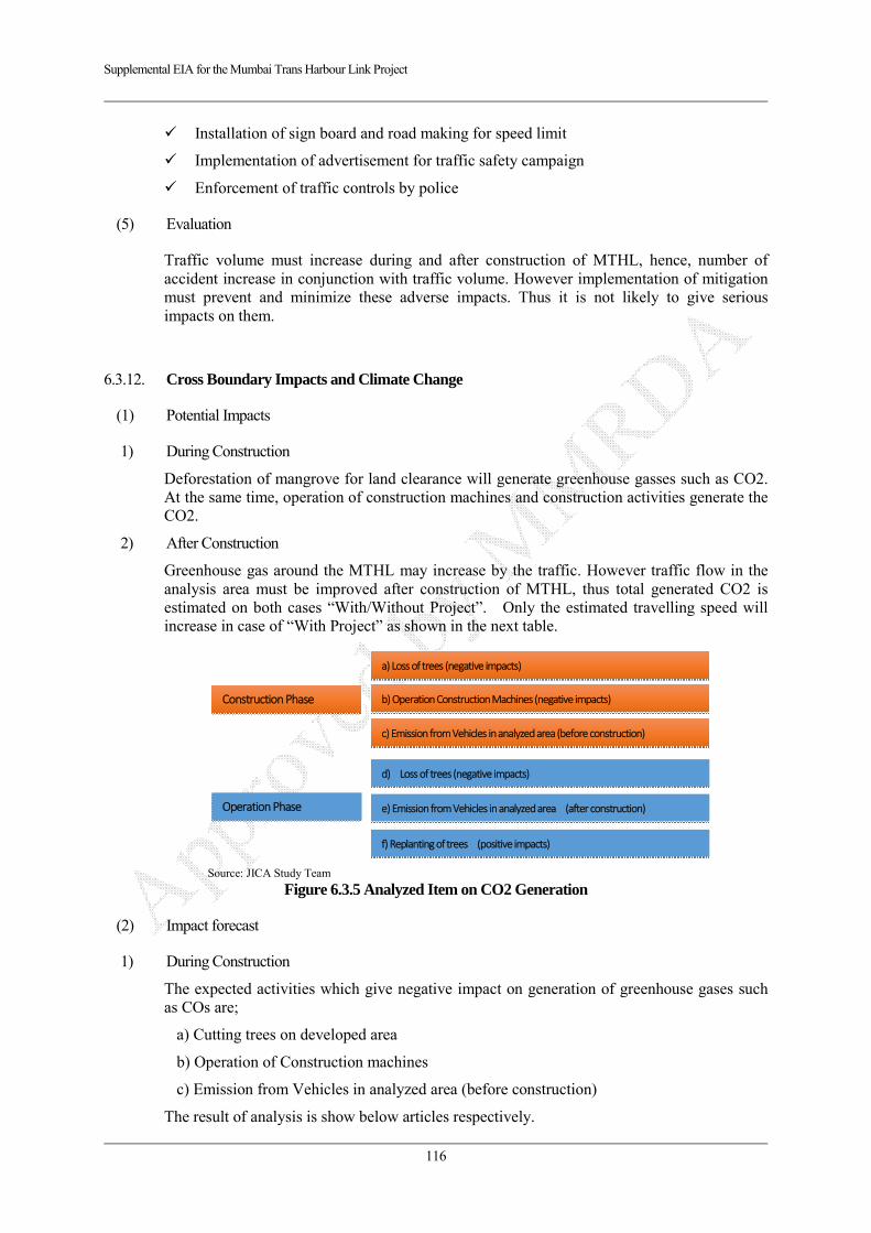
Supplemental EIA for the Mumbai Trans Harbour Link Project
116
Installation of sign board and road making for speed limit
Implementation of advertisement for traffic safety campaign
Enforcement of traffic controls by police
(5) Evaluation
Traffic volume must increase during and after construction of MTHL, hence, number of accident increase in conjunction with traffic volume. However implementation of mitigation must prevent and minimize these adverse impacts. Thus it is not likely to give serious impacts on them.
6.3.12. Cross Boundary Impacts and Climate Change
(1) Potential Impacts
1) During Construction
Deforestation of mangrove for land clearance will generate greenhouse gasses such as CO2. At the same time, operation of construction machines and construction activities generate the CO2.
2) After Construction
Greenhouse gas around the MTHL may increase by the traffic. However traffic flow in the analysis area must be improved after construction of MTHL, thus total generated CO2 is estimated on both cases “With/Without Project”. Only the estimated travelling speed will increase in case of “With Project” as shown in the next table.
Source: JICA Study Team
Figure 6.3.5 Analyzed Item on CO2 Generation
(2) Impact forecast
1) During Construction
The expected activities which give negative impact on generation of greenhouse gases such as COs are;
a) Cutting trees on developed area
b) Operation of Construction machines
c) Emission from Vehicles in analyzed area (before construction)
The result of analysis is show below articles respectively.
Operation Phase
d) Loss of trees (negative impacts)
e) Emission from Vehicles in analyzed area (after construction)
f) Replanting of trees (positive impacts)
Construction Phase
a) Loss of trees (negative impacts)
b) Operation Construction Machines (negative impacts)
c) Emission from Vehicles in analyzed area (before construction)

Supplemental EIA for the Mumbai Trans Harbour Link Project
117
a) Cutting trees on developed area
According to CRZ clearance, loss of mangrove area is 0.1776 ha. Affected area out of CRZ is estimated 0.0264ha shown in below.
Table 6.3.8 Estimated CO2 Volume by Cutting Tree
Area Affected mangrove area (ha)
CO2 sink Unit (t/ha) Note***
Lost volume of carbon sink (CO2 t)
Cutting Duration (Year)
Lost volume of carbon dioxide sink (CO2 t/Year)
1. CRZ (Sewri and Navi Mumbai side)Note* 0.1776 524.48 93.15 1 93.15
2. Out of CRZ (Navi Mumbai Side)Note** 0.0264 524.48 13.85 1 13.85
Total 0.2040 524.48 107.00 1 107.00
Note *: CRZ Clearance July 2013 ( Sewri: (CRZ-I Number of piers 62 x (3x4) m2/pier = 744 m2) + (CRZ-II Number of Piers 8 x (3x4)m2/pier = 96 m2) =
840 m2, Navi Mumbai: (CRZ-I Number of piers 22 x (3x4) m2/pier = 264 m2) + (CRZ-II Number of Piers 6 x (3x4)m2/pier = 72 m2) = 336m2 totally 0.1176ha on affected piers area + other affected area 0.06 ha : Grand total is 0.01776 ha)
**: Mangrove area out of CRZ is from ST. 16500 to ST. 16980 and from ST. 17580 to 17900. Number of main route without ramp section is 22 piers. 22 piers x (3x4) = 264 m2
***: Biomass Mangrove = 192 Ct/ha above ground biomass + 94.08 Ct/ha below ground biomass (ratio 0.49) = 286.08 Ct/ha CO2 Sink Unit = 286.08 x (44/12) x CF (0.5)= 524.48 CO2 t/ha.
b) Impact of Construction Machines Operation
The estimated generated CO2 unit volume is given from a reference, and the quantitative analysis is carried out in accordance with these values. The result of analysis is shown below, totally 45,683 t-CO2 during construction and 13,052 CO2-t per year.
Table 6.3.9 Estimated CO2 Volume by Construction Activities
Type of Structure Unit (CO2 t/km) Length (km) Generated CO2 t Construction year
Generated CO2 t/year
Embankment 3401.7 1.2 4,082 4.5 907
Bridge (PC) 2101.05 19.8 41,601 4.5 9,245
Total 21.0 45,683 13,052
Source: JICA Study Team Generated CO2 Unit: Highway Technology Research Center in Japan (2004 December) Highway with 4 carriage way, Earth work section: 2,267.8t-CO2/km, Steel Bridge Section: 1,287 t-CO2/km, PC Bridge Section: 1400.7 t-CO2/km, Tunnel Section: 713.5 t-CO2/km
c) Emission from Vehicles in analyzed area (before construction)
The estimated generated CO2 from traffic network is shown below;
Table 6.3.10 Estimated CO2 Volume from Traffic (before construction 2015)
Period Year Estimated (CO2 t/year) Source: Road Traffic
Without Project
Before Construction 2015 4,534,386
Source: JICA Study Team
2) Operation Phase
The expected activities which give negative impact on generation of greenhouse gases such as CO2 are;
d) Cutting trees on developed area
e) Replanting of mangrove
f) Emission from Vehicles in analyzed area
The result of analysis is show below articles respectively.

Supplemental EIA for the Mumbai Trans Harbour Link Project
118
d) Impact of Cutting Trees (Negative impacts)
Estimated lost volume of carbon sink is 107.0 CO2 t/year as shown in Table xxx.
e) Replanting of mangrove (Positive impacts)
According to specific condition on the CRZ clearance issued in 2013, 5 times of cutting mangrove area shall be replanted on the Nhava side designated by MoEF. Thus although 0.1776 ha of mangrove is cut during construction stage, 5 times of 0.1776, 0.888ha mangrove area will be created by mitigation measures in accordance with CRZ clearance.
Table 6.3.11 Estimated CO2 Volume by Cutting Tree
Area Replanted mangrove area(ha)Note*
CO2 sink Unit (t/ha) Note**
Created volume of carbon sink (CO2 t/year)
1. CRZ (Sewri and Navi Mumbai side) 0.888 524.48 465.74
Note) *: Replanted mangrove area = 0,1776 x 5 times in accordance with CRZ Clearance = 0.888 ha **: Biomass Mangrove = 192 Ct/ha above ground biomass + 94.08 Ct/ha below ground biomass (ratio 0.49) = 286.08 Ct/ha CO2 Sink Unit = 286.08 x (44/12) x CF (0.5)= 524.48 CO2 t/ha. Source: JICA Study Team
f) Emission from Vehicles in analysed area (Positive impacts with project)
Basically travelling speed in the analyzed area must increase due to improvement of traffic, thus total generated greenhouse gas such as CO2 will decrease after construction.
Table 6.3.12 Estimated CO2 Volume from Traffic (Operation Phase 2022, 2032 and 2042)
Period Year Estimated (CO2 t/year)
Without Project With Project
After Construction 2022 729,433 729,488After Construction 2032 986,541 984,706After Construction 2042 1,392,036 1,390,991Source: JICA Study Team
3) Compiled Result of Quantitative Analysis
The estimated comprehensive CO2 volume is shown below. Although negative impacts are predicted during construction 4.5 years in case of “With Project” due to mainly construction activities, basically positive impact is given by the project operation phase due to improvement of traffic stream after 2032. Thus it is not likely to give significant impact on the generation of CO2.
Table 6.3.13 Compiled Estimated CO2 Volume during Construction and Operation Phase
ConstructionWorks (t/year)
Road Traffic(t/year)
Cut Mangrove(t/year)
ReplantingMangrove (t/year)
1. Without ProjectTotal (CO2 t/y)
ConstructionWorks Road Traffic
Cut Mangrove(t/year)
ReplantingMangrove (t/year)
2. With Project Total(CO2 t/y)
2015 0 454,386 0 0 454,386 0 454,386 0 454,386 02018 0 591,914 0 0 591,914 10,152 591,914 107 602,173 -10,2592022 0 729,443 0 0 729,443 0 729,488 107 -466 729,595 -1522032 0 986,541 0 0.0 986,541 0 984,706 107 -466 984,813 1,7282042 0 1,392,036 0 0.0 1,392,036 0 1,390,991 107 -466 1,391,098 939
With ProjectEstimated (CO2 t/Year)
Year 1. Without -2. With Project
Without Project
Source: JICA Study Team
(3) Mitigation Measures
With regard to cutting mangrove during construction, replanting mangrove will be conducted in accordance with CRZ clearance in 2013.
Supplemental EIA for the Mumbai Trans Harbour Link Project
119
(4) Evaluation
Negative impacts are forecasted during construction due to construction activities such as operation of construction machines, however, traffic stream in the analyzed area will be improved by the construction of MTHL operation phase. Thus it is likely to give positive impacts on this item.

Supplemental EIA for the Mumbai Trans Harbour Link Project
120
CHAPTER 7 ENVIRONMENTAL MANAGEMENT PLAN
7.1. Mitigation Measures
An Environmental Management Plan (EMP) has been recommended in this chapter. This EMP takes into account all the environmental impacts identified for MTHL and the corresponding mitigation measures to ameliorate the same. The EMP presented below includes:
Specific actions to be taken vis-à-vis site-specific issues;
Mitigation measures for abatement of the undesirable impacts caused during construction and operation stages
Agencies responsible for its implementation & supervision;
Post project Environmental Monitoring Program to be undertaken after commissioning of the project
Environmental status reporting frequency; and
Institutional arrangement, Strengthening of their capabilities, and role.
Mitigation measure and monitoring plan is merged from Rapid EIA 2012 prepared by MMRDA, CRZ clearance specific condition and JICA Scoping report commented by JICA Advisory Committee.
The cost for all mitigation measures is including a part of construction cost except replanting mangrove. The cost of replanting mangrove in accordance with CRZ clearance is estimated 60 Lakh INR on Rapid EIA 2012
Detailed mitigation measures and monitoring plan should be establish in the future under MMRDA and General Consultant
Environmental management plan during construction phase and operation phase is listed below.
Table 7.1.1 Environmental Management Plan
Area No.
Item
(on Rapid EIA 2012)
Mitigation Measures Responsibility
During Construction Operation Implementation
Agency Responsible Agency
Pollu
tion
1 Air pollution (Air quality)
All vehicles and machineries shall obtain & maintain the ‘Pollution under Control Certificate (PUC)’. These vehicles will be maintained so that emissions conform to the standards prescribed in the certificate.
Vehicles carrying construction material shall be covered to avoid spilling
Asphalt mixing plant (Hot mix and batching plants) shall be over 500 m away from any communities and 300 m from the road as far as possible to avoid any air emissions from these plants.
Water sprinkling shall be carried out twice or thrice each day on earth road/unpaved sections of road and construction yard near residential area to avoid dust generation
The exhaust of DG set will be released at the height prescribed by MPCB (Maharashtra Pollution Control Board) so that it does not affect nearby population.
Appropriate land use management along the road (commercial and industrial area)
Monitor periodically ambient air quality at suggested locations
Enforcing different control measures to minimize the air pollution
Contractor (Construction Company)
MMRDA & General Consultant (PMC & EC)
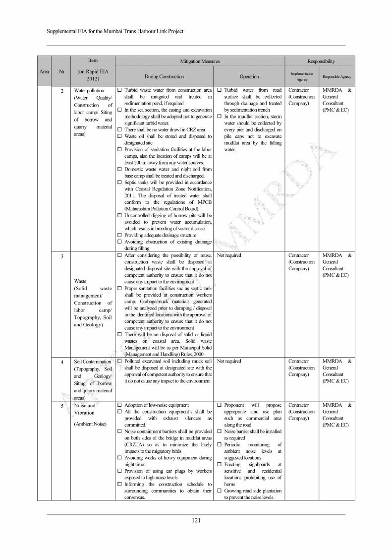
Supplemental EIA for the Mumbai Trans Harbour Link Project
121
Area No.
Item
(on Rapid EIA 2012)
Mitigation Measures Responsibility
During Construction Operation Implementation
Agency Responsible Agency
2 Water pollution (Water Quality/ Construction of labor camp/ Siting of borrow and quarry material areas)
Turbid waste water from construction area shall be mitigated and treated in sedimentation pond, if required
In the sea section, the casing and excavation methodology shall be adopted not to generate significant turbid water.
There shall be no water drawl in CRZ area Waste oil shall be stored and disposed to
designated site Provision of sanitation facilities at the labor
camps, also the location of camps will be at least 200 m away from any water sources.
Domestic waste water and night soil from base camp shall be treated and discharged.
Septic tanks will be provided in accordance with Coastal Regulation Zone Notification, 2011. The disposal of treated water shall conform to the regulations of MPCB (Maharashtra Pollution Control Board).
Uncontrolled digging of borrow pits will be avoided to prevent water accumulation, which results in breeding of vector disease.
Providing adequate drainage structure Avoiding obstruction of existing drainage
during filling
Turbid water from road surface shall be collected through drainage and treated by sedimentation trench
In the mudflat section, storm water should be collected by every pier and discharged on pile caps not to excavate mudflat area by the falling water.
Contractor (Construction Company)
MMRDA & General Consultant (PMC & EC)
3
Waste (Solid waste management/ Construction of labor camp/ Topography, Soil and Geology)
After considering the possibility of reuse, construction waste shall be disposed at designated disposal site with the approval of competent authority to ensure that it do not cause any impact to the environment
Proper sanitation facilities suc as septic tank shall be provided at construction workers camp. Garbage/muck materials generated will be analyzed prior to dumping / disposal in the identified locations with the approval of competent authority to ensure that it do not cause any impact to the environment
There will be no disposal of solid or liquid wastes on coastal area. Solid waste Management will be as per Municipal Solid (Management and Handling) Rules, 2000
Not required Contractor (Construction Company)
MMRDA & General Consultant (PMC & EC)
4 Soil Contamination(Topography, Soil and Geology/ Siting of borrow and quarry material areas)
Polluted excavated soil including muck soil shall be disposed at designated site with the approval of competent authority to ensure that it do not cause any impact to the environment
Not required Contractor (Construction Company)
MMRDA & General Consultant (PMC & EC)
5 Noise and Vibration
(Ambient Noise)
Adoption of low-noise equipment All the construction equipment’s shall be
provided with exhaust silencers as committed.
Noise containment barriers shall be provided on both sides of the bridge in mudflat areas (CRZ-IA) so as to minimize the likely impacts to the migratory birds
Avoiding works of heavy equipment during night time.
Provision of using ear plugs by workers exposed to high noise levels
Informing the construction schedule to surrounding communities to obtain their consensus.
Proponent will propose appropriate land use plan such as commercial area along the road
Noise barrier shall be installed as required
Periodic monitoring of ambient noise levels at suggested locations
Erecting signboards at sensitive and residential locations prohibiting use of horns
Growing road side plantation to prevent the noise levels.
Contractor (Construction Company)
MMRDA & General Consultant (PMC & EC)
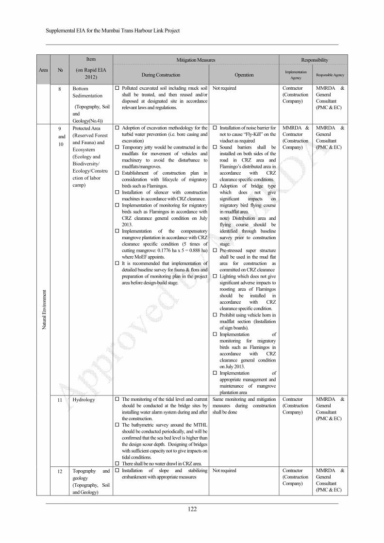
Supplemental EIA for the Mumbai Trans Harbour Link Project
122
Area No.
Item
(on Rapid EIA 2012)
Mitigation Measures Responsibility
During Construction Operation Implementation
Agency Responsible Agency
8 Bottom Sedimentation
(Topography, Soil and Geology(No.4))
Polluted excavated soil including muck soil shall be treated, and then reused and/or disposed at designated site in accordance relevant laws and regulations.
Not required Contractor (Construction Company)
MMRDA & General Consultant (PMC & EC)
Nat
ural
Env
ironm
ent
9
and
10
Protected Area (Reserved Forest and Fauna) and Ecosystem (Ecology and Biodiversity/ Ecology/Construction of labor camp)
Adoption of excavation methodology for the turbid water prevention (i.e. bore casing and excavation)
Temporary jetty would be constructed in the mudflats for movement of vehicles and machinery to avoid the disturbance to mudflats/mangroves.
Establishment of construction plan in consideration with lifecycle of migratory birds such as Flamingos.
Installation of silencer with construction machines in accordance with CRZ clearance.
Implementation of monitoring for migratory birds such as Flamingos in accordance with CRZ clearance general condition on July 2013.
Implementation of the compensatory mangrove plantation in accordance with CRZ clearance specific condition (5 times of cutting mangrove: 0.1776 ha x 5 = 0.888 ha) where MoEF appoints.
It is recommended that implementation of detailed baseline survey for fauna & flora and preparation of monitoring plan in the project area before design-build stage.
Installation of noise barrier for not to cause “Fly-Kill” on the viaduct as required
Sound barriers shall be installed on both sides of the road in CRZ area and Flamingo’s distributed area in accordance with CRZ clearance specific conditions.
Adoption of bridge type which does not give significant impacts on migratory bird flying course in mudflat area. note) Distribution area and flying course should be identified through baseline survey prior to construction stage.
Pre-stressed super structure shall be used in the mud flat area for construction as committed on CRZ clearance
Lighting which does not give significant adverse impacts to roosting area of Flamingos should be installed in accordance with CRZ clearance specific condition.
Prohibit using vehicle horn in mudflat section (Installation of sign boards).
Implementation of monitoring for migratory birds such as Flamingos in accordance with CRZ clearance general condition on July 2013.
Implementation of appropriate management and maintenance of mangrove plantation area
MMRDA & Contractor (Construction Company)
MMRDA & General Consultant (PMC & EC)
11 Hydrology The monitoring of the tidal level and current should be conducted at the bridge sites by installing water alarm system during and after the construction.
The bathymetric survey around the MTHL should be conducted periodically, and will be confirmed that the sea bed level is higher than the design scour depth. Designing of bridges with sufficient capacity not to give impacts on tidal conditions.
There shall be no water drawl in CRZ area.
Same monitoring and mitigation measures during construction shall be done
Contractor (Construction Company)
MMRDA & General Consultant (PMC & EC)
12 Topography and geology (Topography, Soil and Geology)
Installation of slope and stabilizing embankment with appropriate measures
Not required Contractor (Construction Company)
MMRDA & General Consultant (PMC & EC)

Supplemental EIA for the Mumbai Trans Harbour Link Project
123
Area No.
Item
(on Rapid EIA 2012)
Mitigation Measures Responsibility
During Construction Operation Implementation
Agency Responsible Agency
Soci
al E
nviro
nmen
t
13
Involuntary resettlement
Implemention of SIA; ・ Holding consultation meetings for
understanding of compensation policy. ・ Implementation of adequate
compensation on JICA Guidelines. ・ Implementation of livelihood restoration
program based on SIA.
Monitoring based on SIA MMRDA MMRDA
14 The poor Implementation of SIA Monitoring based on SIA MMRDA MMRDA
16 Local economy such as employment and livelihood (Quality of Life/Fisheries)
Implementation of SIA Monitoring based on SIA MMRDA MMRDA
17 Land use and utilization of local resources (Land use/Fisheries)
Holding consultation meetings for understanding of compensation policy and livelihood restoration programs for affected persons including fishermen.
Implementation of adequate compensation for affected properties based on JICA’s Guidelines.
Implementation of livelihood restoration program for income loss for fishermen based on JICA’s Guidelines.
Management of appropriate land use in accordance with approved land use plan along the road.
MMRDA MMRDA (propose to MCGM and CIDCO)
19 Existing social infrastructures and services (Utility services and community severance)
Implementation of SIA Monitoring as required Contractor (Construction Company)
MMRDA & General Consultant (PMC & EC)
22 Local conflict of interests
Local workforce is prioritized for construction of MTHL
Implementation of appropriate education for hired workers from other area and countries.
Not required Contractor (Construction Company)
MMRDA & General Consultant (PMC & EC)
24 Landscape (Aesthetics and landscape)
Adoption of appropriate design and color harmonized with surrounding current landscape
Landscaping of borrow pits
Not required Contractor (Construction Company)
MMRDA & General Consultant (PMC & EC)
27 Infectious diseases such as HIV/AIDS
Installation of sufficient drainage facilities not to provide habitat for vector mosquito.
Provision of adequate temporary sanitation facilities.
Enforcement of medical screening and periodical medical check-up.
In order to prevent spread of infectious diseases such as HIV/AIDS, awareness of the labors and local inhabitants is promoted.
Installation of sufficient drainage facilities not to provide habitat for vector mosquito.
Implementation of periodical maintenance for drainages and bridges.
Contractor (Construction Company)
MMRDA & General Consultant (PMC & EC)
28 Labour Environment
Implementation and follow relevant laws and regulations “Building And Other Construction Workers (Regulation of Employment and Conditions of Service) Act,1996” and “The building and other construction worker’s welfare cess Act, 1996” and IFC Performance Standard 2 Labor and Working Conditions
Not required Contractor (Construction Company)
MMRDA & General Consultant (PMC & EC)
Oth
er
29 Accident
(Accident hazards and safety)
Secure assistance from local police for traffic control during construction phase.
Safety measures will also be undertaken by installing road signs and marking for safe and smooth movement of traffic.
Setting up of appropriate detours. Restricting mobilization speed in the
Implementation of advertisement for traffic safety campaign.
Prepare and administer a monitoring system on road accidents.
Installation of sign board and
Contractor (Construction Company) in consultation with Traffic Police
MMRDA
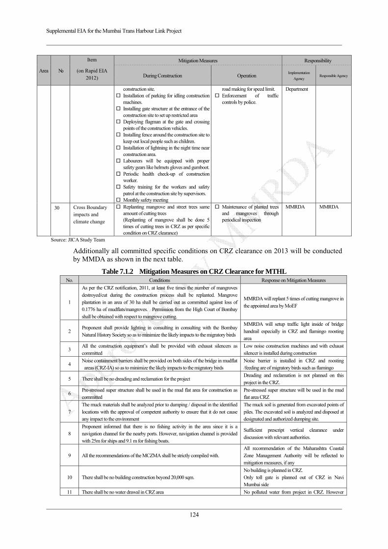
Supplemental EIA for the Mumbai Trans Harbour Link Project
124
Area No.
Item
(on Rapid EIA 2012)
Mitigation Measures Responsibility
During Construction Operation Implementation
Agency Responsible Agency
construction site. Installation of parking for idling construction
machines. Installing gate structure at the entrance of the
construction site to set up restricted area Deploying flagman at the gate and crossing
points of the construction vehicles. Installing fence around the construction site to
keep out local people such as children. Installation of lightning in the night time near
construction area. Labourers will be equipped with proper
safety gears like helmets gloves and gumboot. Periodic health check-up of construction
worker. Safety training for the workers and safety
patrol at the construction site by supervisors. Monthly safety meeting
road making for speed limit. Enforcement of traffic
controls by police.
Department
30 Cross Boundary impacts and climate change
Replanting mangrove and street trees same amount of cutting trees (Replanting of mangrove shall be done 5 times of cutting trees in CRZ as per specific condition on CRZ clearance)
Maintenance of planted trees and mangroves through periodical inspection
MMRDA MMRDA
Source: JICA Study Team
Additionally all committed specific conditions on CRZ clearance on 2013 will be conducted by MMDA as shown in the next table.
Table 7.1.2 Mitigation Measures on CRZ Clearance for MTHL No. Conditions Response on Mitigation Measures
1
As per the CRZ notification, 2011, at least five times the number of mangroves destroyed/cut during the construction process shall be replanted. Mangrove plantation in an area of 30 ha shall be carried out as committed against loss of 0.1776 ha of mudflats/mangroves. Permission from the High Court of Bombay shall be obtained with respect to mangrove cutting.
MMRDA will replant 5 times of cutting mangrove in the appointed area by MoEF
2 Proponent shall provide lighting in consulting in consulting with the Bombay Natural History Society so as to minimize the likely impacts to the migratory birds
MMRDA will setup traffic light inside of bridge handrail especially in CRZ and flamingo roosting area
3 All the construction equipment’s shall be provided with exhaust silencers as committed
Low noise construction machines and with exhaust silencer is installed during construction
4 Noise containment barriers shall be provided on both sides of the bridge in mudflat areas (CRZ-IA) so as to minimize the likely impacts to the migratory birds
Noise barrier is installed in CRZ and roosting /feeding are of migratory birds such as flamingo
5 There shall be no dreading and reclamation for the project Dreading and reclamation is not planned on this project in the CRZ.
6 Pre-stressed super structure shall be used in the mud flat area for construction as committed
Pre-stressed super structure will be used in the mud flat area CRZ
7 The muck materials shall be analyzed prior to dumping / disposal in the identified locations with the approval of competent authority to ensure that it do not cause any impact to the environment
The muck soil is generated from excavated points of piles. The excavated soil is analyzed and disposed at designated and authorized dumping site.
8 Proponent informed that there is no fishing activity in the area since it is a navigation channel for the nearby ports. However, navigation channel is provided with 25m for ships and 9.1 m for fishing boats.
Sufficient prescript vertical clearance under discussion with relevant authorities.
9 All the recommendations of the MCZMA shall be strictly compiled with. All recommendation of the Maharashtra Coastal Zone Management Authority will be reflected to mitigation measures, if any
10 There shall be no building construction beyond 20,000 sqm. No building is planned in CRZ. Only toll gate is planned out of CRZ in Navi Mumbai side
11 There shall be no water drawal in CRZ area No polluted water from project in CRZ. However
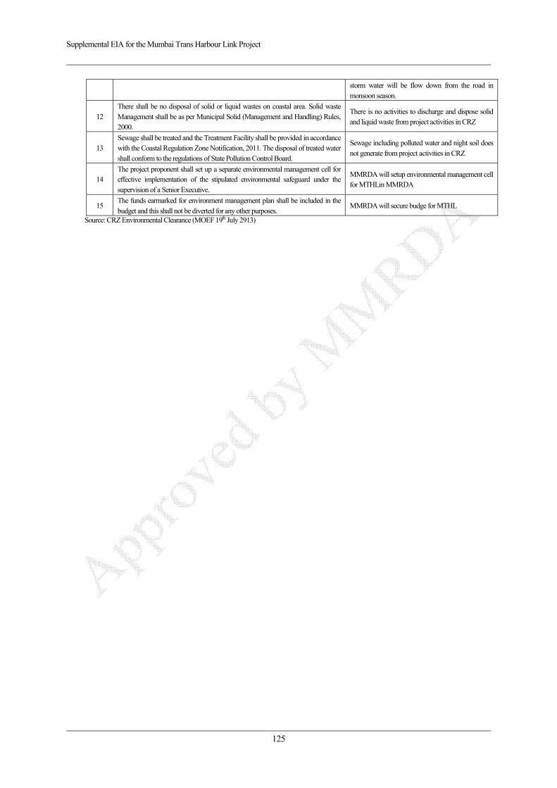
Supplemental EIA for the Mumbai Trans Harbour Link Project
125
storm water will be flow down from the road in monsoon season.
12 There shall be no disposal of solid or liquid wastes on coastal area. Solid waste Management shall be as per Municipal Solid (Management and Handling) Rules, 2000.
There is no activities to discharge and dispose solid and liquid waste from project activities in CRZ
13 Sewage shall be treated and the Treatment Facility shall be provided in accordance with the Coastal Regulation Zone Notification, 2011. The disposal of treated water shall conform to the regulations of State Pollution Control Board.
Sewage including polluted water and night soil does not generate from project activities in CRZ
14 The project proponent shall set up a separate environmental management cell for effective implementation of the stipulated environmental safeguard under the supervision of a Senior Executive.
MMRDA will setup environmental management cell for MTHLin MMRDA
15 The funds earmarked for environment management plan shall be included in the budget and this shall not be diverted for any other purposes.
MMRDA will secure budge for MTHL
Source: CRZ Environmental Clearance (MOEF 19th July 2913)
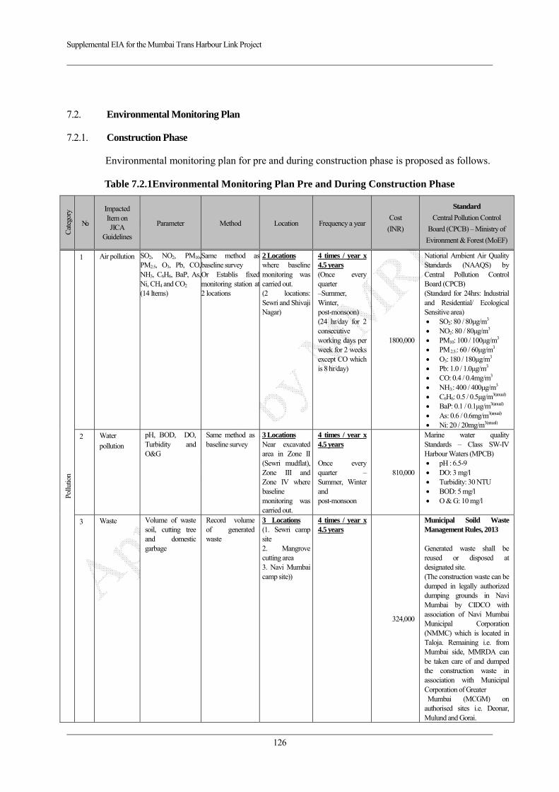
Supplemental EIA for the Mumbai Trans Harbour Link Project
126
7.2. Environmental Monitoring Plan
7.2.1. Construction Phase
Environmental monitoring plan for pre and during construction phase is proposed as follows.
Table 7.2.1Environmental Monitoring Plan Pre and During Construction Phase
Cat
egor
y
No.
Impacted Item on JICA
Guidelines
Parameter Method Location Frequency a yearCost
(INR)
Standard
Central Pollution Control
Board (CPCB) – Ministry of
Evironment & Forest (MoEF)
Pollu
tion
1 Air pollution SO2, NO2, PM10, PM2.5, O3, Pb, CO, NH3, C6H6, BaP, As, Ni, CH4 and CO2 (14 Items)
Same method as baseline survey Or Establis fixed monitoring station at 2 locations
2 Locations where baseline monitoring was carried out. (2 locations: Sewri and Shivaji Nagar)
4 times / year x 4.5 years (Once every quarter –Summer, Winter, post-monsoon) (24 hr/day for 2 consecutive working days per week for 2 weeks except CO which is 8 hr/day)
1800,000
National Ambient Air Quality Standards (NAAQS) by Central Pollution Control Board (CPCB) (Standard for 24hrs: Industrial and Residential/ Ecological Sensitive area)
SO2: 80 / 80μg/m3 NO2: 80 / 80μg/m3 PM10: 100 / 100μg/m3 PM 2.5:: 60 / 60μg/m3 O3: 180 / 180μg/m3 Pb: 1.0 / 1.0μg/m3 CO: 0.4 / 0.4mg/m3 NH3:: 400 / 400μg/m3 C6H6: 0.5 / 0.5μg/m3(anual) BaP: 0.1 / 0.1μg/m3(anual) As: 0.6 / 0.6mg/m3(anual) Ni: 20 / 20mg/m3(anual)
2 Water pollution
pH, BOD, DO, Turbidity and O&G
Same method as baseline survey
3 Locations Near excavated area in Zone II (Sewri mudflat), Zone III and Zone IV where baseline monitoring was carried out.
4 times / year x 4.5 years Once every quarter – Summer, Winter and post-monsoon
810,000
Marine water quality Standards – Class SW-IV Harbour Waters (MPCB)
pH : 6.5-9 DO: 3 mg/l Turbidity: 30 NTU BOD: 5 mg/l O & G: 10 mg/l
3 Waste Volume of waste soil, cutting tree and domestic garbage
Record volume of generated waste
3 Locations (1. Sewri camp site 2. Mangrove cutting area 3. Navi Mumbai camp site))
4 times / year x 4.5 years
324,000
Municipal Soild Waste Management Rules, 2013 Generated waste shall be reused or disposed at designated site. (The construction waste can be dumped in legally authorized dumping grounds in Navi Mumbai by CIDCO with association of Navi Mumbai Municipal Corporation (NMMC) which is located in Taloja. Remaining i.e. from Mumbai side, MMRDA can be taken care of and dumped the construction waste in association with Municipal Corporation of Greater Mumbai (MCGM) on authorised sites i.e. Deonar, Mulund and Gorai.
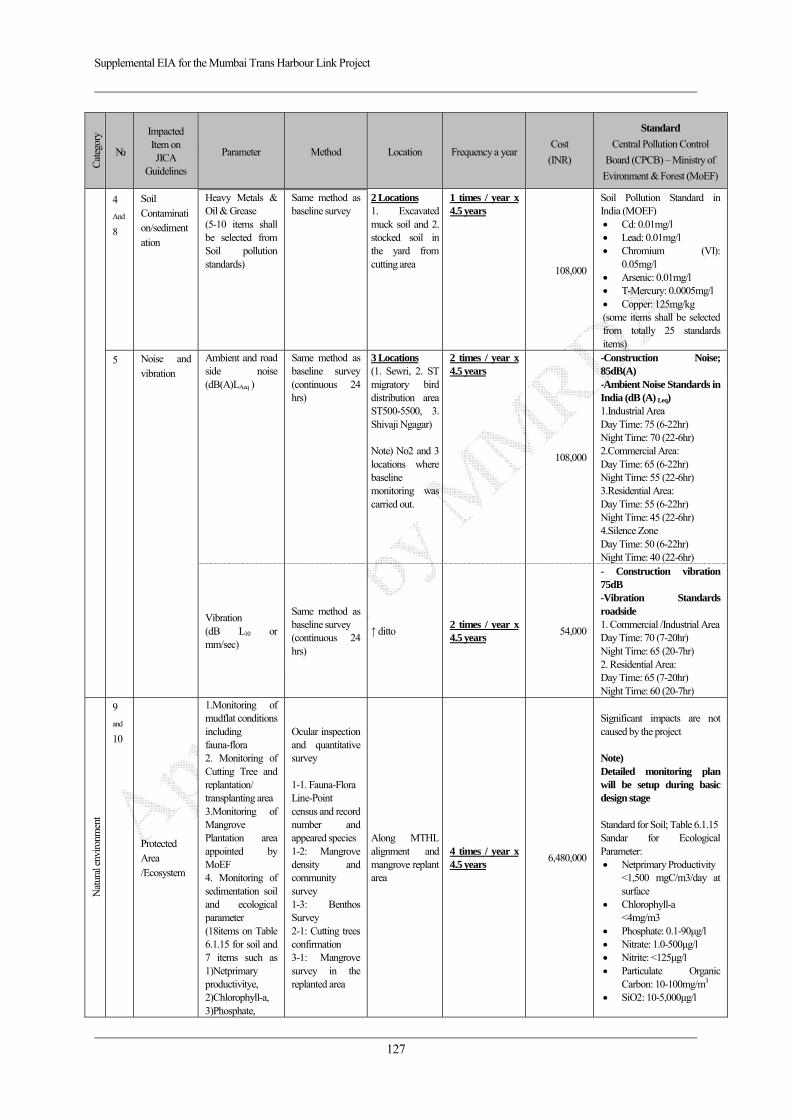
Supplemental EIA for the Mumbai Trans Harbour Link Project
127
Cat
egor
y
No.
Impacted Item on JICA
Guidelines
Parameter Method Location Frequency a year Cost
(INR)
Standard
Central Pollution Control
Board (CPCB) – Ministry of
Evironment & Forest (MoEF)
4
And
8
Soil Contamination/sedimentation
Heavy Metals & Oil & Grease (5-10 items shall be selected from Soil pollution standards)
Same method as baseline survey
2 Locations 1. Excavated muck soil and 2. stocked soil in the yard from cutting area
1 times / year x 4.5 years
108,000
Soil Pollution Standard in India (MOEF)
Cd: 0.01mg/l Lead: 0.01mg/l Chromium (VI):
0.05mg/l Arsenic: 0.01mg/l T-Mercury: 0.0005mg/l Copper: 125mg/kg
(some items shall be selected from totally 25 standards items)
5 Noise and vibration
Ambient and road side noise (dB(A)LAeq )
Same method as baseline survey (continuous 24 hrs)
3 Locations (1. Sewri, 2. ST migratory bird distribution area ST500-5500, 3. Shivaji Ngagar) Note) No2 and 3 locations where baseline monitoring was carried out.
2 times / year x 4.5 years
108,000
-Construction Noise; 85dB(A) -Ambient Noise Standards in India (dB (A) Leq) 1.Industrial Area Day Time: 75 (6-22hr) Night Time: 70 (22-6hr) 2.Commercial Area: Day Time: 65 (6-22hr) Night Time: 55 (22-6hr) 3.Residential Area: Day Time: 55 (6-22hr) Night Time: 45 (22-6hr) 4.Silence Zone Day Time: 50 (6-22hr) Night Time: 40 (22-6hr)
Vibration (dB L10 or mm/sec)
Same method as baseline survey (continuous 24 hrs)
ditto 2 times / year x 4.5 years
54,000
- Construction vibration 75dB -Vibration Standards roadside 1. Commercial /Industrial AreaDay Time: 70 (7-20hr) Night Time: 65 (20-7hr) 2. Residential Area: Day Time: 65 (7-20hr) Night Time: 60 (20-7hr)
Nat
ural
env
ironm
ent
9
and
10
Protected Area /Ecosystem
1.Monitoring of mudflat conditions including fauna-flora 2. Monitoring of Cutting Tree and replantation/ transplanting area 3.Monitoring of Mangrove Plantation area appointed by MoEF 4. Monitoring of sedimentation soil and ecological parameter (18items on Table 6.1.15 for soil and 7 items such as 1)Netprimary productivitye, 2)Chlorophyll-a, 3)Phosphate,
Ocular inspection and quantitative survey 1-1. Fauna-Flora Line-Point census and record number and appeared species 1-2: Mangrove density and community survey 1-3: Benthos Survey 2-1: Cutting trees confirmation 3-1: Mangrove survey in the replanted area
Along MTHL alignment and mangrove replant area
4 times / year x 4.5 years
6,480,000
Significant impacts are not caused by the project Note) Detailed monitoring plan will be setup during basic design stage Standard for Soil; Table 6.1.15 Sandar for Ecological Parameter:
Netprimary Productivity <1,500 mgC/m3/day at surface
Chlorophyll-a <4mg/m3
Phosphate: 0.1-90μg/l Nitrate: 1.0-500μg/l Nitrite: <125μg/l Particulate Organic
Carbon: 10-100mg/m3 SiO2: 10-5,000μg/l

Supplemental EIA for the Mumbai Trans Harbour Link Project
128
Cat
egor
y
No.
Impacted Item on JICA
Guidelines
Parameter Method Location Frequency a year Cost
(INR)
Standard
Central Pollution Control
Board (CPCB) – Ministry of
Evironment & Forest (MoEF)
4)Nitrate, 5)Nitrite, 6)Particulate Organic Carbon, 7) SiO2)
11
Hydrology Flooding situation
Flood level measurement during high precipitation periods
2 Locations (CRZ at Sewri and Shivaji Nagar)
4 times / year x 4.5 years
540,000 Project activities and structures does not cause flooding and impacts on tidal conditions
12
Topography and Geology
Conditions in embankment area
Visual survey about Stability of embankment
2 Locations (1. Embankment of Inter Change in Shibaji Nagar and 2 Cutting area at toll gate in Chirle)
4 times / year x 4.5 years
The cost is including with No17 Land use
Embankment shall be stabilized without any landslide and cracks
Soci
al e
nviro
nmen
t
13 Involuntary resettlement
Payment and implementation of social assistance in accordance with SIA
Consultation Meeting and/or Survey with the project affected persons (PAPs)
Affected area Refer to SIA monitoring plan
Refer to SIA monitoring plan
Compensation shall be completed prior to actual construction activities and secure livelihood standards
14 The poor ditto ditto ditto ditto ditto
16 Local economy such as employment and livelihood
ditto ditto ditto ditto ditto
17 Land use and utilization of local resources
Situation of establishment of land use map
Confirmation of land use map
2 Locations (Sewri and Navi Mumbai side in the Affected area)
2 times / year x 4.5 years
180,000
Designated land use shall be secured without any unplanned development by local people and developers
19 Existing social infrastructures and services
Condition of facilities to be displaced
Ocular inspection Affected area Refer to SIA monitoring plan
Refer to SIA monitoring plan
Compensation shall be completed prior to actual construction activities and secure livelihood standards
22 Local conflict of interests
Construction worker’s township
Confirmation of workers list from contractor
2 Locations (camp site in Sewri and Shivaji Nagar)
4 times / year x 4.5 years
180,000 Employment opportunity shall be provided fairly
24 Landscape Condition of landscape
Visual inspection 1 Location (View from Sewri Fort)
1 time / year x 4.5 year (Dry season) 22,500
Color of structure shall be adopted monotone color harmonized with surrounding landscape
27 Infectious diseases such as HIV/AIDS
Number of infected patient
Confirmation of health check list from contractor
2 Locations (camp site in Sewri and Shivaji Nagar)
4 times / year x 4.5 years
180,000 Infection disease rate shall not be caused by the project
28 Labour Environment
Construction worker’s condition
Confirmation of safety devices and conditions via interviews
2 Location (camp site in Sewri and Shivaji Nagar)
2 times / year x 4.5 years
90,000
“Building And Other Construction Workers (Regulation of Emloyment and Conditions of Service) Act,1996”, “The building and other construction worker’s
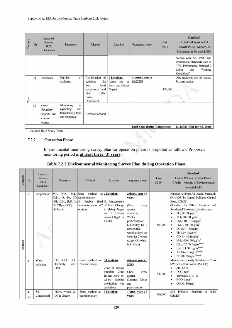
Supplemental EIA for the Mumbai Trans Harbour Link Project
129
Cat
egor
y
No.
Impacted Item on JICA
Guidelines
Parameter Method Location Frequency a year Cost
(INR)
Standard
Central Pollution Control
Board (CPCB) – Ministry of
Evironment & Forest (MoEF)
welfare cess Act, 1996” and international standards such as “IFC Performance Standard 2 Labor and Working Conditions”
Oth
er
29 Accidents Number of accidents
Confirmation of accidents list from local government and State Traffic Police Department
2 Locations (camp site in Sewri and Shivaji Nagar)
4 times / year x 4.5 years
180,000
Any accidents are not caused by construction
30 Cross Boundary impacts and climate change
Monitoring of replanting and transplanting trees and mangrove
Refer to No.9 and 10
Total Cost during Construction : 8,140,500 INR for 4.5 yearsSource: JICA Study Team
7.2.2. Operation Phase
Environmental monitoring survey plan for operation phase is proposed as follows. Proposed monitoring period is at least three (3) years.
Table 7.2.2 Environmental Monitoring Survey Plan during Operation Phase
Cat
egor
y
No.
Impacted Item on JICA
Guidelines
Parameter Method Location Frequency a year Cost
(INR)
Standard
Central Pollution Control Board
(CPCB) – Ministry of Environment &
Forest (MoEF)
Pollu
tion
1 Air pollution SO2, NO2, PM10,PM2.5, O3, Pb, CO,NH3, C6H6, BaP, As,Ni, CH4 and CO2 (14 Items)
Same method as baseline survey Or Establis fixed monitoring station at 2 locations
2 Locations (1. Embankment of Inter Change in Shibaji Nagar and 2 Cutting area at toll gate in Chirle)
2 times / year x 3 years (Once every quarter –Summer, Winter, post-monsoon) (24 hr/day for 2 consecutive working days per week for 2 weeks except CO which is 8 hr/day)
600,000
National Ambient Air Quality Standards (NAAQS) by Central Pollution Control Board (CPCB) (Standard for 24hrs: Industrial and Residential/ Ecological Sensitive area)
SO2: 80 / 80μg/m3 NO2: 80 / 80μg/m3 PM10: 100 / 100μg/m3 PM 2.5:: 60 / 60μg/m3 O3: 180 / 180μg/m3 Pb: 1.0 / 1.0μg/m3 CO: 0.4 / 0.4mg/m3 NH3:: 400 / 400μg/m3 C6H6: 0.5 / 0.5μg/m3(anual) BaP: 0.1 / 0.1μg/m3(anual) As: 0.6 / 0.6mg/m3(anual) Ni: 20 / 20mg/m3(anual)
2 Water pollution
pH, BOD, DO, Turbidity and O&G
Same method as baseline survey
3 Locations Zone II (Sewri mudflat), Zone III and Zone IV where baseline monitoring was carried out.
4 times / year x 3 years Once every quarter – Summer, Winter and post-monsoon
540,000
Marine water quality Standards – Class SW-IV Harbour Waters (MPCB)
pH : 6.5-9 DO: 3 mg/l Turbidity: 30 NTU BOD: 5 mg/l O & G: 10 mg/l
4
And
Soil Contaminati
Heavy Metals & Oil & Grease
Same method as baseline survey
3 Locations
1 time / year x 3 years 108,000
Soil Pollution Standard in India (MOEF)
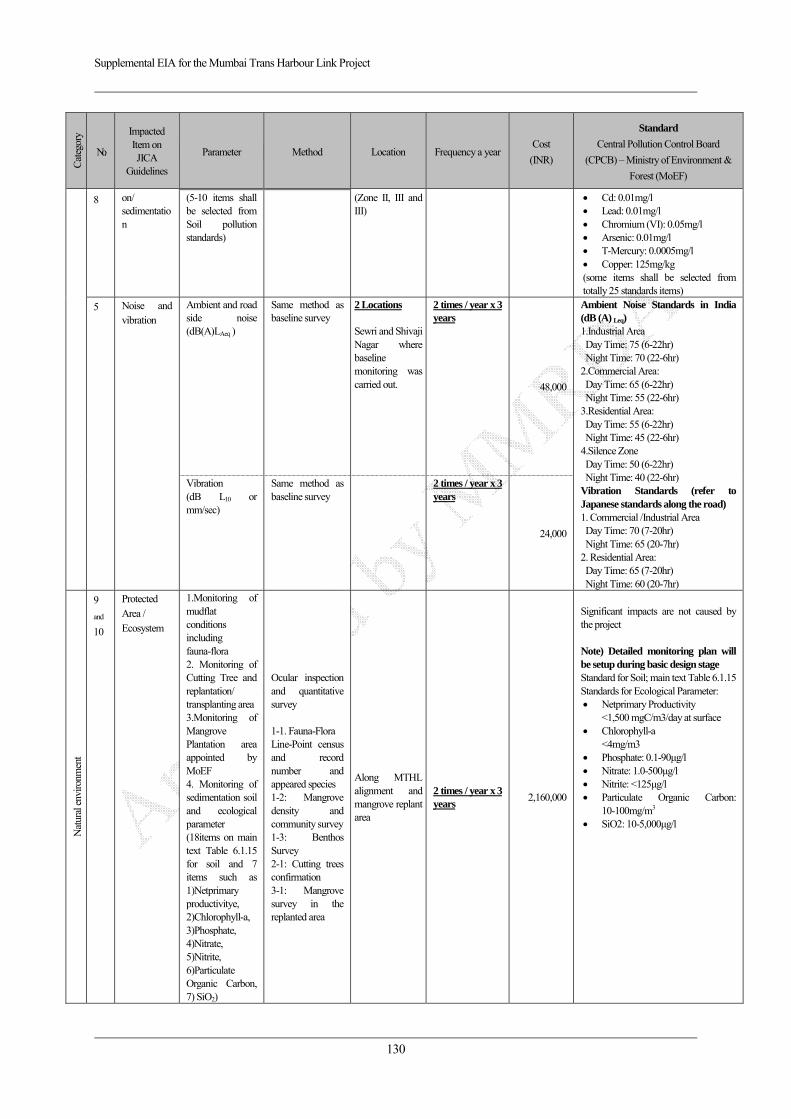
Supplemental EIA for the Mumbai Trans Harbour Link Project
130
Cat
egor
y
No.
Impacted Item on JICA
Guidelines
Parameter Method Location Frequency a year Cost
(INR)
Standard
Central Pollution Control Board
(CPCB) – Ministry of Environment &
Forest (MoEF)
8 on/ sedimentation
(5-10 items shall be selected from Soil pollution standards)
(Zone II, III and III)
Cd: 0.01mg/l Lead: 0.01mg/l Chromium (VI): 0.05mg/l Arsenic: 0.01mg/l T-Mercury: 0.0005mg/l Copper: 125mg/kg
(some items shall be selected from totally 25 standards items)
5 Noise and vibration
Ambient and road side noise (dB(A)LAeq )
Same method as baseline survey
2 Locations Sewri and Shivaji Nagar where baseline monitoring was carried out.
2 times / year x 3 years
48,000
Ambient Noise Standards in India (dB (A) Leq) 1.Industrial Area Day Time: 75 (6-22hr) Night Time: 70 (22-6hr)
2.Commercial Area: Day Time: 65 (6-22hr) Night Time: 55 (22-6hr)
3.Residential Area: Day Time: 55 (6-22hr) Night Time: 45 (22-6hr)
4.Silence Zone Day Time: 50 (6-22hr) Night Time: 40 (22-6hr)
Vibration Standards (refer to Japanese standards along the road) 1. Commercial /Industrial Area Day Time: 70 (7-20hr) Night Time: 65 (20-7hr)
2. Residential Area: Day Time: 65 (7-20hr) Night Time: 60 (20-7hr)
Vibration (dB L10 or mm/sec)
Same method as baseline survey
2 times / year x 3 years
24,000
Nat
ural
env
ironm
ent
9
and
10
Protected Area / Ecosystem
1.Monitoring of mudflat conditions including fauna-flora 2. Monitoring of Cutting Tree and replantation/ transplanting area 3.Monitoring of Mangrove Plantation area appointed by MoEF 4. Monitoring of sedimentation soil and ecological parameter (18items on main text Table 6.1.15 for soil and 7 items such as 1)Netprimary productivitye, 2)Chlorophyll-a, 3)Phosphate, 4)Nitrate, 5)Nitrite, 6)Particulate Organic Carbon, 7) SiO2)
Ocular inspection and quantitative survey 1-1. Fauna-Flora Line-Point census and record number and appeared species 1-2: Mangrove density and community survey1-3: Benthos Survey 2-1: Cutting trees confirmation 3-1: Mangrove survey in the replanted area
Along MTHL alignment and mangrove replant area
2 times / year x 3 years
2,160,000
Significant impacts are not caused by the project Note) Detailed monitoring plan will be setup during basic design stage Standard for Soil; main text Table 6.1.15Standards for Ecological Parameter:
Netprimary Productivity <1,500 mgC/m3/day at surface
Chlorophyll-a <4mg/m3
Phosphate: 0.1-90μg/l Nitrate: 1.0-500μg/l Nitrite: <125μg/l Particulate Organic Carbon:
10-100mg/m3 SiO2: 10-5,000μg/l

Supplemental EIA for the Mumbai Trans Harbour Link Project
131
Cat
egor
y
No.
Impacted Item on JICA
Guidelines
Parameter Method Location Frequency a year Cost
(INR)
Standard
Central Pollution Control Board
(CPCB) – Ministry of Environment &
Forest (MoEF)
11 Hydrology
Flooding situation
Flood level measurement during high precipitation periods
2 Locations (CRZ at Sewri and Shivaji Nagar)
4 times / year x 3 years
360,000 Project activities and structures does not cause flooding and impacts on tidal conditions
12
Topography and Geology
Conditions in embankment area
Visual survey about Stability of embankment
2 Locations (1. Embankment of Inter Change in Shibaji Nagar and 2 Cutting area at toll gate in Chirle)
2 times / year x 3 years
Refer item No 17
Embankment shall be stabilized without any landslide and cracks
Soci
al e
nviro
nmen
t
13 Involuntary resettlement
Payment and implementation of social assistance in accordance with SIA
Consultation Meeting and/or Survey with the project affected persons (PAPs)
Affected area Refer to SIA Monitoring plan
Refer to SIA monitoring plan
Compensation shall be completed prior to actual construction activities and secure livelihood standards
14 The poor ditto ditto ditto ditto ditto
16 Local economy such as employment and livelihood
ditto ditto ditto ditto ditto
17 Land use and utilization of local resources
Situation of establishment of land use map
Confirmation of land use map
2 Locations (Sewri and Navi Mumbai side in the Affected area)
2 times / year x 3 years
60,000 Designated land use shall be secured without any unplanned development by local people and developers
24 Landscape Condition of landscape
Visual inspection 1 Location (View from Sewri Fort)
1 time / year x 3 year (Dry season)
15,000 Color of structure shall be adopted monotone color harmonized with surrounding landscape
Oth
er
29 Accidents Number of traffic accidents
Confirmation of accidents list from local government and State Traffic Police Department
On Mumbai Trans Harbour Link
2 times / year x 3 years
30,000
Any accidents are not caused by construction
30 Cross Boundary impacts and climate change
Monitoring of replanting and transplanting trees and mangrove
Refer to No.9 and 10
Total Cost: 3,945,000 INR for 3 yearsSource: JICA Study Team
7.3. Cost, Financial Source and Frameworks
The objectives and design of the EMP and Environmental Monitoring Plan was described in earlier sections of this chapter. There is a necessity to form a proper ‘Institutional Framework’ for the effective implementation of the formulated environmental management & monitoring plan. The elements of this ‘Institutional Framework’ will co-ordinate and work with each other throughout the project, i.e. during pre-construction, construction & operation stage. The implementation of formulated environmental mitigation measures comes with a
Supplemental EIA for the Mumbai Trans Harbour Link Project
132
cost so the budgeting of EMP is necessary and also the financial source that will provide this budget, are discussed in this section.
The suggested elements of ‘Institutional Framework’ for implementing EMP of MTHL project will be as follows:
a) MMRDA - Project Implementing Agency (PIA) and Environmental Cell
b) Financial Source – JICA & MMRDA
c) Project Contractor – Construction Company (PC)
d) General Consultant
・ Project Management Consultant (PMC)
・ Environmental Consultant (EC)
e) Environmental Authorized Agency - Statutory Bodies (Authorities)
・ Maharashtra State Pollution Control Board (MPCB)
・ Ministry of Environment and Forests
The Environmental Authorized Agency will not be a direct part of ‘Institutional framework’ but it will hold controlling authorities on it. It will review and approve the reports submitted by the PIA and can take necessary further actions, if any.
The above stated elements are part of the ‘Institutional Framework’ who will work together to effectively implement the formulated ‘Environmental Management Plan’. The roles & responsibilities of these elements are given in Table 7.3.1 Roles & Responsibilities of Institutional Framework.

Supplemental EIA for the Mumbai Trans Harbour Link Project
133
Table 7.3.1 Environmental Management and Monitoring Organization
Stage Name of Organization
Roles & Responsibilities
Project Implementing Agency and Environmental cell – PIA Pre- Construction & Construction
MMRDA Initiate the co-ordinate process among the concerned organizations (Elements of Institutional Framework) for EMP implementation. Overseeing the implementation of the EMP by the PMC Approval of ‘6 monthly - Environmental Compliance Report’ submitted by the EC and respond necessary action. After Approval sending the report to the MPCB. Finalization of the SIA during detailed design. Facilitate relocation of people & monitoring actual payments of compensation to affected stakeholders such as landowners, Structure owners etc.
General Consultant Project Management Consultant (PMC)
PIA will get the EMP implanted through PMC. PMC will work in association with Project Contractor (Construction Company) & the Environmental Consultant (EC) on a full time basis at the project site office. PMC will mainly look after managing engineering & construction related activities.
Environmental Consultant (EC)
EC will look after implementation of approved environment measures on site. EC will be in constant touch with PMC & Project Contractor EC will facilitate PIA to obtain mandatory ‘Consent to Establish’ certificate from Maharashtra State Pollution Control Board (MPCB) before start of the Construction on site. EC will get the 6 monthly environmental monitoring done from the MoEF approved laboratory. EC will prepare an ‘Environmental Compliance Report (ECR)’ describing Status of approved Environmental Mitigation measures on site (submitted by PC) and Monitoring of Environmental Attributes (submitted by MoEF Approved Laboratory) on a six monthly basis and will submit it to the PIA for their approval. PIA will then submit the approved ECR to the MPCB.
Project Contractor - PC Construction Company
PC will implement approved EMP (mitigation measures) as directed by PMC & Environmental Consultant. The PC will submit the report for all conducted mitigation measures on site to the EC on a six monthly basis.
Operation (Twice in a year
x 3 years)
Project Implementing Agency – PIA MMRDA PIA will oversee the compliance status of all environmental measures through their
appointed consultants Appointed Consultant by MMRDA
Periodical inspection & maintenance of the MTHL EC will facilitate PIA to obtain mandatory ‘Consent to Operate’ certificate from Maharashtra State Pollution Control Board (MPCB) before start of operation of the project. EC will prepare annual ‘Environmental Statement (Form V)’ as mandated in CRZ clearance and submit to PIA for their approval. PIA after reviewing the same will submit to the MPCB.
Source: JICA Study Team

Supplemental EIA for the Mumbai Trans Harbour Link Project
134
Source: JICA Study Team
Figure 7.3.1 Proposed Environmental Management and Monitoring Implementation Organization
All cost for environmental management plan such as mitigation measures are including in the physical contingency of project construction cost. On the other hands, cost for project management such as Environmental Cell in MMRDA will be secured on MMRDA annual budget.
AuditMMRDA (Environment Cell) (Project Implementation Agency)
Funding Agency (JICA) Environmental Authorized Agency
Maharashtra Pollution Control Board MCB (Statutory Body)
Ministry of Environment and Forests MCB (Statutory Body)
General Consultant
Environmental Consultant
Project Contractor (Design-Built Company)
Reporting
Monitoring
Project Management Consultant
Inspection Reporting
Inspection/ Monitoring Reporting
Reporting
Audit
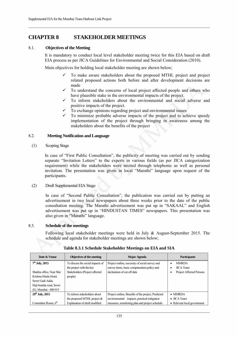
Supplemental EIA for the Mumbai Trans Harbour Link Project
135
CHAPTER 8 STAKEHOLDER MEETINGS
8.1. Objectives of the Meeting
It is mandatory to conduct local level stakeholder meeting twice for this EIA based on draft EIA process as per JICA Guidelines for Environmental and Social Consideration (2010).
Main objectives for holding local stakeholder meeting are shown below;
To make aware stakeholders about the proposed MTHL project and project related proposed actions both before and after development decisions are made
To understand the concerns of local project affected people and others who have plausible stake in the environmental impacts of the project.
To inform stakeholders about the environmental and social adverse and positive impacts of the project.
To exchange opinions regarding project and environmental issues To minimize probable adverse impacts of the project and to achieve speedy
implementation of the project through bringing in awareness among the stakeholders about the benefits of the project
8.2. Meeting Notification and Language
(1) Scoping Stage
In case of “First Public Consultation”, the publicity of meeting was carried out by sending separate “Invitation Letters” to the experts in various fields (as per JICA categorization requirement) while the stakeholders were invited through telephonic as well as personal invitation. The presentation was given in local “Marathi” language upon request of the participants.
(2) Draft Supplemental EIA Stage
In case of “Second Public Consultation”, the publication was carried out by putting an advertisement in two local newspapers about three weeks prior to the date of the public consultation meeting. The Marathi advertisement was put up in “SAKAAL” and English advertisement was put up in “HINDUSTAN TIMES” newspapers. This presentation was also given in “Marathi” language.
8.3. Schedule of the meetings
Following local stakeholder meetings were held in July & August-September 2015. The schedule and agenda for stakeholder meetings are shown below;
Table 8.3.1 Schedule Stakeholder Meetings on EIA and SIA
Date & Venue Objectives of the meeting Major Agenda Participants
7th July, 2015 Shakha office, Near Shri Krishna Hindu Hotel, Sewri Gadi Adda, Haji-bundar road, Sewri (E), Mumbai - 400 015
To discuss the social impacts of the project with the key Stakeholders (Project affected people)
Project outline, necessity of social survey and survey items, basic compensation policy and declaration of cut off data
MMRDA JICA Team Project Affected Persons
29th July, 2015 Committee Room, 6th
To inform stakeholders about the proposed MTHL project & Explanation of draft modified
Project outline, Benefits of the project, Predicted environmental impacts, practical mitigation measures, monitoring plan and project schedule
MMRDA JICA Team Relevant local government
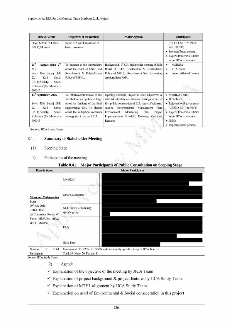
Supplemental EIA for the Mumbai Trans Harbour Link Project
136
Date & Venue Objectives of the meeting Major Agenda Participants
Floor, MMRDA Office, B.K.C, Mumbai
Rapid EIA and formulation of basic consensus
(CIDCO, MPT & JNPT, ASI, NEERI)
Project affected persons Experts from various fields as per JICA requirement
25th August (SIA 2nd PC) Sewri Koli Samaj Hall, 22/1 Koli Samaj Co.Op.Society, Sewri, Koliwada (E), Mumbai - 400015
To intimate to the stakeholders about the result of BSES and Resettlement & Rehabilitation Policy of MTHL.
Background, 1st SIA Stakeholder meeting (SSM), Result of BSES, Resettlement & Rehabilitation Policy of MTHL, Resettlement Site, Requesting opinions from PAPs.
MMRDA JICA Team Project Affected Persons
15th September, 2015 Sewri Koli Samaj Hall, 22/1 Koli Samaj Co.Op.Society, Sewri, Koliwada (E), Mumbai - 400015
To inform/communicate to the stakeholders and public at large about the findings of the draft supplemental EIA. To discuss about the mitigation measures as suggested in the draft EIA.
Opening Remarks, Project in Brief, Objectives & schedule of public consultation meetings, details of first public consultation of EIA, result of reformed studies, Environmental Management Plan, Environment Monitoring Plan, Project Implementation Schedule, Exchange Opinions, Remarks
MMRDA Team JICA Team Relevant local government (CIDCO, MPT & JNPT)
Experts from various fields as per JICA requirement
NGOs Project affected persons
Source: JICA Study Team
8.4. Summary of Stakeholder Meeting
(1) Scoping Stage
1) Participants of the meeting
Table 8.4.1 Major Participants of Public Consultation on Scoping Stage Date & States Major Participants
Mumbai, Maharashtra State 29th July 2015 2.00-4.00pm (at Committee Room, 6th Floor, MMRDA office, B.K.C, Mumbai)
MMRDA Mr. P.D. Mamdapure (Chief Engineer), Mr. S.S. Varaskar (Superintending Engineer), Mr. Yatin Sakhalkar (Ex. Engineer), Mr. Vishram Patil (Chief, Social Development Cell), Mr. A.r. Bhisikar (Deputy Engineer), Mr. G.G. Deshpande (Deputy Engineer)
Other Government
Dr. Shalini Tandon (Scientist- NEERI), Mr. N. Vasudevan (IFS- Head Mangrove Cell), Mr. M.S.Chouhan (Superintending Archaeologist – Archaeological Survey of India), Mr. B.J.Patil (Dy.Chief Engineer- Mumbai Port Trust), Mr. S.K. Karhad (Ex.Engineer – CIDCO), Mrs. Y.A.Bhat (Manager (EC)- JNPT)
NGO and/or Community specific group
Ms. Kalyani (Project Manager –Social Specialist- CEED), Mrs. Jayshree Shinder (Representative of Teacher’s Group), Mrs. Sunita Beloshe (Representative of Women;s Group)
PAPs
Dr. Qaisar Jamal Ansari (Local Medical Practitioner), Mr. Indradeo Mishra (Social Activist), Mr. Arun Mishra (Resident), Mr. Vijay Ojha (Resident), Mr. Jitendra Batkad (Resident), Mr. Israr Khan (Resident), Mr. Khalil Khan (Resident), Mr. H.S.Bait (Resident), Mr. Govind Bodke (Resident), Mr. L.R.Anwar (Resident), Mr. Prabhakar (Resident), Mr. Sayer (Resident), Mr. Hamidullah Khan (Resident)
JICA Team Mr. Hironori Kuroki, Mr. Shinya Nagaoka, Mr. Hrushikesh Kolatkar, Dr. Prajakta Kulkarni, Dr. Nilambari Daripkar, Mrs. Prachi Suraj
Number of Total Participants
Government: 12, PAPs: 13, NGOs and Community Specific Group: 3, JICA Team: 6 Total: 34 (Male: 26, Female: 8)
Source: JICA Study Team
2) Agenda
Explanation of the objective of the meeting by JICA Team
Explanation of project background & project features by JICA Study Team
Explanation of MTHL alignment by JICA Study Team
Explanation on need of Environmental & Social consideration in this project
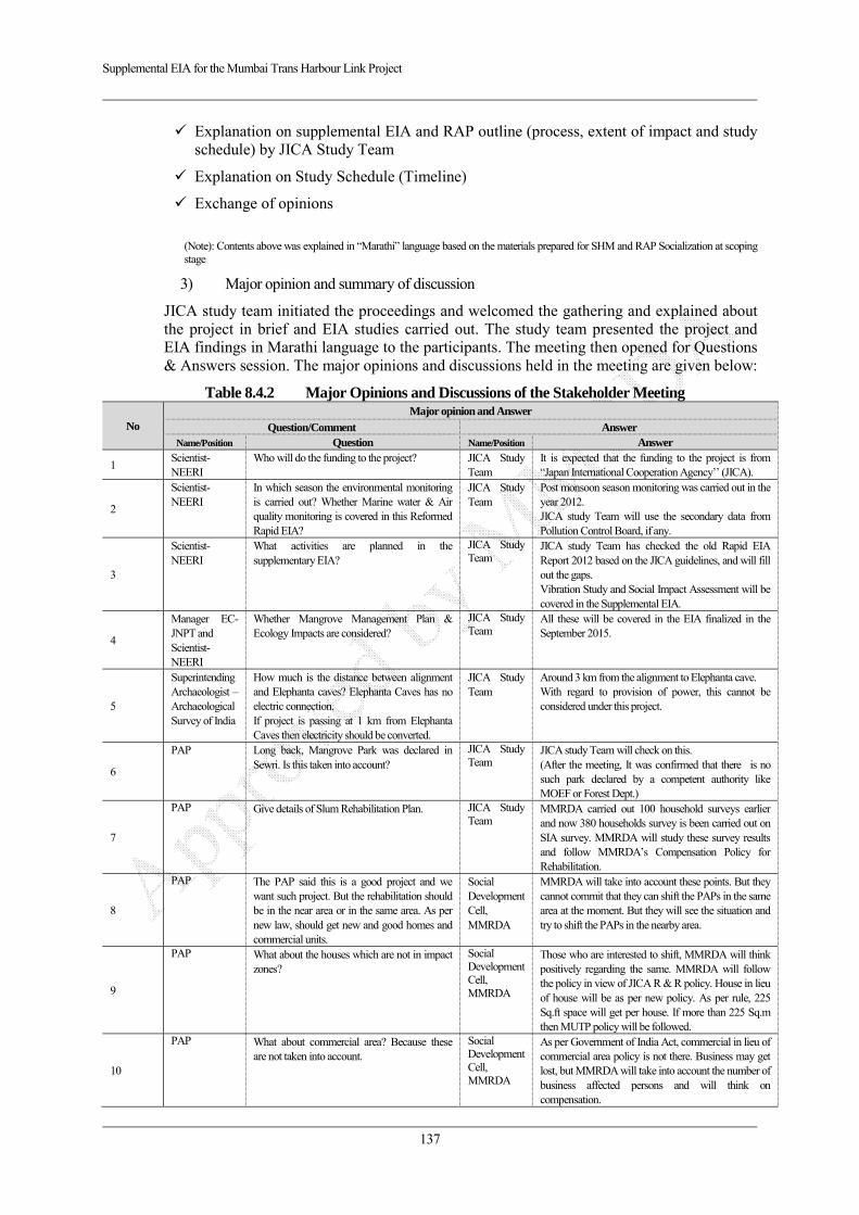
Supplemental EIA for the Mumbai Trans Harbour Link Project
137
Explanation on supplemental EIA and RAP outline (process, extent of impact and study schedule) by JICA Study Team
Explanation on Study Schedule (Timeline)
Exchange of opinions
(Note): Contents above was explained in “Marathi” language based on the materials prepared for SHM and RAP Socialization at scoping stage
3) Major opinion and summary of discussion
JICA study team initiated the proceedings and welcomed the gathering and explained about the project in brief and EIA studies carried out. The study team presented the project and EIA findings in Marathi language to the participants. The meeting then opened for Questions & Answers session. The major opinions and discussions held in the meeting are given below:
Table 8.4.2 Major Opinions and Discussions of the Stakeholder Meeting
No Major opinion and Answer
Question/Comment Answer Name/Position Question Name/Position Answer
1 Scientist- NEERI
Who will do the funding to the project? JICA Study Team
It is expected that the funding to the project is from “Japan International Cooperation Agency’’ (JICA).
2
Scientist- NEERI
In which season the environmental monitoring is carried out? Whether Marine water & Air quality monitoring is covered in this Reformed Rapid EIA?
JICA Study Team
Post monsoon season monitoring was carried out in the year 2012. JICA study Team will use the secondary data from Pollution Control Board, if any.
3
Scientist- NEERI
What activities are planned in the supplementary EIA?
JICA Study Team
JICA study Team has checked the old Rapid EIA Report 2012 based on the JICA guidelines, and will fill out the gaps. Vibration Study and Social Impact Assessment will be covered in the Supplemental EIA.
4
Manager EC- JNPT and Scientist- NEERI
Whether Mangrove Management Plan & Ecology Impacts are considered?
JICA Study Team
All these will be covered in the EIA finalized in the September 2015.
5
Superintending Archaeologist – Archaeological Survey of India
How much is the distance between alignment and Elephanta caves? Elephanta Caves has no electric connection. If project is passing at 1 km from Elephanta Caves then electricity should be converted.
JICA Study Team
Around 3 km from the alignment to Elephanta cave. With regard to provision of power, this cannot be considered under this project.
6
PAP Long back, Mangrove Park was declared in Sewri. Is this taken into account?
JICA Study Team
JICA study Team will check on this. (After the meeting, It was confirmed that there is no such park declared by a competent authority like MOEF or Forest Dept.)
7
PAP Give details of Slum Rehabilitation Plan. JICA Study Team
MMRDA carried out 100 household surveys earlier and now 380 households survey is been carried out on SIA survey. MMRDA will study these survey results and follow MMRDA’s Compensation Policy for Rehabilitation.
8
PAP The PAP said this is a good project and we want such project. But the rehabilitation should be in the near area or in the same area. As per new law, should get new and good homes and commercial units.
Social Development Cell, MMRDA
MMRDA will take into account these points. But they cannot commit that they can shift the PAPs in the same area at the moment. But they will see the situation and try to shift the PAPs in the nearby area.
9
PAP What about the houses which are not in impact zones?
Social Development Cell, MMRDA
Those who are interested to shift, MMRDA will think positively regarding the same. MMRDA will follow the policy in view of JICA R & R policy. House in lieu of house will be as per new policy. As per rule, 225 Sq.ft space will get per house. If more than 225 Sq.m then MUTP policy will be followed.
10
PAP What about commercial area? Because these are not taken into account.
Social Development Cell, MMRDA
As per Government of India Act, commercial in lieu of commercial area policy is not there. Business may get lost, but MMRDA will take into account the number of business affected persons and will think on compensation.

Supplemental EIA for the Mumbai Trans Harbour Link Project
138
11
PAP Are worship/religious places taken into account?
Social Development Cell, MMRDA
MMRDA will think on shifting of these places out of project ROW (Right of Way). OR MMRDA will think on land compensation with discussion with the locals.
12
PAP What if commercial area is above 3000 Sq.ft & has more than two or three properties?
Social Development Cell, MMRDA
The entitlement as per Policy is 225 sq. ft. If there titled property, the maximum area compensated will be 750 sq ft. For Non Titled properties irrespective of their sizes, 225 sq ft shall be given. For additional area up to 750 sq ft, they have to purchase it as per ready reconer rate.
13
PAP If some people are not willing to shift then what will be the solution?
Social Development Cell, MMRDA
Government rules will be strictly followed during development. In many of the projects of MMRDA, it was observed that people want their homes in the same building. Temporary shifting will be given concerning with Mumbai Port Trust. It will be till building construction.
Source: JICA Study Team
Source: JICA Study Team
Figure 8.4.1 Photos of the 1st Public Consultation on EIA
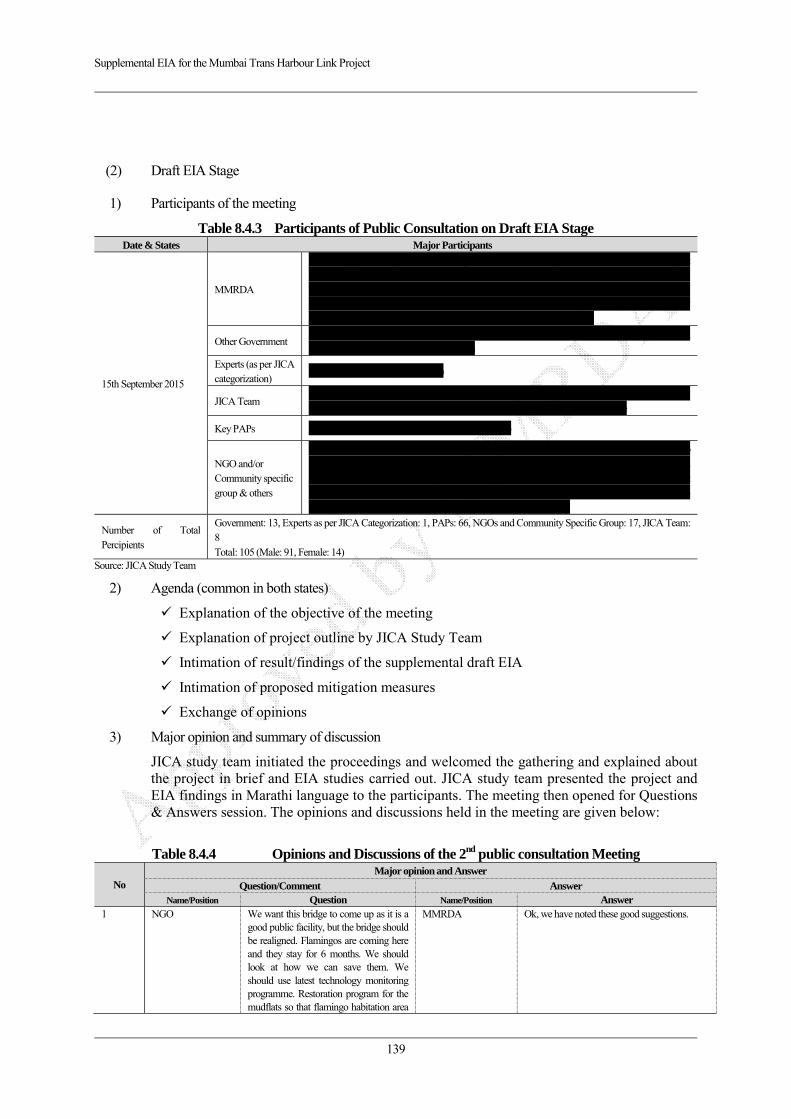
Supplemental EIA for the Mumbai Trans Harbour Link Project
139
(2) Draft EIA Stage
1) Participants of the meeting
Table 8.4.3 Participants of Public Consultation on Draft EIA Stage Date & States Major Participants
15th September 2015
MMRDA
Mr. Sanjay Sethi (Additional Metropolitian Commisioner), Dr. Vikas Tondwalkar (Joint Director-Environment), Mr. P.D. Mamdapure (Chief Engineer), Mr.Ravindra Mathapati (Dy. Collector), Mr.Ramesh Badgujar (Tehsildar), Mr. S.S. Varaskar (Superintending Engineer), Shri.Sanjay Yadav (DMC Co-ordination), Mr. A.r. Bhisikar (Deputy Engineer), Mr. G.G. Deshpande (Deputy Engineer), Mr.Milind Paranjape (Executive Engineer)
Other Government JNPT: Mrs.Y.A.Bhat (Chief Mamager-EC), CIDCO: Mr.J.C.Cherian (Assistant Chief Engineer), MPT: Mr.V.M.Sonar (Executive Engineer)
Experts (as per JICA categorization)
Dr.Dhanya Nambiar (MD- CEED)
JICA Team Mr. Hironori Kuroki, Mr. Shinya Nagaoka, Mr. Hrushikesh Kolatkar, Mr. Vivek Kulkarni, Dr. Prajakta,Kulkarni, Mrs. Prachi Suraj, Dr. Nilambari,Daripkar, Mr.Yadnesh Vichare
Key PAPs Dr. Qaisar Jamal Ansari (Local Medical Practitioner)
NGO and/or Community specific group & others
Dr.Raju Kasambe (BNHS), Mr.Sujit Narwade (BNHS), J.N.Sukhadwalla (Architect), Upendra rao (Architect), Mr.Rajesh (MMKS), Mr.Anant Mundra, Mr. Ashotosh Gupta (TIFR), Ms.Shweta Bhatt (CAT), Ms.Deepa (CAT), Mr. Prasad Khale (CAT), Ms. Vinni (CAT), Mr.Avinash Bhagat (Paryavaran Dakshata Manch), Rupa Dsouza, Bryan D’souza, Abhijeet Jagtap (Terra Nero Enterprises), Mr.Anil (Eco-Echo), Mr. Hemant Mishra (EGIS India)
Number of Total Percipients
Government: 13, Experts as per JICA Categorization: 1, PAPs: 66, NGOs and Community Specific Group: 17, JICA Team: 8 Total: 105 (Male: 91, Female: 14)
Source: JICA Study Team
2) Agenda (common in both states)
Explanation of the objective of the meeting
Explanation of project outline by JICA Study Team
Intimation of result/findings of the supplemental draft EIA
Intimation of proposed mitigation measures
Exchange of opinions
3) Major opinion and summary of discussion
JICA study team initiated the proceedings and welcomed the gathering and explained about the project in brief and EIA studies carried out. JICA study team presented the project and EIA findings in Marathi language to the participants. The meeting then opened for Questions & Answers session. The opinions and discussions held in the meeting are given below:
Table 8.4.4 Opinions and Discussions of the 2nd public consultation Meeting
No Major opinion and Answer
Question/Comment Answer Name/Position Question Name/Position Answer
1 NGO We want this bridge to come up as it is a good public facility, but the bridge should be realigned. Flamingos are coming here and they stay for 6 months. We should look at how we can save them. We should use latest technology monitoring programme. Restoration program for the mudflats so that flamingo habitation area
MMRDA Ok, we have noted these good suggestions.
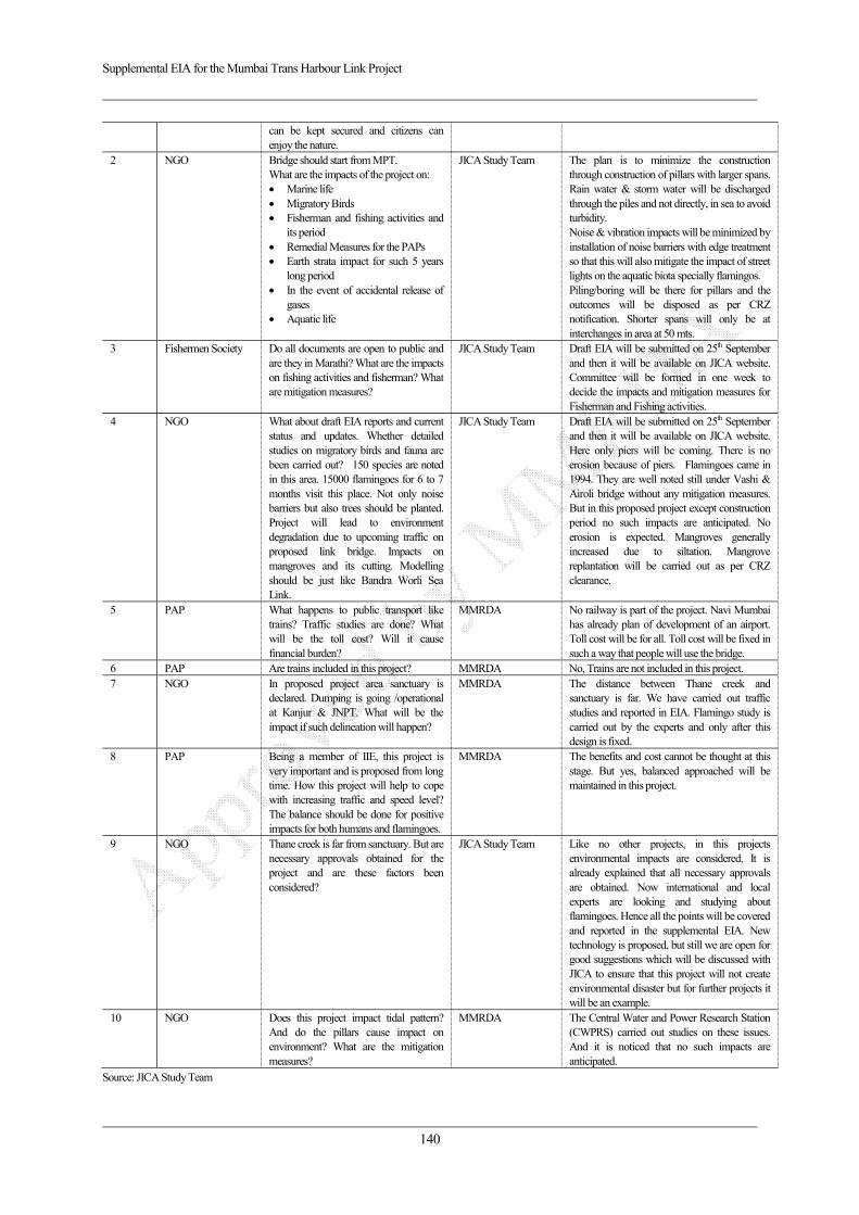
Supplemental EIA for the Mumbai Trans Harbour Link Project
140
can be kept secured and citizens can enjoy the nature.
2 NGO Bridge should start from MPT. What are the impacts of the project on: Marine life Migratory Birds Fisherman and fishing activities and
its period Remedial Measures for the PAPs Earth strata impact for such 5 years
long period In the event of accidental release of
gases Aquatic life
JICA Study Team The plan is to minimize the construction through construction of pillars with larger spans. Rain water & storm water will be discharged through the piles and not directly, in sea to avoid turbidity. Noise & vibration impacts will be minimized by installation of noise barriers with edge treatment so that this will also mitigate the impact of street lights on the aquatic biota specially flamingos. Piling/boring will be there for pillars and the outcomes will be disposed as per CRZ notification. Shorter spans will only be at interchanges in area at 50 mts.
3 Fishermen Society Do all documents are open to public and are they in Marathi? What are the impacts on fishing activities and fisherman? What are mitigation measures?
JICA Study Team Draft EIA will be submitted on 25th September and then it will be available on JICA website. Committee will be formed in one week to decide the impacts and mitigation measures for Fisherman and Fishing activities.
4 NGO What about draft EIA reports and current status and updates. Whether detailed studies on migratory birds and fauna are been carried out? 150 species are noted in this area. 15000 flamingoes for 6 to 7 months visit this place. Not only noise barriers but also trees should be planted. Project will lead to environment degradation due to upcoming traffic on proposed link bridge. Impacts on mangroves and its cutting. Modelling should be just like Bandra Worli Sea Link.
JICA Study Team Draft EIA will be submitted on 25th September and then it will be available on JICA website. Here only piers will be coming. There is no erosion because of piers. Flamingoes came in 1994. They are well noted still under Vashi & Airoli bridge without any mitigation measures. But in this proposed project except construction period no such impacts are anticipated. No erosion is expected. Mangroves generally increased due to siltation. Mangrove replantation will be carried out as per CRZ clearance.
5 PAP What happens to public transport like trains? Traffic studies are done? What will be the toll cost? Will it cause financial burden?
MMRDA No railway is part of the project. Navi Mumbai has already plan of development of an airport. Toll cost will be for all. Toll cost will be fixed in such a way that people will use the bridge.
6 PAP Are trains included in this project? MMRDA No, Trains are not included in this project. 7 NGO In proposed project area sanctuary is
declared. Dumping is going /operational at Kanjur & JNPT. What will be the impact if such delineation will happen?
MMRDA The distance between Thane creek and sanctuary is far. We have carried out traffic studies and reported in EIA. Flamingo study is carried out by the experts and only after this design is fixed.
8 PAP Being a member of IIE, this project is very important and is proposed from long time. How this project will help to cope with increasing traffic and speed level? The balance should be done for positive impacts for both humans and flamingoes.
MMRDA The benefits and cost cannot be thought at this stage. But yes, balanced approached will be maintained in this project.
9 NGO Thane creek is far from sanctuary. But are necessary approvals obtained for the project and are these factors been considered?
JICA Study Team Like no other projects, in this projects environmental impacts are considered. It is already explained that all necessary approvals are obtained. Now international and local experts are looking and studying about flamingoes. Hence all the points will be covered and reported in the supplemental EIA. New technology is proposed, but still we are open for good suggestions which will be discussed with JICA to ensure that this project will not create environmental disaster but for further projects it will be an example.
10 NGO Does this project impact tidal pattern? And do the pillars cause impact on environment? What are the mitigation measures?
MMRDA The Central Water and Power Research Station (CWPRS) carried out studies on these issues. And it is noticed that no such impacts are anticipated.
Source: JICA Study Team
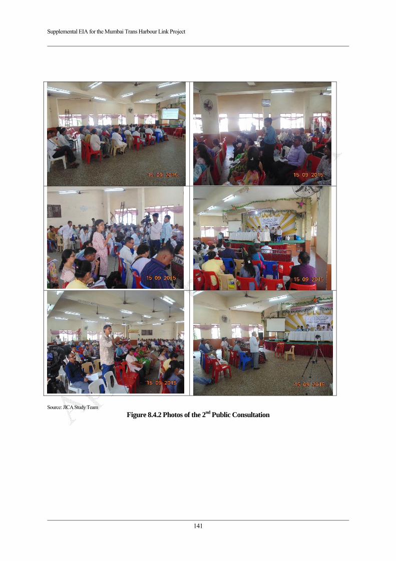
Supplemental EIA for the Mumbai Trans Harbour Link Project
141
Source: JICA Study Team
Figure 8.4.2 Photos of the 2nd Public Consultation
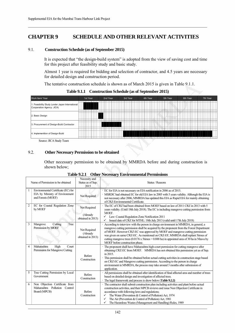
Supplemental EIA for the Mumbai Trans Harbour Link Project
142
CHAPTER 9 SCHEDULE AND OTHER RELEVANT ACTIVITIES
9.1. Construction Schedule (as of September 2015)
It is expected that “the design-build system” is adopted from the view of saving cost and time for this project after feasibility study and basic study.
Almost 1 year is required for bidding and selection of contractor, and 4.5 years are necessary for detailed design and construction period.
The tentative construction schedule is shown as of March 2015 is given in Table 9.1.1.
Table 9.1.1 Construction Schedule (as of September 2015) Source: JICA Study Team
9.2. Other Necessary Permission to be obtained
Other necessary permission to be obtained by MMRDA before and during construction is shown below;
Table 9.2.1 Other Necessary Environmental Permissions
Name of Permission to be obtained Necessity and
Status as of Sep. 2015
Status / Reasons
1 Environmental Certificate (EC) for EIA by Ministry of Environment and Forests (MOEF) Not Required
EC for EIA is not necessary on EIA notification in 2006 as of 2015. MSRDC had obtained EC for old EIA law in 2005 with 5 years validity. Although the EIA is
not necessary after 2006, MMRDA has updated this EIA as Rapid EIA for mainly obtaining of CRZ-Environmental Certificate.
2 EC for Coastal Regulation Zone by MOEF Not Required
(Already
obtained in 2013)
The EC of CRZ had been obtained from MOEF based on law of 2011 CRZ in 2013 with 5 years validity. (Until 18th July 2018). The EC is including mangrove cutting permission from MOEF. Law: Coastal Regulation Zone Notification 2011 Issued date of CRZ for MTHL: 18th July 2013 (valid until 17th July 2018)
3 Mangrove Cutting Tree Permission by MOEF
Not Required (Already
obtained in 2013)
According to interview with the person in charge environment in MMRDA, in general, a mangrove cutting permission shall be acquired by the proponent from the Forest Department of MOEF. However CRZ-EC was approved by MOEF and mangrove cutting permission was given on same CRZ-EC. As mentioned on CRZ-EF, MMRDA shall replant 5times of cutting mangrove trees (0.0176 x 5times = 0.888 ha) in appointed area of 30 ha in Nhava by MOEF before construction phase.
4 Maharashtra High Court Permission for Mangrove Cutting
Before Construction
The proponent shall have Maharashtra high-court permission for cutting mangrove after obtaining CRZ-EC from MOEF. MMRDA has not obtained this permission yet as of Sep. in 2015.
This permission shall be obtained before actual cutting activities in construction stage based on CRZ-EC and Mangrove cutting permission. According to the person in charge environment in MMRDA, the process may take around 3 months after submission of application.
5 Tree Cutting Permission by Local Government Before
Construction
All permissions shall be obtained after identification of final affected area and number of trees based on detailed design and investigation of affected trees.
The legal framework and process is show below (Table 9.2.2) 6 Non Objection Certificate from
Maharashtra Pollution Control Board (MPCB) Before
Construction
The contractor shall submit construction plan including activities and plant before actual construction activities, and then MPCB reviews and issue Non Objection Certificate in accordance with following laws and regulations; The Water (Prevention & Control of Pollution) Act, 1974 The Air (Prevention & Control of Pollution) Act, 1981 The Hazardous Wastes (Management and Handling) Rules, 1989
Work Item/ Year 1st Year 2nd Year 3rd Year 4th Year 5th Year 6th Year 7th Year
1. Feasibility Study (under Japan InternationalCooperation Agency: JICA)
2. Basic Design
3. Procurement of Design-Build Contractor
4. Implementtion of Design-Build
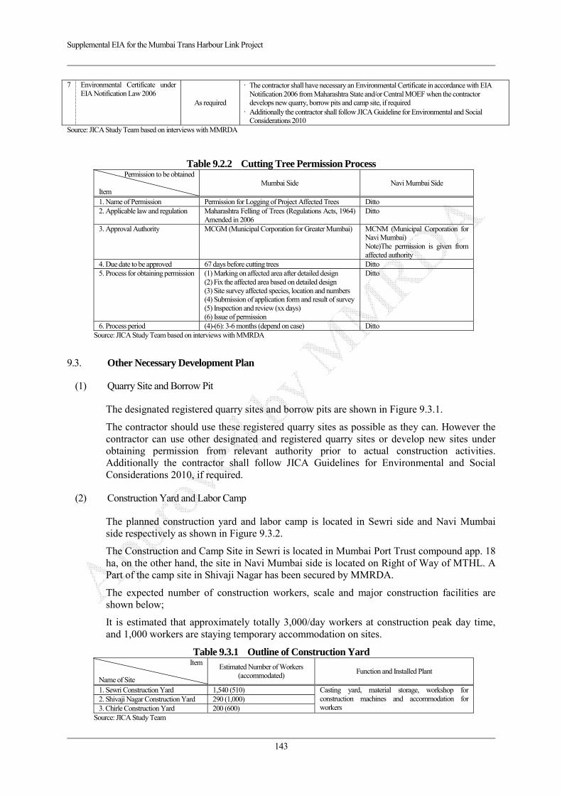
Supplemental EIA for the Mumbai Trans Harbour Link Project
143
7 Environmental Certificate under EIA Notification Law 2006
As required
The contractor shall have necessary an Environmental Certificate in accordance with EIA Notification 2006 from Maharashtra State and/or Central MOEF when the contractor develops new quarry, borrow pits and camp site, if required
Additionally the contractor shall follow JICA Guideline for Environmental and Social Considerations 2010
Source: JICA Study Team based on interviews with MMRDA
Table 9.2.2 Cutting Tree Permission Process Permission to be obtained
Item
Mumbai Side Navi Mumbai Side
1. Name of Permission Permission for Logging of Project Affected Trees Ditto 2. Applicable law and regulation Maharashtra Felling of Trees (Regulations Acts, 1964)
Amended in 2006 Ditto
3. Approval Authority MCGM (Municipal Corporation for Greater Mumbai) MCNM (Municipal Corporation for Navi Mumbai) Note)The permission is given from affected authority
4. Due date to be approved 67 days before cutting trees Ditto 5. Process for obtaining permission (1) Marking on affected area after detailed design
(2) Fix the affected area based on detailed design (3) Site survey affected species, location and numbers (4) Submission of application form and result of survey(5) Inspection and review (xx days) (6) Issue of permission
Ditto
6. Process period (4)-(6): 3-6 months (depend on case) Ditto Source: JICA Study Team based on interviews with MMRDA
9.3. Other Necessary Development Plan
(1) Quarry Site and Borrow Pit
The designated registered quarry sites and borrow pits are shown in Figure 9.3.1.
The contractor should use these registered quarry sites as possible as they can. However the contractor can use other designated and registered quarry sites or develop new sites under obtaining permission from relevant authority prior to actual construction activities. Additionally the contractor shall follow JICA Guidelines for Environmental and Social Considerations 2010, if required.
(2) Construction Yard and Labor Camp
The planned construction yard and labor camp is located in Sewri side and Navi Mumbai side respectively as shown in Figure 9.3.2.
The Construction and Camp Site in Sewri is located in Mumbai Port Trust compound app. 18 ha, on the other hand, the site in Navi Mumbai side is located on Right of Way of MTHL. A Part of the camp site in Shivaji Nagar has been secured by MMRDA.
The expected number of construction workers, scale and major construction facilities are shown below;
It is estimated that approximately totally 3,000/day workers at construction peak day time, and 1,000 workers are staying temporary accommodation on sites.
Table 9.3.1 Outline of Construction Yard Item
Name of Site
Estimated Number of Workers (accommodated)
Function and Installed Plant
1. Sewri Construction Yard 1,540 (510) Casting yard, material storage, workshop for construction machines and accommodation for workers
2. Shivaji Nagar Construction Yard 290 (1,000) 3. Chirle Construction Yard 200 (600)
Source: JICA Study Team
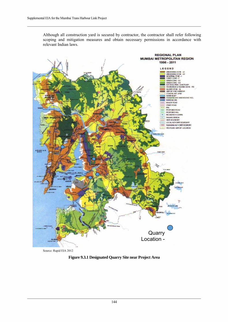
Supplemental EIA for the Mumbai Trans Harbour Link Project
144
Although all construction yard is secured by contractor, the contractor shall refer following scoping and mitigation measures and obtain necessary permissions in accordance with relevant Indian laws.
Source: Rapid EIA 2012
Figure 9.3.1 Designated Quarry Site near Project Area
Quarry Location -

Supplemental EIA for the Mumbai Trans Harbour Link Project
145
Source: JICA Study Team
Figure 9.3.2 Tentative Construction and Camp Site on MTHL
Yard-1 Sewri Candidate
Yard-2 Shivaji Nagar
Candidate Yard-3 Chirle
Yard-1 Sewri (app. 18 ha in Mumbai Port
Trust Compound)
Yard-2 Shibvaji Nagar (app. 10 ha)
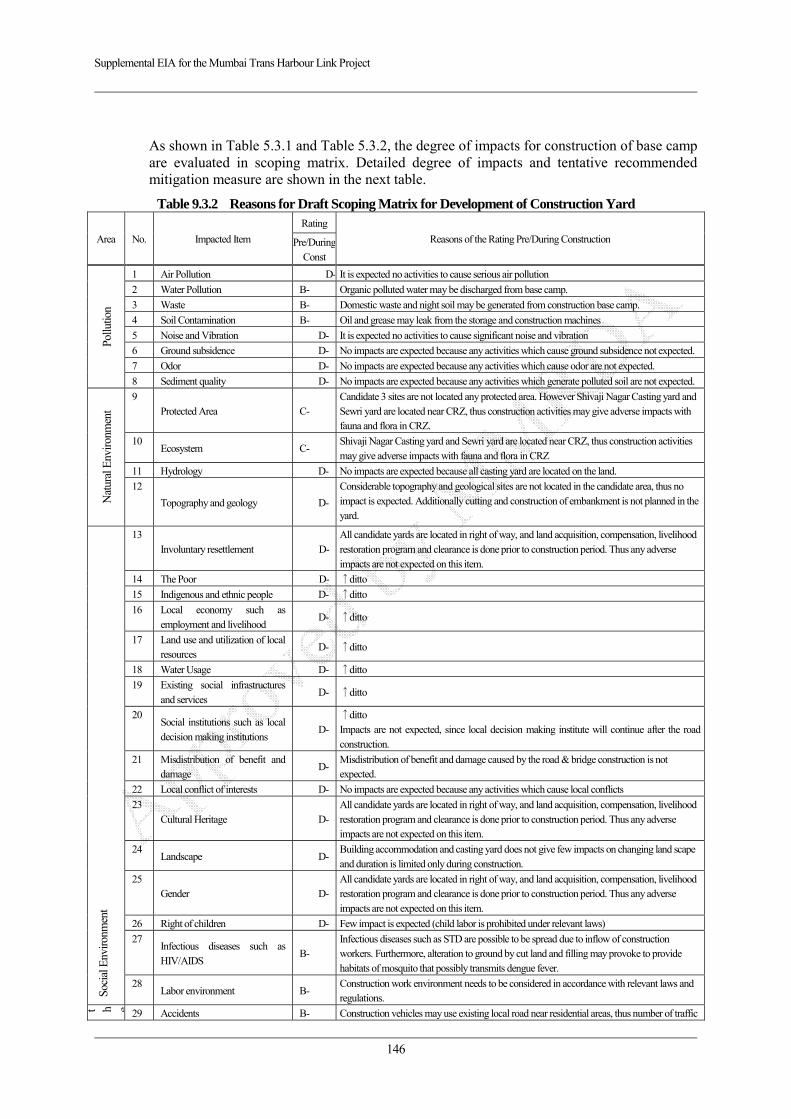
Supplemental EIA for the Mumbai Trans Harbour Link Project
146
As shown in Table 5.3.1 and Table 5.3.2, the degree of impacts for construction of base camp are evaluated in scoping matrix. Detailed degree of impacts and tentative recommended mitigation measure are shown in the next table.
Table 9.3.2 Reasons for Draft Scoping Matrix for Development of Construction Yard
Area No. Impacted Item
Rating
Reasons of the Rating Pre/During Construction Pre/DuringConst
Pollu
tion
1 Air Pollution D- It is expected no activities to cause serious air pollution
2 Water Pollution B- Organic polluted water may be discharged from base camp.
3 Waste B- Domestic waste and night soil may be generated from construction base camp.
4 Soil Contamination B- Oil and grease may leak from the storage and construction machines
5 Noise and Vibration D- It is expected no activities to cause significant noise and vibration
6 Ground subsidence D- No impacts are expected because any activities which cause ground subsidence not expected.
7 Odor D- No impacts are expected because any activities which cause odor are not expected.
8 Sediment quality D- No impacts are expected because any activities which generate polluted soil are not expected.
Nat
ural
Env
ironm
ent
9 Protected Area C-
Candidate 3 sites are not located any protected area. However Shivaji Nagar Casting yard and Sewri yard are located near CRZ, thus construction activities may give adverse impacts with fauna and flora in CRZ.
10 Ecosystem C-
Shivaji Nagar Casting yard and Sewri yard are located near CRZ, thus construction activities may give adverse impacts with fauna and flora in CRZ
11 Hydrology D- No impacts are expected because all casting yard are located on the land.
12
Topography and geology D-
Considerable topography and geological sites are not located in the candidate area, thus no impact is expected. Additionally cutting and construction of embankment is not planned in the yard.
Soci
al E
nviro
nmen
t
13 Involuntary resettlement D-
All candidate yards are located in right of way, and land acquisition, compensation, livelihood restoration program and clearance is done prior to construction period. Thus any adverse impacts are not expected on this item.
14 The Poor D- ↑ditto
15 Indigenous and ethnic people D- ↑ditto
16 Local economy such as employment and livelihood
D- ↑ditto
17 Land use and utilization of local resources
D- ↑ditto
18 Water Usage D- ↑ditto
19 Existing social infrastructures and services
D- ↑ditto
20 Social institutions such as local decision making institutions
D-↑ditto Impacts are not expected, since local decision making institute will continue after the road construction.
21 Misdistribution of benefit and damage
D-Misdistribution of benefit and damage caused by the road & bridge construction is not expected.
22 Local conflict of interests D- No impacts are expected because any activities which cause local conflicts
23 Cultural Heritage D-
All candidate yards are located in right of way, and land acquisition, compensation, livelihood restoration program and clearance is done prior to construction period. Thus any adverse impacts are not expected on this item.
24 Landscape D-
Building accommodation and casting yard does not give few impacts on changing land scape and duration is limited only during construction.
25 Gender D-
All candidate yards are located in right of way, and land acquisition, compensation, livelihood restoration program and clearance is done prior to construction period. Thus any adverse impacts are not expected on this item.
26 Right of children D- Few impact is expected (child labor is prohibited under relevant laws)
27 Infectious diseases such as HIV/AIDS
B- Infectious diseases such as STD are possible to be spread due to inflow of construction workers. Furthermore, alteration to ground by cut land and filling may provoke to provide habitats of mosquito that possibly transmits dengue fever.
28 Labor environment B-
Construction work environment needs to be considered in accordance with relevant laws and regulations.
t h e 29 Accidents B- Construction vehicles may use existing local road near residential areas, thus number of traffic
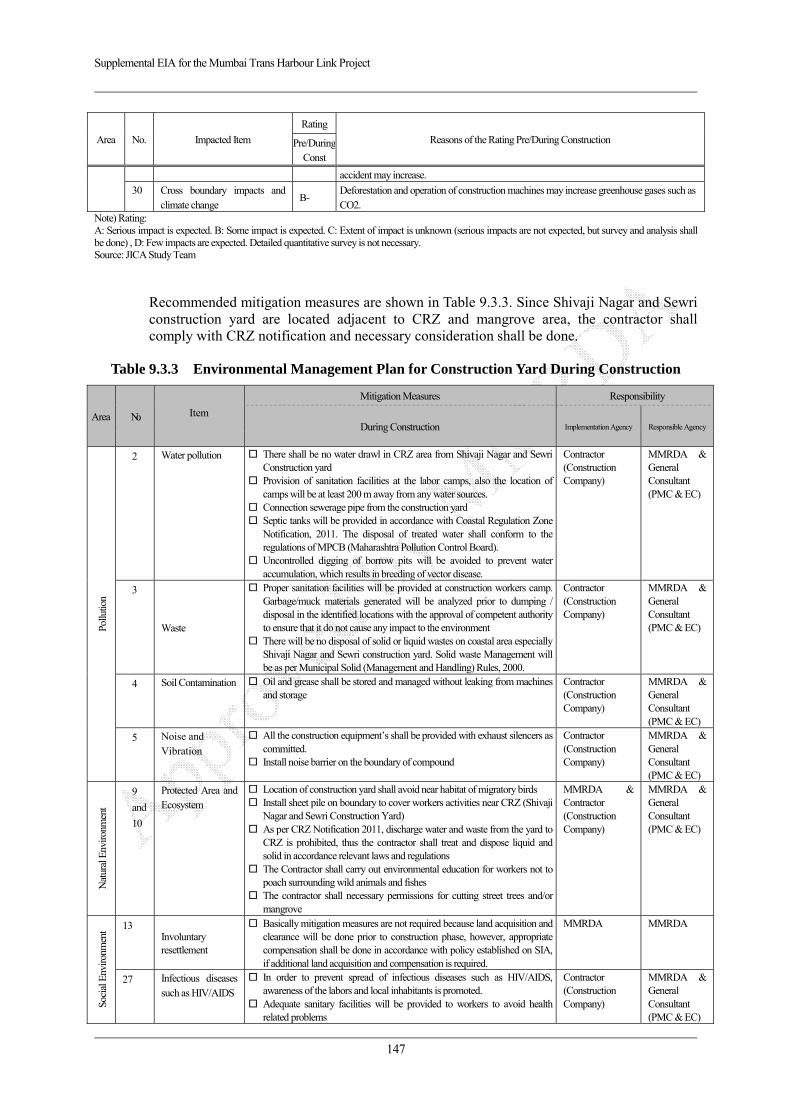
Supplemental EIA for the Mumbai Trans Harbour Link Project
147
Area No. Impacted Item
Rating
Reasons of the Rating Pre/During Construction Pre/DuringConst
accident may increase.
30 Cross boundary impacts and climate change
B- Deforestation and operation of construction machines may increase greenhouse gases such as CO2.
Note) Rating: A: Serious impact is expected. B: Some impact is expected. C: Extent of impact is unknown (serious impacts are not expected, but survey and analysis shall be done) , D: Few impacts are expected. Detailed quantitative survey is not necessary. Source: JICA Study Team
Recommended mitigation measures are shown in Table 9.3.3. Since Shivaji Nagar and Sewri construction yard are located adjacent to CRZ and mangrove area, the contractor shall comply with CRZ notification and necessary consideration shall be done.
Table 9.3.3 Environmental Management Plan for Construction Yard During Construction
Area No. Item
Mitigation Measures Responsibility
During Construction Implementation Agency Responsible Agency
Pollu
tion
2 Water pollution There shall be no water drawl in CRZ area from Shivaji Nagar and Sewri Construction yard
Provision of sanitation facilities at the labor camps, also the location of camps will be at least 200 m away from any water sources.
Connection sewerage pipe from the construction yard Septic tanks will be provided in accordance with Coastal Regulation Zone
Notification, 2011. The disposal of treated water shall conform to the regulations of MPCB (Maharashtra Pollution Control Board).
Uncontrolled digging of borrow pits will be avoided to prevent water accumulation, which results in breeding of vector disease.
Contractor (Construction Company)
MMRDA & General Consultant (PMC & EC)
3
Waste
Proper sanitation facilities will be provided at construction workers camp. Garbage/muck materials generated will be analyzed prior to dumping / disposal in the identified locations with the approval of competent authority to ensure that it do not cause any impact to the environment
There will be no disposal of solid or liquid wastes on coastal area especially Shivaji Nagar and Sewri construction yard. Solid waste Management will be as per Municipal Solid (Management and Handling) Rules, 2000.
Contractor (Construction Company)
MMRDA & General Consultant (PMC & EC)
4 Soil Contamination Oil and grease shall be stored and managed without leaking from machines and storage
Contractor (Construction Company)
MMRDA & General Consultant (PMC & EC)
5 Noise and Vibration
All the construction equipment’s shall be provided with exhaust silencers as committed.
Install noise barrier on the boundary of compound
Contractor (Construction Company)
MMRDA & General Consultant (PMC & EC)
Nat
ural
Env
ironm
ent
9
and
10
Protected Area and Ecosystem
Location of construction yard shall avoid near habitat of migratory birds Install sheet pile on boundary to cover workers activities near CRZ (Shivaji
Nagar and Sewri Construction Yard) As per CRZ Notification 2011, discharge water and waste from the yard to
CRZ is prohibited, thus the contractor shall treat and dispose liquid and solid in accordance relevant laws and regulations
The Contractor shall carry out environmental education for workers not to poach surrounding wild animals and fishes
The contractor shall necessary permissions for cutting street trees and/or mangrove
MMRDA & Contractor (Construction Company)
MMRDA & General Consultant (PMC & EC)
Soci
al E
nviro
nmen
t 13 Involuntary resettlement
Basically mitigation measures are not required because land acquisition and clearance will be done prior to construction phase, however, appropriate compensation shall be done in accordance with policy established on SIA, if additional land acquisition and compensation is required.
MMRDA MMRDA
27 Infectious diseases such as HIV/AIDS
In order to prevent spread of infectious diseases such as HIV/AIDS, awareness of the labors and local inhabitants is promoted.
Adequate sanitary facilities will be provided to workers to avoid health related problems
Contractor (Construction Company)
MMRDA & General Consultant (PMC & EC)
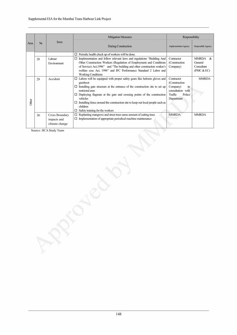
Supplemental EIA for the Mumbai Trans Harbour Link Project
148
Area No. Item
Mitigation Measures Responsibility
During Construction Implementation Agency Responsible Agency
Periodic health check up of workers will be done.
28 Labour Environment
Implementation and follow relevant laws and regulations “Building And Other Construction Workers (Regulation of Employment and Conditions of Service) Act,1996” and “The building and other construction worker’s welfare cess Act, 1996” and IFC Performance Standard 2 Labor and Working Conditions
Contractor (Construction Company)
MMRDA & General Consultant (PMC & EC)
Oth
er
29 Accident Labors will be equipped with proper safety gears like helmets gloves and gumboot
Installing gate structure at the entrance of the construction site to set up restricted area
Deploying flagman at the gate and crossing points of the construction vehicles
Installing fence around the construction site to keep out local people such as children
Safety training for the workers
Contractor (Construction Company) in consultation with Traffic Police Department
MMRDA
30 Cross Boundary impacts and climate change
Replanting mangrove and street trees same amount of cutting trees Implementation of appropriate periodical machine maintenance
MMRDA MMRDA
Source: JICA Study Team