southern california earthquake center geologic vertical motion database
TRANSCRIPT

Southern California Earthquake Center Geologic VerticalMotion Database
Nathan A. NiemiDepartment of Geological Sciences, University of Michigan, 2534 C. C. Little Building, 1100 North University Avenue,Ann Arbor, Michigan 48109, USA ([email protected])
Michael OskinDepartment of Geological Sciences, University of North Carolina, 228 Mitchell Hall, CB 3315, Chapel Hill, NorthCarolina 27599, USA
Now at Department of Geology, University of California, Davis, California 95616, USA
Thomas K. RockwellDepartment of Geological Sciences, San Diego State University, MC-1020, 5500 Campanile Drive, San Diego,California 92182, USA ([email protected])
[1] The Southern California Earthquake Center Geologic Vertical Motion Database (VMDB) integratesdisparate sources of geologic uplift and subsidence data at 104- to 106-year time scales into a singleresource for investigations of crustal deformation in southern California. Over 1800 vertical deformationrate data points in southern California and northern Baja California populate the database. Four mature datasets are now represented: marine terraces, incised river terraces, thermochronologic ages, and stratigraphicsurfaces. An innovative architecture and interface of the VMDB exposes distinct data sets and referenceframes, permitting user exploration of this complex data set and allowing user control over the assumptionsapplied to convert geologic and geochronologic information into absolute uplift rates. Online explorationand download tools are available through all common web browsers, allowing the distribution of verticalmotion results as HTML tables, tab-delimited GIS-compatible text files, or via a map interface through theGoogle Mapsk web service. The VMDB represents a mature product for research of fault activity andelastic deformation of southern California.
Components: 8372 words, 5 figures.
Keywords: deformation; vertical; southern California; Quaternary.
Index Terms: 1209 Geodesy and Gravity: Tectonic deformation (6924); 0525 Computational Geophysics: Data
management; 0520 Computational Geophysics: Data analysis: algorithms and implementation.
Received 3 March 2008; Revised 16 May 2008; Accepted 22 May 2008; Published 11 July 2008.
Niemi, N. A., M. Oskin, and T. K. Rockwell (2008), Southern California Earthquake Center Geologic Vertical Motion
Database, Geochem. Geophys. Geosyst., 9, Q07010, doi:10.1029/2008GC002017.
G3G3GeochemistryGeophysics
Geosystems
Published by AGU and the Geochemical Society
AN ELECTRONIC JOURNAL OF THE EARTH SCIENCES
GeochemistryGeophysics
Geosystems
Data Brief
Volume 9, Number 7
11 July 2008
Q07010, doi:10.1029/2008GC002017
ISSN: 1525-2027
Copyright 2008 by the American Geophysical Union 1 of 14

1. Introduction
[2] Understanding the vertical component of crustalmotion is particularly important in regions of com-plex faulting and distributed deformation such asoccurs across the active Pacific–North Americaplate boundary in southern California [e.g., Pleschet al., 2007]. Vertical motions are a direct result ofreverse displacement common to both exposed andblind faults that threaten the urban region [e.g.,Dolan et al., 1997; Oskin et al., 2000; Grant et al.,1999; Huftile and Yeats, 1996; Yeats and Rockwell,1991; Sorlien et al., 2000; Pinter et al., 2001, 2003].Recoverable vertical motions, if differentiated frompermanent deformation, can also test alternativemodels of strain accumulation on faults [e.g., Arguset al., 1999] and discriminate postseismic relaxationprocesses [Peltzer et al., 1998; Pollitz et al., 2001].
[3] Continuously operating GPS stations of theSouthern California Integrated GPS Network(SCIGN) and the Plate Boundary Observatory(PBO) establish ever-longer time series from whichvertical motions may be resolved [Nikolaidis, 2002;Herring et al., 2006], while new methods thatcombine sparse continuous GPS observations withpermanent scatterer– Interferometric SyntheticAperture Radar (InSAR) provide spatially continu-ous, regional measurements of vertical tectonicmotions [e.g., Burgmann et al., 2006]. The challengein analysis of new vertical geodetic data is to dis-criminate tectonic loading signals from nontectoniceffects, and to interpret tectonic loading in terms ofelastic versus permanent strain accumulation. AsBawden et al. [2001] and King et al. [2006, 2007]demonstrate in the Los Angeles area, ground surfacedisplacement results from fluid infiltration and ex-traction, which significantly affects vertical and hor-izontal geodetic velocities. Other nontectonicmotions of the Earth’s surface, such as landslides,can also be detected, purposefully or not, usingcommon geodetic techniques [e.g., Hilley et al.,2004; Saroli et al., 2004]. In order to distinguishgeodetic sites affected by such nontectonic motions,information on the long-term geologic rates of verti-cal deformation in southern California is required.
[4] To that end, we have developed the SouthernCalifornia Earthquake Center Geologic VerticalMotion Database (VMDB). This database contains�1800 geologic vertical motion rates (104- to 106-year timescale) for southern California and north-ern Baja California (Figure 1). Vertical motionrates are derived from four principal geologic datasources for which past elevations can be deter-
mined: marine terraces, river terraces, shallowmarine stratigraphic horizons, and exhumationrates from low-temperature thermochronometers.The database uses an innovative architecture toseparately store observations (e.g., modern eleva-tions of uplifted marine terraces and terrace ages)from alternative reference frame models (e.g., paleo-sea-level curves) such that multiple reference framemodels may be applied to the interpretation ofvertical motion rates, and the compatibility andveracity of various data models can be assessed.The database is available online (http://www.scec.org/resources/data/vmdb/). Data localities may befiltered by geographic coordinates, or by a searchradius around existing seismic and GPS stations insouthern California (Figure 2a). A web-based inter-face allows the user to select among a variety of datamodels that can be applied to derive vertical motionrates (Figure 2b), and the results are returned as anHTML table, a tab-delimited, GIS-compatible textfile, or an interactive Google Mapsk interface.
2. Geologic Vertical Motion Data
[5] A single geologic vertical motion rate datumrequires four distinct data types: the present-dayelevation of a marker, the paleoelevation of thatmarker, the age of the marker, and a paleoelevationdatum for determining absolute vertical motion(typically relative sea level). These data types areeither stored in the database as fixed values (e.g.,the present-day elevation of a marine terrace), orgenerated on-the-fly on the basis of user-selectedcriteria (e.g., paleoelevation of a marine terrace,which is a function of terrace age and a user-selectedsea-level curve). Relative uplift of a marker is deter-mined from an elevation and paleoelevation. Relativeuplift is converted into a rock uplift reference frame(uplift with respect to sea level) via a paleoelevationdatum. Uplift rates are calculated by dividing abso-lute uplift by age. Uplift data and datum are unique toa specific class of markers (e.g., marine terraces,fluvial terraces, stratigraphic horizons), while agedata types are independent. The ages of most markersare determined via correlation to other markers ofknown age. For example, dozens of marine terracesmay be assigned an age based on geologic, geomor-phic, or topographic similarities to a single terracewith absolute age control via biostratigraphic orisotopic methods. These correlations are tracked inthe database and mapped each time vertical upliftrates are calculated, such that the addition of newabsolute age controls, or recorrelations of terracesequences, automatically propagate through the da-
GeochemistryGeophysicsGeosystems G3G3
niemi et al.: the scec geologic vertical motion database 10.1029/2008GC002017
2 of 14

Figure 1. Map of vertical uplift data points included in the SCEC Geologic Vertical Motion Database, colored bycalculated uplift rate. Uplift rate data points are primarily located along coastlines and major rivers, where terracesprovide retrodeformable markers. Stratigraphic horizons observed in boreholes or seismic reflection lines arerecorded for interior basins, and several thermochronologic ages are reported from the Transverse Ranges. Majoractive faults of southern California are shown relative to uplift rate data, colored by approximate fault slip rate (W. A.Bryant, Digital database of Quaternary and younger faults from the fault activity map of California, version 2.0,accessed 28 April 2008 from the California Geological Survey Web Page: http://www.conservation.ca.gov/cgs/information/publications/Pages/QuaternaryFaults_ver2.aspx). (a) Expanded uplift rate scale, emphasizing variabilityof geologic vertical uplift rates. (b) Condensed uplift rate scale, highlighting distribution of rates in the �1 to 1 mm/arate, where the majority of the geologic uplift rates lie.
GeochemistryGeophysicsGeosystems G3G3
niemi et al.: the scec geologic vertical motion database 10.1029/2008GC002017niemi et al.: the scec geologic vertical motion database 10.1029/2008GC002017
3 of 14

tabase, and are reflected in the uplift rates derivedfrom the data set. Below we describe each of the fourmajor data types incorporated into the SCECVMDB,alongwith typical chronologic data for each type, andmethodologies implemented for deriving geologicuplift rates from these data. A discussion of simpli-fying assumptions, limitations, and potential uses ofthese data is presented in a later section.
2.1. Marine Terraces
[6] Marine terraces begin as eroded bedrock plat-forms formed from wave erosion during timeperiods of stable sea level. A terrace developswhen sea level falls and uplift isolates a platformfrom inundation. Marine terraces define high pre-cision markers of absolute vertical motion [e.g.,Bloom et al., 1974; Bloom and Yonekura, 1985].The VMDB contains over 300 marine terrace datapoints along the Pacific coastline from San Simeonto central Baja California, including nearly alloffshore islands (Figure 1) [e.g., Rockwell et al.,1992; Muhs, 1983; Muhs et al., 1992, 1994, 2002].Relative uplift is calculated from the present terraceelevation near its inland back-edge, known as the‘‘shoreline angle,’’ with respect to the modernshoreline angle (Figure 3a). Absolute uplift is
calculated via correlation of a marine terrace to aparticular sea level stage and its highstand eleva-tion, which serves as a datum. Sea level curvescurrently available in the VMDB include a com-posite Quaternary sea-level curve [Rockwell et al.,1989; Muhs et al., 2002], and 18O-based curves formarine isotopic stages 3 and 5 [Muhs et al., 1994;Chappell and Shackleton, 1986]. Because sea levelis a global reference frame, assignments of thesedatums are essentially temporal correlations, andthus depend on often incomplete knowledge ofterrace ages and spatial correlation of terraces toothers of known age.
[7] Several age dating methods have been used toassign ages to marine terraces and tie these to aparticular sea level highstand. Each of these agedating methods is represented separately in thedatabase in order to preserve appropriate metadata.In rare instances, absolute chronometry is availablefrom U-series disequilibrium on solitary fossil coral[e.g., Ku, 1976], or for the very youngest terraces,14C of organic material. Other ages are determinedrelatively from faunal assemblages or amino acidracemization (randomization of shell protein struc-ture over time) [e.g., Miller and Brigham-Grette,1989] tied to absolutely dated sites. Finally, some
Figure 2. Web interface to the SCEC Geologic Vertical Motion Database. (a) Vertical motion data can be searchedby geographic coordinates of a bounding rectangle, or by defining a search radius around existing GPS stations orseismic monuments in southern California. (b) Results summary page shows the number of each type of data recordfound in the search region, and offers the user a variety of choices for handling the data, including option for dealingwith incomplete data, models for reference datums (such as sea level curves), and output formats, including web pagetables, GIS-compatible text files, and a Google Mapsk display.
GeochemistryGeophysicsGeosystems G3G3
niemi et al.: the scec geologic vertical motion database 10.1029/2008GC002017
4 of 14

ages are assigned on the basis of cross-cuttingrelationships between terrace risers and the orderand relative elevations of sea level highstands.These correlations become less reliable with in-creasing marine terrace age.
2.2. River Terraces
[8] Nearly 500 river terrace data points have beenincorporated into the VMDB from the VenturaRiver, Los Angeles River, San Gabriel River, andSantaAnaRiver. These rivers drain through themajorcoastal basins of southern California. As with marine
terraces, river terraces are formed when a portion ofthe river bed is isolated from inundation (Figure 3b).Typical river terrace markers in the VMDB wereformed during an episode of valley infilling withsediment, followed by river incision that isolated theterrace [Rockwell et al., 1984; Bull, 1991].
[9] Defining an appropriate datum is problematicfor river terraces. Changes in sediment grain sizeand the balance between sediment flux and riverdischarge are most likely to affect river gradientover the time frame of terrace generation at thelength scale of large coastal river basins [Paola et
Figure 3. Schematic diagrams of the geologic development of the four uplift markers currently represented in theVertical Motion Database, illustrated with the geologic observations necessary to derive uplift rate informationfrom each of the four marker types. (a) Marine terrace. (b) Fluvial terrace. (c) Subsurface stratigraphic horizon.(d) Thermochronologic age constraint.
GeochemistryGeophysicsGeosystems G3G3
niemi et al.: the scec geologic vertical motion database 10.1029/2008GC002017
5 of 14

al., 1992]. Sea level change is unlikely to be amajor effect except during eustatic lowstandswhere the river mouth may drop below the shelf-slope break, instigating the formation of incisedvalleys upstream, or by exposing a gentle lowstandshelf that promotes aggradation of the river systemupstream. Most of the terraces in the VMDB wereformed well inland of the shoreline by braidedrivers during times when sea level was not lowenough to cause incised valley formation. Some ofthese terraces are fill deposits (e.g., >20-m-thickfills along the Los Angeles River [Oskin et al.,2000]). Other terraces are straths cut on bedrock,but these also are likely to be formed duringperiods of enhanced sediment flux [e.g., Hancockand Anderson, 2002]. Thus we interpret that mostterraces in the VMDB were probably formed asthin sheets of gravel prograded across the coastalsedimentary basins in response to changes insediment flux and river discharge. The VenturaRiver is a likely exception, as this terrace sequenceis preserved proximal to the coastline and haspreserved terraces that were isolated during sea-level lowstands [Rockwell et al., 1984, 1988].
[10] We make the simplifying assumptions that (1)the depositional slope of a gravel sheet (and thus thebalance of discharge and sediment flux duringgravel sheet formation) is invariant on a given reachof a river system, and (2) the surface elevations ofsubsiding basins upstream and downstream of aflight of terraces does not change appreciably overthe short timescale of terrace records. Because all ofthe uplifts over which river terraces have beenpreserved are underlain by easily eroded marinerocks or unconsolidated fluvial deposits, we do notexpect these uplifts to form resistant barriers andtherefore a constant gradient was maintained acrossan uplift during each terrace-forming event. Thus,any relative changes in gradient of a terrace withrespect to the present river elevation across theseuplifts is interpreted as the result of tectonic uplift.Uplift rates calculated from the difference in terracesurface elevation to the present river elevation willbe more reliable for older andmore highly deformedterraces where the amount of uplift well exceedsshort-term changes in surface elevation along theriver system. The VMDB is built to accommodatealternative reference frames, though no alternativeto the present river elevation is provided currently.
[11] Ages of river terraces, like ages of marineterraces, are determined using a variety of techni-ques and correlations. For the youngest terraces,14C ages are available. Many river terraces are
dated via soil development, a relative dating tech-nique that quantifies soil structure, content, andthickness, and yields an age calibrated to othersoils of known age [e.g., Walker, 1962; Rockwell,2000]. In situ cosmogenic nuclides provide amethod for dating fluvial terraces over ka to Matimescales [e.g., Repka et al., 1998], but at presentno such ages have been published for any of theriver terraces contained in the VMDB.
2.3. Stratigraphic Horizons
[12] Major stratigraphic horizons within the coastalbasins of southern California help to define bothuplift and subsidence rates. Uplift is calculatedfrom a present elevation (often negative if pene-trated below sea level in a well) differenced with abroadly defined paleoelevation datum based ondepositional setting (Figure 3c). The VMDB con-tains almost 1000 stratigraphic horizon data pointsfrom the Ventura and Los Angeles basins, rangingin age from Late Quaternary to early Pliocene. Theuplift (or subsidence) of these stratigraphic hori-zons is determined in the VMDB as the differencebetween the present elevation of the deposit andpaleoelevation at the time of deposition.
[13] Late Quaternary stratigraphic horizons areprimarily known from aquifer systems penetratedbywater wells. Although generally poorly dated, themajority of these aquifer systems are developed insands thought to be beach facies, and thus have welldefined paleoelevations near sea level. Many ofthese horizons have subsided tens to hundreds ofmeters since deposition [Yeats, 1977; K. Mueller,unpublished data, 2003]. Early Quaternary andPliocene stratigraphic horizons [e.g., Cooke et al.,2004] are well-dated from regionally defined faunalassemblages, but were typically deposited belowpaleo-sea level at poorly constrained paleodepths[Blake, 1991]. Because these horizons are older than�1 Ma, the amount of deformation and integrateduplift rates are significant relative to the uncertain-ties inherent in the depths of deposition. Absoluteages are an integral part of the identification andcorrelation of stratigraphic horizons, and are thusincluded as part of a stratigraphic horizon datum.
2.4. Thermochronology
[14] Thermochronologic ages across southern Cal-ifornia present a rich data set for the study ofvertical motions in bedrock terrain [e.g., Blythe etal., 2000]. Low-temperature thermochronologicages (apatite U-Th/He and fission-track ages areincluded at present) represent exhumation of rocks
GeochemistryGeophysicsGeosystems G3G3
niemi et al.: the scec geologic vertical motion database 10.1029/2008GC002017
6 of 14

through a closure temperature, (�70�C and�110�C, respectively [e.g., Farley, 2000; Wagnerand Reimer, 1972]). This closure temperatureserves as a proxy for depth with the assumptionof a geothermal gradient (Figure 3d). If surfaceuplift is assumed to be minimal, then the rate oferosional exhumation is a proxy for rock uplift rate.Using an average geothermal gradient of �30�C/km [Sass et al., 1992], more than 2 km of exhu-mation is required to yield a reset fission-track or(U-Th)/He age and derive a potentially meaningfulexhumation rate.
[15] Given, then, this set of simplifying assump-tions (fixed geothermal gradient, zero surface up-lift, known closure temperature and simple thermalhistory), the depth to the closure temperature of agiven thermochronometer (the closure isotherm)can be treated as a paleoelevation datum. The timeat which a sample passed through this datum (thethermochronometric age of the sample) can then beused to derive a bedrock uplift rate. It is importantto note that the assumption of zero surface uplift isonly valid to first order, and that few bedrockuplands of southern California are sufficientlyexhumed to provide useful low-temperature ther-mochronologic ages. However, where available,thermochronologic data provide vertical motioninformation where no other such data exist, pro-viding a key link from coastal basins to bedrockuplands across major range-bounding faults.
3. Database Technology
[16] The VMDB is built on the open-source Post-greSQL relational database server, with access tothe database provided via a web portal (http://www.scec.org/resources/data/vmdb/). The webportal is built on the PHP scripting language,which permits interaction with users via web-basedquery forms. Vertical motion results are output to aweb browser as HTML tables, GIS-compatible textfiles, or as interactive maps via the Google Mapskweb service.
[17] The VMDB uses a novel approach to compil-ing geologic data into a useful resource for thebroader earthquake research community. Ratherthan attempting to produce a simple, static mapof vertical motion results, the database preservesoriginal geologic data in its intact form encapsu-lated in tables customized to the data type. Thevertical motion database uses object-relationaltechnology pioneered by the open-source Post-greSQL relational database system. The structure
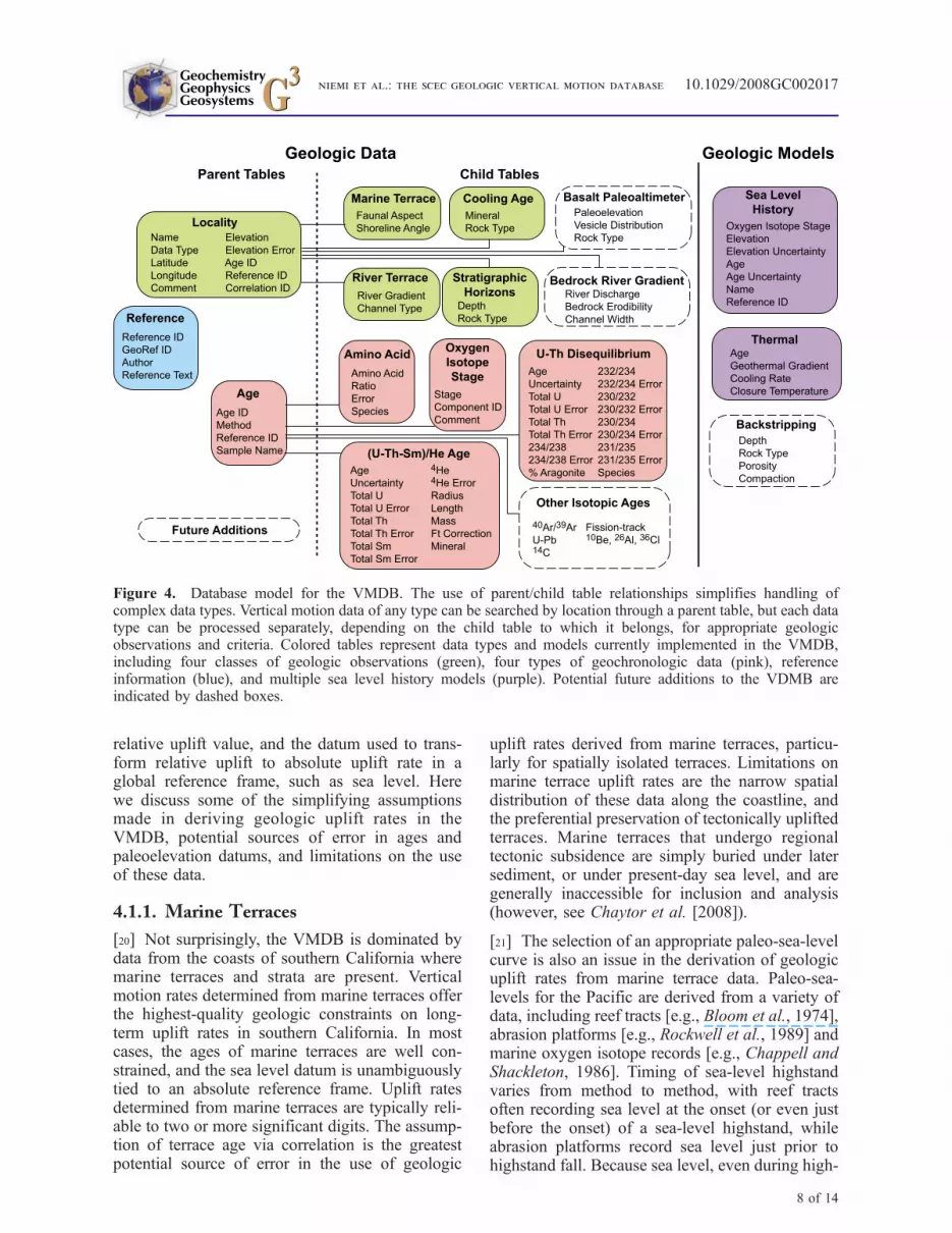
of an object-relational database mirrors the struc-ture of object-oriented programming languages inthat each table acts as a class, and each row in thetable is an object. The power of this approach is theability to make a generic base class and then derivespecialized subclasses. Each subclass can be trea-ted as an individual table, or the base class can beused to address all of the data generically, anapproach known as polymorphism in object ori-ented programming. For example, tables that de-scribe specific subclasses of geologic verticalmotion data, such as marine terraces, river terraces,thermochronology sample profiles, or stratigraphichorizons from oil wells, inherit a generic localitytable. In effect, the classes of vertical motion dataare considered subclasses of the generic localityclass, and each subclass is customized to hold thedata required to completely describe a particulardata type. Generic queries, such as a search on thecommon attributes of location, age, and elevationof vertical motion data, are directed at the parentclass to search all customized subclasses simulta-neously (Figure 4). Such a structure could bemimicked in a traditional relational databasethrough the use of foreign keys, but the resultwould be locality data spread across multipletables. The object-relational approach keeps all ofthe relevant data for each locality intact within itsown specialized table.
[18] Through use of recursive stored procedures(another innovation of PostgreSQL), the verticalmotion database also models correlation betweendata points. A recursive procedure is one that cancall itself, and is ideally suited to querying a chain ofcorrelations through a data set. Modeling correla-tion through recursion is critical because geologicvertical motion data typically rely on a few keylocalities with adequate age and/or elevation con-trol. The end result of this effort to apply object-relational technology and recursion is a seamlessand surprisingly simple approach to geologic verti-cal motion data that preserves the original geologicinformation and relationships, is easily updateableand expandable, and that automatically propagatesnewly added data through the uplift model toprovide the most up-to-date vertical motion rates.
4. Discussion
4.1. Assumptions and Limitations of theVMDB
[19] The reliability of any vertical motion determi-nation is a function of the precision of the age,
GeochemistryGeophysicsGeosystems G3G3
niemi et al.: the scec geologic vertical motion database 10.1029/2008GC002017
7 of 14
relative uplift value, and the datum used to trans-form relative uplift to absolute uplift rate in aglobal reference frame, such as sea level. Herewe discuss some of the simplifying assumptionsmade in deriving geologic uplift rates in theVMDB, potential sources of error in ages andpaleoelevation datums, and limitations on the useof these data.
4.1.1. Marine Terraces
[20] Not surprisingly, the VMDB is dominated bydata from the coasts of southern California wheremarine terraces and strata are present. Verticalmotion rates determined from marine terraces offerthe highest-quality geologic constraints on long-term uplift rates in southern California. In mostcases, the ages of marine terraces are well con-strained, and the sea level datum is unambiguouslytied to an absolute reference frame. Uplift ratesdetermined from marine terraces are typically reli-able to two or more significant digits. The assump-tion of terrace age via correlation is the greatestpotential source of error in the use of geologic
uplift rates derived from marine terraces, particu-larly for spatially isolated terraces. Limitations onmarine terrace uplift rates are the narrow spatialdistribution of these data along the coastline, andthe preferential preservation of tectonically upliftedterraces. Marine terraces that undergo regionaltectonic subsidence are simply buried under latersediment, or under present-day sea level, and aregenerally inaccessible for inclusion and analysis(however, see Chaytor et al. [2008]).
[21] The selection of an appropriate paleo-sea-levelcurve is also an issue in the derivation of geologicuplift rates from marine terrace data. Paleo-sea-levels for the Pacific are derived from a variety ofdata, including reef tracts [e.g., Bloom et al., 1974],abrasion platforms [e.g., Rockwell et al., 1989] andmarine oxygen isotope records [e.g., Chappell andShackleton, 1986]. Timing of sea-level highstandvaries from method to method, with reef tractsoften recording sea level at the onset (or even justbefore the onset) of a sea-level highstand, whileabrasion platforms record sea level just prior tohighstand fall. Because sea level, even during high-
Figure 4. Database model for the VMDB. The use of parent/child table relationships simplifies handling ofcomplex data types. Vertical motion data of any type can be searched by location through a parent table, but each datatype can be processed separately, depending on the child table to which it belongs, for appropriate geologicobservations and criteria. Colored tables represent data types and models currently implemented in the VMDB,including four classes of geologic observations (green), four types of geochronologic data (pink), referenceinformation (blue), and multiple sea level history models (purple). Potential future additions to the VDMB areindicated by dashed boxes.
GeochemistryGeophysicsGeosystems G3G3
niemi et al.: the scec geologic vertical motion database 10.1029/2008GC002017
8 of 14

stands, can fluctuate significantly [e.g., Neumannand Hearty, 1996], and because highstands canhave durations of thousands or tens of thousandsof years [Ku et al., 1974; Chen et al., 1991],geologic vertical uplift rates are sensitive to thechoice of sea-level record, the duration of thehighstand, and the difference between early andlate highstand sea level elevation. Marine terracespreserved in southern California are primarilyabrasion platforms, for which the most appropriatesea level curve is based on abrasion platformsrecorded on Isla de Guadalupe, a stable island ona fossil spreading ridge now attached to the Pacificplate [Muhs et al., 2002]. However, the selection ofsea level curves is left open to the user to explorethe effects of varying highstand timing and mag-nitude on geologic uplift rates in southern Califor-nia. These effects will be modest, however, andwill mainly affect portions of the coast with low(<�0.3 mm/a) uplift rates.
4.1.2. River Terraces
[22] River terraces offer an opportunity to spatiallyextend geologic uplift rates from the coasts towardthe interior basins of southern California. As dis-cussed above, absolute ages of river terraces insouthern California are generally lacking, althoughsome younger terraces do have 14C ages, andrelative age control via soil development is avail-able in some cases. This lack of absolute agecontrol, and assumptions discussed below regard-ing river paleoelevation, result in geologic verticalmotion values from river terraces that are lessreliable than values from marine terraces.
[23] The most significant assumption made inderiving in uplift rates from river terraces is thepaleoelevation of the river system, and the type ofriver terrace considered. Strath terraces form duringperiods of relative stability, when rivers cut later-ally into their banks; fill terraces, on the otherhand, form when a river is unable to carry itsbedload, and aggrades by deposition of this mate-rial [see Merritts et al., 1994]. Incision and aban-donment of a paleo-river bed, and development ofriver terraces, occurs when the power of a riverlocally exceeds that necessary to carry its bedload,and the river incises its bed. River incision andterrace development can be driven by sedimentflux, discharge, tectonic or, in some cases, eustaticchanges. Fluvial responses to tectonic and eustaticforcing cannot be confidently modeled to a preci-sion necessary to extract useful paleogradient data.We therefore make the simplifying assumption thatrivers in southern California have maintained a
constant gradient, and absolute elevation, over thepast several hundred thousand years. At long time-scales, where tectonic deformation will greatlyexceed variability in river elevation due to eustaticchanges, geologic uplift rates derived from aban-doned terraces are likely to be fairly accurate. Atshort timescales, when tectonic deformation ofriver terraces may be overwhelmed by sedimentflux and discharge-driven changes in river eleva-tion, vertical motion rates are likely to be consid-erably less reliable.
4.1.3. Stratigraphic Horizons
[24] Buried stratigraphic horizons offer the greatestpotential for constraining subsidence (negativegeologic uplift) rates in southern California basins.For many stratigraphic horizons, absolute ages arewell constrained, but Late Quaternary stratigraphichorizons lack the fossil age control available toolder horizons [e.g., Cooke et al., 2004]. Paleo-depositional depths for Early Quaternary and Pli-ocene deposits are less well constrained than thosefor Late Quaternary deposits, and this uncertaintyeffects subsidence rates calculated for older strati-graphic horizons that have not experiences signif-icant burial (i.e., those that have slightly negativeuplift rates). For horizons that have subsidedthousands of meters (i.e., those that have signifi-cantly negative uplift rates), the uncertainty inpaleo-depositional depth is trivial compared tothe absolute change in elevation since deposition,and can be discounted. At present, the largestsource of error in vertical uplift rates derived fromstratigraphic horizons is the lack of considerationof sediment compaction and isostatic compensa-tion. To fully consider these effects, an Airyisostatic backstripping model would need tobe implemented for each stratigraphic column[Steckler and Watts, 1978]. Such a model wouldrequire knowledge of the depth and sediment typeof all stratigraphic horizons under the horizon ofinterest, which is not universally available for welldata in southern California, as well as estimatesof initial porosity. For a tectonically active com-pressional regime, crustal thickening and flexuralloading may also need to be considered for acomplete analysis of backstripping. Such a modelcould be implemented in a general way in theVMDB, and this may be a future enhancementmade to the database. Until that time, it should beunderstood that subsidence rates derived fromstratigraphic horizons in the VMDB are a result oftectonic forces, sediment compaction, and isostaticadjustment.
GeochemistryGeophysicsGeosystems G3G3
niemi et al.: the scec geologic vertical motion database 10.1029/2008GC002017
9 of 14

[25] Away from the coastal basins, remnants ofolder marine stratigraphy, now found far inland,provide some constraints on long-term rates ofuplift. Examples of the latter include Eocene ma-rine strata found in the El Paso mountains in thenorthern Mojave Desert [Cox and Diggles, 1986;McDougall, 1987], Miocene marine strata in SanGorgonio Pass [McDougall et al., 1999], andextraregional fluvial systems that drained acrosslow-relief uplands of the Mojave Desert, SanBernardino Mountains and Peninsular Ranges[e.g., Kies and Abbott, 1983; Howard, 2000].However, these data sets are presently too sparseto provide sufficient uplift constraints for compar-ison with present-day uplift rates.
4.1.4. Low-TemperatureThermochronology
[26] As discussed above, a number of simplifyingassumptions must be made to derive a rock upliftrate from low-temperature thermochronologic data,including an assumed, and constant, geothermalgradient, a fixed closure temperature, and steadystate topography (zero net surface uplift). It is, ofcourse, likely that some, or all, of these conditionshave changed over the several million years thatlow-temperature thermochronometers in southernCalifornia were exhumed to the surface. Even inthe event that this is not the case, a number of otherimplicit assumptions and simplifications are madeto derive uplift rates from thermochronologic data.The VMDB process does not consider the effectsof mineral grain size or cooling rate on thermo-chronologic age [i.e., Reiners and Farley, 2001;Farley, 2002]. Additional complicating effects,driven by rapid exhumation and significant topo-graphic relief, such as deflection of isotherms[Stuwe et al., 1994; House et al., 1998] andadvection of isotherms [e.g., Mancktelow andGrasemann, 1997] are also ignored in our simpleassessment of rock uplift rate. Consideration ofthese effects may have significant implications forgeologic vertical uplift rates derived from low-temperature thermochronologic data. These effects,however, are sufficiently complex that we canconceive of no simple way to incorporate themodeling of these processes into the VMDB in agenerally applicable way. As a rule of thumb, rapiduplift rates derived from low-temperature thermo-chronologic data are more susceptible to theseeffects than slow uplift rates. Nonetheless, thesedata offer one of the few avenues for connectinguplift rates in the interior basins across major
range-bounding faults to the bedrock mountainsthat surround the Los Angeles basin.
4.2. Potential Database Additions
[27] The four data types included in the VMDB arenot the only approaches to deriving paleoelevationhistories and, thus, geologic uplift rates, althoughthey are the most relevant to shorter geologictimescales. Additional data types that could poten-tially be incorporated into the VMDB includestable isotope data recorded in geologic and pale-ontologic samples that offer potential for assessinglong-term uplift rates in the interior basins anddeserts of southern California [e.g., Poage andChamberlain, 2002; Horton and Chamberlain,2006; Crowley et al., 2008]. Such data are gener-ally applicable to timescales of millions of years,and can be influenced by a number of factors otherthan changes in elevation [see Rowley andGarzione, 2007]. Other paleoaltimeters (e.g., basaltvesicle paleoaltimetry [Sahagian et al., 2002] andclumped isotopes [Ghosh et al., 2006]) also offerpotential for deriving vertical uplift rates, butrequire continued calibration and refinement toreduce uncertainties to levels that would be usefulfor comparison with modern geodetic deformationrates. The inclusion of any of these data types intothe VMDB is trivial, however, and the databasecould be easily expanded to calculate long-term, aswell as short-term, uplift rates from any geologicproxy that can be tied to an absolute verticaldatum.
4.3. Applications of the Database
[28] The primary impetus in developing this data-base was to constrain short-term (104–106 years)geologic rates of vertical motion for comparisonwith present-day rates of vertical motion derivedfrom GPS geodesy across southern California.Some possible uses of such comparisons are indiscriminating tectonic versus nontectonic sourcesof transient changes in the southern California GPSvelocity field. Many, if not all, GPS monuments insouthern California are susceptible to verticalmotions not related to tectonic effects, particularlygroundwater recharge and withdrawal [Bawden etal., 2001]. A GPS anomaly in the San GabrielValley in 2005 was detected by several processingcenters, and differentiation between a tectonic ornontectonic source was not immediately conclusive[King et al., 2006], although further work clarifiedthis anomaly as hydrologic in nature [King et al.,2007]. Availability of the long-term pattern of
GeochemistryGeophysicsGeosystems G3G3
niemi et al.: the scec geologic vertical motion database 10.1029/2008GC002017
10 of 14

vertical motion in this region would likely havebeen a logical discriminator between the competinghypotheses of aseismic slip and groundwater re-charge for the observed rates of GPS uplift [King etal., 2006].
[29] Broad-scale comparisons between geodeticand geologic rates of vertical motion can also bemade (Figure 5). While some discrepancies be-tween these two sets of vertical motion data can beascribed to extrapolation over significant regionswith no geologic vertical motion data (NO DATAin Figure 5b), other discrepancies are of potentialgeologic interest. Three specific examples are theVentura Avenue anticline (VA in Figure 5b), whereuplifted marine terraces indicate geologic upliftrates as high as 15 mm/a, but GPS velocitiessuggest minimal vertical uplift at present; the SanGabriel Mountains (SG in Figure 5b), where low-temperature thermochronologic ages suggest rockuplift rates of 1–1.5 mm/a, greatly in excess ofpresent-day vertical GPS velocities; and the LosAngeles basin (LA in Figure 5b), where strati-graphic horizons in boreholes and wells suggestsubsidence of the basin over geologic timescales atrates faster than presently observed geodetically.
[30] In the case of the Ventura anticline, theuplifted marine terraces are Late Quaternary inage, and thus the observed discrepancy is unlikelyto represent a fundamental change in the tectonicregime of this fault system, although such a sce-
nario cannot be ruled out entirely. One possibilityto explain the discrepancy is that fold growth maybe coseismic, and thus that vertical uplift of theVentura anticline occurs only during seismic events.In the San Gabriel Mountains, where (U-Th)/Heages are at least several million years old [Blythe etal., 2000], a change in shortening rate, and thusexhumation rate, across the mountains over thistime period is a distinct possibility, and the discrep-ancy between geologic and geodetic vertical upliftrates may represent a long-term change in tectonicrates across this range. In the case of Los AngelesBasin, a decreased subsidence rate at present mayindicate a long-term progressive change in subsi-dence rate, a climatic change limiting sedimentsupply, or simply the difference between tectonicsubsidence (present-day GPS) and the combinedeffects of tectonic subsidence and sediment com-paction (geologic rates). Or, taken as whole, thegeneral decrease in vertical rates at present mayindicate a secular changes in the regional strainfield, with strike-slip kinematics dominating thesouthern California plate boundary at present, andsuppressing vertical motions [Dolan et al., 2007],while at other times, compressional kinematicswould dominate the plate boundary, leading toincreased rates of vertical surface motion.
[31] It is not the intent of this paper to proposesolutions to all of these issues, but simply to pointout that discrepancies between vertical geologic
Figure 5. (a) Map of permanent Global Positioning System monuments of the Plate Boundary Observatory coloredby vertical component of site velocity in a stable North America reference frame [Herring et al., 2006]. (b) Differencebetween vertical component of GPS velocity and geologic uplift rate from the VMDB, calculated by deriving, anddifferencing, a triangulated irregular network (TIN) for each data set. NO DATA, lack of geologic uplift data rendersdifference meaningless; VA, Ventura anticline; SG, San Gabriel Mountains; LA, Los Angeles basin. See text fordiscussion.
GeochemistryGeophysicsGeosystems G3G3
niemi et al.: the scec geologic vertical motion database 10.1029/2008GC002017
11 of 14

and geodetic rates of deformation may potentiallybe as illuminating in understanding the tectonics ofsouthern California as discrepancies between hor-izontal geologic and geodetic rates [e.g., Donnellanet al., 1993; Oskin et al., 2008]. Other potentialapplications may rely on detailed geologic upliftdata on a more limited scale, such as discriminatingelastic from permanent deformation during coseis-mic folding events [e.g., Hudnut et al., 1996; Linand Stein, 1989], constraining models of earth-quake-by-earthquake fold growth [e.g., Leon etal., 2007], or discriminating postseismic relaxationprocesses [Peltzer et al., 1998; Pollitz et al., 2001].We are certain that there are applications for thisdata that have not occurred to us, but we believethat the VMDB provides an easy, intuitive interfacefor the geoscience community to explore andmodel geologic uplift rates in southern Californiafor any purpose.
5. Conclusions
[32] The VMDB represents a mature product forresearch into fault activity and elastic deformationof southern California. The database structure canrobustly model the fundamental vertical motiondata types available, and it can incorporate newdata types that may arise in future research. TheVDMB is available online (http://www.scec.org/resources/data/vmdb/) to any researchers with aninterest in using it, and remains open to submissionof new data sets.
Acknowledgments
[33] This research was supported by the Southern California
Earthquake Center. SCEC is funded by NSF Cooperative
Agreement EAR-0106924 and USGS Cooperative Agreement
02HQAG0008. Students at the University of North Carolina,
San Diego State University, and the University of California,
Santa Barbara, including N. Campagna, K. Le, C. Lippincott,
M. Stillings, and D. Verdugo, are thanked for their efforts
compiling vertical uplift data and developing an early version
of this database. A. Meigs, K. Mueller, and C. Sorlien supplied
unpublished data for inclusion in the VMDB. R. Burgmann
and A. Plesch provided constructive reviews that greatly
improved the presentation of our manuscript. This is Southern
California Earthquake Center contribution 1167.
References
Argus, D. F., M. B. Heflin, A. Donnellan, F. H. Webb,D. Dong, K. J. Hurst, D. Jefferson, G. Lyzenga, M. Watkins,and J. Zumberge (1999), Shortening and thickening ofmetropolitan Los Angeles measured and inferred by usinggeodesy, Geology, 27, 703 – 706, doi:10.1130/0091-7613(1999)027<0703:SATOML>2.3.CO;2.
Bawden, G., W. Thatcher, R. S. Stein, K. W. Hudnut, andG. Peltzer (2001), Tectonic contraction across Los Angelesafter removal of groundwater pumping effects, Nature, 412,812–815, doi:10.1038/35090558.
Blake, G. H. (1991), Review of the Neogene biostratigraphyand stratigraphy of the Los Angeles basin and implicationsfor basin evolution, in Active Margin Basins, edited by K. T.Biddle, AAPG Mem., 52, 135–184.
Bloom, A. L., and N. Yonekura (1985), Coastal terraces gen-erated by sea-level changes and tectonic uplift, in Models inGeomorphology, edited by M. J. Woldenberg, pp. 139–154,Allen and Unwin, Winchester, Mass.
Bloom, A. L., W. S. Broecker, J. M. A. Chappell, R. K.Matthews, and K. J. Mesolella (1974), Quaternary sea-levelfluctuations on a tectonic coast: New 230Th/234U dates fromthe Huon peninsula, New Guinea, Quat. Res., 4, 185–205,doi:10.1016/0033-5894(74)90007-6.
Blythe, A. E., D. W. Burbank, K. A. Farley, and E. J. Fielding(2000), Structural and topographic evolution of the centralTransverse Ranges, California, from apatite fission-track, (U-Th)/He and digital elevation model analyses, Basin Res., 12,97–114, doi:10.1046/j.1365-2117.2000.00116.x.
Bull, W. B. (1991), Geomorphic Responses to ClimaticChange, 326 pp., Oxford Univ. Press, New York.
Burgmann, R., G. Hilley, A. Ferretti, and F. Novali (2006),Resolving vertical tectonics in the San Francisco Bay Areafrom permanent scatterer InSAR and GPS analysis, Geology,34, 221–224, doi:10.1130/G22064.1.
Chappell, J., and N. J. Shackleton (1986), Oxygen isotopesand sea level, Nature, 324, 137–140, doi:10.1038/324137a0.
Chaytor, J. D., C. Goldfinger, M. A. Meiner, G. J. Huftile,C. G. Romsos, and M. R. Legg (2008), Measuring verticaltectonic motion at the intersection of the Santa Cruz-CatalinaRidge and Northern Channel Islands platform, CaliforniaContinental Borderland, using submerged paleoshorelines,Geol. Soc. Am. Bull., 120, 1053–1071, doi:10.1130/B26316.1.
Chen, J. H., H. A. Curran, B. White, and G. J. Wasserburg(1991), Precise chronology of the last interglacial period:234U-230Th data from fossil coral reefs in the Bahamas,Geol. Soc. Am. Bull., 103, 82–97, doi:10.1130/0016-7606(1991)103<0082:PCOTLI>2.3.CO;2.
Cooke, M., A. Meigs, and S. Marshall (2004), Testing 3D faultconfiguration in the northern Los Angeles basin, Californiavia patterns of rock uplift the since 2.9 Ma, Eos Trans. AGU,85(47), Fall Meet. Suppl., Abstract T11D-1296.
Cox, B. F., and M. F. Diggles (1986), Geologic map of the ElPaso Mountains Wilderness Study Area, Kern County, Cali-fornia, 1:24,000, U.S. Geol. Surv. Misc. Field Stud., MF-1827, 14 pp.
Crowley, B. E., P. L. Koch, and E. B. Davis (2008), Stableisotope constraints on the elevation history of the SierraNevada Mountains, California, Geol. Soc. Am. Bull., 120,588–598, doi:10.1130/B26254.1.
Dolan, J. F., K. E. Sieh, T. K. Rockwell, P. Guptill, andG. Miller (1997), Active tectonics, paleoseismology andseismic hazards of the Hollywood fault, southern Califor-nia, Geol. Soc. Am. Bull., 109, 1595–1616, doi:10.1130/0016-7606(1997)109<1595:ATPASH>2.3.CO;2.
Dolan, J. F., D. D. Bowman, and C. G. Sammis (2007), Long-range and long-term fault interactions in southern California,Geology, 35, 855–858, doi:10.1130/G23789A.1.
Donnellan, A., B. H. Hager, and R. W. King (1993), Discre-pancy between geological and geodetic deformation rates inthe Ventura basin, Nature, 366, 333–336, doi:10.1038/366333a0.
GeochemistryGeophysicsGeosystems G3G3
niemi et al.: the scec geologic vertical motion database 10.1029/2008GC002017
12 of 14

Farley, K. A. (2000), Helium diffusion from apatite: Generalbehavior as illustrated by Durango fluorapatite, J. Geophys.Res., 105, 2903–2914.
Farley, K. A. (2002), (U-Th)/He dating: Techniques, calibra-tions, and applications, in Noble Gases in Geochemistry andCosmochemistry, Rev. Mineral. Geochem., vol. 47, edited byP. D. Porcelli, C. J. Ballentine, and R. Wieler, pp. 819–843,Mineral. Soc. of Am., Chantilly, Va.
Ghosh, P., C. N. Garzione, and J. M. Eiler (2006), Rapiduplift of the Altiplano revealed through 13C-18O bonds inpaleosol carbonates, Science, 311, 511–515, doi:10.1126/science.1119365.
Grant, L. B., K. J. Mueller, E. L. Gath, H. Cheng, L. Edwards,R. Munro, and G. Kennedy (1999), Late Quaternary upliftand earthquake potential of the San Joaquin Hills, southernLos Angeles Basin, California, Geology, 27, 1031–1034,doi:10.1130/0091-7613(1999)027<1031:LQUAEP>2.3.CO;2.
Hancock, G. S., and R. S. Anderson (2002), Numerical model-ing of fluvial strath-terrace formation in response to oscillatingclimate, Geol.Soc. Am. Bull., 114, 1131–1142, doi:10.1130/0016-7606(2002)114<1131:NMOFST>2.0.CO;2.
Herring, T., R. King, S. McClusky, M. Murray, M. Santillan,T. Melbourne, and G. Anderson (2006), Plate Boundary Ob-servatory (PBO) measurements of the North American plateboundary, Eos Trans. AGU, 87(52), Fall Meet. Suppl.,Abstract G53B-0903.
Hilley, G. E., R. Burgmann, A. Ferretti, F. Novali, and F. Rocca(2004), Dynamics of slow-moving landslides from perma-nent scatterer analysis, Science, 304, 1952 – 1955,doi:10.1126/science.1098821.
Horton, T. W., and C. P. Chamberlain (2006), Stable isotopicevidence for Neogene surface downdrop in the central Basinand Range Province, Geol. Soc. Am. Bull., 118, 475–490,doi: 10.1130/B25808.1.
House, M. A., B. P. Wernicke, and K. A. Farley (1998),Dating topography of the Sierra Nevada, California, usingapatite (U-Th)/He ages, Nature, 396, 66–69, doi:10.1038/23926.
Howard, J. L. (2000), Provenance of quartzite clasts in theEocene–Oligocene Sespe Formation: Paleogeographic im-plications for southern California and the ancestral ColoradoRiver, Geol. Soc. Am. Bull., 112, 1635–1649, doi:10.1130/0016-7606(2000)112<1635:POQCIT>2.0.CO;2.
Hudnut, K., et al. (1996), Co-seismic displacements of the1994 Northridge, California, earthquake, Bull. Seismol.Soc. Am., 86, S19–S36.
Huftile, G. J., and R. S. Yeats (1996), Deformation rates acrossthe Placerita (Northridge Mw = 6.7 aftershock zone) andHopper Canyon segments of the western Transverse Rangesdeformation belt, Bull. Seismol. Soc. Am., 86, S3–S18.
Kies, R. P., and P. L. Abbott (1983), Rhyolite clast populationsand tectonics in the California continental borderland,J. Sediment. Petrol., 53, 461–475.
King, N., et al. (2006), A GPS anomaly, probably related tohydrology, in the San Gabriel Valley, California, Seismol.Res. Lett., 77, 291.
King, N., et al. (2007), Space geodetic observation of expan-sion of the San Gabriel Valley, California, aquifer system,during heavy rainfall in winter 2004–2005, J. Geophys.Res., 112, B03409, doi:10.1029/2006JB004448.
Ku, T. L. (1976), The uranium-series method of age determi-nation, Annu. Rev. Earth Planet. Sci., 4, 347–379,doi:10.1146/annurev.ea.04.050176.002023.
Ku, T. L., M. A. Kimmel, W. H. Easton, and T. J. O’Neil(1974), Eustatic sea-level 120,000 years ago on Oahu,
Hawaii, Science, 183, 959–962, doi:10.1126/science.183.4128.959.
Leon, L. A., S. A. Christofferson, J. F. Dolan, J. H. Shaw, andT. L. Pratt (2007), Earthquake-by-earthquake fold growthabove the Puente Hills blind thrust fault, Los Angeles, Ca-lifornia: Implications for fold kinematics and seismic hazard,J. Geophys. Res., 112, B03S03, doi:10.1029/2006JB004461.
Lin, J., and R. S. Stein (1989), Coseismic folding, earthquakerecurrence, and the 1987 source mechanism at Whittier Nar-row, Los Angeles basin, California, J. Geophys. Res., 94,9614–9632.
Mancktelow, N., and B. Grasemann (1997), Time-dependenteffects of heat advection and topography on cooling historiesduring erosion, Tectonophysics, 270, 167–195, doi:10.1016/S0040-1951(96)00279-X.
McDougall, K. (1987), Foraminiferal biostratigraphy and pa-leoecology of marine deposits, Goler Formation, California,in Basin Analysis and Paleontology of the Paleocene andEocene Goler Formation, El Paso Mountains, California,edited by B. F. Cox, pp. 43–67, Pac. Sect., Soc. of Econ.Paleontol. and Mineral., Tulsa, Okla.
McDougall, K., R. C. Poore, and J. Matti (1999), Age andenvironment of the Imperial Formation near San GorgonioPass, California, J. Foraminiferal Res., 29, 4–25.
Merritts, D. J., K. R. Vincent, and E. E. Wohl (1994), Longriver profiles, tectonism, and eustasy: A guide to interpretingfluvial terraces, J. Geophys. Res., 99, 14,031–14,050.
Miller, G. H., and J. Brigham-Grette (1989), Amino acid geo-chronology: Resolution and precision in carbonate fossils,Quat. Int., 1, 111–128, doi:10.1016/1040-6182(89)90011-6.
Muhs, D. R. (1983), Quaternary sea-level events on northernSan Clemente Island, California, Quat. Res., 20, 322–341,doi:10.1016/0033-5894(83)90016-9.
Muhs, D. R., T. K. Rockwell, and G. L. Kennedy (1992), LateQuaternary uplift rates of marine terraces on the Pacificcoast of North America, southern Oregon to Baja CaliforniaSur, Quat. Int., 15/16, 121–133, doi:10.1016/1040-6182(92)90041-Y.
Muhs, D. R., G. L. Kennedy, and T. K. Rockwell (1994),Uranium-series ages of marine terrace corals from the Pacificcoast of North America and implications for last-interglacialsea level history, Quat. Res., 42, 72–87, doi:10.1006/qres.1994.1055.
Muhs, D. R., G. L. Kennedy, and T. K. Rockwell (2002), Thelast interglacial period on the Pacific Coast of North Amer-ica: Timing and paleoclimate, Geol. Soc. Am. Bull., 114,569 – 592, doi:10.1130/0016-7606(2002)114<0569:TLIPOT>2.0.CO;2.
Neumann, A. C., and P. J. Hearty (1996), Rapid sea-levelchanges at the close of the last interglacial (substage 5e)recorded in Bahamian island geology, Geology, 24, 775–778, doi:10.1130/0091-7613(1996)024<0775:RSLCAT>2.3.CO;2.
Nikolaidis, R. (2002), Observation of geodetic and seismicdeformation with the global positioning system, Ph.D. thesis,250 pp., Univ. of Calif., San Diego.
Oskin, M., K. Sieh, T. Rockwell, P. Guptill, G. Miller,M. Curtis, M. Payne, and S. McArdle (2000), Active para-sitic folds on the Elysian Park anticline: Implications forseismic hazard in central Los Angeles, California, Geol.Soc. Am. Bull., 112, 693 – 707, doi:10.1130/0016-7606(2000) 112<693:APFOTE>2.0.CO;2.
Oskin, M., L. Perg, E. Shelef, M. Strane, E. Gurney, B. Singer,and X. Zhang (2008), Elevated shear zone loading rate dur-ing an earthquake cluster in eastern California, Geology, 36,507–510, doi:10.1130/G24814A.1.
GeochemistryGeophysicsGeosystems G3G3
niemi et al.: the scec geologic vertical motion database 10.1029/2008GC002017
13 of 14

Paola, C., P. L. Hellert, and C. L. Angevine (1992), The large-scale dynamics of grain-size variation in alluvial basins; 1,Theory, Basin Res., 4, 73–90.
Peltzer, G., P. Rosen, F. Rogez, and K. Hudnut (1998), Poro-elastic rebound along the Landers 1992 earthquake surfacerupture, J. Geophys. Res., 103, 30,131–30,146.
Pinter, N., B. Johns, B. Little, and W. D. Vestal (2001),Fault-related folding in California’s northern Channel Islandsdocumented by rapid-static GPS positioning, GSA Today,11(5), 4 – 9, doi:10.1130/1052-5173(2001)011<0004:FRFICN>2.0.CO;2.
Pinter, N., C. C. Sorlien, and A. T. Scott (2003), Fault-relatedfold growth and isostatic subsidence, California Channel Is-lands, Am. J. Sci., 303, 300–318.
Plesch, A., et al. (2007), Community Fault Model (CFM) forsouthern California, Bull. Seismol. Soc. Am., 97, 1793–1802, doi:10.1785/0120050211.
Poage, M. A., and C. P. Chamberlain (2002), Stable isotopicevidence for a Pre-Middle Miocene rain shadow in the wes-tern Basin and Range: Implications for the paleotopographyof the Sierra Nevada, Tectonics, 21(4), 1034, doi:10.1029/2001TC001303.
Pollitz, F. F., C. Wicks, and W. Thatcher (2001), Mantle flowbeneath a continental strike-slip fault: Postseismic deforma-tion after the 1999 Hector Mine earthquake, Science, 293,1814–1818, doi:10.1126/science.1061361.
Reiners, P. W., and K. A. Farley (2001), Influence of crystalsize on apatite (U-Th)/He thermochronology: An examplefrom the Bighorn Mountains, Wyoming, Earth Planet. Sci.Lett., 188, 413–420, doi:10.1016/S0012-821X(01)00341-7.
Repka, J. L., R. S. Anderson, and R. C. Finkel (1998), Cos-mogenic dating of fluvial terraces, Fremont River, Utah,Earth Planet. Sci. Lett., 152, 59–73, doi:10.1016/S0012-821X(97)00149-0.
Rockwell, T. K. (2000), Use of soil geomorphology in faultstudies, in Quaternary Geochronology: Methods and Appli-cations, Ref. Shelf. Ser., vol. 4, edited by J. S. Noller, J. M.Sowers, and W. R. Lettis, pp. 273–292, AGU, Washington,D. C.
Rockwell, T. K., E. A. Keller, M. N. Clark, and D. L. Johnson(1984), Chronology and rates of faulting of Ventura Riverterraces, California, Geol. Soc. Am. Bull., 95, 1466–1474,doi:10.1130/0016-7606(1984)95<1466:CAROFO>2.0.CO;2.
Rockwell, T. K., E. A. Keller, and G. R. Dembroff (1988),Quaternary rate of folding of the Ventura Avenue anticline,western Transverse Ranges, southern California, Geol. Soc.Am. Bull., 100, 850–858, doi:10.1130/0016-7606(1988)100<0850:QROFOT>2.3.CO;2.
Rockwell, T. K., D. R. Muhs, G. L. Kennedy, S. Wilson, M. E.Hatch, and R. Klinger (1989), Uranium-series ages, faunalcorrelations and tectonic deformation of marine terraceswithin the Agua Blanca fault zone at Punta Banda, northernBaja California, Mexico, in Geologic Studies in Baja Cali-
fornia, edited by P. L. Abbott, pp. 1–16, Pac. Sect., Soc. ofEcon. Paleontol. and Mineral., Tulsa, Okla.
Rockwell, T. K., J. Nolan, D. L. Johnson, and R. Patterson(1992), Ages and deformation of marine terraces betweenPoint Conception and Gaviota, western Transverse Ranges,California, in Quaternary Coasts of the United States: Mar-ine and Lacustrine Systems, Spec. Publ., 48, edited by C. H.Fletcher III and J. F. Wehmiller, pp. 333–341, Soc. of Econ.Paleontol. and Mineral., Tulsa, Okla.
Rowley, D. B., and C. N. Garzione (2007), Stable isotope-based paleoaltimetry, Annu. Rev. Earth Planet. Sci., 35,463–508, doi:10.1146/annurev.earth.35.031306.140155.
Sahagian, D. L., A. A. Proussevitch, and W. D. Carlson(2002), Analysis of vesicular basalts and lava emplacementprocesses for application as a paleobarometer/paleoaltimeter,J. Geol., 110, 671–685, doi:10.1086/342627.
Saroli, M., S. Stramondo, M. Moro, and F. Doumaz (2004),Movements detection of deep seated gravitational slope de-formations by means of InSAR data and photogeologicalinterpretation: Northern Sicily case study, Terra Nova, 17,35–43, doi:10.1111/j.1365-3121.2004.00581.x.
Sass, J. H., A. H. Lachenbruch, T. H. Moses Jr., andP. Morgan (1992), Heat flow from a scientific research wellat Cajon Pass, California, J. Geophys. Res., 97, 5017–5030.
Sorlien, C. C., J.-P. Gratier, B. P. Luyendyk, J. S. Hornafius,and T. E. Hopps (2000), Map restoration of folded and faultedlate Cenozoic strata across the Oak Ridge Fault, onshore andoffshore Ventura Basin, California, Geol. Soc. Am. Bull., 112,1080–1090, doi:10.1130/0016-7606(2000)112<1080:MRO-FAF>2.0.CO;2.
Steckler, M. S., and A. B. Watts (1978), Subsidence of theAtlantic-type continental margin off New York, Earth Pla-net. Sci. Lett., 41, 1 –13, doi:10.1016/0012-821X(78)90036-5.
Stuwe, K., L. White, and R. Brown (1994), The influence oferoding topography on steady-state isotherms: Applicationsto fission track analysis, Earth Planet. Sci. Lett., 124, 63–74,doi:10.1016/0012-821X(94)00068-9.
Wagner, G. A., and G. M. Reimer (1972), Fission track tec-tonics: the tectonic interpretation of fission track apatite ages,Earth Planet. Sci. Lett., 14, 263–268, doi:10.1016/0012-821X(72)90018-0.
Walker, P. H. (1962), Terrace chronology and soil formation onthe south coast of N.S.W., Eur. J. Soil Sci., 13, 178–186,doi:10.1111/j.1365-2389.1962.tb00695.x.
Yeats, R. S. (1977), High rates of vertical crustal movementnear Ventura, California, Science, 196, 295 – 298,doi:10.1126/science.196.4287.295.
Yeats, R. S., and T. K. Rockwell (1991), Quaternary geologyof the Ventura and Los Angeles basins, California, in Qua-ternary Nonglacial Geology, Conterminous U.S., Geol. of N.Am., vol. K-2, pp. 185–189, Geol. Soc. of Am., Boulder,Colo.
GeochemistryGeophysicsGeosystems G3G3
niemi et al.: the scec geologic vertical motion database 10.1029/2008GC002017
14 of 14