japan tohoku earthquake
TRANSCRIPT
TABLE OF CONTENT
No. Content Page
1. 1.0 Introduction 2
2. 2.0 Literature Review 3
3. 3.0 Case Study
3.1 Background
3.2 Causes
3.3 Effects
3.3 Responses
5
4. 4.0 Summary 31
5. 5.0 References 32
1
1.0 INTRODUCTION
Earthquake is trembling or shaking movement of the earth's
surface. Most earthquakes are minor tremors. Larger earthquakes
usually begin with slight tremors but rapidly take the form of one or
more violent shocks, and end in vibrations of gradually diminishing
force called aftershocks. The subterranean point of origin of an
earthquake is called its focus; the point on the surface directly
above the focus is the epicenter. The magnitude and intensity of an
earthquake is determined by the use of scales.
The topic for us is study case of earthquake. We focused on
Tohoku, Japan 2011 earthquake. It was one of the deadliest earthquakes
in history. We focused on the earthquake effects, how does it
happened, the responses and others. We also compare between two cases
in terms of the effect and causes between the two earthquake reports.
We also study on how does it happened and the differences between
land earthquakes point and ocean earthquake point.
2
2.0 LITERATURE REVIEW
We are comparing Tohoku, Japan earthquake with Loma Prieta earthquake.
Loma Prieta Earthquake (1989)
The Loma Prieta earthquake, also known as the Quake of '89 and
the World Series Earthquake was a major earthquake that struck the San
Francisco Bay Area of California on Tuesday, 17th October 1989, at
5:04 pm local time. Caused by a slip along the San Andreas Fault, the
quake lasted 10–15 seconds and measured 6.9 on both the moment
magnitude scale and on the Richter magnitude scale. The quake killed 63
people throughout Northern California, injured 3757 and left some
3,000 to 12,000 people homeless. The earthquake occurred during the
warm-up practice for the third game of the 1989 World Series,
featuring both of the Bay Area's Major League Baseball teams,
the Oakland Athletics and the San Francisco Giants. Because of game-
related sports coverage, this was the first major earthquake in the
United States to have its initial jolt broadcast live on television.
57 of the deaths were directly caused by the earthquake while
six further fatalities were ruled to have been caused indirectly. In
3
addition, there were 3757 injuries as a result of the earthquake, 400
of which were serious. The highest number of fatalities, 42 occurred
in Oakland because of the Cypress Street Viaduct collapse on
the Nimitz Freeway, where the upper level of a double-deck portion of
the freeway collapsed, crushing the cars on the lower deck. One 15 m
section of the San Francisco - Oakland Bay Bridge also collapsed,
leading to a single fatality which is a 23-year-old woman named
Anamafi Moala. Three people were killed in the collapse of the Pacific
Garden Mall in Santa Cruz, and five people were killed in the collapse
of a brick wall on Bluxome Street in San Francisco.
When the earthquake hit, the third game of the 1989 World
Series baseball championship was just beginning. Because of the
unusual circumstance that both of the World Series teams; the San
Francisco Giants and Oakland Athletics were based in the affected
area, many people had left work early or were staying late to
participate in after work group viewings and parties. As a consequence
the normally crowded freeways contained unusually light traffic. If
traffic had been normal for a Tuesday rush hour, injuries and deaths
would certainly have been higher. The initial media reports failed to
take into account the game's effect on traffic and initially estimated
the death toll at 300, a number that was corrected to 63 in the days
after the earthquake.
The earthquake caused severe damage in some very specific
locations in the San Francisco Bay Area, most notably on unstable soil
in San Francisco and Oakland. Oakland City Hall was evacuated after
4
the earthquake until US$80M seismic retrofit and hazard abatement work
was completed in 1995. Many other communities sustained severe damage
throughout the region located in Alameda, San Mateo, Santa Clara, San
Benito, Santa Cruz and Monterey counties. Major property damage in San
Francisco's Marina District about 97 km from the epicentre resulted
from liquefaction of soil used to create waterfront land. Other
effects included sand volcanoes, landslides and ground ruptures. Some
12,000 homes and 2,600 businesses were damaged.
The quake caused an estimated $6 billion in property damage,
becoming one of the most expensive natural disasters in U.S. history
at the time. It was the largest earthquake to occur on the San Andreas
Fault since the great 1906 San Francisco earthquake. Private donations
poured into aid relief efforts and on 26th October, President George H.
W. Bush signed a $1.1 billion earthquake relief package for
California.
5
3.0 CASE STUDY
3.1 Background of Tohoku, Japan’s Earthquake
Japan is situated in the collision zone of at least four
lithospheric plates; the Eurasian/Chinese Plate, the North American
Plate, the Philippine Plate and the Pacific Plate. The continuous
movements of these plates generate a lot of energy released from time
to time in earthquakes and tsunamis of varying magnitude and effect.
The collision is part of the ‘Ring of Fire’ of earthquake and volcanic
activity around the Pacific Ocean.
Chikyu, a deep-sea drilling vessel operated by the Japan Agency
for Marine-Earth Science and Technology, is in the midst of a many-
years study drilling into the seafloor off Japan’s coast to study the
genesis of big quakes there. The deadliest quake in Japan’s history
came in 1923, when more than 140 000 people perished in the magnitude
7.9 Great Kanto Earthquake. That tremor was centred southwest of Tokyo
Bay. The March 11 quake struck more to the north, offshore from the
city of Sendai.
Tsunami warnings spread across the Pacific in the hours after
the earthquake. Earthquakes generate tsunamis when the ground rupture
displaces massive amounts of water. The size of the Japanese quake,
plus its relatively shallow depth of 24km, meant that it was primed to
6
trigger tsunamis. Honshu’s east coast had essentially no time to
prepare for the waves, but the other locations around the Pacific set
into gear preparation and evacuation plans polished after the 2004
Indian Ocean tsunami. Hawaii was reporting waves at 1 meter or less.
3.2 Causes of Japan Earthquake
Volcanoes, earthquakes, and mountain building are major
characteristics of the Japanese Islands in an active continental
margin, which are closely related to plate subduction.
Convergent boundaries
The boundaries of plates covering the surface of the Earth are
classified into three types: convergent, divergent, and transform
types. Convergent boundaries occur where one plate subducts underneath
another plate with density lower than the subducting plate or collides
with another plate in the case that both plates are composed of
continental material. Continental plates cannot dive into the mantle
because their densities are lower than that of the mantle. Divergent
boundaries occur where new lithosphere (plate) is produced and plates
move away from each other at spreading ridges. Transform boundaries
7
occur where one plate laterally slides past another, displacing
spreading ridge.
As an oceanic plate subducts underneath another plate at a
convergent boundary, such area is called a subduction zone. The
Japanese Islands are situated in a subduction zone in the northwestern
margin of the Pacific Ocean where the Pacific Plate and Philippine Sea
Plate are subducting. Convergent boundaries are characterized by
volcanism, earthquakes, and mountain building attributed to active
crustal movement.
The active crustal movement zone surrounding the Pacific Ocean is
called the circum-Pacific orogenic belt, and also known as the Ring of
Fire.
In and around Japan
In Japan, thousands of islands are arranged in several arc-shaped
chains (island arcs). The Japanese Islands are emerged parts of
volcanic island arcs, extending to about 3000 km. The four main
islands and island chains are as follows: Hokkaido, Honshu, Shikoku,
Kyushu, the Kuril Islands connecting with the Hokkaido island, the
Izu-Bonin (Ogasawara) Islands aligning southward from central Honshu, 8
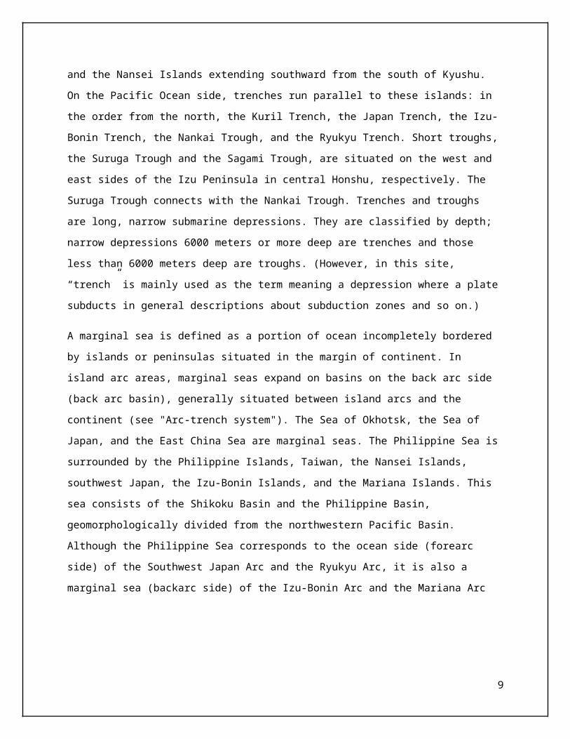
and the Nansei Islands extending southward from the south of Kyushu.
On the Pacific Ocean side, trenches run parallel to these islands: in
the order from the north, the Kuril Trench, the Japan Trench, the Izu-
Bonin Trench, the Nankai Trough, and the Ryukyu Trench. Short troughs,
the Suruga Trough and the Sagami Trough, are situated on the west and
east sides of the Izu Peninsula in central Honshu, respectively. The
Suruga Trough connects with the Nankai Trough. Trenches and troughs
are long, narrow submarine depressions. They are classified by depth;
narrow depressions 6000 meters or more deep are trenches and those
less than 6000 meters deep are troughs. (However, in this site,
“trench” is mainly used as the term meaning a depression where a plate
subducts in general descriptions about subduction zones and so on.)
A marginal sea is defined as a portion of ocean incompletely bordered
by islands or peninsulas situated in the margin of continent. In
island arc areas, marginal seas expand on basins on the back arc side
(back arc basin), generally situated between island arcs and the
continent (see "Arc-trench system"). The Sea of Okhotsk, the Sea of
Japan, and the East China Sea are marginal seas. The Philippine Sea is
surrounded by the Philippine Islands, Taiwan, the Nansei Islands,
southwest Japan, the Izu-Bonin Islands, and the Mariana Islands. This
sea consists of the Shikoku Basin and the Philippine Basin,
geomorphologically divided from the northwestern Pacific Basin.
Although the Philippine Sea corresponds to the ocean side (forearc
side) of the Southwest Japan Arc and the Ryukyu Arc, it is also a
marginal sea (backarc side) of the Izu-Bonin Arc and the Mariana Arc
9
10
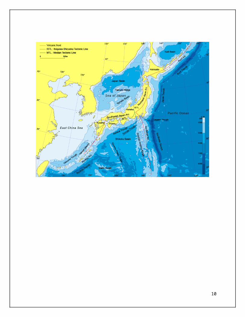
Plate subduction and earthquakes
The Japanese Islands are in marginal areas of the Pacific Plate, the
Philippine Sea Plate, the North American Plate, and the Eurasian Plate
(Figure 3). A triple junction at which the Pacific, the Philippine
Sea, and the North American Plates meet one another is situated off
the Boso Peninsula in central Honshu (Kanto). Oceanic plates, the
Pacific Plate and the Philippine Sea Plate, subduct at trenches or
troughs. The Pacific Plate descends underneath the North American
Plate at the Kuril Trench and the Japan Trench and underneath the
Philippine Sea Plate at the Izu-Bonin Trench. The Philippine Sea Plate
descends beneath the Eurasian Plate at the Suruga and Nankai Troughs
and the Ryukyu Trench. The leading edge of the Pacific Plate reaches
under the Eurasian Plate.
Figure 3
11
Earthquakes very often occur in borders between plates. In Japan, over
1300 felt earthquakes were observed in 2010, but more than 2000
earthquakes were felt in some years. The frequency of M ≥5 aftershock
of M 9 earthquake in eastern Japan in 2011 is over 400 two weeks after
the main shock (M: magnitude).
In plate margins, the crust is stressed by plate movement. The
rocks are broken and energy is released when the stress exceeds their
strength. The rupture generally occurs along faults, which are
considered seismic sources. Therefore, the rapid slip of rocks along a
fault results in an earthquake. Volcanic activity also causes
earthquakes. There are principally three types of fault motion: normal
dip-slip, reverse dip-slip, and strike-slip (left or right). Fault
movements may include a component of strike-slip and dip-slip (see
also "Neodani fault").
As for the M 9.0 eastern Japan earthquake in 2011, Japan
Meteorological Agency reported that the type of earthquake source
fault was the reverse fault, the size of fault was about 450 km long
and 200 km wide, the fault slippage was 20 to 30 meters (maximum), and
the duration of main failure was about three minutes (The 2011 off the
Pacific Coast Tohoku Earthquake [28th report]).
12
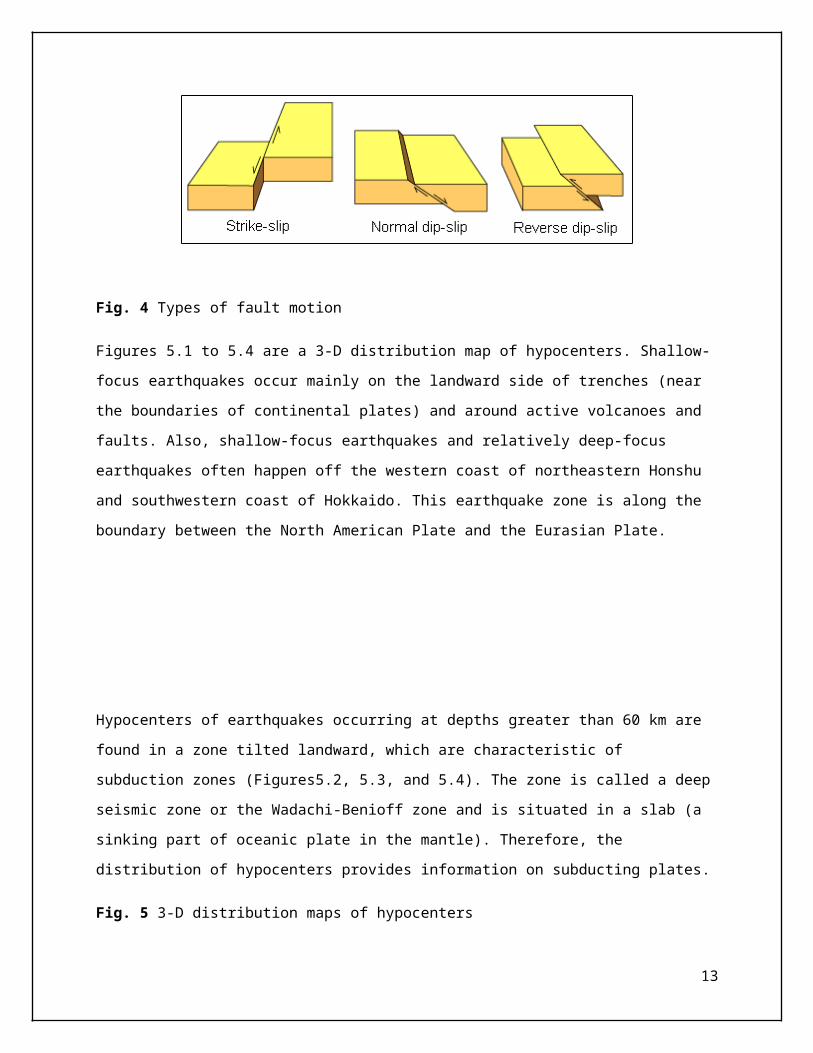
Fig. 4 Types of fault motion
Figures 5.1 to 5.4 are a 3-D distribution map of hypocenters. Shallow-
focus earthquakes occur mainly on the landward side of trenches (near
the boundaries of continental plates) and around active volcanoes and
faults. Also, shallow-focus earthquakes and relatively deep-focus
earthquakes often happen off the western coast of northeastern Honshu
and southwestern coast of Hokkaido. This earthquake zone is along the
boundary between the North American Plate and the Eurasian Plate.
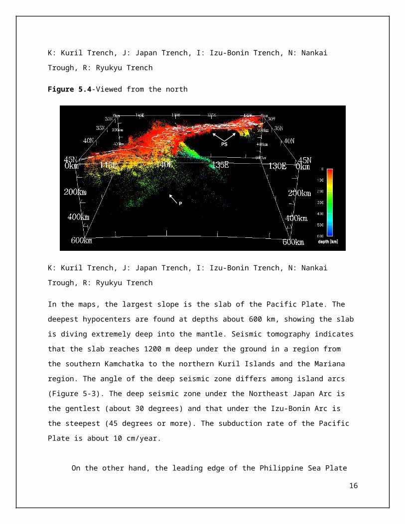
Hypocenters of earthquakes occurring at depths greater than 60 km are
found in a zone tilted landward, which are characteristic of
subduction zones (Figures5.2, 5.3, and 5.4). The zone is called a deep
seismic zone or the Wadachi-Benioff zone and is situated in a slab (a
sinking part of oceanic plate in the mantle). Therefore, the
distribution of hypocenters provides information on subducting plates.
Fig. 5 3-D distribution maps of hypocenters
13
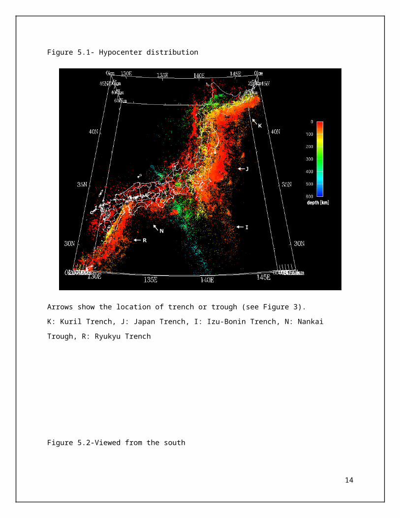
Figure 5.1- Hypocenter distribution
Arrows show the location of trench or trough (see Figure 3).
K: Kuril Trench, J: Japan Trench, I: Izu-Bonin Trench, N: Nankai
Trough, R: Ryukyu Trench
Figure 5.2-Viewed from the south
14
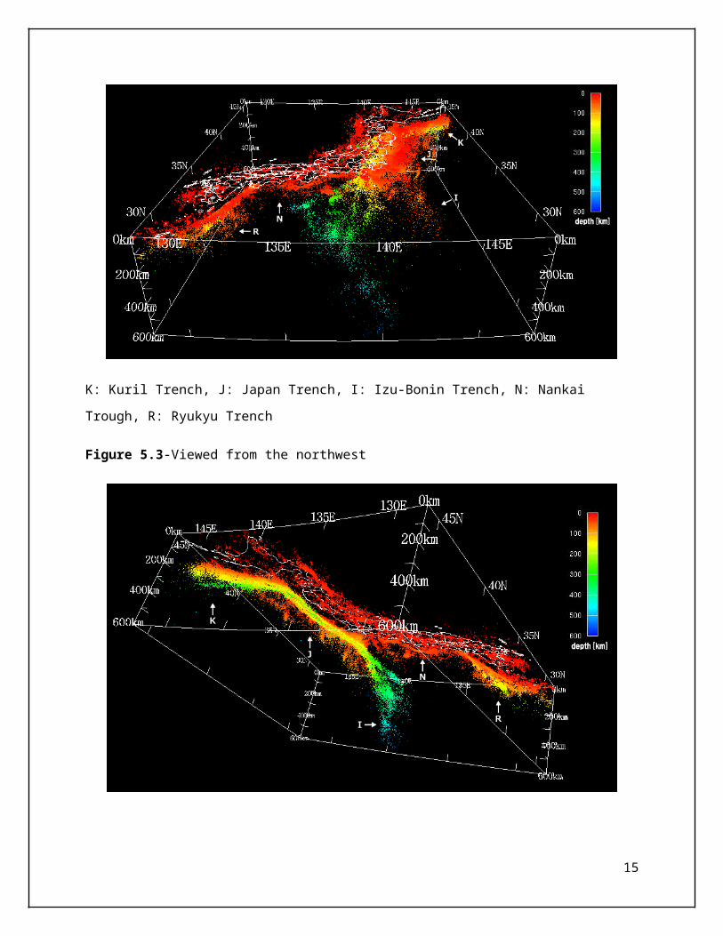
K: Kuril Trench, J: Japan Trench, I: Izu-Bonin Trench, N: Nankai
Trough, R: Ryukyu Trench
Figure 5.3-Viewed from the northwest
15
K: Kuril Trench, J: Japan Trench, I: Izu-Bonin Trench, N: Nankai
Trough, R: Ryukyu Trench
Figure 5.4-Viewed from the north
K: Kuril Trench, J: Japan Trench, I: Izu-Bonin Trench, N: Nankai
Trough, R: Ryukyu Trench
In the maps, the largest slope is the slab of the Pacific Plate. The
deepest hypocenters are found at depths about 600 km, showing the slab
is diving extremely deep into the mantle. Seismic tomography indicates
that the slab reaches 1200 m deep under the ground in a region from
the southern Kamchatka to the northern Kuril Islands and the Mariana
region. The angle of the deep seismic zone differs among island arcs
(Figure 5-3). The deep seismic zone under the Northeast Japan Arc is
the gentlest (about 30 degrees) and that under the Izu-Bonin Arc is
the steepest (45 degrees or more). The subduction rate of the Pacific
Plate is about 10 cm/year.
On the other hand, the leading edge of the Philippine Sea Plate
16
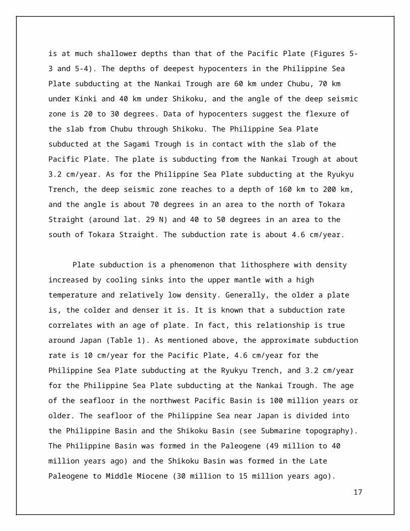
is at much shallower depths than that of the Pacific Plate (Figures 5-
3 and 5-4). The depths of deepest hypocenters in the Philippine Sea
Plate subducting at the Nankai Trough are 60 km under Chubu, 70 km
under Kinki and 40 km under Shikoku, and the angle of the deep seismic
zone is 20 to 30 degrees. Data of hypocenters suggest the flexure of
the slab from Chubu through Shikoku. The Philippine Sea Plate
subducted at the Sagami Trough is in contact with the slab of the
Pacific Plate. The plate is subducting from the Nankai Trough at about
3.2 cm/year. As for the Philippine Sea Plate subducting at the Ryukyu
Trench, the deep seismic zone reaches to a depth of 160 km to 200 km,
and the angle is about 70 degrees in an area to the north of Tokara
Straight (around lat. 29 N) and 40 to 50 degrees in an area to the
south of Tokara Straight. The subduction rate is about 4.6 cm/year.
Plate subduction is a phenomenon that lithosphere with density
increased by cooling sinks into the upper mantle with a high
temperature and relatively low density. Generally, the older a plate
is, the colder and denser it is. It is known that a subduction rate
correlates with an age of plate. In fact, this relationship is true
around Japan (Table 1). As mentioned above, the approximate subduction
rate is 10 cm/year for the Pacific Plate, 4.6 cm/year for the
Philippine Sea Plate subducting at the Ryukyu Trench, and 3.2 cm/year
for the Philippine Sea Plate subducting at the Nankai Trough. The age
of the seafloor in the northwest Pacific Basin is 100 million years or
older. The seafloor of the Philippine Sea near Japan is divided into
the Philippine Basin and the Shikoku Basin (see Submarine topography).
The Philippine Basin was formed in the Paleogene (49 million to 40
million years ago) and the Shikoku Basin was formed in the Late
Paleogene to Middle Miocene (30 million to 15 million years ago).
17
However, an angle of deep seismic zone does not correlate with an age
of plate.
Table 1 Subduction rate and age of seafloor
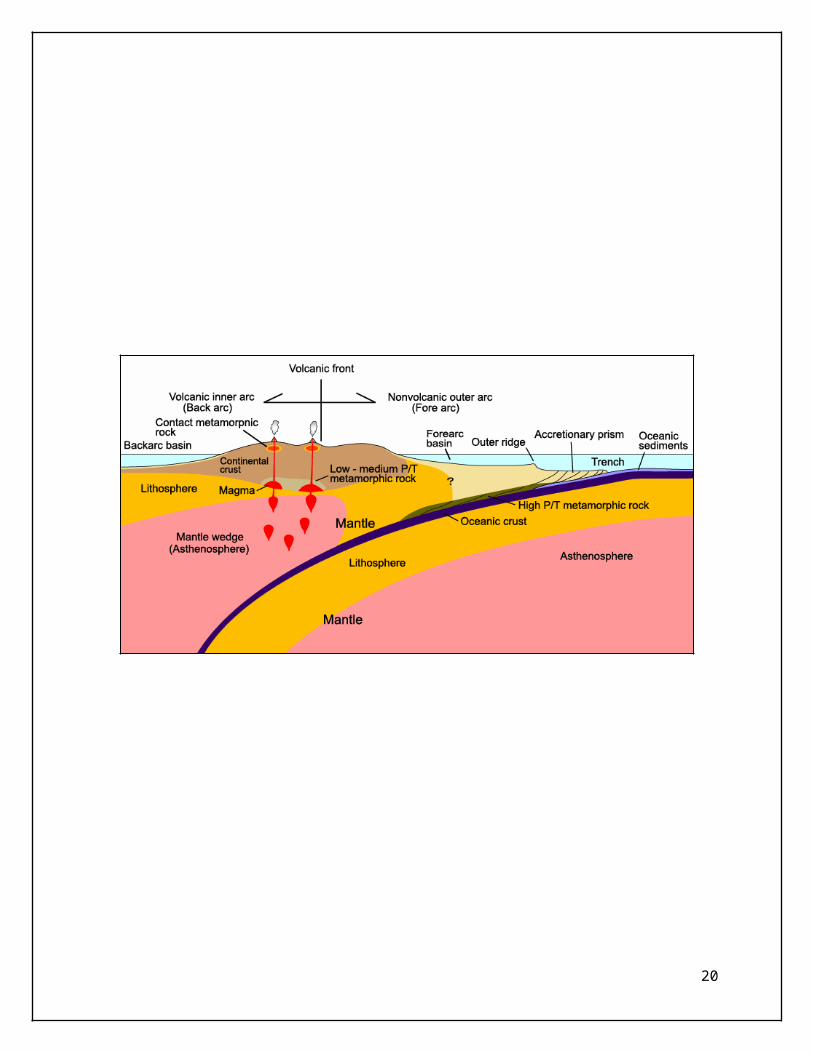
Arc-trench system
In a subduction zone, plate subduction forms a trench and uplift area
parallel to the trench and causes igneous activity and earthquakes.
Such uplift area is called a volcanic island arc or island arc because
it is an arc-shaped chain of islands and volcanoes. Volcanic arcs
formed on the edge of continent without marginal seas are continental
margin arcs.
The arrangement of major landforms, distribution of volcanoes, and
geotectonic subdivisions of southwest Japan are parallel to trenches
off the Japanese Islands. Plate subduction at trenches is responsible
for these features, and island arcs and trenches, therefore, can be
regarded as an arc-trench system. It is mainly characterized by the
following: (1) major landform arrangement, ocean–trench–island arc–
marginal sea (backarc basin)–continent, (2) igneous activity, (3)
earthquakes occurring at depths of ≥70 km in addition to shallow-focus
earthquakes, and (4) accretionary prisms and metamorphic rocks
produced by plate subducting.
18
The Japanese Islands consist of five island arcs: in the order
from the north, the Kuril, the Northeast Japan, the Izu-Bonin, the
Southwest Japan, and the Ryukyu Arcs (Figure 2). The Kuril Arc
collides with the Northeast Japan Arc in central Hokkaido. The
Northeast Japan Arc meets the Southwest Japan Arc in central Honshu,
and the Izu-Bonin Arc collides with these two arcs. The Southwest
Japan Arc meets the Ryukyu Arc in central Kyushu. In these areas
called the arc-arc collision zone, the directions of the island chains
change and geomorphological and geological structures are complicated.
Each island arc is accompanied with a trench in parallel: Kuril
Arc–Kuril Trench, Northeast Japan Arc–Japan Trench, Izu-Bonin Arc–Izu-
Bonin Trench, Southwest Japan Arc–Nankai Trough, and Ryukyu Arc–Ryukyu
Trench. These trenches are divided into two series. The first series
is the line of the Kuril, the Japan, and the Izu-Bonin Trenches, and
the second is the line of the Nankai Trough and the Ryukyu Trench. The
arc-trench system in Japan, therefore, is classified into two systems:
the eastern Japan arc system (the Kuril, the Northeast Japan, and the
Izu-Bonin Arcs) and the western Japan arc system (the Southwest Japan
and the Ryukyu Arcs). Tectonism and volcanism in the eastern Japan arc
system and in the western Japan arc system are mainly regulated by the
Pacific Plate movement and the Philippine Sea Plate movement,
respectively.
19
20
3.3 Effect And Causes of Japan Earthquake 2011 ( Tohoku )
The effects of the great earthquake were felt around the world, from
Norway's fjords to Antarctica's ice sheet. Tsunami debris continues to
wash up on North American beaches two years later.
Deaths
More than 18,000 people were killed in the disaster. Most died by
drowning.
Less than an hour after the earthquake, the first of many tsunami
waves hit Japan's coastline. The tsunami waves reached run-up heights
(how far the wave surges inland above sea level) of up to 128 feet (39
meters) at Miyako city and travelled inland as far as 6 miles (10 km)
in Sendai. The tsunami flooded an estimated area of approximately 217
square miles (561 square kilometres) in Japan.
The waves overtopped and destroyed protective tsunami seawalls at
several locations. The massive surge destroyed three-story buildings
where people had gathered for safety. Near Oarai, the tsunami
generated a huge whirlpool offshore, captured on video.
Nuclear meltdown
The tsunami caused a cooling system failure at the Fukushima Daiichi
Nuclear Power Plant, which resulted in a level 7 nuclear meltdown and
21
release of radioactive materials. About 300 tons of radioactive water
continues to leak from the plant every day into the Pacific Ocean,
affecting fish and other marine life.
Worldwide effects
The tsunami waves also travelled across the Pacific, reaching Alaska,
Hawaii and Chile. In Chile, some 11,000 miles (17,000 km) distant, the
tsunami was 6.6 feet (2 meters) high when they reached the shore. The
surge of water carried tons of debris out to sea as it receded.
Japanese docks and ships, and countless household items, have arrived
on U.S. and Canadian shores in the ensuing years. The U.S. Coast Guard
fired on and sank the derelict boat 164-foot Ryou-Un Maru in 2012 in
the Gulf of Alaska. The ship started its journey in Hokkaido.
Amazing facts
The earthquake shifted Earth on its axis of rotation by
redistributing mass, like putting a dent in a wobbling top. The
temblor also shortened the length of day by about a microsecond.
More than 1,000 aftershocks have hit Japan since the earthquake,
the largest a magnitude 7.9.About 250 miles (400 km) of Japan's
northern Honshu coastline dropped by 2 feet (0.6 meters).
The jolt moved Japan's main island of Honshu eastward by 8 feet
(2.4 meters).
22
The Pacific Plate slid westward nears the epicentre by 79 feet
(24 m).
In Antarctica, the seismic waves from the earthquake sped up the
Whillans Ice Stream, jolting it by about 1.5 feet (0.5 meters).
The tsunami broke icebergs off the Sulzberger Ice Shelf in
Antarctica.
As the tsunami crossed the Pacific Ocean, a 5-foot high (1.5 m)
high wave killed more than 110,000 nesting seabirds at the Midway
Atoll National Wildlife Refuge.
In Norway, water in some fjords pointing northeast toward Japan
(up and over the pole) sloshed back and forth as seismic waves
from the earthquake raced through.
The earthquake produced a low-frequency rumble called infrasound,
which travelled into space and was detected by the Goce
satellite.
Tsunami
An up thrust of 6 to 8 meters along a 180-km wide seabed at 60 km
offshore from the east coast of Tōhoku, resulted in a
major tsunami that brought destruction along the Pacific coastline of
Japan's northern islands. Thousands of lives were lost when entire
23
towns were devastated. The tsunami propagated throughout the Pacific
Ocean region reaching the entire Pacific coast of North and South
America from Alaska to Chile. Warnings were issued and evacuations
carried out in many countries bordering the Pacific. However, while
the tsunami affected many of these places, the extent was minor.
Chile's Pacific coast, one of the furthest from Japan at about
17,000 km (11,000 mi) distant, was struck by waves 2 m (6.6 ft) high,
compared with an estimated wave height of 38.9 meters (128 ft) at Omoe
peninsula, Miyako city, Japan.
Ports
All of Japan's ports were briefly closed after the earthquake, though
the ones in Tokyo and southwards soon re-opened. Fifteen ports were
located in the disaster zone. The north-eastern ports of Hachinohe,
Sendai, Ishinomaki and Onahama were destroyed, while the Port of
Chiba (which serves the hydrocarbon industry) and Japan's ninth-
largest container port at Kashima were also affected, though less
severely. The ports at Hitachinaka, Hitachi, Soma, Shiogama,
Kesennuma, Ofunato, Kamashi and Miyako were also damaged and closed to
ships. All 15 ports reopened to limited ship traffic by 29 March
2011.A total of 319 fishing ports, about 10% of Japan's fishing ports,
were damaged in the disaster. Most were restored to operating
condition by 18 April 2012.
The Port of Tokyo suffered slight damage; the effects of the quake
included visible smoke rising from a building in the port with parts
of the port areas being flooded, including soil liquefaction in Tokyo
Disneyland's parking lot.
24
Dams and water problems
The Fujinuma irrigation dam in Sukagawa ruptured, causing flooding and
washing away five homes. Eight people were missing and four bodies
were discovered by the morning. Reportedly, some locals had attempted
to repair leaks in the dam before it completely failed. On 12 March,
252 dams were inspected and it was discovered that six embankment
dams had shallow cracks on their crests. The reservoir at one
concrete gravity dam suffered a small non-serious slope failure. All
damaged dams are functioning with no problems. Four dams within the
quake area were unreachable. When the roads clear, experts will be
dispatched to conduct further investigations. In the immediate
aftermath of the calamity, at least 1.5 million households were
reported to have lost access to water supplies. By 21 March 2011, this
number fell to 1.04 million.
Electricity
According to the Japanese trade ministry, around 4.4 million
households served by Tōhoku Electric Power (TEP) in north-eastern
Japan were left without electricity. Several nuclear and
conventional power plants went offline after the earthquake,
25
reducing TEPCO's total capacity by 21 GW. Rolling blackouts began
on 14 March due to power shortages caused by the earthquake.
The Tokyo Electric Power Company (TEPCO), which normally
provides approximately 40 GW of electricity, announced that it
could only provide about 30 GW. This was because 40% of the
electricity used in the greater Tokyo area was supplied by
reactors in the Niigata and Fukushima prefectures. The reactors
at the Fukushima Daiichi and Fukushima Dai-ni plants were
automatically taken offline when the first earthquake occurred
and sustained major damage related to the earthquake and
subsequent tsunami. Rolling blackouts of approximately three
hours were experienced throughout April and May while TEPCO
scrambled to find a temporary power solution.
The blackouts affected Tokyo, Kanagawa, Eastern Shizuoka,
Yamanashi, Chiba, Ibaraki, Saitama, Tochigi,
and Gunma prefectures. Voluntary reduced electricity use by
consumers in the Kanto area helped reduce the predicted frequency
and duration of the blackouts. By 21 March 2011, the number of
households in the north without electricity fell to 242,927.
Tōhoku Electric Power was not able to provide the Kanto region
with additional power, because TEP's power plants were also
damaged in the earthquake. Kansai Electric Power Company (Kepco)
cannot share electricity, because its system operates at 60
hertz, whereas TEPCO and TEP operate their systems at 50 hertz;
this is due to early industrial and infrastructure development in
26
the 1880s that left Japan without a unified national power grid.
Two substations, one in Shizuoka Prefecture and one in Nagano
Prefecture, were able to convert between frequencies and transfer
electricity from Kansai to Kanto and Tōhoku, but their capacity
to do so is limited to 1 GW.
With the damage to so many power plants, it may be years before
a long-term solution can be found. In effort to help alleviate
the shortage, three steel manufacturers in the Kanto region are
contributing electricity produced by their in-house conventional
power stations to TEPCO for distribution to the general
public. Sumitomo Metal Industries can produce up to 500 MW, JFE
Steel 400 MW, and Nippon Steel 500 MW of electric power. Auto and
auto parts makers in Kanto and Tohoku agreed in May 2011 to
operate their factories on Saturdays and Sundays and close on
Thursdays and Fridays to assist in alleviating the electricity
shortage during the summer of 2011.
27
Oil, gas and coal
A 220,000-barrel (35,000 m3)-per-day oil refinery of Cosmo Oil
Company was set on fire by the quake at Ichihara, Chiba
Prefecture, to the east of Tokyo. It was extinguished after ten
days, injuring six people, and destroying storage tanks. Others
halted production due to safety checks and power loss.
In Sendai, a 145,000-barrel (23,100 m3)-per-day refinery owned by
the largest refiner in Japan, JX Nippon Oil & Energy, was also
set ablaze by the quake. Workers were evacuated, but tsunami
warnings hindered efforts to extinguish the fire until 14 March,
when officials planned to do so.
An analyst estimates that consumption of various types of oil
may increase by as much as 300,000 barrels (48,000 m3) per day
(as well as LNG), as back-up power plants burning fossil
fuels try to compensate for the loss of 11 GW of Japan's nuclear
power capacity. The city-owned plant for importing liquefied
natural gas in Sendai was severely damaged, and supplies were
halted for at least a month. In addition to refining and storage,
several power plants were damaged. These include Sendai , New-
Sendai , Haranomachi, Hirono and Hitachinaka.
Nuclear power plants
28
The Fukushima Daiichi, Fukushima Daini, Onagawa Nuclear Power
Plant and Tōkai nuclear power stations, consisting of a total
eleven reactors, were automatically shut down following the
earthquake. Higashidōri, also on the northeast coast, was already
shut down for a periodic inspection. Cooling is needed to
remove decay heat after a Generation II reactor has been shut
down, and to maintain spent fuel pools. The backup cooling
process is powered by emergency diesel generators at the plants
and at Rokkasho nuclear reprocessing plant.
At Fukushima Daiichi and Daini, tsunami waves overtopped seawalls
and destroyed diesel backup power systems, leading to severe
problems at Fukushima Daiichi, including three large explosions
and radioactive leakage.
Subsequent analysis found that many Japanese nuclear plants,
including Fukushima Daiichi, were not adequately protected
against tsunami.Over 200,000 people was evacuated.
The 7 April aftershock caused the loss of external power to
Rokkasho Reprocessing Plant and Higashidori Nuclear Power Plant
but backup generators were functional. Onagawa Nuclear Power
Plant lost 3 of 4 external power lines and temporarily lost
cooling function in its spent fuel pools for "20 to 80 minutes".
A spill of "up to 3.8 litres" of radioactive water also occurred
at Onagawa following the aftershock.
A report by the IAEA in 2012 found that the Onagawa Nuclear Power
Plant, the closest nuclear plant to the epicentre of the 2011
earthquake and tsunami, had remained largely undamaged. The
plant's 3 reactors automatically shut down without damage and all
29
safety systems functioned as designed. The plant's 14 meter (46-
foot) high seawall successfully withstood the tsunami.
Europe's Energy Commissioner Günther Oettinger addressed the
European Parliament on 15 March, explaining that the nuclear
disaster was an "apocalypse".
As the nuclear crisis entered a second month, experts recognized
that Fukushima Daiichi is not the worst nuclear accident ever,
but it is the most complicated. Nuclear experts stated that
Fukushima will go down in history as the second-worst nuclear
accident ever, while not as bad as Chernobyl disaster, worse
than Three Mile Island accident.
It could take months or years to learn how damaging the release
of dangerous isotopes has been to human health and food supplies,
and the surrounding country side. Later analysis indicated three
reactors at Fukushima I (Units 1, 2, and 3) had suffered
meltdowns and continued to leak coolant water, and by summer the
Vice-minister for Economy, Trade and Industry, the head of the
Nuclear and Industrial Safety Agency, and the head of the Agency
for Natural Resources and Energy, had lost their jobs.
Fukushima meltdown
Japan declared a state of emergency following the failure of the
cooling system at the Fukushima Daiichi Nuclear Power Plant,
resulting in the evacuation of nearby residents.
30
Officials from the Japanese Nuclear and Industrial Safety
Agency reported that radiation levels inside the plant were up to
1,000 times normal levels, and that radiation levels outside the
plant were up to 8 times normal levels.
Later, a state of emergency was also declared at the Fukushima
Daini nuclear power plant about 11 km (7 mi) south. This brought
the total number of problematic reactors to six. It was reported
that radioactive iodine was detected in the tap water in
Fukushima, Tochigi, Gunma, Tokyo, Chiba, Saitama, and Niigata,
and radioactive caesium in the tap water in Fukushima, Tochigi
and Gunma. Radioactive caesium, iodine, and strontium were also
detected in the soil in some places in Fukushima. There may be a
need to replace the contaminated soil.
Many radioactive hotspots were found outside the evacuation
zone, including Tokyo .Food products were also found contaminated
by radioactive matter in several places in Japan.
On 5 April 2011, the government of the Ibaraki Prefecture banned
the fishing of sand lance after discovering that this species was
contaminated by radioactive caesium above legal limits. As late
as July 2013 slightly elevated levels of radioactivity were found
in beef on sale at Tokyo markets. No death or morbidity has so
far been reported as a result of the radioactive emissions.
31
Transport
Japan's transport network suffered severe disruptions. Many
sections of Tōhoku Expressway serving northern Japan were
damaged.
The expressway did not reopen to general public use until 24
March 2011. All railway services were suspended in Tokyo, with an
estimated 20,000 people stranded at major stations across the
city.
In the hours after the earthquake, some train services were
resumed. Most Tokyo area train lines resumed full service by the
next day—12 March. Twenty thousand stranded visitors spent the
night of 11–12 March inside Tokyo Disneyland.
A tsunami wave flooded Sendai Airport at 15:55 JST, about 1 hour
after the initial quake, causing severe damage. Narita and Haneda
Airport both briefly suspended operations after the quake, but
suffered little damage and reopened within 24 hours. Eleven
airliners bound for Narita were diverted to nearby Yokota Air
Base.
Various train services around Japan were also cancelled, with JR
East suspending all services for the rest of the day. Four trains
on coastal lines were reported as being out of contact with
operators; one, a four-car train on the Senseki Line, was found
32
to have derailed, and its occupants were rescued shortly after
8 am the next morning. Minami-Kesennuma Station on the Kesennuma
Line was obliterated save for its platform; 62 of 70 (31 of 35)
JR East train lines suffered damage to some degree in the worst-
hit areas, 23 stations on 7 lines were washed away, with damage
or loss of track in 680 locations and the 30-km radius around the
Fukushima Daiichi nuclear plant unable to be assessed.
There were no derailments of Shinkansen bullet train services in
and out of Tokyo, but their services were also
suspended. The Tōkaidō Shinkansen resumed limited service late in
the day and was back to its normal schedule by the next day,
while the Jōetsu and Nagano Shinkansen resumed services late on
12 March.
Services on Yamagata Shinkansen resumed with limited numbers of
trains on 31 March. Derailments were minimized because of an
early warning system that detected the earthquake before it
struck. The system automatically stopped all high-speed trains,
which minimized the damage.
The Tōhoku Shinkansen line was worst hit, with JR East estimating
that 1,100 sections of the line, varying from collapsed station
roofs to bent power pylons, will need repairs.
33
Services on the Tōhoku Shinkansen partially resumed only in
Kantō area on 15 March, with one round-trip service per hour
between Tokyo and Nasu-Shiobara, and Tōhoku area service
partially resumed on 22 March between Morioka and Shin-
Aomori. Services on Akita Shinkansen resumed with limited numbers
of trains on 18 March.
Service between Tokyo and Shin-Aomori was restored by May, but at
lower speeds due to ongoing restoration work; the pre-earthquake
timetable was not reinstated until late September.
The rolling blackouts brought on by the crises at the nuclear
power plants in Fukushima had a profound effect on the rail
networks around Tokyo starting on 14 March. Major railways began
running trains at 10–20 minute intervals, rather than the usual
3–5 minute intervals, operating some lines only at rush hour and
completely shutting down others; notably, the Tōkaidō Main
Line, Yokosuka Line, Sōbu Main Line and Chūō-Sōbu Line were all
stopped for the day. This led to near-paralysis within the
capital, with long lines at train stations and many people unable
to come to work or get home. Railway operators gradually
increased capacity over the next few days, until running at
approximately 80% capacity by 17 March and relieving the worst of
the passenger congestion.
34
Telecommunication
Cellular and landline phone service suffered major disruptions in
the affected area. Immediately after the earthquake cellular
communication was jammed across much of Japan due to a surge of
network activity.
On the day of the quake, American broadcaster NPR was unable to
reach anyone in Sendai with working phone or Internet. Internet
services were largely unaffected in areas where basic
infrastructure remained, despite the earthquake having damaged
portions of several undersea cable systems landing in the
affected regions; these systems were able to reroute around
affected segments onto redundant links.
Within Japan, only a few websites were initially
unreachable. Several Wi-Fi hotspot providers reacted to the quake by
providing free access to their networks, and some American
telecommunications and VoIP companies such as AT&T, Sprint, Verizon, T-
Mobile and VoIP companies such as net TALK and Vonage have offered
free calls to (and in some cases, from) Japan for a limited time, as
did Germany's Deutsche Telekom.
35
3.4 RESPONSES
Immediate Response
At 2:46pm (Japan time) on Friday March 11 an earthquake of 8.8 magnitudes hit the northeastern coast of Japan, followed by aftershocks and a series of tsunamis.
According to the Japanese Meteorological Agency, this is the biggest earthquake since records began.
The Soka Gakkai immediately set up a main emergency communications center at the Headquarters in Shinanomachi, Tokyo, headed by Soka Gakkai President Minoru Harada and General Director Masaaki Masaki, and local emergency centers in the affected prefectures.
These task forces are currently working to gather accurate informationon the situation and reaching out to communicate and encourage those affected.
SGI President Daisaku Ikeda expressed his profound condolences to all the victims and his serious concern for all affected, saying he is sending his heartfelt prayers for everyone's safety.
For now, Soka Gakkai has opened community centers in the regions concerned to provide accommodation and will exert its speedy and utmost effort to provide support for local relief activities.
Further response
36
In response to the massive earthquake and subsequent tsunamis which devastated parts of northern Japan on March 11, the Soka Gakkai central emergency communications center at the Soka Gakkai Headquarters in Tokyo is coordinating closely with local emergency centers set up by Soka Gakkai in the prefectures concerned to gather information, contact those in affected areas and initiate relief efforts.
Soka Gakkai members continue to visit accessible areas to check on people's whereabouts and well-being, offering support and helping those in need of shelter find accommodation.
Soka Gakkai community centers throughout the affected region have beenopened to provide accommodation and food for the public, including seven in the worst-hit Miyagi prefecture where Sendai city is located.
The Soka Gakkai Tohoku Culture Center in Sendai is now the regional emergency coordination center for the organization's relief efforts. Around 600 people spent the night there on March 11 and from 6:30am onthe following morning; breakfast prepared by volunteers who worked through the night was served. Snacks and donuts were provided for children.
The center has a large parking lot that has been made available to local fire stations. Twenty fire trucks are now parked there and continue to engage in fighting the fires which are still breaking out.
The Soka Gakkai Headquarters, as well as Soka Gakkai members in Yamagata prefecture and the Shinetsu and Kansai areas, have sent trucks containing relief supplies such as water, blankets, food, stoveburners and portable toilets.
Humanitarian response to the 2011 Tohoku earthquake and tsunami
Following the 2011 Tohoku earthquake and tsunami, Japan received messages of condolence and offers of assistance from a range of international leaders. According to Japan's foreign ministry, 116
37
countries and 28 international organizations had offered assistance toJapan. The magnitude of the earthquake was estimated at 9.0. This article is a list of charitable and humanitarian responses to the disaster from governments and non-governmental organizations. As of March 2012, donations to areas affected by the disaster totaled ¥520 billion and 930,000 people have assisted in disaster recovery efforts.
China, sent US$167,000 in aid along with a 15-member rescue teamwhich left Beijing on Sunday, 13 March 2011, with an additional pledge of RMB 30 million Chinese Yuan (US$4.57 million) of humanitarian supplies announced by China's Ministry of Commerce the following day. The Chinese government decided to donate 20,000 tons of fuel to consisting of 10,000 tons of gasoline and 10,000 tons of diesel. The Chinese navy hospital ship Peace Ark was standing by to assist whilst awaiting approval from Japan, but Japan declined the offer. The northeastern Chinese city of Changchun, a sister city of Sendai, sent 10 tones of drinking water to Japan. The provincial government of Jilin also said it will donate 100,000 U.S. dollars to the Miyagi prefecturegovernment while the municipal government of Changchun, capital of Jilin, pledged 500,000 Renminbi to the municipal government ofSendai. A super-sized 62-meter long mechanized water-pump arm wasdonated by China's Sany group, along with an accompanying team of5 engineers and consultants destined for the effort to quell the overheating and radiation problems of the crippled Fukushima nuclear power plant on 23 March 2011.
Australia prepared the frigate HMAS Sydney, and heavy landing ship HMAS Tobruk to carry helicopters, Australian Army engineers and medical teams to Japan if this is requested by the Japanese Government. Fire and Rescue NSW service sent a 76-member Urban Search and Rescue team, some of which had recently been rotated through the Christchurch recovery effort, and 20 tones of rescue equipment. This team was transported to Japan by a Royal Australian Air Force C-17 Globemaster III transport aircraft,
38
which subsequently remained in the country to contribute to the disaster relief effort. Two other RAAF C-17's were deployed to Japan to transport supplies and equipment, all three moving over one million pounds of cargo.
Philippines The Philippine government made ready to deploy a joint rescue mission composed of 41 members from three of its best search and rescue teams. It was to be complemented by a Philippine Air Force C-130 cargo plane and its crew. The Philippine Government also donated US$1 million to Japan. A 2-manteam has been sent in advance to assess the situation. Due to theoverwhelming response by the global community its search and rescue teams were not deployed. Instead it offered relief goods with the AFP's six-man advance team being in charge of distribution.
Russia State-controlled gas giant Gazprom provided additional liquefied natural gas supplies, the company divert two tankers of150,000 tons to the affected area. Russia's Emergencies Ministry official Irina Andrianova confirmed that Russia will send one Mi-26 helicopter along with a team of 50 Russian rescuers to search for survivors, and promised more aid. A team of Russian rescuers will join the search for survivors. According to Russia’s Emergencies Ministry spokesperson Irina Andrianova, "An Il-76 plane of the Russian Emergencies Ministry sent 50 rescuers, threerelief and rescue vehicles and the necessary equipment which later arrived and covered by RT news media. The Russian emergencyservices agency EMERCOM offered 40 people with three search and rescue dogs. Russia has sent to Japan liquidators of the Chernobyl disaster. The Russian relief group were among largest to r arrive in Japan to render aid and consists of 161 personal.
South Korea were among the first foreign emergency rescue team consisting of 5 rescuers and 2 rescue dogs who arrived in Japan
39
on March 12, while another team of 102 rescuers arrived 2 days later. In total, private donations originating from Korea amounted to 2.97 billion Japanese Yen (37.1 million US dollars inMarch 2011), the 5th largest foreign donation following USA, Taiwan, Canada and Germany. In addition to human aid, Korea sent boric acid to weaken nuclear reactions and power sources forelectricity. Many provinces have offered aid as well. Gyeonggi-do offered US$1 million, and raised additional aid. The South Korean consulate staffs in Sendai were crucial in escorting a Croatian citizen, Vinko Hut Kono, safely to the Akita Airport.
However, some government organizations in South Korea halted their fund drives and instead donated the money to nationalist organizations for political reasons.
Malaysia sent a search and rescue team, with doctors and medical assistants.
4.0 SUMMARY
The magnitude 8.1 Tohoku earthquakes on March 11, 2011, which occurred
near the northeast coast of Honshu, Japan, resulted from thrust
faulting on or near the subduction zone plate boundary between the
Pacific and North America plates. At the latitude of this earthquake,
the Pacific plate moves approximately westwards with respect to the
North America plate at a rate of 83 mm/yr, and begins its westward
descent beneath Japan at the Japan Trench. Note that some authors
divide this region into several micro plates that together define the
40
relative motions between the larger Pacific, North America and Eurasia
plates; these include the Okhotsk and Amur micro plates that are
respectively part of North America and Eurasia.
The location, depth, and focal mechanism of the March 11 earthquake
are consistent with the event having occurred on the subduction zone
plate boundary. Modeling of the rupture of this earthquake indicate
that the fault moved upwards of 30-40 m, and slipped over an area
approximately 300 km long (along-strike) by 150 km wide (in the down-
dip direction). The rupture zone is roughly centered on the earthquake
epicenter along-strike, while peak slips were up-dip of the
hypocenter, towards the Japan Trench axis. The March 11 earthquake was
preceded by a series of large foreshocks over the previous two days,
beginning on March 9th with a M 7.2 event approximately 40 km from the
epicenter of the March 11 earthquake, and continuing with another
three earthquakes greater than M 6 on the same day.
5.0 REFERENCES
41
Book
Alan P. Trujillo & Harold V. Thurman, (2005). Essentials of Oceanography. Plate Tectonics and the Ocean Floor. Pearson Education, Inc
Web
“Japan in a Subduction Zone”. glgarcs.net. retrieved 2013 “Japan’s Earthquake: Response and Reconstruction”.
http://www.sgi.org/. retrieved 2011-2012 “Operation Pacific Assist". Global Operations. Australian Department
of Defence. Retrieved 17 March 20 "U.S. readies earthquake relief response". Reuters. 11 March 2011
42