shipwrecks and amphorae
TRANSCRIPT
University of Southampton
School of Humanities
Department of Archaeology Centre for Maritime Archaeology
Shipwrecks and amphorae: Their relationship with trading routes and the Roman economy in
the Mediterranean.
A dissertation submitted in partial fulfilment of the requirements for a Masters in Science in Maritime Archaeology by instructional course
By: Johan Opdebeeck Supervisor: D.P.S. Peacock
2005
Acknowledgment To everyone — instructors and students — who made the CMA year 2004 – 2005 a fantastic experience. Special thanks are to Dr. John Adams and Dr. Lucy Blue for their effort in making us real maritime archaeologists, my supervisor Dr. David Peacock for the help he gave me with this dissertation and my parents with their support in the never-ending studies of their son. The only thing that is more fun than chasing a dream, is living it!
Content Abstract ...……………………………………………………………………………..3 I. Introduction............................................................................................................4 II. The role of ships in antiquity .................................................................................5 III. Conditions of navigation in the Mediterranean .................................................7 IV. Archaeological data ...........................................................................................9
A. Ships...................................................................................................................9 B. Cargo................................................................................................................11 C. Stowing ............................................................................................................13 D. Amphorae.........................................................................................................14 E. Position of the shipwrecks ...............................................................................16
V. Trading mechanisms and navigational routes......................................................17 A. Mechanism of exchange ..................................................................................17
1. Reciprocity...................................................................................................17 2. Annona or redistribution..............................................................................18 3. Marketing.....................................................................................................22
B. Navigational Routes.........................................................................................25 1. Western Mediterranean................................................................................28
• From Carthage .........................................................................................28 • From Spain...............................................................................................29 • From Gaul ................................................................................................30 • The Adriatic .............................................................................................30
2. East Mediterranean ......................................................................................30 3. East – West routes........................................................................................31
• To Rome...................................................................................................33 • To Spain...................................................................................................33 • To Marseille .............................................................................................34
4. Atlantic Routes.............................................................................................34 VI. Maritime trade and its reflection in the archaeological evidence ....................35 VII. Roman economy and maritime commerce ......................................................41
A. The heydays of Italian export: 150 BC – 1 BC................................................43 B. The shifting to the Spanish economy: 1 – 200 AD..........................................44 C. The dominance of the African economy: 200 – 450 AD.................................46 D. The economic influence from the East: 450 – 700 AD ...................................48
VIII. Difficulties encountered...................................................................................50 IX. Conclusion .......................................................................................................51 X. References............................................................................................................53
2
Figures and Maps Figure 1: Cross-section of the shipwreck “Cabrera C” (Pomey 1997: p 126).............12 Figure 2: Theoretical reconstruction of the amphorae stowinf in the “Madrague de
Giens” (Pomey 1997: p 149)...............................................................................14 Figure 3: Schematic representation of the direct-redistribution route/principal-
secondary port (Pomey 1997: p 157). A, B, C are the zones of economical influence around the principal ports 2, 5 and 10..................................................23
Figure 4: Hypothetical reconstruction of the shipwreck “Grand-Ribaud D” (Pomey 1997: p 185) .........................................................................................................37
Figure 5: The different percentages of amphorae from each source over time (Greene 1986: p 15) ...........................................................................................................41
Map 1: Map of the Mediterranean basin with the most important harbours of the
Roman period (After Pomey 1997: p 135) ..........................................................59 Map 2: Map with the principal winds of the Mediterranean basin (Pomey 1997: p 26)
..............................................................................................................................60 Map 3: Map displaying the major navigation routes in the Mediterranean (Rougé
1966: p 88-89)......................................................................................................61 Map 4: Map depicting the journey of St-Paul from Caesarea Maritima to Rome
(Pomey 1997: p11)...............................................................................................62 Map 5: Distribution of the shipwrecks with a consignment of amphorae ...................63 Map 6: Distribution of shipwrecks with a cargo of African amphorae .......................63 Map 7: Distribution of shipwrecks with a cargo of Spanish amphorae.......................64 Map 8: Distribution of shipwrecks with a cargo of French amphorae ........................64 Map 9: Distribution of shipwrecks with a cargo of Aegean amphorae .......................65 Map 10: Distribution of shipwrecks with a cargo of metal ingots...............................65 Map 11: Distribution of shipwrecks with a cargo of African and Spanish amphorae.66 Map 12: Distribution of shipwrecks with a cargo of Levantine amphorae..................66
3
Abstract
Maritime trade has always played an important role in the Roman economy. The
growing numbers of Roman shipwrecks that are yearly found are the evidence of this
activity. Amphorae are a part of this large-scale exchange of goods as they are
particularly made for sea transport. There are limitations on the available data due to
confusing amphorae typologies, the lack of information in unexplored areas and bad
or non-existing publications. However, the general impression is that the known data
from shipwrecks indicate similar patterns in economy as the archaeological evidence
of land sites. The shifting centres of economical power are reflected in the origin of
cargoes of contemporary shipwrecks. The data can also be linked with the information
derived from ancient texts. The known navigational routes of the vessels have been
derived from these texts and they can be linked with the frequency of shipwrecks and
the origin of their cargoes. But the archaeological data has to be handled careful as
maritime routes and trade were rather complex and dependent on many external
factors.
4
I. Introduction
The archaeology of shipwrecks has shed new light on the economy of Classical
Times. It gives us a clearer impression of the importance of food trade. Combined
with literary sources, it confirms the large scale of sea-borne economic activity.
During the Roman Empire the economy changed from a predominantly agricultural to
a more complex, trade based industry (Garnsey et al 1987). Commodities from the
whole empire and its neighbours were shipped and mainly brought to Italy, more
specifically Rome. This vast amount of traded goods had a huge diversity. Some of
the cargo was perishable and no trace of it is left. Others can still be found in ancient
shipwrecks. One of the more obvious remains are amphorae, which are a distinctive
type of big jars. They were used on an enormous scale and although amphorae can
break, the ceramic itself is almost indestructible. Amphorae were a result of a further
specialization of the sea trade and were specially developed for a wide variety of
contents. The information of the amphorae provides us with a determination of the
production centre and a probable dating of the ware. Can this information help us to
determine the exchange mechanisms of maritime trade in Antiquity? Are we able to
tell something about the routes used by the vessels by looking at the composition of
the shipwreck’s cargoes, as those navigational routes will help us in the further
understanding of the trading mechanism of the Roman Era? Do the changes in Roman
economy and trade, which can be found in the archaeological record of land sites, also
reflect in the wreck sites? The main aim of this research will be to look at the
information that can be derived from the amphorae and look at their contributions and
limitations in the research of maritime trade.
5
II. The role of ships in antiquity
In our modern times with rapid transport by airplanes or motorised transport on
highways, we easily forget the importance of maritime transport. Until the 19th
century, ships were the largest and most complex entities made by man. They
reflected not only the latest technological enquiries of a civilisation, were the way to
transport cargoes par excellence. Cities located at the sea had enormous advantages as
they had the potential for bulk transport at relatively low costs and the possibility of
vital import of grain in case of famine. Gregory of Nazianzus already realised this
advantage in Antiquity:
Gregory of Nazianzus (Fulford 1987):
“Coastal cities supported shortage of corn without much difficulty as they can dispose
of their own products and receive supplies by sea; ... Inland is there no means of
disposing of what we have or of importing what we lack.”
Cost was probably the primary incentive to send goods by ship. It was cheaper to
transport grain from Tunisia to Rome than to transport the same quantity 80 km over
land (Garnsey et al 1987). Research on the “Price Edict of Diocletian” indicates that
inland waterways cost 4.9 times as much as sea transport. Land transport cost between
28 and 56 times as much (Peacock 1978). However, the high cost of land transport
cannot on its own explain the decision of long-distance transport by ship. In practise
economic or political factors and the risk factor will have determined the choice of
route as the availability of transport, information and trader organisation (Hopkins
1980).
Speed was an essential advantage of transport by sea. It took a ship up to 30 days to
sail from Marseille to Alexandria, while the journey on land took four times as long.
Another reason was safety. Fragile items such as pottery or amphorae were at constant
risk due to shocks in carts. In ships the breakage was restricted to loading and
unloading the cargo. The disadvantage was that ships only could sail from March until
November, as the sea was too dangerous during wintertime and there was the obvious
possibility of wrecking.
6
Rome was the centre of the Roman Empire and was the final destination of many
goods. There was a market with the most exotic and luxurious products for a limited
group of wealthy civilians (Meijer et al 1992).
Aelius Aristides, “To Rome” 10-13 (Meijer et al 1992):
“… Here is brought from every land and sea all the crops of the seasons and the
produce of each land, river, lake, as well as the arts of the Greeks and the barbarians,
so that if someone should wish to view all these things, he must either see them by
travelling over the whole world or be in this city… So many merchant ships arrive
here, conveying very kind of goods from every people, every hour, every day, so that
the city is like a factory common to the whole earth. It is possible to see so many
cargoes from India and even from Arabia Felix…Your farmlands are Egypt, Sicily,
and all of Africa, which is cultivated. The arrivals and departures of ships never stop,
so that one would express admiration not only for the harbour, but also for the sea…
So everything comes together here, trade, seafaring, farming, the scouring of mines,
all the crafts that exist or have existed and all that is produced and grown.”
But the demands of the rest of the population for grains and other basic goods, such as
clothing were huge. They were so large that they could not be met from Italian
sources alone and the market of Rome had to be supplied from all parts of the empire
mainly by sea transport.
Grain made up the biggest part of ancient cargoes and the biggest supplier was North
Africa. Oil and wine were besides grain the important commodities in the ancient
international trade. Wine was produced in several places in the Aegean and Western
Mediterranean. It was exported in large quantities with amphorae or dolia to places —
such as Rome or Athens — where the demand for wine was too great to be satisfied
by the local vineyards. Oil was brought in huge amounts to Rome from Africa and
Spain. There were also other goods, which were traded in bulk. Metal, building
materials such as marble and wood, salted fish, garum or fish-sauce, fruits, tiles,
ceramics such as tableware or lamps, ivory, purple, spices, even wild animals and
slaves were widely used and traded in antiquity.
7
The cargo ships also transported passengers. Travellers went down to the waterfront
and asked around until they found a ship scheduled to sail to their destination or at
least at a port along their line of travel. An example is Alexandria, which was a great
centre not only those who wished to sail from Egypt, but also from the Levant. The
passengers who wished to travel to the West followed the coast down and waited the
sailing of the corn fleet (Charlesworth 1970). This fleet carried passengers often in
great numbers. There was only one known route, between Brinisium and Dyrrachium
(Map 1), on which vessels were used exclusively for the transportation of passengers
(Rougé 1981).
III. Conditions of navigation in the Mediterranean
Sailing has always been directly depended on the sea and meteorological conditions.
These conditions will not only have their effect on the direction of different
navigational routes to be used, but they will also play an important role in the
restrictions of navigation and thus influencing economy in general.
The Mediterranean tides and currents are fairly weak and affected navigation only in
certain straits, channels or ends of the deep sea (Casson 1995). On the other hand, the
speed of sailing ships in antiquity was largely dependent on the weather, more in
particularly the direction of the wind. The Mediterranean basin is not always a calm
and sunny environment; unpredictable winds can suddenly appear and are sometimes
very violent. Because of its geographical position the Mediterranean knows during the
year two major, opposite atmospheric systems (Pomey 1997). In summertime, the
weather is controlled by anti-cyclone, which provides good and stable weather, ideal
for sailing (PIC). The winds are stable and come largely from the north-west. In
wintertime, the Mediterranean is swept by numerous depressions, which provoke
unstable weather not suitable for sailing.
This is why sailing was a seasonal activity normally restricted to the summer months
when the weather conditions were stable and when the winds were predominantly
northerly. Outside this season — during the winter months — sailing was reduced to a
minimum, such as carrying vital dispatches, urgent supplies or military movement and
8
ports went into hibernation to wait for the spring (Pomey 1997). This was not only a
matter of the severity of winter storms, but also of visibility. The cloudiness and scant
daylight makes navigation difficult and the mist veils the cliffs, headlands and
mountains. Vegetius wrote about the different periods in which navigation was
assumed to be safe.
Vegetius, “Epitome Rei Militaris” IV.39 (Meijer et al 1992):
“From the sixth day before the calends of June [27 May] until the rising of Arcturus
[24 September] navigation is believed to be safe… From then up to the third before
the ides of November [11 November], navigation is uncertain… From there until the
sixth before the ides of March [10 March] the seas are closed.”
During the sailing season, the Mediterranean knows regular winds, which are blowing
prevailingly from the north-west. This determined major navigation routes by
favouring certain directions and restricting others (Map 2). The best known of these
winds are the Etesians. Pliny said that those winds blew for 40 days from the same
directions (Pomey 1997). It came from the north in the Aegean and from the north-
west in the rest of the Eastern Mediterranean (Mediterranean Pilot V). This northern
wind blows 80% of the time (Casson 1995). The combination of the wind direction
and the restricted sailing season gives a definite pattern to ancient seaborne activity.
Ancient square-riggers were designed for travelling with the wind. Voyages from the
north to south could profit from these prevailing northerly winds in the summer
months. The voyage from Rome to Alexandria was rather quick and easy, but the
return voyage was slow and troublesome. In contrast to the journey from Rome,
which took up to three weeks, the return trip took up to three months. Crossing in the
opposite direction took much longer as it was not possible for ancient square-rigged
ships to sail much closer to the wind then seven points (Casson 1995). This close-
hauled course meant that they had to tack often to sail against the wind (Casson
1995). The only possible westward voyage was sailing at night — when the wind
dropped — or hugging the Syrian and Asiatic coast so the vessels could use the local
breezes (Charlesworth 1970). But most ships sailed outside the season of the Etesians
during the first weeks of august or the first weeks of September. As a result the ships,
which sailed from Alexandria, could do no more then two round-trips if they were
9
lucky enough to have a quick turn-around at either end. Most ships probably managed
to do just one.
Regional winds — such as the Mistral, Bora, Meltem, Sirocco — are numerous and
well known in the Mediterranean (Map 2). They played an important role in trade
routes, as they could facilitate certain crossings by allowing the ship to navigate
against the reigning wind direction. However, the unpredictable and violent character
of these winds makes them sometimes very dangerous. They were sometimes the
reason that ships had to tie up behind islands, because they couldn’t beat against the
violent breezes. Finally, the local land winds associated with the sunrise and fall were
a considerable help to the navigation and in this extent frequently used in antiquity.
They helped the ships to sail in and out the harbours, established the departure or
arrival times and helped to round difficult capes. Combined with regional winds they
allowed the ships to sail against the dominant wind direction.
IV. Archaeological data
Parker said that ancient wrecks can teach us much about maritime cultures,
economical and even political and religious backgrounds of civilisations (Parker 1992
b). But this information needs to be retrieved from the evidence that remained in the
wreck sites. This is why this chapter will deal about the specific archaeological data
that can be retrieved from shipwrecks:
A. Ships
The typical ancient merchant ships were sailing ships with a length 8 and 40 m and a
width between 5 and 10 m (Meijer 1990). Parker’s research indicates that the most
common type of merchant ship had a capacity of 1500 amphorae or 75 tons and was
15 to 20 m long (Parker 1992 b). There is a tendency for the ships to become smaller
in the Late Roman Empire, but there is no reason to believe that those smaller ships
were not seaworthy (Parker 1992 b).
10
The tonnage of the merchant ships in antiquity was variable. Especially the coastal
vessels were very numerous and the capacity of these boats varied from 10 – 20 tons
for small vessels under 15m of length to 50 – 60 tons, which were about 20 m long
(Pomey 1997). In spite of their small capacity, some of those vessels were capable to
navigate around the Mediterranean. These ships were used for cargo that required
rapid transport. As propulsion they were almost completely dependent on oars, the
square sail being used only under very favourable conditions (Meijer et al 1992).
In the ancient texts vessels with a capacity of 10.000 modii or 70 – 80 tons were the
smallest ships allowed to carry the food supply of Rome and enjoy the benefits that
this status brought. Those vessels are the smallest of the medium class transport ships.
Most ships of this class have a capacity of 150 tons. They are mentioned regularly in
the ancient texts and they probably take up most of the vessels for long-distance trade.
These larger vessels used the oars only when entering or leaving a harbour. They were
real sailing ships and were used to transport dispatches, passengers or cargo,
particularly cargo that required rapid transport. There are many types of merchant
galleys known, though their names were probably used with as little precision as in
our modern world (Casson 1994).
- Actuaria: certain kind of oared galley
- Akatoi: vessel used in open water as in rivers
- Keles/Celox: ship built for speed, carrying dispatches or passengers
- Lembus: Little fishing boats or river crafts
- Cercurus: oared cargo vessel of substantial size
- Cybaea: cargo galley
- Phaselus: transport of passengers rather than cargo
The biggest of these merchant vessels were sometimes more then 40 m long and may
have had a capacity of 300 – 400 tons (Meijer 1990). Examples are known from
underwater excavations of the wrecks Isola delle Correnti, Albenga and Madrague de
Giens. They were called muriophoroi (Pomey 1997. De Donato 2003), which literally
translated means carriers of 10,000 amphorae. These ships did not need to remain
close to the coast, nor did they require special harbour facilities, which made them
excellent to use on most of the sea routes.
11
A special type of vessel was the so-called super-freighter with a capacity of more than
1.000 tons. They were only used to transport exceptional cargoes — like the Caligula
obelisk — or the annona grain supply for Rome. These vessels could only anchor in
the largest harbours such as Ostia, Alexandria, Antioch, Massilia, Carthage and
Piraeus. The Isis was such a large grain ship. Lucian described it when it took shelter
in the harbour of Piraeus. It measured 120 cubits or 55 m in length and from deck to
bottom 43 cubits or 13 m. It capacity was probably around 1200 tons, which fits the
description of these ships in the ancient texts (Casson 1994).
B. Cargo
On monuments of the Roman period can be seen that cargo was rarely carried on
deck. The deck of the ship was normally reserved for passengers and crew (Rougé
1981). The ships carried a wide range of size and arrangement of cargo in their hold
and amphorae were the containers of the antiquity to transport a wide range of
foodstuffs from liquids such as oil, wine, fruits, garum, defrutum (Parker 1984) etc…
but other ceramic jars, glass bottles, baskets, barrels and sacks must have been used to
transport goods.
Pomey divides the different objects found in shipwrecks into three main groups
(Pomey 1997):
- The main cargo
- The secondary cargo
- The ship’s fitting or crew’s possessions
The main cargo is the primary reason for the destination and vindication of the
journey. The secondary cargo consists of goods that would not justify the journey, but
will increase the profit because it fills up the empty spaces in the ship’s hold. The
word “piggy-back” is given to these small amounts of cargo found a long distance
from its origin (Parker 1990 b). The shipper would probably have been interested in
an increasing secondary cargo. Most of the contracts were not concerned about this
and it meant an additional profit for the shipper. It would explain some movements of
12
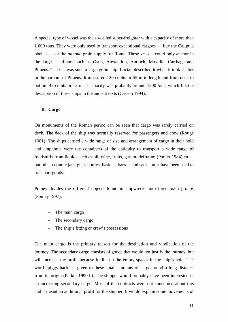
especially pottery, but the evidence of shipwrecks tends against this view of trade. It
seems to be normal for Roman ships to make up a cargo from a variety of sources
(Figure 1). The other objects are of a practical reason like the rigging or goods or
personal goods of the crew, which will lighten life on board.
Figure 1: Cross-section of the shipwreck “Cabrera C” (Pomey 1997: p 126)
Most of the times, amphorae are the main cargo. Especially when there is only one
type of cargo found, 75% of the time it is amphorae (Parker 1992 a). This is mostly
due the bad knowledge/exploration of the site. The unique form of the amphorae
makes it easy to recognize, even by laymen. A cargo of tiles is denser and not so easy
to spot. However, if multiple cargoes types are found in a shipwreck, the percentage
of amphorae in the total consignment is rather low (Parker 1992).
I divided the cargoes into the amphorae, dolia, ceramics — all kinds of pottery—,
stones, sarcophagi, tiles, metal and glass (Appendix 2). I only used the wreck sites or
reports that had a reasonable good identification of amphorae types. Some reports
only vaguely mention amphorae as Roman or Byzantine. This information cannot be
used in research. The division of the ships in different periods is based on the date of
sinking presented by the researchers who excavated the wrecks (Appendix 3).
Because of this date, the information of a particular ship can be used in more than one
period as the assumed data of the wreck covers different periods. For example: there
is a shift of economic importance from Spain to Africa in the 3rd century AD. So I
divided the information into a Spanish period, before 200 AD and an African period,
after 200 AD. This means that the information of cargoes from ships like Capo San
13
Alessio — 100 to 300 AD — will be used in both periods, as there is no possibility to
conclude if this data can be put in one particular period.
C. Stowing
Cargoes of vessels were carefully stowed to prevent breaking and shifting of the
cargo. The goods in the hold were arranged according to their weight and type. Heavy
goods such as metal ingots were loaded at the foot of the hold and lightweight goods,
such as pottery, were usually stowed on top of the main cargo and fore or aft of it. At
La Garoupe A, the amphorae were stacked on top of the dolia and in Dramont E
slender amphorae were placed between fatter, larger ones. Some shipwrecks have
empty spaces in their holds, whether this because the ship was this empty or there
were perishable consignment on board is hard to determine. Complementary or space-
filling goods are mostly on top or at one end of the main cargo (Parker 1992 a).
Grain had no uniform manner to be stored in the hold. It was carried in baskets,
leather sacks or cupae, which are large, wide-mouthed earthenware vases. But more
often it was probably transported loose. Precautions were necessary to avoid shifting
during the voyage. The cargo hold was probably divided into a number of
compartments separated by bulkheads. This method was probably used when the
cargo belonged to different owners or when it did not consist exclusively of grain.
Potteries, like amphorae, were piled on top of each other on layers of straw or
dunnage, but pottery could also have been transported in crates or baskets.
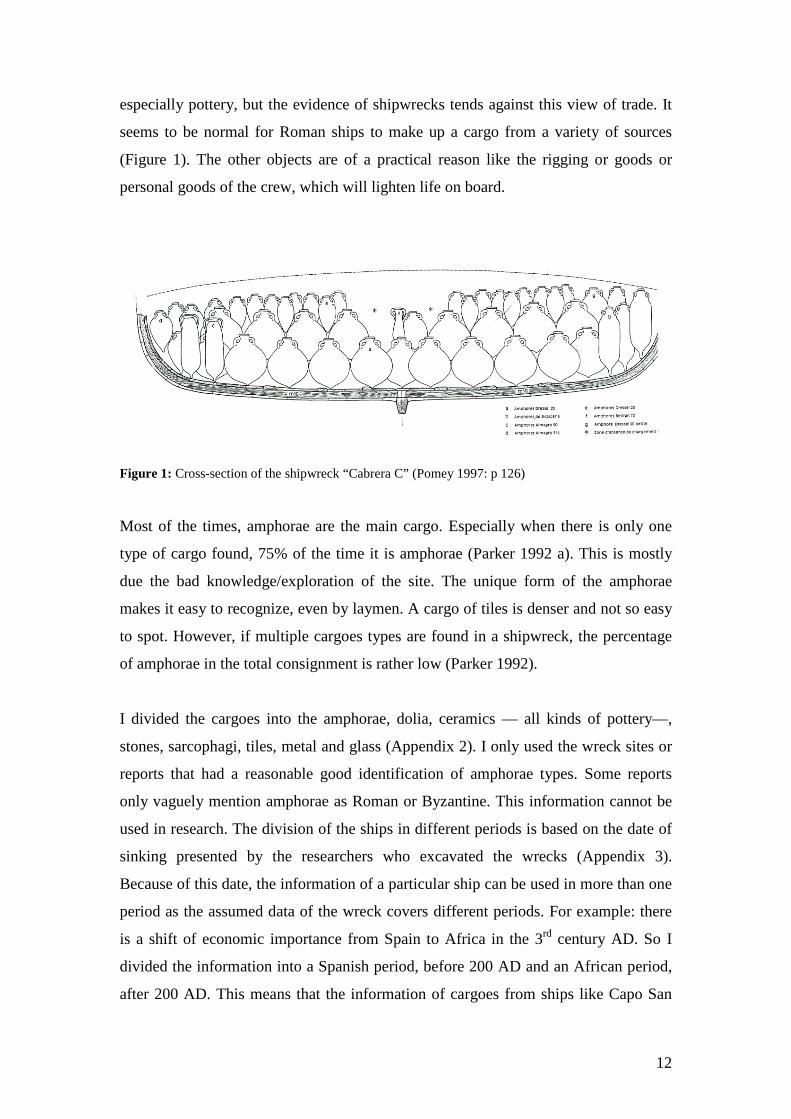
The amphorae were set upright in superimposed tiers and could be stowed from one
layer to nine layers in super freighters like Albenga. Each amphora was placed with
its pointed bottom into the open space around the necks of the jars in the tier below
(Figure 2).
14
Figure 2: Theoretical reconstruction of the amphorae stowinf in the “Madrague de Giens” (Pomey 1997: p 149)
In many cases the cargo was stowed on a layer of brushwood, heather or vine twigs.
The stacking of the cargo was so carefully that a minimum of dunnage was needed.
This dunnage of twigs and branches kept the jars cushioned against each other and the
hull and can sometimes been found in excavations of wrecks. But in case of
amphorae, the points of the bottom row were sometimes set in sand or pebbles —like
Cap Gros C —, which was also used as ballast.
D. Amphorae
Amphorae are the ancient equivalent of the medieval barrel or modern steel drum
(Casson 1994). The ancient authors did not give so much attention to pottery, but the
references that do exist emphasise the amphora’s function as a transport container
(Tomber 1993) specially made for seaborne commerce. In the Mediterranean where
wood was relatively scarce and expensive, clay jars and not barrels were the shipping
containers par excellence.
15
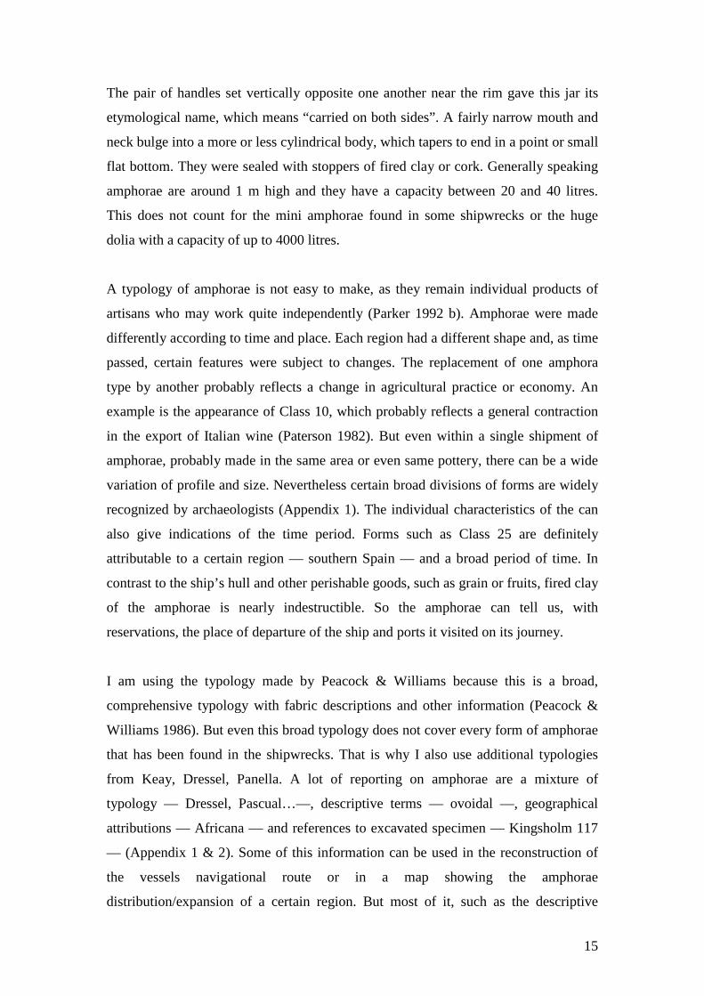
The pair of handles set vertically opposite one another near the rim gave this jar its
etymological name, which means “carried on both sides”. A fairly narrow mouth and
neck bulge into a more or less cylindrical body, which tapers to end in a point or small
flat bottom. They were sealed with stoppers of fired clay or cork. Generally speaking
amphorae are around 1 m high and they have a capacity between 20 and 40 litres.
This does not count for the mini amphorae found in some shipwrecks or the huge
dolia with a capacity of up to 4000 litres.
A typology of amphorae is not easy to make, as they remain individual products of
artisans who may work quite independently (Parker 1992 b). Amphorae were made
differently according to time and place. Each region had a different shape and, as time
passed, certain features were subject to changes. The replacement of one amphora
type by another probably reflects a change in agricultural practice or economy. An
example is the appearance of Class 10, which probably reflects a general contraction
in the export of Italian wine (Paterson 1982). But even within a single shipment of
amphorae, probably made in the same area or even same pottery, there can be a wide
variation of profile and size. Nevertheless certain broad divisions of forms are widely
recognized by archaeologists (Appendix 1). The individual characteristics of the can
also give indications of the time period. Forms such as Class 25 are definitely
attributable to a certain region — southern Spain — and a broad period of time. In
contrast to the ship’s hull and other perishable goods, such as grain or fruits, fired clay
of the amphorae is nearly indestructible. So the amphorae can tell us, with
reservations, the place of departure of the ship and ports it visited on its journey.
I am using the typology made by Peacock & Williams because this is a broad,
comprehensive typology with fabric descriptions and other information (Peacock &
Williams 1986). But even this broad typology does not cover every form of amphorae
that has been found in the shipwrecks. That is why I also use additional typologies
from Keay, Dressel, Panella. A lot of reporting on amphorae are a mixture of
typology — Dressel, Pascual…—, descriptive terms — ovoidal —, geographical
attributions — Africana — and references to excavated specimen — Kingsholm 117
— (Appendix 1 & 2). Some of this information can be used in the reconstruction of
the vessels navigational route or in a map showing the amphorae
distribution/expansion of a certain region. But most of it, such as the descriptive
16
terms, cannot be used, as they do not give specific information. Almost all the
amphorae types that are not included in the Peacock & Williams classifications are
only found in small numbers so they will not provide major changes in the general
patterns. This is way the additional list of other types is not included in the tables of
appendix 3. They are included in the general class that is names “others”.
E. Position of the shipwrecks
The development of scuba diving has brought to light many new sites since World
War II. The great majority of these lie in the Western Mediterranean. Reasons for this
distribution can be found in the early growth of the sport diving in the area, the
accessibility of its coast to large centres of population and a European interest in
antiquities (Parker 1980). The West Mediterranean basin includes at least 70% of all
wreck discoveries (Gibbins 2001). Especially the waters of southern France, the west
coast of Italy and the Islands of Corsica and Sardinia with its good visibility are well
known to sport divers. On the other hand are there few underwater sites known from
N-Africa — inaccessible coasts — or from the east coast of Italy where shelving coast
make the visibility poor and unsuitable for wreck discovery (Map 5).
Gibbins has done research on the amount of ships wrecked in antiquity. He based
himself on the information on Venetian large merchant ships, which had a chance of
one on twenty or thirty to wreck on medium to long distance journeys (Gibbins 2001).
Monte Testacchio contains the remains of 55 million south Spanish amphorae from
middle of the 1st century to the early 3rd century. If the vessels transported an average
of 1,500 amphorae a shipment, this would result in 36,500 cargoes or 250 cargoes a
year over 150 year. The two main routes to Spain are to the north-west littoral or
across open sea through the strait of Bonifacio. The sites found represent one wreck
every two years or 1:500 sailings. In other words, there should be 20 to 30 times as
many wrecks. It indicates how important episodes in the seafaring history are absent.
The coastal distributions of wrecks, how representative are they for sailing as a
whole? Most routes were coast hugging, but there must have been open-sea passages.
Ships on open-sea passages are more likely to be blown inshore than to swamp out at
sea. Therefore one cannot assume that the geographical distribution necessarily
reflects the intensity of maritime navigation and commerce.
17
The exact location of the wrecks is not pinpointed (Appendix 2), as this is not of great
importance. The aim of this research is to find correspondence in certain cargoes and
their relation in the navigation routes of antiquity. Ancient mariners were following a
route, which should be more viewed as a general direction then an exact route. This
means that a position within a few kilometre radius of the place where the wreck lies,
is accurate enough for the objective of my research.
V. Trading mechanisms and navigational routes
A. Mechanism of exchange
The stereotype idea of the merchant in antiquity is an adventurer, sailing from port to
port and buying or selling goods without knowing if he will make profit or when he
will return to his port of origin (Pomey 1997). This kind of merchant probably existed
from the Archaic period onwards, but it is not representative for the merchants in the
Hellenistic/Roman period. So how should we see the Roman economy: “tied” with
exchange of goods determined by redistribution or “free” with exchange resulting
from commercial marketing? Most researchers are following the theory developed by
archaeologists and anthropologists to describe the trading/exchange mechanisms used
in antiquity (Peacock & Williams 1986). This exchange mechanism can be divided
into three main systems:
- Reciprocity: social customs dictate the exchange
- Redistribution: a central authority collects the goods and redistributes them
- Marketing: exchange of goods for profit
1. Reciprocity
Of those three systems, redistribution and marketing are mostly used. On the other
hand, reciprocity might explain occasional finds of exotic goods outside their natural
marketing area (Peacock & Williams 1986), but can be hardly identified on the basis
of archaeological material. Parker thinks that the Hellenistic wreck Chrétienne C
18
could have been carrying a gift of produce from one estate (Parker 1990 a). Maybe we
can classify the wrecks loaded with works art such as Mahdia or Antikythera A under
this category? Are these legally bought objects or are they war/surrender booties from
cities, which can be seen as a social custom.
2. Annona or redistribution
The annona or state food supplies are a special kind of exchange. These goods were
collected in agricultural rich regions and redistributed to cities that have outgrown the
resources of their own hinterland or to military stations on the borders of the empire.
Those shipments took a considerable part of the maritime transport. Grain, being the
basic food in classical antiquity, made the bulk of most annona transports, but
products like oil were encouraged and managed by the Roman State from Hadrian
onwards. In later Roman period the species annonariae also included wine, fat and
fruit (Peacock & Williams 1986).
Rome relied already in its early history on the import of grain from Campania and
Etruria. From the second half of the third century BC, as the population of the city
grew, grain from Sicily, Sardinia and North Africa reached Rome through sale or
diplomatic gift (Garnsey 1983). Contributions from other western area such as Gaul
cannot be ruled out. As the provinces became assimilated into the empire as Roman
provinces, rents from imperial estates or tributes assured a constant supply of grain.
The armies on the frontiers and the city of Rome consumed more taxes than was
produced locally. There was a large-scale interregional flow of taxes and trade from
rich tax-exporting provinces such as Spain, southern Gaul, Northern Africa, Asia
Minor, Syria and Egypt to Rome. The tributes of the provinces were paid in money.
To pay their taxes, the provinces needed trade to gain money (Hopkins 1980). On a
local level, simple farmers were forced to produce and sell a surplus in order to pay
their taxes. This was followed by changes in patterns of consumption. Artisans could
buy more food and make other higher value goods, which increased the growth of
mercantile economy (Woolf 1992). The towns and markets thrived under this growth
of markets. Bureaucracy developed to get goods to the armies at the frontiers. This all
increased the monetization of the Roman economy. Rents functioned in similar ways
19
as taxes, both were charged on the surplus produced by peasants. Many taxes
however, were raised in kind.
The city of Rome had adequate stocks of food for sale to the public, but there was also
the supply of free grain, meat and wine. However, some researchers are of the opinion
that most of the taxes were paid in money and that only as little as 15% of the grain
was distributed freely under the population (Hopkins 1980, Temin 2001). Temin
suspects that the imports of grain would have been too large to be managed by the
government and that there is no indication of such a large bureaucratic administration.
He thinks that the bulk of the grain imports must have been privately owned. The
ships transporting the grain from Egypt were neither owned by the Imperial state nor
operated directly by the state. The shipping contracts with ship owners or navicularii,
were only used to obtain grain for the imperial distribution, which does not sound like
command behaviour or centric transfers. Grain undoubtedly came onto the market
through the regular activity of private merchants or negotiators (Garnsey 1983), but
the arrangements or contracts to transport the annona do not exclude an interference
of the state. It would be unwise to neglect all the references in the ancient texts: from
the amount of grain imported and distributed to the building of an imperial fleet. Most
of the annona supplies were acquired primarily in the provinces through taxation in
kind and they had to be transported. The mechanisms by which the Spanish oil
reached Rome and the military on the Rhine frontier could hardly be described as free
trade (Mattingly 1988).
Class 25 oil amphorae would presumably not have travelled as far as their distribution
shows without some subsidising effect (Mattingly 1988). Additional supplies of grain
and oil came from the rents of the imperial estates or were bought by the state from
merchants or private landowners.
To transport this huge amount of goods the state sold contracts for collection and
transport of grain to Rome or to the army under the Republic. The shippers were
attracted into service of the annona with tax and insurance benefits. Most grain that
was imported in such way was presumably state-owned (Garnsey et al 1987). From
the late Republic onwards, there was an increasing Imperial involvement in the
organisation of the food supply to secure a regular provision and transport of the
annona to Rome. This service became so vital that it could not be left totally in the
20
hands of private entrepreneurs. So Augustus created the service of the annona, which
was under control of the praefectus annonae. When Egypt became part of the Roman
Empire in 31 BC, there was a constant supply of grain from the East. The ancient
texts mention that Egypt supplied 20 million modii or 130.000 tons.
Epitome de Caesaribus I.6 (Meijer et al 1992):
“ In the days of Augustus 20 million modii of grain were imported each year from
Egypt to the city. “
But the importance of other areas has not diminished; Africa, Cyprus, Chersonese and
Spain are also known to have exported grain to Rome. Fulford however, suspects that
the contribution of the overseas transports were exaggerated by the contemporary
witnesses because the exigencies of the sailing season meant that the first arrivals
where at the time of year between sowing and harvesting when the grain stocks were
inevitably low and the people anxious (Fulford 1987). He thinks that agricultural
capacity of traditional sources such as Sicily, Sardinia and Campania was greater than
mentioned in the ancient texts. Nevertheless Flavius reported that during the reign of
Nero, Africa supplied Rome with grain for 8 months a year.
Flavius Josephus, “Jewish War II”. 382-3 & 385-6 (Meijer et al 1992):
“This third of the whole world…bounded by the Atlantic and the pillars of Hercules;
and supporting right up to the Red Sea the thousands of Ethiopians, is subdued in its
entirety; and these people, besides their annual crops, which feed for 8 months of the
year the populace of Rome, pay tribute of every kind… Alexandria, so populous, so
wealthy, so vast… besides money she sends grain to feed Rome for 4 months.”
What Flavius probably meant was that only for 4 months a year, from June to
September, grain ships from Egypt arrived at Rome. Because if he meant that only a
third of the total amount of grain came from Egypt, where Egypt delivered 20 million
modii, it would mean that Rome consumed 60 million modii of grain a year. If we
assume that a regular person used 1 litre of grain or 2,500 calories per person per day,
the city of Rome had 1.5 million inhabitants, which is more then what sources
indicate. Recipients of handouts of cash or grain during the reign of Augustus
numbered at various times between 200,000 and 320,000 (Pomey 1997). This was
21
only for male citizens from the age of ten. This would bring the population on
670,000 inhabitants. If we add a slave population of 30% this would give a number of
1,000,000 inhabitants, without counting in free foreigners or citizens of status who are
not involved in the grain dole (Garnsey et al 1987). Modern estimates are that the city
of Rome had an estimated population of one million inhabitants in the first two
centuries AD Rome (Meijer 1990). Garnsey says that Rome with its one million
inhabitants required a minimum of 30 modii or 200 kg of grain — a minimum of 1700
calories a day — per head per annum, which means that Rome needed 30 million
modii or 200.000 tonnes of grain a year (Garnsey 1983, Pomey 1997). This
consumption rate is also reflected in some ancient texts; Severus wrote that there
could be 75.000 modii issued daily, which would make 28 million modii annually.
Lucian said on the other hand that Rome needed 80.000 modii daily (Lucian I 139,
Vita Severi XXIII). Although some authors think that the city of Rome used the
double or 60 million modii of grain each year (Meijer et al 1992, Casson 1980).
Garnsey thinks that it is not unthinkable that the import levels of grain reached 60
million modii occasionally, as the quantity dispatched from the grain producing
regions must have varied greatly in response to widely fluctuating harvest levels, but a
regular consumption of this quantity seems widely improbable.
To get so much grain on yearly basis from Alexandria to Rome called for a highly
developed organisation. Claudius shifted the main port for Rome from Puteoli to
Ostia; Commodus built a state merchant fleet — Classis Africanus — and port
facilities at Carthage. But in general, fiscal cargoes for the annona were still carried
by ship-owners — navicularii—, which were contracted by the state for the purpose.
These merchants or ship-owners were recompensed considerably with rewards such
as for example citizenship. From time to time emperors took measures to make it
more attractive to invest in grain transport, which can be found in the texts of
Suetonius.
Suetonius, “Claudius” 18-19 (Meijer et al 1992):
“After a series of droughts had caused a scarcity of grain… as a result he took all
possible steps to import corn. Even during the winter months, insuring merchants
against the loss of their ships in stormy weather and offering a bounty for every new
grain-transport built, proportionate to its tonnage.”
22
Shippers made a lot of profit because the annona ships carried in addition to paying
passengers, other goods of diverse ownership. In the 3rd century, private and fiscal
goods were exempt from port tax if carried alongside fiscal loads. Several regulations
are known to intercept the private gain to the detriment of annoni. The Theodosian
Code warned shippers not to overload their grain ships with private cargo and in the
5th century a law penalised the deviation of ships loaded with state grain cargoes from
direct routes in order to deliver unrelated cargoes (Reynolds 1995, Tomber 1993).
The solution in getting this large amount of corn to Rome in such limited time-span
was the use of oversize freighters. The vessel “Isis”, which took shelter in the harbour
of Piraeus, could probably carry a cargo of 1200 to 1300 tons (Casson 1994). This
means that a fleet of about 100 to 120 ships was needed to ferry the amount of grain
that Egypt sent each year to Rome. However, from 330 AD, Egyptian grain was
diverted to the city of Constantinople and Rome relied on its traditional western
sources.
3. Marketing
Besides the annona or tax in kind, which was largely a free enterprise under state
supervision, there are numerous inscriptions and references to merchants or
negotiators indicating that market trading was an important facet of Roman life
(Peacock & Williams 1986, Greene 1986). However, it is very unlikely that
merchants would risk their money on long journeys without knowing the geography
or the climates — more specifically winds — of the coast, which they are sailing
(Pomey 1997). But still exotic imports arrived in all parts of the empire. This means
that even under free merchants there had to be a sort of redistribution of goods.
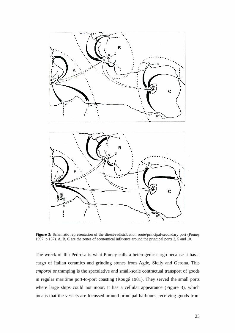
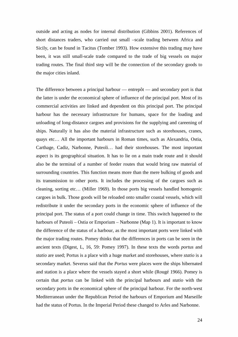
Pomey introduced for redistribution the concepts of “direct route”–“redistribution
route” and “principal port”–“secondary port” (Pomey 1997). The first step is the
transport of the homogenic cargoes from a region of production to a principal harbour
via a direct route (Figure 3). Sud-Perduto 2 is an example of a shipwreck with a
homogenic cargo. The second step is the transport of a heterogenic cargo by coastal
vessels, which connect this principal harbour with secondary ports by a “redistribution
route” (Figure 3).
23
Figure 3: Schematic representation of the direct-redistribution route/principal-secondary port (Pomey 1997: p 157). A, B, C are the zones of economical influence around the principal ports 2, 5 and 10.
The wreck of Illa Pedrosa is what Pomey calls a heterogenic cargo because it has a
cargo of Italian ceramics and grinding stones from Agde, Sicily and Gerona. This
emporoi or tramping is the speculative and small-scale contractual transport of goods
in regular maritime port-to-port coasting (Rougé 1981). They served the small ports
where large ships could not moor. It has a cellular appearance (Figure 3), which
means that the vessels are focussed around principal harbours, receiving goods from
24
outside and acting as nodes for internal distribution (Gibbins 2001). References of
short distances traders, who carried out small –scale trading between Africa and
Sicily, can be found in Tacitus (Tomber 1993). How extensive this trading may have
been, it was still small-scale trade compared to the trade of big vessels on major
trading routes. The final third step will be the connection of the secondary goods to
the major cities inland.
The difference between a principal harbour — entrepôt — and secondary port is that
the latter is under the economical sphere of influence of the principal port. Most of its
commercial activities are linked and dependent on this principal port. The principal
harbour has the necessary infrastructure for humans, space for the loading and
unloading of long-distance cargoes and provisions for the supplying and careening of
ships. Naturally it has also the material infrastructure such as storehouses, cranes,
quays etc… All the important harbours in Roman times, such as Alexandria, Ostia,
Carthage, Cadiz, Narbonne, Puteoli… had their storehouses. The most important
aspect is its geographical situation. It has to lie on a main trade route and it should
also be the terminal of a number of feeder routes that would bring raw material of
surrounding countries. This function means more than the mere bulking of goods and
its transmission to other ports. It includes the processing of the cargoes such as
cleaning, sorting etc… (Miller 1969). In those ports big vessels handled homogenic
cargoes in bulk. Those goods will be reloaded onto smaller coastal vessels, which will
redistribute it under the secondary ports in the economic sphere of influence of the
principal port. The status of a port could change in time. This switch happened to the
harbours of Puteoli – Ostia or Emporium – Narbonne (Map 1). It is important to know
the difference of the status of a harbour, as the most important ports were linked with
the major trading routes. Pomey thinks that the differences in ports can be seen in the
ancient texts (Digest, L, 16, 59: Pomey 1997). In these texts the words portus and
statio are used; Portus is a place with a huge market and storehouses, where statio is a
secondary market. Severus said that the Portus were places were the ships hibernated
and station is a place where the vessels stayed a short while (Rougé 1966). Pomey is
certain that portus can be linked with the principal harbours and statio with the
secondary ports in the economical sphere of the principal harbour. For the north-west
Mediterranean under the Republican Period the harbours of Emporium and Marseille
had the status of Portus. In the Imperial Period these changed to Arles and Narbonne.
25
The coastal vessels that were in charge of the redistributions under the different
statios only sailed well-outline routes. The distances that the coastal vessels covered
were liable to marine geography and different historic periods, but were relatively
small distances. This allowed the mariners to build up a profound knowledge of the
difficulties encountered on their journeys, which decreased the risks of wrecking
considerably. Once large numbers of ships visited a region regularly, navigational
expertise for those areas would mount in contrast to less frequented routes.
As seen above redistribution was also used in transporting and selling of products for
profit and thus cannot simply be linked with only the annona cargoes.
B. Navigational Routes
Rougé was one of the first researchers to examine some of the principle shipping
routes in the Republican-Imperial period (Map 3), which are known from written or
epigraphic sources (Rougé 1966). At present, the known network of regional and
inter-regional shipping routes is primarily based on the distribution of the ceramics
and to a lesser extent on textual evidence (Reynolds 1995).
The data provided by wreck sites should be considered in terms of its field situation
and of closely comparable sites. One should be careful with interpretations such as the
“Last route” theory, which is based on the places of origin of the cargo found aboard
of the wreck (Parker 1995). The latter can not always be derived from the goods on
board, because one should take into account situation like: entrepôts, return cargoes,
ships’ chandlers etc… Interpretations should be based on field experience and
observation of the cargo, such as complementary cargo, paying ballast or space filling
goods. Examination of wrecks like the Madrague de Giens, shows that the position of
assumed complementary cargoes such as tableware — on top of or at the end of
bulkier cargoes — may be due to the wrecking process or the displacement of the
goods when the ships start to perish and fall apart (Muckelroy 1978, Ward et al 1999).
So its relatively economic unimportance is not automatically linked with its position
found in the excavation.
26
Artefacts distribution on land sites can help examining long-distance trade (Peacock
& Williams 1986, Tomber 1993), but the routes followed by the ships can be
complicated and circuitous. Some routes were straight from A to B and back. A good
example is the route of the grain-ships between Alexandria and Rome. Unfavourable
conditions of weather however could divert ships from their original routes, forcing
them to make a detour. The journey of the grain ship “Isis” is an excellent example of
such a detour. Lucian described the sea voyage of the ship, which had to shelter in
Piraeus.
Lucian “The ship” (Greene 1986):
“When they left Pharos the wind was not very strong and they sighted Acamas [west
Cyprus] in seven days. Then it blew against them from the West and they were driven
abeam to Sidon [North Beirut]. After Sidon a severe storm broke out and carried
them through Aulon [channel between Turkey and Cyrpus] to reach Chelidonenses
[Gelidonya, Turkey] on the tenth day… where the Pamhylian and Lycian seas divide,
the swell is driven by numerous currents…the rocks are knife-edged and razor-
sharp…the wave as high as the cliff itself…they saw the fire from Lycia…they guided
the ship back into open sea…sailing across the Aegean beating up with the trade
winds…seventy days after leaving Egypt, they anchored in Piraeus.”
The merchant ships were stopping at various ports of call, which makes the maritime
routes even more complex. In every harbour there would have been an off- and
onloading of cargoes, which suited the ships purpose or next destination. The
examination of wreck assemblages and the hypothesis based on them introduce
explanations in terms of history and economics. Cargoes of marble and tiles for
example are susceptible to direct analysis, as they were probably no subjects to trans-
shipment (Parker 1995). Wreck locations and their density/frequency add an
important discipline to such studies.
Throughout most of the Roman Period, Italy and more specifically Rome, was the
centre of trade, and thus of navigation routes. From the 1st century on, the Roman
economy became increasingly import orientated. Strabo described how boats leaving
Italian harbours, were considerably lighter than when they arrived (Jurisic 2000).
Harbour cities, as loading and unloading centres, became the junction points between
27
which the major sea routes ran (Map 3). They were primarily determined by
geographic-maritime factors and by actual political-strategic situations (Jurisic 2000).
The principle ports of the empire were: Ostia, Puteoli, Marseille, Arles, Narbonne,
Tarragona, Cartagena, Cadiz, Emporium, Carthage, Aquila, Split, Athens,
Constantinople, Rhodes, Antioch, Caesarea Maritima, Gaza, Alexandria, Cyprus &
Crete (Map 1) (Reynolds 1995). The western maritime routes connected Rome
through these harbours with the western provinces such as, Spain, Gaul, Britain and
Africa. The eastern route connected Rome with numerous eastern provinces, among
which Greece and Egypt should be emphasized. Although the connection between the
eastern Adriatic and the economic powerful west of Italy was never strong, the
Adriatic Sea had a specific role in the maritime routes: the longitudinal Adriatic route
was used to serve northern Italy (Jurisic 2000).
In addition to these major routes there must have been regional traffic and
redistribution of goods between the important harbours and minor ports or even
coastal villas.
Most of these navigational routes were never far from visible geographical points in
the landscape, even for long distance routes. Some points — natural or man-made are
visible from far distance, but knowledge of the coastal geography is vital.
The concentration of economic activity and the difficulty of land transport make
coastal navigation very developed in the Mediterranean. But this is not everywhere, as
some regions are more developed and others almost deserted. Navigation around the
Aegean Islands is difficult, but a necessity. On the other hand, the African coast
between Alexandria and Tascape is littered with dangerous reefs and there are few
interesting economic centres except for the region around Cyrene.
A lot of the navigational routes were known as part of a network of greater routes.
The route between Porto Torres in Sardinia and Ostia is an example of a route that
formed part of a more important shipping route. It was also a part of the important
Tarrogona-Ostia and Marseille-Ostia route. Similarly, routes from the East to the
West could follow well-established routes in the West once they entered Western
Mediterranean waters (Map 3).
28
1. Western Mediterranean
• From Carthage
The south-north route from Africa to Italy was of major importance because of the
annona. There is textual evidence for the shipment of the annona supply from
Carthage. Other ports from which fiscal cargoes may have sailed are Missua, Utica
and possibly Rusicade (Reynolds 1995). There are different routes known from Africa
to Rome; According to textual evidence of the Imperial Times, the ships, which sailed
from Carthage to Puteoli, avoided Western Sicily and went straight to Campania.
From the Mid-1st century onwards, an even more direct crossing to Ostia could be
made. Another possibility is a route north to Sardinia and from the east coast of
Sardinia to Ostia (Rougé 1966). According to Strabo, ships coming from Sardinia
could sail northwards to the Isle of Elba and then sail southwards along the Italian
coast. Reynolds thinks that the Strait of Messina in routes from NorthAfrica to Rome
seems to be avoided (Reynolds 1995), but the evidence from the wrecks indicate that
there are many wrecks with African amphorae at the east coast of Sicily, which could
indicate a route through the Strait (Map 6).
The ships loaded with Tripolitanian products probably by-passed Carthage. This can
be seen from archaeological evidence found in Malta, South Italy and Campania
where Tripolitanian products are found numerous in contrast to Carthage (Reynolds
1995).
The demands of the annona caused strong eastwards shipping from southern Portugal,
southern Spain and the western Mediterranean ports to Ostia and eventually Rome. In
the opposite direction are there strong contacts between Tunisia and southern Spain,
especially during Late Roman/Byzantine times. The absence of south-central
Mediterranean coarse ware in Campania and Rome and their presence in Carthage and
Alicante is an indication that these imports were carried and distributed along this
south-Mediterranean shipping route. It is clear that the ships of this route travelled via
the Balearics. The presence of African amphorae in the wrecks around the Balearics
(Map 6) and the presence of Balearic amphorae found in Valencia in Imperial and
Mid-Roman contexts suggest that the vessels probably travelled along the islands
29
(Reynolds 1995). There are also links in the archaeological records of Tarragona and
Alicante, but strangely enough not Cartagena. The Balearic amphorae were probably
distributed along the Carthage – Alicante route. The distinct sources and ranges of
pottery found in Alicante and Cartagena, point out that certain goods from specific
regional sources were supplied directly to Cartagena and others to Alicante. But there
must have been another route along the African coast that has been described by
Braudel as the busiest for shipping in Medieval Times (Braudel 1985, Whittaker
1989).
A few ancient sources relate to direct routes between Tunisian ports and harbours not
related to Rome or Spain (Antoninus & Severus: Rougé 1966). Severus mentions a
shipping route between Narbonne and Carthage and the presence of distinct amounts
of Tunisian amphorae at Naples and Marseille suggests an independent supply from
Carthage (Reynolds 1995).
• From Spain
The Western Mediterranean only had one great west-east route (Map 3), which was
the route from Spain to Italy (Reynolds 1995). The most common of this west-east
route was a departure from Cadiz — conjunction point from the Atlantic routes — to
Sardinia along the northern route of the Balearics. From Sardinia the most common
route was through the Strait of Bonifacio to Italy. The range of African sigillata found
in the archaeological record links the cities of Valencia to Porto Torres in Sardinia
and Ostia, by-passing Alicante (Map 7). But there was also a coastal route to the
north: along the Gaulish coast to Corsica and northern Italy. An Spanish amphorae
found in sea for the coast of southern France bears the inscription of “[R]oma (m) in
via Lata”, which meant that this particular amphorae needed to go to the busiest street
in Rome, the via Latia (Pomey 1997).
Textual evidence for links between Beatica and Mauretania are known from the
Imperial period (Antoninus & Severus: Rougé 1966). The governor of Beatica was
responsible for sending cargoes of grain to the troops stationed in Mauretania.
Archaeological evidence of African sigillata found on the east coast of Spain and
southern France, suggests a south-north route of goods via the Balearics.
30
There was also a route from Baetica to the north following the eastern coast of Spain
towards the Rhône and continuing by shipment or portage to the Rhine. Ships such as
Madrague de Giens or Vendres B, probably had a consignment of goods for the
northern areas (Parker 1980).
• From Gaul
Another important route was the route from Gaul to Italy, where two routes were
possible; along the coast of France straight to Corsica, then onto the Italian coast via
the Isle of Elba or a more direct route through the strait of Bonifacio were it joins the
route Spain – Italy (Map 8).
• The Adriatic
The Adriatic Sea had a known route from Brindisi to the northern isthmus. Whether
the vessels followed a route in the middle of the Adriatic or a more coastal route is
hard to find out. Passenger ships are known to cross the Adriatic from Brindisi to
Dyrrachium. The presence of the Aegean imports in Ravenna and Sicily may indicate
a route from east Sicily to Ravenna via south Italy (Map 9). The cargoes found in
shipwrecks of the Adriatic indicate that 70% of the goods can be attributed to a
general eastern route (Jurisic 2000), especially wine — Class 10 — and pottery. The
main cargoes coming out the Adriatic were north Italian wines in the forms of Class 8
and Class 42 amphorae.
2. East Mediterranean
The most important north-south route in the Eastern Mediterranean is the axis Egypt-
Aegean-Black Sea (Rougé 1966). The Black Sea was the main supplier for garum in
the Eastern Mediterranean (Casson 1994). All those north-south routes congregate in
Rhodes, were the ships supplied when they came from or will be leaving for Egypt.
Secondary routes will be Rhodes – Cyprus, Levant – Egypt. The Ports in the Levant
have most of the time a northerly wind, which allows ships to travel easily to Egypt.
In the opposite direction however, the vessels had to sail against the wind. This
31
resulted in a zigzag course north, the ships would finally arrive somewhere between
Rhodes and the Gulf of Issus (Rougé 1966). Once the shipper knew where he was,
using geographical markings in the landscape, he had to adjust his course in function
of his port of destination.
The provinces of Cyrenaica and Triplotania cover most of the African coast in the
Eastern Mediterranean. Although this area is inhospitable and the coast is littered with
dangerous reefs, there was still export of goods: grain and medicinal herbs from
Cyrenaica and olive oil from Tripolitania (Fulford 1989). Another drawback is the
predominant north-west wind, which limits sailing direction. It makes sailing along
the coast difficult in both directions. But sailing to the Peloponnese or Crete from
Cyrenaica would have presented no problem. The prevailing winds encouraged
navigation of north-south routes for Cyrenaica. As for the Tripolitanian sites, when
the wind comes from the north, sailing west and to the north along the Tunisian coast
would also present no problem. However, when the winds are blowing from the
north-western direction, it would have been hard to sail along the coast. Depending on
the direction of the wind, conditions off Tripolitania encouraged north or north-
western routes. The evidence of the amphorae favours a west-central emphasis to the
pattern of trade from Tripolitania (Fulford 1989). The absence of coarse pottery from
the East reinforces this statement. In the 1st century BC there is a lot of coarse ware
from the Island of Pantelleria, which could have been carried along the route where
traffic was regular. Rather than to look to each other for mutual support, both regions
had contacts with communities to the north. The Gulf of Sirte was probably a serious
navigational problem for a two-way communication and it acted as a barrier between
the two regions.
3. East – West routes
There are three great navigational routes when a vessel wanted to travel from the East
to the West: a northern, a central and a southern route. Each of these routes crossed
the east coast of Sicily (Map 10). From east Sicily, the vessels navigated to their final
destination, which mainly had three great directions: to Rome, to Spain or to Gaul.
32
The northern route is well known, as it is part of the coastal navigation of the Aegean
(Rougé 1966). All journeys from either port in Asia Minor to the West will pass the
Aegean Islands. Depending on the ship’s tonnage or cargo, there are two choices: the
passage at the Corinthian Isthmus to Brindisi — Mare Adriaticum — or to Messina —
Mare Tyrrhenum —. The second option is the route around the Peloponnesus and Cap
Malea. When Cap Malea is rounded there are several options: straight to Sicily or
along the coast of the Peloponnesus to the Adriatic Sea and then the east coast of
Italy. Saint Paul travelled in the opposite direction from Rome to Antioch: his ship
passed Messina, around the Peloponnesus with the headlands of Methone and Malea,
along Cythera, Rhodes, Lycia and Cilicia to Antioch (Reynolds 1995).
Ships coming from the Levant and Cyprus used the central route (Rougé 1966). This
route follows the coasts of Cilicia and Lycia to Rhodes/Carpathos Islands and Crete.
This route will pass the southern coast of Crete, because it protects the ships against
violent northern winds and there is a good sheltered port of Lebena (STRABO X 478:
Rougé 1966). From Crete the vessels sailed straight to Sicily. The journey of St-Paul
from Caesarea to Rome is a good example of this route (Map 5).
Acts of the Apostles 27 — Journey of St-Paul — (Meijer et al 1992, Pomey 1997):
“ Once we were on the ship, we took off for the coast of Asia Minor… From Sidon, we
sailed under the wind from Cyprus as it comes from the opposite direction. After we
crossed the seas of Cilicia and Pamphylia, we arrived in Myre [Lycia]. Here we
changed over to a ship from Alexandria on its way to Rome. The following days we
continued slowly until we reached the Isle of Cnidos, where the winds forced us to
change our route more southerly. We passed Cape Salmone and sailed under Crete…
The night of the fourteenth day, we arrived in the Adriatic…Our ship wrecked on the
Island of Malta, there we stayed for three months… we sailed to Syracuse with a ship
from Alexandria that had hibernated on the Island. After three days in Syracuse, we
found a coasting vessel, which brought us to Rhegium and from there in two days to
Puteoli.”
33
The southern route is used from the great harbour of Alexandria. The African coast
was used during the summer winds, because the vessels could take advantage of the
alternating land and sea breezes up to 20 km from the coast (Rougé 1981). This route
follows the coast of Africa to Paraetonium or Cyrene and from those harbours to
Sicily (Tomber 1993). The hermit John talks in his “Vie d’Hilarion” about his journey
from Paraetonium to Sicily (Rougé 1966).
McGrail thinks that the northern route was the most popular navigational route
because the shores of the northern Mediterranean have a rather high coastal profile,
which provides mariners a distinct aid to navigation (McGrail 2001). The indented
coastline also includes many natural havens with sheltered landing places and supply
of fresh water. The southern shores do not have those advantages. Those conditions
and the fact that the European hinterland had a greater economic potential made
McGrail conclude that northern routes were preferred above the southern routes for
east-west voyages. The southern coast is not only a lee shore, but — especially in the
eastern basin — has only a low-lying coastal area. Many places also have hidden reefs
and shoals offshore. The harbours were few and far between on the African mainland.
• To Rome
The ships from the East heading for Rome passed through the Strait of Messina. The
best examples are the annona grain ships from Egypt. This passage is sometimes
impossible to take for sailing vessels as the ships encounter an opposite wind
direction and current (McGrail 2001).
• To Spain
Large numbers of Aegean imports have been found in Carthage and Cartagena. It can
be discussed that goods were imported from the East as far as Carthage and
redistributed from there. However some finds of Eastern Mediterranean pottery in
Alicante — which does not feature in the Carthage supply — suggest that this was not
always the case. The distribution of certain eastern lamps in Alicante, South-east
Sicily and south Italy suggests a navigational east-west route that by-passed Carthage,
northern Italy/Rome, Gaul and the Balearics. This route was probably a specific route
of some eastern goods in ships from the Levant straight to southern Spain. These
34
ships could be en route for the Atlantic, but specific ceramics have not been found in
Portugal or Britain. Some of these routes are known in ancient texts: Aristides refers
to commercial links between Cadiz and Alexandria (Reynolds 1995).
• To Marseille
There are also direct shipping routes between eastern ports and Gaul. A decree found
in Beirut, talks about the favouring the shipping merchants from Arles. Severus also
talks about a shipping route between Alexandria and Narbonne/Marseille. The ships
sailed along the African coast via Cyrenaica and Carthage to Gaul.
It is likely that Marseille was supplied with eastern imports independent of Carthage
or Italy. Although the archaeological record suggests that the sources supplying
Marseille were distinct to those supplying Alicante. From here the cargo was
redistributed to ports in north-eastern Tarraconensis.
4. Atlantic Routes
Significant amounts of shipping extended also to north-western France and British
Islands. After the Roman conquest of Britain in 43 AD, large amounts of high quality
pottery appeared on land sites (Gould 2000). The strait of Gibraltar, the Isthmuses of
Gaul — Valleys of the Garonne, Loire & Seine — or the Rhone-Rhine axis connected
the west coast of Europe to the Mediterranean.
In the 5th to 7th centuries there was probably an established route to south-west
Britain, which can be seen in the presence of eastern Mediterranean import in sites on
the British Isles and on the site of Conimbriga in Portugal. The absence at Conimbriga
of eastern amphorae however, can indicate different and distinct markets. Maybe
these markets were supplied independently? The finds of fine wares from Bordeaux
on the same sites can also be connected to this traffic. It is possible that those ships on
the east-west route were carrying a principle cargo of grain and no amphorae linked
food or a combination of grain and lesser quantities of amphorae. This pattern is in
contrast with cities such as Rome and Naples were abundant quantities of eastern
amphorae are found. Textual evidence of such a journey exists of an Alexandrian
captain commanding a ship carrying a cargo of corn to Brittany.
35
The absence of Late Roman ceramics at Carthage and Mauretania is good evidence
for the by-passing of these regions by shipping carrying this cargo. Had there been
redistribution from ports such as Carthage, the amount of Tunisian ceramics in the
archaeological evidence would have been greater in Atlantic sites. Although the direct
South Mediterranean route was the principle route to the Atlantic, less important
routes such as East-Marseille-Cartagena-Atlantic could also have existed.
VI. Maritime trade and its reflection in the archaeological evidence
The initiative to transport trade goods is depended upon economic factors — supply
and demand at the start and end point of the route — and the availability of transport
to the chosen destination. By examining the size and the diversity of the cargoes and
the position of the shipwrecks, it is sometimes possible to make some impressions
concerning the cargo and the navigational route followed. However, one has to be
careful to translate the provenance of the cargoes into navigational routes without
reflection: The shipwreck of Cabrera C — 260 AD — has a cargo of amphorae from
Baetica, Lusitania and Tunisia. The amphorae are well balanced and give the
impression that they are loaded and stowed as one unit. This made the archaeologists
who excavated the wreck believe that the all amphorae are loaded in a single
warehouse — probably Cadiz — instead of being collected in harbours of different
regions (Pomey 1997). Similar wrecks are Planier 7, Lazzareto and Ognino A.
The material evidence does not show the difference between privately inspired
enterprises and imperially assisted trade. The ships carrying the annona shipment
where mostly hired from private owners or navicularii. These shipments could have
varied a lot in size: from the super-freighters transporting grain from Egypt to smaller
river vessels, which had to supply the army outpost on the Rhine. But can one see the
difference between ships that went straight to one destination — Pomey: direct route
— and ships that went tramping along the coast — Pomey: redistribution route —
picking up and selling goods at every harbour? Large shipments probably belonged to
the category of ships sailing a direct route. Large vessels will not remain in the
harbour to wait on some handy trade in the near future (Jurisic 2000). This kind of
36
port-to-port exchange was usually performed by smaller vessels of the coastal fleet.
But this cargo did not have to be a homogenic cargo. Large vessels sailing a direct
route, could also carry a mixture of cargo. In ancient texts, there seems to be a
difference between the words mercators and negotiators (Peacock & Williams 1986).
As negotiators chartered the whole ship, the former are merchants who hired part of
the ship to transport its goods.
Circumstances in which cargoes were made up and shipped from the place of origin
could have been complex. Most of these transports are loaded in an entrepôt of a
major harbour, which can or cannot have an ample choice of goods. The economic
possibilities and demands at the place of destination, the variety of supplies at the
place of origin and the possibility of different merchants on a single ship would
probably result in a mixed load. The evidence from shipwrecks indicates that it seems
to be normal for Roman ships to carry a variety of goods (Parker 1990 a). Bulk
cargoes from the south coast of Spain, must have been assembled at an entrepôt. Ships
like Port Vendres B, Salines, Chiessi and Sud-Lavezzi B all have a mixed cargo,
which must have been collected and loaded in a harbour like Cadiz. It is however
possible that the shipments for the annona only consisted out of a single cargo or a
cargo from a single region. But an edict of the 3rd century excludes secondary goods
from port tax, which would have been very profitable for the shippers. These
secondary goods will probably not have overwhelmed the annona cargo in amount,
but it proves that a homogenic cargo must have been rare. A heterogenic shipment on
the other hand does not equal a port-to-port trader. Not only where those big ships to
large to moor in the smaller harbours, but it would have been too time consuming to
rearrange the cargo. The severe stowing of the amphorae and other cargo has a double
objective: cost-effectiveness by minimizing the cargo volume and securing it, so the
amphorae would not shift or break as the ship rolled with the swell. If part of cargo of
the amphorae is removed the whole will be unstable and has to be reorganised. It
seems not logical that huge merchant ships like Madrague de Giens or Albenga will
reorganise its cargo in every port when it delivers a few tens of amphorae a time
(Pomey 1997). The wreck of Sud Perdito B has 48 ingots, each weighting 42 – 48
kilos, in the bottom of its keel with on top a cargo of amphorae. This is not a ship of a
coastal vessel owned by a merchant who sailed from port to port. This rule can also be
applied for the vessels with dolia.
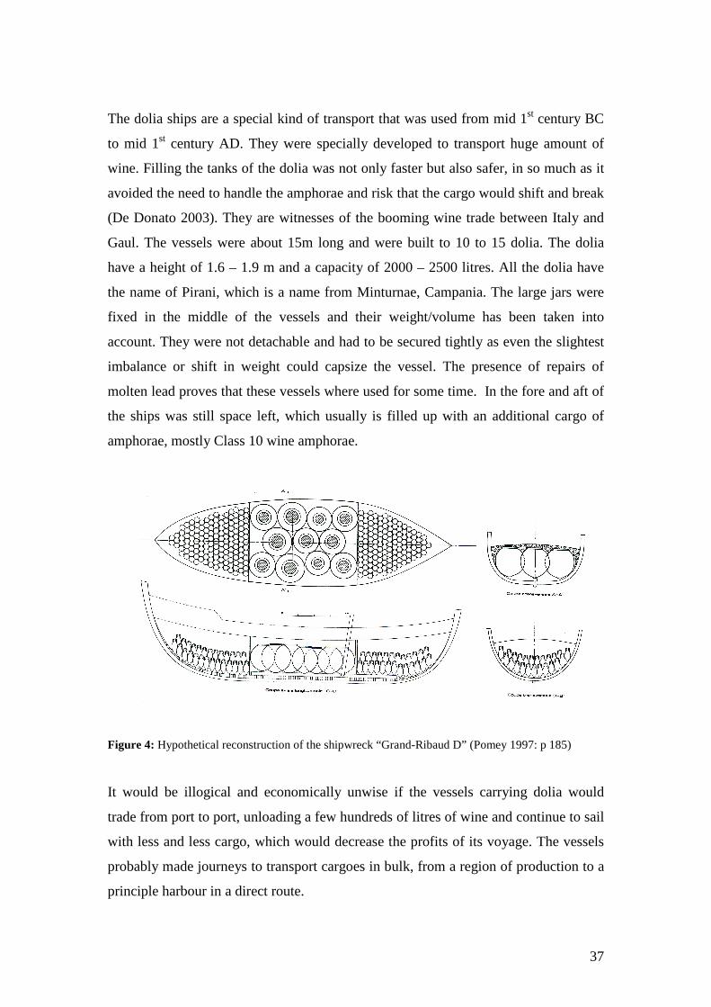
37
The dolia ships are a special kind of transport that was used from mid 1st century BC
to mid 1st century AD. They were specially developed to transport huge amount of
wine. Filling the tanks of the dolia was not only faster but also safer, in so much as it
avoided the need to handle the amphorae and risk that the cargo would shift and break
(De Donato 2003). They are witnesses of the booming wine trade between Italy and
Gaul. The vessels were about 15m long and were built to 10 to 15 dolia. The dolia
have a height of 1.6 – 1.9 m and a capacity of 2000 – 2500 litres. All the dolia have
the name of Pirani, which is a name from Minturnae, Campania. The large jars were
fixed in the middle of the vessels and their weight/volume has been taken into
account. They were not detachable and had to be secured tightly as even the slightest
imbalance or shift in weight could capsize the vessel. The presence of repairs of
molten lead proves that these vessels where used for some time. In the fore and aft of
the ships was still space left, which usually is filled up with an additional cargo of
amphorae, mostly Class 10 wine amphorae.
Figure 4: Hypothetical reconstruction of the shipwreck “Grand-Ribaud D” (Pomey 1997: p 185)
It would be illogical and economically unwise if the vessels carrying dolia would
trade from port to port, unloading a few hundreds of litres of wine and continue to sail
with less and less cargo, which would decrease the profits of its voyage. The vessels
probably made journeys to transport cargoes in bulk, from a region of production to a
principle harbour in a direct route.
38
By the end of the 1st century AD, the dolia ships became obsolete as the system was
unwieldy and the presence of huge containers in the hold presented an obvious and
real danger. The rupture of a dolium — filled with a liquid content — will pour
rapidly the wine into the hold, which could have resulted in a sudden destabilisation
and capsize of the vessel. In spite of the advantages, the fall in imports of Italian wine
in favour of the Gaulish wines and the attendant risks resulted in the disappearance of
the dolia ships (Marlier et al 2002).
Other kinds of transport are the small to medium vessels, which mainly performed the
coastal navigation. They carried a variety of cargo, loaded at a single storehouse in a
major harbour or collected along their routes in different ports. These vessels were
mostly bound to a certain maritime region or economic influence of a major harbour,
but it does not mean that they were not suitable for direct routes. They were capable
to make long journeys and certainly could cross open seas. The ship Sud Perdito B
probably measured under the 20 m. Culip D is a ship found of the coast of Catalonia
with a cargo of Class 25 amphorae and ceramics from Baetica, sigillata from southern
France and lamps from Rome. The ship is a small coastal vessel with a dimension of
about 10 on 3 m and a capacity of 8 tons. If we try to reconstruct the navigational
route followed by this vessel of the 1st century, it would be logical to think that it
visited al the different places and bought or sold goods in the ports. However the
excavations show that the goods have been stowed as one unit in one port (Pomey
1997). The cargo will have been loaded from the huge horrea or storehouses in the
harbour of Narbonne and went south on its final journey. The ship had a number of
smaller items in its hull, which were probably connected to the ship or its crew. A lot
of those items have an Aegean origin. Was this ship a coaster distributing goods in the
neighbouring smaller harbours? There is a good possibility that this ship had its home
base in the Aegean. It came to Narbonne, maybe with a collection of Aegean products
and loaded a number of Western Mediterranean goods for its way back. The position
of the wreck is a bit south of the harbour of Narbonne, ready to make the crossing to
the Strait of Bonifacia, the coast of Italy, Strait of Messina and around the
Peloponnesus to the Aegean. Aegean amphorae where not unknown in southern
France; In Lyon of the 1st century, the Gaulish amphorae take up to 75% of the total,
but 17% are amphorae from the Aegean, which is much more then the ones from
Spain or Italy (Liou 1990). This could indicate that in spite of their size small vessels
39
were capable to maintain an inter-regional long-distance route. The wreck of Les
Roches d’Aurelle — France — on the other hand was probably a small, local coaster.
The cargo existed purely of local products, identifiable with the region of Fréjus. In
contrast to the former ships, which have taken their cargo in a single harbour, the ship
Saint-Gervais C probably collected its cargo at a series of ports of call. The cargo was
made up of two different amphorae types from Beatica — Class 19 and Class 25 —
probably loaded at Cadiz and some Gaulish wine amphorae — Class 27 —, which
were probably loaded at the port of Narbonne. This ship was presumably on its way to
the lower Rhône (Parker 1992 a) and from there to Gaul or further. A very good
example of a ship tramping along different ports is the wreck at Valle Ponti. This
Adriatic shipwreck was loaded with a varied cargo of Spanish lead ingots, a
consignment of coarse pottery, bronze vessels, votive models, lamps, boxwood logs
and amphorae from Kos, Chian and Italy (Parker 1992 a). The ships equipment
included baskets, bags, tools and even a weight and a bronze balance. This ship was
probably involved in the port-to-port sale of goods.
As amphorae are typical products for seaborne commerce, their distribution patterns
can indicate the extent of Roman trade. The distributions of the amphorae in the
Roman empire can be divided in local — Class 28 to 30 —, regional — Class 10,
Class 25, Class 36 — and empire-wide — Class 2, Class 3 to 5 — presence. Empire-
wide distributions appear in a period between the second Punic War and the end of
the Republic, but exchange within the empire was for the most part on a regional level
(Woolf 1992). What does emerge from the distribution of amphorae is the role of the
army (Parker 1973): from the 1st century AD the frontier army was settled in more or
less permanent positions. It demanded a large and constant supply of its customary
foodstuffs. Fish and oil constituents were shipped from Spain.
Although, ancient trade routes can be reconstructed with the aid of distribution maps,
the presence or absence of amphorae cannot always be used as a straight indicator of
trade. Amphorae probably have passed through various stages of re-use and re-
deposition before they definitively entered the archaeological record, which was noted
by Herodotus.
40
Herodotus III.6 (Meijer et al 1992):
“Throughout the year, from all parts of Greece and Phoenicia, wine is imported into
Egypt in earthenware jars; yet one might say that not a single empty wine-jar is to be
seen anywhere in the country... The major of each place has orders to collect all the
jars from his town and send them to Memphis. The people of Memphis have to fill
them with water and send them to this tract of desert in Syria.”
This can significantly extend the life of certain types. An example of this can be found
in the evidence of the Culip D, Procchio and Yassi Ada wrecks. The stoppers were
each made out of amphorae sherds instead of proper made stoppers. However, this
seems to be an exceptional practise (Parker 1992 b).
In the Late Empire, the distances between tax-payers and tax-consumers had to be
shortened (Hopkins 1980). A smaller, strategic military reserve behind the frontiers
made it easier to supply the army with taxes raised locally, because food raised as tax
could not easily be transported. The taxes in kind required no transformation of local
surplus into goods of lower volume. As a result the production and consumption of
wine became increasingly regionalised (Keay 1992) and there is a decline in trade and
in town markets from the 3rd century (Hopkins 1980, Whittaker 1983).
Clearly, it is not easy to suggest shipping routes on the basis of archaeological records
found on land or in shipwrecks. Perhaps, if enough excavations and finds are
published in enough detail, it will be possible to isolate with more certainty ceramic
evidence for local, regional, short-distanced and long-distanced movement of goods
and subsequently the identification of the shipping routes (Reynolds 1995). Only full
excavation and publication of a site will present researchers the desired data. Those
sites are in a minority (Parker 1984), emphasising the need.
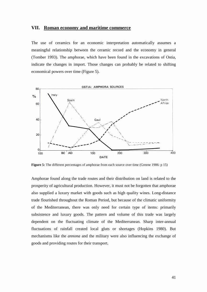
41
VII. Roman economy and maritime commerce
The use of ceramics for an economic interpretation automatically assumes a
meaningful relationship between the ceramic record and the economy in general
(Tomber 1993). The amphorae, which have been found in the excavations of Ostia,
indicate the changes in import. Those changes can probably be related to shifting
economical powers over time (Figure 5).
Figure 5: The different percentages of amphorae from each source over time (Greene 1986: p 15)
Amphorae found along the trade routes and their distribution on land is related to the
prosperity of agricultural production. However, it must not be forgotten that amphorae
also supplied a luxury market with goods such as high quality wines. Long-distance
trade flourished throughout the Roman Period, but because of the climatic uniformity
of the Mediterranean, there was only need for certain type of items: primarily
subsistence and luxury goods. The pattern and volume of this trade was largely
dependent on the fluctuating climate of the Mediterranean. Sharp inter-annual
fluctuations of rainfall created local gluts or shortages (Hopkins 1980). But
mechanisms like the annona and the military were also influencing the exchange of
goods and providing routes for their transport.
42
The ceramic evidence can also be an indicator of the actual reliance on imports; the
sharp increase in volume of imported ceramics between the 2nd and the 3rd century
correlates with the growth in the provision of storage facilities in Ostia (Fulford
1987). It also fits with the written evidence, which says that there was a greater
reliance on imported grain in general. Given the demand for surplus foodstuffs, the
best way of ensuring a widespread distribution of manufactured goods, was to ship
them alongside cargoes with foodstuffs. The production and export of African red
slipware can be linked to the export of agricultural products (Carandini 1983). It was
carried as space filler along the primary cargo. From the 1st century on, the route
Carthage – Rome became one of the most important in the Mediterranean and it may
have stimulated the production of other goods. This kind of correlative evidence
reinforces the idea that the contributions of local agriculture to Rome have been
underestimated as Etruria and Campania —well-known agricultural regions —
correspond with Italy’s most important sources of pottery. Cities with consistently
low ratios of imports to locally made wares would be those in relatively more fertile
regions. If the amount of 20 million modii of grain reached Rome every year, it is
curious that so little proxy evidence has survived. Casson already noticed that after
the conversion of Egypt into the Roman Empire, there was neither sign of an injection
of abundant amounts of grain in the West nor an inevitable economic dislocation in
the place of origin, Egypt (Fulford 1987). However, one should be careful with the
direct correlation between the source of pottery and imported foods. A possibility is
that pottery travelled out from Italy in the holds of the returning grain ships. The
archaeological evidence in Berenice — Cyrenaica — indicates the importance of
ceramic transport in returning grain ships. Cyrenaica not only on the way from Rome
to Egypt, but was also a known supplier of grain: in the mid 1st century BC Pompey
considered using grain from Cyrenaica in his campaign against Caesar (Caesar, Bell.
Civ. 3.5: Fulford 1989). From 200 BC to 50 AD, 35 % of the black-glaze pottery is of
Italian origin, whereas only 5% of the amphorae. In the Late Roman period however,
73% of the ware came from Tunisia. In this period Rome did not get any supplies
from Egypt anymore and the importance of Italian pottery in places on the vessels
route vanished. But redistribution of merchandise and the coastal trading character of
the Mediterranean make it virtually impossible to reconstruct in detail the pattern of
ancient commerce from archaeological evidence alone. Nevertheless is the correlation
between African grain/oil and the comprehensive presence of African pottery in the
43
late 1st and 2nd century AD at Ostia and in the other places in the Western
Mediterranean exceptional. Especially if one compares the data of the amphorae with
the apparent unrelated information such as brick stamps. The largest collection of
Italian brick of that period can be found in Carthage, which would probably have been
brought with the returning empty ships.
A. The heydays of Italian export: 150 BC – 1 BC
During the Republic most trade in amphorae and probably commercial shipping was
from Italy northwards along the coast of the Riviera (Whittaker 1989) and the East
Adriatic. With the aid of big merchant ships such as the Madrague de Giens or the
Albenga, Italy could transport enormous quantities of wine to Gaul in Class 3 to 5
amphorae from Campania and to the East in Class 8 amphorae from Apulia. But this
did not mean that there were no modest ships transporting the same cargo
(Laubenheimer 1990). The wreck found in Cavalière was only 9.5 m on 4.6 m and
could only transport up to 400 amphorae.
The amount of amphorae found in shipwrecks indicates an overwhelming dominance
of Italian goods (Appendix 3). Especially Class 3 to 5 and Class 8 amphorae are
predominantly present. During the early empire, the camps of the Rhine frontier must
have been a major market for these products (Paterson 1982). Italian products such as
black-gloss pottery — Campanian B ware — are regularly found together with
amphorae from Campania or Apulia (Appendix 3). Especially the Class 8 amphorae
from Apulia must have been transported in bulk to the Western Mediterranean. They
were probably shipped to Puteoli and from their redistributed with other wine
amphorae to southern France. This would also explain the rather high amount of
Rhodian amphorae found in relationship with Italian jars. Aegean merchants probably
came with a shipment of Rhodian, Chian and Cnidian wine to Puteoli where the jars
were stored in entrepôts until it was reloaded with other goods to a more western
destination. What the merchants took back to the Aegean is less well known as there
are for this period no shipwrecks found with Italian products. This redistribution
pattern can probably also be applied for the African jars such as Class 32 and Dressel
26 amphorae. They were also transported to Puteoli where they where further
distributed to Rome or other destinations.
44
In spite of the dominance of Italian amphorae, there are the first indications of an
increasing influence from the Spanish province. The colonisation of Hispania and
Narbonensis in the middle of the 1st century BC represents the starting point for
provincial wine production and commercialisation (Tchernia 1986, Tchernia 1989),
which will eventually take over the Italian production from the 1st century AD
onwards. This can be seen in the fairly amount of Class 6 amphorae found at coasts of
Catalonia and south France. Other Spanish products such as Class 14 and Class 16
with fish products indicate the growing economic importance of the Spanish province.
B. The shifting to the Spanish economy: 1 – 200 AD
Already from the reign of Augustus is there a decrease of export in Italian. The
vineyards in Spain and Gaul developed to an extent that they were less dependent on
Italian imports. The immigration of Italians/Romans in the new territories changed the
political and economic power to the provinces and resulted in a competition of export
and trade in the different provinces (Tchernia 1989). The north-east of Italy, more
specifically the Po valley, became more open to Greek imports coming up from the
Adriatic: ordinary wine from Crete, quality wine from Cos and Rhodes and high-
quality wines from Chios and Asia Minor (Pomey 1997). Italy and more specifically
Campania still mass-produced table wine — Class 10 — in the beginning of the first
century. The dolia ships like Grand Ribaud D or Diano Marina are mainly found
together with Class 10 wine amphorae. They are an excellent example of this
booming wine trade. But towards the end of the 1st century the outcome of the
competitive environment are more provincial imports to Italy than it exported. At the
end of the 1st and during the 2nd century grain and Gallic wine made up the largest
import of Rome (De Donato 2003). Italian wine growers protested against the
competition from the Gauls, which were in their eyes nothing more than semi-
Romanised provincials. In 92 AD, Emperor Domitian decreed that half the vineyards
in Gaul had to be uprooted to protect the Italian industry (De Donato 2003). The wine
trade however, was not seriously affected; in contrary Gallic wine amphorae have
been discovered as far as India. The shift in wine production from Campania to
Tarraconensis/south France can be found in Class 10 wine amphorae, which are found
more frequently in shipwrecks with other Spanish amphorae in contrary to the 1st
45
century BC where this type was mainly found together with Italian products
(Appendix 3). In spite of the West Mediterranean dominance in the wine trade, there
were still exports of Apulian and Rhodian wines to some extent.
Spain produced in the 1st century AD the lion’s share of the amphorae brought to
Rome (Pomey 1997), which agrees with the information of shipwrecks. Wine came
from Catalonia, garum and olive oil from southern Spain and metal from Lusitania
and Beatica. In Cadiz and Seville, little coastal and river vessels brought the
amphorae filled with oil to bigger ships, which brought the amphorae to Rome
(Mattingly 1988). The ships used the routes along the coast and partly across the open
sea using the islands to transport all the goods to Rome. The remains of this trade
route can be found in huge mountain of amphorae sherd — Monte Testaccio with a
height of 35 m —, which contains approximately 50 million of mostly Class 25
amphorae. The Spanish amphorae from Baetica and Tarraconensis are frequently
found together. This probably means that they ships loaded with Baetican amphorae
or metal sailed from Cadiz to harbours like Tarragona where they unloaded their
cargo for redistribution or collected an extra shipment of amphorae from
Tarraconensis before continuing their journeys. A good example is the wreck of Port
Vendres B on the French-Spanish border. This Claudian site yielded a collection of
Class 15 and Class 25 amphorae from Baetica, tin and lead ingots, Class 31 from
Tarraconensis, pottery and glass from south Spain and even some Gaulish sigillata. It
was probably a coastal vessel, which loaded its goods at Cadiz and Tarragona, before
heading to south France. The answers why the Spanish oil production reached such a
high level can probably be found in the high amount of shipwrecks with metal ingots
from Baetica. The traffic in metal — tin and lead — from Baetica and Lusitania was
undoubtedly vital and lucrative, acting as an attraction to shipping (Map 11). The
transport of other goods could have arisen out of the shippers seeking for part-cargoes
for the journey. The mixed cargoes were a less financial risk in case of shipwrecking.
Most of the metal ingots of shipwrecks are found in combination of Baetican
amphorae, which probably all have been loaded at entrepôts of Cadiz (Appendix 3).
Although Africa is important in the annona grain supply, there are only a small
number of shipwrecks with African amphorae from the first centuries found. Panella’s
research on the excavations of Ostia indicates that there was already a substantial
presence of African amphorae in the 1st century AD, which will progressively build-
46
up thereafter (Mattingly 1988). Maybe this striking low number of shipwrecks with
African products of the 1st and 2nd century can be ascribed to the uneven distribution
of wreck findings. A demonstration of this trade can be found in the survey of the
Skerki Bank between Africa and Sicily, which yielded four wrecks of the 1st century
with African amphorae.
C. The dominance of the African economy: 200 – 450 AD
During the 3rd century AD, the production of oil in Baetica rapidly decreased. The
production in North Africa was stimulated, as there was still a need for large
quantities of oil. Africa became the biggest producer of grain and oil for Rome
(Pomey 1997, Whittaker 1989) and northern Tunisia was the main production area of
amphorae (Appendix 3) (Keay 1984, Mattingly 1988). The archaeological evidence
shows that the expansion of the Tunisian production in the 4th century was in part
directed towards Rome — where it became the exclusive production area for the
annona — (Keay 1984), but to a greater extent towards other major markets not
connected with the food supply of the city of Rome (Reynolds 1995). Exported
amphorae from North Africa occur in huge quantities in the regions of Italy, Spain
and southern France from the 4th and 5th century (Kingsley & Decker 2001). The
presence of African oil amphorae in Spain is evidence for sale of surpluses directly
from North African ports by private landowners or merchants. It proves the existence
of distinct markets for export goods and a separate distribution network based on
regional ports and their respective shipping routes (Reynolds 1995). Tarracononesis
had a flourishing local wine industry in the 2nd century AD and there were few
imported foodstuffs. From the late 2nd century is there a decrease in wine industry and
an increasing import of African oil. From the early 4th century to middle 5th century
AD the local wine industry died out. The oil comes now solely from Tunisia. At the
same time 25% of the imports are from Baetica (Keay 1984). The information derived
from the shipwrecks indicates that in the 3rd and 4th century there seems to be a
triangular traffic involving Africa, Spain and Italy (Parker 1990 b). Punta Ala A,
Femmina Morta, Sobra, Cabrera A, Planier G, Lazaretto and Marzamemi F have a
cargo with mixed Spanish and African amphorae (Appendix 3). The cargoes of the
wrecks seem to have been a result of setting down and picking up goods along an
extended route (Map 12). But later wrecks like Port-Vendres A and Randello only
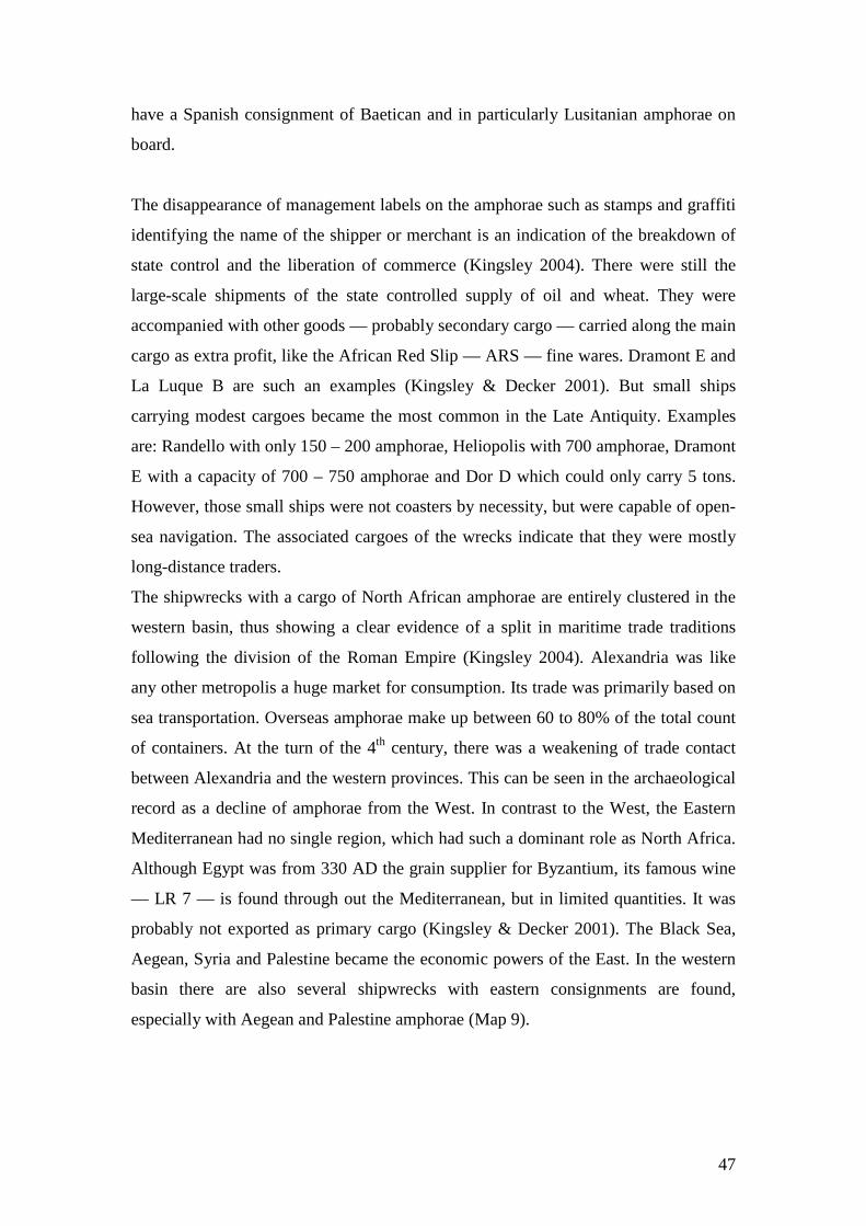
47
have a Spanish consignment of Baetican and in particularly Lusitanian amphorae on
board.
The disappearance of management labels on the amphorae such as stamps and graffiti
identifying the name of the shipper or merchant is an indication of the breakdown of
state control and the liberation of commerce (Kingsley 2004). There were still the
large-scale shipments of the state controlled supply of oil and wheat. They were
accompanied with other goods — probably secondary cargo — carried along the main
cargo as extra profit, like the African Red Slip — ARS — fine wares. Dramont E and
La Luque B are such an examples (Kingsley & Decker 2001). But small ships
carrying modest cargoes became the most common in the Late Antiquity. Examples
are: Randello with only 150 – 200 amphorae, Heliopolis with 700 amphorae, Dramont
E with a capacity of 700 – 750 amphorae and Dor D which could only carry 5 tons.
However, those small ships were not coasters by necessity, but were capable of open-
sea navigation. The associated cargoes of the wrecks indicate that they were mostly
long-distance traders.
The shipwrecks with a cargo of North African amphorae are entirely clustered in the
western basin, thus showing a clear evidence of a split in maritime trade traditions
following the division of the Roman Empire (Kingsley 2004). Alexandria was like
any other metropolis a huge market for consumption. Its trade was primarily based on
sea transportation. Overseas amphorae make up between 60 to 80% of the total count
of containers. At the turn of the 4th century, there was a weakening of trade contact
between Alexandria and the western provinces. This can be seen in the archaeological
record as a decline of amphorae from the West. In contrast to the West, the Eastern
Mediterranean had no single region, which had such a dominant role as North Africa.
Although Egypt was from 330 AD the grain supplier for Byzantium, its famous wine
— LR 7 — is found through out the Mediterranean, but in limited quantities. It was
probably not exported as primary cargo (Kingsley & Decker 2001). The Black Sea,
Aegean, Syria and Palestine became the economic powers of the East. In the western
basin there are also several shipwrecks with eastern consignments are found,
especially with Aegean and Palestine amphorae (Map 9).
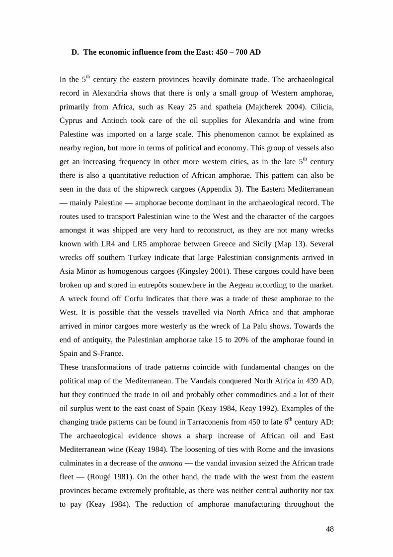
48
D. The economic influence from the East: 450 – 700 AD
In the 5th century the eastern provinces heavily dominate trade. The archaeological
record in Alexandria shows that there is only a small group of Western amphorae,
primarily from Africa, such as Keay 25 and spatheia (Majcherek 2004). Cilicia,
Cyprus and Antioch took care of the oil supplies for Alexandria and wine from
Palestine was imported on a large scale. This phenomenon cannot be explained as
nearby region, but more in terms of political and economy. This group of vessels also
get an increasing frequency in other more western cities, as in the late 5th century
there is also a quantitative reduction of African amphorae. This pattern can also be
seen in the data of the shipwreck cargoes (Appendix 3). The Eastern Mediterranean
— mainly Palestine — amphorae become dominant in the archaeological record. The
routes used to transport Palestinian wine to the West and the character of the cargoes
amongst it was shipped are very hard to reconstruct, as they are not many wrecks
known with LR4 and LR5 amphorae between Greece and Sicily (Map 13). Several
wrecks off southern Turkey indicate that large Palestinian consignments arrived in
Asia Minor as homogenous cargoes (Kingsley 2001). These cargoes could have been
broken up and stored in entrepôts somewhere in the Aegean according to the market.
A wreck found off Corfu indicates that there was a trade of these amphorae to the
West. It is possible that the vessels travelled via North Africa and that amphorae
arrived in minor cargoes more westerly as the wreck of La Palu shows. Towards the
end of antiquity, the Palestinian amphorae take 15 to 20% of the amphorae found in
Spain and S-France.
These transformations of trade patterns coincide with fundamental changes on the
political map of the Mediterranean. The Vandals conquered North Africa in 439 AD,
but they continued the trade in oil and probably other commodities and a lot of their
oil surplus went to the east coast of Spain (Keay 1984, Keay 1992). Examples of the
changing trade patterns can be found in Tarraconenis from 450 to late 6th century AD:
The archaeological evidence shows a sharp increase of African oil and East
Mediterranean wine (Keay 1984). The loosening of ties with Rome and the invasions
culminates in a decrease of the annona — the vandal invasion seized the African trade
fleet — (Rougé 1981). On the other hand, the trade with the west from the eastern
provinces became extremely profitable, as there was neither central authority nor tax
to pay (Keay 1984). The reduction of amphorae manufacturing throughout the
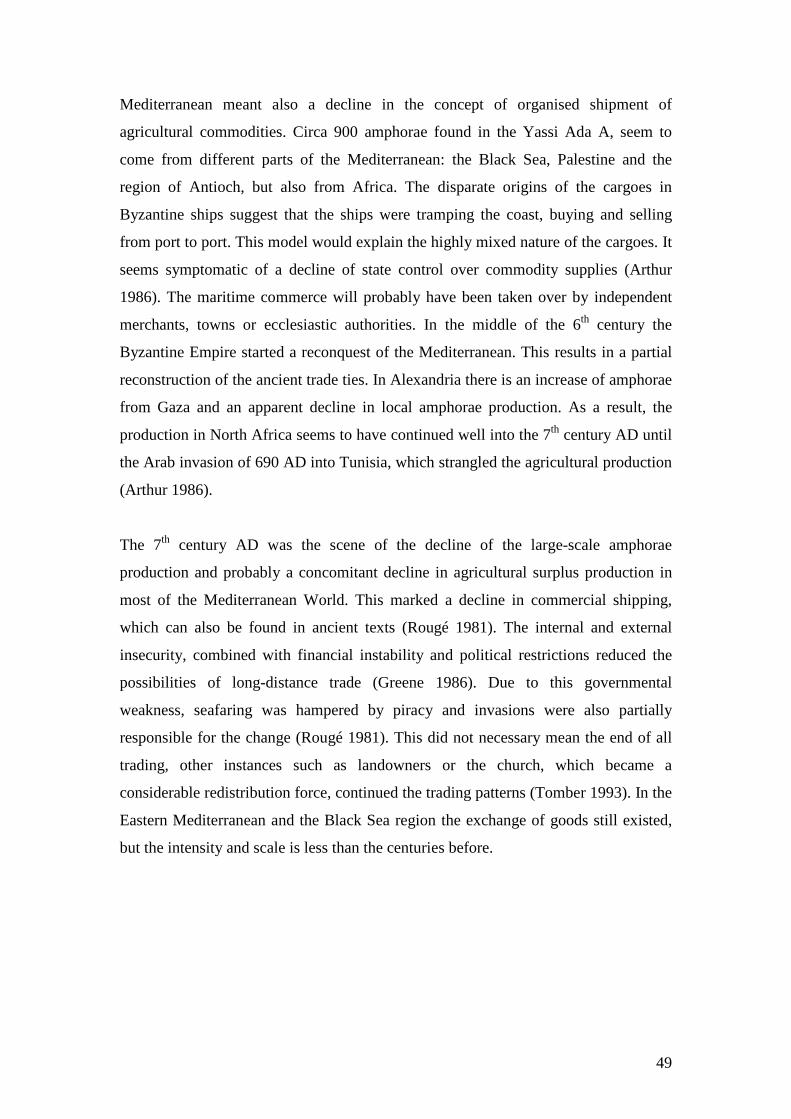
49
Mediterranean meant also a decline in the concept of organised shipment of
agricultural commodities. Circa 900 amphorae found in the Yassi Ada A, seem to
come from different parts of the Mediterranean: the Black Sea, Palestine and the
region of Antioch, but also from Africa. The disparate origins of the cargoes in
Byzantine ships suggest that the ships were tramping the coast, buying and selling
from port to port. This model would explain the highly mixed nature of the cargoes. It
seems symptomatic of a decline of state control over commodity supplies (Arthur
1986). The maritime commerce will probably have been taken over by independent
merchants, towns or ecclesiastic authorities. In the middle of the 6th century the
Byzantine Empire started a reconquest of the Mediterranean. This results in a partial
reconstruction of the ancient trade ties. In Alexandria there is an increase of amphorae
from Gaza and an apparent decline in local amphorae production. As a result, the
production in North Africa seems to have continued well into the 7th century AD until
the Arab invasion of 690 AD into Tunisia, which strangled the agricultural production
(Arthur 1986).
The 7th century AD was the scene of the decline of the large-scale amphorae
production and probably a concomitant decline in agricultural surplus production in
most of the Mediterranean World. This marked a decline in commercial shipping,
which can also be found in ancient texts (Rougé 1981). The internal and external
insecurity, combined with financial instability and political restrictions reduced the
possibilities of long-distance trade (Greene 1986). Due to this governmental
weakness, seafaring was hampered by piracy and invasions were also partially
responsible for the change (Rougé 1981). This did not necessary mean the end of all
trading, other instances such as landowners or the church, which became a
considerable redistribution force, continued the trading patterns (Tomber 1993). In the
Eastern Mediterranean and the Black Sea region the exchange of goods still existed,
but the intensity and scale is less than the centuries before.
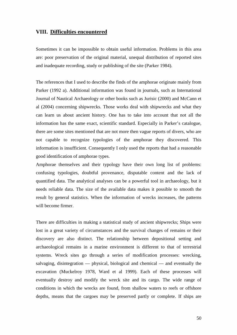
50
VIII. Difficulties encountered
Sometimes it can be impossible to obtain useful information. Problems in this area
are: poor preservation of the original material, unequal distribution of reported sites
and inadequate recording, study or publishing of the site (Parker 1984).
The references that I used to describe the finds of the amphorae originate mainly from
Parker (1992 a). Additional information was found in journals, such as International
Journal of Nautical Archaeology or other books such as Jurisic (2000) and McCann et
al (2004) concerning shipwrecks. Those works deal with shipwrecks and what they
can learn us about ancient history. One has to take into account that not all the
information has the same exact, scientific standard. Especially in Parker’s catalogue,
there are some sites mentioned that are not more then vague reports of divers, who are
not capable to recognize typologies of the amphorae they discovered. This
information is insufficient. Consequently I only used the reports that had a reasonable
good identification of amphorae types.
Amphorae themselves and their typology have their own long list of problems:
confusing typologies, doubtful provenance, disputable content and the lack of
quantified data. The analytical analyses can be a powerful tool in archaeology, but it
needs reliable data. The size of the available data makes it possible to smooth the
result by general statistics. When the information of wrecks increases, the patterns
will become firmer.
There are difficulties in making a statistical study of ancient shipwrecks; Ships were
lost in a great variety of circumstances and the survival changes of remains or their
discovery are also distinct. The relationship between depositional setting and
archaeological remains in a marine environment is different to that of terrestrial
systems. Wreck sites go through a series of modification processes: wrecking,
salvaging, disintegration — physical, biological and chemical — and eventually the
excavation (Muckelroy 1978, Ward et al 1999). Each of these processes will
eventually destroy and modify the wreck site and its cargo. The wide range of
conditions in which the wrecks are found, from shallow waters to reefs or offshore
depths, means that the cargoes may be preserved partly or complete. If ships are
51
found, there are dissimilar amounts of data available. Of the ancient wrecks 70% has
been found in the West Mediterranean (Parker 1990 b). Large area in deep sea and
particular coasts are still unexplored, as they are not favourable in finding or
preserving coherent wrecks.
An intact shipwreck is like a historic document that represents an elective and
deliberate choice of cargo for a journey to a specific destination (Pomey 1997). It
mirrors a truthful economic and commercial situation of the point of origin and the
point of destination. The merchant will only be able to load his ship with the goods
present at starting port and he will probably ship it to a port where there is a demand
for these goods. Every space available will be used — without endangering his ship
— to enlarge the cost-effectiveness. This means that there will not be many
unnecessary goods on board of a ship. Every object is part of the cargo or part of the
ship’s fitting except for a few objects, which probably belong to the crew or
passengers on board. This is why it is important to find, log and examine every object
found on a shipwreck and in the end to publish the acquired data and results.
IX. Conclusion
The above chapters made it clear that it is not always possible to derive certain
conclusions from the data of archaeological material in shipwrecks. Confusing
amphorae typologies, geographical uneven distribution of wreck sites and information
that is hard to interpret due to vague reports are some of the problems, which cause
restrictions in the research. The information that is available must also be treated
carefully: the complexity of the maritime trade in Antiquity makes it not easy to
extrapolate the navigational route of a vessel from the origins of archaeological
material such as amphorae. Nevertheless, the combination of ancient texts with
research of shipwrecks can provide researchers indications and general patterns in
maritime economy. Although the Roman period is known for bulk cargoes, the
evidence presented in chapter VI shows that the shiploads were mostly made up
according to the ships available and other external factors. The information indicates
that the vessels navigating during antiquity were for the greater part small to medium
52
sized ships, which carried cargoes made up from several sources. The broad picture of
Roman economy is that of a market economy instead of tied economy. The evidence
from shipwrecks points towards a relation with economic trends rather than political.
Official state orders and especially the provisions of the army would nevertheless
have their influences on the trading patterns. Chapter VII shows the relationship
between the information derived from the cargoes in the shipwrecks and the known
shifting of economical centres of gravities: in the first two centuries BC, the
economical centre of the Western Mediterranean was in Italy. In the first centuries
AD however, Spain became more important and Italy/Rome became more import-
oriented. When the mining in Spain became less important, the economic stress
became focused on North Africa, which became the major annona supplier. With the
decline of the Roman Empire, the economy became more regionalised. Long-distance
trading still existed but was mainly triggered in the Eastern Mediterranean.
The intention of this research is not on presenting new data, but rather in drawing
different strands of evidence with the intention of stimulating and providing possible
directions for future research. There is still much prospecting to be done in the
unexplored areas, such the African coasts, but there is also a great need of desk-based
research such as providing a tight amphorae typology or the examination and
publications of existing wreck sites material.
53
X. References
Arthur, P. 1986. Amphorae and the Byzantine world. In J.-Y. Empereur & Y. Garlan
(eds.), Recherches sur les amphores grecques. Bulletin de correspandance
Hellénistique, Supp. XIII. p. 655 – 660. Paris.
Braudel, F. 1985. La Méditerranée, l’éspace et l’histoire. Saint-Amand.
Carandini, A. 1983. Pottery and the African economy. In P. Garnsey, K. Hopkins &
C.R. Whittaker, Trade in the ancient economy. London. Hogarth Press. 145 – 162.
Casson, L. 1980. The role of the state in Rome’s grain trade. In J.H. D’Arms & E.C.
Kopff, The seaborne commerce of Ancient Rome: Studies in Archaeology and
History. p. 21 – 33. American Academy in Rome. Rome.
Casson, L. 1994. Ship and Seafaring in ancient times. London. British Museum Press.
Casson, L. 1995. Ships and seamanship in the Ancient World. London. John Hopkins
University Press.
Charlesworth, M.P. 1970. Trade-routes and commerce of the Roman Empire. New
York.
De Donato, G. 2003. Mare Nostrum, the Roman sea. Encyclopaedia of underwater
archaeology. London. Periplus.
Fulford, M.G. 1987. Economic interdependence among urban communities of the
Roman Mediterranean. World Archaeology 19.1: 58 – 75.
Fulford. M.G. 1989. To East and West: the Mediterranean Trade of Cyrenaica and
Tripolitania in Antiquity. Libyan Studies 20: 169 – 191.
54
Garnsey, P. 1983. Grain for Rome. In P. Garnsey, K. Hopkins & C.R. Whittaker,
Trade in the ancient economy. p. 118 – 131. London. Hogarth Press.
Garnsey, P. & Saller, R. 1987. The Roman Empire. Economy, Society and Culture.
University of California Press.
Gibbins, D. 2001. Shipwrecks and Hellenistic trade. In Z.H. Archibald, J. Davies, V.
Gabrielsen & G.J. Olivier, Hellenistic economies. p. 273 – 312. London.
Gould, R.A. 2000. Archaeology and the social history of ships. Cambridge.
Greene, K. 1986. The archaeology of the Roman economy. London.
Hopkins, K. 1980. Taxes and trade in the Roman Empire 200 BC – AD 400. Journal
of Roman Studies V.70: 101 – 125.
Jurisic, M. 2000. Ancient shipwrecks of the Adriatic. BAR international Series 828.
Oxford.
Keay, S. 1984. Late Roman amphorae in the Western Mediterranean; a typology and
economic study. BAR International Series 196. Part I. Oxford.
Keay, S. 1984. Late Roman amphorae in the Western Mediterranean; a typology and
economic study. BAR International Series 196. Part II. Oxford.
Keay, S. 1992. The Siena amphora conference. Part 1: amphorae and the Roman
economy. Journal of Roman Archaeology 5: 353 – 360.
Kingsley, S. 2001. The economic impact of Palestinian wine trade in Late Antiquity.
In S. Kingsley & M. Decker, Economy and exchange in the East Mediterranean
during Late Antiquity. p. 44 - 68. Oxford
Kingsley, S.A. 2004. Barbarian seas; Late Roman to Islam. Encyclopaedia of
underwater archaeology. London. Periplus.
55
Kingsley, S. & Decker, M. 2001. New Rome, new theories on inter-regional
exchange. An introduction to the East Mediterranean economy during Late Antiquity.
In S. Kingsley & M. Decker, Economy and exchange in the East Mediterranean
during Late Antiquity. p. 1 – 27. Oxford.
Laubenheimer, F. 1990. Le temps des amphores en Gaule. Collection des Hesperides.
Paris.
Liou, B. 1990. Sur les amphores et le commerce du vin. In T. Hackens & M. Miro
(eds.), Le commerce maritime Romain en Méditerranée occidentale, Revue du group
Européen d’études pour les techniques physiques, chimiques, biologiques et
mathemathiques appliqués à l’archéologie, PACT 27: 327 - 333. Rixensart.
Majcherek, G. 2004. Alexandria’s long-distance trade in Late Antiquity – the
amphora evidence. In J. Eiring & J. Lund, Transport Amphorae and Trade in the
Eastern Mediterranean: Acts of an International Colloquium at the Danish Institute of
Athens, 26-29 September 2002. Monographs of the Danish Institute at Athens 5: 229
– 236. Aarhus.
Marlier, S. & Sibella, P. 2002. La Giraglia, a dolia wreck of the 1st century BC from
Corsica, France. IJNA 31.2: 161 – 171.
Mattingly, D.J. 1988. Oil for export? Journal of Roman Archaeology 6: 33 – 56.
McCann, A.C. & Oleson, J.P. 2004.Deep-water shipwrecks off Skerki Bank: The
1997 Survey. Journal of Roman Archaeology supplementary series 58. Porthsmouth.
McGrail, S. 2001. Boats of the world. Oxford. Osford University Press.
Mediterranean Pilot, V, 1961. London. Hydrographic department.
Meijer, F. 1990. Schipper, zeil de haven binnen, alles is al verkocht. Handel en
transport in de oudheid. Schoten. Uitgeverij Westland.
56
Meijer, F. & van Nijf , O. 1992. Trade, transport and society in the ancient world; a
sourcebook. New York.
Miller, J.I. 1969. The spice trade of the Roman Empire. Oxford.
Muckelroy, K. 1978. Maritime archaeology. New York. Cambridge University Press.
Parker, A.J. 1973. The evidence provided by underwater archaeology for Roman trade
in the Western Mediterranean. In D.J. Blackmann, Marine Archaeology. p. 361 – 379.
London.
Parker, A.J. 1980. Roman wrecks in the Western Mediterranean. In K. Muckelroy,
Archaeology under Water, an atlas of the world’s submerged sites. p. 50 – 61.
London.
Parker, A.J. 1984. Shipwrecks and ancient trade in the Mediterranean. Archaeological
review from Cambridge 3.2: 99 – 113.
Parker, A.J. 1990 a. Classical antiquity: the maritime dimension. Antiquity 64: 335 –
346.
Parker, A.J. 1990 b. The pattern of commerce as evidenced by shipwrecks. In T.
Hackens & M. Miro (eds.), Le commerce maritime Romain en Méditerranée
occidentale, Revue du group Européen d’études pour les techniques physiques,
chimiques, biologiques et mathemathiques appliqués à l’archéologie, PACT 27: 147 –
168. Rixensart.
Parker, A.J. 1992 a. Ancient shipwrecks of the Mediterranean & the Roman
Provinces. BAR International Series 580. Oxford.
Parker, A.J. 1992 b. Cargoes, containers and stowage: the ancient Mediterranean.
IJNA 21.2: 89 –100.
57
Parker; A.J. 1995. Maritime cultures and wreck assemblages in the Graeco-Roman
world. IJNA 24.2: 87 – 65.
Paterson, J. 1982. Salvation from the sea: amphorae and trade in the Roman West.
Journal of Roman Studies 72: 146 – 157.
Peacock, D.P.S. 1978. The Rhine and the problem of Gaulish wine in Roman Britain.
In J. du Plat Taylor & H. Cleere (eds.), Roman shipping and trade: Britain and the
Rhine Provinces. Council for British Archaeology Research Report 24. p. 49 – 51.
London
Peacock, D.P.S. & Williams, D.F. 1986. Amphorae and the Roman economy, an
introductory guide. Longman Archaeological Series. London.
Pomey, P. 1997. La navigation dans l’Antiquité. Aix-en-Provence. Edisud.
Reynolds, P. 1995. Trade in the Western Mediterranean, AD 400 – 700: the ceramic
evidence. BAR International Series 604. Oxford.
Rougé, J. 1966. Recherches sur l’organisation du commerce maritime en
Méditerranée sous l’empire Romain. Paris.
Rougé, J. 1981. Ships and fleets of the ancient Mediterranean. New York.
Talbert, R.J.A. 1985. Atlas of Classical History. London.
Tchernia, A. 1986. Le vin de l’Italie Romaine; essai d’histoire économique d’après
les amphores. Ecole Française de Rome. Rome.
Tchernia, A. 1989. Encore sur les modèles économiques et les amphores. In M.
Lenoir, D. Manacorda & C. Panella (eds.), Amphores Romaines et histoire
économique: dix ans de recherche. Collection de l’école Française de Rome 114. p.
529 – 536. Rome.
58
Temin, P. 2001. A market economy in the Early Roman Empire. Journal of Roman
Studies 16: 169 – 181.
Tomber, R. 1993. Quantitative approaches to the study of long-distance exchange.
Journal of Roman Archaeology 6: 142 – 166.
Ward, I.A.K., Larcombe, P. & Veth, P. 1999. A new process-based model for wreck
site formation. Journal of archaeological science 26: 561 – 570.
Whittaker, C.R. 1983. Late Roman trade and traders. In P. Garnsey, K. Hopkins &
C.R. Whittaker, Trade in the ancient economy. p. 163 – 180. London. Hogarth Press.
Whittaker, D. 1989. Amphorae and trade. In M. Lenoir, D. Manacorda & C. Panella
(eds.), Amphores Romaines et histoire économique: dix ans de recherche. Collection
de l’école Française de Rome 114. p. 537 – 538. Rome.
Woolf, G. 1992. Imperialism, empire and the intergration of the Roman economy.
World Archaeology 23.3: 283 – 293.
59
Map 1: Map of the Mediterranean basin with the most important harbours of the Roman period (After Pomey 1997: p 135)
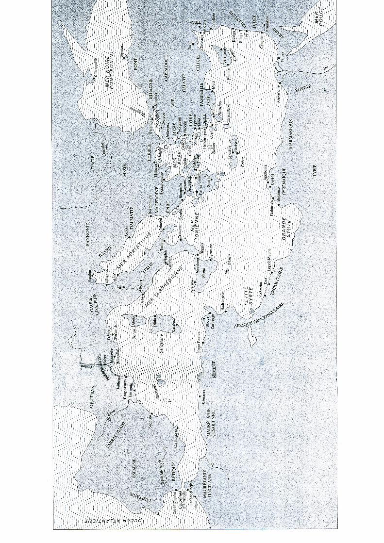

60
Map 2: Map with the principal winds of the Mediterranean basin (Pomey 1997: p 26)
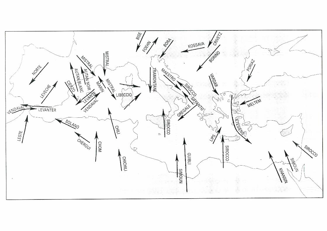
61
Map 3: Map displaying the major navigation routes in the Mediterranean (Rougé 1966: p 88-89)
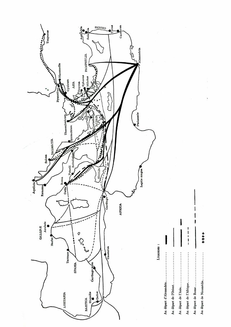

62
Map 4: Map depicting the journey of St-Paul from Caesarea Maritima to Rome (Pomey 1997: p 11)
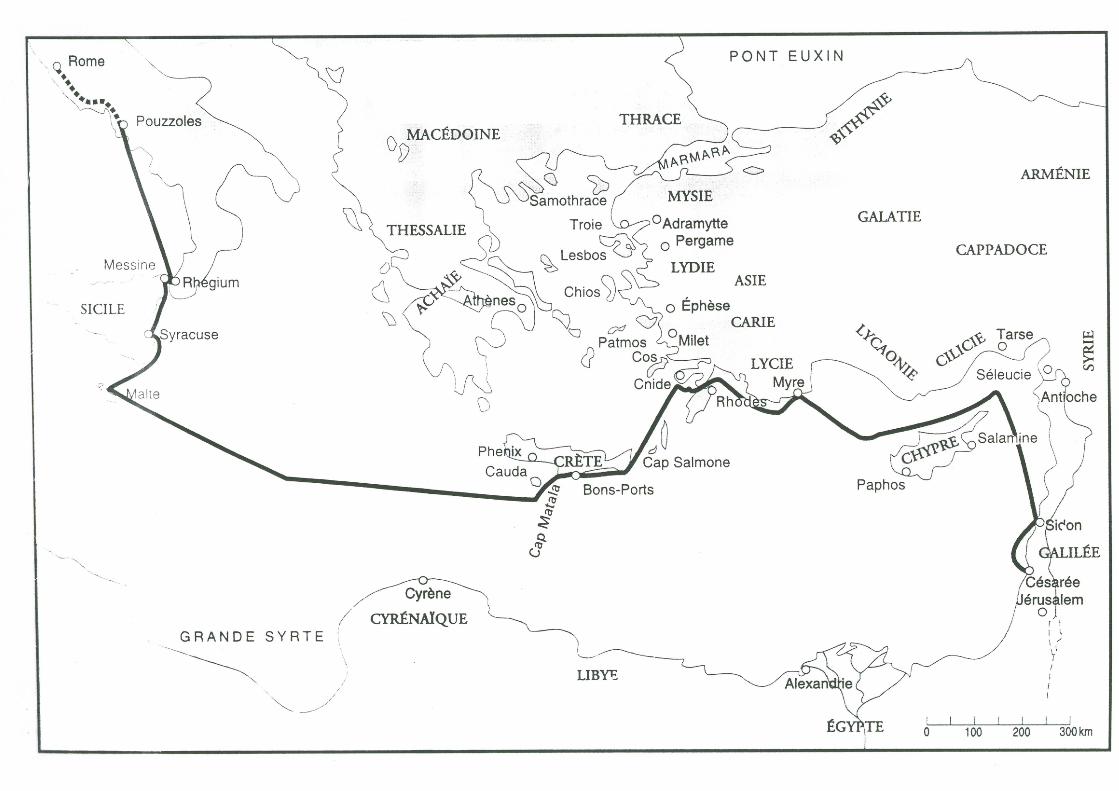
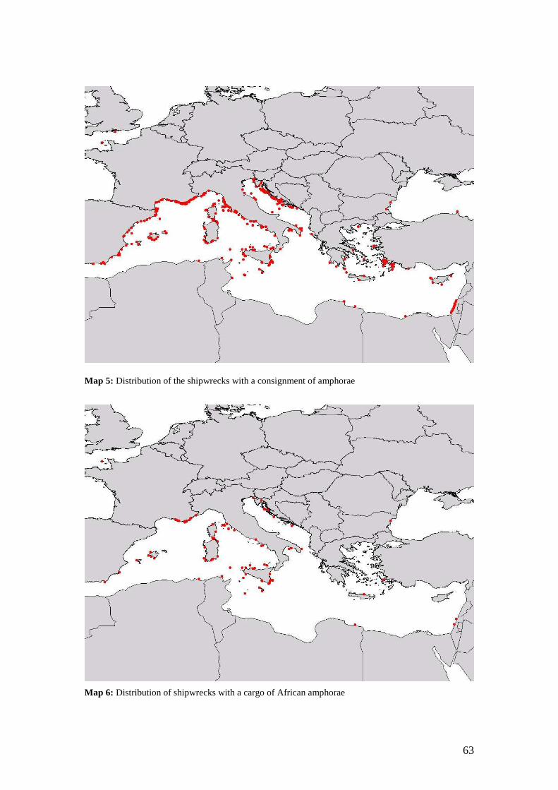
63
Map 5: Distribution of the shipwrecks with a consignment of amphorae
Map 6: Distribution of shipwrecks with a cargo of African amphorae
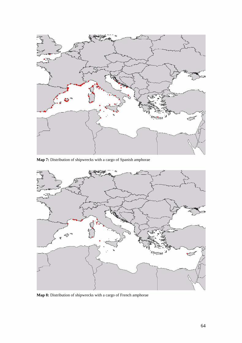
64
Map 7: Distribution of shipwrecks with a cargo of Spanish amphorae
Map 8: Distribution of shipwrecks with a cargo of French amphorae
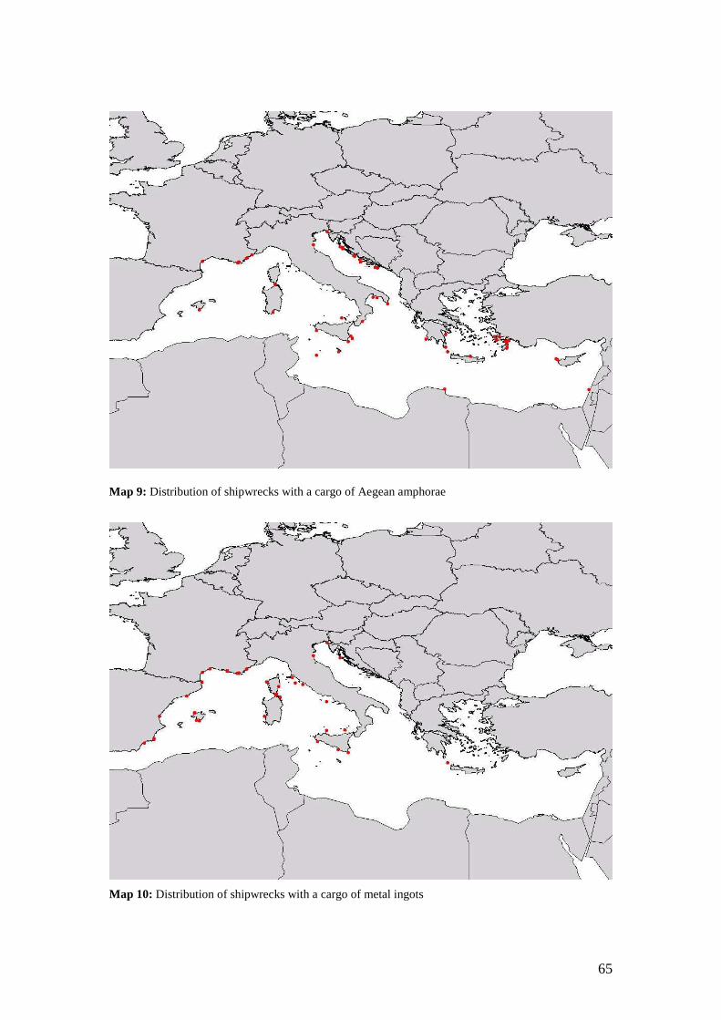
65
Map 9: Distribution of shipwrecks with a cargo of Aegean amphorae
Map 10: Distribution of shipwrecks with a cargo of metal ingots
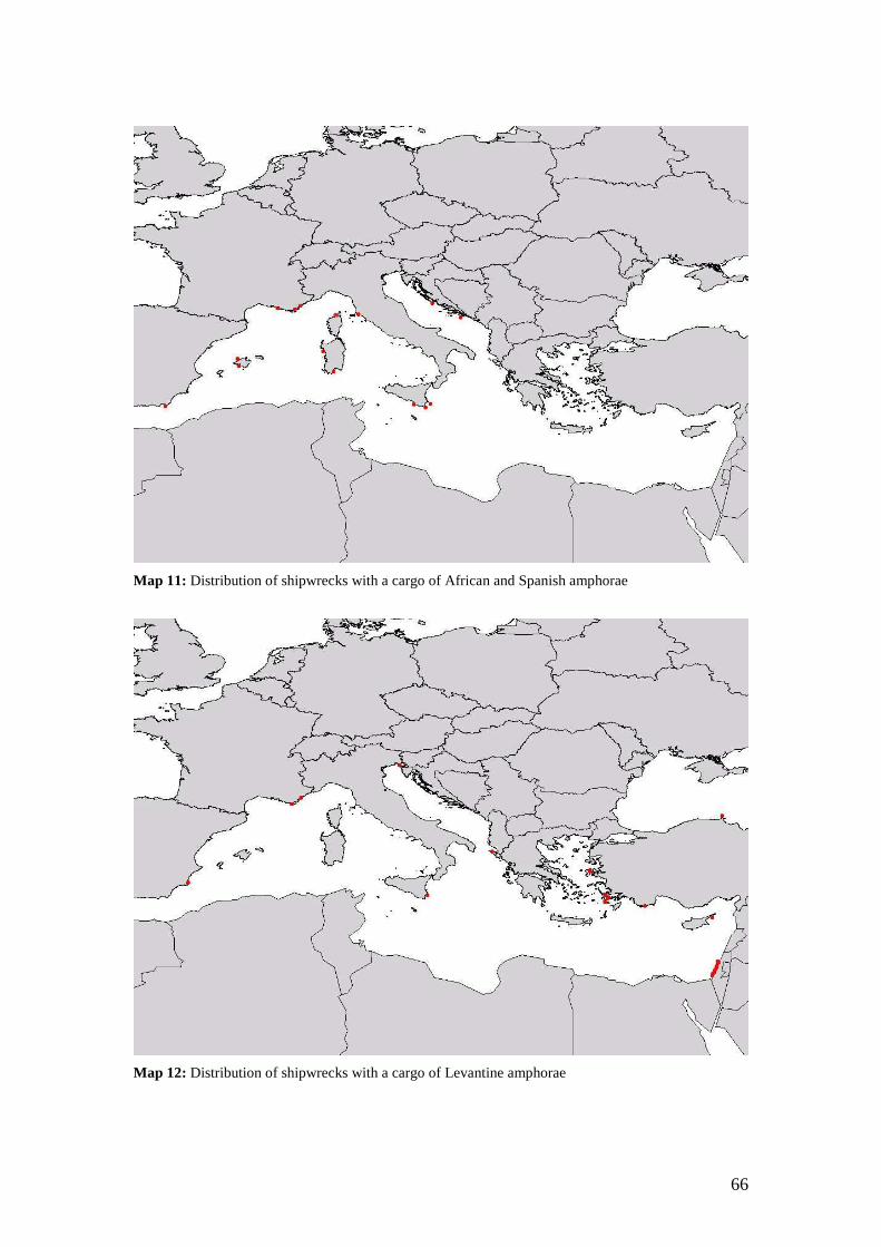
66
Map 11: Distribution of shipwrecks with a cargo of African and Spanish amphorae
Map 12: Distribution of shipwrecks with a cargo of Levantine amphorae
Appendix 1 This appendix is a catalogue of the amphorae types, which have been found in the different shipwrecks. The information comes mainly out of the book of Peacock & Williams (1986). The drawings are from the same book and from Sciallano & Sibella (1994).
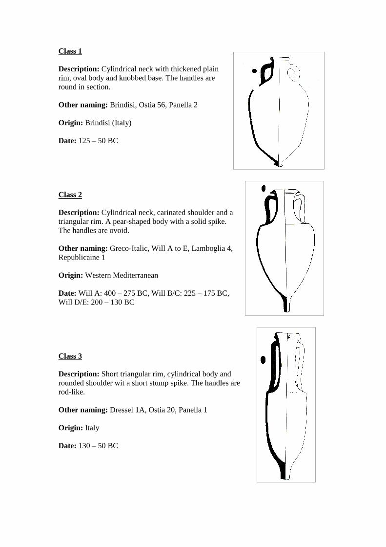
Class 1
Description: Cylindrical neck with thickened plain rim, oval body and knobbed base. The handles are round in section. Other naming: Brindisi, Ostia 56, Panella 2 Origin: Brindisi (Italy) Date: 125 – 50 BC Class 2
Description: Cylindrical neck, carinated shoulder and a triangular rim. A pear-shaped body with a solid spike. The handles are ovoid. Other naming: Greco-Italic, Will A to E, Lamboglia 4, Republicaine 1 Origin: Western Mediterranean Date: Will A: 400 – 275 BC, Will B/C: 225 – 175 BC, Will D/E: 200 – 130 BC Class 3
Description: Short triangular rim, cylindrical body and rounded shoulder wit a short stump spike. The handles are rod-like. Other naming: Dressel 1A, Ostia 20, Panella 1 Origin: Italy Date: 130 – 50 BC
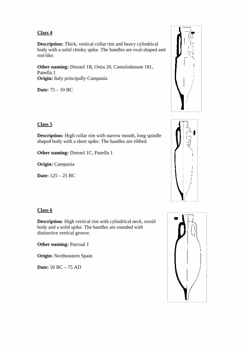
Class 4
Description: Thick, vertical collar rim and heavy cylindrical body with a solid chinky spike. The handles are oval-shaped and rod-like. Other naming: Dressel 1B, Ostia 20, Camulodunum 181, Panella 1 Origin: Italy principally Campania Date: 75 – 10 BC Class 5
Description: High collar rim with narrow mouth, long spindle shaped body with a short spike. The handles are ribbed. Other naming: Dressel 1C, Panella 1 Origin: Campania Date: 125 – 25 BC Class 6
Description: High vertical rim with cylindrical neck, ovoid body and a solid spike. The handles are rounded with distinctive vertical groove. Other naming: Pascual 1 Origin: Northeastern Spain Date: 50 BC – 75 AD
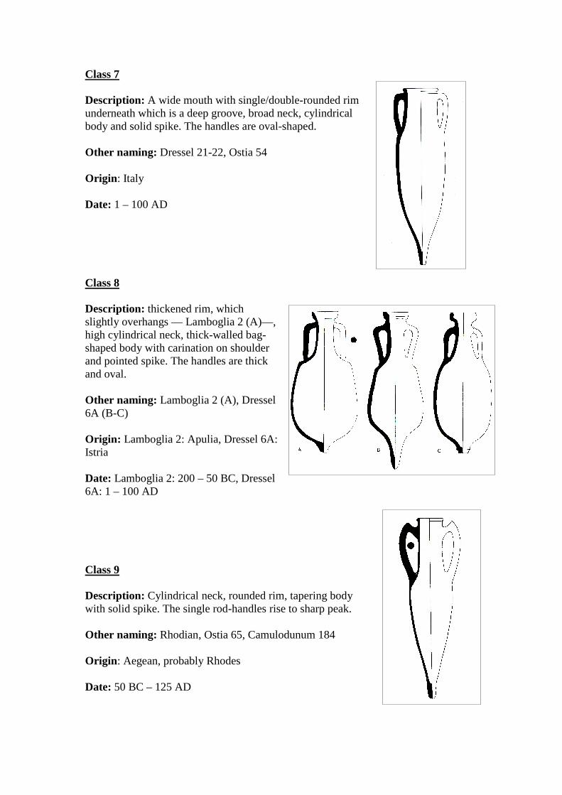
Class 7
Description: A wide mouth with single/double-rounded rim underneath which is a deep groove, broad neck, cylindrical body and solid spike. The handles are oval-shaped. Other naming: Dressel 21-22, Ostia 54 Origin: Italy Date: 1 – 100 AD Class 8
Description: thickened rim, which slightly overhangs — Lamboglia 2 (A)—, high cylindrical neck, thick-walled bag-shaped body with carination on shoulder and pointed spike. The handles are thick and oval. Other naming: Lamboglia 2 (A), Dressel 6A (B-C) Origin: Lamboglia 2: Apulia, Dressel 6A: Istria Date: Lamboglia 2: 200 – 50 BC, Dressel 6A: 1 – 100 AD Class 9
Description: Cylindrical neck, rounded rim, tapering body with solid spike. The single rod-handles rise to sharp peak. Other naming: Rhodian, Ostia 65, Camulodunum 184 Origin: Aegean, probably Rhodes Date: 50 BC – 125 AD
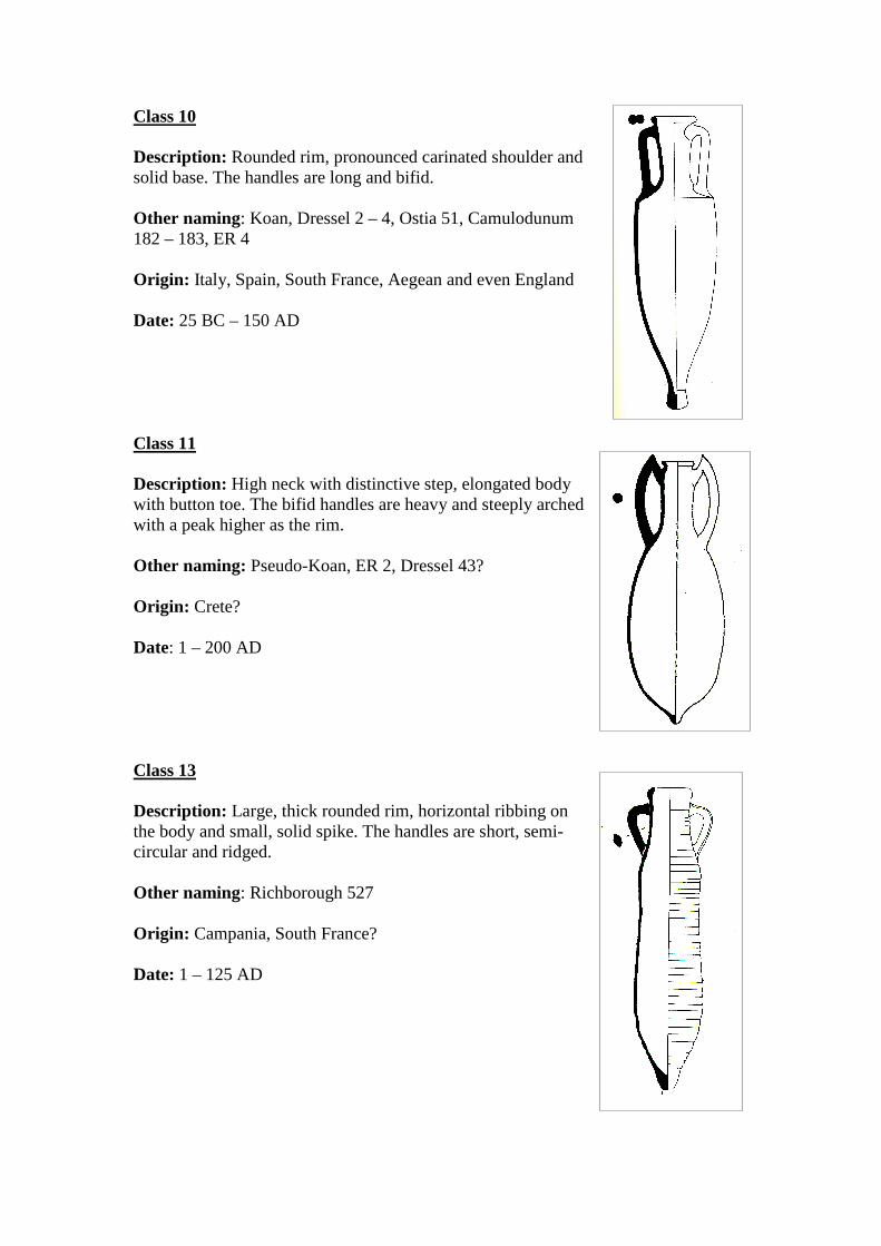
Class 10
Description: Rounded rim, pronounced carinated shoulder and solid base. The handles are long and bifid. Other naming: Koan, Dressel 2 – 4, Ostia 51, Camulodunum 182 – 183, ER 4 Origin: Italy, Spain, South France, Aegean and even England Date: 25 BC – 150 AD Class 11
Description: High neck with distinctive step, elongated body with button toe. The bifid handles are heavy and steeply arched with a peak higher as the rim. Other naming: Pseudo-Koan, ER 2, Dressel 43? Origin: Crete? Date: 1 – 200 AD Class 13
Description: Large, thick rounded rim, horizontal ribbing on the body and small, solid spike. The handles are short, semi-circular and ridged. Other naming: Richborough 527 Origin: Campania, South France? Date: 1 – 125 AD
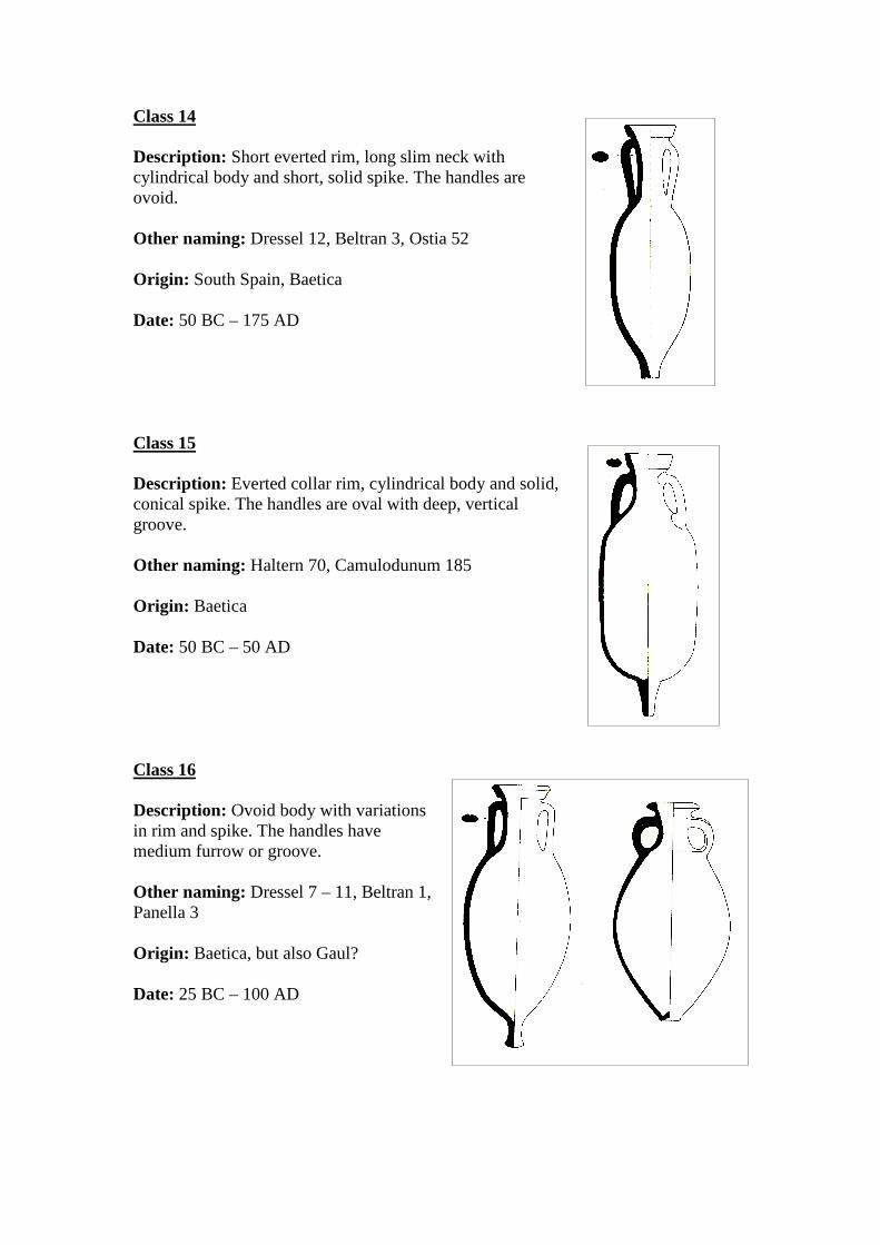
Class 14
Description: Short everted rim, long slim neck with cylindrical body and short, solid spike. The handles are ovoid. Other naming: Dressel 12, Beltran 3, Ostia 52 Origin: South Spain, Baetica Date: 50 BC – 175 AD Class 15
Description: Everted collar rim, cylindrical body and solid, conical spike. The handles are oval with deep, vertical groove. Other naming: Haltern 70, Camulodunum 185 Origin: Baetica Date: 50 BC – 50 AD Class 16
Description: Ovoid body with variations in rim and spike. The handles have medium furrow or groove. Other naming: Dressel 7 – 11, Beltran 1, Panella 3 Origin: Baetica, but also Gaul? Date: 25 BC – 100 AD
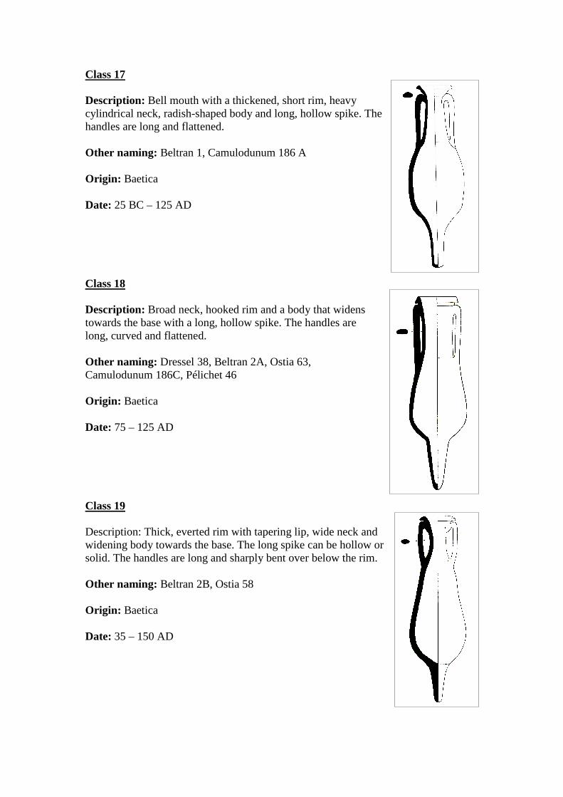
Class 17
Description: Bell mouth with a thickened, short rim, heavy cylindrical neck, radish-shaped body and long, hollow spike. The handles are long and flattened. Other naming: Beltran 1, Camulodunum 186 A Origin: Baetica Date: 25 BC – 125 AD Class 18
Description: Broad neck, hooked rim and a body that widens towards the base with a long, hollow spike. The handles are long, curved and flattened. Other naming: Dressel 38, Beltran 2A, Ostia 63, Camulodunum 186C, Pélichet 46 Origin: Baetica Date: 75 – 125 AD Class 19
Description: Thick, everted rim with tapering lip, wide neck and widening body towards the base. The long spike can be hollow or solid. The handles are long and sharply bent over below the rim. Other naming: Beltran 2B, Ostia 58 Origin: Baetica Date: 35 – 150 AD
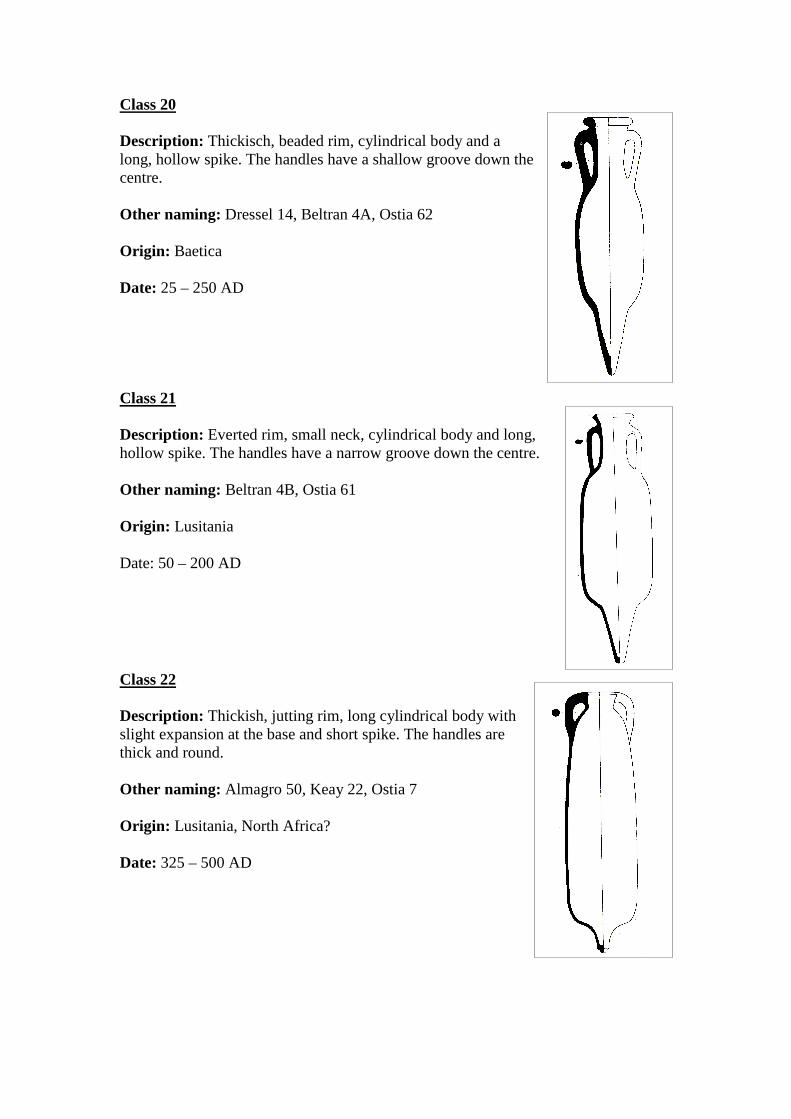
Class 20
Description: Thickisch, beaded rim, cylindrical body and a long, hollow spike. The handles have a shallow groove down the centre. Other naming: Dressel 14, Beltran 4A, Ostia 62 Origin: Baetica Date: 25 – 250 AD Class 21
Description: Everted rim, small neck, cylindrical body and long, hollow spike. The handles have a narrow groove down the centre. Other naming: Beltran 4B, Ostia 61 Origin: Lusitania Date: 50 – 200 AD
Class 22
Description: Thickish, jutting rim, long cylindrical body with slight expansion at the base and short spike. The handles are thick and round. Other naming: Almagro 50, Keay 22, Ostia 7 Origin: Lusitania, North Africa? Date: 325 – 500 AD
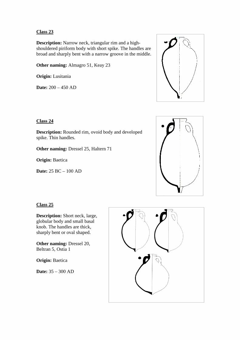
Class 23
Description: Narrow neck, triangular rim and a high-shouldered piriform body with short spike. The handles are broad and sharply bent with a narrow groove in the middle. Other naming: Almagro 51, Keay 23 Origin: Lusitania Date: 200 – 450 AD Class 24
Description: Rounded rim, ovoid body and developed spike. Thin handles. Other naming: Dressel 25, Haltern 71 Origin: Baetica Date: 25 BC – 100 AD Class 25
Description: Short neck, large, globular body and small basal knob. The handles are thick, sharply bent or oval shaped. Other naming: Dressel 20, Beltran 5, Ostia 1 Origin: Baetica Date: 35 – 300 AD
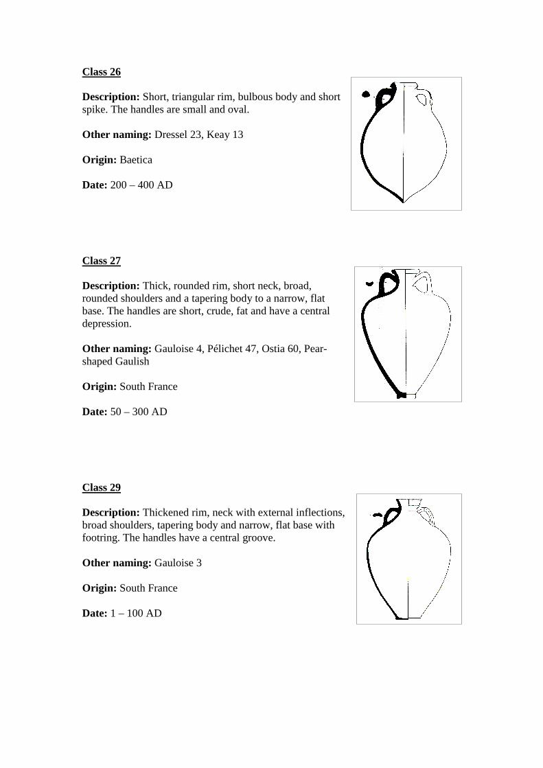
Class 26
Description: Short, triangular rim, bulbous body and short spike. The handles are small and oval. Other naming: Dressel 23, Keay 13 Origin: Baetica Date: 200 – 400 AD Class 27
Description: Thick, rounded rim, short neck, broad, rounded shoulders and a tapering body to a narrow, flat base. The handles are short, crude, fat and have a central depression. Other naming: Gauloise 4, Pélichet 47, Ostia 60, Pear-shaped Gaulish Origin: South France Date: 50 – 300 AD Class 29
Description: Thickened rim, neck with external inflections, broad shoulders, tapering body and narrow, flat base with footring. The handles have a central groove. Other naming: Gauloise 3 Origin: South France Date: 1 – 100 AD
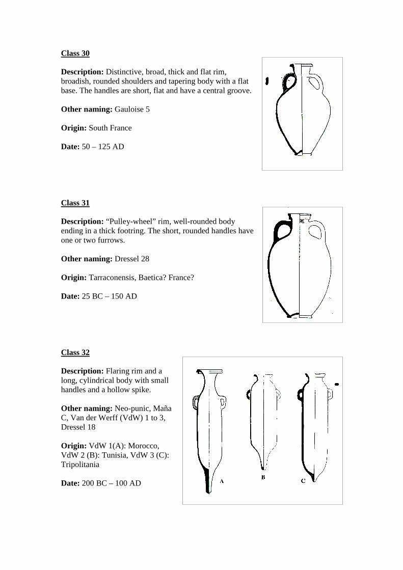
Class 30
Description: Distinctive, broad, thick and flat rim, broadish, rounded shoulders and tapering body with a flat base. The handles are short, flat and have a central groove. Other naming: Gauloise 5 Origin: South France Date: 50 – 125 AD Class 31
Description: “Pulley-wheel” rim, well-rounded body ending in a thick footring. The short, rounded handles have one or two furrows. Other naming: Dressel 28 Origin: Tarraconensis, Baetica? France? Date: 25 BC – 150 AD Class 32
Description: Flaring rim and a long, cylindrical body with small handles and a hollow spike. Other naming: Neo-punic, Maña C, Van der Werff (VdW) 1 to 3, Dressel 18 Origin: VdW 1(A): Morocco, VdW 2 (B): Tunisia, VdW 3 (C): Tripolitania Date: 200 BC – 100 AD
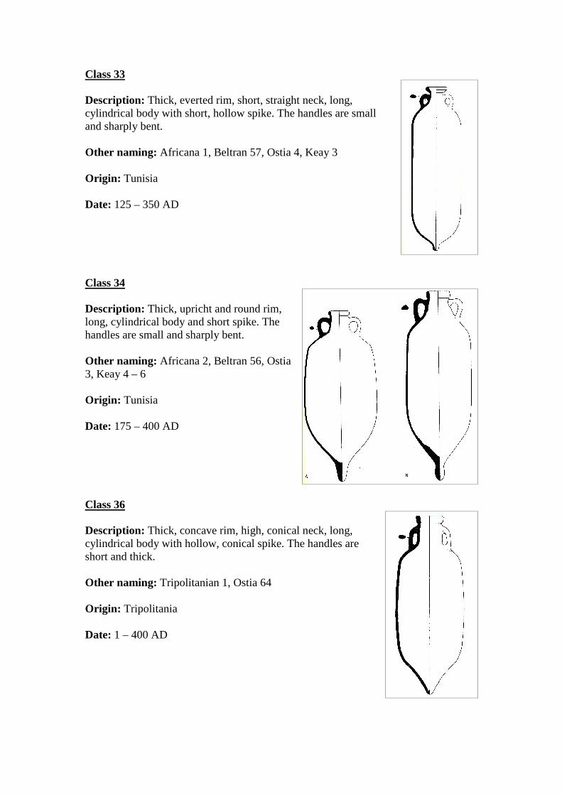
Class 33
Description: Thick, everted rim, short, straight neck, long, cylindrical body with short, hollow spike. The handles are small and sharply bent. Other naming: Africana 1, Beltran 57, Ostia 4, Keay 3 Origin: Tunisia Date: 125 – 350 AD Class 34
Description: Thick, upricht and round rim, long, cylindrical body and short spike. The handles are small and sharply bent. Other naming: Africana 2, Beltran 56, Ostia 3, Keay 4 – 6 Origin: Tunisia Date: 175 – 400 AD Class 36
Description: Thick, concave rim, high, conical neck, long, cylindrical body with hollow, conical spike. The handles are short and thick. Other naming: Tripolitanian 1, Ostia 64 Origin: Tripolitania Date: 1 – 400 AD
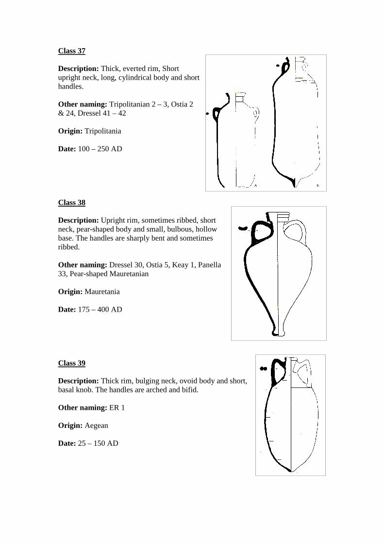
Class 37
Description: Thick, everted rim, Short upright neck, long, cylindrical body and short handles. Other naming: Tripolitanian 2 – 3, Ostia 2 & 24, Dressel 41 – 42 Origin: Tripolitania Date: 100 – 250 AD Class 38
Description: Upright rim, sometimes ribbed, short neck, pear-shaped body and small, bulbous, hollow base. The handles are sharply bent and sometimes ribbed. Other naming: Dressel 30, Ostia 5, Keay 1, Panella 33, Pear-shaped Mauretanian Origin: Mauretania Date: 175 – 400 AD Class 39
Description: Thick rim, bulging neck, ovoid body and short, basal knob. The handles are arched and bifid. Other naming: ER 1 Origin: Aegean Date: 25 – 150 AD

Class 40
Description: Biconical or thick, slightly, inturned rim, narrow neck, carinated shoulder, vertical fluting and squat body with a footed base. The handles are rounded. Other naming: MR 1, Panella 44 – 47 Origin: Mauretania Date: 1 – 300 AD (Biconical rim) or 150 – 400 AD (inturned rim) Class 41
Description: Slightly convex rim with or without ridge, narrow neck, cylindrical body with roudend base and a small point. The handles are bowed. Other naming: MR 2 Origin: Crete Date: 1 – 275 AD Class 42
Description: Rounded rim, high neck, tapering body and flat base with footring. The handles are flatish with a shallow, central groove. Other naming: MR 13, Panella 40 – 41, Pear-shaped Italian, Flat-bottomed Italian Origin: Forlimpopoli? Date: 225 – 375 AD, although evidence from wrecks places this amphora already in the first two centuries.
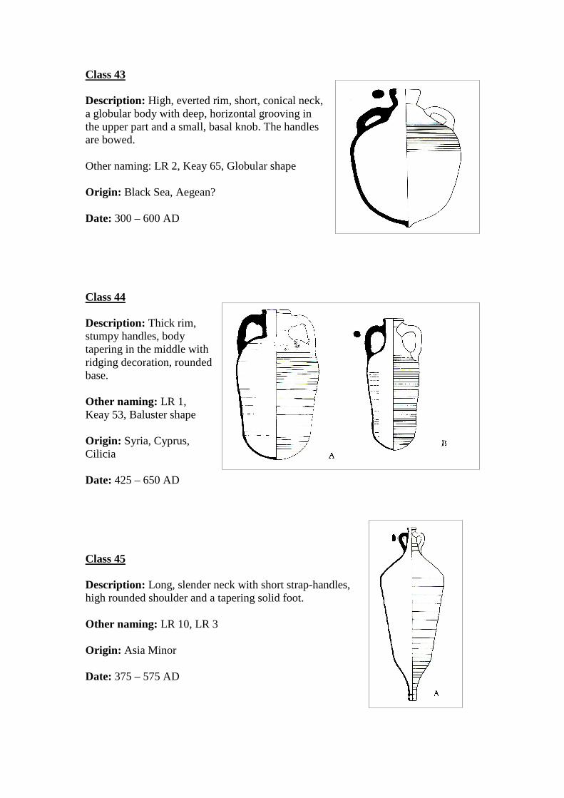
Class 43
Description: High, everted rim, short, conical neck, a globular body with deep, horizontal grooving in the upper part and a small, basal knob. The handles are bowed. Other naming: LR 2, Keay 65, Globular shape Origin: Black Sea, Aegean? Date: 300 – 600 AD Class 44
Description: Thick rim, stumpy handles, body tapering in the middle with ridging decoration, rounded base. Other naming: LR 1, Keay 53, Baluster shape Origin: Syria, Cyprus, Cilicia Date: 425 – 650 AD Class 45
Description: Long, slender neck with short strap-handles, high rounded shoulder and a tapering solid foot. Other naming: LR 10, LR 3 Origin: Asia Minor Date: 375 – 575 AD
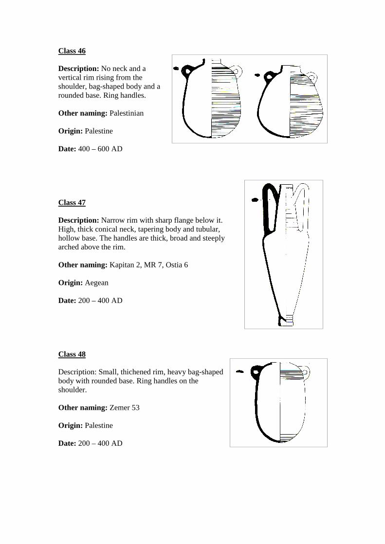
Class 46
Description: No neck and a vertical rim rising from the shoulder, bag-shaped body and a rounded base. Ring handles. Other naming: Palestinian Origin: Palestine Date: 400 – 600 AD Class 47
Description: Narrow rim with sharp flange below it. High, thick conical neck, tapering body and tubular, hollow base. The handles are thick, broad and steeply arched above the rim. Other naming: Kapitan 2, MR 7, Ostia 6 Origin: Aegean Date: 200 – 400 AD Class 48
Description: Small, thichened rim, heavy bag-shaped body with rounded base. Ring handles on the shoulder. Other naming: Zemer 53 Origin: Palestine Date: 200 – 400 AD
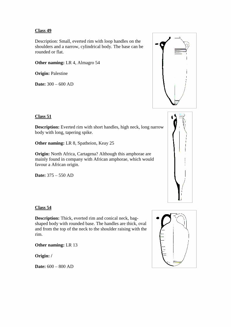
Class 49
Description: Small, everted rim with loop handles on the shoulders and a narrow, cylindrical body. The base can be rounded or flat. Other naming: LR 4, Almagro 54 Origin: Palestine Date: 300 – 600 AD Class 51
Description: Everted rim with short handles, high neck, long narrow body with long, tapering spike. Other naming: LR 8, Spatheion, Keay 25 Origin: North Africa, Cartagena? Although this amphorae are mainly found in company with African amphorae, which would favour a African origin. Date: 375 – 550 AD Class 54
Description: Thick, everted rim and conical neck, bag-shaped body with rounded base. The handles are thick, oval and from the top of the neck to the shoulder raising with the rim. Other naming: LR 13 Origin: / Date: 600 – 800 AD
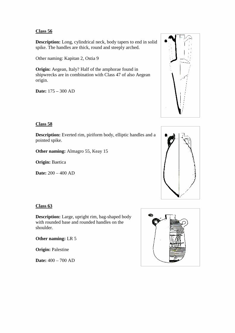
Class 56
Description: Long, cylindrical neck, body tapers to end in solid spike. The handles are thick, round and steeply arched. Other naming: Kapitan 2, Ostia 9 Origin: Aegean, Italy? Half of the amphorae found in shipwrecks are in combination with Class 47 of also Aegean origin. Date: 175 – 300 AD Class 58
Description: Everted rim, piriform body, elliptic handles and a pointed spike. Other naming: Almagro 55, Keay 15 Origin: Baetica Date: 200 – 400 AD Class 63
Description: Large, upright rim, bag-shaped body with rounded base and rounded handles on the shoulder. Other naming: LR 5 Origin: Palestine Date: 400 – 700 AD
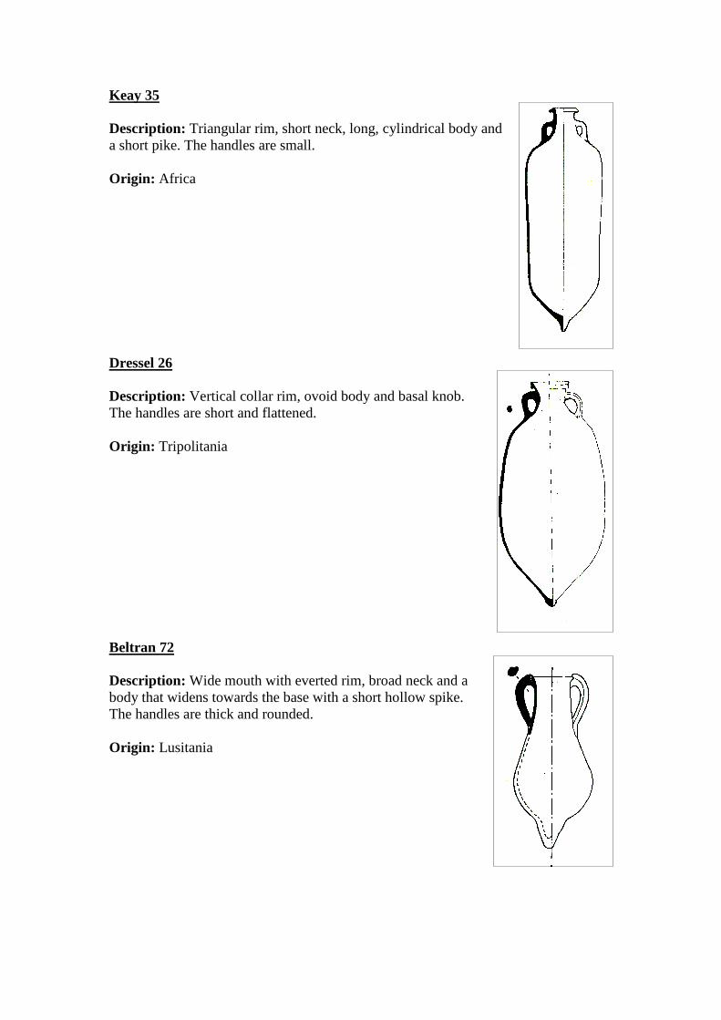
Keay 35
Description: Triangular rim, short neck, long, cylindrical body and a short pike. The handles are small. Origin: Africa
Dressel 26
Description: Vertical collar rim, ovoid body and basal knob. The handles are short and flattened. Origin: Tripolitania Beltran 72
Description: Wide mouth with everted rim, broad neck and a body that widens towards the base with a short hollow spike. The handles are thick and rounded. Origin: Lusitania
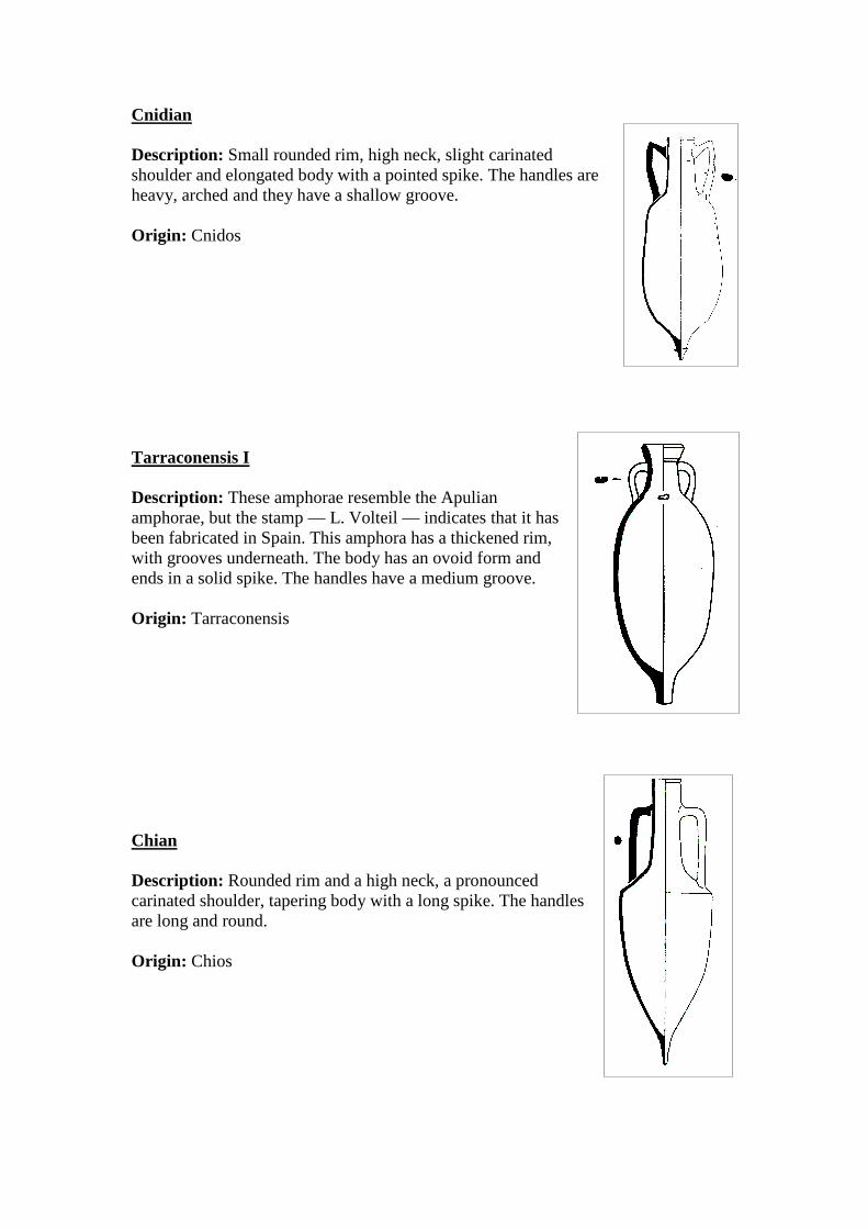
Cnidian
Description: Small rounded rim, high neck, slight carinated shoulder and elongated body with a pointed spike. The handles are heavy, arched and they have a shallow groove. Origin: Cnidos Tarraconensis I
Description: These amphorae resemble the Apulian amphorae, but the stamp — L. Volteil — indicates that it has been fabricated in Spain. This amphora has a thickened rim, with grooves underneath. The body has an ovoid form and ends in a solid spike. The handles have a medium groove. Origin: Tarraconensis Chian
Description: Rounded rim and a high neck, a pronounced carinated shoulder, tapering body with a long spike. The handles are long and round. Origin: Chios
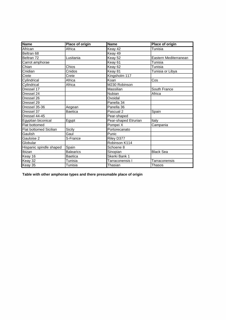
Name Place of origin Name Place of originAfrican Africa Keay 42 TunisiaBeltran 68 Keay 49Beltran 72 Lusitania Keay 52 Eastern MediterraneanCarrot amphorae Keay 61 TunisiaChian Chios Keay 62 TunisiaCnidian Cnidos Keay 81 Tunisia or LibyaCrete Crete Kingsholm 117Cylindrical Africa Koan CosCylindrical Africa M230 RobinsonDressel 17 Massilian South FranceDressel 24 Nubian AfricaDressel 26 OvoidalDressel 29 Panella 34Dressel 35-36 Aegean Panella 36Dressel 37 Baetica Pascual 2 SpainDressel 44-45 Pear-shapedEgyptian biconical Egypt Pear-shaped Etrurian ItalyFlat bottomed Pompei X CampaniaFlat bottomed Sicilian Sicily PortorecanatoGaulish Gaul PunicGauloise 2 S-France Riley D377Globular Robinson K114Hispanic spindle shaped Spain Schoene 8Ibizan Balearics Sinopian Black SeaKeay 16 Baetica Skerki Bank 1Keay 32 Tunisia Tarraconensis I TarraconensisKeay 35 Tunisia Thasian Thasos
Table with other amphorae types and there presumable place of origin
Appendix 2 This appendix is a list of the shipwrecks with a proposed begin and end date, XY coordinates and their cargoes. The wrecks are only those wrecks in which amphorae were found.
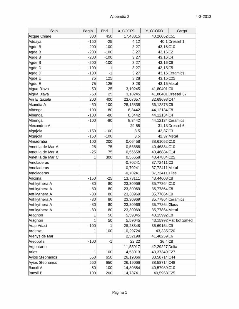
4-3-2013Appendix 2
Pagina 1
Ship Begin End X_COORD Y_COORD CargoAcque Chiare 300 450 17,48815 40,26052 C51Addaya -150 -25 4,12 40,1 Dressel 1Agde B -200 -100 3,27 43,16 C10Agde B -200 -100 3,27 43,16 C2Agde B -200 -100 3,27 43,16 C4Agde B -200 -100 3,27 43,16 C9Agde D -100 -1 3,27 43,15 C5Agde D -100 -1 3,27 43,15 CeramicsAgde E 75 125 3,28 43,15 C25Agde E 75 125 3,28 43,15 MetalAigua Blava -50 25 3,10245 41,80401 C6Aigua Blava -50 25 3,10245 41,80401 Dressel 37Ain El Gazala 200 400 23,07657 32,69698 C47Akandia A -50 100 28,15838 36,12878 C9Albenga -100 -80 8,3442 44,12134 C8Albenga -100 -80 8,3442 44,12134 C4Albenga -100 -80 8,3442 44,12134 CeramicsAlexandria A 29,55 31,13 Dressel 6Algajola -150 -100 8,5 42,37 C3Algajola -150 -100 8,5 42,37 MetalAlmadraba 100 200 0,06458 38,61052 C10Ametlla de Mar A -25 75 0,56658 40,46884 C10Ametlla de Mar A -25 75 0,56658 40,46884 C14Ametlla de Mar C 1 300 0,56658 40,47884 C25Amoladeras -0,70241 37,72411 C3Amoladeras -0,70241 37,72411 MetalAmoladeras -0,70241 37,72411 TilesAncona -150 -25 13,73111 43,44608 C8Antikythera A -80 80 23,30969 35,77864 C10Antikythera A -80 80 23,30969 35,77864 C8Antikythera A -80 80 23,30969 35,77864 C9Antikythera A -80 80 23,30969 35,77864 CeramicsAntikythera A -80 80 23,30969 35,77864 GlassAntikythera A -80 80 23,30969 35,77864 MetalAragnon 1 50 5,59045 43,15992 C8Aragnon 1 50 5,59045 43,15992 Flat bottomedArap Adasi -100 -1 28,28348 36,69154 C9Ardenza 1 100 10,29724 43,335 C20Arenys de Mar 2,52198 41,48259 C6Areopolis -100 -1 22,22 36,4 C8Argentario 11,55917 42,29227 DoliaArles 1 100 4,53013 43,37349 C27Ayios Stephanos 550 650 26,19066 38,58714 C44Ayios Stephanos 550 650 26,19066 38,58714 C48Bacoli A -50 100 14,80854 40,57989 C10Bacoli B 100 200 14,78741 40,5968 C25
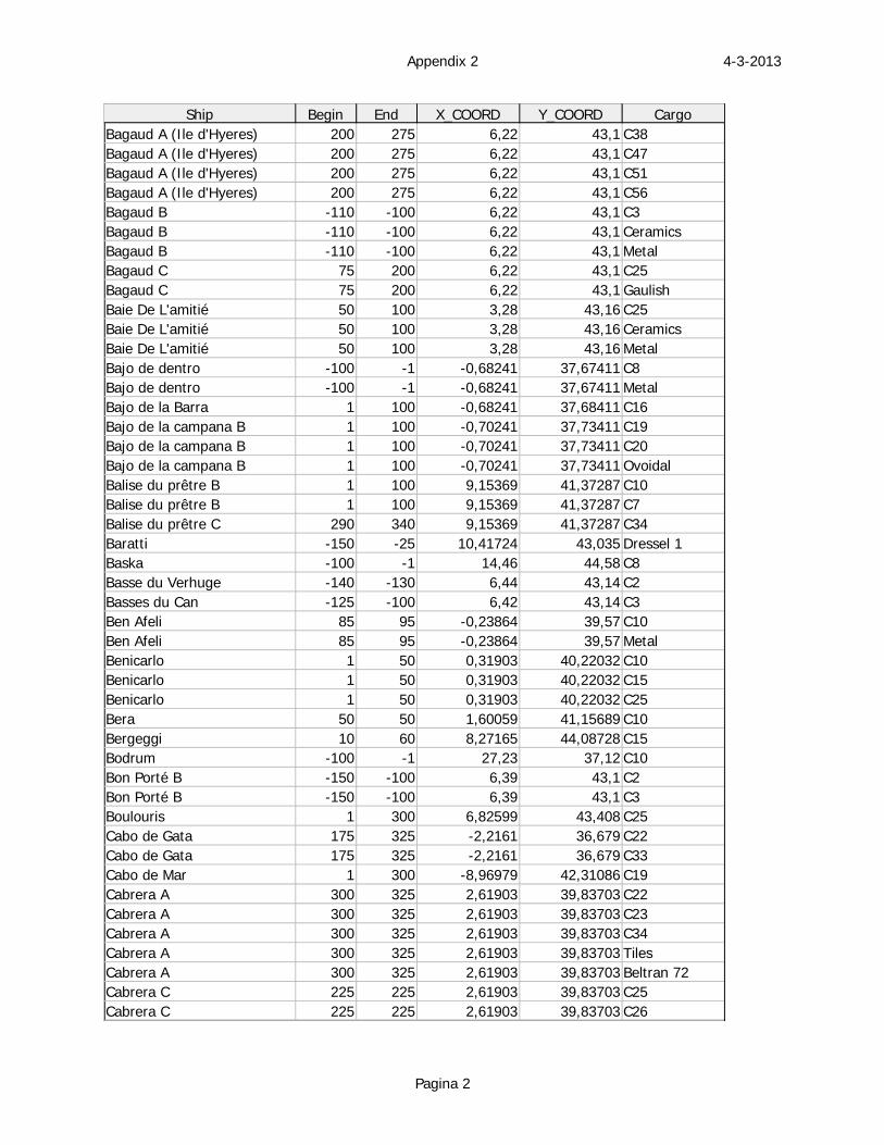
4-3-2013Appendix 2
Pagina 2
Ship Begin End X_COORD Y_COORD CargoBagaud A (Ile d'Hyeres) 200 275 6,22 43,1 C38Bagaud A (Ile d'Hyeres) 200 275 6,22 43,1 C47Bagaud A (Ile d'Hyeres) 200 275 6,22 43,1 C51Bagaud A (Ile d'Hyeres) 200 275 6,22 43,1 C56Bagaud B -110 -100 6,22 43,1 C3Bagaud B -110 -100 6,22 43,1 CeramicsBagaud B -110 -100 6,22 43,1 MetalBagaud C 75 200 6,22 43,1 C25Bagaud C 75 200 6,22 43,1 GaulishBaie De L'amitié 50 100 3,28 43,16 C25Baie De L'amitié 50 100 3,28 43,16 CeramicsBaie De L'amitié 50 100 3,28 43,16 MetalBajo de dentro -100 -1 -0,68241 37,67411 C8Bajo de dentro -100 -1 -0,68241 37,67411 MetalBajo de la Barra 1 100 -0,68241 37,68411 C16Bajo de la campana B 1 100 -0,70241 37,73411 C19Bajo de la campana B 1 100 -0,70241 37,73411 C20Bajo de la campana B 1 100 -0,70241 37,73411 OvoidalBalise du prêtre B 1 100 9,15369 41,37287 C10Balise du prêtre B 1 100 9,15369 41,37287 C7Balise du prêtre C 290 340 9,15369 41,37287 C34Baratti -150 -25 10,41724 43,035 Dressel 1Baska -100 -1 14,46 44,58 C8Basse du Verhuge -140 -130 6,44 43,14 C2Basses du Can -125 -100 6,42 43,14 C3Ben Afeli 85 95 -0,23864 39,57 C10Ben Afeli 85 95 -0,23864 39,57 MetalBenicarlo 1 50 0,31903 40,22032 C10Benicarlo 1 50 0,31903 40,22032 C15Benicarlo 1 50 0,31903 40,22032 C25Bera 50 50 1,60059 41,15689 C10Bergeggi 10 60 8,27165 44,08728 C15Bodrum -100 -1 27,23 37,12 C10Bon Porté B -150 -100 6,39 43,1 C2Bon Porté B -150 -100 6,39 43,1 C3Boulouris 1 300 6,82599 43,408 C25Cabo de Gata 175 325 -2,2161 36,679 C22Cabo de Gata 175 325 -2,2161 36,679 C33Cabo de Mar 1 300 -8,96979 42,31086 C19Cabrera A 300 325 2,61903 39,83703 C22Cabrera A 300 325 2,61903 39,83703 C23Cabrera A 300 325 2,61903 39,83703 C34Cabrera A 300 325 2,61903 39,83703 TilesCabrera A 300 325 2,61903 39,83703 Beltran 72Cabrera C 225 225 2,61903 39,83703 C25Cabrera C 225 225 2,61903 39,83703 C26
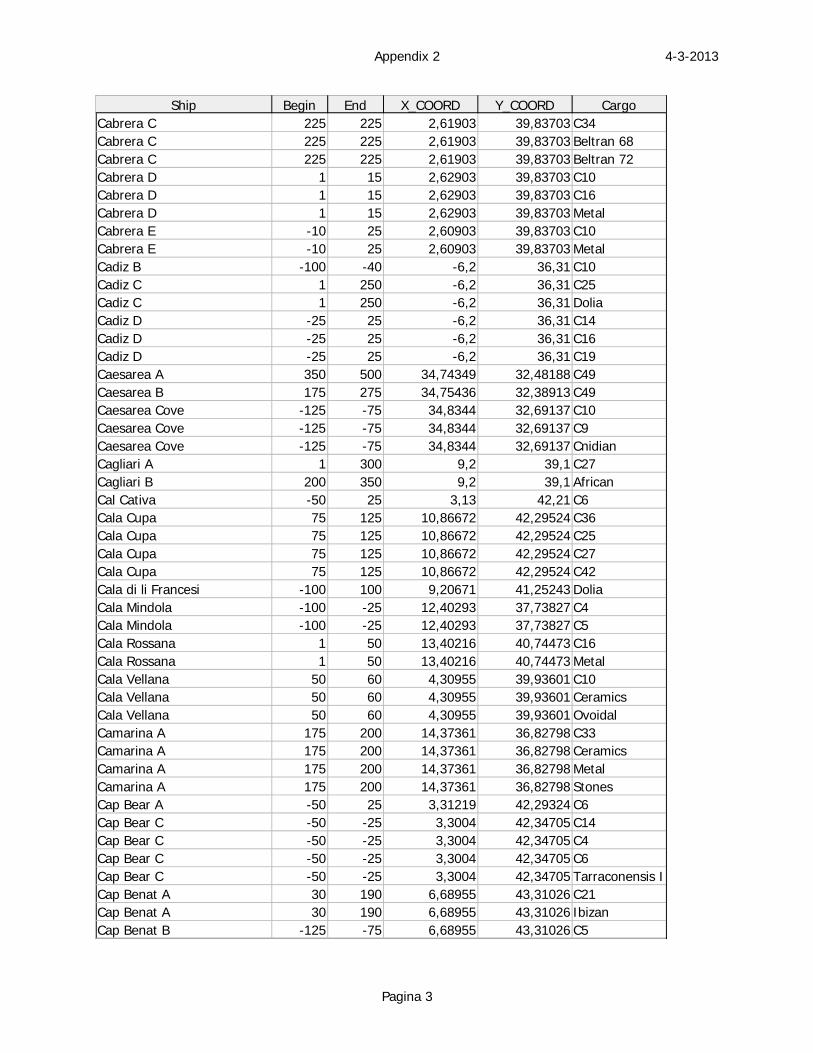
4-3-2013Appendix 2
Pagina 3
Ship Begin End X_COORD Y_COORD CargoCabrera C 225 225 2,61903 39,83703 C34Cabrera C 225 225 2,61903 39,83703 Beltran 68Cabrera C 225 225 2,61903 39,83703 Beltran 72Cabrera D 1 15 2,62903 39,83703 C10Cabrera D 1 15 2,62903 39,83703 C16Cabrera D 1 15 2,62903 39,83703 MetalCabrera E -10 25 2,60903 39,83703 C10Cabrera E -10 25 2,60903 39,83703 MetalCadiz B -100 -40 -6,2 36,31 C10Cadiz C 1 250 -6,2 36,31 C25Cadiz C 1 250 -6,2 36,31 DoliaCadiz D -25 25 -6,2 36,31 C14Cadiz D -25 25 -6,2 36,31 C16Cadiz D -25 25 -6,2 36,31 C19Caesarea A 350 500 34,74349 32,48188 C49Caesarea B 175 275 34,75436 32,38913 C49Caesarea Cove -125 -75 34,8344 32,69137 C10Caesarea Cove -125 -75 34,8344 32,69137 C9Caesarea Cove -125 -75 34,8344 32,69137 CnidianCagliari A 1 300 9,2 39,1 C27Cagliari B 200 350 9,2 39,1 AfricanCal Cativa -50 25 3,13 42,21 C6Cala Cupa 75 125 10,86672 42,29524 C36Cala Cupa 75 125 10,86672 42,29524 C25Cala Cupa 75 125 10,86672 42,29524 C27Cala Cupa 75 125 10,86672 42,29524 C42Cala di li Francesi -100 100 9,20671 41,25243 DoliaCala Mindola -100 -25 12,40293 37,73827 C4Cala Mindola -100 -25 12,40293 37,73827 C5Cala Rossana 1 50 13,40216 40,74473 C16Cala Rossana 1 50 13,40216 40,74473 MetalCala Vellana 50 60 4,30955 39,93601 C10Cala Vellana 50 60 4,30955 39,93601 CeramicsCala Vellana 50 60 4,30955 39,93601 OvoidalCamarina A 175 200 14,37361 36,82798 C33Camarina A 175 200 14,37361 36,82798 CeramicsCamarina A 175 200 14,37361 36,82798 MetalCamarina A 175 200 14,37361 36,82798 StonesCap Bear A -50 25 3,31219 42,29324 C6Cap Bear C -50 -25 3,3004 42,34705 C14Cap Bear C -50 -25 3,3004 42,34705 C4Cap Bear C -50 -25 3,3004 42,34705 C6Cap Bear C -50 -25 3,3004 42,34705 Tarraconensis ICap Benat A 30 190 6,68955 43,31026 C21Cap Benat A 30 190 6,68955 43,31026 IbizanCap Benat B -125 -75 6,68955 43,31026 C5
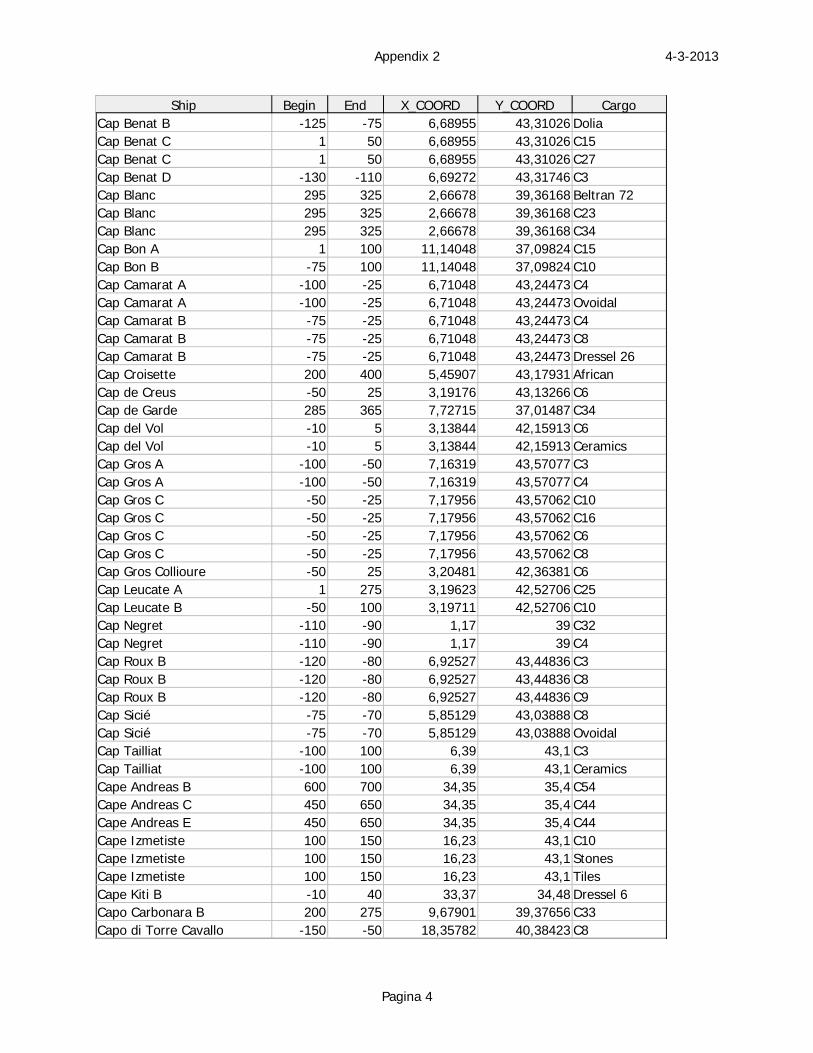
4-3-2013Appendix 2
Pagina 4
Ship Begin End X_COORD Y_COORD CargoCap Benat B -125 -75 6,68955 43,31026 DoliaCap Benat C 1 50 6,68955 43,31026 C15Cap Benat C 1 50 6,68955 43,31026 C27Cap Benat D -130 -110 6,69272 43,31746 C3Cap Blanc 295 325 2,66678 39,36168 Beltran 72Cap Blanc 295 325 2,66678 39,36168 C23Cap Blanc 295 325 2,66678 39,36168 C34Cap Bon A 1 100 11,14048 37,09824 C15Cap Bon B -75 100 11,14048 37,09824 C10Cap Camarat A -100 -25 6,71048 43,24473 C4Cap Camarat A -100 -25 6,71048 43,24473 OvoidalCap Camarat B -75 -25 6,71048 43,24473 C4Cap Camarat B -75 -25 6,71048 43,24473 C8Cap Camarat B -75 -25 6,71048 43,24473 Dressel 26Cap Croisette 200 400 5,45907 43,17931 AfricanCap de Creus -50 25 3,19176 43,13266 C6Cap de Garde 285 365 7,72715 37,01487 C34Cap del Vol -10 5 3,13844 42,15913 C6Cap del Vol -10 5 3,13844 42,15913 CeramicsCap Gros A -100 -50 7,16319 43,57077 C3Cap Gros A -100 -50 7,16319 43,57077 C4Cap Gros C -50 -25 7,17956 43,57062 C10Cap Gros C -50 -25 7,17956 43,57062 C16Cap Gros C -50 -25 7,17956 43,57062 C6Cap Gros C -50 -25 7,17956 43,57062 C8Cap Gros Collioure -50 25 3,20481 42,36381 C6Cap Leucate A 1 275 3,19623 42,52706 C25Cap Leucate B -50 100 3,19711 42,52706 C10Cap Negret -110 -90 1,17 39 C32Cap Negret -110 -90 1,17 39 C4Cap Roux B -120 -80 6,92527 43,44836 C3Cap Roux B -120 -80 6,92527 43,44836 C8Cap Roux B -120 -80 6,92527 43,44836 C9Cap Sicié -75 -70 5,85129 43,03888 C8Cap Sicié -75 -70 5,85129 43,03888 OvoidalCap Tailliat -100 100 6,39 43,1 C3Cap Tailliat -100 100 6,39 43,1 CeramicsCape Andreas B 600 700 34,35 35,4 C54Cape Andreas C 450 650 34,35 35,4 C44Cape Andreas E 450 650 34,35 35,4 C44Cape Izmetiste 100 150 16,23 43,1 C10Cape Izmetiste 100 150 16,23 43,1 StonesCape Izmetiste 100 150 16,23 43,1 TilesCape Kiti B -10 40 33,37 34,48 Dressel 6Capo Carbonara B 200 275 9,67901 39,37656 C33Capo di Torre Cavallo -150 -50 18,35782 40,38423 C8
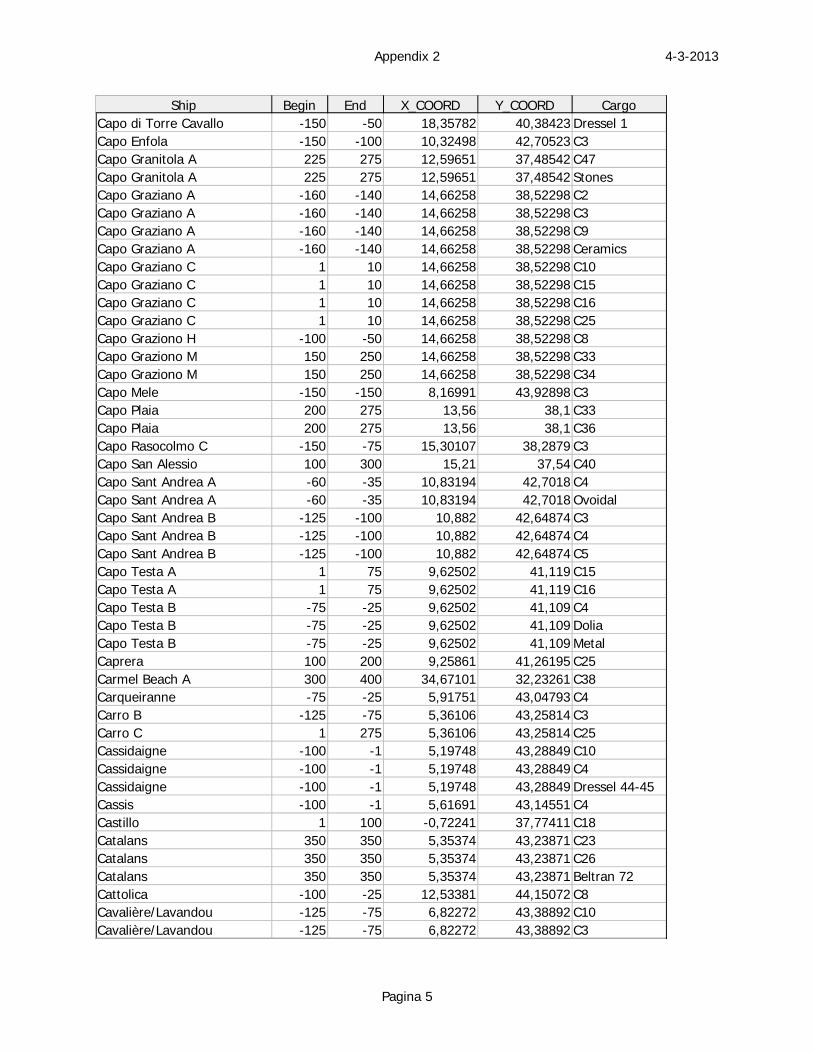
4-3-2013Appendix 2
Pagina 5
Ship Begin End X_COORD Y_COORD CargoCapo di Torre Cavallo -150 -50 18,35782 40,38423 Dressel 1Capo Enfola -150 -100 10,32498 42,70523 C3Capo Granitola A 225 275 12,59651 37,48542 C47Capo Granitola A 225 275 12,59651 37,48542 StonesCapo Graziano A -160 -140 14,66258 38,52298 C2Capo Graziano A -160 -140 14,66258 38,52298 C3Capo Graziano A -160 -140 14,66258 38,52298 C9Capo Graziano A -160 -140 14,66258 38,52298 CeramicsCapo Graziano C 1 10 14,66258 38,52298 C10Capo Graziano C 1 10 14,66258 38,52298 C15Capo Graziano C 1 10 14,66258 38,52298 C16Capo Graziano C 1 10 14,66258 38,52298 C25Capo Graziono H -100 -50 14,66258 38,52298 C8Capo Graziono M 150 250 14,66258 38,52298 C33Capo Graziono M 150 250 14,66258 38,52298 C34Capo Mele -150 -150 8,16991 43,92898 C3Capo Plaia 200 275 13,56 38,1 C33Capo Plaia 200 275 13,56 38,1 C36Capo Rasocolmo C -150 -75 15,30107 38,2879 C3Capo San Alessio 100 300 15,21 37,54 C40Capo Sant Andrea A -60 -35 10,83194 42,7018 C4Capo Sant Andrea A -60 -35 10,83194 42,7018 OvoidalCapo Sant Andrea B -125 -100 10,882 42,64874 C3Capo Sant Andrea B -125 -100 10,882 42,64874 C4Capo Sant Andrea B -125 -100 10,882 42,64874 C5Capo Testa A 1 75 9,62502 41,119 C15Capo Testa A 1 75 9,62502 41,119 C16Capo Testa B -75 -25 9,62502 41,109 C4Capo Testa B -75 -25 9,62502 41,109 DoliaCapo Testa B -75 -25 9,62502 41,109 MetalCaprera 100 200 9,25861 41,26195 C25Carmel Beach A 300 400 34,67101 32,23261 C38Carqueiranne -75 -25 5,91751 43,04793 C4Carro B -125 -75 5,36106 43,25814 C3Carro C 1 275 5,36106 43,25814 C25Cassidaigne -100 -1 5,19748 43,28849 C10Cassidaigne -100 -1 5,19748 43,28849 C4Cassidaigne -100 -1 5,19748 43,28849 Dressel 44-45Cassis -100 -1 5,61691 43,14551 C4Castillo 1 100 -0,72241 37,77411 C18Catalans 350 350 5,35374 43,23871 C23Catalans 350 350 5,35374 43,23871 C26Catalans 350 350 5,35374 43,23871 Beltran 72Cattolica -100 -25 12,53381 44,15072 C8Cavalière/Lavandou -125 -75 6,82272 43,38892 C10Cavalière/Lavandou -125 -75 6,82272 43,38892 C3
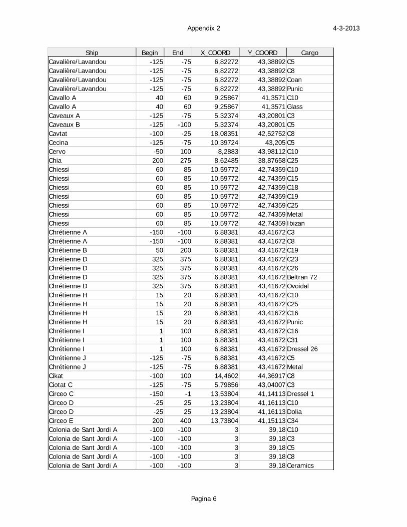
4-3-2013Appendix 2
Pagina 6
Ship Begin End X_COORD Y_COORD CargoCavalière/Lavandou -125 -75 6,82272 43,38892 C5Cavalière/Lavandou -125 -75 6,82272 43,38892 C8Cavalière/Lavandou -125 -75 6,82272 43,38892 CoanCavalière/Lavandou -125 -75 6,82272 43,38892 PunicCavallo A 40 60 9,25867 41,3571 C10Cavallo A 40 60 9,25867 41,3571 GlassCaveaux A -125 -75 5,32374 43,20801 C3Caveaux B -125 -100 5,32374 43,20801 C5Cavtat -100 -25 18,08351 42,52752 C8Cecina -125 -75 10,39724 43,205 C5Cervo -50 100 8,2883 43,98112 C10Chia 200 275 8,62485 38,87658 C25Chiessi 60 85 10,59772 42,74359 C10Chiessi 60 85 10,59772 42,74359 C15Chiessi 60 85 10,59772 42,74359 C18Chiessi 60 85 10,59772 42,74359 C19Chiessi 60 85 10,59772 42,74359 C25Chiessi 60 85 10,59772 42,74359 MetalChiessi 60 85 10,59772 42,74359 IbizanChrétienne A -150 -100 6,88381 43,41672 C3Chrétienne A -150 -100 6,88381 43,41672 C8Chrétienne B 50 200 6,88381 43,41672 C19Chrétienne D 325 375 6,88381 43,41672 C23Chrétienne D 325 375 6,88381 43,41672 C26Chrétienne D 325 375 6,88381 43,41672 Beltran 72Chrétienne D 325 375 6,88381 43,41672 OvoidalChrétienne H 15 20 6,88381 43,41672 C10Chrétienne H 15 20 6,88381 43,41672 C25Chrétienne H 15 20 6,88381 43,41672 C16Chrétienne H 15 20 6,88381 43,41672 PunicChrétienne I 1 100 6,88381 43,41672 C16Chrétienne I 1 100 6,88381 43,41672 C31Chrétienne I 1 100 6,88381 43,41672 Dressel 26Chrétienne J -125 -75 6,88381 43,41672 C5Chrétienne J -125 -75 6,88381 43,41672 MetalCikat -100 100 14,4602 44,36917 C8Ciotat C -125 -75 5,79856 43,04007 C3Circeo C -150 -1 13,53804 41,14113 Dressel 1Circeo D -25 25 13,23804 41,16113 C10Circeo D -25 25 13,23804 41,16113 DoliaCirceo E 200 400 13,73804 41,15113 C34Colonia de Sant Jordi A -100 -100 3 39,18 C10Colonia de Sant Jordi A -100 -100 3 39,18 C3Colonia de Sant Jordi A -100 -100 3 39,18 C5Colonia de Sant Jordi A -100 -100 3 39,18 C8Colonia de Sant Jordi A -100 -100 3 39,18 Ceramics
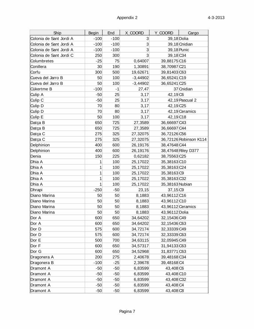
4-3-2013Appendix 2
Pagina 7
Ship Begin End X_COORD Y_COORD CargoColonia de Sant Jordi A -100 -100 3 39,18 DoliaColonia de Sant Jordi A -100 -100 3 39,18 CnidianColonia de Sant Jordi A -100 -100 3 39,18 PunicColonia de Sant Jordi C 250 300 3 39,18 C34Columbretes -25 75 0,64007 39,88175 C16Conillera 30 190 1,30891 38,70987 C21Corfu 300 500 19,62671 39,81403 C63Cueva del Jarro B 50 100 -3,44902 36,65241 C19Cueva del Jarro B 50 100 -3,44902 36,65241 C25Cükertme B -100 -1 27,47 37 CnidianCulip A -50 25 3,17 42,19 C6Culip C -50 25 3,17 42,19 Pascual 2Culip D 70 80 3,17 42,19 C25Culip D 70 80 3,17 42,19 CeramicsCulip E 50 100 3,17 42,19 C18Datça B 650 725 27,3589 36,66697 C43Datça B 650 725 27,3589 36,66697 C44Datça C 275 325 27,32075 36,72126 C56Datça C 275 325 27,32075 36,72126 Robinson K114Delphinion 400 600 26,19176 38,47648 C44Delphinion 400 600 26,19176 38,47648 Riley D377Denia 150 225 0,62182 38,75563 C25Dhia A 1 100 25,17022 35,38163 C10Dhia A 1 100 25,17022 35,38163 C24Dhia A 1 100 25,17022 35,38163 C9Dhia A 1 100 25,17022 35,38163 C32Dhia A 1 100 25,17022 35,38163 NubianDhrapi -250 -50 23,15 37,15 C9Diano Marina 50 50 8,1883 43,96112 C16Diano Marina 50 50 8,1883 43,96112 C10Diano Marina 50 50 8,1883 43,96112 CeramicsDiano Marina 50 50 8,1883 43,96112 DoliaDor A 600 650 34,64202 32,15436 C49Dor A 600 650 34,64202 32,15436 C63Dor D 575 600 34,72174 32,33339 C49Dor D 575 600 34,72174 32,33339 C63Dor E 500 700 34,63115 32,05945 C49Dor F 600 650 34,57317 31,94133 C63Dor G 600 650 34,52968 31,83771 C63Dragonera A 200 275 2,40678 39,48168 C34Dragonera B -100 -25 2,39678 39,48168 C4Dramont A -50 -50 6,83599 43,408 C6Dramont A -50 -50 6,83599 43,408 C10Dramont A -50 -50 6,83599 43,408 C32Dramont A -50 -50 6,83599 43,408 C4Dramont A -50 -50 6,83599 43,408 C8
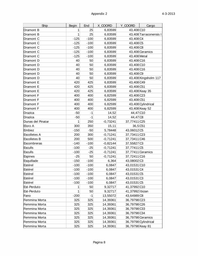
4-3-2013Appendix 2
Pagina 8
Ship Begin End X_COORD Y_COORD CargoDramont B 1 25 6,83599 43,408 C10Dramont B 1 25 6,83599 43,408 Tarraconensis IDramont C -125 -100 6,83599 43,408 C4Dramont C -125 -100 6,83599 43,408 C5Dramont C -125 -100 6,83599 43,408 C8Dramont C -125 -100 6,83599 43,408 CeramicsDramont C -125 -100 6,83599 43,408 MetalDramont D 40 50 6,83599 43,408 C16Dramont D 40 50 6,83599 43,408 C10Dramont D 40 50 6,83599 43,408 C16Dramont D 40 50 6,83599 43,408 C9Dramont D 40 50 6,83599 43,408 Kingsholm 117Dramont E 420 425 6,83599 43,408 C49Dramont E 420 425 6,83599 43,408 C51Dramont E 420 425 6,83599 43,408 Keay 35Dramont F 400 400 6,82599 43,408 C23Dramont F 400 400 6,82599 43,408 C51Dramont F 400 400 6,82599 43,408 CylindricalDramont F 400 400 6,82599 43,408 Keay 52Drazica -50 -1 14,52 44,47 C10Drazica -50 -1 14,52 44,47 C8Dunas del Pinatar 1 250 -0,73241 37,77411 C25Eloro A 300 350 15,11 36,5 C51Embiez -150 -50 5,78448 43,06012 C5Escolletes A 200 300 -0,71241 37,73411 C23Escolletes B 200 500 -0,71241 37,73411 C46Escombreras -140 -100 -0,82144 37,55827 C3Esculls -100 -25 -0,71241 37,77411 C5Esculls -100 -25 -0,71241 37,77411 CeramicsEspines -25 50 -0,71241 37,72411 C16Esquillade -150 -100 6,364 43,08002 C3Estérel -100 -100 6,0847 43,01531 C10Estérel -100 -100 6,0847 43,01531 C4Estérel -100 -100 6,0847 43,01531 C5Estérel -100 -100 6,0847 43,01531 C3Estérel -100 -100 6,0847 43,01531 C5Est-Perduto 1 50 9,32717 41,37992 C10Est-Perduto 1 50 9,32717 41,37992 IbizanFano -200 -1 13,55072 43,64989 C8Femmina Morta 325 325 14,39361 36,79798 C23Femmina Morta 325 325 14,39361 36,79798 C26Femmina Morta 325 325 14,39361 36,79798 C33Femmina Morta 325 325 14,39361 36,79798 C34Femmina Morta 325 325 14,39361 36,79798 CeramicsFemmina Morta 325 325 14,39361 36,79798 CylindricalFemmina Morta 325 325 14,39361 36,79798 Keay 81
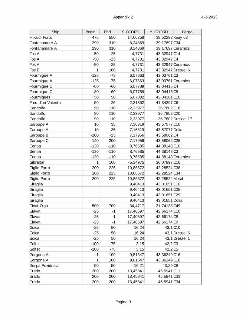
4-3-2013Appendix 2
Pagina 9
Ship Begin End X_COORD Y_COORD CargoFilicudi Porto 475 550 14,66258 38,52298 Keay 62Fontanamare A 290 310 8,24869 39,17697 C34Fontanamare A 290 310 8,24869 39,17697 CeramicsFos A -50 -25 4,7731 43,32947 C14Fos A -50 -25 4,7731 43,32947 C4Fos A -50 -25 4,7731 43,32947 CeramicsFos B 1 100 4,7731 43,32947 Dressel 6Fourmigue A -125 -75 6,07663 43,03761 C3Fourmigue A -125 -75 6,07663 43,03761 CeramicsFourmigue C -80 -60 6,07789 43,04415 C4Fourmigue C -80 -60 6,07789 43,04415 C8Fourmigues 50 50 6,07002 43,04161 C10Freu d'en Valento -50 25 2,21852 41,34297 C6Gandolfo 90 110 -2,33977 36,7802 C18Gandolfo 90 110 -2,33977 36,7802 C20Gandolfo 90 110 -2,33977 36,7802 Dressel 17Garoupe A 10 35 7,16319 43,57077 C10Garoupe A 10 35 7,16319 43,57077 DoliaGaroupe B -100 -25 7,17956 43,58062 C4Garoupe C 140 200 7,17956 43,58062 C25Genoa -130 -110 8,76585 44,38148 C10Genoa -130 -110 8,76585 44,38148 C3Genoa -130 -110 8,76585 44,38148 CeramicsGibraltar 1 100 -5,34975 36,07897 C16Giglio Porto 200 225 10,86672 42,28524 C38Giglio Porto 200 225 10,86672 42,28524 C34Giglio Porto 200 225 10,86672 42,28524 MetalGiraglia 9,40413 43,01651 C10Giraglia 9,40413 43,01651 C25Giraglia 9,40413 43,01651 C29Giraglia 9,40413 43,01651 DoliaGivat Olga 500 700 34,4717 31,74133 C49Glavat -25 -1 17,40597 42,66174 C10Glavat -25 -1 17,40597 42,66174 C8Glavat -25 -1 17,40597 42,66174 C9Goica -25 50 16,24 43,1 C10Goica -25 50 16,24 43,1 Dressel 6Goica -25 50 16,24 43,1 Dressel 1Golfet -100 -75 3,15 42,2 C3Golfet -100 -75 3,15 42,2 C5Gorgona A 1 100 9,81647 43,36249 C16Gorgona A 1 100 9,81647 43,36249 C18Gospa Prizidnica -50 -50 16,21 43,29 C8Grado 200 200 13,45841 45,5941 C11Grado 200 200 13,45841 45,5941 C33Grado 200 200 13,45841 45,5941 C34
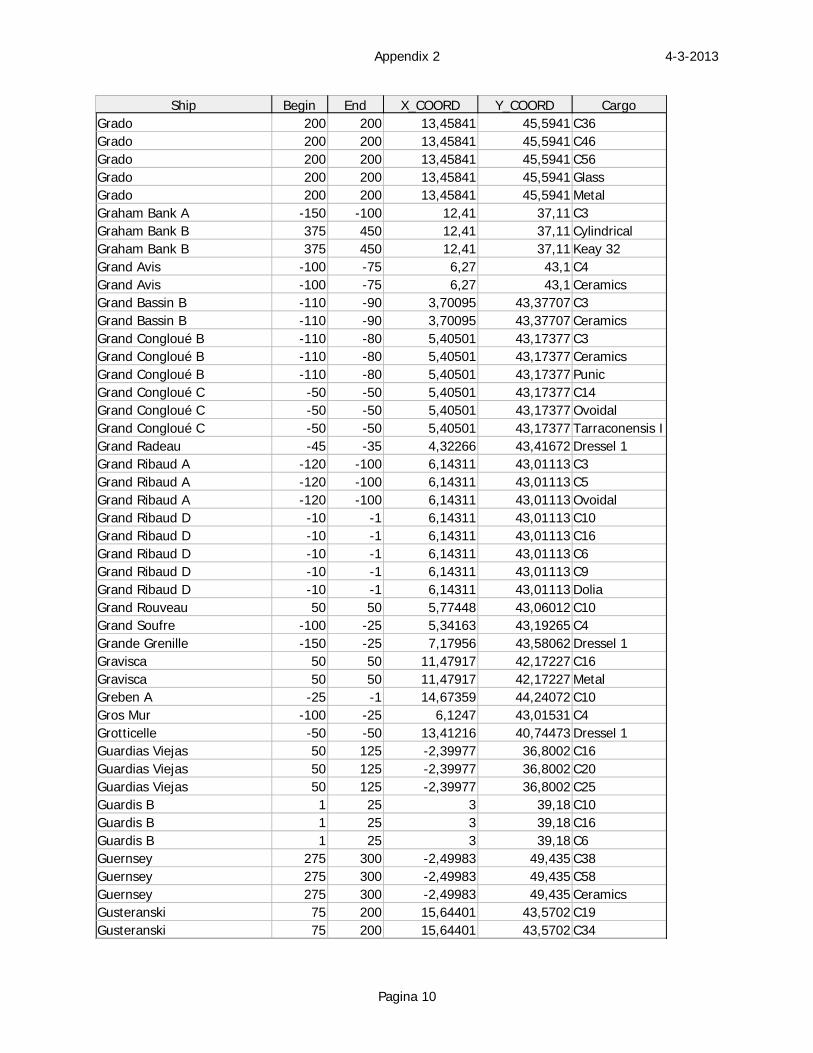
4-3-2013Appendix 2
Pagina 10
Ship Begin End X_COORD Y_COORD CargoGrado 200 200 13,45841 45,5941 C36Grado 200 200 13,45841 45,5941 C46Grado 200 200 13,45841 45,5941 C56Grado 200 200 13,45841 45,5941 GlassGrado 200 200 13,45841 45,5941 MetalGraham Bank A -150 -100 12,41 37,11 C3Graham Bank B 375 450 12,41 37,11 CylindricalGraham Bank B 375 450 12,41 37,11 Keay 32Grand Avis -100 -75 6,27 43,1 C4Grand Avis -100 -75 6,27 43,1 CeramicsGrand Bassin B -110 -90 3,70095 43,37707 C3Grand Bassin B -110 -90 3,70095 43,37707 CeramicsGrand Congloué B -110 -80 5,40501 43,17377 C3Grand Congloué B -110 -80 5,40501 43,17377 CeramicsGrand Congloué B -110 -80 5,40501 43,17377 PunicGrand Congloué C -50 -50 5,40501 43,17377 C14Grand Congloué C -50 -50 5,40501 43,17377 OvoidalGrand Congloué C -50 -50 5,40501 43,17377 Tarraconensis IGrand Radeau -45 -35 4,32266 43,41672 Dressel 1Grand Ribaud A -120 -100 6,14311 43,01113 C3Grand Ribaud A -120 -100 6,14311 43,01113 C5Grand Ribaud A -120 -100 6,14311 43,01113 OvoidalGrand Ribaud D -10 -1 6,14311 43,01113 C10Grand Ribaud D -10 -1 6,14311 43,01113 C16Grand Ribaud D -10 -1 6,14311 43,01113 C6Grand Ribaud D -10 -1 6,14311 43,01113 C9Grand Ribaud D -10 -1 6,14311 43,01113 DoliaGrand Rouveau 50 50 5,77448 43,06012 C10Grand Soufre -100 -25 5,34163 43,19265 C4Grande Grenille -150 -25 7,17956 43,58062 Dressel 1Gravisca 50 50 11,47917 42,17227 C16Gravisca 50 50 11,47917 42,17227 MetalGreben A -25 -1 14,67359 44,24072 C10Gros Mur -100 -25 6,1247 43,01531 C4Grotticelle -50 -50 13,41216 40,74473 Dressel 1Guardias Viejas 50 125 -2,39977 36,8002 C16Guardias Viejas 50 125 -2,39977 36,8002 C20Guardias Viejas 50 125 -2,39977 36,8002 C25Guardis B 1 25 3 39,18 C10Guardis B 1 25 3 39,18 C16Guardis B 1 25 3 39,18 C6Guernsey 275 300 -2,49983 49,435 C38Guernsey 275 300 -2,49983 49,435 C58Guernsey 275 300 -2,49983 49,435 CeramicsGusteranski 75 200 15,64401 43,5702 C19Gusteranski 75 200 15,64401 43,5702 C34
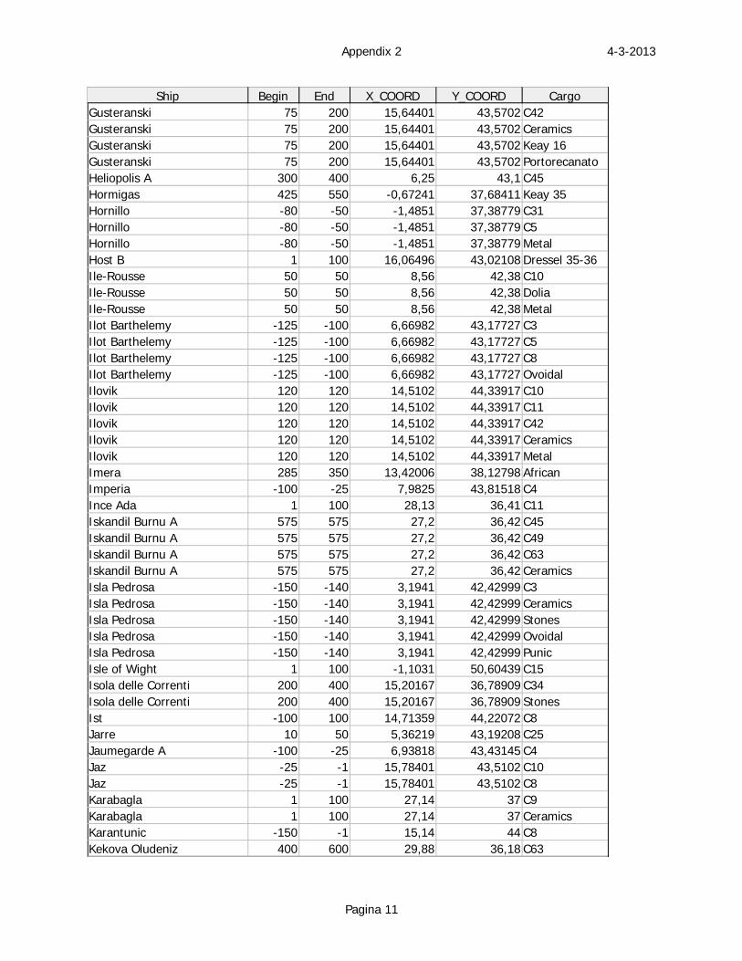
4-3-2013Appendix 2
Pagina 11
Ship Begin End X_COORD Y_COORD CargoGusteranski 75 200 15,64401 43,5702 C42Gusteranski 75 200 15,64401 43,5702 CeramicsGusteranski 75 200 15,64401 43,5702 Keay 16Gusteranski 75 200 15,64401 43,5702 PortorecanatoHeliopolis A 300 400 6,25 43,1 C45Hormigas 425 550 -0,67241 37,68411 Keay 35Hornillo -80 -50 -1,4851 37,38779 C31Hornillo -80 -50 -1,4851 37,38779 C5Hornillo -80 -50 -1,4851 37,38779 MetalHost B 1 100 16,06496 43,02108 Dressel 35-36Ile-Rousse 50 50 8,56 42,38 C10Ile-Rousse 50 50 8,56 42,38 DoliaIle-Rousse 50 50 8,56 42,38 MetalIlot Barthelemy -125 -100 6,66982 43,17727 C3Ilot Barthelemy -125 -100 6,66982 43,17727 C5Ilot Barthelemy -125 -100 6,66982 43,17727 C8Ilot Barthelemy -125 -100 6,66982 43,17727 OvoidalIlovik 120 120 14,5102 44,33917 C10Ilovik 120 120 14,5102 44,33917 C11Ilovik 120 120 14,5102 44,33917 C42Ilovik 120 120 14,5102 44,33917 CeramicsIlovik 120 120 14,5102 44,33917 MetalImera 285 350 13,42006 38,12798 AfricanImperia -100 -25 7,9825 43,81518 C4Ince Ada 1 100 28,13 36,41 C11Iskandil Burnu A 575 575 27,2 36,42 C45Iskandil Burnu A 575 575 27,2 36,42 C49Iskandil Burnu A 575 575 27,2 36,42 C63Iskandil Burnu A 575 575 27,2 36,42 CeramicsIsla Pedrosa -150 -140 3,1941 42,42999 C3Isla Pedrosa -150 -140 3,1941 42,42999 CeramicsIsla Pedrosa -150 -140 3,1941 42,42999 StonesIsla Pedrosa -150 -140 3,1941 42,42999 OvoidalIsla Pedrosa -150 -140 3,1941 42,42999 PunicIsle of Wight 1 100 -1,1031 50,60439 C15Isola delle Correnti 200 400 15,20167 36,78909 C34Isola delle Correnti 200 400 15,20167 36,78909 StonesIst -100 100 14,71359 44,22072 C8Jarre 10 50 5,36219 43,19208 C25Jaumegarde A -100 -25 6,93818 43,43145 C4Jaz -25 -1 15,78401 43,5102 C10Jaz -25 -1 15,78401 43,5102 C8Karabagla 1 100 27,14 37 C9Karabagla 1 100 27,14 37 CeramicsKarantunic -150 -1 15,14 44 C8Kekova Oludeniz 400 600 29,88 36,18 C63
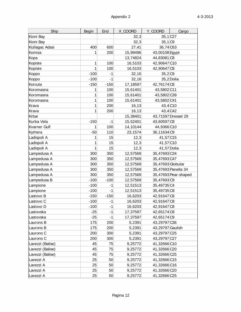
4-3-2013Appendix 2
Pagina 12
Ship Begin End X_COORD Y_COORD CargoKioni Bay 32,3 35,1 C27Kioni Bay 32,3 35,1 C9Kizilagac Adasi 400 600 27,41 36,74 C63Komiza 1 200 15,99496 43,00108 EgyptKopa 13,74824 44,83081 C8Kopiste 1 100 16,5103 42,90647 C10Kopiste 1 100 16,5103 42,90647 C8Koppo -100 -1 32,16 35,2 C9Koppo -100 -1 32,16 35,2 DoliaKorcula -150 -150 17,18597 42,76174 C8Koromasna 1 100 15,61401 43,5802 C11Koromasna 1 100 15,61401 43,5802 C39Koromasna 1 100 15,61401 43,5802 C41Krava 1 200 16,13 43,4 C10Krava 1 200 16,13 43,4 C42Krbar 15,38401 43,71597 Dressel 29Kurba Vela -150 -1 15,52401 43,60597 C8Kvarner Gulf 1 100 14,10144 44,9366 C10Kythera -50 110 23,1574 36,11634 C9Ladispoli A 1 15 12,3 41,57 C15Ladispoli A 1 15 12,3 41,57 C10Ladispoli A 1 15 12,3 41,57 DoliaLampedusa A 300 350 12,57569 35,47693 C34Lampedusa A 300 350 12,57569 35,47693 C47Lampedusa A 300 350 12,57569 35,47693 GlobularLampedusa A 300 350 12,57569 35,47693 Panella 34Lampedusa A 300 350 12,57569 35,47693 Pear-shapedLampedusa B -100 -100 12,57569 35,47693 C9Lampione -100 -1 12,51513 35,49735 C4Lampione -100 -1 12,51513 35,49735 C8Lastovo B -150 -150 16,6203 42,91647 C8Lastovo C -100 -1 16,6203 42,91647 C8Lastovo D -100 -1 16,6203 42,91647 C8Lastovska -25 -1 17,37597 42,65174 C8Lastovska -25 -1 17,37597 42,65174 C9Laurons B 175 200 5,2391 43,29797 C36Laurons B 175 200 5,2391 43,29797 GaulishLaurons C 200 300 5,2391 43,29797 C25Laurons C 200 300 5,2391 43,29797 C27Lavezzi (Balise) 45 75 9,25772 41,32666 C10Lavezzi (Balise) 45 75 9,25772 41,32666 C20Lavezzi (Balise) 45 75 9,25772 41,32666 C25Lavezzi A 25 50 9,25772 41,32666 C15Lavezzi A 25 50 9,25772 41,32666 C16Lavezzi A 25 50 9,25772 41,32666 C20Lavezzi A 25 50 9,25772 41,32666 C25
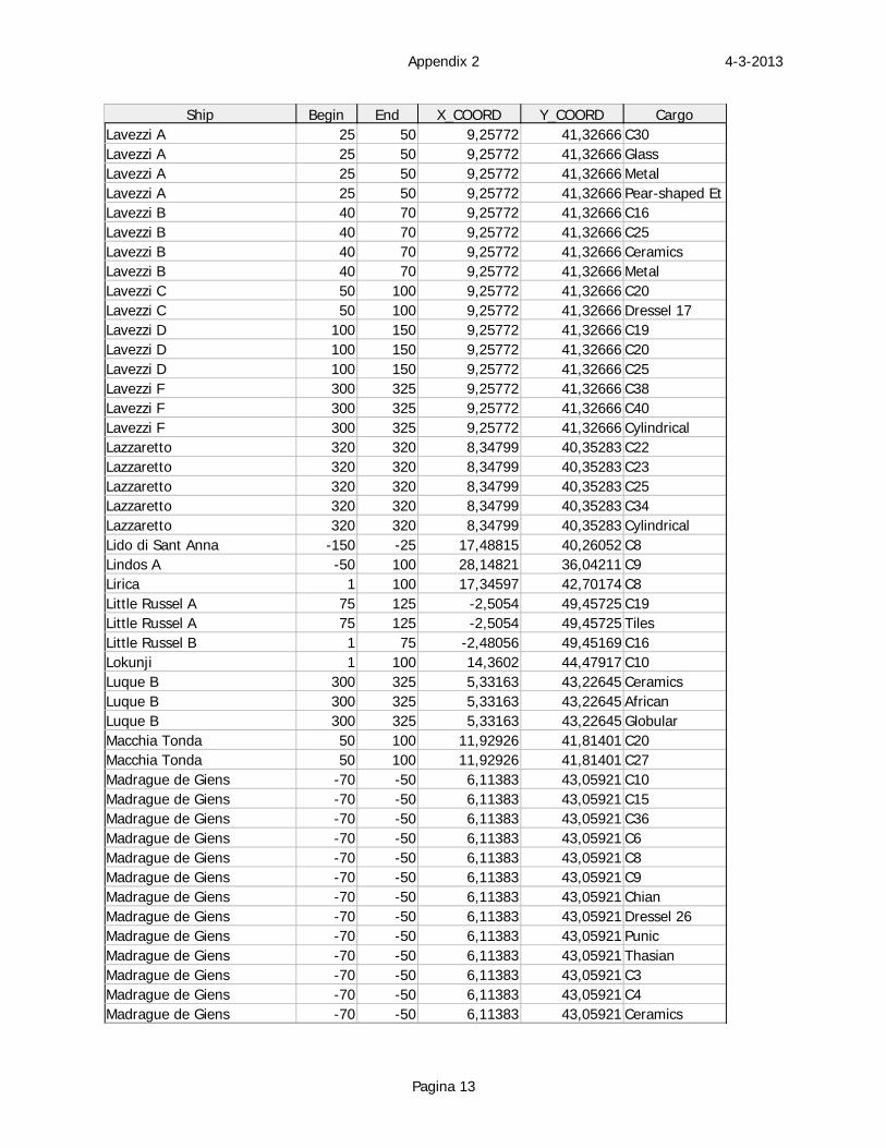
4-3-2013Appendix 2
Pagina 13
Ship Begin End X_COORD Y_COORD CargoLavezzi A 25 50 9,25772 41,32666 C30Lavezzi A 25 50 9,25772 41,32666 GlassLavezzi A 25 50 9,25772 41,32666 MetalLavezzi A 25 50 9,25772 41,32666 Pear-shaped EtLavezzi B 40 70 9,25772 41,32666 C16Lavezzi B 40 70 9,25772 41,32666 C25Lavezzi B 40 70 9,25772 41,32666 CeramicsLavezzi B 40 70 9,25772 41,32666 MetalLavezzi C 50 100 9,25772 41,32666 C20Lavezzi C 50 100 9,25772 41,32666 Dressel 17Lavezzi D 100 150 9,25772 41,32666 C19Lavezzi D 100 150 9,25772 41,32666 C20Lavezzi D 100 150 9,25772 41,32666 C25Lavezzi F 300 325 9,25772 41,32666 C38Lavezzi F 300 325 9,25772 41,32666 C40Lavezzi F 300 325 9,25772 41,32666 CylindricalLazzaretto 320 320 8,34799 40,35283 C22Lazzaretto 320 320 8,34799 40,35283 C23Lazzaretto 320 320 8,34799 40,35283 C25Lazzaretto 320 320 8,34799 40,35283 C34Lazzaretto 320 320 8,34799 40,35283 CylindricalLido di Sant Anna -150 -25 17,48815 40,26052 C8Lindos A -50 100 28,14821 36,04211 C9Lirica 1 100 17,34597 42,70174 C8Little Russel A 75 125 -2,5054 49,45725 C19Little Russel A 75 125 -2,5054 49,45725 TilesLittle Russel B 1 75 -2,48056 49,45169 C16Lokunji 1 100 14,3602 44,47917 C10Luque B 300 325 5,33163 43,22645 CeramicsLuque B 300 325 5,33163 43,22645 AfricanLuque B 300 325 5,33163 43,22645 GlobularMacchia Tonda 50 100 11,92926 41,81401 C20Macchia Tonda 50 100 11,92926 41,81401 C27Madrague de Giens -70 -50 6,11383 43,05921 C10Madrague de Giens -70 -50 6,11383 43,05921 C15Madrague de Giens -70 -50 6,11383 43,05921 C36Madrague de Giens -70 -50 6,11383 43,05921 C6Madrague de Giens -70 -50 6,11383 43,05921 C8Madrague de Giens -70 -50 6,11383 43,05921 C9Madrague de Giens -70 -50 6,11383 43,05921 ChianMadrague de Giens -70 -50 6,11383 43,05921 Dressel 26Madrague de Giens -70 -50 6,11383 43,05921 PunicMadrague de Giens -70 -50 6,11383 43,05921 ThasianMadrague de Giens -70 -50 6,11383 43,05921 C3Madrague de Giens -70 -50 6,11383 43,05921 C4Madrague de Giens -70 -50 6,11383 43,05921 Ceramics
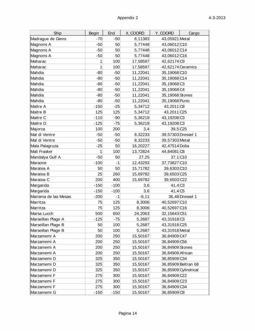
4-3-2013Appendix 2
Pagina 14
Ship Begin End X_COORD Y_COORD CargoMadrague de Giens -70 -50 6,11383 43,05921 MetalMagnons A -50 50 5,77448 43,06012 C10Magnons A -50 50 5,77448 43,06012 C14Magnons A -50 50 5,77448 43,06012 C16Maharac 1 100 17,58597 42,62174 C9Maharac 1 100 17,58597 42,62174 CeramicsMahdia -80 -50 11,22041 35,19068 C10Mahdia -80 -50 11,22041 35,19068 C14Mahdia -80 -50 11,22041 35,19068 C3Mahdia -80 -50 11,22041 35,19068 C4Mahdia -80 -50 11,22041 35,19068 StonesMahdia -80 -50 11,22041 35,19068 PunicMaïtre A -150 -25 5,34712 43,2011 C8Maïtre B 125 125 5,34712 43,2011 C25Maïtre C -110 -90 5,36219 43,19208 C3Maïtre D -125 -75 5,36219 43,19208 C3Majorca 100 200 3,4 39,5 C25Mal di Ventre -50 -50 8,32233 39,57303 Dressel 1Mal di Ventre -50 -50 8,32233 39,57303 MetalMala Palagruza -25 50 16,20227 42,47514 DoliaMali Frasker 1 100 13,72824 44,84081 C8Mandalya Gulf A -50 50 27,25 37,1 C10Maraone -100 -1 12,43293 37,73827 C10Maratea A 50 50 15,71782 39,6303 C10Maratea B 25 260 15,69782 39,6503 C25Maratea C 200 400 15,69782 39,6503 C22Margarida -150 -100 3,6 41,4 C3Margarida -150 -100 3,6 41,4 C5Marisma de las Mesas -200 -1 -6,11 36,48 Dressel 1Marritza 75 125 8,3006 40,52697 C10Marritza 75 125 8,3006 40,52697 C16Marsa Lucch 500 650 24,2063 32,15643 C51Marseillan Plage A -125 -75 5,2687 43,31918 C3Marseillan Plage B 50 100 5,2687 43,31918 C25Marseillan Plage B 50 100 5,2687 43,31918 MetalMarzamemi A 200 250 15,50167 36,84909 C47Marzamemi A 200 250 15,50167 36,84909 C56Marzamemi A 200 250 15,50167 36,84909 StonesMarzamemi A 200 250 15,50167 36,84909 AfricanMarzamemi D 325 350 15,50167 36,85909 C34Marzamemi D 325 350 15,50167 36,85909 Beltran 68Marzamemi D 325 350 15,50167 36,85909 CylindricalMarzamemi F 275 300 15,50167 36,84909 C22Marzamemi F 275 300 15,50167 36,84909 C23Marzamemi F 275 300 15,50167 36,84909 C34Marzamemi G -150 -150 15,50167 36,85909 C8
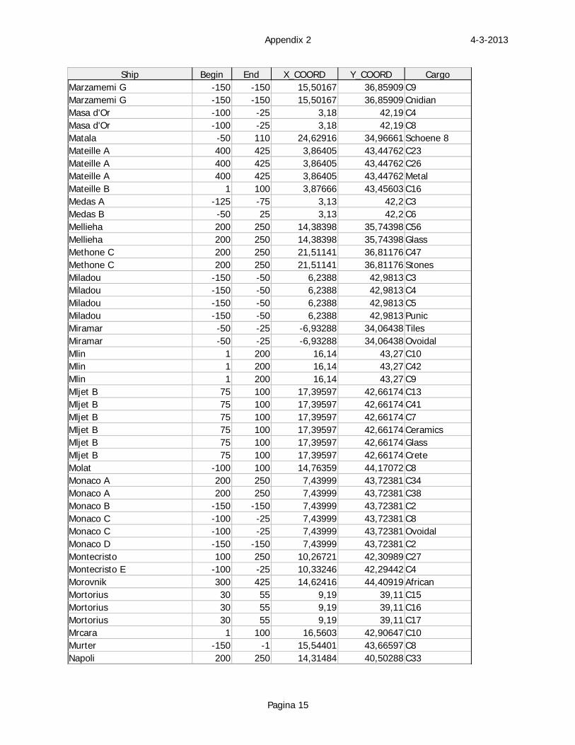
4-3-2013Appendix 2
Pagina 15
Ship Begin End X_COORD Y_COORD CargoMarzamemi G -150 -150 15,50167 36,85909 C9Marzamemi G -150 -150 15,50167 36,85909 CnidianMasa d'Or -100 -25 3,18 42,19 C4Masa d'Or -100 -25 3,18 42,19 C8Matala -50 110 24,62916 34,96661 Schoene 8Mateille A 400 425 3,86405 43,44762 C23Mateille A 400 425 3,86405 43,44762 C26Mateille A 400 425 3,86405 43,44762 MetalMateille B 1 100 3,87666 43,45603 C16Medas A -125 -75 3,13 42,2 C3Medas B -50 25 3,13 42,2 C6Mellieha 200 250 14,38398 35,74398 C56Mellieha 200 250 14,38398 35,74398 GlassMethone C 200 250 21,51141 36,81176 C47Methone C 200 250 21,51141 36,81176 StonesMiladou -150 -50 6,2388 42,9813 C3Miladou -150 -50 6,2388 42,9813 C4Miladou -150 -50 6,2388 42,9813 C5Miladou -150 -50 6,2388 42,9813 PunicMiramar -50 -25 -6,93288 34,06438 TilesMiramar -50 -25 -6,93288 34,06438 OvoidalMlin 1 200 16,14 43,27 C10Mlin 1 200 16,14 43,27 C42Mlin 1 200 16,14 43,27 C9Mljet B 75 100 17,39597 42,66174 C13Mljet B 75 100 17,39597 42,66174 C41Mljet B 75 100 17,39597 42,66174 C7Mljet B 75 100 17,39597 42,66174 CeramicsMljet B 75 100 17,39597 42,66174 GlassMljet B 75 100 17,39597 42,66174 CreteMolat -100 100 14,76359 44,17072 C8Monaco A 200 250 7,43999 43,72381 C34Monaco A 200 250 7,43999 43,72381 C38Monaco B -150 -150 7,43999 43,72381 C2Monaco C -100 -25 7,43999 43,72381 C8Monaco C -100 -25 7,43999 43,72381 OvoidalMonaco D -150 -150 7,43999 43,72381 C2Montecristo 100 250 10,26721 42,30989 C27Montecristo E -100 -25 10,33246 42,29442 C4Morovnik 300 425 14,62416 44,40919 AfricanMortorius 30 55 9,19 39,11 C15Mortorius 30 55 9,19 39,11 C16Mortorius 30 55 9,19 39,11 C17Mrcara 1 100 16,5603 42,90647 C10Murter -150 -1 15,54401 43,66597 C8Napoli 200 250 14,31484 40,50288 C33
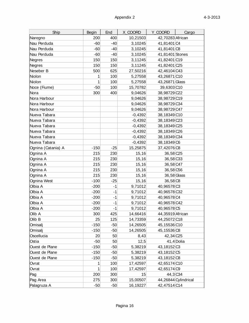
4-3-2013Appendix 2
Pagina 16
Ship Begin End X_COORD Y_COORD CargoNaregno 200 400 10,21503 42,70283 AfricanNau Perduda -60 -40 3,10245 41,81401 C4Nau Perduda -60 -40 3,10245 41,81401 C8Nau Perduda -60 -40 3,10245 41,81401 StonesNegres 150 150 3,11245 41,82401 C19Negres 150 150 3,11245 41,82401 C25Neseber B 500 625 27,50216 42,46104 C43Niolon 1 100 5,27558 43,26871 C10Niolon 1 100 5,27558 43,26871 GlassNoce (Fiume) -50 100 15,70782 39,6303 C10Nora 300 400 9,04626 38,98729 C22Nora Harbour 9,04626 38,98729 C19Nora Harbour 9,04626 38,98729 C34Nora Harbour 9,04626 38,98729 C47Nueva Tabara -0,4392 38,18349 C10Nueva Tabara -0,4392 38,18349 C23Nueva Tabara -0,4392 38,18349 C25Nueva Tabara -0,4392 38,18349 C26Nueva Tabara -0,4392 38,18349 C34Nueva Tabara -0,4392 38,18349 C6Ognina (Catania) A -150 -25 15,25875 37,42076 C8Ognina A 215 230 15,16 36,58 C25Ognina A 215 230 15,16 36,58 C33Ognina A 215 230 15,16 36,58 C47Ognina A 215 230 15,16 36,58 C56Ognina A 215 230 15,16 36,58 GlassOgnina West -100 -25 15,16 36,58 C8Olbia A -200 -1 9,71012 40,96578 C3Olbia A -200 -1 9,71012 40,96578 C32Olbia A -200 -1 9,71012 40,96578 C4Olbia A -200 -1 9,71012 40,96578 C42Olbia A -200 -1 9,71012 40,96578 C5Olib A 300 425 14,66416 44,35919 AfricanOlib B 25 125 14,73359 44,25072 C18Omisalj -150 -50 14,26505 45,15536 C10Omisalj -150 -50 14,26505 45,15536 C8Oscellucia 20 50 8,43 42,34 C25Ostia -50 50 12,5 41,4 DoliaOuest de Plane -150 -50 5,38219 43,18152 C3Ouest de Plane -150 -50 5,38219 43,18152 C5Ouest de Plane -150 -50 5,38219 43,18152 C8Ovrat 1 100 17,42597 42,65174 C10Ovrat 1 100 17,42597 42,65174 C9Pag 200 300 15 44,3 C34Pag Area 275 300 15,00507 44,26844 CylindricalPalagruza A -50 -50 16,19227 42,47514 C14
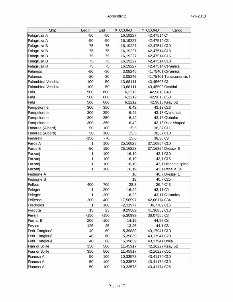
4-3-2013Appendix 2
Pagina 17
Ship Begin End X_COORD Y_COORD CargoPalagruza A -50 -50 16,19227 42,47514 C4Palagruza A -50 -50 16,19227 42,47514 C8Palagruza B 75 75 16,19227 42,47514 C10Palagruza B 75 75 16,19227 42,47514 C13Palagruza B 75 75 16,19227 42,47514 C15Palagruza B 75 75 16,19227 42,47514 C18Palagruza B 75 75 16,19227 42,47514 CeramicsPalamos -80 -30 3,08245 41,75401 CeramicsPalamos -80 -30 3,08245 41,75401 Tarraconensis IPalombina Vecchia -100 -50 13,68111 43,45608 C1Palombina Vecchia -100 -50 13,68111 43,45608 OvoidalPalu 500 600 6,2212 42,9813 C49Palu 500 600 6,2212 42,9813 C63Palu 500 600 6,2212 42,9813 Keay 62Pampelonne 300 350 6,42 43,13 C23Pampelonne 300 350 6,42 43,13 CylindricalPampelonne 300 350 6,42 43,13 GlobularPampelonne 300 350 6,42 43,13 Pear-shapedPanarea (Alberti) 50 100 15,5 38,37 C11Panarea (Alberti) 50 100 15,5 38,37 C10Panarelli -150 -70 15,6 38,38 C3Paros A 1 100 25,16828 37,16854 C10Paros B -50 150 25,16828 37,16854 Dressel 6Parzanj 1 100 16,19 43,1 C10Parzanj 1 100 16,19 43,1 C16Parzanj 1 100 16,19 43,1 Hispanic spindlParzanj 1 100 16,19 43,1 Panella 34Pedagne A 18 40,7 Dressel 1Pedagne B 18 40,7 C25Pefkos 400 700 28,3 36,4 C43Pelegrin 1 200 16,22 43,11 C9Pelegrin 1 200 16,22 43,11 CeramicsPeljesac 200 400 17,58597 42,66174 C34Percheles 1 100 -2,31977 36,7702 C16Perduta 15 25 9,29582 41,36853 C10Perejil -150 -150 -5,30999 36,07555 C3Pernat B -200 -100 14,19 44,57 C8Pesaro -125 -25 13,25 44,1 C8Petit Congloué 40 60 5,39839 43,17941 C10Petit Congloué 40 60 5,39839 43,17941 C29Petit Congloué 40 60 5,39839 43,17941 DoliaPian di Spille 350 500 11,45917 42,16227 Keay 52Pian di Spille 350 500 11,45917 42,16227 C51Pianosa A 50 100 10,33578 43,41174 C10Pianosa A 50 100 10,33578 43,41174 C19Pianosa A 50 100 10,33578 43,41174 C25
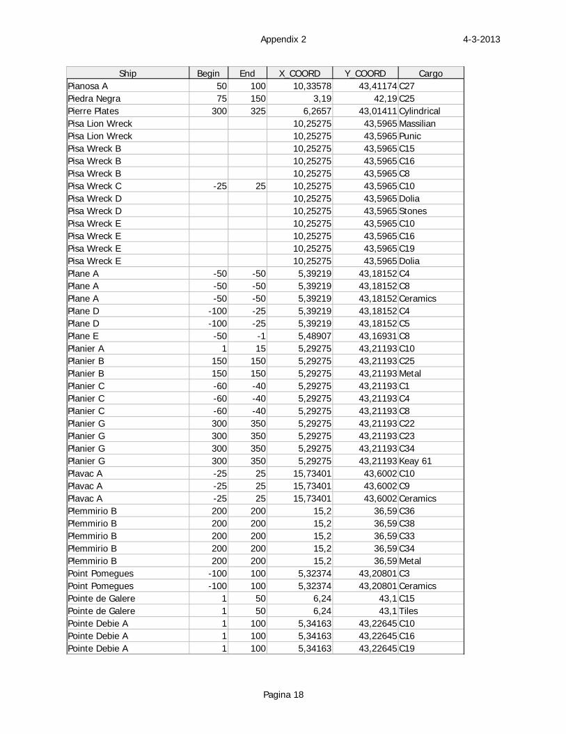
4-3-2013Appendix 2
Pagina 18
Ship Begin End X_COORD Y_COORD CargoPianosa A 50 100 10,33578 43,41174 C27Piedra Negra 75 150 3,19 42,19 C25Pierre Plates 300 325 6,2657 43,01411 CylindricalPisa Lion Wreck 10,25275 43,5965 MassilianPisa Lion Wreck 10,25275 43,5965 PunicPisa Wreck B 10,25275 43,5965 C15Pisa Wreck B 10,25275 43,5965 C16Pisa Wreck B 10,25275 43,5965 C8Pisa Wreck C -25 25 10,25275 43,5965 C10Pisa Wreck D 10,25275 43,5965 DoliaPisa Wreck D 10,25275 43,5965 StonesPisa Wreck E 10,25275 43,5965 C10Pisa Wreck E 10,25275 43,5965 C16Pisa Wreck E 10,25275 43,5965 C19Pisa Wreck E 10,25275 43,5965 DoliaPlane A -50 -50 5,39219 43,18152 C4Plane A -50 -50 5,39219 43,18152 C8Plane A -50 -50 5,39219 43,18152 CeramicsPlane D -100 -25 5,39219 43,18152 C4Plane D -100 -25 5,39219 43,18152 C5Plane E -50 -1 5,48907 43,16931 C8Planier A 1 15 5,29275 43,21193 C10Planier B 150 150 5,29275 43,21193 C25Planier B 150 150 5,29275 43,21193 MetalPlanier C -60 -40 5,29275 43,21193 C1Planier C -60 -40 5,29275 43,21193 C4Planier C -60 -40 5,29275 43,21193 C8Planier G 300 350 5,29275 43,21193 C22Planier G 300 350 5,29275 43,21193 C23Planier G 300 350 5,29275 43,21193 C34Planier G 300 350 5,29275 43,21193 Keay 61Plavac A -25 25 15,73401 43,6002 C10Plavac A -25 25 15,73401 43,6002 C9Plavac A -25 25 15,73401 43,6002 CeramicsPlemmirio B 200 200 15,2 36,59 C36Plemmirio B 200 200 15,2 36,59 C38Plemmirio B 200 200 15,2 36,59 C33Plemmirio B 200 200 15,2 36,59 C34Plemmirio B 200 200 15,2 36,59 MetalPoint Pomegues -100 100 5,32374 43,20801 C3Point Pomegues -100 100 5,32374 43,20801 CeramicsPointe de Galere 1 50 6,24 43,1 C15Pointe de Galere 1 50 6,24 43,1 TilesPointe Debie A 1 100 5,34163 43,22645 C10Pointe Debie A 1 100 5,34163 43,22645 C16Pointe Debie A 1 100 5,34163 43,22645 C19
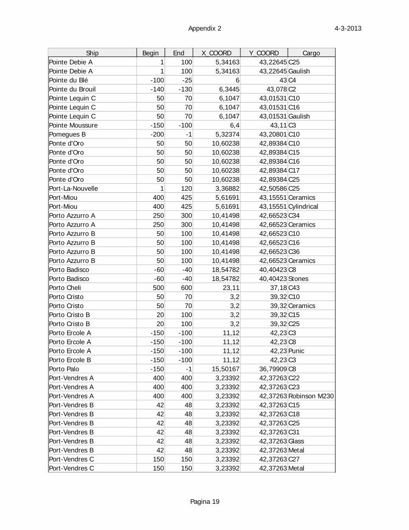
4-3-2013Appendix 2
Pagina 19
Ship Begin End X_COORD Y_COORD CargoPointe Debie A 1 100 5,34163 43,22645 C25Pointe Debie A 1 100 5,34163 43,22645 GaulishPointe du Blé -100 -25 6 43 C4Pointe du Brouil -140 -130 6,3445 43,078 C2Pointe Lequin C 50 70 6,1047 43,01531 C10Pointe Lequin C 50 70 6,1047 43,01531 C16Pointe Lequin C 50 70 6,1047 43,01531 GaulishPointe Moussure -150 -100 6,4 43,11 C3Pomegues B -200 -1 5,32374 43,20801 C10Ponte d'Oro 50 50 10,60238 42,89384 C10Ponte d'Oro 50 50 10,60238 42,89384 C15Ponte d'Oro 50 50 10,60238 42,89384 C16Ponte d'Oro 50 50 10,60238 42,89384 C17Ponte d'Oro 50 50 10,60238 42,89384 C25Port-La-Nouvelle 1 120 3,36882 42,50586 C25Port-Miou 400 425 5,61691 43,15551 CeramicsPort-Miou 400 425 5,61691 43,15551 CylindricalPorto Azzurro A 250 300 10,41498 42,66523 C34Porto Azzurro A 250 300 10,41498 42,66523 CeramicsPorto Azzurro B 50 100 10,41498 42,66523 C10Porto Azzurro B 50 100 10,41498 42,66523 C16Porto Azzurro B 50 100 10,41498 42,66523 C36Porto Azzurro B 50 100 10,41498 42,66523 CeramicsPorto Badisco -60 -40 18,54782 40,40423 C8Porto Badisco -60 -40 18,54782 40,40423 StonesPorto Cheli 500 600 23,11 37,18 C43Porto Cristo 50 70 3,2 39,32 C10Porto Cristo 50 70 3,2 39,32 CeramicsPorto Cristo B 20 100 3,2 39,32 C15Porto Cristo B 20 100 3,2 39,32 C25Porto Ercole A -150 -100 11,12 42,23 C3Porto Ercole A -150 -100 11,12 42,23 C8Porto Ercole A -150 -100 11,12 42,23 PunicPorto Ercole B -150 -100 11,12 42,23 C3Porto Palo -150 -1 15,50167 36,79909 C8Port-Vendres A 400 400 3,23392 42,37263 C22Port-Vendres A 400 400 3,23392 42,37263 C23Port-Vendres A 400 400 3,23392 42,37263 Robinson M230Port-Vendres B 42 48 3,23392 42,37263 C15Port-Vendres B 42 48 3,23392 42,37263 C18Port-Vendres B 42 48 3,23392 42,37263 C25Port-Vendres B 42 48 3,23392 42,37263 C31Port-Vendres B 42 48 3,23392 42,37263 GlassPort-Vendres B 42 48 3,23392 42,37263 MetalPort-Vendres C 150 150 3,23392 42,37263 C27Port-Vendres C 150 150 3,23392 42,37263 Metal
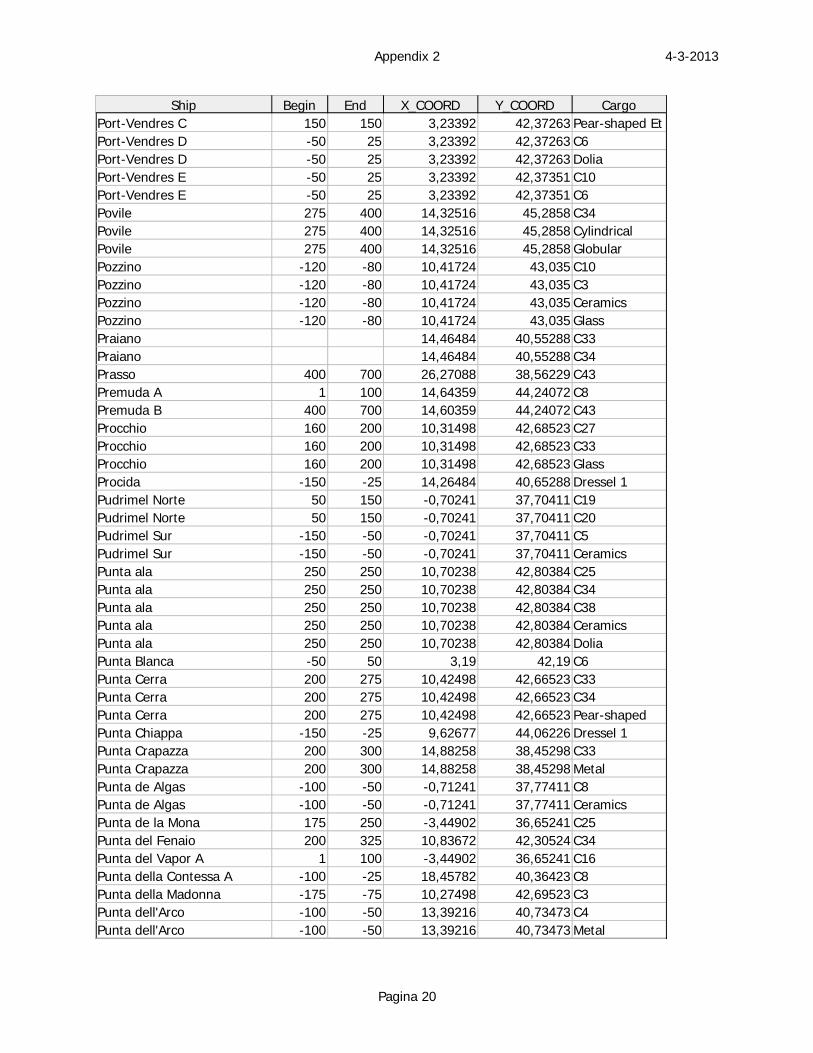
4-3-2013Appendix 2
Pagina 20
Ship Begin End X_COORD Y_COORD CargoPort-Vendres C 150 150 3,23392 42,37263 Pear-shaped EtPort-Vendres D -50 25 3,23392 42,37263 C6Port-Vendres D -50 25 3,23392 42,37263 DoliaPort-Vendres E -50 25 3,23392 42,37351 C10Port-Vendres E -50 25 3,23392 42,37351 C6Povile 275 400 14,32516 45,2858 C34Povile 275 400 14,32516 45,2858 CylindricalPovile 275 400 14,32516 45,2858 GlobularPozzino -120 -80 10,41724 43,035 C10Pozzino -120 -80 10,41724 43,035 C3Pozzino -120 -80 10,41724 43,035 CeramicsPozzino -120 -80 10,41724 43,035 GlassPraiano 14,46484 40,55288 C33Praiano 14,46484 40,55288 C34Prasso 400 700 26,27088 38,56229 C43Premuda A 1 100 14,64359 44,24072 C8Premuda B 400 700 14,60359 44,24072 C43Procchio 160 200 10,31498 42,68523 C27Procchio 160 200 10,31498 42,68523 C33Procchio 160 200 10,31498 42,68523 GlassProcida -150 -25 14,26484 40,65288 Dressel 1Pudrimel Norte 50 150 -0,70241 37,70411 C19Pudrimel Norte 50 150 -0,70241 37,70411 C20Pudrimel Sur -150 -50 -0,70241 37,70411 C5Pudrimel Sur -150 -50 -0,70241 37,70411 CeramicsPunta ala 250 250 10,70238 42,80384 C25Punta ala 250 250 10,70238 42,80384 C34Punta ala 250 250 10,70238 42,80384 C38Punta ala 250 250 10,70238 42,80384 CeramicsPunta ala 250 250 10,70238 42,80384 DoliaPunta Blanca -50 50 3,19 42,19 C6Punta Cerra 200 275 10,42498 42,66523 C33Punta Cerra 200 275 10,42498 42,66523 C34Punta Cerra 200 275 10,42498 42,66523 Pear-shapedPunta Chiappa -150 -25 9,62677 44,06226 Dressel 1Punta Crapazza 200 300 14,88258 38,45298 C33Punta Crapazza 200 300 14,88258 38,45298 MetalPunta de Algas -100 -50 -0,71241 37,77411 C8Punta de Algas -100 -50 -0,71241 37,77411 CeramicsPunta de la Mona 175 250 -3,44902 36,65241 C25Punta del Fenaio 200 325 10,83672 42,30524 C34Punta del Vapor A 1 100 -3,44902 36,65241 C16Punta della Contessa A -100 -25 18,45782 40,36423 C8Punta della Madonna -175 -75 10,27498 42,69523 C3Punta dell'Arco -100 -50 13,39216 40,73473 C4Punta dell'Arco -100 -50 13,39216 40,73473 Metal
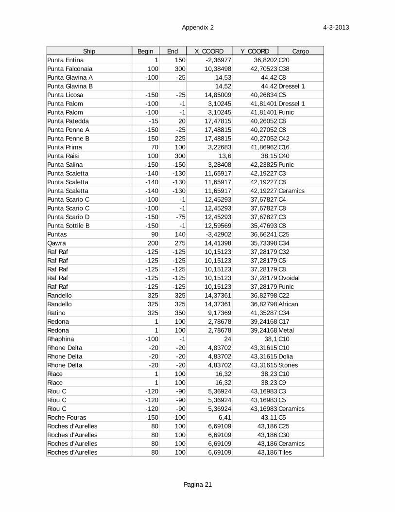
4-3-2013Appendix 2
Pagina 21
Ship Begin End X_COORD Y_COORD CargoPunta Entina 1 150 -2,36977 36,8202 C20Punta Falconaia 100 300 10,38498 42,70523 C38Punta Glavina A -100 -25 14,53 44,42 C8Punta Glavina B 14,52 44,42 Dressel 1Punta Licosa -150 -25 14,85009 40,26834 C5Punta Palom -100 -1 3,10245 41,81401 Dressel 1Punta Palom -100 -1 3,10245 41,81401 PunicPunta Patedda -15 20 17,47815 40,26052 C8Punta Penne A -150 -25 17,48815 40,27052 C8Punta Penne B 150 225 17,48815 40,27052 C42Punta Prima 70 100 3,22683 41,86962 C16Punta Raisi 100 300 13,6 38,15 C40Punta Salina -150 -150 3,28408 42,23825 PunicPunta Scaletta -140 -130 11,65917 42,19227 C3Punta Scaletta -140 -130 11,65917 42,19227 C8Punta Scaletta -140 -130 11,65917 42,19227 CeramicsPunta Scario C -100 -1 12,45293 37,67827 C4Punta Scario C -100 -1 12,45293 37,67827 C8Punta Scario D -150 -75 12,45293 37,67827 C3Punta Sottile B -150 -1 12,59569 35,47693 C8Puntas 90 140 -3,42902 36,66241 C25Qawra 200 275 14,41398 35,73398 C34Raf Raf -125 -125 10,15123 37,28179 C32Raf Raf -125 -125 10,15123 37,28179 C5Raf Raf -125 -125 10,15123 37,28179 C8Raf Raf -125 -125 10,15123 37,28179 OvoidalRaf Raf -125 -125 10,15123 37,28179 PunicRandello 325 325 14,37361 36,82798 C22Randello 325 325 14,37361 36,82798 AfricanRatino 325 350 9,17369 41,35287 C34Redona 1 100 2,78678 39,24168 C17Redona 1 100 2,78678 39,24168 MetalRhaphina -100 -1 24 38,1 C10Rhone Delta -20 -20 4,83702 43,31615 C10Rhone Delta -20 -20 4,83702 43,31615 DoliaRhone Delta -20 -20 4,83702 43,31615 StonesRiace 1 100 16,32 38,23 C10Riace 1 100 16,32 38,23 C9Riou C -120 -90 5,36924 43,16983 C3Riou C -120 -90 5,36924 43,16983 C5Riou C -120 -90 5,36924 43,16983 CeramicsRoche Fouras -150 -100 6,41 43,11 C5Roches d'Aurelles 80 100 6,69109 43,186 C25Roches d'Aurelles 80 100 6,69109 43,186 C30Roches d'Aurelles 80 100 6,69109 43,186 CeramicsRoches d'Aurelles 80 100 6,69109 43,186 Tiles
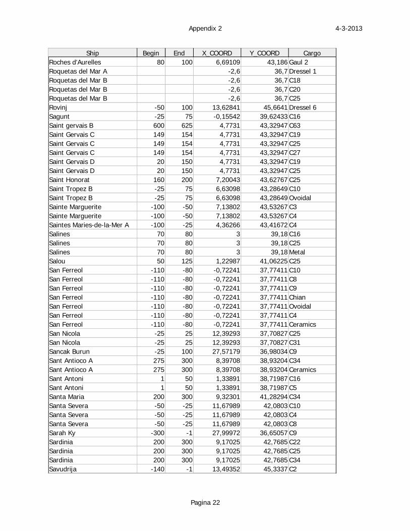
4-3-2013Appendix 2
Pagina 22
Ship Begin End X_COORD Y_COORD CargoRoches d'Aurelles 80 100 6,69109 43,186 Gaul 2Roquetas del Mar A -2,6 36,7 Dressel 1Roquetas del Mar B -2,6 36,7 C18Roquetas del Mar B -2,6 36,7 C20Roquetas del Mar B -2,6 36,7 C25Rovinj -50 100 13,62841 45,6641 Dressel 6Sagunt -25 75 -0,15542 39,62433 C16Saint gervais B 600 625 4,7731 43,32947 C63Saint Gervais C 149 154 4,7731 43,32947 C19Saint Gervais C 149 154 4,7731 43,32947 C25Saint Gervais C 149 154 4,7731 43,32947 C27Saint Gervais D 20 150 4,7731 43,32947 C19Saint Gervais D 20 150 4,7731 43,32947 C25Saint Honorat 160 200 7,20043 43,62767 C25Saint Tropez B -25 75 6,63098 43,28649 C10Saint Tropez B -25 75 6,63098 43,28649 OvoidalSainte Marguerite -100 -50 7,13802 43,53267 C3Sainte Marguerite -100 -50 7,13802 43,53267 C4Saintes Maries-de-la-Mer A -100 -25 4,36266 43,41672 C4Salines 70 80 3 39,18 C16Salines 70 80 3 39,18 C25Salines 70 80 3 39,18 MetalSalou 50 125 1,22987 41,06225 C25San Ferreol -110 -80 -0,72241 37,77411 C10San Ferreol -110 -80 -0,72241 37,77411 C8San Ferreol -110 -80 -0,72241 37,77411 C9San Ferreol -110 -80 -0,72241 37,77411 ChianSan Ferreol -110 -80 -0,72241 37,77411 OvoidalSan Ferreol -110 -80 -0,72241 37,77411 C4San Ferreol -110 -80 -0,72241 37,77411 CeramicsSan Nicola -25 25 12,39293 37,70827 C25San Nicola -25 25 12,39293 37,70827 C31Sancak Burun -25 100 27,57179 36,98034 C9Sant Antioco A 275 300 8,39708 38,93204 C34Sant Antioco A 275 300 8,39708 38,93204 CeramicsSant Antoni 1 50 1,33891 38,71987 C16Sant Antoni 1 50 1,33891 38,71987 C5Santa Maria 200 300 9,32301 41,28294 C34Santa Severa -50 -25 11,67989 42,0803 C10Santa Severa -50 -25 11,67989 42,0803 C4Santa Severa -50 -25 11,67989 42,0803 C8Sarah Ky -300 -1 27,99972 36,65057 C9Sardinia 200 300 9,17025 42,7685 C22Sardinia 200 300 9,17025 42,7685 C25Sardinia 200 300 9,17025 42,7685 C34Savudrija -140 -1 13,49352 45,3337 C2
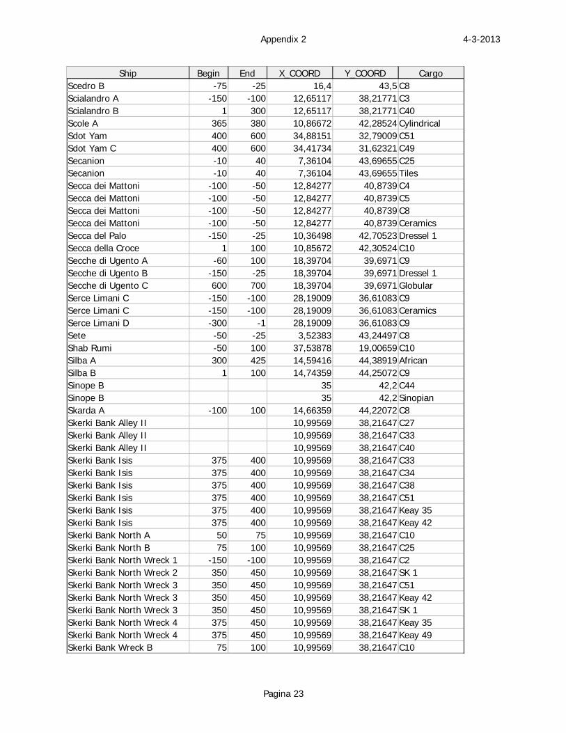
4-3-2013Appendix 2
Pagina 23
Ship Begin End X_COORD Y_COORD CargoScedro B -75 -25 16,4 43,5 C8Scialandro A -150 -100 12,65117 38,21771 C3Scialandro B 1 300 12,65117 38,21771 C40Scole A 365 380 10,86672 42,28524 CylindricalSdot Yam 400 600 34,88151 32,79009 C51Sdot Yam C 400 600 34,41734 31,62321 C49Secanion -10 40 7,36104 43,69655 C25Secanion -10 40 7,36104 43,69655 TilesSecca dei Mattoni -100 -50 12,84277 40,8739 C4Secca dei Mattoni -100 -50 12,84277 40,8739 C5Secca dei Mattoni -100 -50 12,84277 40,8739 C8Secca dei Mattoni -100 -50 12,84277 40,8739 CeramicsSecca del Palo -150 -25 10,36498 42,70523 Dressel 1Secca della Croce 1 100 10,85672 42,30524 C10Secche di Ugento A -60 100 18,39704 39,6971 C9Secche di Ugento B -150 -25 18,39704 39,6971 Dressel 1Secche di Ugento C 600 700 18,39704 39,6971 GlobularSerce Limani C -150 -100 28,19009 36,61083 C9Serce Limani C -150 -100 28,19009 36,61083 CeramicsSerce Limani D -300 -1 28,19009 36,61083 C9Sete -50 -25 3,52383 43,24497 C8Shab Rumi -50 100 37,53878 19,00659 C10Silba A 300 425 14,59416 44,38919 AfricanSilba B 1 100 14,74359 44,25072 C9Sinope B 35 42,2 C44Sinope B 35 42,2 SinopianSkarda A -100 100 14,66359 44,22072 C8Skerki Bank Alley II 10,99569 38,21647 C27Skerki Bank Alley II 10,99569 38,21647 C33Skerki Bank Alley II 10,99569 38,21647 C40Skerki Bank Isis 375 400 10,99569 38,21647 C33Skerki Bank Isis 375 400 10,99569 38,21647 C34Skerki Bank Isis 375 400 10,99569 38,21647 C38Skerki Bank Isis 375 400 10,99569 38,21647 C51Skerki Bank Isis 375 400 10,99569 38,21647 Keay 35Skerki Bank Isis 375 400 10,99569 38,21647 Keay 42Skerki Bank North A 50 75 10,99569 38,21647 C10Skerki Bank North B 75 100 10,99569 38,21647 C25Skerki Bank North Wreck 1 -150 -100 10,99569 38,21647 C2Skerki Bank North Wreck 2 350 450 10,99569 38,21647 SK 1Skerki Bank North Wreck 3 350 450 10,99569 38,21647 C51Skerki Bank North Wreck 3 350 450 10,99569 38,21647 Keay 42Skerki Bank North Wreck 3 350 450 10,99569 38,21647 SK 1Skerki Bank North Wreck 4 375 450 10,99569 38,21647 Keay 35Skerki Bank North Wreck 4 375 450 10,99569 38,21647 Keay 49Skerki Bank Wreck B 75 100 10,99569 38,21647 C10
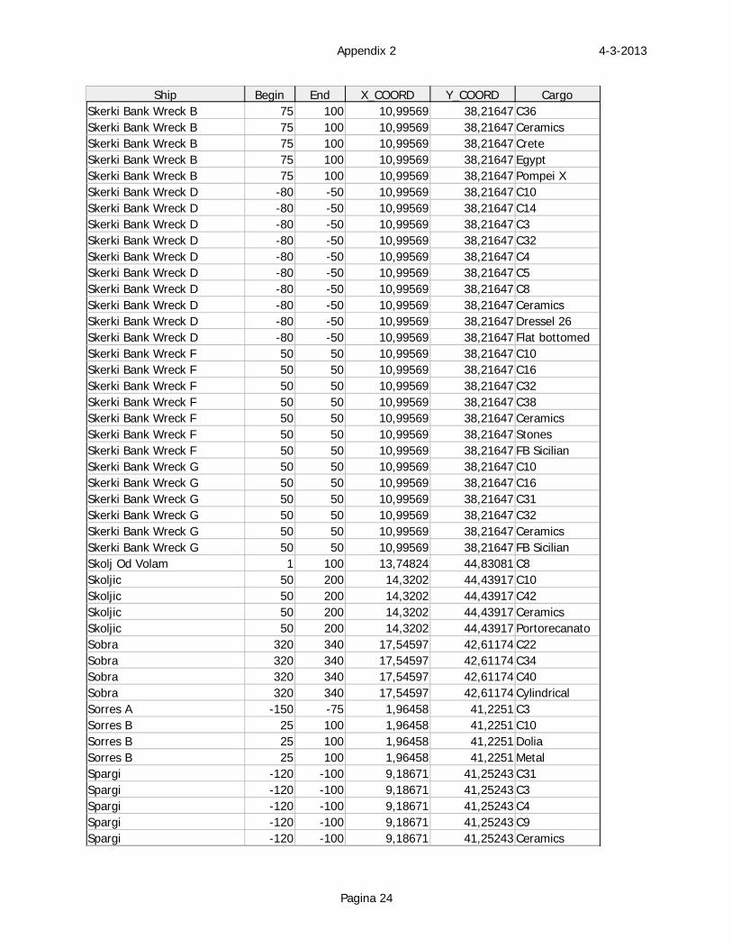
4-3-2013Appendix 2
Pagina 24
Ship Begin End X_COORD Y_COORD CargoSkerki Bank Wreck B 75 100 10,99569 38,21647 C36Skerki Bank Wreck B 75 100 10,99569 38,21647 CeramicsSkerki Bank Wreck B 75 100 10,99569 38,21647 CreteSkerki Bank Wreck B 75 100 10,99569 38,21647 EgyptSkerki Bank Wreck B 75 100 10,99569 38,21647 Pompei XSkerki Bank Wreck D -80 -50 10,99569 38,21647 C10Skerki Bank Wreck D -80 -50 10,99569 38,21647 C14Skerki Bank Wreck D -80 -50 10,99569 38,21647 C3Skerki Bank Wreck D -80 -50 10,99569 38,21647 C32Skerki Bank Wreck D -80 -50 10,99569 38,21647 C4Skerki Bank Wreck D -80 -50 10,99569 38,21647 C5Skerki Bank Wreck D -80 -50 10,99569 38,21647 C8Skerki Bank Wreck D -80 -50 10,99569 38,21647 CeramicsSkerki Bank Wreck D -80 -50 10,99569 38,21647 Dressel 26Skerki Bank Wreck D -80 -50 10,99569 38,21647 Flat bottomedSkerki Bank Wreck F 50 50 10,99569 38,21647 C10Skerki Bank Wreck F 50 50 10,99569 38,21647 C16Skerki Bank Wreck F 50 50 10,99569 38,21647 C32Skerki Bank Wreck F 50 50 10,99569 38,21647 C38Skerki Bank Wreck F 50 50 10,99569 38,21647 CeramicsSkerki Bank Wreck F 50 50 10,99569 38,21647 StonesSkerki Bank Wreck F 50 50 10,99569 38,21647 FB SicilianSkerki Bank Wreck G 50 50 10,99569 38,21647 C10Skerki Bank Wreck G 50 50 10,99569 38,21647 C16Skerki Bank Wreck G 50 50 10,99569 38,21647 C31Skerki Bank Wreck G 50 50 10,99569 38,21647 C32Skerki Bank Wreck G 50 50 10,99569 38,21647 CeramicsSkerki Bank Wreck G 50 50 10,99569 38,21647 FB SicilianSkolj Od Volam 1 100 13,74824 44,83081 C8Skoljic 50 200 14,3202 44,43917 C10Skoljic 50 200 14,3202 44,43917 C42Skoljic 50 200 14,3202 44,43917 CeramicsSkoljic 50 200 14,3202 44,43917 PortorecanatoSobra 320 340 17,54597 42,61174 C22Sobra 320 340 17,54597 42,61174 C34Sobra 320 340 17,54597 42,61174 C40Sobra 320 340 17,54597 42,61174 CylindricalSorres A -150 -75 1,96458 41,2251 C3Sorres B 25 100 1,96458 41,2251 C10Sorres B 25 100 1,96458 41,2251 DoliaSorres B 25 100 1,96458 41,2251 MetalSpargi -120 -100 9,18671 41,25243 C31Spargi -120 -100 9,18671 41,25243 C3Spargi -120 -100 9,18671 41,25243 C4Spargi -120 -100 9,18671 41,25243 C9Spargi -120 -100 9,18671 41,25243 Ceramics
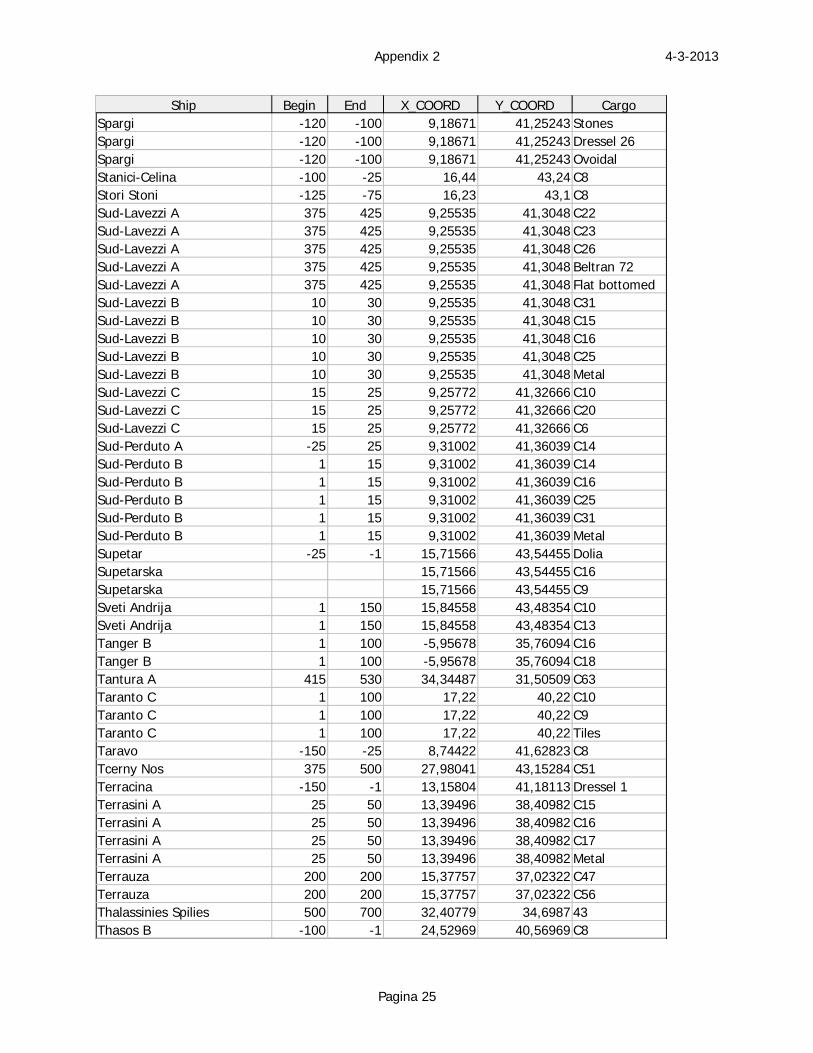
4-3-2013Appendix 2
Pagina 25
Ship Begin End X_COORD Y_COORD CargoSpargi -120 -100 9,18671 41,25243 StonesSpargi -120 -100 9,18671 41,25243 Dressel 26Spargi -120 -100 9,18671 41,25243 OvoidalStanici-Celina -100 -25 16,44 43,24 C8Stori Stoni -125 -75 16,23 43,1 C8Sud-Lavezzi A 375 425 9,25535 41,3048 C22Sud-Lavezzi A 375 425 9,25535 41,3048 C23Sud-Lavezzi A 375 425 9,25535 41,3048 C26Sud-Lavezzi A 375 425 9,25535 41,3048 Beltran 72Sud-Lavezzi A 375 425 9,25535 41,3048 Flat bottomedSud-Lavezzi B 10 30 9,25535 41,3048 C31Sud-Lavezzi B 10 30 9,25535 41,3048 C15Sud-Lavezzi B 10 30 9,25535 41,3048 C16Sud-Lavezzi B 10 30 9,25535 41,3048 C25Sud-Lavezzi B 10 30 9,25535 41,3048 MetalSud-Lavezzi C 15 25 9,25772 41,32666 C10Sud-Lavezzi C 15 25 9,25772 41,32666 C20Sud-Lavezzi C 15 25 9,25772 41,32666 C6Sud-Perduto A -25 25 9,31002 41,36039 C14Sud-Perduto B 1 15 9,31002 41,36039 C14Sud-Perduto B 1 15 9,31002 41,36039 C16Sud-Perduto B 1 15 9,31002 41,36039 C25Sud-Perduto B 1 15 9,31002 41,36039 C31Sud-Perduto B 1 15 9,31002 41,36039 MetalSupetar -25 -1 15,71566 43,54455 DoliaSupetarska 15,71566 43,54455 C16Supetarska 15,71566 43,54455 C9Sveti Andrija 1 150 15,84558 43,48354 C10Sveti Andrija 1 150 15,84558 43,48354 C13Tanger B 1 100 -5,95678 35,76094 C16Tanger B 1 100 -5,95678 35,76094 C18Tantura A 415 530 34,34487 31,50509 C63Taranto C 1 100 17,22 40,22 C10Taranto C 1 100 17,22 40,22 C9Taranto C 1 100 17,22 40,22 TilesTaravo -150 -25 8,74422 41,62823 C8Tcerny Nos 375 500 27,98041 43,15284 C51Terracina -150 -1 13,15804 41,18113 Dressel 1Terrasini A 25 50 13,39496 38,40982 C15Terrasini A 25 50 13,39496 38,40982 C16Terrasini A 25 50 13,39496 38,40982 C17Terrasini A 25 50 13,39496 38,40982 MetalTerrauza 200 200 15,37757 37,02322 C47Terrauza 200 200 15,37757 37,02322 C56Thalassinies Spilies 500 700 32,40779 34,6987 43Thasos B -100 -1 24,52969 40,56969 C8
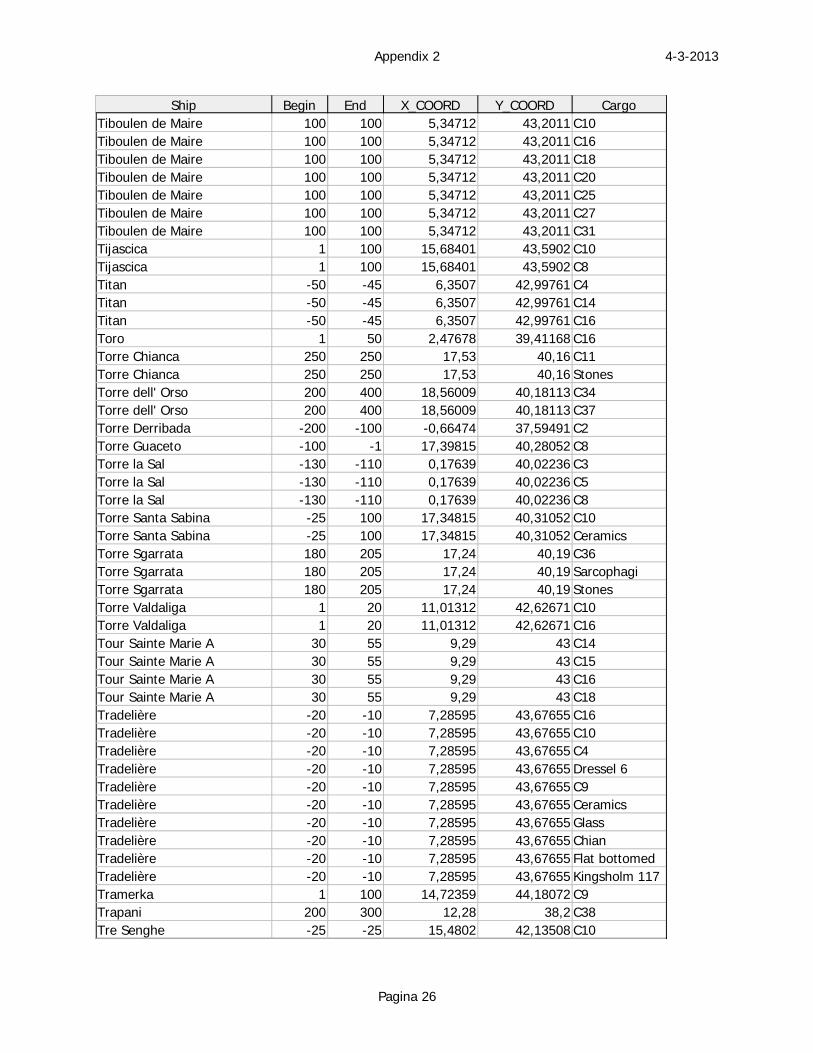
4-3-2013Appendix 2
Pagina 26
Ship Begin End X_COORD Y_COORD CargoTiboulen de Maire 100 100 5,34712 43,2011 C10Tiboulen de Maire 100 100 5,34712 43,2011 C16Tiboulen de Maire 100 100 5,34712 43,2011 C18Tiboulen de Maire 100 100 5,34712 43,2011 C20Tiboulen de Maire 100 100 5,34712 43,2011 C25Tiboulen de Maire 100 100 5,34712 43,2011 C27Tiboulen de Maire 100 100 5,34712 43,2011 C31Tijascica 1 100 15,68401 43,5902 C10Tijascica 1 100 15,68401 43,5902 C8Titan -50 -45 6,3507 42,99761 C4Titan -50 -45 6,3507 42,99761 C14Titan -50 -45 6,3507 42,99761 C16Toro 1 50 2,47678 39,41168 C16Torre Chianca 250 250 17,53 40,16 C11Torre Chianca 250 250 17,53 40,16 StonesTorre dell' Orso 200 400 18,56009 40,18113 C34Torre dell' Orso 200 400 18,56009 40,18113 C37Torre Derribada -200 -100 -0,66474 37,59491 C2Torre Guaceto -100 -1 17,39815 40,28052 C8Torre la Sal -130 -110 0,17639 40,02236 C3Torre la Sal -130 -110 0,17639 40,02236 C5Torre la Sal -130 -110 0,17639 40,02236 C8Torre Santa Sabina -25 100 17,34815 40,31052 C10Torre Santa Sabina -25 100 17,34815 40,31052 CeramicsTorre Sgarrata 180 205 17,24 40,19 C36Torre Sgarrata 180 205 17,24 40,19 SarcophagiTorre Sgarrata 180 205 17,24 40,19 StonesTorre Valdaliga 1 20 11,01312 42,62671 C10Torre Valdaliga 1 20 11,01312 42,62671 C16Tour Sainte Marie A 30 55 9,29 43 C14Tour Sainte Marie A 30 55 9,29 43 C15Tour Sainte Marie A 30 55 9,29 43 C16Tour Sainte Marie A 30 55 9,29 43 C18Tradelière -20 -10 7,28595 43,67655 C16Tradelière -20 -10 7,28595 43,67655 C10Tradelière -20 -10 7,28595 43,67655 C4Tradelière -20 -10 7,28595 43,67655 Dressel 6Tradelière -20 -10 7,28595 43,67655 C9Tradelière -20 -10 7,28595 43,67655 CeramicsTradelière -20 -10 7,28595 43,67655 GlassTradelière -20 -10 7,28595 43,67655 ChianTradelière -20 -10 7,28595 43,67655 Flat bottomedTradelière -20 -10 7,28595 43,67655 Kingsholm 117Tramerka 1 100 14,72359 44,18072 C9Trapani 200 300 12,28 38,2 C38Tre Senghe -25 -25 15,4802 42,13508 C10
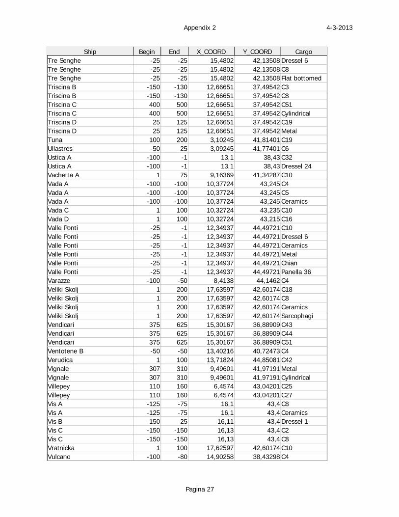
4-3-2013Appendix 2
Pagina 27
Ship Begin End X_COORD Y_COORD CargoTre Senghe -25 -25 15,4802 42,13508 Dressel 6Tre Senghe -25 -25 15,4802 42,13508 C8Tre Senghe -25 -25 15,4802 42,13508 Flat bottomedTriscina B -150 -130 12,66651 37,49542 C3Triscina B -150 -130 12,66651 37,49542 C8Triscina C 400 500 12,66651 37,49542 C51Triscina C 400 500 12,66651 37,49542 CylindricalTriscina D 25 125 12,66651 37,49542 C19Triscina D 25 125 12,66651 37,49542 MetalTuna 100 200 3,10245 41,81401 C19Ullastres -50 25 3,09245 41,77401 C6Ustica A -100 -1 13,1 38,43 C32Ustica A -100 -1 13,1 38,43 Dressel 24Vachetta A 1 75 9,16369 41,34287 C10Vada A -100 -100 10,37724 43,245 C4Vada A -100 -100 10,37724 43,245 C5Vada A -100 -100 10,37724 43,245 CeramicsVada C 1 100 10,32724 43,235 C10Vada D 1 100 10,32724 43,215 C16Valle Ponti -25 -1 12,34937 44,49721 C10Valle Ponti -25 -1 12,34937 44,49721 Dressel 6Valle Ponti -25 -1 12,34937 44,49721 CeramicsValle Ponti -25 -1 12,34937 44,49721 MetalValle Ponti -25 -1 12,34937 44,49721 ChianValle Ponti -25 -1 12,34937 44,49721 Panella 36Varazze -100 -50 8,4138 44,1462 C4Veliki Skolj 1 200 17,63597 42,60174 C18Veliki Skolj 1 200 17,63597 42,60174 C8Veliki Skolj 1 200 17,63597 42,60174 CeramicsVeliki Skolj 1 200 17,63597 42,60174 SarcophagiVendicari 375 625 15,30167 36,88909 C43Vendicari 375 625 15,30167 36,88909 C44Vendicari 375 625 15,30167 36,88909 C51Ventotene B -50 -50 13,40216 40,72473 C4Verudica 1 100 13,71824 44,85081 C42Vignale 307 310 9,49601 41,97191 MetalVignale 307 310 9,49601 41,97191 CylindricalVillepey 110 160 6,4574 43,04201 C25Villepey 110 160 6,4574 43,04201 C27Vis A -125 -75 16,1 43,4 C8Vis A -125 -75 16,1 43,4 CeramicsVis B -150 -25 16,11 43,4 Dressel 1Vis C -150 -150 16,13 43,4 C2Vis C -150 -150 16,13 43,4 C8Vratnicka 1 100 17,62597 42,60174 C10Vulcano -100 -80 14,90258 38,43298 C4
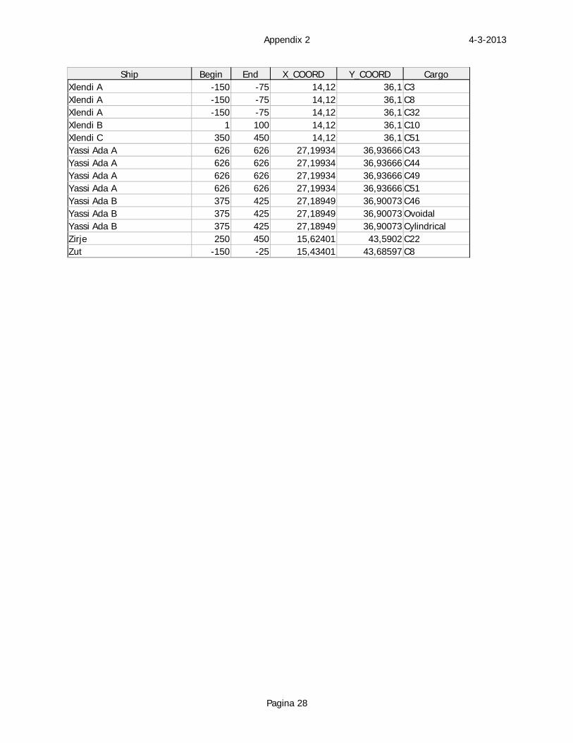
4-3-2013Appendix 2
Pagina 28
Ship Begin End X_COORD Y_COORD CargoXlendi A -150 -75 14,12 36,1 C3Xlendi A -150 -75 14,12 36,1 C8Xlendi A -150 -75 14,12 36,1 C32Xlendi B 1 100 14,12 36,1 C10Xlendi C 350 450 14,12 36,1 C51Yassi Ada A 626 626 27,19934 36,93666 C43Yassi Ada A 626 626 27,19934 36,93666 C44Yassi Ada A 626 626 27,19934 36,93666 C49Yassi Ada A 626 626 27,19934 36,93666 C51Yassi Ada B 375 425 27,18949 36,90073 C46Yassi Ada B 375 425 27,18949 36,90073 OvoidalYassi Ada B 375 425 27,18949 36,90073 CylindricalZirje 250 450 15,62401 43,5902 C22Zut -150 -25 15,43401 43,68597 C8
Appendix 4
This appendix is a bibliography, which have been used in order to create the database of shipwrecks and the amphorae typology.

Bibliography Arthur, P. 1986. Amphorae and the Byzantine world. In J.-Y. Empereur & Y. Garlan
(eds.), Recherches sur les amphores grecques. Bulletin de correspandance
Hellénistique, Supp. XIII. p. 655 – 660. Paris.
Arthur, P. 1989. On the origins of Richborough Form 527. In M. Lenoir, D.
Manacorda & C. Panella (eds.), Amphores Romaines et histoire économique: dix ans
de recherche. Collection de l’école Française de Rome 114. p. 249 – 256. Rome.
Abadie-Reynal, C. 1999. Les amphores Romaines en Mer Noire. In Y. Garlan.
Production et commerce des amphores anciennes en Mer Noire. Aix-en-Provence.
Bass, F.G. & Van Doorninck F.H.Jr. 1971. A fourth century shipwreck at Yassi Ada.
American Journal of Archaeology, 75: 33 – 43.
Bass, F.G. 1982. The pottery. In F.G. Bass, F.H. van Doornick (eds.), Yassi Ada I: a
seventh century Byzantine shipwreck. p. 155 – 188. Texas A&M University Press.
Beltrán Lloris, M. 1978. Ceramica romana: tipologia y clasificacion. Zaragosa.
Bound, M. 1992. A Roman amphora wreck (Pélichet 47) off the island of
Montecristo, Italy. IJNA 21.4: 329 – 336.
Carandini, A. 1983. Pottery and the African economy. In P. Garnsey, K. Hopkins &
C.R. Whittaker, Trade in the ancient economy. London. Hogarth Press. 145 – 162.
Casson, L. 1984. Ancient trade and society. Detroit. Wayne State university press.
Colls, D., Etienne, R., Lequément, R., Liou, B. & Mayet, F. 1977. L’épave Port-
Vendres II et le commerce de la Bétique à l’époque de Claude. Archaeonautica 1.
Paris.
Corsi-Sciallano, M. & Liou, B. 1985. Les épaves de Tarraconaise à chargement
d’amphores dressel 2-4. Archaeonautica 5. Paris.
De Donato, G. 2003. Mare Nostrum, the Roman sea. Encyclopaedia of underwater
archaeology. London. Periplus.
Dore, J. & Keay, N. 1989. Excavations at Sabratha 1948 – 1951. Volume II: the finds.
Society for Libyan Studies Monograph 1. Tripoli.
Empereur, J.-Y. & A. Hesnard 1987. Les amphores Hellensitiques du monde Egéen.
In P. Lévêque & J._P. Morel (eds.), Céramiques Hellenistiques et Romaines. Centre
de recherches d’histoire ancienne 70. p. 10 – 71. Paris.
Empereur, J.-Y. & Picon, M. 1989. Les régions de production d’amphores impériales
en Méditerranée orientale. In M. Lenoir, D. Manacorda & C. Panella (eds.),
Amphores Romaines et histoire économique: dix ans de recherche. Collection de
l’école Française de Rome 114. p. 223 – 248. Rome.
Fulford, M.G. 1977. Pottery and Britain’s trade in the Later Roman Period. In D.P.S.
Peacock (ed.), Pottery and early commerce, characterisation and trade in Roman and
Later ceramics. 55 – 73. London.
Garland, Y. & Empereur, J.-Y. 1987. Bulletin archéologique: amphores et timbres
amphoriques. Revue des études Grecques 100: 58 – 133.
Gibbins, D. 2001. Shipwrecks and Hellenistic trade. In Z.H. Archibald, J. Davies, V.
Gabrielsen & G.J. Olivier, Hellenistic economies. p. 273 – 312. London.
Greene, K. 1986. The archaeology of the Roman economy. London.
Jurisic, M. 2000. Ancient shipwrecks of the Adriatic. BAR international Series 828.
Oxford.
Keay, S. 1984. Late Roman amphorae in the Western Mediterranean; a typology and
economic study. BAR International Series 196. Part I. Oxford.
Keay, S. 1984. Late Roman amphorae in the Western Mediterranean; a typology and
economic study. BAR International Series 196. Part II. Oxford.
Keay, S. 1992. The Siena amphora conference. Part 1: amphorae and the Roman
economy. Journal of Roman Archaeology 5: 353 – 360.
Keen R. & Keen, J. 1979. Little Russel Amphora wreck. Information sheet 1.
Guernsey.
Kingsley, S. 2001. The economic impact of Palestinian wine trade in Late Antiquity.
In S. Kingsley & M. Decker, Economy and exchange in the East Mediterranean
during Late Antiquity. p. 44 - 68. Oxford
Kingsley, S.A. 2002. A sixth-century AD shipwreck off the Carmel Coast, Israel. BAR
International Series 1065. Oxford.
Kingsley, S.A. 2004 A. Shipwreck archaeology of the Holy Land. Duckworth debates
in archaeology. London.
Kingsley, S.A. 2004 B. Barbarian seas; Late Roman to Islam. Encyclopaedia of
underwater archaeology. London. Periplus.
Kingsley, S. & Decker, M. 2001. New Rome, new theories on inter-regional
exchange. An introduction to the East Mediterranean economy during Late Antiquity.
In S. Kingsley & M. Decker, Economy and exchange in the East Mediterranean
during Late Antiquity. p. 1 – 27. Oxford.
Laubenheimer, F. 1990. Le temps des amphores en Gaule. Collection des Hesperides.
Paris.
Leonard, J.R. 1995. The anchorage at Kioni. In J. Fejfer (ed.), Ancient Akamas I.
Settlement and Environment. p. 133 – 170. Aarhus University Press.
Liou, B. 1990. Sur les amphores et le commerce du vin. In T. Hackens & M. Miro
(eds.), Le commerce maritime Romain en Méditerranée occidentale, Revue du group
Européen d’études pour les techniques physiques, chimiques, biologiques et
mathemathiques appliqués à l’archéologie, PACT 27: 327 - 333. Rixensart.
Majcherek, G. 2004. Alexandria’s long-distance trade in Late Antiquity – the
amphora evidence. In J. Eiring & J. Lund, Transport Amphorae and Trade in the
Eastern Mediterranean: Acts of an International Colloquium at the Danish Institute of
Athens, 26-29 September 2002. Monographs of the Danish Institute at Athens 5: 229
– 236. Aarhus.
Marlier, S. & Sibella, P. 2002. La Giraglia, a dolia wreck of the 1st century BC from
Corsica, France. IJNA 31.2: 161 – 171.
Martin-Kilcher, S. 2003. Fish-sauce amphorae from the Iberian peninsula: the forms
and observations on trade with the north-west provinces. In J. Plouviez (ed.),
Amphorae in Britain and the western Empire. Journal of Roman pottery studies 10:
69 – 83. Oxbow books.
Martin-Kilcher, S. 2004. Amphorae in the Roman West: Discussion and research
since 1989. In J. Eiring & J. Lund, Transport Amphorae and Trade in the Eastern
Mediterranean: Acts of an International Colloquium at the Danish Institute of Athens,
26-29 September 2002. Monographs of the Danish Institute at Athens 5: 263 – 272.
Aarhus.
McCann, A.C. & Freed, J. 1994. Deep water archaeology. Late Roman from Carthage
and an ancient trade route near Skerki Bank off northwest Sicily. Journal of Roman
Archaeology supplementary series 13. Oxford.
McCann, A.C. & Oleson, J.P. 2004.Deep-water shipwrecks off Skerki Bank: The
1997 Survey. Journal of Roman Archaeology supplementary series 58. Porthsmouth.
Panella, C. 1973. Anfore. Ostia III. 463 – 633.
Parker, A.J. 1973. The evidence provided by underwater archaeology for Roman trade
in the Western Mediterranean. In D.J. Blackmann, Marine Archaeology. p. 361 – 379.
London.
Parker, A.J. 1977. Lusitanian amphoras. Methodes classiques et methodes formelles
dans l’étude des amphores. Collection de l’ecole française de Rome 32: 35 – 45.
Rome.
Parker, A.J. 1980. Roman wrecks in the Western Mediterranean. In K. Muckelroy,
Archaeology under Water, an atlas of the world’s submerged sites. p. 50 – 61.
London.
Parker, A.J. 1984. Shipwrecks and ancient trade in the Mediterranean. Archaeological
review from Cambridge 3.2: 99 – 113.
Parker, A.J. 1990 a. Classical antiquity: the maritime dimension. Antiquity 64: 335 –
346.
Parker, A.J. 1990 b. The pattern of commerce as evidenced by shipwrecks. In T.
Hackens & M. Miro (eds.), Le commerce maritime Romain en Méditerranée
occidentale, Revue du group Européen d’études pour les techniques physiques,
chimiques, biologiques et mathemathiques appliqués à l’archéologie, PACT 27: 147 –
168. Rixensart.
Parker, A.J. 1992 a. Ancient shipwrecks of the Mediterranean & the Roman
Provinces. BAR International Series 580. Oxford.
Parker, A.J. 1992 b. Cargoes, containers and stowage: the ancient Mediterranean.
IJNA 21.2: 89 –100.
Parker; A.J. 1995. Maritime cultures and wreck assemblages in the Graeco-Roman
world. IJNA 24.2: 87 – 65.
Parker, A.J. & Price, J. 1981. Spanish exports of the Claudian period: the significance
of the Port-Vendres II wreck reconsidered. IJNA 10.3: 221 – 228.
Paterson, J. 1982. Salvation from the sea: amphorae and trade in the Roman West.
Journal of Roman Studies 72: 146 – 157.
Peacock, D.P.S. 1977. Roman amphorae: typology, fabric & origins. Methodes
classiques et methodes formelles dans l’étude des amphores. Collection de l’école
française de Rome 32: 261 – 273. Aix-en-Provence.
Peacock, D.P.S. 1978. The Rhine and the problem of Gaulish wine in Roman Britain.
In J. du Plat Taylor & H. Cleere (eds.), Roman shipping and trade: Britain and the
Rhine Provinces. Council for British Archaeology Research Report 24. p. 49 – 51.
London
Peacock, D.P.S. & Williams, D.F. 1986. Amphorae and the Roman economy, an
introductory guide. Longman Archaeological Series. London.
Raban, A. 1992. Sebastos: the royal harbour at Caesarea Maritima. IJNA 21.2: 111 –
124.
Radic, I. 1991. Three more louteria finds in the Eastern Adriatic. IJNA 20.2: 155 –
160.
Rule, M. & Monaghan, J. 1993. A Gallo-Roman Trading vessel from Guernsey.
Guernsey Museum Monographs 5. Guernsey.
Sagui, L. 1998. African amphorae. In L. Sagui (ed.), Ceramica in Italia: VI – VII
secolo. p. 141 – 155. Firenze.
Sciallano, M. & Sibella, P. 1994. Amphores comment les identifier? Aix-en-Provence.
Sedge, M.H. 2002. The lost ships of Pisa. New York.
Talbert, R.J.A. 1985. Atlas of Classical History. London.
Tchernia, A. 1980. Quelques remarques sur le commerce du vin et les amphores. In
J.H. D’Arms & E.C. Kopff, The seaborne commerce of Ancient Rome: Studies in
Archaeology and History. American Academy in Rome. p. 305 – 312. Rome.
Throckmorton, P. 1974. Romans on the sea. In G. Bass (ed.), A history of seafaring
based on underwater archaeology. p. 65 – 87. London.
Whittaker, D. 1989. Amphorae and trade. In M. Lenoir, D. Manacorda & C. Panella
(eds.), Amphores Romaines et histoire économique: dix ans de recherche. Collection
de l’école Française de Rome 114. p. 537 – 538. Rome.
Williams, D. 2003. Cretan wine in Roman Britain. In J. Plouviez (ed.), Amphorae in
Britain and the western Empire. Journal of Roman pottery studies 10: 26 – 31.
Oxbow Books.