potential impacts of petroleum exploration and exploitation on biodiversity in a patagonian nature...
TRANSCRIPT

Biodiversity and Conservation 12: 1261–1270, 2003. 2003 Kluwer Academic Publishers. Printed in the Netherlands.
Potential impacts of petroleum exploration andexploitation on biodiversity in a Patagonian NatureReserve, Argentina
´*SANDRA MARCELA FIORI and SERGIO MARTIN ZALBA´ ´ ´GEKKO Grupo de Estudios en Conservacion y Manejo, Departmento de Biologıa, Bioquımica y
*´Farmacia, Universidad Nacional del Sur, San Juan 670, 8000 Bahıa Blanca, Argentina; Author forcorrespondence (e-mail: [email protected]; fax: 154-291-4595130)
Received 8 January 2002; accepted in revised form 3 July 2002
Key words: Fragmentation, Patagonian steppe, Seismic prospecting
Abstract. Petroleum exploration and extraction are common on the Patagonian steppe, but their impactson the native biodiversity have not been properly evaluated. We describe both activities in a Patagoniannature reserve and consider their potential impacts on biodiversity. More than 2025 km of seismic lines
2inside the reserve resulted in 87.21 m /ha (0.9%) of directly affected land, and 793 fragments of native2habitats were defined with a mean area of 1.26 6 0.74 km . Vegetation recovery on seismic lines is
extremely poor. We discuss the role of seismic lines as barriers to native species, and their significance inencouraging poaching and the expansion of exotic invasive plants. There is a high degree of overlapbetween current petroleum activities and areas of special conservation concern (high erosion risk,vegetation diversity, abundance of endemic plant species, and habitat quality for native vertebrates). Allthese have a significant impact on the efficiency of the conservation area and highlight the urgent need toimplement appropriate mitigating actions.
Introduction
The Patagonian steppe is one of the largest ecoregions of Argentina, comprising anarea of about 54 million ha. Only 4.7% of this ecosystem is included in naturereserves (Bertonatti and Corcuera 2000) and, despite being legally protected, asignificant proportion of this terrain is exposed to over-grazing by sheep and goats,as well as to oil and gas exploration and extraction.
The petroleum exploration phase was normally conducted by means of seismo-graphic methods: bulldozers scraped away the topsoil to prepare for lined series ofexplosive charges to determine the nature and structure of underground rockformations, and to search for potential oil deposits. The result of this is an extensivenetwork of prospecting lines, with scarce or zero vegetation cover, the effects ofwhich have not been properly investigated in relation to the integrity of Patagonianecosystems.
The petroleum exploitation phase also results in a number of environmentalchanges, such as the construction of roads, pipelines, tanks and other facilities,vehicle traffic, air emissions, and the risk of oil spills. These activities may interferedirectly with the movement and behaviour of wildlife, resulting in changes in their

abundance and distribution, and they also facilitate the introduction and expansionof invasive plant species. The increased access to the area encourages hunters andpoachers, and also favours activities such as cattle ranching by providing therequired access routes (IUCN and EP Forum 1991; Maki 1992).
The aim of this investigation is to describe petroleum exploration and exploitationin a northern Patagonian nature reserve, in the past and the present, and to discusstheir potential impacts on the native biodiversity.
Study area
This study was conducted at the Auca Mahuida Nature Reserve, located in the´Neuquen province (Argentina), between 378309–388 S and 688309–69815 W (Figure
1). The reserve comprises ca. 118960 ha in a region with an arid climate, having amean annual rainfall of 130 mm, a mean annual temperature of 14 8C, and a highwater deficit, which can reach levels of up to 400–600 mm each year (Arroyo 1980;
´Departamento de Geografıa, Universidad Nacional del Comahue 1982; Pires 1995).The reserve is located on an extensive plateau with many volcanic cones, the most
Figure 1. Map of Patagonia with the location of the study site.
1262
conspicuous being the Auca Mahuida Volcano that reaches a height of 2253 m(Holmberg 1964). The reserve includes areas of high-Andean, Patagonian andMonte vegetation (Long 2000). The dominant types of vegetation are shrub-steppeand grass-steppe (Movia et al. 1982). Populations of large Patagonian animals, bothherbivorous and carnivorous, are well represented within its boundaries, including
´one of the largest populations of guanacos (Lama guanicoe) in the Neuquenprovince (Funes 2000).
It is legally designated as a multi-purpose reserve where productive and recrea-tional activities are allowed at a moderate level. The area was subjected to oilprospecting in the past, and at present intensive petroleum extraction activities arebeing carried out, even though technical recommendations have been made againstthem (Fiori and Zalba 2000).
Methods
Seismic prospecting lines, roads, quarries and petroleum drilling pads inside thereserve were located by means of visual interpretation of a false colour compositionfrom bands 2, 3 and 4 of a LANDSAT 5TM satellite image taken in February 1999.
Using a GPS we picked up 110 control points from the study area in order tospatially georeference the image. The resampling process was carried out usingIDRISI 2.0 (Clark University 1997). We discarded 23 control points because theyhad low confidence levels and high residuals, and the final correction resulted in atotal root mean square error (RMS) of 2.5 pixels (75 m). We made a print-out of theimage at a scale of 1 /50000 and visually detected the objects of interest (prospect-ing lines, roads, quarries and petroleum drilling pads) and digitized them by usingthe GIS CAMRIS (Ecological Consulting Inc. 1998). In some sections of the reserveit was difficult to identify roads and seismic lines, as they had similar spectralsignatures to the surrounding land, and so we complemented the interpretation withaerial photographs (scale 1:60000) and maps made by petroleum companiesworking in the area. All this information was corroborated in the field. The totallength of all seismic lines crossing the reserve was measured and the area coveredby them was calculated using an average figure for the width, which was taken frommeasurements made on lines randomly selected in the field. The number and meansize of the remaining habitat fragments were also recorded.
In order to assess the impact of the seismic lines on the vegetation, 16 pairedsample areas were surveyed, each pair including one sample on the prospecting line
2and the other 10 m away in the surrounding vegetation. In each 50 m sample plotwe recorded the presence of the most abundant plant species (percentage cover $10%), and estimated the percentage of bare soil and herb and shrub strata (Mueller-Dombois and Ellenberg 1974). The values of the latter three variables weretransformed to the square root arcsine in order to make them fit a normal dis-tribution, and were compared using paired t-tests.
Using the GIS we evaluated the overlap between the digitalized quarries, roadsand drilling pads with respect to areas of greater erosion risk (Navarro 2000),
1263
vegetation diversity, abundance of endemic plant species (Long 2000), and habitatquality for guanaco (Lama guanicoe), lesser rhea (Pterocnemia pennata), Patago-
´nian cavy (Dolichotis patagonum) and chinchillon (Lagidium viscacia) (Funes2000).
Results
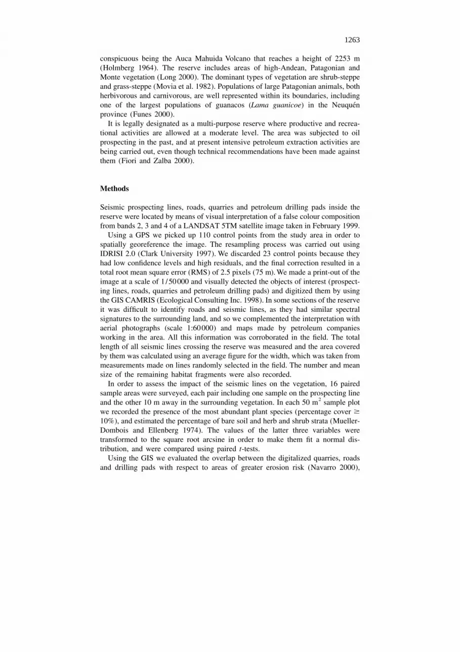
The reserve is almost completely divided up by seismic lines, except for the highestsections of the Auca Mahuida volcano. All the lines remain open, many of thembeing used as roads. The prevailing directions of the lines are from northwest tosoutheast, and from northeast to southwest, while only a few lines cross the reserveeither from north to south, or from west to east, or in intermediate directions (Figure2). The total length of the seismic lines crossing the reserve has been estimated at2025 km. The reserve also has an extensive network of about 107 km of trails androads, mainly associated with petroleum extraction activities, and 57 km of pavedroads along its western and southwestern borders.
2The density of seismic lines was estimated at a minimum of 1.70 km/km , with a2mean width of 5.13 6 1.21 m, resulting in a directly affected area of 87.21 m /ha
(0.9%). Due to the distribution pattern and the total length of the seismic lines, morethan 17% of the total area of the reserve is located at 50 m or less from the closest
Figure 2. Landsat TM image of Auca Mahuida nature reserve (A), with details of quarries and roads (B),and seismic prospecting lines (C).
1264

line. A total of 793 habitat fragments are found within the lines and have a mean2area of 1.26 6 0.74 km . The shape of the fragments is predominantly quadrangular.
Significant differences were found when comparing the percentage of bare soil,which was higher on the seismic lines (t 2.13; P , 0.01), and the cover of herbs(15)
and shrubs, which were higher in the samples in the surrounding vegetation, awayfrom the lines (t 26.67 and 26.89, respectively; P , 0.01) (Figure 3). No(15)
significant differences were found in the proportion of herb /shrub covers (t 1.00;(15)
P 5 0.33).Among the native species, Grindelia chiloensis was one of the main colonizers of
cleared areas. Some exotic invasive species, like Hordeum leporinum and Erodiumcicutarium, were also associated with seismic lines.
There is a considerable overlap between current petroleum activities (quarries andpetroleum drilling pads) and areas of special interest for conservation, i.e. areas withthe highest erosion risks, the highest vegetation diversity and/or abundance ofendemic plant species and with high quality habitats for guanacos, lesser rheas, or toa lesser extent for Patagonian cavies and chinchillones (Table 1). In the case of thePatagonian cavy and lesser rhea, the disturbance created by petroleum activities is
Figure 3. Seismic prospecting line in Auca Mahuida Nature Reserve, showing almost null vegetationrecovery.
1265
Table 1. Spatial superposition (in percentages) between quarries (n 5 34) and drilling pads (n 5 7) andareas of greater conservation interest in the reserve
Petroleum Erosion Plant diversity Habitat foractivities risk and endemism
´Guanaco Lesser Patagonian ChinchillonRhea Cavy
Quarries 58.82 70.59 55.88 26.47 8.82 23.53Drilling pads 28.57 28.57 57.14 42.86 0.00 14.29
superimposed to the effects of the paved road, as no place in the habitats of thesespecies is located farther from the road than 9.5 and 7.6 km, respectively.
Thirty-four quarries were recorded, at least four of which are currently in use.Materials extracted from them are used for the construction of roads or otherinfrastructure. Twelve petroleum facilities were visited, including drilling pads,batteries and gas injection plants. There was no sign of any restoration activities atany of these sites.
Drainage pools with no fences, acting as traps for wildlife, were seen in thesouthern section of the reserve. In the same area we found salty water deposits thathad been opened by petroleum companies which continue flowing after the siteswere abandoned, thus contaminating the soils.
Discussion
While a lot of papers remark on the negative edge effects faced by nature reservesfrom the surroundings lands (Schonewald-Cox et al. 1992; Meffe and Carroll 1994),much less attention has been paid to fragmentation processes occurring inside theboundaries of conservation areas. Our investigation shows that the Auca Mahuidanature reserve is, in fact, an archipelago of patches of natural vegetation that haveresulted from oil and gas prospecting in the area. This is not an isolated case, butalmost the general rule in the natural ecosystems of the Patagonian steppe. As an
´example, two thirds of the protected areas under provincial jurisdiction in Neuquenhave undergone, or still have, petroleum exploration or extraction activities insidetheir boundaries (Di Martino et al. 1999).
It is internationally agreed that the impact of fragmentation on natural ecosystemsaffects all levels of ecological organization (Robinson et al. 1992) and is one of themain causes of biodiversity loss (Wilcox and Murphy 1985; Saunders et al. 1991;Meffe and Carroll 1994). It is therefore important to assess which components orprocesses of the regional ecosystem might be affected by the described fragmenta-tion situation. Seismic lines could be compared with trails and small roads, whichcause many well known ecological effects such as subdividing populations, favour-ing invasive species, increasing the success of generalist predators, facilitatingpoaching activities and interfering with ecological processes (Allen et al. 1998;Gucinski et al. 2000).
1266

Roads may act as barriers of low permeability for taxa like clonal plants(Robinson et al. 1992), amphibians (Gibbs 1998), small mammals, snails, andbutterflies (Bennett 1991). Even narrow, unpaved roads closed to public trafficwould serve as barriers to spiders, carabid beetles (Mader 1984; Mader et al. 1990)and soil macroinvertebrates (Haskell 2000). In Auca Mahuida, the removal oftopsoil from the seismic lines probably makes them effective barriers for specieslike clonal plants, reducing the opportunity of re-invasion by vegetative growth.
The association between seismic lines and roads with exotic plants like Hordeumleporinum and Erodium cicutarium suggests that they could be favouring the spreadand establishment of invasive species, which agrees with a previous study of seedbanks and vegetation associated with Patagonian steppe roadsides (Margutti et al.1996). This could also be the case for the expansion of leaf-cutting ants (Ac-romyrmex lobicornis). Previous studies have shown that this species has expandedits geographical range in northwestern Patagonia in response to road building andmaintenance (Farji-Brener and Corley 1998). During this investigation we foundwinged adults of this species in the vicinity of roads and petroleum drilling pads.
It has already been pointed out that roads may favour the movements of predators,and therefore increase their impact on the populations of preys like small mammals,birds and reptiles (Rich et al. 1994; but see also Yahner and Mahan 1997). Thiseffect has not yet been assessed for seismic lines in Auca Mahuida. However,seismic lines that remain open, particularly those intersecting paved roads, giveaccess to lesser rheas and guanacos poachers who can then go right into the core ofthe reserve (Funes 2000).
The impact of seismic lines on the dynamics of fires or rainfall infiltration andrunoff has not been evaluated either. Nevertheless, it is clear that they increase theintensity of erosion processes in the area (Navarro 2000).
As well as the direct effect of fragmentation by seismic lines, disturbancesoriginating from noise and the movements of people and vehicles associated withpetroleum extraction activities can modify the behaviour of wildlife species withbroad distribution ranges (Klein 1991; Nellemann and Cameron 1996; Bradshaw etal. 1997). In Auca Mahuida, present extraction activities overlap with guanacofeeding and calving areas, and could therefore have a negative influence on theirabundance. This is shown by the movement of herds from their traditional areas ofconcentration to places where they appear to be more exposed to natural predationand illegal hunting, especially during the calving season (Funes 2000). Petroleumexploitation may also prevent guanacos having access to the only permanent sourceof water in the reserve.
In the study area, the timing of rainfall causes a seasonal availability of resourcesthat has been crucial in the evolution of the Patagonian ecosystem (Orians andSolbrig 1977), but this situation may be modified by the existence of rubbishdeposits associated with the presence of petroleum workers in the area. Rubbishbecomes a constant and highly predictable source of food for carnivores andscavengers, probably changing their abundance and distribution in the area andsecondarily affecting the populations of preys (Fiori and Zalba 2000). Also thepresence of electric lines as part of the petroleum facilities may introduce another
1267

change in the trophic relationships by providing perching sites for raptors and thusaiding their hunting performance (Funes 2000).
Considering the extent and potential impact of past and current petroleumactivities described for Auca Mahuida, we think that there is enough information toseverely question their development in areas primarily devoted to the conservationof biodiversity, as commonly happens in Patagonian nature reserves. To assume thatboth activities can coexist could lead to the creation and maintenance of ‘paperreserves’ where the reality on the ground markedly contrasts with our perception ofprotected areas.
Acknowledgements
´The authors wish to express thanks to Sebastian Di Martino and to all those whoworked on the Management Plan for the Auca Mahuida Nature Reserve. Thisinvestigation was funded by the Consejo Federal de Inversiones (Argentina). Dr
´Nestor Cazzaniga and two anonymous referees revised preliminary versions of thismanuscript.
References
Allen C.D., Betancourt J.L. and Swetnam T.W. 1998. Landscape changes in the southwestern UnitedStates: techniques, long-term data sets, and trends. In: Sisk T.D. (ed.), Perspectives on the Land-UseHistory of North America: A Context for Understanding our Changing Environment. US GeologicalSurvey, Biological Resources Division Chapter 9, Biological Science Report USGS/BRD/BSR1998-0003 (Revised September 1999).
´ ´ ´Arroyo J. 1980. Relevamiento y prioritacion de areas con posibillidades de riego. Provincia del Neuquen.Vol. 2: Clima Consejo Federal de Inversiones. Tomo 2. Buenos Aires, Argentina.
Bennett A.F. 1991. Roads, roadsides and wildlife conservation: a review. In: Saunders D.A. and HobbsR.J. (eds), Nature conservation 2: The Role of Corridors. Surrey Beatty and Sons, Chipping Norton,Australia.
´ ´Bertonatti C. and Corcuera J. (eds) 2000. Diagnostico Ambiental de la Republica Argentina 2000.´Fundacion Vida Silvestre Argentina, Buenos Aires, Argentina.
Bradshaw C.J.A., Boutin S. and Hebert D.M. 1997. Effects of petroleum exploration on woodlandcaribou in northeastern Alberta. Journal of Wildlife Management 61: 1127–1133.
Clark University 1997. IDRISI for Windows. Users Guide. Version 2.0. Clark labs for CartographicTechnology and Geographic Analysis, Worcester, Massachusetts.
´Departamento de Geografıa, Universidad Nacional del Comahue 1982. Atlas de la provincia del´Neuquen. Universidad Nacional del Comahue, Buenos Aires, Argentina.
´´Di Martino S., Maletti E., Araya M.M. and Pires A. 1999. Estado de situacion de las Areas Naturales´ ´Protegidas Provinciales del Neuquen. Informe interno. Direccion General de Bosques, Fauna y
´ ´ ´Parques Provinciales. Subsecretarıa de Produccion y Recursos Naturales, Secretarıa de Estado de´ ´Produccion y Turismo, Provincia del Neuquen, Argentina.
Ecological Consulting Inc. 1998. CAMRIS – Sistema de Mapeo e Inventario de Recursos Asistido porComputadora. Vols I and II. Ecological Consulting Inc., Portland, Oregon, 2271225 pp.
Farji-Brener A.G. and Corley J.C. 1998. Successful invasions of hymenopteran insects into NW´Patagonia. Ecologıa Austral 8: 237–249.
Fiori S.M. and Zalba S.M. 2000. Conservar y recuperar los suelos y la cubierta vegetal (Objetivo 3). In:
1268

´Fiori S.M. and Zalba S.M. (eds), Plan de Manejo Reserva Provincial Auca Mahuida (Neuquen).´ ´ ´ ´Diagnostico Especıfico, Taller y Asambleas Publicas Vol. II. Secretarıa de Estado del COPADE y
´Consejo Federal de Inversiones, Bahıa Blanca, Argentina, p. 33.´ ´ ´Funes M. 2000. Conservar el ensamble de herbıvoros (guanaco, choique, mara, chinchillon) y carnıvoros
´ ´ ´ ´(canidos, felidos, mustelidos y rapaces) nativos de zonas aridas (Objetivo 7) y proteger los ambientes´basalticos (bardas, acantilados) y la fauna asociada, especialmente saurios, microroedores y aves
altoandinas (Objetivo 8). In: Fiori S.M. and Zalba S.M. (eds), Plan de Manejo Reserva Provincial´ ´ ´ ´ ´Auca Mahuida (Neuquen). Diagnostico Especıfico, Taller y Asambleas Publicas Vol. II. Secretarıa de
´Estado del COPADE y Consejo Federal de Inversiones, Bahıa Blanca, Argentina, pp. 119–127.Gibbs J.P. 1998. Amphibian movements in response to forest edges, roads, and streambeds in southern
New England. Journal of Wildlife Management 62: 584–589.Gucinski H., Furniss M.J., Ziemer R.R. and Brookes M.H. 2000. Forest roads: A Synthesis of Scientific
Information. USDA Forest Service, Pacific Northwest Research Station, Portland, Oregon.Haskell D.G. 2000. Effects of forest roads on macroinvertebrate soil fauna of the Southern Appalachian
Mountains. Conservation Biology 14: 57–63.´ ´Holmberg E. 1964. Descripcion geologica de la Hoja 33d – Auca Mahuida, E 1:200.000, Bol. 94. Buenos
Aires, Argentina.IUCN and EP Forum 1991. Oil and Gas Exploration and Production in Artic and Subartic Onshore
Regions. Guidelines for Environmental Protection. IUCN, Cambridge, UK.Klein D.R. 1991. Caribou in the changing North. Appalachian Animal Behavior Science 29: 279–291.
´ ´Long A. 2000. Garantizar la conservacion de areas representativas de las distintas regiones fitogeo-´ ´graficas presentes en la reserva y preservar especialmente las especies vegetales endemicas (Objetivo
6). In: Fiori S.M. and Zalba S.M. (eds), Plan de Manejo Reserva Provincial Auca Mahuida´ ´ ´ ´ ´(Neuquen). Diagnostico Especıfico, Taller y Asambleas Publicas Vol. II. Secretarıa de Estado del
´COPADE y Consejo Federal de Inversiones, Bahıa Blanca, Argentina, pp. 77–81.Maki A.W. 1992. Of measured risk: the environmental impacts of the Prudhoe Bay, Alaska, oil field.
Annual Review of Environmental Toxicology and Chemistry 11: 1691–1707.Meffe G.K. and Carroll C.R. 1994. Principles of Conservation Biology. Sinauer Associates Inc.,
Sunderland, Massachusetts, pp. 131–132.Mader H.J. 1984. Animal habitat isolation by roads and agricultural fields. Biological Conservation 29:
81–96.Mader H.J., Schell C. and Kornacker P. 1990. Linear barriers to movements in the landscape. Biological
Conservation 54: 209–222.Margutti L., Ghermandi L. and Rapoport E.H. 1996. Seed bank and vegetation in a Patagonian roadside.
International Journal of Ecology and Environmental Science 22: 159–175.´ ´Movia C.P., Owef G.H. and Perez C.E. 1982. Estudio de la vegetacion natural. Tomo I – Relevamiento.
´ ´ ´Ministerio de Economıa y Hacienda de la Provincia del Neuquen. Subsecretarıa de Recursos´Naturales, Neuquen, Argentina.
Mueller-Dombois D. and Ellenberg H. 1974. Aims and Methods of Vegetation Ecology. John Wiley andSons, New York.
´ ´Navarro E. 2000. Controlar los procesos de erosion hıdrica (Objetivo 4). In: Fiori S.M. and Zalba S.M.´ ´ ´(eds), Plan de Manejo Reserva Provincial Auca Mahuida (Neuquen). Diagnostico Especıfico, Taller y
´ ´Asambleas Publicas Vol. II. Secretarıa de Estado del COPADE y Consejo Federal de Inversiones,´Bahıa Blanca, Argentina, pp. 57–63.
Nellemann C. and Cameron R.D. 1996. Effects of petroleum development on terrain preferences ofcalving caribou. Artic 49: 23–28.
Orians G.H. and Solbrig O.T. (eds) 1977. Convergent evolution in warm desert: an examination ofstrategies and patterns in deserts of Argentina and United States. Dowden, Hutchinson and Ross,Stroudsburg, Pennsylvania.
´Pires A. 1995. Area Natural Protegida Auca Mahuida – Anteproyecto. Informe Interno. Subsecretarıa de´ ´ ´Produccion Agraria, Ministerio de Produccion y Turismo, Provincia del Neuquen, Argentina.
Rich A.C., Dobkin D.S. and Niles L.J. 1994. Defining forest fragmentation by corridors width: theinfluence of narrow forest-dividing corridors on forest-nesting birds in southern New Jersey.Conservation Biology 8: 1109–1121.
1269

Robinson G.R., Holt R.D., Gaines M.S., Hamburg S.P., Johnson M.L., Fitch H.S. et al. 1992. Diverse andcontrasting effects of habitat fragmentation. Science 257: 524–526.
Saunders D.A., Hobbs R.H. and Margules C.R. 1991. Biological consequences of ecosystem fragmenta-tion: a review. Conservation Biology 5: 18–32.
Schonewald-Cox C., Buechner M., Sauvajot R. and Wilcox B. 1992. Cross-boundary managementbetween national parks and surrounding lands: a review. Environmental Management 16: 273–282.
Wilcox B.A. and Murphy D.D. 1985. Conservation strategy: the effects of fragmentation on extinction.American Naturalist 125: 879–887.
Yahner R.H. and Mahan C.G. 1997. Effects of logging roads on depredation of artificial ground nests in aforested landscape. Wildlife Society Bulletin 25: 158–162.
1270