physical and economic change in bangkok, 1851-1925
TRANSCRIPT
Southeast Asian Studies. Vol.36, No.4, March 1999
Physical and Economic Change In Bangkok, 1851-1925
Porphant OL'YYAI\O','T *
Abstract
This paper explains the major patterns of physical change in Bangkok from 1851 brought aboutby the expansion of canals and roads and the attendant development of new suburbs, Fromaround 1890 we see clearly a change in Bangkok from a water-based city to a land-based city.This paper argues that the period from around 1890 to 1910 is significant in Bangkok'sdevelopment. One characteristic of road building in Bangkok is that it was accompanied by theacti ve investment of the Privy Purse Bureau in row houses. Roads brough t about great changein the physical and economic landscape of the capital from 1890.
I Introduction
This paper explains the enormous physical growth and economic diversification of Bangkok
during the period 1851-1925Y From the 1890s. the city changed from one based on water
(river and canals) to one based on roads. This was the era of the building of row houses. the
tram. and other innovations. Two of the themes highlighted here are: (1) the growth of
Bangkok as a major international port; and (2) the role of investment, particularly by the Privy
Purse Bureau. in changing the physical shape of the capital. In emphasizing change from the
1890s, this study adopts the perspective of economic turning points rather than the more
familiar perspective of Thai historiography that usually looks at the various reigns as separate
entities,
By the 1850s. Bangkok was a city tn transition, changing from a moated and fortified city
into a large commercial city. Before 1851, Bangkok was mainly concentrated within the area of
* School of Economics, Sukhothai Thammathirat Open University, Pakkred, Nonthaburi. 11120 Thailand.e-mail: [email protected] (Guest Scholar and JSPS Postdoctoral Fellow, Graduate School ofAsian and African Area Studies, Kyoto University from June 1998-December 1999). The author is
grateful to Professor Malcolm Falkus and anonymous referees for their helpful comments on an earlierdraft of this paper, and grateful too. to Professor Peter Hawkes for the editorial work. I should like
to acknowledge with gratitude financial support for postdoctoral research from the Japan Society forthe Promotion of Science (jSPS). Sole responsibility for the views expressed here, of course. restswith the author.
1) The author is at present preparing an economic history of Bangkok in the period 1880-1930,emphasizing aspects of population. physical change and urban government. The project is being
conducted under the supervision of Professor Tsubouchi Yoshihiro. Graduate School of Asian andAfrican Area Studies. Kyoto University. I am very grateful for his comments and encouragement.
437

the city walls with the palace as its centre. After 1851, the year of accession of Rama IV
(1851-68), the city landscape gradually changed. After the signing of the Bowring Treaty in
1855, the growth of the city gradually accelerated. One of the most important aspects of the
Treaty was that it abolished the state monopoly on international trade and allowed private
business, mostly western and Chinese, to trade freely without state interference. As a result,
more Westerners came to live in Bangkok and set up trading firms and a few industries. The
growth of business generated demand for land for construction and some residential areas.
Under the Bowring Treaty, Bangkok developed essentially as an outward-looking port city,
handling virtually all the kingdom's exports and imports. Rice exports, which were 75 percent
of the value of total exports in the decade before 1914, grew from around 10,000 tons annually
in the 1860s to around 500,000 tons in the 1890s and to over 1 million tons by the 1920s
[Falkus 1993: 148J. Foreign trade had a considerable impact upon general economic activity in
Bangkok. Shipping, warehouses, rice mills, and saw mills all developed in step with foreign
trade. Trade also brought capital, technology, and labour to Bangkok.
We should not, however, exaggerate the impact of the Bowring Treaty on Bangkok's
development. Bangkok was involved in international trade before the treaty in 1855. There
are many studies of pre-1855 Siam, both in Thai and Western languages,Z) which show
Bangkok's development in this period. In the 1820s and 1830s, in particular, Siam's
"expansive" and "export-oriented" economy [Terwiel 1989: 236J led to the development of the
capital city. It was, however, after the Bowring Treaty that Bangkok's large transformation
took place.
II The Historical Significance of Transport Development
Three broad periods can be distinguished: before 1890, 1890-1910, and 1910-25.
Waterways Prior to the Advent of Roads
Throughout the nineteenth century, waterways dominated transportation in Bangkok. As
Crawfurd wrote in 1821:
The face of the river presented a busy scene, from the number of boats and canoes of every size and
description which were passing to and fro. The number of these struck us as very great at the time,
for we were not aware that there are few or no roads in Bangkok, and that the river and canals form
the common highways, not only for goods. but for passengers of every description. [Crawfurd 1977:
79]
Some thirty years later Pallegoix wrote:
2) See Nidhi [1982]; Sarasin [1977]; Cushman [1975]; Hong [1984]; Skinner [1957]; and Evers et al.
[1987: 751-771].
438
P. OC'YYAt\O:\T : Physical and Economic Change in Bangkok. 1851-1925
There is not a single carriage in the capital: everyone travels by boat. The river and the canals are
almost the busy roads. only rarely in the middle of the city and in bazaars or markets you find streets
paved with large bricks.:))
It is impossible to exaggerate the continuing importance of canals for Bangkok's
development in the late nineteenth century. They touched all aspects of commercial life.
provided centres for residential areas, markets. recreation, drinking water, and ceremonies.
Generally. canals linked various regions of Bangkok itself and linked Bangkok with the
provinces. The rice trade was almost totally river and canal-based. and remained so well into
the post-1900 era of railways and roads. The principal canals were: Bangkok Yai (dug in
1522), Mahachai (1704). Rawb Krung (1783). Mahanark (1797), Saen Saeb (1840). Padung
Krungkasem (1851), Hualumpong or Tanon Trong (1856), Phasri Charoen (1864), Tawee
Wattana (1878), Pravet Burirom (1878), Nakhon Nuang Khet (1876), Prem Prachakorn (1869).
and Rangsit (1890s) [N. A. R. 5. M. of Agriculture (Department of Canals) 34/791 (1910) J. In
addition, some minor canals were found within Bangkok: Wat Sampleum. Rongkata, Wat Patum
Kongka, Sathorn, Orachorn, Suan Laung, Sarapratum, Ratchdamri, and so on.
In the late 1860s. the American consul, Townsend Harris wrote of the dominance of the
Chaophraya River as the major route of transportation linking Bangkok and the provinces areas:
Bangkok situated on the river Manum. is the great center of the commerce. inland, coastwise, and
foreign. of the kingdom. This river is the most important commercial channel in Siam: it provides the
greater part of the kingdom. and monopolizes the heaviest share of its navigation and commerce. The
principal articles brought down this river from the upper provinces are: rice and paddy. cotton, teak
timber. sapanwood. lac. gum benzoin. ivory. and beeswax: while the district east and west of the
Manum furnish gamboge. cardamums and sugar. [United States Consular Reports 1872: 991]
The river and canals provided a means of low-cost transportation that increased the
kingdom's carrying capacity for rice and other crops. The bulk of goods transport from the
central producing areas was bound for export through the chief port of Bangkok. About 70-80
percent of rice for export was shipped to Bangkok by boats until the outbreak of World War II.
The central plain depended primarily upon the vast inland waterway transport system to carry
rice to Bangkok for export or for domestic consumption [N. A. R. 7. M. of Commerce 8 .1/1929J.
Canals and the Growth of Bangkok
The extent of Bangkok changed little during the slack period of the 1840s, but in the years
1851-54, when the Padung Krungkasem Canal was dug, the area of Bangkok roughly doubled to
5,552 rai [Department of Fine Arts 1982: 57J, and in the 1860s the canal prompted further
expansion of the city eastwards. The physical growth of Bangkok was considerably influenced
3) Cited in Donner [1978: 787].
439
by canals at this time.4)
City and port grew together, and contemporary maps show how important was the river to
city development. The headquarters, warehouses, and private wharves of the western trading
companies, the rice and saw mills and their wharves, the custom house, and the principal
consular buildings were all concentrated along the banks of the river, principally on the eastern
side but also on the Thonburi side. The old commercial port was centred on the wharves of
the Bangkok Dock Company, a private company launched in 1865 with British capital. Early in
the twentieth century, the Company embarked on improvements and extensions; it then
maintained two dry docks and three slipways and had extensive engineering works, as well as
the principal wharves and storage facilities. Bangkok grew in elongated fashion along the
river, with little extension away from the river until well into the twentieth century. Such
extensions as there were tended to be along canals cut from the main river, and in this way
grew such well-known present-day thoroughfares as Silom, Sathorn, and Rama IV roads [Falkus
1997: 226J.
As foreign trade flourished, more than 15 canals linking Bangkok and the central hinterland
were dug between 1860-1910. Canals facilitated trade, above all the rice trade. Canals
contributed to the growth of Bangkok, and there was a close link between canals and foreign
trade. Trade necessitated the digging of canals. From the 1880s, commercial rice production
expanded rapidly in the provinces adjacent to Bangkok, especially in Ayutthaya and
Chachoengsao, which were centres of fertile rice growing. Such development went hand in
hand with Bangkok's expansion. Bangkok gradually extended to the north when the Prem
Prachakorn Canal was dug in 1869-70. This canal, extending 51.3 kilometres [N. A. R. 5. M.
of Agriculture (Department of Canals) 34/791 (1910) J, facilitated transportation and communication
between Bangkok and Ayutthaya and encouraged people to settle in the northern part of
Bangkok [Chai 1976: 282J. After the 21. 5 kilometre Nakhon Nuang Khet Canal (1876) and the
28.7 kilometre Pravet Burirom Canal (1878) were dug, Bangkok again expanded eastwards,
because these canals provided more rapid communication and transportation between Bangkok
and Chachoengsao, the centre of rice growing on the Bangpakong River [N. A. R. 5. M. of
Agriculture (Department of Canals) 34/791 (1910) J. Waterways dominated rice transport
until the 1940s. In 1929, the Ministry of Commerce recorded that 786,901 kwien of rice arrived
4) The Bangkok Calendar noted in 1871:
The great canal Klawng Padoong gave at once great expansion and life to suburban interests. Not farfrom the same time, the still longer canal Hua-Lampong going eastward through thousands of acres ofthe richest-paddy fields to the head of the Big-bend, was cut. . .. Such a convenience and privilegehad never before been enjoyed by the residents of Bangkok. This canal shortened the distance fromthe Big-bend to Bangkok more than one half. The canal Mahaswas, leading from Bangkok-noi toTacheen River, near the town of Nakawn-Chaisee [Nakhonchaisri], a distance of about 20 miles, andthence to Pra-Pra-Tom, 7.5 miles, was completed soon after. The canal also going to Tacheen River adistance of 17 miles. was made in the latter part of the same reign. and shortens the distance to thepart of the great Sugar district by full 24 hours of travel. [Bangkok Calendar 1871: 151]
440
P. OUYYANOJl:T : Physical and Economic Change in Bangkok. 1851-1925
in Bangkok by water as compared to 121,656 kwien by rail [N. A. R. 7. M. of Commerce 8.1/
1929J. Even in the 1930s, despite the existence of a railway network amounting to some 6,400
kilometres, more than 80 percent of exported rice was carried by water from the interior to the
rice mills.
Road Construction, 1861-89
Before 1861, no roads existed in Bangkok outside the royal palace compound. Some roads
around the royal palace had been brick-paved. but roads were not in daily common use. The
primary purposes of roads were for palace beautification, royal ceremonies, and to help the king
to undertake personal meetings and public administration. Most road construction therefore
was within the royal palaces, or in the areas adjacent to the palace [Nij 1982: 6-12; Department
of Fine Arts 1982: 555-558; Chulalongkorn University 1991: 118-128J.
Foreign visitors described the characteristics of roads in the 1830s:
Like Venice. the city seemed to have arisen from the waters ... the streets are narrow and dirty, the
paved walk in the middle being barely wide enough for two persons to walk abreast. [Ruschenberger
Fitzroy Hall. cited in Nij 1982: 8J
A pedestrian excursion into the town being totally impracticable. on account of the depth of the mud in
the street. . .. It is very inconvenient to walk not only on account of the mud but from the number of
dogs. these brutes appearing to consider Europeans fair game - during two or three excursions in this
swampy town. I was attended by two of the boat's crew, armed with paddles. and we were therefore
able to keep these troublesome animals at bay. [Earl George Windsor. cited in Nij 1982: 8J
Before 1890, there were few roads in Bangkok outside the royal compound. The first was
Charoenkrung Road built in the early 1860s, followed by a handful of others in the succeeding
quarter century.5l
Charoenkrung Road (1863)
This, the first and for a long time the most significant commercial artery in Bangkok, originated
in the 1860s at the behest of the new resident Western community. In 1861 the Western
consuls complained of ill health because there were no roads for making excursions in their
horse-drawn coaches, and put pressure on the government to construct a road system in the
capita1.6) Rama IV, who attempted to avoid conflict with foreigners, ordered Chaophraya
5) For the history of roads in Bangkok and economic impacts of road construction in the Fifth Reign(1868-1910). see Sayomporn [1983J.
6) In the Fourth Reign, European merchants complained through western consuls about the obstacles of
trading and proposed establishing a trading centre some eight or nine kilometres outside the city at asite near present day Prakanong. At their request. the government dug the Hualumpong Canal to that
site. The earth dug from the canal was piled along its north bank to make a road named Tanon /'
441
Srisuriwong and Phraya Indrathipbordee to construct the "New Road." The earth for the road
building was provided from the digging of the canal linking the Bangrak and Hualumpong Canal.
In 1863, the road was opened to traffic.
Bumrnngmuang and Fuangnakorn (1863)
In 1863, Rama IV ordered construction of two roads linking with Charoenkrung Road. First
was Bumrungmuang. This road extended and improved an old road named Sao Chingha, which
ran from Samamchai Road through Sao Chingcha to Pratoo-Samranraj (south of Pak-Klong
Talard) . This road was 2 kilometres in length. Second was Fuangnakorn Road, which ran
from south of Pak Klong Talard, passing Ban Mon, Ban Yuan, and cutting across Charoenkrung
Road and Bumrungmuang Road to the north of Wat Borwonniwet. The total length was 4
kilometres [Chulalongkorn University 1991: 271J .
Road construction in Bangkok was thus both tardy and limited, and remained so until the
early 1890s. We should ask, therefore, why roads in Bangkok came very late. One factor is
the city's geography. The Chaophraya delta where Bangkok is located was swampy and flat
with low elevation. The entire city was approximately 1.5 metres above mean sea level.
During the peak of the rainy season, many parts of the city were under water as the
swollen river and canals caused temporary floods. The construction of roads under these
circumstances was difficult and expensive. The frequent flooding made maintenance costs
very high, especially because construction techniques were primitive. Road construction was
undertaken by gangs of coolies using the simplest hand tools. Moreover, most people lived
along the banks of the canals or the river, since all parts of Bangkok at that time were
connected by either large or small canals. If there were no waterways in any area people
would dig a canal or a ditch to make that place accessible by water. It was rather easy to
construct additional canals attached to the main waterways, as is clearly evidenced by the
multiple branching of small canals shown in contemporary maps [Sternstein 1982: 28J. The
slow development of road construction was caused also by the low demand for roads for
economic activities. Until the 1880s, outside the royal compound, there were no more than five
roads in Bangkok, and this reflects our earlier point that the Bowring Treaty did not bring a
sudden transformation in Bangkok. Even the rice mills and saw mills created little demand for
roads, because waterways were the predominant modes of transportation from the provinces.
Rice and paddy, teak and timber came to Bangkok by the Chaophraya Ri ver and its network of
canals. Several trading agencies established themselves on river sites, and a western
"& Trang (1858), which was renamed to Rama IV Road in the subsequent period (possibly the 1920s).Some segment of this road was called Woa Lumpong Road, later Hua Lumpong Road (circa the 1920s).This canal was then named "Klang Tanon Trong." The cost of canal construction was 16,633 baht.After this canal excavation was completed, the merchant westerners refused to move on the groundsthat it would be too far away from Bangkok [Chaophraya Thipakornwong 1961: 184-185]. Morediscussion is contained in the writing of Nij [Nij 1982: 18-19]. Also see Sayomporn [1983: 18-25J.In my opinion, Tanon Trong or Rama IV could not be characterised as a "road" in the western sense.It was a by-product of canal digging.
442
P. OlTYYAKO,\T : Physical and Economic Change in Bangkok, 1851-1925
commercial area evolved on the two banks near present-day Silom and Bangrak.
The Economic Impacts of Roads on Bangkok's Growth Prior to 1890
Roads were of much less importance than waterways. Such roads as existed before 1890 were
usually built in parallel with canal excavation, because the existing canals provided the
concentration of settlements, the major routes of transportation, and the materials
for construction. The early major road constructions (Charoenkrung, Fuangnakorn,
Bumrungmuang) were all undertaken in parallel with canal excavation. In the case of Rama IV
and Silom roads, the earth used for construction was dug out from adjacent canals. Some parts
of Charoenkrung, Fuangnakorn, and Bumrungmuang complemented existing canals.
Roads made only a minor contribution to Bangkok's growth prior to 1890. Roads acted as
feeders to complement waterways and to facilitate the movement of products. However, the
economic significance of Charoenkrung gradually increased and led to changes in the
development of Bangrak district. Once a number of bridges had been built, a city landscape
based on a road system gradually emerged with the development of clusters of communities,
consulates, residences of foreigners, the harbor, docks, rice mills, saw mills, warehouses, and
churches located in this district. Road construction between 1861 and 1889 certainly brought
no sudden transformation from water to land. A substantial portion of Bangkok's population
remained living along the banks of the river and canals until well after the 1880s. However,
the building of roads gradually induced row house construction, mostly following the Singapore
model. with buildings along both sides of roads.
A further noticeable impact of roads was the impulse they gave to the construction of
palaces and other royal buildings. The expansion of palaces produced fine buildings within
and outside the city walls. During the Fourth Reign (1851-68), three royal palaces were built
for the king, Patumwan Palace, Nuntaautayarn Palace, and Saranrom Palace, and a further nine
palaces for princes and princesses [M. R. Nangnoi 1982: 523J. Subsequently, as the many
scores of the king's children reached adulthood, the numbers of royal buildings multiplied, some
giving rise to new commercial and residential areas.
The multiplication of palaces accelerated the change from water to land. The Bangkok
Calendar in 1871 observed:
Not only the royal palace of the 1st King was greatly improved in the late reign, but also many parts
of the city and suburbs of Bangkok. Several new streets were made within the citadeL and a
continuous block of buildings nearly half mile in length, was erected on each side of one of them. In
the Third Reign. there were very few substantial buildings in the citadel excepting those comprised in
the two royal palaces and the temples. By far the greater part of the princes and princesses who were
not included within the walls of those palaces, lived in but poor houses made of wood, and not a few
were even shabbily enclosed with bamboo watterling. But now you may see good dwelling both of
wood and brick in very many localities besides the many which the late king [the Fourth Reign], at his
own expense, caused to be erected for the improving of the city. And we feel happy in being able to
443
say, that His Majesty, the present supreme king, is giving many tangible proofs that he is determined to
continue the spirit of improving the city, which his illustrious sire and predecessor inaugurated, and
that in our opinion he will speedily make great and cheering changes in the appearance of it. [Bangkok
Calendar 1871]
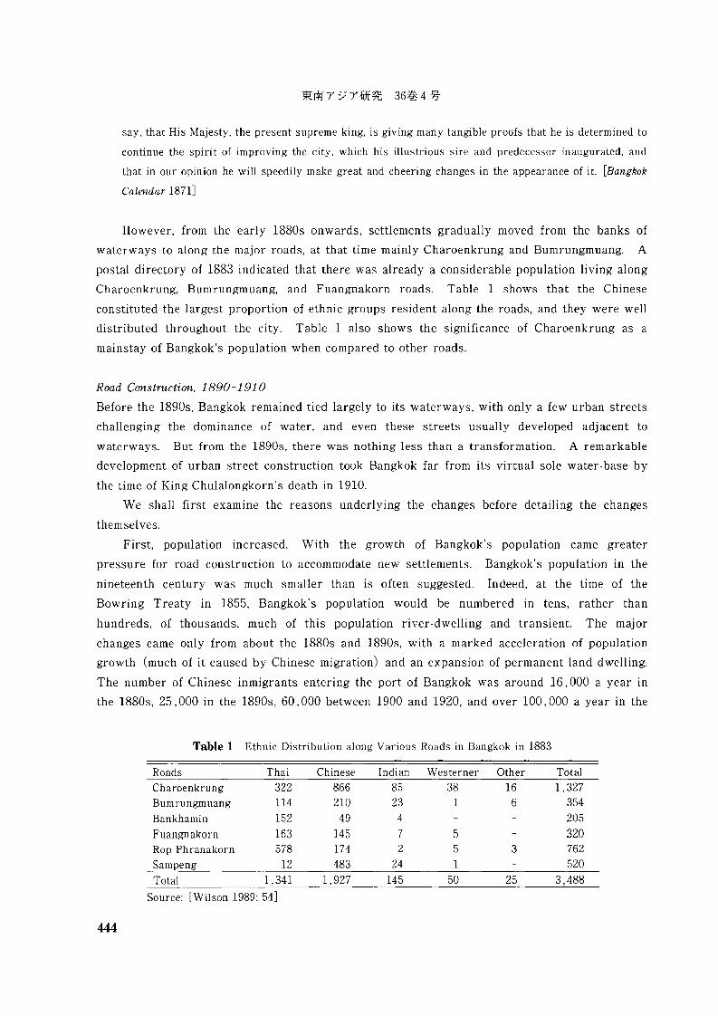
However, from the early 1880s onwards, settlements gradually moved from the banks of
waterways to along the major roads, at that time mainly Charoenkrung and Bumrungmuang. A
postal directory of 1883 indicated that there was already a considerable population living along
Charoenkrung, Bumrungmuang, and Fuangnakorn roads. Table 1 shows that the Chinese
constituted the largest proportion of ethnic groups resident along the roads, and they were well
distributed throughout the city. Table 1 also shows the significance of Charoenkrung as a
mainstay of Bangkok's population when compared to other roads.
Road Construction, 1890-1910
Before the 1890s, Bangkok remained tied largely to its waterways, with only a few urban streets
challenging the dominance of water, and even these streets usually developed adjacent to
waterways. But from the 1890s, there was nothing less than a transformation. A remarkable
development of urban street construction took Bangkok far from its virtual sole water-base by
the time of King Chulalongkorn's death in 1910.
We shall first examine the reasons underlying the changes before detailing the changes
themselves.
First, population increased. With the growth of Bangkok's population came greater
pressure for road construction to accommodate new settlements. Bangkok's population in the
nineteenth century was much smaller than is often suggested. Indeed, at the time of the
Bowring Treaty in 1855, Bangkok's population would be numbered in tens, rather than
hundreds, of thousands, much of this population river-dwelling and transient. The major
changes came only from about the 1880s and 1890s, with a marked acceleration of population
growth (much of it caused by Chinese migration) and an expansion of permanent land dwelling.
The number of Chinese in migrants entering the port of Bangkok was around 16,000 a year in
the 1880s, 25, 000 in the 1890s, 60,000 between 1900 and 1920, and over 100,000 a year in the
Table 1 Ethnic Distribution along Various Roads in Bangkok in 1883
Roads Thai Chinese Indian Westerner Other TotalCharoenkrung 322 866 85 38 16 1,327Bumrungmuang 114 210 23 1 6 354Bankhamin 152 49 4 205Fuangnakorn 163 145 7 5 320Rop Ph ranakorn 578 174 2 5 3 762Sampeng 12 483 24 1 520Total 1,341 1,927 145 50 25 3,488
Source: [Wilson 1989: 54]
444
P. OUYYA~ONT : Physical and Economic Change in Bangkok. 1851-1925
1920s [Skinner 1957: 173J. Estimates of Bangkok's population between the mid-nineteenth
century and 1909 vary widely. A recent and careful consideration of the problem of various
widely differing estimates by Terwiel concludes that the city contained no more than 50,000 to
100,000 people around the 1850s [TerwieI1989: 233J. That is far from the 300,000-500,000
often quoted. A postal census III 1883 suggests a population then of perhaps 120,000 people
[ibid.: 232J. Around the time of the First World War, Bangkok's population stood at some
360,000, heavily concentrated in districts around the royal Palace and commercial river areas.
It is thought that perhaps half of the population was composed of Chinese migrants [Porphant
1997: 258]. In addition to population growth, improved technology for road construction to
some extents affected the growth of road making in this period. A comment by L. R. De La
Mhotiere, the City Engineer of the Bangkok Sanitary Department in the late 1900s. is worth
quoting at length:
The first streets [prior to 1890] laid out were constructed in a very primitive manner. It was
considered sufficient to make the earth from the sides of the roads in order to raise the centre, with
the result that the roads were edged with swamps. at the rear of which the houses were constructed on
piles. To make the roads firmly it was usual to spread a light layer of broken bricks and stones on
the surface: consequently in the rainy season the thoroughfares were reduced to sloughs and puddles
and quickly became impassable. Within the last decade or so the advantages of macadamising the
roads with broken bridges and flints have been recognised. but the system has not been undertaken
with any degree of thoroughness. the materials being merely spread over the roads. and the work of
rolling them in being left to the chance instrumentality of the vehicular traffic. In that portion of the
city. however. between the river and the city wall wherein are the king's palace and the residences of
many Siamese princes. the work of road making has been carried out with more care: better materials
have been used. and the steam-roller has been employed with advantage. The improvement has been
the more marked since the king and other members of the royal family have taken to monitoring:
indeed. some of the thoroughfares are maintained in a far more efficient condition than is actually
demanded by the traffic upon them. [Cited in Wright and Breakspear 1908 (reprinted 1994): 291J
Second, we have growing economic activities III Bangkok, where from the 1880s onwards,
several important developments took place. Above all, the international rice trade developed on
a large scale. This was a crucial factor in attracting a substantial influx of Chinese coolies.
Trade brought a range of economic activity to Bangkok, such as rice mills. shipping,
warehousing, banks, manufacturing production. and distribution of imports and exports.
Centres of trade and commerce such as Bangrak and Sampeng felt the growing demand for
transport. As a result, roads were built within Bangkok principally as feeders for the river
and canals. Subsequently, roads were built as feeders to the railways. The first major
provincial railway between Bangkok and Korat was opened in 1900. and it sparked a growing
demand for transport linking the city and the provinces. At about the same time, demand for
roads was created by the growing number of motor vehicles in Bangkok, which increased during
445
the 1890s and the 1900s.
Third, the growth of trade and business in Bangkok resulted in a rise of the price of land,
which in turn encouraged the king and certain others of the elite to build roads as business
investments. For example, the first private road building was undertaken by Luang
Sathornrajyukti around 1890, a road named "Sathorn." He developed his land southeast of
Silom and constructed another road and canal running parallel to it. He divided the land into
small plots and sold them. The construction of Sathorn Road helped turn the entire area into a
residential centre noted for the many fine homes belonging to the resident foreign community
[Anonymous 1992: 18J. Afterwards, the building of roads not only enhanced the capital
investments of the elite but also helped the city area extend into the suburbs. According to one
source:
The process continued rapidly when two more roads parallel to Silom were built in the northeast.
Around 1893, Chaophraya Surawongsewattanasak ordered the construction of Surawong, a road
parallel to Silom, and Decho, a cross road joining the two. Si Phraya Road, another road parallel to
Silom and Surawong further in the northeast, was built shortly thereafter. This group of four roads
then became a focal area for home owners who wanted to live away from the crowded inner city. The
area became known as "The Four S's" as each of the four roads had its name beginning with an S. [Zoe.
cit.]
Si Phraya Road was built in 1905, when four noblemen of the rank of Phraya (hence Si
(four) Phraya) successfully petitioned the king to construct a road for the development of their
business:
13 August 1905. To His Majesty: In regard to the land at the corner of Charoenkrung Road at
Hongkong Bank, we bought land from a number of people. However, there are no comfortable roads
cutting across this Tumbon [district]. In my opinion, if the construction of a road is undertaken, it
will facilitate the transportation and communication. Conferring with the residents in this Tumbon,
they are pleased to join co-operation by granting money to build a road. So I would like to ask you to
give a permission to construct a road running from Charoenkrung Road to the corner Wat Hua
Lumpong with a total length of 35 sen 8 wa and a width of 5 wa. The road will be surfaced by the
brick pavings.
Phraya Indhrathipbordisriharaj rongmuang
Phraya Piphatkosa
Phraya Noranijrajahuj
Phraya Noranartpakdi
[Office of the Prime Minister 1970: 148-149J
Many commercial activities in Bangkok such as tramways, hotels, and dock facilities, all
created demand for roads. For example, in 1910, the Siam Commercial Bank petitioned the king
446

P. OCYYA"iOt\T : Physical and Economic Change in Bangkok, 1851-1925
for the construction of the new road.')
Fourth, there were developments from the 1880s brought by western technology that went
hand in hand with city roads and streets, for example, tramways, electricity, the telegraph, and
the telephone. For example, in the 1880s Danes introduced a horse-tramway, which was
electrified and extended in 1893. The initiative of British and Danish merchants formed the
first narrow gauge railway company running a line from Bangkok to Paknam in the early 1890s.
In 1898 Danish capital also took over an ailing American electricity supply company. It later
amalgamated with the tramway company and continued in operation until taken over by the
Thai government in 1950 [Falkus 1989: 120-121J.
The Government Power Station and the Siam Electricity Company together supplied the
town of Bangkok and its environs with electric light. There was also a thoroughly up to date
and well-equipped water-supply station, which was under the charge of a government
department. There were two British dockyards, which had slipways able to deal with the
various types of vessel that were able to come up the Chaophraya River, in addition to the
Royal Naval Dockyard. Both these companies. in addition to several others, also undertook
building contract work, and erected ferro concrete buildings in various parts of Bangkok
[Anonymous n. d.: 40J. With respect to electric power, this was practically confined to
Bangkok, where there were two stations in the 1880s. The larger and older station was under
Belgian-Danish management with a normal running capacity of 12,000 KW and a reserve
capacity of 15, 000 KW, part of which was periodically employed. Apart from lighting most of
the town, this plant owned and operated the city tramways and provided power for two
suburban tram services. for operating the road bridge across the river, and for the oil refinery,
7) "The Siam Commercial Bank, Ltd., has purchased a piece of land on the banks of the Manam Chow
Phya [Chao Phraya] and adjoining the Harbour Department, they have caused a handsome and
decorative building to be erected thereon for the purpose of carrying on their increased bankingbusiness of which they now hold one of the biggest shares of all the Banks. The building will be
finished in a few months time and Your Majesty's petitioners are anxious to have the surroundings of
the new building beautified so as to bring them in accordance with the structure. One of the mosteffective improvements towards the achievement of this intent is the building of a new road leading to
the ri ver between the premises of the Harbour Department and those of the Bank. For this purpose it
would be necessary to have a very old house belonging to the Harbour Department pulled down and
the said department would have to give up a portion of their ground-which is not used for otherpurposes. On the other hand Your Majesty's petitioners are prepared to make over to your Majesty's
government the portion of their ground which is wanted for the new road - if the road and a landing
in the river shall be built. Your Majesty's petitioners humbly draw attention to the vast improvement
which by this action would be effected not only to the Bank but also to the Harbour Department and
the public in general as a public road leading to the river in this part of the town would be of verygreat benefit. Your Majesty's petitioners beg leave to state that the Ministry of Local Government H.
E. Chow Phya [Chao Phraya] Yomaraj and the Director of the Harbour Department Phya [Phraya]
Visutr - who have frequently inspected the place - have recognized the utility of this new road and
they are in favour of it being constructed. Your Majesty's petitioners have ventured to present this
petition knowing that Your Most Gracious Majesty will support the improvement of the town ofBangkok and in the hope that Your Most Gracious Majesty may be pleased to order the construction ofthe new road" [N. A. R. 6. M. of the Capital 21/7 (1910) J.
447
tobacco factory and soap works, and several rice mills and industrial establishments. The
other station, Samsen station, was Government owned. It had a capacity of about 10, 000 KW
and supplied light and power to the northern part of the city. About half the output served to
drive the cement factory and also provided power to the airfield establishment at Don Muang
and the military arsenal [loco cit.].
Fifth, we must note the growing prosperity of Siam, and of king and state in the period.
Fiscal reforms in 1892 led to the centralization of taxation. Greater revenue meant more
expenditures on roads and other investment projects, such as railways. Greater revenue also
came from the rapid economic development between 1880 and 1910.8) The increased
government revenues are summarized in Table 2.
Sixth, the Ministry of the Capital (Krasuang Nakornbarn) was established in 1892. With
an increasing population and expanded economic activity, it was necessary to organize
municipal government to administer Bangkok affairs. The Ministry of the Capital assumed
complete responsibility for all arrangements affecting municipal or sanitary matters, such as
construction and repair of public streets, cleaning of streets, construction and cleaning of canals,
supply of water for consumption, the removal of garbage and its destruction at an appropriate
place, and proper drainage. Roads were put in the hands of the Department for Sanitary
Affairs within the Ministry. The Ministry's jurisdiction was (a) the amphurs within the city
wall, (b) Amphur Sampeng, (c) Amphur Sapratum, (e) Amphur Bangrak, (f) Amphur
Bangkoalam, (g) Amphur Banglumpoo Lang, and (h) the part of the amphur district of Bangsue,
west of the Prem Prachakorn Canal [Porphant 1997: 240-260J .
Until 1890, as we have seen, there were only a few roads in Bangkok. But from 1890, the
situation changed. In that year Prince Narisaranuwatiwong, the Minister of Public Works,
proposed a plan for road cutting in Bangkok. The plan was called the Amphur Sampeng
project, and it proposed that no less than 18 roads be cut in the commercial district of Sampeng.
It is not surprising that attention should turn to this area. Sampeng had been a hub of
commerce in Bangkok almost from its establishment in 1782. The demand for roads was
Table 2 Government Revenue, 1889/90-1909/10 (in million baht)
Year Total Year Total1889/90 12.0 1902/03 38.41894/95 17.3 1903/04 42.51895/96 18.1 1904/05 44.91896/97 20.6 1905/06 50.51897/98 24.9 1906/07 55.51898/99 28.2 1907/08 54.31899/00 29.6 1908/09 58.91900/01 35.1 1909/10 60.71901/02 35.6
Source: [Wilson 1983: 242-243J
8 ) For fuller discussion, see Sompop [1989].
448
P. OCYYA'Wi\T : Physical and Economic Change in Bangkok. 1851-1925
determined by the concentration of economic activity in that area, including retail and wholesale
businesses and the head offices of distributors. The advantage of location of the Sampeng area
was its proximity to the river ports which were centres of domestic water transportation. For
example, Rajawong river port was the major port connecting Bangkok to Chon Buri, Bandon
(currently Surat Thani province) and some major seashore provinces in Thailand [Department
of Fine Arts 1982: 563-567J. Bangkok's domestic riverine transportation stimulated the
expansion of trade and commerce. Sampeng, a centre of commerce of Bangkok, had very
inadequate roads, and this hampered trade and business. We can imagine how the growth of
the rice trade and the influence of Chinese in the 1880s put pressure on the district.
Prince Narisaranuwatiwong wrote in 1890:
In my opinion. there are no places which are more prosperous than Sampeng district. since its physical
advantage is suitable for trading location. while its deficiencies of location are that the district has
very few roads which in turn obstructed trading and prosperity. If roads in the district are
constructed. the land will be developed and price of land will be increased many fold. [N. A. R. 5. M. of
Public Works 9/1 no. 370/1 (1892)]
But there was another significant reason for the attention paid to Sampeng. The Privy
Purse Bureau (PPB) was anxious to find profitable investment opportunities. Commercial
activity in the 1880s resulted in a high price for well-situated land, which attracted the PPB to
invest. The PPB was a major source of capital for the king. It was the largest land owner in
Bangkok. Some major commercial activities of the PPB included rent collection from market
places and row houses. In this way, the expansion in investment of elite capital was certainly a
factor in the physical as well as commercial growth of Bangkok, for investment generated a need
for physical infrastructure. Road construction went hand in hand with row house investment
by the PPB to accommodate the swelling population, most of which was made up of Chinese
immigrants. We referred earlier to the Sampeng Road project, and as a result of this the
following roads were built in Sampeng district by 1898 (Table 3) .
While commercial activity brought roads to the commercial districts, royal activities were
causing road building elsewhere. In 1899, one year after visiting Europe, Rama V constructed
the Suan Dusit Palace in the northern part of Bangkok between Padung Krungkasem Canal and
Samsen Canal [Chai 1976: 297J. He personally proposed a project for road construction
around Suan Dusit Palace to provide transportation and communication between the palace and
surrounding areas. As a result, the following roads were cut: Rajawat (Nakornchaisri Road),
Seaw (Sawankalok Road), Koa Sua (Phitsanulok Road) [N. A. R. 5. M. of Public Works 9/39
no. 36/44 (1900) J, Prachairchin (Phetchaburi Road) [N. A. R. 5. M. of Public Works 9/90 no.
36/414 (1900) J, Tubtim, Hongyom, Tek Neau, Tek Tai, Pak Po, Munkornyom, Pueypoa Nguan
and Putthan [N. A. R. 5. M of the Capital 1/50 (1900) J. Also, Sanghi Nok Road (Rajawithee
Road) and Duangduean Nok Road (Sukhothai Road) were cut from Samsen Road to the
Chaophraya River. These roads encouraged considerable settlements around the Samsen
449
Table 3 A List of Some Major Road Construction around Sampeng District, 1892-98
Year Road Construction and Its Description
1892 Yaowaraj Road was constructed between Charoenkrung and Sampeng
Roads. It started from Mahachai Fort and ran southwest to
Charoenkrung Road at Wat Samchin (the area at Wat Samchin Bridge).
This road was 35 sen in length and 10 wa wide the car lane was 7 wa
wide: each footpath was 7 sok wide.
1892 Rajawong Road stretched from the east of the Chaophraya River bank
passing Sampeng Road and Yaowaraj Road to Charoenkrung. Its
length was 670 metres.
1892 Sanamkwai Road (or Nang Lerng Road, currently renamed as
Nakornswan Road) ran from Preatimas gate, which was located
opposite the Mahakarn Fort, to Phitsanulok Road. The total length
was 1,310 sen.
1892 The road (no name) ran from Charoenkrung road to Klang Toey, and
from Charoenkrung at Pak Trok Rongphasi exiting at Wua Lumpong
field [Hua Lampong] along Silom Road.
1893 Chakkrawat Road began at Charoenkrung Road (at Phraya·
Mahamontri's house) running south beside Wat Chakkrawat to the
Chaophraya River. This road was 20 sen 2 wa in length and 10 wa
wide.
1893 Kaosarn Road (now Chanasongkram Road) ran from Wat
Chanasongkram to connect with Fuangnakorn Road. It was 10 sen 6 wa
1 sok in length and 7 wa 2 sok wide.
1893 Burapa Road linked Pahurat Road to the back of Burapapirom Palace
joining Chalermkrung Road. This road was 6 sen 3 wa in length and 7wa 2 sok wide.
1893 This road, which was located at the north of Lawd Canal, ran from
Seaw Bridge to the city wall at Pak Trok Rongmai.
1895 Luang Road linked Charoenkrung and Bumrungmuang to the road in
front of Wat Thepsirintarawat, Unakarn Road ran from Kaosarn Road
through Preatamas Gate.
1896 Road was located along the south bank of Lawd Canal.
1896 Road ran from Chaochan Fort to Ta Pae Road.
1897 Worachak Road ran from Chaochan Palace to Prince Prida Palace.
1898 Surawong Road branched from Charoenkrung to Hualumpong railway
station at Sarapratumwan Road.
Source: The information in the table mostly obtained from Nij [1982: 27-28].
450
Sources
Government Gazetteno. 8, p. 410
R.S. 110
N. A. R. 5. M. of
Public Works9/1 no. 1 (1893)
N. A. R. 5. M. of
Public Works
4/25 no. 46 (1893)
as above
Government Gazette
no. 9. R. S. III p. 66
[ibid.: 46J
N. A. R. 5. M. of the
Capital 464/2no. 1 (1894)
as above
N. A. R. 5.
M. of Public
Works 9/4 (1895)
N. A. R. 5.
M. of Public Works
4/23 (1896)
N. A. R. 5. M. of
Public Works 4/39(1897)
as above
N. A. R. 5M. of Public Works
9/28 (1899)
P. OUYYANO:--iT : Physical and Economic Change in Bangkok. 1851-1925
Road area because they gave easy access to trade around the bank of the Chaophraya River.
Also in 1899, the Tanon Rajadamnoen area project was approved and started. Its primary
purpose was to facilitate the king's travel between the grand palace and Dusit Palace, but it also
served as a signal of the city's prosperity and also as a place for recreation and relaxation
[Collected Laws 1929: 105-106J. Government offices were constructed in the Rajadamnoen
areas [N. A. R. 5. M. of Public Works 9/41 (1899) J, and in a short time this once rather lonely
forest area became a bustling and developing area [Thailand, Government of Thailand 1899:
276J.
Begun 10 August 1899, Rajadamnoen Road was completed on August 7,1901. It stretched
760 metres from Preastimas Road (Nakornswan Road) to Benjamas Road [N. A. R. 5. M. of the
Capital 2/86 (1900) J. In 1901, another project of Rajadamnoen was built, called
Rajadamnoenklang Road. This road, 1,200 metres long and 58 metres wide, ran from
Saphanleaw, passing Banglumpoo Canal, Rajadamnoen Nok, Parnphipoblila Bridge, and Ban
Tanow Ban Dinsaw, to arrive at Parnfaleelard Bridge [Department of Fine Arts 1962: 37J.
Completed in 1903, the last road construction in the Rajadamnoen project was Rajadamnoen
Nai. This road stretched from the angle of Napralarn Road and Sanamchai Road to Prachan
Road (around the eastern part of Sanum Luang), connecting Rajadamnoenklang at
Parnphipobleela Bridge [Department of Fine Arts 1982: 81]. A symbol of Siamese
independence and prosperity, the road vied with the great thoroughfares of Europe.
The Rajadamnoen project was built by the king. At the same time, increasing road
construction was initiated privately by various wealthy merchants and nobles, indicating the
growing participation of land speculators and construction interests in the extension of economic
activity to more suburbs. During the period 1890-1910, newly built private roads included
Sathorn Tai, Surasak, Pramuan, Rongmuang, Sunthorn Pimon, Visudkasat (old), and Si Phraya.
Road Construction, 1910-25
New road construction in the period to 1910 helped transform the central areas into industrial,
residential, and commercial areas including Sampeng, Dusit, Sarapratum, Bangrak, Bangkoalam,
Banglumpoo Lang, the part of Bangsue west of Klong Prem Prachakorn, and the district within
the city wall [N. A. R. 5. M. of the Capital 5.4/10 (1908) J.
Between 1910 and 1925, however, few new roads were cut. Most road expenditure was on
the extension and improvement of existing roads. Only six new roads were built as shown in
Table 4.
Discussion
Unlike his predecessor, King Vajiravudh had little interest in see10g great progress 10 his
capital or in seeking profitable investment through road extension. The PPB paid little
attention to investment in land and row houses over the period 1910-25. No records exist of
large scale row house construction in this period. One reason is probably that Rama VI spent
a large portion of his personal budget on his own activities, especially travelling. The Ministry
451
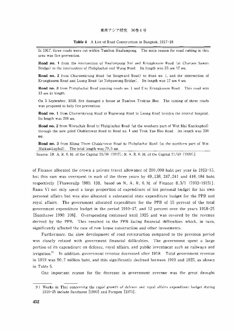
Table 4 A List of Road Construction in Bangkok, 1917-18
In 1917, three roads were cut within Tumbon Hualumpong. The main reason for road cutting in this
area was fire prevention.
Road no. 1 from the intersection of Hualumpong Nai and Krungkasem Road (at Charoen Sawas
Bridge) to the intersection of Plubplachai and Wang Road. Its length was 23 sen 17 wa.
Road no. 2 from Charoenkrung Road (at Songward Road) to Road no. 1, and the intersection of
Krungkasem Road and Luang Road (at Nobpawong Bridge). Its length was 17 sen 6 wa.
Road no. 3 from Plubplachai Road passing roads no. 1 and 2 to Krungkasem Road. This road was
13 sen in length.
On 3 September, 1918, fire damaged a house at Tumbon Troktao Hoo. The cutting of three roads
was proposed to help fire prevention:
Road no. 1 from Charoenkrung Road at Rajawong Road to Luang Road besides the central hospital.
Its length was 208 wa.
Road no. 2 from Worachak Road to Plubplachai Road (at the southern part of Wat Mai KanikaphoI)through the new piled Chakkrawat Road to Road no. 1 and Trok Tao Hoo Road. Its length was 236
wa.
Road no. 3 from Klong Thorn Chakkrawat Road to Plubplachai Road (at the northern part of Wat
Maikanikaphol). The total length was 79.5 wa.
Source: [N. A. R. 6. M. of the Capital 21/36 (1917); N. A. R. 6. M. of the Capital 21/49 (1920)]
of Finance allocated the crown a private travel allowance of 200,000 baht per year in 1913-15,
but this sum was overspent in each of the three years by 49,138, 247,241 and 416,184 baht
respectively [Thaweesilp 1985: 138, based on N. A. R. 6. M. of Finance 8.3/1 (1913-1915)J.
Rama VI not only spent a large proportion of expenditure of his personal budget for his own
personal affairs but was also allocated a substantial state expenditure budget for the PPB and
royal affairs. The government allocated expenditure for the PPB of 15 percent of the total
government expenditure budget in the period 1910-17, and 12 percent over the years 1918-25
[Suntharee 1990: 108J. Overspending continued until 1925 and was covered by the revenue
derived by the PPB. This resulted in the PPB facing financial difficulties which, in turn,
significantly affected the rate of row house construction and other investments.
Furthermore, the slow development of road construction compared to the previous period
was closely related with government financial difficulties. The government spent a large
portion of its expenditure on defence, royal affairs, and public investment such as railways and
irrigation.g
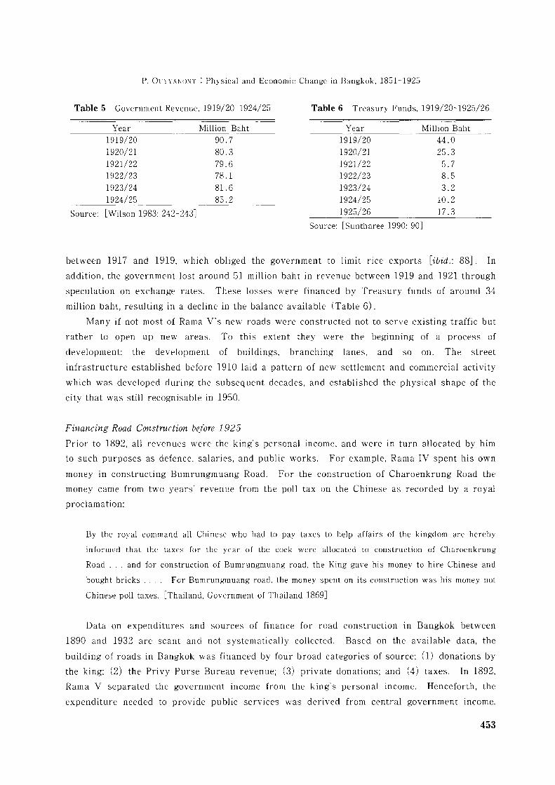
) In addition, government revenue decreased after 1919. Total government revenue
in 1919 was 90.7 million baht, and this significantly declined between 1919 and 1925, as shown
in Table 5.
One important reason for the decrease in government revenue was the great drought
9) Works in Thai concerning the rapid growth of defence and royal affairs expenditure budget during1910-25 include Suntharee [1990] and Pompen [1975J.
452
P. Ol'YYANONT : Physical and Economic Change in Bangkok, 1851-1925
Table 5 Government Revenue, 1919/20-1924/25 Table 6 Treasury Funds, 1919/20-1925/26
Source:
Year1919/201920/211921/221922/231923/241924/25
[Wilson 1983: 242-243J
Million Baht90.780.379.678.1
81. 685.2
Year1919/201920/211921/221922/231923/241924/251925/26
Million Baht44.025.3
5.78.53.2
10.2
17.3
Source: [Suntharee 1990: 90J
between 1917 and 1919, which obliged the government to limit nce exports [ibid.: 88J. In
addition, the government lost around 51 million baht in revenue between 1919 and 1921 through
speculation on exchange rates. These losses were financed by Treasury funds of around 34
million baht, resulting in a decline in the balance available (Table 6).
Many if not most of Rama V's new roads were constructed not to serve existing traffic but
rather to open up new areas. To this extent they were the beginning of a process of
development: the development of buildings, branching lanes, and so on. The street
infrastructure established before 1910 laid a pattern of new settlement and commercial activity
which was developed during the subsequent decades, and established the physical shape of the
city that was still recognisable in 1950.
Financing Road Construction before 1925
Prior to 1892, all revenues were the king's personal income, and were in turn allocated by him
to such purposes as defence, salaries, and public works. For example, Rama IV spent his own
money in constructing Bumrungmuang Road. For the construction of Charoenkrung Road the
money came from two years' revenue from the poll tax on the Chinese as recorded by a royal
proclamation:
By the royal command all Chinese who had to pay taxes to help affairs of the kingdom are hereby
informed that the taxes for the year of the cock were allocated to construction of Charoenkrung
Road ... and for construction of Bumrungmuang road, the King gave his money to hire Chinese and
bought bricks. . .. For Bumrungmuang road, the money spent on its construction was his money not
Chinese poll taxes. [Thailand, Government of Thailand 1869J
Data on expenditures and sources of finance for road construction in Bangkok between
1890 and 1932 are scant and not systematically collected. Based on the available data, the
building of roads in Bangkok was financed by four broad categories of source: (1) donations by
the king; (2) the Privy Purse Bureau revenue; (3) private donations; and (4) taxes. In 1892,
Rama V separated the government income from the king's personal income. Henceforth, the
expenditure needed to provide public services was derived from central government lllcome.
453
Taxes were raised for the specific support of public services as well as for the support of the
royal family. The Ministry of Finance was established in 1892. All ministries had to submit
budget estimates to the king and cabinet each year. Systematic budgets for road construction
and maintenance dated from 1892. At that time the agencies responsible for road cutting were
the Ministry of the Capital, the Ministry of Public Works, and the Privy Purse Bureau.
Government road expenditure could be broadly categorised into two parts. The first part
of the budget was the expenditure on land purchase and the second part was the cost of
construction. As to land purchase, if land was partly lost by road cutting and, in turn, the
owner of the land could gain in terms of a rise in the price of land, the land owners were not
compensated, but had to contribute to the cost of road construction. Secondly, if land was
totally lost by road cutting, land owners were fully compensated at market price [Nij 1982: 25].
Rama V himself observed that:
Capital on road construction was derived from taxes paid by all people all over the whole country, but
spending on road building was undertaken in a particular area, thus providing benefits to that locality
more than others and this is unjust for citizens in other localities. [Thailand, Government of
Thailand 1899: 276J
To solve this problem, land adj acent to newly built roads was purchased, and after
construction of the roads, was sold back to the owners at the original price of the land pI us a
proportional amount added to cover cost of construction. In many cases, the land owners had
to contribute toward road construction if the road was seen as bringing benefit to them. With
respect to the government expenditure budget on road construction in Bangkok, figures are
presented in Table 7.
The question of who should pay for roads in the long term remained unsolved. No
information is available concerning any criteria that were followed, for example, the benefit
principle or ability to pay principle. Revenue raising for road construction was arranged
piecemeal, with each road constructed separately. An interesting observation on the financing
of Bangkok's roads was made in December 1927. It was written by Sir Edward Cook, Financial
Advisor to the Ministry of Finance, and forwarded to the Revenue Department:
Nevertheless, the condition of the Bangkok roads (though it has perhaps slightly improved during the
past year or so) cannot be regarded as creditable to the capital city of a prosperous and progressive
country. . .. The roads are, of course, very much worse where the traffic is at all considerable than
in the less frequented areas.
Bangkok already absorbs (so it is contended) a proportionate share of the general revenues, and it is
not fair that tax-payers outside Bangkok, the vast majority of whom are people of very humble means,
should contribute toward the amenities of those fortunate beings who live in the capital. Those who
hold this view would maintain that the interests of the country at large, where so much requires to be
454
P. OCYYA'iO\T : Physical and Economic Change in Bangkok. 1851-1925
done, have a prior claim on any surplus funds that the government may now possess.
One of the most pressing needs of the moment is. however. said to be for additional expenditure on
roads: more particularly. expenditure of a non-recurring nature. in order that asphalt roads can be laid
down properly. which will not only mitigate the plague of dust which seems to be endemic in Bangkok.
but will also. in the long run. pay for itself by reducing maintenance charges.
suggest that the most suitable as well as the most simple. means of raising new revenue (to finance
the road construction) is to increase the taxation on motor cars. At present the owners of private
motor cars pay only 12 baht a year. which is absurdly small. As I have mentioned, the number of
cars must have increased enormously in the past few years. a fact which of course has added a great
deal to the wear and tear of the roads. [N. A. M. of Finance 0301.1.19/4 (}927-1928)J
This indicates that around the 1920s. road construction was financed by revenue from the
central government. Expenditure on road construction therefore came from tax payers from the
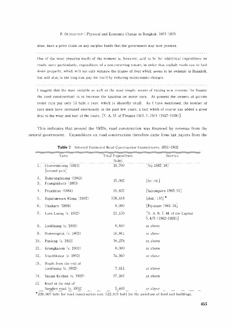
Table 7 Selected Estimated Road Construction Expenditures. 1861-1902
Name
1. Charoenkrung (}863)
[second partJ
2. Bumrungmuang (1863)
3. Fuangnakorn (1863)
4. Preatimas (1884)
5. Rajadamnoen Klang (}902)
6. Unakarn (}898)
7. Lam Luang (c. 1902)
8. Lookluang (c. 1902)
9. Damrongrak (c. 1902)
10. Panieng (c. 1902)
11. Krungkasem (c. 1902)
12. Visuthkasat (c. 1902)
13. Roads from the end of
Lookluang (c. 1902)
14. Sanam Krabua (c. 1902)
Total Expenditure(bah t)
19,700
15.002
55.622
758.618
8.000
21,150
6,640
16,911
16,278
8,000
74.360
7,611
27,342
Sources
[Nij 1982: 18J
[Zoc. cit.J
[Sayomporn 1983: 51J
[ibid.: 110J *
[Piyanart 1985: 24J
[N. A. R. 5. M. of the Capital
5.4/5 (1902-1903)J
as above
as above
as above
as above
as above
as above
as above
15. Road at the end of
Sanghee road (c. 1902) 5,403 as above
* 236,607 baht for road construction cost. 522,011 baht for the purchase of land and buildings.
455
whole kingdom. This financing criterion was unfair for the mass of Thai citizens, for the roads
benefited only Bangkok.
III The Economic Significance of Roads, 1890-1925
Over 135 roads were built between 1890 and 1925. From the 1890s onwards, Bangkok was
transformed from a "floating" city to a "land-based" city. The traditional landscape of
Bangkok, which consisted of city moats and a network of canals, underwent a marked change.
The city landscape based on roads rapidly took shape. Bridges were built to span the canals.
By the mid 1920s, around 41 bridges had been built [Chulalongkorn University 1991: 268J.
Built-up areas of new buildings such as row houses extended along the roads. Canal
construction slowed, then ceased. Klong Sathorn, dug in 1895, was the only major new canal in
Bangkok at the end of the nineteenth century. It extended from the Chaophraya River to Klong
Hualumpong at its intersection with Wittayu Road. After 1900, a few Thonburi canals were
dredged for transport purposes, but for the most part the age of canals in Bangkok was over.
After 1915, no new ones were excavated [Beek 1995: 62J. Some canals, such as Trok Tao,
Nawaree, Wat Sampleum. Suanluang, Wat Kok, Wat Tuk, Chakkrawat, were filled to build
roads. The city wall and city gate were demolished in the 1910s for building roads, housing,
and rowhouses.
A British Consular report in 1900 noted:
Thirty-five years ago there were no streets in Bangkok. All traffic was carried on by boats, and the
numerous canals still compete with the street traffic. As late as ten years ago there were no more
than 9 miles of paved streets in the whole city. Today there are over 47 miles. and many new streets
are being opened up each year, on which the old iron and wooden bridges are being replaced by
modern steel bridges. The King himself builds one steel bridge each year out of his private funds as a
gift to the city, and this is opened to the public with some ceremony on his birthday. The government
imports from England every year considerable quantities of bridge materials. [Account and Paper
1900]
We may note that from the 1890s onwards there was even more rapid rates of areal
expansion than in the previous period as the city absorbed more of the surrounding countryside.
Changes were now caused by the construction of roads rather than canals. Roads brought the
10) For example, between 1890 and 1910, large areas outside the city walls, formerly used for growingrice, Chinese cabbage, green onions. mangoes, and betel nuts were developed as commercial, residentialand industrial areas, including Tung Woalumpong (currently Hualumpong). Tung Samsen (currentlySamsen district), Tung Phayathai (currently Phaya Thai district), Tung Bangkapi (currentlyBangkapi district), Suan Dusit (currently the area around Suan Dusit Palace). and Tung Sompoy(location uncertain). The very names suggest the encroachment of the city on cultivated fields (Tungin Thai means field and Suan means garden) .
456
P. OlTY'{A)iONT : Physical and Economic Change in Bangkok. 1851-1925
expanslOn of trade and business and increased the size of the residential area. lOl Before the
1890s most residential areas were on the banks of the Chaophraya River and canals, but from
the 1890s settlements developed further afield. This was the beginning of the residential and
commercial quarter in the inner area, and the urban area expanded. Such transformation was
helped by the introduction of Western vehicles such as trams. bicycles. and later automobiles,
from the late 1880s.
A good example of the impact of road construction on the growth of the city's area was the
Suan Dusit project. Finished in around 1898, the Suan Dusit palace in the northern part of the
city was regarded as the most beautiful of the king's palaces. Roads built around this palace in
the 1900s included Rajadamnoen Nok, Rajadamnoen Klang. Rajavithee. Benjamas Nai, and
Somchin [Office of Royal Palace 1976: 21-40J. The construction of roads provided convenient
communication between the grand palace and Suan Dusit Palace. Roads also facilitated close
communication with and transportation to more distant districts such as Bangsua and Samsen.
We should not underestimate the influence of palaces and other royal residence on the
growth of Bangkok. It may be recalled that Rama V had literally hundreds of children and
grandchildren by the time of his death in 1910. and Rama IV had been similarly prolific.
Palace construction and new road construction together went hand in hand. A number of
palaces were built within and outside the city walls from the late 1890s. for instance. around
Rajadamnoen Nok Road. Samsen Road, Suan Dusit Palace. Luang Road. and at the corner of
Patumwan Road. As a result. the prosperity and settlement of communities earlier concentrated
on the banks of the Chaophraya River extended to the northern. eastern. and the southern parts
of the old city. The growth of palaces stimulated state officials and others to construct houses
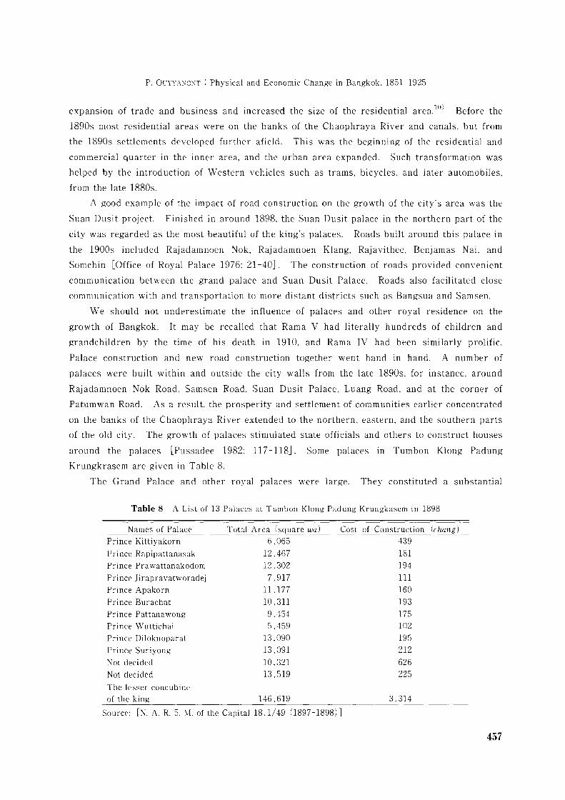
around the palaces [Pussadee 1982: 117-118J. Some palaces in Tumbon Klong Padung
Krungkrasem are given in Table 8.
The Grand Palace and other royal palaces were large. They constituted a substantial
Table 8 A List of 13 Palaces at Tumbon Klong Padung Krungkasem in 1898
Names of Palace
Prince Kittiyakorn
Prince Rapipattanasak
Prince Prawattanakodom
Prince Jirapravatworadej
Prince Apakorn
Prince Burachat
Prince Pattanawong
Prince Wuttichai
Prince Diloknoparat
Prince Suriyong
Not decided
Not decided
Total Area (square wa)
6,065
12.467
12.302
7.917
11.177
10.311
9.454
5.459
13,090
13.091
10.32113.519
Cost of Construction (chang)
439
181
194
111
160
193175
102
195
212
626
225
The lesser concubineof the king 146.619 3.314
Source: [N. A. R. 5. M. of the CapitallS.l/49 (]S97-1S9S)]
457
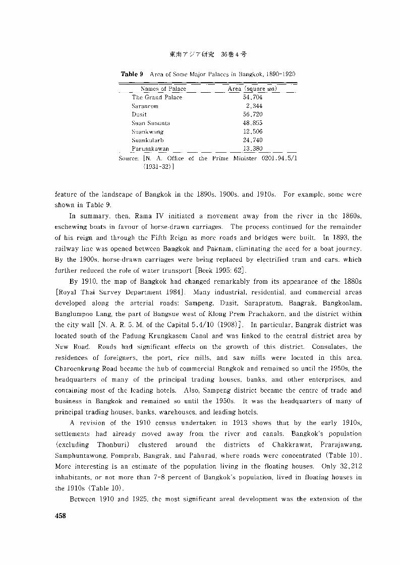
Table 9 Area of Some Major Palaces in Bangkok, 1890-1920
Names of Palace Area (square wa)
The Grand Palace 54,704Saranrom 2,344Dusit 56,720Suan Sununta 48,855Suankwang 12,506Suankularb 24,740Parusakawan 13,380
Source: [N. A. Office of the Prime Minister 0201.94.5/1(1931-32) ]
feature of the landscape of Bangkok in the 1890s, 1900s, and 1910s. For example, some were
shown in Table 9.
In summary, then, Rama IV initiated a movement away from the river III the 1860s,
eschewing boats in favour of horse-drawn carriages. The process continued for the remainder
of his reign and through the Fifth Reign as more roads and bridges were built. In 1893, the
railway line was opened between Bangkok and Paknam, eliminating the need for a boat journey.
By the 1900s, horse-drawn carriages were being replaced by electrified tram and cars, which
further reduced the role of water transport [Beek 1995: 62J.
By 1910, the map of Bangkok had changed remarkably from its appearance of the 1880s
[Royal Thai Survey Department 1984J. Many industrial, residential, and commercial areas
developed along the arterial roads: Sampeng, Dusit, Sarapratum, Bangrak, Bangkoalam,
Banglumpoo Lang, the part of Bangsue west of Klong Prem Prachakorn, and the district within
the city wall [N. A. R. 5. M. of the Capital 5.4/10 (1908) J. In particular, Bangrak district was
located south of the Padung Krungkasem Canal and was linked to the central district area by
New Road. Roads had significant effects on the growth of this district. Consulates, the
residences of foreigners, the port, rice mills, and saw mills were located in this area.
Charoenkrung Road became the hub of commercial Bangkok and remained so until the 1950s, the
headquarters of many of the principal trading houses, banks, and other enterprises, and
containing most of the leading hotels. Also, Sampeng district became the centre of trade and
business in Bangkok and remained so until the 1950s. It was the headquarters of many of
principal trading houses, banks, warehouses, and leading hotels.
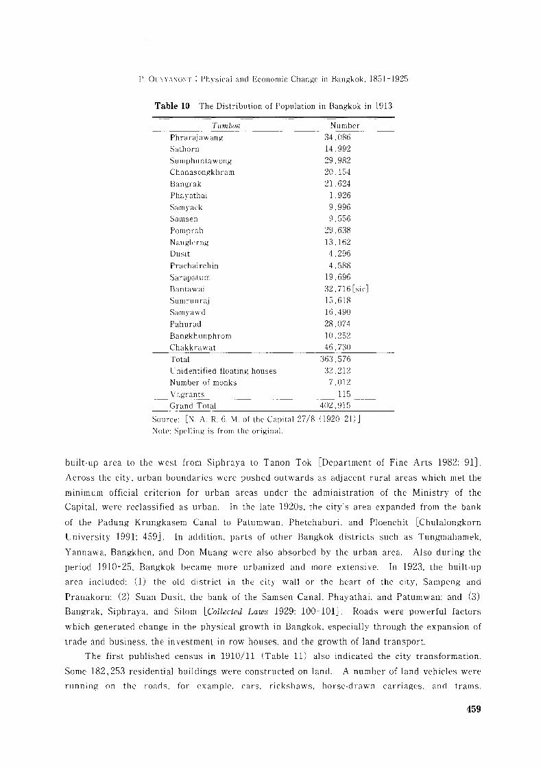
A revision of the 1910 census undertaken in 1913 shows that by the early 1910s,
settlements had already moved away from the river and canals. Bangkok's population
(excluding Thonburi) clustered around the districts of Chakkrawat, Prarajawang,
Samphuntawong, Pomprab. Bangrak, and Pahurad, where roads were concentrated (Table 10).
More interesting is an estimate of the population living in the floating houses. Only 32.212
inhabitants, or not more than 7-8 percent of Bangkok's population, lived in floating houses in
the 1910s (Table 10).
Between 1910 and 1925, the most significant areal development was the extension of the
458
P. OlYYA\O\T : Physical and Economic Change in Bangkok. 1851-1925
Table 10 The Distribution of Population in Bangkok in 1913
Tumbon NumberPhrarajawang 34.086Sathorn 14.992Sumphuntawong 29.982Chanasongkhram 20.154Bangrak 21.624Phayathai 1 .926
Samyaek 9.996Samsen 9.556Pomprab 29.638Nanglerng 13.162Dusit 4.296Prachairchin 4.588Sarapatum 19.696Bantawai 32.716 [sic]Sumrunraj 15.618Samyawd 16,490
Pahurad 28.074Bangkhunphrom 10.252Chakkrawat 46.730Total 363.576Unidentified floating houses 32.212Number of monks 7.012Vagrants 115Grand Total 402.915
Source: [:\. A. R. 6. M. of the Capital 27/8 (1920-21) ]Note: Spelling is from the original.
built-up area to the west from Siphraya to Tanon Tok [Department of Fine Arts 1982: 91J.
Across the city. urban boundaries were pushed outwards as adjacent rural areas which met the
minimum official criterion for urban areas under the administration of the Ministry of the
Capital. were reclassified as urban. In the late 1920s. the city's area expanded from the bank
of the Padung Krungkasem Canal to Patumwan. Phetchaburi. and Ploenchit [Chulalongkorn
University 1991: 459J. In addition. parts of other Bangkok districts such as Tungmahamek.
Yannawa. Bangkhen. and Don Muang were also absorbed by the urban area. Also during the
period 1910-25. Bangkok became more urbanized and more extensive. In 1923. the built-up
area included: (1) the old district in the city wall or the heart of the city. Sampeng and
Pranakorn; (2) Suan Dusit. the bank of the Samsen Canal. Phayathai. and Patumwan; and (3)
Bangrak. Siphraya. and Silom [Collected Laws 1929: 100-101J. Roads were powerful factors
which generated change in the physical growth in Bangkok. especially through the expansion of
trade and business. the investment in row houses. and the growth of land transport.
The first published census in 1910/11 (Table 11) also indicated the city transformation.
Some 182,253 residential buildings were constructed on land. A number of land vehicles were
running on the roads. for example. cars. rickshaws. horse-drawn carriages. and trams.
459
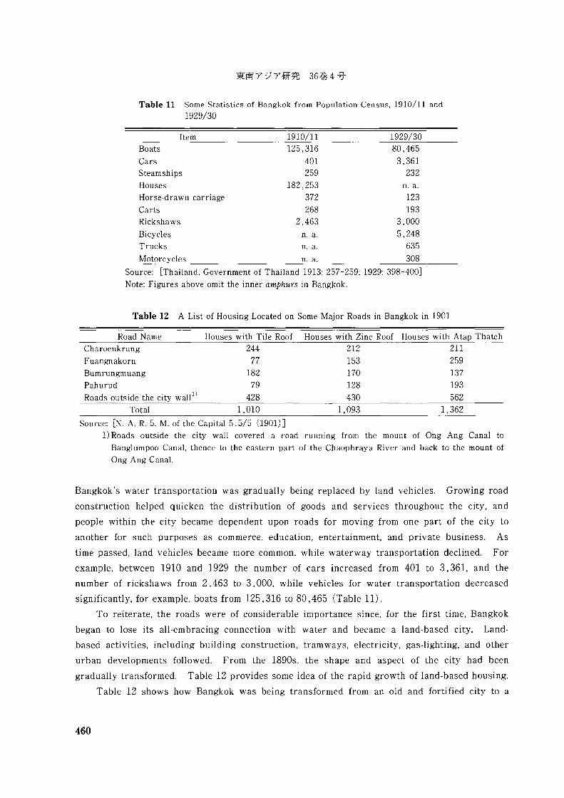
Table 11 Some Statistics of Bangkok from Population Census, 1910/11 and1929/30
Item 1910/11 1929/30Boats 125,316 80,465
Cars 401 3,361Steamships 259 232Houses 182,253 n. a.
Horse-drawn carriage 372 123Carts 268 193Rickshaws 2,463 3,000
Bicycles n. a. 5,248Trucks n. a. 635
Motorcycles n. a. 308
Source: [Thailand, Government of Thailand 1913: 257-259; 1929: 398-400]
Note: Figures above omit the inner amphurs in Bangkok.
Table 12 A List of Housing Located on Some Major Roads in Bangkok in 1901
Road Name Houses with Tile Roof Houses with Zinc RoofCharoenkrung 244 212
Fuangnakorn 77 153Bumrungmuang 182 170Pahurud 79 128
Roads outside the city wall 1) 428 430Total 1,010 1,093
Houses with Atap Thatch211
259137193
5621,362
Source: [N. A. R. 5. M. of the Capital 5.5/5 (1901)]1) Roads outside the city wall covered a road running from the mount of Ong Ang Canal to
Banglumpoo Canal, thence to the eastern part of the Chaophraya River and back to the mount of
Ong Ang Canal.
Bangkok's water transportation was gradually being replaced by land vehicles. Growing road
construction helped quicken the distribution of goods and services throughout the city, and
people within the city became dependent upon roads for moving from one part of the city to
another for such purposes as commerce, education, entertainment, and private business. As
time passed, land vehicles became more common, while waterway transportation declined. For
example, between 1910 and 1929 the number of cars increased from 401 to 3,361, and the
number of rickshaws from 2,463 to 3,000, while vehicles for water transportation decreased
significantly, for example, boats from 125,316 to 80,465 (Table 11).
To reiterate, the roads were of considerable importance since, for the first time, Bangkok
began to lose its all-embracing connection with water and became a land-based city. Land
based activities, including building construction, tramways, electricity, gas-lighting, and other
urban developments followed. From the 1890s, the shape and aspect of the city had been
gradually transformed. Table 12 provides some idea of the rapid growth of land-based housing.
Table 12 shows how Bangkok was being transformed from an old and fortified city to a
460
P. OCYYANONT : Physical and Economic Change in Bangkok. 1851-1925
modern city. In the early nineteenth century. Bangkok housing had a certain style:
The ordinary style of building is to erect two small houses in proximity to each other. on the same
level. One of these is occupied by the husband and the other by his women. The posts are sunk into
the earth three or four feet. The floor is raised six or eight feet from the surface of the ground. and
above this the elevation of the room in ten or twelve feet. Thus the houses are all two stories high:
but in consequence of the dampness and the spring tides. the lower story is seldom occupied. or even
enclosed. Some of these buildings are made of bamboo wicker work. and some of bamboo slats and
covered with a species of palm leaf. [Bangkok Calendar 1871]
By the 1890s, houses thatched with atap leaves declined in favour of houses roofed with tile
or zinc [N. A. R. 5. M. of the Capital 5.5/5 (1901) J. Houses and row houses were often more
convenient for business transactions. They had more capacity to store commodities and more
space than floating houses. Row houses could incorporate modern offices. import-export
distributors, wholesale and retail business, and so on. Several European and Chinese
businessmen rented row houses to run their businesses such as dispensaries, branch offices and
printing presses.1U
A number of economic activities were concentrated along the roads. For example, the
number of pawn shops increased from 39 in 1902 to 61 in 1904 and 93 by 1909, and these were
usually located along the main roads, such as Chareonkrung, Sampeng, and Chakkrawad [The
Collection of Dynasty 1964: 192: N. A. M. of the Capital 8.9 Ko/3 (1904) J. After the outbreak of
World War I, modern machinery was brought into Bangkok by foreign investors, and a number
of plants were set up, including the British-American Tobacco Company. soap factories, coconut
oil and bean oil plants, textile factories, waterworks. and power stations [Anonymous 1985a:
74J. The government also ran the Bangkok waterworks and the Samsen Power station [ibid.:
75J. In the 1920s, there were several factories in Bangkok, big and small, for making nails,
soap, tobacco, fireworks. bricks, medicines, and matches as well as for tanning leather,
furniture-making, boot and shoe-making, boat-building, and tailoring [Anonymous n.d.: 27J. A
match factory, for example. The Min Sae Co. Ltd, was registered by a group of Chinese in 1928.
with capital of 200.000 baht. The Min Sae factory opened on a 20 rai site on Rama IV road,
employing some 700 workers. 600 of whom were day labourers, most being Chinese women and
children, with Siamese employed as outworkers making boxes at home. A reporter described
the complicated automatic machinery, partly driven by electric motor and partly driven by hand.
The company hoped to capture 20 percent of the local market [Hewison 1986: 10J.
11) Aspects of change in the landscape in Bangkok in relation to the growth of roads. business. and tradefrom the nineteenth century are contained in Tomosugi [1993: 1-70], Wright and Breakspear [1908(reprinted 1994): 257-275]. Sayomporn [1983], Chulalongkorn University [1991], Department of FineArts [1982: 32-114, 554-623]. The Composition of Physical Growth of Bangkok [ChulalongkornUniversity 1991] is a book providing maps and photos useful for historical studies of change in thelandscape of Bangkok.
461
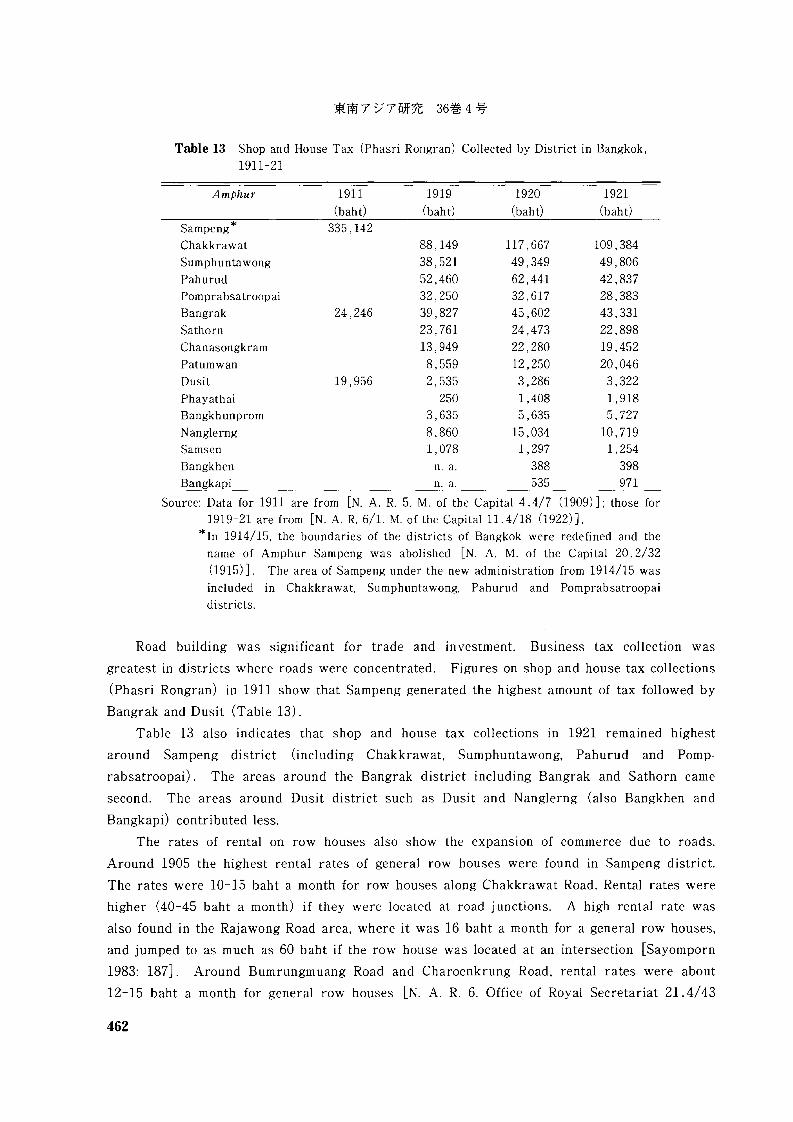
Table 13 Shop and House Tax (Phasri Rongran) Collected by District in Bangkok,1911-21
Amphur 1911(baht)
1919(baht)
1920(baht)
1921(baht)
Sampeng* 335,142Chakkrawat 88,149 117,667 109,384Sumphunta wong 38,521 49,349 49,806
Pah urud 52,460 62,441 42,837Pomprabsatroopai 32,250 32,617 28,383Bangrak 24,246 39,827 45,602 43,331Sathorn 23,761 24,473 22,898Chanasongkram 13,949 22,280 19,452Patumwan 8,559 12,250 20,046Dusi t 19 ,956 2, 535 3,286 3,322Phayathai 250 1,408 1,918Bangkhunprom 3,635 5,635 5,727Nanglerng 8,860 15,034 10,719Samsen 1,078 1,297 1,254Bangkhen n. a. 388 398Bangkapi n. a. 535 971
Source: Data for 1911 are from [N. A. R. 5. M. of the Capital 4.4/7 (1909)]; those for1919-21 are from [N. A. R. 6/1. M. of the Capital 11.4/18 (1922)].
* In 1914/15, the boundaries of the districts of Bangkok were redefined and thename of Amphur Sampeng was abolished [N. A. M. of the Capital 20.2/32
(1915)]. The area of Sampeng under the new administration from 1914/15 wasincluded in Chakkrawat, Sumphuntawong, Pahurud and Pomprabsatroopaidistricts.
Road building was significant for trade and investment. Business tax collection was
greatest in districts where roads were concentrated. Figures on shop and house tax collections
(Phasri Rongran) in 1911 show that Sampeng generated the highest amount of tax followed by
Bangrak and Dusit (Table 13).
Table 13 also indicates that shop and house tax collections in 1921 remained highest
around Sampeng district (including Chakkrawat, Sumphuntawong, Pahurud and Pomp
rabsatroopai). The areas around the Bangrak district including Bangrak and Sathorn came
second. The areas around Dusit district such as Dusit and Nanglerng (also Bangkhen and
Bangkapi) contributed less.
The rates of rental on row houses also show the expansion of commerce due to roads.
Around 1905 the highest rental rates of general row houses were found in Sampeng district.
The rates were 10-15 baht a month for row houses along Chakkrawat Road. Rental rates were
higher (40-45 baht a month) if they were located at road junctions. A high rental rate was
also found in the Rajawong Road area, where it was 16 baht a month for a general row houses,
and jumped to as much as 60 baht if the row house was located at an intersection [Sayomporn
1983: 187J. Around Bumrungmuang Road and Charoenkrung Road, rental rates were about
12-15 baht a month for general row houses [N. A. R. 6. Office of Royal Secretariat 21. 4/43
462
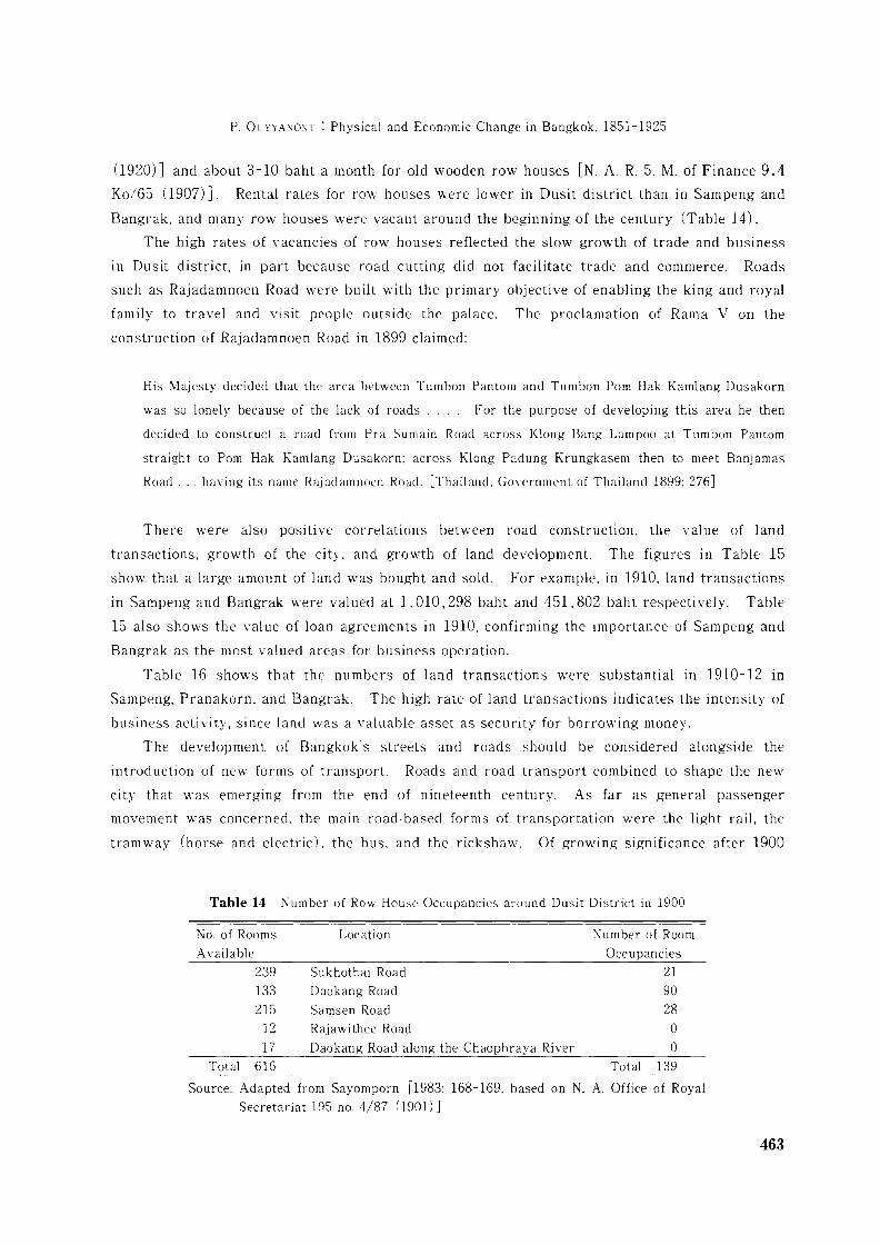
P. OCYYA"iO:\T : Physical and Economic Change in Bangkok. 1851-1925
(1920)J and about 3-10 baht a month for old wooden row houses [N. A. R. 5. M. of Finance 9.4
Ko/55 (1907) ] . Rental rates for row houses were lower in Dusit district than in Sampeng and
Bangrak. and many row houses were vacant around the beginning of the century (Table 14).
The high rates of vacancies of row houses reflected the slow growth of trade and business
10 Dusit district, in part because road cutting did not facilitate trade and commerce. Roads
such as Rajadamnoen Road were built with the primary objective of enabling the king and royal
family to travel and visit people outside the palace. The proclamation of Rama V on the
construction of Rajadamnoen Road in 1899 claimed:
His Majesty decided that the area between Tumbon Pantom and Tumbon Porn Hak Kamlang Dusakorn
was so lonely beca use of the lack of roads . For the purpose of developing this area he then
decided to construct a road from Pra Sumain Road across Klong Bang Lampoo at Tumbon Pantom
straight to Porn Hak Kamlang Dusakorn: across Klong Padung Krungkasem then to meet Banjamas
Road ... having its name Rajadamnoen Road. [Thailand. Government of Thailand 1899: 276]
There were also positive correlations between road construction. the value of land
transactions, growth of the city, and growth of land development. The figures in Table 15
show that a large amount of land was bought and sold. For example, in 1910, land transactions
in Sampeng and Bangrak were valued at 1,010.298 baht and 451. 802 baht respectively. Table
15 also shows the value of loan agreements in 1910, confirming the importance of Sampeng and
Bangrak as the most valued areas for business operation.
Table 15 shows that the numbers of land transactions were substantial in 1910-12 in
Sampeng, Pranakorn. and Bangrak. The high rate of land transactions indicates the intensity of
business activity, since land was a valuable asset as security for borrowing money.
The development of Bangkok's streets and roads should be considered alongside the
introduction of new forms of transport. Roads and road transport combined to shape the new
city that was emerging from the end of nineteenth century. As far as general passenger
movement was concerned. the main road-based forms of transportation were the light rail, the
tramway (horse and electric). the bus. and the rickshaw. Of growing significance after 1900
Table 14 Number of Row House Occupancies around Dusit District in 1900
No. of Rooms Location Number of RoomAvail able Occupancies
239 Sukhothai Road 21133 Daokang Road 90215 Samsen Road 2812 Rajawithee Road 017 Daokang Road along the Chaophraya River 0
Total 616 Total 139
Source: Adapted from Sayomporn [1983: 168-169. based on N. A. Office of RoyalSecretariat 195 no. 4/87 (1901)]
463
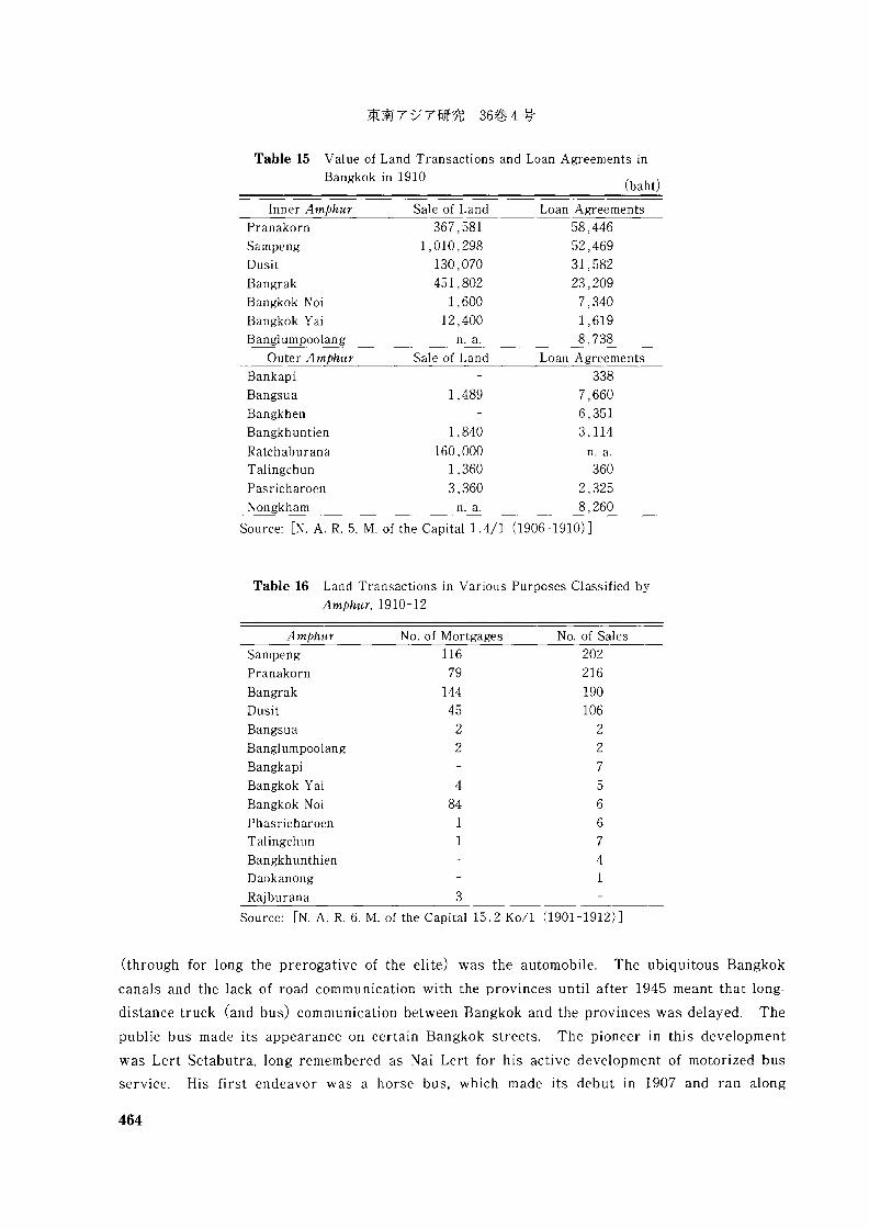
(baht)
Table 15 Val ue of Land Transactions and Loan Agreements inBangkok in 1910
Inner Amphur Sale of Land Loan Agreements
Pranakorn
Sampeng
Dusit
Bangrak
Bangkok Noi
Bangkok Yai
Banglumpoolang
367,581
1,010,298
130,070
451,802
1,600
12,400
n. a.
58,446
52,469
31,582
23,209
7,340
1,619
8,738
Outer Amphur Sale of Land Loan Agreements
1,489
Bankapi
Bangsua
Bangkhen
Bangkhuntien 1 ,840
Ratchaburana 160,000Talingchun 1,360
Pasricharoen 3,360
Nongkham n. a.
338
7,660
6,351
3,114
n. a.360
2,325
8,260
Source: [N. A. R. 5. M. of the Capital 1.4/1 (1906-1910) ]
Table 16 Land Transactions in Various Purposes Classified by
Amphur, 1910-12
Amphur No. of Mortgages No. of Sales
202
216
190
106
227566
741
484
11
116
79
144
45
22
Bangrak
Dusit
Bangsua
Banglumpoolang
Bangkapi
Bangkok Yai
Bangkok Noi
PhasricharoenTalingchun
BangkhunthienDaokanong
Rajburana 3
Sampeng
Pranakorn
Source: [N. A. R. 6. M. of the Capital 15.2 Kof1 (1901-1912) ]
(through for long the prerogative of the elite) was the automobile. The ubiquitous Bangkok
canals and the lack of road communication with the provinces until after 1945 meant that long
distance truck (and bus) communication between Bangkok and the provinces was delayed. The
public bus made its appearance on certain Bangkok streets. The pioneer in this development
was Lert Setabutra, long remembered as Nai Lert for his active development of motorized bus
service. His first endeavor was a horse bus, which made its debut in 1907 and ran along
464
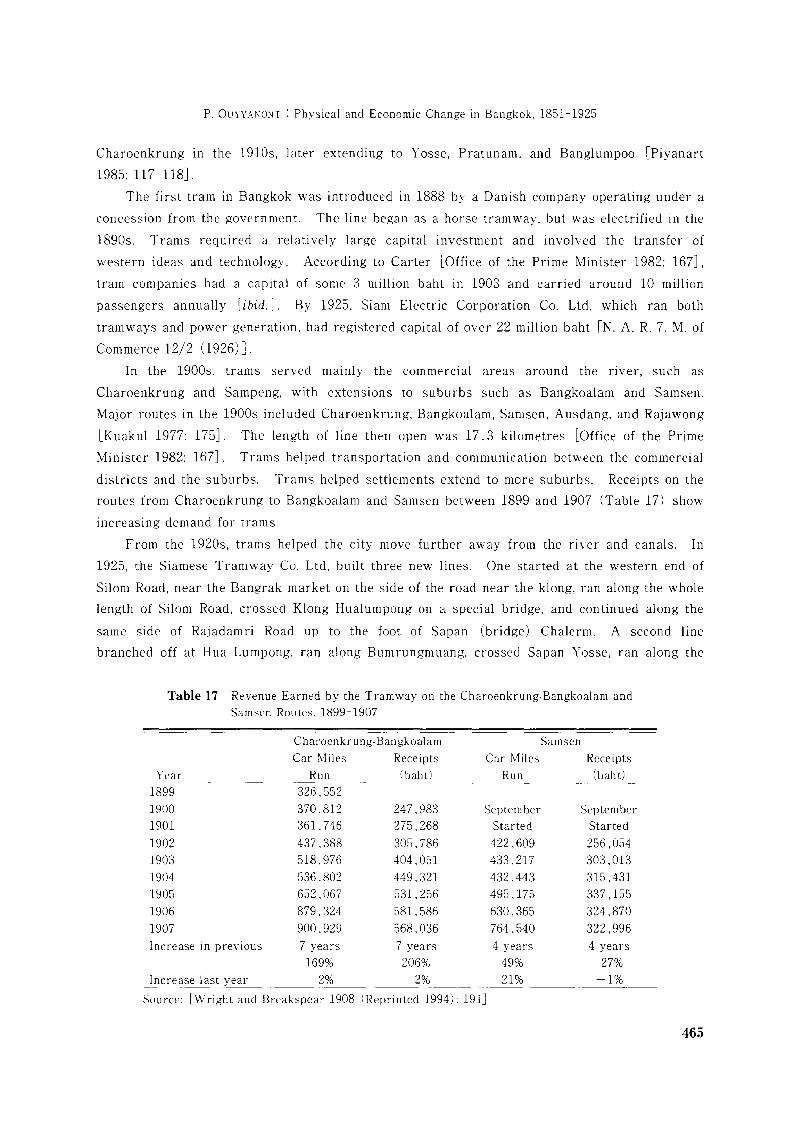
P. 01.TYYAl\O~T : Physical and Economic Change in Bangkok, 1851-1925
Charoenkrung in the 1910s, later extending to Yosse, Pratunam, and Banglumpoo [Piyanart
1985: 117-118].
The first tram in Bangkok was introduced in 1888 by a Danish company operating under a
concession from the government. The line began as a horse tramway, but was electrified in the
1890s. Trams required a relatively large capital investment and involved the transfer of
western ideas and technology. According to Carter [Office of the Prime Minister 1982: 167J,
tram companies had a capital of some 3 million baht in 1903 and carried around 10 million
passengers annually [ibid.J. By 1925, Siam Electric Corporation Co. Ltd, which ran both
tramways and power generation, had registered capital of over 22 million baht [N. A. R. 7. M. of
Commerce 12/2 (1926) J.
In the 1900s, trams served mainly the commercial areas around the river, such as
Charoenkrung and Sampeng, with extensions to suburbs such as Bangkoalam and Samsen.
Major routes in the 1900s included Charoenkrung, Bangkoalam, Samsen, Ausdang, and Rajawong
[Kuakul 1977: 175J. The length of line then open was 17.3 kilometres [Office of the Prime
Minister 1982: 167J. Trams helped transportation and communication between the commercial
districts and the suburbs. Trams helped settlements extend to more suburbs. Receipts on the
routes from Charoenkrung to Bangkoalam and Samsen between 1899 and 1907 (Table 17) show
increasing demand for trams.
From the 1920s. trams helped the city move further away from the river and canals. In
1925, the Siamese Tramway Co. Ltd, built three new lines. One started at the western end of
Silom Road, near the Bangrak market on the side of the road near the klang, ran along the whole
length of Silom Road, crossed Klong Hualumpong on a special bridge. and continued along the
same side of Rajadamri Road up to the foot of Sapan (bridge) Chalerm. A second line
branched off at Hua Lumpong, ran along Bumrungmuang, crossed Sapan Yosse, ran along the
Table 17 Revenue Earned by the Tramway on the Charoenkrung-Bangkoalam and
Samsen Routes, 1899-1907
Charoenkrung-Bangkoalam Samsen
Car Miles Receipts Car Miles Receipts
Year Run (baht) Run (bah t)
1899 326,5521900 370.812 247,983 September September
1901 361,746 275.268 Started Started
1902 437,388 305,786 422,609 256,0541903 518.976 404.051 433.217 303,0131904 536,802 449.321 432,443 315,4311905 652,067 531, 256 495,175 337,1551906 879.324 581,586 630,365 324,8701907 900,929 568,036 764,540 322,996Increase in previous 7 years 7 years 4 years 4 years
169% 206% 49% 27%Increase last year 2% 2% 21% -1%
Source: [Wright and Breakspear 1908 (Reprinted 1994): 191J
465
southern side of Rama I Road to cross Klong Rajadamri on a special bridge connecting with the
Silom line. Thirdly, the Dusit line started in front of Prince Chumporn's palace, ran along the
eastern side of Rama V Road, and terminated in front of Bangsue railway station [N. A. R. 6. M.
of the Capital 13/6 (1925) J.
IV The Privy Purse Bureau and Bangkok's Development
The Privy Purse Bureau (PPB) 12) was also crucial to Bangkok's development. Bangkok's new
streets were often laid out as part of row house (hong taew) construction for royal investment,
especially between 1890 and 1910.
As roads were built the price of land increased, and this attracted the elite and the PPB to
invest in land and land-related business such as market places and row houses. A survey of
land prices in Bangkok in the first decade of the twentieth century shows that the price of land
was highest in the areas where roads were cut (Table 18).
The figures indicate that land prices rose considerably along roads such as Charoenkrung,
Sampeng, Rajawong. The price of well and poorly situated land in some adjacent areas varied
by as much as 250-fold. For example, in 1911 land along Talard Kaosarn Sampeng Road was
300 baht per square wa, while that at the northern part of Tumbon Samsen was 2 baht per
square wa (Table 18). Bangkok's commercial development expanded whenever roads were cut,
for instance, along the south side of Charoenkrung Road, Siphraya, Bangrak, Silom, Suriwong,
Sampeng, and Pomprab. Trading companies and merchant residences were mostly located along
the main roads. Thus the traditional city plan of Bangkok, which consisted of city moats and a
complicated network of canals, underwent a marked change to land-base building after the
1890s.
The PPB acquired land in various ways. It was able to occupy public land, including
unused land belonging to government ministries, unused palaces, and unused land conferred on
government officials [Orathip 1981: 10-13; Chollada 1986: 114-192J.
Land was also obtained through reclaimed mortgage. The PPB frequently lent money
against mortgaged land and real estate, their major customers being Chinese tax-farmers,
aristocrats, and senior bureaucrats. When borrowers were not able to pay their debts, the
properties were transferred to the PPE. For example, a plot of PPB land around
Tawejnareamitre Bridge (5,321 square wa) had previously belonged to Chaophraya Tawej, who
failed to pay a debt of 40,000 baht in 1910 [N. A. R. 5. M. of Finance 9.2/14 no 76/1003
12) The PPB was formally established as an independent department within the Ministry of Finance(Phraklang) in 1890. Its predecessor was established during the reign of King Rama II under thename Ngoen Khang-thi, which was changed to Phara Khlang Khang-thi in the following reign. Thisorganization was the king's personal institution. He was able to manage money to allocate to his owninterests. During the reign of King Rama IV, 5 percent of the total state revenue, around 2,000 chang(160, 000 baht), was regularly allocated to the PPB, together with the extra revenue from the land tax,another 2, 000 chang [Thaweesilp 1985: 124-128]. In 1890, 15 percent of the total revenue wasallocated to the PPB [N. A. R. 5. M. of Finance 9.1 no. 1 (1892)].
466
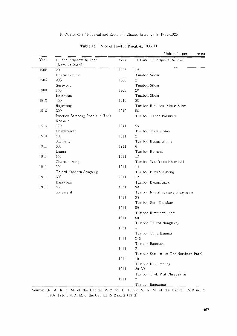
P. Ol'YYAl\O"lT : Physical and Economic Change in Bangkok. 1851-1925
Table 18 Price of Land in Bangkok. 1905-11
Unit: baht per square wa
Year
1905
1905
1908
1910
1910
1910
1910
1911
1911
1911
1911
1911
I: Land Adjacent to Road
(Name of Road)
20Charoenkrung
293Suriwong
160Rajawong
450Rajawong
300
Junction Sampeng Road and Trok
Kaosarn
170Chakkrawat
400
Sampeng
300Luang
160Charoenkrung
300Talard Kaosarn Sampeng
500
Rajawong
350
Songward
Year
1905
1908
1909
1910
1910
1911
1911
1911
1911
1911
1911
1911
1911
1911
II: Land not Adjacent to Road
12Tumbon Silom
2Tumbon Silom
20Tumbon Silom
30
Tumbon Rimboon Klong Silom
50
Tumbon Tanon Pahurud
59Tumbon Trok Sibbia
2
Tumbon Bangprakaew
6
Tumbon Bangrak
18Tumbon Wat Yuan Khumloki
12Tumbon Banknanghong
12Tumbon Bangprakok
98Tumbon Nawat Sungwejwisayaram
35Tumbon Sarn Chaokao
50Tumbon Rimtanonluang
1911 60Tumbon Talard Nanglerng
1911 4Tumbon Tung Banmai
1911 2-6Tumbon Bangsua
1911 2Tumbon Samsen (at The Northern Part)
1911 10Tumbon Hualumpong
1911 20-30
Tumbon Trok Wat Phrayakrai
1911 2Tumbon Bangpong
Source: [N. A. R. 6. M. of the Capital 15.2 no. 1 (909): N. A. M. of the Capital 15.2 no. 2
0909-1910): N. A. M. of the Capital 15.2 no. 3 (1913) ]
467
Table 19 Land Owned by the PPB, Classified by Commercial Districts in Bangkok, 1902
Amphur
Sampeng
BangrakWithin the city wallDusit
Tum bon
Pomprabsatroopai, Samyawd, Sumphuntawong,Chakkrawat, PatumwanSathorn, Bangkwang, Ban TawaiWat Chanasongkram, Prarajawang, Sumrarnraj, PahurudBangkhunprom, Nang Lerng, Samsen
Total
Land Acquisition(rai)
1,831458
861,708
4,083
Source: [N. A. R. 5. M. of Agriculture 6/6153 (1903)]
(1910) J. Chaophraya Surawongwattanasuk bought land beside Talard Hualumpong (23,159
square wa) and mortgaged it with the PPB for 16,000 baht. Chaophraya Surasakmontri bought
land (23 rai) and a house at Tumbon Saladaeng, and mortgaged it with the PPB for 2,755 chang
42 baht (220,442 baht) [N. A. R. 5. M. of Finance 8.1/39 (1897) J . In both cases, the proper
ties were transferred to the PPB when the mortgagees were unable to repay the loan.
The PPB also bought land directly from ordinary people and always had the advantage in
terms of obtaining information on road cutting, the price of land, the advantages of its location,
and so on. In this way, the PPB acquired many plots of land in good locations and commercial
centres. As a result, PPB investments in markets and row houses grew in the quarter century
before 1910 in the main commercial centres such as Bangrak, Rajawong, Suriwong, Patumwan,
Pahurud, Sampeng, Samsen, and Banglumpoo. By thus acquiring land by forfeiture or purchase
in various parts of Bangkok, the PPB controlled both prime commercial land and valuable
cultivated land. Table 19 shows PPB landholdings in 1902.
As the largest and most important land owner in Bangkok, the PPB was a contributing
factor to the growth of Bangkok, influencing road cutting and land use. Road building was
heavily influenced by the king and the PPB, and road construction and row houses went hand in
hand. For example, the PPB would advance money to purchase a plot of land to build row
houses, and then demand road cutting nearby or through the land to increase the price of land
and properties. As recorded in King Chulalongkorn's handwriting in 1901 [Office of the Prime
Minister 1970: 129J:
Chakkri Mahaprasas
4 November 1901
No. 26/1001
Dear Prince Naresworarit
In dealing with a purchase of a plot of land to construct a road and the buildings [row houses] at the
back of Talard Sao Chingcha, this should be done as soon as possible. The construction of the row
houses is almost completed in this year. . .. So road construction in this area should be completed
very soon. The expenditure for purchasing land has been charged to the Privy Purse Bureau, while
468
P. OUYYANOl\T : Physical and Economic Change in Bangkok. 1851-1925
the cost of road construction is financed by another department [Ministry of the CapitalJ.
(Signature)
Chulalongkorn
We should consider further the impact of road construction on row house in vestment.
Throughout the years 1890-1932, the PPB was the largest owner of row houses, which were
usually constructed along both sides of newly cut roads. Row house investment was closely
related to land investment by the PPB, and construction was undertaken along major roads in
the main commercial districts, in Sampeng, Yaowaraj, Pahurud, Charoenkrung, and Fuangna
korn. The first available figure for row house building can be obtained from the postal census
survey in 1883. Unfortunately, some parts of the postal roll in the National Library in
Bangkok are missing. The available data for row houses on Fuangnakorn Road indicate that 83
of 315 households resided in the PPB's row houses and 94 of them dwelt in private tenements
[Tomosugi 1993: 27, 29J.
Scattered records of market transactions give a picture of growing activity in the twenty
years or so before 1910:
In 1892, the PPB had 63 row houses for rent collection along the edge of Bumrungmuang Road. In
1899, the PPB bought the markets and 134 row houses of Krommuan Putharesthumrongsak whose
mortgaged properties were transferred to the Ministry of Finance. [N. A. R. 5. M. of Finance 9.4 ng/11
(1900) ]
In 1899, the PPB bought a group of buildings belonging to the Oriental Hotel along the bank of the
Chaophraya River. Total value was 375,000 baht. [ibid.]
In 1900, the PPB had 215 row houses around the edge of Samsen Road, and 239, 133, and 17 row
houses around the edge of Sangheenok Road, Duangd uan Nok (Sukhothai Road), and Daokang Road
respectively. [N. A. R. 5. M. of Finance 4.1/24 (1903)J
In 1902, the PPB constructed 140 row houses at Sampeng, Pahurud, Plublachai, Chakkrawat, and
Hualumpong. [N. A. R. 6. M. of Finance 1/64 (1912)]
In 1902, there were some 616 row houses constructed by the PPB in Suan Dusit area. [N. A. R. 5.
Office of Royal Secretariat 58/272 no. 120/1172 (1902)]
In 1909, the PPB had a plan to construct hundreds of row houses around Tumbon Samsen. [N. A.
R. 5. M. of Finance 4.1/24 (1903) ]
In 1910, the PPB bought 20 row houses at the edge of Charoenkrung Road from Kromkhun
sabprasart Suphakit at a price of 96, 000 baht. [N. A. R. 5. Office of Royal Secretariat 1. 3/ (1910) ]
469
Rental rates for row houses were low. In 1907, rental rates for row houses at the edge of
Bumrungmuang Road and Charoenkrung Road ranged between 20 and 100 baht a month. The
rates tended to decline for old wooden row houses, the monthly rate being 3-10 baht for one
room [N. A. R. 5. M. of Finance 9.4 Ko/65 (1907) J. Between 1900 and 1910, unskilled Chinese
coolies earned 0.75-1.0 baht a day. If they lived together by sharing the same row houses,
rental rates were cheap. Such low rents also attracted people to run their businesses from row
houses.
In addition, low rental rates attracted low income groups to live in row houses. Some
documents suggest that residents in row houses around the Talard Nang Lerng belonged to low
income groups. In 1901, 613 people lived here, of whom 252 were Thais and 361 were Chinese
[N. A. R. 5. M. of the Capital 8.1/201 (1901) J. Of this group, 284 persons engaged in trading,
229 persons were general workers, 58 males worked in gambling places, and another 58 persons
worked as watchmen. Some 60 children lived in the row houses. The Thais' occupations
included trading in cigarettes, bananas, desserts, and sugarcane. Among the self-employed
were painters, blacksmiths, and carpenters. The Chinese traded in tea, cigarettes, rice, sugar,
and rice noodles, or served as general workers in canal digging, road construction, and coolie
labourers [N. A. R. 5. M. of the Capital 80.1/201 (1901) J.No reliable data are available on the rate of return on row house investments. The low
rental rates suggest that the PPB did not calculate rent from the standpoint of maximizing
profit. The PPB differed from a general private business firm. The role of the PPB (and the
king) was to provide cheap accommodation to the public and welfare to society. Nonetheless,
the availability of moderately high returns on investment was a major factor influencing road
cutting.
V Conclusion
This paper has analysed the major patterns of physical change in Bangkok from 1851,
concentrating on the expansion of canals and roads and the attendant development of new
suburbs. From around 1890, Bangkok began the transition from a water-based city to a land
based city, and the period from around 1890 to 1910 was clearly significant in Bangkok's
development. Key elements here include the rice trade, Chinese immigration, and the activities
of the Privy Purse Bureau and groups of foreign investors. In particular, the Privy Purse
Bureau played an important part in Bangkok's development: Bangkok's new streets were often
laid out as part of row house construction for royal investment.
470
P. OLYY.\\"O:\T : Physical and Economic Change in Bangkok. 1851-1925
Glossary
Amphur
Ban
Chang
Chao Phraya
Changwat
Klang
Kwien
A1enam or A1anam
Nakombam
Phraya
Rai
Sen
Sok
Talard
Tanon
Tumbon or Tambon
Wa
1Vat
District. administrative subdivision of province
Village. house. home
Unit of Thai currency. 1 chang=80 baht
The highest rank of the Thai ancient civil nobility
Province
Canal
A Thai capacity measure equal to 2.000 litres.
River
City administration
Conferred rank. higher than Phra. below Chaophraya
Unit of land: 1 rai=0.16 hectare=1,600 square metres
Unit of linear measure equivalent to 40 metres
An ancient Thai measure of length equal to the distance
from the elbow to the extremity of the middle finger:
roughly 50 centimetres
Market place
Road
Group of villages. official administrative subdivision
under amphur
A measure of length equal to two metres
Temple
Bibliography
0) Documents from Bangkok National Archives
References to the archives begin with "N. A." The citation "N. A. R. 5. M. of the Capital 14/4 (1899)"refers to documents of the Ministry of the Capital from the Fifth Reign and the accompanying numbersidentify to a specific series and file. The citation "N. A. M. of Finance 0301.1.1/139 (931)" refers to thedate and file number for the archive of the Ministry of Finance.
J'v1inistry of the Capital
N. A. R. 5. M. of the Capital 464/28 no. 1 (894)N. A. R. 5. M. of the Capital 18.1/49 0897-1898)N. A. R. 5. M. of the Capital 1/50 (900)N. A. R. 5. M. of the Capital 2/86 (900)
N. A. R. 5. M. of the Capital 5.5/5 (901)N. A. R. 5. M. of the Capital 8.1/201 (901)N. A. R. 5. M. of the Capital 5.4/5 0902-1903)
N. A. R. 5. M. of the Capital 80.1/201 (1901)N. A. R. 5. M. of the Capital 1.4/1 0906-1910)
N. A. R. 5. M. of the Capital 5.4/10 (908)N. A. R. 5. M. of the Capital 4.4/7 (909)
N. A. R. 6. M. of the Capital 15.2 no. 1 (909)N. A. R. 6. M. of the Capital 21/7 (910)
N. A. R. 6. M. of the Capital 15.2 Ko/1 0901-1912)N. A. R. 6. M. of the Capital 21/36 (917)
N. A. R. 6. M. of the Capital 21/49 (920)
N. A. R. 6. M. of the Capital 27/8 0920/21)N. A. R. 6. M. of the Capital 13/6 (925)
471
N. A. R. 6/1. M. of the Capital 11.4/18 (1922)N. A. M. of the Capital 8.9 Ko/3 (1904)N. A. M. of the Capital 15.2 no. 2 (1909-1910)N. A. M. of the Capital 15.2 no. 3 (1913)
Ministry of Public WorksN. A. R. 5. M. of Public Works 9/1 no. 370/1 (1892)N. A. R. 5. M. of Public Works 9/1 no. 1 (1893)N. A. R. 5. M. of Public Works 4/25 no. 46 (1893)N. A. R. 5. M. of Public Works 4/23 (1896)N. A. R. 5. M. of Public Works 4/39 (1897)N. A. R. 5. M. of Public Works 9/28 (1899)N. A. R. 5. M. of Public Works 9/41 (1899)N. A. R. 5. M. of Public Works 9/39 no. 36/44 (1900)N. A. R. 5. M. of Public Works 9/90 no. 36/414 (1900)
Ministry of FinanceN. A. R. 5. M. of Finance 9.1 no. 1 (1892)N. A. R. 5. M. of Finance 8.1/39 (1897)N. A. R. 5. M. of Finance 9.4 ng/11 (1900)N. A. R. 5. M. of Finance 4.1/24 (1903)N. A. R. 5. M. of Finance 9.4 Ko/65 (1907)N. A. R. 6. M. of Finance 9.2/14 no. 76/1003 (1910)N. A. R. 6. M. of Finance 1/64 (1912)N. A. M. of Finance 0301.1.19/4 (1927-1928)
Ministry of CommerceN. A. R. 7. M. of Commerce 12/2 (1926)N. A. R. 7. M. of Commerce 8.1 (1929)
Ministry of AgricultureN. A. R. 5. M. of Agriculture 6/6153 (1903)N. A. R. 5. M. of Agriculture (Department of Canals) 34/791 (1910)
Office of Royal SecretariatN. A. R. 5. Office of Royal Secretariat 58/272 no. 120/1172 (1902)N. A. R. 5. Office of Royal Secretariat 1.3 (1910)N. A. R. 6. Office of Royal Secretariat 21.4/43 (1920)
Office of the Prime MinisterN. A. Office of the Prime Minister 0201.94.5/1 (1931-32)
(2) NewspapersBangkok Calendar. 1871.
(3) Official Government PublicationsThailand, Governtment of Thailand. 1869/70. Government Gazette Proclamation of Rama IV. Vol. 4. (in Thai)---. 1892/93. Government Gazette R. S. 110. no. 8. (in Thai)---. 1893/94. Government Gazette R. S. 111. no. 9. (in Thai)---. 1899. Royal Government Gazette. Vol. 16. (in Thai)---. 1913. Thesapiban. Vol. 13 (Special Issue) August. (in Thai)---. 1929. Thesapiban. Vol. 30. no. 2 August. (in Thai)---.1984. Maps of Bangkok A. D. 1888-1932. Bangkok. (in Thai)
472
P. OUYYA~ONT : Physical and Economic Change in Bangkok. 1851-1925
(4) Published Works
Account and Paper. 1900. Parliament CommaJls. Vol. 87.Anonymous. n. d. Siam Resmtrces.
----. 1977. Royal Duties of King Rama VII. Bangkok: Ruang Rueng Silp Publishing Office. (in Thai)
----. 1985a. Kon Chathung Niyom Thai. Silapawatthanatham 70). (in Thai)
----. 1985b. Sethakit Niyom Thai Yuk lung Plianplaeng Kan Pokkhrong Ph. S. 2495. Silapawatthanatham
70). (in Thai)
----. 1992. Yesterday and Today of Silom Road. Bangkok: Amarin Printing Group.
Beek. S. V. 1995. The Chaophya River in Transition. Kuala Lumpur: Oxford University Press.Carter. C. A. 1988. The Kingdom of Siam 1904. Reprint Editions. Bangkok: The Siam Society.
Chai Ruengsilp. 1976. The Histor.'>' of Thailand: Social Aspects. B. E. 2352-2453. Bangkok: Amarin PublishingOffice. Kurusapa Press. (in Thai)
Chaophraya Thiphakornwong. 1961. The Bangkok Dynastic ChraJlicle Rama IV Bangkok: Kurusapa Press. OnThai)
Chulalongkorn University. 1991. The CompositiaJl of Physical Growth of Bangkok. Bangkok: ChulalongkornUniversity Press. (in Thai)
Collected Laws. 1929. no. 36. On Thai)
Crawfurd. J. 1977. joumal of an Embassy to the Courts of Siam and Cochin China. Kuala Lumpur: OxfordUniversity Press.
Department of Fine Arts. 1962. A Directory Part II: Roads in Changwat Pranakom and Thonburi. Bangkok:Cremation Volume. (in Thai)
----. 1982. The Record of Knmgrattanakosin. Bangkok. (in Thai)
Donner, W. 1978. The Five Faces of Thailand: An Economic Geography. Queensland: University of Queensland
Press.
Evers, H. D.: Rudiger, K.: and Suparb Pas·Ong. 1987. Trade and State Formation: Siam in the Early BangkokPeriod. Modem Asian Studies 21 (4) October: 751-771.
Falkus. M. 1989. Early British Business in Thailand. In British Business in Asia Since 1860. edited by R. P.T. Davenport-Hines and Geoffrey Jones, pp. 118-156. Cambridge: Cambridge University Press.
1993. Bangkok: From Primate City to Primate Megalopolis. In A1egalopolis: The Giant City in
History. edited by Theo Baker and Anthony Sutcliffe, pp. 143-165. London: The Macmillan Press.----. 1997. Bangkok in the Nineteenth and Twentieth Centuries: The Dynamics and Limits of Port
Primacy. In Gateways of Asia Port Cities of Asia in the 13th-20th Centuries, edited by Frank Broeze, pp.
211-222. London and New York: Kegan Paul International.Hewison, K. 1986. Industry Prior to Industrialisation: Thailand. Paper presented at Conference on Industrial
Elites in Southeast Asia Sukhothai, Thailand, 8-12 December.
Hong, Lysa. 1984. Thailand in the Nineteenth Century: EvolutiaJl of the ECaJlomy and Society. Singapore:Institute of Southeast Asian Studies.
Hubbard, R. V. 1977. Canal Construction in the Chao Phraya River Central Thailand. In The Histor.'>' of
Inland Waterway Development in Thailand. Michigan: The Department of Geography, University ofMichigan. Ann Arbor.
Kuakul Yuanyonganan. 1977. The Del'elofnnent of Land CommunicatiaJls. Bangkok: Department of Teacher
Traning. (in Thai)
M. R. Nangnoi Saksri. 1982. Royal Palaces and Palaces in Bangkok. 1782-1982. Bangkok: ChulalongkornUniversity Press. On Thai)
Nidhi Aeusriwong. 1982. Bmtrgeoisie Culture and Literature of Early Bangkok. Bangkok: Thaikhadi ResearchInstitute, Thammasat University. (in Thai)
Nij Hincheeranun. 1982. Road in Bangkok: An Evolution in 200 Years. Paper Presented at Conference on theGrowth and Change of Bangkok in 200 Years, Chulalongkorn University. 17-18 February. (in Thai)
Office of the Prime Minister. 1970. A Collection of King ChulalaJlgkom's A!anuscripts. No.3, part I. Bangkok.(in Thai)
----. 1982. Foreign Records of the Bangkok Period up to 1932. Bangkok: Aksornsmai Press.Office of Royal Palace. 1976. The Record of the CaJlstructiaJl and Repairing Vimammek Palace, 1900-1975.
Bangkok: Office of Royal Palace. Un Thai)
473
Piyanart Bunnag. 1985. The Development of Land Transportation in the Fifth Reign (1868-1910). Bangkok:Chulalongkorn University. (in Thai)
Porphant Ouyyanont. 1997. Bangkok's Population and the Ministry of the Capital in Early 20th CenturyThai History. Tonan Ajia Kenkyu [Southeast Asian Studies] 35 (2): 240-260.
Pussadee Thippawas. 1982. Housing in Bangkok: Models and Changes in 200 Years, 1782-1982. Bangkok:Chulalongkorn University Press. (in Thai)
Royal Thai Survey Department. 1984. Map of Bangkok, 1888-1931. Bangkok.Sarasin Viraphol. 1977. Tribute and Profit: Sino· Siamese Trade 1651-1853. Cambridge: Massachusetts,
Harvard University Press.Skinner, G. W. 1957. Chinese Society in Thailand: An Analytical History. Ithaca: Cornell University Press.Sompop Manarungsan. 1989. Economic Development of Thailand 1850-1950: Response to the Challenge of the
World Economy. Bangkok: Institute of Asian Studies, Chulalaongkorn University.Sternstein, L. 1982. Portrait of Bangkok. Bangkok: Bangkok Metropolitan Administration.Suntharee Asavai. 1987. The History of Rangsit Canal: Land Development and the Social Impacts. Bangkok:
Thammasat University Press. (in Thai)----. 1990. The Economic Crisis after World War I. Bangkok: Thammasat University Press. (in Thai)Terwiel, B. J. 1989. Through Travellers's Eyes: An Approach to Early Nineteenth Century Thai History. Bangkok:
Editions Duang Kamol.Thaweesilp Subvattana. 1985. The Role of Privy Purse in Economic Investment, 1900-1932. Thammasat
University Journal 14 (2): 122-159. (in Thai)The Collection of Dynasty. 1964. Vol. 12 (part 15-18). Bangkok: Kurusapa Publishing Office. (in Thai)Tomosugi, Takashi. 1993. Reminiscences of Old Bangkok: Memory and the Identification of a Changing Society.
Tokyo: The University of Tokyo.United States Consular Reports. 1872. Annual Report on Foreign Commerce. Siam for 1872.Wilson, Constance. M. 1983. Thailand: A Handbook of Historical Statistics. Boston: G. K. Hall & Co.----. 1989. Bangkok in 1883: An Economic and Social Profile. Journal of the Siam Society 77 (2) : 49-58.Wright, A.; and Breakspear, O. T. 1908 [Reprinted 1994]. Twentieth Century Impressions of Siam. Bangkok:
White Lotus.
(5) DissertationsChollada Wattanasiri. 1986. The Privy Purse and the Business Investment, 1890-1932. M. A. Thesis:
Silapakorn University. (in Thai)Cushman, J. W. 1975. Fields from the Sea: Chinese Junk Trade with Siam during the Late Eighteenth and
Early Nineteenth Centuries. Ph. D Thesis, Cornell University.Orathip Tessiri. 1981. Land Holding in Thailand from 1901 to 1932: A Case Study of Monthon Krungthep.
M. A. Thesis, Chulalongkorn University. (in Thai)Porpen Hantrakul. 1975. The Government Spending during the Region of King Rama VI, 1910-1925. M. A.
Thesis, Chulalongkorn University. (in Thai)Sayomporn Tongsari. 1983. The Impact of the Building of Roads in Bangkok during the Reign of King Rama
V (1868-1910): A Study in the Area within the City Walls, the Northern and the Southern Parts of theCity. M. A. Thesis, Silapakorn University. (in Thai)
474