patrolling the berm: discovering the landscape archaeology of western sahara
TRANSCRIPT
Background
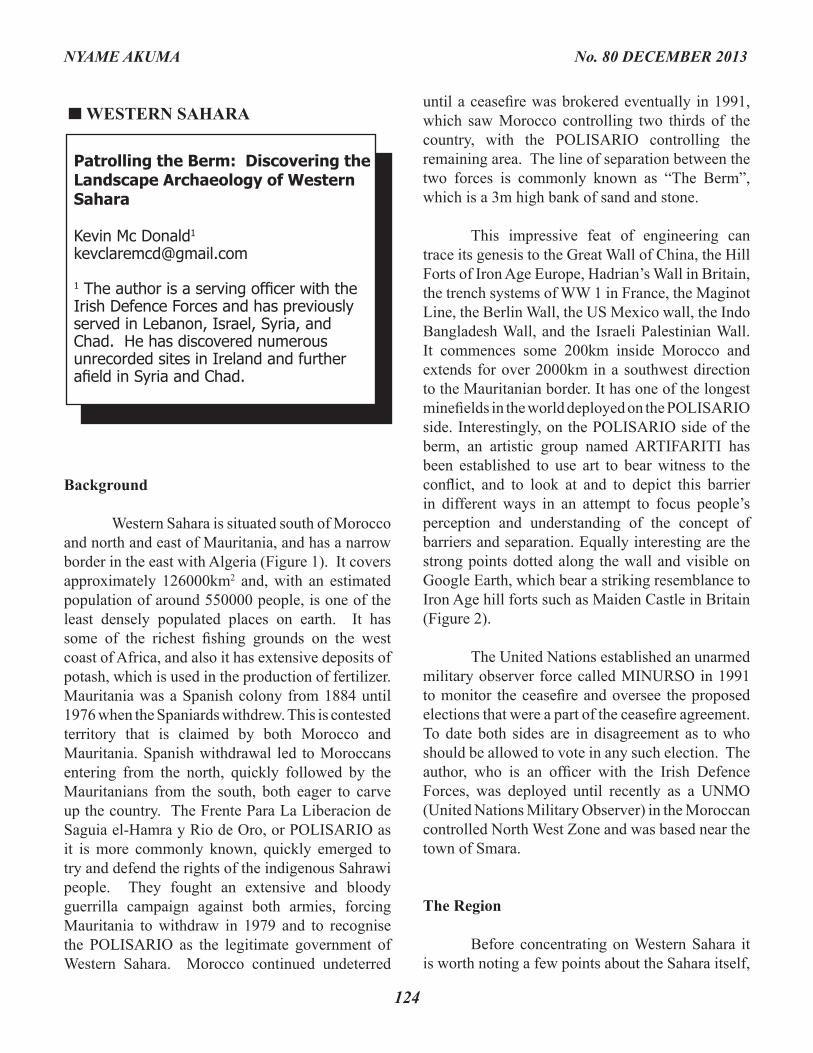
Western Sahara is situated south of Morocco and north and east of Mauritania, and has a narrow border in the east with Algeria (Figure 1). It covers approximately 126000km2 and, with an estimated population of around 550000 people, is one of the least densely populated places on earth. It has some of the richest fishing grounds on the west coast of Africa, and also it has extensive deposits of potash, which is used in the production of fertilizer. Mauritania was a Spanish colony from 1884 until 1976 when the Spaniards withdrew. This is contested territory that is claimed by both Morocco and Mauritania. Spanish withdrawal led to Moroccans entering from the north, quickly followed by the Mauritanians from the south, both eager to carve up the country. The Frente Para La Liberacion de Saguia el-Hamra y Rio de Oro, or POLISARIO as it is more commonly known, quickly emerged to try and defend the rights of the indigenous Sahrawi people. They fought an extensive and bloody guerrilla campaign against both armies, forcing Mauritania to withdraw in 1979 and to recognise the POLISARIO as the legitimate government of Western Sahara. Morocco continued undeterred
until a ceasefire was brokered eventually in 1991, which saw Morocco controlling two thirds of the country, with the POLISARIO controlling the remaining area. The line of separation between the two forces is commonly known as “The Berm”, which is a 3m high bank of sand and stone.
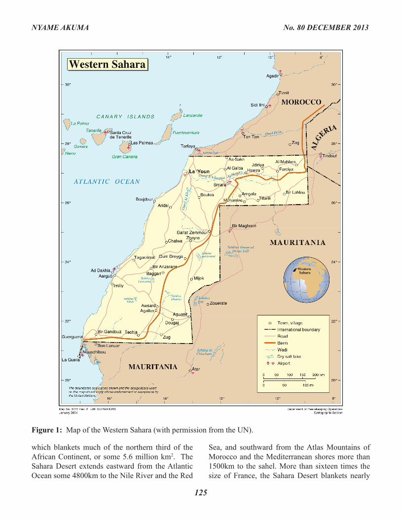
This impressive feat of engineering can trace its genesis to the Great Wall of China, the Hill Forts of Iron Age Europe, Hadrian’s Wall in Britain, the trench systems of WW 1 in France, the Maginot Line, the Berlin Wall, the US Mexico wall, the Indo Bangladesh Wall, and the Israeli Palestinian Wall. It commences some 200km inside Morocco and extends for over 2000km in a southwest direction to the Mauritanian border. It has one of the longest minefields in the world deployed on the POLISARIO side. Interestingly, on the POLISARIO side of the berm, an artistic group named ARTIFARITI has been established to use art to bear witness to the conflict, and to look at and to depict this barrier in different ways in an attempt to focus people’s perception and understanding of the concept of barriers and separation. Equally interesting are the strong points dotted along the wall and visible on Google Earth, which bear a striking resemblance to Iron Age hill forts such as Maiden Castle in Britain (Figure 2).
The United Nations established an unarmed military observer force called MINURSO in 1991 to monitor the ceasefire and oversee the proposed elections that were a part of the ceasefire agreement. To date both sides are in disagreement as to who should be allowed to vote in any such election. The author, who is an officer with the Irish Defence Forces, was deployed until recently as a UNMO (United Nations Military Observer) in the Moroccan controlled North West Zone and was based near the town of Smara.
The Region
Before concentrating on Western Sahara it is worth noting a few points about the Sahara itself,
Patrolling the Berm: Discovering the Landscape Archaeology of Western Sahara
Kevin Mc Donald1
1 The author is a serving officer with the Irish Defence Forces and has previously served in Lebanon, Israel, Syria, and Chad. He has discovered numerousunrecorded sites in Ireland and further afield in Syria and Chad.
WESTERN SAHARA
124
NYAME AKUMA No. 80 DECEMBER 2013
125
NYAME AKUMA No. 80 DECEMBER 2013
which blankets much of the northern third of the African Continent, or some 5.6 million km2. The Sahara Desert extends eastward from the Atlantic Ocean some 4800km to the Nile River and the Red
Sea, and southward from the Atlas Mountains of Morocco and the Mediterranean shores more than 1500km to the sahel. More than sixteen times the size of France, the Sahara Desert blankets nearly
Figure 1: Map of the Western Sahara (with permission from the UN).
all of Mauritania, Western Sahara, Algeria, Libya, Egypt and Niger; the southern half of Tunisia; and the northern parts of Mali, Chad and Sudan. Often associated with majestic sand dunes extending for kilometres, this image of the Sahara is somewhat misleading as the typical sand dune terrain only covers approximately 15% of the entire Sahara.
The area that I patrolled covers approximately 46000km2 and is comprised of what is mainly rocky desert or Hamada. There are few of the previously mentioned large sand dunes associated with most people’s perception of the Sahara and the terrain is marked by numerous ephemeral lakes and rivers, which occasionally emerge as a result of infrequent rainfall. In the west
the land is flat, stretching for kilometres of relative nothingness, with only a few stark wind-scoured acacia trees to break the monotony. Towards the east the land is divided by numerous ridges, flat plateaus and a number of sunken valleys with evidence of up-thrusting and folding in the exposed rock layers. There is significant coverage of a soft siltstone that overlies a younger marly deposit and, from the fossilised plants and even visible imprints of bird’s feet, it is obvious that this layer was associated with a period of abundant water coverage. This rocky surface is now broken up due to weathering and this is often intermixed with abundant scatters of flint nodules. The terrain is tough to negotiate and a journey of 50km could take many hours. The heat is incessant during the months of July to October
126
NYAME AKUMA No. 80 DECEMBER 2013
Figure 2: Aerial picture of a Royal Moroccan Army defensive position, one of many situated on the Berm.
127
and sand storms are a frequent reminder that this is not a region for the faint hearted.
Climate
Today the region is arid with summer temperatures reaching into the high 50°C and occasionally reaching 62°C. Yet night-time temperatures can drop significantly and the desert can be a bitterly cold place. The prevailing winds, emanating from the northeast, evaporate practically all of the moisture from the air as they head southwest, and they generate severe sand and dust storms that distribute sand over vast distances. This, however, was not always the case and the history of this region is one of significant changes to the physical environment between arid phases when the region is virtually uninhabitable and humid phases when the region undergoes a transformation into a savannah type environment with abundant rivers and lakes. Tens of thousands of years may separate these oscillations and during the last glacial maximum c. 21000 BP, the Sahara was much larger than it is today and the aridity associated with this glaciation was due to the reduced moisture available in the atmosphere, decreased solar heating of the land surface, and also changes in oceanic and atmospheric circulation. In general, aridity is associated with glacial periods and humidity with interglacials. There is evidence that a much cooler climate prevailed during the last glacial period and that this gave way to a more humid climate approximately 10000 BP. This wetter climate may well have been triggered by the strengthening African monsoon that was penetrating into the Sahara and was also helped by rainfall generated by the mid latitude weather systems in the early Holocene until c. 8000 BP. This period saw the monsoon belt drift north leading to the development of numerous rivers and lakes but this milder climate gradually changed to a more arid one and by c. 5000 BP aridity was taking a grip on the Sahara. It has been suggested that in the period from 10000 BP in the area now known as Western Sahara, due to its relatively humid climate, may have acted as
a refuge for floral, faunal and human populations during the period known as the Holocene (Brooks et al. 2005). The distinct cultural innovations in lithics and pottery has led some to believe that populations moving into the area during times of aridity in their own regions, lost contact with their former groups and developed individual characteristics in lithic production and domestic ware. More research is needed in this area before any conclusions can be drawn.
The Archaeology
Africa has the longest record of human occupation in the world and its landmass equates to more than one fifth of the habitable area of the globe. As a continent it plays a central role in our understanding of human evolution, the prehistory of our species, and the development of complex societies. Some of the earliest evidence of human occupation in the region is from the site of Ain Hanech in Algeria where Oldowan tools were found, dating to c. 1.8 my BP (Sahnouni et al. 2002). There is evidence from the broader Saharan region for Aterian occupation circa 90 to 60000 BP and may even be earlier in sites such as Ifri n’Ammar and Dar es Soltan 1 in Morocco, which are dated between 145 and 110kya respectively (Scerri 2013). The evidence however, is more scant in Western Sahara and this may well be due to the lack of archaeological investigation because of the recent conflict. Whether driven by drought further south or east, it does appear that this area of the Sahara was certainly reoccupied from approximately 10000 BP, and that these hunter-gatherers soon developed a more sedentary lifestyle as they optimised the abundant resources of elephants, cattle and giraffe. The Sahara may not have been a barrier to movement of peoples northward ‘Out of Africa’ in the early Holocene humid period, but because of the presence of linked lakes, rivers and waterways it may have acted as a green corridor that allowed animals and humans to migrate northwards (Drake et al. 2011).
NYAME AKUMA No. 80 DECEMBER 2013
128
NYAME AKUMA No. 80 DECEMBER 2013
Pastoralism emerged in the 7th and 6th millennia BP and lasted until the final desiccation of the Sahara approximately 5000 BP, which saw the arrival of hyper arid conditions that continue to the present. Because of the conflict, Western Sahara was off limits to foreign archaeologists from the early 1970s to the mid 1990s and today, access to the Moroccan army-controlled area needs to be co-ordinated through the government in Rabat in Morocco, while access to the POLISARIO controlled side is through their headquarters in Algeria. Needless to say the political situation does not appeal to many visitors. Research was conducted in the region during the period of Spanish colonisation but this is difficult to access. However there has been recent work, mainly on the POLISARIO side, by Nick Brooks (Brooks 2005). Brooks has worked in the field of Saharan archaeology and geoarchaeology since 1999 and
has found that the development of complex societies in the middle Holocene was a response of the precursor societies to deteriorating environmental conditions including the start of the desiccation of the Sahara after c. 8000 BP (Brooks et al. 2006). He links the archaeological and paleoenvironmental evidence to demonstrate that the cultural history of the Sahara is intimately linked to a succession of humid and arid episodes with humid conditions fully established by c.10000 BP. This led to a re-occupation of the Sahara by hunter-gatherers from sub-Saharan Africa. This occupation was to reduce again with the onset of aridity after c. 5000 BP.
The two primary features of the prehistoric occupation of this region are extensive lithic evidence and numerous burial cairns scattered over the desert floor. These lithics appear to date mainly to the Holocene but some of the lithics may
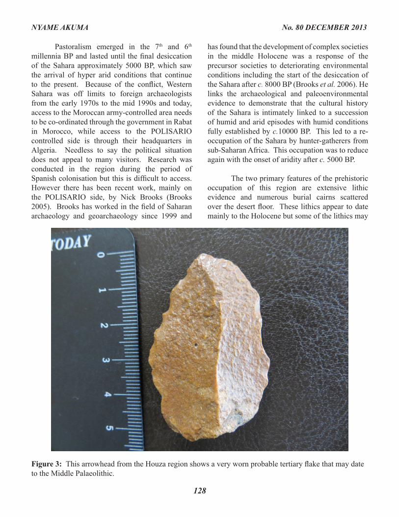
Figure 3: This arrowhead from the Houza region shows a very worn probable tertiary flake that may date to the Middle Palaeolithic.
129
NYAME AKUMA No. 80 DECEMBER 2013
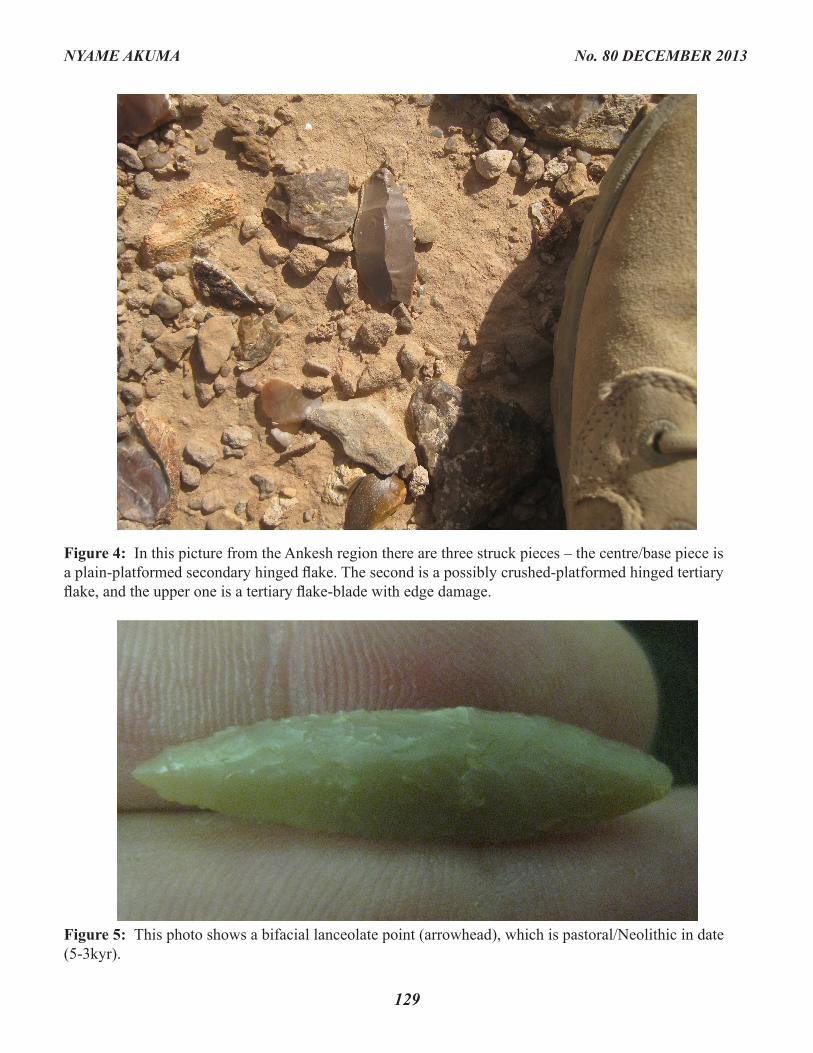
Figure 4: In this picture from the Ankesh region there are three struck pieces – the centre/base piece is a plain-platformed secondary hinged flake. The second is a possibly crushed-platformed hinged tertiary flake, and the upper one is a tertiary flake-blade with edge damage.
Figure 5: This photo shows a bifacial lanceolate point (arrowhead), which is pastoral/Neolithic in date (5-3kyr).
130
NYAME AKUMA No. 80 DECEMBER 2013
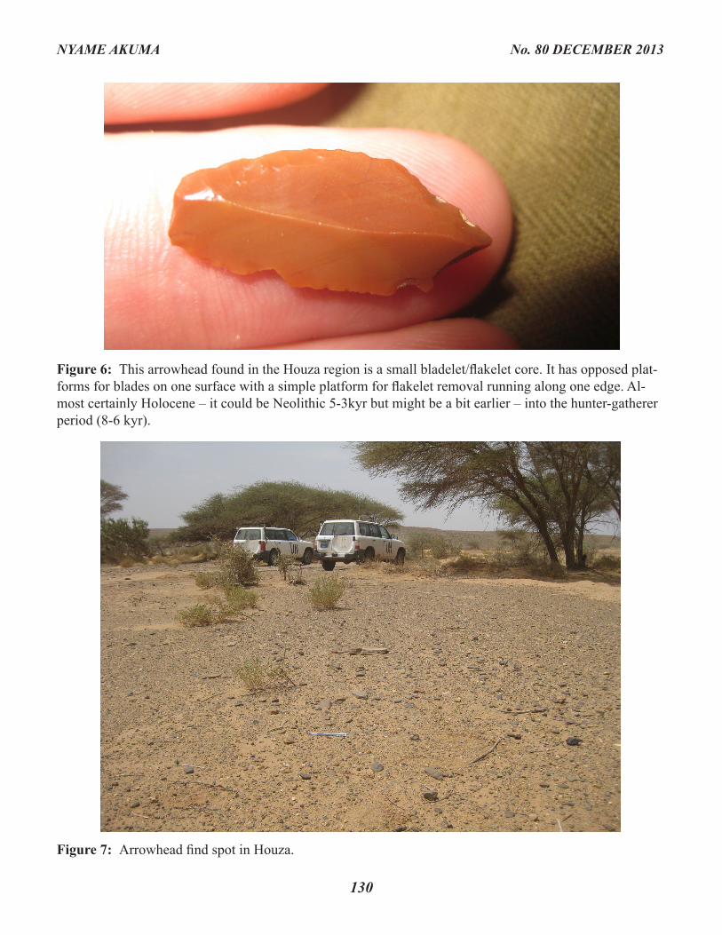
Figure 6: This arrowhead found in the Houza region is a small bladelet/flakelet core. It has opposed plat-forms for blades on one surface with a simple platform for flakelet removal running along one edge. Al-most certainly Holocene – it could be Neolithic 5-3kyr but might be a bit earlier – into the hunter-gatherer period (8-6 kyr).
Figure 7: Arrowhead find spot in Houza.
well be Pleistocene due to their rougher working and their similarity to lithics found elsewhere. The site of Erqueiz Lahmar in the eastern part of the country has produced Late Acheulean hand axes and Mousterian cores (Brooks et al. 2003). In relation to the burial cairns, they range from simple mounds to more complicated conical tumuli, stepped platforms, and cairns with a semi-circular forecourt. Dating of these structures is of course problematic without excavation, but the presence of worked stone adjacent to many of the tombs identified would suggest a mid- to late- Holocene date. Brooks has suggested a date of c. 6000 BP for
similar monuments near Tifarati on the eastern side of the berm (Brooks et al. 2006).
De Lernia (2006) states that there are many later Islamic burial cairns dotted throughout the region but these tend to occur in groups, often with more modern individual burials attached. These are often of double-ended construction type seen across the Sahel and are almost certainly associated with travel routes. In many cases the cairns would have had an association with a known local or religious person who died while travelling.
131
NYAME AKUMA No. 80 DECEMBER 2013
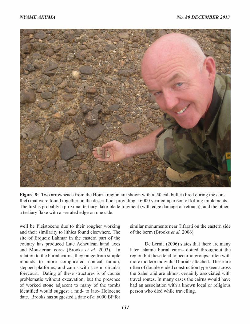
Figure 8: Two arrowheads from the Houza region are shown with a .50 cal. bullet (fired during the con-flict) that were found together on the desert floor providing a 6000 year comparison of killing implements. The first is probably a proximal tertiary flake-blade fragment (with edge damage or retouch), and the other a tertiary flake with a serrated edge on one side.
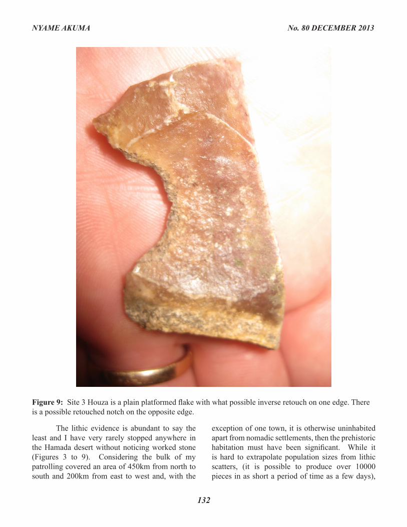
The lithic evidence is abundant to say the least and I have very rarely stopped anywhere in the Hamada desert without noticing worked stone (Figures 3 to 9). Considering the bulk of my patrolling covered an area of 450km from north to south and 200km from east to west and, with the
exception of one town, it is otherwise uninhabited apart from nomadic settlements, then the prehistoric habitation must have been significant. While it is hard to extrapolate population sizes from lithic scatters, (it is possible to produce over 10000 pieces in as short a period of time as a few days),
132
NYAME AKUMA No. 80 DECEMBER 2013
Figure 9: Site 3 Houza is a plain platformed flake with what possible inverse retouch on one edge. There is a possible retouched notch on the opposite edge.
and considering that these lithics could potentially cover some millennia, it could well be that small groups of 20 to 30 people with relatively high mobility travelled independently through the region and perhaps came together seasonally on the lakes in much larger groups (Dr. Tim Reynolds, personal communication).
Flint and chert appear to be the more common lithic choices, and these are often found adjacent to some of the many ancient lakes and watercourses that crisscross the region. In common with other sites where I have discovered lithic scatters, there appears to be an orientation towards the use of high ground overlooking water sources; for example on the Golan Heights I discovered evidence of Yarmukian presence c. 5000 BC, which consisted of flint and chert debitage and pottery at the edge of a plateau overlooking the Yarmuk River (Mc Donald 2007) and on the north west coast of Ireland, I discovered evidence of Neolithic activity in the form of lithic scatters and a polished stone axe on a bluff overlooking the estuary of the River
Erne (Mc Donald 2009). Thus it seems that there is a direct relationship between tool working sites and the landscape in which those tools may be used. Perhaps it is just a matter of economy of effort, but it is easier to produce and sharpen tools adjacent to where you will use them again and again, rather than carrying them from a distant production site.
Burial Monuments
Dating of these monuments is difficult without excavation (Figures 10 to 13) but they may cover the period c. 5600 to 1200 bp with even earlier dates in the 7th millennium bp for burial cairns with just cattle remains interred (Savilli 2002). Nicoll (2004) cites the earliest evidence for cattle domestication in the eastern Sahara where 7000 years ago desiccation increased and advanced rapidly. Cattle herding played an important role in developing societies as it bridged the hunter-gatherer tradition with pastoralism, especially in times of scarce resources. The fact that cattle herding
133
NYAME AKUMA No. 80 DECEMBER 2013
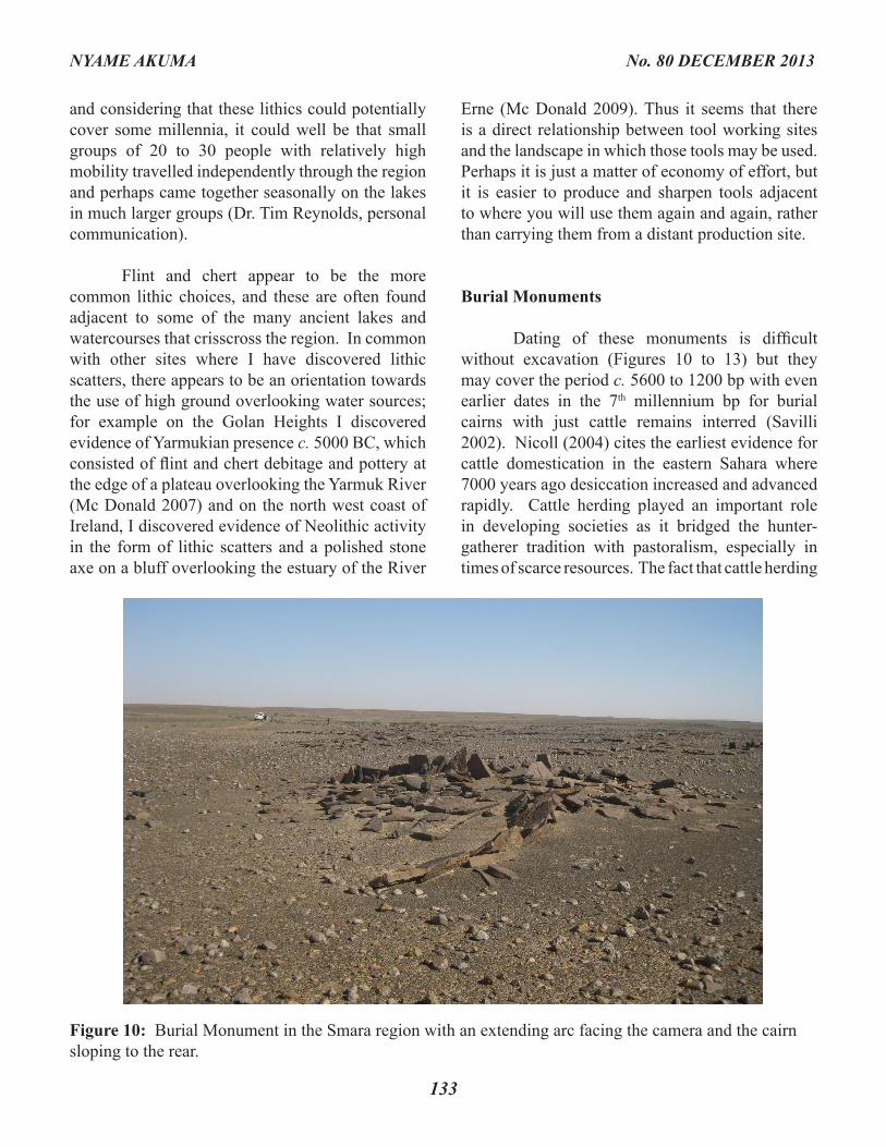
Figure 10: Burial Monument in the Smara region with an extending arc facing the camera and the cairn sloping to the rear.
134
NYAME AKUMA No. 80 DECEMBER 2013
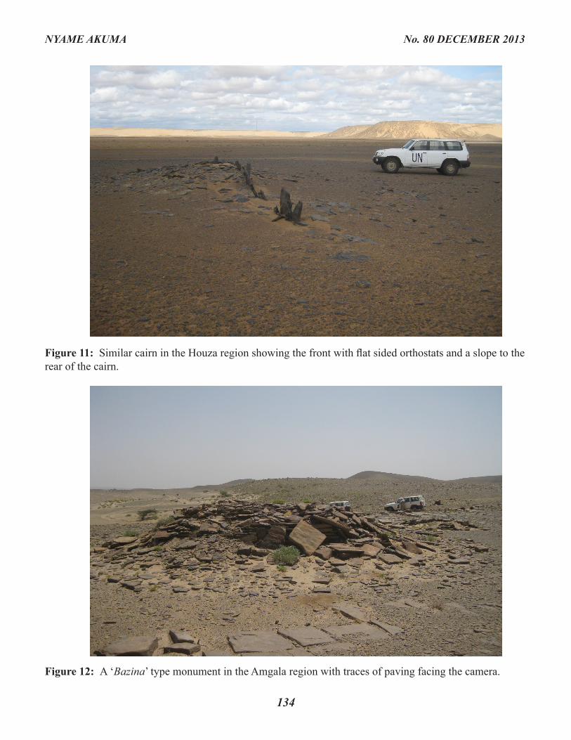
Figure 11: Similar cairn in the Houza region showing the front with flat sided orthostats and a slope to the rear of the cairn.
Figure 12: A ‘Bazina’ type monument in the Amgala region with traces of paving facing the camera.
provided a ‘walking larder’ where milk and blood could readily help sustain communities that found their traditional foraging resources diminished due to the onset of aridity, helps to explain the new importance of cattle and perhaps why it was cattle that were initially buried in funerary monuments rather than humans.
In fact it appears that cattle burials appear c. 7000 BP and according to Di Lernia (2006) the reason for this is a direct response to the arrival of increased aridity from circa 7000 BP. He attributes technical innovations that occurred in the Holocene Sahara to be a response to aridity in direct contradiction to Wendorf and Schild (2003)
who claim the exact opposite: that it was in periods of increased moisture that technical and economic innovations developed. In support of this, they believe that the initial spread of cattle into the Egyptian Sahara c. 9000 BP and the subsequent movement into the Central Sahara c. 7000 BP occurred during moist periods when facilities for water and grazing are available. De Lernia however, believes that megalithic architecture (cattle burials) spread throughout the Sahara in relation to mid Holocene arid periods and this aridity had a twofold effect: it created a ‘push’ effect in increasing migration across the Sahara, and it provided a stimulus to offer sacrifices to the gods for better climatic conditions. The effect of increasing aridity
135
NYAME AKUMA No. 80 DECEMBER 2013
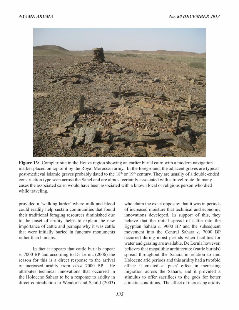
Figure 13: Complex site in the Houza region showing an earlier burial cairn with a modern navigation marker placed on top of it by the Royal Moroccan army. In the foreground, the adjacent graves are typical post-medieval Islamic graves probably dated to the 18th or 19th century. They are usually of a double-ended construction type seen across the Sahel and are almost certainly associated with a travel route. In many cases the associated cairn would have been associated with a known local or religious person who died while traveling.
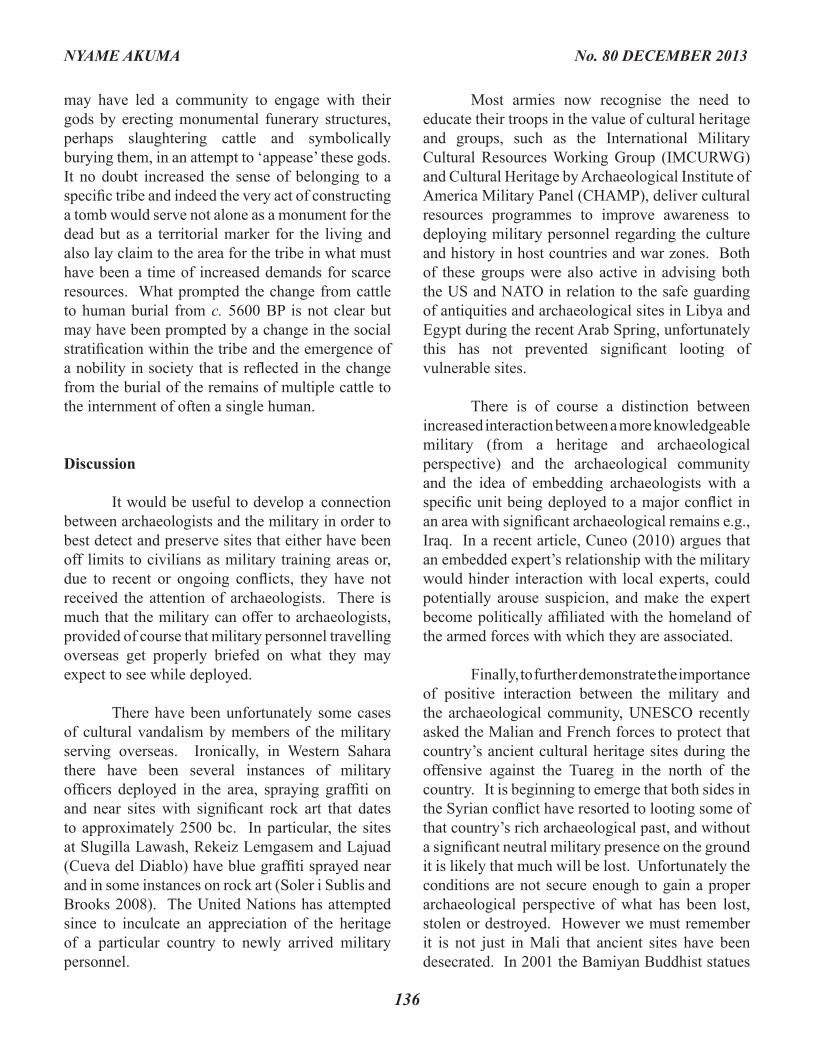
may have led a community to engage with their gods by erecting monumental funerary structures, perhaps slaughtering cattle and symbolically burying them, in an attempt to ‘appease’ these gods. It no doubt increased the sense of belonging to a specific tribe and indeed the very act of constructing a tomb would serve not alone as a monument for the dead but as a territorial marker for the living and also lay claim to the area for the tribe in what must have been a time of increased demands for scarce resources. What prompted the change from cattle to human burial from c. 5600 BP is not clear but may have been prompted by a change in the social stratification within the tribe and the emergence of a nobility in society that is reflected in the change from the burial of the remains of multiple cattle to the internment of often a single human.
Discussion
It would be useful to develop a connection between archaeologists and the military in order to best detect and preserve sites that either have been off limits to civilians as military training areas or, due to recent or ongoing conflicts, they have not received the attention of archaeologists. There is much that the military can offer to archaeologists, provided of course that military personnel travelling overseas get properly briefed on what they may expect to see while deployed.
There have been unfortunately some cases of cultural vandalism by members of the military serving overseas. Ironically, in Western Sahara there have been several instances of military officers deployed in the area, spraying graffiti on and near sites with significant rock art that dates to approximately 2500 bc. In particular, the sites at Slugilla Lawash, Rekeiz Lemgasem and Lajuad (Cueva del Diablo) have blue graffiti sprayed near and in some instances on rock art (Soler i Sublis and Brooks 2008). The United Nations has attempted since to inculcate an appreciation of the heritage of a particular country to newly arrived military personnel.
Most armies now recognise the need to educate their troops in the value of cultural heritage and groups, such as the International Military Cultural Resources Working Group (IMCURWG) and Cultural Heritage by Archaeological Institute of America Military Panel (CHAMP), deliver cultural resources programmes to improve awareness to deploying military personnel regarding the culture and history in host countries and war zones. Both of these groups were also active in advising both the US and NATO in relation to the safe guarding of antiquities and archaeological sites in Libya and Egypt during the recent Arab Spring, unfortunately this has not prevented significant looting of vulnerable sites.
There is of course a distinction between increased interaction between a more knowledgeable military (from a heritage and archaeological perspective) and the archaeological community and the idea of embedding archaeologists with a specific unit being deployed to a major conflict in an area with significant archaeological remains e.g., Iraq. In a recent article, Cuneo (2010) argues that an embedded expert’s relationship with the military would hinder interaction with local experts, could potentially arouse suspicion, and make the expert become politically affiliated with the homeland of the armed forces with which they are associated.
Finally, to further demonstrate the importance of positive interaction between the military and the archaeological community, UNESCO recently asked the Malian and French forces to protect that country’s ancient cultural heritage sites during the offensive against the Tuareg in the north of the country. It is beginning to emerge that both sides in the Syrian conflict have resorted to looting some of that country’s rich archaeological past, and without a significant neutral military presence on the ground it is likely that much will be lost. Unfortunately the conditions are not secure enough to gain a proper archaeological perspective of what has been lost, stolen or destroyed. However we must remember it is not just in Mali that ancient sites have been desecrated. In 2001 the Bamiyan Buddhist statues
136
NYAME AKUMA No. 80 DECEMBER 2013
were dynamited by the Taliban despite appeals from fellow Muslims. In 2012, Sufi shrines in North Africa were attacked by militant Islamists in addition to the remnants of the regions pre-Islamic past (Morris 2013). In Morocco, 8000 year old carvings in the High Atlas Mountains, which depict the Sun as a symbol of pre-Islamic divinity, were destroyed by radical Islamists. But such destruction is not just carried out by Islamic extremists. The Hindus at Ayodhya destroyed centuries old mosques, the Balkans have seen all sides engage in wanton cultural destruction. From the Crusades to the conquest of the Americas, Christian extremists have hacked down and destroyed artefacts and statues of religious rivals and pagans alike. In the 17th century AD, the Puritans destroyed statues and icons in Catholic churches and monasteries. So it appears that the recent events in Mali demonstrate that the wars of today are not just fought with weapons. It behoves all of us with an interest in the past how best to understand and preserve it, to ensure that such acts of cultural desecration become a thing of the past, and we can only accomplish this through explanation and education.
Acknowledgements
I am grateful for the help and support of Dr. Colin Breen (University of Ulster) who provided insight into the archaeology of the region and to Islamic burials in particular. He also gave useful comments on the earlier drafts of this article. Dating of the lithics has been limited to correspondence with Dr. Tim Reynolds, Birkbeck College University of London, and I am grateful to him for his insight and description of the various lithics.
Bibliography
Brooks, N.2005 Cultural heritage and conflict: the threatened archaeology of Western Sahara. Journal of North African Studies 10(3-4):
413-439.
Brooks, N., I. Chiapello, S. Di Lernia, M. Legrand, C. Moulin, and J. Prospero 2005 The Climatic-Environment Society nexus in the Sahara from prehistoric times to the present day. Journal of North African Studies 10(3-4): 253-293.
Brooks N., J. Clark, J. Crisp, F. Crivellaro, H. Jousse, E. Markiewicz, M. Nichol, M. Raffin, R. Robison, A. Wasse, and V. Winton2006 Funerary sites in the “Free Zone”: report on the second and third seasons of fieldwork of the Western Sahara Project. Sahara 17: 75-94.
Brooks, N., S. Di Lernia, N. Drake, M. Raffin, and T. Savage2003 The geoarchaeology of Western Sahara, preliminary results of the first Anglo-Italian expedition in the liberated zone. Sahara 14: 63-80.
Cuneo, A.2010 To embed or not to embed?: Archaeologists, Cultural Heritage Managers and the United States Military. Forum Archaeologiae 55(12020) (http:/farch.net)
Di Lernia, S.2006 Building monuments, creating identity: Cattle cult as a social response to rapid environmental changes in the Holocene Sahara. Quaternary International 151: 50- 62.
Drake, A.N., R.M. Blench, S.J. Armitage, C.S. Bristow, and K.H. White 2011 Ancient watercourses and biogeography of the Sahara explain the peopling of the
137
NYAME AKUMA No. 80 DECEMBER 2013
desert. Proceedings of the National Academy of Sciences 108(2): 458-462. Mc Donald, K. 2007 Discovering the archaeology of Observation Post 55. A Yarmukian Settlement on the Golan Heights. United Nations Truce Supervisory Organisation (UNTSO) News Magazine 3: 25-29. 2009 The Lost Tombs of Finner Camp Co. Donegal. Dublin: Defence Forces Printing Press.
Morris, H. 2013 Mali’s Cultural War: The Fate of The Timbuktu Manuscripts. International Herald Tribune January 13, 2013 http://rendezvous.blogs.nytimes. com/2013/01/30.
Nicoll, K.2004 Recent environmental change and prehistoric human activity in Egypt and Northern Sudan. Quaternary Science Reviews 23: 561-580.
Sahnouni, M., D. Hadjouis, J. van der Made, A. Derradji, A. Canals, M. Medig, H. Belahrech, Z. Harichane, and M. Rabhi2002 Further research at the Oldowan site of Ain Hanech, north-eastern Algeria. Journal of Human Evolution 43: 925-937.
Savilli, S. 2002 A historical background: mortuary archaeology in the Sahara between colonialism and modern research. In S. Di Lernia and G. Manzi, editors, Sand, Stones and Bones: the Archaeology of Death in the Wadi Tannezzuft Valley (5000-2000 BP). Firenze: All’Insegna del Giglio, pp. 17-24.
Scerri, E.M.L.2013 The Aterian and its place in the North African Middle Stone Age. Quaternary International 300: 111-130.
Soler i Subils, J., and N. Brooks2008 Damage to Rock Art Sites attributed to MINURSO in Western Sahara between 1995 and 2007. http://www.udg.edu/grupsrecerca/Sahara/ Rockartdamage/tabid/9039/language/ca- ES/Default.aspx
Wendorf, F., and R. Schild2003 Book Review: Droughts, Food and Culture: Ecological Change and Food Security in Africa’s Later Prehistory Edited by Fekri Hassan, Kluwer Academic/ Plenum Publishers, New York, 2002. African Archaeological Review 20(2): 121- 133.
138
NYAME AKUMA No. 80 DECEMBER 2013