minor mineral block no. 17 & area 1.20 ha located village
TRANSCRIPT
At
Minor Mineral Block No. 17 & Area 1.20 Ha
Located
Village: Kulgam,
Tehsil: Kulgam,
District: Kulgam,
UT: Jammu & Kashmir
Average Proposed Capacity: 19,561.5TPA
Mr. Mushtaq Ahmad Khanday
S/o Shri Lalud Din Khanday
R/o: Near Masjid Shareef, Bhan
District – Kulgam,
UT: - Jammu & Kashmir.
ENVIRONMENT CONSULTANT
Atmos Sustainable Solutions Pvt. Ltd.
QCI – NABET Certificate No.: NABET/EIA/2023/IA 0063
Corp. Off.: A -73, 3rd Floor, Sector – 65, Noida, Uttar Pradesh - 201301

CHAPTER-I
INTRODUCTION
INDEX
S. NO. CONTENTS PAGE NO.
1.0 PREAMBLE 2/I
1.1 IDENTIFICATION OF PROJECT PROPONENT 2/I
1.2 BRIEF DESCRIPTION OF PROJECT 4/I
1.3 REGULATORY COMPLIANCES & APPLICABLE
LAWS/REGULATIONS 20/I
1.4 SCOPE OF THE STUDY 20/I
1.5 POST – ENVIRONMENTAL CLEARANCE MONITORING 20/I
1.6 TRANSFERABILITY OF ENVIRONMENTAL CLEARANCE 21/I
1.7 GENERIC STRUCTURE OF ENVIRONEMNETAL IMPACT
ASSESSMENT DOCUMENT 21/I
1.8 LAWS APPLICABLE TO THIS PROJECT 23/I
1.9 PROFILE OF THE PROJECT PROPONENT 24/I
1.10 COMPLIANCE OF TOR CONDITION 24/I
Minor Mineral Block No. 17,
Located at Village – Kulgam,
Tehsil – Kulgam & District – Kulgam,
UT – Jammu & Kashmir. Draft EIA/EMP: Introduction
Applicant: Mushtaq Ahmad Khanday 2/I
1.0 PREAMBLE
Environmental Impact Assessment (EIA) is a process, used to identify the environmental, social
and economic impacts of a project prior to decision-making. It is a decision making tool, which
guides the decision makers in taking appropriate decisions for proposed projects. EIA
systematically examines both beneficial and adverse consequences of the proposed project and
ensure that these impacts are taken into account during the project designing. The present case
comes under category ‘B1’ the purview of EIA Notification, MoEF, Govt. of India, New Delhi
dated 14th September 2025 and its subsequent amendments thereof and EIA Guidance Manual for
Mining (Feb, 2010) of MoEF, Govt. of India. This Draft EIA study has been carried out to assess
the environmental, social and economic impacts of the project and formulate action plans to reduce
adverse impacts, shape projects to suit the local environment and present the predictions and
options.
1.1 IDENTIFICATION OF PROJECT PROPONENT
Letter of Intent has been allotted in favor of Mushtaq Ahmad Khanday (Project Proponent) by
Government of Jammu and Kashmir Directorate of Geology and Mining, Srinagar for Minor Mineral
Block No. 17 and Vide No. MSK/DGM/Sgr/F-03/Kul/B-17/257 over an area of 1.20 Ha and the
validity of Letter of Intent period is from 10-03-2021 to 09.03.2025. i.e. 5 years. (Copy of LOI is
enclosed as Annexure – I).
Terms of Reference have been awarded in favor of Mushtaq Ahmad Khanday (Project Proponent) by
J&K Environment Impact Assessment Authority, Jammu & Kashmir for Minor Mineral Block No.
17 and Vide Letter No. JKEIAA/2020/337/1834-38 Dated 26.07.2021 over an area of 1.20 Ha. (Copy
of TOR is enclosed as Annexure – II).
Mining Plan has been allotted in favor of Mushtaq Ahmad Khanday (Project Proponent) by
Department of Geology & Mining Govt. of Jammu & Kashmir for Mineral Block No. 17 and Vide
Letter No. 8 MDA/DGM/Kul/213 dated 31.08.2020 over an area of 1.20 Ha. (Copy of Mining Plan
is enclosed as Annexure – III).
Minor Mineral Block No. 17,
Located at Village – Kulgam,
Tehsil – Kulgam & District – Kulgam,
UT – Jammu & Kashmir. Draft EIA/EMP: Introduction
Applicant: Mushtaq Ahmad Khanday 3/I
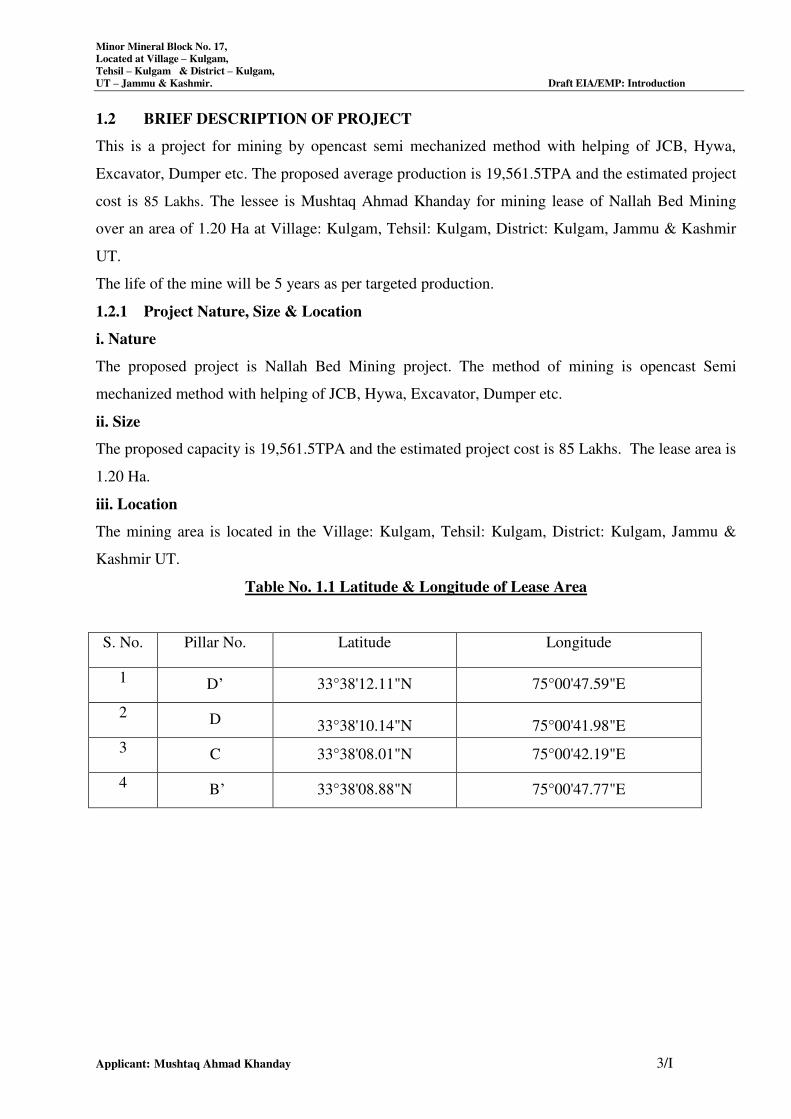
1.2 BRIEF DESCRIPTION OF PROJECT
This is a project for mining by opencast semi mechanized method with helping of JCB, Hywa,
Excavator, Dumper etc. The proposed average production is 19,561.5TPA and the estimated project
cost is 85 Lakhs. The lessee is Mushtaq Ahmad Khanday for mining lease of Nallah Bed Mining
over an area of 1.20 Ha at Village: Kulgam, Tehsil: Kulgam, District: Kulgam, Jammu & Kashmir
UT.
The life of the mine will be 5 years as per targeted production.
1.2.1 Project Nature, Size & Location
i. Nature
The proposed project is Nallah Bed Mining project. The method of mining is opencast Semi
mechanized method with helping of JCB, Hywa, Excavator, Dumper etc.
ii. Size
The proposed capacity is 19,561.5TPA and the estimated project cost is 85 Lakhs. The lease area is
1.20 Ha.
iii. Location
The mining area is located in the Village: Kulgam, Tehsil: Kulgam, District: Kulgam, Jammu &
Kashmir UT.
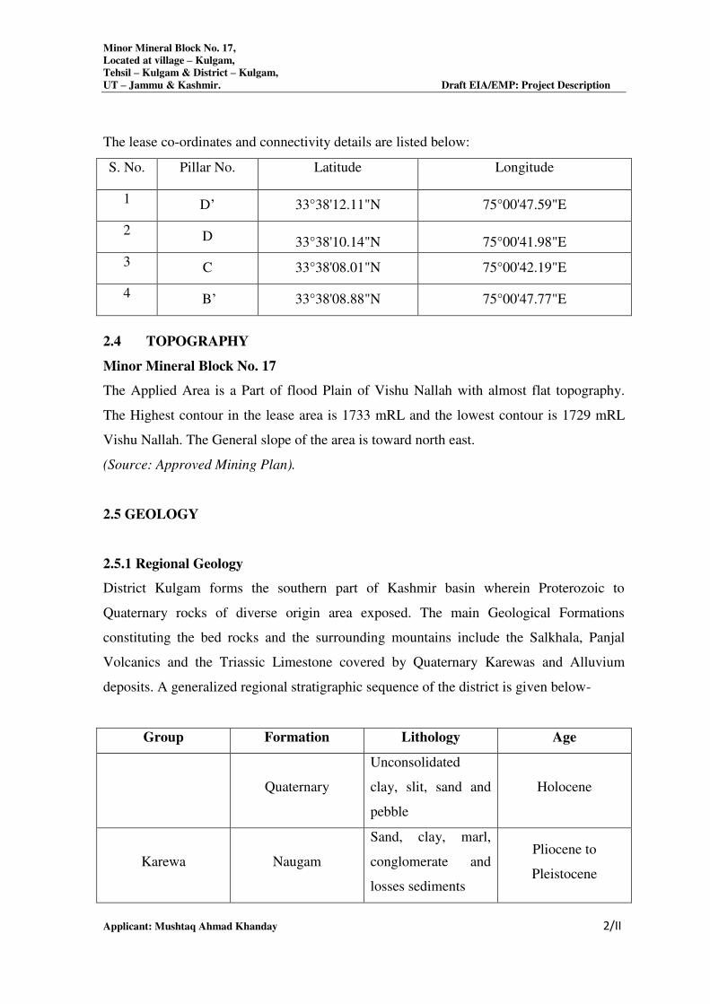
Table No. 1.1 Latitude & Longitude of Lease Area
S. No. Pillar No. Latitude Longitude
1 D’ 33°38'12.11"N 75°00'47.59"E
2 D 33°38'10.14"N 75°00'41.98"E
3 C 33°38'08.01"N 75°00'42.19"E
4 B’ 33°38'08.88"N 75°00'47.77"E
Minor Mineral Block No. 17,
Located at Village – Kulgam,
Tehsil – Kulgam & District – Kulgam,
UT – Jammu & Kashmir. Draft EIA/EMP: Introduction
Applicant: Mushtaq Ahmad Khanday 4/I
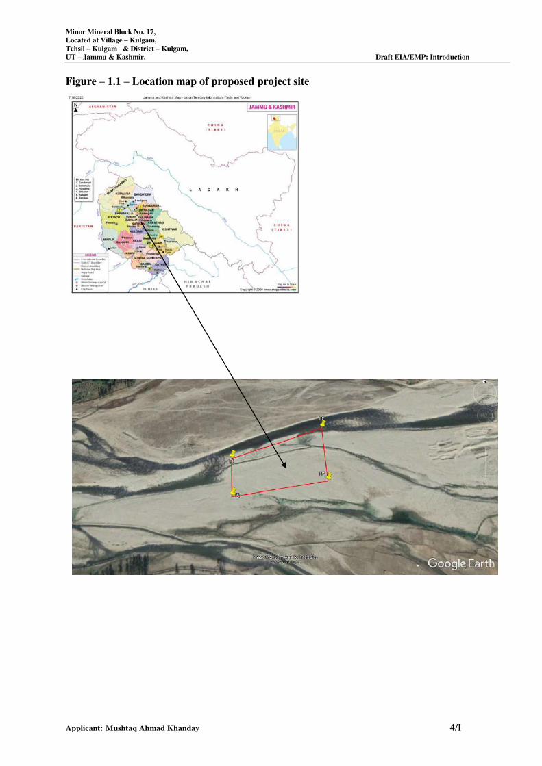
Figure – 1.1 – Location map of proposed project site
Minor Mineral Block No. 17,
Located at Village – Kulgam,
Tehsil – Kulgam & District – Kulgam,
UT – Jammu & Kashmir. Draft EIA/EMP: Introduction
Applicant: Mushtaq Ahmad Khanday 5/I
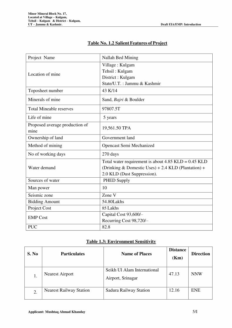
Table No. 1.2 Salient Features of Project
Project Name Nallah Bed Mining
Location of mine
Village : Kulgam
Tehsil : Kulgam
District : Kulgam
State/U.T. : Jammu & Kashmir
Toposheet number 43 K/14
Minerals of mine Sand, Bajri & Boulder
Total Mineable reserves 97807.5T
Life of mine 5 years
Proposed average production of
mine 19,561.50 TPA
Ownership of land Government land
Method of mining Opencast Semi Mechanized
No of working days 270 days
Water demand
Total water requirement is about 4.85 KLD = 0.45 KLD
(Drinking & Domestic Uses) + 2.4 KLD (Plantation) +
2.0 KLD (Dust Suppression).
Sources of water PHED Supply
Man power 10
Seismic zone Zone V
Bidding Amount 54.80Lakhs
Project Cost 85 Lakhs
EMP Cost Capital Cost 93,600/–
Recurring Cost 98,720/–
PUC 82.8
Table 1.3: Environment Sensitivity
S. No Particulates Name of Places Distance
(Km) Direction
1. Nearest Airport Seikh Ul Alam International
Airport, Srinagar 47.13 NNW
2. Nearest Railway Station Sadura Railway Station 12.16 ENE
Minor Mineral Block No. 17,
Located at Village – Kulgam,
Tehsil – Kulgam & District – Kulgam,
UT – Jammu & Kashmir. Draft EIA/EMP: Introduction
Applicant: Mushtaq Ahmad Khanday 6/I
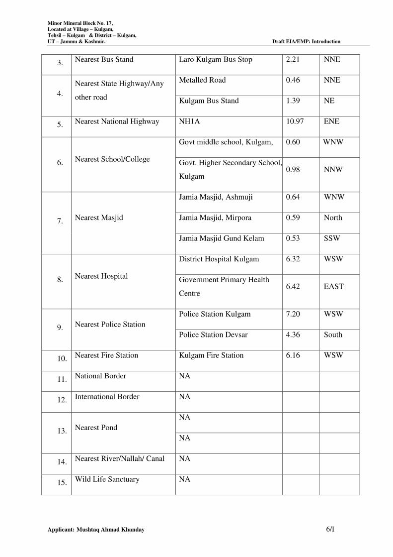
3. Nearest Bus Stand Laro Kulgam Bus Stop 2.21 NNE
4.
Nearest State Highway/Any
other road
Metalled Road 0.46 NNE
Kulgam Bus Stand 1.39 NE
5. Nearest National Highway NH1A 10.97 ENE
6. Nearest School/College
Govt middle school, Kulgam, 0.60 WNW
Govt. Higher Secondary School,
Kulgam 0.98 NNW
7. Nearest Masjid
Jamia Masjid, Ashmuji 0.64 WNW
Jamia Masjid, Mirpora 0.59 North
Jamia Masjid Gund Kelam 0.53 SSW
8. Nearest Hospital
District Hospital Kulgam 6.32 WSW
Government Primary Health
Centre 6.42 EAST
9. Nearest Police Station
Police Station Kulgam 7.20 WSW
Police Station Devsar 4.36 South
10. Nearest Fire Station Kulgam Fire Station 6.16 WSW
11. National Border NA
12. International Border NA
13. Nearest Pond
NA
NA
14. Nearest River/Nallah/ Canal NA
15. Wild Life Sanctuary NA
Minor Mineral Block No. 17,
Located at Village – Kulgam,
Tehsil – Kulgam & District – Kulgam,
UT – Jammu & Kashmir. Draft EIA/EMP: Introduction
Applicant: Mushtaq Ahmad Khanday 7/I
16. Reserved Forest
Mattan Forest 17.57 ENE
17. Protected Forest
18. Wetland
19. Nearest Defence Installation
Army Cantonment
Army School Khanabal
Army, Anantnag
5.07
8.35
6.45
South
NNE
NE
20. Historical Importance Place NA
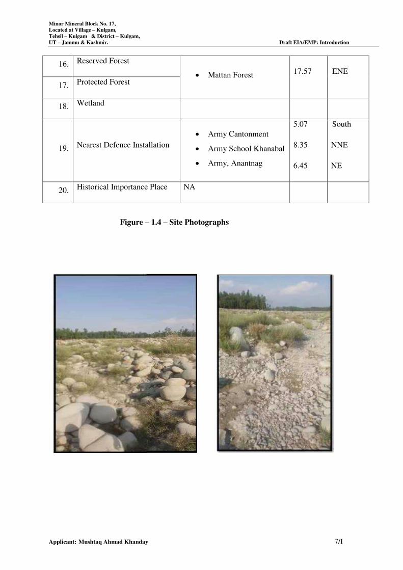
Figure – 1.4 – Site Photographs
Minor Mineral Block No. 17,
Located at Village – Kulgam,
Tehsil – Kulgam & District – Kulgam,
UT – Jammu & Kashmir. Draft EIA/EMP: Introduction
Applicant: Mushtaq Ahmad Khanday 8/I
Project’s importance to the country and the region
The project involves collection of Sand, Bajri & Boulder, thus the proposed mining project would
improve the supply of construction materials like Sand, Bajri & Boulder, making a positive impact
on the infrastructural projects like construction of roads, buildings, bridges etc in the state.
Since the quarries will be leased out to successful allottees, mining operation in the state will get
legalized and it will fetch income to the state exchequer by the way of royalty.
This project operation will generate employment to the people residing in vicinity for about 270
days annually and approximately 10 people will be benefited directly and indirectly by the project.
1.3 REGULATORY COMPLIANCES & APPLICABLE LAWS/REGULATIONS
a) There is no legal case against the project and project proponent.
b) There is no national park / Sanctuary notified under the Wildlife Protection Act in the study
area.
1.4 SCOPE OF THE STUDY
In pursuance to the National Green Tribunal Order 4th
/13th
September, 2018 & subsequent office
Memorandum dated 12th
December, 2018 of Ministry of Environment, Forest & Climate Change,
and Government of India. Committee agreed to formulate the EIA, EMP, CER, CSR be prepared
along with joint public hearing for the three mining blocks. In view of above deliberations, the
committee recommended General & Specific TOR for the project without prejudice to the standing
court orders, if any, with respect to concerned mining project or final outcome of writ petitions/
PILs pending disposal before any court of law.
1.5 POST-ENVIRONMENTAL CLEARANCE MONITORING
For category B1 projects, it shall be mandatory for the project proponent to make public the
environmental clearance granted for their project along with the environmental conditions and
safeguards at their cost by prominently advertising it at least in two local newspapers of the district
or state where the project is located and in addition, this shall also be displayed in the project
proponent’s website permanently. For category B1 projects, irrespective of its clearance by
MOEF&CC/SEIAA, the project proponent shall prominently advertise in the newspapers indicating
that the project has been accorded environmental clearance and the details of MoEF & CC website
where it is displayed.
Minor Mineral Block No. 17,
Located at Village – Kulgam,
Tehsil – Kulgam & District – Kulgam,
UT – Jammu & Kashmir. Draft EIA/EMP: Introduction
Applicant: Mushtaq Ahmad Khanday 9/I
The project management shall submit half-yearly compliance reports in respect of the stipulated
prior environmental clearance terms and conditions on 1st June and 1st December of each calendar
year. All such reports shall be public documents. The latest such compliance report shall be
displayed on the web site of the concerned regulatory authority.
1.6 TRANSFERABILITY OF ENVIRONMENTAL CLEARANCE
A prior environmental clearance granted for a specific project or activity to an applicant may be
transferred during its validity to another legal person entitled to undertake the project or activity on
application by the transferor or the transferee with a written “no objection” by the transferor, to, and
by the regulatory authority concerned, on the same terms and conditions under which the prior
environmental clearance was initially granted, and for the same validity period.
1.7 GENERIC STRUCTURE OF ENVIRONMENTAL IMPACT ASSESSMENT
DOCUMENT
In terms of the EIA notification of the MoEF dated 14th September 2025 and its subsequent
amendment thereof, the generic structure of the EIA document should be as under:
1) Study of the Geological report, Pre-Feasibility report (PFR) or mining plan made available by the
client.
2) Present Environmental Setting
3) Identification, prediction and evaluation of Anticipated Environmental Impact due to the
Proposed mine and related facilities.
The environmental impacts would be anticipated in core and buffer zone on:
Topography and drainage
Climate
Water quality (Surface/Ground)
Hydro-geological Regime
Air quality
Noise Levels
Soil Quality
Flora and Fauna
Land-Use
Socio-Economic Conditions
Habitat
Health, culture, human environment including public health, occupational health and safety
Minor Mineral Block No. 17,
Located at Village – Kulgam,
Tehsil – Kulgam & District – Kulgam,
UT – Jammu & Kashmir. Draft EIA/EMP: Introduction
Applicant: Mushtaq Ahmad Khanday 10/I
Sensitive Places/Historical Monuments.
Chapter 1 – Introduction
The chapter provides description of project background, site and surroundings, objectives, scope
and Organization of the study and format of this report.
Chapter 2 – Project Description
This chapter provides information on project and capacity; need for the project; location; size or
magnitude of operation; technology and process description; maps showing project layout,
component of projects etc.
Chapter 3 – Description of the Environment
This chapter deals with the methodology and findings of field studies undertaken with respect to
ambient air, meteorology, water, soils, noise levels, ecology to define the various existing
environmental status in the area of the project. This also deals with the infrastructural development
as a part of project and sources of pollution from the proposed mining project.
Chapter 4 – Anticipated Environmental Impacts and Mitigation Measures
In this chapter, the potential impacts of the proposed mining and allied activities, which could cause
significant environmental concerns, are identified and discussed. This discussion will form the basis
for environmental management activities.
Chapter 5 – Analysis of Alternatives (Technology and Site)
This chapter will include a comparison of alternatives in this chapter to determine the best method
of achieving the project objectives with minimum environmental impacts or indicates the most
environmentally friendly and cost effective options, if any.
Chapter 6 – Environmental Monitoring Program
This chapter will include ascertaining the environmental impacts; state of pollution within the mine
lease and in its vicinity; planning for predictive or corrective actions in respect of pollution to keep
it within permissible limits.
Chapter 7 – Additional Studies
Risk Hazard
This Draft EIA Report is prepared in accordance with the Term of Reference issued by J&K Expert
Appraisal Committee (JKEAC), Jammu & Kashmir as per the ToR letter of Minor Mineral Block
No. 17 vide letter no. JKEIAA/2020/337/1834-38 dated 26.07.2021.
This Draft EIA Report has been divided into twelve chapters (in addition to Executive Summary) as
briefed here under:
Minor Mineral Block No. 17,
Located at Village – Kulgam,
Tehsil – Kulgam & District – Kulgam,
UT – Jammu & Kashmir. Draft EIA/EMP: Introduction
Applicant: Mushtaq Ahmad Khanday 11/I
This chapter will include outcomes of public consultation, risk assessment, social impact
assessment, R&R action plan, biodiversity conservation plan, watershed management etc.
Chapter 8 – Project Benefits
This chapter deals with improvements in the physical infrastructure, social infrastructure,
employment potential and other tangible benefits due to proposed project activity.
Chapter 9 – Environmental Cost Benefit Analysis
This chapter includes environmental value enhancement (biodiversity, crop productivity, eco
tourism etc.)
Chapter 10 – Environmental Management Plan
This chapter will include the description of administrative aspects of ensuring that the mitigation
measures suggested are implemented and their effectiveness is monitored, after approval of the
EIA.
Chapter 11 – Summary
This will constitute the summary of EIA Report.
Chapter 12 – Disclosure of Consultant
This will includes the names of the consultants engaged in preparation of EIA and nature of
consultancy rendered.
1.8 LAWS APPLICABLE TO THIS PROJECT
The Acts, Notifications, Rules and Amendments applicable for setting up a new mining industry or
its expansion of an existing mine and for operation of a mine include the following:
The Environment (Protection) Act and Rules, 1986;
The Environmental Impact Assessment (EIA) Notification of MoEF&CC 14.09.2025 and its
time to time amendment.
Forest (Conservation) Act, 1980;
The Air (Prevention and Control of Pollution) Act, Rules and Amendment, 1981, 1982,
1983,1987;
The Factories Act and Amendment, 1948, 1987;
The Water (Prevention and Control of Pollution) Act and Rules, 1974, 1975;
The Water (Prevention and Control of Pollution) Cess Act and Rules, 1977, 1978, 1991;
The Public Liability Insurance Act, 1991;
The Environment (Protection) Acts1986/Rules 1986
The Environmental Standards Notification, 1993, 1996;
Minor Mineral Block No. 17,
Located at Village – Kulgam,
Tehsil – Kulgam & District – Kulgam,
UT – Jammu & Kashmir. Draft EIA/EMP: Introduction
Applicant: Mushtaq Ahmad Khanday 12/I
The Environmental Audit Notification, 1992;
The National Environment Tribunal Act, 1995.
Mines and Mineral (Development and Regulation) Act, 1957.
SRO 105 – 31st March, 2016.
1.9 PROFILE OF THE PROJECT PROPONENT
Sh. Mushtaq Ahmad Khanday
S/o Shri Lalud Din Khanday
R/o: Near Masjid Shareef, Bhan,
District – Kulgam and UT- J&K,
Pincode –192231
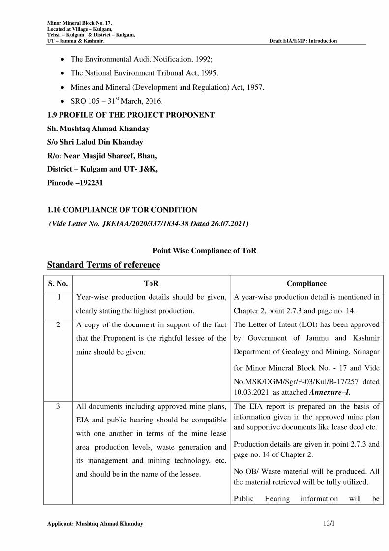
1.10 COMPLIANCE OF TOR CONDITION
(Vide Letter No. JKEIAA/2020/337/1834-38 Dated 26.07.2021)
Point Wise Compliance of ToR
Standard Terms of reference
S. No. ToR Compliance
1 Year-wise production details should be given,
clearly stating the highest production.
A year-wise production detail is mentioned in
Chapter 2, point 2.7.3 and page no. 14.
2 A copy of the document in support of the fact
that the Proponent is the rightful lessee of the
mine should be given.
10.03.2021 as attached Annexure–I.
3 All documents including approved mine plans,
EIA and public hearing should be compatible
with one another in terms of the mine lease
area, production levels, waste generation and
its management and mining technology, etc.
and should be in the name of the lessee.
The EIA report is prepared on the basis of
information given in the approved mine plan
and supportive documents like lease deed etc.
Production details are given in point 2.7.3 and
page no. 14 of Chapter 2.
No OB/ Waste material will be produced. All
the material retrieved will be fully utilized.
Public Hearing information will be
The Letter of Intent (LOI) has been approved
by Government of Jammu and Kashmir
Department of Geology and Mining, Srinagar
for Minor Mineral Block No. - 17 and Vide
No.MSK/DGM/Sgr/F-03/Kul/B-17/257 dated
Minor Mineral Block No. 17,
Located at Village – Kulgam,
Tehsil – Kulgam & District – Kulgam,
UT – Jammu & Kashmir. Draft EIA/EMP: Introduction
Applicant: Mushtaq Ahmad Khanday 13/I
incorporated during Final EIA Report.
All the documents including approved mine
plan, EIA report, lease deed is in the name of
lessee.
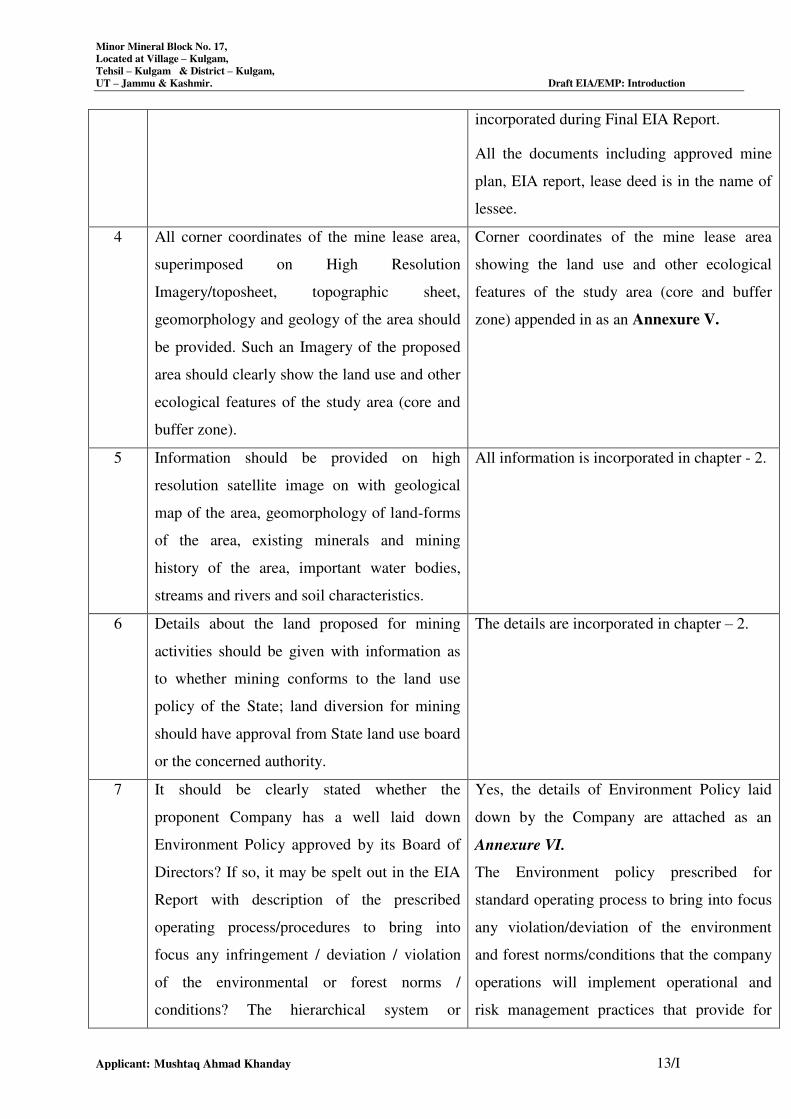
4 All corner coordinates of the mine lease area,
superimposed on High Resolution
Imagery/toposheet, topographic sheet,
geomorphology and geology of the area should
be provided. Such an Imagery of the proposed
area should clearly show the land use and other
ecological features of the study area (core and
buffer zone).
Corner coordinates of the mine lease area
showing the land use and other ecological
features of the study area (core and buffer
zone) appended in as an Annexure V.
5 Information should be provided on high
resolution satellite image on with geological
map of the area, geomorphology of land-forms
of the area, existing minerals and mining
history of the area, important water bodies,
streams and rivers and soil characteristics.
All information is incorporated in chapter - 2.
6 Details about the land proposed for mining
activities should be given with information as
to whether mining conforms to the land use
policy of the State; land diversion for mining
should have approval from State land use board
or the concerned authority.
The details are incorporated in chapter – 2.
7 It should be clearly stated whether the
proponent Company has a well laid down
Environment Policy approved by its Board of
Directors? If so, it may be spelt out in the EIA
Report with description of the prescribed
operating process/procedures to bring into
focus any infringement / deviation / violation
of the environmental or forest norms /
conditions? The hierarchical system or
Yes, the details of Environment Policy laid
down by the Company are attached as an
Annexure VI.
The Environment policy prescribed for
standard operating process to bring into focus
any violation/deviation of the environment
and forest norms/conditions that the company
operations will implement operational and
risk management practices that provide for
Minor Mineral Block No. 17,
Located at Village – Kulgam,
Tehsil – Kulgam & District – Kulgam,
UT – Jammu & Kashmir. Draft EIA/EMP: Introduction
Applicant: Mushtaq Ahmad Khanday 14/I
administrative order of the Company to deal
with the environmental issues and for ensuring
compliance with the EC conditions may also be
given. The system of reporting of non-
compliances / violations of environmental
norms to the Board of Directors of the
Company and/or shareholders or stakeholders
at large may also be detailed in the EIA Report
maximum protection of people and the
environment.
The hierarchical flow diagram is attached as
Ref. Annexure VI.
Yes, the Company has a well laid out policy
of reporting non compliances/ violations of
Environmental Norms to Board of Directors/
owner of the Company.
8 Issues relating to Mine Safety, including
subsidence study in case of underground
mining and slope study in case of open cast
mining, blasting study etc. should be detailed.
The proposed safeguard measures in each case
should also be provided.
Issues relating to Mine safety have been
detailed in Chapter 7 & Page No. 6/VII.
9 The study area will comprise of 10 km zone
around the mine lease from lease periphery and
the data contained in the EIA such as waste
generation etc. should be for the life of the
mine / lease period.
The EIA study has been carried out in the 10
km radius zone from the periphery of ML
area. All the data so generated have been
incorporated in EIA/EMP report.
No OB/ Waste material will be produced. All
the material retrieved will be fully utilized.
A map showing study area (10 km radius) is
given Chapter 3.
10 Land use of the study area delineating forest
area, agricultural land, grazing land, wildlife
sanctuary, national park, migratory routes of
fauna, water bodies, human settlements and
other ecological features should be indicated.
Land use plan of the mine lease area should be
prepared to encompass preoperational,
operational and post operational phases and
submitted. Impact, if any, of change of land use
should be given.
Land use of the study area delineating forest
area, agricultural land, grazing land, water
bodies, human settlements, if any and other
ecological features etc are shown by area
breakup of the land use within 10 km radius
from the mine site in Table 3.13 page 26/III
of Chapter 3.
11 Details of the land for any Over Burden Dumps There are no overburden dumps outside the
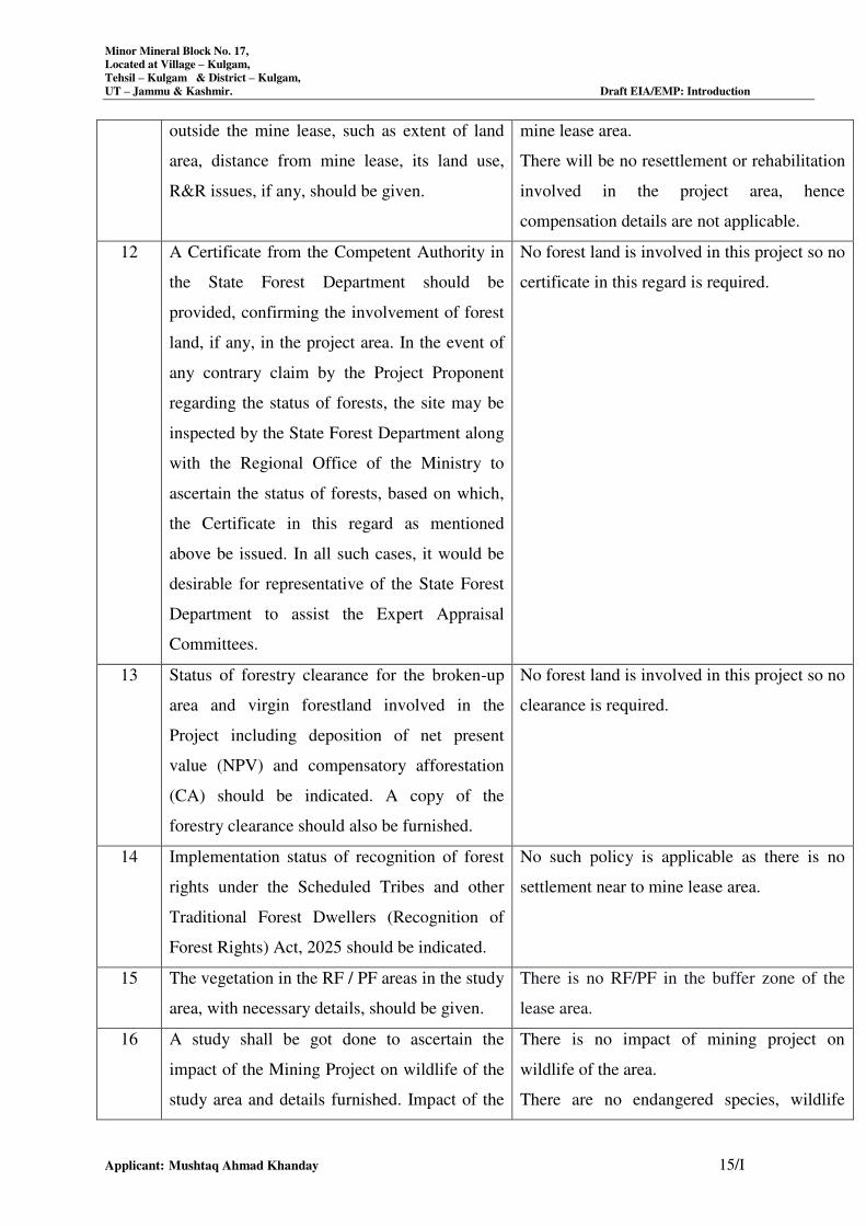
Minor Mineral Block No. 17,
Located at Village – Kulgam,
Tehsil – Kulgam & District – Kulgam,
UT – Jammu & Kashmir. Draft EIA/EMP: Introduction
Applicant: Mushtaq Ahmad Khanday 15/I
outside the mine lease, such as extent of land
area, distance from mine lease, its land use,
R&R issues, if any, should be given.
mine lease area.
There will be no resettlement or rehabilitation
involved in the project area, hence
compensation details are not applicable.
12 A Certificate from the Competent Authority in
the State Forest Department should be
provided, confirming the involvement of forest
land, if any, in the project area. In the event of
any contrary claim by the Project Proponent
regarding the status of forests, the site may be
inspected by the State Forest Department along
with the Regional Office of the Ministry to
ascertain the status of forests, based on which,
the Certificate in this regard as mentioned
above be issued. In all such cases, it would be
desirable for representative of the State Forest
Department to assist the Expert Appraisal
Committees.
No forest land is involved in this project so no
certificate in this regard is required.
13 Status of forestry clearance for the broken-up
area and virgin forestland involved in the
Project including deposition of net present
value (NPV) and compensatory afforestation
(CA) should be indicated. A copy of the
forestry clearance should also be furnished.
No forest land is involved in this project so no
clearance is required.
14 Implementation status of recognition of forest
rights under the Scheduled Tribes and other
Traditional Forest Dwellers (Recognition of
Forest Rights) Act, 2025 should be indicated.
No such policy is applicable as there is no
settlement near to mine lease area.
15 The vegetation in the RF / PF areas in the study
area, with necessary details, should be given.
There is no RF/PF in the buffer zone of the
lease area.
16 A study shall be got done to ascertain the
impact of the Mining Project on wildlife of the
study area and details furnished. Impact of the
There is no impact of mining project on
wildlife of the area.
There are no endangered species, wildlife
Minor Mineral Block No. 17,
Located at Village – Kulgam,
Tehsil – Kulgam & District – Kulgam,
UT – Jammu & Kashmir. Draft EIA/EMP: Introduction
Applicant: Mushtaq Ahmad Khanday 16/I
project on the wildlife in the surrounding and
any other protected area and accordingly,
detailed mitigative measures required, should
be worked out with cost implications and
submitted.
sanctuary, wildlife corridors, faunal migratory
routes or eco-sensitive area near the whole
study area. However, care will be taken to
protect wildlife in the study area.
17 Location of National Parks, Sanctuaries,
Biosphere Reserves, Wildlife Corridors,
Ramsar site Tiger/ Elephant Reserves/(existing
as well as proposed), if any, within 10 km of
the mine lease should be clearly indicated,
supported by a location map duly authenticated
by Chief Wildlife Warden. Necessary
clearance, as may be applicable to such projects
due to proximity of the ecologically sensitive
areas as mentioned above, should be obtained
from the Standing Committee of National
Board of Wildlife and copy furnished.
There are no National parks, and Biosphere
Reserves, Wildlife Corridor, Tiger/ elephant
reserve in the study area of 10 km radius
surrounding the ML area.
18 A detailed biological study of the study area
[core zone and buffer zone (10 km radius of the
periphery of the mine lease)] shall be carried
out. Details of flora and fauna, endangered,
endemic and RET Species duly authenticated,
separately for core and buffer zone should be
furnished based on such primary field survey,
clearly indicating the Schedule of the fauna
present. In case of any scheduled-I fauna found
in the study area, the necessary plan along with
budgetary provisions for their conservation
should be prepared in consultation with State
Forest and Wildlife Department and details
furnished. Necessary allocation of funds for
implementing the same should be made as part
of the project cost.
Flora or fauna species are found in the core
zone.
The species found in the study area are
detailed under Section 3.11.4 Page 32/III of
Chapter 3.
Minor Mineral Block No. 17,
Located at Village – Kulgam,
Tehsil – Kulgam & District – Kulgam,
UT – Jammu & Kashmir. Draft EIA/EMP: Introduction
Applicant: Mushtaq Ahmad Khanday 17/I
19 Proximity to Areas declared as 'Critically
Polluted' should also be indicated and where so
required, clearance certifications from the
prescribed Authorities, such as the SPCB or
State Mining Department should be secured
and furnished to the effect that the proposed
mining activities could be considered.
The project does not come in the proximity to
areas declared as ‘Critically Polluted’.
20 R&R Plan/compensation details for the Project
Affected People (PAP) should be furnished.
While preparing the R&R Plan, the relevant
State/National Rehabilitation & Resettlement
Policy should be kept in view. In respect of
SCs /STs and other weaker sections of the
society in the study area, a need based sample
survey, family-wise, should be undertaken to
assess their requirements, and action
programmes prepared and submitted
accordingly, integrating the sectoral
programmes of line departments of the State
Government. It may be clearly brought out
whether the village(s) located in the mine lease
area will be shifted or not. The issues relating
to shifting of village(s) including their R&R
and socio-economic aspects should be
discussed in the Report.
There will be no resettlement or rehabilitation
involved in the project area, hence
compensation details are not applicable.
21 One season (non-monsoon) [i.e. March-May
(Summer Season); October-December (post
monsoon season) ; December-February (winter
season)]primary baseline data on ambient air
quality as per CPCB Notification of 2009,
water quality, noise level, soil and flora and
fauna shall be collected and the AAQ and other
data so compiled presented date-wise in the
Primary baseline data on ambient air quality
is given in Section 3.5 on Page 3/III of
Chapter 3.
Water quality is given in Section 3.7 Page
13/III of Chapter 3.
Noise level is given in Section 3.6 Page 10/III
of Chapter 3.
Soil characteristics are given in Section 3.8
Minor Mineral Block No. 17,
Located at Village – Kulgam,
Tehsil – Kulgam & District – Kulgam,
UT – Jammu & Kashmir. Draft EIA/EMP: Introduction
Applicant: Mushtaq Ahmad Khanday 18/I
EIA and EMP Report. Site specific
meteorological data should also be collected.
The location of the monitoring stations should
be such as to represent whole of the study area
and justified keeping in view the pre-dominant
downwind direction and location of sensitive
receptors. There should be at least one
monitoring station within 500 m of the mine
lease in the pre-dominant downwind direction.
The mineralogical composition of PM10,
particularly for free silica, should be given.
Page 22/III of Chapter 3.
Details of flora and fauna are given in Section
3.11.4 Page 32/III of Chapter 3.
Site-specific metrological data have been
collected, as prescribed, for Summer Season
of 1st January to 31
st December 2021 in
Chapter -3 & Page No 2/III.
22 Air quality modelling should be carried out for
prediction of impact of the project on the air
quality of the area. It should also take into
account the impact of movement of vehicles for
transportation of mineral. The details of the
model used and input parameters used for
modelling should be provided. The air quality
contours may be shown on a location map
clearly indicating the location of the site,
location of sensitive receptors, if any, and the
habitation. The wind roses showing pre-
dominant wind direction may also be indicated
on the map.
Details of Air Quality Modeling carried out
for air quality of the area has been
incorporated Chapter 4.
23 The water requirement for the Project, its
availability and source should be furnished. A
detailed water balance should also be provided.
Fresh water requirement for the Project should
be indicated.
Total water requirement is about 4.85 KLD=
0.45 KLD (Drinking & Domestic Uses) + 2.4
KLD (Plantation) + 2.0 KLD (Dust
Suppression).
24 Necessary clearance from the Competent
Authority for drawl of requisite quantity of
water for the Project should be provided.
As the lease area falls under semi critical zone
as notified by CGWB, so no permission is
required for drawl of water less than 100
KLD.
Minor Mineral Block No. 17,
Located at Village – Kulgam,
Tehsil – Kulgam & District – Kulgam,
UT – Jammu & Kashmir. Draft EIA/EMP: Introduction
Applicant: Mushtaq Ahmad Khanday 19/I
25 Description of water conservation measures
proposed to be adopted in the Project should be
given. Details of rainwater harvesting proposed
in the Project, if any, should be provided.
Backfilling of the pit will not be required
since the material in the pit will get restored
to it natural topography by the action of the
river.
26 Impact of the Project on the water quality, both
surface and groundwater, should be assessed
and necessary safeguard measures, if any
required, should be provided.
The detailed impact and control measure w.r.t
the quality of water in the surrounding area is
discussed under Section 4.4.2 Page 5/IV of
Chapter 4.
27 Based on actual monitored data, it may clearly
be shown whether working will intersect
groundwater. Necessary data and
documentation in this regard may be provided.
In case the working will intersect groundwater
table, a detailed Hydro Geological Study
should be undertaken and Report furnished.
The Report interalia shall include details of the
aquifers present and impact of mining activities
on these aquifers. Necessary permission from
Central Ground Water Authority for working
below ground water and for pumping of ground
water should also be obtained and copy
furnished.
Ground water level of the plateau area in
general is 10.5-13.5m bgl approx. The mining
activity has been restricted up to a 1 m depth,
so mining activity will not intersect the
groundwater.
28 Details of any stream, seasonal or otherwise,
passing through the lease area and modification
/ diversion proposed, if any, and the impact of
the same on the hydrology should be brought
out.
Project falls on Nallah Vishu.
29 Information on site elevation, working depth,
groundwater table etc. Should be provided both
in AMSL and bgl. A schematic diagram may
also be provided for the same.
The information is incorporated in Chapter-
11 & page No. 6/XI.
30 A time bound Progressive Greenbelt
Development Plan shall be prepared in a
A time bound Progressive greenbelt
development plan is incorporated in chapter
Minor Mineral Block No. 17,
Located at Village – Kulgam,
Tehsil – Kulgam & District – Kulgam,
UT – Jammu & Kashmir. Draft EIA/EMP: Introduction
Applicant: Mushtaq Ahmad Khanday 20/I
tabular form (indicating the linear and
quantitative coverage, plant species and time
frame) and submitted, keeping in mind, the
same will have to be executed up front on
commencement of the Project. Phase-wise plan
of plantation and compensatory afforestation
should be charted clearly indicating the area to
be covered under plantation and the species to
be planted. The details of plantation already
done should be given. The plant species
selected for green belt should have greater
ecological value and should be of good utility
value to the local population with emphasis on
local and native species and the species which
are tolerant to pollution.
VIII, Table 8.1, 8.2 & 8.3 and page No.
4/VIII.
31 Impact on local transport infrastructure due to
the Project should be indicated. Projected
increase in truck traffic as a result of the
Project in the present road network (including
those outside the Project area) should be
worked out, indicating whether it is capable of
handling the incremental load. Arrangement for
improving the infrastructure, if contemplated
(including action to be taken by other agencies
such as State Government) should be covered.
Project Proponent shall conduct Impact of
Transportation study as per Indian Road
Congress Guidelines.
Details of traffic are discussed in chapter 3.
32 Details of the onsite shelter and facilities to be
provided to the mine workers should be
included in the EIA Report.
Infrastructure facilities to be provided for the
mine
workers are as under:-
i. Rest shelter/ rest room.
ii. Separate facility for female and male
Minor Mineral Block No. 17,
Located at Village – Kulgam,
Tehsil – Kulgam & District – Kulgam,
UT – Jammu & Kashmir. Draft EIA/EMP: Introduction
Applicant: Mushtaq Ahmad Khanday 21/I
workers.
iii. First aid room.
iv. Training center.
v. Canteen facilities.
33 Conceptual post mining land use and
Reclamation and Restoration of mined out
areas (with plans and with adequate number of
sections) should be given in the EIA report.
There is no Reclamation and rehabilitation in
the lease area as the project is river bed
mining project.
34 Occupational Health impacts of the Project
should be anticipated and the proposed
preventive measures spelt out in detail. Details
of pre-placement medical examination and
periodical medical examination schedules
should be incorporated in the EMP. The project
specific occupational health mitigation
measures with required facilities proposed in
the mining area may be detailed.
The detail of occupational Health Impact has
been given in chapter 4.
35 Public health implications of the Project and
related activities for the population in the
impact zone should be systematically evaluated
and the proposed remedial measures should be
detailed along with budgetary allocations.
The detail of Public Health implications has
been given in chapter 4.
36 Measures of socio economic significance and
influence to the local community proposed to
be provided by the Project Proponent should be
indicated. As far as possible, quantitative
dimensions may be given with time frames for
implementation.
Measures of socio-economic influence to the
local community have been furnished and
described in Chapter 3.
37 Detailed environmental management plan
(EMP) to mitigate the environmental impacts
which, should inter-alia include the impacts of
change of land use, loss of agricultural and
grazing land, if any, occupational health
Detailed Environmental Management Plan is
discussed under Chapter 10 of EIA report.

Minor Mineral Block No. 17,
Located at Village – Kulgam,
Tehsil – Kulgam & District – Kulgam,
UT – Jammu & Kashmir. Draft EIA/EMP: Introduction
Applicant: Mushtaq Ahmad Khanday 22/I
impacts besides other impacts specific to the
proposed Project
38 Public Hearing points raised and commitment
of the Project Proponent on the same along
with time bound Action Plan with budgetary
provisions to implement the same should be
provided and also incorporated in the final
EIA/EMP Report of the Project.
Public hearing points will be incorporated at
the time of Final EIA/EMP Report.
39 Details of litigation pending against the project,
if any, with direction /order passed by any
Court of Law against the Project should be
given.
There is no litigation pending against this
project.
40 The cost of the Project (capital cost and
recurring cost) as well as the cost towards
implementation of EMP should be clearly spelt
out.
Budget for Environmental protection is given
in Table 10.1 page. 8/X of Chapter 10.
41 A Disaster management Plan shall be prepared
and included in the EIA/EMP Report.
Detailed Environmental Management Plan is
discussed under Chapter 10 of EIA report.
42 Benefits of the Project if the Project is
implemented should be spelt out. The benefits
of the Project shall clearly indicate
environmental, social, economic, employment
potential, etc.
Discussed in Chapter – 3 and page No. 45/III.
43 Besides the above, the below mentioned
general points are also to be followed:
a) Executive Summary of the EIA/EMP
Report
b) All documents to be properly referenced
with index and continuous page numbering.
c) Where data are presented in the Report
especially in Tables, the period in which the
data were collected and the sources should
be indicated.
All general points are incorporated in Final
EIA Report.
Minor Mineral Block No. 17,
Located at Village – Kulgam,
Tehsil – Kulgam & District – Kulgam,
UT – Jammu & Kashmir. Draft EIA/EMP: Introduction
Applicant: Mushtaq Ahmad Khanday 23/I
d) Project Proponent shall enclose all the
analysis/testing reports of water, air, soil,
noise etc. using the MoEF&CC/NABL
accredited laboratories. All the original
analysis/testing reports should be available
during appraisal of the Project.
e) Where the documents provided are in a
language other than English, an English
translation should be provided.
f) The Questionnaire for environmental
appraisal of mining projects as devised
earlier by the Ministry shall also be filled
and submitted.
g) While preparing the EIA report, the
instructions for the Proponents and
instructions for the Consultants issued by
MoEF&CC vide O.M. No. J11013/41/2025-
IA.II (I) dated 4th August, 2009, which are
available on the website of this Ministry,
should be followed.
h) Changes, if any made in the basic scope and
project parameters (as submitted in Form-I
and the PFR for securing the TOR) should
be brought to the attention of MoEF&CC
with reasons for such changes and
permission should be sought, as the TOR
may also have to be altered. Post Public
Hearing changes in structure and content of
the draft EIA/EMP (other than
modifications arising out of the P.H.
process) will entail conducting the PH again
with the revised documentation.
i) As per the circular no. J-11011/618/2010-
Minor Mineral Block No. 17,
Located at Village – Kulgam,
Tehsil – Kulgam & District – Kulgam,
UT – Jammu & Kashmir. Draft EIA/EMP: Introduction
Applicant: Mushtaq Ahmad Khanday 24/I
IA.II (I) dated 30.5.2012, certified report of
the status of compliance of the conditions
stipulated in the environment clearance for
the existing operations of the project, should
be obtained from the Regional Office of
Ministry of Environment, Forest and
Climate Change, as may be applicable.
j) The EIA report should also include (i)
surface plan of the area indicating contours
of main topographic features, drainage and
physical measurements mining area, (ii)
geological maps and sections and (iii)
sections of the mine pit and external dumps,
if any, clearly showing the land features of
the adjoining area.
Specific Terms of Reference:
1. Impact of mining activity on adjacent
agricultural lands with particular reference
to run off, soil erosion and top-soil loss due
to change in topography.
Discussed in Chapter 4.
2. Details of Gradient of riverbed and 3-D
view draped on the satellite image
Discussed in Chapter 3.
3. Details of excavation schedule & sequential
mining plan with a maximum mine depth of
1 mtr.
Discussed in Chapter 2.
4. Details of transportation of mined out
materials with respect to axle load specified
for the road as per the Indian Road congress
for both the ways (loaded as well as
unloaded trucks) load and its impact on the
environment.
Discussed in Chapter 3.
Minor Mineral Block No. 17,
Located at Village – Kulgam,
Tehsil – Kulgam & District – Kulgam,
UT – Jammu & Kashmir. Draft EIA/EMP: Introduction
Applicant: Mushtaq Ahmad Khanday 25/I
5. Impact on mining activity on the existing
land use in the study area.
Discussed in Chapter 2.
6. Impact on mining on aquatic life. Discussed in Chapter 2.
7. NOCs from competent authorities of Forest
Department, Irrigation and Flood Control
Dept. and Fisheries Dept. should be obtained
and submitted while applying for EC
These NOCs from competent authorities of
Forest Department, Irrigation and Flood
Control Dept. and Fisheries Dept will be
provided in Final EIA Report.
8. The quantification of river bed material be
based on excavation only up to a maximum
depth of 1 m in the riverbed or 1 m above
water table whichever comes first to
safeguard ecological conditions.
Complied.
9. A digitalized surface plan showing
coordinates, physical measurements, river
gradient and inter-cross sections at different
intervals should be a mandatory part of
mining plan.
Discussed in Chapter 2.
10. Specific measures to be undertaken to
mitigate the impact of mining activity on the
habitat and migration of fish in the
river/stream and concurrence thereof from
the Fisheries Department.
Complied.
11. The Photography and videography of the
mining block shall be part of the Terms of
Reference.
Complied.
12. The maps shall be submitted on a scale of 1:
3000 and 1: 1500 within 10 kms. Radius.
Incorporated in Chapter 2.
13. The shortest extraction route leading to the
main road but with minimum interference
into human settlements should be the focus
of operation. Detailed contour map of the
approach road from river bed to district road
Complied.
Minor Mineral Block No. 17,
Located at Village – Kulgam,
Tehsil – Kulgam & District – Kulgam,
UT – Jammu & Kashmir. Draft EIA/EMP: Introduction
Applicant: Mushtaq Ahmad Khanday 26/I
/ National highway should be furnished.
14. Dust suppression measures should be
prescribed in the EIA/EMP.
Discussed in Chapter 4.
15. Post project monitoring plan should be
included in the study.
Discussed in Chapter 6
16. Occupational health impacts should be
assessed and plan for implementation of
COVID-19 SOPs in the mining activity
should be detailed.
Discussed in Chapter 4.
17. The consultant while presenting field data in
the EIA report should ensure that the site
specific date-wise datasheets duly attested
by the local panchayats head with his name,
signatures and stamp and attested by District
Mineral Officer with seal and signature are
included in the EIA report.
Complied.
18. The impact of mining activity on the
neighboring villages need to be studied and
extraction road need to be such that it has
least crossing through villages settlements.
Complied.
19. The data displayed on air quality monitoring
stations should be captured with digital
camera displaying the date on the
photographs so captured and same should be
submitted in support of the date-wise data
sheets. These digital photographs should be
submitted in soft as well as appended with
the EIA report.
Complied.
20. Mining shall be proposed manually
minimally supported by semi-mechanized
methods.
Complied.
Minor Mineral Block No. 17,
Located at Village – Kulgam,
Tehsil – Kulgam & District – Kulgam,
UT – Jammu & Kashmir. Draft EIA/EMP: Introduction
Applicant: Mushtaq Ahmad Khanday 27/I
21. The mining plan be approved de novo by the
competent authority, after it is technically
reviewed by the Irrigation and Flood Control
Department and should be based on the
technical feasibility report of I&FC Dept.
Complied.
22. The prescribed TORs would be valid for a
period of four years for submission of the
EIA/EMP reports, as per the S.O. No.
751(E) dated 17th
of Feb., 2020.
Complied.
23. Besides, the TORs are recommended
without prejudice to the standing court
orders, if any, w.r.t the concerned mining
project or final outcome of writ
petitions/LPAs pending disposal before any
competent court of law w.r.t the concerned
mining block.
Complied.
************
CHAPTER-II
PROJECT DESCRIPTION
INDEX
S. No. CONTENTS Page No.
2.0 GENERAL 2/II
2.1 DESCRIPTION OF PROJECT 2/II
2.2 NEED OF THE PROJECT 2/II
2.3 LOCATION DETAILS 2/II
2.4 TOPOGRAPHY 3/II
2.5 GEOLOGY 4/II
2.6 RESERVE 8/II
2.7 MINING 11/II
2.8 BLASTING 22/II
2.9 MINE MACHNINERY & FUEL CONSUMPTION 22/II
2.10 STACKING OF MINERAL REJECTS AND DISPOSAL OF
WASTES 22/II
2.11 USE OF MINERAL 22/II
2.12 SITE SERVICES 22/II
Minor Mineral Block No. 17,
Located at village – Kulgam,
Tehsil – Kulgam & District – Kulgam,
UT – Jammu & Kashmir. Draft EIA/EMP: Project Description
Applicant: Mushtaq Ahmad Khanday 1/II
2.0 GENERAL
This chapter gives broad description of the project, location, type of ore deposit(s), quality
of reserves, Mining methodology, various site utilities and infrastructure etc. The upstream
use of mineral for value addition and its importance is also described.
2.1 DESCIPTION OF PROJECT
The project Nallah Bed Mining Minor Mineral Block-17, Q-Kulgam Bridge Upstream,
Vishu Nallah is proposed for the excavation of sand, bajri & boulder from the bed of
Nallah Vishu. It is an opencast semi-mechanized mining project to excavate sand, bajri
and boulder.
2.2 NEED FOR THE PROJECT
The project involves collection of Nallah bed material. This is very essential to prevent
widening of the river bed due to the deposition of sediments which if not mined out will
cause flooding, damage to the adjoining areas, destruction of life and property. This can
only be prevented by maintaining the existing width and course of the river. If riverbed
minerals are not mined, the widening of river bed will result in excessive erosion; causing
further damage to flora-fauna, agricultural land and settlements situated in close
proximity. In addition to this the production of minerals will benefit the State in the form
of Royalty; the project will generate direct and indirect employment opportunities for the
people in nearby villages. Also the mine management will initiate various socio-economic
developments in nearby village from time to time to improve the socio- economic status in
the area.
2.3 LOCATION DETAILS
2.3.1 Minor Mineral Block No.25
The Nallah Bed Mining Minor Mineral Block-17, Q-Kulgam Bridge Upstream, Vishu
Nallah Project is located in Village: Kulgam, Tehsil: Kulgam, District: Kulgam, and
State/UT: Jammu & Kashmir. The lease area falls in Survey of India Toposheet
43 K/14.
Minor Mineral Block No. 17,
Located at village – Kulgam,
Tehsil – Kulgam & District – Kulgam,
UT – Jammu & Kashmir. Draft EIA/EMP: Project Description
Applicant: Mushtaq Ahmad Khanday 2/II
The lease co-ordinates and connectivity details are listed below:
S. No. Pillar No. Latitude Longitude
1 D’ 33°38'12.11"N 75°00'47.59"E
2 D 33°38'10.14"N 75°00'41.98"E
3 C 33°38'08.01"N 75°00'42.19"E
4 B’ 33°38'08.88"N 75°00'47.77"E
2.4 TOPOGRAPHY
Minor Mineral Block No. 17
The Applied Area is a Part of flood Plain of Vishu Nallah with almost flat topography.
The Highest contour in the lease area is 1733 mRL and the lowest contour is 1729 mRL
Vishu Nallah. The General slope of the area is toward north east.
(Source: Approved Mining Plan).
2.5 GEOLOGY
2.5.1 Regional Geology
District Kulgam forms the southern part of Kashmir basin wherein Proterozoic to
Quaternary rocks of diverse origin area exposed. The main Geological Formations
constituting the bed rocks and the surrounding mountains include the Salkhala, Panjal
Volcanics and the Triassic Limestone covered by Quaternary Karewas and Alluvium
deposits. A generalized regional stratigraphic sequence of the district is given below-
Group Formation Lithology Age
Quaternary
Unconsolidated
clay, slit, sand and
pebble
Holocene
Karewa Naugam
Sand, clay, marl,
conglomerate and
losses sediments
Pliocene to
Pleistocene
Minor Mineral Block No. 17,
Located at village – Kulgam,
Tehsil – Kulgam & District – Kulgam,
UT – Jammu & Kashmir. Draft EIA/EMP: Project Description
Applicant: Mushtaq Ahmad Khanday 3/II
Hirpur
Clay intercalated
with silt, sand,
conglomerate and
lignite
Triassic Limestone
Limestone, shale,
siliceous limestone,
sandstone, quartzite
Triassic
Pir Panjal Panjal Volcanic Light and dark color
amygdaloidal Early Permian
Salkhala
Garnetiferous
sericite phyllite,
Quartz chlorite
schist, Graphitic
limestone
Proterozoic
Table 2.1: Regional Geological Succession of the area
2.5.2 Local Geology
The instant lease area falls in the fluvial bed of Nallah Vishu represented by the
Quaternary sediments bounded by Upper Karewas. Upper Karewas mainly comprise
yellow silt, grey clay, calcareous layers and sand with conglomerate in the lower part an
continental loss and reworked loss in the upper part. This Formation is disposed
horizontally and is reported devoid of fossils or presence of lignite. Nallah Vishu along
with its tributaries area involved in weathering of catchment lithologies and finally
transport and deposit its sediment load in the form of boulder, Bajri, and sand at
convenient locations like meanders, etc. the deposits represent recent geological
Formation and contain several meter thickness of sediments of basalt, limestone, quartize
with fine nature of sand, silt and clay. The present deposits are of good quality and can be
used for building industries.
Kulgam District has vast stretches of a largely flat landform created by the
deposition of sediments over a long period of time by nallah vishu originating from Pir
Panjal Range. These alluvial plains are gently sloping surfaces formed of sediments of
Minor Mineral Block No. 17,
Located at village – Kulgam,
Tehsil – Kulgam & District – Kulgam,
UT – Jammu & Kashmir. Draft EIA/EMP: Project Description
Applicant: Mushtaq Ahmad Khanday 4/II
very fertile nature and mostly lie along the course of the nallah vishu. These plains are
particularly put to the paddy cultivation producing large varieties of rice in bulk quantities.
These plains have an average elevation of 1600 m above mean sea level and are often
flooded by the nallah vishu. Alluvium is typically made up of a variety of materials,
including fine particles of slit, clay, sand and larger particles of cobbles, pebble and
gravels that are loosely held with clayey and silty matrix. The material becomes finer in
the area when it merges in the upstream plains.
(Source: CGWA.gov.in & Approved Mining Plan).
2.5.3 CLIMATE
Kulgam Weather Forecast Providing a local hourly Kulgam weather forecast of rain, sun,
wind, humidity and temperature. The Long-range 12 day forecast also includes detail for
Kulgam weather today. Live weather reports from Kulgam weather stations and weather
warnings that include risk of thunder, high UV index and forecast gales. Kulgam is
1,739 m above sea level and located at 33.65° N 75.02° E. Kulgam has a population of
16,246.
During winter period rainfall also occurs in lower hills and valleys parts.
Mean Maximum Temperature : 210C
Mean Minimum Temperature : 70C
Average Annual Rainfall : 3 mm
(Source: https://www.weather-forecast.com/locations/kulgam/forecasts/latest)
2.5.4 SURFACE DRAINAGE PATTERN
The present mining project represents sub surface minor mineral exploitation in the form
of replenishable fluvial deposits of nallah Vishnu without the involvement of any drilling,
blasting and use of chemical. Further, water shall be drained along river flow. As such
area does not require any specific mine drainage pattern.
(Source: Approved Mining Plan).
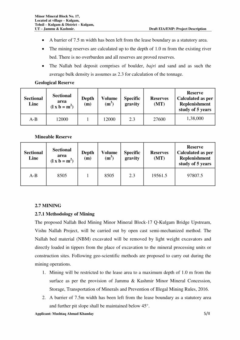
2.6 RESERVE
To estimate the reserve of river bed material, the following parameters are considered:
The reserves are calculated on the basis of established width, thickness and strike
length/influence of the mineralized formation in the area.
Minor Mineral Block No. 17,
Located at village – Kulgam,
Tehsil – Kulgam & District – Kulgam,
UT – Jammu & Kashmir. Draft EIA/EMP: Project Description
Applicant: Mushtaq Ahmad Khanday 5/II
A barrier of 7.5 m width has been left from the lease boundary as a statutory area.
The mining reserves are calculated up to the depth of 1.0 m from the existing river
bed. There is no overburden and all reserves are proved reserves.
The Nallah bed deposit comprises of boulder, bajri and sand and as such the
average bulk density is assumes as 2.3 for calculation of the tonnage.
Geological Reserve
Sectional
Line
Sectional
area
(l x b = m2)
Depth
(m)
Volume
(m3)
Specific
gravity
Reserves
(MT)
Reserve
Calculated as per
Replenishment
study of 5 years
A-B 12000 1 12000 2.3 27600 1,38,000
Mineable Reserve
Sectional
Line
Sectional
area
(l x b = m2)
Depth
(m)
Volume
(m3)
Specific
gravity
Reserves
(MT)
Reserve
Calculated as per
Replenishment
study of 5 years
A-B 8505 1 8505 2.3 19561.5 97807.5
2.7 MINING
2.7.1 Methodology of Mining
The proposed Nallah Bed Mining Minor Mineral Block-17 Q-Kulgam Bridge Upstream,
Vishu Nallah Project, will be carried out by open cast semi-mechanized method. The
Nallah bed material (NBM) excavated will be removed by light weight excavators and
directly loaded in tippers from the place of excavation to the mineral processing units or
construction sites. Following geo-scientific methods are proposed to carry out during the
mining operations.
1. Mining will be restricted to the lease area to a maximum depth of 1.0 m from the
surface as per the provision of Jammu & Kashmir Minor Mineral Concession,
Storage, Transportation of Minerals and Prevention of Illegal Mining Rules, 2016.
2. A barrier of 7.5m width has been left from the lease boundary as a statutory area
and further pit slope shall be maintained below 45°.
Minor Mineral Block No. 17,
Located at village – Kulgam,
Tehsil – Kulgam & District – Kulgam,
UT – Jammu & Kashmir. Draft EIA/EMP: Project Description
Applicant: Mushtaq Ahmad Khanday 6/II
3. Proper benching of 1.0 m height will be maintained in the Nallah bed parallel to
the banks of the nallah. Mining shall be carried out in a single bench of 1.0 m
height divided into 5 sub blocks, one sub- block to be excavated each year,
extracted block as such left for subsequent replenishment.
4. The natural gradient of the Nallah bed will be maintained during the course of
mining. Mining activities will be carried out in such a fashion so that there is no
obstruction to the movement of water flow.
5. The mining shall be done during daytime only to avoid any environmental
pollution and accidental hazards. Working will be carried out for 270 working days
in a calendar year.
6. The Mining of NBM will not generate any topsoil or waste, therefore no space will
be needed for soil stacking yard or waste dumps.
7. 40 employments will be required/ engaged for the proposed project.
8. System of working in the lease will be as per the provisions of mines Act 1952 and
Metalliferous Mines regulations: 1961.
9. Haul roads will be properly maintained and sprayed by water for suppression of
dust.
10. Personal protection equipments life safety helmet, safety shoes, safety goggles,
dust respirators etc. will be provided to the labors as per the mining regulations.
11. The maximum extraction of the mineral is planned in the lean discharge period of
the water body.
12. The Nallah bed material so excavated shall be transported by trucks through
approach roads which finally merge with tar roads for final destinations.
13. Safety zones with respect to bridge, hydraulic points and or/embankment as
prescribed by the Department of Geology and Mining should be strictly adhered to,
14. Mining operations in the river mine block will be in accordance with all other
provisions applicable as per Mines Act, 1952, Metalliferous Mines Regulations;
1961, Mines and Minerals (Development and Regulation) Act, 1957, Sustainable
Sand Mining Management Guidelines 2016, Jammu & Kashmir Minor Mineral
Concession, Storage. Transportation of Minerals and Prevention of Illegal Mining
Rules, 2016, Jammu and Kashmir Water Resources (Regulation and Management)
Act, 2010 Forest (Conservation) Act, 1980 and Environment (Protection) Act,
1986, Wild Life (Protection) Act, 1972, Water (Prevention and Control of
Minor Mineral Block No. 17,
Located at village – Kulgam,
Tehsil – Kulgam & District – Kulgam,
UT – Jammu & Kashmir. Draft EIA/EMP: Project Description
Applicant: Mushtaq Ahmad Khanday 7/II
Pollution) Act, 1974 and Air (Prevention and Control of Pollution) Act, 1981 and
any other applicable law.
2.7.2 Restriction of mining:
1. No mining operation shall be carried out within 50 m of railway line, reservoir or
road horizontally from the outer toe of the bank or the outer age of the cutting as
the case may be.
2. The mining will not be allowed below the water table.
3. No mining operation will be allowed in forest area.
4. No mining will be done during monsoon season and during night times.
5. Sand, Bajri, Boulder shall not be extracted up to a distance of 1 kilometer (1 km)
from major bridges and highways on both sides, or five times (5x) of the span (x)
of a bridge/public civil structure (including water intake points) on up-stream side
and ten times (10x) the span of such bridge on down-stream side, subjected to a
minimum of 250 meters on the upstream side and 500 meters on the upstream side.
6. Mining depth should be restricted to 1 meters and distance from the bank should be
¼th or river width and should not be less than 7.5 meters.
7. A buffer distance /un-mined block of 50 meters after every block of 1000 meters
over which mining is undertaken or at such distance as may be the
directed/prescribed by the regulatory authority shall be maintained.
8. Nallah bed sand mining shall be restricted within the central 3/4th width of the
river/rivulet or 7.5 meters (inward) from Nallah banks but up to 10% of the width
of the river, as the case may be and decided by regulatory authority while granting
environmental clearance in consultation with irrigation department. Regulating
authority while regulating the zone of river bed mining shall ensure that the
objective to minimize the effects of riverbank erosion and consequential channel
migration are achieved to the extent possible. In general, the area for removal of
minerals shall not exceed 60% of the mine lease area, and any deviation or
relaxation in this regard shall be adequately supported by the scientific report.
9. The reclamation of mined out areas will be natural, as during the next monsoon
the void will be replenished with sand, which will be available for fresh quarrying
for the next dry season.
10. The contractor will abide by provision of Mines Act, 1952, Interstate Migrant
Work Man Act the contractor with the satisfaction of competent authority will
Minor Mineral Block No. 17,
Located at village – Kulgam,
Tehsil – Kulgam & District – Kulgam,
UT – Jammu & Kashmir. Draft EIA/EMP: Project Description
Applicant: Mushtaq Ahmad Khanday 8/II
provide drinking water, rest shelter, first aid box, welfare facilities as Central and
State Govt. labor laws.
11. The contractors will abide at the time of mining with the term and condition as laid
down under Mines Act, 1952 and Mines & Minerals (Regulation and
Development) Act, 1957, SRO 105-31st March, 2016, Forest (Conservation) Act,
1980 and the stipulations of the EIA/EMP.
2.7.3 Details of Production
Year ROM(Assuming Specific Gravity as 2.3)
I Year 19,561.5
II Year 19561.5
III Year 19561.5
IV Year 19561.5
V Year 19561.5
Total 97807.5
Total production of mineral block no.17 is 97,807.5T for 5 years, which will be excavated
by opencast semi-mechanized method for 19,561.5TPA.
Block
Number Area Location
Mineable
Reserve
Average
production
Capacity
25 1.20 Ha
River Bed Minning Minor Mineral
Block-17, Q-Kulgam Bridge Upstream,
Vishu Nallah, Village –Kulgam, Tehsil-
Kulgam, District- Kulgam, and
State/U.T.- J & K
97,807.5T 19,561.5TPA
2.8 BLASTING
There will be no drilling and blasting as the material is losse in nature which shall be in
the interest of environment and ecology.
Minor Mineral Block No. 17,
Located at village – Kulgam,
Tehsil – Kulgam & District – Kulgam,
UT – Jammu & Kashmir. Draft EIA/EMP: Project Description
Applicant: Mushtaq Ahmad Khanday 9/II
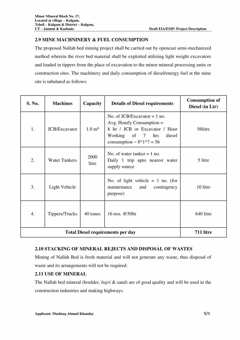
2.9 MINE MACHNINERY & FUEL CONSUMPTION
The proposed Nallah bed mining project shall be carried out by opencast semi-mechanized
method wherein the river bed material shall be exploited utilizing light weight excavators
and loaded in tippers from the place of excavation to the minor mineral processing units or
construction sites. The machinery and daily consumption of diesel/energy fuel at the mine
site is tabulated as follows:
S. No. Machines Capacity Details of Diesel requirements Consumption of
Diesel (in Ltr)
1. JCB/Excavator 1.0 m³
No. of JCB/Excavator = 1 no.
Avg. Hourly Consumption =
8 ltr / JCB or Excavator / Hour
Working of 7 hrs diesel
consumption ~ 8*1*7 = 56
56litre
2. Water Tankers 2000
litre
No. of water tanker = 1 no.
Daily 1 trip upto nearest water
supply source
5 litre
3. Light Vehicle
No. of light vehicle = 1 no. (for
maintenance and contingency
purpose)
10 litre
4. Tippers/Trucks 40 tones 16 nos. @50ltr 640 litre
Total Diesel requirements per day 711 litre
2.10 STACKING OF MINERAL REJECTS AND DISPOSAL OF WASTES
Mining of Nallah Bed is fresh material and will not generate any waste, thus disposal of
waste and its arrangements will not be required.
2.11 USE OF MINERAL
The Nallah bed mineral (boulder, bajri & sand) are of good quality and will be used in the
construction industries and making highways.
Minor Mineral Block No. 17,
Located at village – Kulgam,
Tehsil – Kulgam & District – Kulgam,
UT – Jammu & Kashmir. Draft EIA/EMP: Project Description
Applicant: Mushtaq Ahmad Khanday
10/II
2.12 SITE SERVICES
2.12.1 Working Office:
Temporary working office will be based at mine site. This will be a temporary structure
and can easily be shifted one side to another side as & when required,
2.12.2 Rest Shelter:
A temporary structure with toilet facility as a rest shelter to labors will be provided to the
workers near mine site.
2.12.3 Primary Health/First Aid:
First aid box with principal medicine will be kept at mine site to facilitate the first aid
treatment to the workers in case of any eventuality.
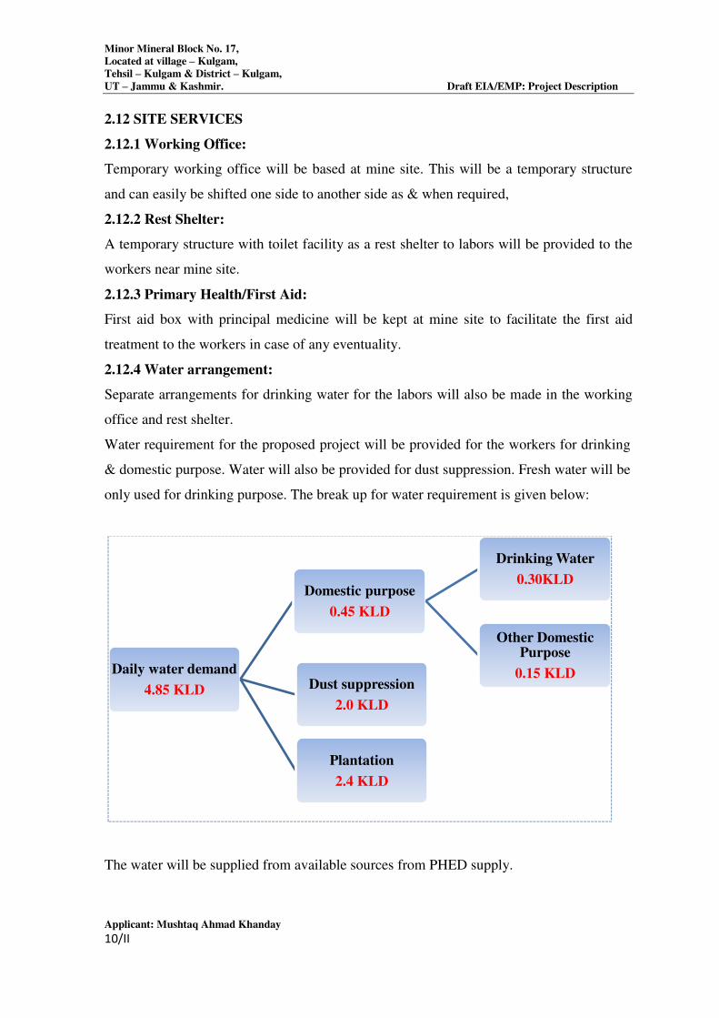
2.12.4 Water arrangement:
Separate arrangements for drinking water for the labors will also be made in the working
office and rest shelter.
Water requirement for the proposed project will be provided for the workers for drinking
& domestic purpose. Water will also be provided for dust suppression. Fresh water will be
only used for drinking purpose. The break up for water requirement is given below:
The water will be supplied from available sources from PHED supply.
Daily water demand
4.85 KLD
Domestic purpose
0.45 KLD
Drinking Water
0.30KLD
Other Domestic Purpose
0.15 KLD Dust suppression
2.0 KLD
Plantation
2.4 KLD
Minor Mineral Block No. 17,
Located at village – Kulgam,
Tehsil – Kulgam & District – Kulgam,
UT – Jammu & Kashmir. Draft EIA/EMP: Project Description
Applicant: Mushtaq Ahmad Khanday
11/II
2.12.5 Sanitary facilities:
Temporary latrines & urinals shall be maintained at convenient places for use of labors.
2.12.6 Man Power Requirement:
The manpower requirement for the proposed project is given below along with the
breakup, who will be utilized for excavation & loading of minerals into trucks or tractor-
trolleys.
*Additional workers include workers for dust suppression purpose, providing water for
drinking & domestic purpose, for maintenance of roads, etc.
********
S. No. Category Numbers
1. Mine Manager (part time) 1
2. Supervisor 1
3. Manager (accounts) 1
4. Operator 2
5. Driver 2
6. Helper 3
TOTAL 10
CHAPTER- 3
DESCRIPTION OF ENVIRONMENT
INDEX
S.NO CONTENT PAGE. NO
3.0 DESCRIPTION OF ENVIRONMENT 2
3.1 PERMEABLE 2
3.2 STUDY AREA 2
3.3 STUDY PERIOD 2
3.4 METEOROLOGICAL CONDITIONS 3
3.5 AIR ENVIRONMENT 4
3.6 NOISE LEVELS 9
3.7 WATER ENVIRONMENT 12
3.8 SOIL CHARACTERISTICS 21
3.9 LAND USE/LAND COVER MAPPING 24
3.10 TRAFFIC ANALYSIS 25
3.11 BIOLOGICAL ENVIRONMENT 27
3.12 SOCIO-ECONOMIC ENVIRONMENT 35
Minor Mineral Block No. 17,
Located at Village – Kulgam,
Tehsil & District – Kulgam
UT – Jammu & Kashmir Draft EIA/EMP: Description of Environment
Applicant: Mushtaq Ahmad Khanday 1/III
3.0 DESCRIPTION OF THEENVIRONMENT
3.1 Preamble
Baseline environmental status in and around proposed mining lease area depicts the existing
environmental conditions of air, noise, water, soil, biological and socio-economic
environment. The proposed project as a center, a radial distance of 10 km is considered as
study area for baseline data collection and environmental monitoring. The data was collected
for various environmental attributes so as to compute the impacts that are likely to arise due to
proposed development activity by Environmental Testing Services recognized by MoEF&CC
as per EPA Act, 1986.
The main aim of the impact assessment study depends mainly on two factors. One is the
estimation of impact from proposed project on the environment and second one is the
assessment of the environmental condition. Both are key factors to arrive at the post project
scenario. The estimated impact due to the proposal mine lease area can be superimposed over
the existing conditions to arrive at the post project scenario. The scope of the baseline studies
includes detailed characterization of following environmental components, which are most
likely to be influenced by the setting up of a mine lease area.
Metrological conditions
Ambient Air Quality
Noise levels
Water Quality (Surface + Ground water)
Soil Quality
Socio economic status
3.2 Study Area
The proposed project as a center, a radial distance of 10 km is considered as study area for
baseline data collection and environmental monitoring.
3.3 Study Period
The baseline environment quality was carried out over a radial distance of 10 km around the
mine during post monsoon season covering the months of 1st October 2020 to 1
st December
2020.
3.4 Meteorological Conditions
Meteorology is the key to understand the air quality. The essential relationship between
meteorology and atmospheric dispersion involves the wind in the broadest sense. Wind
fluctuations over a very wide range of time accomplish dispersion and strongly influence other
Minor Mineral Block No. 17,
Located at Village – Kulgam,
Tehsil & District – Kulgam
UT – Jammu & Kashmir Draft EIA/EMP: Description of Environment
Applicant: Mushtaq Ahmad Khanday 2/III
processes associated with them.
A meteorological station was set up at the proposed plant premises. Meteorological data was
generated during the post-monsoon season monitoring period.
The following parameters were recorded at hourly intervals continuously during
monitoring period:
Wind speed
Wind Direction
Temperature
Rainfall was recorded on daily basis.
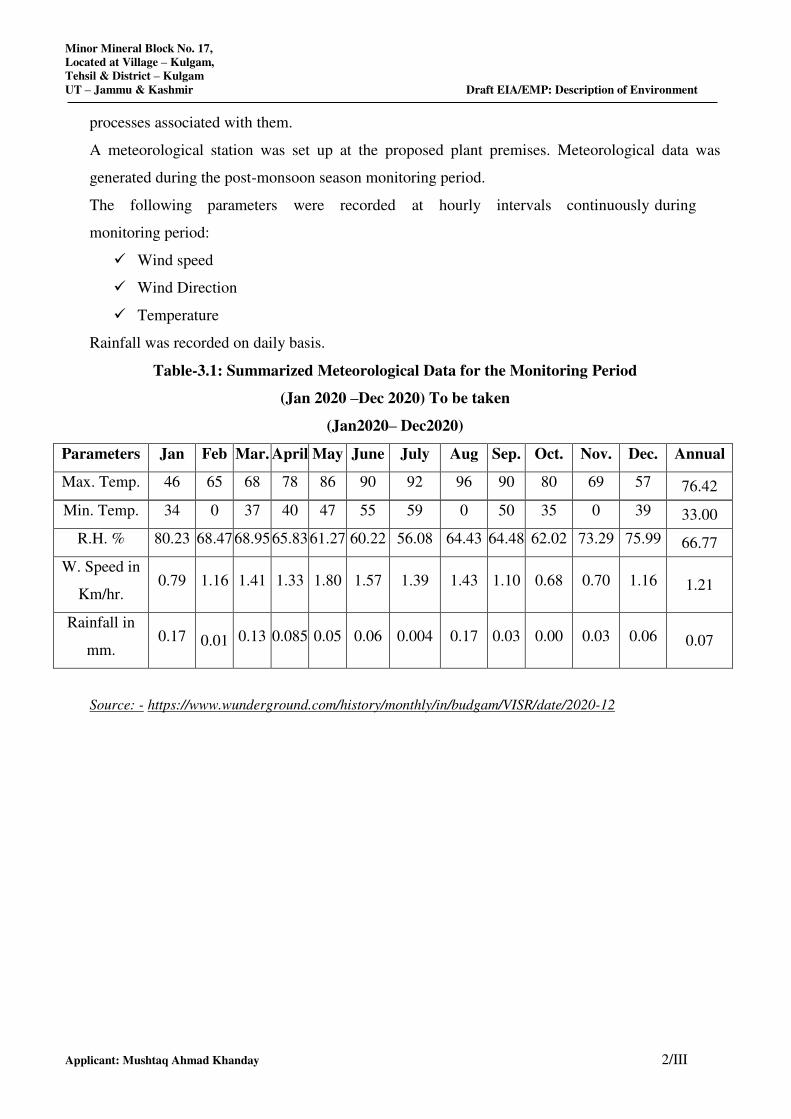
Table-3.1: Summarized Meteorological Data for the Monitoring Period
(Jan 2020 –Dec 2020) To be taken
(Jan2020– Dec2020)
Parameters Jan Feb Mar. April May June July Aug Sep. Oct. Nov. Dec. Annual
Max. Temp. 46 65 68 78 86 90 92 96 90 80 69 57 76.42
Min. Temp. 34 0 37 40 47 55 59 0 50 35 0 39 33.00
R.H. % 80.23 68.47 68.95 65.83 61.27 60.22 56.08 64.43 64.48 62.02 73.29 75.99 66.77
W. Speed in
Km/hr. 0.79 1.16 1.41 1.33 1.80 1.57 1.39 1.43 1.10 0.68 0.70 1.16 1.21
Rainfall in
mm. 0.17 0.01 0.13 0.085 0.05 0.06 0.004 0.17 0.03 0.00 0.03 0.06 0.07
Source: - https://www.wunderground.com/history/monthly/in/budgam/VISR/date/2020-12
Minor Mineral Block No. 17,
Located at Village – Kulgam,
Tehsil & District – Kulgam
UT – Jammu & Kashmir Draft EIA/EMP: Description of Environment
Applicant: Mushtaq Ahmad Khanday 3/III
3.5 AIR ENVIRONMENT
3.5.1 Ambient Air Quality
The ambient air quality was monitored in the impact area as per MoEF&CC guidelines. The
study area represents mostly rural environment. The prime objective of the baseline air quality
study was to assess the ambient air quality of the mining lease area.
Methodology adopted for the study
The baseline status of the ambient air quality has been assessed through a scientifically
designed ambient air quality network. The design of monitoring network in the air quality
surveillance programme has been based on the following consideration.
Meteorological parameters
Topography of the study area
Representative of regional background air quality for obtaining baseline status
Representative of likely impact areas.
Ambient Air Quality Monitoring (AAQM) stations were set up at 18 locations with due
consideration to the above mentioned points. AAQM locations were selected in downwind and
upwind direction of the proposed mining lease area covering core and buffer zones. The
details of the monitoring stations are given in Figure 3.2.
Ambient air quality monitoring was carried out twice a week with a frequency of 24 hours for
12 weeks during the study period. The common air pollutant namely, Particulate Matter-10
(PM10), Sulphur-dioxide (SO2), Oxides of Nitrogen (NO2) has been measured through a
planned field monitoring.
Statistical parameters like minimum, maximum, average and 98th
percentiles have been
computed from the observed field data for all sampling stations. These are compared with the
standards prescribed by Central Pollution Control Board (CPCB) for industrial, residential
rural and other area.
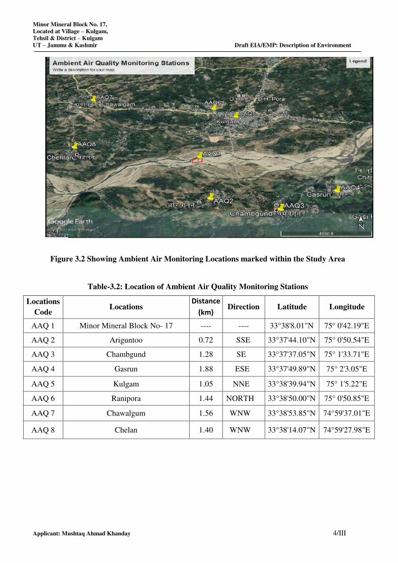
Minor Mineral Block No. 17,
Located at Village – Kulgam,
Tehsil & District – Kulgam
UT – Jammu & Kashmir Draft EIA/EMP: Description of Environment
Applicant: Mushtaq Ahmad Khanday 4/III
Figure 3.2 Showing Ambient Air Monitoring Locations marked within the Study Area
Table-3.2: Location of Ambient Air Quality Monitoring Stations
Locations
Code Locations
Distance
(km) Direction Latitude Longitude
AAQ 1 Minor Mineral Block No- 17 ---- ---- 33°38'8.01"N 75° 0'42.19"E
AAQ 2 Ariguntoo 0.72 SSE 33°37'44.10"N 75° 0'50.54"E
AAQ 3 Chambgund 1.28 SE 33°37'37.05"N 75° 1'33.71"E
AAQ 4 Gasrun 1.88 ESE 33°37'49.89"N 75° 2'3.05"E
AAQ 5 Kulgam 1.05 NNE 33°38'39.94"N 75° 1'5.22"E
AAQ 6 Ranipora 1.44 NORTH 33°38'50.00"N 75° 0'50.85"E
AAQ 7 Chawalgum 1.56 WNW 33°38'53.85"N 74°59'37.01"E
AAQ 8 Chelan 1.40 WNW 33°38'14.07"N 74°59'27.98"E
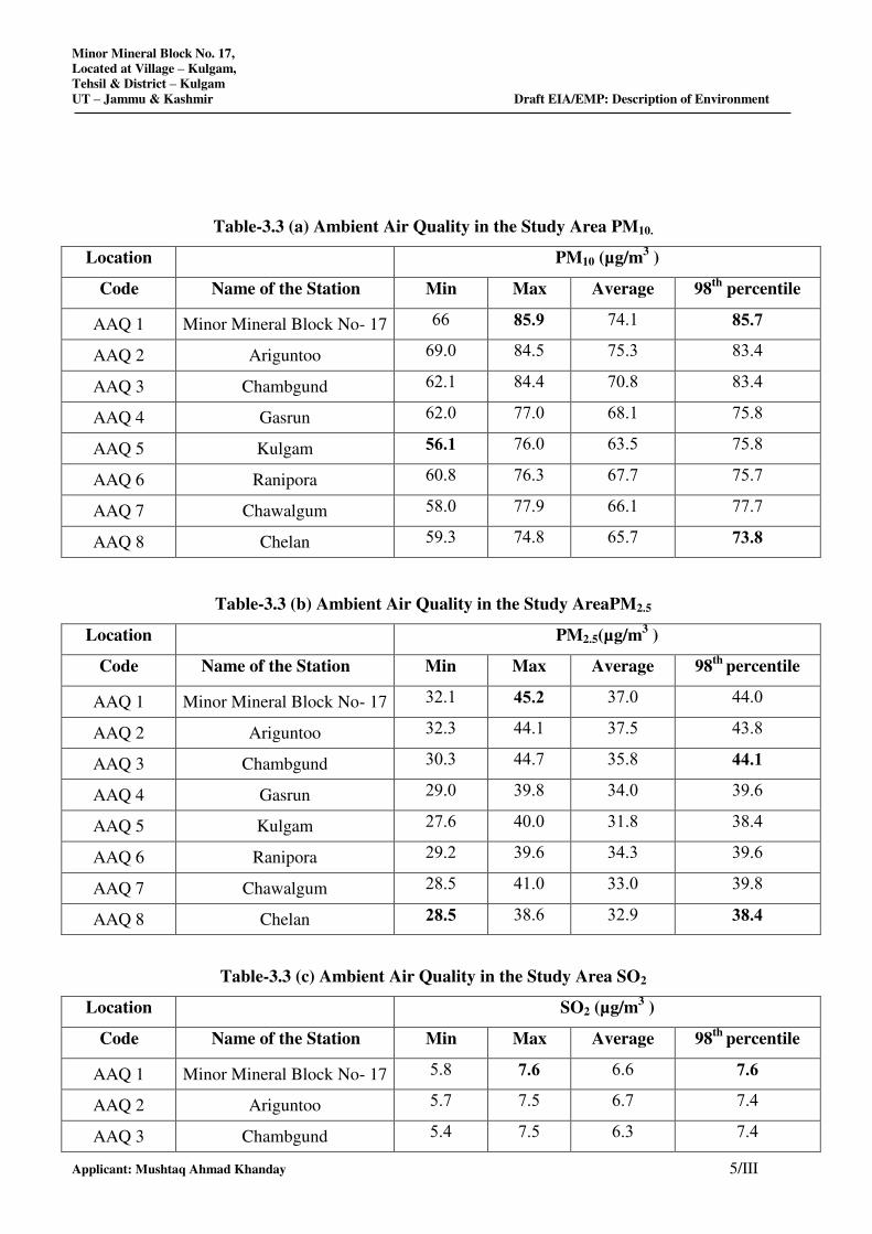
Minor Mineral Block No. 17,
Located at Village – Kulgam,
Tehsil & District – Kulgam
UT – Jammu & Kashmir Draft EIA/EMP: Description of Environment
Applicant: Mushtaq Ahmad Khanday 5/III
Table-3.3 (a) Ambient Air Quality in the Study Area PM10.
Location PM10 (µg/m3 )
Code Name of the Station Min Max Average 98th
percentile
AAQ 1 Minor Mineral Block No- 17 66 85.9 74.1 85.7
AAQ 2 Ariguntoo 69.0 84.5 75.3 83.4
AAQ 3 Chambgund 62.1 84.4 70.8 83.4
AAQ 4 Gasrun 62.0 77.0 68.1 75.8
AAQ 5 Kulgam 56.1 76.0 63.5 75.8
AAQ 6 Ranipora 60.8 76.3 67.7 75.7
AAQ 7 Chawalgum 58.0 77.9 66.1 77.7
AAQ 8 Chelan 59.3 74.8 65.7 73.8
Table-3.3 (b) Ambient Air Quality in the Study AreaPM2.5
Location PM2.5(µg/m3 )
Code Name of the Station Min Max Average 98th
percentile
AAQ 1 Minor Mineral Block No- 17 32.1 45.2 37.0 44.0
AAQ 2 Ariguntoo 32.3 44.1 37.5 43.8
AAQ 3 Chambgund 30.3 44.7 35.8 44.1
AAQ 4 Gasrun 29.0 39.8 34.0 39.6
AAQ 5 Kulgam 27.6 40.0 31.8 38.4
AAQ 6 Ranipora 29.2 39.6 34.3 39.6
AAQ 7 Chawalgum 28.5 41.0 33.0 39.8
AAQ 8 Chelan 28.5 38.6 32.9 38.4
Table-3.3 (c) Ambient Air Quality in the Study Area SO2
Location SO2 (µg/m3 )
Code Name of the Station Min Max Average 98th
percentile
AAQ 1 Minor Mineral Block No- 17 5.8 7.6 6.6 7.6
AAQ 2 Ariguntoo 5.7 7.5 6.7 7.4
AAQ 3 Chambgund 5.4 7.5 6.3 7.4
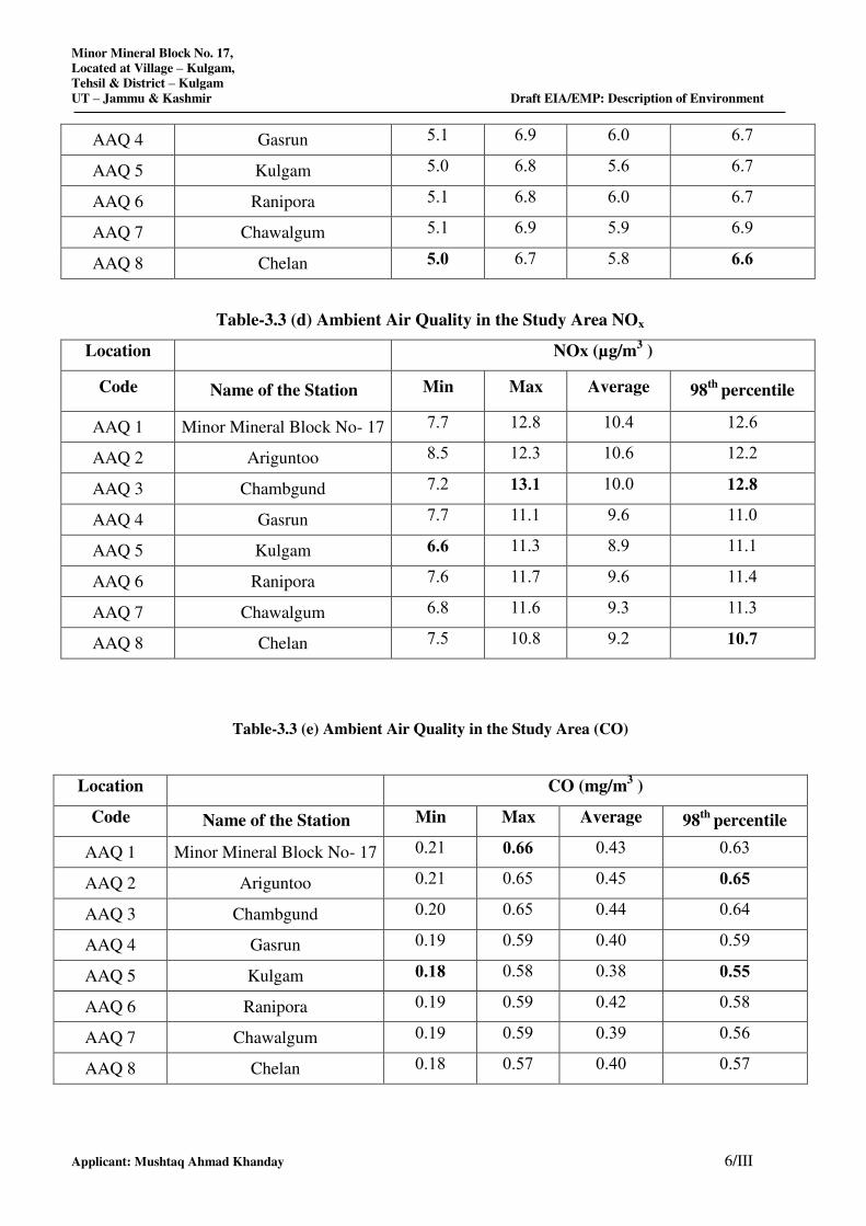
Minor Mineral Block No. 17,
Located at Village – Kulgam,
Tehsil & District – Kulgam
UT – Jammu & Kashmir Draft EIA/EMP: Description of Environment
Applicant: Mushtaq Ahmad Khanday 6/III
AAQ 4 Gasrun 5.1 6.9 6.0 6.7
AAQ 5 Kulgam 5.0 6.8 5.6 6.7
AAQ 6 Ranipora 5.1 6.8 6.0 6.7
AAQ 7 Chawalgum 5.1 6.9 5.9 6.9
AAQ 8 Chelan 5.0 6.7 5.8 6.6
Table-3.3 (d) Ambient Air Quality in the Study Area NOx
Location NOx (µg/m3 )
Code Name of the Station Min Max Average 98th
percentile
AAQ 1 Minor Mineral Block No- 17 7.7 12.8 10.4 12.6
AAQ 2 Ariguntoo 8.5 12.3 10.6 12.2
AAQ 3 Chambgund 7.2 13.1 10.0 12.8
AAQ 4 Gasrun 7.7 11.1 9.6 11.0
AAQ 5 Kulgam 6.6 11.3 8.9 11.1
AAQ 6 Ranipora 7.6 11.7 9.6 11.4
AAQ 7 Chawalgum 6.8 11.6 9.3 11.3
AAQ 8 Chelan 7.5 10.8 9.2 10.7
Table-3.3 (e) Ambient Air Quality in the Study Area (CO)
Location CO (mg/m3 )
Code Name of the Station Min Max Average 98th
percentile
AAQ 1 Minor Mineral Block No- 17 0.21 0.66 0.43 0.63
AAQ 2 Ariguntoo 0.21 0.65 0.45 0.65
AAQ 3 Chambgund 0.20 0.65 0.44 0.64
AAQ 4 Gasrun 0.19 0.59 0.40 0.59
AAQ 5 Kulgam 0.18 0.58 0.38 0.55
AAQ 6 Ranipora 0.19 0.59 0.42 0.58
AAQ 7 Chawalgum 0.19 0.59 0.39 0.56
AAQ 8 Chelan 0.18 0.57 0.40 0.57
Minor Mineral Block No. 17,
Located at Village – Kulgam,
Tehsil & District – Kulgam
UT – Jammu & Kashmir Draft EIA/EMP: Description of Environment
Applicant: Mushtaq Ahmad Khanday 7/III
3.5.3: Baseline Scenario
a) Suspended Particulate Matter(PM10)
Suspended particulate matter in general terms is the particulate matter in suspension in ambient
air. It includes dust, smoke etc. In general some of the important sources of suspended
particulate matter are mines. The following sources of suspended particulate matter in the
study area are identified:
Emission due to vehicular movement
Dust generation from ground or other mining operations
The minimum and maximum level of PM10 recorded within the study area was in the range of
56.1 µg/m3 to 85.9 µg/m
3 with the 98
th percentile ranging between 73.8 µg/m
3 to 85.7 µg/m
3. The
24 hourly average values of PM10 were compared with the National Ambient Air Quality
Standards (NAAQS) and found that all sampling stations recorded in the study area are within the
applicable limits i.e., 100 µg/m3 for PM10 in industrial, residential, rural and other area.
b) Particulate Matter (PM2.5)
Fine particles include all types of combustion, including motor vehicles, power plants,
residential wood burning, forest fires, agricultural burning, and some industrial processes. In
general, some of the important sources of particulate matter are mines. The following sources
of particulate matter in the study area are identified:
Emission due to vehicular movement
Dust generation from ground or other mining operations
PM2.5 recorded within the study area was in the range of 28.5 µg/m3 to 45.2 µg/m
3 with the
98th
percentile ranging between 38.4 µg/m3 to 44.1 µg/m
3were compared with the National
Ambient Air Quality Standards (NAAQS) and found that all sampling stations recorded in the
study area are within the applicable limits i.e., 60µg/m3 for PM2.5 for industrial, residential,
rural and other areas.
c) Sulphur Dioxide (SO2)
Sulphur dioxide gas is an inorganic gaseous pollutant. Sulphur dioxide emissions are expected
to be emitted wherever combustion of any fuel containing Sulphur takes place. The Sulphur in
the fuel will combine with oxygen to form Sulphur dioxide. The following sources of Sulphur
dioxide in the study area are identified:
Minor Mineral Block No. 17,
Located at Village – Kulgam,
Tehsil & District – Kulgam
UT – Jammu & Kashmir Draft EIA/EMP: Description of Environment
Applicant: Mushtaq Ahmad Khanday 8/III
Emissions from domestic/consumption of fuel (coal, diesel, etc.)
Sulphur dioxide in atmosphere is significant because of its toxicity; Sulphur dioxide is capable
of producing illness and lung injury. Further it can combine with water in the air to form toxic
acid aerosols that can corrode metal surfaces, fabrics and the leaves of plants. Sulphur dioxide
is an irritant to the eyes and respiratory system. Excessive exposure to Sulphur dioxide causes
bronchial asthma and other breathing related diseases as it affects the lungs.
The minimum and maximum level of SO2 recorded within the study area was in the range of
5.0 to 7.6 µg/m3 with the 98
th percentile ranging between 6.6 µg/m
3 to 7.6 µg/m
3.
The 24 hourly average values of SO2 were compared with the National Ambient Air Quality
Standards (NAAQS) and it was found that all sampling stations recorded values are below the
applicable limits 80 µg/m3 for industrial, residential, rural and other area.
d) Oxides of Nitrogen (NO2)
The important sources of oxides of Nitrogen are from utilities and auto exhaust due to
vehicular movement in mine lease area. The following sources of oxides of nitrogen in the
study area are identified.
Emissions from vehicular movements in the study area.
Oxides of Nitrogen in the presence of sunlight will undergo reactions with a number of
organic compounds to produce all the effects associated with photochemical smog. NOx has
inherent ability to produce deleterious effects by themselves like toxicity. It causes
asphyxiation when its concentration is great enough to reduce the normal oxygen supply from
the air.
The minimum and maximum level of NOx recorded within the study area was in the range of 6.6
µg/m3 to 13.1 µg/m
3 with the 98
th percentile ranging between 10.7 µg/m
3 to 12.8 µg/m
3. The 24
hourly average values of NO2 were compared with the National Ambient Air Quality Standards
(NAAQS) and it was found that all sampling stations recorded values are below the applicable
limits 80 µg/m3 for industrial, residential, rural and other area.
3.6 NOISE LEVELS
Noise is one of the most undesirable and unwanted by-products of our modern life style. It
may not seem as insidious or harmful as air and water pollutants but it affects human health
and well-being and can contribute to deterioration of human well-being in general and can
cause neurological disturbances and physiological damage to the hearing mechanism in
particular. It is therefore, necessary to measure both the quality as well as the quantity of noise
in and around the proposed site.
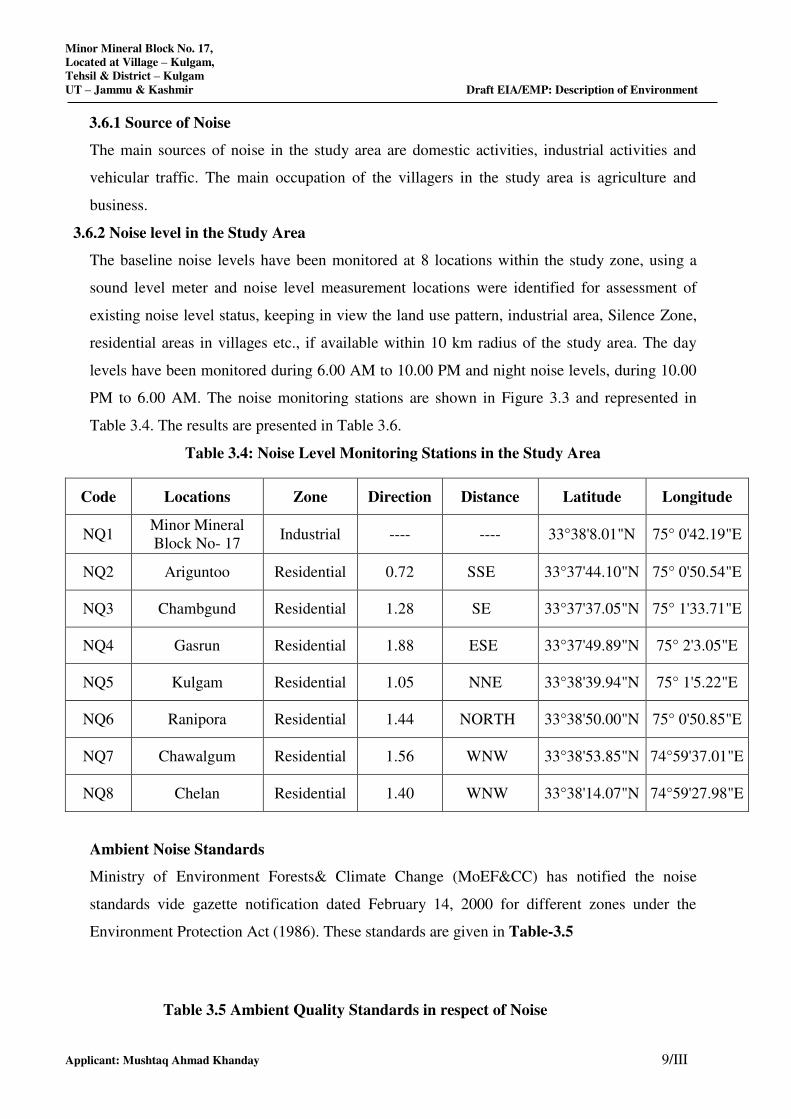
Minor Mineral Block No. 17,
Located at Village – Kulgam,
Tehsil & District – Kulgam
UT – Jammu & Kashmir Draft EIA/EMP: Description of Environment
Applicant: Mushtaq Ahmad Khanday 9/III
3.6.1 Source of Noise
The main sources of noise in the study area are domestic activities, industrial activities and
vehicular traffic. The main occupation of the villagers in the study area is agriculture and
business.
3.6.2 Noise level in the Study Area
The baseline noise levels have been monitored at 8 locations within the study zone, using a
sound level meter and noise level measurement locations were identified for assessment of
existing noise level status, keeping in view the land use pattern, industrial area, Silence Zone,
residential areas in villages etc., if available within 10 km radius of the study area. The day
levels have been monitored during 6.00 AM to 10.00 PM and night noise levels, during 10.00
PM to 6.00 AM. The noise monitoring stations are shown in Figure 3.3 and represented in
Table 3.4. The results are presented in Table 3.6.
Table 3.4: Noise Level Monitoring Stations in the Study Area
Code Locations Zone Direction Distance Latitude Longitude
NQ1 Minor Mineral
Block No- 17 Industrial ---- ---- 33°38'8.01"N 75° 0'42.19"E
NQ2 Ariguntoo Residential 0.72 SSE 33°37'44.10"N 75° 0'50.54"E
NQ3 Chambgund Residential 1.28 SE 33°37'37.05"N 75° 1'33.71"E
NQ4 Gasrun Residential 1.88 ESE 33°37'49.89"N 75° 2'3.05"E
NQ5 Kulgam Residential 1.05 NNE 33°38'39.94"N 75° 1'5.22"E
NQ6 Ranipora Residential 1.44 NORTH 33°38'50.00"N 75° 0'50.85"E
NQ7 Chawalgum Residential 1.56 WNW 33°38'53.85"N 74°59'37.01"E
NQ8 Chelan Residential 1.40 WNW 33°38'14.07"N 74°59'27.98"E
Ambient Noise Standards
Ministry of Environment Forests& Climate Change (MoEF&CC) has notified the noise
standards vide gazette notification dated February 14, 2000 for different zones under the
Environment Protection Act (1986). These standards are given in Table-3.5
Table 3.5 Ambient Quality Standards in respect of Noise
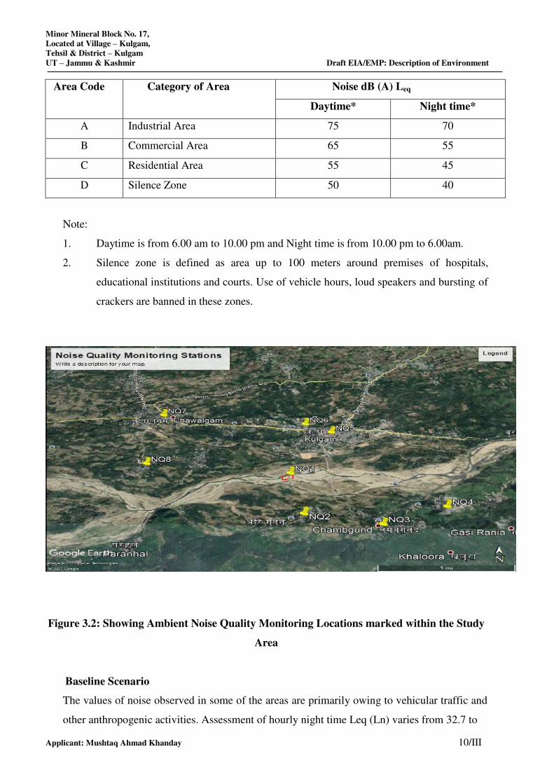
Minor Mineral Block No. 17,
Located at Village – Kulgam,
Tehsil & District – Kulgam
UT – Jammu & Kashmir Draft EIA/EMP: Description of Environment
Applicant: Mushtaq Ahmad Khanday 10/III
Area Code Category of Area Noise dB (A) Leq
Daytime* Night time*
A Industrial Area 75 70
B Commercial Area 65 55
C Residential Area 55 45
D Silence Zone 50 40
Note:
1. Daytime is from 6.00 am to 10.00 pm and Night time is from 10.00 pm to 6.00am.
2. Silence zone is defined as area up to 100 meters around premises of hospitals,
educational institutions and courts. Use of vehicle hours, loud speakers and bursting of
crackers are banned in these zones.
Figure 3.2: Showing Ambient Noise Quality Monitoring Locations marked within the Study
Area
Baseline Scenario
The values of noise observed in some of the areas are primarily owing to vehicular traffic and
other anthropogenic activities. Assessment of hourly night time Leq (Ln) varies from 32.7 to
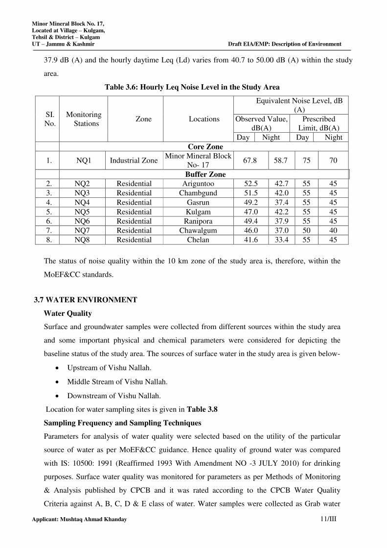
Minor Mineral Block No. 17,
Located at Village – Kulgam,
Tehsil & District – Kulgam
UT – Jammu & Kashmir Draft EIA/EMP: Description of Environment
Applicant: Mushtaq Ahmad Khanday 11/III
37.9 dB (A) and the hourly daytime Leq (Ld) varies from 40.7 to 50.00 dB (A) within the study
area.
Table 3.6: Hourly Leq Noise Level in the Study Area
SI.
No.
Monitoring
Stations Zone Locations
Equivalent Noise Level, dB
(A)
Observed Value,
dB(A)
Prescribed
Limit, dB(A)
Day Night Day Night
Core Zone
1. NQ1 Industrial Zone Minor Mineral Block
No- 17 67.8 58.7 75 70
Buffer Zone
2. NQ2 Residential Ariguntoo 52.5 42.7 55 45
3. NQ3 Residential Chambgund 51.5 42.0 55 45
4. NQ4 Residential Gasrun 49.2 37.4 55 45
5. NQ5 Residential Kulgam 47.0 42.2 55 45
6. NQ6 Residential Ranipora 49.4 37.9 55 45
7. NQ7 Residential Chawalgum 46.0 37.0 50 40
8. NQ8 Residential Chelan 41.6 33.4 55 45
The status of noise quality within the 10 km zone of the study area is, therefore, within the
MoEF&CC standards.
3.7 WATER ENVIRONMENT
Water Quality
Surface and groundwater samples were collected from different sources within the study area
and some important physical and chemical parameters were considered for depicting the
baseline status of the study area. The sources of surface water in the study area is given below-
Upstream of Vishu Nallah.
Middle Stream of Vishu Nallah.
Downstream of Vishu Nallah.
Location for water sampling sites is given in Table 3.8
Sampling Frequency and Sampling Techniques
Parameters for analysis of water quality were selected based on the utility of the particular
source of water as per MoEF&CC guidance. Hence quality of ground water was compared
with IS: 10500: 1991 (Reaffirmed 1993 With Amendment NO -3 JULY 2010) for drinking
purposes. Surface water quality was monitored for parameters as per Methods of Monitoring
& Analysis published by CPCB and it was rated according to the CPCB Water Quality
Criteria against A, B, C, D & E class of water. Water samples were collected as Grab water
Minor Mineral Block No. 17,
Located at Village – Kulgam,
Tehsil & District – Kulgam
UT – Jammu & Kashmir Draft EIA/EMP: Description of Environment
Applicant: Mushtaq Ahmad Khanday 12/III
sample from sampling location in a 5 liter plastic jerry can and 250 ml sterilized clean
glass/pet bottle for complete physico-chemical and bacteriological tests respectively. The
samples were analyzed as per standard procedure / method given in IS: 3025 (Revised Part)
and standard method for examination of water and wastewater Ed.21st, published jointly
APHA, AWWA and WPCF. The surface water quality is compared with CPCB water quality
criteria mentioned in Table below.
Table 3.7: Water Quality Criteria as per Central Pollution Control Board
Designated-Best-Use Class of
water
Criteria
Drinking Water Source
without conventional
treatment but after
disinfection
A Total Coli forms Organism MPN/100ml shall be
50 or less
pH between 6.5 and 8.5
Dissolved Oxygen 6mg/l or more Biochemical
Oxygen Demand 5 days 20°C 2mg/l or less
Outdoor bathing
(Organized)
B Total Coliforms Organism MPN/100ml shall be
500 or less;
pH between 6.5 and 8.5;
Dissolved Oxygen 5mg/l or more Biochemical
Oxygen Demand 5 days 20°C 3mg/l or less
Drinking water source
after conventional
treatment and
disinfection
C Total Coliforms Organism MPN/100ml shall be
5000 or less;
pH between 6 to 9;
Dissolved Oxygen 4mg/l or more Biochemical
Oxygen Demand 5 days 20°C 3mg/l or less
Propagation of Wild life
and Fisheries
D pH between 6.5 to 8.5
Dissolved Oxygen 4mg/l or more Free
Ammonia (as N) 1.2 mg/l or less
Irrigation, Industrial
Cooling, Controlled
Waste disposal
E pH between 6.0 to 8.5
Electrical Conductivity at 25°C micro mhos/cm
Max.2250
Sodium absorption Ratio Max. 26
Boron Max. 2mg/l
Below-E Not Meeting A, B, C, D & E Criteria
As per the standard practice, one sample from each station was taken each month in the study
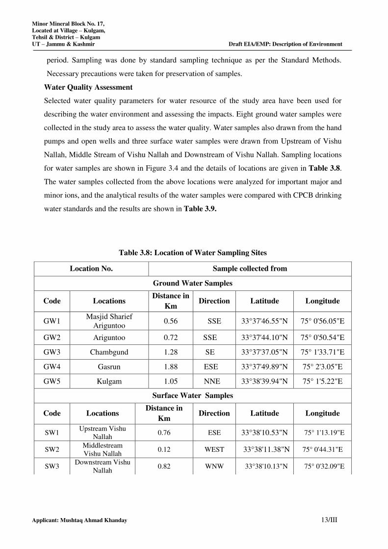
Minor Mineral Block No. 17,
Located at Village – Kulgam,
Tehsil & District – Kulgam
UT – Jammu & Kashmir Draft EIA/EMP: Description of Environment
Applicant: Mushtaq Ahmad Khanday 13/III
period. Sampling was done by standard sampling technique as per the Standard Methods.
Necessary precautions were taken for preservation of samples.
Water Quality Assessment
Selected water quality parameters for water resource of the study area have been used for
describing the water environment and assessing the impacts. Eight ground water samples were
collected in the study area to assess the water quality. Water samples also drawn from the hand
pumps and open wells and three surface water samples were drawn from Upstream of Vishu
Nallah, Middle Stream of Vishu Nallah and Downstream of Vishu Nallah. Sampling locations
for water samples are shown in Figure 3.4 and the details of locations are given in Table 3.8.
The water samples collected from the above locations were analyzed for important major and
minor ions, and the analytical results of the water samples were compared with CPCB drinking
water standards and the results are shown in Table 3.9.
Table 3.8: Location of Water Sampling Sites
Location No. Sample collected from
Ground Water Samples
Code Locations Distance in
Km Direction Latitude Longitude
GW1 Masjid Sharief
Ariguntoo 0.56 SSE 33°37'46.55"N 75° 0'56.05"E
GW2 Ariguntoo 0.72 SSE 33°37'44.10"N 75° 0'50.54"E
GW3 Chambgund 1.28 SE 33°37'37.05"N 75° 1'33.71"E
GW4 Gasrun 1.88 ESE 33°37'49.89"N 75° 2'3.05"E
GW5 Kulgam 1.05 NNE 33°38'39.94"N 75° 1'5.22"E
Surface Water Samples
Code Locations Distance in
Km Direction Latitude Longitude
SW1 Upstream Vishu
Nallah 0.76 ESE 33°38'10.53"N 75° 1'13.19"E
SW2 Middlestream
Vishu Nallah 0.12 WEST 33°38'11.38"N 75° 0'44.31"E
SW3 Downstream Vishu
Nallah 0.82 WNW 33°38'10.13"N 75° 0'32.09"E
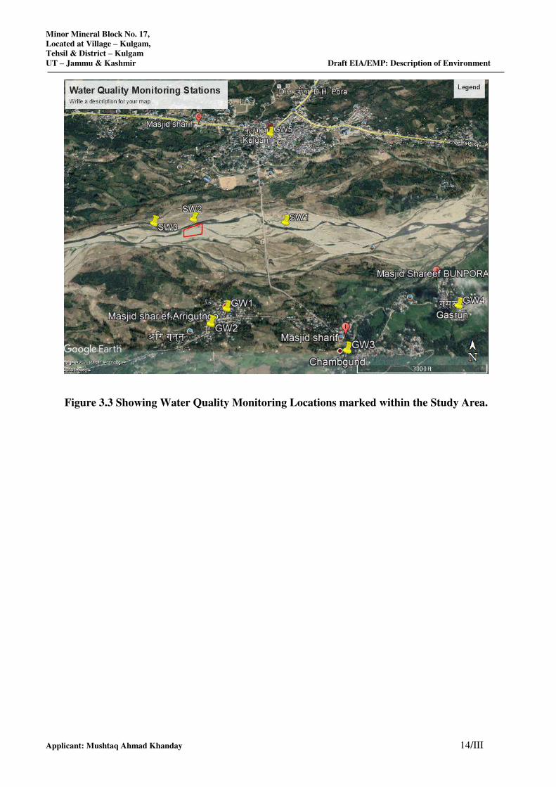
Minor Mineral Block No. 17,
Located at Village – Kulgam,
Tehsil & District – Kulgam
UT – Jammu & Kashmir Draft EIA/EMP: Description of Environment
Applicant: Mushtaq Ahmad Khanday 14/III
Figure 3.3 Showing Water Quality Monitoring Locations marked within the Study Area.
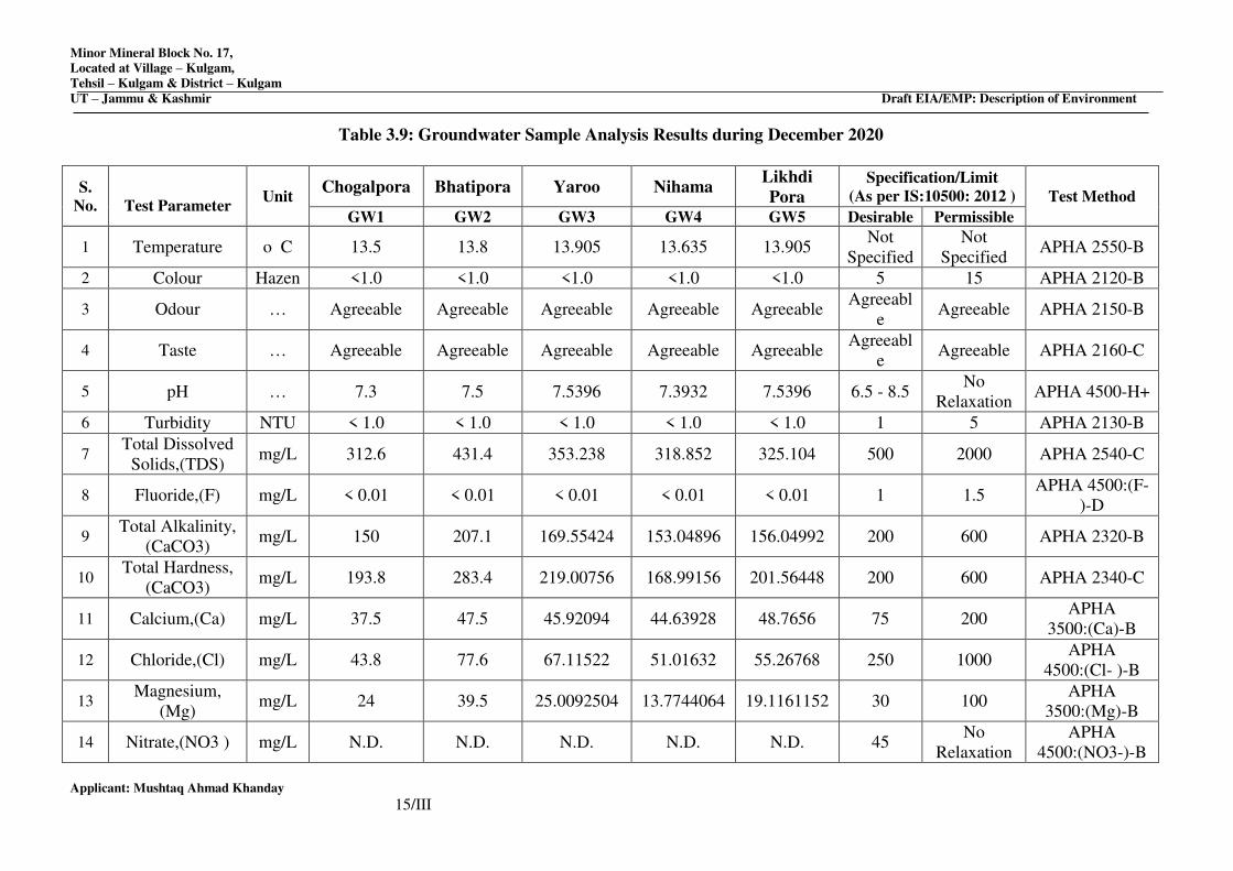
Minor Mineral Block No. 17,
Located at Village – Kulgam,
Tehsil – Kulgam & District – Kulgam
UT – Jammu & Kashmir Draft EIA/EMP: Description of Environment
Applicant: Mushtaq Ahmad Khanday
15/III
Table 3.9: Groundwater Sample Analysis Results during December 2020
S.
No.
Test Parameter Unit
Chogalpora Bhatipora Yaroo Nihama Likhdi
Pora
Specification/Limit
(As per IS:10500: 2012 ) Test Method
GW1 GW2 GW3 GW4 GW5 Desirable Permissible
1 Temperature o C 13.5 13.8 13.905 13.635 13.905 Not
Specified
Not
Specified APHA 2550-B
2 Colour Hazen <1.0 <1.0 <1.0 <1.0 <1.0 5 15 APHA 2120-B
3 Odour … Agreeable Agreeable Agreeable Agreeable Agreeable Agreeabl
e Agreeable APHA 2150-B
4 Taste … Agreeable Agreeable Agreeable Agreeable Agreeable Agreeabl
e Agreeable APHA 2160-C
5 pH … 7.3 7.5 7.5396 7.3932 7.5396 6.5 - 8.5 No
Relaxation APHA 4500-H+
6 Turbidity NTU < 1.0 < 1.0 < 1.0 < 1.0 < 1.0 1 5 APHA 2130-B
7 Total Dissolved
Solids,(TDS) mg/L 312.6 431.4 353.238 318.852 325.104 500 2000 APHA 2540-C
8 Fluoride,(F) mg/L < 0.01 < 0.01 < 0.01 < 0.01 < 0.01 1 1.5 APHA 4500:(F-
)-D
9 Total Alkalinity,
(CaCO3) mg/L 150 207.1 169.55424 153.04896 156.04992 200 600 APHA 2320-B
10 Total Hardness,
(CaCO3) mg/L 193.8 283.4 219.00756 168.99156 201.56448 200 600 APHA 2340-C
11 Calcium,(Ca) mg/L 37.5 47.5 45.92094 44.63928 48.7656 75 200 APHA
3500:(Ca)-B
12 Chloride,(Cl) mg/L 43.8 77.6 67.11522 51.01632 55.26768 250 1000 APHA
4500:(Cl- )-B
13 Magnesium,
(Mg) mg/L 24 39.5 25.0092504 13.7744064 19.1161152 30 100
APHA
3500:(Mg)-B
14 Nitrate,(NO3 ) mg/L N.D. N.D. N.D. N.D. N.D. 45 No
Relaxation
APHA
4500:(NO3-)-B
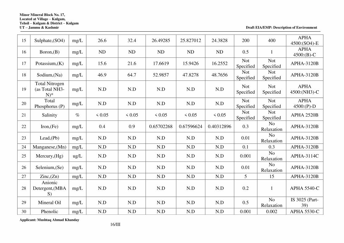
Minor Mineral Block No. 17,
Located at Village – Kulgam,
Tehsil – Kulgam & District – Kulgam
UT – Jammu & Kashmir Draft EIA/EMP: Description of Environment
Applicant: Mushtaq Ahmad Khanday
16/III
15 Sulphate,(SO4) mg/L 26.6 32.4 26.49285 25.827012 24.3828 200 400 APHA
4500:(SO4)-E
16 Boron,(B) mg/L ND ND ND ND ND 0.5 1 APHA
4500:(B)-C
17 Potassium,(K) mg/L 15.6 21.6 17.6619 15.9426 16.2552 Not
Specified
Not
Specified APHA-3120B
18 Sodium,(Na) mg/L 46.9 64.7 52.9857 47.8278 48.7656 Not
Specified
Not
Specified APHA-3120B
19
Total Nitrogen
(as Total NH3-
N)*
mg/L N.D N.D N.D N.D N.D Not
Specified
Not
Specified
APHA
4500:(NH3)-C
20 Total
Phosphorus (P) mg/L N.D N.D N.D N.D N.D
Not
Specified
Not
Specified
APHA
4500:(P)-D
21 Salinity % < 0.05 < 0.05 < 0.05 < 0.05 < 0.05 Not
Specified
Not
Specified APHA 2520B
22 Iron,(Fe) mg/L 0.4 0.9 0.65702268 0.67596624 0.40312896 0.3 No
Relaxation APHA-3120B
23 Lead,(Pb) mg/L N.D N.D N.D N.D N.D 0.01 No
Relaxation APHA-3120B
24 Manganese,(Mn) mg/L N.D N.D N.D N.D N.D 0.1 0.3 APHA-3120B
25 Mercury,(Hg) ug/L N.D N.D N.D N.D N.D 0.001 No
Relaxation APHA-3114C
26 Selenium,(Se) mg/L N.D N.D N.D N.D N.D 0.01 No
Relaxation APHA-3120B
27 Zinc,(Zn) mg/L N.D N.D N.D N.D N.D 5 15 APHA-3120B
28
Anionic
Detergent,(MBA
S)
mg/L N.D N.D N.D N.D N.D 0.2 1 APHA 5540-C
29 Mineral Oil mg/L N.D N.D N.D N.D N.D 0.5 No
Relaxation
IS 3025 (Part-
39)
30 Phenolic mg/L N.D N.D N.D N.D N.D 0.001 0.002 APHA 5530-C
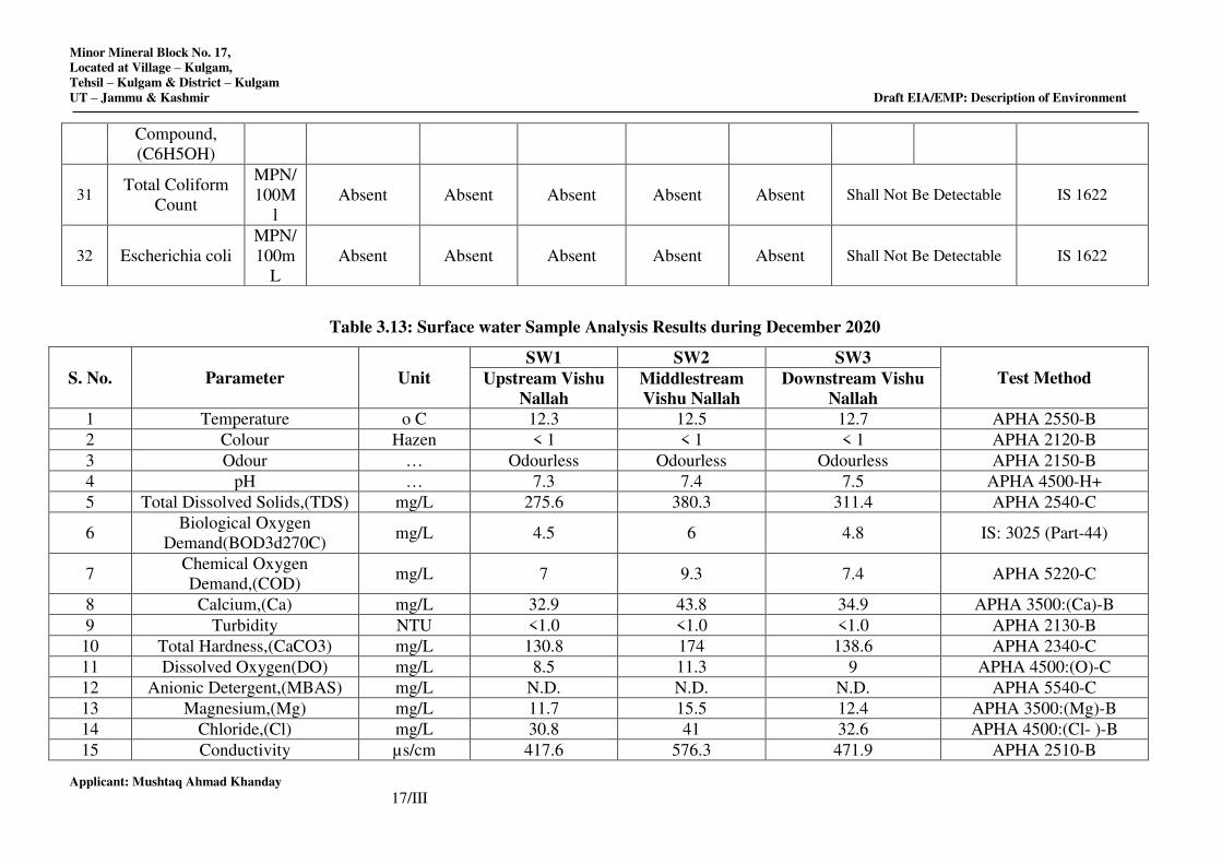
Minor Mineral Block No. 17,
Located at Village – Kulgam,
Tehsil – Kulgam & District – Kulgam
UT – Jammu & Kashmir Draft EIA/EMP: Description of Environment
Applicant: Mushtaq Ahmad Khanday
17/III
Table 3.13: Surface water Sample Analysis Results during December 2020
S. No. Parameter Unit
SW1 SW2 SW3
Test Method Upstream Vishu
Nallah
Middlestream
Vishu Nallah
Downstream Vishu
Nallah
1 Temperature o C 12.3 12.5 12.7 APHA 2550-B
2 Colour Hazen < 1 < 1 < 1 APHA 2120-B
3 Odour … Odourless Odourless Odourless APHA 2150-B
4 pH … 7.3 7.4 7.5 APHA 4500-H+
5 Total Dissolved Solids,(TDS) mg/L 275.6 380.3 311.4 APHA 2540-C
6 Biological Oxygen
Demand(BOD3d270C) mg/L 4.5 6 4.8 IS: 3025 (Part-44)
7 Chemical Oxygen
Demand,(COD) mg/L 7 9.3 7.4 APHA 5220-C
8 Calcium,(Ca) mg/L 32.9 43.8 34.9 APHA 3500:(Ca)-B
9 Turbidity NTU <1.0 <1.0 <1.0 APHA 2130-B
10 Total Hardness,(CaCO3) mg/L 130.8 174 138.6 APHA 2340-C
11 Dissolved Oxygen(DO) mg/L 8.5 11.3 9 APHA 4500:(O)-C
12 Anionic Detergent,(MBAS) mg/L N.D. N.D. N.D. APHA 5540-C
13 Magnesium,(Mg) mg/L 11.7 15.5 12.4 APHA 3500:(Mg)-B
14 Chloride,(Cl) mg/L 30.8 41 32.6 APHA 4500:(Cl- )-B
15 Conductivity µs/cm 417.6 576.3 471.9 APHA 2510-B
Compound,
(C6H5OH)
31 Total Coliform
Count
MPN/
100M
l
Absent Absent Absent Absent Absent Shall Not Be Detectable IS 1622
32 Escherichia coli
MPN/
100m
L
Absent Absent Absent Absent Absent Shall Not Be Detectable IS 1622
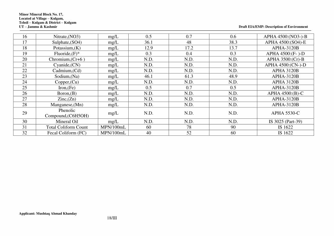
Minor Mineral Block No. 17,
Located at Village – Kulgam,
Tehsil – Kulgam & District – Kulgam
UT – Jammu & Kashmir Draft EIA/EMP: Description of Environment
Applicant: Mushtaq Ahmad Khanday
18/III
16 Nitrate,(NO3) mg/L 0.5 0.7 0.6 APHA 4500:(NO3-)-B
17 Sulphate,(SO4) mg/L 36.1 48 38.3 APHA 4500:(SO4)-E
18 Potassium,(K) mg/L 12.9 17.2 13.7 APHA-3120B
19 Fluoride,(F)* mg/L 0.3 0.4 0.3 APHA 4500:(F- )-D
20 Chromium,(Cr+6 ) mg/L N.D. N.D. N.D. APHA 3500:(Cr)-B
21 Cyanide,(CN) mg/L N.D. N.D. N.D. APHA 4500:(CN-)-D
22 Cadmium,(Cd) mg/L N.D. N.D. N.D. APHA 3120B
23 Sodium,(Na) mg/L 46.1 61.3 48.9 APHA-3120B
24 Copper,(Cu) mg/L N.D. N.D. N.D. APHA 3120B
25 Iron,(Fe) mg/L 0.5 0.7 0.5 APHA-3120B
26 Boron,(B) mg/L N.D. N.D. N.D. APHA 4500:(B)-C
27 Zinc,(Zn) mg/L N.D. N.D. N.D. APHA-3120B
28 Manganese,(Mn) mg/L N.D. N.D. N.D. APHA-3120B
29 Phenolic
Compound,(C6H5OH) mg/L N.D. N.D. N.D. APHA 5530-C
30 Mineral Oil mg/L N.D. N.D. N.D. IS 3025 (Part-39)
31 Total Coliform Count MPN/100mL 60 78 90 IS 1622
32 Fecal Coliform (FC) MPN/100mL 40 52 60 IS 1622
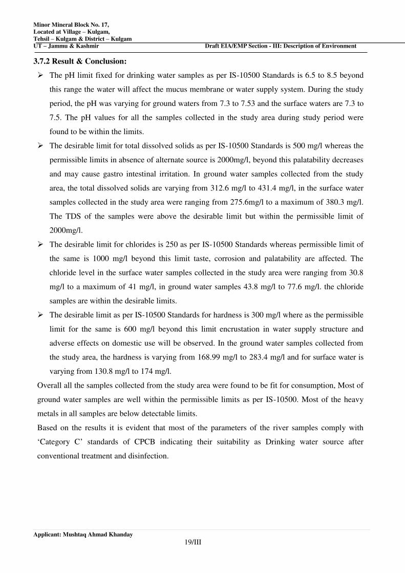
Minor Mineral Block No. 17,
Located at Village – Kulgam,
Tehsil – Kulgam & District – Kulgam
UT – Jammu & Kashmir Draft EIA/EMP Section - III: Description of Environment
Applicant: Mushtaq Ahmad Khanday
19/III
3.7.2 Result & Conclusion:
The pH limit fixed for drinking water samples as per IS-10500 Standards is 6.5 to 8.5 beyond
this range the water will affect the mucus membrane or water supply system. During the study
period, the pH was varying for ground waters from 7.3 to 7.53 and the surface waters are 7.3 to
7.5. The pH values for all the samples collected in the study area during study period were
found to be within the limits.
The desirable limit for total dissolved solids as per IS-10500 Standards is 500 mg/l whereas the
permissible limits in absence of alternate source is 2000mg/l, beyond this palatability decreases
and may cause gastro intestinal irritation. In ground water samples collected from the study
area, the total dissolved solids are varying from 312.6 mg/l to 431.4 mg/l, in the surface water
samples collected in the study area were ranging from 275.6mg/l to a maximum of 380.3 mg/l.
The TDS of the samples were above the desirable limit but within the permissible limit of
2000mg/l.
The desirable limit for chlorides is 250 as per IS-10500 Standards whereas permissible limit of
the same is 1000 mg/l beyond this limit taste, corrosion and palatability are affected. The
chloride level in the surface water samples collected in the study area were ranging from 30.8
mg/l to a maximum of 41 mg/l, in ground water samples 43.8 mg/l to 77.6 mg/l. the chloride
samples are within the desirable limits.
The desirable limit as per IS-10500 Standards for hardness is 300 mg/l where as the permissible
limit for the same is 600 mg/l beyond this limit encrustation in water supply structure and
adverse effects on domestic use will be observed. In the ground water samples collected from
the study area, the hardness is varying from 168.99 mg/l to 283.4 mg/l and for surface water is
varying from 130.8 mg/l to 174 mg/l.
Overall all the samples collected from the study area were found to be fit for consumption, Most of
ground water samples are well within the permissible limits as per IS-10500. Most of the heavy
metals in all samples are below detectable limits.
Based on the results it is evident that most of the parameters of the river samples comply with
‘Category C’ standards of CPCB indicating their suitability as Drinking water source after
conventional treatment and disinfection.
Minor Mineral Block No. 17,
Located at Village – Kulgam,
Tehsil – Kulgam & District – Kulgam
UT – Jammu & Kashmir Draft EIA/EMP Section - III: Description of Environment
Applicant: Mushtaq Ahmad Khanday
20/III
3.8 SOIL CHARACTERISTICS
The composite soil samples were collected from site and the study area and were analyzed for
characterization. The locations of the monitoring sites are depicted in Table 3.15 and the result of
the monitoring and analysis is presented in the Table 3.16 and Figure 3.5 showing soil sample
collection points marked within the study area.
Methodology
The soil samples were collected in the month of Dec 2020. Soil samples were collected
from5locations as given in Table 3.15 at each of these locations 4 sub-locations were identified
randomly from where soil was collected from 30 cm below the surface. The final samples represent
homogenously mixed soil from these 4 sub-locations for each location. The samples were filled in
polythene bags, labeled in the field with number and site name and sent to laboratory for analysis.
Particulars Details
Frequency One grab sample from each station– once during the Study Period
Methodology Composite grab samples of the topsoil were collected from 3 depths,
and mixed to provide a representative sample for analysis. They were
stored in airtight Polythene Bags and analyzed at the laboratory
Table 3.15: Soil Sample Collection Points
Code Locations Distance in km. Direction Latitude Longitude
SQ1
Minor Mineral
Block No- 17 ---- ---- 33°38'8.01"N 75° 0'42.19"E
SQ2 Ariguntoo 0.72 SSE 33°37'44.10"N 75° 0'50.54"E
SQ3 Chambgund 1.28 SE 33°37'37.05"N 75° 1'33.71"E
SQ4 Gasrun 1.88 ESE 33°37'49.89"N 75° 2'3.05"E
SQ5 Kulgam 1.05 NNE 33°38'39.94"N 75° 1'5.22"E
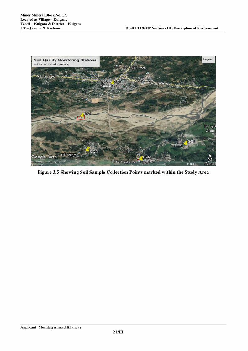
Minor Mineral Block No. 17,
Located at Village – Kulgam,
Tehsil – Kulgam & District – Kulgam
UT – Jammu & Kashmir Draft EIA/EMP Section - III: Description of Environment
Applicant: Mushtaq Ahmad Khanday
21/III
Figure 3.5 Showing Soil Sample Collection Points marked within the Study Area
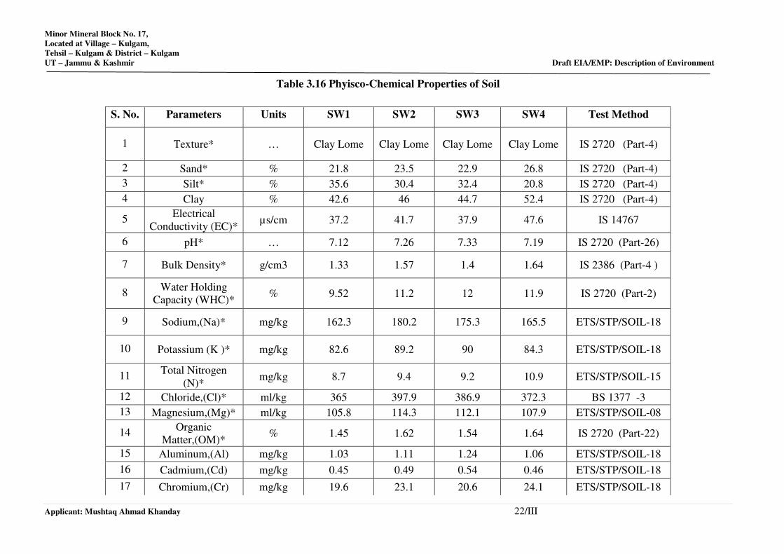
Minor Mineral Block No. 17,
Located at Village – Kulgam,
Tehsil – Kulgam & District – Kulgam
UT – Jammu & Kashmir Draft EIA/EMP: Description of Environment
Applicant: Mushtaq Ahmad Khanday 22/III
Table 3.16 Phyisco-Chemical Properties of Soil
S. No. Parameters Units SW1 SW2 SW3 SW4 Test Method
1 Texture* … Clay Lome Clay Lome Clay Lome Clay Lome IS 2720 (Part-4)
2 Sand* % 21.8 23.5 22.9 26.8 IS 2720 (Part-4)
3 Silt* % 35.6 30.4 32.4 20.8 IS 2720 (Part-4)
4 Clay % 42.6 46 44.7 52.4 IS 2720 (Part-4)
5 Electrical
Conductivity (EC)* µs/cm 37.2 41.7 37.9 47.6 IS 14767
6 pH* … 7.12 7.26 7.33 7.19 IS 2720 (Part-26)
7 Bulk Density* g/cm3 1.33 1.57 1.4 1.64 IS 2386 (Part-4 )
8 Water Holding
Capacity (WHC)* % 9.52 11.2 12 11.9 IS 2720 (Part-2)
9 Sodium,(Na)* mg/kg 162.3 180.2 175.3 165.5 ETS/STP/SOIL-18
10 Potassium (K )* mg/kg 82.6 89.2 90 84.3 ETS/STP/SOIL-18
11 Total Nitrogen
(N)* mg/kg 8.7 9.4 9.2 10.9 ETS/STP/SOIL-15
12 Chloride,(Cl)* ml/kg 365 397.9 386.9 372.3 BS 1377 -3
13 Magnesium,(Mg)* ml/kg 105.8 114.3 112.1 107.9 ETS/STP/SOIL-08
14 Organic
Matter,(OM)* % 1.45 1.62 1.54 1.64 IS 2720 (Part-22)
15 Aluminum,(Al) mg/kg 1.03 1.11 1.24 1.06 ETS/STP/SOIL-18
16 Cadmium,(Cd) mg/kg 0.45 0.49 0.54 0.46 ETS/STP/SOIL-18
17 Chromium,(Cr) mg/kg 19.6 23.1 20.6 24.1 ETS/STP/SOIL-18
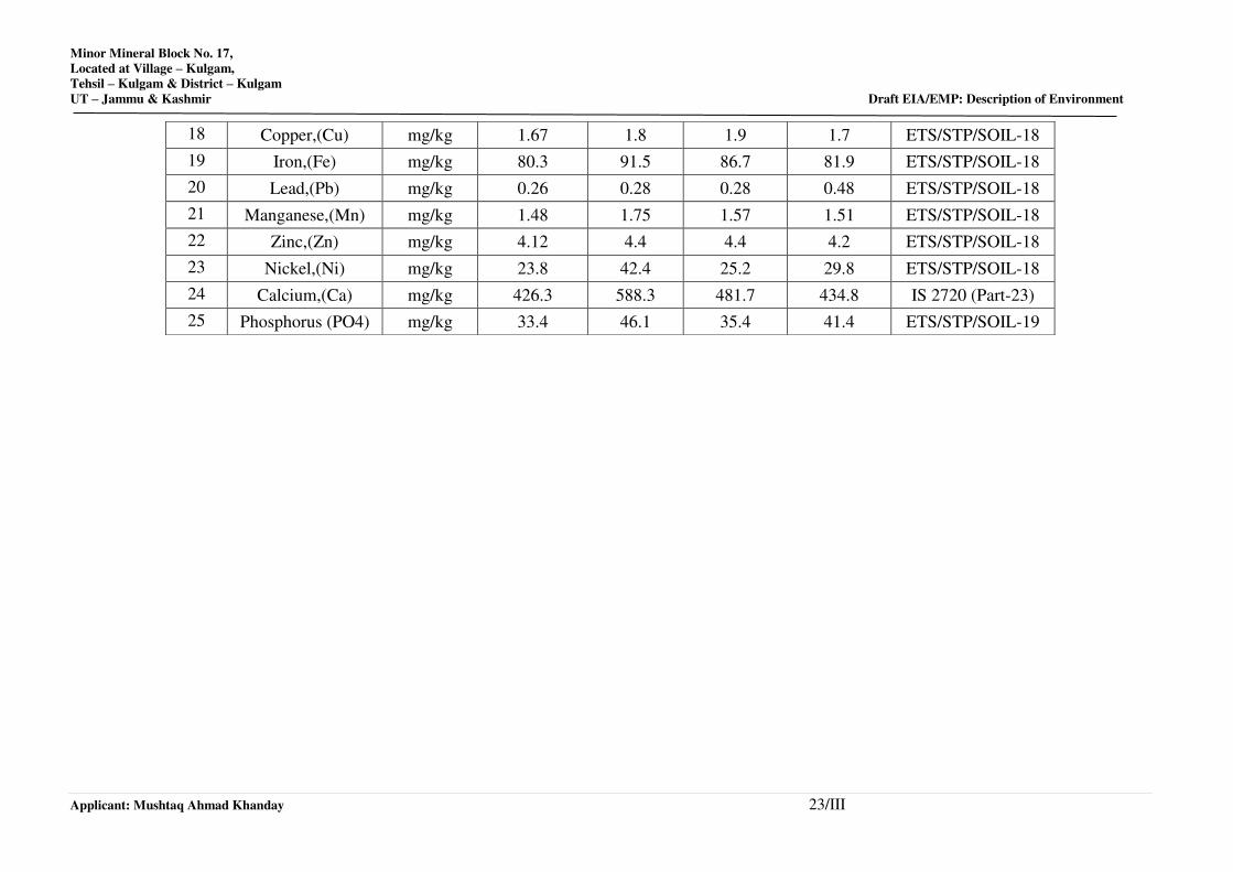
Minor Mineral Block No. 17,
Located at Village – Kulgam,
Tehsil – Kulgam & District – Kulgam
UT – Jammu & Kashmir Draft EIA/EMP: Description of Environment
Applicant: Mushtaq Ahmad Khanday 23/III
18 Copper,(Cu) mg/kg 1.67 1.8 1.9 1.7 ETS/STP/SOIL-18
19 Iron,(Fe) mg/kg 80.3 91.5 86.7 81.9 ETS/STP/SOIL-18
20 Lead,(Pb) mg/kg 0.26 0.28 0.28 0.48 ETS/STP/SOIL-18
21 Manganese,(Mn) mg/kg 1.48 1.75 1.57 1.51 ETS/STP/SOIL-18
22 Zinc,(Zn) mg/kg 4.12 4.4 4.4 4.2 ETS/STP/SOIL-18
23 Nickel,(Ni) mg/kg 23.8 42.4 25.2 29.8 ETS/STP/SOIL-18
24 Calcium,(Ca) mg/kg 426.3 588.3 481.7 434.8 IS 2720 (Part-23)
25 Phosphorus (PO4) mg/kg 33.4 46.1 35.4 41.4 ETS/STP/SOIL-19
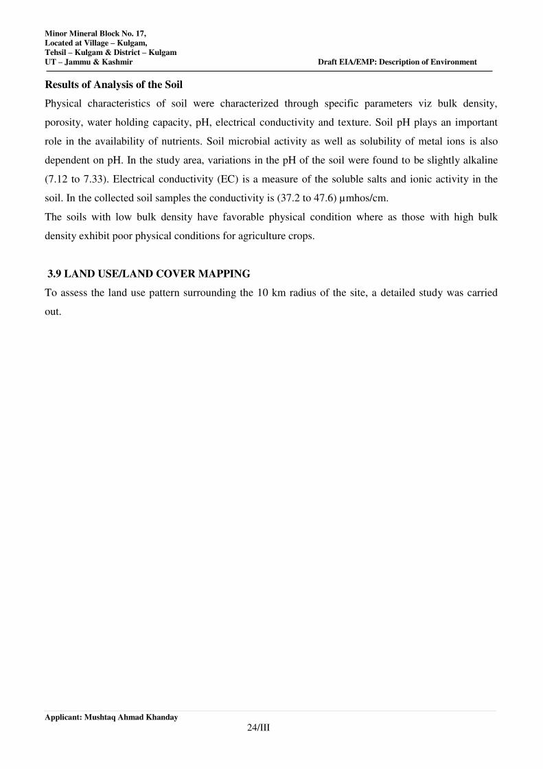
Minor Mineral Block No. 17,
Located at Village – Kulgam,
Tehsil – Kulgam & District – Kulgam
UT – Jammu & Kashmir Draft EIA/EMP: Description of Environment
Applicant: Mushtaq Ahmad Khanday
24/III
Results of Analysis of the Soil
Physical characteristics of soil were characterized through specific parameters viz bulk density,
porosity, water holding capacity, pH, electrical conductivity and texture. Soil pH plays an important
role in the availability of nutrients. Soil microbial activity as well as solubility of metal ions is also
dependent on pH. In the study area, variations in the pH of the soil were found to be slightly alkaline
(7.12 to 7.33). Electrical conductivity (EC) is a measure of the soluble salts and ionic activity in the
soil. In the collected soil samples the conductivity is (37.2 to 47.6) µmhos/cm.
The soils with low bulk density have favorable physical condition where as those with high bulk
density exhibit poor physical conditions for agriculture crops.
3.9 LAND USE/LAND COVER MAPPING
To assess the land use pattern surrounding the 10 km radius of the site, a detailed study was carried
out.
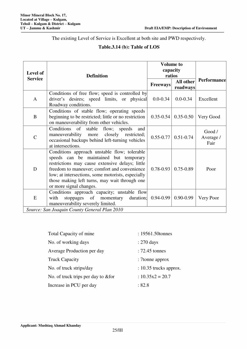
Minor Mineral Block No. 17,
Located at Village – Kulgam,
Tehsil – Kulgam & District – Kulgam
UT – Jammu & Kashmir Draft EIA/EMP: Description of Environment
Applicant: Mushtaq Ahmad Khanday
25/III
The existing Level of Service is Excellent at both site and PWD respectively.
Table.3.14 (b): Table of LOS
Level of
Service Definition
Volume to
capacity
ratios Performance
Freeways All other
roadways
A
Conditions of free flow; speed is controlled by
driver’s desires; speed limits, or physical
Roadway conditions.
0.0-0.34 0.0-0.34 Excellent
B
Conditions of stable flow; operating speeds
beginning to be restricted; little or no restriction
on maneuverability from other vehicles.
0.35-0.54 0.35-0.50 Very Good
C
Conditions of stable flow; speeds and
maneuverability more closely restricted;
occasional backups behind left-turning vehicles
at intersections.
0.55-0.77 0.51-0.74
Good /
Average /
Fair
D
Conditions approach unstable flow; tolerable
speeds can be maintained but temporary
restrictions may cause extensive delays; little
freedom to maneuver; comfort and convenience
low; at intersections, some motorists, especially
those making left turns, may wait through one
or more signal changes.
0.78-0.93 0.75-0.89 Poor
E
Conditions approach capacity; unstable flow
with stoppages of momentary duration;
maneuverability severely limited.
0.94-0.99 0.90-0.99 Very Poor
Source: San Joaquin County General Plan 2010
Total Capacity of mine : 19561.50tonnes
No. of working days : 270 days
Average Production per day : 72.45 tonnes
Truck Capacity : 7tonne approx
No. of truck strips/day : 10.35 trucks approx.
No. of truck trips per day to &for : 10.35x2 = 20.7
Increase in PCU per day : 82.8
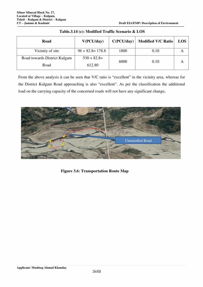
Minor Mineral Block No. 17,
Located at Village – Kulgam,
Tehsil – Kulgam & District – Kulgam
UT – Jammu & Kashmir Draft EIA/EMP: Description of Environment
Applicant: Mushtaq Ahmad Khanday
26/III
Table.3.14 (c): Modified Traffic Scenario & LOS
Road V(PCU/day) C(PCU/day) Modified V/C Ratio LOS
Vicinity of site 96 + 82.8= 178.8 1800 0.10 A
Road towards District Kulgam
Road
530 + 82.8=
612.80 6000 0.10 A
From the above analysis it can be seen that V/C ratio is “excellent” in the vicinity area, whereas for
the District Kulgam Road approaching is also “excellent”. As per the classification the additional
load on the carrying capacity of the concerned roads will not have any significant change.
Figure 3.6: Transportation Route Map
Unmetalled Road
Minor Mineral Block No. 17,
Located at Village – Kulgam,
Tehsil – Kulgam & District – Kulgam
UT – Jammu & Kashmir Draft EIA/EMP: Description of Environment
Applicant: Mushtaq Ahmad Khanday
27/III
3.11 BIOLOGICAL ENVIRONMENT
3.11.1. Introduction:
Biodiversity of reflects the potential of a regional ecosystem. Biota of particular area is considered as
indicators of the environment as they quickly respond not only to one environmental factor but also to
an interactive group of factors. These communities influence and react sensitively to change in the
balance of environmental stresses.
Biological diversity comprises the variability of genus, species and ecosystems and is very crucial for
maintaining the basic processes on which the life depends. On the basis of biological physiology
biodiversity broadly can be divided into two category i.e. the floral diversity and faunal diversity.
Conservation of the biodiversity is essential for the sustainable development as it not only provides
the food, fodder and medicine but also contribute in improvement of essential environmental
attributes like air, water, soil, etc. Before starting any Environmental Impact Assessment study, it is
necessary to identify the baseline of relevant environmental parameters which are likely to be affected
as a result of operation of the proposed project. A similar approach has been adopted for conducting
the study on Biological Environment for this Project. Both terrestrial and aquatic ecosystems have
been studied to understand the biological environment nearby the project site.
The study was conducted in the project area to assess all possible consequences on the biological
environment. Floral and faunal surveys and data collection conducted for assessing the biological
diversity and its status over a period of time that forms an integral part of Impact Assessment
Techniques. The present study is highlighting the various issues pertaining to floristic diversity and
the faunal wealth in the core area i.e. Minor Mineral Block No. 06, District Kulgam, J&K UT and
buffer zone i.e. area within 10 km radius.
3.11.1. Objective of the study:
To collect Baseline data for the study along with a description of the existing terrestrial,
wetland and aquatic vegetation.
To assess scheduled species in the proposed site (Rare, endangered, critically, endangered,
endemic and vulnerable).
To identify locations and features of ecological significance.
To identify impact of proposed project before, after and during development phase.
3.11.2. Period of Sampling: The ecological survey has been conducted during Post monsoon season
for the collection of primary data of flora-fauna, vegetation, soil and other environmental
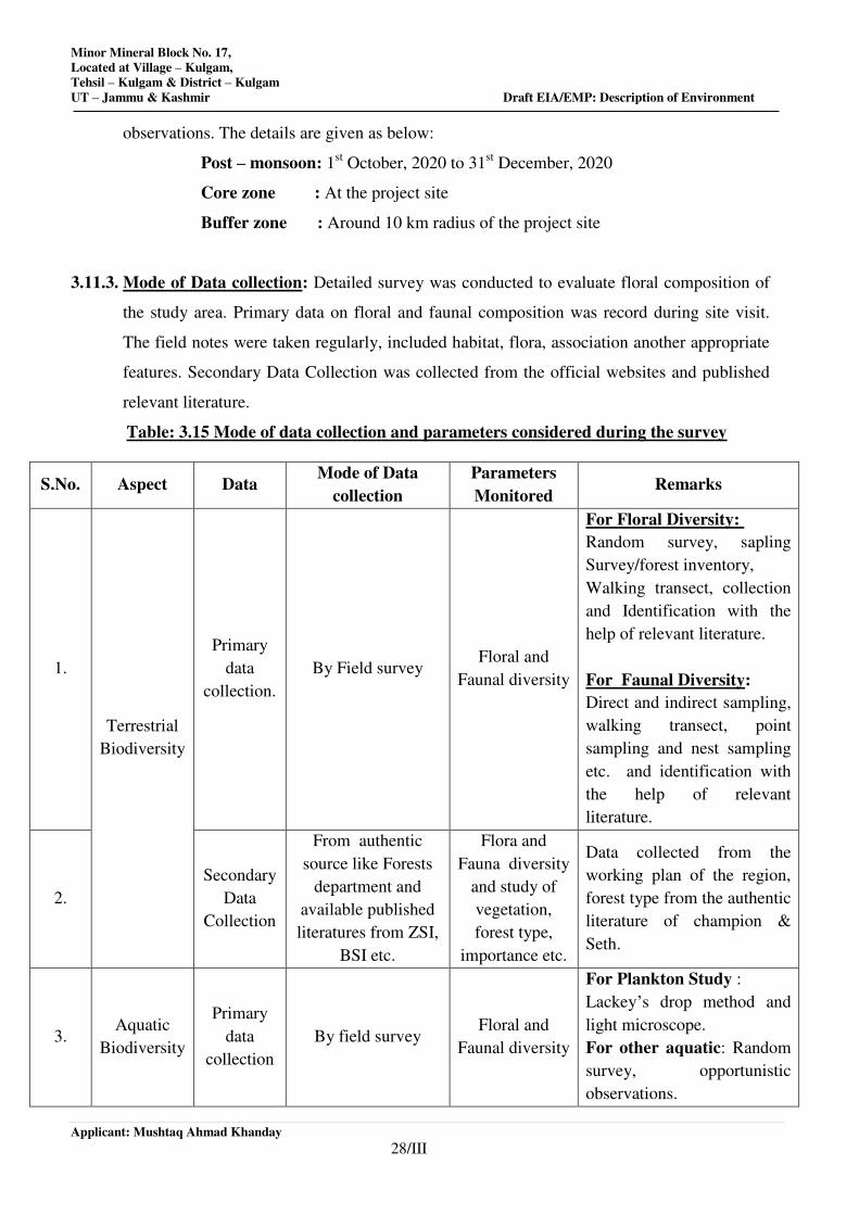
Minor Mineral Block No. 17,
Located at Village – Kulgam,
Tehsil – Kulgam & District – Kulgam
UT – Jammu & Kashmir Draft EIA/EMP: Description of Environment
Applicant: Mushtaq Ahmad Khanday
28/III
observations. The details are given as below:
Post – monsoon: 1st October, 2020 to 31
st December, 2020
Core zone : At the project site
Buffer zone : Around 10 km radius of the project site
3.11.3. Mode of Data collection: Detailed survey was conducted to evaluate floral composition of
the study area. Primary data on floral and faunal composition was record during site visit.
The field notes were taken regularly, included habitat, flora, association another appropriate
features. Secondary Data Collection was collected from the official websites and published
relevant literature.
Table: 3.15 Mode of data collection and parameters considered during the survey
S.No. Aspect Data Mode of Data
collection
Parameters
Monitored Remarks
1.
Terrestrial
Biodiversity
Primary
data
collection.
By Field survey Floral and
Faunal diversity
For Floral Diversity:
Random survey, sapling
Survey/forest inventory,
Walking transect, collection
and Identification with the
help of relevant literature.
For Faunal Diversity:
Direct and indirect sampling,
walking transect, point
sampling and nest sampling
etc. and identification with
the help of relevant
literature.
2.
Secondary
Data
Collection
From authentic
source like Forests
department and
available published
literatures from ZSI,
BSI etc.
Flora and
Fauna diversity
and study of
vegetation,
forest type,
importance etc.
Data collected from the
working plan of the region,
forest type from the authentic
literature of champion &
Seth.
3. Aquatic
Biodiversity
Primary
data
collection
By field survey Floral and
Faunal diversity
For Plankton Study :
Lackey’s drop method and
light microscope.
For other aquatic: Random
survey, opportunistic
observations.
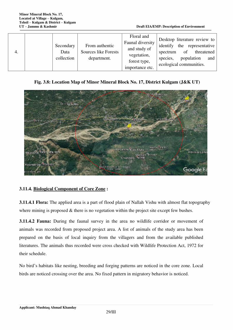
Minor Mineral Block No. 17,
Located at Village – Kulgam,
Tehsil – Kulgam & District – Kulgam
UT – Jammu & Kashmir Draft EIA/EMP: Description of Environment
Applicant: Mushtaq Ahmad Khanday
29/III
4.
Secondary
Data
collection
From authentic
Sources like Forests
department.
Floral and
Faunal diversity
and study of
vegetation,
forest type,
importance etc.
Desktop literature review to
identify the representative
spectrum of threatened
species, population and
ecological communities.
Fig. 3.8: Location Map of Minor Mineral Block No. 17, District Kulgam (J&K UT)
3.11.4. Biological Component of Core Zone :
3.11.4.1 Flora: The applied area is a part of flood plain of Nallah Vishu with almost flat topography
where mining is proposed & there is no vegetation within the project site except few bushes.
3.11.4.2 Fauna: During the faunal survey in the area no wildlife corridor or movement of
animals was recorded from proposed project area. A list of animals of the study area has been
prepared on the basis of local inquiry from the villagers and from the available published
literatures. The animals thus recorded were cross checked with Wildlife Protection Act, 1972 for
their schedule.
No bird’s habitats like nesting, breeding and forging patterns are noticed in the core zone. Local
birds are noticed crossing over the area. No fixed pattern in migratory behavior is noticed.
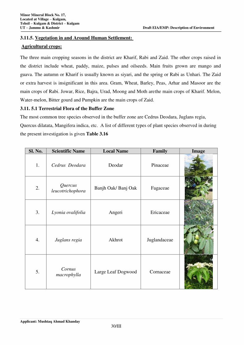
Minor Mineral Block No. 17,
Located at Village – Kulgam,
Tehsil – Kulgam & District – Kulgam
UT – Jammu & Kashmir Draft EIA/EMP: Description of Environment
Applicant: Mushtaq Ahmad Khanday
30/III
3.11.5. Vegetation in and Around Human Settlement:
Agricultural crops:
The three main cropping seasons in the district are Kharif, Rabi and Zaid. The other crops raised in
the district include wheat, paddy, maize, pulses and oilseeds. Main fruits grown are mango and
guava. The autumn or Kharif is usually known as siyari, and the spring or Rabi as Unhari. The Zaid
or extra harvest is insignificant in this area. Gram, Wheat, Barley, Peas, Arhar and Masoor are the
main crops of Rabi. Jowar, Rice, Bajra, Urad, Moong and Moth are the main crops of Kharif. Melon,
Water-melon, Bitter gourd and Pumpkin are the main crops of Zaid.
3.11. 5.1 Terrestrial Flora of the Buffer Zone
The most common tree species observed in the buffer zone are Cedrus Deodara, Juglans regia,
Quercus dilatata, Mangifera indica, etc. A list of different types of plant species observed in during
the present investigation is given Table 3.16
Sl. No. Scientific Name Local Name Family Image
1. Cedrus Deodara Deodar Pinaceae
2. Quercus
leucotrichophora Banjh Oak/ Banj Oak Fagaceae
3. Lyonia ovalifolia Angeri Ericaceae
4. Juglans regia Akhrot Juglandaceae
5. Cornus
macrophylla Large Leaf Dogwood Cornaceae
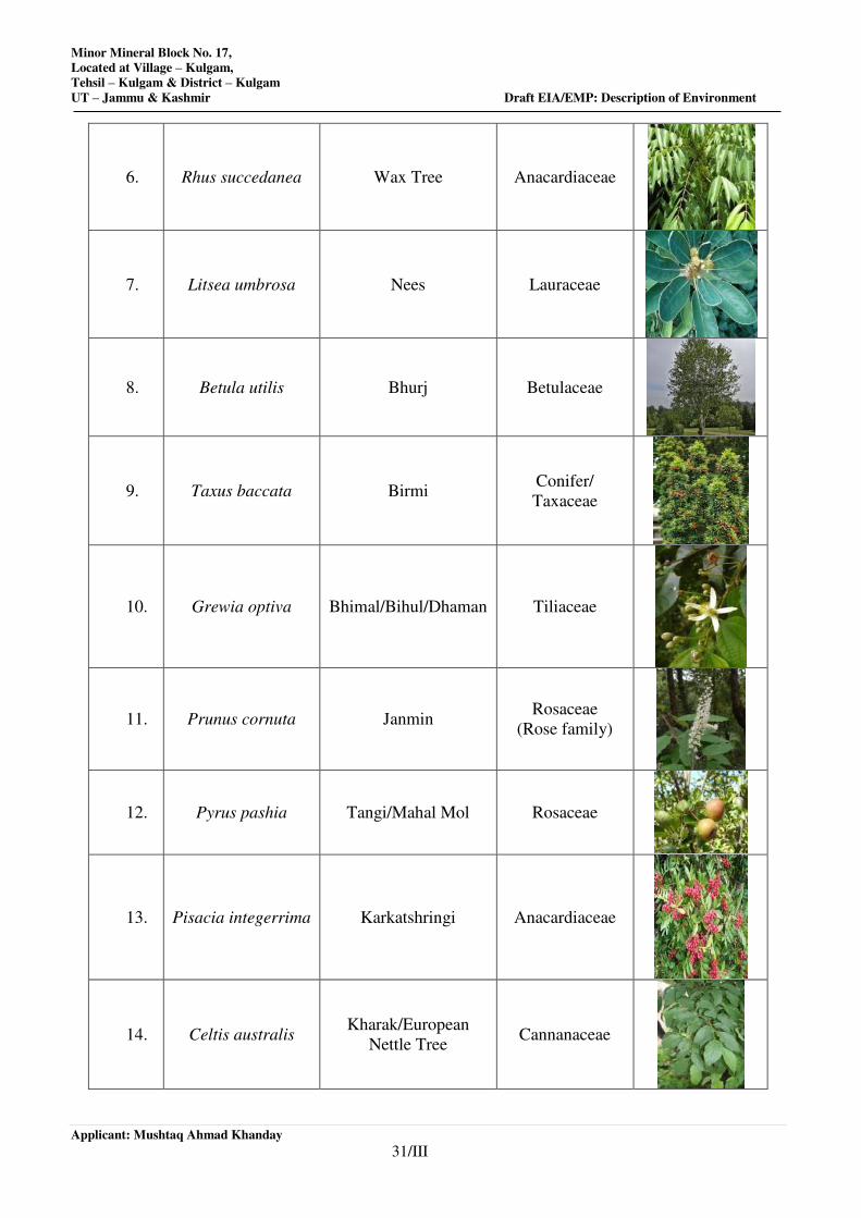
Minor Mineral Block No. 17,
Located at Village – Kulgam,
Tehsil – Kulgam & District – Kulgam
UT – Jammu & Kashmir Draft EIA/EMP: Description of Environment
Applicant: Mushtaq Ahmad Khanday
31/III
6. Rhus succedanea Wax Tree Anacardiaceae
7. Litsea umbrosa Nees Lauraceae
8. Betula utilis Bhurj Betulaceae
9. Taxus baccata Birmi Conifer/
Taxaceae
10. Grewia optiva Bhimal/Bihul/Dhaman Tiliaceae
11. Prunus cornuta Janmin Rosaceae
(Rose family)
12. Pyrus pashia Tangi/Mahal Mol Rosaceae
13. Pisacia integerrima Karkatshringi Anacardiaceae
14. Celtis australis Kharak/European
Nettle Tree Cannanaceae
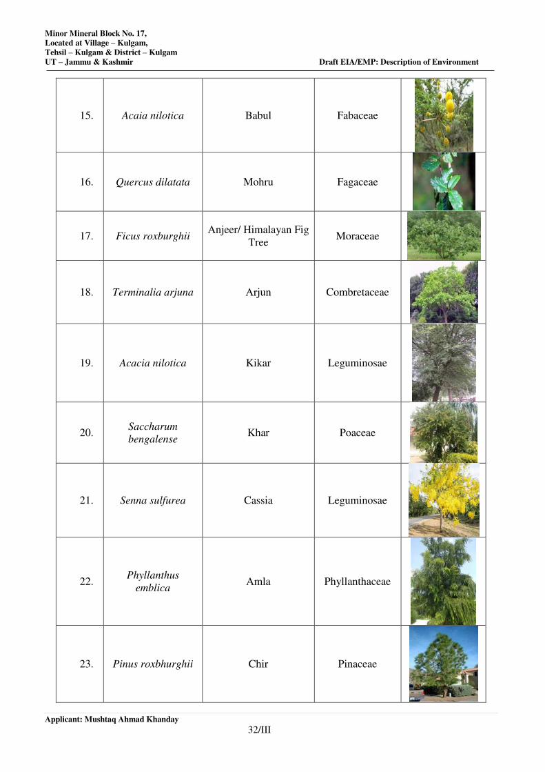
Minor Mineral Block No. 17,
Located at Village – Kulgam,
Tehsil – Kulgam & District – Kulgam
UT – Jammu & Kashmir Draft EIA/EMP: Description of Environment
Applicant: Mushtaq Ahmad Khanday
32/III
15. Acaia nilotica Babul Fabaceae
16. Quercus dilatata Mohru Fagaceae
17. Ficus roxburghii Anjeer/ Himalayan Fig
Tree Moraceae
18. Terminalia arjuna Arjun Combretaceae
19. Acacia nilotica Kikar Leguminosae
20. Saccharum
bengalense Khar Poaceae
21. Senna sulfurea Cassia Leguminosae
22. Phyllanthus
emblica Amla Phyllanthaceae
23. Pinus roxbhurghii Chir Pinaceae
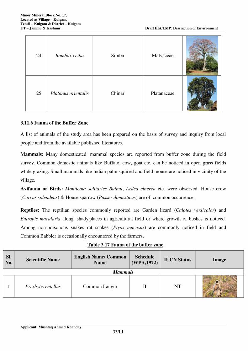
Minor Mineral Block No. 17,
Located at Village – Kulgam,
Tehsil – Kulgam & District – Kulgam
UT – Jammu & Kashmir Draft EIA/EMP: Description of Environment
Applicant: Mushtaq Ahmad Khanday
33/III
24. Bombax ceiba Simba Malvaceae
25. Platanus orientalis Chinar Platanaceae
3.11.6 Fauna of the Buffer Zone
A list of animals of the study area has been prepared on the basis of survey and inquiry from local
people and from the available published literatures.
Mammals: Many domesticated mammal species are reported from buffer zone during the field
survey. Common domestic animals like Buffalo, cow, goat etc. can be noticed in open grass fields
while grazing. Small mammals like Indian palm squirrel and field mouse are noticed in vicinity of the
village.
Avifauna or Birds: Monticola solitaries Bulbul, Ardea cinerea etc. were observed. House crow
(Corvus splendens) & House sparrow (Passer domesticus) are of common occurrence.
Reptiles: The reptilian species commonly reported are Garden lizard (Calotes versicolor) and
Eutropis macularia along shady places in agricultural field or where growth of bushes is noticed.
Among non-poisonous snakes rat snakes (Ptyas mucosus) are commonly noticed in field and
Common Babbler is occasionally encountered by the farmers.
Table 3.17 Fauna of the buffer zone
Sl.
No. Scientific Name
English Name/ Common
Name
Schedule
(WPA,1972) IUCN Status Image
Mammals
1 Presbytis entellus Common Langur II NT
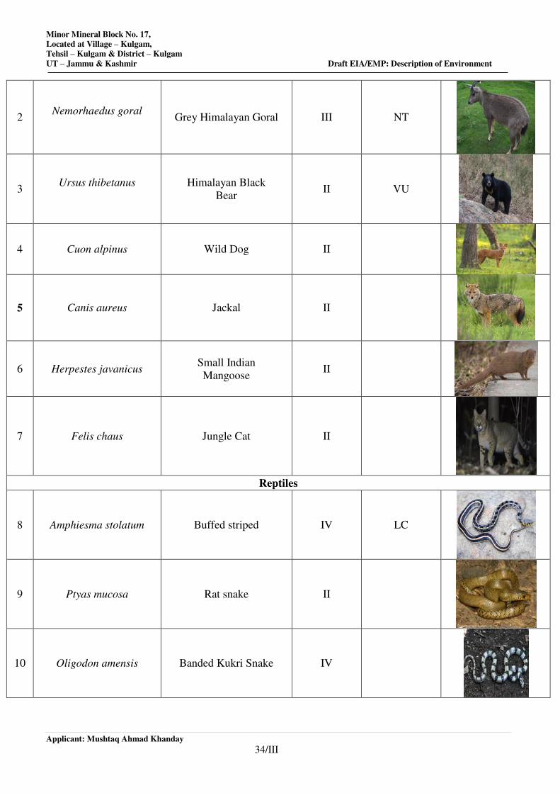
Minor Mineral Block No. 17,
Located at Village – Kulgam,
Tehsil – Kulgam & District – Kulgam
UT – Jammu & Kashmir Draft EIA/EMP: Description of Environment
Applicant: Mushtaq Ahmad Khanday
34/III
2 Nemorhaedus goral
Grey Himalayan Goral III NT
3 Ursus thibetanus
Himalayan Black
Bear II VU
4 Cuon alpinus Wild Dog II
5 Canis aureus Jackal II
6 Herpestes javanicus Small Indian
Mangoose II
7 Felis chaus Jungle Cat II
Reptiles
8 Amphiesma stolatum Buffed striped IV LC
9 Ptyas mucosa Rat snake II
10 Oligodon amensis Banded Kukri Snake IV
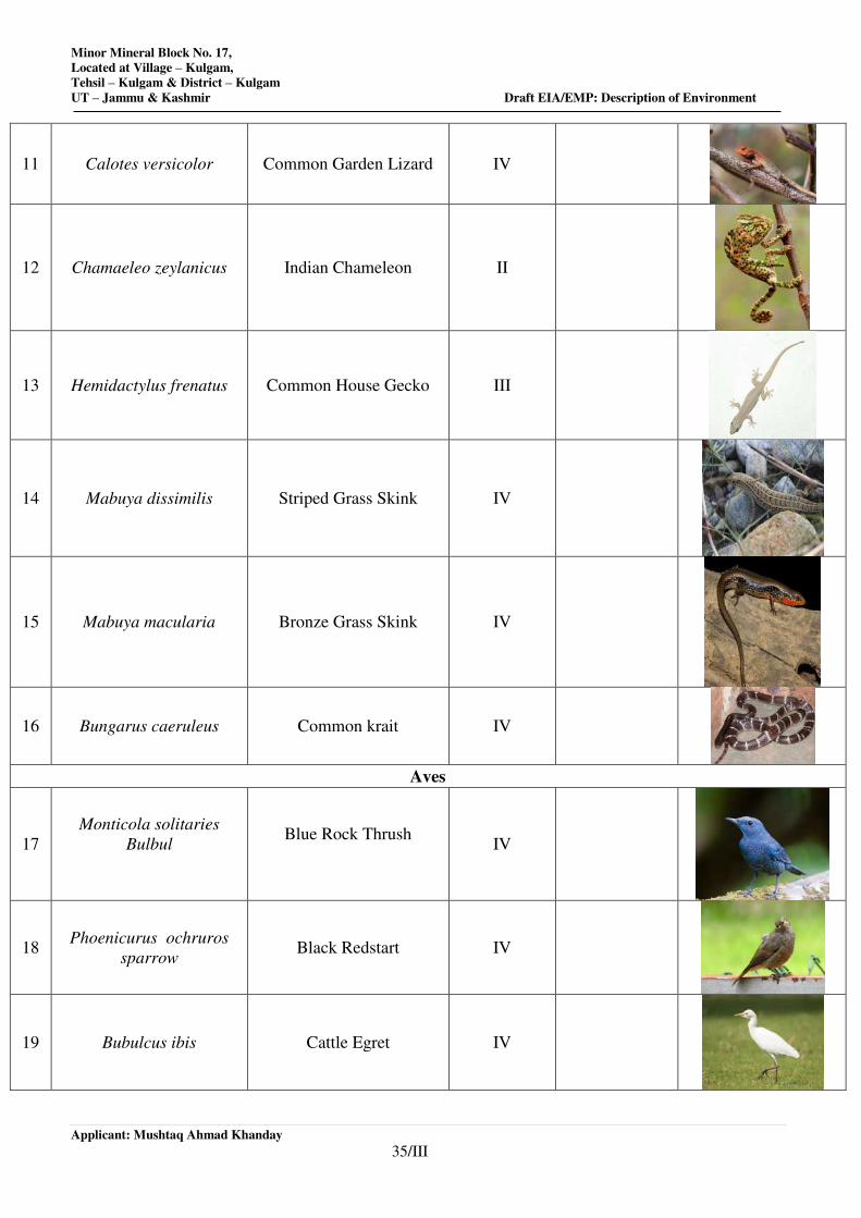
Minor Mineral Block No. 17,
Located at Village – Kulgam,
Tehsil – Kulgam & District – Kulgam
UT – Jammu & Kashmir Draft EIA/EMP: Description of Environment
Applicant: Mushtaq Ahmad Khanday
35/III
11 Calotes versicolor Common Garden Lizard IV
12 Chamaeleo zeylanicus Indian Chameleon II
13 Hemidactylus frenatus Common House Gecko III
14 Mabuya dissimilis Striped Grass Skink IV
15 Mabuya macularia Bronze Grass Skink IV
16 Bungarus caeruleus Common krait IV
Aves
17
Monticola solitaries
Bulbul
Blue Rock Thrush
IV
18 Phoenicurus ochruros
sparrow Black Redstart IV
19 Bubulcus ibis Cattle Egret IV
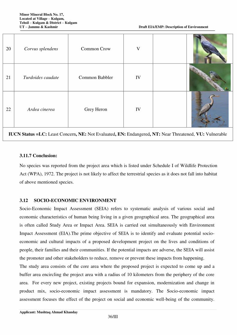
Minor Mineral Block No. 17,
Located at Village – Kulgam,
Tehsil – Kulgam & District – Kulgam
UT – Jammu & Kashmir Draft EIA/EMP: Description of Environment
Applicant: Mushtaq Ahmad Khanday
36/III
20 Corvus splendens Common Crow V
21 Turdoides caudate Common Babbler IV
22 Ardea cinerea Grey Heron IV
IUCN Status =LC: Least Concern, NE: Not Evaluated, EN: Endangered, NT: Near Threatened, VU: Vulnerable
3.11.7 Conclusion:
No species was reported from the project area which is listed under Schedule I of Wildlife Protection
Act (WPA), 1972. The project is not likely to affect the terrestrial species as it does not fall into habitat
of above mentioned species.
3.12 SOCIO-ECONOMIC ENVIRONMENT
Socio-Economic Impact Assessment (SEIA) refers to systematic analysis of various social and
economic characteristics of human being living in a given geographical area. The geographical area
is often called Study Area or Impact Area. SEIA is carried out simultaneously with Environment
Impact Assessment (EIA).The prime objective of SEIA is to identify and evaluate potential socio-
economic and cultural impacts of a proposed development project on the lives and conditions of
people, their families and their communities. If the potential impacts are adverse, the SEIA will assist
the promoter and other stakeholders to reduce, remove or prevent these impacts from happening.
The study area consists of the core area where the proposed project is expected to come up and a
buffer area encircling the project area with a radius of 10 kilometers from the periphery of the core
area. For every new project, existing projects bound for expansion, modernization and change in
product mix, socio-economic impact assessment is mandatory. The Socio-economic impact
assessment focuses the effect of the project on social and economic well-being of the community.

Minor Mineral Block No. 17,
Located at Village – Kulgam,
Tehsil – Kulgam & District – Kulgam
UT – Jammu & Kashmir Draft EIA/EMP: Description of Environment
Applicant: Mushtaq Ahmad Khanday
37/III
The effect may be direct or indirect. Again, the impact may be positive or negative.
3.12.3 Scope of the study
The Scope of socio-economic impact assessment of river bed material leased to Feroz Ahmad Wani is
as follows:
a) To collect baseline data of the study area.
b) To comprehend socio-economic status of the people living in the study area.
c) To assess probable impact of the project on social and economic aspects in the study area.
d) To measure the impact of the project on Quality of life of the people living in the study area.
e) To ensure sustainability of positive impact.
f) To suggest mitigation measures and agency responsible for taking action in case of adverse
impact.
3.12.4 Steps taken by Zenith Environment Consultancy. to prepare the SEIA report
Step 1: Literature review, which includes state profile, district profile, Pre – feasibility report, maps
etc.
Step 2: Referring to TOR to get aware of the direction of the State Environment Impact Assessment
committee.
Step 3: Identification of the study area and important landmarks therein.
Step 4: Preparation of List of villages and urban areas located in the study area and their distance and
direction from the project site.
Step 5: Grouping of villages and urban areas falling under core and buffer area.
Step 6: Site visit to collect the facts through observations
Step 7: Firming up of approach and methodology
Step 8: Finalization of Questionnaires – Listing schedule, Village and Household questionnaire.
Step 9: Collection of secondary data from Census Report, District profile, published and un-published
literatures, administrative records etc.
Step10: Data entry and data validation
Step 11: Generation of Tables
Step 12: Data Analysis and preparation of report.
3.12.5 Concept & Definition of Terms used in the report
Study Area: The study area, also known as impact area has been defined as the sum total of core
Minor Mineral Block No. 17,
Located at Village – Kulgam,
Tehsil – Kulgam & District – Kulgam
UT – Jammu & Kashmir Draft EIA/EMP: Description of Environment
Applicant: Mushtaq Ahmad Khanday
38/III
area and buffer area with a radius of 10 Kilometers from the periphery of the project site. The study
area includes all the land marks both natural and manmade, falling therein.
Quality of Life: The Quality of Life (QoL) refers to degree to which a person enjoys the important
possibilities of his/her life. The ‘Possibilities’ result from the opportunities and limitations, each
person has in his/her life and reflect the interaction of personal and environmental factors.
Enjoyment has two components: the experience of satisfaction and the possession or achievement
of some characteristic.
Household: A group of persons who normally live together and take their meals from a common
kitchen are called a household. Persons living in a household may be related or unrelated or a mix
of both. However, if a group of related or unrelated persons live in a house but do not take their
meals from the common kitchen, then they are not part of a common household. Each such person
is treated as a separate household. There may be one member households, two member households
or multi-member households.
Sex Ratio: Sex ratio is the ratio of females to males in a given population. It is expressed as
'number of females per 1000 males'.
Literates: All persons aged 7 years and above who can both read and write with understanding in
any language are taken as literate. It is not necessary for a person to have received any formal
education or passed any minimum educational standard for being treated as literate. People who are
blind but can read in Braille are also treated as literates.
Literacy Rate: Literacy rate of population is defined as the percentage of literates to the total
population aged 7 years and above.
Labour Force: The labour force is the number of people employed and unemployed in a
geographical entity. The size of the labour force is the sum total of persons employed and
unemployed. An unemployed person is defined as a person not employed but actively seeking work.
Normally, the labour force of a country consists of everyone of working age (commencing from 16
years) and below retirement (65 years) that are participating workers, that is people actively
employed or seeking employment. People not counted under labour force are students, retired
persons and people in prisons stay-at home people permanently disabled persons and discouraged
workers.
Work: Work is defined as participation in any economically productive activity with or without
compensation, wages or profit. Such participation may be physical and/or mental in nature. Work
involves not only actual work but also includes effective supervision and direction of work. The
Minor Mineral Block No. 17,
Located at Village – Kulgam,
Tehsil – Kulgam & District – Kulgam
UT – Jammu & Kashmir Draft EIA/EMP: Description of Environment
Applicant: Mushtaq Ahmad Khanday
39/III
work may be part time or full time or unpaid work in a farm, family enterprise or in any other
economic activity.
Worker: All persons engaged in 'work' are defined as workers. Persons who are engaged in
cultivation of land or milk production even solely for domestic consumption are also treated as
workers.
Main Workers: Those workers who had worked for the major part of the reference period (i.e. 6
months or more in the case of a year) are termed as Main Workers.
Marginal Workers: Those workers who did not work for the major part of the reference period
(i.e. less than 6 months) are termed as Marginal Workers.
Work participation rate: The work participation rate is the ratio between the labour force and the
overall size of their cohort (national population of the same age range). In the present study the
work participation rate is defined as the percentage of total workers (main and marginal) to total
population.
3.12.6 Approach
Research approach plays an important role to decide suitable methodology. It helps to develop
effective research design. There are two types of approaches – Deductive and Inductive.
For the preparation of the present report Inductive approach has been adopted. The work started
with collection of both primary and secondary data, observed a pattern in the data, developed a
hypothesis and finally prepared the report.
3.12.7 Methodology
For Socio-Economic Impact assessment (SEIA) of the proposed River bed mining project which
recourse to systematic analysis of various Socio-Economic characteristics, both in terms of quality
and quantity. Accordingly, both qualitative and quantitative data was collected through primary and
secondary sources. For collection of primary data, a sample survey was conducted across the study
area. For collection of secondary data ZENITH ENVIRONMENT CONSULTANCY approached
the Census Authority in the state for published data/information, visited state and district portal and
referred to administrative records of the state and district administration. The qualitative data deals
with description; they can be observed but not measured. Hence, codes were extensively used
during collection of qualitative data. They were decoded after data processing to facilitate data
analysis and report writing.
Sample design
Minor Mineral Block No. 17,
Located at Village – Kulgam,
Tehsil – Kulgam & District – Kulgam
UT – Jammu & Kashmir Draft EIA/EMP: Description of Environment
Applicant: Mushtaq Ahmad Khanday
40/III
In the rural areas two stage sampling design was adopted. The first stage unit was census villages
and the Ultimate Stage Units were households in the selected villages. The villages and households
were selected scientifically for collection of information.
In the urban area three stage sampling design was adopted. The first stage unit was town, second
stage was municipal wards and ultimate stage unit were households.
Sample Size
The sample size was selected taking into consideration the following factors:
95 % Confidence Limit (Table value: 1.96)
Margin of error (5%) (Table value: 0.05)
Standard deviation (∂)
Design effect
Non-response rate
The Sample size at each level was worked out by applying the following formula:
n = [z*s/E] ^ 2,
Where z is the z value for the level of confidence chosen, s is the estimated standard deviation and
E is the allowable error.
3.12.8 Method of selection of First Stage Units
Probability Proportional to Size (PPS) was adopted to select the villages from the list of census
villages. The households were selected by adopting linear systematic sampling method.
Mapping & Listing
In each sample village complete mapping and listing was undertaken. The maps were prepared for
the sample villages. These maps are hypothetical and not to the scale. Listing was done in Schedule
0.0. The objective of mapping & listing was to develop a frame for selection of households for
sample survey. The Listing of structures was undertaken from south-west corner of the village
moving in clock-wise direction and all the structures including hidden structures were covered for
listing. Both residential and non-residential structures were listed for the preparation of village
frame.
3.12.9 Baseline Data
Baseline data refers to basic information collected before a project/scheme is implemented. It is
used later to provide a comparison for assessing impact of the project. Any attempt to collect base
line data while undertaking actual impact assessment study is faced with recall error. The present
report is provided with following base line data for the study area as a whole.
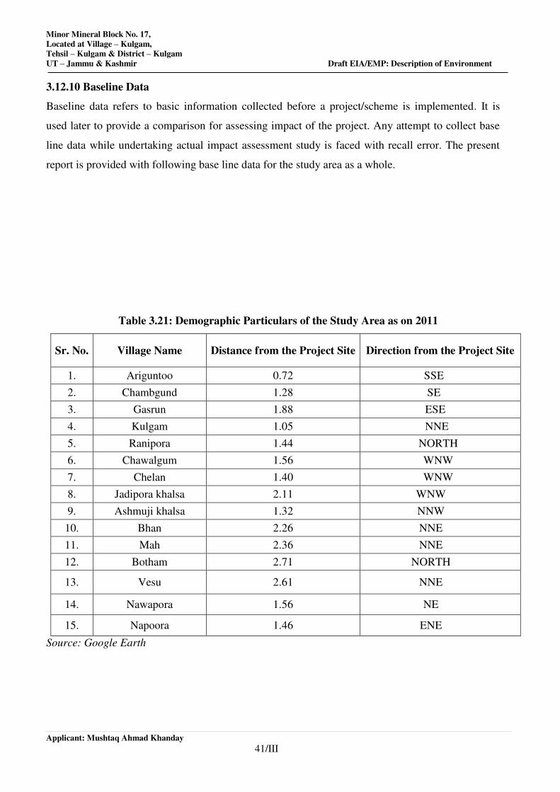
Minor Mineral Block No. 17,
Located at Village – Kulgam,
Tehsil – Kulgam & District – Kulgam
UT – Jammu & Kashmir Draft EIA/EMP: Description of Environment
Applicant: Mushtaq Ahmad Khanday
41/III
3.12.10 Baseline Data
Baseline data refers to basic information collected before a project/scheme is implemented. It is
used later to provide a comparison for assessing impact of the project. Any attempt to collect base
line data while undertaking actual impact assessment study is faced with recall error. The present
report is provided with following base line data for the study area as a whole.
Table 3.21: Demographic Particulars of the Study Area as on 2011
Sr. No. Village Name Distance from the Project Site Direction from the Project Site
1. Ariguntoo 0.72 SSE
2. Chambgund 1.28 SE
3. Gasrun 1.88 ESE
4. Kulgam 1.05 NNE
5. Ranipora 1.44 NORTH
6. Chawalgum 1.56 WNW
7. Chelan 1.40 WNW
8. Jadipora khalsa 2.11 WNW
9. Ashmuji khalsa 1.32 NNW
10. Bhan 2.26 NNE
11. Mah 2.36 NNE
12. Botham 2.71 NORTH
13. Vesu 2.61 NNE
14. Nawapora 1.56 NE
15. Napoora 1.46 ENE
Source: Google Earth
Minor Mineral Block No. 17,
Located at Village – Kulgam,
Tehsil – Kulgam & District – Kulgam
UT – Jammu & Kashmir Draft EIA/EMP: Description of Environment
Applicant: Mushtaq Ahmad Khanday
42/III
3.12.10 Socio-economic Impact of the project
Impact on Demographic composition
The proposed river bed mining project at Tehsil- Kulgam, District- Kulgam will hardly make any
difference in the demographic composition of the study area as the additional employment it
envisages to create will be met locally to the maximum extent. Hence, the chances of in-migration
of people from outside the study area are remote. Accordingly, there will be no variation in the total
population of the study area including that of sex ratio when the mine starts operating.
Employment Opportunities
The proposed river bed mining project at Tehsil- Kulgam, District- Kulgam will provide direct
employment up to 10 persons in each block, 2 will be driver, 2 will be operator and 2 will be
Supervisory staffs. The Supervisory staffs will include Mines Manager and Supervisor. The project
promoter has planned to recruit the semi-skilled and unskilled workers locally. Every effort will be
made to recruit and deploy the skilled and Supervisory staffs locally after imparting proper training
to them. In rare cases they will be recruited from outside the study area. Besides, the above
employment for persons belonging to informal sector will be generated due to opening of the above
Nallah bed mine. It is a positive and direct impact of the project since it will provide employment
opportunities to the local people.
Impact on Agriculture
No negative impact on agricultural production in the study area is anticipated due to mining of river
bed material at Tehsil- Kulgam, and District- Kulgam. Hence no agriculture is possible in the lease
area due to its sand, boulder and bajri.
Impact on road development
Movement of trucks and other vehicles to and fro the mine is expected to increase substantially,
when mining will start. The existing roads connecting the river bed with the national and state
highways are mostly narrow mud roads. There will be mud slide and traffic bottle neck if these
roads are not widened and their conditions are not improved by making them paved roads. Hence,
there is ample scope for road development in and around the mining areas.
Impact on Law & Order
As most of the workers to be employed are local people no law & order problem is envisaged. It is
expected that the workers will attend to their duties from their residence and return to their homes
after the day’s work. There would have been law & order problem if the workers were migrants and
lived in shanties closed to the mining area. However, to meet any untoward incident one police post
may be set up closed to the mining site.

Minor Mineral Block No. 17,
Located at Village – Kulgam,
Tehsil – Kulgam & District – Kulgam
UT – Jammu & Kashmir Draft EIA/EMP: Description of Environment
Applicant: Mushtaq Ahmad Khanday
43/III
Impact on Health
a) Safe work environment: The project proponent shall ensure health and safety of all the
employees at work. He will provide and maintain a safe work environment and ensure that the
machinery and equipment in use is safe for employees. Further, he will ensure that working
arrangements are not hazardous to employees.
b) Provision of First Aid: The first aid treatment shall reflect the hazards associated with the
mining of sand, boulder and Bajri. The first aiders must be well trained in handling patients
working in river bed mining material.
c) Regular health examination: For all mine workers regular health examination must be
compulsory. The regular health examination will cover treatment of serious back injury;
existing asthma or respiratory diseases, existing skin diseases, lung function test (pre and post
ventolin, Audiograms, Chest X- ray etc.)
d) No work for temporal disabilities: The workers having temporary disability must stop doing
the job till he/she recovers from disabilities.
e) Health Education: Adequate health education and information related to the job shall be
provided to the workers. Baseline health information shall be recorded for future references.
f) Tie up with the nearest hospital for medical help: To meet the medical needs of the mine
workers tie-ups with nearest hospitals may be made. Efforts will be made to reserve few beds in
the above hospitals for the workers of the upcoming mining project. This will ensure timely
medical aid to the affected persons.
g) Supply of Mask, Gloves: The workers in the river bed material mine are subject to respiratory
diseases. For protection from dust it will be made compulsory for all workers to wear masks
and gloves, while working in the mine.
h) Administration of Anti-venom injections: Provision of Anti-venom therapy will be made
available for administration to the workers in case of snake, spider and insect bites, while
working in the mine.
i) Special telephone number: A special telephone number will be made available to the workers
in case of emergency so that they can dial the same for medical assistances. Further, efforts will
be made to provide vehicles to the patients in short duration for shifting to the health
institutions.
j) Special Group Insurance Scheme: All the mine workers have been planned to be covered
under a Group Insurance Scheme of LIC or any other Insurance company.
Minor Mineral Block No. 17,
Located at Village – Kulgam,
Tehsil – Kulgam & District – Kulgam
UT – Jammu & Kashmir Draft EIA/EMP: Description of Environment
Applicant: Mushtaq Ahmad Khanday
44/III
Perception of the people
During site visit people living in the study area were asked to indicate their perception about the
proposed river bed material mining project at Tehsil- Kulgam, District- Kulgam. Majority of them
welcomed the project since it would create employment opportunities for the local people. They
retorted that by implementing such employment oriented projects the economic condition of the
common people can be improved. The overall perception of the people in the study area on the
proposed mining project was ‘Very Good’. They said that they will welcome the project whole
heartedly if employment opportunities in the proposed mining project are guaranteed for the local
people.
3.12.11 OCCUPATIONAL PATTERN
The overall percentage of workers in the area is 36.88 %.
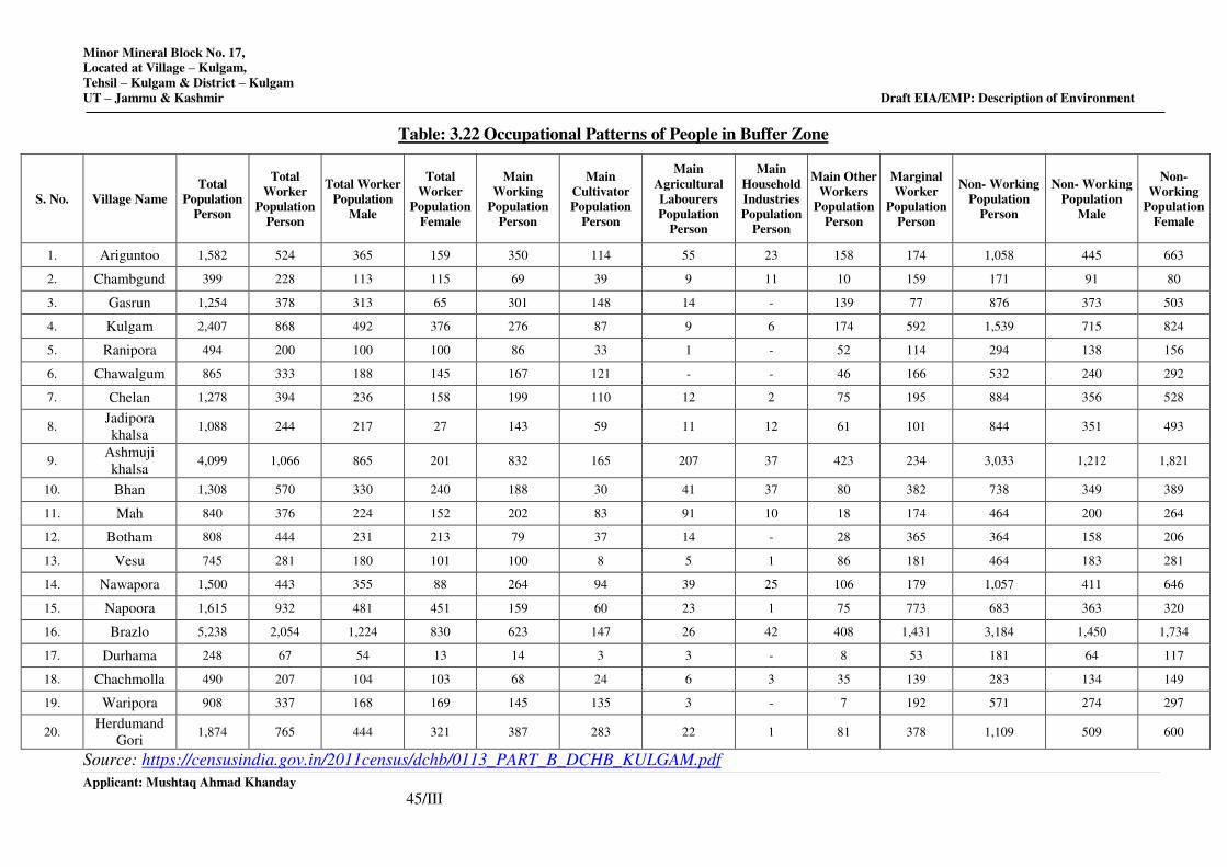
Minor Mineral Block No. 17,
Located at Village – Kulgam,
Tehsil – Kulgam & District – Kulgam
UT – Jammu & Kashmir Draft EIA/EMP: Description of Environment
Applicant: Mushtaq Ahmad Khanday
45/III
Table: 3.22 Occupational Patterns of People in Buffer Zone
S. No. Village Name
Total
Population
Person
Total
Worker
Population
Person
Total Worker
Population
Male
Total
Worker
Population
Female
Main
Working
Population
Person
Main
Cultivator
Population
Person
Main
Agricultural
Labourers
Population
Person
Main
Household
Industries
Population
Person
Main Other
Workers
Population
Person
Marginal
Worker
Population
Person
Non- Working
Population
Person
Non- Working
Population
Male
Non-
Working
Population
Female
1. Ariguntoo 1,582 524 365 159 350 114 55 23 158 174 1,058 445 663
2. Chambgund 399 228 113 115 69 39 9 11 10 159 171 91 80
3. Gasrun 1,254 378 313 65 301 148 14 - 139 77 876 373 503
4. Kulgam 2,407 868 492 376 276 87 9 6 174 592 1,539 715 824
5. Ranipora 494 200 100 100 86 33 1 - 52 114 294 138 156
6. Chawalgum 865 333 188 145 167 121 - - 46 166 532 240 292
7. Chelan 1,278 394 236 158 199 110 12 2 75 195 884 356 528
8. Jadipora
khalsa 1,088 244 217 27 143 59 11 12 61 101 844 351 493
9. Ashmuji
khalsa 4,099 1,066 865 201 832 165 207 37 423 234 3,033 1,212 1,821
10. Bhan 1,308 570 330 240 188 30 41 37 80 382 738 349 389
11. Mah 840 376 224 152 202 83 91 10 18 174 464 200 264
12. Botham 808 444 231 213 79 37 14 - 28 365 364 158 206
13. Vesu 745 281 180 101 100 8 5 1 86 181 464 183 281
14. Nawapora 1,500 443 355 88 264 94 39 25 106 179 1,057 411 646
15. Napoora 1,615 932 481 451 159 60 23 1 75 773 683 363 320
16. Brazlo 5,238 2,054 1,224 830 623 147 26 42 408 1,431 3,184 1,450 1,734
17. Durhama 248 67 54 13 14 3 3 - 8 53 181 64 117
18. Chachmolla 490 207 104 103 68 24 6 3 35 139 283 134 149
19. Waripora 908 337 168 169 145 135 3 - 7 192 571 274 297
20. Herdumand
Gori 1,874 765 444 321 387 283 22 1 81 378 1,109 509 600
Source: https://censusindia.gov.in/2011census/dchb/0113_PART_B_DCHB_KULGAM.pdf
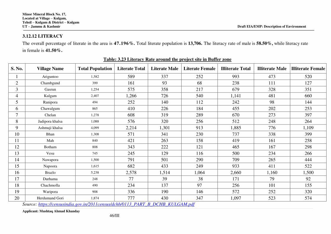
Minor Mineral Block No. 17,
Located at Village – Kulgam,
Tehsil – Kulgam & District – Kulgam
UT – Jammu & Kashmir Draft EIA/EMP: Description of Environment
Applicant: Mushtaq Ahmad Khanday
46/III
3.12.12 LITERACY
The overall percentage of literate in the area is 47.196%. Total literate population is 13,706. The literacy rate of male is 58.50%, while literacy rate
in female is 41.50%.
Table: 3.23 Literacy Rate around the project site in Buffer zone
S. No. Village Name Total Population Literate Total Literate Male Literate Female Illiterate Total Illiterate Male Illiterate Female
1 Ariguntoo 1,582 589 337 252 993 473 520
2 Chambgund 399 161 93 68 238 111 127
3 Gasrun 1,254 575 358 217 679 328 351
4 Kulgam 2,407 1,266 726 540 1,141 481 660
5 Ranipora 494 252 140 112 242 98 144
6 Chawalgum 865 410 226 184 455 202 253
7 Chelan 1,278 608 319 289 670 273 397
8 Jadipora khalsa 1,088 576 320 256 512 248 264
9 Ashmuji khalsa 4,099 2,214 1,301 913 1,885 776 1,109
10 Bhan 1,308 571 341 230 737 338 399
11 Mah 840 421 263 158 419 161 258
12 Botham 808 343 222 121 465 167 298
13 Vesu 745 245 129 116 500 234 266
14 Nawapora 1,500 791 501 290 709 265 444
15 Napoora 1,615 682 433 249 933 411 522
16 Brazlo 5,238 2,578 1,514 1,064 2,660 1,160 1,500
17 Durhama 248 77 39 38 171 79 92
18 Chachmolla 490 234 137 97 256 101 155
19 Waripora 908 336 190 146 572 252 320
20 Herdumand Gori 1,874 777 430 347 1,097 523 574
Source: https://censusindia.gov.in/2011census/dchb/0113_PART_B_DCHB_KULGAM.pdf
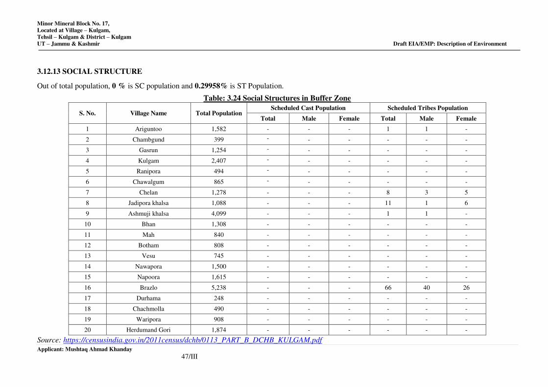
Minor Mineral Block No. 17,
Located at Village – Kulgam,
Tehsil – Kulgam & District – Kulgam
UT – Jammu & Kashmir Draft EIA/EMP: Description of Environment
Applicant: Mushtaq Ahmad Khanday
47/III
3.12.13 SOCIAL STRUCTURE
Out of total population, 0 % is SC population and 0.29958% is ST Population.
Table: 3.24 Social Structures in Buffer Zone
S. No. Village Name Total Population Scheduled Cast Population Scheduled Tribes Population
Total Male Female Total Male Female
1 Ariguntoo 1,582 - - - 1 1 -
2 Chambgund 399 - - - - - -
3 Gasrun 1,254 - - - - - -
4 Kulgam 2,407 - - - - - -
5 Ranipora 494 - - - - - -
6 Chawalgum 865 - - - - - -
7 Chelan 1,278 - - - 8 3 5
8 Jadipora khalsa 1,088 - - - 11 1 6
9 Ashmuji khalsa 4,099 - - - 1 1 -
10 Bhan 1,308 - - - - - -
11 Mah 840 - - - - - -
12 Botham 808 - - - - - -
13 Vesu 745 - - - - - -
14 Nawapora 1,500 - - - - - -
15 Napoora 1,615 - - - - - -
16 Brazlo 5,238 - - - 66 40 26
17 Durhama 248 - - - - - -
18 Chachmolla 490 - - - - - -
19 Waripora 908 - - - - - -
20 Herdumand Gori 1,874 - - - - - -
Source: https://censusindia.gov.in/2011census/dchb/0113_PART_B_DCHB_KULGAM.pdf
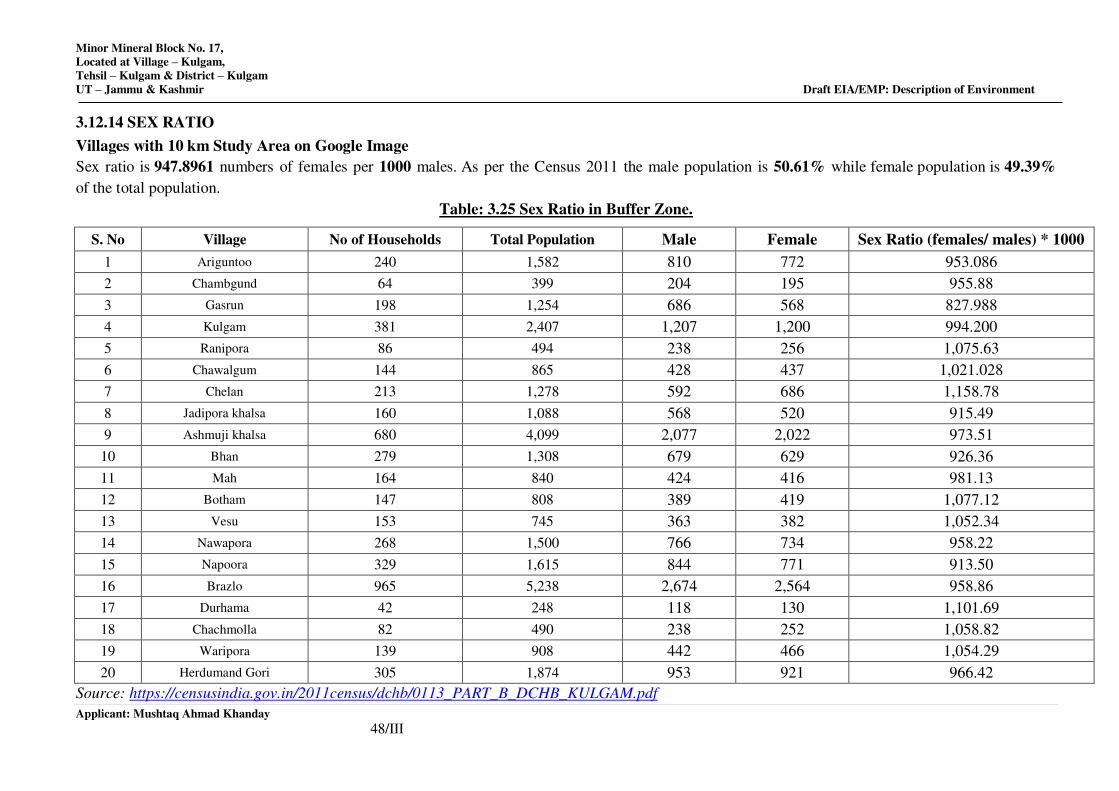
Minor Mineral Block No. 17,
Located at Village – Kulgam,
Tehsil – Kulgam & District – Kulgam
UT – Jammu & Kashmir Draft EIA/EMP: Description of Environment
Applicant: Mushtaq Ahmad Khanday
48/III
3.12.14 SEX RATIO
Villages with 10 km Study Area on Google Image
Sex ratio is 947.8961 numbers of females per 1000 males. As per the Census 2011 the male population is 50.61% while female population is 49.39%
of the total population.
Table: 3.25 Sex Ratio in Buffer Zone.
S. No Village No of Households Total Population Male Female Sex Ratio (females/ males) * 1000
1 Ariguntoo 240 1,582 810 772 953.086
2 Chambgund 64 399 204 195 955.88
3 Gasrun 198 1,254 686 568 827.988
4 Kulgam 381 2,407 1,207 1,200 994.200
5 Ranipora 86 494 238 256 1,075.63
6 Chawalgum 144 865 428 437 1,021.028
7 Chelan 213 1,278 592 686 1,158.78
8 Jadipora khalsa 160 1,088 568 520 915.49
9 Ashmuji khalsa 680 4,099 2,077 2,022 973.51
10 Bhan 279 1,308 679 629 926.36
11 Mah 164 840 424 416 981.13
12 Botham 147 808 389 419 1,077.12
13 Vesu 153 745 363 382 1,052.34
14 Nawapora 268 1,500 766 734 958.22
15 Napoora 329 1,615 844 771 913.50
16 Brazlo 965 5,238 2,674 2,564 958.86
17 Durhama 42 248 118 130 1,101.69
18 Chachmolla 82 490 238 252 1,058.82
19 Waripora 139 908 442 466 1,054.29
20 Herdumand Gori 305 1,874 953 921 966.42
Source: https://censusindia.gov.in/2011census/dchb/0113_PART_B_DCHB_KULGAM.pdf
Minor Mineral Block No. 17,
Located at Village – Kulgam,
Tehsil – Kulgam & District – Kulgam
UT – Jammu & Kashmir Draft EIA/EMP: Description of Environment
Applicant: Mushtaq Ahmad Khanday
49/III
3.12.15 CONCLUSION
The implementation of the river bed mining project at Tehsil - Kulgam, District - Kulgam, and State – Jammu & Kashmir will generate both direct and
indirect employment for the local aspirants. The issue of environment clearance to the mine lease holder will make mining of river bed material legally
valid and it will generate revenue for the state. It is expected that prospective entrepreneurs will venture to set up industrial units in the vicinity of the
project area to provide employment opportunities to the local people. With the implementation of the proposed river bed mining Project the occupational
pattern of the people in the area will change making more people engaged in mining, industrial and business activities rather in agriculture. Thus there
will be a gradual shifting of population from agriculture to other sectors of the economy including service sectors.
The study area is still lacking in health and educational facilities. It is expected that same will improve to a great extent with the commissioning of
proposed River bed mining project and associated industrial and business activities.
*************
CHAPTER-IV
ANTICIPATED ENVIRONMENTAL IMPACT AND MITIGATION MEASURES
INDEX
S. No. CONTENTS Page No.
4.0 GENERAL 1/VI
4.1 IDENTICAL OF IMPACTS 2/VI
4.2 METHODOLOGY OF ASSESSMENT 2/VI
4.3 CRITERIA OF ASSESSMENT 3/VI
4.4 ASSESSMENT OF ENVIRONMENTAL IMPACTS AND
MITIGATION MEASURES DURING CONSTRUCTION PHASE
3/VI
4.5 IMPACT MATRIX 21/VI
Minor Mineral Block No. 17,
Located at Village –Kulgam,
Tehsil – Kulgam & District – Kulgam,
UT – Jammu & Kashmir
Applicant: Mushtaq Ahmad Khanday 1/IV
4.0 GENERAL
The mining projects along with other activities in vicinity may influence the existing physical,
biological and social components of environment. In case of mining projects, impacts on
biodiversity, air pollution, water pollution, waste management and social issues may be
associated. These impacts could be minimized up to a significant level when scientific mining
procedures, guidelines and rules are taken into account. The nature and characteristics of impacts
are required to be taken into consideration while evaluating the magnitude of impacts. Open cast
mining activities have different types of impacts on nearby environment with respect to both
magnitude and significance. During the working life of mine, air, water, noise and land use are
likely to be affected due to mining of minerals and associated activities. The various anticipated
impacts and mitigation measures are discussed in this chapter.
Environmental factors (“impacts”) associated with, or caused by, mining, as distinct from those
associated with the subsequent use of the extracted minerals, are largely confined to relatively
restricted areas in the vicinity of the appropriate geological formation and Upstream in the
catchment where the deposit is located. These impacts would normally be considered to be
“direct” impacts that can be linked directly to the mining and ore processing operations.
In contrast, there are many other types of impacts that are associated with mining activities, but
do not occur as a direct consequence of the mining activity itself. These would be considered to
be “indirect” impacts. A typical example would be the variety of impacts caused by the
activities of individuals and organizations that take place in areas peripheral to a mining
operation. In several instances, these indirect impacts can exceed the total environmental impact
of the original mining operation and thereby require a far greater degree of management
attention.
The term “cumulative impacts” is generally applied to those situations where several impacts
from different processes and activities combine to exert a greater set of (usually adverse) effects
than those that would be predicted from the original activities. An example of this type of
situation would be the combination of adverse effects that a community would experience if it
were exposed simultaneously to atmospheric emissions of gases, windblown dust and effluent
discharged from a mining operation. A second example would be the situation where effluents
and discharges from several mining operations or industries in a single catchment exerted a set of
combined effects or impacts on the river system draining the basin. In some circumstances, there
may be synergistic effects, where the combined (cumulative) effect of two different activities is
greater than would be expected from a simple combination of the two isolated activities.
Minor Mineral Block No. 17,
Located at Village –Kulgam,
Tehsil – Kulgam & District – Kulgam,
UT – Jammu & Kashmir
Applicant: Mushtaq Ahmad Khanday 2/IV
Similarly, there are also certain circumstances where the impacts from two different activities
effectively neutralize each other – this situation is often referred to as an “antagonistic” or
“counteractive” interaction. Three typical wastes provide a simple example of this type of
situation, namely: acid rock drainage, raw sewage and power station ash. Individually, these
wastes exert serious adverse impacts on aquatic environments; in combination, however, they
neutralize and offset each other so that their combined effect on the aquatic environment is often
innocuous.
4.1 IDENTIFICATION OF IMPACTS
The areas of environmental concerns for which the impacts and their predictions are taken into
consideration are mainly:
• Land Environment
• Water Environment
• Air Environment
• Noise Environment
• Biological Environment–Ecological Flora and fauna
• Socio economic Environment
• Occupational Health and Safety
The impacts can be further categorized as positive impacts and negative impacts depending upon
their nature, potential and magnitude in construction phase and in operation phase.
4.2 METHODOLOGY OF ASSESSMENT
The overall impact on Air, Water, Noise, Soil, Socio Economic, Ecological, Land environment
etc. will be assessed. In addition, it will be weighed in positive impact and negative impact
created by the project. To estimate the impact produced, a framework has been designed as
given ahead:
• Environmental Sensitivity is defined
• Status of work done till date
• Status of activities (in quantitative terms) undertaken during project period.
4.3 CRITERIA OF ASSESSMENT
A detailed damage to environment resulted due to construction activities assessed by
ascertaining weight-age matrix index method. Seven scale of matrix has been fixed ranging
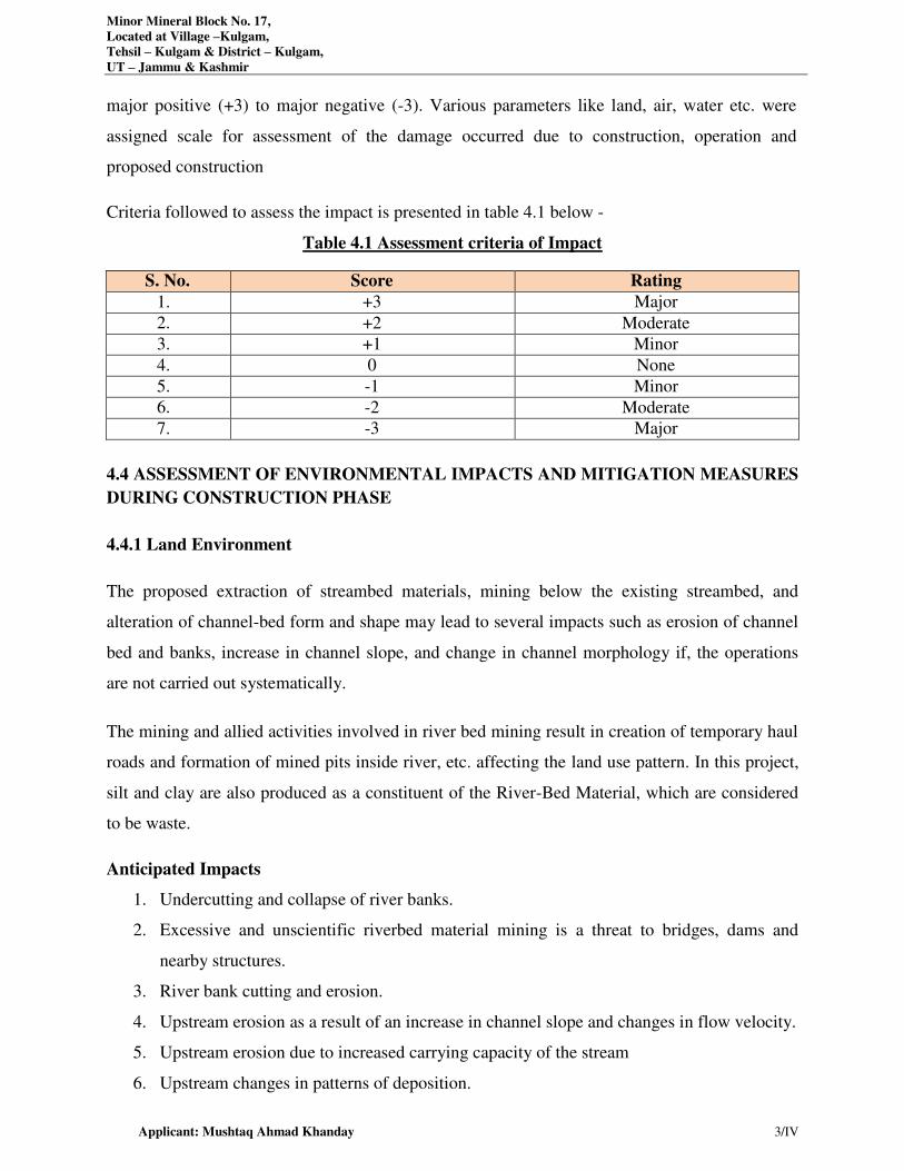
Minor Mineral Block No. 17,
Located at Village –Kulgam,
Tehsil – Kulgam & District – Kulgam,
UT – Jammu & Kashmir
Applicant: Mushtaq Ahmad Khanday 3/IV
major positive (+3) to major negative (-3). Various parameters like land, air, water etc. were
assigned scale for assessment of the damage occurred due to construction, operation and
proposed construction
Criteria followed to assess the impact is presented in table 4.1 below -
Table 4.1 Assessment criteria of Impact
S. No. Score Rating
1. +3 Major
2. +2 Moderate
3. +1 Minor
4. 0 None
5. -1 Minor
6. -2 Moderate
7. -3 Major
4.4 ASSESSMENT OF ENVIRONMENTAL IMPACTS AND MITIGATION MEASURES
DURING CONSTRUCTION PHASE
4.4.1 Land Environment
The proposed extraction of streambed materials, mining below the existing streambed, and
alteration of channel-bed form and shape may lead to several impacts such as erosion of channel
bed and banks, increase in channel slope, and change in channel morphology if, the operations
are not carried out systematically.
The mining and allied activities involved in river bed mining result in creation of temporary haul
roads and formation of mined pits inside river, etc. affecting the land use pattern. In this project,
silt and clay are also produced as a constituent of the River-Bed Material, which are considered
to be waste.
Anticipated Impacts
1. Undercutting and collapse of river banks.
2. Excessive and unscientific riverbed material mining is a threat to bridges, dams and
nearby structures.
3. River bank cutting and erosion.
4. Upstream erosion as a result of an increase in channel slope and changes in flow velocity.
5. Upstream erosion due to increased carrying capacity of the stream
6. Upstream changes in patterns of deposition.
Minor Mineral Block No. 17,
Located at Village –Kulgam,
Tehsil – Kulgam & District – Kulgam,
UT – Jammu & Kashmir
Applicant: Mushtaq Ahmad Khanday 4/IV
7. Changes in channel bed and habitat type.
Mitigation Measures
1. Since the project is mainly for sand, bajri and boulder excavation (soil deficient), no loss of top soil is
involved.
2. The silt and clay generated as waste will be used for plantation or filling up low lying area elsewhere.
3. Mining will be restricted to the lease area to a maximum depth of 1.0 m from the surface as
per the provision of Jammu & Kashmir Minor Mineral Concession, Storage, Transportation
of Minerals and Prevention of Illegal Mining Rules, 2016.
4. A barrier of 7.5 m width has been left from the lease boundary as a statutory area and further
pit slope shall be maintained below 45°.
5. Safety zones with respect to bridge, hydraulic points and or/embankment as prescribed by the
Department of Geology and Mining should be strictly adhered to
6. In this activity, the work is proposed to be done opencast semi-mechanized method. The river
bed material (RBM) excavated will be removed by light weight excavators and directly
loaded in tippers from the place of excavation to the mineral processing units or construction
sites.
7. The mining is planned in non monsoon seasons only, so that the excavated area gets replenished
during the monsoon each year.
8. Grasses and bushes which have fibrous roots at the first instance are proposed to grown along
the banks which enhances the binding properties of the soil. Hence protecting the banks.
9. The systematic and scientific removal of sand, bajri and boulder will not cause bed
degradation.
10. Restoration of bank will be ensured at the end of mine closure every year.
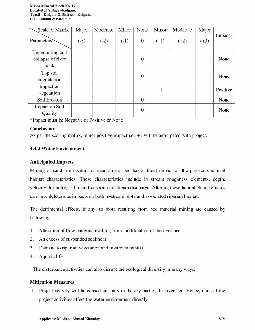
Minor Mineral Block No. 17,
Located at Village –Kulgam,
Tehsil – Kulgam & District – Kulgam,
UT – Jammu & Kashmir
Applicant: Mushtaq Ahmad Khanday 5/IV
Scale of Matrix
Parameters
Major Moderate Minor None Minor Moderate Major Impact*
(-3) (-2) (-1) 0 (+1) (+2) (+3)
Undercutting and
collapse of river
bank
0 None
Top soil
degradation 0 None
Impact on
vegetation +1 Positive
Soil Erosion 0 None
Impact on Soil
Quality 0 None
*Impact must be Negative or Positive or None
Conclusion:
As per the scoring matrix, minor positive impact i.e., +1 will be anticipated with project.
4.4.2 Water Environment
Anticipated Impacts
Mining of sand from within or near a river bed has a direct impact on the physico-chemical
habitat characteristics. These characteristics include in stream roughness elements, depth,
velocity, turbidity, sediment transport and stream discharge. Altering these habitat characteristics
can have deleterious impacts on both in-stream biota and associated riparian habitat.
The detrimental effects, if any, to biota resulting from bed material mining are caused by
following:
1. Alteration of flow patterns resulting from modification of the river bed
2. An excess of suspended sediment
3. Damage to riparian vegetation and in-stream habitat
4. Aquatic life
The disturbance activities can also disrupt the ecological diversity in many ways.
Mitigation Measures
1. Project activity will be carried out only in the dry part of the river bed. Hence, none of the
project activities affect the water environment directly.
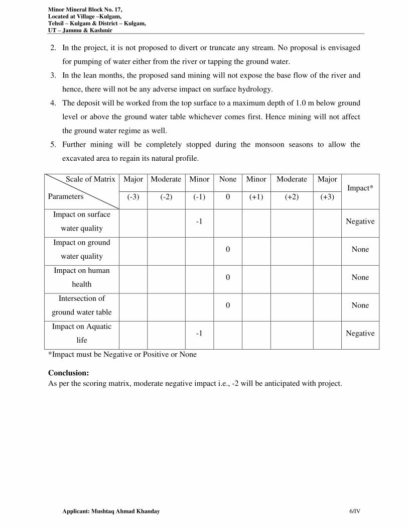
Minor Mineral Block No. 17,
Located at Village –Kulgam,
Tehsil – Kulgam & District – Kulgam,
UT – Jammu & Kashmir
Applicant: Mushtaq Ahmad Khanday 6/IV
2. In the project, it is not proposed to divert or truncate any stream. No proposal is envisaged
for pumping of water either from the river or tapping the ground water.
3. In the lean months, the proposed sand mining will not expose the base flow of the river and
hence, there will not be any adverse impact on surface hydrology.
4. The deposit will be worked from the top surface to a maximum depth of 1.0 m below ground
level or above the ground water table whichever comes first. Hence mining will not affect
the ground water regime as well.
5. Further mining will be completely stopped during the monsoon seasons to allow the
excavated area to regain its natural profile.
Scale of Matrix
Parameters
Major Moderate Minor None Minor Moderate Major Impact*
(-3) (-2) (-1) 0 (+1) (+2) (+3)
Impact on surface
water quality -1 Negative
Impact on ground
water quality 0 None
Impact on human
health 0 None
Intersection of
ground water table 0 None
Impact on Aquatic
life -1 Negative
*Impact must be Negative or Positive or None
Conclusion:
As per the scoring matrix, moderate negative impact i.e., -2 will be anticipated with project.
Minor Mineral Block No. 17,
Located at Village –Kulgam,
Tehsil – Kulgam & District – Kulgam,
UT – Jammu & Kashmir
Applicant: Mushtaq Ahmad Khanday 7/IV
4.4.3 Air Environment
Emission of fugitive dust is envisaged due to:
i. Mining Activities includes excavation and lifting of minerals. The whole process will be done
opencast semi-mechanized. Therefore the dust generated is likely to be insignificant as
compared to mining processes involving drilling, blasting, mechanized loading etc.
ii. Transportation of minerals will be done by road using trucks. Fugitive dust emission is
expected from the transportation of trucks on the haul roads. Evaluation of fugitive dust
emission has been done by using line source model as given below:
Air Modeling
A detailed study on emission sources and quantification of pollutant concentration by means of
dispersion modeling is required to access the environmental impact of a mine. On the basis of the
predicted increments to air pollutant concentrations, an effective mitigation and environmental
plan can be devised for sensitive areas. In case of river bed mining, as there are no blasting and
drilling activities, the impacts may only be caused by material handling and transportation
activities. The material is mostly wet, and therefore effect is minimal.
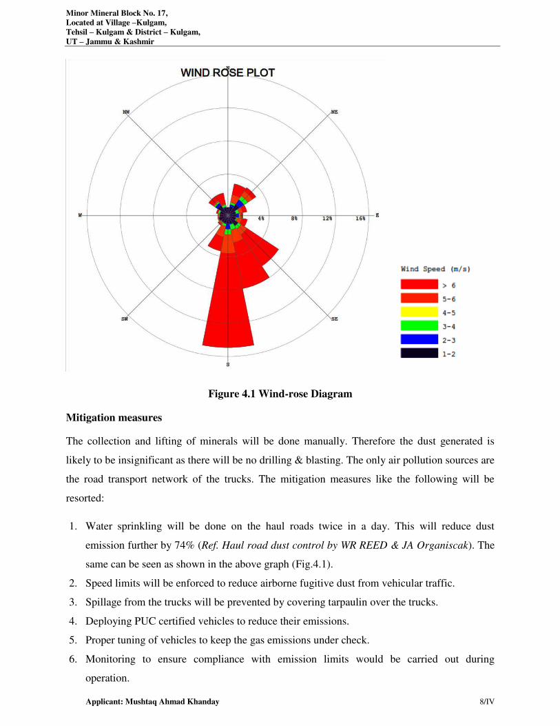
Minor Mineral Block No. 17,
Located at Village –Kulgam,
Tehsil – Kulgam & District – Kulgam,
UT – Jammu & Kashmir
Applicant: Mushtaq Ahmad Khanday 8/IV
Figure 4.1 Wind-rose Diagram
Mitigation measures
The collection and lifting of minerals will be done manually. Therefore the dust generated is
likely to be insignificant as there will be no drilling & blasting. The only air pollution sources are
the road transport network of the trucks. The mitigation measures like the following will be
resorted:
1. Water sprinkling will be done on the haul roads twice in a day. This will reduce dust
emission further by 74% (Ref. Haul road dust control by WR REED & JA Organiscak). The
same can be seen as shown in the above graph (Fig.4.1).
2. Speed limits will be enforced to reduce airborne fugitive dust from vehicular traffic.
3. Spillage from the trucks will be prevented by covering tarpaulin over the trucks.
4. Deploying PUC certified vehicles to reduce their emissions.
5. Proper tuning of vehicles to keep the gas emissions under check.
6. Monitoring to ensure compliance with emission limits would be carried out during
operation.
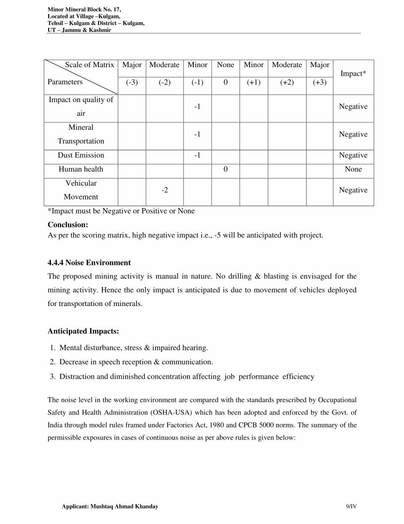
Minor Mineral Block No. 17,
Located at Village –Kulgam,
Tehsil – Kulgam & District – Kulgam,
UT – Jammu & Kashmir
Applicant: Mushtaq Ahmad Khanday 9/IV
Scale of Matrix
Parameters
Major Moderate Minor None Minor Moderate Major Impact*
(-3) (-2) (-1) 0 (+1) (+2) (+3)
Impact on quality of
air -1 Negative
Mineral
Transportation -1 Negative
Dust Emission -1 Negative
Human health 0 None
Vehicular
Movement -2 Negative
*Impact must be Negative or Positive or None
Conclusion:
As per the scoring matrix, high negative impact i.e., -5 will be anticipated with project.
4.4.4 Noise Environment
The proposed mining activity is manual in nature. No drilling & blasting is envisaged for the
mining activity. Hence the only impact is anticipated is due to movement of vehicles deployed
for transportation of minerals.
Anticipated Impacts:
1. Mental disturbance, stress & impaired hearing.
2. Decrease in speech reception & communication.
3. Distraction and diminished concentration affecting job performance efficiency
The noise level in the working environment are compared with the standards prescribed by Occupational
Safety and Health Administration (OSHA-USA) which has been adopted and enforced by the Govt. of
India through model rules framed under Factories Act, 1980 and CPCB 5000 norms. The summary of the
permissible exposures in cases of continuous noise as per above rules is given below:
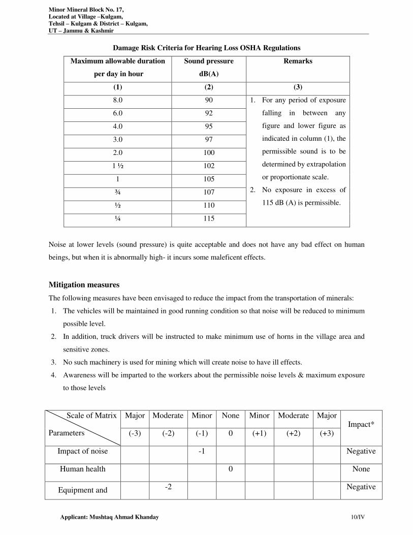
Minor Mineral Block No. 17,
Located at Village –Kulgam,
Tehsil – Kulgam & District – Kulgam,
UT – Jammu & Kashmir
Applicant: Mushtaq Ahmad Khanday 10/IV
Damage Risk Criteria for Hearing Loss OSHA Regulations
Maximum allowable duration
per day in hour
Sound pressure
dB(A)
Remarks
(1) (2) (3)
8.0 90 1. For any period of exposure
falling in between any
figure and lower figure as
indicated in column (1), the
permissible sound is to be
determined by extrapolation
or proportionate scale.
2. No exposure in excess of
115 dB (A) is permissible.
6.0 92
4.0 95
3.0 97
2.0 100
1 ½ 102
1 105
¾ 107
½ 110
¼ 115
Noise at lower levels (sound pressure) is quite acceptable and does not have any bad effect on human
beings, but when it is abnormally high- it incurs some maleficent effects.
Mitigation measures
The following measures have been envisaged to reduce the impact from the transportation of minerals:
1. The vehicles will be maintained in good running condition so that noise will be reduced to minimum
possible level.
2. In addition, truck drivers will be instructed to make minimum use of horns in the village area and
sensitive zones.
3. No such machinery is used for mining which will create noise to have ill effects.
4. Awareness will be imparted to the workers about the permissible noise levels & maximum exposure
to those levels
Scale of Matrix
Parameters
Major Moderate Minor None Minor Moderate Major Impact*
(-3) (-2) (-1) 0 (+1) (+2) (+3)
Impact of noise -1 Negative
Human health 0 None
Equipment and -2 Negative
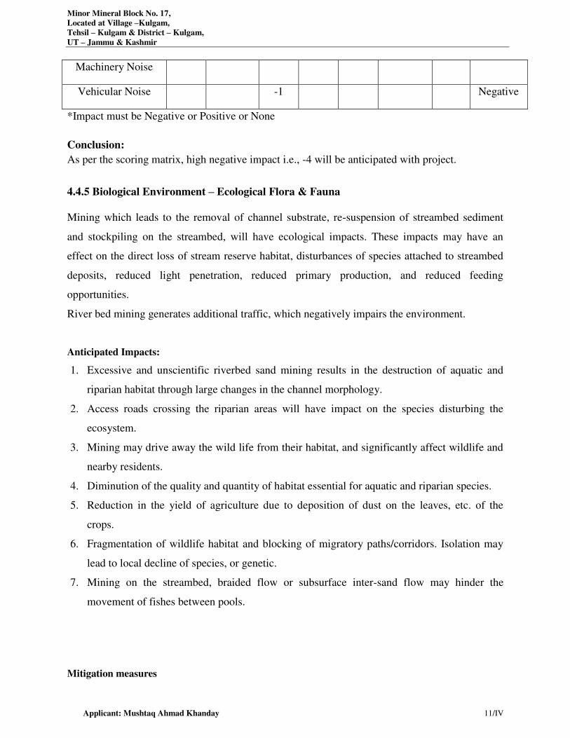
Minor Mineral Block No. 17,
Located at Village –Kulgam,
Tehsil – Kulgam & District – Kulgam,
UT – Jammu & Kashmir
Applicant: Mushtaq Ahmad Khanday 11/IV
Machinery Noise
Vehicular Noise -1 Negative
*Impact must be Negative or Positive or None
Conclusion:
As per the scoring matrix, high negative impact i.e., -4 will be anticipated with project.
4.4.5 Biological Environment – Ecological Flora & Fauna
Mining which leads to the removal of channel substrate, re-suspension of streambed sediment
and stockpiling on the streambed, will have ecological impacts. These impacts may have an
effect on the direct loss of stream reserve habitat, disturbances of species attached to streambed
deposits, reduced light penetration, reduced primary production, and reduced feeding
opportunities.
River bed mining generates additional traffic, which negatively impairs the environment.
Anticipated Impacts:
1. Excessive and unscientific riverbed sand mining results in the destruction of aquatic and
riparian habitat through large changes in the channel morphology.
2. Access roads crossing the riparian areas will have impact on the species disturbing the
ecosystem.
3. Mining may drive away the wild life from their habitat, and significantly affect wildlife and
nearby residents.
4. Diminution of the quality and quantity of habitat essential for aquatic and riparian species.
5. Reduction in the yield of agriculture due to deposition of dust on the leaves, etc. of the
crops.
6. Fragmentation of wildlife habitat and blocking of migratory paths/corridors. Isolation may
lead to local decline of species, or genetic.
7. Mining on the streambed, braided flow or subsurface inter-sand flow may hinder the
movement of fishes between pools.
Mitigation measures
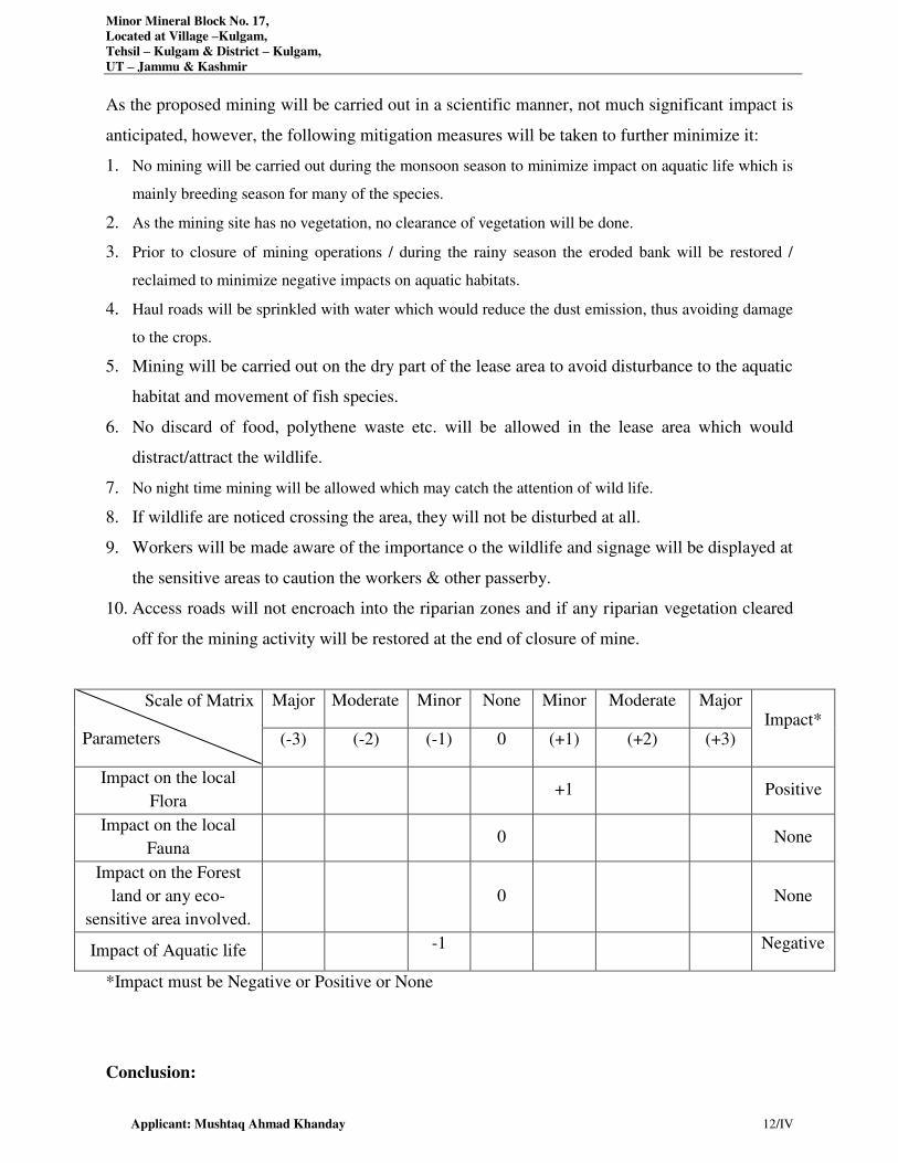
Minor Mineral Block No. 17,
Located at Village –Kulgam,
Tehsil – Kulgam & District – Kulgam,
UT – Jammu & Kashmir
Applicant: Mushtaq Ahmad Khanday 12/IV
As the proposed mining will be carried out in a scientific manner, not much significant impact is
anticipated, however, the following mitigation measures will be taken to further minimize it:
1. No mining will be carried out during the monsoon season to minimize impact on aquatic life which is
mainly breeding season for many of the species.
2. As the mining site has no vegetation, no clearance of vegetation will be done.
3. Prior to closure of mining operations / during the rainy season the eroded bank will be restored /
reclaimed to minimize negative impacts on aquatic habitats.
4. Haul roads will be sprinkled with water which would reduce the dust emission, thus avoiding damage
to the crops.
5. Mining will be carried out on the dry part of the lease area to avoid disturbance to the aquatic
habitat and movement of fish species.
6. No discard of food, polythene waste etc. will be allowed in the lease area which would
distract/attract the wildlife.
7. No night time mining will be allowed which may catch the attention of wild life.
8. If wildlife are noticed crossing the area, they will not be disturbed at all.
9. Workers will be made aware of the importance o the wildlife and signage will be displayed at
the sensitive areas to caution the workers & other passerby.
10. Access roads will not encroach into the riparian zones and if any riparian vegetation cleared
off for the mining activity will be restored at the end of closure of mine.
Scale of Matrix
Parameters
Major Moderate Minor None Minor Moderate Major Impact*
(-3) (-2) (-1) 0 (+1) (+2) (+3)
Impact on the local
Flora +1 Positive
Impact on the local
Fauna 0 None
Impact on the Forest
land or any eco-
sensitive area involved.
0 None
Impact of Aquatic life -1 Negative
*Impact must be Negative or Positive or None
Conclusion:
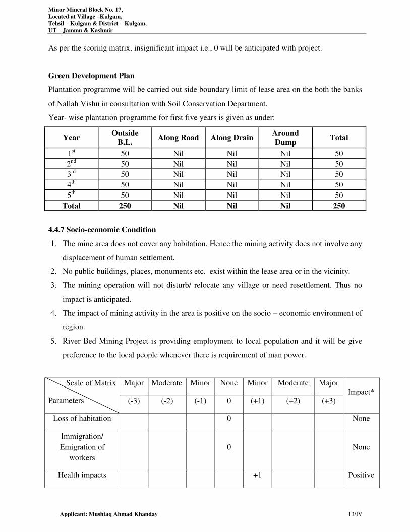
Minor Mineral Block No. 17,
Located at Village –Kulgam,
Tehsil – Kulgam & District – Kulgam,
UT – Jammu & Kashmir
Applicant: Mushtaq Ahmad Khanday 13/IV
As per the scoring matrix, insignificant impact i.e., 0 will be anticipated with project.
Green Development Plan
Plantation programme will be carried out side boundary limit of lease area on the both the banks
of Nallah Vishu in consultation with Soil Conservation Department.
Year- wise plantation programme for first five years is given as under:
Year Outside
B.L. Along Road Along Drain
Around
Dump Total
1st 50 Nil Nil Nil 50
2nd
50 Nil Nil Nil 50
3rd
50 Nil Nil Nil 50
4th
50 Nil Nil Nil 50
5th
50 Nil Nil Nil 50
Total 250 Nil Nil Nil 250
4.4.7 Socio-economic Condition
1. The mine area does not cover any habitation. Hence the mining activity does not involve any
displacement of human settlement.
2. No public buildings, places, monuments etc. exist within the lease area or in the vicinity.
3. The mining operation will not disturb/ relocate any village or need resettlement. Thus no
impact is anticipated.
4. The impact of mining activity in the area is positive on the socio – economic environment of
region.
5. River Bed Mining Project is providing employment to local population and it will be give
preference to the local people whenever there is requirement of man power.
Scale of Matrix
Parameters
Major Moderate Minor None Minor Moderate Major Impact*
(-3) (-2) (-1) 0 (+1) (+2) (+3)
Loss of habitation 0 None
Immigration/
Emigration of
workers
0 None
Health impacts +1 Positive
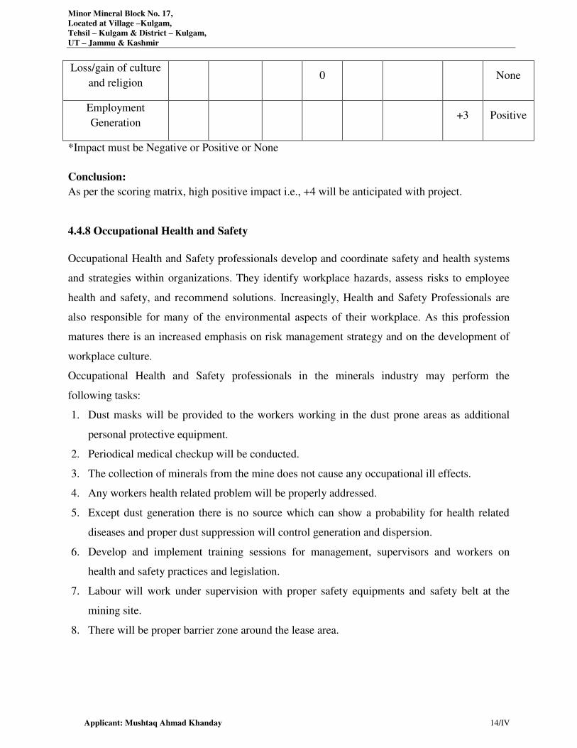
Minor Mineral Block No. 17,
Located at Village –Kulgam,
Tehsil – Kulgam & District – Kulgam,
UT – Jammu & Kashmir
Applicant: Mushtaq Ahmad Khanday 14/IV
Loss/gain of culture
and religion 0 None
Employment
Generation +3 Positive
*Impact must be Negative or Positive or None
Conclusion:
As per the scoring matrix, high positive impact i.e., +4 will be anticipated with project.
4.4.8 Occupational Health and Safety
Occupational Health and Safety professionals develop and coordinate safety and health systems
and strategies within organizations. They identify workplace hazards, assess risks to employee
health and safety, and recommend solutions. Increasingly, Health and Safety Professionals are
also responsible for many of the environmental aspects of their workplace. As this profession
matures there is an increased emphasis on risk management strategy and on the development of
workplace culture.
Occupational Health and Safety professionals in the minerals industry may perform the
following tasks:
1. Dust masks will be provided to the workers working in the dust prone areas as additional
personal protective equipment.
2. Periodical medical checkup will be conducted.
3. The collection of minerals from the mine does not cause any occupational ill effects.
4. Any workers health related problem will be properly addressed.
5. Except dust generation there is no source which can show a probability for health related
diseases and proper dust suppression will control generation and dispersion.
6. Develop and implement training sessions for management, supervisors and workers on
health and safety practices and legislation.
7. Labour will work under supervision with proper safety equipments and safety belt at the
mining site.
8. There will be proper barrier zone around the lease area.
Minor Mineral Block No. 17,
Located at Village –Kulgam,
Tehsil – Kulgam & District – Kulgam,
UT – Jammu & Kashmir
Applicant: Mushtaq Ahmad Khanday 15/IV
Under Covid – 19 following precautions will be done:
Temperature of employees will be checked by Thermometer Gun twice a day and log book
for the same will be maintained.
Face protection shields along with masks and PPEs and along with sanitizer will be provided.
Gloves, masks and hand sanitizers will be provided.
Social distance will be maintained.
It is ensured by PP that the updated guidelines of MHA in content of Covid -19 will be followed
during Mining operation at Mining site.
Hence, as per the study of areas of environmental concerns and scoring matrix, the overall result
comes to have major negative impact anticipated from the project.
4.5 IMPACT MATRIX
Various activities from the Minor Mineral Block No. 17 projects are likely to have some impact
on the environmental constituents during its operational phase. The impact assessment matrix
given in Table 4.3 reveals the impact associated with each activity of the project on various
environmental parameters during operational phase before any mitigation measures are
implanted. To assess the severity of the impacts, they are categorized as follows:
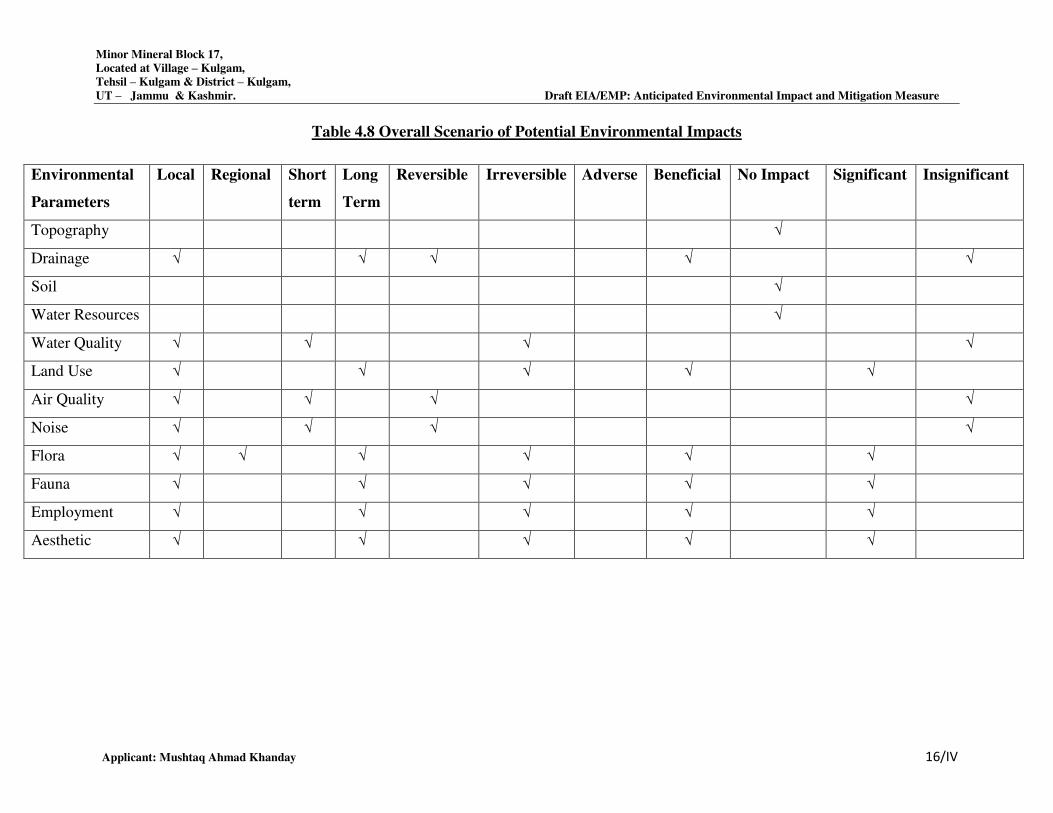
Minor Mineral Block 17,
Located at Village – Kulgam,
Tehsil – Kulgam & District – Kulgam,
UT – Jammu & Kashmir. Draft EIA/EMP: Anticipated Environmental Impact and Mitigation Measure
Applicant: Mushtaq Ahmad Khanday 16/IV
Table 4.8 Overall Scenario of Potential Environmental Impacts
Environmental
Parameters
Local Regional Short
term
Long
Term
Reversible Irreversible Adverse Beneficial No Impact Significant Insignificant
Topography √
Drainage √ √ √ √ √
Soil √
Water Resources √
Water Quality √ √ √ √
Land Use √ √ √ √ √
Air Quality √ √ √ √
Noise √ √ √ √
Flora √ √ √ √ √ √
Fauna √ √ √ √ √
Employment √ √ √ √ √
Aesthetic √ √ √ √ √
CHAPTER-V
ANALYSIS OF ALTERNATIVES (TECHNOLOGY & SITE)
SI.NO. CONTENTS Page No.
5.1 ANALYSIS OF ALTERNATIVES TECHNOLOGY 2/V
5.2 ANALYSIS OF ALTERNATIVE SITE 2/V
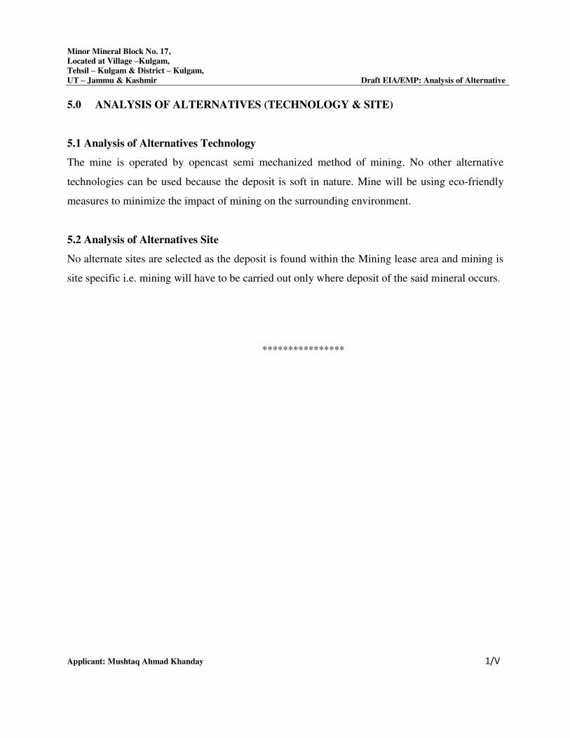
Minor Mineral Block No. 17,
Located at Village –Kulgam,
Tehsil – Kulgam & District – Kulgam,
UT – Jammu & Kashmir Draft EIA/EMP: Analysis of Alternative
Applicant: Mushtaq Ahmad Khanday 1/V
5.0 ANALYSIS OF ALTERNATIVES (TECHNOLOGY & SITE)
5.1 Analysis of Alternatives Technology
The mine is operated by opencast semi mechanized method of mining. No other alternative
technologies can be used because the deposit is soft in nature. Mine will be using eco-friendly
measures to minimize the impact of mining on the surrounding environment.
5.2 Analysis of Alternatives Site
No alternate sites are selected as the deposit is found within the Mining lease area and mining is
site specific i.e. mining will have to be carried out only where deposit of the said mineral occurs.
****************
CHAPTER-VI
ENVIRONMENTAL MONITORING PROGRAMME
INDEX
S. No. CONTENTS Page No.
6.0 INTRODUCTION 2/VI
6.1 ENVIRONMENTAL MONITORING AND REPORTING
PROCEDURE 2/VI
6.2 MONITORING METHODOLOGIES AND PARAMETERS 3/VI
6.3 MONITORING SCHEDULE 4/VI
6.4 BUDGET ALLOCATION FOR EMP IMPLEMENTATION 4/VI
6.5 REPORTING SCHEDULES OF THE MONITORING DATA 6/VI
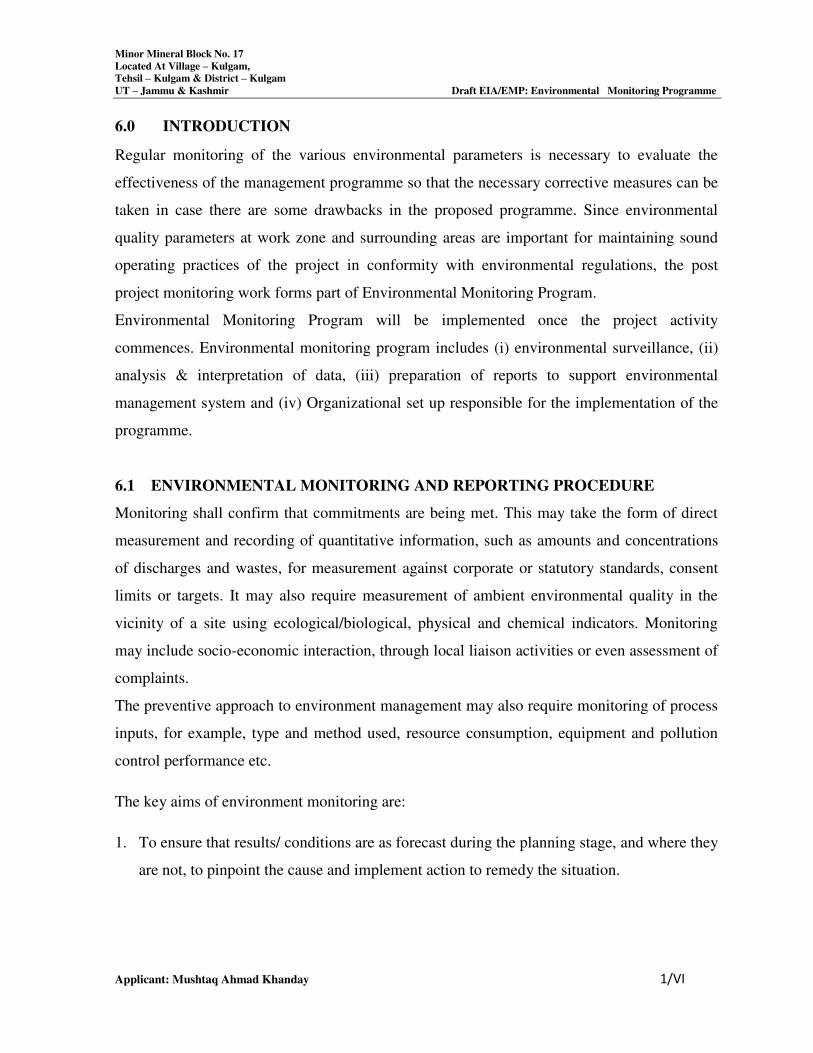
Minor Mineral Block No. 17
Located At Village – Kulgam,
Tehsil – Kulgam & District – Kulgam
UT – Jammu & Kashmir Draft EIA/EMP: Environmental Monitoring Programme
Applicant: Mushtaq Ahmad Khanday 1/VI
6.0 INTRODUCTION
Regular monitoring of the various environmental parameters is necessary to evaluate the
effectiveness of the management programme so that the necessary corrective measures can be
taken in case there are some drawbacks in the proposed programme. Since environmental
quality parameters at work zone and surrounding areas are important for maintaining sound
operating practices of the project in conformity with environmental regulations, the post
project monitoring work forms part of Environmental Monitoring Program.
Environmental Monitoring Program will be implemented once the project activity
commences. Environmental monitoring program includes (i) environmental surveillance, (ii)
analysis & interpretation of data, (iii) preparation of reports to support environmental
management system and (iv) Organizational set up responsible for the implementation of the
programme.
6.1 ENVIRONMENTAL MONITORING AND REPORTING PROCEDURE
Monitoring shall confirm that commitments are being met. This may take the form of direct
measurement and recording of quantitative information, such as amounts and concentrations
of discharges and wastes, for measurement against corporate or statutory standards, consent
limits or targets. It may also require measurement of ambient environmental quality in the
vicinity of a site using ecological/biological, physical and chemical indicators. Monitoring
may include socio-economic interaction, through local liaison activities or even assessment of
complaints.
The preventive approach to environment management may also require monitoring of process
inputs, for example, type and method used, resource consumption, equipment and pollution
control performance etc.
The key aims of environment monitoring are:
1. To ensure that results/ conditions are as forecast during the planning stage, and where they
are not, to pinpoint the cause and implement action to remedy the situation.
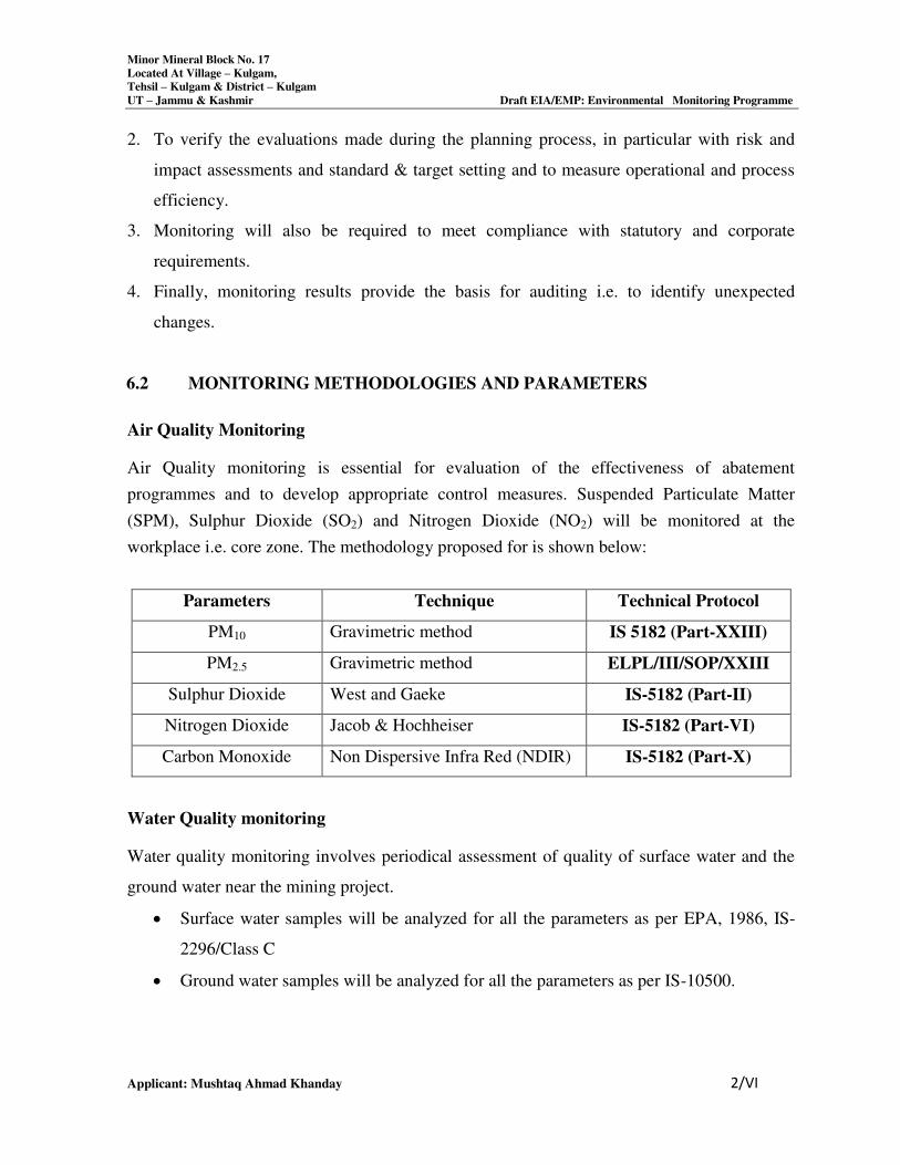
Minor Mineral Block No. 17
Located At Village – Kulgam,
Tehsil – Kulgam & District – Kulgam
UT – Jammu & Kashmir Draft EIA/EMP: Environmental Monitoring Programme
Applicant: Mushtaq Ahmad Khanday 2/VI
2. To verify the evaluations made during the planning process, in particular with risk and
impact assessments and standard & target setting and to measure operational and process
efficiency.
3. Monitoring will also be required to meet compliance with statutory and corporate
requirements.
4. Finally, monitoring results provide the basis for auditing i.e. to identify unexpected
changes.
6.2 MONITORING METHODOLOGIES AND PARAMETERS
Air Quality Monitoring
Air Quality monitoring is essential for evaluation of the effectiveness of abatement
programmes and to develop appropriate control measures. Suspended Particulate Matter
(SPM), Sulphur Dioxide (SO2) and Nitrogen Dioxide (NO2) will be monitored at the
workplace i.e. core zone. The methodology proposed for is shown below:
Parameters Technique Technical Protocol
PM10 Gravimetric method IS 5182 (Part-XXIII)
PM2.5 Gravimetric method ELPL/III/SOP/XXIII
Sulphur Dioxide West and Gaeke IS-5182 (Part-II)
Nitrogen Dioxide Jacob & Hochheiser IS-5182 (Part-VI)
Carbon Monoxide Non Dispersive Infra Red (NDIR) IS-5182 (Part-X)
Water Quality monitoring
Water quality monitoring involves periodical assessment of quality of surface water and the
ground water near the mining project.
Surface water samples will be analyzed for all the parameters as per EPA, 1986, IS-
2296/Class C
Ground water samples will be analyzed for all the parameters as per IS-10500.
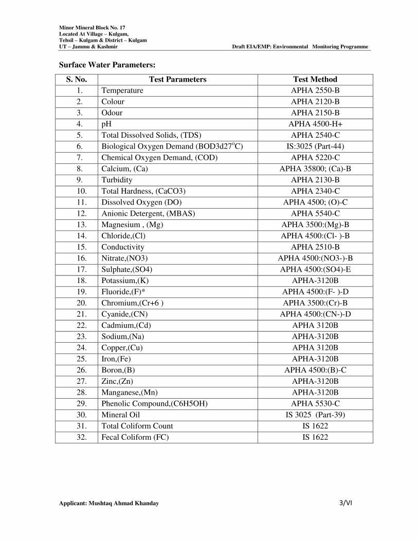
Minor Mineral Block No. 17
Located At Village – Kulgam,
Tehsil – Kulgam & District – Kulgam
UT – Jammu & Kashmir Draft EIA/EMP: Environmental Monitoring Programme
Applicant: Mushtaq Ahmad Khanday 3/VI
Surface Water Parameters:
S. No. Test Parameters Test Method
1. Temperature APHA 2550-B
2. Colour APHA 2120-B
3. Odour APHA 2150-B
4. pH APHA 4500-H+
5. Total Dissolved Solids, (TDS) APHA 2540-C
6. Biological Oxygen Demand (BOD3d27oC) IS:3025 (Part-44)
7. Chemical Oxygen Demand, (COD) APHA 5220-C
8. Calcium, (Ca) APHA 35800; (Ca)-B
9. Turbidity APHA 2130-B
10. Total Hardness, (CaCO3) APHA 2340-C
11. Dissolved Oxygen (DO) APHA 4500; (O)-C
12. Anionic Detergent, (MBAS) APHA 5540-C
13. Magnesium , (Mg) APHA 3500:(Mg)-B
14. Chloride,(Cl) APHA 4500:(Cl- )-B
15. Conductivity APHA 2510-B
16. Nitrate,(NO3) APHA 4500:(NO3-)-B
17. Sulphate,(SO4) APHA 4500:(SO4)-E
18. Potassium,(K) APHA-3120B
19. Fluoride,(F)* APHA 4500:(F- )-D
20. Chromium,(Cr+6 ) APHA 3500:(Cr)-B
21. Cyanide,(CN) APHA 4500:(CN-)-D
22. Cadmium,(Cd) APHA 3120B
23. Sodium,(Na) APHA-3120B
24. Copper,(Cu) APHA 3120B
25. Iron,(Fe) APHA-3120B
26. Boron,(B) APHA 4500:(B)-C
27. Zinc,(Zn) APHA-3120B
28. Manganese,(Mn) APHA-3120B
29. Phenolic Compound,(C6H5OH) APHA 5530-C
30. Mineral Oil IS 3025 (Part-39)
31. Total Coliform Count IS 1622
32. Fecal Coliform (FC) IS 1622
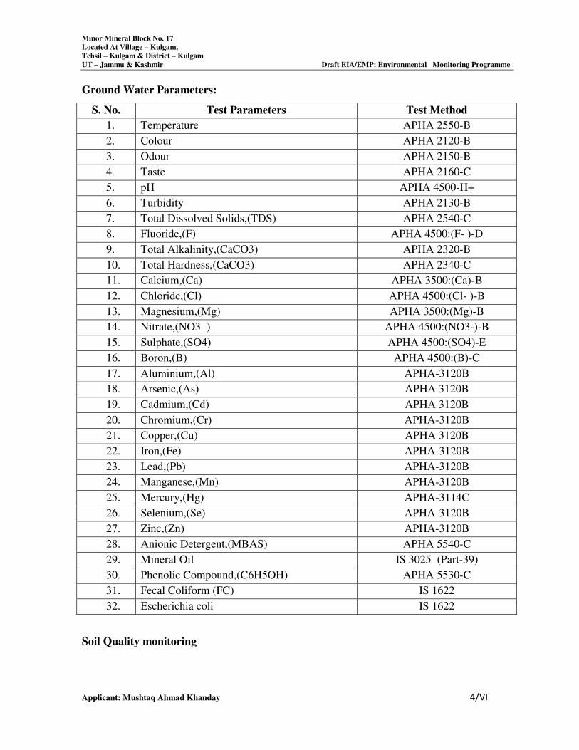
Minor Mineral Block No. 17
Located At Village – Kulgam,
Tehsil – Kulgam & District – Kulgam
UT – Jammu & Kashmir Draft EIA/EMP: Environmental Monitoring Programme
Applicant: Mushtaq Ahmad Khanday 4/VI
Ground Water Parameters:
S. No. Test Parameters Test Method
1. Temperature APHA 2550-B
2. Colour APHA 2120-B
3. Odour APHA 2150-B
4. Taste APHA 2160-C
5. pH APHA 4500-H+
6. Turbidity APHA 2130-B
7. Total Dissolved Solids,(TDS) APHA 2540-C
8. Fluoride,(F) APHA 4500:(F- )-D
9. Total Alkalinity,(CaCO3) APHA 2320-B
10. Total Hardness,(CaCO3) APHA 2340-C
11. Calcium,(Ca) APHA 3500:(Ca)-B
12. Chloride,(Cl) APHA 4500:(Cl- )-B
13. Magnesium,(Mg) APHA 3500:(Mg)-B
14. Nitrate,(NO3 ) APHA 4500:(NO3-)-B
15. Sulphate,(SO4) APHA 4500:(SO4)-E
16. Boron,(B) APHA 4500:(B)-C
17. Aluminium,(Al) APHA-3120B
18. Arsenic,(As) APHA 3120B
19. Cadmium,(Cd) APHA 3120B
20. Chromium,(Cr) APHA-3120B
21. Copper,(Cu) APHA 3120B
22. Iron,(Fe) APHA-3120B
23. Lead,(Pb) APHA-3120B
24. Manganese,(Mn) APHA-3120B
25. Mercury,(Hg) APHA-3114C
26. Selenium,(Se) APHA-3120B
27. Zinc,(Zn) APHA-3120B
28. Anionic Detergent,(MBAS) APHA 5540-C
29. Mineral Oil IS 3025 (Part-39)
30. Phenolic Compound,(C6H5OH) APHA 5530-C
31. Fecal Coliform (FC) IS 1622
32. Escherichia coli IS 1622
Soil Quality monitoring
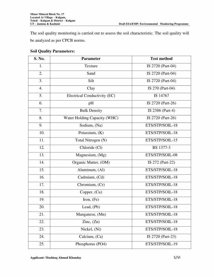
Minor Mineral Block No. 17
Located At Village – Kulgam,
Tehsil – Kulgam & District – Kulgam
UT – Jammu & Kashmir Draft EIA/EMP: Environmental Monitoring Programme
Applicant: Mushtaq Ahmad Khanday 5/VI
The soil quality monitoring is carried out to assess the soil characteristic. The soil quality will
be analyzed as per CPCB norms.
Soil Quality Parameters:
S. No. Parameter Test method
1. Texture IS 2720 (Part-04)
2. Sand IS 2720 (Part-04)
3. Silt IS 2720 (Part-04)
4. Clay IS 270 (Part-04)
5. Electrical Conductivity (EC) IS 14767
6. pH IS 2720 (Part-26)
7. Bulk Density IS 2386 (Part-4)
8. Water Holding Capacity (WHC) IS 2720 (Part-26)
9. Sodium, (Na) ETS/STP/SOIL-18
10. Potassium, (K) ETS/STP/SOIL-18
11. Total Nitrogen (N) ETS/STP/SOIL-15
12. Chloride (Cl) BS 1377-3
13. Magnesium, (Mg) ETS/STP/SOIL-08
14. Organic Matter, (OM) IS 272 (Part-22)
15. Aluminum, (Al) ETS/STP/SOIL-18
16. Cadmium, (Cd) ETS/STP/SOIL-18
17. Chromium, (Cr) ETS/STP/SOIL-18
18. Copper, (Cu) ETS/STP/SOIL-18
19. Iron, (Fe) ETS/STP/SOIL-18
20. Lead, (Pb) ETS/STP/SOIL-18
21. Manganese, (Mn) ETS/STP/SOIL-18
22. Zinc, (Zn) ETS/STP/SOIL-18
23. Nickel, (Ni) ETS/STP/SOIL-18
24. Calcium, (Ca) IS 2720 (Part-23)
25. Phosphorus (PO4) ETS/STP/SOIL-19
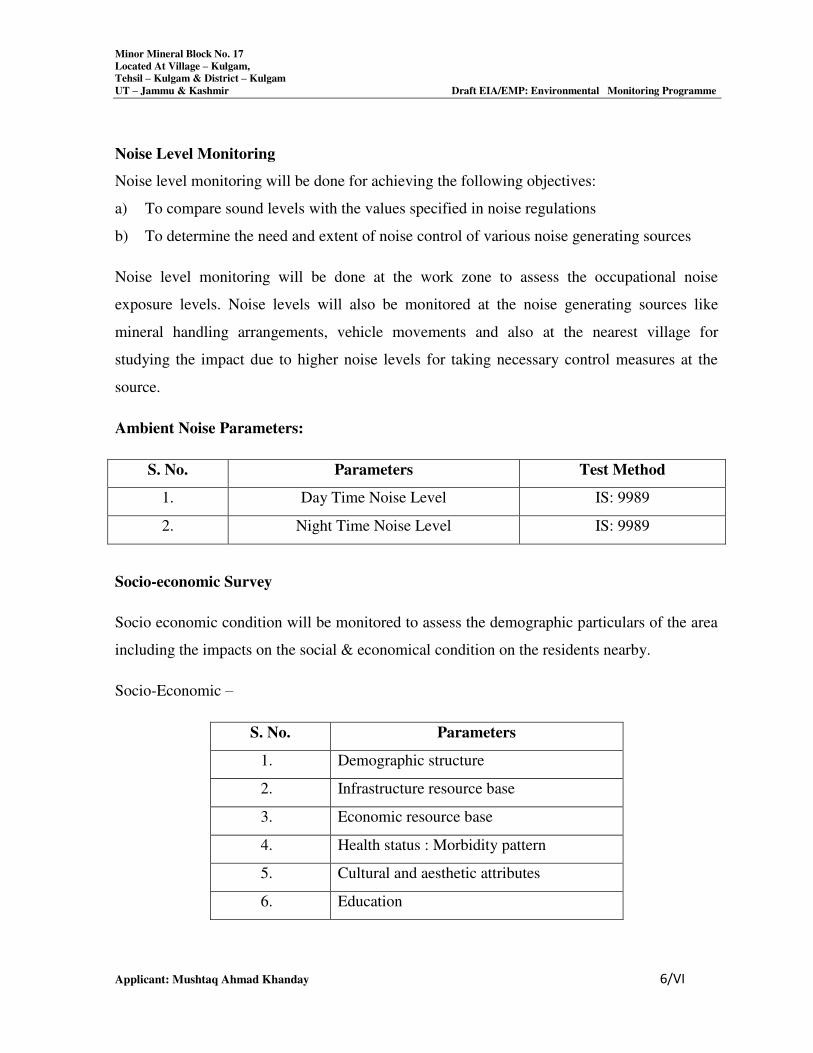
Minor Mineral Block No. 17
Located At Village – Kulgam,
Tehsil – Kulgam & District – Kulgam
UT – Jammu & Kashmir Draft EIA/EMP: Environmental Monitoring Programme
Applicant: Mushtaq Ahmad Khanday 6/VI
Noise Level Monitoring
Noise level monitoring will be done for achieving the following objectives:
a) To compare sound levels with the values specified in noise regulations
b) To determine the need and extent of noise control of various noise generating sources
Noise level monitoring will be done at the work zone to assess the occupational noise
exposure levels. Noise levels will also be monitored at the noise generating sources like
mineral handling arrangements, vehicle movements and also at the nearest village for
studying the impact due to higher noise levels for taking necessary control measures at the
source.
Ambient Noise Parameters:
S. No. Parameters Test Method
1. Day Time Noise Level IS: 9989
2. Night Time Noise Level IS: 9989
Socio-economic Survey
Socio economic condition will be monitored to assess the demographic particulars of the area
including the impacts on the social & economical condition on the residents nearby.
Socio-Economic –
S. No. Parameters
1. Demographic structure
2. Infrastructure resource base
3. Economic resource base
4. Health status : Morbidity pattern
5. Cultural and aesthetic attributes
6. Education
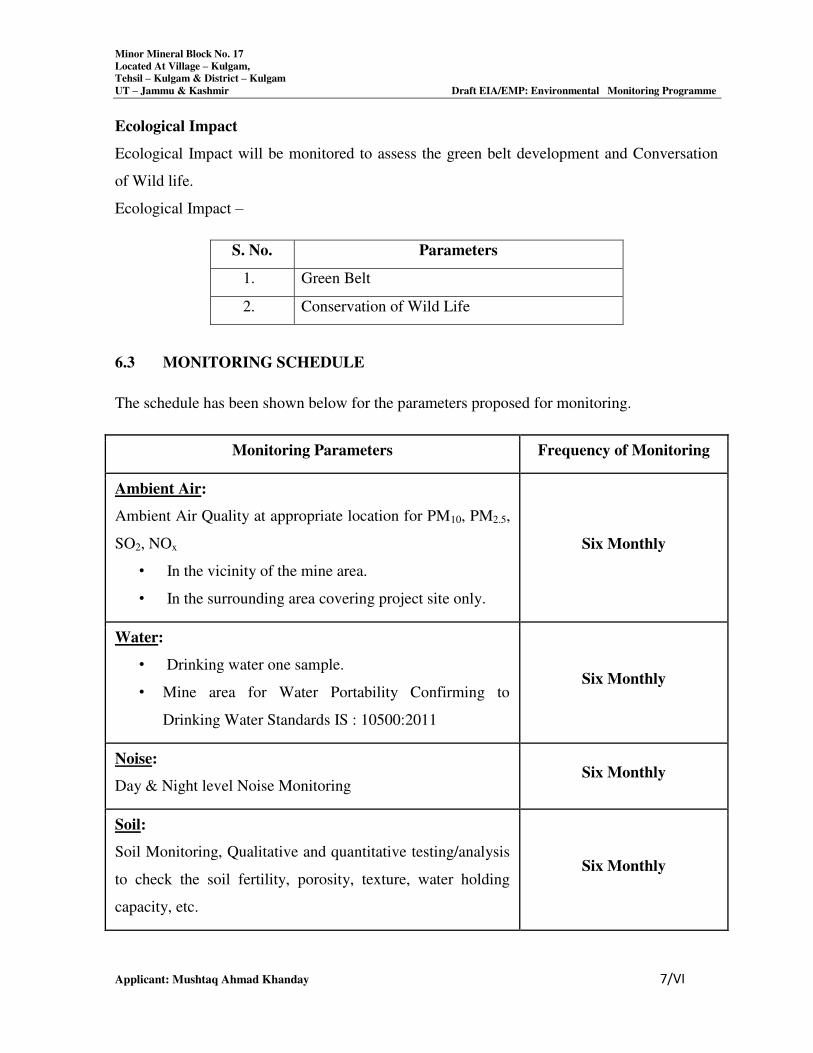
Minor Mineral Block No. 17
Located At Village – Kulgam,
Tehsil – Kulgam & District – Kulgam
UT – Jammu & Kashmir Draft EIA/EMP: Environmental Monitoring Programme
Applicant: Mushtaq Ahmad Khanday 7/VI
Ecological Impact
Ecological Impact will be monitored to assess the green belt development and Conversation
of Wild life.
Ecological Impact –
S. No. Parameters
1. Green Belt
2. Conservation of Wild Life
6.3 MONITORING SCHEDULE
The schedule has been shown below for the parameters proposed for monitoring.
Monitoring Parameters Frequency of Monitoring
Ambient Air:
Ambient Air Quality at appropriate location for PM10, PM2.5,
SO2, NOx
• In the vicinity of the mine area.
• In the surrounding area covering project site only.
Six Monthly
Water:
• Drinking water one sample.
• Mine area for Water Portability Confirming to
Drinking Water Standards IS : 10500:2011
Six Monthly
Noise:
Day & Night level Noise Monitoring Six Monthly
Soil:
Soil Monitoring, Qualitative and quantitative testing/analysis
to check the soil fertility, porosity, texture, water holding
capacity, etc.
Six Monthly
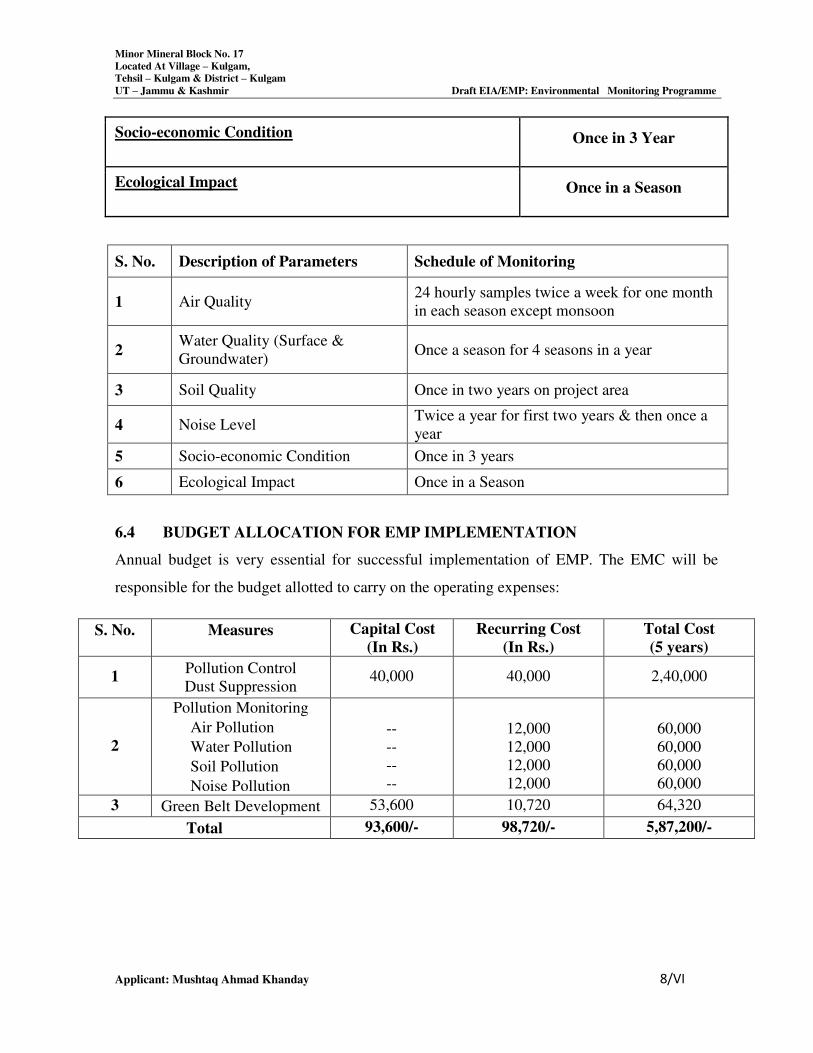
Minor Mineral Block No. 17
Located At Village – Kulgam,
Tehsil – Kulgam & District – Kulgam
UT – Jammu & Kashmir Draft EIA/EMP: Environmental Monitoring Programme
Applicant: Mushtaq Ahmad Khanday 8/VI
Socio-economic Condition Once in 3 Year
Ecological Impact Once in a Season
S. No. Description of Parameters Schedule of Monitoring
1 Air Quality 24 hourly samples twice a week for one month
in each season except monsoon
2 Water Quality (Surface &
Groundwater) Once a season for 4 seasons in a year
3 Soil Quality Once in two years on project area
4 Noise Level Twice a year for first two years & then once a
year
5 Socio-economic Condition Once in 3 years
6 Ecological Impact Once in a Season
6.4 BUDGET ALLOCATION FOR EMP IMPLEMENTATION
Annual budget is very essential for successful implementation of EMP. The EMC will be
responsible for the budget allotted to carry on the operating expenses:
S. No. Measures Capital Cost
(In Rs.)
Recurring Cost
(In Rs.)
Total Cost
(5 years)
1 Pollution Control
Dust Suppression 40,000 40,000 2,40,000
2
Pollution Monitoring
Air Pollution
Water Pollution
Soil Pollution
Noise Pollution
--
--
--
--
12,000
12,000
12,000
12,000
60,000
60,000
60,000
60,000
3 Green Belt Development 53,600 10,720 64,320
Total 93,600/- 98,720/- 5,87,200/-
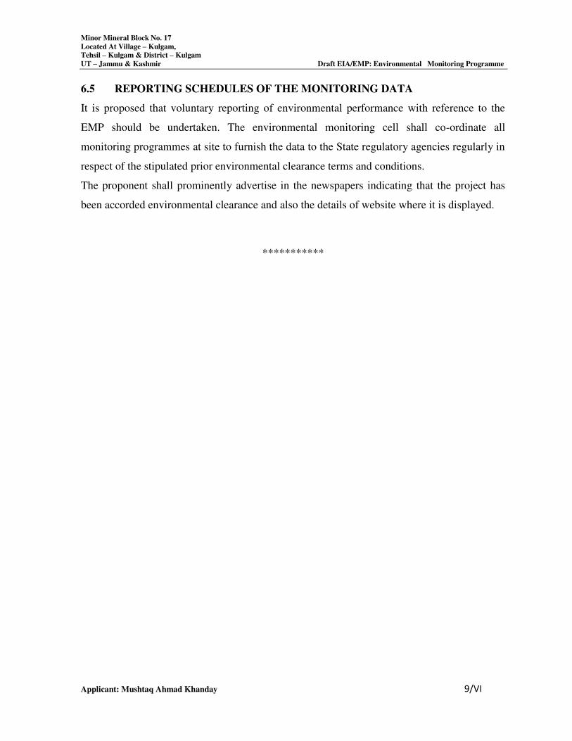
Minor Mineral Block No. 17
Located At Village – Kulgam,
Tehsil – Kulgam & District – Kulgam
UT – Jammu & Kashmir Draft EIA/EMP: Environmental Monitoring Programme
Applicant: Mushtaq Ahmad Khanday 9/VI
6.5 REPORTING SCHEDULES OF THE MONITORING DATA
It is proposed that voluntary reporting of environmental performance with reference to the
EMP should be undertaken. The environmental monitoring cell shall co-ordinate all
monitoring programmes at site to furnish the data to the State regulatory agencies regularly in
respect of the stipulated prior environmental clearance terms and conditions.
The proponent shall prominently advertise in the newspapers indicating that the project has
been accorded environmental clearance and also the details of website where it is displayed.
***********
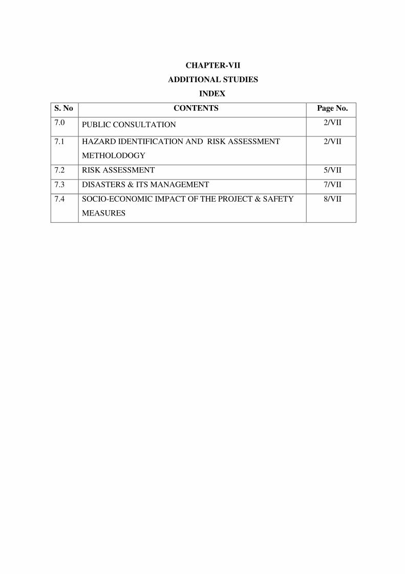
CHAPTER-VII
ADDITIONAL STUDIES
INDEX
S. No CONTENTS Page No.
7.0 PUBLIC CONSULTATION 2/VII
7.1 HAZARD IDENTIFICATION AND RISK ASSESSMENT
METHOLODOGY
2/VII
7.2 RISK ASSESSMENT 5/VII
7.3 DISASTERS & ITS MANAGEMENT 7/VII
7.4 SOCIO-ECONOMIC IMPACT OF THE PROJECT & SAFETY
MEASURES
8/VII
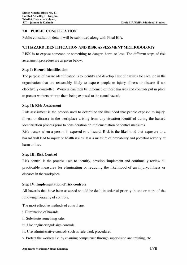
Minor Mineral Block No. 17,
Located At Village – Kulgam,
Tehsil & District – Kulgam,
UT – Jammu & Kashmir Draft EIA/EMP: Additional Studies
Applicant: Mushtaq Ahmad Khanday 1/VII
7.0 PUBLIC CONSULTATION
Public consultation details will be submitted along with Final EIA.
7.1 HAZARD IDENTIFICATION AND RISK ASSESSMENT METHODOLOGY
RISK is to expose someone or something to danger, harm or loss. The different steps of risk
assessment procedure are as given below:
Step I: Hazard Identification
The purpose of hazard identification is to identify and develop a list of hazards for each job in the
organization that are reasonably likely to expose people to injury, illness or disease if not
effectively controlled. Workers can then be informed of these hazards and controls put in place
to protect workers prior to them being exposed to the actual hazard.
Step II: Risk Assessment
Risk assessment is the process used to determine the likelihood that people exposed to injury,
illness or disease in the workplace arising from any situation identified during the hazard
identification process prior to consideration or implementation of control measures.
Risk occurs when a person is exposed to a hazard. Risk is the likelihood that exposure to a
hazard will lead to injury or health issues. It is a measure of probability and potential severity of
harm or loss.
Step III: Risk Control
Risk control is the process used to identify, develop, implement and continually review all
practicable measures for eliminating or reducing the likelihood of an injury, illness or
diseases in the workplace.
Step IV: Implementation of risk controls
All hazards that have been assessed should be dealt in order of priority in one or more of the
following hierarchy of controls.
The most effective methods of control are:
i. Elimination of hazards
ii. Substitute something safer
iii. Use engineering/design controls
iv. Use administrative controls such as safe work procedures
v. Protect the workers i.e. by ensuring competence through supervision and training, etc.
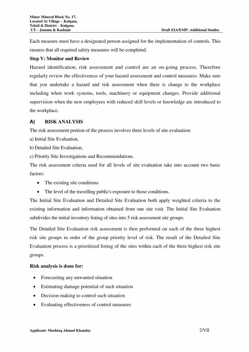
Minor Mineral Block No. 17,
Located At Village – Kulgam,
Tehsil & District – Kulgam,
UT – Jammu & Kashmir Draft EIA/EMP: Additional Studies
Applicant: Mushtaq Ahmad Khanday 2/VII
Each measure must have a designated person assigned for the implementation of controls. This
ensures that all required safety measures will be completed.
Step V: Monitor and Review
Hazard identification, risk assessment and control are an on-going process. Therefore
regularly review the effectiveness of your hazard assessment and control measures. Make sure
that you undertake a hazard and risk assessment when there is change to the workplace
including when work systems, tools, machinery or equipment changes. Provide additional
supervision when the new employees with reduced skill levels or knowledge are introduced to
the workplace.
A) RISK ANALYSIS
The risk assessment portion of the process involves three levels of site evaluation:
a) Initial Site Evaluation,
b) Detailed Site Evaluation,
c) Priority Site Investigations and Recommendations.
The risk assessment criteria used for all levels of site evaluation take into account two basic
factors:
The existing site conditions
The level of the travelling public's exposure to those conditions.
The Initial Site Evaluation and Detailed Site Evaluation both apply weighted criteria to the
existing information and information obtained from one site visit. The Initial Site Evaluation
subdivides the initial inventory listing of sites into 5 risk assessment site groups.
The Detailed Site Evaluation risk assessment is then performed on each of the three highest
risk site groups in order of the group priority level of risk. The result of the Detailed Site
Evaluation process is a prioritized listing of the sites within each of the three highest risk site
groups.
Risk analysis is done for:
Forecasting any unwanted situation
Estimating damage potential of such situation
Decision making to control such situation
Evaluating effectiveness of control measures
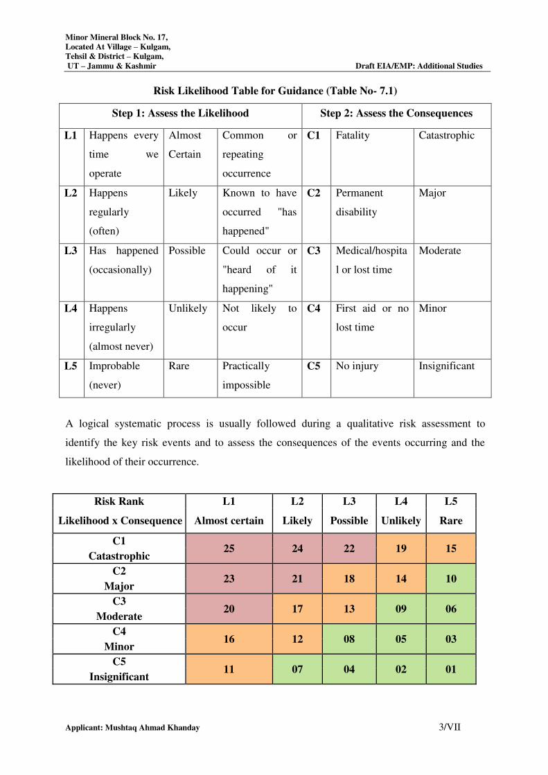
Minor Mineral Block No. 17,
Located At Village – Kulgam,
Tehsil & District – Kulgam,
UT – Jammu & Kashmir Draft EIA/EMP: Additional Studies
Applicant: Mushtaq Ahmad Khanday 3/VII
Risk Likelihood Table for Guidance (Table No- 7.1)
Step 1: Assess the Likelihood Step 2: Assess the Consequences
L1 Happens every
time we
operate
Almost
Certain
Common or
repeating
occurrence
C1 Fatality Catastrophic
L2 Happens
regularly
(often)
Likely Known to have
occurred "has
happened"
C2 Permanent
disability
Major
L3 Has happened
(occasionally)
Possible Could occur or
"heard of it
happening"
C3 Medical/hospita
l or lost time
Moderate
L4 Happens
irregularly
(almost never)
Unlikely Not likely to
occur
C4 First aid or no
lost time
Minor
L5 Improbable
(never)
Rare Practically
impossible
C5 No injury Insignificant
A logical systematic process is usually followed during a qualitative risk assessment to
identify the key risk events and to assess the consequences of the events occurring and the
likelihood of their occurrence.
Risk Rank L1 L2 L3 L4 L5
Likelihood x Consequence Almost certain Likely Possible Unlikely Rare
C1 25 24 22 19 15
Catastrophic
C2 23 21 18 14 10
Major
C3 20 17 13 09 06
Moderate
C4 16 12 08 05 03
Minor
C5 11 07 04 02 01
Insignificant
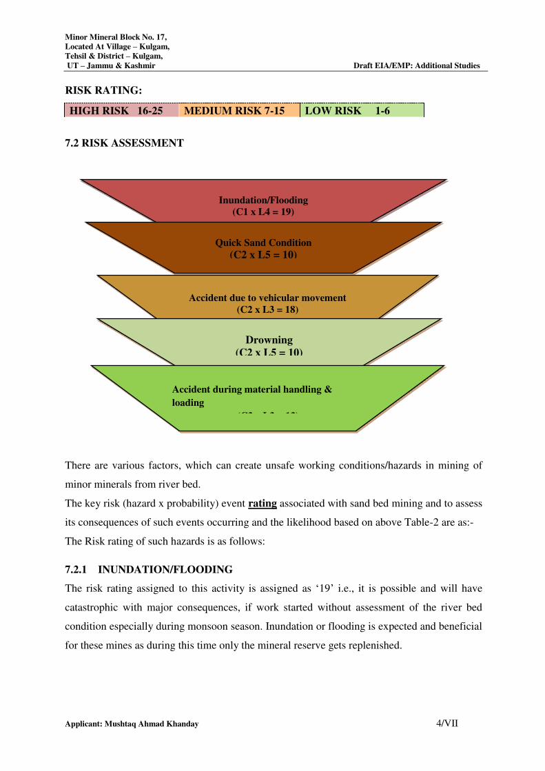
Minor Mineral Block No. 17,
Located At Village – Kulgam,
Tehsil & District – Kulgam,
UT – Jammu & Kashmir Draft EIA/EMP: Additional Studies
Applicant: Mushtaq Ahmad Khanday 4/VII
RISK RATING:
HIGH RISK 16-25 MEDIUM RISK 7-15 LOW RISK 1-6
7.2 RISK ASSESSMENT
There are various factors, which can create unsafe working conditions/hazards in mining of
minor minerals from river bed.
The key risk (hazard x probability) event rating associated with sand bed mining and to assess
its consequences of such events occurring and the likelihood based on above Table-2 are as:-
The Risk rating of such hazards is as follows:
7.2.1 INUNDATION/FLOODING
The risk rating assigned to this activity is assigned as ‘19’ i.e., it is possible and will have
catastrophic with major consequences, if work started without assessment of the river bed
condition especially during monsoon season. Inundation or flooding is expected and beneficial
for these mines as during this time only the mineral reserve gets replenished.
Inundation/Flooding
(C1 x L4 = 19)
(
Quick Sand Condition
(C2 x L5 = 10)
Accident due to vehicular movement
(C2 x L3 = 18)
Drowning
(C2 x L5 = 10)
Accident during material handling &
loading
(C3 x L3 = 13)
Minor Mineral Block No. 17,
Located At Village – Kulgam,
Tehsil & District – Kulgam,
UT – Jammu & Kashmir Draft EIA/EMP: Additional Studies
Applicant: Mushtaq Ahmad Khanday 5/VII
Measures to prevent consequences of Inundation/Flooding
Inundation of flooding is expected and beneficial for these mines as during this time only the
mineral reserve gets replenished.
1. During monsoon months and heavy rains the mining operations are ceased.
2. There should be mechanism/warning system of heavy rains and discharges from the
upstream dams.
7.2.2 Quick Sand Condition
The risk rating assigned to this activity is assigned as ‘12’ i.e., it is an unlikely event with
major consequences as frequency of this risk is less likely to occur.
Two things may create the conditions to form quicksand. Underground water may seep-up and
saturate the sand, thereby reducing the friction between the sand grains and giving the sand a
liquid nature. Or, sand or another soil may be sifted by the force of an earthquake so that
friction is lessened and the earth becomes unsteady.
This creates danger condition to the trucks plying near the river bed and banks for
transportation of minerals.
Measures to Prevent Quick Sand Condition
1. The only way to avoid quick sand condition is by avoiding mineral lifting below water
table.
2. Mining will be done in layers rather than going for maximum depth at one time.
7.2.3 ACCIDENT DUE TO VEHICULAR MOVEMENT
The risk rating assigned to this activity is assigned as ‘13’ i.e., it is possible event with
moderate consequences as frequency of this operation is more but the predicted/assumed
intensity is less like minor cuts, bodily injury. The possibilities of road accidents are due to
reckless or untrained driver or overloading of trucks or in case pathway is not compacted
suitably, etc.
Measures to Prevent Accidents during Transportation
1. All transportation within the main working should be carried out directly under the
supervision and control of the management.
2. The Vehicles will be maintained/ repaired and checked thoroughly by the competent
person.
Minor Mineral Block No. 17,
Located At Village – Kulgam,
Tehsil & District – Kulgam,
UT – Jammu & Kashmir Draft EIA/EMP: Additional Studies
Applicant: Mushtaq Ahmad Khanday 6/VII
3. A statutory provision of constant education, training etc. will go a long way in reducing
the incidents of such accidents.
4. Overloading will not be permitted and will be covered with tarpaulin.
5. The maximum permissible speed limit will be ensured.
6. The truck drivers will have valid driving license.
7.2.4 DROWNING
The risk rating assigned to this activity is assigned as ‘16’ i.e., it is a rare accident but will
have major consequences, if occurred. This may occur due to flash floods etc due to which the
workers at the site may get seriously injured or drowned.
Measure to Prevent Drowning
1. The mining will be done under strict supervision and only in the dry part of the river.
2. Mining will be completely stopped in monsoon season to avoid such accidents.
3. Deep water areas will be identified and ‘No Go Zones’ will be clearly marked and made
aware to the mine workers.
7.2.5 ACCIDENT DURING MATERIAL HANDLING & LOADING
The risk rating assigned to this activity is assigned as ‘18’ i.e. it is possible event with minor
consequences”, as frequency of this operation is more but the predicted/assumed intensity is
less like minor cuts, abrasion, etc. may be due to river bank collapse, over thrown
boulders/pebbles, injuries due to carelessness use of hand tools, etc.
Measures to Prevent Accidents during material handling & loading
1. The truck should be brought to a lower level so that the loading operation suits to the
ergonomic condition of the workers.
2. The loading should be done from one side of the truck only to avoid over throw of
materials.
3. The workers should be provided with gloves and safety shoes during loading.
All the activities will be done under strict supervision/control to avoid anticipated accidents so
that the risk is reduced to a level considered As Low as Reasonably Practicable (ALARP)
conditions which are adequately safe and healthy.
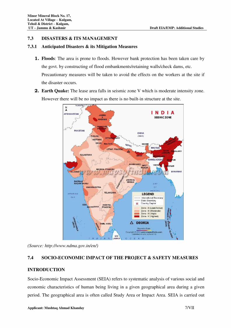
Minor Mineral Block No. 17,
Located At Village – Kulgam,
Tehsil & District – Kulgam,
UT – Jammu & Kashmir Draft EIA/EMP: Additional Studies
Applicant: Mushtaq Ahmad Khanday 7/VII
7.3 DISASTERS & ITS MANAGEMENT
7.3.1 Anticipated Disasters & its Mitigation Measures
1. Floods: The area is prone to floods. However bank protection has been taken care by
the govt. by constructing of flood embankments/retaining walls/check dams, etc.
Precautionary measures will be taken to avoid the effects on the workers at the site if
the disaster occurs.
2. Earth Quake: The lease area falls in seismic zone V which is moderate intensity zone.
However there will be no impact as there is no built-in structure at the site.
(Source: http://www.ndma.gov.in/en/)
7.4 SOCIO-ECONOMIC IMPACT OF THE PROJECT & SAFETY MEASURES
INTRODUCTION
Socio-Economic Impact Assessment (SEIA) refers to systematic analysis of various social and
economic characteristics of human being living in a given geographical area during a given
period. The geographical area is often called Study Area or Impact Area. SEIA is carried out
Minor Mineral Block No. 17,
Located At Village – Kulgam,
Tehsil & District – Kulgam,
UT – Jammu & Kashmir Draft EIA/EMP: Additional Studies
Applicant: Mushtaq Ahmad Khanday 8/VII
separately but concurrently with Environment Impact Assessment (EIA). The study area
consists of core area where the project is located and a buffer area encircling the project area
with a radius of 10 kilometers from the periphery of the core area. For every new project or
existing project under expansion or tied for modernization or change in product mix, Socio-
economic Impact Assessment is mandatory. The Socio-economic Impact Assessment focuses
the effect of the project on social and economic well-being of the community. The impact may
be direct or indirect. Further, the impact may be positive or negative.
OBJECTIVES OF SEIA
The prime objective of the current study is to assess the impact of the proposed project Nallah
Bed Mining on socio-economic characteristics of people living in the neighborhoods. Further,
it is to be established whether the impending impact would be direct or indirect. Furthermore,
it is to be examined whether the said impact would be positive or negative. Lastly, it is to be
comprehended if the impact is positive how long it would sustain or if it is negative how soon
the same could be eased.
SCOPE
The Scope of the study is as follows:
a) To collect baseline data of the study area
b) To comprehend socio-economic status of the people living in the study area.
c) To assess probable impact of the project on social and economic aspects in the study area.
d) To measure the impact of the project on Quality of life of the people living in the study
area.
e) To ensure sustainability of positive impact.
f) To suggest mitigation measures and agency responsible for taking action in case of
adverse impact.
SOCIO-ECONOMIC IMPACT OF THE PROJECT
1. Impact on population composition
The impact of the proposed Nallah Bed Mining Minor Mineral Block-17 Project on population
composition will be marginal as only few skilled and managerial staff will be recruited from outside
and the rest will be recruited locally. The impact will be significant if a large number of people from
outside get employed in the proposed project. In that case not only the population of the study area
Minor Mineral Block No. 17,
Located At Village – Kulgam,
Tehsil & District – Kulgam,
UT – Jammu & Kashmir Draft EIA/EMP: Additional Studies
Applicant: Mushtaq Ahmad Khanday 9/VII
will go up but also the skewed sex ratio may make permanent social effects like rise in exploitation
of women, higher crime rate, increase in sexual diseases and depression among youth.
2. Impact on employment generation
The proposed Nallah Bed Mining Minor Mineral Block-17 Project is expected to provide
employment opportunities to workers. It is understood that all the persons to be deployed for
various mining activities will be recruited locally and there is very little scope for migration of
people from outside the study area. The employment potentiality of the project is expected to
ameliorate the economic condition of the families of those persons who will get employed in the
proposed mining project. However, the Nallah Bed Mining Project will provide seasonal
employment. Further, the project will provide indirect employment to about 10 people who will be
involved in segregation of extracted mining materials, petty business and service oriented
industries.
3. Impact on Health
Extraction of sand, bajri & boulder from the river bed poses serious health risks due to dust,
quarrying and stone crushing. The effects will vary depending upon the nature of the dust particles,
silica content in it and the size of the particles. Pneumoconiosis is an occupational lung disease often
caused to miners, due to the inhalation of dust. Silica content in the sand may also lead to Silicosis,
which is again an occupational lung disease. Miners may also suffer with occupational respiratory
ailments, skin allergies etc, but the same are preventable if exposure is minimized. Further, regular
health check-up of the miners is required to prevent any negative impact on their health. In the
present Nallah Bed Mining Project, no adverse impact on health is expected if minimum precautions
are taken by the miners.
4. Impact on road development
Movement of trucks and other vehicles to and fro the quarry is expected to increase substantially,
when mining will start. The existing roads connecting the quarry with the national and state
highways are mostly narrow mud roads. There will be mud slide and traffic bottle neck if these
roads are not widened and their conditions are not improved by making them paved roads. Hence,
there is ample scope for road development in and around the mining areas.
5. Impact on law & Order
As local people will be employed to run the quarry, no law & order problem is envisaged. It is
expected that the workers will attend to their duties from their residence and return to their homes
after the day’s work is over. There would have been law & order problem if the workers were
Minor Mineral Block No. 17,
Located At Village – Kulgam,
Tehsil & District – Kulgam,
UT – Jammu & Kashmir Draft EIA/EMP: Additional Studies
Applicant: Mushtaq Ahmad Khanday 10/VII
migrants and lived in shanties closed to the mining area. However, to meet any untoward incident
one police post may be set up closed to the project area.
Few safety measures are outlined below:
a) Safe Working Environment: The project proponent shall ensure health and safety of all
the employees at work. Efforts will be made to provide and maintain a safe work
environment and ensure that the machinery and equipment in use is safe for employees.
Further, it will be ensured that working arrangements are not hazardous to employees.
b) Provision of First Aid: The first aid treatment reflects the hazards associated with the
mining of Sand. The first-aiders will be well trained in handling patients working in the
above Mining Project.
c) Regular Health Examination: For all mine workers regular health examination will be
made compulsory. Treatment for respiratory diseases or asthma, skin diseases, lung
function test (pre and post ventolin), Audiograms, Chest X- ray etc., as required will be
given.
d) No work for Temporal Disabilities: The workers having temporary disability will be
asked to stop doing the job till he/she recovers from disabilities.
e) Health Education: Adequate health education and information related to the job will be
provided to the workers. Baseline health information will be recorded for future
references.
f) Tie-up with the Nearest Hospital for Medical Assistance: To meet the medical needs of
the mine workers tie-up with nearest hospitals will be made. Efforts will be made to
reserve few beds in the above hospitals for the workers of the mining project. This will
ensure timely medical aid to the affected persons.
g) Supply of Mask and Gloves: The workers in the project are subject to respiratory
diseases. For protection from dust it will be made compulsory for all workers to wear
masks and gloves, while working in the mine.
h) Administration of Anti-venom Injections: Provision of Anti-venom therapy will be
made available for administration to the workers in case of snake, spider and insect bites,
while working in the mine.
i) Special Telephone Number: A special telephone number will be made available to the
workers in case of emergency so that they can dial the same for–medical assistances.
Minor Mineral Block No. 17,
Located At Village – Kulgam,
Tehsil & District – Kulgam,
UT – Jammu & Kashmir Draft EIA/EMP: Additional Studies
Applicant: Mushtaq Ahmad Khanday 11/VII
Further, efforts will be made to provide vehicles to the patients in short duration for
shifting to a hospital.
j) Special Group Insurance Scheme: All the mine workers will be covered under a Group
Insurance Scheme of LIC or any other Insurance company.
CONCLUSION
The commissioning of Nallah Bed Mining Minor Mineral Block-17 Q-Kulgam Bridge,
Upstream Vishu Nallah, Project Village –Kulgam, Tehsil – Kulgam, and District –Kulgam,
UT – Jammu & Kashmir will provide employment to local people who are in search of the
same. The granting of Environment Clearance to the project will make mining of Sand, Bajri
and boulder legally valid and it will generate revenue for the state. With the implementation of
the project there will be increase in the employment opportunities for the local villagers. The
study area is still lacking in health and educational facilities. It is expected that same will
improve to a great extent with opening of the project and associated activities.
*************
CHAPTER-VIII
PROJECT BENEFITS
INDEX
SI.NO. CONTENTS Page No.
8.0 GENERAL 2/VIII
8.1 IMPROVEMENTS IN SOCIAL INFRASTRUCTURE 3/VIII
8.2 PLANTATION 3/VIII
8.3 HEALTH 3/VIII
8.4 ENVIRONMENTAL BENEFITS 4/VIII
Minor Mineral Block No. 17,
Located At Village –Kulgam,
Tehsil & District – Kulgam,
UT – Jammu & Kashmir Draft EIA/EMP: Project Benefits
Applicant: Mushtaq Ahmad Khanday 1/VIII
8.0 GENERAL
The continuation of the project will bring overall improvement in the locality, neighborhood
and the state by bringing industry, roads, water supply, electricity, employment, living
standard and economic growth.
EMPLOYMENT
The socio-economic conditions of the surrounding villages are poor as there is no significant
source of earning. The occupational activities are agriculture, cattle rearing and employment
in mines but on daily wages. The mining activity will provide employment to local people
which will increase socio- economic status of the area.
8.1 IMPROVEMENTS IN PHYSICAL AND SOCIAL INFRASTRUCTURE
The operation of the project will enhance the socio-economic activities in the adjoining areas.
This will result in following benefits:-
Improvements in physical infrastructure.
Improvements in Social Infrastructure.
Increase in Employment Potential.
Contribution to the Exchequer.
Prevention of illegal mining.
Enhancement of green cover.
IMPROVEMENTS IN PHYSICAL INFRASTRUCTURE:
The project will improve the physical infrastructure of the adjoining areas. This will include
the following:-
Improved road communication due to opening of the proposed project.
Strengthening of existing community facilities through the Community Development
Programme.
Pumping of mine water augment the water availability after treatment.
Creation of community assets (infrastructure) like provision for drinking water,
construction of school buildings, village roads/ linked roads, dispensary & health centre,
community centre, market place etc.
Skill development & capacity building like vocational training, income generation
programs and entrepreneurship development program.
Minor Mineral Block No. 17,
Located At Village –Kulgam,
Tehsil & District – Kulgam,
UT – Jammu & Kashmir Draft EIA/EMP: Project Benefits
Applicant: Mushtaq Ahmad Khanday 2/VIII
Literacy program, adult education, assists formation of Village Working Group (VWG),
Mahila Mandal etc.
Awareness program and community activities, like health camps, medical aids, family
welfare programs, immunization camp sports & cultural activities, plantation etc.
IMPROVEMENTS IN SOCIAL INFRASTRUCTURE:
There will be some obvious changes in various environmental parameters due to mining
activity. Increase socio-economic activities, creation of new employment opportunities, infra-
structural development, better educational and health facilities.
Following are the specific impacts:-
Socio-Economic: - There will be positive impact in socio-economic area due to increased
economic activities, creation of new employment opportunities, infrastructural development
and better educational and health facilities.
Population dynamics: - Due to the direct and indirect employment potential, there is a scope
of migration of people into project area and in the peripheral regions; from nearby areas.
Health Care facilities: - Lessee will undertake awareness program and community activities
like health, camps, medical aids, family welfare camps, AIDS awareness program, Health
checkup will be scheduled in which BP level or sugar level will be measured etc.
Employment Potential: - There is a possibility of creation of direct and indirect employment
opportunities due to working of this mine.
INCREASES IN EMPLOYMENT POTENTIAL :
Increase in Employment Potential due to the project activity, Employment opportunities will
increase both directly as well indirectly.
CONTRIBUTION TO THE EXCHEQUER:
As the saleable minerals will be given royalty. Since the quarries will be leased out to
successful allottees, mining operation in the state will get legalized and it will fetch income to
the state exchequer.
PREVENTION OF ILLEGAL MINING:
SRO-105. - In exercise of the powers conferred by section 15 read with section 23C
of the Mines and Minerals (Development and Regulation) Act, 1957, (Central Act 67
Minor Mineral Block No. 17,
Located At Village –Kulgam,
Tehsil & District – Kulgam,
UT – Jammu & Kashmir Draft EIA/EMP: Project Benefits
Applicant: Mushtaq Ahmad Khanday 3/VIII
of 1957), the Government of Jammu and Kashmir hereby makes the following rules
for regulating the grant of various forms of mineral concessions in respect of minor
minerals and storage, transportation of minerals and prevention of illegal mining in
the State.
The State Government may, by notification in the Official Gazette, make rules for
preventing illegal mining, transportation and storage of minerals and for the purposes
connected therewith.
In particular and without prejudice to the generality of the foregoing power, such rules
may provide for all or any of the following matters, namely:
Establishment of check-posts for checking of minerals under transit.
Establishment of weigh-bridges to measure the quantity of mineral being transported.
Regulation of mineral being transported from the area granted under a prospecting
licence or a mining lease or a quarrying licence or a permit, in whatever name the
permission to excavate minerals, has been given.
Inspection, checking and search of minerals at the place of excavation or storage or
during transit.
Maintenance of registers and forms for the purposes of these rules;
1. Ins. by Act 56 of 1972, s. 13 (w.e.f. 12-9-1972).
2. Ins. by Act 25 of 1994, s. 9 (w.e.f. 25-1-1994).
3. Ins. by Act 38 of 1999, s. 18 (w.e.f. 18-12-1999).
4. Ins. by s. 19, ibid. (w.e.f. 18-12-1999).
The period within which and the authority to which applications for revision of any
order passed by any authority be preferred under any rule made under this section and
the fees to be paid therefore and powers of such authority for disposing of such
applications; and.
Any other matter which is required to be, or may be, prescribed for the purpose of
prevention of illegal mining, transportation and storage of minerals.
Notwithstanding anything contained in section 30, the Central Government shall have
no power to revise any order passed by a State Government or any of its authorized
officers or any authority under the rules made under sub-sections (1) and (2).
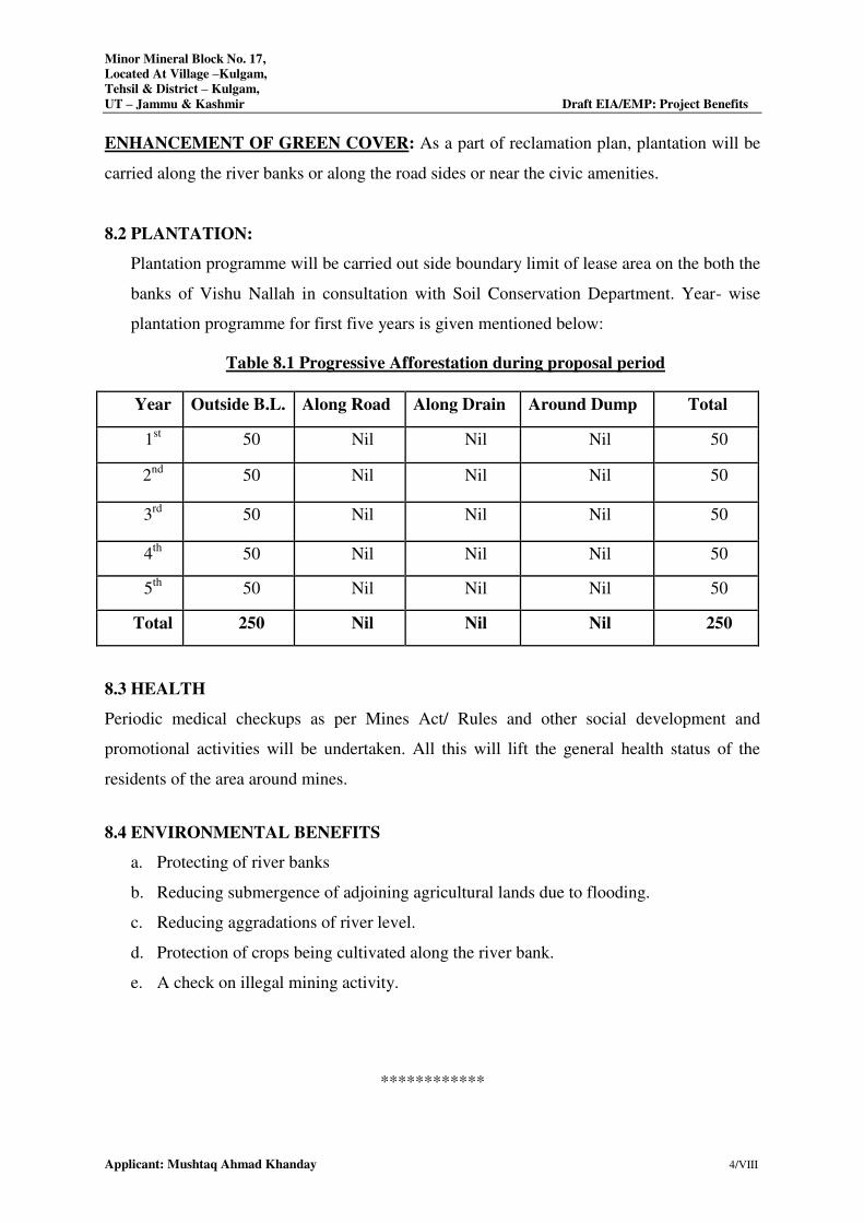
Minor Mineral Block No. 17,
Located At Village –Kulgam,
Tehsil & District – Kulgam,
UT – Jammu & Kashmir Draft EIA/EMP: Project Benefits
Applicant: Mushtaq Ahmad Khanday 4/VIII
ENHANCEMENT OF GREEN COVER: As a part of reclamation plan, plantation will be
carried along the river banks or along the road sides or near the civic amenities.
8.2 PLANTATION:
Plantation programme will be carried out side boundary limit of lease area on the both the
banks of Vishu Nallah in consultation with Soil Conservation Department. Year- wise
plantation programme for first five years is given mentioned below:
Table 8.1 Progressive Afforestation during proposal period
Year Outside B.L. Along Road Along Drain Around Dump Total
1st 50 Nil Nil Nil 50
2nd
50 Nil Nil Nil 50
3rd
50 Nil Nil Nil 50
4th
50 Nil Nil Nil 50
5th
50 Nil Nil Nil 50
Total 250 Nil Nil Nil 250
8.3 HEALTH
Periodic medical checkups as per Mines Act/ Rules and other social development and
promotional activities will be undertaken. All this will lift the general health status of the
residents of the area around mines.
8.4 ENVIRONMENTAL BENEFITS
a. Protecting of river banks
b. Reducing submergence of adjoining agricultural lands due to flooding.
c. Reducing aggradations of river level.
d. Protection of crops being cultivated along the river bank.
e. A check on illegal mining activity.
************

CHAPTER-9
COST BENEFIT ANALYSIS
INDEX
SI. NO. CONTENTS Page No.
9.0 Environmental Cost Benefit Analysis 1/IX
Minor Mineral Block No. 17,
Located At Village –Kulgam,
Tehsil – Kulgam & District – Kulgam,
UT – Jammu & Kashmir Draft EIA/EMP: Cost Benefit Analysis
Applicant: Mushtaq Ahmad Khanday 1/IX
9.0 Environmental Cost Benefit Analysis
As per the ToR points issued by JKEIAA
For Minor Mineral Block 25 Vide Letter No. JKEIAA/2020/337/1834-38 Dated 26.07.2021.
For the mining project activity, the ‘Environmental Cost Benefit Analysis’ is not required.
Henceforth, this chapter is not applicable.
*************
CHAPTER-X
ENVIRONMENTAL MANAGEMENT PLAN
INDEX
S. No. CONTENTS Page No.
10.0 INTRODUCTION 2/X
10.1 LAND USE PATTERN 2/X
10.2 AIR ENVIRONMENT MANAGEMENT 3/ X
10.3 NOISE AND VIBRATION ENVIRONMENT 4/ X
10.4 WATER MANAGEMENT 5/ X
10.5 SOLID WASTE MANAGEMENT 5/ X
10.6 GREEN BELT DEVELOPMENT 6/X
10.7 SOCIO-ECONOMIC ENVIRONMENT 6/X
10.8 OCCUPATIONAL HEALTH AND SAFETY 7/X
10.9 COST OF EMP MEASURES 12/X
10.10 SUMMARY 13/X
Minor Mineral Block No. 17,
Located at Village – Kulgam,
Tehsil & District – Kulgam,
UT – Jammu & Kashmir Draft EIA/EMP: Environment Management Plan
Applicant: Mushtaq Ahmad Khanday 1/X
10.0 INTRODUCTION
To mitigate the adverse impacts which are likely to be caused due to the mining operation and
overall scientific development of local habitat, environmental management plan (EMP) has been
formulated and integrated with the mine planning. The details of the anticipated impacts and
mitigative measures have been discussed in Section IV of this report, based on the results of
present environmental conditions and environmental impact assessment. The EMP has therefore
been made considering implementation and monitoring of environmental protection measures
during and after mining operations.
The mitigation measures which reduce the impact have already been identified earlier in Section
IV. To minimize the adverse impact, certain additional EMP is enumerated below for
implementation.
10.1 LAND USE PATTERN
Nallah bed mining can lead to river bank erosion and sedimentation arising from changes in
hydrology due to alteration in water depths and river bed morphology. Sand and gravel in
lowland river landforms are biologically important and an economic asset. Keeping this in mind,
the following management plans are suggested:
i. The area under mining at a given time will be kept minimum and the area will be reclaimed
by top soil.
ii. There will be no mining near the banks. This is to protect the bank erosion and river
migration.
iii. Proper wide benches in the mining area will be created to prevent any erosion.
iv. Grass/plants will be planted on the slopes and benches to prevent soil erosion.
10.2 AIR ENVIRONMENT MANAGEMENT
Mitigative measures suggested for air emission control will be based on the baseline ambient air
quality monitoring data. From the point of view of maintenance of an acceptable ambient air
quality in the region, it is desirable that the air quality needs to be monitored on a regular basis to
check it vis-à-vis the NAAQS prescribed by MoEF&CC and in cases of non-compliance,
appropriate mitigative measures will be adopted. In order to minimize impacts of mining on air
and to maintain it within the prescribed limits of CPCB/ SPCB, an Environmental Management
Minor Mineral Block No. 17,
Located at Village – Kulgam,
Tehsil & District – Kulgam,
UT – Jammu & Kashmir Draft EIA/EMP: Environment Management Plan
Applicant: Mushtaq Ahmad Khanday 2/X
Plan (EMP) has been prepared. This will help in resolving all environmental and ecological
issues likely to cause due to mining in the area. During the course of mining no toxic substances
are released into the atmosphere as such there seems to be no potential threat to health of human
beings. In the mining activities, the only source of gaseous emissions is from the engines of
vehicles. The reasons may be quality of fuel, improper operation of the engine, etc; proper
maintenance of engines will improve combustion process and brings reduction in pollution.
10.2.1 Control of Gaseous Pollution
In mining activities, the only source of gaseous emissions is from the engines of transport
vehicles. The emissions from the diesel engines of the machinery can be controlled by proper
maintenance and monitoring of machines.
10.2.2 Control of Dust Pollution
The main pollutant in air is PM10, which is generated due to various mining activities. However
to reduce the impact of dust pollution the following steps have been taken during various mining
activities.
a) During loading operation
i. Latest loading equipment like hydraulic excavators will be used with dumpers. This
reduces the number of buckets to fill from height and thus have comparatively less dust
generation. The propagation of this dust is confined to loading point only and does not
affect any person both the operators of excavator and dumpers who will sit in closed
chamber and will be equipped with dust mask.
ii. Skilled operators will operate excavators.
iii. Avoid overloading of dumpers and consequent spillage on the roads.
iv. The operators’ cabin in the drills, dumpers will be provided with dust free enclosure and
persons working at high dust prone areas will be provided with dust mask.
Minor Mineral Block No. 17,
Located at Village – Kulgam,
Tehsil & District – Kulgam,
UT – Jammu & Kashmir Draft EIA/EMP: Environment Management Plan
Applicant: Mushtaq Ahmad Khanday 3/X
b) During Transport operation
i) All the haulage roads including the main ramp be kept wide, leveled, compacted and
properly maintained and watered regularly during the shift operation to prevent
generation of dust due to movement of dumpers, and other vehicles.
ii) Mineral carrying trucks will be effectively covered by Tarpaulin to avoid escape of fines
to atmosphere.
iii)Regular Compaction and grading of haul roads to clear accumulation of loose material.
iv) Air quality will be regularly monitored both in the core zone and the buffer zone.
c) Plantation work carried out
In order to reduce air pollution in the surroundings, green belt will be developed around mines
office, mine approach road. The plantation will be done around the lease boundary.
d) Monitoring of air pollution
Periodic air quality survey will be carried out to monitor the changes consequent upon mining
activities as per the norms of Jammu & Kashmir Pollution Control Board.
10.3 NOISE AND VIBRATION ENVIRONMENT
The ambient noise level monitoring carried out in and around the proposed mine lease area
shows that ambient noise levels are well within the stipulated limits of MoEF&CC. There is no
drilling and blasting for mineral extraction. Noise pollution will only be due to loading and
transporting equipment. Effective steps will be taken to keep the noise level well below the
DGMS prescribed limit of 85 dbA.
10.3.1 Noise Abatement and Control
i. Proper maintenance of all machines is being carried out, which help in reducing
generation of noise during operations.
ii. No other equipments accept the Transportation vehicles and Excavator and Loaders (as
and when required) for loading is allowed.
iii. Noise generated by these equipments is intermittent and does not cause much adverse
impact.
Minor Mineral Block No. 17,
Located at Village – Kulgam,
Tehsil & District – Kulgam,
UT – Jammu & Kashmir Draft EIA/EMP: Environment Management Plan
Applicant: Mushtaq Ahmad Khanday 4/X
iv. Periodical monitoring of noise will be done to adopt corrective actions wherever needed.
v. Plantation will be taken up along the approach roads. The plantation minimizes
propagation of noise and also arrests dust.
10.4 WATER MANAGEMENT
There will be no wastewater generation from the mining operations. Only wastewater generation
will be sanitary wastewater, which will be treated in septic tank followed by subsurface
dispersion.
10.4.1 Surface and Ground Water Management
i. Mining will neither intersect the ground water table of the area. So not at all disturbing
water environment.
ii. The mining does not have any impact on topography and natural drainage of surrounding
area.
iii. Rain water harvesting pits will be proposed on the mining site.
10.4.2 Waste Water Management
No waste water is generated from the mining activity of minor minerals as the project only
involves lifting/excavation of Sand and transportation directly to the consumers.
10.4.3 Water Conservation The projects do not consume any process water except for drinking,
dust suppression and plantation. Plantation is proposed, which will increase the water holding
capacity and help in recharging of ground water. No artificial rainwater harvesting is proposed
for the present project.
10.5 SOLID WASTE MANAGEMENT
Waste management is an important facet of environment management. Thus, solid waste
management is important from both aesthetics and environment viewpoints.
i. Solid waste (sand and silt) that will be generated during mining activities as spillage will
be utilized for filling of the mine voids. Apart from this, no other solid wastes will be
generated from the said mining operations.
Minor Mineral Block No. 17,
Located at Village – Kulgam,
Tehsil & District – Kulgam,
UT – Jammu & Kashmir Draft EIA/EMP: Environment Management Plan
Applicant: Mushtaq Ahmad Khanday 5/X
ii. Generated food waste or any other domestic waste will be collected in dustbins and will
be properly disposed off.
iii. There are no toxic elements present in the mineral which may contaminate the soil or
river water.
10.6 GREEN BELT DEVELOPMENT
The proposed green belt in the lease area is to be developed taking into consideration the
availability of area as the efficiency of green belt in pollution control mainly depends on tree
species, its width, distance from pollution sources, side of the habitat from working place and
tree height. The proposed green belt has been designed to control PM10, gaseous pollutants,
noise, surface run off and soil erosion etc. While considering the above aspects due care will be
taken for selecting the suitable characteristics plant species such as fast growing, locally suitable
plant species, resistant to specific pollutant and those which would maintain the regional
ecological balance, soil and hydrological conditions.
Guidelines for plantation: The plant species identified for greenbelt development will be
planted using pitting technique. The pit size will be either 45 cm x 45 cm x 45 cm or 60 cm x 60
cm x 60 cm. bigger pit size will be considered at marginal and poor quality soil. Soil used for
filling the pit should be mixed with well decomposed farm yard manure or sewage sludge at the
rate of 2.5 kg (on dry weight basis) and 3.6 kg (on dry weight basis) for 45cm x 45 cm x 45 cm
and 60 cm x 60 cm x 60 cm size pits respectively. The filling of soil should be completed at least
5-10 days before actual plantation. Healthy sapling of identified species should be planted in
each pit with the commencement of monsoon. Provision for regular and liberal watering during
the summer period during the commissioning stage of the plant will be arranged from the local
available resources. The authorities responsible for plantation will also make adequate measures
for the protection of the saplings. While making choices of plant species for cultivation in green
belt, weight age has been given to the natural native species, bio climatic condition, plants which
can be grown as per normal horticultural practices. Plant species identified for greenbelt
development, considering the bio-climatic and soil condition.
Minor Mineral Block No. 17,
Located at Village – Kulgam,
Tehsil & District – Kulgam,
UT – Jammu & Kashmir Draft EIA/EMP: Environment Management Plan
Applicant: Mushtaq Ahmad Khanday 6/X
10.7 SOCIO-ECONOMIC ENVIRONMENT
10.7.1 Management Plan for Socio-Economic Environment
i. In general, socio-economic environment will have positive impact due to the mining
project in the area.
ii. The deployed laborers will be from nearby villages only as these people are mainly
dependent upon such mining activities.
iii. In order to further improve the socio-economic conditions of the area, the management
will contribute for development works in consultation with local bodies.
10.8 OCCUPATIONAL HEALTH AND SAFETY
Occupational Health and Safety professionals develop and coordinate safety and health systems
and strategies within organizations. They identify workplace hazards, assess risks to employee
health and safety, and recommend solutions. Increasingly, Health and Safety Professionals are
also responsible for many of the environmental aspects of their workplace. As this profession
matures there is an increased emphasis on risk management strategy and on the development of
workplace culture.
Occupational Health and Safety professionals in the minerals industry may perform the
following tasks:
i. The collection of minor minerals from the Nallah bed mining material does not cause any
occupational ill effects.
ii. Except fugitive dust generation there is no source which can show a probability for health
related diseases and proper dust suppression will control dust generation and dispersion.
iii. Dust masks will be provided to the workers working in the dust prone areas as additional
personal protective equipment.
iv. The occupational health hazards have so far not been reported.
v. Awareness program will be conducted about likely occupational health hazards so as to
have preventive action in place.
vi. Any workers health related problem will be properly addressed.
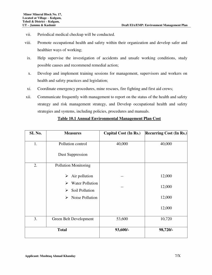
Minor Mineral Block No. 17,
Located at Village – Kulgam,
Tehsil & District – Kulgam,
UT – Jammu & Kashmir Draft EIA/EMP: Environment Management Plan
Applicant: Mushtaq Ahmad Khanday 7/X
vii. Periodical medical checkup will be conducted.
viii. Promote occupational health and safety within their organization and develop safer and
healthier ways of working;
ix. Help supervise the investigation of accidents and unsafe working conditions, study
possible causes and recommend remedial action;
x. Develop and implement training sessions for management, supervisors and workers on
health and safety practices and legislation;
xi. Coordinate emergency procedures, mine rescues, fire fighting and first aid crews;
xii. Communicate frequently with management to report on the status of the health and safety
strategy and risk management strategy, and Develop occupational health and safety
strategies and systems, including policies, procedures and manuals.
Table 10.1 Annual Environmental Management Plan Cost
SI. No. Measures Capital Cost (In Rs.) Recurring Cost (In Rs.)
1. Pollution control
Dust Suppression
40,000 40,000
2. Pollution Monitoring
Air pollution
Water Pollution
Soil Pollution
Noise Pollution
--
--
12,000
12,000
12,000
12,000
3. Green Belt Development 53,600 10,720
Total 93,600/- 98,720/-
Minor Mineral Block No. 17,
Located at Village – Kulgam,
Tehsil & District – Kulgam,
UT – Jammu & Kashmir Draft EIA/EMP: Environment Management Plan
Applicant: Mushtaq Ahmad Khanday 8/X
10.10 SUMMARY
As per Above discussion there is no measure impact on the environment due to mining
except fugitive emission in the form of dust generated during handling of mineral. The
adequate preventive measures will be adopted to contain the various pollutants within
permissible limits. Plantation development will be carried out in the mine premises, along the
approach roads, around Govt. buildings, schools approx 50 trees per year for both leases. It
will prove an effective pollution mitigate technique, and help avoid soil erosion during
monsoon season. Employment opportunities will be provided to the locals only as providing
extraction of minerals from the mine site is the only prevailing occupation for them for their
livelihood.
*************
CHAPTER-XI
SUMMARY AND CONCLUSION
INDEX
SI.NO. CONTENTS Page No.
11.0 INTRODUCTION 2/XI
11.1 ENVIRONMENTAL CLEARANCE 2/XI
11.2 TERMS OF REFERENCE 2/XI
11.3 BRIEF DESCRIPTION OF PROJECT 3/IX
11.4 MINING DETAILS 4/IX
11.5 SUMMARY 4/IX
11.6 CONCLUSION 5/IX
Minor Mineral Block No. 17,
Located at Village –Kulgam,
Tehsil & District – Kulgam,
UT – Jammu & Kashmir Draft EIA/EMP: Summary and Conclusion
Applicant: Mushtaq Ahmad Khanday 2/XI
11.0 INTRODUCTION
Nallah Bed Mining Project is situated at Minor Mineral Block – 17, Q- Kulgam Bridge
Upstream, Vishu Nallah, Village: Ashmuji, Tehsil: Kulgam, District: Kulgam, and State/UT:
Jammu & Kashmir over an area of 1.20 ha for 5 year Lease Period in the favor of Project
Proponent Mushtaq Ahmad Khanday. The proposed rate of average production is 19,561.5
TPA of Sand, Bajri & Boulder. The estimated project cost is Rs. 85 Lakhs.
11.1 ENVIRONMENTAL CLEARANCE:
Environmental Impact Assessment (EIA) is a process, used to identify the environmental,
social and economic impacts of a project prior to decision-making. It is a decision making
tool, which guides the decision makers in taking appropriate decisions for proposed projects.
EIA systematically examines both beneficial and adverse consequences of the proposed
project and ensure that these impacts are taken into account during the project designing.
The present case comes under category ‘B1’ the purview of EIA Notification, MoEF, Govt.
of India, New Delhi dated 14th September 2006 and its subsequent amendments thereof and
EIA Guidance Manual for Mining (Feb, 2010) of MoEF, Govt. of India. This Draft EIA study
has been carried out to assess the environmental, social and economic impacts of the project
and formulate action plans to reduce adverse impacts, shape projects to suit the local
environment and present the predictions and options.
11.2 TERMS OF REFERENCE:
Terms of Reference has been awarded in favor of Mushtaq Ahmad Khanday (Project
Proponent) by J&K Environment Impact Assessment Authority, Jammu & Kashmir for Minor
Mineral Block No. 17 and Vide Letter No. JKEIAA/2020/337/1834-38 dated 26.07.2021 over
an area of 1.20 Ha. (Copy of TOR is enclosed as Annexure – II).
11.3 BRIEF DESCRIPTION OF PROJECT:
A. Project Proponent
Project Proponent Mushtaq Ahmad Khanday
Nature of Project Nallah Bed Mining Project
B. Size of the Project
Project Name Minor Mineral Block No. 17
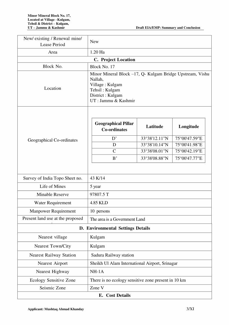
Minor Mineral Block No. 17,
Located at Village –Kulgam,
Tehsil & District – Kulgam,
UT – Jammu & Kashmir Draft EIA/EMP: Summary and Conclusion
Applicant: Mushtaq Ahmad Khanday 3/XI
New/ existing / Renewal mine/
Lease Period New
Area 1.20 Ha
C. Project Location
Block No. Block No. 17
Location
Minor Mineral Block –17, Q- Kulgam Bridge Upstream, Vishu
Nallah,
Village : Kulgam
Tehsil : Kulgam
District : Kulgam
UT : Jammu & Kashmir
Geographical Co-ordinates
Geographical Pillar
Co-ordinates Latitude Longitude
D’ 33°38'12.11"N 75°00'47.59"E
D 33°38'10.14"N 75°00'41.98"E
C 33°38'08.01"N 75°00'42.19"E
B’ 33°38'08.88"N 75°00'47.77"E
Survey of India Topo Sheet no. 43 K/14
Life of Mines 5 year
Minable Reserve 97807.5 T
Water Requirement 4.85 KLD
Manpower Requirement 10 persons
Present land use at the proposed
site
The area is a Government Land
D. Environmental Settings Details
Nearest village Kulgam
Nearest Town/City Kulgam
Nearest Railway Station Sadura Railway station
Nearest Airport Sheikh Ul Alam International Airport, Srinagar
Nearest Highway NH-1A
Ecology Sensitive Zone There is no ecology sensitive zone present in 10 km
Seismic Zone Zone V
E. Cost Details
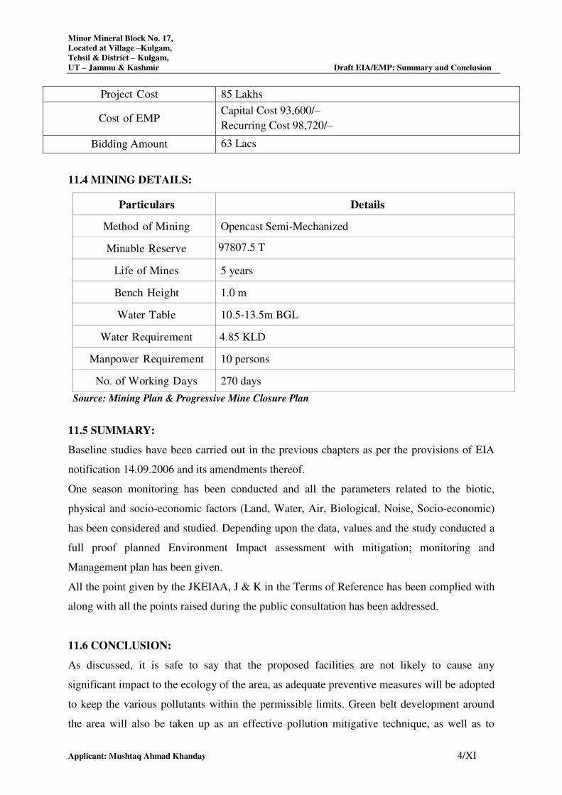
Minor Mineral Block No. 17,
Located at Village –Kulgam,
Tehsil & District – Kulgam,
UT – Jammu & Kashmir Draft EIA/EMP: Summary and Conclusion
Applicant: Mushtaq Ahmad Khanday 4/XI
Project Cost 85 Lakhs
Cost of EMP Capital Cost 93,600/–
Recurring Cost 98,720/–
Bidding Amount 63 Lacs
11.4 MINING DETAILS:
Particulars Details
Method of Mining Opencast Semi-Mechanized
Minable Reserve 97807.5 T
Life of Mines 5 years
Bench Height 1.0 m
Water Table 10.5-13.5m BGL
Water Requirement 4.85 KLD
Manpower Requirement 10 persons
No. of Working Days 270 days
Source: Mining Plan & Progressive Mine Closure Plan
11.5 SUMMARY:
Baseline studies have been carried out in the previous chapters as per the provisions of EIA
notification 14.09.2006 and its amendments thereof.
One season monitoring has been conducted and all the parameters related to the biotic,
physical and socio-economic factors (Land, Water, Air, Biological, Noise, Socio-economic)
has been considered and studied. Depending upon the data, values and the study conducted a
full proof planned Environment Impact assessment with mitigation; monitoring and
Management plan has been given.
All the point given by the JKEIAA, J & K in the Terms of Reference has been complied with
along with all the points raised during the public consultation has been addressed.
11.6 CONCLUSION:
As discussed, it is safe to say that the proposed facilities are not likely to cause any
significant impact to the ecology of the area, as adequate preventive measures will be adopted
to keep the various pollutants within the permissible limits. Green belt development around
the area will also be taken up as an effective pollution mitigative technique, as well as to
Minor Mineral Block No. 17,
Located at Village –Kulgam,
Tehsil & District – Kulgam,
UT – Jammu & Kashmir Draft EIA/EMP: Summary and Conclusion
Applicant: Mushtaq Ahmad Khanday 5/XI
serve as biological indicators for the pollutants released from the premises of “River Bed
Mining Project.
The proposed Nallah bed mining project will prove beneficial to the local people as direct
and indirect employment opportunity will be generated. There will be increase in revenue
generation to the government by way of government taxes etc. Further improvement in
infrastructure will take place like education, roads, availability of drinking water, medical
facilities in adjacent villages.
There will be no significant pollution of air, water, soil and noise. Regular monitoring of all
the components of environment will be done and according to that the proposed mitigation
measures will be adopted. Increased social welfare measures taken by the proponent will
bring development in the near-by villages.
*************
Revised Letter of Intent
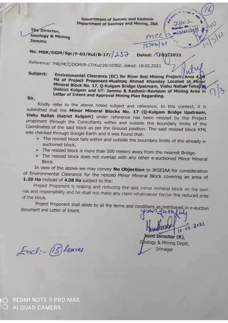
Office order of EC for River Bed/Nallah Bed Mining projects from Government of Jammu &
Kashmir, Department of Geology & Mining, Srinagar (J&K UT).
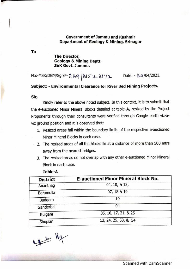
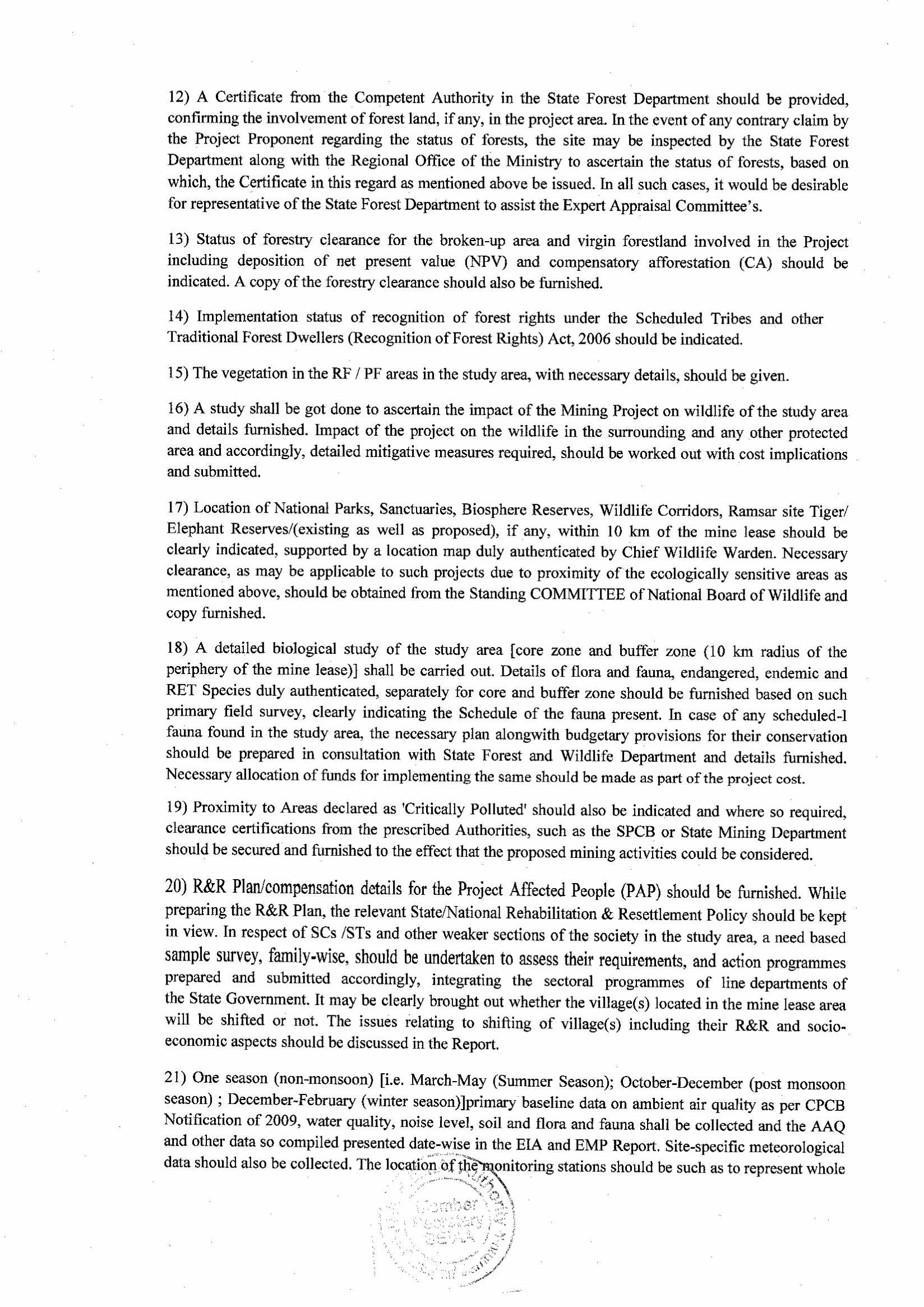
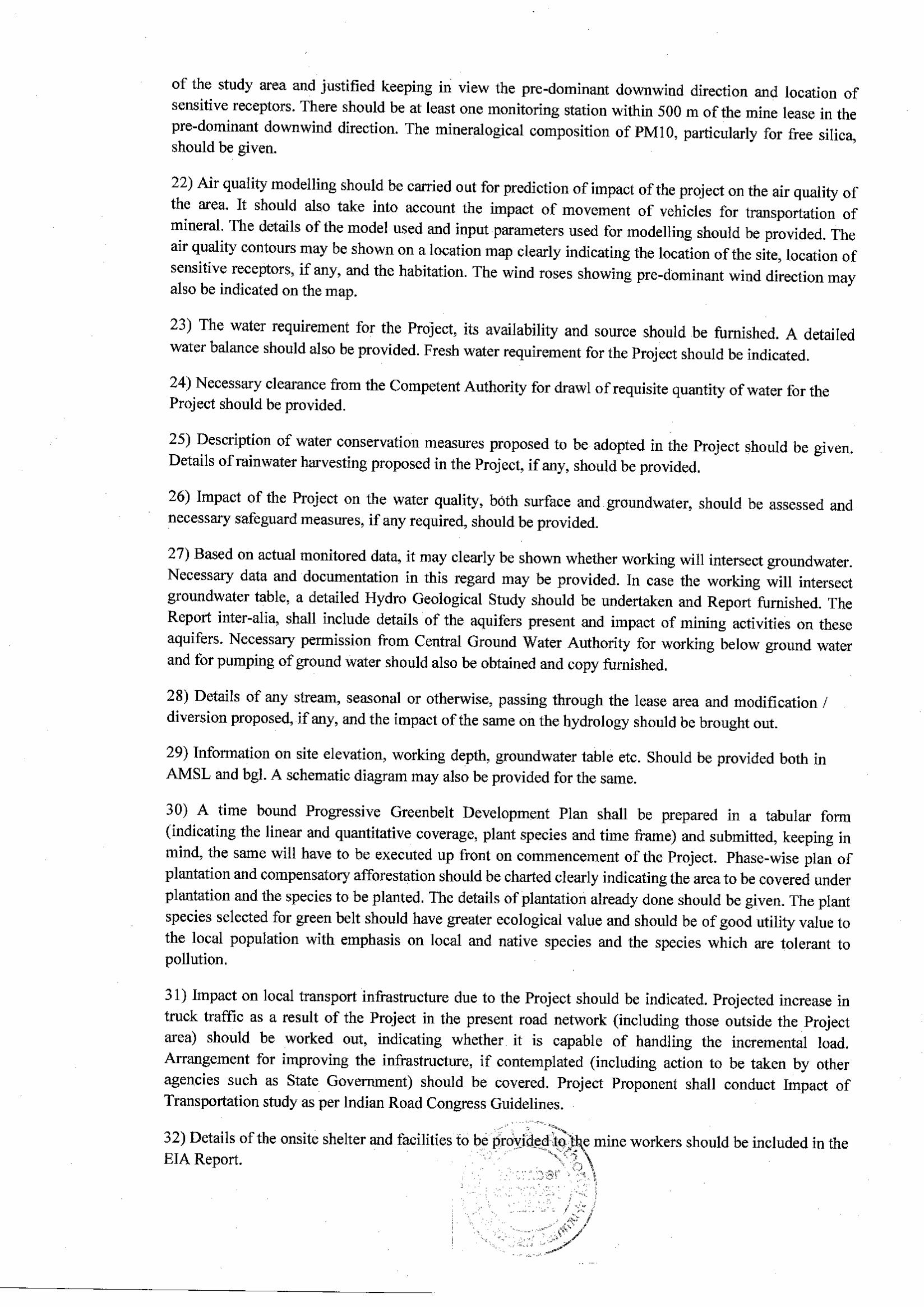
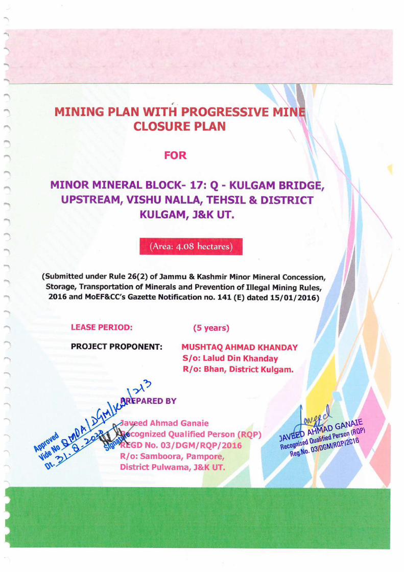

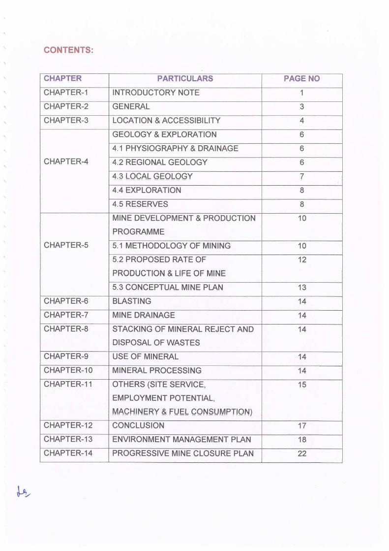
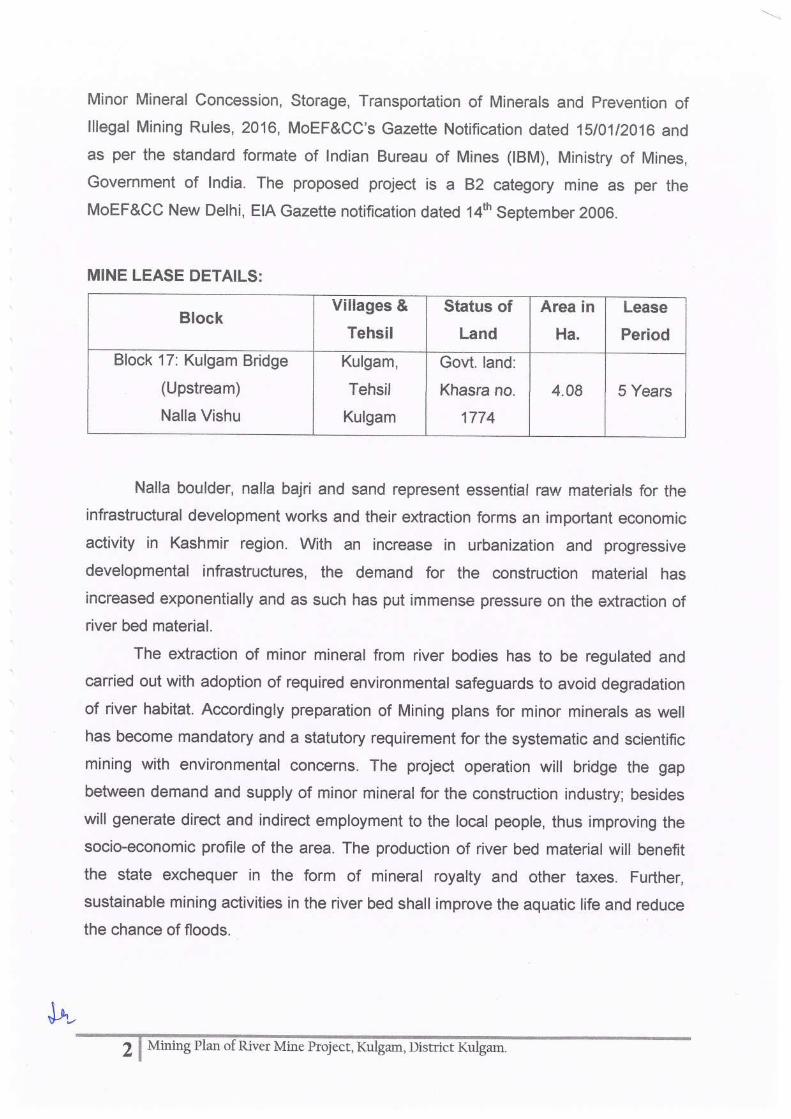
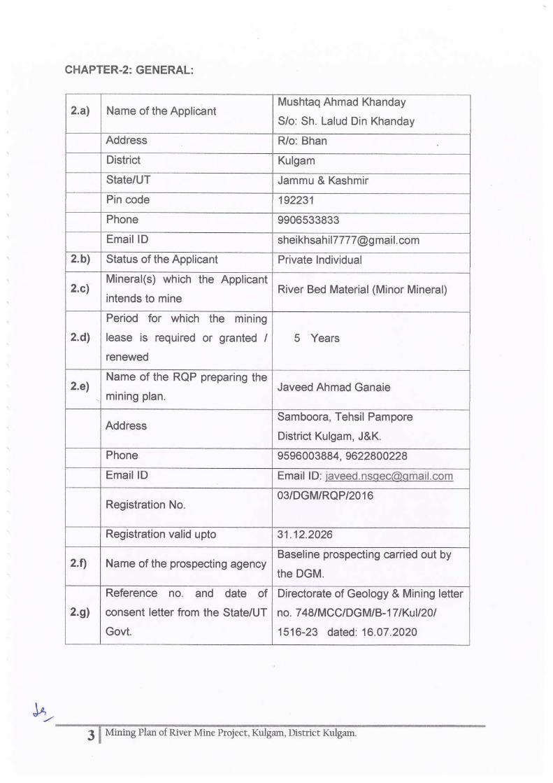
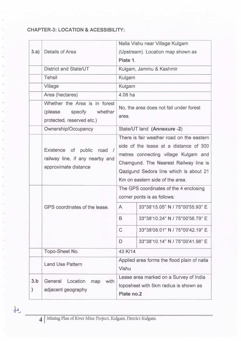
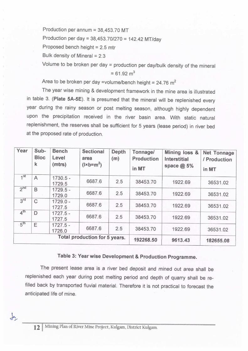
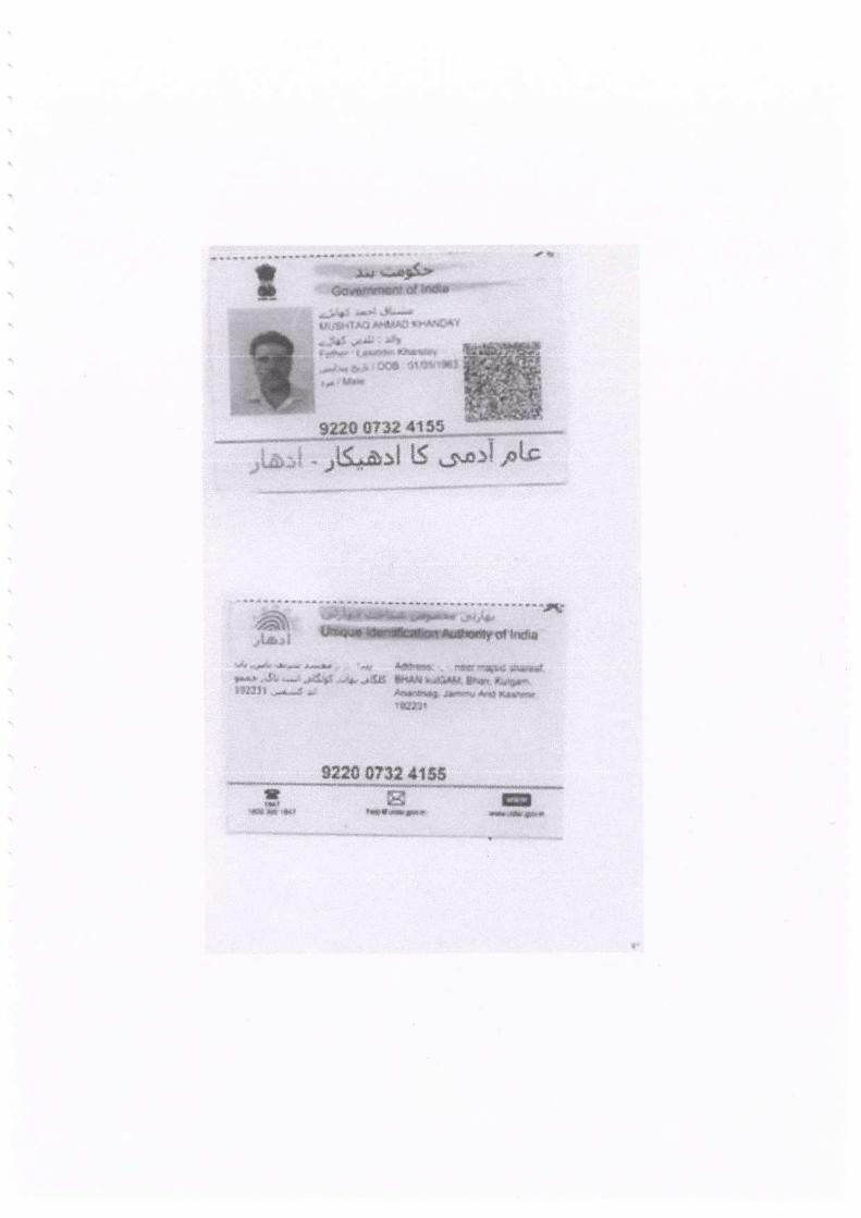
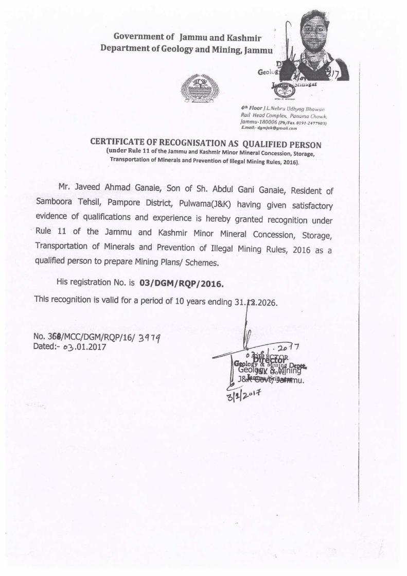

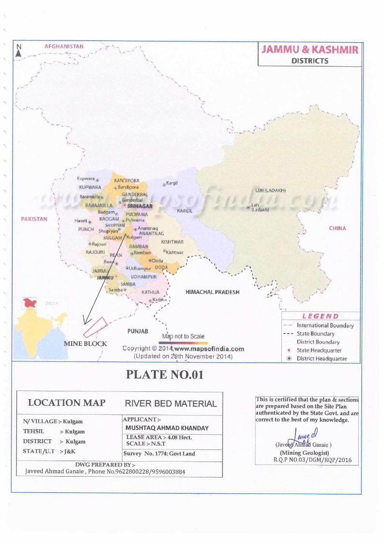
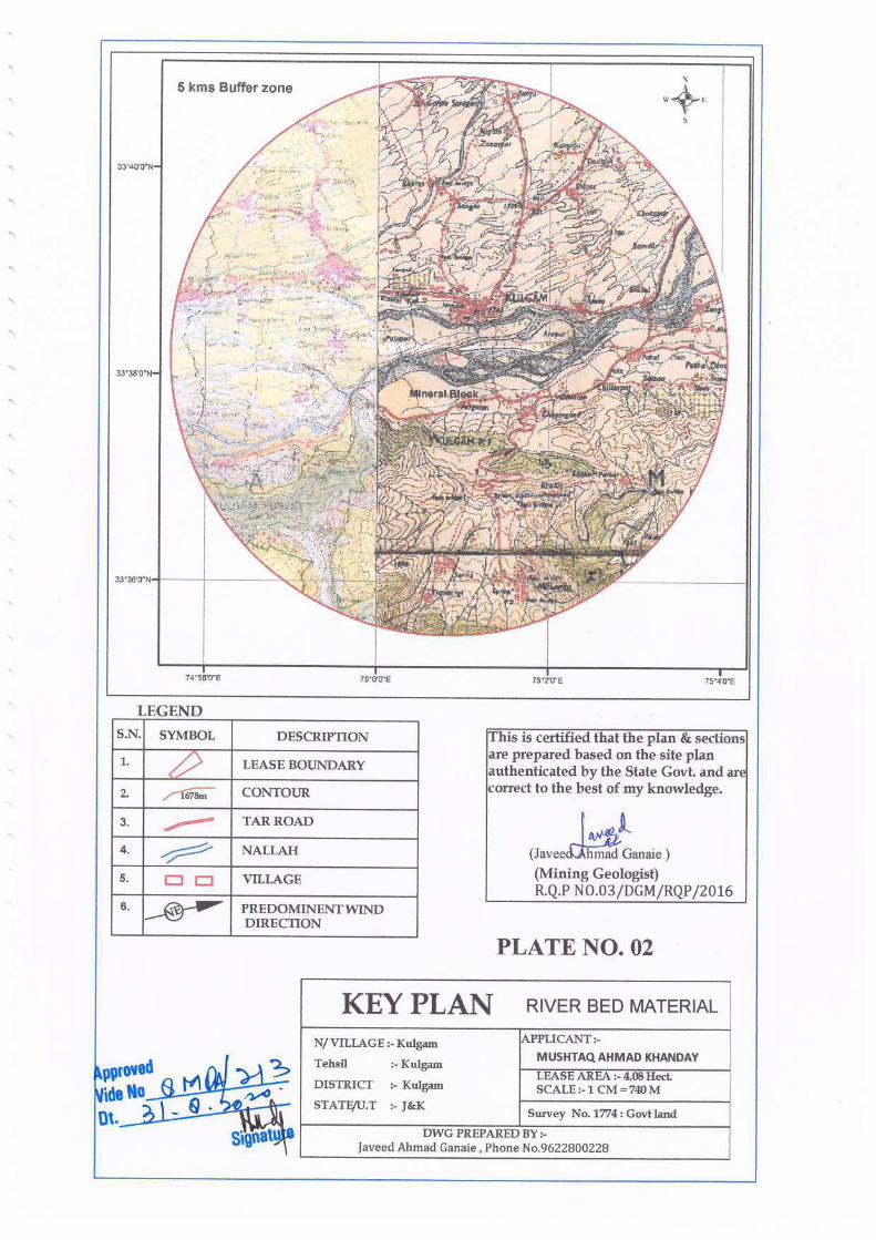
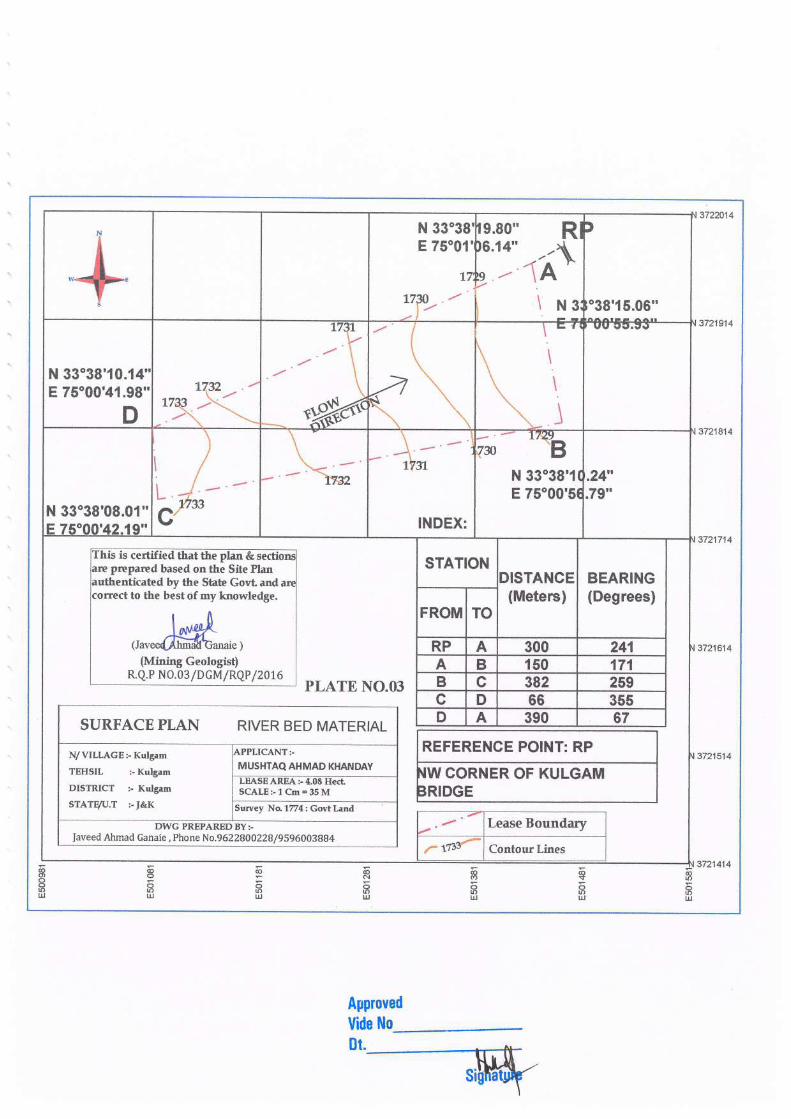
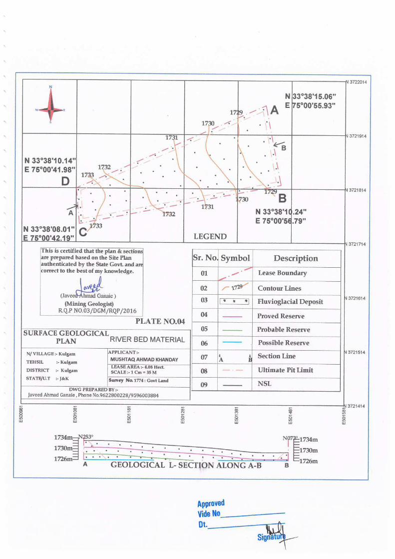
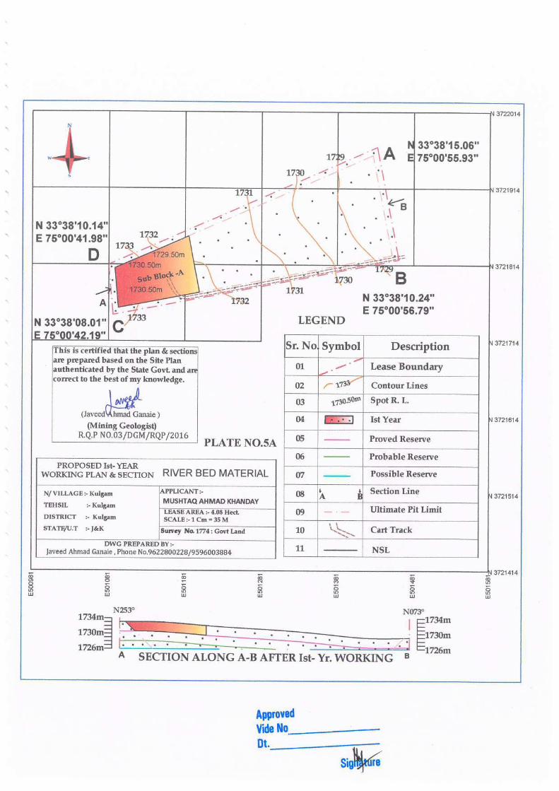
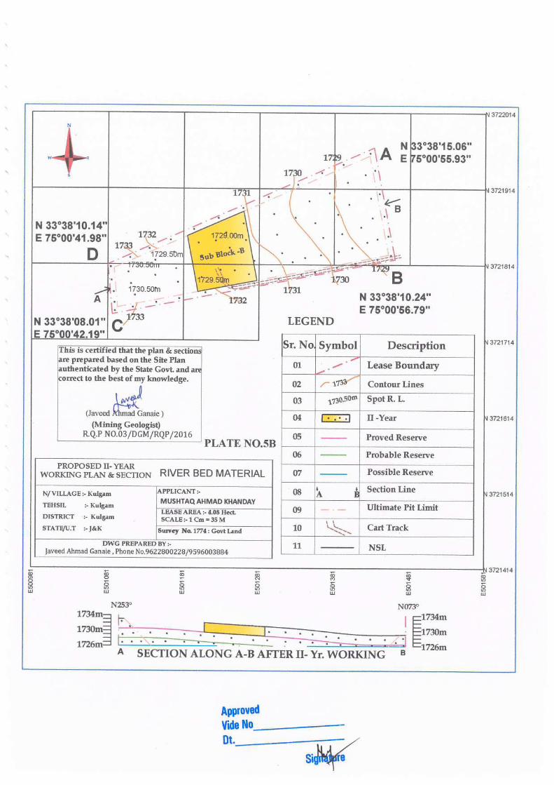
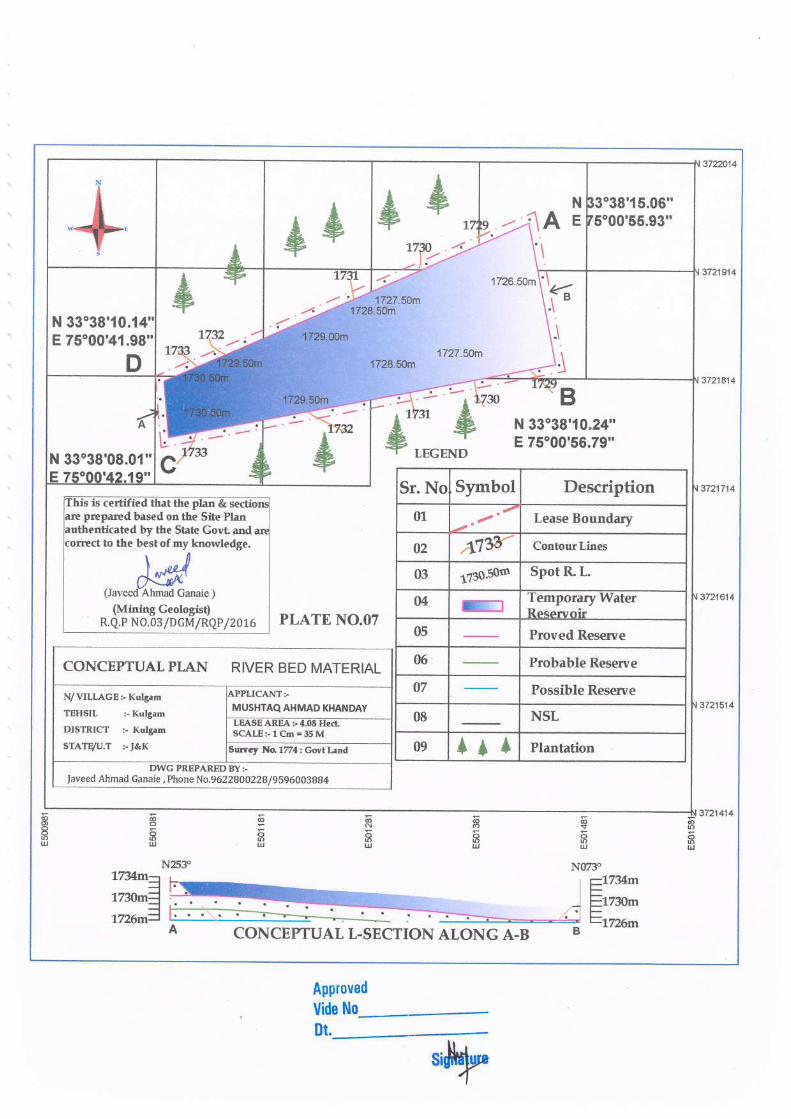
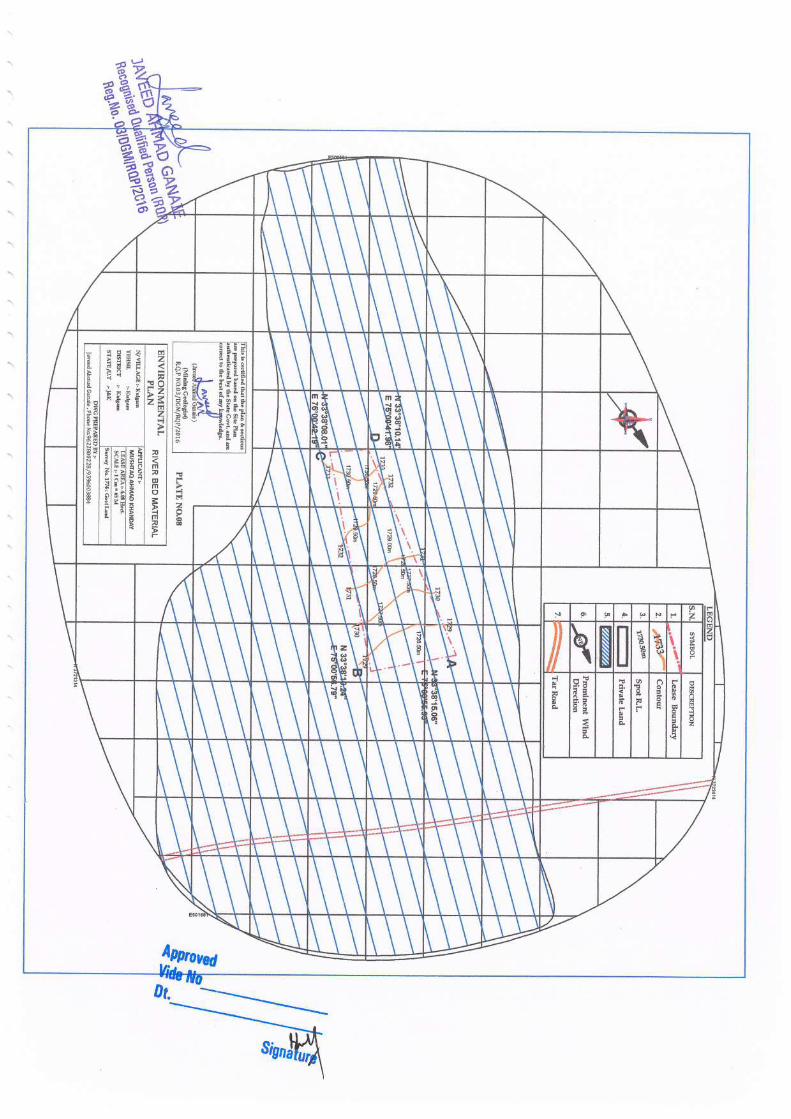

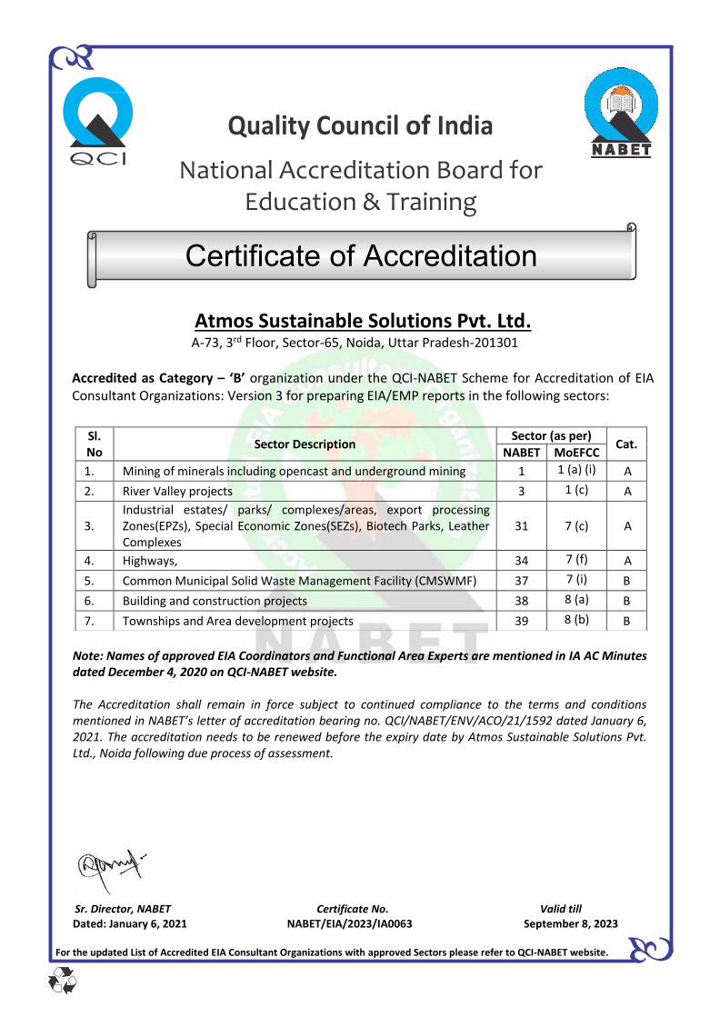
Quality Council of India
National Accreditation Board for Education & Training
Certificate of Accreditation
Atmos Sustainable Solutions Pvt. Ltd. A-73, 3rd Floor, Sector-65, Noida, Uttar Pradesh-201301
Accredited as Category – ‘B’ organization under the QCI-NABET Scheme for Accreditation of EIA Consultant Organizations: Version 3 for preparing EIA/EMP reports in the following sectors:
Note: Names of approved EIA Coordinators and Functional Area Experts are mentioned in IA AC Minutes dated December 4, 2020 on QCI-NABET website. The Accreditation shall remain in force subject to continued compliance to the terms and conditions mentioned in NABET’s letter of accreditation bearing no. QCI/NABET/ENV/ACO/21/1592 dated January 6, 2021. The accreditation needs to be renewed before the expiry date by Atmos Sustainable Solutions Pvt. Ltd., Noida following due process of assessment.
Sr. Director, NABET Certificate No. Valid till Dated: January 6, 2021 NABET/EIA/2023/IA0063 September 8, 2023
For the updated List of Accredited EIA Consultant Organizations with approved Sectors please refer to QCI-NABET website.
Sl. No
Sector Description Sector (as per)
Cat. NABET MoEFCC
1. Mining of minerals including opencast and underground mining 1 1 (a) (i) A
2. River Valley projects 3 1 (c) A
3. Industrial estates/ parks/ complexes/areas, export processing Zones(EPZs), Special Economic Zones(SEZs), Biotech Parks, Leather Complexes
31
7 (c) A
4. Highways, 34 7 (f) A
5. Common Municipal Solid Waste Management Facility (CMSWMF) 37 7 (i) B
6. Building and construction projects 38 8 (a) B
7. Townships and Area development projects 39 8 (b) B