malta and plato's atlantis
TRANSCRIPT
M

MALTA
ECHOES OF PLATO’S ISLAND
The Prehistoric Society of Malta
2001
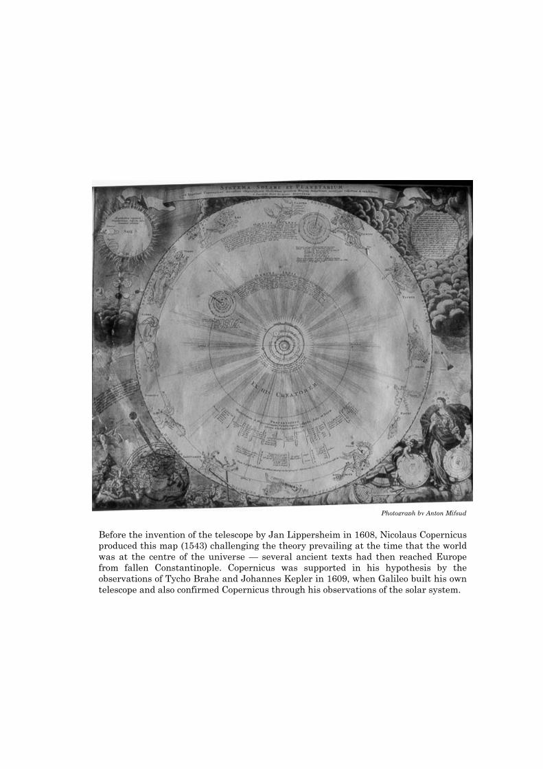
Before the invention of the telescope by Jan Lippersheim in 1608, Nicolaus Copernicus produced this map (1543) challenging the theory prevailing at the time that the world was at the centre of the universe — several ancient texts had then reached Europe from fallen Constantinople. Copernicus was supported in his hypothesis by the observations of Tycho Brahe and Johannes Kepler in 1609, when Galileo built his own telescope and also confirmed Copernicus through his observations of the solar system.
Photograph by Anton Mifsud
MALTA
ECHOES OF PLATO’S ISLAND
Anton Mifsud Simon Mifsud
Chris Agius Sultana Charles Savona Ventura
The Prehistoric Society of Malta
2001
MALTA: ECHOES OF PLATO’S ISLAND Anton Mifsud, Simon Mifsud, Chris Agius Sultana, Charles Savona Ventura ISBN No. 99932-15-02-3. First published by the Prehistoric Society of Malta, July 2000. Second Edition, September 2001, revised by Anton Mifsud. © The Prehistoric Society of Malta. Except when stated otherwise, line drawings by Tabitha Mifsud, photography and full text by Anton Mifsud. Cover design by Tabitha Mifsud and Proprint Co. Ltd. Underwater photography by Chris Agius Sultana. All rights reserved. No part of this volume may be reproduced, stored in a retrieval system, or transmitted in any form or by any means with the prior permission of the Prehistoric Society of Malta. (E-mail - [email protected]). Printed by Proprint Co. Ltd., Shepherds Street, Mosta, MST 08, Malta. Sole distributor — The Prehistoric Society of Malta (e-mail - [email protected]).

To Maria, Michaela and Zea
Preface to the first edition The present theme of Plato’s Island was initiated by one of Malta’s senior archaeologists, definitely not a diehard archaeologist, and presently the Head of Archaeology and Classics at the University of Malta. During his lecture at the Medical School on St. Luke’s Day, 1998, Anthony Bonanno made mention of Giorgio Grongnet, the architect of the Mosta Dome, and one of the chief proponents for the identification of Plato’s island in the Maltese islands — Grongnet had dedicated the greater part of his life to the solution of this problem, and his manuscript is still to be found at the National Library in Valletta. He had unfortunately lost his credibility when he attempted to sustain his hypothesis through a forged inscription, a circumstance which he himself freely admitted. It was also during 1998 that I was actually conducting research in order to disprove this very hypothesis as then being resuscitated by Chris Agius Sultana from Rabat. The outcome was a reversal of my original intention in liaison with my fellow authors. Which category of archaeologist – scholar of antiquities – is best suited to deal with the main theme of this publication? Is it the professional, the quack or the amateur? The professional archaeologist is not necessarily fully qualified to dictate an exclusive interpretation of accumulated data, for archaeology embraces a multitude of disciplines, and the professional archaeologist’s exclusivity lies solely with his license to dig and to report faithfully upon what he has destroyed. (My personal preference for a truly professional archaeologist outside of the Maltese Islands is Paul Bahn. He makes archaeology intensely interesting, and is honest enough to admit a soft spot for Indiana Jones). One category of professional archaeologist who qualifies for a key role in such an investigation on Plato’s Island is the specialized underwater archaeologist who is well equipped for the job. Advances in underwater technology have been responsible in recent times for the discovery of ancient sites lost by submersion, and for operations upon the Titanic and the Kursk. This brings us to the diehard archaeologist, the graduate in archaeological studies who raises an eyebrow, or both, at the mere mention of Plato’s Island, and who immediately betrays his prejudice by refusing to consider any evidence linked with this theme. He would have to insist that the Russian submarine was a collective burial site because a large quantity of bodies was discovered inside it, in the same way that the Hal Saflieni Hypogeum is still assumed to represent a collective burial site on the same grounds. Genuine scholarship requires no added weight of authority, and the efforts of quack archaeologists are not worthy of consideration — a quack is strictly a person who claims a doctoral qualification when he has none. Prehistoric interpretation is open to all scholars with sufficient gray matter in their skulls to exclude personal bias in favour of logical processes. The theme of Plato’s Island is ideally dealt with by the genuine amateurs of archaeology, particularly those scholars who have no personal interests in gain or promotion through the hypotheses they formulate. It is this last category that we have attempted to emulate.
Preface to the second edition
This early second edition has been occasioned through the rapid exhaustion of the first. It has been made possible through the collaboration of a number of friends, chief among whom I would like to include Edwin Lanfranco, Geraldine Camilleri, Joan Marler and Linda Eneix. Abigail has once more read the final draft. At the turn of the millennium, Atlantis has been included in the "traditional" works of archaeology, albeit in a disparaging context, where the attempts of genuine amateurs to identify Plato's island are denigrated in a most unscholarly manner. The bi-monthly Americal journal Archaeology and the textbook by the same name have both neglected to disguise their bias when dealing with the theme. Thus both publications have attempted to pontificate from their mythical ivory towers by emarginating amateur archaeologists in general to an-"other", a "pseudo-", "on the fringe" and a dowright fraudulent category of archaeology of the Piltdown type; the self-styled true professional archaeologists are assumed to be themselves, the "searchers," with a self-awarded exclusive right to the interpretation of archaeological data. (It is as if the culprit for the Piltdown forgery has been identified, and Woodward Smith of the British Museum exonerated from any participation in the fraud). But truly remarkable are the comments relating to the opinion of the "scientist" in these matters, for the authors seem to ignore the fact that most "searchers" or so-called "professional" archaeologists lack the required quantum of basic scientific knowledge, whether this is anatomy, biology, botany, physiology, pathology, bacteriology, forensics, physics or chemistry - one lecture on radiocarbon dating is hardly satisfactory to professionalize a graduate in archaeological studies. On the other hand, the contrary is true for most amateurs. Three of the four authors of this publication are scientists who are fully accredited also in the United Kingdom. Less than a century ago one sole Maltese scientist in the same discipline, Temi Zammit, proved his archaeological worth by challenging even Arthur Evans over Tarxien, and Zammit's dating of Tarxien has remained unchanged although also challenged later by Arthur's namesake, John D. History repeats itself, and once again the amateur researcher will topple the professed searcher over. The evidence for our hypothesis on Plato's Island is being presented not to the searchers' establishment for any form of approval, but to a jury of readers for their final decision. A. M.
Table of Contents
Preface vi
List of illustrations ix Introduction 1
The Twentieth Century 1 An assessment of the megalithic structures 1
The ancient texts 2 The Egyptian Priests 2
The library of Alexandria 2 The antiquity of sources in the texts 4
Severe losses of ancient texts 4 Corruption of texts 4
Politics and prehistory 6 Discoveries confirming the texts 6
Solon and Psonchis in Sais 8 Fact or Fiction 10
Acceptance of Plato’s story 12 Similar cataclysms in historical accounts 12 The search for Plato’s island 12
Malta as a remnant of Plato’s island 14 Criteria for qualification 16
1. A larger landmass in antiquity 16 (a) Early antiquity 16
The early scholars 16 Bathemetry in the nineteenth century 16
Fossil remains 18 Stratigraphy 18
(b) Later antiquity 18 The ancient geographers 18 Cart ruts 24 Biogeographic index 26
2. Floral, faunal and anthropological links with the Pelagian islands and North Africa during the prehistoric period 26
Podarcis 26 Anthropological links 28
Cultural links with the countries dominated by Plato’s island 28 Links with ancient Tyrrhenia 28
Links with ancient Egypt 28 Links with ancient Libia 30
3. Tectono-seismic profile of the Maltese islands 32 Tilting 34
4. Catastrophic events on Malta 36 The flood in ancient cultures 36
Torrential flooding events 36 Human victims of flooding events in the late Neolithic 38
Land submergence and subsidence 40 Submerged temples 42
Land movements on Malta during the Holocene 44 Volcanic activity on Malta 44
5. The Chronology 46 Absolute dating 46
Relative dating 46 Radiocarbon dating 46
6. Features on Malta compatible with Plato’s description 48 Geography 48
The western ocean 48 The Straits of Heracles 48
Plato’s relative geography 52 Cultural and physical features 52
Cultural features 52 Physical features – cart ruts 52
Physical features – temples 54 7. Other ancients texts confirming the geographical position of Plato’s Atlantika 56
Ogygia 56 Malta or Crete 56
Chaldean links 58 Conclusion 58
Summary 58 Endnotes 60
References 64 Plates 73
Index 84
List of illustrations
Figures
Figure 1. The ancient texts 3 Figure 2. The antiquity of sources for the ancient texts 5 Figure 3. Corruption of the texts 5 Figure 4. Revival of the ancient authors 7 Figure 5. Mythology transformed into history 7 Figure 6. The story on the temple walls 9 Figure 7. Features of Plato’s Island 11 Figure 8. The Parthenon 11 Figure 9. Graham’s Island 13 Figure 10. The search for Plato’s island 15 Figure 11. Deodat de Dolomieu 17 Figure 12. The Central Mediterranean sea floor 19 Figure 13. Ptolemy’s maps confirmed after seventeen centuries 21 Figure 14. Ptolemy’s maps of the Maltese Islands 22 Figure 15. A wider latitude for Malta 23 Figure 16. The extensive networks of cart ruts 25 Figure 17. The Maltese wall lizard, Podarcis filfolensis 27 Figure 18. Links with ancient Egypt 29 Figure 19. Links with ancient North Africa 31 Figure 20. Tectono-seismic profiles of the Central Mediterranean 33 Figure 21. The Pantelleria Rift and Tilting 35 Figure 22. Major flooding events in the Mediterranean 37 Figure 23. Alluvial nature of human remains in the hypogea 39 Figure 24. Maltese human remains in alluvial events 41 Figure 25. Submerged prehistoric man-made structures 43 Figure 26. Land displacements in recent times 45 Figure 27. Radiocarbon dates for prehistoric Malta 47 Figure 28. Landmasses between Libia and Sicily 49 Figure 29. Small islands 50 Figure 30. The Straits of Heracles and the western ocean 51 Figure 31. Cult of the Bull 53 Figure 32. They built many temples to their gods 55 Figure 33. Malta or Thera 57 Figure 34. Links with Babylon and King Ninus 59
Plates
Plate 1. Poseidon and the dolphin 73 Plate 2. Secondary sources for the ancient texts 74 Plate 3. Volcanic ash at Mriehel 75 Plate 4. George Zammit Maempel and the distribution of volcanic ash areas 76 Plate 5. Elevation of sea level associated with Mediterranean seismic events 77 Plate 6. Aerial views of submerged features 78 Plate 7. Cart ruts on elevated areas – interrupted by land movement 79 Plate 8. Vestiges of cart ruts leading to the sea 80 Plate 9. Disappearing cart ruts 81 Plate 10. Submerged man-made structures at St. George’s Creek 82 Plate 11. The INA and ITV 83
ix

1
MALTA: ECHOES OF PLATO’S ISLAND
Introduction
The most ancient architectural civilisation
on the planet is represented by a megalithic
culture which flourished for a thousand
years between 3600/3500 and 2600/2500BC,
and which was concentrated on the tiny
Maltese archipelago in the Central
Mediterranean. The radiocarbon dates have
said so.1 The dates have also indicated
that, just after its sudden termination
around 2600/2500BC, the pyramidal form of
megalithic culture appeared in Egypt.
The small size of the Maltese archipelago of
today militates against the prominent
archaeological position it assumes. Its
megalithic monuments, decorative art and
statuary are the remarkable survivors of its
civilisation.2 The temples of Malta never
fail to amaze all nationalities, except for the
native Maltese. Yet how could such a small
surface area produce a civilisation
antedating the Egyptian one by a thousand
years?3 Equally enigmatic are the
circumstances of its sudden and abrupt
termination, followed by a complete break
in the archaeological record, and
represented by ―several feet of fine sand,
containing no stones or broken fragments of
rock and no traces of any Bronze Age pottery
or metal, clearly showing that this layer had
been deposited by centuries of wind and
rain, untouched by the hand of man‖4.
Although several hypotheses have been put
forward to explain its sudden and complete
elimination, such as famine, plague,
warfare and over-exploitation of natural
resources,5 a more satisfactory
interpretation in this regard is still
wanting.
The twentieth century
Problems with Maltese prehistory were
sparked off at the turn of the century with
Albert Mayr (1901), who identified the
megalithic structures on Malta and Gozo as
prehistoric rather than Phoenician. Malta‘s
prehistory was carried back from 1500 to
3000 BC. Merely a few years previously
Arthur Evans had established Bronze Age
Crete as the cradle of Mediterranean
civilisation. Mayr had barely shaken the
Cretan cradle in the Aegean when a series
of archaeological discoveries in Malta
completely reversed it. Three sites at
Tarxien established a new order in
Mediterranean prehistoric archaeology.
The Hal Saflieni Hypogeum, the Tarxien
temples and the Tarxien Cemetery site
delineated a new sequence, where art in
architecture was first manifest in Neolithic
Malta at around 3000BC6; calibrated
radiocarbon dating has since pinpointed the
Tarxien date to 3100BC7.
An assessment of the megalithic
structures
The megalithic structures of the Maltese
islands were already known abroad as
temples in the sixteenth century, such as by
Nostradamus8. Quintinus described the
megalithic temple at Grand Harbour which
is now lost, but which was also confirmed by
later visitors. 9
Maltese megalithic architecture developed
in insularity, as an isolated phenomenon,
without any parallels elsewhere on earth,
and with no known external source of
inspiration. These unique constructions,
the world‘s most impressive prehistoric
monuments, appeared before the temples of
the eastern Mediterranean and also before
the Egyptian pyramids and Stonehenge.
―Neolithic Malta … developed, in its
insularity, in its own most original
manner‖.10 ―No significant parallels are at
present known to the temples, the carving,
the statuettes, or the pottery … they remain
an isolated phenomenon in prehistoric
Europe‖.11 ―Archaeologists have not ceased
to scour the Mediterranean from the Levant
to Spain in search of the culture from which
Malta drew its inspiration‖.12
―It should now be clear to all serious and
unbiased students of megaliths that these
structures of great stones came into existence
in many separate societies: Malta…‖13 ―It is
now not possible to derive the (Maltese)
temples from outside, and the spirals prove
older than those of Mycenae … The world‘s
most impressive prehistoric monuments …
The great stone monuments of Malta, and
the finds that go with them, have long
presented difficulties to the archaeologist …
the tree-ring calibration … sets aside
entirely the traditional links with the
Aegean‖.14
Malta:
2
―The temples of Malta are actually older
than the temples of the eastern
Mediterranean, older even than the
pyramids. Therefore, even though they knew
nothing of writing, wheeled transport or the
use of metal, the Neolithic inhabitants of
Malta must have been sufficiently
sophisticated in their own social
organisation to construct these
extraordinary monuments without external
help‖.15
Trump described the Maltese temples as
―site-orientated spatial systems of cyclopean
or orthostatic masonry‖.16 An architectural
assessment defines them as a ―series of
unique constructions that to this day testify
to the skill, ingenuity and sublimated
ambitions of these early inhabitants of the
Maltese islands‖.17
The ancient texts
People have been writing stories for a very
long time. Almost invariably with the
ancient authors, supernatural beings were
invoked as active participants in their early
prehistoric past. God of the Israelites
created the universe and picked them out as
the chosen race; he punished them for their
transgressions, and aided them in the wars
against their enemies. Other civilisations
too had their unseen god who influenced
human lives in a supernatural manner. In
a material world such ancient texts, tinged
as they are with the supernatural, would be
frowned upon with good reason, particularly
when they fail to measure up to scientific
methods. The main error with the ancient
texts has been their absolute chronology; in
Genesis, for example, on the one hand
Adam had lived for nine centuries, and on
the other, the world had been created a
mere four millennia before Christ. The
archaeology of the lands of the Bible,
however, tends to confirm the events
recorded in it. And the recently discovered
Dead Sea scrolls of Qumran (1947, 1956)
have confirmed both the Greek version of
the ancient Hebrew texts (Septuagint:
Alexandria 3rd century BC) and the Latin
one (Vulgate of St. Jerome, 3rd century AD).
Unfortunately however, although not
always accurate, the ―imperfectly preserved‖
ancient text of Manetho has always been
the professional archaeologist‘s mainstay of
ancient Egyptian chronology.
Manetho was an Egyptian priest who wrote
in the third century BC, and his subject
matter was the history and religion of
ancient Egypt. As is usually the norm with
ancient texts, the writings of Manetho have
reached us only through ―fragmentary and
often distorted quotations‖ by Josephus and
the Christian chronographers, Africanus
and Eusebius. Both the Jews18 and the
early Christians19 modified Manetho‘s text
to suit their religious and political
inclinations.20 The Jews amended the
sections which associated their lineage with
the leper communities. The modifications
made by the Christians were aimed at
synchronising the Egyptian accounts with
the Biblical chronography.21
Nevertheless these surviving fragments of
Manetho‘s text have been constantly
utilised by archaeologists to build up the
succession of Egyptian kings where the
archaeological evidence was inconclusive,
and Manetho's division of the rulers of
Egypt into 30 dynasties is still accepted tale
quale.
The Egyptian priests
The priests in ancient Egypt were in an
ideal position to render an account of its
ancient history. There was unlimited
access to ancient documentary evidence in
the form of inscriptions on the temple walls,
clay tablets and texts of papyrus. The
Egyptian priests were well versed in Greek,
and were able to produce good and reliable
historical accounts.
Before the conquest and Hellenization of
Egypt by Alexander the Great in 332 BC,
Greek scholars visited Egypt and obtained
information on its ancient history from the
experts themselves, the priests living on the
fertile Delta of the Nile.
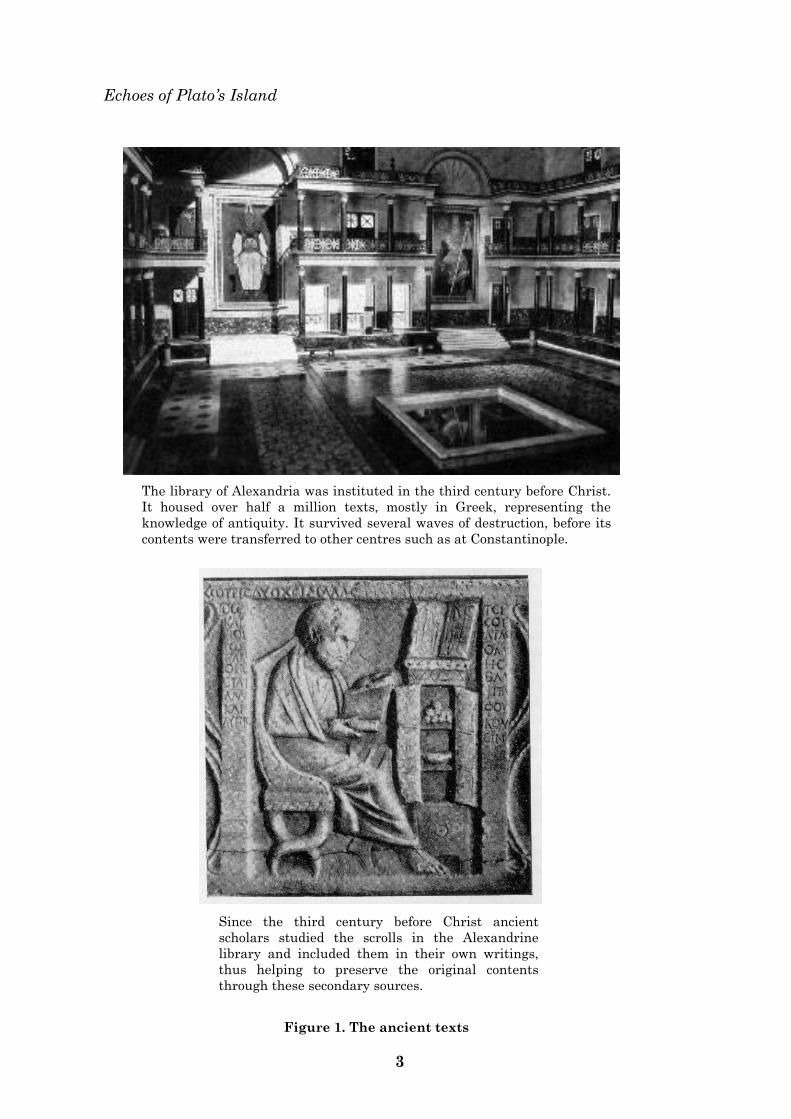
The library of Alexandria
From the 3rd century BC, shortly after the
Greek conquest of Egypt, the library of
Alexandria became the outstanding centre
of Greek culture. It was the most celebrated
repository of the ancient texts in antiquity.
The institution was intended from the very
start as a great international school and
library. Ptolemy I founded the Museum, or
Shrine to the Muses, which included the
library itself and a school. A strong Jewish
presence in Alexandria was a significant
feature at the time, and thus the library
also became the largest centre for Jewish
scholarship in the ancient world.
Echoes of Plato‘s Island
3
The library of Alexandria was instituted in the third century before Christ.
It housed over half a million texts, mostly in Greek, representing the
knowledge of antiquity. It survived several waves of destruction, before its
contents were transferred to other centres such as at Constantinople.
Since the third century before Christ ancient
scholars studied the scrolls in the Alexandrine
library and included them in their own writings,
thus helping to preserve the original contents
through these secondary sources.
Figure 1. The ancient texts
Malta:
4
The library served as a repository for every
Greek work of the classical period that was
then available, and eventually housed more
than half a million volumes. The institution
was directed by great scholars such as
Callimachus, who utilised their time in the
library conducting valuable research. Thus,
although several of the ancient documents
were subsequently lost, their contents have
been preserved in secondary sources — in
the records of those scholars who
researched them in antiquity and in more
recent times.
The antiquity of sources in the texts
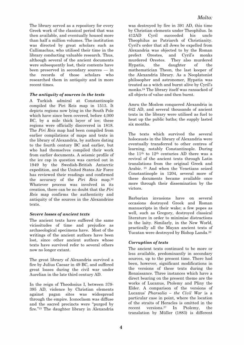
A Turkish admiral at Constantinople
compiled the Piri Reis map in 1513. It
depicts regions now lying in the South Pole
which have since been covered, before 4,000
BC, by a mile thick layer of ice; these
regions were officially discovered in 1818.
The Piri Reis map had been compiled from
earlier compilations of maps and texts in
the library of Alexandria, by authors dating
to the fourth century BC and earlier, but
who had themselves compiled their work
from earlier documents. A seismic profile of
the ice cap in question was carried out in
1949 by the Swedish-British Antarctic
expedition, and the United States Air Force
has reviewed their readings and confirmed
the accuracy of the Piri Reis map.22
Whatever process was involved in its
creation, there can be no doubt that the Piri
Reis map confirms the authenticity and
antiquity of the sources in the Alexandrine
texts.
Severe losses of ancient texts
The ancient texts have suffered the same
vicissitudes of time and prejudice as
archaeological specimens have. Most of the
writings of the ancient authors have been
lost, since other ancient authors whose
texts have survived refer to several others
now no longer extant.
The great library of Alexandria survived a
fire by Julius Caesar in 49 BC, and suffered
great losses during the civil war under
Aurelian in the late third century AD.
In the reign of Theodosius I, between 379-
395 AD, violence by Christian elements
against pagan sites was widespread
through the empire. Iconoclasm was diffuse
and the sacred precincts were ―purged by
fire.‖23 The daughter library in Alexandria
was destroyed by fire in 391 AD, this time
by Christian elements under Theophilus. In
412AD Cyril succeeded his uncle
Theophilus as Patriarch of Christianity.
Cyril's order that all Jews be expelled from
Alexandria was objected to by the Roman
prefect Orestes, and Cyril‘s monks
murdered Orestes. They also murdered
Hypatia, the daughter of the
mathematician Theon, the last keeper of
the Alexandria library. As a Neoplatonist
philosopher and astronomer, Hypatia was
treated as a witch and burnt alive by Cyril‘s
monks.24 The library itself was ransacked of
all objects of value and then burnt.
Amru the Moslem conquered Alexandria in
642 AD, and several thousands of ancient
texts in the library were utilised as fuel to
heat up the public baths; the supply lasted
six months.
The texts which survived the several
holocausts in the library of Alexandria were
eventually transferred to other centres of
learning, notably Constantinople. During
the 11th to 12th centuries AD there was a
revival of the ancient texts through Latin
translations from the original Greek and
Arabic. 25 And when the Venetians seized
Constantinople in 1204, several more of
these documents became available once
more through their dissemination by the
victors.
Barbarian invasions have on several
occasions destroyed Greek and Roman
manuscripts in their wake; a few popes as
well, such as Gregory, destroyed classical
literature in order to minimise distractions
in the laity. Similarly, in the New World,
practically all the Mayan ancient texts of
Yucatan were destroyed by Bishop Landa.26
Corruption of texts
The ancient texts continued to be more or
less available, predominantly in secondary
sources, up to the present time. There had
been, however, significant modifications in
the versions of these texts during the
Renaissance. Three instances which have a
direct bearing on the present theme are the
works of Lucanus, Ptolemy and Pliny the
Elder. A comparison of the versions of
Lucanus‘ Pharsalia – the Civil War is a
particular case in point, where the location
of the straits of Heracles is omitted in the
recent versions.27 In Ptolemy, the
translation by Müller (1883) is different
Echoes of Plato‘s Island
5
Figure 2. Antiquity of sources for the ancient texts.
The Piri Reis map was discovered in 1929 in the Topkapi, Constantinople, the
depository of the ancient texts after their dispersal from Alexandria in the 8th
century AD. It was drawn in 1513AD — spherical trigonometry as applied to
maps was ‗discovered‘ in Europe at the turn of the 18th century AD. Antarctica
was ‗discovered‘ in 1818, and its outline beneath the ice (as it appears already on
the Piri Reis map) was confirmed by seismic profile in 1949.
Figure 3. Corruption of the ancient texts
The ancient texts were subjected to the whims and prejudices of several ‗scholars.‘ The
Italian Ludovico Domenichi (left) corrupted the content of the ancient texts by incorrect
translation. The chaplain of the Order of St. John of Jerusalem, Fra Giuseppe Vella
(right), falsified documents in an attempt to attenuate the Arab presence in Sicily and
Malta.
Malta:
6
from the four earlier versions (1490, 1520,
1540 and 1574),28 in some of the readings of
latitude for the Maltese islands. And
whereas the original Pliny (Book 7: 56)
mentions the military encounter between
the Athenians and the Atlanteans as the
first documented battle, and that the
weapons used were wooden sticks hardened
with fire because of a lack of the knowledge
of iron, this detail is omitted in the more
recent versions.29
Attempts at distortion of ancient documents
have complicated the issue even further. In
the local scenario, there is the classical
instance of falsification of ‗Arabic‘
documents by the Abate Giuseppe Vella,
Chaplain of the Sacred Order of Jerusalem
in Palermo in the late eighteenth century.
The prevalence of prejudice over logic in
such instances is further manifest by the
attitude of the authorities towards this
forgery. Notwithstanding the exposure, the
Abate‘s action was then considered to have
been a ―beneficial imposture‖.30
Politics and prehistory
Unfortunately prehistoric interpretation
has often been tarnished on political
grounds. ―There was a long dispute whether
it (Malta) was in Europe or Africa, but the
British Parliament at last ended the matter
by declaring it to be in Europe‖.31 ―Though
Malta is classed with Europe, it boasts that
honour more from an act of the British
parliament, passed in its ‗omnipotence,‘
than from any intrinsic claims of the island
itself, to that distinction. It lies to the south
of the whole maritime frontier of Algiers, as
well as of most of the shores of Tunis and
Morocco. Ptolemy32 places Malta, with
sufficient reason, in Africa; and the earlier
geographers chiefly adopted the same
classification‖.33 The early Christian church
also acknowledged the situation that Malta
formed part of the group of islands on the
African Pelagian block.34 Politically, it has
also been linked to North Africa for a short
while — in the sixteenth century, Malta
formed with Tripoli the joint domain of the
Knights of St. John.
During the last war, the British
administration investigated the Maltese
links with Africa, in a confidential dossier of
the Colonial Office (1941-3), under the title
of ―Information re Continent in which Malta
is situated.‖ Britain was at war with Italy,
and the Italian affiliations of several
Maltese had featured significantly during
the same war. The contents of the dossier
were never published, and were ―destroyed
under statute‖ in 1973.35 Distortion of
archaeological evidence in Malta and other
Mediterranean islands has featured also in
recent years.36
Discoveries confirming the texts
The ancient scholars such as Thales
(585BC), Pythagoras (500BC), Aristarchus
(280BC), Eratosthenes of Cyrene (240BC)
and Hipparchus (150BC) had investigated
astronomy; physics had been studied by
Aristotle (350BC), Plato (400BC) and
Democritus (440BC). After their dispersal
in the seventh century AD, the ancient
texts were practically ignored right up to
the fifteenth century AD. It was shortly
after the capture of Constantinople, in
1454, that Greek scholars such as
Bessarione, Crisolora and Calcondila once
again acquainted Europe with Greek
literature, and the contents of several more
of the ancient Greek texts made their
appearance amongst the scholars of Europe.
Literary works, which were based on these
ancient texts, started to appear in the late
fifteenth century, and these are particularly
useful as secondary sources of original texts
which have since been lost.
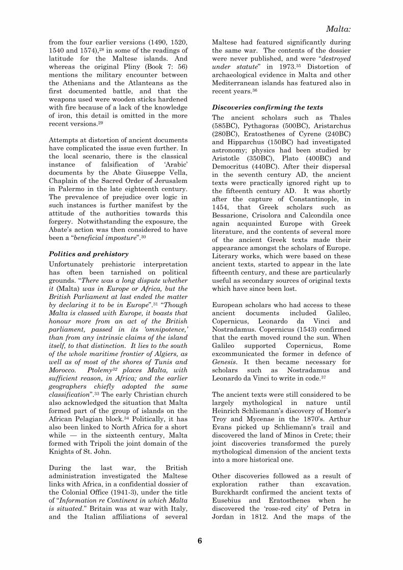
European scholars who had access to these
ancient documents included Galileo,
Copernicus, Leonardo da Vinci and
Nostradamus. Copernicus (1543) confirmed
that the earth moved round the sun. When
Galileo supported Copernicus, Rome
excommunicated the former in defence of
Genesis. It then became necessary for
scholars such as Nostradamus and
Leonardo da Vinci to write in code.37
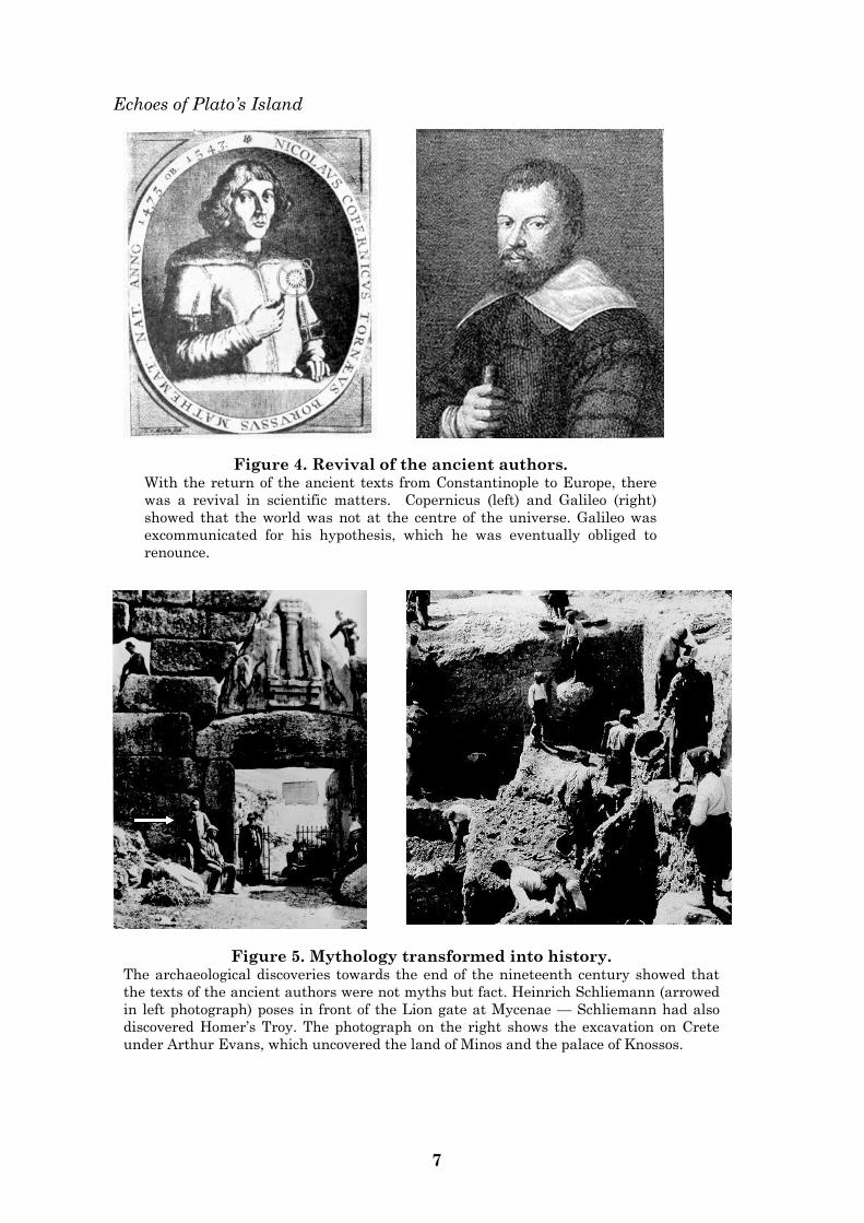
The ancient texts were still considered to be
largely mythological in nature until
Heinrich Schliemann‘s discovery of Homer‘s
Troy and Mycenae in the 1870‘s. Arthur
Evans picked up Schliemann‘s trail and
discovered the land of Minos in Crete; their
joint discoveries transformed the purely
mythological dimension of the ancient texts
into a more historical one.
Other discoveries followed as a result of
exploration rather than excavation.
Burckhardt confirmed the ancient texts of
Eusebius and Eratosthenes when he
discovered the ‗rose-red city‘ of Petra in
Jordan in 1812. And the maps of the
Echoes of Plato‘s Island
7
Figure 4. Revival of the ancient authors. With the return of the ancient texts from Constantinople to Europe, there
was a revival in scientific matters. Copernicus (left) and Galileo (right)
showed that the world was not at the centre of the universe. Galileo was
excommunicated for his hypothesis, which he was eventually obliged to
renounce.
Figure 5. Mythology transformed into history. The archaeological discoveries towards the end of the nineteenth century showed that
the texts of the ancient authors were not myths but fact. Heinrich Schliemann (arrowed
in left photograph) poses in front of the Lion gate at Mycenae — Schliemann had also
discovered Homer‘s Troy. The photograph on the right shows the excavation on Crete
under Arthur Evans, which uncovered the land of Minos and the palace of Knossos.
Malta:
8
ancient geographers such as Claudius
Ptolemy have also been confirmed in this
way — in 1888 Henry Morton Stanley
discovered the Ruwenzori mountain range
in Central Africa, and this has been
identified with Ptolemy‘s Mountains of the
Moon, the source of the Nile in Central
Africa. Some ancient geographers remain
unknown, as in the instance of the Piri Reis
map, already referred to above.
The accounts of the ancient authors have
been thoroughly researched in recent years,
and several extinct sites have been
identified, if only in part.38 One of the very
recent (1998) is based on the account given
by Strabo of ancient Alexandria. In
conditions of poor visibility underwater,
over an area of 27 hectares, Franck
Goddio‘s team have uncovered the
submerged Antirhodos island, the site of
Cleopatra‘s palace; this lay under layers of
thick silt and a one-metre crust of
calcareous deposit, at a depth of five to six
metres beneath the surface of Alexandria
bay, not far from the modern city‘s
shoreline.39 In the meantime, the Tower of
Babel has been reported as identified in
Pontus, in the Black Sea, as described by
some ancient Aramaic Biblical texts.40 The
Black Sea is also the site of the most recent
discovery associated with the descriptions
by the ancient authors (Strabo, Arrian and
Aristotle)— the sunken city of Phasis, the
destination of Jason and the Argonauts.41
The sunken site par excellance is the island
described by Plato in the fourth century
before Christ. In 1939 the Director of the
Department of Antiquities in Greece,
Spyridon Marinatos, picked up Arthur
Evans‘ trail and identified the island of
Thera-Santorini in the Aegean Sea with
Plato‘s Island. In 1977, Marinatos was
supported by James W. Mavor, the naval
engineer who designed the Alvin, the
research submarine of the Woodshole
Oceanographic Institute. The Thera
hypothesis has enjoyed the greatest
popularity to date. The theme of Plato‘s
Island had originated in Egypt.
Solon and Psonchis in Säis
Solon was an Athenian of royal lineage, well
known for his poetry and verse. According
to Plutarch,42 he flourished around 600BC.
Because of his fair-mindedness and
integrity, which earned him the trust of all
the Athenian social classes, he was given
full administrative powers over Athens
around 594 BC. Through this office Solon
was successful in implementing major
changes to improve the political,
administrative and social structures of the
nation.43
Solon had travelled widely. In 590 BC he
left Athens for ten years and visited Säis in
Egypt, ―on the Canopian shore, by the Nile‘s
deep mouth‖; there he conversed with the
wise men of Säis, particularly with
Psonchis, the most learned of the Egyptian
high priests, upon points of philosophy and
history. According to Clement of
Alexandria, Psonchis had instructed
Pythagoras in the science of the Egyptians.
Solon also visited Heliopolis and conversed
with the priest Psenopbis.44
The ancient Greeks had lost most of their
records in a major flood45. In fact, Psonchis
thus addressed himself to Solon — ―You
have no antiquity in history, and no history
of antiquity.‖46
It was a different situation in ancient
Egypt, as Psonchis explained to Solon.
―Whatever happened either in your country
or in ours, or in any other region of which
we are informed, if any action which is
noble or great, or in any other way
remarkable has taken place, all that has
been written down of old, is preserved in our
temples; whereas your people and the others
are but newly equipped, every time, with
letters and all such arts as civilised states
require … when the flood comes … it leaves
none of you but the unlettered and the
uncultured … with no knowledge of what
happened in olden times in this land and in
your own‖.47 Psonchis then proceeded to
outline the most remarkable event in the
prehistory of the ancient Athenians, when
they had led the military forces of the
eastern Mediterranean against those of
Atlantika in the west. The defeat of the
Atlantean forces was immediately followed
by a cataclysmic disaster, which submerged
Atlantika beneath the waves for all time.48
―In comparison of what then was, there are
remaining in small islands only the bones of
the wasted body … the mere skeleton of the
country being left.‖49 Psonchis also gave
Solon several details about Atlantika before
its submergence.
The civilisation of Atlantika had been
established for a millennium in advance of
Echoes of Plato’s Island
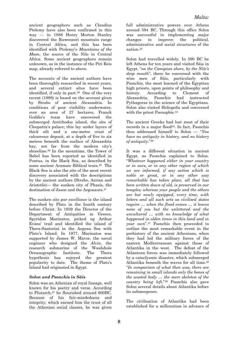
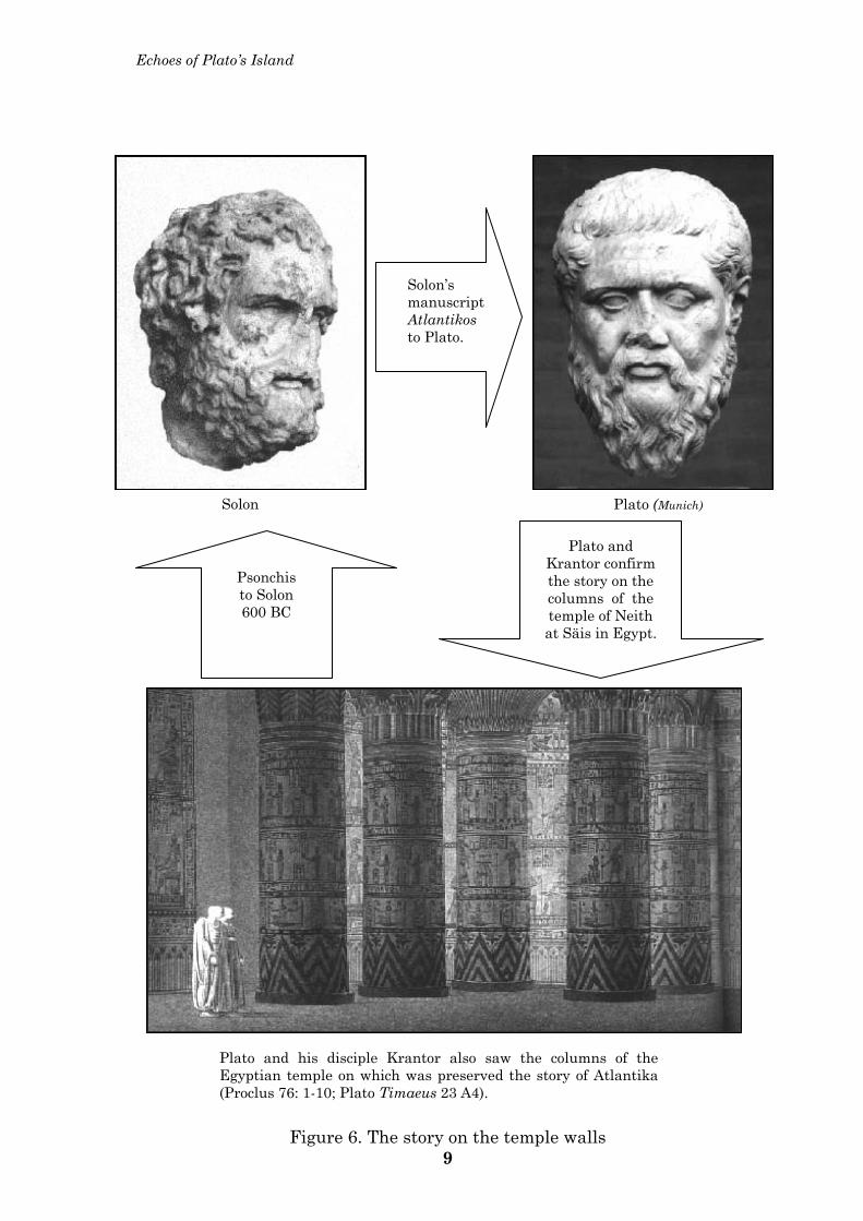
Plato and his disciple Krantor also saw the columns of the Egyptian temple on which was preserved the story of Atlantika (Proclus 76: 1-10; Plato Timaeus 23 A4).
Plato (Munich) Solon
Psonchis to Solon 600 BC
Plato and Krantor confirm the story on the columns of the temple of Neith at Säis in Egypt.
Solon’s manuscript Atlantikos to Plato.
Figure 6. The story on the temple walls 9
Malta:
10
the Egyptian one.50 It had lain close to the
straits of Heracles in the western ocean.51
―Atlantika was the way to other islands, and
from these you might pass to the whole of
the opposite continent which surrounded the
true ocean; for this sea which is within the
Straits of Heracles is only a harbour, having
a narrow entrance, but that other is a real
sea, and the surrounding land may be most
truly called a boundless continent‖.52
The Atlanteans, or Atlantoi, had built
impressive temples to their gods.53 They
built triremes in their shipyards,54 and had
developed an intricate network of channels
over the rocky terrain in order to transport
their water and goods across the country.55
They performed bull sacrifice.56 They were
successful in their military ventures, and
had subjected the lands of ancient Libia and
Egypt, and the western Mediterranean as
far as the Tyrrhenian Sea;57 their empire
excelled that of Libia and Asia put
together.58
On his return to Athens, Solon put the
details of Psonchis‘ account to writing in the
manuscript Atlantikos. This text has since
been lost, but its contents reached his great
grandson, Plato, a scholar, thinker and
historian like himself, and one of the
profoundest minds of the ancient world.
―Solon intended to use the story of Atlantika
for his poem … my great grandfather
Dropidas had the original writing, which is
still in my possession, and was carefully
studied by me when I was a child‖.59
Plato was born in Athens in 427BC. Family
connections brought him into contact with
Socrates, one of the world‘s greatest
thinkers, and a decisive influence on Plato.
Socrates left no written records, and it was
through Plato that most of the former‘s
teachings were brought down the
generations to modern times. After the
death of Socrates, Plato travelled
extensively. In 395BC he visited Egypt
together with Krantor, one of his disciples,
and together they confirmed Solon‘s account
with the Egyptian priests Pateneit, Ochalpi
and Ethimon, respectively at Säis,
Heliopolis and Sebennytus in Northern
Egypt. They also saw the columns on which
was preserved the story of Atlantika.60 Back
in Athens Plato put the episode in writing
once again in his Timaeus and Critias, both
of which have survived, and have thus
furnished mankind with a unique
description of the lost island of Atlantika.
Around 387BC Plato founded his Academy,
an institution devoted to the pursuit of
philosophy and scientific research; the most
notable student in the Academy was the
philosopher Aristotle.
Fact or fiction
Ironically Aristotle is practically the only
ancient author who treated the story of his
tutor as fictitious. This must have been a
purely subjective view. Another of Plato‘s
disciples, Krantor, was more objective, for
he visited Egypt himself and actually saw
the story of Atlantika still engraved on the
temple walls. Proclus (410-485AD) wrote in
his Comments on Plato‘s Timaeus61 that the
first commentator on the work of Plato was
Krantor. According to the latter, Plato had
not invented the story (and Plato himself
had insisted that the story was true62) but
had copied it from the Egyptian institution.
As a proof Plato referred to the Egyptian
priest who said that those items are
chiselled into the columns and preserved till
the present day.63 Strabo (67 BC –23 AD)
declared in his Geographia that he fully
agreed with Plato that the story was not
fiction.64 And at the time of Ammianus
Marcellinus (330-400AD), a noble Greek of
Antioch, the story of Plato‘s Island was still
considered in Alexandria to have been a
historical fact.65
And it may have been equally so in Athens.
The Parthenon was the chief temple of the
Greek goddess Athena on the hill of the
Acropolis at Athens. It was built between
447 and 438 BC. Just under the ceiling of
the portico, a continuous, low-relief frieze
decorates the top of the outer wall of the
cella of the Parthenon;66 some of the friezes
have been transferred to the British
Museum. Although it is traditionally
interpreted as a procession, David Pinnegar
has reviewed the entire frieze as one whole,
and has concluded that the Parthenon
represents a ‗Council of gods‘, and was built
to commemorate Athena and Hephaestus
for championing the victory of the
Athenians over the Atlanteans. The frieze
also confirms, according to Pinnegar, that
the story of Atlantika was common
knowledge among the Athenians of the
time, and that they accepted it as the
truth.67 Solon had brought the story to
Athens in 590 BC.
Echoes of Plato‘s Island
11
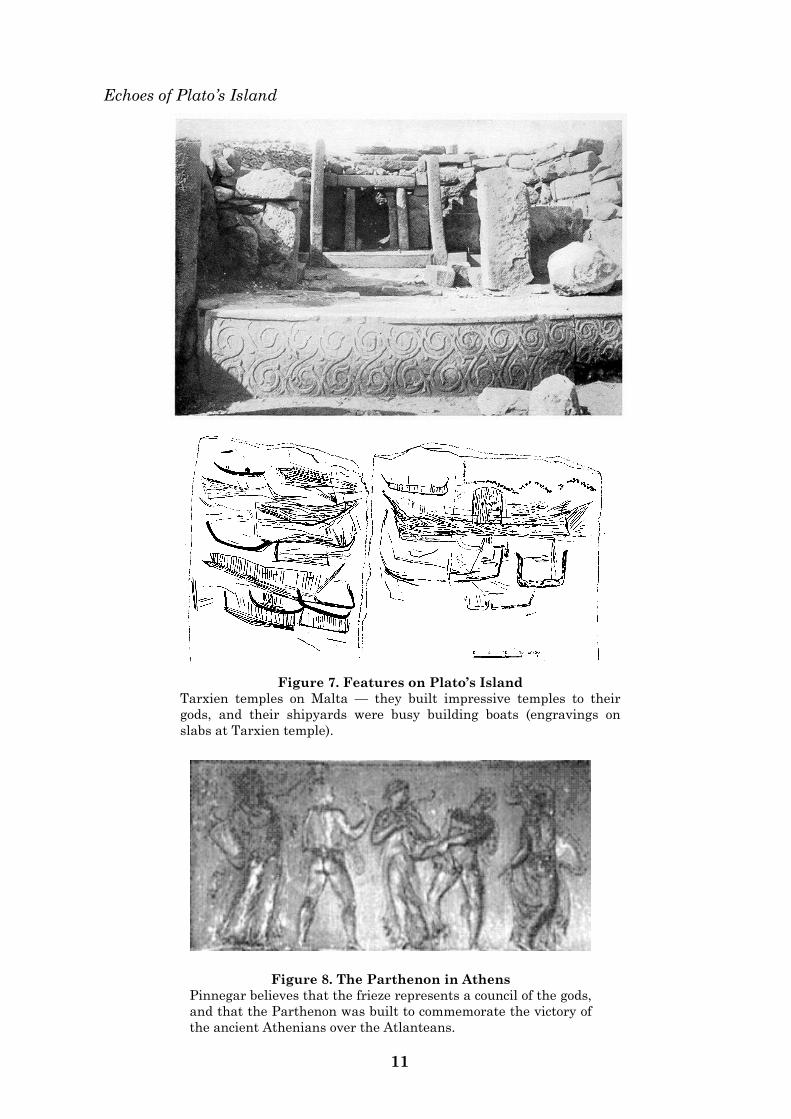
Figure 7. Features on Plato’s Island
Tarxien temples on Malta — they built impressive temples to their
gods, and their shipyards were busy building boats (engravings on
slabs at Tarxien temple).
Figure 8. The Parthenon in Athens
Pinnegar believes that the frieze represents a council of the gods,
and that the Parthenon was built to commemorate the victory of
the ancient Athenians over the Atlanteans.
Malta:
12
Socrates (469-399 BC) flourished during the
building of the Parthenon, and his
comments to Critias in relation to Solon‘s
story was that ―this story will be admirably
suited to the festival of the goddess which is
now being held, because of its connection
with her (Athena had founded both Athens
and Egypt68). And the fact that it is no
invented fable but genuine history is all-
important.‖69 Socrates did not commit
himself to writing, except through his pupil,
Plato (427-347 BC). Since Plato was born
after the Parthenon was finished, it is more
than likely that Socrates informed Plato
about the Parthenon and its purpose, and
that Plato subsequently went over to Egypt
with Krantor to confirm the story of Solon‘s
Atlantikos on the walls of the Egyptian
temples.
Acceptance of Plato’s story
Most of the other ancient authors, whether
Greek, Roman or Christian, accepted the
existence, sublime status and eventual
submergence of Atlantika as outlined by
Plato. The list of these ancient historians
who quoted Plato‘s account as genuine is
significant, and includes, in chronological
order, Thucylides (460-400 BC), Apollodoros
(2nd cent. BC), Timagenes (1st cent. BC),
Strabo (1st cent. BC), Diodorus Siculus (1st
cent. BC), Philo Judaeus (20 BC – 40 AD),
Pliny (61 – 113 AD), Pomponius Mela (1st
cent. AD), Plutarch (46-120 AD), Tertullian
(160-220 AD), Arnobius Afer (3rd cent. AD),
Marcellinus (330-395 AD), and Kosmas
Indikopleustes (6th cent. AD). 70
Similar cataclysms in historical
accounts
Several instances are recorded of natural
occurrences involving phenomena similar to
those on Plato‘s island. On Santorini in the
Aegean a volcanic eruption in 1500BC
destroyed thirty-two square miles of land
surface rising a thousand feet above sea
level; its force was three times that on
Krakatoa in 1883.
In more recent times, similar events have
likewise been recorded. In Jamaica, an
earthquake in 1692 sank the greater part of
Port Royal into the sea. In 1775, an
earthquake shook Lisbon, killing 60,000
persons in several minutes and lowering the
level of the quay and docks to six hundred
feet below sea level.
In 1808, a volcano in San Jorge (Azores)
rose to several thousand feet. In 1811,
another volcanic island, Sambrina (Azores),
rose and later sank. The islands of Corvo
and Flores in Azores, mapped since 1351,
constantly changed their shape, with large
parts of Corvo having disappeared into the
sea. In the Fernando Noronha group of
islands, volcanic activity in 1931 erupted
two new islands, which later sank again. In
the Salvage islands, near Madeira, small
volcanic islands appeared in 1944.71
The island of Surtsey erupted through an
undersea volcanic eruption off the
southwestern coast of Iceland in 1963.
Other islands erupted near the Azores in
the 18th and 19th centuries and disappeared
after years or merely after a few days.72
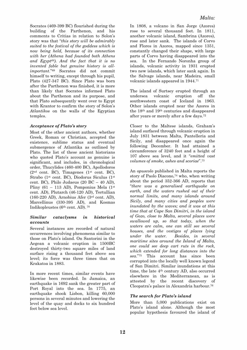
Closer to the Maltese islands, Graham‘s
island surfaced through volcanic eruption in
July 1831 between Malta, Pantelleria and
Sicily, and disappeared once again the
following December. It had attained a
circumference of 3240 feet and a height of
107 above sea level, and it ―emitted vast
volumes of smoke, ashes and scoriae‖.73
An opuscolo published in Malta reports the
story of Paolo Diacono,74 who, when writing
about the period 352-366 AD, reports that
―there was a generalised earthquake on
earth, and the waters rushed out of their
normal limits, and many islands around
Sicily, and many cities and peoples were
inundated by the waves; and it was at this
time that at Cape San Dimitri, in the island
of Gozo, close to Malta, several places were
swallowed up, so that today, when the
waters are calm, one can still see several
houses, and the vestiges of places lying
under the water. Besides, in several
maritime sites around the Island of Malta,
one could see deep cart ruts in the rock,
which extended for long distances into the
sea.‖75 This account has since been
corrupted into the locally well known legend
of San Dimitri. Similar inundations at this
time, the late 4th century AD, also occurred
elsewhere in the Mediterranean, as is
attested by the recent discovery of
Cleopatra‘s palace in Alexandria harbour.76
The search for Plato’s island
More than 5,000 publications exist on
Plato‘s island alone. Although the most
popular hypothesis favoured the island of
Echoes of Plato‘s Island
13
Fig. 9 Graham’s Island
Graham‘s Island as surveyed by Dr. John Davy, senior medical officer
with the British forces in Malta (1832). In July 1831, the island surfaced
through volcanic activity between Malta, Pantelleria and Sicily, and
then disappeared once again beneath the surface the following
December.
Malta:
14
Thera (Thera-Santorini) in the Aegean, the
opinion of serious scholars is that the site
was in the Mediterranean, with North
Africa obtaining the majority of proponents
(15), followed by the Holy Land (9),
Tartessos / Southern Spain (9) and Crete or
Thera (9). Next in line is another
Mediterranean island, including Malta (6).77
Initially the Atlantic Ocean seemed to be
the most logical place to search in, and
several theories were put forward since the
discovery of the New World, such as by
Bacon in 1614, Kircher in 1655, and
Donnelly in 1882. Geological evidence
deriving from plate tectonics has, however,
disproved the possibility that the Atlantic
Ocean could be the site of Plato‘s island.78
The search was then transferred to the
Mediterranean, with Marinatos and Mavor
placing Plato‘s island in the Cretan Island
of Thera. Galanopoulos and Bacon have also
located Plato‘s Island in the Eastern
Mediterranean, but they too have offered no
adequate explanation for the location of the
straits of Heracles.79
In dealing with the megalithic constructions
of Europe and the Mediterranean, Mavor
erroneously asserts that theirs was
universally a funerary function, and that
they were contemporary with Minoan
Crete, whence they derived.80 This has long
been disproved, particularly with regard to
the megalithic structures on the Maltese
islands.81
Recent geological evidence from Santorini
has not confirmed the Thera-Santorini
theory.82 Furthermore, this hypothesis is
presently losing favour, after analysis of
volcanic ash has shown that the island was
destroyed at least 150 years before the
collapse of the palaces on Crete, showing
that the Minoan eruption significantly
preceded the decline of the Cretan
civilisation.83
In recent years, Peter James (1995) has
identified Plato‘s Island with the Turkish
city of Tantalis, which was described by
Pliny as having been destroyed by an
earthquake. However, James has
overlooked a crucial element in Pliny‘s
account of Atlantika. Pliny affirmed that
the battle in question had been fought with
wooden sticks hardened with fire, since the
knowledge of iron was lacking.84 The battle
was not fought with bronze weapons, so
that the submergence of Atlantika occurred
before the Bronze Age; it took place during
the preceding period, the Stone Age. Yet
both the Theran (Marinatos and Mavor)
and Turkish (James) hypotheses date the
battle, between Athenians and Atlanteans,
and the ensuing destruction of Atlantika, to
the Bronze Age at approximately 1500BC.
Thus this extract from Pliny excludes both
hypotheses for Bronze Age Thera and
Tantalis.
Furthermore, James saw the essential
elements of Plato‘s story as lying in the
association of Plato‘s Island with Egypt and
Athens, and this posed him with the major
problem to his own hypothesis. Nor was he
able to identify a megalithic culture which
was a thousand years earlier than that of
Egypt.85 The only option is Malta.
Malta as a remnant of Plato’s island
Malta has been proposed as a remnant of
Plato‘s island since at least 1525,86 a few
decades after the ‗return‘ of the ancient
texts to Europe from Constantinople. After
a silent period during the time of the
Knights of St. John (1530-1798), a
resurgence occurred during the British
period (1815-1964). In the nineteenth
century, the names of Grongnet87 (1854),
Borzesi (1830) and Godwin (1880) were
associated with Plato‘s Island in Malta, and
in 1910, Dr J. J. Borg re-proposed the
hypothesis on the basis of the Maltese
prehistoric flora. ―The tradition of the
submerged Atlantis to which many ancient
writers refer, and which when deprived of
its legendary character will be found to
apply to the submerged land between Malta
and Africa ... It is the duty of local
archaeologists to try to unravel this legend
and to separate the real from the unreal;
and I am confident that the solution of this
mystery will throw much light on the
significance of the prehistoric monuments in
Malta and other countries bordering the
Mediterranean‖.88 Fifty years later, a
captain in the Royal Navy, Eric Brockman
commented thus ―upon this western edge of
the islands, the megaliths of Hagar Qim
and Mnajdra, and that lonely survival of
the lost continent, the islet of Filfla …
solitary in a silver sea, remnant of a great
expanse of hill and valley which once
stretched unbroken towards what was to be
Carthage, the Atlas, and the great lakes of
the Sahara‖.89
Echoes of Plato’s Island
The Maltese architect, Giorgio Grongnet, researched for several decades on Plato’s Island and concluded (1854) that its remnants are the Maltese Islands.
Jules Verne (1870) included Atlantis in his 20,000 leagues under the Sea, and associated it with Thera-Santorini in the Eastern Mediterranean.
Ignatius Donnelly’s publication on Atlantis (1882) was well received world wide. He hypothesized for Plato’s Island in the Atlantic Ocean.
Galanopoulos supports Marinatos and Mavor in placing Atlantis in the Eastern Mediterranean on Thera-Santorini.
Figure 10. The Search for Plato’s Island 15
Malta:
16
In 1989 Attard presented his research on
Plato‘s Island in Malta in the novel The
Atlantis Inheritance.
Criteria for qualification
According to Plato, what remained of
Atlantika were a few small islands.90 The
other small islands close to the Maltese are
Pantelleria and the Pelagian group. In
order to substantiate the hypothesis that
these central Mediterranean islands
represent the remnants of Plato‘s island, a
number of basic questions require to be
addressed.
1. Is there any evidence that the
Maltese islands once constituted a
significantly larger landmass?
2. Are there any links in life forms
between the individual central
Mediterranean islands?
3. Is the seismo-tectonic profile of the
central Mediterranean islands
compatible with such a cataclysmic
event as described by Plato?
4. Has there been any evidence of
significant land displacements
during the presence of man in
Malta?
5. Does the relative chronology of
Plato‘s description fit the dates for
the end of the Temple period in
Malta?
6. Are there features on the Maltese
Islands which conform to those
described by Plato?
7. Are there any secondary sources of
relevant ancient texts which have
been ignored?
1. A larger landmass in antiquity
A - Early antiquity
The present surface area and configuration
of the Maltese islands is by far too small to
have permitted the accumulation of the
large volumes of water necessary to carve
out the extensive valleys and deep ravines
cutting their surface en route to the coast.
Furthermore the presence of similar valleys
beneath the present sea level along the
northeastern coast of the archipelago91
indicates a surface tilt since their
formation.
Several scholars from diverse disciplines
have clearly indicated that the Maltese
islands were significantly larger in their
surface area during prehistoric times.
The early scholars
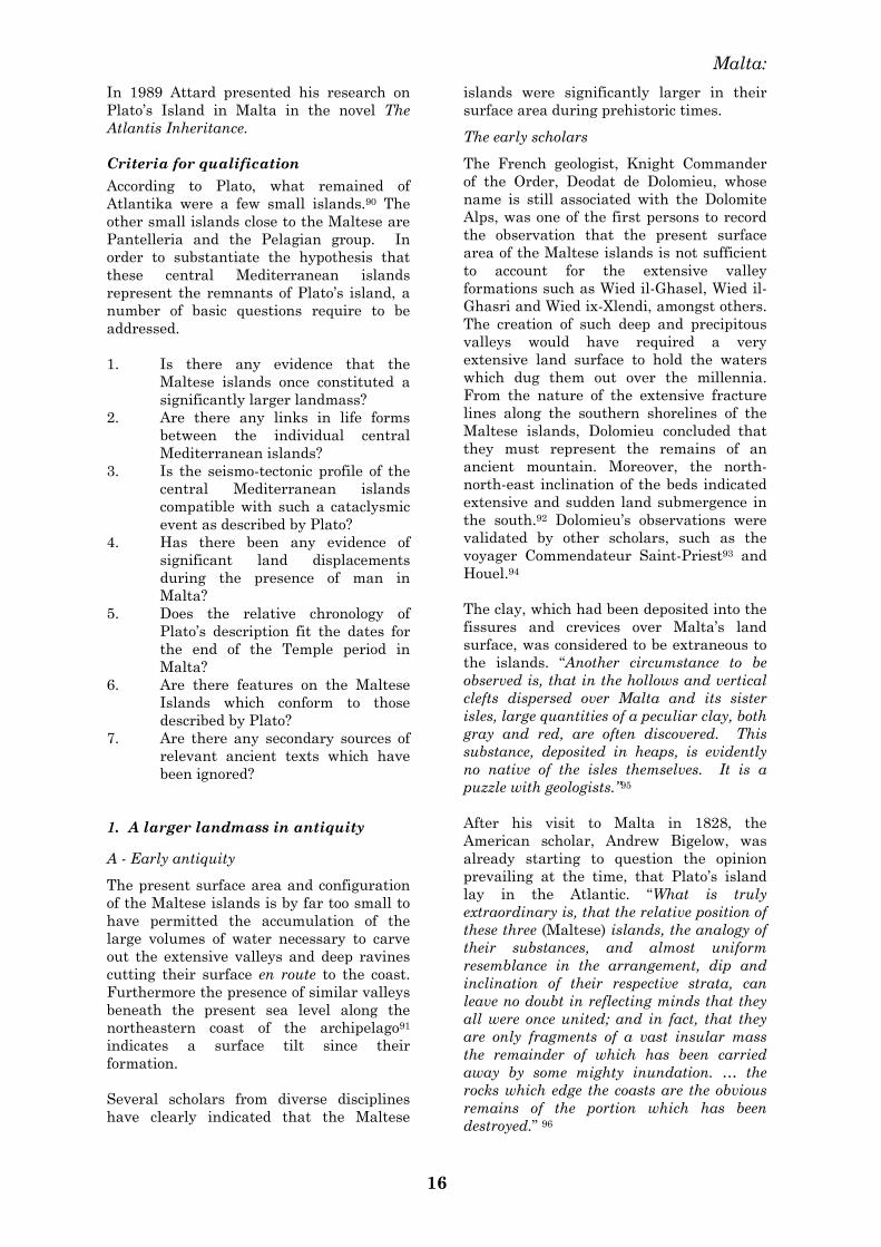
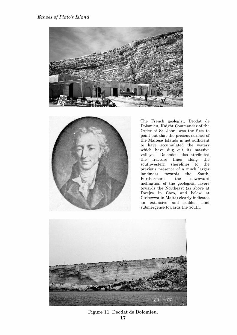
The French geologist, Knight Commander
of the Order, Deodat de Dolomieu, whose
name is still associated with the Dolomite
Alps, was one of the first persons to record
the observation that the present surface
area of the Maltese islands is not sufficient
to account for the extensive valley
formations such as Wied il-Ghasel, Wied il-
Ghasri and Wied ix-Xlendi, amongst others.
The creation of such deep and precipitous
valleys would have required a very
extensive land surface to hold the waters
which dug them out over the millennia.
From the nature of the extensive fracture
lines along the southern shorelines of the
Maltese islands, Dolomieu concluded that
they must represent the remains of an
ancient mountain. Moreover, the north-
north-east inclination of the beds indicated
extensive and sudden land submergence in
the south.92 Dolomieu‘s observations were
validated by other scholars, such as the
voyager Commendateur Saint-Priest93 and
Houel.94
The clay, which had been deposited into the
fissures and crevices over Malta‘s land
surface, was considered to be extraneous to
the islands. ―Another circumstance to be
observed is, that in the hollows and vertical
clefts dispersed over Malta and its sister
isles, large quantities of a peculiar clay, both
gray and red, are often discovered. This
substance, deposited in heaps, is evidently
no native of the isles themselves. It is a
puzzle with geologists.‖95
After his visit to Malta in 1828, the
American scholar, Andrew Bigelow, was
already starting to question the opinion
prevailing at the time, that Plato‘s island
lay in the Atlantic. ―What is truly
extraordinary is, that the relative position of
these three (Maltese) islands, the analogy of
their substances, and almost uniform
resemblance in the arrangement, dip and
inclination of their respective strata, can
leave no doubt in reflecting minds that they
all were once united; and in fact, that they
are only fragments of a vast insular mass
the remainder of which has been carried
away by some mighty inundation. … the
rocks which edge the coasts are the obvious
remains of the portion which has been
destroyed.‖ 96
Echoes of Plato’s Island
The French geologist, Deodat de Dolomieu, Knight Commander of the Order of St. John, was the first to point out that the present surface of the Maltese Islands is not sufficient to have accumulated the waters which have dug out its massive valleys. Dolomieu also attributed the fracture lines along the southwestern shorelines to the previous presence of a much larger landmass towards the South. Furthermore, the downward inclination of the geological layers towards the Northeast (as above at Dwejra in Gozo, and below at Cirkewwa in Malta) clearly indicates an extensive and sudden land submergence towards the South.
Figure 11. Deodat de Dolomieu. 17
Malta:
18
Bathymetry in the nineteenth century
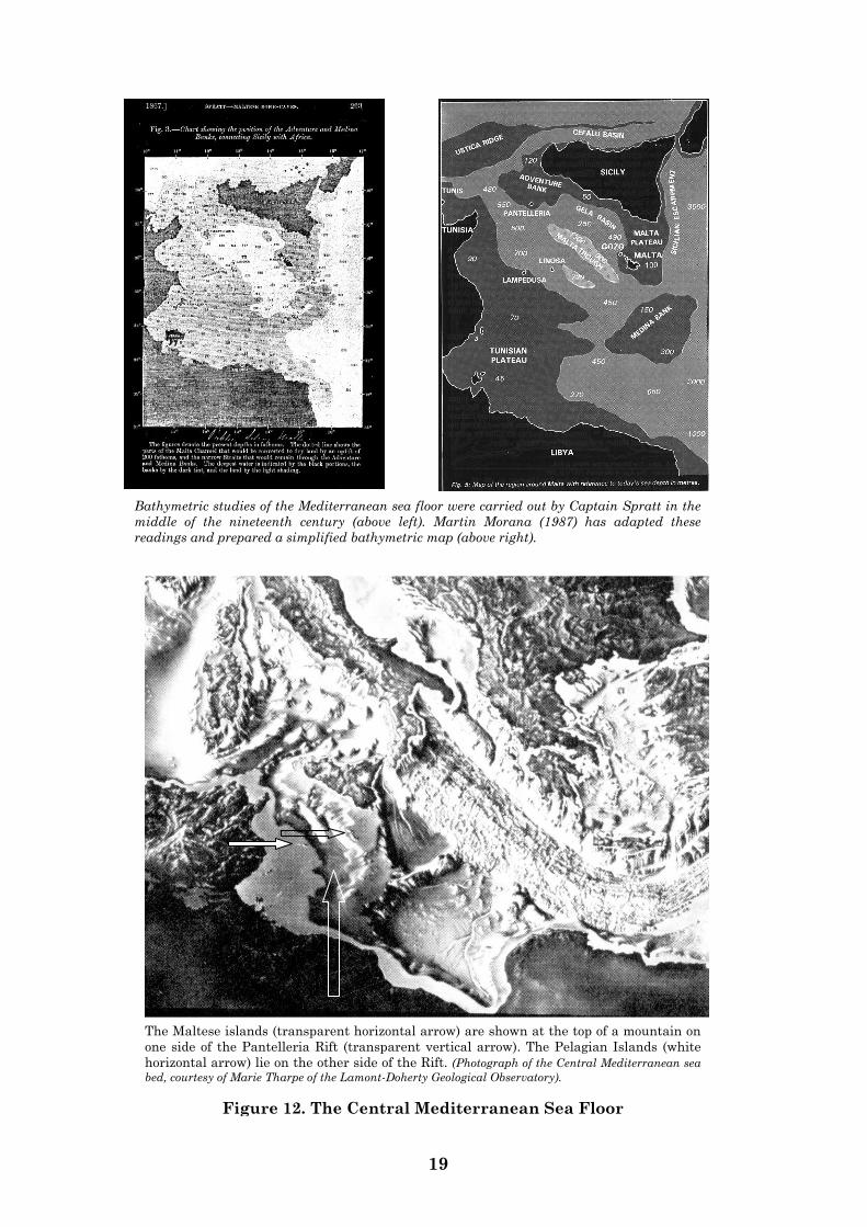
The British Navy under Admirals Smyth
and Spratt carried out surveys of the sea
floor around the Maltese Islands, and these
bathymetric studies confirmed that
relatively shallow ridges of the sea floor still
connect Malta to the North African
shoreline. These features are reminiscent of
the shoals described by Plato, although they
would have had to be much shallower then.
According to Smyth, an elevation of sea
level by 250 fathoms would connect the
islands with Sicily, Italy and Tripoli
through narrow strips of land or ridges,
broken by two narrow channels
approximately five miles broad.97 The
recent study by Glomar Challenger of the
Mediterranean Sea floor has confirmed the
findings of Admiral Smyth.98
The hypothesis of submergence and flooding
of the Maltese islands had also been raised
by Captain Spratt to explain the pell-mell
arrangement of the fossil mammalian
remains discovered in the Maltese caverns.
Fossil remains in Malta show the
―connexion of Malta with Europe and Africa
by land that must have existed to serve as a
highway of migration between them, but
which has since subsided beneath the
Mediterranean. These submerged lands are
really now indicated by the bank called the
Adventure Bank discovered by Admiral
Smyth, between Tunis and the northwest
part of Sicily. … and also by another bank
… as a well-defined, but more deeply
submerged, ridge, connecting the south-
eastern end of Malta with Tripoli, and
which I have named the Medina Bank.‖99
Fossil remains
The major research carried out on these
fossil remains was by the army surgeon and
naturalist, Arthur Leith Adams, in the
1870‘s. Speaking to the inaugural assembly
of the Maltese Archaeological Society in
1866, Leith Adams stressed that the
present size of the Maltese islands was
―perfectly inadequate for the maintenance of
the fauna just named‖ (hippopotamus and
elephant), and that an extension of the
southern regions of the Maltese islands
must have been present during the
Pleistocene.1 Leith Adams then proposed a
1 The Pleistocene period extends between
approximately 1.6 million and 10,000 years ago.
submergence of the ―post-Miocene land‖,
followed by an upheaval of parts of it, and
this as evidenced by the ―shattered
conditions of the strata‖ and by the Graham
Island episode.100
―I agree with Dr Falconer [the British
palaeontologist working in the Sicilian
caverns] (Palaeontological Memoirs, 2: 301)
that at this time ‗there must have been
continuity of land between Sicily and Malta,
and Sicily and Cape Bon,‘ at all events, that
Africa, Malta, and Italy were then united.‖
The hypothesis for an African source of
elephant and hippopotamus during the
Pleistocene is no longer acceptable to the
majority of palaeontologists.
However, the vast numbers of fossils
discovered in Malta clearly indicated that
―in order to have maintained so numerous a
fauna, there must have been a greater
lateral extension of both islands.‖101
Stratigraphy
George Sinclair, a civil engineer in the
service of the British Admiralty in Malta,
corroborated these statements in 1924. He
examined both the interior and the exterior
stratifications of Ghar Dalam, and
correlated these with the depression of sea
levels and land elevations in the
Mediterranean since the Palaeolithic
period.2 He concluded that, in between the
various periods of submergence of the
Maltese islands, a land bridge was in
existence with Africa during the middle
Palaeolithic period.102
B - Later antiquity
Evidence also exists for a larger Maltese
landmass during its occupation by humans.
Some medieval maps do not speak of Malta
but of a certain Gaulometin or Galonia leta,
and combine Malta and Gozo into one big
island.103 Malta was formally placed on the
European map with the coming of the Order
of St John in 1530.
The ancient geographers
A southern extension of the Maltese islands
in historic times is recorded in the annals of
Claudius Ptolemy (fl. 121-151 AD), the
2 The period when stone tools were unpolished,
approximately before 10, 000BP. (BP denotes ‗before
the present time‘).
Echoes of Plato‘s Island
19
The Maltese islands (transparent horizontal arrow) are shown at the top of a mountain on
one side of the Pantelleria Rift (transparent vertical arrow). The Pelagian Islands (white
horizontal arrow) lie on the other side of the Rift. (Photograph of the Central Mediterranean sea
bed, courtesy of Marie Tharpe of the Lamont-Doherty Geological Observatory).
Figure 12. The Central Mediterranean Sea Floor
Bathymetric studies of the Mediterranean sea floor were carried out by Captain Spratt in the
middle of the nineteenth century (above left). Martin Morana (1987) has adapted these
readings and prepared a simplified bathymetric map (above right).
Malta:
20
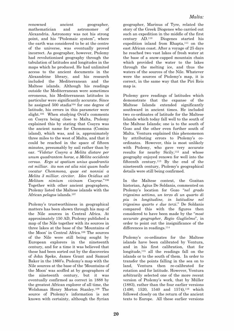
renowned ancient geographer,
mathematician and astronomer of
Alexandria. Astronomy was not his strong
point, and his ―Ptolemaic system‖, where
the earth was considered to be at the centre
of the universe, was eventually proved
incorrect. As geographer, however, Ptolemy
had revolutionised geography through the
tabulation of latitudes and longitudes in the
maps which he produced. He had unlimited
access to the ancient documents in the
Alexandrine library, and his research
included the Mediterranean and the
Maltese islands. Although his readings
outside the Mediterranean were sometimes
erroneous, his Mediterranean latitudes in
particular were significantly accurate. Since
he assigned 500 stadia104 for one degree of
latitude, his errors in this parameter were
slight.105 When studying Ovid‘s comments
on Cosyra being close to Malta, Ptolemy
explained this by stating that Cosyra was
the ancient name for Chemmona (Comino
island), which was, and is, approximately
three miles to the west of Malta, and that it
could be reached in the space of fifteen
minutes, presumably by sail rather than by
oar. ―Videtur Cosyra a Melita distare per
unum quadrantem horae, a Melita occidente
versus. Ergo ut spatium unius quadrantis
est milliar. ita non est alia nisi quam hodie
vocatur Chemmona, quae est nonnisi a
Melita 3 milliar. circiter. Ideo Ovidius ait
Melitam nimium vicinam Cosyrae.‖106
Together with other ancient geographers,
Ptolemy listed the Maltese islands with the
African pelagos islands.107
Ptolemy‘s trustworthiness in geographical
matters has been shown through his map of
the Nile sources in Central Africa. At
approximately 150 AD, Ptolemy published a
map of the Nile together with its sources in
three lakes at the base of the ‗Mountains of
the Moon‘ in Central Africa.108 The sources
of the Nile were still being sought by
European explorers in the nineteenth
century, and for a time it was believed that
these had been sorted out by the discoveries
of John Speke, James Grant and Samuel
Baker in the 1860‘s. Ptolemy‘s map with the
Nile sources at the base of the ‗Mountains of
the Moon‘ was scoffed at by geographers of
the nineteenth century, but it was
eventually confirmed as correct in 1888 by
the greatest African explorer of all time, the
Welshman Henry Morton Stanley.109 The
source of Ptolemy‘s information is not
known with certainty, although the Syrian
geographer, Marinus of Tyre, related the
story of the Greek Diogenes who carried out
such an expedition in the middle of the first
century AD.110 Diogenes started his
expedition inland from Rhapta,111 on the
east African coast. After a voyage of 25 days
he reached two vast lakes of fresh water at
the base of a snow-capped mountain chain
which provided the water to the lakes
through the melting ice, and thus the
waters of the sources of the Nile. Whatever
were the sources of Ptolemy‘s map, it is
correct, in the same way that the Piri Reis
map is.
Ptolemy gave readings of latitudes which
demonstrate that the expanse of the
Maltese Islands extended significantly
southward in ancient times. He included
two co-ordinates of latitude for the Maltese
Islands which today fall well to the south of
the Maltese Islands; one is to the south of
Gozo and the other even further south of
Malta. Ventura explained this phenomenon
by attributing errors to Ptolemy‘s co-
ordinates. However, this is most unlikely
with Ptolemy, who gave very accurate
results for nearby Sicily,112 and whose
geography enjoyed renown for well into the
fifteenth century.113 By the end of the
nineteenth century, Ptolemy‘s geographical
details were still being confirmed.
In the Maltese context, the Gozitan
historian, Agius De Soldanis, commented on
Ptolemy‘s location for Gozo ―nel grado
trigesimo settimo, un terzo di un quarto di
piu in longitudine, in latitudine nel
trigesimo quarto e due terzi.‖ De Soldanis
compared this with the figures then
considered to have been made by the ―most
accurate geographer, Regio Guglielmo‖, in
order to point out the insignificance of the
differences in readings.114
Ptolemy‘s co-ordinates for the Maltese
islands have been calibrated by Ventura,
and in his first calibration, that for
longitude,115 all the readings fall on the
islands or to the south of them. In order to
transfer the points falling in the sea on to
land, Ventura then re-calibrated for
rotation and for latitude. However, Ventura
arbitrarily selected one of the more recent
version of Ptolemy‘s work, that by Müller
(1883), rather than the four earlier versions
(1490, 1520, 1540 and 1574),116 which
followed closely on the return of the ancient
texts to Europe. All these earlier versions
Echoes of Plato’s Island
Claudius Ptolemy (fl. 121-151 AD), renowned astronomer, mathematician and geographer of Alexandria, with unlimited access to the ancient texts in the Alexandrine library.
Ptolemy’s sources produced this map of the ultimate Nile sources in the Lunae Montes (Mountains of the Moon) in Central Africa, ‘discovered’ more than sixteen centuries later.
Henry Morton Stanley traced and found the lost Dr Livingstone in Africa, but his main feat was the elucidation of the Nile sources, and his discovery of Ptolemy’s Lunae Montes in 1888.
Original photograph of the ice-capped Ruwenzori mountain range in Central Africa, ‘discovered’ by Stanley in 1888, and identified with Ptolemy’s ‘Mountains of the Moon’ and the sources of the White Nile.
Figure 13. Ptolemy’s maps confirmed 21
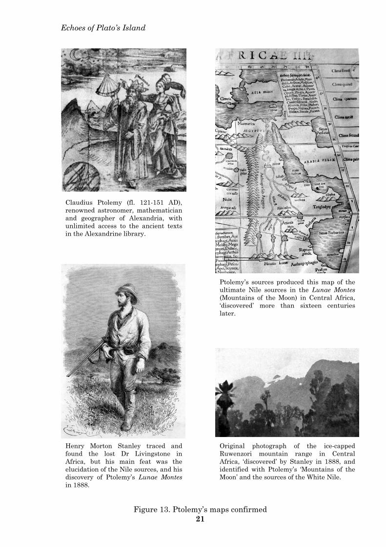
Echoes of Plato’s Island
An early world map by Ptolemy (Ulm 1482 in Hapgood 1966 – above) shows a large unidentified island in the Central Mediterranean (arrowed). Ptolemy (1540) also depicted graphically the zone of battle between the Romans and Punics (left) and the zone of shipwrecks (below), the latter presumably associated with the shoals described by Plato. The pelagos nomenclature to the Maltese and Pelagian islands is also seen, and the town of Achola, a colony of the Maltese Islands, also appears on the North African coast (arrowed — below, left).
Ptolemy was an armchair geographer who obtained his data from the ancient library of Alexandria. These data were then adapted to the maps in his Geographike Hyphegesis. The apparent discrepancy between the fine details in the various Tabulae (Mundi, Aphricae and Europae) — some of the Maltese promontories are represented as islands — are attributable to the various editors of his work who modified it regularly from time to time.
Tabula Europae VII
Tabula Aphricae II
Figure 14. The Central Mediterranean in Ptolemy’s maps 22
Echoes of Plato’s island
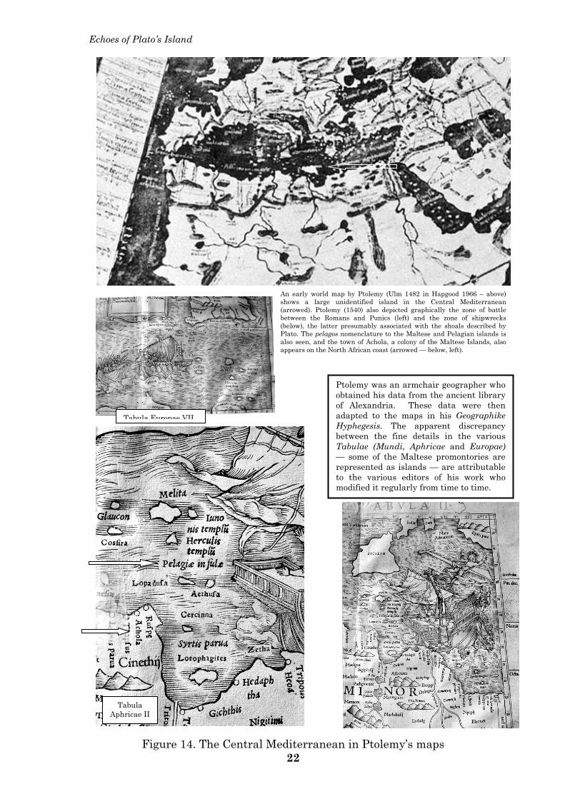
Ventura has calibrated the co-ordinates which Ptolemy gave for the Maltese Islands. The diagram above (1988: 262, figure 4) represents Ventura’s results after correction for longitude, and it can be seen that all the readings fall on the islands, or to the south of them. No reading falls to the North of the archipelago. Readings G and H fall to the south respectively of Gozo and Malta. Furthermore, point H reaches ten minutes further to the south according to at least four more ancient versions of Ptolemy than the one used by Ventura. (See text pp. 20 et seq.). Thus Ptolemy’s co-ordinates, derived from the ancient authors of Alexandria, confirm a larger expanse of the Maltese islands towards the South.
Reproduced through the kind permission of Frank Ventura
Figure 15. A wider latitude for the Maltese islands 23
Malta:
24
had in fact given a latitude for the temple of
Hercules117 ten minutes further to the South.
Ptolemy‘s map for the Maltese islands, as
shown in his Tabula Europae VII, confirms
the lower latitude of Hercules‘ temple.118
Using the figure for latitude given by the
four earlier versions, there is no way that
the temple can be placed on land, even after
Ventura‘s second calibration for rotation
and latitude.
The crucial point remains that Ptolemy
gave co-ordinates for Malta which extended
over twenty minutes of latitude (between
34º 45‘ and 34º 25‘). He was therefore
attributing a maximum latitude width for
Malta alone of at least 30.82 kilometres.119
This measurement today is approximately
21.5 kilometres, so that it is evident that in
the ancient sources researched by Ptolemy,
the Maltese islands still extended
southward significantly more than today.120
Ventura‘s calibrated positions for longitude
also demonstrate the three sites which can
be confirmed,121 namely the site of Calypso‘s
abode in the peninsula of Mellieha
(Chersonesos),122 Quintinus‘s temple in
Grand harbour,123 and the temple of
Proserpine at Mtarfa.124
Cart ruts
Before their gradual disappearance over the
past few decades, the cart-ruts had been
repeatedly, and validly, associated with an
extension of Malta‘s landmass. ‖In several
maritime sites around the Island of Malta,
one could see deep cart ruts in the rock,
which extended for long distances into the
sea.‖125 ―Some serious disruptions and
subsidings have taken place on the island …
near the coast … an extraordinary
subsidence … must have occurred on the
coast not far from the pleasure grounds of
Boschetto … on the southern side of which
vestiges of wheels have cut into the rock, and
may be traced to the sea … and the ruts may
be perceived under the water at a great
distance, and to a great depth; indeed, as far
as the eye can possibly distinguish any thing
through the waves. This circumstance gives
every reason to suppose that the ground
must have sunk very considerably in this
spot.‖126
Dr. Davy observed cart-ruts between Marfa
and Wied il-Qammieh in northwest Malta,
and from their interrupted nature at the
edge of the cliffs, inevitably concluded that
the Maltese islands had once been
significantly larger in size during the
presence of man in Malta.127
Under the sub-title Indications of a greater
modern extension of the Islands, Leith
Adams thus commented on the cart-ruts at
Marfa and Fomm ir-Rih Bay. ―They run to
the edge of a sea-cliff some 80 to 100 feet
high, under which detached masses are
lying about, thus also showing an extensive
disappearance of the coast since the cart-
ruts were formed‖.128 In the meantime,
during an earthquake in February 1861,
―several old fissures had been widened, and
tottering cliffs on the south coast tumbled
down‖.129 To this day, slices of Maltese
landscape await collapse into the sea, and
the temple at Xrobb il-Ghagin has been lost
in this manner.
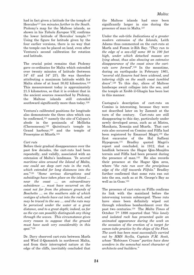
Castagna‘s description of cart-ruts on
Comino is interesting, because they were
not described later on by Zammit at the
turn of the century. Cart-ruts are still
disappearing to this day, particularly under
newly developed areas, such as at Mistra,
Manikata, Xemxija and Mtarfa. That cart
ruts also occurred on Comino and Filfla had
been registered by Emanuel Magri,130 the
first excavator of the Hal Saflieni
Hypogeum.131 Bradley quoted Magri‘s
report and concluded, in 1912, that a
landlink between the Hagar Qim-Mnajdra
terrain and Filfla had been present during
the presence of man.132 He also records
their presence at the Hagar Qim area,
where ―the ruts run over the precipitous
edge of the cliff towards Filfola.‖ Bradley
further confirmed that some ruts ran out
into the sea, such as at St. George‘s Bay as
well as in Gozo.133
The presence of cart-ruts on Filfla confirms
its link with the mainland before the
intervening terrain submerged. These ruts
have since been definitely wiped out
through relentless bombardment over the
past two centuries.134 The Malta Times of
October 7th 1898 reported that ―this lonely
and isolated rock has presented quite an
animated appearance during the week on
the occasion of the erection of a target for
canon-tube practice by the ships of the Fleet.
The work has been most successfully carried
out by HMS Scylla, Captain P.M. Scott,
whose ―Robinson Crusoe‖ parties have done
wonders in the somewhat novel character of
architects and builders.‖
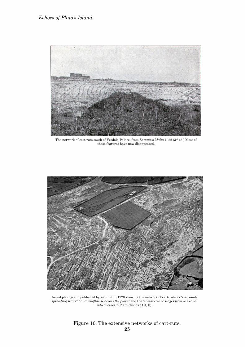
Echoes of Plato’s Island
Aerial photograph published by Zammit in 1928 showing the network of cart-ruts as “the canals spreading straight and lengthwise across the plain” and the “transverse passages from one canal
into another.” (Plato Critias 11D, E).
The network of cart ruts south of Verdala Palace, from Zammit’s Malta 1952 (3rd ed.) Most of
these features have now disappeared.
Figure 16. The extensive networks of cart-ruts. 25
Malta:
26
Cart-ruts, in much smaller concentrations,
have been reported elsewhere, to the north
of Malta in the Mediterranean at
Marseilles, near Aosta in Italy, at
Agrigento, Syracuse and Trogilos Bay in
Sicily; they have also been reported on the
southern shores of the Mediterranean.135
Biogeographic Index
This index measures the likelihood of an
island being colonised, in relation to its size
and distance from the mainland.
Notwithstanding their very low
biogeographic index, a category C, and
despite their being the most remote islands
in the Mediterranean, both Pantelleria and
Lampedusa were occupied by humans by
the 6th millennium BC, and were exploited
well in advance of several category A
islands.136 Pantelleria provided the obsidian
for the earliest Neolithic Maltese, and
Stentinello pottery was found at
Lampedusa. This colonisation of
Lampedusa and Pantelleria occurred at a
time when maritime technology and
navigational knowledge were still too
primitive to have permitted it.137
The Maltese islands, Pantelleria and the
Pelagian islands possess the lowest
biogeographic indices in the Mediterranean,
0.03 to 0.1, and their early colonisation can
only make sense if they were much larger in
size; ideally if they were one land mass. As
if to confirm this theme, Patton includes
both Lampedusa and Pantelleria with the
Maltese Islands.138
2. Floral, faunal and
anthropological links with the
Pelagian islands and North Africa
during the prehistoric period
On the Maltese islands, a large variety of
life forms, whether these are plant, animal
or human, manifest significant similarities
with life forms on other areas on the
Pelagian block — Pantelleria, the Pelagian
islands and the North African coast.
The present floral assemblage of the
Maltese islands is similar to that of
Lampedusa.139 Jasonia glutinosa,
Hypericum aegypticum, Crucianella
rupestris and Filago gussonei are plants
peculiar to Lampedusa, Pantelleria and
Malta. Callitris quadrivalvis,
Enarthrocarpus pterocarpus, and Melitella
pusilla are peculiar to Malta and the
opposite North African coast.140 Callitris
and Hypericum are not eaten by birds, and
their seeds are not disseminated by the air-
borne route.141
The fossil herpetofauna of the Maltese
islands have also been the subject of
research vis-à-vis land-bridge connections of
the Maltese islands to the mainland.142
Pasa had already suggested in 1953 that
the Maltese islands were linked to Sicily,
North Africa and the Eastern
Mediterranean during the Pleistocene.143
The frog Discoglossus pictus has a western
Mediterranean distribution including
Northwest Africa, Malta and Sicily. The
locally extinct toads, Bufo bufo and Bufo
viridis, were discovered in Maltese
Pleistocene horizons, and their distribution
includes North and Northwest Africa and
Europe. The locally extinct tortoise, Testudo
graeca, has a similar distribution.144
According to Kotsakis, the ctenodactylid
Pellegrina panormensis may be taken as a
significant indication of an ancient link
with Africa during the Pleistocene. Both
Pellegrinia and Maltamys have been
interpreted as of African origin.145
An extremely rare land snail which is
endemic to Filfla is the Lampedusa
gattoi.146 There are also several more
Maltese endemic life forms with close
relatives on the Pelagian islands, especially
insects,147 but a particularly useful marker
is the wall lizard.
Podarcis
The wall lizard Podarcis is a very
satisfactory biogeographical marker during
the Holocene (~10,000 years ago) because of
its pattern of evolution over this period of
time. After the isolation of the central
Mediterranean islands at the start of the
Holocene, the Siculo-Maltese lizard (Lacerta
siculomelitensis) ‗differentiated‘ into a
different genus with several species.
Podarcis filfolensis is found only in the
Maltese and Pelagian islands (Linosa and
Lampione; there are no Podarcis on
Lampedusa). Conversely, Podarcis Sicula is
found in Sicily and Pantelleria, but not in
Malta and the Pelagian islands. Podarcis
tiliguerta is found only in Sardinia and
Corsica. The distribution trend of these
different species of wall lizard manifests an
individual species limitation to
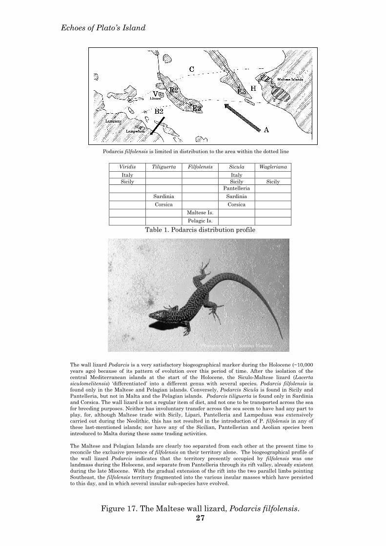
Echoes of Plato’s Island
Viridis Tiliguerta Filfolensis Sicula Wagleriana Italy Italy Sicily Sicily Sicily
Pantelleria Sardinia Sardinia Corsica Corsica Maltese Is. Pelagic Is.
Table 1. Podarcis distribution profile
Podarcis filfolensis is limited in distribution to the area within the dotted line
The wall lizard Podarcis is a very satisfactory biogeographical marker during the Holocene (~10,000 years ago) because of its pattern of evolution over this period of time. After the isolation of the central Mediterranean islands at the start of the Holocene, the Siculo-Maltese lizard (Lacerta siculomelitensis) ‘differentiated’ into a different genus with several species. Podarcis filfolensis is found only in the Maltese and Pelagian islands. Conversely, Podarcis Sicula is found in Sicily and Pantelleria, but not in Malta and the Pelagian islands. Podarcis tiliguerta is found only in Sardinia and Corsica. The wall lizard is not a regular item of diet, and not one to be transported across the sea for breeding purposes. Neither has involuntary transfer across the sea seem to have had any part to play, for, although Maltese trade with Sicily, Lipari, Pantelleria and Lampedusa was extensively carried out during the Neolithic, this has not resulted in the introduction of P. filfolensis in any of these last-mentioned islands; nor have any of the Sicilian, Pantellerian and Aeolian species been introduced to Malta during these same trading activities. The Maltese and Pelagian Islands are clearly too separated from each other at the present time to reconcile the exclusive presence of filfolensis on their territory alone. The biogeographical profile of the wall lizard Podarcis indicates that the territory presently occupied by filfolensis was one landmass during the Holocene, and separate from Pantelleria through its rift valley, already existent during the late Miocene. With the gradual extension of the rift into the two parallel limbs pointing Southeast, the filfolensis territory fragmented into the various insular masses which have persisted to this day, and in which several insular sub-species have evolved.
Photograph by C. Savona Ventura
Figure 17. The Maltese wall lizard, Podarcis filfolensis. 27
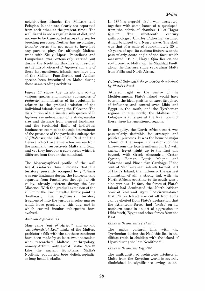
Malta:
28
neighbouring islands; the Maltese and
Pelagian Islands are clearly too separated
from each other at the present time. The
wall lizard is not a regular item of diet, and
not one to be transported across the sea for
breeding purposes. Neither has involuntary
transfer across the sea seem to have had
any part to play, for, although Maltese
trade with Sicily, Lipari, Pantelleria and
Lampedusa was extensively carried out
during the Neolithic, this has not resulted
in the introduction of P. filfolensis in any of
these last-mentioned islands; nor have any
of the Sicilian, Pantellerian and Aeolian
species been introduced to Malta during
these same trading activities.
Figure 17 shows the distribution of the
various species and insular sub-species of
Podarcis, an indication of its evolution in
relation to the gradual isolation of the
individual islands during the Holocene. The
distribution of the insular sub-species of P.
filfolensis is independent of latitude, insular
size and distance from nearest landmass,
and the territorial limits of individual
landmasses seem to be the sole determinant
of the presence of the particular sub-species
of filfolensis; the islet of St. Paul and the
General‘s Rock are a mere few metres from
the mainland, respectively Malta and Gozo,
and yet they harbour a sub-species which is
different from that on the mainland.
The biogeographical profile of the wall
lizard Podarcis thus indicates that the
territory presently occupied by filfolensis
was one landmass during the Holocene, and
separate from Pantelleria through its rift
valley, already existent during the late
Miocene. With the gradual extension of the
rift into the two parallel limbs pointing
Southeast, the filfolensis territory
fragmented into the various insular masses
which have persisted to this day, and in
which several insular sub-species have
evolved.
Anthropological links
Man came ―out of Africa,‖ and so did
―mitochondrial Eve.‖ Links of the Maltese
prehistoric folk with the southern continent
have been made by at least two anatomists
who researched Maltese anthropology,
namely Arthur Keith and J. Leslie Pace.148
Like the ancient Egyptians, Malta‘s
Neolithic population bore dolichocephalic,
or long-headed, skulls.
In 1839 a negroid skull was excavated,
together with some bones of a quaduped,
from the debris of chamber 12 of Hagar
Qim.149 The nineteenth century
anthropologist Charles Pickering assumed
it had belonged to a Negro slave. The skull
was that of a male of approximately 30 to
40 years of age; its curious feature was the
particularly acute angle of the face, which
measured 61º.150 Hagar Qim lies on the
south coast of Malta, on the Maghlaq Fault,
along the fracture ridge separating Malta
from Filfla and North Africa.
Cultural links with the countries dominated
by Plato‘s island
Situated right in the centre of the
Mediterranean, Plato‘s island would have
been in the ideal position to exert its sphere
of influence and control over Libia and
Egypt in the south, and the Tyrrhenian
regions in the north; the Maltese and
Pelagian islands are at the focal point of
these three last-mentioned regions.
In antiquity, the North African coast was
particularly desirable for strategic and
political purposes. It was the home or major
colony of the major civilisations of the
time—from the fourth millennium BC with
ancient Egypt, right up to the first and
beyond, with Greek Alexandria, Cretan
Cyrene, Roman Leptis Magna and
Sabratha, and Phoenician Carthage. If the
central Mediterranean islands formed part
of Plato‘s Island, the nucleus of the earliest
civilisation of all, a strong link with the
North African coastline to its south was a
sine qua non. In fact, the forces of Plato‘s
Island had dominated the North African
coast of Libia and Egypt. The circumstance
that Plato‘s Island was cut off from Libia
can be elicited from Plato‘s declaration that
the Atlantean forces had landed on its
northern coast in an act of aggression on
Libia itself, Egypt and other forces from the
East.
Links with ancient Tyrrhenia
The major cultural link with the
Tyrrhenian during the Neolithic lies in the
diffuse trade in obsidian with the island of
Lipari during the late Neolithic.151
Links with ancient Egypt152
The multiplicity of prehistoric artefacts in
Malta from the Egyptian world is severely
diminished in significance owing to the
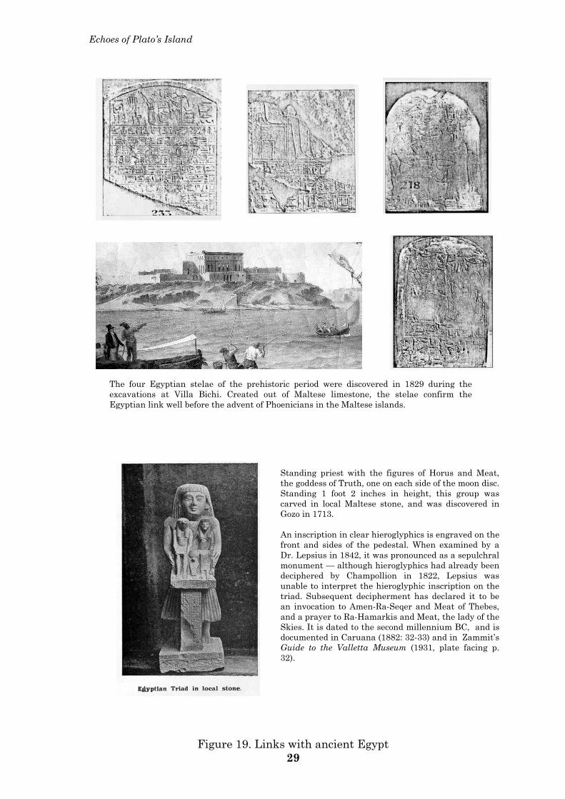
Echoes of Plato’s Island
The four Egyptian stelae of the prehistoric period were discovered in 1829 during the excavations at Villa Bichi. Created out of Maltese limestone, the stelae confirm the Egyptian link well before the advent of Phoenicians in the Maltese islands.
Standing priest with the figures of Horus and Meat, the goddess of Truth, one on each side of the moon disc. Standing 1 foot 2 inches in height, this group was carved in local Maltese stone, and was discovered in Gozo in 1713. An inscription in clear hieroglyphics is engraved on the front and sides of the pedestal. When examined by a Dr. Lepsius in 1842, it was pronounced as a sepulchral monument — although hieroglyphics had already been deciphered by Champollion in 1822, Lepsius was unable to interpret the hieroglyphic inscription on the triad. Subsequent decipherment has declared it to be an invocation to Amen-Ra-Seqer and Meat of Thebes, and a prayer to Ra-Hamarkis and Meat, the lady of the Skies. It is dated to the second millennium BC, and is documented in Caruana (1882: 32-33) and in Zammit’s Guide to the Valletta Museum (1931, plate facing p. 32).
Figure 19. Links with ancient Egypt 29
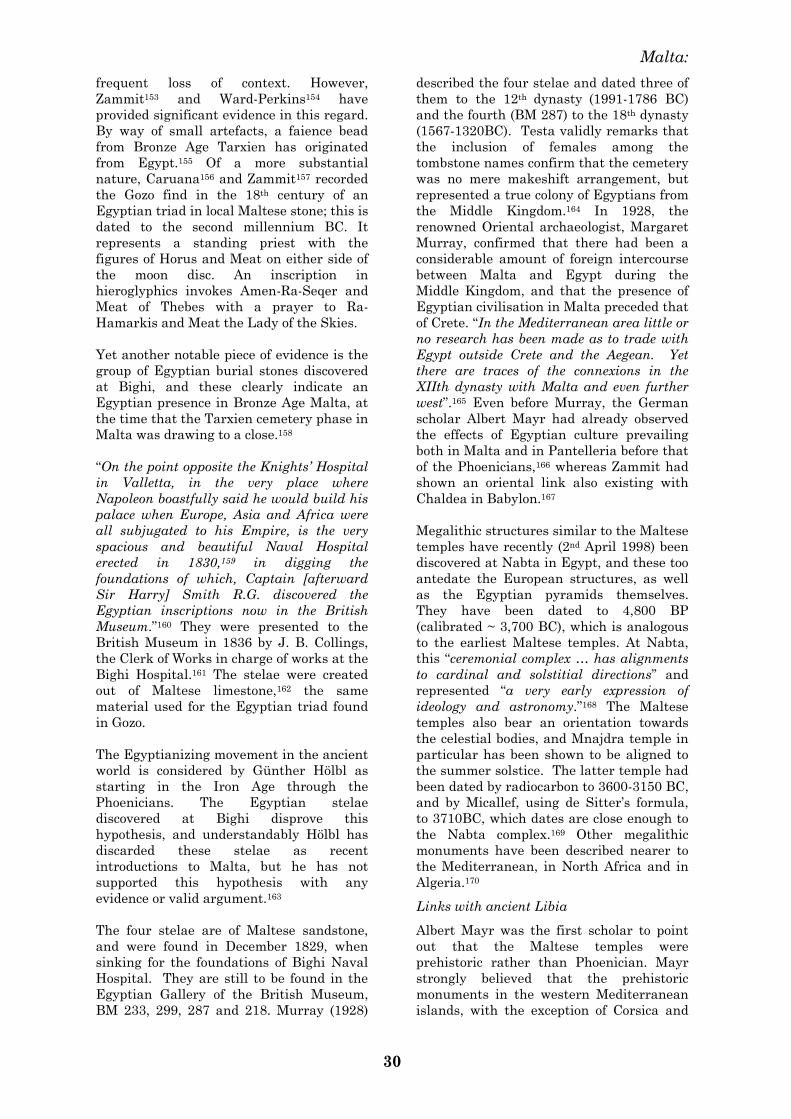
Malta:
30
frequent loss of context. However,
Zammit153 and Ward-Perkins154 have
provided significant evidence in this regard.
By way of small artefacts, a faience bead
from Bronze Age Tarxien has originated
from Egypt.155 Of a more substantial
nature, Caruana156 and Zammit157 recorded
the Gozo find in the 18th century of an
Egyptian triad in local Maltese stone; this is
dated to the second millennium BC. It
represents a standing priest with the
figures of Horus and Meat on either side of
the moon disc. An inscription in
hieroglyphics invokes Amen-Ra-Seqer and
Meat of Thebes with a prayer to Ra-
Hamarkis and Meat the Lady of the Skies.
Yet another notable piece of evidence is the
group of Egyptian burial stones discovered
at Bighi, and these clearly indicate an
Egyptian presence in Bronze Age Malta, at
the time that the Tarxien cemetery phase in
Malta was drawing to a close.158
―On the point opposite the Knights‘ Hospital
in Valletta, in the very place where
Napoleon boastfully said he would build his
palace when Europe, Asia and Africa were
all subjugated to his Empire, is the very
spacious and beautiful Naval Hospital
erected in 1830,159 in digging the
foundations of which, Captain [afterward
Sir Harry] Smith R.G. discovered the
Egyptian inscriptions now in the British
Museum.‖160 They were presented to the
British Museum in 1836 by J. B. Collings,
the Clerk of Works in charge of works at the
Bighi Hospital.161 The stelae were created
out of Maltese limestone,162 the same
material used for the Egyptian triad found
in Gozo.
The Egyptianizing movement in the ancient
world is considered by Günther Hölbl as
starting in the Iron Age through the
Phoenicians. The Egyptian stelae
discovered at Bighi disprove this
hypothesis, and understandably Hölbl has
discarded these stelae as recent
introductions to Malta, but he has not
supported this hypothesis with any
evidence or valid argument.163
The four stelae are of Maltese sandstone,
and were found in December 1829, when
sinking for the foundations of Bighi Naval
Hospital. They are still to be found in the
Egyptian Gallery of the British Museum,
BM 233, 299, 287 and 218. Murray (1928)
described the four stelae and dated three of
them to the 12th dynasty (1991-1786 BC)
and the fourth (BM 287) to the 18th dynasty
(1567-1320BC). Testa validly remarks that
the inclusion of females among the
tombstone names confirm that the cemetery
was no mere makeshift arrangement, but
represented a true colony of Egyptians from
the Middle Kingdom.164 In 1928, the
renowned Oriental archaeologist, Margaret
Murray, confirmed that there had been a
considerable amount of foreign intercourse
between Malta and Egypt during the
Middle Kingdom, and that the presence of
Egyptian civilisation in Malta preceded that
of Crete. ―In the Mediterranean area little or
no research has been made as to trade with
Egypt outside Crete and the Aegean. Yet
there are traces of the connexions in the
XIIth dynasty with Malta and even further
west‖.165 Even before Murray, the German
scholar Albert Mayr had already observed
the effects of Egyptian culture prevailing
both in Malta and in Pantelleria before that
of the Phoenicians,166 whereas Zammit had
shown an oriental link also existing with
Chaldea in Babylon.167
Megalithic structures similar to the Maltese
temples have recently (2nd April 1998) been
discovered at Nabta in Egypt, and these too
antedate the European structures, as well
as the Egyptian pyramids themselves.
They have been dated to 4,800 BP
(calibrated ~ 3,700 BC), which is analogous
to the earliest Maltese temples. At Nabta,
this ―ceremonial complex … has alignments
to cardinal and solstitial directions‖ and
represented ―a very early expression of
ideology and astronomy.‖168 The Maltese
temples also bear an orientation towards
the celestial bodies, and Mnajdra temple in
particular has been shown to be aligned to
the summer solstice. The latter temple had
been dated by radiocarbon to 3600-3150 BC,
and by Micallef, using de Sitter‘s formula,
to 3710BC, which dates are close enough to
the Nabta complex.169 Other megalithic
monuments have been described nearer to
the Mediterranean, in North Africa and in
Algeria.170
Links with ancient Libia
Albert Mayr was the first scholar to point
out that the Maltese temples were
prehistoric rather than Phoenician. Mayr
strongly believed that the prehistoric
monuments in the western Mediterranean
islands, with the exception of Corsica and
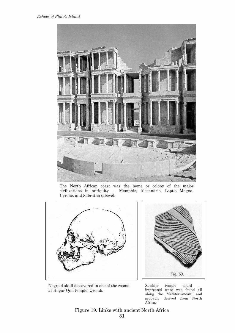
Echoes of Plato’s Island
The North African coast was the home or colony of the major civilizations in antiquity — Memphis, Alexandria, Leptis Magna, Cyrene, and Sabratha (above).
Negroid skull discovered in one of the rooms at Hagar Qim temple, Qrendi.
Xewkija temple sherd —impressed ware was found all along the Mediterranean, and probably derived from North Africa.
Figure 19. Links with ancient North Africa 31
Malta:
32
Sicily, were introduced there from Libia.
The absence of such monuments in Sicily
indicated that the Maltese prehistoric
population had derived from North Africa
and that of Sicily from the north.171
Megalithic structures and true dolmens are
absent in Sicily but present in North
Africa.172 Moreover, the absence of a copper
age in Malta contrasts with the situation in
mainland Sicily, and further diminishes the
links therewith during the megalithic
culture period.
Ward Perkins visited the archaeological
sites in North Africa in the 1940s. ―The
most striking remains of the Maltese
Neolithic culture are, without question, the
megalithic temples … Archaeologists have
not ceased to scour the Mediterranean from
the Levant to Spain in search of the culture
from which Malta drew its inspiration …
their choice has fallen upon the
neighbouring shores of northern Africa,
about whose contemporary culture
practically nothing is known.‖173
Horatio Vella quotes Herodotus (IV) for the
―first literary evidence of the fertility notions
among the Libians in ancient North Africa.‖
In prehistoric times, Malta shared with
North Africa, and the rest of the
Mediterranean, ―in the veneration of a
fertility goddess … a main female deity and
her subordinate consort.‖174
In ancient prehistoric times, Malta‘s ruler
was known as Battus,175 which is the
ancient Libian, and also Theran,
nomenclature for the title of a king in
Libia;176 the Therans in Libia had their own
king Battus.177 Malta‘s Battus greeted
Queen Dido en route to establish Carthage.
Even before the arrival of the first
Phoenicians there, Malta was large enough
to have its own colonies, such as at Acholla,
on the North African coast of Tunisia.178 It
was Acholla that Emanuel Magri visited
with a view to excavation in March of 1907,
when he suddenly passed away with the
loss of all his archaeological notes.179
The Stentinello ceramic ware has been
discovered all over the Mediterranean,
including North Africa. Emanuel Magri
identified this incised pottery with that
attributed to the ancient Libians.180
The two British directors of the Malta
Archaeological Survey (1951) associated the
Maltese Neolithic civilisation with the
North African. The impressed ware is
―associated with early communities of stone-
using agriculturalists, from many places in
the Mediterranean area: it was found at
Stentinello in Sicily, and reaches as far west
as the south of France, the Spanish Levant,
and the north African coast in Tangier. The
style might in fact be African in origin.‖181
3. Tectono-seismic profile
Sixty-seven million years ago Africa started
on its collision course with Europe. The
impact occurred at three main sites.
Utilising the nomenclature of today,
Morocco hit Gibraltar on the west, and
Arabia hit Turkey on the east. The third,
and central, point of impact occurred
between the Pelagian block and Italy.
The Pelagian block represents the northern
and central portion of the African plate, and
it included the Tunisio-Sicilian landbridge,
the Maltese and Pelagian islands, and the
southeastern block of Sicily, the Hyblean
plateau.
This central collision front between Africa
and Europe created major changes in
geological structure. A circle of mountain
ranges absorbed some of the stress forces as
it was raised throughout North Africa and
southern Europe. The significant
alterations in the earth‘s crust occurred in
the central Mediterranean region. The
Pelagian block underwent fragmentation of
its crust at several sites, as an effect of the
shearing forces acting along Africa‘s
continuing movement into Europe. Faults,
grabens and rifts3 made their appearance
throughout the region, and these have
occasioned ―extensive tectonic and volcanic
activity‖ throughout the central
Mediterranean region up to the present
time. This rift faulting in the Pelagian block
is one of the ―most spectacular phenomena
in the world‖.182
The central area for studying the
3 A fault is a fracture in the earth‘s crust, along which
the bordering land segments move in relation to one
another. When a land segment collapses between its
neighbours, it becomes a graben, whilst the higher
land segments are known as horsts. A rift is crudely a
massive graben.
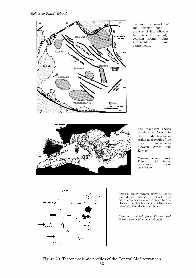
Echoes of Plato’s Island
The mountain chains which have formed in the Mediterranean region as a result of the plate movements between Africa and Eurasia. (Diagram adapted from Ventura and Galea, reproduced with permission)
Tectonic framework of the Pelagian shelf — grabens of late Miocene to recent activity, collision fronts, plate movements and escarpments.
Areas of recent volcanic activity close to the Maltese Islands, in black. The maritime zones are arrowed in white. The black arrows denotes the site of Graham’s Island (1), Pantelleria and Linosa. (Diagram adapted from Ventura and Galea, reproduced with permission)
Figure 20. Tectono-seismic profiles of the Central Mediterranean 33
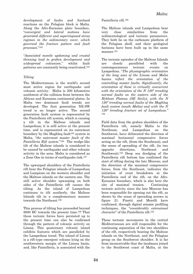
Malta:
34
development of faults and foreland
reactions on the Pelagian block is Malta.
Along the Afro-Eurasian plate boundary,
―convergent and lateral motions have
generated different and superimposed stress
regimes in the sedimentary cover, which
governed the fracture pattern and fault
processes.‖183
―Associated mantle updoming and crustal
thinning lead to graben development and
widespread volcanism,‖ whilst fault
patterns are constantly being reactivated.184
Tilting
The Mediterranean is the world‘s second
most active region for earthquake and
volcanic activity. Malta is 200 kilometres
southwest of the collision front between the
African and Eurasian continental plates. In
Malta two dominant fault trends are
developed. The first generation NE-SW
trend is no longer active. The second
generation fault system is represented by
the Pantelleria rift system, which is causing
a tilt in the Maltese islands and
Lampedusa; it is still active at the present
time, and is represented on its outermost
boundary by the Maghlaq fault185 system in
Malta, ―the outermost master fault of the
Pantelleria Rift system.‖186 The wedge-like
tilt of the Maltese islands is considered to
be caused by earthquake and other volcanic
activity in the area. Malta is considered as
a Zone One in terms of earthquake risk.187
The upwarped shoulders of the Pantelleria
rift bear the Pelagian islands of Lampedusa
and Lampione on the western shoulder and
the Maltese islands on the eastern one. The
still active shoulder upwarping on both
sides of the Pantelleria rift causes the
tilting. As the island of Lampedusa
continues to tilt southerly, the Maltese
Islands tilt in a complementary manner
towards the Northeast.188
This process of tilting has proceeded beyond
8000 BC towards the present time.189 That
these tectonic forces have persisted up to
the present time can also be confirmed
through the pattern of volcanic activity on
Linosa. This quaternary volcanic island
exhibits features which are paralleled by
the Lampedusa trend. The island of Linosa
is a rift-type emergent volcano lying on the
southwestern margin of the Linosa basin,
and, like Pantelleria, is associated with the
Pantelleria rift.190
The Maltese islands and Lampedusa bear
very close similarities from the
sedimentological and tectonic parameters.
They both lie on the carbonate platform of
the Pelagian shelf, and their geological
horizons have been built up in the same
manner.191
The tectonic episodes of the Maltese Islands
are closely paralleled with the
contemporaneous tectonic events on
Lampedusa. ―The physiographic orientation
of the long axes of the Linosa and Malta
basins reflect the orientation of the
controlling master faults. Significantly, the
orientation of these is virtually concurrent
with the orientation of the N 120º trending
normal faults on the eastern side of the
Hyblean Plateau (SE Sicily), with the N
120º trending normal faults of the Maghlaq
fault system (south Malta) and with the N
120º trending fracture set of Lampedusa.‖ 192
Field data from the graben shoulders of the
Pantelleria rift, namely Malta to the
Northeast, and Lampedusa on the
Southwest, have delineated the direction of
maximal horizontal compressive forces
acting on the rift, (from the Southeast), and
the sense of spreading of the rift, (in two
opposite directions, Northeast and
Southwest).193 Deep sea dredging of the
Pantelleria rift bottom has confirmed the
start of rifting during the late Miocene, and
the direction of the maximal compressive
forces, from the Southeast, indicates the
initiation of crust breakdown at the
Pantelleria end of the rift, on the Afro-
Eurasian boundary, which is also here the
site of maximal tension. Continuing
tectonic activity since the late Miocene has
been responsible for opening out the rift, as
shown by the sense of spreading arrows in
figure 21. Finetti and Morelli have
confirmed, through digital seismic profiling
techniques, the ―considerably extensional
character‖ of the Pantelleria rift.194
These tectonic movements in the central
Mediterranean are still responsible for the
continuing separation of the two shoulders
of the rift, respectively bearing the Maltese
islands on the Northeast, and the Pelagian
group on the Southwest shoulder. It is far
from inconceivable that the landmass joined
to the Southwest coast of Malta, at the
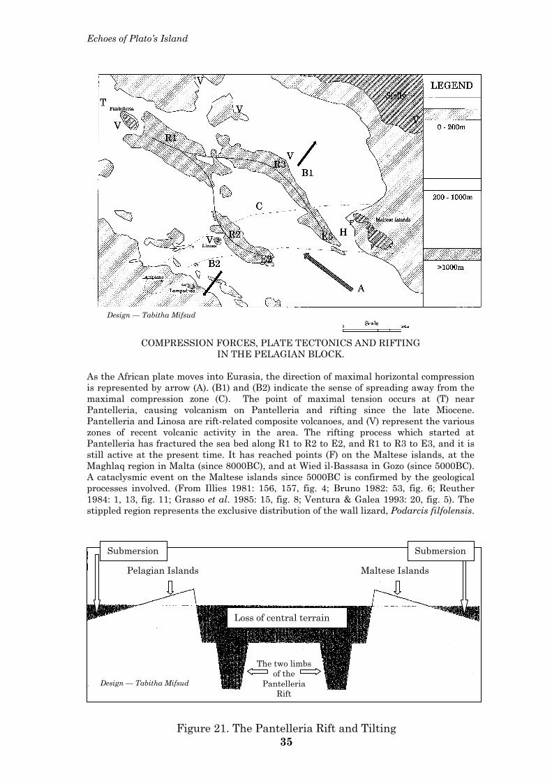
Echoes of Plato’s Island
COMPRESSION FORCES, PLATE TECTONICS AND RIFTING IN THE PELAGIAN BLOCK.
As the African plate moves into Eurasia, the direction of maximal horizontal compression is represented by arrow (A). (B1) and (B2) indicate the sense of spreading away from the maximal compression zone (C). The point of maximal tension occurs at (T) near Pantelleria, causing volcanism on Pantelleria and rifting since the late Miocene. Pantelleria and Linosa are rift-related composite volcanoes, and (V) represent the various zones of recent volcanic activity in the area. The rifting process which started at Pantelleria has fractured the sea bed along R1 to R2 to E2, and R1 to R3 to E3, and it is still active at the present time. It has reached points (F) on the Maltese islands, at the Maghlaq region in Malta (since 8000BC), and at Wied il-Bassasa in Gozo (since 5000BC). A cataclysmic event on the Maltese islands since 5000BC is confirmed by the geological processes involved. (From Illies 1981: 156, 157, fig. 4; Bruno 1982: 53, fig. 6; Reuther 1984: 1, 13, fig. 11; Grasso et al. 1985: 15, fig. 8; Ventura & Galea 1993: 20, fig. 5). The stippled region represents the exclusive distribution of the wall lizard, Podarcis filfolensis.
Pelagian Islands Maltese Islands
The two limbs of the
Pantelleria Rift
Submersion Submersion
Loss of central terrain
Design — Tabitha Mifsud
Design — Tabitha Mifsud
Figure 21. The Pantelleria Rift and Tilting 35
Malta:
36
Maghlaq site, would have collapsed and
submerged at a point in time when its
underlying structures gave way to the
rifting process. Such a collapse would have
occasioned the displacement of massive
volumes of sea water on the southwestern
coastline, with a rapidly following torrential
flooding event along a SW to NE direction.
4. Catastrophic events on Malta
The Flood in ancient cultures
The biblical archaeologists date the
catastrophic Diluvium to around 2500BC,195
corresponding to the end of the Tarxien
period. In fact the ten-foot deep flood
horizon at Ur in Mesopotamia conveniently
separates the Neolithic from the Bronze
Age periods. The sacred texts of Jews,
Christians and Muslims recount the same
episode of the catastrophic Flood worldwide;
the ancient Greeks suffered such a major
flood which destroyed all their records.196
The ancient cuneiform tablets of Nineveh
recount the epic of Gilgamesh, which is
identical to the story of Noah and the Flood.
Variations of the event are to be found in
practically all ancient cultures, and the
story has been handed down to several of
today‘s nations—the Americas, Australia,
India, Tibet, Kashmir, Polynesia and
Lithuania.
Climatic conditions worldwide were
significantly perturbed owing to the mini
Ice Age prevailing during this same period
of time, and the third millennium BC saw a
general decline in the growth and
efflorescence of societies in the Aegean,
Egypt, the Indus valley and western Asia.
In Egypt, the Old Kingdom, during which
the pyramids were built, gave way to the
turmoil of the First Intermediate Period. In
Palestine, Early Bronze Age towns were
abandoned. In Mesopotamia, the Akkadian
Empire collapsed around 2,200 BC. Cretan
and Greek civilisations collapsed in 2,200
BC, whereas the great cities in the Indus
Valley collapsed between 2,200 and
2,100BC. The collapse of these societies
often left an archaeological hiatus of about
three centuries. 197
Although the Maltese radiocarbon
chronology has not pinpointed the exact
date of passage from the Tarxien to the
Early Bronze Age, the dates do indicate
that this transition occurred approximately
at the same time, certainly in the later half
of the third millennium BC. A similar
hiatus in the archaeological record is also
observable in the Maltese context.
Torrential flooding events
Major flooding events have occurred in the
Maltese islands, both in prehistoric and in
ancient historic times. The former are
characterised by alluvial (water-borne)
deposits of extinct animals, such as
hippopotamus, elephant and red deer,
whereas the latter are represented by
isolated victims in the minor episodes, and
with alluvial events of a more significant
nature in the major ones.
Torrential flooding events are characteristic
of the Maltese islands. They have been
responsible in early antiquity for the
deposits of extinct animals in the lower
layers of Ghar Dalam, in the Southeast of
Malta. This is one of the major areas along
the Maltese coastline where the massive
volumes of water would have ended their
journey towards the sea. Such torrential
flows, which also produced the deep gorges
and valleys throughout the Maltese islands,
would have required a much larger surface
area of the Maltese islands towards the
south.
The earliest recorded flooding episode in
Malta has been dated to approximately
120,000 years before the present time —
this has produced the Hippopotamus layer
in Ghar Dalam. Massive numbers of dwarf
elephant and hippopotamus were carried
away by the flood waters and the small
percentage which did not end up in the sea
were deposited in sites such as Ghar
Dalam. Several other episodes followed
during the later periods of the same ‗Ice
Age‘, and were responsible for carrying
away the carnivores of the period, such as
wolf and fox, and the red deer. Two human
taurodont molar teeth were included with
the remains of red deer. Once again these
remains of extinct Maltese mammals were
eventually deposited in successive layers at
Ghar Dalam.198 Moreover the flooding
episode during the carnivore episode was
associated with significant evidence of
burning — ash was a significant feature of
pollen analysis of this layer.199 Fire and
water were responsible for this cataclysm,
and the evidence thus points to volcanic
activity on the Maltese islands at this
period of time. Ash can be dated, and would
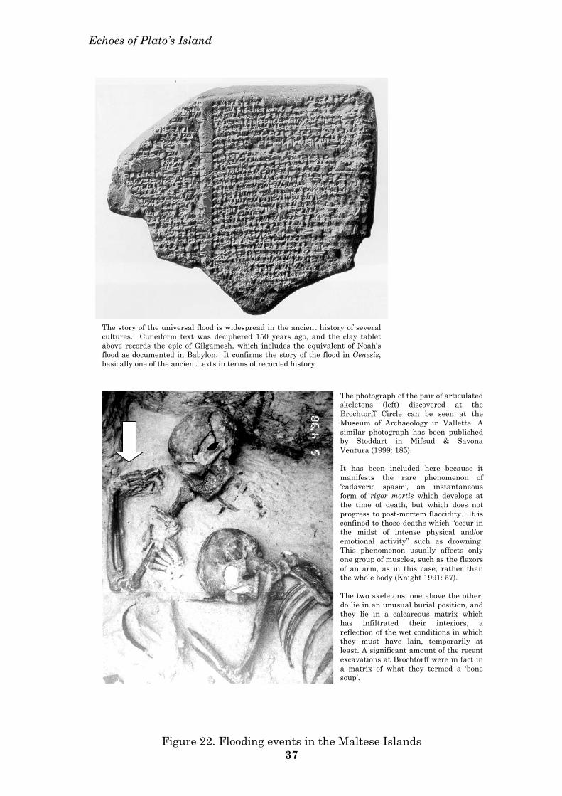
Echoes of Plato’s Island
The story of the universal flood is widespread in the ancient history of several cultures. Cuneiform text was deciphered 150 years ago, and the clay tablet above records the epic of Gilgamesh, which includes the equivalent of Noah’s flood as documented in Babylon. It confirms the story of the flood in Genesis, basically one of the ancient texts in terms of recorded history.
The photograph of the pair of articulated skeletons (left) discovered at the Brochtorff Circle can be seen at the Museum of Archaeology in Valletta. A similar photograph has been published by Stoddart in Mifsud & Savona Ventura (1999: 185). It has been included here because it manifests the rare phenomenon of ‘cadaveric spasm’, an instantaneous form of rigor mortis which develops at the time of death, but which does not progress to post-mortem flaccidity. It is confined to those deaths which “occur in the midst of intense physical and/or emotional activity” such as drowning. This phenomenon usually affects only one group of muscles, such as the flexors of an arm, as in this case, rather than the whole body (Knight 1991: 57). The two skeletons, one above the other, do lie in an unusual burial position, and they lie in a calcareous matrix which has infiltrated their interiors, a reflection of the wet conditions in which they must have lain, temporarily at least. A significant amount of the recent excavations at Brochtorff were in fact in a matrix of what they termed a ‘bone soup’.
Figure 22. Flooding events in the Maltese Islands 37
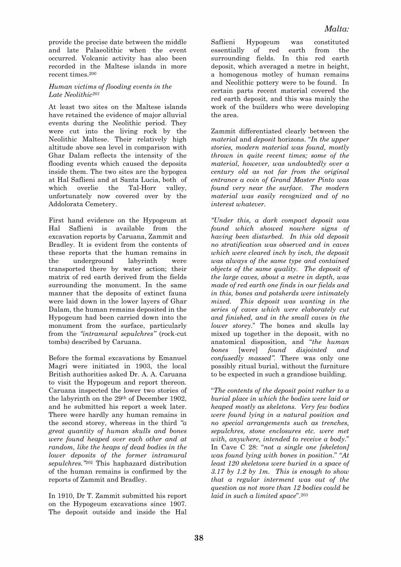
Malta:
38
provide the precise date between the middle
and late Palaeolithic when the event
occurred. Volcanic activity has also been
recorded in the Maltese islands in more
recent times.200
Human victims of flooding events in the
Late Neolithic201
At least two sites on the Maltese islands
have retained the evidence of major alluvial
events during the Neolithic period. They
were cut into the living rock by the
Neolithic Maltese. Their relatively high
altitude above sea level in comparison with
Ghar Dalam reflects the intensity of the
flooding events which caused the deposits
inside them. The two sites are the hypogea
at Hal Saflieni and at Santa Lucia, both of
which overlie the Tal-Horr valley,
unfortunately now covered over by the
Addolorata Cemetery.
First hand evidence on the Hypogeum at
Hal Saflieni is available from the
excavation reports by Caruana, Zammit and
Bradley. It is evident from the contents of
these reports that the human remains in
the underground labyrinth were
transported there by water action; their
matrix of red earth derived from the fields
surrounding the monument. In the same
manner that the deposits of extinct fauna
were laid down in the lower layers of Ghar
Dalam, the human remains deposited in the
Hypogeum had been carried down into the
monument from the surface, particularly
from the ―intramural sepulchres‖ (rock-cut
tombs) described by Caruana.
Before the formal excavations by Emanuel
Magri were initiated in 1903, the local
British authorities asked Dr. A. A. Caruana
to visit the Hypogeum and report thereon.
Caruana inspected the lower two stories of
the labyrinth on the 29th of December 1902,
and he submitted his report a week later.
There were hardly any human remains in
the second storey, whereas in the third ―a
great quantity of human skulls and bones
were found heaped over each other and at
random, like the heaps of dead bodies in the
lower deposits of the former intramural
sepulchres.‖202 This haphazard distribution
of the human remains is confirmed by the
reports of Zammit and Bradley.
In 1910, Dr T. Zammit submitted his report
on the Hypogeum excavations since 1907.
The deposit outside and inside the Hal
Saflieni Hypogeum was constituted
essentially of red earth from the
surrounding fields. In this red earth
deposit, which averaged a metre in height,
a homogenous motley of human remains
and Neolithic pottery were to be found. In
certain parts recent material covered the
red earth deposit, and this was mainly the
work of the builders who were developing
the area.
Zammit differentiated clearly between the
material and deposit horizons. ―In the upper
stories, modern material was found, mostly
thrown in quite recent times; some of the
material, however, was undoubtedly over a
century old as not far from the original
entrance a coin of Grand Master Pinto was
found very near the surface. The modern
material was easily recognized and of no
interest whatever.
―Under this, a dark compact deposit was
found which showed nowhere signs of
having been disturbed. In this old deposit
no stratification was observed and in caves
which were cleared inch by inch, the deposit
was always of the same type and contained
objects of the same quality. The deposit of
the large caves, about a metre in depth, was
made of red earth one finds in our fields and
in this, bones and potsherds were intimately
mixed. This deposit was wanting in the
series of caves which were elaborately cut
and finished, and in the small caves in the
lower storey.‖ The bones and skulls lay
mixed up together in the deposit, with no
anatomical disposition, and ―the human
bones [were] found disjointed and
confusedly massed‖. There was only one
possibly ritual burial, without the furniture
to be expected in such a grandiose building.
―The contents of the deposit point rather to a
burial place in which the bodies were laid or
heaped mostly as skeletons. Very few bodies
were found lying in a natural position and
no special arrangements such as trenches,
sepulchres, stone enclosures etc. were met
with, anywhere, intended to receive a body.‖
In Cave C 28: ―not a single one [skeleton]
was found lying with bones in position.‖ ―At
least 120 skeletons were buried in a space of
3.17 by 1.2 by 1m. This is enough to show
that a regular interment was out of the
question as not more than 12 bodies could be
laid in such a limited space‖.203
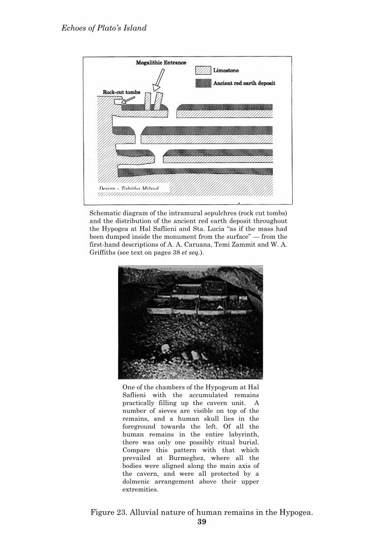
Echoes of Plato’s Island
Schematic diagram of the intramural sepulchres (rock cut tombs) and the distribution of the ancient red earth deposit throughout the Hypogea at Hal Saflieni and Sta. Lucia “as if the mass had been dumped inside the monument from the surface” — from the first-hand descriptions of A. A. Caruana, Temi Zammit and W. A. Griffiths (see text on pages 38 et seq.).
Design – Tabitha Mifsud
One of the chambers of the Hypogeum at Hal Saflieni with the accumulated remains practically filling up the cavern unit. A number of sieves are visible on top of the remains, and a human skull lies in the foreground towards the left. Of all the human remains in the entire labyrinth, there was only one possibly ritual burial. Compare this pattern with that which prevailed at Burmeghez, where all the bodies were aligned along the main axis of the cavern, and were all protected by a dolmenic arrangement above their upper extremities.
Figure 23. Alluvial nature of human remains in the Hypogea. 39
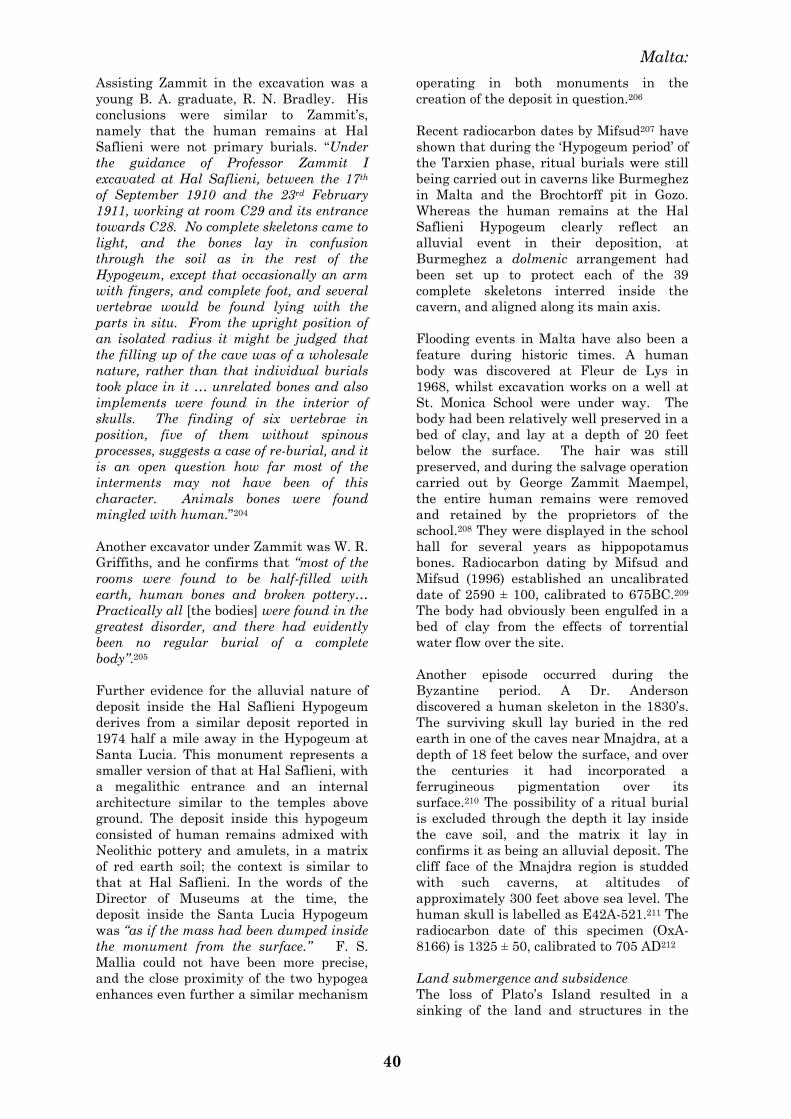
Malta:
40
Assisting Zammit in the excavation was a
young B. A. graduate, R. N. Bradley. His
conclusions were similar to Zammit‘s,
namely that the human remains at Hal
Saflieni were not primary burials. ―Under
the guidance of Professor Zammit I
excavated at Hal Saflieni, between the 17th
of September 1910 and the 23rd February
1911, working at room C29 and its entrance
towards C28. No complete skeletons came to
light, and the bones lay in confusion
through the soil as in the rest of the
Hypogeum, except that occasionally an arm
with fingers, and complete foot, and several
vertebrae would be found lying with the
parts in situ. From the upright position of
an isolated radius it might be judged that
the filling up of the cave was of a wholesale
nature, rather than that individual burials
took place in it … unrelated bones and also
implements were found in the interior of
skulls. The finding of six vertebrae in
position, five of them without spinous
processes, suggests a case of re-burial, and it
is an open question how far most of the
interments may not have been of this
character. Animals bones were found
mingled with human.‖204
Another excavator under Zammit was W. R.
Griffiths, and he confirms that ―most of the
rooms were found to be half-filled with
earth, human bones and broken pottery…
Practically all [the bodies] were found in the
greatest disorder, and there had evidently
been no regular burial of a complete
body‖.205
Further evidence for the alluvial nature of
deposit inside the Hal Saflieni Hypogeum
derives from a similar deposit reported in
1974 half a mile away in the Hypogeum at
Santa Lucia. This monument represents a
smaller version of that at Hal Saflieni, with
a megalithic entrance and an internal
architecture similar to the temples above
ground. The deposit inside this hypogeum
consisted of human remains admixed with
Neolithic pottery and amulets, in a matrix
of red earth soil; the context is similar to
that at Hal Saflieni. In the words of the
Director of Museums at the time, the
deposit inside the Santa Lucia Hypogeum
was ―as if the mass had been dumped inside
the monument from the surface.‖ F. S.
Mallia could not have been more precise,
and the close proximity of the two hypogea
enhances even further a similar mechanism
operating in both monuments in the
creation of the deposit in question.206
Recent radiocarbon dates by Mifsud207 have
shown that during the ‗Hypogeum period‘ of
the Tarxien phase, ritual burials were still
being carried out in caverns like Burmeghez
in Malta and the Brochtorff pit in Gozo.
Whereas the human remains at the Hal
Saflieni Hypogeum clearly reflect an
alluvial event in their deposition, at
Burmeghez a dolmenic arrangement had
been set up to protect each of the 39
complete skeletons interred inside the
cavern, and aligned along its main axis.
Flooding events in Malta have also been a
feature during historic times. A human
body was discovered at Fleur de Lys in
1968, whilst excavation works on a well at
St. Monica School were under way. The
body had been relatively well preserved in a
bed of clay, and lay at a depth of 20 feet
below the surface. The hair was still
preserved, and during the salvage operation
carried out by George Zammit Maempel,
the entire human remains were removed
and retained by the proprietors of the
school.208 They were displayed in the school
hall for several years as hippopotamus
bones. Radiocarbon dating by Mifsud and
Mifsud (1996) established an uncalibrated
date of 2590 ± 100, calibrated to 675BC.209
The body had obviously been engulfed in a
bed of clay from the effects of torrential
water flow over the site.
Another episode occurred during the
Byzantine period. A Dr. Anderson
discovered a human skeleton in the 1830‘s.
The surviving skull lay buried in the red
earth in one of the caves near Mnajdra, at a
depth of 18 feet below the surface, and over
the centuries it had incorporated a
ferrugineous pigmentation over its
surface.210 The possibility of a ritual burial
is excluded through the depth it lay inside
the cave soil, and the matrix it lay in
confirms it as being an alluvial deposit. The
cliff face of the Mnajdra region is studded
with such caverns, at altitudes of
approximately 300 feet above sea level. The
human skull is labelled as E42A-521.211 The
radiocarbon date of this specimen (OxA-
8166) is 1325 ± 50, calibrated to 705 AD212
Land submergence and subsidence The loss of Plato‘s Island resulted in a
sinking of the land and structures in the
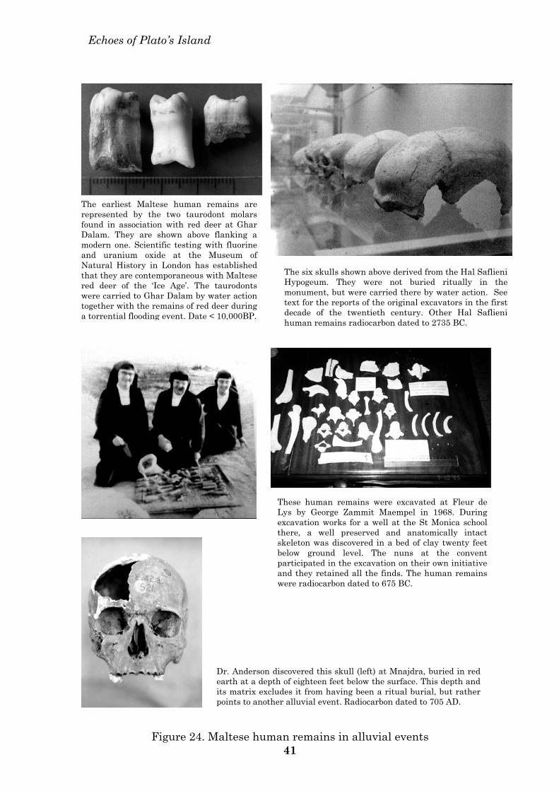
Echoes of Plato’s Island
The earliest Maltese human remains are represented by the two taurodont molars found in association with red deer at Ghar Dalam. They are shown above flanking a modern one. Scientific testing with fluorine and uranium oxide at the Museum of Natural History in London has established that they are contemporaneous with Maltese red deer of the ‘Ice Age’. The taurodonts were carried to Ghar Dalam by water action together with the remains of red deer during a torrential flooding event. Date < 10,000BP.
The six skulls shown above derived from the Hal Saflieni Hypogeum. They were not buried ritually in the monument, but were carried there by water action. See text for the reports of the original excavators in the first decade of the twentieth century. Other Hal Saflieni human remains radiocarbon dated to 2735 BC.
These human remains were excavated at Fleur de Lys by George Zammit Maempel in 1968. During excavation works for a well at the St Monica school there, a well preserved and anatomically intact skeleton was discovered in a bed of clay twenty feet below ground level. The nuns at the convent participated in the excavation on their own initiative and they retained all the finds. The human remains were radiocarbon dated to 675 BC.
Dr. Anderson discovered this skull (left) at Mnajdra, buried in red earth at a depth of eighteen feet below the surface. This depth and its matrix excludes it from having been a ritual burial, but rather points to another alluvial event. Radiocarbon dated to 705 AD.
Figure 24. Maltese human remains in alluvial events 41
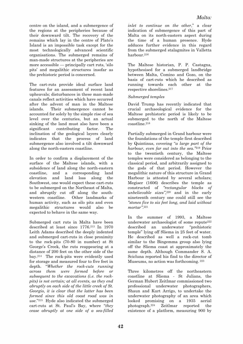
Malta:
42
centre on the island, and a submergence of
the regions at the peripheries because of
their downward tilt. The recovery of the
remains which lay in the centre of Plato‘s
Island is an impossible task except for the
most technologically advanced scientific
organisations. The submerged remains of
man-made structures at the peripheries are
more accessible — principally cart ruts, ‗silo
pits‘ and megalithic structures insofar as
the prehistoric period is concerned.
The cart-ruts provide ideal surface land
features for an assessment of recent land
upheavals; disturbances in these man-made
canals reflect activities which have occurred
after the advent of man in the Maltese
islands. Their submergence cannot be
accounted for solely by the simple rise of sea
level over the centuries, but an actual
sinking of the land must also have been a
significant contributing factor. The
inclination of the geological layers clearly
indicates that the process of land
submergence also involved a tilt downward
along the north-eastern coastline.
In order to confirm a displacement of the
surface of the Maltese islands, with a
subsidence of land along the north-eastern
coastline, and a corresponding land
elevation and land loss along the
Southwest, one would expect these cart-ruts
to be submerged on the Northeast of Malta,
and abruptly cut off along the south-
western coastline. Other landmarks of
human activity, such as silo pits and even
megalithic structures would also be
expected to behave in the same way.
Submerged cart ruts in Malta have been
described at least since 1776.213 In 1970
Leith Adams described the deeply indented
and submerged cart-ruts in close proximity
to the rock-pits (70-80 in number) at St
George‘s Creek, the ruts reappearing at a
distance of 200 feet on the other side of the
bay.214 The rock-pits were evidently used
for storage and measured four to five feet in
depth. ―Whether the rock-cuts running
across them were formed before or
subsequent to the excavations (i.e. the rock-
pits) is not certain; at all events, as they end
abruptly on each side of the little creek of St.
Georgio, it is clear that the latter has been
formed since this old coast road was in
use.‖215 Hyde also indicated the submerged
cart-ruts at St. Paul‘s Bay, where ―they
cease abruptly at one side of a sea-filled
inlet to continue on the other,‖ a clear
indication of submergence of this part of
Malta on its north-eastern aspect during
the time of a human presence. Hyde
adduces further evidence in this regard
from the submerged stalagmites in Valletta
harbour.216
The Maltese historian, P. P. Castagna,
hypothesised for a submerged landbridge
between Malta, Comino and Gozo, on the
basis of cart-ruts which he described as
running towards each other at the
respective shorelines.217
Submerged temples
David Trump has recently indicated that
crucial archaeological evidence for the
Maltese prehistoric period is likely to be
submerged to the north of the Maltese
coastline.218
Partially submerged in Grand harbour were
the foundations of the temple first described
by Quintinus, covering ―a large part of the
harbour, even far out into the sea.‖219 Prior
to the twentieth century, the Maltese
temples were considered as belonging to the
classical period, and arbitrarily assigned to
the gods of that period. However the
megalithic nature of this structure in Grand
Harbour is attested by several scholars;
Megiser (1606) describes the temple as
constructed of ―rectangular blocks of
unbelievable sizes‖,220 and in the early
nineteenth century one could still see the
―stones five to six feet long, and laid without
mortar‖.221
In the summer of 1993, a Maltese
underwater archaeologist of some repute222
described an underwater ―prehistoric
temple‖ lying off Sliema in 25 feet of water.
He described as well a rock-cut tomb
similar to the Bingemma group also lying
off the Sliema coast at approximately the
same depth. Although Commander S. A.
Scicluna reported his find to the director of
Museums, no action was forthcoming. 223
Three kilometres off the northeastern
coastline at Sliema - St Julians, the
German Hubert Zeitlmar commissioned two
professional underwater photographers,
Shaun and Kurt Arrigo, to undertake the
underwater photography of an area which
looked promising on a 1935 aerial
photograph.224 Zeitlmar reported the
existence of a platform, measuring 900 by
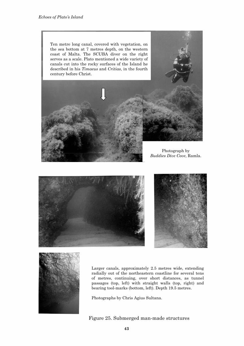
Echoes of Plato’s Island
Larger canals, approximately 2.5 metres wide, extending radially out of the northeastern coastline for several tens of metres, continuing, over short distances, as tunnel passages (top, left) with straight walls (top, right) and bearing tool-marks (bottom, left). Depth 19.5 metres. Photographs by Chris Agius Sultana.
Ten metre long canal, covered with vegetation, on the sea bottom at 7 metres depth, on the western coast of Malta. The SCUBA diver on the right serves as a scale. Plato mentioned a wide variety of canals cut into the rocky surfaces of the Island he described in his Timaeus and Critias, in the fourth century before Christ.
Photograph by
Buddies Dive Cove, Ramla.
Figure 25. Submerged man-made structures
43

Malta:
44
500 metres, and lying between 25 and 8
metres beneath the sea level. Upon this
platform stand two circular structures,
measuring between 4 and 6 metres in
diameter, and resembling the megalithic
Maltese structures on land; there are,
besides, rectangular chambers orientated
towards the east, collapsed megalithic
structures and even cart-ruts.225
Other professional divers have reported
sightings of unusual underwater features,
and the most recent which has been
brought to our attention by Leslie Farrugia
and Audrey Mifsud is a ten-metre long
canal, approximately one metre in depth
and slightly less in width, at a depth of 7
metres on the west coast of Malta. Another
feature which is being investigated is a
small flight of stairs at a depth of 20 metres
and lying approximately fifty metres
distant from the canal. 226
Land movements on Malta during the
Holocene227
Geological displacements during recent
times are evident in several sites in the
Maltese islands. In Malta, recently active
fault systems have also been identified on
the Southwest coast, at 52553E, 63965N.
Westward, along the Maghlaq fault, recent
tectonic movements have been cited by
Trechmann (1938) and Illies (1981). At the
site of Ras il-Bajjada, slicing and
slickensiding of faults with Pleistocene
deposits are a clear indication of tectonic
activity in recent times.228
In central Gozo a Holocene fault scarp has
also been recorded by Illies; in eastern
Gozo, recent activity is indicated by the
slickensided brown-reddish infillings of
fissures in the Lower Coralline
Limestone.229
Moreover, in Gozo, the fault systems west of
Mgarr ix-Xini (south-western coastline)
have been active since 5000BC,230 whilst
more recent activity, within historical
times, is indicated by the sinistral bending
of the ancient cart ruts as they cross faults
over a length of about 200m. Brockman
further noted that some tracks had been
―softened by great heat and then to have
cooled and set in the new curves. This, in
itself, seems evidence that they are older
than some vast but unrecorded volcanic
disturbance‖.231
Volcanic activity on Malta
The three basins of the Pantelleria rift are
1— the Pantelleria basin, associated with
volcanic Pantelleria island, 2— the Linosa
basin, associated with the volcanic Linosa
island, and 3 — the Malta basin, with a
missing volcano,232 but with its ash fall-out
still present on Malta.
In 1888, the historian Castagna suggested
that a massive volcanic eruption had caused
the destruction of the southern regions of
the Maltese Islands.233
In 1896, Cooke reported an unidentified
layer, 45 cm thick, during pipeline
excavation trenching at St. Joseph Street,
in Hamrun.234
During trenching operations in 1965, at a
site in Mriehel,235 1.5km distant from
Cooke‘s (1896) site, Zammit Maempel
identified a layer which was similar, in
texture, coloration, thickness and height
above sea level, to that described earlier by
Cooke. Zammit Maempel carried out
extensive investigations, both locally and
abroad, as to its true nature and possible
source of origin. Mineralogical and
microscopical examination of the deposit
identified it as volcanic ash from an
unknown source.236
The ―numerous air spaces and loosely bound
nature‖ of the deposit confirmed that the
ash fall had been air-borne, and not water-
borne. The thickness of the deposit was
sufficient for Zammit Maempel to attribute
it to ―volcanic activity of considerable
intensity,‖ and to suggest ―metamorphic and
volcanic rocks in nearby landmasses once
connected with Malta but now
submerged‖.237
Moreover, the distribution of this ash fall
over such a large surface, and a similar
layer can still be seen today in excavation
works along the Mriehel bypass, makes it
all the more substantial. The dating is even
more significant, for the underlying Cervus
layer confirms the volcanic ash fall as
occurring in the prehistoric period, since
8000BC.238 Maltese fishermen who dredge
the sea bottom with their nets still come up
with blocks of lava in their catches.239
Figure 26 shows the distribution of volcanic
activity around the Maltese
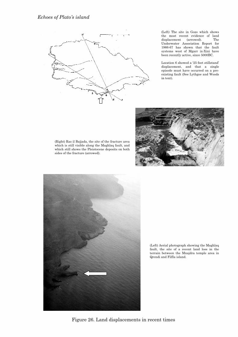
Echoes of Plato’s island
(Left) Aerial photograph showing the Maghlaq fault, the site of a recent land loss in the terrain between the Mnajdra temple area in Qrendi and Filfla island.
(Right) Ras il Bajjada, the site of the fracture area which is still visible along the Maghlaq fault, and which still shows the Pleistocene deposits on both sides of the fracture (arrowed).
(Left) The site in Gozo which shows the most recent evidence of land displacement (arrowed). The Underwater Association Report for 1966-67 has shown that the fault systems west of Mgarr ix-Xini have been recently active, since 5000BC. Location 6 showed a ‘25 feet stillstand’ displacement, and that a single episode must have occurred on a pre-existing fault (See Lythgoe and Woods in text).
Figure 26. Land displacements in recent times
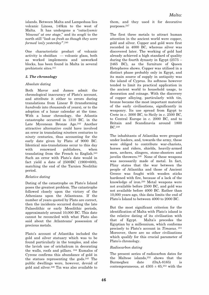
Malta:
46
islands. Between Malta and Lampedusa lies
volcanic Linosa, 140km to the west of
Malta. It has undergone a ―cataclysmic
‗blowout‘ at one stage,‖ and its scogli to the
north still ―look as fresh as though they were
formed ‗only yesterday‘‖.240
One characteristic product of volcanic
activity is obsidian — volcanic glass, both
as worked implements and unworked
blocks, has been found in Malta in several
prehistoric sites.241
5. The chronology
Absolute dating
Both Mavor and James admit the
chronological inaccuracy of Plato‘s account,
and attribute it either to errors during
translations from Linear B (transforming
hundreds into thousands of years), or to the
adoption of a lunar calendar at the time.
With a lunar chronology, the Atlantis
catastrophe occurred in 1310 BC, in the
Late Mycenean Bronze Age.242 Another
attractive alternative could have involved
an error in translating nineteen centuries to
ninety centuries, thus accounting for the
early date given by Plato of 9000 BC.
Identical mis-translations occur to this day
with renowned publishers, when
translating from the French to English.243
Such an error with Plato‘s date would in
fact yield a date of 2500BC (1900+600),
matching the end of the Tarxien Neolithic
period.
Relative dating
Dating of the catastrophe on Plato‘s Island
poses the greatest problem. The catastrophe
followed closely upon the victory of the
Athenians upon the Atlanteans. If the
number of years quoted by Plato are correct,
then the incidents occurred during the late
Palaeolithic or early Mesolithic periods,
approximately around 10,000 BC. This date
cannot be reconciled with what Plato also
said about the Atlanteans‘ possession of
precious metals.
Plato‘s account of Atlantika included the
gold and silver statuary which was to be
found particularly in the temples, and also
the lavish use of orichalcum in decorating
the walls, roofs and pillars. 244 Eumalos of
Cyrene confirms this abundance of gold in
the statues representing the gods.245 The
public dwellings were, however, devoid of
gold and silver.246 Tin was also available to
them, and they used it for decorative
purposes.247
The first three metals to attract human
attention in the ancient world were copper,
gold and silver. Copper and gold were first
recorded in 4000 BC, whereas silver was
discovered later. The working of gold had
already achieved a high standard of quality
during the fourth dynasty in Egypt (2575 –
2465 BC), as the furniture of Queen
Hetepheres shows. Copper was utilised in a
distinct phase probably only in Egypt, and
its main source of supply in antiquity was
the island of Cyprus. Its softness however
tended to limit its practical application in
the ancient world to household usage, to
decoration and coinage. With the discovery
of copper alloying, particularly with tin,
bronze became the most important material
of the early civilisations, significantly in
weaponry. Its use spread from Egypt to
Crete in c. 3000 BC, to Sicily in c. 2500 BC,
to Central Europe in c. 2000 BC, and to
Britain and Scandinavia around 1800
BC.248
The inhabitants of Atlantika were grouped
under leaders, and, towards the army, these
were obliged to contribute war-chariots,
horses and riders, shields, heavily-armed
men, archers, slingers, stone-shooters and
javelin throwers.249 None of these weapons
was necessarily made of metal. In fact,
Pliny states that the war between the
people of Atlantika and those of Ancient
Greece was fought with wooden sticks
hardened with fire, because of a lack of the
knowledge of iron.250 Metal weapons were
not available before 2500 BC, and gold was
not available before 4000 BC. Rather than
10,000 years ago, this data limits the end of
Plato‘s Island to between 4000 to 2000 BC.
But the most significant criterion for the
identification of Malta with Plato‘s island is
the relative dating of its civilisation with
that of Egypt. Malta‘s precedes the
Egyptian by a millennium, which conforms
precisely to Plato‘s account in Timaeus. 251
Moreover, there are no other civilisations
which qualify for this crucial parameter of
Plato‘s chronology.
Radiocarbon dating
The present series of radiocarbon dates for
the Maltese islands,252 shows that the
Burmeghez date (OxA-8165) is
contemporaneous, at 4305 ± 65,253 with the
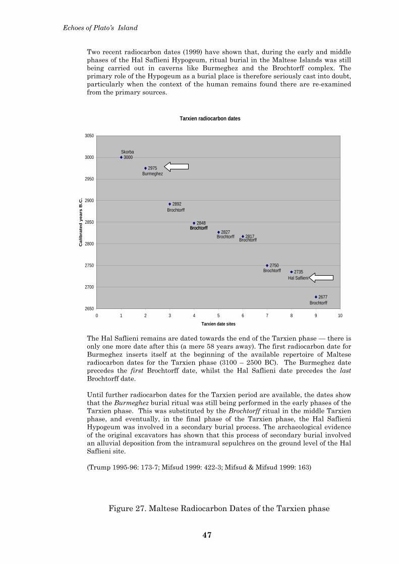
Echoes of Plato’s Island
Two recent radiocarbon dates (1999) have shown that, during the early and middle phases of the Hal Saflieni Hypogeum, ritual burial in the Maltese Islands was still being carried out in caverns like Burmeghez and the Brochtorff complex. The primary role of the Hypogeum as a burial place is therefore seriously cast into doubt, particularly when the context of the human remains found there are re-examined from the primary sources.
The Hal Saflieni remains are dated towards the end of the Tarxien phase — there is only one more date after this (a mere 58 years away). The first radiocarbon date for Burmeghez inserts itself at the beginning of the available repertoire of Maltese radiocarbon dates for the Tarxien phase (3100 – 2500 BC). The Burmeghez date precedes the first Brochtorff date, whilst the Hal Saflieni date precedes the last Brochtorff date. Until further radiocarbon dates for the Tarxien period are available, the dates show that the Burmeghez burial ritual was still being performed in the early phases of the Tarxien phase. This was substituted by the Brochtorff ritual in the middle Tarxien phase, and eventually, in the final phase of the Tarxien phase, the Hal Saflieni Hypogeum was involved in a secondary burial process. The archaeological evidence of the original excavators has shown that this process of secondary burial involved an alluvial deposition from the intramural sepulchres on the ground level of the Hal Saflieni site. (Trump 1995-96: 173-7; Mifsud 1999: 422-3; Mifsud & Mifsud 1999: 163)
Figure 27. Maltese Radiocarbon Dates of the Tarxien phase
Tarxien radiocarbon dates
3000
2975
2892
2848
28272817
27502735
2677
2650
2700
2750
2800
2850
2900
2950
3000
3050
0 1 2 3 4 5 6 7 8 9 10
Tarxien date sites
Cal
ibra
ted
yea
rs B
.C.
Skorba
Burmeghez
Hal Saflieni
Brochtorff
BrochtorffBrochtorff
Brochtorff Brochtorff
Brochtorff
Brochtorff
47
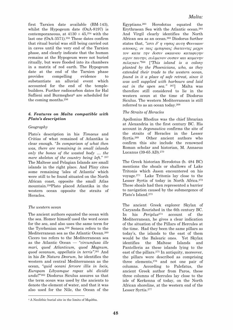
Malta:
48
first Tarxien date available (BM-143),
whilst the Hypogeum date (OxA-8197) is
contemporaneous, at 4130 ± 45,254 with the
last one (OxA-3571).255 These dates confirm
that ritual burial was still being carried out
in caves until the very end of the Tarxien
phase, and clearly indicate that the human
remains at the Hypogeum were not buried
ritually, but were flooded into its chambers
in a matrix of red earth. The Hypogeum
date at the end of the Tarxien phase
provides compelling evidence to
substantiate an alluvial event which
accounted for the end of the temple-
builders. Further radiocarbon dates for Hal
Saflieni and Burmeghez4 are scheduled for
the coming months.256
6. Features on Malta compatible with
Plato’s description
Geography
Plato‘s description in his Timaeus and
Critias of what remained of Atlantika is
clear enough. ―In comparison of what then
was, there are remaining in small islands
only the bones of the wasted body … the
mere skeleton of the country being left.‖ 257
The Maltese and Pelagian Islands are small
islands in the right place. And Pliny cites
some remaining ‗isles of Atlantis‘ which
were still to be found situated on the North
African coast, opposite the small Atlas
mountain.258Plato placed Atlantika in the
western ocean opposite the straits of
Heracles.
The western ocean
The ancient authors equated the ocean with
the sea. Homer himself used the word ocean
for the sea, and also uses the same term for
the Tyrrhenian sea.259 Seneca refers to the
Mediterranean sea as the Atlantic Ocean.260
Cicero too refers to the Mediterranean sea
as the Atlantic Ocean — ―circumfusa ille
mari, quod Atlanticum, quod Magnum,
quod oceanum, appellatis in terris‖.261 And
in his De Natura Deorum, he identifies the
western and central Mediterranean as the
ocean, ―quid oceani fervore illis in locis,
Europam Libyamque rapax ubi dividit
unda?‖262 Diodorus Siculus assures us that
the term ocean was used by the ancients to
denote the element of water, and that it was
also used for the Nile, the Ocean of the
4 A Neolithic burial site in the limits of Mqabba.
Egyptians.263 Herodotus equated the
Erythraean Sea with the Atlantic ocean.264
And Virgil clearly identifies the North
African sea as an ocean.265 Diodorus further
states that, ―
,
,
.‖266 [―This island is a colony
planted by the Phoenicians, who, as they
extended their trade to the western ocean,
found in it a place of safe retreat, since it
was well supplied with harbours and laid
out in the open sea.‖ 267] Malta was
therefore still considered to lie in the
western ocean at the time of Diodorus
Siculus. The western Mediterranean is still
referred to as an ocean today.268
The Straits of Heracles
Apollonius Rhodius was the chief librarian
at Alexandria in the first century BC. His
account in Argonautica confirms the site of
the straits of Heracles in the Lesser
Syrtis.269 Other ancient authors who
confirm this site include the renowned
Roman scholar and historian, M. Annaeus
Lucanus (39-65 AD).270
The Greek historian Herodotus (b. 484 BC)
mentions the shoals or shallows of Lake
Tritonis which Jason encountered on his
voyage.271 Lake Tritonis lay close to the
Lesser Syrtis of today in North Africa.272
These shoals had then represented a barrier
to navigation caused by the submergence of
Plato‘s Island.273
The ancient Greek explorer Skylax of
Caryanda flourished in the 6th century BC.
In his Periplus274 account of the
Mediterranean, he gives a clear indication
of the situation of the Pillars of Hercules at
the time. Had they been the same pillars as
today‘s, the islands to the east of them
would be the Balearic ones. Yet Skylax
identifies the Maltese Islands and
Pantelleria as these islands lying to the
east of the pillars.275 In antiquity, moreover,
the pillars were described as comprising
three elements,276 and not one pair of
columns. According to Palefatus, the
ancient Greek author from Paros, these
three columns of Hercules lay close to the
isle of Kerkenna of today, on the North
African shoreline, at the western end of the
Lesser Syrtis.277
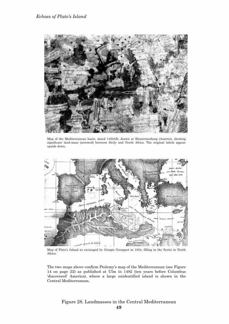
Echoes of Plato’s Island
Map of the Mediterranean basin, dated 1450AD, drawn at Klosterneuburg (Austria), showing significant land-mass (arrowed) between Sicily and North Africa. The original labels appear upside down.
Map of Plato’s Island as envisaged by Giorgio Grongnet in 1854, filling in the Syrtis in North Africa. The two maps above confirm Ptolemy’s map of the Mediterranean (see Figure 14 on page 22) as published at Ulm in 1482 (ten years before Columbus ‘discovered’ America), where a large unidentified island is shown in the Central Mediterranean.
Figure 28. Landmasses in the Central Mediterranean 49
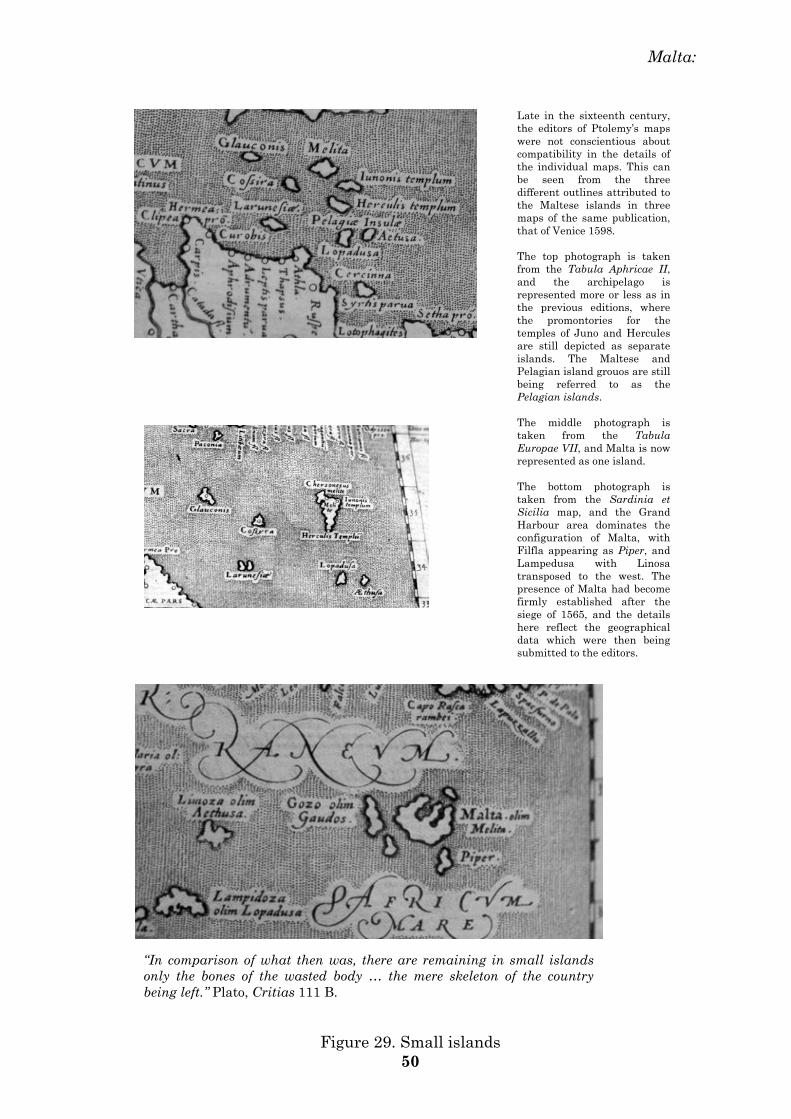
Malta:
Late in the sixteenth century, the editors of Ptolemy’s maps were not conscientious about compatibility in the details of the individual maps. This can be seen from the three different outlines attributed to the Maltese islands in three maps of the same publication, that of Venice 1598. The top photograph is taken from the Tabula Aphricae II, and the archipelago is represented more or less as in the previous editions, where the promontories for the temples of Juno and Hercules are still depicted as separate islands. The Maltese and Pelagian island grouos are still being referred to as the Pelagian islands. The middle photograph is taken from the Tabula Europae VII, and Malta is now represented as one island. The bottom photograph is taken from the Sardinia et Sicilia map, and the Grand Harbour area dominates the configuration of Malta, with Filfla appearing as Piper, and Lampedusa with Linosa transposed to the west. The presence of Malta had become firmly established after the siege of 1565, and the details here reflect the geographical data which were then being submitted to the editors.
“In comparison of what then was, there are remaining in small islands only the bones of the wasted body … the mere skeleton of the country being left.” Plato, Critias 111 B.
Figure 29. Small islands 50
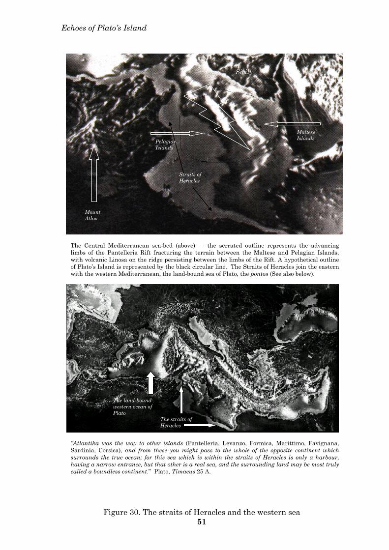
Echoes of Plato’s Island
Sicily
Maltese Islands Pelagian
Islands
Mount Atlas
Straits of Heracles
The Central Mediterranean sea-bed (above) — the serrated outline represents the advancing limbs of the Pantelleria Rift fracturing the terrain between the Maltese and Pelagian Islands, with volcanic Linosa on the ridge persisting between the limbs of the Rift. A hypothetical outline of Plato’s Island is represented by the black circular line. The Straits of Heracles join the eastern with the western Mediterranean, the land-bound sea of Plato, the pontos (See also below).
The land-bound western ocean of Plato
The straits of Heracles
“Atlantika was the way to other islands (Pantelleria, Levanzo, Formica, Marittimo, Favignana, Sardinia, Corsica), and from these you might pass to the whole of the opposite continent which surrounds the true ocean; for this sea which is within the straits of Heracles is only a harbour, having a narrow entrance, but that other is a real sea, and the surrounding land may be most truly called a boundless continent.” Plato, Timaeus 25 A.
Figure 30. The straits of Heracles and the western sea 51
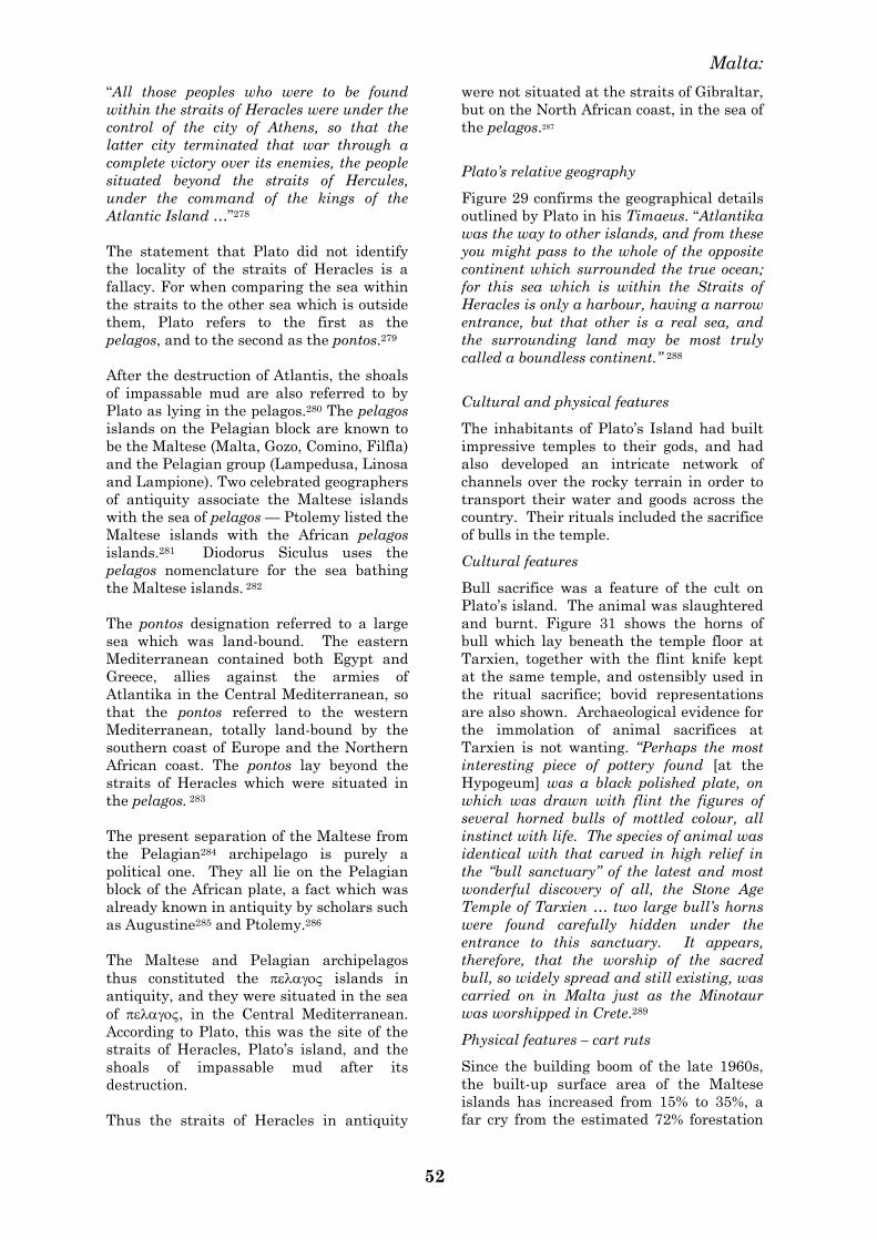
Malta:
52
―All those peoples who were to be found
within the straits of Heracles were under the
control of the city of Athens, so that the
latter city terminated that war through a
complete victory over its enemies, the people
situated beyond the straits of Hercules,
under the command of the kings of the
Atlantic Island …‖278
The statement that Plato did not identify
the locality of the straits of Heracles is a
fallacy. For when comparing the sea within
the straits to the other sea which is outside
them, Plato refers to the first as the
pelagos, and to the second as the pontos.279
After the destruction of Atlantis, the shoals
of impassable mud are also referred to by
Plato as lying in the pelagos.280 The pelagos
islands on the Pelagian block are known to
be the Maltese (Malta, Gozo, Comino, Filfla)
and the Pelagian group (Lampedusa, Linosa
and Lampione). Two celebrated geographers
of antiquity associate the Maltese islands
with the sea of pelagos — Ptolemy listed the
Maltese islands with the African pelagos
islands.281 Diodorus Siculus uses the
pelagos nomenclature for the sea bathing
the Maltese islands. 282
The pontos designation referred to a large
sea which was land-bound. The eastern
Mediterranean contained both Egypt and
Greece, allies against the armies of
Atlantika in the Central Mediterranean, so
that the pontos referred to the western
Mediterranean, totally land-bound by the
southern coast of Europe and the Northern
African coast. The pontos lay beyond the
straits of Heracles which were situated in
the pelagos. 283
The present separation of the Maltese from
the Pelagian284 archipelago is purely a
political one. They all lie on the Pelagian
block of the African plate, a fact which was
already known in antiquity by scholars such
as Augustine285 and Ptolemy.286
The Maltese and Pelagian archipelagos
thus constituted the islands in
antiquity, and they were situated in the sea
of , in the Central Mediterranean.
According to Plato, this was the site of the
straits of Heracles, Plato‘s island, and the
shoals of impassable mud after its
destruction.
Thus the straits of Heracles in antiquity
were not situated at the straits of Gibraltar,
but on the North African coast, in the sea of
the pelagos.287
Plato‘s relative geography
Figure 29 confirms the geographical details
outlined by Plato in his Timaeus. ―Atlantika
was the way to other islands, and from these
you might pass to the whole of the opposite
continent which surrounded the true ocean;
for this sea which is within the Straits of
Heracles is only a harbour, having a narrow
entrance, but that other is a real sea, and
the surrounding land may be most truly
called a boundless continent.‖ 288
Cultural and physical features
The inhabitants of Plato‘s Island had built
impressive temples to their gods, and had
also developed an intricate network of
channels over the rocky terrain in order to
transport their water and goods across the
country. Their rituals included the sacrifice
of bulls in the temple.
Cultural features
Bull sacrifice was a feature of the cult on
Plato‘s island. The animal was slaughtered
and burnt. Figure 31 shows the horns of
bull which lay beneath the temple floor at
Tarxien, together with the flint knife kept
at the same temple, and ostensibly used in
the ritual sacrifice; bovid representations
are also shown. Archaeological evidence for
the immolation of animal sacrifices at
Tarxien is not wanting. ―Perhaps the most
interesting piece of pottery found [at the
Hypogeum] was a black polished plate, on
which was drawn with flint the figures of
several horned bulls of mottled colour, all
instinct with life. The species of animal was
identical with that carved in high relief in
the ―bull sanctuary‖ of the latest and most
wonderful discovery of all, the Stone Age
Temple of Tarxien … two large bull‘s horns
were found carefully hidden under the
entrance to this sanctuary. It appears,
therefore, that the worship of the sacred
bull, so widely spread and still existing, was
carried on in Malta just as the Minotaur
was worshipped in Crete.289
Physical features – cart ruts
Since the building boom of the late 1960s,
the built-up surface area of the Maltese
islands has increased from 15% to 35%, a
far cry from the estimated 72% forestation
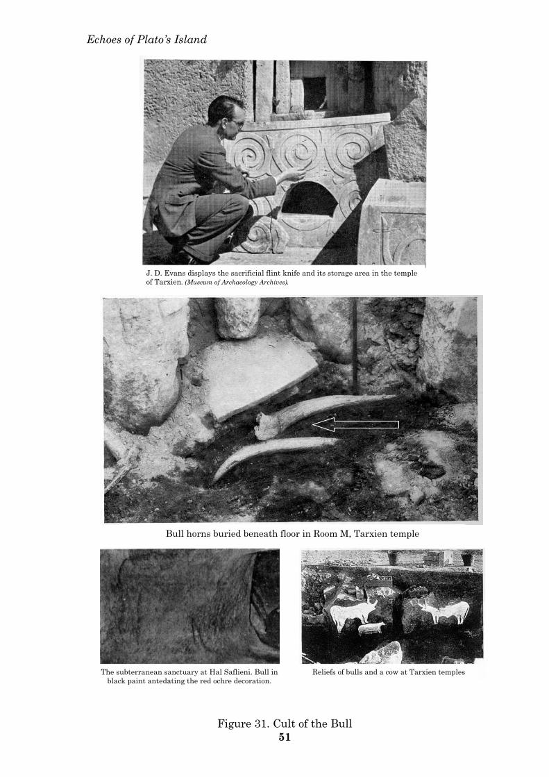
Echoes of Plato’s Island
Bull horns buried beneath floor in Room M, Tarxien temple
Reliefs of bulls and a cow at Tarxien temples The subterranean sanctuary at Hal Saflieni. Bull in black paint antedating the red ochre decoration.
J. D. Evans displays the sacrificial flint knife and its storage area in the temple of Tarxien. (Museum of Archaeology Archives).
Figure 31. Cult of the Bull 51
Malta:
54
status during early Neolithic times. This
factor, together with the extensive
quarrying operations, has contributed
towards the elimination of several
archaeological features and loss of
landscape around archaeological sites. The
fraction which remains is significant
nonetheless.
Besides the high concentration of
megalithic structures on the Maltese
islands, the distribution of the cart-ruts is
no less diffuse. In form and function the
Maltese cart-ruts tally with the rock-canals
described by Plato.290 In his Critias he
describes the intricate and intersecting
networks of rock-cut291 ―canals spreading
straight and lengthwise across the plain and
back into the ditch292, toward the sea293‖.
These networks of canals were ―a hundred
feet in width, and lay at intervals of a
hundred stadia between each other; by them
they brought down the wood from the
mountains to the city, and conveyed the
fruits of the earth in ships, cutting
transverse passages from one canal into
another, and to the city. Twice in the year
they gathered the fruits of the earth - in
winter having the benefit of the rains, and
in summer introducing the water of the
canals‖.294 Independently of Plato, the most
plausible hypothesis, which has been
reached to account for the function of the
Maltese cart-ruts, is that of transport of the
products outlined by Plato.295 Zammit had
suggested the transfer of soil up the
hillsides to terraced fields,296 and other
hypotheses at present include the carriage
of megaliths to temple sites, and the
carriage of water, which latter function is
also mentioned by Plato.
Physical features - temples
The inhabitants of Plato‘s island employed
themselves in constructing their temples
and palaces. There were many temples built
and dedicated to many gods.297
It was readily apparent to the British
members of the Maltese Archaeological
Survey of the 1950s that the megalithic
structures on Malta and Gozo were temples
or sanctuaries erected by the ―consummate
master-masons‖ of a precocious civilisation,
and suggesting concepts of ―drowned cities
and lost continents‖ caused by an ―ancient
and long-forgotten cataclysm‖.298
―A temple is essentially the architectural
framework or setting for a set of prescribed
ritual acts, and is planned and devised for
this purpose. The religion and its ritual
comes first; the setting for the ceremonies
comes as a consequence.‖ … ‖On Malta and
Gozo were some remarkable stone-built
temples of prehistoric date‖ of ―extreme
architectural sophistication and complexity,
but unlike anything else in the
Mediterranean world,‖ … ―the most magic
and potent island-sanctuaries of the central
Mediterranean world.‖ During this
―brilliant phase‖ of Malta‘s prehistory, ―the
development of a religious architecture [was]
carried to a pitch unknown elsewhere
westward of the Aegean.‖299
The Hypogeum itself was a ―unique,
underground temple-tomb‖ … ―obviously
modelled in part on the temples above
ground.‖300 A ―terrifyingly impressive
monument, the underground temple and
ossuary at Hal Saflieni … sometimes
reproduces the solid architectural features
proper to buildings made of separate blocks
above ground.‖301
In prehistoric Malta lay ―the brilliant
civilisation of the temple-builders‖ … ―an
individuality and uniqueness among its
contemporaries‖.302 And the British
megalith man himself, Glyn Daniel,
eventually accepted the Maltese megalithic
structures as ―apsidial temples‖ in a class of
their own.303
―The temple-builders of Malta in the third
millennium BC produced small models in
limestone of the structures which they had
built or were to build … [in the latter case]
a good example of both planning and
design‖.304
Architecturally, ―these anthropomorphic
structures indicate the islands in pre-history
as probably the Holy Shrine of the Middle
Sea. With their deft spatial organization,
these time-resisting giant stone buildings,
man‘s earliest evocations to an Earth
Deity…‖305 By architects overseas, Malta is
described as ―an island of prehistoric sacred
places viewed as site significant spatial
systems‖.306
The Neolithic population of Malta was very
healthy and ate soft food. Several suffered
from a peculiar affliction of arthritis of the
proximal joint of the thumb. This has been
associated with occupational disease
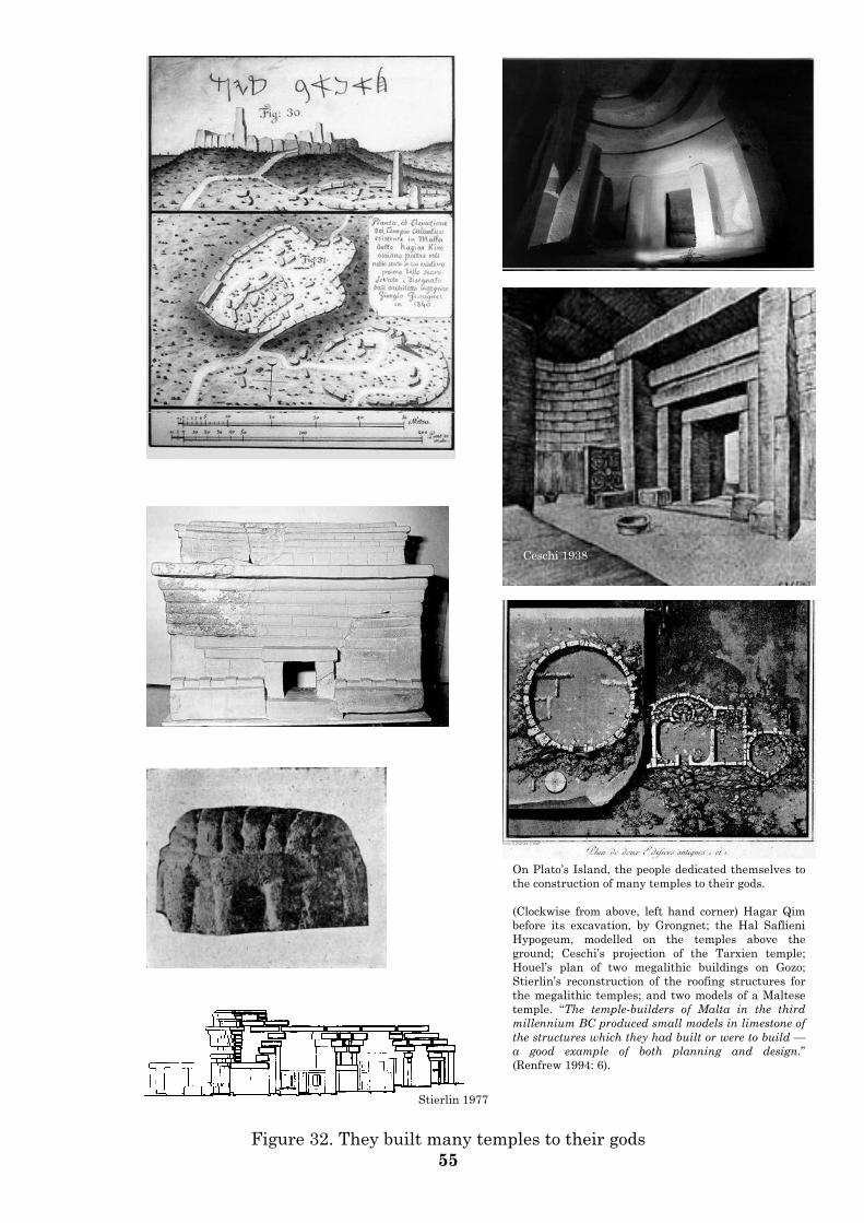
On Plato’s Island, the people dedicated themselves to the construction of many temples to their gods. (Clockwise from above, left hand corner) Hagar Qim before its excavation, by Grongnet; the Hal Saflieni Hypogeum, modelled on the temples above the ground; Ceschi’s projection of the Tarxien temple; Houel’s plan of two megalithic buildings on Gozo; Stierlin’s reconstruction of the roofing structures for the megalithic temples; and two models of a Maltese temple. “The temple-builders of Malta in the third millennium BC produced small models in limestone of the structures which they had built or were to build — a good example of both planning and design.” (Renfrew 1994: 6). Stierlin 1977
Ceschi 1938
Figure 32. They built many temples to their gods 55
Malta:
56
associated with stressful forces at these
joints, caused by constant levering of heavy
loads, such as megaliths.307
7. Other ancient texts confirming
the site of Plato’s Island.
Ogygia308
Homer‘s Odysseus recounts the travels of
Ulysses and his long sojourn with the
nymph Calypso on the island of Ogygia,
some time after the Trojan War of 1184BC.
Ogygia is identified with Malta by several
ancient authors, and Plato‘s Island is
identified with Ogygia by others.
The Greek poet and scholar, Callimachus
(305-240BC), was a native of Cyrene in
North Africa. As chief librarian in the great
library of Alexandria between 260 and 240
BC, he had direct access to thousands of
ancient texts for several years. Here he
compiled the Pinakes, a monumental
catalogue of the ancient authors, with
biographical and bibliographic details.
Callimachus identified Ogygia with the
Maltese islands.309
Amongst several other ancient authors,
Herodotus, Hesiod and Diodorus Siculus
also identified the Maltese Islands with
Ogygia; Homer310 and Catullus (b. 87 BC)
identified Ogygia with Calypso in Malta.311
In the first century before Christ, the
Roman scholar Albius Tibullus associated
Calypso with Atlantis,312 and a manuscript
of 1525 confirms this further. ―The cause of
the loss of Atlantis was the deluge of Ogyge
… this island is much discussed among
authors, but I maintain that this island is
Malta, precisely that which Homer calls
Ogygia.‖313
The main proponent for the association of
Ogygia with the Maltese Islands was
Philipp Clüverius.314 Clüverius was a
German geographer of the seventeenth
century, a key figure in the revival of
geographic learning in Europe and the
founder of historical geography. His
authority stems from his approach to
geography — this was strictly through
history and the ancient authors.
Malta or Crete
Once again, Malta and the Aegean vie with
each other for another title in
Mediterranean archaeology. At the
beginning of the century it was for the
source of Mediterranean civilisation; figure
33 shows Arthur Evans hugging the
Maltese spirals which the Cretans
emulated. At the turn of the century, and of
the second millennium, Malta and the
Aegean island of Thera contend for the title
of Plato‘s island.
Ironically for Thera, it is the testimony of
an ancient Cretan from Thera who provided
the supplementary ancient text.
In 631 BC a colony of ancient Greeks from
Thera left their homeland to settle on the
North African shoreline. They were led by
one Aristoteles, their Battus, and they
founded the colony of Cyrene, known today
as Cyrenaeica, on the western boundaries of
Libia. The city of Cyrene dominated a huge
area of North Africa between the 6th
century BC and the 4th century AD.
One of these Therans, the historian
Eumalos of Cyrene315 wrote the History of
Libia in several volumes, which have not,
unfortunately, survived the vicissitudes of
time. It has however fortunately survived
in the writings of later scholars. In 1830 an
Italian scholar from Siena, Giuseppe
Perricciuoli Borzesi, translated a fragment
of the text into Italian. It was included in
the Appendix to The Historical Guide to the
Island of Malta and its Dependencies, and
was dedicated to the Maltese Governor at
the time, Sir Henry Ponsonby. After giving
an account of ancient Libia, its kings and its
religious beliefs, the account runs thus.
―… Ninus, King of Babylon, nephew of the
famous Ogyge. The latter was the king of
Atlantis, the island which once existed
between Libia and Sicily,316 and which was
submerged. This large island was known as
Decapolis, Atlantika, by our forefathers of
Cyrene, as well as by the ancient Greeks.
Ogyge was the king who governed the
famous island at the time of the horrible
inundation … the summit of Mount Atlas,
which was situated in the middle of the
island Atlantika was not submerged. This
summit of Mount Atlas has preserved the
name of Ogyge from that of its last king, and
it is in fact this circumstance why we still
know as Ogygia that island which once
exists between Libia and Sicily; it is nothing
more than the summit of the Mount of
Atlantika.‖317
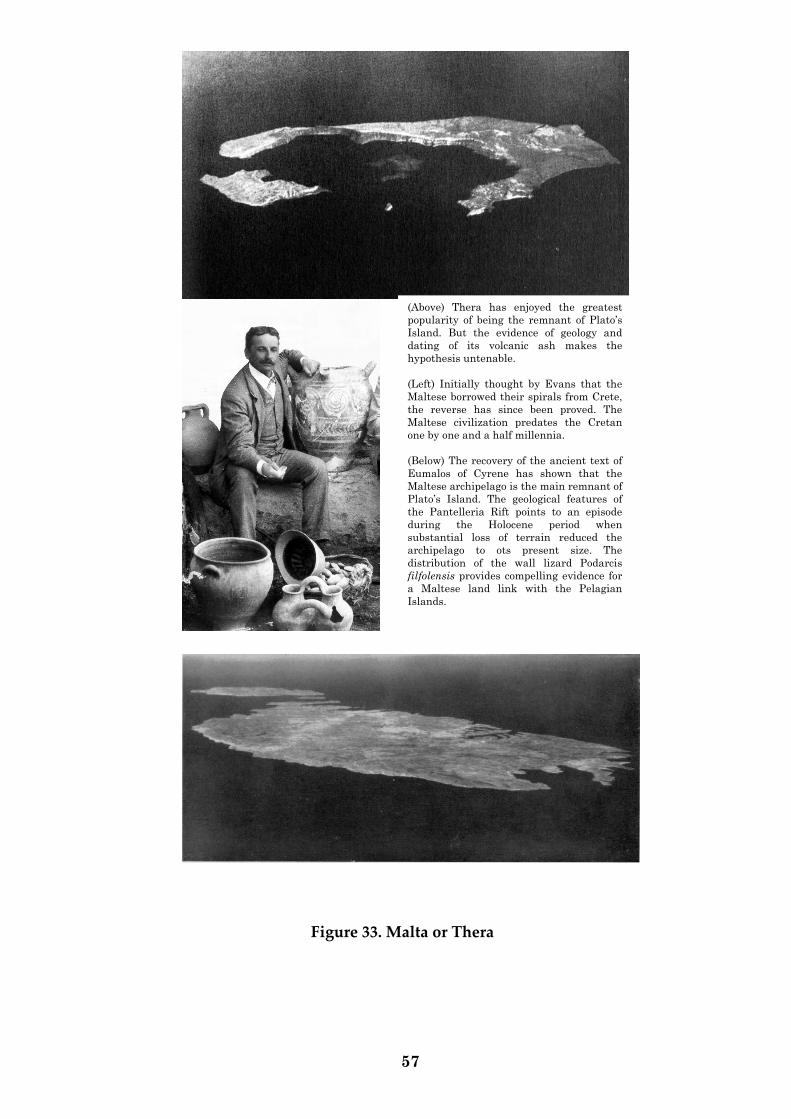
57
Figure 33. Malta or Thera
(Above) Thera has enjoyed the greatest
popularity of being the remnant of Plato’s
Island. But the evidence of geology and
dating of its volcanic ash makes the
hypothesis untenable.
(Left) Initially thought by Evans that the
Maltese borrowed their spirals from Crete,
the reverse has since been proved. The
Maltese civilization predates the Cretan
one by one and a half millennia.
(Below) The recovery of the ancient text of
Eumalos of Cyrene has shown that the
Maltese archipelago is the main remnant of
Plato’s Island. The geological features of
the Pantelleria Rift points to an episode
during the Holocene period when
substantial loss of terrain reduced the
archipelago to ots present size. The
distribution of the wall lizard Podarcis
filfolensis provides compelling evidence for
a Maltese land link with the Pelagian
Islands.
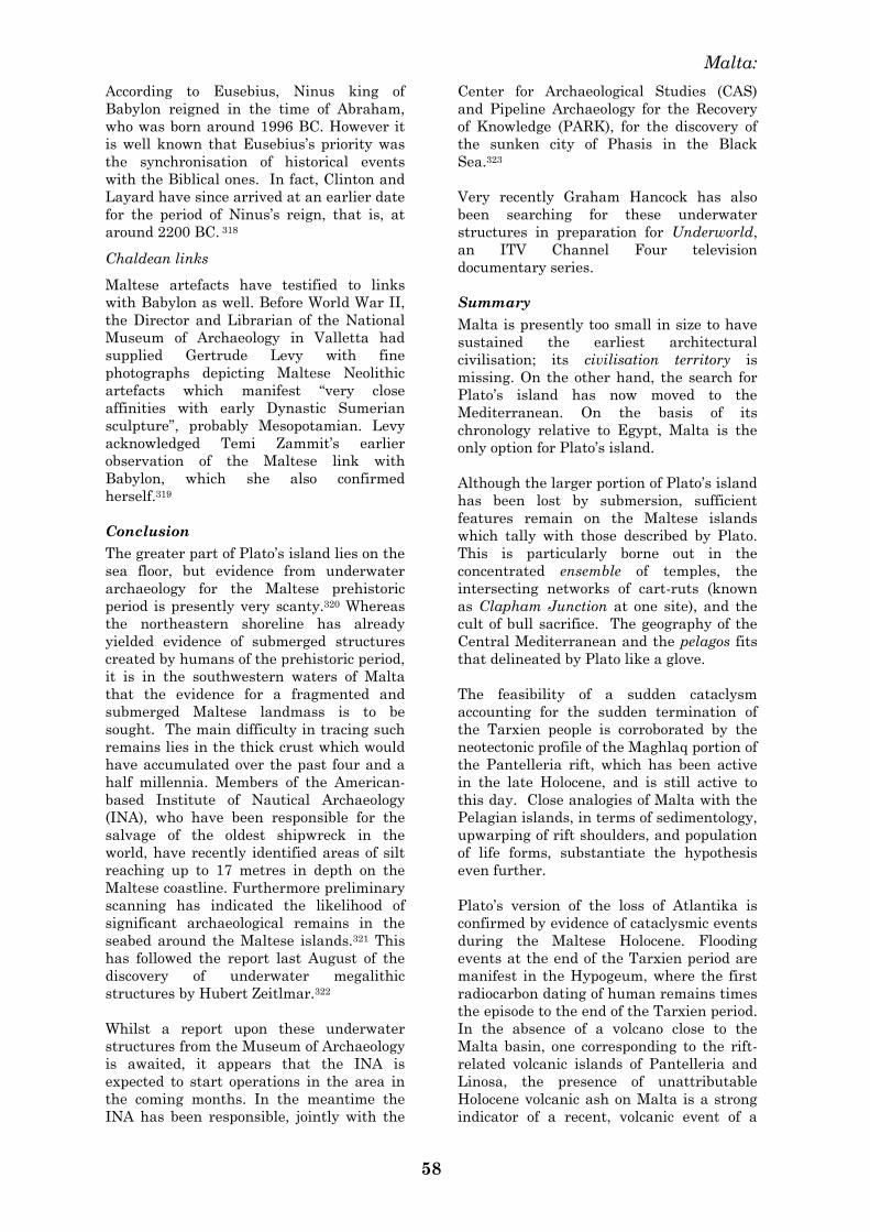
Malta:
58
According to Eusebius, Ninus king of
Babylon reigned in the time of Abraham,
who was born around 1996 BC. However it
is well known that Eusebius‘s priority was
the synchronisation of historical events
with the Biblical ones. In fact, Clinton and
Layard have since arrived at an earlier date
for the period of Ninus‘s reign, that is, at
around 2200 BC. 318
Chaldean links
Maltese artefacts have testified to links
with Babylon as well. Before World War II,
the Director and Librarian of the National
Museum of Archaeology in Valletta had
supplied Gertrude Levy with fine
photographs depicting Maltese Neolithic
artefacts which manifest ―very close
affinities with early Dynastic Sumerian
sculpture‖, probably Mesopotamian. Levy
acknowledged Temi Zammit‘s earlier
observation of the Maltese link with
Babylon, which she also confirmed
herself.319
Conclusion
The greater part of Plato‘s island lies on the
sea floor, but evidence from underwater
archaeology for the Maltese prehistoric
period is presently very scanty.320 Whereas
the northeastern shoreline has already
yielded evidence of submerged structures
created by humans of the prehistoric period,
it is in the southwestern waters of Malta
that the evidence for a fragmented and
submerged Maltese landmass is to be
sought. The main difficulty in tracing such
remains lies in the thick crust which would
have accumulated over the past four and a
half millennia. Members of the American-
based Institute of Nautical Archaeology
(INA), who have been responsible for the
salvage of the oldest shipwreck in the
world, have recently identified areas of silt
reaching up to 17 metres in depth on the
Maltese coastline. Furthermore preliminary
scanning has indicated the likelihood of
significant archaeological remains in the
seabed around the Maltese islands.321 This
has followed the report last August of the
discovery of underwater megalithic
structures by Hubert Zeitlmar.322
Whilst a report upon these underwater
structures from the Museum of Archaeology
is awaited, it appears that the INA is
expected to start operations in the area in
the coming months. In the meantime the
INA has been responsible, jointly with the
Center for Archaeological Studies (CAS)
and Pipeline Archaeology for the Recovery
of Knowledge (PARK), for the discovery of
the sunken city of Phasis in the Black
Sea.323
Very recently Graham Hancock has also
been searching for these underwater
structures in preparation for Underworld,
an ITV Channel Four television
documentary series.
Summary
Malta is presently too small in size to have
sustained the earliest architectural
civilisation; its civilisation territory is
missing. On the other hand, the search for
Plato‘s island has now moved to the
Mediterranean. On the basis of its
chronology relative to Egypt, Malta is the
only option for Plato‘s island.
Although the larger portion of Plato‘s island
has been lost by submersion, sufficient
features remain on the Maltese islands
which tally with those described by Plato.
This is particularly borne out in the
concentrated ensemble of temples, the
intersecting networks of cart-ruts (known
as Clapham Junction at one site), and the
cult of bull sacrifice. The geography of the
Central Mediterranean and the pelagos fits
that delineated by Plato like a glove.
The feasibility of a sudden cataclysm
accounting for the sudden termination of
the Tarxien people is corroborated by the
neotectonic profile of the Maghlaq portion of
the Pantelleria rift, which has been active
in the late Holocene, and is still active to
this day. Close analogies of Malta with the
Pelagian islands, in terms of sedimentology,
upwarping of rift shoulders, and population
of life forms, substantiate the hypothesis
even further.
Plato‘s version of the loss of Atlantika is
confirmed by evidence of cataclysmic events
during the Maltese Holocene. Flooding
events at the end of the Tarxien period are
manifest in the Hypogeum, where the first
radiocarbon dating of human remains times
the episode to the end of the Tarxien period.
In the absence of a volcano close to the
Malta basin, one corresponding to the rift-
related volcanic islands of Pantelleria and
Linosa, the presence of unattributable
Holocene volcanic ash on Malta is a strong
indicator of a recent, volcanic event of a
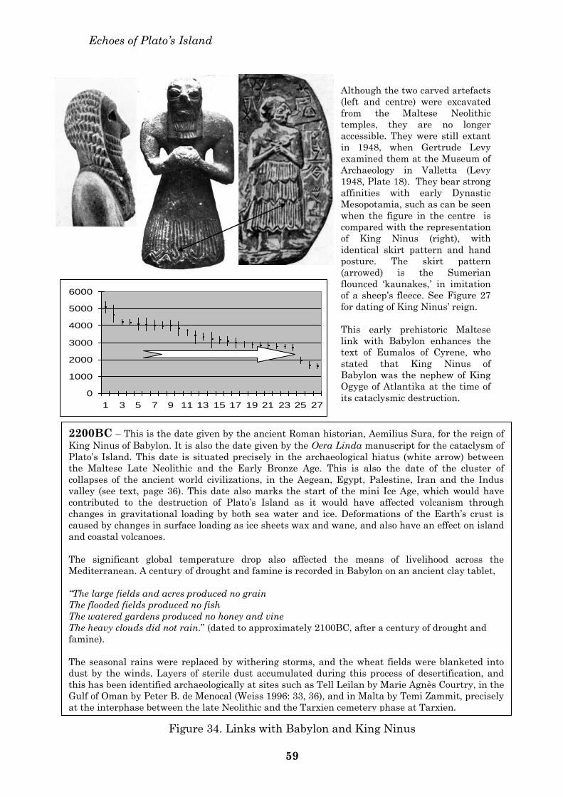
Echoes of Plato’s Island
Figure 34. Links with Babylon and King Ninus
59
Although the two carved artefacts
(left and centre) were excavated
from the Maltese Neolithic
temples, they are no longer
accessible. They were still extant
in 1948, when Gertrude Levy
examined them at the Museum of
Archaeology in Valletta (Levy
1948, Plate 18). They bear strong
affinities with early Dynastic
Mesopotamia, such as can be seen
when the figure in the centre is
compared with the representation
of King Ninus (right), with
identical skirt pattern and hand
posture. The skirt pattern
(arrowed) is the Sumerian
flounced ‘kaunakes,’ in imitation
of a sheep’s fleece. See Figure 27
for dating of King Ninus’ reign.
This early prehistoric Maltese
link with Babylon enhances the
text of Eumalos of Cyrene, who
stated that King Ninus of
Babylon was the nephew of King
Ogyge of Atlantika at the time of
its cataclysmic destruction.
0
1000
2000
3000
4000
5000
6000
1 3 5 7 9 11 13 15 17 19 21 23 25 27
2200BC – This is the date given by the ancient Roman historian, Aemilius Sura, for the reign of
King Ninus of Babylon. It is also the date given by the Oera Linda manuscript for the cataclysm of
Plato’s Island. This date is situated precisely in the archaeological hiatus (white arrow) between
the Maltese Late Neolithic and the Early Bronze Age. This is also the date of the cluster of
collapses of the ancient world civilizations, in the Aegean, Egypt, Palestine, Iran and the Indus
valley (see text, page 36). This date also marks the start of the mini Ice Age, which would have
contributed to the destruction of Plato’s Island as it would have affected volcanism through
changes in gravitational loading by both sea water and ice. Deformations of the Earth’s crust is
caused by changes in surface loading as ice sheets wax and wane, and also have an effect on island
and coastal volcanoes.
The significant global temperature drop also affected the means of livelihood across the
Mediterranean. A century of drought and famine is recorded in Babylon on an ancient clay tablet,
“The large fields and acres produced no grain
The flooded fields produced no fish
The watered gardens produced no honey and vine
The heavy clouds did not rain.” (dated to approximately 2100BC, after a century of drought and
famine).
The seasonal rains were replaced by withering storms, and the wheat fields were blanketed into
dust by the winds. Layers of sterile dust accumulated during this process of desertification, and
this has been identified archaeologically at sites such as Tell Leilan by Marie Agnès Courtry, in the
Gulf of Oman by Peter B. de Menocal (Weiss 1996: 33, 36), and in Malta by Temi Zammit, precisely
at the interphase between the late Neolithic and the Tarxien cemetery phase at Tarxien.
Malta:
60
cataclysmic nature, somewhere between the
south-western coastline of the Maltese
islands and the southeastern extremity of
the Malta basin. Previous to this episode at
Mriehel, volcanic activity in Malta has been
shown by pollen analysis to have occurred
also during the Ice Age. Volcanic activity
very close to the Maltese islands has been
registered as recently as 1831 in Graham‘s
island.
The text of Plato, the ancient author, is
confirmed by another ancient Greek author.
The Theran, Eumalos of Cyrene, was Plato‘s
contemporary, but he lived nearer to
Atlantika, and could therefore furnish more
details about the true site of Plato‘s island
— Eumalos placed it in the pelagos, in the
Central Mediterranean, the sea bathing the
Maltese and Pelagian islands.
We are indebted for much assistance to Abigail, Jael,
Tabitha, Seana, Marika, Tonio, Pierre, James and
Simon; to Anthony Frendo, Charles Galea Bonavia and
Norman Formosa. Horatio Vella was most hospitable
and generous to Anton Mifsud, who presented him
with several passages for translation from the ancient
Greek texts. George Borg at the Gozo Reference
Library was indispensable. Unsworth Booksellers in
London have also been most kind in giving Anton
Mifsud access to their rare books for sale. Graham
Hancock has been the final spur to publish.
324
Endnotes
1 Renfrew 1971, 1972, 1973: 161, 1977: 616-7, 1978,
1979, 1983: 6. 2 Renfrew 1978: 161. 3 See Renfrew 1979: 161. 4 Zammit 1916: 135; Griffiths 1920: 469. Trump (1977:
606) points out that Zammit‘s description of this
deposit ―does not tally with other known natural
deposits from Malta.‖ Evans‘ suggestion that this
deposit was artificially laid down is based on its
absence in an area beyond the temple (Evans 1971:
149). However this area, which was excavated by
Baldacchino in 1950, had been cleared in Roman times
for use as arable land (MAR 1950: I), thus invalidating
Evans‘ argument. 5 Zammit 1917b: E4; Evans 1959: 168, 1971: 224;
Trump 1977; Bonanno 1986: 40-1, 1994: 90; Savona-
Ventura & Mifsud 1999: 72-3. See also England 1999:
147. 6 Zammit 1926: 22; Ugolini 1934; Randall McIver 1935. 7 Renfrew 1972, 1977. 8 ―De l'Orient viendra de coeur Punique, Fâcher
Hadrie, & les hoires Romulides, Accompagnè de la
classe Libique, Temples Melites et proche isles vuides‖. 9 Vide infra. 10 Mayr 1920. 11 Gordon Childe 1925: 101; 1958: 119. 12 Ward Perkins 1942: 21.
13 Daniel 1978: 81. 14 Renfrew 1978: 161, 1979: 48, 255. 15 Bahn 1996: 80-1. See also Renfrew 1978: 161. 16 Trump 1983: 65. 17 Mahoney 1996: 1. 18 Josephus, Contra Apionem, i. 19 Eusebius Chronicles; Sextus Julianus Africanus,
Chronicles and Epitome. 20 Waddell 1971: vi-xxviii. 21 David 1986: 21-2; Waddell 1971: xvi-xx. Using
Manetho‘s text, Syncellus (George the monk) in 800
AD calculated that Adam flourished around 5500 BC. 22 For a good overview of the Piri Reis map and its
implications, see Hancock 1996: 3-13. 23 Brown 1997: 49. 24Cyril's army of monks were canonized by Cyril for
murdering Orestes; Cyril himself was beatified for
eliminating Hypatia. 25 See Healy 1999: 384. 26 Berlitz 1977: 12-13. 27 See Haskins 1887: 349 & Housman 1926: 282, and
compare with Brown & Martindale 1998: 264. 28 Octo Libri Ptolemei 1490; C. Ptolomaeus, Auctus
Restitutus Emaculatus 1520; Geographia Universalis,
vetus et nova, complectens Claudii Ptolemoaei
Alexandrini Enerrationis Libros VIII, 1540; La
Geografia di Claudio Tolomeo 1574. 29 Pliny the Elder produced his Natural History in AD
77. In 1141 Crichdale produced an abridged version of
Pliny‘s work; material considered irrelevant was
omitted. Petrarch amended the text once again in
1350, and the first edition was published in Venice in
1469. Barbarus produced a version with corrections in
1492-3, and a similar exercise was carried out by
Rhenanus in 1525. At the turn of the sixteenth century
Pliny‘s work was well known and admired by all
scholars. In 1601 Philemon Holland published another
translated version of Pliny‘s Natural History (See
Healy 1999: viii, 380-391). Since the sixteenth century
at least, translations have been seriously modified in
parts — e.g. in the index of the 1566 edition there is a
reference (p. 256, line 34) to ‗Atlantis‘, but the relevant
text at the end of the chapter has been omitted.
Several references to ‗Atlantis‘, the ‗islands of Atlantis‘
and the ‗Atlantic Sea‘ are omitted in the later versions. 30 Baviera Albanese 1963. 31 Harding 1945 vi: 300; Brydone 1848: 258. Malta was
colonized by the British between 1815 and 1964. 32 Lib. iv. Cap. 3. 33 Bigelow 1831: 474. 34 Augustine, De Civitatis Dei: 16, Cap. 17. The terms
‗Pelagian‘ and ‗Pelagic‘ are variously used by different
disciplines to denote the same meaning. ‗Pelagian‘ has
been used for this text on Patrick J. Schrembi‘s
suggestion. 35 Colonial Office 158-536/89009; Vella 1974: 14. 36 Blouet 1965: 9; Ellul 1988, 1997; Mayrhofer 1996;
Mifsud & Mifsud 1997; Sant Cassia 1993; Given 1998. 37 Unfortunately Nostradamus has since been
interpreted as an astrologer. 38 E.g. Bradford 1964. 39 Empereur1999: 36; Schuster 1999: 44. 40 Grimston 1999. 41 Archaeology 52 (6): 19. 42 De Iside et Osiride. 43 Burn 1987: 119-20. 44 Donnelly (1882) 1950: 17. 45 Diodorus v, 57: 2-5; see also Augustine, De Civitatis
Dei xviii: 10-11. 46 Timaeus 22 B-C. 47 Timaeus 23 A - B. 48 Timaeus 25 B-D.
Echoes of Plato‘s Island
61
49 Critias 111 B. 50 Timaeus 23 D, 24 D. 51 Timaeus 24 E. 52 Timaeus 25 A. 53 Critias 115 C-E. 54 Critias 117 D. 55 Critias 118 D-E. 56 Critias 120 A. 57 Timaeus 25 B; Critias 114 C. The sphere of influence
of Plato‘s Island extended to the Mediterranean
peoples in Egypt on the one hand and to the
Tyrrhenian Sea on the other. The region in between
these two zones is the Central Mediterranean, where
the Maltese and Pelagian islands are to be found. 58 Timaeus 24 E. Libya and Asia were considered to be
much smaller in Plato‘s time. The Romans had not
extended their victories beyond the mountains of
Europe and the seas of Asia, and their geography
reached just Asia Minor, Phoenicia, and a small part of
North Africa. The Greeks at the time of Plato did not
know all of Asia, except up to the Euphrates.
Alexander had extended his dominions up to the river
Indus, as the confines of this part of the world.
Furthermore, Andrews has suggested that Plato
mistook meson for mezon in Solon‘s manuscript
Atlantikos, and thus caused the subsequent translation
of ‗between‘ to read ‗larger than‘. Thus Plato‘s Island
lay, according to Andrews, ‗between Libia and Asia‘
(See Luce 1969: 45). 59 Critias 113 B. 60 Proclus 76: 1-10; Donnelly 1882; 1950: 17; Berlitz
1977: 36-7. Hieroglyphs of 2000 BC show that
Egyptian children were then already being taught that
the world was round (See Steiger 1977: 50-1). 61 Proclus 76: 1-10. 62 Timaeus 20 E, 26 E. 63 Timaeus 23. A-4. 64 Strabo 2.3.6-7. 65 Marcellinus xv., 3, 6; xvii., 7, 13. See also Friedrich
2000: 149. 66 The frieze is 40 inches (101 cm) high and 525 feet
(160 m) long. 67 Pinnegar 1998. 68 Timaeus 23D, 24C. 69 Timaeus 26E. 70 Strabo (Lib. i, Cap. 2), Pomponius Mela (Lib.i, Cap.
4, 8; Lib. ii, Cap. 6; Lib. iii, Cap. 1, 10), Pliny (Lib. ii,
Cap. 90), Tertullian (Adversus Gentes, Lib. i) and
Keckerm (Problema IV). See Berlitz 1977: 37-44. 71 Berlitz 1977: 66-7. 72 Galanopoulos & Bacon1969: 60-1; Berlitz 1977: 66. 73 Smyth 1854: 111-2. 74 De fast: Rom: ad Eutrop: Histor: Lib xi. 75 Sanzio 1776: 114. 76 Vide supra. 77 Berlitz 1977: 156; James 1995: 84. 78 See Westwood 1997: 15. 79 Galanopoulos & Bacon 1969. 80 Mavor 1973: 177-8; 263-4. 81 Mifsud & Mifsud 1999: 149-168. 82 Friedrich 2000: 2, 154-7. 83 Westwood 1997: 29. 84 Lib. vii, Cap. 56 (Omitted since the sixteenth
century). The Maltese Stone Age ended around
2600/500BC. 85 1995: 85-6. 86 Bibischok 1525. Lib. v, Cap. 15: 47. 87 Grongnet‘s name routinely appears also without the
first ‗n‘.
88 Borg 1911: 39-49. 89 Brockman 1975: 69, 72. 90 Critias 111 B. 91 For example, at Valletta, Marsaxlokk and
Marsalforn. 92 Dolomieu 1791: Appendix. 93 Saint-Priest 1791: 74. 94 Houel 1787: 486. 95 Bigelow 1831: 216. 96 Bigelow 1831: 215, 464. 97 Leith Adams 1870: 147-148; Spratt, 23: 283, 293. 98 Hsü 1983: 2, 4. 99 Spratt 1867, xxiii: 292, 296. 100 Leith Adams 1866: 6-7. 101 Leith Adams 1870: 148, fn 1, 149. 102 Sinclair 1924, 261-275. The African landbridge is no
longer considered a tenable hypothesis by most
scholars. 103 Friggieri & Freller 1998: 154, fn. 1. The sources of
these maps would probably have derived from the
Alexandrine library, since the islands were certainly
separate in Claudius Ptolemy‘s time. 104 Eratosthenes had assigned 700 stadia (Ventura
1988: 257). One stadium was approximately 185
metres, but varied between 154 and 215 metres. 105 Smyth 1854: 321; Ventura 1988. 106 Ptolemy,. Tabula II. Aphricae, 1.8; 3.20. 107 Ptolemy Lib. iii, tab. 2, Cap. 3; Lib. iv, Cap. 3. 108 Ptolemy‘s Geographia, Lib.iv.. 109 Stanley 1878; 1890. 110 See Moorehead 1971: 15-16. 111 Today‘s Pangani in Tanganyika. 112 Syracuse 37º > 37.04º; Catania 37º 40‘ > 37º 31‘;
Taormina 37º 45‘ > 37º 51‘; Messina 38º 10‘ > 38º 12‘
(Ventura 1988: 261, fn. 15). 113 Friggieri & Freller 1998: 155 fn. 4. 114 Agius de Soldanis 1746: fol. 79. 115 Ventura 1988: 262, fig. 4. 116 Octo Libri Ptolemei 1490; C. Ptolomaeus, Auctus
Restitutus Emaculatus 1520; Geographia Universalis,
vetus et nova, complectens Claudii Ptolemoaei
Alexandrini Enerrationis Libros VIII, 1540; La
Geografia di Claudio Tolomeo 1574. 117 Prior to the twentieth century, the Maltese temples
were considered to belong to the classical period, and
arbitrarily assigned to Hercules, Juno &c. However the
megalithic nature of this structure at Valletta is
attested by several scholars; Megiser (1606) describes
the temple as constructed of ―rectangular blocks of
unbelievable sizes‖ (Friggieri & Freller 1998: 139), and
in the early nineteenth century one could still see the
―stones five to six feet long, and laid without mortar‖
(De Boisgelin 1804 I: 58-9). See also Quintinus 1536
(Vella 1980: 23) and Pajoli 1694 (Zammit Ciantar 1998:
54). 118 Although seemingly referring to separate islands for
the temples of Juno and Hercules, these are considered
to refer to promontories. 119 500 stadia per degree multiplied by 185 metres per
stadium, divided by 60 minutes = 1541 metres per
minute. 120 Filfla is 5 kilometres to the south of Malta, and the
cleavage of the Pleistocene slickensliding at the
Maghlaq fault must of necessity have occurred after
the Ice Age. The fragmentation of the land separating
Filfla from the Maghlaq fault must therefore have
occurred in stages during the Holocene, i. e. the last
10,000 years. 121 Ventura 1988: 262, fig. 4. 122 Houel 1787 (4): 262; plate CCLXIV; De Boisgelin
Malta:
62
1804: 2; plate VI; De Non 1789: 283-6. 123 Ptolemy Tab. II Aphricae; Fazello Lib. i, Cap. 1;
Megiser 1606, Cap. 2; Barbaro 1768: 43; De Non 1789:
280-1; Bres 1816: 60-1; Vella 1980: 22; Vella 1982: 275-
6; Friggieri & Freller 1998: 34, 139; Zammit Ciantar
1998: 54, 56. 124 Borg Grech 1940: 131. 125 Sanzio 1776: 114. 126 De Boisgelin 1804, 1: 49; Bigelow 1831: 217-8. 127 Davy 1842, i: 108. 128 Leith Adams 1870: 250-1 129 Leith Adams, 1870: 151, fn 3. 130 Bradley 1912: 262. 131 According to Ellul (1988: 65), old fishermen recall
the ruts on Filfla. 132 The evidence of Wrangel island has confirmed that
evolutionary phases may require only a few millennia
to take effect (Vartanyan et al. 1993: 337-340), well
nigh sufficient for the lizard subspecies filfolensis to
have evolved on Filfla island during this interval of
isolation. 133 Bradley 1912: 261-2. 134 See also Brockman 1975: 72-3. 135 Brockman 1975: 77; Parker and Rubenstein 1988:
56. 136 Patton 1996: 45, 53, 57, 59. 137 Patton 1996: 47. 138 Patton 1996: 47. 139 Zerafa 1838: ix a. 140 Caruana Gatto 1915: 240. 141 Borg 1911: 39-49. 142 Savona-Ventura 1984: 93-106. 143 Pasa 1953: 175-286. 144 Savona-Ventura 1984: 99, 100, 102. 145 Kotsakis 1978 (99): 263-276; Azzaroli 1990: 83-90;
Leighton1996 (5): 21-29. 146 Farrugia Randon & Farrugia Randon 1995: 39. 147 Pers. comm. Patrick J. Schembri to Anton Mifsud,
26th June 2000. 148 Keith 1924: 251-60, 257-8; 1925: 345, 348-50; Pace
1972: 1-2. 149 Malta Penny Magazine 1840 (34): 138; Leith Adams
1870: 243. 150 Pickering 1850: 191; Vassallo 1871: 9-10. 151 Trump 1990: 44. 152 Vella (2000: 44 et seq.) has submitted evidence for
the Maltese islands as the ancestral home of the
ancient Egyptians, and also for the survivors of
Atlantis. 153 Zammit 1916: plate XVII, fig. 1; 1930: plate xv, 2;
Evans 1971: 163, 235. 154 M.A.R. 1938-9: xii. 155 Stone, in Evans 1971: 235-6. 156 Caruana 1882: 32-33. 157 Zammit 1931b: 42, and plate facing p. 32) 158 Bedford 1894: 75. 159 Presently converted into a Centre for Conservation. 160 Bedford 1894: 75. 161 Testa n.d.: 1474-5. 162 Testa n.d..: 1474. 163 Hölbl 1989: 168. See also Bonanno 1998: 223, fn 16. 164 Testa n.d. 1473-1477. 165 Murray 1928: 45-48; 1962: 257-8. 166 Mayr 1894: 38; Stöger 1999: 11. See Bonanno 1998:
217 for the Egyptianizing movements he proposes. 167 Zammit 1927: 26-28. 168 Malville et al. 1998: 488. 169 Grima 1980; Agius & Ventura 1981; Ellul 1988: 25;
Micallef, 1989; Ventura & Tanti 1990; Stoddart et al.
1993: 16; England 1999: 141. 170 Sergi 1901: 65. 171 Mayr 1908: 114-5.
172 Camps 1962. See Joussaume 1985: 226-8, 230 et seq. 173 Ward Perkins 1942: 21-2. 174 Vella 1993: 3 (2): 220. 175 Ovid iii: 567-578. 176 Herodotus iv: 150, 153, 155. 177 Vide infra. 178 Stephen of Byzantium 1958: 152; Magri 1901: 16-
22. 179 Mallia 1978: 130, fn. 9. 180 Magri 1906: 7. 181 Piggott 1954: 206. 182 Grasso et al. 1985: 2; Illies 1981: 151. 183 Reuther 1984: 1. 184 Grasso et al. 1985: 13; Reuther 1984: 14. 185 The Maghlaq Fault extends in a WNW-SSE for a
distance of five miles south of Siggiewi and Qrendi. It
has caused a downthrow of 600 feet on the southern
aspect of Malta at this site, leaving Filfla with its
surface layers of Upper Coralline Limestone intact.185
This WNW-SSE fault trend is paralleled in
Lampedusa. 186 Pedley et al. 1976; Illies 1981: 151, 152, 156, 165 fig.
10; Reuther 1984: 13 fig. 11; Grasso et al. 1985: 12 fig
6. 187 Galea 1999, in Aloisio 1999. 188 Reuther 1984: 14; Illies 1980: 151-168. 189 Vossmerbäumer 1972. See Reuther 1984: 14. This
tilting process has also contributed to the significant
difference in altitude above sea level between the
Pleistocene caverns at Mnajdra (300ft), on the
southwestern coast, and Ghar Dalam (50ft), on the
eastern tip of Malta. Major land upheavals have also
caused a difference in altitude above sea level between
the upper Coralline at Mnajdra and that at Filfla
across a three-mile stretch of sea. 190 Segre 1960: 115-162. 191 Grasso et al. 1985: 16. 192 Grasso et al. 1985: 16-17. 193 Illies 1981: 157, fig. 4; Grasso et al. 1985: 15, fig. 8. 194 1973: 263-344. 195 Edens 1996: 144. Wood from the mount of Ararat,
the alleged site of Noah‘s Ark, has been dated to
2534BC (Keller 1980: 40). 196 Diodorus v. 57: 2-5. 197 Weiss 1996: 30-6. 198 Mifsud & Mifsud 1997: 34-36; 38 et seq. 199 Pollen Analysis report by Katryna Fenech for Anton
Mifsud, 16/2/1999. Ash comprised 60% of the deposit. 200 Vide infra for the mriehel volcanic ash layer, and
supra for Graham‘s island. 201 Major sites of alluvial deposits in the Maltese
islands have been destroyed through human
intervention. Glaring examples include the the present
Maghtab mound and the Addolorata Cemetery at Tal-
Horr, where ancient human remains routinely turned
up during its excavation works (See Chief Secretary to
Government, Malta, to A. A. Caruana 4th December
1899, No. 4678 in Archives at Santo Spirito, Mdina). 202 National Archives of Malta (Santo Spirito): Lt.
Governor to Caruana 27th December 1902, and
Caruana to Lt. Governor 5th January 1903. 203 Zammit 1910: 34-37, 42. 204 Zammit, Peet & Bradley 1912: 21. 205 Griffiths 1920: 466. 206 Museum of Archaeology Reports 1973-74. 207 Mifsud 1999: 422-3. 208 Pers. comm. G. Zammit Maempel to Anton Mifsud,
October 1996; pers. comm. Sr. Terezina Saliba et al. to
Anton Mifsud, October 1996. 209 Mifsud & Mifsud 1997: 91; BM-3015. 210 Williamson MS 1840: 153; Knowles MS 1910: 9. 211 The skull was discovered at the Museum of Natural
Echoes of Plato‘s Island
63
History in London by Anton Mifsud in 1997. 212 Mifsud 1999: 422-3. 213 Vide supra. 214 Leith Adams 1870: 250-1. See also Trump 1990: 86.
Underwater cart-ruts have also been reported at the
Salini (pers. comm. Anthony Bonanno to Anton Mifsud
1999) and 3 kilometres northeast of St Julians Tower
(Zeitlmar 1999). 215 Leith Adams 1870: fig. 4 of sketch facing 244, 249-
50; Griffiths 1920: 449; 455-6. 216 Hyde 1955: 59, 103, 104, 107. 217 Castagna 1888 I: 8. 218 Trump 1999: 33. 219 Vella 1980: 22-3; Mahoney 1996: 73. The remains of
the temple have since been obliterated through the
restorations on the fortification and the construction of
the present ditch. 220 Friggieri & Freller 1998: 139. 221 De Boisgelin 1804 i: 58-9. See also Quintinus 1536
(Vella 1980: 23) and Pajoli 1694 (Zammit Ciantar 1998:
54). 222 Scicluna is known world wide for his underwater
archaeological activities and research, and has himself
led several underwater expeditions in the Central
Mediterranean. In 1960, he was responsible for the
recovery of several priceless artefacts from the Roman
wreck at Xlendi Bay. Commander Scicluna also
recovered the first four-pronged galley anchor of the
Order of St. John, besides several musket balls of the
Siege of Malta and swivel cannon of the 18th century.
Scicluna‘s expertise in underwater research earned
him at least two major commissions, one from the
British Navy and the other from the British
Committee of Nautical Archaeology (See Schiavone &
Scerri 1997: 514). 223 Scicluna 1994: 16. Graham Hancock pointed this
reference out to Anton Mifsud. 224 The photograph is in the possession of Joseph S.
Ellul. The photography session was carried out on the
13th July 1999. 225 Zeitlmar 1999, in Borg 1999a, 1999b. Aaccording to
one report, the Department of Museums were not able
to reach the site for confirmation of the finds. 226 The sightings have been made by members of the
Buddies Dive Cove at Ramla Bay, Marfa
(www.buddies.com.mt). Chris Agius Sultana has
reported several larger canals radiating out of the
northeastern coastline. 227 This period follows the Pleistocene, and extends
from 8000BC to the present day. 228 Illies 1981: 163-4; Martineau 1967: 23; Reuther
1984: 5-6. 229 Illies 1981: 158; Hyde 1955: 59; Reuther 1984: 10. 230 Martineau 1967: 19, fig. 1. 231 Griffiths 1920: 449; Reuther 1984: 10; Brockman
1975: 77. 232 The central island of the Maltese archipelago is
Comino. The Greeks called it ‗Haephestia‘, meaning
volcanic (See Agius de Soldanis 1794 [1999: 193];
Farrugia Randon & Farrugia Randon 1995: 1).
Furthermore, Haephestus and Athena championed the
cause of the Athenians against the Atlanteans (See
text). 233 Castagna 1888, i: 8-10. 234 Zammit Maempel 1981: 256, 257. 235 Presently the St. Theresa Girls‘ School. 236 Zammit Maempel 1981: 243-260. 237 Zammit Maempel 1981: 251, 258. 238 Zammit Maempel 1981: 259. 239 Pers. comm. Keith Buhagiar to Anton Mifsud
October 1999. 240 Zammit Maempel 1981: 258. 241 Although attributable to Pantelleria and Lipari, the
obsidian expert Robert Tykot was unable to confirm
this in November of 1998. On two successive occasions
Tykot was not granted access to examine the obsidian
in the Museum of Archaeology in Valletta. 242 Folliot 1984: 49. 243 Verne 1862: 108; Verne 1958: 42; Verne 1959: 86. 244 Critias 114 E. 245 Perriccuoli Borzesi 1830: 13, quoting Eumalos of
Cyrene. 246 Critias 112 B-C. 247 Critias 116 B-C. 248 Encyclopaedia Britannica CD-ROM 1997. 249 Critias 119 A-B. 250 Pliny vii: 56. 251 Timaeus 23 D, 24 D. 252 Trump 1995-6, 6: 173-7. 253 Mifsud 1999: 422-3. 254 Mifsud 1999: 422-3. 255 Both the Burmeghez and Hypogeum dates are in
uncalibrated radiocarbon years. 256 Mifsud & Mifsud 1999: 164-5. 257 Critias 111 B. 258 Pliny 1566: 246 (Lib. vi, Cap 31). 259 Odysseus x: 508. 260 Quaestiones Naturales. 261 Somnium Scipionis. 262 Cicero Lib. iii. 263 Biblioteca Storica, i. 264 Bunbury i: 288. 265 Aeneid iv: 481. 266 Diodorus v.12.1-3. 267 Oldfather 1952: 129. 268 Ventura & Galea 1993: 6. 269 Argonautica v. 1230. 270 Lucanus Lib. ix, v. 652. 271 Herodotus, iv: 179. 272 Bunbury 1879, i: 286; Rieu 1975: 214-5. 273 Timaeus 25 D. 274 A mariner‘s coastal guide. 275 Periplus — Canaan, col. 498. 276 Strabo iii: 170. 277 Palefatus, Cap. 32. 278 Critias E 108-9 279 Timaeus 24 E5, 25 A2, 25 A 4. 280 Critias 109 A. 281 Ptolemy Lib. iii, tab. 2, Cap. 3; Lib. iv, Cap. 3. 282 Diodorus v.12.1-3. 283 Folliot (1984: 59) confirmed these two designations
for the seas described by Plato. It was well known in
antiquity that the Maltese islands lay on the Pelagian
block at the head of the African plate — on this basis,
St. Augustine included the Maltese islands with Africa. 284 The Chambers Twentieth Century Dictionary (1956:
798) defines ‗pelagic‘ as ‗deposited under deep water
conditions‘, such as the Maltese and Pelagian islands
have been. 285 Augustine, De Civitatis Dei: xvi, Cap. 17. 286 Ptolemy Lib. iii, tab. 2, Cap. 3; Lib. iv, Cap. 3. 287 See Liddell & Scott 1890: 1170, 1254 respectively
for usage of pelagos and pontos in ancient Greek
authors. 288 Timaeus 25A. 289 Griffiths 1920: 468-9; 477. 290 These rock-canals are distinct from the canal dug
from the seaside, and which measured 300 ft in width,
100 ft in depth and 50 stadia in length. 291 Plato used the verb , signifying ―to plough‖ or
Malta:
64
―to cut lengthwise‖. 292 Translation by Horatio Vella (23.12.99). Quarries
are frequently associated with ruts in Malta; a quarry
can also be interpreted as a ditch. Trump accepts the
possibly secondary nature of these cart-ruts as water
catchment areas (Trump 1990: 33). 293 Plato refers to the sea as , which several
ancient authors like Herodotus and Homer identify
with the Mediterranean, and not with the Aegean Sea
(Liddell and Scott 1999: 357). 294 Critias 118D, E. 295 Trump 1990: 32; 1998: 35. 296 Gracie (1954) and Evans (1971) criticize Zammit
(1931) for the absence of a map, so that the ruts ―run
predominently [sic] from the valleys up to the heights‖
(Evans 1971: 203). However Zammit included an
excellent set of five aerial photographs among his
plates, and these transmit their message even better
than a map. 297 Critias 116 C et seq. 298 Ward Perkins 1954: 962. 299 Piggott 1954: 205-7. 300 Ward Perkins 1954: 962. 301 Piggott 1954: 205-7. 302 Evans 1954: 131. 303 Daniel 1972: 7. 304 Renfrew 1994: 6. 305 England 1998: 10. 306 Foster 1991: 1. 307 Savona-Ventura & Mifsud 1999: 56. 308 Today Ogygia is traditionally associated with the
sister island of Gozo. 309 Strabo Lib. i, 7. 310 Odysseus Lib. i, 8. 311 Catullus Lib. iv, Eleg. 1. 312 Tibullus Lib. iv, Eleg. 1. 313 Bibischok 1525. Lib v, Cap. 15: 47. 314 Geography of Ancient Sicily, Lib. 2, Cap. 16; De
erroribus Ulyssis, fol. 474. 315 ‗Eumalos‘ is the archaic Doric equivalent of
‗Eumelus‘, and is translated literally as ‗rich in sheep‘.
See Liddell & Scott 1890: 606, 607. 316 Ancient ‗Sicania‘ is modern Sicily (Diodorus Siculus
v. 6.1-5).317 Eumalos vi, cited in Perricciuoli Borzesi 1830: 5-6;
See also Grongnet 1854: 619 & Godwin 1880: 11. 318 Eusebius 1529, i: 41, 2: 65; Clinton 1834, 1: 263;
Layard 1849, 2: 217. See Bishop 1965: 5, fn. §, 6 fn. ‡. 319 Levy 1948: xv, 138, plates XVIII c to f; Zammit
1927: 26-28. 320 Pers. comm. Reuben Grima to Anton Mifsud,
September 1998. 321 Times of Malta 16th October 1999: 11. 322 Vide supra. 323 Archaeology 52 (6): 19. 323 The recent ‗discovery‘ of a secret chamber beneath
the Egyptian Sphinx is expected by Robert Bauval to
lead to the retrieval of ancient Egyptian texts relating,
amongst other things, to Plato‘s Island (Bauval 1999).
References Unless stated otherwise, the references to the ancient
texts derive from the Loeb Classics Series (1912-58),
Harvard University Press.
Abela, G.F. 1647. Della Descrittione di Malta Isola nel
Mare Siciliano, con le sue antichita. Malta: Paolo
Bonacota.
Agius, G. and Ventura, F. 1981. Investigation into the
possible astronomical alignments of the Copper Age
temples in Malta. Archaeoastronomy, the Bulletin of
the Center for Archaeoastronomy iv (1): 10-21. USA:
University of Maryland.
Agius de Soldanis, G.F. 1754. Gozo, Sacro, Profano,
Antico, Moderno. English translation 1999. Malta:
Media Centre Publications.
Aloisio, F. 1999. Probability of earthquake risks in
Malta being studied. The Malta Independent on
Sunday 19th September: 48.
Ammianus Marcellinus. 1874. Rerum gestarum libri
qui supersunt. Leipzig: Gardthausen.
Anca, F. 1859-60. Note sur deux nouvelles ossiferes
decouvertes en Sicile en 1859. Bulletin de la Societe
Geologique de France (2) 17: 684-695.
Apollonius of Rhodes. 1975. Argonautica. Translation
by E. V. Rieu. Penguin.
Apollonius Rhodius. 1905. Argonautica. Leipzig:
Merkel.
Arambourg, C. and Arnould, M. 1950. Note sur les
fouilles paleontologiques executees en 1947-48 et 1949
dans le gisement Villafranchian de la Garaet Ichkeul.
Bullettin de la Societe de la Science Naturelle de
Tunisie II (3-4): 149-57.
Ashby, T., Zammit, T. and Despott, G. 1916.
Excavations in Malta in 1914. Man 1916, i: 14. London:
The Royal Anthropological Institute.
Attard, J. 1989. The Atlantis Inheritance. Malta: PEG
Ltd.
Augustine of Hippo, De Civitatis Dei.
Azzaroli, A. 1990. Palaeogeography of terrestrial
vertebrates in the Perityrrhenian area.
Palaeogeography, Palaeoclimatology, Palaeoecology 77:
83-90.
Bahn, P. (ed.) 1996. The Story of Archaeology. London:
Phoenix Illustrated.
Baldacchino, J. G. and Evans, J. D. 1954. Prehistoric
Tombs near Zebbug. Papers of the British School at
Rome 22: 1-21.
Barbaro, D. 1794. Degli Avanzi a alcuni edifizj scoperti
in Malta l‘anno 1768. Malta.
Bauval, R. 1999. Secret Chamber: the Quest for the
Hall of Records. Century.
Baviera Albanese, A. 1963. Il problema dell‘Arabica
impostura dell‘Abate Vella. Nuovi Quaderni del
Meridione, Anno I: 397-8, cited in Vella 1974: 360, 367,
fn 49.
Bedford, W.K. 1894. Malta and the Knight
Hospitallers.
Berlitz, C. 1977. The Mystery of Atlantis. Granada
Publishing Ltd.
Bernabò Brea, L. 1950a. The Prehistoric Culture-
Sequence in Sicily. Annual Report of the University of
London Institute of Archaeology of London 13 (6).
Echoes of Plato‘s Island
65
Bernabò Brea, L. 1950b. Il neolitico a ceramica
impressa e la diffusione nel Mediterraneo. Rivista
Internazionale di Studi Liguri 16: I.
Bibischok, 1525. Origine del Mondo — Che Malta sia
un avanzo dell‘Atlantide. Cited in Grongnet MS614:
135.
Bigelow, A. 1831. Travels in Malta and Sicily. Boston:
Carter, Hendee and Babcock.
Bishop, A. 1965 (4th ed.) The Two Babylons. London:
Sue Partridge & Co.
Blouet, B. 1965. Gozo. Malta: Progress Press Co. Ltd.
Bochard, S. 1712. Geographia Sacra. Cited in
Grongnet 1854: 603
Bonanno, A. 1982: Quintinus and the location of the
temple of Hercules at Marsaxlokk. Melita Historica
viii (3): 190-1.
Bonanno, A. 1986. A Socio-economic Approach to
Maltese Prehistory. The Temple Builders. In Malta:
Studies of its Heritage and History, pp. 15-45. Malta:
Mid-Med Bank Ltd.
Bonanno, A. (ed.) 1991. Introduction to History,
Culture and Society in the Mediterranean World.
Journal of Mediterranean Studies 1 (2): 163-9.
Bonanno, A. 1993. The Birgu Peninsula in Prehistoric
and Classical Times. In Bugeja, L., Buhagiar, N. and
Fiorini, S. (eds.) Birgu, a Maltese Maritime City 1: 17-
30. Msida: Malta University Series Ltd.
Bonanno, A. 1994. Archaeology. In Frendo, H. and
Friggieri, O. (eds.) Malta: Culture and Identity, pp. 81-
103. Malta: Ministry of Youth and the Arts.
Bonanno, A. 1998. An Egyptianizing Relief from Malta.
In Bonasca, N., Naro, M. C., Portale, E. C. and Tullio,
A. (eds.) Egitto in Italia, dall‘Antichità al Medioevo, pp.
217-228. Atti del III Congresso Internazionale Italo-
Egiziano, Roma, CNR – Pompei, 13-19 novembre 1995.
Bonfiglio, L., di Stefano, G., Insacco, G. and Massa,
A.C. 1992. New Pleistocene fissure-filling deposits
from the Hyblean Plateau (South Eastern Sicily).
Rivista Italiana di Paleontologia e Stratigrafia 98 (4):
523-539.
Borg, D. 1999a. Sejba Unika fl-ibhra Maltin. Il-
Mument 31 October 1999.
Borg, D. 1999b. In-Nazzjon 1st to 5th November 1999.
Borg, J. J. 1911. Remains of the Prehistoric Flora of
Malta. Archivum Melitense I (2-4) April 1911.
Borg, J. 1915. Agriculture and Horticulture in Malta.
In Macmillan, A. (ed.) Malta and Gibraltar, pp. 173-
182. London: W., H. and L. Collingridge.
Borg Grech, V. 1940. Heathenism before the Christian
Era in Malta. The Sundial 3: 131-2. Literary Society,
Royal University of Malta.
Borsari, 1882. Geografia etnologfica e storica della
Tripolitania, Cirenaica e Fezzan. Naples.
Borzesi G. P. 1830. The Historical Guide to the Island
of Malta and its Dependencies, dedicated to Mr Henry
Ponsonby. With an Appendix. Malta: Government
Press.
Bradley, R.N. 1912. Malta and the Mediterranean
Race. London: T. Fisher Unwin.
Bres, 0. 1816. Malta Antica Illustrata. Rome:
Stamperia De Romanis.
Brockman, E. 1975 (2nd ed.) Last Bastion. Malta:
Progress Press Co. Ltd.
Brown, P. 1997. Authority and the Sacred. Cambridge
University Press.
Brown, S. A. and Martindale, C. [eds.] 1998. The Civil
War, (translated by Nicholas Rowe). London:
Everyman, J. M. Dent.
Bruno, S. 1982. Catalogo Sistematico, Zoogeografico e
Geonemico dei Lacertidae di Corsica, Italia e Isole
Maltesi. Natura Bresciana 19: 39-95.
Brydone, F. 1848. Travels in Sicily and Malta.
Aberdeen: George Clark and Son.
Brydone, P. 1775. (3rd ed.) A tour through Sicily and
Malta, in a series of letters to William Beckford Esq. of
Somerly in Suffolk.
Bunbury, E. H. 1879. A History of Ancient Geography,
2 vols. London: John Murray.
Burn, A. R. 1987. The Pelican History of Greece.
Penguin Books Ltd.
Callimachus, Poems. 1697. Utrecht.
Camps, C. 1962. Aux origines de la Berberie:
monuments et rites funeraires protohistoriques. Paris:
Delegation Generale en Algerie.
Capula, M. 1994. Evolutionary relationships of
Podarcis lizards from Sicily and the Maltese islands.
Zeitschrift für Zooligische Systematik und
Evolutionsforschung 32 (3): 180-192.
Caruana, A. A. 1882. Report on the Phoenician and
Roman Antiquities in the group of the Islands of Malta.
Malta: Government Printing Office.
Caruana Gatto, A. 1915. Maltese Flora. In Macmillan,
A. (ed.) Malta and Gibraltar, pp. 173-182. London: W.
H. and L. Collingridge.
Castagna P. P. 1888. Lis Storia ta Malta bil Gzejer
tahha. Malta.
Catullus, V. Elegies. Warre Cornish.
Cherry, J. F. 1981. Pattern and Process in the earliest
colonization of the Mediterranean islands. Proceedings
of the Prehistoric Society 47: 41-68.
Cicero, Somnium Scipionis. Translated in Nine
Orations and the Dream of Scipio by P. Bovie (1967).
Malta:
66
Cicero, De Natura Deorum.
Clinton, H. F. 1834. Fasti Hellenici, 3 vol. Oxford.
Clüverius, P. 1624. Introductio in Universam
Geographiam — De Sicilia Antiqua.
Colonial Office, Dossier 158-536/89009, cited in Vella
1974: 14, fn 2. Public Records Office, London.
Daniel, G. 1972. Megaliths in History. London: Thames
and Hudson.
Daniel, G. E. 1978. Review of S.J. De Laet (ed.)
Acculturation and Continuity in Atlantic Europe:
Papers presented at the IVth Atlantic Colloquium.
Helinium XVIII: 268-9.
David, A. R. 1986. The Pyramid builders of Ancient
Egypt. London: Guild Publishing.
Davy, J. 1842. Notes and Observations on the Ionian
Islands and Malta. London.
De Boisgelin, L. 1804. Ancient and Modern Malta.
Whitefriars: T. Davison.
De Non, M. 1789. Travels in Sicily and Malta. London.
De Saint-Priest de Guignard, F.E. 1791. Malte par un
voyageur Francais. Paris.
Diacono, P. De Past. Rom. Ad Eutrop. Histor., xi. Cited
in Grongnet 1854, MS. 614/5.
Diodorus Siculus, Bibliotheca Storica I.
Dolomieu, D. 1791. Appendix to Malte par un Voyageur
Francais. Paris.
Donnelly, I. 1882. Atlantis: The Antediluvian World.
[Sykes E. (ed.) 1950]. London: Sidgwick and Jackson
Ltd.
Edens, C. 1996. Ur. In Bahn, P. (ed.) The Story of
Archaeology, pp. 142-144. London: Phoenix Illustrated.
Ellul, J. S. 1988. Malta's Prediluvian Culture at the
Stone Age Temples. Malta: Printwell Ltd.
Ellul, J. S. 1997. Letters 19th January. Sunday Times
of Malta.
Empereur, J- V. 1999. Diving on a Sunken City.
Archaeology 52 (2): 36-43.
England, R. 1998. The Spirit of Place. Milan: L‘Arca
Edizioni spa.
England, R. 1999. Megalithic Mandalas of the Middle
Sea. In Mifsud, A. and Savona Ventura, C. (eds.)
Facets of Maltese Prehistory, pp. 137-148. Malta: The
Prehistoric Society of Malta.
Eumalos of Cyrene, Storia Libiae. Cited in Perricciuoli
Borzesi 1831: 5-6.
Eusebius. 1529. Chronicles. Basle.
Eusebius von Cesararea. 1866. Chronicorum canonum
quae supersunt. Berlin: Schoene.
Evans, J. D. 1954. New Light on Malta‘s Earliest
Inhabitants. The Listener 22/7/54.
Evans, J. D. 1977. Island Archaeology in the
Mediterranean: problems and opportunities. World
Archaeology, 9 (1): 12 –29.
Falconer, H. 1860. On the Ossiferous Grotta di
Maccagnone near Palermo. Quarterly Journal of the
Geological Society 99-106.
Falconer, H. 1868a. On the Fossil Remains of Elephas
Melitensis, &c., from the Ossiferous Caves of Malta. In
Murchison, C. (ed.) Palaeontological Memoirs and
Notes of the late Hugh Falconer ii: 292. London.
Falconer, H. 1868b. Memorandum on the former
Connection by Land of Sicily with Malta. In
Murchison, C. (ed.) Palaeontological Memoirs and
Notes of the late Hugh Falconer ii: 552. London.
Falconer, H. 1868c. Primeval Man and his
Contemporaries. In Murchison, C. (ed.)
Palaeontological Memoirs and Notes of the late Hugh
Falconer ii: 596. London.
Farrugia Randon, S. and Farrugia Randon, R. 1995.
Comino, Filfla and St. Paul‘s Island. Malta.
Fazellus, T. 1579. Rerum Sicularum Scriptores.
Frankfurt.
Finetti, I. and Morelli, C. 1973. Geophysical
exploration of the Mediterranean Sea. Bollettino
Geofisico di Teoria Applicata xv (60): 263-344.
Folliot, K. A. 1984. Atlantis revisited. Oxford:
Professional Books Ltd.
Foster, M. T. 1991. Malta: an Island of prehistoric
sacred places viewed as significant spatial systems.
Unpublished typescript, University of Malta.
Friedrich, W. L. 2000. Fire in the Sea. The Santorini
Volcano: Natural History and the Legend of Atlantis.
Translation by A. R. McBirney. Cambridge University
Press.
Friggieri, A. and Freller, T. 1998. Malta, the Bulwark
of Europe. Malta
Galanopoulos, A. G. and Bacon, E. 1969. Atlantis: the
truth behind the legend. London: Nelson.
Galea, R. V. 1915. Geology of the Maltese Archipelago.
In Macmillan, A., (ed.) Malta and Gibraltar, pp. 173-
182. London: W., H. and L. Collingridge.
Geddie, W. (ed.) 1956. Chambers Twentieth Century
Dictionary. London: W. & R. Chambers Ltd.
Gemmellaro, G. G. 1866. Sulla grotta di Carburanceli,
nuova grotta ad ossame e ad armi di pietra dei dintorni
della Grazia di Carini. Palermo.
Given, M. 1998. Inventing the Eteocypriots:
Imperialist Archaeology and the Manipulation of
Ethnic Identity. Journal of Mediterranean
Archaeology 11 (1): 3-29.
Godwin, G. N. 1880. A Guide to the Maltese Islands.
Malta.
Echoes of Plato‘s Island
67
Gordon Childe, V. 1925. The Dawn of European
Civilization. 6th edition. London: Kegan Paul, Trench,
Trubner.
Gordon Childe, V. 1958. The Prehistory of European
Society. Victoria: Penguin.
Gracie, H. S. 1954. The ancient cart-tracks of Malta.
Antiquity 28 (110) 91-98.
Grasso, M., Pedley, H. M., and Reuther, C. D. 1985.
The Geology of the Pelagian Islands and their
structural setting related to the Pantelleria rift
(Central Mediterranean Sea). Centro 1 (2): 1-19.
Griffiths, W. A. 1920. Malta, the halting place for
nations. National Geographic 37 (5): 445-478.
Grima, C. 1980. Calendric Observations from Mnajdra.
Sunday Times of Malta, May 23; June 1.
Grimston, J. 1999. Tower of Babel is ‗found‘ near the
Black Sea. The Sunday Times 4th April: 1. 10. London.
Grongnet de Vasse, G. 1854. L‘Atlantide. MS. 614/5.
Biblijoteka Nazzjonali, Valletta.
Hancock, G. 1996. Fingerprints of the Gods. London:
Mandarin Paperbacks.
Hapgood, C. H. 1966. Maps of the Ancient Sea Kings.
Illinois: Adventures Unlimited Press.
Harding, W. (ed.) 1945. The Malta Act. In The revised
edition of the laws of Malta 1942.
Haskins, C. E. (ed.). 1887. Lucani Pharsalia. London:
George Bell and Sons.
Healy, J. E. 1999. Pliny the Elder on Science and
Technology. Oxford University Press.
Herodotus. Histories. 1996. Hertfordshire: Wordsworth
Editions Ltd.
Hesiod, Theogony. Translated by Richmond Lattimore
(1959).
Hölbl, G. 1989. Ägyptisches Kulturgut auf den Inseln
Malta und Gozo in Phönischer und Punischer Zeit.
Vienna.
Homer, The Odyssey. (For Greek text - Stanford, W. B.
(ed.) 1955. The Odyssey of Homer. London: MacMillan
& Co Ltd; English translation – Lawrence, T. E. 1992.
The Odyssey. Wordsworth Classics).
Houel, J. 1787. Voyage Pittoresque des Isles de la
Sicile, de Lipari et Malte. Paris.
Housman, A. E. [ed.] 1950 (first impression 1927,
second impression, corrected 1928). M. Annaei Lucani
– Belli Civilis. Oxford: Basil Blackwell.
Hsü, K. J. 1983. The Mediterranean was a Desert. New
Jersey: Princeton University Press.
Hyde, H. P. T. 1955. Geology of the Maltese Islands.
Malta: Lux Press.
Illies, J. H. 1980. Form and formation of graben
structures: the Maltese Islands. In Closs, H., Gehlem,
K. V., Illies, H., Kuntz, E., Neumann, J. and Seibold,
E. (eds.) Mobile Earth, pp. 161-184. Boppard: Boldt.
Illies, J. H. 1981. Graben Formation – The Maltese
Islands, a case history. Tectonophysics 73: 151-168.
James, P. 1995. The Sunken Kingdom. London:
Jonathan Cape.
Joussaume, R. 1985. Dolmens for the Dead. London:
Batsford Books.
Josephus, Contra Apionem vol, i. Translation by H. St.
J. Thackeray.
Keckerm, Contemplatio de Terra motu, Problema iv.
Cited in Grongnet MS 614: 146.
Keith, A. 1925. The Antiquity of Man (2 vols). London:
Williams and Norgate Ltd.
Keller, W. 1980. The Bible as History. New York:
Bantam Books.
Knight, B. 1991. Forensic Pathology. London: Edward
Arnold.
Knowles, F. H. S. 1910. Williamson Collection of
Human Crania. Revised Catalogue. Oxford: Royal
Army Medical College. MS. in Palaeontology
Department, Museum of Natural History, London.
Kotsakis, T. 1978. Sulle Mammalofaune Quaternarie
Siciliane. Bollettino del Servizio Geologico Italiano 99:
263-276. Rome.
Kovaks, M. G. (ed.) 1989. The Epic of Gilgamesh.
California: Stanford University Press.
Lanfranco, G. 1961. The Roman Cart Ruts of Malta
(iv). The Sunday Times of Malta 27th August.
Layard, A. 1849. Nineveh and its Remains. London.
Leighton, R. (ed.) 1996. Early Societies in Sicily.
Accordia Research Centre, University of London.
Leith Adams, A. 1865. Maltese Caves - Report on
Mnaidra Cave. The Report of the British Association for
the Advancement of Science for 1865.
Leith Adams, A. 1866. Second Report on Maltese
Fossiliferous Caves. The Report of the British
Association for the Advancement of Science for 1866.
Leith Adams, A. 1866. Transactions of the Society of
Archaeology, History and Natural Sciences of Malta,
8th January 1866, pp. 6-7. Malta.
Leith Adams, A. 1870. Notes of a Naturalist in the Nile
Valley and Malta. Edinburgh: Edmondston and
Douglas.
Leith Adams, A. 1874. Concluding Report on the
Maltese Fossil Elephant. Report of the British
Association for 1873, pp. 185-7.
Malta:
68
Leith Adams, A. 1881. Palaeontological Society III 41:
2-4.
Levy, G.R. The Gate of Horn. London: 1948. Faber and
Faber Limited.
Liddell, H. G. and Scott, R. 1890 (7th ed.). Greek-
English Lexicon. Oxford: Clarendon Press.
Liddell, H. G. and Scott, R. 1999. An Intermediate
Greek-English Lexicon. Oxford: Clarendon Press.
Lucanus, M. A. 1515. Pharsaglia. Venetiis Aldus in
Aedibus Andreae Soceri. (1658: Leyden).
Luce, J. V. 1969. The End of Atlantis. London: Thames
and Hudson.
Magri, E. 1901. Three Punic Inscriptions re-discovered
in Malta. Malta: Govt. Printing Office.
Mahoney, L. 1996. 5000 years of Architecture. Malta:
Valletta Publishing.
Mallia, S. 1978. Manuel Magri S.J. Malta: IKS Istitut
Kommunikazzjoni Socjali.
Malville J. M., Wendorf, F, Mazar, A. A., and Schild, R.
1988. Megaliths and Neolithic astronomy in southern
Egypt. Nature 392: 488.
Malta Penny Magazine 1840 (34): 135-8.
Martineau, M. P. 1967. The formation and significance
of submarine terraces off the coast of Malta. In
Lythgoe, J. N. and Woods, J. D. (eds.) Underwater
Association Report 1966-67, pp. 19-23. The Underwater
Association of Malta.
Mavor, J. W. 1973. Voyage to Atlantis. Fontana.
Mayr, A. 1901. Die Vorgeschichtlichen Denkmler von
Malta. Abhandlungen der kgl. Bayerischen Akademie
der Wissenschaft 1, xxi: 645.
Mayr, A. 1908. The prehistoric remains of Malta.
Private publication.
Mayr, A. 1920. Scoperte preistoriche in Malta.
Translation from Kunschronik und Kunstmarkt (40):
832-834. Melita 1921, 1: 505-507.
Mayrhofer, K. 1996. The Mystery of Hagar Qim.
Malta: Union Print Co. Ltd.
Megiser, H. 1606. Propugnaculum Europae. Leipzig. In
Friggieri, A. and Freller, T. 1998. Malta, the Bulwark
of Europe. Malta.
Micallef, P. I. 1989. Mnajdra Prehistoric Temple.
Malta.
Mifsud, A. 1999. Burmeghez OxA-8165; Hypogeum
OxA-8197; Mnajdra OxA-8166. In Ramsey, C. B.,
Pettitt, P. B., Hedges, R. E. M., Hodgins, G. W. L. and
Owen, D. C., Datelist 28. Archaeometry 41 (2): 421-431.
Mifsud, A. and Mifsud, S. 1997. Dossier Malta:
Evidence for the Magdalenian. Mosta: Proprint Co.
Ltd.
Mifsud, A. and Mifsud, S. 1999. The Subterranean
Sanctuary at Hal Saflieni. In Mifsud, A. and Savona-
Ventura, C. (eds.) Facets of Maltese Prehistory, pp. 149-
168. Malta: The Prehistoric Society of Malta.
Mohen, J. 1990. The World of Megaliths. New York:
Facts on File.
Moorehead, A. 1971. The White Nile. Penguin-Hamish
Hamilton.
Morana, M. 1987. The Prehistoric Cave of Ghar Dalam.
Fgura, Malta: Printwell Ltd.
Müller, C. 1883. Claudii Ptolomaei Geographia. Paris.
Murray, M. A. 1928. Ancient Egypt. London.
Murray M. A. 1962. The Splendour that was Egypt.
London: The New English Library Ltd.
M[useum of] A[rchaeology] R[eports]. Malta:
Government Printing Office.
National Archives of Malta (Santo Spirito, Rabat).
CSG 04/181, Letter Book 108.
Orpheus, 1500. Argonautica. Florence: Hymni, et
Prodi Hymni.
Ovidius Naso, P. Fasti. Bohn‘s Classical Library.
Pace, J. L. 1972. The Anatomical Features of
Prehistoric Man in Malta. Royal University of Malta.
Palefatus, 1578. De Phorcynis Filiabus, Lib. i, and
Appendix 33. Paris: Gulielmum Gulianum.
Patton, M. 1996. Islands in Time. London: Routledge.
Parker, R., and Rubenstein, M. 1988. Malta‘s Ancient
Temples and Ruts. Kent: The Institute for Cultural
Research.
Pasa, A. 1953. Appunti eologici per la palaeogeografia
delle Puglie. Mem. Biogeogr. Adriat. 2: 175-286.
Pedley, H. M., House, M. R. and Waugh, B. 1976. The
Geology of Malta and Gozo. Proceedings of the
Geological Association 87: 325-341.
Perlès, C. 1979. Des navigateurs méditerranéens il y a
10,000 ans. La Recerche 10 (96): 82-5.
Perricciuoli Borzesi, G. 1830. The Historical Guide to
the Island of Malta and its Dependencies, dedicated to
Mr Henry Ponsonby, with an Appendix. Malta:
Government Press.
Pickering, C. 1850. The Races of Man. London.
Piggott, S. 1954. Magic Island-sanctuaries of the
Mediterranean. The Listener 5th August 1954.
Pinnegar, D. 1998. http://www.mistral.co.uk/
hammer wood/elgin.htm
Plato, Timaeus and Critias.
Pomponius Mela, Pomponij Melle Cosmographi de Situ
Orbis.
Plinii Opera 1599. Frankfort.
Plinio, G. 1573. Historia Naturale. Italian translation

Echoes of Plato‘s Island
69
by Lodovico Domenichi. Vinegia: Giacomo Vidali.
Plinius G. 1543. Historia Naturale. Italian translation
by Christophoro Landino. Venice: Gabriel Iolito di
Ferrarii.
Plinius G. 1566. Histoire Naturale. French translation
by Claude Sennelon. Lyon.
Plinius Secundus, G. 1601. Historia Naturalis.
Translation by Philemon Holland.
Plinius Secundus, G. 1999. Natural History. Loeb
Classical Library. English Translation by H. Rackham.
Harvard University Press.
Pliny, Histoire Naturelle de Pline. 1771. Paris.
Plutarch, Lives: Life of Solon. De Iside et Osiride.
Pring, J. T. 1995. The Pocket Oxford Greek Dictionary.
Oxford University Press.
Proclus in Timaeo. 1847. Vratislaviae.
Proclus 1966. Commentaire sur le Timee, 11e partie:
L;Atlantide. Paris. Translated by A.J. Festugiere.
Ptolemy of Alexandria, Geographia Lib. IV.
Translations - Octo Libri Ptolemei 1490; C.
Ptolomaeus, Auctus Restitutus Emaculatus 1520;
Geographia Universalis, vetus et nova, complectens
Claudii Ptolemoaei Alexandrini Enerrationis Libros
VIII, 1540; La Geografia di Claudio Tolomeo 1574.
Quintinus, J., in Vella, H. 1980.
Randall-McIver, D. 1935. The Prehistoric Antiquities
of Malta. Antiquity 9 (34): 204-8.
Renfrew, C. 1971. Carbon 14 and the Prehistory of
Europe. Scientific American 225: 63-72.
Renfrew, C. 1972. Malta and the calibrated
radiocarbon chronology. Antiquity 46: 141-4.
Renfrew, C. 1977. Ancient Europe is older than we
thought. National Geographic 152 (5): 614-623.
Renfrew, C. 1978. Before Civilization. London: Penguin
Group.
Renfrew, C. 1979. Problems in European Prehistory.
Edinburgh University Press.
Renfrew, C. (ed.) 1983. The Megalithic Monuments of
western Europe. London: Thames and Hudson.
Renfrew, C. 1994. Towards a Cognitive Archaeology. In
Renfrew, C. and Zubrow. E. B. W. (eds.) The Ancient
Mind. Cambridge University Press.
Reuther, C. D. 1984. Tectonics of the Maltese Islands.
Centro 1 (1): 1-20.
Rieu, E. V. 1975. Apollonius of Rhodes – The Voyage of
Argo. Penguin Classics.
Sant Cassia, P. 1993. History, Anthropology and
Folklore in Malta. Journal of Mediterranean Studies 3
(2): 291-315.
Sanzio, R. 1776. Sopra S. Publio Vescovo di Malta, e
dedicato al Gran Maestro De Rohan. Istoria Ispanica.
Malta. Cited in Grongnet MS. 614/5: 355.
Savona-Ventura, C. 1984. The fossil herpetofauna of
the Maltese Islands; a review. Naturalista Siciliana
IV, VIII (3-4).
Savona-Ventura, C. and Mifsud, A. 1999. Prehistoric
Medicine in Malta. Malta: Vivian Ltd. and A. M.
Mangion Ltd.
Schiavone, M. J. and Scerri, L. J. 1997. Maltese
Biographies of the Twentieth century. Malta: PIN
publications.
Schuster, A. M. H. 1999. Mapping Alexandria‘s Royal
Quarters. Archaeology 52 (2): 44-6.
Scicluna, S. A. 1994. Sea level changes. The Sunday
Times of Malta, 20th February 1994: 16.
Scylacis. De Insulis. MS in Vatican Library. Cited by
Grongnet 1854: 622.
Scylacis. 1639. Periplus. Amstelodami. Cited in
Grongnet 1854: 622.
Segre, A. G. 1960. Geologia. In Zavattari E. (ed),
Biogeografia delle Isole Pelagie. Rend. Acad. Naz. (40)
Ser. IV, 11: 115-162.
Seneca, Quaestiones Naturalis.
Sergi, G. 1901. The Mediterranean Race – a study of
the origin of Mediterranean peoples. London: Walter
Scott, citing Borsari, 1882: 11 et seq.
Shackleton, J. C., Andel T. H. van and Runnels, C. N.
1984. Coastal Palaeogeography of the central and
western Mediterranean during the last 125,000 years
and its archaeological implications. Journal of Field
Archaeology 11: 307-314.
Sinclair, G. 1924. Ghar Dalam and the Eurafrican
Bridge. Journal of the Royal Anthropological Institute
16: 261-275.
Skylax, in Müller, K. 1965. Geographi Graeici Minores
I. Hildesheim: Georg Olms.
Smyth, W. H. 1854. The Mediterranean. London: John
W. Parker and Son.
Spratt, T. A. B. 1852. On the Geology of Malta and
Gozo. Malta.
Spratt, T. A. B. 1867. On the Bone-Caves in the Island
of Malta, near Crendi, Zebbug and Melliha.
Proceedings of the Geological Society for November
1867, pp. 283-297.
Stanley, H. M. 1878. Through the Dark Continent, 2 vols.
London..
Stanley, H. M. 1890. In Darkest Africa, 2 vols.
Sampson Low.
Steiger, B. 1977. Atlantis Rising. London: Sphere
Books Ltd.
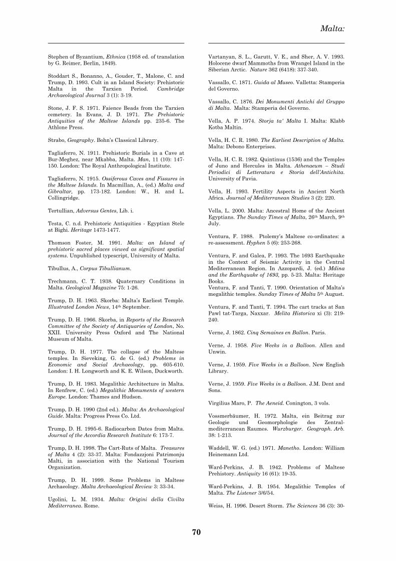
Malta:
70
Stephen of Byzantium, Ethnica (1958 ed. of translation
by G. Reimer, Berlin, 1849).
Stoddart S., Bonanno, A., Gouder, T., Malone, C. and
Trump, D. 1993. Cult in an Island Society: Prehistoric
Malta in the Tarxien Period. Cambridge
Archaeological Journal 3 (1): 3-19.
Stone, J. F. S. 1971. Faience Beads from the Tarxien
cemetery. In Evans, J. D. 1971. The Prehistoric
Antiquities of the Maltese Islands pp. 235-6. The
Athlone Press.
Strabo, Geography. Bohn‘s Classical Library.
Tagliaferro, N. 1911. Prehistoric Burials in a Cave at
Bur-Meghez, near Mkabba, Malta. Man, 11 (10): 147-
150. London: The Royal Anthropological Institute.
Tagliaferro, N. 1915. Ossiferous Caves and Fissures in
the Maltese Islands. In Macmillan, A., (ed.) Malta and
Gibraltar, pp. 173-182. London: W., H. and L.
Collingridge.
Tertullian, Adversus Gentes, Lib. i.
Testa, C. n.d. Prehistoric Antiquities - Egyptian Stele
at Bighi. Heritage 1473-1477.
Thomson Foster, M. 1991. Malta: an Island of
prehistoric sacred places viewed as significant spatial
systems. Unpublished typescript, University of Malta.
Tibullus, A., Corpus Tibullianum.
Trechmann, C. T. 1938. Quaternary Conditions in
Malta. Geological Magazine 75: 1-26.
Trump, D. H. 1963. Skorba: Malta‘s Earliest Temple.
Illustrated London News, 14th September.
Trump, D. H. 1966. Skorba, in Reports of the Research
Committee of the Society of Antiquaries of London, No.
XXII. University Press Oxford and The National
Museum of Malta.
Trump, D. H. 1977. The collapse of the Maltese
temples. In Sieveking, G. de G. (ed.) Problems in
Economic and Social Archaeology, pp. 605-610.
London: I. H. Longworth and K. E. Wilson, Duckworth.
Trump, D. H. 1983. Megalithic Architecture in Malta.
In Renfrew, C. (ed.) Megalithic Monuments of western
Europe. London: Thames and Hudson.
Trump, D. H. 1990 (2nd ed.). Malta: An Archaeological
Guide. Malta: Progress Press Co. Ltd.
Trump, D. H. 1995-6. Radiocarbon Dates from Malta.
Journal of the Accordia Research Institute 6: 173-7.
Trump, D. H. 1998. The Cart-Ruts of Malta. Treasures
of Malta 4 (2): 33-37. Malta: Fondazzjoni Patrimonju
Malti, in association with the National Tourism
Organization.
Trump, D. H. 1999. Some Problems in Maltese
Archaeology. Malta Archaeological Review 3: 33-34.
Ugolini, L. M. 1934. Malta: Origini della Civilta
Mediterranea. Rome.
Vartanyan, S. L., Garutt, V. E., and Sher, A. V. 1993.
Holocene dwarf Mammoths from Wrangel Island in the
Siberian Arctic. Nature 362 (6418): 337-340.
Vassallo, C. 1871. Guida al Museo. Valletta: Stamperia
del Governo.
Vassallo, C. 1876. Dei Monumenti Antichi del Gruppo
di Malta. Malta: Stamperia del Governo.
Vella, A. P. 1974. Storja ta' Malta I. Malta: Klabb
Kotba Maltin.
Vella, H. C. R. 1980. The Earliest Description of Malta.
Malta: Debono Enterprises.
Vella, H. C. R. 1982. Quintinus (1536) and the Temples
of Juno and Hercules in Malta. Athenaeum – Studi
Periodici di Letteratura e Storia dell‘Antichita.
University of Pavia.
Vella, H. 1993. Fertility Aspects in Ancient North
Africa. Journal of Mediterranean Studies 3 (2): 220.
Vella, L. 2000. Malta: Ancestral Home of the Ancient
Egyptians. The Sunday Times of Malta, 26th March, 9th
July.
Ventura, F. 1988. Ptolemy‘s Maltese co-ordinates: a
re-assessment. Hyphen 5 (6): 253-268.
Ventura, F. and Galea, P. 1993. The 1693 Earthquake
in the Context of Seismic Activity in the Central
Mediterranean Region. In Azzopardi, J. (ed.) Mdina
and the Earthquake of 1693, pp. 5-23. Malta: Heritage
Books.
Ventura, F. and Tanti, T. 1990. Orientation of Malta‘s
megalithic temples. Sunday Times of Malta 5th August.
Ventura, F. and Tanti, T. 1994. The cart tracks at San
Pawl tat-Targa, Naxxar. Melita Historica xi (3): 219-
240.
Verne, J. 1862. Cinq Semaines en Ballon. Paris.
Verne, J. 1958. Five Weeks in a Balloon. Allen and
Unwin.
Verne, J. 1959. Five Weeks in a Balloon. New English
Library.
Verne, J. 1959. Five Weeks in a Balloon. J.M. Dent and
Sons.
Virgilius Maro, P. The Aeneid. Conington, 3 vols.
Vossmerbäumer, H. 1972. Malta, ein Beitrag zur
Geologie und Geomorphologie des Zentral-
mediterranean Raumes. Wurzburger. Geograph. Arb.
38: 1-213.
Waddell, W. G. (ed.) 1971. Manetho. London: William
Heinemann Ltd.
Ward-Perkins, J. B. 1942. Problems of Maltese
Prehistory. Antiquity 16 (61): 19-35.
Ward-Perkins, J. B. 1954. Megalithic Temples of
Malta. The Listener 3/6/54.
Weiss, H. 1996. Desert Storm. The Sciences 36 (3): 30-
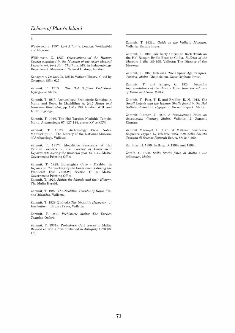
Echoes of Plato‘s Island
71
6.
Westwood, J. 1997. Lost Atlantis. London: Weidenfeld
and Nicolson.
Williamson, G. 1837. Observations of the Human
Crania contained in the Museum of the Army Medical
Department, Fort Pitt, Chatham. MS. in Palaeontology
Department, Museum of Natural History, London.
Xenagoras. De Insulis. MS in Vatican library. Cited by
Grongnet 1854: 627.
Zammit, T. 1910. The Hal Saflieni Prehistoric
Hypogeum. Malta.
Zammit, T. 1915. Archaeology: Prehistoric Remains in
Malta and Gozo. In MacMillan A. (ed.) Malta and
Gibraltar Illustrated, pp. 186 - 198. London: W.H. and
L. Collingridge.
Zammit, T. 1916. The Hal Tarxien Neolithic Temple,
Malta. Archaeologia 67: 127-144, plates XV to XXVI.
Zammit, T. 1917a. Archaeology Field Notes,
Manuscript 18. The Library of the National Museum
of Archaeology, Valletta.
Zammit, T. 1917b. Megalithic Sanctuary at Hal
Tarxien. Reports on the working of Government
Departments during the financial year 1915-16. Malta:
Government Printing Office.
Zammit, T. 1925. Burmeghez Cave - Mkabba, in
Reports on the Working of the Governments during the
Financial Year 1922-23, Section O: 3. Malta:
Government Printing Office.
Zammit, T. 1926. Malta: the Islands and their History.
The Malta Herald.
Zammit, T. 1927. The Neolithic Temples of Hajar Kim
and Mnaidra. Valletta.
Zammit, T. 1928 (2nd ed.) The Neolithic Hypogeum at
Hal Saflieni. Empire Press, Valletta.
Zammit, T. 1930. Prehistoric Malta: The Tarxien
Temples. Oxford.
Zammit, T. 1931a. Prehistoric Cart tracks in Malta.
Revised edition. (First published in Antiquity 1928 (2):
18).
Zammit, T. 1931b. Guide to the Valletta Museum.
Valletta: Empire Press.
Zammit, T. 1935. An Early Christian Rock Tomb on
the Hal Resqun Bridle Road at Gudia. Bulletin of the
Museum 1 (5): 189-195. Valletta: The Director of the
Museum.
Zammit, T. 1966 (4th ed.). The Copper Age Temples,
Tarxien, Malta. Ghajnsielem, Gozo: Orphans Press.
Zammit, T. and Singer, C. 1924. Neolithic
Representations of the Human Form from the Islands
of Malta and Gozo. Malta.
Zammit, T., Peet, T. E. and Bradley, R. N. 1912. The
Small Objects and the Human Skulls found in the Hal
Saflieni Prehistoric Hypogeum. Second Report. Malta.
Zammit Ciantar, J. 1998. A Benedictine‘s Notes on
Seventeenth Century Malta. Valletta: J. Zammit
Ciantar.
Zammit Maempel, G. 1981. A Maltese Pleistocene
Sequence capped by volcanic Tufa. Atti della Societa
Toscana di Scienze Naturali Ser. A. 88: 243-260.
Zeitlmar, H. 1999. In Borg, D. 1999a and 1999b.
Zerafa. S. 1838. Sulla Storia fisica di Malta e sue
adiacenze. Malta.
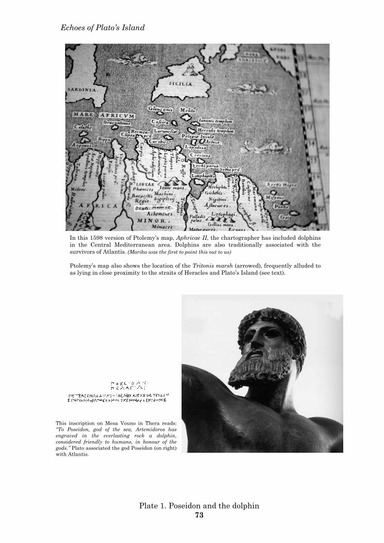
Echoes of Plato’s Island
This inscription on Mesa Vouno in Thera reads: “To Poseidon, god of the sea, Artemidoros has engraved in the everlasting rock a dolphin, considered friendly to humans, in honour of the gods.” Plato associated the god Poseidon (on right) with Atlantis.
In this 1598 version of Ptolemy’s map, Aphricae II, the chartographer has included dolphins in the Central Mediterranean area. Dolphins are also traditionally associated with the survivors of Atlantis. (Marika was the first to point this out to us) Ptolemy’s map also shows the location of the Tritonis marsh (arrowed), frequently alluded to as lying in close proximity to the straits of Heracles and Plato’s Island (see text).
Plate 1. Poseidon and the dolphin 73
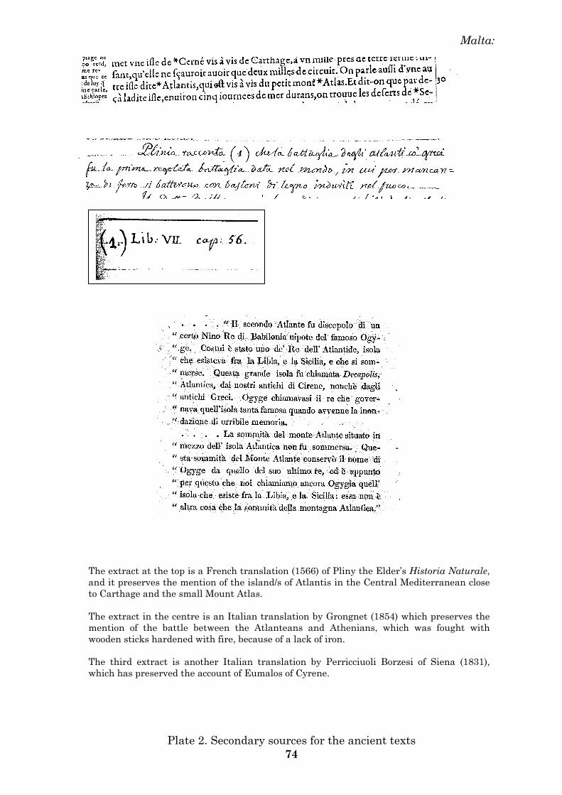
Malta:
The extract at the top is a French translation (1566) of Pliny the Elder’s Historia Naturale, and it preserves the mention of the island/s of Atlantis in the Central Mediterranean close to Carthage and the small Mount Atlas. The extract in the centre is an Italian translation by Grongnet (1854) which preserves the mention of the battle between the Atlanteans and Athenians, which was fought with wooden sticks hardened with fire, because of a lack of iron. The third extract is another Italian translation by Perricciuoli Borzesi of Siena (1831), which has preserved the account of Eumalos of Cyrene.
Plate 2. Secondary sources for the ancient texts 74

Echoes of Plato’s Island
Volcanic ash layer (E) of recent deposition. It was discovered by George Zammit Maempel in 1965 during excavation works on the Mriehel Primary School. The ash layer was 45 cm thick. The origin of the ash has not been identified outside the Maltese islands. (Photograph courtesy of George Zammit Maempel).
Sites similar to the Mriehel ash deposit are to be found all along the Mriehel by-pass road, which is rapidly building up with construction sites. This photograph shows the same soil deposit underlying a layer similar to the ash deposit, but which cannot be tested at this stage. (Photograph – Anton Mifsud).
Plate 3. Volcanic ash at Mriehel 75
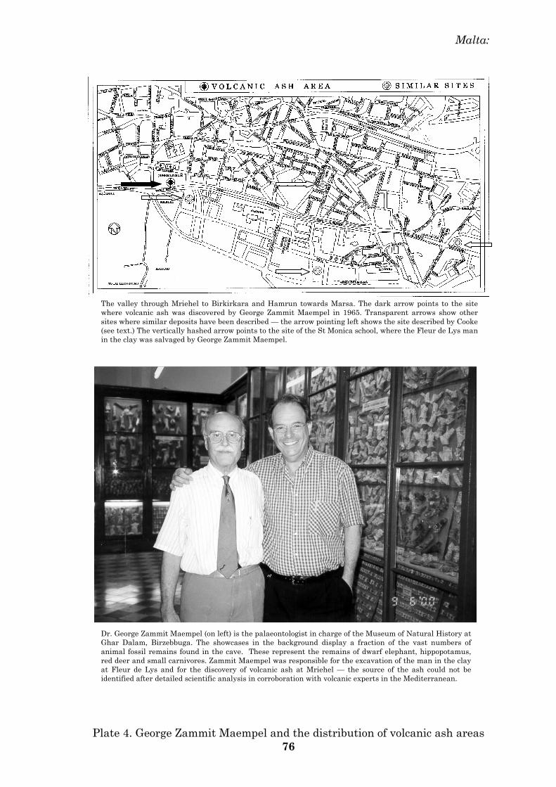
Malta:
The valley through Mriehel to Birkirkara and Hamrun towards Marsa. The dark arrow points to the site where volcanic ash was discovered by George Zammit Maempel in 1965. Transparent arrows show other sites where similar deposits have been described — the arrow pointing left shows the site described by Cooke (see text.) The vertically hashed arrow points to the site of the St Monica school, where the Fleur de Lys man in the clay was salvaged by George Zammit Maempel.
Dr. George Zammit Maempel (on left) is the palaeontologist in charge of the Museum of Natural History at Ghar Dalam, Birzebbuga. The showcases in the background display a fraction of the vast numbers of animal fossil remains found in the cave. These represent the remains of dwarf elephant, hippopotamus, red deer and small carnivores. Zammit Maempel was responsible for the excavation of the man in the clay at Fleur de Lys and for the discovery of volcanic ash at Mriehel — the source of the ash could not be identified after detailed scientific analysis in corroboration with volcanic experts in the Mediterranean.
Plate 4. George Zammit Maempel and the distribution of volcanic ash areas 76
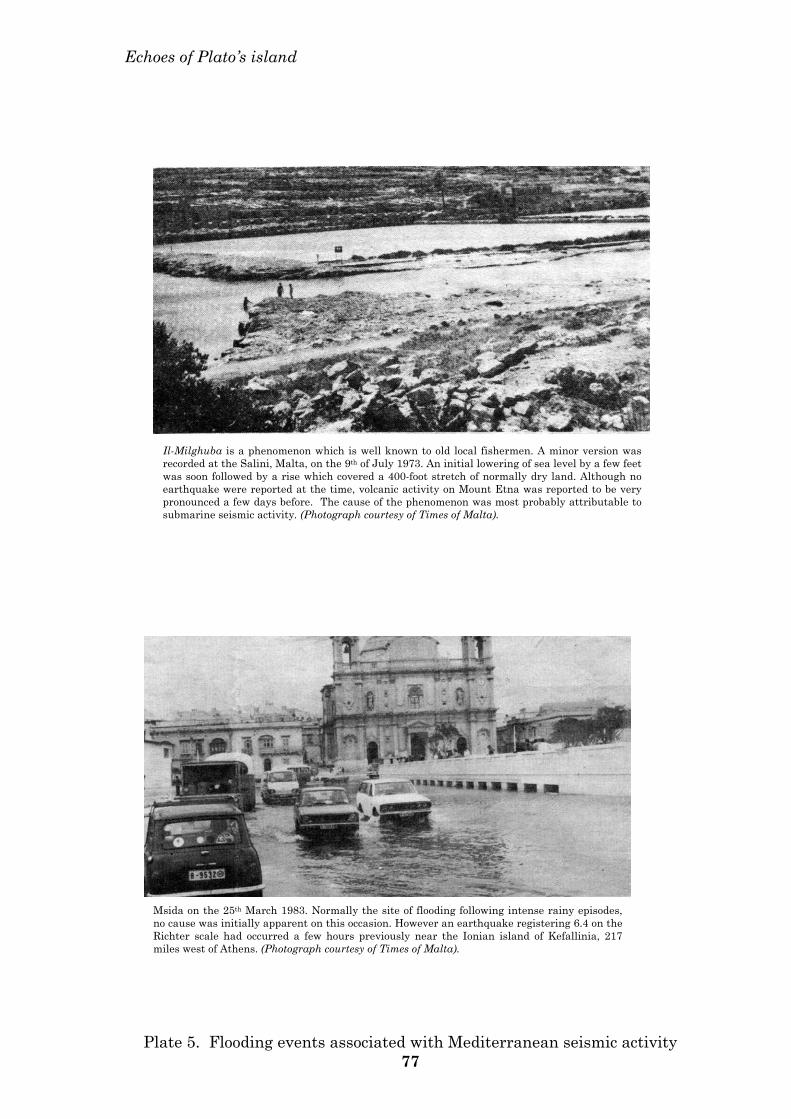
Echoes of Plato’s island
Il-Milghuba is a phenomenon which is well known to old local fishermen. A minor version was recorded at the Salini, Malta, on the 9th of July 1973. An initial lowering of sea level by a few feet was soon followed by a rise which covered a 400-foot stretch of normally dry land. Although no earthquake were reported at the time, volcanic activity on Mount Etna was reported to be very pronounced a few days before. The cause of the phenomenon was most probably attributable to submarine seismic activity. (Photograph courtesy of Times of Malta).
Msida on the 25th March 1983. Normally the site of flooding following intense rainy episodes, no cause was initially apparent on this occasion. However an earthquake registering 6.4 on the Richter scale had occurred a few hours previously near the Ionian island of Kefallinia, 217 miles west of Athens. (Photograph courtesy of Times of Malta).
Plate 5. Flooding events associated with Mediterranean seismic activity 77
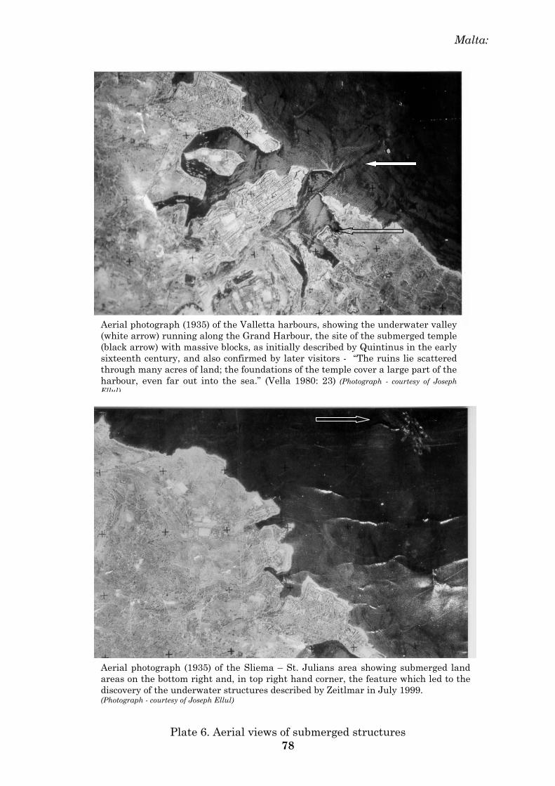
Malta:
Aerial photograph (1935) of the Valletta harbours, showing the underwater valley (white arrow) running along the Grand Harbour, the site of the submerged temple (black arrow) with massive blocks, as initially described by Quintinus in the early sixteenth century, and also confirmed by later visitors - “The ruins lie scattered through many acres of land; the foundations of the temple cover a large part of the harbour, even far out into the sea.” (Vella 1980: 23) (Photograph - courtesy of Joseph Ellul)
Aerial photograph (1935) of the Sliema – St. Julians area showing submerged land areas on the bottom right and, in top right hand corner, the feature which led to the discovery of the underwater structures described by Zeitlmar in July 1999. (Photograph - courtesy of Joseph Ellul)
Plate 6. Aerial views of submerged structures 78
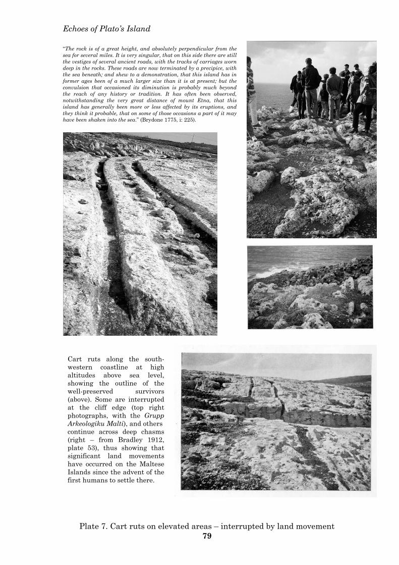
Echoes of Plato’s Island
Cart ruts along the south-western coastline at high altitudes above sea level, showing the outline of the well-preserved survivors (above). Some are interrupted at the cliff edge (top right photographs, with the Grupp Arkeologiku Malti), and others continue across deep chasms (right – from Bradley 1912, plate 53), thus showing that significant land movements have occurred on the Maltese Islands since the advent of the first humans to settle there.
“The rock is of a great height, and absolutely perpendicular from the sea for several miles. It is very singular, that on this side there are still the vestiges of several ancient roads, with the tracks of carriages worn deep in the rocks. These roads are now terminated by a precipice, with the sea beneath; and shew to a demonstration, that this island has in former ages been of a much larger size than it is at present; but the convulsion that occasioned its diminution is probably much beyond the reach of any history or tradition. It has often been observed, notwithstanding the very great distance of mount Etna, that this island has generally been more or less affected by its eruptions, and they think it probable, that on some of those occasions a part of it may have been shaken into the sea.” (Brydone 1775, i: 225).
Plate 7. Cart ruts on elevated areas – interrupted by land movement 79
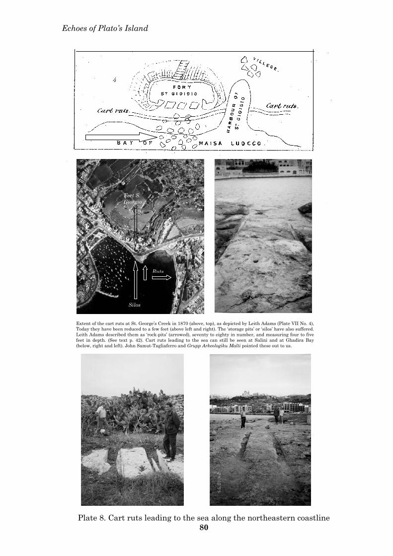
Echoes of Plato’s Island
Ruts
Silos
Fort S. Giorgio
Extent of the cart ruts at St. George’s Creek in 1870 (above, top), as depicted by Leith Adams (Plate VII No. 4), Today they have been reduced to a few feet (above left and right). The ‘storage pits’ or ‘silos’ have also suffered. Leith Adams described them as ‘rock-pits’ (arrowed), seventy to eighty in number, and measuring four to five feet in depth. (See text p. 42). Cart ruts leading to the sea can still be seen at Salini and at Ghadira Bay (below, right and left). John Samut-Tagliaferro and Grupp Arkeologiku Malti pointed these out to us.
Plate 8. Cart ruts leading to the sea along the northeastern coastline 80
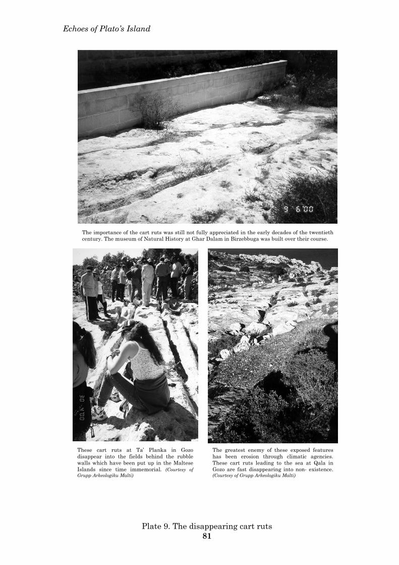
Echoes of Plato’s Island
The importance of the cart ruts was still not fully appreciated in the early decades of the twentieth century. The museum of Natural History at Ghar Dalam in Birzebbuga was built over their course.
These cart ruts at Ta’ Planka in Gozo disappear into the fields behind the rubble walls which have been put up in the Maltese Islands since time immemorial. (Courtesy of Grupp Arkeologiku Malti)
The greatest enemy of these exposed features has been erosion through climatic agencies. These cart ruts leading to the sea at Qala in Gozo are fast disappearing into non- existence. (Courtesy of Grupp Arkeologiku Malti)
Plate 9. The disappearing cart ruts 81
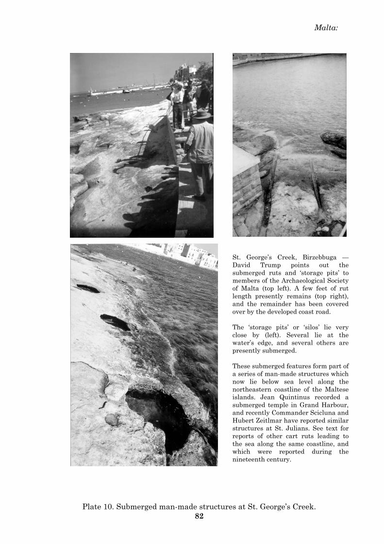
Malta:
St. George’s Creek, Birzebbuga — David Trump points out the submerged ruts and ‘storage pits’ to members of the Archaeological Society of Malta (top left). A few feet of rut length presently remains (top right), and the remainder has been covered over by the developed coast road. The ‘storage pits’ or ‘silos’ lie very close by (left). Several lie at the water’s edge, and several others are presently submerged. These submerged features form part of a series of man-made structures which now lie below sea level along the northeastern coastline of the Maltese islands. Jean Quintinus recorded a submerged temple in Grand Harbour, and recently Commander Scicluna and Hubert Zeitlmar have reported similar structures at St. Julians. See text for reports of other cart ruts leading to the sea along the same coastline, and which were reported during the nineteenth century.
Plate 10. Submerged man-made structures at St. George’s Creek. 82
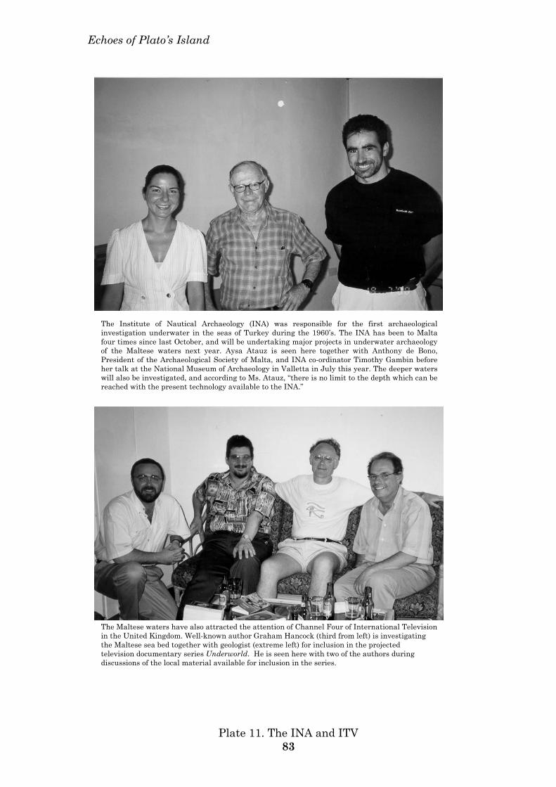
Echoes of Plato’s Island
The Institute of Nautical Archaeology (INA) was responsible for the first archaeological investigation underwater in the seas of Turkey during the 1960’s. The INA has been to Malta four times since last October, and will be undertaking major projects in underwater archaeology of the Maltese waters next year. Aysa Atauz is seen here together with Anthony de Bono, President of the Archaeological Society of Malta, and INA co-ordinator Timothy Gambin before her talk at the National Museum of Archaeology in Valletta in July this year. The deeper waters will also be investigated, and according to Ms. Atauz, “there is no limit to the depth which can be reached with the present technology available to the INA.”
The Maltese waters have also attracted the attention of Channel Four of International Television in the United Kingdom. Well-known author Graham Hancock (third from left) is investigating the Maltese sea bed together with geologist (extreme left) for inclusion in the projected television documentary series Underworld. He is seen here with two of the authors during discussions of the local material available for inclusion in the series.
Plate 11. The INA and ITV 83
INDEX Acholla – 32. Agius de Soldanis – 20, 61, 63. Alexandria – 2, 8, 10, 12, 20, 28, 48. Ancient texts – 2, 4, 6, 14, 16, 20, 56. Architecture – 1, 40, 54. Ash, volcanic – 12, 14, 36, 44, 58, 62. Atlantika – 8, 10, 12, 14, 16, 46, 48, 52, 56, 58, 60. Atlantikos – 10, 12, 61. Augustine – 52. Babylon - 30, 56, 58. Battus – 32, 56. Berlitz, Charles – 60, 61. Bighi – 30. Biogeography – 26, 28. Borg, J. J. – 14, 61. Borzesi, G. P. – 14, 56, 63, 64. Burials – 30, 38, 40, 48. Burmeghez – 40, 46, 48, 63. Callimachus – 4, 56. Canals – 42, 44, 54, 63. Cart ruts – 12, 24, 26, 42, 44, 52, 54, 58, 62, 63, 64. Caruana, A. A. – 38. Chaldea – 30, 58. Chronology – 2, 12, 16, 36, 46, 58. Cleopatra – 8, 12. Cluverius, Philipp – 56. Comino – 20, 24, 42, 52. Constantinople – 4, 6, 14. Copernicus – 6. Crete – 1, 6, 14, 28, 30, 36, 46, 52, 56. Cult of the Bull – 10, 52, 58. Dating – 1, 4, 40, 44, 46, 58, 60. Diodorus Siculus – 12, 48, 52, 56, 64.
Dolomieu, Deodat de – 16, 61. Donnelly, Ignatius – 14, 60, 61. Egypt, Egyptians – 1, 2, 8, 10, 12, 14, 26, 28, 30, 36, 46, 48, 52, 58, 61, 62, 64. Eumalos of Cyrene – 46, 56, 60, 63, 64. Eusebius – 2, 6, 58, 60, 64. Evans, Arthur – 1, 6, 8, 56. Filfla – 14, 24, 26, 28, 52. Flloding events – 8, 18, 36, 38, 40, 48, 58. Galanopoulos, A. G. – 14, 61. Galileo – 6. Goddio, Frank – 8. Gozo – 1, 12, 18, 20, 24, 28, 30, 40, 42, 44, 52, 54, 60. Graham’s Island – 12, 18, 60, 62. Grongnet, Giorgio – 14, 61, 64. Hagar Qim – 14, 24. Heracles, Straits of – 4, 10, 14, 48, 52. Hypogeum, Hal Saflieni – 1, 24, 38, 40, 48, 54. James, Peter – 14, 46, 61. Josephus – 2, 60. Krantor – 10, 12. Land movements – 44.
Libia – 10, 28, 30, 32, 56, 61. Library of Alexandria – 2, 4, 56. Linosa – 26, 34, 44, 46, 52, 58. Magri, Emanuel – 24, 32, 38. Malta, Maltese – 1, 2, 6, 12, 14, 16, 18, 20, 24, 26, 28, 30, 32, 34, 36, 38, 40, 42, 44, 46, 48, 52, 54, 56, 58, 60, 61, 62, 63, 64. Manetho – 2, 60. Marcellinus, Ammianus – 10, 12, 61. Marinatos, Spyridon – 8, 14. Mavor, James – 8, 14, 46, 61.
Mayr, Albert – 1, 30, 60, 62. Mediterranean – 1, 2, 6, 8, 10, 12, 14, 16, 18, 20, 26, 28, 30, 32, 34, 48, 52, 54, 56, 58, 60, 61, 63. Megalithic structures – 1, 14, 30, 32, 40, 42, 44, 54, 56, 58, 61. Mnajdra – 14, 24, 30, 40, 62. Mountains of the Moon – 8, 20. Nabta – 30. Pantelleria – 12, 16, 26, 28, 30, 34, 44, 48, 58, 63, 66. Parthenon – 10, 12. Pelagian block, islands – 6, 16, 26, 28, 32, 34, 48, 52, 58, 60, 61, 63. Pelagos – 20, 52, 58, 60, 63. Piri Reis – 4, 8, 20, 60. Plato – 6, 8, 10, 14, 16, 18, 28, 40, 42, 46, 48, 52, 54, 56, 58, 60. Pliny the Elder – 4, 6, 12, 14, 46, 52, 60, 61, 63. Podarcis – 26, 28. Precious metals – 46. Psonchis – 8, 10, 12. Ptolemy I – 2. Ptolemy, Claudius – 4, 6, 8, 18, 20, 24, 52, 60, 61, 63. Quintinus, Jean - 1, 24, 42, 61, 63. Ruwenzori – 8. Sais – 8. San Dimitri – 12. Schliemann, Heinrich - 6. Skulls – 28, 38, 40, 62. Skylax – 48. Socrates – 10, 12. Solon – 8, 10, 12, 61. Stelae – 30. Strabo – 8, 10, 12, 61, 63, 64. Submerged structures – 8, 12, 14, 16, 18, 24, 36, 40, 42, 44, 48, 56, 58.
Syrtis – 48. Tantalis – 14. Tectonics – 14, 16, 32, 34, 44, 58. Temples – 1, 2, 8, 10, 12, 16, 24, 30, 32, 40, 42, 46, 48, 52, 54, 58, 60, 61, 63. Tilting – 34, 62. Verne, Jules – 63. Volcano – 12, 14, 32, 34, 36, 38, 44, 46, 58, 60, 62, 63. Wrangel Island – 62. Zammit Maempel, George - 44, 63. Zammit, Themistocles - 24, 30, 38, 40, 54, 58, 60, 62, 64.
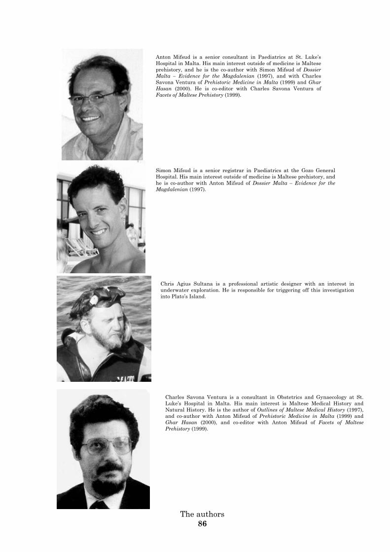
Anton Mifsud is a senior consultant in Paediatrics at St. Luke’s Hospital in Malta. His main interest outside of medicine is Maltese prehistory, and he is the co-author with Simon Mifsud of Dossier Malta – Evidence for the Magdalenian (1997), and with Charles Savona Ventura of Prehistoric Medicine in Malta (1999) and Ghar Hasan (2000). He is co-editor with Charles Savona Ventura of Facets of Maltese Prehistory (1999).
Simon Mifsud is a senior registrar in Paediatrics at the Gozo General Hospital. His main interest outside of medicine is Maltese prehistory, and he is co-author with Anton Mifsud of Dossier Malta – Evidence for the Magdalenian (1997).
Chris Agius Sultana is a professional artistic designer with an interest in underwater exploration. He is responsible for triggering off this investigation into Plato’s Island.
Charles Savona Ventura is a consultant in Obstetrics and Gynaecology at St. Luke’s Hospital in Malta. His main interest is Maltese Medical History and Natural History. He is the author of Outlines of Maltese Medical History (1997), and co-author with Anton Mifsud of Prehistoric Medicine in Malta (1999) and Ghar Hasan (2000), and co-editor with Anton Mifsud of Facets of Maltese Prehistory (1999).
The authors
86

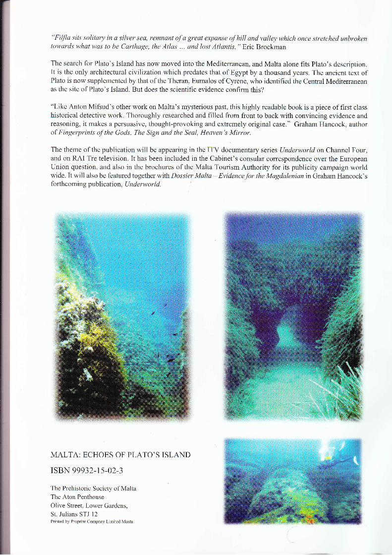
"Filfla sits solitary in a silver sea, remnant of a great expanse of hill and valley which once stretched unbrokentowards what was to be Carthage, the Atlas ... and lost Atlantis. " Eric Brockman
The search for Plato's Island has now moved into the Mediterranean, and Malta alone fits Plato's description.It is the only architectural civilizalionwhich predates that of Egypt by a thousand years. The ancient text ofPlato is now supplemented by that of the Theran, Eumalos of Cy.rene, who identified the Central Mediterraneanas the site of Plato's Island. But does the scientific evidence confirm this?
"Like Anton Mifsud's other work on Malta's mysterious past, this highly readable book is a piece of first classhistorical detective work. Thoroughly researched and filled from front to back with convincing evidence andreasoning, it makes a persuasive, thought-provoking and extremely original case." Graham Hancock, authorof Fingerprints of the Gods, The Sign and the Seal, Heaven's Mirror.
The theme of the publication will be appearing in the ITV documentary series (Jnderworldon Channel Four,and on RAI Tre television. It has been included in the Cabinet's consular correspondence over the EuropeanUnion question, and also in the brochures of the;Malta Tourism Authority for its publicity campaign worldwide. It will also be featured together with Dossier Malta - Evidencefor the Magdalenian in Graham Hancock'sforthcoming publication, Underworld.
MALTA: ECHOES OF PLATO,S ISLAND
ISBN 99932-t5-02-3
The Prehistoric Society of MaltaThe Aton Penthouse
Olive Street, Lower Gardens,
St. Julians STJ 12Printed by Proprint Company Limited Mosta