lange, m. (2007) preliminary report on the neolithic site us007, us island (h.u.n.e.-concession)....
TRANSCRIPT
2007
Harrassowitz Verlag · Wiesbaden
Proceedings of the Second International Conference on the Archaeology of the Fourth Nile CataractBerlin, August 4th–6th, 2005
Edited by Claudia Näser and Mathias Lange
Offprint from
134
Preliminary report on the Neolithic site US007, Us Island (H.U.N.E. concession)
Mathias Lange
Introduction
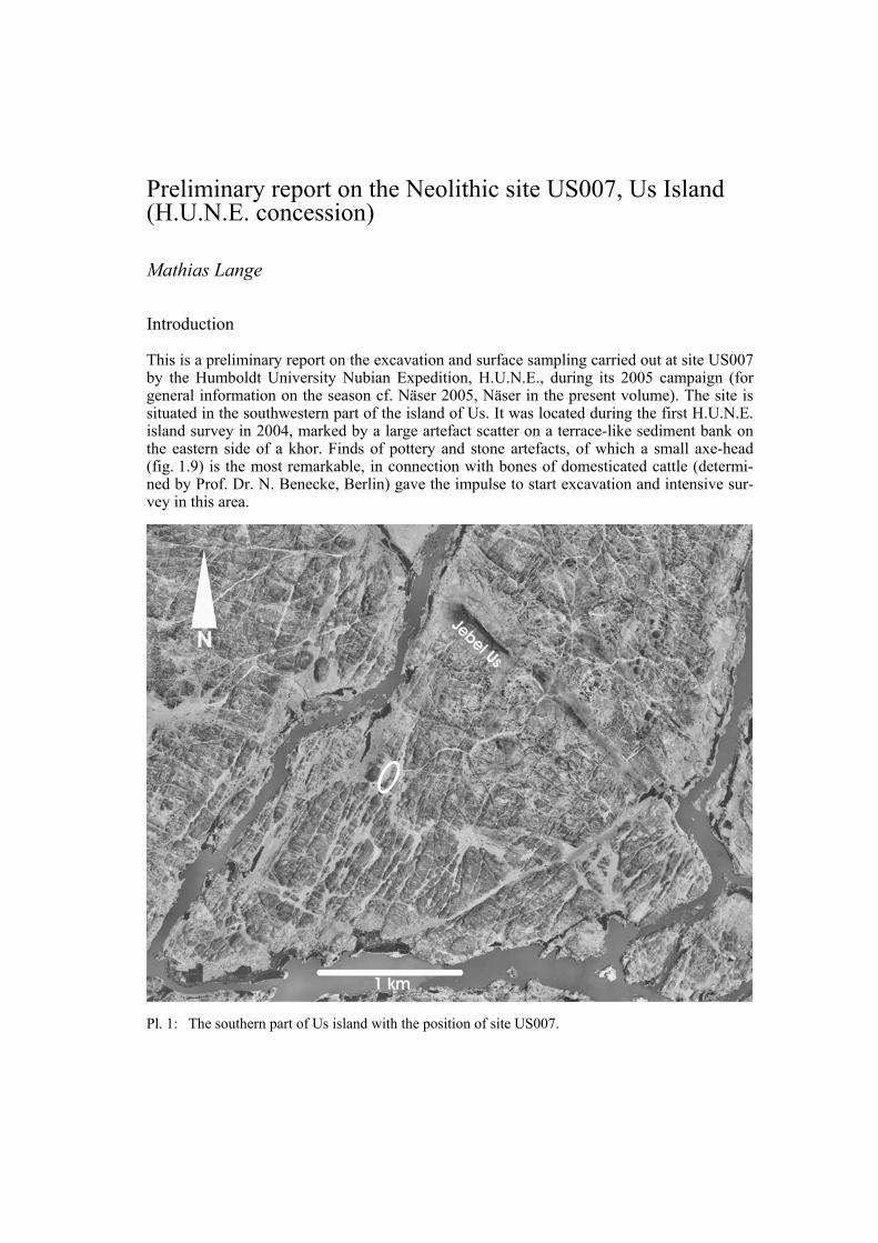
This is a preliminary report on the excavation and surface sampling carried out at site US007 by the Humboldt University Nubian Expedition, H.U.N.E., during its 2005 campaign (for general information on the season cf. Näser 2005, Näser in the present volume). The site is situated in the southwestern part of the island of Us. It was located during the first H.U.N.E. island survey in 2004, marked by a large artefact scatter on a terrace-like sediment bank on the eastern side of a khor. Finds of pottery and stone artefacts, of which a small axe-head (fig. 1.9) is the most remarkable, in connection with bones of domesticated cattle (determi-ned by Prof. Dr. N. Benecke, Berlin) gave the impulse to start excavation and intensive sur-vey in this area.
Pl. 1: The southern part of Us island with the position of site US007.
Preliminary report on the Neolithic site US007, Us Island
135
US007 lies approximately 1.3 km southwest of Gebel Us (pl. 1), which is the most prominent landmark on the island, and 550 m southeast of the modern bank of the river Nile. To the north, in a distance of about 450 m, one can find the modern village Shaqqaiq. The khor with the site is called Khor Alqara’ by the local inhabitants, Alqara’ being the name of a type of coloquinta plant which used to grow there until the 1970s, when the valley was still used as pasture ground for goats. During the Sahel drought of the 1970s the vegetation cover was destroyed, the valley dried up completely and no pasture came back afterwards. Just 50 m west of the site is a Gebel called Gebel Khor Alqara’.
The surrounding landscape consists of the same granitic rock, which makes up most of the cataract area. It is separated by several small dry valleys, which often seem to have been created by tectonic movements, according to their appearance in the satellite pictures (cf. Schmitz 1983, 105). On many of the rocks in the surroundings of the site, rock engravings, for example of cattle, can be found. However, no engravings were found directly at the site. The site was investigated at the end of the 2005 season from March 26th to March 28th.
Colour pl. 35 shows the view from Gebel Khor Alqara’ towards the east. It gives an over-view of the site, which is situated on a large sandy bank of approximately 80 m length and a maximum width of 15 m on the eastern side of the khor in front of a granitic ridge. The bank is in some areas covered by the remnants of grey-coloured calcareous sediments and rhi-zomes, which demonstrate that, in earlier times, this must have been a shore line and the whole situation would have appeared as a swampy area filled with reeds. In front of this bank the valley floor is covered with coarse sand. An Acacia tree, a Tundub shrub and some smaller shrubs are the only remnants of vegetation. Remarkable features in the centre of the site are two tumuli, which are badly damaged by erosion. Nevertheless, they prevented the sediment underneath from erosion, so that in this area the sand bank is better preserved than anywhere else on the site and consequently rises almost 3 m above the ground of the khor. Thus, in most parts of the site the sediment will already have been lost by erosion to a large extent. Adjacent to the tumuli are several disturbed Islamic graves. The archaeological finds of the site are restricted to the sand bank and the rocky ridge behind it and they stretch, more or less continuously, from the southern end of the granitic ridge to its northern end over a distance of altogether 100 m. The densest concentrations of finds can be found between the rocks on the southern end, above and behind the two tumuli and on the flat areas at the north-ern end of the ridge. One of these concentrations, situated between some large granite rocks, was chosen for excavation.
Colour pl. 36 provides a closer view of the terrace and the valley floor. The eroded tumuli, marking the highest point of the sediment terrace, are visible in the centre, and in the left foreground scarce remains of the artefact scatter can be detected.
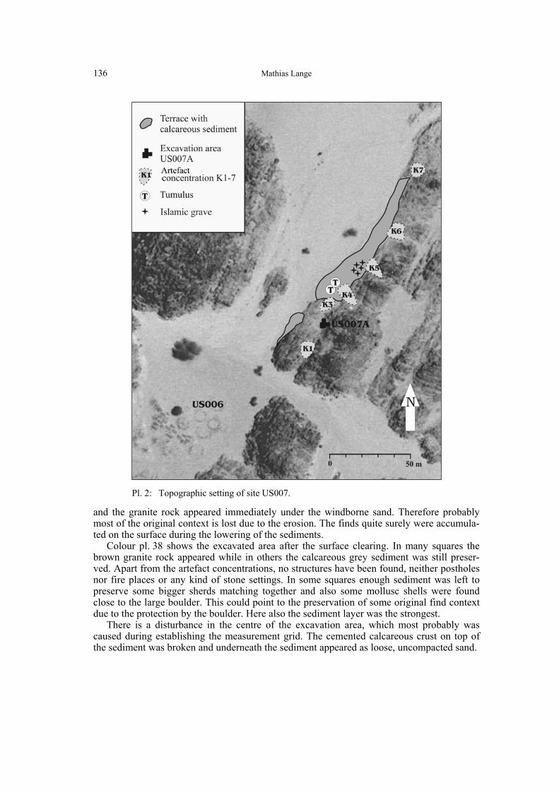
Apart from the excavation, a detailed surface survey was carried out using a total station. Some results of the surface survey are indicated on the site map (pl. 2). The granite ridge with the sand bank on its northwestern side is visible on the right side. Along this ridge and the sand bank the position of the different artefact concentrations, labelled K1 to K7, is marked.
Excavation of the site
K2 was the concentration chosen for excavation and labelled US007A (pl. 2). It is situated at the foot of the ridge in front of a large granite boulder, which was at least partially protecting the site from wind erosion. In the same way, this boulder might have served as a wind shelter in ancient times and therefore might have made this spot particularly attractive.
Colour pl. 37 shows the site before excavation with a dense concentration of stone arte-facts and some sherds and bones on the surface. The site was excavated in 0.25 m2- units in artificial layers of 5 cm each. Unfortunately, in many squares the sediment was already eroded
Mathias Lange
136
and the granite rock appeared immediately under the windborne sand. Therefore probably most of the original context is lost due to the erosion. The finds quite surely were accumula-ted on the surface during the lowering of the sediments.
Colour pl. 38 shows the excavated area after the surface clearing. In many squares the brown granite rock appeared while in others the calcareous grey sediment was still preser-ved. Apart from the artefact concentrations, no structures have been found, neither postholes nor fire places or any kind of stone settings. In some squares enough sediment was left to preserve some bigger sherds matching together and also some mollusc shells were found close to the large boulder. This could point to the preservation of some original find context due to the protection by the boulder. Here also the sediment layer was the strongest.
There is a disturbance in the centre of the excavation area, which most probably was caused during establishing the measurement grid. The cemented calcareous crust on top of the sediment was broken and underneath the sediment appeared as loose, uncompacted sand.
Pl. 2: Topographic setting of site US007.
Preliminary report on the Neolithic site US007, Us Island
137
Finds from the excavation
Examination of the finds has just started, but so far it can be stated that the pottery found mainly consists of brown, thin-walled, undecorated well smoothed or sometimes even pol-ished sherds. The decorations are mostly restricted to the rim top and appear as milled rims with fine zigzags (fig. 1: 2f., 6) or as oblique parallel incisions and impressions (fig. 1: 1, 4). One wall sherd shows a comb-impressed pattern, which, due to bad preservation, cannot be classified precisely (fig. 1: 5).
The fabric of the pottery appears to be very homogenous with a high component of small, angular quartz grains and mica, and only very limited amounts of organic material. There are some red polished sherds and also some red polished black topped sherds. Apart from them, one sherd of rippled ware could be identified. Most sherds were undecorated. This altogether makes it possible to relate the site to the Late Neolithic phase, dateable to the 4th millennium BC.
raw
mat
eria
l
quar
tz
quar
tzite
silic
ified
sand
ston
e
flint
agat
e
foss
ilize
d w
ood
silts
tone
gran
ite
carn
elia
n
sum
%
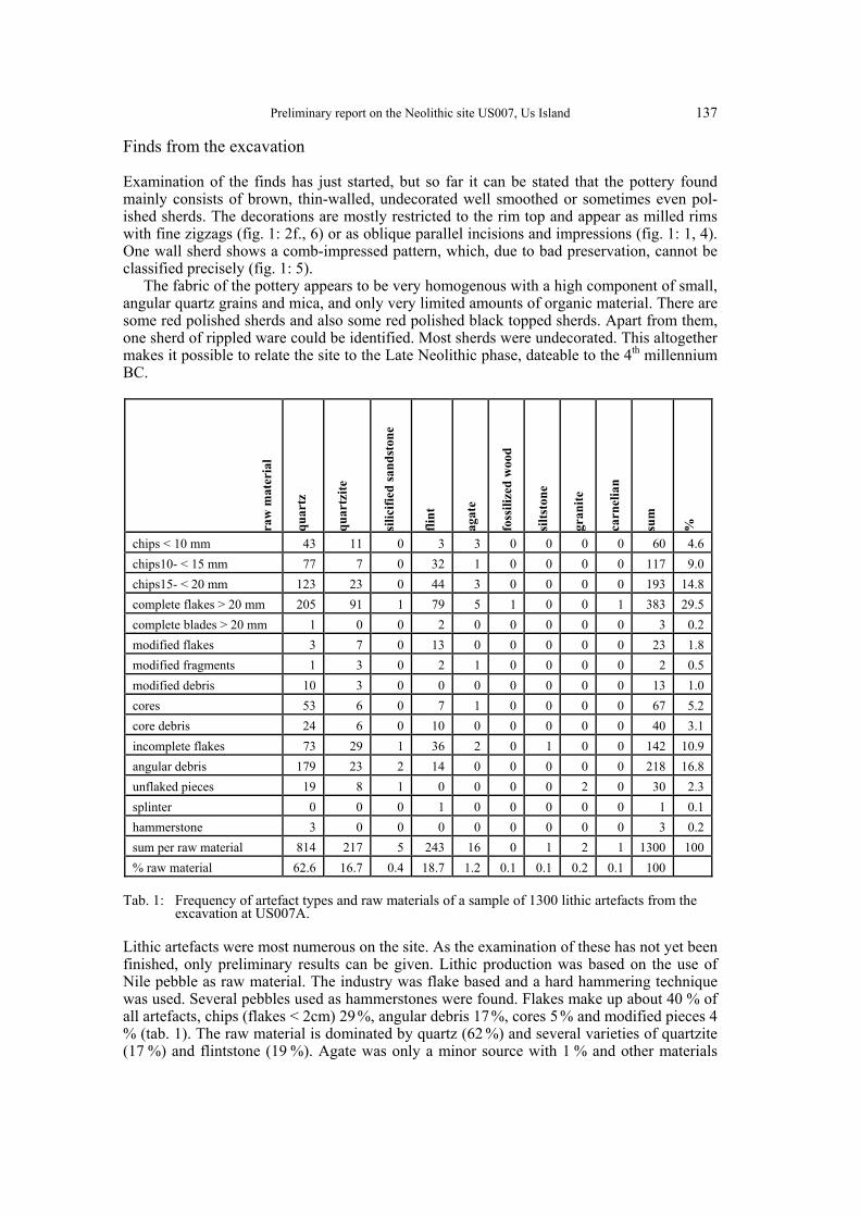
chips < 10 mm 43 11 0 3 3 0 0 0 0 60 4.6 chips10- < 15 mm 77 7 0 32 1 0 0 0 0 117 9.0 chips15- < 20 mm 123 23 0 44 3 0 0 0 0 193 14.8 complete flakes > 20 mm 205 91 1 79 5 1 0 0 1 383 29.5 complete blades > 20 mm 1 0 0 2 0 0 0 0 0 3 0.2 modified flakes 3 7 0 13 0 0 0 0 0 23 1.8 modified fragments 1 3 0 2 1 0 0 0 0 2 0.5 modified debris 10 3 0 0 0 0 0 0 0 13 1.0 cores 53 6 0 7 1 0 0 0 0 67 5.2 core debris 24 6 0 10 0 0 0 0 0 40 3.1 incomplete flakes 73 29 1 36 2 0 1 0 0 142 10.9 angular debris 179 23 2 14 0 0 0 0 0 218 16.8 unflaked pieces 19 8 1 0 0 0 0 2 0 30 2.3 splinter 0 0 0 1 0 0 0 0 0 1 0.1 hammerstone 3 0 0 0 0 0 0 0 0 3 0.2 sum per raw material 814 217 5 243 16 0 1 2 1 1300 100 % raw material 62.6 16.7 0.4 18.7 1.2 0.1 0.1 0.2 0.1 100
Tab. 1: Frequency of artefact types and raw materials of a sample of 1300 lithic artefacts from the
excavation at US007A.
Lithic artefacts were most numerous on the site. As the examination of these has not yet been finished, only preliminary results can be given. Lithic production was based on the use of Nile pebble as raw material. The industry was flake based and a hard hammering technique was used. Several pebbles used as hammerstones were found. Flakes make up about 40 % of all artefacts, chips (flakes < 2cm) 29 %, angular debris 17 %, cores 5 % and modified pieces 4 % (tab. 1). The raw material is dominated by quartz (62 %) and several varieties of quartzite (17 %) and flintstone (19 %). Agate was only a minor source with 1 % and other materials

Mathias Lange
138
Fig. 1: US007: Pottery from the excavation US007A and a stone axe-head from the surface survey.
Preliminary report on the Neolithic site US007, Us Island
139
like fossilized wood, carnelian, siltstone, granite and silicified sandstone make up less than 1 % together. The tools consist mainly of pieces with use-retouch or notched and denticulated pieces, apart from these four small borers must be mentioned.
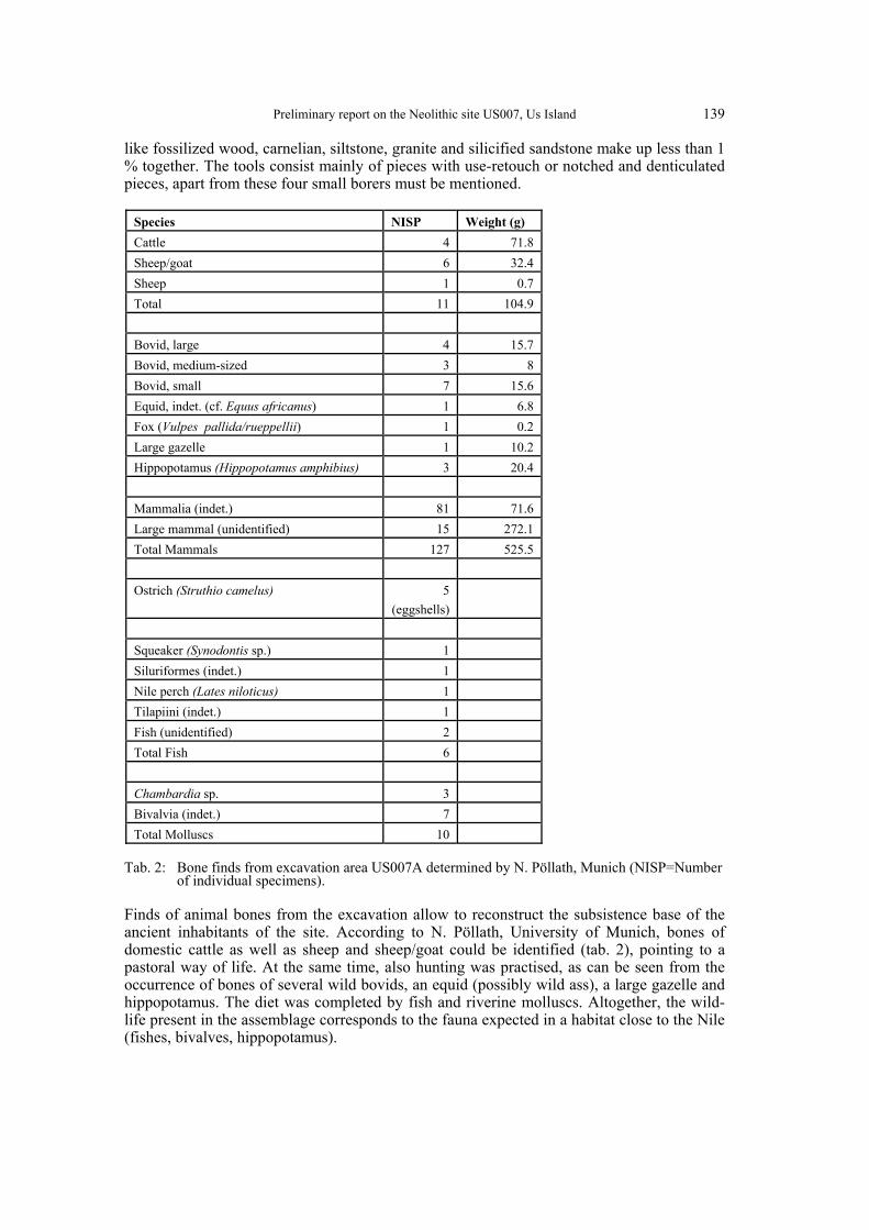
Species NISP Weight (g) Cattle 4 71.8 Sheep/goat 6 32.4 Sheep 1 0.7 Total 11 104.9 Bovid, large 4 15.7 Bovid, medium-sized 3 8 Bovid, small 7 15.6 Equid, indet. (cf. Equus africanus) 1 6.8 Fox (Vulpes pallida/rueppellii) 1 0.2 Large gazelle 1 10.2 Hippopotamus (Hippopotamus amphibius) 3 20.4 Mammalia (indet.) 81 71.6 Large mammal (unidentified) 15 272.1 Total Mammals 127 525.5 Ostrich (Struthio camelus) 5
(eggshells)
Squeaker (Synodontis sp.) 1 Siluriformes (indet.) 1 Nile perch (Lates niloticus) 1 Tilapiini (indet.) 1 Fish (unidentified) 2 Total Fish 6 Chambardia sp. 3 Bivalvia (indet.) 7 Total Molluscs 10
Tab. 2: Bone finds from excavation area US007A determined by N. Pöllath, Munich (NISP=Number
of individual specimens).
Finds of animal bones from the excavation allow to reconstruct the subsistence base of the ancient inhabitants of the site. According to N. Pöllath, University of Munich, bones of domestic cattle as well as sheep and sheep/goat could be identified (tab. 2), pointing to a pastoral way of life. At the same time, also hunting was practised, as can be seen from the occurrence of bones of several wild bovids, an equid (possibly wild ass), a large gazelle and hippopotamus. The diet was completed by fish and riverine molluscs. Altogether, the wild-life present in the assemblage corresponds to the fauna expected in a habitat close to the Nile (fishes, bivalves, hippopotamus).
Mathias Lange
140
Finds from the surface survey
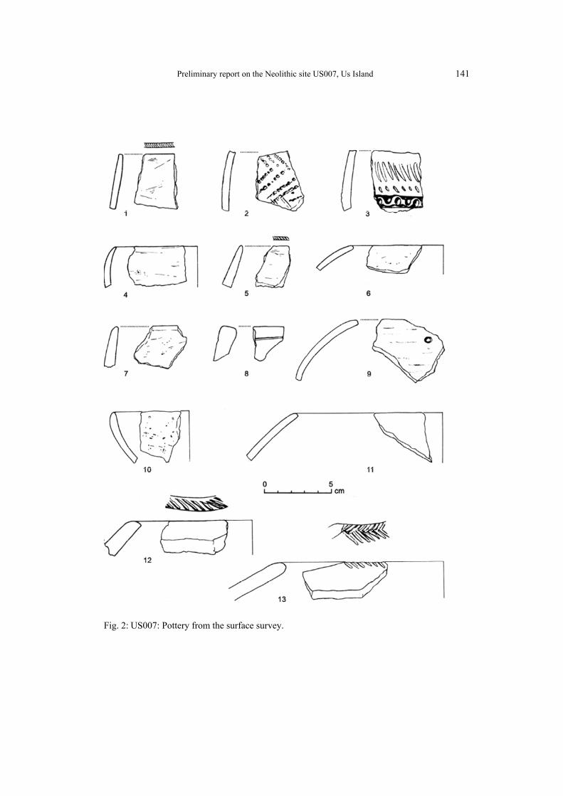
Pottery samples from the surroundings of the excavation area were collected during the sur-face survey. Again, the pottery fabric appears to be very homogenous, with angular quartz grains and mica as dominating tempering agents, except for a few sherds of the Christian period. Decorations are rare, and again mostly restricted to the rim top. Milled rims with fine zigzags (fig. 2: 1) or oblique parallel impressions occur (fig. 2: 5, 12, 13). In a few cases, decorations on wall sherds were observed: a plain zigzag in rocker stamp technique combi-ned with a wavy-line impression (fig. 2: 3) like those described from the Nubian A-Group (Type “RB1”, cf. Nordström 1972, 75) and a comb-impressed herring-bone pattern (fig. 2: 2). This again would confirm a date of the site in the late Neolithic period.
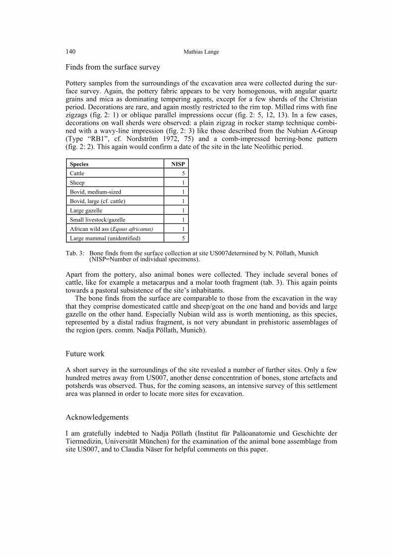
Species NISP Cattle 5 Sheep 1 Bovid, medium-sized 1 Bovid, large (cf. cattle) 1 Large gazelle 1 Small livestock/gazelle 1 African wild ass (Equus africanus) 1 Large mammal (unidentified) 5
Tab. 3: Bone finds from the surface collection at site US007determined by N. Pöllath, Munich
(NISP=Number of individual specimens).
Apart from the pottery, also animal bones were collected. They include several bones of cattle, like for example a metacarpus and a molar tooth fragment (tab. 3). This again points towards a pastoral subsistence of the site’s inhabitants.
The bone finds from the surface are comparable to those from the excavation in the way that they comprise domesticated cattle and sheep/goat on the one hand and bovids and large gazelle on the other hand. Especially Nubian wild ass is worth mentioning, as this species, represented by a distal radius fragment, is not very abundant in prehistoric assemblages of the region (pers. comm. Nadja Pöllath, Munich).
Future work
A short survey in the surroundings of the site revealed a number of further sites. Only a few hundred metres away from US007, another dense concentration of bones, stone artefacts and potsherds was observed. Thus, for the coming seasons, an intensive survey of this settlement area was planned in order to locate more sites for excavation.
Acknowledgements
I am gratefully indebted to Nadja Pöllath (Institut für Paläoanatomie und Geschichte der Tiermedizin, Universität München) for the examination of the animal bone assemblage from site US007, and to Claudia Näser for helpful comments on this paper.
Preliminary report on the Neolithic site US007, Us Island
141
Fig. 2: US007: Pottery from the surface survey.

Mathias Lange
142
References
Näser, C. 2005 Die Humboldt University Nubian Expedition 2005: Arbeiten im Bereich der Inselkonzession, Der Antike
Sudan. Mitteilungen der Sudanarchäologischen Gesellschaft zu Berlin 16: 49-67.
Nordström, H.-Å. 1972 Neolithic and A-Group Sites. The Scandinavian Joint Expedition to Nubia 3.1-3.2. Stockholm.
Schmitz, H.-J. 1983 Geologische Interpretation von Landsat-Bildern des NW-Sudan, Berliner Geowissenschaftliche Abhand-
lungen (A) 47: 95-108.