j - mineral resources tasmania
TRANSCRIPT
Prepared for: Tasmanian DeveloJ!..ment Authority22 Elizabeth StreetHobart Tas. 7000
-'n, -:3qq::J~, ,.......
308001
MINESI'lLE IlEi ..~t<;)'~'?:_
- 4 MAR 1993DOC. lIEF. .lU,~jo- -0fftC'..Ef' - -'58:- V J"!!.d,~.P. v~
Toe. JJ/)o·
A.A. ~_.,/
1'ttJ&}l/i'" .~
!.
L?"l~~T c...n.=
~c.i\1
By: Lindsay A. NewnhamB.Se., F.Aust. I.M.M.
Box 1002Devonport Tas. 7310
Phone: (004) 282 289Fax: (004) 282 781
MICROfiLMEDFiCHE No.ol4-2#-47
NEWNHAM EXPLORATION AND MINING SERVICES
97-3995MINERAL RESOURCE POTENTIALASSESSMENT-MT LYELL - 30M/SO
• L.A.NEWNHAM
MINERAL RESOURCE POTENTIAL ASSESSMENT
OF MINING LEASES HELD BY
MT. LYELL MINING AND RAILWAY COMPANYLIMITED
QUEENSTOWN, TASMANIA
3o~\~O
'.' .toI
IIIIII
•I
•I
•'.I
•IIIIII•
, I, \',• .:1 "'.\~ ,
c , DEPARTMENT
\,t
OF STATE DEVELOPMENT ANDDIVISION OF MINES
l '~".RESOURCES
308002
MEMORANDUM •~~!NES
Fll" l~" --<':;i', C::;6 'j~:..~"-:'
TO: M.W.D. Ayre- 5 MAR 199J--
DOC. REF. ll4 ;), ".~crq
FOIl '=LIFROM: Bill Baker AC110N
SEC. /P,SUBJECT: MTLYELL IN SITU LEACHING rt:Aou-r--- .... .fl.
Ie iLH"1. ,
DATE: 4 March 1993 ,- ,'l~
FILE NO: WEB13.93:MP i-~........,) )
" 1 v
I, Af> v
The Division of Mines has received proposals from Pasminco and Minproc for prefeasibility study of in situ leaching of copper at Mt Lyell.
PASMINCO
STAGE 1: $20000
(a) Small scale laboratory achievable extraction rates for copper.
(b) Isolation of suitable bacteria and estimation of their nutrient requirements.
(c) Preliminary flow sheet and process cost estimation.
STAGE 2: $100000 - $150000
(a) Column testing of copper extraction to give reagent requirements and productionrates.
(b) Detailed testing of solvent extraction! electrowinning procedures.
(c) Detailed costing of the process.
MINPROC
STAGE 1: $32000 + travel expenses
(a) Large scale laboratory and column extraction studies.
(b) Proven copper tolerant bacteria (Gunpowder, etc) available for study.
•\.'./ .. \
-, )
2
308003
, .
(c) Preliminary study underground at Mt Lyell to examine the problems of in situleaching.
STAGES 2 & 3: $54000
(a) Final investigations of bacterial leaching - flow sheets, mass balances, etc.
(b) Detailed mine study - ore breakage, solution management and optimum scale ofoperation.
The Minproc proposal appears to have the greater merit for the following reasons:
1. The pre-feasibility study goes further than that of Pasrninco in that it considersbulk ore problems and includes mining constraints.
2. Suitable bacteria are available to Minproc whilst they must be sought andcultured by Pasminco.
3. Although we are considering funding only the first stage of investigations the allup cost of the Minproc proposal is $86 000 + travelling costs, compared with$120 000 to $170 000 for the Pasminco proposal.
4. Minproc has no ties to any major mining company and this would give us greaterfreedom of action should the investigations prove successful.
Bill BakerMANAGER - LABORATORY SERVICES
c.c. Bob CallaghanChris BrooksBrian McBride
II 308004
CONTENTS
IPage Number
I 1. REPORT STATEMENT 1.
I2. SUMMARY 2.
3. INTRODUCTION 6.
I 4. OPERATIONAL TENURE 7.
5. SPECIAL REFERENCES 8.
I 5.1 Davies and Speechly Report 8.
5.2 Mt. Lyell. Technical Review 8.
I 5.3 Ore Potential Report 8.
I 5.4 Old Mines - New Visions (O.M.N.V.) 8.
6. MlNEIDSTORY 10.
I 6.1 Summary 10.
6.2 Historical Production 11.
I 6.3 Recent and Projected Production 11.
I 6.4 Mine Data Conventions 12.
7. CURRENT IDENTIFIED RESOURCES 13.
I 8. GEOLOGY 17.
8.1 General Comments 17.
I 8.2 Regional Geology 18.
I8.3 Local Geology 18.
8.4 EVOlution of Geological Thinking 20.
I 9. WEST LYELL AREA 23.
9.1 Introduction 23.
I 9.2 Production 23.
I9.2.1 West Lyell Open-cut 23.
9.2.2 Prince Lyell 24.
I 9.2.3 Royal Tharsis 25.
9.2.4 A-Lens 26.
I•
II 30800:>
I 9.3 Exploration 26.
9.4 Resource Potential 26.
I 9.4.1 Prince Lyell Depth Extensions 27.
I 9.4.2 Royal Tharsis and A-Lens Depth Extensions 28.
9.4.3 Shallow Open-cut Extensions 29.
I 9.4.4 Low Grade Mineralised Envelope Potential 30.
9.4.5 Waste Dumps 31.
I 9.5 Summary 32.
I10. CAPE HORN - ROYAL THARSIS AREA (WESTERN THARSIS) 34.
10.1 Introduction 34.
I 10.2 Known Deposits 34.
10.3 Exploration 35.
I 10.4 Resource Potential 35.
I10.5 Summary 36.
11. LYELL COMSTOCK· CAPE HORN AREA 38.
I 11.1 Introduction 38.
11.2 Production 38.
I 11.3 Exploration 39.
I11.4 Resource Potential 40.
12. NORTH LYELL AREA 44.
I 12.1 Introduction 44.
12.2 Production 44.
I 12.3 Exploration 45.
12.4 Resource Potential 46.
I 12.5 Summary 47.
I 13. COPPER CLAYS 49.
13.1 Introduction 49.
I 13.2 Production 49.
13.3 Resource Potential 50.
I
•
M
IIIIIIIIIIIIIIIIIII
•
14. OTIlER POTENTIAL RESOURCES
14.1 Blow· South Lyell Area
14.2 Precious Metals
14.3 Other Base Metals
14.4 Miscellaneous
15. RESOURCE EVALUATION STRATEGIES
15.1 Evaluation Requirements
15.1.1 Open-cut Potential
15.1.2 Underground Potential
15.1.3 Waste Dumps
15.2 Evaluation Methodologies
15.3 Critical Path Evaluation
15.4 Assessment Programs and Costs
16. REFERENCES
51.
51.
51.
52.
53.
55.
55.
55.
56.
56.
56.
57.
60.
61.
30800(,
308007
North Lyell Area - Isometric UIustration
Lyell Comstock· Cape Horn Area· Generalised Plan
Lyell Comstock - Cape Horn: Longitudinal Projection
Section of Mineralised Lenses· North of Cape Horn
North Lyell Area - Level PlansNorth Lyell Area - Level Plans
North Lyell Area· Section
Western Tharsis - Cross Section
Western Tharsis - Longitudinal Projection
West Lyell Area - Longitudinal Projection
Prince Lyell - Generalised Section
Prince Lyell- Detailed Section WL 701, WL717
Western Tharsis - Generalised Plan
Locality Map
Mine Layout and Access
Copper Price and Financial Performance
Mt. Lyell Production
Regional Geology
Aerial Photo· Principal Resource Areas
Fig. 24
Fig. 25
Fig. 13
Fig. 14
Fig. 15
Fig. 16
Fig. 17
Fig. IS
Fig. 19
Fig. 20
Fig. 21
Fig. 22
Fig. 23 (a)(b)
Fig. 7 Local Geology
Fig. S Schematic Cross Section
Fig. 9 Setting of Mt. Lyell Deposits - Sillitoe.
Fig. 10 Lyell Comstock Geology - Corbett
Fig. 11 West Lyell Area· Generalised Plan
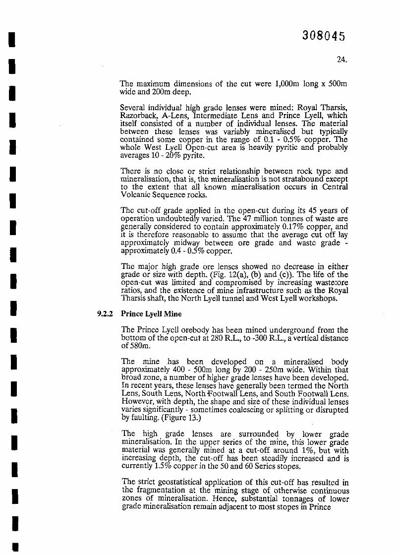
Fig. 12 (a), (b), (c).West Lyell Mineralisation at +400, +300, +200 R.L.
Prince Lyell Level Plans +100, -100, -300, -400 R.L.
Fig. 1
Fig. 2
Fig. 3
Fig. 4
Fig. 5
Fig. 6
FIGURES
IIIIIIIIIIIIIIIIIIIII
IIIIIIIIIIIIIIIIIIIII
TABLES
Table 1
Table 1
Table 3
Table 4
Table 5
Table 6
Table 7
TableS
Table 9
Table 10
Mineral Resource Potential Summary
Historical Production
Mt. Lyell Operating Statistics: 1976-92
Identified Resources - June 1992
Estimated Identified Resources - June 1995
West Lyell Production
Prince Lyell Production by Series
North Lyell Area - Production
Resource Potential - North Lyell Area
Resource Evaluation Strategic Plan
308008
IIIIIIIIIIIIIIIIIIIII
308009
1.
1. REPORT STATEMENT
Copper-gold-silver deposits at Queenstown are currently mined by the Mt. LyellMininS and Railway Company Limited, a wholly owned subsidiary of RenisonGoldfields Consolidated Limited.
R.G.C. has advised the Tasmanian Government that it will cease miningoperations no later than June, 1995, and relinquish the Lease no later than June,1996.
Because of the economic and social importance of the mine to Tasmania,Government has announced its desire to see operations continue beyond thisplanned withdrawal by R.G.C..
For this to happen, it will be necessary to demonstrate that mineral resourcesremain in the area, capable of profitably supporting a continuing operation,albeit of a technically different nature to the current operation.
Government has commissioned this report in order to highlight, and wherepossible, quantify, the potential for such resources. The report only deals withthe resource potential on the current mining leases.
Acknowledgement:
I gratefully acknowledge the advice and assistance of the staff of the Mt. Lyell Miningand Railway Company Limited, which was openly and freely given at all times.
308010
2.2. SUMMARY (Fig. 1, Table 1)
(i) Current mining operations are confined to the 50 and 60 Series stopes onthe Prince Lyell orebody. R.G.C. will cease operations when these twostoping series are completed - no later than June, 1995.
(ii)
(iii) The majority of this resource and resource potential falls into five discretegeographical locations:
- West Lyell (Prince Lyell, Royal Tharsis, and A Lens).Western Tharsis (Cape Hom-Royal Tharsis).Cape Hom-Lyell Comstock.
- North Lyell.Clays.
Based on mining and processing characteristics, the potential in theseareas can be broadly grouped into:
---
deep mineralisation amenable to underground miningshallow mineralisation amenable to open-cut miningwaste dumps.
•
(iv)
(v)
(vi)
In all cases, this potential must be confirmed by further geological, miningand metallurgical studies.
For each group, scope exists to innovate with mining and mineralprocessing technologies not previously implemented on a large scale atLyell. Sub level caving of deep resources, in situ solvent extraction, (bothunderground and on surface) and waste dump leaching, all requirefurther investigation.
A thorough evaluation of all these opportunities is unrealistic. Theresource potential of each area in each group should be ranked andfurther evaluation appropriately focused on the highest ranked areas ineach group: see Table 1.
Prominent in this Table is Prince Lyell below 60 Series. The orezone isshowing no decrease in size with depth, and copper and gold gradesappear to be increas~.The recently coml'leted hole WL7 lA_intersectedtrue width 0 m 0 2.73 copper, .98 - nne gold, and mil of .62 0
copper,:3 e ilo in 90 Series, Witliin a200m wide copperanomalous zone.
. resource potential exists at depthom areas. ?
•Combined, these three areas provide scope for an expanded undergroundoperation utilising different underground extraction methods such as sublevel caving.
In addition to Prince Lyell, subsin the Western Tharsis pe
~:.....;..--:-
(vii)
308011
3., ,. ,
(viii)
Davies and Speechly pointed out the advantages of sub-level caving to acontinuing Lyell operation and further detailed the current mining andprocessing constraints and solutions confronting an expandedunderground operation.
Areas such as Royal Tharsis, Crown Lyell, Cape Horn and LyellComstock have the potential to support modest open-cut operations.Each of these areas has a resource potential the range 1-5 million tonnesof 0.5-1.5% copper.
?•
(ix)
(x)
The copper clay deposits could support one or more modest open-cutoperations, but they would require their own processing plant whichwould produce a high grade copper concentrate. Some of the clays lie justoutside the existing Lease.
Large tonnages of low grade copper mineralisation exist firstly as in-situremnants around the former West Lyell open-cut and Prince Lyell :::>orebodies and secondly as waste dumps adjacent to West Lyell. •
(xi)
Waste dumps are estimated to contain 45 million tonnes of 0.17% copper.
This material may be amenable to modern solvent extraction (SX-EW)technologies, either on an in situ or mined basis. The resultant productwould be a high grade copper concentrate.
The North Lyell area, because of its relatively high proportion ofbornite mineralisation, easy underground access, altitude andgeographical location, is recommended for trialling the effectiveness ofSX-EW processes at Mt. Lyell. Any such trial should be preceded by aquality collation of the extensive, but currently disparate, resource
rmation on the area.
An integrated operation based on conventional underground and opencut production, SX-EW and copper clay operations could provide anopportunity for expanded output at Lyell.
tbe re auld b a strong argument for on sit:;;:; ==sOr:'==-=p"'roce':..=':':s'"'slnc="g of concsntrates, tillsing modern, clean, smelting /"
echnology, thereby reducing the current massive ex-mine costs.
(xiii) Alternatively the geographically and technically disparate nature of thepotential resources may support several commercially distinct operations.
/'
(xiv) Considerable technical and financial studies remain to be completed toevaluate the resource potential at Lyell.
(xii)
If a reasonable continuity of operations beyond 1995 is desirable, thenthese evaluation studies must be commenced by the end of 1993, or I
•r. :I'
308012
4
A strategic plan embracing an evaluation critical path is necessary, andshould co=ence with the drill evaluation of Prince Lyell 70 and 80Series, drill testing of Royal Tharsis open-cut area, and SX·EW studies atNorth Lyell.
,
•
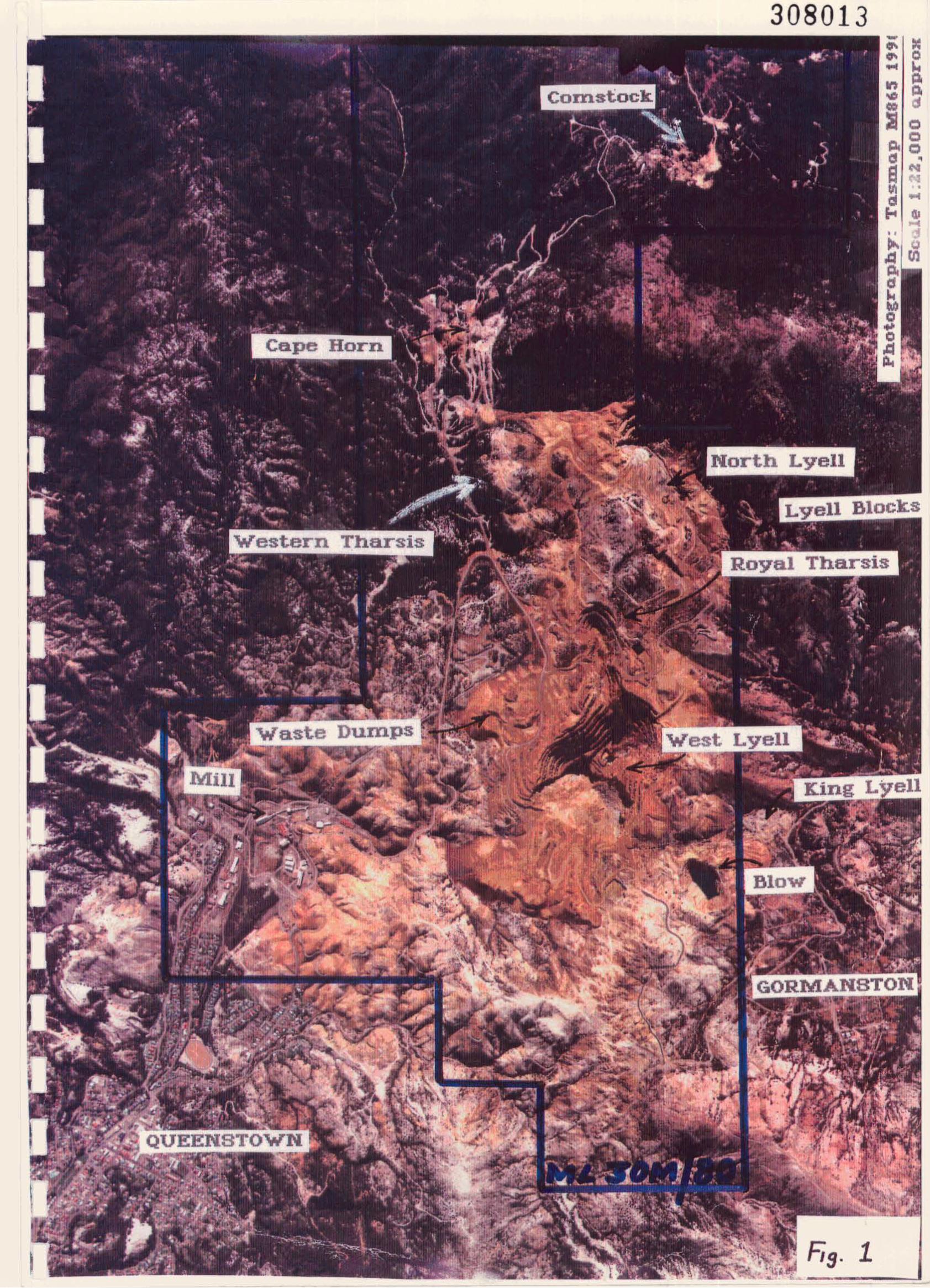
-Fis. 1
308013 - Ie'"'" 0.. ...It) Po
Po...00 d
:s c:l
lloc:lc:l
d •a ..'I
III •d .."" CIl...
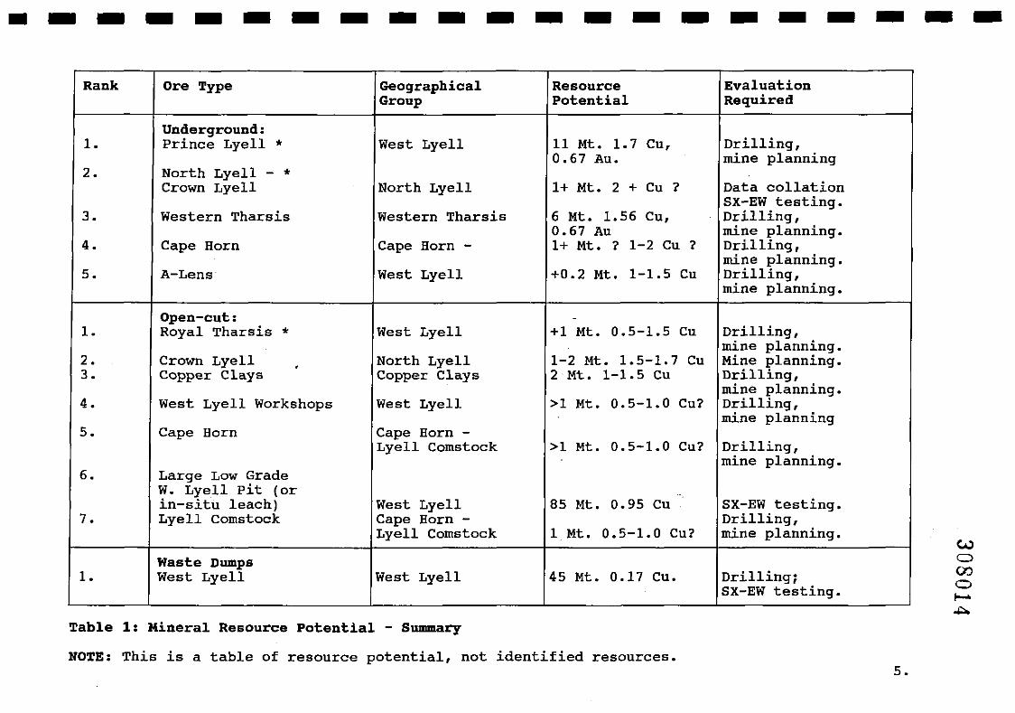
---------------------Rank Ore Type Geographical Resource Evaluation
Group Potential Required
Underground:1. Prince Lyell * West Lyell 11 Mt. 1.7 Cu, Drilling,
0.67 Au. mine planning2. North Lyell - *
Crown Lyell North Lyell 1+ Mt. 2 + Cu ? Data collationSX-EW testing.
3. Western Tharsis Western Tharsis 6 Mt. 1.56 Cu, Drilling,0.67 Au mine planning.
4. Cape Horn Cape Horn - 1+ Mt. ? 1-2 Cu ? Drilling,mine planning.
5. A-Lens West Lyell +0.2 Mt. 1-1.5 Cu Drilling,mine planning.
Open-cut: -
1. Royal Tharsis * West Lyell +1 Mt. 0.5-1.5 Cu Drilling,mine planning.
2. Crown Lyell . North Lyell 1-2 Mt. 1.5-1.7 Cu Mine planning.3. Copper Clays Copper Clays 2 Mt. 1-1.5 Cu Drilling,
mine planning.4. West Lyell Workshops West Lyell >1 Mt. 0.5-1.0 Cu? Drilling,
mine planning5. Cape Horn Cape Horn -
Lyell Comstock >1 Mt. 0.5-1.0 Cu? Drilling,mine planning.
6. Large Low GradeW. Lyell pit (orin-situ leach) West Lyell 85 Mt. 0.95 Cu SX-EW testing.
7. Lyell Comstock Cape Horn - Drilling,Lyell Comstock 1 Mt. 0.5-1.0 Cu? mine planning.
Waste Dumps1. West Lyell West Lyell 45 Mt. 0.17 Cu. Drilling;
SX-EW testing.
Table 1: Mineral Resource Potential - Summary
NOTE: This is a table of resource potential, not identified resources.5.
IIIIIIIIIIIIIIIIIIII
•
3.
308015
6.
INTRODUCTION
This report identifies the mineral resource potential on the Consolidated MiningLease 30 M/80.
It is clear that the potential is collectively substantial, but is varied in technicalnature and geographically disparate.
Without wanting to place inappropriate constraints on future exploration,mining or mineral processing technologies, it was considered important to makesome attempt to rank the various resource potentials in a practical and logicalsense, so that future technical and commercial evaluation of the field could beappropriately focused.
Hence, the report has placed the resource into five geographic categoriesconsidered to have the greatest potential:
West Lyell (Prince Lyell and Royal Tharsis)Western Tharsis (Cape Horn to Royal Tharsis)Cape Horn - Lyell ComstockNorth LyellCopper Clays.
Undoubtedly, additional potential lies outside these key areas, and may form thebasis for longer term exploration programs.
Most of the potential resources require further technical evaluation (drilling,mine planning and metallurgical studies), before they can be reported asidentified mineral resources and/or reserves, as per the Australasian Code forReporting of Identified Mineral Resources and Ore Reserves.
Substantial technical data bases exist at Mt. Lyell which will afford interestedparties the opportunities of more thoroughly assessing the resources in the fiveareas identified as having the maximum potential.
(i)
(li)
IIIIIIIIIIIIIIIIIIIII
4.
308016
7.
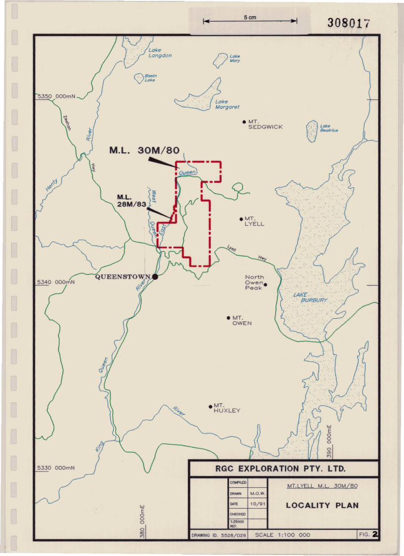
OPERATIONAL TENURE (Fig. 2)
Current operations are undertaken on mining leases 30M/80 and 28M/83 with acombined area of 1,236 hectares, issued under the Mining Act, 1929.
These Leases will expire at the cessation of operations in 1996.
The Lessee holds a Licence to Operate a Scheduled Premises issued under theEnvironment Protection Act, 1973, and operations are undertaken in accordancewith an Environmental Rehabilitation and Mana~ement Plan, dated 1992, whichdetails agreed environment management prescnptions, up to closure in June,1996.
Overall conditions covering operations up to June, 1996, are subject tolegislation, namely:
The Mt. Lyell Mining and Railway Company Limited (Continuation ofOperations) Acts 1985 and 1987.
The Mt. Lyell Mining and Railway Company Limited (Continuation ofOperations) Act, 1992.
If R.G.c. locates a new operator prior to June, 1996, then all legislativeconditions and obligations currently applying to the tenements will be assignedto the new operator, and any such arrangements would require Governmentapproval.
If a new 0l?erator commences operations beyond 1996, it will start with a cleanslate, requuinll aJ?proval of the development and environmental managementplans and the Issumg of a new Mining Lease and a new Licence to Operate.
5cm
308017
5350 OOOmN
OBa5inLak.
O La',Mary
~ke~~arel
wEogo'"'"
OLa"'. lkotric~
lAKEBUf?BUR't
.MT.LYELL
NorthOwen.Peak
• MT,SEDGWICK
• MT.OWEN
RGC EXPLORATION PTY. LTD.
.MT.HUXLEY
M.L.
QUEENSTOW~
~~e
5330 OOOmN
5340 OOOmN
<_lIDMT.LYELL M.L. 30M/eO
M.O.W.
DRAWING 10. ~528/029 SCALE 1: 1 00 000
wEoooo~
CLUE 10/g1 LOCALITY PLAN
IIIIIIIIIIIIIIIIIIII
•
5.
308018
8.
SPECIAL REFERENCES
Over a century of continuous mining operations at Mt. Lyell has resulted in anenormous data base of published and unpublished references on the mine.
Many of these were referenced in preparing this report and are listed in Section16.
However, four recent internal Mt. Lyell Mining and Railway Company Ltd.reports are worthy of special reference for anyone contemplating a continuinginterest in the longer term future of Mt. Lyell:
5.1 Davies and Speechly Report
"Preliminary Report to Mt. Lyell Copper Division of Renison GoldfieldsConsolidated limited. Lonll Term Planning Strategies for Mt. LyellOperations", by Edward DaVIes and Brian Speechly, 18 January, 1992.
This report addresses a range of technical matters confronting long termfuture 0l?erations at Mt. Lyell. The resource potential of the Lease andthe minmg options to utilise that resource are reviewed, includingdevelopment of a large open-cut and a change of underground miningmethod.
Mining and milling constraints and remedies confronting an expandedoperation are reviewed, including the desirability of downstreamprocessing through the application of new smelting technologies.
The report also positively addresses environmental considerations andproposes options for acceptable environmental management.
5.2 Mt. Lyell - Technical Review
This report, written late 1991, is an excellent and in-depth technicalreview of the geology, mining and mineral processing functions of Mt.Lyell.
It provides an in-depth statement on current operational methods,equipment and performance.
5.3 Ore Potential Report (Dufty Report)
"Progress Report on the Assessment of the Ore Potential of the Mt. LyellCopper Field" by M. Dufty, M. Flitcroft, and M. McKeown, 21st May,1991.
This report reviews the geological setting, known resource and resourcepotential of the Mt. Lyell Consolidated Mining Lease and adjacent areas.
5.4 Old Mines· New Visions (O.M.N.V.)
"Old Mines - New Visions" by M. Flitcroft and M. McKeown, 29thJanuary, 1992.
This substantial report is a visionary look at the potential remainingcopper resource at Mt. Lyell.
IIIIIIIIIIIIIIIIIIIII
308019
9.
It specifically highlights the substantial resources that may exist on theLease if a lower grade cut-off is applied and concludes that theseresources might support a large tonnage open-cut operation, and possiblyexpanded underground operations.
Geostatistical modelling and application are heavily relied upon insupport of these arguments.
10.
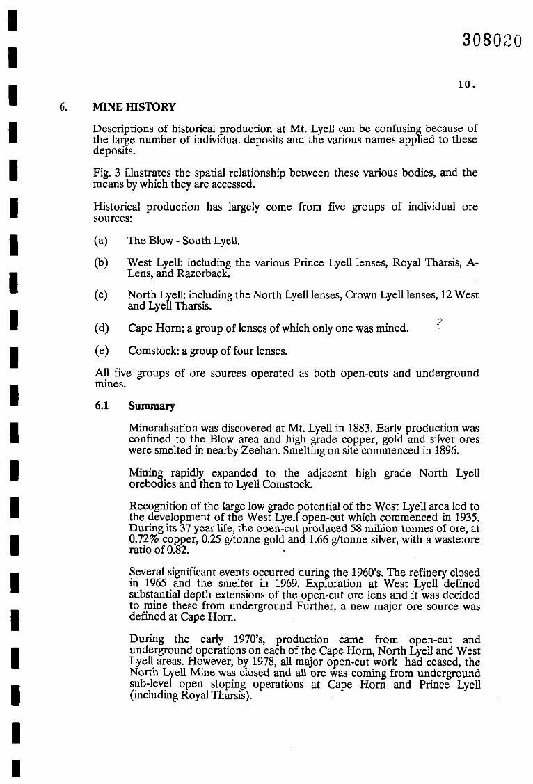
MINEIllSTORY
All five groups of ore sources operated as both open-cuts and undergroundmines.
308020
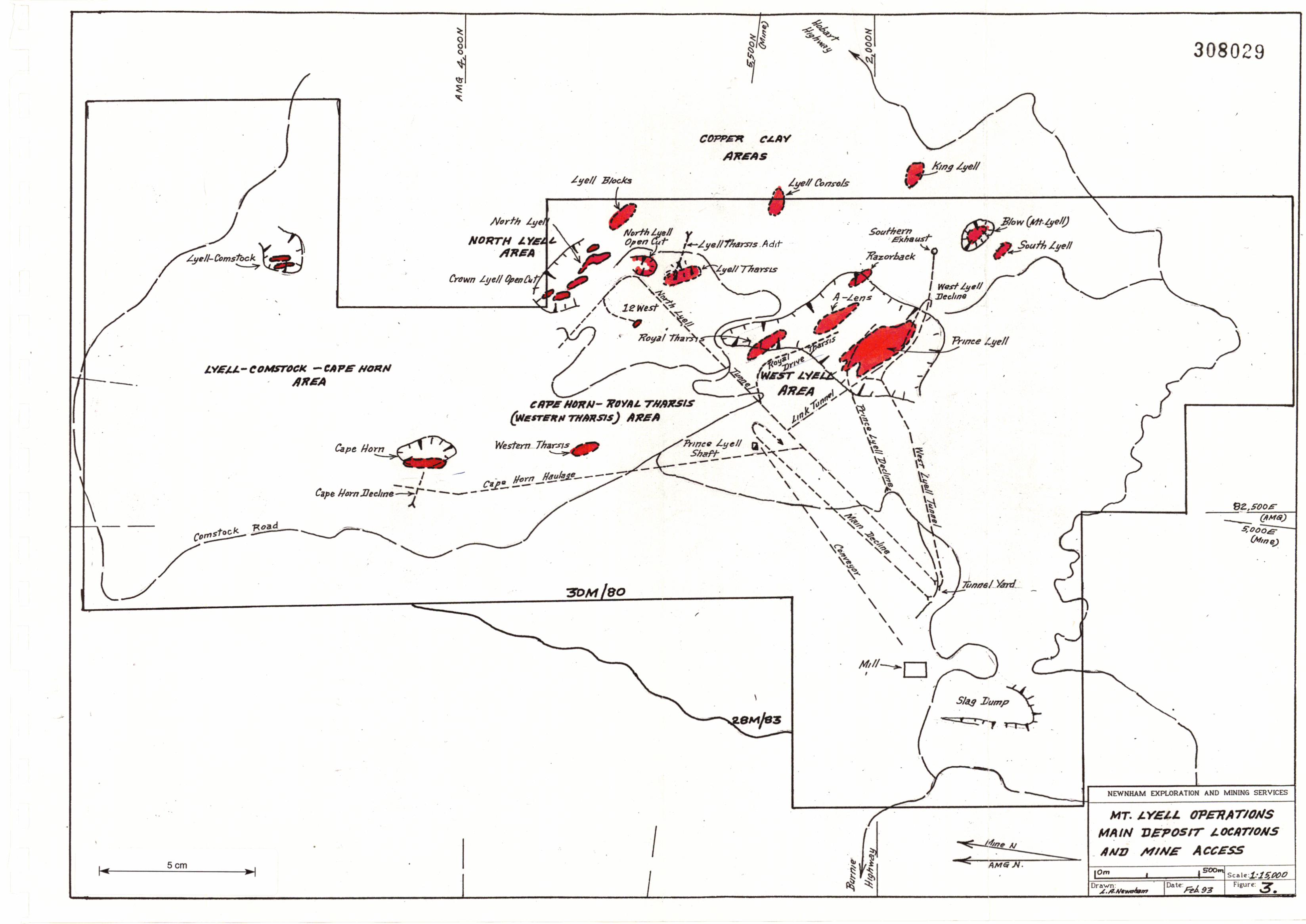
Cape Horn: a group of lenses of which only one was mined.
Comstock: a group of four lenses.
North Lyell: including the North Lyell lenses, Crown Lyell lenses, 12 Westand Lyell Tharsis.
?
The Blow - South Lyell.
West Lyell: including the various Prince Lyell lenses, Royal Tharsis, ALens, and Razorback.
6.1 Summary
Mineralisation was discovered at Mt. Lyell in 1883. Early production wasconfined to the Blow area and high Ilrade copper, gold and silver oreswere smelted in nearby Zeehan. Smeltmg on site commenced in 1896.
Mining rapidly expanded to the adjacent high grade North Lyellorebodies and then to Lyell Comstock.
Recognition of the large low grade potential of the West Lyell area led tothe development of the West Lyell open-cut which commenced in 1935.During its 37 year life, the open-cut produced 58 million tonnes of ore, at0.72% copper, 0.25 g!tonne gold and 1.66 g!tonne silver, with a waste:oreratio of 0.82.
Several significant events occurred during the 1960's. The refinery closedin 1965 and the smelter in 1969. Exploration at West Lyell definedsubstantial depth extensions of the open-cut ore lens and it was decidedto mine these from underground Further, a new major ore source wasdefined at Cape Hom.
During the early 1970's, production came from open-cut andunderground operations on each of the Cape Hom, North Lyell and WestLyell areas. However, by 1978, all major open-cut work had ceased, theNorth Lrell Mine was closed and all ore was coming from undergroundsub-leve open stoping operations at Cape Horn and Prince Lyell(including Royal Tharsis).
(c)
(d)
(e)
(a)
(b)
Descriptions of historical production at Mt. Lyell can be confusing because ofthe large number of individual deposits and the various names applied to thesedeposits.
Fig. 3 illustrates the spatial relationship between these various bodies, and themeans by which they are accessed.
Historical production has largely come from five groups of individual oresources:
6.
IIIIIIIIIIIIIIIIIIIII
IIIIIIIIIIIIIIIIIIIII
308021
11.
Cape Hom closed in 1987, leaving Prince Lyell and Royal Tharsis as thetwo dominant ore sources. Since 1992, all production has come fromPrince Lyell.
6.2 Historical Production
Total estimated production since 1896 is 109 million tonnes of 1.19%copper, 0.4 gltonne gold, 6.8 gltonne silver, containing approximately 1.3million tonnes of copper, 43 tonnes of gold and 740 tonnes of silver. Totalproduction estimates for each of the five groups of ore sources are shownm Table 2.
Ore Source Ore Tonnes (M) Cu% Aug/t Ag (glt)
West Lyell
Open-Cut 58.3 0.72 0.25 1.66Prince Lyell 28.5 1.29 0.40 2.91Royal Tharsis 2.0 1.56 0.49 2.77Razorback 0.2 1.10 0.24 1.48
North Lyell
North Lyell 4.7 5.28 0.40 34.29Crown Lyell & 12 West 4.0 1.62 0.37 6.67Lyell Tharsis 0.7 0.94 0.27 4.85
Cape Horn 4.1 1.43 0.42 3.30
Blow
Mt. Lyell & South Lyell 5.6 1.29 1.99 61.22
Lyell Comstock 1.3 2.38 0.67 5.23
Others 0.2
109.6 1.19 0.40 6.84.Table 2: Historical Production: 1896 • January, 1993.
6.3 Recent and Projected Production
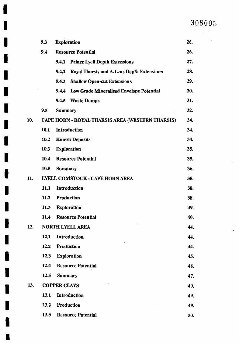
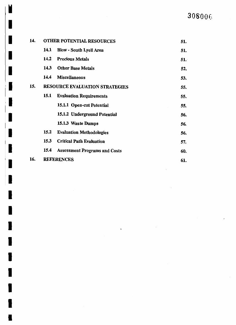
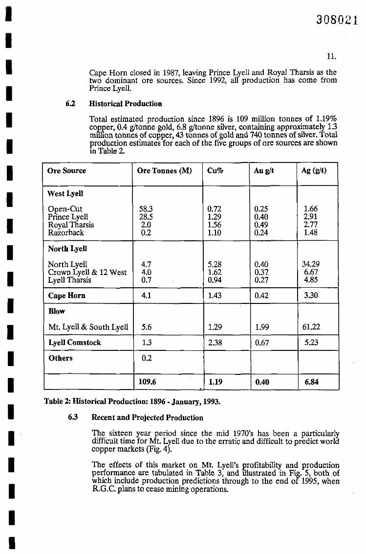
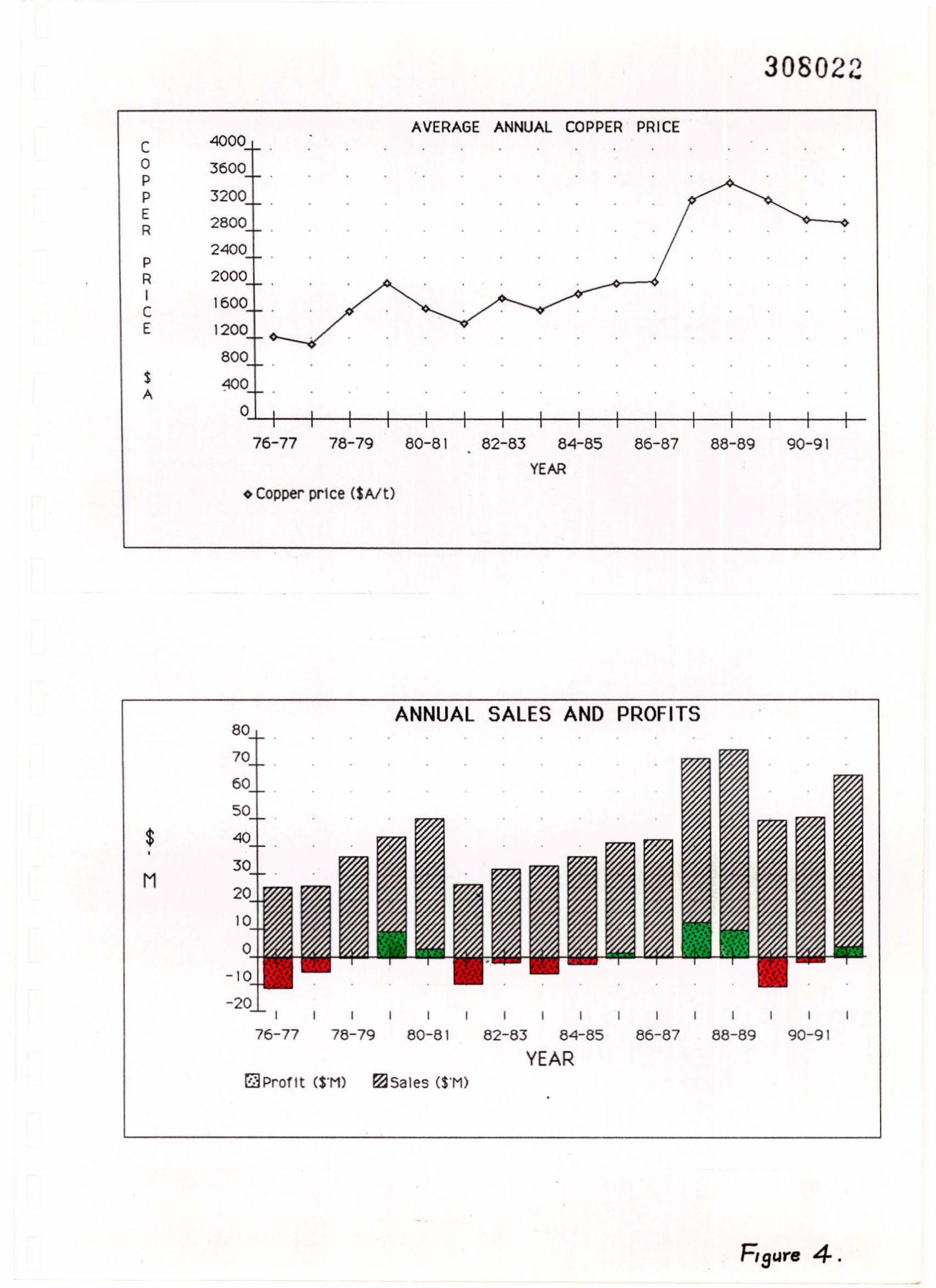
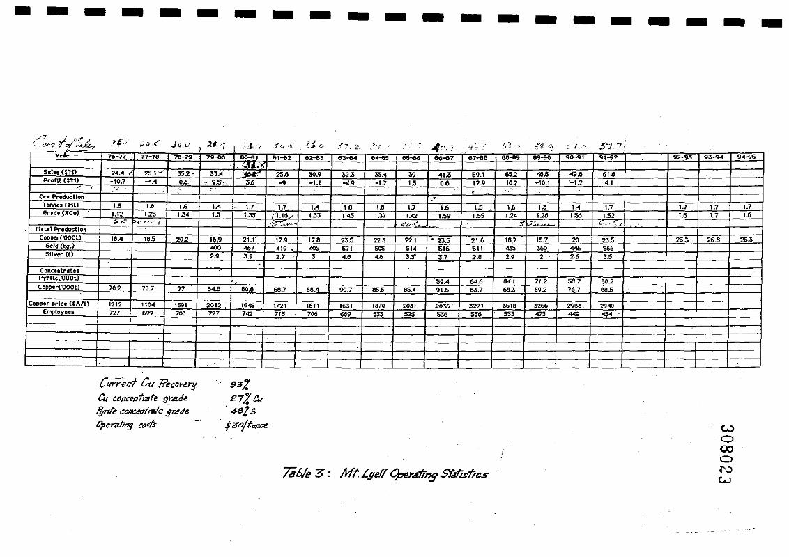
The sixteen year period since the mid 1970's has been a particularlydifficult time for Mt. Lyell due to the erratic and difficult to predict worldcopper markets (Fig. 4).
The effects of this market on Mt. Lyell's r.rofitability and productionperformance are tabulated in Table 3, and illustrated in Fig. 5, both ofwhich include production predictions through to the end of 1995, whenRG.C. plans to cease mining operations.
308022
AVERAGE ANNUAL COPPER PRICE
•
•
0'-'-+---+_-+--+---+--+--+---+--1--+---+-+-_+---+_+-_1-
SA
C 40000P • • •
P • • • •• • •
ER •
P • •
RICE
76-77 78-79 80-81 82-83 84-85 86-87 88-89 90-9 I•
YEAR~ Copper price (SAlt)
ANNUAL SALES AND PROFITS80
$•
M
I
76-77 78-79 80-81I I I I
82-83 84-85 86-87 88-89 90-91
YEAR[JProflt (S'Ml ~Sales (S'M)
Fi gUY8 4.-
• - - - - - - - - - - - - - - - - - - - -
wo00ol\.)
w
.." .,
g~J.
n/.tk. 4 81s13o/t'anne
Current C~ li'eaorerg
a, ClJl1centlate gradelftnte e_tr.rfe 5",'/e
tJperalinj Ca5ts
,t~f-4, ]~,/ ~Cr '? ;1.1, 7 ]''41\' 0; 0 Ii,2'. ,Jj"!' I
, ~. c.i ;~h ~. ..' -' . - . ~. '-(9-~ J~u .~'.J.,- r
92.... 93-941 9 ... ...g50<"" 05-06 66-87 87-60 O<HI. .....0 90"" 91-92v. ?6-n 77-78 715-79 7.-ilO O<HI. 81-82 82-83 83-e..
~.~32.3 "',< 39 .,.3 59.1 65.2 46.8 49.8 61.8S.les Ul1) 24.4 25.1 "'.2 • 33.• 25.8 30.9
10.2 -to.l "-1.2 <,IProm Ul1) -10.7 ..... 0.8 .9S. 3.6 -9 -1.1 "',9 -1.7 IS 0.6 12.9< , ., ., , ..
1.7
Or-. Producllon
1.3 I.. 1.7 1.7 1.71.7 I•• 1.8 1.8 1.7 1.6 IS 1.6• .6
Tonne~ (lil) 1.8 1.6 1.6 1•• 1.71.56 1.82 '.6 l.71.37 1.<2 • .59 1.55 .2< 1206rl<fe (KCu) 1.12 125 1.3< 1.3 ',35 1.115 1.3. 1.45
4&( , ~.....:... ("C.1 .;,.-'""- ~;;(-<:- '!.. '_·h-::_.~ ?J;: ."....-~
Metal Produdlon -20 23S 25.3 26.6 25.321.6 18.7 15.1CoppU'{"OOOt.) 18..4 lOS 202 16.9 21.1 17.9 17.8 23S 22.3 22,1 . 235 ... 360 4<6 566601.1 (k.a.) 400 467 419 .. 405 571 50S 51. 5" 511
'S 3,7 2" 2.9 2 2,' J.5Sliver (l) 2,9 J,9 2,7 J ... • .6.Concentr.les
'59.4 64.6 .... 1 712 58,7 602PYl"'llet"OOOtl
OS.4 91.5 03,7 ".3 592 76.7 60SCopper{"'OOOt) 70.2 70.7 n 64,6 60.8 ".7 .... 90,7 65S
1870 2031 2036 3271 3516 3266 2903 . 2940Copper price ($A/l) 1212 1104 1591 20'2 "45 1<21 16 " 1631
5J3 525 5J6 55. 553 475 4<9 45'En'Iployecs 727 .99 708 727 7<2 715 706 669
.
"'.'::', .',
/} s:
...,.,..0:...,.,.~.;.;:; .:........:'~:."t:; ':".::. ~l~.;
92-93 94-95
I
I -,
92-93 94-95I I I I I
84-85 86-87 88-89 90-91
YEAR
, , I
82-83 84-85 86-87 88-89 90-91
YEAR
ANNUAL TONNES COPPER PRODUCED
, -, -,
80-81 82-83
, ,
76-77 78-79 80-81
308024
r:'JTonnes ('MU c Grade mCu)
ANNUAL HEAD GRADE AND TONNES MINED
r;] Copper('OOOt)
I
76-77 78-79
30 I
27+- .
24 t
21+-
18 7:
:~~ @
~: ,~
IIIIIIIIIIIII
T
IH0US
I AND
I T0
INNES
III
•
IIIIIIIIIIIIIIIIIIII•
308025
12.
The significant increase in grade of the underground mine since 1986 canbe attnbuted to an increase in cut-off grade and the selective mining ofore lenses in the Prince Lyell mineralisea zone, rather than changes in theinherent nature of the ore bodies.
6.4 Mine Data Conventions
Mt. Lyell mine data is presented on a local mine grid. Mine North liesapproximately 8° 30' East of AMG. North.
Sea level = 00 RL., hence there are positive and negative RLs.
One hundred metre RL. slices are known as "series" to reflect the sublevel open stoping blocks. Hence
200 to 100 RL. = 20 Series100 to 00 RL. = 30 Series00 to -100 RL. = 40 Series, etc.
The old 11 Level (Tunnel Level) equates approximately to 200 RL.
13.
CURRENT IDENTIFIED RESOURCES
The June, 1992, resource estimates are shown in Table 4.
308026
Measured - drilling and exposures sufficient to confirm continuity ofmineralisation.
Probable ore reserves are defined as indicated resources on which all drilling hasbeen completed, but where mine planning is incomplete and dilution has notbeen proVIded for. Part of 60 Series is classified as probable ore. That part of 60Series which is neither a proven nor probable reserve is classified as an IndicatedResource.
Indicated - some drilling and exposures but continuity not yet confirmed.
Inferred - inferred from existing geological knowledge. Drilling andexposure insufficient to classify higher.
Proven ore reserves are defined as measured resources on which mine planninghas been completed and mine dilution provided for. In the case of Mt. L¥ell, allmeasured resources are also proven ore resources and include the remainmg orein 50 Series, together with some 60 Series material.
(b)
(c)
(a)
Mt. Lyell estimates its identified resources at least on an annual basis. The mostrecent report is:
"Statement of Ore Reserve Estimate and Reconciliation, June 1992" by M.J.Flitcroft and M. House, July, 1992.
The report quantifies identified resources, but does not address the resourcepotential of the Lease, in terms of either exploration potential or the applicationof lower cut-off grades. This is discussed further below in this report.
Identified resources are subdivided into:
7.
IIIIIIIIIIIIIIIIIIII
•
·_------------------~
Category Location Tonnes ( 'M) Cu% Au gft Ag gft,
Measured Resource
(Proven Reserves) Prince 50 and partPrince 60 Series 3.01 1. 78 0.51 3.05
Indicated ResourcePart of Prince60 Series 3.48 1. 60 0.48 2.98
Western Tharsis10-60 Series 6.00 1.56 0.54 1. 70
A-Lens 50 Series 0.20 1.50 .0.20 1.50
Crown III Pillars 1.20 1.60 0.40 4.00
Total Indicated 10.88 1.58 0.5 2.36
Inferred ResourcePrince 70 Series 5.5 1. 73 0.67 3.0
Prince 80 Series 5.5 1. 73 0.67 3.0Western Tharsis70 Series 1.6 1.56 0.54 1.7
Total Inferred 12.6 1.71 0.65 2.83
Total IdentifiedResources 26.49 1.66 0.57 2.66
wo00ol\:)
...... :Table 4: Identified Resources - June, 1992.
14.
IIIIIIIIIIIIIIIIIIIII
308028
15.
By June, 1995, all the current measured resources and Prince Lyell 60 Seriesindicated resource will have been mined.
Identified resources remaining at that stage, when R.G.C. ceases mining, will beapproximately 20 million tonnes of 1.65% copper and 0.6 gltonne gold, as shownin Table 5.
---------------------Location Category Tonnes ( 'M) Cut Au g/t Ag g/t
Prince Lyell
70 Series Inferred 5.5 1. 73 0.67 3.0
80 Series Inferred 5.5 1. 73 0.67 3.0
TotalPrince Lyell 11.0 1.73 0.67 3.0
WesternTharsis
10-60 Series Indicated 6.0 1.56 0.54 1. 70
70 Series Inferred 1.6 1.56 0.54 1. 70
Total westernTharsis 7.6 1.56 0.54 1.70
Crown IIIPillars Indicated 1.2 1.6 0.40 4.0
TotalIdentifiedResources 19.8 1.65 0.60 2.56
Table 5: Estimated Identified Resource - June, 1995.
16.
wo00o(..)
o
17.
GEOLOGY
308031
8.1 General Comments
Despite the large amount of exploration that has taken place on the Mt.Lyell field and the plethora of geological studies completed over a 100year period, there remains a strong diversity of opinion as to the origin ofthe Mt. Lyell mineralisation and the factors responsible for shaping thismineralisation into ore bodies and controlling the distnbution of thoseore bodies.
Most geological studies of Lyell have concentrated on either thegeological setting of the field, or details of specific ore bodies. Fewhave stood back and in the practical sense asked the question whyis Mt. Lyell where it is. In the whole of western Tasmania, nothingelse looks geologically like Mt. Lyell in terms of setting,deformation, mineralisation or size. Why is this so? What is specialabout the Mt. Lyell area, and is that important in terms of futureore discovery?
Most of the genetic and mineralisation control theories haveevolved with a somewhat myopt'ic concentration on the Mt. Lyell )(area, with little regional ovefVIdv of available information on newdiscoveries which are tending to indicate that base and preciousmetal deposits were forming in Palaeozoic rocks in a continuumfrom early Cambrian to mid Devonian. This fact should influencelong-term future exploration directions in the Mt. Lyell area.
No substantial mineralisation has been discovered at Mt. Lyell onthe basis of geological modelling. All known orebodies werediscovered by early surface prospecting and trenching, followed byeither pattern drilling or a combination of geophysics and drilling.Does this mean that geological studies are an ineffective tool fordiscovery at Lyell, or that such studies may play a part indiscovermg deeper concealed deposits in the future?
(c)
(b)
(a)
Much of the geological thinking reflects, in a general sense, the geolo~cal
theories popular at the time, the cyclicity of those theories, and the fIeldsof specialisation of the geologists. Hence, if a structural geologist isworKing on the field, everything tends to be interpreted structurally; if avolcanogenic geolo.gist is involved, everything tends to be interpretedvolcanogenically, etc.
This report is not intended to be a geological re'p0rt on Mt. Lyell, butrather an overview of the mineral resource potentIal of the field. Hence,~eological factors are only dwelt upon where they may have some directmfluence on ore discovery and defmition.
A selection of references is attached (Section 16) for readers wishing toread further on the geology of Mt. Lyell.
Several features of Mt. Lyell geology and exploration are worth noting:
8.
IIIIIIIIIIIIIIIIIIII•
IIIIIIIIIIIIIIIIIIIII
308032
18.
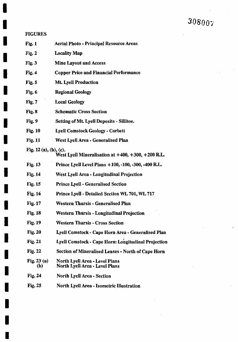
8.2 Regional Geology (Fig. 6 - From Corbett)
The principal Mt. Lyell deposits occur in a 4 Ian. long x 2 Ian. wide zone ofCambrian volcanics (Mt. Read Volcanics) and Cambrian-Ordoviciansediments, occurring at the intersection of the north-south Great LyellFault and the east-west Firewood Siding Fault, both of which areregarded as deep seated, thrust structures, active from the Precambrian tothe Devonian.
The Mt. Read Volcanics are dominated by feldspar phyric dacites andrhyolitic lavas of the Central Volcanic Sequence, overlain in the Northnear Comstock by andesitic volcaniclastics and sediments of the TyndallGroup.
The Mt. Read Volcanics are in faulted contact with the Upper Cambrian Lower Ordovician Owen Conglomerate. Unconformably overlying theOwen Conglomerate is a thin sandstone unit known as the Pioneer Bedswhich in turn is overlain by Lower Ordovician Gordon Limestone.
The region has been severely deformed on a number of occasions fromthe Cambrian to Devonian, resulting in greenschist metamorphism withaccompanying strong cleava&e development of the Central VolcanicSequence and a complex faultmg pattern.
It is instructive to note firstly that deformation in the Lyell area is moresevere than anywhere else in the Palaeozoic Dundas Trough in Tasmania,and secondly that the Central Volcanic Sequence is more intenselysheared and deformed than the overlying volcanoclastic and sedimentaryformations.
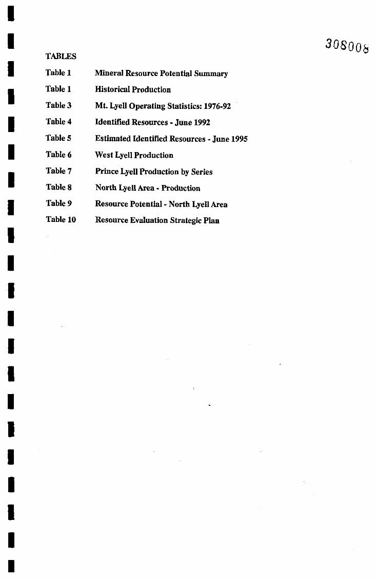
8.3 Local Geology (Fig. 7, 8 - after Hills)
The principal Mt. Lyell deposits occur in either Central VolcanicSequence felsic and mafic tuffs (Prince Lyell - Western Tharsis, CapeHorn) or near the contact of the Central Volcanic Sequence - TyndallGroup (Lyell Comstock) or near the contact of the Central VolcanicSequence and Cambrian-Ordovician sediments (North Lyell - LyellBlocks).
The area has suffered severe structural deformation dominated by earlymajor East-West faults, such as-the Firewood Siding Fault - Owen Faultand the North Lyell Fault, later regional thrust faults such as the GreatLyell Fault, and late stage NNW faults such as Glen Lyell Fault.
There is little agreement in contemporary literature on the structuralhistory of Mt. Lyell, including the sequence of faulting, the relative impactof each phase of faulting on the previous stage, and the relevance offaulting to ore genesis and ore locatIOn.
Alteration is widespread. Sericite-pyrite alteration is pervasive,particularly in the volcanic sequences but also in the Owen Conglomerate,Pioneer Beds and Gordon Limestone. Hematite-barite and silicahematite-barite alteration is common in the Central Volcanic Sequenceand the overlying sediments at North Lyell, and in the Central VolcanicSequence and Tyndall Group at Comstock.
Crimson Cn/l1k Formation - maficgf.y....ocktl. muds/one, bosofl
SUCCtlSS Crtlsk Group - sands/one,muds/one, dolomfl6
Mafic (tholeiitic) .i ultramafic rocks
Tyndall Group It'a/conics
Sf/chI Rang6 Beds - siliciclasticsands/one .i conglomsrole
W.sJ"rn volcano -sadimflnlarysBquftnc8s-Dundos Group, MI CnarlerGroup, Yolande Ri"er SeqlJ(lnce
Lo/s Cambrian, Ordovician 'andSiluro-Devonian SIId/mlln/orysequences
~ ~
~ ~ ~ ~
~ ~ ~ ~
~ ~ ~ ~ ~
......... PCm .......... ~ ~
~ ~ ~ ~ ~
~ ~ ~ ~
~ ~ ~ ~ ~
~ ~ ~
~~ ~ g
~ ~ ~ ~
BeddIng with facing
'-.__.i===~";.._;..'~'==~lO',"• : IScale
')(' Alina
PRECAl.48RIAH
~F'C" I R610fi,,!ly unmBtamorpho:oedL.£....::..:::. quorlz/flts <i" 510/65
~ Doyon/an granitel..!..2..i..J
r~:1 Mf!1taquarlzites, schists
rTI Post-Devonion coyer- rllrl/ory (T).L...!:.:!....J Permian-Jurassic (P-J)
~~~[]ffi
CAl,lilRIAN
Gma
m E:388888I AndtlsiJes and basalts~ B888288I•~ ~ [as/ern quarlr-phyrlc ssquencfI
j~ Granile .t (Sla!9d po,phyry (x)It:~
0-0
~
~I~ ,~,
J--\. "P-J '\ ......1
C...... -,
,/0-0
'-'
308033
--.--L ~
.~ .......... ~m
\ ~
\~
\>~ ~, ~
~
0-0
Sub-T.r1IQry occurrence
I) 0-0
I /.:"1-:.-', '
~.',""-: :-:~Y:I:"
,
,'-1• 4) + )
Geology of the central part of the Dundas trough from Mount Darwin Lo Moina, showingJistrilmtion of major lithologic associations of the Mount Read Volcanics belt and associated Cambrialland Proterozoic sequences, Based on published maps of the Mounl Read Voll:anies Project and Geological Survey.
"
II
I
II
I
I
I
I
II
I
I
I
I
I
II
Nf;WNHAM EXPLORATION AND MINING SERVICES
MDI/NT LYELL I/EPO,sITS'REGIONAL GEOL061CAL
SErr/lV~ (!'rom Corbelt199?J
SC.IlII':Do.tl':Dr.ll ......n:
..,Scm
•II
II
308034
-Local geological map of Mount Lyell, after Cox (1979, 1981)and Walshe and Solomon (1981).
v
v v
v v v
v v
v v v
V v
v v
v
v
v
v v
v v
" vv",v. v
~
II II V V
v
v
v
x
v
x
x
x
x
x
x •
x
x
x
x
x x xx x x
0
0 0 0 0 0 0MOUNT LYELL
0 0 0 0 0 0 0 0
NORTH ,..,0 0 0
v v ,, , v 0 0
v V v v
x v v v 0 0v v v
v \11 v 0vx v V
x
x
x
x
MN
Juulion Uneon'o,:mify I:
Felsic Pyroclastics (unit, EaF COl.1981) 1C
Altered Felsic Vok:onici (Mine Sequlnce unit O)"'r'-"'::...I_.s:<..!:!l~r.t!~.:.Intermediale a Felsic \olcanics(unilsA.B,sC) l(
metrea
'213
14
13
16
17
xOREBODIES
xI Mount Lyell (BlOW)
•2 South Lyell
•3 Ra.r:orbocllx4 Prince Lyell
x x3 A Len,x
6 Royal Tharaiax x7 Lyell Thor'ii
x xB North Lyell
x x9 Twelve Wilt
x x10 Crown &.rIllx x
a !lOa
ORDOVICIAN x
~ Gordon Group corbono1u I
~ Pione.,. bed'} x'VVV HoulOljll Unconformity Denison Group
~ Owen Conglomerat.
LEGEND
QUATERNARY
~ Glacial Moroin.
x •SILURO -DEVONIANx x ./
~ Eldon Groupx x • x v v
x x x x v v
CAMBRIAN
[[3 TyndOIl Group
I
I
II
I
II
I
II
III
I
II
II
Reproduced dtredf;j Prom 11,//$(1.9.90/
• Scm
o
o 0 0
o bOO
19.
EAST
",o~~o"..~~'
Q SEOS'O~
o 0 0
o 0 0 0 0 0
"I
308035
SCALE
Scm
I km (Cllll(OX)
(e)
large disseminated pyrite-chalcopyrite bodies such as West Lyell,Royal Tharsis, and Cape Horn;
bornite-chalcopyrite, for example, North Lyell and Crown Lyell (inpart);
massive pyrite-chalcopyrite (Mt. Lyell and South Lyell);
massive pyrite-galena-sphalerite-chalcopyrite (Tasman and CrownLyell);
native copper-cuprite-chalcocite in Gordon limestone (LyellBlocks, King Lyell, and Lyell Consols).
The ore bodies are very elongate, with depth:strike length ratios typically>4:1. They generally dip steeply 70-90°, and high grade lenses tend tooccur in clusters within a broader lower grade halo.
(c)
(d)
(b)
Mineralisation occurs in five basic styles:
(a)
o,
WEST
IIIIIIIIIIIIIIIIIIII
•
II
308036
II
HAULAGEUIICOHFORIf/TY
SILICA -HlI/ATITE-'ARITE
"fI LYELL 'LOCKS .fI TYPE G 0 ROO II
LIIfESTOIiE
D.1r' EH
CDIIGLD"ERATE
..
..
HEIlATlTE - IARiTE
aLDIr' __~~~;-'-~~~--~TYPE
." -'SERICITE _-----.;-;-.PYRITE
..
. .' ... .
. .'
HllICl LnLL _.;-t-t-ITYPE .
HT. READ . .'1DL CAllreS·· •• '
Approl.. \trticQIScale
'~CXlOm
"'IIERALlZ/IiG .;IfFLUIDS /
I
II
IIII
II
I
I
II
Scm
III
ThIS ar.twtns /S ~.ltel1 ",,.ecJI!llr,,m Silk/be {t96s)rBl'ortfor I'Gc.In the. /'BO~~" su;d;nT4J/JDdjt me tv,a'ence IV~
s"fMna'1I1 support"f~fMf;»;.,d #1,kamsmdeve"'pm~l1f ()f'.MY: ~J'~/IONlbdtlJeS - the ku/~ ~D"e.pt
IS enC4psullih!d In tl"s IM"lI'Mns,tI sedJD17
NEWNHAM EXPLORATION AND MINING SF:RVICES
SC/fEMAr/C SETTlNfi;S
DF Mr. ~YG~ ORE" Bo~"gSAND A,SSOCIIITEJ) A~T"'lfrtD"
frDm SiI/t'h>" 198£SCAliI':
•Drll;wn:
IIIIIIIIIIIIIIIIIIII
•
308037
20.
Studies at both Prince Lyell and North Lyell clearly show that thedistribution of mineralisation is not strictly lithologically controlled, withzones of continuous mineralisation commonly transversing formationaland lithological boundaries. Pyrite is abundant. In fact, the whole Mt.Lyell field can be regarded as one very large pyritic system. Massive 1020% pyrite zones in excess of 200m wide, 500m long and I,DOOm deepextend through the Cape Horn - Western Tharsis - Royal Tharsis andWest Lyell areas. There is a general, but not direct, relationship betweenpyrite and copper mineralisation. Most ore bodies occur within pyriticzones, although not necessarily in the most pyritic parts of these zones,and not all pyrite zones contain ore bodies.
8.4 Evolution or Geological Thinking
Geological thinking on the genesis of the Mt. Lyell ore bodies iscontinually changing and has an ominous cyclicity to it (Arnold).
Early this century, the ore bodies were generally considered to bereplacement types, with fluids derived from some deep magmatic body.
During the 1920's - 50's, they were considered simrly to be structurallycontrolled and probably Devonian age. In the 1960 s and 70's they werewidely regarded as volcanogenic accumulations formed during CambrianMt. Read Volcanism.
In the early 1980's, some Mt. Lyell geologists were recognising widespreadmineralisation in post Mt. Read volcanic sediments (Owen Conglomerate,Pioneer Beds and Gordon Limestone) in the North Lyell area, and hencechallenging the volcanogenic theories, in favour of structurally controlledhydrothermal replacement.
In 1984, Sillitoe, Brook and Bird, all noted extensive eupriferousmineralisation and associated silicification and hematite-barite alterationin post-Cambrian sediments at North Lyell, both on surface and inunderground workings.
They considered mineralisation in both the volcanics and youngersediments to be attnbutable to channelling of hydrothermal fluids alongthe western faulted (Great Lyell Fault) margin of an Owen Conglomerate.filled graben basin where it was cut and further deformed by the Lindagraben (Fig. 9).
Sillitoe also regarded the copper clay deposits at Lyell Blocks to bestructurally controlled hypogene mineralisation replacing GordonLimestone. He pointed to the facts that the deposits were developed on asteep 1O-15m wide structure and mineralisation changed to chalcocite atdepth.
These workers regarded the geological setting at Lyell Comstock to besimilar to North Lyell with extensive silica-barite-hematite alteration inthe Tyndall Group above the Central Volcanic Sequence.
21.
308038
, --"." 0.,
• •
<<
A
~
A
•. ",'
•• A
•
Brook further supported these general ideas of post Mt. Read volcanicore forming processes.
Corbett, however, maintains that the Lyell Comstock orebodies andassociated mineralisation are exhalative and hosted by andesitic volcanicsnear the Tyndall Group - Central Volcanic Sequence. He considered aprecursor of the Great Lyell Fault controlled hydrothermal andmineralising processes and interpreted the Comstock chert as a sinter. Hisreconstruction of the pre-deformation sequence in the Comstock area isillustrated in Fig. 10 and contrasts starkly with the concepts of Sillitoe forthis area.
Sillitoe postulated several genetic models:
a pre-Devonian stock at depth releasing fluids into both volcanicsand sediments in a' structurally prepared area;
metamorphogenic fluids released from Mt. Read volcanics duringearly deformation;
very late stage Mt. Read volcanic source which would require rapidaccumulation of Gordon Limestone and Owen Conglomerate;
connate brines generated by dewatering of an Ordovician-Siluriansedimentary basin west of Mt. Lyell with fluids structurallychannelled and trapped in the Lyell area.
Arnold interpreted and further refined Sillitoe's structural comments andsuggested the Great Lyell Fault was a strongly folded thrust plane,thereby explaining the structure of the Tharsis Ridge, which is an outlierof Owen Conglomerate.
More recently, Berry suggested the Owen Conglomerate accumulated ina confined basin whose margins were formed by significant structuressuch as the Great Lyell and Firewood Sidin~ and North Lyell Faults.These basin bounding faults then acted as mmeralisation conduits andtrap sites where ore fluids reacted with cooler connate waters derivedfrom Owen Conglomerate basin dewatering. This concept is not dissimilarto those of Sillitoe.
• •
< < <CENf.lMl. "~l.eAHfC. C(H1i'S.~1' <
< < <<
• - ........ .'-" " • A
• A 4
• • • AA
A A A AA ANlIEo&ITt:S
0 A
~ A • •A ~ ~ ~..
• •
•
IIIIIIIIIIIIIIIIIII
22.
Two important conclusions are:
308039
However, as Arnold points out, it is important at Lyell to avoid rigidmodels - an approach which has been conspicuous by its lack of orediscovery.
The Tyndall Group, Owen Conglomerate, Pioneer Beds andGordon Limestone may be important ore deposit hosts, and havebeen little explored to date.
Structure is probably a major factor in detennining ore bodylocation.
(b)
(a)
A rapid accumulation of late Cambrian-early Ordovician sedimentsdeveloped in a structurally controlled basin on top of these volcanics.Subsequent defonnation of this basin and the underlying volcanicsproduced both considerable remobilisation of mineralisation andhydrothermal activity alon~ major faults, resulting in the concentration ofmineralisation into orebodles in the volcanics and overlying sediments.
Irrespective of the details of the model, several features of Mt. Lyellgeology are noteworthy:
(a) Mt. Lyell occurs at the intersection of a number of major faultsand it is a very defonned area.
(b) The accumulation of sulfides in this structural focus was large;probably at least 10 million tonnes of chalcopyrite, 100 tonnes ofgold and 100+ million tonnes of pyrite.
(c) The orebodies are not lithologically bound.
It is important to draw a distinction in the light of these conceptualmodels between genesis of mineralisation and factors controlling orebody fonnation. The mineralisation may have had its genesis in theCambrian volcanics, but the factors controlling the concentration ofmineralisation such as major structures are more relevant to thediscovery of future orebodies.
In summary, these more recent genetic and ore forminil models aresuggesting that mineralisation was associated with Cambrian Mt. Readvolcanism which itself may have been influenced by deep seated ancientstructures.
IIIIIIIIIIIIIIIIIIII
•
9.1 Introduction
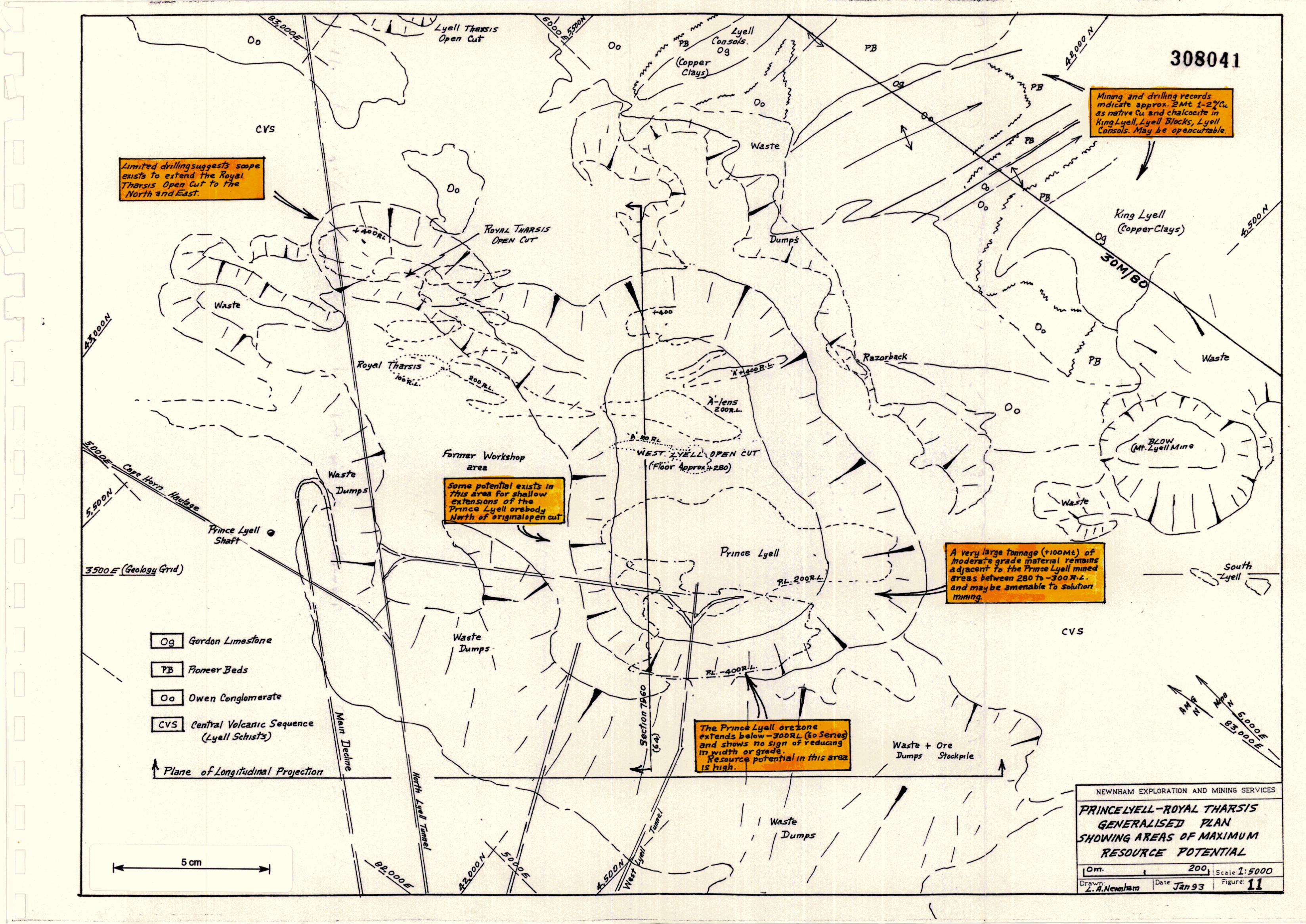
9. RESOURCE POTENTIAL - WEST LYELL AREA (Fig. 11)
Table 6: West Lyell Production (to December, 1992)
Ore Source Tonnes ('M) Cu% GradeAug/t Agglt
Open cut 58.3 0.72 0.25 1.66
Underground -Prince Lyell 28.5 1.29 0.40 2.91Royal Tharsis 2.0 1.56 0.49 2.77Razorback 0.2 1.10 0.24 1.48
89 0.92 0.3 2.1
)----Production
9.2.1 West Lyell Open-cut
The West Lyell Open-cut commenced operations in 1934 andremained in continuous production till 1978. Total production was58.3 million tonnes, 0.72% copper, 0.25 g/tonne gold, 1.66 g/tonnesilver at an average 1.3 million tonnes per annum, and a waste:oreratio of 0.82.
All current production is from Prince Lyell underground, and the bulk ofMt. Lyell's identified resources lie within that orebody. The mostsignificant resource potential on the Lyell field is also considered to liewithin this area.
The West Lyell area refers to a closely spaced group of higher grade orebodies occurring within a broad body of lower grade mineralisation.
The area includes the Prince Lyell, Royal Tharsis, Razorback, A-Lens andIntermediate Lens orebodies. CollectIvely they were mined near surfacein the West Lyell open cut and underground as individual mines on thePrince Lyell, Royal Tharsis, and A-Lens mines.
Some literature refers to the West Lyell style of mineralisation (beingdisseminated chalcopyrite-pyrite) and m this context the term is used todescribe a style of mmeralisation rather than a physical location.
The West Lyell area is the most productive section of the Mt. Lyell field.The mineralisation occupies an area of 1,000m x 750m and has beenvariably mined over a vertical depth of 800m. Production has amountedto 89 million tonnes of 0.92% copper, 0.3 g/tonne gold, 2.1 g/tonne silver,which represents approximately 63% of the total value of metal outputfrom the Mt. Lyell field (Table 6).
308040
23.
9.2
IIIIIIIIIIIIIIIIIIII
•
308042
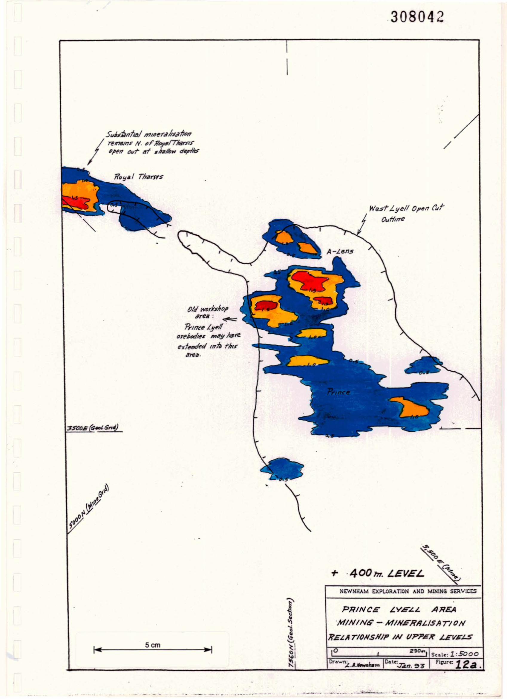
I
WestLyell OI'M t'utOu'fltl1e
/
A-1.ens
<'-=n-tn"'Y'f!
(J,~Mdlls m/l.!/M~
",I"""''''' tnt. Nitsd",•.
•
Subilnf",/ nfln"r4hhlfIMrUT«lnS- N.•FR#yI/Tkmrp,en cur 1ft slIJh", d"nz:.-
•
. .
+ ·400171. LEVEL
NEWNHAM EXPLORAnON AND MlNlNG SER.V1CES
Scm~I
PRINCE ~V.E~L AREA
'MINlNiI; - NfINLi"RRi./SA nON
"ELA rlONSHIP IN VPJI'eK kEVEt.S
,• _0 __._ .• ~.______ •• • .>~""- ......----- --~-~"'-~ • -- . . .
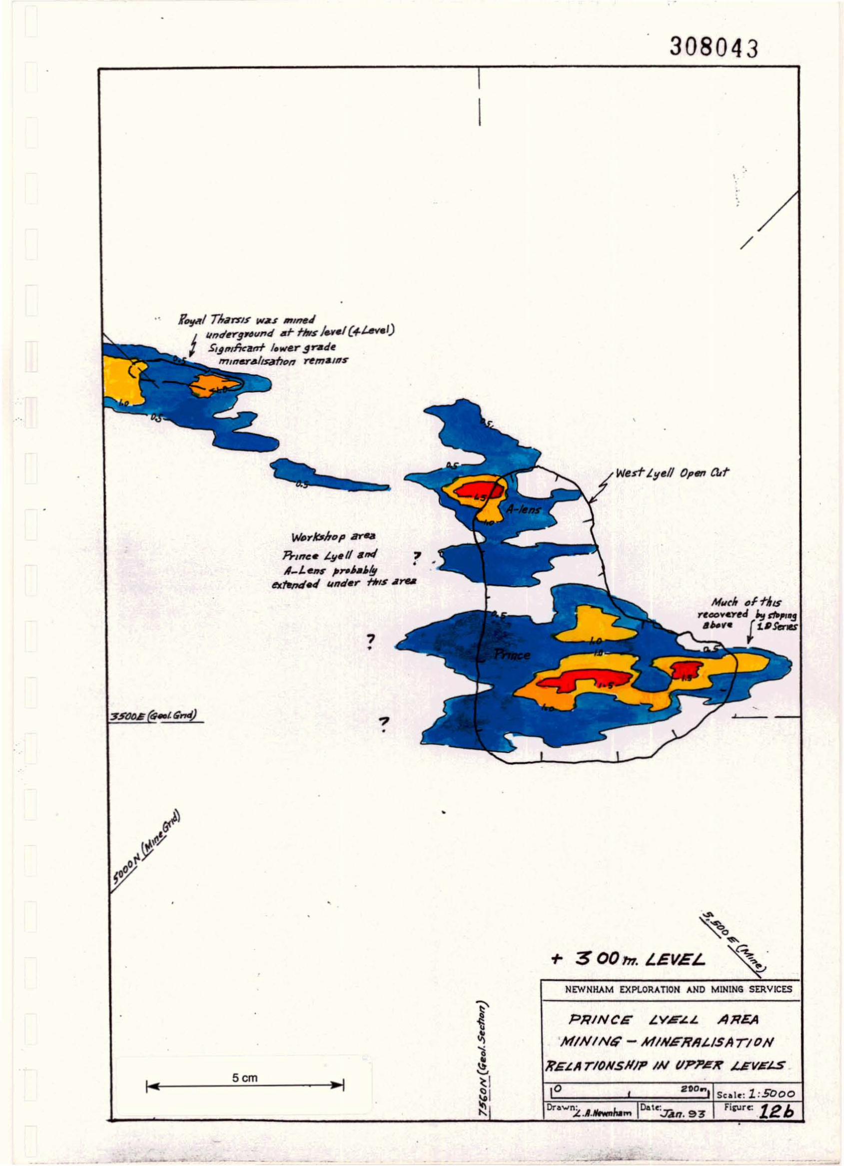
308043•
I,
/
-•
•
,
West L!lell 01'''' ad
7•
.,•
•
""'rblrDp _
1J..mce ~!I.I/ .".fA_J..., ,,70U#f!J
ex.,.",..,J un.er f/rIs ArM
Ft1!Jd/ TJ,I"lf WAS IIIJmtJi "",Ierg..und.r fir..1....1(+t-01)" 5J.I",l7canf In,~r ~ratl~
mlnar.IJS4'ht>11 ~m./IIS
..
.' .
•
• •
+ 300117. LEVEL
NEWNHAM EXPLORATION AND MINING SERVICES
5cm~I
PRINCE L.YE~,l AREA
'MININt;' -I4INERR,lISArJON
li'E~1ITIONSNIP IN VPJDeJr ~VELS
Oa"'~ Fi""c 12bV~". 93•
•
308044
I..• •
•
/
..5 uJ"t..ntJ.1 l"waY graaamar.n.J remams 6nuru/
RO!l.J rJ.rs1s
L"wesf" 1• .,./1(°9.1 71ta'f'"SIS
cut t F,ll ulUlersro"mJ
..
•
,
711.. ;'off;,m .1 f;'~
V ..sf- Lyoll 0l',n-cuf
w.s 22.0 ~.L. overR--1nC'. 4rtJ 24-0 11.L. over'
A-Lens.
NU<h of fh,s/ re",,,."'" mtne.ra!Js.n'J"n
"",V 1t3.,. caved . ,
• '.
• •
~..,"0'"+ 2.00 m, LEVEL ,
NE'HNHAM EXPLORATION AND MINING StR,vICES
•
Fia;urc
Sale: 1:5000o..tr.~
,.J4JT, 93'
PRINCG LYE~.L AREA
'MININt; - MIN.GRI1LISATIDN
l?GLII rlONSNIP IN VPJ'eK 4£VEI..SScm
IIIIIIIIIIIIIIIIIII•
308045
24.
The maximum dimensions of the cut were 1,000m long x 500mwide and 200m deep.
Several individual high grade lenses were mined: Royal Tharsis,Razorback, A-Lens, Intermediate Lens and Prince Lyell, whichitself consisted of a number of individual lenses. The materialbetween these lenses was variably mineralised but typicallycontained some copper in the range of 0.1 - 0.5% copper. Thewhole West Lyell Open-cut area is heavily pyritic and probablyaverages 10 - 20% pyrite.
There is no close or strict relationship between rock type andmineralisation, that is, the mineralisation is not stratabound exceptto the extent that all known mineralisation occurs in CentralVolcanic Sequence rocks.
The cut-off grade applied in the open-cut during its 45 years ofoperation undoubtedly varied. The 47 million tonnes of waste are~enerally considered to contain approximately 0.17% copper, andIt is therefore reasonable to assume that the average cut off layapproximately midway between ore grade and waste grade approximately 0.4 - 0.5% copper.
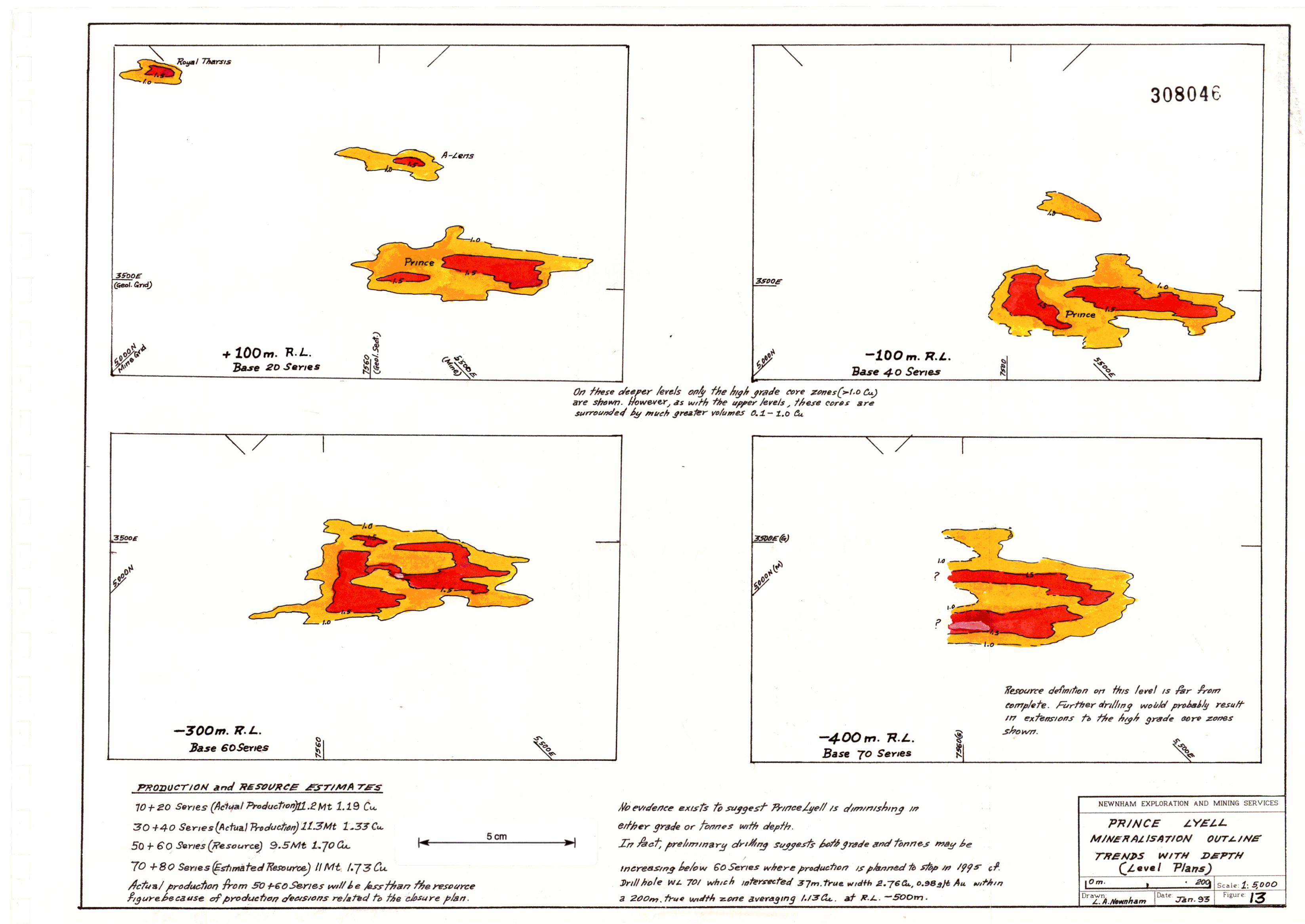
The major high grade ore lenses showed no decrease in eithergrade or size with depth. (Fig. 12(a), (b) and (c)). The life of theopen-cut was limited and compromised by increasing waste:oreratios, and the existence of mine infrastructure such as the RoyalTharsis shaft, the North Lyell tunnel and West Lyell workshops.
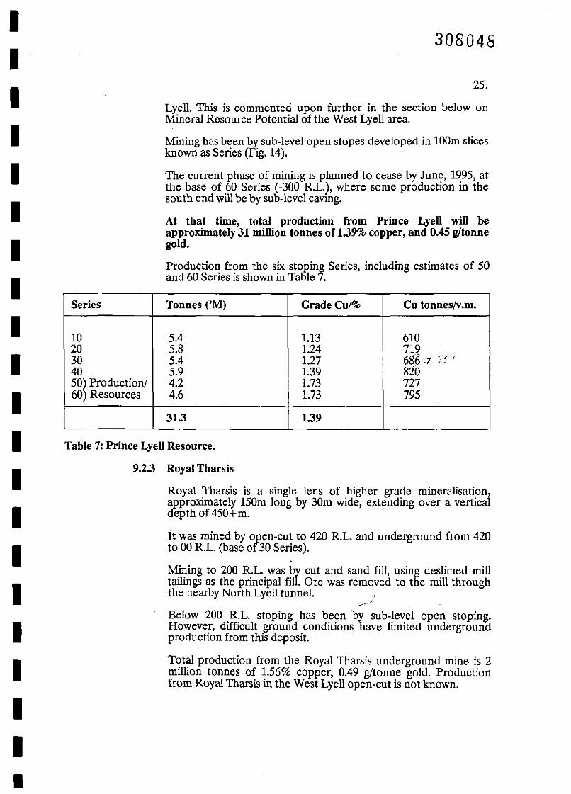
9.2.2 Prince Lyell Mine
The Prince Lyell orebody has been mined underground from thebottom of the open-cut at 280 R.L., to -300 R.L., a vertical distanceof 580m.
The mine has been developed on a mineralised bodyapproximately 400 - 500m long by 200 - 250m wide. Within thatbroad zone, a number of higher grade lenses have been developed.In recent years, these lenses have generally been termed the NorthLens, South Lens, North Footwall Lens, and South Footwall Lens.However, with depth, the shape and size of these individual lensesvaries significantly - sometimes coalescing or splitting or disruptedby faulting. (Figure 13.)
The high grade lenses are surrounded by lower grademineralisation. In the upper series of the mine, this lower gradematerial was generally mined at a cut-off around 1%, but withincreasing depth, the cut-off has been steadily increased and iscurrently 1.5% copper in the 50 and 60 Series stopes.
The strict geostatistical application of this cut-off has resulted inthe fragmentation at the mining stage of otherwise continuouszones of mineralisation. Hence, substantial tonnages of lowergrade mineralisation remain adjacent to most stopes in Prince
IIIIIIIIIIIIIIIIIIII
•
308048
25.
Lyell. This is commented upon further in the section below onMineral Resource Potential of the West Lyell area.
Mining has been by sub-level open stopes developed in 100m slicesknown as Series (Fig. 14).
The current phase of mining is planned to cease by June, 1995, atthe base of 60 Series (-300 RL.), where some production in thesouth end will be by sub-level cavrng.
At that time, total production from Prince Lyell will beapproximately 31 million tonnes of 1.39% copper, and 0.45 g/tonnegold.
Production from the six stoping Series, including estimates of 50and 60 Series is shown in Table 7.
Series Tonnes ('M) GradeCu/% Cu tonnes/v.m.
10 5.4 1.13 61020 5.8 1.24 71930 5.4 1.27 686,/ )';---;
40 5.9 1.39 81050~ Production/ 4.2 1.73 72760 Resources 4.6 1.73 795
31.3 1.39
Table 7: Prince Lyell Resource.
9.2.3 Royal Tharsis
Royal Tharsis is a single lens of higher grade mineralisation,approximately 150m long by 30m wide, extending over a verticaldepth of 450+m.
It was mined by open-cut to 420 RL. and underground from 420to 00 RL. (base of 30 Series).
.Mining to 200 RL. was by cut and sand fill, using deslirned milltailings as the principal fill. Ore was removed to the mill throughthe nearby North Lyell tunnel. )
/----
Below 200 RL. stoping has been by sub-level open stoping.However, difficult ground conditions have limited undergroundproduction from this deposit.
Total production from the Royal Tharsis underground mine is 2million tonnes of 1.56% copper, 0.49 g!tonne gold. Productionfrom Royal Tharsis in the West Lyell open-cut is not known.
308049
•o
-
---I
.--~
-
••
••
•
ow."Cong/tJrn .....te
••
Esutn/ltetl rUIJ"rtQ Y~1114111$.sur!a('-70S.YI'S· W,IfIIIf 0.5 t'u:
~n.,./()~:
Al'p,,,,,. 9G1rl1: D.S-I.oilL(Fhtl:roft, M'i/',...II7)
7Jla II1cN4es !fl/1c." if!tJ!lltrhl"fIS~
A-~."r~ K"'z#~8~K
Much Dr tins will b, 4H~t:tetl t""v41JjJn9 e/'.Jrels h.!l IInJcryr,umlC~"'/1.$ 'I"Y4tJ"n.s.
- .----1
,
..
,
NEWNKAM EXPLORATION AND MINING SERVICES
•
PRINCE LYELL
t;EN£RALISE.1J C'ROSS SECTION
NORTHERN END (secti." 7560A",DX)
IOn, !
••
•
•
••
•
•
•
••
o
--WesT" Lyr~~ O'4N Cvr
1?-"ducfton S"BM-t t'J.72C",,-,o.'ZSAI.4
--
--I
- oOR.L.
1 (} Sr,.,~s
Scm
w«srLy.11 N'8st"e ;Dumps
4- 5Mr D./7,""
J
00 7f.~.
l!-tnco '!loll t"CJ1.rI.rts ,,/it
"~""S ,Fm6,/~r;'/~h.Ir4ltl'.;."sw~ lIP.nm,r4USlOAl'
IVlfW/11 I (I,ptfr IJMmZMS'
Z 4/1«(>4.$c..);"""'NJ.., """I."/dl:JO-ISt%:'/F'F./"p,JI ,ntl n~4JtCISS oP /l!OO"" tI.pt'h.
•
1---
Dn....n:~--------- J.:...L. ./</""",;'.111 0&\(: :Un 93 I Fi;urr. 15
-SOD
80 SEi{/[;S
90 SERIES
~I
Base 60 SerIes-300 1i'.~.
70 S£7?IES
..22". (trJle WIdth)/.78 £4.
PHINCE .t.YG~
CROSS SECTION
70 lind eo S~/£S
NoRrN £N:ZJ
NEWHHAM OCPLORATION AND MINING SERVICES
5cm
10m- 40 t Sce.i~: 1: 1000[)re.'1~A.!IeI'o'I1barnIWIl~.Tan9.3' I rj~;.;re: 16
0/
~-..:
18",1..6. Cu (rru<!WJth)0.3 All
\ .\.:!\
"ThIS t."oml)llflf~ sedlll1 Incorporales "'14:1m" "'Me sem""s 64-N(7560) lind 65(7530)
TltIS ft""tetldn/ltn.9 mdtc-'tes flt,,:fl1-1I7Ce Ly"// IS NOr
~duCJ1M In sIze With depth ~ ""I,,!rr.96/J Jlnd~DppteY9Y6t!LS
-5 be I"CTftUI"!J'
W./. 701 lI."d w./. 717 drll/~d tr7 /.990-9/ h1ro fAe/1orfttem mll.r:9'" of' l1-tnc~L!I"1/ ",<1'tared fM.trl'lo 1r1.,9hSY4.dQ le..ns-ru "p /I'1lner4//silTll1n mag
~nd ..t Ins! <!oom.J,elow 60Se"es, ;rnd passIM!!
e¥rend lurfttertVorftt t;,,,,, /,nmous!g tb.usht «.. LOrts·"&qj)
Be/ow -~okJ.. r;'(y ",ere PrMVC"'"n7B/7UII/(y.
Gr~de &#nfi,vrs aJ,DI'e..-3,50MJ?L. weredenyee' ~ntlJ1 DlO~K h16d~1 SI~ftt,dS
-SOORI-
I
II
•
I
I
IIIIIIIIIIIIIII
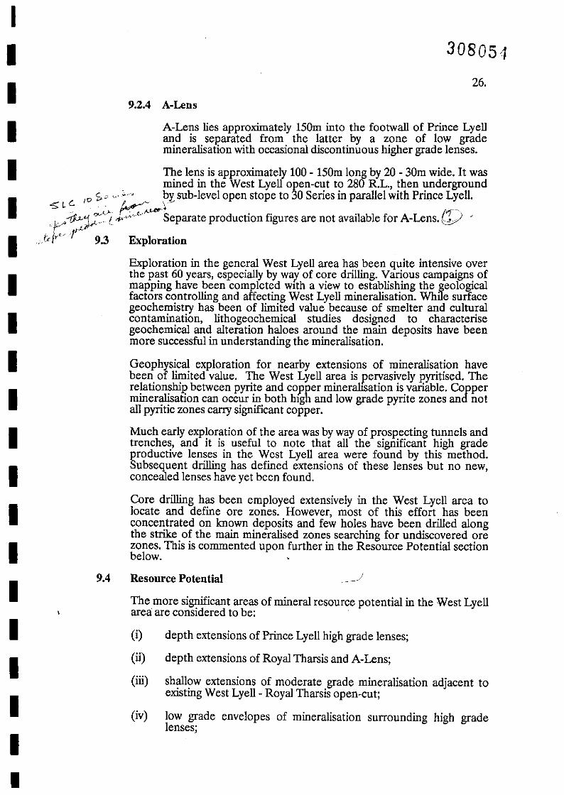
9.2.4 A-Lens
26.
308051
A-Lens lies approximately 150m into the footwall of Prince Lyelland is separated from the latter by a zone of low grademineralisation with occasional discontinuous higher grade lenses.
The lens is approximately 100 - 150m long by 20 - 30m wide. It wasmined in the West Lyell open-cut to 280 RL., then underground
c .. by sub-level open stope to 30 Series in parallel with Prince Lyell.<0: cCo ,0 ,v k:~..-'tY ..Iv"--r:P-)::.:'t. ,..,.~c<.e,c Separate production figures are not available for A-Lens.l[) ,. 1,J-
Irfr~ . 9.3 Exploration
Exploration in the general West Lyell area has been quite intensive overthe past 60 years, especially by way of core drilling. Various campaigns ofmapping have been completed WIth a view to establishing the geologicalfactors controlling and affecting West Lyell mineralisation. While surfacegeochemistry has been of limited value because of smelter and culturalcontamination, lithogeochemical studies designed to characterisegeochemical and alteration haloes around the main deposits have beenmore successful in understanding the mineralisation.
Geophysical exploration for nearby extensions of mineralisation havebeen of limited value. The West Lyell area is pervasively pyritised. Therelationship between pyrite and copper mineralisation is variable. Coppermineralisation can occur in both hIgh and low grade pyrite zones and notall pyritic zones carry significant copper.
Much early exploration of the area was by way of prospecting tunnels andtrenches, and it is useful to note that all the significant high gradeproductive lenses in the West Lyell area were found by this method.Subsequent drilling has defined extensions of these lenses but no new,concealed lenses have yet been found.
Core drilling has been employed extensively in the West Lyell area tolocate and define ore zones. However, most of this effort has beenconcentrated on known deposits and few holes have been drilled alongthe strike of the main mineralised zones searching for undiscovered orezones. This is commented upon further in the Resource Potential sectionbelow. .
depth extensions of Prince Lyell high grade lenses;
depth extensions of Royal Tharsis and A-Lens;
shallow extensions of moderate grade mineralisation adjacent toexisting West Lyell- Royal Tharsis open-cut;
low grade envelopes of mineralisation surrounding high gradelenses;
(i)
(li)
(iii)
(iv)
Resource Potential
The more significant areas of mineral resource potential in the West Lyellarea are considered to be:
9.4
IIIIIIIIIIIIIIIIIIII
•
IIIIIIIIIIIIIIIIIIIII
30805~)
27.
(v) waste dumps.
9.4.1 Prince Lyell Depth Extensions
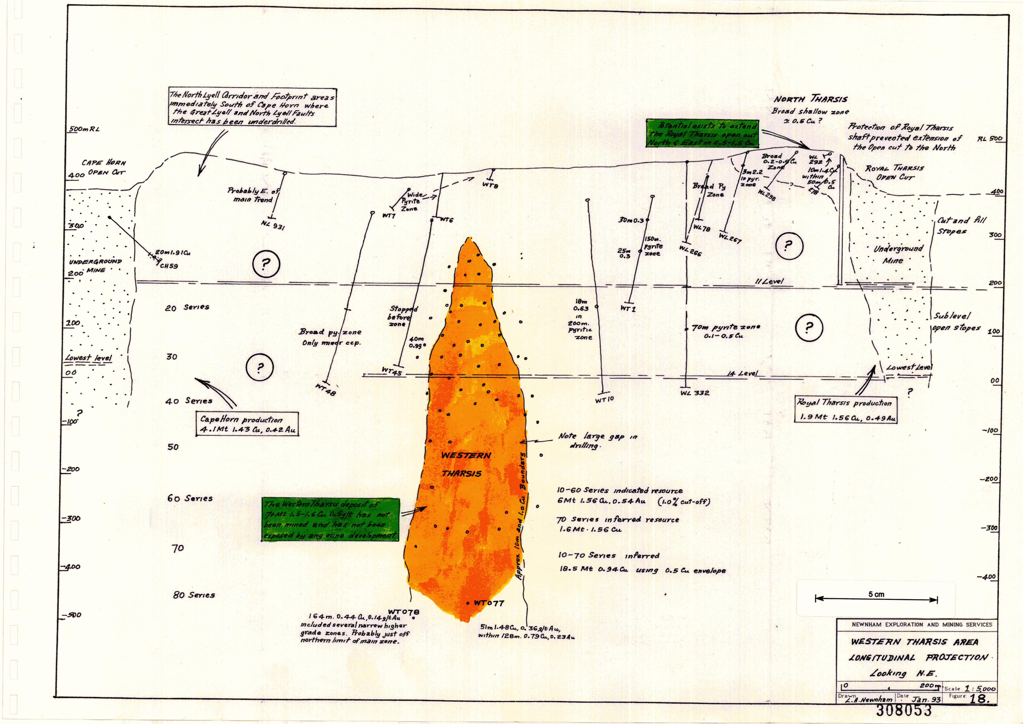
Production and resource estimation data demonstrate that there isno diminuition of the Prince Lyell ore zone in either grade or sizewith depth. In fact, available data can be interpreted to suggestthat copper and gold grades are increasing with depth.
Production from 50 Series is due to finish in June, 1993, and willtotal approximately 3.8 million tonnes of 1.63% copper.
Production from 60 Series has already commenced and is due forcompletion by June, 1995. Estimated total 60 Series production is3.8 million tonnes of 1.67% copper.
The pre-mining resource figure for 50 and 60 Series combined was9.5 million tonnes of 1.7% copper.
In July, 1992, Mt. Lyell estimated an infeceed resource in each of70 and 80 Series of 5.5 million tonnes of 1.73% copper, 0.67gltonne gold, 3.0 glt silver, being a total of 11 million tonnes ofthose grades.
This estimate was based on detailed drilIing information availablein 60 Series and the top of 70 Series, and only a very few drill holesin the main part of 70 and 80 Series.
In fact, it may be that the resource potential of Prince Lyell below60 Series is better than that shown in the June, 1992 inferredresource figure, because of an apparent increase in grades withdepth.
Arguably, two of the best intersections on the whole Mt. Lyell fieldwere recently obtained in deep drill holes below 60 Series:
WL 701 intersected both a North and South Lens in 90Series. In the North Lens, 200 m below 60 Series, itintersected a true width of 37m of 2.76% copper, 0.98g!tonne gold, and in the South Lens, 275m below 60 Series,18m of 1.62% copper, 0.3 g!tonne gold.
WL 717, 50m below 60 Series, intersected 45m of 2.44%copper, 0.58 g!tonne gold in the North Lens and didn'treach the South Lens.
These are exciting intersections. Their locations are shown on i1.longitudinal projection (Fig. 14), generalised section (Fig. 15) and ~detailed sectIOn (Fig. 16).
WL 701 confirms that both the main North and South Lensescontinue to 90 Series (the bottom half of the hole wasunfortunately not surveyed and a steady flattening of the hole isassumed in line with normal deviation patterns at Lyell).
IIIIIIIIIIIIIIIIIIIIIII
308056
28.
By not intersecting conglomerate, this hole points to the PrinceLyell North and South Lenses continuing at least to 100 Series.
The hole plots on the projected extreme Northern limit of theNorth Lens which either confirms that projected boundary orsuggests the body plunges or widens to the North.
WL 717 occurs 25m beneath West Lyell 724 which carried only anarrow high grade zone in the North Lens, suggesting either closeproximity to the Northern ore zone margin or the influence of aflat fault.
Traditional thinking at Lyell always had the Great Lyell Fault(Owen Conglomerate contact) tenninating Prince Lyell withdepth. However, intersections such as WL 701 and WL 219indicate that if this is so, then the tennination is below 100 Series.An alternative interpretation is of course that the Great LyellFault rolls back East at some depth and doesn't tenninate PrinceLyell against conglomerate.
WL 701 and 717 suggest:
the high grade Prince Lyell ore zones extend at least to 90Series;
they maintain their present size over that depth;
grade may continue to increase below 60 Series.
Additional drilling is required to confirm and define this resourcepotential.
Clearly a most significant mineral resource potential at Mt. Lyellremains largely untested in the high grade Lenses in Prince Lyellbelow 60 Series.
In their recent report on long tenn planning strategies at Lyell,Davies and Speechly strongly recommended deeper mining onPrince Lyell should be by sub-level caving methods. The currentmine plan at Lyell has all but enforced that recommendation, asthere IS now insufficient time to develop a sub-level open stope on70 Series without a significant break in production.
9.4.2 Royal Tharsis and A-Lens Depth Extensions
Royal Tharsis has been partially mined to 30 Series. Currentdrilling below 30 Series suggests mineralisation weakens and maybe tenninated in 40 Series on the Great Lyell Fault - OwenConglomerate contact.
Hence, the depth extension potential of high grade Royal Tharsisore is not rated highly.
It is worth noting however, that extraction of 20 and 30 Series was J --- Itnot complete because of ~()or operating cpngitions. _ ,0 I/VJL-<Al<J-<-~.~.!
IIIIIIIIIIIIIIIIIIIII
308057
29.
Also, considerable high grade mineralisation remains in cut and fill.trown pillars between 200 R.L. and the open-cut, and possibly as a
7 rib pillar around the Royal Tharsis shaft.
Mining of A-Lens ceased in 40 Series in 1990-91. Subsequentdrilling has shown this Lens may continue to 60 Series over 100 150m strike length and 20 • 30m width. Grades tend to be in the 1 1.5% copper range.
Mt. Lyell has estimated an indicated resource in 50 Series A-Lensof 0.2 million tonnes of 1.50% copper, 0.2 gltonne gold at a 1%copper cut off.
9.4.3 Shallow Open-Cut Extensions
This section considers the potential for shallow resources in the 0.5"-- 1.5%-cOpper range which may exist adjacent to the existing West
Lyell open-cut and which may be amenable to mining by extensionto that open-cut.
Two such areas have been identified:
northerly extensions of the Royal Tharsis deposit;
westerly extensions to Prince Lyell.
Royal Tharsis:
Mining records and existing drilling suggest that potential exists formineralisation to extend north and north-east ofthe existing RoyalTharsis open-cut and underground mines.
The Royal Tharsis open-cut was severely limited by the presenceof the Royal Tharsis shaft and the northern development of the pitwas halted in +1% copper mineralisation in order to preserve a nbpillar around the shaft.
Drill hole WL 292 intersected 10m of 1.4% copper within a zoneof 50m of 0.5% copper, whilst adjacent drill hole WL 278intersected 69m of 0.37% copper. Both holes lie just north-east ofthe existing open-cut.
WL258, 100m north of the open-cut intersected a broad zone oflow grade mineralisation with several intersections in the 0.2 0.5% copper range, whilst WL 267, 200m north of the open-cutintersected 3m of 2.2% copper in a broad pyritic zone.
The area east of the open-cut, between the open-cut and theconglomerate, remains essentially untested.
Hence, there is a broad area north and east of the Royal Tharsisop.e~-cut, ~pproximately 300m long by.150m wide, where. the feweXlstm~ dnll holes and open-cut sampling suggest potentIal existsto. def~e <I; modest open-cuttable resource of 0.5 - 1.5% coppermmeralisatlOn.
IIIIIIIIIIIIIII '1 o. Sr-
•
IIIII
•
308058
30.
This area has been referred to in other reports as North Tharsis.Drilling would be required to determine this resource potential.
It is useful to note that this area is unaffected by caving associatedwith underground mining of Prince Lyell.
Prince Lyell:
The main Prince Lyell orebody strikes north-west - south-eastacross the overall trend of the West Lyell open-cut. In the earlydays of the open-cut, the major West Lyell Workshops wereestablished in the general area where the north-west extension ofPrince Lyell ore zone would lie.
Some early drilling was undertaken in this area, but was mainlyaimed at testing the area between Prince Lyell and Royal Tharsis.
Potential remains for mineralisation associated with Prince Lyell toextend through the western wall of the cut into the formerworkshop area.
Any future mining in this region would be influenced by both cavesubsidence adjacent to Prince Lyell and waste dumJ?s to the west.Shallow drilling would be required to test the potential resource.
9.4.4 Low Grade Mineralised Envelope Potential
In their recent internal R.G.c. paper "Old Mines - New Visions",Flitcroft and McKeown exhaustively highlighted the effects on theWest Lyell mineral resource of selectively mining the higher gradelenses from within a much larger copper mineralised body.
They estimated that the current practice of mining at 1.5% coppercut-off meant only 20% of the copper contained within a 0.5%copper envelope was recovered.
The overall Prince Lyell mineralised system is very large. In theopen-cut, 58 million tonnes were mined from a pit 200m deep, Le.approximately 30 million tonnes per 100m vertICal series, using a0.4% copper cut-off. Most of thiS came from Prince Lyell - sayabout 20 million tonnes per Series.
This figure is reasonably consistent for the full known andprojected vertical extent of Prince Lyell to 100 Series. Carrascofintemal R.G.C. Memo) estimated the average potential of eachSeries to 100 Series using a 0.5% copper cut-off as 14 milliontonnes per series.
Production records show that actual tonnes extracted from PrinceLyell per series have gradually decreased with depth as cut-off hasbeen steadily increased: 5-6 million tonnes per Series wereextracted in 10 - 40 Series whilst 3 - 4 million tonnes per Series willbe extracted in 50 - 60 Series.
Hence a very large amount of 0.5 - 1.5% copper material remainsin and around the high grade lenses extracted.
IIIIIIIIIIIIIIIIIIIIIt
308059
31.
Flitcroft and McKeown geostatistically estimated this remaining- resource from 0 • 70 Series within a 0.5% copper envelope,
allowing for cave, to be approximately ~5 million tonnes of 0.95%copper.
If a 0.1% copper envelope was applied, the resource was increasedto 354 million tonnes of 0.52% copper.
'fL' ';t'~~';~;'t. _ Resource estimates of this magnitude of course entice thou&hts of:;Lbq ;~t~r;>'-~~.l ve~ lar&e open-cut ope:ations. D~vies and Speechly consIdered",,[LV /0,,-1 cr~~1- thIS optIon !!t length, I.e. en!ar&illg t~e West ~yell open-cut.~
32.
West Lyell Area Summary
In a practical sense, this potential can be subdivided into;
308060
Drilling is required to confirm this resource.
Moderate grade mineralisation sUIToundin~ Prince Lyell, andwaste dumps, which may be amenable to in-SItu and heap leachingtechnologies respectively.
Drilling and metallurgical test work is required to confirm thisresource.
The resource potential of the dumps would need to be confirmedby air-core hammer drilling, and the metallurgical feasibility ofleaching and recovering the copper would require testing.
Any dump leaching operation would nicely complement anadjacent ill-situ leaching operation on low grade West Lyellmmeralisation.
If it could be demonstrated that the dumps were amenable toaccelerated copper leaching, then they could become a usefulsupplementary source of hi~ grade copper concentrateproduction whilst at the same tune allowing the problem of acidmine drainage to be reduced and efficiently controlled.
The production of copper precipitates from mine drainage is not anew concept at Mt. Lyell. Up to 150 tonnes per annum copperprecipitates were produced from the 1930's untIl the late 1960's.
In 1967, an investigation was also completed into the viability ofleaching the West Lyell waste dumps, with reported encouragingresults.
(c)
Continuation of high grade lenses of mineralisation beneath thePrince Lyell 60 Series which may be amenable to undergroundmining by sub-level caving me ods. A limited amount of drillingsug~ests firstly the tonnage potential of this area is at least as goodas m higher series (5+ million tonnes/lOO vertical metres),secondly, copper and gold grades may be increasing with depth,and thirdly, mineralisation should extend at least to 90 Series(300m below 60 Series) and probably deeper.
Drilling is required to confirm this resource.
(b) Shallow moderate grade (0.5 - 1.5% copper) mineralisation whichmay be amenable to conventional open-cut mining by extendingthe existing open-cut. The most attractive of these areas is anorthern and eastern extension of the Royal Tharsis orebody.
(a)
Considerable mineral resource potential exists adjacent to and beneaththe former West Lyell open-cut which was developed on a cluster ofsteeply dipping high grade lenses enveloped within a much larger lowergrade mineralised zone.
9.5
IIIIIIIIIIIIIIIIIIII
•
IIIIIIIIIIIIIIIIIIIII
308061.
33.
Combined, these resources present substantial scope for the integratedapplication of new underground and surface mining and metal recoveryprocedures at Mt. Lyell.
IIIIIIIIIIIIIIIIIIIII
10.
308062
34.
CAPE HORN· ROYAL THARSIS AREA· (WESTERN THARSIS)
10.1 Introduction
Sparse core drilling indicates a 200 - 300m wide zone of pyritic felsicvolcanics stretches 1,500m between cape Horn and the Royal Tharsis West Lyell areas. Contained within this zone is the major Western Tharsismineral deposit (Fig. 17).
Geologically, the setting of this area is complex. An outlying ridge ofOwen Conglomerate (Tharsis Ridge) lies to the east of Western Tharsisand this has been interpreted either as an erosional remnant beneath afolded Great Lyell Fault, or a simple fault block. The North Lyell Faultcuts through the zone to the north near Cape Horn. Recent R.G.c.drawings show the faulted contact between volcanics and OwenConglomerate in the footwall of Western Tharsis as the North Lyell Fault.However, it is more likely to be the Great Lyell Fault, close to thatcomplex area where a folded, crumpled Great Lyell Fault intersects theNorth Lyell Fault. An area of such intense structural deformation mayexplain why the Western Tharsis orebody formed in this particularlocation, i.e. the Western Tharsis orebody may be structurally controllednear the intersection of the Great Lyell Fault and North Lyell Fault.
10.2 Known Deposits
The Cape Horn and Royal Tharsis Mines (descnbed elsewhere) occur ateither end of this pyritic zone.
The Western Tharsis deposit occurs approximately half way along thezone, 700m north of Royal Tharsis and 700m south of cape Hom.
Apart from a series of old shallow exploration tunnels, no production hasbeen achieved.
The Western Tharsis area is currently accessed underground via the 11and 14 level tunnels, driven in the hangingwall of Western Tharsis ontheir way to cape Hom.
Surface and underground core drilling suggest Western Tharsis is avertically elongated finger of mineralisation which essentially peters outwithin 70m of surface (Fig. 1&), but expands over a 800+m. verticaldistance to a zone of significant copper - gold mineralisation,approximately 400m long by 150m wide. Mineralisation is disseminatedchalcopyrite-pyrite contained within a felsic volcanic sequence. As withthe cape Horn and West Lyell orezones, Western Tharsis consists of ahigher grade lens of mineralisation contained within a much larger zoneof copper mineralisation. To date, only one major such high grade lenshas been defined (Fig. 19).
Mineralisation boundaries transgress lithological boundaries, andmineralisation controls appear to be other than lithologic.
In June, 1992, R.G.c. reported an indicated resource in Western Tharsisin 10 - 60 Series (200 - -300 RL.) of 6 million tonnes of 1.56% cop.\?er, 0.54g/tonne gold and 1.7 g/tonne sIlver, using a 1% cut-off, and an mferredresource in 70 Series of 1.4 million tonnes of the same grades. .
308063
I"Scm
~I . 500
80Senes
2/)0
-500
70 5eYles
IOSey,e's
-100
-300
60206 t. Cu.,..",,"
SO S"Yles195 tr. Co... p.v.
00
40I 63t:.Cu. p_v,,"
30 Si!nesI3'Bt.Cu p .... m
20501:. C",. p."'.m.
100
/ /
r
••
/I
n:.I
I
•
10-60 Senes rnt:ltcat"~tl F.s()UYCiP:t;Mt /.S6Cu.O.S4-A44.t.7AS
, • 0 Cu t: ut· edT-
70 St!!"/~J ,,,hrrl!'JY'rSDurceI. 6Mt I. s~a...,
>
0.5 a... env~/opt!
Jt!S,.,.,. 0.79 CI,J, .. 0.2.3 sft Av.
(O-70Ser/t!s
rnfe.r,.~d
/8.5Mt 0.94- C....
O. S Env~0f'.
NEWNHAM EXPLORAnON AND MINING SERVICES
CROSS-S£CTION 21.-
1?l'<"nl/g cDmpleted wr077 mdfafed that- .. I,,~h.,grade ctJre of mJn~r.t/lsiltDI7 41'proJl< . SCm· w,c/"~
ISO.... -E!oOm. Ions and., VerA$ms appro1l. I. sc....... o.4-gJtAupers,sr«d iJl~/ow 60S,,,0t.s .. ..",!h a ,",auG-ttv. Cdf'd('(1yof 200- 2.50 't. C.... p0'- rerflC6! m~n-',
W£ST.ERN THA71SIS
oLaoi'm North
2 Su.ll!: 1:5000F;~rc: 19
•
IIIIIIIIIIIIIIIIIIIII
308064
35.~
However, R.G.c. (O.M.N.V.) has shown that within a 0.5% copperenvelope, the 10 - 70 Series resource is 18 million tonnes of 0.94%copper, and that both tonnes per vertical metre and grade appear to beincreasing with depth.
10.3 Previous Exploration
This strongly pyritic zone was extensively prospected early this century byway of shallow tunnels. Little encouragement was derived from this work.
In the 1950-60's, E.M. geophysical surveys completed over much of thearea north of West Lyell, defined several strong anomalies commonlyknown as the footprint anomalies, and further north-west between CapeHorn and North Lyell as the corridor anomalies.
Some core drilling completed to test these anomalies, &enerallyintersected broad 10-20% pyrite zones. The only excej?tions to thls were afew holes which intersected the weak copper mineralisation in the top ofWestern Tharsis. Subsequent follow up drilling from under8!'ound andsurface confirmed the Western Tharsis deposit and highlighted itsincreasing potential with depth.
The E.M. surveys and subsequent drilling programmes through this areahighlighted several important aspects of geophysics applied at Lyell:
very large zones of strong (semi-massive) pyrite mineralisation aredeveloped within a broad pyritic alteration zone whichencompasses most of the Mt. Lyell field;
the relatively small orebodies mayor may not be closely associatedwith these stronger pyritic zones;
hence, the magnitude of geophysical response over the strongpyritic zones may be a red herring in diverting drilling attentionfrom potential orezones which lie in weaker pyritised rocks, e.g.North Lyell;
substantial and persistent drilling for orezones is required in bothstrongly and weakly pyritic zones.
In regard to this latter point, the'general Cape Horn to Royal Tharsis areais under-drilled, especially north of Royal Tharsis and immediately southeast of Cape Horn (Fig. 18).
10.4 Resource Potential
Several features of the known Western Tharsis orebody are noted:
only one high grade lens within a broader low grade zone isindicated and the grade of this lens is somewhat lower than thoseat similar depths at West Lyell and Cape Hom;
IIIIIIIIIIIIIIIIIIIIIII
30806;)
36.
average vertical productivity potential of Western Tharsis from 1060 Series is 156 tonnes of copper per vertical metre, comparedwith 130 tonnes at Cape Horn and 700-800 tonnes at Prince Lyelland North Lyell;
recently completed drill holes Wf077 and Wf078 indicateWestern Tharsis may continue to improve in grade with depth andwill probably extend to at least 100+ Series.
Results of drill holes WfOn and Wf078 justify additional comment.Both holes intersected broad 100-150m wide copper anomalous zones:
Wf077: 120m (estimated true thickness) 0.79% copper;Wf078: 160m (estimated true thickness) 0.44% copper.
Wf078 intersected the mineralised zone north of the anticipated highgrade lens and the broad zone of low grade mineralisation is somewhatstronger than that in similar situated holes at higher levels.
Wf077 intersected 50m (estimated true thickness) of 1.48% copper and0.36 g/tonne gold in a high grade lens in 80 Series, approximately 250mbelow the deepest previous drilling.
Hence, data from these holes combined with geostatistical trends fromhigher levels suggest that potential for defining significant tonnages of1.5-2% copper ore below 60 Series is high.
It should be noted that a significant 200m x 100m gap occurs in thedrilling pattern on Western Tharsis in 50 and 60 Series.
Drilling is reguired to both infill this gap and to test the deeper potentialbelow 60 Senes.
Elsewhere in this 1,500m pyritic zone between Cape Horn and RoyalTharsis exploration has been sparse. In the 700m zone between CapeHorn and Western Tharsis, only six holes have been drilled and thedeepest of these was 400m below surface (Fig. 18).
In the 700m zone between Western Tharsis and Royal Tharsis, only eightholes have been drilled and the deepest of these was 350m below surface.
These two areas are essentially unexplored and present significant scopefor future ore discovery.
10.5 Resource Potential Summary
The Western Tharsis deposit contains an identified resource of 7.6million tonnes of 1.56% copper, 0.54 g/tonne gold, between 10-70 Series,with a productive capacity of 156 tonnes of copper per vertical metre,using a 1.0% copper cut-otT.
Grade and tonnage and therefore copper productivity appear to beincreasing with depth and recent drilling confirms potential remains todefine substantially more 1.5-2.0% copper mineralisation below 60 Series(-300 RL).
IIIIIIIIIIIIIIIIIIII
30806r
37.
Within a 0.5% copper envelope, RG.C. has estimated an identifiedresource of 18 million tonnes of 0.94% copper.
Western Tharsis mineralisation is generally of a lower grade than eitherCape Horn and Prince Lyell and has a lower productlVe capacity thanPrmce Lyell. However, because it lies only 850m north of the Prince Lyellshaft and the Prince Lyell Decline, it could represent a significantauxiliary underground ore source to continued milling of Prince Lyellbelow 60 Series, thereby supporting an expanded mining operation.
The areas between Western Tharsis-Royal Tharsis and Western Tharsis Cape Horn have attracted little drilling attention and both areas containpotential for the discovery of new deposits. They should be included fordrill testing in any strategic plan aimed at more fully testing the mineralresource potential of the Mt. Lyell area.
IIIIIIIIIIIIIIIIIIIII
30806'/
38.
11, LYELL COMSTOCK - CAPE HORN AREA
11,1 Introduction
The Lyell Comstock - Cape Hom area is a 1,500m long north-easttrendin~ sheared and pyritised belt of volcanics near the northern end ofthe minmg lease (Fig. 20).
The belt abuts the Great Lyell Fault which separates it from the OwenConglomerate to the east.
Significant production has come from the Lyell Comstock mine near thenorthern end of the belt and the Cape Hom mine on the southern end.The pyritised volcanics between these two mines has been extensivelyprospected by shallow pits and adits. A small lead-zinc occurrence northof Comstock was prospected by development of the Tasman Crown mine.
11.2 Production
The LyeU Comstock deposit is developed at the top of the CentralVolcanic Sequence close to its contact with the overlying Tyndall Groupsediments and volcanics. A silicified body (chert) occurs near thehan~gwall. Sillitoe and Brook regarded the hematised chert assilicification associated with mineralisation, and regarded the area assimilar in geology and mineralogy to the high grade North Lyell area.Corbett however regarded the chert as a sinter deposit associated withexhalative mineralisation.
The Great Lyell Fault east of the mine dips 7SO from surface to 460 RLthen flattens to 33° at 375 RL, then steepens to 65° below that, i.e. thefault appears to be folded. Wade believed the fault would continue tosteepen with depth and roll under the Owen Conglomerate to the east,just below 11 Level.
Production came from four high grade lenses of pyrite-chalcopyritebornite mineralisation within a lower grade body 210m long, 165m wideand 360m deep. This body lay between the Comstock Chert and theOwen Conglomerate and dIpped steeply west, parallel to schistocity.
The Lyell Comstock mine produced 1.34 million tonnes of 2.38% copper,0.67 g/tonne gold, 5 g/tonne silver, from an open-cut and elevenunderground levels over a vertical distance of 360m. The undergroundmine was accessed by shaft and two adits. Mine production from the fourhigh grade lenses was approximately 100 tonnes of copper per verticalmetre.
The No.1 and No. 2 lenses died out above 5 Level.
No.3 lens was the largest - 50-100m long, I5-30m wide and still welldeveloped on 11 Level.
No.4 lens extended from 7 Level to 11 Level, where it attained itsmaximum width of 42 x 22m.
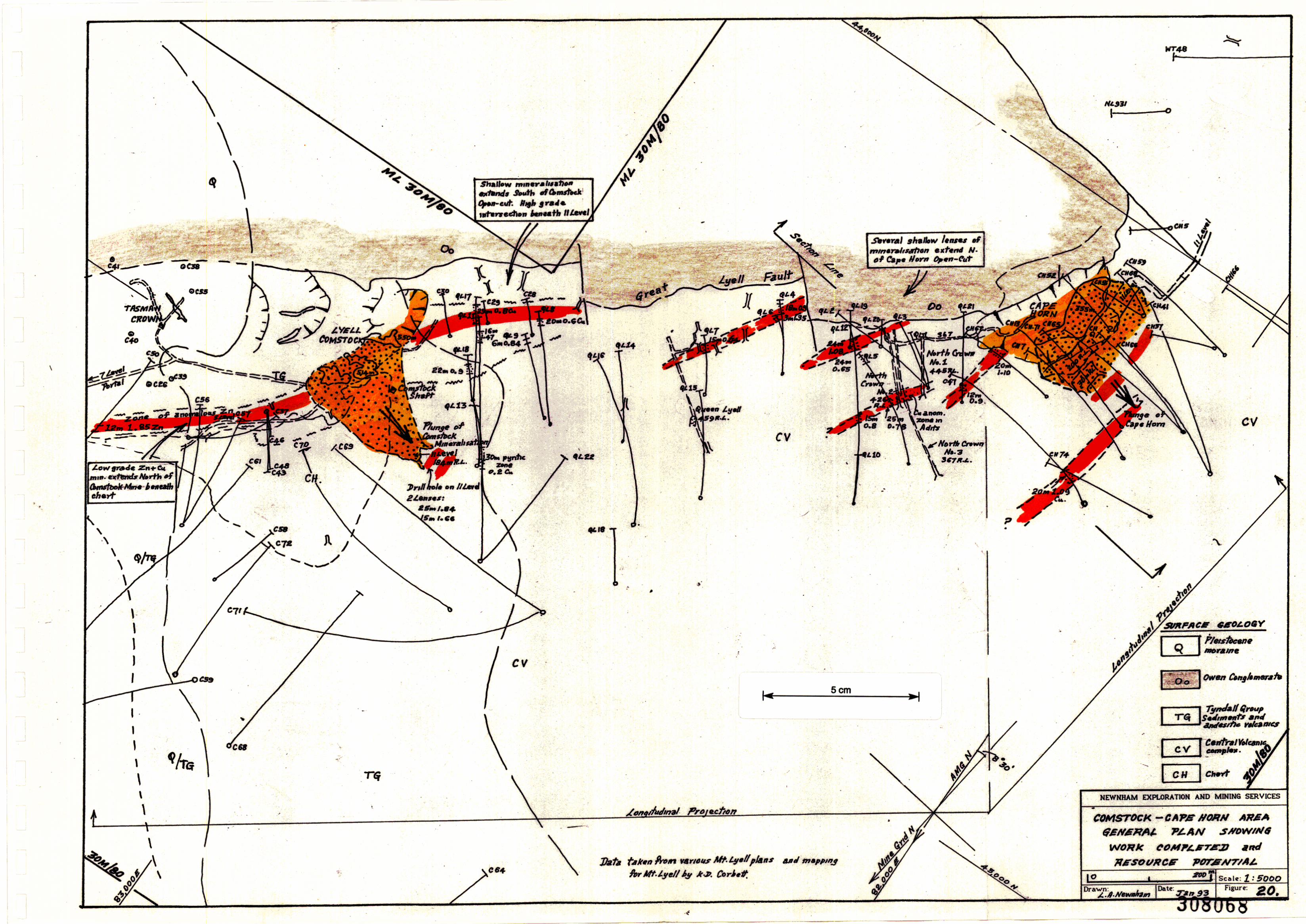
IIIIIIIIIIIIIIIIIIIII
30806939.
Production grade on 11 Level was 1.94% copper.
Drilling suggested No.3 and No. 4 lenses continued below 11 Level and areserve of 0.4 million tonnes of 2.25% copper was estimated on closure.Records suggest closure was largely due to manpower shortages in 1942. )
f ..",J (.' /1-7,The Cape Horn Mine was developed on a high grade lens of/pyritechalcopyrite mineralisation 250m long x 50m wide, dipping 80° southwest, developed in sheared Central Volcanic Sequence rocksapproximately 50-80m from the Great Lyell Fault near its intersectionwith the North Lyell Fault.
It produced 4.1 million tonnes of 1.43% copper, 0.42 gltonne gold, 3.3gltonne silver, from an open-cut and sub-level open stope mine over avertical distance of 400m. Mine productivity was therefore 130 tonnes ofcopper per vertical metre.
Access to the underground mine was via both rail haulage on 11 Level(200 RL) and a decline. The lowest level was 30 RL (equivalent to 30Series in Prince Lyell).
The Tasman Crown and Crown Lyell Extended Mines were developed totest two occurrences of copper and galena-sphalerite north of LyellComstock. The latter body was approximately 33m long x 2m wide. Themineralisation is hosted by Tyndall Group volcanoclastics and containsnarrow fine-grained sedimentary interbeds.
No commercial production was obtained from the mine but it proveduseful as an access to 11 Level on the Lyell Comstock Mine.
North Crown and Queen Lyell:
The broad pyritic zone between Cape Hom and Lyell Comstock wasprospected at shallow depths by four major tunnels known as NorthCrown 1, 2, 3 and Queen Lyell (FIg. 20).
Several narrow zones of +0.5% copper were intersected, being bestdeveloped in North Crown 2 and 3.
11.3 Exploration
Early prospecting along the Cape Horn-Lyell Comstock zone was by wayof tunnelling and trenching the broad outcropping pyritic zone. Theshallow Lyell Comstock and Tasman Crown deposits were soon locatedand developed. However, the potential of the Cape Hom area was notrecognised.
E.M. surveys completed in the 1930-40's highlighted several anomaliesand these were tested by shallow drilling programs south of the ComstockMine and in the Cape Hom area. In the former, holes C 24, 28, 29, 30(Fig. 20) located a 50m wide zone of approximately 0.5% copper nearsurface.
Following further geophysical surveys, deeper drilling was completedbetween Lyell Comstock and Cape Hom during the 1960's and defined
3080"0
•IIIIIIIIIIIIIIIIIIII
40.
308071
several zones of mineralisation, including the Cape Hom deposit whichwas subsequently developed.
During this period, the Lyell Comstock deposit was interpreted asoccurring in a similar geolo~ical environment to the high grade NorthLyell orebodies and some drilling was undertaken around the Comstockchert to test this
concept without success. However, a zone of significant copper-zincmineralisation was located, trending north-east (grid) of the LyellComstock Mine in the foot wall of the chert.
During the 1980's, the general environs of the chert were further mapped,sampled and drilled to evaluate the area's gold potential, withoutsigmficant success.
shallow southern extensions of the Lyell Comstock Mine;
depth extensions of the Lyell Comstock Mine;
other areas.
additional are lenses in the hanging wall of Cape Hom;
a series of discreet shallow lenses immediately north of the CapeHom Mine;
depth e.xtensi<;m.s of the Cape Ho.m. orebody below the l.owest level ....of preVIous mrnrng; /:.~.-. ./1-_ ,., ") $-<'( cc__ CC'-'1",,,,·,,,",'6-
moderate grade remnants adjacent to Cape Hom stopes;
(v)
(vi)
(vii)
(i)
(li)
(iii)
(iv)
11.4.1 Cape Horn Remnants
Cape Horn was mined by open-cut from surface to 170 RL andfrom underground to 30m RL where drilling indicated itmaintained grade but diminished dramatically in size.
Production during the last four years averaged >2% copper.
However, very little drilling exists below 00 RL, i.e. below 30 Seriesequivalent and results from those few holes are not all that
More recently, R.G.C. has been conducting exploration north-west ofLyell Comstock, searching for volcanogenic zinc deposits in the TyndallGroup volcanoclastics, following the intersection of broad zinc enrichedzones in several drill holes in that region.
No drilling has been undertaken in the zone between Lyell Comstock andCape Hom apart from Cape Hom are delineation drilling during the pasttwenty years.
Resource Potential (Figs. 20, 21, 22)
Previous exploration and mining indicates potential exists for significantcopper-gold mineralisation to remain in the following areas:
11.4
IIIIIIIIIIIIIIIIIIII,
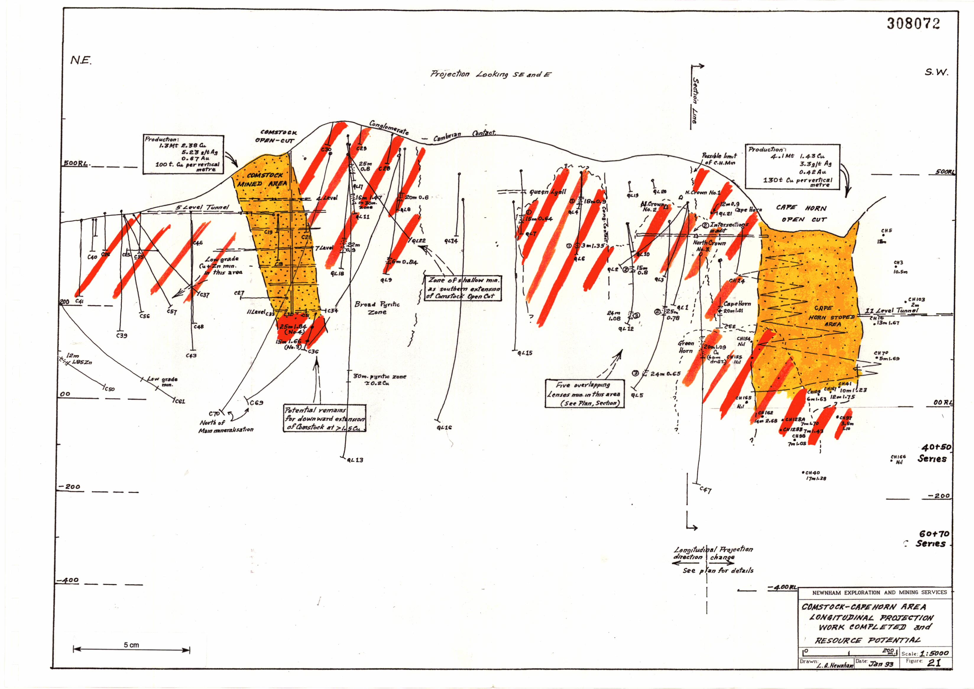
308073
w
-200
OOIlL
J.1.l<vo1 200---tu,,".1 R,L.
•
•
C7+
" Ir,mH.m",,,,,""trlh.,, tIJC",. 'IfH ' ~,.#on
M. f, 1'11'''1'''N.•fer.
'~2m(1Io".)I. D~Cw. - ",-,her. ratA_ ••,,'$
•JI,.NJ,.tIM ".f!"y JWU.Nr..IIIA-n.",J.".rwll!J <'til D. _Go...
1?.J.fI".«".,,,,-,, ","IP,<No '",m_rla•,20", '.Ofe...,,,,,
~,.1h.Jretool
L."'tIIt I"'"'", ~.~.II_r"..",. ,"J,.ftI."..", ISO",. S'."S'ftfJOil
•
•
• •
.~~ ._-.>-.... \', ."'... . 'I" t ...., ..
0... '..._ ,.. _ <+7'·\. ., \.
+ •
•
•
•
•
••
,
:1•
."
....
1.~.(4
•
..
,
Scm-4-0 0
NEWNHAM EXPLORATION AND MINING SERVICES
COMSTOCK - CAPe HOlrN AU""
SIMI- SCHIMATIC SIc-rION
IIIIN/!'RIIJ.ISJnJ ~NSES Ntl1tTH
PF I!API HPlrn ,
rillS' .I"",..sr:J,.",.~e , ••'h~" II. nllllNw .,",.,Q ".~~",..~ ,II",JS>.I'R~ ,"An•••F _ ....ImM"..ltsr<ll""~1 AI.rtf, offI,. i'I".II.m""".wht~III1't.!I;;'rmh7• .6Ans 111'." 6"""'~~"'~SWI~·
Fvrllt-ra'rtlltn1 .....,1<1 J. ,.,U/rod D 'OIl JII""!Ii r"'~Mll \"
Ora'lofn.:.c .ItI "If, Scale: 1 :5000
Date: or. F1curc 82v." g~ ". •
-
I
IIIIIIIIIIIIIIIIIII~
308074
41.
discouraging. The deepest hole is CH40 which intersected 17m of1.28% copper at RL -150 (approximately).
Potential certainly exists for the Cape Horn orebody to continuebelow OORL. This potential would require testing by surface coredrilling.
Any deeper resource so defined could be used to supplementunderground production from Prince Lyell and Western Tharsis inan expanded underground operation.
11.4.2 Moderate Grade Cape Horn Remnants
Mining at Cape Horn involved the selective extraction of a highgrade core from within a much broader, lower grade envelope ofmineralisation.
R.G.C. estimated that approximately 12 million tonnes of 1.12%copper originally existed in a 0.5% copper envelope down to -200RL. Of this 4 million tonnes of 1.43% copper has been extracted,and 8 million tonnes of 0.97% copper remams. ~ ~
This moderate grade envelope could therefore contribute to eitheran expanded Cape Horn open-cut, or a deeper underground minebased on mining at lower grades over greater widths, or to anunderground in situ solvent extraction operation.
11.4.3 Additional Hanging Wall Lenses
Drilling has indicated that an additional lens of mineralisation isdeveloped approximately 100m into the hangingwall of the mainCape Horn orebody, below 200 RL and slightly to the north.
Hole CH47 intersected 22m (horizontal) of 1.09% copper,including several higher grade zones. R.G.C. refers to this lens asGreen Horn.
The \?otential for this lens to extend further north and at depthremams untested.
The development of such additional, parallel lenses is attractivebecause it dramatically improves the vertical productivity of theresource.
11.4.4 Lenses North of Cape Horn (Fig. 22)
Drilling and shallow tunnelling to the immediate north of CapeHorn has indicated the presence of four lenses of mineralisation.One of these is possibly the northern extension of the main CapeHorn orebody. Individually they average IS-20m horizontal widthand have been drill indicated to extend (discontinuously?) 500mnorth of Cape Horn. The deepest intersection is in QL5 at 50 RL.Grades are generally in the range 0.6-1.0% copper.
Such a resource if confirmed by drilling and appropriatelymodelled, could form the basis of a substantially enlarged open-cut
I
IIIIIIIIIIIIIIIIIIIII
30807542.
operation which might include these four lenses, plus the remnantenvelope material at Cape Horn.
11.4.5 Shallow Southern Extensions of Lyell Comstock
Drilling programs completed in the 1940's and 1960's have defineda 15-25m wide zone of mineralisation within a broader pyriticzone extending 250m south of the Comstock Mine. The zoneextends from near surface over a vertical distance of 300m to 250RL. Grades range from 0.6-1.4% copper and averageapproximately 0.9% copper.
Such a deposit if confirmed might support a modest open-cutoperation in this area.
Drilling is required to further evaluate this potential.
11.4.6 Depth Continuation of Comstock
The Comstock Mine was worked to 11 Level (200 RL). Where theNo.3 and No.4. lenses were mined. On closure, it was estimatedthat 0.4 million tonnes, 2.25% copper and 0.6 g/tonne goldremained below 11 Level. Production grade at the close of miningwas 1.94% copper.
Drill hole C36 completed to test these lenses 50m below 11 Levelintersected 15m of 1.66% copper in No. 3 and 25m of 1.84%copper in No.4, which suggested No.3 was thinning in depth andNo.4 thickening.
QL13 passed 150m beneath 11 Level and intersected minor copperin a 30m pyritic zone. However, it is probable that this hole passedjust south of the down-dip extension of the lenses.
Potential for additional resources below 11 Level does exist andwould require further drilling to confirm.
11.4.7 Other Potential
A broad zone of significant copper-lead-zinc mineralisationextend.s. alons strike nOI:th-east of the Comstock Mine in greyquartZltIc schIsts and altered cherts.
Hole C42 was drilled north-west into the hanging wall of chert andintersected 21m of 0.44% copper, 2% zinc.
Approximately 100m north-east of the mine C43 intersected 200mdrill length of 0.2-0.4% copper and 1.94% zinc, whilst holes C46and C48 on the same section intersected a 100m drill lengthinterval of similar copper but 0.2-0.3% zinc.
All of these holes were drilled from the 5 Level access tunnel.Further north-east along strike CS6 and CS7 intersected a 70-80mwide pyritic zone which carried 0.1-0.5% copper, including 3m of1.8% copper in each hole. CSO intersected 12m of 1.85% zinc,
IIIIIIIIIIIIIIIIIIIII
308076
43.
approximately 350m north of the mine and C61 intersected 15m of0.4% copper and 0.33% zinc in the same zone.
Potential certainly exists in this copper-zinc pyritic zone whichextends north-east of Comstock for the development of furthermineralisation and additional drill testing is warranted, particularlyin the area north-east of CSO.
R.G.C. is currently testing another base metal rich zone in TyndallGroup sediments and volcanics to the north and north-west ofComstock, and several broad intersections of low grademineralisation have been obtained to date.
11.5 Summary
Resource potential exists at both the Cape Hom and Lyell ComstockMines for depth extension and shallow strike extensions of previouslymined orebodies.
Such resources could provide a basis for the development of modest sizedopen-cut operations, or expanded underground operations utilising eitherconventional or SX techniques.
The I,OOOm zone between Cape Hom and Lyell Comstock is onlysuperficially drill tested and any future long term operation at Lyellshould plan to further test this area.
Significant copper-zinc mineralisation has been drill intersected in twozones north-east and north of Lyell Comstock. The former, which isadjacent to the Great Lyell Fault, is considered to have the higherpotential and further testing along strike and at depth is warranted.
IIIIIIIIIIIIIIIIIIII..
12.
308077
44.
NORTH LYELL AREA
12.1 Introduction
The North Lyell area refers to a cluster of high grade orebodies whichoccurs in a structurally complex area adjacent to the North Lyell Fault(Fig. 17).
Mineralisation consists of chalcopyrite-bornite in a silicious-hematitebarite alteration zone which overprints both volcanic schists and theoverlying conglomerates, sandstones and limestones.
Interpretations of the genesis of mineralisation and its structural settingare numerous and the area has become the type location for the ongoingcontroversy on the volcanogenic/non-volcanogenic origin of Mt. Lyellmineralisation.
The basic geological elements and the relative physical location ofdeposits are illustrated on Figs. 23(a) and (b), and 24 (from RG.C.). TheNorth Lyell deposits essentially occur in an east-west structural pendantof Cambrian volcanics and Ordovician sediments. This pendant isgenerally referred to as the North Lyell Corridor. The Lyell Blockscopper clay deposits lie within this corridor to the east of North Lyell andare discussed separately in Section 13.
The main North Lyell orebodies differed significantly from other Mt.Lyell deposits on several accounts:
the lenses were very discrete and relatively low in sulfur;
mineralisation was common in the adjacent Ordovicianconglomerates and sandstones;
some of the lenses were very high grade in both copper and silver;
much of the copper was present as bornite;
extensive silica-barite-hematite alteration was associated with themineralisation, and it affected both the volcanics and the overlyingsediments.
12.2 Production
The North Lyell orebodies were some of the earliest mined and highestgrade orebodies on the Mt. Lyell field.
In this report, the term North Lyell is used to collectively include theNorth Lyell, Crown Lyell, Lyell Tharsis and 12 West orebodies whichoccur as close spaced, steeply dipping interconnected lenses within a600m x 500m area.
Production between 1896-1985 was 9.4 million tonnes of 3.41% copper,0.38 gltonne gold and 20.5 gltonne silver. This production came from fourseparate operations (Table 8). However, these lenses are so closelyrelated ~eologically,that it seems more appropriate to regard them as oneproductIve unit, similar to the various Pnnce Lyell lenses.
800 W. (~7!'l6111. E.I
IIIIIIIIIIIIIIII
'200 S. ( !6!41ft. N.
v
v
v
v v
v v"V-V
v v vcv-v
v v v
v v v.'v c1\Q" v•••vO v v v
v v v v v
v v v v
v
<fIB'"
1 LEVEL 513....RL.
M
1200 "
v v v vv v v
vv v t v
v v CROWN 1 v
v v
v v
800W.
308078
NEWNHAM DiPLORAT10N AND MINING SERVICES
HORT){ t:YEt:t. MINE AREA
,LEVEL. PL.-IINS (1andS)
IIII
•
kEY: See .~CtJl11l'ilh!llng
N~r~ .LlI,/I .s~cf/on
5cm~I
These Level pl;."i Illvs/';'sk th 51'.l'1al relahoM}"p 6.twrm
North LY 811, C,.o.... .L!J.II, LY811910<l<5, L5' e1171,8171s, /2 W.st OreJ,,,,;,,,s
dna'hOW r#af YEIa1;4Qs}nj!' V4Y1I1S JVd'I1 aepfh ese, f{,l/oWJf1.J h!_ Ii/S,y
I
5 LEVEL
]J..f" sourre' Ji'GC pl;m dated :r,,1g 8S.
389m R.L.
1°Drawn
zroo, sCill<o::1:5;OOO
Dill!": :J""Jfn 931 Fir;ure:e.~a
II
3080'19
I---
vvv
v
v
vvlviviviv-ivivivlvIi~~~~I-V====-Y====-v-====.v-===-v====v-====.v -====v====-v
v t::=:=. II ====- II ===== II-==== V-====V-===v===== Ii====v--
II
II
I
II
II
II M
II
IIOOS.
800'11.
M---------j 12009.
I~w
I 9 LEVEL 253'.. R.L. 12 LEVEL - [172m R.L.
III
!<IEY, See aC~QN1p~ngm5
)lDdn I.!I,IIS.d,of1
Scm
The•• L .v.1 plans IIIIIsT",t. f/", spllt,,1 r.lllhDf1shlp JeTw.en
North [yell. Crawn L!I.II. L!I"/IBlocKs, LyeIITI./I)7's. /2 Wpst Orel""It,s
clnd how fhat yp/,tit",.slllp VdiYII?.$' w,/,I, a'epfh (;ee ~/JQ prevlDuS l=ig~)
NEWNHAM EXPLORATION AND MINING S[RVICES
NollTH ,,-YEJ./.. M/NE AREA
.l.EVE/.. P,,-ANS (9 anti 12)
2QO, sCl:.kl:S;:ooo
I
II
308080
IIIIIIIIIIIIII
NE sw
~~~_----'I__--'J,---__,,- ~'~C:!E~V~E=C-,( '13.:1111. A..5.L,,)
-=::l---......,,-_--,,__-.,.,. --'-.-'c"'E,,V"'E�.'-'( 44e..s ... A.a.,-)
, --'.~C=Ev"'E1.'=-'( ~.OIll_A.S.L)
I SECTION 17
NE'NNHAM EXPl.ORATION AND MINING SERVICES
2Of. f, . Stille: 1; 5.000
NORTH £YE.l.i.. MINE liNEA
CIi'OSS S£CrlON
Drll'-'n:I
5cm
I ·0 a01 Owsn Ct:'I?$/pm~rare
I' y • I s.h,srsI~-I Sc.hlsts wdh Sc.-J} 4~nrftol'1
§-''\'''''~l Hematih -bRnf'e- SIItCJ!l alre.,.4ftof7
~ ()rBbdd,es
II
•I
IIIIIIIIIIIIIIIIIIIII
308081
45.
Mine Tonnes CM) %Cu gltAu gltAg
North Lyell 4.72 5.28 0040 34.29Crown Lyell 3.83 1.60 0.37 6.6712 West 0.13 7.59 0.37 39.00Lyell Tharsis 0.69 0.94 0.27 4.85
Total 9.37 3.41 0.38 20.5
Table 8: North Lyell Area - Production.
The relationship of the ore lenses and the Crown Lyell mining system areillustrated in the isometric drawing, Fig. 25.
Ore was extracted from both open-cuts and underground over acombined vertical distance of 400m. The lowest level was 13 Level (150mRL) where the ore was considered to cut out against OwenConglomerate.
The vertical productivity was approximately 800 tonnes of copper pervertical metre - comparable to Prince Lyell.
The North Lyell Mine, which closed in 1953, was accessed by both shaftand the North Lyell tunnel on 11 Level. Ore was railed 2.5 Jan. along thistunnel to the concentrator.
Commencing in 1967, the main CroWD Lyell m orebody was mined bysub-level open stoping. Ore extraction was along the North Lyell Tunnel.The primary stopes only extracted 44% of the mineralised body andmining ceased in 1976 due to the combination of difficult ground andaccess conditions.
The 12 West Orebody south-west of the Crown Shaft was a small, veryhigh grade bornite orebody tucked into a fold in the steeply dippingfaulted contact between volcanics and Owen Conglomerate.
Lyell Tharsis is a relatively low grade (0.94% copper) shallow open-cutand underground operation immediately south of North Lyell. Theunderground operation was accessed via a short adit.
12.3 Exploration
The North Lyell-Crown Lyell orebodies lie at the eastern end of theNorth Lyell Corridor, a 1,000m long, fault bounded pendant of shearedvolcanics and sediments extending along the North Lyell Fault to theCape Horn area.
The main North Lyell area has been intensively drilled and explored byunderground mine development.
West of the Crown Lyell Mine, the Corridor has not been so exhaustivelyexamined.
IIIIIIIIIIIIIIIIIIII
•
C/rOWN MINE'PYOQUCnDn
3.83 MtI. GOr....o.l7A..,. (7 As·
SL.o!b level Open st'DfmS
No st'oplng 'on
{'YOW(1 3 be/oMl
7/-''''/
Scm
MINEPraduc"hon0./3 Mt7.~S eo..0.37 A..39 As
#~U'/fYELilL. "'~·6!17_
308082
IIIIIIIIIIIIIIIIIIII•
308083
46.
An exploration drive was developed on 11 Level north-west of the CrownShaft (Fig. 17) and whilst drilling from this drive together with driveexposures located substantial low grade mineralisation, no significanthigher grade mineralisation was located.
The remainder of the Corridor has been prospected at shallow depth bythe North Lyell Consolidated and Anaconda Tunnels. Following E.M.surveys in the 1960's, six cored holes were completed into a pyriticsourced anomalous zone (Fig. 17). Results were not encouraging.
In the mid 1980's, some drilling was undertaken in the North Lyell area,firstly to test for extensions of shallow ore which could be open-cut, andsecondly for mineralisation in Ordovician sediments.
Significant shallow mineralisation was outlined around the North Lyelland Crown Lyell open-cuts and some of this was mined to supplementunderground production from Prince Lyell.
Drill holes NL1101 and NLlI02 completed immediately east of NorthLyell intersected broad barite-hematite-silica alteration zones inOrdovician sediments. The latter intersected 26m of 0.7% copper, 8gltonne silver, including 6m of 1.48% copper, 15 gltonne silver, in alteredsandstones.
12.4 Resource Potential
Opportunities exist for relatively small extensions of the Crown, NorthLyell and Lyell Tharsis orebodies.
The most prospective areas for additional mineralisation area:
crown pillars below Crown III open-cut;beneath 7 Level in the Crown Lyell Mine;beneath 13 Level in North Lyell Mine;above 12 West stopes.
In June, 1992, RG.C. identified an indicated resource of 1.2 milliontonnes of 1.6% copper, 0.4 gltonne gold remaining as crown pillarsbeneath the open-cut. Potential for additional open-cut ore around theexisting cut is limited and the mineability of the crown pillars requiresinvestigation. The existing steep batters and underlying workings maypresent complications.
Core drilling from surface would be required to better determine themagnitude of the mineralisation potential in the other three areas.Existin& drilling indicates that the potential below Crown Lyell and NorthLyell IS limited because of the underlying Ordovician OwenConglomerate.
Dufty et aI., and Flitcroft and McKeown point to additional resourcepotential in the North Lyell area (Table 9).
47.
Table 9: Resource Potential - North Lyell Area.
308084
This potential may exist and could present scope for either extensions ofopen-cut operations around the North Lyell and Lyell Tharsis areas ordevelopment of underground mining, based on small high gradeextensIOns of North Lyell and Crown Lyell lenses, accessed by a shortdecline driven from east of the Mine where the topography fans rapidlytowards current quarrying operations.
North Lyell mineralisation contains a significantly higher proportion ofbornite than other Mt. Lyell ores.
This feature, combined with easy decline access, high altitude andgeographical separation from other operational areas, highlights thepotentIal for this area to support an in-situ solvent extraction operation.
In a rudinIentary sense, such an operation is currently in progress,because surface waters have been prevented from dischar~g into theLinda Valley by diverting them down the North Lyell mme workings,presumably mto the North Lyell tunnel.
If SX-EW operations appear viable at Lyell, it is recommended that the /process be trialled in the North Lyell-Crown Lyell area.
Testing of the area between the Crown and Cape Horn Mines along theNorth Lyell Fault is inadequate. Many workers believe the North LyellFault is an inIportant structural element in the development of Mt. Lyellorebodies and certainly this zone requires more drilling as a componentof a longer term program to assess the mineral resource potential of theLyell field.
12.5 Summary
Approximately 25% of the total production on the Mt. Lyell field hascome from high grade deposits beneath a 30 hectare area at North Lyell.
7./;
Area Potential Resource Mining
Crown Lyell 1 0.2 Mt 1.48 Co Underground
Crown Lyell 3 1.6 Mt 1.4 Co Underground and open-cut
Crown Lyell -Extended 0.7 Mt 1.1 Co Underground
Lyell Tharsis 0.3 Mt 1.2 Cu Underground and open-cut
North Lyell 2.7 Mt 0.94 Co Underground
IIIIIIIIIIIIIIIIIIII
•
IIIIIIIIIIIIIIIIIIII
•
30808~)
48.
Naturally, this immediate area has been intensively explored. However,potential remains for firstly shallow resources capable of supporting amodest open-cut operation, and secondly deeper high grade remnantswhich could be accessed with a short decline from the Linda Valley.
Collectively these resources, which contain significant bornite, may beamenable to a solvent extraction operation. A thorough assessment of theNorth Lyell area requires a quality collation of existing data.
The area west of North Lyell between the Crown Lyell and Cape HomMines adjacent to the North Lyell Fault has been only superficially tested(6 drill holes) for further North Lyell type deposIts, and presents anexcellent exploration opportunity.
IIIIIIIIIIIIIIIIIIIII
13.
308086
49.
COPPER CLAYS (Figs. 3,11,17)
13.1 Introduction
Deposits of copper bearing clays occur in three east dipping synclinaltroughs east of the main Mt. Lyell operations at the western end of theLinda Valley:
Lyell BlocksLyell ConsolsKing Lyell
The King Lyell deposit lies just outside MlJOM/80 lease.
The copper occurs as native copper, cuprite and chalcocite in intenselyweathered sandy beds of the lower Gordon Limestone, immediatelyabove the Pioneer Beds (sandstones). The red and yellow copper bearingclays are generally overla.Jn by black clays developed by either weatheringGordon Limestone, or hydrothermal alteration resulting indecarbonisation of the limestone.
A controversy exists as to the ori~ of the deposits. Some workers regardthem as secondary deposits denved from mineralisation in the nearbyvolcanics and accumulated in weathered Ordovician sediments. However,a more thorough examination of mine workings and geological recordsappear to favour a process of hydrothermal replacement of limestonesfollowed at a much later stage by deep weathering.
Sillitoe (1984) cited the Lyell Blocks Mine which was developed in claysadjacent to a steep 1O-15m wide structure, and the chanwng nature ofmineralisation from native copper and cuprite to chalCOCIte at depth asevidence of fracture controlled hypogene mineralisation which was latermodified by karstic weathering. He and others consider the originalcopper deposits to be post-Cambrian mineralisation.
13.2 Production
Attempts were made to mine all three clay deposits by undergroundmethods which understandably suffered from poor ground conditions.
Core drill testing was also attempted but results are unreliable because ofpoor core recoveries.
The Blocks Mine was developed in a clay filled trough 120m wide, 180mdeep adjacent to the North Lyell Fault. The main shaft serviceddevelopment to the 135m level and prospecting to 165m level. Productionbetween 1900-1907 was approximately 200,000 tonnes for a recovered2,500 tonnes of copper, i.e. a recovered grade of 1.2% copper.
A considerable amount of development work had been undertaken whenthe shaft collapsed and the Mine was abandoned.
The Lyell Consols deposit lies in a trough 180m long, 12m wide, 45m deepadjacent to the Whaleback Fault with probable extensions to the west andeast.
50.
Resource Potential
Between 1907-1910 approximately 300 tonnes of copper were recoveredfrom 25,000 tonnes of ore for a recovered grade of 1.2% copper. Againthe Mine was abandoned when the shaft collapsed. An in-situ grade of3% is attnbuted to Lyell Consols' mineralisation.
The King Lyell deposit (which lies just outside 30M/80) was developed in90-120m thick east dipping brown-grey-orange clays and mudstones.Initially it was sluiced and later mined and prospected underground.
Again mining was abandoned following subsidence and water problems.The known King Lyell deposit is 45m long, 34m wide and 43m deep.
Part of King Lyell is now covered by the toe of the West Lyell wastedumps.
Two other small deposits occur between King Lyell and Lyell Consols.
1.6 million tonnes of 1.5-2% copper;0.25 million tonnes of 3% copper?
0.15 million tonnes of 2% copper.
Blocks:Consols:King Lyell:
Remaining resources may be in the vicinity of:
A possible total of 2 million tonnes of 1-1.5% copper. Potential for thedefinition of additional resources appears reasonable.
Whilst these deposits are not large, they have three attractive features:
amenable to open-cut mining;simple processing;high grade copper concentrate.
In the past, great difficulty has been experienced in establishing reliableresource estimates on the clays because of poor drilling conditions andcore recoveries. This problem would be overcome efficiently andeconomically by air-core drilling.
The copper clay resources are considered to represent scope for amedium sized operation which' because of its unique character couldeither supplement larger adjacent hard rock mining operations or standalone as a separate operation with its own specialised treatment facility.
13.3
IIIIIIIIIIIIIIIIIIII
•
IIIIIIIIIIIIIIIIIIII
•
14.
308088
51.
OTHER POTENTIAL RESOURCES
14.1 Blow - South Lyell Area
These two adjacent deposits occur south of PriTIce Lyell. The Blow (IronBlow or Mt. Lyell Mine) was the first discovered deposit on the Mt. LyellField. From 1893-96 it was mined for ~old alone and from 1896-1929 as acopper ore for pyritic smelting. Mining was by both open-cut andunderground methods, and total production was 5.5 million tonnes of1.3% copper, 1.99 g/tonne of gold, 61 g/tonne of silver.
The high gold and silver values set it aside in type from other deposits atMt. Lyell. The open-cut today represents a significant tourist attraction.
The last resource estimate was in 1924: 1.6 million tonnes of 0.5% copper,1.3 g/tonne gold.
The adjacent South Lyell deposit consisted of two non-outcroppinglenses of massive pyrite with low chalcopyrite, mined specifically for feedto the pyritic smelters and the production of sulfuric aCid.
Production between 1899-1922 was 324,000 tonnes of 50% sulfur, 0.4%copper, 1.1 g/tonne gold, 6 g/tonne silver, consisting of 205,000 tonnes of0.51 copper, 1.2 g/tonne gold from the Main Lens and 119,000 tonnes of.0.26 copper, 1 g/tonne gold from the North Lens.
Bird (1984) interpreted the lenses as strongly fault controlled with thehigher grade gold zones (5-8 g/tonne) occurring near the intersection ofthe Proprietary and Owen Spur Faults. He considered the depth potentialof the deposits to be structurally limited and estimated total resources of0.6 million tonnes of low copper grades.
However, Wade and Solomon (1958) reported a resource potential ofapproximately 0.3 million tonnes and considered the deposit hadsubstantial depth potential.
14.2 Precious Metals
The mines of the Mt. Lyell field have produced approximately 44 tonnesof gold and 740 tonnes of silver over a 110 year life.
Precious metal production in 1991-92 was 0.566 tonnes of gold and 3.46tonnes of silver, contained within the copper concentrate which averagesapproximately 6.4 g/tonne gold and 39 gltonne silver.
Gold and silver are present to varying degrees in all Mt. Lyell deposits.The upper part of the Blow was initially mined for gold, and totalproductIon averaged 1.99 g/tonne gold and 61 g/tonne silver. The NorthLyell orebodies were high in silver (34 g/tonne average) and significantsilver was also reported trom the Lyell Blocks deposit. Elevated gold wasreported in the South Lyell and Lyell Comstock Mines and in the chertbody in the hanging wall of that Mine.
Precious metal content in Prince Lyell appears to be increasing steadilywith depth and currently averages 0.51 gltonne gold, 3.05 g/tonne silver. Itis important to note thiS trend may continue below 60 Series. Drill hole
52.
308089
WL70l intersected 37m true width of 2.75% copper and 0.98 gltonne goldin the North Lens, including one 2m interval of 6.1 g/tonne gold.
The controls and associations of precious metals are not particularly clear.They appear to be associated with copper mineralisation and to beconcentrated close to fault zones.
The first of these zones may represent a north-north-east continuation ofLyell Comstock where anomalous copper and zinc values have beenobtained in volcanics in the footwall of the Comstock Chert (CSO: 12m of1.8% zinc). See Section 11 for more details on this zone.
The second is a broad zone of anomalous lead and zinc in andesiticvolcanoclastics and sediments north-west of Lyell Comstock. This mixedvolcanic-sedimentary sequence ts interpreted by R.G.c. as being near thebase of the Tyndall Group, stratigraphically equivalent to the HellyerQue River deposits and overlain by the Comstock Chert, interpreted as avolcanic hot spring sinter deposit. Other workers (Sillitoe, Brook, Bird)regarded the chert as silicious alteration associated with the formation ofthe Lyell Comstock deposit.
Holes C64, C68, C69, C70 and cn have all recorded broad zones of lowgrade mineralisation:
13m 0.17 copper, 0.34 lead, 0.24 zinc, 0.26 gold including8m of 0.12 copper 0.12 lead, 0.04 zinc, and 0.39 lead and 0.22 gold.14m 0.66 lead, 1.16 zinc, 244 silver.137m 0.17 lead, 0.25 zinc, 5.4 silver.
C69:
C70:C71:
In the 1980's, R.G.c. undertook studies of the Mt. Lyell field exploringfor stand alone gold deposits based on various gold deposit models. This :tintermittent programme failed to highli~t any significantly encouragingareas and was perhaps prematurely termmated.
However, the Cambrian volcanics of the Mt. Lyell region are pervasivelygold anomalous and regional anecdotal evidence suggests that ~old mayhave been remobilised and concentrated by subsequent tectoDlsm bothwithin the Cambrian volcanics and the younger Palaeozoic sediments.
Hence, whilst immediate opportunities for stand alone gold deposits havenot yet been indicated on ML30M/80, gold and silver do represent avaluable by-product in the known copper orebodies and longer termpotential certainly exists for the discovery of stand alone precious metaldeposits. .
Other Base Metals
No production of base metals other than copper, e.g. lead and zinc hasoccurred on the Mt. Lyell field. Most exploration encouragement to datehas occurred near the northern end of the field where early undergrounddevelopment at the Tasman Crown Mine prospected a small occurrenceof massive pyrite-galena-sphalerite mineralisation in Tyndall Groupvolcanoclastics and exploration in the Lyell Comstock area has drillindicated the existence of two base-metal enriched zones.
14.3
IIIIIIIIIIIIIIIIIIII
•
IIIIIIIIIIIIIIIIIIII
•
14.4
308090
53.Miscellaneous
This report has so far addressed the mineral resource potential whichexists as either extensions to areas which have already been mined or inareas tested only by drilling.
On the basis of geological modelling, geophysical and lithogeochemicalstudies, there are other areas that have longer term resource potentialwhich have either not yet reached the drilling stage, or which have beeninadequately drilled.
In the last ten years a significant amount of research and non-drillingexploration has taken place at Lyell but for various reasons associatedwith difficult operating conditions, very little exploration drilling awayfrom known orezones has occurred - averaging only I,OOOm of suchdrilling per annum.
In this context, the saying: "IQ is fine but BQ fmds the mine", isappropriate.
Given an environment of long term confidence in copper and the currentremaining identified and potential resources at Lyell, a greater and moreconsistent drilling effort on untested or under-tested anomalous areasand exploration concepts is warranted.
The last significant drilling of this nature was NLll02 designed to test forgold and copper mineralisation in Ordovician sediments in a structurallycomplex setting at North Lyell. The hole intersected 26m of 0.7% copper, ,~.
8 g/tonne silver, in a zone of intensely altered sandstones. That was a -f'.significant and exciting result for such a new concept but has not beenfollowed up.
Further, much of the exploration undertaken in the last 25 years has beenbased on volcanogenic models. It is now clear that whilst some or all ofthe mineralisation may have a volcanogenic origin, it was remobilised andconcentrated into orebodies by later structural events and there is thus astrong argument in support of drilling structurally disturbed zones suchas:
(a) the North Lyell Corridor where the North Lyell Fault intersectsthe Great Lyell Fault, i.e. east of Cape Hom, where to date thereis only one shallow hole;
(b) the North Lyell Fault zone east of the North Lyell area where itintersects the Great Lyell Fault.
In terms of modern exploration philosophy which supports persistentdrilling in known mineralised areas, the Mt. Lyell field is seriously underdrilled in areas away from known deposits, all ofwhicb either outcroppedor had surface expressions, i.e. exploration for blind orebodies has beenminimal.
The Mt. Lyell area represents, by several orders of magnitude, the lar~estaccumulation of non-ferrous mineralisation in Tasmania, and justifies ~Lmore intense exploration for non-outcropping, structurally controlled -1'deposits in both conventional and non-conventional host rocks.
IIIIIIIIIIIIIIIIIIII
•
308091
54.
Any strategic/Ian to continue operations at Lyell should have theconfidence an optimism to include an on-going drilling program aimedat assessing this unquantified resource potential.
IIIIIIIIIIIIIIIIIIII
•
16.
308092
55.
RESOURCE EVALUATION STRATEGIES
15.1 Evaluation Requirements
There are major technical and social factors which support the concept ofany future mining operation at Lyell commencing as soon as possible afterthe planned cessation of operations by RG.C. in June, 1995, Le.avoidance of significant breaks in operation. To achieve this, aconsiderable amount of technical work would be required over the nexttwo years.
A strategic resource assessment plan is urgently required.
This paper has identified a substantial number of areas which areconsidered to have a high chance of containing resources which mightsupport one or more continuing major mining operations at Queenstown.
The potential in all of these areas is only inferred or indicated. In allcases, the level of technical knowledge is insufficient for the purpose ofpreparing final development and business plans to evaluate theircommercial viability.
Various geological, mining and processing investigations are requiredprior to the preparation of such plans.
Clearly neither the time nor commercial justification exists to fully test allthe areas of significant resource potential.
The assessment plan should therefore rank the areas, schedule and costtheir assessment, and establish a critical assessment path.
A single plan is not possible, because different potential investors willhave differing objectives. However, no matter what these objectives are,all plans should be focused and driven along a critical path, otherwisevaluable resources will become rapidly disseminated and ineffective.
Table 1 represents but one manner of grouping and ranking these areas.The potential resource shown in this table is meant to give the reader onlya broad order of magnitude assessment of the potential of individualareas. These assessments should not be treated in the same way asresources and reserves as defined by the Australasian Institute of Miningand Metallurgy, and certainly they should not be totalled or bulked.
Brief comments on the likely evaluation of work required on each of theareas is presented below:
15.1.1 Open-Cut Potential
(a) Royal Tharsis -Shallow pattern core drilling followed by pit optimisationstudies. Access is excellent and this would be an easy task.
(b) Crown Lyell -Minor additional drilling; main considerations are thepracticalities of mining the remnants.
56.
15.2.1 Drilling
15.1.2 Underground Potential
308093
Prince L).'ell -Core drilling 70, 80, 90 series, mainly from underground,some from surface; sub-level cave mine planning.
(a)
(c)
(d)
(e)
(b)
(a)
In all cases where drilling is necessary, it should be core drilling.Exceptions are air-core drilling of the copper clays and wastedumps.
Reverse circulation drilling is not recommended because of veryhigh rainfall, hi&h water table and large quantities of ground water,and hole deviatIon.
(g)
Copper Clar.s -Air-core drilling of 2-3 areas followed by metallurgical testwork and pit design studies.
West Lyell Workshop Area-Shallow pattern core drilling followed by geotechnical andpit design studies.
Cape Hom Extension -Core drilling and mine planning.
Lar&e Low Grade West Lyell Pit-In-SItu leaching leaching studies in conjunction with similarstudies on adjacent waste dumps.
Lyell Comstock -Core drilling and mine planning.
All of the above could be undertaken without interference to thecurrent operations.
(c)
(e)
(f)
(d)
West Lyell-Air core drilling and leaching studies.
Evaluation Methodologies
North Lyell -Data collation; minor drilling; SX-EW test work.
Western Tharsis-Infill core drilling from underground (?), sub-level cavemine planning.
Cape Hom-Depth extension core drilling; mine planning.
A-Lens -Depth extension core drilling (? underground).
15.1.3 Waste Dumps
15.2
IIIIIIIIIIIIIIIIIIII
•
IIIIIIIIIIIIIIIIIIII
•
308094
57.
Traditionally, NO-BO or 56/4611 has proved adequate at Mt.Lyell.
15.2.2 Geophysics
Geophysics is not considered appropriate for evaluating theresource potential of any of the above areas. The evaluation workis down to mine scale in strongly sheared and pyritic rocks.
15.2.3 Solvent Extraction Metallurgy
Considerable data already exists at Lyell on the various pastattempts at SX-EW. This data should be reviewed prior to ongoingtests with contemporary technology.
15.2.4 Mine Planning
Alternative underground mining methods should be investigated.Davies and Speechly recommended sub-level caving and provideddetailed layouts, costs and benefits on lower Prince Lyell.
If drilling confirms open-cut resources, computerised pitoptimisation studies should be undertaken on such areas.
15.3 Critical Path Evaluation (Table 10)
Conceivably in future operations, ore could be drawn concurrently fromfour supply bases, either by one or more operators:
underground (conventional)open-cut (conventional)copper claysin SItu leaching.
The four groupings are determined principally by processingrequirements. Realistically, conventional underground production willprobably be in the grade range 1.5-2.5% copper and 0.5-0.75 g/tonne gold,whereas conventional open-cut ore will be about half these grades. The~esira~ility of blending these ores in one concentrator requiresmvestlgatlOn.
Any future major underground operation would appear to dependcritically on confIrmation of the 70 and 80 Series Prince Lyell resourcepotential.
If that potential could not be confirmed, then the chances of a WesternTharsis or Cape Horn being developed underground would diminishdramatically.
If the Prince Lyell resource potential was confirmed, then further testingof both Cape Horn and Western Tharsis would be justified. Thecombined resources of Prince Lyell, Western Tharsis, Cape Horn couldjustify an expanded underground operation of 2+ millIOn tonnes perannum. The commercial advantages of such an expanded undergroundoperation were enunciated recently by Davies and Speechly. They further
IIIIIIIIIIIIIIIIIIII
•
308095
58.
detailed the current mine and mill infrastructure constraints on such anexpansion and recommended ways of removing these constraints.
Clearly, either continuing or expanding underground operations beyond1995 would benefit from the availability of the current Prince Lyell shaftand decline system. Hence, it will be very important to confirm the PrinceLyell resource below 60 Series well in advance of 1995.
The open-cut resources could be considered as either part of anintegrated and expanded open-cut and underground mining operation, oras a stand alone operation. Either way, if advantage is to be taken of theexisting processing infrastructure, the resource potential of several of thehisher ranked areas should be further tested by drilling and mine studiespnor to 1995, e.g. Royal Tharsis, Crown Lyell, and West Lyell Workshopareas.
The copper clay resources would require their own processing plant andseparate open-cut operations. Hence, from a technical infrastructurepoint of view, the same urgency to confirm the resources does not exist.However, if a continuation of production is seen as desirable from otherpoints of view, then confirmatory drill testing, mine planning andmetallurgical test work would need to start soon.
Leaching operations based on waste dumps and in-situ ores similarlywould require their own treatment plants and mine operations. If such anoperation was to take place whist either conventional underground oropen-cut mining was in progress, it is likely that all operations would haveto be under the control of one operator - otherwise there would bearguments!
Leaching of in-situ ores (underground and surface) and dumps is verymuch a technologically unknown process at Lyell. Hence, substantialmetallurgical and mine design studies would have to commence soon, ifsuch operations were to playa role in continuing operations beyond 1995.
The benefits of undertaking SX-EW trials on the North Lyell area wereoutlined in greater detail in Section 12.
Given a substantial resource and a 5-10 year minimum life of mine,downstream processing of copper concentrates, using Isasmelt/Austmelttechnology, should be investigated as a means of dramatically reducingthe current high ex-mine charges on a low valued concentrate.
Other factors important in establishing a critical path resource evaluationstrategy are firstly that any new operation beyond 1995 will require atailings dam and secondly the new operator will be required to preparedevelopment and environment management plans for Governmentapproval.
Table 10 represents one resource evaluation strategy and highlights theimportance of time and effort with respect to testing of the mineralresource potential if a reasonable continuation of operations is to beachieved.
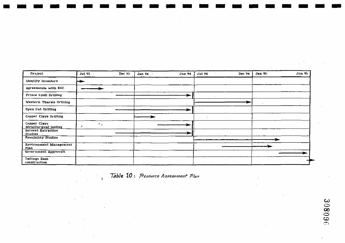
• - - - - - - - - - - - - - - - - - - - -
Project Jul ~3 Dec 93 Jan 94 JUD 94 Jul 9... Dec 94 J~ 95 Jun 95
Identify Invt!'Stors f.-Agreements with IlGC .-Prince Lyell DrilUng
Western Tbarsls Drllltng ..Open Cut Drilling -ICopper Clays Dr-UUng ...Copper Clays .. .-Metallurdcal teslin1t .Solvenl ExtractionStudiesPea:slbllity StudJ.es
Environment ManagementPlanGovernment Approvals ..T:IIilings Dam -~construction
7able 10: 'Resource Assessmmf- Plan
IIIIIIIIIIIIIIIIIIII
•
308097
60.
15.4 Resource Assessment Program and Costs
It was not within the scope of this report to design and cost programs totest the various potential mineral resources listed.
However, once an evaluation plan has been devised, it is a relativelysimple task to detail the plan, using the very adequate data base held onthe Mt. Lyell Mine.
IIIIIIIIIIIIIIIIIIII
•
16.
308098
61.
REFERENCES
Arnold, G.O., 1985, "Mt. Lyell 1985: An Exploration Perspective", UnpublishedRG.C. report.
Arnold, G.O., 1990, "Interpretations and Exploration at Mt. Morgan and Mt.Lyell", G.SA, 10th AG.M., Hobart.
Beddows, J.W., 1985, "Report on Work Completed July 1984 - January 1985 onA to P. Linda Valley Area", Unpublished RG.C. report.
Berry, RE., 1990, "Structure of the Queenstown Area and its Relation toMineralisation. Interim Report." Codes: Arnira Project P291, Structureand Mineralisation of Western Tasmania, Report No.1.
Berry, RE., 1991, "An Excursion Guide for the Mt. Lyell Mining Lease withEmphasis on the Great Lyell Fault, Haulage Unconformity and NorthLyell Alteration". Codes: Amira Project P291, Structure andMineralisation of Western Tasmania, Report No.2.
Brook, W.A, 1984, "Exploration for Gold Deposits at Mt. Lyell within the MineLease and Buffer Zone: Regional and General Aspects", unpublishedRG.C. report.
Brook, WA, 1984, "Mineralisation at Mt. Lyell and Exploration of the BufferZone, Mine Lease and E.L. 9/66", unpublished RO.C. report.
Bird, M., 1984, "Report on South Lyell Pyritic Body as an Exploration Target",Mt. Lyell unpublished report.
Bishop, J., 1984, "Report on the 1982 Geophysical Surveys of the Mt. LyellMining Field", unpublished RG.C. report.
Bryant, C.J., 1975, "Geology and Mineralisation of Corridor Area, Mt. Lyell,Tasmania", University of Tasmania, B.Sc. Hons. Thesis.
Corbett, KD., 1989, "Geology of the Comstock Area, Mt. Lyell", unpublishedRG.C. report.
Corbett, KD., 1992, "Stratigraphic - Volcanic Setting of Massive SulfideDeposits in the Cambrian Mt. Read Volcanics, Tasmania", Econ. Geol.,V.87.
Corbett, K.D., et. al., "The Mount Read Volcanics and Cambrian-OrdovicianRelationships at Queenstown, Tasmania", Journal of GeographicalSociety of Australia, V.21, part 2.
Cox, S.P., 1979, "Deformation of the Mt. Read Volcanics and AssociatedSulphide Deposits, Mt. Lyell", University of Tasmania, Ph.D. Thesis.
Davies, E., Speechly, B., 1991, "Preliminary Report to Mount Lyell CopperDivision of Renison Goldfields Consolidated Limited. Long TermPlanning Strategies for Mount Lyell Operations", unpublished RG.C.report.
IIIIIIIIIIIIIIIIIIII
•
308099
62.
Dufty, M., 1991, "Ml..30M/80 and A to P Queenstown. Mt. Lyell Mining Lease.Report on Exploration for Period November 1989 - May 1991",unpublished RC.e. report.
Dufty, M., et. al., 1991, "Progress Report on the Assessment of the Ore Potentialof the Mount Lyell Copper FIeld", unpublished RG.C. report.
Fitzgerald, F.F., 1987, "Authority to Prospect, Queenstown. Progress Report1986-87", R.G.e. unpublished report.
Fitzgerald, F.F., 1988, "Authority to prospect, Queenstown. Report onExploration 1987-88", unpublished R.G.C. report.
Flitcroft, M.J., McKeown, M., 1992, "Old Mines - New Visions", unpublished Mt.Lyell report.
Flitcroft, M.J., House, M.J., 1992, "Statement of Ore Reserve Estimate andReconciliation, 1992", unpublished Mt. Lyell report.
Green, G., 1971, "Geology and Mineralisation of the Cape Hom - LyellComstock Area, Mt. Lyell", University of Tasmania, B.Sc. Hons. Thesis.
Green, G., 1990, "Palaeozoic Geology and Mineral Deposits of Tasmania", Geo!.of the Min. Deps. of Australia and Papua new Guinea (Ed. Hughes),Aust. I.M.M.
Halley, S.W., 1992, "ML 30M/80 and A to P Queenstown. Mt. Lyell Mine LeaseReport on Exploration for Period June 1991 - May 1992", unpublishedRG.e. report.
Hernnann, W., 1986, "Notes on Geological Mapping in the Queenstown Area Tasmania, February-April, 1986", unpublished RG.e. report.
Hills, P. B., 1990, "Mt. Lyell Copper-Gold-Silver Deposits", Geo!. of Min. Deps.of Australia and Papua New Guinea (Ed. Hughes), Aust. LM.M.
Komysham, P., 1985, "Geological Investigations in the Cape Hom - LyellComstock - West Sedgewick Area", unpublished RG.C. report.
Matthews, P., 1973, "Crown Lyell Mine. Planning Report on Closure", InternalMt. Lyell report. .
Manning, e.G., 1990, "Geology and Mineralisation of the Western TharsisCopper Deposit, Mt. Lyell, Tasmania, University of Tasmania, B.Sc.Hons. Thesis.
McDonald, M.J., 1968, "Proress Report on the Geology of the West LyellOrebodies at Mt. Lyell " Internal Mt. Lyell report.
Raymond, OL, 1991, "Geology and Mineralisation of the Southern Prince LyellDeeps, Queenstown, Tasmania:, University of Tasmania M.Sc. Thesis.
Reid, KO., 1970, "The King Lyell Area - a Re-examination", internal Mt. Lyellreport.
'.••••••••I
•••••••I
•••
308100
63.
Reid, KG., 1975, "Geology of Mt. Lyell", Aust. I.M.M. Monograph No.5.
Reid, KG., 1976, "Mt. Lyell Copper Deposits" Econ. Geo!. of Australia andPapua New Guinea, Aust. I.M.M.
Roberts, PA, 1987, "A to P Queenstown, Application for Renewal andReduction to 10 sq. kilometres", unpublished RG.C. report.
Sheppard, N.W., 1987, "Exploration Rock Geochemistry at Mt. Lyell, Tasmania",University of Sydney, Ph.D. Thesis.
Sillitoe, R.H., 1984, "A Re-appraisal of the Mount Lyell Copper Deposits,Tasmania: Implications for Exploration", unpublished RG.C. report.
Sillitoe, RH., 1985, "Further Comment on Geology and Exploration at MountLyell, Tasmania", unpublished RG.C. report.
Wade, 1957, "Comstock Mines - Geological Report, 1957", unpublished Mt. Lyellreport.
Wade, 1957, "Mount Lyell Copper Clay Deposits", unpublished Mt. Lyell report.
Walshe, J., 1971, "Geology of the Southern Mount Lyell Field and TraceElement Studies of the Pyrite Mineralisation", University of Tasmania,B.Sc. Hons. Thesis.
Walshe, J., 1977, "Geochemistry of the Mount Lyell Copper Deposits",University of Tasmania, Ph.D. Thesis.
White, N.C., 1975, "Cambrian Volcanism and Mineralisation, South-WestTasmania", University of Tasmania, Ph.D. Thesis.
White, A, 1989, "Authority to Prospect Report on Exploration 1988-89",unpublished RG.C. report.