toka tindung gold mine mineral resources - archi indonesia
TRANSCRIPT
Toka Tindung Gold Mine
Mineral Resources
Summary prepared by
PT Archi Indonesia Tbk and
SRK Consulting (Australasia) Pty Ltd*
*PT Energi dan Mineral Teknologi Internasional engaged SRK Consulting
to prepare this Summary on their behalf.

Mineral Resource Estimates
The Mineral Resource estimate for Toka Tindung Gold Mine was reported as at 31 December 2020 (Table 1.1). Where Ore Reserves have been
reported, the Mineral Resources are reported inclusive of Ore Reserves.
The Mineral Resources are reported with reasonable prospects for eventual economic extraction using an US$2,340/oz gold price within an optimised pit
shell outline for the open pit Mineral Resources at a 0.2 g/t Au cut-off and mining parameters from the current Toka Tindung Gold Mine open pit
operations. Indicated Mineral Resources within the stockpile categories comprise 162 koz Au or 2.9% of the total Mineral Resources at Toka Tindung
Gold Mine. The entire stockpile Mineral Resources are reported as Ore Reserves.
In the opinion of the Competent Persons who prepared the Mineral Resource estimates reported for Toka Tindung Gold Mine are acceptable as a
reasonable representation of global grades and tonnages and have been prepared to a sufficient quality standard under the guidelines set out in the
JORC Code (2012). Appendix 1 JORC Table 1 (Sections 1, 2, and 3) for Araren Pit, similar Tables are available for Toka, Kopra, Talawaan, Alaskar and
Marawuwung deposits and will be made available on PT Archi Indonesia’s website.
The Competent Persons are;
not aware of any new information or data that materially affects the information included in this report;
in the case of estimates of the stated Mineral Resources, that all material assumptions and technical parameters underpinning the Mineral Resources
continue to apply and have not materially changed;
that the form and context in which the Competent Person’s findings are presented have not been materially modified.
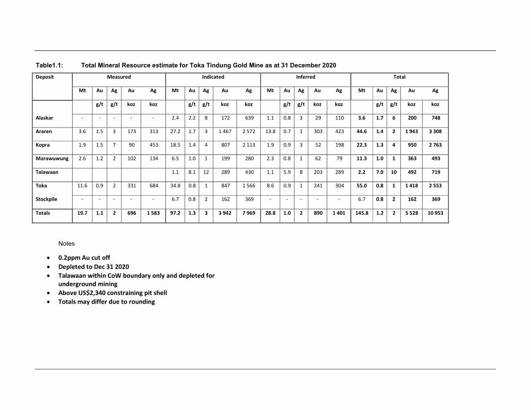
Table1.1: Total Mineral Resource estimate for Toka Tindung Gold Mine as at 31 December 2020
Deposit Measured Indicated Inferred Total
Mt Au Ag Au Ag Mt Au Ag Au Ag Mt Au Ag Au Ag Mt Au Ag Au Ag
g/t g/t koz koz g/t g/t koz koz g/t g/t koz koz g/t g/t koz koz
Alaskar - - - - - 2.4 2.2 8 172 639 1.1 0.8 3 29 110 3.6 1.7 6 200 748
Araren 3.6 1.5 3 173 313 27.2 1.7 3 1 467 2 572 13.8 0.7 1 303 423 44.6 1.4 2 1 943 3 308
Kopra 1.9 1.5 7 90 453 18.5 1.4 4 807 2 113 1.9 0.9 3 52 198 22.3 1.3 4 950 2 763
Marawuwung 2.6 1.2 2 102 134 6.5 1.0 1 199 280 2.3 0.8 1 62 79 11.3 1.0 1 363 493
Talawaan 1.1 8.1 12 289 430 1.1 5.9 8 203 289 2.2 7.0 10 492 719
Toka 11.6 0.9 2 331 684 34.8 0.8 1 847 1 566 8.6 0.9 1 241 304 55.0 0.8 1 1 418 2 553
Stockpile - - - - - 6.7 0.8 2 162 369 - - - - - 6.7 0.8 2 162 369
Totals 19.7 1.1 2 696 1 583 97.2 1.3 3 3 942 7 969 28.8 1.0 2 890 1 401 145.8 1.2 2 5 528 10 953
Notes
0.2ppm Au cut off Depleted to Dec 31 2020 Talawaan within CoW boundary only and depleted for
underground mining Above US$2,340 constraining pit shell Totals may differ due to rounding
Practitioner Consent
The information in this report that relates to the sampling, data preparation, lithology modelling, oxidisation modelling and density assignment in support of the Toka Tindung Gold Mine’s Mineral Resources is based on and fairly reflects information compiled and conclusions derived by Ms Sonia Konopa, who is a Competent Person, a Fellow of the AusIMM and a Member of the Australasian Institute of Geoscientists. Ms Konopa is a full-time employee of Archi based in their Jakarta office. Ms Konopa has sufficient experience that is relevant to the mineral asset under consideration, the style of mineralisation and the type of deposit under consideration and to the activity being undertaken to qualify as a Competent Person as defined in the 2012 edition of the ‘JORC Code. Ms Konopa consents to the inclusion in the Report of the matters based on their information in the form and context in which it appears.
The information in this report that relates to the compilation, grade estimation, classification and reporting of the Toka Tindung Gold Mine’s Mineral Resources is based on and fairly reflects information compiled and conclusions derived by Mr Danny Kentwell, who is a Competent Person and Fellow of the AusIMM. Mr Kentwell is a full-time employee of SRK based in our Melbourne office. Mr Kentwell has sufficient experience that is relevant to the mineral asset under consideration, the style of mineralisation and the type of deposit under consideration and to the activity being undertaken to qualify as a Competent Person as defined in the 2012 edition of the ‘JORC Code. Mr Kentwell consents to the inclusion in the Report of the matters based on their information in the form and context in which it appears.
The information in this report that relates to the depletion of the Talawaan deposit and stockpile Mineral Resource grade and tonnage is based on and fairly reflects information compiled and conclusions derived by Mr Shawn David Crispin, who is a Competent Person and Fellow of the AusIMM. Mr Crispin is a full-time employee of Archi based in their Jakarta office. Mr Crispin has sufficient experience that is relevant to the mineral asset under consideration, the style of mineralisation and the type of deposit under consideration and to the activity being undertaken to qualify as a Competent Person as defined in the 2012 edition of the ‘JORC Code. Mr Crispin consents to the inclusion in the Report of the matters based on their information in the form and context in which it appears.
The Consent Forms of the Competent Persons are attached in Appendix 2.
Drill Data Inputs Data used to support the 2020 Toka Tindung Gold Mine’s resource models are a combination of exploration diamond drilling (DD), exploration reverse circulation drilling (RC and RD), and grade control reverse circulation drilling (GCRC). A total of 94,935 drillholes and approximately 1,286,500m contributes to the data inputs used to complete the Mineral Resource estimates (Table 1.2).
Table 1.2: Summary of Drill Statistics
Deposit DD RC GCRC
Count Metres Count Metres Count Metres
Alaskar 149 38,366 91 13,244 - -
Araren 476 101,249 531 76,747 70,093 145,093
Kopra 274 51,380 900 120,860 2,403 54,233
Marawuwung 228 32,453 203 26,439 - -
Toka 323 44,136 1,403 188,211 17,357 340,738
Talawaan 168 19,638 138 13,945 - -
Total 1,618 287,222 3,266 439,446 89,853 540,064
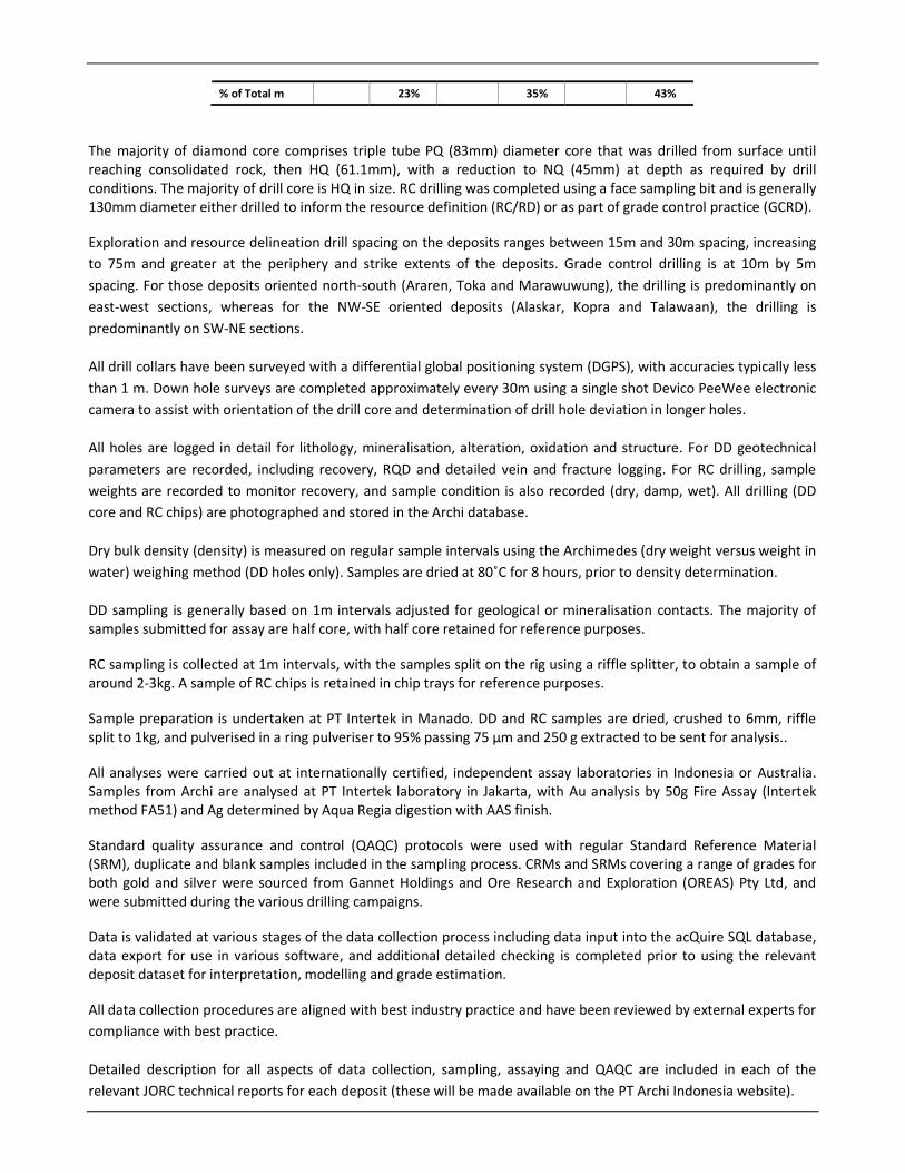
% of Total m 23%
35%
43%
The majority of diamond core comprises triple tube PQ (83mm) diameter core that was drilled from surface until reaching consolidated rock, then HQ (61.1mm), with a reduction to NQ (45mm) at depth as required by drill conditions. The majority of drill core is HQ in size. RC drilling was completed using a face sampling bit and is generally 130mm diameter either drilled to inform the resource definition (RC/RD) or as part of grade control practice (GCRD).
Exploration and resource delineation drill spacing on the deposits ranges between 15m and 30m spacing, increasing to 75m and greater at the periphery and strike extents of the deposits. Grade control drilling is at 10m by 5m spacing. For those deposits oriented north-south (Araren, Toka and Marawuwung), the drilling is predominantly on east-west sections, whereas for the NW-SE oriented deposits (Alaskar, Kopra and Talawaan), the drilling is predominantly on SW-NE sections.
All drill collars have been surveyed with a differential global positioning system (DGPS), with accuracies typically less than 1 m. Down hole surveys are completed approximately every 30m using a single shot Devico PeeWee electronic camera to assist with orientation of the drill core and determination of drill hole deviation in longer holes.
All holes are logged in detail for lithology, mineralisation, alteration, oxidation and structure. For DD geotechnical parameters are recorded, including recovery, RQD and detailed vein and fracture logging. For RC drilling, sample weights are recorded to monitor recovery, and sample condition is also recorded (dry, damp, wet). All drilling (DD core and RC chips) are photographed and stored in the Archi database.
Dry bulk density (density) is measured on regular sample intervals using the Archimedes (dry weight versus weight in water) weighing method (DD holes only). Samples are dried at 80˚C for 8 hours, prior to density determination.
DD sampling is generally based on 1m intervals adjusted for geological or mineralisation contacts. The majority of samples submitted for assay are half core, with half core retained for reference purposes.
RC sampling is collected at 1m intervals, with the samples split on the rig using a riffle splitter, to obtain a sample of around 2-3kg. A sample of RC chips is retained in chip trays for reference purposes.
Sample preparation is undertaken at PT Intertek in Manado. DD and RC samples are dried, crushed to 6mm, riffle split to 1kg, and pulverised in a ring pulveriser to 95% passing 75 µm and 250 g extracted to be sent for analysis..
All analyses were carried out at internationally certified, independent assay laboratories in Indonesia or Australia. Samples from Archi are analysed at PT Intertek laboratory in Jakarta, with Au analysis by 50g Fire Assay (Intertek method FA51) and Ag determined by Aqua Regia digestion with AAS finish.
Standard quality assurance and control (QAQC) protocols were used with regular Standard Reference Material (SRM), duplicate and blank samples included in the sampling process. CRMs and SRMs covering a range of grades for both gold and silver were sourced from Gannet Holdings and Ore Research and Exploration (OREAS) Pty Ltd, and were submitted during the various drilling campaigns.
Data is validated at various stages of the data collection process including data input into the acQuire SQL database, data export for use in various software, and additional detailed checking is completed prior to using the relevant deposit dataset for interpretation, modelling and grade estimation.
All data collection procedures are aligned with best industry practice and have been reviewed by external experts for compliance with best practice.
Detailed description for all aspects of data collection, sampling, assaying and QAQC are included in each of the relevant JORC technical reports for each deposit (these will be made available on the PT Archi Indonesia website).

In SRK’s opinion, the resource database is suitable for Mineral Resource estimation purposes for the deposit underpinning Toka Tindung Gold Mine.
Geological modelling and domain modelling
The Toka Tindung Gold Mine area is located on the eastern margin of the South East Asia Plate within the Sulawesi-East Mindanao magmatic arc, a highly mineralised belt of volcanics and high level intrusives of early Miocene to Quaternary age. A series of north-northwest–south-southeast trending faults define structural corridors which host the deposits. The deposits are low-sulfidation epithermal systems.
Mineralisation at the southern deposits of Alaskar, Araren, Kopra and Talawaan occurs in quartz-adularia veins hosted by basaltic andesite. Wall rock alteration is characterized by narrow zones of strong silicification and argillic or propylitic alteration. At the northern deposits of Toka and Marawuwung, mineralisation is generally of a lower grade tenure than the southern deposits. Mineralisation at Toka and Marawuwung occurs within a package of silicified pyroclastic rocks. Low-grade mineralization occurs throughout this lithological package, with higher-grade zones associated with quartz-adularia veins. Wall rock alteration is characterized by silicification and argillic or propylitic alteration.
The Toka Tindung Gold Mine’s deposits have been interpreted and modelled in 3D for mineralization (gold), lithology and oxidation using both Leapfrog and MicroMine computer software. The domains were constructed by interval selection methodology, snapping to the drillhole intercept in 3D. Mineralisation was modelled on 12.5m to 25m spaced sections (in the more densely drilled areas) out to 50m (at the northern and southern extents), lithology on 25m sections and oxidation on 50m sections.
The mineralisation domains were used to control estimation of gold (Au) and silver (Ag). Density was assigned based on statistical analysis using a combination of lithology and oxidation.
Oxidation domains were defined using the logged visual oxidation parameter. The criteria used was: Oxide (COX) ≥ 70%; Partial Oxide (POX) ≥ 30% and <70%; and Fresh (UNOX) <30%. Interval selection was assessed visually in 3D and
smoothed as required to produce a simplified appropriate representation of the oxidation material types that that would be appropriate to use for modelling purposes. Statistical analysis supports this approach.
The domain strategy in 2020 was similar to what has previously been used for the southern deposits defining the mineralized quartz veins. High grade zones were defined using a nominal gold grade >1.0 g/t Au, minimum 1m width, and maximum 5m internal dilution. A noted change to the previous domain strategy was to also define a low grade halo around the high grade zones that effectively delineates the entire mineralized corridor to include any stockwork veining or breccia that occurs peripheral to the main quartz veins. A nominal 0.2 g/t Au lower cut was used to define the low grade halo.
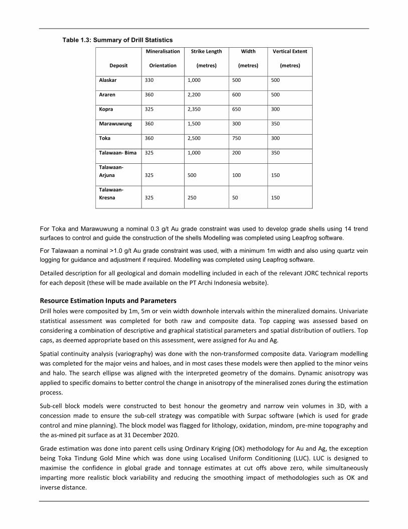
Table 1.3: Summary of Drill Statistics
Deposit
Mineralisation
Orientation
Strike Length
(metres)
Width
(metres)
Vertical Extent
(metres)
Alaskar 330 1,000 500 500
Araren 360 2,200 600 500
Kopra 325 2,350 650 300
Marawuwung 360 1,500 300 350
Toka 360 2,500 750 300
Talawaan- Bima 325 1,000 200 350
Talawaan- Arjuna 325 500 100 150
Talawaan-Kresna 325 250 50 150
For Toka and Marawuwung a nominal 0.3 g/t Au grade constraint was used to develop grade shells using 14 trend
surfaces to control and guide the construction of the shells Modelling was completed using Leapfrog software.
For Talawaan a nominal >1.0 g/t Au grade constraint was used, with a minimum 1m width and also using quartz vein
logging for guidance and adjustment if required. Modelling was completed using Leapfrog software.
Detailed description for all geological and domain modelling included in each of the relevant JORC technical reports for each deposit (these will be made available on the PT Archi Indonesia website).
Resource Estimation Inputs and Parameters Drill holes were composited by 1m, 5m or vein width downhole intervals within the mineralized domains. Univariate statistical assessment was completed for both raw and composite data. Top capping was assessed based on considering a combination of descriptive and graphical statistical parameters and spatial distribution of outliers. Top caps, as deemed appropriate based on this assessment, were assigned for Au and Ag.
Spatial continuity analysis (variography) was done with the non-transformed composite data. Variogram modelling was completed for the major veins and haloes, and in most cases these models were then applied to the minor veins and halo. The search ellipse was aligned with the interpreted geometry of the domains. Dynamic anisotropy was applied to specific domains to better control the change in anisotropy of the mineralised zones during the estimation process.
Sub-cell block models were constructed to best honour the geometry and narrow vein volumes in 3D, with a concession made to ensure the sub-cell strategy was compatible with Surpac software (which is used for grade control and mine planning). The block model was flagged for lithology, oxidation, mindom, pre-mine topography and the as-mined pit surface as at 31 December 2020.
Grade estimation was done into parent cells using Ordinary Kriging (OK) methodology for Au and Ag, the exception being Toka Tindung Gold Mine which was done using Localised Uniform Conditioning (LUC). LUC is designed to maximise the confidence in global grade and tonnage estimates at cut offs above zero, while simultaneously imparting more realistic block variability and reducing the smoothing impact of methodologies such as OK and inverse distance.

A high grade restriction approach was applied to specific domains to prevent smearing of outlier high grades into low grade or waste areas. Density was assigned based on a combination of lithology and oxidation.
Table 1.4 summarises the block model parameters and key estimation parameters applied for all the Toka Tindung
Gold Mine’s resource models.
Detailed description for all aspects of the resource estimation process and parameters used are included in each of the relevant JORC technical reports for each deposit (these will be made available on the PT Archi Indonesia website).
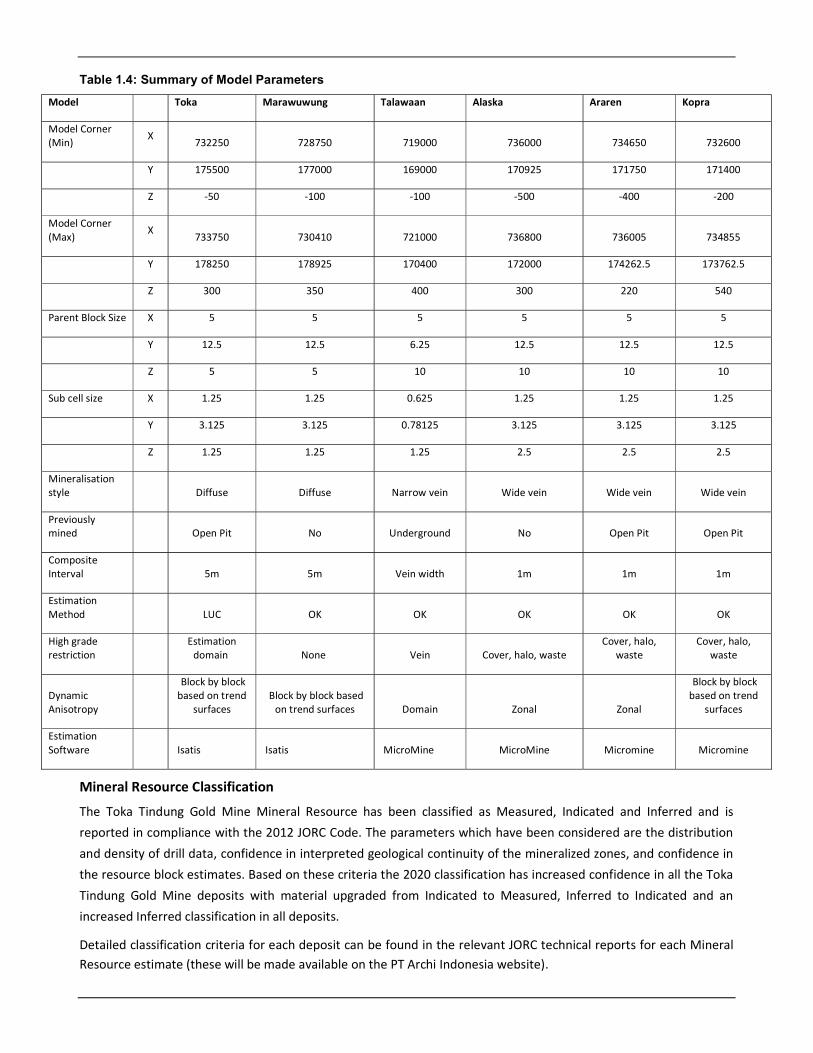
Table 1.4: Summary of Model Parameters
Model Toka Marawuwung Talawaan Alaska Araren Kopra
Model Corner (Min)
X 732250 728750 719000 736000 734650 732600
Y 175500 177000 169000 170925 171750 171400
Z -50 -100 -100 -500 -400 -200
Model Corner (Max)
X 733750 730410 721000 736800 736005 734855
Y 178250 178925 170400 172000 174262.5 173762.5
Z 300 350 400 300 220 540
Parent Block Size X 5 5 5 5 5 5
Y 12.5 12.5 6.25 12.5 12.5 12.5
Z 5 5 10 10 10 10
Sub cell size X 1.25 1.25 0.625 1.25 1.25 1.25
Y 3.125 3.125 0.78125 3.125 3.125 3.125
Z 1.25 1.25 1.25 2.5 2.5 2.5
Mineralisation style Diffuse Diffuse Narrow vein Wide vein Wide vein Wide vein
Previously mined Open Pit No Underground No Open Pit Open Pit
Composite Interval 5m 5m Vein width 1m 1m 1m
Estimation Method LUC OK OK OK OK OK
High grade restriction
Estimation domain None Vein Cover, halo, waste
Cover, halo, waste
Cover, halo, waste
Dynamic Anisotropy
Block by block based on trend
surfaces Block by block based
on trend surfaces Domain Zonal Zonal
Block by block based on trend
surfaces
Estimation Software Isatis Isatis MicroMine MicroMine Micromine Micromine
Mineral Resource Classification
The Toka Tindung Gold Mine Mineral Resource has been classified as Measured, Indicated and Inferred and is reported in compliance with the 2012 JORC Code. The parameters which have been considered are the distribution
and density of drill data, confidence in interpreted geological continuity of the mineralized zones, and confidence in the resource block estimates. Based on these criteria the 2020 classification has increased confidence in all the Toka
Tindung Gold Mine deposits with material upgraded from Indicated to Measured, Inferred to Indicated and an increased Inferred classification in all deposits.
Detailed classification criteria for each deposit can be found in the relevant JORC technical reports for each Mineral Resource estimate (these will be made available on the PT Archi Indonesia website).
The criteria for classification applied for most of the deposits is as follows:
Measured (RESCAT=1): average drill spacing of <15m; very high confidence in continuity of mineralization; block estimated in first or second interpolation pass (PASS = 1); average distance of samples to block centroid (AVDIST) <10m.
Indicated (RESCAT=2): average drill spacing of <30m; high confidence in continuity of mineralization; block estimated in first or second interpolation pass (PASS = 1 or 2); average distance of samples to block centroid (AVDIST) <25m.
Inferred(RESCAT=3): average drill spacing <50m maximum up to 100m; moderate confidence in continuity of mineralisation based on lesser drill support along strike or at depth; block estimated in second or third interpolation pass (PASS = 2 or 3); average distance of samples to block centroid (AVDIST) <40m maximum 100m.
Mineral Resources were reported constrained by an optimized Whittle pit shell generated using US$2,340/oz Au
prices at a 0.2 g/t Au cut-off, based on a processing flowsheet incorporating the current Toka Tindung Gold Mine CIL process. It is considered that in doing so that the “reasonable prospects for eventual economic extraction” (Clause 20) of the 2012 JORC Code have been met.
Validation The validation of the global resource estimates was performed by way of visual checks of block estimates against the drill composites, comparison of statistical de-clustered mean data and swath plots in northing, easting and elevation.
Visual checks confirmed that in general, the models reflect grade trends in the input data, and model grades correlate reasonably with the composite grades. There is no obvious smearing of high grade, with areas of higher grade being well constrained locally around the drill intercept, supporting the application of top capping and high grade restriction.
In the swath plots, the overall trends between the block estimates and composites show a good correlation for Au and Ag, with no significant bias between the two sets of data. The plots indicate that in general, the block estimates
are well-conditioned with respect to the supporting data.
The Mineral Resource estimate was also independently reviewed and audited by SRK consultants, who found the
estimates to be fair and representative estimations for use in Ore Reserve estimation.
Appendix 1: JORC 2012 Table 1
Section One: Sampling Techniques and Data
Criteria JORC Code explanation
Commentary
Sampling Techniques
Nature and quality of sampling
Samples informing the resource model are predominantly from half diamond drill (DD) core in PQ3, HQ3 or NQ3 size or 130mm Reverse Circulation (RC) drilling samples.
Include reference to measures taken to ensure sample representivity and the appropriate calibration of any measurement tools or systems used.
Diamond drill core is marked with sampling intervals by geologists according to geological boundaries. Individual sample lengths generally range from 0.2 – 1m. For RC drilling, sampling is conducted at 1m intervals and collected using a 3 tier riffle splitter at the rig to produce an ~2kg subsample which is sent to the laboratory for sample preparation and analysis. Samples are dried and crushed in the lab and riffle split again to ~ 1.5kg for grinding to 200# prior to fire assay analysis.
Aspects of the determination of mineralisation that are Material to the Public Report.
Half-core diamond drill core and the reverse circulation cutting samples of approximately 2kg, were pulverised to produce 50g flux fused charge for fire assay.
Drilling Techniques
Drill type (e.g. core, reverse circulation, open-hole hammer, rotary air blast, auger, Bangka, sonic, etc.) and details (e.g. core diameter, triple or standard tube, depth of diamond tails, face-sampling bit or other type, whether core is oriented and if so, by what method, etc.).
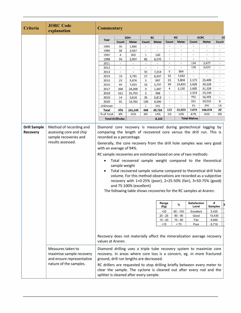
The drill data used for the Araren resource model is diamond and reverse circulation drilling. Diamond core of PQ, HQ, NQ and BQ diameters with standard and triple tube core recovery systems were used by Aurora Gold Ltd. Diamond core of PQ, HQ and NQ diameters with triple tube recovery has been collected by Archi. The majority of drill core is HQ in size, with PQ used from surface until competent rock is reached where upon HQ is utilized. Further reductions in core size occur if necessitated by drilling conditions. RC drilling with a face sampling bit has been used by Aurora Gold Ltd and Archi. Drill hole diameter is generally 130mm. Where possible, a down hole core orientation tool (Orishot Gen 4 Multishot) is used to enable collection of detailed structural information. The table below shows the distribution of drilling at Araren by year.
Criteria JORC Code explanation
Commentary
Drill Sample Recovery
Method of recording and assessing core and chip sample recoveries and results assessed.
Diamond core recovery is measured during geotechnical logging by comparing the length of recovered core versus the drill run. This is recorded as a percentage. Generally, the core recovery from the drill hole samples was very good with an average of 94%. RC sample recoveries are estimated based on one of two methods:
Total recovered sample weight compared to the theoretical sample weight
Total recovered sample volume compared to theoretical drill hole volume. For this method observations are recorded as a subjective recovery with 1=0-25% (poor), 2=25-50% (fair), 3=50-75% (good) and 75-100% (excellent)
The following table shows recoveries for the RC samples at Araren:
Recovery does not materially affect the mineralization average recovery values at Araren.
Measures taken to maximise sample recovery and ensure representative nature of the samples.
Diamond drilling uses a triple tube recovery system to maximize core recovery. In areas where core loss is a concern, eg. in more fractured ground, drill run lengths are decreased. RC drillers are requested to stop drilling briefly between every meter to clear the sample. The cyclone is cleaned out after every rod and the splitter is cleaned after every sample.
Range (Kg)
% Satisfaction
Level #
Samples Sample %
>25 90 - 100 Excellent 5,435
20 - 25 80 - 90 Good 15,430
15 - 20 70 - 80 Fair 9,946
<15 < 70 Poor 6,716
Criteria JORC Code explanation
Commentary
Whether a relationship exists between sample recovery and grade and whether sample bias may have occurred due to preferential loss/gain of fine/coarse material.
The relationship between grade and recovery shows no evidence that there is any systematic bias in the samples or significant loss of gold from fine fractions.
Logging Whether core and chip samples have been geologically and geotechnically logged to a level of detail to support appropriate Mineral Resource estimation, mining studies and metallurgical studies.
All drill holes were logged for geological features. For diamond drill core, geotechnical logging was done by trained technicians under the supervision of geologists. Geotechnical logging includes measurements of drill run length, core recovery, RQD, fracture count and fracture characteristics. Geological logging was completed by geologists on hand written logging sheets, which were transcribed into the Acquire database system. Logged characteristics include (but are not limited to) assay mark-up interval, lithology, structure, veining, alteration type and intensity, and mineralisation. The data collection programs have used standardised logging codes and processes, supported by Standard Operating Procedure (SOP) documentation. All holes are logged to a level of detail to support appropriate Mineral Resource estimation. A representative chip sample from each meter is retained in trays. All half core is retained for reference and further sampling if required. Some core has been specifically drilled for metallurgical test work and fully utilized for this purpose.
Whether logging is qualitative or quantitative in nature. Core (or costean, channel, etc.) photography.
Visual geological and alteration logs are taken by a dedicated team of experienced geologists using a standardised logging scheme. Although visual logs are inherently qualitative, additional quantitative measurements of core are also taken routinely and are included in the interpretation of logged data. These include RQD measurements and magnetic susceptibility measurements. These are all measured on a metre by metre basis. All core and RC chips are digitally photographed after logging and before cutting and sampling.
The total length and percentage of the relevant intersections logged.
100% of the DD holes were logged for geology and geotechnical features. 100% of the RC holes were logged for geology.
Sub-Sampling Techniques and Sample Preparation
If core, whether cut or sawn and whether quarter, half or all core taken.
The drill core is cut into halves using a diamond blade core-saw, with one half sampled and one half retained.
If non-core, whether riffled, tube sampled, rotary split, etc. and whether sampled wet or dry.
RC chip samples are riffle split to 2-3kg if dry. If samples are wet, Aurora initially took grab samples of 2-3kg from the wet slurries following homogenization. This was later changed to spear sampling of wet sampling. Archi utilize grab sampling for wet RC samples. Validation of assays results from wet samples is done as part of the data validation process to determine if the samples are considered to be biased, in which cases they are excluded for use in the grade estimation.
Criteria JORC Code explanation
Commentary
For all sample types, the nature, quality and appropriateness of the sample preparation technique.
Prior to 1999, all gold and silver assay samples were sent to Intertek Testing Services’ site preparation facilities and then to Intertek’s Jakarta laboratory for analysis, with check assays performed at other commercial laboratories. From May 1999, the samples were prepared and analysed in a new site facility managed by PT Indo Assay Utama Laboratories, an Indonesian subsidiary of the Australian-based analytical group Analabs Pty Ltd. DD core and RC samples were dried and crushed to 6mm if necessary, riffle split to 1kg and pulverized in a ring pulverizer. Archi has sent all RC and DD samples to the sample preparation facility in Manado operated by PT Intertek Utama Services. Routine sample preparation protocols include:
weighing drying at 105°C jaw crushing to 2mm (gravel wash & air spray between each
sample); sizing test carried out on 1:15 samples (95% <2mm) riffle splitting to 1.5kg pulverizing to 95% passing 75µm using ring mill pulverisers
(gravel wash & air spray between each sample) A sub-sample of 250grams is taken and sent by air to the Intertek Jakarta laboratory and 250grams is returned to site for storage. Samples from grade control drilling are analyzed on site with routine sample preparation protocols including:
drying at 105°C crushing to nominal 2mm riffle splitting to 1.5kg fine pulverizing to 95% passing 75µm using LM5 pulverizers
Quality control procedures adopted for all sub-sampling stages to maximise representivity of samples. Measures taken to ensure that the sampling is representative of the in-situ material collected, including for instance results for field duplicate/second-half sampling.
Drill core is generally sampled at 0.2 – 1m intervals. Core is cut in half with a diamond saw, with half sampled and half retained for reference. One SRM (Standard Reference Material) and one blank sample (containing no gold) is inserted for every 50 drill samples submitted for analysis. RC drilling is sampled on 1m intervals with one SRM, one blank and one duplicate sample inserted every 25 samples.
Whether sample sizes are appropriate to the grain size of the material being sampled.
Petrographic studies and metallurgical test work shows that gold and silver forms mostly as free grains of electrum in the Toka Tindung deposits. These electrum grains occur at sizes of 1-10 microns. The electrum occurs in quartz veins and less commonly as inclusions with pyrite and arsenopyrite. Therefore, sample sizes are large relative to the grain size and this ensures that samples remain representative and any nugget effects of gold are minimised.

Criteria JORC Code explanation
Commentary
Quality of Assay Data and Laboratory Tests
The nature, quality and appropriateness of the assaying and laboratory procedures used and whether the technique is considered partial or total.
All analyses were carried out at internationally certified, independent assay laboratories in Indonesia or Australia. Samples from Aurora drilling were initially assayed for gold by Aqua Regia and later by 50g Fire Assay methods. Silver and arsenic were analysed by an Aqua Regia digestion method with determinations by AAS (Atomic Absorption Spectrometer). Independent consultants concluded that there was no significant difference between the Fire Assay and Aqua Regia assay determinations. Samples from Archi are analysed at PT Intertek laboratory in Jakarta. Gold analysis is by 50g Fire Assay (Intertek method FA51) with a lower detection limit of 0.01ppm Au. Silver and arsenic are determined by Aqua Regia digestion with AAS analysis (Intertek method GA02). Lower detection limits are 1ppm for Ag and 40ppm for As. Grade control samples are analysed onsite. Gold and silver analysis of 30g samples is undertaken using Aqua Regia methods. Sets of check samples are sent to independent laboratories in Indonesia for analysis to ensure accuracy of results.
For geophysical tools, spectrometers, handheld XRF instruments, etc., the parameters used in determining the analysis including instrument make and model, reading times, calibrations factors applied and their derivation, etc.
A Halo Terraspec VNIR/SWIR spectrometer was acquired in 2018 to assist in identifying alteration assemblages. Routine sampling of core is conducted every meter. Whilst booting up the tool runs through a full set of diagnostic tests and automatically undertakes a white reference scan from the external Spectrumlon disk. After this initial external white reference scan, the tool continues to complete regular internal scans. Interpretation of spectra uses TSG software for initial interpretation. All readings are visually checked and corrected by a trained operator. Magnetic susceptibility data is routinely collected from drill core on a per meter basis using CormaGeo RT-1 machines. These are factory calibrated in accordance with the manufacturers guidelines. Standard collection SOPs are used to eliminate outside influence on the magnetic susceptibility readings.
Nature of quality control procedures adopted (e.g. standards, blanks, duplicates, external laboratory checks) and whether acceptable levels of accuracy (i.e. lack of bias) and precision have been established.
Quality control measures during the Aurora drilling involved the use of known certified gold standards, blanks and duplicate samples on a routine basis. Sample and assay quality were monitored by duplicating every 20th RC sample and the insertion of standards every 50th sample or in the case of DD core, every 20th sample. For DD drilling Archi inserts one commercial SRM (Standard Reference Material) and one blank sample containing no gold for every 50 drill samples submitted for analysis. For RC drilling, one SRM, one blank and one duplicate sample is submitted for every 25 samples. Archi has a suite of certified and non-certified standards (“Standards”) covering a range of grades and elements (including Au &Ag). Certified standards, sourced from Gannet Holdings and Ore Research and Exploration (OREAS) Pty Ltd, were submitted as part of this campaign. Assay results received outside 2SD of the certified assay limits of standards / blanks are checked and re-analysed if necessary by appropriate methods. The use of routine blanks, standards and duplicates in addition to referee laboratory check assaying are considered adequate for the determination of accuracy and precision of the assay data.
Criteria JORC Code explanation
Commentary
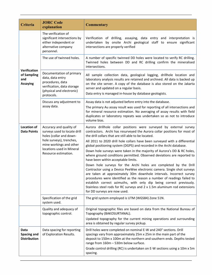
Verification of Sampling and Assaying
The verification of significant intersections by either independent or alternative company personnel.
Verification of drilling, assaying, data entry and interpretation is undertaken by onsite Archi geological staff to ensure significant intersections are properly verified
The use of twinned holes. A number of specific twinned DD holes were located to verify RC drilling. Twinned holes between DD and RC drilling confirm the mineralised intersections.
Documentation of primary data, data entry procedures, data verification, data storage (physical and electronic) protocols.
All sample collection data, geological logging, drillhole location and laboratory analysis results are retained and archived. All data is backed up on the site server. A copy of the database is also stored on the Jakarta server and updated on a regular basis. Data entry is managed in-house by database geologists.
Discuss any adjustment to assay data.
Assay data is not adjusted before entry into the database. The primary Au assay result was used for reporting of all intersections and for mineral resource estimation. No averaging of assay results with field duplicates or laboratory repeats was undertaken so as not to introduce volume bias.
Location of Data Points
Accuracy and quality of surveys used to locate drill holes (collar and down-hole surveys), trenches, mine workings and other locations used in Mineral Resource estimation.
Aurora drillhole collar positions were surveyed by external survey contractors. Archi has resurveyed the Aurora collar positions for most of the drill collars that are still able to be located. All 2011 to 2020 drill hole collars have been surveyed with a differential global positioning system (DGPS) and recorded in the Archi database. Down hole surveys were taken in the majority of Aurora’s DD & RC holes, where ground conditions permitted. Observed deviations are reported to have been within acceptable limits. Down hole surveys for the Archi holes are completed by the Drill Contractor using a Devico PeeWee electronic camera. Single shot surveys are taken at approximately 30m downhole intervals. Incorrect survey procedures were identified as the reason a number of readings failed to establish correct azimuths, with only dip being correct previously. Stainless steel rods for RC surveys and 2 x 1.5m aluminum rod extensions for DD surveys are now used.
Specification of the grid system used.
The grid system employed is UTM (WGS84) Zone 51N.
Quality and adequacy of topographic control.
Original topographic files are based on data from the National Bureau of Topography (BAKOSURTANAL). Updated topography for the current mining operations and surrounding area is obtained by regular survey pickup.
Data Spacing and Distribution
Data spacing for reporting of Exploration Results.
Drill holes were completed on nominal E-W and 240° sections. Drill spacings vary from approximately 25m x 25m in the main part of the deposit to 150m x 100m at the northern and southern ends. Depths tested range from 160m – 530m below surface. Grade control drilling (RC) is undertaken on E-W sections using a 10m x 5m spacing.

Criteria JORC Code explanation
Commentary
Whether the data spacing and distribution is sufficient to establish the degree of geological and grade continuity appropriate for the Mineral Resource and Ore Reserve estimation procedure(s) and classifications applied.
The data spacing and distribution of drill hole samples from both diamond and reverse circulation is sufficient to establish confidence in geological and grade continuity.
Whether sample compositing has been applied.
Drill holes were composited over 1m downhole intervals within the mineralised domains.
Orientation of Data in Relation to Geological Structure
Whether the orientation of sampling achieves unbiased sampling of possible structures and the extent to which this is known, considering the deposit type.
The orientation of structural controls at the Araren deposit are observable and well understood. Drilling is oriented, as much as possible, to intersect mineralizing structures perpendicular to the strike orientation to minimize sample bias.
If the relationship between the drilling orientation and the orientation of key mineralised structures is considered to have introduced a sampling bias, this should be assessed and reported if material.
Where possible, drilling has attempted to intersect structures, as close as possible, perpendicular to the structures strike orientation. Bias has been minimized as much as practical by this practice.
Sample Security
The measures taken to ensure sample security.
Samples are delivered by Archi site personnel to PT Intertek laboratory in Manado, utilizing good security to ensure appropriate chain of custody. Pulps are packaged and sent via courier to ITS Jakarta.
Audits or Reviews
The results of any audits or reviews of sampling techniques and data.
Independent and internal reviews of the geology, sampling and assay quality and resource estimation methods have been undertaken at various stages throughout the life of the project. Between 1996 and 2003, data and data collection protocols were routinely reviewed by Mining and Resource Technology Pty (MRT, now Golder Associates) and Snowden Mining Consultants. All aspects of the data quality and procedures was found to meet industry standards and be appropriate for the style of mineralisation. Anthony Woodward of Mining Associates Limited visited the site in August 2011 during the compilation of a review of drilling, sampling techniques, QAQC and verification sampling. Methods were found to conform to international best practice, including that required by JORC. Audits of the Aurora drilling data have previously been carried out by several independent consultants. Mr Joe MacPherson of EMINTECH visited the site during August 2020 to undertake an independent review of Archi’s exploration targets. SOPs for DD core and RC sampling and preparation were reviewed and found to be

Criteria JORC Code explanation
Commentary
in order. The Intertek preparation laboratory was also visited. The processes observed conformed to Intertek and Archi Standard Operating Procedures. In October 2020 SRK Consulting (Australasia) Pty Ltd completed a detailed desktop review of the exploration documents and data relied on by Mr MacPherson (as detailed above). SRK found no issue with the data reviewed. A systematic and regular internal review process was undertaken by the Archi Head of Mineral Resources during all key stages of the resource estimation process including data input validation, geological interpretation and modelling, geostatistical analysis, estimation parameter selection, and validation of the resource estimate.
Section Two: Reporting of Exploration Results
Criteria JORC Code Explanation Commentary
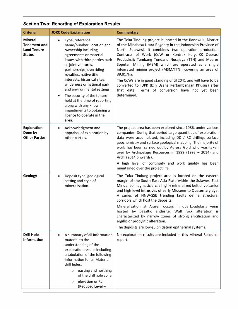
Mineral Tenement and Land Tenure Status
Type, reference name/number, location and ownership including agreements or material issues with third parties such as joint ventures, partnerships, overriding royalties, native title interests, historical sites, wilderness or national park and environmental settings.
The security of the tenure held at the time of reporting along with any known impediments to obtaining a licence to operate in the area.
The Toka Tindung project is located in the Ranowulu District of the Minahasa Utara Regency in the Indonesian Province of North Sulawesi. It combines two operation production Contracts of Work (CoW or Kontrak Karya-KK Operasi Producksi): Tambang Tondano Nusajaya (TTN) and Meares Soputan Mining (MSM) which are operated as a single integrated mining project (MSM/TTN), covering an area of 39,817ha. The CoWs are in good standing until 2041 and will have to be converted to IUPK (Izin Usaha Pertambangan Khusus) after that date. Terms of conversion have not yet been determined.
Exploration Done by Other Parties
Acknowledgment and appraisal of exploration by other parties.
The project area has been explored since 1986, under various companies. During that period large quantities of exploration data were accumulated, including DD / RC drilling, surface geochemistry and surface geological mapping. The majority of work has been carried out by Aurora Gold who was taken over by Archipelago Resources in 1999 (1993 – 2014) and Archi (2014 onwards). A high level of continuity and work quality has been maintained over the project life.
Geology Deposit type, geological setting and style of mineralisation.
The Toka Tindung project area is located on the eastern margin of the South East Asia Plate within the Sulawesi-East Mindanao magmatic arc, a highly mineralized belt of volcanics and high level intrusives of early Miocene to Quaternary age. A series of NNW-SSE trending faults define structural corridors which host the deposits. Mineralisation at Araren occurs in quartz-adularia veins hosted by basaltic andesite. Wall rock alteration is characterized by narrow zones of strong silicification and argillic or propylitic alteration. The deposits are low-sulphidation epithermal systems.
Drill Hole Information
A summary of all information material to the understanding of the exploration results including a tabulation of the following information for all Material drill holes:
o easting and northing of the drill hole collar
o elevation or RL (Reduced Level –
No exploration results are included in this Mineral Resource report.

Criteria JORC Code Explanation Commentary
elevation above sea level in metres) of the drill hole collar
o dip and azimuth of the hole
o down hole length and interception depth
o hole length
Data Aggregation Methods
In reporting Exploration Results, weighting averaging techniques, maximum and/or minimum grade truncations (e.g. cutting of high grades) and cut-off grades are usually Material and should be stated.
No exploration results are included in this Mineral Resource report.
Where aggregate intercepts incorporate short lengths of high grade results and longer lengths of low grade results, the procedure used for such aggregation should be stated and some typical examples of such aggregations should be shown in detail.
No exploration results are included in this Mineral Resource report.
The assumptions used for any reporting of metal equivalent values should be clearly stated.
No exploration results are included in this Mineral Resource report.
Relationship Between Mineralisation Widths and Intercept Lengths
These relationships are particularly important in the reporting of Exploration Results. If the geometry of the mineralisation with respect to the drill hole angle is known, its nature should be reported. If it is not known and only the down hole lengths are reported, there should be a clear statement to this effect (e.g. ‘down hole length, true width not known’).
No exploration results are included in this Mineral Resource report.
Diagrams Appropriate maps and sections (with scales) and tabulations of intercepts should be included for any significant discovery being reported These should include, but not be limited to a plan view of drill hole collar locations and appropriate sectional views.
No exploration results are included in this Mineral Resource report.
Balanced Reporting
Where comprehensive reporting of all Exploration Results is not practicable, representative reporting
No exploration results are included in this Mineral Resource report.
Criteria JORC Code Explanation Commentary
of both low and high grades and/or widths should be practiced to avoid misleading reporting of Exploration Results.
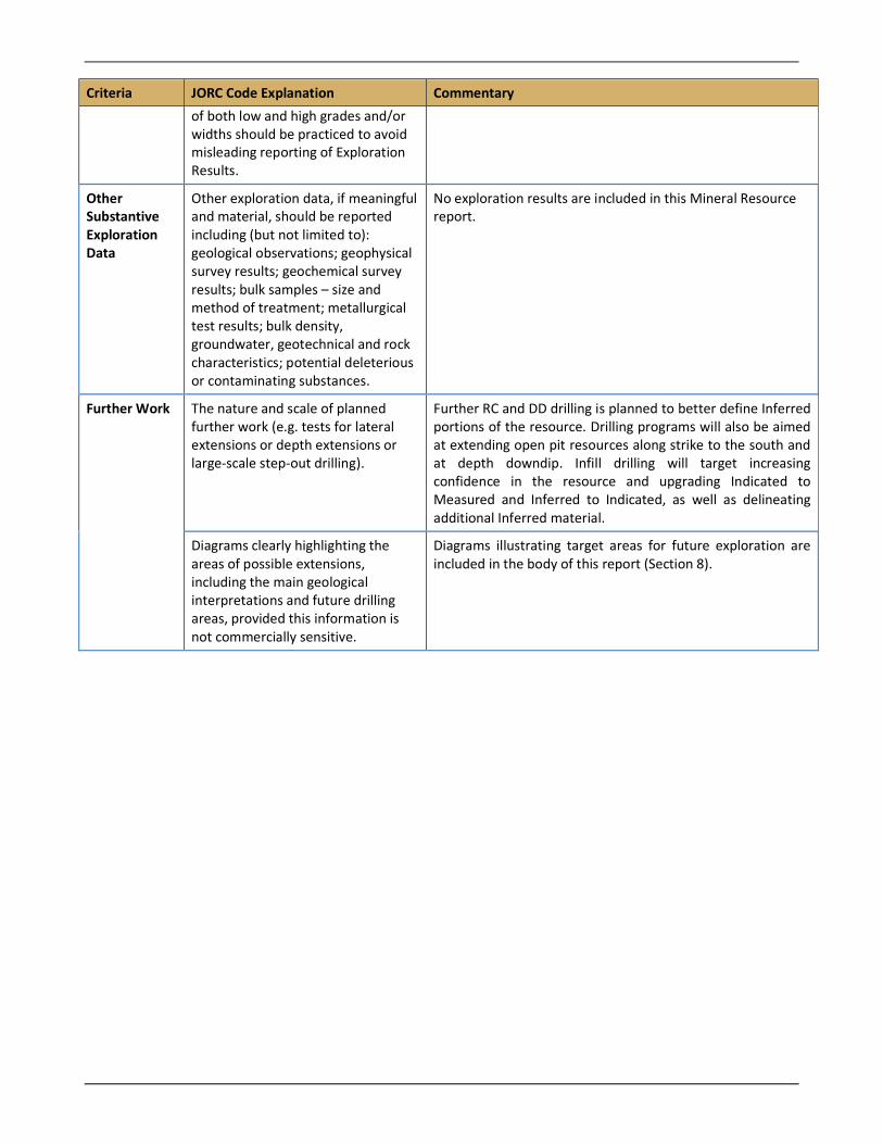
Other Substantive Exploration Data
Other exploration data, if meaningful and material, should be reported including (but not limited to): geological observations; geophysical survey results; geochemical survey results; bulk samples – size and method of treatment; metallurgical test results; bulk density, groundwater, geotechnical and rock characteristics; potential deleterious or contaminating substances.
No exploration results are included in this Mineral Resource report.
Further Work The nature and scale of planned further work (e.g. tests for lateral extensions or depth extensions or large-scale step-out drilling).
Further RC and DD drilling is planned to better define Inferred portions of the resource. Drilling programs will also be aimed at extending open pit resources along strike to the south and at depth downdip. Infill drilling will target increasing confidence in the resource and upgrading Indicated to Measured and Inferred to Indicated, as well as delineating additional Inferred material.
Diagrams clearly highlighting the areas of possible extensions, including the main geological interpretations and future drilling areas, provided this information is not commercially sensitive.
Diagrams illustrating target areas for future exploration are included in the body of this report (Section 8).
Section Three: Estimation and Reporting of Mineral Resources
Criteria JORC Code Explanation Commentary
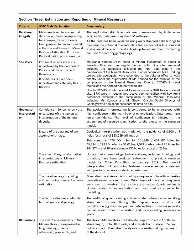
Database Integrity
Measures taken to ensure that data has not been corrupted by, for example, transcription or keying errors, between its initial collection and its use for Mineral Resource Estimation Purposes. Data validation procedures used.
The exploration drill hole database is maintained by Archi in an acQuire SQL database using the GIM software. All the data has been validated using Archi standard field settings to minimize the potential of errors. Data transfer for collar locations and assays are done electronically. Look-up tables and fixed formatting are used for entering geology logs.
Site Visits Comment on any site visits undertaken by the Competent Person and the outcome of those visits. If no site visits have been undertaken indicate why this is the case.
Ms Sonia Konopa (Archi Head of Mineral Resources) is based in Jakarta office and has regular contact with mine site personnel including the geologists collecting the input data used in the preparation of the Mineral Resources. Two experienced Toka Tindung project site geologists, were seconded to the Jakarta office to work directly under the supervision of Ms Konopa for the duration of the compilation of the Mineral Resources. Due to COVID-19 travel restrictions Ms Konopa has not visited site.
Due to COVID-19 international travel restrictions SRK has not visited site. SRK were in regular and active communication with key Archi personnel involved in the compilation of the Mineral Resources including Ms Konopa and Mr Shawn Crispin (Archi Director of Geology) who has spent considerable time on site.
Geological Interpretation
Confidence in (or conversely the uncertainty of) the geological interpretation of the mineral deposit.
The geological interpretation is considered to be understood with high confidence in the main body of mineralisation. Outer areas have lesser confidence. The level of confidence is reflected in the assignment of resource classification to the blocks in the resource model.
Nature of the data and of any assumptions made.
Geological interpretation was made with the guidance of 8,100 drill holes for a total of 323,089 drill metres. This comprises 476 DD holes for 101,249m, 409 RC holes for 45,724m, 122 RD holes for 31,023m, 7,073 grade control RC holes for 144,874m and 20 grade control DD holes for a total of 219m.
The effect, if any, of alternative interpretations on Mineral Resource estimation.
Updated wireframes of geological surfaces, including lithology and oxidation, have been produced subsequent to previous resource model by Cube Consulting in January 2019. The overall interpretations of controlling features however remain consistent with previous resource model interpretations.
The use of geology in guiding and controlling mineral Resource estimation
Mineralization at Araren is hosted by a sequence of basaltic andesites beneath recent volcanic cover. Wireframes of the cover sequence were used to constrain the resource estimation. Quartz veining is closely related to mineralization and was used as a guide for modelling.
The factors affecting continuity both of grade and geology
The width of quartz veining and associated alteration varies along strike and down-dip through the deposit. Areas of structural complication (eg dilational jogs and intersecting structures) generally contain wider zones of alteration and corresponding increases in grade.
Dimensions The extent and variability of the Mineral Resource expressed as length (along strike or otherwise), plan width, and
The Araren Mineral Resource Estimate is approximately 2,500m in strike length, up to 600m wide, and extends from surface to 570m below surface. Mineralisation styles are consistent along the length of the deposit.
Criteria JORC Code Explanation Commentary
depth below surface to the upper and lower limits of the Mineral Resource
Estimation and Modelling Techniques
The nature and appropriateness of the estimation techniques applied and key assumptions, including treatment of extreme grade values, domaining, interpolation parameters and maximum distance of extrapolation from data points. If a computer assisted estimation was chosen include a description of computer software and parameters used.
Estimation was completed using ordinary kriging within a 3D model in Micromine software. Estimation was performed on parent blocks with discretisation of 4x4x4 subdivisions north, east and RL. The sub blocks were assigned on the parent block grade. The average sample interval length was 1m, with 1m selected as the compositing length. To avoid loss of data from small ‘residuals’ at the end of a composite (i.e. < 0.5m intervals), the residual was added to the previous interval. Capped grades were applied to composited data as appropriate. Top caps were determined based on statistical descriptive analysis and graphical method such as linear and natural log histogram, then confirmed by log probability plots. Mineralisation domains were defined by 3D wireframes with hard boundaries to constrain the estimate. Lithology and mineralisation domains were made using Micromine while oxidation domains were built in Leapfrog. Variography was done in Micromine software, with the non-transformed composite data. Variogram modelling was carried out for major vein and major halo, and applied to minor veins, minor halo, and waste. The variogram models were spherical and had a low nugget effect (15-20% of total sill), with a maximum range of 25m in the high grade domains and 100m in halo and waste. Four-sectors and four search passes were run for 1x, 1.5x, 3x, and 6x radii with 5 samples minimum and 20 samples maximum at first pass then reduced at the next pass. A modified and simplified dynamic anisotropy (DA) method was used to account for directional variation in the continuity of the modelled mineralisation in the high grade and halo domains. The mineralized corridor generally follows a regular and observable north-south direction, swinging off to the southeast in the southern part of the deposit. The deposit was sub-domained into five areas of anisotropy search based on the major direction of the mineralization. These areas were assessed and had average azimuth and dips applied for each domain within each anisotropy zone. In the dynamic search process, the searches follow the azimuth and dip that have been assigned to predefined subdomains in the block model. High grade restriction method was applied on the halo, cover and waste domains to control the influence of high grades in these domains. With this method, the estimation was performed using an uncapped value within a search radius of 25mx15mx5m around the capped grade. Negative weights were set to zero during the estimation. Where gold/silver data was insufficient to inform blocks during estimation, a mean value was assigned to the block based on the mean of the estimated blocks for that domain. Full details of the parameters and domains are provided in tables in the body and appendices of this report.
Criteria JORC Code Explanation Commentary
The availability of check estimates, previous estimates and/or mine production records and whether the Mineral Resource estimate takes appropriate account of such data.
Previous estimates were available as a reference and were used as a visual check against this estimate.
The assumptions made regarding recovery of by-products.
Gold is the primary revenue metal in the dore product with silver a minor contributor. Recovery of Au is applied for each block in the Ore Reserve model, using recovery formulae determined through metallurgical test work. Au recovery of 88.7% and Silver recovery of 72% has been applied.
Estimation of deleterious elements or other non-grade variables of economic significance (e.g. sulphur for acid mine drainage characterisation)
No estimations for elements other than Au and Ag were undertaken.
In the case of block model interpolation, the block size in relation to the average sample spacing and the search employed
The block model size is approximately half the average drill hole spacing in the X-Y dimensions, and equivalent to 3 to 5 samples in the z dimension. This is considered reasonable based on the available drill support and style of mineralisation.
Any assumptions behind modelling of selective mining units.
Application of an SMU has not been applied to the Mineral Resource model. The sub-celled Mineral Resource model has been maintained (without regularization) for use as the basis of the Ore Reserve model. The reason for this is that the mining method (mining direction) for these ‘vein’ style deposits is from hanging wall to footwall, using a more selective mining method on contact boundaries between ore and waste. When assessing the impact of SMU block sizes on the deposits, regularizing these ‘vein’ style deposits was over diluting the ore zones compared to the mining accuracy achievable with the selected excavation equipment being proposed. For the ‘vein’ style deposits, ore loss and dilution has been applied manually in the optimization process and the production schedule results to present the Ore Reserve estimate (inclusive or ore loss and dilution effects).
Any assumptions about correlations between variables
No correlations between variables are used during the Mineral Resource Estimation process.
Description of how the geological interpretation work was used to control the Resource Estimates
Mineralised domains based on a combination of geological controls, predominantly quartz veining, and grade shells were used as the constraint for grade estimation. Hard boundaries were applied to the domains during the estimation process.
Discussion of basis for using or not using grade cutting or capping
Top capping was assessed based on considering a combination of descriptive and graphical statistical parameters and spatial distribution of outliers. Top caps, as deemed appropriate based on this assessment, were assigned for Au and Ag. Top cap values are presented in Appendix B of this report.
Criteria JORC Code Explanation Commentary
The process of validation, the checking process used, the comparison of model data to drill hole data, and use of reconciliation data if available
Validation of the global resource estimate was done by way of visual checks of block estimates against the drill composites, comparison of statistical de-clustered mean data, and swath plots in northing, easting and elevation. Visual checks confirmed that in general the model reflects grade trends in the input data and model grades correlate reasonably with the composite grades. There is no obvious smearing of high grade, with areas of higher grade being well constrained locally around the drill intercept.
Moisture Whether the tonnages are estimated on a dry basis or with natural moisture, and the method of determination of the moisture content
Tonnages were estimated on a dry basis.
Cut-off parameters
The basis if the adopted cut-off grade or quality parameters applied
Reporting of the Araren Mineral Resource is based on a gold cut-off of 0.2 g/t Au. This reflects updated economic parameters applied in the Ore Reserve and meets the site’s current approximate threshold for waste versus mineralised waste. Mineralised waste may be stockpiled for eventual treatment
Mining factors or assumptions
Assumptions made regarding possible mining methods, minimum mining dimensions and internal (or if applicable external) mining dilution. It is always necessary as part of the process of determining reasonable prospects for eventual economic extraction to consider potential mining methods, but the assumptions made regarding mining methods and parameters when estimating Mineral Resources may not always be rigorous. Where this is the case, this should be reported with an explanation of the basis of the mining assumptions made.
The Araren Mineral Resource estimate is based on an open pit mining scenario. The parent block size of 5mE x 12.5mN x 10mRL for 625 cubic metres, with sub-celling down to 1.25mE x 3.125mN x 2.5mRL, is considered to be appropriate for the informing data spacing and the geometry of the vein style orebody. The mining factors and assumptions regarding Araren are described in detail in the Ore Reserves Statement.
Metallurgical factors or assumptions
The basis for assumptions or predictions regarding metallurgical amenability. It is always necessary as part of the process of determining reasonable prospects for eventual economic extraction to consider potential metallurgical methods, but the assumptions made regarding mining methods and parameters when estimating Mineral Resources may not always be rigorous. Where this is the case, this should be reported
The metallurgical factors and assumptions regarding processing methods are based on those from other deposits within the Toka Tindung Gold Mine which have been processed through the current CIL plant since 2011.
Criteria JORC Code Explanation Commentary
with an explanation of the basis of the metallurgical assumptions made.
Environmental factors or assumptions
Assumptions made regarding possible waste and process residue disposal. It is always necessary as part of the process of determining reasonable prospects for eventual economic extraction to consider the potential environmental impact of the mining and processing operations. While at this stage the determination of potential environmental impacts, particularly for a greenfields project, may not always be well advanced, the status of early consideration of these potential environmental impacts should be reported. Where these aspects have not been considered this should be reported with an explanation of the environmental assumptions made.
The Toka Tindung operation has an existing tailings storage facility, water management plan and environmental plan.
Bulk Density
Whether assumed or determined. If assumed, the basis for the assumptions. If determined, the method used, whether wet or dry, the frequency of the measurements, the nature, size and representativeness of the samples.
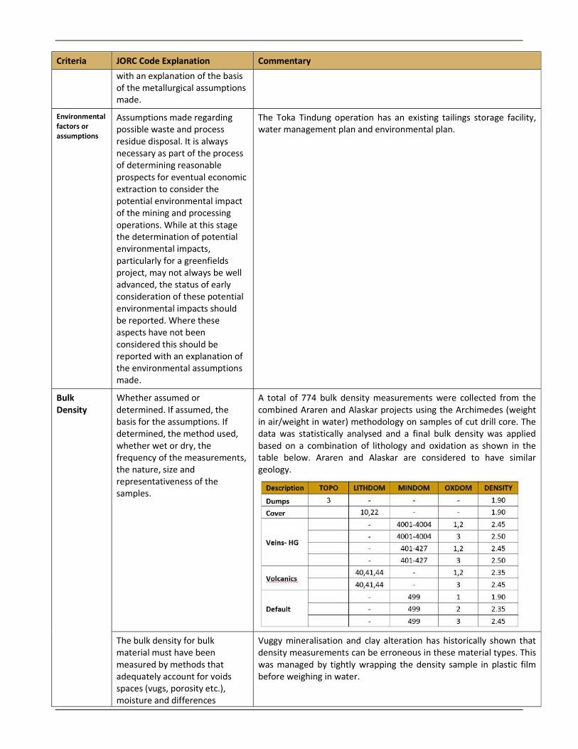
A total of 774 bulk density measurements were collected from the combined Araren and Alaskar projects using the Archimedes (weight in air/weight in water) methodology on samples of cut drill core. The data was statistically analysed and a final bulk density was applied based on a combination of lithology and oxidation as shown in the table below. Araren and Alaskar are considered to have similar geology.
The bulk density for bulk material must have been measured by methods that adequately account for voids spaces (vugs, porosity etc.), moisture and differences
Vuggy mineralisation and clay alteration has historically shown that density measurements can be erroneous in these material types. This was managed by tightly wrapping the density sample in plastic film before weighing in water.
Criteria JORC Code Explanation Commentary
between rock and alteration zones within the deposit.
Discuss assumptions for bulk density estimates used in the evaluation process of the different minerals.
The Mineral Resource model used an assigned bulk density. The values used for densities were split by lithology and oxidation. No consideration has been given for other specific mineral properties.
Classification
The basis for the classification of the Mineral Resource into varying confidence categories.
The parameters which have been considered for classification of the Mineral Resource are the distribution and density of drill data; confidence in interpreted geological continuity of the mineralised zones, and confidence in the resource block estimates.
Measured: average drill spacing of <15m; very high confidence in continuity of mineralisation; block estimated in first interpolation pass (PASS = 1); average distance of samples to block centroid (AVDIST) <10m.
Indicated: average drill spacing of <30m; high confidence in continuity of mineralization; block estimated in first or second interpolation pass (PASS = 1 or 2); average distance of samples to block centroid (AVDIST) <25m.
Inferred: average drill spacing <50m maximum up to 100m; moderate confidence in continuity of mineralisation based on lesser drill support along strike or at depth; block estimated in second or third interpolation pass (PASS = 2 or 3); average distance of samples to block centroid (AVDIST) <40m up to maximum 100m.
Whether appropriate account has been taken of all relevant factors (i.e. relative confidence in tonnage, grade estimates, reliability of input data, confidence in continuity of geology and metal values, quality, quantity and distribution of the data.
The Araren deposit is reasonably well drilled in the Measured and Indicated Categories, which contribute to the bulk of the Ore Reserves. Confidence in the data used for this Mineral Resource estimate is high due to the SOPs, supervision and training provided to staff; and the results have been reviewed by an external third party. It is considered that all relative factors have been accounted for appropriately.
Whether the results accurately reflect the Competent Person’s view of the deposit.
The Competent Person’s considers that the results accurately reflect their view of the deposit.
Audits or reviews
The results of any audits or reviews of mineral resource estimates.
SRK Consultants have completed an independent review of the Alaskar 2020 Mineral Resource estimate and their findings indicated that no fatal flaws were identified, and that the Mineral Resource is considered to be reasonable and is aligned to good industry practices and JORC Code guidelines.
Discussion of relative accuracy / confidence
Where appropriate a statement of the relative accuracy and confidence level in the Mineral Resource estimate using an approach or procedure deemed appropriate by the competent person.
The Competent Person’s considers the most likely outcome is that this Mineral Resource Estimate will reasonably and accurately estimate the contained gold metal to be recovered during mining.
Criteria JORC Code Explanation Commentary
The statement should specify whether it relates to global or local estimates, and, if local, state the relevant tonnages, which should be relevant to technical and economic evaluation. Documentation should include assumptions made and the procedures used.
The Araren Mineral Resource statement is a global estimate.

APPENDIX 2 Competent Person’s Consent