indonesian journal on geoscience earthquakes
TRANSCRIPT

IJOG
197
Indonesian Journal on Geoscience Vol. 8 No. 2 August 2021: 197-212
How to cite this article: Mulyaningsih, S., 2021. Earthquakes, Volcanic Eruptions, and Other Geological Disasters During Historical
Records In Yogyakarta Special Region, Indonesia. Indonesian Journal on Geoscience, 8 (2), p.197-212. DOI: 10.17014/ijog.8.2.197-212
INDONESIAN JOURNAL ON GEOSCIENCEGeological Agency
Ministry of Energy and Mineral Resources
Journal homepage: hp://ijog.geologi.esdm.go.idISSN 2355-9314, e-ISSN 2355-9306
Indexed by: SCOPUS (Q3)
Earthquakes, Volcanic Eruptions, and Other Geological Disasters
During Historical Records In Yogyakarta Special Region, Indonesia
Sri Mulyaningsih
Geological Engineering, Faculty of Mineral Technology, Institut Sains & Teknologi AKPRIND Yogyakarta
Corresponding author: [email protected] received: February, 26, 2018; revised: May, 28, 2019;
approved: March, 3, 2021; available online: June, 04 2021
Abstract - Yogyakarta, Indonesia, is a very fast developing area. The Yogyakarta historical time is divided into Pre-Old Mataram Era (1st - 8th century), Old Mataram Era (8th - 12th century), and Young Mataram Era (since 16th century). Geology has recorded many intermittent natural disasters within those historical time: volcanism, earthquakes, and rock movements as well. Those natural disasters have caused lots of damages, shown by buried and collapsed old buildings. Larger volcanic eruptions were known to occur once in 50 - 150 years ago, which were mostly followed by lahars as far as 32 km from the crater of Merapi Volcano, of which the last eruption was in 2010. Earthquakes were identified based on bumpy foundations that particularly occurred in the first pile of temple stones, i.e. at the temples of Kedulan, Plaosan, Morangan, Gampingan, and Boko Palace. Surface fractures are also present on the base of the palace floors. During 18th - 21st century, larger earthquakes with magnitude of 5 - 8 Richter scale occurred once in 20 - 70 years, of which the last earthquake was in 2006. A geological study clarified that there was a marine volcanism during the Tertiary with radial normal faults. The normal faults have been potential to reactivate since Plio-Pleistocene untill now, shown by surface deformations at Sudimoro Hills with a mass movement occurence as happened in Imogiri (March, 17th 2019), Pleret (2018), Piyungan, and Dlingo (March, 17th - 18th 2019). A stratigraphic study of volcaniclastic deposits around Gendol, Opak, Kuning, and Bedog Rivers shows potential floods around the rivers.
Keywords: volcanic, earthquake, disasters, hazards, historical time
© IJOG - 2021. All right reserved
Introduction
The tectonic setting of Yogyakarta was in-fluenced by an active subduction zone located in the south of Java Island as long as 200 km (Hamilton, 1979; Figure 1). It has dynamically formed geological processes, including upliftings, volcanism, and mountain buildings in a very long period, since the Early Miocene (van Bemmelen, 1949). An earthquake was noticed in the Saturday
morning of 27th, May 2006. It caused serious damages and fatalities on thousands of people living in Yogyakarta and Klaten (Central Java).
For millions of years, the studied area has gradually moved from submarine to subaerial area (Hamilton, 1979; Bronto et al., 2009; Mulya-ningsih and Sanyoto, 2012). Those affected the geological deformations in the region that formed plain morphology of Yogyakarta graben, Southern Mountain, West Progo Mountain, and Merapi
IJOG
Indonesian Journal on Geoscience, Vol. 8 No. 2 August 2021: 197-212
198
Volcano. Mulyaningsih (2006), Mulyaningsih et al. (2006), and Mulyaningsih (2016) noted some geological disasters, such as volcanic eruptions, lahars, and earthquakes that had occured since the 1st century, in and around the studied area. There-fore, it can be assumed that the studied area has potential hazards, i.e. volcanic eruptions, lahars, and earthquakes. All of the geological processes have affected the development of cultures as shown by the local wisdom. The hypothesis is
the dynamic geological processes occurring from time to time. They tend to be more frequent and more intense, even though they occurred periodi-cally, unavoidably, and countably.
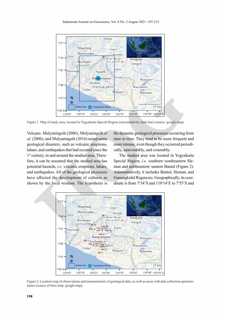
The studied area was located in Yogyakarta Special Region, i.e. southern−southeastern Sle-man and northeastern−eastern Bantul (Figure 2). Admnistratively, it includes Bantul, Sleman, and Gunungkidul Regencies. Geographically, its coor-dinate is from 7o34’S and 110o14’E to 7o55’S and
Study area
N
7°41'
110°21'
7°34'
110°28'
7°27'
7°55’
110°35'110°14' 110°42' 110°49' 110°54’ E110°07'
7°48'
7°68’S
Yogyakarta Special
Province
N
Yogyakarta Palace
Salatiga
Ampel
Boyolali
Magelang
Mertoyudan
Borobudur
Ngaglik
Surakarta
Grogol
Wonogiri
Java
Purworejo
Kasihan
GalurWonosiri
Klaten
Wuryantoro
Baturetno
Mount Merapi2911 m (9551 ft)
25 km
YOGYAKARTA
Banguntapan
Figure 1. Map of study area, located in Yogyakarta Special Region (surrounded by dash line) (source: google.map)
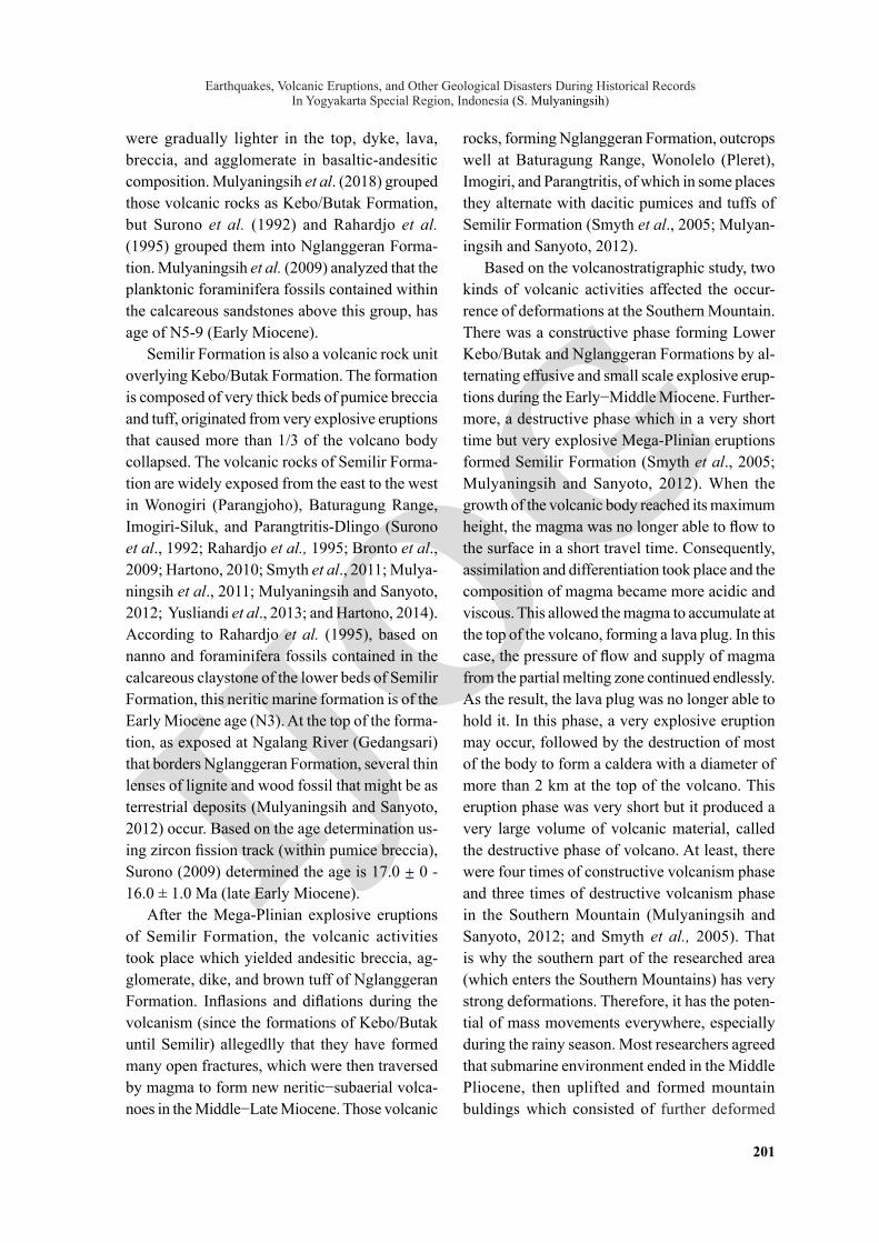
Figure 2. Location map of observations and measurements of geological data, as well as areas with data collection question-naires (source of base map: google.map).
Study area
N
7°41'
110°21'
7°34'
110°28'
7°27'
7°55’
110°35'110°14' 110°42' 110°49' 110°54’ E110°07'
7°48'
7°68’S
Yogyakarta Special
Province
N
Yogyakarta Palace
Salatiga
Ampel
Boyolali
Magelang
Mertoyudan
Borobudur
Ngaglik
Surakarta
Grogol
Wonogiri
Java
Purworejo
Kasihan
GalurWonosiri
Klaten
Wuryantoro
Baturetno
Mount Merapi2911 m (9551 ft)
25 km
YOGYAKARTA
Banguntapan
SC -1
SC -2
SC -3
SC -4 SC -5 SC -6
SC -7SC -8
SC -9
SC -10 SC -11SC -12
SC -13SC -14

IJOG
Earthquakes, Volcanic Eruptions, and Other Geological Disasters During Historical Records In Yogyakarta Special Region, Indonesia (S. Mulyaningsih)
199
110o30’E. Yogyakarta is an area occupied with vol-caniclastic deposits coming from Merapi Volcano bordered with scarps trending southwest−northeast of the Southern Moutain. The main purpose of this study is to describe natural disasters that have taken place in the researched area through geological approaches and the knowledge of the local people on the history. Hopefully, the results of this study can be used as the basis for determining policies in handling geological hazards in Yogyakarta Special Region, especially by volcanic eruptions, lahars (floods), and earthquakes.
Sampling and Analytical Method
The research performed geological and statis-tical data. More than ~70% of data were collected as primary data in the field through geological mapping, while ~30% of data were as secondary data which are direct infomation from the local people and questionnaires, literatures, journal, and reports.
The geomorphology of the studied area was described in the basis of morphostructures, morphometries, and morphoarrangements. It is comprehensively analyzed to interprete the deformations (active faults), distribution of his-torical community, historical disasters caused by pyroclastic and lahars/floods, palaeovalleys, and palaeoslides. Those are directly done in the field, supported by imagery analyses. Stratigraphic profiles are obtained by measuring surface out-crops for both exposed Quaternary and Tertiary volcanic deposits, as well as through several mass movements and anthropogenic processes. Geological structures (faults and joints) were studied in the field that showed lots of cracks in the temple walls and floors, river terraces, cliffs with ancient lakes, ancient mass movements, surface deformations, and also studied by car-rying out questionnaires. The questionnaires include information from the local people about the disasters and the victims of earthquakes on May 27th, 2006 and on Merapi Volcano eruption on October 2010. The identification was intended
to reveal the main geological processes causing the damages of public facilities and houses. It was also supported by the resistivity method us-ing dipole-dipole configuration to describe the ripple fields and the thickness of the avalanches. The observation was carried out in six ranges of three stopsites before the landslide on March 17, 2019, and identified several buried faults that had potential to move in the future.
Evidences of disasters were collected based on geological mapping and questionnaires to people who lived in the areas of the recorded disasters. The mapping had been done on the deformed areas of 2006 earthquake, located in Imogiri, Piyungan, Dlingo, Pleret, and at some buried temples located along Opak and Gendol Rivers. Conversations were carried out with the victims’ family of 2010 Merapi Volcanic eruption, located in Cangkringan, Pakem, and Ngemplak. About a hundred people responded to the questionnaires on disaster in Merapi Volcano eruption on Octo-ber 2010, and about a hundred and fifty people responded to the questionnaires on disasters of 2006 earthquake and 2018 - 2019 landslides in Imogiri, Pleret, and Dlingo areas.
Lahars and floods caused by the ancient vol-canic eruptions were interpreted from measured stratigraphic sections on the observation areas with volcanic deposits that hoard the temples. Hot ash clouds (by co-PDC) were identified from their antidune depositional structures (by turbulent mechanisms: high pressure and low percent particles), the availability (residential areas: temples/artifacts), the thickness, and their physical properties. Disasters caused by lahars were identified by using the thickness of flows. It is assumed that debris lahars contain 60−80% of particles and 20 - 40% of water. While un-cohesive lahars contain 40 - 60% of water and 40−60% of particles, and cohesive lahars or fluvio-volcanic (distal lahar) that are usually called as floods contain 60 - 80% of water and 20 - 40% of material (Mulyaningsih, 2015). If there is 40 cm of lava in one layer, then the flow amount that forms 40% of particles + 60% of water is 100 cm - 160 cm.

IJOG
Indonesian Journal on Geoscience, Vol. 8 No. 2 August 2021: 197-212
200
All data were compiled, then analyzed by overlapping each other, and synthesized so that the evidence of recurring disasters was obtained in the studied area. Disasters occurred alternately from time to time, but people reacted wisely. Conclusions were obtained after all qualitative and quantitative data were discussed.
Geological setting
Yogyakarta had been a deep sea volcan-ism area since the Late Oligocene, then it had gradually been becoming shallower until the Middle Miocene, forming volcanic rock units composed of Kebo-Butak, Semilir, and Nglang-geran Formations (Rahardjo et al., 1995). Since the Middle Miocene, the volcanic activity had declined, deposited epiclastic rocks of Sambipitu Formation. In the Late Miocene, the volcanism stopped completely, depositing sedimentary rocks of Oyo and Wonosari Formations. Fig-ure 3 presents the regional stratigraphy of the studied area.
Pillow basaltic lava composing lower Kebo/Butak Formation indicates as a result of deep sea volcanism, spotly found in Watuadeg (Berbah-Sleman), Tegalrejo, and Kalinampu (Surono, 2009; Mulyaningsih, 2016), and Bawuran (Mu-lyaningsih and Sanyoto, 2012). Those were inter-preted as the oldest volcanism in Yogyakarta and Central Java Province (Bronto et al., 2008; Faisal et al., 2018). However, Harijoko et al. (2014) found the presence of smectite, cristobalite, and heulandite (zeolite) minerals in the calcareous sediments trapped within the pillow lavas of Watuadeg outcrops. The paleontological analysis recognized foraminifera fossils (Globoquadrina altispira and Globorotalia peripheroronda) indi-cating the Middle Miocene age, and the benthic fossils (Amphistegina lessonii) showing neritic condition.
The next larger volcanism widely occurred in Giriloyo-Wonolelo (Mulyaningsih et al., 2018), Candisari, Piyungan, Gedangsari, and Tegalrejo (Rahardjo et al., 1977; Mulyaningsih and San-yoto, 2012; and Bronto, 2013). The recorded volcanic rocks were dark colour crystal tuff that
Figure 3. Stratigraphic regional of Southern Mountains and West Progo Range based on previous study (compiled from: Rahardjo et al., 1977; van Bemmelen, 1949; Bronto, 2009; and Mulyaningsih, 2016) and its interpretation of geological and volcanic activities during geological records of Yogyakarta Special Region.
EOCENE
Pre-TERTIARY
OLIGOCENE
MIOCENE
PLIOCENE
PLEISTOCENE
RECENE
AGESOUTHERNMOUNTAIN
WEST PROGORANGE GEOLOGICAL PROCESS
NO VOLCANIC ACTIVITIES
Quaternary Volc. Activity
Upliftings of Southern Mountainsand West Progo Range in Plio-Pleistocene
No volcanic activity in bothSouthern Mountains and WestProgo Range
Volcanic activities increased inSouthern Mountains (constructiveand destructive phases) butdescreased in West Progo Range
Volcanic activities in West Progo(constructive phase) andSouthern Mountains (constructiveand destructive phases)
BASEMENT ROCKS:MET. ROCKS
BASEMENTROCKS
AXINEA BEDS
JOGJA. BEDS
DISCOCY. BEDSGAMPING/WUNG-KAL FORMATION
KEBO/BUTAKFORMATION
OLD ANDESITEFORMATION
MERAPIVOL. DEP
MERAPIVOL. DEP
ALLUVIAL ALLUVIAL
WONOSARI FORMATION
SE
NT
OL
O F
OR
MA
TIO
N
SAMBIPITUFORMATION
OYO FORMATION
SEMILIRFORMATION
NGLANGGERANFORMATION
IJOG
Earthquakes, Volcanic Eruptions, and Other Geological Disasters During Historical Records In Yogyakarta Special Region, Indonesia (S. Mulyaningsih)
201
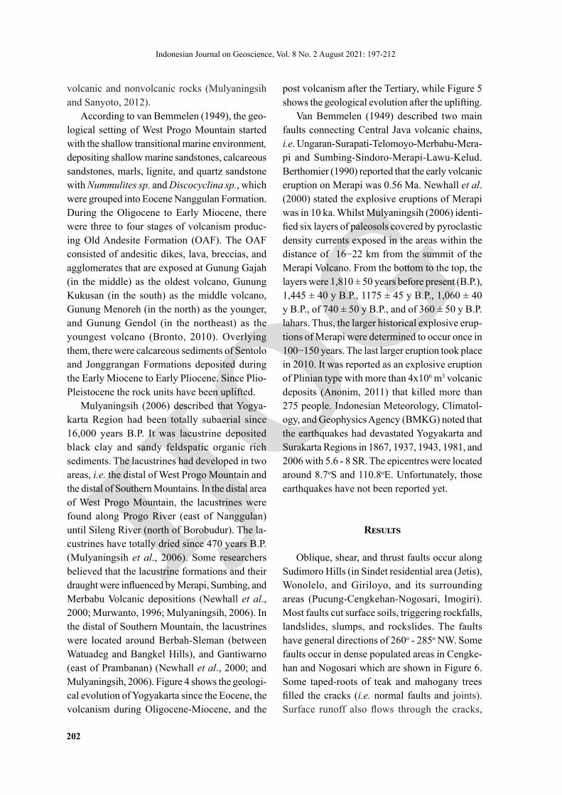
were gradually lighter in the top, dyke, lava, breccia, and agglomerate in basaltic-andesitic composition. Mulyaningsih et al. (2018) grouped those volcanic rocks as Kebo/Butak Formation, but Surono et al. (1992) and Rahardjo et al. (1995) grouped them into Nglanggeran Forma-tion. Mulyaningsih et al. (2009) analyzed that the planktonic foraminifera fossils contained within the calcareous sandstones above this group, has age of N5-9 (Early Miocene).
Semilir Formation is also a volcanic rock unit overlying Kebo/Butak Formation. The formation is composed of very thick beds of pumice breccia and tuff, originated from very explosive eruptions that caused more than 1/3 of the volcano body collapsed. The volcanic rocks of Semilir Forma-tion are widely exposed from the east to the west in Wonogiri (Parangjoho), Baturagung Range, Imogiri-Siluk, and Parangtritis-Dlingo (Surono et al., 1992; Rahardjo et al., 1995; Bronto et al., 2009; Hartono, 2010; Smyth et al., 2011; Mulya-ningsih et al., 2011; Mulyaningsih and Sanyoto, 2012; Yusliandi et al., 2013; and Hartono, 2014). According to Rahardjo et al. (1995), based on nanno and foraminifera fossils contained in the calcareous claystone of the lower beds of Semilir Formation, this neritic marine formation is of the Early Miocene age (N3). At the top of the forma-tion, as exposed at Ngalang River (Gedangsari) that borders Nglanggeran Formation, several thin lenses of lignite and wood fossil that might be as terrestrial deposits (Mulyaningsih and Sanyoto, 2012) occur. Based on the age determination us-ing zircon fission track (within pumice breccia), Surono (2009) determined the age is 17.0 0 - 16.0 ± 1.0 Ma (late Early Miocene).
After the Mega-Plinian explosive eruptions of Semilir Formation, the volcanic activities took place which yielded andesitic breccia, ag-glomerate, dike, and brown tuff of Nglanggeran Formation. Inflasions and diflations during the volcanism (since the formations of Kebo/Butak until Semilir) allegedlly that they have formed many open fractures, which were then traversed by magma to form new neritic−subaerial volca-noes in the Middle−Late Miocene. Those volcanic
rocks, forming Nglanggeran Formation, outcrops well at Baturagung Range, Wonolelo (Pleret), Imogiri, and Parangtritis, of which in some places they alternate with dacitic pumices and tuffs of Semilir Formation (Smyth et al., 2005; Mulyan-ingsih and Sanyoto, 2012).
Based on the volcanostratigraphic study, two kinds of volcanic activities affected the occur-rence of deformations at the Southern Mountain. There was a constructive phase forming Lower Kebo/Butak and Nglanggeran Formations by al-ternating effusive and small scale explosive erup-tions during the Early−Middle Miocene. Further-more, a destructive phase which in a very short time but very explosive Mega-Plinian eruptions formed Semilir Formation (Smyth et al., 2005; Mulyaningsih and Sanyoto, 2012). When the growth of the volcanic body reached its maximum height, the magma was no longer able to flow to the surface in a short travel time. Consequently, assimilation and differentiation took place and the composition of magma became more acidic and viscous. This allowed the magma to accumulate at the top of the volcano, forming a lava plug. In this case, the pressure of flow and supply of magma from the partial melting zone continued endlessly. As the result, the lava plug was no longer able to hold it. In this phase, a very explosive eruption may occur, followed by the destruction of most of the body to form a caldera with a diameter of more than 2 km at the top of the volcano. This eruption phase was very short but it produced a very large volume of volcanic material, called the destructive phase of volcano. At least, there were four times of constructive volcanism phase and three times of destructive volcanism phase in the Southern Mountain (Mulyaningsih and Sanyoto, 2012; and Smyth et al., 2005). That is why the southern part of the researched area (which enters the Southern Mountains) has very strong deformations. Therefore, it has the poten-tial of mass movements everywhere, especially during the rainy season. Most researchers agreed that submarine environment ended in the Middle Pliocene, then uplifted and formed mountain buldings which consisted of further deformed
IJOG
Indonesian Journal on Geoscience, Vol. 8 No. 2 August 2021: 197-212
202
volcanic and nonvolcanic rocks (Mulyaningsih and Sanyoto, 2012).
According to van Bemmelen (1949), the geo-logical setting of West Progo Mountain started with the shallow transitional marine environment, depositing shallow marine sandstones, calcareous sandstones, marls, lignite, and quartz sandstone with Nummulites sp. and Discocyclina sp., which were grouped into Eocene Nanggulan Formation. During the Oligocene to Early Miocene, there were three to four stages of volcanism produc-ing Old Andesite Formation (OAF). The OAF consisted of andesitic dikes, lava, breccias, and agglomerates that are exposed at Gunung Gajah (in the middle) as the oldest volcano, Gunung Kukusan (in the south) as the middle volcano, Gunung Menoreh (in the north) as the younger, and Gunung Gendol (in the northeast) as the youngest volcano (Bronto, 2010). Overlying them, there were calcareous sediments of Sentolo and Jonggrangan Formations deposited during the Early Miocene to Early Pliocene. Since Plio-Pleistocene the rock units have been uplifted.
Mulyaningsih (2006) described that Yogya-karta Region had been totally subaerial since 16,000 years B.P. It was lacustrine deposited black clay and sandy feldspatic organic rich sediments. The lacustrines had developed in two areas, i.e. the distal of West Progo Mountain and the distal of Southern Mountains. In the distal area of West Progo Mountain, the lacustrines were found along Progo River (east of Nanggulan) until Sileng River (north of Borobudur). The la-custrines have totally dried since 470 years B.P. (Mulyaningsih et al., 2006). Some researchers believed that the lacustrine formations and their draught were influenced by Merapi, Sumbing, and Merbabu Volcanic depositions (Newhall et al., 2000; Murwanto, 1996; Mulyaningsih, 2006). In the distal of Southern Mountain, the lacustrines were located around Berbah-Sleman (between Watuadeg and Bangkel Hills), and Gantiwarno (east of Prambanan) (Newhall et al., 2000; and Mulyaningsih, 2006). Figure 4 shows the geologi-cal evolution of Yogyakarta since the Eocene, the volcanism during Oligocene-Miocene, and the
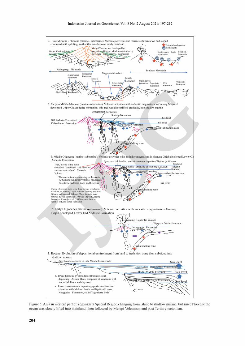
post volcanism after the Tertiary, while Figure 5 shows the geological evolution after the uplifting.
Van Bemmelen (1949) described two main faults connecting Central Java volcanic chains, i.e. Ungaran-Surapati-Telomoyo-Merbabu-Mera-pi and Sumbing-Sindoro-Merapi-Lawu-Kelud. Berthomier (1990) reported that the early volcanic eruption on Merapi was 0.56 Ma. Newhall et al. (2000) stated the explosive eruptions of Merapi was in 10 ka. Whilst Mulyaningsih (2006) identi-fied six layers of paleosols covered by pyroclastic density currents exposed in the areas within the distance of 16−22 km from the summit of the Merapi Volcano. From the bottom to the top, the layers were 1,810 ± 50 years before present (B.P.), 1,445 ± 40 y B.P., 1175 ± 45 y B.P., 1,060 ± 40 y B.P., of 740 ± 50 y B.P., and of 360 ± 50 y B.P. lahars. Thus, the larger historical explosive erup-tions of Merapi were determined to occur once in 100−150 years. The last larger eruption took place in 2010. It was reported as an explosive eruption of Plinian type with more than 4x10⁶ m3 volcanic deposits (Anonim, 2011) that killed more than 275 people. Indonesian Meteorology, Climatol-ogy, and Geophysics Agency (BMKG) noted that the earthquakes had devastated Yogyakarta and Surakarta Regions in 1867, 1937, 1943, 1981, and 2006 with 5.6 - 8 SR. The epicentres were located around 8.7oS and 110.8oE. Unfortunately, those earthquakes have not been reported yet.
Results
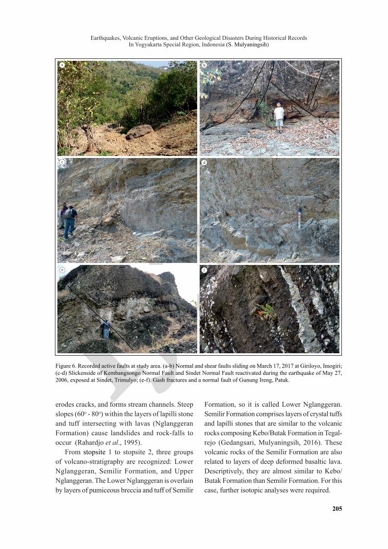
Oblique, shear, and thrust faults occur along Sudimoro Hills (in Sindet residential area (Jetis), Wonolelo, and Giriloyo, and its surrounding areas (Pucung-Cengkehan-Nogosari, Imogiri). Most faults cut surface soils, triggering rockfalls, landslides, slumps, and rockslides. The faults have general directions of 260o - 285o NW. Some faults occur in dense populated areas in Cengke-han and Nogosari which are shown in Figure 6. Some taped-roots of teak and mahogany trees filled the cracks (i.e. normal faults and joints). Surface runoff also flows through the cracks,

IJOG
Earthquakes, Volcanic Eruptions, and Other Geological Disasters During Historical Records In Yogyakarta Special Region, Indonesia (S. Mulyaningsih)
203
Figure 4. Area located in southern part of Yogyakarta Special Region slowly changing from deep marine (in Oligocene to Early Miocene) to shallow marine (in Late Miocene).
1. Oligocene -Early Miocene (deep marine): Volcanic activities with basaltic magmatism developed lower Kebo/ Butak FormationSea level
2. Early Miocene (marine: neritic): volcanic activities with basaltic -andesitic magmatism developed lower Nglanggeran Formation as volcanic constructive phase 1 (above Upper Kebo/Butak Formation)
Submarine -Island Volcanism with strato type volcano
Marine sedimentation
The volcano deposited Lower Nglanggeran Formation that composed of pyroxene -rich basalt (lava, breccia, dyke, and agglomerate with light to reddish brown color)Lower layer of this sequence is composed of calcareous sandstone and mudstone with N5- 6 (Early Miocene) exposed at Giriloyo -Pucung -Imogiri.
Sea level
3. Early Middle Miocene (marine: outer neritic): volcanic activity with explosive eruptions produced lower Semilir Formation as destructive phase 1
The dacitic magma pluged the vent so that added the pressure eruptions; very explosive eruptions were following the dacitic magmatic period; deposited beds of Lower SemilirFormation, that composed by dark grey to dark greenish pumice breccia and tuff
Deposited massive and thick layers of pumices
Kebo/Butak volcano was inactive after explosive eruption during late EarlyMiocene
4. Early-Mid Middle Miocene (marine: inner-middle neritic): volcanic activity with effusive and Strombolian eruptions produced UpperNglanggeran Formation as destructive phase 1
Kebo/Butak FormationLower Nglanggeran FormationLower Semilir
Formation
Upper Semilir Formation :Beds of rhyolitic pumice and tuff
Light grey andesitic lava, agglomerate, and brecciaUpper Nglanggeran Formation
Sambipitu Formation (shallow marine)
Oyo Formation (outer neritic)
5. Late Middle Miocene -Upper Miocene: shallowing marine, no volcanism, developed ep iclastic sediments of Sambipitu Formation and carboraceous sediments of Oyo Formation
Kebo/Butak FormationLower Nglanggeran Formation
Semilir Formation
Upper Nglanggeran Formation (mainland)Coarse - to fine - grained of epiclastic sediments of Sambipitu Formation (shallow marine)
Calcareous sediments of OyoFormation (outer neritic)
Limestone of Wonosari Formation
6. Late Miocene: shallowing marine, no volcanism, developed carbonaceous sediments (Wonosari Formation)
Deposited basaltic pillow lavas
Deposited layers of volcanic materials composed of basaltic lavas, pumices, and tuffs of Kebo- ButakFormation
Deposited layers of feldspathic tuffs and marls of lower Kebo -Butak Formation Shallower
partial melting
Late Oligocene subduction
Submarine volcanism
Deeper partial melting
Shallower partial melting
Early Miocene subduction
Kebo -Butak Formation
Deeper partial melting
More deeper partial melting
Sea level
There were evolving magma from basaltic to andesitic to dacitic in a long period with superimposed volcanism
Marine sedimentation
Shallower partial melting
Early Miocene subduction
Kebo -Butak Formation
Deeper partial melting
More deeper partial melting
Lower Nglanggeran Formation
Kebo/Butak Formation
Lower Nglanggeran Formation
Basement Rocks
Lower Semilir Formation
Lower Semilir Formation
Middle Nglanggeran Formation with andesitic volcanic materials
Lava plug: with rhyolitic magma
MiddleNglanggeran Formation
LowerSemilirFormation
MiddleNglanggeran Formation
IJOG
Indonesian Journal on Geoscience, Vol. 8 No. 2 August 2021: 197-212
204
Figure 5. Area in western part of Yogyakarta Special Region changing from island to shallow marine, but since Pliocene the ocean was slowly lifted into mainland, then followed by Merapi Volcanism and post Tertiary tectonism.
2. Early Oligocene (marine-submarine): Volcanic activities with andesitic magmatism in Gunung Gajah developed Lower Old Andesite Formation
1. Eocene: Evolution of depositional environment from land to transition zone then subsided intoshallow marine
Sea level
The volcanism was moving to the south; i.e Gunung Kukusan Volcano, produced basaltic to andesitic lavas and breccias
3. Middle Oligocene (marine-submarine): Volcanic activities with andesitic magmatism in Gunung Gajah developed Lower Old Andesite Formation
3. Early to Middle Miocene (marine -submarine): Volcanic activities with andesitic magmatism in Gunung Menoreh developed Upper Old Andesite Formation; this area was also uplifted gradually, into shallow marine
4. Late Miocene - Pliocene (marine - submarine): Volcanic activities and marine sedimentation had stoped continued with uplifting, so that this area become totaly mainland
Sea level
Sea level
Sea level
Yogyakarta Beds (Early Eocene)Axinea
Beds (Middle Eocene)
Discocyclina Beds (Upper Middle Eocene)
Oligocene Subduction zone
Partial melting zone
Gunung Gajah/ Ijo Volcano
Nanggulan Formation
a. It was transition zone depositing quartz sandstone and claystone with Mollusc fossils and lignite of Lower Nanggulan Formation, called Yogyakarta Beds
b. It was followed by subsidence (transgression) depositing Axinea Beds, composed of sandstone with marine Mollusca and claystone
c. Outer Neritic occurred in Late Middle Eocene with Discocyclina Beds
Oligocene Subduction zone
Partial melting zone
Nanggulan Formation
Pyroxene - rich basaltic- andesitic volcanic deposits of Gajah - Ijo Volcano
Basaltic - andesitic of Gunung Kukusan VolcanoThen, moved to the north deposited hornblend -rich andesitic volcanic materials of MenorehVolcano
During Oligocene, there were three periods of volcanic activities, i.e. Gunung Gajah Volcano, Gunung KukusanVolcano and Menoreh Volcano. These deposits were reported by van Bemmelen (1949) as The Old Andesite Formation. Rahardjo et al. (1995) covered them as member of Kebo-Butak Formation
Sea level
Oligocene Subduction zone
Partial melting zone
Nanggulan Formation
Sentolo Formation
Jonggrangan Formation
Old Andesite Formation/Kebo -Butak Formation
Sea level
Sea level
Sea level
Southern Mountain
Kebo-ButakFormation
SemilirFormation Nglanggeran
Formation SambipituFormation
Oyo Formation
WonosariFormation
Yogyakarta Graben
Kulonprogo Mountain
Old Andesite Formation (Kebo -Butak Formation)
SentoloFormation
NanggulanFormation
JonggranganFormation
Merapi Volcano was developed by Yogyakarta Graben, which was intruded by the young Quaternnarry magmatism
Merapi Fluviovolcanicdeposits
Quaternnarry faults reactivation
Southern Mountain
Merapi Volcano
Potential earthquakesSettlements
IJOG
Earthquakes, Volcanic Eruptions, and Other Geological Disasters During Historical Records In Yogyakarta Special Region, Indonesia (S. Mulyaningsih)
205
erodes cracks, and forms stream channels. Steep slopes (60o - 80o) within the layers of lapilli stone and tuff intersecting with lavas (Nglanggeran Formation) cause landslides and rock-falls to occur (Rahardjo et al., 1995).
From stopsite 1 to stopsite 2, three groups of volcano-stratigraphy are recognized: Lower Nglang geran, Semilir Formation, and Upper Nglang geran. The Lower Nglanggeran is overlain by layers of pumiceous breccia and tuff of Semilir
Formation, so it is called Lower Nglanggeran. Semilir Formation comprises layers of crystal tuffs and lapilli stones that are similar to the volcanic rocks composing Kebo/Butak Formation in Tegal-rejo (Gedangsari, Mulyaningsih, 2016). These volcanic rocks of the Semilir Formation are also related to layers of deep deformed basaltic lava. Descriptively, they are almost similar to Kebo/Butak Formation than Semilir Formation. For this case, further isotopic analyses were required.
a
a b
c d
e f
Figure 6. Recorded active faults at study area. (a-b) Normal and shear faults sliding on March 17, 2017 at Giriloyo, Imogiri; (c-d) Slickenside of Kembangsongo Normal Fault and Sindet Normal Fault reactivated during the earthquake of May 27, 2006, exposed at Sindet, Trimulyo; (e-f). Gash fractures and a normal fault of Gunung Ireng, Patuk.

IJOG
Indonesian Journal on Geoscience, Vol. 8 No. 2 August 2021: 197-212
206
The volcanic rocks overlying Semilir For-mation are called Upper Nglanggeran. A fault system separates Lower Nglanggeran and Semi-lir Formation with Upper Nglanggeran. Lower Nglanggeran is deeply weathered, while Upper Nglanggeran is less weathered. Most surface soils located in Sudimoro and its vicinities are faulted, of which the main directions are north-west−southeast as oblique normal faults. Figure 7 presents the lithologic profile of the Upper Nglanggeran and Lower Nglanggeran exposed in Cengkehan-Giriloyo (stopsite 1).
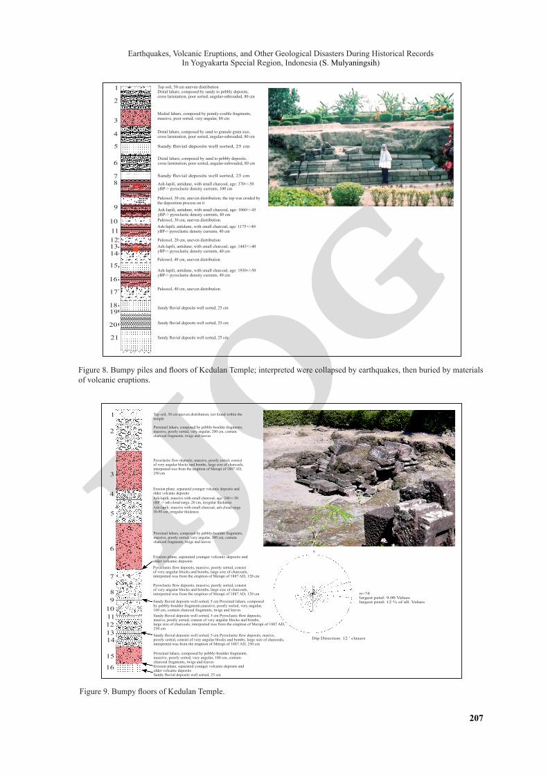
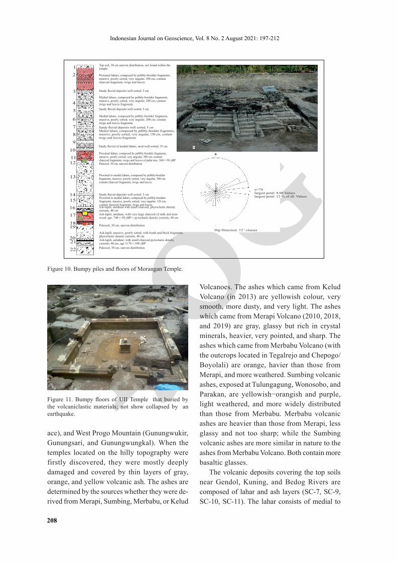
BMKG stated earthquakes with a magnitude of 5.9 occurred in Yogyakarta on 1867, 1937, 1943, 1981, and 2006 which damaged public facilities. Most stones of Kedulan Temple were lightly to severely damaged (Figures 8 and 9). The piles of stones at the bottom of the temple were greatly shaken and formed wavy floor. This condition also occurred at Gampingan Temple (Piyungan-Bantul), Plaosan Temple (600 m from Prambanan Temple to the east), Morangan Temple (Cangkringan-Sleman; Figure 10), and UII Temple (Figure 11). Opak Fault through Opak River is believed (by the most Indonesian geolo-gists) as the main fault triggering the earthquake. The data were obtained through deformations,
victims, broken and collapsed public facilities and houses mainly in Jetis (SC-2), Imogiri (SC1), Pleret (SC3), and Banguntapan (SC6) in Bantul Regency; Berbah and Prambanan (SC-8) in Sle-man Regency; Pathuk, Gedangsari, and Playen in Gunung Kidul Regency. The undulated temple foundation (pilled-stones) and cracks within temple stones built around the Opak River, many fault scarps occurring along the Southern Moun-tain, and cracks that cross-cut the present layers of the PDC (1930 AD) prove the presence of natural disasters. The fault system had a general direction of N260o−310oE (SC-8 and SC-9).
The recent activities of Merapi Volcano are performed by forming and collapsing lava domes; occasionally by explosion forming cal-dera rims (Mulyaningsih and Sanyoto, 2012). The data recorded that lahars and volcanic ashes (co-PDC) buried and damaged temples and public facilities that were built in 1st–15th centuries (Mulyaningsih, 2016). Archaeologi-cal and geological investigations undiscovered dead bodies or fossils within deposits. As men-tioned by Mulyaningsih (2006) and Mundardjito (1990), more than two hundred temples were located in distal to medial facies of Merapi Volcano, Southern Mountain (Ratu Boko Pal-
fresh aglomerate of Upper Nglanggeran
cross beddedcrystall tuff
Semilir Formation (?) thatdescriptively is closed toKebo/Butak Formationexposed at Tegalrejo-Gedangsari (Mulyaningsih, 2016)
cross beddedcrystall tuff
lava
lapillistone withextensional joins
beds of crystall tuff
fresh aglomerateUpper Nglanggeran
weathered aglomerate ofLower Nglanggeran
autoclastic breccia
Semilir Formation
Sample No. 1a & 1b
lapillistone
laminated fine ashes
autoclastic breccia
cross beddedcrystall tuff
fresh lava ofUpper Nglanggeran
Figure 7. Lithologic profile explaining the relationship of the Upper Nglanggeran and Lower Nglanggeran exposed at Cengkehan – Giriloyo (stopsite 1).
IJOG
Earthquakes, Volcanic Eruptions, and Other Geological Disasters During Historical Records In Yogyakarta Special Region, Indonesia (S. Mulyaningsih)
207
Top soil, 50 cm uneven distributionDistal lahars, composed by sandy to pebbly deposits,cross larnination, poor sorted, angular-subrouded, 80 cm
Medial lahars, composed by pennly-couble fragments,massive, poor sorted, very angular, 80 cm
Paleosol, 30 cm, uneven distribution; the top was eroded bythe deposition process on it
Distal lahars, composed by sand to granule grain size,cross larnination, poor sorted, angular-subrouded, 80 cm
Sandy fluvial deposits well sorted, 25 cm
Distal lahars, composed by sand to pebbly deposits,cross larnination, poor sorted, angular-subrouded, 80 cm
Sandy fluvial deposits well sorted, 25 cm
Ash-lapili, antidune, with small charcoal, age: 370+/-50 yBP-> pyroclastic density currents, 100 cm
Ash-lapili, antidune, with small charcoal, age: 1060+/-45 yBP-> pyroclastic density currents, 40 cm
Paleosol, 30 cm, uneven distribution
Ash-lapili, antidune, with small charcoal, age: 1175+/-40 yBP-> pyroclastic density currents, 40 cm
Paleosol, 20 cm, uneven distribution
Ash-lapili, antidune, with small charcoal, age: 1445+/-40 yBP-> pyroclastic density currents, 40 cm
Paleosol, 40 cm, uneven distribution
Ash-lapili, antidune, with small charcoal, age: 1930+/-50 yBP-> pyroclastic density currents, 40 cm
Paleosol, 40 cm, uneven distribution
Sandy fluvial deposits well sorted, 25 cm
Sandy fluvial deposits well sorted, 25 cm
Sandy fluvial deposits well sorted, 25 cm
1
2
3
4
5
6
78
9
10
13
11
12
14
15
18
20
21
19
17
16
Figure 8. Bumpy piles and floors of Kedulan Temple; interpreted were collapsed by earthquakes, then buried by materials of volcanic eruptions.
Figure 9. Bumpy floors of Kedulan Temple.
Top soil, 50 cm uneven distribution, not found within thetemple
Proximal lahars, composed by pebbly-boulder fragments,massive, poorly sorted, very angular, 200 cm, containcharcoal fragments, twigs and leaves
Pyroclastic flow deposits, massive, poorly sorted, consistof very angular blocks and bombs, large size of charcoals,interpreted was from the eruption of Merapi of 1887 AD,250 cm
Erosion plane, separated younger volcanic deposits andolder volcanic deposits
Ash-lapili, massive with small charcoal, age: 240+/-50yBP -> ash cloud surge, 20 cm, irregular thickness
Ash-lapili, massive with small charcoal, ash cloud surge30-90 cm, irregular thickness
Proximal lahars, composed by pebbly-boulder fragments,massive, poorly sorted, very angular, 300 cm, containcharcoal fragments, twigs and leaves
Erosion plane, separated younger volcanic deposits andolder volcanic deposits
Proximal lahars, composed by pebbly-boulder fragments,massive, poorly sorted, very angular, 180 cm, containcharcoal fragments, twigs and leavesErosion plane, separated younger volcanic deposits andolder volcanic depositsSandy fluvial deposits well sorted, 25 cm
Pyroclastic flow deposits, massive, poorly sorted, consistof very angular blocks and bombs, large size of charcoals,interpreted was from the eruption of Merapi of 1887 AD, 120 cm
Pyroclastic flow deposits, massive, poorly sorted, consistof very angular blocks and bombs, large size of charcoals,interpreted was from the eruption of Merapi of 1887 AD, 120 cm
Sandy fluvial deposits well sorted, 5 cm Proximal lahars, composed by pebbly-boulder fragments,massive, poorly sorted, very angular, 160 cm, contain charcoal fragments, twigs and leaves
Sandy fluvial deposits well sorted, 5 cm Pyroclastic flow deposits, masive, poorly sorted, consist of very angular blocks and bombs, large size of charcoals, interpreted was from the eruption of Merapi of 1887 AD,250 cm
Sandy fluvial deposits well sorted, 5 cm Pyroclastic flow deposits, masive, poorly sorted, consist of very angular blocks and bombs, large size of charcoals,interpreted was from the eruption of Merapi of 1887 AD, 250 cm
n=74largest petal: 9.00 Valueslargest petal: 12 % of all. Values
oDip Direction: 12 classes
0
1
2
3
4
5
6
7
89
10
13
1112
14
15
16
IJOG
Indonesian Journal on Geoscience, Vol. 8 No. 2 August 2021: 197-212
208
ace), and West Progo Mountain (Gunungwukir, Gunungsari, and Gunungwungkal). When the temples located on the hilly topography were firstly discovered, they were mostly deeply damaged and covered by thin layers of gray, orange, and yellow volcanic ash. The ashes are determined by the sources whether they were de-rived from Merapi, Sumbing, Merbabu, or Kelud
Volcanoes. The ashes which came from Kelud Volcano (in 2013) are yellowish colour, very smooth, more dusty, and very light. The ashes which came from Merapi Volcano (2010, 2018, and 2019) are gray, glassy but rich in crystal minerals, heavier, very pointed, and sharp. The ashes which came from Merbabu Volcano (with the outcrops located in Tegalrejo and Chepogo/Boyolali) are orange, havier than those from Merapi, and more weathered. Sumbing volcanic ashes, exposed at Tulungagung, Wonosobo, and Parakan, are yellowish−orangish and purple, light weathered, and more widely distributed than those from Merbabu. Merbabu volcanic ashes are heavier than those from Merapi, less glassy and not too sharp; while the Sumbing volcanic ashes are more similar in nature to the ashes from Merbabu Volcano. Both contain more basaltic glasses.
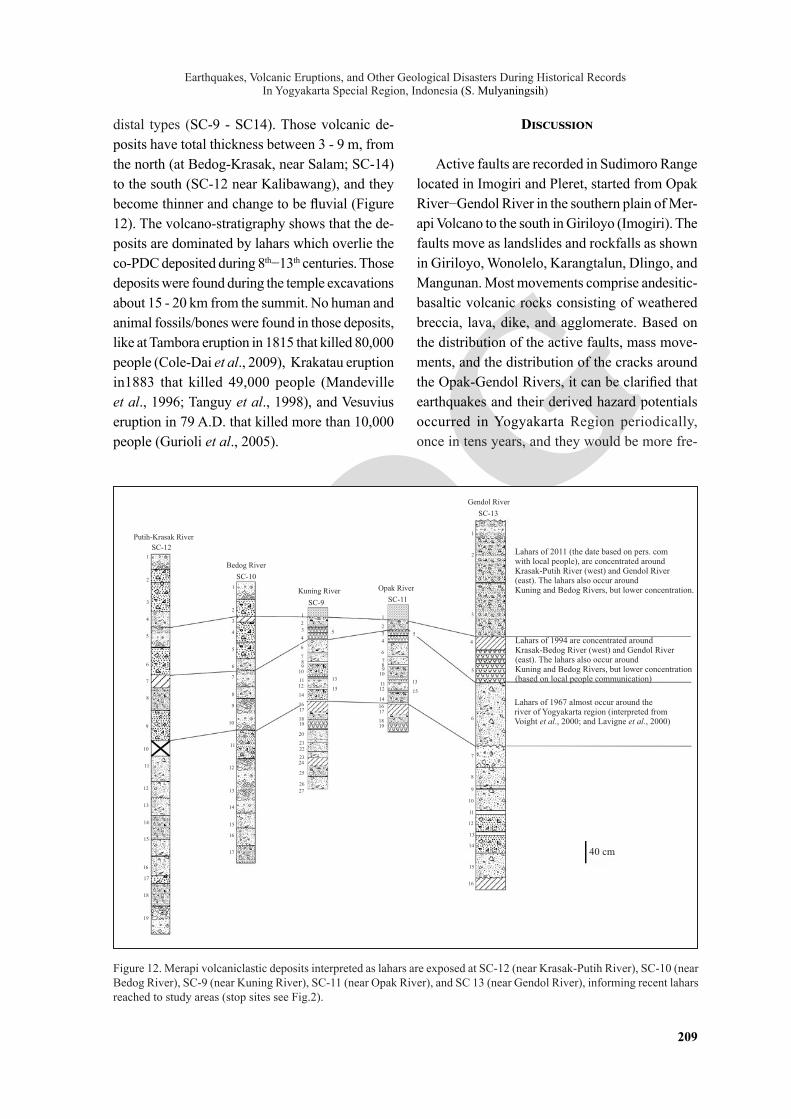
The volcanic deposits covering the top soils near Gendol, Kuning, and Bedog Rivers are composed of lahar and ash layers (SC-7, SC-9, SC-10, SC-11). The lahar consists of medial to
Figure 11. Bumpy floors of UII Temple that buried by the volcaniclastic materials; not show collapsed by an earthquake.
lahars
Layers of lahars
d
0
n=74largest petal: 9.00 Valueslargest petal: 12 % of all. Values
Top soil, 50 cm uneven distribution, not found within thetemple
Proximal lahars, composed by pebbly-boulder fragments,massive, poorly sorted, very angular, 300 cm, containcharcoal fragments, twigs and leaves
Medial lahars, composed by pebbly-boulder fragments,massive, poorly sorted, very angular, 200 cm, containtwigs and leaves fragments
Proximal lahars, composed by pebbly-boulder fragments,massive, poorly sorted, very angular, 300 cm, containcharcoal fragments, twigs and leaves of palm tree, 360=/-50 yBPPaleosol, 30 cm, uneven distribution
Sandy fluvial deposits well sorted, 5 cm
Sandy fluvial deposits well sorted, 5 cm
Medial lahars, composed by pebbly-boulder fragments,massive, poorly sorted, very angular, 200 cm, containtwigs and leaves fragments
Sandy fluvial deposits well sorted, 5 cmMedial lahars, composed by pebbly-boulder fragments,massive, poorly sorted, very angular, 150 cm, containtwigs and leaves fragments
Sandy fluvial of medial lahars, mod-well sorted, 35 cm
Proximal to medial lahars, composed by pebbly-boulder fragments, massive, poorly sorted, very angular, 300 cm, contain charcoal fragments, twigs and leaves
Sandy fluvial deposits well sorted, 5 cmProximal to medial lahars, composed by pebbly-boulder fragments, massive, poorly sorted, very angular, 120 cm, contain charcoal fragments, twigs and leaves
Ash-lapili, massive, poorly sorted, with bomb and block fragments,phyroclastic density currents, 40 cmAsh-lapili, antidune, with small charcoal pyroclastic density currents, 40 cm, age 1170+/-100 yBP
Paleosol, 30 cm, uneven distribution
Paleosol, 30 cm, uneven distribution
Ash-lapili, antidune, with very large charcoal of stalk and stemwood, age: 740+/-50 yBP-> pyroclastic density currents, 40 cm
Ash-lapili, antidune with small charcoal, phyroclastic density currents, 40 cm
1
2
3
4
5
6
7
8
9
10
13
1112
1415
18
2021
19
17
16
22
oDip Direction: 12 classes
Figure 10. Bumpy piles and floors of Morangan Temple.
IJOG
Earthquakes, Volcanic Eruptions, and Other Geological Disasters During Historical Records In Yogyakarta Special Region, Indonesia (S. Mulyaningsih)
209
Figure 12. Merapi volcaniclastic deposits interpreted as lahars are exposed at SC-12 (near Krasak-Putih River), SC-10 (near Bedog River), SC-9 (near Kuning River), SC-11 (near Opak River), and SC 13 (near Gendol River), informing recent lahars reached to study areas (stop sites see Fig.2).
40 cm
Lahars of 1967 almost occur around theriver of Yogyakarta region (interpreted fromVoight et al., 2000; and Lavigne et al., 2000)
Lahars of 1994 are concentrated aroundKrasak-Bedog River (west) and Gendol River(east). The lahars also occur aroundKuning and Bedog Rivers, but lower concentration(based on local people communication)
Lahars of 2011 (the date based on pers. comwith local people), are concentrated aroundKrasak-Putih River (west) and Gendol River(east). The lahars also occur aroundKuning and Bedog Rivers, but lower concentration.
SC-13
Gendol River
SC-11
Opak River
SC-9
Kuning River
SC-10
Bedog River
SC-12
Putih-Krasak River
1
2
3
4
5
6
7
8
9
10
11
12
13
14
15
17
18
19
16
15
17
16
13
14
11
12
9
10
8
6
7
4
5
3
2
1
1
4
32
5
6
7
910
8
1112
13
1415
1617
1819
20
2122
2324
25
26
27
4
3
2
5
7
11
14
13
15
1
6
89
10
12
1617
1819
2
1
3
15
16
13
14
11
12
10
9
8
7
6
5
4
distal types (SC-9 - SC14). Those volcanic de-posits have total thickness between 3 - 9 m, from the north (at Bedog-Krasak, near Salam; SC-14) to the south (SC-12 near Kalibawang), and they become thinner and change to be fluvial (Figure 12). The volcano-stratigraphy shows that the de-posits are dominated by lahars which overlie the co-PDC deposited during 8th−13th centuries. Those deposits were found during the temple excavations about 15 - 20 km from the summit. No human and animal fossils/bones were found in those deposits, like at Tambora eruption in 1815 that killed 80,000 people (Cole-Dai et al., 2009), Krakatau eruption in1883 that killed 49,000 people (Mandeville et al., 1996; Tanguy et al., 1998), and Vesuvius eruption in 79 A.D. that killed more than 10,000 people (Gurioli et al., 2005).
Discussion
Active faults are recorded in Sudimoro Range located in Imogiri and Pleret, started from Opak River−Gendol River in the southern plain of Mer-api Volcano to the south in Giriloyo (Imogiri). The faults move as landslides and rockfalls as shown in Giriloyo, Wonolelo, Karangtalun, Dlingo, and Mangunan. Most movements comprise andesitic-basaltic volcanic rocks consisting of weathered breccia, lava, dike, and agglomerate. Based on the distribution of the active faults, mass move-ments, and the distribution of the cracks around the Opak-Gendol Rivers, it can be clarified that earthquakes and their derived hazard potentials occurred in Yogyakarta Region periodically, once in tens years, and they would be more fre-
IJOG
Indonesian Journal on Geoscience, Vol. 8 No. 2 August 2021: 197-212
210
quent and more intense. Larger and more intense earthquakes require a longer time to accumulate enormous energy, but logically new deformations would occur more intensely and more frequently in areas with older deformations. It would require a shorter time than 2006 earthquake, maybe less than 45 years ([20+70]:2), i.e. before year 2046. Larger volcanic eruptions occur once in 50−100 years, but logically it would be less frequent but more intense. Larger eruption with more Vulkanian-Subplinian type would occur in year 2010+50 or around 2060.
Lahars occur in every large eruption. Merapi eruptions occurring in rainy seasons will have higher hazard potential than in dry seasons. Unconsolidated volcanic deposits will more ef-fectively move in saturated water. Now PVMBG (Centre for Volcanology and Geological Hazard Mitigation) monitores the early warning system to potential lahar hazard. Moreover, people should be educated to cope with the impact of the po-tential disasters.
Other geological problems related to climate in the studied area are mass movements in the dis-tal of Sudimoro Range and Piyungan Range. They focus on the fault system located in Southern Mountains and Opak Fault System. Developing a vulnerable zone into a good environment zone can be done through geological conservation and developing special interest in geopark manage-ment which can be done in the Giriloyo areas (Imogiri), Ngelo-Wonolelo-Cegokan (Pleret), Sentong-Pagerjurang (Piyungan), and Candisari (Prambanan). Further hazard management should be applied immediately to develop geoparks based on geological studies.
The earthquakes caused extended damages to the old buildings/temples (Mulyaningsih, 2006). At that time, the temples might not have en-tirely collapsed. After the coming of Islam in the 15thcentury, the local people no longer used the temples as worship places, so those temples were abandoned. After those temples were buried by the volcanic materials and/or shocked by earth-quakes, no efforts to rebuild them. The people let the buildings/temples remain buried.
Learning from the previous geological disas-ters, using the concept “the present is the key to the past and the future”, future potential hazards are necessary to be studied. It depends on the cultures, local wisdoms, and social economy. The education for hazard managements should be synergized with the local resources. The motto "life in harmony dealing with geological disasters" should widely be understood by all Indonesian people living around them. People should independently learn how to survive and realize that they live in disaster-impacted areas.
Conclusions
Yogyakarta Special Region has the future potential hazards, i e., earthquakes, mass move-ments, and volcanic eruptions. Earthquakes have occurred since the upliftings of the Southern Mountain, and continue to occur until now. The evidences of earthquakes and mass movements followed the uplifting and proved the existence of tectonic reactivation. They occur periodically, but more frequently and more intensely. The volcanic eruptions also occurring periodically are often followed by avalanches triggering lahars (floods). Lahars can reach places of more than 20 km from the Merapi crater, and are able to collapse build-ings and public facilities around Gendol-Opak, Kuning, Bedog, and Krasak-Putih Rivers. Espe-cially for Gendol-Opak River, it is also potentially impacted by the reactivation of Opak Fault that is sometimes shaken by earthquakes.
The awareness of the local people for the potential disasters is required in order to make them be able to live in harmony with the disasters. Chain-message approach in emergency learning for people who live in the impacted- areas will greatly help to minimize the risk.
Acnowledgements
The author thanks the research team of De-partment of Geology IST AKPRIND Yogyakarta

IJOG
Earthquakes, Volcanic Eruptions, and Other Geological Disasters During Historical Records In Yogyakarta Special Region, Indonesia (S. Mulyaningsih)
211
who have been the partners in discussions both in the field and when drafting the paper. Special thanks are also submitted to the Higher Education (RISTEKDIKTI) who has funded this study in 2018, especially in the Giriloyo area (Southern Mountain).
REFERENCES
Anonim, 2011. Global Volcanism Program, 2011. Report on Merapi (Indonesia). Herrick, J.A. and Wunderman, R. (eds.), 2011. Report on Merapi (Indonesia). Bulletin of the Global Volcanism Network, 36 (5). Smithsonian Institution. DOI: 10.5479/si.GVP. BGVN201105-263250
Berthomier, P.C., 1990. Etude volcanoloque du Merapi (Center Java) Téphostratigraphie et chronologie-méchanismes éruptifs.Doc-toral dissertation, University of Blaise Pascal, Clermont-Ferrand, 115 pp.
Bronto, S., Mulyaningsih, S., Hartono, G., and Astuti, B., 2008. Gunung Api Purba Watu-adeg: Sumber erupsi dan posisi stratigrafi. Indonesian Journal on Geoscience, 3 (3), p.117-128. DOI:10.17014/ijog.vol3no3.20081
Bronto, S., Mulyaningsih, S., Hartono, G., and Astuti, B., 2009. Waduk Parangjoho dan Songputri: Alternatif Sumber Erupsi For-masi Semilir di daerah Eromoko, Kabupaten Wonogiri, Jawa Tengah. Indonesian Journal on Geoscience, 4 (2), p.77-92. DOI:10.17014/ijog.vol4no2.20091
Bronto, S., 2013. Geologi Gunung Api Purba. Cetakan ke 2, Badan Geologi Kementerian ESDM, Bandung: 184pp.
Cole-Dai, J., Ferris, D., Lanciki, A., Savarino, J., Baroni, M., and Thiemens, M.H., 2009. Cold decade (A.D. 1810–1819) caused by Tambora (1815) and another (1809) stratospheric vol-canic eruption. Geophysical Research Letters, 36, L22703. DOI:10.1029/2009gl040882
Faizal, M., Arisandy, R.F., Wijaksono, S.H., Al-ansa, F.R., Arifin, M.N., and Mulyaningsih, S., 2018. Efforts on Geological Conservation to Watuadeg-Basalt Pillow Lavas at West Sum-
ber, Berbah District, Sleman Regency, Yog-yakarta Special Region-Indonesia. Journal of Geoscience, Engineering, Environment, and Technology, 3 (3), p.174-179. DOI:10.24273/jgeet.2018.3.3.2035
Gurioli, L., Houghton, B.F., Cashman, K.V., and Cioni, R., 2005. Complex changes in erup-tion dynamics during the 79 A.D. eruption of Vesuvius. Bulletin of Volcanology, 67 (2), p.144-159. DOI:10.1007/s00445-004-0368-4
Hamilton, W.B., 1979. Tectonics of the Indo-nesian region (Vol. 1078). US Government Printing Office, 1078pp. DOI:10.3133/pp1078
Harijoko, A., Hidiyawati, R., Wibowo, H.E., Setiawan, N.I., and Budiono, B., 2014. Oc-tober. Re-Interpretasi Hubungan Lava Bantal Watuadeg dengan Batuan Vulkaniklastik di Desa Watuadeg, Berbah, Sleman, D.I. Yog-yakarta. PROSIDING SEMINAR NASIONAL KEBUMIAN KE-7 Jurusan Teknik Geologi, Fakultas Teknik, Universitas Gadjah Mada, 30-31 Oktober 2014. Jurusan Teknik Geologi. DOI:10.29408/geodika.v4i2.2643
Hartono, H.G., 2010. Geomorfologi dan Petrologi dalam Kajian Penentuan Lokasi Sumber Erupsi Gunung Api Purba di Pegunungan Selatan, Daerah Istimewa Yogyakarta, p.1-20.
Hartono, H.G., 2014. Geologi Gunung Api Purba Gajahmungkur, Wonogiri, Jawa Tengah. Ma-jalah Teknik Geologi, 4 (2), p.101-112.
Mandeville, C.W., Carey, S., and Sigurdsson, H., 1996. Magma mixing, fractional crystalliza-tion and volatile degassing during the 1883 eruption of Krakatau Volcano, Indonesia. Journal of Volcanology and Geothermal Research, 74 (3), p.243-274. DOI:10.1016/s0377-0273(96)00060-1
Mulyaningsih, Muchlis, Heriyadi, N.W.A.A.T., Kiswiranta, D., Suhartono, Sukirman, Wis-mantoro, B.D., Nurohman, Mustofa, Zainal, and Hidayat, R., 2018. Potensi Alam di Daerah Giriloyo, Desa Wukirsari, Kecamatan Imogiri, Kabupaten Bantul; Laboratorium Alam bagi Pembelajaran Geologi Gunung Api Purba, Jurnal Riset Daerah Kab. Bantul, 17 (3), p.3167-3180. DOI:10.22146/jkn.12507
IJOG
Indonesian Journal on Geoscience, Vol. 8 No. 2 August 2021: 197-212
212
Mulyaningsih, S., 2006. Geologi lingkungan di daerah lereng selatan Gunung Api Merapi, pada waktu sejarah (Historical time). Diser-tasi di Departemen Teknik Geologi, Sekolah Tinggi Pascasarjana, tidak dipublikasikan. Dengan lampiran-lampiran 365pp.
Mulyaningsih, S., Sampurno, Zaim, Y., Puradima-ja, D.J., Bronto, S., and Siregar, D.A., 2006. Perkembangan Geologi pada Kuarter Awal sampai Masa Sejarah di Dataran Yogyakarta, Jurnal Geologi Indonesia, 1 ( 2) p.10-3-113. DOI:10.17014/ijog.vol1no2.20065
Mulyaningsih, S. and Sanyoto, S., 2012. Geologi Gunung Api Merapi sebagai Acuan dalam Interpretasi Gunung Api Komposit Tersier di Daerah Gunung Gede Imogiri Daerah Istimewa Yogyakarta. Prosiding Seminar Aplikasi Sains & Teknologi (SNAST) Periode III. DOI:10.14203/risetgeotam2012.v22.59
Mulyaningsih, S., 2015. Vulkanologi. Yogya-karta, Ombak, 284pp.
Mulyaningsih, S., Husadani, Y.T., Umboro, P.A., Sanjoto, S., and Purnamawati, D.I., 2011. Ak-tivitas vulkanisme eksplosif penghasil Formasi Semilir bagian bawah di daerah Jetis Imogiri. Jurnal Teknologi Technoscientia, p.64-78.
Mulyaningsih, S., 2016. Volcanostratigraphic Sequences of Kebo-Butak Formation at Bayat Geological Field Complex, Central Java Province and Yogyakarta Special Province, Indonesia. Indonesian Journal on Geoscience, 3 (2), p.77-94. DOI:10.17014/ijog.3.2.77-94
Murwanto, H., 1996. Pengaruh aktivitas gu-nungapi kwarter terhadap perkembangan lingkungan danau di Daerah Borobudur dan sekitar Jawa Tengah (Doctoral dissertation, [Yogyakarta]: Universitas Gadjah Mada), unpublished.
Mundardjito, 1990. Metode Penelitian, Monumen Lembaran Sastra Seri Penerbitan Ilmiah, 11, edisi Khusus, Depok: Fakultas Sastra UI. p. 19 -31.
Newhall, C.G., Bronto, S., Alloway, B., Banks, N.G., Bahar, I., Del Marmol, M.A., Hadis-antono, R.D., Holcomb, R.T.,Macgeelin, J., Miksic, J.N., Rubin, M., and Sayudi, S.D.,
2000.10,000 Years of explosive eruptions of Merapi Volcano, Central Java: archaeological and modern implications. Journal of Volca-nology and Geothermal Research, 100 (1), p.9-50. DOI:10.1016/s0377-0273(00)00132-3
Rahardjo, W., Sukandarrumidi, and Rosidi, H.M.D., 1995. Peta Geologi Lembar Yogya-karta, Jawa, skala 1 : 100.000, Cetakan ke 2, PSG, Bandung.
Rahardjo, W., Sukandarrumidi, and Rosidi, H.M.D., 1977. Peta Geologi Lembar Yogya-karta, Jawa, skala 1 : 100.000, Cetakan ke 1, PSG, Bandung.
Smyth, H., Hall, R., Hamilton, J., and Kinny, P., 2005. East Java: Cenozoic basins, volcanoes and ancient basement. Proceedings of the In-donesian Petroleum Association, 30th Annual Convention. p.251-266. Indonesian Petroleum Association. DOI:10.29118/ipa.629.05.g.045
Smyth, H.R., Crowley, Q.G., Hall, R., Kinny, P.D., Hamilton, P.J., and Schmidt, D.N., 2011. A Toba-scale eruption in the Early Miocene: The Semilir eruption, East Java, Indonesia. Lithos, 126 (3-4), p.198-211. DOI:10.1016/j.lithos.2011.07.010
Surono, S., 2009. Litostratigrafi Pegunungan Selatan Bagian Timur Daerah Istimewa Yo-gyakarta dan Jawa Tengah. Jurnal Geologi dan Sumberdaya Mineral, 19 (3) pp.209-221.
Surono,Toha, B., and Sudarno, I., 1992. Peta Geologi Lembar Surakarta-Giritontro, Jawa. Bandung. Pusat Penelitian dan Pengembangan Geologi.
Tanguy, J.C., Ribière, C., Scarth, A., and Tjetjep, W.S., 1998. Victims from volcanic eruptions: a revised database. Bulletin of Volcanology, 60 (2), p.137-144. DOI:10.1007/s004450050222
Van Bemmelen, R.W., 1949. The Geology of Indonesia, Vol. IA, Martinus Nijhoff, the Hague. 732pp.
Yusliandi, A., Hartono, H.G., and Bernadeta, S., 2013. Studi genesis co-ignimbrite daerah Pasekan dan sekitarnya, Kecamatan Eromoko, Kabupaten Wonogiri, Provinsi Jawa Tengah. Proceedings of Seminar Nasional, 8, p.32-3. DOI:10.52436/1.jpti.11