thai geoscience journal
TRANSCRIPT
THAI
GEOSCIENCE
JOURNALVol. 2 No. 2 July 2021
ISSN 2730-2695
NEW NORMAL
Published by
Department of Mineral Resources
Geological Society of Thailand
Coordinating Committee for Geoscience
Programmes in East and Southeast Asia (CCOP)

Editorial CommitteeHonorary Editors
Advisory Editors
Editor in Chief
Dr. Apsorn Sardsud Department of Mineral Resources, Thailand
Associate Editors
Editorial Secretary
Department of Mineral Resources, Thailand
Ms. Cherdchan Pothichaiya
Mr. Inthat Chanpheng
Ms. Jeerawan Mermana
Mr. Kitti Khaowiset
Mr. Kittichai Tongtherm
Ms. Kunlawadee Nirattisai
Prof. Dr. Che Aziz bin Ali
Prof. Dr. Clive Burrett
Assoc. Prof. Dr. Kieren Torres Howard
Prof. Dr. Koji Wakita
Dr. Mongkol Udchachon
Prof. Dr. Punya Charusiri
Dr. Toshihiro Uchida
University Kebangsaan Malaysia, Malaysia
Palaeontological Research and Education Centre,
Mahasarakham University, Thailand
Kingsborough Community College & The Graduate Center,
City University of New York (CUNY), USA
Faculty of Science, Yamaguchi University, Japan
Palaeontological Research and Education Centre,
Mahasarakham University, Thailand
Department of Mineral Resources, Thailand
Coordinating Committee for Geoscience Programmes
in East and Southeast Asia, Thailand (CCOP)
Ms. Paveena Kitbutrawat
Ms. Peeraporn Nikhomchaiprasert
Dr. Puangtong Puangkaew
Mr. Roongrawee Kingsawat
Mrs.
Ms. Thapanee Pengtha
On the cover
1) Combined positive and negative data for source crater location. Greener areas = higher probability.
Yellower areas = lower probability. Red / orange areas = no probability. (Aubrey Whymark , p.22, fig. 23)
2) Bird-Feather in Khamti amber (photomicrographs by Thet Tin Nyunt; dark field, 40×)
(Thet Tin Nyunt et al., p.68, fig. 9)
3) Radiolarian SEM photos of Mississippian chert from southern peninsular Thailand. All scale bars
indicate 100 μm. (Katsuo Sashida et al., p.77, fig. 5 )
Sasithon Saelee
Dr. Sommai Techawan
Mr. Niwat Maneekut
Mr. Montri Luengingkasoot
Dr. Young Joo Lee
Department of Mineral Resources and
Geological Society of Thailand
Department of Mineral Resources, Thailand
Department of Mineral Resources, Thailand
Coordinating Committee for Geoscience Programmes
in East and Southeast Asia, Thailand (CCOP)
Palaeontological Research and Education Centre,
Mahasarakham University, Thailand
Prof. Dr. Clive Burrett
Dr. Dhiti Tulyatid
Prof. Dr. Katsuo Sashida
Prof. Dr. Nigel C. Hughes
Prof. Dr. Punya Charusiri
Coordinating Committee for Geoscience Programmes
in East And Southeast Asia, Thailand (CCOP)Mahidol University, Kanchanaburi Campus, Thailand
University of California, Riverside, USA
Department of Mineral Resources and
Geological Society of Thailand
THAI GEOSCIENCE
JOURNAL
Vol. 2 No. 2
July 2021
Published ByDepartment of Mineral Resources • Geological Society of Thailand
Coordinating Committee for Geoscience Programmes in East and Southeast Asia (CCOP)
Copyright © 2021 by the Department of Mineral Resources of Thailand
Thai Geoscience Journal website at http://www.dmr.go.th/tgjdmr
Preface
The Thai Geoscience Journal, Volume 2 Number 2, online in July
2021, constitutes our One Year Anniversary issue. We propose continuing
our journal with several kinds of geological and geoscience objectives and
with an increased distribution. We need more co-operation with global
geoscience organizations. In this issue we welcome the Coordinating
Committee for Geoscience Programmes in East and Southeast Asia (CCOP)
as our co-organizers of the TGJ. We have the honor to warmly welcome Dr.
Young Joo Lee, Director of CCOP as our Honorary Editor along with his
colleagues to our editorial team.
The COVID-19 pandemic situation has changed the life and behavior
of people around the world. The New Normal has changed with most of us
working at home (WFH) along with social distancing. Our New Normal
geological life means that it is difficult and dangerous to go in the field. In
this situation, we will probably do more research about data management
instead and write articles from our stored data and then hopefully send the
results to TGJ.
We sincerely hope that the COVID-19 pandemic will soon be over and
bring back our life even though it will not be quite the same. We hope to find
a new way of life and learn to be happy again. Finally, we are pleased to
invite all geologists, scientists and researchers to publish in our TGJ.
Thank you very much.
(Dr. Sommai Techawan)
Director-General of the Department of Mineral Resources
President of the Geological Society of Thailand

Welcome to the Thai Geoscience Journal, Volume 2, Number 2. It is
almost one year since the first TGJ issue in July 2020. We have connected
our TGJ to the Coordinating Committee for Geoscience Programmes in East
and Southeast Asia (CCOP) as the co-organizer for this publication and we
will be working together on this and subsequent issues. We very much
appreciate the kind cooperation of Dr. Young Joo Lee, Director of CCOP,
and Dr. Dhiti Tulyatid, Regional Expert, CCOP.
This issue includes many geological articles from the CCOP’s annual
meeting and other researchers. The New Normal geoscience article
discussing Covid-19 and the world’s population is very relevant to the
current situation. The paper on the Australasian tektite forming crater is a
continuing theme from TGJ Vol.2 No.1 and may inspire researchers who are
interested in this new theory. This issue also includes various and interesting
articles such as the 3D geological mapping in Tokyo, Japan, mineral
resources studies (monazite and xenotime in Malaysia, and gemmology in
Myanmar), and Carboniferous radiolarians in Thailand.
Finally, we would like to express our appreciation to all of our TGJ
Vol.2 No.2’s authors for publishing your valuable articles in TGJ. As the TGJ
editor in chief, I would like to express my thanks to TGJ’s honorary,
advisory, associate editors, and reviewers for their kind support. Special
thanks are due to the editorial secretary team who have worked very hard on
every TGJ issue. We continue to strive to make TGJ a high international
standard journal and welcome all researchers to be TGJ members and to be
part of our geoscience community.
From the editor
Thank you very much.
(Dr. Apsorn Sardsud)
Editor in Chief
Thai Geoscience Journal
LIST OF CONTENTS
Thai Geoscience Journal
Vol. 2 No. 2
July 2021
ISSN 2730-2695
Copyright © 2021 by the Department of Mineral Resources of Thailand
Thai Geoscience Journal website at http://www.dmr.go.th/tgjdmr
Printed: 2twin Printing tel +66 2 185 9953, July 2021
Any opinions expressed in the articles published in this journal are considered the author’s academic
Autonomy and responsibility about which the editorial committee has no comments, and upon which
the editorial committee take no responsibility
ข้อคิดเห็นของบทความทุกเรื่องท่ีตีพิมพ์ลงในวารสารฯ ฉบับนี้ถือว่าเป็นความคิดอิสระของผู้เขียน กองบรรณาธิการไม่มีส่วนรับผิดชอบ หรือไม่จ าเป็นต้องเห็นด้วยกับข้อคดิเห็นนั้น ๆ แต่อย่างใด
Page
A review of evidence for a Gulf of Tonkin location for the Australasian tektite source crater
Aubrey Whymark
1 - 29
The ‘new normal’ for geoscience in a post-COVID world: connecting informed
people with the earth
Steven M. Hill, Jane P. Thorne, Rachel Przeslawski, Rebecca Mouthaan, and
Chris Lewis
30 - 37
3D geological mapping of central Tokyo
Susumu Nonogaki and Tsutomu Nakazawa
38 - 42
REE and Th potential from placer deposits: a reconnaissance study of monazite and
xenotime from Jerai pluton, Kedah, Malaysia
Fakhruddin Afif Fauzi, Arda Anasha Jamil, Abdul Hadi Abdul Rahman,
Mahat Hj. Sibon, Mohamad Sari Hasan, Muhammad Falah Zahri,
Hamdan Ariffin, and Abdullah Sulaiman
43 - 60
Geology, occurrence and gemmology of Khamti amber from Sagaing region,
Myanmar
Thet Tin Nyunt, Cho Cho, Naing Bo Bo Kyaw, Murali Krishnaswamy,
Loke Hui Ying, Tay Thye Sun, and Chutimun Chanmuang N.
61 - 71
Additional occurrence report on early Carboniferous radiolarians from southern
peninsular Thailand
Katsuo Sashida, Tsuyoshi Ito, Sirot Salyapongse, and Prinya Putthapiban
72 - 87
Thai Geoscience Journal 2(2), 2021, p. 1-29 1
Copyright © 2021 by the Department of Mineral Resources of Thailand
ISSN-2730-2695; DOI-10.14456/tgj.2021.2
A review of evidence for a Gulf of Tonkin location
for the Australasian tektite source crater
Aubrey Whymark*
Consultant Wellsite Geologist, Manila, Philippines.
*Corresponding author: [email protected]
Received 5 March 2021; Accepted 17 June 2021.
Abstract
Australasian tektites (AAT) occur across Southeast Asia, Australia, the Indian Ocean, and southwest
Pacific Ocean. AAT form the youngest and most extensive major tektite strewn field. Unlike other
tektite strewn fields, AAT have no known source crater. Review of the literature establishes that a
single ~ 43 km post-impact diameter crater exists, possibly significantly enlarged by slumping. The
obliquity of the impact that formed the AAT would result in a crater that is less pervasive in depth
but with greater downrange shock effects and melt ejection. Multiple lines of evidence, historically
viewed in isolation, were examined, concatenated, contextualized, and discussed. Tektite morpho-
logy and distribution; microtektite regressions; geochemical considerations, comparisons, and iso- -concentration regressions; lithological characteristics; age of source rock; and regional geological
considerations are reviewed. The source material is predicted to be an abnormally thick sequence of
rapidly deposited, poorly compacted, deltaic to shallow marine, shales to clay-rich siltstones of early
Pleistocene to Pliocene age. The impact likely occurred in a shallow marine environment. Forty-
two maps of positive and negative parameters are presented and overlain. These indicate the AAT
source crater probably lies in the central to northwestern Yinggehai - Song Hong Basin / Gulf of
Tonkin. This geochemically optimal setting is characterized by exceptionally high sedimentation
rates that explain the 10Be and Rb-Sr age discrepancy, the seawater signature, and apparent absence
of a crater by rapid burial.
Keywords: Australasian tektite, Gulf of Tonkin, impact crater, Pleistocene, Song Hong Basin,
Yinggehai Basin.
1. Introduction
Tektites are naturally occurring, holohyaline
macroscopically homogenous, droplets formed
by the melting and ballistic ejection of silica-
rich target rocks by large cosmic impacts.
Australasian tektites (AAT) form a young and
extensive strewn field covering over 10% of the
Earth’s surface. All major tektite groups, apart
from the AAT, have been geochemically
associated with terrestrial impact craters. AAT
have been extensively studied, drawing data
from diverse and disparate fields, each yielding
conclusion in isolation. This article attempts to
concatenate all available evidence to identify
the probable AAT source crater location.
2. Constraints
2.1 Presence of a Crater: All other known
tektite strewn fields are associated with craters.
The existence of silica-rich ballistic ejecta with
low-angle trajectories and velocities exceeding
5 km/s (Chapman, 1964) demonstrates a direct
transfer of energy, as opposed to an aerial burst
(Wasson, 2003), or impact plume (Wasson,
2017) scenario. An impact crater is concluded
to exist.
2.2 Single or Multiple Craters: The distance
of ejection can be related to crater size, which
in turn is a function of the mass and velocity of
the impactor (Elliott, Huang, Minton, & Freed,
2018). Other factors, such as obliquity of
impact and target composition, also influence
distance of ejection and are discussed in
Section 2.6. The distance between the most
northerly Indochinese macro-tektites and most
southerly Australian macro-tektites exceeds
8,500 km. The implication is that at least one
large impact crater is present. A thorough review
of the geochemistry of tektites (Schnetzler &
Pinson Jr, 1963), concluded that a random process
of formation or multiple separate impacts could
2 Aubrey Whymark / Thai Geoscience Journal 2(2), 2021, p. 1-29
be excluded. Nd and Sr isotopic variations
indicate a single impact event (Blum, Papanas-
tassiou, Koeberl, & Wasserburg, 1992; Shaw &
Wasserburg, 1982). Rare-earth elements (REE)
indicate a single reasonably uniform source
(Koeberl, 1994; Koeberl, Kluger, & Kiesl, 1985).
It is concluded that a single large crater in a
relatively homogenous source rock exists.
Associated smaller craters in the same source
rock cannot be excluded but are not required.
2.3 Age: AAT are 786 ± 2 ka based on 40Ar/39Ar
dating of tuffs at ODP Site 758 and relative
stratigraphic position to Termination IX (Mark
et al., 2017) or 788.1 ± 3 ka based on the 40Ar/39Ar age data from four AAT (Jourdan,
Nomade, Wingate, Eroglu, & Deino, 2019). The
impact occurred during a glaciation where the
continental shelf would be subaerially exposed
or covered by very shallow seas. The young
age means that geological evidence of the
structure could not have been eroded away.
The structure exists, even if buried. The recent
age of ejecta means that the tektite distribution
suffers little stratigraphic outcrop bias. Plate
tectonic shift of the crater and ejecta has a low
significance over this short period of time, but
in high resolutions should be considered.
2.4 The Crater Size: Utilizing microtektite data
and the methodology of Stöffler, Gault,
Wedekind, & Polkowski (1975), which is
calibrated to known impacts and thus has a high
expectation for accuracy, a post-impact crater
diameter of 32 ± 14 km is derived (Glass &
Pizzuto, 1994), or 33 ± 8 km (Prasad, Mahale, &
Kodagali, 2007). If un-melted ejecta estimates
are considered, which should provide an even
more accurate estimate, a 39 to 44 km (Glass,
2003) and 43 ± 9 km (Glass & Koeberl, 2006)
diameter crater estimate is derived. Studying the
compositional range of condensate droplets
(bottle-green microtektites), which reflect plume
cooling rate and therefore plume size, a 40 to 60
km diameter crater was estimated (Elkins-
Tanton, Kelly, Bico, & Bush, 2002).
Tektite distribution can be compared with
tektite / spherule strewn fields that have a
known crater, but source rock, fluid content, sea
depth, and impactor parameters, particularly
velocity and obliquity of impact may have
varied. It can be crudely ascertained that the
AAT source crater is likely larger than the 24
km diameter (Schmieder & Kring, 2020) Ries
Crater, significantly smaller than the 100 km
diameter (Schmieder & Kring, 2020) Popigai
Crater, and broadly comparable with the 40 to
45 km (Schmieder & Kring, 2020) Chesapeake
Bay Crater, with slumped outer rim of 80 to 90
km (Collins & Wünnemann, 2005).
In conclusion, a crater with 43 ± 9 km
diameter (Glass & Koeberl, 2006) should be
sought. If the crater is in a continental shelf
setting then, post-impact, it may be slumped to
80 to 90 km or more in diameter.
2.5 Obliquity of Impact / Crater Geometry:
The AAT impact was oblique, and this is very
adequately demonstrated by asymmetric morp-
hological and geochemical variations of tektites
that indicate the source crater is in the broad
Indochinese portion of the strewn field. The
obliquity of the impact would reduce the depth
and volume of melted and shocked materials at
the impact site and enhance the volume of ejected
melt (including tektites) (Pierazzo & Melosh,
2000). However, highly oblique impacts (<5°)
may have a negative effect on tektite production
as the first formed ejecta must travel a greater
distance to traverse the atmosphere.
To establish whether the impact was a highly
oblique (<5°) grazing impact, or an oblique (5°
to 30°) impact the distal ejecta pattern should be
reviewed. The AAT strewn field has a
downrange lobe of ejecta, mirroring forbidden
zones, and butterfly lobes, typical of impacts
below 45° (Gault & Wedekind, 1978). The
bilateral symmetry of the downrange ejecta is
broadly along a 164° azimuth and the butterfly
lobes are ~62° offset from the center of the
downrange ejecta. In grazing impacts that
produce elliptical craters a 90° offset from the
center of the downrange ejecta would be
anticipated (Gault & Wedekind, 1978).
Highly oblique grazing impacts result in
increased projectile contamination of the target
melt (Artemieva & Pierazzo, 2003; Stöffler,
Artemieva, & Pierazzo, 2002), something not
observed in AAT.
In a grazing impact there should be an uprange
forbidden zone, but in less oblique impacts the
uprange forbidden zone may close as the impact

Aubrey Whymark / Thai Geoscience Journal 2(2), 2021, p. 1-29 3
proceeds (Schultz, Anderson, & Hermalyn, 2009;
Schultz et al., 2007). Therefore, the presence of
uprange tektites is an argument against a grazing
impact. This will be discussed further as the
evidence is presented.
AAT distribution suggests an oblique impact
above 5° but, by comparison to Artemieva (2013),
under 30°. An oblique impact is optimal for melt
(tektite) ejection (Pierazzo & Melosh, 2000) and
will limit downward shock effects at the impact
site. The impact crater might be asymmetrical in
its depth profile, deeper in a north-northwesterly
direction, after Gault & Wedekind (1978). If there
was subsequent slumping this may be influenced
by the asymmetry of the post-impact crater profile
and might result in an elliptical slumped crater.
The above factors may result in a less pervasive
crater with atypical morphology. This would
make recognition more problematic.
2.6 Tektite Morphological Regression: AAT
fall into three transitional but readily differen-
tiable morphological groups, which can be
compared with tektites in strewn fields with a
known source crater. Distal tektites (e.g.,
Australites) were the first formed, highest velo-
city tektites. They underwent minimal plastic
deformation as the molten body exited the
atmosphere, suffered ablation during re-entry,
then spallation. Medial tektites (e.g., Philippi-
nites, Billitonites, and Bediasites) underwent
moderate plastic deformation as the molten body
exited the atmosphere, re-entry heating that was
insufficient for ablation to occur, and then
spallation. Proximal tektites (e.g., Indochinites,
Moldavites, Georgiaites, Ivory Coast Tektites)
underwent significant plastic deformation as they
interacted with the atmosphere at lower altitudes,
suffered minimal re-entry heating and minimal
spallation. Muong Nong-type (MN-type) layered
impact glass, whilst ballistically ejected, never
formed discrete surface tension-controlled
droplets due to lower melt temperature. MN-type
layered impact glasses represent the lowest
energy, theoretically most proximal, melts.
The lower ablation limit for tektites is about
5 km/s (Chapman, 1964). This is the defining
boundary between medial and distal tektite
morphologies. Within the AAT strewn field, the
most northerly ablated downrange tektites are
found in Sangiran, Java (Chapman, 1964). To
the north (along an azimuth towards Indochina),
tektites are not ablated and therefore re-entered
at velocities below about 5 km/s. Taking
Sangiran, Java, as the 5 km/s mark, and utilizing
trajectory calculations from Orbit 1.2 Software
(1998-2000), the crater likely lies somewhere
between 3,319 km away (37° ejection angle)
and 2,632 km away at 20° and 56.8° ejection
angle (shown in Fig. 1). At ejection angles lower
than 20° or higher than 56.8° (which are less
likely) the crater will be even closer. A potential
margin of error of hundreds (but not thousands)
of kilometers exists, but this calculation
indicates the most probable impact region and
rules out the wildest crater guesses where
modelled re-entry velocities do not match
observed physical attributes of the tektites. Re- -entry angles of tektites over Java were likely
quite oblique with angles of 20° to 25° probably
being realistic, implying a distance from the
source crater of 2,632 km to 2,992 km, again
within a margin of error being present.
Fig. 1: Taking Sangiran, Java, as the 5 km/s mark,
where the most northerly directly downrange ablated
tektites exist, the crater likely lies somewhere between
3,319 km away (37° ejection angle) and 2,632 km away
at 20° and 56.8° ejection angle. The AAT crater
probably lies within the belt highlighted in green. The
middle to southerly portion of the green shaded region
is most probable based on a 20° to 25° re-entry angle
for tektites in Java. The yellow area is lower
probability. Inset: Data used in map overlay. Green =
Probable regions; Yellow = Less favorable regions for
the AAT impact.
4 Aubrey Whymark / Thai Geoscience Journal 2(2), 2021, p. 1-29
Increased target rock compressibility can
enhance melt production (Stöffler, Hamann, &
Metzler, 2018). Obliquity of impact can enhance
melt ejection (Pierazzo & Melosh, 2000). Water-
-rich surface layers can potentially enhance melt
production and ejection (K. T. Howard, 2011).
These factors, together with the size of the
impact, result in greater tektite abundance
(assuming suitable source rocks) and distance of
ejection (asymmetrically in the case of oblique
impact). Regardless of scaling, the distal, medial,
and proximal tektite morphological divisions
would be expected to be found at broadly the
same distance from the impact location. This is
because the morphological divisions are
primarily related to re-entry heating, controlled
principally by velocity. A re-entry tektite must
travel from the crater location to a fall location. It
can theoretically do so by any combination of
angle and velocity that achieves the defined
distance. Ejection angles of 15° to 50° result in
tektite velocities of: 2.87 to 3.74 km/s to land at
900 km; 3.70 to 4.50 km/s to land at 1,650 km;
and 6.40 to 7.05 km/s to land at 6,800 km from
the impact location (Orbit 1.2 Software, 1998- 2000). Velocity values are reasonably constrain-
ed regardless of the ejection angle.
Oblique impacts result in a low-angle
downrange ejection of the highest velocity melts
compared to vertical impacts that result in
higher angle omnidirectional ejection of melt
(Gault & Wedekind, 1978). The melt will travel
further in oblique impacts, but at lower angles.
In more energetic oblique impacts, sufficient
energy is present in the later stage of impact to
yield high-angle omnidirectional melts as well
as the initial higher velocity low-angle
downrange melt ejecta. So, at a set distance
from the impact crater the ejecta may be low-
-angle melts derived from a smaller oblique
crater or (low and) high-angle melts derived
from a larger oblique or vertical impact.
Morphological differences would be anticipated
between low- and high-angle melt ejecta. Low-
-angle tektites will encounter greater atmospheric
interaction. This manifests morphologically in
cascading to smaller bodies in a hot melt, or by
plastic deformation in a cooler more viscous melt
during exit, and in a longer duration of heating
during re-entry.
The question arises whether magnitude and
obliquity of impact, which may affect ejection
angle, influences the distance at which morpho-
logical groups theoretically occur. In short, it
does, but to a minimal degree: this methodology
will not offer precision but is expected to deliver
a broadly accurate result. This is because re-entry
velocity does not vary dramatically in response
to expected re-entry angles at a fixed location. It
is the tektite velocity that defines the boundary
between distal and medial forms. The medial to
proximal boundary is a little more complex:
again, the medial morphology requires a certain
re-entry velocity / heating, but spallation can be
over-ridden by the glass temperature in the re-
-entry phase. If the glass retained sufficient
temperature from formation, crack growth and
spallation are inhibited. Scaling may have greater
influence in the proximal realm, but the
prerequisite for sufficient velocity to produce
medial cores validates that all medial cores
should be found at similar distances from the
source. Variations in core morphology are
illustrated in Fig. 11 of Chapman (1964). Uncer-
tainty in comparisons may be reduced further by
comparing tektites from similar craters in terms
of magnitude, obliquity, and target.
The distance of proximal and medial North
American tektites from the Chesapeake Bay
source crater can be compared with Australasian
tektites. The two impacts are comparable in
terms of calculated magnitude and can be
inferred to have similar target rock characteristics
as both impacts yield widespread tektites. The
asymmetry of the North American tektite
distribution suggests the Chesapeake Bay impact
was oblique, although likely less oblique than the
AAT impact. Within the North American strewn
field, the medial tektite morphologies are found
at distances of 1,955 km to 2,180 km (O’Keefe,
1963) southwest from the point of impact. The
proximal North American tektites are found
predominantly to the southwest at distances of
635 km to 930 km (Povenmire, 2010; Povenmire
& Strange, 2006). The comparable Chesapeake
Bay impact is used to evaluate the AAT impact
crater location.
The Central European strewn field yields
proximal tektites at distances of 185 km to 430
km (Čada, Houzar, Hrazdil, & Skála, 2002; Trnka

Aubrey Whymark / Thai Geoscience Journal 2(2), 2021, p. 1-29 5
& Houzar, 2002) from the Ries source crater.
The Ivory Coast strewn field yields tektites at
distances of 255 to 320 km (Gentner, 1966)
from the Bosumtwi source crater. These
smaller impacts demonstrate that true tektites
can occur in closer proximity to the crater.
The North American Bediasites are morpho-
logical equivalents to Philippinites, Malaysianites,
Brunei tektites, Billitonites and northern Indone-
sianites. In North America similar morphologies
occur at distances of 1,955 to 2,180 km (O’Keefe,
1963) from the impact site and do not occur within
930 km (Povenmire, 2010) from the impact site.
All locations within 930 km of medial tektite
occurrences can be eliminated as shown in red in
Fig. 2. It can be established that by 1,955 km there
are no proximal tektite morphologies (the true
number is likely much less but cannot be
calibrated). The source crater must be within
1,955 km of all proximal tektite morphologies.
This further restricts the potential source area
(green region in Fig. 2). A focal point can be
established by assuming all proximal tektites
occur within 930 km of the impact site. The actual
number is somewhere between 930 and 1,955 km
but likely close to the lower limit for the AAT
when cross referenced with other evidence
presented in this article. The focal point is
therefore an area of highest probability but does
not rule out surrounding areas. This approach is
demonstrated by the dark green region in Fig. 2.
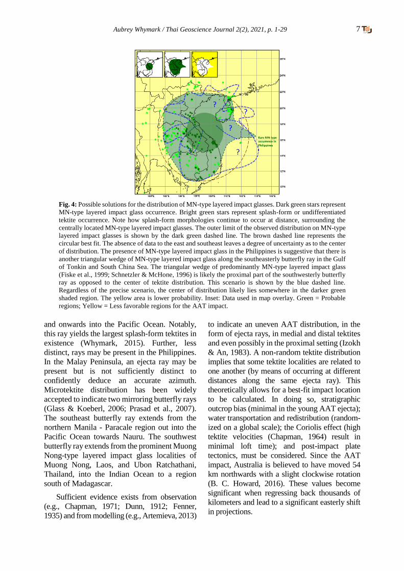
2.7 Distribution of MN-Type Layered Impact
Glass: Muong Nong-type (MN-type) layered
impact glasses are the lowest temperature
ballistically (Huber, 2009; Koeberl, 1992;
Schnetzler, 1992) ejected melts. These impact
glasses are not entirely homogenized, are
volatile-rich in comparison to tektites, contain
relict mineral grains, and have alternating layers
of different composition (Koeberl, 1986).
Logically, MN-type tektites are expected to
occur in proximity to the source crater. A
triangular wedge-shaped ~65,000 km2 area was
noted in northeastern Thailand, southern Laos,
and central Vietnam where MN-type layered
impact glasses occur in the absence (or near-
-absence) of true splash-form tektites (Fiske et
al., 1999; Schnetzler & McHone, 1996) (see
Fig. 3). Further afield a mixture of MN-type
layered impact glasses and splash-form tektites
.
occur. Then further out, importantly in all
directions, only splash-form tektites, in the
absence of MN-type layered impact glasses,
occur (Fig. 3). This triangular wedge-shaped
area of MN-type layered impact glasses has
been assumed by many to represent the center
of the proximal tektite distribution and the
impact crater should lie close by. However, this
region of MN-type impact glasses is neither in
the most northwesterly part of the strewn field
nor in the center of the proximal splash-form
tektite and MN-type impact glass distribution:
instead, it is rather unsatisfactorily to the
southwest of center.
The triangular wedge of MN-type layered
impact glasses can be followed to the southwest
(see Fig. 3) and it appears to be the proximal part
of the prominent southwesterly butterfly ray.
Fig. 2: A map utilizing data from the North American strewn
field and comparing it with morphological groups of tektites
in the Australasian region. All medial tektites (e.g.,
Philippinites) should be at least 930 km from the source
crater, ruling out the areas in red. Medial tektite locations
used: 16.386186° N, 119.892056° E, Bolinao, Philippines;
10.955550° N, 119.405150° E, northern Palawan, Philip-
pines; 4.952386° N, 114.835486° E, Brunei; -2.923631° S,
108.206319°E, Belitung, Indonesia; 4.750000° N,
103.166667° E, Malay Peninsula, Malaysia. All proximal
tektites (e.g., Indochinites) should be within 1,955 km of the
source crater: possible areas are in green. If it is assumed that
all proximal tektites occur within 930 km of the source crater
(a number likely marginally too low) then the darker green
area is the most probable crater location (in reality, this is
almost certainly a broader area focused on this region as 930
km represents a minimum value). The yellow area is lower
probability. Inset: Data used in map overlay. Green =
Probable regions; Yellow = Less favorable regions; Red =
Incompatible regions for the AAT impact.

6 Aubrey Whymark / Thai Geoscience Journal 2(2), 2021, p. 1-29
This ray extends into the central Indian Ocean
and beyond, almost reaching the southernmost
tip of Africa. The triangular wedge of MN-type
layered impact glasses points towards an origin
in the Gulf of Tonkin, possibly forming arcuate
rays in a cardioid (heart)-shaped pattern, with
reference to Schultz et al. (2009, 2007). A
mirroring wedge of MN-type layered impact
glasses would be expected on the southeasterly
butterfly ray that extends through northern
Manila and Paracale in the Philippines, onwards
in the direction of Micronesia in the southern
Pacific Ocean. This mirroring wedge of MN-
-type layered impact glasses cannot be
observed, if present, as it falls in the Gulf of
Tonkin and South China Sea. In support of its
presence, rare examples of MN-type layered
impact glasses have been found along the same
trajectory in Manila and Paracale in the Philip-
pines (Chapman & Scheiber, 1969; Whymark,
2020). It is apparent, as seen in all oblique crater
ray systems, that ejecta distribution is not equal.
This scenario is depicted in Fig. 3.
Regardless of whether the triangular wedge-
shaped area of MN-type layered tektites is
accepted as the center of distribution or whether
this region is accepted as the proximal part of the
southwesterly butterfly ray, with the
center of distribution in the Gulf of Tonkin, it
is evident the lowest temperature melts are not
concentrated in the most northwesterly area of
tektite distribution (i.e., Yunnan and Guangxi
regions of China and northern Vietnam) (Fig.4).
This observation is critical as it implies a
crater located in the center of the proximal part
of the strewn field and implies the presence of
uprange ejecta.
2.8 Tektite Crater Rays: Ejecta rays can be
seen emanating from craters on geologically
less active planetary bodies (e.g., the Moon,
Mercury, Ganymede). Increased gravity and
increased atmospheric density (e.g., Venus) will
act to suppress ejecta rays (Schultz, 1992). The
Earth has slightly greater gravity than Venus but
the atmosphere on Earth is significantly less
dense. Tektite droplets, forming from the ejecta
curtain at altitude, would be less inhibited on
Earth, compared with Venus. The presence of
distal AAT (e.g., Australites) that re-entered the
atmosphere (Chapman, 1964) is proof that AAT
ejecta was not wholly suppressed by the Earth’s
gravity and atmosphere. The distance that AAT
ejecta has travelled, by comparison to crater
rays on other planetary bodies, indicates that
tektites are part of a crater ray system as opposed
to randomly distributed.
In Australia, the prominent linear tektite
concentration that runs through South Australia,
Victoria, and into Tasmania has a distinct high
calcium (HCa) geochemical profile (Chapman,
1971). The combined linear tektite distribution and
distinct geochemistry indicate this feature is an
ejecta ray. The presence of at least one AAT ejecta
ray suggests the existence of a crater ray system.
Tektite distribution patterns, in terms of location,
abundance, and maximum tektite size, hint at a
further two ejecta rays in Western Australia. In the
Philippines, a prominent ray is suggested from
Zambales, through northern Manila, Rizal
Province (Tanay, Siniloan), Paracale, Catanduanes,
Fig. 3: The distribution of MN-type layered impact glas-
ses (green stars). The green region is predominantly MN-
type layered impact glasses in the absence (or near-
absence) of splash-form tektites (Fiske et al., 1999;
Schnetzler & McHone, 1996). This region has
traditionally been taken as the center of the Australasian
strewn field. In fact, it may represent one of two butterfly
rays emanating from the Gulf of Tonkin (suggested by
green dashed line) (Whymark, 2020). The most
prominent rays are indicated, with an assumed crater
position in the Gulf of Tonkin as per Whymark (2013)
(note that this location is not proven). Note how the green
region of MN-type layered impact glass and prominent
localities such as Muong Nong and Ubon Ratchathani lie
beneath this inferred ray. Inset: Data used in map
overlay. Green = Probable regions for the AAT impact.
Aubrey Whymark / Thai Geoscience Journal 2(2), 2021, p. 1-29 7
and onwards into the Pacific Ocean. Notably,
this ray yields the largest splash-form tektites in
existence (Whymark, 2015). Further, less
distinct, rays may be present in the Philippines.
In the Malay Peninsula, an ejecta ray may be
present but is not sufficiently distinct to
confidently deduce an accurate azimuth.
Microtektite distribution has been widely
accepted to indicate two mirroring butterfly rays
(Glass & Koeberl, 2006; Prasad et al., 2007).
The southeast butterfly ray extends from the
northern Manila - Paracale region out into the
Pacific Ocean towards Nauru. The southwest
butterfly ray extends from the prominent Muong
Nong-type layered impact glass localities of
Muong Nong, Laos, and Ubon Ratchathani,
Thailand, into the Indian Ocean to a region
south of Madagascar.
Sufficient evidence exists from observation
(e.g., Chapman, 1971; Dunn, 1912; Fenner,
1935) and from modelling (e.g., Artemieva, 2013)
to indicate an uneven AAT distribution, in the
form of ejecta rays, in medial and distal tektites
and even possibly in the proximal setting (Izokh
& An, 1983). A non-random tektite distribution
implies that some tektite localities are related to
one another (by means of occurring at different
distances along the same ejecta ray). This
theoretically allows for a best-fit impact location
to be calculated. In doing so, stratigraphic
outcrop bias (minimal in the young AAT ejecta);
water transportation and redistribution (random-
ized on a global scale); the Coriolis effect (high
tektite velocities (Chapman, 1964) result in
minimal loft time); and post-impact plate
tectonics, must be considered. Since the AAT
impact, Australia is believed to have moved 54
km northwards with a slight clockwise rotation
(B. C. Howard, 2016). These values become
significant when regressing back thousands of
kilometers and lead to a significant easterly shift
in projections.
Fig. 4: Possible solutions for the distribution of MN-type layered impact glasses. Dark green stars represent
MN-type layered impact glass occurrence. Bright green stars represent splash-form or undifferentiated
tektite occurrence. Note how splash-form morphologies continue to occur at distance, surrounding the
centrally located MN-type layered impact glasses. The outer limit of the observed distribution on MN-type
layered impact glasses is shown by the dark green dashed line. The brown dashed line represents the
circular best fit. The absence of data to the east and southeast leaves a degree of uncertainty as to the center
of distribution. The presence of MN-type layered impact glass in the Philippines is suggestive that there is
another triangular wedge of MN-type layered impact glass along the southeasterly butterfly ray in the Gulf
of Tonkin and South China Sea. The triangular wedge of predominantly MN-type layered impact glass
(Fiske et al., 1999; Schnetzler & McHone, 1996) is likely the proximal part of the southwesterly butterfly
ray as opposed to the center of tektite distribution. This scenario is shown by the blue dashed line.
Regardless of the precise scenario, the center of distribution likely lies somewhere in the darker green
shaded region. The yellow area is lower probability. Inset: Data used in map overlay. Green = Probable
regions; Yellow = Less favorable regions for the AAT impact.
8 Aubrey Whymark / Thai Geoscience Journal 2(2), 2021, p. 1-29
The use of a non-random tektite distribution
pattern, corrected for the Coriolis effect and
continental drift, should allow an accurate crater
position to be calculated. This is beyond the
scope of this article but is highlighted for future
research to provide additional layers of data.
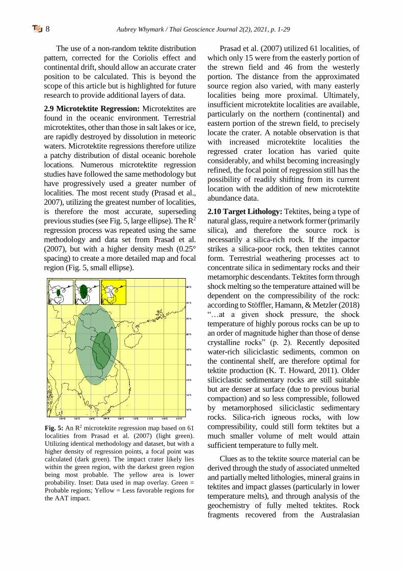
2.9 Microtektite Regression: Microtektites are
found in the oceanic environment. Terrestrial
microtektites, other than those in salt lakes or ice,
are rapidly destroyed by dissolution in meteoric
waters. Microtektite regressions therefore utilize
a patchy distribution of distal oceanic borehole
locations. Numerous microtektite regression
studies have followed the same methodology but
have progressively used a greater number of
localities. The most recent study (Prasad et al.,
2007), utilizing the greatest number of localities,
is therefore the most accurate, superseding
previous studies (see Fig. 5, large ellipse). The R2
regression process was repeated using the same
methodology and data set from Prasad et al.
(2007), but with a higher density mesh (0.25°
spacing) to create a more detailed map and focal
region (Fig. 5, small ellipse).
Prasad et al. (2007) utilized 61 localities, of
which only 15 were from the easterly portion of
the strewn field and 46 from the westerly
portion. The distance from the approximated
source region also varied, with many easterly
localities being more proximal. Ultimately,
insufficient microtektite localities are available,
particularly on the northern (continental) and
eastern portion of the strewn field, to precisely
locate the crater. A notable observation is that
with increased microtektite localities the
regressed crater location has varied quite
considerably, and whilst becoming increasingly
refined, the focal point of regression still has the
possibility of readily shifting from its current
location with the addition of new microtektite
abundance data.
2.10 Target Lithology: Tektites, being a type of
natural glass, require a network former (primarily
silica), and therefore the source rock is
necessarily a silica-rich rock. If the impactor
strikes a silica-poor rock, then tektites cannot
form. Terrestrial weathering processes act to
concentrate silica in sedimentary rocks and their
metamorphic descendants. Tektites form through
shock melting so the temperature attained will be
dependent on the compressibility of the rock:
according to Stöffler, Hamann, & Metzler (2018)
“…at a given shock pressure, the shock
temperature of highly porous rocks can be up to
an order of magnitude higher than those of dense
crystalline rocks” (p. 2). Recently deposited
water-rich siliciclastic sediments, common on
the continental shelf, are therefore optimal for
tektite production (K. T. Howard, 2011). Older
siliciclastic sedimentary rocks are still suitable
but are denser at surface (due to previous burial
compaction) and so less compressible, followed
by metamorphosed siliciclastic sedimentary
rocks. Silica-rich igneous rocks, with low
compressibility, could still form tektites but a
much smaller volume of melt would attain
sufficient temperature to fully melt.
Clues as to the tektite source material can be
derived through the study of associated unmelted
and partially melted lithologies, mineral grains in
tektites and impact glasses (particularly in lower
temperature melts), and through analysis of the
geochemistry of fully melted tektites. Rock
fragments recovered from the Australasian
Fig. 5: An R2 microtektite regression map based on 61
localities from Prasad et al. (2007) (light green).
Utilizing identical methodology and dataset, but with a
higher density of regression points, a focal point was
calculated (dark green). The impact crater likely lies
within the green region, with the darkest green region
being most probable. The yellow area is lower
probability. Inset: Data used in map overlay. Green =
Probable regions; Yellow = Less favorable regions for
the AAT impact.
Aubrey Whymark / Thai Geoscience Journal 2(2), 2021, p. 1-29 9
microtektite layer were found to be well sorted,
quartz-rich, fine-grained (silt- to fine sand-sized)
sedimentary rock (Glass & Barlow, 1979; Glass &
Koeberl, 2006). A derivation from shales,
graywackes, and lithic arenites has been suggested
(Glass, Huber, & Koeberl, 2004; Koeberl, 1992).
In agreement, K. T. Howard (2011) suggested a
mixture of shale-like material and a very quartz-
rich material. A minor carbonate (dolomite)
component was suggested to explain the CaO
(positively correlated with MgO) variation
(Amare & Koeberl, 2006).
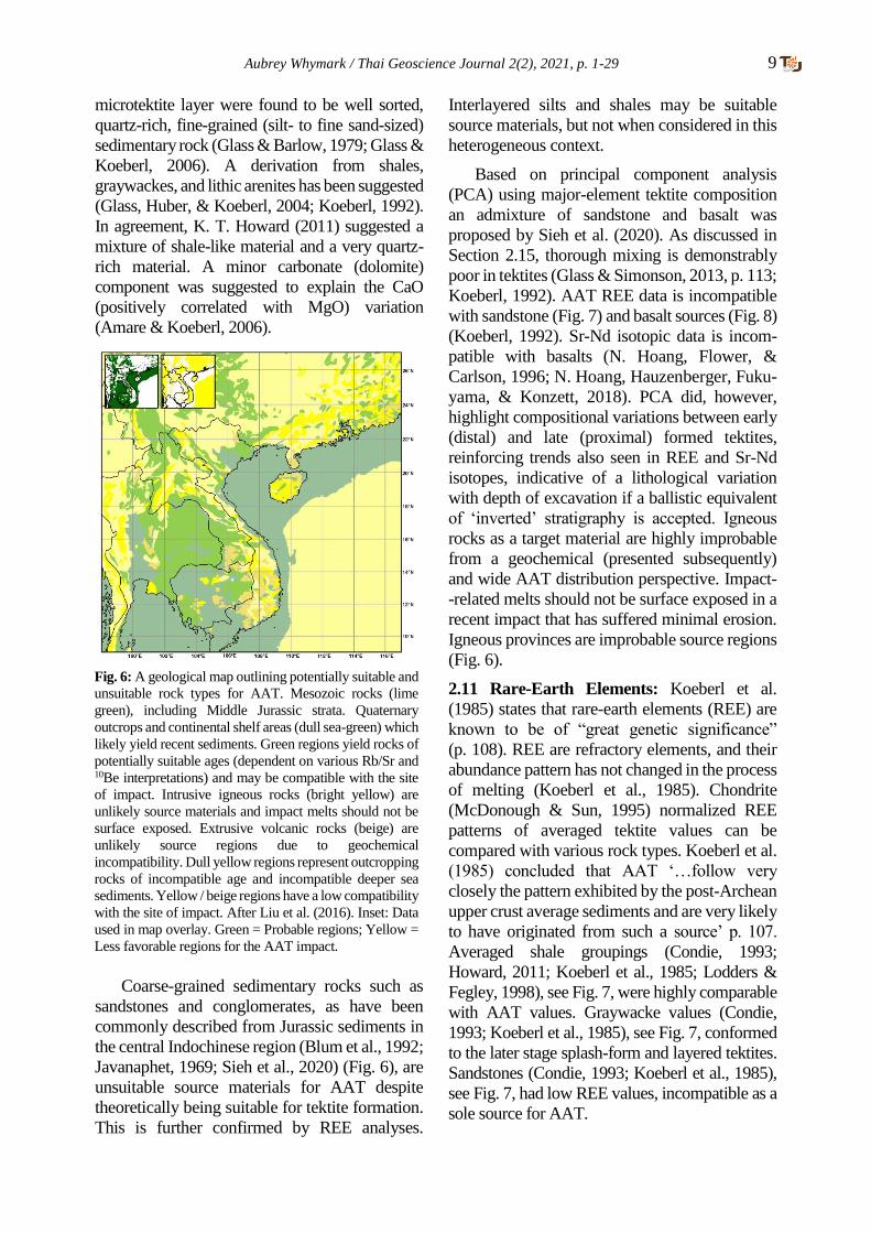
Coarse-grained sedimentary rocks such as
sandstones and conglomerates, as have been
commonly described from Jurassic sediments in
the central Indochinese region (Blum et al., 1992;
Javanaphet, 1969; Sieh et al., 2020) (Fig. 6), are
unsuitable source materials for AAT despite
theoretically being suitable for tektite formation.
This is further confirmed by REE analyses.
Interlayered silts and shales may be suitable
source materials, but not when considered in this
heterogeneous context.
Based on principal component analysis
(PCA) using major-element tektite composition
an admixture of sandstone and basalt was
proposed by Sieh et al. (2020). As discussed in
Section 2.15, thorough mixing is demonstrably
poor in tektites (Glass & Simonson, 2013, p. 113;
Koeberl, 1992). AAT REE data is incompatible
with sandstone (Fig. 7) and basalt sources (Fig. 8)
(Koeberl, 1992). Sr-Nd isotopic data is incom-
patible with basalts (N. Hoang, Flower, &
Carlson, 1996; N. Hoang, Hauzenberger, Fuku-
yama, & Konzett, 2018). PCA did, however,
highlight compositional variations between early
(distal) and late (proximal) formed tektites,
reinforcing trends also seen in REE and Sr-Nd
isotopes, indicative of a lithological variation
with depth of excavation if a ballistic equivalent
of ‘inverted’ stratigraphy is accepted. Igneous
rocks as a target material are highly improbable
from a geochemical (presented subsequently)
and wide AAT distribution perspective. Impact-
-related melts should not be surface exposed in a
recent impact that has suffered minimal erosion.
Igneous provinces are improbable source regions
(Fig. 6).
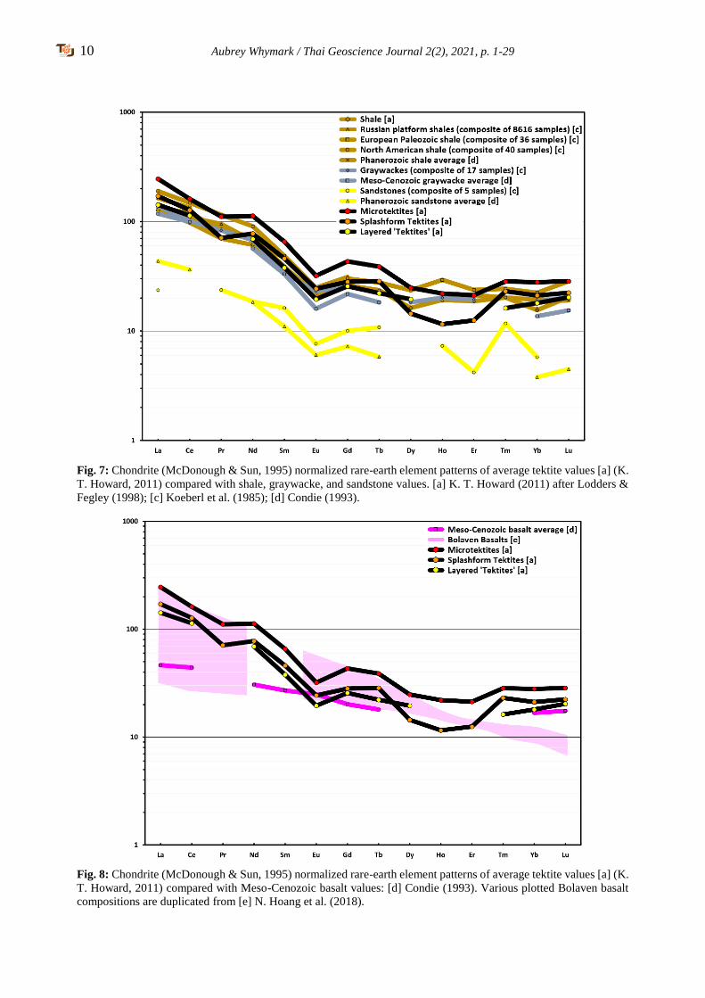
2.11 Rare-Earth Elements: Koeberl et al.
(1985) states that rare-earth elements (REE) are
known to be of “great genetic significance”
(p. 108). REE are refractory elements, and their
abundance pattern has not changed in the process
of melting (Koeberl et al., 1985). Chondrite
(McDonough & Sun, 1995) normalized REE
patterns of averaged tektite values can be
compared with various rock types. Koeberl et al.
(1985) concluded that AAT ‘…follow very
closely the pattern exhibited by the post-Archean
upper crust average sediments and are very likely
to have originated from such a source’ p. 107.
Averaged shale groupings (Condie, 1993;
Howard, 2011; Koeberl et al., 1985; Lodders &
Fegley, 1998), see Fig. 7, were highly comparable
with AAT values. Graywacke values (Condie,
1993; Koeberl et al., 1985), see Fig. 7, conformed
to the later stage splash-form and layered tektites.
Sandstones (Condie, 1993; Koeberl et al., 1985),
see Fig. 7, had low REE values, incompatible as a
sole source for AAT.
Fig. 6: A geological map outlining potentially suitable and
unsuitable rock types for AAT. Mesozoic rocks (lime
green), including Middle Jurassic strata. Quaternary
outcrops and continental shelf areas (dull sea-green) which
likely yield recent sediments. Green regions yield rocks of
potentially suitable ages (dependent on various Rb/Sr and 10Be interpretations) and may be compatible with the site
of impact. Intrusive igneous rocks (bright yellow) are
unlikely source materials and impact melts should not be
surface exposed. Extrusive volcanic rocks (beige) are
unlikely source regions due to geochemical
incompatibility. Dull yellow regions represent outcropping
rocks of incompatible age and incompatible deeper sea
sediments. Yellow / beige regions have a low compatibility
with the site of impact. After Liu et al. (2016). Inset: Data
used in map overlay. Green = Probable regions; Yellow =
Less favorable regions for the AAT impact.
10 Aubrey Whymark / Thai Geoscience Journal 2(2), 2021, p. 1-29
Fig. 7: Chondrite (McDonough & Sun, 1995) normalized rare-earth element patterns of average tektite values [a] (K.
T. Howard, 2011) compared with shale, graywacke, and sandstone values. [a] K. T. Howard (2011) after Lodders &
Fegley (1998); [c] Koeberl et al. (1985); [d] Condie (1993).
Fig. 8: Chondrite (McDonough & Sun, 1995) normalized rare-earth element patterns of average tektite values [a] (K.
T. Howard, 2011) compared with Meso-Cenozoic basalt values: [d] Condie (1993). Various plotted Bolaven basalt
compositions are duplicated from [e] N. Hoang et al. (2018).

Aubrey Whymark / Thai Geoscience Journal 2(2), 2021, p. 1-29 11
Fig. 9: Chondrite (McDonough & Sun, 1995) normalized rare-earth element patterns of average tektite values [a] (K.
T. Howard, 2011) compared with Upper Miocene sediment values: [b] (Cao et al., 2015). Bright green wells were
categorized by (Cao et al., 2015) as Group 1 wells with relatively high REE concentrations. Dark green wells were
categorized by (Cao et al., 2015) as Group 2 wells with relatively low REE concentrations. Pale green wells were
uncategorized, falling into both Group 1 and 2 with some anomalies.
REE values for basalt (including Bolaven
Plateau basalts), see Fig. 8, did not reproduce the
AAT REE pattern (Condie, 1993; N. Hoang et al.,
2018). Basic igneous rocks can be excluded as a
potential source material for AAT (wholly or in
part) based on REE (N. Hoang et al., 1996, 2018;
Koeberl, 1992) (Fig. 8). Koeberl (1992) states:
‘Mixing of local soils, or with some related
loess samples, cannot reproduce the tektite
REE patterns, and any basaltic, oceanic, or
extraterrestrial rocks can be excluded as source
rocks…’ p. 1033. Figs. 7 & 8 demonstrate that
REE patterns of sandstones and basalts, either
in isolation or in combination, are incompatible
with AAT.
All shales have similar REE patterns, so it is
not possible to determine the exact precursor rock /
formation from which AAT originated (Koeberl
et al., 1985). It can simply be determined that the
source rock was shale-rich and post-Archean
(Koeberl et al., 1985). Averaged tektite values
from K. T. Howard (2011), suggest that earlier
formed microtektites have, on average, higher
REE concentrations than splash-form tektites,
which in turn have higher REE concentrations
than the last formed layered ‘tektites’ (Figs. 7 - 9).
If a ballistic equivalent of ‘inverted’ stratigraphy,
a concept that is not proven but appears likely, is
accepted then REE may indicate a subtle transi-
tion from shales to siltier / sandier interbedded
shales or graywackes with greater depth of
excavation.
Australasian tektite REE values can be
compared with Upper Miocene sediments from
boreholes in the Yinggehai Basin and Qiong-
dongnan Basin (Cao, Jiang, Wang, Zhang, &
Sun, 2015), see Fig. 9. AAT REE values were
comparable with sediments containing high
REE concentrations, categorized as Group 1 wells
by Cao et al. (2015). Average AAT microtektite
values closely matched well LT33. Average
AAT splash-form and layered ‘tektite’ values
were comparable with wells HK17 and LT1, see
Fig. 9. In the sparse data set, in terms of
geographic and stratigraphic extent, Group 1
wells corresponded with regions surrounding
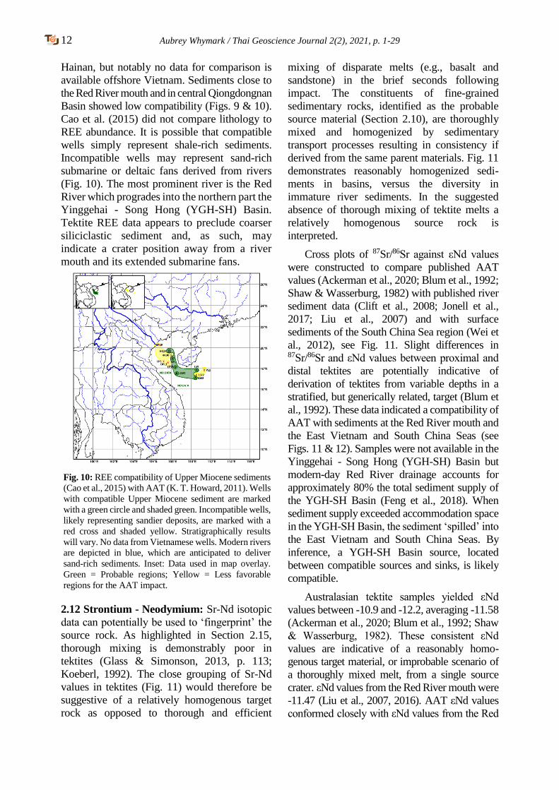
12 Aubrey Whymark / Thai Geoscience Journal 2(2), 2021, p. 1-29
Hainan, but notably no data for comparison is
available offshore Vietnam. Sediments close to
the Red River mouth and in central Qiongdongnan
Basin showed low compatibility (Figs. 9 & 10).
Cao et al. (2015) did not compare lithology to
REE abundance. It is possible that compatible
wells simply represent shale-rich sediments.
Incompatible wells may represent sand-rich
submarine or deltaic fans derived from rivers
(Fig. 10). The most prominent river is the Red
River which progrades into the northern part the
Yinggehai - Song Hong (YGH-SH) Basin.
Tektite REE data appears to preclude coarser
siliciclastic sediment and, as such, may
indicate a crater position away from a river
mouth and its extended submarine fans.
2.12 Strontium - Neodymium: Sr-Nd isotopic
data can potentially be used to ‘fingerprint’ the
source rock. As highlighted in Section 2.15,
thorough mixing is demonstrably poor in
tektites (Glass & Simonson, 2013, p. 113;
Koeberl, 1992). The close grouping of Sr-Nd
values in tektites (Fig. 11) would therefore be
suggestive of a relatively homogenous target
rock as opposed to thorough and efficient
mixing of disparate melts (e.g., basalt and
sandstone) in the brief seconds following
impact. The constituents of fine-grained
sedimentary rocks, identified as the probable
source material (Section 2.10), are thoroughly
mixed and homogenized by sedimentary
transport processes resulting in consistency if
derived from the same parent materials. Fig. 11
demonstrates reasonably homogenized sedi-
ments in basins, versus the diversity in
immature river sediments. In the suggested
absence of thorough mixing of tektite melts a
relatively homogenous source rock is
interpreted.
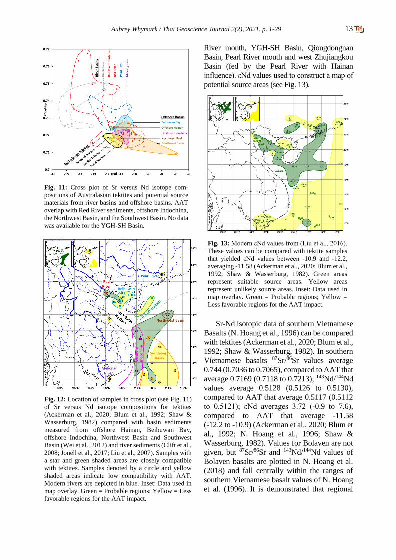
Cross plots of 87Sr/86Sr against εNd values
were constructed to compare published AAT
values (Ackerman et al., 2020; Blum et al., 1992;
Shaw & Wasserburg, 1982) with published river
sediment data (Clift et al., 2008; Jonell et al.,
2017; Liu et al., 2007) and with surface
sediments of the South China Sea region (Wei et
al., 2012), see Fig. 11. Slight differences in 87Sr/86Sr and εNd values between proximal and
distal tektites are potentially indicative of
derivation of tektites from variable depths in a
stratified, but generically related, target (Blum et
al., 1992). These data indicated a compatibility of
AAT with sediments at the Red River mouth and
the East Vietnam and South China Seas (see
Figs. 11 & 12). Samples were not available in the
Yinggehai - Song Hong (YGH-SH) Basin but
modern-day Red River drainage accounts for
approximately 80% the total sediment supply of
the YGH-SH Basin (Feng et al., 2018). When
sediment supply exceeded accommodation space
in the YGH-SH Basin, the sediment ‘spilled’ into
the East Vietnam and South China Seas. By
inference, a YGH-SH Basin source, located
between compatible sources and sinks, is likely
compatible.
Australasian tektite samples yielded εNd
values between -10.9 and -12.2, averaging -11.58
(Ackerman et al., 2020; Blum et al., 1992; Shaw
& Wasserburg, 1982). These consistent εNd
values are indicative of a reasonably homo-
genous target material, or improbable scenario of
a thoroughly mixed melt, from a single source
crater. εNd values from the Red River mouth were
-11.47 (Liu et al., 2007, 2016). AAT εNd values
conformed closely with εNd values from the Red
Fig. 10: REE compatibility of Upper Miocene sediments
(Cao et al., 2015) with AAT (K. T. Howard, 2011). Wells
with compatible Upper Miocene sediment are marked
with a green circle and shaded green. Incompatible wells,
likely representing sandier deposits, are marked with a
red cross and shaded yellow. Stratigraphically results
will vary. No data from Vietnamese wells. Modern rivers
are depicted in blue, which are anticipated to deliver
sand-rich sediments. Inset: Data used in map overlay.
Green = Probable regions; Yellow = Less favorable
regions for the AAT impact.
Aubrey Whymark / Thai Geoscience Journal 2(2), 2021, p. 1-29 13
River mouth, YGH-SH Basin, Qiongdongnan
Basin, Pearl River mouth and west Zhujiangkou
Basin (fed by the Pearl River with Hainan
influence). εNd values used to construct a map of
potential source areas (see Fig. 13).
Sr-Nd isotopic data of southern Vietnamese
Basalts (N. Hoang et al., 1996) can be compared
with tektites (Ackerman et al., 2020; Blum et al.,
1992; Shaw & Wasserburg, 1982). In southern
Vietnamese basalts 87Sr/86Sr values average
0.744 (0.7036 to 0.7065), compared to AAT that
average 0.7169 (0.7118 to 0.7213); 143Nd/144Nd
values average 0.5128 (0.5126 to 0.5130),
compared to AAT that average 0.5117 (0.5112
to 0.5121); εNd averages 3.72 (-0.9 to 7.6),
compared to AAT that average -11.58
(-12.2 to -10.9) (Ackerman et al., 2020; Blum et
al., 1992; N. Hoang et al., 1996; Shaw &
Wasserburg, 1982). Values for Bolaven are not
given, but 87Sr/86Sr and 143Nd/144Nd values of
Bolaven basalts are plotted in N. Hoang et al.
(2018) and fall centrally within the ranges of
southern Vietnamese basalt values of N. Hoang
et al. (1996). It is demonstrated that regional
Fig. 11: Cross plot of Sr versus Nd isotope com-
positions of Australasian tektites and potential source
materials from river basins and offshore basins. AAT
overlap with Red River sediments, offshore Indochina,
the Northwest Basin, and the Southwest Basin. No data
was available for the YGH-SH Basin.
Fig. 12: Location of samples in cross plot (see Fig. 11)
of Sr versus Nd isotope compositions for tektites
(Ackerman et al., 2020; Blum et al., 1992; Shaw &
Wasserburg, 1982) compared with basin sediments
measured from offshore Hainan, Beibuwan Bay,
offshore Indochina, Northwest Basin and Southwest
Basin (Wei et al., 2012) and river sediments (Clift et al.,
2008; Jonell et al., 2017; Liu et al., 2007). Samples with
a star and green shaded areas are closely compatible
with tektites. Samples denoted by a circle and yellow
shaded areas indicate low compatibility with AAT.
Modern rivers are depicted in blue. Inset: Data used in
map overlay. Green = Probable regions; Yellow = Less
favorable regions for the AAT impact.
Fig. 13: Modern εNd values from (Liu et al., 2016).
These values can be compared with tektite samples
that yielded εNd values between -10.9 and -12.2,
averaging -11.58 (Ackerman et al., 2020; Blum et al.,
1992; Shaw & Wasserburg, 1982). Green areas
represent suitable source areas. Yellow areas
represent unlikely source areas. Inset: Data used in
map overlay. Green = Probable regions; Yellow =
Less favorable regions for the AAT impact.
14 Aubrey Whymark / Thai Geoscience Journal 2(2), 2021, p. 1-29
basalts are incompatible as a source material for
AAT.
2.13 Major Element Geochemical Regression:
The geographic distribution of SiO2, Na2O, and
CaO concentrations in MN-type layered
impact glasses and intermediate tektites are
plotted from Schnetzler (1992) (Figs. 14 - 16).
Schnetzler (1992) utilized a sparse data set with
some approximated or poorly defined localities
(SiO2 = 22 localities / 166 analyses; Na2O = 23
localities / 97 analyses; CaO = 24 localities / 98
analyses). The absence of data from the Gulf of
Tonkin, East Vietnam Sea, and South China
Sea potentially skews data westwards. Whilst
trends are observed, the contours are somewhat
subjective, and the possibility of erroneous
localities cannot be dismissed. The use in map
overlay, however, remains valid as the principle
combines weak data to create a more robust
argument through weight of evidence. The major
element geochemical iso-concentrations in
Schnetzler (1992) appear to trend to the center of
the proximal tektite strewn field.
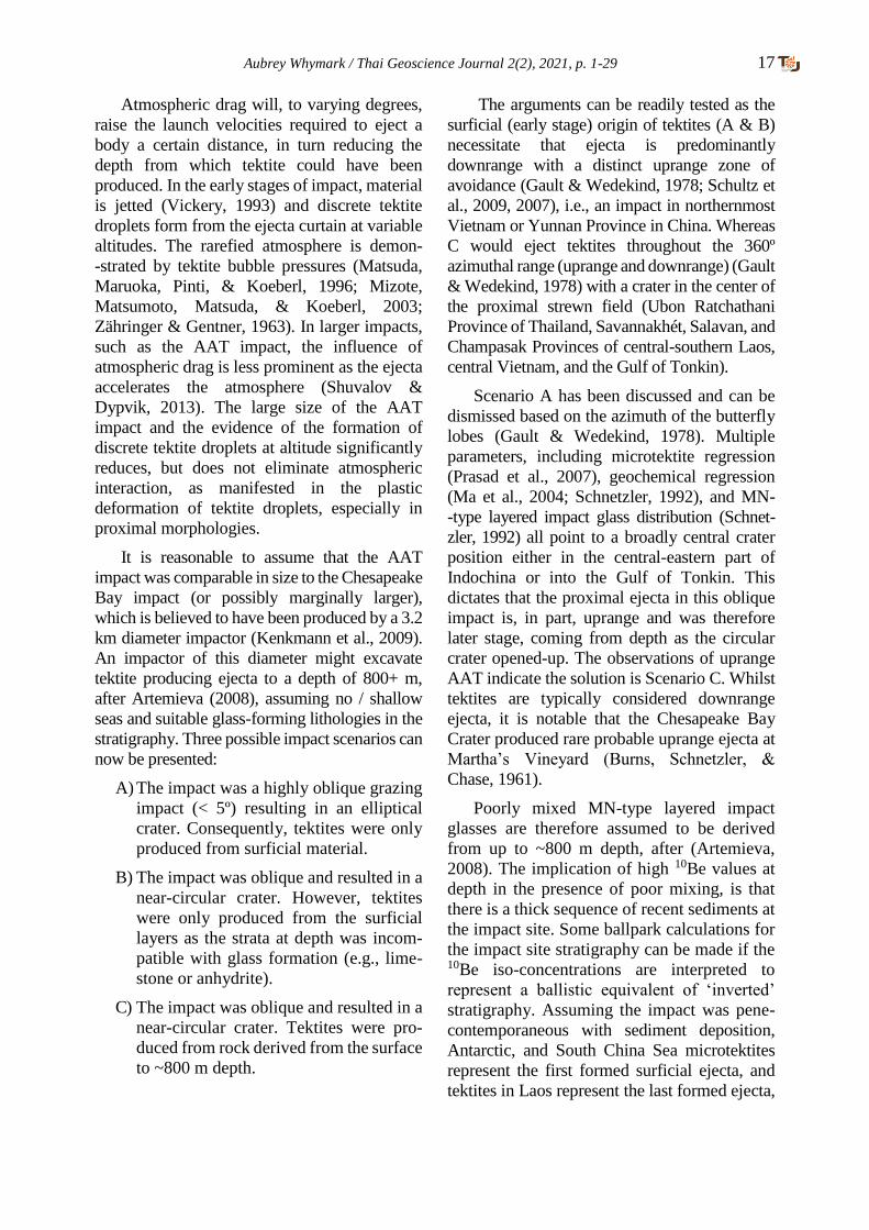
2.14 Beryllium-10 Regression: A trend of
decreasing 10Be content with proximity to the
likely source area is observed (Table 1). This
trend in 10Be iso-concentrations within the AAT
strewn field is increasingly being accepted as
representing a ballistic equivalent of ‘inverted’
stratigraphy (Ma et al., 2004). An ‘inverted’
stratigraphy should be more evident if a thick
sedimentary column has been sampled. 10Be
iso-concentrations of MN-type layered impact
glasses were used by Ma et al. (2004) to
calculate the crater position with the assumption
that the crater would lie at the center of the
lowest concentration of 10Be (Fig. 17).
2.15 Target Lithology Age: Rb-Sr versus 10Be:
There is conflicting data regarding the strati-
graphic age of the target material. Resolving
this issue would significantly narrow down the
crater search area. The conflicting data are:
• It was determined that the last major Rb-Sr
fractionation event (i.e., weathering, trans-
portation, and deposition) experienced by the
sedimentary target materials occurred in a
narrow range of stratigraphic ages ~170 Ma
ago (Blum et al., 1992).
• The 10Be content in tektites, half-life of 1.39
Ma (Chmeleff, Blanckenburg, Kossert, &
Jakob, 2010; Korschinek et al., 2010), was
recognized as being too high to be derived
from a Middle Jurassic source rock (Blum et
al., 1992). It was concluded by Ma et al.
(2004) that the AAT source material “did
not consist of older igneous or sedimentary
rocks, but of unconsolidated materials or
young sedimentary rocks” (p. 3887).
There are three solutions that might theoretically
provide satisfactory outcomes (Fig. 18):
1) There is thorough mixing between
Middle Jurassic rocks and a young
surficial cover during melt production. If
it were a young fluvial sediment cover a
~1:4 ratio of young fluvial sediment to
Middle Jurassic rock (Blum et al., 1992)
would be expected.
2) The source rock is solely Middle Jurassic
in age. A weathered surface in the target
area was exposed to meteoric waters for
longer than the half-life of 10Be and if 10Be was not lost to erosion or solution
then a ~200 m column of Middle Jurassic
bedrock could yield the correct 10Be
content (Blum et al., 1992).
3) The source rock is a young unconsolidated
sedimentary rock (Ma et al., 2004). This
suggests that the Rb-Sr clock may not have
been reset and represents the penultimate
depositional cycle (at ~170 Ma) or an
averaged Rb-Sr age (Cordani, Mizusaki,
Kawashita, & Thomaz-Filho, 2004; Dic-
kin, 2005).
Mixing is demonstrably poor in microtektites
according to Glass & Simonson (2013): “There
is not time for impact melt to be thoroughly
mixed and homogenized prior to being ejected”
(p. 113). Koeberl (1992) states that the lower
temperature, MN-type layered impact glasses
are “…compatible with incomplete mixtures of
different target rocks” (p. 1056). It is assumed
that microtektites represent early stage,
typically shallow derived, melts whereas MN-
-type layered impact glasses represent later stage,
on average more deeply excavated, melts. The
compositional layering in MN-type impact glasses

Aubrey Whymark / Thai Geoscience Journal 2(2), 2021, p. 1-29 15
Fig. 16: The geographic distribution of CaO con-
centrations in MN-type layered impact glasses and
intermediate tektites based on 24 localities / 98
analyses (Schnetzler, 1992). Note the absence of
data to the east and southeast due to the presence
of seas. Green regions represent regions of higher
probability and yellow areas denote lower
probability for the presence of the AAT source
crater. Inset: Data used in map overlay. Green =
Probable regions; Yellow = Less favorable regions
for the AAT impact.
Fig. 17: Regression of 10Be iso-concentrations (Ma
et al., 2004) indicate the crater is within the shaded
region, with the best fit at ‘•’. Note the absence of
data to the east and southeast due to the presence of
seas. The yellow shaded area denotes lower
probability for the AAT source crater. Inset: Data
used in map overlay. Green = Probable regions;
Yellow = Less favorable regions for the AAT
impact.
Fig. 15: The geographic distribution of Na2O con-
centrations in MN-type layered impact glasses and
intermediate tektites based on 23 localities / 97
analyses (Schnetzler, 1992). Note the absence of data
to the east and southeast due to the presence of seas.
Green regions represent regions of higher probability
and yellow areas denote lower probability for the
presence of the AAT source crater. Inset: Data used
in map overlay. Green = Probable regions; Yellow =
Less favorable regions for the AAT impact.
Fig. 14: The geographic distribution of SiO2 concen-
trations in MN-type layered impact glasses and
intermediate tektites based on 22 localities / 166
analyses (Schnetzler, 1992). Note the absence of data
to the east and southeast due to the presence of seas.
Green regions represent regions of higher probability
and yellow areas denote lower probability for the
presence of the AAT source crater. Inset: Data used in
map overlay. Green = Probable regions; Yellow =
Less favorable regions for the AAT impact.
16 Aubrey Whymark / Thai Geoscience Journal 2(2), 2021, p. 1-29
Table 1: Average 10Be concentrations of tektites grouped by country. Sources: [1] = (Ma et al., 2004); [2]
= (Rochette et al., 2018); [3] = (Koeberl, Nishiizumi, Caffee, & Glass, 2015). Note that corrections for in
situ 10Be production are minimal, not exceeding ~10 × 106 atom/g (Ma et al., 2004, after others).
Country Average 10Be (atoms/g) Source
Laos 59 ±9 × 10⁶ (uncorrected) [1]
Thailand 71 ±17 × 106 (uncorrected) [1]
Vietnam 73 ±13 × 106 (uncorrected) [1]
China 85 ±24 × 106 (uncorrected) [1]
Indonesia 115 ±27 × 106 (uncorrected) [1]
Philippines 121 ±22 × 106 (uncorrected) [1]
Australia 136 ±30 × 106 (uncorrected) [1]
Microtektites:
Antarctica 184 ±8 × 10⁶ (corrected
for in situ production)
[2]
S. China Sea 260 ±60 ×106 [3]
Fig. 18: Three scenarios that satisfactorily explain the Rb-
Sr and 10Be values.
may reflect sedimentary bedding, indicative of
melting with practically no mixing, implying 10Be content at depth. It was remarked by Ma et
al. (2004): “assuming that during crater
formation neither the precursor grains nor the
material melted mixed efficiently on a scale of
tens of meters (N. A. Artemieva and E. Pierazzo,
personal communication, 2002) we conclude
that the vertical extent or thickness (as opposed
to the absolute depth) of the hypothetical region
that participated in tektite formation was likely
between 15 and 300 m.” (p. 3892).
The assumption made in Ma et al. (2004) was
that if mixing is poor then high 10Be values in
tektite demonstrate a surficial origin (15 to 300 m).
This has been supported by numerous authors:
~200 m (Blum et al., 1992); X0 m (Trnka, 2020);
first tens of cm’s of soil / sediment for Antarctica
microtektites (Rochette et al., 2018). This
assumption, however, is incorrect as it assumes
an impact on land or in a region of normal
sedimentation. Within the region of most
probable impact (i.e., Indochinese to southern
Chinese region) the YGH-SH Basin in the Gulf
of Tonkin demonstrates exceptionally high
sedimentation rates and therefore presumable
abnormally high 10Be content at great depth.
Sediments predominantly comprise siliciclastic
continental material in a deltaic to shallow
marine setting. High 10Be values in AAT do not
demonstrate a surficial origin unless the source
crater geology is known. 10Be content does,
however, potentially allow a crude understanding
of stratigraphy at the unknown impact location if
depth of excavation of tektites can be
independently estimated.
Artemieva (2008) states that: “Excavation
depth (initial position of ejecta in the target)
drops quickly with increasing ejection velocity:
from 0.25 Dpr for 2 km/s to 0.02 Dpr for 11
km/s” (p. 1) (Dpr = diameter of projectile). The
trajectories of tektites, neglecting atmospheric
drag, were calculated (Schmitt, 2004): at 2 km/s
material is ejected laterally 204 km at 15º and
75º; 312 km at 25º and 65º to a maximum of 408
km at 45º. Moldavites, from Ries Crater, occur
at distances beyond ~185 km. Assuming
ejection angles from 15º to 75º, neglecting
atmospheric drag, corresponding velocities of
1.35 to 1.9 km/s are calculated for these
Moldavites, suggestive that tektites are present
in ejecta travelling at under (or certainly close
to) 2 km/s.
Aubrey Whymark / Thai Geoscience Journal 2(2), 2021, p. 1-29 17
Atmospheric drag will, to varying degrees,
raise the launch velocities required to eject a
body a certain distance, in turn reducing the
depth from which tektite could have been
produced. In the early stages of impact, material
is jetted (Vickery, 1993) and discrete tektite
droplets form from the ejecta curtain at variable
altitudes. The rarefied atmosphere is demon-
-strated by tektite bubble pressures (Matsuda,
Maruoka, Pinti, & Koeberl, 1996; Mizote,
Matsumoto, Matsuda, & Koeberl, 2003;
Zähringer & Gentner, 1963). In larger impacts,
such as the AAT impact, the influence of
atmospheric drag is less prominent as the ejecta
accelerates the atmosphere (Shuvalov &
Dypvik, 2013). The large size of the AAT
impact and the evidence of the formation of
discrete tektite droplets at altitude significantly
reduces, but does not eliminate atmospheric
interaction, as manifested in the plastic
deformation of tektite droplets, especially in
proximal morphologies.
It is reasonable to assume that the AAT
impact was comparable in size to the Chesapeake
Bay impact (or possibly marginally larger),
which is believed to have been produced by a 3.2
km diameter impactor (Kenkmann et al., 2009).
An impactor of this diameter might excavate
tektite producing ejecta to a depth of 800+ m,
after Artemieva (2008), assuming no / shallow
seas and suitable glass-forming lithologies in the
stratigraphy. Three possible impact scenarios can
now be presented:
A) The impact was a highly oblique grazing
impact (< 5º) resulting in an elliptical
crater. Consequently, tektites were only
produced from surficial material.
B) The impact was oblique and resulted in a
near-circular crater. However, tektites
were only produced from the surficial
layers as the strata at depth was incom-
patible with glass formation (e.g., lime-
stone or anhydrite).
C) The impact was oblique and resulted in a
near-circular crater. Tektites were pro-
duced from rock derived from the surface
to ~800 m depth.
The arguments can be readily tested as the
surficial (early stage) origin of tektites (A & B)
necessitate that ejecta is predominantly
downrange with a distinct uprange zone of
avoidance (Gault & Wedekind, 1978; Schultz et
al., 2009, 2007), i.e., an impact in northernmost
Vietnam or Yunnan Province in China. Whereas
C would eject tektites throughout the 360º
azimuthal range (uprange and downrange) (Gault
& Wedekind, 1978) with a crater in the center of
the proximal strewn field (Ubon Ratchathani
Province of Thailand, Savannakhét, Salavan, and
Champasak Provinces of central-southern Laos,
central Vietnam, and the Gulf of Tonkin).
Scenario A has been discussed and can be
dismissed based on the azimuth of the butterfly
lobes (Gault & Wedekind, 1978). Multiple
parameters, including microtektite regression
(Prasad et al., 2007), geochemical regression
(Ma et al., 2004; Schnetzler, 1992), and MN-
-type layered impact glass distribution (Schnet-
zler, 1992) all point to a broadly central crater
position either in the central-eastern part of
Indochina or into the Gulf of Tonkin. This
dictates that the proximal ejecta in this oblique
impact is, in part, uprange and was therefore
later stage, coming from depth as the circular
crater opened-up. The observations of uprange
AAT indicate the solution is Scenario C. Whilst
tektites are typically considered downrange
ejecta, it is notable that the Chesapeake Bay
Crater produced rare probable uprange ejecta at
Martha’s Vineyard (Burns, Schnetzler, &
Chase, 1961).
Poorly mixed MN-type layered impact
glasses are therefore assumed to be derived
from up to ~800 m depth, after (Artemieva,
2008). The implication of high 10Be values at
depth in the presence of poor mixing, is that
there is a thick sequence of recent sediments at
the impact site. Some ballpark calculations for
the impact site stratigraphy can be made if the 10Be iso-concentrations are interpreted to
represent a ballistic equivalent of ‘inverted’
stratigraphy. Assuming the impact was pene-
contemporaneous with sediment deposition,
Antarctic, and South China Sea microtektites
represent the first formed surficial ejecta, and
tektites in Laos represent the last formed ejecta,
18 Aubrey Whymark / Thai Geoscience Journal 2(2), 2021, p. 1-29
a 2.28 to 2.97 Ma packet of sediment was
sampled by AAT (early Pleistocene to Pliocene).
Assuming ~800 m depth was sampled; an
average sedimentation rate of 269 to 351 m/Ma
is derived. The calculations are crude owing to
multiple variables, but the principal point is that
acceptance of uprange tektite distribution
demonstrates excavation from depth and by
inference a thick sequence of recent, rapidly
deposited, sediment was sampled by AAT.
Even if the sediment column estimate was
reduced in consideration of atmospheric drag,
the same conclusions will apply. Material is not
ejected uprange until later stages of impact as
the circular crater forms.
To reset the Rb-Sr clock substantial
exchange and homogenization of Sr with sea /
formation water is required. Rapidly deposited
sediments, especially in a deltaic, but even in
open marine environments, may preserve
previous Rb-Sr dates (Cordani et al., 2004) / an
average of the provenance ages of the sedimen-
tary constituents (Dickin, 2005).
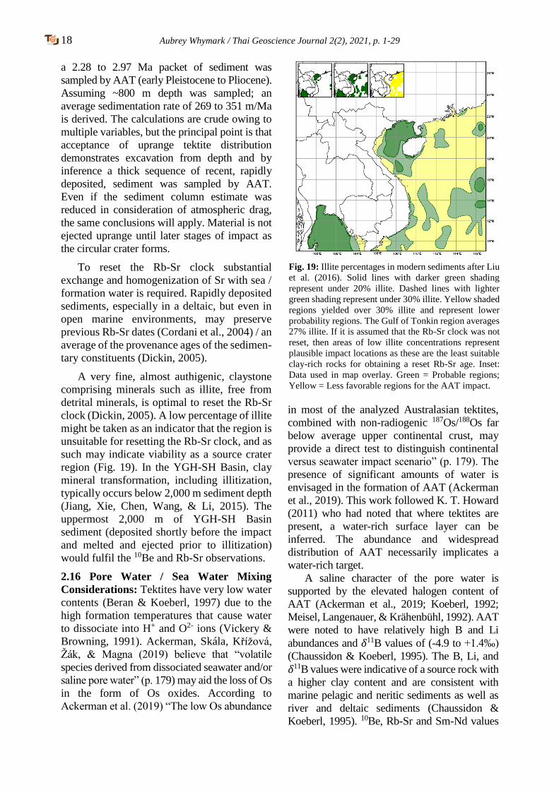
A very fine, almost authigenic, claystone
comprising minerals such as illite, free from
detrital minerals, is optimal to reset the Rb-Sr
clock (Dickin, 2005). A low percentage of illite
might be taken as an indicator that the region is
unsuitable for resetting the Rb-Sr clock, and as
such may indicate viability as a source crater
region (Fig. 19). In the YGH-SH Basin, clay
mineral transformation, including illitization,
typically occurs below 2,000 m sediment depth
(Jiang, Xie, Chen, Wang, & Li, 2015). The
uppermost 2,000 m of YGH-SH Basin
sediment (deposited shortly before the impact
and melted and ejected prior to illitization)
would fulfil the 10Be and Rb-Sr observations.
2.16 Pore Water / Sea Water Mixing
Considerations: Tektites have very low water
contents (Beran & Koeberl, 1997) due to the
high formation temperatures that cause water
to dissociate into H+ and O2- ions (Vickery &
Browning, 1991). Ackerman, Skála, Křížová,
Žák, & Magna (2019) believe that “volatile
species derived from dissociated seawater and/or
saline pore water” (p. 179) may aid the loss of Os
in the form of Os oxides. According to
Ackerman et al. (2019) “The low Os abundance
in most of the analyzed Australasian tektites,
combined with non-radiogenic 187Os/188Os far
below average upper continental crust, may
provide a direct test to distinguish continental
versus seawater impact scenario” (p. 179). The
presence of significant amounts of water is
envisaged in the formation of AAT (Ackerman
et al., 2019). This work followed K. T. Howard
(2011) who had noted that where tektites are
present, a water-rich surface layer can be
inferred. The abundance and widespread
distribution of AAT necessarily implicates a
water-rich target.
A saline character of the pore water is
supported by the elevated halogen content of
AAT (Ackerman et al., 2019; Koeberl, 1992;
Meisel, Langenauer, & Krähenbühl, 1992). AAT
were noted to have relatively high B and Li
abundances and 𝛿11B values of (-4.9 to +1.4‰)
(Chaussidon & Koeberl, 1995). The B, Li, and
𝛿11B values were indicative of a source rock with
a higher clay content and are consistent with
marine pelagic and neritic sediments as well as
river and deltaic sediments (Chaussidon &
Koeberl, 1995). 10Be, Rb-Sr and Sm-Nd values
Fig. 19: Illite percentages in modern sediments after Liu
et al. (2016). Solid lines with darker green shading
represent under 20% illite. Dashed lines with lighter
green shading represent under 30% illite. Yellow shaded
regions yielded over 30% illite and represent lower
probability regions. The Gulf of Tonkin region averages
27% illite. If it is assumed that the Rb-Sr clock was not
reset, then areas of low illite concentrations represent
plausible impact locations as these are the least suitable
clay-rich rocks for obtaining a reset Rb-Sr age. Inset:
Data used in map overlay. Green = Probable regions;
Yellow = Less favorable regions for the AAT impact.
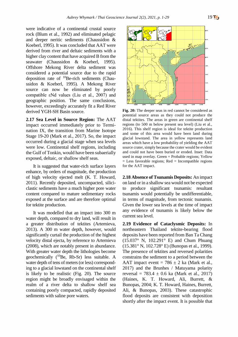
Aubrey Whymark / Thai Geoscience Journal 2(2), 2021, p. 1-29 19
were indicative of a continental crustal source
rock (Blum et al., 1992) and eliminated pelagic
and deeper neritic sediments (Chaussidon &
Koeberl, 1995). It was concluded that AAT were
derived from river and deltaic sediments with a
higher clay content that have acquired B from the
seawater (Chaussidon & Koeberl, 1995).
Offshore Mekong River delta sediment was
considered a potential source due to the rapid
deposition rate of 10Be-rich sediments (Chau-
ssidon & Koeberl, 1995). A Mekong River
source can now be eliminated by poorly
compatible εNd values (Liu et al., 2007) and
geographic position. The same conclusions,
however, exceedingly accurately fit a Red River
derived YGH-SH Basin source.
2.17 Sea Level in Source Region: The AAT
impact occurred immediately prior to Termi-
nation IX, the transition from Marine Isotope
Stage 19-20 (Mark et al., 2017). So, the impact
occurred during a glacial stage when sea levels
were low. Continental shelf regions, including
the Gulf of Tonkin, would have been subaerially
exposed, deltaic, or shallow shelf seas.
It is suggested that water-rich surface layers
enhance, by orders of magnitude, the production
of high velocity ejected melt (K. T. Howard,
2011). Recently deposited, uncompacted, silici-
clastic sediments have a much higher pore water
content compared to mature sedimentary rocks
exposed at the surface and are therefore optimal
for tektite production.
It was modelled that an impact into 300 m
water depth, compared to dry land, will result in
a greater distribution of tektites (Artemieva,
2013). A 300 m water depth, however, would
significantly curtail the production of the highest
velocity distal ejecta, by reference to Artemieva
(2008), which are notably present in abundance.
With greater water depth the lithologies become
geochemically (10Be, Rb-Sr) less suitable. A
water depth of tens of meters (or less) correspond-
ing to a glacial lowstand on the continental shelf
is likely to be realistic (Fig. 20). The source
region might be broadly envisaged within the
realm of a river delta to shallow shelf sea
containing poorly compacted, rapidly deposited
sediments with saline pore waters.
Fig. 20: The deeper seas in red cannot be considered as
potential source areas as they could not produce the
distal tektites. The areas in green are continental shelf
regions (to 500 m below present sea level) (Liu et al.,
2016). This shelf region is ideal for tektite production
and some of this area would have been land during
glacial lowstand. The area in yellow represents land
areas which have a low probability of yielding the AAT
source crater, simply because the crater would be evident
and could not have been buried or eroded. Inset: Data
used in map overlay. Green = Probable regions; Yellow
= Less favorable regions; Red = Incompatible regions
for the AAT impact.
2.18 Absence of Tsunamis Deposits: An impact
on land or in a shallow sea would not be expected
to produce significant tsunamis: resultant
tsunamis would potentially be undifferentiable,
in terms of magnitude, from tectonic tsunamis.
Given the lower sea levels at the time of impact
any evidence of tsunamis is likely below the
current sea level.
2.19 Evidence of Cataclysmic Deposits: In
northeastern Thailand tektite-bearing flood
deposits have been reported from Ban Ta Chang
(15.037° N, 102.291° E) and Chum Phuang
(15.381° N, 102.728° E) (Bunopas et al., 1999).
The presence of tektites and reversed polarities
constrains the sediment to a period between the
AAT impact event = 786 ± 2 ka (Mark et al.,
2017) and the Brunhes / Matuyama polarity
reversal = 783.4 ± 0.6 ka (Mark et al., 2017)
(Haines, K. T. Howard, Ali, Burrett, &
Bunopas, 2004; K. T. Howard, Haines, Burrett,
Ali, & Bunopas, 2003). These catastrophic
flood deposits are consistent with deposition
shortly after the impact event. It is possible that
20 Aubrey Whymark / Thai Geoscience Journal 2(2), 2021, p. 1-29
these deposits are unrelated, but assuming that
these deposits are related to the AAT impact
event, it would suggest that the locations are
within approximately 750 km of the impact site,
after Collins, Melosh, & Marcus (2005).
2.20 Absence of a Crater: A recent crater that
is 43 ± 9 km in diameter (Glass & Koeberl,
2006) is sought. A structure on land should
form a distinctive morphological scar, which in
tropical regions would be expected to form of
a lake. The 1.83 km diameter, 0.576 Ma
(±0.047 Ma), Lonar Crater (Jourdan, Moynier,
Koeberl, & Eroglu, 2011; Schmieder & Kring,
2020) contains a 1.2 km diameter lake. The
10.5 km, 1.13 Ma (±0.10 Ma) (Jourdan, 2012;
Koeberl, Bottomley, Glass, & Storzer, 1997;
Schmieder & Kring, 2020) Bosumtwi Crater in
Ghana, again in a tropical region, contains an 8
km diameter lake. The only significant lake in
Indochina, Tonle Sap, was suggested as a
possible source crater by Hartung & Koeberl
(1994). Tektite distribution patterns and geoche-
mical regressions would indicate that this cannot
be the AAT source crater.
Given the absence of a lake, if the crater
were onshore, it would be impossible to erode
anything more than the most surficial part of a
relatively pervasive impact structure. Distinct
pyroclastic-like lithologies should be observed.
Igneous-like lithologies would have been
observed with deeper, but implausible, erosion.
Estimated denudation rates are 23 m to 393 m
since the AAT impact crater formed (Carter,
Roques, & Bristow, 2000; Jonell et al., 2017;
Yan, Carter, Palk, Brichau, & Hu, 2011) with
perhaps ± 75 m of erosion being a realistic
average value to use.
Destruction of the crater by tectonic
processes can be ruled out in the brief time since
impact. Tectonic processes may, however, have
enhanced sediment accommodation space,
assisting burial. Newly formed craters are natural
depocenters. Furthermore, post-impact, the crater
floor would be expected to continue to sag, e.g.,
Ries Crater experienced 134 +23/-49m of crater
floor subsidence lasting more than 600 ka (Arp et
al., 2021). Burial of the crater appears to be the
only viable option to hide a crater.
Burial by extensive flood basalts is a possi-
bility but would require a thick and extensive
area of ~1,450 km2 or more of post-impact age
lava flows to cover a ~43 km diameter crater.
Bolaven Plateau (seen in southern Laos in Fig.
6) is the only plausible (although sub-optimally
placed) volcanic center in the region of interest.
Bolaven lacks suitably extensive flood basalts
of a young post-impact age, allowing, at best, a
17 km diameter crater (Sieh et al., 2020), which
is 7 times less energetic than predicted, after
Collins et al. (2005), and more comparable with
the Bosumtwi impact that produced the much
smaller Ivory Coast Tektite strewn field.
Geochemical considerations have already been
discussed and raise objections for an AAT
impact into a pre-existing volcanic center.
Burial by sediments appears to be the only
plausible option to hide a crater. This could be by
river sediments or within a basin, such as the
YGH-SH Basin (Fig. 21). A river scenario is
somewhat problematic due to the raised crater
rim geometry that would more likely result in a
lake and diverted river system. A basin scenario,
with exceptionally high sedimentation rates,
readily explains the absence of a crater and is
entirely conceivable within the source region.
Sedimentation rates in the YGH-SH Basin were
estimated as 235 m/Ma in the late Miocene and
780 m/Ma in the Pliocene to Quaternary (Lei et
al., 2011). High sedimentation rates prior to the
impact readily explain the geochemical observa-
tions in tektites
2.21 Absence of an Ejecta Blanket: Whilst
there have been reports of an ejecta blanket in
and around the Bolaven Plateau (Sieh et al.,
2020; Tada et al., 2019) (Fig. 22), no convin-
cing evidence of a suevite deposits has been
presented. The presence of high shock / high
temperature tektites (Tada et al., 2019) in a low
shock, un-melted, monomict breccia deposit
suggests the crater is not nearby. The
monolithologic, cobbly / boulder sandstone
breccia (Sieh et al., 2020; Tada et al., 2019) is
unlike a proximal suevite, which characteristi-
cally yields partial melts. Furthermore, the
single represented lithology is a sandstone, which
is unsuitable from a REE perspective to be the
AAT source material. A localized mass transport
or flash flood origin might be more plausible,
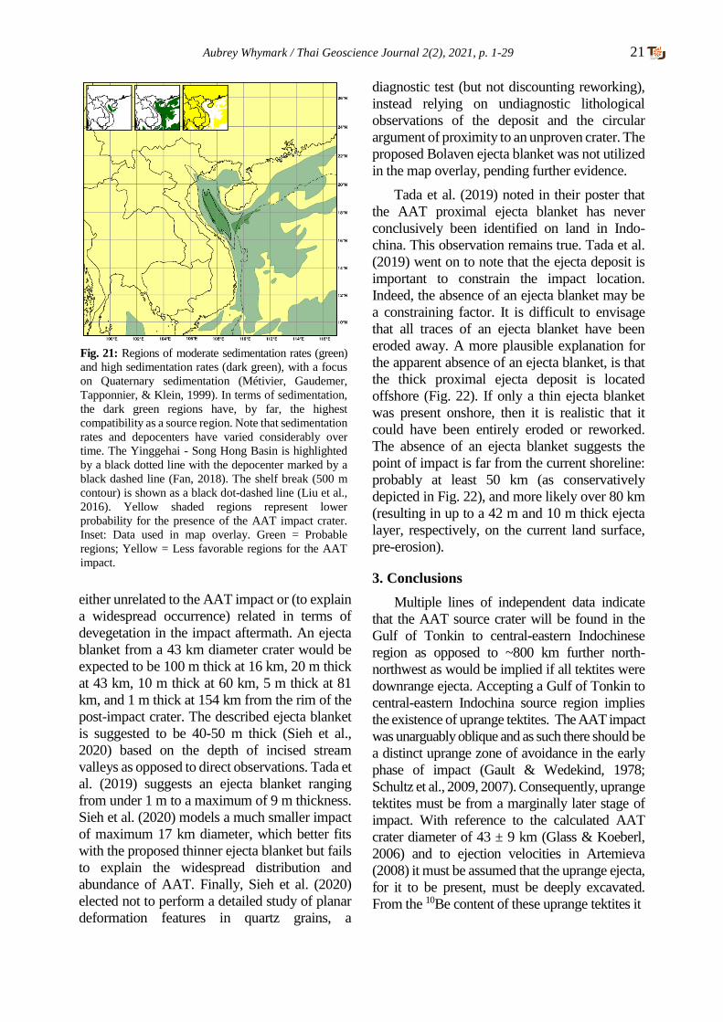
Aubrey Whymark / Thai Geoscience Journal 2(2), 2021, p. 1-29 21
Fig. 21: Regions of moderate sedimentation rates (green)
and high sedimentation rates (dark green), with a focus
on Quaternary sedimentation (Métivier, Gaudemer,
Tapponnier, & Klein, 1999). In terms of sedimentation,
the dark green regions have, by far, the highest
compatibility as a source region. Note that sedimentation
rates and depocenters have varied considerably over
time. The Yinggehai - Song Hong Basin is highlighted
by a black dotted line with the depocenter marked by a
black dashed line (Fan, 2018). The shelf break (500 m
contour) is shown as a black dot-dashed line (Liu et al.,
2016). Yellow shaded regions represent lower
probability for the presence of the AAT impact crater.
Inset: Data used in map overlay. Green = Probable
regions; Yellow = Less favorable regions for the AAT
impact.
either unrelated to the AAT impact or (to explain
a widespread occurrence) related in terms of
devegetation in the impact aftermath. An ejecta
blanket from a 43 km diameter crater would be
expected to be 100 m thick at 16 km, 20 m thick
at 43 km, 10 m thick at 60 km, 5 m thick at 81
km, and 1 m thick at 154 km from the rim of the
post-impact crater. The described ejecta blanket
is suggested to be 40-50 m thick (Sieh et al.,
2020) based on the depth of incised stream
valleys as opposed to direct observations. Tada et
al. (2019) suggests an ejecta blanket ranging
from under 1 m to a maximum of 9 m thickness.
Sieh et al. (2020) models a much smaller impact
of maximum 17 km diameter, which better fits
with the proposed thinner ejecta blanket but fails
to explain the widespread distribution and
abundance of AAT. Finally, Sieh et al. (2020)
elected not to perform a detailed study of planar
deformation features in quartz grains, a
diagnostic test (but not discounting reworking),
instead relying on undiagnostic lithological
observations of the deposit and the circular
argument of proximity to an unproven crater. The
proposed Bolaven ejecta blanket was not utilized
in the map overlay, pending further evidence.
Tada et al. (2019) noted in their poster that
the AAT proximal ejecta blanket has never
conclusively been identified on land in Indo-
china. This observation remains true. Tada et al.
(2019) went on to note that the ejecta deposit is
important to constrain the impact location.
Indeed, the absence of an ejecta blanket may be
a constraining factor. It is difficult to envisage
that all traces of an ejecta blanket have been
eroded away. A more plausible explanation for
the apparent absence of an ejecta blanket, is that
the thick proximal ejecta deposit is located
offshore (Fig. 22). If only a thin ejecta blanket
was present onshore, then it is realistic that it
could have been entirely eroded or reworked.
The absence of an ejecta blanket suggests the
point of impact is far from the current shoreline:
probably at least 50 km (as conservatively
depicted in Fig. 22), and more likely over 80 km
(resulting in up to a 42 m and 10 m thick ejecta
layer, respectively, on the current land surface,
pre-erosion).
3. Conclusions
Multiple lines of independent data indicate
that the AAT source crater will be found in the
Gulf of Tonkin to central-eastern Indochinese
region as opposed to ~800 km further north-
northwest as would be implied if all tektites were
downrange ejecta. Accepting a Gulf of Tonkin to
central-eastern Indochina source region implies
the existence of uprange tektites. The AAT impact
was unarguably oblique and as such there should be
a distinct uprange zone of avoidance in the early
phase of impact (Gault & Wedekind, 1978;
Schultz et al., 2009, 2007). Consequently, uprange
tektites must be from a marginally later stage of
impact. With reference to the calculated AAT
crater diameter of 43 ± 9 km (Glass & Koeberl,
2006) and to ejection velocities in Artemieva
(2008) it must be assumed that the uprange ejecta,
for it to be present, must be deeply excavated.
From the 10Be content of these uprange tektites it
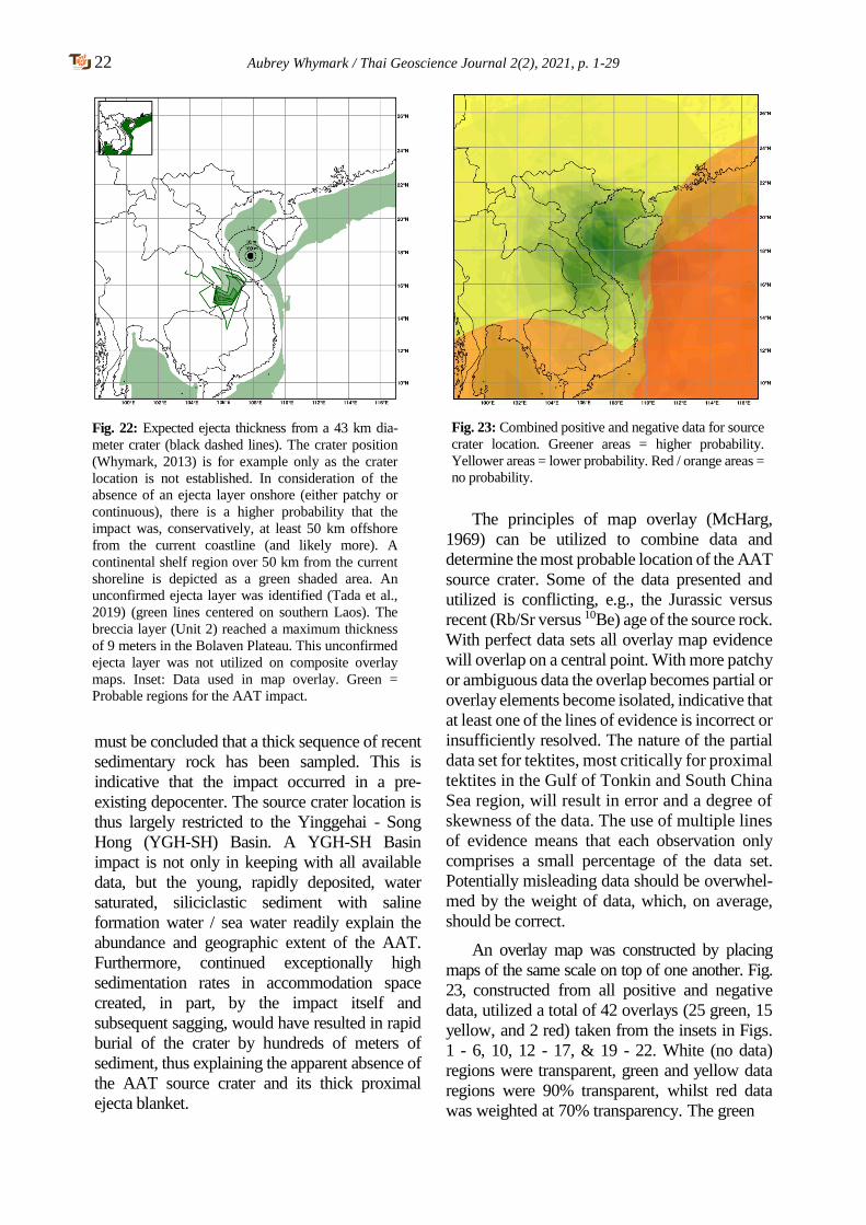
22 Aubrey Whymark / Thai Geoscience Journal 2(2), 2021, p. 1-29
must be concluded that a thick sequence of recent
sedimentary rock has been sampled. This is
indicative that the impact occurred in a pre-
existing depocenter. The source crater location is
thus largely restricted to the Yinggehai - Song
Hong (YGH-SH) Basin. A YGH-SH Basin
impact is not only in keeping with all available
data, but the young, rapidly deposited, water
saturated, siliciclastic sediment with saline
formation water / sea water readily explain the
abundance and geographic extent of the AAT.
Furthermore, continued exceptionally high
sedimentation rates in accommodation space
created, in part, by the impact itself and
subsequent sagging, would have resulted in rapid
burial of the crater by hundreds of meters of
sediment, thus explaining the apparent absence of
the AAT source crater and its thick proximal
ejecta blanket.
The principles of map overlay (McHarg,
1969) can be utilized to combine data and
determine the most probable location of the AAT
source crater. Some of the data presented and
utilized is conflicting, e.g., the Jurassic versus
recent (Rb/Sr versus 10Be) age of the source rock.
With perfect data sets all overlay map evidence
will overlap on a central point. With more patchy
or ambiguous data the overlap becomes partial or
overlay elements become isolated, indicative that
at least one of the lines of evidence is incorrect or
insufficiently resolved. The nature of the partial
data set for tektites, most critically for proximal
tektites in the Gulf of Tonkin and South China
Sea region, will result in error and a degree of
skewness of the data. The use of multiple lines
of evidence means that each observation only
comprises a small percentage of the data set.
Potentially misleading data should be overwhel-
med by the weight of data, which, on average,
should be correct.
An overlay map was constructed by placing
maps of the same scale on top of one another. Fig.
23, constructed from all positive and negative
data, utilized a total of 42 overlays (25 green, 15
yellow, and 2 red) taken from the insets in Figs.
1 - 6, 10, 12 - 17, & 19 - 22. White (no data)
regions were transparent, green and yellow data
regions were 90% transparent, whilst red data
was weighted at 70% transparency. The green
Fig. 22: Expected ejecta thickness from a 43 km dia-
meter crater (black dashed lines). The crater position
(Whymark, 2013) is for example only as the crater
location is not established. In consideration of the
absence of an ejecta layer onshore (either patchy or
continuous), there is a higher probability that the
impact was, conservatively, at least 50 km offshore
from the current coastline (and likely more). A
continental shelf region over 50 km from the current
shoreline is depicted as a green shaded area. An
unconfirmed ejecta layer was identified (Tada et al.,
2019) (green lines centered on southern Laos). The
breccia layer (Unit 2) reached a maximum thickness
of 9 meters in the Bolaven Plateau. This unconfirmed
ejecta layer was not utilized on composite overlay
maps. Inset: Data used in map overlay. Green =
Probable regions for the AAT impact.
Fig. 23: Combined positive and negative data for source
crater location. Greener areas = higher probability.
Yellower areas = lower probability. Red / orange areas =
no probability.
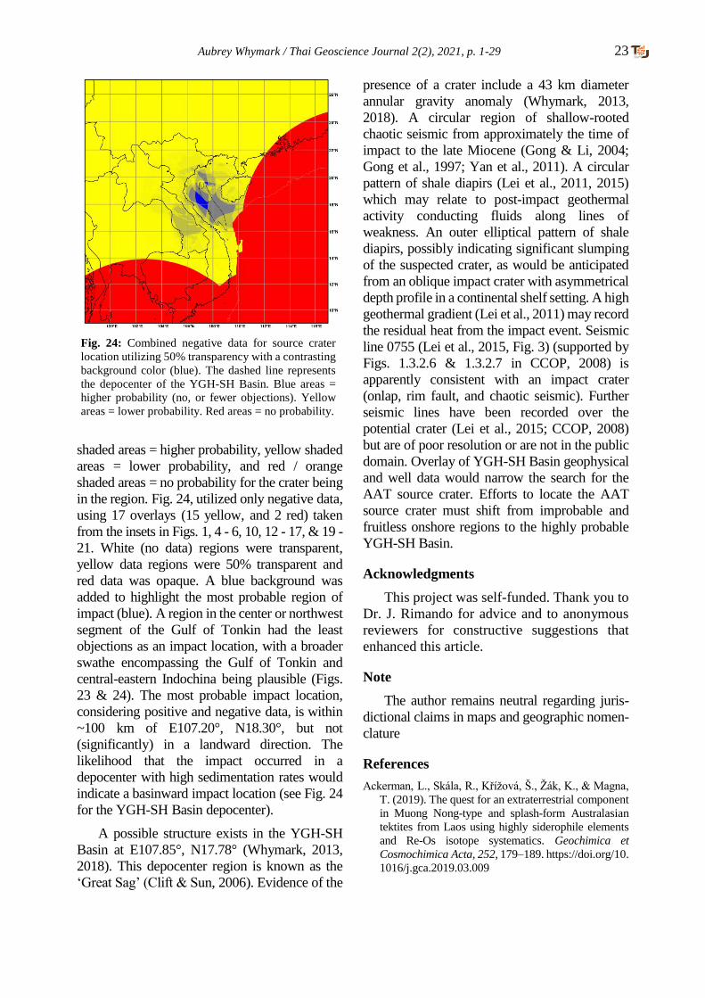
Aubrey Whymark / Thai Geoscience Journal 2(2), 2021, p. 1-29 23
shaded areas = higher probability, yellow shaded
areas = lower probability, and red / orange
shaded areas = no probability for the crater being
in the region. Fig. 24, utilized only negative data,
using 17 overlays (15 yellow, and 2 red) taken
from the insets in Figs. 1, 4 - 6, 10, 12 - 17, & 19 -
21. White (no data) regions were transparent,
yellow data regions were 50% transparent and
red data was opaque. A blue background was
added to highlight the most probable region of
impact (blue). A region in the center or northwest
segment of the Gulf of Tonkin had the least
objections as an impact location, with a broader
swathe encompassing the Gulf of Tonkin and
central-eastern Indochina being plausible (Figs.
23 & 24). The most probable impact location,
considering positive and negative data, is within
~100 km of E107.20°, N18.30°, but not
(significantly) in a landward direction. The
likelihood that the impact occurred in a
depocenter with high sedimentation rates would
indicate a basinward impact location (see Fig. 24
for the YGH-SH Basin depocenter).
A possible structure exists in the YGH-SH
Basin at E107.85°, N17.78° (Whymark, 2013,
2018). This depocenter region is known as the
‘Great Sag’ (Clift & Sun, 2006). Evidence of the
presence of a crater include a 43 km diameter
annular gravity anomaly (Whymark, 2013,
2018). A circular region of shallow-rooted
chaotic seismic from approximately the time of
impact to the late Miocene (Gong & Li, 2004;
Gong et al., 1997; Yan et al., 2011). A circular
pattern of shale diapirs (Lei et al., 2011, 2015)
which may relate to post-impact geothermal
activity conducting fluids along lines of
weakness. An outer elliptical pattern of shale
diapirs, possibly indicating significant slumping
of the suspected crater, as would be anticipated
from an oblique impact crater with asymmetrical
depth profile in a continental shelf setting. A high
geothermal gradient (Lei et al., 2011) may record
the residual heat from the impact event. Seismic
line 0755 (Lei et al., 2015, Fig. 3) (supported by
Figs. 1.3.2.6 & 1.3.2.7 in CCOP, 2008) is
apparently consistent with an impact crater
(onlap, rim fault, and chaotic seismic). Further
seismic lines have been recorded over the
potential crater (Lei et al., 2015; CCOP, 2008)
but are of poor resolution or are not in the public
domain. Overlay of YGH-SH Basin geophysical
and well data would narrow the search for the
AAT source crater. Efforts to locate the AAT
source crater must shift from improbable and
fruitless onshore regions to the highly probable
YGH-SH Basin.
Acknowledgments
This project was self-funded. Thank you to
Dr. J. Rimando for advice and to anonymous
reviewers for constructive suggestions that
enhanced this article.
Note
The author remains neutral regarding juris-
dictional claims in maps and geographic nomen-
clature
References
Ackerman, L., Skála, R., Křížová, Š., Žák, K., & Magna,
T. (2019). The quest for an extraterrestrial component
in Muong Nong-type and splash-form Australasian
tektites from Laos using highly siderophile elements
and Re-Os isotope systematics. Geochimica et
Cosmochimica Acta, 252, 179–189. https://doi.org/10.
1016/j.gca.2019.03.009
Fig. 24: Combined negative data for source crater
location utilizing 50% transparency with a contrasting
background color (blue). The dashed line represents
the depocenter of the YGH-SH Basin. Blue areas =
higher probability (no, or fewer objections). Yellow
areas = lower probability. Red areas = no probability.
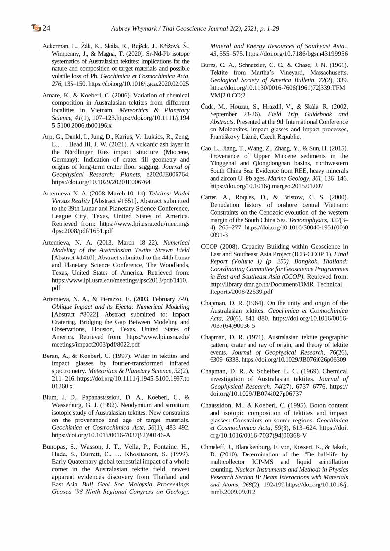
24 Aubrey Whymark / Thai Geoscience Journal 2(2), 2021, p. 1-29
Ackerman, L., Žák, K., Skála, R., Rejšek, J., Křížová, Š.,
Wimpenny, J., & Magna, T. (2020). Sr-Nd-Pb isotope
systematics of Australasian tektites: Implications for the
nature and composition of target materials and possible
volatile loss of Pb. Geochimica et Cosmochimica Acta,
276, 135–150. https://doi.org/10.1016/j.gca.2020.02.025
Amare, K., & Koeberl, C. (2006). Variation of chemical
composition in Australasian tektites from differrent
localities in Vietnam. Meteoritics & Planetary
Science, 41(1), 107–123.https://doi.org/10.1111/j.194
5-5100.2006.tb00196.x
Arp, G., Dunkl, I., Jung, D., Karius, V., Lukács, R., Zeng,
L., … Head III, J. W. (2021). A volcanic ash layer in
the Nördlinger Ries impact structure (Miocene,
Germany): Indication of crater fill geometry and
origins of long-term crater floor sagging. Journal of
Geophysical Research: Planets, e2020JE006764.
https://doi.org/10.1029/2020JE006764
Artemieva, N. A. (2008, March 10–14). Tektites: Model
Versus Reality [Abstract #1651]. Abstract submitted
to the 39th Lunar and Planetary Science Conference,
League City, Texas, United States of America.
Retrieved from: https://www.lpi.usra.edu/meetings
/lpsc2008/pdf/1651.pdf
Artemieva, N. A. (2013, March 18–22). Numerical
Modeling of the Australasian Tektite Strewn Field
[Abstract #1410]. Abstract submitted to the 44th Lunar
and Planetary Science Conference, The Woodlands,
Texas, United States of America. Retrieved from:
https://www.lpi.usra.edu/meetings/lpsc2013/pdf/1410.
Artemieva, N. A., & Pierazzo, E. (2003, February 7-9).
Oblique Impact and its Ejecta: Numerical Modeling
[Abstract #8022]. Abstract submitted to: Impact
Cratering, Bridging the Gap Between Modeling and
Observations, Houston, Texas, United States of
America. Retrieved from: https://www.lpi.usra.edu/
meetings/impact2003/pdf/8022.pdf
Beran, A., & Koeberl, C. (1997). Water in tektites and
impact glasses by fourier-transformed infrared
spectrometry. Meteoritics & Planetary Science, 32(2),
211–216. https://doi.org/10.1111/j.1945-5100.1997.tb
01260.x
Blum, J. D., Papanastassiou, D. A., Koeberl, C., &
Wasserburg, G. J. (1992). Neodymium and strontium
isotopic study of Australasian tektites: New constraints
on the provenance and age of target materials.
Geochimica et Cosmochimica Acta, 56(1), 483–492.
https://doi.org/10.1016/0016-7037(92)90146-A
Bunopas, S., Wasson, J. T., Vella, P., Fontaine, H.,
Hada, S., Burrett, C., … Khositanont, S. (1999).
Early Quaternary global terrestrial impact of a whole
comet in the Australasian tektite field, newest
apparent evidences discovery from Thailand and
East Asia. Bull. Geol. Soc. Malaysia. Proceedings
Geosea ’98 Ninth Regional Congress on Geology,
Mineral and Energy Resources of Southeast Asia.,
43, 555–575. https://doi.org/10.7186/bgsm43199956
Burns, C. A., Schnetzler, C. C., & Chase, J. N. (1961).
Tektite from Martha’s Vineyard, Massachusetts.
Geological Society of America Bulletin, 72(2), 339.
https://doi.org/10.1130/0016-7606(1961)72[339:TFM
VM]2.0.CO;2
Čada, M., Houzar, S., Hrazdil, V., & Skála, R. (2002,
September 23-26). Field Trip Guidebook and
Abstracts. Presented at the 9th International Conference
on Moldavites, impact glasses and impact processes,
Františkovy Lázně, Czech Republic.
Cao, L., Jiang, T., Wang, Z., Zhang, Y., & Sun, H. (2015).
Provenance of Upper Miocene sediments in the
Yinggehai and Qiongdongnan basins, northwestern
South China Sea: Evidence from REE, heavy minerals
and zircon U–Pb ages. Marine Geology, 361, 136–146.
https://doi.org/10.1016/j.margeo.2015.01.007
Carter, A., Roques, D., & Bristow, C. S. (2000).
Denudation history of onshore central Vietnam:
Constraints on the Cenozoic evolution of the western
margin of the South China Sea. Tectonophysics, 322(3–
4), 265–277. https://doi.org/10.1016/S0040-1951(00)0
0091-3
CCOP (2008). Capacity Building within Geoscience in
East and Southeast Asia Project (ICB-CCOP 1). Final
Report (Volume I) (p. 250). Bangkok, Thailand:
Coordinating Committee for Geoscience Programmes
in East and Southeast Asia (CCOP). Retrieved from:
http://library.dmr.go.th/Document/DMR_Technical_
Reports/2008/22539.pdf
Chapman, D. R. (1964). On the unity and origin of the
Australasian tektites. Geochimica et Cosmochimica
Acta, 28(6), 841–880. https://doi.org/10.1016/0016-
7037(64)90036-5
Chapman, D. R. (1971). Australasian tektite geographic
pattern, crater and ray of origin, and theory of tektite
events. Journal of Geophysical Research, 76(26),
6309–6338. https://doi.org/10.1029/JB076i026p06309
Chapman, D. R., & Scheiber, L. C. (1969). Chemical
investigation of Australasian tektites. Journal of
Geophysical Research, 74(27), 6737–6776. https://
doi.org/10.1029/JB074i027p06737
Chaussidon, M., & Koeberl, C. (1995). Boron content
and isotopic composition of tektites and impact
glasses: Constraints on source regions. Geochimica
et Cosmochimica Acta, 59(3), 613–624. https://doi.
org/10.1016/0016-7037(94)00368-V
Chmeleff, J., Blanckenburg, F. von, Kossert, K., & Jakob,
D. (2010). Determination of the 10Be half-life by
multicollector ICP-MS and liquid scintillation
counting. Nuclear Instruments and Methods in Physics
Research Section B: Beam Interactions with Materials
and Atoms, 268(2), 192-199.https://doi.org/10.1016/j.
nimb.2009.09.012
Aubrey Whymark / Thai Geoscience Journal 2(2), 2021, p. 1-29 25
Clift, P. D., Long, H. V., Hinton, R., Ellam, R. M.,
Hannigan, R., Tan, M. T., … Duc, N. A. (2008).
Evolving east Asian river systems reconstructed by
trace element and Pb and Nd isotope variations in
modern and ancient Red River-Song Hong sedi-
-ments: Evolution of East Asian River Systems.
Geochemistry, Geophysics, Geosystems, 9(4). https
://doi.org/10.1029/2007GC001867
Clift, P. D., & Sun, Z. (2006). The sedimentary and
tectonic evolution of the Yinggehai-Song Hong basin
and the southern Hainan margin, South China Sea:
Implications for Tibetan uplift and monsoon
intensification: Evolution of Yinggehai-Song Hong
Basin. Journal of Geophysical Research: Solid
Earth, 111(B6), B06405. https://doi.org/10.1029
/2005JB004048
Collins, G. S., Melosh, H. J., & Marcus, R. A. (2005).
Earth impact effects program: A web-based
computer program for calculating the regional
environmental consequences of a meteoroid impact
on Earth. Meteoritics & Planetary Science, 40(6),
817–840. https://doi.org/10.1111/j.1945-5100.200
5.tb00157.x
Collins, G. S., & Wünnemann, K. (2005). How big was
the Chesapeake Bay impact? Insight from numerical
modeling. Geology, 33(12), 925–928. https://doi.org/
10.1130/G21854.1
Condie, K. C. (1993). Chemical composition and
evolution of the upper continental crust: Contrasting
results from surface samples and shales. Chemical
Geology, 104(1–4), 1–37. https://doi.org/10.1016/
0009-2541(93)90140-E
Cordani, U. G., Mizusaki, A. M., Kawashita, K., &
Thomaz-Filho, A. (2004). Rb–Sr systematics of
Holocene pelitic sediments and their bearing on whole-
rock dating. Geological Magazine, 141(2), 233–244.
https://doi.org/10.1017/S0016756803008616
Dickin, A. P. (2005). Radiogenic Isotope Geology (2nd
ed.), 492 p. Cambridge University Press. https://
doi.org/10.1017/CBO9781139165150
Elkins-Tanton, L. T., Kelly, D. C., Bico, J., & Bush, J.
W. M. (2002, March 11–15). Microtektites as vapor
condensates, and a possible new strewn field at 5 Ma
[Abstract #1622]. Abstract submitted to the 33rd
Lunar and Planetary Science Conference, League
City, Texas, United States of America. Retrieved
from: https://www.lpi.usra.edu/meetings/lpsc2002/
pdf/1622.pdf
Elliott, J. R., Huang, Y.-H., Minton, D. A., & Freed, A.
M. (2018). The length of lunar crater rays explained
using secondary crater scaling. Icarus, 312, 231–246.
https://doi.org/10.1016/j.icarus.2018.04.015
Fan, C. (2018). Tectonic deformation features and
petroleum geological significance in Yinggehai large
strike-slip basin, South China Sea. Petroleum
Exploration and Development, 45(2), 204–214.
https://doi.org/10.1016/S1876-3804(18)30024-7
Feng, Y., Zhan, W., Chen, H., Jiang, T., Zhang, J.,
Osadczuk, A., … Zhang, W. (2018). Seismic
characteristics and sedimentary record of the late
Pleistocene delta offshore southwestern Hainan
Island, northwestern South China Sea. Interpretation,
6(4), SO31-SO43. https://doi.org/10.1190/INT-2018-
0012.1
Fenner, C. (1935). Australites, part II. Numbers, forms,
distribution and origin. Transactions of the Royal
Society of South Australia, 59, 125–140.
Fiske, P. S., Schnetzler, C. C., Mchone, J., Chanthava-
-ichith, K. K., Homsombath, I., Phouthakayalat, T., …
Xuan, P. T. (1999). Layered tektites of southeast Asia:
Field studies in central Laos and Vietnam. Meteoritics
& Planetary Science, 34(5), 757–761. https://onlineli
brary.wiley.com/doi/abs/10.1111/j.1945-5100.1999
.tb01388.x
Gault, D. E., & Wedekind, J. A. (1978, March 13-17).
Experimental studies of oblique impact. In: Proceedings
of the 9th Lunar and Planetary Science Conference (pp.
3843-3875), Houston, Texas, United States of America.
Retrieved from:http://adsabs.harvard.edu/full/1978LPS
C....9.3843G
Gentner, W. (1966). Auf der Suche nach Kratergläsern,
Tektiten und Meteoriten in Afrika. Naturwissen-
-schaften, 53(12), 285–289. https://doi.org/10.1007/
BF00712210
Glass, B. P. (2003, March 17–21). Australasian
microtektites in the South China Sea: Implications
regarding the location and size of the source crater
[Abstract #1092]. Abstract submitted to the 34th
Lunar and Planetary Science Conference, League
City, Texas, United States of America. Retrieved
from: https://www.lpi.usra.edu/meetings/lpsc2003
/pdf/1092.pdf
Glass, B. P., & Barlow, R. A. (1979). Mineral inclusions in
Muong Nong-type indochinites: Implications
concerning parent material and process of formation.
Meteoritics, 14(1), 55–67. https://doi.org/10.1111/j.
1945-5100.1979.tb00479.x
Glass, B. P., Huber, H., & Koeberl, C. (2004). Geochemistry
of Cenozoic microtektites and clinopyroxene-bearing
spherules. Geochimica et Cosmochimica Acta, 68(19),
3971–4006. https://doi.org/10.1016/j.gca.2004.02.026
Glass, B. P., & Koeberl, C. (2006). Australasian
microtektites and associated impact ejecta in the
South China Sea and the Middle Pleistocene
supereruption of Toba. Meteoritics & Planetary
Science, 41(2), 305–326. https://doi.org/10.1111/j.
1945-5100.2006.tb00211.x
Glass, B. P., & Pizzuto, J. E. (1994). Geographic variation
in Australasian microtektite concentrations: Impli-
cations concerning the location and size of the source

26 Aubrey Whymark / Thai Geoscience Journal 2(2), 2021, p. 1-29
crater. Journal of Geophysical Research, 99(E9),
19075-19081. https://doi.org/10.1029/94JE01866
Glass, B. P., & Simonson, B. M. (2013). Distal impact
ejecta layers: A record of large impacts in
sedimentary deposits. 716 p. Heidelberg; New York:
Springer. ISBN 978-3-540-88262-6
Gong, Z. S., & Li, S. T. (2004). Dynamic research of oil
and gas accumulation in northern marginal basins of
South China Sea. 339 p. Science in China Press,
Beijing, (in Chinese with English abstract).
Gong, Z. S., Li, S. T., Xie, T. J., Zhang, Q. M., Xu, S.
C., Xia, K. Y., … Liu, L. H. (1997). Continental
margin basin analysis and hydrocarbon accumu-
-lation of the northern South China Sea. 510 p. China
Sci. Press, Beijing, (in Chinese with English
abstract).
Haines, P. W., Howard, K. T., Ali, J. R., Burrett, C. F., &
Bunopas, S. (2004). Flood deposits penecontem-
-poraneous with ∼0.8 Ma tektite fall in NE Thailand:
Impact-induced environmental effects? Earth and
Planetary Science Letters, 225(1–2), 19–28. https:
//doi.org/10.1016/j.epsl.2004.05.008
Hartung, J. B., & Koeberl, C. (1994). In search of the
Australasian tektite source crater: The Tonle Sap
hypothesis. Meteoritics, 29(3), 411–416.https://
doi.org/10.1111/j.1945-5100.1994.tb00606.x
Hoang, N., Flower, M. F. J., & Carlson, R. W. (1996).
Major, trace element, and isotopic compositions of
Vietnamese basalts: Interaction of hydrous EM1-rich
asthenosphere with thinned Eurasian lithosphere.
Geochimica et Cosmochimica Acta, 60(22), 4329–
4351. https://doi.org/10.1016/S0016-7037(96)00247-5
Hoang, N., Hauzenberger, C., Fukuyama, M., & Konzett, J.
(2018, October 16-17). Cenozoic volcanism in the
Bolaven Plateau, southern Laos. Abstract submitted to
the Regional Congress on Geology, Minerals and
Energy Resources of Southeast Asia (GEOSEA),
Hanoi, Vietnam.
Howard, B. C. (2016). Australia Is Drifting So Fast GPS
Can’t Keep Up. National Geographic. [online]. [Cited
23 September 2016]. Retrieved from: https://www.
nationalgeographic.com/news/2016/09/australia-move
s-gps-coordinates-adjusted-continental-drift/
Howard, K. T. (2011). Volatile enhanced dispersal of high
velocity impact melts and the origin of tektites.
Proceedings of the Geologists’ Association, 122(3),
363–382. https://doi.org/10.1016/j.pgeola.2010.11.006
Howard, K. T., Haines, P. W., Burrett, C. F., Ali, J. R., &
Bunopas, S. (2003). Sedimentology of 0.8 Ma log-
bearing flood deposits in northeast Thailand and
mechanisms for pre-flood deforestation. Proceedings,
8th International Congress on Pacific Neogene
Stratigraphy, Chiang Mai, Thailand, 49–67.
Huber, H. (2009). INAA of Muong-Nong type tektites
and adjacent soil samples. 22nd Seminar Activation
Analysis and Gamma-Spectroscopy. Program and
Book of Abstracts. 35.
Izokh, E. P., & An, L. D. (1983). Tektites of Vietnam.
Tektites delivered by a comet: A hypothesis. NASA
Report No. NAS 1.7720103; NASA-TT-20103.
Transl. into English from Meteoritika (Moscow), 42,
158-170.
Javanaphet, C. (1969). Geological Map of Thailand;
Scale 1: 1,000,000 with Explanation. Department of
Mineral Resources, Bangkok, Thailand.
Jiang, T., Xie, X., Chen, H., Wang, Z., and Li, X. (2015)
Geochemistry of pore water and associated diagenetic
reactions in the diapiric area of Yinggehai Basin,
northwestern South China Sea. Journal of Earth
Science, 26(3), 306–316. https://doi.org/10.1007/s125
83-015-0526-y
Jonell, T. N., Clift, P. D., Hoang, L. V., Hoang, T.,
Carter, A., Wittmann, H., … Rittenour, T. (2017).
Controls on erosion patterns and sediment transport
in a monsoonal, tectonically quiescent drainage,
Song Gianh, central Vietnam. Basin Research, 29,
659–683. https://doi.org/10.1111/bre.12199
Jourdan, F. (2012). The 40Ar/39Ar dating technique
applied to planetary sciences and terrestrial impacts.
Australian Journal of Earth Sciences, 59(2), 199–
224. https://doi.org/10.1080/08120099.2012.644404
Jourdan, F., Moynier, F., Koeberl, C., & Eroglu, S.
(2011). 40Ar/39Ar age of the Lonar crater and
consequence for the geochronology of planetary
impacts. Geology, 39(7), 671–674. https://doi.org/
10.1130/G31888.1
Jourdan, F., Nomade, S., Wingate, M. T. D., Eroglu, E.,
& Deino, A. (2019). Ultraprecise age and formation
temperature of the Australasian tektites constrained
by 40Ar/39Ar analyses. Meteoritics & Planetary
Science, 54(10), 2573–2591. https://doi.org/10.11
11/maps.13305
Kenkmann, T., Collins, G. S., Wittmann, A.,
Wünnemann, K., Reimold, W. U., & Melosh, H. J.
(2009). A model for the formation of the Chesapeake
Bay impact crater as revealed by drilling and
numerical simulation. Geological Society of America
Special Papers, 458, 571–585. https://doi.org/10.11
30/2009.2458(25)
Koeberl, C. (1986). Muong Nong type tektites from the
moldavite and North American strewn fields?
Journal of Geophysical Research: Solid Earth,
91(B13), E253–E258. https://doi.org/10.1029/JB0
91iB13p0E253
Koeberl, C. (1992). Geochemistry and origin of Muong
Nong-type tektites. Geochimica et Cosmochimica
Acta, 56(3), 1033–1064. https://doi.org/10.1016
/0016-7037(92)90046-L
Koeberl, C. (1994). Tektite origin by hypervelocity
asteroidal or cometary impact: Target rocks, source
craters, and mechanisms. Geological Society of
Aubrey Whymark / Thai Geoscience Journal 2(2), 2021, p. 1-29 27
America Special Papers, 293, 133–152. https://doi.
org/10.1130/SPE293-p133
Koeberl, C., Bottomley, R., Glass, B. P., & Storzer, D.
(1997). Geochemistry and age of Ivory Coast tektites
and microtektites. Geochimica et Cosmochi-mica Acta,
61(8), 1745–1772. https://doi.org/10.1016/S0016-
7037(97)00026-4
Koeberl, C., Kluger, F., & Kiesl, W. (1985). Rare earth
elemental patterns in some impact glasses and
tektites and potential parent materials. Chemie Der
Erde, 44(2), 107–121.
Koeberl, C., Nishiizumi, K., Caffee, M. W., & Glass, B.
P. (2015, July 27–31). Beryllium-10 in Individual
Australasian Microtektites and Origin of Tektites
[Abstract #5187]. Abstract submitted to the 78th
Annual Meeting of the Meteoritical Society,
Berkeley, California, United States of America.
Retrieved from: https://www.hou.usra.edu/meetings
/metsoc2015/pdf/5187.pdf
Korschinek, G., Bergmaier, A., Faestermann, T.,
Gerstmann, U. C., Knie, K., Rugel, G., … Gostomski,
C. L. von. (2010). A new value for the half-life of 10Be
by heavy-ion elastic recoil detection and liquid
scintillation counting. Nuclear Instruments and
Methods in Physics Research Section B: Beam
Interactions with Materials and Atoms, 268(2), 187–
191. https://doi.org/10.1016/j.nimb.2009.09.020
Lei, C., Ren, J., Clift, P. D., Wang, Z., Li, X., & Tong,
C. (2011). The structure and formation of diapirs in
the Yinggehai–Song Hong Basin, South China Sea.
Marine and Petroleum Geology, 28(5), 980–991.
https://doi.org/10.1016/j.marpetgeo.2011.01.001
Lei, C., Ren, J., Sternai, P., Fox, M., Willett, S., Xie, X.,
… Wang, Z. (2015). Structure and sediment budget
of Yinggehai–Song Hong basin, South China Sea:
Implications for Cenozoic tectonics and river basin
reorganization in Southeast Asia. Tectonophysics,
655, 177–190. https://doi.org/10.1016/j.tecto.2015.
05.024
Liu, Z., Colin, C., Huang, W., Le, K. P., Tong, S., Chen,
Z., & Trentesaux, A. (2007). Climatic and tectonic
controls on weathering in south China and Indochina
Peninsula: Clay mineralogical and geochemical
investigations from the Pearl, Red, and Mekong
drainage basins: controls on weatherings in S. China.
Geochemistry, Geophysics, Geosystems, 8(5).
https://doi.org/10.1029/2006GC001490
Liu, Z., Zhao, Y., Colin, C., Stattegger, K., Wiesner, M.
G., Huh, C. A., … Li, Y. (2016). Source-to-sink
transport processes of fluvial sediments in the South
China Sea. Earth-Science Reviews, 153, 238–273.
https://doi.org/10.1016/j.earscirev.2015.08.005
Lodders, K., & Fegley, B. (1998). The Planetary
Scientist’s Companion. 392 p. Oxford University
Press on Demand. ISBN: 9780195116946
Ma, P., Aggrey, K., Tonzola, C., Schnabel, C., de Nicola,
P., Herzog, G. F., … Klein, J. (2004). Beryllium-10
in Australasian tektites: Constraints on the location
of the source crater. Geochimica et Cosmochimica
Acta, 68(19), 3883–3896. https://doi.org/10.1016/
j.gca.2004.03.026
Mark, D. F., Renne, P. R., Dymock, R. C., Smith, V. C.,
Simon, J. I., Morgan, L. E., … Pearce, N. J. G. (2017).
High-precision 40Ar/39Ar dating of Pleistocene tuffs
and temporal anchoring of the Matu-yama-Brunhes
boundary. Quaternary Geochronology, 39, 1–23.
https://doi.org/10.1016/j.quageo.2017.01.002
Matsuda, J., Maruoka, T., Pinti, D. L., & Koeberl, C.
(1996). Noble gas study of a philippinite with an
unusually large bubble. Meteoritics & Planetary
Science, 31(2), 273–277. https://doi.org/10.1111/
j.1945-5100.1996.tb02023.x
McDonough, W. F., & Sun, S. S. (1995). The
composition of the Earth. Chemical Geology, 120(3–
4), 223–253. https://doi.org/10.1016/0009-2541
(94)00140-4
McHarg, I. L. (1969). Design with Nature. Garden City,
N.Y.: Published for the American Museum of
Natural History [by] the Natural History Press.
Meisel, T., Langenauer, M., & Krähenbühl, U. (1992).
Halogens in tektites and impact glasses. Meteoritics,
27(5), 576–579. https://doi.org/10.1111/j.1945-
5100.1992.tb01079.x
Métivier, F., Gaudemer, Y., Tapponnier, P., & Klein, M.
(1999). Mass accumulation rates in Asia during the
Cenozoic. Geophysical Journal International,
137(2), 280–318. https://doi.org/10.1046/j.1365-
246X.1999.00802.x
Mizote, S., Matsumoto, T., Matsuda, J., & Koeberl, C.
(2003). Noble gases in Muong Nong-type tektites
and their implications. Meteoritics & Planetary
Science, 38(5), 747–758. https://doi.org/10.1111/j.
1945-5100.2003.tb00039.x
O’Keefe, J. A. (1963). Tektites. 228 p. The University of
Chicago Press.
Orbit 1.2 Software. (1998-2000). Published by Siltec Ltd.
Retrieved (in 2011, no longer available) from:
http://physics-animations.com/Physics/English/orbit.htm
Pierazzo, E., & Melosh, H. J. (2000). Melt Production in
Oblique Impacts. Icarus, 145(1), 252–261.
https://doi.org/10.1006/icar.1999.6332
Povenmire, H. (2010, July 26–30). The First Georgia-
Area Tektite Found in South Carolina [Abstract
#5222]. Abstract submitted to the 73rd Annual
Meeting of the Meteoritical Society, New York,
United States of America. Retrieved from:
https://www.lpi.usra.edu/meetings/metsoc2010/pdf/
5222.pdf
28 Aubrey Whymark / Thai Geoscience Journal 2(2), 2021, p. 1-29
Povenmire, H., & Strange, R. L. (2006, March 13–17).
The First Tektite from Dooly Crisp Counties,
Georgia [Abstract #1002]. Abstract submitted to the
37th Lunar and Planetary Science Conference,
League City, Texas, United States of America.
Retrieved from: https://www.lpi.usra.edu/meetings
/lpsc2006/pdf/1002.pdf
Prasad, M. S., Mahale, V. P., & Kodagali, V. N. (2007).
New sites of Australasian microtektites in the central
Indian Ocean: Implications for the location and size
of source crater. Journal of Geophysical Research,
112(E6), E06007. https://doi.org/10.1029/2006JE00
2857
Rochette, P., Braucher, R., Folco, L., Horng, C. S.,
Aumaître, G., Bourlès, D. L., & Keddadouche, K.
(2018). 10Be in Australasian microtektites compared
to tektites: Size and geographic controls. Geology,
46(9), 803–806. https://doi.org/10.1130/G45038.1
Schmieder, M., & Kring, D. A. (2020). Earth’s Impact
Events Through Geologic Time: A List of
Recommended Ages for Terrestrial Impact
Structures and Deposits. Astrobiology, 20(1), 91–
141. https://doi.org/10.1089/ast.2019.2085
Schmitt, S. R. (2004). Ballistic Trajectory (2-D)
Calculator-Computes the maximum height, range,
time to impact, and impact velocity of a ballistic
projectile. [online]. [Cited 14 November 2020].
Retrieved from: http://www.convertalot.com/bal
listic_trajectory_calculator.html
Schnetzler, C. C. (1992). Mechanism of Muong Nong-
type tektite formation and speculation on the source
of Australasian tektites. Meteoritics, 27(2), 154–165.
https://doi.org/10.1111/j.1945-5100.1992.tb00743.x
Schnetzler, C. C., & McHone, J. F. (1996). Source of
Australasian tektites: Investigating possible impact
sites in Laos. Meteoritics & Planetary Science,
31(1), 73–76. https://doi.org/10.1111/j.1945-5100
.1996.tb02055.x
Schnetzler, C. C., & Pinson Jr, W. H. (1963). The
chemical composition of tektites. In: O’Keefe, J. A.
(1963) Tektites (p. 95–129). The University of
Chicago Press.
Schultz, P. H. (1992). Atmospheric effects on ejecta
emplacement and crater formation on Venus from
Magellan. Journal of Geophysical Research:
Planets, 97(E10), 16183–16248. https://doi.org/10.
1029/92JE01508
Schultz, P. H., Anderson, J. B. L., & Hermalyn, B.
(2009, March 23–27). Origin and Significance of
Uprange Ray Patterns [Abstract #2496]. Abstract
submitted to the 40th Lunar and Planetary Science
Conference, The Woodlands, Texas, United States of
America. Retrieved from: https://www.lpi.usra.
edu/meetings/lpsc2009/pdf/2496.pdf
Schultz, P. H., Eberhardy, C. A., Ernst, C. M., A’Hearn,
M. F., Sunshine, J. M., & Lisse, C. M. (2007). The
Deep Impact oblique impact cratering experiment.
Icarus, 191(2), 84–122. https://doi.org/10.1016/j.
icarus.2007.06.031
Shaw, H. F., & Wasserburg, G. J. (1982). Age and
provenance of the target materials for tektites and
possible impactites as inferred from Sm-Nd and Rb-
Sr systematics. Earth and Planetary Science Letters,
60(2), 155–177. https://doi.org/10.1016/0012-821X
(82)90001-2
Shuvalov, V., & Dypvik, H. (2013). Distribution of
ejecta from small impact craters. Meteoritics &
Planetary Science, 48(6), 1034–1042. https://doi.
org/10.1111/maps.12127
Sieh, K., Herrin, J., Jicha, B., Schonwalder Angel, D.,
Moore, J. D. P., Banerjee, P., … Charusiri, P. (2020).
Australasian impact crater buried under the Bolaven
volcanic field, Southern Laos. Proceedings of the
National Academy of Sciences, 117(3), 1346–1353.
https://doi.org/10.1073/pnas.1904368116
Stöffler, D., Gault, D. E., Wedekind, J. E., & Polkowski G.
(1975). Experimental hypervelocity impact into quartz
sand: Distribution and shock metamorphism of ejecta.
Journal of Geophysical Research, 80(29), 4062-4077.
https://doi.org/10.1029/JB080i029p04062
Stöffler, D., Hamann, C., & Metzler, K. (2018). Shock
metamorphism of planetary silicate rocks and
sediments: Proposal for an updated classification
system. Meteoritics & Planetary Science, 53(1), 5–
49. https://doi.org/10.1111/maps.12912
Tada, T., Carling, P. A., Tada, R., Songtham, W., Chang,
Y., & Tajika, E. (2019, December 9-13). Constraint
on the Location of the Australasian Tektite Impact
Event based on the Distribution of the Ejecta Deposits
across the Eastern Indochina [Abstract #NH51C-
0786; Poster #0786]. American Geophysical Union
Fall Meeting, San Francisco, United States of
America. Abstract retrieved from: https://ui.adsabs.
harvard.edu/abs/2019AGUFMNH51C0786T/abstract
Trnka, M. (2020, March 16–20). Notes on Contents of
10Be Isotope in Tektites and Microtektites of the
Australasian Strewn Field [Abstract #1149].
Abstract submitted to the 51st Lunar and Planetary
Science Conference, The Woodlands, Texas, United
States of America. Retrieved from: https://
www.hou.usra.edu/meetings/lpsc2020/pdf/1149.pdf
Trnka, M., & Houzar, S. (2002). Moldavites: A review.
Bulletin of the Czech Geological Survey, 77(4), 283–
302. Retrieved from: http://www.geology.cz/
bulletin/fulltext/04trnkafinal.pdf
Vickery, A. M. (1993). The theory of jetting: Appli-
cation to the origin of tektites. Icarus, 105(2), 441–
453. https://doi.org/10.1006/icar.1993.1140
Vickery, A. M., & Browning, L. (1991, July 21-26).
Water depletion in tektites. Abstract submitted to the
78th Annual Meeting of the Meteoritical Society,
Monterey, California, United States of America. In:
Aubrey Whymark / Thai Geoscience Journal 2(2), 2021, p. 1-29 29
Meteoritics, 26, 403. Retrieved from: http://adsabs.
harvard.edu/full/1991Metic..26Q.403V
Wasson, J. T. (2003). Large Aerial Bursts: An Important
Class of Terrestrial Accretionary Events.Astrobiology,
3(1), 163–179. https://doi.org/10.1089/15311070332
1632499
Wasson, J. T. (2017, March 20–24). A Thermal-Plume
Origin of Layered and Splash-Form Tektites and
Libyan Desert Glass [Abstract #2916]. Abstract
submitted to the 48th Lunar and Planetary Science
Conference, The Woodlands, Texas, United States of
America. Retrieved from: https://www.hou.us
ra.edu/meetings/lpsc2017/pdf/2916.pdf
Wei, G., Liu, Y., Ma, J., Xie, L., Chen, J., Deng, W., &
Tang, S. (2012). Nd, Sr isotopes and elemental
geochemistry of surface sediments from the South
China Sea: Implications for Provenance Tracing.
Marine Geology, 319–322, 21–34. https://doi.org/
10.1016/j.margeo.2012.05.007
Whymark, A. (2013, March 18–22). Review of the
Australasian tektite source crater location and
candidate structure in the Song Hong-Yinggehai
basin, Gulf of Tonkin [Abstract #1077]. Abstract
submitted to the 44th Lunar and Planetary Science
Conference, The Woodlands, Texas, United States of
America. Retrieved from: https://www.lpi.usra.
edu/meetings/lpsc2013/pdf/1077.pdf
Whymark, A. (2018, March 19-23). Further Geo-
physical Data in the Search for the Australasian
Tektite Source Crater Location in the Song Hong-
-Yinggehai Basin, Gulf of Tonkin [Abstract #1078].
Abstract submitted to the 49th Lunar and Planetary
Science Conference, The Woodlands, Texas, United
States of America. Retrieved from: https://www.hou.
usra.edu/meetings/lpsc2018/pdf/1078.pdf
Whymark, A. (2020, August 5–7). Newly Discovered
Muong Nong-Type Layered Impact Glass / Tektites
from Paracale, Philippines and Implications for
Source Crater Location [Abstract #2006]. Abstract
submitted to the 11th Planetary Crater Consortium
Meeting, Hawaii (Virtual), United States of America.
Retrieved from: https://www.hou.usra.edu/meetings
/crater2020/pdf/2006.pdf
Yan, Y., Carter, A., Palk, C., Brichau, S., and Hu, X.
(2011). Understanding sedimentation in the Song
Hong-Yinggehai Basin, South China Sea:
Sedimentation in the Yinggehai Basin. Geochemistry,
Geophysics, Geosystems, 12(6), https://doi.org/10.10
29/2011GC003533
Zähringer, J., & Gentner, W. (1963). Radiogenic and
atmospheric argon content of tektites. Nature,
199(4893), 583–583. https://doi.org/10.1038/1995
83a0

30 Thai Geoscience Journal 2(2), 2021, p. 30-37
Copyright © 2021 by the Department of Mineral Resources of Thailand
ISSN-2730-2695; DOI-10.14456/tgj.2021.3
The ‘new normal’ for geoscience in a post-COVID world:
connecting informed people with the Earth
Steven M. Hill*, Jane P. Thorne, Rachel Przeslawski,
Rebecca Mouthaan, and Chris Lewis
Geoscience Australia, Canberra, Australia.
*Corresponding author: [email protected]
Received 17 March 2021; Accepted 17 June 2021.
Abstract
We consider how our society can use data, information and knowledge of the Earth under a broad
definition of geoscience to better connect with the Earth system. This is important in our changing
world, in particular how geoscience contributes to our response to the societal impacts of the
COVID-19 pandemic. Ultimately, informed decisions utilizing the best geoscience data and
information provide key parts of our economic, environmental and cultural recovery from the
pandemic. The connection to country and more widely connection to our planet and the greater
Earth system that comes from personal experience has been especially challenged in 2020. Much
of Australia’s population have been encouraged to stay in our homes, first because of major fires
and more recently in response to isolation from the COVID-19 pandemic. Although domestic
travel became increasingly allowable, international travel has been restricted for much longer.
This has increased the importance of trusted data and information initially from domestic locations
and for more extended time between countries that are now less accessible. We discuss ways that
geoscience governs our discovery and use of minerals, energy and groundwater resources and
builds resilience and adaptation to environmental and cultural change. A broad definition of
geoscience also includes positioning and location data and information, such as through integrated
digital mapping, satellite data and real-time precise positioning. Important here is sharing, with
two-way exchange of data, information and knowledge about the Earth, through outreach in
geoscience education programs and interactions with communities across Australia, into
neighboring countries in Asia and the Pacific, and across the world. An aspiration is for geoscience
to inform social license through evidence-based decisions, such as for land and marine access, for
a strong economy, resilient society and sustainable environment. At Geoscience Australia, we
have developed a ten years strategic plan (Strategy 2028) that guides us to be a trusted source of
information on Australia’s geology and geography for government, industry and community
decision making. This will contribute to a safer, more prosperous and well-informed Australia and
its connection to neighbouring countries, such as in Asia, as well as people that are better
connected to country and our planet.
Keywords: community education and outreach, earth system science, environment, geoscience, mapping,
resources
1. Introduction
The importance of trusted, high-quality and
relevant science to inform and advise govern-
ments and our communities is greater now than
it ever has been. This is particularly the case for
geoscience and its role to guide people’s
connection to the Earth as the place where we
live and obtain the resources we need to live our
lives. Our community’s recognition of the value
of geoscience ensures the future viability and
evolution of geoscience and it’s ability to
contribute to informed impact in our nations, and
our planet. This recognition, however, is not to
be presumed (or assumed). The world changes
and as such the roles and perceptions of
geoscience need to evolve and adapt for its
continued resilience and relevance.
This paper has three main parts:
Steven M. Hill et al. / Thai Geoscience Journal 2(2), 2021, p. 30-37 31
1. It considers how geoscientists project
and define themselves in society and suggests
that a broad definition of geoscience within a
greater Earth system has greater value than
more narrow, specialized foundations;
2. Demonstrations of how Geoscience
Australia strategically supports and develops its
science as part of the broad context of geoscience
within an Earth system for maximum impact and
value; and,
3. Consideration of how this approach is
being developed in response to the post-COVID
demands of our society and their connection to
our planet.
2. Geoscience in the Earth System
Traditionally in Australia there has been an
emphasis on the links between geology, geolo-
gists and our resources industry, particularly for
mineral commodities such as iron ore, gold and
base metals, but also energy commodities such
as coal, oil, gas, and uranium. This largely
reflects the importance of this industry for
export earnings and our nation’s prosperity.
This has meant that the projection of the role of
the geologist has not been challenged so much
in the past as it is today. Rather than the vision
of mining to express progress and prosperity
there is now a greater call for the industry to be
viewed on the basis of more trusted equitable
and ethical criteria and the sustainable public
value of the industry for not only the economy
but also the environment and community. This
includes assessment and visibility of the entire
resources chain from investment, exploration,
mining, and the destiny (such as uses, recycling
or reuse) of the resources. This broader
perspective calls for a broader context of our
science of the Earth that extends beyond just
rocks and resources but into the broader field of
geoscience.
Geoscience embodies the science of the
Earth. It especially includes but extends beyond
geology to also include fields of geography,
geodesy, Earth observation, marine science,
pedology, geophysics, geochemistry, geoha-
zards, and many parts of climatology, ecology,
hydrology, space and planetary science and,
environmental science. Geoscience investigates
the past, measures the present and models the
future behavior of the planet. It links closely
with the biological, chemical and physical
sciences as part of Earth system science (Steffen
et al., 2020), to include a holistic view on
interactions and dynamic processes between ice,
rocks, water, air and life.
3. Geoscience Australia: role and science
At Geoscience Australia we embrace the
broad perspective of geoscience, not just in our
name, but in the strategic planning of our role,
activities and our science. Geoscience Australia
is Australia’s national public-sector geoscience
entity. We provide advice on the geology and
geography of Australia to support progress,
growth, and investment towards a safer, more
prosperous and well-informed Australia. Our
main stakeholders include government, industry
and the community.
Our decadal strategy, Strategy 2028, sets
out the impacts our work will have over the
next decade under six key areas:
1. Building Australia’s resource wealth.
Australia has a rich and diverse mineral and
energy endowment, which is a major contributor
to the nation’s wealth, economically and socially.
The provision of high quality regional-scale
geoscience data and information lowers the
risks of exploration, advanced exploration,
mining and processing technologies;
2. Supporting Australia’s community safety.
Providing disaster risk information to help
Australians understand the consequences of
hazard events, which contributes to more
resilient communities now and in the future;
3. Securing Australia’s water resources.
Supporting the fair sharing of water resources by
identifying the location, quantity and quality of
groundwater resources to support sustainable
water management in the driest inhabited conti-
nent;
4. Managing Australia’s marine jurisdictions.
Including baseline mapping, understanding of
marine resources and assets, and the ability to
measure change over time;

32 Steven M. Hill et al. / Thai Geoscience Journal 2(2), 2021, p. 30-37
5. Creating a location-enabled Australia.
Providing information on when and where
events and activities occur is essential to make
decisions and improve economic, environmental
and social outcomes. This includes delivery of
real-time precise positioning, digital location
information and Earth observation from satellite
data platforms; and,
6. Enabling an informed Australia. Delivering
world-class, trusted data and platforms and
expertise to support high-impact geoscience,
transparent evidence-based decisions and social
licence to operate. This includes our education
and science outreach programs.
To achieve these strategic impacts we need
to be the best people and organization that we
can as well as ensure that we have a strong
foundation of excellent and relevant science.
The Geoscience Australia Science Principles
describe how we conduct science in both long-
term planning and day-to-day operations. The
six Science Principles are:
1. Relevant science to ensure that Geoscience
Australia provides quality assured information to
the right people in the right timeframe so they can
make evidence-based decisions, particularly
related to the Australian Government. This
includes the provision of scientific advice to meet
national and international obligations (e.g. Paris
Climate Agreement,Australia New Zealand
Foundational Spatial Data Framework and
United Nations Integrated Geospatial Infor-
mation Network, Offshore Petroleum and
Greenhouse Gas Storage Act 2006, and the
United Nations – Global Geodetic Reference
Frame Sustainable Development Goals, and
Sendai Framework for Disaster Risk Reduction).
2. Collaborative science to allow Geoscience
Australia to meet emerging challenges that are
more complex than any single individual, team
or agency can achieve. This requires us to
engage with not only the broader research and
data community, but also non-scientific stake-
holders who are more likely to use and value our
information if they are involved in our work.
3. Quality science to maximise stakeholder
confidence that the data and information we
provide is accurate, results are repeatable, and
any uncertainties are explained and accounted
for. All of these mean our science reflects not just
quality, but integrity. Data and information can
then be used to inform current decisions and
debate, and be re-used and re-purposed long after
it is created. As both a government agency and a
member of the Australian research community,
we have key compliance requirements, including
the Australian Code for the Responsible Conduct
of Research.
4. Transparent science to demonstrate that
our scientific activities are unbiased and reflect
commitment to extend the role that science plays
in the transparency of Australian Government
processes (e.g. Principles on Open Public Sector
Information, Declaration of Open Government).
By openly sharing our work and abiding by the
FAIR data principles (findable, accessible, inte-
roperable, reusable) we create a platform that
supports further innovation in the tradition of
scientific discovery.
5. Communicated science to ensure that
Geoscience Australia’s scientific data and
information is accessible to and understandable
by a variety of stakeholders. By tailoring the
communication of scientific information to a
particular audience and purpose, Geoscience
Australia’s scientific work can be valued by
stakeholders. This also means communicating
appropriate background knowledge to stake-
holders and the public to increase their
capability to understand complex ideas often
associated with scientific research. Part of
communication here also involves active
listening, particularly to ensure that stake-
holder’s matters of concern and their needs are
well understood.
6. Sustained science capability to undertake
scientific activities that meet current and future
strategic priorities. The type and level of science
capability we retain in-house is inherently
controlled by strategic demands and available
budget. It is also dependent on technical and
business capabilities such as information
management, outreach and education, enginee-
ring, and communication.
Three examples of major projects from
Geoscience Australia’s work program are
briefly outlined as well as their impact and
value for our nation. These include:
Steven M. Hill et al. / Thai Geoscience Journal 2(2), 2021, p. 30-37 33
i) Positioning Australia;
ii) Digital Earth Australia (DEA); and,
iii) Exploring for the Future (EFTF).
i. Positioning Australia
The Positioning Australia Program is
developing a world-leading satellite positioning
capability, which many refer to as GPS (Global
Positioning System). The program will provide
accurate, reliable, and real-time positioning
across Australia. It will enable increased
productivity, new and innovative technologies,
and accelerate economic growth, particularly for
regional Australia and businesses.
The program encompasses the National
Positioning Infrastructure Capability (NPIC)
and a Satellite Based Augmentation System (or
SBAS) and is underpinned by the Australian
Geospatial Reference System. Currently, we
can know our position on the Earth within 5-10
metres of accuracy. By upgrading our existing
ground stations, we will improve our posi-
tioning accuracy to within 3-5 centimetres. We
are doing this by building the physical and data
infrastructure and analytics capabilities to
deliver 3 things:
1. 10 cm accuracy of positioning across
Australia and its maritime zones
through SBAS;
2. 3-5 cm accuracy of positioning for
areas with mobile phone coverage, in
particular regional and metropolitan
areas, through NPIC; and,
3. Open-source tools and software to
support use of positioning, navigation
and timing services.
This work is vital for the next wave of
innovation, from location-based automation or
artificial intelligence, to augmented reality.
Positioning Australia is fundamental in suppor-
ting the transformational technologies that will
benefit our economy.
To trial this, we established 27 SBAS
projects across 10 industry sectors including
agriculture, aviation, construction, consumer,
resources, road, rail, maritime, mining and
water utilities. Based on the SBAS trial across
10 industry sectors, we have estimated the
economic value of our positioning program.
An independent report, which investigated the
benefits of SBAS, found that it would create
A$6.2 billion of value over 30 years; over
A$200 million p/a economic benefit initially,
with plenty of upside across a range of sectors.
The benefits included:
• Improving the efficient spraying of =
water on farms (by between 1 and 7%)
by being able to spray exactly where
water is needed;
• Finding injured patients to facilitate
helicopter rescues more effectively;
• Enabling intelligent transport systems,
to reduce road fatalities;
• Improving safety at mine sites; and,
• Supporting virtual fencing to manage
livestock better.
It is also important to note that we expect
there will be uses that we have not thought of
yet, enabling innovation and new businesses to
start and flourish
ii. Digital Earth Australia (DEA)
In the DEA program, we are transforming
satellite imagery into insights about changes in
Australia’s natural and built environments. DEA
provides access to high quality satellite imaging
of the Earth’s surface, to detect physical changes
across Australia in unprecedented detail,
including soil and coastal erosion, crop growth,
water quality, and changes to cities and regions
over time. It gives farmers, land managers,
industry, and governments the information they
need to make better decisions about how they
optimise the use of their resources.
DEA will benefit users that need accurate
and timely information on the health and
productivity of Australia’s landscape. It will
support government and industry to better
monitor change, to protect and enhance
Australia’s natural resources and enable more
effective policy responses to natural resource
management problems. Information extracted
from satellite images of the Earth will assist
emergency managers in real time during
disasters like bushfires and floods. It will assist
in more productive farming and enable
informed decision making across governments.
34 Steven M. Hill et al. / Thai Geoscience Journal 2(2), 2021, p. 30-37
iii. Exploring for the Future (EFTF)
Through the EFTF program, we are
building a prospectus of mineral, energy, and
groundwater resources for Australia. The
program launched in 2016, and the first four
years of work has focused on northern
Australia, using innovative techniques to map
the surface and image deep into the Earth,
developing a much better understanding of
Australia’s resource potential.
The first phase of the EFTF program set out
to address the strategic need for more
geoscience information in northern Australia.
Some 21 projects have delivered over 250 new
datasets and technical reports, covering more
than 3 million square kilometres of the
continent, and creating images of the Earth’s
crust and upper mantle, down to 200 kilometres
depth, assisting in identifying the regional-
-scale systems that result in the creation of ore
deposits, oil and gas fields and groundwater
resources.
All of these data are freely available through
our digital catalogue and world-leading data
discovery portal. The portal includes innovative
3D visualisation and analytical tools that can
create maps to support analysis and decision-
making. The portal can be visited at eftf.ga.gov.au.
The EFTF program has changed perceptions
and behaviours in the minerals and petroleum
industries, with the program’s pre-competitive
data and information translating into real
impacts. For example, since 2018, 17 companies
have acquired new exploration acreage in the
region in between Tennant Creek and Mount Isa
covering more than 100,000 square kilometres.
This uptake of exploration tenements and the
investment that follows, can be linked back to
Geoscience Australia’s program activities and
outputs. Importantly, this new interest is in
‘greenfield’ areas—locations that have only seen
limited exploration in the past. Nearby, the
program has also stimulated work program
commitments valued at close to $100 m in the
South Nicholson Basin, an emerging petroleum
play on the Queensland Northern Territory
border. An independent analysis of the EFTF
program’s projected economic impacts indicates
that the return on the government’s investment
will be substantial. The report considered three
projects representing $40 million of investment
under the program. The returns from the potential
discovery and development of new mineral and
energy resources were estimated by ACIL Allen
to range from $446 million under the most
conservative modelling to more than $2.5 billion
under the most optimistic modelling.
The first phase of the program created
hundreds of jobs, through more than 300
contracts worth $69.4 million. This included the
creation of 11 jobs for Indigenous Australian
trainees in Alice Springs, processing geological
samples with the Centre for Appropriate
Technology—a not-for-profit Aboriginal and
Torres Strait Islander company. Any invest-
ments in mining and agricultural operations will
also create further opportunities for employment
in regional Australia, supporting economic
recovery in regions where opportunities may
otherwise be limited. Large mines can directly
employ thousands of people and indirect
employment can be several times that.
Importantly, this brings with it the opportunity
for significant levels of employment for
Indigenous Australians in regional areas. These
benefits further demonstrate the importance of
the resources sectors as “engines” of the
Australian economy – engines that are needed
more than ever in the economic recovery from
the COVID-19 pandemic.
The outcomes and impacts from the first
phase of EFTF have inspired the extension of
EFTF for a second phase. In June 2020, this
program received a $125 million extension and
expansion over the next four years. The
emphasis of this phase is to take the program
national. While the work will be extended into
southern Australia, two corridors that extend
north-south across the continent will ensure
continued focus on prospective regions in
northern Australia. This is a fantastic oppor-
tunity to continue our use of innovative
geoscientific techniques to expand the national
coverage of key datasets and to take more
detailed looks into new regions to encourage
further greenfield exploration. Through encou-
raging investment, the program will contribute
towards the nation’s post COVID-19 economic
recovery, creating jobs where they are needed
Steven M. Hill et al. / Thai Geoscience Journal 2(2), 2021, p. 30-37 35
in regional and remote communities both now
and into the future.
4. Geoscience in response to change following
COVID-19
COVID Change and Challenge
The COVID-19 pandemic has brought
obvious illness and death to our world, but it
has also brought challenges for our industries
and economies, employment, travel and most
particularly it has challenged the mental health
of people and communities. For many it has
created a new experience of uncertainty and
loss of control of their lives, and as such has
been a reminder that our society and the world
changes. We live in interesting times and
probably the most inevitable feature of our time
is “change”. Key here is going to be how we
are resilient, how we adapt, but most of all how
we adopt changes as opportunities.
One challenge that we still have to adapt to is
how we will maintain and grow our “connection”
within our community of scientists and extend
that into our society. Most particularly how we
best live and connect to our country and the
nation and planet in which we live. In Australia,
domestic travel within states and territories has
flourished (particularly for tourism), however,
interstate travel has had the risk of uncertainty
due to border closures, while international travel
has been extremely limited. With busy lives and
then lockdowns and border closures and other
pressures, maintaining and growing our
connection to country and planet will challenge
us. This leaves us open to risks of mis-
information about regions and nations that we are
now have less physical connection.
Indigenous Science
We have much to learn from indigenous
people and their connection to country but also
their traditions of respect and passing on skill
and knowledge related to country. How many
in our increasingly urban society understand
where they live in relation to geology,
geography and landscape? Despite the amount
of landscaping and concreting, asphalt and
artificial lawn that we cover the ground with,
we still live as part of an active and changing
Earth system.
Indigenous science incorporates traditional
knowledge and perspectives that have built on
thousands of years of observation and experi-
mentation, and then may be combined with more
conventional scientific methods. Indigenous
science is typically expressed as observations,
know-how, practices, skills and innovations.
Previously it has been recognised in applications
for agriculture, land management, ecology and
medicine, although emerging potential exists in
geoscience applications.
With much of this work being implemented
in regional and remote areas we are also building
opportunities to partner with indigenous commu-
nities, encouraging indigenous participation by
sourcing goods and resources directly through
local communities. Our motivation is to develop
and sustain respectful and meaningful relation-
ships, build local indigenous capacity and
contribute to local economic development for
mutual benefit.
Our best people and science to meet the
challenge
To meet the challenges of a changing world,
our science is more important than it has ever
been, especially because of the risk of mis-
information and poor decisions about country
and places that we are less connected with. Skill
and knowledge will be important here but so too
how we make our data and information
accessible as well as ensuring that we provide
“fit-for-purpose” and relevant data and inform-
ation for making efficient and connected
decisions about our country.
Education and communication of our
science will be important here. Geoscience
Australia maintains an active and engaging
geoscience education and outreach program
with visiting school groups but also an
increasing amount of online teaching materials
and delivery. In 2019 our education centre
hosted visits from over 11,300 students and
1050 teachers, and although the centre was
closed for on-site visits for much of 2020, our
online delivery into schools reached out to
many more than this. We are also making our
36 Steven M. Hill et al. / Thai Geoscience Journal 2(2), 2021, p. 30-37
national collection of minerals and fossils more
accessible via online “galleries” and associated
information. One example of this is our online
Google Arts and Culture exhibit of “Minerals
in ModernTechnology” (https://artsandculture
.google.com/story/RQXxTbNbs585MQ).
This also is reflected in the respectful way
that we access land and marine areas to conduct
our science, and as part of this, Geoscience
Australia has recently established a Land and
Marine Access team (LAMA) to lead us on a best
practice approach in this area. It is increasingly
important that this access is legally compliant but
also prevents harm and includes timely and
accountable record keeping, such as access
agreements. A key component here is that access
is purposeful, transparent, effective and
inclusive. This means that all stakeholders
interested in, or affected by field activities will be
engaged using the most appropriate communi-
cation channels and language. Communication
will be open and honest, seeking to build trust
and credibility. Engagement will occur early in
the planning process and will continue
throughout the project life cycle, providing
opportunities for stakeholders to ask questions,
seek clarification and to contribute their own
experiences and information. The field access
cycle will be closed by all data obtained by field
activities being delivered back to those
communities that have been impacted by data
acquisition.
Whilst communication and education are
important pursuits we also need to bring our
best ears and actively listen to the community
and their matters of concern that we are trying
to engage with (e.g. Stewart & Lewis, 2017).
We must continue to nurture an inclusive
culture in our geoscience community, to ensure
that all of us feel we can belong, that we are
valued for who we are as well as our know-
ledge, skills and experience. This includes
providing equal opportunities to participate,
contribute and progress. To maximise our
opportunities for success we need to tap into
the full breadth and diversity of expertise,
people and talent that we possess across our
geoscience community and our science
partners. This not only makes us better people
and provides a better place to work but also
improves scientific outcomes and innovations,
such as through contributions from our
cognitive diversity and the novel questions,
new discoveries, and greater networks and
connections that come from that (Medin & Lee
et al., 2012; Dutt, 2019; Handley et al., 2020;
Hanson, Woden, & Lerback, 2020).
5. Conclusions
We hope that it has given you some new
insights and perspectives on how a definition
of ourselves as geoscientists within the context
of a broader Earth system can bring higher
impact and value to our nation, neighboring
countries, such as in Asia, and across the world.
Let’s bring our best and most connected person
to achieve better geoscience!
Acknowledgements
This paper has been published with
permission of the Chief Executive Officer of
Geoscience Australia. The authors acknow-
ledge the insights and benefits from discussions
with other staff at Geoscience Australia. We
also thank the organizers of the CCOP Thematic
Session (56th CCOP Annual Session) for provi-
ding the opportunity to present this orally and
now as a written manuscript. Feedback and
discussion with delegates of CCOP conference
following the oral presentation have also been
valuable and inspirational.
We acknowledge the owners and commu-
nities, including aboriginal communities whose
land and sea country that we have worked on to
conduct our geoscience. Our collaboration with
Australia’s state and territory governments have
also been important for enabling our geoscience
to have its value, impact and connection.
References
Dutt, K. (2019). Race and racism in geosciences. Nature
Geoscience, 13, 2-3. https://doi.org/10.1038/s41561-
019-0519-z
Handley, H.K., Hillman, J., Finch, M., Ubide, T.,
Kachovich, S., McLaren, S, Petts, A., Purandare, J.,
Foote, A. & Tiddy, C. (2020). In Australasia, gender
is still on the agenda in geosciences. Advances in
Geoscience, 53, 205-226. https://doi.org/10.5194/
adgeo-53-205-2020
Steven M. Hill et al. / Thai Geoscience Journal 2(2), 2021, p. 30-37 37
Hanson, B., Woden, P. & Lerback, J. (2020). Age,
gender and international author networks in the Earth
and space sciences: implications for addressing
implicit bias. Earth and Space Science, 7(5). https://
doi.org/10.1029/2019EA000930
Medin, D.L. & Lee, C.D. (2012, April). Diversity makes
better science. Association for Psychological Science
Observer, 25(5). Retrieved from https://www.psycho-
-logicalscience.org/observer/diversity-makes-better-
science
Steffen, W., Richardson, K., Rockstrom, J., Schell-
-nhuber, H.J., Dube, O.P., Dutreuil, S., Lenton, T.M.
& Lubchenco, J. (2020). The emergence and
evolution of Earth System Science. Nature Reviews
Earth & Environment, 1, 54-63. https://doi.org/
10.1038/s43017-019-0005-6
Stewart, I.S. & Lewis, D. (2017). Communicating con-
-tested geoscience to the public: moving from
‘matters of fact’ to ‘matters of concern’, Earth-
Science Reviews, 174, 122-133. https://doi.org/10.
1016/j.earscirev.2017.09.003
38 Thai Geoscience Journal 2(2), 2021, p. 38-42
Copyright © 2021 by the Department of Mineral Resources of Thailand
ISSN-2730-2695; DOI-10.14456/tgj.2021.4
3D geological mapping of central Tokyo
Susumu Nonogaki* and Tsutomu Nakazawa Geological Survey of Japan, AIST, Tsukuba, Japan
*Corresponding author: [email protected]
Received 17 March 2021; Accepted 29 June 2021.
Abstract
The Geological Survey of Japan (GSJ) carried out 3D geological mapping of central Tokyo. In
this project, we performed surface-based geological modeling using borehole logs created by GSJ
and also those provided by local governments as well as the development of the Web system for
sharing 3D geoinformation. The 3D geological map of central Tokyo will be released on the
“Urban Geological Map” website in a year. In this paper, we describe the current progress of this
project.
Keywords: borehole logs, geotechnical properties, Tokyo, voxel model, 3D geological map.
1. Introduction
Recently there is growing demand for
subsurface information to contribute to the
evaluation of geological risk, such as liquefaction
and amplification of ground motion, in urban
areas in Japan due to frequent disasters caused by
large-scale earthquakes. To meet this demand,
GSJ has carried out a 3D geological mapping
project since 2013. In the project, we create 3D
geo-information based on detailed stratigraphic
studies and on computer modeling of subsurface
geological structures and make it open to the
public on the Internet. To date, we have created a
3D geological map of the northern Chiba area,
eastern part of Tokyo metropolitan area (Naya et
al., 2018), and released it on the “Urban
Geological Map” website (https://gbank.gsj.jp/
urbangeol/index_en.html). As the next stage of
this work, we are carrying out 3D geological
mapping of central Tokyo, cooperating with the
Civil Engineering & Training Center (CETC) of
the Tokyo Metropolitan Government. In this
paper, we describe an outline of the 3D
geological mapping method and summarize the
current progress of the work.
2. Methodology
The study area comprises the special wards
of Tokyo, Japan (Fig. 1). This area geologically
consists of three parts: upland with Pleistocene
deposits, lowland with Holocene deposits, and
reclaimed land along the coast. In this area, there
are more than 60,000 borehole logs created for
public construction works. The borehole logs
are accumulated as XML files by CETC. Most
of them have simple lithofacies descriptions
and Standard Penetration Test results (SPT N-
values). In our project, we utilize these
borehole logs to assess the subsurface geology.
Fig. 2 shows a flow diagram of the 3D
geological mapping. In the mapping, we perform
(1) establishment of a standard stratigraphic
framework, (2) stratal correlation using borehole
logs, (3) surface-based geological modeling,
and (4) release of the map on the Internet. The
details of each process are described below.
2.1 Establishment of standard stratigraphic
framework
A standard stratigraphic framework beneath
central Tokyo is established based on high-
quality stratigraphic data obtained from
drilling surveys and laboratory work by GSJ.
The stratigraphic data includes detailed core
descriptions such as sedimentary facies, tephra
marker layers, and fossils, 14C age measurement,
and PS velocity and density logging.
2.2 Stratal correlation using borehole logs
Stratal correlation between borehole logs
obtained from past construction work is carried out
by adopting the standard stratigraphic frame work.
In order to increase the efficiency of the stratal
correlation process, voxel models of geotechnical
properties, such as lithofacies and SPT N-values,
are constructed from a large number of borehole
logs based on Nonogaki et al. (2020) and are used
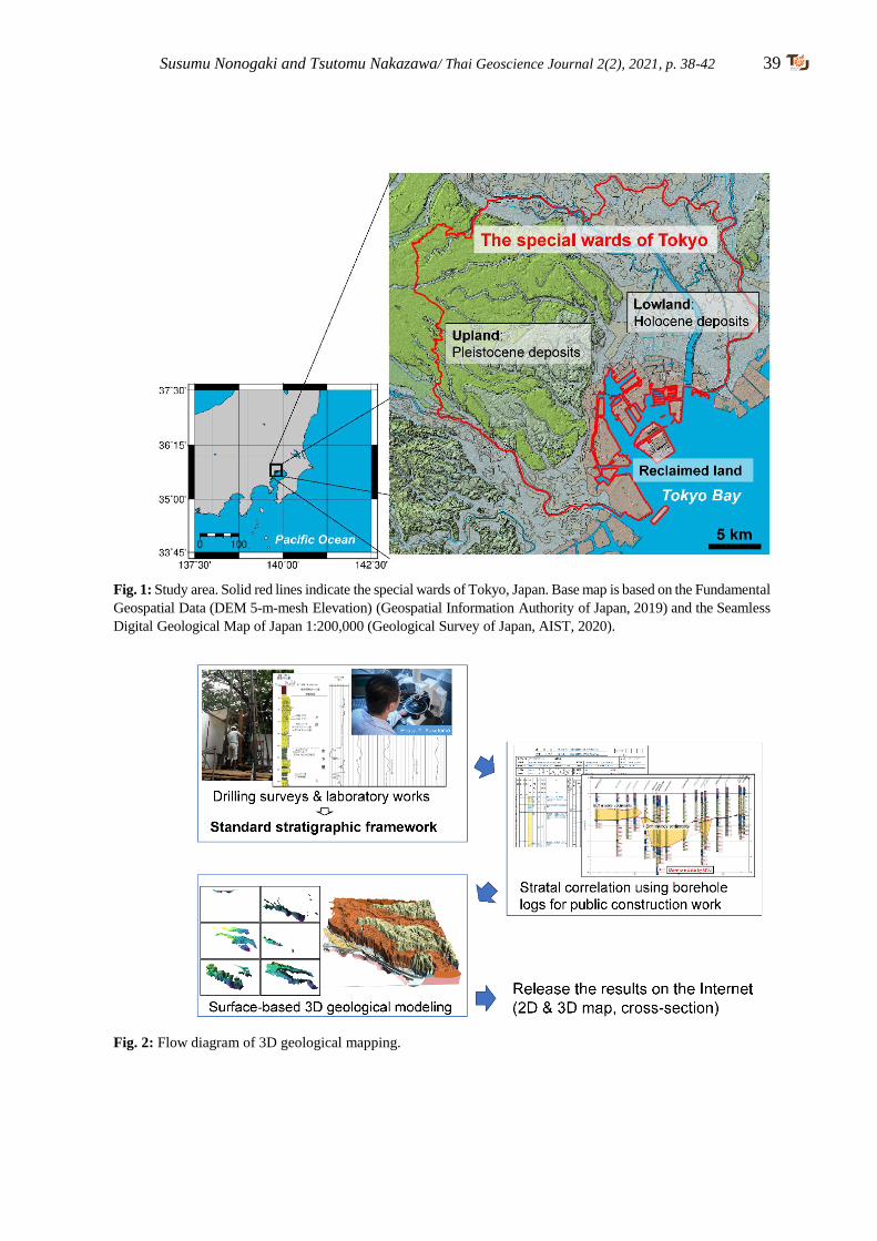
Susumu Nonogaki and Tsutomu Nakazawa/ Thai Geoscience Journal 2(2), 2021, p. 38-42 39
Fig. 1: Study area. Solid red lines indicate the special wards of Tokyo, Japan. Base map is based on the Fundamental
Geospatial Data (DEM 5-m-mesh Elevation) (Geospatial Information Authority of Japan, 2019) and the Seamless
Digital Geological Map of Japan 1:200,000 (Geological Survey of Japan, AIST, 2020).
Fig. 2: Flow diagram of 3D geological mapping.
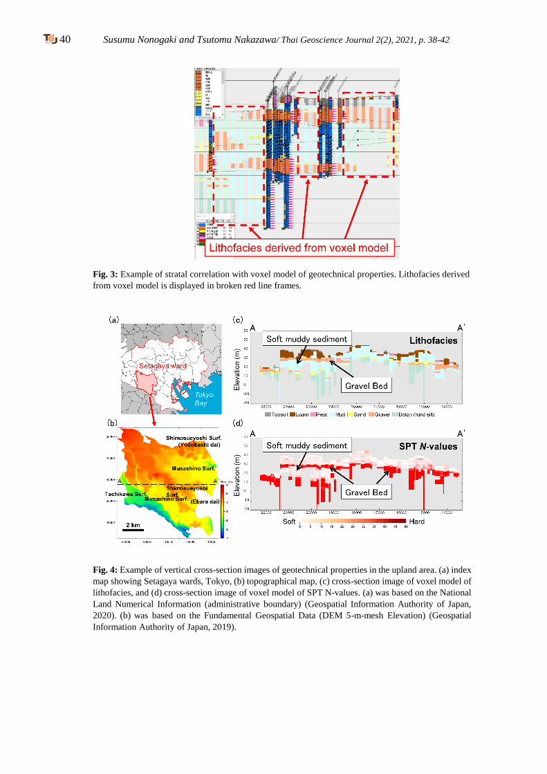
40 Susumu Nonogaki and Tsutomu Nakazawa/ Thai Geoscience Journal 2(2), 2021, p. 38-42
Fig. 3: Example of stratal correlation with voxel model of geotechnical properties. Lithofacies derived
from voxel model is displayed in broken red line frames.
Fig. 4: Example of vertical cross-section images of geotechnical properties in the upland area. (a) index
map showing Setagaya wards, Tokyo, (b) topographical map, (c) cross-section image of voxel model of
lithofacies, and (d) cross-section image of voxel model of SPT N-values. (a) was based on the National
Land Numerical Information (administrative boundary) (Geospatial Information Authority of Japan,
2020). (b) was based on the Fundamental Geospatial Data (DEM 5-m-mesh Elevation) (Geospatial
Information Authority of Japan, 2019).
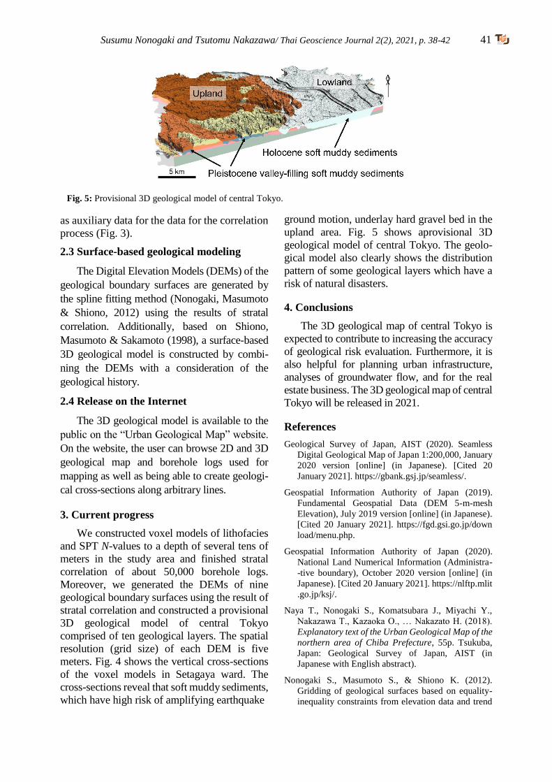
Susumu Nonogaki and Tsutomu Nakazawa/ Thai Geoscience Journal 2(2), 2021, p. 38-42 41
as auxiliary data for the data for the correlation
process (Fig. 3).
2.3 Surface-based geological modeling
The Digital Elevation Models (DEMs) of the
geological boundary surfaces are generated by
the spline fitting method (Nonogaki, Masumoto
& Shiono, 2012) using the results of stratal
correlation. Additionally, based on Shiono,
Masumoto & Sakamoto (1998), a surface-based
3D geological model is constructed by combi-
ning the DEMs with a consideration of the
geological history.
2.4 Release on the Internet
The 3D geological model is available to the
public on the “Urban Geological Map” website.
On the website, the user can browse 2D and 3D
geological map and borehole logs used for
mapping as well as being able to create geologi-
cal cross-sections along arbitrary lines.
3. Current progress
We constructed voxel models of lithofacies
and SPT N-values to a depth of several tens of
meters in the study area and finished stratal
correlation of about 50,000 borehole logs.
Moreover, we generated the DEMs of nine
geological boundary surfaces using the result of
stratal correlation and constructed a provisional
3D geological model of central Tokyo
comprised of ten geological layers. The spatial
resolution (grid size) of each DEM is five
meters. Fig. 4 shows the vertical cross-sections
of the voxel models in Setagaya ward. The
cross-sections reveal that soft muddy sediments,
which have high risk of amplifying earthquake
ground motion, underlay hard gravel bed in the
upland area. Fig. 5 shows aprovisional 3D
geological model of central Tokyo. The geolo-
gical model also clearly shows the distribution
pattern of some geological layers which have a
risk of natural disasters.
4. Conclusions
The 3D geological map of central Tokyo is
expected to contribute to increasing the accuracy
of geological risk evaluation. Furthermore, it is
also helpful for planning urban infrastructure,
analyses of groundwater flow, and for the real
estate business. The 3D geological map of central
Tokyo will be released in 2021.
References
Geological Survey of Japan, AIST (2020). Seamless
Digital Geological Map of Japan 1:200,000, January
2020 version [online] (in Japanese). [Cited 20
January 2021]. https://gbank.gsj.jp/seamless/.
Geospatial Information Authority of Japan (2019).
Fundamental Geospatial Data (DEM 5-m-mesh
Elevation), July 2019 version [online] (in Japanese).
[Cited 20 January 2021]. https://fgd.gsi.go.jp/down
load/menu.php.
Geospatial Information Authority of Japan (2020).
National Land Numerical Information (Administra-
-tive boundary), October 2020 version [online] (in
Japanese). [Cited 20 January 2021]. https://nlftp.mlit
.go.jp/ksj/.
Naya T., Nonogaki S., Komatsubara J., Miyachi Y.,
Nakazawa T., Kazaoka O., … Nakazato H. (2018).
Explanatory text of the Urban Geological Map of the
northern area of Chiba Prefecture, 55p. Tsukuba,
Japan: Geological Survey of Japan, AIST (in
Japanese with English abstract).
Nonogaki S., Masumoto S., & Shiono K. (2012).
Gridding of geological surfaces based on equality-
inequality constraints from elevation data and trend
Fig. 5: Provisional 3D geological model of central Tokyo.

42 Susumu Nonogaki and Tsutomu Nakazawa/ Thai Geoscience Journal 2(2), 2021, p. 38-42
data. International Journal of Geoinformatics, 8, 49–
60.
Nonogaki S., Masumoto S., Nemoto T., Nakazawa T., &
Nakayama T. (2020). Voxel modeling of lithofacies
using Voronoi diagram based on locations of a large
number of borehole data. Geoinformatics, 31, 3–10
(in Japanese with English abstract). doi: 10.6010/
geoinformatics.31.1_3
Shiono K., Masumoto S., & Sakamoto M. (1998).
Characterization of 3D distribution of sedimentary
layers and geomapping algorithm—Logical model of
geologic structure. Geoinformatics, 9, 121–134 (in
Japanese with English abstract). doi: 10.6010/geo
informatics1990.9.3_121
Thai Geoscience Journal 2(2), 2021, p. 43-60 43 Copyright © 2021 by the Department of Mineral Resources of Thailand
ISSN-2730-2695; DOI-10.14456/tgj.2021.5
REE and Th potential from placer deposits: a reconnaissance study of
monazite and xenotime from Jerai pluton, Kedah, Malaysia
Fakhruddin Afif Fauzi1*, Arda Anasha Jamil2, Abdul Hadi Abdul Rahman3, Mahat Hj. Sibon3,
Mohamad Sari Hasan4, Muhammad Falah Zahri5, Hamdan Ariffin1, Abdullah Sulaiman1 1Department of Mineral and Geoscience Kedah / Perlis / Pulau Pinang, Alor Setar, Malaysia
2Department of Mineral and Geoscience Johor, Johor Bahru, Malaysia 3Department of Mineral and Geoscience Selangor / W.P., Shah Alam, Malaysia
4Department of Mineral and Geoscience Pahang, Kuantan, Malaysia 5Technical Service Division, Department of Mineral and Geoscience, Ipoh, Malaysia
*Corresponding author: [email protected]
Received 17 March 2021; Accepted 29 June 2021.
Abstract
Thorium (Th), rare earth elements (REE), yttrium (Y) and scandium (Sc) are among crucial
elements in minerals that have a very high worldwide demand for green energy generation and
high technology manufacturing industries. The current principal ore minerals for these elements
are monazite, bastnäsite and xenotime. A reconnaissance study on monazite and xenotime
minerals was conducted in southern part of Jerai peak area, which consists of mostly pegmatites
and granite bedrocks and alluvial plains. Heavy mineral concentrate samples were obtained from
various origins including gravelly layer from stream banks, flowing stream beds and seasonal
stream beds for recent fluvial environment. Samples were also taken from weathered bedrocks of
pegmatites and granites and different subsurface profiles from 12 pits dug in the alluvial plain
area. Monazite and xenotime contents from stream bed samples are higher (8.43% and 6.05%)
compared to other origins in recent fluvial environment and higher in weathered pegmatites
(13.70% and 1.45%) compared to weathered granites. The monazite and xenotime content are also
higher in eastern side of the alluvial plain, up to 3.16% and 2.91% respectively, but lower than
samples from recent fluvial environment. The Th, REE and Y contents are very high up to 1,530
ppm, 21,031 ppm and 7,604 ppm respectively in samples containing monazite and/or xenotime.
The Sc content, however, is very low which is up to 87.8 ppm in all samples although it shows
positive correlation with monazite and/or xenotime contents. Both REE containing minerals could
be economically potential if mined as placer suites together with garnet, tourmaline and other
industrially beneficial minerals.
Keywords: Jerai, Kedah, monazite, REE, thorium, xenotime
1. Introduction
1.1 Background
The importance of rare earth elements
(REE), thorium (Th), yttrium (Y) and scandium
(Sc) has become worldwide emergence in
electronics and high technology industries. REE,
Y and Sc are crucial for production of magnets in
computer drives and defence applications, metal
alloys including batteries and superalloys,
phosphors such as LED and optical sensors,
additive in ceramics and glass polishing and also
used as catalyst in various chemical processes
(Jha, 2014). Th, as ThO2 is well-known for better
energy generating purpose than uranium (U) as
the former does not easily oxidized and resistant
to ionic radiation (IAEA, 2005).
REE is defined as a set of 17 chemical
elements in the periodic table, comprising 15
lanthanides which are cerium (Ce), dysprosium
(Dy), erbium (Er), europium (Eu), gadolinium
(Gd), holmium (Ho), lanthanum (La), lutetium
(Lu), neodymium (Nd), praseodymium (Pr),
promethium (Pm), samarium (Sm), terbium
(Tb), thulium (Tm) and ytterbium (Yb), as well
as yttrium (Y) and scandium (Sc) (Connelly
and Damhus, 2005).
The history of REE dated back in 1788
when Johan Gadolin discovered a rare pitch-
-black rock in Ytterby, Sweden. The rock
44 Fakhruddin Afif Fauzi et al. / Thai Geoscience Journal 2(2), 2021, p. 43-60
samples were taken across European countries
where their scientists competed to distinguish
elements that exist as well as to complete the
Lanthanide Series of Periodic Table of
Elements. In fact, the names of yttrium,
erbium, terbium and ytterbium derived from
the origin of the sample. Th, on the other hand,
was discovered by Jöns Jacob Berzelius, a
Swedish scientist in 1828.
Placers are defined as mineral deposits
formed by the mechanical concentration of
minerals from weathered debris, such as beaches
and streams, by which the economic mineral
deposits have high density but are very resistant
to chemical and physical breakdown (Sengupta
and Van Gosen, 2016). Among these minerals
are monazite, xenotime, bastnäsite and loparite
which are considered as the most important
placer rare earth minerals (REM) in the world
(Zhou et al., 2017). The former 2 minerals are
common by-products of alluvial tin mining in
Malay Peninsular since early 1900s (Willbourn,
1925). The placer REM are practically mined
together with other minerals including garnet,
zircon, cassiterite, and Ti-bearing minerals like
rutile and ilmenite as mineral suite or co-products
before separation processes (Sengupta and Van
Gosen, 2016).
Placer REM currently represent the third
most important global REE source of production
after Bayan Obo carbonate rocks in inner
Mongolia and Mountain Pass carbonatites in
California, which come from the monazite and
xenotime dispersed in Neogene to Quaternary
beach sand in Australia (McLennan and Taylor,
2012). In comparison, current and previous
productive placer deposits contain 6% to 7% of
heavy minerals including REM as reported in
Eneabba district, Australia and Xun Jiang
district, China (Shepherd, 1990; Jackson and
Christiansen, 1993).
In 1980s, the xenotime-bearing alluvial
placer deposits in Malaysia were once the
largest source of Y in the world (Castor and
Hendrick, 2006). JMG (2019) stated that the
production of both monazite and xenotime in
Malaysia increased from 25 tonnes in 2009 to
1,654 tonnes in 2018, which were obtained
from alluvial tailings in Ipoh, Perak. USGS
(2019) estimated that Malaysia has 30,000
tonnes of rare earth oxides (REO) in 2018.
Monazite is a phosphate mineral consisting
REE (Ce, La, Nd), Th and U. Monazite is a
common accessory mineral in peraluminous
granites, syenitic and granitic pegmatites, quartz
veins and carbonatites but lesser in charnockites,
migmatites and paragneisses (Rapp and Watson,
1986). In peraluminous granites, monazite
constitutes a major host of LREE, excluding Eu,
Th and U, with minor amount of Y and HREE
(Hinton and Paterson, 1994; Bea et al., 1994;
Bea, 1996). The monazite stability in silicate
melts depends on SiO2, CaO and P2O5, including
oxygen fugacity, peraluminous content and
content ratios of lanthanides and actinides
(Cuney and Friedrich, 1987; Casilas et al., 1995).
Felsic differentiation towards granite plutons
strongly depletes LREE and Th due to monazite
fractionation (Ward et al., 1992; Wark and Miller,
1993; Zhao and Cooper, 1993). According to Che
Zainol Bahri et al. (2018), the Th content in
Malaysian monazite ranges between 2,525 ppm
to 40,868 ppm while Willbourn (1925) mentioned
that the mineral contains 3.5% to 8.38% of
ThO2. Atomic Energy Licencing Act 1984 stated
that if radionuclide of Naturally Occurring
Radioactive Materials (NORM) of Th-232
exceeds 1 Bq/g, it is considered as radioactive.
1 Bq/g of Th-232 is equivalent to 246 ppm,
assuming the chain is in equilibrium.
Xenotime is also a phosphate mineral but
abundant particularly in Ca-poor peraluminous
granites, which accounts for huge fraction of Y
and HREE contents and variable portion of
substituted U (Wark and Miller, 1993; Bea,
1996). In xenotime-bearing peraluminous gra-
-nites, the Y and HREE fractions contained in
xenotime vary from 30% to 50%, that is closely
related to xenotime-apatite-zircon concomitance
during plutonic facies differentiation (Bea, 1996;
Wark and Miller, 1993; Förster and Tischendorf,
1994). Xenotime also contains minor amounts
of Th and LREE, particularly Nd and Sm
(Förster, 1998b).
Hence, this conducted study is to determine
the potential of Th and REE based on monazite
and xenotime distributions in placer environments
within Jerai Pluton area.

Fakhruddin Afif Fauzi et al. / Thai Geoscience Journal 2(2), 2021, p. 43-60 45
1.2 Previous studies
Studies on the occurrences of monazite and
xenotime in Malaysia were commenced as parts
of regional mapping and regional geochemical
surveys by Geological Survey of Malaysia since
1925, continued by Department of Mineral and
Geoscience Malaysia (JMG) from 2000 until
present.
The Malaysian monazite generally has
moderately well-rounded discrete or as some
parts with colour varies from clear, deep canary
yellow through cream coloured with resinous
lustre due to progressive oxidation of REE
(Flinter et al., 1963; Wan Hassan, 1989). The
Jerai monazite, however, has unusual elongated
rolled grains of flattened form with deep green
colour (Wan Hassan, 1989; Flinter et al., 1963).
Wan Hassan (1989) distinguished the xenotime
crystal habit to have squat tetragonal bipyramid
in Malaysian Tin Belt and prism with double
pyramidal terminations in Malaysian Eastern
Belt.
Studies on radioactive minerals on Malaysian
Central Belt then were conducted in 1993 to
1995 (Mohd Hasan et al. 1993, 1995; Zakaria et
al. 1994). Academy of Sciences Malaysia
(ASM) later initiated a study on REE associated
with ion adsorption clay in 2013 (ASM, 2014).
In 2018, JMG conducted a reconnaissance
study on REE, Th and Sc potentials in Malaysia.
The preliminary study comprised their potential
in clayey horizons in weathered granites and
placer deposits, including Jerai Pluton (Abdul
Rahman et al. 2018a, b). Hence, this paper is
aimed to deliver the outcomes of the study
commenced in the pluton area.
1.3 Study area
The study area is situated at the south of
Mount Jerai, west of Kedah state with a total of
40 km2. The area is mostly covered with paddy
fields with freshwater for drainage sourced
from streams flowing from the peak. The study
area lies in the National Jerai Geopark (Fig.1).
2. Geological Setting
2.1 Regional geology
The Jerai Pluton lies within the western tin
granites of Peninsular which is part of the
Southeast Asian Magmatic Arc that was
triggered during Late Permian to Triassic
subduction-collision event due to the closure of
Palaeo-Tethyan Ocean beneath the Southeast
Asian crust (Robb, 2019) (Fig.1).
The tin granites of western Peninsular
Malaysia have been considered as products of
partial melting of the metamorphic basement
during the collision of Sibumasu and East
Malaya blocks (Liu et al., 2020; Ng et al., 2015),
based on their ilmenite-series, peraluminous
character (Ishihara et al., 1979), and charac-
teristic of S-type granites (Chappell and White,
2001). More recently, the genetic link between
the tin mineralization and the granites has been
constrained, by which the age of tin ores and their
granitic hosted rocks in the western Peninsular
Malaysia is within the range of the 230 to 210 Ma
(Yang et al., 2020).
2.2 Local geology
The study area consists of granitic bedrock,
metasedimentary bedrocks and unconsolidated
deposits.
The granitic bedrock covered the northern
part of the study area. It is from the Jerai Pluton
that intruded during Late Triassic and shaped the
mountain (Fig.1). Jamil et al. (2006) divided the
pluton into 3 facies according to mineralogical
criteria, which are biotite – muscovite granite,
tourmaline granite and pegmatite. The pegmatite
facies which occurred as veins ranging from few
centimetres to several meters, are the primary
source of tin associated with Nb-Ta (Bradford,
1972). Khoo (1977) proposed that the pegmatites
also occurred as sync-plutonic dykes that filled
the ductile cracks in granites during intrusion.
Apart of tourmalines, garnets, particularly pinkish
variety, are the common accessory minerals in
Jerai Granite found in this study.
The metasedimentary facies within the
study area are quartzites and schists from
Cambrian Jerai Formation. Both facies are
mineralized with magnetite and/or hematite
(Bean and Hill, 1969; Bradford, 1972) and
regarded as source of iron ores since 535 B.C.
(Mokhtar and Saidin, 2018).
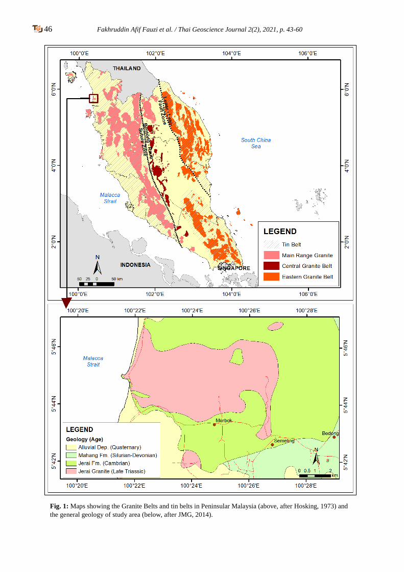
46 Fakhruddin Afif Fauzi et al. / Thai Geoscience Journal 2(2), 2021, p. 43-60
Fig. 1: Maps showing the Granite Belts and tin belts in Peninsular Malaysia (above, after Hosking, 1973) and
the general geology of study area (below, after JMG, 2014).
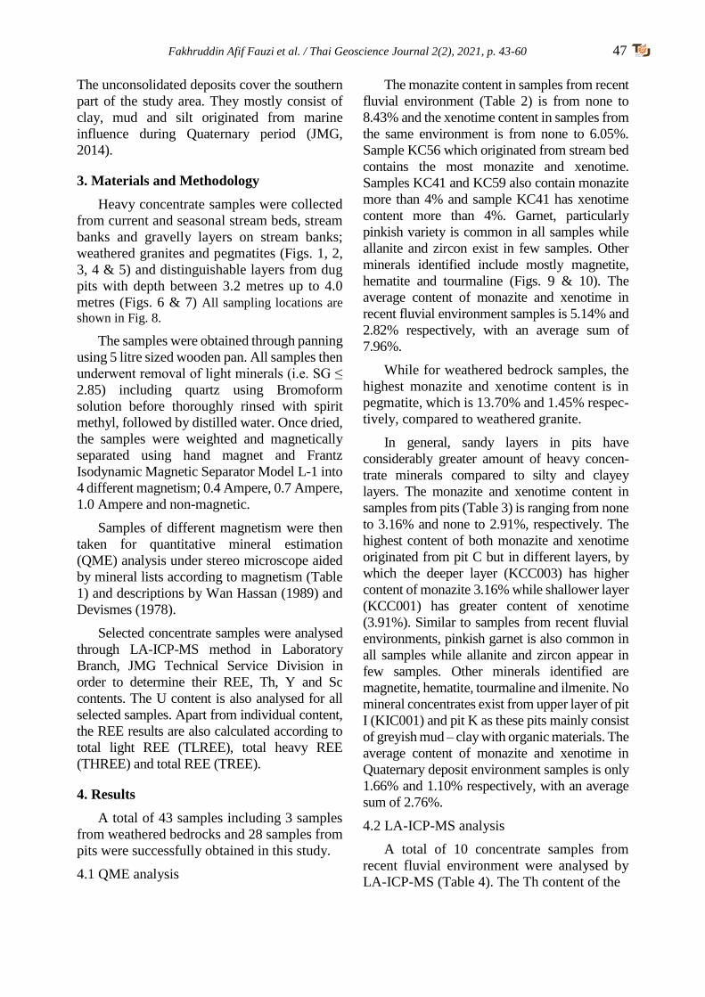
Fakhruddin Afif Fauzi et al. / Thai Geoscience Journal 2(2), 2021, p. 43-60 47
The unconsolidated deposits cover the southern
part of the study area. They mostly consist of
clay, mud and silt originated from marine
influence during Quaternary period (JMG,
2014).
3. Materials and Methodology
Heavy concentrate samples were collected
from current and seasonal stream beds, stream
banks and gravelly layers on stream banks;
weathered granites and pegmatites (Figs. 1, 2,
3, 4 & 5) and distinguishable layers from dug
pits with depth between 3.2 metres up to 4.0
metres (Figs. 6 & 7) All sampling locations are
shown in Fig. 8.
The samples were obtained through panning
using 5 litre sized wooden pan. All samples then
underwent removal of light minerals (i.e. SG ≤
2.85) including quartz using Bromoform
solution before thoroughly rinsed with spirit
methyl, followed by distilled water. Once dried,
the samples were weighted and magnetically
separated using hand magnet and Frantz
Isodynamic Magnetic Separator Model L-1 into
4 different magnetism; 0.4 Ampere, 0.7 Ampere,
1.0 Ampere and non-magnetic.
Samples of different magnetism were then
taken for quantitative mineral estimation
(QME) analysis under stereo microscope aided
by mineral lists according to magnetism (Table
1) and descriptions by Wan Hassan (1989) and
Devismes (1978).
Selected concentrate samples were analysed
through LA-ICP-MS method in Laboratory
Branch, JMG Technical Service Division in
order to determine their REE, Th, Y and Sc
contents. The U content is also analysed for all
selected samples. Apart from individual content,
the REE results are also calculated according to
total light REE (TLREE), total heavy REE
(THREE) and total REE (TREE).
4. Results
A total of 43 samples including 3 samples
from weathered bedrocks and 28 samples from
pits were successfully obtained in this study.
4.1 QME analysis
The monazite content in samples from recent
fluvial environment (Table 2) is from none to
8.43% and the xenotime content in samples from
the same environment is from none to 6.05%.
Sample KC56 which originated from stream bed
contains the most monazite and xenotime.
Samples KC41 and KC59 also contain monazite
more than 4% and sample KC41 has xenotime
content more than 4%. Garnet, particularly
pinkish variety is common in all samples while
allanite and zircon exist in few samples. Other
minerals identified include mostly magnetite,
hematite and tourmaline (Figs. 9 & 10). The
average content of monazite and xenotime in
recent fluvial environment samples is 5.14% and
2.82% respectively, with an average sum of
7.96%.
While for weathered bedrock samples, the
highest monazite and xenotime content is in
pegmatite, which is 13.70% and 1.45% respec-
tively, compared to weathered granite.
In general, sandy layers in pits have
considerably greater amount of heavy concen-
trate minerals compared to silty and clayey
layers. The monazite and xenotime content in
samples from pits (Table 3) is ranging from none
to 3.16% and none to 2.91%, respectively. The
highest content of both monazite and xenotime
originated from pit C but in different layers, by
which the deeper layer (KCC003) has higher
content of monazite 3.16% while shallower layer
(KCC001) has greater content of xenotime
(3.91%). Similar to samples from recent fluvial
environments, pinkish garnet is also common in
all samples while allanite and zircon appear in
few samples. Other minerals identified are
magnetite, hematite, tourmaline and ilmenite. No
mineral concentrates exist from upper layer of pit
I (KIC001) and pit K as these pits mainly consist
of greyish mud – clay with organic materials. The
average content of monazite and xenotime in
Quaternary deposit environment samples is only
1.66% and 1.10% respectively, with an average
sum of 2.76%.
4.2 LA-ICP-MS analysis
A total of 10 concentrate samples from
recent fluvial environment were analysed by
LA-ICP-MS (Table 4). The Th content of the
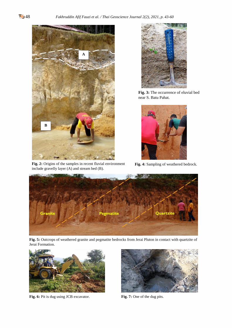
48 Fakhruddin Afif Fauzi et al. / Thai Geoscience Journal 2(2), 2021, p. 43-60
A
B
Fig. 2: Origins of the samples in recent fluvial environment
include gravelly layer (A) and stream bed (B).
Fig. 3: The occurrence of eluvial bed
near S. Batu Pahat.
Fig. 4: Sampling of weathered bedrock.
Fig. 5: Outcrops of weathered granite and pegmatite bedrocks from Jerai Pluton in contact with quartzite of
Jerai Formation.
Fig. 6: Pit is dug using JCB excavator. Fig. 7: One of the dug pits.
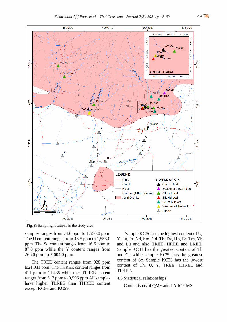
Fakhruddin Afif Fauzi et al. / Thai Geoscience Journal 2(2), 2021, p. 43-60 49
samples ranges from 74.6 ppm to 1,530.0 ppm.
The U content ranges from 48.5 ppm to 1,553.0
ppm. The Sc content ranges from 16.5 ppm to
87.8 ppm while the Y content ranges from
266.0 ppm to 7,604.0 ppm.
The TREE content ranges from 928 ppm
to21,031 ppm. The THREE content ranges from
411 ppm to 11,435 while ther TLREE content
ranges from 517 ppm to 9,596 ppm All samples
have higher TLREE than THREE content
except KC56 and KC59.
Sample KC56 has the highest content of U,
Y, La, Pr, Nd, Sm, Gd, Tb, Dy, Ho, Er, Tm, Yb
and Lu and also TREE, HREE and LREE.
Sample KC41 has the greatest content of Th
and Ce while sample KC59 has the greatest
content of Sc. Sample KC23 has the lowest
content of Th, U, Y, TREE, THREE and
TLREE.
4.3 Statistical relationships
Comparisons of QME and LA-ICP-MS
Fig. 8: Sampling locations in the study area.
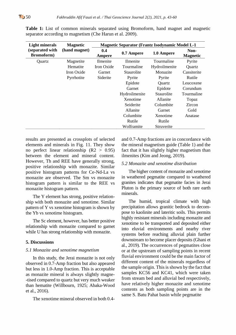
50 Fakhruddin Afif Fauzi et al. / Thai Geoscience Journal 2(2), 2021, p. 43-60
Table 1: List of common minerals separated using Bromoform, hand magnet and magnetic
separator according to magnetism (Che Harun et al. 2009).
results are presented as crossplots of selected
elements and minerals in Fig. 11. They show
no perfect linear relationship (R2 > 0.95)
between the element and mineral content.
However, Th and REE have generally strong,
positive relationship with monazite. Similar
positive histogram patterns for Ce-Nd-La vs
monazite are observed. The Sm vs monazite
histogram pattern is similar to the REE vs
monazite histogram pattern.
The Y element has strong, positive relation-
ship with both monazite and xenotime. Similar
pattern of Y vs xenotime histogram is shown by
the Yb vs xenotime histogram.
The Sc element, however, has better positive
relationship with monazite compared to garnet
while U has strong relationship with monazite.
5. Discussions
5.1 Monazite and xenotime magnetism
In this study, the Jerai monazite is not only
observed in 0.7-Amp fraction but also appeared
but less in 1.0-Amp fraction. This is acceptable
as monazite mineral is always slightly magne-
-tised compared to quartz but very much weaker
than hematite (Willbourn, 1925; Abaka-Wood
et al., 2016).
The xenotime mineral observed in both 0.4-
and 0.7-Amp fractions are in concordance with
the mineral magnetism guide (Table 1) and the
fact that it has slightly higher magnetism than
ilmenites (Kim and Jeong, 2019).
5.2 Monazite and xenotime distribution
The higher content of monazite and xenotime
in weathered pegmatite compared to weathered
granites indicates that pegmatite facies in Jerai
Pluton is the primary source of both rare earth
minerals.
The humid, tropical climate with high
precipitation allows granitic bedrock to decom-
pose to kaolinite and lateritic soils. This permits
highly resistant minerals including monazite and
xenotime to be transported and deposited either
into eluvial environments and nearby river
systems before reaching alluvial plain further
downstream to become placer deposits (Ghani et
al., 2019). The occurrences of pegmatites close
or at the upstream of sampling points in recent
fluvial environment could be the main factor of
different content of the minerals regardless of
the sample origin. This is shown by the fact that
samples KC56 and KC41, which were taken
from stream bed and alluvial bed respectively,
have relatively higher monazite and xenotime
contents as both sampling points are in the
same S. Batu Pahat basin while pegmatite
Light minerals
(separated with
Bromoform)
Magnetic
(hand magnet)
Magnetic Separator (Frantz Isodynamic Model L-1
0.4
Ampere 0.7 Ampere 1.0 Ampere
Non-
Magnetic
Quartz Magnetite
Hematite
Iron Oxide
Pyrrhotite
Ilmenite
Iron Oxide
Garnet
Siderite
Ilmenite
Tourmaline
Staurolite
Pyrite
Epidote
Garnet
Hydroilmenite
Xenotime
Seiderite
Allanite
Columbite
Rutile
Wolframite
Tourmaline
Hydroilmenite
Monazite
Pyrite
Quartz
Epidote
Staurolite
Allanite
Columbite
Garnet
Xenotime
Rutile
Struverite
Pyrite
Quartz
Cassiterite
Rutile
Leucoxene
Corundum
Tourmaline
Topaz
Zircon
Gold
Anatase
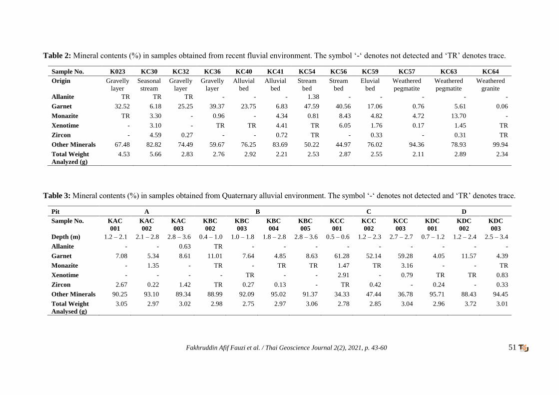
Fakhruddin Afif Fauzi et al. / Thai Geoscience Journal 2(2), 2021, p. 43-60 51
Table 2: Mineral contents (%) in samples obtained from recent fluvial environment. The symbol ‘-‘ denotes not detected and ‘TR’ denotes trace.
Sample No. K023 KC30 KC32 KC36 KC40 KC41 KC54 KC56 KC59 KC57 KC63 KC64
Origin Gravelly
layer
Seasonal
stream
Gravelly
layer
Gravelly
layer
Alluvial
bed
Alluvial
bed
Stream
bed
Stream
bed
Eluvial
bed
Weathered
pegmatite
Weathered
pegmatite
Weathered
granite
Allanite TR TR TR - - - 1.38 - - - - -
Garnet 32.52 6.18 25.25 39.37 23.75 6.83 47.59 40.56 17.06 0.76 5.61 0.06
Monazite TR 3.30 - 0.96 - 4.34 0.81 8.43 4.82 4.72 13.70 -
Xenotime - 3.10 - TR TR 4.41 TR 6.05 1.76 0.17 1.45 TR
Zircon - 4.59 0.27 - - 0.72 TR - 0.33 - 0.31 TR
Other Minerals 67.48 82.82 74.49 59.67 76.25 83.69 50.22 44.97 76.02 94.36 78.93 99.94
Total Weight
Analyzed (g)
4.53 5.66 2.83 2.76 2.92 2.21 2.53 2.87 2.55 2.11 2.89 2.34
Table 3: Mineral contents (%) in samples obtained from Quaternary alluvial environment. The symbol ‘-‘ denotes not detected and ‘TR’ denotes trace.
Pit A B C D
Sample No. KAC
001
KAC
002
KAC
003
KBC
002
KBC
003
KBC
004
KBC
005
KCC
001
KCC
002
KCC
003
KDC
001
KDC
002
KDC
003
Depth (m) 1.2 – 2.1 2.1 – 2.8 2.8 – 3.6 0.4 – 1.0 1.0 – 1.8 1.8 – 2.8 2.8 – 3.6 0.5 – 0.6 1.2 – 2.3 2.7 – 2.7 0.7 – 1.2 1.2 – 2.4 2.5 – 3.4
Allanite - - 0.63 TR - - - - - - - - -
Garnet 7.08 5.34 8.61 11.01 7.64 4.85 8.63 61.28 52.14 59.28 4.05 11.57 4.39
Monazite - 1.35 - TR - TR TR 1.47 TR 3.16 - - TR
Xenotime - - - - TR - - 2.91 - 0.79 TR TR 0.83
Zircon 2.67 0.22 1.42 TR 0.27 0.13 - TR 0.42 - 0.24 - 0.33
Other Minerals 90.25 93.10 89.34 88.99 92.09 95.02 91.37 34.33 47.44 36.78 95.71 88.43 94.45
Total Weight
Analysed (g)
3.05 2.97 3.02 2.98 2.75 2.97 3.06 2.78 2.85 3.04 2.96 3.72 3.01
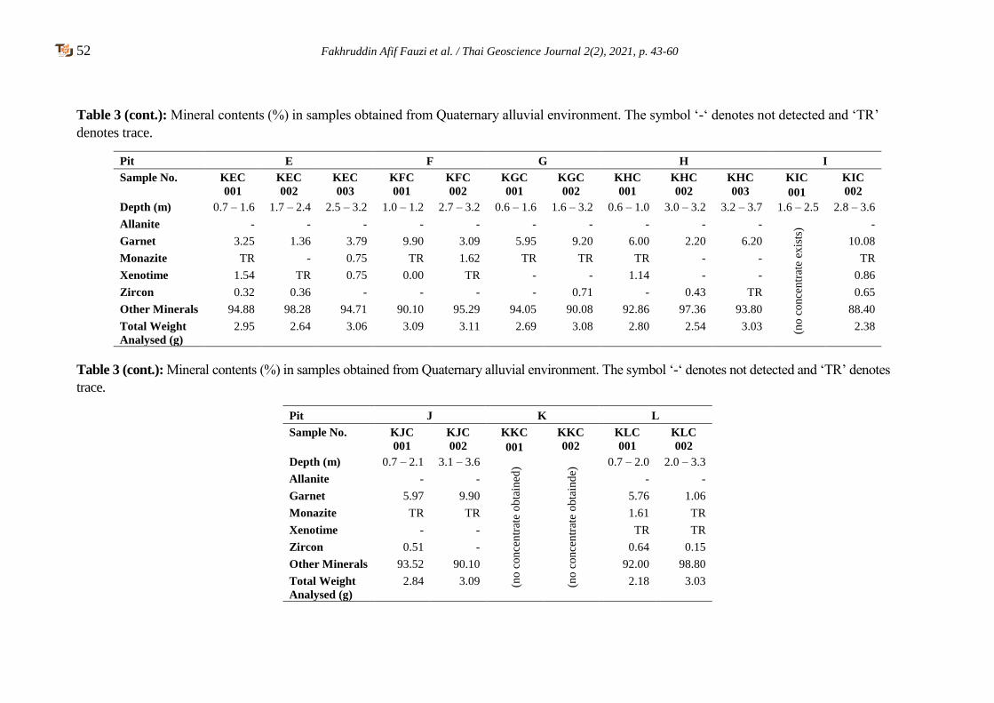
52 Fakhruddin Afif Fauzi et al. / Thai Geoscience Journal 2(2), 2021, p. 43-60
Table 3 (cont.): Mineral contents (%) in samples obtained from Quaternary alluvial environment. The symbol ‘-‘ denotes not detected and ‘TR’
denotes trace.
Pit E F G H I
Sample No. KEC
001
KEC
002
KEC
003
KFC
001
KFC
002
KGC
001
KGC
002
KHC
001
KHC
002
KHC
003
KIC
001
KIC
002
Depth (m) 0.7 – 1.6 1.7 – 2.4 2.5 – 3.2 1.0 – 1.2 2.7 – 3.2 0.6 – 1.6 1.6 – 3.2 0.6 – 1.0 3.0 – 3.2 3.2 – 3.7 1.6 – 2.5 2.8 – 3.6
Allanite - - - - - - - - - -
(no
con
cen
trat
e ex
ists
) -
Garnet 3.25 1.36 3.79 9.90 3.09 5.95 9.20 6.00 2.20 6.20 10.08
Monazite TR - 0.75 TR 1.62 TR TR TR - - TR
Xenotime 1.54 TR 0.75 0.00 TR - - 1.14 - - 0.86
Zircon 0.32 0.36 - - - - 0.71 - 0.43 TR 0.65
Other Minerals 94.88 98.28 94.71 90.10 95.29 94.05 90.08 92.86 97.36 93.80 88.40
Total Weight
Analysed (g)
2.95 2.64 3.06 3.09 3.11 2.69 3.08 2.80 2.54 3.03 2.38
Table 3 (cont.): Mineral contents (%) in samples obtained from Quaternary alluvial environment. The symbol ‘-‘ denotes not detected and ‘TR’ denotes
trace.
Pit J K L
Sample No. KJC
001
KJC
002
KKC
001
KKC
002
KLC
001
KLC
002
Depth (m) 0.7 – 2.1 3.1 – 3.6
(no
con
cen
trat
e o
bta
ined
)
(no
con
cen
trat
e o
bta
ind
e) 0.7 – 2.0 2.0 – 3.3
Allanite - - - -
Garnet 5.97 9.90 5.76 1.06
Monazite TR TR 1.61 TR
Xenotime - - TR TR
Zircon 0.51 - 0.64 0.15
Other Minerals 93.52 90.10 92.00 98.80
Total Weight
Analysed (g)
2.84 3.09 2.18 3.03
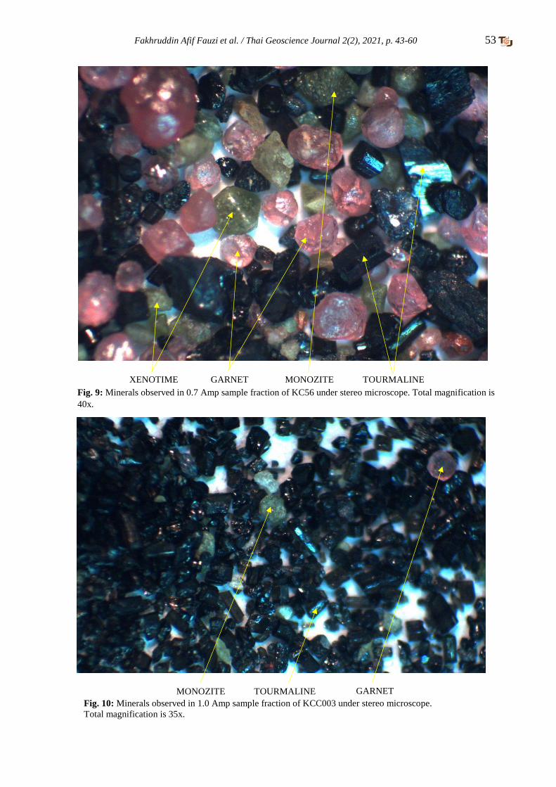
Fakhruddin Afif Fauzi et al. / Thai Geoscience Journal 2(2), 2021, p. 43-60 53
XENOTIME GARNET MONOZITE TOURMALINE
Fig. 9: Minerals observed in 0.7 Amp sample fraction of KC56 under stereo microscope. Total magnification is
40x.
GARNET MONOZITE TOURMALINE
Fig. 10: Minerals observed in 1.0 Amp sample fraction of KCC003 under stereo microscope.
Total magnification is 35x.
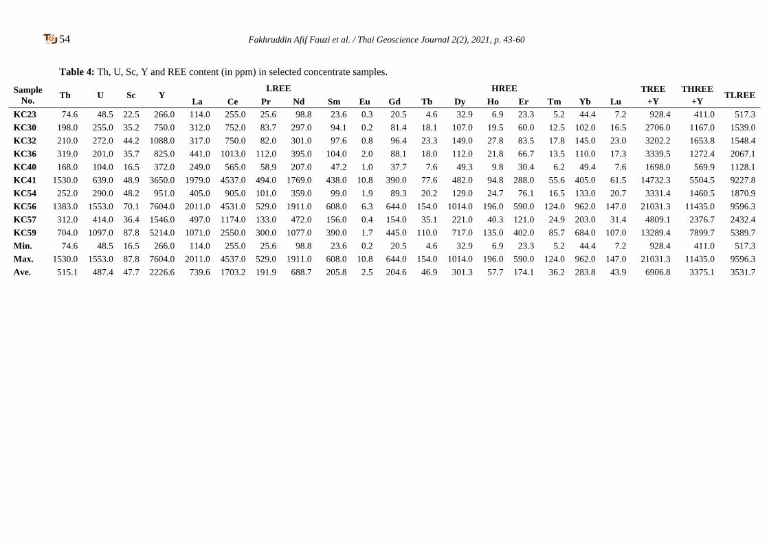
54 Fakhruddin Afif Fauzi et al. / Thai Geoscience Journal 2(2), 2021, p. 43-60
Table 4: Th, U, Sc, Y and REE content (in ppm) in selected concentrate samples.
Sample
No. Th U Sc Y
LREE HREE TREE
+Y
THREE
+Y TLREE
La Ce Pr Nd Sm Eu Gd Tb Dy Ho Er Tm Yb Lu
KC23 74.6 48.5 22.5 266.0 114.0 255.0 25.6 98.8 23.6 0.3 20.5 4.6 32.9 6.9 23.3 5.2 44.4 7.2 928.4 411.0 517.3
KC30 198.0 255.0 35.2 750.0 312.0 752.0 83.7 297.0 94.1 0.2 81.4 18.1 107.0 19.5 60.0 12.5 102.0 16.5 2706.0 1167.0 1539.0
KC32 210.0 272.0 44.2 1088.0 317.0 750.0 82.0 301.0 97.6 0.8 96.4 23.3 149.0 27.8 83.5 17.8 145.0 23.0 3202.2 1653.8 1548.4
KC36 319.0 201.0 35.7 825.0 441.0 1013.0 112.0 395.0 104.0 2.0 88.1 18.0 112.0 21.8 66.7 13.5 110.0 17.3 3339.5 1272.4 2067.1
KC40 168.0 104.0 16.5 372.0 249.0 565.0 58.9 207.0 47.2 1.0 37.7 7.6 49.3 9.8 30.4 6.2 49.4 7.6 1698.0 569.9 1128.1
KC41 1530.0 639.0 48.9 3650.0 1979.0 4537.0 494.0 1769.0 438.0 10.8 390.0 77.6 482.0 94.8 288.0 55.6 405.0 61.5 14732.3 5504.5 9227.8
KC54 252.0 290.0 48.2 951.0 405.0 905.0 101.0 359.0 99.0 1.9 89.3 20.2 129.0 24.7 76.1 16.5 133.0 20.7 3331.4 1460.5 1870.9
KC56 1383.0 1553.0 70.1 7604.0 2011.0 4531.0 529.0 1911.0 608.0 6.3 644.0 154.0 1014.0 196.0 590.0 124.0 962.0 147.0 21031.3 11435.0 9596.3
KC57 312.0 414.0 36.4 1546.0 497.0 1174.0 133.0 472.0 156.0 0.4 154.0 35.1 221.0 40.3 121.0 24.9 203.0 31.4 4809.1 2376.7 2432.4
KC59 704.0 1097.0 87.8 5214.0 1071.0 2550.0 300.0 1077.0 390.0 1.7 445.0 110.0 717.0 135.0 402.0 85.7 684.0 107.0 13289.4 7899.7 5389.7
Min. 74.6 48.5 16.5 266.0 114.0 255.0 25.6 98.8 23.6 0.2 20.5 4.6 32.9 6.9 23.3 5.2 44.4 7.2 928.4 411.0 517.3
Max. 1530.0 1553.0 87.8 7604.0 2011.0 4537.0 529.0 1911.0 608.0 10.8 644.0 154.0 1014.0 196.0 590.0 124.0 962.0 147.0 21031.3 11435.0 9596.3
Ave. 515.1 487.4 47.7 2226.6 739.6 1703.2 191.9 688.7 205.8 2.5 204.6 46.9 301.3 57.7 174.1 36.2 283.8 43.9 6906.8 3375.1 3531.7
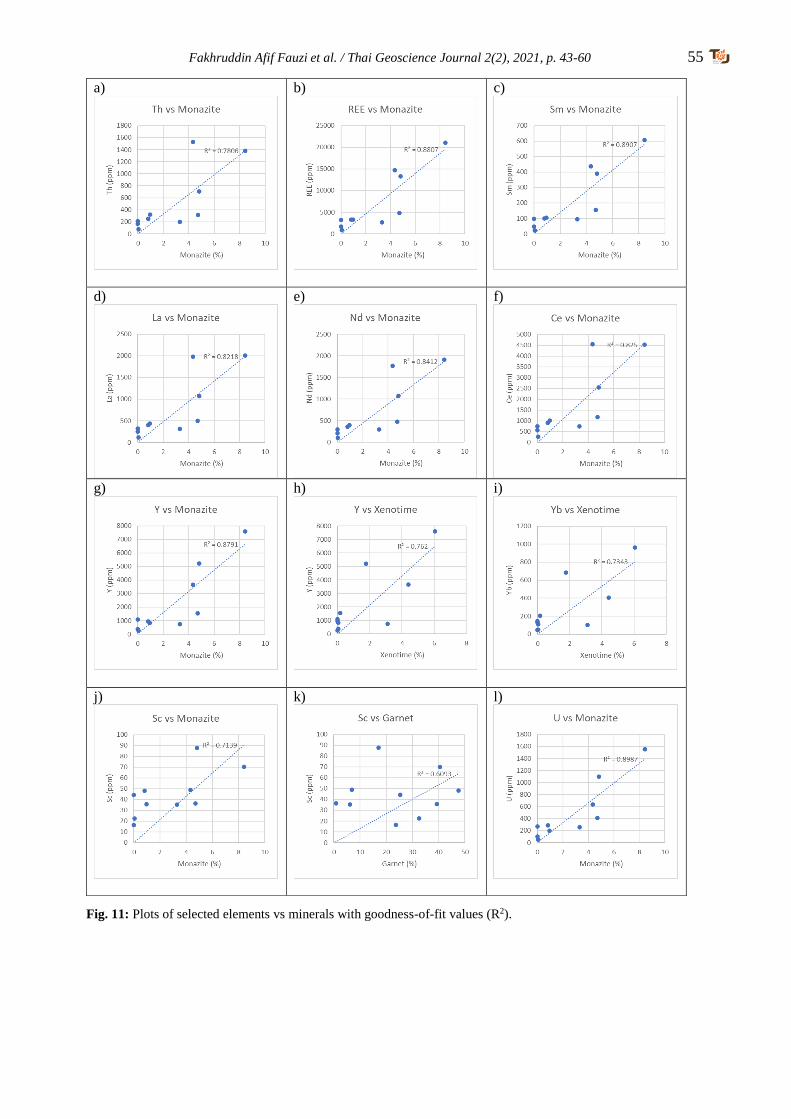
Fakhruddin Afif Fauzi et al. / Thai Geoscience Journal 2(2), 2021, p. 43-60 55
a)
b)
c)
d)
e)
f)
g)
h)
i)
j)
k)
l)
Fig. 11: Plots of selected elements vs minerals with goodness-of-fit values (R2).

56 Fakhruddin Afif Fauzi et al. / Thai Geoscience Journal 2(2), 2021, p. 43-60
dykes occurred at the upstream of the river
basin (Bradford, 1972). Sample KC30 which
also contains considerable amount of monazite
and xenotime could have pegmatite bedrock at
upstream while sample KC54, although
collected from stream bed of S.Ayer Jerneh,
contains only traces of both minerals. This is
due to fact that pegmatites do not occur much
at its upstream (Bradford, 1972).
The gravelly layers at recent stream banks
are regarded as the paleo stream beds of high
energy water flow (Harraz, 2013). However,
very low monazite and xenotime content in the
layers is either due to dispersion of the minerals
during deposition by high energy stream flow
or the parent rocks did not completely weather
yet to permit both minerals to deposit. In the
alluvial plain, the lower content of monazite
and xenotime than in the recent fluvial
environment is expected as heavy minerals,
including both rare earth minerals were
widespread when reaching the relatively flat
plain area under lower energy regime (Gupta
and Krishnamurthy, 2005).
In comparison, the monazite and xenotime
contents between sampling points in the
alluvial plains show relatively higher at eastern
side (downstream S. Batu Pahat) compared to
western side (downstream S. Jerneh and S.
Badong). The main factor of different
distribution pattern is the influence of marine
sedimentation during Pleistocene period at the
western plain area (Khoo, 1996; Allen, 2000).
This is also supported by the occurrence of
clayey or muddy layers in pits in that area,
suggestive of Gula Formation which were
deposited in paleo tidal flat or swamp
environment during following Holocene period
(Hassan, 1990) (Fig. 12).
5.3 Elements and mineral relationships
A positive relationship is shown by Th and
monazite, indicating that monazite is the chief
mineral containing the radioactive element. This
is also shown by strong relationship between U
and monazite. Monazite is one of the minerals
searched for its Th content, although the Th
content is lower than in thorianite (ThO2) and
thorite ((Th,U)SiO4) (Voncken, 2016). The U
occurs as U4+ only as accessory in selected
minerals like apatite, zircon and monazite that is
concentrated into residual melts (Robb, 2005).
However, thorianite, thorite and apatite are not
observed during QME analysis while zircon
occurs in very lesser amount compared to
monazite but low Th and U content may also be
contributed by dark Nb-Ta minerals that could
exist in placer deposits (Bradford, 1972; Zhang
et al., 2002).
Apart from radioactive elements, the
monazite also has strong relationships with REE,
Y and Sc, indicating that the Jerai monazite
contains many elements in its crystal lattices.
Monazite generally contains higher amount of
HREE while xenotime tends to contain higher
amount of LREE (Förster, 1998a, b). All samples
in this study, excluding KC41, KC564 and
KC57, fit the different LREE-HREE concen-
trations.
The similarities of La, Ce and Nd vs monazite
plots could represent uniform concentration ratios
of these element in one monazite mineral. In fact,
the highest content of Ce compared to La and Nd
would suggest the monazite-Ce species occurs the
most in Jerai area (Mindat.org, 2021).
The Y content has stronger relationship with
monazite compared to xenotime. Although Y is
the main element in xenotime, Flinter et al.
(1963) studied that the Jerai monazite also
contains considerably high amount of Y with
value ranges 2.5% to 5.9%. The variation of Y
content could also be the main factor of samples
containing higher monazite than xenotime, but
has higher HREE concentration because Y is
considered as HREE in this study.
Similarities of Y and Yb plots are due to
fact that both HREE also have uniform
concentration ratios and tend to occur together
(Förster, 1998b).
Sc is likely contributed by monazite
compared to garnet, although its content is
considerably very low. Sc is more common as
trace amounts in iron and magnesium rich
rocks (Gupta and Krishnamurthy, 2005).
5.4 Mining potential
The maximum total content of monazite and
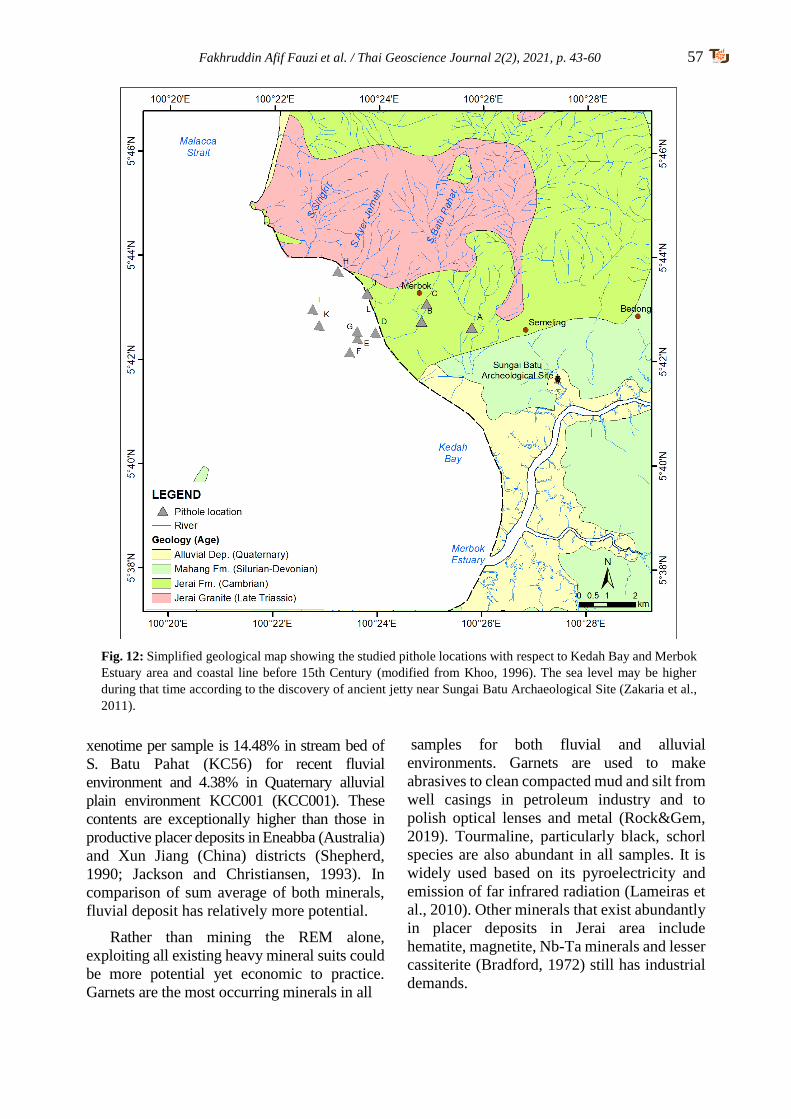
Fakhruddin Afif Fauzi et al. / Thai Geoscience Journal 2(2), 2021, p. 43-60 57
xenotime per sample is 14.48% in stream bed of
S. Batu Pahat (KC56) for recent fluvial
environment and 4.38% in Quaternary alluvial
plain environment KCC001 (KCC001). These
contents are exceptionally higher than those in
productive placer deposits in Eneabba (Australia)
and Xun Jiang (China) districts (Shepherd,
1990; Jackson and Christiansen, 1993). In
comparison of sum average of both minerals,
fluvial deposit has relatively more potential.
Rather than mining the REM alone,
exploiting all existing heavy mineral suits could
be more potential yet economic to practice.
Garnets are the most occurring minerals in all
samples for both fluvial and alluvial
environments. Garnets are used to make
abrasives to clean compacted mud and silt from
well casings in petroleum industry and to
polish optical lenses and metal (Rock&Gem,
2019). Tourmaline, particularly black, schorl
species are also abundant in all samples. It is
widely used based on its pyroelectricity and
emission of far infrared radiation (Lameiras et
al., 2010). Other minerals that exist abundantly
in placer deposits in Jerai area include
hematite, magnetite, Nb-Ta minerals and lesser
cassiterite (Bradford, 1972) still has industrial
demands.
Fig. 12: Simplified geological map showing the studied pithole locations with respect to Kedah Bay and Merbok
Estuary area and coastal line before 15th Century (modified from Khoo, 1996). The sea level may be higher
during that time according to the discovery of ancient jetty near Sungai Batu Archaeological Site (Zakaria et al.,
2011).
58 Fakhruddin Afif Fauzi et al. / Thai Geoscience Journal 2(2), 2021, p. 43-60
6. Conclusion and recommendation
The monazite and xenotime contents are
relatively higher in recent fluvial deposits than
Quaternary alluvial deposits. Higher content of
both minerals was shown in both fluvial and
downstream, alluvial plains of S. Batu Pahat
basin. The occurrences of pegmatite as chief
host rock for monazite and xenotime at
upstream could be the factor of higher content
of the minerals in S. Batu Pahat than S. Ayer
Jerneh and S. Singkir. The lower content of
mineral samples including monazite and
xenotime in western side of Quaternary plain is
due to influence of marine sedimentation
during Quaternary period. The higher Th and
LREE content are contributed by monazite
while Y and HREE are chiefly contributed by
xenotime. The Sc content is also contributed by
monazite although it is considerably low.
The monazite and xenotime in Jerai area
are economically potential as placer deposits if
mining method considers of harvesting other
minerals like garnet, tourmaline, iron ores and
Nb-Ta minerals which could be industrially
beneficial. Other analysis techniques such as
XRD, FESEM and EPMA are also recom-
mended to be done in order to detail the mineral
contents in the placer deposits.
Acknowledgements
The authors would like to thank The
Director General of JMG Malaysia for giving
the opportunity for this study to be published
and JMG REE Team for ideas and supports
given during this study. Also special thanks to
Ms. Brendawati Ismail, JMG Chief Editor and
Mr. Ledyhernando Taniou for proofread.
References
Abaka-Wood, G.B., Addai-Mensah, J., & Skinner, W.
(2016). Magnetic separation of monazite from mixed
minerals. Chemeca.
Abdul Rahman, A.H., Sibon, M., & Hasan, M.S.
(2018a). Reconnaissance study on thorium element
from monazite source in southern Kedah. Putrajaya,
Malaysia: Department of Mineral and Geoscience
Malaysia.
Abdul Rahman, A.H., Sibon, M., & Hasan, M.S.
(2018b). Reconnaissance study on rare earth
elements in southern Kedah. Putrajaya, Malaysia:
Department of Mineral and Geoscience Malaysia.
Allen, J. (2000). In support of trade: Coastal site location
and environmental transformation in early historical
period Malaysia and Thailand. Bulletin Indo Pacific
Prehistory Association, 20, 62–78.
ASM (2014). Blueprint for the establishment of rare
earth-based industries in Malaysia: summary for
policy maker. Kuala Lumpur, Malaysia: Akademi
Sains Malaysia.
Bea, F. (1996). Residence of REE, Y, Th and U in
granites and crustal protoliths; Implications for the
chemistry of crustal melts. Journal of Petrology,
37(3), 521–552. doi: 10.1093/petrology/37.6.1601
Bea, F., Pereira, M.D., Corretge, L.G., & Fershtater,
G.B. (1994). Differentiation of strongly peralu-
-minous, perphosphorous granites: The Pedro-
-bernardo pluton, central Spain. Geochimica et Cos-
-mochimica Acta, 58(12), 2609– 2627. doi: 10.1016/
0016-7037(94)90132-5
Bean, J.H., & Hill, J.H. (1969). The iron-ore deposits of
West Malaysia, Vol.2. Kuala Lumpur, Malaysia:
Geological Survey of Malaysia.
Bradford, E.F. (1972). The geology and mineral
resources of the Gunung Jerai area, Kedah. District
Memoir 13. Kuala Lumpur, Malaysia: Geological
Survey of Malaysia.
Casillas, R., Nagy, G., Panto´, G., Bra¨ndle, J., &
Fo´rizs, I. (1995). Occurrence of Th, U, Y, Zr, and
REE- bearing accessory minerals in late Variscan
granitic rocks from the Sierra de Guadarrama
(Spain). European Journal of Mineralogy, 7(4), 989–
1006.
Castor, S.B., & Hedrick, J.B. (2006). Rare earth
elements. In J.E. Kogel, N.C. Trivedi, J.M. Barker,
and S.T. Krukowski (Ed.), Industrial minerals and
rocks—commodities, markets, and uses (pp.769-
792). Colorado, USA: Society for Mining,
Metallurgy, and Exploration, Inc.
Chappell, B.W., & White, A.J.R. (2001). Two
contrasting granite types: 25 years later. Australian
Journal of Earth Science, 48(4), 489–499. doi:
10.1046/j.1440-0952.2001.00882.x
Che Harun, H., Ismail, A., Che Wan, R., Sulaiman, Z.A.,
Ash’ari, M.A., Husin, Z., Abdul Ghani, M.Z., Che
Kasim, M.Z., Ismail, Y., Abu Hasan, M., Daril, K.,
Md Slar, K., Hamzah, A.B., & Zakri, H. (Ed.) (2009).
Placer tin exploration guidelines (in Malay).
JMG.GP.03. Kuala Lumpur, Malaysia: Department
of Mineral and Geoscience Malaysia.
Che Zainol Bahri, C.N.A., Ismail, A.F., Ab Majid, A.,
Mohd Ruf, M.I.F., & Al-Areqi, W.M. (2018).
Extraction and purification of thorium oxide from
monazite mineral. Sains Malaysiana, 47(8), 1873–
1882. doi: 10.17576/jsm-2018-4708-28
Connelly, N.G., & Damhus, T. (2005). Nomenclature of
inorganic chemistry: IUPAC recommendations (p.
51). London, England: RSC Publishing.
Fakhruddin Afif Fauzi et al. / Thai Geoscience Journal 2(2), 2021, p. 43-60 59
Cuney, M., & Friedrich, M. (1987). Physicochemical
and crystal-chemical controls on accessory mineral
paragenesis in granitoids: Implications for uranium
metallogenesis. Bulletin Mine´ralogie, 110, 235–
247.
Devismes, P. (1978). Atlas photographique des mine-
-raux d’alluvions. Paris, France: Mem. Bur. Rech.
Geol. Minières.
Flinter, B.H., Butler, J.R., & Harral, G.M. (1963). A
study of alluvial monazite from Malaya. The
American Mineralogist, 48, 1210–1226.
Förster, H-J. (1998a). The chemical composition of
REE-Y-Th-U-rich accessory minerals in peralu-
-minous granites of the Erzgebirge-Fichtelgebirge
region, Germany. Part I: the monazite-(Ce)-bra-
-bantite solid solution series. American Miner-
-alogist, 83, 259–272.
Förster, H-J. (1998b). The chemical composition of
REE-Y-Th-U-rich accessory minerals in peralumi-
-nous granites of the Erzgebirge-Fichtelgebirge
region, Germany. Part II: Xenotime. American
Mineralogist, 83, 1302–1315.
Förster, H.-J., & Tischendorf, G. (1994). The western
Erzgebirge-Vogtland granites: implications to the
Hercynian magmatism in the Erzgebirge-Fichtelge-
-birge anticlinorium. In R. Seltmann, H. Ka¨mpf, and
P. Mo¨ller (Ed.), Metallogeny of collisional orogens
(pp. 35-48). Prague, Czech Republic: Czech Geolo-
-gical Survey.
Ghani, A.A., Shahjamal, M., Ng, T.F., Ismail, N.E.H.,
Mohamad Zulkifley, M.T., Islami, N., Quek, L.Z.,
Abu Bakar, A.F., Amir Hassan, M.H., Abdul Aziz,
J.H., & Masor, A.F. (2019). Ce anomaly in I-type
granitic soil from Kuantan, Peninsular Malaysia:
Retention of zircon in the weathering product. Sains
Malaysiana, 482), 309–315. doi: 10.17576/jsm-
2019-4802-06
Gupta C.K., & Krishnamurthy, N. (2005). Extractive
metallurgy of the rare earths (p. 484). Florida, USA:
CRC Press.
Hassan, K. (1990). A summary of the Quaternary
geology investigations in Seberang Prai, Pulau
Pinang and Kuala Kurau. Geol. Soc. Malaysia
Bulletin, 26, 47–53.
Harraz, H.Z. (2013). Topic 7: Placer mineral deposits. A
short series lectures, Tanta University.
Hinton, R.W., & Paterson, B.A. (1994). Crystallisation
history of granitic magma: Evidence from trace
element zoning. Mineralogical Magazine, 58A, 416–
417.
Hosking, K.F.G. (1973). The primary tin mineralization
patterns of West Malaysia. Geol. Soc. Malaysia
Bulletin, 6, 297–308.
IAEA (2005). Thorium fuel cycle – potential benefits
and challenges. Report no. IAEA-TECDOC-1450 (p.
90) Vienna, Austria: Author.
Ishihara, S., Sawata, H., Arpornsuwan, S., Busaracome,
P., & Bungbrakearti, P. (1979). The magnetite-series
and ilmenite-series granitoids and their bearing on tin
mineralization, particularly of the Malay Peninsula
region. Geol. Soc. Malaysia Bulletin, 11, 103–110.
Jackson, W.D., & Christiansen, G. (1993). International
strategic minerals inventory summary report—rare-
earth oxides: USGS Circular 930-N (p. 68p).
Virginia, USA: USGS.
Jamil, A., Ghani, Azman A., Zaw, K., Osman, S., &
Quek, L.X. (2016). Origin and tectonic implications
of the ~200 Ma, collision-related Jerai Pluton of the
Western Granite Belt, Peninsular Malaysia. Journal
of Asian Earth Sciences, 127(2016), 32–46. doi:
10.1016/j.jseaes.2016.06.004
Jha, A.R. (2014). Rare earth materials: Properties and
applications. Florida, USA: CRC Press.
JMG (2014). Geological map of Kedah. Kuala Lumpur,
Malaysia: Author.
JMG (2019). Mining industries in Malaysia 2018.
Putrajaya, Malaysia: Author.
Kim, K., & Jeong, S. (2019). Separation of monazite
from placer deposit by magnetic separation.
Minerals, 2019(9), 149–160. doi: 10.3390/min903
0149
Khoo, T.T. (1977). Occurrence and implication of
syncplutonic pegmatite dykes in the Gunung Jerai
granite, Kedah. Geol. Soc. Malaysia Bulletin, 8, 117–
120.
Khoo T.T. (1996). Geomorphological evolution of the
Merbok estuary area and its impact on the early state
of Kedah, northwest Peninsular Malaysia. J. SE
Asian Earth Sci, 13(3-5), 347–371. doi: 10.1016/07
43-9547(96)00042-6
Lameiras, F.S., Nunes, E.H.M., & Maria-Leal, J. (2010).
Backgrounds for the industrial use of black
tourmaline based on Its crystal structure character-
-istics. Ferroelectrics, 377(1), 107–119. doi: 10.10 8000150190802523719
Liu, L., Hu, R., Zhong, H., Yang, J., Kang, L., Zhang,
X., Fu, Y., Mao, W., & Tang, Y. (2020). Petrogenesis
of multistage S-type granite from the Malay
Peninsula in the Southeast Asian tin belt and their
relationship to Tethyan evolution. Gondwana
Research, 84, 20–37. doi: 10.1016/j.gr.2020.02.013
Atomic Energy Licensing Act 1984 (Malaysia).
McLennan, S.M., & Taylor, S.R. (2012). Geology,
geochemistry and natural abundances of the rare
earth elements. In A.D. Atwood (Ed), The rare earth

60 Fakhruddin Afif Fauzi et al. / Thai Geoscience Journal 2(2), 2021, p. 43-60
elements: fundamentals and applications (p. 8). West
Sussex, United Kingdom: Wiley.
Mindat (2011). Monazite-(Ce). https://www.mindat.org/
min-2751.html. Accessed 20 January 2021.
Mohd Hasan, M.Z., Zakaria, M.R., Lee, A.K., & Chong,
F.S. (1993). Transect 2 radioactive mineral exploration,
Peninsular Malaysia. Kuala Lumpur, Malaysia:
Geological Survey of Malaysia.
Mohd Hasan, M.Z., Zakaria, M.R., & Ong, W.S. (1995).
Transect 1 radioactive mineral exploration, Peninsular
Malaysia. Kuala Lumpur, Malaysia: Geological
Survey of Malaysia.
Mohd Mokhtar, N.A., & Saidin, M. (2018). The
contributions of Lembah Bujang to the iron industry
in Malaysia (in Malay). Melayu: Jurnal Antara-
-bangsa Dunia Melayu, 11(2), 182–199.
Ng, S.W.P., Chung, S.L., Robb, L.J., Searle, M.P., Ghani
A.A., Whitehouse, M.J., Oliver, G.J.H., Sone, M.,
Gardiner, N.J., & Roselee, M.H. (2015). Petrogenesis
of Malaysian granitoids in the Southeast Asian tin belt:
Part 2. U-Pb zircon geochronology and tectonic model.
Geological Society of America Bulletin, 127, 1238–
1258. doi:10.1130/B31214.1
Rapp, R.P., & Watson, E.B. (1986). Monazite solubility
and dissolution kinetics: Implications for the thorium
and light rare earth chemistry of felsic magmas.
Contr. to Mineral. and Petrol., 94, 304-316.
doi:10.1007/BF00371439
Robb, L. (2005). Introduction to ore-forming processes.
New Jersey, USA: Blackwell Science Ltd.
Robb, L.J. (2019). The geology of tin deposits with special
reference to tin mineralisation in Peninsular Malaysia.
Proceedings of the National Tin Conference 2019.
Kuala Lumpur: Malaysia: Tin Board.
Rock & Gem (2019). Rietreved from https://www.rock
ngem.com/garnet-an-industrial-commodity/#:~:text=
Garnet%20Applied%20Benefits&text=The%20petro
leum%20industry%20uses%20huge,for%20water%2
0and%20industrial%20liquids.
Sengupta, D., & Van Gosen, B.S. (2016). Chapter 4:
Placer-type rare earth element deposits. In P.L.
Verplanck, & M.W. Hitzman (Ed.), Rare earth and
critical elements in ore deposits. Reviews in Economic
Geology (pp. 81–100). Virginia, USA: SEG.
Shepherd, M.S. (1990). Eneabba heavy mineral sand
placers. In F.E. Hughes, (Ed.), Geology and mineral
deposits of Australia and Papua New Guinea
(p.1591). London, United Kingdom: Institute of
Mining and Metallurgy.
USGS (2019). Mineral commodity summary 2019.
Virginia, USA: Author.
Voncken, J.H.L. (2016). The rare earth elements: An
introduction. London, United Kingdom: Springer
Nature.
Wan Hassan, W.F. (1989). Some characteristics of the
heavy detrital minerals from Peninsular Malaysia.
Geology Society of Malaysia Bulletin, 24, 1–12.
Ward, C.D., McArthur, J.M., & Walsh, J.N. (1992). Rare
earth element behaviour during evolution and
alteration of the Dartmoor granite, SW England.
Journal of Petrology, 33(4), 785–815. doi:10.1093
/petrology/33.4.785
Wark, D.A., & Miller, C.F. (1993). Accessory mineral
behaviour during differentiation of a granite suite:
Monazite, xenotime, and zircon in the Sweetwater wash
pluton, southeastern California, U.S.A. Chemical
Geology, 110(3), 49–67. doi: 0009-2541(93)90247-G
Willbourn, E.S. (1925). A list of minerals found in
British Malaya together with a description of their
properties, composition, occurrences and uses.
Journal of the Malayan Branch of the Royal Asiatic
Society, 3(3), 57–100.
Yang, J., Zhou, M., Zhong, H., Williams-Jones, A.E.,
Liu, L., Zhang, X., Fu, Y., & Mao, W. (2020).
Granite-related tin metallogenic events and key
controlling factors in Peninsular Malaysia, Southeast
Asia: New insights from cassiterite U-Pb dating and
zircon geochemistry. Economic Geology, 115(3),
581–601. doi:10.5382/econgeo.4736
Zakaria, I. I., Saidin, M., & Abdullah, J. (2011). Ancient
jetty at Sungai Batu Complex, Bujang Valley,
Kedah. Postgraduate Student Forum. Retrieved from
http:// www.cuhk.edu.hk/ant/PostgraduateForum20
11/Arch/IklilIzzatiZAKARIA.pdf.
Zakaria, M.R., Mohd Hasan, M.Z., Lee, A.K., Ong,
W.S., & Teoh, L.H. (1994). Transect 3 radioactive
mineral exploration, Peninsular Malaysia. Kuala
Lumpur, Malaysia: Geological Survey of Malaysia.
Zhang, P., Tao, K., Yang, Z., Yang, X., & Song, R.
(2002). Rare earths, niobium and tantalum minerals
in Bayan Obo ore deposit and discussion on their
genesis. Journal of Rare Earths, 20(2), 81–86.
Zhao, J.-X., & Cooper, J.A. (1993). Fractionation of
monazite in the development of V-shaped REE
patterns in leucogranite systems: Evidence from a
muscovite leucogranite body in central Australia.
Lithos, 30(1), 23–32. doi: 10.1016/0024-4937(93)
90003-U
Zhou, B., Li, Z., & Chen, C. (2017). Global potential of
rare earth resources and rare earth demand from
clean technologies. Minerals, 2017(7), 203–217.
doi:10.3390/min7110203
Thai Geoscience Journal 2(2), 2021, p. 61-71 61
Copyright © 2021 by the Department of Mineral Resources of Thailand
ISSN-2730-2695; DOI-10.14456/tgj.2021.6
Geology, occurrence and gemmology of Khamti amber
from Sagaing region, Myanmar
Thet Tin Nyunt1*, Cho Cho2, Naing Bo Bo Kyaw3, Murali Krishnaswamy4,
Loke Hui Ying5, Tay Thye Sun5, Chutimun Chanmuang N6.
1 Department of Geological Survey and Mineral Exploration, Ministry of Natural Resources and Environmental
Conservation, 15011 Nay Pyi Taw, Myanmar 2 School of Earth Sciences, China University of Geosciences (Wuhan); Myanma Gems Enterprise, 15011
Nay Pyi Taw, Myanmar 3 Myanma Gems Enterprise, 15011 Nay Pyi Taw, Myanmar
4 Department of Chemistry, NUS High School of Mathematics and Science, 20 Clementi Ave. 1, Singapore 129957 5 Far East Gemological Laboratory, 12 Arumugam Road #04-02, LTC Building B, Singapore 409958
6 Institut für Mineralogie und Kristallographie, Universität Wien, Althanstraße 14, 1090, Vienna, Austria
*Corresponding author: [email protected]
Received 17 March 2021; Accepted 4 June 2021
Abstract
A large quantity of Burmite (or Myanmar amber) is produced at Tanai in the Hukaung valley in
Kachin State and at Hti Lin (Tilin) in the Magway Region. Another occurrence of amber is found
in Pat-tar bum (also called Pat-ta bum) which is located near the Nampilin stream, about 40 km
southeast of Khamti (Hkamti), Khamti Township, Sagaing Region. The present mining sites in
Pat-ta bum are Laychun (Lachun) Maw (most productive), Kyat Maw, Shan Maw, Gyar Maw,
Kyauk Tan Maw and Nameindra Maw. Low grade metamorphic rocks, Kanpetlet schists and
similar schists to the Naga Hills are exposed in the eastern part which include glaucophane schist,
graphite schist, and epidote schist. Sedimentary units of Miocene age of the Upper Pegu Group
are widely exposed in the western, middle and northeastern part. Amber is found in Orbitolina
(mid-Cretaceous) bearing limestone which ranges from a few centimetres to up to two metres in
thickness. This limestone is intercalated with sandstone and carbonaceous shaley limestone and
sometimes together with carbonaceous materials. The bedding dips vary from 20˚ to 35˚ and
amber production follows the bedding plane. Amber is also found in sandstone and carbonaceous
shale. The primary amber mining is carried out by blasting the amber-bearing limestone,
sandstone and carbonaceous shaley limestone along their bedding planes and aditing. The colour
of Pat-tar bum (Khamti) amber varies from yellow, greenish-yellow, orangy-yellow, golden
yellow, brownish-yellow and brown. Gemmologically, it is transparent to opaque and the
refractive index ranges from 1.53 to 1.54 (spot reading), and the specific gravity ranges from 1.03
to 1.09. Ultraviolet radiation analyses show that very strong chalky yellowish-blue under long
wave and weak chalky yellowish-blue or greenish weak chalky yellowish-blue or greenish under
short wave. Some of the deep brownish material displays weak chalky blue or yellow under long
wave ultraviolet light and inert under short wave ultraviolet light. Inclusions that identified in
amber samples in the present study are flattened gas bubbles, flow marks, some brownish organic
debris and various organic inclusions (spiders, flies, feather-like and plant-like inclusions and
other organic materials). Eleven analysed specimens of Pat-tar bum amber were quite similar to
one another and the IR features are dominated by a group of absorption bands at around 2800–
3000 cm–1, relatively narrow bands in the range of 950–1750 cm–1 overlaying a broad hump at
800–1400 cm–1, and a weak broad band at around 3420 cm–1. Pat-tar bum amber does not show
the characteristic IR and Raman bands of young copal (which lie in the 1050–1250 cm–1 region
and at 1764 cm–1), which provides the confirmation for the older age of the amber i.e., mid-
-Cretaceous as confirmed by Orbitolina sp. in the host limestone.
Keywords: amber, FTIR and Raman spectra, Khamti, Orbitolina sp., Pat-tar bum
62 Thet Tin Nyunt et al. / Thai Geoscience Journal 2(2), 2021, p. 61-71
1. Introduction
Major production of Burmite (Myanmar
amber) in Myanmar is from Tanai, Hukaung
valley in Kachin State and Hti Lin (Tilin),
Magway Region. Another occurrence of amber
is found in Pat-tar bum (also called Pat-ta bum)
which is located near the Nampilin stream,
about 40 km southeast of Khamti (Hkamti),
Khamti Township, Sagaing Region and about
112 km southwest of Tanai (Fig. 1). The
present mining sites in Pat-tar bum are
Laychun (also spelled Lachun or Lachon) Maw
(most productive), Kyat Maw, Shan Maw,
Gyar Maw, Kyauk Tan Maw and Nameindra
Maw (“Maw” means “mine” in Myanmar)
(Thet Tin Nyunt et al., 2019, 2020).
2. Geology
Paleocene to Eocene molasse-type sedimen-
tary units of the Paunggyi Formation and the
Cretaceous units are locally exposed including
limestone in the study area (Fig. 2). Ultramafic
and mafic intrusions of mostly Jurassic age also
occurred (Soe Thura Tun et al., 2014). These
intrusions include peridotite and serpentinite
which are the important source for jadeitite near
Nansibon (Cho Cho, 2016 ; Kyu Kyu Thin, 2016).
Low grade metamorphic rocks, Kanpetlet schists
and similar schists to those of the Naga Hills are
exposed in the eastern part which include
glaucophane schist, graphite schist, and epidote
schist. Orbitolina sp. bearing limestone (mid-
-Cretaceous, Albian?) intercalated with sandstone,
shaley limestone and carbonaceous limestones are
exposed in the Pat-tar bum area. Sedimentary
units of Upper Pegu Group of Miocene age are
widely exposed in the western, middle and
northeastern part.
3. Occurrence of Amber
Amber from Pat-tar bum is found in
Orbitolina sp. (mid-Cretaceous, Albian?) bear-
ing limestone (Fig. 3). The fossils that present
in the amber bearing limestone can only
identify that these fossils ranges from Lower
Aptian to Albian. So more thin sections are
necessary for further identification of this
important fossils (Tian Jiang, pers. comm.).
The thickness of amber bearing limestone is
ranges from a few centimetres to up to two
metres. This lime-stone are intercalated with
sandstone and carbonaceous shaley limestone
and sometimes together with carbonaceous
materials (Thet Tin Nyunt, et al., 2019, 2020).
Fig 1: Location map of the Pat-tar bum amber mine in Sagaing Region.
Thet Tin Nyunt et al. / Thai Geoscience Journal 2(2), 2021, p. 61-71 63
4. Amber Production
Five major production sites including 13
blocks where the mining operation has been
operated by Sea-Sun-Star Co. Ltd. are:
Laychun (Lachun) Maw, Kyat Maw, Shan
Maw, Gyar Maw and Kyauk Tan Maw (Fig. 4).
Nameindra Maw is now under suspension.
Among them, the Laychun Maw is currently
the most productive. The dips of the bedding
vary from 20˚ to 35˚ and amber production is
carried out along the bedding plane by adits.
The primary amber mining is carried out by
blasting the amber-bearing limestone, sand-
stone and carbonaceous shaley limestone along
their bedding plane and aditing into the
limestone. Excavated amber-bearing limestone
were sorted by manpower outside of the adit
(Figs. 5, 6 & 7).
5. Gemmology
The colour of Pat-tar bum (Khamti) amber
varies from yellow, greenish-yellow, orangy-
yellow, golden yellow, brownish-yellow, brown
and reddish brown (Fig. 8). Clarity is from
transparent to opaque, the refractive index ranges
from 1.53 to 1.54 (spot reading), and specific
gravity (SG) ranges from 1.03 to 1.09. These
ranges are typical of amber (O’Donoghue, 2008)
where the higher SG is due to the attachment of
calcite matrix. Ultraviolet radiation analyses show
that very strong chalky yellowish-blue under long
wave and weak chalky yellowish-blue or greenish
Fig 2: Regional geological map of the Pat-tar bum area (after Soe Thura Tun et al., 2014).
Fig 3: Orbitolina sp. in amber bearing mid-Cretaceous (Albian?) limestone (10×, cross-polarised transmitted
light). (photos by Cho Cho)
1 mm

64 Thet Tin Nyunt et al. / Thai Geoscience Journal 2(2), 2021, p. 61-71
Fig 4: Location map of the Pat-tar bum amber mines.
Thet Tin Nyunt et al. / Thai Geoscience Journal 2(2), 2021, p. 61-71 65
weak chalky yellowish-blue or greenish under
short wave (Kocsis et al., 2020). Some of the deep
brownish material displays weak chalky blue or
yellow under long wave ultraviolet light and inert
under short wave ultraviolet light.
6. Inclusions in Amber
Inclusions that are contained in amber
samples collected the present study are flattened
gas bubbles, flow marks, some brownish organic
debris and various animal inclusions (spiders,
flies, feathers-like and plant-like inclusions, and
organic materials) (Figs. 9 & 10).
7. FTIR and Raman analyses
In the present study, eleven samples of Pat-
-tar bum amber were analyses by FTIR (Fourier-
-transform infrared) and Raman analyses. Fig. 11
presents a pair of infrared absorption [recorded in
ATR (attenuated total reflection) mode] and Raman spectra obtained from amber sample KT21,
which is representative of all samples analysed
herein. The IR spectrum is dominated by a
group of absorption bands at around 2800–3000
cm–1, relatively narrow bands in the range 950–
1750 cm–1 overlaying a broad hump at 800–
1400 cm–1, and a weak broad band at around
3420 cm–1 (Fig. 11, top; for details see Thet Tin
Nyunt et al., 2020). The positions and relative
intensities of bands in the IR spectrum of
Khamti amber are similar to those seen in the IR
spectra of Myanmar amber from Tanai and Hti
Lin regions reported by various authors (e.g.
Tay et al., 2015; Liu, 2018; Chen et al., 2019;
Jiang et al., 2020; see Fig. 12), with the
exception of a broad band at around 3420 cm-1
(present study) or 3500 cm–1 (Thet Tin Nyunt
et. al., 2019), respectively, in the spectra of
Khamti amber. The absence of bands at 3048,
1642 and 887 cm–1 in the Raman spectrum
(Fig. 11, bottom) as well as in the IR spectrum
confirms that the Khamti material is amber and
(d)
(a)
(c)
(b)
Fig 5: Amber excavation at Laychun Maw: (a) Manual extraction of amber by manpower outside of the adit;
(b) amber with carbonaceous materials in limestone; (c) extracted amber and (d) yellowish brown honey
colour amber from Laychun Maw. (photos by Thet Tin Nyunt)
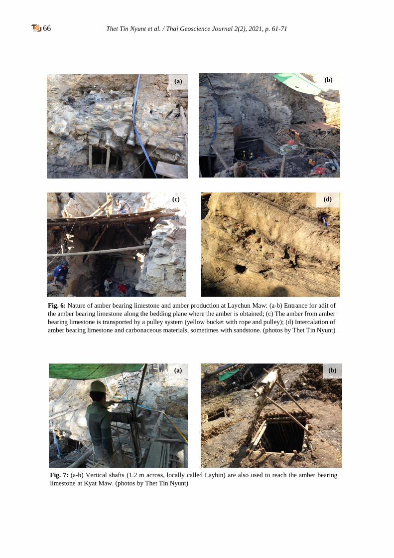
66 Thet Tin Nyunt et al. / Thai Geoscience Journal 2(2), 2021, p. 61-71
(a) (b)
(c) (d)
(a) (b)
Fig. 6: Nature of amber bearing limestone and amber production at Laychun Maw: (a-b) Entrance for adit of
the amber bearing limestone along the bedding plane where the amber is obtained; (c) The amber from amber
bearing limestone is transported by a pulley system (yellow bucket with rope and pulley); (d) Intercalation of
amber bearing limestone and carbonaceous materials, sometimes with sandstone. (photos by Thet Tin Nyunt)
Fig. 7: (a-b) Vertical shafts (1.2 m across, locally called Laybin) are also used to reach the amber bearing
limestone at Kyat Maw. (photos by Thet Tin Nyunt)
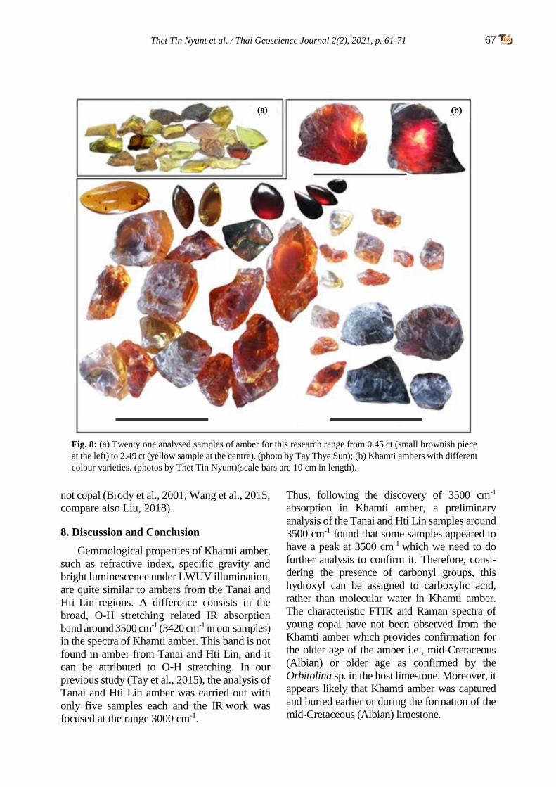
Thet Tin Nyunt et al. / Thai Geoscience Journal 2(2), 2021, p. 61-71 67
not copal (Brody et al., 2001; Wang et al., 2015;
compare also Liu, 2018).
8. Discussion and Conclusion
Gemmological properties of Khamti amber,
such as refractive index, specific gravity and
bright luminescence under LWUV illumination,
are quite similar to ambers from the Tanai and
Hti Lin regions. A difference consists in the
broad, O-H stretching related IR absorption
band around 3500 cm-1 (3420 cm-1 in our samples)
in the spectra of Khamti amber. This band is not
found in amber from Tanai and Hti Lin, and it
can be attributed to O-H stretching. In our
previous study (Tay et al., 2015), the analysis of
Tanai and Hti Lin amber was carried out with
only five samples each and the IR work was
focused at the range 3000 cm-1.
Thus, following the discovery of 3500 cm-1
absorption in Khamti amber, a preliminary
analysis of the Tanai and Hti Lin samples around
3500 cm-1 found that some samples appeared to
have a peak at 3500 cm-1 which we need to do
further analysis to confirm it. Therefore, consi-
dering the presence of carbonyl groups, this
hydroxyl can be assigned to carboxylic acid,
rather than molecular water in Khamti amber.
The characteristic FTIR and Raman spectra of
young copal have not been observed from the
Khamti amber which provides confirmation for
the older age of the amber i.e., mid-Cretaceous
(Albian) or older age as confirmed by the
Orbitolina sp. in the host limestone. Moreover, it
appears likely that Khamti amber was captured
and buried earlier or during the formation of the
mid-Cretaceous (Albian) limestone.
Fig. 8: (a) Twenty one analysed samples of amber for this research range from 0.45 ct (small brownish piece
at the left) to 2.49 ct (yellow sample at the centre). (photo by Tay Thye Sun); (b) Khamti ambers with different
colour varieties. (photos by Thet Tin Nyunt)(scale bars are 10 cm in length).
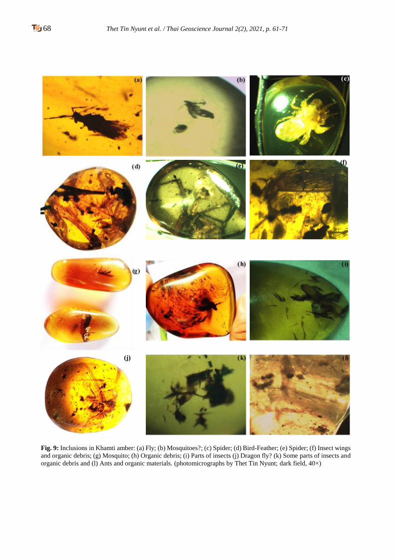
68 Thet Tin Nyunt et al. / Thai Geoscience Journal 2(2), 2021, p. 61-71
Fig. 9: Inclusions in Khamti amber: (a) Fly; (b) Mosquitoes?; (c) Spider; (d) Bird-Feather; (e) Spider; (f) Insect wings
and organic debris; (g) Mosquito; (h) Organic debris; (i) Parts of insects (j) Dragon fly? (k) Some parts of insects and
organic debris and (l) Ants and organic materials. (photomicrographs by Thet Tin Nyunt; dark field, 40×)
(j)
(e) (f)
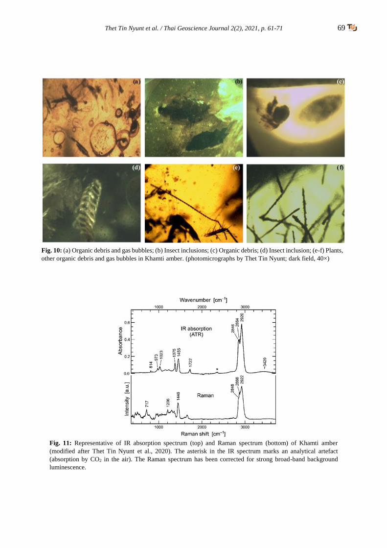
Thet Tin Nyunt et al. / Thai Geoscience Journal 2(2), 2021, p. 61-71 69
Fig. 10: (a) Organic debris and gas bubbles; (b) Insect inclusions; (c) Organic debris; (d) Insect inclusion; (e-f) Plants,
other organic debris and gas bubbles in Khamti amber. (photomicrographs by Thet Tin Nyunt; dark field, 40×)
Fig. 11: Representative of IR absorption spectrum (top) and Raman spectrum (bottom) of Khamti amber
(modified after Thet Tin Nyunt et al., 2020). The asterisk in the IR spectrum marks an analytical artefact
(absorption by CO2 in the air). The Raman spectrum has been corrected for strong broad-band background
luminescence.
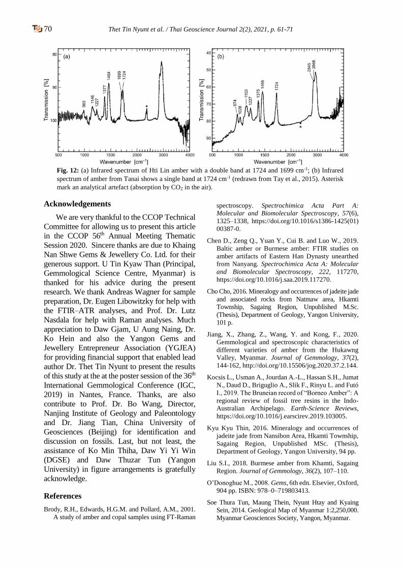
70 Thet Tin Nyunt et al. / Thai Geoscience Journal 2(2), 2021, p. 61-71
Acknowledgements
We are very thankful to the CCOP Technical
Committee for allowing us to present this article
in the CCOP 56th Annual Meeting Thematic
Session 2020. Sincere thanks are due to Khaing
Nan Shwe Gems & Jewellery Co. Ltd. for their
generous support. U Tin Kyaw Than (Principal,
Gemmological Science Centre, Myanmar) is
thanked for his advice during the present
research. We thank Andreas Wagner for sample
preparation, Dr. Eugen Libowitzky for help with
the FTIR–ATR analyses, and Prof. Dr. Lutz
Nasdala for help with Raman analyses. Much
appreciation to Daw Gjam, U Aung Naing, Dr.
Ko Hein and also the Yangon Gems and
Jewellery Entrepreneur Association (YGJEA)
for providing financial support that enabled lead
author Dr. Thet Tin Nyunt to present the results
of this study at the at the poster session of the 36th
International Gemmological Conference (IGC,
2019) in Nantes, France. Thanks, are also
contribute to Prof. Dr. Bo Wang, Director,
Nanjing Institute of Geology and Paleontology
and Dr. Jiang Tian, China University of
Geosciences (Beijing) for identification and
discussion on fossils. Last, but not least, the
assistance of Ko Min Thiha, Daw Yi Yi Win
(DGSE) and Daw Thuzar Tun (Yangon
University) in figure arrangements is gratefully
acknowledge.
References
Brody, R.H., Edwards, H.G.M. and Pollard, A.M., 2001.
A study of amber and copal samples using FT-Raman
spectroscopy. Spectrochimica Acta Part A:
Molecular and Biomolecular Spectroscopy, 57(6),
1325–1338, https://doi.org/10.1016/s1386-1425(01)
00387-0.
Chen D., Zeng Q., Yuan Y., Cui B. and Luo W., 2019.
Baltic amber or Burmese amber: FTIR studies on
amber artifacts of Eastern Han Dynasty unearthed
from Nanyang. Spectrochimica Acta A: Molecular
and Biomolecular Spectroscopy, 222, 117270,
https://doi.org/10.1016/j.saa.2019.117270.
Cho Cho, 2016. Mineralogy and occurrences of jadeite jade
and associated rocks from Natmaw area, Hkamti
Township, Sagaing Region, Unpublished M.Sc.
(Thesis), Department of Geology, Yangon University,
101 p.
Jiang, X., Zhang, Z., Wang, Y. and Kong, F., 2020.
Gemmological and spectroscopic characteristics of
different varieties of amber from the Hukawng
Valley, Myanmar. Journal of Gemmology, 37(2),
144-162, http://doi.org/10.15506/jog.2020.37.2.144.
Kocsis L., Usman A., Jourdan A.-L., Hassan S.H., Jumat
N., Daud D., Briguglio A., Slik F., Rinyu L. and Futó
I., 2019. The Bruneian record of “Borneo Amber”: A
regional review of fossil tree resins in the Indo-
Australian Archipelago. Earth-Science Reviews,
https://doi.org/10.1016/j.earscirev.2019.103005.
Kyu Kyu Thin, 2016. Mineralogy and occurrences of
jadeite jade from Nansibon Area, Hkamti Township,
Sagaing Region, Unpublished MSc. (Thesis),
Department of Geology, Yangon University, 94 pp.
Liu S.I., 2018. Burmese amber from Khamti, Sagaing
Region. Journal of Gemmology, 36(2), 107–110.
O’Donoghue M., 2008. Gems, 6th edn. Elsevier, Oxford,
904 pp. ISBN: 978–0–719803413.
Soe Thura Tun, Maung Thein, Nyunt Htay and Kyaing
Sein, 2014. Geological Map of Myanmar 1:2,250,000.
Myanmar Geosciences Society, Yangon, Myanmar.
Fig. 12: (a) Infrared spectrum of Hti Lin amber with a double band at 1724 and 1699 cm-1; (b) Infrared
spectrum of amber from Tanai shows a single band at 1724 cm-1 (redrawn from Tay et al., 2015). Asterisk
mark an analytical artefact (absorption by CO2 in the air).

Thet Tin Nyunt et al. / Thai Geoscience Journal 2(2), 2021, p. 61-71 71
Tay T.S., Kleismantas A., Thet Tin Nyunt, Zheng M.R,
Krishanswamy M. and Loke H.Y., 2015. Burmese
amber from Hti Lin. Journal of Gemmology, 34(7),
606–615, http://dx.doi.org/10.15506/JoG.2015.34.
7.606.
Thet Tin Nyunt, Tay Thye Sun, Cho Cho, Naing Bo Bo
Kyaw and Wai Yang Lai Aung, 2019. Amber from
Khamti, Sagaing Region, Myanmar. International
Gemmological Conference, Nantes, France, 27–31
August, 219–221.
Thet Tin Nyunt, Tay, T. S., Loke, H.Y., Krishnaswamy,
M., Cho, Cho, Naing Bo Bo Kyaw, Wai Yan Lai
Aung and Chutimun Chanmuang N., 2020. Amber
from Khamti, Sagaing Region, Myanmar, Journal of
Gemmology, 37(3), 314-322.
DOI:10.15506/JoG.2020.37.3.314.
Wang, Y., Shi, G., Shi, W. and Wu, R., 2015. Infrared
spectral characteristics of ambers from three main
sources (Baltic, Dominica and Myanmar). Spectroscopy
and Spectral Analysis, 35(8), 2164–2169, https://doi.org/
10.3964/j.issn.1000-0593(2015)08-2164-06 (in Chinese
with English abstract)
72 Thai Geoscience Journal 2(2), 2021, p. 72-87
Copyright © 2021 by the Department of Mineral Resources of Thailand ISSN-2730-2695; DOI-10.14456/tgj.2021.7
Additional occurrence report on early Carboniferous radiolarians
from southern peninsular Thailand
Katsuo Sashida1*, Tsuyoshi Ito2, Sirot Salyapongse1 and Prinya Putthapiban1
1 Mahidol University Kanchanaburi Campus, 99 M.9 Lunsaum Kanchanaburi-Sangkraburi Road Sai Yok, Thailand 2 Institute of Geology and Geoinformation, Geological Survey of Japan, AIST, Tsukuba, 305-8567, Japan
*Corresponding author: [email protected]
Received 3 May 2021; Accepted 5 July 2021
Abstract
Moderately-preserved radiolarians have been identified from black chert interbedded with layers
of medium- to coarse-grained sandstone and variegated siliceous shale outcropped at a quarry near
Ka Bang, Songkhla Province, southern peninsular Thailand. The following radiolarians (13
species belonging to seven genera) were identified and systematically investigated: namely
Albaillella sp., Ceratoikiscum sp., Stigmosphaerostylus variospina, Stigmosphaerostylus cfr. vulgaris,
Stigmosphaerostylus cfr. delvolei, Stigmosphaerostylus sp., Stigmosphaerostylus? sp. A, Stigmosphae-
-rostylus? sp. B, Stigmosphaerostylus? sp. C, Trilonche? sp., Spongentactnia exilispina, Pylentonema
antiqia, and Archocyrtium sp. These radiolarians indicate the Tournaisian–Visean, Mississippian
(early Carboniferous) in age. The present authors have already reported a Tournaisian radiolarian
fauna which is slightly older than the present fauna from black bedded chert in the Saba Yoi-
Kabang area. This is an additional report on the occurrence of early Carboniferous radiolarians
from southern peninsular Thailand. The radiolarian-bearing chert reported in this study may have
been deposited in the upper continental rise to open deep-sea basins within the Paleotethys Ocean
on the basis of the lithological and radiolarian characteristics.
Keywords: Carboniferous, depositional setting, paleogeography, Paleotethys Ocean, radiolarian
fauna, Sibumasu terrane
1. Introduction
Mainland Thailand tectonically consists the
Sibumasu Terrane, Inthanon Zone, Sukhothai
Terrane, and Indochina Terrane, from west to
east (e.g., Metcalfe, 2017) (Fig. 1 A). Lower
Carboniferous siliceous rocks, such as chert and
siliceous shale, are distributed in southern
peninsular Thailand and the northwestern part of
peninsular Malaysia (e.g., Sashida, Salyapongse
and Charusri, 2002; Basir and Zaiton, 2011).
Several researchers have reported radiolarian
occurrences from these siliceous rocks (e.g.,
Caridroit, Fontaine, Jongkanjanasoontorn,
Suteethorn and Vachard, 1990; Sashida, Igo,
Hisada, Nakornsri and Ampornmaha, 1993;
Sashida, Igo, Adachi, Ueno, Nakornsri and
Sardsud, 1998; Sashida, Nakornsri, Ueno and
Sardsud, 2000; Sashida et al., 2002; Wonganan
and Caridroit, 2005; Wonganan, Randon and
Caridroit, 2007; Saesaengseerung, Sashida and
Sardsud, 2007a, 2007b, 2015; Kamata et al.,
2015). These radiolarian-bearing siliceous rocks
are considered to have been deposited on the
slope, upper continental rise, and lower
continental rise of the Sibumasu Terrane to the
ocean basin of the Paleotethys based on their
lithological characteristics and radiolarian faunal
analysis (Basir and Zaiton, 2011). The present
authors already reported the occurrence of early
Carboniferous radiolarians from the Saba Yoi-
Kabang areas, southern peninsular Thailand
(Sashida et al., 2002), and have continued to
investigate the area. A new radiolarian
assemblage, distinguishable from the previously-
reported one, was obtained from a chert layer
intercalated within the sandstone–siliceous shale
sequence cropping out in a quarry near the
locality of Sashida et al. (2002). Further, the
lower Carboniferous radiolarian-bearing sili-
ceous rocks shown in this study differ from
contemporary siliceous rocks in neighboring
areas (e.g., Sashida et al., 1993, 1998; Wonganan
et al., 2007) in containing coarse-grained clastic
materials. In this article, we describe an early
Katsuo Sashida et al. / Thai Geoscience Journal 2(2), 2021, p. 72-87 73
Carboniferous radiolarian assemblage from a
quarry near Ka Bang, southern peninsular
Thailand, as an additional occurrence report of
the authors’ previous study. In addition, we
discuss the depositional setting of the radiolarian-
bearing siliceous rocks.
2. Previous studies on southern peninsular
Thailand and sample locality of this study
Although most of peninsular Thailand is
included in the Sibumasu Terrane in the tectonic
subdivision map of mainland Southeast Asia by
Metcalfe (2017), southern part is in the Inthanon
Terrane (Fig. 1A).
Ueno and Charoentitirat (2011) summarized
the Carboniferous–Permian stratigraphy in
southern Peninsular Thailand (their Lower
Peninsular Thailand) and discriminated the
Yaha Formation (?Mississippian), Khuan Klang
Formation (Mississippian), Kaeng Krachan
Group (?latest Pennsylvanian–early Permian),
and Ratburi Limestone (early–late Permian).
Concerning the Yaha Formation, this formation
was first introduced by Muenlek, Meesook,
Tongchit, Tipdhonsab and Skulkaew (1985) in
the Geological Map of Changwat Narathiwat and
Amphoe Takbai for a mainly siliciclastic succes-
sion of shale, sandstone, siliceous shale, chert
and conglomerate (Ueno and Charoentitirat,
2011). Muenlek et al. (1985) also introduced the
Mayo Formation for similar lithologic characters
distributed in the North east of Yala and included
both formations in the Kaeng Krachan Group
with the Mayo Formation in the lower part and
the Yaha Formation in the upper. DMR (1999)
regarded the Mayo and Haya formations as
identical Carboniferous strata, and mapped the
Yaha Formation in Yala, Pattani, Songkhla and
Phatthalung provinces. Igo (1973) reported the
occurrence of late Tournaisian conodonts from a
chert–siliceous shale succession at the northern
end of Ko Yo in Songkhla Province which
substantiated the Mississippian age for the Yaha
Formation. Sashida et al. (2002) discriminated
Mississippian radiolarians from a sandstone–
chert succession exposed in the Saba Yoi-
Kabang area near the Songkhla-Yala provincial
boundary. Besides these Carboniferous fossils,
late Permian and Middle Triassic radiolarians
have been reported from two areas where the
distributional area of the Yaha Formation
according to DMR (1999): the Chana area
(Sashida et al., 2000) and the Rattaphum area
(Sardsud and Saengsrichan, 2002; Kamata et al.,
2008, 2009) in Songkhla Province. Ueno and
Charoentitirat (2011) regarded the Yaha Forma-
tion only provisionally as Mississippian due to
the controversial litho- and chronostratigraphic
characterization of the above mentioned Yaha
Formation. DMR (2013) discriminated 12
lithological units of Carboniferous sedimentary
rocks in Thailand and set up sandstone, shale,
siliceous shale with Posidonia becheri, chert,
and conglomerate around Songkhla and Yala,
in the border areas with Malaysia, as Unit Cy.
The Saba Yoi-Kabang area, study area of
this article, is located within the distributional
area of Unit Cy of DMR (2013) (Fig. 1B). A
study section crops out at the quarry along the
road, about 15 km west-southwest of Outcrop 1
of Sashida et al. (2002). A column of the section
with outcrop photographs is shown in Fig. 2.
Rocks at this outcrop strike N–S and dip 30° to
50° west. The total thickness of the formation of
this outcrop attains 12 m. Variegated siliceous
shale, mainly dark gray, green, brown, white,
yellow, and black, predominates in the section.
This siliceous shale is thinly bedded with
several millimeters to a few centimeter beds,
and it is strongly folded and sheared in the
middle part of the section. The folded and
sheared parts are cut by faults that are almost
parallel to the bedding. Sandstone beds in the
lower part intercalate with black chert beds and
have a total thickness of about 1.5 m. Sandstone
in the middle part of the section is coarse-
grained and thickly bedded with intercalated
very thin shale. Sandstone beds in the upper part
are thickly bedded and have about 2.5 m total
thickness. Radiolarian-bearing chert is thinly
bedded with intercalated thin siliceous shale,
and the total thickness is about 30 cm. This chert
is black when fresh and brown to yellow on
weathered surfaces. The lower and upper limits
of this section are not exposed.
3. Materials and methods
We collected more than 10 samples from
variegated siliceous shale and other chert layers
of the section. Among them, only one sample
74 Katsuo Sashida et al. / Thai Geoscience Journal 2(2), 2021, p. 72-87
(SYK-1) yielded radiolarians. Under thin section,
the samples characteristically contain radiolarian
and foraminifer shells within matrices consisting
of fine-grained quartz and clay minerals (Fig. 3).
Foraminiferal shells are concentrated in some
parts and their maximum diameter attains 300
μm. The foraminiferal shells were replaced by
silica and are infilled with silica.
Radiolarian specimens were extracted from
chert by the procedures, which generally
established by Pessagno and Newport (1972), as
mentioned below. In addition, we recovered the
foraminiferal shells during the procedures.
Crushed chert of several centimeters size was
soaked in a diluted hydrofluoric acid (HF)
solution (3–5%) for about 24 hours at room
temperature. The sample was washed and sieved
by nylon mesh of 36 μm for collecting residue.
This procedure was repeated five times for every
samples. The residue was dried in an oven. Well-
preserved specimens in the residue were placed
on scanning electron microscopy (SEM) plugs
and coated with platinum in a vacuum evapo-
rator. SEM images of foraminifers are shown in
Fig. 4; those of radiolarians are shown in Figs. 5
and 6. Generic and species name of the forami-
nifers have not been identified. The systematic
paleontology of radiolarians will be described in
Section 6.
4. Age of radiolarian fauna
We discriminated radiolarians of 13 species
belonging to seven genera from the chert sample
(SKY-1). Identified radiolarians are Albaillella
sp., Ceratoikiscum sp., Stigmosphaerostylus
variospina (Won), Stigmosphaerostylus cfr.
delvoli (Gourmelon), Stigmosphaerostylus cfr.
vulgaris (Won), Stigmosphaerostylus sp.,
Stigmosphaerostylus? sp. A, Stigmosphaero-
stylus? sp. B, Stigmosphaerostylus? sp. C,
Trilonche? sp., Spongentactnia exilispina (Fo-
reman), Pylentonema antiqua (Deflandre), and
Archocyrtium sp.
Stigmosphaerostylus vulgaris and Stigmos-
phaerostylus variospina was originally described
by Won (1983) from the lower Carboniferous the
Rheinisches Schiefergebirge, Germany. Subsequ-
ently, Gourmelon (1987) reported these two
species from the Tournaisian of the Montagne
Noire and the central Pyrenees in France.
Saesaengseerung et al. (2007a) reported the
occurrence of these two species from a sequence
of chert, siliceous shale, and sandstone from the
Pak Chom area, Loei Province, northeastern
Thailand. The occurrence of these two species
has been reported by Sashida et al. (2002) from
the Saba Yoi-Kabang area. Stigmosphaerostylus
delvoli was first reported from the Tournaisian of
the Montagne Noire and Central Pyrenees by
Gourmelon (1987). Spongentactinia exlispina
was described as Entactinia exlispina by
Foreman (1963) from the Upper Devonian Ohio
Shale. Subsequently this species was reported
from the Tournaisian of the Montagne Noire by
Gourmelon (1987). Pylentonema antiqua was
first described from the lower Carboniferous of
France by Deflandre (1963) and subsequently
Holdsworth (1973) and Holdsworth, Jones and
Allison (1978) reported this species from the
Upper Devonian of Alaska and the lower
Carboniferous of Istanbul, Turkey, respectively.
Sandberg and Gutshik (1984) reported this
species from the Mississippian (lower
Carboniferous) of North America. This species is
also known from the Montagne Noire, France
(Gourmelon, 1987), Southern Thailand (Sashida
et al., 2002), and northwestern Peninsular
Malaysia (Basir and Zaiton, 2011).
We discriminate poorly preserved species
Albaillella sp. whose shell features are slightly
similar to Albaillella indensis Won. According to
Aitchison, Suzuki, Caridroit, Danelian and Noble
(2017), Albaillella idensis has a range from the
late Tournaisian to middle Visean (Mississip-
pian) and this species is an index of the boundary
between the upper Tournaisian through lower
Visean. As mentioned above, our radiola-
rian fauna is similar to those from the lower
Carboniferous Rheinisches Schiefergebirge,
Germany (Won, 1983) and the Montagne Noire,
France (Gourmelon, 1987).
The geologic age of the chert sample (SKY-1)
may be late Tournaisian to early Visean
(Mississippian). In our previous study, Albaillella
deflandrei Gourmelon occurred in all of the
samples (Sashida et al., 2002). Albaillella deflan-
drei is regarded as an index species of the late
middle Tournaisian by Aitchison et al. (2017);
therefore, our present radiolarian is younger than
the samples from our previous study.
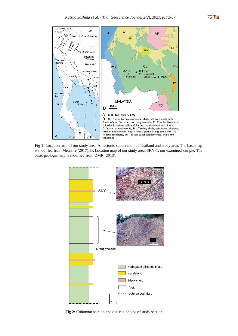
Katsuo Sashida et al. / Thai Geoscience Journal 2(2), 2021, p. 72-87 75
Fig 1: Location map of our study area. A. tectonic subdivision of Thailand and study area. The base map
is modified from Metcalfe (2017). B. Location map of our study area, SKY-1, our examined sample. The
basic geologic map is modified from DMR (2013).
Fig 2: Columnar section and outcrop photos of study section.

76 Katsuo Sashida et al. / Thai Geoscience Journal 2(2), 2021, p. 72-87
Fig 3: Thin section microphotographs of radiolarian-bearing chert. 1, 3, and 4 are under
plane polarized light; 2 is under cross polarized light.
Fig 4: SEM (Scanning Electron Microscope) photos of foraminiferal shells.
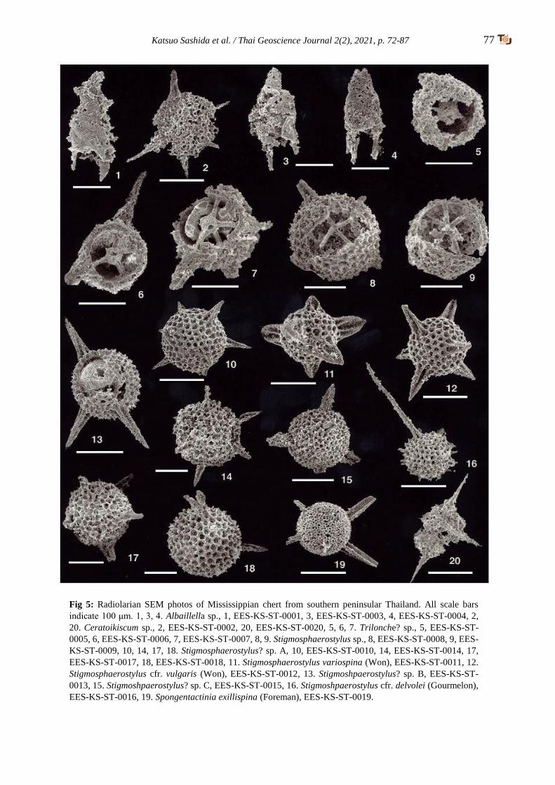
Katsuo Sashida et al. / Thai Geoscience Journal 2(2), 2021, p. 72-87 77
Fig 5: Radiolarian SEM photos of Mississippian chert from southern peninsular Thailand. All scale bars
indicate 100 μm. 1, 3, 4. Albaillella sp., 1, EES-KS-ST-0001, 3, EES-KS-ST-0003, 4, EES-KS-ST-0004, 2,
20. Ceratoikiscum sp., 2, EES-KS-ST-0002, 20, EES-KS-ST-0020, 5, 6, 7. Trilonche? sp., 5, EES-KS-ST-
0005, 6, EES-KS-ST-0006, 7, EES-KS-ST-0007, 8, 9. Stigmosphaerostylus sp., 8, EES-KS-ST-0008, 9, EES-
KS-ST-0009, 10, 14, 17, 18. Stigmosphaerostylus? sp. A, 10, EES-KS-ST-0010, 14, EES-KS-ST-0014, 17,
EES-KS-ST-0017, 18, EES-KS-ST-0018, 11. Stigmosphaerostylus variospina (Won), EES-KS-ST-0011, 12.
Stigmosphaerostylus cfr. vulgaris (Won), EES-KS-ST-0012, 13. Stigmoshpaerostylus? sp. B, EES-KS-ST-
0013, 15. Stigmoshpaerostylus? sp. C, EES-KS-ST-0015, 16. Stigmoshpaerostylus cfr. delvolei (Gourmelon),
EES-KS-ST-0016, 19. Spongentactinia exillispina (Foreman), EES-KS-ST-0019.
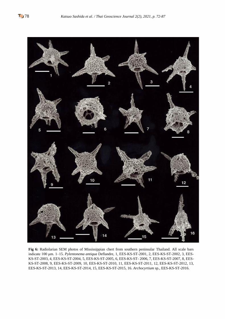
78 Katsuo Sashida et al. / Thai Geoscience Journal 2(2), 2021, p. 72-87
Fig 6: Radiolarian SEM photos of Mississippian chert from southern peninsular Thailand. All scale bars
indicate 100 μm. 1–15. Pylentonema antiqua Deflandre, 1, EES-KS-ST-2001, 2, EES-KS-ST-2002, 3, EES-
KS-ST-2003, 4, EES-KS-ST-2004, 5, EES-KS-ST-2005, 6, EES-KS-ST- 2006, 7, EES-KS-ST-2007, 8, EES-
KS-ST-2008, 9, EES-KS-ST-2009, 10, EES-KS-ST-2010, 11, EES-KS-ST-2011, 12, EES-KS-ST-2012, 13,
EES-KS-ST-2013, 14, EES-KS-ST-2014, 15, EES-KS-ST-2015, 16. Archocyrtium sp., EES-KS-ST-2016.
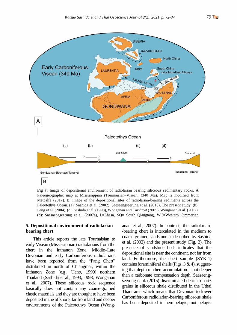
Katsuo Sashida et al. / Thai Geoscience Journal 2(2), 2021, p. 72-87 79
5. Depositional environment of radiolarian-
bearing chert
This article reports the late Tournaisian to
early Visean (Mississippian) radiolarians from the
chert in the Inthanon Zone. Middle–Late
Devonian and early Carboniferous radiolarians
have been reported from the “Fang Chert”
distributed in north of Chiangmai, within the
Inthanon Zone (e.g., Ueno, 1999) northern
Thailand (Sashida et al., 1993, 1998; Wonganan
et al., 2007). These siliceous rock sequence
basically does not contain any coarse-grained
clastic materials and they are thought to have been
deposited in the offshore, far from land and deeper
environments of the Paleotethys Ocean (Wong-
anan et al., 2007). In contrast, the radiolarian-
-bearing chert is intercalated in the medium to
coarse-grained sandstone as described by Sashida
et al. (2002) and the present study (Fig. 2). The
presence of sandstone beds indicates that the
depositional site is near the continent, not far from
land. Furthermore, the chert sample (SYK-1)
contains foraminiferal shells (Figs. 3 & 4), suggest-
ing that depth of chert accumulation is not deeper
than a carbonate compensation depth. Saesaeng-
seerung et al. (2015) discriminated detrital quartz
grains in siliceous shale distributed in the Uthai
Thani area which means that Devonian to lower
Carboniferous radiolarian-bearing siliceous shale
has been deposited in hemipelagic, not pelagic
Fig 7: Image of depositional environment of radiolarian bearing siliceous sedimentary rocks. A
Paleogeographic map at Mississippian (Tournaisian–Visean: (340 Ma). Map is modified from
Metcalfe (2017). B. Image of the depositional sites of radiolarian-bearing sediments across the
Paleotethys Ocean. (a): Sashida et al. (2002), Saesaengseerung et al. (2015), The present study. (b):
Feng et al. (2004), (c): Sashida et al. (1998), Wonganan and Caridroit (2005), Wonganan et al. (2007),
(d): Saesaengseerung et al. (2007a), L=Lhasa, SQ= South Qiangtang, WC=Western Cimmerian
Continent,
Continent,
80 Katsuo Sashida et al. / Thai Geoscience Journal 2(2), 2021, p. 72-87
environment. For these reasons, we speculate that
the radiolarian-bearing chert of Sashida et al.
(2002) and this study deposited on shallower area
near land.
In addition to the above-mentioned charac-
teristics, the radiolarian faunal characteristic
supports the speculation of the depositional
setting. Catalano, Stefano and Kozur (1991), Feng
and Ye (1996), Feng, Helmcke, Chonglakmani,
Helmcke and Liu (2004), and others mentioned
that early Carboniferous radiolarian assemblages
from shallow-water sediments are scarce and low
diverse: only by members of the Spumellaria
and/or Entactinaria usually represented. On the
other hand, early Carboniferous radiolarian
assemblages from deep-water basins are charac-
terized by abundant and high diversity radiola-
rians including Spumellaria and/or Entactinaria,
Nassellaria, and Albaillellaria, and they usually
make radiolarites and/or radiolarian chert. Basir
and Zaiton (2011) reported the occurrence of early
Carboniferous (Tournaisian) radiolarians from
Peninsular Malaysia. They discriminated following
three radiolarian assemblages based on the faunal
composition and lithology: the Stigmosphaero-
stylus, Archocyrtium, and Albaillellara assem-
blages. The Stigmosphaerostylus Assemblage is
characterized by the occurrence of Stigmos-
pharostylus variospina and spherical entactina-
rians but its specific diversity is very low. The
Archocytrium Assemblage is characterized by
moderate diversity and is dominated by cone-
shaped archocyrtiids such as Archocyrtium. This
assemblage consists of 20 radiolarian species. The
Albaillella assemblage is characterized by the
common occurrence of Albaillella and high
species diversity (more than 34 species identified).
Basir and Zaiton (2011) inferred that The
Stigmosphaerostylus Assemblage is due to the
shallow water environment (upper continental
rise), the Archocyrtium Assemblage is rather
deeper environment (continental rise), and the
Abaillella Assemblage is open deep-sea marine
environment (Ocean basin). They recognized the
radiolarian absence in the fauna is attributed to a
strong diagenesis and selective dissolution
(O’Dogherty, Rodriguez-Canero, Gursky, Matin-
Algarra, and Caridroit, 2000). Our examined
radiolarian fauna from the chert sample is
correlated to the transitional assemblage between
the Arhcocyrtium and Albaillella assemblages
based on radiolarian faunal similarity, implying
that the chert has been deposited in the upper
continental rise to the open deep-sea marine
environment (Ocean basin).
The depositional sites of the Devonian to
lower Carboniferous radiolarian-bearing siliceous
rocks in Thailand are located in roughly four sites
in the Paleotethys Ocean based on the lithological
characteristics and present geological settings
(Fig. 7). The radiolarian-bearing chert reported in
this study may have been deposited in the upper
continental rise to the open deep-sea basins within
the Paleotethys Ocean on the basis of the
lithological and faunal characteristics. Seamount
consisting of basaltic rocks and carbonate rocks
completely lacks of coarse-grained terrestrial
materials which may indicate that it formed far
from land in the Paleotethys Ocean.
6. Systematic paleontology
Radiolarian description was made by K. S.
and T. I. All specimens treated in this paper are
stored at the Earth Evolution Sciences, University
of Tsukuba, Japan with registered EES-KS.
Taxonomic scheme of radiolarians is followed
from that of Noble et al (2017).
Order Albaillellaria Deflandre, 1953
Family Albaillellidae Deflandre, 1953 sensu
Holdsworth (1977)
Genus Albaillella Deflandre, 1952
Type species. - Albaillella paradoxa Defladre,
1952
Albaillella sp.
Figs. 5.1, 5.3, 5.4
Remarks. -We collected more than 10 specimens
attributed to this species. However, all of them are
poorly preserved. Our examined specimens may
have cylindrical shell with a smooth surface and
conical apical part, and a well-developed H-frame.
At the pseudo-abdomen, ventral and dorsal wing
may be present. Although we cannot compare
precisely our specimens, their outer shell features,
short conical and short wing are slightly similar to
those of Albaillella indensis Won. Our specimens
may be distinguished from Albaillella deflandre
Gourmelon by having above mentioned shell
characters.

Katsuo Sashida et al. / Thai Geoscience Journal 2(2), 2021, p. 72-87 81
Sample, occurrence, and range. - This species
occurs from Sample SKY-1 and is known from
southern Thailand. Mississippian (Tournaisian–
Visean).
Family Ceratoiksicidae Holdsworth, 1969
Genus Ceratoikiscum Deflandre, 1953
Type species. - Ceratoikiscum avimexpectans
Deflandre, 1953
Ceratoikiscum sp.
Figs. 5.2, 5.20
Remarks. - Three incomplete specimens were
examined. Our specimens are characterized by
having a sturdy and conical a.a (a-rod: extra-
triangular) and long needle-like i.d (intersector:
extratriangular), i.v. (intersetor: extratriangular)
and a.p. (a-rod: extratriangular) (nomenclature of
Ceratoikiscum is from Holdsworth, 1969).
However, cavaeal ribs are not clear which may be
covered by spongy patagial structure.
Sample, occurrence, and range.- This species
occurs from Sample SKY-1 and is known from
southern Thailand. Mississippian (Tournaisian–
Visean).
Order Entactinaria Kozur and Mostler, 1982
Family Entactiniidae Riedel, 1967
Genus Spongentactinia Nazarov, 1975
Type species. - Spongentactinia fungosa Nzarov,
1975
Spongentactinia exilispina (Foreman, 1963)
Fig. 5.19
1963 Entactinia exilispina Foreman, p. 273, pl. 1,
fig. 8.
1987 Spongentactinia exilispina (Foreman),
Gourmelon, p. 56, 57, pl. 5, figs. 6-8.
Remarks. - We identified only one specimen of
this species. Our specimen is characterized by
having a spongy spherical shell with may be six
spines which are three bladed. Although our
examines specimen is an incomplete one, general
outer shell features are identical to those of
S. exilispina.
Sample, occurrence, and range.- This species
occurs from Sample SKY-1 and is known from
Ohio shale and Montagne Noire, France. Upper
Devonian (Famennian) to Mississippian
(Tournaisian–Visean).
Genus Stigmosphaerostylus Rüst, 1892
Type species. - Stigmosphaerostylus notabilis
Rüst, 1892
Stigmosphaerostylus variospina (Won, 1983)
Fig. 5.11
1983 Palaeoxyphostylus variospina Won, p. 156,
156, pl. 8, figs. 1–4, 6–22.
1986 Entactinia variospina (Won), Gourmelon,
pl. 4, fig. 1.
1987 Entactinia variospina (Won), Gourmelon, p.
49, 50, pl. 3, figs.6, 11.
1989 Entactinia variospina (Won), Braun, p. 368,
pl. 2, figs. 3, 4, pl. 4, fig. 5.
1990 Entactinia variospina (Won), Braun, pl. 7,
figs. 4.1–4.13, 4.14.
1994 Entactinia variospona (Won), Kiessling and
Tragelehn, p. 236, pl. 4, figs. 23, 24.
1995 Entactinia variospina (Won), Basir, p. 78,
pl. 1, figs.2–4.
1996 Entactinia variospina (Won), Spiller, pl. 2,
figs. 7, 8.
1997 Entactinia variospina (Won), Feng et al., p.
86, pl. 3, figs. 12, 13.
1998 Entactinia variospina (Won), Sashida et al.,
p. 13, 15, figs. 9.1–9.10.
1998 Entactinia variospina (Won), Wang et al.,
pl. 2, figs. 6, 7.
1998 Entactinia variospina (Won), Won, p. 238,
pl. 2, fig. 18.
2000 Entactinia variospina (Won), Sashida et al.,
p.83, figs. 6.5–6.12.
2002 Stigmosphaerostylus variospina (Won),
Spiller, p. 43, pl. 6, figs. g, h, i.
2002 Stigmosphaerostylus variospina (Won),
Sashida et al., p. 132, 133, pl. 1, figs.
18,22,23, pl. 3, fig.12?
2007a Stigmosphaerostylus variospina (Won),
Saesaengseerung et al., p. 115, 116, figs.
8,7, 8.8, 8.17.
2011 Stigmosphaerostylus variospina (Won),
Basir and Zaiton, pl. 1, figs. 1–4.
2015 Stigmosphaerostylus variospina (Won),
Saesaengseerung et al., p. 123, pl. 2, figs. 1–14.

82 Katsuo Sashida et al. / Thai Geoscience Journal 2(2), 2021, p. 72-87
Remarks. - Only one specimen was examined.
Our specimen has a spherical shell with short, and
sturdy six spines. Shell has many small circular
pores surrounded by pentagonal to circular shell
frames. Length of spines is generally half of the
shell diameter. Won (1983) showed the various
types of the spines; number, shape and length of
this species. Our examined specimen has shorter
and more sturdy spines compared with any of her
examined specimens. Gourmelon (1987) also
showed several shell morphology of this species.
Our specimen is similar to his specimens (pl. 3,
figs. 7, 8) which have shorter spines. Our
specimen is also similar to the species reported by
Saesaengseerung et al. (2007) by having short and
sturdy three-bladed spines. This species is
distinguished from E. vulgaris by having above
mentioned shell characters.
Sample, occurrence, and range.- This species
occurs from Sample SKY-1 and is known from
northern and southern Thailand, Peninsular
Malaysia, Europe, and South China. Upper
Devonian (Famennian) to Mississippian
(Tournaisian–Visean).
Stigmosphaerostylus cfr. delvolei (Gourmelon, 1987)
Fig. 5.16
cfr.
1987 Entactinia? delvolvei Gourmelon, p. 45, 46,
pl. 7, figs. 8–10.
Remarks. - Two specimens attributed to this
species have been identified. Examined
specimens characteristically have a spherical shell
with 6 to 7? thin and long spines with small
needle-like bi-spines. Illustrated specimen has a
long and thin spine whose length is almost twice
as the diameter of a spherical shell. Our specimens
are similar to the type species of this species which
has only two long spines. Our specimens are
incomplete, therefore we identified this species
with cfr.
Sample, occurrence, and range. - This species
occurs from Sample SKY-1 and is known from
the Montagne Noire, France. Mississippian
(Tournaisian).
Stigmosphaerostylus cfr. vulgaris (Won, 1983)
Fig. 5.12
cfr.
1983 Entactinia? vulgaris Won, pl. 4, figs. 1-3
1986 Entactinia vulgaris Won, Gourmelon, p.
184, pl. 2, fig. 4.
1987 Entactinia vulgaris Won, Gourmelon, p.
50, 51, pl. 4, figs. 1-6.
Remarks. - We examined two specimens. An
illustrated specimen has a spherical shell with 6
three-bladed long conical spines. Many small
circular pores surrounded by pentagonal to
circular frames are present on the surface of the
shell. The original specimens attributed to this
species by Won (1983) have more sturdy and
longer spines. Therefore, we put cfr. for our
specimens.
Sample, occurrence, and range.- This species
occurs from Sample SKY-1 and is known from
Germany and France, Mississippian (Tournaisian–
Visean).
Stigmosphearostylus sp.
Figs. 5.8, 5.9
Remarks. - Several incomplete specimens were
examined. Illustrated specimens have a rather
small spherical shell with may be six or seven
spines. Small circular pores surrounded by square
to circular pore frames are present. Thin to
moderately thick internal spicule systems
consisting of six-rayed spicules are observed in
our specimens. Internal spicule system does not
have median bar, point centered. This species is
distinguished from S. sp. B of the present study by
having smaller spherical shell.
Sample, occurrence, and range.- This species
occurs from Sample SKY-1 and is known from
southern Thailand. Mississippian (Tournaisian–
Visean).
Stigmosphaerostylus? sp. A
Figs. 5.10, 5.14, 5.17, 5.18
Remarks. - Seven specimens of this species were
examined. This species has a spherical shell with
six, short, three-bladed and conical spines. This
Katsuo Sashida et al. / Thai Geoscience Journal 2(2), 2021, p. 72-87 83
species is similar to S. deflendrei (Won, 1991)
described from Germany in general shell feature.
However, latter species has longer and more
sturdy spines. This species also resembles S.
vulgaris (Won, 1983), but it differs from the latter
by smaller and shorter spines. We questionably
assigned this species in Stigmosphaerostylus
because the internal shell structure cannot be
detected.
Sample, occurrence, and range.- This species
occurs from Sample SKY-1 and is known from
southern Thailand. Mississippian (Tournaisian–
Visean).
Stigmosphaerostylus? sp. B
Fig. 5.13
Remarks. – One specimen has been identified.
This species is characterized by a spherical shell
with may be six or seven spines. Spherical shell is
thick and has many and small circular pores on its
outer surface. Small conical spines are present at
the junction of each neighboring pore flame.
Spines are three-bladed and sturdy and long
conical shale. We cannot observe the inner side of
the spherical shell and determine the presence of
spicule system or inner shell. Therefore, we
questionably assigned this species in Stigmosph-
earostylus. This species is distinguished from
Stigmosphearostylus? sp. A of the present study
by having longer and more sturdy spines.
Sample, occurrence, and range.- This species
occurs from Sample SKY-1 and is known from
southern Thailand. Mississippian (Tournaisian–
Visean).
Stigmosphaerostylus? sp. C
Fig. 6.15
Remarks. – Only one specimen has been
examined. This species has a spherical shell with
more than four spines whose length is almost two-
thirds of the diameter of shell. Shell has many
small circular pores surrounded by polygonal to
circular frames. This species similar to Stigmos-
phaerostylus? sp. A of the present study but it has
thicker spines.
Sample, occurrence, and range.- This species
occurs from Sample SKY-1 and is known from
southern Thailand. Mississippian (Tournaisian–
Visean).
Genus Trilonche Hinde, 1899 sensu Aitchison
and Stratford, 1997
Type species.- Trilonche vetusta Hinde, 1899
Trilonche? sp.
Figs. 6.5, 6,7
Remarks. - Three specimens were examined. This
species has a spherical shell with three to more
three-bladed spines and an internal spherical shell.
Inner and outer shells are connected by six three-
bladed thick spines. The presence of an internal
spicule system cannot be determined. The outer
shell is thick and has many small pores on the
surface of the outer shell. The internal surface of
the outer shell is fine sponge. Inner shell has a
circular phylome. We questionably placed this
species in Trilonch because we did not observe the
internal spicules in the inner shell and the inner
shell has a pylome.
Sample, occurrence, and range.- This species
occurs from Sample SKY-1 and is known from
southern Thailand. Mississippian (Tournaisian–
Visean).
Family Pylentonemidae Deflandre, 1963
Genus Pylentonema Deflandre, 1963 sensu
Holdsworth et al., 1978
Type species.- Acanthopyle antiqua Deflandre,
1960
Pylentonema antiqua (Deflandre, 1960)
Figs. 6.1–6.15
1960 Acanthopyle antiqua Deflandre, p. 216, pl.
1, fig. 14
1963 Pylentonema antiqua (Deflandre), p. 3981–
3984, figs. 1–5.
1973 Pylentonema antiqua (Deflandre), Holds-
worth, p. 122-125, pl. 1, fig. 4.
1978 Pylentonema antiqua (Deflandre), Holds-
worth et al, p. 785, figs. 3d, 3e.
1984 Pylentonema antiqua (Deflandre), Sandberg
and Gutshick, pl. 6, figs. P, T.
1986 Pylentonema antiqua (Deflandre), Gourme-
lon, p. 188-189, pl. 1, figs. 7, 8.
84 Katsuo Sashida et al. / Thai Geoscience Journal 2(2), 2021, p. 72-87
1987 Pylentonema antiqua (Deflandre), Gourme-
lon, p. 102, pl. 15, figs. 1–6.
1998 Pylentonema antiqua (Deflandre), Won, p.
255, 256, pl. 6m figs. 9–14, 16.
2002 Pylentonema antiqua (Deflandre), Sashida
et al., P. 131, 132, pl. 1, figs. 14–17, 20–22,
pl. 2, fig. 2, pl. 3, figs. 2, 6, 8, 9, 11?.
Remarks. - More than 30 specimens identified to
this species have been obtained. Our forms are
characterized by having a spherical shell with 7
spines, among which one is generally small and
others are three bladed and sturdy, and their length
is almost same as the diameter of spherical shell.
Small circular pores surrounded by pentagonal to
circular pore rim are present. Internal surface of
spherical sell is generally spongy. A large circular
pylome is present surrounded by a narrow pylome
rim. We can see the internal spicule system (e.g.,
fig. 6.6), but the presence of inner shell is not sure
due to the mesh structure of the internal surface of
spherical shell. Position of spines around pylome
is variable as discussed by Won (1998), but the
type of four spines around pylome (her type Bs
and Bd) may be most predominate.
Sample, occurrence, and range.- This species
obtained from Sample SKY-1 and is known from
Germany, France, North America, Turkey,
Thailand. Upper Devonian (upper Famennian) to
Mississippian (Tournaisian–Visean).
Order Nassellaria Ehrenberg, 1875
Family Archocyrtidae Kozur and Mostler, 1981
Genus Archocytrium Deflandre, 1972 sensu
Holdsworth (1973)
Type species. - Archocyrtium riedeli Deflandre,
1960
Archocyrtium sp.
Fig. 6.16
Remarks. - Three specimens attributed this species
were identified. An illustrated specimen has a
subspherical cephalis with three bladed apical
horn and three three-bladed feet. Length of apical
horn is almost equal with the diameter of cephalis.
Small pores are observed on the surface of
cephalis. Length of three feet are not known. Our
specimens may have week pyrome. This species
is similar to Arhocyrtium venustum Cheng and A.
riedeli Deflandre, however, precise comparison
cannot be made.
Sample, occurrence, and range. - This species
occurs from Sample SKY-1 and is known from
southern Thailand. Mississippian (Tournaisian–
Visean).
7. Conclusions
1. Radiolarians of 13 species belonging to
seven genera have been identified from a
black chert bed intercalated within
sandstone and variegated siliceous shale
at the Kabang area, Songkhla Province,
southern peninsular Thailand.
2. The age of the radiolarians may indicate
the Tournaisian to Visean, Mississippian
(early Carboniferous). The age is slightly
younger than that of the previously
reported radiolarians in the Saba Yoi-
Kabang area in our previous study.
3. The radiolarian-bearing chert character-
ristically contains foraminiferal shells
and therefore the chert may have been
deposited in shallower ocean than the
carbonate compensation depth. The chert
is intercalated within sandstone beds, so
that the chert was deposited near land.
4. The radiolarians from the chert sample is
correlated to the transitional assemblage
between the Arhcocyrtium and Albail-
lella assemblages. Consequently, the
chert has probably been deposited in the
upper continental rise to the open deep-
sea marine environment.
5. On the basis of the lithological and
radiolarian faunal characteristics, the
radiolarian-bearing chert may have been
deposited in the upper continental rise to
the open deep-sea basins within the
Paleotethys Ocean. However, further
study such as sedimentary structure and
zircon provenance analyses are required
to clarify this interpretation.
Acknowledgements
The first author (K.S.) would like to express
his sincere thanks to the Mahidol University
Kanchanaburi Campus for offering facilities to
Katsuo Sashida et al. / Thai Geoscience Journal 2(2), 2021, p. 72-87 85
carry out our research. The authors also thank to
Drs. Sardsud, A. and Saesaengseerung, D. of the
DMR (Department of Mineral Resources of
Thailand) for giving us various suggestions for
our investigations in Thailand. The authors
further express our thanks to Dr. Suzuk N. of the
Tohoku University for offering important
radiolarian literature. We would like to
acknowledge three anonymous reviewers for
critical reading the manuscript and giving us
many constructive suggestions that improved
our manuscript.
References
Aitchison, J.C. & Stratoford, J.M.C. (1997). Middle
Devonian (Givetian) radiolarians from eastern New
South Wales, Australia: A reassessment of the Hinde
(1899) funa. Neues Jarbuh Fur Geologie und
Palaeontologie, Abhandlung, 203, 369–390.
Aitchison, J.C., Suzuki, N., Caridroit, M., Danelian, T.
& Noble, P. (2017). Paleozoic radiolarian
biostratigraphy. Geodiversitas, 39, 419–502.
Basir, J. (1995). Occurrence of bedded radiolarian chert
in the Kubang Pasu Formation, North Kedah,
Peninsular Malaysia. Warta Geologi, 21, 73–79.
Basir, J. & Zaiton, H. (2011). Lower Carboniferous
(Tournaisian) radiolarians from peninsular Malaysia
and their significance. Bulletin of the Geological
Society of Malaysia, 57, 47–54.
Braun, A. (1989). Unterkarbonishe Radiolarien aus
Kieslschifergeronllen des Marine bei Frankfurt am
Main. Jahresber, Mitt. Oberrhein. Geologische, 71,
357–380.
Braun, A. (1990). Radiolarien aus dem Unter-Karbon
Deutschlands. Courier Forschung-sinstitute
Senckenberg, 133, 1–177.
Caridroit, M., Fontaine, H., Jongkanjanasoontorn, Y.,
Suteehorn, V. & Vachard, D. (1990). First results of
a palaeontological study of Northwest Thailand. In
Fontaine, H. ed., Ten Years of CCOP Research on
the Pre-Tertiary of East Asia. CCOP/TP, 20, 337–
350.
Catalano, R., Stefano, P.D. & Kozur, H. (1991). Permian
circumpacific deep-water faunas from western
Tethys (Sicily, Italy)-new evidence for the position
of the Permian Tethys. Palaeogeography,
Palaeoclimatology, Palaeoecology, 87, 75–108.
Deflandre, G. (1952). Albaillella nov. gen., radiolaire
fossile du Carbonifere inferieur, type d7ne lignee
aberrante eteinte. Comptes Rendus hebdomadaires
des Seances delAcademie des Sciences (Paris), Serie
D: Sciences naturelles, 234, 872–874.
Deflandre, G. (1953). Radiolaires fossils. In Grasse P. P.
ed., Traite de Zoologie. Masson, Paris, 389–436.
Deflandre, G. (1960). A propos du developpment des
recherches sur les Radiolaires fossils. Revue de
Micropaleonotologie, 2, 212–218.
Deflandre, G. (1963). Pylentonema, nouveau genre de
Radiolarie du Viseen: Sphaerellaire ou Nassellaire?
Comptes Rendus hebdomadaires des Seanace de
lAcademie des Sciences (Paris), Serie D: Science
naturelles, 257, 3981–3984.
Deflandre, G. (1972). Le systeme trabeculaire interne chez
les pylentonemides et les Popofskyllides, Radiolaires
du Paleozoique. Pylogenese des Nassellaries. Comptes
Rendus Academie des Sciences, Paris 274, series D,
3535–3540.
DMR (Department of Mineral Resources of Thailand).
(1999). Geological Map of Thailand, Scale
1:1,000,000. Geological Survey Division, Department
of Mineral Resources of Thailand, Bangkok.
DMR (Department of Mineral Resources of Thailand).
(2013). Geological Map of Thailand, Scale
1:1,000,000. Geological Survey Division, Department
of Mineral Resources of Thailand, Bangkok.
Ehrenberg, C.G. (1876). Fortestzung der mikro-
-geologischen Studien als Gesammt-Uebersichtder
mikroskopischen Palaontologie gleichartig analysirter
Gebigsarten der Erde, mit specieller Rucksicht aud den
Polycystine-Megel von Barbados. Abhandlungender
koniglichen preussichen-Akadeie der Wissenschaften
zur Berlin, 1875, 1–225.
Feng, Q. & Ye, M. (1996). Devonian to Triassic Tethys in
Western Yunnan, China, In Fan, N. & Feng, Q., eds.
Sedimentologic, stratigraphic and maicropaleontologic
studies on Changning-Menglian Orogenic belt, 15–22.
Feng, G, Ye, M., & Zhang, Z. (1997). Early Carboni-
-ferous radiolarians from western Yunnan. Acta
Micropalaeontologica Sinica, 14, 79–92.
Feng, Q., Helmcke, D., Chonglakmani, P., Helmcke, I.
& Liu, B. (2004). Early Carboniferous radiolarians
from North-West Thailand. Palaeogeographical
implications. Palaeontology, 47, 377–393.
Foreman, H.P. (1963). Upper Devonian Radiolaria from
the Huron Member of the Ohio Shale. Micropale-
-ontology, 9, 267–304.
Gourmelon, F. (1986). Etude des Radiolaires dun nodule
pjhosphate du Carboniferieur de Bareilles, Hautes
Pyrenees, France. Geobios, 19, 179–197.
Gourmelon, F. (1987). Les radiolaires tournaisiens des
nodulesphtoshate de la Montagne noire et des
Pyrenees. Baiostratigraphie du Paleozoique, 6, 1–
172.
Hinde, G.J. (1899). On the Radiolaria in the Devonian
rocks of New South Wales. Quarterly Journal of the
Geological Society of London, 55, 38–64.
Holdsworth, B.K. (1969). Namurian Radiolaria of the
genus Ceratoikiscum from Staffordshire and

86 Katsuo Sashida et al. / Thai Geoscience Journal 2(2), 2021, p. 72-87
Derbyshire, England. Micropaleontology, 15, 221–
229.
Holdsworth, B.K. (1973). The Radiolaria of the Baltalimani
Formation, Lower Carboniferous, Istanbul. In Kaya, Q.,
ed., Paleozoic of Istanbul, 117-134, Ege Universites
Fen Fakaltesi Kitaplor, 40.
Holdsworth, B.K. (1977). Paleozoic Radiolaria of the genus
Ceratoikiscum from Staffordshire and Derbyshire,
England. Micropaleontology, 15, 221–229.
Holdsworth, B.K., Jones, D.L. & Allison, C. (1978).
Upper Devonian radiolarians separated from chert of
the Ford Lake Shale, Alaska. Journal of Research,
U.S. Geological Survey, 6, 775–788.
Igo, H. (1973). Lower Carboniferous conodonts from Ko
Yo, Songkhla, peninsular Thailand. Geology and
Paleontology of Southeast Asia, 12, 29–42.
Kamata, Y., Ueno, K., Saengsrichan, W., Sardsud, A.,
Charoentitirat, T., Charsiri, P., & Hisada, K. (2008).
Stratigraphy and geological ages of siliceous
sedimentary rocks distributed in the Hat Yai area,
southern peninsular Thailand. In Choowong, M. &
Thitimakorn, T., eds. Proceedings of International
Symposium on Geoscience Resources and Environ-
-ments of Asian Terranes (Great 2008), 4th IGCP516,
and 5th APSEG. Bangkok, 24–26, November 2008 (pp.
349–352). Bangkok, Thailand.
Kamata, Y., Ueno, K., Hara, H., Ichise, M., Charoentitirat,
T., Charusiri, P., Sardsud, A., & Hisda, K. (2009).
Classification of the Sibumasu and Paleo-Tethys
tectonic division in Thailand using chert lithofacies.
Island Arc, 18, 21–31.
Kamata, Y., Kato, M., Ueno, K., Miyahigashi, A.,
Charoentitirat, T. & Sardsud, A. (2015). Middle-Late
Devonian radiolarians from Klaeng District, Rayong
Province, southeastern Thailand. Geotectonic signify-
-cance of the Rayong area as a continental margin of the
Sibumasu Block. Journal of Asian Earth Sciences, 104,
197–204.
Kiessling, W. & Tragelehn, H. (1994). Devonian
radiolarian faunas of conodont-dated localities in the
Frankenwald (northern Bavaria, Gemany). Abhand-
-lungen der Geologischen Bundesnanstalt, 50, 219–
255.
Kozur, H. & Mostler, H. (1981). Beitrage zur Erforschnung
der mesozoischen Radiolarien. Teil IV: Thalasso-
-spharacea Haeckel, 1862, Hexastylacea Haeckel 1882,
emend. Petrushevskaya, 1979, Sponguracea Haeckel,
1862 emend, und weitere triassische Lithocycliacea,
Trematodiscaea, Actiommadea und Nassellaira.
Gologische-Palaontologische Mitteilungea Innsbruck,
Sonderband, 1, 1–208.
Kozur, H. & Mostler, H. (1982). Entactinaria suborder nov., a
new radiolarian suborder. Geologische-Palaontologische
Mitteilugen Innsbruck, 11/12, 399–414.
Metcalfe, I. (2017). Tectonic evolution of Sundaland.
Bulletin of the Geological Society of Malaysia, 63,
27–60.
Muenlek, S., Meesook, A., Tongchit, P., Tipdhonsab, C.,
& Skulkaew, P. (1985). Geologic Map of Changwat
Narathiwat and Amphoe Takbai (Sheet NB 47-8,5,
Scale 1:250,000). Geological Survey Division,
Department of Mineral Resources, Bangkok.
Nazarov, B.B. (1975). Radiolaria of the Lower-Middle
Paleozoic of Kazakhstan. Trudy Geologischeskii
Institut Akademia Nauk SSSR, 275, 203 p.
Noble, P., Aitchison, J.C., Danelian, T., Dumitrica, P.,
Maletz, J., Suzuki, N., Cuvelier, J., Caridroit, M., &
O’Dogherty, L. (2017). Taxonomy of Paleozoic
radiolarian genera. Geodiversitas, 39, 419–502.
O’Dogherty, L., Rodriguez-Canero, R., Gursky, H.J.,
Matin-Algarra, A. & Caridroit, M. (2000). New data
on Carboniferous stratigraphy and palaeogeography
of the Malaguide complex (Betic Cordillera,
southern Spain). Comptes Rendus-Academie des
Sciences, Serrie II: Sciences de la Terra, et des
Planetes, 331, 533–541.
Pessagno, E.A. and Newport, R. L. (1972). A technique
for extracting Radiolaria from radiolarian cherts.
Micropaleontology, 18, 231–234.
Riedel, W.R. (1967). Some new families of Radiolaria.
Proceedings of the Geological Society of London,
1640, 148–149.
Rüst, D. (1892). Beitrage zur Kenntnis der fossilen
Radiolarien aus Gesteinen der Trias und der
palaeozoischen. Schichten. Palaeontolographica,
38, 107–192.
Saesaengseerung, D., Sashida, K., & Sardsud, A.
(2007a). Late Devonian to early Carboniferous
radiolarian fauna from the Pak Chom area, Loei
Province, northeastern Thailand. Paleontological
Research, 11, 109–121.
Saesaengseerung, D. Sashida, K., & Sardsud, A.
(2007b). Devonian to Triassic radiolarian faunas
from northern and northeastern Thailand. In
Tantiwanit, W. ed., Proceedings of the International
Conference on Geology of Thailand: Towards
Sustainable Development and Sufficiency Economy
(pp. 54–71). Bangkok, Thailand.
Saesaengseerung, D., Kawinae, T., & Pothichaiya, C.
(2015). Discovery of Devonian to Carboniferous
radiolarians from central Thailand and its
significance of these fauna in Thailand and Laos. The
3rd Lao-Thai Technical Conference, July 8-8, 2015
(pp. 115–134). Bangkok, Thailand.
Sandberg, C. & Gutschick, R.C. (1984). Distribution,
microfauna and source-rock potential of
Mississippian Della Phosphatic member of
Woodman Formation and equivalents, Utah and
adjacent states. In Woodward, J. et al. (Eds.),
Hydrocarbon source rocks of the Greater Rocky
Katsuo Sashida et al. / Thai Geoscience Journal 2(2), 2021, p. 72-87 87
Mountain region (pp. 135–178), Rocky Mountain
Association of Geologists, Denver, Colorado.
Sardsud, A. & Saengsrichan, W. (2002). Geological
Map of Amphoe Hat Yai Sheet (5023II). Department
of Mineral Resources, Technical report, no. 16, 1–
77. (in Thai with English summary)
Sashida, K., Igo, H., Hisada, K., Nakornsri, N., &
Amprnmaha, A. (1993). Occurrence of Paleozoic
and Early Mesozoic Radiolaria in Thailand
(preliminary report). Journal of Southeast Asian
Earth Sciences, 8, 97–108.
Sashida, K., Igo, H., Adachi, S., Ueno, K., Nakornsri, N.,
& Sardsud, A. (1998). Late Paleozoic radiolarian
faunas from northern and northeastern Thailand.
Science Reports of the Institute of Geosciences,
University of Tsukuba, section B, 19, 1–27.
Sashida, K., Nakornsri, N., Ueno, K., & Sardsud, A.
(2000). Carboniferous and Triassic radiolarian fauna
from the Saba Yoi area, southernmost part of
peninsular Thailand and their paleogeographic
significance. Science Reports of the Institute of
Geoscience, University of Tsukuba, section B, 21,
71–99.
Sashida, K., Salyapongse, S., & Charusri, P. (2002).
Lower Carboniferous radiolarian fauna from the
Saba Yoi-Kabang area, southernmost part of
peninsular Thailand. Micropaleontology, 48,
supplement 1, 129–143.
Spiller, F.C.P. (1996). Late Paleozoic radiolarians from
the Bentong-Raub suture zone, Peninsular Malaysia.
The Island Arc, 5, 91–103.
Spiller, F.C.P. (2002). Radiolarian biostratigraphy of
Peninsular Malaysia and implications for regional
palaeotectonic and palaeogeography.
Palaeontographica Abteilung A: Palaeozoologie-
Stratigraphie, 266, 1–91.
Ueno, K. (1999). Gondwana/Tethys divide in East Asia:
solution from Late Paleozoic foraminiferal
paleobiogeography. In Ratanasthien, B. & Rieb, S.L.
(Eds.), Proceedings of the International Symposium
on Shallow Tethys (ST) 5, (pp. 45–54), Chiang Mai,
Thailand.
Ueno, K. & Charoentitirat, T. (2011). Carboniferous and
Permian. In Ridd, M.F. et al., eds., The Geology of
Thailand, 71–136, The Geological Society, London.
Wakita, K. & Metcalfe, I. (2005). Ocean plate
stratigraphy in East and Southeast Asia. Journal of
Asian Earth Sciences, 24, 679–702.
Wang, Y.J., Luo, H., Kuang, G., & Li, J. (1998). Late
Devonian-Late Permian strata of cherty facies at
Xiadong and Banchen countries of the Qinzhou area,
SE Guangxi. Acta Micropalaeonotoliglca Sinica, 15,
351–366.
Won, M.Z. (1983). Radiolarian aus dem Unterkarbon
des Rheinischen Schiefergebireges. Palaeontogra-
phica, Abteilung A: Palaozoologie-Stratigraphie,
182, 116–175.
Won, M.Z. (1991). Lower Carboniferous radiolarians
from siliceous boulders in western Germany. Journal
of Paleontological Society of Korea, 7, 77-106.
Won, M. (1998). A Tournaisian (Lower Carboniferous)
radiolarian zonation and radiolarian of the A.
pseudoparadoxa Zone from Oese (Rheinische
Schifergebirege) Germany. Journal of Korean Earth
Science Society, 19, 216–259.
Wonganan, N. & Caridroit, M. (2005). Middle and
Upper Devonian radiolarian faunas from Chiang Dao
area, Chiang Mai Province, northern Thailand.
Micropaleontology, 51, 39–57.
Wonganan, N., Randon, N. & Caridroit, M. (2007).
Mississippian (early Carboniferous) radiolarian
biostratigraphy of northern Thailand (Chang Dao
area). Geobios, 40, 875–888.
CONCEPT DESIGN
This logo composes of Abbreviations of Thai Geoscience Journal
T = THAI G = GEOSCIENCE J = JOURNAL
Coexistence of 3 abbreviations design in a concept of modernity blend with a Thainess
Modification of G alphabet in a shape of ammonoid shows relevance to geology
and infinite development of Thai Geoscience Journal
• SCOPE AND AIM OF THAI GEOSCIENCE JOURNAL (TGJ): TGJ is an international
(Thai and English) journal publishing original research articles dealing with the geological
sciences. It focuses, mainly but not exclusively, on: Sedimentology and Geomorphology,
Palaeontology, Quaternary, Geology and Environment Change, Geological Hazards,
Environmental Geosciences, Geophysics, Mineral and Petroleum Geology, Tectonics and
Structural Geology, Geochemistry and Geochronology, Metamorphic Geology and Volcanic
and Igneous Geology. Two types of articles are published in the Journal: Research Articles
and Reviews. Research Articles are new original articles, normally not exceeding 25
pages. Review Articles are those papers that summarize the current state of knowledge on
specific fields or topics of geosciences. They analyze and discuss previously published
research results, rather than report new results. TGJ Aim is to provide valuable geoscience
knowledge and information and push more inspiration for readers and researchers to
produce treasure research in the future.
• FEEDBACK AND CONTACT: We welcome your feedback, comments and suggestions for the
development of TGJ
Please contact: Dr. Apsorn Sardsud (Editor-in-Chief, TGJ)
Department of Mineral Resources
75/10 RamaVI Road Ratchathewee Bangkok 10400, Thailand
Phone: +66 (0)2 6219731
Email: [email protected]
Website: http://www.dmr.go.th/tgjdmr
TGJ Contributors
Assoc. Prof. Dr. Apichet Boonsoong
Dr. Apsorn Sardsud
Prof. Dr. Che Aziz bin Ali
Prof. Dr. Clive Burrett
Assoc. Prof. Dr. Danupon Tonnayopas
Dr. Dhiti Tulyatid
Dr. Ian Watkinson
Mr. Jittisak Premmanee
Prof. Dr. Katsumi Ueno
Prof. Dr. Katsuo Sashida
Prof. Dr. Ken-Ichiro Hisada
Assoc. Prof. Dr. Kieren Howard
Prof. Dr. Koji Wakita
Assoc. Prof. Dr. Kriengsak Srisuk
Assoc. Prof. Dr. Lindsay Zanno
Dr. Mallika Nillorm
Dr. Martin Smith
Adj. Prof. Dr. Michael Ryan King
Prof. Dr. Montri Choowong
Assoc. Prof. Dr. Mongkol Udchachon
Prof. Dr. Nigel C. Hughes
Mr. Niwat Boonnop
Asst. Prof. Nussara Surakotra
Asst. Prof. Dr. Passkorn Pananont
Dr. Phumee Srisuwan
Prof. Dr. Pitsanupong Kanjanapayont
Dr. Pol Chaodumrong
Dr. Pradit Nulay
Dr. Prinya Putthapiban
Prof. Dr. Punya Charusiri
Asst. Prof. Dr. Rattanaporn Hanta
Assoc.Prof. Rungruang Lertsirivorakul
Assoc. Prof. Dr. Sachiko Agematsu-Watanabe
Dr. Sasiwimol Nawawitphisit
Dr. Seung-bae Lee
Dr. Siriporn Soonpankhao
Asst. Prof. Dr. Sombat Yumuang
Mr. Somchai Chaisen
Dr. Surin Intayos
Mr. Sutee Chongautchariyakul
Dr. Tawatchai Chualaowanich
Mr. Thananchai Mahatthanachai
Assoc. Prof. Dr.Thasinee Charoentitirat
Dr. Toshihiro Uchida
Mr.Tritip Suppasoonthornkul
Dr. Weerachat Wiwegwin
Assoc. Prof. Dr. Yoshihito Kamata
Chiang Mai University, Thailand
Department of Mineral Resources, Thailand
Universiti Kebangsaan Malaysia, Malaysia
Mahasarakham University, Thailand
Prince of Songkla University, Thailand
Coordinating Committee for Geoscience Programmes in East and
Southeast Asia, Thailand (CCOP)
University of London, England
Department of Mineral Resources, Thailand
Fukuoka University, Japan
Mahidol University, Kanchanaburi campus, Thailand
University of Tsukuba, Japan
Kingsborough Community College, City University of New York, USA
Yamaguchi University, Japan
Khon Kaen University, Thailand
North Carolina State University, USA
Department of Mineral Resources, Thailand
Global Geoscience, British Geological Survey, UK
Western Colorado University, Thailand
Chulalongkorn University, Thailand
Mahasarakham University, Thailand
University of California, Riverside, USA
Department of Mineral Resources, Thailand
Khon Kaen University, Thailand
Kasetsart University, Thailand
Department of Mineral Fuels, Thailand
Chulalongkorn University, Thailand
Geological Society of Thailand, Thailand
Department of Mineral Resources, Thailand
Mahidol University Kanchanaburi Campus, Thailand
Department of Mineral Resources, Thailand
Suranaree University of Technology, Thailand
Khon Kaen University, Thailand
University of Tsukuba, Japan
Department of Mineral Resources, Thailand
Korea Institute of Geoscience and Mineral Resources, Republic of Korea
Department of Mineral Resources, Thailand
Geo-Informatics and Space technology Development Agency, Ministry of
Science and Technology (GISTDA), Thailand
Department of Mineral Resources, Thailand
Burapha University, Chanthaburi Campus, Thailand
Department of Mineral Resources, Thailand
Department of Mineral Resources, Thailand
Department of Mineral Fuels, Thailand
Chulalongkorn University, Thailand
Retired geophysicist, Japan
Department of Mineral Fuels, Thailand
Department of Mineral Resources, Thailand
University of Tsukuba, Japan

Thai Geoscience Journal
Vol. 2 No. 2
July 2021
ISSN 2730-2695
C O N T E N T S
Honorary Editors
Dr. Sommai Techawan
Mr. Niwat Maneekut
Mr. Montri Luengingkasoot
Dr. Young Joo Lee
Advisory Editors
Prof. Dr. Clive Burrett
Dr. Dhiti Tulyatid
Prof. Dr. Katsuo Sashida
Prof. Dr. Nigel C. Hughes
Prof. Dr. Punya Charusiri
Associate Editors
Prof. Dr. Che Aziz bin Ali
Prof. Dr. Clive Burrett
Assoc. Prof. Dr. Kieren Torres Howard
Prof. Dr. Koji Wakita
Dr. Mongkol Udchachon
Prof. Dr. Punya Charusiri
Dr. Toshihiro Uchida
Published by
Department of Mineral Resources
Geological Society of Thailand
Coordinating Committee for
Geoscience Programmes in
East And Southeast Asia (CCOP) Copyright © 2021 by the Department of Mineral Resources of Thailand
Thai Geoscience Journal website at http://www.dmr.go.th/tgjdmr
A review of evidence for a Gulf of Tonkin location for the Australasian
tektite source crater
Aubrey Whymark
The ‘new normal’ for geoscience in a post-COVID world: connecting
informed people with the Earth
Steven M. Hill, Jane P. Thorne, Rachel Przeslawski,
Rebecca Mouthaan, and Chris Lewis
3D geological mapping of central Tokyo
Susumu Nonogaki and Tsutomu Nakazawa
REE and Th potential from placer deposits: a reconnaissance study
of monazite and xenotime from Jerai pluton, Kedah, Malaysia
Fakhruddin Afif Fauzi, Arda Anasha Jamil, Abdul Hadi Abdul Rahman,
Mahat Hj. Sibon, Mohamad Sari Hasan, Muhammad Falah Zahri,
Hamdan Ariffin, and Abdullah Sulaiman
Geology, occurrence and gemmology of Khamti amber from Sagaing
region, Myanmar
Thet Tin Nyunt, Cho Cho, Naing Bo Bo Kyaw, Murali Krishnaswamy,
Loke Hui Ying, Tay Thye Sun, and Chutimun Chanmuang N.
Additional occurrence report on early Carboniferous radiolarians
from southern peninsular Thailand
Katsuo Sashida, Tsuyoshi Ito, Sirot Salyapongse, and Prinya Putthapiban
1- 29
30 - 37
38 - 42
43 - 60
61 - 71
72 - 87
Editor in Chief
Dr. Apsorn Sardsud