hydrogeochemistry: an investigation tool to evaluate infiltration into large moving rock masses...
TRANSCRIPT

Hydrogeochemistry: an investiga-tion tool to evaluate infiltrationinto large moving rock masses(case study of La Clapiereand Sechilienne alpine landslides)Y. Guglielmi Æ J.M. Vengeon Æ C. Bertrand Æ J. Mudry Æ J.P. Follacci Æ A. Giraud
Abstract Isotopic and hydrogeochemical methodshave been used to investigate groundwater move-ment inside the La Clapiere and Sechilienne alpinelandslides in southern France. The d18O data wereused to determine the infiltration altitudes of the twoareas. The infiltration results indicate that thelandslides are recharged from beyond the landslides’perimeters. Hydrogeochemical data on major ionswere collected from springs. Numerical simulationsof water–rock interactions were then undertaken.The major petrographic contrast between the limitedsedimentary rocks and the more common mica-gneiss/micaschist results in a marked change be-tween the measured and calculated groundwatercontents. This contrast of 800 mg/l of SO4 in theTriassic rocks but only 100 mg/l for the waters fromthe metamorphic strata at La Clapiere is significant.Two different groundwaters have been identified inboth landslides: (1) a perched shallow saturatedzone near the slope summit; and (2) a deep saturated
zone located at the foot of the slope. Chemi-calmonitoring of spring waters in the two zones hasallowed an assessment of the infiltration within theslope over time. There is a good correlation betweenthe sulphate content of the perched waters and rateof slope movement, with a sulphate dilution peakcorresponding to an acceleration in the movementof the landslip. However, there is no correlationbetween the chemistry of the deep aquifer and thespeed of movement. It would appear therefore thatthe hydromechanical behaviour of the landslidedepends on the vertical leakage from the perchedaquifer down to the basal aquifer and the near-sur-face effects of the water movement.
Resume Des methodes isotopiques et hydrogeo-chimiques ont ete utilisees pour etudier la circulationdes eaux dans des glissements de terrains alpins, LaClapiere et Sechilienne situes au sud de la France. Lesdonnees d’d18O ont ete utilisees pour determiner lesaltitudes d’infiltration de ces deux zones. L’infiltra-tion se fait sur des zones de recharge superieures auxperimetres des glissements. Les donnees hy-drogeochimiques consistent a analyser les ions maj-eurs des eaux des sources. Des simulationsnumeriques des interaction eaux-roche sont realiseesa partir de ces donnees. Les contrastes petrographi-ques entre les roches sedimentaires et les roches lesplus abondantes qui sont les micagneiss/micaschistsimpliquent des variations bien marquees entre lesconcentrations calculees et mesurees des eaux. Cecontraste est tres net dans le cas de la Clapiere car ilest de 800 mg/l pour les terrains triasiques alors qu’iln’est que de 100 mg/l pour des eaux qui ont circulesur des terrains metamorphiques. Dans les deuxglissements de terrains, deux types d’eau ont pu etreidentifies: a) une zone saturee, perchee peu profondepres du sommet du glissement; b) une zone profondelocalisee au pied de glissement. Un suivi chimiquedes eaux de sources dans les deux zones permetde determiner une estimation des infiltration dans lemassif en fonction du temps. Il y a une bonne
Received: 17 February 2000 / Accepted: 21 June 2001Published online: 28 March 2002ª Springer-Verlag 2002
Y. Guglielmi (&) Æ C. Bertrand Æ J. MudryEA 2642 Strain, Flow, Transfer,Department of Geosciences,University of Franche-Comte,16 route de Gray, 25030 Besancon, Francee-mail: [email protected].: +33-3-81666289Fax: +33-3-81666558
J.M. Vengeon Æ A. GiraudLaboratoire Interdisciplinaire de Recherche Impliquant laGeologie et la Mecanique (LIRIGM),University Joseph Fourier, BP53,38041 Grenoble cedex 9, France
J.P. FollacciCentre d’Etude Technique de l’Equipment (CETE) Mediterranee,Avenue de Stalingrad, 06000 Nice, France
DOI 10.1007/s10064-001-0144-z Bull Eng Geol Env (2002) 61:311–324 311

correlation entre les concentrations en sulfates dansles eaux du reservoir perche et les vitesses demouvement du glissement. Une dilution des con-centrations en sulfates correspond a une accelera-tion du mouvement du glissement. Cependant, il n’ya pas de correlation entre la chimie des eaux dureservoir profond et la vitesse du mouvement. Celasignifie que le comportement hydromecanique duglissement depend des pertes d’eau depuis le reser-voir perche vers l’aquifere basal.
Keywords Large moving rock masses ÆHydrogeology Æ Water chemistry Æ Hydromechanics
Mots cles Grands mouvements de versantsrocheux Æ Hydrogeologie Æ Chimie des eaux ÆHydromecanique
Introduction
One of the main factors that initiates and controls themobilisation of rock is the infiltration of precipitation intothe rock mass (Noverraz et al. 1998). Unfortunately, due tothe anisotropy of the rock mass, understanding thegroundwater regime beneath large landslides cannot beundertaken using classic hydrogeological methods. Fur-ther, the movement of such landslides quickly destroysinstrumentation and is a danger for operators. For thesereasons, it is desirable to develop an indirect methodbased on the study of the hydrogeochemistry of thegroundwaters and any water–rock interactions in an areathat includes a large landslide.This paper presents the first hydrogeochemical data ontwo of the main landslides in the French Alps – at Sechi-lienne, bordering the Belledone massif near Grenoble, andat La Clapiere in the Mercantour massif near Nice. The twoobjectives of the study were firstly to calibrate the hy-drogeochemical water measurements on each site andsecondly to show how geochemical data can be correlatedwith the normal monitoring of the rate of movement.
Characteristics of the hydrogeologyof large moving rock masses
The observations summarised below are based on thestudies of the Sechilienne and La Clapiere areas (Antoine etal. 1994 ; Follacci 1999; Guglielmi et al. 2000). Comparisonsare also made with other work relating to large movingrock masses and climate (Noverraz et al. 1998). Large rockmass instabilities usually occur in mountainous regions.For this reason, their hydrogeology depends on three mainfactors: (1) the variability of rainfall and infiltration rate;(2) the drainage anisotropy of the rock mass between alow-permeability block/matrix (primary permeability) and
the fractures that readily transmit water (secondary per-meability); (3) the modification of the hydraulic parame-ters of the rock mass reservoir related to both the change inweather (rain/snow) and the ongoing slope movement.
Variability of precipitationLarge hillside instabilities extend over considerable rangesin altitude on mountainous slopes: La Clapiere extendsfrom 1,100 to 2,000 m and the Sechilienne from 345 to 350(Fig. 1a). In such mountainous environments, rain andsnow may fall simultaneously (rain at low altitudes andsnow at high altitudes), or successively, as when snow isfollowed by a rain event over the whole slope. Snowmeltmay vary both spatially and over time; e.g. the melting ofthe snow cover will take place at higher altitudes later inthe season. In addition, the rain and snow induce differentinfiltration: instantaneous rain infiltration at low altitudeswhile at higher elevations the infiltration is delayed untilthe main snowmelt. However, daily melting, partly due tothe geothermal flux at the basal part of the snow cover,may result in a continuous low aquifer recharge (Jacquemin1984). The melting of snow induces significant variationsin the yield of springs; the lows of late winter are oftentwice as high as those of the summer months.At La Clapiere, for example, the mean yearly rainfall issome 936 mm and falls within two short periods; about 1or 2 months long in the autumn and in June. Snow nor-mally occurs from December to April. During the winterperiod, the 0 !C isotherm is at approximately 1,800 mordnance datum (OD); hence the melting of the meanannual snow cover which is present between Decemberand April produces an equivalent of 810 mm of water at2,500 m OD, while at 1,100 m OD it is less than 200 mm(Programme INTERREG 1996). Typically, below 1,800 msnow melts on several occasions even in winter, but athigher altitudes it will occur as a single event in the spring.In the lower altitudes, with several periods of melting, onlyabout 20 to 50 mm of water infiltrates into the massif atdifferent periods. Above 1,800 m, however, there is sig-nificant infiltration at the end of the winter season andmass movements of 30 to 100 mm/day have been observed(Follacci 1987) when about 1 m of water is believed toinfiltrate into the rock mass with the spring snowmelt.
Drainage anisotropyInfiltration enters the rock mass through a complex an-isotropic bedrock reservoir. This can be divided into twozones: the main landslide itself and the upslope area whichtends to creep downslope due to loss of support. Themovement of the landslide results in the development ofopen fractures in the disturbed and brecciated mass.Consequently, the disturbed mass has many voids suchthat it can be compared to a porous reservoir. In the less-disturbed remainder of the slope, the rock matrix behavesas a relatively impervious material with flows concentratedin the fractures. Although they undoubtedly exist, there isno obvious hydraulic connection between these two zones.When the infiltration rate is such that the full ingresscannot be transmitted through the rocks, a head of wateris created as the bedrock mass becomes progressively
Y. Guglielmi et al.
312 Bull Eng Geol Env (2002) 61:311–324

saturated. However, on a hill slope, neither the limits ofthe area supplying the groundwater through a series ofpassageways to a landslip nor the egress points are known;some of these may be downslope of the visible landslide.
Modification of hydraulic conductivityby the movement
In a discontinuous aquifer, the flow and the consequentialwater pressure depend on the aperture of the fractures(Louis 1974; Neretnieks 1983; Cacas et al. 1990; Abelin etal. 1991). Laminar flow between the two sides of a fractureis approximated by a simplification of the Boussinesqequation (Krantz et al. 1979; Witherspoon et al. 1980;
Fig. 1a–c.Hydrogeology of the La Clapiere slope. a Hydrogeological map;b geological cross section of the moving rock mass; c Piper diagramof chemical types of spring waters
Hydrogeochemistry: an investigation tool to evaluate inltration into large moving rock masses
Bull Eng Geol Env (2002) 61:311–324 313

Renshaw 1995). This shows that for a constant hydraulichead, the flow rate varies with the cube of the aperture ofthis fracture. In a system of fractures, the flow is controlledby the connectivity of the different fracture directions andby the different conductivities of the fractures (Long et al.1985; Lee and Farmer 1990). In the case of large, rockylandslides the complex behaviour of anisotropic aquifers iscomplicated not only by the bedrock but also by the effectsof the internal deformation of the moving mass creatingand closing fractures as the movement occurs. It appearsfrom field and laboratory studies that normal closure of afracture can occur under low stresses and that even with amoderate closure there is a significant decrease in the rateof flow (Tsang and Witherspoon 1981; Billaux and Gentier1990; Sibai et al. 1997). Gentier and Hoppkins (1997;Gentier et al. 1998) note that shear displacement intro-duces dilatancy in the plane of the fracture, resulting in anincrease in the flow rate where the hydromechanical cou-pling is related to differences in the conductivities of thevarious sets of fractures (Guglielmi 1998, 1999). The in-ternal flow is rendered more complex in the case of afracture system and varies with time depending on thestate of the deformation.
The sites
La ClapiereThe La Clapiere landslide is located on the left bank of theNW–SE Tinee valley, near the town of Saint-Etienne-de-Tinee (Alpes-Maritimes, France; Fig. 1a). It is moni-tored by the French Ministry of Equipment. It is borderedto the south-east by the Rabuons River – a major tributaryflowing from a lake at an elevation of 2,500 m – whilenearby the mountain peaks commonly exceed 3,000 m.The base of the La Clapiere landslide is at an elevation of1,100 m where the 1 km wide disturbed rock mass extendsout over the Quaternary alluvial deposits of the River Ti-nee. At the top of the landslide a 120 m high scarp extendsover a width of 800 m at an elevation of some 1,600 m. Thebase of the slip is not known over the upper 500 m of thelandslide, but it can be seen at the lower elevations. It isthought the failure may reach a depth of some 100 to200 m (Fig. 1b). The landslide itself is divided into sevensegments related to pre-existing faults, each segmentmoving at a slightly different speed. Typically, a 200 mwide zone is present on the flanks, in which the movementis very small such that it acts as a transition between thestable area and the slide itself.Bogdanoff and Ploquin (1980) record that the strata in thisarea consist of micagneisses which form the Argentera–Mercantour massif of Variscan age. The average strike ofthe foliation is N140!E while the north-easterly dips varybetween 55 and 90!. Three sets of faults are present,trending N10–30!E, N90!E and N110–140!E (Fig. 1a). Tothe south-east of the Rabuons River, some 0.5 km aboveits confluence with the Tinee River, the gneisses have beenthrust above the Triassic sedimentary sequence which hereoccurs as a tight overturned syncline with an inner core of
gypsum and cargneules (cellular tectonised dolomites)enclosed by sandstone horizons. (Faure-Muret 1947; Ivaldiet al. 1991). The thrust plane between the gneisses and theunderlying Triassic strata is exposed in the bed of theCascaı where it can be seen to strike N140!E and dipnorth-eastwards at about 80!. Scree and fluvio-glacial de-posits locally cover the gneisses, especially in the upperreaches of the Rabuons River.The foot of the landslide is drained by a group of perennialsprings (springs 14, 15 and 16, Fig. 1a) with a total dis-charge estimated at 0.5 l/s. Other temporary springs occurhigher up the slope, such as spring 13 (Fig. 1a), while in theadjacent areas springs can also be observed emanating fromfractures in the bedrock (springs 6 and 7) or from theweathered superficial formations (e.g. spring 5). Within theRabuons valley, other springs discharge from the glacio-fluvial and scree deposits (springs 4 and 8), while to the westsprings 11 and 12 have been observed close to a mappedfracture line. The mean discharge of a single temporaryspring reaches about 0.2 l/s, while the total discharge of thetemporary lateral outflows is about 5 l/s. Individual flows ashigh as 4 to 5 l/s have been measured locally, e.g. at theoverthrust (springs 9 and 10), emphasising the importanceof this major feature in the drainage of the hill mass. Thesprings in this area are mainly egress points related to wateremanating from the bedrock through the fractures. How-ever, as would be expected, some springs drain only thescrees above elevations of 2,000 m (springs 2 and 3) or theglacio-fluvial deposits where these abut the alluvium of theRiver Tinee (spring 17).
SechilienneThe Sechilienne landslide is located on the right bank ofthe east to west flowing River Romanche, near the south-eastern side of the city of Grenoble (Isere, France). Thelandslide is located on the southern slope of Mount Sec,part of the L’Oeilly Peak Mountain which rises to a max-imum elevation of 1,547 m (Fig. 2a). The mountain is atthe south-west border of the Belledone Alpine massif. Theslope is formed of micaschists, with a general northerlysubvertical foliation. To the east it is bordered by a N20!E-trending major fault zone. Two conjugate subverticalstrike/slip fault sets are present, trending N140!E andN50–70!E with sinistral and dextral movements respec-tively. The N50–70!E faults have resulted in a strip-likemorphology in the slope, while other fractures present at alower level are more parallel to the axis of the valley. ThePeak of L’Oeilly is formed of sedimentary Carboniferous toLiassic deposits unconformably overlying the old strata(Fig. 2a, b), the boundary between the sedimentary andolder metamorphic deposits being at approximately1,100 m, slightly higher than the upper backscar of thedisturbed zone. Locally, scree and glacio-fluvial deposits
Fig. 2a–c.Hydrogeology of the Sechilienne slope. a Hydrogeological map;b geological cross sections of the Mount Sec massif (A–A¢ cross sectionof the moving area; B–B¢ cross section of Fau Laurent sedimentarydeposits); c Piper diagram of chemical types of spring waters
c
Y. Guglielmi et al.
314 Bull Eng Geol Env (2002) 61:311–324

Hydrogeochemistry: an investigation tool to evaluate inltration into large moving rock masses
Bull Eng Geol Env (2002) 61:311–324 315

veneer the micaschists and overlying sedimentary deposits(e.g. at Mount Sec).The landslip is moving from the top of the dome-shapedMount Sec (1,130 m) to the floor of the valley at 345 m(Fig. 2b, A–A¢ cross section). Between 345 and 700 m thereis an unstable, totally disorganised area of some 60,000 m2
referred to as the Sechilienne Ruins, while between 700 and1,150 m the slope has deep N50–80!E cracks in addition tosome N140!E faults where the apertures may be up toseveral metres wide. This approximately 0.5 km2 zone islimited to the north by a 30 to 50 m high backscarp.The mechanical behaviour of the landslide is a conse-quence of loading due to collapse at the top of the slopeinducing movement and hence pushing up the lower partof the slope. The deformation process has been investi-gated by direct observations in three horizontal gallerieslocated at different altitudes (Vengeon 1998): a 240 m longinvestigation gallery at 710 m and two 60 and 240 m longold mining galleries at altitudes of 900 and 585 m re-spectively (see Fig. 2b). The fractures effectively divide theslope into diamond-shaped blocks such that the blocksmove independently, resulting locally in differing degreesof movement. Indeed, it is these block movements that areresponsible for the entire mass movement at Sechiliennewhere no basal shear has been identified.Three main factors explain the hydrogeology of the massif:
1. The top sedimentary deposits contain a perched multi-layered aquifer (Fig. 2b, B–B¢ cross section) drained byseveral perennial springs which outflow at the top andthe middle of the slope at between 820 and 1,170 m(Fig. 2a; springs 4, 9, 10 and 11). During periods of highinfiltration, a temporary spring appears (spring 5) at analtitude of 1,310 m, indicating that the rocks are satu-rated to at least 100 m above the elevation of the top ofthe slide. The total discharge of perennial springs isestimated at 10 to 30 l/s depending on the season. Thisvalue appears low compared to the mean annual re-charge of the natural reservoir which is about 60 l/s,indicating that some 50 to 80% of the groundwater yieldpasses down into and through the bedrock. Some of thewater rising through the springs infiltrates back into thebedrock at a lower elevation, while the remainder flowsinto the Romanche River.
2. An Electricite de France (EDF) water gallery is locatedat the bottom of the slope at 425 m (Fig. 2a, b), directlyunder the landslide. During the digging of this gallery,springs that were initially draining the basement aqui-fer at an elevation of 500 m dried up. It is clear there-fore that the bedrock aquifer was drawn down and waspartially released by this gallery as the water egressedthrough open discontinuities, particularly followingrainfall on the massif (Fig. 2b). As perennial flows onlyoccur in the lower gallery (G585), it is clear that thenear-surface bedrock beneath the higher parts of theSechilienne landslide is not saturated or that the watermovement in the near-surface regolith is capable oftransmitting the ‘‘diffused’’ outflow.
3. No spring is visible at the foot of the slope wherethe landslide intercepts the alluvium in the Romanche
valley. Some 2 km to the west of the landslide, a spring(no. 1) rises from the alluvium in the park of VizilleCastle. This spring yields some 1,200 l/s which it isbelieved is partly from the Mount Sec bedrock aquiferand partly water derived from the Romanche River it-self. An estimated value of 200 to 500 l/s would corre-spond to a recharge area of approximately 10 to 20 km2.This would be equivalent to about 50 to 80% of theslope forming the Mount Sec and Peak of L’Oeilly onwhich the Sechilienne landslide occurs.
Comparison of the two sitesAlthough both the Sechilienne and La Clapiere landslidesare responsible for moving in excess of 50 million m3 ofmaterial, in the former the main movement is in the upperpart of the slope while in the latter the landslide extendsover the whole hill slope. Upslope of the main landslide atLa Clapiere is an area where regressive slips are takingplace, giving the appearance of a broken, disturbed bed-rock. At La Clapiere, a distinct basal slide has been located,while at Sechilienne no single sliding surface is evident, thedeformation here being related to the tectonically frac-tured block structure.In both cases, the geology of the slope consists of meta-morphic rocks with outliers of the Mesozoic sedimentarycover. At La Clapiere, the gneisses are composed of quartz,plagioclases, biotite, muscovite with minor calcite, pyriteand K-feldspar. The gneisses are highly foliated with al-ternating light and dark bands. At Sechilienne the foliationin the micaschists is accentuated by the biotites, phengitesand chlorites alternating with granoclastic quartz andfeldspar. Small layers of black schists and calcitic veinswere observed in an investigation gallery. At La Clapierethe Triassic deposits are present in an overthrust, while atSechilienne the Liassic, Triassic and Carboniferous de-posits unconformably lie at the top of the massif.At La Clapiere the internal drainage of the massif consistsof a complex system of interconnected pathways betweenthe fractured bedrock and the overlying screes or breccia.Most of the springs identified outflow in the higher part ofthe slope some distance from the landslide, hence it isdifficult to assess which part of the bedrock they drain andto establish a water balance. At Sechilienne there are twomain saturated zones. A perched sedimentary aquifer leaksinto the underlying bedrock aquifer which could be par-tially drained at a spring located near the town of Vizille(Fig. 2, spring 1), although this assumption needs to bedefined by tracing tests. In both landslide areas significantvolumes of water can move through and/or be temporarilystored in the moving rock mass.
From classical hydrogeology toan indirect approach: methodology
Landslide hydrogeology aims firstly at evaluating the dis-tribution of the hydraulic pressure inside the rock mass
Y. Guglielmi et al.
316 Bull Eng Geol Env (2002) 61:311–324

and secondly at determining the danger thresholds. Hy-drogeology is traditionally based on piezometric mea-surements, but these are not appropriate in the presentcase and would probably be quickly destroyed. Conse-quently, an indirect method based on the chemistry of thegroundwater outlets has been developed using the waterchemistry related to the interstitial fluids within the largemoving rocks masses and the chemical content of thespring waters resulting from global water–rock interac-tions within the bedrock (Bakalowicz 1979; Mudry 1987).The sampling of spring waters was performed duringdifferent periods of the year using a typology related to thein-situ hydrogeological conditions. This typology is com-pared with a parametrical study on a geochemical model(Made et al. 1990) which has been successfully tested onthe La Clapiere slope (Guglielmi et al. 2000). The resultswere compared with those obtained at the Sechilienne sitein order to assess how chemical monitoring of springwaters may help elucidate the mechanical behaviour oflarge landslides.The chemistry of the waters was determined by:
Atomic absorption spectrometry (accuracy ±0.05 mg l–1)K+, Na+, Ca2+ and Mg2+
High-pressure ionic chromatograph (accuracy ±0.02 mg l–1)SO4
2–, Cl– and NO3–
Volumetry in the field (accuracy 1%) (acid–base titration)HCO3
–
WTW (Wissenschaftlich-Technische-Werkstatten) (typeLF30)pH, electrical conductivity and temperature.Measurements were modified to a standard temperature of25 !C.All the analyses were performed in the hydrogeology lab-oratory of the Department of Geosciences (University ofFranche-Comte) for the La Clapiere landslide and at theGrenoble Region Water Association (SIERG) for theSechilienne landslide. The d18O measurements were madeat Avignon and Thonon to an accuracy of 0.25&.The thermo-kinetic geochemicalmodel KINDIS (Made et al.1990) was used to simulate the water composition for dif-ferent water–rock interactions. This model describes theinteractions between minerals and aqueous solutions, tak-ing into account the irreversible dissolution of some reac-tants and the reversible precipitation of secondary products.KINDIS calculates, by incrementation, the quantity ofdestroyed or formed phases per kilogramme of solution,according to the reaction ratewhich corresponds to themassof dissolved rock per kilogramme of weathering solution.Evolution of the chemical composition of the solution andthe distribution of elements between simple and complexions are also determined at each step of this calculation.
Results of sampling
Recharge aread18O values of spring waters were used to establish themean recharge altitude of both landslides (Fig. 3a, b). In
the present study, both old data from La Clapiere (Guglielmiand Mudry 1995; Compagnon 1996) and new data from thesame springs sampled at two different periods were used,while at Sechilienne all the data were new.18O is a thermo-dependent tracer. This means that aspatial and temporal tracing exists: winter and/or high-elevation waters are more negative than summer and/orlow-elevation ones. In order to take into account the effectof relief on the variations of the isotopic ratios, the localgradient on the slope was calibrated. Local springs wereused where the catchment area could be clearly bounded(e.g. springs related to limited scree areas). The averageelevation of the springs recharge area was estimated andthe d18O plotted to allow comparison with the rechargealtitude. The variation of d18O versus season was evaluatedat La Clapiere by measuring d 18O at different elevationsduring the winter, low-water period and early summer –snow-melt flood period – while at Sechilienne the mea-
Fig. 3a,b.Isotopic gradients (values used to calculate the gradients are plottedin black, values of springs in the recharge area with mean elevationare plotted with open circles and squares). Squares a and b correspondto d18O values of springs located about 2 km from the landslide andare not shown on the hydrogeological map in Fig. 1.a La Clapiere massif (June gradient dashed line with d18O valuesin squares; December gradient continuous line with d18O valuesplotted in circles); b Sechilienne massif
Hydrogeochemistry: an investigation tool to evaluate inltration into large moving rock masses
Bull Eng Geol Env (2002) 61:311–324 317

surements were taken only at the end of the spring infil-tration period. Similar variations have been documentedby Razafindrakoto (1988).On these calibration curves (lines in Fig. 3a,b), a generaldecrease of d18O versus altitude is observed, although, aswith other Mediterranean mountain areas (Mudry et al.1994; Guglielmi et al. 1998), this relationship is representedby a flex curve because of the non-linear distribution ofeffective rainfall versus elevation (Blavoux et al. 1992). Onthe d18O versus altitude scattergram, each point for whichthe altitude of the intake area is unknown was plotted withits d18O and the altitude of the spring itself. Projecting thed18O value in parallel to the vertical axis, the average ele-vation of the recharge areas could then be estimated.At La Clapiere, both winter and summer gradients werecalculated from springs at 1,100 and 2,500 m with a knownaverage recharge elevation (Compagnon 1996; Fig. 3a):
d18O ! "2:10 ln #elevation$ % 4:18with r ! 0:989 #1$
d18O ! "2:92 ln #elevation$ % 10:69with r ! 0:988 #2$
The data on which Eq. (1) are based were collected inDecember 1995 and the data for Eq. (2) in June 1996. Byplotting 18O contents of the spring waters on the gradientsalready established, the mean elevation of infiltration areawas determined. The lateral springs of the landslide havean infiltration area that ranges from 1,600 to 1,800±150 m.This corresponds to the transitional area which surroundsthe landslide. The recharge area of waters outflowing fromthe foot of the landslide have an average altitude rangingfrom 1,570±150 m at the end of the low-water period to1,780±150 m during the snow-melt flood period. Thiswould indicate that the area of water infiltration for all thesprings outflowing from the basement aquifer is approxi-mately the same, larger and higher than the landslide areaitself and varying according to the seasons.At Sechilienne, the gradient is calculated from springslocated between 1,000 and 1,200 m and from water thattemporarily flows in the investigation gallery from a localrecharge area at a mean altitude of 710 m (Vengeon 1998;Fig. 3b). The gradient d18O=–3.86·ln (elevation)+16.1 withr=0.991 was established on 29 August 1996 after a 100 mmlocal rainfall on the massif. Only the sample from theperennial flow observed in the gallery at 585 m was used toplot this gradient. Recharge comes from an altitude of 980 mwhich corresponds to an infiltration area that includes thetop of the landslide and a large part of the summit ofthe Mount Sec massif, including the sedimentary deposits.
Discussion
The data show that at La Clapiere the elevation of the re-charge into the landslide varies according to the season, thetype of precipitation and the temperature (Compagnon et al.1997). Direct infiltration of the autumn rainfall is spreadover the whole recharge area. Very little delayed infiltrationoccurs after winter rainfall and only at low altitudes. During
the spring period, snowmelt is responsible for substantialinfiltration at progressively higher altitudes (Follacci 1999).At La Clapiere the surface recharge area was assessed to beabout 4 km2 and at Sechilienne 5 to 10 km2, indicatingthat the hydrogeological resource boundaries are muchlarger than the landslide surface (less than 1 km2 in bothcases). At La Clapiere the recharge area includes themoving zone, the zone above and part of the bedrock. AtSechilienne, it includes the calcareous and gypsiferousmarls at the top of the Peak of L’Oeilly, a part of the MountSec metamorphic bedrock and the landslide area. Takinginto account the local mean annual precipitation (mathe-matically corrected for the assumed evapotranspiration),the infiltration yields onto these surfaces are about 40 l/sat La Clapiere and 60 to 80 l/s at Sechilienne. Comparisonwith the outflow of the springs of the two massifs (5 l/s atLa Clapiere, 2 l/s at the perennial outlet in the gallery G585at Sechilienne) shows an important loss of 35 and 70 l/s,indicating that the majority of the water flowing into thehill slope moves in the rock mass, flowing directly into thealluvial deposits of the valley in the case of La Clapiere orthrough outlets situated at some distance from the land-slide in the case of Sechilienne.The variation of the recharge areas as determined by thechange in 18O implies a seasonal as well as an elevationeffect. Only where the limits of the recharge area are wellknown can the 18O gradients be calculated. With thisinformation, the mean infiltration altitude can be estab-lished within approximately 50 to 100 m. The study hasindicated that the gradients at Sechilienne (Vengeon1998) and at La Clapiere (Compagnon et al. 1997) havenotable differences, probably due to local morphologicalfactors and to the proximity of the seashore. In fact, thelowest intercept which is observed at La Clapiere is dueto the Mediterranean and mountainous climate of theMercantour massif, whilst the Sechilienne area is subjectto oceanic air masses.
Infiltration flow paths deduced from mineralcontent of the waters
In-situ measurements of water chemical contentsat La Clapiere
The chemistry of the waters flowing from the foot of thelandslide can be clearly distinguished from spring watersegressing from higher up the slope. The SO4
2– content atthe landslide foot is some 800 mg/l compared with 50 mg/lat higher altitudes. Plotting the chemical types previouslydefined on the Piper diagram on the hydrogeological map,three distinct water chemistries are noted (Compagnon1996; Guglielmi and Mudry 1996; Compagnon et al. 1997):(1) calcium-bicarbonate-rich waters from the more stableupper slopes (Fig. 1c, springs 4 to 7); (2) magnesium-sulphate-rich waters occur in the springs at the foot of thelandslide and along the thrust fault between the gneissesand Triassic rocks (Fig. 1c, springs 9, 10, 14, 15, 16); and(3) water with intermediate chemistry – between (1) and(3) – from springs situated on the central part of the slope(Fig. 1c, springs 11 and 12).
Y. Guglielmi et al.
318 Bull Eng Geol Env (2002) 61:311–324

Examination of Fig. 4b shows three distinct zones: (1) anupper zone relating to spring 4 at approximately 1,000 m,where the SO4 and HCO3
– contents are low; (2) a zonefrom springs 2 (400 m), 3 (800 m), 10 (1,000 m) and 11(800 m), where the HCO3
– content is high but the SO4
content is still relatively low; and (3) a spread of pointswith higher HCO3
– and SO4 values from waters taken fromfractures in the bedrock tunnel at G585 and G710.Figure 4a shows the relationship between the SO4
2– andHCO3
– for the waters sampled from both the foot andupper part of the landslide at La Clapiere. It can be seenthat the points cluster in two groups with positive slopes:(1) a line through the data points related to the springs atthe top and middle of the slope (r=0.71; n=161) intersectsthe origin; and (2) the springs at the foot of the landslide(r=0.96; n=38) intercept the SO4
2– axis at values of be-tween 580 and 700 mg/l, indicating a large increase in thesulphate and calcium bicarbonate contents in the watersissuing at lower altitudes.The similarity between the gradient of the lines indi-cates that much of the sulphate in the waters sampled isassociated with an enrichment of HCO3
–, probably due toleaching as the waters percolated through the unsaturatedzone of the massif (Bakalowicz 1979). Such a situation is
probably related to the dissolution of calcite mixing withthe sulphuric acid from weathered pyrites in the aeratedzone and the minerals in solution being leached from thiszone and appearing at the foot of the landslide.
In-situ measurements of water chemical contentsat Sechilienne
At this site, the chemical composition of waters has lessvariation, the SO4
2– contents varying from 10 mg/l(Fig. 2c, spring 4) to 60 mg/l (springs 2, 3, 10 and 11),with a maximum of 250 mg/l at G710 and G585. Figure 4bindicates that the calcium-bicarbonate-rich waters are dueto dissolution from the sedimentary perched aquifer as allthe water from the sedimentary rocks clusters in onegroup.
Theoretical calculation of water chemical contents:geochemical modelling
The minerals taken into account at both landslips arethose described by Bogdanoff and Ploquin (1980) andVengeon (1998); see Table 1. In both landslides themajor rock-forming minerals are quartz, albite, biotiteand muscovite, while phengite is present at Sechilienne.The minor minerals include pyrite, calcite and K-feld-spars, while chlorite is also present at La Clapiere.Table 1 also provides the geochemistry of the snowmeltwaters.As the system is open to atmospheric gases, the partialpressure of CO2 is 3.14·10–4 atm. However, the partialpressure of O2 is fixed at a value of 10–30 atm, considerablylower than found in the atmosphere (about 0.21 atm), inorder to take into account the fact that the redox equi-librium cannot be attained in natural solutions (Michard1989). The 10–30 atm partial pressure of oxygen and pHdetermine the initial redox potential of the solution at560 mV (oxidising medium). During the modelling, onlycalcite could precipitate as a primary mineral, althoughsiderite and gibbsite occurred as secondary minerals. Theother minerals could not precipitate at these temperaturesdue to their slow precipitation kinetics.Theoretical curves of sulphate incorporation obtainedusing the weathering rate of the La Clapiere gneisses or theSechilienne micaschists by snow-melt waters displayed thesame general shape (Fig. 5). The sulphate contents (solidline) progressively increase following an approximatelylinear trend for reaction rates over 0.01 g/l. During thesimulation, the sulphate contents are controlled only bythe oxidation of pyrite. As described by Deutsch (1997),the more aerated the soils, the more the pyrite will beaffected and sulphates produced.During the simulation, the pH displayed very differentvariations (dashed line). This is due to the different min-eralogy of the La Clapiere gneisses and the Sechiliennemicaschists (Fig. 5a, b). In the case of the gneisses, the pHdecreased in two steps. Firstly, pH increased to between0.0001 and 0.001 until water was saturated with albite atapproximately 7.5. It then decreased slowly until waterreached saturation with respect to anorthite. At a reactionrate of 100 g/l, the pH fell to values below 5. In the case ofthe Sechilienne area, in the micaschists there is no
Fig. 4a,b.Plot of the springs on an SO4
2– versus HCO3– diagram. Numbers on
right correspond to springs shown in Fig. 1a (graph a, La Clapiere)and Fig. 2a (graph b, Sechilienne)
Hydrogeochemistry: an investigation tool to evaluate inltration into large moving rock masses
Bull Eng Geol Env (2002) 61:311–324 319

anorthite, hence the pH decreased markedly immediatelyafter the water was saturated with albite. The increased pHis due to silicate mineral dissolution which incorporatesthe protons of the solution and those related to pyritedissolution. Only the pH ranges from 5 to 8 were plotted asthe upper values fit the pH measured in the field, whichranged between 7.0 and 7.6 at La Clapiere and 7.35 and 7.5at Sechilienne (Fig. 5c).At La Clapiere, the springs at the foot of the landslide(Fig. 5a) clearly do not correspond with the modelledcurves. Solutions with the same order of magnitude of pH(between 7.0 and 7.6) show a difference in sulphate con-centration of about 100 mg/l (Fig. 5c). This indicates thatthe sulphates are provided not only by the dissolution ofpyrite but also by the evaporites within the massif bed-rock. The springs at the top and middle part of the slope fitwith the theoretical curves for a low reaction rate (about0.03 to 0.3 g/l of dissolved rock) and with the modelledsulphate contents related to the dissolution of the pyritesin the bedrocks of 17 to 126 mg/l (Fig. 5c).At Sechilienne, data were only plotted from the waters ofgalleries G585 and G710 which drain the basementaquifer (Fig. 5b). These waters did not fit the modelledcurve and there was an important difference between thecalculated and the measured pH values (2.8 and 7.5 re-spectively; Fig. 5c). This is probably related to the factthat the simulation was carried out using the composi-tion of snow-melt waters. In the field, however, much ofthe infiltration comes from the perched sedimentaryaquifer. The numerical simulation suggests that sulphatevalues of 100 to 200 mg/l can be obtained from thedissolution of pyrites inside the micaschists by snowmelt for a neutral pH. In conclusion, the sulphate con-tent of the Sechilienne waters sampled in the galleriesindicates that about 30% of the minerals within the waterare from the sedimentary deposits and 70% are from themicaschist bedrock.
Correlation of spring water chemistryand landslide speeds
At the La Clapiere site, three springs were monitored fromDecember 1995: spring 4 at an elevation of 1,650 m(Fig. 1), spring 11 at 1,185 m and spring 15 at 1,100 m.Springs 4 and 11 collect perched waters from the superfi-
cial zone and spring 15 from the deep basal saturated zone.The spring waters were sampled at least once a month andas often as every 2 days, depending on the flow. The
Table 1.Relative amounts of rock minerals (molar %) taken into account in the geochemical model and snow-melt water chemical content (mg/l).Alkalinity recalculated from values of pCO2 and pH
Majors Minors
Rock minerals Quartz Albite Muscovite Biotite Pyrite Calcite K-feldspar Chlorite
La Clapiere 65.67 12.37 9.5 6.42 3.98 1.34 0.46 0.23
Majors Minors
Rock minerals Quartz Albite Biotite Muscovite Phengite Pyrite Calcite K-feldspar
Sechilienne 66.07 11.69 6.42 4.75 4.75 3.98 1.346 1.00Snowmelt water, pH 5 K+ Na+ Ca2+ Mg2+ Cl– SO4
2– H4SiO4
0.039 0.023 0.04 0.024 0.0478 0.096 0.096
Fig. 5a–c.Plot of measured/simulated data for pH and sulphate versus reactionrate. Dashed line simulated pH; solid line simulated sulphate; blackpointsmeasured sulphate concentrations. a La Clapiere; b Sechilienne;c comparison of measured and calculated mean values
Y. Guglielmi et al.
320 Bull Eng Geol Env (2002) 61:311–324

results of the sampling between 17 February and 24 Oc-tober 1996 are shown in Fig. 6.Precipitation was monitored using a rain gauge located atthe village of Saint-Etienne-de-Tinee (elevation 1,150 m)and two snow gauges at elevations 1,800 and 2,500 m. Themain purpose was to compare the variation in sulphatecontent of the spring waters during periods of infiltrationand to compare the chemical variations with landslidespeed measurements as reported by the Centre d’EtudeTechnique de l’Equipment (CETE) (Follacci et al. 1988). Forthe latter, two points were selected at the top and bottom of
the moving zone. The first point (Fig. 6, number 35) wastaken to represent the speed of the displacement between1,500 and 2,000 m, while the second (number 10) representsthe speed of the displacement between 1,100 and 1,500 m.The monitoring included three infiltration periods: (1)from 23 April 1995 to 4 June 1995 – snow melt infiltrates atelevations higher than 1,800 m and rainfall occurs below1,800 m; (2) from 10 November 1995 to 4 February 1996 –significant rainfall occurred in the valley and on the slopesto quite high elevations. This induced snow meltingbetween 1,800 and 2,500 m such that the infiltration
Fig. 6.Comparison between SO4
2– content ofspring waters and speed variations for tworepresentative points of the moving zone atthe La Clapiere site
Hydrogeochemistry: an investigation tool to evaluate inltration into large moving rock masses
Bull Eng Geol Env (2002) 61:311–324 321
consisted of a mixture of rain and snow melt; and (3) from22 March 1996 to 7 July 1996 – snow melting began at alow altitude (about 1,800 m) and was taking place at2,500 m by 11 June 1996.The sulphate content of the water varied over time and twovery different patterns can be seen (Fig. 6). Springs 4 and11, to the north and west of the landslide, had sulphatecontents under 100 mg/l, the two springs having similarvariations with two troughs recorded between 17 Februaryand 30 March 1996 and from 25 April to 4 June 1996,associated with two snow-melt infiltration periods (from10 November 1995 to 4 February 1996 and from 21 March1996 to 7 July 1996 respectively). The lowest sulphateconcentrations were found some 40 to 50 days after thebeginning of infiltration, an increase in sulphate concen-trations being noted with the return to low water levels anda decrease in the outflow of the Tinee River with the end ofthe snow melting on the Argentera–Mercantour massif.
Spring 15, at the foot of the landslide, had a sulphatecontent of over 700 mg/l, in contrast to those noted forsprings 4 and 11. In the case of spring 15, there was onlyone dilution period which occurred from 17 June to 1September 1996. This cannot be correlated with the twosnow-melt periods or the flows in the River Tinee. As themean altitude of the recharge area of spring 15 is the sameas that of springs 4 and 11, it is concluded that the transittime of the infiltration to this spring is much longer, with adelay from the beginning of the infiltration period to theminimum sulphate concentration of about 80 to 90 days.The speed variations at the top of the landslide (Fig. 6,point 35) indicate two acceleration peaks exceeding70 mm/day coincident with troughs in sulphate concen-tration at springs 4 and 11. Between the peaks, a deceler-ation period occurs in parallel with an increase in thesulphate content of the springs. At the foot of the landslidethere is only one continuous acceleration from 10 January
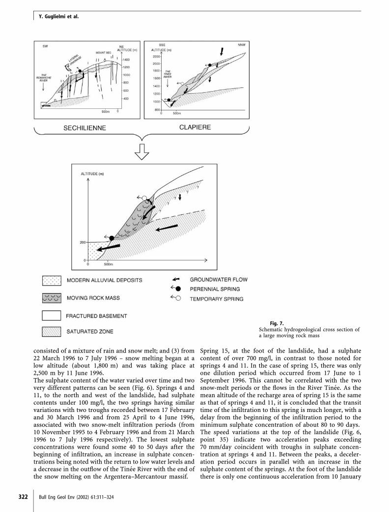
Fig. 7.Schematic hydrogeological cross section ofa large moving rock mass
Y. Guglielmi et al.
322 Bull Eng Geol Env (2002) 61:311–324

to 23 June 1996, followed by a slowing down. Accelerationbegins when there is no notable chemical variation at thespring, i.e. presumably before the percolating waters reachthe spring.The chemical monitoring of spring waters with time showsa notable difference in the speed of water passage throughthe regolith/bedrock between the top and the foot of the LaClapiere slope. This affects both the time and intensity offlow at the springs and the movement of the landslide.Movement of the foot of the landslide is induced by gravityloading from above; the upper part (point 35), with infil-tration rates of 17 to 33 mm/day, moving at three times therate measured at point 10.
Conclusions
There is a clear difference between the sulphate contentsacquired by laboratory analysis and those used in a modelsimulation. Concentrations up to 800 mg/l were measuredfor waters emanating from the Triassic strata, while thebedrock waters at La Clapiere produced only 150 mg/l.This is in stark contrast to the established pyrite content ofsome 5% in the bedrock which gives a calculated sulphatewater content of 10 mg/l.At La Clapiere, the variation in sulphate from 10 mg/l atthe top of the landslide to 800 mg/l at the foot may berelated to dissolution from the Triassic gypsum where it isoverthrust over the microgneisses. At Sechilienne there isdownslope enrichment of sulphate ions from 60 to250 mg/l. Again, it is considered that this is related topercolating water from the Triassic syncline through themicaschist bedrock.The study has shown that the monitoring of water chem-istry over time gives a sensitive indication of infiltrationflows into the landslide. At La Clapiere the chemicalvariation of the spring waters coincides with the rate ofmovement of the slide; 10 mm/day acceleration is associ-ated with a 15 to 20 mg/l drop in the sulphate concen-tration in the groundwater.The hydrochemistry implies that there are two waterpassages within the slope (Fig. 7): (1) at La Clapiere thereis a perched water level in the scree and the upslope zoneof regressive slips and a further zone above the overthrust.At Sechilienne the groundwater is at the top of the sedi-mentary deposits; and (2) a deep saturated zone whichextends into the fractured metamorphic bedrock with aprobable unsaturated zone above.Isotopic results indicate that the main recharge of thelandslide is from the perched saturated zone. As this waterpasses downslope and possibly into the slope, in order toestablish a hydrogeological balance it is necessary for thewaters to migrate for some distance from the area of theinstability. It is believed that the groundwater flows mainlythrough a network of widely dilated fractures and throughthe breccia, becoming enriched with HCO3 as it passesthrough this aerated zone. During snowmelt, waters alreadyenriched in Ca2+ or SO4
2 are leached from the perchedaquifer into the fracture network within the bedrock.
The hydromechanical behaviour of the moving rock massdepends on the passage of water between the two saturatedzones: the upper perched condition and the lower satu-rated zone towards the base of the slope. As anticipated, inboth areas the maximum speed of sliding is coincidentwith periods of increased underground flow and a conse-quential rise in water pressures in the massif: (1) an in-creased head of water – possibly between 200 and 400 m;(2) a raising of the general groundwater level in the per-ched zone with water passing into the landslide. At LaClapiere temporary springs occur at about 1,500 m, indi-cating temporary drainage of the saturated zone above thelandslide where heads of up to 100 m may develop.The study indicates that hydrogeochemistry could be auseful additional tool in the study of large landslides.However, more work is required to confirm the validity ofthe method, which can only be substantiated with verycareful monitoring of not only the groundwater chemistryand precipitation as rainfall and snow but also the periodsover which snow melt occurs, both in the lower parts ofthe valley and higher on the hill slopes.
References
Abelin H, Birgersson J, Gidlund J, Nertnieks I (1991) A large-scaleflow and tracer experiment in granite, 1. Experimental designand flow distribution. Water Resour Res 27:3017–3117
Antoine P, Giraud A, Evrard H, Rochet L (1994) A huge slopemovement at Sechilienne, Isere, France. Landslide News 8:15–18
Bakalowicz M (1979) Contribution de la geochimie des eaux a laconnaissance de l’aquifere karstique et de la karstification.Thesis, Natural Sciences and Water Sciences, University Pierreet Marie Curie, Paris VI
Billaux D, Gentier S (1990) Numerical and laboratory studies offlow in a fracture. In: Proc Int Symp on Rock Joints, Loen,Norway, 4–6 June, AA Balkema, Rotterdam, pp 369–373
Blavoux B, Mudry J, Puig JM (1992) Bilan, fonctionnement etprotection du systeme karstique de la Fontaine de Vaucluse(sud-est de la France). Geodinamica Acta 5(3):153–172
Bogdanoff S, Ploquin A (1980) Les gneiss et migmatites du massifde l’Argentera (Alpes-Maritimes): apport de deux coupesgeochimiques. Bull Soc Geol Fr 22(3):353–358
Cacas MC, Ledoux E, De Marsily G, Tillie B, Barbreau A, DurandE, Feuga B, Peaudecerf P (1990) Modelling fracture flow with astochastic discrete fracture network: calibration and validation,1. The flow model. Water Resour Res 26:479–489
Compagnon F (1996) Approche hydrochimique des vitesses dedeplacement d’un grand glissement de terrain; La Clapiere(Alpes Maritimes). DEA Master Thesis, Universite de Nancy
Compagnon F, Guglielmi Y, Mudry J, Follacci JP, Ivaldi JP (1997)Approche chimique et isotopique de l’origine des eaux entransit dans un grand mouvement de terrain: exemple duglissement de La Clapiere (Alpes Maritimes). C R Acad Sci 325(Ser 2a)(8):565–570
Deutsch WJ (1997) Ground water geochemistry. Fundamentalsand applications to contamination. Environmental science.Lewis Publishers, New York, 221 pp
Faure-Muret A (1947) Sur des affleurements de Trias pinces dansles schistes cristallins de la vallee de la Tinee (Alpes-Maritimes).C R Acad Sci 224:205–207
Follacci JP (1987) Les mouvements du versant de La Clapiere aSaint-Etienne-de-Tinee (Alpes Maritimes). Bull Liaison LabPonts Chaussees 150/151:107–109
Hydrogeochemistry: an investigation tool to evaluate inltration into large moving rock masses
Bull Eng Geol Env (2002) 61:311–324 323

Follacci JP (1999) Seize ans de surveillance du glissement de LaClapiere (Alpes-Maritimes). Bull Liaison Lab Ponts Chaussees220(4253):35–51
Follacci JP, Guardia P, Ivaldi JP (1988) Le glissement de LaClapiere (Alpes Maritimes, France) dans son cadre geodyna-mique. In: Proc C R 5eme Symp Int sur Les Glissements deTerrain, Lausanne, pp 1323–1327
Gentier S, Hoppkins DL (1997) Mapping fracture aperture as afunction of normal stress using a combination of casting, imageanalysis and modelling techniques. Pap 132, Int J Rock MechMin Sci 34:3–4
Gentier S, Riss J, Hoppkins D, Lamontagne E (1998) Hydrome-chanical behaviour of a fracture: how to understand the flowpaths. In: Rossmanith HP (ed) Mechanics of jointed and faultedrock. AA Balkema, Rotterdam, pp 583–588
Guglielmi Y (1998) Hydromechanics of fractured rock masses:results from an experimental site in limestone. In: Proc Conf onMechanics of Jointed and Faulted Rock, Vienna, 6–9 April
Guglielmi Y (1999) Apport de la mesure des couplages hy-dromecaniques a la connaissance hydrogeologique des reser-voirs fissures: approche sur site experimental. Habilitation aDiriger des Recherches, University de Besancon
Guglielmi Y, Mudry J (1996) Hydrogeologie du glissement de LaClapiere – definition du bassin versant. University of Franche-Comte (CETE), Nice
Guglielmi Y, Mudry J, Blavoux B (1998) Estimation of the waterbalance of alluvial aquifers in a high isotropic contrast region:an example from southeastern France. J Hydrol 210:106–115
Guglielmi Y, Bertrand C, Compagnon F, Follacci JP, Mudry J(2000) Acquisition of water chemistry in a mobile fissuredbasement massif: its role in the hydrogeological knowledge ofthe La Clapiere landslide (Mercantour massif, southern Alps,France). J Hydrol 229:138–148
Programme INTERREG (1996) Risques generes par les grandsmouvements de versant – etude comparative de quatre sites desAlpes franco-italiennes. Regione Piemonte. Recommandations.LIRIGM, University Joseph Fourrier, Grenoble
Ivaldi JP, Guardia P, Follaci JP, Terramorsi S (1991) Plis decouverture en echelon et failles de second ordre associes a undecrochement dextre de socle sur le bord nord-ouest de l’Ar-gentera (Alpes-Maritimes, France). C R Acad Sci Paris 313 (Ser2):361–368
Jacquemin P (1984) Reponse hydrodynamique des hauts bassinsdu Doubs et de la Loue. Thesis, University of Besancon
Krantz RL, Frankel AD, Engelder T, Scholz CH (1979) The per-meability of whole and jointed Barre granite. Int J Rock MechMin Sci Geomech Abstr 16:225–234
Lee CH, Farmer IW (1990) Estimates of conducting aperture,fracture porosity and fracture permeability in rock masses. In:
Hustrulid, Jonhson (eds) Rock mechanics: contributions andchallenges. AA Balkema, Rotterdam
Long JCS, Gilmour NMP, Witherspoon PA (1985) A model forsteady fluid flow in random three-dimensional networks of disc-shaped fractures. Water Resour Res 21(8):1105–1115
Louis C (1974) Introduction a l’hydrolique des roches. Bull BurRech Geol Minieres Sect 3(4):283–356
Made B, Clement A, Fritz B (1990) Modelisation cinetiqueet thermodynamique de l’alteration: le modele geochimiqueKINDIS. C R Acad Sci 310 (Ser 2):31–36
Michard G (1989) Equilibres chimiques dans les eaux naturelles.Publisud, Paris
Mudry J (1987) Apport du tracage physico-chimique naturel a laconnaissance hydrocinematique des aquiferes carbonates. The-sis, Natural Sciences and Hydrology, University of Franche-Comte, Besancon
Mudry J, Lastennet R, Puig JM, Blavoux B (1994) Use of naturaltracing to understand how an aquifer works. Intake area, re-charge fluxes, transit – an example from the Ventoux-Vauclusekarst systems (southeastern France) – basic and applied hy-drogeological research in French karstic areas. In: Crampon N,Bakalowicz M (eds) Proc COST-65, Montpellier-Millau Worksh,EC, Brussels, pp 27–35
Neretnieks I (1983) A note on fracture flow dispersion mecha-nisms in the ground. Water Resour Res 19:364–370
Noverraz F, Bonnard C, Dupraz H, Huguenin L (1998) Grandsglissements de versants et climat. Rapport Final PNR31. vdfHochschulverlag AG an der ETH, Zurich, 314 pp
Razafindrakoto S (1988) Teneurs en isotopes stables des precip-itations et des eaux souterraines et leurs variations en France.Thesis, University of Avignon and Pays de Vaucluse
Renshaw CE (1995) On the relationship between mechanical andhydraulic apertures in rough-walled fractures. J Geophys Res100(B12):629–636
Sibai M, Sotoudeth HM, Henry JP (1997) Etude experimentale ducouplage hydromecanique de joints rocheux. Rev Fr Geotech81:33–39
Tsang YW, Witherspoon PA (1981) Hydromechanical behaviourof a deformable rock fracture subject of normal stress. J Geo-phys Res 86(B10):9287–9298
Vengeon JM (1998) Deformation et rupture des versants en ter-rain metamorphique anisotrope. Thesis, University JosephFourrier, Grenoble
Witherspoon PA, Wang JSY, Iway K, Gale JE (1980) Validity ofcubic law for fluid flow in a deformable rock fracture. WaterResour Res 16(6):1016–1024
Y. Guglielmi et al.
324 Bull Eng Geol Env (2002) 61:311–324