human footprints in central mexico older than 40,000 years
TRANSCRIPT

ARTICLE IN PRESS
0277-3791/$ - se
doi:10.1016/j.qu
�CorrespondE-mail addr
Quaternary Science Reviews 25 (2006) 201–222
Human footprints in Central Mexico older than 40,000 years
Silvia Gonzaleza,�, David Huddarta, Matthew R. Bennettb, Alberto Gonzalez-Huescac
aSchool of Biological and Earth Sciences, Liverpool John Moores University, Liverpool L3 3AF, UKbSchool of Conservation Sciences, Bournemouth University, Talbot Campus, Fern Barrow, Poole, Dorset BH12 5BB, UK
cInstituto de Geofısica, UNAM, Ciudad Universitaria, CP 04510 Mexico D.F., Mexico
Received 28 April 2005; accepted 13 October 2005
Abstract
The timing, route and origin of the first colonization to the Americas remains one of the most contentious topics in human evolution.
A number of migration routes have been suggested and there are different views as to the antiquity of the earliest human occupation.
Some believe that settlement happened as early as 30 ka BP, but most of the currently accepted early sites in North America date to the
latest Pleistocene, related to the expansion of the Clovis culture, while the oldest directly radiocarbon dated human remains are 11.5 ka
BP. In this context new evidence is presented in this paper, in the form of human footprints preserved in indurated volcanic ash, to
suggest that Central Mexico was inhabited as early as over 40 ka BP.
Human and animal footprints have been found within the upper bedding surfaces of the Xalnene volcanic ash layer that outcrops in
the Valsequillo Basin, south of Puebla, Mexico. This ash layer was produced by a subaqueous monogenetic volcano erupting within a
palaeo-lake, dammed by lava within the Valsequillo Basin during the Pleistocene. The footprints were formed during low stands in lake
level along the former shorelines and indicate the presence of humans, deer, canids, big felids, and probably camels and bovids. The
footprints were buried by ash and lake sediments as lake levels rose and transgressed across the site. The ash has been dated to at least
40 ka BP by OSL dating of incorporated, baked lake sediments.
r 2005 Elsevier Ltd. All rights reserved.
1. Introduction
The first colonization of the Americas remains acontentious issue, with different theories as to when ithappened and by whom (e.g., Dixon, 1999; Chatters, 2000;Fiedel, 2000). Some researchers believe the settlement was30 ka BP or older (Bonnichsen and Turnmire, 1999); butthe most accepted dates of occupation are in the latestPleistocene, related to the ‘Clovis First’ model, whilst theoldest directly radiocarbon-dated human remains found sofar are around 11.5 ka BP (Dillehay, 2000; Gonzalez et al.,2003). This hypothesis of human settlement is complicated,however, since the earliest accepted human occupation date(12.5 ka BP) comes from the Monte Verde site in southernChile (Dillehay, 1989, 1997), where lithic technologies arevery different from the Clovis sites in the south west of theUSA.
e front matter r 2005 Elsevier Ltd. All rights reserved.
ascirev.2005.10.004
ing author. Tel.: +44151 231 2213.
ess: [email protected] (S. Gonzalez).
In this paper we present new evidence in the form ofhuman footprints that suggest that Central Mexico wascolonized much earlier. These footprints are preserved onthe upper bedding planes of indurated, basaltic volcanicash, deposited along the shores of a shallow Pleistocenelake in the Valsequillo Basin, south of Puebla (Fig. 1). Thehuman and associated animal footprints (Figs. 2 and 3) arefound in a small abandoned quarry close to CerroToluquilla, a small monogenetic volcano (Fig. 1). Thefootprints were made during the latest stages of depositionof the ash following a period of lower lake level. Theyare present in several layers on the top ash sequence, wherethe ash is interbedded with lake sediments (Fig. 4A). Theprints were preserved as trace fossils by the relatively fastdeposition of fine-grained lake sediment and ash as lakelevels later transgressed across the site. The beddingsurfaces on the ash contain evidence of desiccation cracksconsistent with their temporary exposure above the lake.The volcanic ash is also cut by a number of irregular, silt-filled hydrofractures (Fig. 4B) that resulted from the
ARTICLE IN PRESS
La Malinche
Puebla
Lake Valsequillo(c. 2080 m)
CerroToluquilla
Xalnene Ash
Upper LakeSediments
Scoured FootprintsA A’Workings(E)
QuarryMapped areas
Covered
A
A’
Workings
0 10
Scoured
Slabs
Xalnene Ash
20
(D)
N
Mexico
Balsas Group
LaharsLake
sediments
Zacachimalpa orCaulapan Tuff
Ixcalo Lava
ValsequilloGravels Xalnene Ash
Cerro Toluquilla
ValsequilloReservoir
HumanFootprints
Fluctuating palaeolake levels
Lower LakeSediments
0 10 (m)20
(F)
(A)
Slopedeposits
Barranca Caulapan
West East
Balsas Group
Puebla
Cerro Toluquilla
N
0 2 4(km)
ValsequilloReservoir
Toluquilla Quarry[Human Footprints]
(B)
1
2
3
4
5 67
8
9
10
(C)
10
9
8
7
6
5
4
3
2
1 Rio Atoyac
San Francisco TotimehuacanTecacaxcoBarranca CaulapanEl MiradorHueyatlacoEl HornoTetela PeninsulaSanta Cruz IxtlaBarranca Mina del Frances
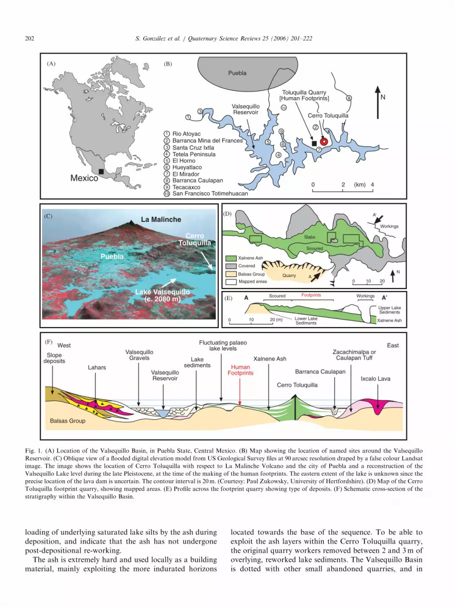
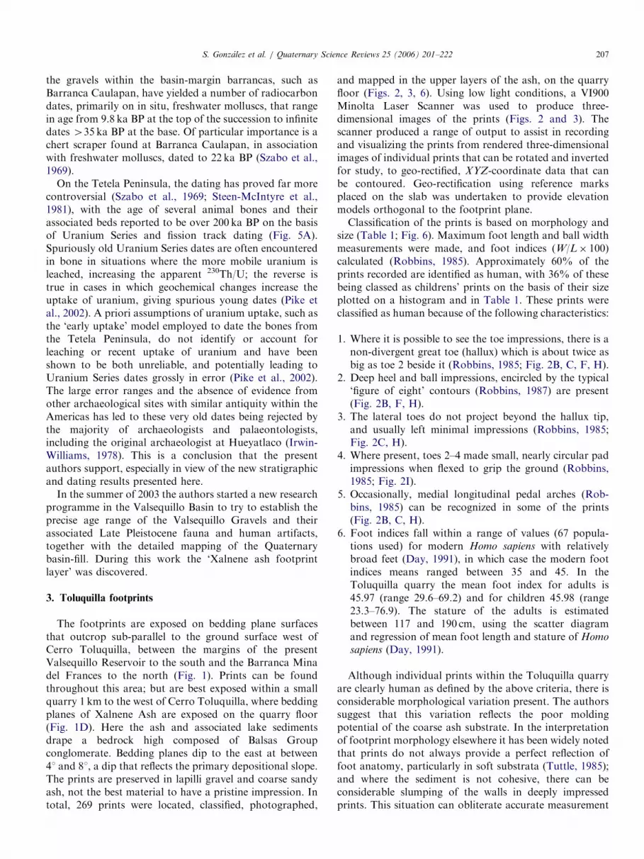
Fig. 1. (A) Location of the Valsequillo Basin, in Puebla State, Central Mexico. (B) Map showing the location of named sites around the Valsequillo
Reservoir. (C) Oblique view of a flooded digital elevation model from US Geological Survey files at 90 arcsec resolution draped by a false colour Landsat
image. The image shows the location of Cerro Toluquilla with respect to La Malinche Volcano and the city of Puebla and a reconstruction of the
Valsequillo Lake level during the late Pleistocene, at the time of the making of the human footprints. The eastern extent of the lake is unknown since the
precise location of the lava dam is uncertain. The contour interval is 20m. (Courtesy: Paul Zukowsky, University of Hertfordshire). (D) Map of the Cerro
Toluquilla footprint quarry, showing mapped areas. (E) Profile across the footprint quarry showing type of deposits. (F) Schematic cross-section of the
stratigraphy within the Valsequillo Basin.
S. Gonzalez et al. / Quaternary Science Reviews 25 (2006) 201–222202
loading of underlying saturated lake silts by the ash duringdeposition, and indicate that the ash has not undergonepost-depositional re-working.
The ash is extremely hard and used locally as a buildingmaterial, mainly exploiting the more indurated horizons
located towards the base of the sequence. To be able toexploit the ash layers within the Cerro Toluquilla quarry,the original quarry workers removed between 2 and 3m ofoverlying, reworked lake sediments. The Valsequillo Basinis dotted with other small abandoned quarries, and in
ARTICLE IN PRESS
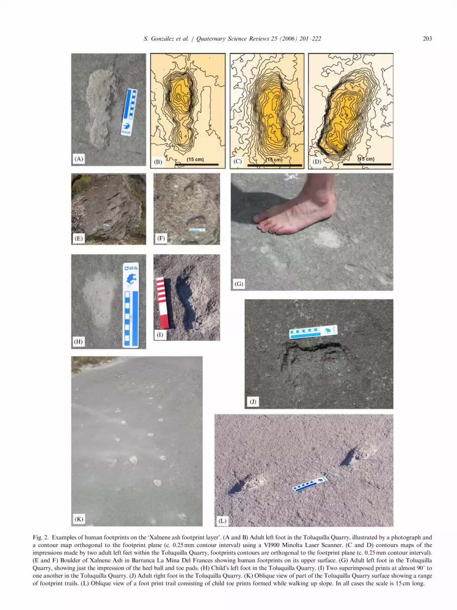
Fig. 2. Examples of human footprints on the ‘Xalnene ash footprint layer’. (A and B) Adult left foot in the Toluquilla Quarry, illustrated by a photograph and
a contour map orthogonal to the footprint plane (c. 0.25mm contour interval) using a VI900 Minolta Laser Scanner. (C and D) contours maps of the
impressions made by two adult left feet within the Toluquilla Quarry, footprints contours are orthogonal to the footprint plane (c. 0.25mm contour interval).
(E and F) Boulder of Xalnene Ash in Barranca La Mina Del Frances showing human footprints on its upper surface. (G) Adult left foot in the Toluquilla
Quarry, showing just the impression of the heel ball and toe pads. (H) Child’s left foot in the Toluquilla Quarry. (I) Two superimposed prints at almost 901 to
one another in the Toluquilla Quarry. (J) Adult right foot in the Toluquilla Quarry. (K) Oblique view of part of the Toluquilla Quarry surface showing a range
of footprint trails. (L) Oblique view of a foot print trail consisting of child toe prints formed while walking up slope. In all cases the scale is 15 cm long.
S. Gonzalez et al. / Quaternary Science Reviews 25 (2006) 201–222 203
ARTICLE IN PRESS
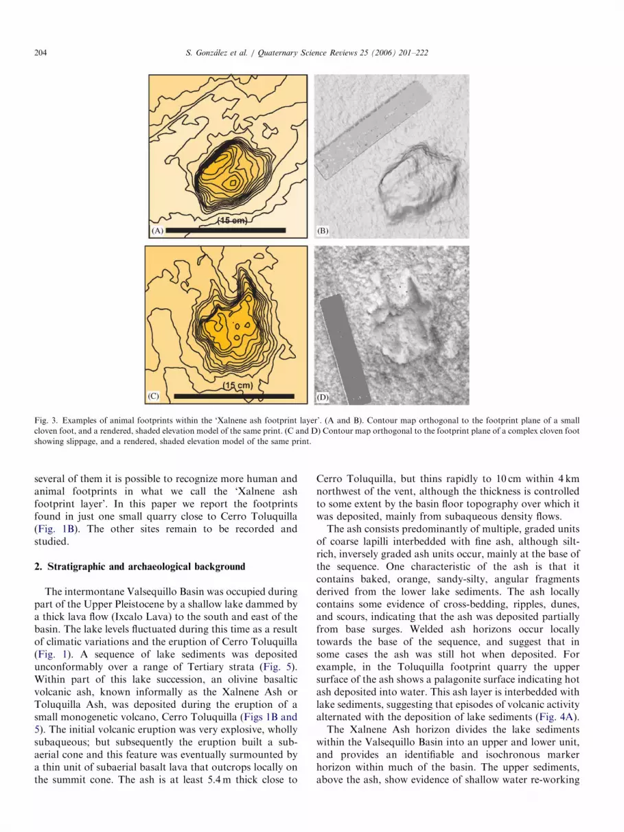
Fig. 3. Examples of animal footprints within the ‘Xalnene ash footprint layer’. (A and B). Contour map orthogonal to the footprint plane of a small
cloven foot, and a rendered, shaded elevation model of the same print. (C and D) Contour map orthogonal to the footprint plane of a complex cloven foot
showing slippage, and a rendered, shaded elevation model of the same print.
S. Gonzalez et al. / Quaternary Science Reviews 25 (2006) 201–222204
several of them it is possible to recognize more human andanimal footprints in what we call the ‘Xalnene ashfootprint layer’. In this paper we report the footprintsfound in just one small quarry close to Cerro Toluquilla(Fig. 1B). The other sites remain to be recorded andstudied.
2. Stratigraphic and archaeological background
The intermontane Valsequillo Basin was occupied duringpart of the Upper Pleistocene by a shallow lake dammed bya thick lava flow (Ixcalo Lava) to the south and east of thebasin. The lake levels fluctuated during this time as a resultof climatic variations and the eruption of Cerro Toluquilla(Fig. 1). A sequence of lake sediments was depositedunconformably over a range of Tertiary strata (Fig. 5).Within part of this lake succession, an olivine basalticvolcanic ash, known informally as the Xalnene Ash orToluquilla Ash, was deposited during the eruption of asmall monogenetic volcano, Cerro Toluquilla (Figs 1B and5). The initial volcanic eruption was very explosive, whollysubaqueous; but subsequently the eruption built a sub-aerial cone and this feature was eventually surmounted bya thin unit of subaerial basalt lava that outcrops locally onthe summit cone. The ash is at least 5.4m thick close to
Cerro Toluquilla, but thins rapidly to 10 cm within 4 kmnorthwest of the vent, although the thickness is controlledto some extent by the basin floor topography over which itwas deposited, mainly from subaqueous density flows.The ash consists predominantly of multiple, graded units
of coarse lapilli interbedded with fine ash, although silt-rich, inversely graded ash units occur, mainly at the base ofthe sequence. One characteristic of the ash is that itcontains baked, orange, sandy-silty, angular fragmentsderived from the lower lake sediments. The ash locallycontains some evidence of cross-bedding, ripples, dunes,and scours, indicating that the ash was deposited partiallyfrom base surges. Welded ash horizons occur locallytowards the base of the sequence, and suggest that insome cases the ash was still hot when deposited. Forexample, in the Toluquilla footprint quarry the uppersurface of the ash shows a palagonite surface indicating hotash deposited into water. This ash layer is interbedded withlake sediments, suggesting that episodes of volcanic activityalternated with the deposition of lake sediments (Fig. 4A).The Xalnene Ash horizon divides the lake sediments
within the Valsequillo Basin into an upper and lower unit,and provides an identifiable and isochronous markerhorizon within much of the basin. The upper sediments,above the ash, show evidence of shallow water re-working

ARTICLE IN PRESS
Fig. 4. Some characteristics of the Xalnene Ash in the Toluquilla Quarry. (A) Interbedded silt and ash outcropping in the floor of the quarry. (B) Silt-filled
hydrofractures. (C) Rendered elevation model produced using a VI900 Minolta Laser Scanner of sharp ‘pick’ marks on part of the quarry floor, as a
contrast to human footprints (D) A view of the quarry floor showing footprints and linear tool marks formed by quarry working. E) Oblique view of part
of the quarry floor showing footprints, desiccation cracks, and post-lithification tool marks formed by bulldozer tracks.
S. Gonzalez et al. / Quaternary Science Reviews 25 (2006) 201–222 205
associated with numerous small fluctuations in water levelthat caused the shoreline repeatedly to transgress or regressover the lake floor. Lake-marginal barrancas like theCaulapan Barranca to the north east (Fig. 1B) were filledwith a range of re-worked lake sediments and alluvialgravels during this process.
Perhaps the most famous example of these re-workedlake sediments and alluvial gravels within the ValsequilloBasin occurs on the Tetela Peninsula (Fig. 1B). They weredescribed during the late 1960s and early 1970s at theHueyatlaco archaeological site excavations by Irwin-Williams (1962, 1966, 1967, 1978) and Armenta Camacho(1959, 1978), and the site was re-excavated again by agroup from the Instituto Nacional de Antropologia(INAH) Mexico, led by Ochoa-Castillo in 2000 (Ochoa-Castillo et al., 2003). At this archaeological site, a lithicsequence has been reported that includes unifacial andbifacial artifacts in association with megafaunal remains,including mastodon, mammoth, camel, horse, and bison(Irwin-Williams, 1962, 1966). Human artifacts in associa-
tion with megafauna were also claimed by Irwin-Williamsto have been found within these same strata at other sitesnearby: El Mirador, El Horno, and Tecacaxco (Irwin-Williams, 1962, 1966), (Fig. 1B).The sediments associated with the archaeological finds
have been informally called the Valsequillo Gravels inprevious work (Irwin-Williams, 1978). They have beenconsidered by some workers (Szabo et al., 1969; Steen-McIntyre et al., 1981) to be older in age than a range offossiliferous, alluvial gravels that infill gullies at the basinmargins, such as the Barranca Caulapan site. However,both the alluvial sequences in the Tetela Peninsula and theBarranca Caulapan, with their fossiliferous-rich gravelsand their associated human artifacts, are stratigraphically
younger than the Xalnene Ash with its human footprints(Fig. 5). However, at Barranca Caulapan there is noXalnene Ash in the sequence, either in situ or as reworkedfragments but on the Tetela Peninsula there are reworkedpieces of both Xalnene Ash and lava in the ValsequilloGravels and these gravels are directly above the Xalnene
ARTICLE IN PRESS
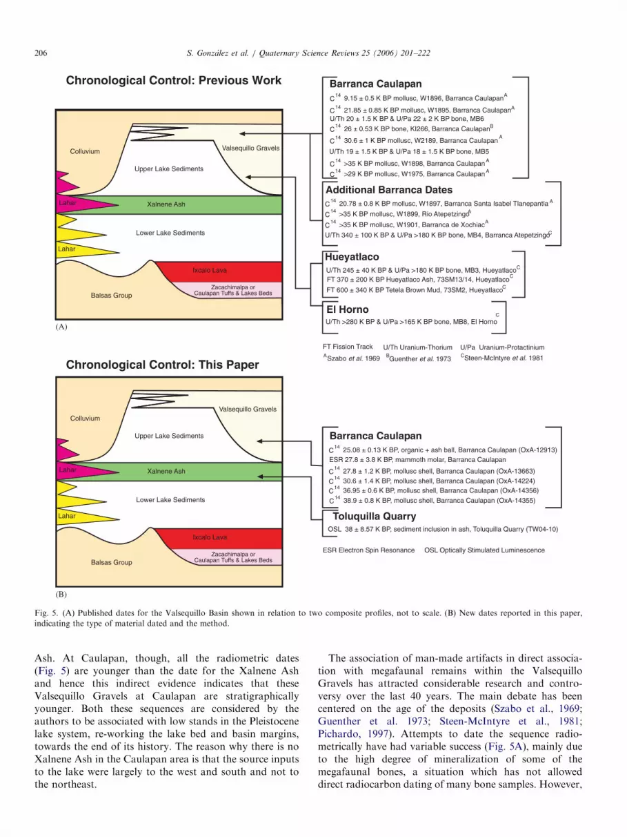
FT Fission Track
Steen-McIntyre et al. 1981CGuenther et al. 1973
BSzabo et al. 1969A
U/Th Uranium-Thorium U/Pa Uranium-Protactinium
20.78 ± 0.8 K BP mollusc, W1897, Barranca Santa Isabel Tlanepantla AC14
>35 K BP mollusc, W1899, Rio AtepetzingoAC14
>35 K BP mollusc, W1901, Barranca de XochiacAC
14
U/Th 340 ± 100 K BP & U/Pa >180 K BP bone, MB4, Barranca AtepetzingoC
Additional Barranca Dates
U/Th 19 ± 1.5 K BP & U/Pa 18 ± 1.5 K BP bone, MB5
U/Th 20 ± 1.5 K BP & U/Pa 22 ± 2 K BP bone, MB6
9.15 ± 0.5 K BP mollusc, W1896, Barranca CaulapanAC
14
21.85 ± 0.85 K BP mollusc, W1895, Barranca CaulapanAC14
26 ± 0.53 K BP bone, KI266, Barranca CaulapanBC14
30.6 ± 1 K BP mollusc, W2189, Barranca CaulapanA
C14
>35 K BP mollusc, W1898, Barranca Caulapan AC
14
>29 K BP mollusc, W1975, Barranca Caulapan AC
14
Barranca Caulapan
Colluvium
Upper Lake Sediments
Valsequillo Gravels
Xalnene Ash
Balsas Group
Lower Lake Sediments
Zacachimalpa orCaulapan Tuffs & Lakes Beds
Ixcalo Lava
Lahar
Lahar
ESR Electron Spin Resonance OSL Optically Stimulated Luminescence
ESR 27.8 ± 3.8 K BP, mammoth molar, Barranca Caulapan
Barranca Caulapan
Colluvium
Upper Lake Sediments
Valsequillo Gravels
Xalnene Ash
Balsas Group
Lower Lake Sediments
Zacachimalpa orCaulapan Tuffs & Lakes Beds
Ixcalo Lava
Lahar
Lahar
27.8 ± 1.2 K BP, mollusc shell, Barranca Caulapan (OxA-13663)C14
30.6 ± 1.4 K BP, mollusc shell, Barranca Caulapan (OxA-14224)C14
25.08 ± 0.13 K BP, organic + ash ball, Barranca Caulapan (OxA-12913)C14
Chronological Control: Previous Work
Chronological Control: This Paper
OSL 38 ± 8.57 K BP, sediment inclusion in ash, Toluquilla Quarry (TW04-10)
Toluquilla Quarry
U/Th >280 K BP & U/Pa >165 K BP bone, MB8, El Horno
El HornoC
CFT 370 ± 200 K BP Hueyatlaco Ash, 73SM13/14, Hueyatlaco
FT 600 ± 340 K BP Tetela Brown Mud, 73SM2, HueyatlacoC
U/Th 245 ± 40 K BP & U/Pa >180 K BP bone, MB3, HueyatlacoC
Hueyatlaco
36.95 ± 0.6 K BP, mollusc shell, Barranca Caulapan (OxA-14356)C14
38.9 ± 0.8 K BP, mollusc shell, Barranca Caulapan (OxA-14355)C14
(A)
(B)
Fig. 5. (A) Published dates for the Valsequillo Basin shown in relation to two composite profiles, not to scale. (B) New dates reported in this paper,
indicating the type of material dated and the method.
S. Gonzalez et al. / Quaternary Science Reviews 25 (2006) 201–222206
Ash. At Caulapan, though, all the radiometric dates(Fig. 5) are younger than the date for the Xalnene Ashand hence this indirect evidence indicates that theseValsequillo Gravels at Caulapan are stratigraphicallyyounger. Both these sequences are considered by theauthors to be associated with low stands in the Pleistocenelake system, re-working the lake bed and basin margins,towards the end of its history. The reason why there is noXalnene Ash in the Caulapan area is that the source inputsto the lake were largely to the west and south and not tothe northeast.
The association of man-made artifacts in direct associa-tion with megafaunal remains within the ValsequilloGravels has attracted considerable research and contro-versy over the last 40 years. The main debate has beencentered on the age of the deposits (Szabo et al., 1969;Guenther et al. 1973; Steen-McIntyre et al., 1981;Pichardo, 1997). Attempts to date the sequence radio-metrically have had variable success (Fig. 5A), mainly dueto the high degree of mineralization of some of themegafaunal bones, a situation which has not alloweddirect radiocarbon dating of many bone samples. However,
ARTICLE IN PRESSS. Gonzalez et al. / Quaternary Science Reviews 25 (2006) 201–222 207
the gravels within the basin-margin barrancas, such asBarranca Caulapan, have yielded a number of radiocarbondates, primarily on in situ, freshwater molluscs, that rangein age from 9.8 ka BP at the top of the succession to infinitedates 435 ka BP at the base. Of particular importance is achert scraper found at Barranca Caulapan, in associationwith freshwater molluscs, dated to 22 ka BP (Szabo et al.,1969).
On the Tetela Peninsula, the dating has proved far morecontroversial (Szabo et al., 1969; Steen-McIntyre et al.,1981), with the age of several animal bones and theirassociated beds reported to be over 200 ka BP on the basisof Uranium Series and fission track dating (Fig. 5A).Spuriously old Uranium Series dates are often encounteredin bone in situations where the more mobile uranium isleached, increasing the apparent 230Th/U; the reverse istrue in cases in which geochemical changes increase theuptake of uranium, giving spurious young dates (Pike etal., 2002). A priori assumptions of uranium uptake, such asthe ‘early uptake’ model employed to date the bones fromthe Tetela Peninsula, do not identify or account forleaching or recent uptake of uranium and have beenshown to be both unreliable, and potentially leading toUranium Series dates grossly in error (Pike et al., 2002).The large error ranges and the absence of evidence fromother archaeological sites with similar antiquity within theAmericas has led to these very old dates being rejected bythe majority of archaeologists and palaeontologists,including the original archaeologist at Hueyatlaco (Irwin-Williams, 1978). This is a conclusion that the presentauthors support, especially in view of the new stratigraphicand dating results presented here.
In the summer of 2003 the authors started a new researchprogramme in the Valsequillo Basin to try to establish theprecise age range of the Valsequillo Gravels and theirassociated Late Pleistocene fauna and human artifacts,together with the detailed mapping of the Quaternarybasin-fill. During this work the ‘Xalnene ash footprintlayer’ was discovered.
3. Toluquilla footprints
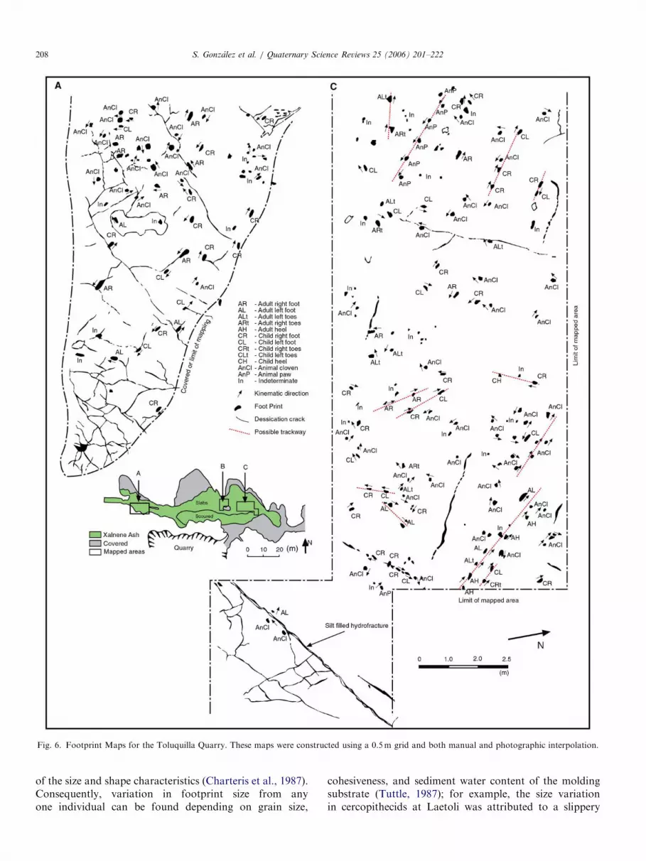
The footprints are exposed on bedding plane surfacesthat outcrop sub-parallel to the ground surface west ofCerro Toluquilla, between the margins of the presentValsequillo Reservoir to the south and the Barranca Minadel Frances to the north (Fig. 1). Prints can be foundthroughout this area; but are best exposed within a smallquarry 1 km to the west of Cerro Toluquilla, where beddingplanes of Xalnene Ash are exposed on the quarry floor(Fig. 1D). Here the ash and associated lake sedimentsdrape a bedrock high composed of Balsas Groupconglomerate. Bedding planes dip to the east at between41 and 81, a dip that reflects the primary depositional slope.The prints are preserved in lapilli gravel and coarse sandyash, not the best material to have a pristine impression. Intotal, 269 prints were located, classified, photographed,
and mapped in the upper layers of the ash, on the quarryfloor (Figs. 2, 3, 6). Using low light conditions, a VI900Minolta Laser Scanner was used to produce three-dimensional images of the prints (Figs. 2 and 3). Thescanner produced a range of output to assist in recordingand visualizing the prints from rendered three-dimensionalimages of individual prints that can be rotated and invertedfor study, to geo-rectified, XYZ-coordinate data that canbe contoured. Geo-rectification using reference marksplaced on the slab was undertaken to provide elevationmodels orthogonal to the footprint plane.Classification of the prints is based on morphology and
size (Table 1; Fig. 6). Maximum foot length and ball widthmeasurements were made, and foot indices (W/L� 100)calculated (Robbins, 1985). Approximately 60% of theprints recorded are identified as human, with 36% of thesebeing classed as childrens’ prints on the basis of their sizeplotted on a histogram and in Table 1. These prints wereclassified as human because of the following characteristics:
1.
Where it is possible to see the toe impressions, there is anon-divergent great toe (hallux) which is about twice asbig as toe 2 beside it (Robbins, 1985; Fig. 2B, C, F, H).2.
Deep heel and ball impressions, encircled by the typical‘figure of eight’ contours (Robbins, 1987) are present(Fig. 2B, F, H).3.
The lateral toes do not project beyond the hallux tip,and usually left minimal impressions (Robbins, 1985;Fig. 2C, H).4.
Where present, toes 2–4 made small, nearly circular padimpressions when flexed to grip the ground (Robbins,1985; Fig. 2I).5.
Occasionally, medial longitudinal pedal arches (Rob-bins, 1985) can be recognized in some of the prints(Fig. 2B, C, H).6.
Foot indices fall within a range of values (67 popula-tions used) for modern Homo sapiens with relativelybroad feet (Day, 1991), in which case the modern footindices means ranged between 35 and 45. In theToluquilla quarry the mean foot index for adults is45.97 (range 29.6–69.2) and for children 45.98 (range23.3–76.9). The stature of the adults is estimatedbetween 117 and 190 cm, using the scatter diagramand regression of mean foot length and stature of Homosapiens (Day, 1991).
Although individual prints within the Toluquilla quarryare clearly human as defined by the above criteria, there isconsiderable morphological variation present. The authorssuggest that this variation reflects the poor moldingpotential of the coarse ash substrate. In the interpretationof footprint morphology elsewhere it has been widely notedthat prints do not always provide a perfect reflection offoot anatomy, particularly in soft substrata (Tuttle, 1985);and where the sediment is not cohesive, there can beconsiderable slumping of the walls in deeply impressedprints. This situation can obliterate accurate measurement
ARTICLE IN PRESS
Fig. 6. Footprint Maps for the Toluquilla Quarry. These maps were constructed using a 0.5m grid and both manual and photographic interpolation.
S. Gonzalez et al. / Quaternary Science Reviews 25 (2006) 201–222208
of the size and shape characteristics (Charteris et al., 1987).Consequently, variation in footprint size from anyone individual can be found depending on grain size,
cohesiveness, and sediment water content of the moldingsubstrate (Tuttle, 1987); for example, the size variationin cercopithecids at Laetoli was attributed to a slippery

ARTICLE IN PRESS
Fig. 6. (Continued)
S. Gonzalez et al. / Quaternary Science Reviews 25 (2006) 201–222 209
muddy surface (White and Suwa, 1987). Issues ofpreservation quality are relevant within the Toluquillafootprint layer, since the molding medium was coarse, non-cohesive ash that was not compacted before the impres-sions were made. Moreover, there is likely to have beenmarked spatial variation in water contents across the lakeshoreline as it desiccated; and immediate post-productionalteration is likely as the surface was either desiccatedfurther, or subsequently submerged by transgressing lakelevels. In short, conditions for preserving the prints werefar from ideal, reflecting the variation of morphologicaltypes present and the general lack of extensive trackwaysfrom a single individual. These limitations in the evidencepreclude incontrovertible identification of the footprints
as human but the evidence from the six criteria adds weightto the conclusion.Despite these problems, several short trackways of
human prints can be recognized in some parts of thequarry, but are incomplete, reflecting the poor preservationpotential of the coarse lapilli ash (Figs. 2K, 6). The trailsfound so far are not sufficiently well-defined to calculatepace, stride length, and other reconstructions of gait(Napier, 1964; Robbins, 1985; Bird, 1987; Day, 1991).The authors suggest that the sediment surface was onlylocally water-saturated, a situation which limited theformation of prints to specific areas of the surface at anyone moment in time. More importantly, the prints are notconfined to a single horizon, but occur in several thin ash
ARTICLE IN PRESS
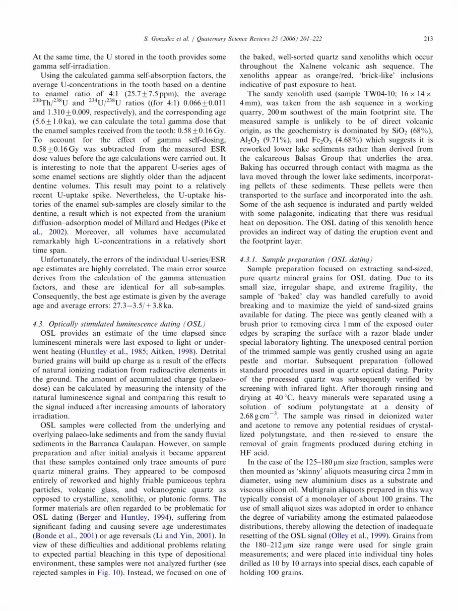
Table 1
Footprint types at Cerro Toluquilla quarry in the Valsequillo basin
N Length Width
Average Max Min Average Max Min Depth
Adults 67 21a 31 13 9.4 13 7 2.2
Left feet 14 22.9 31 18 9.4 13 7 2.2
Right feet 22 20.7 27 13 9.5 13 7 2.1
Toe prints 13 11.7 16 6 7.9 9 5 1.7
Heel prints 13 9.7 17.5 6 6.6 9 4 1.5
Unclearb 6 19.3 23 16 9.1 10 7.5 2.25
Children 97 11.9a 18 8 5.9 10 3 1.54
Left feet 28 12.1 16 9 5.8 9 3 1.4
Right feet 30 12.5 17 9 6.2 10 3.5 1.5
Toe prints 3 12.3 15 9 7.3 9 6 1
Heel prints 7 7 10 4 5.3 7 3 1.2
Unclearb 29 11.2 18 8 5.8 9 3.5 1.6
Cloven feet 99 6.9 20 4 5.1 11.5 2 1.35
Dogs 5 5.5 7 5 5.3 8 3 0.7
Birds 1 8 4 1.5
All dimensions are cm.aBased on complete examples only.bPrint with insufficient detail to determine left or right footprint.
S. Gonzalez et al. / Quaternary Science Reviews 25 (2006) 201–222210
layers near the upper surface of the ash unit. Consequently,in places the floor of the quarry forms a diachronoussurface, since its exhumation, both by natural erosion andanthropogenic quarrying, has not always occurred parallelto the bedding surfaces and therefore the isochronousfootprint horizons.
Cross-cutting and superimposed prints and trackwayswere observed on some parts of the slabs, and areconsistent with exposure over several days. Desiccationcracks (Figs. 2A, 6) cross-cut many of the prints, andsuggest that the prints were made when the ash was firstexposed and therefore damp. A relatively high proportionof heel and toe prints are present and form some of the besttrackways present (Fig. 2J, K). The authors suggest thatthis variation may reflect the primary slope of the sediment(41–81).
Several types of animal prints were noted (Fig. 3),including canids, big felids, and animals with cloven feet.The latter were dominant (37% of the total, Table 1). Thelimited faunal range is surprising, but probably reflects thecoarse nature of the ash surface and consequently thepreferential preservation of prints from relatively heavyanimals. A large number of subtle traces and irregularmarks are present on the slab surfaces, and furtherinvestigation may yield evidence for a more diverse fauna.A large range of sizes exists within the cloven feet class(Table 1); but there is, however, some evidence to suggestthat two populations may exist within this class: apopulation of relatively small prints (4� 5 cm) consistentwith deer, and a second population with larger prints(8� 10 cm) which may belong to camels or bovids. Thisinterpretation is consistent with the megafaunal remains
found within the Valsequillo Gravels both by the authorsand by previous investigators (Irwin-Williams, 1967;Armenta Camacho, 1959, 1978; Ochoa-Castillo et al.,2003). The primary slope may also explain why some of thecloven prints in particular show evidence of slipping.It is important to recognize that some of the surface
marks found on the ash are associated with quarryingoperations. In addition to individual pick marks (Fig. 4C),there are continuous, linear, chisel marks associatedwith the excavation of individual ash slabs (Fig. 4D),and caterpillar track marks (Fig. 4E) caused by amechanized bulldozer which was used to clear away theoverlying lake sediment from the ash during quarrying.These marks are all erosional; and post-date the lithifica-tion of the ash and the ichnofacies, having very sharplimits. On a small part of the quarry (Fig. 6B) a parallelismbetween the footprint trails and linear quarry tool markscan be noted. This parallelism does not occur on otherparts of the quarry floor, and it is chance that the printlines are parallel to the lines of quarried slabs. Surfaceweathering of the ash and the interbedded thin lakesediments, coupled with erosion during storm run-off,has produced a distinctive micro-topography on parts ofthe slab; and its effects are easily distinguished from thefootprints.
4. New dating programme
There have been significant advances in dating techni-ques since the early archaeological sites in the ValsequilloBasin were first reported more than 40 years ago. In thenew dating programme reported here, we have used the

ARTICLE IN PRESSS. Gonzalez et al. / Quaternary Science Reviews 25 (2006) 201–222 211
following methods: accelerator mass spectrometer radio-carbon dating (accelerator mass spectrometry, AMS) onmollusc shells and organic balls (Fig. 9, 10); electron spinresonance (ESR) on a mammoth molar found at BarrancaCaulapan (Fig. 8, 10); optically stimulated luminescencedating (OSL) and Argon–Argon dating on the XalneneAsh and overlying lava (Fig. 9, 10). Given the potentialimportance of this site, the methods used are described indetail before the stratigraphic implications of the new datesare discussed.
4.1. Radiocarbon dating
AMS 14C dating of shell and organic remains wasundertaken at the Oxford Radiocarbon Accelerator Unit(ORAU; University of Oxford). Shell species from theValsequillo sites for radiocarbon dating were identified byS. de Grave and J. Davies of the Oxford UniversityMuseum of Natural History (Table 2). The fragmented andsmall size of the samples meant that in one instance it wasnot possible to assign the shell to a specific species. All ofthe shells recovered for dating were composed of thearagonitic form of calcium carbonate, rather than thecalcitic form. Powder X-ray diffractometry (XRD) andmineral staining (Friedman, 1959) were used to check thecrystallinity of each dated carbonate specimen anddetermine the extent of any diagenetic alteration whichcould be associated with contamination effects. Becauserecrystallized carbonate is only manifest in the form ofcalcite, the homogeneity of the aragonite fraction of theshell was checked (Chappell and Polach, 1972). The OxA-13663 and OxA-14224 shell samples were checked usingXRD; but owing to the small sample sizes (o70mg) andthe instrument precision, it was difficult to exclude thepossible presence of calcite below 2% at best. This lack ofprecision means that we cannot be completely confidentthat the shells are wholly aragonitic, and therefore there isthe potential for contamination at the 2% level. Whetherthis factor is significant or not rests upon the ‘true’ age ofthe specimens, the age of the contaminants, and theirfractional size compared with the autochthonous samplecarbonate.
The conventional radiocarbon ages BP are reported inTable 2 (Stuiver and Polach, 1977). The similarity between
Table 2
Radiocarbon AMS results for shell carbonates and for an organic ash ball fro
OxA no. Species Environment
12913 — Organic ball/bas
14355 Spilochlamys conica Riverine/
Lacustrine
14356 Poteriidae Riverine/Lacustr
13663 Unidentified (fragments) Probably freshw
14224 Pomatiopsis a(fragments) Riverine/Lacustr
aThe specimen is of the genus Pomatiopsis (family Pomatiopsidae), an amp
lakes.
the four shell determinations and those shells previouslydated (Fig. 5; Szabo et al., 1969) suggests strongly theabsence of a significant diagenetic alteration and contam-ination effect.Marine and freshwater shell 14C concentration reflects
the 14C concentration of the lacustrine, oceanic, or riverinereservoir in which they grow. Numerous studies attest tooffsets in 14C ages of shell carbonates from theseenvironments compared with the atmospheric 14C reser-voir. These ages must be corrected where appropriate, ifthe size of the reservoir can be quantified. Previous workon radiocarbon dating freshwater pelecypods has shownthat in areas with non-carbonaceous bedrock there is likelyto be a small reservoir offset. For example, an offset of 450years for Anodonta specimens has been obtained from theMojave River Basin (Berger and Meek, 1992). Similarly,landsnail species in Texas incorporated reservoir offsetsaveraging 700 years, but sometimes ranging between 1000and 2500 years (Goodfriend et al., 1999). The dilution ofwaters from dissolved bicarbonates derived from carbo-naceous formations (‘hard water’ effect) may also produceolder than expected ages (Marchenko et al., 1989;Newnham et al., 1998). This situation is considered to bea possibility for the Valsequillo sites, since the Tertiarybedrock (Balsas Group) is limestone. On the basis of thisevidence, we suggest that a significant reservoir offset ispossible but unlikely to be more than 2500 years.A sub-sample of the carbonate (c. 15–30mg) was
weighed and loaded into a glass reaction vessel andhydrolyzed with concentrated orthophosphoric acid invacuo. The CO2 was cryogenically distilled and volume-trically measured to determine the carbon yield. All datedcarbonates were within acceptable thresholds. The stableisotope ratios for carbon were measured using a Europa20-20 IR mass spectrometer, and the carbon was thenconverted into graphite, and AMS dated (Bronk Ramseyet al., 1999, 2004).
4.2. ESR/U-series analysis
Four enamel and adjacent dentine samples were cut froma mammoth tooth obtained from the Valsequillo Gravelsin the Barranca Caulapan (Figs. 7, 8). All eight sampleswere analyzed for U-concentrations (solution ICP-MS)
m the Valsequillo area
d13C Radiocarbon age BP
altic ash �22.1 250807130
�4.3 389007800
ine �2.3 369507600
ater �26 278807120
ine �2.2 306207140
hibious species that live on river banks and moist areas near streams and

ARTICLE IN PRESSS. Gonzalez et al. / Quaternary Science Reviews 25 (2006) 201–222212
and U-series isotopes (solution MC-ICP-MS). The enamelsamples were used for ESR dose determinations. All datawere then used to calculate combined ESR/U-series age
Fig. 7. Mammoth molar from Barranca Caulapan, showing location of
the eight samples used for ESR dating.
Table 3
U-concentrations and U-series results
Sample U (ppm) 234U/ 238U 234U/238U
error
230Th/ 238U 2
e
EN1 0.95 1.3282 0.0037 0.1144 0
EN2 1.17 1.3121 0.0033 0.0627 0
EN3 0.65 1.3171 0.0044 0.0746 0
EN4 1.53 1.3074 0.0045 0.0543 0
DE1 37.7 1.3050 0.0015 0.0702 0
DE2 31.3 1.3032 0.0030 0.0535 0
DE3 18.3 1.3038 0.0020 0.0628 0
DE4 38.3 1.3051 0.0023 0.0677 0
Table 4
ESR analysis
Sample Dea
(Gy)
Thickness
(mm)
Removed
(mm)
Ext.
Gamma
DR
(mGya�1)
Int.
DRb
(mGya�1)
p-EN
EN1 7.4270.83 26007200 200750 182716 58718 0.777
EN2 6.4570.38 25507200 200750 182716 38710 2.757
EN3 6.4670.40 22007200 200750 182716 2576 2.057
EN4 7.2570.37 28007200 200750 182716 3779 4.297
DR: Dose rate; ext.: external; int.: internal.aMeasured ESR dose values (D) were corrected for the calculated internal gbThe internal dose rate assumes an alpha efficiency of 0.1370.02.
estimates. In situ gamma-spectrometric measurement(331 mGy/a) and neutron activation analysis of thesediment (U: 0.53 ppm; Th: 3.36 ppm; K: 7060 ppm) weremade. The neutron activation data would result in a doserate of 393 mGy/a, implying a water content in the range ofabout 15%.The substantial size of the mammoth tooth has
significant influence on the fraction of the external gammadose rate that is received by the enamel section used forESR dating. The three dimensional shape of the tooth wasapproximated by measuring three 8-point X–Y cross-sections along a Z-axis and three 8-point X–Z cross-sections along a Y-axis (placing the measured enamelsamples at the origin of the XYZ-coordinates). Thefraction of the external gamma dose was then calculatedusing gamma attenuation values for bone, based on MonteCarlo simulations; and integrating the three-dimensionalbody in 1mm steps. The result was that the externalgamma dose rate was attenuated to 47% of the infinitematrix dose rate for K, 45% for Th, and 43% for U. It wasassumed that the average density of enamel and dentinewas 2.95, and that the dentine had a water-filled porevolume of 20%. These attenuation values will containuncertainties in the range of 10%, resulting in an externalgamma dose rate of 148715 mGy/a. The cosmic dose rate�1 for a depth of 1772m is 3474 mGy/a, resulting in atotal gamma plus cosmic dose rate of �1182716 mGy/a.
30Th/ 238U
rror
Apparent
Age (ka)
Age error
(ka)
Initial234U/238U
234U/238U
error
.0026 9.8 0.2 1.3374 0.0038
.0022 5.3 0.2 1.3168 0.0033
.0027 6.3 0.2 1.3228 0.0045
.0012 4.6 0.1 1.3115 0.0043
.0017 6.0 0.1 1.3102 0.0015
.0016 4.6 0.1 1.3072 0.0031
.0006 5.4 0.1 1.3085 0.0019
.0016 5.8 0.1 1.3102 0.0023
b-DE1 DR
(mGy a�1)
p-DE1 b-DE2 DR
(mGya�1)
p-DE2 Age (ka) Age
error
(ka)
0.52 1976 2.5370.83 872 3.0770.68 27.7 +5.0
�4.9
0.76 2175 2.2070.55 972 2.7070.59 25.8 +3.3
�2.9
0.66 1574 3.6470.87 2476 2.4470.59 26.2 +3.4
�3.0
0.82 1072 4.3570.77 1674 3.0070.57 29.5 +3.5
�3.0
amma dose (0.5870.16Gy).
ARTICLE IN PRESSS. Gonzalez et al. / Quaternary Science Reviews 25 (2006) 201–222 213
At the same time, the U stored in the tooth provides somegamma self-irradiation.
Using the calculated gamma self-absorption factors, theaverage U-concentrations in the tooth based on a dentineto enamel ratio of 4:1 (25.777.5 ppm), the average230Th/238U and 234U/238U ratios ((for 4:1) 0.06670.011and 1.31070.009, respectively), and the corresponding age(5.671.0 ka), we can calculate the total gamma dose thatthe enamel samples received from the tooth: 0.5870.16Gy.To account for the effect of gamma self-dosing,0.5870.16Gy was subtracted from the measured ESRdose values before the age calculations were carried out. Itis interesting to note that the apparent U-series ages ofsome enamel sections are slightly older than the adjacentdentine volumes. This result may point to a relativelyrecent U-uptake spike. Nevertheless, the U-uptake his-tories of the enamel sub-samples are closely similar to thedentine, a result which is not expected from the uraniumdiffusion–adsorption model of Millard and Hedges (Pike etal., 2002). Moreover, all volumes have accumulatedremarkably high U-concentrations in a relatively shorttime span.
Unfortunately, the errors of the individual U-series/ESRage estimates are highly correlated. The main error sourcederives from the calculation of the gamma attenuationfactors, and these are identical for all sub-samples.Consequently, the best age estimate is given by the averageage and average errors: 27.3�3.5/+3.8 ka.
4.3. Optically stimulated luminescence dating (OSL)
OSL provides an estimate of the time elapsed sinceluminescent minerals were last exposed to light or under-went heating (Huntley et al., 1985; Aitken, 1998). Detritalburied grains will build up charge as a result of the effectsof natural ionizing radiation from radioactive elements inthe ground. The amount of accumulated charge (palaeo-dose) can be calculated by measuring the intensity of thenatural luminescence signal and comparing this result tothe signal induced after increasing amounts of laboratoryirradiation.
OSL samples were collected from the underlying andoverlying palaeo-lake sediments and from the sandy fluvialsediments in the Barranca Caulapan. However, on samplepreparation and after initial analysis it became apparentthat these samples contained only trace amounts of purequartz mineral grains. They appeared to be composedentirely of reworked and highly friable pumiceous tephraparticles, volcanic glass, and volcanogenic quartz asopposed to crystalline, xenolithic, or plutonic forms. Theformer materials are often regarded to be problematic forOSL dating (Berger and Huntley, 1994), suffering fromsignificant fading and causing severe age underestimates(Bonde et al., 2001) or age reversals (Li and Yin, 2001). Inview of these difficulties and additional problems relatingto expected partial bleaching in this type of depositionalenvironment, these samples were not analyzed further (seerejected samples in Fig. 10). Instead, we focused on one of
the baked, well-sorted quartz sand xenoliths which occurthroughout the Xalnene volcanic ash sequence. Thexenoliths appear as orange/red, ‘brick-like’ inclusionsindicative of past exposure to heat.The sandy xenolith used (sample TW04-10; 16� 14�
4mm), was taken from the ash sequence in a workingquarry, 200m southwest of the main footprint site. Themeasured sample is unlikely to be of direct volcanicorigin, as the geochemistry is dominated by SiO2 (68%),Al2O3 (9.71%), and Fe2O3 (4.68%) which suggests it isreworked lower lake sediments rather than derived fromthe calcareous Balsas Group that underlies the area.Baking has occurred through contact with magma as thelava moved through the lower lake sediments, incorporat-ing pellets of these sediments. These pellets were thentransported to the surface and incorporated into the ash.Some of the ash sequence is indurated and partly weldedwith some palagonite, indicating that there was residualheat on deposition. The OSL dating of this xenolith henceprovides an indirect way of dating the eruption event andthe footprint layer.
4.3.1. Sample preparation (OSL dating)
Sample preparation focused on extracting sand-sized,pure quartz mineral grains for OSL dating. Due to itssmall size, irregular shape, and extreme fragility, thesample of ‘baked’ clay was handled carefully to avoidbreaking and to maximize the yield of sand-sized grainsavailable for dating. The piece was gently cleaned with abrush prior to removing circa 1mm of the exposed outeredges by scraping the surface with a razor blade underspecial laboratory lighting. The unexposed central portionof the trimmed sample was gently crushed using an agatepestle and mortar. Subsequent preparation followedstandard procedures used in quartz optical dating. Purityof the processed quartz was subsequently verified byscreening with infrared light. After thorough rinsing anddrying at 40 1C, heavy minerals were separated using asolution of sodium polytungstate at a density of2.68 g cm�3. The sample was rinsed in deionized waterand acetone to remove any potential residues of crystal-lized polytungstate, and then re-sieved to ensure theremoval of grain fragments produced during etching inHF acid.In the case of the 125–180 mm size fraction, samples were
then mounted as ‘skinny’ aliquots measuring circa 2mm indiameter, using new aluminium discs as a substrate andviscous silicon oil. Multigrain aliquots prepared in this waytypically consist of a monolayer of about 100 grains. Theuse of small aliquot sizes was adopted in order to enhancethe degree of variability among the estimated palaeodosedistributions, thereby allowing the detection of inadequateresetting of the OSL signal (Olley et al., 1999). Grains fromthe 180–212 mm size range were used for single grainmeasurements; and were placed into individual tiny holesdrilled as 10 by 10 arrays into special discs, each capable ofholding 100 grains.

ARTICLE IN PRESSS. Gonzalez et al. / Quaternary Science Reviews 25 (2006) 201–222214
4.3.2. Equipment
All measurements were conducted using an automatedRisø DA-15 TL/OSL reader system fitted with clusters ofblue-green light-emitting diodes (Nichia NSPB500S), andproviding a peak emission at 470730 nm at a power of15mWcm�2. Potential feldspar contaminants were identi-fied by stimulation from an array of infrared diodescentered at 830710 nm. The luminescence from eachaliquot was filtered through three 2.5mm Hoya U340filters; and photon emission was detected in the ultra-violetregion by a blue-green sensitive, bialkali photomultipliertube (EMI 9235Q). Laboratory irradiations required tobuild up the dose response curves of individual aliquotswere carried out with a calibrated 40mCi 90Sr/90Y b-source.Sample aliquots were placed in alternate positions on a 48sample carousel, leaving two empty positions betweenaliquots in order to limit the effects of cross-irradiation andcross-illumination. Single grain measurements were carriedout on a total of 600 grains using a laser-guided attachmentto the Risø reader, providing a high-powered (10-mW),finely focused green laser (Nd:YVO4; 532 nm) beamcapable of stimulating single grains (Bøtter-Jensen et al.,2002; Duller and Murray, 2000; Duller et al., 2000).
The gamma contribution to the sample was obtainedfrom field gamma-ray spectrometer measurements toaccommodate any in situ heterogeneity in the gammaradiation flux. The spectra was acquired with an EG&GMicroNomad portable system using a 3 in NaI detectorcalibrated against standard blocks of U, Th, and K housedat RLAHA (University of Oxford). Extended countingtimes were used for extra precision, as the environmentaldose rate was found to be very low. Complementarygeochemical analyses of the sample used for dating wereundertaken in order to determine the localized beta doserate contributions of 238U, 232Th, and 40K within thesample. Due to the small amount of material available foranalysis (o800mg), the concentration of radioactiveelements was determined on a homogenized and pulverizedsub-sample by ICP-MS using a lithium metaborate/tetraborate fusion preparation technique developed atActlab, Canada.
4.3.3. Measurement procedures
Palaeodose estimates were made using a modified single-aliquot regenerative-dose (SAR) procedure (Murray andWintle, 2000) in which blue-OSL measurements werepreceded by IR stimulation (Murray and Wintle, 2003).This post-IR blue-OSL method assumes that the twostimulation methods are mineral specific, and that theIRSL stimulation has almost completely depleted thefeldspathic traps.
Following the measurement of the natural OSL, up toseven regenerative dose cycles were given to individualaliquots. This procedure was followed by a zero dosecycle and a repeat of the first regenerative dose, to assessthe degree of recuperation and verify that the measurementprotocol yielded the correct known dose (recycling ratio).
Additionally, two aliquots were used to carry out doserecovery tests (Murray and Wintle, 2003). These weremeasured alongside the main series of 20 multigrainsingle aliquots, thereby ensuring the use of identicalmeasurement conditions, except that the natural signalhad previously been erased by deliberately exposing themineral grains for 100 s to light from the blue LED source(set to 80% power) and then giving each aliquot a knownlaboratory dose. The dose received by these controlaliquots may be treated as if it was the natural signal,and the palaeodose measurement procedure can be used tosee if this dose can be successfully recovered from grainswhich have not been subjected to any potential changes asa result of previous treatments associated with theluminescence measurement procedure.A preheat of 260 1C for 10 s was applied prior to the
measurement of the natural and regenerated luminescencesignals. In the cases of multigrain aliquots, OSL measure-ments of 100 s duration were performed at a raisedtemperature of 125 1C to ensure no retrapping of chargeto the 110 1C TL trap during measurement. Palaeodoseswere calculated from the first 2 s of stimulation, using thelast 20 s as a stable background count rate. In order tomonitor and correct for changes in sensitivity, the OSLresponse to a small test dose (�5Gy) was measuredfollowing a preheat at 220 1C. In the case of single grainmeasurements, the signal used for palaeodose calculationwas based on the counts originating from the initial 0.1 s ofexposure to the laser light and using the last 0.2 s of the 1 sstimulation period as background counts.Dose-rate calculations were carried out (Aitken, 1985).
They include an absorption coefficient for water (Zimmer-mann, 1971), and use dose-rate conversion factors (Ada-miec and Aitken, 1998). Beta, gamma, and cosmic ray doserates were corrected for the estimated average long-termwater content of the sediment surrounding the sample, andthe internal moisture content of the sample itself based onsealed samples collected in the field for this purpose. Alarge relative uncertainty was attached to the measuredwater content of the sediment in order to accommodate theeffects of likely variations in the past. The contribution ofthe cosmic-ray dose rate was calculated from publisheddata (Prescott and Hutton, 1994), making allowance foraltitude, geomagnetic position, and time-averaged thick-ness of the sediment overburden.For multigrain single aliquots, the palaeodose was
obtained by interpolation from a linear portion of thelaboratory dose response curve. Data analyses were madeusing a weighted linear fitting and an orthogonal fittingprocedure developed by R. Bailey of Royal Holloway(University of London). A mean palaeodose estimationwas derived from the weighted mean calculated forreplicate single aliquots. The uncertainty in the palaeodosewas estimated using the standard error of the unweighteddata. For single grain OSL measurements, the data wasanalyzed using the ‘Analyst’ software package writtenby G. Duller of Aberystwyth (University of Wales), using
ARTICLE IN PRESS
10
9
8
7
6
5
4
3
2
1
0
Fre
quen
cy
10 50 90 130 170 210 250 290
Palaeodose (Gy)
0.0 2000.0 4000.0
Palaeodose (sec. exposure to β-source)
Palaeodose: 45.99 + 9.78 Gyweighted mean of 8 grains
Grain size = 180-212 µm
4
3
2
1
0
Fre
quen
cy
Palaeodose52.65 + 3.11 Gy
10 50 90 130 170 210 250
Palaeodose (Gy)
290
Grain size: 125-180 µm
(A)
(B)
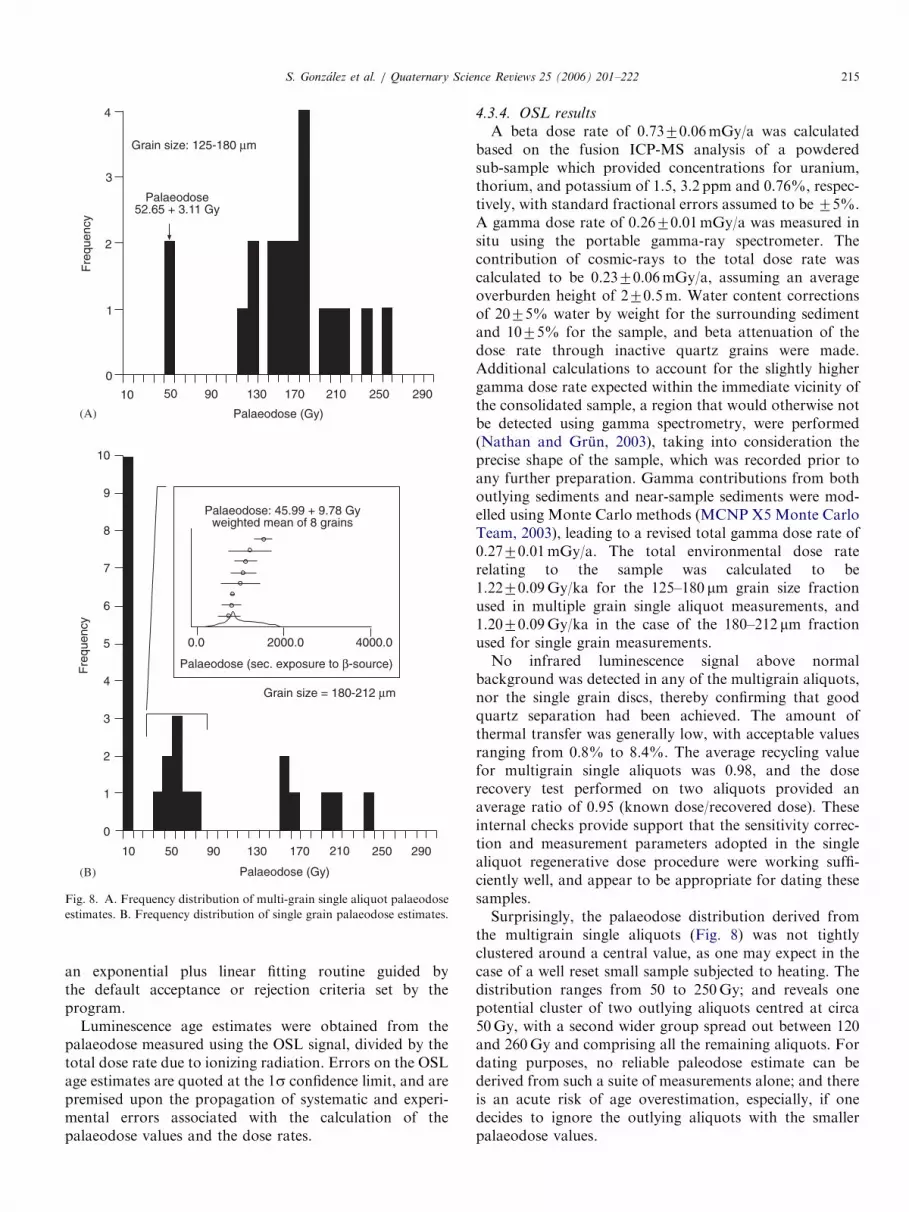
Fig. 8. A. Frequency distribution of multi-grain single aliquot palaeodose
estimates. B. Frequency distribution of single grain palaeodose estimates.
S. Gonzalez et al. / Quaternary Science Reviews 25 (2006) 201–222 215
an exponential plus linear fitting routine guided bythe default acceptance or rejection criteria set by theprogram.
Luminescence age estimates were obtained from thepalaeodose measured using the OSL signal, divided by thetotal dose rate due to ionizing radiation. Errors on the OSLage estimates are quoted at the 1s confidence limit, and arepremised upon the propagation of systematic and experi-mental errors associated with the calculation of thepalaeodose values and the dose rates.
4.3.4. OSL results
A beta dose rate of 0.7370.06mGy/a was calculatedbased on the fusion ICP-MS analysis of a powderedsub-sample which provided concentrations for uranium,thorium, and potassium of 1.5, 3.2 ppm and 0.76%, respec-tively, with standard fractional errors assumed to be 75%.A gamma dose rate of 0.2670.01mGy/a was measured insitu using the portable gamma-ray spectrometer. Thecontribution of cosmic-rays to the total dose rate wascalculated to be 0.2370.06mGy/a, assuming an averageoverburden height of 270.5m. Water content correctionsof 2075% water by weight for the surrounding sedimentand 1075% for the sample, and beta attenuation of thedose rate through inactive quartz grains were made.Additional calculations to account for the slightly highergamma dose rate expected within the immediate vicinity ofthe consolidated sample, a region that would otherwise notbe detected using gamma spectrometry, were performed(Nathan and Grun, 2003), taking into consideration theprecise shape of the sample, which was recorded prior toany further preparation. Gamma contributions from bothoutlying sediments and near-sample sediments were mod-elled using Monte Carlo methods (MCNP X5 Monte CarloTeam, 2003), leading to a revised total gamma dose rate of0.2770.01mGy/a. The total environmental dose raterelating to the sample was calculated to be1.2270.09Gy/ka for the 125–180 mm grain size fractionused in multiple grain single aliquot measurements, and1.2070.09Gy/ka in the case of the 180–212 mm fractionused for single grain measurements.No infrared luminescence signal above normal
background was detected in any of the multigrain aliquots,nor the single grain discs, thereby confirming that goodquartz separation had been achieved. The amount ofthermal transfer was generally low, with acceptable valuesranging from 0.8% to 8.4%. The average recycling valuefor multigrain single aliquots was 0.98, and the doserecovery test performed on two aliquots provided anaverage ratio of 0.95 (known dose/recovered dose). Theseinternal checks provide support that the sensitivity correc-tion and measurement parameters adopted in the singlealiquot regenerative dose procedure were working suffi-ciently well, and appear to be appropriate for dating thesesamples.Surprisingly, the palaeodose distribution derived from
the multigrain single aliquots (Fig. 8) was not tightlyclustered around a central value, as one may expect in thecase of a well reset small sample subjected to heating. Thedistribution ranges from 50 to 250Gy; and reveals onepotential cluster of two outlying aliquots centred at circa50Gy, with a second wider group spread out between 120and 260Gy and comprising all the remaining aliquots. Fordating purposes, no reliable paleodose estimate can bederived from such a suite of measurements alone; and thereis an acute risk of age overestimation, especially, if onedecides to ignore the outlying aliquots with the smallerpalaeodose values.

ARTICLE IN PRESSS. Gonzalez et al. / Quaternary Science Reviews 25 (2006) 201–222216
Single grain measurements (Fig. 8) obtained from 24grains of the same population of mineral grains and whichpassed the acceptance criteria set by the program used foranalysis, confirm that the sample is composed of grainshaving a wide range of palaeodoses. However, thetechnique also shows the presence of three distinctpopulations. A first set of 10 grains consistently producednear zero estimates, as one would expect in the case ofeffectively modern age grains derived from the outersurface of the small specimen, which was exposed todaylight during sampling. These residual grains are likelyto have been introduced through contamination in theearly stages of preparation.
A second well-constrained cluster of eight grainsprovides a weighted mean palaeodose of 45.9979.78, andis clearly separated from a third group of values withconsiderably higher estimates (Fig. 8). The latter appear tobe more widely distributed, ranging from 160 to 240Gy;and in general the result matches the spread of valuesnoticed previously for the frequency distribution amongthe multigrain single aliquot data. The second cluster ofgrains is believed to be related to the thermal resetting ofthe OSL signal as a result of exposure to heat during thevolcanic eruption. This explanation would provide aluminescence age estimate of 38.0478.57 ka. Similarly, ifthe two low outliers among the multi-grain single aliquotsare interpreted as representing populations of grainsunaffected by the presence of younger or older grains,then their mean palaeodose would provide a correspondingdate of 43.0574.08 ka.
Due to the original incorporation processes of the lakesediments into the ash, it is likely that the sample was nothomogenously heated throughout. Some grains may wellhave retained an inherited signal from a previous bleachingevent. However, it is interesting to note that such grains donot appear to have retained a luminescence signal relatingto a geological age. Laboratory irradiations used in theconstruction of growth curves were carried out up to400Gy, and showed that most aliquots had not yet reachedtheir saturation point. This result is not surprisingconsidering the low levels of radioactivity recorded locally,a characteristic of regions with a predominant volcanicgeology (Prescott et al., 1982). Thus, a geological sourcelike the Tertiary Balsas Conglomerate for the origin of thesand inclusions seems unlikely. Assuming a mean palaeo-dose of circa 200Gy for the original material, and based onthe assumption that the sample was derived from a largermass of sands of similar composition, an approximate ageestimate in excess of 180 ka BP may be calculated for thedepositional age of the pre-existing sediment source. Thisinterpretation supports the view that the specimen wasderived from underlying Pleistocene palaeo-lake sedimentsduring the eruption of the Toluquilla volcano.
In addition to suggesting a depositional age for the ashas well as the former Pleistocene lacustrine sediments, thevalue of the single grain analyses also illustrates theadvantages of being able to date very small specimens
and/or poorly reset samples containing complex mixturesof composite grain populations which are often difficult todetect and interpret using more conventional multiple grainsingle aliquot dating techniques.
4.4. Argon–argon dating of the xalnene ash
A sample of ash (TQ1) from the footprint horizons fromthe Toluquilla quarry site was crushed and cleaned usingdeionized water. Two types of material were picked forAr–Ar analysis, visible clear colourless crystals, and cleanlapilli fragments. Although it was not possible to avoid allexternal lapilli surfaces, fresh fragments were selectedwhere possible. Samples were prepared for irradiation bywashing in methanol and de-ionized water, and wrapped inAl foil. Along with a standard mineral sanidine, FCT(Age ¼ 28.03Ma), the unknown samples were irradiated atthe McMaster reactor in Canada. The J value measured onthe standard was 0.00012270.00001. Samples were loadedinto the system and heated using a focussed CW Nd-YAGlaser, and the isotope ratios of Argon released wasmeasured in an MAP 215–50 noble gas mass spectrometer.(Tables 3 and 4)Only two analyses were made of the clear crystals
(Table 5), which contain only low concentrations of 39Ar(derived from potassium during the irradiation) andslightly higher concentrations of 37Ar (derived fromcalcium), making the age calculations on such a youngsample ineffective. Any radiogenic argon derived from thedecay of potassium is swamped by atmospheric contam-ination. Lapilli fragments from the same sample yieldedhigher concentrations of 39Ar and 37Ar, but indicate thatthe sample had Ca/K ratios in the region of 4–10 and aretherefore likely to contain only 1–2% potassium, makingprecise age measurements challenging. However, it ispossible to detect non-atmospheric argon in the lapilli,which yield apparent ages in the range 2.2–4.6Ma. Theages start high, reduce, and return to a high age, yielding acrude saddle shape, a release pattern commonly associatedwith extraneous argon. The source of extraneous argonmight be dissolved in the glass, or present as particles ofmuch older soil mineral fragments on the outsides of thelapilli. Thus it has not been possible to determine an Ar–Arage for this sample. A total fusion age for an overlying lava(TQ2) did not release sufficient radiogenic argon todetermine an age. Unfortunately, this particular horizondoes not have high potassium concentrations needed tomeasure young ages.
4.4.1. Dating summary and stratigraphic implications
The stratigraphy and the new reliable dates obtainedwith a range of dating techniques (Figs. 5B, 9, 10) indicatethat the Valsequillo Gravels in the Barranca Caulapanrange in age from 9 to over 38 ka BP. These dates aremore or less in agreement with the dates obtained in the1960s and 1970s (Fig. 5A; Szabo et al., 1969). Themammoth molar ESR date (27.373.8 ka BP) and the
ARTICLE IN PRESS
Table 5
Ar–Ar data for the Xalnene Ash at Toluquilla quarry
Sample Step number 40Ar 7 39Ar 7 38Ar 7 37Ar 7 36Ar 7
TQ1 1 24.8309 0.0359 0.0302 0.0042 0.0129 0.0042 0.2567 0.0085 0.0881 0.0042
2 17.4060 0.1015 0.0086 0.0042 0.0429 0.0042 0.0514 0.0120 0.0672 0.0059
TQ2 1 40.9369 0.0792 1.2549 0.0059 0.0343 0.0042 5.3112 0.1527 0.0532 0.0059
2 75.9507 2.3818 4.3634 0.0255 0.1331 0.0059 9.4180 0.2883 0.3293 0.0133
3 238.0746 0.1131 12.0654 0.1050 0.1803 0.0042 42.7067 1.8930 0.2323 0.0133
4 152.5291 0.1127 5.5590 0.0504 0.0987 0.0000 25.7635 0.4503 0.2914 0.0059
Sample Step number 40Ar*/39Ar 7 Age (Ma) 7 37Ar/39Ar 7
TQ1 1 �40.12 �41.48 �8.85 9.20 8.5 1.2
2 �283.12 �245.52 �63.42 56.22 5.9 3.2
TQ2 1 20.10 1.40 4.42 0.48 4.2 0.1
2 �4.89 �1.05 �1.08 0.25 2.2 0.1
3 14.04 0.35 3.09 0.26 3.5 0.2
4 11.95 0.33 2.63 0.23 4.6 0.1
Amounts of argon isotopes are shown in cc STP� 10�12. The J value was 0.000122, measured using the FCT sanidine standard.
S. Gonzalez et al. / Quaternary Science Reviews 25 (2006) 201–222 217
organic ball radiocarbon AMS date (25.0870.13 ka BP)are both from reworked material, but indicate a similar agerange for the gravels. The dates obtained for the molluscshells, which are in situ, are 27.8871.2, 30.6271.4,36.9570.6, and 38.970.8 ka BP (locations of all samplesin Fig. 10).
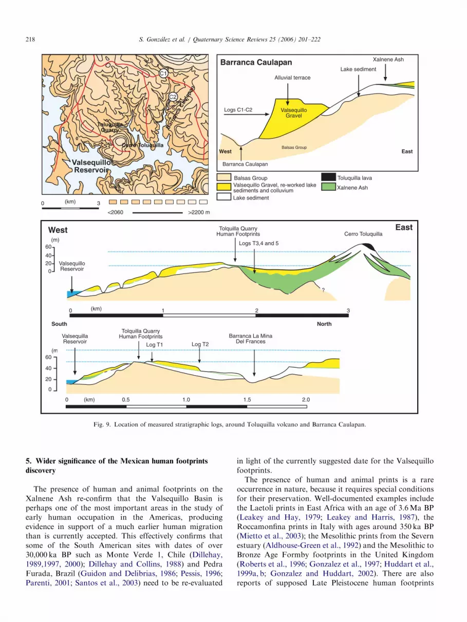
It is clear from the new dating programme therefore thatthe Valsequillo Gravels exposed within the BarrancaCaulapan range in age from the Late Pleistocene at thebase of the sequence to the Holocene transition at the top.It is worth noting that within these gravels fresh watermolluscs in association with a flake scraper were reportedand dated during the 1960s to an age of 21.85 ka BP (Szaboet al., 1969). The Valsequillo Gravels in the BarrancaCaulapan occur within a river terrace in a barranca. TheXalnene Ash does not occur within the barranca fill (Figs.9, 10), but with the new dating evidence the gravels areyounger in age and stratigraphically on the TetelaPeninsula the Valsequillo gravels contain pieces of XalneneAsh and lava, and can be demonstrated to be stratigra-phically younger in the field.
Attempts were made to date directly the Xalnene Ashusing Ar–Ar on a sample from the Xalnene ash at thefootprint quarry and on the olivine-basalt lava flow at thetop of the Toluquilla Volcano. However, in both cases theamount of potassium was too low to allow a reliable agedetermination in materials that are too young for thismethod.
We managed, however, to obtain a date of 38.0478.57 ka BP for the Xalnene Ash using OSL on single grainsderived from a sandy xenolith (baked lacustrine sediments)within the ash. If the outliers in the multi-grain aliquots areinterpreted as representing grain populations unaffected bythe presence of younger or older grains, then their meanpalaeodose suggests a date of 43.0574.08 ka BP. Further-more, some grains appear to have retained an inherited
signal from a previous bleaching event; and give anapproximate age of over 180 ka BP, providing a likelyoriginal Sangamonian age for the lower lake sedimentsfrom which the sandy xenoliths were derived.The dating programme indicates, therefore, that the
human and animal footprints preserved in the upper partof the Xalnene Ash are at least older than 40K BP, giventhe consistent dates obtained from the Barranca Caulapansediments which are stratigraphically younger than theXalnene Ash, and the OSL date from the baked lacustrinesediments xenolith incorporated within the Xalnene Ash(See the composite stratigraphy in Fig. 5B and details foreach sedimentary log measured in Fig. 10).The stratigraphic relationships between the overlying
Valsequillo Gravels, with their human artefacts andanimal bones, and the Xalnene Ash has been widelydiscussed for the Tetela Peninsula within the literaturerelated to the original Hueyatlaco archaeologicalexcavations (Guenther et al. 1973; Steen-McIntyre et al.,1981). However, at the Hueyatlaco archaeological sitefragments of Xalnene Ash and Toluquilla lava werereported to occur within the Valsequillo Gravels (Irwin-Williams, 1962, 1966) and observations by the authorsconfirm this on the Tetela Peninsula. Furthermore, theXalnene Ash has been observed below the ValsequilloGravels in this area. These observations effectivelyconstrain the archaeological sites of Hueyatlaco, El Horno,Tecacaxco and El Mirador to post- Xalnene Ash inage and provide a minimum age constraint of around40 ka BP. These sites cannot therefore be as old as pre-viously suggested in the literature, with ages of 245740,3707200, and 6007340 ka BP (Szabo et al., 1969;Pichardo, 1997). It is likely that these ages were obtainedfrom older reworked material incorporated into theselayers; or in the case of the Uranium Series dates, due tothe use of models that are now known to be unreliable.
ARTICLE IN PRESS
Valsequillo Gravel, re-worked lakesediments and colluvium
Balsas Group
Lake sediment
Toluquilla lava
Xalnene Ash
<2060
Balsas Group
ValsequilloGravel
Lake sediment
Alluvial terrace
Xalnene Ash
(km)0 3
Cerro Toluquilla
ValsequilloReservoir
?
02040
60(m)
West East
10 2 3(km)
0
20
40
60(m)
0 0.5 1.0 1.5 2.0(km)
ValsequillaReservoir
Barranca La MinaDel Frances
South NorthTolquilla Quarry
Human Footprints
Log T1 Log T2
Logs T3,4 and 5
Tolquilla QuarryHuman Footprints
>2200 m
Barranca Caulapan
Logs C1-C2
Barranca Caulapan
West East
Fig. 9. Location of measured stratigraphic logs, around Toluquilla volcano and Barranca Caulapan.
S. Gonzalez et al. / Quaternary Science Reviews 25 (2006) 201–222218
5. Wider significance of the Mexican human footprints
discovery
The presence of human and animal footprints on theXalnene Ash re-confirm that the Valsequillo Basin isperhaps one of the most important areas in the study ofearly human occupation in the Americas, producingevidence in support of a much earlier human migrationthan is currently accepted. This effectively confirms thatsome of the South American sites with dates of over30,000 ka BP such as Monte Verde 1, Chile (Dillehay,1989,1997, 2000); Dillehay and Collins, 1988) and PedraFurada, Brazil (Guidon and Delibrias, 1986; Pessis, 1996;Parenti, 2001; Santos et al., 2003) need to be re-evaluated
in light of the currently suggested date for the Valsequillofootprints.The presence of human and animal prints is a rare
occurrence in nature, because it requires special conditionsfor their preservation. Well-documented examples includethe Laetoli prints in East Africa with an age of 3.6Ma BP(Leakey and Hay, 1979; Leakey and Harris, 1987), theRoccamonfina prints in Italy with ages around 350 ka BP(Mietto et al., 2003); the Mesolithic prints from the Severnestuary (Aldhouse-Green et al., 1992) and the Mesolithic toBronze Age Formby footprints in the United Kingdom(Roberts et al., 1996; Gonzalez et al., 1997; Huddart et al.,1999a, b; Gonzalez and Huddart, 2002). There are alsoreports of supposed Late Pleistocene human footprints

ARTICLE IN PRESS
Fig. 10. Stratigraphy and location of dating samples, in Toluquilla Quarry and Barranca Caulapan.
S. Gonzalez et al. / Quaternary Science Reviews 25 (2006) 201–222 219

ARTICLE IN PRESSS. Gonzalez et al. / Quaternary Science Reviews 25 (2006) 201–222220
preserved in volcanic sequences from Amanalco de Becerra(Estado de Mexico; Sanchez, 1897; Leon, 1921; Aveleyra,1950), the child’s footprint in clay at Monte Verde in Chile(Dillehay, 1997) and middle Holocene footprints fromAcahualinca in Nicaragua (Kidder, 1943), together withthe Monte Hermoso human footprints from Argentina(Politis and Bayon, 1995). The footprints reported here addto this literature, and reflect specific environmentalconditions for their preservation within the ValsequilloBasin in Mexico.
The human footprints and their dating presented in thispaper help to resolve the controversy related to the age ofthe archaeological (lithics and worked bone) and asso-ciated megafaunal remains that were reported in theValsequillo Gravels in the 1960s and 1970s. They alsosuggest that other sites in Central Mexico with the sametype of fossiliferous gravels associated with lithics whichhave been claimed to be of great antiquity in the pastshould be studied; e.g., Tequixquiac in the north of theBasin of Mexico (Barcena, 1882). These potentially ‘early’Mexican sites need to be re-evaluated carefully in a widercontinental scale approach, rather than as isolated sites.From the evidence presented here, the ‘Clovis First’ modelof human occupation can no longer be accepted as the firstevidence of human presence in the Americas; and newtimings as well as routes of migration suitable for thepresence of these much earlier sites need to be considered.
The Xalnene Ash occurs extensively within the Valse-quillo Basin; and other sites with human and animalfootprints have been observed by the authors in the area,suggesting that the potential for the study of these tracefossils in the Valsequillo region may be considerable.Future planned excavation to uncover unweatheredfootprints from the sediment overburden, together withfurther dating, and investigation may yield data on otherearly sites in the Basin, the fauna present, a more precisecalculation of the height, pace, and stride of the humanpopulation present; and a better understanding of theassociation between animals and humans at this time.Further palaeoenvironmental analysis (pollen, diatoms,stable isotopes, tephrachronology) of the Basin sequencesis ongoing.
Note added in proof
This paper was received on 28 April 2005, refereed andaccepted on 13 October 2005, was on line on 28 November2005 and was to be published in the first issue of thisjournal in January 2006. Subsequently, a paper by Renne etal. (2005) was published on 1st December 2005, after whichit was decided that this brief additional note to our paperwas necessary in order to place both papers in context.
The crux of both papers is the dating of the volcanic ashlayer, in which we have interpreted a potential suite ofhuman and animal footprints that were formed contem-poraneously with the ash on a lake shoreline at approxi-mately 40 ka BP. However, Renne et al. (2005) suggest that
this ash is much older at 1.3M years based on Ar–Ardating and suggest that the footprints cannot be of ahuman. It has been suggested that the traces are the resultof quarrying operations. However, we recognise thepresence of a much younger set of anthropogenic tracessuperimposed and cross-cutting the older traces, which weinterpret as potential footprints. In our paper we have useda set of well-established criteria to argue that the oldertraces on the ash are human. It is important to mentionthat other potential footprints have been recorded in otherlocations within the Valsequillo Basin on the same ashlayer where no quarrying operations have occurred.Moreover we suggest that the ash layer, and therefore
the human footprints, are much younger, at approximately40 ka BP years ago, and we have dated this ash by OSLdating of orange inclusions that are older lake sedimentincorporated into the hot ash. The ash is extremelyheterogeneous with inclusions of many different lithologiesand origins and it is not homogeneous as suggested byRenne et al. (2005). It is also important to note that we alsoattempted to date the ash by Ar–Ar but failed to obtain areliable date. The suggested reverse magnetisation of theash which is used by Renne et al. (2005) to corroboratetheir data needs to be carefully evaluated, due to the factthat they report only very few results from un-orientatedrock samples.At present, therefore, there is a major dichotomy in the
dating of the Xalnene ash and by implication theinterpretation of the trace fossils on the ash surface. Bothdating techniques appear to be sound but what is requiredis replication of the dating of the ash and a detailedunderstanding of its formation. A date of 1.3M for the ashis problematic in a geological context since the overlyingsediments, dated in this paper, were deposited between 0.9and 40 ka BP and there is no apparent weathering orpalaeosol horizons between these sediments and the ash. Ifthere is a major basin-wide unconformity within thesequence as suggested by Renne et al.’s (2005) dates thenthere should be geological evidence of its presence. To datewe have found none, but further stratigraphic work withinthe basin is underway. We have a new research grant fromthe Natural Environment Research Council (NERC) forthe next 3 years, which will be further addressing the issuesdiscussed in this paper.The following paper is our interim statement on both the
footprint interpretation and the age of the Xalnene ash.Undoubtedly there will be further discussion by thescientific community in the future of this exciting geologicalsequence and its incorporated human and animal tracefossils, megafaunal bones and associated artefacts.
Acknowledgements
The authors wish to acknowledge the original advice onthe Valsequillo Basin from Virginia Steen-McIntyre andMichael Day for help in human footprint analysis. Theconstructive comments of two referees and the editor

ARTICLE IN PRESSS. Gonzalez et al. / Quaternary Science Reviews 25 (2006) 201–222 221
helped to improve this paper. Discussions in the field withRhiannon Stevens, Sarah Metcalfe, Peter Schaff, RexDalton, Ana Lillian Martin del Pozzo and Mario Perez-Campa were very useful. We acknowledge the datingresults used in this paper and their interpretation by thefollowing: Jean-Luc Schwenninger (Oxford University)OSL dating; Tom Higham and Christopher Bronk-Ramsey(Oxford University) AMS radiocarbon dating; SimonKelley (The Open University) Ar–Ar dating and RainerGrun (Australian National University) ESR dating.Alistair Pike (The University of Bristol) adviced onUranium Series dating. Work on the petrology of theXalnene ash using SEM was carried out at the LaboratorioUniversitario de Petrologıa, UNAM, Mexico with the helpof Carlos Linares Lopez. The expertise of Paul Zukowsky(University of Hertfordshire) using GIS and the hospitalityof Luis Mendez during fieldwork is gratefully acknowl-edged. The work was funded through a NERC grant NER/T/S/2002/00467, and is part of the EFCHED thematicprogramme.
References
Adamiec, G., Aitken, M.J., 1998. Dose-rate conversion factors: update.
Ancient TL 16, 37–50.
Aitken, MJ., 1985. Thermoluminescence Dating. Studies in Archaeologi-
cal Science. Academic Press, London and New York.
Aitken, M.J., 1998. Introduction to Optical Dating. Oxford University
Press, Oxford.
Aldhouse-Green, S.H.R., Whittle, A.W.R., Allen, J.R.L., Caseldine, A.E.,
Culver, S.J., Day, M.H., Lundquist, J., Upton, D., 1992. Prehistoric
human footprints from the Severn Estuary at Uskmouth and Magor
Pill, Gwent, Wales. Archaelogy Cambrensis 141, 14–55.
Armenta Camacho, J., 1959. Hallazgo de un artefacto asociado con
mamut en el Valle de Puebla. Instituto Nacional Antropologia e
Historia, Direccion Prehistoria Publicacion, 7, 7–25, Mexico D.F.
Armenta Camacho, J., 1978. Vestigios de labor humana en huesos de
animales extinctos de Valsequillo, Puebla, Mexico. Consejo Editorial
del Gobierno del Estado de Puebla. Puebla, Mexico.
Aveleyra, L., 1950. Prehistoria de Mexico. Ediciones Mexicanas, Mexico
DF.
Barcena, M., 1882. Descripcion de un hueso labrado, de llama fosil,
encontrado en los terrenos posterciarios de Tequixquiac. Anales del
Museo Nacional de Mexico; 1a Epoca 2, 439–444.
Berger, G.W., Huntley, D.J., 1994. Tests for optically stimulated
luminescence from tephra glass. Quaternary Science Reviews 13,
509–512.
Berger, R., Meek, N., 1992. Radiocarbon dating of Anodonta in the
Mojave River Basin. Radiocarbon 34, 578–584.
Bird, M.E., 1987. A preliminary comparative study of fossil and extant
mammalian tracks and trails. In: Leakey, M.D., Harris, J.M. (Eds.),
Laetoli: a Pliocene Site in Northern Tanzania. Clarendon Press,
Oxford, pp. 546–550.
Bonde, A., Murray, A.S., Frierich, W.L., 2001. Santorini: luminescence
dating of a volcanic province using quartz? Quaternary Science
Reviews 20, 789–793.
Bonnichsen, R., Turnmire, K.L., 1999. An introduction to the peopling of
the Americas. In: Bonnichsen, R., Turnmire, K.L. (Eds.), Ice Age
Peoples of the Americas: Environments, Origins and Adaptations.
Oregon State University Press, Corvallis, pp. 1–26.
Bøtter-Jensen, L., Duller, G.A.T., Murray, A.S., 2002. Advances in
luminescence measurement systems. Radiation Measurements 32,
523–528.
Bronk Ramsey, C., Hedges, R.E.M., 1999. Hybrid ion sources: radio-
carbon measurements from microgram to milligram. Nuclear Instru-
ments and Methods in Physical Research B 123, 539–545.
Bronk Ramsey, C., Higham, T.F.G., Leach, P., 2004. Towards high
precision AMS: progress and limitations. Radiocarbon 46, 17–24.
Chappell, J., Polach, H.A., 1972. Some effects of partial recrystallisation
on 14C dating of Late Pleistocene corals and molluscs. Quaternary
Research 2, 244–252.
Charteris, J., Wall, J.C., Nottrodt, J.W., 1987. Functional reconstruction
of gait from the Pliocene hominid footprints at Laetoli, northern
Tanzania. Nature 290, 496–498.
Chatters, J.C., 2000. The recovery and first analysis of an early Holocene
human skeleton from Kennewick, Washington. American Antiquity
65, 291–316.
Day, M.H., 1991. In: Cahiers de Paleoanthrop, Origines de la Bipedie chez
les hominids. CRNS, Paris, pp. 199–213.
Dillehay, T.D., 1989. Monte Verde: A Late Pleistocene Settlement in
Chile: Palaeoenvironment and Site Context.
Dillehay, T.D., 1997. Monte Verde: A Late Pleistocene Settlement in
Chile: The Archaeological Context and Interpretation.
Dillehay, T.D., 2000. The Settlement of the Americas. Basic Books, New
York.
Dillehay, T.D., Collins, M., 1988. Early cultural evidence from Monte
Verde in Chile. Nature 332, 150–152.
Dixon, E.J., 1999. Bones, Boats and Bison: Archaeology and the First
Colonisation of Western North America. University of New Mexico
Press, Albuquerque.
Duller, G.A.T., Murray, A.S., 2000. Luminescence dating of sediments
using individual mineral grains. Geologos 5, 88–106.
Duller, G.A.T., Bøtter-Jensen, L., Murray, A.S., 2000. Optical dating of
single-sized grains of quartz: sources of variability. Radiation
Measurements 32, 453–457.
Fiedel, S.J., 2000. The peopling of the new world: present evidence, new
theories, and future directions. Journal of Archaelogical Research 8,
39–103.
Friedman, G.M., 1959. Identification of carbonate minerals by staining
methods. Journal of Sedimentary Petrology 29, 87–97.
Gonzalez, S., Huddart, D., 2002. Formby Point. In: Huddart, D., Glasser,
N.F. (Eds.), The Quaternary of Northern England, Geological
Conservation Review Series. Joint Nature Conservation Committee,
Peterborough, pp. 569–581.
Gonzalez, S., Huddart, D., Roberts, G., 1997. Holocene development of
the Sefton coast: a multidisciplinary approach to understanding the
archaeology. In: Sinclair, A., Slater, E., Gowlett, J. (Eds.). Proceedings
of the Archaeological Sciences Conference, 1995, Oxbow Archae-
ological Monographs Series, Oxford, pp. 289–299.
Gonzalez, S., Jimenez-Lopez, J.C., Hedges, R., Huddart, D., Ohman, J.C.,
Turner, A., Pompa y Padilla, J.A., 2003. Earliest humans in the
Americas: new evidence from Mexico. Journal of Human Evolution
44, 379–387.
Goodfriend, G.A., Lain Ellis, G., Toolin, L.J., 1999. Radiocarbon age
anomalies in land snail shells from Texas: ontogenetic, individual and
geographic patterns of variation. Radiocarbon 41, 149–156.
Guenther, E.W., Bunde, H., Nobis, G., 1973. Investigaciones Geologicas y
Paleontologicas en Valsequillo cerca de Puebla (Mexico). Das Mexiko-
Projekt Der Deutschen Forschungsgemeinschaft, Franz Steiner Verlag
GMBH-Wiesbaden, 22pp.
Guidon, N., Delibrias, G., 1986. Carbon-14 dates point to man in the
Americas 32,000 years ago. Nature 321, 769–771.
Huddart, D., Gonzalez, S., Roberts, G., 1999a. The archaeological record
and mid-Holocene marginal coastal palaeoenvironments around
Liverpool Bay. Journal of Quaternary Science 14, 563–574.
Huddart, D., Roberts, G., Gonzalez, S., 1999b. Holocene human and
animal footprints and their relationships with coastal environmental
change, Formby Point, NW England. Quaternary International 55,
29–41.
Huntley, D.J., Godfrey-Smith, D.I., Thewalt, M.L.W., 1985. Optical
dating of sediments. Nature 313, 105–107.

ARTICLE IN PRESSS. Gonzalez et al. / Quaternary Science Reviews 25 (2006) 201–222222
Irwin-Williams, C., 1962. Preliminary Report on Investigations in the
Region of Valsequillo Reservoir. Unpublished report submitted to
Departamento de Prehistoria Instituto Nacional de Antropologia e
Historia, Mexico D.F., 32pp.
Irwin-Williams, C., 1966. Preliminary Report on Investigations in the
Region of the Valsequillo Reservoir. Unpublished report submitted to
Departamento de Prehistoria Instituto Nacional de Antrolpologia e
Historia, Mexico D.F., 35pp.
Irwin-Williams, C., 1967. Association of early man with horse, camel and
mastodon at Hueyatlaco, Valsequillo (Puebla, Mexico). In: Martin,
P.S., Wright, Jr., H.E. (Eds.), Pleistocene extinctions: the search for a
cause. Yale University Press, New Haven and London, pp. 337–347.
Irwin-Williams, C., 1978. Summary of archaeological evidence from the
Valsequillo region, Puebla, Mexico. In: Browman, D. (Ed.), Cultural
Continuity in Mesoamerica. Aldine, Chicago, pp. 7–22.
Kidder, A.V., 1943. Human Footprints in Nicaragua. El Norte de Mexico
y el sur de Estados Unidos. Sociedad Mexicana de Antropologia,
Mexico, DF, pp. 162–163.
Leakey, M.D., Harris, J.M, 1987. Laetoli: a Pliocene site in Northern
Tanzania. Clarendon Press, Oxford.
Leakey, M.D., Hay, R.L., 1979. Pliocene footprints in the Laetoli Beds at
Laetoli, Northern Tanzania. Nature 278, 317.
Leon, N., 1921. Huellas humanas impresas sobre roca en el territorio
mexicano. El Mexico Antiguo 1, 204–210.
Li, S.-H., Yin, G.-M., 2001. Luminescence dating of young volcanic
activity in China. Quaternary Science Reviews 20, 865–868.
Marchenko, E., Srdoc, D., Golubic, S., Pezdic, J., Head, M.J., 1989.
Carbon uptake in aquatic plants deduced from their natural 13C and14C content. Radiocarbon 31, 785–794.
MCNP X5 Monte Carlo Team, 2003. MCNP—A General Monte Carlo
N-Particle Transport Code, Version 5. Los Alamos National
Laboratory, USA.
Mietto, P., Avanzani, M., Rolandi, G., 2003. Human footprints in
Pleistocene volcanic ash. Nature 422, 133.
Murray, A.S., Wintle, A.G., 2000. Luminescence dating of quartz using an
improved single-aliquot regenerative-dose protocol. Radiation Mea-
surements 32, 57–73.
Murray, A.S., Wintle, A.G., 2003. The single aliquot regenerative dose
protocol: potential for improvements in reliability. Radiation Mea-
surements 37, 377–381.
Napier, J.R., 1964. The evolution of bipedal walking in the hominids.
Archives de Biologie (Liege) 75 (suppl.), 673–708.
Nathan, R., Grun, R., 2003. Gamma dosing and shielding of a human
tooth by a mandible and skull cap: Monte Carlo simulations and
implications for the accuracy of ESR dating of tooth enamel. Ancient
TL 21, 79–84.
Newnham, R.M., Lowe, D.J., Matthews, B.W., 1998. A late-Holocene
and prehistoric record of environmental change from Lake Waikar-
emoana, New Zealand. The Holocene 9, 443–454.
Ochoa-Castillo, P., Perez-Campa, M., Martin-Del Pozzo, A.L., Arroyo-
Cabrales, J., 2003. New Excavations in Valsequillo, Puebla, Mexico.
Current Research in the Pleistocene 20, 61–63.
Olley, J.M., Caitcheon, G.G., Roberts, R.G., 1999. The origin of dose
distributions in fluvial sediments, and the prospect of dating single
grains from fluvial deposits using optically stimulated luminescence.
Radiation Measurements 30, 207–217.
Parenti, F., 2001. Le Gisement Quaternaire de Pedra Furada (Piauı,
Bresil): Stratigraphie, Chronologie, Evolution Culturelle. Editions
Recherche sur les Civilisations, Paris.
Pessis, A.-M. (Ed.), 1996. Proceedings of the International Meeting on the
Peopling of the Americas, Sao Raimundo Nonato, Piauı, Brazil.
Revista da Fundac- ao Nuseu do Homen Americano, vol. 1(1). Sao
Raimundo Nonato.
Pichardo, M., 1997. Valsequillo biostratigraphy: new evidence for pre-
Clovis date. Anthropologica Anzeiger 55, 233–246.
Pike, A.W.G., Hedges, R.E.M., Van Calsteren, P., 2002. U-Series dating
of bone using the diffusion-adsorption model. Geochemica et
Cosmochimica Acta 66, 4273–4286.
Politis, G.G., Bayon, C., 1995. Early Holocene human footprints and sea
mammals in the tidal zone of the Argentinian seashore. Past 20, 5–6.
Prescott, J.R., Hutton, J.T., 1994. Cosmic ray contributions to dose rates
for luminescence and ESR dating: large depths and long term time
variations. Radiation Measurements 23, 497–500.
Prescott, J.R., Robertson, G.B., Green, J.C., 1982. Thermoluminescence
dating of Pacific Island pottery: success and failure. Archaeologia
Oceania 17, 42–147.
Renne, P.R., Feinberg, J.M., Waters, M.R., Arroyo-Cabrales, J., Ochoa-
Castillo, P., Perez-Campa, M., Knight, K.B., 2005. Age of Mexican
ash with alleged footprints. Natur 438, doi:10.1038/nature04425,
E7–E8.
Robbins, L.M., 1985. Footprints: collection, analysis and interpretation.
Charles C. Thomas, Springfield, Illinois.
Robbins, L.M., 1987. Hominid footprints from site G. In: Leakey, M.D.,
Harris, J.M. (Eds.), Laetoli: A Pliocene Site in Northern Tanzania.
Clarendon Press, Oxford, pp. 497–502.
Roberts, G., Gonzalez, S., Huddart, D., 1996. Intertidal Holocene
footprints and their archaeological significance. Antiquity 70, 647–651.
Sanchez, J., 1897. Importancia de la Historia Natural en el Estudio de la
Historia Antigua y la Arqueologia Americanas. Congreso Internacio-
nal de Americanistas: Actas de la 11a Reunion (Mexico 1895). pp.
386–396.
Santos, G.M., Bird, M.I., Parenti, F., Fifield, L.K., Guidon, N.,
Hausladen, P.A., 2003. A revised chronology of the lowest occupation
layer of Pedra Furada Rock Shelter, Piauı, Brazil: the Pleistocne
peopling of the Americas. Quaternary Science Reviews 22, 2303–2310.
Steen-McIntyre, V., Fryxell, R., Malde, H., 1981. Geologic evidence for
age of deposits at Hueyatlaco archaeological site, Valsequillo, Mexico.
Quaternary Research 16, 1–17.
Stuiver, M., Polach, H.A., 1977. Discussion: reporting of 14C data.
Radiocarbon 19, 355–363.
Szabo, B.J., Malde, H.E., Irwin-Williams, C., 1969. Dilemma posed by
uranium-series dates on archaeologically significant bones from
Valsequillo, Puebla, Mexico. Earth Planetary Science Letters 6,
237–244.
Tuttle, R.H., 1985. Ape footprints and Laetoli impressions: A response to
the SUNY claims. In: Tobias, P.V. (Ed.), Hominid Evolution: Past,
Present and Future. Alan R. Liss, New York, pp. 129–133.
Tuttle, R.H., 1987. Kinesiological inferences and evolutionary implica-
tions from Laetoli bipedal trails G-1, G-2/3 and A. In: Leakey, M.D.,
Harris, J.M. (Eds.), Laetoli: A Pliocene Site in Northern Tanzania.
Clarendon Press, Oxford, pp. 503–520.
White, T.D., Suwa, G., 1987. Hominid Footprints at Laetoli; Facts and
Interpretations. American Journal of Physical Anthropology 72,
485–514.
Zimmermann, D.W., 1971. Thermoluminescent dating using fine grains
from pottery. Archaeometry 13, 29–52.