hathaway pond dam – sippican river
TRANSCRIPT
1
Hathaway Pond Dam – Sippican River Feasibility Study Report
November 29, 2010 Prepared for: Coalition for Buzzards Bay 620 Belleville Avenue New Bedford, MA 02745

2
3
TABLE OF CONTENTS BACKGROUND................................................................................................................................................4 SITE CONDITIONS.......................................................................................................................................6
Hydrology ........................................................................................................................... 6 Impoundment Sediment ......................................................................................................... 7 Cranberry Operations ........................................................................................................... 9 Ecology ............................................................................................................................ 13
ALTERNATIVES ANALYSIS....................................................................................................................14 Do-nothing Option ............................................................................................................. 14 Dam Repair Option ........................................................................................................... 15 Partial Removal Option ...................................................................................................... 18 Full Removal Option .......................................................................................................... 22
REFERENCES ...............................................................................................................................................26 APPENDICES .................................................................................................................................................27
A – Dam Inspection Reports 2006, 2008, and 2009 B – Office of Dam Safety Order C – CBB – Beaton Inc. Agreement D – MacBroom Report on Hathaway Pond for MA DER (former Riverways) E – Concept Drawings for Hathaway Pond F – DRAFT Sediment Management Plan G – Benjamin Gilmore Report on Beaton Water Supply Needs H – Structural Review of Hathaway (2010) I – USGS Report on SE Massachusetts Hydrology
4
BACKGROUND
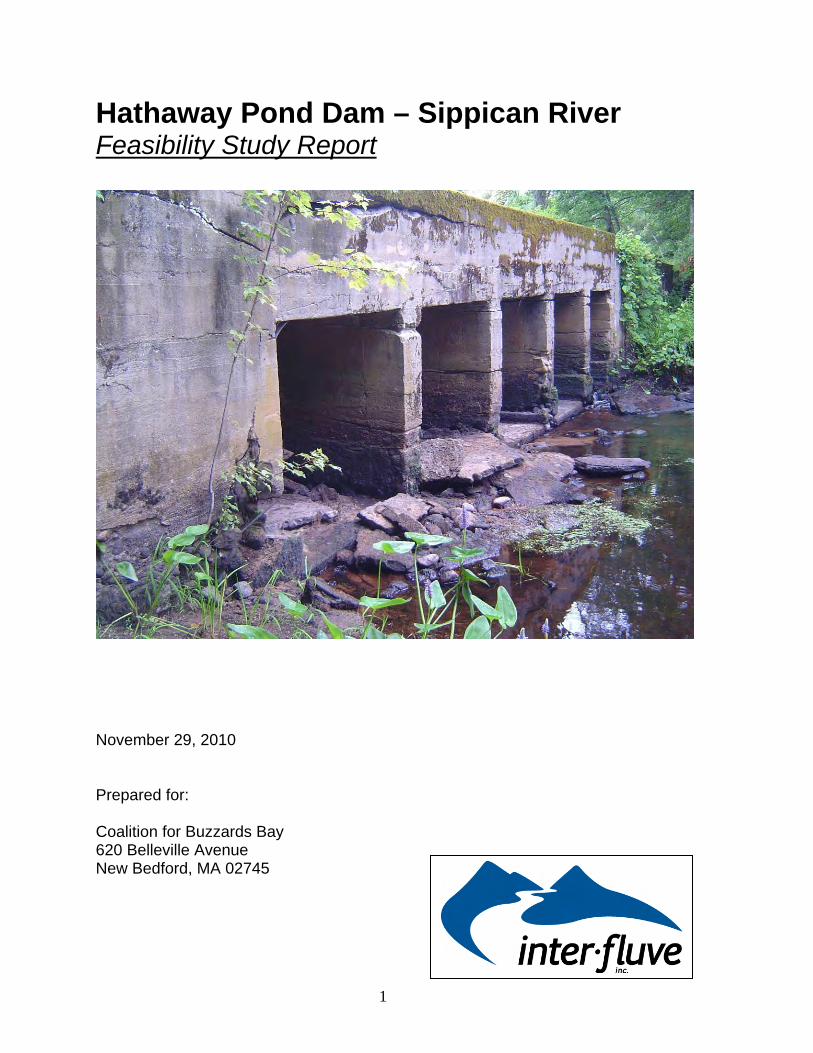
The Hathaway Pond dam (Figure 1) is owned by Susan Hampson and is currently not used
by the dam owner for any economic purpose. An adjacent cranberry operation, Beaton’s Inc.,
northeast of the dam is using water pumped up from the impoundment as a secondary water source
(Figure 2). The dam is classified as a Significant Hazard Potential Dam or a Class II hazard dam
(Class III is the highest rating) due to the potential for downstream loss of life and property
associated with catastrophic failure of the dam. The owner of the dam is under an order to remove
or repair the structure from the MA Office of Dam Safety (ODS), following an inspection in 2006 by
GAF Engineering (Appendix A – Dam Inspection Reports) that documented significant structural
failures compromising the safety of the structure in its current state. Additional inspections occurred
in 2008 and 2009. Following a significant rain event in March 2010, a sinkhole developed in the
embankment to the right of the primary spillway, breaching the dam. The sinkhole was temporarily
filled with sandbags. After this event, the condition of the dam was downgraded from “Poor” to
“Unsafe” and is under a permanent drawdown order from the MA Office of Dam Safety, awaiting
either repair or removal by the owner (Appendix B).
The owner offered the dam for sale to other area property owners including those using the
water source of Hathaway Pond, without receiving offers or agreements for purchase. In 2008, the
Coalition for Buzzards Bay (CBB) entered into an agreement to purchase the eight acre property that
includes the dam, contingent on being able to develop a cost effective strategy for addressing the
dam safety issue while concurrently improving the ecological conditions of the river, including
elimination of the barrier to migratory fish migration associated with the dam. CBB is seeking an
alternative to the public safety and environmental problems associated with the dam that does not
disrupt the existing adjacent agricultural operations. In 2010 CBB and Beaton’s, Inc., the operator of
the only agricultural entity currently authorized to draw water from the Hathaway Pond
impoundment, formally agreed to cooperate in identifying and implementing a solution to the
environmental and safety problems at the dam that will not disrupt the cranberry bog production
(Appendix C).
MA Department of Fish and Game conducted a preliminary assessment of the
environmental impacts of the dam (Appendix D). The findings from that study indicated the dam
was a barrier to natural riverine function and the existing fish ladder was inefficient at passing
migrating herring. Inter-Fluve was hired to perform an alternatives analysis of potential solutions that
address the safety and environmental issues at the Hathaway Pond site without disrupting adjacent
agricultural operations. This report is the result of that effort.
5
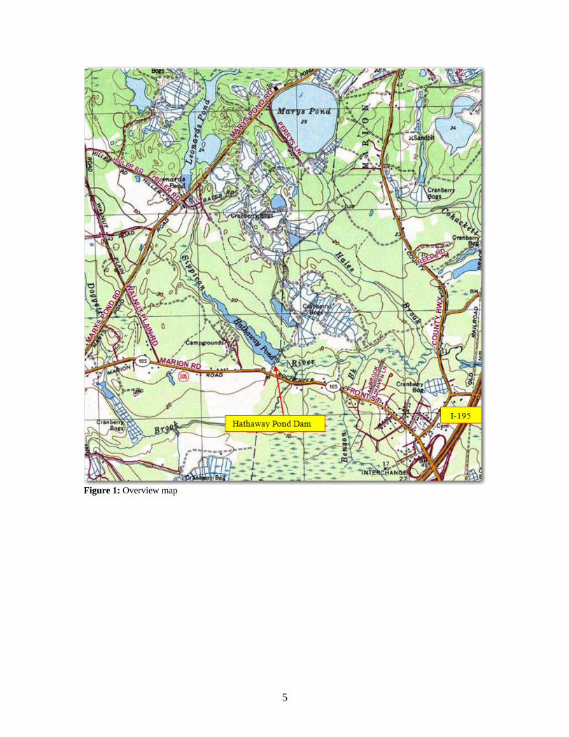
Figure 1: Overview map
6
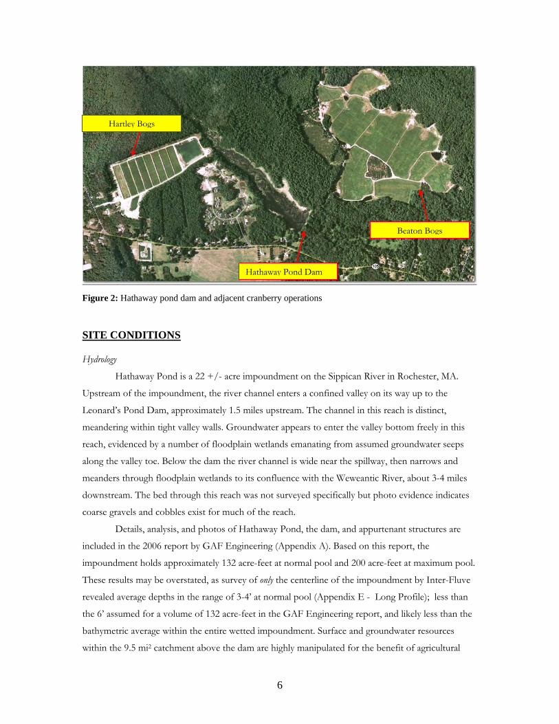
Figure 2: Hathaway pond dam and adjacent cranberry operations SITE CONDITIONS Hydrology
Hathaway Pond is a 22 +/- acre impoundment on the Sippican River in Rochester, MA.
Upstream of the impoundment, the river channel enters a confined valley on its way up to the
Leonard’s Pond Dam, approximately 1.5 miles upstream. The channel in this reach is distinct,
meandering within tight valley walls. Groundwater appears to enter the valley bottom freely in this
reach, evidenced by a number of floodplain wetlands emanating from assumed groundwater seeps
along the valley toe. Below the dam the river channel is wide near the spillway, then narrows and
meanders through floodplain wetlands to its confluence with the Weweantic River, about 3-4 miles
downstream. The bed through this reach was not surveyed specifically but photo evidence indicates
coarse gravels and cobbles exist for much of the reach.
Details, analysis, and photos of Hathaway Pond, the dam, and appurtenant structures are
included in the 2006 report by GAF Engineering (Appendix A). Based on this report, the
impoundment holds approximately 132 acre-feet at normal pool and 200 acre-feet at maximum pool.
These results may be overstated, as survey of only the centerline of the impoundment by Inter-Fluve
revealed average depths in the range of 3-4’ at normal pool (Appendix E - Long Profile); less than
the 6’ assumed for a volume of 132 acre-feet in the GAF Engineering report, and likely less than the
bathymetric average within the entire wetted impoundment. Surface and groundwater resources
within the 9.5 mi2 catchment above the dam are highly manipulated for the benefit of agricultural
Hathaway Pond Dam
Hartley Bogs
Beaton Bogs
7
production of cranberries. The dam at Leonard’s Pond upstream of Hathaway Pond, provides water
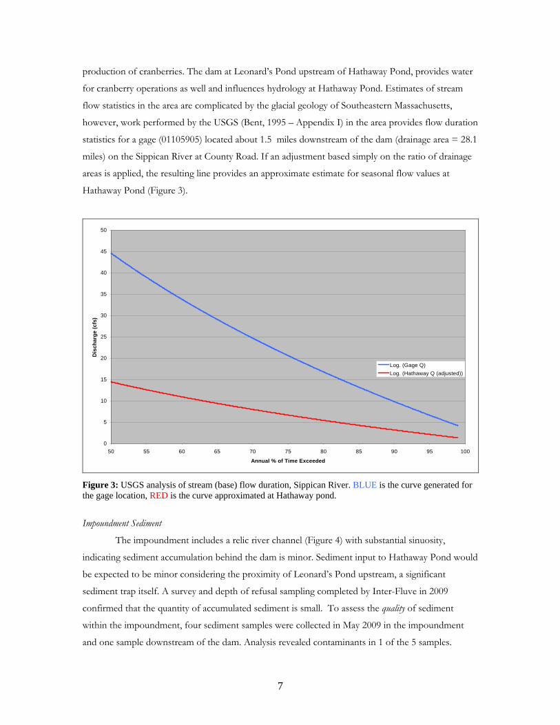
for cranberry operations as well and influences hydrology at Hathaway Pond. Estimates of stream
flow statistics in the area are complicated by the glacial geology of Southeastern Massachusetts,
however, work performed by the USGS (Bent, 1995 – Appendix I) in the area provides flow duration
statistics for a gage (01105905) located about 1.5 miles downstream of the dam (drainage area = 28.1
miles) on the Sippican River at County Road. If an adjustment based simply on the ratio of drainage
areas is applied, the resulting line provides an approximate estimate for seasonal flow values at
Hathaway Pond (Figure 3).
0
5
10
15
20
25
30
35
40
45
50
50 55 60 65 70 75 80 85 90 95 100
Annual % of Time Exceeded
Dis
char
ge (c
fs)
Log. (Gage Q)Log. (Hathaway Q (adjusted))
Figure 3: USGS analysis of stream (base) flow duration, Sippican River. BLUE is the curve generated for the gage location, RED is the curve approximated at Hathaway pond.
Impoundment Sediment
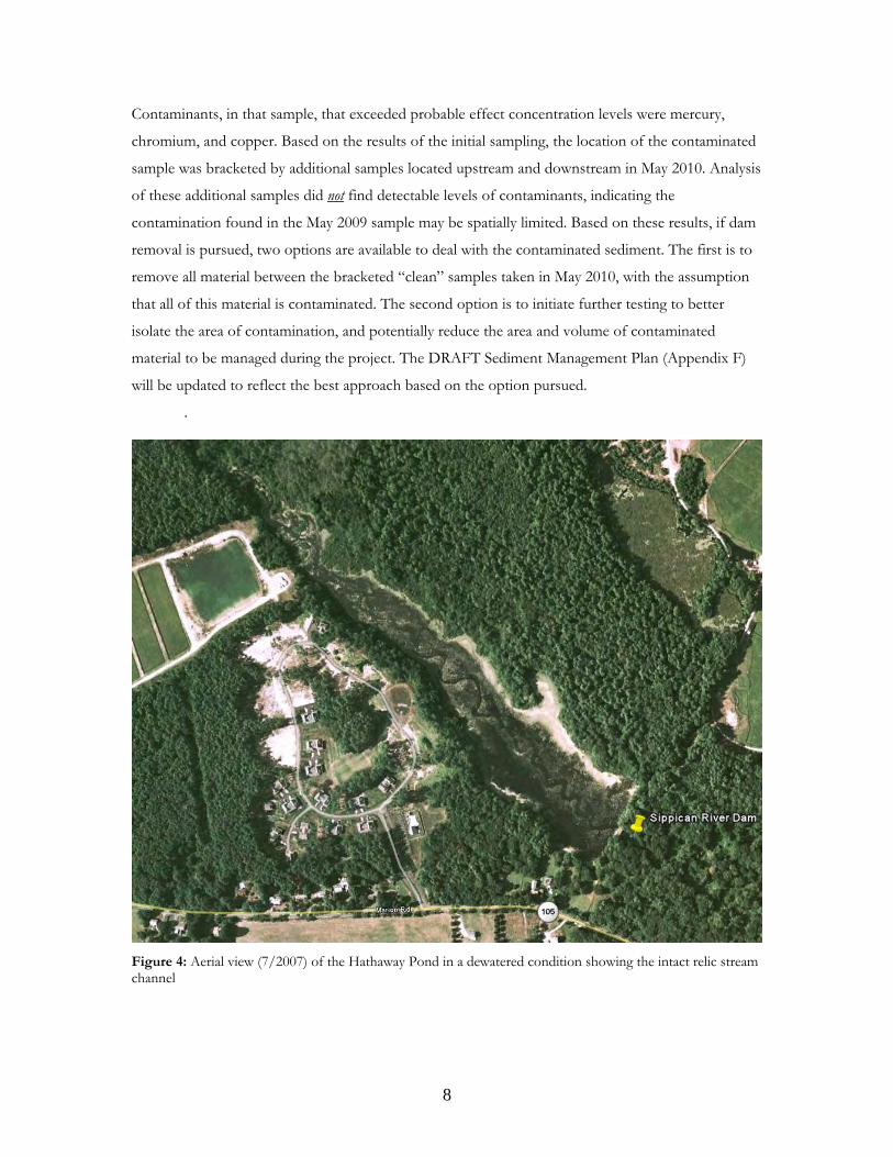
The impoundment includes a relic river channel (Figure 4) with substantial sinuosity,
indicating sediment accumulation behind the dam is minor. Sediment input to Hathaway Pond would
be expected to be minor considering the proximity of Leonard’s Pond upstream, a significant
sediment trap itself. A survey and depth of refusal sampling completed by Inter-Fluve in 2009
confirmed that the quantity of accumulated sediment is small. To assess the quality of sediment
within the impoundment, four sediment samples were collected in May 2009 in the impoundment
and one sample downstream of the dam. Analysis revealed contaminants in 1 of the 5 samples.
8
Contaminants, in that sample, that exceeded probable effect concentration levels were mercury,
chromium, and copper. Based on the results of the initial sampling, the location of the contaminated
sample was bracketed by additional samples located upstream and downstream in May 2010. Analysis
of these additional samples did not find detectable levels of contaminants, indicating the
contamination found in the May 2009 sample may be spatially limited. Based on these results, if dam
removal is pursued, two options are available to deal with the contaminated sediment. The first is to
remove all material between the bracketed “clean” samples taken in May 2010, with the assumption
that all of this material is contaminated. The second option is to initiate further testing to better
isolate the area of contamination, and potentially reduce the area and volume of contaminated
material to be managed during the project. The DRAFT Sediment Management Plan (Appendix F)
will be updated to reflect the best approach based on the option pursued.
.
Figure 4: Aerial view (7/2007) of the Hathaway Pond in a dewatered condition showing the intact relic stream channel
9
Cranberry Operations
As mentioned, Hathaway Pond provides a secondary water source to approximately 55 acres
of bogs located just north and east of the dam. The water is pumped from a short canal (at the
northeast corner of the dam) up and into the bog complex. An agreement was tendered between
CBB and Beaton’s Inc. (Appendix C) to investigate alternative solutions to providing the necessary
water to these bogs that would allow restoration of the Sippican River as well the continuation of
cranberry operations on the Beaton property. A report investigating these alternatives was performed
by Benjamin Gilmore P.E., guided by the three options of repair, partial breach, and full removal that
are outlined in more detail below. The conclusion of the report indicates that the best long term
solution to maintain cranberry production for the Beaton bogs that rely on Hathaway Pond as a
water source is to construct a groundwater fed reservoir on the Beaton property. In addition,
maintaining the hydraulic connection of the existing canal and pump apparatus (see Sheet 1 of
drawings in Appendix E) would allow some water to be drawn from the Sippican, at the location of
the current dam/pump station, if necessary. This conclusion helped guide the alternative analysis
for the dam as discussed below, since one of the initial constraints for all alternatives was to avoid
disruption of the cranberry operation. All of the alternatives evaluated can meet this constraint with
modifications to the existing canal and pump drawing water from Hathaway and modifications to
canals and water control structures allowing transfer of water from Leonard’s Pond through Hiller
Front bogs and into Hiller “Back” bogs, shown in Figure 2. These manipulations will meet the
temporary water use requirements of the Beaton bogs to bridge the gap in time between any
modification to Hathaway Dam and completion of the recommended groundwater fed reservoir.
The full report is included as Appendix G.
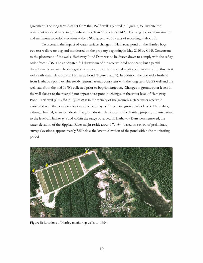
Another cranberry bog operation, the Hartley Bogs, is located on the right side (west) of the
river near the head of the Hathaway Pond impoundment. Comprised of approximately 15 acres, this
operation drains water to, but does not draw water from either the Sippican River or Hathaway
Pond. These bogs are not constructed on historic wetlands, but instead the existing ground was
excavated down to an elevation where interaction with groundwater would be assured. Concerns
have been noted by the bog owners that changes to the water level of Hathaway Pond, associated
with dam modification or removal, could affect the elevation of groundwater within their bog
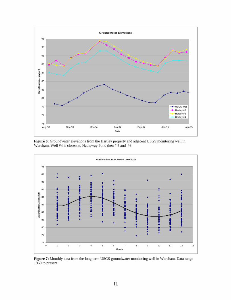
system. Data were provided by the Hartley’s collected in the mid 1990’s from monitoring wells on
the property, prior to construction of the bogs. This data (Figure 5 and 6) indicates a variability of
approximately 6’ in the natural seasonal cycle of groundwater in the area and a spatial variation of
approximately 2’ at any given moment on the property. The USGS has a long term monitoring well
in nearby Wareham. Data from the well are plotted along with the Hartley data to illustrate
10
agreement. The long term data set from the USGS well is plotted in Figure 7, to illustrate the
consistent seasonal trend in groundwater levels in Southeastern MA. The range between maximum
and minimum recorded elevation at the USGS gage over 50 years of recording is about 8’.
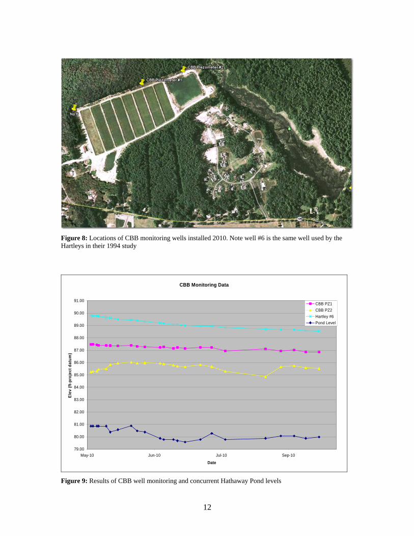
To ascertain the impact of water surface changes in Hathaway pond on the Hartley bogs,
two test wells were dug and monitored on the property beginning in May 2010 by CBB. Concurrent
to the placement of the wells, Hathaway Pond Dam was to be drawn down to comply with the safety
order from ODS. The anticipated full drawdown of the reservoir did not occur, but a partial
drawdown did occur. The data gathered appear to show no causal relationship in any of the three test
wells with water elevations in Hathaway Pond (Figure 8 and 9). In addition, the two wells furthest
from Hathaway pond exhibit steady seasonal trends consistent with the long term USGS well and the
well data from the mid 1990’s collected prior to bog construction. Changes in groundwater levels in
the well closest to the river did not appear to respond to changes in the water level of Hathaway
Pond. This well (CBB #2 in Figure 8) is in the vicinity of the ground/surface water reservoir
associated with the cranberry operation, which may be influencing groundwater levels. These data,
although limited, seem to indicate that groundwater elevations on the Hartley property are insensitive
to the level of Hathaway Pond within the range observed. If Hathaway Dam were removed, the
water elevation of the Sippican River might reside around 76’ +/- based on review of preliminary
survey elevations, approximately 3.5’ below the lowest elevation of the pond within the monitoring
period.
Figure 5: Locations of Hartley monitoring wells ca. 1994
11
Groundwater Elevations
75
77
79
81
83
85
87
89
91
93
95
Aug-93 Nov-93 Mar-94 Jun-94 Sep-94 Jan-95 Apr-95
Date
Elev
(ft-p
roje
ct d
atum
)
USGS WellHartley #6Hartley #5Hartley #4
Figure 6: Groundwater elevations from the Hartley property and adjacent USGS monitoring well in Wareham. Well #4 is closest to Hathaway Pond then # 5 and #6
Monthly data from USGS 1960-2010
78
79
80
81
82
83
84
85
86
87
88
0 1 2 3 4 5 6 7 8 9 10 11 12 13
Month
Gro
undw
ater
Ele
vatio
n (ft
)
Figure 7: Monthly data from the long term USGS groundwater monitoring well in Wareham. Data range 1960 to present.
12
Figure 8: Locations of CBB monitoring wells installed 2010. Note well #6 is the same well used by the Hartleys in their 1994 study
CBB Monitoring Data
79.00
80.00
81.00
82.00
83.00
84.00
85.00
86.00
87.00
88.00
89.00
90.00
91.00
May-10 Jun-10 Jul-10 Sep-10
Date
Elev
(ft-p
roje
ct d
atum
)
CBB PZ1CBB PZ2Hartley #6Pond Level
Figure 9: Results of CBB well monitoring and concurrent Hathaway Pond levels
13
Ecology
The impact of dams on the ecologic function of a river system is well established. The dam
structure itself represents a barrier to the natural transport (both upstream and downstream) of
water, sediment, and aquatic species. This is of particular concern for anadromous species that
historically ascend freshwater streams to complete their life cycle, and are prevented from doing so
by dams. The extirpation of Atlantic salmon from much of the northeast is due in part to the impact
of dams. Dams create impoundments that displace riverine habitat with lake habitat. This
conversion often extirpates riverine species within the impoundment, and also affects reaches below
the dam by sending warm water downstream, often extirpating temperature sensitive species (such as
brook trout). Because the sediment supply from upstream is effectively shut off, channel erosion
often increases in the river below the dam as “hungry water” mobilizes sediment to correct the
imbalance. These are a few of the more noticeable impacts, a host of additional impacts related to
water quality (dissolved oxygen, nutrient cycling), hyporheic exchange, and non-fish aquatic species
exists as well.
The Sippican River is classified as a Riverine Priority Vegetation Community in areas directly
north and south of Hathaway Pond. These Riverine Priority Vegetation Communities are one of 8
systems identified by Natural Heritage Endangered Species Program as being “most critical to the
conservation of the Commonwealth’s biodiversity.” Immediately surrounding Hathaway Pond is
classified as BioMap Core Habitat, a designation given to large, relatively intact tracts of land that are
able to support threatened or endangered species and native communities. Below the dam along the
Sippican River are a number of state threatened and endangered floral and faunal species, however
none of these have been documented upstream of the dam. The river itself maintains a run of alewife
with varying returns ranging from up to 900 fish to as low as a few dozen based on counts completed
during various years by Alewives Anonymous. A run of blueback herring has not been specifically
identified, but local fish biologists indicate they likely use the Sippican, though in lower numbers than
the alewife due to habitat preferences (Steve Hurley, MA DFG, personal communication). It is
acknowledged that some alewife spawning may occur in the Hathaway Pond impoundment, but
habitat here is limited in quality and in quantity relative to Leonard’s Pond (upstream). A habitat
evaluation of Hathaway Pond and Leonard’s Pond is underway by the Massachusetts Division of
Marine Fisheries, but results are not currently available. A concrete sluice with approximately 8
baffles serves as a fish ladder around the Hathaway Pond Dam; however it lacks the attraction flow
necessary for fish to effectively find and enter the ladder. It is unlikely that this structure effectively
and consistently, passes fish, particularly river herring.
14
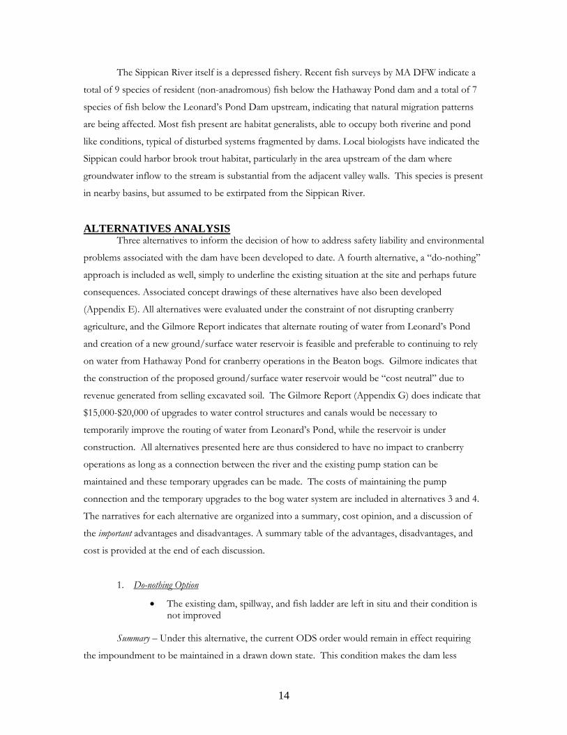
The Sippican River itself is a depressed fishery. Recent fish surveys by MA DFW indicate a
total of 9 species of resident (non-anadromous) fish below the Hathaway Pond dam and a total of 7
species of fish below the Leonard’s Pond Dam upstream, indicating that natural migration patterns
are being affected. Most fish present are habitat generalists, able to occupy both riverine and pond
like conditions, typical of disturbed systems fragmented by dams. Local biologists have indicated the
Sippican could harbor brook trout habitat, particularly in the area upstream of the dam where
groundwater inflow to the stream is substantial from the adjacent valley walls. This species is present
in nearby basins, but assumed to be extirpated from the Sippican River.
ALTERNATIVES ANALYSIS Three alternatives to inform the decision of how to address safety liability and environmental
problems associated with the dam have been developed to date. A fourth alternative, a “do-nothing”
approach is included as well, simply to underline the existing situation at the site and perhaps future
consequences. Associated concept drawings of these alternatives have also been developed
(Appendix E). All alternatives were evaluated under the constraint of not disrupting cranberry
agriculture, and the Gilmore Report indicates that alternate routing of water from Leonard’s Pond
and creation of a new ground/surface water reservoir is feasible and preferable to continuing to rely
on water from Hathaway Pond for cranberry operations in the Beaton bogs. Gilmore indicates that
the construction of the proposed ground/surface water reservoir would be “cost neutral” due to
revenue generated from selling excavated soil. The Gilmore Report (Appendix G) does indicate that
$15,000-$20,000 of upgrades to water control structures and canals would be necessary to
temporarily improve the routing of water from Leonard’s Pond, while the reservoir is under
construction. All alternatives presented here are thus considered to have no impact to cranberry
operations as long as a connection between the river and the existing pump station can be
maintained and these temporary upgrades can be made. The costs of maintaining the pump
connection and the temporary upgrades to the bog water system are included in alternatives 3 and 4.
The narratives for each alternative are organized into a summary, cost opinion, and a discussion of
the important advantages and disadvantages. A summary table of the advantages, disadvantages, and
cost is provided at the end of each discussion.
1. Do-nothing Option
• The existing dam, spillway, and fish ladder are left in situ and their condition is not improved
Summary – Under this alternative, the current ODS order would remain in effect requiring
the impoundment to be maintained in a drawn down state. This condition makes the dam less
15
effective at providing water for cranberry operations, less effective at passing fish and does not
permanently address the issue of safety. The cost of ongoing required dam safety monitoring would
remain.
Safety concerns would be paramount. A catastrophic failure of the dam has already been
identified by the Office of Dam Safety as a scenario to be avoided. Typically such failures, as has
already been the case, occur during significant flood events. Even with the spillway completely open,
floods in excess of this capacity can build a sizeable volume of water behind the dam.
Liability for such a catastrophic failure would be substantial for the dam owner. In addition,
the cost of fines levied from the Office of Dam Safety for continued non-compliance of their order
to remove or repair would grow.
Ecological impacts associated with compromised fish passage would remain or worsen as
the existing fish ladder would continue to perform poorly. Habitat within the impoundment would
be suspended between riverine and impoundment characteristics, reducing the viability of all species
that utilize either of the two habitats.
2. Dam Repair Option
• Make necessary improvements to fix the existing function and structure of the dam to MA Office of Dam Safety standards
• Add a more effective fish ladder to improve fish passage characteristics
Summary – The requirements to bring the dam into compliance are detailed in the GAF
report. Additional review for this study by a structural engineer has added that the concrete spillway
should be replaced instead of repaired. Note that no structural review of the dam has occurred since
the March 2010 breach and additional measures may be required. The addition of a steep pass fish
ladder is intended to improve the attraction flow and fish passage characteristics for river herring
over the currently installed ladder.
Cost - Given the hazard classification of the dam coupled with the perpetual maintenance
associated with the structure, the indirect costs following the initial capital investment to bring the
structure into compliance with contemporary dam standards would be substantial. In addition to the
GAF report (2006) where a detailed analysis of total costs (construction and engineering) for
repairing the existing structure were estimated at $160K - $200K, a recent review of the structure by
a structural engineer (Appendix H) increased that estimate to $330K - $400K based largely on their
opinion that the retaining wall on the downstream side of the main spillway had in fact already failed
and should be rebuilt to remain viable. Previous reviews by GAF Engineering had not included costs
for this continued deterioration. The failure of the earthen embankment in March 2010 indicates
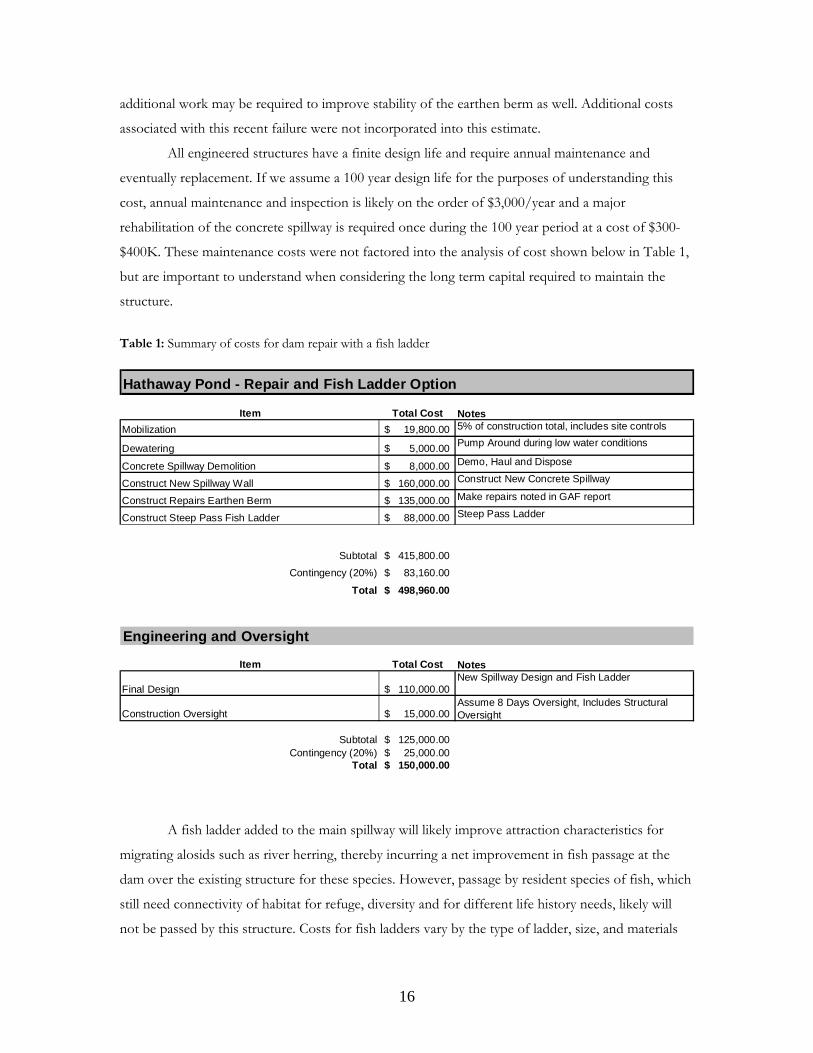
16
additional work may be required to improve stability of the earthen berm as well. Additional costs
associated with this recent failure were not incorporated into this estimate.
All engineered structures have a finite design life and require annual maintenance and
eventually replacement. If we assume a 100 year design life for the purposes of understanding this
cost, annual maintenance and inspection is likely on the order of $3,000/year and a major
rehabilitation of the concrete spillway is required once during the 100 year period at a cost of $300-
$400K. These maintenance costs were not factored into the analysis of cost shown below in Table 1,
but are important to understand when considering the long term capital required to maintain the
structure.
Table 1: Summary of costs for dam repair with a fish ladder Hathaway Pond - Repair and Fish Ladder Option
Item Total Cost NotesMobilization 19,800.00$ 5% of construction total, includes site controls
Dewatering 5,000.00$ Pump Around during low water conditions
Concrete Spillway Demolition 8,000.00$ Demo, Haul and Dispose
Construct New Spillway Wall 160,000.00$ Construct New Concrete Spillway
Construct Repairs Earthen Berm 135,000.00$ Make repairs noted in GAF report
Construct Steep Pass Fish Ladder 88,000.00$ Steep Pass Ladder
Subtotal 415,800.00$ Contingency (20%) 83,160.00$
Total 498,960.00$
Engineering and Oversight
Item Total Cost Notes
Final Design 110,000.00$ New Spillway Design and Fish Ladder
Construction Oversight 15,000.00$ Assume 8 Days Oversight, Includes Structural Oversight
Subtotal 125,000.00$ Contingency (20%) 25,000.00$
Total 150,000.00$
A fish ladder added to the main spillway will likely improve attraction characteristics for
migrating alosids such as river herring, thereby incurring a net improvement in fish passage at the
dam over the existing structure for these species. However, passage by resident species of fish, which
still need connectivity of habitat for refuge, diversity and for different life history needs, likely will
not be passed by this structure. Costs for fish ladders vary by the type of ladder, size, and materials
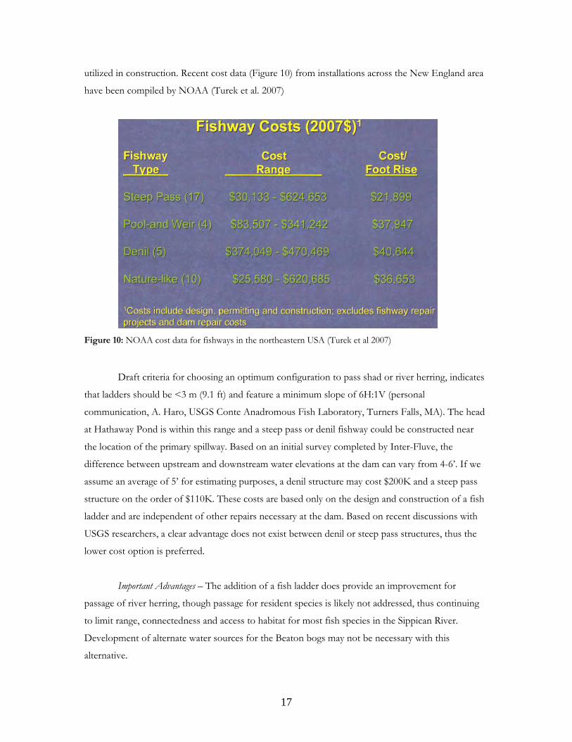
17
utilized in construction. Recent cost data (Figure 10) from installations across the New England area
have been compiled by NOAA (Turek et al. 2007)
Figure 10: NOAA cost data for fishways in the northeastern USA (Turek et al 2007)
Draft criteria for choosing an optimum configuration to pass shad or river herring, indicates
that ladders should be <3 m (9.1 ft) and feature a minimum slope of 6H:1V (personal
communication, A. Haro, USGS Conte Anadromous Fish Laboratory, Turners Falls, MA). The head
at Hathaway Pond is within this range and a steep pass or denil fishway could be constructed near
the location of the primary spillway. Based on an initial survey completed by Inter-Fluve, the
difference between upstream and downstream water elevations at the dam can vary from 4-6’. If we
assume an average of 5’ for estimating purposes, a denil structure may cost $200K and a steep pass
structure on the order of $110K. These costs are based only on the design and construction of a fish
ladder and are independent of other repairs necessary at the dam. Based on recent discussions with
USGS researchers, a clear advantage does not exist between denil or steep pass structures, thus the
lower cost option is preferred.
Important Advantages – The addition of a fish ladder does provide an improvement for
passage of river herring, though passage for resident species is likely not addressed, thus continuing
to limit range, connectedness and access to habitat for most fish species in the Sippican River.
Development of alternate water sources for the Beaton bogs may not be necessary with this
alternative.
18
Important Disadvantages – Cost and liability are the two most important factors against
pursuing this option. The short term capital expenditure and long term maintenance costs far
outweigh any marginal advantages. The liability associated with owning a dam, particularly a high
hazard structure, is difficult to quantify, but tends to be avoided when considering risk and asset
management decisions.
Repairing the dam provides no restorative effect on the river system, although the fish ladder
as stated above, may improve passage for river herring over the existing structure.
3. Partial Removal Option • Add a fishway / roughened channel that would improve fish passage
characteristics beyond that of a fish ladder option • Remove the state designation of the term “dam” from the property, and the
associated annual maintenance, inspection, and liability associated with dam ownership
• Maintain a connection with the draw point of the exiting pump system • Provide an alternative with costs between repair and removal
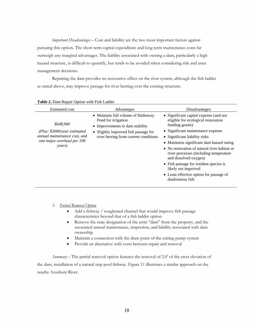
Summary – The partial removal option features the removal of 2.0’ of the crest elevation of
the dam, installation of a natural step pool fishway. Figure 11 illustrates a similar approach on the
nearby Acushent River.
Table 2. Dam Repair Option with Fish Ladder
Estimated cost Advantages Disadvantages
$648,960
(Plus: $3000/year estimated annual maintenance cost, and one major overhaul per 100
years)
• Maintain full volume of Hathaway Pond for irrigation
• Improvements to dam stability • Slightly improved fish passage for
river herring from current conditions
• Significant capital expense (and not eligible for ecological restoration funding grants)
• Significant maintenance expense • Significant liability risks • Maintains significant dam hazard rating • No restoration of natural river habitat or
river processes (including temperature and dissolved oxygen)
• Fish passage for resident species is likely not improved
• Least effective option for passage of diadromous fish
19
Figure 11: Fishway at a dam on the Acushnet River
Ideally this alternative would remove the significant liability and maintenance cost associated
with dam ownership, but because a hydraulic structure remains in place, both liability and
maintenance remains, although at a lower level. Both of the following criteria must be met to remove
the dam from the Office of Dam Safety (ODS) roster; <6’ of head at the design 100 year flow and
<15 acre-feet of impounded water at this flow. Even if these two requirements are met, the Director
of ODS may, at their discretion, continue to require annual inspections and maintenance due to an
assumed hazard to the public. Preliminary discussions with ODS indicate that this dam likely would
qualify for such an extension of the statute. Without a clear solution that removes the liability of dam
ownership, the focus of this alternative moves toward maintaining a smaller impoundment, with a
lower dam, while improving fish passage.
The incorporation of the natural fishway will provide fish passage to a greater range of
species at various life stages. The fishway will be placed on a gradual slope, less steep than a fish
ladder. The construction of this fishway includes some key challenges. The valley bottom below the
dam is wide and flat, and will require the fishway channel to be elevated above the floodplain down
to meet the existing channel. One bank boundary for the fishway channel can likely be the dam
embankment itself, but the other will need to be constructed of fill, which will likely create wetland
impacts. These impacts may be offset by restoration in the upstream impoundment, but this cannot
be verified without more detailed design. The inlet of the fishway at the dam is an extremely critical
area, as the inlet must be structurally substantial and controlled to convey an average flow with
20
suitable hydraulics for fish passage. Larger flows must quickly spread out and occupy the primary
spillway to dissipate energy.
The dam itself will undergo a significant change. The current spillway will be removed and
replaced with a long (approximately 130’) primary spillway with a fixed elevation crest. The crest will
be reinforced with either articulated block or rip rap, providing a hard, flexible lining to
accommodate the 100 yr event design flow. The fishway will occupy a portion of this spillway and
will act as a secondary spillway structure, handling flows consistent with annual average volumes. The
remaining portion of the dam (approximately 370’) will be repaired following the recommendations
in the GAF report.
The Gilmore Report indicates the long term solution to providing water to the Beaton bogs
is the construction of a groundwater fed reservoir. However, the current canal and pump
configuration may be able to provide supplemental water to the Beaton property if the canal were
deepened to ensure interaction with the new water level in the Sippican. Further, existing water from
other bogs on the property (labeled “Hiller Front” in the Gilmore Report) can be routed through the
Beaton bogs (labeled “Hiller Back” in the Gilmore report) to provide the necessary volume of water
for cranberry operations while the groundwater reservoir is being constructed.
Cost – The cost associated with option 2 is shown below in Table 3. The structure will still
be maintained as a dam and thus will continue to have the long term maintenance and monitoring
costs associated with it. The major cost of replacing the concrete spillway will be removed, leaving an
annual maintenance cost of $3,000/year, though these may be reduced depending on the final
configuration of the structure (see discussion under full removal option above). The spillway is made
of a flexible rock lining as opposed to a rigid concrete structure and therefore will have a longer
design life associated with it. Other repairs required for the dam under the GAF report were
included, based on the linear feet of dam remaining outside the footprint of the new
spillway/fishway construction. Contaminated sediment appears to be a minor component if it plays a
role at all in this option and is not explicitly noted in the costs. Costs associated with providing water
to the Beaton bogs will focus largely on the construction of the groundwater reservoir noted in the
Gilmore Report. Costs for improvements to the canal and pump system are highly dependant on the
final configuration of the dam, but a median value for planning purposes is listed as $10,000. Median
costs for improvements to the existing drainage paths to pull water from “Hiller Front” into “Hiller
Back” are listed as $20,000.
21
Table 3: Summary of costs for partial removal Hathaway Pond - Partial Removal Option
Item Total Cost NotesMobilization 11,000.00$ 5% of construction total
Dewatering 5,000.00$ Pump Around during low water conditions
Concrete Spillway Demolition 8,000.00$ Excavator with a Thumb, Haul and Dispose
Partial Earthen Berm Removal 1,750.00$ Remove 2' depth of 130' of Earthen embankment
Construct Primary Spillway 15,000.00$ Rip Rap Primary Spillway
Construct Earthen Berm Repairs 100,000.00$ Make repairs noted in GAF report, NOT covered by other tasks
Construct Fishway 50,000.00$ Includes 120' Fishway and Inlet Construction
Revegetation 2,000.00$ BRS trees/shrubs NO seed; Assumes volunteer Install, Materials only
Pump Canal Improvements 10,000.00$ Deepen and widen existing canal to pump to maintain water connection, add headgate and fish screen to inlet
Beaton Drainage Improvements 20,000.00$ Improve drainage on Beaton property to allow water flow from "Hiller Front" to "Hiller Back" bogs.
Subtotal 222,750.00$
Contingency (20%) 44,550.00$ Total 267,300.00$
Engineering and Oversight
Item Total Cost NotesFinal Design 65,000.00$ Includes Spillway Design and Fishway design Construction Oversight 15,000.00$ Assume 8 Days Oversight, Includes Structural Oversight
Subtotal 80,000.00$ Contingency (20%) 16,000.00$
Total 96,000.00$
Important Advantages – The primary advantage of this option is improvements to fish passage
relative to the dam repair option. A secondary advantage is cost, in that this alternative is less
expensive than the full repair option.
Important Disadvantages – Several disadvantages present themselves under this option. First the
long term maintenance and liability costs associated with the ownership of a dam would continue.
Maintenance may be less, given the new spillway configuration, but will not be eliminated. The added
fishway will provide passage for a greater range of species and life stages of fish over both the
existing structure and the fish ladder option; however it remains a contrived approach to passage and
is not ideal for movement of fish. Funding for this option may be limited as many restoration
funding sources view partial removals as less desirable to complete removals when allocating limited
restoration funds.
The last, and perhaps the most, important disadvantage is that this scenario does not restore
natural river processes. Sediment transport, natural disturbance regimes, the fluid transfer of flora
and fauna along the river corridor and water quality characteristics, including temperature and
22
dissolved oxygen, are still altered by the presence of this dam. The only improvement over existing
conditions is some improvement in fish passage, and perhaps the transition to more emergent
wetlands near the upper end of the impoundment.
4. Full Removal Option
• Completely remove the dam and earthen embankment • Minimize downstream sediment transport from impoundment • Provide optimal fish passage for ALL species • Restore river processes and function • Maintain a connection via the existing canal to the Sippican River for pumping
water
Summary – A preliminary investigation into the removal of the Hathaway Pond dam revealed
a relatively uncomplicated project for full removal. Sediment sampling results indicate minor
contamination in the impoundment in only 1 of 4 samples (Appendix F). Follow-up sampling failed
to replicate this contamination, indicating contaminants may be limited in their spatial extent. An
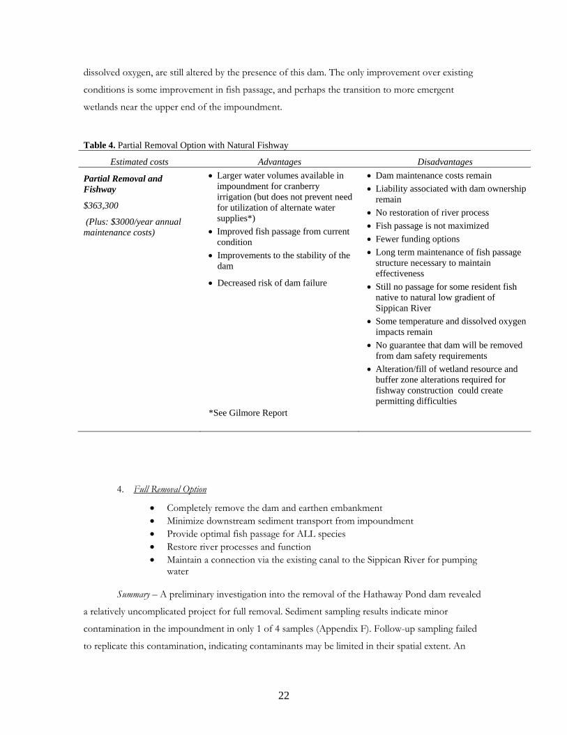
Table 4. Partial Removal Option with Natural Fishway
Estimated costs Advantages Disadvantages
Partial Removal and Fishway
$363,300
(Plus: $3000/year annual maintenance costs)
• Larger water volumes available in impoundment for cranberry irrigation (but does not prevent need for utilization of alternate water supplies*)
• Improved fish passage from current condition
• Improvements to the stability of the dam
• Decreased risk of dam failure
*See Gilmore Report
• Dam maintenance costs remain • Liability associated with dam ownership
remain • No restoration of river process • Fish passage is not maximized • Fewer funding options • Long term maintenance of fish passage
structure necessary to maintain effectiveness
• Still no passage for some resident fish native to natural low gradient of Sippican River
• Some temperature and dissolved oxygen impacts remain
• No guarantee that dam will be removed from dam safety requirements
• Alteration/fill of wetland resource and buffer zone alterations required for fishway construction could create permitting difficulties
23
investigation into the volume of sediment accumulated in the impoundment indicated very little
sediment is present, and a full removal could be expected to discharge little material downstream.
The presence of a relic channel (Figure 4) in the impoundment provides a historic and effective
planform channel for the restored river to occupy following removal. Construction would occur
during low flow conditions beginning with the removal of the primary concrete spillway. The earthen
embankment would then be removed and graded into existing floodplain elevations on either side of
the former dam footprint. For this study, removal of the entire berm was assumed, though if
designed, a portion of the berm may be left intact as dictated by the hydraulic conveyance under large
flood events. As with the Partial Removal option above, additional excavation and perhaps the
installation of a head gate structure and a fish screen would be required to maintain the hydraulic
connection between the existing canal and the new river channel. Habitat restoration within the
impoundment channel may be performed using logs placed by an excavator to accentuate pools and
restore areas of local scour that build microhabitat within the channel bed. A pedestrian bridge may
be installed to allow access across the river at the current location of the dam to maintain
connections between Rt. 105, hiking trails and adjacent conservation lands.
Cost - The management of sediment and restoration of a river channel following dam
removal account for a majority of both design and construction expenses associated with these
projects. Preliminary results seem to indicate that both of these issues are at the extreme minimum in
terms of cost and complexity if full removal were pursued. Little if any maintenance costs are
associated with this option.
Costs associated with maintaining water for the Beaton bogs are the same as described above
under the partial removal option. Some additional expense is anticipated to deepen the canal that
provides water to the existing pump, as full removal decrease the water elevation of the Sippican
further than a partial removal scenario. For this, $5,000 was added to account for additional
excavation, bringing the estimated median cost for this effort to $15,000. The cost to retrofit existing
drainage structures to move water from Hiller Front to Hiller Back remains approximately $20,000.
Optional expenses include pedestrian bridge and channel restoration features within the
former impoundment, but the advantage is only in creating habitat more quickly following removal,
as the habitat will develop on its own in the years following dam removal. A pedestrian bridge can
take many forms and thus entail a range of costs depending on the intended use and design. A
median cost of $20,000 is assumed here for planning purposes.
24
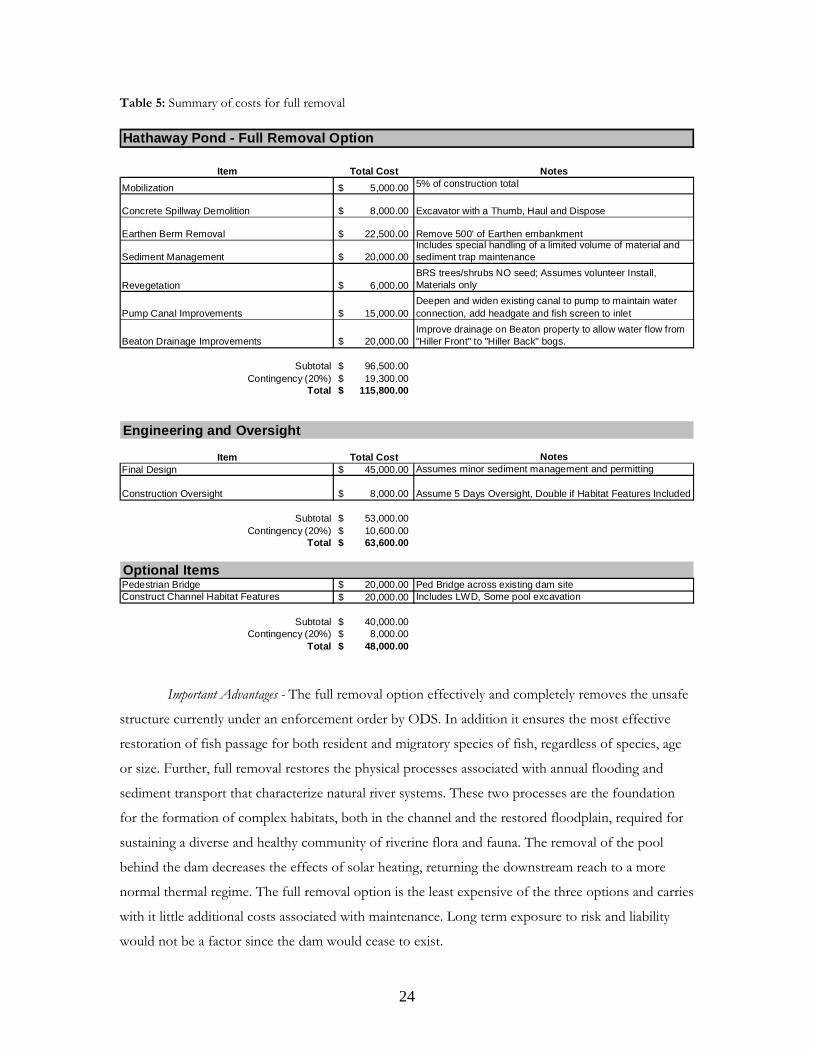
Table 5: Summary of costs for full removal Hathaway Pond - Full Removal Option
Item Total Cost NotesMobilization 5,000.00$ 5% of construction total
Concrete Spillway Demolition 8,000.00$ Excavator with a Thumb, Haul and Dispose
Earthen Berm Removal 22,500.00$ Remove 500' of Earthen embankment
Sediment Management 20,000.00$ Includes special handling of a limited volume of material and sediment trap maintenance
Revegetation 6,000.00$ BRS trees/shrubs NO seed; Assumes volunteer Install, Materials only
Pump Canal Improvements 15,000.00$ Deepen and widen existing canal to pump to maintain water connection, add headgate and fish screen to inlet
Beaton Drainage Improvements 20,000.00$ Improve drainage on Beaton property to allow water flow from "Hiller Front" to "Hiller Back" bogs.
Subtotal 96,500.00$ Contingency (20%) 19,300.00$
Total 115,800.00$
Engineering and Oversight
Item Total Cost NotesFinal Design 45,000.00$ Assumes minor sediment management and permitting
Construction Oversight 8,000.00$ Assume 5 Days Oversight, Double if Habitat Features Included
Subtotal 53,000.00$ Contingency (20%) 10,600.00$
Total 63,600.00$
Optional Items Pedestrian Bridge 20,000.00$ Ped Bridge across existing dam siteConstruct Channel Habitat Features 20,000.00$ Includes LWD, Some pool excavation
Subtotal 40,000.00$ Contingency (20%) 8,000.00$
Total 48,000.00$
Important Advantages - The full removal option effectively and completely removes the unsafe
structure currently under an enforcement order by ODS. In addition it ensures the most effective
restoration of fish passage for both resident and migratory species of fish, regardless of species, age
or size. Further, full removal restores the physical processes associated with annual flooding and
sediment transport that characterize natural river systems. These two processes are the foundation
for the formation of complex habitats, both in the channel and the restored floodplain, required for
sustaining a diverse and healthy community of riverine flora and fauna. The removal of the pool
behind the dam decreases the effects of solar heating, returning the downstream reach to a more
normal thermal regime. The full removal option is the least expensive of the three options and carries
with it little additional costs associated with maintenance. Long term exposure to risk and liability
would not be a factor since the dam would cease to exist.
25
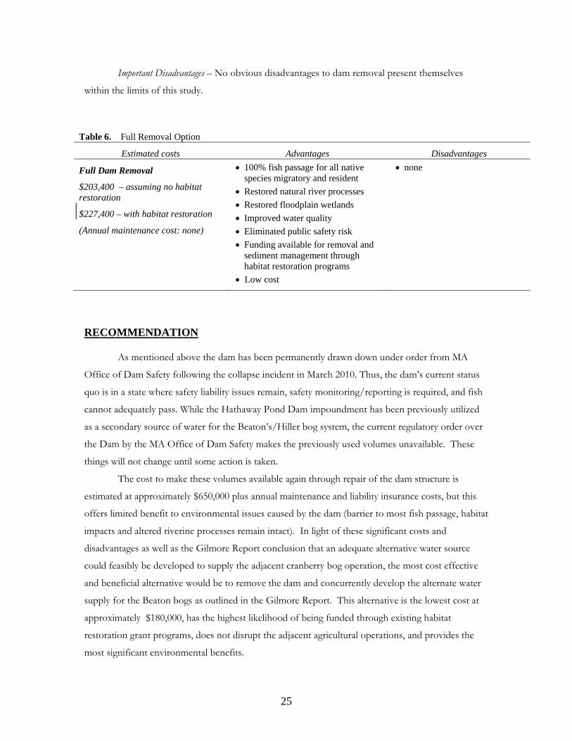
Important Disadvantages – No obvious disadvantages to dam removal present themselves
within the limits of this study.
Table 6. Full Removal Option
Estimated costs Advantages Disadvantages
Full Dam Removal
$203,400 – assuming no habitat restoration
$227,400 – with habitat restoration
(Annual maintenance cost: none)
• 100% fish passage for all native species migratory and resident
• Restored natural river processes • Restored floodplain wetlands • Improved water quality • Eliminated public safety risk • Funding available for removal and
sediment management through habitat restoration programs
• Low cost
• none
RECOMMENDATION As mentioned above the dam has been permanently drawn down under order from MA
Office of Dam Safety following the collapse incident in March 2010. Thus, the dam’s current status
quo is in a state where safety liability issues remain, safety monitoring/reporting is required, and fish
cannot adequately pass. While the Hathaway Pond Dam impoundment has been previously utilized
as a secondary source of water for the Beaton’s/Hiller bog system, the current regulatory order over
the Dam by the MA Office of Dam Safety makes the previously used volumes unavailable. These
things will not change until some action is taken.
The cost to make these volumes available again through repair of the dam structure is
estimated at approximately $650,000 plus annual maintenance and liability insurance costs, but this
offers limited benefit to environmental issues caused by the dam (barrier to most fish passage, habitat
impacts and altered riverine processes remain intact). In light of these significant costs and
disadvantages as well as the Gilmore Report conclusion that an adequate alternative water source
could feasibly be developed to supply the adjacent cranberry bog operation, the most cost effective
and beneficial alternative would be to remove the dam and concurrently develop the alternate water
supply for the Beaton bogs as outlined in the Gilmore Report. This alternative is the lowest cost at
approximately $180,000, has the highest likelihood of being funded through existing habitat
restoration grant programs, does not disrupt the adjacent agricultural operations, and provides the
most significant environmental benefits.
26
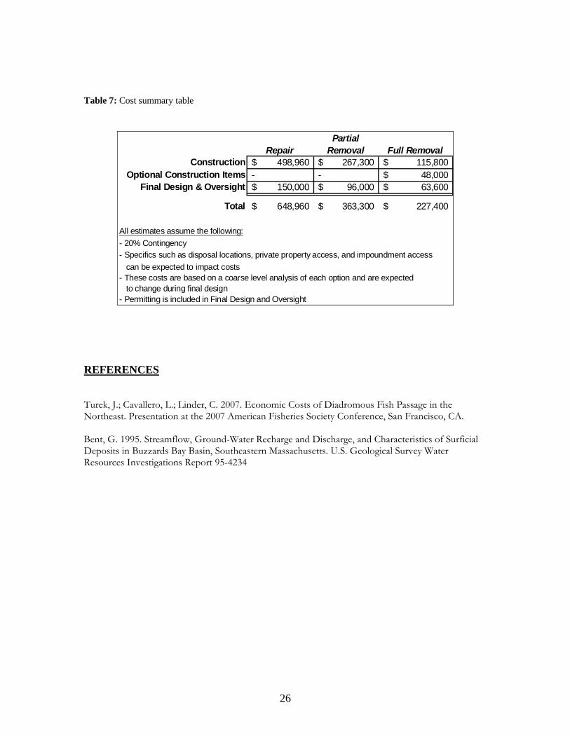
Table 7: Cost summary table
RepairPartial
Removal Full RemovalConstruction 498,960$ 267,300$ 115,800$
Optional Construction Items - - 48,000$ Final Design & Oversight 150,000$ 96,000$ 63,600$
Total 648,960$ 363,300$ 227,400$
All estimates assume the following:- 20% Contingency - Specifics such as disposal locations, private property access, and impoundment access can be expected to impact costs - These costs are based on a coarse level analysis of each option and are expected to change during final design- Permitting is included in Final Design and Oversight
REFERENCES Turek, J.; Cavallero, L.; Linder, C. 2007. Economic Costs of Diadromous Fish Passage in the Northeast. Presentation at the 2007 American Fisheries Society Conference, San Francisco, CA. Bent, G. 1995. Streamflow, Ground-Water Recharge and Discharge, and Characteristics of Surficial Deposits in Buzzards Bay Basin, Southeastern Massachusetts. U.S. Geological Survey Water Resources Investigations Report 95-4234
27
APPENDICES
A – Dam Inspection Reports 2006, 2008, and 2009 B – Office of Dam Safety Order C – CBB – Beaton Inc. Agreement D – MacBroom Report on Hathaway Pond for MA DER (former Riverways) E – Concept Drawings for Hathaway Pond F – DRAFT Sediment Management Plan G – Benjamin Gilmore Report on Beaton Water Supply Needs H – Structural Review of Hathaway (2010) I – USGS Report on SE Massachusetts Hydrology