experience - downtown partnership of colorado springs
TRANSCRIPT

EXPERIENCE
Prepared under the direction of: Downtown Development Authority of Colorado Springs
and the City of Colorado Springs
Prepared by MIG, Inc. in association with: Progressive Urban Management Associates,
Starboard Realty Group, Alta Planning + Design,
and Walker Parking Associates
DOWNTOWNCOLORADO SPRINGS
NOVEMBER
2016

E X P E R I E N C E D O W N T O W N C O L O R A D O S P R I N G S
Table of Contents
INTRODUCTION ...........................................................................................................................i
Overview .................................................................................................................................................................................... ii
Setting ....................................................................................................................................................................................... iii
Context ...................................................................................................................................................................................... x
Background ................................................................................................................................................................................ xiii
Planning Process ........................................................................................................................................................................ xiv
Implementation: Who and How ................................................................................................................................................ xv
Plan on a Page ........................................................................................................................................................................... xvi
VOLUME 1 – EXPERIENCE DOWNTOWN PLAN OF DEVELOPMENT ......................................1-1
1. Assets, Opportunities and Challenges .......................................................................................... 1-3
Overview ....................................................................................................................................................................................1-4
Assets and Opportunities ..........................................................................................................................................................1-4
Challenges .................................................................................................................................................................................1-10
2. Vision Framework ......................................................................................................................... 1-13
Overview ....................................................................................................................................................................................1-14
Vision and Values .......................................................................................................................................................................1-14
Goals and Action Steps .............................................................................................................................................................1-16
3. DDA Boundary Description and Amendments .............................................................................. 1-25
Overview ....................................................................................................................................................................................1-26
4. Tax Increment Financing ............................................................................................................... 1-29
Overview ....................................................................................................................................................................................1-30

VOLUME 2 – EXPERIENCE DOWNTOWN MASTER PLAN .........................................................2-1
1. Land Use ....................................................................................................................................... 2-3
Master Plan Guiding Principles..................................................................................................................................................2-4
Overview ....................................................................................................................................................................................2-4
Historic Context .........................................................................................................................................................................2-5
Existing Land Use ......................................................................................................................................................................2-7
Future Land Use .........................................................................................................................................................................2-10
Catalytic Development Sites .....................................................................................................................................................2-12
Influence Sites ............................................................................................................................................................................2-23
2. Parks, Trails and Waterways .......................................................................................................... 2-25
Overview ....................................................................................................................................................................................2-26
Legacy Loop ..............................................................................................................................................................................2-27
Urban and Neighborhood Greenways ......................................................................................................................................2-30
Downtown Parks and Waterways ..............................................................................................................................................2-30
3. Gateways and Districts ................................................................................................................. 2-33
Overview ....................................................................................................................................................................................2-34
Gateways ...................................................................................................................................................................................2-36
Districts ......................................................................................................................................................................................2-40
4. Transportation, Mobility and Parking........................................................................................... 2-45
Overview ....................................................................................................................................................................................2-46
Mobility Framework ...................................................................................................................................................................2-46
Transit ........................................................................................................................................................................................2-66
Parking .......................................................................................................................................................................................2-71
5. Urban Design and Public Space .................................................................................................... 2-75
Overview ....................................................................................................................................................................................2-76
Form-Based Code ......................................................................................................................................................................2-76
Public Space ..............................................................................................................................................................................2-83
Acknowledgments ............................................................................................................................ 2-96

I

Introduction
The Introduction explains the setting, provides context and background, reviews the planning process and describes the organization of the Plan of Development and Master Plan.
OverviewSettingContextBackgroundPlanning ProcessImplementation: Who and HowPlan on a Page

ii E X P E R I E N C E D O W N T O W N C O L O R A D O S P R I N G S
Overview
These plans illustrate that path forward. They serve as
tactical updates to the 2007 Imagine Downtown
Plan of Development and the 2009 Imagine
Downtown Master Plan, both of which were approved
by City Council after a four-year strategic visioning
process involving hundreds of stakeholders.
The updated Plan of Development also incorporates
and supports more than a dozen recent,
complementary city and regional plans. The Plan
of Development works in alignment with the updated
Master Plan, and also advances the vision, objectives,
policies and strategies of the city’s Comprehensive
Plan. The updated Master Plan provides specific
tactics to move forward unfulfilled goals of the 2009
plan as well as providing new chapters addressing
transportation and mobility, and parks, trails and public
spaces.
One conviction has emerged from the process to
update the Imagine Downtown Plan of Development
and Imagine Downtown Master Plan: We are no
longer “imagining” a great downtown – we are
creating it and experiencing it daily, and must move
swiftly to seize opportunities in the near-term to propel
Downtown Colorado Springs forward. For this reason,
the updated plans are now called the Experience
Downtown Colorado Springs Plan of Development
and the Experience Downtown Colorado Springs
Master Plan.
Vibrant, livable downtowns are now understood to be an economic imperative for cities.
Millennials and boomers are driving a resurgence in
Downtown living. Skilled talent is in high demand,
prompting both start-ups and established businesses
to locate in the compact urban centers that
their employees prefer. Transit and infrastructure
improvements are helping revitalize historic districts,
create more walkable and bikeable destinations,
and foster more engaging and healthy Downtown
environments.
Downtown Colorado Springs has embraced many
steps in line with these broader trends. Now is
the time to align all business, government and
community forces to create the greatest Downtown
of any midsize city in the country.
The long-envisioned renaissance of Downtown
Colorado Springs has taken hold in recent years, as
new market interest and development have bolstered
the city center in myriad ways. Tejon Street hums as
a retail and dining destination. The Legacy Loop and
other biking and walking connections are becoming
a reality. Several major projects – including the U.S.
Olympic Museum in Southwest Downtown, new
business investment, and hundreds of new residential
units in the pipeline – are poised to further accelerate
growth and change in the coming years.
But much work remains. Colorado Springs vies for jobs,
workers and tourists against comparable markets with
already revitalized city centers, bustling with amenities,
residents and workers. Building from the foundation
of recent successes, Colorado Springs must outline a
strategic, actionable, consensus-built roadmap to
elevate Downtown to the next level.

iiiI N T R O D U C T I O N
Setting
For the purposes of these plans, Downtown is viewed
in the context of the Legacy Loop trail system and
the land use study area defined by the boundary
of the Downtown Development Authority (DDA).
Generally speaking, the study area is bounded on the
north by Colorado College (Cache la Poudre Street);
on the east by the Shooks Run section of the Legacy
Loop; on the south by Fountain Boulevard and the
freight rail tracks; and on the west by the Monument
Creek Trail section of the Legacy Loop and Interstate
25 (Figure 1.1).
Downtown Colorado Springs’ geographic location and
spectacular physical setting have played a major role
in shaping its history. Location and setting also serve
as important drivers of its future development.
Although many towns and cities in Colorado were
settled by miners and ranchers, Colorado Springs’
appeal was climate and culture. Looming over the
city is Pikes Peak, where Katharine Lee Bates penned
“America the Beautiful.” By 1918 Colorado Springs
was renowned as a destination, with both the Antlers
and Broadmoor hotels serving tourists from around
the world. At an elevation of 6,035 feet, the area also
became a health-oriented destination where thousands
of people came to relieve their tuberculosis in the dry
mountain air.
Colorado Springs is still known as a tourist destination
due to its natural beauty, proximity to outdoor
recreation, and a culture of adventure that attracts
visitors from around the world. The city features 14,287
acres of dedicated parkland and experiences an
average of 247 days of sunshine per year, adding not
only to its tourist charm, but also to its status as a great
place to live.
Postcards of the Antlers Hotel from the early 1900s showcased Colorado Springs’ natural and architectural beauty.
source: Colorado Springs Pioneers Museum
source: Colorado Springs Pioneers Museum

iv E X P E R I E N C E D O W N T O W N C O L O R A D O S P R I N G S
Source: Esri, DigitalGlobe, GeoEye, Earthstar Geographics, CNES/Airbus DS, USDA, USGS, AEX, Getmapping, Aerogrid, IGN, IGP, swisstopo, and the GIS User Community
IMAGINE DOWNTOWN | MASTER PLAN TACTICAL UPDATE
Downtown Study Area 0 500 1000 2000 feet
LegendDowntown Study Area
BID Boundary
25
25
LOWELL NEIGHBORHOOD
MILL STREET / LAS VEGASNEIGHBORHOODS
WESTSIDENEIGHBORHOOD
DIVINE REDEEMERNEIGHBORHOOD
MIDDLESHOOKS RUN
NEIGHBORHOOD
HILLSIDENEIGHBORHOOD
COLORADO COLLEGE
S TE
JON
ST
N T
EJO
N S
T
S W
EBER
ST
SAH
WA
TCH
ST
S SI
ERRA
MA
DRE
ST
E KIOWA ST
E BIJOU ST
E DALE ST
CIM
INO
DR
E COSTILLA ST
E CIMARRON ST
N W
EBER
ST
E RIO GRANDE ST
E PLATTE AVE
E ST VRAIN ST
E BOULDER ST
E CUCHARRAS ST
E MORENO AVE
S C
ASC
AD
E A
VE
E MONUMENT ST
W MORENO AVE
W COLORADO AVEW COLORADO AVE
E WILLAMETTE AVE
W BIJOU STW BIJOU ST
E PIKES PEAK AVE
W RIO GRANDE ST
NN
EVA
DA
AVE
W COSTILLA ST
W CIMARRON ST
SN
EVA
DA
AVE
E LAS ANIMAS S
FOUNTAIN BLVDFOUNTAIN BLVD
W MILL ST
E COSTILLA ST
E PLATTE AVE
E BOULDER ST
E WILLAMETTE AVE
E CACHE LA POUDRE AVEW CACHE LA POUDRE AVE
N S
PRU
CE
ST
N W
ALN
UT
ST
MESA RD
T
PUEBLOAVE
SW
AH
SATC
HA
VE
SPR
OSP
ECT
STC
ON
EJOS
STC
ON
EJOS
ST
W PIKES PEAK AVE
W KIOWA ST
ANTLERS PL
NSI
ERRA
MA
DRE
ST
SC
ORO
NA
ST
W VERMIJO AVE
NC
ASC
AD
EA
VE
W CUCHARRAS ST
E COLORADO AVE
NIN
STIT
UTE
STS
INST
ITU
TEST
NW
AH
SATC
HA
VE
NC
ASC
AD
EA
VE
E PIKES PEAK AVE
W CIMARRON ST
Figure 1.1 | Downtown Study Area
Source: Esri, DigitalGlobe, GeoEye, Earthstar Geographics, CNES/Airbus DS, USDA, USGS, AEX, Getmapping, Aerogrid, IGN, IGP, swisstopo, and the GIS User Community
IMAGINE DOWNTOWN | MASTER PLAN TACTICAL UPDATE
Downtown Study Area 0 500 1000 2000 feet
LegendDowntown Study Area
BID Boundary
25
25
LOWELL NEIGHBORHOOD
MILL STREET / LAS VEGASNEIGHBORHOODS
WESTSIDENEIGHBORHOOD
DIVINE REDEEMERNEIGHBORHOOD
MIDDLESHOOKS RUN
NEIGHBORHOOD
HILLSIDENEIGHBORHOOD
COLORADO COLLEGE
S TE
JON
ST
N T
EJO
N S
T
S W
EBER
ST
SAH
WA
TCH
ST
S SI
ERRA
MA
DRE
ST
E KIOWA ST
E BIJOU ST
E DALE ST
CIM
INO
DR
E COSTILLA ST
E CIMARRON ST
N W
EBER
ST
E RIO GRANDE ST
E PLATTE AVE
E ST VRAIN ST
E BOULDER ST
E CUCHARRAS ST
E MORENO AVE
S C
ASC
AD
E A
VE
E MONUMENT ST
W MORENO AVE
W COLORADO AVEW COLORADO AVE
E WILLAMETTE AVE
W BIJOU STW BIJOU ST
E PIKES PEAK AVE
W RIO GRANDE ST
NN
EVA
DA
AVE
W COSTILLA ST
W CIMARRON ST
SN
EVA
DA
AVE
E LAS ANIMAS S
FOUNTAIN BLVDFOUNTAIN BLVD
W MILL ST
E COSTILLA ST
E PLATTE AVE
E BOULDER ST
E WILLAMETTE AVE
E CACHE LA POUDRE AVEW CACHE LA POUDRE AVE
N S
PRU
CE
ST
N W
ALN
UT
ST
MESA RD
T
PUEBLOAVE
SW
AH
SATC
HA
VE
SPR
OSP
ECT
ST
CO
NEJO
SST
CO
NEJO
SST
W PIKES PEAK AVE
W KIOWA ST
ANTLERS PL
NSI
ERRA
MA
DRE
ST
SC
ORO
NA
ST
W VERMIJO AVE
NC
ASC
AD
EA
VE
W CUCHARRAS ST
E COLORADO AVE
NIN
STIT
UTE
STS
INST
ITU
TEST
NW
AH
SATC
HA
VE
NC
ASC
AD
EA
VE
E PIKES PEAK AVE
W CIMARRON ST

vI N T R O D U C T I O N
Sources: Esri, DeLorme, USGS, NPS, Sources: Esri, USGS, NOAA
0 10 205 Miles
0 10 20 40 miles
LegendCounty BoundariesHighways
FORT COLLINS
PUEBLO
COLORADOSPRINGS
LAKEGEORGE
ROCKYFORD
LIMON
AURORA
PARKER
ELLICOTT
PEYTON
Par
kLa
keSaguache
Chaffee
Den
ver
CrowleyLincoln
Ote
roP
ueb
loPue
blo
Cus
ter
WashingtonMorgan
El PasoElbert
ArapahoeAdams
AdamsWeld
Park
Clear Creek
Dou
glas
Jeff
erso
n
Gilpin
Boulder
Summ
itG
rand
FreemontTeller
FLORENCE
WOODLANDPARK
DENVER
9471
71
96
96
6967
67
83
86
25
25
70
70
70
76
76
25
24
40
36
36
24
24
285
34
85
34
34
50
50
Figure 1.2 | Front Range Context
COLORADO’S FRONT RANGE AND THE COLORADO SPRINGS AREA
Situated 70 miles south of Denver and a two-hour drive
from the skiing and outdoor recreation found in Summit
and Chaffee counties, and easily accessible by air and
car travel, Colorado Springs sits in a strategic position
at the center of Colorado’s Front Range (Figure 1.2).
Despite its proximity and similarities to other Front
Range area communities, the city has been shaped by
distinct demographic, cultural, and economic conditions
that continue to define its development and market
opportunities.
Colorado Springs is the seat of El Paso County, the
state’s second most populous county. With a land area of
approximately 195 square miles and a 2014 population
of 445,830, it is also the state’s largest city in land mass
and is the second largest city in population (Figure
1.3). The city’s population density of approximately
2,300 people per square mile is significantly lower than
Denver's (4,000 per square mile), but similar to other
Front Range cities such as Fort Collins (2,653) or Pueblo
(2,265). Colorado Springs' density pattern is partially due
to the city's significant infill opportunities, with almost
30% of it's total land mass (36,000 acres) being vacant.
This trend is similarly reflected in the downtown and
surrounding central areas.
As home to the U.S. Air Force Academy, Fort Carson,
Peterson Air Force Base and other installations,
Colorado Springs’ demographics and economy are
strongly influenced by the military and defense
industries. Military installations represent four of the top
five public sector employers locally, although the bases
lie outside city limits. Fort Carson boasts just over 26,000
active duty employees, plus nearly 100,000 civilian
employees, family members and retirees with ties to
the post (70 percent living off post). Peterson has nearly
18,000 employees and the Air Force Academy attracts
4,000 elite students each year. 0 1.25 2.5 5 miles
LegendDowntown Study Area
Market Study Area
City of Colorado SpringsHighways
UNITED STATESAIR FORCEACADEMY
BLACK FOREST
CIMARRONHILLS
FOUNTAIN
FORTCARSON
COLORADOSPRINGS
MUNICIPALAIRPORT
MANITOUSPRINGS
FALCON
GLENEAGLE
SECURITY-WIDEFIELD
25
25
24
24
24
87
87
87
21
94
21
21
83
115
16
Figure 1.3 | Colorado Springs Area
0 1.25 2.5 5 miles
LegendDowntown Study Area
Market Study Area
City of Colorado SpringsHighways
UNITED STATESAIR FORCEACADEMY
BLACK FOREST
CIMARRONHILLS
FOUNTAIN
FORTCARSON
COLORADOSPRINGS
MUNICIPALAIRPORT
MANITOUSPRINGS
FALCON
GLENEAGLE
SECURITY-WIDEFIELD
25
25
24
24
24
87
87
87
21
94
21
21
83
115
16
Sources: Esri, DeLorme, USGS, NPS, Sources: Esri, USGS, NOAA
0 10 205 Miles
0 10 20 40 miles
LegendCounty BoundariesHighways
FORT COLLINS
PUEBLO
COLORADOSPRINGS
LAKEGEORGE
ROCKYFORD
LIMON
AURORA
PARKER
ELLICOTT
PEYTON
Par
kLa
ke
Saguache
Chaffee
Den
ver
CrowleyLincoln
Ote
roP
ueb
loPue
blo
Cus
ter
WashingtonMorgan
El PasoElbert
ArapahoeAdams
AdamsWeld
Park
Clear Creek
Dou
glas
Jeff
erso
n
Gilpin
Boulder
Summ
itG
rand
FreemontTeller
FLORENCE
WOODLANDPARK
DENVER
9471
71
96
96
6967
67
83
86
25
25
70
70
70
76
76
25
24
40
36
36
24
24
285
34
85
34
34
50
50

vi E X P E R I E N C E D O W N T O W N C O L O R A D O S P R I N G S
Education is a significant influence in Colorado
Springs, and it is regularly ranked among the top
10 most educated cities in America. The city has
seven school districts and more than 190 elementary,
middle, junior and senior high schools. Downtown sits
within Colorado Springs School District 11, which has
31 elementary schools, nine middle schools, and four
high schools, of which one is located in the Downtown
core, William J. Palmer High School. Higher education
is particularly important in the city; Colorado Springs
has 12 colleges and universities with an estimated
student population of nearly 35,000 students. Colorado
College, which is located on the northern edge of
Downtown, enrolls approximately 2,000 students
per year, and Pikes Peak Community College enrolls
approximately 6,000 students annually at its Downtown
campus.
Finally, tourism is a major driver of Colorado
Springs’ economy, attracting an average of more
than 5 million visitors per year. The industry is the
third largest in Colorado Springs, supporting 17,000
jobs and generating over $56 million in tax revenue
for the City. Downtown Colorado Springs boasts
numerous attractions for visitors and is home to the
historic Antlers Hotel and the Mining Exchange Hotel,
opened in 2012.
The U.S. military and defense industries are major employers in the Colorado Springs area.
DOWNTOWN COLORADO SPRINGS
At just over one square mile in size, Downtown serves
not only the citizens of Colorado Springs but also
functions as a regional employment, retail and
entertainment center catering to nearby towns
and cities. While Downtown is still not a primary
destination for some residents of the city, it is
bordered by numerous established and emerging
neighborhoods such as the Old North End, Middle
Shooks Run, Lowell, Mill Street, Hillside, Ivywild, and
the Westside (Figure 1.4). These neighborhoods, as
well as nearby neighborhoods such as Gold Hill Mesa
and the Broadmoor area, turn frequently to Downtown
for employment, dining, shopping and cultural
experiences. The Legacy Loop, a nearly 10-mile ring
of trails and parks, encircles the Downtown study
area and serves as a unifying feature that links many
adjacent neighborhoods to the city center. Several
portions of the Legacy Loop also connect to regional
trails that tie Downtown to the rest of the city and
support its role as an important organizing element
surrounding the core.
In recent years, the city center has struggled at times
to attract new residents and investment. According
to the 2016 Market Assessment conducted as part of
the update process, while the city’s overall population
increased significantly (15%) from 2000 to 2010,
Downtown experienced a population decline, losing
8% of its population. Downtown is slowly regaining
its residential population (growing 3% from 2010
to 2015) and could grow by more than one-third as
new residential units meet pent-up demand.

viiI N T R O D U C T I O N
Figure 1.4 | Downtown Neighborhoods
Patty JewettGolf Course
Memorial Park
EvergreenCemetery
OlympicTrainingCenterPalmer
HighSchool
Bear CreekPark
Old Colorado
City
SondermannPark
LOWELL NEIGHBORHOOD
MILL STREET / LAS VEGASNEIGHBORHOODS
IVYWILDNEIGHBORHOOD
LOWER SKYWAYNEIGHBORHOOD
BROADMOORNEIGHBORHOOD
STRATTON MEADOWSNEIGHBORHOOD
PIKES PEAKPARK NORTH
NEIGHBORHOOD
EASTLAKENEIGHBORHOOD
WESTSIDENEIGHBORHOOD
GOLD HILL MESANEIGHBORHOOD
MESANEIGHBORHOOD
MESA SPRINGSNEIGHBORHOOD
DIVINE REDEEMERNEIGHBORHOOD
OLD NORTH ENDNEIGHBORHOOD
ROSWELLNEIGHBORHOOD KITTY HAWK
NEIGHBORHOOD
WASSONNEIGHBORHOOD
PATTY JEWETTNEIGHBORHOOD
MIDDLESHOOKS RUN
NEIGHBORHOOD
HILLSIDENEIGHBORHOOD
PARK HILLNEIGHBORHOOD
KNOB HILLNEIGHBORHOOD
COLORADO AVE
PIKES PEAK AVE
PLATTE AVE
UN
ION
BLV
D
8TH
ST
21ST
ST
UN
ION
BLV
D
UINTAH ST
MESA RD
UINTAH ST
PALMER PARK BLVD
NE
VA
DA
AV
E
NE
VA
DA
AV
E
CA
SCA
DE
AV
E
WE
BE
R S
T
WA
HSA
TCH
AV
E
FILLMO
RE ST
FILLMORE ST
CHEYENNE BLVD
25
25
25
24
87
87
24
0 0.25 0.5 1 miles
LegendDowntown Study Area
Park / Open Space
Legacy Loop Trail
Other Trail

viii E X P E R I E N C E D O W N T O W N C O L O R A D O S P R I N G S
1900 - 1929
Monument Valley Park, donated by Gen. Palmer opens 1907
The El Paso County Courthouse opens its new building in Alamo Square 1903
Winfield Scott Stratton purchases a street car company and creates a 41-mile transit system, costing five cents per ride 1901
The second Antlers Hotel opens 1901
1930 - 1969
Colorado Springs Fine Arts Center opens 1936
The last electric trolley car is removed from city streets 1932
Electric traffic lights are installed at major Downtown intersections 1923
I-25 opens along Downtown’s western boundary 1960
The second Antlers Hotel is demolished 1965
The Chase Stone Center, a complex including the third Antlers Hotel, the Holly Sugar Building, and retail shops, is finished 1967
1870 - 1899
Colorado College founded by the Colorado Council of Congregational Churches on land donated by the Colorado Springs Company 1874
Acacia Place and Alamo Square (now Pioneers Square), are deeded to the public through the plat filing of the original town site 1871
General Palmer’s crew drives the first stake at the intersection of Pikes Peak and Cascade avenues 1871
The first Antlers Hotel, “The Finest Resort Hotel in the Mountain West” opens 1883
The Great Fire levels the business area, including the first Antlers Hotel 1898
Antlers Park is formally deeded to the public 1899
The Payne Chapel A.M.E. (African Methodist Episcopal) Church is built on Weber Street and Pueblo Avenue to serve the African American community 1897
Katharine Lee Bates, staying at the Antlers Hotel, writes “America the Beautiful” after descending from Pikes Peak 1893
City Auditorium is constructed 1923
1870 1880 1890 1900 1910 1920 1930 1940 1950 1960 1970
Figure 1.5 | The Evolution of Downtown Colorado Springs
The Evolution of Downtown Colorado Springs

ixI N T R O D U C T I O N
2010 - 20162000 - 2009
The United States Olympic Committee moves its headquarters to Downtown Colorado Springs in a new building at the corner of Tejon and Colorado 2010
Through the State of Colorado Regional Tourism Act (RTA), an estimated $120 million in tax increment financing is approved to help finance and develop four projects coined 'City for Champions,' including the U.S. Olympic Museum and a Sports and Events Center in Downtown 2013
Site preparation begins for the U.S. Olympic Museum 2015
Blue Dot Place, the first for-rent apartment project built in the core since 1960, is completed and leased 2016
1970 - 1999
Downtown Partnership and Community Ventures, successors of Downtown Inc., are founded 1997
Founding of Art on the Streets 1998
Imagine Downtown planning begins 2006
The Fine Arts Center unveils its $28.4 million, 48,000-square-foot renovation and expansion 2007
The Julie Penrose Fountain is completed at America the Beautiful Park 2007
Founding of Downtown Development Authority 2007
Tejon Street is converted from one-way to two-way traffic 2008
Colorado College opens the Edith Kinney Gaylord Cornerstone Center for the Arts 2008
Adoption of the Downtown Form-Based Code and Imagine Downtown Master Plan 2009
America the Beautiful Park opens 2004
Lowell, a 58-acre mixed-use urban renewal project in the southeast corner of Downtown, is under way 2000
Uncle Wilber Fountain opens in Acacia Park 2001
The Pikes Peak Greenway, a 35-mile trail from Palmer Lake to Fountain, is completed 2002
The Olympic Training Center moves its headquarters to Colorado Springs 1978
The Pioneers Museum opens in the renovated El Paso County Courthouse after the Pikes Peak Landmarks Council lobbies for the building’s preservation 1979
The first Downtown Plan is issued 1971
The Downtown Action Plan is completed 1992
The 2,000-seat Pikes Peak Center for the Performing Arts opens 1982
1970 1980 1990 20202000 2010
Figure 1.5 | The Evolution of Downtown Colorado Springs

x E X P E R I E N C E D O W N T O W N C O L O R A D O S P R I N G S
LOCAL GOVERNMENT
In November 2010, the citizens of Colorado Springs
voted to change the form of city government from
a council-manager form to a council-mayor (“strong
mayor”) structure. Today, the Mayor serves as the
executive branch and City Council serves as the
legislative body for the City, overseeing land use and
serving as board of directors of the Colorado Springs
Utilities. The City Council has nine members, six of
whom each represent one of six equally populated
districts; the remaining three members are elected “at-
large.” The Downtown Study area is located entirely
within District 3.
The City is also the county seat for El Paso County. The
Board of County Commissioners is made up of five
men and women representing defined districts.
Context
AREA HISTORY
In 1871, General William Jackson Palmer laid out
the City of Colorado Springs at the confluence of
Monument and Fountain creeks, driving the first stake
for Pikes Peak Avenue directly in line with the summit
of Pikes Peak. He set in motion the aspirations,
perseverance, and civic pride that created the
unique place that is now Downtown Colorado
Springs.
The community has since grown far beyond its original
boundaries into nearly 200 sprawling square miles, but
Downtown remains the urban center and true heart
of Colorado Springs. Since Palmer’s day, there have
been many private and public efforts to carry on and
add to his legacy, each responding to the challenges
and demands of a particular time. Many have begun
with the recognition of Downtown’s importance to the
city’s image, identity and sense of place. In our own
time, the citizens of Colorado Springs have come to
realize that the vitality and future prosperity of a
modern city requires a Downtown that enlivens the
entire community and fosters civic pride.
Colorado Springs’ history and heritage are an important part of its tourist appeal.

xiI N T R O D U C T I O N
MARKET CONDITIONS
Area Employment
Downtown is an important employment center, with
20 times the number of businesses and more than
10 times the number of jobs per square mile than
the city as a whole, according to the 2016 State
of Downtown Report and Market Assessment. In
addition, 22 percent of Downtown businesses are in
the professional, scientific, and technical industries,
more than double citywide figures. The top employers
in the Pikes Peak Region include military and
defense, technology, finance, tourism and health
care industries. Other large employers contributing
to the area economy include software, cybersecurity,
advanced manufacturing, information processing
companies, sports, and national nonprofit associations.
Employment contributes significantly to Downtown’s
occupied square footage and daytime population.
However, the area’s employee to resident ratio of 12
to 1 indicates a jobs-housing imbalance (comparative
cities with a healthy residential mix range from roughly
3:1 to 7:1).
Residential
Downtown residents are typical of those in other
cities, predominantly millennials and boomers without
children. With fewer than 2,000 people living in the
DDA boundary, the residential market lags behind
the robust housing market seen in urban centers
along the Front Range. However, waiting lists at new
developments and the speed with which residential
units are renting indicate pent-up demand for
increased housing options. As of late 2015, there are
approximately 1,100 housing units Downtown, with 4
percent of Downtown workers living in the city core.
DISTRICTS AND FINANCIAL TOOLS
Downtown is served by a number of special districts,
urban renewal areas, and other public tools to support
the task of catalyzing redevelopment in the urban
core and leveling the playing field due to higher costs
associated with urban infill.
• The DDA has the authority through its plan of development to engage in various activities and financing to support economic and physical development within the district. These activities include facilitating grants, technical support, business recruitment, improvements to the public realm, marketing, guidance through city process, property purchase, and direct support of development within the district, among other tasks. The work of the DDA is funded through a mil levy and the ability to use Tax Increment Financing (TIF) on properties within the district.
• The Greater Downtown Colorado Springs Business Improvement District (BID) ensures that Downtown provides an urban environment that is clean, engaging, friendly and walkable through a mil levy assessed on downtown properties within the district.
• The Colorado Springs Urban Renewal Authority (CSURA) has authorized several Urban Renewal sites within the downtown core, including Southwest Downtown, Citygate and City Auditorium Block. The CSURA supports projects that supply public benefit, provide quality sustainable places, create jobs, promote public art, offer affordable housing and raise the standard of development in Colorado Springs through tax increment financing tools.
This plan, in addition to serving as a land use plan
to guide the decisions of City leaders and staff,
also serves as an update to the DDA’ s plan of
development.

xii E X P E R I E N C E D O W N T O W N C O L O R A D O S P R I N G S
Office
Downtown maintains the strongest office market in
the region with over with 3.5 million square feet,
representing over 21% of the city’s base of Class A
office space, and 12% of the office square footage
overall. Downtown averages lower vacancy rates and
higher asking rates per square foot than the rest
of the city. According to brokers, office tenants like
the “vibe” of Downtown. However, most new leases in
recent years have been the result of lateral movements
and not new companies locating in the center city.
Retail
Downtown’s retail market is unique in the region, with
over 90 percent of shops being locally owned, and
boasting the largest concentration of locally owned
restaurants in the Pikes Peak region. This depth of local
ownership has helped Downtown weather national
contraction in retail markets, as many chains have
merged, declared bankruptcy or shuttered hundreds
of locations nationwide in recent years. Shoppers are
attracted to Tejon Street, which offers an experience
many want: quaint businesses along an attractive,
walkable street. Downtown on average has lower
vacancy and higher lease rates than the rest of the
city, but lease rates are still significantly behind those
of newer lifestyle centers in the region, particularly
in the north and east sections of the city. The Market
Assessment notes that the current lack of critical
mass Downtown makes it a challenge to attract
national retailers. However, there is an opportunity
to attract regional retailers and restaurants, and for
independent businesses to provide their own spin on
known brands. In addition, based on mid- to long-term
development projections, Downtown may eventually
attract larger, national chains that fit within the city
center context.
Tejon Street is Downtown’s strong retail spine.
The Garden of the Gods is one of Colorado Springs' outdoor recreation assets, located 5 miles from Downtown.
Nearly one-quarter of Colorado Springs’ workforce is located within one square mile of Downtown.
source: City of Colorado Springs

xiiiI N T R O D U C T I O N
Final Plan of Development
For
Downtown Colorado Springs
February 2, 2007
Background
HISTORY OF DOWNTOWN PLANS
Planning for a vibrant Downtown is a continual process.
Colorado Springs has engaged in such efforts for at
least 40 years, yielding many notable changes and
achievements.
1970s
The first Downtown Plan, issued in 1971, reflected the
community’s desire to sustain the area’s prominence
while suburban sprawl took the city center farther away
from the original town site. The plan did not, however,
serve as a rallying point for community decisions on
important public improvements in the Downtown,
despite the completion of several of the urban renewal
projects outlined in its pages. Further, the 1971 plan
did not provide a context within which individual
development decisions could be evaluated.
In 2007, the official Plan of Development for the DDA established the initial framework for the Imagine Downtown Master Plan, adopted in 2009.
1980s and 1990s
During the 1980s, the need for a more coordinated,
dynamic approach to developing and improving
Downtown Colorado Springs was raised repeatedly
by citizens and elected officials in the community. This
public concern sprang from several sources, and worries
included economic vitality, the physical quality of both
public and private realms, and the need for new tools
for public policy and community participation to aid in
achieving Downtown goals. The result of this realization
was the Downtown Action Plan (DAP), formally adopted
as the master plan for Downtown in 1992. The DAP
organized the Downtown into distinct districts and set
forth specific economic and land use recommendations
for each of those areas.
2000s
In 2005-2006, Downtown Partnership, in conjunction
with the City, undertook a planning process called
Imagine Downtown. This process served to create
a fresh vision for the future of Downtown Colorado
Springs. Imagine Downtown engaged more than 400
stakeholders in informational sessions, work groups
and focus groups, eventually determining a vision for
Downtown and a broad set of numerous goals.
In 2006, a primary goal of the Imagine Downtown Plan
was accomplished: approval from taxpayers in the
district for the creation and funding of a Downtown
Development Authority (DDA). In 2007, City Council
approved the Imagine Downtown Plan as the official
Plan of Development for the DDA as required by
Colorado law. That same year, work began on a
land use master plan that established clear land use
objectives and a framework for physical development
to take shape, while aligning with the vision of the
Imagine Downtown Plan. In 2009, the resulting Imagine
Downtown Master Plan and Form-Based Code were
adopted by City Council.

xiv E X P E R I E N C E D O W N T O W N C O L O R A D O S P R I N G S
THE NEED FOR UPDATED PLANS
While many significant individual projects have come
to fruition since adoption of the Imagine Downtown
Plan of Development and Imagine Downtown Master
Plan, development in Downtown Colorado Springs
has lagged behind that of comparable markets. Yet,
in the past five years a variety of demographic and
economic trends that support vibrant, compact,
walkable urban centers have begun to take hold
in the city center. Recent investments in important
projects such as the U.S. Olympic Museum, Catalyst
Campus, and new multifamily housing developments
all reflect and support this Downtown resurgence.
Downtown is an important driver for the city as a
whole, contributing 14 times its geographic weight
in sales tax. The success and attractiveness of
the city center brings value to all of Colorado
Springs and the wider region. As the City begins its
Comprehensive Plan process in 2016, these updated
tactical plans for Downtown are an important guide for
the rest of the city.
In the spring of 2015, the Board of Directors of the
Downtown Development Authority (DDA) authorized
a tactical update to the Imagine Downtown Plan of
Development and Imagine Downtown Master Plan to
further its vision by:
• Updating specific tactics and more deeply addressing public spaces, access and mobility;
• Developing market-based actions and tools;
• Integrating findings of numerous community plans; and
• Producing compelling materials that highlight investment opportunities in Downtown Colorado Springs.
PLAN OUTREACH AND INPUTS
The 2007 and 2009 Imagine Downtown plans put
forth a vision supported by a process that included
more than 400 stakeholders. This tactical update
builds upon and refines that vision, based on a robust
program of research and public input from hundreds of
stakeholders including:
• Review of more than a dozen recent city, regional and state plans;
• 2014 and 2015 Downtown Perceptions online surveys with more than 1,200 respondents;
• Targeted focus groups including over 60 stakeholders;
• Numerous one-on-one stakeholder interviews;
• Public community workshop with 150 attendees;
• Regular review and input by a Technical Advisory Committee made up of 14 regional leaders with diverse areas of technical expertise;
• Area tour by bike;
• Regional and market area data analysis;
• Three stakeholder charrettes with 75 participants;
• Community surveys; and
• Consultant expertise.
Planning Process
More than 150 people braved the first blizzard of 2015 to share ideas for Downtown at the Community Workshop.

xvI N T R O D U C T I O N
Implementation: Who and How
Downtown Colorado Springs is poised to enter
an exciting new era. Established and emerging
local retail and dining spots, vibrant nearby
neighborhoods, and close ties to outdoor recreation
opportunities all bolster Downtown’s traditional role
as the city’s business and cultural center.
The Experience Downtown Plan of Development and
Master Plan position the city center to build upon
this strong base and leverage new projects, trends
and emerging preferences including the forthcoming
U.S. Olympic Museum, a nascent Downtown housing
renaissance, major infrastructure projects, and new
business investments and accelerator programs.
In response to the leadership from the Downtown
family of organizations and the City’s Urban Planning
Division, the following organizations and divisions
are called to work collaboratively in support of this
plan, and incorporate the strategies into their annual
work plans and long-range planning efforts:
• City of Colorado Springs and its departments;
• El Paso County;
• Downtown Partnership and its family of organizations;
• Colorado Springs Utilities;
• Colorado Springs Urban Renewal Authority;
• Private businesses, developers, and investors;
• Colorado Springs Regional Business Alliance (CSRBA);
• Pikes Peak Regional Building Department (PPRBD);
• Pikes Peak Area Council of Governments (PPACG);
• State of Colorado and its departments;
• Colorado Department of Transportation (CDOT);
• Council of Neighbors and Organizations (CONO);
• Cultural Office of the Pikes Peak Region (COPPeR);
• Neighborhood groups and associations within and adjacent to Downtown;
• Colorado Springs Convention and Visitors Bureau (CVB).
• Advocacy groups and associations; and
• Citizens.
The Experience Downtown Plan of Development
serves as the official development plan for the
Downtown Development Authority. The Board and
staff of the DDA, working alongside staff of the City’s
Urban Planning Division, shall annually review the plan
goals and action steps and determine near- and mid-
term tactics that further their implementation.
The Experience Downtown Master Plan serves as
the land use plan for Downtown. It guides City staff
and Downtown stakeholders in the improvements of
streets, parks, trails, gateways, mobility, parking and
public space.
Progress on meeting priorities and tactics shall
be publicly posted and measured through
the Downtown website or other means. New
opportunities and challenges will undoubtedly
arise over the next decade, which will necessitate
that specific actions be reviewed, reconsidered and
augmented.
Implementing the Experience Downtown plans will
require sustained participation and coordination
among public and private stakeholders. Fortunately,
the planning process involved many stakeholders
who already are engaged, committed and ready to
move on key action items. The successful outcome
of these initial actions will be instrumental in
demonstrating early progress toward the overall vision,
and will be important to maintaining momentum as
implementation continues over the next decade.

xvi E X P E R I E N C E D O W N T O W N C O L O R A D O S P R I N G S
Plan on a Page
The plan on a page diagram on the following page
illustrates how the vision and goals inform the
action steps and recommendations in the Plan of
Development and Master Plan. The vision and goals
were derived from the previous Imagine Downtown
Master Plan, but also reflect a synthesis of the
community input received during the update process
for both plans. Chapter 2 of the Plan of Development
discusses the plan goals in more detail and provides
action steps that articulate specific priorities for
achieving each of the goals. The Master Plan discusses
existing conditions and recommended improvements,
concepts and strategies for Downtown land use;
parks, trails and waterways; gateways and districts;
transportation, mobility and parking; and urban design
and public space. Together, the goals, action steps,
and recommended Master Plan strategies plot the
course for growth, prosperity and a higher quality
of life in Downtown Colorado Springs.
INTEGRATED PLANS
This plan integrates the findings and recommendations of numerous completed and ongoing community plans and initiatives. Our thanks go to the hundreds of community stakeholders lending voice to these plans:
• City of Colorado Springs Infill Comprehensive Plan Supplement, 2016
• Downtown Colorado Springs Market Assessment, 2016
• State of Downtown Report, 2016
• City Council and Mayoral Strategic Plans, 2015
• 2040 Regional Transportation Plan, 2015
• Bike Share Feasibility Study, 2015
• Utilities Policy Advisory Committee, 2015
• City of Colorado Springs Parks Master Plan, 2014
• Regional Non-Motorized Transportation Plan, 2014
• Statewide Transit Plan, 2012
• Urban Land Institute Panel Study of Downtown, 2012
• Downtown Transit Center Relocation Study (in process)
• Envision Shooks Run (in process)
• Bike Master Plan (in process)
• Cimarron / I-25 Task Force (in process)

Welcoming | Vibrant | Connected | Walkable | Anchored | Innovative | Entrepreneurial | Valued
Downtown Colorado Springs Vision
Goals
Action Steps
volume 1 PLAN OF DEVELOPMENT
volume 2MASTER PLAN
GOAL 1Economic andCultural Heartof the Region
Facing the Future
Diverse and Inclusive Place to Live,
Natural Setting
Lifestyles
Multi-modal Networks
Visitor Experience
The Development Plan serves as the official plan of development for the Downtown Development Authority, outlining the goals and actions that will move Downtown toward achieving its vision.
Chapter 1 Assets, Opportunities, and ChallengesChapter 2 Vision FrameworkChapter 3 Boundary DescriptionChapter 4 Tax Increment Financing
The Experience Downtown Master Planis designed to fulfill Downtown's long-term
Vision and Goals through key physical elementsthat define its desired character and function.
Land Use Chapter 1 Parks, Trails and Waterways Chapter 2
Gateways and Districts Chapter 3 Transportation, Mobility and Parking Chapter 4
Urban Design and Public Space Chapter 5
GOAL 3
GOAL 2
GOAL 4
GOAL 5 GOAL 6
GOAL 7
GOAL 8A Place for Inspiration,Honoring History and
Integrated with Adjacent Neighborhoods
Celebrating and Connecting with
and Exceptional Outdoor Recreation
A Place forHealthy and Active
A Walkable and Bike-FriendlyCenter Connected Through
Safe and Accessible
A Leader in InnovativeUrban Design and Sustainability
Offering anUnforgettable

EXPERIENCE
Prepared under the direction of: Downtown Development Authority of Colorado Springs
and the City of Colorado Springs
Prepared by MIG, Inc. in association with: Progressive Urban Management Associates,
Starboard Realty Group, Alta Planning + Design,
and Walker Parking Associates
PLAN OF DEVELOPMENT
DOWNTOWNCOLORADO SPRINGSVol1
NOVEMBER
2016


OverviewAssets and OpportunitiesChallenges
Assets, Opportunities and Challenges
chapter1An assessment
of Downtown's assets, opportunities and challenges was conducted, prioritizing the previous Imagine Downtown Plan’s goals and objectives.

1-4 V O L U M E 1 E X P E R I E N C E D O W N T O W N P L A N O F D E V E L O P M E N T
Overview
The 2007 Imagine Downtown Plan of Development presented five themes, 23 goals and 20 strategic areas focused on the growth of residential, employment, retail, restaurant, cultural institutions and the arts. The plan also put forth a set of numerous objectives.
Though well intended, the sheer number of
recommendations was challenging at best. The plan
was further hampered due to its launch during a
historic recession. Nevertheless, many successes
were achieved, in particular the creation of the
Downtown Development Authority. With this in mind, a
reassessment of Downtown’s assets, opportunities and
challenges was conducted for this tactical update.
The U.S. Olympic Museum will draw thousands of visitors to the city and help revitalize the southwest part of Downtown.
source: U.S. Olympic Museum
This plan is a supplement and update to that certain
plan of development known as the Imagine Downtown
Plan, adopted and approved by the Colorado Springs
City Council on February 2 2007. It provides updated
guidance as to the goals to be achieved within the
plan area boundaries, and strategies that the Colorado
Springs Downtown Development Authority will use to
implement them.
This plan does not update, change or modify the
boundaries of the Colorado Springs Downtown
Development Area, or the authorization for tax
increment financing contained in the original Imagine
Downtown Plan. The base year certified for the original
Imagine Downtown Plan shall remain the base year for
the purposes of calculating incremental tax revenues.

1-5C H A P T E R 1 A S S E T S , O P P O R T U N I T I E S A N D C H A L L E N G E S
Assets and Opportunities
Urban lifestyle within the great outdoors
With five parks and the Legacy Loop trail system,
Downtown Colorado Springs is positioned to
become unique nationwide as a thriving, compact
urban area integrated with world-class outdoor
experiences.
Part of General Palmer’s vision over 100 years ago,
the Legacy Loop is a premier amenity for visitors and
residents alike. The nearly 10-mile loop trail around the
city center – while not yet fully connected – provides
opportunities to enjoy walking, running, and biking in a
natural setting just steps from Downtown and adjacent
waterways. The loop also connects key regional trails
– Midland Trail, Pikes Peak Greenway Trail, Shooks
Run Trail, and Fountain Creek Regional Trail – which
provide access to many of the city’s natural attractions
and serve as a means for daily commuting. Completion
of the Legacy Loop – to include seamless connections
into the Downtown core, wayfinding signage,
programmatic activities, user amenities and areas of
access to the water – is an essential and high priority of
this plan.
Downtown also is enhanced by its urban parks.
America the Beautiful, Monument Valley, Acacia,
Antlers and Alamo parks provide a range of activities,
programming, and amenities. And, it should be noted
that Downtown provides myriad incredible views of
Pikes Peak, the defining natural feature of the city.
Colorado Springs has a wealth of recreational resources accessible to the core of Downtown.
Recent achievements, along with the area’s inherent
natural beauty and historic assets, together combine
to create a strong foundation for increased activity and
investment in the city center. Renewed housing activity,
vibrant local neighborhoods, new types of business
environments, and the impending world-class U.S.
Olympic Museum are just a few of the key ingredients
to make Downtown a magnet for local investment,
for external investment and for talent. Specific
assets and opportunities include:
CityROCK Climbing Center is exemplifies the city's active lifestyle.
source: CityROCK Climbing Center

1-6 V O L U M E 1 E X P E R I E N C E D O W N T O W N P L A N O F D E V E L O P M E N T
Destination for employment
A key focus of the 2007 plan was to attract and retain
new primary employment, yet that goal was hampered
due to timing with the recession. But a turnaround
is occurring, and recent office occupancy rates
around 90% show that office space is now being
leased after several years of negative absorption.
While Downtown always has been a historic center
for business, it has consistently commanded higher
lease rates, which for a time led companies to consider
other areas of the city. Today, however, companies
are choosing to locate Downtown, seeing value in the
higher rent structure with the goal of attracting highly-
skilled employees who prefer an urban, walkable
environment.
The 2016 grand opening of Catalyst Campus –
combining cyber and defense firms, co-working
space, training programs, and specific technology and
support service needs – perfectly aligns with the jobs
recommendations of the original plan and will aid in
the achievement of new primary employment, as well
as spin-off firms that have the potential to multiply this
growth. Relocation and attraction of employers such as
BombBomb, The Gazette, American Vein and Vascular,
and Elevated Insights bring age-diverse, well-paid
and sought-after talent into Downtown. A burgeoning
entrepreneurial scene fostered by Epicentral
Coworking and recent additions of places such as
The Machine Shop, Welcome Fellow and Pikes Peak
Makerspace bode well for more business spin-offs.
Housing renaissance
To truly thrive, city centers must have people living in
them 24/7, enjoying shopping, dining, and cultural
and recreational opportunities just outside their
doorstep. Essential to Downtown Colorado Springs’
forward momentum is production of a minimum
of 2,000 new-build residential units. Downtown
has long prioritized the development of housing as
an essential strategy, yet lacked the market demand
to move forward with gusto. However, the tide is
turning. Average rents are rising rapidly citywide,
and vacancy rates have decreased. In early 2016 the
first for-rent apartment project was completed in the
Downtown core since 1960. Blue Dot Place, a 33-unit
project, has served as a catalyst, as it has been able to
demonstrate the marketability of new, urban-style
rental product. Nearly 400 additional units are in the
near-term pipeline.
Downtown will have a strong mix of new and established housing options.
source: Nor’wood Development Group

1-7C H A P T E R 1 A S S E T S , O P P O R T U N I T I E S A N D C H A L L E N G E S
Olympic City USA
Colorado Springs now celebrates its brand as Olympic
City USA, home to the U.S. Olympic Committee
headquarters, the largest of three Olympic training
centers in the country, and more than 20 national
governing bodies of sport. Downtown is especially
poised to leverage and embody this new and
exciting brand. The opening of the U.S. Olympic
Museum will further solidify the city’s reputation as a
center of Olympic and athletic activity and will serve
as a new draw for hundreds of thousands of visitors
from around the country. This world-class facility is an
enormous win and opportunity for Downtown, and
creates valuable momentum for new investment and
development, particularly in the southwest part of
Downtown. Plans to improve streetscapes, adjacent
development, and connections to other parts of the
city center are crucial to leveraging this important
asset.
Welcoming public spaces
Safe, comfortable, and welcoming public spaces
are a crucial ingredient of vibrant downtowns. While
Colorado Springs still has work to do on this front,
there is great opportunity for continued improvement
based on recent efforts. The re-zoning of Downtown
in 2009 to the Form-Based Zone and establishment
of the Downtown Review Board as its governing
entity sets the stage for future development that
is more oriented to the street and more focused on
the creation of pedestrian-friendly environments and
inviting public spaces. Downtown leads the city as the
most pedestrian-friendly environment with a Walkscore
of 71, compared with a citywide Walkscore score of 33.
The recent installation of many pedestrian-protecting
streetscape improvements, new landscaped medians,
and sidewalk improvements further enhance that
distinction. Programming such as Skate in the Park seasonally transform Downtown's image and use.
Local retailers and the Downtown experience
A strong core of locally owned shops and restaurants
has long been a strength of Downtown Colorado
Springs, and it has been an especially strong asset
since 2010. The Market Assessment notes that retail
vacancy has been lower in Downtown compared
to citywide over the last five years, and sales tax
returns have increased year over year since 2012 in
the Business Improvement District (BID), with a 17%
increase from 2013 to 2014. Focusing on unique
independent retail further strengthens Downtown’s
brand and differentiation from other retail areas of
the city.
Another important factor has been Downtown’s ability
to enhance the overall experience for patrons. Today,
people visit destinations not just to shop, or just to
visit one restaurant, but rather for the experience
of doing a little bit of everything. New programming
such as Skate in the Park, the Downtown Sunday
Market, Holiday Pop-Up Shops, Pints & Plates craft
beer event, First Friday art walks, shopping strolls,
Small Business Saturday and much more have done
more to improve the success of existing retailers than
could have been imagined.

1-8 V O L U M E 1 E X P E R I E N C E D O W N T O W N P L A N O F D E V E L O P M E N T
Arts and culture
The city center has seen strong success in the growth
and development of arts and culture over the past
several years. One of the greatest accomplishments
was the establishment of Downtown as a certified
Colorado Creative District in 2014, among the first
in the state to receive this recognition. The Downtown
Partnership continues to cultivate public arts
programming as an important amenity and attraction.
The Art on the Streets program will celebrate its
20th year in 2018, and the establishment of the Judy
Noyes Memorial Purchase Fund serves as a valuable
funding mechanism for public art. The creation of
programs such as INTERSECTION (artist-designed
traffic signal cabinet wraps), Core Culture walking
tours and enhanced First Friday gallery walks lure
people Downtown for fresh and fun experiences.
Downtown benefits greatly from anchor cultural
institutions – the Colorado Springs Fine Arts
Center, Pioneers Museum, Pikes Peak Center for the
Performing Arts, Cottonwood Arts Center and the
Colorado Springs Conservatory – that bring hundreds
of thousands of people to the city center each year.
Programmed events on Downtown’s wide streets showcase Colorado Springs’ active culture.
Downtown Colorado Springs is considered walkable and bikable when compared to cities of similar size regionally.
Diverse, active adjacent neighborhoods
Downtown is the city’s center of business and
entertainment activity, but it has managed to grow
and develop in a manner that successfully retained
the single-family residential character in surrounding
neighborhoods adjacent to Downtown. These urban
neighborhoods, each with their own distinct
character and relationship to the core, provide
a strong foundation for the culture of active
Downtown living that is beginning to take hold.
Home to a wide range of residents – from students
and millennials, to young families, to seniors –
neighborhoods in the greater city center provide a
diverse and active community that supports Downtown
and wants to see it grow. Improved walking and biking
connections and a wider range of amenities will further
enhance this important relationship.

1-9C H A P T E R 1 A S S E T S , O P P O R T U N I T I E S A N D C H A L L E N G E S
Catalytic development sites can be leveraged to accomplish many of the Downtown’s short- and long-term goals.
Pikes Peak Avenue and other Downtown streets have rights-of-way greater than 100 feet wide.
Wide streets
Many of Downtown Colorado Springs’ streets have
extremely wide rights of way, often much more than
needed to accommodate automobile traffic. In the
short-term, these streets can be viewed as a challenge,
as they allow traffic to travel very quickly; oftentimes
do not have safe accommodations for cyclists; and
create uncomfortable and sometimes unsafe crossing
options for pedestrians. In the long run, however,
Downtown’s wide streets provide for unique design
opportunities. Some streets in the central core must
continue to serve automobile traffic as their primary
function, while balancing safety and comfort for
pedestrians and cyclists. Many others can be planned
and converted to offer a wider range of mobility
options and community amenities. Walking, biking,
gathering, play, and urban agriculture are just a few
of the features to integrate as Downtown’s streets are
designed for living – not just driving.
Consolidated ownership of strategic sites
Given the assets and opportunities described
above, it is also important to note the advantage
Downtown has with many of its key catalytic areas
owned by single entities. Many cities and developers
struggle to assemble parcels for meaningful and
thoughtful development. Depot Station, CityGate,
the Gazette/St. Francis properties and much of
the land around the future U.S. Olympic Museum
are consolidated under single ownership entities,
alleviating one difficult hurdle in the (re)development
of these key areas. These large sites, along with
other vacant parcels and surface parking lots,
provide many opportunities for both large-
scale catalytic development and for more fine-
grained revitalization efforts that will knit together
Downtown’s assets and amenities.

1-10 V O L U M E 1 E X P E R I E N C E D O W N T O W N P L A N O F D E V E L O P M E N T
Challenges
The issue is complex and involves a multi-pronged
effort to ensure chronic or temporarily homeless
persons are safely sheltered. This begins with
prioritizing an adequate supply of year-round
shelter beds, a day center, counseling and outreach
services, storage services, mental health services and
permanent supportive housing.
Distinct from the condition of being homeless is
the behavior of a limited but visible population that
seriously impacts Downtown’s ability to ensure a
welcoming environment for all. Downtown proudly
welcomes all people, but not all behaviors. A
continued, persistent and thoughtful commitment by
police, Ambassador volunteers, private security and
others is essential to address behavior that is illegal,
intimidating and inappropriate.
A combination of persistent concerns and more recent
challenges must be overcome if Downtown is going
to reach its potential as the best Downtown in a mid-
sized city. The city center has a surplus of vacant and
underutilized land, a limited range of housing stock,
and a visible street population that can deter patrons
due to real or perceived safety concerns. To realize its
full potential, Downtown must work in alignment with
the City to confront these challenges with vigor.
Ensuring a clean and safe environment
Ensuring a clean, safe and welcoming environment
is essential to economic vitality. This must be viewed
as an ongoing and ever-evolving collaborative effort
by the City Police Department, the County, the
Greater Downtown Business Improvement District,
the Continuum of Care, human service agencies and
groups such as Keep Colorado Springs Beautiful. Like
many cities on the Front Range and nationwide,
Downtown has experienced a surge in street
population in recent years, and the Legacy Loop at
times is filled with homeless camps and trash.
Downtown's streets frame its setting and represent its perceived safety and cleanliness.

1-11C H A P T E R 1 A S S E T S , O P P O R T U N I T I E S A N D C H A L L E N G E S
Providing a variety of housing choices
The nascent housing renaissance taking hold in
Downtown Colorado Springs was noted earlier as a
key opportunity. Yet, the near-term lack of housing
inventory and limited array of options for potential
residents remains a serious issue. Thin margins on
new construction make development of workforce
and affordable housing challenging or impossible
without deep supportive partnerships and resources.
The inability to date of the state legislature to address
construction defects reform stymies creation of
owner-occupied multifamily housing. Early signs of
a turnaround in Downtown housing are promising,
but should not be viewed with complacency.
Supportive policies and incentives are necessary to
foster a deep and diverse housing inventory.
Innovative work environments will help Downtown attract new companies and younger skilled workers.
Retaining and attracting a young, skilled workforce
The value of Downtown as a workforce development
strategy was not articulated in past plans, but has
proven in recent years to be a significant piece of the
value proposition, and has indeed led to job growth in
recent years. Highly skilled workers, particularly those
of the millennial generation, are demanding walkable
and bikeable urban environments. Downtown, being
the most walkable and bikeable area of the city, has
demonstrated that urban amenities provide value to
segments of the workforce that are in high demand
and able to choose where they want to work and
live. Having a variety of interesting work environments,
a healthy jobs market, a supportive entrepreneurial
culture, plus a youthful and interesting “vibe” are key
to attracting a talented and committed workforce.

1-12 V O L U M E 1 E X P E R I E N C E D O W N T O W N P L A N O F D E V E L O P M E N T
Providing a range of urban amenities
Downtown has many attributes that residents seek
(restaurants, craft breweries, shopping, close-in trails,
cultural activities) but lacks resident-serving amenities
such as a grocery, pharmacy, dog parks, and a wider
variety of options for socializing. Providing most or all
of a resident’s daily needs within walking or biking
distance is central to the effort to attract more
residents. While some commercial amenities likely will
not emerge until a more robust residential population
creates the marketplace to ensure success, public
investment in features such as dog parks, improved
public spaces and transit will help.
Enhancing public transportation
The operation of public transportation in Colorado
Springs is a challenge due to low density patterns
and limited resources. While Downtown serves as
a major employment center, just over half of the
city’s population lives outside a transit service area,
making transit access to Downtown a challenge.
Several initiatives are under way, however, to increase
and improve public transit access Downtown. A
comprehensive study is in progress to identify a
location for a modern new multi-modal transportation
facility in or near the core. In addition, Mountain
Metropolitan Transit (MMT) is adding more frequency
to key routes passing through Downtown, with a
focus on routes that had the strongest ridership
pre-recession and that have the best chance of
attracting choice riders. Other aspects essential in
leveraging transit service for Downtown needs include:
redesigning bus operations to provide multiple stops
and more frequent service throughout the city center
rather than at one fixed transit center; creating a free-
fare/frequent-stop zone that would help serve the
role of a Downtown circulator; and examining future
options for improved regional transit connections.
Amenities like dog parks will help make Downtown more attractive for new residents.
Though the transit center is centrally located on Nevada and Kiowa, accessing routes to Downtown may be challenging to residents throughout the city.

OverviewVision and Values Goals and Action Steps
Vision Framework
Private economic efforts must work alongside public sector investments, and every endeavor must operate in concert to bring about a bright and prosperous future. chapter
2

1-14 V O L U M E 1 E X P E R I E N C E D O W N T O W N P L A N O F D E V E L O P M E N T
Overview
The vision framework defines how Downtown Colorado Springs will evolve in the coming years. Though specific tactics of the framework may change from year to year as the plan is implemented, the vision is a broad, consensus-built direction that endures over time. It is based on a set of values that express community members’ beliefs about the most important and desirable characteristics of Downtown.
VISION
The vision framework builds on the vision of the
2007 Imagine Downtown Plan of Development,
continuing the momentum of past investments and
accomplishments while incorporating the aspirations,
needs and values of today’s community. The vision
reaffirms the key role that Downtown plays in the city’s
overall quality of life. To achieve the desired vision,
this plan must be forward thinking and dynamic
to account for future market trends. The success
of the city center depends in part on its ability to be
proactive and capitalize on the increased focus to
revitalize and improve Downtown.
Revitalizing the area will not necessarily proceed in
an easily discernible, linear fashion. Rather, it will
often be recognizable in multiple efforts occurring
simultaneously and synergistically. Public efforts must
work alongside private efforts, and every endeavor
must operate in concert to bring about a bright and
prosperous future.
Vision and Values
Downtown Colorado Springs already has a strong foundation to build upon in all of the values that City and residents identified.

1-15C H A P T E R 2 V I S I O N F R A M E W O R K
Downtown Colorado Springs has local retail stores that draw visitors and locals, while inciting economic growth .
VALUES
The following values were developed at the
Stakeholder and Community Charrettes in response to
the 2007 vision statement.
Welcoming
Creating and maintaining a welcoming environment
is vital to the success of Downtown. Downtown’s
backdrop harnesses a positive reception for locals and
visitors, allowing the discovery of important places
within it.
Vibrant
A vibrant city center is where people can express
themselves in ways that are additive to its identity.
Providing a variety of choices for living, working and
entertainment is essential to an active Downtown.
Connected
Downtown is a unified setting with a logical and
balanced street system. A range of mobility options
are integrated into Downtown’s context with clearly
defined routes and trails supporting all modes of
transportation.
Walkable
Downtown streets are defined as links to places for
all modes of transportation. Trails and other aspects
of pedestrian and bicycle mobility and safety are
prioritized within the auto-centric city grid.
Anchored
Downtown is an economic engine and a regional
destination. Influences of culture, commerce, design
and history are rooted here and celebrated with
expressive and appropriate built environments.
Innovative
Downtown is known as the setting for innovation
by being a place where new ideas are welcomed
and supported. Its dynamic urban setting fosters
innovation, and businesses are attracted here because
of a concentration of forward-thinking companies and
individuals.
Entrepreneurial
Downtown is where opportunity flourishes, establishing
a locale for building, creating and networking.
Individuals and companies are attracted here
because of the support and organizational skills of an
established, thriving business community.
Valued
A valued place requires respect and appreciation
from the broader citywide and regional populace,
and visitors from out of town. Downtown’s allure and
economic impact establishes admiration and demands
care.

1-16 V O L U M E 1 E X P E R I E N C E D O W N T O W N P L A N O F D E V E L O P M E N T
Goals and Action Steps
The following goals are adapted from the previous
plan’s goals, providing continuity and a link with the
past, while also looking to the future. Building upon
the community values, the goals were developed in
collaboration with community and business leaders,
Downtown neighbors, and other stakeholders. The
goal statements describe how Downtown will look, feel
and function in the near future. Within each goal are
tactical, specific action steps to move the goal toward
implementation.
Successful implementation of the action steps articulated in this chapter will facilitate new quality development and events Downtown.
2009 IMAGINE DOWNTOWN MASTER PLAN VISION
“Downtown is an image and symbol of the region and has an opportunity to reaffirm its identity as the epicenter and economic engine of the city, a desirable place to live, work, learn and play, and a point of public and private investment.”

1-17C H A P T E R 2 V I S I O N F R A M E W O R K
GOAL 1GOAL 1 GOAL 3 GOAL 3 GOAL 2 GOAL 2
GOAL 8GOAL 8GOAL 7GOAL 7
GOAL 6GOAL 6GOAL 5GOAL 5GOAL 4GOAL 4
Downtown’s economic, civic and cultural energy
expands throughout the region. Downtown is a
magnet for internal and external new investment.
Cultural assets, and unique retail and restaurant
offerings are attractive to new talent. New businesses,
entrepreneurs and urban professionals integrate
themselves into Downtown’s economic context.
New technologies and innovative ideas transform
Downtown while respecting its cultural heritage.
Action Steps:
• Ensure Downtown real estate product is positioned to fill demand by major primary employers in traditional and growing industry sectors and amenities serve to attract, and retain talent.
• Provide tools and technical support to ensure the health and viability of brand-defining businesses, such as street-level retailers, creative and innovation-based industries, and others that will add unique character to a vibrant downtown.
• Position Downtown as the prime location for start-ups, entrepreneurial activity, coworking, temporary pop-up shops, maker spaces, artisan manufacturing and a place where new ideas flourish.
• Form deeper engagement partnerships with Colorado College, Pikes Peak Community College and University of Colorado – Colorado Springs to better connect students with Downtown opportunities for learning, living, shopping, dining, culture, fun and employment.
• Ensure robust technology infrastructure Downtown to meet the needs of entrepreneurs and companies of all sizes.
• Support the growth and viability of one-of-a-kind retail, restaurant and service businesses, with keen attention to first-to-market brands and offerings.
• Ensure Downtown is clean, safe and inviting to a wide range of users.
ECONOMIC AND CULTURAL HEARTOF THE REGION

1-18 V O L U M E 1 E X P E R I E N C E D O W N T O W N P L A N O F D E V E L O P M E N T
GOAL 1GOAL 1 GOAL 3 GOAL 3 GOAL 2 GOAL 2
GOAL 8GOAL 8GOAL 7GOAL 7
GOAL 6GOAL 6GOAL 5GOAL 5GOAL 4GOAL 4
Downtown’s neighborhoods are thriving places
providing housing and amenities for people and
families of all cultures, ages and incomes. Efforts are
made to preserve existing neighborhood character
while encouraging residential growth, focusing on
building a greater density of residents within the
core and surrounding neighborhoods. New and
modified residential development includes workforce
and affordable housing. Public transit, employment
opportunities, schools, shopping and parks are
conveniently located within walking distance.
Action Steps:
• Support and incentivize construction of at least 1,000 new residential units by 2020, and 2,000 total by 2025.
• Support and incentivize the development of publicly accessible resident-serving amenities, to include healthy food, fitness options, a dog park, a pharmacy, garden plots, etc.
• Promote public policies that are supportive of urban living and the development of urban residential product.
• Lead a cohesive strategy to grow workforce and affordable housing opportunities both within and easily accessible to Downtown, while continuing to comprehensively plan in surrounding urban neighborhoods.
• Through partnerships, ensure the city has enough year-round shelter space and permanent supportive housing options so that chronic or temporarily homeless persons are safely sheltered and receiving needed services.
DIVERSE AND INCLUSIVE PLACE TO LIVE,INTEGRATED WITH
ADJACENT NEIGHBORHOODS
CELEBRATING AND CONNECTING WITH

1-19C H A P T E R 2 V I S I O N F R A M E W O R K
GOAL 1GOAL 1 GOAL 3 GOAL 3 GOAL 2 GOAL 2
GOAL 8GOAL 8GOAL 7GOAL 7
GOAL 6GOAL 6GOAL 5GOAL 5GOAL 4GOAL 4
Downtown Colorado Springs is unique and nationally
known as a thriving urban area integrated with
world-class outdoor and recreational opportunities.
The Legacy Loop trail system is a beloved and cared-
for asset.
Action Steps:
• Complete the Legacy Loop, to include seamless connections into Downtown, wayfinding signage, programmatic activities, user amenities and areas of access to the creek.
• Create and implement a brand campaign positioning Downtown as a vibrant urban area integrated with world-class outdoor experiences.
• Develop strong biking and walking connections through Downtown, connecting to regional bike and recreation amenities such as Legacy Loop and Memorial Park.
CELEBRATING AND CONNECTING WITHOUTDOOR RECREATION AND
EXCEPTIONAL NATURAL SETTING
source: Jon Severson
Urban single-track for cyclists is available just outside the core off the Legacy Loop.

1-20 V O L U M E 1 E X P E R I E N C E D O W N T O W N P L A N O F D E V E L O P M E N T
GOAL 1GOAL 1 GOAL 3 GOAL 3 GOAL 2 GOAL 2
GOAL 8GOAL 8GOAL 7GOAL 7
GOAL 6GOAL 6GOAL 5GOAL 5GOAL 4GOAL 4
Downtown Colorado Springs recognizes the
importance of promoting healthy living through
its built form and established programs. An
interconnected system of parks, trails, waterways,
open space and recreational facilities supports
healthy and active lifestyles throughout Downtown
neighborhoods. Organized events and activities
devoted to improving people’s health and wellness
take root in the city center.
Action Steps:
• Reassess Acacia and Antlers Parks with year-round uses in mind, with redesigns to better accommodate existing programming such as Skate in the Park, while activating year-round with additional programming, amenities and safety features.
• Launch and ensure sustainability of a bike share program, with a Phase 1 centered on Downtown.
• Signal and invite an active lifestyle through amenities, events, and offerings.
A PLACE FOR HEALTHY ANDACTIVE LIFESTYLES A W
ALKABLE AND BIKE-FRIENDLY CENTER

1-21C H A P T E R 2 V I S I O N F R A M E W O R K
GOAL 1GOAL 1 GOAL 3 GOAL 3 GOAL 2 GOAL 2
GOAL 8GOAL 8GOAL 7GOAL 7
GOAL 6GOAL 6GOAL 5GOAL 5GOAL 4GOAL 4
Downtown leaders understand the importance of
being a hub for city and regional transportation. Well-
designed and maintained streets, pathways, alleys,
transit and facilities are concentrated at the heart of
Colorado Springs, providing access and mobility to all
destinations.
Action Steps:
• Accelerate the pace of implementation for the Mobility Framework in the Experience Downtown Master Plan, with keen emphasis on urban and neighborhood greenways, signature streets and pedestrian priority streets, as well as conversion of Bijou/Kiowa to two ways.
• Assess parking systems to continue positioning parking as an economic development tool, to include assessment of nighttime and 24-hour usage, demand pricing, new technologies, and holistic approaches among the city parking enterprise, county parking and private facilities.
• Position the new and relocated Downtown Transit Center based on TOD principles as the hub for regional multi-modal transportation and a model of placemaking.
• Launch a frequent-stop or free-fare transit route or circulator within the greater Downtown area.
• Be the leading voice in efforts to ensure Downtown is positioned as the choice location in Southern Colorado for regional rail and other regional transportation connections.
A WALKABLE AND BIKE-FRIENDLY CENTERCONNECTED THROUGH SAFE AND
ACCESSIBLE MULTI-MODAL NETWORKS

1-22 V O L U M E 1 E X P E R I E N C E D O W N T O W N P L A N O F D E V E L O P M E N T
GOAL 1GOAL 1 GOAL 3 GOAL 3 GOAL 2 GOAL 2
GOAL 8GOAL 8GOAL 7GOAL 7
GOAL 6GOAL 6GOAL 5GOAL 5GOAL 4GOAL 4
Downtown is a place where people want to be because
of its beauty, comfort and sustainable practices. The
transition between private development and public
space is seamless, providing ample outdoor space to
take in the Colorado sunshine. The once vast amount
of underutilized space, including vacant parcels,
surface parking lots and wide right-of-ways, now
consists of innovative building designs, construction
materials and stormwater management.
Environmental stewardship is garnered by public and
private improvements.
Action Steps:
• Embark on a cohesive design and execution process to demarcate nine identified Downtown gateways through signage and other features, while also ensuring highest and best usage of properties at the gateways.
• In partnership with Colorado Springs Utilities, lead the visioning and planning process for highest and best use of the decommissioned Drake Power Plant area.
• Embark on a cohesive design and execution strategy to ensure Downtown alleyways are pedestrian assets, to include aesthetic and safety improvements, lighting, improved paving, and integrated systems for deliveries and trash haul.
• Update the Form Based Code based on the adopted goals and strategies of the updated Master Plan.
• Assess and implement a robust wayfinding system, to include signage from trails into the core, identification of bike amenities and usage of mobile technologies.
• Develop and promote the unique character of Downtown’s identified five districts through differentiated yet cohesive streetscape treatments, signage and marketing efforts.
• Encourage and integrate sustainability practices in the built environment, streetscapes and public amenities, landscape treatments and services.
A LEADER IN INNOVATIVE URBAN DESIGN
AND SUSTAINABILITY

1-23C H A P T E R 2 V I S I O N F R A M E W O R K
GOAL 1GOAL 1 GOAL 3 GOAL 3 GOAL 2 GOAL 2
GOAL 8GOAL 8GOAL 7GOAL 7
GOAL 6GOAL 6GOAL 5GOAL 5GOAL 4GOAL 4
Downtown offers a distinct experience for visitors
unlike any other city of its size. Visitors as well as
locals enjoy the U.S. Olympic Museum and other
one-of-a-kind anchors as well as the shopping, dining,
culture and authentic vibe of the city center.
Action Steps:
• Support and complete construction of the U.S. Olympic Museum, to include the pedestrian bridge from America the Beautiful Park and enhanced streetscape treatments that position the area as a public space for celebrations, festivals and year-round activities.
• Complete feasibility study for a sports event center and determine next steps accordingly.
• Position Downtown as a prime location for tourists to lodge, shop, dine and enjoy daytime and nighttime activities.
OFFERING AN UNFORGETTABLE VISITOR EXPERIENCE

1-24 V O L U M E 1 E X P E R I E N C E D O W N T O W N P L A N O F D E V E L O P M E N T
GOAL 1GOAL 1 GOAL 3 GOAL 3 GOAL 2 GOAL 2
GOAL 8GOAL 8GOAL 7GOAL 7
GOAL 6GOAL 6GOAL 5GOAL 5GOAL 4GOAL 4
Incentives to discover Downtown are inspired by
enriched relics of the past, including adaptively reusing
celebrated architecture and repurposing historic
streets to safely support multiple transportation
modes. Arts, culture and a thriving culinary and craft
brew scene thrive.
Action Steps:
• Assess publicly owned assets, including but not limited to the downtown parks, City Auditorium, Acacia Park Band Shell, various rights of ways and public parking, to ensure highest and best usage of such assets to fulfill community goals.
• Build on Downtown’s status as a certified creative district through continued creative programming such as First Fridays, live performances and events emphasizing local food and beer/spirits, etc.
• Incorporate public art into planning processes and utilize creative and artist-centered approaches to utilitarian forms such as benches, signage, bike racks and other street and park elements.
A PLACE FOR INSPIRATION,HONORING HISTORY AND
FACING THE FUTURE
source: Stellar Propeller Studio

Overview
DDA Boundary Description and Amendments
chapter3

1-26 V O L U M E 1 E X P E R I E N C E D O W N T O W N P L A N O F D E V E L O P M E N T
Overview
The Imagine Downtown Final Plan for Downtown
Colorado Springs is located within the city limits of the
City of Colorado Springs, County of El Paso, Colorado,
in an area whose boundaries are described as follows:
These boundaries describe the “plan of development and
the “plan of development area” under the Downtown
Development Authority Statute. All boundary lines are
assumed to lie on the centerlines of the identified streets
and alleys, with the exception of highway and railroad
rights-of-way. All references to reception numbers or to
book and page numbers refer to documents recorded
with the El Paso County Clerk and Recorder’s Office.
The Point of Beginning is at the intersection of the
centerline of Cache La Poudre Street West and Cascade
Avenue North thence,
• East on Cache La Poudre West to the intersection with North Weber Street, thence
• South on North Weber Street to the intersection with Platte Avenue East, thence
• East on Platte Avenue East to the intersection with Bijou Court, thence
• South on Bijou Court to the intersection with Bijou Street East, thence
• East on Bijou Street East to the intersection with Wahsatch Avenue North, thence
• South on Wahsatch Avenue North to the intersection with the East/West alley between Kiowa Street East and Pikes Peak Avenue East, thence
• East on said alley South of Kiowa Street East to the intersection with El Paso Street North, thence
• South on El Paso Street North to the intersection with the East/West alley between Colorado Avenue East and Cucharras Street East, thence
• West on said alley to the Northeast corner of the property described in a deed recorded at Reception #099014966, thence
• West on the North property line of the property described in a deed recorded at Reception #204075634 to the Northwest corner of the property described in a deed recorded at Reception #204075634, thence
This Experience Downtown Plan of Development is an
update to that certain plan of development known as
the Imagine Downtown Plan, adopted and approved
by the Colorado Springs City Council on February 2,
2007. It provides updated guidance as to the goals
to be achieved within the plan area boundaries, and
strategies that the Colorado Springs Downtown
Development Authority will use to implement them.
This plan does not update, change or modify the
boundaries of the Colorado Springs Downtown
Development Area, or the authorization for tax
increment financing contained in the original Imagine
Downtown Plan. The base year certified for the original
Imagine Downtown Plan shall remain the base year for
the purposes of calculating incremental tax revenues.
Boundary Description for the Imagine Downtown Plan
of Development and updated and restated Experience
Downtown Plan of Development:
Source: Esri, DigitalGlobe, GeoEye, Earthstar Geographics, CNES/Airbus DS, USDA, USGS, AEX, Getmapping, Aerogrid, IGN, IGP, swisstopo, and the GIS User Community
IMAGINE DOWNTOWN | MASTER PLAN TACTICAL UPDATE
Downtown Study Area 0 500 1000 2000 feet
LegendDowntown Study Area
BID Boundary
25
25
LOWELL NEIGHBORHOOD
MILL STREET / LAS VEGASNEIGHBORHOODS
WESTSIDENEIGHBORHOOD
DIVINE REDEEMERNEIGHBORHOOD
MIDDLESHOOKS RUN
NEIGHBORHOOD
HILLSIDENEIGHBORHOOD
COLORADO COLLEGE
S TE
JON
ST
N T
EJO
N S
T
S W
EBER
ST
SAH
WA
TCH
ST
S SI
ERRA
MA
DRE
ST
E KIOWA ST
E BIJOU ST
E DALE ST
CIM
INO
DR
E COSTILLA ST
E CIMARRON ST
N W
EBER
ST
E RIO GRANDE ST
E PLATTE AVE
E ST VRAIN ST
E BOULDER ST
E CUCHARRAS ST
E MORENO AVE
S C
ASC
AD
E A
VE
E MONUMENT ST
W MORENO AVE
W COLORADO AVEW COLORADO AVE
E WILLAMETTE AVE
W BIJOU STW BIJOU ST
E PIKES PEAK AVE
W RIO GRANDE ST
NN
EVA
DA
AVE
W COSTILLA ST
W CIMARRON ST
SN
EVA
DA
AVE
E LAS ANIMAS S
FOUNTAIN BLVDFOUNTAIN BLVD
W MILL ST
E COSTILLA ST
E PLATTE AVE
E BOULDER ST
E WILLAMETTE AVE
E CACHE LA POUDRE AVEW CACHE LA POUDRE AVE
N S
PRU
CE
ST
N W
ALN
UT
ST
MESA RD
T
PUEBLOAVE
SW
AH
SATC
HA
VE
SPR
OSP
ECT
ST
CO
NEJO
SST
CO
NEJO
SST
W PIKES PEAK AVE
W KIOWA ST
ANTLERS PL
NSI
ERRA
MA
DRE
ST
SC
ORO
NA
ST
W VERMIJO AVE
NC
ASC
AD
EA
VE
W CUCHARRAS ST
E COLORADO AVE
NIN
STIT
UTE
STS
INST
ITU
TEST
NW
AH
SATC
HA
VE
NC
ASC
AD
EA
VE
E PIKES PEAK AVE
W CIMARRON ST
DDA Boundary
Source: Esri, DigitalGlobe, GeoEye, Earthstar Geographics, CNES/Airbus DS, USDA, USGS, AEX, Getmapping, Aerogrid, IGN, IGP, swisstopo, and the GIS User Community
IMAGINE DOWNTOWN | MASTER PLAN TACTICAL UPDATE
Downtown Study Area 0 500 1000 2000 feet
LegendDowntown Study Area
BID Boundary
25
25
LOWELL NEIGHBORHOOD
MILL STREET / LAS VEGASNEIGHBORHOODS
WESTSIDENEIGHBORHOOD
DIVINE REDEEMERNEIGHBORHOOD
MIDDLESHOOKS RUN
NEIGHBORHOOD
HILLSIDENEIGHBORHOOD
COLORADO COLLEGE
S TE
JON
ST
N T
EJO
N S
T
S W
EBER
ST
SAH
WA
TCH
ST
S SI
ERRA
MA
DRE
ST
E KIOWA ST
E BIJOU ST
E DALE ST
CIM
INO
DR
E COSTILLA ST
E CIMARRON ST
N W
EBER
ST
E RIO GRANDE ST
E PLATTE AVE
E ST VRAIN ST
E BOULDER ST
E CUCHARRAS ST
E MORENO AVE
S C
ASC
AD
E A
VE
E MONUMENT ST
W MORENO AVE
W COLORADO AVEW COLORADO AVE
E WILLAMETTE AVE
W BIJOU STW BIJOU ST
E PIKES PEAK AVE
W RIO GRANDE ST
NN
EVA
DA
AVE
W COSTILLA ST
W CIMARRON ST
SN
EVA
DA
AVE
E LAS ANIMAS S
FOUNTAIN BLVDFOUNTAIN BLVD
W MILL ST
E COSTILLA ST
E PLATTE AVE
E BOULDER ST
E WILLAMETTE AVE
E CACHE LA POUDRE AVEW CACHE LA POUDRE AVE
N S
PRU
CE
ST
N W
ALN
UT
ST
MESA RD
T
PUEBLOAVE
SW
AH
SATC
HA
VE
SPR
OSP
ECT
ST
CO
NEJO
SST
CO
NEJO
SST
W PIKES PEAK AVE
W KIOWA ST
ANTLERS PL
NSI
ERRA
MA
DRE
ST
SC
ORO
NA
ST
W VERMIJO AVE
NC
ASC
AD
EA
VE
W CUCHARRAS ST
E COLORADO AVE
NIN
STIT
UTE
STS
INST
ITU
TEST
NW
AH
SATC
HA
VE
NC
ASC
AD
EA
VE
E PIKES PEAK AVE
W CIMARRON ST

1-27C H A P T E R 3 D D A B O U N D A R Y D E S C R I P T I O N A N D A M E N D M E N T S
• South along the West property line of the property described in a deed recorded at Reception #204075634 to the Northwest corner of the property described in a deed recorded at Reception #099014966, thence
• South along the West property line of the property described in a deed recorded at Reception #099014966 to the intersection of the North property line of the property described in a deed recorded at Book 6335, Page 8, thence
• West on the North property line of the property described in a deed recorded at Book 6335, Page 8 to the Northwest Corner of the property described in a deed recorded at Book 6335, Page 8, thence
• Following along the Westerly property line of the property described in a deed recorded at Book 6335, Page 8 to the intersection with Costilla Street East, thence
• West on Costilla Street East to the intersection with Wahsatch Avenue South, thence
• South on Wahsatch Avenue South to the intersection with Rio Grande Street East, thence
• West on Rio Grande Street East to the intersection with Nevada Avenue South, thence
• South on Nevada Ave South to the intersection with the East boundary of the Denver & Rio Grande Railway Right-of-Way, thence
• Northwesterly on the East line of the Denver & Rio Grande Railway Right-ofWay to the intersection with Tejon Street South, thence
• North on Tejon Street South to the intersection of Fountain Blvd. West, thence
• West on Fountain Blvd. West to the intersection of the property described in a deed recorded at Reception #98054628, thence
• North along the Easterly boundary of said property to the Northeast corner of property described in a deed recorded at Reception #98054628, thence
• West along the Northerly boundary of the property described in a deed recorded at Reception #98054628 to the Northwest corner of the property described in a deed recorded at Reception #98054628, thence
• South along the Westerly boundary of the property described in a deed recorded at Reception #98054628 to a point along the Northerly boundary of said property, thence
• Westerly along the Northerly boundary of the property described in a deed recorded at Reception #98054628 to the intersection of the East Boundary of the Denver & Rio Grande Railway Right-of-Way, thence
• Northwesterly on the East boundary of the Denver & Rio Grande Railway Right-of-Way to the intersection with Cimarron Street West, thence
• West on Cimarron Street West to the East boundary of the Interstate 25 Highway Right-of-Way line, thence
• North along the East Right-of-Way line of the Interstate 25 Highway Right-of-Way to the intersection of Bijou Street West, thence
• East on Bijou Street West to the intersection of Cascade Avenue North, thence
• North along Cascade Avenue North to the Point of Beginning at the intersection of the centerline of Cache La Poudre West and Cascade Avenue North.
Colorado Springs City Council amended Ordinance No.
07-15 on March 12, 2015, by the adoption of Ordinance
No. 15-20 to re-describe the Colorado Springs
Downtown Development Authority so as to include
certain additional property as follows: 825 E. Pikes Peak
Ave.; 0 S. Institute St.; 30 S. Prospect St.; 704-720 E.
Colorado Ave.; 731 E. Colorado Ave.; 737 E. Colorado
Ave.; 749 E. Colorado Ave.; 727 E. Pikes Peak Ave.; 735 E.
Pikes Peak Ave.; 730 E. Pikes Peak Ave.; 745 E. Pikes Peak
Ave.; 749 E. Pikes Peak Ave.; 107 2. Prospect St.; 715 E.
Pikes Peak Ave.; 710-750 E. Pikes Peak Ave.
Such properties are represented by parcel numbers:
64172-21-9022; 64172-19-005; 64172-19-004; 64172-19-
003; 64172-19-002; 64172-19-001; 64163-03-036; 64173-
03-032; 64173-03-038; 64172-19-017; 64172-18-002;
64172-18-004; 64173-02-035; 64173-02-010; 64172-16-039.


Overview
Tax Increment Financing
chapter4

1-30 V O L U M E 1 E X P E R I E N C E D O W N T O W N P L A N O F D E V E L O P M E N T
Overview
As noted in Chapter 3, this Experience Downtown
Plan of Development is an update to that certain plan
of development known as the Imagine Downtown
Plan, adopted and approved by the Colorado Springs
City Council on February 2, 2007. It provides updated
guidance as to the goals to be achieved within the
plan area boundaries, and compels and authorizes
the Colorado Springs Downtown Development
Authority to use its tax increment financing authority to
implement them. This plan does not update, change
or modify the boundaries of the Colorado Springs
Downtown Development Area, or the authorization
for tax increment financing contained in the original
Imagine Downtown Plan. The base year certified for
the original Imagine Downtown Plan shall remain the
base year for the purposes of calculating incremental
tax revenues.
Tax Increment Financing
(1) The Experience Downtown Plan of Development
contemplates that a primary method of financing for
development projects shall be the use of property
tax increment financing as provided in §31-25-807(3),
Colorado Revised Statutes.
(2) Certain areas within the boundaries of the Authority
are also designated as “urban renewal areas” under
Part 1 of Article 25 of Title 31 C.R.S. (the “Urban
Renewal Law”). Such areas therefore are also subject
to tax increment financing authorization pursuant to
the Urban Renewal Law.
Such urban renewal areas which are subject to tax
increment financing authorization pursuant to the
Urban Renewal Law shall be considered to be excluded
from the tax increment financing area of the Authority
until the expiration of such tax increment authorization
pursuant to the Urban Renewal Law.
(3) Therefore, tax increment financing for property tax
for the Authority shall not include
1. The Southwest Downtown Urban Renewal Plan area as recorded on November 19, 2001 at Reception Number 201169596 of the records of the El Paso County Clerk and Recorder;
2. The CityGate Urban Renewal District area as recorded on June 26, 2006 at Reception Number 206093978 of the records of the El Paso County Clerk and Recorder;
3. And the City Auditorium Block Urban Renewal Plan area as recorded on March 23, 2006 at Reception Number 206042290 of the records of the El Paso County Clerk and Recorder
The urban renewal areas shall be eligible for inclusion
in a plan or plans of development of the Authority
which provide for tax increment financing as authorized
by Section 31-25-807 (3) Colorado Revised Statutes for
property tax, when such areas are no longer subject to
tax increment financing authorization for property tax
under the Urban Renewal Law. At such time, no formal
action of the City or Authority shall be required in
order for the Authority to begin receiving incremental
tax revenues from these areas; however, the Authority
shall provide notice to the County Assessor upon such
an occurrence.
(4) Except as herein noted and as the Authority may
legally provide otherwise, all taxes levied after the
effective date of approval of the original Imagine
Downtown Plan by the City Council of the City of
Colorado Springs upon taxable property each year or
levied by or for the benefit of any public body each
year within the boundaries of the original Imagine
Downtown Plan and certain property included by
Ordinance No. 07-15 and Ordinance No. 15-20 as set
forth in chapter 3 of the Experience Downtown Plan
of Development, the “plan of development area,”
but excluding “urban renewal areas” described in
paragraph number (3), hereinafter called the “taxable

1-31C H A P T E R 4 T A X I N C R E M E N T F I N A N C I N G
property area” shall be divided for the thirty year
period as set forth in the original Imagine Downtown
Plan as follows:
(5) That portion of the taxes which are produced by
the levy at the rate fixed each year by or for each
such public body upon the valuation for assessment
of taxable property within the taxable property area
last certified prior to the effective date of approval
by the Colorado Springs City Council of the original
Imagine Downtown Plan, or, as to an area later added
to the boundaries of the plan of development area, the
effective date of the modification of the Experience
Downtown Plan of Development, shall be paid into the
funds of each such public body as are all other taxes
collected by or for said public body.
(6) That portion of said property taxes within the
taxable property area in excess of such amount
shall be allocated to and, when collected, paid
into a special fund of the City of Colorado Springs,
unless otherwise agreed to by the City of Colorado
Springs and the Authority, for the payment of the
principal of, the interest on, and any premiums due in
connection with the bonds of, loans or advances to, or
indebtedness incurred by, whether funded, refunded,
assumed, or otherwise, by the City of Colorado
Springs for financing or refinancing, in whole or in
part, a development project within boundaries of the
Experience Downtown Plan of Development as set
forth in chapter 3. Unless and until the total valuation
for assessment of the taxable property within the
taxable property area exceeds the base valuation for
assessment of the taxable property within the taxable
property area, as provided in paragraph (5), all of the
taxes levied upon the taxable property within the
taxable property area in such boundary area shall be
paid into the funds of the respective public bodies
unless otherwise agreed to between the Authority,
the City, or other public body. When such bonds,
loans, advances, and indebtedness, if any, including
interest thereon and any premiums due in connection
therewith, and including any refunding securities
therefor, have been paid, all taxes upon the taxable
property within the taxable property area shall be paid
into the funds of the respective public bodies.
(7) As used in this Chapter 4, “taxes” shall include, but
not be limited to, all levies authorized to be made on
an ad valorem basis upon real and personal property;
but nothing in this Chapter 4 shall be construed to
require any public body to levy taxes.
(8) Unless and until the total property tax collections
in the taxable property area exceed the base year
property tax collections in the taxable property area,
as provided herein, all such property tax collections
shall be paid into the funds of the appropriate public
body. The Authority reserves the right to enter into
agreements with select taxing jurisdictions relative to
allocation of incremental tax revenues.
(9) The Authority and the City or other public body
may, by agreement, provide for the method, amounts,
and other procedures by which increments shall
be allocated and paid to the Authority pursuant to
the provisions of the Experience Downtown Plan of
Development and as allowed by law.
(10) The adoption of the Experience Downtown Plan
shall be deemed the continuation of a provision that
taxes, if any, upon taxable property in the taxable
property area, shall be divided among the Authority
and various taxing entities for the same thirty year
period as set forth in section IX of the Imagine
Downtown Plan subject to any agreements between
the Authority and El Paso County, the City of Colorado
Springs School District 11, or other public body.

NOVEMBER
2016
EXPERIENCE
Prepared under the direction of: Downtown Development Authority of Colorado Springs
and the City of Colorado Springs
Prepared by MIG, Inc. in association with: Progressive Urban Management Associates,
Starboard Realty Group, Alta Planning + Design,
and Walker Parking Associates
MASTER PLAN
DOWNTOWNCOLORADO SPRINGSVol21


Master Plan Guiding Principles
Overview
Historic Context
Existing Land Use
Future Land Use
Catalytic Development Sites
Influence Sites
Land Use
chapter1
Highlights
Smart land use decisions are key drivers of Downtown’s
revitalization. A continued emphasis on and promotion of greater
density, mixed-use buildings, and housing opportunities will
enhance the core’s ability to attract and retain a critical mass of
residents that support a range of amenities.
Planning for key long-term redevelopment opportunities must
begin now if Downtown is to truly optimize its transformative power in
coming years.
Strategic identification and assessment of the core’s near- and mid-
term catalytic sites helps city and Downtown stakeholders anticipate
key redevelopment opportunities and plan the public space and
multi-modal investments needed to support and activate them.

2-4 V O L U M E 2 E X P E R I E N C E D O W N T O W N M A S T E R P L A N
Master Plan Guiding Principles
Through the planning process, Guiding Principles emerged that inform the approach to the Master Plan. In particular, the Plan functions as a land use plan with a unique framework that embraces the Guiding Principles by prioritizing economic development, placemaking, branding and development of Downtown as its own neighborhood. The guiding principles are described below:
• Foster conditions that make Downtown a magnet for local investment, external investment and talent.
• Provide the housing and amenities for Downtown to thrive as a neighborhood.
• Promote healthy lifestyles and connect to world-class outdoor recreation.
• Improve walking, biking and transit within and to Downtown.
• Creatively use rights-of-way and other public assets to stimulate and support private-sector development.
• Use creative placemaking techniques to enhance gathering spaces and showcase local culture.
• Develop the public realm to create an environment attractive to employers and job seekers.
Overview
The Guiding Principles in this plan will help “create a city that matches our scenery.”
Land use traditionally has been the basis of most city
and smaller area plans. The location, intensity, and
variety of land uses continue to be crucial components
of planning cities generally and downtowns in
particular. Most cities around the coun try continue to
employ the traditional American model – born of the
industrial age of the early 20th century – of regulating
and separating residential, commercial, and industrial
development with the goal of eliminating or reducing
the proximity of incompatible uses.
However, many municipalities – including Colorado
Springs – have embraced the idea that such strict
separation of uses is often times no longer
necessary and in fact, that more vibrant, safe,
and interesting places are created when a mix of
appropriate uses is encouraged. In recent years
this new development flexibility, coupled with
increased market desirability for density in Downtown
environments, has bolstered the fiscal, environmental,
mobility and social benefits for many cities, residents
and businesses across the country.
This section reviews the historic context of land use in
Colorado Springs and summarizes the existing patterns
Downtown. Key implications of this current pattern are
examined and used to inform a future land use map
designed to support more flexible and creative mixed-
use development. Finally, key catalytic development
sites are identified and discussed with respect to their
importance to this evolving land use paradigm.

2-5C H A P T E R 1 L A N D U S E
HISTORIC DOWNTOWN PLANNING
General Palmer’s early plans for Colorado Springs’ original town site were carefully laid out so that Pikes Peak Avenue, as the city’s “Main Street,” would line up with the majestic view of the mountain that dominates the landscape. This central corridor and its commercial and office district were carefully planned to be the center of the community – today’s Downtown. Many of the streets were designed with wide rights of way to accommodate the turning of horse and carriage, as well as to maintain the vistas of the Peak.
Historic Context
Planning has been significant in Colorado Springs since
its founding. The city was relatively compact – focused
largely on Downtown and adjacent neighborhoods
– until the 1950s. However, like much of the rest of
the country following World War II, the city’s urban
form changed drastically. The new dominance of
automobiles and the development pattern that cars
helped to facilitate led to a more sprawling, suburban-
oriented America.
These far-reaching changes and patterns, still
predominant into the early 21st century, dictated
much of the land use and character seen in
Colorado Springs today. As master planned
developments each built thousands of homes,
drawing the population gradually farther away from
the city center, employment and retail uses followed.
Downtown remained a center of business and
government activity, but much of the growth and
energy shifted toward new residential populations.
National retailers followed the rooftops in suburban
markets, while smaller, locally owned businesses
continued to form the foundation of Downtown retail
and hospitality. This trend has persisted to date;
however, national and local trends have shifted in
recent years toward acceptance and investment in
both urban and suburban markets.
Birdseye rendering of Colorado Springs’ grid system, 1909.

2-6 V O L U M E 2 E X P E R I E N C E D O W N T O W N M A S T E R P L A N
Source: Esri, DigitalGlobe, GeoEye, Earthstar Geographics, CNES/Airbus DS, USDA, USGS, AEX, Getmapping, Aerogrid, IGN, IGP, swisstopo, and the GIS User Community
0 500 1000 2000 feet
LegendDowntown Study Area
BID Boundary
25
25
LOWELL NEIGHBORHOOD
MILL STREET / LAS VEGASNEIGHBORHOODS
WESTSIDENEIGHBORHOOD
DIVINE REDEEMERNEIGHBORHOOD
MIDDLESHOOKS RUN
NEIGHBORHOOD
HILLSIDENEIGHBORHOOD
COLORADO COLLEGE
S TE
JON
ST
N T
EJO
N S
T
S W
EBER
ST
SAH
WA
TCH
ST
S SI
ERRA
MA
DRE
ST
E KIOWA ST
E BIJOU ST
E DALE ST
CIM
INO
DR
E COSTILLA ST
E CIMARRON ST
N W
EBER
ST
E RIO GRANDE ST
E PLATTE AVE
E ST VRAIN ST
E BOULDER ST
E CUCHARRAS ST
E MORENO AVE
S C
ASC
AD
E A
VE
E MONUMENT ST
W MORENO AVE
W COLORADO AVEW COLORADO AVE
E WILLAMETTE AVE
W BIJOU STW BIJOU ST
E PIKES PEAK AVE
W RIO GRANDE ST
NN
EVA
DA
AVE
W COSTILLA ST
W CIMARRON ST
SN
EVA
DA
AVE
E LAS ANIMAS S
FOUNTAIN BLVDFOUNTAIN BLVD
W MILL ST
E COSTILLA ST
E PLATTE AVE
E BOULDER ST
E WILLAMETTE AVE
E CACHE LA POUDRE AVEW CACHE LA POUDRE AVE
N S
PRU
CE
ST
N W
ALN
UT
ST
MESA RD
T
PUEBLOAVE
SW
AH
SATC
HA
VE
SPR
OSP
ECT
ST
CO
NEJO
SST
CO
NEJO
SST
W PIKES PEAK AVE
W KIOWA ST
ANTLERS PL
NSI
ERRA
MA
DRE
ST
SC
ORO
NA
ST
W VERMIJO AVE
NC
ASC
AD
EA
VE
W CUCHARRAS ST
E COLORADO AVE
NIN
STIT
UTE
STS
INST
ITU
TEST
NW
AH
SATC
HA
VE
NC
ASC
AD
EA
VE
E PIKES PEAK AVE
W CIMARRON ST
Figure 1.1 | Existing Land Use

2-7C H A P T E R 1 L A N D U S E
Existing Land Use
Current land uses in Downtown generally continue to be
separated based on the market forces and regulations
of earlier eras and are distributed as follows (See Figure
1.1):
Office, retail and service commercial comprise the
majority of the land uses and are concentrated in the
core.
Residential options are in limited supply Downtown and
exist primarily in the northern and southern portions
of the study area, abutting several of the Downtown-
adjacent neighborhoods noted throughout this plan.
Industrial facilities and warehouses are concentrated
in peripheral boundaries of the study area, particularly
in the Southwest Downtown Urban Renewal Area and
just east of the study area boundary along the rail tracks
south of Catalyst Campus.
Government and public safety uses including City and
El Paso County buildings are primarily found in the core
of Downtown.
Art, cultural, and educational amenities abound and
are located throughout much of the core (Figure 1.2),
including the Pikes Peak Center for the Performing
Arts and the Pioneers Museum close to the retail core,
Cottonwood Center for the Arts on the eastern edge,
and the Colorado Springs Fine Arts Center and other
cultural amenities to the north near Colorado College.
Twenty-five properties listed on the National Register
of Historic Places are located in Downtown, as well as
dozens of art galleries, creative businesses, and artisan
spaces.
Parks and recreation uses are located in multiple parts
of Downtown, with the original parks envisioned by
General Palmer complemented by the newer America
the Beautiful Park, and the Legacy Loop trail system
which runs through Monument Valley Park on the west
and Shooks Run on the east.
More than 18% of land in the 648-acre DDA is devoted to vacant parcels and surface parking lots, and 39% to street rights-of-way1 (see Figure 1.3). Thus, over
55% of the study area is underdeveloped
and mostly dedicated to the car. Collectively,
these underutilized assets pose significant
challenges to fostering good urban design
and an intimate, walkable core. However, they
also represent a significant opportunity for
Downtown to transform itself with a thriving critical mass of residents and employees, an array of public spaces and amenities, and streetscapes that are alive with a range of uses and activities.
1 A substantial amount of street right of way must continue to be reserved for automobile traffic; however, a significant portion of many streets can be utilized to introduce a variety of uses, programming, or development incentives that will enhance mobility and livability Downtown.
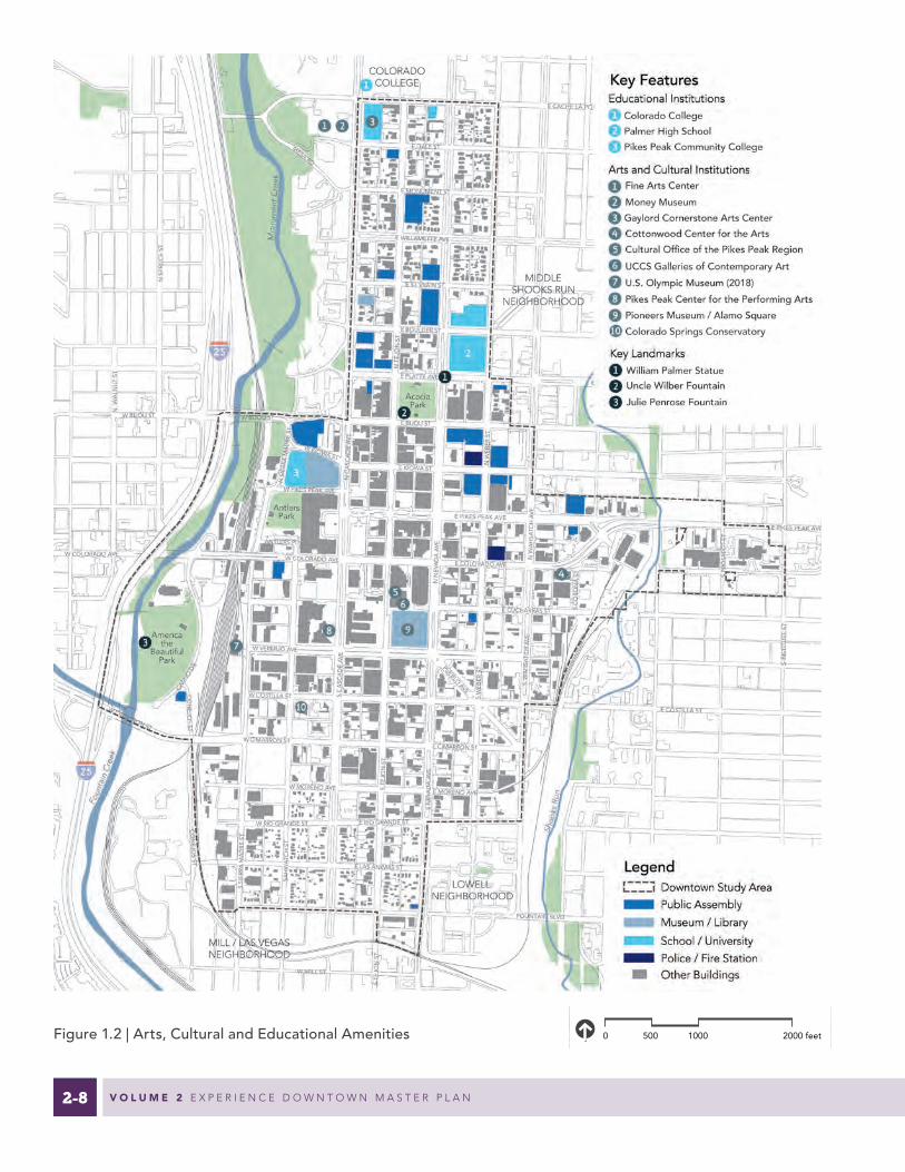
2-8 V O L U M E 2 E X P E R I E N C E D O W N T O W N M A S T E R P L A N
Source: Esri, DigitalGlobe, GeoEye, Earthstar Geographics, CNES/Airbus DS, USDA, USGS, AEX, Getmapping, Aerogrid, IGN, IGP, swisstopo, and the GIS User Community
0 500 1000 2000 feet
LegendDowntown Study Area
BID Boundary
25
25
LOWELL NEIGHBORHOOD
MILL STREET / LAS VEGASNEIGHBORHOODS
WESTSIDENEIGHBORHOOD
DIVINE REDEEMERNEIGHBORHOOD
MIDDLESHOOKS RUN
NEIGHBORHOOD
HILLSIDENEIGHBORHOOD
COLORADO COLLEGE
S TE
JON
ST
N T
EJO
N S
T
S W
EBER
ST
SAH
WA
TCH
ST
S SI
ERRA
MA
DRE
ST
E KIOWA ST
E BIJOU ST
E DALE ST
CIM
INO
DR
E COSTILLA ST
E CIMARRON ST
N W
EBER
ST
E RIO GRANDE ST
E PLATTE AVE
E ST VRAIN ST
E BOULDER ST
E CUCHARRAS ST
E MORENO AVE
S C
ASC
AD
E A
VE
E MONUMENT ST
W MORENO AVE
W COLORADO AVEW COLORADO AVE
E WILLAMETTE AVE
W BIJOU STW BIJOU ST
E PIKES PEAK AVE
W RIO GRANDE ST
NN
EVA
DA
AVE
W COSTILLA ST
W CIMARRON ST
SN
EVA
DA
AVE
E LAS ANIMAS S
FOUNTAIN BLVDFOUNTAIN BLVD
W MILL ST
E COSTILLA ST
E PLATTE AVE
E BOULDER ST
E WILLAMETTE AVE
E CACHE LA POUDRE AVEW CACHE LA POUDRE AVE
N S
PRU
CE
ST
N W
ALN
UT
ST
MESA RD
T
PUEBLOAVE
SW
AH
SATC
HA
VE
SPR
OSP
ECT
ST
CO
NEJO
SST
CO
NEJO
SST
W PIKES PEAK AVE
W KIOWA ST
ANTLERS PL
NSI
ERRA
MA
DRE
ST
SC
ORO
NA
ST
W VERMIJO AVE
NC
ASC
AD
EA
VE
W CUCHARRAS ST
E COLORADO AVE
NIN
STIT
UTE
STS
INST
ITU
TEST
NW
AH
SATC
HA
VE
NC
ASC
AD
EA
VE
E PIKES PEAK AVE
W CIMARRON ST
Figure 1.2 | Arts, Cultural and Educational Amenities

2-9C H A P T E R 1 L A N D U S E
Source: Esri, DigitalGlobe, GeoEye, Earthstar Geographics, CNES/Airbus DS, USDA, USGS, AEX, Getmapping, Aerogrid, IGN, IGP, swisstopo, and the GIS User Community
0 500 1000 2000 feet
LegendDowntown Study Area
BID Boundary
25
25
LOWELL NEIGHBORHOOD
MILL STREET / LAS VEGASNEIGHBORHOODS
WESTSIDENEIGHBORHOOD
DIVINE REDEEMERNEIGHBORHOOD
MIDDLESHOOKS RUN
NEIGHBORHOOD
HILLSIDENEIGHBORHOOD
COLORADO COLLEGE
S TE
JON
ST
N T
EJO
N S
T
S W
EBER
ST
SAH
WA
TCH
ST
S SI
ERRA
MA
DRE
ST
E KIOWA ST
E BIJOU ST
E DALE ST
CIM
INO
DR
E COSTILLA ST
E CIMARRON ST
N W
EBER
ST
E RIO GRANDE ST
E PLATTE AVE
E ST VRAIN ST
E BOULDER ST
E CUCHARRAS ST
E MORENO AVE
S C
ASC
AD
E A
VE
E MONUMENT ST
W MORENO AVE
W COLORADO AVEW COLORADO AVE
E WILLAMETTE AVE
W BIJOU STW BIJOU ST
E PIKES PEAK AVE
W RIO GRANDE ST
NN
EVA
DA
AVE
W COSTILLA ST
W CIMARRON ST
SN
EVA
DA
AVE
E LAS ANIMAS S
FOUNTAIN BLVDFOUNTAIN BLVD
W MILL ST
E COSTILLA ST
E PLATTE AVE
E BOULDER ST
E WILLAMETTE AVE
E CACHE LA POUDRE AVEW CACHE LA POUDRE AVE
N S
PRU
CE
ST
N W
ALN
UT
ST
MESA RD
T
PUEBLOAVE
SW
AH
SATC
HA
VE
SPR
OSP
ECT
ST
CO
NEJO
SST
CO
NEJO
SST
W PIKES PEAK AVE
W KIOWA ST
ANTLERS PL
NSI
ERRA
MA
DRE
ST
SC
ORO
NA
ST
W VERMIJO AVE
NC
ASC
AD
EA
VE
W CUCHARRAS ST
E COLORADO AVE
NIN
STIT
UTE
STS
INST
ITU
TEST
NW
AH
SATC
HA
VE
NC
ASC
AD
EA
VE
E PIKES PEAK AVE
W CIMARRON ST
Figure 1.3 | Vacant Parcels, Parking Lots and Rights-of-Way
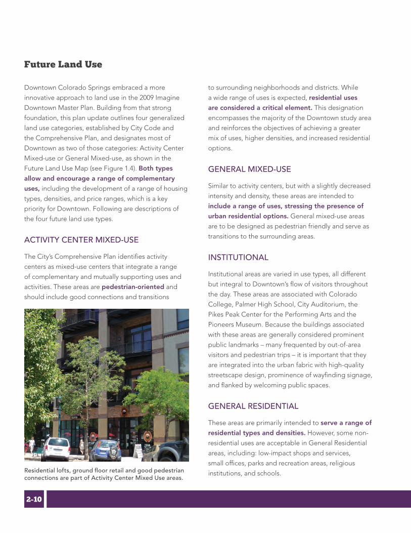
2-10 V O L U M E 2 E X P E R I E N C E D O W N T O W N M A S T E R P L A N
Future Land Use
Downtown Colorado Springs embraced a more
innovative approach to land use in the 2009 Imagine
Downtown Master Plan. Building from that strong
foundation, this plan update outlines four generalized
land use categories, established by City Code and
the Comprehensive Plan, and designates most of
Downtown as two of those categories: Activity Center
Mixed-use or General Mixed-use, as shown in the
Future Land Use Map (see Figure 1.4). Both types
allow and encourage a range of complementary
uses, including the development of a range of housing
types, densities, and price ranges, which is a key
priority for Downtown. Following are descriptions of
the four future land use types.
ACTIVITY CENTER MIXED-USE
The City’s Comprehensive Plan identifies activity
centers as mixed-use centers that integrate a range
of complementary and mutually supporting uses and
activities. These areas are pedestrian-oriented and
should include good connections and transitions
to surrounding neighborhoods and districts. While
a wide range of uses is expected, residential uses
are considered a critical element. This designation
encompasses the majority of the Downtown study area
and reinforces the objectives of achieving a greater
mix of uses, higher densities, and increased residential
options.
GENERAL MIXED-USE
Similar to activity centers, but with a slightly decreased
intensity and density, these areas are intended to
include a range of uses, stressing the presence of
urban residential options. General mixed-use areas
are to be designed as pedestrian friendly and serve as
transitions to the surrounding areas.
INSTITUTIONAL
Institutional areas are varied in use types, all different
but integral to Downtown’s flow of visitors throughout
the day. These areas are associated with Colorado
College, Palmer High School, City Auditorium, the
Pikes Peak Center for the Performing Arts and the
Pioneers Museum. Because the buildings associated
with these areas are generally considered prominent
public landmarks – many frequented by out-of-area
visitors and pedestrian trips – it is important that they
are integrated into the urban fabric with high-quality
streetscape design, prominence of wayfinding signage,
and flanked by welcoming public spaces.
GENERAL RESIDENTIAL
These areas are primarily intended to serve a range of
residential types and densities. However, some non-
residential uses are acceptable in General Residential
areas, including: low-impact shops and services,
small offices, parks and recreation areas, religious
institutions, and schools.Residential lofts, ground floor retail and good pedestrian connections are part of Activity Center Mixed Use areas.

2-11C H A P T E R 1 L A N D U S E
Source: Esri, DigitalGlobe, GeoEye, Earthstar Geographics, CNES/Airbus DS, USDA, USGS, AEX, Getmapping, Aerogrid, IGN, IGP, swisstopo, and the GIS User Community
0 500 1000 2000 feet
LegendDowntown Study Area
BID Boundary
25
25
LOWELL NEIGHBORHOOD
MILL STREET / LAS VEGASNEIGHBORHOODS
WESTSIDENEIGHBORHOOD
DIVINE REDEEMERNEIGHBORHOOD
MIDDLESHOOKS RUN
NEIGHBORHOOD
HILLSIDENEIGHBORHOOD
COLORADO COLLEGE
S TE
JON
ST
N T
EJO
N S
T
S W
EBER
ST
SAH
WA
TCH
ST
S SI
ERRA
MA
DRE
ST
E KIOWA ST
E BIJOU ST
E DALE ST
CIM
INO
DR
E COSTILLA ST
E CIMARRON ST
N W
EBER
ST
E RIO GRANDE ST
E PLATTE AVE
E ST VRAIN ST
E BOULDER ST
E CUCHARRAS ST
E MORENO AVE
S C
ASC
AD
E A
VE
E MONUMENT ST
W MORENO AVE
W COLORADO AVEW COLORADO AVE
E WILLAMETTE AVE
W BIJOU STW BIJOU ST
E PIKES PEAK AVE
W RIO GRANDE ST
NN
EVA
DA
AVE
W COSTILLA ST
W CIMARRON ST
SN
EVA
DA
AVE
E LAS ANIMAS S
FOUNTAIN BLVDFOUNTAIN BLVD
W MILL ST
E COSTILLA ST
E PLATTE AVE
E BOULDER ST
E WILLAMETTE AVE
E CACHE LA POUDRE AVEW CACHE LA POUDRE AVE
N S
PRU
CE
ST
N W
ALN
UT
ST
MESA RD
T
PUEBLOAVE
SW
AH
SATC
HA
VE
SPR
OSP
ECT
ST
CO
NEJO
SST
CO
NEJO
SST
W PIKES PEAK AVE
W KIOWA ST
ANTLERS PL
NSI
ERRA
MA
DRE
ST
SC
ORO
NA
ST
W VERMIJO AVE
NC
ASC
AD
EA
VE
W CUCHARRAS ST
E COLORADO AVE
NIN
STIT
UTE
STS
INST
ITU
TEST
NW
AH
SATC
HA
VE
NC
ASC
AD
EA
VE
E PIKES PEAK AVE
W CIMARRON ST
Figure 1.4 | Future Land Use

2-12 V O L U M E 2 E X P E R I E N C E D O W N T O W N M A S T E R P L A N
Catalytic Development Sites
Downtown’s future land use is influenced by a number
of key catalytic development sites and influence sites
(see Figure 1.5). Finite market demand and investment
capacity dictate that only a certain number of catalytic
projects will be built in the core during each market
cycle. However, while these sites capture today’s
development expectations and desires, there is always
a possibility that new sites and priorities will arise in the
next development cycle. This chapter best captures
development opportunities at the current point in
time.
Sixteen Catalytic sites are identified based on
their near- to mid-term development potential, and
their ability to impact the development and capital
attraction patterns in the city center. Additionally,
five Influence sites are generally located outside the
study area boundary, but have immense impact on the
growth and overall success of the greater Downtown
area. Both Catalytic sites and Influence sites will require
strong partnerships and planning to ensure their
integration and ability to move Downtown toward the
achievement of its goals.
Several of the sites are located near important
Downtown gateways and represent significant
transformative opportunities and the potential to
increase synergy between gateway and mobility
improvements. Examples include:
• The primary access point to the U.S. Olympic Museum and Southwest Downtown will be via the Cimarron Street gateway, which will be anchored by the development of the Citygate property (Site C.), and eventually by the redevelopment of Drake Power Plant (Site 1).
• The development of Catalyst Campus, and the Gazette-St. Francis properties (Sites I & H) will be critical in the evolution of the Pikes Peak Avenue gateway from the east. In conjunction with the Cottonwood Center for the Arts and Catalyst Campus, the area currently has momentum that can be captured to create a creatively and economically diverse hub of new businesses and residents.
• The continued growth of the Lowell Neighborhood (Site 3) and other residential developments on the southern edge of Downtown (Sites D & F) should convey a clear shift to a higher density urban neighborhood.
• The northern gateway area near Weber Street will increase in importance as Colorado College (Site 5) executes its plans for expansion and mixed-use development south of Cache la Poudre Avenue.

2-13C H A P T E R 1 L A N D U S E
Source: Esri, DigitalGlobe, GeoEye, Earthstar Geographics, CNES/Airbus DS, USDA, USGS, AEX, Getmapping, Aerogrid, IGN, IGP, swisstopo, and the GIS User Community
0 500 1000 2000 feet
LegendDowntown Study Area
BID Boundary
25
25
LOWELL NEIGHBORHOOD
MILL STREET / LAS VEGASNEIGHBORHOODS
WESTSIDENEIGHBORHOOD
DIVINE REDEEMERNEIGHBORHOOD
MIDDLESHOOKS RUN
NEIGHBORHOOD
HILLSIDENEIGHBORHOOD
COLORADO COLLEGE
S TE
JON
ST
N T
EJO
N S
T
S W
EBER
ST
SAH
WA
TCH
ST
S SI
ERRA
MA
DRE
ST
E KIOWA ST
E BIJOU ST
E DALE ST
CIM
INO
DR
E COSTILLA ST
E CIMARRON ST
N W
EBER
ST
E RIO GRANDE ST
E PLATTE AVE
E ST VRAIN ST
E BOULDER ST
E CUCHARRAS ST
E MORENO AVE
S C
ASC
AD
E A
VE
E MONUMENT ST
W MORENO AVE
W COLORADO AVEW COLORADO AVE
E WILLAMETTE AVE
W BIJOU STW BIJOU ST
E PIKES PEAK AVE
W RIO GRANDE ST
NN
EVA
DA
AVE
W COSTILLA ST
W CIMARRON ST
SN
EVA
DA
AVE
E LAS ANIMAS S
FOUNTAIN BLVDFOUNTAIN BLVD
W MILL ST
E COSTILLA ST
E PLATTE AVE
E BOULDER ST
E WILLAMETTE AVE
E CACHE LA POUDRE AVEW CACHE LA POUDRE AVE
N S
PRU
CE
ST
N W
ALN
UT
ST
MESA RD
T
PUEBLOAVE
SW
AH
SATC
HA
VE
SPR
OSP
ECT
ST
CO
NEJO
SST
CO
NEJO
SST
W PIKES PEAK AVE
W KIOWA ST
ANTLERS PL
NSI
ERRA
MA
DRE
ST
SC
ORO
NA
ST
W VERMIJO AVE
NC
ASC
AD
EA
VE
W CUCHARRAS ST
E COLORADO AVE
NIN
STIT
UTE
STS
INST
ITU
TEST
NW
AH
SATC
HA
VE
NC
ASC
AD
EA
VE
E PIKES PEAK AVE
W CIMARRON ST
Figure 1.5 | Catalytic Development Sites

2-14 V O L U M E 2 E X P E R I E N C E D O W N T O W N M A S T E R P L A N
Denver and Rio Grande Railroad Depot, Antlers Park, and Antlers Hotel and Plaza
Built in 1887, the building served as a depot for
passenger and freight on the Denver and Rio Grande
Railroad until 1971. Its historic Late Victorian/Queen
Anne architectural style and location make it a
significant catalytic site for Downtown. The added
historic significance of the depot, adjacent Antlers
Park, and Antlers Hotel serving as the city’s original
visitor gateway makes the site all the more important.
Linked just steps from the future U.S. Olympic Museum
by Sierra Madre Street, the site offers opportunities for
a mix of uses, as it has at various times since 1971.
Critical catalytic elements include:
• Destination tenants for the Depot property
• Multi-modal connectivity infrastructure and access to rail
• Park improvements and placemaking elements, including lighting and safety improvements and ongoing programming
• Special purpose street improvements on Sierra Madre Street
• Palmer Center plaza redesign to be inclusive toward east face
•
The historic Depot is currently vacant but remains a great opportunity and asset to the City.
Antlers Park - an underutilized Downtown asset.Palmer Center is Downtown's largest formal plaza, but used infrequently.
a

2-15C H A P T E R 1 L A N D U S E
U.S. Olympic Museum and Southwest Downtown District
This iconic museum located at Sierra Madre Street and
Vermijo Avenue will enhance the city’s reputation
as a center for world class athletics and a global
tourist destination expected to draw 350,000 visitors
a year. Development planned to accompany and
support the museum has the potential to transform
several underutilized blocks on the southwest side of
Downtown, and become the essential “front lawn” to
Downtown.
Critical catalytic elements include:
• U.S. Olympic Museum
• Pedestrian Bridge connecting to America the Beautiful Park
• Plaza and pedestrian focused streetscape infrastructure, suited for frequent community celebrations of large and small scales
• High density mixed use development
• Multi-modal connectivity infrastructure and access to rail
Citygate
One of the premier mixed-use infill redevelopment
opportunities in Downtown, Citygate is a 12-acre,
four-block site on the south side of Cimarron Street
between Sierra Madre and Sahwatch streets. Its history
as an industrial area and location near the rail tracks
offer an authentic, urban aesthetic not available in
many parts of the city center. Bordered to the south
and east by mature neighborhoods and small local-
serving retail nodes, and just a short walk to America
the Beautiful Park, the site has strong potential to
stimulate further investment and create a more
cohesive urban fabric along Cimarron Street. Future
development should be integrally designed to fit into
Downtown's street grid with street-facing buildings
constructed to activate the public realm.
Critical catalytic elements include:
• Proximity to America the Beautiful Park and the future U.S. Olympic Museum
• Major interchange and multi-modal improvements at Interstate 25 and Cimarron Street
• Proximity to Drake Power Plant, set for decommissioning no later than 2035
• One of the largest available development sites in the core
• Important element of the Cimarron Street gateway
The U.S. Olympic Museum and pedestrian bridge to America the New Development will transform the southwest side of Downtown.
Activities in All Seasons
14
source: U.S. Olympic Museum
source: Nor'wood Development Group
source: Nor'wood Development Group
b c

2-16 V O L U M E 2 E X P E R I E N C E D O W N T O W N M A S T E R P L A N
South Cascade Residential Development
Local developers are making early forays into the
multifamily market. Several projects are currently
in the final stages of planning, including a 187-unit
multifamily development on Cascade Avenue between
Moreno and Rio Grande streets. The addition of new
residents will increase the density and vibrancy of the
existing residential neighborhood and will provide
additional support for a range of businesses
emerging along South Tejon Avenue.
New residential developments in the New South End and East End districts (see Districts on page 2-24) will add needed density and vibrancy to areas just outside the City Center.
CASCADE APARTMENTSSCHEMATIC DESIGN PACKAGE 10-20-14
DRAWING INDEX
A-000 COVER/INDEX
CIVIL
C1 PRELIMINARY GRADING PLANC2 PRELIMINARY UTILITY PLAN
STRUCTURAL
S-000 GENERAL NOTES, LEGENDS-100A G3 FOUNDATION PLAN - AREA AS-101A LEVEL G1 FRAMING PLAN - AREA AS-101B LEVEL G1 FRAMING PLAN - AREA BS-102A LEVEL G1 FRAMING PLAN - AREA AS-102B LEVEL G1 FRAMING PLAN - AREA BS-103A PODIUM FRAMING PLAN - AREA AS-103B PODIUM FRAMING PLAN - AREA BS-104A LEVEL 2 FRAMING PLAN - AREA AS-104B LEVEL 2 FRAMING PLAN - AREA BS-105A LEVEL 3 FRAMING PLAN - AREA AS-105B LEVEL 3 FRAMING PLAN - AREA BS-106A LEVEL 4 FRAMING PLAN - AREA AS-106B LEVEL 4 FRAMING PLAN - AREA BS-107A ROOF FRAMING PLAN - AREA AS-107B ROOF FRAMING PLAN - AREA B
LANDSCAPE
L-101 SITE PLANSL-102 LANDSCAPE PERSPECTIVESL-103 LANDSCAPE PERSPECTIVESL-104 LANDSCAPE PERSPECTIVESL-105 LANDSCAPE DETAILS
ARCHITECTURE
A-100 SITE PLANA-101 FLOOR PLANA-102 FLOOR PLANA-103 FLOOR PLANA-104 FLOOR PLANA-105 FLOOR PLANA-106 FLOOR PLANA-201 BUILDING ELEVATIONSA-202 BUILDING ELEVATIONSA-203 BUILDING ELEVATIONSA-204 BUILDING SECTIONSA-301 BUILDING PERSPECTIVESA-302 BUILDING PERSPECTIVESA-303 BUILDING PERSPECTIVESA-401 UNIT PLANSA-402 UNIT PLANSA-403 UNIT PLANSA-404 UNIT PLANSA-405 UNIT PLANSA-406 UNIT PLANSA-407 UNIT PLANSA-408 UNIT PLANSA-409 UNIT PLANSA-601 TYPICAL WALL TYPESA-602 TYPICAL WALL TYPESA-603 TYPICAL WALL TYPESA-604 TYPICAL WALL TYPES
COPYRIGHT 2013 - DAVIS PARTNERSHIP, P.C.
Issue/Revisions Date No.
-
Consultant
Project Information
CASC
ADEAPA
RTM
ENTS
SCHEM
ATICDES
IGNPA
CKAGE
Sheet Information
Sheet Title:
Sheet Number:
DPA Project:
-
- -
14102.02
-
PROG
RESS
S
NOT F
OR
CONSTRUC
TION
10/20/201
4
10.20.2014
1 2 3 4 5 6
1 2 3 4 5 6
E
D
C
B
A
C
B
A
E
D
COVER
A-000
South Wahsatch Residential Development
Also through local developers, a 172-unit multifamily
project at Colorado and Wahsatch avenues has broken
ground. This development will create an important
node of activity and density that will begin to link
the East End and the core along Colorado Avenue.
It also adds a residential use in an area currently
dominated by commercial uses and surface parking
lots and will set a new standard for density and
streetscape interface in the area.
The larger scale of the two aforementioned projects
allows the incorporation of amenities not offered
in any urban product currently available, including
clubhouses, fitness rooms, pools, community decks,
dog wash stations among other more common
amenities such as garage parking and dedicated bike
storage, and pet relief areas. Both projects also are
designed to offer two-story brownstone-style units on
two or three sides, providing a better interface with the
street and pedestrian realm.
d e
source: Nor'wood Development source: Nor'wood Development

2-17C H A P T E R 1 L A N D U S E
Blue Dot Place Development and Vicinity
Blue Dot Place is a four-story development with 33
one- and two-bedroom apartment units located
near the intersection of Nevada Avenue and Costilla
Street. Several other new businesses, renovations,
and vacant sites near this intersection have positioned
it as a key redevelopment area. The first new for-
rent residential project built in the study area
since 1960 already has had a positive catalytic
influence, helping “make the case” to potential
Downtown investors that latent demand exists for
this type of product. Although this scale of apartment
project may be more feasibly replicated throughout
Downtown (compared to the larger projects mentioned
previously), the development does not provide pool
or fitness facilities, making the facilities offered at the
YMCA even more important as an urban amenity.
Blue Dot Place is in the heart of the emerging New South End district.
f
source: Jana Bussanich Photography
This development and the area around it are strong
examples of the catalytic power of strategic investment
downtown. At the completion of the 2009 Imagine
Downtown Master Plan, no one would have pegged
the intersection of South Nevada Avenue and Costilla
Street as the next node for investment in Downtown.
But today, the New South End neighborhood is
anchored by Blue Dot Place apartments and small
businesses emerging in the area. The 2016 State of
Downtown Report notes that strategic funding from
the DDA between 2013 and 2016 has leveraged
a fiftyfold return in private investment in the
immediate area. To date, approximately $14 million
in announced, in-process or completed investment by
the private sector has occurred in a four-block radius
of the intersection. This includes Blue Dot’s 33 new
residences, another 29 residential units in the mid-term
pipeline, and eight new small businesses.

2-18 V O L U M E 2 E X P E R I E N C E D O W N T O W N M A S T E R P L A N
Block on Nevada and Vermijo Avenues
This block between Nevada Avenue and Weber
Street and Cucharras Street and Vermijo Avenue is
a strategic redevelopment opportunity. In addition
to the Colorado Springs Independent newspaper
building, it consists primarily of large surface parking
lots and several low intensity and underutilized
buildings including the former Colorado Springs
Health Partners (CSHP) offices and clinic, now vacant.
There are several catalytic advantages to the location.
Redevelopment of this block would fill in and activate
a significant area linking the City Center and New
South End districts. This site also is located at the
intersection of the proposed urban greenway at Weber
g and Cucharras planned streetscape improvements
along Vermijo. Public realm improvements will provide
safe and comfortable non-motorized transportation
movement within the City Center as well as easy
access to the Legacy Loop. Residential and mixed
use development would add vibrancy throughout
the day in an area that is currently commercially
oriented. Specific attention should be paid to the
streetscape and pedestrian crossings around the
site, but particularly along Nevada Avenue. The size
and prominent position of this block mean that it has
immense potential to set the tone for other blocks
along Nevada Avenue and the transition between the
City Center and East End districts.
The block northeast of Nevada and Vermijo avenues is an important mixed use redevelopment / adaptive reuse opportunity.

2-19C H A P T E R 1 L A N D U S E
Gazette and St. Francis Hospital and Surrounding Sites
These three sites, located along Prospect Street
south of Pikes Peak Avenue, as well as the large
vacant parcel across Pikes Peak Avenue to the north,
provide unparalleled views of the city center and
Pikes Peak. All three locations offer easy access to
the Shooks Run Trail/Legacy Loop and the east side
of the city center. The former Gazette building has
an industrial aesthetic and large central spaces
somewhat uncommon in Downtown, while several
buildings on the former St. Francis site provide historic
ambiance. The sites offer distinct redevelopment
opportunities in close proximity to each other and
to the core, with market potential for residents,
resident-serving amenities, retail, office and/or artisan
manufacturing.
Critical catalytic elements include:
• Potential to activate both sides of Pikes Peak Avenue at the eastern gateway to Downtown
• Connectivity to the Legacy Loop
• High density mixed use development
• Artisan manufacturing or maker space node
• Connectivity to Downtown (new pedestrian bridge crossing at Shooks Run)
Catalyst Campus
This innovation campus on the east side of Downtown
offers a unique model combining industry specific
start-up space, support services, workforce training,
and access to capital all located in the renovated
Atchison, Topeka & Santa Fe Railroad depot and
surrounding parcels near the intersection of Pikes
Peak and Colorado avenues. As Catalyst grows
and develops it is likely to become a significant
employment and education node within Downtown,
supplying new primary jobs that will attract more
retail, restaurant and service amenities to the east side.
Critical catalytic elements include:
• Renovated historic depot buildings
• Improved connectivity to the Legacy Loop and connection across Shooks Run to the east
• Concentrated employment cluster
• Large site with capacity for significant medium-density development
The Gazette and St. Francis Hospital sites are unique assets for redevelopment on the east side.
h i
source: Nor'wood Development

2-20 V O L U M E 2 E X P E R I E N C E D O W N T O W N M A S T E R P L A N
Parking Lot on Tejon Street and Pikes Peak Avenue
This large L-shaped parking lot on the northeast
corner of Tejon Street and Pikes Peak Avenue occupies
prime real estate in the city center. Higher intensity
development on this site will activate one of the key
intersections Downtown and fill an obvious gap in
the pedestrian realm on one of the signature blocks of
Pikes Peak Avenue.
City Auditorium
The auditorium building was built in 1923 and has
played host to a variety of notable concerts and
events. The City’s Park System Master Plan identifies
the auditorium on one of its top two priorities for
“Recreation Buildings, Community Centers and
Museums.” The City is undertaking an economic
feasibility study that will provide recommendations
on how to best use the facility in the future. Aligning
recommendations for the Auditorium facility and
the development objectives of the property owners
of adjacent parcels, including the large parking lot
south of the auditorium building, at the intersection of
Pikes Peak and Nevada avenues, is important in order
to truly take advantage of this catalytic site.
Transit Center Relocation
In 2016, Metropolitan Mountain Transit is studying
options for relocating the Downtown transit station
currently located on the southwest corner of Kiowa
Street and Nevada Avenue. Removing bus operations
from the lower floor of this structure opens up
possibilities for renovating and adaptively reusing
the space for retail, hospitality, and other uses that
activate the ground level along both streets while
achieving greater functionality and TOD potential for
future transit operations. (see Figure 1.6)
The relocation of the Transit Center will help activate an important Downtown intersection.
j k
l
Re-purposing the historic City Auditorium building and developing the surrounding block will activate a key site in the City Center.

2-21C H A P T E R 1 L A N D U S E
Figure 1.6 | Transit Center Illustration (before and after)

2-22 V O L U M E 2 E X P E R I E N C E D O W N T O W N M A S T E R P L A N
m
First Presbyterian / YMCA Expansion
The planned expansion of the Downtown YMCA
and redevelopment of nearby buildings and parking
lots operated by First Presbyterian Church southeast
of Bijou and Weber streets will transform these two
important Downtown blocks. The expansion will
provide enhanced and updated services and facilities
for YMCA members, incorporate a major health
care component on-site, introduce senior housing
and community services, and will potentially include
a charter school. Most importantly, however, the
renovated facility will serve as a great amenity
and attraction available to existing and future
Downtown residents. The YMCA expansion will bring
new activity adjacent to Acacia Park, and both projects
will leverage access to the neighborhood green street
proposed on Weber Street (see Chapter 4).
n
Acacia Park Apartments Reuse
The half block north of Acacia Park across Platte
Avenue is somewhat underutilized given its proximity
to the park, the vibrant retail along Tejon Street, and
the planned YMCA expansion. The existing Acacia Park
Apartments, a small but dated residential building,
and the fast food restaurant do little to activate the
northern edge of the park despite providing much
needed affordable housing units. A freshening of
these properties through redevelopment or adaptive
reuse with more pedestrian activated uses and
articulation would catalyze Tejon Street and Platte
Avenue. Redevelopment of the residential properties
should aim to retain affordable workforce housing, and
accommodate for any possible displacement due to
redevelopment.
o
p Bijou and Cascade Redevelopment
For many years, the gateway along East Bijou has been
marked by a small but influential site at the corner
of Bijou and Cascade. A former drive-through bank,
the property has remained vacant for many years and
is troubled with vagrancy and trespassing. In 2016,
developers announced plans to construct a 10-story,
176-room hotel facility. Development of this site is a
critical to enhancing the Bijou gateway, as well as
future re-development of surrounding sites to create
an activity center in this important gateway.
Adaptive reuse of the Acacia Park Apartments will help activate Acacia Park and key pedestrian streets nearby.
Parking Lot on Cascade Avenue between Pikes Peak and Colorado Avenues
This half-block parking lot is located across Cascade
Avenue from the Antlers Hotel, Wells Fargo Tower and
First Bank Tower. 1.7 acres in size, the lot is just steps
from one of the more vibrant blocks of Tejon Street
and two of its most important intersections at Pikes
Peak and Colorado avenues. The site has immense
potential to develop a full range of uses given its
location in the heart of Downtown, and along a key
neighborhood green street spine. Residential, office,
commercial, and hospitality uses could all coexist and
thrive on this key site.

2-23C H A P T E R 1 L A N D U S E
The planned closing of the Drake Power Plant by 2035 represents a once-in-a-century opportunity to completely transform an important site just outside the Downtown study area.
The Springs Rescue Mission will better serve a great need near Downtown by providing a low barrier shelter, day center, expanded kitchen and dining facilities.
Influence Sites
Drake Power Plant
The future redevelopment of the Drake power plant
site represents a once-in-a-century opportunity.
In a monumental decision made by the board
of the Colorado Springs Utilities in 2015, a full
decommissioning date has been set for the year 2035.
The stage is set for the transformation of the site
that currently dominates the land use and skyline
of Southwest Downtown. Downtown stakeholders
must continue to support the closure of Drake and
push for an acceleration of the 20-year shut down time
frame. Mitigation and redevelopment of the site will
help knit together key downtown assets including the
Legacy Loop, America the Beautiful Park, the Citygate
redevelopment, and the existing Mill Neighborhood.
Planning efforts must commence immediately to
anticipate infrastructure, open space, and other public
investments that will help guide the redevelopment
and transform the site and some of its structures into a
landmark destination in Downtown.
Springs Rescue Mission – Multi Agency Campus Expansion
Located just south of the Downtown study area
boundary and adjacent to the southern end of the
Legacy Loop lies the existing Springs Rescue Mission
campus, which serves the homeless population with
low-barrier shelter and other supportive services.
Colorado Springs currently faces a shortage of several
hundred year-round shelter beds, lacks a day center
facility and lacks storage services for unsheltered
populations. However, efforts are under way to address
these issues through the Continuum of Care (CoC), a
collaborative initiative to sustain a durable system of
care that prevents and ends homelessness. Springs
Rescue Mission’s campus expansion will include new
year-round shelter beds, a day center, and new kitchen
and dining hall, all in Phase 1; a second phase includes
new permanent supportive housing. While the many
human service agencies within the greater Downtown
area provide a range of much needed services to the
community, a keen focus on increasing youth and
low-barrier shelter services is the most critical element
necessary to ensure that unsheltered populations
have safer sleeping alternatives to alleyways, business
doorways, creeks, trails, etc.
1 2

2-24 V O L U M E 2 E X P E R I E N C E D O W N T O W N M A S T E R P L A N
Transit Mix
Located along the Legacy Loop and Shooks Run
corridor, the Transit Mix Concrete Company site on the
east side of Downtown is another important potential
redevelopment adjacent to the study area. Although
the site currently continues with regular Transit Mix
operations, focused planning efforts should begin to
assess the site’s integration into the Downtown fabric,
its impact on access to the Legacy Loop, close in
neighborhoods such as Hillside, and connections to
Catalyst Campus and other catalytic sites on the east
side of Downtown.
Colorado College Development
The majority of the Colorado College campus is
located just north of the Plan's study area boundary,
although, of course, CC has been and continues to
be considered an essential part of the Downtown
fabric. A campus master plan was completed in 2015
that calls for locating several new campus facilities
south of Cache La Poudre Street between Tejon and
Weber streets (within the Plan's Study Area boundary).
The College owns several blocks in this area and
intends to complement the campus uses with mixed
use development that will support both students
as well as area residents. This development is an
opportunity for cooperation and better linkages with
the core of Downtown to the south. Additionally, the
neighborhood greenway designation of Cascade,
Weber and Cache La Poudre streets is vital for traffic
calming, better connectivity of the campus to the
Downtown core, and safer pedestrian and bike access
throughout the greater campus area.
4 Lowell Neighborhood
Encompassing 58 acres surrounding the historic Lowell
School, the Lowell neighborhood represents a unique
and historically centered new-urbanist neighborhood
in the heart of the city. Originally approved as an Urban
Renewal Area in 1988, the Lowell Neighborhood has
been the only new neighborhood to emerge adjacent
to downtown in decades, providing hundreds of
residential units over its 25-year life. The neighborhood
is generally bound by Rio Grande Street to the north,
Nevada Avenue to the west, the railroad tracks to
the south and Shooks Run to the east. Due primarily
to lags in market cycles, the area’s redevelopment
is not completed, and several acres still exist for
new development. Lowell is an integral part of the
Downtown, despite being just outside the study area
boundaries, and should be treated with similar priority
to core sites.
The Lowell Neighborhood will provide an attractive entry into Downtown, innovative mixed income housing opportunities, and neighborhood oriented commercial activities adjacent to the core.
5
3
source: http://www.csurbanrenewal.org/

Parks, Trails and Waterways
chapter2Overview
Legacy Loop
Urban and Neighborhood Greenways
Downtown Parks and Waterways
Highlights
Completing missing links of the Legacy Loop is a top priority.
Prioritizing these projects will not only enhance one of Downtown’s
greatest assets, but also increase connections among many other
important destinations and activities in the core.
Regular reassessment and reprogramming of the city center’s parks
will ensure they remain beloved amenities for residents and visitors
alike. Each Downtown park has a unique role to play, and together they
offer recreation opportunities for a diverse range of users.
Downtown’s creeks and waterways are underutilized resources.
Projects that increase access to and enjoyment of these amenities
should be prioritized.

2-26 V O L U M E 2 E X P E R I E N C E D O W N T O W N M A S T E R P L A N
Overview
Colorado Springs’ connection to and celebration of the natural environment is ingrained in the origins and very fabric of the city. Beyond its incomparable views of Pikes Peak, Downtown’s most tangible connection to this history and beauty is through its parks and trails.
Historic Acacia and Antlers parks punctuate the core’s
urban grid, while America the Beautiful Park creates an
amazing backdrop and future connection to the U.S.
Olympic Museum. Monument Valley Park serves as a
historic amenity and contains the Pikes Peak Greenway
Trail as part of the Legacy Loop, and the amenities of
Prospect Lake and Memorial Park are a short distance
east of Downtown.
The Legacy Loop Trail and the various parks and
greenways that nearly encircle the city center are
unique assets for residents and visitors alike, and
an attractive amenity to employers and investors in
downtown. Completing missing trail links and better
connecting Downtown to the loop are key imperatives
of this plan. In concert with existing recreational
and open space assets, these improvements will
support numerous Imagine Downtown Master Plan
goals including celebrating the natural setting,
promoting a healthy downtown, providing safe and
convenient modes of transportation, and ensuring an
unforgettable visitor experience.
This section addresses the Legacy Loop and its missing
links, introduces the concept of urban greenways, and
discusses how the role of Downtown parks can be
expanded to better serve both residents and visitors.
As new development and density influence the area,
it is important to rethink the scale and variety of parks
and gathering spaces available in the core. It is also
critical to more proactively address access to the
great asset of Downtown’s adjacent waterways.
Acacia Park is currently programmed with a play facility, an historic band-shell and a semi-public shuffleboard court.
Uncle Wilber Fountain is a cherished summertime destination in Acacia Park.
Antlers Park is a strong potential location for an urban off-leash dog park.

2-27C H A P T E R 2 P A R K S , T R A I L S A N D W A T E R W A Y S
Legacy Loop
Downtown and its surrounding neighborhoods are
woven together by a natural greenway and trail system,
known as the Legacy Loop (see Figure 2.1). The system
consists of existing parks and trails that expand along
Monument and Fountain creeks. Connecting these
natural assets in a loop surrounding Downtown has
long been a vision of the community. The City’s Park
System Master Plan notes that expanding the urban
trail system was identified by the public as a top
priority, and the 2012 Urban Land Institute Advisory
Services Panel Report also stressed the importance of
prioritizing the completion of this key Downtown asset.
General Palmer, who dedicated thousands of acres
to the city for parks and open space, supported
this notion of a “Park Ring” around the city (now
Downtown). The Legacy Loop’s 6.7-mile system of trails
is currently a place for jogging, biking, special events,
exploring or just strolling. However, missing links are
apparent and new facilities and updated infrastructure
are needed to complete the loop. Completion of the
Legacy Loop is a top priority of the Experience
Downtown Master Plan. The Park System Master
Plan identifies portions of the Pikes Peak Greenway,
Shooks Run Trail, and the connecting Rock Island Trail
(between Circle Drive and Powers Boulevard) as Tier 1
priorities for greenway improvements and connectivity.
Also crucial, as the Loop serves as a gateway into
Downtown, is the cleanliness, safety and ongoing
upkeep of the trails and creeks that make up the Loop.
In mid-2015, Colorado Springs was awarded a $1
million grant from Great Outdoors Colorado in support
of these efforts. The grant is being used to address
some of projects listed below that will enhance access
to and overall connectivity of the trail system.
• Building approximately 2.5 miles of 12-foot wide multi-use trail along northern sections of the loop;
• Constructing a trail to connect the Pikes Peak Greenway, Rock Island Trail, and Shooks Run Trail at the north end of the system, closing one of the largest existing gaps in the loop, and linking the major north-south and east-west regional trails in the city;
• Constructing new trail and underpasses along the northwest portion of the loop to create a continuous 10-mile loop without street crossings;
• Construction of a new multi-use trailhead at Fontanero Street with 100 parking spaces and amenities for hosting races and other community events; and
• The Popcycle Bridge project (in partnership with Kids on Bikes) was completed in 2015 and provides gathering spaces for bicyclists, bicycle-themed art, and facilities for bicycle safety training.
Pikes Peak Greenway Trail along Monument Creek is the western segment of the Legacy Loop.

2-28 V O L U M E 2 E X P E R I E N C E D O W N T O W N M A S T E R P L A N
Figure 2.1 | Legacy Loop

2-29C H A P T E R 2 P A R K S , T R A I L S A N D W A T E R W A Y S
This suite of projects will represent a major
achievement for Downtown and greater Colorado
Springs, moving one step closer to completing the
Legacy Loop. However, remaining connectivity gaps
will still exist at the southern end of the system, and
addressing them should be a top priority for future
planning and funding opportunities.
In 2016, a facilities master plan was under way to
determine multi-modal transportation and drainage
infrastructure improvements along the Shooks Run
Corridor, which makes up the eastern portion of the
Legacy Loop. A transformative approach has been
16
selected that addresses facilities needs, and will guide
how infrastructure improvements are implemented
over the next 50 years.
Beyond connectivity, Legacy Loop's character should
be strengthened with recognition and preservation
of the ecological resources along the greenway
and waterways, ongoing improvements such as
Olympic-themed interpretive signage and public
art installations. Another priority for the Legacy
Loop is increasing connectivity from the trails and
waterways to and from the core by way of a series
of urban and neighborhood greenways.
Renderings depicting Legacy Loop improvements at America the Beautiful Park (above) and along Shooks Run (below, from the Envision Shooks Run Master Plan by Design Workshop).
source: Design Workshop
source: Nor'wood Development Group

2-30 V O L U M E 2 E X P E R I E N C E D O W N T O W N M A S T E R P L A N
Urban and Neighborhood GreenwaysThe concept of urban and neighborhood greenways
is explored in more detail in Chapter 4. These
corridors are important within the context of parks
and trails, as they are designated routes designed
to slow automobile traffic and create safe
street environments for pedestrian and bicyclist
movement. They provide the opportunity of improving
important east-west connectivity to the Legacy Loop
and within the city center, facilitating increased
accessibility to Downtown and regional parks and trails
by residents, employees, and visitors. This enhanced
access supports both healthy living and multi-modal
transportation goals. Physical improvements such as
designated and protected cycling lanes and specialty
paving treatments will distinguish these corridors
from other Downtown streets. Furthermore, urban
and neighborhood greenways are intended to stand
out within the established street grid by incorporating
some of the natural features found along the Legacy
Loop. These elements include: street trees, natural
landscaping and natural stormwater management
infrastructure such as bioswales. Figure 2.2 illustrates
a number of these cutting edge public realm and
greenway design options along Sierra Madre Street.
Urban and neighborhood greenways not only provide
safe connections to the beautiful outdoor settings,
they also integrate natural features from a trail
system into an urban context.
Downtown Parks and Waterways
Downtown parks provide urban open spaces and
recreational and gathering opportunities for residents
and visitors. Currently, there are three main city parks
within the Study Area: Acacia, Antlers, and America
the Beautiful, plus a fourth park being the grounds
surrounding Pioneers Museum known as Alamo Park.
Monument Valley Park and Shooks Run border the core
on the west and east respectively and are very much
considered part of the Downtown fabric. Memorial
Park and Prospect Lake are easily accessible from
Downtown by walking, biking, or transit.
The Park System Master Plan discusses a strong
support for Downtown revitalization and infill as a key
opportunity for future improvement in the system.
The Experience Downtown Master Plan supports and
reinforces this vision. As future development and
redevelopment occurs, Downtown will be tasked
with re-imagining existing parks and incorporating
new public spaces with park-like elements, including
trail connections, parklets, community gardens,
and informal gathering spaces (as discussed in the
Residential Garden Streets section of Chapter 4).
In addition to noting a very high proportion of
residents who enjoy the city’s recreation and outdoor
opportunities, the Park System Master Plan also
identifies using parks and special events as a means to
promote tourism. Each Downtown park has a distinct
character that defines its current uses and future
opportunities to serve both locals and visitors.
Parks, recreation and cultural services resources
should be leveraged to support these efforts, as
the Park System Master Plan states that Monument
Valley Park, Acacia Park and Antlers Park are among
the top priorities in the category of neighborhood
parks, community parks and playgrounds. Acacia
and Monument Valley parks are also identified as top
priorities for evaluation and facilities management
plans.Urban and neighborhood greenways can add beauty and improved mobility to Downtown as depicted in Boulder, CO.

2-31C H A P T E R 2 P A R K S , T R A I L S A N D W A T E R W A Y S
Diagonal Parking (Gravel) PavedShoulder
29’
Diagonal Parking (Gravel)
29’8’
PavedShoulder
8’
Travel Lane
11’
Travel Lane
11’
60’
100’
Sidewalk Bioswale Parking
Bu�e
r
12’ 10’ 3’ 12’8’
Parking Sidewalk
8’6’
Bike Lane
Bike Lane
6’ 10’
Travel LaneTravel Lane
10’
51’
85’
Figure 2.2 | Sierra Madre Urban Greenway Street Section (looking north, from Cucharras Street; before and after)

2-32 V O L U M E 2 E X P E R I E N C E D O W N T O W N M A S T E R P L A N
ACACIA PARK
Acacia Park serves as one of the centers of activity
and recreation Downtown. Recent improvements
in amenities and programming have increased its
use by a wider range of residents. Its proximity
to one of the more successful retail blocks of Tejon
Street increases its visibility to Downtown visitors
and solidifies its role as a major site for events
Downtown. Recent programing efforts, such as the
Downtown Sunday Market, Skate in the Park, summer
concerts and other festivities have enlivened the park
dramatically.
However, several factors create challenges in the
park, including the sunken playground; landscaping
that can hide people and diminish park safety; the
aging and underused shuffleboard area; poorly
maintained restrooms; and the visibility and design of
the band shell's side.
ANTLERS PARK
Antlers Park, once a prominent site, especially for
train passengers disembarking at the Denver and Rio
Grande Station across Sierra Madre Street, is now
one of the least used spaces Downtown. Hidden
from most of the core by the Antlers Hotel to the east,
the park sees little active use among its giant historic
shade trees. Numerous stakeholders mentioned it
as an ideal location for creating a key missing urban
amenity in the city center: an off-leash dog park. A
variety of programming is possible in Antlers Park, but
viable only if circulation and access are improved. The
site is currently isolated and bounded by vacant and
underutilized parcels. However, with the proposed
transformation of Sierra Madre Street, reactivation
of the historic depot, and new programming efforts,
Antlers Park should once again become a favored
gathering spot Downtown.
AMERICA THE BEAUTIFUL PARK
America the Beautiful Park lives up to its name, with
majestic views of Pikes Peak and a combination
of manicured and natural areas including the
confluence of Monument and Fountain creeks. The
park is currently difficult to access from many parts of
Downtown. However, the planned pedestrian bridge
connecting to the future U.S. Olympic Museum will
create an essential and strong link. In addition, the
development expected to accompany the museum,
development at Citygate, the multi-modal trail
improvements being constructed as part of the
Interstate 25 and Cimarron interchange, and the
upcoming Creekside project will further position
and highlight the park as an iconic element of
Downtown.
WATERWAYS
The newly completed Creekside Project at America the
Beautiful Park should serve as a model to encourage
greater access to Downtown’s multiple waterways
for all types of users and abilities. Although many of
Downtown's waterways are currently difficult to access,
great opportunities exist to emulate the success of
other Front Range cities. Denver, Boulder, Pueblo and
Fort Collins have embraced their local streams and
rivers by enhancing safe access, and integrating them
into the fabric of Downtown. Colorado Springs should
actively identify similar opportunities to increase
access to its waterways, particularly in conjunction with
adjacent park and trail projects.

Gateways and Districts
chapter3Overview
Gateways
Districts
Highlights
Gateway areas must be enhanced to improve placemaking and
multi-modal access, showcase local arts and culture, and incentivize
private investment. A wide range of incremental improvements and
investments can be utilized to revitalize these areas based on levels of
prioritization and funding.
Downtown’s districts are a key part of its identity as a unique
destination in the city. The design, programming, and infrastructure
investments in each district should support the vision and branding
of Downtown as a whole while also creating differentiated areas that
serve and appeal to a wide range of residents and visitors.

2-34 V O L U M E 2 E X P E R I E N C E D O W N T O W N M A S T E R P L A N
Overview
Gateways and districts are two essential facets of Downtown’s identity and image. “Welcoming” is one of the key values identified by community stakeholders, and enhanced gateways are a great opportunity to create the welcoming environment that is vital to success.
Downtown’s primary gateway locations are typically
found on the periphery of the study area, often in
transition areas or near major infrastructure such as
Interstate 25. However, few of these locations currently
inspire the sense of arrival one should feel when
entering the economic and cultural heart of the region.
In many cases these entrances to the core are visually
unappealing and feel safe only to those arriving by car;
walking and biking are not always comfortable options.
This plan recognizes current efforts to address these
challenges and suggests new strategies to enhance
placemaking, ensure multi-modal access, showcase
community arts and culture, and foster private
realm development and improvements.
While the gateways create people’s first impression of
Downtown, collectively the districts provide a range
of uses and settings to suit many different needs.
A clear sense of definable districts in the city core
is still evolving. While Downtown itself strives to be
more relevant to residents in other parts of the city,
too strong of a focus on subareas could dilute that
message. However, the array of different uses, building
types, art and culture, and activities associated with
the various districts is part of the allure of Downtown
and should be celebrated. A nuanced strategy that
balances these two perspectives and evolves over time
is crucial as Downtown markets itself and its brand to
the broader region.

2-35C H A P T E R 3 G A T E W A Y S A N D D I S T R I C T S
Source: Esri, DigitalGlobe, GeoEye, Earthstar Geographics, CNES/Airbus DS, USDA, USGS, AEX, Getmapping, Aerogrid, IGN, IGP, swisstopo, and the GIS User Community
0 500 1000 2000 feet
LegendDowntown Study Area
BID Boundary
25
25
LOWELL NEIGHBORHOOD
MILL STREET / LAS VEGASNEIGHBORHOODS
WESTSIDENEIGHBORHOOD
DIVINE REDEEMERNEIGHBORHOOD
MIDDLESHOOKS RUN
NEIGHBORHOOD
HILLSIDENEIGHBORHOOD
COLORADO COLLEGE
S TE
JON
ST
N T
EJO
N S
T
S W
EBER
ST
SAH
WA
TCH
ST
S SI
ERRA
MA
DRE
ST
E KIOWA ST
E BIJOU ST
E DALE ST
CIM
INO
DR
E COSTILLA ST
E CIMARRON ST
N W
EBER
ST
E RIO GRANDE ST
E PLATTE AVE
E ST VRAIN ST
E BOULDER ST
E CUCHARRAS ST
E MORENO AVE
S C
ASC
AD
E A
VE
E MONUMENT ST
W MORENO AVE
W COLORADO AVEW COLORADO AVE
E WILLAMETTE AVE
W BIJOU STW BIJOU ST
E PIKES PEAK AVE
W RIO GRANDE ST
NN
EVA
DA
AVE
W COSTILLA ST
W CIMARRON ST
SN
EVA
DA
AVE
E LAS ANIMAS S
FOUNTAIN BLVDFOUNTAIN BLVD
W MILL ST
E COSTILLA ST
E PLATTE AVE
E BOULDER ST
E WILLAMETTE AVE
E CACHE LA POUDRE AVEW CACHE LA POUDRE AVE
N S
PRU
CE
ST
N W
ALN
UT
ST
MESA RD
T
PUEBLOAVE
SW
AH
SATC
HA
VE
SPR
OSP
ECT
ST
CO
NEJO
SST
CO
NEJO
SST
W PIKES PEAK AVE
W KIOWA ST
ANTLERS PL
NSI
ERRA
MA
DRE
ST
SC
ORO
NA
ST
W VERMIJO AVE
NC
ASC
AD
EA
VE
W CUCHARRAS ST
E COLORADO AVE
NIN
STIT
UTE
STS
INST
ITU
TEST
NW
AH
SATC
HA
VE
NC
ASC
AD
EA
VE
E PIKES PEAK AVE
W CIMARRON ST
Figure 3.1 | Gateways and Districts

2-36 V O L U M E 2 E X P E R I E N C E D O W N T O W N M A S T E R P L A N
WESTERN GATEWAYS
Bijou and Kiowa streets comprise a major
highway access point into the city's core. While the
view of the Downtown skyline announces a sense
of arrival, other aspects of the approach must be
improved. Roadway configuration and prominent uses
are two key issues. The design of these streets as a
one-way couplet speeds drivers into and out of
the core and confuses orientation and wayfinding,
especially for drivers unfamiliar with the area. On the
north side of Bijou Street, the Marian House Soup
Kitchen run by the Catholic Charities of Central
Colorado and a large Firestone Auto Care Center
are the most prominent structures. Although both
uses are valuable assets to the city, opportunities
to enliven the public realm surrounding these
properties with engaging public art, and additional
street level development on the adjacent blocks
should be pursued. Catalytic site P (Figure 1.5) has
been proposed by developers as a future site for a
new 10-story hotel, which would add development
in urban form and provide added pedestrian level
activity. Creating opportunities for more iconic and
inspirational public art, signage, uses and buildings at
this important entrance should be a priority.
Colorado Avenue provides clear and direct
access into Downtown from Old Colorado City
and other neighborhoods to the west. However,
improvements are needed for connecting pedestrians
and bicyclists from these neighborhoods into the
core. Similarly, creating safer and more comfortable
access for Downtown residents and visitors trying to
reach America the Beautiful Park should be a priority.
Signalizing the intersection at Sahwatch Street should
be considered to help walkers and bikers using
Colorado more easily access Antlers Park, the historic
Depot, and Sierra Madre Street connecting south to
the U. S. Olympic Museum.
a
b
Gateways
Primarily located at major automobile entrances to
Downtown, the gateways identified on the Gateways
and Districts map (see Figure 3.1) currently fail to
provide the type of first impression desired as
people visit from other parts of the city and beyond.
Visually unappealing uses and infrastructure tend to
dominate the western and southern gateways while
the eastern gateways (particularly Pikes Peak Avenue)
provide spectacular views of Pikes Peak, but lack a
commensurate quality of streetscape and built form.
The northern gateways physically link the Colorado
College campus with Downtown, but fail to inspire a
true sense of connection with the core just five blocks
to the south.
The nine gateways listed on the following pages
are not the only entrances to Downtown, but they
are locations where connectivity and land use
improvements will have the greatest impact.
Although the gateways are described in association
with specific streets and intersections, the identified
challenges and opportunities generally apply to a
wider area around each location. Perceptions and
experiences of residents and visitors often extend
several blocks prior to and after a specific location.
Gateway areas are indicated by letter on Figure 3.1.
Kiowa Street with its swift moving one-way traffic, serves as a primary entrance to Downtown.

2-37C H A P T E R 3 G A T E W A Y S A N D D I S T R I C T S
SOUTHERN GATEWAYS
Tejon Street and Nevada Avenue are the
primary gateways from neighborhoods such as Ivywild
and the Broadmoor to the south. Both are dominated
by I-25, rail bridges and aging infrastructure, have
roadways generally undesirable for non-automobile
travel, and are surrounded by land uses and buildings
that have not been updated in decades. A range
of improvements, which can be implemented
incrementally, are available for these gateways and
explored in greater detail in Chapter 4. Figure 3.2
illustrates a concept for the Tejon gateway which shows
how important entrances to Downtown can be
designed and programmed to improve multi-modal
access and begin to address visually unappealing
uses and infrastructure.
The Cimarron Street / Interstate 25 interchange
is undergoing a major overhaul from 2015 to 2017,
in cooperation with the Colorado Department of
Transportation. This $115 million project involves the
reconstruction and realignment of bridge structures,
ramps, and acceleration/deceleration lanes; improved
regional trail connectivity and aesthetic improvements,
and the reconstruction and enhancement of over
2,000 feet of the Upper Fountain Creek habitat. These
improvements will drastically alter the experience
of entering Downtown at one of the busiest
interchanges in the region and the primary highway
access point for the future U.S. Olympic Museum. In
conjunction with Citygate, other Southwest Downtown
Urban Renewal District projects along Cimarron, and
the City’s plan for a two-way cycle track along the
north side of Cimarron east of Interstate 25, in addition
to the new pedestrian bridge that is designed to
connect America the Beautiful Park to the U.S. Olympic
Museum, the western gateway will become a premier
entrance to Downtown for all modes.
The Cimarron Street gateway is a vital access point to the U.S. Olympic Museum and the Citygate catalytic site but is currently uninviting and not pedestrian oriented.
c
d

2-38 V O L U M E 2 E X P E R I E N C E D O W N T O W N M A S T E R P L A N
Figure 3.2 | Tejon Gateway Illustration (before and after)

2-39C H A P T E R 3 G A T E W A Y S A N D D I S T R I C T S
EASTERN GATEWAYS
Pikes Peak Avenue provides access to the core
of Downtown from Memorial Park and other areas to
the east, passing by several important catalytic sites.
The intersection with Colorado Avenue, the width of
Pikes Peak Avenue (particularly between Corona Street
and Nevada Avenue), and the large surface parking
lots and underutilized parcels all detract from the area’s
vitality. In addition, the connection to and from the
Legacy Loop at this key juncture is poorly marked in
both directions.
Platte Avenue is a key component of east-west
mobility, including connecting to the Middle Shooks
Run neighborhood, the U.S. Olympic Training Center,
and as far as those in the eastern suburbs of the city.
However, the experience of walking, biking, and
driving along Platte is generally considered to be an
uncomfortable experience for all modes. While the
street itself lacks in mobility function, the intersection
at Platte Avenue and Wahsatch Avenue is largely
comprised of fast food restaurants and parking lots,
which do not support the broader vision. Lack of
bicycle facilities further compounds the unappealing
nature of this entrance to Downtown, particularly for
students at nearby Palmer High School. While this
gateway is primarily a locally utilized location, creating
a better sense of place and comfortable access for all
modes of transportation along the street will increase
the area’s vibrancy as an urban neighborhood.
NORTHERN GATEWAYS
The northern gateways are marked at Cache La
Poudre Street intersections, representing
Downtown’s transition area with Colorado College.
Until recent years, the few businesses in this area were
college-serving in nature and did not attract much
non-student business. Colorado College completed
its Master Plan update in 2015 and began its new
off-campus development program with a renovation
of historic Spencer Hall. In addition, the college
has plans to develop several blocks along Tejon
and Weber streets with a mixed-use combination
of school facilities, housing, and ground floor retail
designed to attract both students and the wider
community. The school has indicated a desire to
work with the City and Downtown Partnership to help
strengthen the physical and programmatic links
between the campus and the rest of Downtown.
e
f
g

2-40 V O L U M E 2 E X P E R I E N C E D O W N T O W N M A S T E R P L A N
Districts
This plan update recognizes and refines the concept
of districts within the core. The Gateways and Districts
map (see Figure 3.1) delineates five such areas, each
with a distinctive character and function in the context
of Downtown.
The districts and their distinct boundaries provide
a framework for the City and its partners to
prioritize and implement improvements throughout
Downtown. To residents, employees, and visitors, the
districts themselves are more malleable. Boundaries
are not indicated on the ground and definitions and
perceptions of where a change in character takes place
can differ. Nonetheless, these areas each have an
identifiable character based on their location, uses,
and anchor institutions. Beyond these differences
and unique identities, however, the districts’ most
important role in Downtown is their collective diversity
and character, distinct from the rest of the city.
The sections below describe the five districts,
providing an illustrative snapshot of the primary uses,
activities, and desired ambiance for each area.
CITY CENTER
The City Center district is both the geographic and
activity center for Downtown. People of all ages and
backgrounds commingle in the City Center: Palmer
High School students, college students, professionals,
entrepreneurs, Olympic athletes, church parishioners,
artists, loft dwellers, tourists and more.
Its character changes throughout the hours and
days of the week. Office workers fill coffee shops and
lunch spots during the early part of the day. Evening
hours attract a variety of users including art enthusiasts
perusing galleries; running clubs hitting the streets,
and diners exploring locally owned restaurants.
Later on, a range of people enjoy independent films,
dance clubs, unique events and festivals at the City
Auditorium, or the Colorado Springs Philharmonic.
On weekends, experiences in the City Center change
yet again, with shoppers perusing boutiques, children
splashing in Uncle Wilber Fountain and church
parishioners enjoying a leisurely brunch.
While the cupola of Pioneers Museum – the former
county courthouse – may be the most distinctive
element of the Downtown skyline, the core features
buildings of every type: historic churches, class A office
buildings, co-working spaces, converted lofts and
apartments, and even the more solid and pragmatic
architecture of government buildings. But the core is
also a place for reinvention – where an old movie
theater becomes a climbing gym and a historic
mining stock exchange becomes a boutique hotel.
Pioneers Museum is an iconic expression of historic architecture integrated into Downtown's skyline.

2-41C H A P T E R 3 G A T E W A Y S A N D D I S T R I C T S
NEAR NORTH END
The idyllic campus of Colorado College is situated
just beyond the northern border of the Near North
End district. Its students spill onto the streets of the
Near North End in search of funky hang-outs and
retail shops. North Tejon Street provides students
with just what they seek: delis, taco shops, and the
neighborhood pizza place are all within walking
distance of the dormitories at the south end of the
campus while laundries, salons, and stores intermingle
with business offices and residences. The Near North
End links the Colorado College campus to the core
of the city while providing unique offerings catering
to both college students and residents.
Off the well-worn path of Tejon Street, quiet residences
and offices silhouette the side streets. Boasting large,
landscaped medians and tree-lined streets, the
neighborhoods in the Near North End feel historic
and inviting. Throughout the district, grand houses are
reused as apartments and bed and breakfasts, filling
the needs of CC students and out-of-town visitors,
while more modest homes along the side streets are
home to young professionals and families.
The arts and cultural scene is strong within the
district. The Fine Arts Center overlooks Monument
Valley Park and the mountains beyond. The exquisite
paintings and exhibitions are matched only by the
views from the western balcony. Located within the
art museum is Bemis Art School, a longtime favorite
school for children and adults alike. Within walking
distance of the Fine Arts Center are the American
Numismatic Association Money Museum, where
patrons can study history through various forms of
currency, and the Edith Kinney Gaylord Cornerstone
Arts Center. After classes, students can be found
hanging out on the CC quad. The Near North End district is characterized by its quiet residential areas and proximity to Colorado College.

2-42 V O L U M E 2 E X P E R I E N C E D O W N T O W N M A S T E R P L A N
NEW SOUTH END
A quirky mix of historic and rejuvenated industrial,
commercial, and residential properties lies just south
of Vermijo Street. Converted residences along Tejon
Street and Cascade Avenue now house professional
offices and the occasional restaurant. Warehouses
and other industrial buildings have been adapted
for restaurants, and modern retail uses occupy
revitalized spaces throughout the district. The area
has undergone somewhat of a revival, but many
redevelopment opportunities still remain, especially
for housing development as a new neighborhood
begins to grow and flourish.
The primary residential component of the district
(clustering around Sahwatch Street and South
Cascade Avenue) consists of modest cottages and
bungalows neatly ordered with consistent setbacks.
Substantial, landscaped medians and street trees
provide a shady canopy along Cascade and plentiful
greenspace; however, streetscape is inconsistent and
sparse throughout the residential areas and on side
streets. Clusters of residential apartment housing are
beginning to emerge, with new apartments built and
planned for South Nevada Avenue, as well as Costilla
Street. Many lots are underdeveloped and poised for
residential product types.
Although parts of the district have been revitalized, the
area has maintained its historic character. One example
is the Colorado Springs Day Nursery, in operation since
1923, which stands at the corner of East Rio Grande
and South Tejon streets. For 85 years the nursery has
watched over children from families in all economic
brackets. It has evolved into one of Colorado Springs’
most beloved landmarks and adds to the district’s
diverse composition and suite of resident-serving
amenities.
New retail uses have started to emerge around
Costilla Street and South Tejon Street including
breweries, restaurants, a children’s store, hair salons,
fitness studios, new bank buildings and other activating
uses that complement the primarily residential and
office users.
Residential streets and small-scale retail and restaurant areas add character to the New South End.

2-43C H A P T E R 3 G A T E W A Y S A N D D I S T R I C T S
EAST END
The district’s location between the City Center district
and Memorial Park makes it an ideal opportunity for
mixed-use development. Presently, several creative
industry uses are located within the area, including a
western music recording studio, a well-known potter,
KKTV, and Cottonwood Center for the Arts.
The East End is home to several architectural assets
including the historic Santa Fe Depot building and
the former St. Francis hospital. The depot property,
purchased and renovated by O’Neil Group Companies
in 2014, has been converted into the Catalyst Campus
for technology, targeting aerospace, defense, and
cyber security companies, while providing co-working
space and educational resources in the same industry
arena. Across Shooks Run Creek adjacent to the
campus sits nearly 14 acres of property poised for
redevelopment. The site includes the former Gazette
property, four industrial buildings totaling 129,000
square feet, which housed the local newspaper until
its move further into the core in 2013, and the historic
Penrose St. Francis Hospital which has been vacant
since 2010. While the synergies and users have not
been fully defined between the two campuses, these
important architectural and land assets provide a
potential center of gravity for the East End that
will create an economic spin-off effect for the entire
district.
In addition to the larger urban campus development
potential in the district, there also has been recent
residential development activity, including a 172-
unit apartment building at the corner of Wahsatch
and Colorado avenues. It is essential that the
neighborhood is anchored with residents to ensure
that vitality and active streets evolve in the area.
Historic assets and underutilized sites provide ample redevelopment opportunities in the East End district.

2-44 V O L U M E 2 E X P E R I E N C E D O W N T O W N M A S T E R P L A N
SOUTHWEST
Linked together and to the core by Sierra Madre
and Vermijo streets, the district has significant
opportunities to leverage public investments in
streetscape improvements to become a vibrant
Downtown destination. The district is anchored
by a regional green space – America the Beautiful
Park – and the new U.S. Olympic Museum, which is a
catalytic investment that will become an extraordinary
destination and centerpiece for the district. The
influence of the U.S. Olympic Museum and proximity
to America the Beautiful Park (and the long-awaited
pedestrian bridge to reach it) will imbue the area with
an atmosphere of sport, the outdoors, and natural
beauty.
The opportunity to build a stadium or ballpark
continues to intrigue numerous Downtown
stakeholders. While a 10,000 seat, multi-use sports
and events center was supported by the Colorado
Economic Development Commission in 2013 as part
of the City for Champions Regional Tourism Act (RTA)
funding, the community has yet to determine the
feasibility of such a facility. A privately funded study
is currently is under way to assess the feasibility of a
facility and to explore potential user groups.
The Southwest district’s character has a predominantly industrial feel but also contains Downtown’s largest park, America the Beautiful Park.
In addition to the U.S. Olympic Museum, the proposed
sports and events facility could serve as another
important anchor for Downtown and Southwest
Downtown in particular. Due to the nature of existing
sites and consolidated ownership, a stadium could
help in filling the abundance of developable land
downtown while creating a new destination with
regional appeal. Many midsize cities around the
country have successfully capitalized on stadiums and
ballparks as anchors of economic development and
revitalization strategies, including: Columbus, Ohio;
Oklahoma City; Charlotte, N.C.; El Paso, Texas; and
Minneapolis, Minn.
The effort to revitalize Southwest Downtown Colorado
Springs represents a once-in-a-generation opportunity
to completely transform an underutilized segment
of the core into a new urban neighborhood: an
ambitious, mixed-use development with extraordinary
places to live, work, play and learn. Planned mixed-
use development on blocks adjacent to the museum
as well as further south at Citygate will add a critical
mass of residents and visitors, bringing to life this long
blighted area.

Mobility, Transportation and Parking
chapter4Overview
Mobility Framework
Transit
Parking
Highlights
All Downtown streets must have safe and comfortable access for walking and biking. Streets
that are not prioritized as part of this plan’s tactical mobility framework should still meet baseline
minimum standards until they can be prioritized for more enhanced upgrades.
Excess street width provides opportunities for more diverse, active, and welcoming public
spaces and to create safer mobility options for Downtown walkers and bikers.
Urban and neighborhood greenways are primary routes to connect users from the
Legacy Loop to the Downtown core and circulate residents and visitors within the city
center.
Enhanced regional and local transit are critical aspects of creating improved
mobility options for Downtown and other city residents.
The City Parking Enterprise and the County's parking services must
balance operational needs with other important objectives
including urban design, economic development and
improved multi-modal access.

2-46 V O L U M E 2 E X P E R I E N C E D O W N T O W N M A S T E R P L A N
Overview
Although Downtown has begun the process of creating more robust pedestrian and bicycle networks, much work remains. A focus on forward-thinking mobility and parking is a critical aspect of this tactical update. A balanced approach seeks to bolster walking, biking, and transit as key modes for traveling to and within Downtown, while maintaining navigability and operations for cars.
Mobility and parking issues affect the experience
of every resident and visitor to the city's core and
are crucial components of the important goal of
successfully developing more housing and mixed-use
density. This section addresses the hierarchy, function,
and character of Downtown streets; the role of transit;
and parking considerations. Additional concepts are
identified to better connect Downtown to the Legacy
Loop, enhance trails and parks, embrace Fountain
and Monument creeks, and create more livable and
memorable urban spaces.
Mobility Framework
A focus on Downtown mobility is supported by the
Regional Non-Motorized Transportation Plan adopted
by the Pikes Peak Area Council of Governments (PPACG)
in 2015. It identifies 68 corridors of improvement and
21 prioritized corridors. Of the 21 prioritized corridors,
seven corridors are connected directly to Downtown
and/or the Legacy Loop (see Figure 4.1). In addition,
all seven of the Downtown connected corridors are
identified as either short- or short/medium-term
prioritization.
One noteworthy characteristic of nearly all of
Downtown’s major corridors is their large street widths.
Generally, at either 100 feet or 140 feet, these rights-
of-way far exceed those in most downtowns. The
wide right-of-way and multiple travel lanes are requisite
for primary automobile routes such as Nevada Avenue
(the main north-south corridor through Downtown),
and major arterials connecting to Interstate 25 such as
Bijou and Kiowa streets and Cimarron Street. However,
for many other streets in the city center, the excess
street width is an opportunity to provide better
experiences for walkers and bikers and to create more
diverse, active, and welcoming public spaces.
Street types are generally grouped into classes, or
systems, according to the traffic service that they intend
to provide. The U.S. Department of Transportation
classifies streets as follows:
• Local Street - Consists of all roads not defined as arterials or collectors; primarily provides access to land with little or no through movement.
• Collector Street - Provides a less highly developed level of service at a lower speed for shorter distances by collecting traffic from local roads and connecting them with arterials.
• Arterial Street - Provides the highest level of service at the greatest speed for the longest uninterrupted distance, with some degree of access control.

2-47C H A P T E R 4 M O B I L I T Y , T R A N S P O R T A T I O N A N D P A R K I N G
Corridor 13
Corridor 33
Corridor 23
Corridor 41
Cor
ridor
F
Cor
ridor
29a
Corridor D
Cor
ridor
C
INTE
RSTATE 25
30TH
B
AC
AD
EM
Y
WOODMEN
MESA
US H
IGHW
AY 2
4
NE
VAD
A
GALLEY
MU
RR
AY
8TH
FONTAINE
HI GH
POWERS
UN
ION
21S
T
OLD RANCH
PALMER PARK
DRENNAN
COLORADO
OLD STAGE
MARKSHEFFEL
DUBLIN
CH
EL TON
MIL
AM
SHOUP
VOLLM
ER
PIKES PEAK
31ST
RESEARCH
LAKE
BAPTIST
NORTH GATE
NO RAD
MA
IN
PLATTE
FOUNTAIN
STATEH
IGH
WA
Y1 15
CIR
CLE
STATE HIGHW AY 94
FILLMORE
US HIGHWAY 85-87
I 25
STA TE HIGHW
AY
83
HA
NC
OC
K
CONSTITUTION
VICKERS
B ARNES
PE
TERSO
N
M
A NIT OU
GOLD CAMP
OR
OB
LANC
O
BRIARG ATE
ME
RID
IAN
SU
NH
ILLS
POCO
ASTROZON
BLA
CK
FO
RE
ST
UINTAH
EL
PAS
O
FALCON
FLYI N
GW
RANCH
STELLA
CRYSTAL PARK
STARRANCH
C AREF REE
CHEYENNE CA NYON
CHEYENN
E
FLIN
TRID
GE
BRADLEY
VINDICA TOR
VENETUCCI
STE TSON HILLS
CENTENNIAL
FARTH I NG
RA
NG
EW
OO
D
RO
LLE
R C
OA
ST
ER
BECKY
US HIGHWAY24 BYPASS
STONE
M ANO R
ROCKRIMMON
SPACE VILLAGE
TEMPLETO NGAP
CHEYE NNE MOUN TAIN
VIN
CE
NT
G
LENEAGLE
C IMA RRON
OR C HARD VALLEY
STRU
THERS
GARDEN OF THE GODS
EL
PO
MA
R
YAMPA
I 25
USHIGHWAY 24
FOUNT AIN
OLD RANCH
MA
RK
SH
EFF
EL
CRYSTAL PARK
CHEYENNE
PIKES PEAK
MUR
RA
Y
CHEYENNE
UINTAH
BRADLEY
TEM
PLETO
N GAP
Corridor G
Corridor 12
Corridor H
Corridor I
Corridor A1
Corridor B
Corridor 29
Corridor 71
Corridor J
Corridor E
Corridor 18
Corridor 43
Corridor A2
Figure 4.1 | Prioritized Improvement Corridors1 Identified in the Regional Non-Motorized Transportation Plan
1. The numbers on the map indicate the corridor reference number in the Regional Non-Motorized Transportation System Plan which identified 68 improvement corridors of varying length throughout the region.

2-48 V O L U M E 2 E X P E R I E N C E D O W N T O W N M A S T E R P L A N
Streets in Downtown Colorado Springs are classified
primarily as local streets and collector streets. Arterial
streets exist Downtown, but should be limited to
minor arterials, establishing safe streetscapes for
pedestrians and bicyclists. This would require Nevada
and Wahsatch to be re-classified from major arterials
to minor arterials. Downtown speed limits should be
posted at the lower end of existing ranges, and lanes
should be narrowed to an urban scale. Though general
street classifications are defined above, more detailed
explanations establish Downtown’s mobility framework.
The mobility framework for this plan is described below
and illustrated in Figure 4.2. Key streets are identified
and categorized based on their potential character
and functional role within the system. This typology
addresses:
• Signature Streets, Pedestrian Priority Streets, and Downtown Alleyways, which focus on providing a great walkable environment Downtown that supports key retail, entertainment and employment nodes;
• Urban and Neighborhood Greenways that create major walking and biking routes through the core, provide connectivity to the Legacy Loop, and help address stormwater management with innovative Low Impact Development (LID) strategies that preserve or re-create natural landscape features, maximize pervious surfaces, and emphasize control and treatment of water as close to the source as possible;
• Residential Garden Streets and Special Purpose Streets that re-imagine the beauty, functionality, and range of activities that unique streets Downtown can support;
• Major Transportation Streets that will provide efficient and orderly flow of automobile and truck traffic to pass through and into the city center; and
• Other Downtown Streets need to maintain minimum infrastructure, (as outlined in Figure 5.4 | Streetscape Elements Matrix) but are not prioritized for the purposes of this plan.
All street types in the city center must have safe and
comfortable access for walking and biking. Pedestrian
and bicycle connectivity measures are encouraged
on every street type, including complete sidewalks
and bike facilities. Not all Downtown streets are
classified as part of the mobility framework. Rather, this
framework identifies the Downtown streets that are
short- to medium-term tactical priorities for creating
an even more robust multi-modal network for moving
people throughout Downtown and connecting them to
the Legacy Loop trail system. As these priority projects
are completed, remaining Downtown streets should be
categorized and prioritized for enhanced multi-modal
access based on future development patterns and
newly identified connectivity needs.

2-49C H A P T E R 4 M O B I L I T Y , T R A N S P O R T A T I O N A N D P A R K I N G
Source: Esri, DigitalGlobe, GeoEye, Earthstar Geographics, CNES/Airbus DS, USDA, USGS, AEX, Getmapping, Aerogrid, IGN, IGP, swisstopo, and the GIS User Community
0 500 1000 2000 feet
LegendDowntown Study Area
BID Boundary
25
25
LOWELL NEIGHBORHOOD
MILL STREET / LAS VEGASNEIGHBORHOODS
WESTSIDENEIGHBORHOOD
DIVINE REDEEMERNEIGHBORHOOD
MIDDLESHOOKS RUN
NEIGHBORHOOD
HILLSIDENEIGHBORHOOD
COLORADO COLLEGE
S TE
JON
ST
N T
EJO
N S
T
S W
EBER
ST
SAH
WA
TCH
ST
S SI
ERRA
MA
DRE
ST
E KIOWA ST
E BIJOU ST
E DALE ST
CIM
INO
DR
E COSTILLA ST
E CIMARRON ST
N W
EBER
ST
E RIO GRANDE ST
E PLATTE AVE
E ST VRAIN ST
E BOULDER ST
E CUCHARRAS ST
E MORENO AVE
S C
ASC
AD
E A
VE
E MONUMENT ST
W MORENO AVE
W COLORADO AVEW COLORADO AVE
E WILLAMETTE AVE
W BIJOU STW BIJOU ST
E PIKES PEAK AVE
W RIO GRANDE ST
NN
EVA
DA
AVE
W COSTILLA ST
W CIMARRON ST
SN
EVA
DA
AVE
E LAS ANIMAS S
FOUNTAIN BLVDFOUNTAIN BLVD
W MILL ST
E COSTILLA ST
E PLATTE AVE
E BOULDER ST
E WILLAMETTE AVE
E CACHE LA POUDRE AVEW CACHE LA POUDRE AVE
N S
PRU
CE
ST
N W
ALN
UT
ST
MESA RD
T
PUEBLOAVE
SW
AH
SATC
HA
VE
SPR
OSP
ECT
ST
CO
NEJO
SST
CO
NEJO
SST
W PIKES PEAK AVE
W KIOWA ST
ANTLERS PL
NSI
ERRA
MA
DRE
ST
SC
ORO
NA
ST
W VERMIJO AVE
NC
ASC
AD
EA
VE
W CUCHARRAS ST
E COLORADO AVE
NIN
STIT
UTE
STS
INST
ITU
TEST
NW
AH
SATC
HA
VE
NC
ASC
AD
EA
VE
E PIKES PEAK AVE
W CIMARRON ST
Figure 4.2 | Mobility Framework

2-50 V O L U M E 2 E X P E R I E N C E D O W N T O W N M A S T E R P L A N
The Experience Downtown Master Plan’s emphasis on
safe multi-modal travel also is reflected in the mission
statement of the City’s Bicycle Master Plan (expected
completion 2017): “Colorado Springs is a vibrant
community where bicycling is integral to the city’s
culture and quality of life for people of all ages and
abilities, where a well-connected and well-maintained
network of trails and on-street infrastructure offers
a bicycling experience that is convenient, safe and
inviting for transportation and recreational purposes.”
Level of service considerations in new street designs
Downtown should account for the capacity of all
modes, rather than just automobiles. Many of the
street types in this mobility framework, particularly
those that emphasize use by walkers and bicyclists, will
be designed to reduce excessive automobile speeds
and to be more sensitive to surrounding land use
context. Finally, Downtown street guidelines emphasize
seizing opportunities to reallocate street right-of-way in
appropriate contexts to provide wider sidewalks, safer
bicycle facilities, green spaces and natural stormwater
infrastructure, and on-street parking. The following list
illustrates additional considerations and standards that
should inform the design of Downtown streets moving
forward.
• Intersections should be designed to minimize inter-modal conflicts, slow speeds of automobiles (and in some cases, bicyclists), and maximize the visibility, safety, and comfort of pedestrians.
• Street and intersection design features (such as narrower travel lanes, on-street parking, paving materials, signage, medians, and mid-block curb extensions) and other elements of the streetscape and surrounding land use context should encourage drivers to use lower speeds Downtown.
• Where possible, space in streets and intersections that is not needed for the efficient movement of automobiles, should be reclaimed to create safer environments for pedestrians, bicyclists, and transit riders.
• New and redesigned streets and intersections should take advantage of opportunities to reduce the amount of pavement and other impervious surfaces and integrate sustainable stormwater management practices when the context allows.
• Priority pedestrian areas should provide amenities that enhance the safety, comfort, and enjoyment of walkers including public art, street trees and landscaping, street furniture, and easily legible wayfinding for a variety of users.

2-51C H A P T E R 4 M O B I L I T Y , T R A N S P O R T A T I O N A N D P A R K I N G
SIGNATURE STREETS
Pedestrian activity with thriving retail, restaurant and
entertainment currently exists on Tejon Street between
St. Vrain Street and Moreno Avenue. The Pikes Peak
Avenue intersection at Tejon Street is especially
characteristic of Downtown’s signature streetscape.
By identifying Pikes Peak Avenue and Tejon Street as
“spines,” the mobility framework symbolically identifies
the importance of these two signature streets to
Downtown (See Figure 4.3). While it does not possess
the activity levels of Tejon Street today, developing
more street level activity along Pikes Peak Avenue
from “depot to depot” is a priority for connecting and
revitalizing Downtown.
These key segments of Tejon Street and Pikes
Peak Avenue set a precedent for Downtown’s
character. Serving as major walking corridors and
retail attractors, these corridors are characterized
by wide sidewalks; sidewalk patio dining; adjacent
retail and entertainment activities; and streetscape
design features such as patterned street crossings,
low level pedestrian lighting, ornamental landscaping,
pedestrian benches, and public art. Though many
Downtown streets should strive to have similar
characteristics as these segments, Vermijo Avenue is
primed to become a signature street in the near future.
As described in Chapter 1 as a catalytic site, the U.S.
Olympic Museum and Southwest Downtown area are
poised to develop along Vermijo Avenue. With this
concentration of growth and current position within
the context of Pioneers Museum and Tejon Street,
Vermijo Avenue will become the newest antenna of
Downtown’s Signature Streets, between America the
Beautiful Park and the U.S. Olympic Museum to Weber
Street.
Defining Signature Streets Streetscape Elements (highlights from Streetscape Elements Matrix, Figure 5.5)• Required inclusion of a great breadth of site
furnishings within a defined palette;
• Encouraged pedestrian gathering spaces;
• Required enhanced hardscape features;
• Required installation of landscape elements in raised beds and tree grates;
• Encouraged incorporation of space saving on-street parking; and
• Required distinguished and consistent public signage accessible and legible for a variety of users.
A great pedestrian environment supports residential, retail, and mixed use areas.

2-52 V O L U M E 2 E X P E R I E N C E D O W N T O W N M A S T E R P L A N
Source: Esri, DigitalGlobe, GeoEye, Earthstar Geographics, CNES/Airbus DS, USDA, USGS, AEX, Getmapping, Aerogrid, IGN, IGP, swisstopo, and the GIS User Community
0 500 1000 2000 feet
LegendDowntown Study Area
BID Boundary
25
25
LOWELL NEIGHBORHOOD
MILL STREET / LAS VEGASNEIGHBORHOODS
WESTSIDENEIGHBORHOOD
DIVINE REDEEMERNEIGHBORHOOD
MIDDLESHOOKS RUN
NEIGHBORHOOD
HILLSIDENEIGHBORHOOD
COLORADO COLLEGE
S TE
JON
ST
N T
EJO
N S
T
S W
EBER
ST
SAH
WA
TCH
ST
S SI
ERRA
MA
DRE
ST
E KIOWA ST
E BIJOU ST
E DALE ST
CIM
INO
DR
E COSTILLA ST
E CIMARRON ST
N W
EBER
ST
E RIO GRANDE ST
E PLATTE AVE
E ST VRAIN ST
E BOULDER ST
E CUCHARRAS ST
E MORENO AVE
S C
ASC
AD
E A
VE
E MONUMENT ST
W MORENO AVE
W COLORADO AVEW COLORADO AVE
E WILLAMETTE AVE
W BIJOU STW BIJOU ST
E PIKES PEAK AVE
W RIO GRANDE ST
NN
EVA
DA
AVE
W COSTILLA ST
W CIMARRON ST
SN
EVA
DA
AVE
E LAS ANIMAS S
FOUNTAIN BLVDFOUNTAIN BLVD
W MILL ST
E COSTILLA ST
E PLATTE AVE
E BOULDER ST
E WILLAMETTE AVE
E CACHE LA POUDRE AVEW CACHE LA POUDRE AVE
N S
PRU
CE
ST
N W
ALN
UT
ST
MESA RD
T
PUEBLOAVE
SW
AH
SATC
HA
VE
SPR
OSP
ECT
ST
CO
NEJO
SST
CO
NEJO
SST
W PIKES PEAK AVE
W KIOWA ST
ANTLERS PL
NSI
ERRA
MA
DRE
ST
SC
ORO
NA
ST
W VERMIJO AVE
NC
ASC
AD
EA
VE
W CUCHARRAS ST
E COLORADO AVE
NIN
STIT
UTE
STS
INST
ITU
TEST
NW
AH
SATC
HA
VE
NC
ASC
AD
EA
VE
E PIKES PEAK AVE
W CIMARRON ST
Figure 4.3 | Pedestrian Realm

2-53C H A P T E R 4 M O B I L I T Y , T R A N S P O R T A T I O N A N D P A R K I N G
PEDESTRIAN PRIORITY STREETS
Several streets are identified in the mobility framework
as pedestrian priority streets, ideally suited to
leveraging and expanding the pedestrian and retail
orientation along the signature streets (see Figure 4.3).
These segments should include components such
as social gathering spaces, wayfinding features,
mobility and access for all abilities, and designated
places with capacity for events and programming.
Suggested pedestrian and retail-oriented extensions
from the Signature Streets include:
• Tejon Street north of St. Vrain Street to the Colorado College campus;
• Tejon Street south of Vermijo Avenue to Rio Grande Street;
• Boulder Street, Platte Avenue, Bijou Street, Kiowa Street, and Costilla Street between Nevada and Cascade avenues;
• Pike Peak Avenue from Nevada Avenue to Corona Street; and
• Colorado Avenue from Nevada Avenue to Wahsatch Street.
These street segments build on what’s working well
along Tejon Street and Pikes Peak Avenue and respond
to potential future developments. Emphasizing Tejon
Street as a pedestrian priority to the north supports
Colorado College’s plans for increased mixed use
development and retail opportunities between Cache
la Poudre and Dale streets.
Pedestrian priority streets can support considerable
commercial activities and residential uses, but
generally have less concentrated retail and
entertainment activities in comparison to the signature
streets. Street level office uses may be a good fit, and
fill approximately 60 to 70 percent of buildings on the
pedestrian priority blocks north of Acacia Park and
along Colorado and Pikes Peak avenues as mixed use
development accelerates in those areas. Increased
access for Downtown workers to a more accessible
and connected pedestrian network will further support
the retail and entertainment uses along the pedestrian
priority and signature streets.
Defining Pedestrian Priority Streets Streetscape Elements (highlights from Streetscape Elements Matrix, Figure 5.5)• Required inclusion of a great breadth of site
furnishings within a defined palette;
• Encouraged pedestrian gathering spaces;
• Required enhanced hardscape features;
• Required installation of landscape elements in raised beds and tree grates;
• Encouraged incorporation of space saving on-street parking; and
• Required distinguished and consistent public signage.
Amenities and gathering spaces along pedestrian priority streets can attract and support retail and office users as shown in Noe Valley in San Francisco.

2-54 V O L U M E 2 E X P E R I E N C E D O W N T O W N M A S T E R P L A N
DOWNTOWN ALLEYWAYS
Many of Downtown’s alleys (Figure 7.3) can be utilized
to create alternative walking routes to and from
destinations and parking facilities. Activating alleys
for pedestrian use creates a finer grained feeling of
movement and access in the core. The alleys can
also become welcoming spaces in their own right,
inspiring secondary store entrances, outdoor dining
opportunities, venues for public art and murals, event
spaces, and informal gathering areas. All these uses
activate the alleys, creating safer and more inviting
areas for pedestrian activity and greater variety
and opportunity for retail and hospitality businesses.
The alleys indicated in Figure 7.3 are the top priorities
for conversion and adaptation given their centralized
locations and ability to facilitate mobility and retail
activity in the city center. However, alleys in other
parts of the core also will be considered for future
improvements and programming.
A system of policies and ordinances to address trash
service, delivery access (and center lane use for
deliveries) and utility use is needed in conjunction with
alley improvements.
Defining Alleyways Streetscape Elements (highlights from Streetscape Elements Matrix, Figure 5.5) • Encouraged addition of appropriate site
furnishings and pedestrian lighting;
• Limited pedestrian gathering spaces;
• Required accessible paving material and underground utilities;
• Limited landscape elements;
• Encouraged parking structure access; and
• Required identity and wayfinding signage.
Simple alleyway improvements and beautification can create intimate Downtown gathering spaces as shown in Seattle, WA.
The alley off Bijou Street has notable upgrades, making the space ideal for pedestrian activity.

2-55C H A P T E R 4 M O B I L I T Y , T R A N S P O R T A T I O N A N D P A R K I N G
URBAN AND NEIGHBORHOOD GREENWAYS
These streets are designated routes through
Downtown designed to slow automobile traffic,
create safe environments for pedestrian and bicyclist
movement, and create better connections between
existing neighborhoods, trails and parks that border
Downtown in all directions. Improved greenway
facilities are planned to exist every two block faces
from any given point in Downtown, and will include
multi-modal and specific streetscape improvements.
Urban and neighborhood greenways prioritize sensible
reductions in the number and width of automobile
travel lanes and parking, the provision of dedicated or
preferably protected bicycle lanes, and safe transitions
at intersections and between different types of multi-
modal facilities.
Other design considerations include:
Using colored pavement to help create visibility and
awareness of cyclists.
• If a cycle track exists on the same side of the road as transit stops, the transit stop and waiting area should be located between the cycle track and the street.
• Special care must be taken in designing intersections involving cycle tracks, particularly as related to the turn movements of automobiles.
• On street parking should be discouraged approaching intersections or driveways to ensure adequate visibility of approaching cyclists.
• Striping for dedicated bike lanes should often be continued through unsignalized or complicated intersections to help direct both bicyclists and motorists.
• When possible, provide bicycle lanes that run to the left of dedicated automobile right-turn lanes to avoid potential conflicts between turning vehicles and bicyclists.
A concept for transforming Downtown streets to
greenways is illustrated on Weber Avenue in Figure
4.4.
The mobility framework proposes two levels of
greenways – Urban and Neighborhood (see Figure 4.5).
Urban greenways are the primary routes to connect
the Downtown core to both sides of the Legacy
Loop on Pikes Peak Avenue to the east and Cucharras
and Costilla streets to the west via a pedestrian
bridge to America the Beautiful Park. These segments
are connected north to south with additional urban
greenways along Sierra Madre Street, Cascade Avenue
and Weber Street. Together, these links create an easily
navigable east to west connection from Shooks Run
Trail to the Pikes Peak Greenway Trail. Importantly,
these six segments create dynamic urban greenway
Loops designed to circulate residents, employees,
and visitors within the core of Downtown,
connecting many existing assets and catalytic
development sites. The Loops will not only greatly
enhance circulation in the city center, but will also be a
signature feature and attraction for Downtown. The
network of urban greenways will seamlessly connect
urban amenities to the regional trail system and bring
those natural features into Downtown in a tangible and
beautiful way.
All urban greenways should be complemented by easily accessible bicycle parking and amenities.

2-56 V O L U M E 2 E X P E R I E N C E D O W N T O W N M A S T E R P L A N
Figure 4.4 | Weber Street Section (looking south, near Willamette Avenue intersection; before and after)

2-57C H A P T E R 4 M O B I L I T Y , T R A N S P O R T A T I O N A N D P A R K I N G
Source: Esri, DigitalGlobe, GeoEye, Earthstar Geographics, CNES/Airbus DS, USDA, USGS, AEX, Getmapping, Aerogrid, IGN, IGP, swisstopo, and the GIS User Community
0 500 1000 2000 feet
LegendDowntown Study Area
BID Boundary
25
25
LOWELL NEIGHBORHOOD
MILL STREET / LAS VEGASNEIGHBORHOODS
WESTSIDENEIGHBORHOOD
DIVINE REDEEMERNEIGHBORHOOD
MIDDLESHOOKS RUN
NEIGHBORHOOD
HILLSIDENEIGHBORHOOD
COLORADO COLLEGE
S TE
JON
ST
N T
EJO
N S
T
S W
EBER
ST
SAH
WA
TCH
ST
S SI
ERRA
MA
DRE
ST
E KIOWA ST
E BIJOU ST
E DALE ST
CIM
INO
DR
E COSTILLA ST
E CIMARRON ST
N W
EBER
ST
E RIO GRANDE ST
E PLATTE AVE
E ST VRAIN ST
E BOULDER ST
E CUCHARRAS ST
E MORENO AVE
S C
ASC
AD
E A
VE
E MONUMENT ST
W MORENO AVE
W COLORADO AVEW COLORADO AVE
E WILLAMETTE AVE
W BIJOU STW BIJOU ST
E PIKES PEAK AVE
W RIO GRANDE ST
NN
EVA
DA
AVE
W COSTILLA ST
W CIMARRON ST
SN
EVA
DA
AVE
E LAS ANIMAS S
FOUNTAIN BLVDFOUNTAIN BLVD
W MILL ST
E COSTILLA ST
E PLATTE AVE
E BOULDER ST
E WILLAMETTE AVE
E CACHE LA POUDRE AVEW CACHE LA POUDRE AVE
N S
PRU
CE
ST
N W
ALN
UT
ST
MESA RD
T
PUEBLOAVE
SW
AH
SATC
HA
VE
SPR
OSP
ECT
ST
CO
NEJO
SST
CO
NEJO
SST
W PIKES PEAK AVE
W KIOWA ST
ANTLERS PL
NSI
ERRA
MA
DRE
ST
SC
ORO
NA
ST
W VERMIJO AVE
NC
ASC
AD
EA
VE
W CUCHARRAS ST
E COLORADO AVE
NIN
STIT
UTE
STS
INST
ITU
TEST
NW
AH
SATC
HA
VE
NC
ASC
AD
EA
VE
E PIKES PEAK AVE
W CIMARRON ST
Figure 4.5 | Greenways, Trails and Parks

2-58 V O L U M E 2 E X P E R I E N C E D O W N T O W N M A S T E R P L A N
The urban greenway loops are connected to other
parts of Downtown and adjacent neighborhoods by
the neighborhood greenways. This network connects
missing links of the existing bike lane network,
while enhancing certain routes in function and
aesthetic. The following streets are classified as
neighborhood greenways:
• Cascade Avenue and Weber Street from the Old North End to the southern train tracks;
• Sierra Madre Street from Monument Valley Park to Moreno Avenue;
• Tejon Street from Moreno Street to neighborhoods south of I-25;
• Rio Grande Street from Cascade Avenue to Weber Street;
• Moreno Avenue from Sierra Madre to Weber Street;
• Costilla Street from Sierra Madre to eastern Downtown neighborhoods and Memorial Park;
Protected bicycle facilities on urban greenways increase safety and comfort for users as shown in Vancouver, British Columbia.
• Cucharras Street from the Pioneers Museum to Shooks Run Trail;
• Bijou Street, Boulder Street and Willamette Street from Cascade Avenue to the Shooks Run Trail and eastern Downtown neighborhoods; and
• Minor routes off of Cascade Avenue to Monument Valley Park;
The neighborhood greenways will share many
characteristics with the urban greenways, including
designated bicycle and pedestrian facilities and
integrated landscaping, but these features may be
slightly scaled back or modified depending on the
context and circulation needs along each segment.
These routes place more design attention on
multi-modal connectivity and less to identity and
placemaking. Neighborhood greenways connect
surrounding neighborhoods to Downtown by making
certain improved pedestrian and bike facilities exist
every two blocks.
Both urban and neighborhood greenways also should
be designed and viewed as connective elements that
link Downtown’s districts and provide a unifying theme
and aesthetic that bridges the different look and feel in
different parts of the core. While residents and visitors
will see and experience a variety of streetscape and
design elements in the different districts, being on a
greenway will solidify the impression that they are in a
cohesive Downtown network.
Defining Urban and Neighborhood Greenways Streetscape Elements (highlights from Streetscape Elements Matrix, Figure 5.5) • Encouraged site furnishings where appropriate;
• Encouraged pedestrian gathering spaces;
• Encouraged landscape elements planted according to adjacent land use;
• Conditional on-street parking options; and
• Required wayfinding signage.

2-59C H A P T E R 4 M O B I L I T Y , T R A N S P O R T A T I O N A N D P A R K I N G
RESIDENTIAL GARDEN STREETS
Streets in the Mill/Las Vegas Neighborhood south
of Cimarron Street have wide rights-of-way and low
amounts of pass-through automobile traffic. Streets
such as Sahwatch Avenue, Rio Grande Street, and Las
Animas Street (Figure 4.6), therefore have the potential
of supporting a range of improvements such as
gardens, small park spaces, green infrastructure,
wayfinding features, and places for gathering and
play. These features will combine to establish an
original neighborhood image and identity and utilize
the excess right-of-way to create spaces for living
rather than just driving. Figure 4.7 illustrates this type
of transformation on Sahwatch Street. These unique
Residential Garden Streets will provide amenities that
increase the distinctiveness of the neighborhood and
attract new residents. This area is primarily a single
family residential neighborhood, but adjacent catalytic
sites should encourage more residential and mixed-use
growth in coming years. Many of these improvements
can be implemented incrementally, and customized
to fit the needs and desires of the local residents,
both existing and future.
Defining Residential Garden Streets Streetscape Elements (highlights from Streetscape Elements Matrix, Figure 5.5) • Conditional site furnishings;
• Encouraged pedestrian gathering spaces;
• Required wide accessible sidewalks;
• Encouraged landscape improvements;
• Conditional on-street parking options; and
• Required wayfinding and identity signage.
Low Impact Development (LID) infrastructure adds beauty, storm water mitigation and water quality improvements to neighborhood streets as shown in Portland, Oregon.
Community gardens are a key distinguishing amenity of Residential Garden Streets as shown in Whiteaker, Eugene.
source: www.suburbanpermaculture.org

2-60 V O L U M E 2 E X P E R I E N C E D O W N T O W N M A S T E R P L A N
Figure 4.7 | Sahwatch Residential Garden Street Illustration (before and after during a closed street event)

2-61C H A P T E R 4 M O B I L I T Y , T R A N S P O R T A T I O N A N D P A R K I N G
Source: Esri, DigitalGlobe, GeoEye, Earthstar Geographics, CNES/Airbus DS, USDA, USGS, AEX, Getmapping, Aerogrid, IGN, IGP, swisstopo, and the GIS User Community
0 500 1000 2000 feet
LegendDowntown Study Area
BID Boundary
25
25
LOWELL NEIGHBORHOOD
MILL STREET / LAS VEGASNEIGHBORHOODS
WESTSIDENEIGHBORHOOD
DIVINE REDEEMERNEIGHBORHOOD
MIDDLESHOOKS RUN
NEIGHBORHOOD
HILLSIDENEIGHBORHOOD
COLORADO COLLEGE
S TE
JON
ST
N T
EJO
N S
T
S W
EBER
ST
SAH
WA
TCH
ST
S SI
ERRA
MA
DRE
ST
E KIOWA ST
E BIJOU ST
E DALE ST
CIM
INO
DR
E COSTILLA ST
E CIMARRON ST
N W
EBER
ST
E RIO GRANDE ST
E PLATTE AVE
E ST VRAIN ST
E BOULDER ST
E CUCHARRAS ST
E MORENO AVE
S C
ASC
AD
E A
VE
E MONUMENT ST
W MORENO AVE
W COLORADO AVEW COLORADO AVE
E WILLAMETTE AVE
W BIJOU STW BIJOU ST
E PIKES PEAK AVE
W RIO GRANDE ST
NN
EVA
DA
AVE
W COSTILLA ST
W CIMARRON ST
SN
EVA
DA
AVE
E LAS ANIMAS S
FOUNTAIN BLVDFOUNTAIN BLVD
W MILL ST
E COSTILLA ST
E PLATTE AVE
E BOULDER ST
E WILLAMETTE AVE
E CACHE LA POUDRE AVEW CACHE LA POUDRE AVE
N S
PRU
CE
ST
N W
ALN
UT
ST
MESA RD
T
PUEBLOAVE
SW
AH
SATC
HA
VE
SPR
OSP
ECT
ST
CO
NEJO
SST
CO
NEJO
SST
W PIKES PEAK AVE
W KIOWA ST
ANTLERS PL
NSI
ERRA
MA
DRE
ST
SC
ORO
NA
ST
W VERMIJO AVE
NC
ASC
AD
EA
VE
W CUCHARRAS ST
E COLORADO AVE
NIN
STIT
UTE
STS
INST
ITU
TEST
NW
AH
SATC
HA
VE
NC
ASC
AD
EA
VE
E PIKES PEAK AVE
W CIMARRON ST
Figure 4.6 | Residential Garden and Special Purpose Streets

2-62 V O L U M E 2 E X P E R I E N C E D O W N T O W N M A S T E R P L A N
SPECIAL PURPOSE STREETS
Special Purpose Streets with unique, targeted
enhancements include Vermijo Avenue, Sierra Madre
Street, and Pueblo Avenue (see Figure 4.6). These
segments all have the potential – based on their
character and proximity to other Downtown assets –
for enhancements and improvements that will create
distinctive environments that add to the richness
of the urban fabric in the city center for both
daily use and special events. These streets provide
opportunities for increased programming (either
temporary or permanent) and events and are amenities
that will help catalyze redevelopment at key catalytic
sites. Each street can operate independently for
smaller events or they can be linked to create a linear
plaza or festival space connecting several districts and
amenities.
Vermijo Avenue
Vermijo Avenue from Sierra Madre Street to Nevada
Avenue is being designed as part of the Southwest
Downtown Master Plan in conjunction with the
construction of the U.S. Olympic Museum. Phase 1
of Vermijo Avenue, from Sierra Madre to Sahwatch
Streets, is programmed as a flexible use space, with
a curb-less street design, high quality materials
and signature streetscape features to facilitate the
significant connection and interaction with the museum
plaza. The current designs also highlight sustainable
stormwater management practices within the public
realm and streetscape.
Sierra Madre Street
Sierra Madre Street from Cimarron Street north to
Kiowa Street has the potential to transform from a
primarily industrial-serving functional road into a
distinct multi-use street that connects several of
Downtown’s most important assets and serves as a
spine of the emerging Southwest district. The segment
of Sierra Madre Street from Costilla Street to Cucharras
Street will receive much attention due to its proximity
to the U.S. Olympic Museum at the intersection with
Vermijo Avenue. However, connections south to
Cimarron Street and the planned two-way dedicated
bicycle track as well as north to the historic depot,
Antlers Park, and the Bijou entrance to the Pikes Peak
Greenway are equally important and as potentially
transformative. Enhancements should include curbless
edges, special paving materials, and bioswales that
align with similar improvements on Vermijo Avenue.
Pueblo Avenue
Pueblo Avenue is an underutilized two-block diagonal
street southeast of the Pioneers Museum between
Nevada Avenue and Wahsatch Street. Several reasons
support its special purpose use as a plaza and
market street. One or both blocks can be activated
for discrete regularly occurring markets and small
events or be used in conjunction with Vermijo
Avenue (and even Sierra Madre Street) to create
a combined festival, plaza, or market space for
larger events or a parade route. It is currently used
primarily for daytime employee parking and has
several small businesses, but is not heavily used for
traffic circulation. Its central location is close to several
catalytic development sites and is at the nexus of the
City Center, East End, and South End districts.

2-63C H A P T E R 4 M O B I L I T Y , T R A N S P O R T A T I O N A N D P A R K I N G
MAJOR TRANSPORTATION STREETS
These streets primarily provide for the movement of
automobile traffic to and through the Downtown,
as well as direct connections to the Interstate.
Although safe walking and biking conditions should be
pursued on all Downtown streets, efficient traffic flow,
capacity and signal timing is of primary importance on
these roadways at speeds appropriate for a primarily
pedestrian environment. Examples include Platte
Avenue east of Nevada Avenue, Colorado Avenue,
Cimarron Street, Sahwatch Street between Cimarron
Street and Colorado Avenue, and Nevada Avenue
(see Figure 4.8). Sahwatch Street should be treated
as a low-volume thoroughfare that provides primary
automobile access into and through Southwest
Downtown as it develops, placing high priority on
pedestrian protecting infrastructure. Nevada Avenue
is a particularly important and recognizable Downtown
roadway that requires additional care to safely and
comfortably accommodate its significant automobile
traffic as well as consistent pedestrian activity.
These streets, closely associated with several of
the gateways described in Chapter 3, serve as key
entryways into Downtown. While it is important for
automobile traffic to pass through these thresholds
without major interruptions, particular attention should
be paid to establishing an authentic character for each
gateway. With the addition of emphasized streetscape
elements and refined architecture, motorists will
effectively know they’re crossing into a pedestrian-
oriented zone.
Kiowa and Bijou Streets
While the efficient flow of traffic is paramount,
particularly on streets providing access to and from
Interstate 25, one particular change is recommended
that will reduce traffic flow in favor of other Downtown
objectives. Kiowa and Bijou streets, which currently
operate as a one-way couplet to efficiently move cars
into and out of Downtown, should be converted to
two-way traffic flow east of Cascade Avenue. Such
a change would slow traffic, improve pedestrian
safety, and increase visibility and access to retailers
along these two streets, while still maintaining ease
of automobile traffic flow and on-street parking.
Adjacent catalytic sites, including the corner of Bijou
and Cascade and the YMCA, will benefit from the
standpoint of redevelopment potential after these
streets support two-way traffic. Reconfiguring Bijou and
Kiowa will make them viable for supporting businesses,
public places and connecting streets.
Defining Major Transportation Streets Streetscape Elements (highlights from Streetscape Elements Matrix, Figure 5.5)• Encouraged site furnishings;
• Conditional pedestrian gathering spaces;
• Required wide accessible sidewalks with planters and underground utilities;
• Encouraged landscape improvements;
• Conditional on-street parking options; and
• Required wayfinding and pedestrian signage.
Colorado Avenue is an important Downtown gateway and major transportation street.

2-64 V O L U M E 2 E X P E R I E N C E D O W N T O W N M A S T E R P L A N
Source: Esri, DigitalGlobe, GeoEye, Earthstar Geographics, CNES/Airbus DS, USDA, USGS, AEX, Getmapping, Aerogrid, IGN, IGP, swisstopo, and the GIS User Community
0 500 1000 2000 feet
LegendDowntown Study Area
BID Boundary
25
25
LOWELL NEIGHBORHOOD
MILL STREET / LAS VEGASNEIGHBORHOODS
WESTSIDENEIGHBORHOOD
DIVINE REDEEMERNEIGHBORHOOD
MIDDLESHOOKS RUN
NEIGHBORHOOD
HILLSIDENEIGHBORHOOD
COLORADO COLLEGE
S TE
JON
ST
N T
EJO
N S
T
S W
EBER
ST
SAH
WA
TCH
ST
S SI
ERRA
MA
DRE
ST
E KIOWA ST
E BIJOU ST
E DALE ST
CIM
INO
DR
E COSTILLA ST
E CIMARRON ST
N W
EBER
ST
E RIO GRANDE ST
E PLATTE AVE
E ST VRAIN ST
E BOULDER ST
E CUCHARRAS ST
E MORENO AVE
S C
ASC
AD
E A
VE
E MONUMENT ST
W MORENO AVE
W COLORADO AVEW COLORADO AVE
E WILLAMETTE AVE
W BIJOU STW BIJOU ST
E PIKES PEAK AVE
W RIO GRANDE ST
NN
EVA
DA
AVE
W COSTILLA ST
W CIMARRON ST
SN
EVA
DA
AVE
E LAS ANIMAS S
FOUNTAIN BLVDFOUNTAIN BLVD
W MILL ST
E COSTILLA ST
E PLATTE AVE
E BOULDER ST
E WILLAMETTE AVE
E CACHE LA POUDRE AVEW CACHE LA POUDRE AVE
N S
PRU
CE
ST
N W
ALN
UT
ST
MESA RD
T
PUEBLOAVE
SW
AH
SATC
HA
VE
SPR
OSP
ECT
ST
CO
NEJO
SST
CO
NEJO
SST
W PIKES PEAK AVE
W KIOWA ST
ANTLERS PL
NSI
ERRA
MA
DRE
ST
SC
ORO
NA
ST
W VERMIJO AVE
NC
ASC
AD
EA
VE
W CUCHARRAS ST
E COLORADO AVE
NIN
STIT
UTE
STS
INST
ITU
TEST
NW
AH
SATC
HA
VE
NC
ASC
AD
EA
VE
E PIKES PEAK AVE
W CIMARRON ST
Figure 4.8 | Major Transportation Streets and Gateways
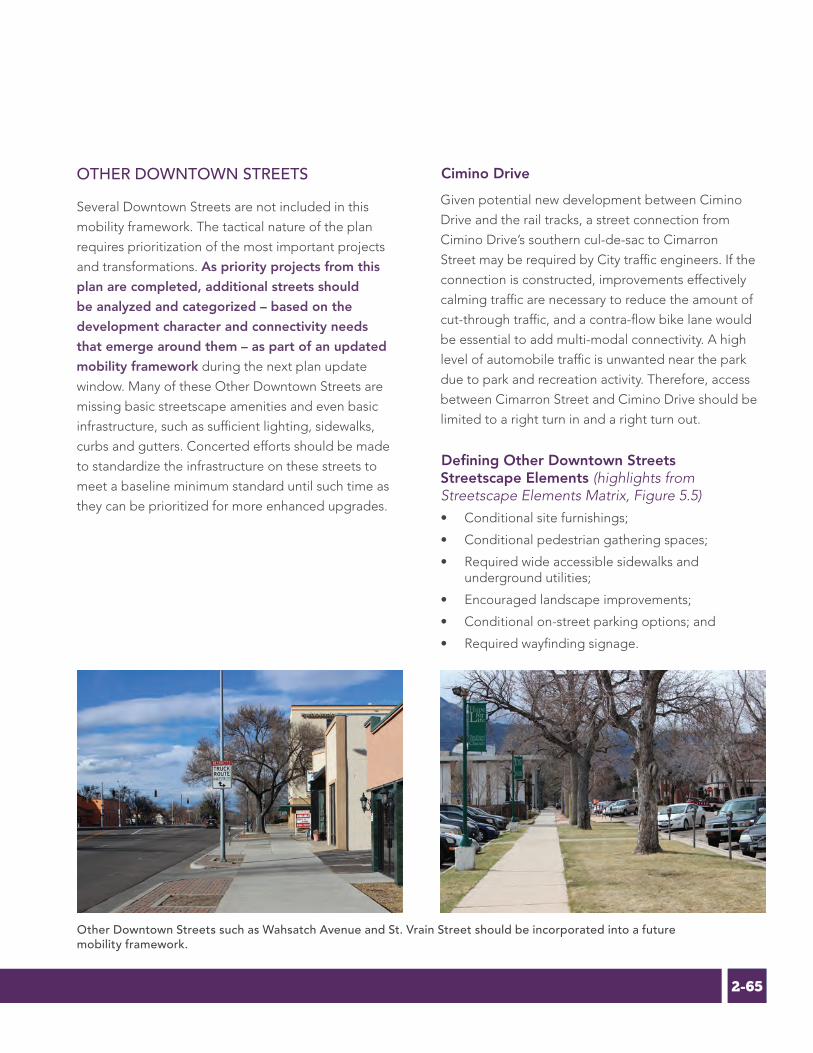
2-65C H A P T E R 4 M O B I L I T Y , T R A N S P O R T A T I O N A N D P A R K I N G
OTHER DOWNTOWN STREETS
Several Downtown Streets are not included in this
mobility framework. The tactical nature of the plan
requires prioritization of the most important projects
and transformations. As priority projects from this
plan are completed, additional streets should
be analyzed and categorized – based on the
development character and connectivity needs
that emerge around them – as part of an updated
mobility framework during the next plan update
window. Many of these Other Downtown Streets are
missing basic streetscape amenities and even basic
infrastructure, such as sufficient lighting, sidewalks,
curbs and gutters. Concerted efforts should be made
to standardize the infrastructure on these streets to
meet a baseline minimum standard until such time as
they can be prioritized for more enhanced upgrades.
Cimino Drive
Given potential new development between Cimino
Drive and the rail tracks, a street connection from
Cimino Drive’s southern cul-de-sac to Cimarron
Street may be required by City traffic engineers. If the
connection is constructed, improvements effectively
calming traffic are necessary to reduce the amount of
cut-through traffic, and a contra-flow bike lane would
be essential to add multi-modal connectivity. A high
level of automobile traffic is unwanted near the park
due to park and recreation activity. Therefore, access
between Cimarron Street and Cimino Drive should be
limited to a right turn in and a right turn out.
Defining Other Downtown Streets Streetscape Elements (highlights from Streetscape Elements Matrix, Figure 5.5)• Conditional site furnishings;
• Conditional pedestrian gathering spaces;
• Required wide accessible sidewalks and underground utilities;
• Encouraged landscape improvements;
• Conditional on-street parking options; and
• Required wayfinding signage.
Other Downtown Streets such as Wahsatch Avenue and St. Vrain Street should be incorporated into a future mobility framework.

2-66 V O L U M E 2 E X P E R I E N C E D O W N T O W N M A S T E R P L A N
Transit
In Colorado Springs, local bus transit service is
provided and operated by Mountain Metropolitan
Transit (MMT), a department within the City of
Colorado Springs (See Figure 4.9), while regional
transportation efforts are led by the Pikes Peak Area
Council of Governments (PPACG). The operation
of local public transportation service is a particular
challenge in Colorado Springs due to limited funding
that is spread thin given the sprawled development
patterns in much of the city. However, improved
transit options and increased transit utilization are
crucial aspects of developing an urban center easily
accessible from both local and regional destinations.
Improved transit service also aligns with Downtown’s
goal of attracting and retaining both millennials
and people age 65 and older, two demographic
segments recognized for an increasing interest in
transit. This section examines existing service and
planned improvements for transit service to and within
Downtown, regional transit options, and potential
implications of the ongoing transit station relocation
study.
LOCAL SERVICE
The PPRTA 2040 Regional Transit Plan notes that
Mountain Metropolitan Transit primarily provides
a lifeline service for its customers that have few
other mobility choices. However, there is growing
community support for moving to a system that
is not just based on access to services, but rather
creating better general connectivity that will attract
“choice” riders. The MMT system and its budget
expanded from 2004 to 2008, particularly in an effort
to implement more express routes to attract those
“choice” riders. However, much of this progress was
reversed due to budget cuts during the 2008 to 2010
recession, and service levels were reduced by almost
one-third. Little recovery was made for the first few
years after the recession, but in 2015 and 2016, several
initiatives were under way to increase both budgets
and service levels, especially on the routes that had
attracted the best ridership during the 2004-2008
expansion.
Mountain Metropolitan Transit is increasing service levels on popular Downtown routes.

2-67C H A P T E R 4 M O B I L I T Y , T R A N S P O R T A T I O N A N D P A R K I N G
Library 21C
East Library
Penrose Library
Library Express
Sand Creek Library
Rockrimmon Library
Ruth Holley Library
Manitou Springs Library
Old Colorado City Library
Cheyenne Mountain Library
Allegheny Dr
Norad Rd
S C
ircle
Dr
Gold Cam
p Rd
Zeppelin Rd
N T
ejon
St
Stad
ium
Blv
d
Pro
Rode
o Dr
Mesa A
v
S Li
mit
St
Jani
tell
Rd
Janitell Rd
E Harrison St
E Fountain Blvd
N E
l Pas
o St
Dublin Blvd
Cowpoke Rd
E Cheyenne Rd
W Bijou St
Winters Dr
Avia
tion
Wy
Aerotech Dr
Van
Teyl
inge
n D
r
E Fontanero St
N N
ewpo
rt R
d
Woo
ten
Rd
Orchard Valley Rd
Vapo
r Trl
Motor City Dr
Wolf Lake Dr
E Costilla St
Mila
m R
d
Delta Dr
Vinc
ent D
r
Milton E Proby Pkwy
Delmonico Dr
Vollm
er R
d
Vindicator Dr
N H
anco
ck A
v
Federal Dr
Elkton Dr
Dublin Blvd
Bott Av
Bla
ck F
ores
t Rd
Aeroplaza D
r
Oro
Bla
nco
Dr
Flin
tridg
e Dr
Lexington Dr
Mesa Rd
Magrath Av
Old Ranch Rd
Pete
rson
Rd
N Carefree Cr
Mar
k D
ablin
g B
lvd
Vickers Dr
Rang
ewoo
d Dr
W Rockrimmon Blvd
Rockrimmon Blvd
Hw
y 83
W Rio Grande St
Hw
y 115
Sout
hgat
e R
d
Orio
n D
r
Verde Dr
Mesa Av
King St
Brady Rd
Monterey Rd
Mirage Dr
Wheeler Av
Lelaray St
Omaha Blvd
Car
mel
Dr
Oak Hills Dr
Farthing Dr
Inspiration Dr
Tom
ah D
r
Big Valley Dr
Star Ran
ch Rd
W Montebello Dr
N Chelton Rd
Popes Valley Dr
Meadowland Blvd
Meadow Ridge Dr
Parkview Blvd
Thames Dr
Bell D
r
Bear C
reek R
d
Northwind Dr
Whimsical Dr
Woodland Hills Dr
Summerset
Dr
N S
pruc
e St
Chancellor Dr
Oak Valley Dr
Constellation Dr
York Rd
Penrose Blvd
Saddle Rock Rd
Gillen Rd
Wolf Village Dr
S C
oron
a Av
Patrician Wy
Mal
low
Rd
El Paso Blvd
Vickers Dr
Montrose Av
Tuck
erm
an L
n
Pine Manor Dr
Tahoe Blvd
Silent Rain Dr
Hop
eful
Dr
East
mea
dow
Dr
Skyw
ay B
lvd
Contrails Dr
Bab
cock
Rd
E Jackson StM
irada
Rd
Shalimar Dr
Brookwood Dr
Avondale Dr
Cha
parr
al R
d
Leon Young Dr
El Camino Dr
Cragin Rd
Downhill Dr
Family Pl
N W
alnu
t St
W Polk St
Valemount Dr
Uni
vers
ity D
r
Cottage Dr
Holiday Ln
Bra
inar
d D
r
Broadmoor Valley Rd
Haven
wood D
r
Coo
per A
v
E Old Farm Cr
Gra
nd L
awn
Cr
Deliverance Dr
Ston
y Cr
eek
Dr
W Old Farm
Cr
Ranch Dr
Chapel Hills Dr
Agora Pt
Pring Ran
ch Rd
Sodbuster Trl
Prin
ce D
r
Lizard Rock Trl
Cheyenne Mountain Blvd
Chaseglen D
r
La Salle St
Chapel Ridge Dr
Windjammer Dr
Royal Pine Dr
Yellowwood Dr
N Nonchalant Cir
S Che
yenn
e Can
yon R
d
Fraser Valley Ln
N L
ogan
Av
Vista Grande Dr
Braddock Dr
Campus Dr
Bro
adm
oor B
luffs
Dr
Low
ick
Dr
Thun
der M
ount
ain
AvPi
neda
le D
r
Broadmoor Valley Dr
Whimsic
al Wy
Vist
a Pl
Che
rryw
ood
Dr
Templeton Gap Rd
Old Broadmoor Rd
Sadd
le R
ock
Rd
Cheyenne Mountain Blvd
Flin
trid
ge D
r
Tutt Blvd
S 31
st S
t
W Woodmen Rd
E Woodmen Rd
Venetucci Blvd
E Cache La Poudre St
S Union B
lvd
N U
nion
Blv
d
W Uintah St E Uintah St
Tutt
Blv
d
Maizeland Rd
Temple
ton G
ap R
d
Stetson Hills Blvd
Research Pkwy
E Platte Av
E Pikes Peak Av
Palmer Park Blvd
S N
evad
a Av
N N
evad
a Av
S M
urra
y B
lvd
Morning Sun Av
Milton E Proby Pkwy
Manitou Av
Lower Gold Camp Rd
E Las Vegas St
Lake Av
Jet W
ing Dr
Security Blvd
US Hwy 24
Hancock Expy
Garden Of The Gods Rd
Galley Rd
E Fountain Blvd
Font
mor
e R
d
W Fillmore StE Fillmore St
Explorer Dr
Cor
pora
te D
r
Constitution Av
W Colorado Av
N C
ircle
Dr
Centennial Blvd
Briargate Pkwy
Briargate Blvd
E Boulder St
Barnes Rd
Austin Bluffs Pkwy
Astrozon Blvd
Airport Rd
N Academy Blvd
N 30th
St
N 30th
St
S 21
st S
t
N 1
9th
St
S 8t
h St
Maxwell St
Eagle Rock Rd
W Brookside St Capulin Dr
S 26
th S
t
E Fourth St
Mount View Ln
N E
l Pas
o St
N M
urra
y B
lvd
N P
ower
s B
lvd
S Carefree Cr
Cheyenne Blvd
Cheyenne Meadows Rd
B St
Mai
n St
Hancock Expy
Fontaine Blvd
N C
hest
nut S
t
UCCS
The BroadmoorThe World Arena
Colorado College
Chapel Hills Mall
Pikes Peak Cog Railway
The Independence Center
The Myron Stratton Home
Criminal Justice Center (CJC)
Colorado Springs Senior Center
The Promenade Shops at Briargate
Cheyenne Mountain Shopping Center
US Social Security Administration
Sky Sox Stadium & Sand Creek Stadium
Colorado Department of Motor Vehicles
El Paso County Citizens Service Center
UCCS Overflow Parking and Shuttle Access
PFC Floyd K. Lindstrom Outpatient Clinic
Pikes Peak Community College - Downtown Campus
Fort Carson
Air Force Academy
Peterson Air Force Base
Cheyenne Mountain Air Force Station
Colorado Springs Municipal Airport
City of Manitou Springs
City of Fountain
Memorial Hospital
Penrose Hospital
Memorial Hospital North
Saint Francis Hospital
TRANSIT SYSTEM MAPService is NOT provided on New Year’s Day, Thanksgiving Day, or Christmas Day.
Schedules are available at the Downtown Terminal or online at WWW.MMTRANSIT.COMNORTH
12345678910
11
12
14
15
16
17
19
22
23
25
27
32
36
39
33
35
34
I-25 & Woodmen Rd
I-25 & S Tejon St
Black Forest Rd & Woodmen Rd
Park & Ride Locations
Citadel Mall Transfer Center
Downtown Terminal
PPCC Centennial Campus
Voyager Parkway Transfer Center
Main Transfer Centers
Streams
Lakes
Parkland
Military Installation
City of Manitou Springs
City of Fountain
Libraries
Hospitals
Attractions and Landmarks
Hillside - Hancock Plaza
Centennial Blvd - Garden of the Gods Rd
Colorado Ave - Manitou
8th St - Broadmoor
Boulder St - Citadel
Fillmore St - Citadel
Pikes Peak Ave - Citadel
Cache La Poudre St - Citadel
Nevada Ave - UCCS
Hwy 115 - PPCC
World Arena - PPCC
Palmer Park Blvd
Chestnut St - Garden of the Gods Rd
E Fountain Blvd - Cheyenne Mtn Center
Brookside St - Uintah Gardens
19th St - Fillmore St
Nevada Ave - Eagle Rock
Southborough via Murray Blvd
Galley Rd - Tutt Blvd
N Academy Blvd - Voyager Pkwy
S Academy Blvd - PPCC
Incline/Cog Shuttle
Garden of the Gods Rd - Austin Bluffs Pkwy
Las Vegas St - PPCC
Manitou Avenue Shuttle
Corporate Dr - Voyager Pkwy
Security-Widefield
WEEKDAY EVENING SUNDAYSATURDAY
WEEKDAY SATURDAY
WEEKDAY EVENING SUNDAYSATURDAY
WEEKDAY EVENING SUNDAYSATURDAY
WEEKDAY EVENING SUNDAYSATURDAY
WEEKDAY EVENING SUNDAYSATURDAY
WEEKDAY SATURDAY
WEEKDAY EVENING SATURDAY
WEEKDAY EVENING SUNDAYSATURDAY
WEEKDAY EVENING SUNDAYSATURDAY
WEEKDAY EVENING SUNDAYSATURDAY
WEEKDAY EVENING SUNDAYSATURDAY
WEEKDAY SATURDAY
WEEKDAY SATURDAY
WEEKDAY SATURDAY
WEEKDAY SATURDAY
WEEKDAY EVENING SUNDAYSATURDAY
WEEKDAY
WEEKDAY
WEEKDAY
WEEKDAY
WEEKDAY EVENING SATURDAY
WEEKDAY EVENING SATURDAY
WEEKDAY
WEEKDAY SATURDAY
WEEKDAY EVENING
WEEKDAY EVENING
Downtown Terminal, Hancock Plaza
Downtown Terminal, EPC Citizens Service Center
Downtown Terminal, Manitou Springs Memorial Park
Downtown Terminal
Downtown Terminal, Citadel Mall Transfer Center
Citadel Mall Transfer Center, Fillmore St & Cascade Ave, Cache La Poudre St & Nevada Ave
Downtown Terminal, Citadel Mall Transfer Center
Citadel Mall Transfer Center, Cache La Poudre St & Nevada Ave
Downtown Terminal, Fillmore St & Cascade Ave, Cache La Poudre St & Nevada Ave, UCCS
Downtown Terminal, Nevada Ave & Rio Grande St, PPCC
Downtown Terminal, Nevada Ave & Rio Grande St, Venetucci Blvd & Lake Ave, PPCC
Cache La Poudre St & Nevada Ave
Downtown Terminal, EPC Citizens Service Center
Nevada Ave & Rio Grande St, Venetucci Blvd & Lake Ave
Nevada Ave & Navajo St, 8th St & Brookside St, Colorado Ave & 26th St, 19th & Henderson Ave
Cache La Poudre St & Nevada Ave, 19th St & Henderson Ave, Fillmore St & Cascade Ave
Downtown Terminal, Cache La Poudre St & Nevada Ave, Fillmore St & Cascade Ave, Eagle Rock Transfer Point
Citadel Mall Transfer Center, Hancock Plaza
Citadel Mall Transfer Center, Morning Sun Ave
Citadel Mall Transfer Center, Morning Sun Ave, Voyager Pkwy Transfer Center
Citadel Mall Transfer Center, Hancock Plaza, PPCC
Hancock Plaza
Manitou Springs Memorial Park
EPC Citizens Service Center, UCCS, Morning Sun Ave
PPCC
Seasonal Shuttle, runs 5/1/2016 through 9/12/2016
Eagle Rock Transfer Point, Voyager Pkwy Transfer Center
Transfer LocationsService DaysService AreaRoute ID
Other Map Elements
Copyright (C) 2016 City of Colorado Springs on behalf of the Colorado Springs Utilities. All rights reserved. Spring, 2016
E�ective May 1, 2016
Figure 4.9 | Mountain Metropolitan Transit Service
Library 21C
East Library
Penrose Library
Library Express
Sand Creek Library
Rockrimmon Library
Ruth Holley Library
Manitou Springs Library
Old Colorado City Library
Cheyenne Mountain Library
Allegheny Dr
Norad Rd
S C
ircle
Dr
Gold Cam
p Rd
Zeppelin Rd
N T
ejon
St
Stad
ium
Blv
d
Pro
Rode
o Dr
Mesa A
v
S Li
mit
St
Jani
tell
Rd
Janitell Rd
E Harrison St
E Fountain Blvd
N E
l Pas
o St
Dublin Blvd
Cowpoke Rd
E Cheyenne Rd
W Bijou St
Winters Dr
Avia
tion
Wy
Aerotech Dr
Van
Teyl
inge
n D
r
E Fontanero St
N N
ewpo
rt R
d
Woo
ten
Rd
Orchard Valley Rd
Vapo
r Trl
Motor City Dr
Wolf Lake Dr
E Costilla St
Mila
m R
d
Delta Dr
Vinc
ent D
r
Milton E Proby Pkwy
Delmonico Dr
Vollm
er R
d
Vindicator Dr
N H
anco
ck A
v
Federal Dr
Elkton Dr
Dublin Blvd
Bott Av
Bla
ck F
ores
t Rd
Aeroplaza D
r
Oro
Bla
nco
Dr
Flin
tridg
e Dr
Lexington Dr
Mesa Rd
Magrath Av
Old Ranch Rd
Pete
rson
Rd
N Carefree Cr
Mar
k D
ablin
g B
lvd
Vickers Dr
Rang
ewoo
d Dr
W Rockrimmon Blvd
Rockrimmon Blvd
Hw
y 83
W Rio Grande St
Hw
y 115
Sout
hgat
e R
d
Orio
n D
r
Verde Dr
Mesa Av
King St
Brady Rd
Monterey Rd
Mirage Dr
Wheeler Av
Lelaray St
Omaha Blvd
Car
mel
Dr
Oak Hills Dr
Farthing Dr
Inspiration Dr
Tom
ah D
r
Big Valley Dr
Star Ran
ch Rd
W Montebello Dr
N Chelton Rd
Popes Valley Dr
Meadowland Blvd
Meadow Ridge Dr
Parkview Blvd
Thames Dr
Bell D
r
Bear C
reek R
d
Northwind Dr
Whimsical Dr
Woodland Hills Dr
Summerset
Dr
N S
pruc
e St
Chancellor Dr
Oak Valley Dr
Constellation Dr
York Rd
Penrose Blvd
Saddle Rock Rd
Gillen Rd
Wolf Village Dr
S C
oron
a Av
Patrician Wy
Mal
low
Rd
El Paso Blvd
Vickers Dr
Montrose Av
Tuck
erm
an L
n
Pine Manor Dr
Tahoe Blvd
Silent Rain Dr
Hop
eful
Dr
East
mea
dow
Dr
Skyw
ay B
lvd
Contrails Dr
Bab
cock
Rd
E Jackson St
Mira
da R
d
Shalimar Dr
Brookwood Dr
Avondale Dr
Cha
parr
al R
d
Leon Young Dr
El Camino Dr
Cragin Rd
Downhill Dr
Family Pl
N W
alnu
t St
W Polk St
Valemount Dr
Uni
vers
ity D
r
Cottage Dr
Holiday Ln
Bra
inar
d D
r
Broadmoor Valley Rd
Haven
wood D
r
Coo
per A
v
E Old Farm Cr
Gra
nd L
awn
Cr
Deliverance Dr
Ston
y Cr
eek
Dr
W Old Farm
Cr
Ranch Dr
Chapel Hills Dr
Agora Pt
Pring Ran
ch Rd
Sodbuster Trl
Prin
ce D
r
Lizard Rock Trl
Cheyenne Mountain Blvd
Chaseglen D
r
La Salle St
Chapel Ridge Dr
Windjammer Dr
Royal Pine Dr
Yellowwood Dr
N Nonchalant Cir
S Che
yenn
e Can
yon R
d
Fraser Valley Ln
N L
ogan
Av
Vista Grande Dr
Braddock Dr
Campus Dr
Bro
adm
oor B
luffs
Dr
Low
ick
Dr
Thun
der M
ount
ain
AvPi
neda
le D
r
Broadmoor Valley Dr
Whimsic
al Wy
Vist
a Pl
Che
rryw
ood
Dr
Templeton Gap Rd
Old Broadmoor Rd
Sadd
le R
ock
Rd
Cheyenne Mountain Blvd
Flin
trid
ge D
r
Tutt Blvd
S 31
st S
t
W Woodmen Rd
E Woodmen Rd
Venetucci Blvd
E Cache La Poudre St
S Union B
lvd
N U
nion
Blv
d
W Uintah St E Uintah St
Tutt
Blv
d
Maizeland Rd
Temple
ton G
ap R
d
Stetson Hills Blvd
Research Pkwy
E Platte Av
E Pikes Peak Av
Palmer Park Blvd
S N
evad
a Av
N N
evad
a Av
S M
urra
y B
lvd
Morning Sun Av
Milton E Proby Pkwy
Manitou Av
Lower Gold Camp Rd
E Las Vegas St
Lake Av
Jet W
ing Dr
Security Blvd
US Hwy 24
Hancock Expy
Garden Of The Gods Rd
Galley Rd
E Fountain Blvd
Font
mor
e R
d
W Fillmore StE Fillmore St
Explorer Dr
Cor
pora
te D
r
Constitution Av
W Colorado Av
N C
ircle
Dr
Centennial Blvd
Briargate Pkwy
Briargate Blvd
E Boulder St
Barnes Rd
Austin Bluffs Pkwy
Astrozon Blvd
Airport Rd
N Academy Blvd
N 30th
St
N 30th
St
S 21
st S
t
N 1
9th
St
S 8t
h St
Maxwell St
Eagle Rock Rd
W Brookside St Capulin Dr
S 26
th S
t
E Fourth St
Mount View Ln
N E
l Pas
o St
N M
urra
y B
lvd
N P
ower
s B
lvd
S Carefree Cr
Cheyenne Blvd
Cheyenne Meadows Rd
B St
Mai
n St
Hancock Expy
Fontaine Blvd
N C
hest
nut S
t
UCCS
The BroadmoorThe World Arena
Colorado College
Chapel Hills Mall
Pikes Peak Cog Railway
The Independence Center
The Myron Stratton Home
Criminal Justice Center (CJC)
Colorado Springs Senior Center
The Promenade Shops at Briargate
Cheyenne Mountain Shopping Center
US Social Security Administration
Sky Sox Stadium & Sand Creek Stadium
Colorado Department of Motor Vehicles
El Paso County Citizens Service Center
UCCS Overflow Parking and Shuttle Access
PFC Floyd K. Lindstrom Outpatient Clinic
Pikes Peak Community College - Downtown Campus
Fort Carson
Air Force Academy
Peterson Air Force Base
Cheyenne Mountain Air Force Station
Colorado Springs Municipal Airport
City of Manitou Springs
City of Fountain
Memorial Hospital
Penrose Hospital
Memorial Hospital North
Saint Francis Hospital
TRANSIT SYSTEM MAPService is NOT provided on New Year’s Day, Thanksgiving Day, or Christmas Day.
Schedules are available at the Downtown Terminal or online at WWW.MMTRANSIT.COMNORTH
12345678910
11
12
14
15
16
17
19
22
23
25
27
32
36
39
33
35
34
I-25 & Woodmen Rd
I-25 & S Tejon St
Black Forest Rd & Woodmen Rd
Park & Ride Locations
Citadel Mall Transfer Center
Downtown Terminal
PPCC Centennial Campus
Voyager Parkway Transfer Center
Main Transfer Centers
Streams
Lakes
Parkland
Military Installation
City of Manitou Springs
City of Fountain
Libraries
Hospitals
Attractions and Landmarks
Hillside - Hancock Plaza
Centennial Blvd - Garden of the Gods Rd
Colorado Ave - Manitou
8th St - Broadmoor
Boulder St - Citadel
Fillmore St - Citadel
Pikes Peak Ave - Citadel
Cache La Poudre St - Citadel
Nevada Ave - UCCS
Hwy 115 - PPCC
World Arena - PPCC
Palmer Park Blvd
Chestnut St - Garden of the Gods Rd
E Fountain Blvd - Cheyenne Mtn Center
Brookside St - Uintah Gardens
19th St - Fillmore St
Nevada Ave - Eagle Rock
Southborough via Murray Blvd
Galley Rd - Tutt Blvd
N Academy Blvd - Voyager Pkwy
S Academy Blvd - PPCC
Incline/Cog Shuttle
Garden of the Gods Rd - Austin Bluffs Pkwy
Las Vegas St - PPCC
Manitou Avenue Shuttle
Corporate Dr - Voyager Pkwy
Security-Widefield
WEEKDAY EVENING SUNDAYSATURDAY
WEEKDAY SATURDAY
WEEKDAY EVENING SUNDAYSATURDAY
WEEKDAY EVENING SUNDAYSATURDAY
WEEKDAY EVENING SUNDAYSATURDAY
WEEKDAY EVENING SUNDAYSATURDAY
WEEKDAY SATURDAY
WEEKDAY EVENING SATURDAY
WEEKDAY EVENING SUNDAYSATURDAY
WEEKDAY EVENING SUNDAYSATURDAY
WEEKDAY EVENING SUNDAYSATURDAY
WEEKDAY EVENING SUNDAYSATURDAY
WEEKDAY SATURDAY
WEEKDAY SATURDAY
WEEKDAY SATURDAY
WEEKDAY SATURDAY
WEEKDAY EVENING SUNDAYSATURDAY
WEEKDAY
WEEKDAY
WEEKDAY
WEEKDAY
WEEKDAY EVENING SATURDAY
WEEKDAY EVENING SATURDAY
WEEKDAY
WEEKDAY SATURDAY
WEEKDAY EVENING
WEEKDAY EVENING
Downtown Terminal, Hancock Plaza
Downtown Terminal, EPC Citizens Service Center
Downtown Terminal, Manitou Springs Memorial Park
Downtown Terminal
Downtown Terminal, Citadel Mall Transfer Center
Citadel Mall Transfer Center, Fillmore St & Cascade Ave, Cache La Poudre St & Nevada Ave
Downtown Terminal, Citadel Mall Transfer Center
Citadel Mall Transfer Center, Cache La Poudre St & Nevada Ave
Downtown Terminal, Fillmore St & Cascade Ave, Cache La Poudre St & Nevada Ave, UCCS
Downtown Terminal, Nevada Ave & Rio Grande St, PPCC
Downtown Terminal, Nevada Ave & Rio Grande St, Venetucci Blvd & Lake Ave, PPCC
Cache La Poudre St & Nevada Ave
Downtown Terminal, EPC Citizens Service Center
Nevada Ave & Rio Grande St, Venetucci Blvd & Lake Ave
Nevada Ave & Navajo St, 8th St & Brookside St, Colorado Ave & 26th St, 19th & Henderson Ave
Cache La Poudre St & Nevada Ave, 19th St & Henderson Ave, Fillmore St & Cascade Ave
Downtown Terminal, Cache La Poudre St & Nevada Ave, Fillmore St & Cascade Ave, Eagle Rock Transfer Point
Citadel Mall Transfer Center, Hancock Plaza
Citadel Mall Transfer Center, Morning Sun Ave
Citadel Mall Transfer Center, Morning Sun Ave, Voyager Pkwy Transfer Center
Citadel Mall Transfer Center, Hancock Plaza, PPCC
Hancock Plaza
Manitou Springs Memorial Park
EPC Citizens Service Center, UCCS, Morning Sun Ave
PPCC
Seasonal Shuttle, runs 5/1/2016 through 9/12/2016
Eagle Rock Transfer Point, Voyager Pkwy Transfer Center
Transfer LocationsService DaysService AreaRoute ID
Other Map Elements
Copyright (C) 2016 City of Colorado Springs on behalf of the Colorado Springs Utilities. All rights reserved. Spring, 2016
E�ective May 1, 2016

2-68 V O L U M E 2 E X P E R I E N C E D O W N T O W N M A S T E R P L A N
One key action item from the 2040 Regional Transit
Plan is to “Improve Connectivity, Transfers, and Hubs”
in order to create a more seamless journey for riders
and limit the number of transfers or out-of-direction
journey time needed to reach key destinations. In
response, Mountain Metropolitan Transit has added
more frequency to key routes passing through
Downtown. In addition to the increased frequency
on these routes, Mountain Metropolitan Transit is
working with other City departments to enhance
these corridors from placemaking and transit-oriented
development perspectives in an effort to further drive
choice ridership on these key routes.
Despite these efforts, it is currently difficult to get
around the city using the transit system. According to
the PPACG 2040 Moving Forward Transportation Plan,
it is estimated that 56% of Colorado Springs residents
live outside existing transit service areas. MMT must
work more aggressively to enhance transit options
and first- and last-mile connections that will provide
incentive to a wider spectrum of potential users to
A frequent service, fare-free zone Downtown could serve the role of a traditional circulator route as shown in Denver with RTD's 16th Stret Mall Shuttle.
use the system and increase their ability to reach
Downtown and other major employment and activity
hubs. The key focus, especially in the short-term,
should be on frequency and mode shift towards choice
ridership.
The Statewide Transit Plan and the 2040 Regional
Transportation Plan note that the PPACG region will
generate enough revenue through 2040 ($808
million) to continue operations and maintenance,
but “does not allow Mountain Metro Transit to
expand its system in any way.” MMT and Downtown
stakeholders need to embrace and promote creative
strategies for improving the transit system and
access to it. Without such efforts, the city will fail to
rise to the challenge posed by the Statewide Transit
Plan when it concludes that “Moving into the 21st
century, the linkages between economics, land use
and transportation are likely to become even more
prominent as regions work to create sustainable,
healthy and vibrant communities.”
DOWNTOWN SERVICE
Future plans for transit improvements that serve the
goal of greater connectivity also should include an
eventual shift to more of a grid system citywide. A
number of stakeholder sessions for the 2040 Regional
Transit Plan discussed the feasibility of transitioning the
current multi-hub route structure to such a grid-based
network. Though the plan identifies a key action of
improving service hours and frequencies, it predicts
that the degree of service increases proposed would
still operate more effectively through its current multi-
hub route structure for the time being.
Nonetheless, the maintenance and expansion of the
grid-type effect already present Downtown is a priority
in conjunction with an increased number of stops and
higher frequency service throughout the city center.

2-69C H A P T E R 4 M O B I L I T Y , T R A N S P O R T A T I O N A N D P A R K I N G
REGIONAL SERVICE
Existing and planned regional transit service falls
short of providing Colorado Springs with needed
connectivity to the Denver metropolitan area and
its expanding FasTracks system. Currently, limited
regional bus service from Colorado Springs is provided
by the Greyhound national network and by Bustang, a
CDOT-funded regional carrier with routes to Denver,
Fort Collins and west on the Interstate 70 corridor
to Glenwood Springs. Bustang has three stops in
Colorado Springs, including the Downtown Station.
However, there are a number of challenges associated
with use of the Bustang system. Service is infrequent
and typically focused only on peak commute hours.
Additionally, a number of the Bustang buses leave the
Colorado Springs area stops before local bus service
begins at 6:15, limiting access for non-automobile
users. Furthermore, service times make the service
work for commuters going from Colorado Springs to
Denver, not the other way. While at present time there
is limited demand for southbound trips from Denver
to Colorado Springs, it is anticipated that if service
were improved in the reverse direction, ridership
demand would increase. Similarly, the lack of a Denver
Tech Center or south Denver stop makes the service
prohibitive for many commuters working in those
areas.
Examining future options for improved and more
regular long range transit connections is a crucial
imperative for better linking Colorado Springs and
Downtown into the regional system, in particular
the Regional Transportation District (RTD) FasTracks
expansion in the Denver area, the largest such transit
expansion under way in the country. Downtown
stakeholders echo the analysis of the 2015 Statewide
Transit Plan which shows that Colorado Springs is the
only major urban area in the state without regional
bus or interstate train service providing regular travel
into other major cities. In addition to this spatial gap
in regional connectivity, the Plan also recognizes the
distinct temporal gap that exists, with limited to non-
existent transit service and frequency on weekends
and during early morning and late evening hours that
serve users other than typical 9-5 commuters. The
Statewide Transit Plan reiterated the recommendations
of the Rocky Mountain Rail Authority (RMRA) study
that called for an Interregional Connectivity Study
(ICS) as an important next step in following up and
implementing the High-speed Intercity Passenger Rail
(HSIPR) feasibility study. This study concluded that
HSIPR is feasible on two main Colorado corridors:
I-25 from Pueblo to Fort Collins and I-70 from Denver
International Airport (DIA) to Eagle County Regional
Airport. CDOT began the ICS study in mid-2014.
Better regional service, especially to Denver, also
will help Colorado Springs connect to interstate rail
options. Colorado Springs is not served by either of
the Amtrak routes that pass through Colorado: the
California Zephyr that runs through Denver serving the
I-70 corridor on its route between Chicago and San
Francisco; and the Southwest Chief Route that travels
through southeast Colorado on its route between
Chicago and Los Angeles.
The Colorado Department of Transportation’s Bustang service provides limited regional transit connectivity to Denver and beyond.

2-70 V O L U M E 2 E X P E R I E N C E D O W N T O W N M A S T E R P L A N
Based on the establishment and success of the Pikes
Peak Rural Transportation Authority (PPRTA) and
the subsequent demonstrated interest in regional
cooperation and funding mechanisms, the 2040
Regional Transit Plan recommends pursuing a new
governance structure for transit that embraces a
regional perspective and leads to regional planning
and implementation of transit. This regional
perspective will benefit the city as a whole and
Downtown in particular if it succeeds in expanding
planning and cooperation that brings regular high-
capacity transit options between Colorado Springs
and Denver. When this more robust regional transit
system is initiated, the Downtown multi-modal
station will be an obvious and crucial hub and one
of Downtown’s best tools for attracting regional
transit service at a scale and frequency that truly
connect it to the Denver area and to interstate options
in a meaningful way. The relocation of the Downtown
Transit Station is a key aspect determining Downtown’s
ability to take advantage of future options for regional
transit, particularly high speed rail. This factor must
weigh heavily in the ultimate decision for where to
locate the station and how to design it for easy future
compatibility with regional bus and rail options.
DOWNTOWN TRANSIT STATION RELOCATION STUDY
Ensuring that numerous routes provide east-west and
north-south access every two to three blocks throughout
Downtown is a priority of this plan. If operated as a free-
fare/frequent-stop zone in Downtown, this improved
service on existing lines could help serve the role of
a circulator for employees, residents and visitors. The
issue of foregone fare revenue in a fare-free Downtown
zone will need to be addressed; the City may justify the
missed revenues if the resulting system is seen as having
a catalytic enough effect on Downtown development and
activity.
The location, timing, and design of future bus stops
Downtown also will be determined by the eventual
relocation of the transit station. Although available
resources limit expansion or major redesign of services
at present, City, MMT, and Downtown stakeholders must
begin work on medium- and long-term plans that focus
on the importance of bringing people to and from the
core, on both local and regional scales.
A comprehensive study is in progress to identify a
location for a modern new multi-modal transportation
facility in or near the core. The station should be located
within two blocks of the urban greenway network and
should not be located east of Wasatch Avenue. In
addition, Mountain Metropolitan Transit desires to make
the new station a truly multi-modal hub – with a focus on
non-motorized connections – and a positive public space
that enriches the Downtown urban fabric and operates
during all hours of the day and evening. Multiple factors
should be considered to ensure this goal is achieved,
including:
• Proximity to existing or potential heavy rail corridor to ensure the possibility of regional rail transit in the future.
• Creation of a truly multi-modal facility and integration of all anticipated uses;
The new transit center location should be within close proximity to shopping, restaurants and other amenities.

2-71C H A P T E R 4 M O B I L I T Y , T R A N S P O R T A T I O N A N D P A R K I N G
• A location with good street and trail connectivity to ensure safe and comfortable pedestrian and bicycle access;
• A location that links riders into a downtown free-fare/frequent stop zone;
• Proximity to other desirable destinations and amenities including parks, educational facilities, retail shopping options, and employment nodes;
• Proximity to existing or anticipated concentrations of housing;
• Ease of access and use by tourists and visitors to the community;
• Bus or shuttle access creating connection to the Colorado Springs Airport;
• Mixed-use development options and compatible adjacent uses.
Finally, the relocation of the Transit station has implications
for placemaking Downtown. The current station
location will be a key redevelopment opportunity
and provide an ideal location for ground floor activation
and streetscape enhancements recommended in other
chapters of this Plan. MMT should engage a range of
public and private partners to leverage the development
potential and activity associated with the transit station
toward fulfilling these goals.
BIKE SHARE
Bike sharing is increasingly establishing itself as an
integral part of multi-modal transportation strategies in
cities nationwide. Downtown Colorado Springs should
embrace a bike share program as both an important
transit option as well as an economic driver in attracting
tourists and workforce. With a Phase 1 bike share program
centered on Downtown, stations should be geared toward
first- and last-mile connection to transit; short round-trip
options for office workers who commute by car; access
for tourists to the multiple cultural attractions within the
greater Downtown area; and connectivity for students at
Colorado College and Pikes Peak Community College
and, eventually, UCCS.
Parking
One of the key components to any downtown
revitalization effort is a transportation network that
allows employees, customers, visitors, and residents
convenient (and cost effective) access to the city
center. Many cities have opted to address this need by
strengthening public transportation networks including
local and regional bus and rail, as well as convenient
“last mile” connections such as bike share, streetcars,
and downtown circulator systems. In addition to
improving public transportation systems, many cities
also encourage smart urban planning policies such
as increasing residential density in transit served
neighborhoods, improving walkability, and creating a
more robust bicycle network within the urban context.
Though urban planning and transportation strategies
for higher density and improved multi-modal
connectivity are important aspects of Downtown’s
evolution, the fact remains that most communities
in the United States still rely on the automobile for
more than 50% of trips generated to, from, and within
a downtown. This means that the parking system is
one of the most critical elements to the economic
success of the city center.
Much of the central business district of Downtown
Colorado Springs is parking exempt, which allows
businesses to develop by creating enough parking
to meet market demands, rather than by fulfilling
code requirements that usually create an unnecessary
surplus of parking. In this context, parking is often
provided by both the public sector and the private
sector, assuming parking rates are high enough to
justify the costs of privately managed public parking.

2-72 V O L U M E 2 E X P E R I E N C E D O W N T O W N M A S T E R P L A N
provider of structured parking. However, the Parking
Enterprise is the only provider of metered on-street
parking spaces. Hourly rates at metered spaces in the
Downtown core are $1 per hour, and $0.75 per hour for
areas outside of the core.
Several other Downtown parking garages are owned
and managed by private entities such as office
buildings, as well as by El Paso County. County facilities
are generally not available for public parking, with the
exception of juror uses and events at the Pikes Peak
Center for the Performing Arts. Greater efficiencies
may be possible within the parking system if the
City can partner with the County and other private
parking owners to offer excess parking for public
use. This can be accomplished through programs
and policies that encourage private participation in
the parking market and by the City taking the lead in
setting parking rates at a high enough price point that
the private market also can compete.
One of the key factors influencing future growth in
Downtown is its parking availability. From a parking
supply perspective, the system must be robust
enough to not only accommodate existing
parking demand, but have enough capacity
COLORADO SPRINGS PUBLIC PARKING – EXISTING SYSTEM
Public parking in Colorado Springs is operated as
an enterprise, a self-sustaining government-owned
business that by code must receive at least 75 percent
of its annual non-debt revenue from nongovernment
sources. The Enterprise, while not strictly driven by
revenue, collects revenue that can in turn be used to
provide for planning, development, improvement,
beautification, equipping and maintaining the parking
structures and parking related facilities. The Parking
Enterprise is an asset and a tool to Downtown
revitalization that can be used to achieve public
goals, to manage the parking system in a way that
supports urban planning and design objectives, and as
a tool for public-private partnerships in development
of catalytic sites and priority uses.
Public parking within the city center consists of both
three off-street structured facilities that are owned and
managed by the City Enterprise as well as metered
and time-limited on-street spaces. The three public
parking structures comprise roughly 38% of the
total off-street parking supply in Downtown, so the
City Enterprise is a significant, but not the primary,
Downtown parking strategy must price and manage on-street and structured parking to meet different goals.

2-73C H A P T E R 4 M O B I L I T Y , T R A N S P O R T A T I O N A N D P A R K I N G
to accommodate future growth. The current
parking availability reflects the Downtown’s ability
to absorb additional vehicles if the city grows. A
2009 Downtown parking study conducted by Walker
Parking Consultants indicated that the 2,661 street
and garage public parking spaces were 58% occupied
during the week and only 19% occupied on the
weekend. This level of space utilization may present
significant additional capacity for growth in Downtown,
especially for weekend and evening uses. However, this
Downtown parking occupancy data is somewhat dated
and may not reflect current utilization trends. Updated
data to determine current and future utilization
rates will be especially important for city center
parking analysis. The City Parking Enterprise should
commission a more focused Downtown parking study
in 2018-2019 after re-development in the Southwest
Downtown district is anticipated to be partially
complete.
As Downtown grows and faces new demands,
the Parking Enterprise must continue to balance
operational needs with other City objectives,
including urban design, economic development
and improved multi-modal access. In addition to
strategic management partnerships, supplying
public parking to a private project can serve as an
economic development incentive and excellent
example of a public private partnership. Historically
the Parking Enterprise has been a partner in economic
development initiatives, and should continue to be
used as a tool for attracting more investment into
Downtown.
PUBLIC PARKING PRICING
Public parking pricing in Downtown should generally
be competitive with that of the private market. If public
pricing is too low, it limits the potential for maximized
revenue and thus public benefit, which is partially
returned to the public in the form of investment in
improved streetscapes and additional parking when
and where needed. Pricing the public parking system
too high will discourage use of the system and loss
of customers to the private market, or from visiting
Downtown all together. Regular evaluation and
inflation of parking pricing is encouraged in order
to maintain a competitive advantage and to support
the rising cost of operating the system, particularly
as the system grows into new areas or provides new
infrastructure. Public parking rates currently are set by
City Council, while hours are set administratively by
Enterprise staff; flexibility to adjust rates would enable
the Parking Enterprise to operate in a more market-
driven manner.
The Parking Enterprise should continue to price on-
street metered spaces and structured garage spaces
to meet different goals. On-street meters generally
should be priced higher and with shorter lengths
of stay to stimulate turnover and to encourage use
of garages. Parking garages will generally be priced
more affordable per hour to encourage long-term
or all day users. (An exception to the general rule of
pricing on-street meters to promote turnover may be
along certain urban and neighborhood greenways,
where vehicles parked for longer duration help
provide a consistent buffer for protected bicycle
lanes.) Furthermore, accommodations for low emission
vehicles, electric vehicles, car sharing and carpooling
should continue to be integrated into the system.

2-74 V O L U M E 2 E X P E R I E N C E D O W N T O W N M A S T E R P L A N
PARKING TECHNOLOGY
Many new parking technologies may transform
Downtown parking management in the coming
years. These technologies include real-time parking
occupancy systems, automated parking, cashier-
less payment options using credit card payments
and mobile phones, and enforcement option using
license plate recognition. The near-term emphasis of
technology investments and improvements should
be providing consistent payment methods and
enhancing ease of customer use. All meters should
have a similar customer interface and accept credit
cards. Certain streets should be considered for
different payment systems such as pay stations in order
to achieve street design goals. Removing meters (and
converting to one or two payment stations per block)
along from key segments of Special Purpose Streets
(Vermijo, Pueblo, and Sierra Madre) will provide a
much more flexible environment for festivals, markets,
and other public gatherings and events. Over the mid-
to long-term, opportunities will exist for the City to
improve operational efficiencies by investing in proven
technologies to better manage existing and future
resources.
BICYCLE PARKING
While convenient parking systems are essential
for success, safe and convenient bicycle parking
options are also an important strategy for supporting
a more multi-modal environment and facilitating
mode shift. Bicycle parking should be approached as
systematically as automobile parking. Designated
areas should be available - at a minimum - every
two blocks within Downtown to provide easy and
safe access for residents, employees, and visitors.
Additionally, distributed bicycle parking along the
streetscape is an essential feature to a bicycle
friendly environment. One of the primary advantages
of traveling Downtown by bike is that one can park at
exactly the desired destination.
Convenient and efficient Downtown parking supports local businesses.

Urban Design and Public Space
chapter5Overview
Form-Based Code
Public Space
Highlights
Future code revisions should balance the desire for compact
urban form, densities that support a range of urban amenities, and a
connected, pedestrian-friendly walkable environment.
Promote and encourage activated shared public spaces including
sidewalks, plazas, and parklets that enhance people's feelings of
comfort, safety, and enjoyment while Downtown.
Careful planning and management of public space and streetscape
elements will unify Downtown’s look and feel while still providing
opportunities to distinguish and differentiate the core’s unique districts.

2-76 V O L U M E 2 E X P E R I E N C E D O W N T O W N M A S T E R P L A N
Overview
Great design helps unite the look and feel of adjacent
land uses; stimulates private development that
engages the public realm; and creates streets and
other public spaces at a human scale that invite people
to gather and move about the city. These public
spaces are the connective tissue among the other
physical elements described in this plan. Strong urban
design can help link the buildings, gateways, streets,
parks, and trails in safe, comfortable, creative and
engaging ways.
In combination with innovative land use strategies,
urban design should help foster the character
that differentiates the various neighborhoods
and districts within the city center. It also should
create distinctions between Downtown and the rest of
Colorado Springs. The design of new and renovated
buildings must focus on the activation of ground floors
and the relationship of buildings to adjacent and
nearby streets. In addition to the impact of individual
buildings, the thoughtful design and maintenance of
public roadsides, landscape, street furniture, public
parks and plazas, public art, and signage are all
elements that impact public space.
This chapter discusses and provides considerations
for key urban design tools: Form-Based Code, public
space and streetscape guidelines.
Form-Based Code
The establishment of a Form-Based Code is one
of the milestone achievements resulting from the
Imagine Downtown Master Plan. Adopted in 2009,
the Code encourages compact, mixed-use, and
pedestrian-friendly revitalization efforts in a delineated
City Center district (see Figure 5.1 for the geographic
extent covered by the Form-Based Code District). It is
a key element in the City’s vision to promote economic
vitality, sustainable growth, and a better quality of
life. Unlike traditional zoning that regulates primarily
by use, the Form-Based Code focuses on directing
high quality urban form to coordinate a variety of
complementary uses around attractive streetscapes
and public spaces.
This section outlines the regulatory basis for the
Form-Based Code and discusses the sectors used to
administer its guidelines and standards in different
parts of the city center. As the Code will be under
review in the near-term, this section also identifies
areas where the Code Review Committee could
consider changes or adjustments to best achieve the
goals of the master plan.
REGULATORY BASIS FOR THE CODE
The Code is legally established through zoning
ordinance 09-83 and 12-23 and its enabling legislations
found in Section 7.3.801 of the City Codes. The
Downtown Review Board (DRB) was established
concurrently with the Form-Based Code. This board
has the authority to approve, conditionally approve,
or deny projects that require greater flexibility for
specific standards. The DRB operates similarly to a
traditional “board of adjustments,” granting warrants
from specific standards and making other discretionary
decisions.

2-77C H A P T E R 5 U R B A N D E S I G N A N D P U B L I C S P A C E
Source: Esri, DigitalGlobe, GeoEye, Earthstar Geographics, CNES/Airbus DS, USDA, USGS, AEX, Getmapping, Aerogrid, IGN, IGP, swisstopo, and the GIS User Community
0 500 1000 2000 feet
LegendDowntown Study Area
BID Boundary
25
25
LOWELL NEIGHBORHOOD
MILL STREET / LAS VEGASNEIGHBORHOODS
WESTSIDENEIGHBORHOOD
DIVINE REDEEMERNEIGHBORHOOD
MIDDLESHOOKS RUN
NEIGHBORHOOD
HILLSIDENEIGHBORHOOD
COLORADO COLLEGE
S TE
JON
ST
N T
EJO
N S
T
S W
EBER
ST
SAH
WA
TCH
ST
S SI
ERRA
MA
DRE
ST
E KIOWA ST
E BIJOU ST
E DALE ST
CIM
INO
DR
E COSTILLA ST
E CIMARRON ST
N W
EBER
ST
E RIO GRANDE ST
E PLATTE AVE
E ST VRAIN ST
E BOULDER ST
E CUCHARRAS ST
E MORENO AVE
S C
ASC
AD
E A
VE
E MONUMENT ST
W MORENO AVE
W COLORADO AVEW COLORADO AVE
E WILLAMETTE AVE
W BIJOU STW BIJOU ST
E PIKES PEAK AVE
W RIO GRANDE ST
NN
EVA
DA
AVE
W COSTILLA ST
W CIMARRON ST
SN
EVA
DA
AVE
E LAS ANIMAS S
FOUNTAIN BLVDFOUNTAIN BLVD
W MILL ST
E COSTILLA ST
E PLATTE AVE
E BOULDER ST
E WILLAMETTE AVE
E CACHE LA POUDRE AVEW CACHE LA POUDRE AVE
N S
PRU
CE
ST
N W
ALN
UT
ST
MESA RD
T
PUEBLOAVE
SW
AH
SATC
HA
VE
SPR
OSP
ECT
ST
CO
NEJO
SST
CO
NEJO
SST
W PIKES PEAK AVE
W KIOWA ST
ANTLERS PL
NSI
ERRA
MA
DRE
ST
SC
ORO
NA
ST
W VERMIJO AVE
NC
ASC
AD
EA
VE
W CUCHARRAS ST
E COLORADO AVE
NIN
STIT
UTE
STS
INST
ITU
TEST
NW
AH
SATC
HA
VE
NC
ASC
AD
EA
VE
E PIKES PEAK AVE
W CIMARRON ST
Figure 5.1 | Form-Based Code Sectors

2-78 V O L U M E 2 E X P E R I E N C E D O W N T O W N M A S T E R P L A N
SECTORS
Downtown is divided into four sectors to guide
the application of the Code. Specific standards are
correlated with specific sectors, which are represented
on the Form Based Code Sectors Map (Figure 5.1).
Some parts of the Downtown study area are not
covered by the Form-Based Code. In particular, areas
in the eastern part of Downtown are zoned Special
Use and General Commercial or Residential Use.
Additionally, the Form-Based Code District extends
beyond the study area boundary to the south,
encompassing critical gateways at South Nevada
Avenue and South Tejon Street.
The Form-Based Code sectors do not directly align
with the districts in this plan. In particular, the Central
Sector of the Form-Based Code covers a significant
portion of the Downtown study area and overlaps
the City Center, New South End, Southwest, and
East End districts. The lack of alignment between the
districts and the FBZ sectors could cause concern
for implementing zoning modifications that can
effectuate district wide change, however because the
district sectors in this plan are primarily meant to
guide public realm improvements and facilitate a
“sense of place,” their discrepancy is not inherently
problematic. The next update to the Form-Based
Code should however consider whether rezoning Code
sectors to more closely match the district boundaries is
appropriate or desired.
Each sector is detailed as follows:
The Central Sector encompasses the majority
of the Downtown Form-Based Code District, and
geographically represents the heart of Downtown. The
primary goal for the Central Sector is to increase
Downtown density, create an iconic skyline and
establish a high-quality pedestrian environment
at the street level. The central sector has a two-story
height minimum, but does not restrict maximum
building heights, encouraging increased building
densities both horizontally and vertically. It is intended
that the Central Sector will have commercial uses
(retail, restaurant, entertainment and office) on the first
level of most buildings, with residential, lodging and
office uses on the upper levels. The Central Sector
does not require specific parking standards, both to
encourage a multi-modal environment that is not solely
dependent on the car, as well as to respond to market
demands for parking.
The Corridor Sector is found in three distinct areas
of the city center: at the southern end of Downtown
just north of I-25; along South Nevada Avenue and
South Tejon Street; and along two blocks of North
Cascade Avenue near the Kiowa Street and Bijou
Street entrance from I-25. While these areas aren’t
envisioned to support the density of the Central
Sector, a unique set of standards was developed to
reflect the importance of these areas as gateways,
and to address the appropriate height and intensity
of developed land along the significantly wide
rights-of-way on Nevada and Cascade avenues (each
approximately 140 wide).
The Transition 1 and Transition 2 Sectors surround
much of the Central Sector in order to provide an
area of transition from the high density land uses
to the lower density residential and mixed uses
in surrounding neighborhoods and other master
planned districts. These sectors allow a variety of non-
residential uses and a mix of housing types at medium
to low intensities and densities, but permit all building
types outlined in the code.

2-79C H A P T E R 5 U R B A N D E S I G N A N D P U B L I C S P A C E
OBJECTIVES OF THE CODE
The Form-Based Code specifies private building
standards that promote a high quality, pedestrian-
oriented public realm that encourages activation
of the space for the comfort and safety of all users.
The Code provides standards that require the design
of new buildings to support the density, street level
activity, visual interest, and engaging public spaces
demanded by Downtown residents, employees, and
visitors. The Code standards are organized into several
categories, including building type, frontages, uses,
parking, block standards, public spaces, and signage.
Specifically, and in line with the 2009 Imagine
Downtown Master Plan, the Code outlines regulatory
guidelines and standards to:
• Create a predictable investment environment for development;
• Remove barriers to revitalize Downtown Colorado Springs;
• Promote a mix of uses including retail, office, residential, institutional, and others;
• Establish transitions from the Downtown core and urban renewal sectors to the surrounding neighborhoods;
• Clearly communicate through simple language and easily understood graphics the physical requirements and expectations for new development;
• Implement a review and approval process that is efficient and effective in approving projects that meet the Code’s requirements;
• Promote new development which respects the historic building fabric, as well as the natural environment, and enhances the pedestrian experience;
• Establish a coordinated streetscape plan including street trees, public art and appropriate street furnishings;
• Accommodate the changing uses of buildings while maintaining the integrity and viability of the public realm, with an emphasis on intermodal transportation options and pedestrian linkages and orientation; and
• Implement the goals, objectives and strategies of the Downtown Development Authority and its Plan of Development to ultimately revitalize and improve Downtown Colorado Springs.
The Downtown Form-Based Code was revised in 2012.

2-80 V O L U M E 2 E X P E R I E N C E D O W N T O W N M A S T E R P L A N
FORM-BASED CODE CONSIDERATIONS
Design provisions are outlined in the Code to achieve
the objectives listed above. Since the code’s inception
in 2009, there have been limited opportunities to
see the effects of the Code on physical construction
primarily due to the sluggish development climate
during the recession. However, several current and
planned developments have started to demonstrate
the positive effects of the Code throughout
Downtown.
However, since the Code’s creation, a handful of
issues have been brought to light, some minor and
others more philosophical in their potential impacts
on Downtown development. The following should
be considered by the Code Review Committee when
considering revisions to the code:
Use Categories
The focus of Form-Based Code is the form,
massing, and location of buildings and public space.
However, the Code does specify a few prohibited
and conditional uses in the Form-Based sectors to
promote “a balanced and desirable collection of
varied uses” and to support the goal of increased
residential uses Downtown. Limited refinements should
be considered by the Code Review Committee to
ensure efficacy of the code and to make consideration
for new or changing industries, such as medical and
recreational marijuana uses, businesses with different
types of liquor licenses such as breweries, different
types of manufacturing, and others that may still be
emerging. Creating more clarity around conditional
and prohibited use will inform future businesses and
investors of the priorities for the area.
First, the code should more carefully define “Mixed-
Use Buildings” and include a specific criteria requiring
that a minimum percentage of building ground
floors are occupied by active uses, understanding
the constraints with the encouragement of podium
parking.
More importantly, Code adjustments should be
considered to allow a new light industrial use category
as a conditional use in the Form Based Zone to
better accommodate the potential for artisan
manufacturing and maker spaces. The 2016 Market
Assessment written in parallel with the Experience
Downtown Master Plan notes the importance in
Downtown of niche opportunities for small-scale
light industrial and artisan manufacturing; flexible,
collaborative, co-working spaces; and non-traditional
office formats often favored by entrepreneurial and
innovation based businesses. In some cases, these
uses may find suitable spaces in existing older
buildings around the periphery of the Downtown core.
The market assessment states that there also may be
opportunities to replicate this product type through
creative construction of low rise, open floorplate,
light industrial concepts and through conversions and
subdivisions of existing Class B and C office properties.
Each of these potential opportunities should be
supported and encouraged with this suggested zoning
use change.

2-81C H A P T E R 5 U R B A N D E S I G N A N D P U B L I C S P A C E
Downtown Architecture Considerations
Many aspects of well-articulated ground floors and
building façades are covered by the Code. Several
revisions will further enhance its effectiveness in
creating the type of activated, ground floor streets,
sidewalks, and public spaces desired in Downtown.
Design Guidelines should more clearly encourage
creative and eclectic design, and architectural
diversity and variety. In addition, options for active
ground floor uses will be improved by blurring
the lines between interior and exterior spaces by
encouraging operable walls, functional garage doors,
etc. Guidelines should expand on the importance of
prominent entrances, orienting entrances on all active
street faces, and celebrating corner entrances. High
quality, human-scaled materials will further enhance
the pedestrian realm.
Sustainable design principles should be highlighted
that encourage active and passive solar design in
new and renovated buildings, climatically sensitive
design such as entrance vestibules, and rainwater
catchment and Low Impact Development techniques
that can serve as beautiful, functional, and interactive
design elements. Section 4.1 of the Code on
Architectural Guidelines already addresses step backs
and transitions, two critical elements often used to
ensure proper shade to sun ratios. Further detail
and guidelines could be provided specifying the
importance of solar access in public rights-of-way for
added pedestrian comfort.
Some Downtown buildings already foster interactions between their ground floor and public space users by incorporating transparent façades and seating patios.

2-82 V O L U M E 2 E X P E R I E N C E D O W N T O W N M A S T E R P L A N
Public Realm
Streets and sidewalks are the primary areas where people
experience the public realm and its relationship to private
buildings. Design principles that help create comfortable,
human-scaled outdoor “rooms” improve the public
realm. The Code calls for active uses on ground floors, and
a higher proportion of doors, windows, and outdoor seating
options all to help increase the safety and comfort of
pedestrians and improve the look and feel of the buildings
themselves. Encouraging uses such as outdoor dining
contributes to the feeling of activity and safety on streets.
While the Code does a good job of supporting these goals,
refining the following categories in Sections 2 and 4 will
increase its effectiveness.
Revised requirements for Vehicular Zones can offer
prototypical solutions for allocating roadway space for
more uses beyond vehicular lanes and parking. Multi-
modal and public space objectives can be supported
with adjustments to lane reductions, reduced lane widths,
stronger pedestrian realm and crossing requirements.
Revision should consider the introduction of an “activation
zone” between the building edge and the pedestrian way
that encourages ground floor commercial and residential
tenants to utilize the space just outside their entrance for
outdoor seating, display of goods, and other elements such
as umbrellas, tables, and plantings. This can be achieved by
intentional encroachment and use of the wide rights-of-way
for greater amenity zone activation, helping create more
room for activation space along the building frontage.
Finally, adjusting requirements for glazing and fenestration
percentages, providing more specific design solutions for
pedestrian-friendly alleyways, revising building step back
transition requirements, modifying design guidelines for
drive-through lanes – longer term – considering parking
maximums will all enhance the Code’s efficacy in providing
the type of streets and public spaces described and called
for in this Master Plan.
LOW IMPACT DEVELOPMENT (LID)
“LID is an approach to land development (or re-development) that works with nature to manage stormwater as close to its source as possible. LID employs principles such as preserving and recreating natural landscape features, minimizing effective imperviousness to create functional and appealing site drainage that treat stormwater as a resource rather than a waste product. There are many practices that have been used to adhere to these principles such as bioretention facilities, rain gardens, vegetated rooftops, rain barrels and permeable pavements.” Source: www.epa.gov

2-83C H A P T E R 5 U R B A N D E S I G N A N D P U B L I C S P A C E
Public Space
Colorado Springs’ Downtown will become more
vibrant by encouraging active use of its public spaces.
Streets, sidewalks, plazas, and parklets are the primary
areas where people experience the public realm and
its relationship to private buildings. Requiring and
encouraging design principles that create comfortable,
human-scaled outdoor “rooms” supports increased
pedestrian use and improves use and enjoyment of
shared public spaces.
Good public spaces are perceived as safe, comfortable,
and welcoming when activated. Therefore, design is
integral to how people will use public space, or whether
the space will even be used at all. Both the public and
private sectors have important roles to play in creating
activated, well-used public spaces. Though a space may
be part of the public realm, adjacent buildings help shape
its character, use, and design. A cohesive transition and
relationship between public and private built forms
has the ability to help establish strong public spaces.
Active uses on ground floors, and a higher proportion
of doors, windows, and outdoor seating options all help
to increase the safety and comfort of pedestrians and
improve the look and feel of the buildings themselves.
Encouraging uses such as outdoor dining contributes
to the feeling of activity and safety on streets. Ground
floors should be well-designed to showcase restaurants,
shops, resident entrances and patios, and active office
spaces. These spaces must work symbiotically with the
surrounding sidewalks and public spaces to provide
experiences that are active, engaging, safe, and
comfortable. Curating and managing ground floor
spaces with façade easements, promoting temporary
uses in vacant lots and storefronts, assisting longer-
term tenants with retail strategy, wrapping un-activated
façades with activating uses are all strategies for
improving and activating adjacent public spaces.
Figure 5.2 illustrates how many of these public space
design principles can be used to transform the wide right-
of-way and under-used public spaces along Pikes Peak
Ave east of Nevada Avenue.
The following is a list of general principles outlining
public and private enhancements to improve
Downtown’s public spaces:
Public Enhancements
• Provide opportunities for outdoor dining, public art, street furnishings, information booths, vendors and landscaping.
• Enhance street safety, including lane reductions, reduced lane widths and crossing requirements.
• Revise vehicular zone requirements to reallocate roadway space for uses beyond vehicular lanes and parking.
• Provide more specific design solutions for pedestrian-friendly alleyways.
• Modify design guidelines for drive through lanes.
• Establish parking maximums.
• Enhance Downtown’s image by planting more trees and other vegetation.
• Activate the edges of new and existing parking structures.
• Enhance neighborhood connections to Downtown.
• Ensure that all infrastructure investments are designed and implemented to enhance the aesthetic quality.
Private Enhancements
• Promote active and visible uses on ground floors including more transparency through doors and windows and by providing outdoor seating options.
• Ensure that buildings are designed to promote a well-scaled, pedestrian-friendly environment.
• Introduce an “activation zone” that encourages the space outside commercial entrances for outdoor seating and other amenities.
• Adjust requirements for glazing and fenestration percentages.
• Revise building step back transition requirements.

2-84 V O L U M E 2 E X P E R I E N C E D O W N T O W N M A S T E R P L A N
Figure 5.2 | Pikes Peak Avenue Illustration (before and after)

2-85C H A P T E R 5 U R B A N D E S I G N A N D P U B L I C S P A C E
PUBLIC SPACE ELEMENTS
Public space elements are defined in this Plan as
additional features added to the streetscape and
other public spaces with the intent of improving
their appearance and function. They exist within the
public right-of-way and help establish the character
pedestrians, bicyclists, and others experience in the
public realm. This section addresses public space
elements in Downtown Colorado Springs from several
perspectives including overarching district wide
themes and specific applications based on street types
identified in the mobility framework in Chapter 4.
The broad categories of streetscape elements
discussed in this Plan (with examples) include:
• Site furnishings – benches, pedestrian level street lighting, public restrooms, etc.
• Pedestrian gathering spaces – plazas, café seating, etc.
• Hardscape features – bulb-outs, wide sidewalks, etc.
• Landscape elements – grated street trees, shrub beds, etc.
• Circulation and mobility – pedestrian crossings, bike lanes, etc.
• Parking options – on-street parallel parking, parking structures, etc.
• Signage – wayfinding signage, gateway signage, etc.
• Public art – sculptures, murals, etc.
Well-designed public space elements improve the appearance and function of Downtown.

2-86 V O L U M E 2 E X P E R I E N C E D O W N T O W N M A S T E R P L A N
Consistent and Unifying City Center Elements
Public space elements are installed throughout
Downtown; however, they are more concentrated and
generally more cohesive in the City Center than
in other districts. Based on a thorough inventory
and analysis of elements within the City Center,
the following list identifies the most common and
consistent elements. Examples of these elements are
also illustrated in Figure 5.3.
• Variations of the emerald green color are used to coat benches, street lights, trash bins, utility enclosures, and other elements.
• Street lights are generally all the same height, traditionally designed with pole groves and ornamental frosted coverings, and positioned near the back of the curb.
• Bulb-outs with raised planters are most commonly seen at intersections along Tejon Street and Pikes Peak and Colorado avenues.
• Special paving materials (brick pavers) occur in amenity zones (areas on the backside of the curb) throughout streets with high pedestrian activity.
• Planted street trees are located throughout the district, generally with tree grates in denser locations and tree lawns in more residentially focused areas.
Inconsistent City Center Elements
In contrast to the elements listed above, there are a
number of elements found throughout the City Center
that contrast or conflict with the more consistent
palette. The list below identifies several categories of
elements that tend to have inconsistencies. Figure 5.4
on page 88 illustrates specific examples of elements
that are outliers from the established City Center
palette and detract from its cohesive character.
• Absence of or inconsistent tree grates throughout denser commercial areas.
• At least nine types of pedestrian lights exist throughout the district.
• Dissimilar bike racks, unevenly positioned.
• Unique raised planters (and planting materials) and a disproportionate level of furnishings provided by private building owners.
• Inconsistent hardscape and paving materials block-to-block and incongruent adjacent palettes.
Elements in Other Districts
The other Downtown districts generally lack the
concentration and cohesive identity of public
space elements found in the City Center. With few
exceptions, specific public space elements identified
in the City Center do not exist in the surrounding
districts. Furthermore, where pockets of elements are
found in these districts, the range of elements used
is typically inconsistent. As a result, the peripheral
districts tend to lack a distinct or identifiable public
space character.
Complete consistency of public space elements
among Downtown’s various districts is not necessary,
nor even desirable. A balance must be struck
between unifying elements and features that reveal
differences among key Downtown areas. A few
common design themes and consistent application of
select elements will help people identify Downtown
as a cohesive entity. Beyond this, however, the public
space palette for each district should reflect its unique
history, assets, and identity.

2-87C H A P T E R 5 U R B A N D E S I G N A N D P U B L I C S P A C E
Figure 5.3 | Consistent and Unifying City Center Public Space Elements

2-88 V O L U M E 2 E X P E R I E N C E D O W N T O W N M A S T E R P L A N
Figure 5.4 | Inconsistent City Center Public Space Elements

2-89C H A P T E R 5 U R B A N D E S I G N A N D P U B L I C S P A C E
ENHANCED DISTRICT IDENTITY
The distinctive qualities of each Downtown area
should be reinforced through the addition of
recognizable public space elements. For each
district, this section encapsulates the character profile
provided in Chapter 6 to help identify a theme or
approach that the public space palette should build
from. Though each district is distinct in character, a
blending of identified elements should be established
on urban and neighborhood greenways, unifying
Downtown’s character as a whole (refer to the urban
and neighborhood greenways in Chapter 4 and the
Streetscape Elements Matrix, Figure 5.5).
City Center
The City Center is Downtown’s activity hub and its
most established district in terms of identity. The
district invites people of all ages and backgrounds
to walk its streets and enter its buildings. Therefore,
numerous public space elements already have taken
hold, shaping the district’s overall look and feel.
Public space elements recommendations:
• Continue using the existing color palette and primary furnishing typology identified above in Existing Public Space Elements.
• Discontinue use of inconsistent site furnishings noted above.
• Incorporate a greater diversity of planters and vegetation that complement existing features.
• Consider accenting some streetscape furnishings with complementary colors to emerald green adding more variety and detail.
• Proactively work to adequately space furnishings based on estimated pedestrian use.
• Select paving patterns that complement existing materials and avoid repetitive treatments.
• Identify locations for parklets built to provide additional public space and complement adjacent uses.
• Integrate bicycle safety improvements at intersections (including those with bulb-outs treatments) such as:
• Bike boxes: designated areas at the head of traffic
• Intersection crossing markings and through bike lanes: designating bicycle space through intersections, in concert with turn lanes and bulb-outs
• A cycle track intersection approach: reducing turn conflicts by designing separated bicycle facilities built into the hardscape
• Design sustainable public spaces that include long-lasting, low-maintenance materials and low-water use native plantings, and incorporate Low Impact Development (LID) strategies for stormwater management and water quality such as permeable pavers, bioretention techniques, and tree box filters.
• Make wayfinding signage accessible and legible to all abilities and generations.
• Install public restroom(s) in highly trafficked places, designed to deter misuse by including features such as: locked exterior doors during certain hours, sensor surveillance, unlocked main room (to reduce queuing and extended private uses), ventilated ceilings, ADA compliant, no mirrors, etc.

2-90 V O L U M E 2 E X P E R I E N C E D O W N T O W N M A S T E R P L A N
Near North End
The Near North End links the Colorado College
campus to the core of Downtown and includes other
cultural institutions including the Fine Arts Center.
The district generally has a historic and inviting feel,
accentuated by student-oriented restaurants, coffee
shops, and stores, as well as historic single family
homes and small scale offices. The public space
palette for the Near North End should draw from the
established Colorado College palette and mirror
the more traditional, open, and natural setting
found in the area, including the new landscaping
installed along the college’s southern edge at Cache
La Poudre Street.
Public space elements recommendations:
• Include traditional street furnishings to reflect the historic identity and the presence of established cultural institutions.
• Pull from Colorado College’s palette, using black powder coated street furnishings.
• Fill Tejon Street with street trees and continue establishing tree lawns on adjacent streets with more residential character.
• Continue using sandstone paving slabs as accents in furnishing zones.
• Incorporate LID design elements on wide streets and on streets with medians.
Public space elements in the Near North End reflect the influence of Colorado College and the adjacent residential areas.
Use repetition in landscape design to create a consistent canopy for both shade and aesthetic appeal, shown here in Prospect New Town, Longmont , CO.
A consistent material palette will allow for individual uses to create their own identities within the larger area, depicted here in Madison, WI.

2-91C H A P T E R 5 U R B A N D E S I G N A N D P U B L I C S P A C E
New South End
The New South End includes an eclectic mix of
residential, commercial and light industrial uses. As the
existing neighborhood evolves, many development
and redevelopment opportunities exist, especially
for mixed use and housing. Substantial rights-of-way
exist on all streets in the area, creating a disjointed
feel between land uses, but also providing ample
opportunity for creative use of the streets for
amenities that will enhance the neighborhood. Sizable
landscaped medians and tree lawns are characteristic
of the district. Tying the variety of land uses together
with a unifying public space/streetscape is an
overarching principle for the area.
Public space elements recommendations:
• Emphasize consistent landscape elements and planting areas
• Celebrate the “small neighborhood feel” of the district with accessible clusters of furnishings and other elements that will attract neighbors to gather.
• Focus on elements that utilize excess rights-of-way to minimize the separation caused by large street widths, including:
• Pedestrian crossings and bike lanes.
• Pedestrian gathering spaces.
• Hardscape features such as bulb-outs.
Landscape elements can help to tie together numerous land uses in pedestrian-oriented environment, such as this example in Austin, TX..
Seating parklets can both consolidate and disperse pedestrian gathering spaces throughout the district, such as this application in Minneapolis, MN.
The eclectic character of the New South End requires public space elements that unify the streetscape and other public areas.

2-92 V O L U M E 2 E X P E R I E N C E D O W N T O W N M A S T E R P L A N
Art and wayfinding can be an integral part of a blended material palette that's used to establish an identity, depicted here in Monor, Hungary.
East End
The East End is currently an underutilized part of
Downtown, but opportunity exists to reinforce its
authentic and artistic character. Large underutilized
and vacant sites delineate the district’s eastern border.
The former Gazette newspaper building, St. Francis
Hospital, and historic Santa Fe Depot are unique
architectural relics poised for inventive redefinition.
Several creative industries and galleries are located
within the area and a variety of artistic elements
including murals punctuate the area. The emerging
identity of the East End is rooted in repurposing
underutilized space, celebrating the connections to
Shooks Run, and adding residential and employment
intensity to bolster the authentic character.
Public space elements recommendations:
• Improve the consistency of public realm features.
• Incorporate the Santa Fe Train Depot theme and color palette.
• Build off of the semi-industrial architectural theme that currently exists in the district.
• Employ public space elements and materials that can develop a patina and weathered character.
• Emphasize wayfinding and improved visibility of Legacy Loop access.
• Include site furnishings that are less ornate and include defined edges, similar to the hard buildings and features currently present.
• Incorporate existing street art and new public art into the public realm.
Public space elements in the East End should provide consistency and celebrate the semi-industrial and artistic character of the area.
Opportunities to gather informally should be integrated within the industrial fabric using a minimalist palette, shown here in Old Town Philadelphia.
source: M. Kennedy

2-93C H A P T E R 5 U R B A N D E S I G N A N D P U B L I C S P A C E
Southwest
The Southwest district will transform more rapidly than
any other part of Downtown. It is a scene of remarkable
contrasts where underutilized sites and industrial uses
will be replaced with a modern world-class museum
and adjacent development. Desolate roads are
being re-imagined as a “Champions Boulevard” with
innovative, multi-modal festival streets. The barrier
of freight rail tracks gives way to the splendor of
America the Beautiful Park and Pikes Peak. All of these
elements will inform the function and aesthetic of a
truly vibrant, mixed use district, just blocks from the
Downtown core.
Public space elements recommendations:
• Embrace the strong contrast between old and new, authentic and modern.
• Design a palette combining natural, industrial, and sleek modern elements.
• Emphasize pedestrian and mobility features that celebrate health, athletics, and outdoor culture.
• Reinforce and protect the natural beauty of the district by incorporating sustainable, green technologies and LID elements.
• Emphasize intersection and crosswalk treatments to better accommodate the high levels of pedestrian traffic expected in the area.
• The sections of Vermijo Avenue and Sierra Madre Street categorized as Special Purpose Streets should receive special treatments that enhance their visibility and usefulness as special streets Downtown, including distinct paving and a curbless environment, specialized pedestrian level street lighting, removable bollards, and parking solutions that eliminate regularly spaced meters.
Public space elements in the Southwest district shall balance the area’s gritty aesthetic with the polished look of new development like the U.S. Olympic Museum.
Material cues from the existing context should inform the architecture as it will largely reflect the character of the area, such as Collectivo Coffee in Madison, WI.
Seating and gathering should respond to the needs of all user groups, including commerce in the public realm, depicted here in Austin's Second Street District.
source: Christopher Weed Sculpture Inc

2-94 V O L U M E 2 E X P E R I E N C E D O W N T O W N M A S T E R P L A N
PROPOSED ELEMENTS BY STREET TYPE
The district-oriented recommendations above
highlight overarching themes to guide design. The
City and its partners will also propose, design, build
and maintain streetscape improvements on a street-
by-street and block-by-block basis. The mobility
framework presented in Chapter 4 identifies a range
of prioritized street categories that will help guide
public realm planning and investment Downtown. This
typology is the basis for the Streetscape Elements
Matrix on page 95 (Figure 5.5). The matrix is a tool for
determining the appropriate streetscape elements
for the street types identified in the mobility
framework, providing a finer level of assessment than
the more thematic district-wide recommendations.
For each street type, elements in the streetscape
categories listed at the beginning of this chapter are
rated as Required (R), Encouraged (E), Limited (L), or
Prohibited (P).
Signature Streets
Pedestrian Priority Streets
Green StreetsAlleyway
ImprovementsTransportation
StreetsResidential
Garden Streets
Other Downtown
StreetsGateways
Site FurnishingsBenches R R L E L L L LLean Bars E E L E L P L LTrash and Recycling Bins R R E E L L L LPedestrian Level Street Lighting R R R R E E E EOverhead Streetlights R R R L R R R RHydration Stations E E E P E P L LBicycle Racks R R R E E L L EBicycle Repair Stations E E R L E E L LEnhanced Bicycle Storage L L E L E L L LNewspaper / Information Kiosk L L L L L L L LTransit Stop Bench* R R R P R R R LTransit Stop Shelters E E E P R L E EPublic Art Displays R R E E E E E EOrnamental Planters R R E R L E L ERenewable Energy Installments E E E E E E E EDog Parkers** E E L L L P P LPublic Restroom/ Loo Facility L E E P L P L P
Pedestrian GatheringPlazas E E E E L L L LParklets/Parking Lane Patios E E E P L E L LPocket Parks L E E L L E L LCafé Seating / Tables E E E L L E L L
Hardscape FeaturesSidewalk (6' minimum) R R R L R R R RWide Sidewalks (12' minimum) R R E P E E E EADA accessibility ramps R R R R R R R RBulbouts*** R R E P E L L RPedestrian Islands L L E P R E E EEnhanced Amenity Zone R R E R E L L RUnderground Utilities R R R R R R R RRaised Planters R R E P R L L R
Circulation and MobilityPedestrian Crossings R R R L R R R RMid-Block Crossings L L L L E L L ETraffic Calming Design R R E E E E E RPublic Transit Circulation Route P L P P R P L LTransit Bulb Out P L P P R P L LDesignated Bicycle Lanes L L L L L E L LProtected Bike Lanes E E R P E E E LBuffered Bike Lanes E E L P E E E LPublic Space Connectivity / Access R R E R R R E R
Landscape ElementsStreet Trees R R E P E L E RNative Planting Areas E E E P E E E LTree Lawns L L L P L E L LLandscaping Beds R R E E E E E RLandscaped Medians L L E P L E L LInorganic Material Landscaping L L E L E E E LUrban Agricultural Plots L L L L L E E LLID Improvements E E E E E E E E
Parking OptionsOn-Street Parallel Parking E E E P E E E EOn-Street Diagonal Parking L L L P L L L PAngled Median Parking L L L P P P L PParallel Median-Parking L L L P P L L PReversed Angle Parking L L L P P L L LSurface Parking Lots (behind buildings) P P L L L L L LParking Structures (with first level retail) R E L E E P L LParking Structures (100% parking) L L L L L P L L
Public SignageWayfinding Signage R R R R R R R RIdentity Signage R R E R L R L EBanners R E L L E P P RTrail Entry Signage L L R P L L L RBicycle Route Wayfinding R R R L R L E EPedestrian Signage (non-flashing) E E E R R E E EGateway or Downtown Entry Signage E E L L E L L R
9'-10' lane widths E E E L L E E L11' lane widths L L L L E L L E12' or wider lane widths P P P P L P P LVehicles Prohibited P P P L P P P P25 miles or less speed E E E R L R E L25 - 35 miles per hour speed P P P P L P P P
Legend R = Required E = Encouraged L = Limited P = Prohibited*
*****
Transit stops should be strategically located throughout DowntownA brand of permanent street lockers for dogs, www.dogparker.comBulbouts designed with straight angles and lines, not rounded
Traffic Engineering
Downtown streets require different streetscape elements depending on a pedestrian, bicycle, or public space focus.

2-95C H A P T E R 5 U R B A N D E S I G N A N D P U B L I C S P A C E
Signature Streets
Pedestrian Priority Streets
Green StreetsAlleyway
ImprovementsTransportation
StreetsResidential
Garden Streets
Other Downtown
StreetsGateways
Site FurnishingsBenches R R L E L L L LLean Bars E E L E L P L LTrash and Recycling Bins R R E E L L L LPedestrian Level Street Lighting R R R R E E E EOverhead Streetlights R R R L R R R RHydration Stations E E E P E P L LBicycle Racks R R R E E L L EBicycle Repair Stations E E R L E E L LEnhanced Bicycle Storage L L E L E L L LNewspaper / Information Kiosk L L L L L L L LTransit Stop Bench* R R R P R R R LTransit Stop Shelters E E E P R L E EPublic Art Displays R R E E E E E EOrnamental Planters R R E R L E L ERenewable Energy Installments E E E E E E E EDog Parkers** E E L L L P P LPublic Restroom/ Loo Facility L E E P L P L P
Pedestrian GatheringPlazas E E E E L L L LParklets/Parking Lane Patios E E E P L E L LPocket Parks L E E L L E L LCafé Seating / Tables E E E L L E L L
Hardscape FeaturesSidewalk (6' minimum) R R R L R R R RWide Sidewalks (12' minimum) R R E P E E E EADA accessibility ramps R R R R R R R RBulbouts*** R R E P E L L RPedestrian Islands L L E P R E E EEnhanced Amenity Zone R R E R E L L RUnderground Utilities R R R R R R R RRaised Planters R R E P R L L R
Circulation and MobilityPedestrian Crossings R R R L R R R RMid-Block Crossings L L L L E L L ETraffic Calming Design R R E E E E E RPublic Transit Circulation Route P L P P R P L LTransit Bulb Out P L P P R P L LDesignated Bicycle Lanes L L L L L E L LProtected Bike Lanes E E R P E E E LBuffered Bike Lanes E E L P E E E LPublic Space Connectivity / Access R R E R R R E R
Landscape ElementsStreet Trees R R E P E L E RNative Planting Areas E E E P E E E LTree Lawns L L L P L E L LLandscaping Beds R R E E E E E RLandscaped Medians L L E P L E L LInorganic Material Landscaping L L E L E E E LUrban Agricultural Plots L L L L L E E LLID Improvements E E E E E E E E
Parking OptionsOn-Street Parallel Parking E E E P E E E EOn-Street Diagonal Parking L L L P L L L PAngled Median Parking L L L P P P L PParallel Median-Parking L L L P P L L PReversed Angle Parking L L L P P L L LSurface Parking Lots (behind buildings) P P L L L L L LParking Structures (with first level retail) R E L E E P L LParking Structures (100% parking) L L L L L P L L
Public SignageWayfinding Signage R R R R R R R RIdentity Signage R R E R L R L EBanners R E L L E P P RTrail Entry Signage L L R P L L L RBicycle Route Wayfinding R R R L R L E EPedestrian Signage (non-flashing) E E E R R E E EGateway or Downtown Entry Signage E E L L E L L R
9'-10' lane widths E E E L L E E L11' lane widths L L L L E L L E12' or wider lane widths P P P P L P P LVehicles Prohibited P P P L P P P P25 miles or less speed E E E R L R E L25 - 35 miles per hour speed P P P P L P P P
Legend R = Required E = Encouraged L = Limited P = Prohibited*
*****
Transit stops should be strategically located throughout DowntownA brand of permanent street lockers for dogs, www.dogparker.comBulbouts designed with straight angles and lines, not rounded
Traffic Engineering
Figure 5.5 | Streetscape Elements Matrix

2-96 E X P E R I E N C E D O W N T O W N P L A N S
Acknowledgments
The creation of this plan would not
have been possible without the
efforts and support of numerous
individuals and groups. Downtown
and City staff would like to thank
all those who participated in these
efforts and who ultimately made this
plan a reality.
Colorado Springs Mayor and City CouncilMayor John Suthers
Merv Bennett, Council President, At-Large
Jill Gaebler, President Pro-tem, District 5
Don Knight, District 1
Larry Bagley, District 2
Keith King, District 3
Helen Collins, District 4
Andy Pico, District 6
Bill Murray, At-Large
Tom Strand, At-Large
El Paso County Commissioners Amy Lathen, Chair of the County
Commission
Sallie Clark
Darryl Glenn
Dennis Hisey
Peggy Littleton
Downtown Development Authority BoardDavid Lord, Chair
Steve Engel, Vice Chair
Roger Sauerhagen, Secretary/Treasurer
Aaron Briggs
Jill Gaebler
Chris Jenkins
Dot Lischick
David Lux
Jessica Modeer
Chuck Murphy
Ingrid Richter
Antony Rosendo
Downtown Review BoardStuart Coppedge, Chair
Daniel Hankins
Aaron Briggs
Tiffany Colvert
Gary Marchio
Dan Robertson
Ray Walkowski
Lisa Tessarowicz
Dot Lischick
Kristin Heggem
Doug Hahn
Randy Case
Colorado Springs Planning Commission Eric Phillips, Chair of the Planning
Commission
John Henninger, Vice Chair
Sherrie Gibson
Reggie Graham
Jeffrey Markewich
Rhonda McDonald
Robert Shonkwiler
Carl Smith
Ray Walkowski
Colorado Springs Parks, Recreation and Cultural Services BoardMina Liebert, Chair
Gary Feffer, Vice-Chair
Jackie Hilaire
Charles Castle
Scot Hume
Ron Ilgen
Alex Johnson
Jason Rupinski
Hank Scarangella
Gary Bostrom
Carol Beckman
Charlie Dunn
Downtown Master Plan Project Management TeamSusan Edmondson, President and
CEO, Downtown Colorado Springs Partnership
Sarah Harris, Director of Business Development & Economic Vitality, Downtown Colorado Springs Partnership
Karen Palus, Director of Parks, Recreation and Cultural Services, City of Colorado Springs
Peter Wysocki, Director of Planning and Development, City of Colorado Springs
Ryan Tefertiller, Urban Planning Manager, City of Colorado Springs
Travis Easton, Director of Public Works, City of Colorado Spring
Downtown Master Plan Technical Advisory Committee Aaron Briggs, HB&A Architects
Al Wenstrand, Colorado Springs Regional Business Alliance
Aubrey Day, Live Well Colorado
Doug Price, Colorado Springs Convention and Visitors Bureau
Edward Bledowski, DLR Group
Jeff Finn, Nor’Wood Development Group

2-97
Jim Smith, Mountain Chalet
Lisa Tessarowicz, Epicentral Coworking
Nolan Schriner, NES Landscape Architects
Ray Walkowski, Colorado Springs Planning Commission
Simon Penner, Newmark Grubb Knight Frank
Steve Engel, Griffis/Blessing, Inc
Tatiana Bailey, Southern Colorado Economic Forum, UCCS
Jim Rees, Colorado Springs Urban Renewal Authority
Colorado Springs Urban Renewal AuthorityWynne Palermo, Chair
Tiffany Colvert, Vice Chair
Merv Bennett
Randy Case
Gary Feffer
Toby Gannett
Valerie Hunter
Jim Mason
Brian Olson
Jim Raughton
Peter Scoville
Robert Shonkwiler
Jack Wiepking
City Staff and Civic PartnersBob Cope, City of Colorado Springs,
Economic Development
Brian Olson, El Paso County, Sales and Use Tax Administrator
Brian Shevock, City of Colorado Springs, Bike Planner
Brian Vitulli, Mountain Metro Transit, Planning Supervisor
Carl Schueler, City of Colorado Springs, Comprehensive Planning Manager
Chris Lieber, Parks, Recreation and Cultural Services, Park Development Manager
Connie Perry, Parks, Recreation and Cultural Services, Landscape Planner
Craig Blewitt, Mountain Metro Transit, Director
Deanne McCann, El Paso County, Economic Development
Elena Nunez, Colorado Springs Utilities, Economic Development
Greg Warnke, City of Colorado Springs, Parking Administrator
Henry Yankowski, El Paso County, County Administrator
Jeff Greene, City of Colorado Springs, Chief of Staff
Jessica McMullen, El Paso County, Assistant to the County Administrator
Kathleen Krager, City of Colorado Springs, Traffic Engineer
Katie Carleo, City of Colorado Springs, Principal Planner
Lonna Thelen, City of Colorado Springs, Principal Planner
Matt Mayberry, Colorado Springs Pioneers Museum, Director
Meggan Herington, City of Colorado Springs, Land Use Review Manager
Mike Chavez, City of Colorado Springs, Engineering Manager
Mike Schultz, City of Colorado Springs, Principal Planner
Sara Lobato, El Paso County, Economic Development
Tim Roberts, City of Colorado Springs, Senior Transportation Planner
Tyrone Johnson, Colorado Springs Utilities, Business Development Manager
Mathew Fitzsimmons, City of Colorado Springs Planner II
Consultant TeamChris Beynon, MIG Inc., Principal
Jay Renkens, MIG Inc., Principal
Chris Ryerson, MIG Inc., Project Manager
Cole Gehler, MIG Inc., Project Associate
Brad Segal, P.U.M.A., President
Erica Heller, P.U.M.A., Vice President
Erin Lyng, P.U.M.A., Associate
Joshua Mehlem, Alta Planning + Design, Associate
Brian Bergeler, Alta Planning + Design, Planner
Jeremiah J. Simpson, Walker Parking Consultants
David J. Lieb, Parking Consultant III
Bruce O’Donnell, Starboard Realty Group LLC, Principal
A special thanks to: the Downtown
Partnership of Colorado Springs
and the boards of its family of
organizations; City Staff, Planning
Commission, Downtown Review
Board, Parks Recreation and Cultural
Services Board, the Colorado
Springs Urban Renewal Authority
(URA); the Citizens Transportation
Advisory Board (CTAB); the
Active Transportation Advisory
Commission (ATAC); staff from El
Paso County, Pikes Peak Regional
Building Department, Colorado
Springs Utilities, Colorado Springs
Convention and Visitors Bureau,
Colorado Springs Regional Business
Alliance; and many other leaders
in our community for their active
involvement in leading this plan.


